Embed Size (px)
DESCRIPTION
Explorations in Architecture, Landscape Architecture, and Fabrication.
Citation preview

KU
RT
A
M
AR
SH
M.A
RC
H +
M
.L
.A
. |
U
NIV
ER
SIT
Y O
F V
IR
GIN
IA


TA
BL
E
OF
C
ON
TE
NT
S
A R C H I T E C T U R E L A N D S C A P E
KU
RT
A
M
AR
SH
1
2
3
2 0 0 9
2 0 1 0
2 0 1 1
2 0 1 2
2 0 0 8
2 0 1 0
2 0 0 9
2 0 0 9
2 0 1 0
2 0 1 0 - 1 1
2 0 1 1
2 0 1 1
2 0 1 2
2 0 1 2
2 0 1 2
2 0 1 2
4
6
5
7
8
9
1 0
1 1
1 2
1 3
1 5
1 4
1 6
c l i m a t i c f a b r i c s - soft surface operations [ Lucia Phinney ]
o b s c u r e d p e r c e p t i o n s - digital fabrication [ Jeff Ponitz + David Malda ]
s t r i a t e d p a s s a g e - independent study | fabrication [ Robin Dripps ]
p o p l a r w a r d r o b e - work done for Dripps + Phinney Studio
n o l a s c h o o l f o r t h e a r t s - studio arch701 [ William Williams ]
p o t o m a c s c i e n c e c e n t e r - studio arch801 [ Phoebe Crisman ]
e x o s k e l e t a l u r b a n i s m - work done for Dripps + Phinney Studio
t e r r a n o v a : building a new venetian ground - studio lar702 [ Jorg Sieweke ]
c h a r l o t t e s v i l l e c i t y m a r k e t - studio lar801 [ Beth Meyer ]
a s l o w | w e t d i a g o n a l - studio alar802 [ Margarita Jover ]
h u b s t e p : a new way to move in c’ville - competition entry
b m o r e p u b l i c w a t e r - thesis [ Robin Dripps ]
r e s u m e
t h e a n t i - t u r f : an alternative nursery - planted form + function [ Julie Bargman + Colston Burrell ]
h e r e f o r d a c a d e m i c e d g e - studio arch601 [ Robin Dripps ]
l a b y r i n t h i n e v o l u m e s - competition entry
t h e f a r m e r i n t h e d e l l s c h o o l - studio arch602 [ Peter Waldman ]


CL
IM
AT
IC
F
AB
RIC
S
Ad
vis
or :
Lu
cia
Ph
inn
ey
Co
lla
bo
ra
to
rs
: J
ie H
ua
ng
+ E
rin
Ro
ot
So
ft S
urfa
ce
Op
era
tio
ns |
Fa
ll 2
00
9
modules assembled in looser configuration (permeable enclosure)
desi
gn |
const
ruct
ion p
hoto
monta
ge -
w
hit
e a
nd a
lum
inet
shade f
abri
cs, alu
min
um
conduit
, st
eel hard
ware
, pla
stic
zip
-tie
s, w
ire s
tudy m
odel
modules assembled in tighter configuration (dense shelter)
The perception of a change in climatic conditions can mark a soft, flexible, boundary between different spaces. Using fabric surfaces to manipulate the flow of sunlight and wind, our group has articulated spaces with their own microclimates similar to those created by shading tree canopies or a sheltering hedgerow in the landscape.
The canopies of trees that provide shaded spaces in the summer lose their leaves to allow sunlight to penetrate to the ground in winter when it is needed for warmth. Likewise, in order to maintain a relatively consistent level of comfort, a constructed microclimatic space must be flexible to accommodate changes in the surrounding environment. The modular form of the triangle used in our construction can be reconfigured to allow for more or less penetration by the elements of sun and wind: a denser, more solid, configuration offers fuller protection from the elements, while a loser configuration has minimal impact, perhaps only shading the inhabitants face from the direct light.
The project demonstrates that with an economy of inexpensive materials, a light, portable, intervention can succeed in creating beautiful spaces that can be manipulated by their inhabitants to adapt to a multitude of shifting environments.

CL
IM
AT
IC
F
AB
RIC
S :
R
EV
IS
IT
ED
Co
lla
bo
ra
to
r :
Jie
Hu
an
g
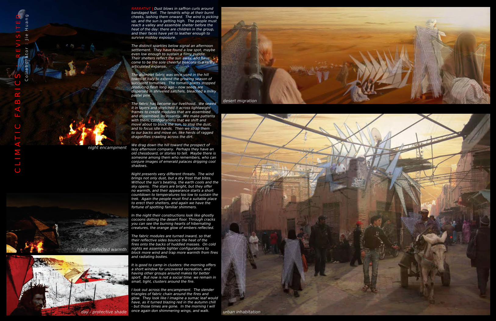
desert migration
urban inhabitation
night encampment
night - reflected warmth
day - protective shade
NARRATIVE | Dust blows in saffron curls around bandaged feet. The tendrils whip at their burnt cheeks, lashing them onward. The wind is picking up, and the sun is getting high. The people must reach a valley and assemble shelter before the heat of the day: there are children in the group, and their faces have yet to leather enough to survive midday exposure.
The distinct sparkles below signal an afternoon settlement. They have found a low spot, maybe even low enough to sustain a filmy puddle. Their shelters reflect the sun away, and have come to be the sole cheerful beacons in a rarely articulated expanse.
The aluminet fabric was once used in the hill towns of Italy to extend the growing season of succulent tomatoes. The tomato plants stopped producing flesh long ago – now seeds are dispersed in shriveled satchels, bleached a milky pastel pink.
The fabric has become our livelihood. We sewed it in layers and stretched it across lightweight frames to create modules that are assembled and dissembled, incessantly. We make patterns with them, configurations that we shift and move about to block the sun, to stop the dust, and to focus idle hands. Then we strap them to our backs and move on, like herds of ragged dragonflies crawling across the dirt.
We drag down the hill toward the prospect of lazy afternoon company. Perhaps they have an old chessboard, or stories to tell. Maybe there is someone among them who remembers, who can conjure images of emerald palaces dripping cool shadows.
Night presents very different threats. The wind brings not only dust, but a dry frost that bites. Without the sun’s beating, the earth cools and the sky opens. The stars are bright, but they offer no warmth, and their appearance starts a short countdown to temperatures too low to sustain the trek. Again the people must find a suitable place to erect their shelters, and again we have the fortune of spotting familiar shimmers.
In the night their constructions look like ghostly cocoons dotting the desert floor. Through cracks you can see the burning hearts of hibernating creatures, the orange glow of embers reflected.
The fabric modules are turned inward, so that their reflective sides bounce the heat of the fires onto the backs of huddled masses. On cold nights we assemble tighter configurations to block more wind and trap more warmth from fires and radiating bodies.
It is good to camp in clusters: the morning offers a short window for uncovered recreation, and having other groups around makes for better sport. But now is not a social time: we remain in small, tight, clusters around the fire.
I look out across the encampment. The slender triangles of fabric chain around the fires and glow. They look like I imagine a sumac leaf would have, as it turned blazing red in the autumn chill - but those times are gone. In the morning I will once again don shimmering wings, and walk .


OB
SC
UR
ED
P
ER
CE
PT
IO
NS
A
dv
iso
rs
: J
eff
Po
nit
z +
Da
vid
Ma
lda
Co
lla
bo
ra
to
r :
Jie
Hu
an
gD
igit
al
Fa
bric
atio
n |
Sp
rin
g 2
01
0
mate
rial +
fabri
cati
on
This investigation began with a desire to use the parametric modeling program, Grasshopper, to create a gradient three-dimensional surface that might lend itself to fabrication using the school’s new CNC Router. The Grasshopper software allowed us to develop a consistent geometric logic that could then be disrupted with an adjustable curve of influence to produce multiple iterations of the surface. Various methods of screening were then tested in attempts to create an effect that would change the viewer’s perception of the surface as they moved around it. This shifting perception is created by partially obscuring the surface and using light and shadow to enhance the irregular depths of the contours. The parallel striations were developed as a geometry that could create the desired effect while providing a simple means of joinery through splicing. These long contoured cuts were also relatively fast and easy for the CNC router to perform. Furthermore, it was important that these spliced joints be operable to produce the corrugated assembly method that allowed for stable vertical stacking. This also makes the installation adaptable to any number of locations or uses.


ST
RIA
TE
D P
AS
SA
GE
A
dv
iso
r :
Ro
bin
Drip
ps
Co
lla
bo
ra
to
r :
Jie
Hu
an
gIn
de
pe
nd
en
t S
tu
dy
: F
ab
ric
atio
n|
Sp
rin
g 2
01
1
conceptual collage | tunnel + tower
Striated Passage takes inspiration from the infrastructural spaces of an abandoned weather station and a basement steam tunnel to create an ephemeral installation along the 2nd floor gallery of the University of Virginia’s School of Architecture at Campbell Hall. Existing spaces of extreme exposure and enclosure were photographed, sketched, collaged and analyzed for their spatial character. Donated materials commonly seen in boat yards - plastic boat-wrap, rope, and rigging hardware - were fastened together with zip-ties to create a striated passage that stretches along the hallway, drawing visitors from the entrance of the building to the school’s gallery display spaces. Overlapping networks of rope and plastic form a gradient condition along the length of the gallery that creates a forced perspective and juxtaposes against the solidity of the gallery wall.


PO
PL
AR
W
AR
DR
OB
E
Co
lla
bo
ra
to
rs
: R
ob
in D
rip
ps
, L
uc
ia P
hin
ne
y +
Sa
ra
h C
an
cie
nn
ew
ork
do
ne
fo
r D
rip
ps
+ P
hin
ne
y S
tu
dio
| S
um
me
r 2
01
2
mate
rial +
fabri
cati
on
clear acrylic fins form one side of the wardrobe tuplic poplar pattern routed into the wardrobe’s sliding doors stainless steel hardware and sliding track
Poplar Wardrobe is a CNC fabricated project constructed at the home/office/research laboratory of Dripps + Phinney Studio in Batesville, Va. The side wall of the wardrobe consists of clear acrylic fins cut to reflect the constructed and natural topography of the office and its landscape. The front wall is four large sliding doors each made of four CNC routed acrylite panels mounted on welded steal frames that slide along a steal track attached to the ceiling trusses. The pattern routed into the doors was derived by parametrically sampling photos of the overlapping branching and leafing patterns of the Tulip Poplars (Liriodendron tulipifera) that meter the office’s view out toward the Blue Ridge Mountains.


French Quarter diagram :buildings + courtyards
LA
BY
RIN
TH
IN
E V
OL
UM
ES
C
oll
ab
ora
to
r :
Jie
Hu
an
gD
es
Co
urs
co
mp
etit
ion
en
try
: 2
01
0
positive volumes + negative spaces
accentuated passages + positive volumes +
negative spaces
positive volumes
negative spaces
kagri
cult
ura
l sh
ade f
abri
c -
bla
ck 6
0%
+ a
lum
inet
40
%;
LED
lig
hts
- r
ed +
whit
e
kee k
lam
p s
yst
em
; bla
ck g
alv
aniz
ed c
onduit
;
diagram of volumes + paths | prototypical configuration
pavilion entrance | prototypical configuration interior perspective | prototypical configuration
The typology of small courtyards that exists in New Orlean’s French Quarter constitutes a labyrinthine network of niches of various spatial and experiential qualities. This proposal takes the unique character of this network as the inspiration for creating a maze-like construction that displays a similar level of spatial variety and irregularity within the confines of a smaller outdoor space.
The assembly of overlapping rectangular volumes of drastically differing dimensions creates a variety of spaces within the courtyard: spaces of passage, spaces to pause, spaces for gathering, and more intimate spaces.
The rectangles and the articulated passages between them would have an outer skin of black shade fabric that would give the initial outward appearance of an ephemeral dark presence within the courtyard. The interior skins would consist largely of aluminet shade fabric, which would give the inside a shimmering appearance as light is reflected about the spaces.
Participants would be given small LED lights that would be used to illuminate the way as they navigate the spaces. The light from these would shine through the different fabrics to throw web-like shadows on the interior surfaces, and allow one to trace the activities of other individuals as they move through the installation. From the exterior, the dark volumes will illuminate with activity.


H
ER
EF
OR
D A
CA
DE
MIC
E
DG
E
CH
AR
LO
TT
ES
VIL
LE
, V
A
Ad
vis
or :
Rb
oin
Drip
ps
Fa
ll 2
00
8
plan view | earthwork + structure
4 - articulated edges + seams
conceptual model | field disturbance
3 - hydrology
2 - topography
1 - city + university + nature
displaced topography | rooftop, balcony + catwalk network
landscape corridor | seasonal stream, vegetation + circulation porous edges | study spaces + library Hereford Academic Edge is an academic facility at the edge of Hereford College at the University of Virginia. Library stacks, computer facilities, and both indoor and outdoor study and auditorium spaces are situated along the site’s steep topography following a field strategy of overlapping grids. The grids reflect the orientation of Jefferson’s University as it meets the Charlottesville city grid here at the edge of Grounds. They intersect on site and are altered by a seasonal stream and the welcome intrusion of the forest ecology that abuts the site to the West. Planes terrace down the slopes creating spaces for gathering and sharing information, while a central corridor is given over to the flow of water and supported vegetation. A system of stairs, ramps, and catwalks connects the two sides and allow people to filter though the facility and out to the University, the neighborhood, or the forests of Observatory Hill. The topographic edge is articulated on both of its sides by earthwork and supported architectural spaces that house social and intellectual activities engaging the University, the City, and their natural surroundings.


T
HE
F
AR
ME
R IN
T
HE
D
EL
L S
CH
OO
L C
HA
RL
OT
TE
SV
ILL
E,
VA
Ad
vis
or :
Pe
te
r W
ald
ma
n S
prin
g 2
00
9
classroom / orchard edge
site plan
3rd floor plan
sections :
diagonal EW looking South diagonal EW looking North
2nd floor plan1st floor plan
circulation + layered constructionoverall perspective | classrooms + main bldg
main bldg model
parkscape | night
parkscape | day
The Farmer in the Dell School is an elementary school by day and local culinary institute by night. The school is located on Emmet Rd between the UVA Dell stormwater retention landscape and the Curry School of Education. It takes the geometries and programs of these adjacencies as cues for the development of a learning landscape of classrooms, productive gardens, orchards, and large cooking, dinning and picnic areas. The spaces are organized along a long ramp/walkway that runs diagonally along the site with a central geometric collision as the main kitchen, dinning and library space. This is a large and layered construction of intersecting volumes of glass and scaffolding that creates several open stories overlooking a main atrium with a view to the dell. Classrooms face the pond and are elevated above the floodplane to maximize view and create sheltered outdoor classrooms below. A recreational parkscape of striating stone walls and large floodplane trees adds to the functioning public space of the dell and buffers the school grounds from the busy road. This school creates a didactic and productive landscape populated with indoor and outdoor spaces for education, agriculture, the culinary arts, and social gathering around food.


N
OL
A S
CH
OO
L F
OR
T
HE
A
RT
SN
EW
OR
LE
AN
S,
LA
Ad
vis
or :
Wil
lia
m W
illi
am
s F
all
20
09
library with view over floodwall
sidewalk view into courtyard
courtyard interiorground floor + site plan
1st floor plan
2nd floor plan
3rd floor plan
The New Orleans School for the Arts is an arts high school and dormitory located on the edge of the historic French Quarter, along an earthen levee and a concrete floodwall, in a neighborhood badly affected by flooding during Hurricane Katrina. The building geometries mediate between the orthogonal grid of the mixed industrial/residential neighborhood to the North and the slight curve of the Mississippi river to the South, so that building components meet at oblique angles to create a variety of nuanced indoor and outdoor spaces within the trapezoidal site. In section, the building steps up from the street to create terraces with northern exposure and provide visual access over the floodwall to the river and downtown New Orleans. The overlap of two geometric orientations allows for different programs to occupy distinct spaces while remaining connected through non-orthogonal courtyards and rooftop terraces. This way spaces for fine arts, theatre, dance, music, and dormitories can be shifted and stacked along the site drawing students and visitors through their shared outdoor spaces and connecting neighborhood to river via intellectual and creative activity.

PO
TO
MA
C S
CIE
NC
E C
EN
TE
R :
G
MU
PE
RE
C S
CIE
NC
E C
EN
TE
R
WO
OD
BR
IDG
E,
VA
Ad
vis
or :
Ph
oe
be
Cris
ma
n F
all
20
10
longitudinal section
courtyard rendering
5. metal screens
1. rectangular volume
massing diagram sequence :
exploded axon (bldg layers) :
2. terraced
3. courtyard subtracted to create floating field station
4. grassland roofscape
2. circulation + vertical cores
1. concrete base + vertical cores
3rd floor plan
2nd floor plan
1st floor plan
ground floor + site plan
3. glazing + metal walls
court
yard
gla
ss w
all
+ b
alc
ony c
onst
ruct
ion
exte
rior
meta
l w
all
const
ruct
ion


PO
TO
MA
C S
CIE
NC
E C
EN
TE
R :
F
LO
AT
ING
LE
AR
NIN
G L
AB
W
OO
DB
RID
GE
, V
A
floating field station rendering
observation tower + entrance - fisheye perspective floating field station plan + sections
floating field station model (plan view)
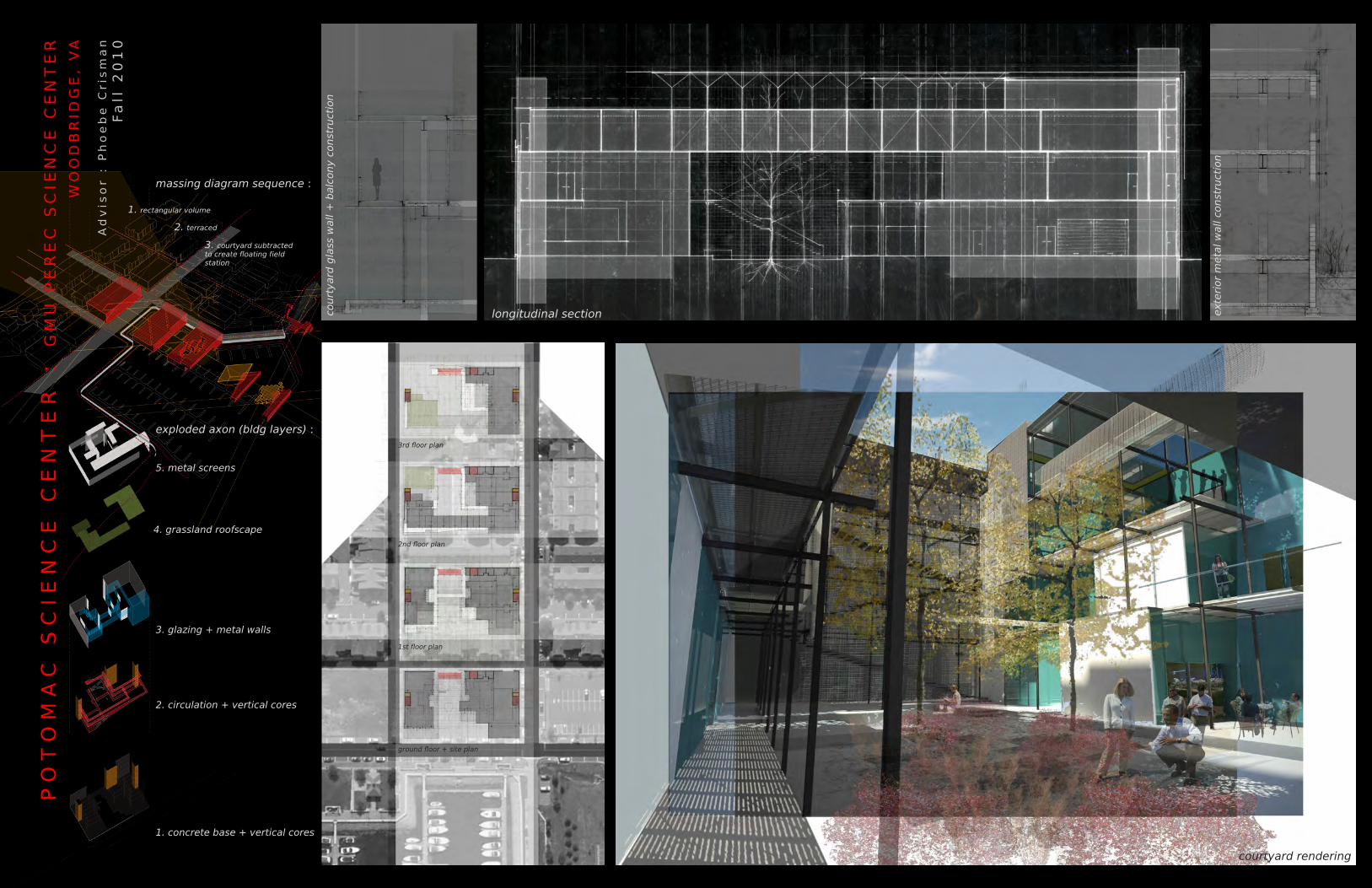
Belmont Bay is in need of a node of activity within the community, one that will simultaneously invigorate the harbor’s street life and allow members and visitors to understand the bay’s place within its larger social and ecological context. George Mason University’s (GMU) Potomac Environmental Research and Education Center (PEREC) laboratory building and its harbor-side site can fill this need in a way that showcases the education and environmental stewardship inherent in the PEREC program.
The site’s central location within the Belmont Bay community and its immediate adjacency to the community’s most attractive amenity, the Occoquan River, makes it a potential catalyst for the construction of a more lively and connected social and ecological community: As a social and ecological hub, the building is designed to be porous and penetrable; light-weight, and able to allow for the passage of different social and environmental systems. The building is conceived as a four story rectangular volume that takes up the entirety of the site. The volume is divided into rectangular modules that can be shifted and removed to allow for the fluid entrance of sun from above and social activity on the ground floor. The resulting courtyard space is open to street and sky and functions as the center of circulation and social interaction for the building’s regular occupants and its many visitors. The scientists at PEREC want a small field station on the Occoquan River for closer, hands on, research and learning of the freshwater tidal ecosystem. The same layered construction method is utilized to create several sheltered research labs and classrooms. A network of smaller wooden walkways and floating wetlands aggregates around these research platforms and creates a series of mesocosms of different types and sizes for more controlled analysis of the local ecosystem. A skeletal lookout tower/weather station anchors this matrix of platforms, mesocosms, and floating wetlands to the shore, and marks the entrance with a visible vertical element.
This project demonstrates that a building need not be a place for human activity alone, but can foster meaningful, didactic, interaction between community and environment.

EX
OS
KE
LE
TA
L U
RB
AN
IS
MB
ALT
IMO
RE
, M
D
C
oll
ab
ora
to
rs
: R
ob
in D
rip
ps
, L
uc
ia P
hin
ne
y +
Sa
ra
h C
an
cie
nn
ew
ork
do
ne
fo
r D
rip
ps
+ P
hin
ne
y S
tu
dio
| S
um
me
r 2
01
0+
11
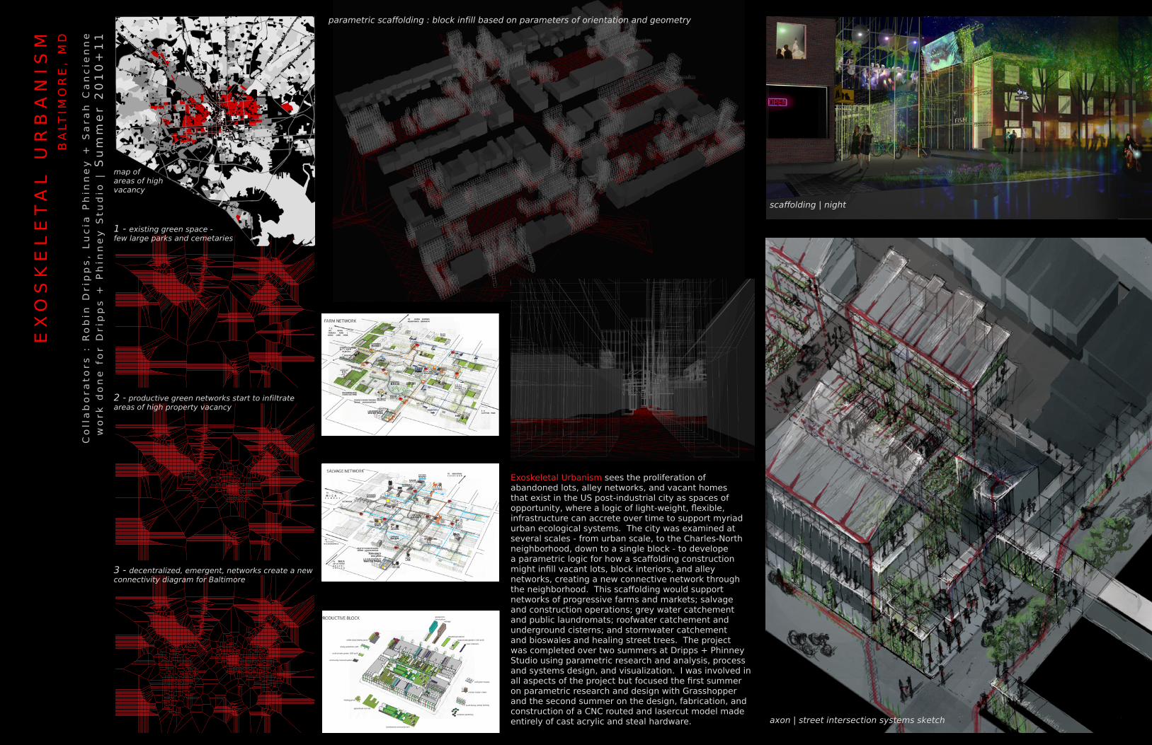
parametric scaffolding : block infill based on parameters of orientation and geometry
axon | street intersection systems sketch
scaffolding | night
1 - existing green space - few large parks and cemetaries
map of areas of high vacancy
2 - productive green networks start to infiltrate areas of high property vacancy
3 - decentralized, emergent, networks create a new connectivity diagram for Baltimore
Exoskeletal Urbanism sees the proliferation of abandoned lots, alley networks, and vacant homes that exist in the US post-industrial city as spaces of opportunity, where a logic of light-weight, flexible, infrastructure can accrete over time to support myriad urban ecological systems. The city was examined at several scales - from urban scale, to the Charles-North neighborhood, down to a single block - to develope a parametric logic for how a scaffolding construction might infill vacant lots, block interiors, and alley networks, creating a new connective network through the neighborhood. This scaffolding would support networks of progressive farms and markets; salvage and construction operations; grey water catchement and public laundromats; roofwater catchement and underground cisterns; and stormwater catchement and bioswales and healing street trees. The project was completed over two summers at Dripps + Phinney Studio using parametric research and analysis, process and systems design, and visualization. I was involved in all aspects of the project but focused the first summer on parametric research and design with Grasshopper and the second summer on the design, fabrication, and construction of a CNC routed and lasercut model made entirely of cast acrylic and steal hardware.


EX
OS
KE
LE
TA
L U
RB
AN
IS
M :
S
YS
TE
MS
M
OD
EL
BA
LT
IMO
RE
, M
D
Pedestrian Path Network
Water Flows
Scaffolding
Row House Party Walls
Socioeconomic Nodes
Extruded Streets
Cistern Networks
Socioeconomic Connectivity
Sidewalks and alleyways traverse streets and blocks creating myriad options for pedestrian movement around the city.
Clean water is collected from rooftops and stored underground in cisterns. Contaminated surface flows are directed through filtration beds and cleaning basins for use in the neighborhood laundromat.
Lightweight, modular, scaffolding structures support urban infrastructures, allowing the city’s social, economic, and ecological activity to extend vertically.
Strong party walls support scaffolding infrastructure.
Each block has at least one hub of activity that acts as a scocial and economic interface for the block (i.e. food/beverage shops, markets, salvage/recycling operations, laundromats, etc.).
The existing street grid is reinvigorated with layers of social, ecological, and hydrological activity.
Chains of concrete cisterns burried underneath impermeable alleyways collect and store roofwater for each block.
The base geometry is a triangulated web connecting the the neighborhoods’ socioeconomic nodes.
Model Key :


TE
RR
A N
OV
A :
B
UIL
DIN
G A
N
EW
V
EN
ET
IA
N G
RO
UN
D
Ad
vis
or :
Jo
rg
Sie
we
ke
Co
lla
bo
ra
to
rs
: E
rin
Ro
ot +
Ju
lie
Pric
eS
prin
g 2
01
1
TH
E V
EN
ET
IAN
LA
GO
ON
, IT
ALY
night render : tidal stairs + urban floating wetland/walkway network
day render : groundbuilding lace + lagoon floating wetland/walkway network current lagoon : erosion, islands, boat traffic, salt marshes + mudflats
Venice symbolizes the strange beauty that is possible when human habitation adapts itself to extreme environmental surroundings. Sea level rise and climate change place the Venetian lagoon at a critical juncture in its existence and necessitate new techniques of adaptation. Terra Nova proposes a new, more flexible set of methods to build ground, improve biodiversity, and permit human access to these critical processes in order to allow this unique city and ecosystem to survive.
This multifunctional operation of ground building lace, floating wetland/walkway networks, and tidal stairs would bring the richness of the lagoon’s ecology into closer proximity with the city of Venice and give it a more evocative and accessible presence within the lagoon. By diversifying and protecting the ecological activity within the lagoon, and allowing people to experience these processes, the project aims to change the perception of Venice from that of a postcard image of narrow alleys and gondola-filled canals to a fantastic city in which the urban fabric, history, and practices are inextricably connected to the processes that constitute this unique lagoon environment.
GROUNDBUILDING LACE | Terra Nova proposes an aquatic geotextile that could be employed throughout the lagoon as part of a new ground-building regime of incremental sediment accretion and supplementation. The geotextile uses patterns of perforations that open and expand like gills to capture and hold sediment. This would encourage a slow and varied buildup of ground and the shifting emergence of a diversity of lagoon morphologies and interdependent ecosystems.
FLOATING WETLANDS / PATH NETWORK | To protect against erosion and pollution from boat traffic, the edge between channel and newly accreting ground would be thickened by a network of floating treatment wetland islands. These islands are made of a matrix of recycled plastic curls that supports plant growth and provides habitat for marine invertebrates. The network is a voronoi pattern that is parametrically derived along curve geometries that thicken and thin to create more or less biomass for varying protection and habitat needs.
TIDAL STAIR | In places, the voronoi pattern tightens and regularizes to create a floating walkway that allows residents and visitors to occupy this emerging world of ecological activity. The walkway would be accessed through a new typology of stairs that would attach at key places along the hard vertical edges of the city. These large terracing stairs would retract and extend as an evocative new register of tidal flux that allows for constant access to the water. The pathways would provide new publically accessible waterfronts in emerging residential zones and allow pedestrian access to some of the city’s mysterious and beautiful peripheral islands that are currently marginalized and underused.


barene elevation above mean sea level: 0.24-0.50m
tidal creeks 0.10-1m deep
high marsh
Inul
a cr
ithm
oide
s
Pucc
inel
lia
palu
stri
s “p
ucci
nell
ia”
Sarc
ocor
nia
frut
icos
a “g
lass
wort
”
Sarc
ocor
nia
frut
icos
a “g
lass
wort
”
Pucc
inel
lia
palu
stri
s “p
ucci
nell
ia”
Inul
a cr
ithm
oide
s
Inul
a cr
ithm
oide
s
Sarc
ocor
nia
frut
icos
a “g
lass
wort
”
medium marsh
spar
tima
mar
itim
a “c
ommo
n co
rdgr
ass”
low marshsalinity=25-35%
Junc
us m
arit
imus
“se
a ru
sh”
Suae
da m
arit
ima
“ann
ual
seab
lith
e”
Sarc
ocor
nia
frut
icos
a “g
lass
wort
”
Aste
r Trip
oliu
m “a
ea a
ster
”
Limo
nium
nar
bone
nse
“sea
lav
enda
r”
Junc
us m
arit
imus
“se
a ru
sh”
Suae
da m
arit
ima
“ann
ual
seab
lith
e”
Sarc
ocor
nia
frut
icos
a “g
lass
wort
”
Limo
nium
nar
bone
nse
“sea
lav
enda
r”
Aste
r tr
ipol
ium
“aea
ast
er”
Pucc
inel
lia
palu
stri
s “p
ucci
nell
ia”
Inul
a cr
ithm
oide
s
Larus michahellis “Gabbiano reale”Haematopus ostralegus “Beccaccia di mare”
Haematopus haematopus “Cavaliere d’Italia”Recurvirostra avosetta “Avocetta”
Tringa totamus “Pettegola”Tadorna tadorna “Valpoca”
Anas platyrynchos “Germano reale”Charadrius alexandrinus “Fratino”
periwinklesperiwinklesperiwinklesperiwinklesperiwinklesperiwinklesperiwinklesperiwinklesperiwinklesperiwinklesperiwinklesbarnaclesbarnaclesbarnaclesbarnaclesbarnaclesbarnaclesbarnaclesbarnacles
musselsmusselsmusselsmusselsmusselsmusselsmusselsmusselsmusselsmussels
mud wormsmud wormsmud wormsmud wormsmud wormsmud wormsmud wormsmud wormsmud wormsmud wormsmud wormsmud wormsmud wormsmud wormsmud wormsmud wormsgrey crabgrey crabgrey crabgrey crabgreen crabgreen crabgreen crabgreen crabgreen crabgreen crabgreen crab
oystersoystersoystersoystersmudflat
groundbuilding lace buffering floating wetland
avg. tidal range: 0.6-1.1m
lagoon mean depth: 1.5m
navigation channel depth: 4m-30m
10cm above msl20cm30cm40cm50cm
TE
RR
A N
OV
A :
B
UIL
DIN
G A
N
EW
V
EN
ET
IA
N G
RO
UN
D
TH
E V
EN
ET
IAN
LA
GO
ON
, IT
ALY
FLOATING WETLANDS | PATH NETWORK : adaptive geometries create an occupiable erosion
buffers and a thickened ecotone for new ground.
GROUNDBUILDING LACE : gradients of perfortating and weaving
encourage varied land accretion over time.
TIDAL STAIR : occupying and traversing Venice’s hard edges
via terraces that retract and extend with the tide.
PROTOTYPICAL PLAN :
giudecca | isola la grazia
ECOLOGICAL SECTION :


CH
AR
LO
TT
ES
VIL
LE
C
IT
Y M
AR
KE
T
CH
AR
LO
TT
ES
VIL
LE
, V
A
Ad
vis
or :
Be
th
Me
ye
rF
all
20
11
model 1 - bathtub topography
conceptual models :
urban context | site diagram - lines, edges and adjacencies
urban framework plan - social and ecological flows interact along the length of the site
model 2 - explosive intersections model 3 - figured edges
This project reimagines the edge of an urban stream valley as a two story line of market clusters linked to a daylit stream and an urban playground. This 500’ constructed edge will act as a shared front porch joining the residential neighborhoods around the downtown mall across a corridor of heightened social and ecological activity. This corridor will draw social activity from the downtown Mall to the North and connect this to the ecological, hydrological, and recreational activities of the Rivanna River and its associated trail network via Pollocks Run and Moore’s Creek to the South.


FA L L
S UMM E R
S P R I N G
W I N T E R
CH
AR
LO
TT
ES
VIL
LE
C
IT
Y M
AR
KE
T
CH
AR
LO
TT
ES
VIL
LE
, V
A
IX industrial playground + canopy curvature studies
stream corridor + market edge section model
plan : sections : The 6th St. edge is constructed as a two-story market porch that is fragmented to accommodate various scales of activity, from the full Saturday market, to smaller weekday market clusters. The edge is covered by an undulating canopy structure that sets up a meter for vendor clusters and individual stalls and provides simple tables and benches. When not operating as a full market, the structure will provide an armature for social gathering such as community meetings, bbqs, picnics, street sports and general front-porch activities.
The construction of this edge is closely linked to the daylighting of Pollocks run, a culverted stream that runs underneath the site. The streambed is constructed as a series of gently tilted planes that encourage slow filtering sheet flow and support verdant wetland vegetation. The stream leads residents and visitors along the market edge and under Monticello Ave to the former IX factory site, where postindustrial expanses will be the backdrop for an urban playground of basketball courts, and pavilions.


The site is poised at the intersection of several distinct communities and processes, each crucially involved in the physical and social shaping of downtown Charlottesville. Figuring this important edge as a shared front porch, market and playground for the adjacent communities will change this site from a problematic divide to a connective element for downtown Charlottesville. The varied scales and qualities of this constructed edge and the temporal nature of the various programs of market, stream corridor, linear park, and playground will support rhythmic occupations by all of the site’s adjacent influences in spaces that are distinct yet connected.
CH
AR
LO
TT
ES
VIL
LE
C
IT
Y M
AR
KE
T
CH
AR
LO
TT
ES
VIL
LE
, V
A


H
UB
S
TE
P :
A
N
EW
W
AY
T
O M
OV
E IN
C
’V
IL
LE
CH
AR
LO
TT
ES
VIL
LE
, V
A
Ad
vis
or :
Ma
rg
arit
a J
ov
er
8 s
tu
de
nt t
ea
m l
ed
by
Ku
rt M
ars
h a
nd
Ma
ure
en
Mc
Ge
eB
elm
on
t B
rid
ge
co
mp
etit
ion
| S
prin
g 2
01
2
presentation model
section perspective | N-S
section perspective | E-W
We understand the new Belmont bridge as a surface of collective experience - an activated public space that builds upon the ideology of the Halprin’s vision for the Charlottesville Downtown Mall. The bridge is envisioned as an extension of the public space of the mall – a continuous urban surface supporting fluid connections across the railroad as well as creating spaces of exchange above and below. This landscape supports a non-hierarchical experience where pedestrians, bikes, cars and public transportation move across a shared surface. The co-existence of different modes of circulation thus becomes a public act, one which engenders new connections and relationships across the City of Charlottesville and the greater region.
The local and regional transportation networks of Charlottesville are currently egregiously disjointed. Centralizing the various transit modes that connect and support the citizens of Charlottesville provides the opportunity for the bridge to act as an intermodal transit hub for the city. This will be the new threshold to the city, sited at a crucial juncture in the urban fabric, where one arrives via regional transportation and immediately accesses local networks of buses, trolleys, bikes and pedestrian paths.
As a continuation of the Mall the surface bridge peels up to become a landscape of native grassland hillocks crisscrossed by local transport routes. This landscape also wraps in on itself, sheltering spaces below for a larger regional transit terminal and its associated social and commercial activities. The lifted urban crust is punctured by large elliptical apertures that foster vertical exchanges between transport modes, social activity, light. These connect the experience of the sunny grassland above to that of the shaded forest below. The spaces therefore emerge from the folded surface, engage one another, and provide a collective experience of movement. The resulting landscape is one of multiplicity, where our quotidian activities are


A S
LO
W |
W
ET
D
IA
GO
NA
L U
RB
AN
WA
TE
R M
AN
AG
EM
EN
T A
S P
UB
LIC
LA
ND
SC
AP
E G
EN
ER
AT
OR
Ad
vis
or :
Ma
rg
arit
a J
ov
er
Sp
rin
g 2
01
2
BA
RC
EL
ON
A,
SP
AIN
A Slow / Wet Diagonal proposes connecting Parc de la Segrerra to Parc de Ciutadella and the Mediterranean via a diagonal that slows and stores Barcelona’s seasonally large levels of stormwater and uses this water to support diverging dry and wet public landscapes and sustainable transportation infrastructures. This proposal would alleviate the seasonal flooding that occurs in the low elevation land along the coast of east Barcelona via a new public stormwater infrastructure that sustains connective landscapes for public recreation and circulation across Barcelona’s vast Eixample.
The large elevated surface of the Avenguda Meridiana is transformed into a sponge of sand and gravel that stores and filters stormwater runoff. The water is captured through a perforated concrete surface pattern that both directs it and provides a surface for public activities and circulation. This high sandy corridor fosters a dry, scrubby, landscape of arid plants that is typical to Catalonia. The hard, dry, surfaces allow for bicycle networks and tramways above and protect an existing metro line from seasonal flooding below. The stormwater slowly moves through the sand and is filtered before seeping out to an existing, partially exposed, metro track that diverges and reconnects to the diagonal as a low elevation trace through the city. The space of this metro track is enlarged and repurposed as a series of retention ponds surrounded by terraced park spaces where the partially filtered water is used to maintain a more mesic environment that creates a cool, lush, and quiet public landscape. At the diagonal’s southern terminus the Zoological Park is redesigned as an urban park striped with small cafes, bars, picnic pavilions, and sports fields as well as public lockers and restrooms. The grand structure of French Station is repurposed to shelter a water park with various indoor/outdoor pools and saunas, and paths that connect the old city to the new diagonal. The urban park bridges across Ronda Litoral to create a physical connection between Parc de la Ciutadella, the beach, and the Sea.
This project proposes a new, public, stormwater infrastructure to capture and use east Barcelona’s stormwater before it creates flooding problems in the low elevation neighborhoods along the coast and in the Besos River delta. This stormwater infrastructure shapes varying public landscapes and ecosystems for recreation, transportation, and small-scale commerce that extends the public landscape of Parc de la Segrerra to downtown Barcelona and the Sea.


Yucca sp. (variety)low to high dense succulentlarge showy seasonal blooms
Aloe sp. (variety) low to high dense succulentlarge showy seasonal blooms Phoenix dactylifera - Date Palm
Charmaerops humilis - Dwarf Fan Palmpalm shrub to stout ttree
Olea europea - Olivesilvery foliage, gnarled form
Pinus pinea - Stone Pine scrubby shrub to tree
Pistacia lentiscus - Pistacio
Pinus halepensis - Alapo Pine
Celtis australis - European Hackberry Platanus hispanica - Plane Tree Quercus faginea - Little-Leafed Oak Tilia tomentosa - Silver Linden
Populus nigra - Lombardy PoplarSalix sp. - Willow (variety) from loose shrubs to large wide trees
Acacia saligna (sp.) - Acacia yellow blooming dense waterbank shrub
E - W s e c t i o n | p e r s p e c t i v e l o o k i n g N o r t h
p l a n t p a l e t t e t w o d i s t i n c t l a n d s c a p e t y p e s
w a t e r c y c l e d i a g r a m s r a i n f a l l d a t a + s e a s o n a l d i a g r a m s
k u r t a . m a r s h | m . a r c h + m . l . a ‘ 1 2
A S
LO
W |
W
ET
D
IA
GO
NA
L B
AR
CE
LO
NA
, S
PA
INLower landscape : the wetland
microclimate
storage capacity : 1,300,000 cubic feet / 35,000 cubic meters
410,963 sq.ft. area x 3 ft. avg. Lower Site - existing
Upper landscape : the storage sponge
storage capacity : 3,600,000 cubic feet / 1,000,000 cubic meters( 1,951,563 sq.ft. area x 5 ft. avg. depth x 30% for course sand matrix))
Upper Site - existing
stormwater retention/detention streetscape possibilities - plans + sections


1 8 0 1
1 8 6 9
2 0 0 2
1 7 7 3
1 6 0 0
T h e J o n e s Fa l l s C o r r i d o r :r i v e r t o r o a d - a h i s t o r y o f B a l t i m o r e
1 7 0 0
1661 - David Jones settles on the East Bank; Jonestown is formed
1729 - Baltimore Town forms on the West Bank; river provides transportation, drinking water, food, & recreation
1745 - Towns unite to form the City of Baltimore
1766 - Harrison Marsh is filled in & the lower river is diverted and channelized
1786 - first recorded flood submerges business district
1805 - the Jones Falls channel is deepened
1837 - flood wipes-out all bridges; 19 deaths
1868 - flood kills 50 people and causes over $1 million in damage
1910 - lower Jones Falls declared “an odorous, poisonous, water hole”
1915 - Jones Falls buried; construction completed on a 3-bay underground box culvert
1945 - Jones Falls Expressway (JFX) first conceived as a collaboration between Baltimore City officials and Robert Moses
1956 - city approves construction of JFX; mayor D’Alesandro breaks ground
1961 - 1st and 2nd sections open [Charles St. - Jones
Falls Rd]
1962 - 3rd section opens [downtown to
Beltway]
1977 - 1st elevated section completed [Gay to
Monument Sts]
1983 - 2nd elevated section completed [to
Pleasant St]
1987 - final sections completed [connection to Presidents St + Inner
Harbor]
2005 - first plans proposed to remove portion of elevated expressway
2009 - viaduct study published with proposal to convert JFX to an on-grade green boulevard
1804 - a stone & gravel turnpike was built in the Jones Falls valley to connect downtown to the county
1983 - EPA names Baltimore stormwater most contaminated in a 28 metropolitan region sampling
1997 - Jones Falls Watershed Association forms
2010 - Watershed Associations unite;Jones Falls Watershed Association, Herring Run WSA, Gwyns Falls WSA, Baltimore Harbor WSA, & Baltimore Harbor Waterkeeper
1 8 0 0
1 9 0 0
2 0 0 0
Kurt Marsh | M.Arch + M.L.A. [Dec. 2012]
BM
OR
E P
UB
LIC
W
AT
ER
B
ALT
IMO
RE
, M
D
Ad
vis
or :
Ro
bin
Drip
ps
Th
es
is |
Fa
ll 2
01
2
A R
iver
and a
Road :
H
isto
ry o
f th
e Jones
Falls
This project redesigns the space of a culverted river and an elevated highway as a multifunctional infrastructural public corridor connecting downtown Baltimore through hydrological and social activity.
Creating a corridor for visible stormwater management introduces an alternative spatial logic into the urban fabric of downtown Baltimore – a field strategy that is gradient and flexible so as to fit within and respond to varying site geometries and conditions. This responsive organizational logic informs the structures for alternative social and ecological occupations of the site. The underutilized artery through the center of Baltimore is thus transformed into a vibrant intensified space where the intersection of transportation and hydrological infrastructures breeds new spatial typologies for hybrid public spaces.
Baltimore is a city founded on a river, the Jones Falls River. Its urban fabric grew as a response to the infrastructural services provided by the river corridor – transportation, energy for mills, and drainage – so that major streets radiate from the corridor, and urban grids shift with the river’s bends. Unfortunately, as Baltimore grew and modernized the street grid was prioritized, and the city began encroaching on the river’s floodplane. To accommodate this shift in attitude, the lower Jones Falls was adjusted to follow a straight path, and in 1915 it was burried in three large box culverts that run unnoticed through downtown before spilling into the Inner Harbor. Soon after, the Jones Falls Expressway (JFX) was constructed alongside the buried river to efficiently connect Baltimore’s downtown business districts to the expanding suburbs by bypassing much of the city fabric via this partially elevated highway.

PU
BL
IC
W
AT
ER
B
ALT
IMO
RE
, M
D
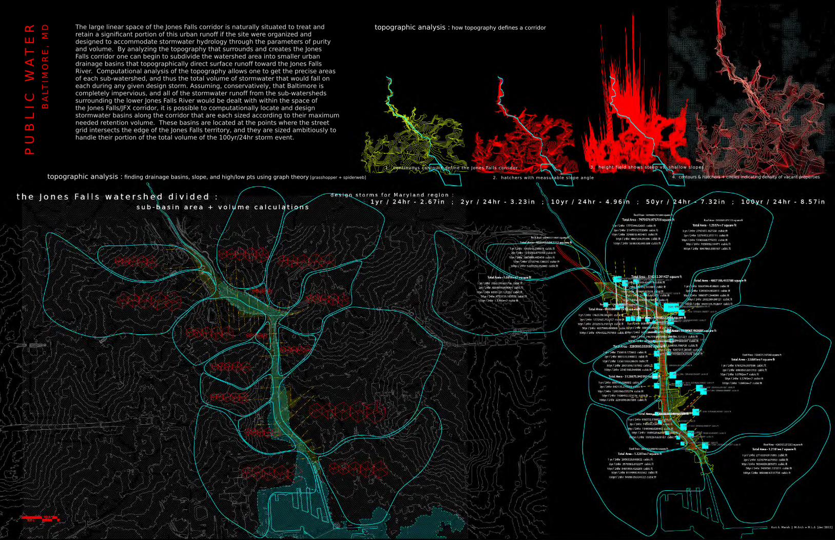
1 . continuous contours define the Jones Falls corridor
2. hatchers with measurable slope angle
3. height f ield shows steep vs. shallow slopes
topographic analysis : how topography defines a corridor
4. contours & hatchers + circles indicating density of vacant properties topographic analysis : finding drainage basins, slope, and high/low pts using graph theory [grasshopper + spiderweb]
The large linear space of the Jones Falls corridor is naturally situated to treat and retain a significant portion of this urban runoff if the site were organized and designed to accommodate stormwater hydrology through the parameters of purity and volume. By analyzing the topography that surrounds and creates the Jones Falls corridor one can begin to subdivide the watershed area into smaller urban drainage basins that topographically direct surface runoff toward the Jones Falls River. Computational analysis of the topography allows one to get the precise areas of each sub-watershed, and thus the total volume of stormwater that would fall on each during any given design storm. Assuming, conservatively, that Baltimore is completely impervious, and all of the stormwater runoff from the sub-watersheds surrounding the lower Jones Falls River would be dealt with within the space of the Jones Falls/JFX corridor, it is possible to computationally locate and design stormwater basins along the corridor that are each sized according to their maximum needed retention volume. These basins are located at the points where the street grid intersects the edge of the Jones Falls territory, and they are sized ambitiously to handle their portion of the total volume of the 100yr/24hr storm event.


BM
OR
E P
UB
LIC
W
AT
ER
B
ALT
IMO
RE
, M
D
1 - regular grid of points
4 - cross-streets disturb the field
2 - grid warps in response to the Jones Falls curve
5 - existing buildings disturb the field
3 - Jones Falls curve disturbs the field
6 - JFX highway disturbs the field
p t / v o r o n o i m a n i p u l a t i o n : a b s t r a c t e d s t u d y
a a
a
b
b
b
The ground of the corridor is divided to create a parametrically informed field pattern that can accommodate a multitude of flows and programs along the length of the lower Jones Falls. The ultimate field is a voronoi pattern based on an irregular grid of points that radiates in a gradient from the curvature of the river. These points were shifted, added to, and subtracted from in response to flows of transportation and hydrology entering and crossing the site. The resulting voronoi pattern reflects the site’s physical geometries, as well as the various social, infrastructural, and hydrological forces acting along the corridor. The voronoi cells allow for the shaping of retention basins based on the parameters of volume, site geometry, and spatial constraint. The basins terrace down from the street toward the river to create a filtration sequence for the polluted urban runoff.
Existing roads cross the corridor on grade and bring water and street life to the terraces of the retention basins, and the underside of the JFX is activated as a public space sheltered by the expressway and serviced by transportation, energy, and water infrastructure. The edges of this covered space are populated by thin branching structures that derive their form from the edges of the voronoi field pattern. These branching structures bridge from the ground to the JFX and support occupation and movement between the two. The curvilinear scaffolds plug into the underside of the JFX as the high-speed movement of the expressway is seen as an opportunity to generate electricity. Small wind turbines are embedded in a screen that runs vertically alongside the highway and twists to become canopy in places where bus stops and drop-off points are added. The bus stops would allow people to take buses into the city and switch at points along the highway to other local bus routes, or to bicycle or foot transportation. The underside of the highway would have a robust bicycle and pedestrian network weaving alongside existing roads and new program.


1 y r / 2 4 h r2 y r / 2 4 h r
1 0 y r / 2 4 h r
5 0 y r / 2 4 h r
1 0 0 y r / 2 4 h r
BM
OR
E P
UB
LIC
W
AT
ER
drainage medium
I - inflowplan :
section : sediment catchment chambers filtration medium
- controls, directs, slows inflow rates
- removes course sediment - removes fine sediment and pollutants
- controls outflow; redirects to conveyance systemor exfiltrates into ground
storm
wate
r ru
noff
treate
d w
ate
r
I I - pretreatment II I - f i ltration IV - outflows t o r m w a t e r f i l t r a t i o n s y s t e m s : basic f low diagram (4 parts) :
17'-4"17'-4"
57'-9"37'-1"26'-7"52'-1"
173'-6"96'-1"
20'-4" 19'-2" 21'-1" 8'-11" 9'-11" 5'-10" 3'-11"
42'-11"
16'-5"20'-1"20'-1"
61'-7"
I - inflowII - pretreatmentII I - f i ltrationIV - outflow (infi ltration)
l a n d s c a p e o f u r b a n h y d r o l o g y : stormwater filtration/retention basins as temporal public space
section :
plan :
riparia zone - remnant culvert - expanded flood zone
buffer zone
gravel filter beds / retention chambers
fine sand filter
course sand filter
flow dispersement + sediment /
garbage catchment
street / sidewalk inflow
design for volume :
J o n e s Fa l l s s t o r m w a t e r f i l t r a t i o n s y s t e m (4 parts) :
- at the street edge is a band of small cells that act as a large comb that slows the flow of water, forces it to drop its sediment content, and catches trash and other solid waste. On dry days, these concrete extrusions can be used as a field of irregular platforms and benches for public gatherings and activities.
- next, the water moves down to cells filled with course sand medium for the removal of larger toxins and chemicals in the water.
- after a series of finer sand filtration beds the water enters large gravel and rock beds where some remaining toxins are biologically processed by the microbiota living on the stone surfaces.
- the final, largest, beds are at the lowest elevation and are designed to pool in storm events and allow for slow infiltration into the ground.
- some beds will host pioneer species of vegetation from seeds deposited by alluvial overflow from the newly exposed Jones Falls River.
- other beds will be maintained as platforms with climbing and seating walls for social and athletic activities.
- the maintenance of this stormwater filtration landscape becomes a public spectacle as machines dredge sediment and debris from the street edge after every storm event, and remove and replace filtration media on regular schedules based on the bed’s place in the filtration sequence and subsequent toxicity buildups (beds closest to the street edge, and most easily accessed, require the most frequent cleaning).


BM
OR
E P
UB
LIC
W
AT
ER
B
ALT
IMO
RE
, M
D
under the JFX - the pedestrian/bike way
the JFX bus stop edge
5 - power canopy a ribbon of gradient apatures twists along the sides of the highway, closing to become a canopy for newly established bus stops, and opening to create a screen of wind turbines and/or solar panels
4 - vertical circulation scaffolds supporting large stairways and elevators connect the ground to a second level of occupation, support spaces for new ground-level program, and to new bus stops positioned along the elevated highway
vertical circulation : stair/elevator scaffolds
infrastructural scaffold :
2 - vertical infrastructure the cracked ground along the sides of the JFX gives rise to infrastructural scaffolds that provide power and water to small scale program and public spaces under the highway
1 - ground works the ground is broken up to accomodate storm water and move runoff from the elevated highway to larger retention basins along the corridor
3 - power conduits a strip of electric generators are held in skeletal conduits along the underside of the highway
process model - JFX as infrastructural armature
elevation :
t h e j o n e s f a l l s e x p r e s s w a y : diversifying vehicular infrastructure
- one lane of the JFX is given up to bus and carpool, creating the need for bus stops/drop-off points along the highway.
- the high-speed traffic and exposed condition of the highway are seen as possibilities for generating power.
- parametric scaffolds connect the ground to the highway, physically and infrastructurally, and support emerging small-scale program.


E D U C A T I O N :2008 - 2012 University of Virginia School of Architecture Charlottesville, VA M.Arch + M.L.A., December 2012 (Faculty Award for Design Excellence)
Summer 2011 European Masters in Landscape Architecture (EMILA) (Summer Workshop) The Netherlands
Summer 2007 Columbia University GSAPP (Intensive Intro to Architecture) New York, NY
2005 - 2006 Seoul Korean Academy (서울한국어아카데미) (Korean Language) Seoul, South Korea
2001 - 2005 Georgetown University Washington, DC B.A. in English and Studio Art, May 2005
Spring 2004 University of New South Wales + UNSW College of Fine Arts Sydney, Australia
January 2004 UNSW Lady Elliot Island Program (Marine Science) Great Barrier Reef, Australia
Summer 2002 Universidad de Deusto (Spanish Language + Culture) Bilbao, Spain
W O R K E X P E R I E N C E :July 2013 - present Supermass Studio : landscape, urbanism & ecology New York, NY Landscape + Urban Design: Research, Concept, Representation
Fall 2012 UVA | Design Center (Margarita Jover) Charlottesville, VA Design, Representation + Presentation
Summer 2010 + 2011 + 2012 Dripps + Phinney Studio Batesville, VA Design, Research, Fabrication + Construction (http://explodebreps.wordpress.com + http://dataanimal.wordpress.com)
2008 - 2012 UVA | Graduate Teaching Assistantships : Charlottesville, VA Drawing and Composition Pam Black Architectural Theory + Analysis Phoebe Crisman Graphics Workshop Robin Dripps Digital Fabrication Jeff Ponitz Shops Short Courses | FabLab Melissa Goldman Arch 601 Graduate Foundation Studio Robin Dripps Arch 701/801 Graduate Studio Robin Dripps
Winter 2011 Sorkin Studios | Terreform New York, NY Concept Rendering
Summer 2009 MOS Architects | P.S.1 MoMA - Afterparty Pavilion Long Island City, NY Construction
Winter 2008 Diller Scofidio + Renfro New York, NY Graphic Design, Editing + Layout
2007 - 2008 Austin Patterson Disston Architects Southport, CT CAD Technitian + Intern
2005 - 2007 Pagoda Foreign Language Academy (파고다외국어학원) Seoul, South Korea English Teacher
Summers 1998 - 2004 Greenfield Animal Hospital Fairfield, CT Veterinary Technitian + ReceptionistP U B L I C A T I O N | A W A R D S :2013 Faculty Award for Design Excellence Master of Architecture UVA, Charlottesville, VA2013 LUNCH 8_Futures for Sites Unknown Bmore Public Water : Urban Infrastructure as Public Landscape Generator UVA, Charlottesville, VA2012 LUNCH 7_CONVERSATIONS Terra Nova : Building a New Venetian Ground UVA, Charlottesville, VA2011 ASLA Student Honor Awards - collaboration Terra Nova : Building a New Venetian Ground ASLA 2011 Adobe Design Achievement Awards - semifinalist Climatic Fabrics Adobe Systems Inc.2011 LUNCH 6_SYSTEMS Projects from HuangMarshWorkshop UVA, Charlottesville, VA2010 LUNCH 5_FLUX Fabric[ated] Atmospheres UVA, Charlottesville, VA
S K I L L S : Representation | Fabrication Adobe Creative Suite, Rhino, V-ray, Grasshopper, MasterCAM, ArchiCAD, AutoCAD, ArchGIS Painting, Drawing, Collage, CNC and Analog Model Making + FabricationLanguage Proficient in Spanish and Korean | Extensive English writing and editing experience
KU
RT
A
M
AR
SH
ku
rt.m
ars
h@
gm
ail
.co
m
(2
03
) 2
60
- 3
80
0
65
5 M
ac
on
Stre
et
Bro
ok
lyn
, N
Y 1
12
33