Embed Size (px)
Citation preview
ASX ANNOUNCEMENT ASX: NVA, OTC: NVAAF, FSE: QM3
Nova Minerals Ltd is a dynamic Australian explorer and developer of its expanding flagship 3.3Moz Estelle Gold project situated in Alaska
Nova Minerals Limited
ACN: 006 690 348
ASX: NVA
OTC: NVAAF
Office:
Suite 602, 566 St Kilda Road
Melbourne, VIC, 3004
Australia
Contact:
P: +61 3 9537 1238
W: www.novaminerals.com.au
05 October 2020
Korbel Interim Gold Mineral Resource increases to 3.3Moz
Growth Continues at the Estelle Gold Project
Interim Mineral Resource for Korbel (drilling to 30 June 2020) – 3.3Moz Inferred JORC Mineral Resource Estimate (“MRE”)
“Snap-shot in time” Interim Mineral Resource Estimate established Resource mineralization from surface Global resource for Blocks A and B due in 2021 Results due for remainder of Blocks B and Block A with over 95% of initial drilling
program (48 holes total) now completed
61% increase in tonnes from 7,200m Diamond to 30 June 2020 of up to 40,000m planned for 2020
Results for further 32 drill holes in Korbel Blocks A and B submitted to lab and now forthcoming
Additional drilling planned on new high grade Block B Southeast extension zone (Pad 6) next to hole KBDH-012 101m @ 1.3 g/t incl. 82m @ 1.5 g/t, 30m @ 2.4 g/t, 3m @ 7.7 g/t, 6m @ 4.7 g/t and 3m @ 8.2 g/t
o KBDH-012 returned an overall average grade of 0.6 g/t Au over 429m from 3m within the Korbel intrusive with multiple high-grade zones (ASX: 19 August 2020)
RC drilling commenced on Block C and D and infill of Block B with 10 holes
completed to date.
Diamond and RC drilling continue unabated with increase from initial 25,000m up to 40,000m for 2020 and up to 80,000m planned for 2021
**Remainder of Block A and Block B, Block B Southeast Extension, Blocks C and D, Cathedral,
You Beauty, Izabela and Sweet Jenny is not included in this new resource upgrade and provides substantial resource upside**
NVA CEO, Mr. Christopher Gerteisen commented: “We are very pleased with the results of this Interim Mineral Resource Estimate which represents a “snap-shot in time” and is based on very few of the additional drill results of the total planned drill program. Importantly, the thickness of mineralisation at Korbel Blocks A and B is consistent throughout, which provides an exciting opportunity to significantly grow our resources beyond this point. One of the key objectives this year was to begin to determine the extent of Korbel and in the process capture more tonnes, as tonnage is king with these IRGS deposits. We are very encouraged by the consistent significant increase in tonnes as we drill. The extent of the system
For
per
sona
l use
onl
y

Page 2
remains elusive as the deposit is still wide open. It is important to note the resource mineralization at Korbel starts at surface making it readily amenable to open pit bulk mining methods. This coupled with exceptional metallurgical recoveries from test work thus far will reflect positively in the economic studies now underway.
In terms of further upside in the Korbel system, Blocks C and D, Cathedral, You Beauty, Izabela and Sweet Jenny are exciting high value targets in the list of drill priorities, with drilling having now commenced on Blocks C and D. This RC program is now generating targets for subsequent follow up resource diamond drilling which we expect to continue to grow the global resource at Korbel. With these positive developments, additional drilling has been planned and we will continue unabated, now increasing the drilling from the current 25,000m up to 40,000m for 2020 and up to 80,000m is planned for 2021. The additional 2020 drilling will also be included in the global resource upgrade planned for 2021, where we will also be looking at proving up a significant portion of the resource to the higher confidence Measured & Indicated categories. This upcoming global resource will be a key input to the economic studies which have now commenced on Blocks A and B with activities including detailed metallurgical test work, including ore sorting, and other long lead study items.
Several high-grade areas have been intersected within the Korbel deposit through drilling to date, a highlight being the newly discovered Block B southeast extension zone. While increasing resource volume has been our primary focus until now, we will begin to follow-up and delineate these zones with the additional drilling planned through 2021 and beyond.
We are continuing to develop the Estelle Gold Project in a world-class district. We are focussed on increasing our total resource inventory whilst executing our path to production with urgency.”
Nova Minerals Limited (“Nova” or the “Company”) (ASX: NVA, OTC: NVAAF, FSE: QM3) is pleased to provide an update on its resource estimate, within the Company's flagship Estelle Gold Project located in the prolific Tintina Gold Belt.
Figure 1. Resource Estimate block model, Korbel gold deposit.
For
per
sona
l use
onl
y

Page 3
Mineral Resource Estimate
Total Mineral Resource for Block B (drilling to 30 June 2020) – 291mt @ 0.4g/t for 3.3Moz Inferred JORC Mineral Resource Estimate (MRE)
Notes:
• Mineral Resources that are not Mineral Reserves do not have demonstrated economic viability
• The effective date of this estimate is 01 October 2020
• The reported Mineral Resources are considered to have reasonable prospects for economic extraction
• Ounce (troy) = metric tonnes x grade / 31.103. Calculations used metric units (meters, tonnes and g/t)
• This Resource Estimate is done to JORC Standards
• Resources at 0.18 g/t cut-off = 290Mt @ 0.4 g/t Au for 3.3 Moz Geologic Interpretation - The property is situated within the Koyukuk terrane, one of several arc assemblages accreted late into the North American Cordillera. The property straddles the north-south trending axis of the Late Cretaceous / Early Tertiary Mt Estelle plutonic suite that intrudes the Latest Jurassic to Early Cretaceous Kahilltna Assemblage sediments. The Kahiltna Assemblage includes units of volcaniclastic sediments, siltstone and local conglomerate interpreted as flysch deposits deposited in a continental margin setting. The Mount Estelle composite pluton is the southern-most pluton in the Yentna trend and has isotopic ages ranging from 68 – 78 Ma with many crystallization ages averaging 70 Ma. The Mount Estelle pluton is zoned from a granite core to more mafic marginal phase. Xenoliths of the country rocks and of the various intrusive phases occur throughout the pluton. Sheeted joint sets and unusual spherical, onion-skin-like features occur in core areas of the pluton. Adjacent to the Mount Estelle pluton, the country rock is hornfelsed and locally exhibits red staining and sericite-clay alteration, and pyrite in disseminations and along fractures. The Estelle gold deposit is interpreted to be a reduced intrusion-related gold system (IGRS). The main geologic characteristics of the Estelle deposit are remarkably similar to those of the Fort Knox and Dublin Gulch gold deposits which are also located in the Tintina Gold Belt (Nova Minerals News Release June 19, 2019) A satellite image study of the entire Estelle property was completed by Michael Baker in 2019. At the property scale the structural pattern is dominated by an orthogonal set of northwest and northeast trending faults that are interpreted to have originated above the rising Estelle pluton. The northwest faults are interpreted to truncate the earlier northeast fractures but are themselves cut by a later set of northeast trending minor faults. The northwest trending structures are inferred to have an extensional component. At the property scale, the 2 general structural trends are about 125 and 55 degrees. Extensive zones of argillic and or phyllic alteration were mapped in the central deposit area
For
per
sona
l use
onl
y

Page 4
Bundtzsen (2018). The alteration is characterized by a quartz-sericite-pyrite assemblage with minor to trace amounts of biotite, kaolinite and potassium feldspar. The alteration is most commonly observed in the Alaskite and in the enveloping quartz monzonite intrusive rocks. Within the altered zones, sulfide mineralization was mapped and sampled. The sulfide mineralization occurs as: 1) Sulfide blebs in within mm-scale sheeted quartz vein arrays; 2) Sulfide coatings on joint and fracture surfaces; 3) Sulfide blebs within hydrothermally altered quartz-carbonate infillings; and, 4) Finely disseminated sulfides in bleached altered intrusive rock. In hand sample, sulfide minerals include arsenopyrite, pyrite and chalcopyrite. Of these, arsenopyrite is most abundant and occurs as mm-scale grains in veins and pervasively disseminated grains throughout the hydrothermally altered, sugary textured, intrusive host rocks. Sulfide mineralization is most abundant in the Alaskites. An M.Sc. study completed in 2014 on the Oxide mineralization established the vein assemblages and cross-cutting relationships, identified minerals associated with gold mineralization and determined the relative timing of mineral and vein formation. Type 1 veins are a quartz-only vein that commonly has sinuous contacts with the host rock. The quartz is typically milky in appearance and is coarse grained (>5 mm). Sparse molybdenite is locally present. Quartz is the only alteration mineral associated with Type 1 veins and silicification adjacent to veins is pervasive. Type 2 are quartz-sulfide-Au-feldspar veins with albite-sericite alteration selvages and are locally sheeted; Coexisting pyrite, pyrrhotite, and arsenopyrite are the sulfides observed in Type 2 veins. Arsenopyrite contains inclusions of loellingite and/or Au-Bi-Te alloys. Albite is a common alteration mineral associated with the Type 2 veins, and it commonly occurs within the 1 to 30 mm bleached vein selvages. Albite forms rims on igneous orthoclase and plagioclase crystals proximal to the veins forming a “secondary” porphyry-like texture in which the crystals appear larger than their primary size. Type 3 quartz-sulfide-Au-chlorite veins, which appear to host most of the gold at the Estelle Property, with chlorite-sericite alteration selvages; Type 3 veins are polymetallic with coexisting chalcopyrite, pyrrhotite, and arsenopyrite forming the most common sulfides with lesser galena, argentiferous galena, and bismuthiferous galena occur free in veins and as inclusions in pyrrhotite, chalcopyrite, and arsenopyrite. The most significant gold mineralization occurs as inclusions of gold, bismuth, and tellurium within arsenopyrite. Chlorite is the main alteration mineral associated with Type 3 veins. Chlorite forms 0.2 to 10 cm vein selvages adjacent to Type 3 veins, and is also present within the veins, where it partially or completely replaces biotite. Pyrite is commonly present along chlorite cleavage planes. Sericite and carbonate alteration are also associated with Type 3 veins. Plagioclase adjacent to Type 3 veins has altered to sericite and very fine crystalline calcite is present in the groundmass adjacent to Type 3 veins. Type 4 veins are calcite-only veins that are typically branching in nature, fine to coarsely crystalline, and iron-oxide stained. Type 4 calcite veins formed last.
For
per
sona
l use
onl
y

Page 5
Drill Spacing - Based on the above geological interpretation for the 2019 RC drilling campaign the Inferred Resource was planed using a drill spacing of 150 m centers. This is an appropriate spacing for the geometry and footprint of an IRGS style deposit. For the 2020 Diamond Drill campaign the 0.18 g/t cut-off solid block model was used for the guide for the layouts of the drilling. Drill holes where designed such that they would drill below the R/C holes and drill beyond the inferred resource boundary. A total of 20,000 of drilling were laid out. This release reports on holes KBDH-001 to 012, 13, 15, 17, and 19 (7195.13m) See Figure 2.
Figure 2. Plan view map of the Korbel gold deposit illustrating the R/C and Diamond drill hole locations of Block B with a grade contours and IP Chargeability n=2.
Estimation Methodology - Estimates of open pit Mineral Resources reported herein are based on resource models compiled by Mr Nicolas Johnson of MPR Geological Consultants Pty Ltd. MIK with block support adjustment was used to estimate gold resources into blocks with dimensions of 50 metres (east) by 50 metres (north) by 10 metres (elevation), considered appropriate given the spacing of data available to inform the estimates and the mining bench height anticipated to be applicable in an open pit mine. MIK of gold grades used indicator variography based on the 3 metre resource composite sample grades. Gold grade continuity was characterised by indicator variograms at 14 indicator thresholds spanning the global range of
For
per
sona
l use
onl
y

Page 6
grades in each of the mineralised domains. The effect of extreme gold grades on the conditional statistics of data informing the estimation was considered. The effect of extreme grades on estimates was by the selection of the median instead of the mean for the highest indicator threshold. Block support adjustments were derived from the variogram of gold composited grades. The selective mining unit was assumed to be in the general range 10mE by 10mN by 5mRL, reflecting the scale of mining anticipated. Additional adjustments for the “Information Effect” have been applied, based on the assumption of high quality grade control sampling at 10mE x 20mN x 3m will be employed in the future open pit mining operation. The Mineral Resource estimates can be reasonably expected to provide appropriately reliable estimates of potential mining outcomes at the assumed selectivity without application of additional mining dilution or mining recovery factors. Compositing and wire-framing were performed using Micromine software. Exploratory data analysis, variogram calculation and modelling, and resource estimation were performed using FSSI Consultants (Australia) Pty Ltd (FSSI) GS3M software. Criteria for Resource Classification The Mineral Resource classification also considered the quality of the data collected (geology, survey and assaying data), the density of data, the confidence in the geological models and mineralisation model, and the grade estimation quality. The current estimates are deemed to be Inferred resources and extend to a maximum distance of approximately 200 metres from drill holes. Depth of Overburden – The average grade and average depth of samples form the first 6 metres from this program returned a value of 0.14 g/t Au and 4.43m. This value is close to the Inferred Resource Estimate’s lower cut-off grade (0.18 g/t Au) and demonstrates that mineralization starts near surface in the Korbel deposit area. Cut-off Grades – The Mineral Resource has been reported at a 0.18 g/t Au grade cut-off for the Oxide Korbel deposit. This cut-off was chosen using current economic parameters applicable for open cut mining for similar deposit types. Similar deposits to Estelle include the Fort Knox and Dublin Gulch Eagle deposits which have cut-off grades between 0.10 – 0.15 g/t Au (See Table 2).
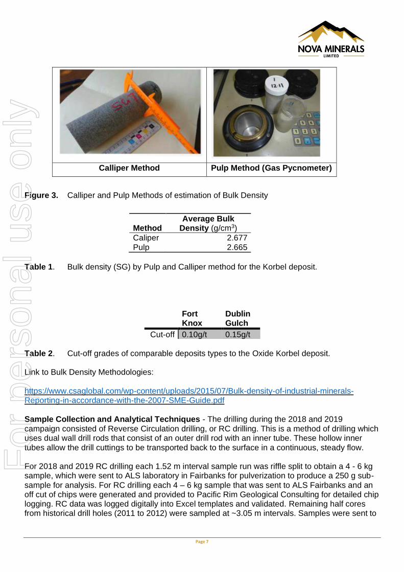
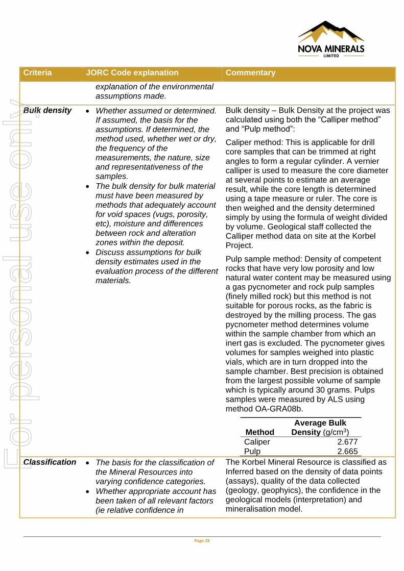
Bulk density – Bulk Density at the project was calculated using both the “Calliper method” and “Pulp method”:
Caliper method: This is applicable for drill core samples that can be trimmed at right angles to form a regular cylinder. A vernier caliper is used to measure the core diameter at several points to estimate an average result, while the core length is determined using a tape measure or ruler (Figure 3). The core is then weighed and the density determined simply by using the formula of weight divided by volume. Geological staff collected the Calliper method data on site at the Korbel Project (Table 1).
Pulp sample method: Density of competent rocks that have very low porosity and low natural water content may be measured using a gas pycnometer and rock pulp samples (finely milled rock) but this method is not suitable for porous rocks, as the fabric is destroyed by the milling process. The gas pycnometer method determines volume within the sample chamber from which an inert gas is excluded. The pycnometer gives volumes for samples weighed into plastic vials (Figure 3), which are in turn dropped into the sample chamber. Best precision is obtained from the largest possible volume of sample which is typically around 30 grams. Pulps samples were measured by ALS using method OA-GRA08b.
For
per
sona
l use
onl
y
Page 7
Calliper Method Pulp Method (Gas Pycnometer)
Figure 3. Calliper and Pulp Methods of estimation of Bulk Density
Method Average Bulk
Density (g/cm3)
Caliper 2.677 Pulp 2.665
Table 1. Bulk density (SG) by Pulp and Calliper method for the Korbel deposit.
Fort Knox
Dublin Gulch
Cut-off 0.10g/t 0.15g/t Table 2. Cut-off grades of comparable deposits types to the Oxide Korbel deposit. Link to Bulk Density Methodologies:
https://www.csaglobal.com/wp-content/uploads/2015/07/Bulk-density-of-industrial-minerals-Reporting-in-accordance-with-the-2007-SME-Guide.pdf
Sample Collection and Analytical Techniques - The drilling during the 2018 and 2019 campaign consisted of Reverse Circulation drilling, or RC drilling. This is a method of drilling which uses dual wall drill rods that consist of an outer drill rod with an inner tube. These hollow inner tubes allow the drill cuttings to be transported back to the surface in a continuous, steady flow. For 2018 and 2019 RC drilling each 1.52 m interval sample run was riffle split to obtain a 4 - 6 kg sample, which were sent to ALS laboratory in Fairbanks for pulverization to produce a 250 g sub-sample for analysis. For RC drilling each 4 – 6 kg sample that was sent to ALS Fairbanks and an off cut of chips were generated and provided to Pacific Rim Geological Consulting for detailed chip logging. RC data was logged digitally into Excel templates and validated. Remaining half cores from historical drill holes (2011 to 2012) were sampled at ~3.05 m intervals. Samples were sent to
For
per
sona
l use
onl
y
Page 8
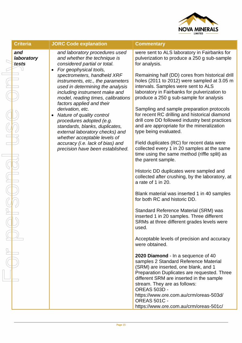
ALS laboratory in Fairbanks for pulverization to produce a 250 g sub-sample for analysis. Sample prep consisted of ALS Prep 31 - Crush to 70% less than 2 mm, riffle split off 250 g, pulverize split to better than 85% passing 75 microns. Sample analysis consisted of ALS Au-ICP21 Fire Assay with 30 g sample charge using ICP-AES finish. Detection Limits range from 0.001 - 10 g/t Au. For sample exceeding the upper detection limit of 10 g/t Au the material was re-run using ALS method Au-GRA21. This Fire Assay technique utilizes a charge size of 30 g and a gravimetric finish. Detection Limits range from 0.05 -10,000 g/t Au. All 2020 core drilling has been oriented core using a Reflex Act III instrument down the entire hole. Downhole surveys are taken 15.24 meters off of the casing and every 45.72 meters down-hole using a Reflex multi-shot instrument. Hole collar surveys are done using a LT500T GNSS receiver unit capable of a horizontal accuracy of 67-85cm and a vertical accuracy of 76-107cm in the far northern hemisphere of Alaska. Surveys are done in the NAD83 datum for X and Y, and the GRS80 datum for vertical location. The core is digitally logged in Excel in detail (geology, alteration, mineralization, RQD, recoveries and structural data). Analysis of 2,431 veins from the oriented core has indicated a consistent, strong preferred orientation of NW-SE striking, steeply dipping sheeted veins. Drill hole orientation for future drill holes are being designed for more optimal intersection angles of the veins. Three (3) meter samples are marked out for the entire length of the drill holes and the core is photographed both wet and dry. Each sample is cut perpendicular to the mineralized sheeted veins producing a representative half-core that is bagged, tagged and packaged for shipment in large rice bags, palletized and sent to ALS laboratory in Fairbanks for analysis. Shipping of samples are highly controlled using dedicated shippers who only handle shipments from the Estelle project. Sample shipping protocol is currently being updated with revised chain of custody tracking and security ties on sample bags for an added level of security. QA/QC Control Sample – In a sequence of 40 samples 2 Standard Reference Material (SRM) are inserted, one blank, and 1 Preparation Duplicates are requested. Three different SRM are inserted in the sample stream. They are as follows:
OREAS 503D - https://www.ore.com.au/crm/oreas-503d/ OREAS 501C - https://www.ore.com.au/crm/oreas-501c/ OREAS 60D - https://www.ore.com.au/crm/oreas-60d/ Blank - Browns Hill Basalt Quarry or Pea Gravel from Alaska Industrial Hardware Chantal Principal Geologist from Qualitica Consulting Inc has reviewed this data and concluded that all the QA/QC data falls within acceptable tolerances for the Inferred level of confidence. Additional check assay programs and re-assay will be conducted on an ongoing basis prior to the release of any future resource studies.
To learn more please visit: https://novaminerals.com.au/estelle-gold/ .
This announcement has been authorised for release by the Board.
- Ends -
For
per
sona
l use
onl
y

Page 9
Further information:
Christopher Gerteisen
CEO and Executive Director
P: +61 3 9537 1238
Ian Pamensky
Company Secretary
P: +61 414 864 746
Competent Person Statements Data Compilation and Project Manager- Mr Dale Schultz P.Geo., Principle of DjS Consulting, who is Nova groups Chief Geologist and COO of Nova Minerals subsidiary Snow Lake Resources Ltd., compiled and evaluated the technical information in this release and is a member of the Association of Professional Engineers and Geoscientists of Saskatchewan (APEGS), which is ROPO, accepted for the purpose of reporting in accordance with ASX listing rules. Mr Schultz has sufficient experience relevant to the style of mineralization and type of deposit under consideration and to the activity that he is undertaking to qualify as a Competent Person as defined in the 2012 edition of the ‘Australian Code for Reporting of Exploration Results, Mineral Resources and Ore Reserves’. Mr Schultz consents to the inclusion in the report of the matters based on information in the form and context in which it appears. QA/QC Checks - QUALITICA CONSULTING INC. provides the mining industry with expert analytical quality control advice and database support, ensuring that you and all stakeholders have confidence in your data. Since 2003, Qualitica has been providing quality control services to mineral exploration and mining operation clients throughout North America and abroad. Our comprehensive range of services include database auditing, analysis and reporting of quality control data, site-specific quality control training program, NI 43-101 reporting for sampling and analytical quality control. Chantal is a Principal Geologist from Qualitica has been retained my Nova Minerals. She specializes in all aspect of quality assurance and quality control in the context of mine geology and exploration, including generation of site-specific certified reference materials, metallurgical testing, laboratory audit, ore pre-concentration and ore sorting/blending to optimize grade. Proficient in Datamine Fusion Suite and acQuire suite of software for managing geological and analytical databases. She has authored a series of site-specific Best Practices Documents from diamond drilling and logging to analytical quality control. Chantal has reviewed SRM, Blank, and Duplicates and found 98% of the data falls within acceptable tolerances. She has recommended additional re-assay of selective samples and sending 5% of the total sample sets for External Laboratory Check Assays. Resource Estimation - The information in this press release that relates to the Mineral Resources is based on information compiled and reviewed by Mr Nicolas Johnson, who is a Member of the Australian Institute of Geoscientists and a full-time employee of MPR Geological Consultants Pty Ltd (MPR). Mr Johnson has sufficient experience that is relevant to the style of mineralisation and type of deposit under consideration and to the activity that he has undertaken to be a Competent Person as defined in the JORC Code (2012). He has no economic, financial or pecuniary interest in the Company and consents to the inclusion in this report of the matters based on his information in the form and context in which it appears.
For
per
sona
l use
onl
y

Page 10
Core Logging - William J. Burnett, MSc, CPG-11263 has over 25 years of experience in operations and exploration, mine and project management. He has worked in both surface and underground mines and held positions including General Mine Manager, Exploration Manager, Chief Geologist, Mine Engineer and geologist. In 2009, Mr. Burnett started a consulting company called Yukuskokon Professional Services, LLC. (YKPS). YKPS had since grown into a full-service exploration company providing project management, environmental permitting, logistics, core drilling support and drill pad construction, core drilling, geological, engineering and metallurgical support for exploration and mining projects. Yukuskokon owns and operates track mounted and fly core drills with locations in Alaska, Nevada and Oregon. During his time operating Yukuskokon Professional Services, he has worked on various projects (from mining to environmental) in Alaska, Mexico and Nova Scotia. In addition to his duties at Yukuskokon, Mr. Burnett also serves as Director and CFO for Intercept Minerals Corp. and serves on the University of Alaska Anchorage Geological Advisory Board. Mr. Burnett is a member of the American Institute of Professional Geologists. He has a Master of Science degree in Economic Geology from Colorado State University, and a Bachelor of Science degree in Geology from Fort Lewis College. Cautionary Note Regarding Forward-Looking Statements This news release contains “forward-looking information” within the meaning of applicable securities laws. Generally, any statements that are not historical facts may contain forward-looking information, and forward looking information can be identified by the use of forward-looking terminology such as “plans”, “expects” or “does not expect”, “is expected”, “budget” “scheduled”, “estimates”, “forecasts”, “intends”, “anticipates” or “does not anticipate”, or “believes”, or variations of such words and phrases or indicates that certain actions, events or results “may”, “could”, “would”, “might” or “will be” taken, “occur” or “be achieved.” Forward-looking information is based on certain factors and assumptions management believes to be reasonable at the time such statements are made, including but not limited to, continued exploration activities, Gold and other metal prices, the estimation of initial and sustaining capital requirements, the estimation of labour costs, the estimation of mineral reserves and resources, assumptions with respect to currency fluctuations, the timing and amount of future exploration and development expenditures, receipt of required regulatory approvals, the availability of necessary financing for the Project, permitting and such other assumptions and factors as set out herein. apparent inconsistencies in the figures shown in the MRE are due to rounding Forward-looking information is subject to known and unknown risks, uncertainties and other factors that may cause the actual results, level of activity, performance or achievements of the Company to be materially different from those expressed or implied by such forward-looking information, including but not limited to: risks related to changes in Gold prices; sources and cost of power and water for the Project; the estimation of initial capital requirements; the lack of historical operations; the estimation of labour costs; general global markets and economic conditions; risks associated with exploration of mineral deposits; the estimation of initial targeted mineral resource tonnage and
For
per
sona
l use
onl
y
Page 11
grade for the Project; risks associated with uninsurable risks arising during the course of exploration; risks associated with currency fluctuations; environmental risks; competition faced in securing experienced personnel; access to adequate infrastructure to support exploration activities; risks associated with changes in the mining regulatory regime governing the Company and the Project; completion of the environmental assessment process; risks related to regulatory and permitting delays; risks related to potential conflicts of interest; the reliance on key personnel; financing, capitalisation and liquidity risks including the risk that the financing necessary to fund continued exploration and development activities at the Project may not be available on satisfactory terms, or at all; the risk of potential dilution through the issuance of additional common shares of the Company; the risk of litigation. Although the Company has attempted to identify important factors that cause results not to be as
anticipated, estimated or intended, there can be no assurance that such forward-looking information
will prove to be accurate, as actual results and future events could differ materially from those
anticipated in such information. Accordingly, readers should not place undue reliance on forward-
looking information. Forward looking information is made as of the date of this announcement and
the Company does not undertake to update or revise any forward-looking information this is included
herein, except in accordance with applicable securities laws.
Appendix 1. The following table 1 is provided to ensure compliance with the JORC Code (2012) requirements for the reporting of the exploration results for the Estelle Gold Project – Alaska JORC Code, 2012 Edition – Table The following table is provided to ensure compliance with the JORC Code (2012 Edition) for the reporting of Exploration Results
Section 1 Sampling Techniques and Data
(Criteria in this section apply to all succeeding sections.)
Criteria JORC Code explanation Commentary
Sampling techniques
• Nature and quality of sampling (e.g. cut channels, random chips, or specific specialised industry standard measurement tools appropriate to the minerals under investigation, such as down hole gamma sondes, or handheld XRF instruments, etc.). These examples should not be taken as limiting the broad meaning of sampling.
• Include reference to measures taken to ensure sample representivity and the appropriate calibration of any measurement tools or systems used.
The mineral resource estimate is based on a combination of recent sampling data collected from reverse circulation (RC) drilling resampling and historical diamond drill (DD) core. For recent (2018 and 2019) RC drilling each 1.52 m interval was riffle split to obtain a 4-6 kg sample, which were sent to ALS laboratory in Fairbanks for pulverization to produce a 250 g sub-sample for analysis. Remaining half (DD) cores from historical drill holes (2011 to 2012) were sampled at 3.05 m intervals. Samples were sent to ALS
For
per
sona
l use
onl
y

Page 12
Criteria JORC Code explanation Commentary
• Aspects of the determination of mineralisation that are Material to the Public Report.
• In cases where ‘industry standard’ work has been done this would be relatively simple (e.g. ‘reverse circulation drilling was used to obtain 1 m samples from which 3 kg was pulverised to produce a 30 g charge for fire assay’). In other cases more explanation may be required, such as where there is coarse gold that has inherent sampling problems. Unusual commodities or mineralisation types (e.g. submarine nodules) may warrant disclosure of detailed information.
laboratory in Fairbanks for pulverization to produce a 250 g sub-sample for analysis Sampling and sample preparation protocols for recent RC drilling and historical diamond drill core DD followed industry best practices and are appropriate for the mineralization type being evaluated. 2020 Diamond Drilling - Sampling is completed on sawn half HQ core. Sampling is based along lithological contacts and is sampled at 3-meter (10 ft.) intervals (run block to run block).
Drilling techniques
• Drill type (e.g. core, reverse circulation, open-hole hammer, rotary air blast, auger, Bangka, sonic, etc.) and details (e.g. core diameter, triple or standard tube, depth of diamond tails, face-sampling bit or other type, whether core is oriented and if so, by what method)
Drill types used included recent RC (NQ size) and historic DD (NQ size). Recent Drilling in 2019 consisted of Reverse Circulation drilling, or RC drilling. This is a method of drilling which uses dual wall drill rods that consist of an outer drill rod with an inner tube. These hollow inner tubes allow the drill cuttings to be transported back to the surface in a continuous, steady flow. 2020 Diamond Drilling - Diamond HQ core drilling · Drilling oriented core using Reflex Act III, orientation taken at every run except for when encountering incompetent rock (i.e. structures)
Drill sample recovery
• Method of recording and assessing core and chip sample recoveries and results assessed.
• Measures taken to maximise sample recovery and ensure representative nature of the samples.
• Whether a relationship exists between sample recovery and
Recovery data is typically not recorded for RC drilling. No recovery data was available for the historic DD. 2020 Diamond Drilling - Core loggers measure and record percentage core recovery as well as percentage RQD. All measurements recorded in imperial and
For
per
sona
l use
onl
y

Page 13
Criteria JORC Code explanation Commentary
grade and whether sample bias may have occurred due to preferential loss/gain of fine/coarse material.
converted to metric during QA/QC. · Drillers are responsible for recording mislatches, and dropped core which can result in loss of core. All recovery measurements are recorded in a digital core log in excel. Overall excellent core recoveries reported, with loss being in areas related to post-mineral structures, especially shears
Logging • Whether core and chip samples have been geologically and geotechnically logged to a level of detail to support appropriate Mineral Resource estimation, mining studies and metallurgical studies.
• Whether logging is qualitative or quantitative in nature. Core (or costean, channel, etc.) photography.
• The total length and percentage of the relevant intersections logged.
Hole SE11-001, SE12-002, SE-12-004 are historic drill holes that are included in the Inferred Resource Study. These holes where located on the property and GPS using a Montana 650 Garmin and re-sampled as part of our 2019 program. For re-sampling all SE series of holes interval data was collected for each hole along with geological logging information and all core boxes were photo graphed for verification purposes. See example of core photos below.
RC chip sample intervals were recorded in the field on a logging template form. 100% of the chip samples were sent to ALS Fairbanks and off-cut chips were submitted to Pacific Rim Geological Consulting for detailed geological logging. These data have been compiled digitally.
A total of 823 samples of RC Chips were used to support the Inferred Resource. A total of 285 historic drill core samples were used to support the Inferred Recourse. Therefore 75% of the Resources is supported but RC and 25% by historic drill core.
2020 Diamond Drilling - Whole HQ core is logged in a qualitatively and quantitatively
For
per
sona
l use
onl
y

Page 14
Criteria JORC Code explanation Commentary
manner and recorded into a running Excel spreadsheet: · Major units and samples follow lithological changes
Primary, secondary, and tertiary alteration types and intensity · Mineralization type (arsenopyrite, pyrite, and chalcopyrite), percentage mineralization, and texture · Structures including veins, faults, and shears. Orientation recorded (alpha/beta)
Core boxes are labelled for core photos and efficient storage
Density is measured using 10cm core at 15.24 meters (50 ft) and then every 45.72 (150 ft) The entire length of the drill core is logged including geology, RQD, oriented core data/structural data
Sub-sampling techniques and sample preparation
• If core, whether cut or sawn and whether quarter, half or all core taken.
• If non-core, whether riffled, tube sampled, rotary split, etc. and whether sampled wet or dry.
• For all sample types, the nature, quality and appropriateness of the sample preparation technique.
• Quality control procedures adopted for all sub-sampling stages to maximise representivity of samples.
• Measures taken to ensure that the sampling is representative of the in situ material collected, including for instance results for field duplicate/second-half sampling.
• Whether sample sizes are appropriate to the grain size of the material being sampled.
Each 1.52 m RC interval was riffle split (dry) to obtain a 4-6 kg sample, which was sent to the ALS laboratory for pulverization. Field duplicates (RC) for recent data were collected every 1 in 20 samples at the same time using the same method (riffle split) as the parent sample. Historic DD duplicates were sampled and collected after crushing, by the laboratory, at a rate of 1 in 20. Blank material was inserted 1 in 40 samples for both RC and historic DD. Standard Reference Material (SRM) was inserted 1 in 20 samples. Three different SRMs at three different grades levels were used. 2020 Diamond Drilling - HQ core is cut using an electric saw into half core, with cut lines perpendicular to the orientation of the veins.
Quality of assay data
• The nature, quality and appropriateness of the assaying
2018 and 2019 RC -Each 1.52 m interval was riffle split to obtain a 4-6 kg sample, which
For
per
sona
l use
onl
y
Page 15
Criteria JORC Code explanation Commentary
and laboratory tests
and laboratory procedures used and whether the technique is considered partial or total.
• For geophysical tools, spectrometers, handheld XRF instruments, etc., the parameters used in determining the analysis including instrument make and model, reading times, calibrations factors applied and their derivation, etc.
• Nature of quality control procedures adopted (e.g. standards, blanks, duplicates, external laboratory checks) and whether acceptable levels of accuracy (i.e. lack of bias) and precision have been established.
were sent to ALS laboratory in Fairbanks for pulverization to produce a 250 g sub-sample for analysis. Remaining half (DD) cores from historical drill holes (2011 to 2012) were sampled at 3.05 m intervals. Samples were sent to ALS laboratory in Fairbanks for pulverization to produce a 250 g sub-sample for analysis Sampling and sample preparation protocols for recent RC drilling and historical diamond drill core DD followed industry best practices and are appropriate for the mineralization type being evaluated. Field duplicates (RC) for recent data were collected every 1 in 20 samples at the same time using the same method (riffle split) as the parent sample. Historic DD duplicates were sampled and collected after crushing, by the laboratory, at a rate of 1 in 20. Blank material was inserted 1 in 40 samples for both RC and historic DD. Standard Reference Material (SRM) was inserted 1 in 20 samples. Three different SRMs at three different grades levels were used. Acceptable levels of precision and accuracy were obtained. 2020 Diamond - In a sequence of 40 samples 2 Standard Reference Material (SRM) are inserted, one blank, and 1 Preparation Duplicates are requested. Three different SRM are inserted in the sample stream. They are as follows: OREAS 503D - https://www.ore.com.au/crm/oreas-503d/ OREAS 501C - https://www.ore.com.au/crm/oreas-501c/
For
per
sona
l use
onl
y

Page 16
Criteria JORC Code explanation Commentary
OREAS 60D - https://www.ore.com.au/crm/oreas-60d/ Blank - Browns Hill Basalt Quarry or Pea Gravel from Alaska Industrial Hardware Chantal Principal Geologist from Qualitica Consulting Inc has reviewed this data and concluded that all the QA/QC data falls within acceptable tolerances for the Inferred level of confidence. Additional check assay programs and re-assay will be conducted on an ongoing basis prior to the release of any future resource studies. All Samples were sent to ALS laboratory in Fairbanks for pulverization to produce a 250 g sub-sample for analysis. Sample prep consisted of ALS Prep 31 - Crush to 70% less than 2 mm, riffle split off 250 g, pulverize split to better than 85% passing 75 microns. Sample analysis consisted of ALS Au-ICP21 Fire Assay with 30 g sample charge using ICP-AES finish. Detection Limits range from 0.001 - 10 g/t Au. For sample exceeding the upper detection limit of 10 g/t Au the material was re-run using ALS method Au-GRA21. This Fire Assay technique utilizes a charge size of 30 g and a gravimetric finish. Detection Limits range from 0.05 -10,000 g/t Au.
Verification of sampling and assaying
• The verification of significant intersections by either independent or alternative company personnel.
• The use of twinned holes.
• Documentation of primary data, data entry procedures, data verification, data storage (physical and electronic) protocols.
• Discuss any adjustment to assay data.
The verification of significant intersections has been completed by company personnel and the competent persons. No drill holes within the resource were twinned. For RC drilling each 1.52 m sample was sent to ALS Fairbanks and an off cut of chips were generated form each 1.52 metre and provided to Pacific Rim Geological Consulting for detailed chip logging. RC data was logged digitally into Excel templates and validated.
For
per
sona
l use
onl
y
Page 17
Criteria JORC Code explanation Commentary
Historic DD sample intervals were logged onto paper and subsequently entered into excel spreadsheets. Photos were taken of each core box. Recent Assay files are received from the laboratory in CSV format and these files were made available to the Deposit Modeler. No historic DD logs or assay data was available. All the available data was made available to the deposit modeler. There were no adjustments to assay data. Cut core prepped samples are dispatched to: ALS Minerals 1060 Bush St. Fairbanks, AK 99709 · Data is recorded and stored in Excel on a running spreadsheet · Data is backed up additionally on a removable drive
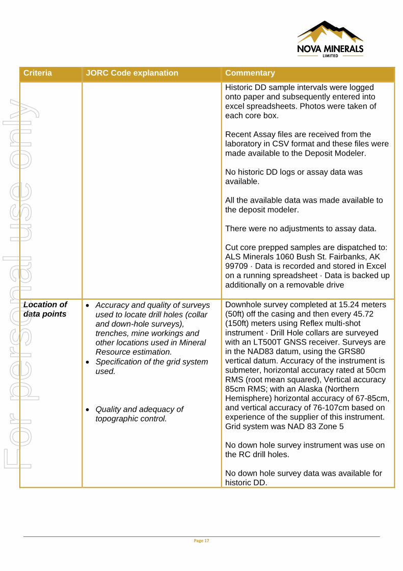
Location of data points
• Accuracy and quality of surveys used to locate drill holes (collar and down-hole surveys), trenches, mine workings and other locations used in Mineral Resource estimation.
• Specification of the grid system used.
• Quality and adequacy of topographic control.
Downhole survey completed at 15.24 meters (50ft) off the casing and then every 45.72 (150ft) meters using Reflex multi-shot instrument · Drill Hole collars are surveyed with an LT500T GNSS receiver. Surveys are in the NAD83 datum, using the GRS80 vertical datum. Accuracy of the instrument is submeter, horizontal accuracy rated at 50cm RMS (root mean squared), Vertical accuracy 85cm RMS; with an Alaska (Northern Hemisphere) horizontal accuracy of 67-85cm, and vertical accuracy of 76-107cm based on experience of the supplier of this instrument. Grid system was NAD 83 Zone 5 No down hole survey instrument was use on the RC drill holes. No down hole survey data was available for historic DD.
For
per
sona
l use
onl
y

Page 18
Criteria JORC Code explanation Commentary
Data spacing and distribution
• Data spacing for reporting of Exploration Results.
• Whether the data-spacing and distribution is sufficient to establish the degree of geological and grade continuity appropriate for the Mineral Resource and Ore Reserve estimation procedure(s) and classifications applied.
• Whether sample compositing has been applied.
The drill hole spacing is sufficient to demonstrate geological and grade continuity appropriate for the Mineral Resource
The drill spacing applied to each deposit is considered suitable for the style of mineralisation and mineral resource estimation requirements.
Orientation of data in relation to geological structure
• Whether the orientation of sampling achieves unbiased sampling of possible structures and the extent to which this is known, considering the deposit type.
• If the relationship between the drilling orientation and the orientation of key mineralised structures is considered to have introduced a sampling bias, this should be assessed and reported if material.
Drill holes were drilled predominantly perpendicular to mineralized domains where possible. No orientation based sampling bias has been identified in the data. Relationship between drilling orientation and the orientation to mineralized zones in currently being investigated
Sample security
• The measures taken to ensure sample security.
Nova Minerals personnel managed the sample chain of custody. Both RC and historic DD core samples were securely stored on site prior to being dispatched to the ALS Fairbanks laboratory for assay analysis. Chain of custody form, security tags, currently updating sample security protocol Dispatch sheets were used to document sample numbers through the delivery process. ALS maintains a Webtrieve application to confirm and monitor samples and jobs within the laboratory process.
Audits or reviews
• The results of any audits or reviews of sampling techniques and data.
External review confirms sampling protocols are within industry best practices for RC drilling and for re-sampling of historic DD.
For
per
sona
l use
onl
y
Page 19
Section 2 Reporting of Exploration Results
(Criteria listed in the preceding section also apply to this section.)
Criteria JORC Code explanation Commentary
Mineral tenement and land tenure status
• Type, reference name/number, location and ownership including agreements or material issues with third parties such as joint ventures, partnerships, overriding royalties, native title interests, historical sites, wilderness or national park and environmental settings.
• The security of the tenure held at the time of reporting along with any known impediments to obtaining a licence to operate in the area.
The Estelle project is comprised of one hundred and eighty Six (186) State of Alaska mining claims consisting of one hundred and eighty two (182) x 160 acres per claim and four (4) x 40 acres per claim for a total or 29,280 acres (118.5km2) for the entire claim group. The mining claims are wholly owned by AKCM (AUST) Pty Ltd. (an incorporated Joint venture (JV Company between Nova Minerals Ltd and AK Minerals Pty Ltd) via 100% ownership of Alaskan incorporate company AK Custom Mining LLC. AKCM (AUST) Pty Ltd is owned 51% by Nova Minerals Ltd 49% by AK Minerals Pty Ltd. Nova owns 51% of the project and has the right to earn up to 85% of the project through the joint venture agreement. There are no native title interests in or over any of the claims and they are not located within any environmentally sensitive areas including National Parks, Conservation Reserves or Wilderness areas. The Company is not aware of any other impediments that would prevent an exploration or mining activity.
Exploration done by other parties
• Acknowledgment and appraisal of exploration by other parties.
The Estelle prospect has undergone both surface and sub-surface exploration intermittently since the 1970’s. The latest exploration was conducted between 2011 and 2014 which was previously reported by Nova Minerals Limited (formally Quantum Resources).
Geology • Deposit type, geological setting and style of mineralisation.
The Oxide deposit is classified as a Reduced Intrusion-Related Gold Deposit (RIRG) type. RIRG deposits typically occur associated with moderately reduced intrusions in reduced siliciclastic Sequences. Key characteristics of
For
per
sona
l use
onl
y

Page 20
Criteria JORC Code explanation Commentary
these deposits include low sulfide content with associated with reduced mineral and metal assemblages of Au>Ag, Bi, As, W, and Mo. The mineralization occurs in multiphase granitic stocks and plutons. Gold is hosted in sheeted veins, which are coeval with their causative intrusions. Although these deposits do not have a significant hydrothermal alteration footprint, there are often peripheral mineralization occurrences and proximal thermal alteration, which have a predictable distribution pattern, including secondary aluminosilicates, biotite, and tourmaline, skarns and polymetallic veins.
Drill hole Information
• A summary of all information material to the understanding of the exploration results including a tabulation of the following information for all Material drill holes: o easting and northing of the drill
hole collar o elevation or RL (Reduced
Level – elevation above sea level in metres) of the drill hole collar
o dip and azimuth of the hole o down hole length and
interception depth o hole length.
• If the exclusion of this information is justified on the basis that the information is not Material and this exclusion does not detract from the understanding of the report, the Competent Person should clearly explain why this is the case.
Drilling information used used for the estimation of mineral resources included the following: Location data including Easting, Northing and RL of drill hole collars recorded in NAD 83 Zone 5. Drill Hole Azimuth is the 360o bearing of the hole orientation. Drill Hole Dip is the inclination of the drill hole from horizontal. Down Hole Length is the distance down the inclination of the hole and is measured as the distance from the collar to the end of hole. Intercept Depth is the distance from the start of the hole down the inclination of the hole to the depth of the zone of interest. The listing of the entire drill hole database used to estimate the mineral resource was not considered relevant for this release.
Data aggregation methods
• In reporting Exploration Results, weighting averaging techniques, maximum and/or minimum grade truncations (eg cutting of high
Reported intercepts quoted in the report are length weighted.
For
per
sona
l use
onl
y

Page 21
Criteria JORC Code explanation Commentary
grades) and cut-off grades are usually Material and should be stated.
• Where aggregate intercepts incorporate short lengths of high-grade results and longer lengths of low grade results, the procedure used for such aggregation should be stated and some typical examples of such aggregations should be shown in detail.
• The assumptions used for any reporting of metal equivalent values should be clearly stated.
No maximum grade truncations or top cuts were applied. cut-off grade of 0.18g/t Au were applied to the Mineral Resource Estimate. Metal equivalent values are not used in reporting.
Relationship between mineralisation widths and intercept lengths
• These relationships are particularly important in the reporting of Exploration Results.
• If the geometry of the mineralisation with respect to the drill hole angle is known, its nature should be reported.
• If it is not known and only the down hole lengths are reported, there should be a clear statement to this effect (eg ‘down hole length, true width not known’).
Zones of mineralisation are based on interpreted geology recorded in drilling logs coupled with gold grades. Reporting of mineralised intercepts, widths and grades are deemed acceptable by the Competent Persons. Drill holes were orientated to intersect mineralisation at a perpendicular angle.
Diagrams • Appropriate maps and sections (with scales) and tabulations of intercepts should be included for any significant discovery being reported These should include, but not be limited to a plan view of drill hole collar locations and appropriate sectional views.
Appropriate figures are provided in the ASX release and depict the key results from the Resource Estimate.
Balanced reporting
• Where comprehensive reporting of all Exploration Results is not practicable, representative reporting of both low and high grades and/or widths should be practiced to avoid misleading reporting of Exploration Results.
Not Applicable (NA) – no drilling or sampling is being reported.
Other substantive
• Other exploration data, if meaningful and material, should be reported including (but not
Geological consultants completed geological mapping within the prospect area in the past.
For
per
sona
l use
onl
y

Page 22
Criteria JORC Code explanation Commentary
exploration data
limited to): geological observations; geophysical survey results; geochemical survey results; bulk samples – size and method of treatment; metallurgical test results; bulk density, groundwater, geotechnical and rock characteristics; potential deleterious or contaminating substances.
Rock chip and channel samples collected during reconnaissance are reported and tabularised in full and locations plotted on generated maps in this report. Major geological observations have been reported.
Further work • The nature and scale of planned further work (eg tests for lateral extensions or depth extensions or large-scale step-out drilling).
• Diagrams clearly highlighting the areas of possible extensions, including the main geological interpretations and future drilling areas, provided this information is not commercially sensitive.
Nova is in the process of planning future exploration and drilling activities. Additional areas require follow-up work in future drill program.
Section 3 Estimation and Reporting of Mineral Resources
(Criteria listed in section 1, and where relevant in section 2, also apply to this section.)
Criteria JORC Code explanation Commentary
Database integrity
• Measures taken to ensure that data has not been corrupted by, for example, transcription or keying errors, between its initial collection and its use for Mineral Resource estimation purposes.
• Data validation procedures used.
Field data is compiled into Excel spreadsheets. Assay data CSV files are downloaded directly from the ALS Webtrieve server. Various software tools are used to validate the data and all errors were corrected before loading of data into the block model. The following basic validation checks on the data were completed:
• Sample inventory checks, shipped verses received
• Visual digital data checked against original hard copies
• overlapping sample intervals.
• Sample intervals with no assay data.
• Duplicate records.
• Assay grade ranges.
• Collar coordinates ranges.
• Valid hole orientation data. There are no significant issues with the data.
For
per
sona
l use
onl
y
Page 23
Criteria JORC Code explanation Commentary
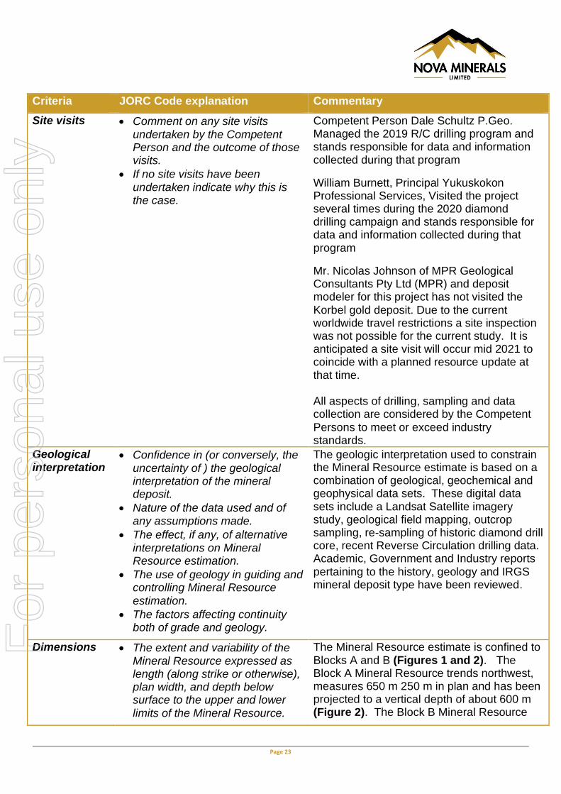
Site visits • Comment on any site visits undertaken by the Competent Person and the outcome of those visits.
• If no site visits have been undertaken indicate why this is the case.
Competent Person Dale Schultz P.Geo. Managed the 2019 R/C drilling program and stands responsible for data and information collected during that program
William Burnett, Principal Yukuskokon Professional Services, Visited the project several times during the 2020 diamond drilling campaign and stands responsible for data and information collected during that program
Mr. Nicolas Johnson of MPR Geological Consultants Pty Ltd (MPR) and deposit modeler for this project has not visited the Korbel gold deposit. Due to the current worldwide travel restrictions a site inspection was not possible for the current study. It is anticipated a site visit will occur mid 2021 to coincide with a planned resource update at that time. All aspects of drilling, sampling and data collection are considered by the Competent Persons to meet or exceed industry standards.
Geological interpretation
• Confidence in (or conversely, the uncertainty of ) the geological interpretation of the mineral deposit.
• Nature of the data used and of any assumptions made.
• The effect, if any, of alternative interpretations on Mineral Resource estimation.
• The use of geology in guiding and controlling Mineral Resource estimation.
• The factors affecting continuity both of grade and geology.
The geologic interpretation used to constrain the Mineral Resource estimate is based on a combination of geological, geochemical and geophysical data sets. These digital data sets include a Landsat Satellite imagery study, geological field mapping, outcrop sampling, re-sampling of historic diamond drill core, recent Reverse Circulation drilling data. Academic, Government and Industry reports pertaining to the history, geology and IRGS mineral deposit type have been reviewed.
Dimensions • The extent and variability of the Mineral Resource expressed as length (along strike or otherwise), plan width, and depth below surface to the upper and lower limits of the Mineral Resource.
The Mineral Resource estimate is confined to Blocks A and B (Figures 1 and 2). The Block A Mineral Resource trends northwest, measures 650 m 250 m in plan and has been projected to a vertical depth of about 600 m (Figure 2). The Block B Mineral Resource
For
per
sona
l use
onl
y

Page 24
Criteria JORC Code explanation Commentary
measures 500 m 300 m in plan and has been projected to a maximum depth of about 300 m below surface (Figure 2). Resource Blocks A and B are interpreted to be part of the same hydrothermal system and likely off-set by the Valley Fault (Figures 1 and 2).
Estimation and modelling techniques
• The nature and appropriateness of the estimation technique(s) applied and key assumptions, including treatment of extreme grade values, domaining, interpolation parameters and maximum distance of extrapolation from data points. If a computer assisted estimation method was chosen include a description of computer software and parameters used.
• The availability of check estimates, previous estimates and/or mine production records and whether the Mineral Resource estimate takes appropriate account of such data.
• The assumptions made regarding recovery of by-products.
• Estimation of deleterious elements or other non-grade variables of economic significance (eg sulphur for acid mine drainage characterisation).
• In the case of block model interpolation, the block size in relation to the average sample spacing and the search employed.
• Any assumptions behind modelling of selective mining units.
• Any assumptions about correlation between variables.
• Description of how the geological interpretation was used to control the resource estimates.
• Discussion of basis for using or
Mineral resources were estimated by Multiple Indicator Kriging (MIK) with block support adjustment. The modelling included a broad mineralised domain capturing drill hole intercepts of greater than 0.01 g/t. Grade continuity characterised by indicator variograms modelled at 14 indicator thresholds. All class grades were derived from class mean grades, with the exception of the upper bin grade, which was derived from the bin median, The modelling used a three-pass octant based search strategy giving estimates extrapolated to a maximum of 200m from composite locations. Estimated resources include a variance adjustment to give estimates of recoverable resources for selective mining unit dimensions of 10 m east by 10 m north by 5 m in elevation. The variance adjustments were applied using the direct lognormal method. Data viewing, compositing and wire-framing was performed using Micromine software. Exploratory data analysis, variogram analysis and modelling, and Mineral Resource estimation utilsed FSSI Consultants (Australia) Pty Ltd (FSSI) GS3M software. The modelling technique is appropriate for the mineralisation style, and potential mining method. Resulting Mineral Resource estimates were compared with the previous estimate performed by Nova. For the same area covered by Nova, the MPR estimate statistics
For
per
sona
l use
onl
y

Page 25
Criteria JORC Code explanation Commentary
not using grade cutting or capping.
• The process of validation, the checking process used, the comparison of model data to drill hole data, and use of reconciliation data if available.
and results are 7% lower for grade, 60% more tonnes and 30% more ounces at the cut-off grade. MPR’s estimate has the benefit of additional drilling and covers a larger area accounting for the global variances. There is no assumption made regarding the recovery of any by-product. No deleterious elements or other non-grade variables of economic significance are estimated in the current study. Block dimensions used were 50 mE by 50 mN by 10 mRL and chosen due to the current broad spacing of the drill holes. The modelling includes a three pass octant search strategy with search ellipsoids aligned with the average domain orientations. Search radii and minimum data requirements are: Search 1: 100 by 100 by 25 m (16 data), Search 2: 200 by 200 by 50 m (16 data), Search 3: 200 by 200 by 50 m (8 data).
Estimated resources include a variance adjustment to give estimates of recoverable resources for selective mining unit dimensions of 10 m east by 10 m north by 5 m in elevation with grade control sampling on an 10 m by 20 m by 3 m pattern. The variance adjustments were applied using the direct lognormal method.
The modelling did not include any specific assumptions about correlation between variables.
Interpretation of the mineralised domain used for resource modelling included reference to geological logging, and the domain is consistent with geological understanding.
Statistical analysis showed the gold population in the mineralized domain to be highly skewed and moderately high coefficient of variation. All class grades were derived from class mean grades, with the exception of upper bin
For
per
sona
l use
onl
y

Page 26
Criteria JORC Code explanation Commentary
grade, which is derived from bin median to reduce the impact of a small number of outlier composites on the estimated resource grade. Model validation included visual comparison of model estimates and composite grades
Moisture • Whether the tonnages are estimated on a dry basis or with natural moisture, and the method of determination of the moisture content.
All tonnages are estimated on a dry basis.
Cut-off parameters
• The basis of the adopted cut-off grade(s) or quality parameters applied.
The Mineral Resource has been reported at a 0.18 g/t Au grade cut-off for the Oxide Korbel deposit. This cut-off was chosen using current economic parameters applicable for open cut mining for similar deposit types.
Mining factors or assumptions
• Assumptions made regarding possible mining methods, minimum mining dimensions and internal (or, if applicable, external) mining dilution. It is always necessary as part of the process of determining reasonable prospects for eventual economic extraction to consider potential mining methods, but the assumptions made regarding mining methods and parameters when estimating Mineral Resources may not always be rigorous. Where this is the case, this should be reported with an explanation of the basis of the mining assumptions made.
The only mining method envisaged for the extraction of gold from the Koebel deposit is anticipated to involve large-scale. open pit, truck and shovel mining methods. Grade control of mining blocks will be based on sampling from high quality reverse circulation drilling blast holes.
Estimated resources include a variance adjustment to give estimates of recoverable resources for selective mining unit dimensions of 10 m east by 10 m north by 5 m in elevation with grade control sampling on an 10 by 20 by 3 m pattern. The variance adjustments were applied using the direct lognormal method.
Metallurgical factors or assumptions
• The basis for assumptions or predictions regarding metallurgical amenability. It is always necessary as part of the process of determining reasonable prospects for eventual economic extraction to consider potential metallurgical methods, but the assumptions regarding metallurgical treatment
A total of 25 drill samples were collected for gold cyanidation (AuCN) analysis at ALS assay laboratory. These drill sample rejects were analysed for total gold by fire assay method (AuFA). Indicative leach recoveries were calculated using the AuCN / AuFA ratio. To provide a check, increase confidence in the results and determine the most suitable analytical method, two separate AuCN analyses were performed on each of the
For
per
sona
l use
onl
y

Page 27
Criteria JORC Code explanation Commentary
processes and parameters made when reporting Mineral Resources may not always be rigorous. Where this is the case, this should be reported with an explanation of the basis of the metallurgical assumptions made.
samples. The first AuCN analysis was by ALS method AA13, a basic tube leach test utilizing a 30g sample size with a <2 hour leach time, AAS finish. The second AuCN analysis was by ALS method AA14, a more representative bottle roll leach test utilizing a 1kg sample size with a 12 hour leach time, AAS finish. As expected, the 12 hour bottle roll test showed significantly increased recoveries across the board, establishing a clear positive correlation between leach retention time and recovery. Furthermore, the 12 hour bottle roll result provides the most representative data to date reflecting how the Korbel Gold Deposit mineralized material will perform in any future heap leach mining operation scenario. As such, the company views these results as a very encouraging component in the technical matrix which continues to build in support of the economic viability of the Estelle Gold Project.
Table 1. Summary of Results*
Environmen-tal factors or assumptions
• Assumptions made regarding possible waste and process residue disposal options. It is always necessary as part of the process of determining reasonable prospects for eventual economic extraction to consider the potential environmental impacts of the mining and processing operation. While at this stage the determination of potential environmental impacts, particularly for a greenfields project, may not always be well advanced, the status of early consideration of these potential environmental impacts should be reported. Where these aspects have not been considered this should be reported with an
At this stage it is premature to detail the potential environmental impacts of a large-scale open pit mining operation and environmental factors were not considered in detail. It is assumed that the Oxide Korbel would have camp, milling, processing, waste rock and tailings disposal facilities constructed on site. Power and road access would also likely be required. Processing operations may utilise a dry stacked tailings storage facility which combines a waste landform with filtered tailings in a lined facility and subsequently covered by mine waste material. Subaqueous settlement beneath a pit lake (water cover) may be used to prevent the oxidation of tailings.
For
per
sona
l use
onl
y
Page 28
Criteria JORC Code explanation Commentary
explanation of the environmental assumptions made.
Bulk density • Whether assumed or determined. If assumed, the basis for the assumptions. If determined, the method used, whether wet or dry, the frequency of the measurements, the nature, size and representativeness of the samples.
• The bulk density for bulk material must have been measured by methods that adequately account for void spaces (vugs, porosity, etc), moisture and differences between rock and alteration zones within the deposit.
• Discuss assumptions for bulk density estimates used in the evaluation process of the different materials.
Bulk density – Bulk Density at the project was calculated using both the “Calliper method” and “Pulp method”:
Caliper method: This is applicable for drill core samples that can be trimmed at right angles to form a regular cylinder. A vernier calliper is used to measure the core diameter at several points to estimate an average result, while the core length is determined using a tape measure or ruler. The core is then weighed and the density determined simply by using the formula of weight divided by volume. Geological staff collected the Calliper method data on site at the Korbel Project.
Pulp sample method: Density of competent rocks that have very low porosity and low natural water content may be measured using a gas pycnometer and rock pulp samples (finely milled rock) but this method is not suitable for porous rocks, as the fabric is destroyed by the milling process. The gas pycnometer method determines volume within the sample chamber from which an inert gas is excluded. The pycnometer gives volumes for samples weighed into plastic vials, which are in turn dropped into the sample chamber. Best precision is obtained from the largest possible volume of sample which is typically around 30 grams. Pulps samples were measured by ALS using method OA-GRA08b.
Method Average Bulk
Density (g/cm3)
Caliper 2.677 Pulp 2.665
Classification • The basis for the classification of the Mineral Resources into varying confidence categories.
• Whether appropriate account has been taken of all relevant factors (ie relative confidence in
The Korbel Mineral Resource is classified as Inferred based on the density of data points (assays), quality of the data collected (geology, geophyics), the confidence in the geological models (interpretation) and mineralisation model.
For
per
sona
l use
onl
y

Page 29
Criteria JORC Code explanation Commentary
tonnage/grade estimations, reliability of input data, confidence in continuity of geology and metal values, quality, quantity and distribution of the data).
• Whether the result appropriately reflects the Competent Person’s view of the deposit.
The reported Mineral Resource estimate is consistent with the Competent Person’s view of the deposit.
Audits or reviews
• The results of any audits or reviews of Mineral Resource estimates.
No external audits or independent reviews have been undertaken on the current Mineral Resource estimate.
Discussion of relative accuracy/ confidence
• Where appropriate a statement of the relative accuracy and confidence level in the Mineral Resource estimate using an approach or procedure deemed appropriate by the Competent Person. For example, the application of statistical or geostatistical procedures to quantify the relative accuracy of the resource within stated confidence limits, or, if such an approach is not deemed appropriate, a qualitative discussion of the factors that could affect the relative accuracy and confidence of the estimate.
• The statement should specify whether it relates to global or local estimates, and, if local, state the relevant tonnages, which should be relevant to technical and economic evaluation. Documentation should include assumptions made and the procedures used.
• These statements of relative accuracy and confidence of the estimate should be compared with production data, where available.
Accuracy is indicated by the Inferred classification assigned to the resource in accordance with the JORC code 2012 Edition using a qualitative approach.
Locally, accuracy is expected to be higher and globally, the result is more general.
Future phases of exploration will seek to improve accuracy and confidence in the resource
For
per
sona
l use
onl
y
Page 30
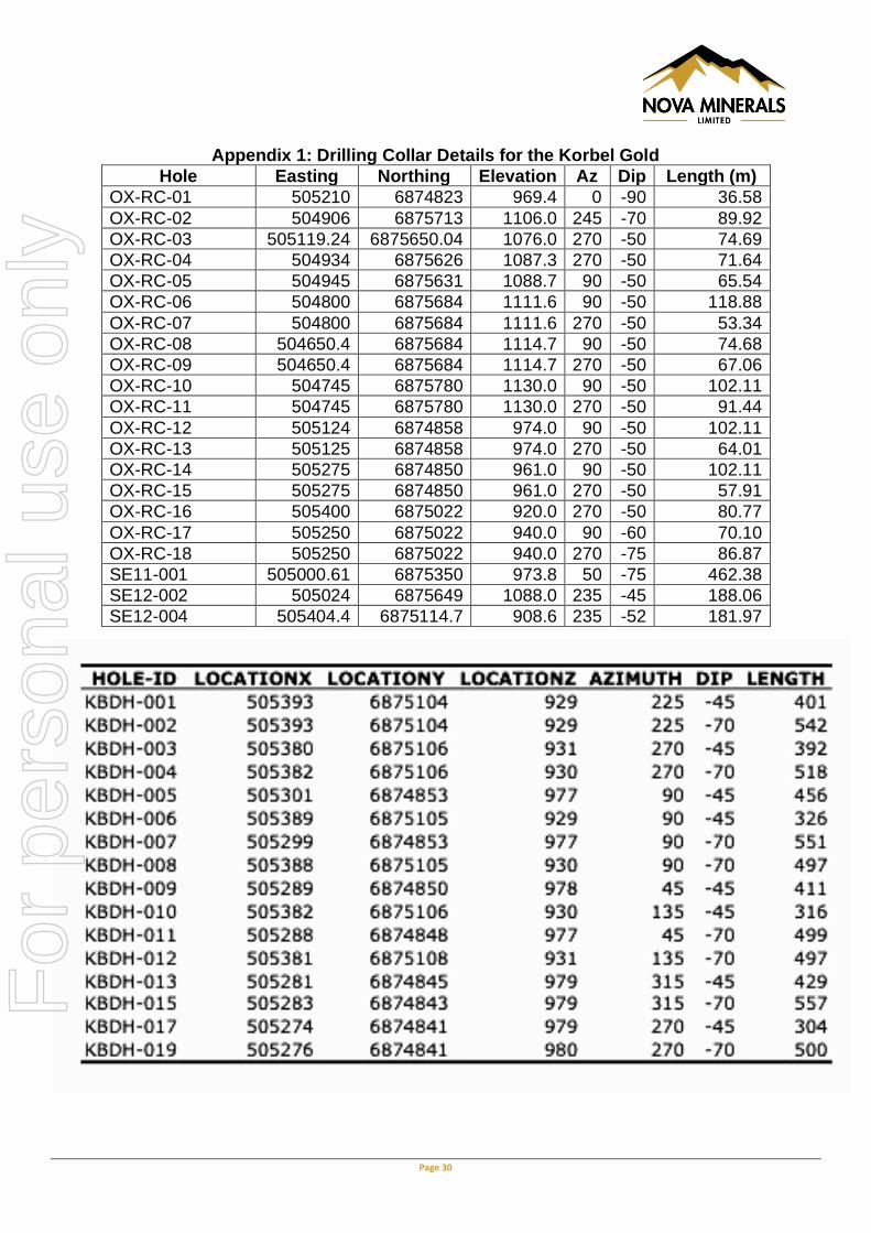
Appendix 1: Drilling Collar Details for the Korbel Gold
Hole Easting Northing Elevation Az Dip Length (m)
OX-RC-01 505210 6874823 969.4 0 -90 36.58
OX-RC-02 504906 6875713 1106.0 245 -70 89.92
OX-RC-03 505119.24 6875650.04 1076.0 270 -50 74.69
OX-RC-04 504934 6875626 1087.3 270 -50 71.64
OX-RC-05 504945 6875631 1088.7 90 -50 65.54
OX-RC-06 504800 6875684 1111.6 90 -50 118.88
OX-RC-07 504800 6875684 1111.6 270 -50 53.34
OX-RC-08 504650.4 6875684 1114.7 90 -50 74.68
OX-RC-09 504650.4 6875684 1114.7 270 -50 67.06
OX-RC-10 504745 6875780 1130.0 90 -50 102.11
OX-RC-11 504745 6875780 1130.0 270 -50 91.44
OX-RC-12 505124 6874858 974.0 90 -50 102.11
OX-RC-13 505125 6874858 974.0 270 -50 64.01
OX-RC-14 505275 6874850 961.0 90 -50 102.11
OX-RC-15 505275 6874850 961.0 270 -50 57.91
OX-RC-16 505400 6875022 920.0 270 -50 80.77
OX-RC-17 505250 6875022 940.0 90 -60 70.10
OX-RC-18 505250 6875022 940.0 270 -75 86.87
SE11-001 505000.61 6875350 973.8 50 -75 462.38
SE12-002 505024 6875649 1088.0 235 -45 188.06
SE12-004 505404.4 6875114.7 908.6 235 -52 181.97
For
per
sona
l use
onl
y

Page 31
Appendix 2 - Estelle Gold Project Drill hole collar information and intervals > 0.6 g/t Au cut-off grades summary for drill holes not reported.
For
per
sona
l use
onl
y

Page 32
For
per
sona
l use
onl
y


![UNIQUELY - MegawealthHOTEL ST KILDA BEACH HOUSE MONARCH CAKES PRINCE HOTEL ST KILDA PAVILION ST KILDA SEA BATHS,UQV` WYP]H[L [YHUX\PSSP[` YPNO[ PU [OL heart of St Kilda. Easy access](https://img.pdfslide.us/doc/110x75/5f508750f5612961de4bc3eb/uniquely-hotel-st-kilda-beach-house-monarch-cakes-prince-hotel-st-kilda-pavilion.jpg)