Embed Size (px)
Citation preview
KOOLAN ISLAND IRON ORE MINE AND PORT FACILITY
Aztec Resources Limited
Report and recommendations of the Environmental Protection Authority
Environmental Protection Authority Perth, Western Australia
Bulletin 1203 [November, 2005]

ISBN. 0 7307 6844 9 ISSN. 1030 - 0120 Assessment No. 1605
Contents
Page 1. Introduction and background……………………………………………….. 1
2. The proposal………………………………………………………………….. 3
3. Consultation…………………………………………………………………... 8
4. Relevant environmental factors……………………………………………... 9
4.1 Marine ecosystem 9
4.2 Flora, fauna and weeds 13
4.3 Soil contamination 15
5. Conditions and commitments………………………………………………. 18
6. Other advice…………………………………………………………………. 19
7. Conclusions………………………………………………………………….. 20
8. Recommendations…………………………………………………………... 20
Tables 1. Summary of key proposal characteristics…………………………………..… 5 Figures 1. Site location 2. Site layout 3. Seawall and revetment 4. Port facility 5. Identified contaminated sites Appendices
1. References 2. Recommended environmental conditions and proponent’s consolidated
commitments
1
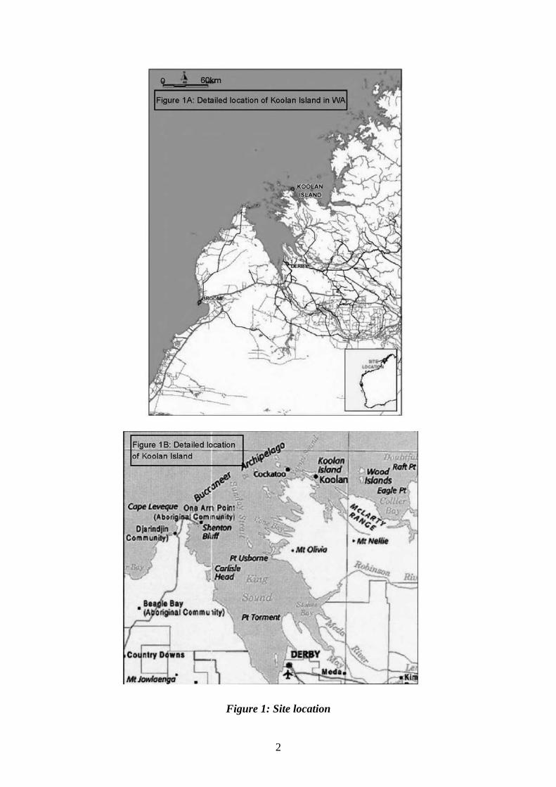
1. Introduction and background This report provides the advice and recommendations of the Environmental Protection Authority (EPA) to the Minister for the Environment on the environmental factors relevant to a proposal by Aztec Resources Limited, the proponent, to manage existing contamination within the project area, develop an iron ore mine, and construct associated infrastructure and a port facility on Koolan Island. The proponent has applied for mining leases 04/416 and 04/417 and miscellaneous licenses 04/29 and 04/47. Koolan Island is within the Buccaneer Archipelago, and is 130 kilometres northeast of Derby (Figure 1). Koolan Island is in a remote location with no permanent or temporary residents, and is separated from the mainland by a one kilometre wide channel. BHP mined iron ore on Koolan Island between 1965 and 1993. Approximately 68 million tonnes of high grade iron ore was extracted from five pits (Main, Mullet, Acacia, Eastern and Barramundi), crushed and shipped from a port facility at Arbitration Cove. As part of mining operations, BHP reclaimed the area east of Arbitration Cove (Lower Mangrove Inlet) with waste rock. Waste rock dumps were also placed in the sea, along parts of the southern edge of the island, and around each of the pits. Decommissioning of the mine in 1993 included removal (some in situ burial) of all infrastructure associated with BHP operations and rehabilitation of cleared areas by moon scaping. When mining ceased, the Main Pit was at approximately 80 metres below sea level, and a channel was created to allow seawater flooding of the pit. The EPA was advised of the proposal by the proponent in April 2005. Based on the information provided, the EPA considered that the proposal had the potential to have an effect on the environment, but could be managed to meet the EPA’s environmental objectives. Consequently, it was notified in The West Australian newspaper on 18 April 2005 that the EPA intended to set the level of assessment at Assessment on Referral Information. The proponent has submitted an Environmental Referral Document (Ecologia, 2005) setting out the details of the proposal, potential environmental impacts and appropriate measures to manage those impacts. The EPA considers that the proposal can be managed in an acceptable manner, subject to the proponent’s commitments and the EPA’s recommended conditions being made legally binding. The EPA has determined, under section 40(1) of the Environmental Protection Act 1986, that the level of assessment for the proposal is Assessment on Referral Information, and this report provides the EPA’s advice and recommendations in accordance with section 44(1).
2
Figure 1: Site location
3
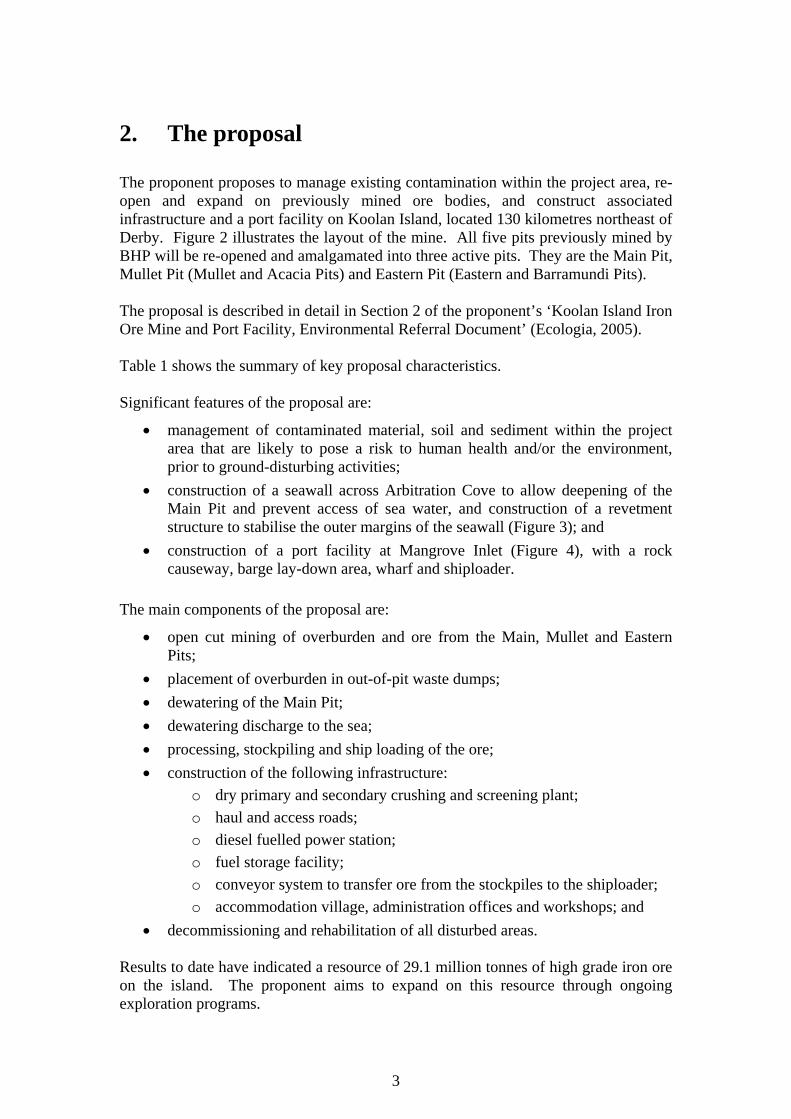
2. The proposal The proponent proposes to manage existing contamination within the project area, re-open and expand on previously mined ore bodies, and construct associated infrastructure and a port facility on Koolan Island, located 130 kilometres northeast of Derby. Figure 2 illustrates the layout of the mine. All five pits previously mined by BHP will be re-opened and amalgamated into three active pits. They are the Main Pit, Mullet Pit (Mullet and Acacia Pits) and Eastern Pit (Eastern and Barramundi Pits). The proposal is described in detail in Section 2 of the proponent’s ‘Koolan Island Iron Ore Mine and Port Facility, Environmental Referral Document’ (Ecologia, 2005). Table 1 shows the summary of key proposal characteristics. Significant features of the proposal are:
• management of contaminated material, soil and sediment within the project area that are likely to pose a risk to human health and/or the environment, prior to ground-disturbing activities;
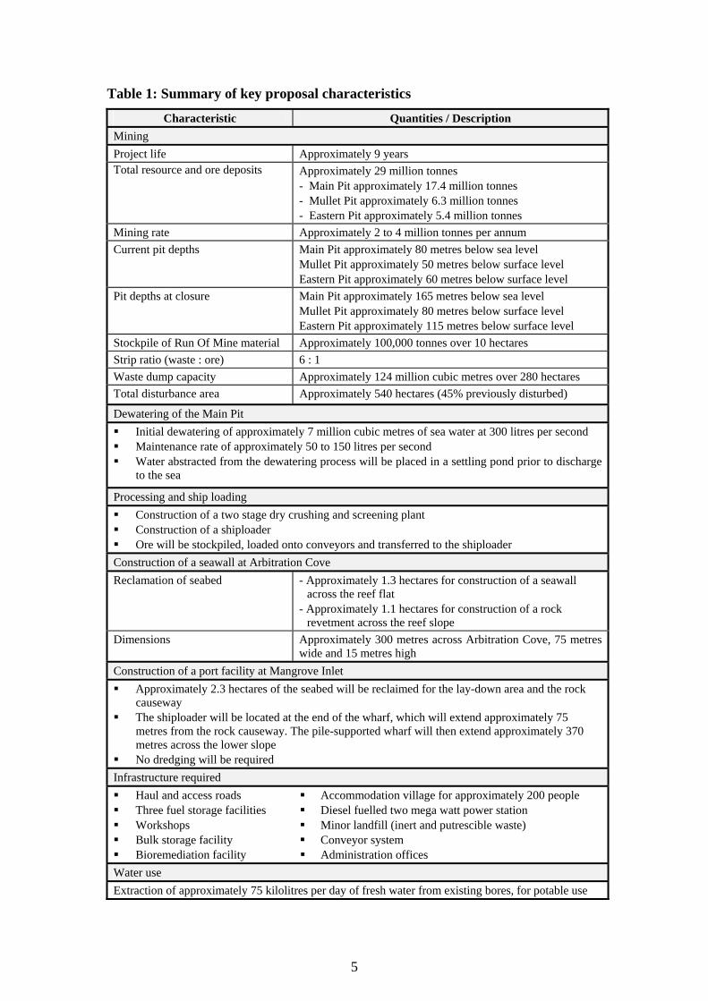
• construction of a seawall across Arbitration Cove to allow deepening of the Main Pit and prevent access of sea water, and construction of a revetment structure to stabilise the outer margins of the seawall (Figure 3); and
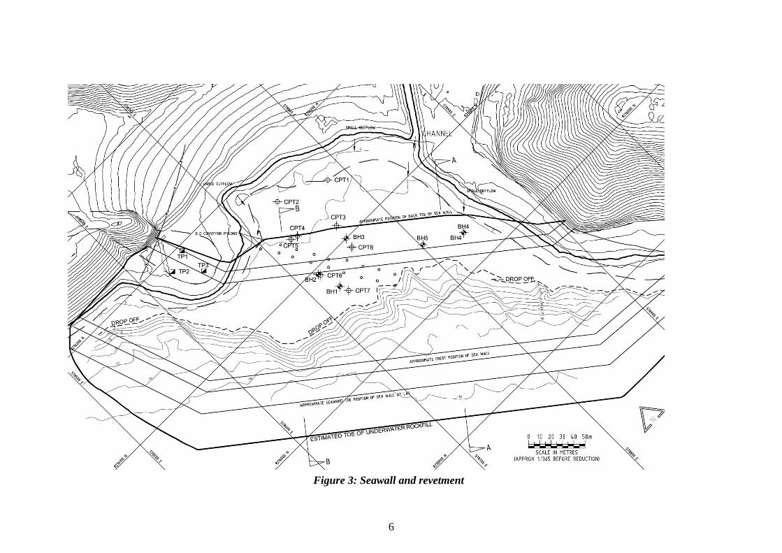
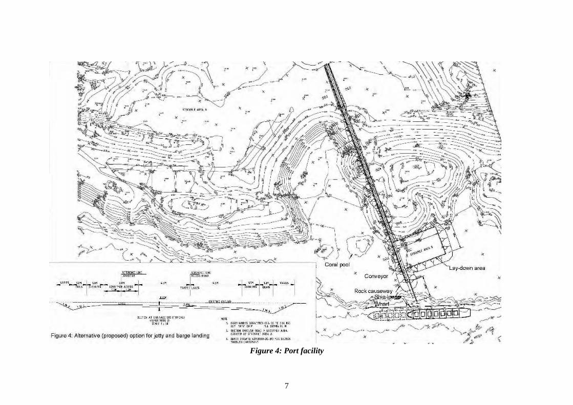
• construction of a port facility at Mangrove Inlet (Figure 4), with a rock causeway, barge lay-down area, wharf and shiploader.
The main components of the proposal are:
• open cut mining of overburden and ore from the Main, Mullet and Eastern Pits;
• placement of overburden in out-of-pit waste dumps; • dewatering of the Main Pit; • dewatering discharge to the sea; • processing, stockpiling and ship loading of the ore; • construction of the following infrastructure:
o dry primary and secondary crushing and screening plant; o haul and access roads; o diesel fuelled power station; o fuel storage facility; o conveyor system to transfer ore from the stockpiles to the shiploader; o accommodation village, administration offices and workshops; and
• decommissioning and rehabilitation of all disturbed areas. Results to date have indicated a resource of 29.1 million tonnes of high grade iron ore on the island. The proponent aims to expand on this resource through ongoing exploration programs.
4
Figure 2: Site layout
5
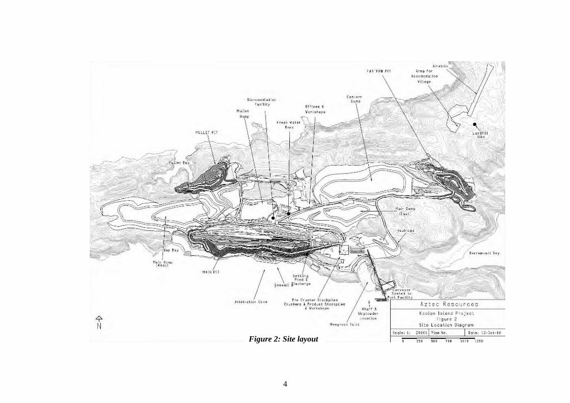
Table 1: Summary of key proposal characteristics
Characteristic Quantities / Description Mining Project life Approximately 9 years Total resource and ore deposits Approximately 29 million tonnes
- Main Pit approximately 17.4 million tonnes - Mullet Pit approximately 6.3 million tonnes - Eastern Pit approximately 5.4 million tonnes
Mining rate Approximately 2 to 4 million tonnes per annum Current pit depths Main Pit approximately 80 metres below sea level
Mullet Pit approximately 50 metres below surface level Eastern Pit approximately 60 metres below surface level
Pit depths at closure Main Pit approximately 165 metres below sea level Mullet Pit approximately 80 metres below surface level Eastern Pit approximately 115 metres below surface level
Stockpile of Run Of Mine material Approximately 100,000 tonnes over 10 hectares Strip ratio (waste : ore) 6 : 1 Waste dump capacity Approximately 124 million cubic metres over 280 hectares Total disturbance area Approximately 540 hectares (45% previously disturbed)
Dewatering of the Main Pit Initial dewatering of approximately 7 million cubic metres of sea water at 300 litres per second Maintenance rate of approximately 50 to 150 litres per second Water abstracted from the dewatering process will be placed in a settling pond prior to discharge
to the sea
Processing and ship loading Construction of a two stage dry crushing and screening plant Construction of a shiploader Ore will be stockpiled, loaded onto conveyors and transferred to the shiploader
Construction of a seawall at Arbitration Cove Reclamation of seabed - Approximately 1.3 hectares for construction of a seawall
across the reef flat - Approximately 1.1 hectares for construction of a rock
revetment across the reef slope Dimensions Approximately 300 metres across Arbitration Cove, 75 metres
wide and 15 metres high Construction of a port facility at Mangrove Inlet Approximately 2.3 hectares of the seabed will be reclaimed for the lay-down area and the rock
causeway The shiploader will be located at the end of the wharf, which will extend approximately 75
metres from the rock causeway. The pile-supported wharf will then extend approximately 370 metres across the lower slope
No dredging will be required Infrastructure required Haul and access roads Three fuel storage facilities Workshops Bulk storage facility Bioremediation facility
Accommodation village for approximately 200 people Diesel fuelled two mega watt power station Minor landfill (inert and putrescible waste) Conveyor system Administration offices
Water use Extraction of approximately 75 kilolitres per day of fresh water from existing bores, for potable use
6
Figure 3: Seawall and revetment
7
Figure 4: Port facility
8
3. Consultation The proponent has advised that consultation has occurred with the following government agencies and stakeholders during preparation of the Environmental Referral Document:
• Department of Conservation and Land Management (CALM); • Department of Industry and Resources; • Department of Indigenous Affairs; • Department of Environment; • Department of Fisheries; • Shire of Derby-West Kimberley; • Shire of Broome; • Conservation Council of Western Australia; • Marine and Coastal Community Network; • Wildflower Society of Western Australia; • Kimberley Environment Horticulture; • Broome Botanical Society; • Kimberley Land Council; • Environs Kimberley Inc; and • Greens (MLC) WA.
The proponent arranged a stakeholder site visit to Koolan Island on 16 May 2005. The main issues raised by stakeholders during the site visit and at meetings held with the proponent were:
1. impacts on the marine environment (benthic habitat and water quality); 2. impacts on conservation significant vegetation, flora and fauna; 3. weed control; 4. mine closure; and 5. management of existing contamination.
The proponent has addressed these issues in the Environmental Referral Document (Ecologia, 2005). Stakeholder comments and the proponent’s responses are provided in Table 3.1 of the Environmental Referral Document (Ecologia, 2005). The proponent will continue to liaise with the stakeholders and government agencies during implementation of the proposal.
9
4. Relevant environmental factors It is the EPA’s opinion that the following environmental factors relevant to the proposal require evaluation in this report:
1. marine ecosystem; 2. flora, fauna and weeds; and 3. soil contamination.
4.1 Marine ecosystem
Description The waters surrounding Koolan Island have been recommended to be considered for inclusion in Western Australia’s marine reserve system (CALM, 1999). Previous surveys of marine water quality, fauna and flora in the area are limited. The proponent commissioned a baseline water quality survey (MAFRL, 2004) and a survey of marine benthic habitats on the southern shore of the island (Mscience, 2005). The tidal range experienced at Koolan Island is significant, with water levels rising and falling up to 11 metres. This tidal range contributes to naturally elevated turbidity levels for oceanic waters and very fast water movement. Heavy rainfall and cyclones also increase turbidity levels during the wet season. The benthic habitats identified by the proponent are reef flat, coral slope, lower slope, channel floor and coral pool. The reef flat consists of sand, silt mud flats from the shoreline, benthic macroalgae, burrowing organisms in the inner flats and encrusting biota, including small corals in the outer flat. The coral slope has an abundant cover of living coral in a fringe extending seaward from the edge of the reef flat to the lower slope. The lower slope consists of broken rubble and filter feeding sessile biota such as sponges and gorgonians from the lower edge of the coral zone to the channel floor. The coral pool at the mouth of Mangrove Inlet is considered to be of conservation significance because the corals are highly diverse and in good condition, and the feature is the only example of such habitat near Koolan Island (Mscience, 2005). There is evidence that previous mining activities on Koolan Island have impacted the marine environment (Mscience, 2005). Waste rock was dumped into the ocean from Jap Bay to Arbitration Cove and at Mangrove Inlet during construction of a barge landing. The sub-tidal and intertidal habitats at Arbitration Cove, where the wharf and shiploader were located is significantly disturbed, with evidence of abandoned infrastructure on the sea floor, such as steel pipes and cables. At some places, the reef flat has been impacted from waste rock and sediment which was transported to the marine environment from waste dump areas during and after heavy rains.
10
Assessment The EPA’s environmental objectives for this factor are to maintain the ecological integrity and biodiversity of the marine environment and to ensure that impacts on marine communities located adjacent to the proposal footprint are avoided. The proposal has the potential to impact on marine water quality and marine benthic habitats from:
• construction of the seawall at Arbitration Cove; • construction of the port facility at Mangrove Inlet; • the discharge of water from the Main Pit into the sea; and • sediment runoff from stormwater.
The EPA has considered the cumulative loss of benthic primary producer habitats (BPPH) associated with this proposal in the context of Guidance Statement No. 29 Benthic Primary Producer Habitat Protection for Western Australia’s Marine Environment (EPA, 2004). In view of the CALM (1999) recommendation that the waters surrounding Koolan Island be considered for inclusion in the marine reserve system, the cumulative losses of BPPH are considered in the context of a Category B area, which has a cumulative loss threshold for each BPPH type of 1% (EPA, 2004). Seawall and port facility
The proponent has predicted that construction of the seawall will impact approximately 1.3 hectares of reef flat habitat. In addition, the construction of the revetment structure is predicted to impact approximately 1.1 hectares of coral slope and lower slope habitats (Mscience, 2005). Construction of the port facility includes reclamation of approximately 2.3 hectares of reef flat for the barge lay-down area and rock causeway. The shiploader will be located at the end of the wharf, which will extend approximately 75 metres from the rock causeway. The pile-supported wharf will then extend approximately 370 metres across the lower slope. In considering the cumulative loss of BPPH, the EPA is aware that the proponent has estimated the loss of the coral slope habitat, based on the potential linear distribution of coral slope habitat along coastlines within a management unit. These estimates are based on survey results of the coral slope habitat along the southern shoreline of Koolan Island and the adjacent mainland (Mscience, 2005), and on interpretation of a satellite image of the management unit. The proponent considered that coral slope is the most significant BPPH type. The proponent’s rationale for the proposed management unit boundary is primarily based on assumptions that: a) dispersal of coral larvae between reefs separated by over tens of kilometres is likely; b) tidal currents are likely to be effective long distance dispersal mechanisms in the area; and c) the larval competence period for most corals in the area are between one to two weeks. Using the above approach, the proponent estimates that there is an 85 kilometre length of coral slope habitat (with a width of approximately 10 to 15 metres) within its defined management unit. The proponent has calculated that the cumulative loss of coral slope habitat in the context of this 85 kilometre linear length of coral slope habitat amounts to 0.8%.
11
The EPA notes that the proponent has not evaluated the cumulative loss of the other BPPH, including the reef flat. The proponent suggests that past mining activities at Koolan Island, such as coastal waste dumping, have resulted in the loss of sections of the reef flat habitat. The EPA notes that the spatial extent of historical impacts on the reef flat habitat is currently not well documented. The EPA also notes that this proposal will have additional direct impacts on reef flat habitats. The EPA considers that in applying Guidance Statement No. 29, it would be appropriate to determine losses of BPPH within a smaller management unit, taking into account the distribution of the coral slope habitat on the southern shore of Koolan Island and the adjacent mainland. On this basis, the EPA has estimated that the cumulative loss of coral slope habitat is likely to be slightly in excess of 1%, which is the EPA’s recommended cumulative loss threshold for each habitat type in Category B areas (EPA, 2004). Based on the EPA’s analysis of coral slope habitat loss within a smaller management unit being slightly in excess of the recommended cumulative loss threshold, the EPA considers the construction and operation phases of the proposal should be carefully managed so that the extent of the impacts on the marine environment predicted in the Environmental Referral Document (Ecologia, 2005) are not exceeded. The EPA recommends the proponent be required to confirm the extent of the direct and indirect impacts of the proposal on water and sediment quality and health of the benthic habitats in a Marine Management Plan (condition 7), and identify measures whereby the impacts will be contained within the identified areas. Proposed activities that are likely to cause direct impacts on the environment include construction of the seawall and port facility, and potentially, the placement of infrastructure for dewatering. Potential indirect impacts include elevated turbidity and sedimentation generated during construction in the marine environment, and stormwater runoff from waste dumps, stockpiles and roads into the marine environment. The zone in which indirect impacts are likely includes the area where sub-lethal ecological effects on marine environmental quality are observed, but there is no loss of benthic habitat. Beyond this area, a zone of influence can be defined where measurable changes in marine environmental quality may occur, but these changes should not result in detectable ecological effects. Beyond the zone of influence, the EPA expects that there should be no detectible change in water and sediment quality or health of the benthic habitats from the background state. The EPA is aware of the potential for the generation of turbidity, particularly during the construction phase. The EPA considers that the proponent should implement measures to minimise turbidity such as the use of geotextile material to retain and minimise the dispersion of fines from the seawall and other rock structures. The EPA notes that the proposed construction of the port facility is unlikely to have a significant impact on the conservation significant coral pool community. However, the EPA considers that strict turbidity and sedimentation controls should be implemented in accordance with best practice around Mangrove Inlet, particularly
12
during construction of the processing plant and workshops and construction, maintenance and use of the stockpiles, roads, the conveyor system and port facility. The health of the coral pool community should be monitored and triggers for management actions developed, to ensure the unique habitat is protected from the project activities (condition 7). Dewatering discharge
The Main Pit will be dewatered in two stages: initial bulk displacement of sea water, and ongoing pumping of groundwater to maintain dry working conditions on the pit floor. A settling pond will be constructed near the Main Pit to ensure that the water abstracted will be of appropriate quality prior to discharge into the marine environment. The EPA recommends the proponent be required to minimise impacts from dewatering discharge on the marine environment in accordance with a Marine Management Plan (condition 7). The proponent should be required to analyse key parameters of the water to be discharged, including Copper concentrations, as part of the Plan. Sediment runoff from stormwater
The EPA notes that there is potential for an increase in sediment runoff and erosion from the mine site during and following heavy rainfall events, particularly if the waste dumps, stockpiles, pits and roads are not constructed and managed appropriately. The EPA considers that stormwater should be managed to ensure that all existing and potential sources of sediment runoff do not adversely impact the marine environment (condition 7). To ensure the EPA’s objectives are achieved, the EPA considers that the proponent should undertake diligent monitoring and management of the aspects of the proposal with potential to impact the marine environment in accordance with a Marine Management Plan (condition 7). The Plan should incorporate a sediment and water quality and benthic habitat monitoring programme that is underpinned by defined management triggers and management options that will be implemented in the event that trigger levels for any particular indicator are exceeded. The EPA recommends a water quality monitoring framework that is consistent with the National Water Quality Management Strategy (ANZECC, 2000) should be implemented by the proponent during all phases of the project. There is also potential for the marine environment to be impacted from existing contamination on the island. The EPA recommends the proponent be required to prepare and implement a Contamination Management Plan (condition 13) to incorporate management of potential impacts on the marine environment.
Summary Having particular regard to the recommended approach to identify the extent of direct and indirect impacts, define the management triggers and actions, and develop a monitoring programme to ensure that the impacts do not occur outside the identified areas and are within acceptable levels, as set out in the recommended environmental condition, it is the EPA’s opinion that the proposal can be managed to meet the EPA’s environmental objectives for this factor.
13
4.2 Flora, fauna and weeds
Description Koolan island has an area of 2,580 hectares, of which approximately 20% will be cleared as a result of the proposal (45% of the total area to be cleared has been previously disturbed). Ecologia Environment prepared vegetation, flora, fauna and weed survey reports for the project area. The vegetation of the island is characteristic of the Fitzgerald Botanical District, comprising predominantly savannah woodland over hummock grasses. The vine thicket and mangrove communities are considered to be of environmental significance (Ecologia, 2004a). Five flora species of conservation significance were identified within the project area. Phyllanthus aridus is widespread throughout the central part of the island. Gymnanthera cunninghamii and Brachychiton xanthophyllus were located near the proposed Eastern Pit. Corymbia aff. cadophera and Eucalyptus kenneallyi are also species of interest (Ecologia, 2004b). Table 4.7 of the Environmental Referral Document (Ecologia, 2005) lists the fauna species of conservation significance known to occur in and around Koolan Island. Species of particular interest are Ramphotyphlops yampiensis (Blind Snake), Erythrotriorchis radiatus (Red Goshawk), Dasyurus hallucatus (Northern Quoll); Macroderma gigas (Ghost Bat), Rhinonicteris aurantius (Orange Leaf-nosed Bat) and Hipposideros stenotis (Northern Leaf-nosed Bat). Short-range endemic invertebrate fauna species that are known to occur on the island include land snails (Kimboraga koolanensis and Amplirhagada astute) and earthworms (Ecologia, 2005). As a result of previous mining activities on the island a number of exotic plants were introduced, and weeds are now abundant. The total number of weed species on Koolan Island is approximately 60 taxa. The species of greatest environmental concern are Jatropha gossypiifolia (Bellyache Bush), Senna alata (Candle Bush), Cryptostegia madagascariensis (Rubber Vine), and Passiflora foetida var. hispida (Stinking Passionflower).
Assessment The EPA’s environmental objectives for this factor are to maintain the abundance, diversity, geographic distribution and productivity of flora and fauna at species and ecosystem levels through the avoidance or management of adverse impacts and improvement in knowledge, and to minimise the spread of weeds. The proposal has the potential to impact on conservation significant flora and fauna through clearing of vegetation for mining, and construction of infrastructure and waste dumps. It is currently unknown whether subterranean fauna exist on Koolan Island. If they do exist, they may be impacted by groundwater drawdown. Land clearing, vehicle movement and shipping to and from the island, have the potential to introduce weeds and spread existing populations of weeds within the project area, if these activities are not managed properly.
14
The total area of disturbance (approximately 540 hectares) will be progressively rehabilitated in accordance with a Closure Plan (condition 6). Some disturbed areas from previous mining activities were rehabilitated with non local plant species. Where the proponent impacts upon previously disturbed or rehabilitated areas, the vegetation will be rehabilitated with local native species. The EPA notes comments made by the proponent that it may not be practicable to progressively backfill the pits as mining progresses and at the completion of mining. The proposed location of the waste dump for the Eastern Pit occurs within 0.5 hectares of the significant vegetation type, the vine thicket. This area is currently infested with weeds, and represents approximately 3% of the total area of vine thickets on the island. The proponent has considered relocating the waste dump. However, this would result in impacting on previously undisturbed areas. The option of isolating the vine thicket amidst the waste dumps would result in degradation of the thicket over time. The proponent has put forward a conservation offset to impacting the vine thicket by funding a weed research program (commitment 3). The other significant vegetation type, the mangroves, will not be impacted by the proposal. To minimise potential impacts on flora and fauna species and habitat areas for species of conservation significance, the EPA recommends that the proponent be required to prepare and implement a Significant Species Management Plan (condition 9). Conservation significant species are those that are not described, poorly sampled, listed as rare, threatened or endangered under the Wildlife Conservation Act 1950 or listed as Priority by CALM. Potential impacts on conservation significant flora and fauna species and significant fauna habitat need to be identified and recorded on mine plans so that they can be managed in an environmentally acceptable manner. The proponent would undertake additional pre-land clearing survey work to identify or improve knowledge of the distribution of the species of conservation significance and where possible, adjust clearing boundaries to avoid disturbance. CALM would be consulted to develop management strategies where significant flora or fauna, vegetation associations or habitat areas cannot practically be avoided. The EPA notes the commitment made by the proponent to implement vegetation clearing demarcation standards, as part of the Environmental Management Plan (commitment 1), to ensure that approved areas to be disturbed are clearly pegged, and clearing impacts are limited to areas within the footprint. Furthermore, the environmental training section of the Environmental Management Plan (commitment 1) addresses no access areas to ensure that workers are aware of prohibited areas. The EPA recommends the proponent be required to determine the presence of conservation significant subterranean fauna within the project area (condition 10-1). In the event that subterranean fauna are found, the EPA recommends the proponent prepare and implement a Subterranean Fauna Management Plan (condition 10-2) to maintain the long-term persistence of subterranean fauna species and communities within the project area. The EPA considers that strict weed hygiene measures should be implemented during all phases of the project to prevent the introduction of new weeds and minimise the spread of existing weeds. The EPA recommends that a Quarantine Management Plan should be prepared and implemented by the proponent (condition 11).
15
Summary Having particular regard to the:
• advice by CALM on the acceptability of the proposed management of conservation significant flora and fauna and weeds;
• conservation offset provided by the proponent to conduct weed research; and • recommended conditions and commitments;
it is the EPA’s opinion that the proposal can be managed to meet the EPA’s environmental objectives for this factor.
4.3 Soil contamination
Description Contaminated areas exist on Koolan Island from BHP’s previous mining operations. URS Australia conducted baseline investigations to identify the primary potential sources of contamination on the island (URS, 2005). The main sources of contamination from previous mining activities are petroleum hydrocarbons and asbestos. The main potential contamination issues are domestic and industrial landfill disposals, workshop activities, fuel and waste oil distribution and storage, buried machinery, and former township support systems and infrastructure. Figure 5 shows the location of the identified contaminated sites within the project area. Possible pollutant linkages on the island as a result of future mining activities include:
• Total Petroleum Hydrocarbon (TPH) impacted soils potentially contaminating adjacent soils and entering the marine environment through stormwater runoff. TPH also has the potential to produce vapours which could be inhaled by the human workforce or have dermal contact with the human workforce.
• Asbestos fibres from asbestos-containing materials may be released into the atmosphere, and consequently inhaled by the human workforce, through excavation of historical landfills or tracking of heavy plant or similar over asbestos-containing materials.
• During the wet season surface waters may enter the historical landfills, and contaminated surface water may leach down the coastal valleys into the marine environment.
Assessment The EPA’s environmental objectives for this factor are to:
• ensure that rehabilitation of the site is to an acceptable standard and is compatible with the intended land use and consistent with appropriate criteria; and
• ensure that asbestos does not become airborne and represent an unacceptable risk to human health.

16
Figure 5: Identified contaminated sites
17
According to EPA Guidance Statement No. 17 Remediation Hierarchy for Contaminated Land (EPA, 2000), the preferred hierarchy approach for site remediation is for contaminated material to:
• be treated on-site and the contaminants reduced to acceptable levels; or • be treated off-site and returned for reuse after the contaminants have been
reduced to acceptable levels. The area considered for assessment of this factor include all land within the mining leases 04/416 and 04/417 and miscellaneous licenses 04/29 and 04/47 applied for. The EPA notes from investigation work (URS, 2005) that the main sources of contamination are petroleum hydrocarbons and asbestos. The EPA notes that in general, TPH is present near the surface and at low concentrations (URS, 2005). The EPA considers that it is unlikely that the concentration of TPH in the soil will have significant impact on groundwater quality. The EPA considers that the presence of asbestos, pending its form, has the potential to affect human health. The EPA notes that the proponent has prepared an Asbestos Management Plan detailing strategies to manage asbestos contaminated soil and to minimise impact on human health. The EPA considers that the proponent should liaise with the Department of Health to ensure that the Asbestos Management Plan meets the requirements of that Department. The EPA notes, on advice from the Department of Environment, that the complete extent and nature of contamination within the project area has not been fully delineated, and additional investigation works are required, particularly in relation to the areas described below.
1. A management plan to be put in place to ensure that the old tyre tip (area A) does not burn in the future.
2. A management plan to be prepared to determine the nature and extent of soil contamination associated with the underground storage tank (area E).
3. Potentially significant impacts in areas where intrusive investigations have not been possible due to an inability to gain adequate access, including areas F and H, should be investigated when access becomes available.
4. Further investigations are required to determine the nature and extent of contamination and the potential risk to the marine environment in areas G, I, N, P (old township) and Q.
5. Heavy metals should be included in the analysis suite for further investigations in area O (domestic airstrip).
6. Treatment of groundwater prior to consumption. 7. Monitoring and analysis of water flowing from coastal landfills to assess if
discharge water from these areas will pollute the environment. 8. Handling of potential asbestos debris in accordance with the statutory
regulations and accepted professional standards to prevent the spread of asbestos fibres.
18
The EPA recommends that the proponent should ensure that the quality of groundwater to be used for potable supply is to the satisfaction of the Department of Health (condition 12). The EPA also recommends the proponent undertakes the additional contaminated sites investigation works and subsequent management measures, prior to ground-disturbing activities, in accordance with a Contamination Management Plan (condition 13) and Asbestos Management Plan (condition 14) .
Summary Having particular regard to the:
• baseline environmental contaminated site assessment undertaken by URS Australia on behalf of the proponent; and
• recommended conditions and proponent commitments; it is the EPA’s opinion that the proposal can be managed to meet the EPA’s environmental objectives for this factor.
5. Conditions and commitments Section 44 of the Environmental Protection Act 1986 requires the EPA to report to the Minister for the Environment on the environmental factors relevant to the proposal and on the conditions and procedures to which the proposal should be subject, if implemented. In addition, the EPA may make recommendations as it sees fit. The proponent provided an array of commitments to ameliorate the impacts of the proposal on the environment. The commitments were considered by the EPA as part of its assessment of the proposal and, following discussion with the proponent, the EPA sought additional commitments. The EPA recognises that not all of the commitments are written in a form which makes them readily enforceable, but they do provide a clear statement of the action to be taken as part of the proponent’s responsibility for, and commitment to, continuous improvement in environmental performance. Some commitments were modified to ensure enforceability, and formed part of the conditions to which the proposal should be subject, if it is to be implemented.
19
6. Other advice The EPA acknowledges reference made in the Western Australian Planning Commission’s State Planning Strategy - Final Report December1997 to manage and preserve the unique environment of the Kimberley plateau for conservation and tourism. In 1980 the EPA recommended that a biological survey of the Buccaneer Archipelago be undertaken with a view to recommending the creation of specific reserves through the System 7 Red Book Report (EPA, 1993). CALM revised and updated the recommendations in the System 7 Report in Nature Conservation Reserves in the Kimberley Western Australia (Burbidge et. al., 1991). This document acknowledged that “The Kimberley of Western Australia has a flora and fauna largely distinct from that of the rest of the State. And there is a need for a proper, representative conservation reserve system in the Kimberley.” Several islands were recommended as Class A and Class B reserves in the document. However, Koolan Island and Cockatoo Island were not recommended because the islands are developed as iron ore mines, with associated residential and port facilities (Burbidge, et. al., 1991). The Kimberley islands have been separated from the mainland for up to 10,000 years. The EPA recognises that this has resulted in the development of new taxa. The EPA notes the commitment made by the proponent to undertake hygiene measures to ensure that feral animals and introduced plants are not established on the island, in accordance with the Environmental Management Plan (commitment 1). The EPA considers that this is an important issue that should be covered under the Quarantine Management Plan (condition 11). The Humpback Whale (Megaptera novaeangliae) is a listed threatened species and migratory species under the provisions of the Environmental Protection and Biodviersity Conservation Act 1999. The migratory path of the Humpback Whale along the Western Australian coast includes the waters of the Buccaneer Archipelago, and the Kimberley area may be used as a calving ground by the whales between June and mid November (Jenner et al., 2001). The EPA considers that the proponent should minimise interference to Humpback Whales during construction of the seawall and port facility, blasting of the pits and shipping activities in accordance with the Marine Management Plan (condition 7). Furthermore, implementation of the management measures to minimise impact on the water quality and benthic habitat as part of the Marine Management Plan should ensure that the marine environment is continued to be suitable for Humpback Whales. The EPA notes, on advice of the Department of Environment, that licence conditions regarding dewatering and discharge cannot be applied to the project because Koolan Island is not a proclaimed area under the Rights in Water and Irrigation Act 1914. Therefore the EPA recommends the proponent be required to prepare and implement a Water Management Plan (condition 8) to minimise impacts from dewatering and groundwater abstraction on the island’s hydrological system.
20
7. Conclusions The EPA has considered the proposal by Aztec Resources Limited to manage contaminated material, soil and sediment within the project area, re-open and expand on previously mined ore bodies and to construct associated infrastructure and a port facility on Koolan Island. The EPA has concluded that the proposal is capable of being managed in an environmentally acceptable manner such that it is unlikely that the EPA’s objectives would be compromised, provided there is satisfactory implementation of the recommended conditions and proponent’s commitments.
8. Recommendations The EPA submits the following recommendations to the Minister for the Environment:
1. that the Minister notes that the proposal being assessed is for the Koolan Island Iron Ore Mine and Port Facility;
2. that the Minister considers the report on the relevant environmental factors as set out in Section 4;
3. that the Minister notes that the EPA has concluded that it is unlikely that the EPA’s objectives would be compromised, provided there is satisfactory implementation by the proponent of the recommended conditions set out in Appendix 2, including the proponent’s commitments; and
4. that the Minister imposes the conditions and procedures recommended in Appendix 2 of this report.

Appendix 1
References
Burbidge, A.A., McKenzie, N.L. and Kenneally, K.F. (1991) Nature Conservation Reserves in the Kimberley Western Australia. Department of Conservation and Land Management, Western Australia.
CALM (1999) A Representative Marine Reserve System for Western Australia.
Report of the Marine Parks and Reserves Selection Working Group. Department of Conservation and Land Management, Western Australia.
Ecologia (2004a) Aztec Resources Koolan Island Iron Ore Project, Flora and
Vegetation Assessment. Ecologia Environment (Unpubl) September 2004. Ecologia (2004b) Aztec Resources Koolan Island Project, Priority Flora and
Declared Weed Survey. Ecologia Environment (Unpubl) September 2004. Ecologia (2005) Koolan Island Iron Ore Mine and Port Facility, Environmental
Referral Document. Ecologia Environment (Unpubl) October 2005. EPA (1993) Red Book Status Report; on the Conservation Reserves for Western
Australia, as recommended by the Environmental Protection Authority (1976-1984). Environmental Protection Authority, Perth, Western Australia.
EPA (2000) Remediation Hierarchy for Contaminated Land. Guidance for the
Assessment of Environmental Factors, Environmental Protection Authority, Perth, Western Australia.
EPA (2004) Benthic Primary Producer Habitat Protection for Western Australia’s
Marine Environment. Guidance for the Assessment of Environmental Factors, Environmental Protection Authority, Perth, Western Australia.
Jenner, K. C. S., Jenner, M-N. M. and McCabe, K. A. (2001) Geographical and
Temporal Movements of Humpback Whales in Western Australian Waters. APPEA Journal 749-765.
MAFRL (2004) Koolan Island Baseline Marine Survey. Marine and Freshwater
Research Laboratory Environmental Science (Unpubl) July 2004. Mscience (2005) Koolan Island Mine Marine Benthic Habitat Survey. Mscience Pty
Ltd (Unpubl) February 2005. URS (2005) Phase 1 and Phase 2 Baseline Environmental Site Assessment, Koolan
Island Iron Ore Project. URS Australia Pty Ltd (Unpubl) March 2005.

Appendix 2
Recommended environmental conditions and proponent’s consolidated commitments
Statement No.
RECOMMENDED CONDITIONS AND PROCEDURES
STATEMENT THAT A PROPOSAL MAY BE IMPLEMENTED (PURSUANT TO THE PROVISIONS OF THE
ENVIRONMENTAL PROTECTION ACT 1986)
KOOLAN ISLAND IRON ORE MINE AND PORT FACILITY SHIRE OF DERBY-WEST KIMBERLEY
Proposal: Management of existing contaminated material, soil and
sediment within the project area, re-opening of an iron ore mine and construction of associated infrastructure and a port facility on Koolan Island, and subsequent rehabilitation and decommissioning of the site, as documented in schedule 1 of this statement.
Proponent: Aztec Resources Limited Proponent Address: 6 King’s Park Road, WEST PERTH WA 6005 Assessment Number: 1605 Report of the Environmental Protection Authority: Bulletin 1203 The proposal referred to above may be implemented by the proponent subject to the following conditions and procedures: 1 Implementation 1-1 The proponent shall implement the proposal as documented in schedule 1 of
this statement subject to the conditions and procedures of this statement. 2 Proponent Commitments 2-1 The proponent shall implement the environmental management commitments
documented in schedule 2 of this statement. 3 Proponent Nomination and Contact Details 3-1 The proponent for the time being nominated by the Minister for the
Environment under section 38(6) or (7) of the Environmental Protection Act 1986 is responsible for the implementation of the proposal until such time as the Minister for the Environment has exercised the Minister’s power under section
38(7) of the Act to revoke the nomination of that proponent and nominate another person as the proponent for the proposal.
3-2 If the proponent wishes to relinquish the nomination, the proponent shall apply
for the transfer of proponent and provide a letter with a copy of this statement endorsed by the proposed replacement proponent that the proposal will be carried out in accordance with this statement. Contact details and appropriate documentation on the capability of the proposed replacement proponent to carry out the proposal shall also be provided.
3-3 The nominated proponent shall notify the Department of Environment of any
change of contact name and address within 60 days of such change. 4 Commencement and Time Limit of Approval 4-1 The proponent shall substantially commence the proposal within five years of
the date of this statement or the approval granted in this statement shall lapse and be void.
Note: The Minister for the Environment will determine any dispute as to whether the proposal has been substantially commenced.
4-2 The proponent shall make application for any extension of approval for the
substantial commencement of the proposal beyond five years from the date of this statement to the Minister for the Environment, prior to the expiration of the five-year period referred to in condition 4-1.
The application shall demonstrate that: 1. the environmental factors of the proposal have not changed significantly; 2. new, significant, environmental issues have not arisen; and
3. all relevant government authorities have been consulted.
Note: The Minister for the Environment may consider the grant of an extension of the time limit of approval not exceeding five years for the substantial commencement of the proposal.
5 Compliance Audit and Performance Review 5-1 The proponent shall prepare an audit program and submit compliance reports to
the Department of Environment which addresses:
1. the status of implementation of the proposal as defined in schedule 1 of this statement;
2. evidence of compliance with the conditions and commitments; and
3. the performance of the environmental management plans and programmes.
Note: Under sections 48(1) and 47(2) of the Environmental Protection Act 1986, the Chief Executive Officer of the Department of Environment is empowered to monitor the compliance of the proponent with the statement and should directly receive the compliance documentation, including environmental management plans, related to the conditions, procedures and commitments contained in this statement.
5-2 The proponent shall submit a performance review report every four years following the formal authority issued to the decision-making authorities under section 45(7) of the Environmental Protection Act 1986, to the requirements of the Minister for the Environment on advice of the Environmental Protection Authority, which addresses:
1. the major environmental issues associated with implementing the project;
the environmental objectives for those issues; the methodologies used to achieve these; and the key indicators of environmental performance measured against those objectives;
2. the level of progress in the achievement of sound environmental
performance, including industry benchmarking, and the use of best practicable measures available;
3. significant improvements gained in environmental management, including
the use of external peer reviews;
4. stakeholder and community consultation about environmental performance and the outcomes of that consultation, including a report of any on-going concerns being expressed; and
5. the proposed environmental objectives over the next four years, including
improvements in technology and management processes. 5-3 The proponent may submit a report prepared by an independent auditor to the
Chief Executive Officer of the Department of Environment on each condition and commitment of this statement which requires the preparation of a management plan, programme, strategy or system, stating whether the requirements of each condition and commitment have been fulfilled within the timeframe stated within each condition and commitment.
6 Closure 6-1 Within 12 months following the formal authority issued to the decision-making
authorities under section 45(7) of the Environmental Protection Act 1986, the proponent shall prepare a Closure Plan to the requirements of the Minister for the Environment on advice of the Environmental Protection Authority, the Department of Conservation and Land Management and the Department of Industry and Resources.
The objectives of this Plan are to:
• achieve construction of landforms which are stable, non-polluting and aesthetically compatible with the surrounding landscape;
• establish sustainable endemic vegetation communities, consistent with the reconstructed landscape and surrounding vegetation; and
• ensure that closure planning and rehabilitation are carried out in a coordinated, progressive manner and are integrated with development planning, consistent with current best practice, and the agreed end land use.
This Plan shall set out procedures to:
1. manage the ground and surface water systems affected by the open pits and
waste rock dumps to ensure there are no long term impacts; 2. ensure that the impacted areas in the marine environment displays similar
floral, faunal and benthic habitat diversity, health and water quality as surrounding marine ecosystems;
3. rehabilitate all disturbed areas to a standard suitable for the agreed end land
use(s), with consideration and incorporation of:
• the characteristics of the pre-mining ecosystems within Koolan Island (through research and baseline surveys); and
• best practice rehabilitation techniques, including topsoil management, used elsewhere in the mining industry;
4. identify completion criteria, which ensure that there is adequate
rehabilitation of the final landform and that appropriate species are used in rehabilitation of the steep scree slopes, ridges and waste dumps;
5. monitor rehabilitation to assess the performance of all rehabilitated areas
against the completion criteria;
6. report on the rehabilitation and monitoring results; 7. identify and manage any contaminated material, soil or sediment within the
project area; 8. develop management strategies and/or contingency measures in the event
that operational experience and/or monitoring indicate that a closure objective is unlikely to be achieved; and
9. develop a ‘walk away’ solution for the decommissioned mine site.
Note: A ‘walk away’ solution means that the site shall either no longer require management at the time the proponent ceases mining operations, or if further management is deemed necessary, the proponent shall make adequate provisions so that the required management is undertaken with no liability to the State.
6-2 The proponent shall review and revise the Closure Plan required by condition 6-1 at intervals not exceeding four years to the requirements of the Minister for the Environment on advice of the Environmental Protection Authority, the Department of Conservation and Land Management and the Department of Industry and Resources.
6-3 The proponent shall implement the Closure Plan required by condition 6-1 and
subsequent revisions required by condition 6-2.
6-4 The proponent shall make the Closure Plan required by condition 6-1 and subsequent revisions required by condition 6-2 publicly available.
7 Marine Environment 7-1 Prior to the commencement of activities that may affect the marine
environment, the proponent shall prepare a Marine Management Plan to the requirements of the Minister for the Environment on advice of the Environmental Protection Authority, the Department of Conservation and Land Management and the Department of Fisheries.
The objectives of this Plan are to:
• maintain the ecological integrity and biodiversity of the marine environment;
• avoid impact on the coral pool community at Mangrove Inlet; and • manage project activities to ensure that impacts on marine habitats,
communities and biota outside the project footprint are avoided.
This Plan shall set out procedures to:
1. identify the potential direct and indirect impacts on the marine environment during all phases of project activities;
2. minimise the disturbance footprint of the seawall and the revetment
structure; 3. identify the cause and effect pathways associated with the potential impacts
identified in point 1 above; 4. spatially and temporally define the zones of direct and indirect impact on
sediment and water quality and benthic habitat health, as well as the boundary of the zone beyond which the marine environment will be protected;
5. minimise the sediment movement from waves, tidal currents and runoff
during construction of the seawall through construction techniques and use of a sediment curtain;
6. manage the direct and indirect impacts, identified in point 1 above, on sediment and water quality and benthic habitat health, including the use of geotextile materials;
7. analyse the quality of the water to be discharged from dewatering the Main
Pit; 8. spatially and temporally define the mixing zones where water will be
discharged to the marine environment; 9. manage impacts associated with dewatering discharge to the marine
environment;
10. manage stormwater to minimise impacts on the marine environment from existing and proposed sources of sediment runoff;
11. establish suitable reference sites from which to collect data for sediment and
water quality and benthic habitat health indicators and derive site-specific environmental quality criteria for the direct and indirect impact zones;
12. develop a marine environmental quality monitoring programme, which
incorporates:
• scale maps showing the locations of each monitoring site and reference site;
• the rationale for the selection of the monitoring and reference sites; • procedures for routine monitoring of sediment and water quality and
benthic habitat health during the life of the mine; • the environmental quality criteria for triggering pre-determined
management action(s) and where necessary the rationale for their derivation;
• methodologies for evaluating data collected at the monitoring and reference sites against the environmental quality criteria; and
• the pre-determined adaptive management actions which will be implemented in the event that environmental quality criteria are not being achieved;
13. carry out a baseline survey and regular ongoing surveys for introduced
marine pests; 14. develop a spill contingency plan; 15. restore or rehabilitate the marine environment, where impacts have occurred
outside the identified indirect impact zone, during the life of the mine;
16. restore or rehabilitate the marine environment during the decommissioning phase, and ensure there is no net loss of benthic primary producer habitats and where possible generate a net gain in the area of benthic primary producer habitat and/or their associated communities.
17. ensure that construction of the seawall and port facility, blasting in the pits
and shipping activity which occurs during the Humpback Whale migration period do not significantly impact on the whales during the life of the mine; and
18. undertake surveillance during the Humpback Whale migration period to
avoid interference with the whales.
7-2 The proponent shall review and revise the Marine Management Plan required by condition 7-1 at intervals not exceeding four years.
7-3 The proponent shall implement the Marine Management Plan required by
condition 7-1 and subsequent revisions required by condition 7-2. 7-4 The proponent shall make the Marine Management Plan required by condition
7-1 and subsequent revisions required by condition 7-2 publicly available. 8 Water 8-1 Prior to dewatering or groundwater abstraction, the proponent shall prepare a
Water Management Plan to the requirements of the Minister for the Environment on advice of the Environmental Protection Authority.
The objective of this Plan is to the maintain the quality and quantity of water so that existing and potential environmental values, including ecosystem maintenance are protected. This Plan shall set out procedures to: 1. complete a hydrogeological investigation to determine the current quantity
and quality of the groundwater aquifers of Koolan Island;
2. model the current groundwater system and the short and long-term hydrogeological impacts of mining;
3. develop a Water Operating Strategy, incorporating the results of the
hydrogeological investigation and modelling, in consultation with the Water and Rivers Commission, that includes:
• appropriate dewatering and discharge rates; • monitoring of groundwater abstraction and discharge; • monitoring of groundwater quality and quantity; • methods to maximise water efficiency; and • measures of dewatering to achieve target groundwater levels;
4. manage and minimise impacts on the groundwater aquifers; and
5. report on the management actions and monitoring results.
8-2 The proponent shall review and revise the Water Management Plan required by
condition 8-1 at intervals not exceeding two years. 8-3 The proponent shall implement the Water Management Plan required by
condition 8-1 and subsequent revisions required by condition 8-2. 8-4 The proponent shall make the Water Management Plan required by condition 8-
1 and subsequent revisions required by condition 8-2 publicly available. 9 Conservation of Significant Flora and Fauna 9-1 Prior to ground-disturbing activities, the proponent shall commence staged pre-
land clearing surveys of the areas to be disturbed for conservation-significant flora and fauna species, particularly:
• Phyllanthus aridus; • Gymnanthera cunninghamii; • Brachychiton xanthophyllus; • Corymbia aff. cadophera; • Eucalyptus kenneallyi; • Ramphotyphlops yampiensis (Blind Snake); • Erythrotriorchis radiatus (Red Goshawk); • Dasyurus hallucatus (Northern Quoll); • Macroderma gigas (Ghost Bat); • Rhinonicteris aurantius (Orange Leaf-nosed Bat); • Hipposideros stenotis (Northern Leaf-nosed Bat); and • short range endemic invertebrate fauna, including the land snails
Kimboraga koolanensis and Amplirhagada astute.
The summary report of the results of the staged pre-land clearing surveys shall be provided to the Environmental Protection Authority and the Department of Conservation and Land Management within two weeks of becoming available.
9-2 Prior to ground-disturbing activities in a particular staged area to be cleared, the
proponent shall prepare a Significant Species Management Plan for conservation-significant flora or fauna species recorded during the staged pre-land clearing surveys required by condition 9-1, to the requirements of the Minister for the Environment on advice of the Environmental Protection Authority and the Department of Conservation and Land Management.
The objective of this Plan is to maintain the abundance, diversity, geographic distribution, conservation status and productivity of flora and fauna at species and ecosystem levels through the avoidance or management of adverse impacts and improvement in knowledge.
This Plan shall describe the significant, identified species of flora and fauna, and describe significant vegetation associations and habitat areas, and shall set out procedures to:
1. demarcate identified populations and/or individuals of conservation-
significant species of flora and fauna, vegetation associations and habitat areas;
2. modify land clearing plans and evaluate alternative mine plans, to minimise
or avoid impacts on the conservation-significant, identified species of flora and fauna, vegetation associations and habitat areas;
3. minimise impacts where proposed mining activities are likely to impact on
conservation-significant, identified species of flora and fauna, vegetation associations and habitat areas;
4. monitor and record impacts on conservation-significant, identified species of
flora and fauna, vegetation associations and habitat areas; and
5. implement appropriate contingency measures where impacts on conservation-significant, identified species of flora and fauna, vegetation associations and habitat areas are identified.
9-3 The proponent shall review and revise the Significant Species Management Plan
required by condition 9-2 at intervals not exceeding four years. 9-4 The proponent shall implement the Significant Species Management Plan
required by condition 9-2 and subsequent revisions required by condition 9-3.
9-5 The proponent shall make the Significant Species Management Plan required by condition 9-2 and subsequent revisions required by condition 9-3 publicly available.
10 Subterranean Fauna 10-1 Within six months following the formal authority issued to the decision-making
authorities under section 45(7) of the Environmental Protection Act 1986, the proponent shall commence surveys for subterranean fauna in accordance with a Subterranean Fauna Survey Programme to the requirements of the Minister for the Environment on advice of the Environmental Protection Authority and the Department of Conservation and Land Management.
This Programme shall set out procedures to: 1. survey areas affected by project operations for subterranean fauna; and 2. survey areas with similar habitats outside the areas to be affected by project
operations to establish the conservation significance of subterranean fauna within the areas to be affected.
10-2 In the event that subterranean fauna have been identified, in meeting the requirements of condition 10-1, the proponent shall prepare a Subterranean Fauna Management Plan prior to any dewatering or groundwater abstraction, to the requirements of the Minister for the Environment on advice of the Environmental Protection Authority and the Department of Conservation and Land Management.
The objective of this Plan is to maintain the abundance, diversity, geographic
distribution and productivity of subterranean fauna at species and ecosystem levels through the avoidance or management of adverse impacts and through improvements in knowledge.
This Plan shall set out procedures to: 1. avoid and/or manage impacts on subterranean fauna species and communities
and their habitats where the long-term survival of those species and/or communities may be at risk as a result of project operations;
2. monitor the distribution and abundance of subterranean species and communities, particularly those identified by the surveys required by condition 10-1 as being at risk of loss as a result of project operations;
3. monitor the groundwater levels, groundwater quality and other relevant
aspects of subterranean fauna habitat; 4. take timely remedial action in the event that monitoring indicates that project
operations may compromise the long-term survival of subterranean fauna species and/or communities; and
5. report on the survey results and management actions.
10-3 The proponent shall review and revise the Subterranean Fauna Management
Plan required by condition 10-2 at intervals not exceeding four years. 10-4 The proponent shall implement the Subterranean Fauna Management Plan
required by condition 10-2 and subsequent revisions required by condition 10-3. 10-5 The proponent shall make the Subterranean Fauna Management Plan required
by condition 10-2 and subsequent revisions required by condition 10-3 publicly available.
11 Quarantine 11-1 Prior to ground-disturbing activities, the proponent shall prepare a Quarantine
Management Plan to the requirements of the Minister for the Environment on advice of the Environmental Protection Authority, the Department of Conservation and Land Management and the Department of Agriculture.
The objectives of this Plan are to:
• prevent the spread of introduced flora and fauna species within Koolan Island and between the island and the mainland;
• prevent the establishment of introduced flora and fauna species on Koolan Island; and
• control and/or eradicate introduced flora and fauna species on Koolan Island. This Plan shall set out procedures to:
1. identify the location, approximate number and type of each weed species
recorded within the project area during previous vegetation surveys, while having regard for weed species outside the project area;
2. undertake ongoing surveys for introduced fauna; 3. identify weeds of environmental significance in the project area as target
weeds in collaboration with the Department of Conservation and Land Management;
4. map the presence of target weeds; 5. control and eradicate target weeds; 6. manage and control identified introduced fauna; 7. identify performance indicators for quarantine management;
8. monitor the distribution and success of weed control;
9. implement appropriate hygiene practices to prevent the establishment and
spread of introduced flora and fauna;
10. monitor the success of quarantine management; and 11. report on the quarantine management actions and monitoring results.
11-2 The proponent shall review and revise the Quarantine Management Plan
required by condition 11-1 at intervals not exceeding four years. 11-3 The proponent shall implement the Quarantine Management Plan required by
condition 11-1 and subsequent revisions required by condition 11-2. 11-4 The proponent shall make the Quarantine Management Plan required by
condition 11-1 and subsequent revisions required by condition 11-2 publicly available.
12 Potable Water Supply 12-1 The proponent shall ensure that the quality of groundwater to be used for
potable supply is to the satisfaction of the Department of Health.
13 Contamination 13-1 Prior to ground-disturbing activities, the proponent shall prepare a
Contamination Management Plan to the requirements of the Minister for the Environment on advice of the Environmental Protection Authority.
The objective of this Plan is to ensure that the extent and nature of contamination is fully determined so that appropriate remedial and management measures can be implemented for rehabilitation of the site.
This Plan shall set out procedures to:
1. define the extent and nature of contamination within the project area; 2. identify whether the contamination is posing a risk to human health and/or
the environment;
3. manage the identified contamination to an acceptable level, in liaison with the Department of Environment and the Department of Health;
4. identify the timing schedule for management actions;
5. detail the site validation methods; and
6. develop contingency plans in the event that additional contamination is
identified. 13-2 The proponent shall review and revise the Contamination Management Plan
required by condition 13-1 at intervals not exceeding four years.
13-3 The proponent shall implement the Contamination Management Plan required by condition 13-1 and subsequent revisions required by condition 13-2.
13-4 The proponent shall make the Contamination Management Plan required by
condition 13-1 and subsequent revisions required by condition 13-2 publicly available.
14 Asbestos 14-1 Prior to ground-disturbing activities, the proponent shall prepare an Asbestos
Management Plan to the requirements of the Minister for the Environment on advice of the Environmental Protection Authority, the Department of Health and the Department of Consumer and Employment Protection.
The objective of this Plan is to ensure that asbestos does not become airborne and represent an unacceptable risk to human health.
This Plan shall set out procedures to:
1. define the extent and nature of asbestos within the project area; 2. identify whether the contamination is posing a risk to human health and/or
the environment;
3. manage the identified asbestos-contaminated material in liaison with the Department of Health and the Department of Consumer and Employment Protection;
4. identify the timing schedule of management actions;
5. detail the site validation methods; and
6. develop contingency plans in the event that additional asbestos material is
identified. 14-2 The proponent shall review and revise the Asbestos Management Plan required
by condition 14-1 at intervals not exceeding four years.
14-3 The proponent shall implement the Asbestos Management Plan required by condition 14-1 and subsequent revisions required by condition 14-2.
14-4 The proponent shall make the Asbestos Management Plan required by condition
14-1 and subsequent revisions required by condition 14-2 publicly available. Procedures 1. Where a condition states “to the requirements of the Minister for the
Environment on advice of the Environmental Protection Authority”, the Environmental Protection Authority will provide that advice to the Department of Environment for the preparation of written notice to the proponent.
2. The Environmental Protection Authority may seek advice from other agencies
or organisations, as required, in order to provide its advice to the Department of Environment.
3. Where a condition lists advisory bodies, it is expected that the proponent will
obtain the advice of those listed as part of its compliance reporting to the Department of Environment.
Notes 1. The Minister for the Environment will determine any dispute between the
proponent and the Environmental Protection Authority or the Department of Environment over the fulfilment of the requirements of the conditions.
2. The proponent is required to apply for a Works Approval, Licence and
Registration for this project under the provisions of Part V of the Environmental Protection Act 1986.
Schedule 1 The Proposal (Assessment No. 1605) The proposal is to manage all contamination within the project area, re-open and expand on previously mined ore bodies and to construct associated infrastructure and a port facility on Koolan Island. The proponent has applied for mining leases 04/416 and 04/417 and miscellaneous licenses 04/29 and 04/47. Koolan Island is within the Buccaneer Archipelago, and is 130 kilometres northeast of Derby. Significant features of the proposal are:
• management of contaminated material, soil and sediment within the project area that are likely to pose a risk to human health and/or the environment, prior to ground-disturbing activities;
• construction of a seawall across Arbitration Cove to allow deepening of the Main Pit and prevent access of sea water, and construction of a revetment structure to stabilise the outer margins of the seawall (Figure 3); and
• construction of a port facility at Mangrove Inlet (Figure 4), with a rock causeway, barge lay-down area, wharf and shiploader.
The main components of the proposal are:
• open cut mining of overburden and ore from the Main, Mullet and Eastern Pits;
• placement of overburden in out-of-pit waste dumps; • dewatering of the Main Pit; • dewatering discharge to the sea; • processing, stockpiling and ship loading of the ore; • construction of the following infrastructure:
o dry primary and secondary crushing and screening plant; o haul and access roads; o diesel fuelled power station; o fuel storage facility; o conveyor system to transfer ore from the stockpiles to the shiploader; o accommodation village, administration offices and workshops; and
• decommissioning and rehabilitation of all disturbed areas. The summary of key proposal characteristics are shown in Table 1. Figures (attached)
Figure 1 – Site location
Figure 2 – Site layout Figure 3 – Seawall and revetment Figure 4 – Port facility Figure 5 – Identified contaminated sites
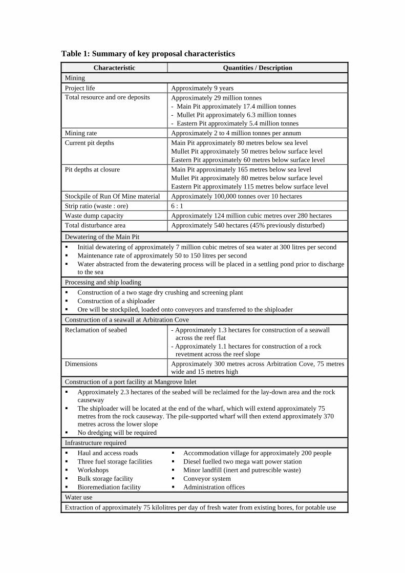
Table 1: Summary of key proposal characteristics
Characteristic Quantities / Description Mining Project life Approximately 9 years Total resource and ore deposits Approximately 29 million tonnes
- Main Pit approximately 17.4 million tonnes - Mullet Pit approximately 6.3 million tonnes - Eastern Pit approximately 5.4 million tonnes
Mining rate Approximately 2 to 4 million tonnes per annum Current pit depths Main Pit approximately 80 metres below sea level
Mullet Pit approximately 50 metres below surface level Eastern Pit approximately 60 metres below surface level
Pit depths at closure Main Pit approximately 165 metres below sea level Mullet Pit approximately 80 metres below surface level Eastern Pit approximately 115 metres below surface level
Stockpile of Run Of Mine material Approximately 100,000 tonnes over 10 hectares Strip ratio (waste : ore) 6 : 1 Waste dump capacity Approximately 124 million cubic metres over 280 hectares Total disturbance area Approximately 540 hectares (45% previously disturbed)
Dewatering of the Main Pit Initial dewatering of approximately 7 million cubic metres of sea water at 300 litres per second Maintenance rate of approximately 50 to 150 litres per second Water abstracted from the dewatering process will be placed in a settling pond prior to discharge
to the sea
Processing and ship loading Construction of a two stage dry crushing and screening plant Construction of a shiploader Ore will be stockpiled, loaded onto conveyors and transferred to the shiploader
Construction of a seawall at Arbitration Cove Reclamation of seabed - Approximately 1.3 hectares for construction of a seawall
across the reef flat - Approximately 1.1 hectares for construction of a rock
revetment across the reef slope Dimensions Approximately 300 metres across Arbitration Cove, 75 metres
wide and 15 metres high Construction of a port facility at Mangrove Inlet Approximately 2.3 hectares of the seabed will be reclaimed for the lay-down area and the rock
causeway The shiploader will be located at the end of the wharf, which will extend approximately 75
metres from the rock causeway. The pile-supported wharf will then extend approximately 370 metres across the lower slope
No dredging will be required Infrastructure required Haul and access roads Three fuel storage facilities Workshops Bulk storage facility Bioremediation facility
Accommodation village for approximately 200 people Diesel fuelled two mega watt power station Minor landfill (inert and putrescible waste) Conveyor system Administration offices
Water use Extraction of approximately 75 kilolitres per day of fresh water from existing bores, for potable use
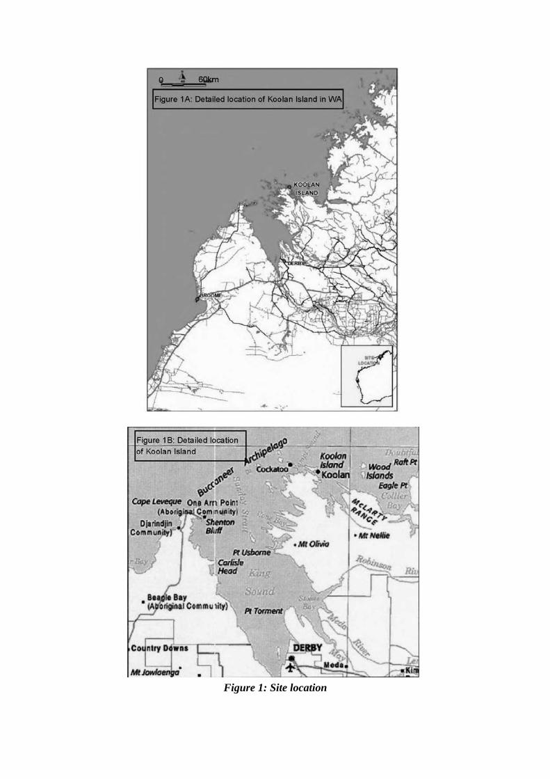
Figure 1: Site location
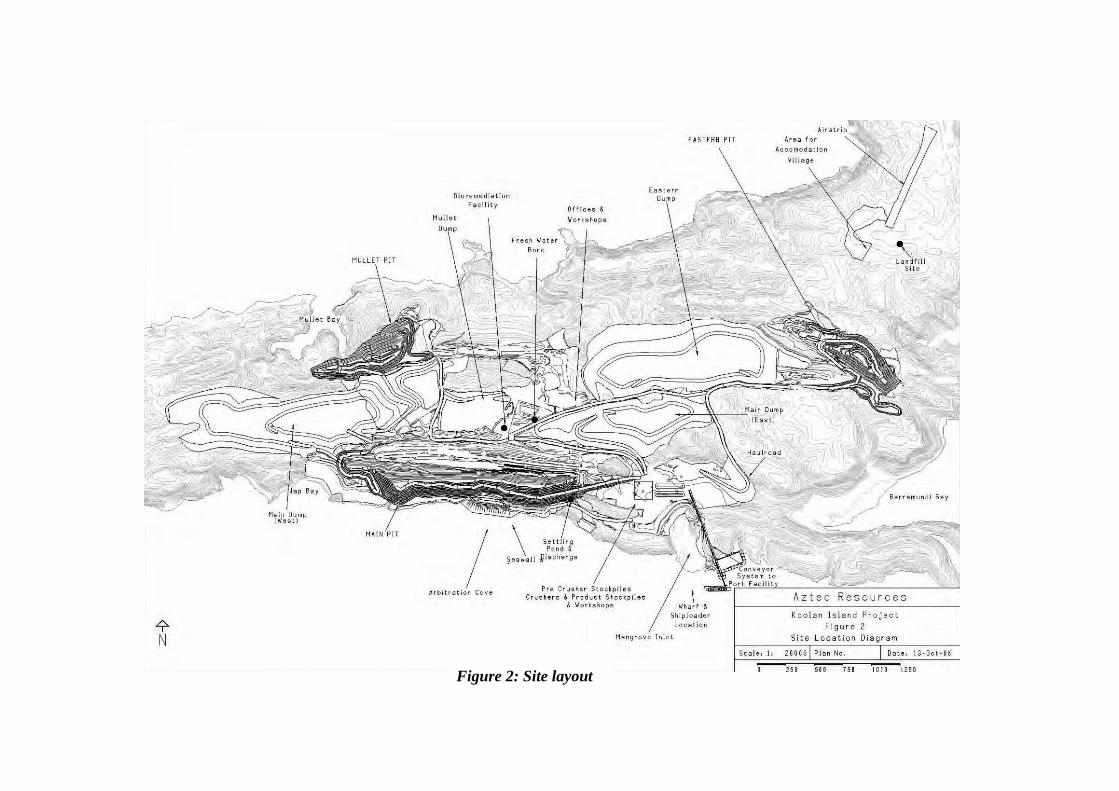
Figure 2: Site layout
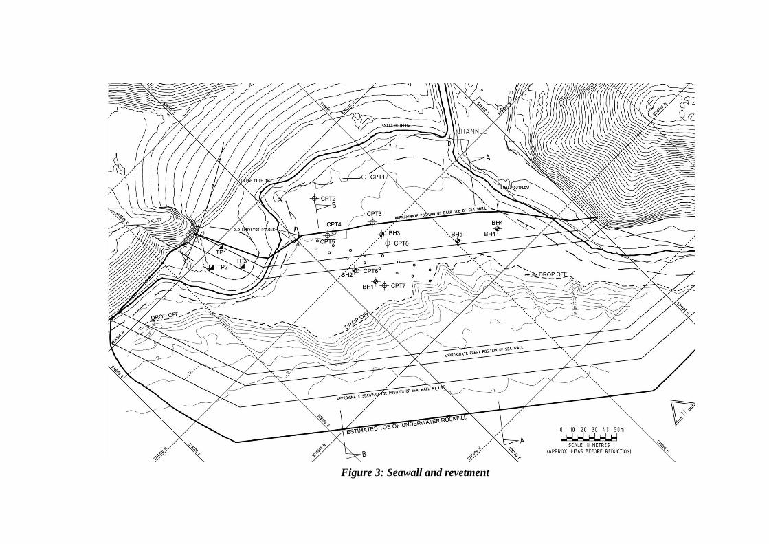
Figure 3: Seawall and revetment
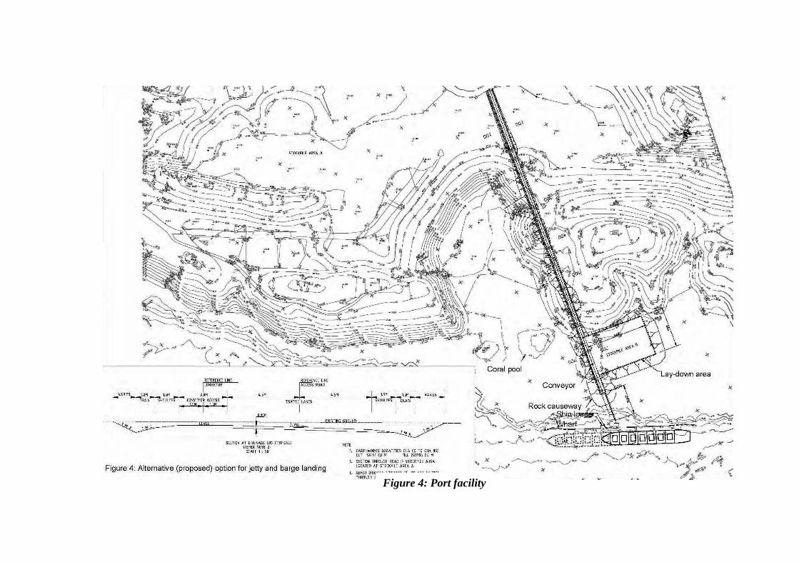
Figure 4: Port facility
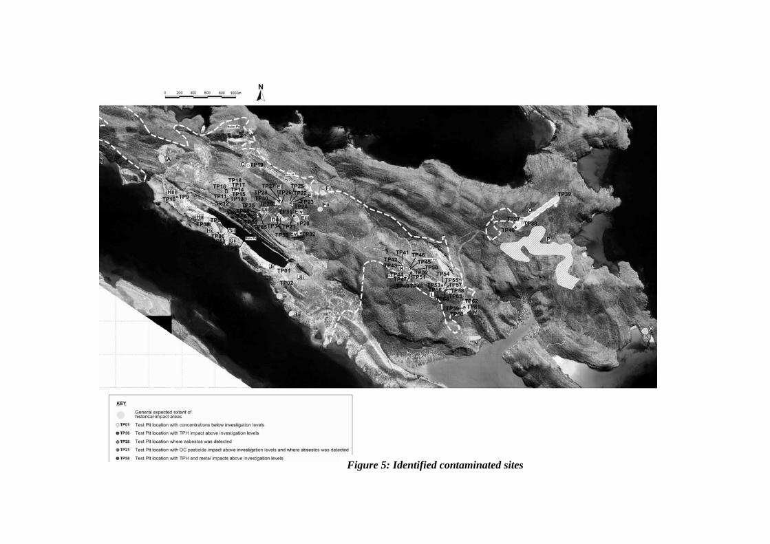
Figure 5: Identified contaminated sites
Schedule 2
Proponent’s Environmental Management Commitments – November 2005 KOOLAN ISLAND IRON ORE MINE AND PORT FACILITY (Assessment No. 1605)
Note: The term “commitment” as used in this schedule includes the entire row of the table and its six separate parts as follows:
• a commitment number; • a commitment topic; • the objective of the commitment; • the ‘action’ to be undertaken by the proponent; • the timing requirements of the commitment; and • the agency to provide technical advice to the Department of Environment.
No Topic Objective Action Timing Advice 1 Environmental
Management Plan
Provide operational control documentation for the management of environmental impacts during construction and operation
Implement the Environmental Management Plan (October 2005) which addresses the management of key environmental aspects, including:
• environmental training; • inspections and auditing; • Aboriginal heritage; • weed and pest management; • vegetation clearing and demarcation; • topsoil management; • borrow pits; • surface water; • hydrocarbon and chemical management and spills; • waste management; and • fire control.
For each aspect, the objective, management measures, monitoring programme and reporting requirements shall be described.
Construction and operation
CALM
2 Environmental Management System
Provide a risk-based management system for the identification and control of impacts
Implement the Environmental Management System for the project that embraces the ISO 14001 standards.
All phases -
No Topic Objective Action Timing Advice 3 Offset Contribute to sustainable development of
the industry 1) Ameliorate previous impacts wherever feasible. 2) Contribute AUD$100,000 to CALM over a 3-year period for a
suitable weed research program.
Life of mine
CALM
4 Groundwater Maintain or improve the quality of groundwater to ensure that existing and potential uses, including ecosystem maintenance are protected, consistent with the Australian and New Zealand Water Quality Guidelines (ANZECC, 2000)
1) Use information from dewatering studies to develop appropriate plant design and management plans to prevent groundwater contamination and ensure that the marine environment (and associated commercial industries) is not effected by discharge of groundwater from pit dewatering.
2) Implement the plant designs and management plans.
Prior to dewatering or groundwater abstraction Construction and operation
-
5 Contaminated sites
To identify contamination, assess any associated risks to the environment and/or human health and remediate where necessary
1) Carry out additional investigations of previously identified contamination.
2) Develop and implement management plans to prevent mobilisation of contaminants and impacts on the environment and/or the health of personnel.
Pre-construction Construction and operation
DoH DoCEP
6 Short range endemic fauna
Maintain the abundance, diversity and geographic distribution of short range endemic fauna at species and ecosystem levels
1) Conduct targeted surveys for all land snail species (as an indicator of short range endemic fauna) to ascertain the distribution and habitats of land snails on the island.
2) Where impacts on short range endemic fauna of conservation significance are identified, prepare and implement species-specific management plans for those species.
Pre-construction
Construction and operation
CALM
7 Landscape values
Manage and mitigate impacts on landscape values and maintain the integrity, ecological functions and environmental values of soil and landform
1) Consult with stakeholders to assess existing landform/landscape values and how these will be affected by the proposal.
Life of mine -
8 Consultation To consult with relevant stakeholders 1) Consult with stakeholders during preparation of management plans required by conditions 6, 7, 8 9, 10, 11, 13 and 14.
2) Deliver a presentation on the project operations to the key stakeholders at least once a year.
Life of mine -
DoCEP Department of Consumer and Employment Protection CALM Department of Conservation and Land Management DoH Department of Health