Embed Size (px)
Citation preview

1
ko, Haw
CD/M5
the Commissioners ofNorthern lighthouses
IGHT
The Corporation ofTrinity House London
US1E
AcewNve
iT
roL
The Commissioners ofIrish Lights
-JORITIES

The General Lighthouse Authorities of the United Kingdom and Ireland
THE GENERAL LIGHTHOUSE AUTHORITIESOF THE UNITED KINGDOM AND
IRELAND
AIDS TO NAVIGATION REVIEW 2005
Part 1 Executive Summary
A joint review of Aids to Navigation (AtoN) of the coasts of the UnitedKingdom (UK) and Ireland has been conducted in accordance with theguide-lines set out in Chapter 7.3 of the three GLAs' Joint NavigationRequirements Policy document. Each GLA has reviewed the AtoN in itsown area of responsibility and joint consultations have been conductedover areas of common or overlapping interest, such as the North Channel.Users are consulted wherever and whenever appropriate. Several of theproposed changes contained in the Review have been incorporated as adirect result of user response already obtained to date on specific areas ofinterest. Some of the user response already obtained has resulted in theimplementation of certain changes. This Review addresses the current andfuture requirements of national and international shipping and those ofMariners in general for consultation purposes.
1.2 The study has been carried out based solely on the minimum navigationalrequirements and does not at this stage take into account any otherconsiderations. It is important to appreciate that the measures contained inthis Review will not necessarily take place within the next 5 years,however they will shape the GLAs' Capital Works and Buoyageprogramme contained within individual Corporate Plans.
1.3 The bridges of most modern commercial ships are fitted with a number ofkey navigational aids, which rely on inputs from GPS for position and
1.4 GPS has brought readily available and accurate position fixing to millionsand has changed the manner in which the mariner conducts a voyage.However, there is concern in the maritime sector over such high relianceon GPS for positioning fixing and timing due to the known vulnerabilityof the system to accidental or malicious interference.
1.5 The advent of Galileo will only ameliorate this concern to a limiteddegree. The similarities of GPS and Galileo mean that they suffer fromthe same weaknesses. It is essential to retain a mix of complementarysystems, as the fundamental principle of marine navigation is never to relyon a single source of navigation information when alternative sources areavailable.
1.6 Given that 95% of UK trade, and 98% of Irish trade, is carried by sea andour waters are some of the busiest in the world, the potential for
GLAs' AtoN Review 2005 Page 2 of 54

GLAs' AtoN Review 2005 Page 3 of 54
The General Lighthouse Authorities of the United Kingdom and Ireland
disruption, environmental damage and even loss of life resulting frominterruption to the GNSS signals is of great concern.
1.7 Radar and visual aids are seen as a terrestrial backup to satellite systems aswell as providing clear physical marking of wrecks, shoals and otherhazards.
1.8 On 6th October 2004 the General Lighthouse Authorities published theMarine Aids to Navigation Strategy to 2020, known as '2020 The Vision'.This strategy document looks carefully at trends in navigational practicesand determines a future strategy for the provision of both visual andelectronic Aids to Navigation and forms the foundation of this review.
1.9 This is the second time that the three GLAs have conducted a total,simultaneous review of all their AtoN. In accordance with their JointNavigation Requirements Policy document, it is the intention to conductsuch a review every five years, in order to ensure:
'That the aids to navigation provided by the GLAs in the interestof general navigation are cost-effective and continue to meet thepresent changing need of all mariners and comply whereverpossible with internationally-accepted criteria and
That timely reviews of the GLAs' aids to navigation are carriedout to facilitate financial, operational and engineering planning."
1.10 Whilst each GLA has carried out its own review of its own AtoN, thereare areas where the boundaries of two, or even all three, GLAs meet andwhere a concerted view has been necessary.
1.1 1 In producing the recommendations contained in the Review, therefore, theGLAs have:
Carried out their own internal study of the AtoN in their area ofresponsibility;Selectively involved the users in initial discussions;Carried out cross-border discussions with other GLAs;Briefed individual GLA User Consultative Groups on the mainrecommendations arising out of the Review.
1.12 Each AtoN has been studied in isolation, as well as in relation to the otherAtoN in its vicinity, which we refer to as the "mix" of AtoN.
1.13 An overall summary of the changes is contained in table 1 below.

The General Lighthouse Authorities of the United Kingdom and Ireland
Table 1: 2005 AtoN Review - Summary of the GLAs' Main Recommendations
Type of AtoN Change NumberLighthouse Discontinue 10
Establish 6
Investigate discontinuance 2
Discontinue light only 3
Reduce range 36 + (1)Increase range 6
Investigate range 1
Alter character 11 + (1)Discontinue sector 4Establish/Restore sector I
Alter sector 3
Amend hours of exhibition 3 + (1)Move light 3
Hand over 17
Major Floating Aid Discontinue (associated with upgrading of existingbuoy to a Superbuoy)
I
Replace LV by SLV with reduced range and daymark 4
Replace SLV by SLF with reduced range anddaymark
1
Replacement by Superbuov 4
Move 1
AtoN- AIS Establish 93 + (2)Racons Establish 11 + (2)
Discontinue 3
-Upgrade 1
Buoys Establish 11 + (3)Discontinue 19 + (4)Investigate future requirement 7
Replace by new design Class 3 85 + (1)Alter characteristics 12
Investigate hand over/handover 9 + (1)Light 26 + (3)Increase range of light 100 + (1)Decrease range of light 6
Move/investigate moving 12
Beacons/Daymarks Investigate Lighting 6
Investigate establishment/Re-instatementDiscontinue 10
EstablishLight 18 + (1)Increase range of light 4
Alter characteristics/Restore 6
Handover 12 + (1)Fog Signals Discontinue 75
NOTE: In a number of cases there is more than one option, which will satisfy the minimumnavigational requirement and therefore some of the recommendations contained in the Reviewprovide for alternative solutions and/or further investigations and/or are dependent upon otherfactors. These are represented by the figures in brackets.
GLAs' AtoN Review 2005 Page 4 of 54

The General Lighthouse Authorities of the United Kindom and Ireland
Part 2 Introduction
2.1 The Review
2.1.1 This is the second time that the three GLAs have conducted a total,simultaneous review of all their AtoN. In accordance with their JointNavigation Requirements Policy document, it is the intention to continuesuch reviews every five years, in order to ensure:
that the aids to navigation provided by the GLAs in the interest ofgeneral navigation are cost-effective and continue to meet thepresent changing need of all mariners and comply wherever possiblewith internationally-accepted criteria and
that timely reviews of the GLAs' aids to navigation are carried out tofacilitate financial, operational and engineering planning."
2.1.2 The GLA Marine Aids to Navigation Strategy to 2020 (2020 The Vision)forms the strategic foundation of this review.
2.1.3 This joint review of Aids to Navigation (AtoN) of the United Kingdom(UK) and Ireland coasts has been conducted in accordance with theguide-lines set out in Chapter 7.3 of the three GLAs' Joint NavigationRequirements Policy document. Each GLA has reviewed the AtoN in itsown area of responsibility and joint consultations have been conducted overareas of common or overlapping interest, such as the North Channel. Usersare consulted wherever and whenever appropriate. Several of the proposedchanges contained in the Review have been incorporated as a direct result ofuser response obtained to date on specific areas of interest. Some of the userresponse already obtained has resulted in the implementation of certainchanges. This Review addresses the current and future requirements ofnational and international shipping and those of Mariners in general forconsultation purposes. The review covers the period 2005 to 2010.
2.1.4 The study has been carried out based solely on the minimum navigationalrequirements and does not at this stage take into account any otherconsiderations. It is important to appreciate that the measures contained inthis Review will not necessarily take place within the next 5 years, howeverthey will shape the GLAs' Capital Works and Buoyage programmecontained within individual Corporate Plans
2.2 Transport By Sea
2.2.1 Since the completion of the 1998 AtoN Review of GLA-provided AtoN,the volume, character and pattern of seaborne traffic around the coasts ofthe UK and Ireland has been subject to continuous change. Closerintegration of the European Trading Bloc has brought a renewedawareness to the importance of our sea trades.
2.2.2 The European Union (EU) dependency on waterborne transport to carry90% of its external trade closely resembles that of island economies such
GLAs' AtoN Review 2005 Page 5 of 54

The General Lighthouse Authorities of the United Kingdom and Ireland
as our own. This fact, combined with the realization in Brussels of thecost-effectiveness of short sea shipping, the part it has to play in easingland transport problems and its comparative environmental-friendliness,has contributed to a greater awareness within the EU of not onlymember countries' dependence on sea transport but also the need to bothregulate and nurture its continued growth.
2.2.3 The predicted sustained growth within the combined economies of ourislands, coupled with the expected expansion of the EU to include othercountries which rely heavily upon marine transport, can be expected tofurther encourage the adoption of policies which will enhance thedevelopment of such short sea trade.
2.3 Shipping Trends
2.3.1 In terms of ship management, trends towards greater sophistication ofon-board equipment, reduced manning levels, mixing of crewnationalities, the growth in the economic vessel size, changes in tradingpatterns and the growth of transshipment to/from hub-ports have allcontributed in the intervening period to a change of emphasis andreliance upon the AtoN provided by the GLAs
2.3.2 High-speed craft, most especially in the area of ferries, have proliferatedin recent years, with services now running between Holyhead andDublin/Dun Laoghaire, Rosslare to Fishguard, Loch Ryan andBelfast/Larne, to and from the Isle of Man and from Harwich and theChannel ports to continental Europe. The speeds at which these vesselsoperate (up to 50 knots) means that special attention has had to be paidto AtoN used by them for navigation and orientation.
2.4 Fishing
2.4.1 The fishing industry has been undergoing a programme ofrationalisation, where the number of vessels has declined in the movetowards larger vessels capable of going further afield in pursuit of non-quota fish stocks.
2.4.2 The speed at which both these larger vessels and the smaller inshorevessels now operate has also changed dramatically in recent years.Speeds of up to 30 knots are not uncommon with inshore crabbers. Thetraditional in-shore boat still remains however, with professionalmarketing increasing the size and value of in-shore catches and theconsequent retention of the fleet.
2.5 Aquaculture
2.5.1 Frequent applications for aquaculture licenses are made to the variousGovernment Departments responsible for such activities for almostevery coastal region. Long-established salmon farming has beenaugmented by the cultivation of other fin-fish and many varieties ofshellfish. The GLAs are consulted on a regular basis by the GovernmentDepartments responsible for aquaculture, regarding the impact of
GLAs' AtoN Review 2005 Page 6 of 54

The General Lity.hthouse Authorities of the United Kingdom and Ireland
aquaculture on the safety of navigation in specific coastal areas. Thisincludes the marking and lighting of fish farms, floating structures andcages.
2.6 Marine Leisure
2.6.1 The marine leisure industry has also undergone considerable change,though quite how much is difficult to quantify. The number of yachtmarinas already built, or in the planning stage best illustrates the growth,which this marine sector has achieved and expects to achieve. Thedemand for these facilities is created by the overcrowded conditions ofestablished moorings and the overflow resulting from the increasednumber of craft. A remarkable feature of this sector is the speed withwhich new technology, in the form of satellite navigation systems,electronic chart systems and even integrated navigation systems, hasbeen embraced.
2.6.2 Leisure passenger cruising is also increasing quickly. Ports are activelyencouraging calls by Cruise liners, resulting in very significant growth inport tonnage in some areas.
2.6.3 Smaller 100/200 passenger, 100metre length, specialist cruise ships arealready appearing in our waters. The attraction for this type of trade isspecial-interest tours, calls at smaller ports and cruising the unspoiltcoastlines.
2.6.4 Offshore islands are now attracting large numbers of tourists from themainland harbours, carried in small ferries. Islands on our coasts areexperiencing increasing traffic movements and very substantialpassenger volumes.
2.7 Offshore Renewable Energy Sites
2.7.1.1 Since the last review there has been a proliferation of offshore windfarmsite proposals around our coasts and this trend is set to continue. Thereare, so far, five sites around the coast with another 29 in the planningstage. These sites present a particular challenge to the GeneralLighthouse Authorities to ensure they are marked correctly and do notimpede safe navigation of vessels.
2.7.1.2 Off the Orkney Islands trials are currently underway to harness wavepower and a single tidal power generator has been in operation off theNorth Devon coast for a number of years. It is likely that, over the nextfive years, commercial production of wave and tidal energy power willcommence. These sites are also challenging to mark, particularly wavegenerators that are often difficult to see, have a low freeboard and couldpotentially break free of their moorings.
2.8 New Technology
GLAs' AtoN Review 2005 Page 7 of 54

The General Lighthouse Authorities of the United Kingdom and Ireland
2.8.1 The fundamental nature of marine navigation has altered over the lastdecade as a result of the proliferation of good, reliable, mass-marketGPS receivers with a nominal accuracy of 13 metres or better (since theremoval of Selective Availability in 2000), and immune to the causes ofimperfection associated with previous generations of electronicpositioning systems. The GLAs have operated a public serviceDifferential GPS system since 1998, which offers an enhanced level ofaccuracy (5 metres or better) and an integrity warning of GPS serviceinterruption or degradation. (D)GPS is widely used as the primarynavigation system on almost all classes of vessels.
2.8.2 The widespread availability of GPS and DGPS receivers, at low cost, isincreasingly encouraging mariners of all classes to navigate either closerinshore or closer to dangers, doing so in conditions of darkness andreduced visibility where they would not have previously ventured.
2.8.3 GPS will be joined during the next 5 years by additional Global SatelliteNavigation Systems (GNSS), including a resurgent GLONASS serviceand a European Civil operated GALILEO service, which isoptimistically due to commence operation in 2008. From an operationalperspective, GALILEO brings greatly improved performance in terms ofaccuracy and availability as a position fixing system, when compared tothe current GPS alone. Galileo itself is inherently superior to currentGPS due to improved technology and contributes significantly to a morerobust GNSS by more than doubling the number of satellites deployed,using signals broadcast on several frequencies and providingindependent control. Galileo will, therefore, reduce the well-knownvulnerability of GNSS to interference and jamming, although it cannoteliminate this problem. Availability of an enhanced GNSS Service, hasthe potential, in time, to lead to reductions in other forms of aids tonavigation.
2.8.4 UPS has brought readily available and accurate position fixing tomillions and has changed the manner in which the mariner conducts avoyage. However, there is concern in the maritime sector over such highreliance on GPS for positioning fixing and timing due to the knownvulnerability of the system to accidental or malicious interference.
2.8.5 The bridges of most modern commercial ships are fitted with a numberof key navigational aids, which rely on inputs from GPS for position andtiming. For example, an integrated bridge has GPS inputs to radar,electronic chart, autopilot, Automatic Identification System (AIS),Global Maritime Distress and Safety System (GMDSS) Voyage DataRecorders, Emergency Position Indicating Rescue Beacon (EPIRB) andmore.
2.8.6 Given that 95% of UK trade, and 98% of Irish trade, is carried by seaand our waters are some of the busiest in the world, the potential fordisruption, environmental damage and even loss of life resulting frominterruption to the GNSS signals is of great concern.
2.8.7 The advent of Galileo will only ameliorate this concern to a limiteddegree. The similarities of GPS and Galileo mean that they suffer from
GLAs' AtoN Review 2005 Page 8 of 54

The General Lighthouse Authorities of the United Kingdom and Ireland
the same weaknesses. It is essential to retain a mix of complementarysystems, as the fundamental principle of marine navigation is never torely on a single source of navigation information when alternativesources are available.
2.8.8 It is these increasingly recognized concerns that have led to GLAparticipation in a pan-European Terrestrial Navigation LORAN-CSystem on a trial basis. LORAN is significantly less vulnerable tointerference than GNSS and, in the context of an integratedLORAN/GNSS receiver, offers greater security to the user. Potentialdevelopments in LORAN technology offer accuracy levels of up to 20metres.
2.8.9 A future growth area in the provision of aids to navigation will be theintroduction of Automatic Identification Systems (AIS). This systemwill be a compulsory requirement on all SOLAS vessels greater than300gt with effect from the end of 2004. It is considered that navigationalsafety can be improved by the fitting of compatible equipment on someAtoN. In the short term, advantage can be gained by using AIS as ameans by which the GLAs can monitor the status of the AtoN includingreal-time information on the AtoN position and complement the existingservice provided to the mariner by facilitating identification of the AtoN.In the longer term it may be possible to use both shore based andfloating aids to provide meteorological and hydrological information, aswell utilising the AtoN status information as a feed into the World WideNavigation Warning System, resulting in improvements to the way inwhich data is currently made available/presented to the mariner on thebridge.
AIS technology can also be used in the following manner:
As synthetic AIS on an aid to navigation
As virtual AtoN, for example for use in wreck marking prior todeploying buoys, mitigating further the risk to mariners
To facilitate traffic analysis by AtoN providers to assist in theprovision of the appropriate level of service and mix of AtoN
2.8.10 Following sea trials THLS has decided to embark on a programme ofreplacement of the current THLS Class 3, 4 and 5 buoys and other non-standard buoys by a Class 3 buoy using modern material options, such asplastics. Two sizes of Class 3 buoy have been identified. These aredesignated in the Area Schedules, contained in Section 4 of this Review,as large or small. In each case, the dayrnark and radar conspicuity of thestations concerned will be improved as radar reflectors and topmarkswill come as a standard fit to new buoys. In the case of the smallerversion, the radar reflector is built into the buoy body, whilst for thelarger version this will be integrated into the Topmark.
2.8.11 In addition, selected THLS Class II buoy stations, that may beacceptable to the user for replacement by this new design Class 3 buoy,have also been identified within the relevant Area Schedules.
GLAs' AtoN Review 2005 Page 9 of 54

The General Lighthouse Authorities of the United Kingdom and Ireland
2.8.12 Advances in LED technology now enable the GLAs to improve andthereby standardize on the light ranges of their buoys. This improvementwill be particularly welcomed by those users who have previouslyexpressed concerns over the lack of visibility of some lights, particularlyin areas suffering from high levels of background lighting. In addition,the use of LED technology is currently being extended to beacons and tosome lighthouses.
2.9 2020 The Vision
2.9.1 On 61h 2004 the General Lighthouse Authorities published theMarine Aids to Navigation Strategy to 2020, known as '2020 TheVision'. This strategy document looks carefully at trends in navigationalpractices and determines a future strategy for the provision of bothvisual and electronic Aids to Navigation.
2.9.2 The strategy takes into account the evolving shipboard practices andtraining requirements of seafarers. Traditional navigational skillssometimes appear to be superseded by over reliance on newtechnological advances however it is clear from in depth consultationwith users that lighthouses, buoys and beacons will continue to play avital role in a balanced AtoN system.
2.9.3 As already mentioned above, position fixing using GNSS is prevalentamongst both commercial and leisure users. Radar and visual aids areseen as a terrestrial backup to satellite systems as well as providing clearphysical marking of wrecks, shoals and other hazards. This back up rolehas been further emphasised by the known vulnerability of GNSS andthe ease with which signals can be subject to interference from jamming,spoofing or natural influences, as discussed above.
2.9.4 The key conclusions of 2020 The Vision are:
Lighthouses will have decreasing significance over time andsome may be discontinued. Those that remain will provideplatforms for additional services.
Unlit beacons will normally be discontinued or lighted.
MFAs will be replaced once the operational performance ofbuoys meets navigational requirements.
The will be no significant changes with regards the provision ofbuoys although they may be used as platforms for additionalservices.
Fog signals have a limited application in hazard warning.
RACONS are an integral part of an AtoN system and willcontinue to be provided.
GLAs' AtoN Review 2005 Page 10 of 54

The General Lichthouse Authorities of the United Kinuslom and Ireland
LORAN C. as a terrestrial system, should be adopted as themaritime radionavigation backup to GNSS.
A1S Technology will significantly enhance and complementexisting AtoN.
Differential GNSS services will continue to be provided.
2.10 Traffic Separation Schemes (TSS)
2.10.1 The practice of following predetermined routes has been operational fornearly 100 years. The application of the idea to the Dover Straits in the1960s has led to the modern TSS where opposing traffic is separatedinto "lanes".
2.10.2 The International Maritime Organization is the specialist agency of theUnited Nations responsible for maritime safety. It is the onlyinternational body for establishing and adopting measures on aninternational level concerning ship routeing and areas to be avoided byships or certain classes of ships.
2.10.3 Submissions regarding route proposals or areas to be avoided are theresponsibility of Government, i.e. The Department of Communications,Marine and Natural Resources in Ireland and the Department forTransport (DIY) in the UK. In the UK this role has been delegated to theMaritime and Coastguard Agency, which is an Executive Agency of theDfT.
2.10.4 There are 10 TSSs adopted in the UK and Ireland. These are situated inthe Approaches to The Humber, Dover Straits, the English Channel,Scilly Isles, Smalls, Anglesey, North Channel (Rathlin Is.), Fastnet andTuskar.
2.10.5 A Deep Water Route for tankers exists West of the Outer Hebrides.
2.10.6 In particular, the use of A1S to monitor vessel movements from shorestations is being developed. The sensitivity of our coasts, both from anenvironmental/tourism viewpoint, and from that of the aquaculturelobby, may lead to Governments decreeing that certain classes of vessels(or all vessels) keep a certain distance off our coasts, or follow particularroutes.
2.11 Form of the Review
2.11.1 Whilst each GLA has carried out a review of its own AtoN, there areareas where the boundaries of two, or even all three, GLAs meet andwhere a concerted view has been necessary. Thus, for example, in theNorth Channel/Isle of Man area, all three authorities have combined toproduce the reports covering this area.
2.11.2 In producing the recommendations herein, therefore, the GLAs have:
GLAs' AtoN Review 2005 Page 11 of 54

The General Lighthouse Authorities of the United Kingdom and Ireland
carried out their own internal study of the AtoN in their area ofresponsibility;
selectively involved the users in initial discussions;carried out cross-border discussions with other GLAs;
briefed Individual GLA User Consultative Groups
2.11.3 Each AtoN has been studied in isolation, as well as in relation to theother AtoN in its vicinity which we refer to as the "mix" of AtoN. Thestudy has been carried out based solely on the minimum navigationalrequirements and does not at this stage take into account any otherconsiderations. It is important to appreciate that the measures containedin this Review will not necessarily take place within the next 5 years,however they will shape the GLAs' Capital Works and Buoyageprogramme contained within individual Corporate Hans.
2.11.4 Comments from users on the proposals contained in Parts 3 and 4 of theReview document would be welcomed by 31 March 2005.
2.11.5 Comments should be sent to the appropriate GLA, as follows:
Comments in respect of Areas 1 - 8 to:The Director of Marine OperationsNorthern Lighthouse Board84 George StreetEdinburghScotland EH2 3DAEmail: [email protected]
Comments in respect of Areas 9 - 14 to:The Director of Navigational RequirementsTrinity House Lighthouse ServiceTrinity HouseTower HillLondonEC3N 4DHEmail: [email protected]
Comments in respect of Areas 15 -21 to:lead of Marine Dept.,
Commissioners of Irish Lights16 Lower Pembroke StreetDublin 2Ireland.Email:[email protected]
GLAs AtoN Review 2005 Page 12 of 54

The General Lighthouse Authorities of the United Kingdom and Ireland
Part 3 Overview of the Results
3.1 The GLAs' areas of jurisdiction, which includes 8623 miles of coastline,have been broken down into 21 Areas. Where considered appropriate,these 21 Areas have been broken down further into sub-areas.Boundaries of these Areas, which are shown for illustrative purposes infigure 1 below, are as follows:
The Isle of Man, North Channel, the Clyde2 The Mull of Kintyre to Ardnamurchan3 Ardnamurchan to Barra Head; Cape Wrath to the Flannan Isles4 Scotland N Coast, Orkney Islands (excluding Pentland Firth)5 Pentland Firth6 Shetland Islands7 Clythness to Rattray Head8 Rattray Head to St Abbs Head9 Berwick to Sizewell10 Sizewell to Shoreham11 - Shoreham to Lyme Regis12 - Lyme Regis to Bude13 - Bode to Cardigan14 - Cardigan to Silloth15 - St John's Point, Down to Rathlin East16 - Rathlin East to Tory17 - Tory to Loop Head18 - Loop Head to Fastnet19 - Fastnet to Tuskar20 - Tuskar to Baily21 - Baily to St John's Point, Down
Not to be used for Navigation
Oil
II
CI
GLAs' AtoN Review 2005 Page 13 of 54
IBe. stk
.4.4
Reproduced from Admiralty Chart 2 by permission of the Controller of Her Majesty'sStationery Office and the UK Hydrographic Office (www.ukho.gov.uk)
Figure 1: Chartlet depicting GLAs' Area Boundaries

The General Lighthouse Authorities of the United Kinalorn and Ireland
3.2 For illustrative purposes, and to facilitate ease of reference, a chartletdepicting the sub-areas for Areas 9 - 14 can be found at figure 2 below.
CHARTLET DETAILINGSUB AREAS 9-14
NE Coast
9
... ............\ ash
.........
larniouth
HanvIch
F.StUar.......
Do er
Arc Sm,well
Area ID - SteesseR 'Shoreham
Area II Munch= Lymo Reps
Area IL' Lyme Reps Bude
Area 1; Bud, Carthon
Are.14 Cardv, StIluth
Figure 2: Boundary Chartlet for depicting sub-areas within Areas 9-14
3.2 The GLAs have agreed areas of contiguous coastline where they willconsult mutually, regarding AtoN provision. These contiguous areaswere first agreed in 1980. The chartlet depicting these areas, which iscontained in Annex 10.1 of the GLAs' Joint Navigational RequirementsPolicy document, is reproduced at figure 3 below, for information.
3.3 The GLAs have had the benefit of access to a computer database ontraffic movement to assist in the evaluation of the volume of traffic. Thedatabase currently used contains details of over 3,500 routes, includingports of departure and destination, together with the number, type, sizeof vessels using each route annually. Although the database currently inuse by the GLAs is more comprehensive than that used for the 1997-98Review, there are some types of vessel that have not yet been includedin the database, such as fishing vessels and pleasure craft, as well asspecialist vessels. A plot can be created to overlay onto an AdmiraltyRaster Scan Chart showing routes within a given radius of a location.
GLAs' AtoN Review 2005 Page 14 of 54

r. In I NO
r I L.
The General Lighthouse Authorities of the United Kinttdorn and Ireland
Figure 3: GLAs' Areas of Consultation Chartlet
3.4 The Area overviews, which follow, contain information on commercialtraffic levels from this database and figures 4 - 16 depict routes withinspecified search radii of selected GLA AtoN. The use of plots from thisdatabase, Ship Routes, and their overlay onto extracts from theAdmiralty ARCs charts is gratefully acknowledged. For future reviewstraffic data based on actual ship routes from the Automatic IdentificationSystem (AIS) transmissions of vessels will be used.
3.5 Table 2 below depicts a blank standard Review Report form, reproducedfrom the GLAs' Joint Navigation Policy Document, which has beenagreed for use in Reviews of this nature. Explanatory notes arecontained on this blank form, which serve both as the information for theuser when studying the completed review forms, as well as guidance tothe GLAs when completing these forms.
hx-.A7
21; - N5 IN
OP - Ot.1 "30.00- 00I-ON Dl
SC;:. C c_)2° _31-1=1., I "_ r,, 02 - JJ*-.
C. 1O..7N 02' L.,51" 315%. G'N 05° /31.-1
Dl' 00. ON L)5" ° OCT- Lu.-11.1 ° on/ D7° ocr. 01-1.52" OG'.. SN n7° 017-
ONS'ar° 1.),4
F. . ON 05" f-t_SI.' 54. ON OS' OH' -
if;:" 11LI 4 L-10 -
° 1
4 "55" 4f.J".. 4N D4"._*12-
00; "nEV_ ot9 06" 3'7- "30SG" I a_ z.N 0729_ nr,,
GLAs' AtoN Review 2005 Page 15 of 54

The General Lighthouse Authorities of the United Kingdom and Ireland
Table 2: Blank Standard GLAs' AtoN Review Report Form: including Key to Columns andGuidance Notes upon their Completion.
3.6 Some of the information contained in the text within this Part of theReview has been sourced from the Admiralty Sailing Directions, the useof which is gratefully acknowledged. Diagrams depicting the location ofthe GLAs' DGPS transmitters are contained in the Admiralty List ofRadio Signals Volume 2, NP282.
3.7 Area Overviews
3.7.1 AREA 1- ISLE OF MAN, NORTH CHANNEL, CLYDE
3.7.1.1 This region is one in which all three General Lighthouse Authorities'(GLAs') areas meet. This part of the report is, therefore, a joint one, withinput from all three.
3.7.1.2 This is a busy region and one in which strong tidal streams (up to 6knots) and poor weather conditions are prevalent. As well as coastalmerchant traffic, the Royal Navy operates a major base for submarinesand surface vessels in the Upper Clyde and ferry services, many of themhigh-speed vessels (over 35 knots), serve the Isle of Man and run acrossthe North Channel and the Clyde. The region is well served with AtoN,both fixed and floating.
3.7.1.3 The area has been divided into four sub-areas, together with details ofthe major proposed changes, these are as follows:
3.7.1.3.1 Isle of Man
GLAs' AtoN Review 2005 Page 16 of 54
AREABA CHART/
ALL NO
NAME OF ATON CHARACTER VISIBILITY RANGE (NM) TIDALSTREAM
(KNTS)
FEATURESMARKED
OTHERATON IN
VICINITY
(NAMES)
VALUE TOUSERS
COMMENTS
>10NM >5NM >2NM IF IS% % %
Column 1 Indicates the most appropriate British Admiralty Chart for the AtoN specified on that page and advises of the ALL No , whereappropriate
Column 2 List the name of each AtoN
Column 3 Lists the character of each AtoN and any associated services
Column 4 Average percentage time for which conditions of nominal, good and poor visibility (i.e. at >10, >5 and >2 nautical miles,respectively) can be expected, followed by the range of lights under each of these conditions (This informationenables an assessment of visual position-fixing facilities in the area).
Column 5 Shows the strength (in knots) of the tidal stream that can be expected in the vicinity of each AtoN.
Column 6 Identifies the specific features, which are marked.
Column 7 Indicates other AtoN in the vicinity of the features in column (6)
Column 8 Indicates the degree of utilization of each AtoN by merchant ships (M), fishermen (F), leisure craft (L), and specialists (S) (using inthe appropriate user sub-columns, the notation "3" for High use, "2" for Medium use, "1' for Low use and "0" forZero use) taking into account the routes generally followed by the different categories of user. (The informationprovided in this column may be supplemented by a chart(s) of suitable scale, showing the tracts the differentcategories of user normally follow. This supplementary information may be requested from users invited tocomplete the column or comment on the report).
Column 9 Contains relevant remarks (e.g. any recommendations by the General Lighthouse Authorities or users based on an assessmentof relevant information in the report or users experience)
3.7.15.4
The General Lighthouse Authorities of the United Kingdom and Ireland
3.7.15 AREA 15- ST JOHN'S POINT DOWN TO RATHLIN ISLAND
3.7.15.1 St. John's Point, Co. Down to Rathlin Island forms the entire Southwestside of the North Channel, which carries a considerable volume ofseaborne traffic through a relatively narrow seaway.
3.7.15.2 It also contains two of the most important commercial ports in Ireland,Belfast and Lame, as well as a number of very viable fishing ports andleisure centres, such as Bangor, Portavogie, Ballywalter, Portafen-y,Strangford and Ardglass.
3.7.15.3 This coastal area can be divided roughly in two for the purpose ofdescribing the natural features of its terrain. With the exceptions of theMaidens Rocks and Hunter Rock, both of which are very well lighted,the coast from Fair Head to Black Head, at the Northeastern entrance toBelfast Lough, is quite steep-to, with deep water off, and no navigationalhazards to speak of. However, on passing South of Belfast Lough, thecoast from Mew Island to the entrance to Strangford Lough is low-lying,rock strewn and decidedly inhospitable, apart from Donaghadee Sound,from the Mariner's viewpoint.
Inshore channels are virtually non existent along this stretch of coast, asall but the smallest of craft keeps well East of the two major floatingaids, South Rock Light Float and the Skulmartin Buoy. In the case ofDonaghadee Sound, this passage has in it a number of shoal patcheswhich are adequately buoyed and lighted for safe navigation. It is notsuitable for large vessels but does attract a considerable amount ofBelfast traffic, which would otherwise be obliged to pass East of MewIsland.
3.7.15.5 Belfast and Strangford Loughs are the only two inlets, which offershelter to vessels seeking refuge from adverse weather. Belfast Loughbeing open to the East is of limited use in this respect. However, AudleyRoads, in Strangford Lough, provides an all-weather anchorage forsmaller commercial vessels, fishing boats and leisure craft.
GLAs' AtoN Review 2005 Page 45 of 54

ftl,?At
71f.4.,
The General Lighthouse Authorities of the United Kingdom and Ireland
r rn-"-,
t s- '
c
n A
:
ay
rig Jc AA:
0A I.:
;
1. A
S .11
;
.'Sr!ii;AurrA
' 7.1.,
Reproduced from Admiralty Chart 1121 by permission of the Controller of Her Majesty's StationeryOffice and the hydrographic offices of France and the United Kingdom (www.uk.ho.govaik)
Figure 14: ShipRoutes overlay for some of the 241 routes identified within a 20 nm of Belfast
3.7.15.6 Within a radius of 20nm of Belfast there are some 24,578 vesselmovements per annum using 241 routes- See figure 14 above.
3.7.15.7 The large volume of through traffic has been sustained by containertraffic into Liverpool. There has also been a considerable increase insailing and leisure traffic through this area.
3.7.15.8 IMO TSS indicates an important routing point within area 15.
3.7.15.9 The changes proposed for this area can be summarised, as follows:
Pladdy Lug Beacon Due to confusion among vessels leadingto grounding in this area, re-designate as starboard lateraldaymark and light.South Rock ALF Disestablish ALF and replace withsuperbuoy with AIS AtoN in conjunction with the lighting of oldSouth Rock LighthouseNorth Rocks Beacon Establish red can topmarkPlough Buoy Install LED Light and upgrade to 4.5nm rangeSkulmartin Buoy Install LED Light and upgrade to 6nm rangeand remove whistle fog signal.Deputy Buoy Install LED Light and upgrade to 4.5nm rangeMew Island Lighthouse Reduce range to 20nm ifeconomically advantageous and establish AIS AtoN.Cloghan Jetty Buoy Contract buoy. Traffic clearance mark.Consult customer with regard to disestablishing.
GLAs' AtoN Review 2005 Page 46 of 54

The General Lighthouse Authorities of the United Kingdom and Ireland
Blackhead Antrim Lighthouse Reduce range to 20nm ifeconomically advantageousBarr Point Fog Signal Disestablish.South Hunter Buoy Remove whistle fog signalNorth Hunter Buoy Change character to Q from VQ toimprove differentiation with South HunterMaidens Lighthouse Reduce flash period. Reduce range to20= if economically advantageous. Discontinue Aux. light.Introduce red sector equivalent on main light
3.7.16 AREA 16- RATHLIN EAST TO TORY ISLAND
3.7.16.1 The North Irish coast between Rathlin East Lighthouse and Tory Islandis relatively clear of hazards to navigation, which have not already beenclearly marked by the relevant GLA or local authorities.
3.7.16.2 To take the region as a whole, the three principal islands which lie offthis coast, Tory, Inishtrahull and Rathlin, are each provided withsufficient aids, both visual and electronic, to guide the deeper draught,North Atlantic traffic, bound in or out of the North Channel, well Northof any inshore hazards which lie along the coast.
3.7.16.3 As far as the needs of inshore traffic is concerned, the mainland coastcan be described as a series of prominent headlands, jutting out intocomparatively deep water, with few exceptions, and a number of verydeep, navigable inlets, the principal ones being Sheep Haven, MulroyBay, Lough Swilly and Lough Foyle.
3.7.16.4 Looking at the region from West to East, Tory Sound is deep andnavigable, being delineated by night by the sectored local authority lighton Bloody Foreland, as well as the major light on Tory Island.
3.7.16.5 Horn Head, which follows, is quite clear of off-lying dangers, and theshoals on either side of the entrance to Mulroy Bay are sufficientlyinshore as not to constitute a serious danger.
3.7.16.6 The isolated Limeburner Rock, with only 2 metres of water over it, isadequately marked by a First Class lighted buoy which also serves as auseful waypoint for offshore traffic.
3.7.16.7 Fanad Head and Malin Head are also relatively free of immediatedangers. However, lnishtrahull Sound, which lies close East of MalinHead can be treacherous sea passage for smaller vessels in certainweather and tidal conditions, and the unlighted Garvan Isles which lie onthe landward side of the Sound are a danger to be particularly avoided.The powerful light and racon on Inishtrahull are considered adequate forthe guidance of vessels transiting the sound of taking the offshore route.
3.7.16.8 Inshore navigation between Inishtrahull Sound and Rathlin Island doesnot pose any particular problems. Any identifiable hazards are minor andso close to the mainland that they do not call for attention beyond thatwhich is already provided.
GLAs' AtoN Review 2005 Page 47 of 54

The General Lighthouse Authorities of the United Kingdom and Ireland
3.7.16.9 Finally, with regard to the Eastern section of the coast, Rathlin Sound isan important passage for shipping, which is well served by thelighthouses at Rathlin West and Rue Point. The tidal streams andoverfalls in this area can be of remarkable strength and turbulence andthese two aids, at either end of the sound, can greatly assist the safetransit of inshore traffic.
3.7.16.10 The changes proposed for this area can be summarised, as follows:
RathIin East Lighthouse Reduce range to 20nm ifeconomically advantageous and establish permanent AIS AtoNRue Point Establish AIS AtoN or Racon.Drake Wreck Buoy Survey wreck area with view to dis-establishing buoy
a The Storks Beacon Change to N. Cardinala Foyle Buoy Remove whistle fog signal and establish AIS
AtoNInishowen Lighthouse Disestablish fog signal
a Inishtrahull Lighthouse Establish AIS AtoNLimeburner Buoy Remove whistle fog signal and establishAIS AtoN
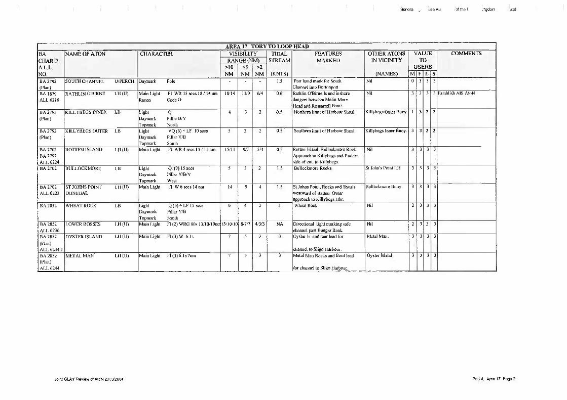
3.7.17 AREA 17- TORY ISLAND TO LOOP HEAD
3.7.17.1 The Tory Island to Loop Head region is one of the most exposed areas inNorthwest Europe, as it takes the fall brunt of the prevailing winds andNorth Atlantic storms.
3.7.17.2 The geographical features of this coastline vary considerably along itswhole length, and the number of AtoN provided from place to place tendto reflect the density of marine hazards to be found in any one locality.
3.7.17.3 For instance, the Co. Clare coast from Loophead to Galway Bay beingsteep-to with high sheer cliffs and few off-lying rocks, is one of thelongest stretches of un-lighted coastline in the country.
3.7.17.4 Galway Bay is, in general, well served by the natural protection itreceives during severe North Atlantic weather from the strategic locationof the Aran Islands. The Bay is adequately lighted, and thus ease ofaccess, but offers limited shelter for large vessels, which may bedisabled, or under stress of weather. However, the anchorage to the Eastof Blackhead Lighthouse is tenable in certain weather conditions and isfrequently used by vessels awaiting suitable conditions to enter GalwayHarbour.
3.7.17.5 The physical nature of the coastline changes dramatically betweenRossaveal and Eagle Island. The shoaled and rock strewn coasts ofCounties Galway and Mayo protrude out into the North Atlantic andpresent a formidable number of hazards for the inshore mariner. Thereis, consequently, a larger number of AtoN provided in this area, the twomajor ones being Slyne Head and Eagle Island.
GLAs' AtoN Review 2005 Page 48 of 54

The General Lighthouse Authorities of the United Kintadom and Ireland
3.7.17.6 This section of the coast is not well endowed with harbours of refuge forlarger vessels, Blacksod Bay, with Blackrock and Blacksod Lighthousesin its approaches, being the most suitable one available.
3.7.17.7 The coast from Donegal Bay to Tory island, within which the two majorfishing ports of Killybegs and Burtonport are located, is characterised bythe highest sea cliffs in the country, Slieve League, and a hazardous rockoffshore between Dawros Had and Bloody Foreland, on the West coastof Co. Donegal.
3.7.17.8 In addition to the various GLA AtoN in this region, which provide forthe needs of shipping in general, the relevant local authorities haveadequately provided for the requirements of the Ports and Harbourswithin their jurisdictions.
3.7.17.9 The changes proposed for this area can be summarised, as follows:
Tory Island Lighthouse Reduce range to 20nm ifeconomically advantageous and establish AIS AtoN,Aranmore Lighthouse Reduce range to 20nm if economicallyadvantageousRathlin O'Birne Lighthouse Establish AIS AtoNBlackrock Sligo Lighthouse Incorporate the red sector lightinto the main light. Increase red range to 8nm and reduce whiterange to 10nm.Eagle Island Lighthouse Establish AIS AtoNDillisk Rocks Perch Restore South Cardinal Daymark.Investigate provision of North Cardinal Beacon on west of rockSlyne Head Lighthouse Establish AIS AtoNCashla Bay Directional Light Replace PEL to provide 2nmdaytime rangeCannon Rocks Perch DisestablishMutton Island Buoy DisestablishEeragh Lighthouse Reduce range to 18nmInisheer Lighthouse Establish AIS AtoN
3.7.18 AREA 18- LOOP HEAD TO FASTNET
3.7.18.1 This zone encompasses the South West Coast from Loop Head toFastnet Rock including the Shannon Estuary.
3.7.18.2 The Coast in this area is characterised by high bold headlands and deepbays. There are a large number of offshore islands.
3.7.18.3 Approaches to ports and harbours are invariably hazardous due to therocky nature of the area.
3.7.18.4 The severe weather conditions frequently encountered in this zone canforce vessels to seek shelter in the numerous bays in the area. As thepredominant wind is Southwesterly it can be necessary to go quite deepinto bays before suitable shelter can be found. The Shannon Estuary andBantry Bay in particular are frequently used as ports of refuge.
GLAs' AtoN Review 2005 Page 49 of 54

3.7.18.6 There is a busy fishing trade in the area ranging from small inshore boatsto large offshore trawlers and deep-sea tuna boats..
3.7.18.7 The changes proposed for this area can be summarised, as follows:
Loop Head Lighthouse Reduce range to 20nm ifeconomically advantageous. Establish AIS AtoNInishtearaght Lighthouse Establish AIS AtoNCastlemaine Beacon Restore BeaconColt Rock Beacon Review lighting optionsSheeps Head Lighthouse Realign red sector to cover BulligRock and Three Castles HeadBlackhorse Rocks Perch Review lighting options
3.7.19 AREA 19- FASTNET TO TUSKAR
3.7.19.1 The Fastnet to Tuskar region consists of relatively safe waters forvessels making offshore passages but dangerous inshore waters. Thecoastline, particularly in the West of the region, is high and rocky withbold cliffs and headlands.
3.7.19.2 The approaches to the ports, anchorages and bays are difficult withdangerous offshore rocks and reefs.
3.7.19.3 It has been necessary to provide a mixture of buoys, beacons andlighthouses to adequately mark the inshore dangers and support theoffshore route.
3.7.19.4 The only offshore dangers in the offshore route are the Kinsale HeadGas Field, which is subject to a 500m-exclusion zone and the FastnetRock.
3.7.19.5 Fastnet Rock is a common waypoint for transatlantic traffic.
3.7.19.6 IMO recognised Traffic Separation Schemes are in force off Fastnet andTuskar. The offshore route between these schemes covers a distance of140', taking vessels clear of all headlands and the Coningbeg Lighttloat,(6' off Old Head East bound, 1.5' off Old Head West bound).
GLAs' AtoN Review 2005 Page 50 of 54
The General Lighthouse Authorities of the United Kingdom and Ireland
3.7.18.5 Through traffic will normally follow the offshore route outside the majorlights. Coastal traffic and vessels bound for ports within the zonefrequently use the more restricted inshore passages, particularly duringadverse weather conditions.

The General Lighthouse Authorities of the United Kinfzdom and Ireland
Reproduced from Admiralty Chart 1121 by permission of the Controller of Her Majesty's StationeryOffice and the hydrographic offices of France and the United Kingdom (www.ukho.gov.uk)
Figure 15: ShipRoutes overlay for some of the 361 routes identified within a 20 nm of positionLatitude 51° 49' 31".47N., Longitude 06° 05' 27".99W.
3.7.19.7 There are some 17, 544 vessel movements per annum within a 20nmradius of position Latitude 51° 49' 3I".47N., Longitude 06° 05'27".99W., that falls between the Tuskar TSS and Smalls TSS, asillustrated in figure 15 above.
3.7.19.8 Good fishing grounds in the area attract a sizeable number of craft.Problems can be encountered during the salmon season when long, oftenpoorly marked, nets present an additional hazard.
3.7.19.9 The changes proposed for this area can be summarised, as follows:
Fastnet Lighthouse Reduce range to 20nm if economicallyadvantageous. Establish A1S AtoN.Glandore Buoy Re-establish demolished perch as lightedstarboard lateral markGlandore SE perch DisestablishGalley Head Lighthouse Reduce range to 20nm ifeconomically advantageous.Danger Buoy - Re-name "Sunk Rock". Reposition and designateas starboard lateral lighted buoy.Black Tom Buoy Increase range to 4.5nmBarrel Rock Perch Consider viability of reinstatement ofdaymarkOld Head of Kinsale Lighthouse Establish AIS AtoNDaunt Buoy - Establish superbuoy with increased range andestablish A1S AtoN and Racon.
GLAs' AtoN Review 2005 Page 51 of 54

The General Lighthouse Authorities of the United Kingdom and Ireland
Hook Head Lighthouse Reduce range to 20mn if economicallyadvantageous and establish AIS AtoNConingbeg ALF Disestablish ALF and establish superbuoywith AIS AtoN together with minor light on Saltee Islands.Barrels Buoy Remove whistle fog signal.Fundale Buoy Rename and reposition buoy to better markCoHough Rock
3.7.20 AREA 20- TUSKAR TO BAILY
3.7.20.1 The Tuskar to Baily region is unique on the Irish Coast for itspreponderance of shallow banks and relatively low-lying coastline.
3.7.20.2 Banks extend up to nine miles off the coast with some drying at lowwater. These banks are gradually extending northwards requiringongoing reviews of buoy positions.
3.7.20.3 The coastline, with the exception of a series of prominent headlands, islow lying. This, combined with the distance offshore of the dangerousbanks, necessitates a reliance on floating aids.
3.7.20.4 There are four principal shipping routes through the region:
A through route for vessels bound for the North Channel or Ports onthe West Coast of the U.K.
An offshore route to Dublin Bay.
A coastal route to Dublin Bay and Ports between Rosslare andDublin.
The East/West corridors through the Banks.
3.7.20.5 Within the coastal route are a number of internal channels, the North andSouth Shears, the Rusk Channel, and channels between the Codling,India and Arklow Banks and the Blackwater and Lucifer Banks.
3.7.20.6 All of these routes require appropriate AtoN to safely guide the mariner.The mix of aids required is dependant on a range of factors, includingsize and type of vessel involved, traffic density, proximity of hazards,etc.
3.7.20.7 In assessing the AtoN requirements in this area, it should be borne inmind that, due to the prevailing Southwesterly winds, many smaller orlower powered vessels, on coastal passage, seek the shelter of the landduring heavy weather from this direction, and thus pass well inside mostof the off-lying sandbanks.
3.7.20.8 There is a clear requirement for the provision of suitable AtoN for thesafe inshore passage around Tuskar Rock Lighthouse.
3.7.20.9 The changes proposed for this area can be summarised, as follows:Tuskar Lighthouse Establish AIS AtoN
GLAs' AtoN Review 2005 Page 52 of 54

The General Lighthouse Authorities of the United Kingdom and Ireland
Splaugh Buoy Change characteristic to FL (2) R 6sSouth Long Buoy Establish AIS AtoN. Remove whistle fogsignalCalmines and South Holdens Buoy - Synchronise timing andflash characters.South Blackwater Buoy DisestablishSoutheast Blackwater Buoy Establish superbuoy with Raconand AIS AtoN and re-position 2 cables east.Rusk No 1 & No 2. Buoy - Synchronise timing and flashcharacters.East Blackwater Buoy DisestablishArklow Lanby Establish AIS and repositionSouth Arklow Buoy DisestablishArklow No 1 and No 2 Buoy DisestablishNorth Arklow Buoy Remove whistle fog signalWicklow Head Lighthouse - Reduce range to 20nm ifeconomically advantageousCodling Lanby Establish AIS AtoNSouth Codling Buoy Reposition subject to surveyBennet Bank Buoy Reposition subject to surveyNorth and South Burford Buoys Establish AIS AtoNMuglins Lighthouse Change to red light and maintain rangeDun Laoghaire East and West Lighthouses- Synchronisetiming and flash characters
3.7.21 AREA 21 - BAILY TO ST JOHN'S POINT DOWN
3.7.21.1 St John's point, Co. down, to Baily Lighthouse is a coastline, which canbe characterised throughout its entire length by a very low-lyingfeatureless foreshore. There is only one notable exception to this andthat is the area of the high coastal slopes of Slieve Donard, in theMourne Mountains, that border the sea just south of Newcastle, on thewestern shore of Dundrum Bay.
3.7.21.2 The coast between the two above mentioned reference points, St John'sPoint and Baily, falls away to the west and culminates in the shallowesturial waters of Dundalk Bay. Consequently, through-traffic in theIrish Sea, on passage between the Codling Lanby, or Kish Tower, andthe South Rock Lightfloat, transits well to the east of this region and haslittle or not use for the coastal aids to navigation provided therein.
3.7.21.3 However, there are many harbours and ports in the area, which generateconsiderable coastal traffic, including commercial, fishing and leisurecraft. The four main commercial ports are Drogheda, Dundalk,Greenore, and Wanenpoint, while the principal fishing and leisure boatharbours are Howth, Malahide, Rush, Sken-ies, Balbriggan, Port Oriel,Kilkeel and Annalong.
3.7.21.4 Most of the ports in this region have tidal limitations or restrictions, asthe foreshore throughout its length is shelving and shallow, consisting
GLAs' AtoN Review 2005 Page 53 of 54

The General Lighthouse Authorities of the United Kinedom and Ireland
mainly of sand and gravel but with some off-lying rocks in the vicinityof the south Down coast and the Skerries/Loughshinny area of the northCounty Dublin coast.
3.7.21.5 With the exception of Carlingford Lough, there is virtually no safeanchorage for vessels seeking shelter from strong on-shore winds in thisregion. It is a very exposed coast, which is consequently subject to localstructural damage and erosion in heavy easterly weather. A case in pointwas the havoc wreaked by Hurricane Charlie in the autunui of 1986.
3.7.21.6 The changes proposed for this area can be summarised, as follows:
Burren Perch Light perchRockabill Lighthouse Establish AIS AtoNCard y Rocks Perch Repair topmarkDundalk Pile Lighthouse Restore sector light subject tosounding surveyHaulbowline Lighthouse Disestablish turning lightCarlingford Buoy DisestablishHellyhunter Buoy Increase range, establish AIS AtoN andrepositionDZ East, Middle and West Buoys Light buoys or discontinueSt Johns Point Lighthouse Reduction of range to 20nm ifeconomically advantageous. Establish A1S AtoN.
GLAs' AtoN Review 2005 Page 54 of 54

.eral Lii Authc the Un gdom g nd
AREA 15 ST JOHN'S POINT, DOWN TO RATIILIN EASTBACHART/A.L.L.NO.
NAME OF ATON CHARACTER VISIBILITY TIDALSTREAM
(KNTS)
FEATURESMARKED
OTHER ATONSIN VICINITY
(NAMES)
VALUE COMMENTSTO
USLRSRANGE (NM)>10NM
>5
NM>2
NM MFLS55% 93% 96%
BA 633 WATER ROCK I.1/Perch Daymark Red PoleTo prnark Red Can
_ _ _ 0.4 Water Rocks and port hand markfor approach to Killough Hbr
Ni!. 0 3 3 3
BA 2159
BA 2156
GUNS ISLAND 11Bcn Daymark White Stone PillarTopmark Red Can
- - - 0.5 South end of Guns Island andtogether with St Patrick's Perchprovides a clearing line forQuintin Rock.
St Patrick's Perch. 2 3 3 3
BA 2 159 ST PATR1CKS 15,1P
ROCKS
Daymark Red PoleTopmark Red Can
- - 2.5 St.Patrick Rock and together withGuns Is. Beacon provides aa clearing line for Quintin Rock.
Guns Island Beacon. 0 3 3 3
BA 2159 PLADDY LUG UBcn Daymark White Stone Pillar - 5 Pladdy lug Rock and East side ofEast Channel to Strangford Lough.
Angus Rock Lighthouse. 1 3 3 3 Re-designate as starboard lateraldaymark and light
BA 2159 BAR PLADDY LB Light Q (6) + LF 15 seesDayrnark Pillar 'CBTopmark South
5 4 2 5 Bar Pladdy Rock and East side ofsafe water channel to Strangford
Lough.
Nil. 3 3 3 3
BA 2159ALL 5962.9
STRANGFORD LB Light LE. 10 secsDaymark RWVS
Topmark Sphere
6 4 2 0.9 Safe water mark for approach toStrangford Lough
Nil. ") 2 2 2
BA 2159
ALL 5963.3ANGUS ROCK LII (U) Main Light Fl. R 5 secs 6 nit 6 4 2 5,0 Angus Rock and West side of
East Channel to Strangford Lgh.
Nil_ 3 3 3 3
BA 2156 BUTTER PLADDY LB Light Q. (3) 10 secs
Dayrnark BYETopmark East
5 4 2 I Butter Pladdy Rock. Nil. I 2 2 2
BA 2156BA 2093ALL 5966
SOUTH ROCK LF Main Light Fl. (3) R 30 secs 20 cmFog Signal horn (3) 45 secsRacon Code T
20 12 6 1,4 Dangers to Westward andreference point for North IrishSea Traffic,
North Rocks Beacon.South Ridge Buoy.
3 3 3 3 Disestablish ALP. Establishsuperbuoy with AIS AtoN andRacon in conjunction with thelighting of old South RockLighthouse
BA 2156 NORTH ROCKS ITI3cn Dayrnark Red Conical - 0.8 Eastern extremity of theNorth Rocks.
South Rock ALP. 0 3 3 0 Establish Red Can topmark
BA 2156 PLOUGH LB Light Fl. R. 3 sec
Daymark Can Red
4 3 2 1 .4 Plough Rock and port hand markfor approach to Portavogie.
Nil. 0 3 3 2 Install LED and upgrade to 4.5nnrange
BA 2156
ALL 5972
SKULMART1N LB Light LEI. 10 secs
Daymark RWVSToprnark Sphere
7 5 3 2.3 Inshore dangers between SouthRock ALF and Mew Is Lighthouse
Nil. 3 3 3 3 Install LED and upgrade to 6nmrangeRemove Whistle fog signal
BA 2156 SKUI.MARTIN UlPerch Dar-nark Red PoleTopmark Red Can
- - - 2.3 Skullmartin Rock and indicatesSouth side of safe water channel
to Ballywalter Pier,
Skullmartin Buoy. 0 3 3 0
BA 3709BA 1753
ALL5974
DONAGHADEE LH (U) Main Light Ism WR 4 secs 18 / 14 nm 18/14 11/9 5/4 1.6 Pier and Southern approach toDonaghadee Sound. Dangersoff Ballyferris Point,
Nil 3 3 3 3
BA 3709
,...
FORELAND LB Light Fl. R 6 secsDay/nark Can Red
5 4 2 3 Foreland Spit and port hand markfor transiting Donaghadee Sod
Deputy and Governor Buoys. 3 3 3 3
Joint GLAs' Review of AtoN 2003/2004 Part 4 Area 15 Page 1

the Linn,-
AREA 15 ST JOHN'S POINT, DOWN TO RATIILIN EASTBACHART/A.L.L.NO.
NAME OF ATON CHARACTER VISIBILITY TIDALSTREAM
(KNTS)
FEATURESMARKED
OTHER ATONSIN VICINITY
(NAMES)
VALUE COMMENTSTO
USERSRANGE (NM)>10NM
>5NM
>2NM MELS
55% 93% 96%BA 3709 GOVERNOR LB Light Fl. R 3 secs
Daymark Can Red4 3 2 3 Governor Rocks and port hand
mark for transiting DonaghadeeSound.
Deputy and Foreland Buoys 3 3 3 3
BA 3709 DEPUTY LB Light FI.G 2 secsDaymark Conical Green
4 3 2 3 Deputy Reefs and starboard handmark for transiting Donaghadee
Sound.
Foreland and Governor Buoys. 3 3 3 3 Install LED and upgrade to 4 5nnrange
BA 3709 FORELAND ROCK 1.11Perch Daymark Red Pole
Topmark Red Can
- 3 Foreland Rock. Nil 0 3 3 0
BA 3709
BA 1753ALL 5976
MEW ISLAND LH (LI) Main Light Fl (4) W 30 secs 24 nm
Racon Code 0
24 14 7 3.5 Mew Is, and Southern side of
entrance to Belfast Lough.
Nil 3 3 3 3 Reduce range to 20nm whereeconomically advantageous andestablish A IS AtoN
BA 1753 SOUTH BRIGGS LB Light Fl. (2) R 10 secs
Dayrnark Can Red
) 4 2 1.3 South Briggs Rock and port hand
mark for traffic usingDonaghadee Sound.
Nil 3 3 3 3
BA 1753
ALL 6028BLACKHEAD 1,F1 (11)
(ANTRIM)Main Light Fl. W 3 secs 27 nnl 27 15 7 0.9 Blackhead and Northern side
of Belfast Lough.Nil 3 3 3 3 Reduce range to 20nm where
economically advantageous
BA 1237ALL 6030
BARR POINT FSS Fog Signal Horn 30 secs - - 0.7 Fog signal for approach toLame Harbour.
Nil 3 3 3 3 Disestablish
BA 1237 LARNE No 7 LB Light Q.G.
Dayrnark Conical Green3 2 2 1.2 North limit of Middle Bank and
starboard hand mark for channelto Magheramourne.
No. 5 Larne Buoy. 3 1 3 3
BA 1237 LARNE No 5 LB Light Q.G.Dayrnark Conical Green
5 4 2 0.8 Shallows West of buoy and stbdhand mark for channel to
Maghera-rnourne Harbour.
No. 7 Lame. 3 1 3 3
BA 1237All. 6035
LARNE No 4 L Ben Light Fl. (2)R 6 secs 4 nmDaymark Red Pile
Topmark Can Red
4 3 2 1.5 Shallows East of Beacon and porthand mark for channel toLame Harbour.
No. 2 Lame Beacon. 3 1 3 3
BA 1237ALL 6033.4
LARNE No 2 LBen Light Fl R 3 secs 4 notDaymark Red PileTopmark Can Red
4 3 2 1.5 Shallows East of Beacon and port
hand mark for channel toLame Harbour.
No. 4 Lame Beacon. 3 1 3 3
BA 1237 LARNE No 3 LB Light 1,1(2) G 6 secs
Daymark Conical Green5 .4 2 1.8 Shallows West of buoy and stbd
hand mark for channel toLarne Harbour.
No. 1 Larne Buoy. 3 1 3 3
BA 1237
ALI, 6031
CHAINE TOWER 1.11 (U) Main Light Iso. WR 5 secs 16/16nm 16/16 10/10 5/5 01 Sandy Point and safe approach toLame Harbour from North East
Nil. 3 1 3 3
BA 1237 LARNE No 1 LB Light Q. GDaymark Conical GreenTopmark Cone
6 4 2 I 8 West side of approach channel
to Lame HarbourNil 3 1 3 3
Joint GLAs Review of AtoN 2003/2004 Part 4 Area 15 Page 2

AREA 15 ST JOHN'S POINT, DOWN TO RATEILIN EAST
BA NAME OF ATON CHARACTER VISIBILITY TIDAL FEATURES OTHER ATONS VALUE COMMENTS
CHART/ RANGE (NM) STREAM MARKED IN VICINITY TO
ALL. >10 >5 >2 USERS
NO. NM NM NM (KNTS) (NAMES) MFLS55% 93% 96%
BA 1237 SOUTH HUNTER LB Light VQ (6) + L FL 10 Sees 6 4 2 2 Hunter Rock North Hunter Buoy 3 3 3 3 Remove Whistle fog signal
ALL 6029 Fog Signal WhistleDaymark Pillar YfB
Topmark South
BA 1237 NORTH HUNTER LB Light VQ.
Daymark Pillar WY6 4 2 2 Hunter Rock. South Hunter Buoy. 3 3 3 3 Change character to Q for
differentiation with S Hunter
Topmark North
Radio RTE
BA 2724 MAIDENS LH (II) Main Light Fl. (3) W 20 secs 24 nm 24 14 7 3 East Maiden and surrounding Highland Rock Perch. 3 3 3 3 Reduce flash period. Reduce
BA 2198
ALL 6042
Aux Light Fl, R 5 secs 8 nmRacon Code M
8 5 3 rocks and shoals Aux. light marksHighland group of rocks.
range to 20nm whereeconomically advantageous.Discontinue Aux. light. Introducered sector equivalent on mainlight
BA 2198 HIGHLAND ROCK UPerch Daymark Red PoleTopmark Red Can
- 4 5 highland Rock and Northern limitof associated rock group
Maidens Lighthouse. 2 3 3 2
'teral Li, e Autht the Ur. .gdom _nd
Joint GLAs Review of AtoN 2003/2004 Part 4 Area 15 Page 3

Gener, useAL . of the .:ingdom .. -.and
AREA 16 RATHL1N EAST TO TORY
BACHART/A.L.L.
NO.
NAME OF ATON CHARACTER VISIBILITY TIDAL
STREAM
(KNTS)
FEATURESMARKED
OTHER ATONSIN VICINITY
(NAMES)
VALUE COMMENTSTO
USERSRANGE (NM)>10
NM>5
NM>2
NM MFLS55% 93% 96%
BA 2798
BA 2199ALL 6062
RATHLIN EAST LH (U) Main Light Fl. (4) W 20 secs 26 rim
Racon Code GRadio AIS experimental
26 15 7 2 5 Altacarry Head arid turning pointfor traffic using Ts s
Nil. 3 3 3 3 Reduce range to 20nin where
economically advantageous and
establish permanent AIS AtoNBA 2798
ALL 6060
RUE, POINT LH (U) Main Light Fl (2) W 5 secs 14 cm 14 9 4 4 Rue Point and Northern side ofof entrance to Rathlin Sound.
Nil. 3 3 3 3 Establish A1S AloN or Racon
BA 2798 DRAKE WRECK LB Light Q (6) -'- LF 15 secs
Daymark Pillar Y/B
Topmark South
5 4 2 0.6 Wreck and West-ern ext. ofsafe approach to Port.
Nil. 3 1 3 3 Survey wreck area with view to
dis-establishing buoy
BA 2798
ALL 6064
RATHL. IN WEST LH (U) Main Light Fl. 11.5 secs 22 um 22 13 6 2.5 West side of Rathlin Is. and forEast Bound traffic using TSS
Nil. 3 3 3 3
BA 0049 THE STORKS UBcn Daymark Red conicalTopmark Red Sphere
- - - 1 The Storks Rocks. Nil 1 2 3 2 Change to N. Cardinal
BA 2499 BLUICK ROCK UIPERCH Dayrnark Iron conical Lattice beaconTopmark Green cone
_ 2.5 Shtick Rock and starboard handmark for North Channel.
Nil I 3 3 1
BA 2499 TUNS LB Light Fl. R 3 secs
Dayruark Can Red
6 4 2 2 Northern end of Tuns Bank andand Port hand mark for North Ch.to Foyle Ports. Also marks Easternside of entrance to River Foyle.
Inishowen Lighthouse. 3 3 3 3
BA 2499
ALL 6083
FOYLE LB Light Lit 10 secsFog Signal Whistle
Daymark RWVS
7 5 3 1.3 Landfall mark for approach toRiver Foyle.
Inishowen Lighthouse.Tuns Buoy.
3 3 3 3 Remove Whistle fog signal.Establish AIS AtoN
BA 2499ALL 6084
INISHOWEN LH (U) Main Light Fl. (2) WRG lOs 18/14114nrn
Fog Signal Horn (2) 30 secs18/14/14 11/9/9 6/4/4 1.3 Dunagree Pt Westem side or
entrance to River Foyle, Approachto River Foyle and Tuns Bank.
Tuns and Foyle Buoys. 3 3 3 3 Discontinue fog signal
BA 2811
ALL 6164
INISHTFtAHULL LB (U) Main Light FL (3) W 15 secs 19 cm
Racon Code T
19 11 5 2.5 Inislitrallull Island and off-lyingdangers.
Nil 3 3 2 3 Establish AIS AtoN
BA 2697 INCI I FLATS I..B Light FL (2) R 6 secsDaymark Cart Red
4 3 2 I 8 Inch Flats and port hand mark forchannel to Rathmullan.
Inch Spit Buoy. 2 3 2 3
BA 2697 1NCI I SPIT LB Light Fl. R 3 secsDaymark Can Red
3 2 2 1.8 Shallows Eastwards and port hand
mark for channel to Rathmullan.Kinnegar and Inch Flats Buoys 2 3 2 3
BA 2697 KINNEGAR LB Light FLG 10 secsDaymark Conical Green
3 2 2 18 Kinnegar Spit and starboard handmark for channel to Rath-mullan.
Inch Spit Buoy. 2 3 2 1
BA 2697
ALL 6174BUNCRANA LH (U) Main Light Iso. WR 4 secs 14 / 11 run 14/11 9/7 4/4 1.8 Buncrana Pier and Carrick
acullin Rock.Nil 2 3 2 3
BA 2697 SALTPANS LB L ight Q (3) 10 secs
Daymark Pillar B/Y/BTopmark East
5 4 2 1.8 Eastern limit of Saltpans Bank andturning mark for channel to
Rathmullan.
Nil 2 3 2 3
BA 2697 WHITE STRAND LB Light Fl. R 10 secsDaymark Can Red
1 2 2 1.8 White Strand Rock and port handmark for channel to Buncranaand Rathmullan.
Colpagh Buoy and DunreeLighthouse.
2 3 2 3
BA 2697 COLPAGH LB Light Fl. 11.6 secs
Dayrnark Can Red5 4 2 1 8 Colpagh Bank and Rocks. Port
hand mark for channel to Buncranaand Rathinullan,
Dunree Lighthouse and WhiteStrand Buoy.
2 3 2 3
Joint GLAs Review of AtoN 2003/2004 Part 4 Area 16 Page 1

AREA 16 RATHIAN EAST TO TORYBACHART/ALL.NO
NAME OF ATON CHARACTER VISIBILITY TIDALSTREAM
(KNTS)
FEATURESMARKED
OTHER ATONSIN VICINITY
(NAMES)
VALUE COMMENTSTO
USERSRANGE (NM)
>10NM
>5
NM>2
NM NI F L S55% 93% 96%
BA 2697
ALL 6172DUNREE LH (13) Main Light Fl. (2) WR 5 secs 12/9nm 1219 8/6 4/3 1.5 Headland. Cal lagh Rock, Colpagh
Bank 8c White Strand Rk.
Colpagh and White StrandBuoys.
3 3 2 3
BA 2697 SW1LLYMORE LB Light Fl. Ci 3 secs
Daymark Conical Green5 4 2 1 Swillymore Rocks. Fanad Head Lighthouse. 2 3 2 3
BA 2699BA 2697
ALL 6168
FANAD HEAD LH (U) Main Light Fl. (5) WR 20 secs 18114nm 18/14 11/9 5/4 1.0 Headland Western side ofentrance to Lough Swilly,Liniebumer and Swillymore Rocks
Swillymore Buoy. 3 3 2 3
BA 2699BA 2811
ALL 6178
L1MEBURNER LB Light Q
Dayinark Pillar FINTopinark North
Fog Signal Whistle
6 4 2 1.5 LinIchumer Rock. Nil 3 3 3 3 Remove whistle fog signal.Establish A1S AtoN
BA 2699 BAR ROCK UBct) Daymark Green conialTopinark Can
- 0 5 Bar Rock and Western side ofentrance to Ards Bay.
Nil 0 3 3 0
3use AL of the ingdorn and
Joint GLAs Review of Aloft 2003/2004 Part 4 Area 16 Page 2

Genera iuse At of the ingdorr and
AREA 17 TORY TO LOOP HEADBACHART/A.L.L.NO.
NAME OF ATON CHARACTER VISIBILITY TIDALSTREAM
(KNTS)
FEATURESMARKED
OTHER ATONSIN VICINITY
(NAMES)
VALUETO
USERS
COMMENTSRANGE (NM)
>10NM
>5NM
>2NM M F L S
BA 2725ALL 6200
TORY ISLAND LH (If) Main Light F1.(4) W 30 secs 27 umRacon Code MDGPS 288,50 -200nin
27 15 7 1.5 Tory Island and landfall fortransatlantic traffic.
Nil 3 3 3 3 Reduce range to 20nin where
economically advantageous
and establish AIS
BA 1883 COLA SPIT LB Main Light Fl. R 3sDaymark Can Red
3 2 2 1 'Cola Spit and port hand mark forSouth entrance to Gweedore Bayand North ent. to Cola Roads.
Middle Rock Buoy. 0 3 2 2
BA 1883 MIDDLE ROCK LB Main Light Fl (2) R. 3s
Daymark Can Red
3 2 2 1 Middle Rock and port hand mark
for South Ent. to Cola Rds &(iweedore Bay.
Cola Spit Buoy. 0 3 2 2
BA 2792(Plan)
ALL 6210
BALLAGH ROCKS LH (1_1) Main Light Fl W 2.5 secs Sum 5 3 2 1.0 Ballagh Rooks and Eastern sideof entrance to Aranmore Rds.
Nil 0 3 2 3
BA 1883ALL 6208
ARANMORE LH (U) Main Light Fl. (2) W 20 secs 28 nmSector Light El. R 3 secs 13 cm
28
13
16
8
7
4
1.0 Rinralvros Point and Stag Rocks. Nil 3 3 3 3 Reduce range to 20nm whereeconomically advantageous
BA 2792(Plan)
ANCHORAGE Ul3crt
OBELISK)Daym ark While Obelisk - NA Point South of White Strand and
leading line toghether with peakof Moyle- corragh Hill for NEapproach to Sound of Aran
Nil_ 0 3 2 3
BA 2792(Plan)
CARR1CKBEAL- U/PERCHATROHA
Dayinark Pole YBYTopinark West
- - - 1.2 Rock and clearing line, togetherwith Lackmorris Perch for NorthApproach to Sound of Aran.
Lackmorris Perch. 0 3 3 3
BA 2792
(Plan)
LACKMORRIS LI/PERCH Dayrnark Pole Is° DangerTopmark 2 spheres Black
1,2 Lackmorris Rock & clearing linetogether with Carrickbeal atroliaRock for North approach toSound of Aran
Carrickbealatrohalower Perch
0 3 3 3
Joint GLAs Review of AtoN 2003/2004 Part 4 Area 17 Page 1
13enera. use Au of the I lngdorn and
AREA 17 TOR% TO LOOP HEADBA
CHART/A.L.L.NO.
NAME OF ATON CHARACTER VISIBILITY TIDALSTREAM
(KNTS)
FEATURESMARKED
OTHER ATONSIN VICINITY
(NAMES)
VALUETO
USERS
COMMENTSRANGE (NM)
>10
NM>5
NM>2
NM M F L SBA 2792(Plan)
SOUTH CHANNEL U/PERCI I Dayrnark Pole 1.5 Port band mark for SouthChannel ink) Burtonport
Nil 0 3 3 3
BA 1879
ALL 6216
RATHL1N O'BIRNE LI I (LI) Main Light FL WR 15 secs 18 / 14 11111 18,14
Racon Code 011/9 6/4 0.6 Rathlin O'Birrie Is and inshore
dangers between Mahn MoreHead and Rossarrell Point.
Nil 3 3 3 3 Establish AIS AWN
BA 2792
(Plan)
KILLYBEGS INNER LB Light Q 4
Daymark Pillar 13/Y
Topmark North
3 2 0.5 Northern limit of Harbour Shoal. Killybegs Outer Buoy. 1 3 2 2
BA 2792(Plan)
KILL YFIEGS OUTER LB Light VQ (6) -1- LF. 10 secs 5
Daymark Pillar Y/13
Topmark South
3 2 0.5 Southern limit of Harbour Shoal Killybegs Inner Buoy. 3 3 2 2
BA 2702
BA 2792
ALL 6224
ROTTEN ISLAND LH (II) Main Light El. WR 4 secs 15 / 11 nm 15/11 9/7 5/4 0.5 Rotton Island, Bullockmore RockApproach to Killybegs and Easternside of cut. to Killybegs.
Nil 3 3 3 3
BA 2702 BULLOCKMORE LB Light Q. (9) 15 secs 5
Daymark Pillar Y./13/Y
Topmark West
3 2 1.5 Bullockmore Rocks. St John's Point LB. 3 3 3 3
BA 2702ALL 6222
ST JOHNS POINT LH (U)DONEGAL
Main Light El. W 6 secs 14 um 14 9 4 1.5 Stiohns Point, Rocks and Shoalswestward of station. Outerapproach to Killybegs I ibr.
Btillockniore Buoy. 3 3 3 3
HA 2852 WHEAT ROCK LB Light Q (6) + LE 15 secs 6
Daymark Pillar Y/B
Toprnark South
4 2 I Wheat Rock. Nil 2 3 3 3
BA 2852
ALL 6236
LOWER ROSSES LH (U) Main light El (2) WRG lOs 13/10/1011m13/10/10 8/7/7 4/3/3 NA Directional light marking safechannel past Bungar Bank.
Nil 2 3 3 1
BA 2852
(Plan)ALL 6244.1
OYSTER ISLAND LII (U) Main Light Fl (3) W. 6.1s 7 5 3 3 Oyster Is. and rear lead for
channel to Sligo Harbour.
Metal Man. 3 3 3 3
BA 2852
(Plan)ALL 6244
METAL MAN LI1 (U) Main Light Fl (3) 6.1s 711in 7 5 3 3 Metal Man Rocks and front lead
for channel to Sligo Harbour.
Oyster Island. 3 3 3 3
Joint GLAs Review of AtoN 2003/2004 Part 4 Area 17 Page 2

, Genera. ,,w,,.,Juse of the rangdoni
AREA 17 TORY TO LOOP HEADBACHART/A.L.L.NO.
NAME OF ATON CHARACTER VISIBILITY TIDALSTREAM
(KNTS)
FEATURESMARKED
OTHER ATONSIN 'VICINITY
(NAMES)
VALUETO
USERS
COMMENTSRANGE (NM)
>10
NM>5
NM>2
NM M F L SBA 2852
ALL 6232
BLACKROCK SLIGO LI I (U) Main Light FLW 5 secs 13 umSector Light Fl. R 3 secs 5 nin
13
5
8
3
4
2
1 Black Rk. Wheat and Seal Rocks. Wheat Rock Buoy. 3 3 3 3 Incorporate Red sector lightinto Main light Increase Redrange to 8nin Reduce Whiterange to 10nrn. Ie.Disestablish Aux
BA 2715 KILLALA I.B Light FL G 6 secs
Daymark Conical Green5 3 2 0 5 St Patrick& Rocks and starboard
hand mark for approach to Killala.Carrigpatrick Buoy. 1 3 3 3
BA 2715 CARRICKPATRICK LB Light Q. (3) 10 secs
Daymark Pillar 13/Y/B
Topmark East
6 4 2 0.5 St Patricks Rocks. Killala Buoy 1 3 3 3
BA 2073
ALL 6266BROAD-HAVEN LH (11) Main Light Iso. WR 4 secs 17 / 12 inn 17/12 10/8 514 13 Cuba-cachet Point and West side
of entrance to Broadhavenanchorage.
Nil. 1 3 3 1
BA 2703ALL 6268
EAGLE ISLAND I.H (IT) Main Light Fl. (3) W 15 secs 19 nm 19 11 5 0.6 Eagle Is. and outer Northernlimits of Conn- aught landmass.
Nil 3 3 3 3 Establish AIS AtoN
BA 2704ALL 6270
BLACKROCK MAYO LII (U) Main Light FLWR 12 secs 22 / 16 um 22/16 13110 6/5 0.5 Black Rock, Inislikea andDuvillaun Iss
Nil 3 3 3 3
BA 2704 CARRIGEENMORE ti/PERCH Daymark Pole - - - I Carrigeenmore Rock. Blacksod Lighthouse. 0 2 3 3
BA 2704 BLACKSOD I,P Light Q. (3) 10 secs
Dayinark Pillar B/Y/BTopmark East
3 2 2 1 Shoal East of Blacksod Point. Blacksod Lighthouse 2 3 3 3
BA 2704
ALL 6272BLACKSOD I.H (U) Main Light Ft (2) WE 7.5s I 2/9inn 12/9 8/7 4/3 I Blacksod Point and Western side
of entrance to Blacksod Bay.Carrigeen- more Rock.
Blacksod Buoy.CarrigeentnorePerch
2 3 3 3
BA 2667ALL 6276
ACH1LLBEG LH (U) Main Light Fl. WR 5 secs 18 / 15 imi 18/15 11/9 5/4 0.5 Achillbeg Island. Northern apprto Clew Bay, Clare Is. andassociated rocks. Bills Rocks.Southern entrance to Achill Sound.
Nil 1 3 3 3
BA 2057 CLOUGFICORM1CK LB Main Light Q (9)15sDaymark Pillar YiB/YTown ark West
4 3 2 I Western extent or spit Nviiichprotudes Westward of ClewBay Islands.
Nil 1 2 2 3
Joint GLAs Review of Atoti 2003/2004 Part 4 Area 17 Page 3

ieneral Ise Ant .)I the I 'Figdom ind
AREA 17 TOR% TO LOOP HEAD
BACHART/A.L.L.NO.
NAME OF ATON CHARACTER VISIBILITY TIDALSTREAM
(KNTS)
FEATURESMARKED
OTHER ATONSIN VICINITY
(NAMES)
VALUETO
USERS
COMMENTS
RANGE (NM)>10NM
>5
NM>2NM M I' L S
BA 2057
ALL 6278INISHGORT 1,H (U)
...
Main Light LEI. 10 secs 10 am 10 7 3 1.5 Southern end of Inisligort Islandand entrance to Westport Channel.
Dormsh Buoy. I 2 2 3
BA 2057 DORNISH LB Light Fl. G 3 secsDaymark Conical Green
3 2 2 1.5 Dornish Bar and starboard handmark for entrance to WestportHarbour.
Inisligort Lighthouse. 1 2 2 3
BA 2057BA 2667
DILLISK ROCKS U/PERCH Daymark Pole - - 1.5 Dillisk Rocks and Shoals. Nil 0 2 2 3 Restore South CardinalDaymark. Investigateprovision of North CardinalBeacon on west of rock.
BA 2707 INISIIBOFFIN NORTH 1.1Ben Daymark Concrete Tower - NA Rear lead for access toInishboffin Harbour.
Inishboffin South Bcn. 1 2 2 3
BA 2707 INISHBOFFIN SOUTH LIBen Daymark Concrete Tower - - - NA Front lead for access toInishboffin Harbour.
Inishboffin North Ben, 1 2 2 3
BA 2707 GUN ROCK UBcit Day-mark White stone pillar - - - 0.5 Gun Rock and outer approach
to lnishboffin Harbour.
Nil 1 2 2 3
BA 2708 FISHING POINT UBcit Daymark White stone pillar 0.5 Fishing Point and Southern sideof entrance to Clifden Bay
Nil 1 2 2 3
BA 2708 SEAL ROCK UBcn Daymark White stone pillar - - 0.5 Seal Rocks & Carricklahan Nil 1 2 2 3
BA 2708BA 1820
ALL 6288
SLYNE HEAD L11 (U) Main Light Fl 2) W 15 sees 19 innRacon T
19 12 6 3 Headland and Islands, Rocksand Shoals from S14...erd Rocks
to Inishboffin
Nil 3 3 3 3 Establish A IS AtoN
BA 2096ALL 6304.5
CAS/ILA BAY DIR LII (U)(1,ion Point)
Main Light Dir [so WRG 4s 8/6/Sam 8/6/6 514/4 3/2/2 NA Lion Point and safe approach toAnchorage and Rossaveel Port.
Nil. 3 3 3 3 Replace PEL to provide 2nmdaytime range
BA 2096 CANNON ROCK 1,B Light FIG 5 secsDaymark Conical Green
5 4 2 0.5 Cannon Rock and starboard handmark for entrance to Cashla Bay.
Cannon Rock Perch, 3 3 3 3
BA 2096 CANNON ROCK U/PERCH Daymark Pole - - 0.5 Cannon Rock, Cannon Rock Buoy. 0 1 1 0 Disestablish
BA 1903 MUTTON Of LB Main Light Fl. Y 5s 5 4 2 1 Mutton Island Outfall Mutton Island andTwain Shoals buoy
3 3 3 1
BA 1984
BA 1903
MUTTON ISLAND 1.13 Light Fl (2) R 6 secs
Dayrnark Can Red5 4 2 1 Mutton Is. Rocks and Shoals.
Port hand mark for channel toGalway Harbour.
Tawin Shoals buoy 1 1 I 1 Disestablish
BA 1984 TAWIN SHOALS LB Light Fl. (3) G 10 secsDayinark Conical Green
4 3 2 1 Tawin Shoals and starboardhand mark for channel toGalway Harbour.
Margaretta, MuttonOfF and Mutton IslandBuoys.
3 3 3 3
Joint GLAs' Review of AtoN 2003/2004 Part 4 Area 17 Page 4

jeneral ;Ise Au, 5f that. kgdom Ind
AREA 17 TORY TO LOOP HEADBACHART/A.L.L.NO.
NAME OF ATON CHARACTER VISIBILITY TIDALSTREAM
(KNTS)
FEATURESMARKED
OTHER ATONSIN VICINITY
(NAMES)
VALUETO
USERS
COMMENTSRANGE (NM)
>10NM
>5
NM>2
NM M F L SBA 1984 MARGARETTA LB Light FL G 3 secs
Daymark Conical Green6 4 2 1 Northern limit of Margareta
Shoal and starboard hand markat entrance of channel toGalway Harbour Roads
Blackrock and TawinShoals Buoys.
3 3 3 3
BA 1984 BLACKROCK LB Light Fl. R 3 secsDaymark Can Red
4 3 2 I Black Rock and port hand markfor channel to Galway Harbour.
Margaretta Buoy. 3 3 3 3
BA 1984 BLACKROCK U/PERC/I Daymark PoleTopmark Can
- - - 1 Black Rock and North side ofchannel into Galway Mr.
Blackrock Buoy. 0 3 3 3
BA 2173
BA 1984ALL 6332
BLACKHEAD CLARE LH (U) Main Light FI.WR 5 secs II / 8 ern 11/8 7/5 4/3 1 headland and Illanuloo Rock
(Red sector).
Nil 3 3 3 3
BA 3339
ALL 6296EERAGH LH (U) Main Light Fl. W 15 secs 23 nut 23 13 6 0.8 Rock Is. Northern App. to
to Galway Bay.Nil 3 3 3 3 Reduce range to 18nrn
BA 3339 KILLEANEY LB Light FLG 3 secsDaymark Conical Green
3 2 2 0.7 South-eastern extremity of Barof Aran and North-western limitof the entrance to Killeaney Bay.
Straw islandLighthouse.
3 3 3
BA 3339
ALL 6298
STRAW ISLAND LH (U) Main Light Fl. (2) W 5 secs 15 Tim 15 9 5 0.7 Straw Is and Southern entranceto Killeaney Bay.
Kiileaney Buoy. 3 3 3 3
BA 3338BA 3339ALL 6334
INTSHEER LH (U) Main Light Iso. WR 12 s 20/1.6iim
Racon Code K20/16 12110 6/5 1 0 South-eastern end of Aran Is.,
Finnis Rock and Western side ofSouthern approach to Galway Bay.
Finnis Buoy. 3 3 3 3 Establish AIS AtoN
BA 3338BA 3339
FINNIS LB Light Q. (3) 10 secsDayinark Pillar B/Y/BTopmark East
1 4 2 1 Finals Rock. luisheer Lighthouse, 3 3 3 3
Joint GLAs Review of AioN 2003/2004 Part 4 Area 17 Page 5

Genen_ JUSB AL,_ of the _....__ .:ingdor.... _ Jiand
AREA 18 LOOP HEAD TO FASTNET
BACHART/
A.L.L. NO.
NAME OF Al'ON CHARACTER VISIBILITY TIDALSTREAM
(KNTS)
FEATURESMARKED
OTHER Al'ONSIN VICINITY
(NAMES)
VALUE COMMENTS
RANGE (NM) TO
>10 >5 >2 USERS
NM NM NM M F I. S55% 93% 96%
BA 1819ALL 6338
LOOP HEAD I.H (U) Main Light Fl (4) W 20 secs 23 runDGPS 293kHz - 150nm
23 13 6 1.5 Headland and approach toShannon estuary
Nil. 3 3 3 3 Reduce range to 20nin ifeconomically advantageous.Establish AIS AtoN.
BA 1547ALL 6340
K1LCREDAUN LH (U) Main Light FLW 6 secs 13 nut 13 8 4 4 Headland and entrance toRiver Shannon.
Kilcredaun, Tail of Beal,Beal Spit, Carrigaholt andBeal Bar Buoys.
3 2 3 3
BA 1547
all 6340.5
CO. RLIS POINT Ldg Lts(FRONT)
Main Light Oc W 5s 10 6 3 NA Shannon mouth narrows. KrIcredaun, Tail of Beal,Beal Spit, Carrigaholt andBeal Bar Buoys
3 3 3 3
BA 1547ALL 6340.51
CORLIS POINT Lgt Lb s
(REAR)QURRIN QUAY
Main Light Oc W 5s 10 6 3 NA Shannon mouth narrows. Kileredaun, Tail of Beal,Beal Spit, Carrigaholt and
3 3 3 3
BA 1547ALL 6342
SCATTERY ISLAND LH (U) Main Light Fl. (2) W 8 secs 10 am 10 6 3 4.0 Rincanna Point and lowerreaches of River Shannon.
Rineanna Buoy 3 2 3 3
BA 1547 R1NEANNA LB Light QR.Daymark Can Red
4 3 2 3 Southern extremity of RineannaShoal and port hand mark fortraffic to and from ShannonPorts.
Asdec Buoy and SeatteryIsland Lighthouse.
3 2 3 3
BA 1547 ASDEE LB Light El. R 3 secsDaymark Can Red
4 3 2 3 Port hand mark for traffic routeto and from Shannon Ports.
Letter Point and RineannaBuoys.
3 2 3 3
BA 1547 LETTER POINT 1.13 Light Fl. R 7 secsDaymark Can Red
4 3 2 3 Port hand mark for traffic. routeto and from Shannon Ports.
Doonaha and Asdee Buoys 3 2 3 3
BA 1547 DOONAHA LB Light Q (3) R 5sDaymark Can Red
4 3 2 3.5 Port hand mark for traffic routeto and from Shannon Ports.
Beal Bar and Letter PointBuoys.
3 2 3 3
BA 1547 BEAL BAR LB Light Q
Daymark Pillar B/Y
Topmark North
5 4 2 4 Beal Bar and Eastern side ofdeep water channel.
Beal Spit, Carrigaholt, Tailof Beal and Kilcredann BuoysKilcredaun Lighthouse.
3 2 3 3
BA 1547 BEAL SPIT LB Light VQ (9)10 secsDaymark Pillar Y;13/Y
Topmark West
6 4 2 4 Western extremity of Beal Spitand Eastern side of deepwater channel.
Carrigaholt, Kilcredaun,Tail of Beal & Beal Bar Buoys,Kilcredann Lighthouse
3 2 3 3
I3A 1547 CARRIGAHOLT LB tight Fl.(2) R 6 secsDaymark Can Red
4 3 2 4 Port hand stark for deep waterchannel
Beal Spit, Tail of Beal, andBeal Bar Buoys.Kilcredaun Lighthouse.
3 2 3 3
BA 1547 TAIL OF REAL LB Light Q (9) 15 secsDap:nark Pillar Y/B/YTopmark West
5 4 2 4 Western extremity of Beal Bar& East side of deep waterChannel.
Kilcredann, Beal Spit,Beal Bar & Carrigaltolt BuoysKilereclann Lighthouse.
3 2 3 3
BA 1547 KILCREDAUN LB Light Fl. (2+1) R I °secsDaymark Can R/G/R
4 3 2 4 Preferred channel to starboardmarking West side or deepwater channel
Tail of Beal, Carrigaholt,Beal Spit and Beal Bar BuoysKilcredaun Lighthouse.
3 2 3 3
BA 1819 KILSTIFFIN LB Light Fl. Rd secsDayrnark Can Red
6 4 2 4 Kilstiffin Bank and port handbuoy for approach to RiverShannon
Ballybunion Kilcreduun andTail of Beal Buoys.Kilcredaun Lighthouse
3 1 3 3
Joint GLAs' Review of AtoN 2003/2004 Part 4 Area 18 Regal

!Generi Rise A. of the :ingdor land
AREA 18 LOOP HEAD TO FASTNET I
BACHART/
A.L.L. NO.
NAME OF ATON CHARACTER VISIBILITY TIDALSTREAM
(KNTS)
FEATURESMARKED
OTHER ATONSIN VICINITY
(NAMES)
VALUE COMMENTSRANGE (NM) 10
>10 >5 >2 USERS
NM NM NM MFES
BA 1819
ALL 6339BALLYBUNION LB Light Q
Racon Code MDaymark Pillar 13/Y
Topmast North
55%6
93%4
96%2 4 Ballybunion Bar and outer
entrance to River ShannonKilstiffin, Tail of Beal andKilcredatm. BuoysKilcredatin Lighthouse.
3 2 3 3
BA 2739
ALL 6392LITTLE SAMPHIRE LH (U) Main Light Fl WRG 5s 16113113mn 16/13/13 10/7/7 5/4/4 1.0 Little Samphire Island.
Mucklagh more and EasternRocks Approach to Tralee Bay.
Nil 3 3 3 3
BA 2790ALL 6408
INISHTEARAGHT Lli (U) Main Light Fl. (2)20 secs 19 urn 19 11 5 1.0 Inishlearaght and BlasketIslands.
Nil 3 3 3 3 Establish AIS AtoN
BA 2789 CASTL EMATNE UBen Daymark White Stone Beacon - 3 Rossbehy Point and Southernof entrance to Castlernaine Hbr.
Nil 0 3 3 0 Restore beacon
BA 2125 FOOT LB Light VQ (3) 5 secsDaymark Pillar B/Y/BTopmark East
4 3 2 1 Foot Spit and turning point forside approach to Valentia Pier.
Nil 1 3 3 3
BA 2125ALL 6417.1
VALENTIA REAR LH (U) Main light Oc W 4 secs 5 am 5 4 2 NA Entrance channel to ValentiaHarbour
VaIentia Front.Harbour Rock Perch.
1 3 3 3
BA 2125ALL 6417
VALENT1A FRONT LH (U) Main Light Oc WRG 4 s 11/8/8nnt 11/8/8 7/5/5 4/3/3 NA Entrance channel to ValentiaHarbour.
Valentia Rear Leading Light.Harbour Rock Perch.
1 3 3 3
BA 2125ALL 6417.5
HARBOUR ROCK LIPERCH Light Q (3) 10 secs 5 antDaymark Pole
Topmark West
5 4 2 I Harbour Rock and West side ofof channel into Valcntra Mr
Cromwell Point LighthouseValentia Leading Lights.
1 3 3 3
BA 2125
ALL 6416
CROMWELL POINT 1.H (U)
(FORT)
Main Light EI.WR 2 secs 17 / 15 nm 17/15 10/9 5/5 0.6 Fort Point and West side ofof entrance to Valentia Hbr
Harbour Rock PerchValentia Leading Lights
1 3 3 3
BA 2125 PORTMAGEE EAST LEPERCH Daymark Pole - - 0.6 Shoal water East of bridge andport hand mark for Port-mageeChannel
Portmagee West Perch, 0 3 3 0
BA 2125 PORTMAGEE WEST U/PERCH Daymark Pole - - 0.6 Shoal water East of bridge ittilport hand mark for Port-mageeChannel
Porlmagee East Perch. 0 3 3 0
BA 2423ALL 6422
SKELLIGS ROCK LH (U) Main Light FL (3) W 15 secs 19 run 19 II 5 1.0 Skelligs and Lemon Rocks. Nil 3 3 3 3
BA 2495 MAIDEN ROCK LB Main Light Fl. G 5sDaymark Conical Greets
3 2 2 0.6 Maiden Rock and starboard handmark for deep channel toKenmare Harbour.
Nil 0 3 3 3
BA 2495ALL 6430
BULL ROCK LI1 (U) Main Light Fl W 15 secs 21 nut 21 12 6 3.0 Bull and surrounding RocksTransatlantic landfall station.
Nil 3 3 3 3
BA 1838 HORSE LB Light PLO 6 secsDaymark Conical Green
4 3 2 0.5 Eastern limit of Horse Rocks.Starboard hand mark and channelentrance for Bantry Harbour
Ciurteenroe and ChapelBuoys.
0 3 3 3
BA 1838 GURTEENROE LB Light FL R3 secsDaymark Can Red
3 3 2 0.5 Limit of shoal West ofGureen-roe Point. Port handstark for appr Bantry Harbour.
Chapel and Horse Buoys 0 3 3 3
Joint GLAs Review of AtoN 200112004 Part 4 Area 18 Page 2

Gener ouse A a of the (ingda aland
AREA 18 LOOP HEAD TO FASTNET
BACHART/
A.L.L. NO.
NAME OF ATON CHARACTER VISIBILITY TIDALSTREAM
(KNTS)
FEATURESMARKED
OTHER ATONSIN VICINITY
(NAMES)
VALUE COMMENTSRANGE (NM) TO
>10 >5 >2 USERS
NM NM NM M F I. S
BA 1838 CHAPEL LB Light FLG 2 secsDaymark Conical Green
55%3
93 %3
96 %2 0.5 Limit of shoal water East of
Chapel Is. and Starboard handmark for approach Bantry I ibr.
Gurteenroe and HorseBuoys.
0 3 3 3
BA 1840 CARRIGVADDR A 1PPERCH Dayinark Pole
Topmark Smith
- - - 0 5 Group of rocks East end Bere Is& West side of East eat Berehaven.
Roancarrig Lighthouse 1 3 3 2
BA 1840
A1.1, 6442
ROANCARRIGMORE LH (1.1) Main Light I. WR 3 secs 18/14 nni 18114 11/9 5/4 0.5 Roancarrigmor, Roancarrigheg,Doucallia and Bulliga Rocks.Safe channel East entrance
I3erehaven
Carrigavadra Perch. 3 3 3 3
BA 1840 CiEORGE LB Light Fl. (2) 10 secsDaymark Pillar BIRIBTopa-lark Isolated Danger
George Rock and safe channelBerehaven
Bardini Reefer & HornetBuoys.
1 3 3 3
BA 1840 BARDINI REEFER LB Light QDaymark Pillar 131Y
Topmark North
0 5 Wreck and safe channel Berehaven Hornet and George Buoys. I 3 3 3
BA 1840 HORNET LB Light VQ (6) + LE 10 secsDayrnark Pillar Y/BTopinark South
0.5 Hornet Rock and safe channelBerehaven.
Bardini Reefer andGeorge Buoys.
I 3 3 3
BA I 840 (Plan)
ALL 6436
CASTLETOWN LH (U)
DIR Li
Light Dir Oc.WRG 5s14! nn
Daymark Orange concrete14/11 I I 9/7i7 4/4/4 NA Safe approach to Castletownbere
West entranceCastletown Rear. 1 3 3 3
BA 1840 (Plan) CASTLETOWN UBcn
REARDaymark Orange concrete NA Safe approach to Castletownbere
West entranceCastleto m Directional Light 1 3 3 3
BA 1840 (Plan) WALTER SCOTT LB Light Q (6) + LF 15 secsDaymark Pillar Y/BTopinark South
0 5 Walter Scott Rock.and turningmark for vessels proceedingeast-wards to Berehaven
Nil 1 3 3
BA 1840 (Plan) /PERCOLT ROCK UCII Daynaark PoleTopmark Can
- 0.5 Colt Rock Castletownbere directionalLight and Castletown Rear.
I 1 3 1 Review lighting options
BA 1840 (Plan)ALL 6434
ARDNAKINNA LH (U) Main Light Gp Fl (2) WR I Os 17/14am 7/14 10/9 5/4 Ardnakinna Point and Westentrance to Castletownbere
Nil 2 3 3 3
BA 1840 (Plan)ALL 6432
SI IEEPS I lEAD Lli (U) Main Light Fl. (3) WR 15 s 18115nm 1815 11/9 5/5 0.5 Headland and entrance toBantry Bay.
Nil 3 3 3 3 Realign red sector to coverBullig Rock and 'Three Castleshead
BA 2184 2424ALL 6448
M1ZEN HEAD LH (U) Main Light ISO W 4 secs 15 nmDGPS 284kHz - 150ntn.
5 Headland Nil 3 1 3 3
BA 2184
ALI. 6450CROO VENK HA LH (II) Main Light LEI. W R 8 s 13/11nm 13/11 8/7 4/4 0.5 Rock Is. Point, safe water appr
and entrance to Crookhaven.Black horse Rocks Perch. 0 3 3 3
BA 2184 BLACKHORSE U.,T'ERCH
ROCKS
Daymark Pole BYTopmark North
- - 0.5 131ackhorse Rocks, Alderman
Rocks and entrance toCrookhaven
Crookhaven Lighthouse 0 3 3 3 Review lighting options
Joint GLAs Review of AtoN 200312004 Part 4 Area 18 Page 3

AREA 19 FASTNET TO TUSKARBA
CHART/ALL. NO.
NAME OF ATON CHARACTER VISIBILITYRANGE (NM)
TIDALSTREAM(KNTS)
FEATURESMARKED
OTHER ATONSIN VICINITY
(NAMES)
VALUE COMMENTSTO
>10NM
>5
NM>2
NMUSERS
MELS54% 92% 95%
BA 2184
ALL 5702FASTNET LH (U) Main Light FLW 5 secs 27 rim
Fog Signal I iom (4) 60 secs
Racon Code G
27 15 7 1.0 Fastnet Rock. Transatlantic landfall,TSS.
Nil 3 3 3 3 Reduce range to 20tim ifeconomically advantageous andestablish ALS AtoN
BA 2129 LITTLE GOAT 'nenISLAND
Daymark White stone beacon - - - 0.7 Goat Island. Goat Is. andMan of War sounds
Nil. 0 3 3 3
BA 2129 CUSH LB Main Light QDaymark BY
Topmark North
4 3 2 0.6 Cush Spit and starboard handmark for Long Island Channel.
Nil 0 1 3 3
BA 2129 BULL ROCK L/PERCH Main Light Fl (2) R. 5s
Daymark Red PoleTopmark Can
4 3 2 04 Bull Rock and Eastern,WesternChannels to Schull Harbour.
Nil 0 3 3 3
BA 2129ALL 5703
COPPER POINT LH (U) Main Light Q (3) lOsecs 8 sin 8 S 3 0.5 Copper Point and outer entranceto Schutt Harbour.
Amelia Buoy. 0 3 3 3
BA 2129 AMELIA LB Light FI.G 3 secsDaymark Conical Green
5 4 9 0.5 Amelia Rock and outer entranceof Schutt Harbour.
Copper Point Lighthouse. 0 3 3 3
BA 3725 LOUSY ROCKS UIPERCH Daymark Pole YB
Topinark South
0.3 Lousy Rocks Wallis Buoy. 0 3 3 3
BA 3725 WALLIS LB Light QR
Daymark Catt Red
3 3 2 0.3 Wallis Rock and port handmark for Baltimore.
lousy Rocks Perch. 0 3 3 3
BA 3725 LOU LB Light H.0 3 secsDayinark Conical Green
3 3 2 0.5 Loo Rock and starboard hand markfor entrance of Baltimore Harbour.
Baltimore Beacon. 0 3 3 3
BA 3725 BALTIMORE LIBcn
(LOTS WIFE)Dayrnark White Stone Beacon - - NiA Beacon Point. and entrance to
Baltimore Harbour.
Loo Buoy. 0 3 3 3
BA 2129 KOWLOON BRIDGE LB Light Q 6 + LI, 15 secsDaymark Pillar Y/13
Topmark South
5 4 2 2 Wreck of ship "Kowloon Bridge". Nil 3 3 3 3
BA 2092
(Plan)ALL 5707.5
GLANDORE LB Light Fl (2+1) G 7secsDaymark Pole G/RIG
3 2 2 0.5 Dangers Rocks and "preferredchannel to port" mark intoUnion Ilan.
Danger Buoy Glandore North,Middle and South EastPerches.
0 3 3 3 Re-establish demolished perch aslighted starboard lateral mark.
BA 2092(Plan)
CiLANDORE SE LI/PERCH Daymark Red PoleTopmark Can
0 5 Dangers Rocks and port handchannel mark into Union Hall.
Danger and Glandore Buoy,North and Middle perches
0 3 3 3 Disestablish
BA 2092
(Plan)
GLANDORE MIDDLE WPERCII Dayinark Green PoleTopmark Cone
- - - 0.5 Dangers Rocks and starboardhand channel mark into Union Hall.
Danger and Gland= Buoy,North and SE perches
0 3 3 3
BA 2092(Plan)
GLANDORE N U/PERCH Daymark Green PoleTopmark Cone
0.5 Sunk and Dangers Rocks and
starboard hand channel mark
into Union Hall.
Danger and Glandore Buoy,
North and Middle perches
0 3 3 3
Gera house ss of th. Kingdo eland
Joint GLAs Review of AtoN 200312004 Part 4 Area 19 Page 1

a Gene.......3ouse of thf..
AREA 19 FASTNET TO TESKAR.
BACHART/ALL. NO
NAME OF ATON CHARACTER VISIBILITYRANGE (NM)
TIDALSTREAM(KNTS)
FEATURESMARKED
OTHER ATONSIN VICINITY
(NAMES)
VALUE COMMENTSTO
>10NM
>5
NM>2
NM
USERSMF LS
54% 92% 95%BA 2092
(Plan)
DANGER LB Light Q
Daymark Pillar E3/Y
Toprnark North
4 3 2 0.5 Sunk Rock and Westeni approach
to Union Hall.
Glandore North, Middle and
South Fast Perches. And
Glandore Buoy
0 3 3 3 Re-name Sunk Rock. Repositionand designate as starboard lateral
lighted buoy
BA 2092
ALL 5708GALLEY HEAD LH (U) Main Light FL (5) W 20 secs 23nm 23 13 6 2.5 1 leadland, Doolic, Sunk and
Clout Rocks.
Nil 3 3 3 3 Reduce range to 20nm ifeconomically advantageous
BA 2092 WIND ROCK 1.1/PERCH Daymark. Green Pole
Topmark Cone
- - 0.5 Wind Rock and entrance to
Clonakilty Harbour.
Nil 0 3 3 3
BA 2081 COURTMACSHERRY LB Light FI.G 3 secs
Daymark Conical Green
5 4 2 0.5 Entrance to Coudinacsherry
Harbour.
Nil 0 3 3 3
BA 2092 2081 BLACK TOM LB Main light Fl. G. 5s
Dayrnark Conical Green
3 3 2 0.5 Black Tom Rock and BarrelRock group
Barrel Rock Perch. 0 3 3 3 Increase range to 4.5 run.
BA 2092 2081 BARREL ROCK U/PERCII(Ruin)
Daymark Pole - - - 0.5 Ban-el Rock and shoal water
North of rock.
Black Tom Buoy. 0 3 3 3 Consider viabiality ofreinstatement of daymark.
BA 1765 2049
BA 2424ALL 5710
OLD HEAD OF LH (U)KINSALE
Main Light Fl. (2) W 10 secs 25ntn
Fog Signal Horn (3) 45 secs
25 14 7 1 3 Headland Nil 3 3 3 3 Establish AIS AtoN
BA 2053 BULMAN LB Light Q (6) + LF 15 secs
Daymark Pillar Y/B
Topmark South
6 4 2 1 Batman Rock and Eastern
entrance to Kinsale Harbour.
Charleston lighthouse. 2 3 3 3
BA 2053
ALL 5712CHARLESFORT LH (U) Main Light FLWRG 5s 815/6nm 8/5/6 5/4/4 3/2/2 1 Charlesfort Point. Farmer Rock.
Approach to Kinsale Lower Hr.
Bulinan Buoy. I 3 3 3
BA 1765 DAUNT LB Light Fl. (2) R 6 secs
Dayinark Can Red
4 3 2 0.4 Daunt Rock. Port hand buoy for
approach to Cork Harbour.
Cork Buoy 3 3 3 3 Establish Superbuoy withincreased range, A1S AtoN andRacon.
BA 1765
ALL 5717CORK LB Light L.FI. 10 secs
Racon Code T
Daymark RWVS
6 4 2 0.4 Landfall. Daunt Buoy. 3 3 3 3
BA 1765 1777
ALL 5718ROCHES POINT Lli (U) Main Light Fl WR 3 secs 20/16nm
Fog Signal Horn 30 secs
20/16 12/10 6/5 0.6 Roches Point. Entrance to Cork
Harbour. Shallows North of Point.Daunt and Pollock Rocks,
Daunt and Pollock Buoys. 3 3 3 3
BA 1765 POWER LB Light Q (6) + LEI. 15 secs
Daymark Pillar Y/BToprnark South
6 4 2 0.5 Power Bank
Covered by Ballycotton Red sector.
Pollock Buoy. 3 3 2 3
I3A 1765 POLLOCK LB Light Fl R 6 secs
Daymark Can Red
4 3 2 0.5 Pollock Rock.Covered by B IIa..ycotton Red sector
Power Buoy. 3 3 3 3
BA 2424 SMITHS LB Light Fl. (3) R 10 secs
Daymark Can Red
4 3 2 0.5 Smiths Rock.
Covered by Ballycotion Red sector
Ballvcotton Lighthouse. 3 3 3 3
Joint GLAs Review of AtoN 2003/2004 Part 4 Area 19 Page 2
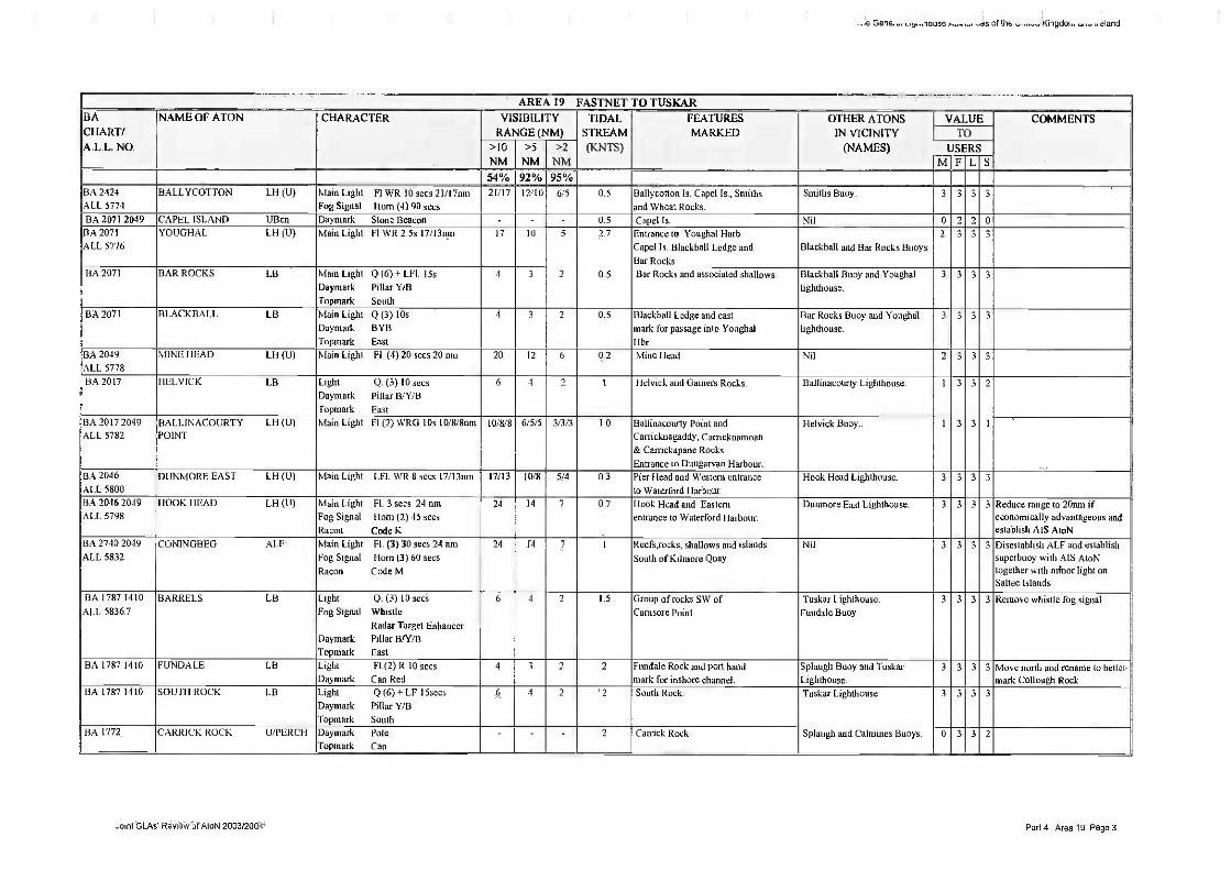
1
..,e Gene amuse a of thy
AREA 19 FASTNET TO TUSKARBACHART/A.L.L. NO.
NAME OF ATON CHARACTER VISIBILITYRANGE (NM)
TIDALSTREAM(KNTS)
FEATURESMARKED
OTHER ATONSIN VICINITY
(NAMES)
VALUE COMMENTSTO
NMNMNMUSERS
MFLS54% 92% 95%
BA 2424
ALL 5774
BALLYCOTTON L11 (U) Main Light El WR 10 secs 21/17intiFog Signal Born (4) 90 secs
21/17 12/10 6/5 0.5 Ballycothan Is. Capcl Is., Smithsand Wheat Rocks.
Smalls Buoy_ 3 3 3 3
BA 2071 2049 CAPEL ISLAND UBcn Dayrnark Stone Beacon - 0.5 Capel Is Nil 0 2 2 013A 2071
ALL 5776YOUGHAL LH (U) Main Light FLWR 2.5s 17/13nm 17 10 5 2.7 Entrance to Youghal Barb.
Capel Is. Blackball Ledge andBar Rocks
Blackball and Bar Rocks Buoys.2 3 3 3
BA 2071 BAR ROCKS LB Main Light Q (6) + LEI. 15sDaymark Pillar Y/B
Topmark South
4 3 2 0.5 Bar Rocks and associated shallows. Blackball Buoy and Youghal
lighthouse.
3 3 3 3
BA 2071 BLACKBALL LB Main Light Q (3) lOsDaymark BYBTopmark East
4 3 2 0.5 Blackball Ledge and eastmark for passage into Youghal
Hbr.
Bar Rocks Buoy and Youghal
lighthouse.
3 3 3 3
BA 2049ALL 5778
MINE HEAD (.11 (U) Main Light Fl (4)20 secs 20 am 20 12 6 0.2 Mine Head Nil 2 3 3 3
13A 2017 HELVICK LB Light Q. (3) 10 secsDaymark Pillar B/Y113
Top-nark East
6 4 2 1 Helvick and Gainers Rocks. Ballinacourty Lighthouse. 1 3 3 2
BA 2017 2049ALL 5782
BALIANACOURTY LH (U)POINT
Main Light Fl (2) WRG 105 I 0/8/8nrn 10/8/8 6/5/5 3/3/3 1.0 Ball inacourly Point andCarricknagaddy, Carricknamoan& Carrickapane Rocks.Entrance to Dungarvan Harbour
Helvick Buoy. 1 3 3 1
BA 2046ALL 5800
DUNMORE EAST LH (U) Main Light LFI. WR 8 secs 171I3nm 17/13 10/8 5/4 0.3 Pier Ilead and Western entranceto Waterford Harbour.
Hook Head Lighthouse. 3 3 3 3
BA 2046 2049ALL 5798
HOOK HEAD LH (H) Main tight FL 3 secs 24 notFog Signal Horn (2) 45 secsRacon Code K
24 14 7 0.7 I look Head and Easternentrance to Waterford Harbour.
Dunmore East Lighthouse. 3 3 3 3 Reduce range to 20mn ifeconomically advantageous andestablish AlS AtoN
BA 2740 2049ALL 5832
CONINGBEG Al.F Main Light FL (3) 30 secs 24 nmFog Signal Horn (3) 60 secs
Racon Code M
24 14 7 1 Reefs,rocks, shallows and islandsSouth of Kilmore Quay.
Nil 3 3 3 3 Disestablish ALF and establishsuperbuoy with ALS AtoNtogether with minor light onSallee Islands
BA 1787 1410
ALL 5836.7
BARRELS LB Light Q. (3) 10 secsFog Signal Whistle
Radar Target EnhancerDayrnark Pillar B/Y/13
Topmark East
6 4 2 1.5 Group of rocks SW ofCarnsore Point.
Tuskar Lighthouse.Fundale Buoy
3 3 3 3 Remove whistle fog signal.
BA 1787 1410 FUNDALE LB light Fl.(2) R 10 secsDaymark Can Red
4 3 2 2 Fundale Rock and port hand
mark for inshore channelSplaugh Buoy and TuskarLighthouse.
3 3 3 3 Move north and rename to bettermark Collough Rock
BA 1787 1410 SOUTH ROCK LB Light Q (6) + LF 15secsDayinark Pillar YA3
Topmark South
6 4 2 2 South Rock. Tuskar Lighthouse 3 3 3 3
BA 1772 CARRICK ROCK U/PERCH Dayinark PoleTopmark Can
- - 2 Carrick Rock. Splaugh and Calmines Buoys. 0 3 3 2
Joint GLAs* Review of Atoll 2003/2004 Part 4 Area 19 Page 3

.e Gene louse I of IN lKingdoi
AREA 20 TUSKAR TO BAILYBACHART/A.L.L.NO.
NAME OF ATON CHARACTER VISIBILITYRANGE (NM)
TIDALSTREAM
(KNTS)
FEATURESMARKED
OTHER ATONSIN VICINITY
(NAMES)
VALUE COMMENTSTO USERS
>10 >5 >2
NM NM NM MFLS54% 92% 95%
BA 1772
BA 1787
ALL 5838
TUSKAR LB (U) Main Light Q (2) 7.5 secs 24 tam
Fog Signal Horn (4) 45 secsRacon Code I
24 14 7 3 0 Tuskar Rock. Is an element ofthe TSS.
South Rock Buoy. 33 3 3 Establish AlS AtoN
BA 1772
BA 1787
ALL 5839
SPLAUGH LB Light Fl R 6 secsDaymark Can RedTopmark Red CanRadio RTE
6 4 2 2 Splaugh Rock and Eastern
entrance of South Shear Channel.
South Long, South Hoidens
and Calmines Buoys.
3 3 3 3 Change characteristic to Fl (2) R 6sec
BA 1772
BA 1787
S LONG LB Light VQ (6) t IF lOsecsFog Signal WhistleDaymark Pillar Y/I3
Topmark South
6 4 2 2 Southern extremity of Long Bank
and Western entrance of South
Shear Channel.
Splaugh, South Iloldens,and Calmines Buoys
3 3 3 3 Establish AIS AtoN
Remove Whistle fog signal
BA 1772
BA 1787
CALMINES LB Light Fl, R 2 secsDaymark Can RedRadio RTE
4 3 2 2 Calmines Patch and port hand
mark for South Shear Channel.West and South Hoidens,South Long and Splaugh Buoys.
3 3 3 3 Synchronise timing and flashcharacters with South Hoidens
BA 1772
BA 1787
HOLDENS SOUTH LB Light Fl. (2) G 6 secs
Daymark Conical GreenRadio RTE
4 3 2 2 Southern extremity of HoidensBed and starboard hand markfor South Shear Channel.
West Hoidens, Calmines,
South Long and Splaugh Buoys3 3 3 3 Synchronise timing and flash
characters with Cali-nines
BA 1772
BA 1787
HOIDENS wEsT 1.13 Light Fl. (3) G 10 secs
Daymark Conical Green
5 4 2 2 Southwest side of Hoidens Bed.
Eastern entrance of SouthShear Channel.
Calmines and South I loldens
Buoys
3 3 3
BA 1772
BA 1787
I.UCIFFR 1.13 Light VQ (3) 5 secsDaymark Pillar B/W/3
Topmark East
7 5 3 2 Southern extremity of LuciferBask.
South Long Buoy. 3 3 3 3
BA 1772
BA 1787
W LONG LB Light Q.G.
Daymark Conical Green4 3 2 2 Western side of Long Batik and
starboard hand channel markfor North- Shear Channel
North Long Buoy. 3 3 3 3
BA 1772
BA 1787
N LONG LB Light Q
Daymark Pillar 13/Y
Topinark North
6 4 2 2 Northern extremity of Long Bank
and Northern entrance of NorthShear Chnl.
South Blackwater andWest Long Buoys.
3 3 3 3
BA 1787 BLACKWATER LB
SOUTH
Light Q (6) 4- LF 15sees
Fog Signal Whistle
Day/nark Pillar Y/13
Topmark South
6 4 2 2 Southern end of Blackwater Bank. SE Blackwater, WestBlackwater, North tong
Buoys.
3 3 33 Disestablish
BA 1787 BLACKWATER SE LB Light Fl. R 10 secs
Dayinark Can Red
5 4 2 2 Southeast side of Hint:waterBank
East and South lilackwaterBuoys.
3 3 3 3 Re position 2 Cables East andextablish Superbuoy with Raconand MS AtoN
BA 1787 BLACKWATER W LB Light Fl G 6 secsDaymark Conical Green
5 4 2 2 West side Black- water Bank. No. I & 2 Rusk and SouthBlackwater Buoys
2 3 3 2
Joint GLAs Review of AtoN 2003/2004 Pan 4 Area 20 Pagel

of the Kingdoi, ,ttand
AREA 20 TUSKAR TO BAILY
BACHART/A.L.L.
NO
NAME OF ATON CHARACTER VISIBILITY
RANGE (NM)TIDALSTREAM
(KNTS)
FEATURESMARKED
OTHER ATONSIN VICINITY
(NAMES)
VALUE COMMENTSTO USERS
>10 >5 >2
NM NM NM M F L S54% 92% 95%
BA 1787 RUSK No 2 LB Light Fl. (3) R isecsDaymark Can Red
4 3 2 2 Southern extremity of Rusk Bank
and Southern entrance of Rusk
Channel,
Nos and 4 Rusk Buoys. 2 3 3 2 Synchronise timing with No 2 Rusk
BA 1787 RUSK No I LB Main Light Fl (2) G 5s
Dayruark Conical Green
5 3 2 2 West side of Money weights
Bank and Southern entrance of
Rusk Channel
Has 2 and 4 Rusk Buoys. 2 3 3 2 Synchronise tinting with No 1 Rush
BA 1787
ALL 5844.5
BLACK WATER E LB light Q (3) 10 secs
Daymark Pillar B/Y/B
Topmark East
7 5 3 2 Eastern side of Moneyweights
and Blackwater banks
SE Blackwater and NorthBlackwater Buoys.
3 1 3 3 Disestablish
BA 1787 RUSK No 4 LB Main Light Fl (3) R 6see
Dayrnark Can Red
4 3 2 2 Eastern side of Rusk Bank and
channel mark Rusk channel
No .6 Rusk, North Blackwater
Nos 2 & 1 Rusk Buoys.
2 3 3 2
BA 1787 BLACK WATER N LB Light Q.Dayrnark Pillar WYTopinark North
5 4 2 2 Northern extremity of Blackwater
Bank and Northern entrance of
Rusk Channel_
Nos 6 and 4 Rusk Buoys. 3 3 3 3
BA 1787 RUSK No 6 LB Light Fl. R 3 secs
Daymark Cart Red
4 3 2 2 North Eastern extremity Rusk
Bank & Northern entrance of
Rusk Channel.
North 131ackwater and
No.4 Rusk Buoys
2 3 3 2
BA 1787 GLASSGORMAN LB
No. 1
Light Fl. (2) R 6 sees
Daymark Can Red
5 4 2 2 South East side of Glassgorman
Bank,
Arklow Lanby and SouthArklow Buoys
3 3 3 3
BA 1787
ALL 5845ARKLOW LANBY Main Light Fl. (2) W 12 secs 15 iim
Fog Signal Horn Morse "A" 30sRacon Code 0
15 9 5 3.3 Eastern extremity of sandbanks
which proliferate between
Codling Lanby & Tuskar Rock.
No.1 Glassgorman and
South Arklow Buoys.
3 3 3 3
Establish AIS AtoN and reposition
BA 1787 ARUM' S 1.8 Light YQ (6) A- LEI lOsecs
Daymark Pillar Y/13
Topmark South
5 4 2 3.3 Southern extremity of Arklow
Bank.
No.1 Glass-gonnan, ArklowLanby, No.1 Arklow Buoys.
3 3 3 3 Disestablish
BA 1787 CiLASSGORMAN LB
No. 2
Light Fl. (4) R 10 secs
Daymark Can Red
4 3 2 2.5 North Eastern side of
Glass- gorman Bank
No.1 Glass-gorman,
South Arklow Buoys.
3 3 3 3
BA 1787 COURTOWN LB Light Fl Y IOsDayrnark Cross
4 3 2 2.5 Courtown outfall Glassgorman No I 2 3 3 3
BA 1787 ARKLOW No 1 LB Light Fl. (3) R 10 secs
Daymark Can Red
4 3 2 3.3 Eastern side of Arklow Bank. South ArkIow Buoy,Arklow Lanby.
3 3 3 3 Disestablish
BA 1468 ARKLOW No 2 LB Light Fl. R6 secs
Daymark Can Red
a 4 2 4 Eastern side of Arklow Bank. North Arklow Buoy. 3 3 3 3 DisestablishBA 1787
BA 1468 ARKLOW N LB Light Q.Fog Signal Whistle
Daymark Pillar WYTopinark North
6 4 2 3.9 North extremity of Arklow Bank. Horseshoe and No. 2
Arklow Buoys.
3 3 3 3 Remove Whistle fog signalBA 1787
BA 1468 HORSESHOE I.,F3 Light Ft. R 3 secs
Dayinark Can Red
4 3 2 2.5 Horseshoe Rock Wicklow Head Lighthouse,
South India Buoys.
3 3 3 3
BA 1468
ALL 5850WICKLOW HEAD LH (Ill) Main Light FL (3) 15 secs 23 mu 23 13 6 2.5 Wicklow Head South India and Horseshoe
Buoys.3 3 3 3 Reduce range to 20nin if
economically advantageous
Joint GLAs Review of AtoN 2003/2004 Part 4 Area 20 Page 2

.1a Gene._. souse .s of thE stand
AREA 20 TUSKAR TO BAILYBA
CHART/ALL.NO.
NAME OF ATON CHARACTER VISIBILITYRANGE (NM)
TIDALSTREAM
(KNTS)
FEATURESMARKED
OTHER ATONSIN VICINITY
(NAMES)
VALUE COMMENTSTO USERS
>10 >5 >2NM NM NM M F I S
I 54% 92% 95%I BA 1468I BA 633 II
light FL (4) Y 10 secs
Daymark Special Mark V Can4 Extremity of sewage pipe. Nil 3 3
BA 1468
I
i
Light Q6 + LF. 15 secsDaymark Pillar Y.(13
Topinark South
6 South extremity of India Bank North India Buoy,
Wicklow Head Lighthouse.
3 3
BA 1468 iIIRJave P1 light VQ,
Dayrnark Pillar B/Y
Topmark North
6 North extremity of India Bank South India and South CodlingBuoys.
3 3
BA 1468
ALL 5861
E.JPIE Main Light Fl 4 secs 15 innFog Signal Horn 20 secsRacon Code G
15 The banks and shallow patcheswhich make up Codling Bank.
South India, North India,South Codling & East CodlingBuoys.
3 3 Establish AIS AtoN
BA 1468 NS1SJPI I Light VQ,6 + LF, 10 secsDaymark Pillar Y/13
"Fopinark South
6 Southern extent of Codling Bank. North India, East CodlingBuoys.
3 3 Reposition subject to survey
BA 1468 UT1WI i I.ight FL (2) R 6 sees
Daymark Can Red
4 5 metre Breaches Shoal. Moulditch, West Codling,North India Buoys.
3 3
BA 1468 Light Fl. (4) R 10 secsDayinark Can Red
4 Eastern limits of Codling Bank. South Codling Buoy. 3 3
BA 1468 EIJ.JpI1.I E Light Fl. G 10 secs
Daymark Conical Green
5 Western extremity of CodlingBank.
Breaches, North India,South Codling Buoys
3 3
BA 1468 I11iJPI1UiPt Light Fl. RIO secsDaymark Can Red
6 3.8111 patch on Moulditch Bank, Greystones Outfall,WestCodling, Breaches Bys.
3 3
BA 1468 Light Fl. VS seesDaymark Special Mark Y Can
4 Extremity of sewage pipe Moulditch Buoy. 0 3
BA 1468 Light Fl. (2) R. 10 secs
Daymark Can Red
4 Mid lenght of combined Kishand Bray Banks
Nil 3 3
BA 1468 light Fl. (4) V JO secsDayinark Special Mark Y Can
4 Extremity of sewage pipe Nil 0 3
BA 1468 Light FLY 3 secs
Day-mark Special Mark Y Can
4 Extremity of sewage pipe Nil 0 2
BA 1447
BA 1415
IIIiIUtlI 1 ight FI.Y 5 secs
Dayinark Special Mark Y4 Extremity of sewage pipe. Dun Laoghaire East and
West Lighthouses3 3
BA 1415 11 Light VQ.
Daytuark Pillar 13/Y
Topmark North
6 Northern extremity of Kish Bank Kish Lighthouse. 3 3
BA 1415 Light Q6+LF 15 secs
Daymark Pillar YiBTopinark South
S O41/1 patch on Bennet Bank Kish Lighthouse. 3 3 Reposition subject to survey
Joint GI_Ast Review of AtoN 2003/2004 Part 4 Area 20 Page 3

. a of the Kingclor.. oalanol
AREA 20 TUSKAR TO BAILYBACHART/A.L.L.
NO.
NAME OF ATON CHARACTER,
VISIBILITY
RANGE (NM)TIDALSTREAM
(KNTS)
FEATURESMARKED
OTHER ATONSIN VICINITY
(NAMES)
VALUE COMMENTSTO USERS
>10 >5 >2
NM NM NM MFLS54% 92% 95%
HA 1415
ALL 5869
BURFORD S LA Light VQ6+LF 10 secsFog Signal Whistle
Radar Target EnhancerDaymark Pillar Y/13
Topinark South
6 4 2 1.3 Southern extremity of BurfordBank
Kish Lighthouse. 3 3 3 3 Establish AIS AtoN
AA 1415
A 5869.1
BURFORD N LB Light QFog Signal Whistle
Radar Target EnhancerDaymark Pillar B/YTopmark North
6 4 2 1.3 Northern extremity of BurfordBank
Kish Lighthouse . 3 3 3 3 Establish AIS AtoN
BA 1415 ROSBEG EAST LB Light Q (3) 10 secsDayinark Pillar H/Y/B
Topmark East
6 4 2 1.3 4.5m. Patch at edge of RosbegBank.
Bally lighthouse. 3 3 3 3
BA 1415
ALL 5865
KISH LH (LI) Main Light Fl. (2) W 20 secs 22 maRacon Code T
Fog Signal Horn (2) 30sec
22 13 6 1.3 Kish Bank N Kish and Bennet BankBuoys.
3 3 3 3
BA 1415
ALL 5868MUGLINS LH (U) Main Light FLW 5 secs Ilnm 11 7 4 0.6 Muglins Island Dun Laoghaire E&W L/Hs.
S. Burford buoy.
3 3 3 3 Change to Red light and maintainrange and Increase conspicuity
BA 1447
BA 1415
ALL 5874
DUN LAOGHA IRE 1.1i (U)
WEST
Main Light Fl. (3) G 8 secs 7 tun 7 5 3 0.5 Pier Head Dun Laoghaire E Lighthouse,at Outfall buoy
3 3 3 3 Synchronise liming and flashcharacters and increase range
BA 1447
BA 1415
ALL 5872
DUN LAOGUAIRE 1.11 (U)
EASTMain Light Fl (2) R 10 sees 17 nrn
Fog Signal Horn 30 secs
17 10 5 0 5 Pier Head Dun Laoghaire W Lighthouse,
at Outfall buoy3 3 3 3 Synchronise timing and flash
characters
BA 1447BA 1415
DUN LAOCIFIAIRE LBOUTFALL
Main Light Fl. Y. 53
Daymark Can special Mark YTopmark X
4 3 2 0.5 Extremity of outfall pipe Dun Laoghaire E Lighthouse, I 3 1 3
Dun Laoghaire W Lighthouse,
BA1415
ALL 5898
BALLY LB (U) Main Light Fl. W 15 secs 26 nni 26 15 7 06 Howth Head Rosbeg East, N.Burford,S Burford, Bennet Bank buoys
3 3 3 3
Joint GLAs Review of AtoN 2003/2004 Part 4 Area 20 Pagel

...neral the U,. 1gdom
AREA 21 DAILY TO ST JOHN'S POINT, DOWNBACHART/A.L.L.NO.
NAME OF ATON CHARACTER VISIBILITYRANGE (NM)
TIDALSTREAM
(KNTS)
FEATURESMARKED
OTHER ATONSIN VICINITY
(NAMES)
VALUE COMMENTSTO USERS
>10 >5 >2
NM NM NM MFLS54% 92% 95%
BA 1415
(Plan)ALL 5900
HOWTH LB (U) Main Light Fl. (2) WR 7.5s 12 I 9 mu 12/9 8..'6 4/3 0.8 Hov,,th Pier and safe water
approach to Howth Channel.Nil. 2 3 3 3
BA 1415(Plan)
ROWAN SOUTfl LB Light Q.G.
Daymark Conical Green3 2 0 8 South Rowan Rocks and starboard
hand mark for channel to HowthHarbour.
Howth Buoy. 0 3 3 3
BA 1415
(Plan)
HOWTH LB Light FLG 5 secs
Daymark Conical Green
4 3 2 0.8 2.2 and 2.7 metre patches.Starboard hand mark for channel
to Howth Hbr.
South Rowan Buoy. 0 3 3 3
BA 1415 ROWAN ROCKS LB Light Q. (3) 10 secsDaymark Pillar B/Y/B
Topmark East
4 3 2 0.7 South Eastern limit of dangersoff ThuIla Is. Outer channel markfor app. to Howth Harbour.
Nil 0 3 3 3
BA 44 BURREN ROCKS U/PERC1I Daymark Pole '(BYTopmark West
- 0.8 I3urren Rocks and starboardhand mark for Lambay sound.
Nil. 1 3 ' I Light Perch
BA 0044
BA 1468TAYLOR ROCK LA Main Light Q
Daymark Pillar BYTopmark North
4 3 2 0 5 Taylors Rock Nil 0 3 3 3
BA 0044BA 1121
ALL 5904
ROCKAB1LL LH (U) Main Light Fl. WR 12 secs 22/18nmFog Signal Horn (4) 60 secs
22/18 13/11 6/6 0.5 Rockabill Rock. Lambay IsSkerries Islands.
Nil 3 3 3 3 Establish A1S AtoN
BA 0044 CARDY ROCKS UTERCH Daymark Pole
Topmark Can- 0.3 Cardy Rocks. Nil 0 3 3 0 Repair topmark
BA 0044 DUNANY LB Light Fl. R 3 secsDayrnark Can Red
4 3 2 0.5 Dundalk Patch and DunanyShoals. Southern side of safeentrance to Dundalk Bay.
Nil. 3 3 3 3
BA 0044
ALL 5920
DUNDALK PILE LH (U) Main Light Fl WR15secs 21/18nmSector Light Occ.G 5seesFog Signal Horn (3) 60 secs
21/18 12/11 6/5 1.0 North and South Bull sand-banks.Safe approach to dredgedchannel for Dundalk
Nil. 3 3 ' 3 Restore sector light subject tosounding survey
BA 0044 IMOGENE LB Light Fl. (2) R 10 secsDaymark Can Red
4 3 2 0.5 Imogene and Castle Rocks.The Ridge.
Dunany buoy 3 3 ' 3
BA 2800
ALL 5934
GREEN ISLAND LI1 (U) Main Light Occ. W 3 secs 11 muDayn)ark Lattice Beacon
11 7 4 2 5 Rear lead for Carlingford Cut. Vidal Bank. 3 3 3 3
BA 2800
ALL 5932
VIDAL BANK 1,1-1(U) Main Light Occ. W 3 secs 11 muDaymark Lattice Beacon
11 7 4 2.5 Front lead for Carlingford Cut. Green Island. 3 3 3 3
BA 2800
ALL 5928
HAULBOWLINE LH (U) Main Light Fl. (3) W 10 secs 17 nmTurning Light F.R. 9 nmFog Signal Horn 30 secs
17
9
10
6
5
3
2.5 Haul-bowline Rocks. Entranceto Carlingford Lough. Turninglight for vessels transitingCarlingford Cut.
Nil 3 3 3 3 Disestablish turning light
Joint GLAs Review or AtoN 2003/2004 Part 4 Area 21 Page 1

natal L 3e Ault if the U igdom and
AREA 21 DAILY TO ST JOHN'S POINT, DOWNBACHART/A.L.L.NO.
NAME OF ATON CHARACTER VISIBILITYRANGE (NM)
TIDALSTREAM
(KNTS)
FEATURESMARKED
OTHER ATONSIN VICINITY
(NAMES)
VALUE COMMENTSTO USERS
>10 >5 >2
NM NM NM MELS54% 92% 95%
BA 0044 CARLINGFORD LB Light LI' 10 secs
Fog Signal Whistle
Daymark RWVS
6 ' 4 2 0.5 Safe water mark for approach
to Carlingford Lough.Nil. 3 3 3 3 Disestablish
BA 2800
ALL 5947HELLYHUNTER LB Light Q (6) 1' LF 15 secs
Racon Code K
Daymark Pillar Y/BTopmark South
6 4 1 0 5 Hellyhunter Rock and Shoal Carlingford buoy 3 3 3 3 Increase range, Establish AISAtoN and reposition
BA 0044 DZ WEST U13 Daymark Special Mark Y Conical - 0 4 Danger area of target practice
in Dundrurn Bay.DZ East and Middle
Buoys.
0 3 3 3 Light buoy or discontinue
BA 0044 D7. MIDDLE LIB Daymark Special Mark Y Conical 0.4 Danger area of target practice
in Dundrum Bay.DZ East and West
Buoys.
0 3 3 3 Light buoy or discontinue
BA 0044 DZ EAST UB Day-mark Special Mark Y Conical - 0.4 Danger area of target practice
in Dundrum Bay.DZ Middle and West
Buoys.
0 3 3 3 Light buoy or discontinue
BA 44 1411
ALL 5958ST JOHNs POINT LH (U)DOWN
Main Light Q (2) W 7.5 secs 25 nnt
Aux Fl WR. 3s 15/11
25
15;11
14
917
7
9/7NA St John's Point
Dundrum bay danger zone
DZ East West andMiddle
3 3 3 3 Reduce range to 20nrn ifeconomically advantageous,Discontinue Aux light. EstablishAIS AtoN
Joint GLAs Review of AtoN 2003/2004 Part .4 Area 21 Page 2