Embed Size (px)
Citation preview

Knowledge-Based Systems 174 (2019) 57–72
Contents lists available at ScienceDirect
Knowledge-Based Systems
journal homepage: www.elsevier.com/locate/knosys
Extracting geographic features from the Internet: A geographicinformationmining frameworkYing Zhang a,∗, Qunfei Ma a, Yao-Yi Chiang b, Craig Knoblock b, Xin Zhang c, Puhai Yang a,Minghe Gao a, Xiang Hu a
a School of Control and Computer Engineering, North China Electric Power University, 2 Beinong Road, 102206, Beijing, Chinab Dana and David Dornsife College of Letters Arts and Sciences, University of Southern California, Los Angeles, USAc School of Computer Science and Technology, Changchun University of Science and Technology, 130022, Changchun, China
a r t i c l e i n f o
Article history:Received 26 October 2018Received in revised form 21 December 2018Accepted 23 February 2019Available online 14 March 2019
Keywords:Geographic information mining frameworkPlace entity extractionPlace-name datasetGeographic information mining
a b s t r a c t
In this paper, we propose a Geographic Information Mining framework to contribute some exploratoryresults concerning harvesting the featured place information entities from the Web. In the framework,we suggest an iterative geographic information mining model reflecting the data evolution along themining process. Associating the iterations, we propose a set of methodologies and integrate them intothe processing onto solving the critical issues concerning collecting data, filtering irrelevant samplesand extracting featured entities. According to the experiments, the contribution brings in a soundsystematic solution to enrich the existing digital gazetteers as complete as Google Maps.
© 2019 Elsevier B.V. All rights reserved.
1. Introduction
Digital gazetteers are the structured dictionaries of namedplaces. As defined by Goodchild and Hill [1], a gazetteer is com-posed of three core components, i.e., namely place names, placetypes and geospatial locations. The primary purpose of a gazetteeris to translate the informal place names and place categories tothe formal georeferencing of mathematical schemes and well-known types [2,3]. Seen that the explosion of web-based serviceson the Internet, more and more gazetteer applications require avery high level of completeness, but the current gazetteers stilllack the local place names used in everyday conversations [4,5].Besides, the existing structured dictionaries only provide staticinformation but do not incorporate frequent updates. Thus, thereis a strong need to enrich gazetteers with abundant up-to-datelocal place entries for improving the timeliness and integrity ofthe structured geographical data. One critical issue is effectivelyand efficiently building up place-name datasets.
Conventionally, place-name datasets can be obtained fromsome structured data sources, such as DBpedia,1 LinkedGeoData,2Wikimapia,3 Google Places API,4 and OpenStreetMap.5 However,
∗ Corresponding author.E-mail address: [email protected] (Y. Zhang).
1 http://wiki.dbpedia.org/Downloads.2 http://linkedgeodata.org/sparql.3 http://wikimapia.org/api.4 https://developers.google.com/places/.5 http://www.openstreetmap.org.
these structured sources only provide static information but donot always incorporate the timely updates. Not only that, al-though some commercial sources, such as the Google Places API,maintain high-quality location data, many restrictions are issuedfor obtaining and using their data (i.e., usage limits). In contrast,the volume of vernacular publicly available on the Web is enor-mous and grows rapidly. Meanwhile, the up-to-date informationof places is commonly released on the Web and accepts frequentrenewing since the unstructured web pages. The great utilityof the Web in conducting studies on the data collection andextraction has been widely recognized [6–8].
In this paper, we firstly propose a Geographic InformationMining (GIM) framework inspired by the CRISP-DM (Cross In-dustry Standard Process for Data Mining) methodology [9] forextracting geographic information. The GIM framework enablesus to build up the multiple dimensions of modeling geographicinformation mining processes, i.e., the phase-oriented model, thegeneric/specific task-oriented model and the instance-orientedmodel. Associated with search engines, each of the models specifyand arrange the focal phases, tasks and instances as the entriesintegrating the potential methodological solutions to contributethe effort onto mining the geographic information from webpages. Under the phase-oriented modeling dimension, the in-formation mining process consists with as a serial of phases.Each of the phases specifies a sequential business reflecting theevolution from raw data to structured knowledge. Seeing thatinformation mining would not be completed when a solution isjust deployed, we specially bring in an iterative scheme of struc-turing the procedural modules (i.e., tasks and instances) under the
https://doi.org/10.1016/j.knosys.2019.02.0310950-7051/© 2019 Elsevier B.V. All rights reserved.

58 Y. Zhang, Q. Ma, Y.-Y. Chiang et al. / Knowledge-Based Systems 174 (2019) 57–72
task-oriented and instance-oriented modeling dimensions. Theiterative scheme reveals the sustaining evolution of knowledgediscovery through gaining and utilizing the previously obtainedmining achievement(s) during mining information [10], and italso exposes that information mining is an open process takingadvantage of various solutions to collect, extract and treat datasamples.
As the foundation for constructing GIM framework, CRISP-DMmethodology, as a bridge between the gap of business problemsand data mining objectives, provides a standard reference modelto translate business problems into a set of data mining tasksand is independent of technological aspects. It is inclined toimprove the effectiveness and efficiency of managing data miningprojects. In contrast, GIM framework proposed in this paper isdesigned for organizing the potential methodological solutions ofresolving geographic information mining issues from web pagesand it supports to load the compatible methods with the iterativemodeling dimensions. In other words, GIM could be adopted as atechnological roadmap toward extracting the accurate and timelygeographic features, associated locations and feature types fromfreely available online data to build the place-name datasets,which mainly concerns the key issues as follows:
The first issue is to collect and identify the appropriate placetypes for composing the keywords in the format of <StreetNames><City names><Place Types> to search for the initial thegeographic information.
The second issue is to filter out the ‘‘noisy’’ information mixedwith the obtained search results for preserving the meaningfuland valuable information.
The third issue is to extract the necessary geospatial locationsfrom the various web pages [11] in consideration of the distinctstructures in different web pages.
The fourth issue is to address the problem of place namedisambiguation (also called toponym disambiguation), i.e., to ac-curately identify the place names as low ambiguous as possible.
To completely present our research progress for readers’ betterunderstanding onto the contribution in this paper, we brieflyclarify the previous study in the following Section 2. Aroundthe relevant research topics, we discuss the related work in thesame section. In Section 3, we elaborate the GIM framework andpropose a set of methods integrated into the framework for build-ing place-name datasets relying on the previous research result.Then in Section 5, we expound a set of experiments to verifythe proposed contribution and make a comprehensive analysisonto the experimental results. In the last section, we concludethe research contribution with highlighting the characteristics ofthe proposed framework and state the future work concerningimproving the performance for enriching gazetteers.
2. Previous study and related work
2.1. The previous work
Our previous work proposed in [12] provided a set of pre-liminary solutions/results corresponding to the mentioned criticalissues being concerned with the proposed GIM framework.
(1) To compose the proper searching keywords in the format of<Street Names><City names><Place Types> with websearch engines, the previous work collect the place typesthrough receiving the manually input.
(2) To filter out the webpages containing many real-estatelistings for obtaining more usable searching results, theprevious work selected to query the Google search en-gine with the recently sold house addresses (the addressescan be collected from any real-estate website). With thereturned results providing the domain names of popularreal estate websites, we are able to eliminate the ‘‘noisy’’webpages.
(3) To retrieve place addresses from the unstructured web-pages, we presented an algorithm to parse the place ad-dress as a line starting with a number and containing thecity name as an address in the condition where the lengthof the line is less than a given threshold. Meanwhile, wealso used a similar means to determine whether or not acombination of two lines represents one address.
(4) To extract place names exactly from the given webpages,we simply assumed that the corresponding webpage titlewas the place name if the returned webpage containedonly one address and the address was the same as theaddress used to query the search engine API.
With answering the four critical issues, the above-introducedwork brings our inceptive reflection of establishing the GIMframework in this paper. On this basis, we will depict the frame-work with highlighting the progress with the contrast betweenthe previous work and current contribution in Section 3.
2.2. Related work review
A considerable number of researchers have collected data forgenerating gazetteers from structured Internet sources [13–15].The approach mentioned in [16] extracted points of interest froma set of popular Web sources including DBpedia, OpenStreetMap,Wikimapia, Google Places, Foursquare, and Eventful. The first twosources provide SPARQL endpoints, and the latter four sourcesoffer RESTful API. Blessing and Schütze [17] used Google APIsto query the Web and generate place name variations. Theirqueries had the names of places as positive terms and had thestopwords as negative terms. The stopwords are used to excludewebpages that make the query result noisy. Gelernter et al. [18]presented a method to enrich a gazetteer by identifying sourcesof novel local gazetteer entries in crowdsourced OpenStreetMapand Wikimapia geotags. However, these volunteered geographicinformation are not complete and up-to-date. Through comparingthe result obtained from the methods brought in by the GIMframework,we find that both OpenStreetMap and Wikimapia, asthe data sources are not as latest and complete as ours.
Datasets mined with web crawling tools can be considerablydifferent from data sets retrieved via the exposed query APIs.Thus, many researchers took advantage of search engines toquery the Internet to extract information for enriching gazetteers[19–22]. For instance, Uryupina [23] put forward an approachto the automatic acquisition of geographical gazetteers from theInternet. A new gazetteer can be learned from a small set ofpre-classified examples by applying bootstrapping techniques.However, bootstrapping could produce a drift toward a noisyresult due to the inferred examples. Brindley et al. [24] discov-ered neighborhood place names from addresses found in webpages. They extracted postal addresses from the Web and createdrelatively simple linguistic models to produce neighborhood defi-nitions. Popescu et al. [25] presented an automated technique forcreating and enriching geographical gazetteers. Their techniquemerges disparate information from Wikipedia, Panoramio, andWeb search engines to identify geographical names.
With the mined data, named entity disambiguation is neces-sary to identify and determine the appropriate sense of entitiesfor further computation corresponding to the context [26]. Wanget al. [27] presented a topic model for named entity disambigua-tion in the field of community question answering. The modelperformed learning in an unsupervised manner but could take ad-vantage of weak supervision signals estimated from the metadataof community question answering and knowledge bases. Hungand Chen [28] proposed a word sense disambiguation (WSD)method for sentiment classification. This paper argued that thetask of word sense disambiguation should be done before a
Y. Zhang, Q. Ma, Y.-Y. Chiang et al. / Knowledge-Based Systems 174 (2019) 57–72 59
proper sentiment score or sentiment orientation for a word inSentiWordNet can be justified. It built WSD-based SentiWordNetlexicons by taking advantage of three WSD techniques based onthe context of word-of-mouth documents. Gutiérrez et al. [29]proposed an unsupervised approach to solve semantic ambiguityissue based on a multidimensional network through analyzingdifferent lexical resources. Concerning the place name disam-biguation issue, the researches related to gazetteers enrichmentidentify the issue as Toponym Resolution (TR) [30]. The threedirections in TR employed heuristic techniques, machine learningand semantic Web separately [31,32]. Despite their simplicity,the methods based on heuristics have shown a relatively goodperformance in some text domains [33,34]. Two types of theresearch works took advantage of machine learning. Some re-searches usually depend on supervised approaches that requireannotated datasets. For instance, Overell and Rüger [35,36] pro-posed co-occurrence models generated from Wikipedia to solvethe place name disambiguation problem by supervised learningtechniques. In order to take advantage of the unlabeled data andavoid the need of annotation, a number of methods use a smalllexicon such as a small gazetteer [37–40] as seeds to extract placenames. In contrast, without using a gazetteer, DeLozier et al. [41]presented a toponym resolver that used the geographic profiles ofthe local clusters to build a system that computes the overlap ofall geo-profiles in a given text span. For semantic aspect, Zaila andMontesi [42] built a geographic ontology GeoNW by combiningGeoNames, WordNet and Wikipedia resources, and based on thisGeoNW, an algorithm for solving toponym disambiguation waspresented. Different from the discussed traditional methods, wesuggest to avoid ambiguity problem by using queries of <StreetNames><City names><Place Types>. Our provided solutiondoes not suffer from the problem of ambiguous place names sincethe three components in the given queries mutually restrict eachother. It means that given a specific address and a place type, thepossibility that the extracted place names are ambiguous is small.
3. The GIM framework
In this paper, we propose a Geographic Information Mining(GIM) framework for locating our contributed methodologies asa systematic solution to the various issues concerned in buildingup place-name dataset (Seen in Fig. 1). The framework provides aset of modeling dimensions elicited by the contribution from [9]in terms of a hierarchical complexity of processing potentialgeographic information. The modeling dimensions are:
(1) Phase-oriented modeling dimension: it provides thescheme of modeling the total geographic information pro-cess with four phases, i.e., objective definition, iterativeprocessing, evaluation and refinement and deployment. Thephases imply a serial of critical business carrying out oneafter another to achieve the preset milestones. The di-mension reflects the evolution process from raw data tostructure knowledge, during which we employ the con-ventional process of knowledge discovery and data miningmethodologies (e.g., [43] and [44]) and build up the phase-oriented reference model. Specially, the potential iterationsare programmed between ‘‘iterative processing’’ phase and‘‘evaluation and refinement’’ phase in consideration of thefact that geographic information mining would producesome unforeseen findings and often require the continuouscomputations.
(2) Generic task-oriented modeling dimension: it unfoldsthe ‘‘iterative processing’’ phase and provides a hierarchi-cal modeling scheme of decomposing the critical activitiesduring the ‘‘iterative process’’ phase. Under the dimension,one or more groups of tasks are organized and each group
is designed as an implementation of geographic informa-tion mining methodology to cover one kind of geographicinformation mining scenario. In the framework, the groupscould be created and combined dynamically according tothe specific problem to ensure the flexibility of leadingvarious types of geographic information solutions.
(3) Specific task-oriented modeling dimension: Within onegroup, i.e., referring to an adopted methodology duringmining geographic information, the procedures are ar-ranged as a number of task suites. Each suite consists withthree actions that are interrelated in an iterative mannerand specifies the determined actions iteratively carryingout the methodology in a particular engagement. In otherwords, one group of task suites is modeled as an iterationchain.
(4) Instance-oriented modeling dimension: Referring to eachaction within one task suite, it is configured with thespecific parameter(s) and reflects the actual occurrenceduring the execution of geographic information mining,i.e., an instance is acting the corresponding actions andmeanwhile keeping the coordination with the other twoinstances. The instances are designed and categorized asCollection (C), Treatment (T) and Extraction (E) to form aserial of iterations, which implies the essential behaviorsof coping with data.
During constructing the systematic solution of mining geo-graphic information under the GIM framework, we take advan-tage of web search engines for multiple times to gather theintermediate data associating extracting and mining the placeentities, such as the place types.
As follows, we will depict the modeling regulation of the GIMframework and elaborate the proposed methodological solutionsto solve the particular research issues simultaneously.
3.1. Geographic information mining process
Along the geographic information mining process, a set ofraw data should be assembled for the further intermediate dataentities collection and extraction to achieve the final place-namedataset establishment, i.e, implementing the structured knowl-edge discovery. We model the process with four phases (i.e., ob-jective definition, iterative processing, evaluation and refinement,and deployment) reflecting the critical activities executed in turn(see Fig. 1).
Objective definition. With analyzing the raw data towarddiscovering the potential interests in it, we arrange the ‘‘ob-jective definition’’ as the first phase to determine the problemspecification(s) and compose the strategy of coping with theproblem(s). Both the specification(s) and the strategy would elicitthe objectives stated in form of questions:
(1) What kinds of data organization to be built up?(2) What kinds of hidden information to be mined?
The first question concerns the necessities of dealing withdata for proceeding with employing the further procedures ofmining target information, while the second question specifiesthe structure and content of the final results through miningprocedures. In this paper, we kick off the practice under theGIM framework by answering the questions mentioned above asfollows:
(1) The raw data mainly originates from the web pages re-turned by search engines that receive the keywords in theformat of <Street Names><City names><Place Types>.Most of the preliminary data would emerge as unstruc-tured since they are gathered through employing search
60 Y. Zhang, Q. Ma, Y.-Y. Chiang et al. / Knowledge-Based Systems 174 (2019) 57–72
Fig. 1. The GIM framework.
engines providing plenty of web pages. Some filtering andformatting procedures would thus be adopted. Through theintermediate procedures, the data would evolve into thestructured entities. In this paper, the mined place-nameentities are organized as JSON-encoded entities.
(2) Through collecting the preliminary data associated withemploying search engines and filtering the irrelevant webpages, we retrieve the place addresses from the valid pagesand then mine the place names with taking advantage ofboth title and abstracts of the target web pages providedby search engines. The place names are the outcome toachieve our target of enriching place-name datasets.
Iterative processing. With the answers obtained through theobjective definition phase, the second phase, i.e., ‘‘iterative pro-cessing’’, then starts. The phase reflects and arranges the criticalactivities of coping with data according to the previously specifiedobjective definition, and it brings in the problem-solving patternof iteratively executing activities toward the objectives. Duringthe iterative processing phase, the iterations are implementedwith the phase-oriented ones and task-oriented ones.
Evaluation and refinement. The phase-oriented iterations areimplemented with the close link between the iterative processingand the evaluation and refinement phases. The iterations indicatethat the processing made onto data would be performed multipletimes according to the conclusion made from the ‘‘evaluationand refinement’’ phase. In other words, it is essential to evalu-ate the produced outcome from the iterative processing phasefor determining whether the objectives could be achieved. Inthis paper, we propose an approach of constructing place-namedatasets proceeding to develop the previous research work [12] tosolve the critical issues concerned during the iterative processingphase.
Since the task-oriented iterations would be unfolded duringthe iterative processing phase and meanwhile reflect the ac-tivities under the task-oriented and instance-oriented modelingdimensions, we will not continue with expounding them anddisturb the introduction to general geographic information min-ing process and we will elaborate the corresponding issues oftask-oriented iterations in Section 3.2.
Deployment. Through the iterative processing and the evalua-tion and refinement phases, the place-name entities are providedas the meaningful outcome and organized as the input to the‘‘deployment’’ phase, through which we are enabled to gain thestructured knowledge for the further business objectives. In thispaper, we visualize the place-name entities on maps to reflect theintuitive outcome from mining geographic information and thenare going to contribute the built place-name dataset to enrich theexisting gazetteers.
3.2. Intermediate data processing
In this section, we resolve the iterative processing phase anddepict the in-line iterative procedures of collecting, treating andextracting data under the task-oriented and instance-orientedmodeling dimensions. As illustrated by the geographic infor-mation mining process in Fig. 1, the iterative processing phaseconsists with one or more generic tasks, i.e., a set of generic taskscould be dynamically arranged corresponding to the conventionalproblem scenarios during mining geographic information un-der the generic task-oriented modeling dimension. With analyz-ing the representative literature devoted to enriching gazetteersthrough data mining [12,19,20,22,34], we outline four generictasks as follows:
• To seek for potential resources: it refers to collect the initialraw data according to the objectives of mining information.
• To clean and structure samples: it refers to preliminarily treatthe collected data to filter the irrelevant pieces, structure thedata entities and/or reformat the data, etc.
• To expose featured components: it refers to process the sam-ples with some methodologies toward geographic informa-tion mining objectives and assistant highlighting the fea-tures for the further process.
• To retrieve target entities: it refers to extract the target dataresults as the information mining outcome.
Under different overall geographic information mining re-quirements, the four generic tasks might not be strictly arrangedas the above-prescribed order and might be omitted in somecases, but they could cover all potential problem scenarios andsupport to employ new methods.

Y. Zhang, Q. Ma, Y.-Y. Chiang et al. / Knowledge-Based Systems 174 (2019) 57–72 61
Each of the generic tasks consists with a set of specific tasksthat are designed and settled in consideration of the actual par-ticular situations, i.e., one specific task describes one meaningfultriplet containing three procedural actions organized iteratively.Between the specific tasks, the upstream one provides the tem-porary output to the downstream one, and the latter consumesthe intermediate input and continues with propagating the ef-fort onto the further specific task(s) if necessary. An iterationchain reflecting a serial of interrelated specific tasks is formedcorresponding to each generic task.
One triplet is constituted with three instance that are con-figured with particular parameters, i.e., collection, treatment andextraction instances (we denote them as a CTE iteration for short).The collection instance contains the requirement specificationsof dealing with initial data and is responsible for gathering thenecessary data samples. Then the treatment instance proceedswith processing the collected data with cleaning, constructing,combining and/or formatting operations. Next, the extraction in-stance starts to extract the potential features associated with thespecifications and targets brought in by the collection instance.According to the regulation of the generic tasks, one or more CTEiterations would be arranged to ensure enough effort made foranswering the requirements.
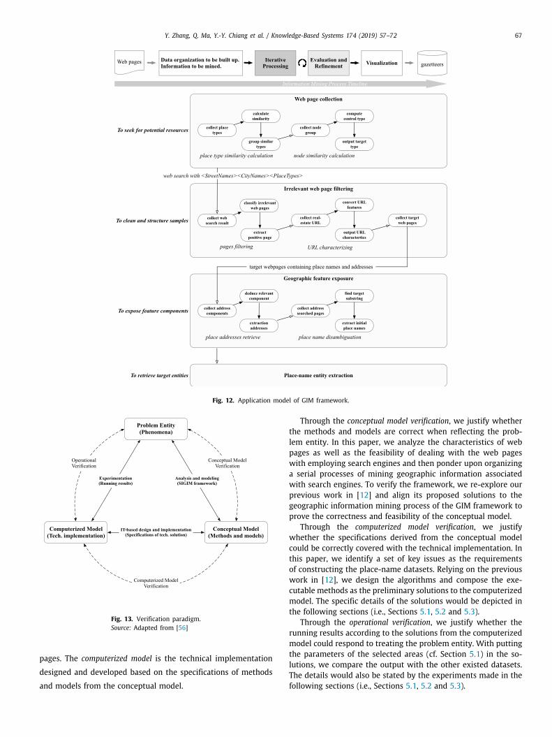
4. Automatic construction of place-name datasets under GIMframework
In this section, we present a set of methodologies of solv-ing the critical issues for automatically constructing place-namedatasets and integrate them into the geographic information min-ing process of the GIM framework, through which we suggest anapplication model of the framework.
Based on the objective definition of the proposed researchwork stated in Section 3.1, we then proceed to consider thecorresponding critical issues and identify the initial generic tasksaccording to the actual research scope.
4.1. Web page collection
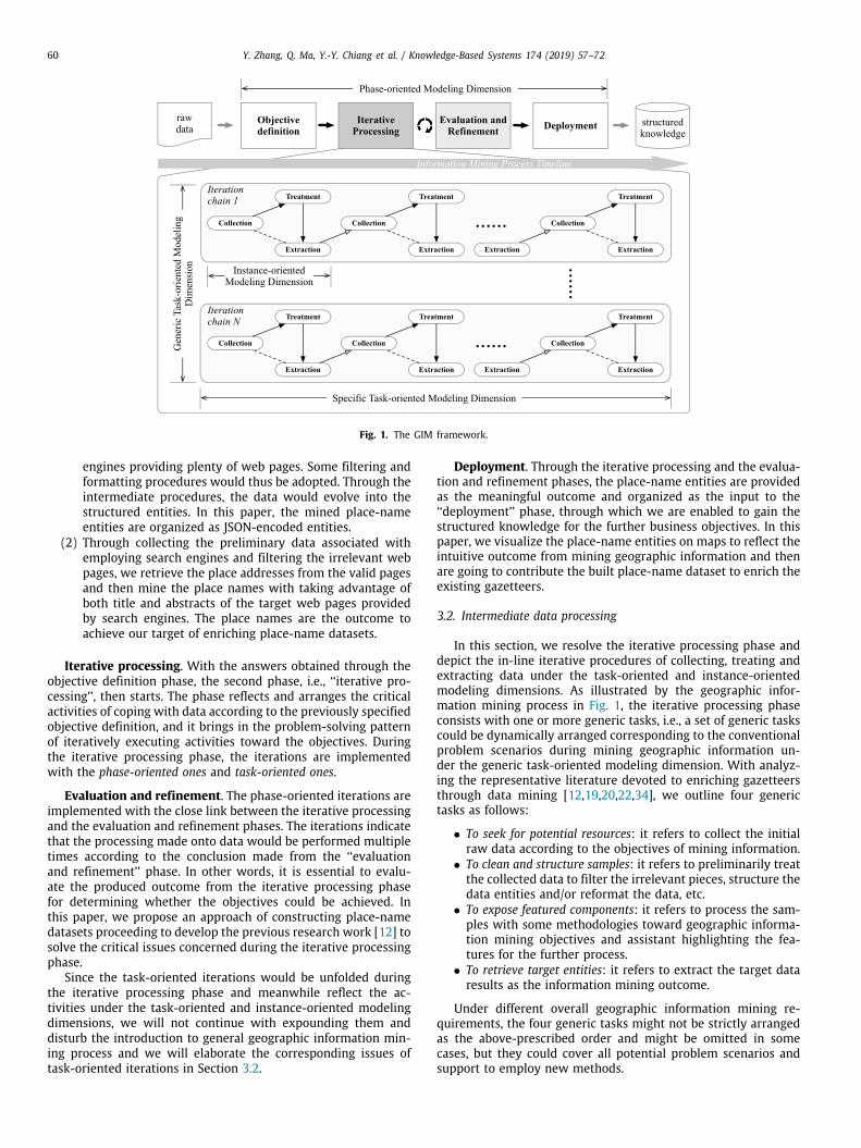
To collect web pages that contain place information, we needto first compile a list of search queries for querying a searchengine API. The search engine queries consist of three parts inthis work, namely, Street Name, City Name, and Place Type. Toprepare our queries, we first give a specific city name and thenextract street names of this city from OpenStreetMap (OSM) [45,46]. OpenStreetMap is a leading VGI (Volunteered GeographicInformation) project, aiming at creating a free editable map ofthe world. It has over 1.6 million registered users, and nearly 30%of them have made actual contributions to the maps [47,48]. Weimplement a technical solution to automatically download datafrom OSM as an XML file containing three primitive data types,namely, Node, Way, and Relation. Each of the three primitive datatypes is associated with a set of tags. A tag is basically a pair (key,value) that complements the information corresponding to theprimitive data types. Fig. 2 gives a snippet of the OSM file. Weextract the street names from those tags whose keys equals to‘‘addr:street ’’ and whose values are the specific street names (suchas ‘‘Main Street’’ and ‘‘N Sepulveda Boulevard’’) as shown in Fig. 2.Besides, we could also choose some alternative geospatial sourcesto extract street names, for example, Wikimapia.
For business types, in the previous work, we manually preparea list of popular place types, such as Restaurant, Bar, etc. In thiswork, we present an algorithm to generate a set of place typesautomatically. The corresponding process is shown in Fig. 3. Largenumbers of place types have been collected from Google PlacesAPIs.
Given the above, the generic task of web page collection con-sists with two specific tasks: place type similarity calculation andnode similarity calculation.
We firstly calculate the similarity of each pair of types basedon the WordNet as shown in Algorithm 1 (seen in the 5th line ofAlgorithm 1).
sim(x, y) = e−αl·eβh
− e−βh
eβh + e−βh (1)
In Eq. (1), x and y represent two types selected from theinput list, l is the shortest path length between x and y, and his the depth of subsumer in the hierarchical semantic nets [49].α ∈ [0, 1] and β ∈ [0, 1] are the parameters which scalethe contributions of shortest path length and depth, separately.For WordNet, the optimal values for the proposed parametersare: α = 0.2 and β = 0.5, as presented by Li et al. [50].Correspondingly, the similar types are placed in one group asshown in Fig. 4.
Then we calculate the sum of similarities for each node inone group. For example, compared with the other nodes in onegroup, the similarity sum of node 4 is the largest one. Thus, node4, which represents its neighbors such as nodes 1,8 and 12, willbe output as illustrated in Fig. 5. The other nodes such as 2, 6, 7and 10 will be put back to the second task, i.e., node similaritycalculation.
Algorithm 1: Generating a set of place typesInput: allTypes[]=a collection of all types extracted from
Google Places APIOutput: resultList[]=a proper scale data set of place types
1 List[] typeList=deleteNoneBusinessTypes(allTypes)2 // step 1: generate different similarity groups3 for each type x in typeList do4 for each type y in typeList do5
sim(x, y) = e−αl·eβh
− e−βh
eβh + e−βh
6 if (sim(x, y) < threshold)AND(groupList(y).has(x) ̸=
True)AND(groupList(x).has(y) ̸= True) then7 groupList(x).append(y);
8 //step2: calculate the group center for each group g9 first=g[1];
10 second=g[2];11 num=the number of types in one group;12 switch num of do13 case 114 output first;15 case 216 if frequency(first) > frequency(second) then17 output first;18 else19 output second;
20 otherwise21 center=argmax
v∈g
∑u∈g
weight(u, v)
22 output center;
4.2. Irrelevant web page filtering
Although search engines are able to return as many resultsas we want, many of them are irrelevant. For this work, many
62 Y. Zhang, Q. Ma, Y.-Y. Chiang et al. / Knowledge-Based Systems 174 (2019) 57–72
Fig. 2. A snippet of OpenStreetMap.
Fig. 3. The generation process of a set of place types.
real estate listings returned from search engines are big obstaclesand should be coped with through executing irrelevant web pagefiltering task. We take advantage of machine learning to traina classifier to identify the real-estate web pages. A classifiersuitable for this task should have two main characteristics. Onone hand, it should not be sensitive to the ratio of the negativesamples to the positive ones because the training data are oftenimbalanced (i.e., more positive samples than negative ones). Onthe other hand, the classifier should work well based on thelimited training samples. Inspired by Vapnik [51], we select theSupport Vector Machine (SVM), which is known to be insensitive
to the size of training samples, to answer the two desired require-ments. In the training set, we configure the real-estate web pagesas positive samples, and the others as the negative ones. This typeof problem situation can be supported by a traditional two-class-SVM. However, the two-class-SVM classifiers might be overlybiased toward one class of samples when the ratio of the negativeexamples to the positive examples is not balanced. To cope withthis issue, one-class classification solutions are introduced.
Bernhard Scholkopf in [52,53] developed an algorithm thatreturns a function f that takes the value +1 in a ‘‘small’’ fieldcapturing most of the data points and −1 elsewhere. Thus, thestrategy behind it is to map the data into the feature space

Y. Zhang, Q. Ma, Y.-Y. Chiang et al. / Knowledge-Based Systems 174 (2019) 57–72 63
Fig. 4. Group the similar place types.
Fig. 5. Compute the group center for types.
according to the selected kernel and to separate them from theorigin with the maximum margin. Users can choose differenttypes of kernel functions which generate a variety of nonlinearestimators in input space. As shown in Fig. 6, the algorithm triesto separate dataset from the origin with maximum margin, andthe corresponding problem is denoted as below:
minω∈F ,ε∈Rt ,ρ∈R
12∥ω∥
2+
1vl
∑i
ξi − ρ (2)
subject to
(ω · Φ(xi)) ≥ ρ − ξi, ξi ≥ 0 (3)
v ∈ (0, 1) is a parameter representing the percentage ofthe negative samples within the training dataset. Nonzero slackvariables ξi are penalized in the objective function. According tothe dual problem presented by expression (4) and (5), we canget the decision functions shown in formula (6) and (7). In thiswork, we select Radial Basis Function (RBF, described by formula(8)) as the kernel function because of its good performance to bediscussed in Section 5.
minα
12
∑ij
αiαjk(xi, xj) subject to 0 ≤ αi ≤1vl
,∑
i
αi = 1
(4)
k(x, y) = (Φ(x),Φ(y)) (5)
f (x) = sgn(∑
i
αik(xi, x) − ρ) (6)
ρ = (ω · Φ(xi)) =
∑j
αjk(xj, xi) (7)
Fig. 6. One-class classification problem.
K (xi, xj) = exp(−γxi − xj
2), γ > 0 (8)
Given the SVM model, we then need to extract the featuresfor real-estate websites. For this work, we collect the real-estateURLs and extract their common features. We pick up sevenfeatures from the common attributes: (1) the number of stringscomposing a URL; (2) the ordinal number of the string containingthe first number in the given URL; (3) the position (i.e., the ordinalnumber) of the first number character in that string; (4) whetherthe string containing the first number is the longest one; (5) theposition (i.e., the ordinal number) of ‘‘www’’; and (6) the posi-tion (i.e., the ordinal number) of ‘‘com’’. For instance, the corre-sponding characteristic vector corresponding to an instance URL‘‘https://www.zillow.com/homedetails/16080-Running-Deer-Trl-Poway-CA-92064/16828157_zpid/’’ is expressed as <7, 6, 1, 1, 2,4>. We use ‘‘//’’, ‘‘/’’, and ‘‘.’’ to separate the URL string, and take‘‘-’’ as the separator between words. The procedures of webpagefiltering module are shown in Fig. 7.
4.3. Geographic feature exposure
Place name and place address are two features of geographicinformation during extracting place-name entities for buildinga gazetteer. However, extracting both of them is a challengebecause of the variety of web page structures. A lot of relatedresearch work use the statistic methods based on the vast corpusto disambiguate geographic features. Others adopt predefinedrules to filter out place names. In contrast, we take advantageof the titles and abstracts generated by Google (demonstrated inFig. 8) to extract place names.
Therefore, we identify and plan two specific tasks for exposinggeographic features as place addresses retrieve and place namedisambiguation.
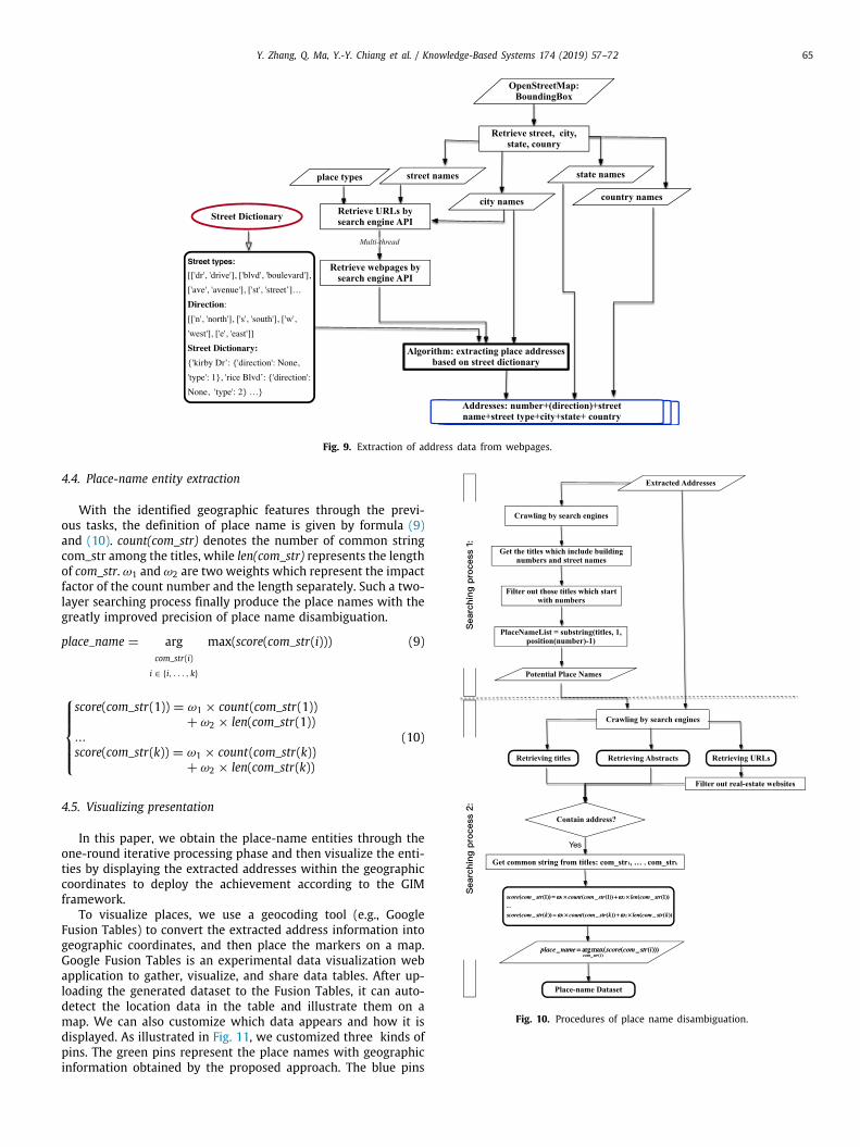
During the execution of the place addresses retrieve task,some challenges affect the performance of address extractionfrom web pages. For instance, one or more elements in the ad-dress may be missing. It may also have some extra text to indicaterouting information [54]. The wide variation in abbreviation willalso affect the performance of extraction. In order to address suchproblems, we present a new method shown in Algorithm 2.
Since we focus on American addresses in this work, we pro-pose a common pattern for American address styles, i.e., ‘‘number+(direction)+street name+street type+city name+state name+country name’’. According to Algorithm 2, we get the position ofcity name in the webpage content at first, and then set the cityname as the center of strings, and extract its following wordsto obtain the state name and country name, and retrieve its

64 Y. Zhang, Q. Ma, Y.-Y. Chiang et al. / Knowledge-Based Systems 174 (2019) 57–72
Fig. 7. Real-estate filter.
Fig. 8. Titles and abstracts generated by Google.
previous words to check whether the previous words are thestreet type, street name, direction or numbers based on thegiven address pattern. The street dictionary is critical for thealgorithm, as shown in Fig. 9, which includes two parts, namely,Street Types and Direction. Street Types consist of various typessuch as ‘‘street ’’, ‘‘avenue’’, and ‘‘drive’’ with their correspond-ing abbreviations ‘‘st ’’, ‘‘ave’’, and ‘‘dr ’’. Direction is comprisedof ‘‘north’’, ‘‘south’’, ‘‘west ’’, ‘‘east ’’ and their abbreviations. Forinstance, in the street dictionary, one record written as ‘‘‘RiceBoulevard’:‘direction’:None, ‘type’:2’’ means that for street ‘RiceBlvd’, there is no direction information and the street type isthe second type in the type list. As mentioned in Section 4.1,the street names are retrieved from OpenStreetMap on the con-dition that a specific city name is given in advance. Thus, therelationships among city name, state name and country namecan be obtained. Correspondingly, we can identify them immedi-ately by looking up the state name dictionary and country namedictionary by Algorithm 2 when the state name and the countryname are missing in the web content. In addition, we use twoflexible variables denoted as m and n in the algorithm to solvethe problem concerning the extra information in address texts.
During the execution of place name disambiguation, a largenumber of researchers took advantage of gazetteer to identifyplace names. There is a common weakness of these methods thatrely on the gazetteers is that the gazetteers are highly incom-plete. Some other researchers used machine learning for toponymresolution. Due to the limited availability of annotated corpora,
such approaches cannot avoid the instinct problems as that thesupervised machine learning method and the semi-supervisedmachine learning method have.
To reduce the dependence on both the gazetteers and theannotated corpora, we employ search engines to extract titles andabstracts that are used to resolve place names as Fig. 10 depicts.
The previously extracted place addresses are used as the in-put data for disambiguating the place names. Given one specificaddress, we utilize search engines to retrieve those titles includ-ing the building numbers and the street names as the same asthe search keyword has. Then we extract substrings which startfrom the beginning up to the building numbers as the potentialplace names from the extracted titles. To check whether thesepotential place names are real place names, we take both thecorresponding addresses and the potential place names as thekeywords during the next round of searching process. Meanwhile,this method can also address the problem that one place ismapping to the various place names. In the second searchingprocess, we extract both abstracts and URLs associated with theweb page titles. URLs are utilized to filter out the real-estatewebsites as mentioned in Section 4.2. The common substringsfrom the web page titles will be extracted when the searching ad-dress is contained in either titles or their corresponding abstracts.The common substring which gets the highest similarity score istaken as a place name.
Y. Zhang, Q. Ma, Y.-Y. Chiang et al. / Knowledge-Based Systems 174 (2019) 57–72 65
Fig. 9. Extraction of address data from webpages.
4.4. Place-name entity extraction
With the identified geographic features through the previ-ous tasks, the definition of place name is given by formula (9)and (10). count(com_str) denotes the number of common stringcom_str among the titles, while len(com_str) represents the lengthof com_str. ω1 and ω2 are two weights which represent the impactfactor of the count number and the length separately. Such a two-layer searching process finally produce the place names with thegreatly improved precision of place name disambiguation.
place_name = argcom_str(i)
i ∈ {i, . . . , k}
max(score(com_str(i))) (9)
⎧⎪⎪⎪⎨⎪⎪⎪⎩score(com_str(1)) = ω1 × count(com_str(1))
+ ω2 × len(com_str(1))...
score(com_str(k)) = ω1 × count(com_str(k))+ ω2 × len(com_str(k))
(10)
4.5. Visualizing presentation
In this paper, we obtain the place-name entities through theone-round iterative processing phase and then visualize the enti-ties by displaying the extracted addresses within the geographiccoordinates to deploy the achievement according to the GIMframework.
To visualize places, we use a geocoding tool (e.g., GoogleFusion Tables) to convert the extracted address information intogeographic coordinates, and then place the markers on a map.Google Fusion Tables is an experimental data visualization webapplication to gather, visualize, and share data tables. After up-loading the generated dataset to the Fusion Tables, it can auto-detect the location data in the table and illustrate them on amap. We can also customize which data appears and how it isdisplayed. As illustrated in Fig. 11, we customized three kinds ofpins. The green pins represent the place names with geographicinformation obtained by the proposed approach. The blue pins
Fig. 10. Procedures of place name disambiguation.

66 Y. Zhang, Q. Ma, Y.-Y. Chiang et al. / Knowledge-Based Systems 174 (2019) 57–72
Fig. 11. Geocoding and visualizing the extracted place-name dataset in maps (The green pins represent the place names with geographic information obtained byour approach. The blue pins denote those places extracted from OpenStreetMap, and the red pins describe the place information retrieved from Wikimapia) . (Forinterpretation of the references to color in this figure legend, the reader is referred to the web version of this article.)
Algorithm 2: Extracting Place AddressInput:Street Dictionary[] sdList; pages[]= A collection of webpages;Street Types[] stList; Street Direction[] sdirList;State Names[] snList; Country Names[] cnList;Output: Address[] address;
1 contentPages[]=filterHtmlTags(pages);2 //find the position of city name in the webpage content3 location=position(city_name);4 address.addCity(city name);5 //judge whether the following word is a state name6 if string(location+1,1) is in snList then7 address.addState(string(location+1,1));8 else9 Look up dictionary for state name;
10 address.addState(state name);11 //judge whether the following words contain country name12 if string(location+m,m+1) is in cnList then13 address.addCountry(string(location+m,m+1));14 else15 Look up dictionary for country name;16 address.addCountry(country name);17 //judge whether the previous word is a street type18 if string(location-1,1) is in stList then19 location =location-1;20 address.addType(string(location-1, 1));21 //judge whether the previous n words is a street name22 if string(location-n, n) is in snList then23 location=location-n;24 address.addName(string(location-n, n));25 //judge whether the previous word is a street
direction26 if string(location-1, 1) is in sdirList then27 location=location-1;28 address.addDirection(string(location-1, 1));
29 //judge whether the previous word is a house number30 if string(location-1, 1) is a digital number then31 address.addNumber(string(location-1, 1));
32 return address;
denote those places extracted from OpenStreetMap, while the red
pins describe the place information retrieved from Wikimapia.
Table 1The comparison between the previous work and the proposed contribution.Issue The previous work The proposed
contribution
To compose searchingkeywords
Manually providing placetypes
Suggesting theWordNet-basedsimilarity computingmethod
To filter irrelevantwebpages
Querying Google searchengine using recentlysold home address
Employing SVM to trainreal-estate filteringmodel
To retrieve placeaddresses
Parsing the placeaddress as a line startingwith a number andcontaining the city nameas an address (linelength < threshold)
Proposing a new patternfor place namerecognition
To extract placenames
Assuming the webpagetitle was the place name
Providing a two-layersearching process
In Table 1, we summarize the whole research work withcomparing the previous work and the current contribution underthe GIM framework.
In Section 4, we depict the particular process of adopting theGIM framework to automatically construct place-name datasetsby proposing the methods for solving the critical problems duringgeographic information mining. We thus derive an applicationmodel based on the GIM framework (cf. Fig. 12).
5. Verification and experiments
In this section, we are going to evaluate whether the GIMframework integrated with the methods would meet the re-quirements and specifications brought in by the issue of en-riching place-name datasets from mining geographic informa-tion from Internet. To answer the question ‘‘Are we building thethings right?’’ [55] frequently posed during verifications, we struc-ture the verification paradigm by following the process proposedby Sargent [56] but slightly modifying it to fit our work in thispaper (seen in Fig. 13).
In the paradigm, the problem entity refers to the target phe-nomena that we are going to analyze and model. In this paper,the phenomenon is that there is plenty of data reflecting thepotential geographic features and available information withinInternet. The conceptual model, on one hand, brings in our mod-eling achievement of representing the problem entity and, onother hand, presents our reflection onto organizing the suiteof methodologies for mining geographic information from web
Y. Zhang, Q. Ma, Y.-Y. Chiang et al. / Knowledge-Based Systems 174 (2019) 57–72 67
Fig. 12. Application model of GIM framework.
Fig. 13. Verification paradigm.Source: Adapted from [56]
pages. The computerized model is the technical implementation
designed and developed based on the specifications of methods
and models from the conceptual model.
Through the conceptual model verification, we justify whetherthe methods and models are correct when reflecting the prob-lem entity. In this paper, we analyze the characteristics of webpages as well as the feasibility of dealing with the web pageswith employing search engines and then ponder upon organizinga serial processes of mining geographic information associatedwith search engines. To verify the framework, we re-explore ourprevious work in [12] and align its proposed solutions to thegeographic information mining process of the GIM framework toprove the correctness and feasibility of the conceptual model.
Through the computerized model verification, we justifywhether the specifications derived from the conceptual modelcould be correctly covered with the technical implementation. Inthis paper, we identify a set of key issues as the requirementsof constructing the place-name datasets. Relying on the previouswork in [12], we design the algorithms and compose the exe-cutable methods as the preliminary solutions to the computerizedmodel. The specific details of the solutions would be depicted inthe following sections (i.e., Sections 5.1, 5.2 and 5.3).
Through the operational verification, we justify whether therunning results according to the solutions from the computerizedmodel could respond to treating the problem entity. With puttingthe parameters of the selected areas (cf. Section 5.1) in the so-lutions, we compare the output with the other existed datasets.The details would also be stated by the experiments made in thefollowing sections (i.e., Sections 5.1, 5.2 and 5.3).

68 Y. Zhang, Q. Ma, Y.-Y. Chiang et al. / Knowledge-Based Systems 174 (2019) 57–72
Fig. 14. Experimental setting.
Table 2The comparison among kernel functions.
Precision Recall F-Measure
Linear 0.674502712477 0.941919191919 0.786090621707Poly 0.659574468085 0.939393939394 0.775RBF 0.959349593496 0.893939393939 0.925490196078Sigmoid 0.714867617108 0.886363636364 0.791431792559
5.1. Experimental setting
In this section and the following ones (i.e., Sections 5.1, 5.2and 5.3), we concentrate upon specifying our experimental setupand demonstrating the evaluation results from employing thecritical methods under the GIM framework, i.e., the computerizedmodel and operational verifications.
Referring to the adopted one-class-SVM for filtering out irrel-evant web pages (cf. Section 4.2), we first give the experimentalresults to elaborate why we select RBF as a kernel function in thiswork. Following that, we then illustrate the good performanceof the proposed web page filtering solution. Finally, we test thethree datasets (i.e., our built up dataset and the two datasets re-spectively provided by OpenStreetMap and Wikimapia) in termsof precision, recall, and F-score [57,58].
During evaluating the contribution, we selected four areas ofthe United States to apply the proposed methods. Fig. 14 specifiesthe experimental settings such as the range of correspondingareas, city names, street types and place types, which are used toquery the Google Search Engine. The street names were obtainedfrom OpenStreetMap automatically as discussed in Section 4.1.In this work, all the extracted place types were merged to 40representative types as shown in Fig. 14. In addition, the specificmeanings of parameters for each stage listed below have beendiscussed in the corresponding sections.
5.2. Evaluation measurement
In this paper, three measures were used to evaluate the per-formances of the proposed contribution. They are precision, recall
and F-measure. We used Eq. (11) to evaluate the precision ofthe generated place name datasets. It is defined as the ratio ofthe number of correctly extracted places to the total number ofextracted places. TP denotes the number of true positives, TNrepresents the number of true negatives, FP is the number of falsepositives, and FN means the number of false negatives.
P =TP
TP + FP× 100% (11)
Recall was used to evaluate the missing places through theproposed process (cf. Section 3.1) according to Eq. (12). It isdefined as the ratio of the number of correctly extracted placesto the total number of places in the ground truth.
R =TP
TP + FN× 100% (12)
We evaluated the harmonic mean of P and R, i.e., F-score,which was calculated by Eq. (13). F-score have a high value onlywhen both P and R have high values and can be seen as a way tofind the best compromise between P and R.
F1 = 2 × (P × RP + R
) =2TP
2TP + FP + FN× 100% (13)
5.3. Performance evaluation
5.3.1. Evaluation for real-estate website filteringTo evaluate the performance of the information mining pro-
cess of the GIM framework, we first test the function of theirrelevant web page filtering task (cf. Section 4.2), whose per-formance take a significant effect on the GIM framework. Inthis module, we selected RBF as a kernel function for one-class-SVM because the experimental results illustrated that RBF kernelfunction got the best results as shown in Table 2. Parameter‘‘gamma’’ is usually set to the ratio of 1 to the number of featuretypes. In this paper, gamma =
1thenumberoffeaturetypes =
17 ≈ 0.10.
In contrast, ‘‘nu’’ is a parameter representing the proportion ofnegative examples to the whole training set. Actually, ‘‘nu’’ is thesame as variable ‘‘v’’ in formula (1). In this test, ‘‘nu’’ is set to0.1. The training set includes 3710 samples and the testing set

Y. Zhang, Q. Ma, Y.-Y. Chiang et al. / Knowledge-Based Systems 174 (2019) 57–72 69
Fig. 15. An average precision comparison among our approach, OSM andWikimapia.
contains 824 samples. Correspondingly, the precision of webpagefiltering module of our method is 0.959, the recall is equal to0.894, and the value of F-measure reaches 0.925.
5.3.2. Comparison between the explored result, OSM and wikimapiaIn the experiments, we selected Google Map as the ground
truth because of its high quality. As shown in Fig. 14, we testedfour city areas with selecting 10 blocks to evaluate the perfor-mance of the methods and models.
Tables 3, 4, 5, 6 present the overall results for all test blocksof four cities. We compared our obtained results in this paperwith OpenStreetMap and Wikimapia regarding recall, precisionand F-score (Figs. 15, 16, 17). Fig. 15 shows an average precisionof each area. We can see that the obtained precision was higherthan that of OpenStreetMap and Wikimapia. Compared with asingle source, the Internet is much wider although it has variouscomplicated structures. Thus, the methods of our contributioncan retrieve large numbers of places. Even compared with GoogleMaps, our contribution obtained more places as illustrated inTables 3, 4, 5, 6.
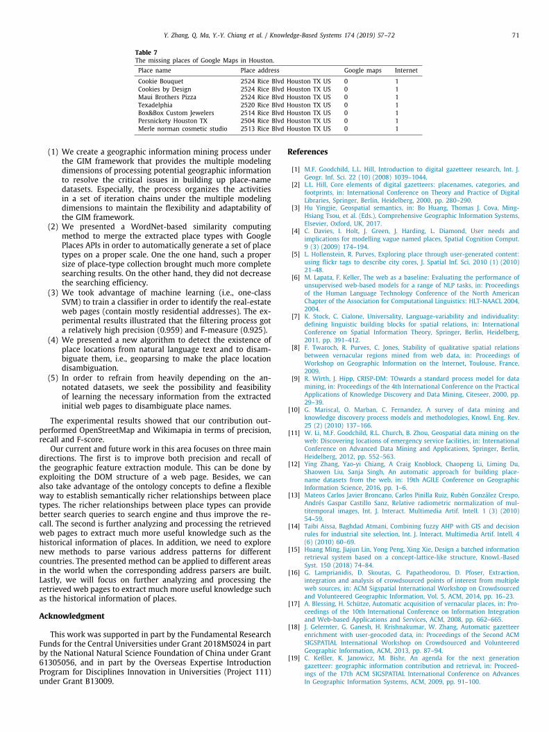
The places listed in Table 7 were extracted by our proposedmethod from Internet, while they are missing on current GoogleMaps. For instance, more than one places share the same address‘‘2524 Rice Blvd Houston TX US’’, namely, Cookie Bouquet, Cook-ies by Design, and Maui Brothers Pizza. However, we can get onlyone place ‘‘Pizza L’Vino’’ from Google Maps. Since we could notwalk there to check how many places which shared the sameaddress, we considered Google Maps as ground truth in this work.Therefore, the extra places extracted from Internet were simplytaken as negative samples. Correspondingly, the value of TP (TruePositive) declined, and the value of FP (False Positive) raised.Based on the definition of precision given by Eq. (11), we can findthat this is the main reason why the average precisions of ourcontribution did not reach as high as 0.9. Since OpenStreetMapand Wikimapia are developed by volunteers, precision of themshould be high. However, for many areas, most of places aremissed in OpenStreetMap and Wikimapia. Some blocks in thetesting areas have no marked places. So, the average precisionof OSM and Wikimapia for the testing area is relatively low.
Fig. 16 illustrates that the recall of our contribution was muchhigher than that of OpenStreetMap and Wikimapia. The numberof extracted place names is larger than that of Google Maps.However, since we use Google Maps as the ground truth, thesamples that were missed on the current Google Maps wereconsidered as negative ones.
Fig. 17 illustrates that our contribution outperformed Open-StreetMap and Wikimapia in F-score. However, large numbers of
Fig. 16. An average recall comparison among our approach, OSM and wikimapia.
Fig. 17. An average F-score comparison among our approach, OSM andwikimapia.
the extracted places include more false positives, which preventour contribution gaining a higher F-score. The false-positives inour contribution could be from two main reasons. First, comparedwith Google Maps, our methods of the GIM framework extractedmore places, so such extra samples were taken as false positivesin our work. Thus, the real F-score of our contribution could behigher than test value. Second, the main idea in our contributionfor extracting place names was to retrieve the common substringsfrom titles when each part of searching address is contained in ei-ther titles or their corresponding abstracts. Most of the addressessatisfied this rule, but there were some exceptions. For instance,given the query ‘‘417 Spring St New York NY US’’, our methodsincorrectly extracted the place name ‘‘First Niagara Bank’’ fromthe title since the union of both title and abstract contained everypart of the search query. However, the real place address for ‘‘FirstNiagara Bank’’ is ‘‘417 Spring Street Jamestown, NY’’ as shown inFig. 18. So, we can see that the performance including precision,recall and F-score of New York city area are not as good as thatof other areas. We would address the first problem by manuallywalking to the selected areas in order to check the correctnessof the extra place information. In order to overcome the secondproblem, we would add additional conditions such as whether ornot the street name in the searching query belong to the extractedcity.
6. Conclusion
In this paper, we presented a Geographic Information Mining(GIM) framework for building place-name datasets from Internet toenrich gazetteers with local place names used in normal life. Thiswork concludes and extends our previous work in [12]. The newwork in this paper were comprised of the following parts:

70 Y. Zhang, Q. Ma, Y.-Y. Chiang et al. / Knowledge-Based Systems 174 (2019) 57–72
Table 3The overall results for all the test blocks at Houston.Precision Recall F-score
Pro-App.a OSM Wikimapia Pro-App. OSM Wikimapia Pro-App. OSM Wikimapia
73% 0 100% 93% 0 3% 82% 0 6%81% 0 82% 86% 0 41% 83% 0 55%80% 0 0 100% 0 0 89% 0 088% 100% 67% 82% 6% 12% 85% 11% 20%83% 100% 73% 83% 3% 23% 83% 6% 35%60% 0 0 86% 0 0 71% 0 059% 0 71% 83% 0 22% 69% 0 34%60% 100% 100% 79% 11% 5% 68% 20% 10%86% 100% 100% 96% 4% 40% 91% 8% 57%91% 0 60% 69% 0 10% 78% 0 17%
aIt refers to the proposed approach in this paper.
Table 4The overall results for all the test blocks at Chicago.Precision Recall F-score
Pro-App.a OSM Wikimapia Pro-App. OSM Wikimapia Pro-App. OSM Wikimapia
60% 0 0 100% 0 0 75% 0 069% 0 0 92% 0 0 79% 0 080% 100% 100% 100% 13% 13% 89% 23% 23%72% 100% 100% 82% 27% 5% 77% 43% 10%83% 0 0 79% 0 0 81% 0 085% 100% 100% 88% 24% 12% 86% 39% 21%71% 100% 100% 68% 23% 5% 69% 37% 10%60% 0 0 82% 0 0 69% 0 071% 100% 0 63% 50% 0 67% 67% 093% 100% 100% 88% 13% 13% 90% 23% 23%
aIt refers to the proposed approach in this paper.
Table 5The overall results for all the test blocks at New York.Precision Recall F-score
Pro-App.a OSM Wikimapia Pro-App. OSM Wikimapia Pro-App. OSM Wikimapia
67% 0 0 100% 0 0 80% 0 086% 0 0 60% 0 0 71% 0 090% 100% 14% 79% 4% 4% 84% 8% 6%63% 100% 0 63% 13% 0 63% 23% 048% 0 0 77% 0 0 59% 0 063% 0 0 71% 0 0 67% 0 050% 0 50% 100% 0 11% 67% 0 18%70% 100% 67% 88% 13% 25% 78% 23% 36%54% 100% 13% 64% 3% 4% 57% 5.6% 7%57% 0 14% 65% 5% 5% 59% 6% 6%
aIt refers to the proposed approach in this paper.
Table 6The overall results for all the test blocks at San Francisco.Precision Recall F-score
Pro-App.a OSM Wikimapia Pro-App. OSM Wikimapia Pro-App. OSM Wikimapia
71% 100% 100% 79% 16% 16% 75% 28% 28%79% 100% 100% 92% 17% 25% 85% 29% 40%100% 100% 100% 82% 18% 9% 90% 31% 17%75% 100% 100% 86% 14% 14% 80% 25% 25%78% 100% 100% 89% 21% 16% 83% 35% 28%93% 100% 100% 84% 22% 3% 88% 36% 6%71% 100% 100% 81% 33% 9% 76% 50% 17%100% 100% 100% 71% 14% 14% 83% 25% 25%82% 100% 0 100% 22% 0 90% 36% 083% 100% 100% 96% 12% 4% 89% 21% 8%
aIt refers to the proposed approach in this paper.
Fig. 18. A snippet of false sample generated by our approach.
Y. Zhang, Q. Ma, Y.-Y. Chiang et al. / Knowledge-Based Systems 174 (2019) 57–72 71
Table 7The missing places of Google Maps in Houston.Place name Place address Google maps Internet
Cookie Bouquet 2524 Rice Blvd Houston TX US 0 1Cookies by Design 2524 Rice Blvd Houston TX US 0 1Maui Brothers Pizza 2524 Rice Blvd Houston TX US 0 1Texadelphia 2520 Rice Blvd Houston TX US 0 1Box&Box Custom Jewelers 2514 Rice Blvd Houston TX US 0 1Persnickety Houston TX 2504 Rice Blvd Houston TX US 0 1Merle norman cosmetic studio 2513 Rice Blvd Houston TX US 0 1
(1) We create a geographic information mining process underthe GIM framework that provides the multiple modelingdimensions of processing potential geographic informationto resolve the critical issues in building up place-namedatasets. Especially, the process organizes the activitiesin a set of iteration chains under the multiple modelingdimensions to maintain the flexibility and adaptability ofthe GIM framework.
(2) We presented a WordNet-based similarity computingmethod to merge the extracted place types with GooglePlaces APIs in order to automatically generate a set of placetypes on a proper scale. One the one hand, such a propersize of place-type collection brought much more completesearching results. On the other hand, they did not decreasethe searching efficiency.
(3) We took advantage of machine learning (i.e., one-classSVM) to train a classifier in order to identify the real-estateweb pages (contain mostly residential addresses). The ex-perimental results illustrated that the filtering process gota relatively high precision (0.959) and F-measure (0.925).
(4) We presented a new algorithm to detect the existence ofplace locations from natural language text and to disam-biguate them, i.e., geoparsing to make the place locationdisambiguation.
(5) In order to refrain from heavily depending on the an-notated datasets, we seek the possibility and feasibilityof learning the necessary information from the extractedinitial web pages to disambiguate place names.
The experimental results showed that our contribution out-performed OpenStreetMap and Wikimapia in terms of precision,recall and F-score.
Our current and future work in this area focuses on three maindirections. The first is to improve both precision and recall ofthe geographic feature extraction module. This can be done byexploiting the DOM structure of a web page. Besides, we canalso take advantage of the ontology concepts to define a flexibleway to establish semantically richer relationships between placetypes. The richer relationships between place types can providebetter search queries to search engine and thus improve the re-call. The second is further analyzing and processing the retrievedweb pages to extract much more useful knowledge such as thehistorical information of places. In addition, we need to explorenew methods to parse various address patterns for differentcountries. The presented method can be applied to different areasin the world when the corresponding address parsers are built.Lastly, we will focus on further analyzing and processing theretrieved web pages to extract much more useful knowledge suchas the historical information of places.
Acknowledgment
This work was supported in part by the Fundamental ResearchFunds for the Central Universities under Grant 2018MS024 in partby the National Natural Science Foundation of China under Grant61305056, and in part by the Overseas Expertise IntroductionProgram for Disciplines Innovation in Universities (Project 111)under Grant B13009.
References
[1] M.F. Goodchild, L.L. Hill, Introduction to digital gazetteer research, Int. J.Geogr. Inf. Sci. 22 (10) (2008) 1039–1044.
[2] L.L. Hill, Core elements of digital gazetteers: placenames, categories, andfootprints, in: International Conference on Theory and Practice of DigitalLibraries, Springer, Berlin, Heidelberg, 2000, pp. 280–290.
[3] Hu Yingjie, Geospatial semantics, in: Bo Huang, Thomas J. Cova, Ming-Hsiang Tsou, et al. (Eds.), Comprehensive Geographic Information Systems,Elsevier, Oxford, UK, 2017.
[4] C. Davies, I. Holt, J. Green, J. Harding, L. Diamond, User needs andimplications for modelling vague named places, Spatial Cognition Comput.9 (3) (2009) 174–194.
[5] L. Hollenstein, R. Purves, Exploring place through user-generated content:using flickr tags to describe city cores, J. Spatial Inf. Sci. 2010 (1) (2010)21–48.
[6] M. Lapata, F. Keller, The web as a baseline: Evaluating the performance ofunsupervised web-based models for a range of NLP tasks, in: Proceedingsof the Human Language Technology Conference of the North AmericanChapter of the Association for Computational Linguistics: HLT-NAACL 2004,2004.
[7] K. Stock, C. Cialone, Universality, Language-variability and individuality:defining linguistic building blocks for spatial relations, in: InternationalConference on Spatial Information Theory, Springer, Berlin, Heidelberg,2011, pp. 391–412.
[8] F. Twaroch, R. Purves, C. Jones, Stability of qualitative spatial relationsbetween vernacular regions mined from web data, in: Proceedings ofWorkshop on Geographic Information on the Internet, Toulouse, France,2009.
[9] R. Wirth, J. Hipp, CRISP-DM: TOwards a standard process model for datamining, in: Proceedings of the 4th International Conference on the PracticalApplications of Knowledge Discovery and Data Mining, Citeseer, 2000, pp.29–39.
[10] G. Mariscal, O. Marban, C. Fernandez, A survey of data mining andknowledge discovery process models and methodologies, Knowl. Eng. Rev.25 (2) (2010) 137–166.
[11] W. Li, M.F. Goodchild, R.L. Church, B. Zhou, Geospatial data mining on theweb: Discovering locations of emergency service facilities, in: InternationalConference on Advanced Data Mining and Applications, Springer, Berlin,Heidelberg, 2012, pp. 552–563.
[12] Ying Zhang, Yao-yi Chiang, A Craig Knoblock, Chaopeng Li, Liming Du,Shaowen Liu, Sanja Singh, An automatic approach for building place-name datasets from the web, in: 19th AGILE Conference on GeographicInformation Science, 2016, pp. 1–6.
[13] Mateos Carlos Javier Broncano, Carlos Pinilla Ruiz, Rubén González Crespo,Andrés Gaspar Castillo Sanz, Relative radiometric normalization of mul-titemporal images, Int. J. Interact. Multimedia Artif. Intell. 1 (3) (2010)54–59.
[14] Taibi Aissa, Baghdad Atmani, Combining fuzzy AHP with GIS and decisionrules for industrial site selection, Int. J. Interact. Multimedia Artif. Intell. 4(6) (2010) 60–69.
[15] Huang Ming, Jiajun Lin, Yong Peng, Xing Xie, Design a batched informationretrieval system based on a concept-lattice-like structure, Knowl.-BasedSyst. 150 (2018) 74–84.
[16] G. Lamprianidis, D. Skoutas, G. Papatheodorou, D. Pfoser, Extraction,integration and analysis of crowdsourced points of interest from multipleweb sources, in: ACM Sigspatial International Workshop on Crowdsourcedand Volunteered Geographic Information, Vol. 5, ACM, 2014, pp. 16–23.
[17] A. Blessing, H. Schütze, Automatic acquisition of vernacular places, in: Pro-ceedings of the 10th International Conference on Information Integrationand Web-based Applications and Services, ACM, 2008, pp. 662–665.
[18] J. Gelernter, G. Ganesh, H. Krishnakumar, W. Zhang, Automatic gazetteerenrichment with user-geocoded data, in: Proceedings of the Second ACMSIGSPATIAL International Workshop on Crowdsourced and VolunteeredGeographic Information, ACM, 2013, pp. 87–94.
[19] C. Keßler, K. Janowicz, M. Bishr, An agenda for the next generationgazetteer: geographic information contribution and retrieval, in: Proceed-ings of the 17th ACM SIGSPATIAL International Conference on AdvancesIn Geographic Information Systems, ACM, 2009, pp. 91–100.

72 Y. Zhang, Q. Ma, Y.-Y. Chiang et al. / Knowledge-Based Systems 174 (2019) 57–72
[20] C.B. Jones, R.S. Purves, P.D. Clough, H. Joho, Modelling vague places withknowledge from the web, Int. J. Geogr. Inf. Sci. 22 (10) (2008) 1045–1065.
[21] R. Purves, P. Clough, H. Joho, Identifying imprecise regions for geographicinformation retrieval using the web, in: Proceedings of the 13th AnnualGIS Research UK Conference, 2005, pp. 313–318.
[22] S. Schockaert, M. De Cock, Neighborhood restrictions in geographic IR,in: Proceedings of the 30th Annual International ACM SIGIR Conferenceon Research and Development in Information Retrieval, ACM, 2007, pp.167–174.
[23] O. Uryupina, Semi-supervised learning of geographical gazetteers fromthe internet, in: Proceedings of the HLT-NAACL 2003 Workshop on Anal-ysis of Geographic References-Volume 1, Association for ComputationalLinguistics, 2003, pp. 18–25.
[24] P. Brindley, J. Goulding, M.L. Wilson, A data driven approach to mappingurban neighbourhoods, in: Proceedings of the 22nd ACM SIGSPATIALInternational Conference on Advances in Geographic Information Systems,ACM, 2014, pp. 437–440.
[25] A. Popescu, G. Grefenstette, P.A. Moëllic, Gazetiki: automatic creation ofa geographical gazetteer, in: Proceedings of the 8th ACM/IEEE-CS JointConference on Digital Libraries, ACM, 2008, pp. 85–93.
[26] W. Lorenzo, Rubén González Crespo, A. Castillo, A prototype for linearfeatures generalization, Int. J. Interact. Multimedia Artif. Intell. 1 (3) (2010)59–65.
[27] F. Wang, W. Wu, Z. Li, M. Zhou, Named entity disambiguation for questionsin community question answering, Knowl.-Based Syst. 126 (C) (2017)68–77.
[28] C. Hung, S.J. Chen, Word sense disambiguation based sentiment lexiconsfor sentiment classification, Knowl.-Based Syst. 110 (2016) 224–232.
[29] Y. Gutiérrez, S. Vázquez, A. Montoyo, Spreading semantic information byword sense disambiguation, Knowl.-Based Syst. 132 (2017).
[30] R. Volz, J. Kleb, W. Mueller, Towards ontology-based disambiguation ofgeographical identifiers, in: CEUR Workshop Proceedings, 2007.
[31] Xu Haijiao, Changqin Huang, Dianhui Wang, Enhancing semantic imageretrieval with limited labeled examples via deep learning, Knowl.-BasedSyst. 163 (2019) 252–266.
[32] Zhou Yu, Jianbin Huang, He Li, Heli Sun, Yan Peng, Yueshen Xu, Asemantic-rich similarity measure in heterogeneous information networks,Knowl.-Based Syst. 154 (2018) 32–42.
[33] J.L. Leidner, Toponym resolution in text: annotation, evaluation and appli-cations of spatial grounding, in: ACM SIGIR Forum, Vol. 41, No. 2, ACM,2007, pp. 124–126.
[34] M. Speriosu, J. Baldridge, Text-driven toponym resolution using indirectsupervision, in: Proceedings of the 51st Annual Meeting of the Associationfor Computational Linguistics (Volume 1: Long Papers), Vol. 1, 2013, pp.1466–1476.
[35] S.E. Overell, S. Rüger, Geographic co-occurrence as a tool for gir, in:Proceedings of the 4th ACM Workshop on Geographical InformationRetrieval, ACM, 2007, pp. 71–76.
[36] S.E. Overell, S.M. Rüger, Identifying and grounding descriptions of places,in: ACM Workshop on Geographic Information Retrieval, Gir 2006, Seattle,Wa, USA, 2008.
[37] R. Yangarber, W. Lin, R. Grishman, Unsupervised learning of generalizednames, in: Proceedings of the 19th International Conference on Compu-tational Linguistics-Volume 1, Association for Computational Linguistics,2002, pp. 1–7.
[38] M. Collins, Y. Singer, Unsupervised models for named entity classifica-tion, in: 1999 Joint SIGDAT Conference on Empirical Methods in NaturalLanguage Processing and Very Large Corpora, 1999.
[39] S. Cucerzan, D. Yarowsky, Language independent named entity recognitioncombining morphological and contextual evidence, in: 1999 Joint SIGDATConference on Empirical Methods in Natural Language Processing and VeryLarge Corpora, 1999.
[40] R. Yangarber, R. Grishman, P. Tapanainen, S. Huttunen, Automatic acqui-sition of domain knowledge for information extraction, in: Proceedings ofthe 18th Conference on Computational linguistics-Volume 2, Associationfor Computational Linguistics, 2000, pp. 940–946.
[41] G. DeLozier, J. Baldridge, L. London, Gazetteer-independent toponymresolution using geographic word profiles, in: AAAI, 2015, pp. 2382–2388.
[42] Y.L. Zaila, D. Montesi, Geographic information extraction, disambigua-tion and ranking techniques, in: Proceedings of the 9th Workshop onGeographic Information Retrieval, ACM, 2015, p. 11.
[43] O. Maimon, L. Rokach, Decomposition methodology for knowledge discov-ery and data mining, in: Data Mining and Knowledge Discovery Handbook,Springer, Boston, MA, 2005, pp. 981–1003.
[44] E.E. Vityaev, B.Y. Kovalerchuk, Relational methodology for data mining andknowledge discovery, Intell. Data Anal. 12 (2) (2008) 189–210.
[45] L. Alarabi, A. Eldawy, R. Alghamdi, M.F. Mokbel, TAREEG: a MapReduce-based web service for extracting spatial data from OpenStreetMap, in:Proceedings of the 2014 ACM SIGMOD International Conference onManagement of Data, ACM, 2014, pp. 897–900.
[46] A. Ballatore, M. Bertolotto, D.C. Wilson, Geographic knowledge extractionand semantic similarity in OpenStreetMap, Knowl. Inf. Syst. 37 (1) (2013)61–81.
[47] P. Neis, A. Zipf, Analyzing the contributor activity of a volunteeredgeographic information project—The case of OpenStreetMap, ISPRS Int. J.Geo-Inf. 1 (2) (2012) 146–165.
[48] M. Haklay, How good is volunteered geographical information? a compara-tive study of openstreetmap and ordnance survey datasets, Environ. Plann.B 37 (4) (2010) 682–703.
[49] Y. Li, D. McLean, Z.A. Bandar, K. Crockett, Sentence similarity based onsemantic nets and corpus statistics, IEEE Trans. Knowl. Data Eng. (8) (2006)1138–1150.
[50] Y. Li, Z.A. Bandar, D. McLean, An approach for measuring semanticsimilarity between words using multiple information sources, IEEE Trans.Knowl. Data Eng. 15 (4) (2003) 871–882.
[51] V. Vapnik, The Nature of Statistical Learning Theory, Springer science andbusiness media, 2013.
[52] B. Schölkopf, J.C. Platt, J. Shawe-Taylor, A.J. Smola, R.C. Williamson, Esti-mating the support of a high-dimensional distribution, Neural Comput. 13(7) (2001) 1443–1471.
[53] B. Schölkopf, R.C. Williamson, A.J. Smola, J. Shawe-Taylor, J.C. Platt, Supportvector method for novelty detection, in: Advances in Neural InformationProcessing Systems, 2000, pp. 582–588.
[54] Z. Yu, High accuracy postal address extraction from web pages, in: MastersAbstracts International, Vol. 45, No. 05, 2007.
[55] W.L. Oberkampf, C.J. Roy, Verification and Validation in ScientificComputing, Cambridge University Press, 2010.
[56] R.G. Sargent, Verification and validation: verification and validation ofsimulation models, J. Simul. 7 (1) (2010) 12–24.
[57] M. Andrea Rodriguez, M.J. Egenhofer, Comparing geospatial entity classes:an asymmetric and context-dependent similarity measure, Int. J. Geogr.Inf. Sci. 18 (3) (2004) 229–256.
[58] I. Muslea, S. Minton, C.A. Knoblock, Active learning with strong and weakviews: A case study on wrapper induction, in: IJCAI, Vol. 3, 2003, pp.415–420.


![arXiv:0811.0074v2 [math.LO] 13 Mar 2009 · arXiv:0811.0074v2 [math.LO] 13 Mar 2009 Logicaltoolsforhandlingchangeinagent-basedsystems DovMGabbay1 King’sCollege,London2 KarlSchlechta3](https://img.pdfslide.us/doc/110x75/5f13d0a39dd7b86cce227f02/arxiv08110074v2-mathlo-13-mar-2009-arxiv08110074v2-mathlo-13-mar-2009.jpg)


![RamanSpectroscopyinGraphene-BasedSystems ...in the field of ion implantation and graphite intercalation compounds [6], and its success on this field kept increasing with applications](https://img.pdfslide.us/doc/110x75/60c61d0239d29a77110d2a6c/ramanspectroscopyingraphene-basedsystems-in-the-ield-of-ion-implantation-and.jpg)