Embed Size (px)
Citation preview

Know the Earth…Show the Way
NATIONAL GEOSPATIAL-INTELLIGENCE AGENCY
Towards the Next Earth Gravitational Model to Degree 2160:
Status and Progress
Towards the Next Earth Gravitational Model to Degree 2160:
Status and Progress
Dynamic Planet 2005Cairns, Australia
22-26 August 2005
Dynamic Planet 2005Cairns, Australia
22-26 August 2005
Steve Kenyon, John Factor, NGANikolaos Pavlis, Jarir Saleh, Simon Holmes, Raytheon IS

24 Aug 05 2
NATIONAL GEOSPATIAL-INTELLIGENCE AGENCY
Know the Earth…Show the Way
Earth Gravitational Model 2006
• CHAMP and GRACE satellite gravity missions– 100x improvement in the accuracy
with which large regional features of the gravitational field can be modeled
• Need for higher-resolution model of the gravitational field and geoid– 5’ x 5’ resolution– n=m=2160– 15 cm global RMS accuracy
goal for geoid

24 Aug 05 3
NATIONAL GEOSPATIAL-INTELLIGENCE AGENCY
Know the Earth…Show the Way
Progression of EGMs
EGM96• 30’x30’ resolution• 50 cm RMS accuracy• 70 x 70 error
propagation• 40 satellites used
for long ’s• 30 M surface gravity
values• 29 elevation codes• 130 K coefficients
EGM06• 5’x5’ resolution• 15 cm RMS accuracy• 2160 x 2160 error
propagation• CHAMP and GRACE
used for long ’s• 52 M surface gravity
values• SRTM, ICESAT• 4.7 M coefficients

24 Aug 05 4
NATIONAL GEOSPATIAL-INTELLIGENCE AGENCY
Know the Earth…Show the Way
10-3
10-2
10-1
100
101
102
103
0 20 40 60 80 100 120 140 160
EGM96 Geoid SignalEGM96 Geoid ErrorEGM96S Geoid ErrorGGM01S Geoid ErrorGGM02S Geoid Error DOT Signal (POCM_4B, Rapp 1998)GRACE Geoid Error (UT/CSR Simulation)
0 20 40 60 80 100 120 140 160
[ D
egre
e V
aria
nce
] 1/
2
(mm
)Spherical Harmonic Degree

24 Aug 05 5
NATIONAL GEOSPATIAL-INTELLIGENCE AGENCY
Know the Earth…Show the Way
EGM06 Geoid Goals
• EGM06 Geoid Error Goal - 15 cm Global RMS
• 5 cm commission error from GRACE out to n=m=100
• 3 cm omission error beyond 2160 following Kaula's Rule
• NGA’s detailed gravity data are expected to meet an ~14 cm geoid commission error requirement for degrees 101-2160

24 Aug 05 6
NATIONAL GEOSPATIAL-INTELLIGENCE AGENCY
Know the Earth…Show the Way
EGM06 Geographic Accuracy Breakdown
• Ocean areas with good altimetric data: from +/- 5 cm to +/- 10 cm
• Land areas with good surface gravity data: from +/- 10 cm to +/- 15 cm
• Land areas with poor surface gravity data: from
+/- 15 cm to +/- 50 cm
• Land areas with no surface gravity data: from +/- 50 cm to +/- 120 cm

24 Aug 05 7
NATIONAL GEOSPATIAL-INTELLIGENCE AGENCY
Know the Earth…Show the Way
Data Collection MethodsData Collection MethodsUNCLASSIFIED

24 Aug 05 8
NATIONAL GEOSPATIAL-INTELLIGENCE AGENCY
Know the Earth…Show the Way

24 Aug 05 9
NATIONAL GEOSPATIAL-INTELLIGENCE AGENCY
Know the Earth…Show the Way

24 Aug 05 10
NATIONAL GEOSPATIAL-INTELLIGENCE AGENCY
Know the Earth…Show the Way
Statistics of 5’x5’ g (v081005)
Source Area Min. Max. RMS ArcGP 4.0 186.0 235.6 31.3 8.1
Altimetry 67.0 -360.4 377.9 29.2 3.1
Terr. 15’ 18.0 -284.5 443.8 42.3 6.1
Fill-in 3.2 -196.9 256.4 32.3 24.6
Actual 5’ 78.8 -360.4 669.8 29.6 3.6
All 100.0 -360.4 669.8 32.3 6.0
(, ) 19.5, 293.5 19.5, 204.5
The Fill-in anomalies for v081005 have decreased from 16.7 to 3.2 of the world compared to PGM2004A

24 Aug 05 11
NATIONAL GEOSPATIAL-INTELLIGENCE AGENCY
Know the Earth…Show the Way
Mongolian Aerogravity Project

24 Aug 05 12
NATIONAL GEOSPATIAL-INTELLIGENCE AGENCY
Know the Earth…Show the Way
JGP95E 5’x 5’ Global Elevation Source Codes

24 Aug 05 13
NATIONAL GEOSPATIAL-INTELLIGENCE AGENCY
Know the Earth…Show the Way
SRTM World Coverage Map
Coverage between latitudes 60 N - 54 S80% of the Earth’s landmass
24 Aug 05 14
NATIONAL GEOSPATIAL-INTELLIGENCE AGENCY
Know the Earth…Show the Way
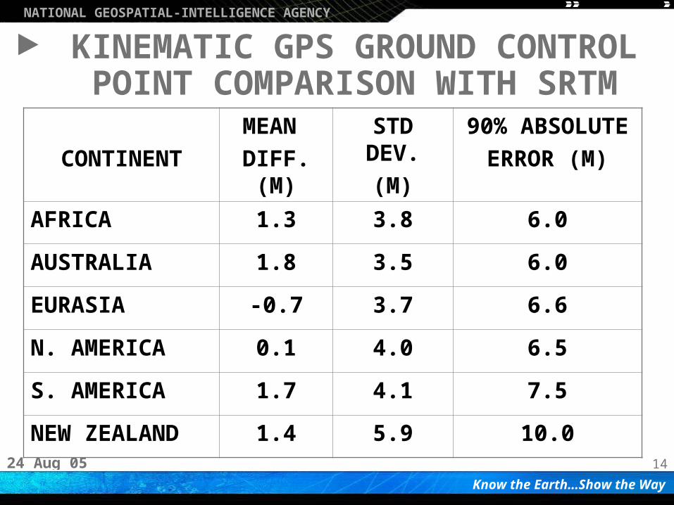
KINEMATIC GPS GROUND CONTROL POINT COMPARISON WITH SRTM
CONTINENT
MEAN
DIFF. (M)
STD DEV.
(M)
90% ABSOLUTE
ERROR (M)
AFRICA 1.3 3.8 6.0
AUSTRALIA 1.8 3.5 6.0
EURASIA -0.7 3.7 6.6
N. AMERICA 0.1 4.0 6.5
S. AMERICA 1.7 4.1 7.5
NEW ZEALAND 1.4 5.9 10.0

24 Aug 05 15
NATIONAL GEOSPATIAL-INTELLIGENCE AGENCY
Know the Earth…Show the Way
RMS = 2.9 mgal in comparison with NGA’s “Best” Marine 5’x5’ File
KMS 2002 2’x2’g

24 Aug 05 16
NATIONAL GEOSPATIAL-INTELLIGENCE AGENCY
Know the Earth…Show the Way
GPS/Leveling Comparisons (±2 m edit threshold)
Model (Nmax)All
(10767)
NGS
(4649)
All
(10767)
NGS
(4649)
EGM96 (360)
PGM2004A (2159)
G99SSS (1’→10800)
PGM2005A (2159)
29.3
15.5
-
15.6
21.4
9.7
9.1
9.7
25.8
12.6
-
12.5
18.1
7.3
5.7
7.3
Linear Trend Removal
Before After
Weighted Mean Std. Deviation (cm)

24 Aug 05 17
NATIONAL GEOSPATIAL-INTELLIGENCE AGENCY
Know the Earth…Show the Way
GPS Leveling Comparisons over Some Areas with New g
Area (Npts)
PGM2004A PGM2005A
Mean Diff.
(cm)
Std. Dev. (cm)
Mean Diff.
(cm)
Std. Dev. (cm)
Tasmania (46)
Greece (36)
Japan (826)
Switzerland (115)
-25.2
-69.2
-22.0
-59.8
60.1
22.6
18.7
13.4
-20.2
-73.1
-21.1
-53.6
12.6 17.5 17.0 28.5 ?
Statistics before bias removal. 2 m edit applied.

24 Aug 05 19
NATIONAL GEOSPATIAL-INTELLIGENCE AGENCY
Know the Earth…Show the Way
Upcoming EGM06 Activities
• Spherical harmonic synthesis software will be made available at end of 2005– Official EGM06 project software – Provides ability to efficiently compute geodetic
quantities to n=m=2160– Test sets to be provided– Available thru http://earth-info.nga.mil/GandG/
• Validation of new EGM06– GPS/leveling, orbits, DOVs, etc. – International participation is welcome– Spring 2005 timeframe leading to final EGM06
selection

24 Aug 05 20
NATIONAL GEOSPATIAL-INTELLIGENCE AGENCY
Know the Earth…Show the Way
Summary
• EGM06 is planned for June 2006– New surface and airborne gravity collected until Jan 06– Goal of EGM06 is 15 cm– n=m=2160– 5’x5’ resolution
• Latest GRACE model, Surface Gravity, Satellite Altimetry, SRTM and ICESAT data will be utilized
• Error Propagation to n=m=2160• 5’x5’ gravity data from unsurveyed areas
is welcome