Embed Size (px)
Citation preview

DEPARTMENT OF COMMUNITY
DEVELOPMENT
Dave Tomek Director
Robert Deatherage Building
Mary Beth Salisbury Community Resources
Joe Johnston Customer Resources
Mahmoud Najda P.E. Development Review
Kerry Godwin Planning & Zoning
Osceola Coun
1 Courthouse Square Suite 1100 Kissimmee, FL 34741 PH: (407) 742-0200 Fax: (407) 742-0206 www.osceola.ore
March 21,2013
John Adams RJ Whidden & Associates, Inc. 316 Church Street Kissimmee, FL 34741
Sent via email: ;ohn@r;wa.net
RE: PDI2-00011 - Rolling Oaks - Approval to amend and restate the previously approved PD08-00009 to implement the Land Use Trade Off Matrix from the CTS/Rolling Oaks Development of Regional Impact (DRI) and increase retail-services, decrease the number of timeshare/short term rental units, increase the timeshare/short term rental acreage, decrease the trade center acreage, extend the phasing schedule and build-out dates, and add an access point.
Dear Mr. Adams,
Your request for approval of the Rolling Oaks Planned Development (PD) amendment, PDI2-00011, was granted by the Osceola County Board of County Commissioners at their meeting on March 18, 2013. The PD was approved with the Special Conditions listed below. The approved narrative (date-stamped, "REVISED AUG 172012") is attached for your reference.
Special Conditions:
1. Approval of this Planned Development Amendment, date-stamped, "REVISED AUG 17 2012", shall supersede PD08-00009 and all prior approvals.
The official Board action is reflected in the minutes subsequently reviewed and adopted by the Board. Any conflicts between the restatement of the Board's action contained herein and the approved minutes of the Board shall be reconciled by utilizing the Board approved minutes.
All written commitments made in the application and subsequent submissions of information made during this application review process, which are on file with the Planning and Zoning Office, shall be considered to be binding upon the applicant, provided such commitments are not at variance with the Comprehensive Plan, LDC, other development regulations, or other development orders in effect at the time of development.
PD12-00011 Approval Letter Page 2
You must obtain any required permits from the Building Department prior to construction. Unless the conditions listed above have been complied with, permits will not be issued. If I can be of further ilssistance, please contact me at (407) 742-0297.
Respectfully,
Brenda Ryan, FCHP [email protected] Project Coordinator
cc: PD12-00011 Project File Jennifer Bryla, Principal Planner, [email protected] Rebecca Grohall, Planner III, [email protected] ATTACHMENT: Approved Narrative


Rolling Oaks PMUD
Amendment to Previously Approved PD08-00009
Submitted: 16 August 2012
1
Table of Contents
Section 1 Consulting Team
Section 2 Maps and Plans
Rolling Oaks General Location Map
Rolling Oaks Revised Concept Plan
Rolling Oaks Aerial Photograph
Rolling Oaks Existing Land Use Map
Rolling Oaks Vegetative Associations Map
Rolling Oaks Soils Classification Map
Rolling Oaks Topographic Map
Section 3 Pre-Development Background and Site Inventory
3.1 General Location
3.2 Section, Township and Range
3.3 Pre-Development Access
3.4 Vegetation and Wetlands
3.5 Wildlife
3.6 Land Use Summary
3.7 Soils
3.8 Drainage, Floodplains and Topography
3.9 Archaeological and Cultural Resources
3.10 Affidavit or Statement Regarding Existing Structures
Section 4 Proposed Planned Development
4.1 Project Description
4.2 Project Phasing
4.3 Summary of Proposed Land Uses
Section 5 Provision of Community Services
5.1 Open Space
5.2 Wastewater Collection
5.3 Water Distribution
5.4 Solid Waste
5.5 Police and Fire Protection
5.6 Stormwater Management
5.7 Utility Installation
5.8 Transportation/Roads

Rolling Oaks PMUD
Amendment to Previously Approved PD08-00009
Submitted: 16 August 2012
2
Section 6 Proposed Development Standards
6.1 Density Statement
6.2 Permitted Uses
6.3 Prohibited Uses
6.4 Development Standards
6.5 Building/Lot Restrictions
6.6 Parking
6.7 Buffers and Landscaping
6.8 Signage
Section 7 Justification for Proposed Planned Development
7.1 Purpose
7.2 Identification of Requested Deviations from Standard Zoning
7.3 Satisfaction of LDC Objectives 14.24 (a) (1-10)
Section 8 Anticipated Neighborhood Impacts
8.1 Neighborhood Compatibility
8.2 Influence on Future Development Patterns
8.3 Influence on Neighboring Drainage
8.4 Alterations Proposed to Wetlands
8.5 Offsite Drainage Alterations Proposed
8.6 Impacts Anticipated to Topo and Vegetation
8.7 Impacts Anticipated to Wildlife
8.8 Impacts Anticipated on Population
Section 9 Exhibits from CTS DRI Development Order
Exhibit 4 –Land Use Trade Off Matrix Exhibit 6 – Ranges of Development Thresholds prepared 3/27/98
Exhibit A – Land Use Conversion Matrix Spreadsheet
Provided Under Separate Cover:
Application for Concurrency Management Review

Rolling Oaks PMUD
Amendment to Previously Approved PD08-00009
Submitted: 16 August 2012
3
Section 1 - Development Consulting Team
Applicant/Owners: Wooden Bridge Partners Hotel LLC (Subject Property) Attn: Mr. Richard Jerman c/o Sun Terra Communities 1750 West Broadway, Ste. 111 Oveido, Florida 32765 407 542-4909 Fx: 407 542-4911 Cell: 407 221-7040
Em: [email protected] Additional Owners: Rolling Oaks Investment Properties LLLP (Subject Property) c/o Falcon Land and Development Attn: Mr. John Christe 1951 NW 19
th Street, Suite 200
Boca Raton, Florida 33431 Ph: 561.961.1000 Fx: 561.338.2957
Em: [email protected] Planner/Agent: Rj Whidden and Associates, Inc. Attn: Mr. John Adams 316 Church Street Kissimmee, Florida 34741 Ph: 407.846.1880 Em: [email protected]
Environmental Scientist: Bio-Tech Consulting, Inc. Attn: John Miklos, President 2002 East Robinson Street Orlando, Florida 32803 Ph: 407 894-5969 Fx: 407 894-5970 Cell: 407 963-0291
Civil Engineer: Dave Schmitt Engineering, Inc. Mr. Dave Schmitt, P.E.
3680 Avalon Park East Blvd., Suite 310 Orlando, Florida 32828 Ph: 407. 207-9088 Fx: 407. 207-9089 Em: [email protected]

Rolling Oaks PMUD
Amendment to Previously Approved PD08-00009
Submitted: 16 August 2012
4
Traffic Engineer: Leftwich Consulting Engineers, Inc. Scot Leftwich, PHD or James Taylor
12151 Science Dr. Ste. 101 Orlando, FL. 32826
Ph: 407. 281-8100 Fx: 407. 399-5598 Em: [email protected]
Geotechnical Engineer: Universal Engineering Sciences Attn: Mr. Mark Israel 3532 Maggie Boulevard Orlando, Florida 32811 Ph: 407.423.0504 Fx: 407.423.3106 Em: [email protected]

Rolling Oaks PMUD
Amendment to Previously Approved PD08-00009
Submitted: 16 August 2012
5
Section 2 Maps and Plans
Rolling Oaks General Location Map
Rolling Oaks Revised Concept Plan
Rolling Oaks Aerial Photograph
Rolling Oaks Existing Land Use Map
Rolling Oaks Vegetative Associations Map
Rolling Oaks Soils Classification Map
Rolling Oaks Topographic Map

Sections 3 & 4, Township 25 South, Range 27 EastOsceola County, Florida
General Location Map
PD Boundary
528
545
535
435
417
27
192
54 532
545
536
City Of Kissimmee
Orange County
Osceola CountyPolk County
Lake County
Walt Disney World
Subject Site
Polk C
ounty
Osce
ola
County
Lake
County
Ora
nge C
ounty
Reedy Creek Swamp
Green SwampRun
4
1792
1792
Poin
ciana B
lvd
192
Orlando RegionalSand Lake Hospital
Florida HospitalCelebration
Celebration Fire DepartmentStation 72
Reedy CreekFire Svc
Horizons West
Horizons West
Lake County Fire Department
Station 112
Polk County Fire Department
Station 30
Polk County Fire Department
Station 18
2 Miles
NRj WHIDDEN and ASSOCIATES, INC.
LAND PLANNERS AND DEVELOPMENT CONSULTANTS
(Approximate)0
429
429
Polk
County
Osc
eola
County


NRj WHIDDEN and ASSOCIATES, INC.
LAND PLANNERS AND DEVELOPMENT CONSULTANTS
(Approximate)0 1000’
429
192
Rolling Oaks DRI
Formosa Gardens DRI
Funie Steed Road
Bla
ck L
ake Road
Orange CountyOsceola County
Sections 3 and 4, Township 25 South, Range 27 EastOsceola County, Florida
Aerial Photograph
Formosa Gardens Blv
d

1500’
Sections 3 & 4, Township 25 South, Range 27 EastOsceola County, Florida
NRj WHIDDEN and ASSOCIATES, INC.
LAND PLANNERS AND DEVELOPMENT CONSULTANTS
(Approximate)0
Existing Land Use Map
Legend
Tourist CommercialLow Density ResidentialMedium Density Residential
Osceola County
Orange County
PD Boundary
US H
ighway 192
Sta
te R
oad
429
Funie Steed Rd

145
145
145
421
411
310
320
610 421
411 411
411
310
141
320320
145
310
610
421
329
617
421
411
610
641
411
Vegetation Legend
310 - Herbaceous Rangeland
320 - Shrubs and Brushlands
329 - Other Shrubs and Brush
411 - Pine Flatwoods
421 - Xeric Oak610 - Wetland Hardwood Forest
617 - Mixed Wetland Hardwoods
641 - Freshwater Marsh
145 - Tourist Services / Hotel
Vegetation Association Map
800’
U.S. Highway 192
SplendidChina
Sta
te R
oad
429
Existing Hotel and Restaruant
Funie Steed Rd
Orange CountyOsceola County
Sections 3 & 4, Township 25 South, Range 27 EastOsceola County, Florida
NRj WHIDDEN and ASSOCIATES, INC.
LAND PLANNERS AND DEVELOPMENT CONSULTANTS
(Approximate)0
Formosa Gardens Blvd
141 - Commercial Retail/Services

7
Soils Classification Map
Soils Legend
1-Adamsville Sand
7-Candler Sand, 0 to 5% slopes
8-Candler Sand, 5 to 12% slopes
15-Hontoon Muck
16-Immokalee Fine Sand
22-Myakka Fine Sand
32-Placid Fine Sand
34-Pomello Fine Sand, 0 to 5% slopes
44-Tavares Fine Sand, 0 to 5% slopes
NRj WHIDDEN and ASSOCIATES, INC.
LAND PLANNERS AND DEVELOPMENT CONSULTANTS
0 800’(Approximate)
U.S. Highway 192
SplendidChina
So
uth
west
Belt
way
Existing Hotel and Restaruant
Funie Steed Rd
Orange CountyOsceola County
2222
22
15
16
1644
7
16
44
22
1
8
15
44
44
16
22
34
7
8
8 44W
15
44
7
8
7
7
44
4432
22
16
15
1
Sections 3 & 4, Township 25 South, Range 27 EastOsceola County, Florida
Formosa Gardens Blvd
140
130
130
125
105
105
110
110
110
110
120
Note:1. Information shown hereon is based on GIS data,
100 Year Flood Plain
500 Year Flood Plain
Topographic Map
800’
U.S. Highway 192
Funie Steed Rd
Orange CountyOsceola County
Sections 3 & 4, Township 25 South, Range 27 EastOsceola County, Florida
NRj WHIDDEN and ASSOCIATES, INC.
LAND PLANNERS AND DEVELOPMENT CONSULTANTS
(Approximate)0
Sta
te R
oad
429
Speldid China
Formosa Gardens Blvd

Rolling Oaks PMUD
Amendment to Previously Approved PD08-00009
Submitted: 16 August 2012
6
Section 3 – Pre-Development Background and Site Inventory
3.1 General Location:
The Rolling Oaks PMUD is located on the south side of U.S. Highway 192, west of
Formosa Gardens Boulevard, east of the Southwest Beltway, and north of Funie Steed Road.
Please consult Section 2 - General Location Map for the site location.
3.2 Section, Township and Range:
The subject site occupies part of Sections 3 and 4 in Township 25 South, Range 27 East, Osceola
County, Florida. The Tax Parcels are: 03-25-27-0000-0030-0000 and 04-25-27-0000-0060-000.
3.3 Pre-Development Access:
As shown on the Aerial Photograph provided in Section 2 herein, access to the project is from
U.S. Highway 192 and Funie Steed Road.
3.4 Vegetation and Wetlands:
The predevelopment condition of the Rolling Oaks PMUD was comprised of twelve (12)
FLUCFCS classifications. Approximately 56 acres or 19% in the northern portion of the project
has been permitted and developed as Retail-Services. Descriptions and percent of predevelopment
cover of each land use identified within the project are provided below and illustrated on the
Vegetative Associations Map provided in Section 2 herein.
145 — Tourist Services (9.01 acres)
Tourist Services compose approximately 2.99% of the project area. An abandoned hotel is the
main feature. This service is currently out of operation. Consumed by a large percentage of
impervious surfaces, this un-maintained area has little to no native vegetation. Some areas were
planted with ornamentals (some exotic) but these areas have become re-colonized by pioneering
species due to the lack of maintenance activities.
191 — Undeveloped Land within Urban Areas (6.38 acres)
A small parcel of undeveloped land exists on the south and east sides of the hotel and occupies
2.l2% of the total project area. It was likely used for overflow parking for the hotel, but has no
definitive markings. This area has little to no canopy cover and is dominated by bahiagrass
(Paspalum notatum).
300 — Rangeland (56.67 acres)
Approximately 18.83% of the project’s area is composed of Rangeland. These are relatively large
areas that are dominated by bahiagrass and have a sparse to absent tree canopy. Other, associated
groundcover species include bracken fern (Pteridium aquilinum), skyblue lupine (Lupinus
diffuses), dog fennel (Eupatorium capillifolium), ragweed (Ambrosia artemisiifolia) and
pricklypear (Opuntia humifusa).

Rolling Oaks PMUD
Amendment to Previously Approved PD08-00009
Submitted: 16 August 2012
7
421 — Xeric Oak (83.99 acres)
Xeric Oak composes 27.91% of the project area and has a canopy dominated by sand live oak
(Quercus geminata), myrtle oak (Quercus myrtifolia), Chapman’s oak (Quercus chapmanii) and
live oak (Quercus virginiana). The remaining vegetation found in this cover type includes
groundcover species such as saw palmetto (Serenoa repens), dog fennel, catbrier (Smilax sp.),
skyblue lupine, rose nataigrass (Rhjrnche/ytrum repens), bracken fern, deer moss (Cladonia sp.)
and soldier moss (Cladina sp.).
427 — Live Oak (28.86 acres)
Live Oak dominates the vegetated portion of the site between the large central wetland and the
vacant Splendid China attraction to the east, and composes approximately 9.59% of the total land
use area. These areas are dominated almost exclusively by live oak, with groundcover similar to
that found in the Xeric Oak areas.
434 — Hardwood-Conifer Mixed (38.67 acres)
Hardwood-Conifer Mixed makes up 12.85% of the project acreage. These areas mainly fringe the
northern and western boundaries of the large, central wetland. The canopy is dominated by live
oak, sand live oak and slash pine (Pinus elliottii). Groundcover includes saw palmetto, gailberry
(Ilex glabra), grape vine (Vitis sp.), rusty lyonia (Lyonia ferruginea) and deer moss.
511 — Ditches (Upland-Cut~ (0.49 acre)
A large upland-cut ditch system extends from the southern property boundary to the southeast tip
of the large central wetland (Wetland #3). It averages 8 to 10 feet wide at top of bank. No flowing
water was observed during any of the site visits.
512 — Ditches (Wetland-Cut~ (1.32 acres)
The large ditch system described above continues to extend along the edge of Wetland #3. No
flowing water was observed within these ditches. However, standing water was observed at
several locations along the ditches. The spoil banks of this ditch system included primarily
wetland trees such as dahoon holly (Ilex cassine), red bay (Persea borbonia), loblolly bay
(Gordonia lasianthus), red maple (Acerrubrum), and laurel oak. A 0.22-acre wetland-cut ditch is
also located in the southwest portion of the property. This ditch includes similar species listed
above.
630 — Wetland Forested Mixed (71.49 acres)
A majority of the site’s wetlands are considered mixed forested wetlands. This cover type
composes 23.76% of the total property acreage. Included in this category are a large central
system and three small, contiguous portions in the northeast region of the property.
Historically, the larger, central system (Wetland #3), some of which meanders in and out of the
project boundary, had unobstructed connectivity to the Reedy Creek system. However, following
the construction of Splendid China and other surrounding developments and roadways, the
natural, unobstructed connections that used to exist to the Reedy Creek system are no longer
intact. This wetland is now surrounded by roads on all sides (including significant barriers at US
192 and the new SR 429). These impediments to the unobstructed connection have resulted in a
measurable reduction of the natural hydroperiod, resulting in felled trees and visible signs of soil
subsidence. In addition, facultative and upland plant species are encroaching on its edges.
Dominant canopy species include sweetbay magnolia (Magnolia virginiana), loblolly bay, red
bay, and red maple. Sub-canopy species include titi (Cyrilla racemiflora), dahoon holly, winged
sumac (Rhus copallinum), buttonbush (Cephalanthus occidentalis), cinnamon fern (Osmunda
cinnamomea), Carolina willow (Salix caroliniana), and wax myrtle (Myrica cerifera).
Groundcover includes Virginia chain fern (Woodwardia virginica), redroot (L.achnanthes

Rolling Oaks PMUD
Amendment to Previously Approved PD08-00009
Submitted: 16 August 2012
8
caroliniana), gailberry, bracken fern, yellow-eyed grass (Xyris sp.), bushy bluestem (Andropogon
glomeratus), royal fern (Osmunda regalis), grape vine, sawgrass (Cladium jamaicense), and
blackberry (Rubus sp).
There are three smaller lobes of a mixed forested wetland system, located in the northeast portion
of the site, that are contiguous with offsite wetlands. This system has similar vegetative
composition and hydrology compared to the larger central system. Historically, it had an
uninhibited connection to wetlands on the north side of US 192. Presently, however, this
connection has been drastically constricted to one double box culvert running under US 192.
641 — Freshwater Marshes (1.90 acres)
Two isolated wetlands are classified as Freshwater Marshes, which compose O.63% of the total
project acreage. These two freshwater marshes are hydrologically stressed with evidence of one or
more feet of soil subsidence and dead trees and shrubs along the edges. These areas are dominated
by herbaceous vegetation including maidencane (Panicum hemitomon), redroot, St. John’s wort
(Hjpericum fasciculatum), and dog fennel. Thick monocultures of titi dominate a majority of the
perimeter of these wetlands.
6415 — Dogfennel and Low Marsh Grasses (0.13 acre)
This FLUCFCS community is a highly disturbed site located along the northeast border and
composes 0.O4% of the project acreage. This area is surrounded by development on the east and
south sides and appears to have suffered significant changes in hydrology. Although maidencane
was present, this site was almost entirely covered with dog fennel.
6417 — Freshwater Marsh with shrubs. brush and vines (1.99 acre)
This FLUCFCS community is a hydrologically stressed wetland system with evidence of one or
more feet of soil subsidence. The community is located along the northern property boundary and
composes O.66% of the project acreage. Representation vegetation includes buttonbush, wax
myrtle, maidencane, and dog fennel. A thick monoculture of titi dominates the perimeter of the
wetland.
Jurisdictional Wetland Assessment Onsite wetlands and other surface waters include five Wetland Forested Mixed communities, two
Freshwater Marsh communities, one Dogfennel and Low Marsh Grasses community, one
Freshwater Marsh with shrubs, brush and vines community and two ditches. The jurisdictional
wetlands and surface waters were delineated (flagged) in the field by MSCW scientists and
surveyed by Ganung-Belton Associates, Inc. Wetlands and surface waters are typically regulated
as jurisdictional by the Department of the Army, Corps of Engineers (ACOE) and the South
Florida Water Management District (SFWMD), and permits are required for any alteration to these
systems. As part of a separate permit application, a site visit was conducted by Susan Elfers of the
SFWMD on January 11, 2007 to verify the jurisdictional boundaries of wetlands in the northeast
region of the property (Specifically, Wetlands IC, 6, 7, and the northeast segment of Wetland 3).
All of the wetland lines checked by Ms. Elfers on January 11 were verified and accepted. The
remaining wetland boundaries and acreages need to be verified and could change during the
permitting process.
Permitting Requirements:
Department of the Army. Corps of Engineers
Wetlands and surface waters found onsite possess a direct hydrological connection to “waters of
the United States” sufficient for the ACOE to exert jurisdiction over these systems. Therefore, any

Rolling Oaks PMUD
Amendment to Previously Approved PD08-00009
Submitted: 16 August 2012
9
alteration to these wetlands would require a permit.
Based on conversations MSCW had with the Client, it is understood that more than 0.5-acres of
wetland impacts will be proposed. Therefore, the ACOE will require the submittal of an Individual
Permit (IP). An IP application requires extensive onsite and offsite information and typically may
take 12 to 18 months (or longer) to permit depending on the complexity of the site and whether the
project is perceived as controversial. Public notice and a multi-agency review are required for an
IP.
South Florida Water Management District
The SFWMD will require an Environmental Resource Permit (ERP) prior to any proposed
development of the site, regardless of the amount of wetland impacts. The SFWMD typically
requires the preservation of a 15-foot minimum, 25-foot average upland buffer surrounding all
wetlands remaining in the post-development condition. At a minimum, the SFWMD may require a
Conservation Easement be placed over the upland buffers to provide reasonable assurances that
exempt activities will not occur within the buffer and that secondary impacts will not occur to the
remaining wetland system(s).
It is presumed that the wetland impact acreage will be 1.0 acre or more, in which case an
Individual ERP will be required. This permit will require approval from the SFWMD Governing
Board and may take 6-9 months to issue.
Wetland Mitigation As a condition of permit issuance, the aforementioned regulatory agencies typically require
applicants to demonstrate that wetland impacts have been reasonably avoided or minimized. If
wetland impacts are unavoidable, the SFWMD and the ACOE will require compensatory
mitigation.
The amount of mitigation required by the agencies is variable depending on the wetland functions
presumed to be lost due to the proposed impacts. Mitigation plans acceptable to the SFWMD and
the ACOE typically include any combination of onsite measures (wetland preservation,
enhancement, creation) or offsite activities (wetland preservation, enhancement, creation,
mitigation banking). The preservation of the onsite wetlands may be sufficient mitigation for a
small amount of impact. If preservation alone is not sufficient to mitigate proposed wetland
impacts, additional mitigation may be needed. Mitigation plans are coordinated with the agencies
on a case-by-case basis during the permit application process.
To offset the direct and secondary wetland impacts requiring mitigation, a combination of onsite
wetland enhancement and preservation, onsite upland preservation, and offsite mitigation at an
area known as HRI ROMA is proposed.
3.5 Wildlife:
Avid Group conducted a Listed Species and Habitat Assessment on the southern portion of the
Rolling Oaks PMUD . The assessment included both field surveys and database reviews
from local, state, and federal agencies. This information was analyzed to determine if protected
species would be impacted as a result of the proposed development.
The habitats and natural features within the project area have been historically impacted by
agricultural activities. Additionally, commercial developments and major highways completely

Rolling Oaks PMUD
Amendment to Previously Approved PD08-00009
Submitted: 16 August 2012
10
surround the property have severed the onsite habitats from any connection to adjacent habitat.
Consequently, these impacts have decreased the potential of continuous biological viability of
protected species on the project site. There is nuisance and exotic vegetation which is impacting
the quality of the habitats that exist on the property; therefore, it is anticipated that the proposed
development will minimally impact or affect populations of threatened or endangered species or
species of special concern and their associated habitats on the project site.
No listed plant species classified by the United States Fish and Wildlife Service (USFWS) or the
Florida Fish and Wildlife Conservation Commission (FWC) were observed within the project area
during the field reviews, and none are expected to occur within the project site due to the lack of
preferred habitat.
Field investigations have revealed the existence of two state (FWC) and one federally (USFWS)
protected faunal species populations and its associated habitat within the project site. Gopher
tortoise (Gopherus polyphemus) burrows have been located and surveyed. Additionally, the
presence of a remnant sand skink (Neoseps reynoldsi) population has been verified and the extent
of remnant habitat has been calculated. Other species that were surveyed for and not observed
onsite include: gopher frog (Rana capito), Florida burrowing owl (Athene cunicularia floridana),
bald eagle (Haliaeetus leucocephalus), wading birds, Florida scrub jay (Aphelocoma
coerulescens), and Florida mouse (Podomys floridanus). All surveys were conducted using
approved survey methodology by USFWS or FWC.
The existing site does not contain viable suitable tortoise habitat required for on-site relocation.
Therefore, on-site relocation was not recommended. An application was submitted to FWC
March 16, 2007 for a Gopher Tortoise Incidental Take Permit (ITP). The ITP was received on
May 7th
, 2007.
The developer shall comply with all applicable permitting agency policies through the EIP
process.
3.6 Land Use Summary:
The previously approved Rolling Oaks PMUD is located within the Tourist Commercial
Land Use district as shown on FLUM 2025 of the Osceola County Comprehensive Plan. This
district allows for commercial and tourist-oriented uses at a maximum of 40 du/acre, hotel rooms
at a maximum of 60 rooms per acre, attractions, and tourist related commercial uses.
As shown on the Revised Concept Plan, provided in Section 2 herein, the changes proposed by
this amendment request account for the implementation of the Land Use Trade Off Matrix as
adopted in Condition #2 of the CTS DRI Development Order (Exhibit 4 –Land Use Trade Off
Matrix). A copy of the exhibit is provided in Section 9 herein.
3.7 Soils:
According to the Soils Classification Map, provided in Section 2 herein, there are nine types of
soils identified on site. The upland soil types present are Adamsville (1), Candler Sand 0 to 5%
slopes (7), Candler 5 to 12% slopes (8), Immokalee Fine Sand (16), Myakka Fine Sand (22),
Placid Fine Sand (32), Pomello Fine Sand (34), and Tavares Fine Sand (44).
The one on-site wetland soil type was classified as Hontoon Muck (15). While limitations are

Rolling Oaks PMUD
Amendment to Previously Approved PD08-00009
Submitted: 16 August 2012
11
described in the Soil Survey for Osceola County Area, Florida, the upland soil types identified on
the Soils Classification Map, provided in Section 2 herein, are representative Osceola County soils
that can be used for development purposes through proper soil management, utilizing standard
construction methods for prevention of wind and water soil erosion.
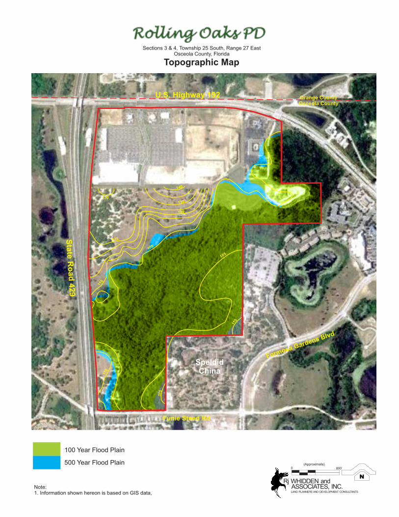
3.8 Drainage, Floodplains and Topography:
The Topographic Map, provided in Section 2 herein, denotes that the subject site consists of
several ridges with elevations ranging from a high of approximately 120 to 140 feet NGVD in the
north-central area of the site to a low of 105 feet around the perimeter of the jurisdictional
wetland. No increase in offsite flooding shall result from the proposed amendment. All drainage
improvements shall be in accordance with the South Florida Water Management District and
Osceola County Engineering Department regulations. Any drainage basins previously discharging
across this site shall be conveyed through the post-development site.
Based on a Letter of Map Revision (“LOMR”), approved by the Federal Emergency Management
Agency (“FEMA”) on December 7, 2001 the 100-year floodplain elevation onsite is 104.3’. This
results in the majority of the site residing within the 100-year floodplain area. Any fill placed
below Elevation 104.3’ would require equal compensating storage volume be provided to offset
the loss in existing 100-year floodplain storage volume onsite. Storage volume shall be provided
within proposed ponds between the existing average wet season water table and the existing 100-
year floodplain elevation.
The site is located within the jurisdictions of the South Florida Water Management District
(“SFWMD”), Osceola County, and the Reedy Creek Improvement District (“RCID”). Water
quality treatment volume is required for any proposed development onsite. In addition, stormwater
attenuation volume is required to limit the proposed post-development peak discharge rate for the
10-year/72-hour design storm event to that of the pre-development conditions.
Based on FIRM Map No.12097C0030F, dated June 6, 2001, and as shown on the Topographic
Map provided in Section 2 herein, the 100-year floodplain is confined to the areas adjacent to the
central wetland. The flood prone area is designated as Zone AE with the remainder of the site
designated as Zone X shaded and unshaded. Much of the improvement proposed within the
floodplain is a waterway system for stormwater management. 3.9 Archaeological and Cultural Resources:
There are no known archaeological or cultural resources located on the subject site.
3.10 Affidavit or Statement Regarding Existing Structures:
The Aerial Photograph, provided in Section 2 herein, indicates that the Rolling Oaks PMUD
property is partially constructed with commercial development in the northwest portion of the
property and the existing 335 room hotel and restaurant site on U.S. Highway 192.

Rolling Oaks PMUD
Amendment to Previously Approved PD08-00009
Submitted: 16 August 2012
12
Section 4 Proposed Planned Development
4.1 Project Description:
The Applicant is requesting an amendment to previously approved PD 08-00009 (approved by
Osceola County on August 25, 2008) to allow for the demolition of the existing hotel and
restaurant in order to implement the Land Use Trade Off Matrix adopted by Condition 2 of the
CTS DRI Development Order. This conversion will allow for the increase of the previously
approved retail-services threshold by 9,000 sf from 446,000 sf to the maximum threshold of
455,000 sf as defined by Exhibit 6, Ranges of Development Threshold of the CTS DRI
Development Order. This shall be accomplished by reducing the number of Timeshare or STR
units to the minimum threshold of 310 units from the previously approved 410 units. Demolition
of the existing 335 room hotel is proposed by this PD amendment; however, the 335 rooms shall
be maintained for construction of a new facility on the parcel for development within phase 2.
This PD Amendment also proposes to extend the phasing schedule and build-out date from 2012
to 2016. This reflects the recently invoked DRI Development Order extensions pursuant to HB
7207 and the Emergency Executive Orders signed by Governor Scott in 2011.
This PD Amendment proposes to account for a road connection to the University Financial Plaza
Associates, Ltd. PCD located to the east of the project’s frontage along US Hwy 192. This
connection was approved by the Osceola County Board of County Commissioners by their
adoption of PD 07-00013 on November 19, 2007.
This PD Amendment corrects scrivener’s errors in the previously approved PD 08-00009. Sections
4.1.1, 6.2.4 (now 6.2.3) and Section 5.8 below inadvertently defined the approved residential
threshold of 410 units as 510 units. Additionally, the previously approved Trade Center parcel was
inadvertently omitted from the project description and permitted use sections. The Trade Center
description has been included in Sections 4.1.5 and 6.2.4 below.
This PD Amendment also proposes allow for a future reconfiguration of the existing stormwater
management easement located in the northeastern portion of the project. This future
reconfiguration will allow for a future extension of Black Lake Road to access parcels south of the
current boundaries of the development.
This PD Amendment also proposes an adjustment to the areas for the Trade Center Parcel and the
Time Share or STR Parcel as shown on the Revised Concept Plan, provided in Section 2 herein.
The Time Share or STR Parcel is being increased by 9.2 acres from the previously approved 22.8
acres to 32.0 acres, with a simultaneous 9.2 acre decrease in area for the Trade Center Parcel from
the previously approved 32.5 acres to 23.3 acres. This adjustment in area is based on preliminary
engineering studies to accommodate the development threshold currently approved. No
modification to the previously approved density or intensity is proposed for these parcels.
The Rolling Oaks PMUD will remain a planned mixed-use development of approximately
301 acres and be developed in accordance with the Revised Concept Plan, provided in Section 2
herein, according to the thresholds as otherwise previously approved, by PD 08-00009 outlined
below:

Rolling Oaks PMUD
Amendment to Previously Approved PD08-00009
Submitted: 16 August 2012
13
4.1.1 Up to 310 interval ownership units or short term rental units are planned on
approximately 32.0 acres in the west central portion of the subject site. No on-site
marketing of the timeshare units is proposed by this application. If the developer finds it
necessary to employ an on-site marketing program for the timeshare units in the future,
then the developer shall be required to submit to Osceola County a CDP that
demonstrates adequate additional parking to accommodate prospective purchasers of the
timeshare resort.
4.1.2 Two tourist commercial parcels (retail/services) are planned for a total of 455,000 sf in
the northern portion of the subject site. The eastern most tourist commercial parcel will
now absorb an additional 4.8 acres of the existing hotel and restaurant site proposed for
demolition. Access to these parcels is proposed from the collector roadway network
interior to the development. A blend of restaurants, shops, services and a variety of
entertainment venues are planned for these parcels to serve both visitors of the
development and neighboring tourist facilities.
4.1.3 1360 rooms on a total of approximately 34.2 acres. This includes the existing 335 room
hotel site located on 8.6 acres located near the northeast corner of the project, the villas
on approximately 20.2 acres proposed in the southern portion of the property, and the
proposed hotel on approximately 5.4 acres located in the central portion of the site.
4.1.4 A 7.1 acre attraction center containing 20,000 sf is planned near the mid-point at the
easterly boundary.
4.1.5 A Trade Center parcel of approximately 23.3 acres (formerly 32.5 acres) is planned in the
center of the development behind the tourist commercial frontage on US Hwy 192. This
Trade Center parcel will include up to 975,000 sf of office and exhibition space with
ancillary commercial uses to showcase various businesses related to the tourist market.
4.1.6 Approximately 75.3 acres of wetlands are proposed to be preserved. The 5.2 acres of
wetlands that are proposed to be removed, subject to permitting, are limited to access
roads and highway frontage areas within the commercial retail/ services tract.
4.1.7 Water management areas totaling approximately 31 acres are proposed to provide
stormwater management for the subject site.
4.1.8 Landscaped buffers shall be provided along U.S. Highway 192, in accordance with the
Osceola County Land Development Code. Buffers will also be required along the
Western Beltway. Residential areas will include dense vegetative buffers that will reduce
the ambient noise associated with the high speed traffic on the beltway. The commercial
tract will address visual screening for the exiting traffic from the beltway. Specifics of the
buffers will be addressed on the Engineering Improvement Plans.
4.1.9 Typical utilities and other similar infrastructure elements are proposed.
4.2 Project Phasing
The previously approved Rolling Oaks PMUD is proposed as a three-phase project with an
anticipated ten year build out, commencing in 2007 with completion anticipated by 2016. The
Concept Plan, attached hereto in Section 2 has identified Phase 1 Commercial development. The
developer may choose to sub-phase the development through the subdivision and/or the

Rolling Oaks PMUD
Amendment to Previously Approved PD08-00009
Submitted: 16 August 2012
14
construction plan process. This shall be permitted provided that the developer can illustrate that
any sub-phase has adequate infrastructure and open space constructed concurrent with or prior to
the sub-phase being proposed.
4.3 Summary of Rolling Oaks PMUD Proposed Land Uses:
Phase Type of Development Acres Units
Phase 1 Commercial/Retail/Services 60.8 339,000 sf
Trade Center (Office) 0 0
Attraction 0 0
Hotel 0 0
Residential (Timeshare or STR) 32.0 310 units
Internal Service Roads 10.8 N/A
Water Management Ponds 18.0 N/A
Open Space and Buffers 33.2 N/A
Preserved Wetlands 73.6 N/A
Phase 2 Commercial/Retail/Services 0 116,000 sf
Trade Center (Office & Exhibition with ancillary commercial)
11.3 500,000
Attraction 7.1 50 parking spaces
Hotel 14.0 500 rooms
Residential 0 0
Internal Service Roads 1.2 N/A
Water Management Ponds 13.0 N/A
Open Space and Buffers 9.8 N/A
Preserved Wetlands 0 N/A
Phase 3 Commercial/Retail/Services 0 0 sf
Trade Center (Office & Exhibition with ancillary commercial)
12.0 475,000
Attraction 0 0
Hotel (Villas) 20.2 860 rooms
Residential 0 0
Internal Service Roads 1.0 N/A
Water Management Ponds 0 N/A
Open Space and Buffers 0 N/A
Preserved Wetlands 0 N/A
Note:
For purposes of transportation conditions, project phasing is defined by vehicular trips pursuant to
condition 20 of the CTS DRI (nka Rolling Oaks) Development Order. Phasing shown above shall
be subject to compliance with the DRI Development Order conditions.

Rolling Oaks PMUD
Amendment to Previously Approved PD08-00009
Submitted: 16 August 2012
15
Section 5 - Provision of Community Services
5.1 Open Space (Provided):
Perimeter buffers and miscellaneous open space 43.00 acres
Wetlands and accessible water management ponds (not to exceed 50% of 45.15 acre required open space)
22.57 acres
Total open space provided 65.57 acres
Open Space (Required):
Total PMUD acreage of 301 acres x 15% required open space 45.15 acres
5.2 Wastewater Collection:
Toho Water Authority is the wastewater service provider for the Rolling Oaks PMUD.
5.3 Water Distribution:
Toho Water Authority will provide potable water service for the Rolling Oaks PMUD.
5.4 Solid Waste:
Solid waste disposal for the project will be provided by Osceola County.
5.5 Police and Fire Protection:
The Osceola County Sheriff’s Department will provide police protection. Fire Station 71 in
Lindfields will provide first responder fire protection and EMS service. Fire Station 72 in
Celebration will provide second responder service.
5.6 Stormwater Management:
The site is located within the jurisdictions of the South Florida Water Management District
(“SFWMD”), Osceola County, and the Reedy Creek Improvement District (“RCID”). Water
quality treatment volume is required for any proposed development onsite. In addition,
stormwater attenuation volume is required to limit the proposed post-development peak discharge
rate for the 10-year/72-hour design storm event to that of the pre-development conditions. Based
on a search of SFWMD permit files, there have been no SFWMD permits issued for the subject
property to date.
Stormwater discharge from the property is regulated by the Reedy Creek Improvement District, a
Special Taxing District created in 1967 by the Florida Legislature. A one-time drainage fee
collected by RCID will be determined as follows:
RCID Fee = 44.15 x [Discharge Rate (csm) - 13] x [Site area - wetlands]

Rolling Oaks PMUD
Amendment to Previously Approved PD08-00009
Submitted: 16 August 2012
16
The discharge rate used in the above equation is the peak rate during the 50-year/72-hour storm
event. The total stormwater management area proposed with future development onsite may be
increased beyond the minimum required by SFWMD and Osceola County, if desired, to reach the
optimum balance of stormwater management area versus fees paid to RCID.
Proposed wet detention ponds shall extend from the top of bank elevation to two feet below the
control elevation with a maximum slope not greater than 4:1 (horz:vert). A 2:1 (horz:vert) slope
shall be maintained from that point to the proposed bottom of the wet pond. Control structures
shall be utilized to retain the pre-post volumes for each parcel. The control structures shall also
contain “bleeder” orifices at the control elevation to convey the water quality draw down to the
adjacent wetlands. Any additional storage compensation for impacted wetlands shall be
compensated within the proposed Stormwater Management System. The proposed systems shall
be designed to meet all dimensions and technical criteria as set forth by the SFWMD and Osceola
County and retain the prepost volume generated by all SFWMD events up to the 100 yr-24hr
event.
Best Management Practices will be utilized in accordance with the required regulatory agencies to
minimize any increase in runoff from the site and to minimize any degradation of water quality in
the ultimate basin over that which occurred in the pre-development state. The proposed system
will function similarly to the existing conditions (pre-post volume and flood plain compensation)
and will treat the required water quality produced by this development.
5.7 Utility Installation:
With the exception of primary facilities providing service to the project, all utility lines, including
telephone, cable and electric lines, shall be installed underground. Large transformers shall be
placed on the ground on pad mounts and enclosed or located in a vault. All such above ground
facilities shall be screened with landscaping.
5.8 Transportation/Roads:
The estimated external daily and peak hour trip levels for the Rolling Oaks PMUD are
provided below.
Unit Count ADT Rate ADT Peak Hour Rate Peak Hour
310 Timeshares/STR 5.19 1,609 0.50 155
1360 Room Hotel and Villas 8.03 10,921 0.61 830
Trade Center 975,000 sf 100.0 9,750 0.0012 1,170
Retail/Service 446,000 455,000 sf .070/ksf 3,185 .012/ksf 546
Totals: 25,465 2,701
Traffic signals at project entrances shall be installed or modified, when warranted, by the
applicant.
The developer shall dedicate 25 ft of additional right-of-way along the full length of the property
on Funie Steed Road. This dedication shall be addressed with the EIP and the final plat for the
phase of development fronting on Funie Steed Road.

Rolling Oaks PMUD
Amendment to Previously Approved PD08-00009
Submitted: 16 August 2012
17
Section 6 - Proposed Development Standards
6.1 Density Statement:
The following table calculates the density of the Rolling Oaks PMUD based upon the
current LDC.
Description
Units/Acres
Total Project Area
301 acres
Proposed Residential Lands 22.8 acres
Proposed Resort Residential Units 310 dwelling units Maximum density proposed by this PMUD
18.0 du/acre
6.2 Permitted Rolling Oaks PMUD Uses:
6.2.1 1,360 hotel rooms including resort villas.
6.2.2 A 975,000 sf trade center, including office and exhibition space with ancillary
commercial uses.
6.2.3 A maximum of 310 timeshare units (with off-site marketing) or short term rental units.
Should an on-site marketing program be utilized to market the timeshare product, the
developer shall be required to submit to Osceola County a CDP that establishes a parking
standard in additional to the required parking spaces for the units. This CDP shall
demonstrate that adequate parking exists to accommodate the prospective purchasers on
the timeshare resort.
6.2.4 A maximum of 455,000 sf commercial retail/service/office
6.2.5 A maximum of 20,000 sf of attraction with 350 parking spaces. The developer shall be
required to submit to Osceola County a CDP that demonstrates that the 50 maximum
parking spaces are adequate to serve the specific attraction.
6.2.6 Stormwater management ponds.
6.2.7 Landscaped buffers and entrance features including walls, fences, and decorative
accessories.
6.2.8 Signage in compliance with the Osceola County Land Development Code. This includes
the previously approved Sign Master Plan (CDP08-0022) as may be amended from time
to time.
6.2.9 Other similar uses which are reasonably implied and are consistent with the objectives of
this district, based on appropriate consideration of the nature of the intended activity, the
character of the proposed development, the location of the site, and the compatibility with
adjacent parcels. The Planning Official shall make the above determinations.

Rolling Oaks PMUD
Amendment to Previously Approved PD08-00009
Submitted: 16 August 2012
18
6.3 Prohibited Uses:
All uses not specified or implied as a permitted use shall be prohibited. In cases where a use is not
listed or implied as a permitted use the Planning Official shall determine whether a use would be
permitted. Appeals of the Planning Official’s decision shall be as provided for according to
Chapter 2 of the LDC.
6.4 Rolling Oaks PMUD Development Standards:
1 Parking areas may be located 7 feet from the PMUD perimeter
6.5 Building / Lot Restrictions:
The land will not be overdeveloped with buildings, structures, or paving. Open spaces will be an
integral part of the site and landscaping will be provided to enhance the character and appearance
of the development. Existing large deciduous trees will be conserved when practical to do so.
Development within the commercial lots shall allow for the construction of multiple buildings
and/or uses within a single lot.
6.6 Parking:
Parking for specific uses with the Rolling Oaks PMUD shall comply with Chapter 7 of the
Osceola County Land Development Code.
6.7 Buffers and Landscaping:
Unless otherwise specified, upland buffers between on-site wetlands and any type of development
or land alteration shall be 15’minimum/25’ minimum average as established in accordance with
South Florida Water Management District permit approval process. Such buffers shall be
delineated with temporary construction fencing prior to construction in adjacent areas to allow
these buffers to be protected from construction disturbance.
Development Standards Timeshares or STR
Villas Commercial & Trade Center
Hotel Other
Minimum lot width at mid-point of lot NA 20 feet 100 feet 150 feet NA
Minimum lot area NA 800 sf 10,000 sf 150,000 sf NA
Minimum air conditioned living area 700 sf 800 sf NA NA NA
Maximum building height 6 story 3 story 2 story 6 story 2story
Maximum lot coverage 85% 100% 85% 85% NA
Minimum building setback from PMUD perimeter 25 feet 25 feet 25 feet 1 25 feet 1 25 feet 1
Minimum building setback from U.S. Hwy. 192 and the Western Connector except for existing buildings
85 feet
85 feet
85 feet
85 feet
85 feet
Minimum front setback for a/c portion of building 10 feet 0 feet 25 feet 25 feet 25 feet
Minimum side setback for buildings 10 feet 0 feet 15 feet 15 feet 15 feet
Minimum rear setback for buildings or ancillary structures 10 feet 0 feet 25 feet 25 feet 15 feet
Minimum rear setback for alley entry garages NA 10 feet NA NA NA
Minimum rear setback for open or soft covered pools, patios or decks
5 feet 0 feet NA 10 feet NA
Minimum distance between buildings 15 feet 0 feet 20 feet 20 feet 20 feet

Rolling Oaks PMUD
Amendment to Previously Approved PD08-00009
Submitted: 16 August 2012
19
Landscaped buffers shall be provided in accordance with Chapter 10 of the Osceola County Land
Development Code. Buffers will also be required along the Western Beltway. Residential areas
along the Western Beltway/S.R.429 will include dense vegetative buffers that will reduce the
ambient noise associated with the high speed traffic on the beltway. The commercial tract along
the beltway will address visual screening for the exiting traffic. Specifics of the buffers and
landscape plans will be addressed on the Engineering Improvement Plans. Landscaping will
include a minimum number of tree credits as required by the Osceola County Land Development
Code. Required tree credits may be offset by credits assigned for existing upland trees to be
preserved.
6.8 Signage:
Project signage shall be in accordance with Chapter 15 of the Osceola County Land Development
Code. This includes the previously approved Sign Master Plan (CDP08-0022) as may be amended
from time to time.

Rolling Oaks PMUD
Amendment to Previously Approved PD08-00009
Submitted: 16 August 2012
20
Section 7 - Justification for Proposed Planned Development
7.1 Purpose:
In accordance with Section 14.24 (a) of the Osceola County LDC, it is in the interest of this
proposal to implement flexible design guidelines that depart from conventional straight zoning
standards in order to provide a fully integrated, quality development. Implementation of these
guidelines will result in a more efficient utilization of the land together with an increased level of
amenities as discussed in 7.3 below.
7.2 Identification of Requested Deviations from Standard Zoning:
As allowed in Section 14.24 (a) of the Osceola County LDC, this Planned Development requests
the following deviations (indicated in blue) from standard zoning requests:
Lot width
Lot area
Setbacks (Zero lot lines for Villas)
Lot coverage
7.3 Satisfaction of LDC Objectives 14.24 (a) (1) through (10):
As required under Section 14.24 (a) of the Osceola County LDC, the specific objectives outlined
in subsections (1) through (10) are satisfied by implementation of the deviations outlined above
for the proposed development in the following manner:
7.3.1 In accordance with LDC Objective 14.24 (a) (1) which speaks to preservation of natural
features, threatened and endangered flora and fauna, and clustering of usable open space
for recreation, the Revised Concept Plan provided in Section 2 herein preserves 73.6
acres of wetlands and associated habitats. Protected species whose habitat is affected by
development will be relocated to suitable protected environments.
7.3.2 In accordance with LDC Objective 14.24(a) (2) which speaks to design sensitivity to
natural topography, native upland or wetland vegetation, and the preservation of
historical or cultural resources, the Revised Concept Plan in Section 2 herein preserves
the major central wetland. Roads and ponds are designed to minimize impacts to the
natural topography. Please consult the Vegetative Association Map in Section 2 for on-
site vegetation communities.
7.3.3 In accordance with LDC Objective 14.24(a) (3) which speaks to housing types and
compatibility of neighborhood arrangements that provide for variety in home buying
options, this PMUD provides for tourist oriented attractions, retail commercial and
services, and a variety of resort residential accommodations, such as hotels, timeshares or
short term rental and resort villas.
7.3.4 In accordance with LDC Objective 14.24(a) (4) which speaks to creativity in the
proposed use of land relative to physical development, the Revised Concept Plan in
Section 2 integrates the natural components of the site with the proposed development.
The plan minimizes impacts to the natural topography with road and stormwater pond
placements that are sensitive to the terrain.

Rolling Oaks PMUD
Amendment to Previously Approved PD08-00009
Submitted: 16 August 2012
21
7.3.5 In accordance with LDC Objective 14.24(a) (5) which speaks to the establishment of
criteria for inclusion of compatible associated uses to complement varied land uses within
the development, the proposed project is a planned tourist destination compatible with the
uses in the West Highway 192 Tourist Corridor.
7.3.6 In accordance with LDC Objective 14.24(a)(6) which addresses simplification of review
procedure by provision of comprehensive, simultaneous review of land use, site impacts,
development standards, public needs and requirements, and health and safety, the planned
elements of the proposed project are outlined in Section 4 herein. Public needs and
requirements, and provisions for the health and safety of the public are outlined in
Section 5 herein. Impacts of the proposed development are discussed in Section 8 herein.
Specific development standards are discussed in Section 6 herein.
7.3.7 In accordance with LDC Objective 14.24(a) (7) which speaks to the utilization of
clustering to reduce costs and promote efficient use of land, the Revised Concept Plan
masses open space and recreation areas, and proposes development utilizing upland
assets. The result is the clustering of higher density development pockets and the
minimization of service infrastructure.
7.3.8 In accordance with the LDC Objective 14.24(a)(8), provision of standards to insure
consistency of development to be requested in subsequent site plans, this comprehensive
development report outlines specific development standards which will govern any
ensuing site plans in Section 6 herein.
7.3.9 In accordance with the LDC Objective 14.24(a) (9), provision of buffering and greenbelts
within and bordering Planned Developments, the Revised Concept Plan provided in
Section 2 herein depicts proposed wetlands and perimeter buffers. Internal greenways
shall be developed to provide open space opportunities within the project, as well as
provide wildlife corridors.
7.3.10 In accordance with the LDC Objective 14.24(a) (10), integration of interconnected
pedestrian and bicycle friendly improvements, the PMUD shall provide for ample
pedestrian walks and internal sidewalks which link the proposed uses with US Highway
192, Funie Steed Road, and other adjacent uses. The system of walkways and bicycle
paths between neighborhoods, buildings, open spaces, recreation areas, parking areas,
and off-site walkways and paths will be distinctively designed and marked, and where
appropriate for night-time usage, adequately lit.

Rolling Oaks PMUD
Amendment to Previously Approved PD08-00009
Submitted: 16 August 2012
22
Section 8 - Anticipated Neighborhood Impacts
8.1 Neighborhood Compatibility with existing neighborhoods adjacent to and within
approximately 300’ of the Rolling Oaks PMUD .
Direction from Project Neighboring Land Use Designation
North Commercial Northeast
Commercial East
Commercial
Southeast
Commercial
South
LDR
Southwest
LDR
West
Commercial
Northwest
Commercial
8.2 Influence on future development patterns adjacent to the Rolling Oaks PMUD.
Direction from Project Neighboring Zoning
N US Highway 192
NE PCD
E University Financial Plaza & Formosa Gardens PD
SE Formosa Gardens (Splendid China) PD
S Funie Steed Road
SW Western Beltway
W Western Beltway NW Western Beltway
8.3 Influence on Neighboring Drainage:
There are no known extraordinary influences on neighboring drainage. The subject site will be
approved and permitted by the South Florida Water Management District and the Osceola County
Engineering Department. In no event shall any neighboring properties be adversely impacted by
the Rolling Oaks PMUD.

Rolling Oaks PMUD
Amendment to Previously Approved PD08-00009
Submitted: 16 August 2012
23
8.4 Alterations proposed to wetlands:
73.6 acres of wetlands identified on the Vegetative Association Map, provided in Section 2 herein
are proposed to be preserved. As shown on the Revised Concept Plan, provided in Section 2
herein, this application proposes to permit 5.3 acres of wetland impacts. These wetlands targeted
for impact are associated with the internal access network and highway commercial frontage.
8.5 Offsite Drainage Alterations Proposed:
No offsite drainage alterations are anticipated as necessary for the construction of the project.
8.6 Impacts Anticipated to Topo and Vegetation:
No impacts are anticipated to topography and vegetation for the project since the project will be
graded to minimize impacts to the terrain and there are no threatened and endangered species of
flora within areas slated for development on site.
8.7 Impacts Anticipated to Wildlife:
According to the applicant’s environmental scientist, a variety of flora and fauna species could be
anticipated to occur within the property boundaries; however, historical habitat alterations have
affected the potential utilization of the habitats on site. Two species of note anticipated within the
site are the gopher tortoise and sand skink. If development is proposed within existing habitat
areas, the Florida Fish and Wildlife Conservation Commission will require relocation of gopher
tortoises to a pre-approved recipient site and an incidental take permit with mitigation for impacts
to sand skink habitat.
8.8 Impacts Anticipated on Population:
No permanent residents are anticipated for this resort development.

Rolling Oaks PMUD
Amendment to Previously Approved PD08-00009
Submitted: 16 August 2012
24
Section 9 - Exhibits
Exhibit 4 –CTS D.O. Land Use Trade Off Matrix
Exhibit 6 – CTS D.O. Ranges of Development Thresholds
Exhibit A – Land Use Conversion Matrix Spreadsheet


DRI Approved
Development
Program
2012 Trip Conversion
Matrix with PD12-00010
(1)
PD12-0010
Proposed
Development
Program
Commercial (sq.ft)446,000 sf (+) 9,000 sf 455,000 sf
Hotel (rooms) 1,360 1,360
Attraction (sq.ft.) 20,000 20,000
Trade Center (sq.ft.) 975,000 975,000
Short term Rental/Timeshare
Residential (Units)
410 (-)100 units = 9 ksf 310
(1) Trip conversion rate from Exhibit 4 of CTS DRI; Timeshare to Tourist Commercial = 0.09 ksf/unit