Embed Size (px)
DESCRIPTION
City of Kingston Flooding Task Force Final Report (draft)
Citation preview
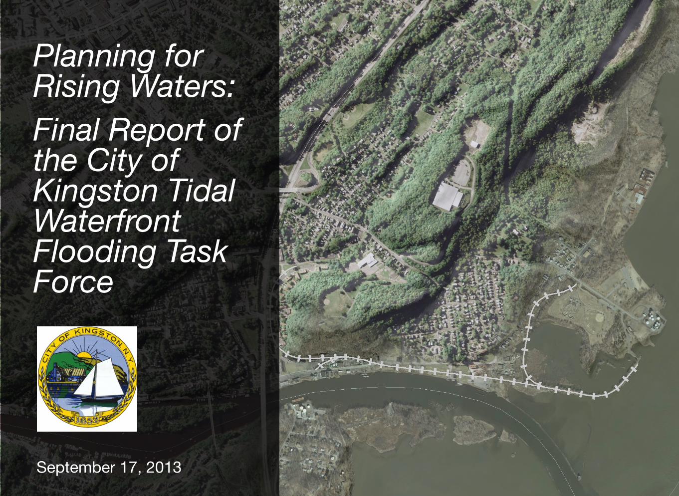
Planning for Rising Waters: Final Report of the City of Kingston Tidal Waterfront Flooding Task Force
September 17, 2013
ii
Planning for Rising Waters: Final Report of the City of Kingston Tidal Waterfront Flooding Task Force
September 17, 2013Suggested Citation:City of Kingston Tidal Waterfront Flooding Task Force, 2013. Planning for Rising Waters: Final Report of the City of Kingston Tidal Waterfront Flooding Task Force Published by the City of Kingston 420 Broadway Kingston, NY 12401 (845)- 331-0080
Available at http://www.kingstoncac.org/index.php/initiatives/tidal-waterfront-flooding-task-force
iii
Dear friends and neighbors,
In October 2012 the Kingston Tidal Waterfront Flooding Task Force was formed including waterfront property and business owners, representatives of waterfront cultural institutions, and others with interest or expertise that are important to any dialogue about the future of the City’s Rondout/Hudson waterfront. I charged this group with the task of assessing local risks and generating strategies that will help create a more vibrant, secure and prosperous waterfront in the coming decades and to address the challenges our city faces from waterfront flooding and sea-level rise.
This community-driven process was convened by the City’s Conservation Advisory Council and the Economic Development Office, and led by a consulting team from Scenic Hudson and the NYS Department of environmental conservation with expert facilitation from the Consensus Building Institute.
The City was selected to participate in this pilot effort because of the actions we are taking to respond to climate change by adopting the
“Climate Smart and Green Jobs Community” pledge and becoming a New York State “Climate Smart Community”. The Climate Action Plan was adopted by the Common Council in September 2012.
The Kingston Tidal Waterfront Flooding Task Force met seven times over eight months, to address community needs and goals, identify our waterfronts greatest vulnerabilities and opportunities, and assist in developing final recommendations. Recommendations in this report draw on contributions from Task Force meetings and discussions, the Georgetown Climate Centers Adaptation Clearinghouse, Kingston’s use (and piloting) of the New York Climate Smart Planning self-assessment process and a review of the recommendations of the New York State Sea Level Rise Task Force.
The findings and recommendations of the Task Force will be instrumental in the implementation of the Climate Action Plan’s recommendations as well as contributing directly to the City of Kingston’s new Comprehensive Master Plan now in planning stages. It is my hope that is part of our effort to improve the quality of life in the City of Kingston and continue to grow as a sustainable community, that you join me in the active participation in the endeavors set forth in this plan. We have a tremendous opportunity to be a “model” of sustainability, not only for the Hudson Valley but for the entire State of New York.
Sincerely
Shane R. Gallo
Mayor, City of Kingston
Shane GalloMayor
CITY OF KINGSTONOFFICE OF THE MAYOR
CITY HALL420 BROADWAY
KINGSTON, NEW YORK 12401www.kingston-ny.gov
July 31,2013
Foreword
iv
This document describes the recommendations of the Kingston Waterfront Flooding Task Force, developed over the course of the Task Force’s work from December 2012 through July 2013. The recommendations draw on contributions from Task Force meetings and discussions, the Georgetown Climate Center’s Adaptation Clearinghouse, Kingston’s use of the New York Climate Smart Planning self-assessment process and a review of the recommendations of the New York State Sea Level Rise Task Force. The Task Force used the following key themes to guide their process and ultimately these recommendations:
‣ Recognize waterfront history and preserve a sense of community and a “sense of place,”
‣ Promote a waterfront economy and economic revitalization,
‣ Prioritize health and safety,
‣ Use natural systems to reduce flood risk,
‣ Secure infrastructure,
‣ Promote the implementation of Kingston’s Climate Action Plan, including reduction of greenhouse gas emissions through green architecture and infrastructure.
This report was prepared by members of the City of Kingston, NY, Waterfront Flooding Task Force, appointed by Mayor Shayne Gallo. Kingston staff convened and participated on the Planning Team:
Suzanne Cahill, City of Kingston Department of Planning
Julie Noble, City of Kingston, Parks and Recreation & Conservation Advisory Council
Gregg Swanzey, City of Kingston Department of Economic Development
A Planning Team consisting of the following provided technical assistance and project management:
Ona Ferguson, The Consensus Building Institute
Jonathan T. Lockman, Catalysis Adaptation Partners, LLC
Barry Pendergrass, NYS Department of State
Sacha Spector, Scenic Hudson, Inc.
Emilie Hauser, NYS Department of Environmental Conservation NYSDEC Hudson River National Estuarine Research Reserve (HRNERR) and New England Interstate Water Pollution Control Commission
Mark Lowery, NYSDEC Office of Climate Change
Kristin Marcell, NYSDEC Hudson River Estuary Program and Cornell University Water Resources Institute
Elizabeth Murphy, NYSDEC Hudson River Estuary Program and Cornell University Water Resources Institute
Christina Tobitsch, Student Conservation Association at NYSDEC Hudson River National Estuarine Research Reserve
The following experts provided Information, tools and resources during the process:
Jessica Grannis, Georgetown Climate Center
Robert Lane, Regional Plan Association
Huntley Gill, Guardia Architects
Allan Shope, Allan Shope Architects
Mary Kimball, New York City Department of City Planning
The following local organizations donated space for public and task force meetings:
City of Kingston
Steel House Restaurant
Riverview Baptist Church
New Central Baptist Church
Art Society of Kingston
Project support was generously provided by (in alphabetical order):
Sean Eldridge
Lincoln Institute of Land Policy
NYSDEC Hudson River Estuary Program
NYSDEC HRNERR Estuary Training Program
Whitney Foundation
Acknowledgements
5Kingston Tidal Waterfront Flooding Task Force: Final Report
CONTENTS
A. Executive Summary
B. Overview of Kingston Flooding Task Force Process, Methodology, and Activities
C. Flooding Risks Today and In The Future
D. Resilience Vision for Kingston
E. Recommendations
F. Appendices
1. Participants
2. Recommendations categories
3. Resources shared
4. Glossary
5. Resources
6. Climate Adaptation Strategies
7. Supplemental Materials
6Kingston Tidal Waterfront Flooding Task Force: Final Report
Report Contents
Introduction
The Kingston, NY waterfront along the Rondout Creek and Hudson River is home to the commercial, industrial, and recreational shipping and boating communities, energy and wastewater infrastructure, businesses, churches, City parks and one of the few public beaches on the Hudson. A natural draw for festivals and celebrations, it also serves as the jumping off point for cruises of the Hudson River.
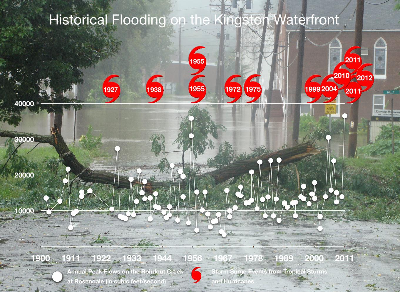
Flooding in the Kingston waterfront is nothing new. Over the last 100 years, the waterfront has experienced flooding from at least 12 hurricanes and tropical storms. Today, some areas of the waterfront, such as low areas along East Strand, occasionally flood when high tides coincide with a few inches of rain.
In the fall of 2012, Mayor Shane Gallo appointed the Kingston Waterfront Flooding Task Force. Mayor Gallo charged the Task Force with evaluating the present and future vulnerability to flooding, storm surge, and sea-level rise along the Rondout-Hudson waterfront. He asked the Task Force to recommend strategies for a resilient waterfront. The Task Force included waterfront and business property owners, representatives of cultural institutions, neighborhood residents, elected officials, and City and County staff. The Kingston Conservation Advisory Council (CAC), Office for Economic Development, and Planning Department convened the Task Force. A planning team consisting of staff from the City of Kingston, the New York State Department of Environmental Conservation Hudson River Estuary Program and Office of Climate Change, the New York State Department of State, and Scenic Hudson guided the efforts of the Task Force. The Consensus Building Institute and Catalysis
Adaptation Partners provided facilitation and modeling services for the effort.
Task Force Process
The Task Force met seven times between December 2012 and July 2013. Participants at the large public kick-off meeting described their visions of a flood-resilient Kingston waterfront. The Task Force selected the following key themes from that vision to guide the process and ultimately the selection of final recommendations:
‣ Recognize waterfront history and preserve a sense of community and a “sense of place.”
‣ Promote a waterfront economy and economic revitalization.
‣ Prioritize health and safety.
‣ Use natural systems to reduce flood risk.
‣ Secure infrastructure.
‣ Promote the implementation of Kingston’s Climate Action Plan, including reduction of greenhouse gas emissions through green architecture.
Task Force Sea-Level Rise Projections and Planning Horizons
The Task Force identified and mapped waterfront assets and assessed vulnerability of the assets under a variety of sea-level rise and storm scenarios. Next, the Task Force, with assistance from the Planning Team, learned about, and evaluated flood adaptation
A. Executive Summary
7Kingston Tidal Waterfront Flooding Task Force: Final Report
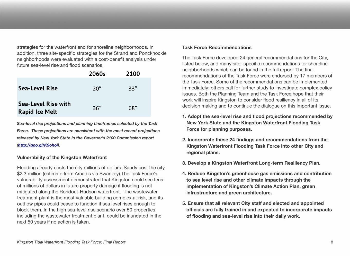
strategies for the waterfront and for shoreline neighborhoods. In addition, three site-specific strategies for the Strand and Ponckhockie neighborhoods were evaluated with a cost-benefit analysis under future sea-level rise and flood scenarios.
2060s 2100
Sea-Level Rise 20” 33”
Sea-Level Rise with Rapid Ice Melt 36” 68”
Vulnerability of the Kingston Waterfront
Flooding already costs the city millions of dollars. Sandy cost the city $2.3 million (estimate from Arcadis via Swanzey).The Task Force’s vulnerability assessment demonstrated that Kingston could see tens of millions of dollars in future property damage if flooding is not mitigated along the Rondout-Hudson waterfront. The wastewater treatment plant is the most valuable building complex at risk, and its outflow pipes could cease to function if sea level rises enough to block them. In the high sea-level rise scenario over 50 properties, including the wastewater treatment plant, could be inundated in the next 50 years if no action is taken.
Task Force Recommendations
The Task Force developed 24 general recommendations for the City, listed below, and many site- specific recommendations for shoreline neighborhoods which can be found in the full report. The final recommendations of the Task Force were endorsed by 17 members of the Task Force. Some of the recommendations can be implemented immediately; others call for further study to investigate complex policy issues. Both the Planning Team and the Task Force hope that their work will inspire Kingston to consider flood resiliency in all of its decision making and to continue the dialogue on this important issue.
1. Adopt the sea-level rise and flood projections recommended by New York State and the Kingston Waterfront Flooding Task Force for planning purposes.
2. Incorporate these 24 findings and recommendations from the Kingston Waterfront Flooding Task Force into other City and regional plans.
3. Develop a Kingston Waterfront Long-term Resiliency Plan.
4. Reduce Kingston’s greenhouse gas emissions and contribution to sea level rise and other climate impacts through the implementation of Kingston’s Climate Action Plan, green infrastructure and green architecture.
5. Ensure that all relevant City staff and elected and appointed officials are fully trained in and expected to incorporate impacts of flooding and sea-level rise into their daily work.
8Kingston Tidal Waterfront Flooding Task Force: Final Report
Sea-level rise projections and planning timeframes selected by the Task
Force. These projections are consistent with the most recent projections
released by New York State in the Governor's 2100 Commission report
(http://goo.gl/K9ohoi).
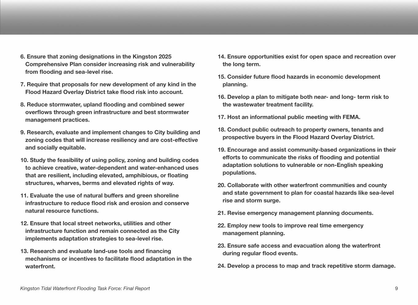
6. Ensure that zoning designations in the Kingston 2025 Comprehensive Plan consider increasing risk and vulnerability from flooding and sea-level rise.
7. Require that proposals for new development of any kind in the Flood Hazard Overlay District take flood risk into account.
8. Reduce stormwater, upland flooding and combined sewer overflows through green infrastructure and best stormwater management practices.
9. Research, evaluate and implement changes to City building and zoning codes that will increase resiliency and are cost-effective and socially equitable.
10. Study the feasibility of using policy, zoning and building codes to achieve creative, water-dependent and water-enhanced uses that are resilient, including elevated, amphibious, or floating structures, wharves, berms and elevated rights of way.
11. Evaluate the use of natural buffers and green shoreline infrastructure to reduce flood risk and erosion and conserve natural resource functions.
12. Ensure that local street networks, utilities and other infrastructure function and remain connected as the City implements adaptation strategies to sea-level rise.
13. Research and evaluate land-use tools and financing mechanisms or incentives to facilitate flood adaptation in the waterfront.
14. Ensure opportunities exist for open space and recreation over the long term.
15. Consider future flood hazards in economic development planning.
16. Develop a plan to mitigate both near- and long- term risk to the wastewater treatment facility.
17. Host an informational public meeting with FEMA.
18. Conduct public outreach to property owners, tenants and prospective buyers in the Flood Hazard Overlay District.
19. Encourage and assist community-based organizations in their efforts to communicate the risks of flooding and potential adaptation solutions to vulnerable or non-English speaking populations.
20. Collaborate with other waterfront communities and county and state government to plan for coastal hazards like sea-level rise and storm surge.
21. Revise emergency management planning documents.
22. Employ new tools to improve real time emergency management planning.
23. Ensure safe access and evacuation along the waterfront during regular flood events.
24. Develop a process to map and track repetitive storm damage.
9Kingston Tidal Waterfront Flooding Task Force: Final Report
!
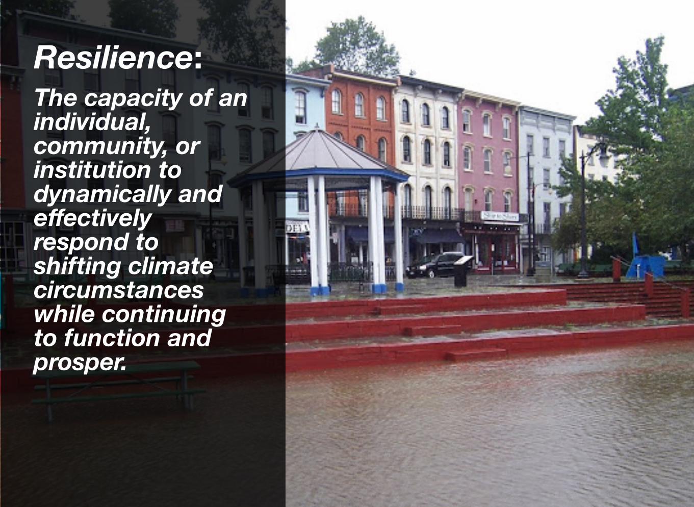
Resilience:The capacity of an individual, community, or institution to dynamically and effectively respond to shifting climate circumstances while continuing to function and prosper.
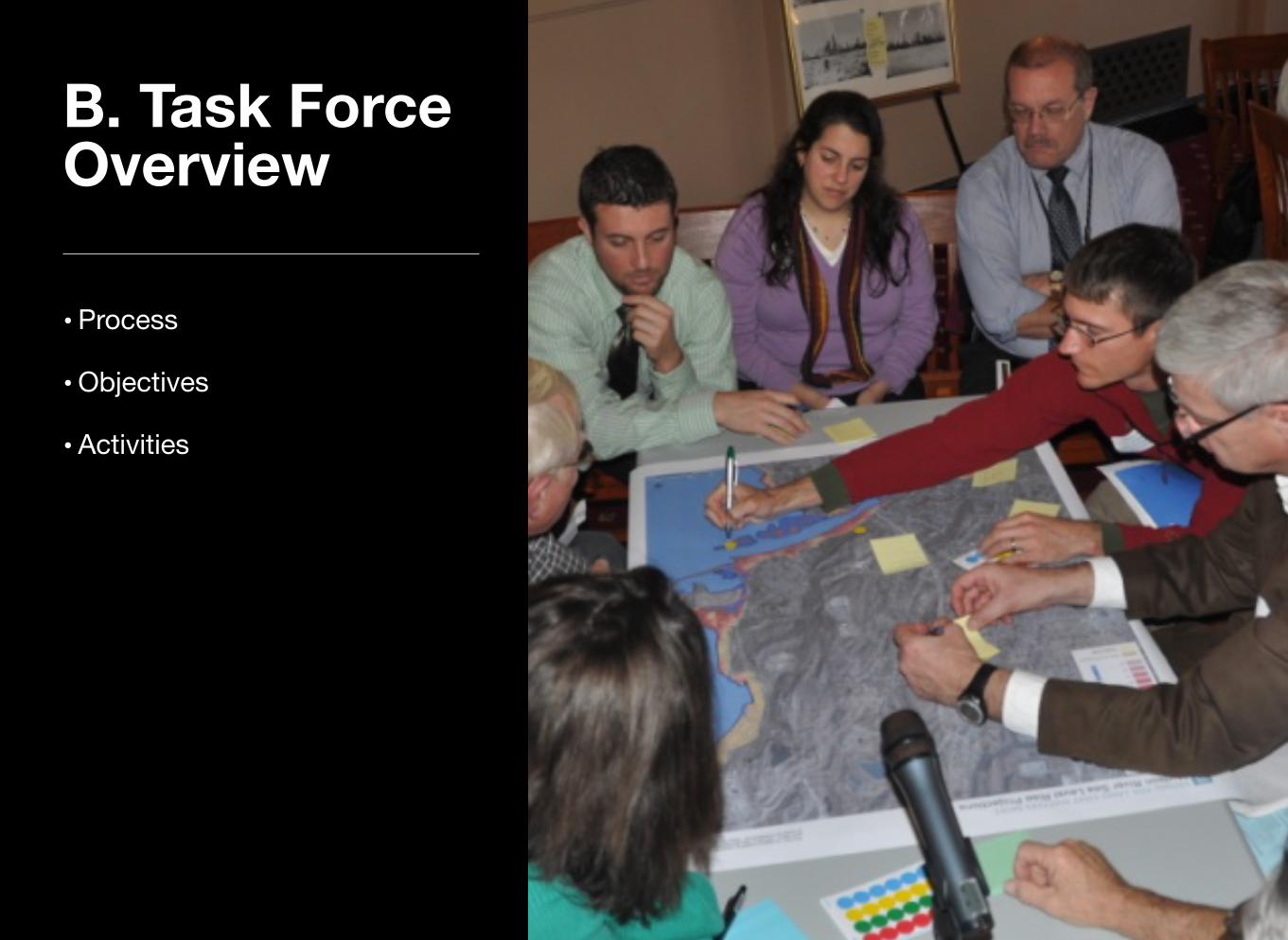
B. Task Force Overview
• Process
• Objectives
• Activities
During the summer of 2012, staff from Hudson River organizations interested in helping Hudson waterfront communities address flooding risk related to sea-level rise began talking with leaders in the City of Kingston. These partner groups, including Scenic Hudson, the New York State Department of Environmental Conservation (NYSDEC)’s Hudson River Estuary Program and Hudson River National Estuarine Research Reserve, the New York State Department of State, the Consensus Building Institute and the Lincoln Institute of Land Policy, and Catalysis Adaptation Partners began to work with City staff in the Planning and Economic Development departments and members of the Kingston Conservation Advisory Council. Together, with a shared interest in helping the City move forward to address the pressing issue of flooding on the Hudson and Rondout, they formed a Planning Team and designed a process to help local residents, community and business leaders tackle this challenge. The partners brought the following expertise to the Task Force:
‣ Kingston CAC – local climate and environmental initiatives
‣ Kingston Economic Development Department – local economic development plans and initiatives
‣ Kingston Planning Department – local zoning, building codes and planning processes
‣ NYS DEC Hudson River Estuary Program and Hudson River Research Reserve – training program coordination, natural resources and adaptation policy
‣ NYS DEC Office of Climate Change – sea-level rise science, natural resources and adaptation policy
‣ Scenic Hudson – mapping, planning, sea-level rise science, natural resources and adaptation policy
‣ NYS DOS – risk assessment and coastal processes
‣ The Consensus Building Institute and the Lincoln Institute of Land Policy – meeting facilitation and consensus building
‣ Catalysis Adaptation Partners – vulnerability assessment and cost benefit analysis
In December of 2012, Mayor Gallo selected and appointed the Kingston Waterfront Flooding Task Force to conduct a study of Kingston’s waterfront flooding to make recommendations to the City. Task Force members were selected to represent a wide range of perspectives on and local knowledge of the waterfront area, including residents, business owners, developers, and City and county staff. (See Appendix 1 for a list of appointed members, a list of the Planning Team, and a list of others who attended three or more of the Task Force’s meetings.)
The Task Force met seven times between December 2012 and July 2013. They met at numerous locations along the waterfront, generously hosted by the following businesses, organizations and by the City: City Hall, Riverview Baptist Church, New Central Baptist Church, The Steel House and The Art Society of Kingston. Task Force participation ranged from 11 – 26 members per meeting, and overall meeting participation ranged from 27 – 76 people. For more details on individual meetings, please see the meeting summaries, available at http://www.kingstoncac.org/index.php/initiatives/tidal-waterfront-flooding-task-force.
Process
12Kingston Tidal Waterfront Flooding Task Force: Final Report
Development of the Recommendations and Final Report
After careful consideration of (1) the vulnerability of assets along the Rondout Hudson waterfront under the selected sea-level rise and flood scenarios and (2) potential adaptation approaches, Task Force members offered ideas for strategies to improve flood resilience at the site, neighborhood and city scale. These ideas were discussed at in-person meetings and members had several opportunities to review them in detail online and provide feedback via email and survey. The Task Force members were encouraged to evaluate strategies considering the key themes identified in the visioning session at the kick-off meeting, local knowledge, feasibility, current and planned initiatives, and the cost-benefit analysis done by Catalysis. The Planning Team used feedback from the Task Force to refine the Task Force’s 24 final recommendations to the City, as presented in this report. Because there was varied attendance at meetings, including some appointed members of the Task Force who attended very few meetings, members had the option to “opt in” to endorsing the recommendations. Members approved the final recommendations in this report in July 2013 and submitted to Mayor Shayne Gallo and the Common Council for consideration thereafter.
13Kingston Tidal Waterfront Flooding Task Force: Final Report
Task Force Objectives
At the outset of the Task Force a series of objectives were defined by Mayor Gallo, the partner groups and the members of the Task Force. These ultimately included:
‣ Bring the community together to describe a shared vision for the future of their waterfront;
‣ Create a foundation of analysis, data and communal knowledge about sea-level rise and flooding adaptation approaches, and use this information to determine which approaches make sense for Kingston, and why;
‣ Produce a set of specific, phased recommendations for policy improvements, capital investments, open space/access opportunities and future studies that will move Kingston toward its vision for greater resilience;
‣ Position Kingston to begin implementing the Task Force’s recommendations and to better compete for future state and federal support for waterfront improvements;
‣ Build the community’s capacity and experience in planning for waterfront resilience.
Objectives
14Kingston Tidal Waterfront Flooding Task Force: Final Report
SequenceWith technical support from the Planning Team, the Task Force used multiple tools and exercises to think about Kingston’s waterfront flood risk and options for how best to prepare the waterfront and community for the future. Over the course of the eight-month process, the group followed this step-wise sequence to arrive at its recommendations:
Activities
1. Mapped waterfront assets and evaluated their current flood risk. In the kick-off meeting, Task Force members and the public completed an interactive mapping exercise to identify locations of past flooding and important waterfront assets. Scenic Hudson compiled this local knowledge with FEMA’s 100-year floodplain and future sea-level rise projections to create story-telling maps showing future flooding projections and waterfront assets.
2. Created a vision for a flood-resilient Kingston waterfront. Participants at the kick-off meeting described what a future flood-resilient waterfront would look like for Kingston. Their comments were grouped into six key themes, which are listed earlier in this report.
3. Chose sea-level rise and flood scenarios for planning purposes. Mark Lowery (NYS DEC) and Sacha Spector (Scenic Hudson) presented the Task Force with a background on the latest sea-level rise and flooding projections from New York State. The Task Force chose to study one and ten percent storms (“100-” and “10-year” flood events ) in years 2060 and 2100, with a total of 66 inches of sea-level rise by 2100 (a moderate-high projection).
4. Assessed the vulnerability of waterfront assets and parcels under selected sea-level rise and flood scenarios. The Task Force completed two vulnerability assessments of the Kingston waterfront: the Department of State’s Coastal Reconstruction and
Activities
15Kingston Tidal Waterfront Flooding Task Force: Final Report
Identify and assess risks to community assets
Determine vulnerability of assets
Prioritize vulnerabilities and opportunities
Develop adaptation vision and select strategies
Identify implementation tools to achieve vision and strategies
Develop adaptation roadmap
Resilience Planning (CRRP) tool and the Coastal Adaptation to Sea-Level Rise Tool (COAST). The CRRP tool was piloted by this Task Force. It looks at the hazard, exposure, and vulnerability of each of the 121 identified waterfront assets to create a relative scoring of risk. This CRRP tool has since been finalized and is available for use by other communities. Catalysis Partners ran COAST using parcel value and the damage depth function, developed by the Army Corps of Engineers, to estimate damage costs in various places under various scenarios over time.
5. Considered site-specific options for adaptation for 11 neighborhoods/areas along the waterfront. Mary Kimball (NYC Planning), Mark Lowery (NYS DEC), and Kristin Marcell (NYS DEC) presented the Task Force with an overview of some of the potential responses to flooding, from updating City zoning to retrofitting buildings to accommodate periodic flooding. The Task Force used their local knowledge and what they had learned through the process to define 11 neighborhoods along the waterfront. They then explored options for adaptation strategies for each neighborhood based on physical attributes and land use. There was a range of opinions about these approaches, and those that reached agreement by most of the participants were included in the recommendations section as site specific recommendations.
6. Analyzed the costs and benefits of three adaptation strategies for the Strand and Ponckhockie. The Task Force identified three adaptation scenarios for the Strand and Ponckhockie neighborhoods to run through COAST to better understand the
relative costs and benefits of each strategy. JT Lockman (Catalysis) ran the model and presented results… [Want a little more about what they chose and the results here.] The cost benefit analysis was undertaken by Catalysis Adaptation Partners and funded by the NYSDEC Hudson River Estuary Program, through NEIWPCC.
7. Developed final recommendations for the Mayor and Common Council. Using prior local knowledge with increased understanding of Kingston’s flooding risk, vulnerable assets, key values, city planning, adaptation strategies, and costs and benefits, the Task Force developed a suite of final recommendations to the City, as presented in this report.
16Kingston Tidal Waterfront Flooding Task Force: Final Report
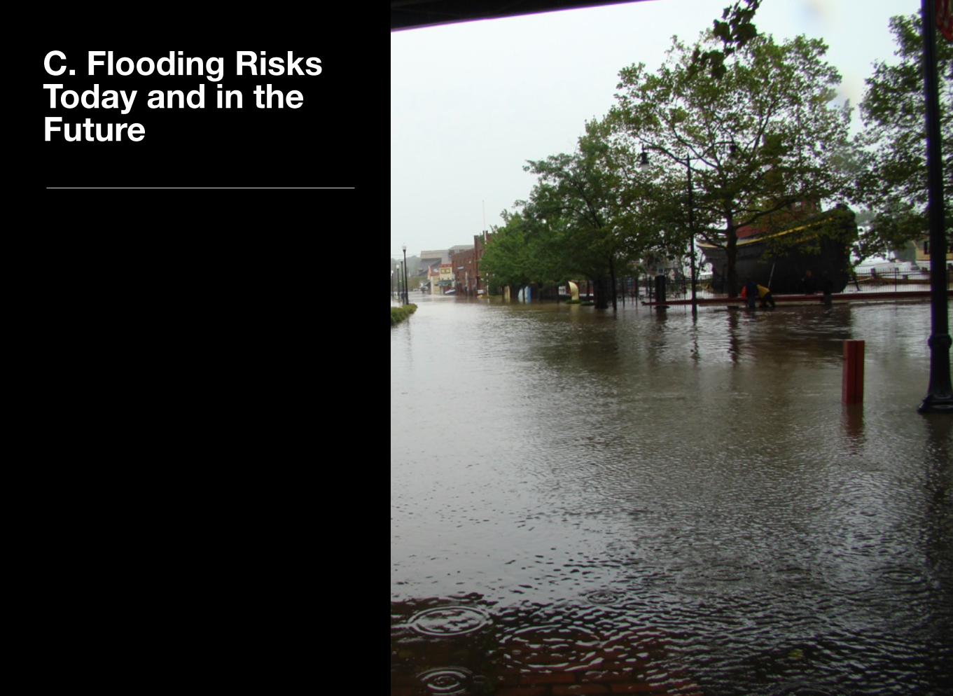
C. Flooding Risks Today and in the Future
The same confluence of waterways that attracted commerce and amenities to the waterfront presents the risks of serious waterfront flooding. Historically, the waterfront has been subject to flooding from both the Rondout Creek, due to heavy rainfall events, and the Hudson River, due to high tides and storm surges (associated with hurricanes, tropical storms, and nor’easters) that travel up the river.
Over the last 100 years the waterfront has experienced flooding from at least 12 hurricanes and tropical storms and many more nor’easters. In recent years, the entire waterfront area was seriously impacted by flooding from both the Hudson and Rondout during Tropical Storms Irene and Lee in 2011 and by a record-breaking storm surge during Hurricane Sandy in 2012. Some areas of the waterfront, like the Ponckhockie neighborhood, are flooded regularly when high tides coincide with a few inches of rain.
Public health and safety, damage to assets, business downtime, and accessibility are some of the top concerns motivating Kingston to take action against future flooding events, whose frequency and intensity are likely to increase due to more frequent intense downpours, storm surge events, and rising sea level that exacerbates the impact of both upland and tidal flooding.
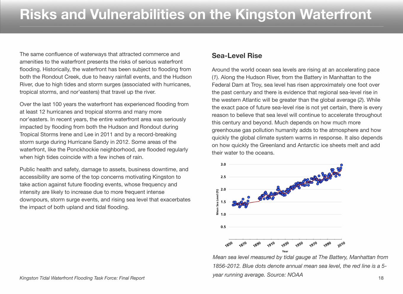
Sea-Level Rise
Around the world ocean sea levels are rising at an accelerating pace (1). Along the Hudson River, from the Battery in Manhattan to the Federal Dam at Troy, sea level has risen approximately one foot over the past century and there is evidence that regional sea-level rise in the western Atlantic will be greater than the global average (2). While the exact pace of future sea-level rise is not yet certain, there is every reason to believe that sea level will continue to accelerate throughout this century and beyond. Much depends on how much more greenhouse gas pollution humanity adds to the atmosphere and how quickly the global climate system warms in response. It also depends on how quickly the Greenland and Antarctic ice sheets melt and add their water to the oceans.
Risks and Vulnerabilities on the Kingston Waterfront
18Kingston Tidal Waterfront Flooding Task Force: Final Report
Mean sea level measured by tidal gauge at The Battery, Manhattan from 1856-2012. Blue dots denote annual mean sea level, the red line is a 5-year running average. Source: NOAA
1955
1927 1938
10000
20000
30000
40000
1900 1911 1922 1933 1944 1956 1967 1978 1989 2000 2011
201119991972 2004
2010 2012
2011
19751955
Historical Flooding on the Kingston Waterfront
Annual Peak Flows on the Rondout Creek at Rosendale (in cubic feet/second)
Storm Surge Events from Tropical Storms and Hurricanes
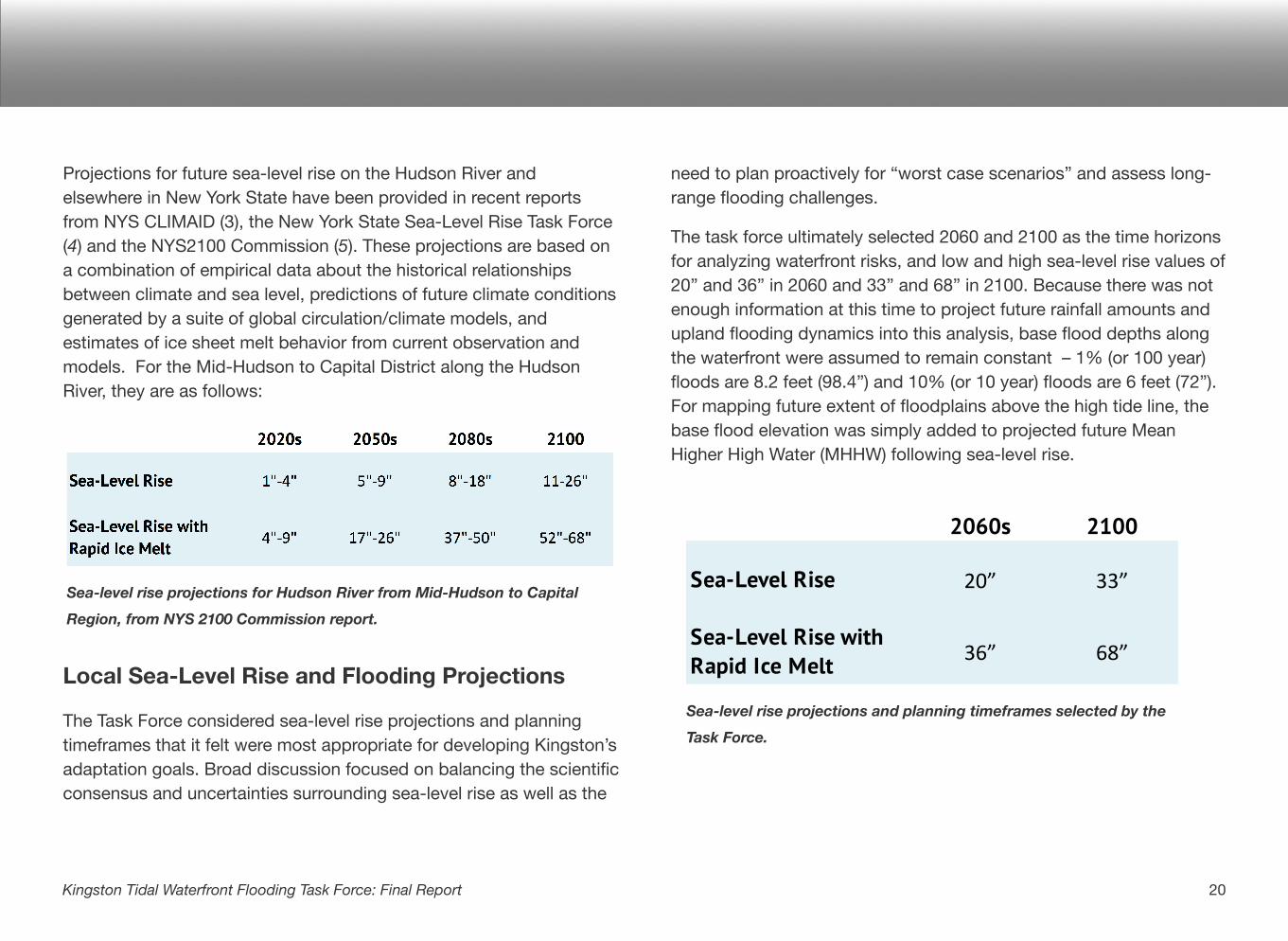
Projections for future sea-level rise on the Hudson River and elsewhere in New York State have been provided in recent reports from NYS CLIMAID (3), the New York State Sea-Level Rise Task Force (4) and the NYS2100 Commission (5). These projections are based on a combination of empirical data about the historical relationships between climate and sea level, predictions of future climate conditions generated by a suite of global circulation/climate models, and estimates of ice sheet melt behavior from current observation and models. For the Mid-Hudson to Capital District along the Hudson River, they are as follows:
Local Sea-Level Rise and Flooding Projections
The Task Force considered sea-level rise projections and planning timeframes that it felt were most appropriate for developing Kingston’s adaptation goals. Broad discussion focused on balancing the scientific consensus and uncertainties surrounding sea-level rise as well as the
need to plan proactively for “worst case scenarios” and assess long-range flooding challenges.
The task force ultimately selected 2060 and 2100 as the time horizons for analyzing waterfront risks, and low and high sea-level rise values of 20” and 36” in 2060 and 33” and 68” in 2100. Because there was not enough information at this time to project future rainfall amounts and upland flooding dynamics into this analysis, base flood depths along the waterfront were assumed to remain constant – 1% (or 100 year) floods are 8.2 feet (98.4”) and 10% (or 10 year) floods are 6 feet (72”). For mapping future extent of floodplains above the high tide line, the base flood elevation was simply added to projected future Mean Higher High Water (MHHW) following sea-level rise.
Sea-level rise projections and planning timeframes selected by the
Task Force.
20Kingston Tidal Waterfront Flooding Task Force: Final Report
Sea-level rise projections for Hudson River from Mid-Hudson to Capital
Region, from NYS 2100 Commission report.
2060s 2100
Sea-Level Rise 20” 33”
Sea-Level Rise with Rapid Ice Melt 36” 68”
21Kingston Tidal Waterfront Flooding Task Force: Final Report
0
50
100
150
200
0 6 12 18 24 30 36 42 48 54 60 66
Acre
s Im
pact
ed
Amount of Sea-Level Rise (inches)
1% floodInundatedMapping Sea-Level Rise and Flooding
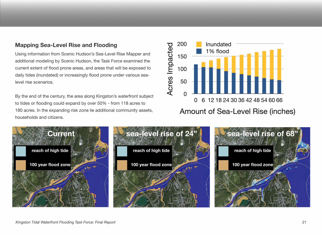
Using information from Scenic Hudson’s Sea-Level Rise Mapper and additional modeling by Scenic Hudson, the Task Force examined the current extent of flood prone areas, and areas that will be exposed to daily tides (inundated) or increasingly flood prone under various sea-level rise scenarios.
By the end of the century, the area along Kingston’s waterfront subject to tides or flooding could expand by over 50% - from 118 acres to 180 acres. In the expanding risk zone lie additional community assets, households and citizens.
Current sea-level rise of 24” sea-level rise of 68”
reach of high tide
100 year flood zone
reach of high tide
100 year flood zone
reach of high tide
100 year flood zone
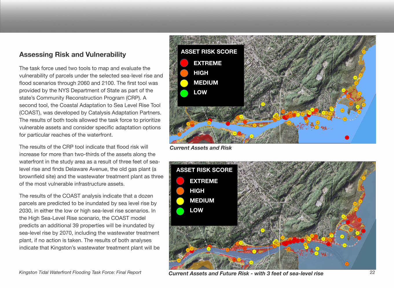
Assessing Risk and Vulnerability
The task force used two tools to map and evaluate the vulnerability of parcels under the selected sea-level rise and flood scenarios through 2060 and 2100. The first tool was provided by the NYS Department of State as part of the state’s Community Reconstruction Program (CRP). A second tool, the Coastal Adaptation to Sea Level Rise Tool (COAST), was developed by Catalysis Adaptation Partners. The results of both tools allowed the task force to prioritize vulnerable assets and consider specific adaptation options for particular reaches of the waterfront.
The results of the CRP tool indicate that flood risk will increase for more than two-thirds of the assets along the waterfront in the study area as a result of three feet of sea-level rise and finds Delaware Avenue, the old gas plant (a brownfield site) and the wastewater treatment plant as three of the most vulnerable infrastructure assets.
The results of the COAST analysis indicate that a dozen parcels are predicted to be inundated by sea level rise by 2030, in either the low or high sea-level rise scenarios. In the High Sea-Level Rise scenario, the COAST model predicts an additional 39 properties will be inundated by sea-level rise by 2070, including the wastewater treatment plant, if no action is taken. The results of both analyses indicate that Kingston’s wastewater treatment plant will be
22Kingston Tidal Waterfront Flooding Task Force: Final Report
9
8
7
6
5
4
3
2
1
99
98 94
91
89
88
86
848281
78
75
73
72
70
69
68
67
65
62
61
60
58
57
56
55
51
504948
46
45
43
42
39
32
2218
11
10
121
120
119
118
117
116
115
114
113
112
110108
107
104
101
111
£¤9W
Source: Esri, i-cubed, USDA, USGS, AEX, GeoEye, Getmapping, Aerogrid , IGN, IGP, and the GIS User Community
0 1,400 2,800700Feet
Community Restoration and Resilience Planning - 100 year Storm 8/5/2013
City of KingstonUlster County, NY 5
G:\Projects\ByCounty\Ulster\Kingston\SeaLevelRise\1KingstonSLRDec2012_mw_noNotes.mxd
Current Assets and Risk
Current Assets and Future Risk - with 3 feet of sea-level rise
EXTREME HIGHMEDIUMLOW
ASSET RISK SCORE
EXTREME HIGHMEDIUMLOW
ASSET RISK SCORE
routinely or permanently inundated at 36” of sea-level rise and strategies will need to be developed to adapt this critical infrastructure. See Supplemental Materials for the full results of the CRP and COAST analyses at http://www.kingstoncac.org/index.php/initiatives/tidal-waterfront-flooding-task-force
The task force learned about a variety of strategies for waterfront adaptation under four broad adaptation approaches: do nothing, fortify, accommodate or strategically relocate uses. Adaptation options that “fortify” use hard or soft structures to prevent flood waters from reaching community assets. Adaptation options that “accommodate” modify community assets to reduce the impact of flood waters. Adaptation options that “strategically relocate” move buildings,
infrastructure or uses back from the most vulnerable areas to greatly minimize the risk of flooding. See Appendix 6 for more information on the benefits and drawbacks of these approaches.
Evaluating Alternatives
The task force divided the waterfront into eleven neighborhoods and considered which of the four approaches and strategies were most appropriate for each reach based on physical properties and land use. There was a range of opinions about these approaches, and those that reached agreement by most of the participants were included in the recommendations section as site specific recommendations.
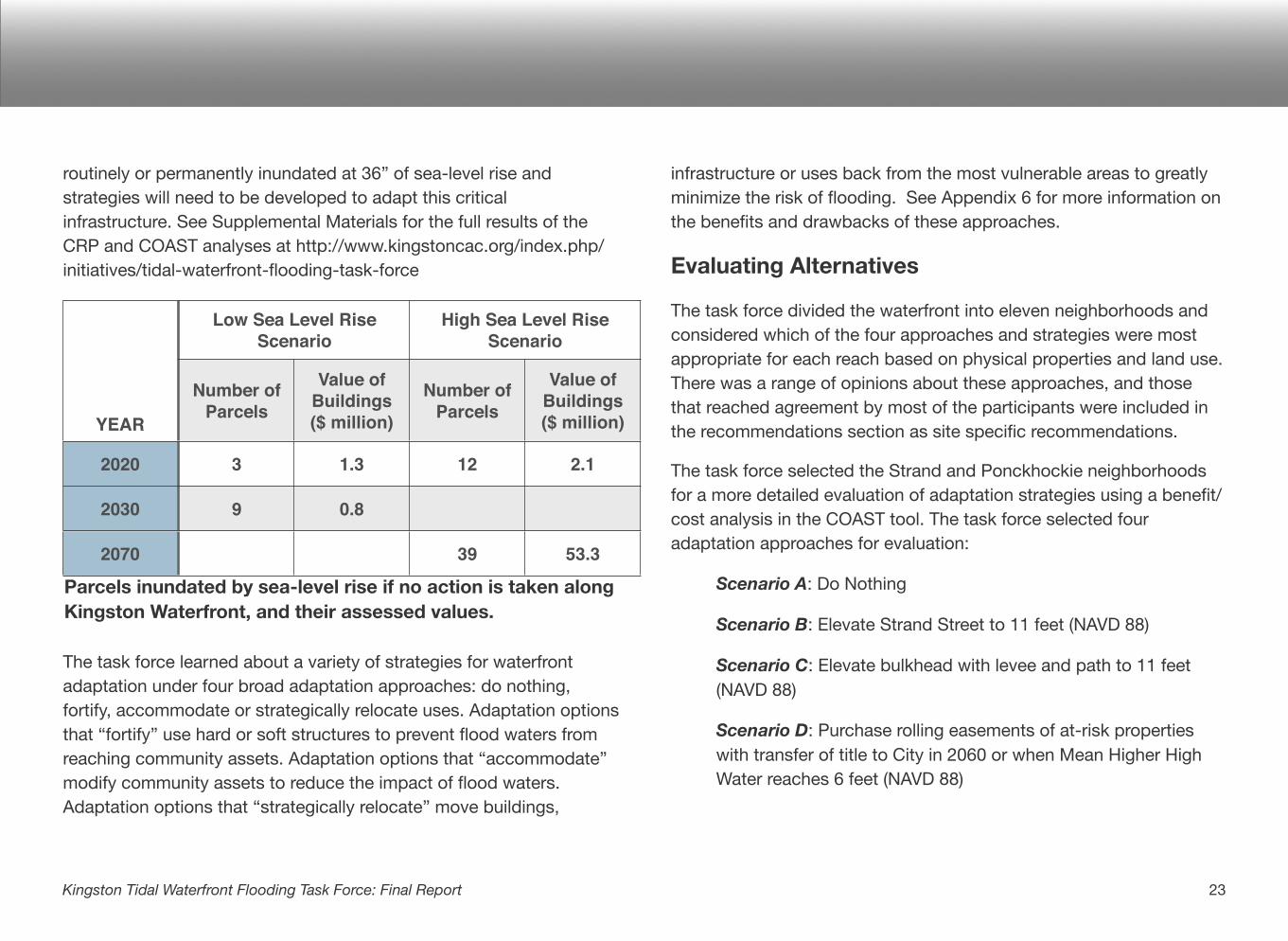
The task force selected the Strand and Ponckhockie neighborhoods for a more detailed evaluation of adaptation strategies using a benefit/cost analysis in the COAST tool. The task force selected four adaptation approaches for evaluation:
Scenario A: Do Nothing
Scenario B: Elevate Strand Street to 11 feet (NAVD 88)
Scenario C: Elevate bulkhead with levee and path to 11 feet (NAVD 88)
Scenario D: Purchase rolling easements of at-risk properties with transfer of title to City in 2060 or when Mean Higher High Water reaches 6 feet (NAVD 88)
23Kingston Tidal Waterfront Flooding Task Force: Final Report
YEARYEAR
2020
2030
2070
Low Sea Level Rise Scenario
Low Sea Level Rise Scenario
High Sea Level Rise Scenario
High Sea Level Rise Scenario
Number of Parcels
Value of Buildings($ million)
Number of Parcels
Value of Buildings($ million)
3 1.3 12 2.1
9 0.8
39 53.3
Parcels inundated by sea-level rise if no action is taken along Kingston Waterfront, and their assessed values.

The consulting firm Parsons Brinkerhoff provided construction and maintenance cost estimates for Scenarios B and C. The results of the cumulative damage estimates from the COAST model for these four scenarios are summarized in the following table. For more information on the scenarios and the results see the full COAST report at http://www.kingstoncac.org/index.php/initiatives/tidal-waterfront-flooding-task-force .
The elevation of the bulkhead along the East Strand/Ponckhockie neighborhood appears to have the best benefit/cost ratio of the four scenarios explored in this timeframe, and with these assumptions.
It is important to note that both of the fortification approaches, elevation of the Strand and the bulkhead, have high levels of residual risk. They encourage additional development in high risk areas and if they fail due to overtopping or a breach the results can be catastrophic, if no redundant safety measures are in place. Initial investments in fortification measures can also limit future opportunities to accommodate or strategically relocate uses. For more information on the benefits and drawbacks to specific measures see Appendix 5.
24Kingston Tidal Waterfront Flooding Task Force: Final Report
Sources
(1) Vermeer, M., and S. Rahmstorf. 2009. Global sea level linked to global temperature. Proceedings of the National Academy of Sciences 106:21527 -21532.
(2) Church, J. A., N. J. White, R. Coleman, K. Lambeck, and J. X. Mitrovica. 2004. Estimates of the Regional Distribution of Sea Level Rise over the 1950-2000 Period. Journal of Climate 17:2609-2625.
(3) NYSERDA ClimAID Team. 2010. Integrated Assessment for Effective Climate‐change Adaptation Strategies in New York State. http://www.nyserda.ny.gov/climaid
(4) New York State Sea Level Rise Task Force. 2010. Report to the Legislature. http://www.dec.ny.gov/docs/administration_pdf/slrtffinalrep.pdf
(5) The NYS 2100 Commission. 2012. Building Resilience in New York. http://www.rockefellerfoundation.org/media/download/7c012997-176f-4e80-bf9c-b473ae9bbbf3
25Kingston Tidal Waterfront Flooding Task Force: Final Report
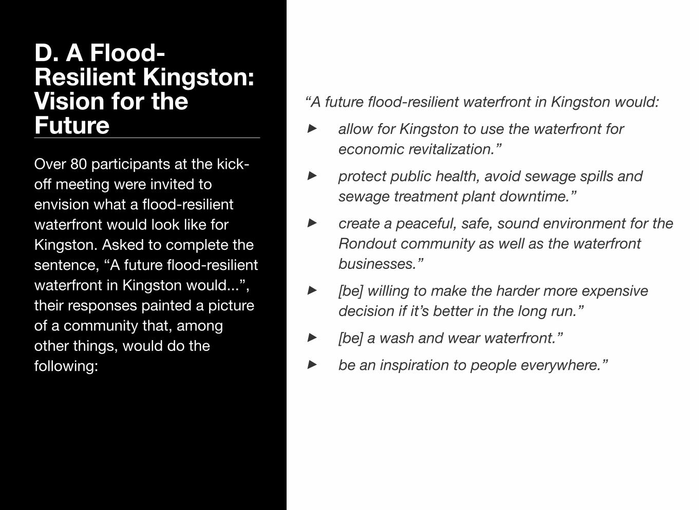
D. A Flood-Resilient Kingston: Vision for the FutureOver 80 participants at the kick-off meeting were invited to envision what a flood-resilient waterfront would look like for Kingston. Asked to complete the sentence, “A future flood-resilient waterfront in Kingston would...”, their responses painted a picture of a community that, among other things, would do the following:
“A future flood-resilient waterfront in Kingston would:
‣ allow for Kingston to use the waterfront for economic revitalization.”
‣ protect public health, avoid sewage spills and sewage treatment plant downtime.”
‣ create a peaceful, safe, sound environment for the Rondout community as well as the waterfront businesses.”
‣ [be] willing to make the harder more expensive decision if it’s better in the long run.”
‣ [be] a wash and wear waterfront.”
‣ be an inspiration to people everywhere.”
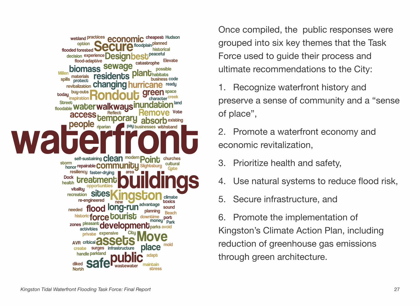
Once compiled, the public responses were grouped into six key themes that the Task Force used to guide their process and ultimate recommendations to the City:
1. Recognize waterfront history and preserve a sense of community and a “sense of place”,
2. Promote a waterfront economy and economic revitalization,
3. Prioritize health and safety,
4. Use natural systems to reduce flood risk,
5. Secure infrastructure, and
6. Promote the implementation of Kingston’s Climate Action Plan, including reduction of greenhouse gas emissions through green architecture.
27Kingston Tidal Waterfront Flooding Task Force: Final Report
28Kingston Tidal Waterfront Flooding Task Force: Final Report
Solutions through public policyThe greatest number of ideas looked to use policy as a tool for intelligent planning, land use and building codes to restrict unsustainable development.
Comments included:“[Have] no building within the flood zones”“[Have] high density development in areas that do not flood”“Reflect resiliency, best practices in updated zoning code”“Be prepared to take advantage of funding or other opportuni-ties: be ready with a plan”“Remove, through buy-outs, people and buildings from repeti-tively flooded areas”“Ensure flood-adaptive buildings are considered in planning ap-provals”“Vote to increase taxes temporarily to pay for project to address problem”
Prioritize health and safetyDiscussions on public health and safety were frequently linked with concerns of flooding leading to spills at the sewage treatment plant, Central Hudson gas tanks, and other sites with toxic substances.
Comments included:“[Be] planned to meet human safety concerns”“Protect public health, avoid sewage spills and sewage treat-ment plant downtime”“[Be] seen as the best “hurricane hole” port in the storm during hurricane season”“Secure and clean up toxics at Central Hudson Gas and Electric and Millen’s sites”
Promote a waterfront economy and economic revitalizationGroup discussions underlined the importance of King-ston’s waterfront as an economic driver. Many attendees noted the opportunity for flood resiliency to increase the area’s economic benefit. Marinas, restaurants, museums and historical buildings are important in attracting boaters and other tourists to the area.
Comments included:“Allow for Kingston to use water front for economic revitalization”“Invest to protect maritime assets w/o which economic vitality dis-appears”“[Mean that] boaters entering the Rondout experience a pleasant entry”“[Be] self-sustaining, repairable, and profitable”“Be similar to Kingston Point Park during the recreational era (Note from transcriber: KPP used to be a dayliner landing with a Ferris wheel and other tourist activities) but with modern enhance-ments. It would draw tourist and residents to its clean water for recreation, historical and cultural assets”
Fortify some areas and secure infrastructureSeveral groups discussed the possibility of fortifying key infrastructure or areas using gating, bulkheads, dykes or break away walls. The negative viewshed implications of creating a wall was mentioned under this topic.
Comments included:Secure the existing Rondout business, churches and residents with a dyke upon which the trolley would run”“Gate buildings that can’t be re-engineered to withstand surges”
Maximize use of natural systems to reduce flood riskAttendees recognized the use of natural systems to cre-ate a healthy shoreline. Ideas included preserving and creating floodable land uses, including parks, walkways, green spaces, wetlands and other biomass.Comments included:“An environmentally safe waterfront area would create a peace-ful, safe, sound environment for the Rondout community as well as the waterfront businesses”“NOT be diked; include more parkland and “floodable” land uses and preserve walkways”“[Have] healthy habitats”“Consider doing plantings to put some biomass in the floodplain to absorb force”“Use biomass in areas where needed”“Secure Slightsburg Spit (the wetland) to the extent possible”“[Have] an enhanced riparian forested buffer with less hard walk-ways to allow for access to the creek’s green areas”“[Have] green space along the river”“Leave Island Dock undeveloped”
Address upstream sources of flood riskSeveral attendees discussed the need to “attack the problem at the source” by preventing the upper Rondout from becoming clogged or relying on new en-ergy sources that do not lead to toxic spills.
29Kingston Tidal Waterfront Flooding Task Force: Final Report
Build and retrofit to accommodate floodingMore attendees discussed building and retrofitting water-front assets to accommodate flooding rather than armor-ing or relocating them. Several pointed out the Steel-house and Clearwater buildings as models that highlight the importance of designing assets to recover quickly af-ter a flood (“Resiliency is reflected in how quickly we re-cover”). Other comments included:
Comments included: “Flooding should be a temporary inconvenience – not a catastro-phe”“Design infrastructure to adapt to changing climate; get new tech-nology that will rebound to water; mold; drying faster materials”“Elevate critical systems”“Design [buildings] to absorb force”“Assets that can tolerate inundation temporarily should be recog-nized”“[Be] a wash and wear waterfront”
Relocate some uses away from high risk areasAttendees volunteered several vulnerable assets they would like to see relocated. There was disagreement regarding relocating versus armoring the sewage treat-ment plant.
Comments included:“[Remove] areas that can’t handle temporary inundation”“Move City Beach to Shoreline on North Street by AVR develop-ment”“Move historic framed buildings to a safe place”“Move the wastewater treatment plant!”
Make decisions based on the best available information and collaborationGroups were quite interested in using knowledge and collaboration to make well informed decisions. At-tendees suggested we look at what other places have done and to watch what happens in New York City. They also noted that it is “important to make goals at-tainable.”
Comments included:We usually take the cheapest option today but then spend more money in the long run”“Let’s make sure that we are willing to make the harder more ex-pensive decision if it’s better in the long run”
Preserve a sense of community and a “sense of place” Kingston waterfront inspires a “sense of place”, a con-nection between people and the water, that people do not want to sacrifice in order to become more flood-resilient. This includes preserving parks and historic buildings, or perhaps future sites for recreation and ac-cess.
Comments included:“Be an inspiration to people everywhere”“[Have] public and private sites that maintain and honor the indi-vidual and community “sense of place” that a waterfront embod-ies”“[Where] waterfront access would be public all along the shore-line”“Have [a] solution without changing the character of the water-front”“[Have] waterfront parks like Kingston Point”“Take the stress out of the waterfront”
30Kingston Tidal Waterfront Flooding Task Force: Final Report
E. Recommendations
Based on eight months of study and discussion of future risks of flooding and sea-level rise along the Kingston waterfront, the Task Force grouped its recommendations for the City of Kingston in the following categories:
1. City operations, funding and decision-making2. Resilient structures 3. Promotion of a waterfront economy and economic revitalization4. Collaboration and public outreach5. Emergency management6. Site-based recommendations
Some recommended actions would be implemented in the near term (0-5 years) and some in the longer term (5 years+). The recommendations were endorsed by the following Task Force members, including all Task Force members present at the final Task Force meeting: David Allen, Susan Spencer Crowe, Steve Finkle, Scott Herrington, Tom Hoffay, Ann Loeding, Patrick McDonough, Kevin McEvoy, Jon McGrew, Julie Noble, Steve Noble, Steve Schabot, Jennifer Schwartz Berky, Allan Shope, Arthur Snyder and Gregg Swanzey. Based on its findings, the Task Force presents the City with the following recommendations to achieve these themes listed above, the stated goals of the Task Force, and a more flood-resilient waterfront.
Near-term Actions
1. Adopt the sea-level rise and flood projections recommended by New York State and used by the Kingston Task Force for planning purposes.
Adopt these projections to inform all City near-term planning and decision making, recognizing both the inherent uncertainty in long-term climate projections and the need to adapt to conditions that may occur if meaningful steps are not taken to reduce greenhouse gas emissions. Ensure there is a mechanism in place to regularly re-evaluate and update these sea-level rise and flood projections, using new information released by the state, and to incorporate updated projections into planning and decision making.
2. Incorporate the findings and recommendations from the Kingston Waterfront Flooding Task Force into other City and regional plans.
Relevant plans include the current comprehensive plan and zoning update (Kingston 2025), Tidal Rondout Creek Watershed Management Plan, East Strand Street Flooding and Stormwater Management Analysis, Generic Environmental Impact Statement for Brownfields along the Rondout, open space plan and future plans such as climate adaptation plan, revisions to the Local Waterfront Revitalization Program, transportation plans, the Ulster County Multi-Hazard Mitigation Plan, and the inter-municipal comprehensive harbor management plan. Consider updating and adopting the 2010 City of Kingston Stormwater Management Plan.
RECOMMENDATION
City operations, funding and decision making should strive to reduce vulnerability to flooding and increase resilience.
City agencies responsible for the management and regulation of resources, infrastructure and vulnerable populations should consider the impacts of flooding, sea-level rise and climate change in all relevant decision making, including long‐term planning, programming, permitting, regulation, emergency response, and funding and capital-expenditure decisions.
32Kingston Tidal Waterfront Flooding Task Force: Final Report
City Operations, Funding and Decision Making
Long-term Actions
3. Develop a Kingston Waterfront Long-term Resiliency Plan.
In order to refine Kingston’s approach to increasing the resiliency of its waterfront, this plan should build on the efforts of the Kingston Tidal Waterfront Flooding Task Force and:
‣ Implement the recommendations of the Kingston Tidal Waterfront Flooding Task Force consistent with the six key themes;
‣ Prioritize adaptation actions City-wide according to the vulnerability of assets, their value to the community, considerations of environmental quality and human welfare, and capital-investment capacity.
‣ Work with property owners to explore the appropriateness of and select site-specific strategies for implementation of adaptation approaches such as fortification, accommodation or relocation of assets from flood-prone areas;
‣ Consider identifying areas where development should be restricted in the future to minimize vulnerability;
‣ Outline a research agenda to explore new approaches to waterfront architecture and infrastructure;
‣ Assess the risk of suspension or release of contaminants from waterfront properties and facilities during flood events and with inundation from sea-level rise;
‣ Ensure that the approval of structural protection measures (like seawalls and bulkheads) will not result in the elimination of all intertidal areas and the public’s right to access those areas as water levels rise.
4. Reduce Kingston’s greenhouse gas emissions and contribution to sea level rise and other climate change impacts through the implementation of Kingston’s Climate Action Plan, green infrastructure and green architecture.
5. Ensure that all relevant City staff and elected and appointed officials are fully trained in and expected to incorporate impacts of flooding and sea-level rise into their daily work.
This could include planning, engineering, emergency management and public works personnel as well as common council and other leaders. Kingston could consider implementing the following recommendations:
‣ Issuing an executive policy that requires City staff to consider flooding and sea-level rise impacts into their daily work and decision making.
33Kingston Waterfront Tidal Flooding Task Force: Final Report
‣ Informing and training staff and officials of Kingston, neighboring municipalities and county officials on the risk assessments and findings from the Kingston Waterfront Flooding Task Force.
‣ Adapting and modifying infrastructure over time to address increasing vulnerability to flooding and sea-level rise.
‣ Considering sea-level rise and flood impacts over the lifespan of any proposed project that will require capital expenditure plans or departmental requests for funds. Develop a City-wide capital improvement plan that incorporates the needs of all departments to allow for prioritization of investment in flood resilience across departments.
‣ Enforcing existing regulations relevant to status quo flooding and sea-level rise impacts, such as those that fall to the local floodplain administrator (Kingston § 405-26. Flood Hazard Overlay District) and zoning board of appeals.
‣ Requiring that City agencies report regularly on emerging vulnerabilities and progress toward achieving resiliency to sea-level rise and flooding in their agencies’ annual reports.
‣ Evaluating the costs and benefits of reducing the impact of rising flood insurance premiums on residents and businesses by participating in the National Flood Insurance Program’s Community Rating System.
34Kingston Waterfront Tidal Flooding Task Force: Final Report
Near-term Actions
6. Ensure that zoning designations in the Kingston 2025 Comprehensive Plan consider increasing risk and vulnerability from flooding and sea-level rise.
7. Require that proposals for new development of any kind in the Flood Hazard Overlay District take flood risk into account.
Ensure that current building codes are being enforced along the waterfront and that all proposals for new development demonstrate adequate safety and viability over the long run, including, but not limited to shoreline protection, building standards, locations of structures and uses of structures.
8. Reduce stormwater, upland flooding and combined sewer overflows through green infrastructure and best stormwater management practices.
The waterfront experiences significant flood impacts from the landward side. Evaluate the use of backflow preventers in some areas as a near-term solution to waterfront flooding issues. Where feasible and cost effective, promote the use of best stormwater management practices and green infrastructure to absorb stormwater.
RECOMMENDATION
The City should encourage safe and resilient structures in the waterfront area through zoning, permitting and building codes in existing and new development.
35Kingston Tidal Waterfront Flooding Task Force: Final Report
Resilient Structures
Long-term Actions
9. Research, evaluate and implement changes to City building and zoning codes that will increase resiliency and are cost-effective and socially equitable.
At present, the FEMA Special Flood Hazard Area (i.e., the regulated 100-year floodplain) does not account for changes in flood risk due to sea-level rise and stronger storms. Kingston has adopted the state’s two-foot freeboard requirement for construction of new structures, substantial improvement (>50%) or reconstruction of substantially damaged structures. Kingston could consider going beyond state floodplain regulations to reduce long-term vulnerability and reduce the cost of flood insurance for new construction. Options include extending the boundaries of the current Flood Hazard Overlay District (Kingston §405-26) or increasing the freeboard requirement in this district. The costs and benefits of these and other options should be evaluated to inform potential implementation.
10. Study the feasibility of using policy, zoning and building codes to achieve creative, water-dependent and water-enhanced uses that are resilient, including elevated, amphibious, or floating structures, wharves, berms and elevated rights of way.
11. Evaluate the use of natural buffers and green shoreline infrastructure to reduce flood risk and erosion and conserve natural resource functions.
In codes and zoning policies, encourage the use of buffer areas and other land-use based coastal protection strategies to reduce flooding risk to human communities and reduce risk to natural resources. Consistent with this Task Force’s site-specific recommendations, support projects or actions that use green shoreline infrastructure to protect shoreline assets and conserve natural protective features and/or secure opportunities for habitat migration in response to sea-level rise where appropriate (e.g., Kingston Point).
12. Ensure that local street networks, utilities and other infrastructure function and remain connected as the City implements adaptation strategies to sea-level rise.
Pay special attention to waterfront road access, entrances and exits; and the implications for public safety, emergency response, public infrastructure and evacuation. Ensure that zoning revisions and other policies incorporate these vulnerabilities and adaptive responses.
36Kingston Waterfront Tidal Flooding Task Force: Final Report
13. Research and evaluate land-use tools and financing mechanisms or incentives to facilitate flood adaptation in the waterfront.
Conduct further studies to evaluate land-use tools and financing mechanisms to promote resilient development along the waterfront. Financing could include the use of tax incentives, waiver of permit fees, or a grant or revolving loan fund to encourage property owners to flood-proof or elevate structures. Land-use tools could include rolling easements, incentives for donation of conservation easements or the use of publicly owned properties acquired through tax delinquency as relocation sites for exchange with willing flood vulnerable owners. Mechanisms should be evaluated for social equity and effects on affordable housing.
37Kingston Waterfront Tidal Flooding Task Force: Final Report
Long-term Actions
14. Ensure opportunities exist for open space and recreation over the long term.
Waterfront access and water recreation draw visitors to the Rondout; these recreational opportunities are critical to local businesses. Current waterfront open space and parks should be studied, and an adaptation and transition plan for existing sites and potential locations for future sites put in place.
15. Consider future flood hazards in economic development planning.
The City should ensure that any new waterfront economic development planning and implementation consider current coastal hazards and future impacts of sea-level rise and flooding. Plans for remediation of contaminated sites and redevelopment of brownfields must be effective and safe as sea levels rise and flood risk increases.
16. Develop a plan to mitigate both near- and long- term risk to the wastewater treatment facility.
This plan should consider the life cycle of plant components, the value of the property for other uses, and innovative approaches (e.g., distributed systems and shared municipal services) that may effectively meet the wastewater treatment needs for the City and surrounding communities over the long term.
RECOMMENDATION
Kingston should promote its waterfront as a world-class destination, home to vibrant businesses, cultural assets and water-based recreation. Kingston should promote its waterfront economy and economic revitalization. The local economy depends on safe, clean water and public access to the shoreline from land and river.
38Kingston Tidal Waterfront Flooding Task Force: Final Report
Promoting a Waterfront Economy and Economic Revitalization
Near-term Actions
17. Host an informational public meeting with FEMA.
Work with FEMA to inform community members about the Community Rating System, flood insurance changes, flood hazard overlay districts and resilient rebuilding approaches. Provide public informational events as necessary.
18. Conduct public outreach to property owners, tenants and prospective buyers in the Flood Hazard Overlay District.
Enforce existing regulations that require that all developers be notified if their properties are in the current Area of Special Flood Hazard §405-26 C (7). Be sure all property owners, tenants, and prospective buyers are aware of the current and projected future floodplain. Mail all property owners and tenants in the District information on flood safety and emergency warning systems in Kingston, appropriate responses to flood warnings, the public health effects of flooding, and potential flood-mitigation strategies for their properties. Consider using interpretive signs to educate the public about flood risk and measures Kingston is taking to increase resiliency. Repeat as necessary.
19. Encourage and assist community-based organizations in their efforts to communicate the risks of flooding and potential adaptation solutions to vulnerable or non-English speaking populations.
RECOMMENDATION
The City should engage with and protect the community through collaboration and public outreach in order to raise public awareness of the risks of flooding, coastal hazards and sea-level rise, and give community members the tools and information they need to reduce their vulnerability.
39Kingston Tidal Waterfront Flooding Task Force: Final Report
Community Collaboration and Public Outreach
Work with community-based organizations to facilitate translation of complex information to community members in vulnerable or non-English speaking neighborhoods, gather information on local impacts of flooding and encourage dialogue on potential adaptation solutions.
20. Collaborate with other waterfront communities and county and state government to plan for coastal hazards like sea-level rise and storm surge.
Present findings from the Kingston Waterfront Flooding Task Force to adjacent waterfront communities. Collaborate on a plan with Esopus and Ulster that outlines joint goals for waterfront resiliency along the Rondout. Work together to advocate for the federal government to continue to fund the maintenance and operation of the USGS stream gauges in the Rondout and elsewhere for real-time flood emergency management.
40Kingston Waterfront Tidal Flooding Task Force: Final Report
Near-term Actions
21. Revise emergency management planning documents.
Incorporate flooding and sea-level rise risks into Kingston’s updated comprehensive emergency management plan. Specifically, include sea-level rise as a hazard in Kingston, a plan for emergency debris removal following large flood events, and strategies to manage marinas and other water dependent uses in flood emergencies. Work with Ulster County Emergency Management on the five-year update of its multi-hazard mitigation plan so that sea-level rise and storm surge are considered in the plan.
22. Employ new tools to improve real time emergency management planning.
Use tools like the USGS Rondout stream gauge and the Stevens Institute New York Harbor Observing and Predicting System (NYHOPS) model to improve real time planning in flood situations. The Rondout stream gauge provides real time information on water level and flow and notifications as water levels reach certain heights. The NYHOPS model of the Hudson estuary can be used to access more localized water level forecasts for estuary shoreline communities as a storm approaches. Streamline emergency management decision making during flooding by creating an organizational framework to conduct rapid preliminary damage assessments. Collaborate with other members of the Hudson Valley emergency management community to advocate for new tools and modeling that will improve decision making.
23. Ensure safe access and evacuation along the waterfront during regular flood events.
RECOMMENDATION
Kingston should ensure the efficiency and effectiveness of emergency management strategies to promote the safety of residents and limit damage to infrastructure and properties.
41Kingston Tidal Waterfront Flooding Task Force: Final Report
Emergency Management
Evaluate evacuation plans in light of sea-level rise to ensure evacuation routes are safe and accessible. Ensure that the law enforcement and emergency services launch facility on the Rondout remains accessible and operational during high-water events.
Long-term Actions
24. Develop a process to map and track repetitive storm damage.
The process should include a method to gather, record and archive information on properties affected by storms and damages sustained over time to be used for future planning decisions, and should cover coastal, riverine and stormwater impacts.
42Kingston Waterfront Tidal Flooding Task Force: Final Report
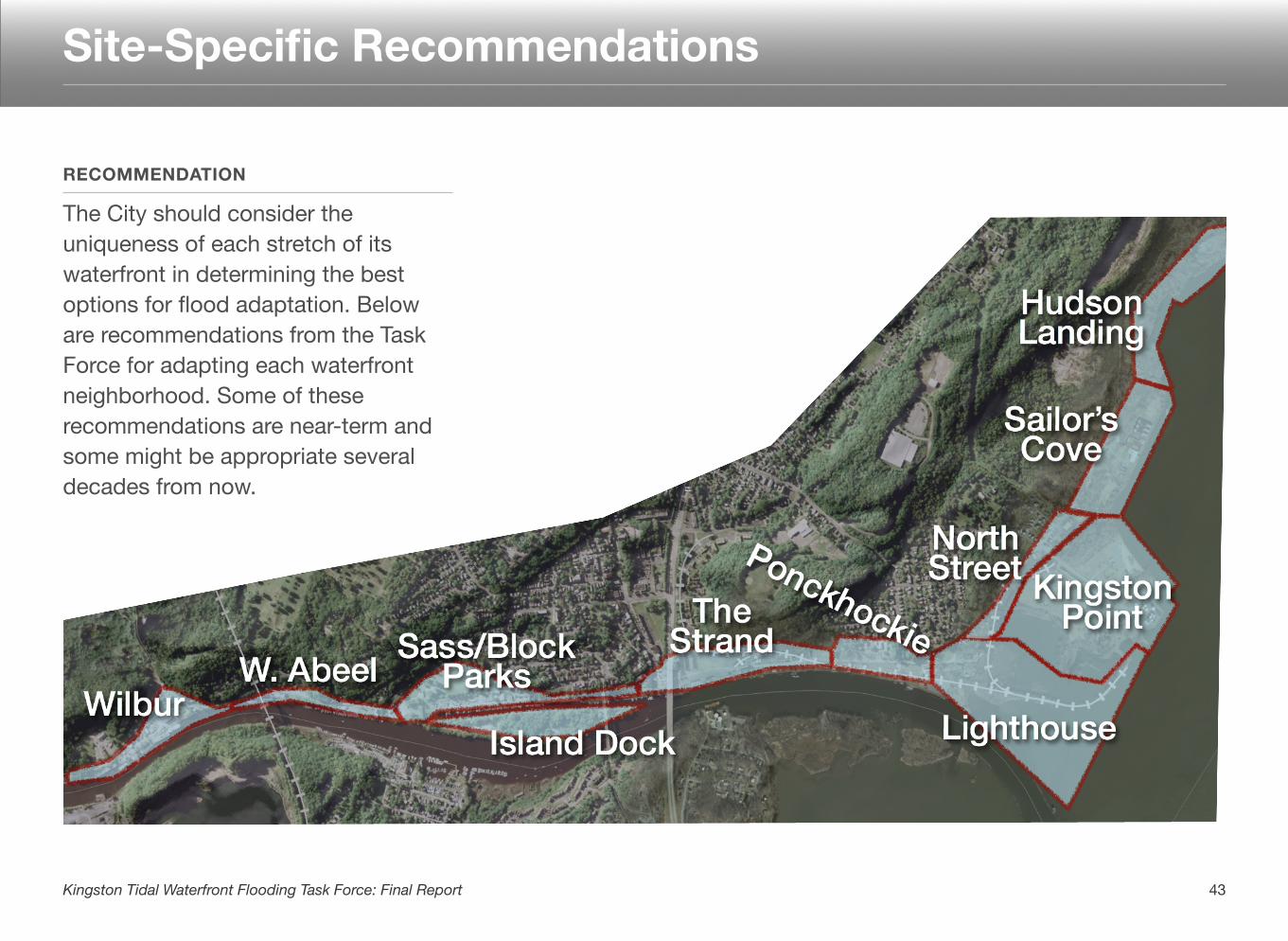
RECOMMENDATION
The City should consider the uniqueness of each stretch of its waterfront in determining the best options for flood adaptation. Below are recommendations from the Task Force for adapting each waterfront neighborhood. Some of these recommendations are near-term and some might be appropriate several decades from now.
43Kingston Tidal Waterfront Flooding Task Force: Final Report
Site-Specific Recommendations
Wilbur
‣ Route 213 may need to be elevated or re-engineered and may need additional planning to ensure access and egress for residents during high-water events.
‣ Several existing residential and commercial structures need to be made flood-resilient or flood-proof.
West Abeel
‣ Consider elevating or re-engineering the roadway, or other measures to ensure access and egress for residents during high-water events.
‣ Consider working with property owners to explore options and feasibilities for constructing resilient waterfront wharf or pier structures to enable continued waterfront use, not berms or shoreline hardening.
Sass/Block Parks
‣ Develop a plan for the adaptation of waterfront parks to maintain uses as water levels rise.
‣ Ensure that the harbor and its use are continued as one of the most storm-secure deep-water harbors on the Hudson River.
‣ Evaluate whether the channel adjacent to Block Park must be dredged to allow continued use for marinas. Consider enabling water flow through channel.
‣ Consider alternatives to the use of berms or hardened shorelines where appropriate. Evaluate potential for raised walkways along shoreline.
‣ Consider elevating or re-engineering Abeel Street, or taking other measures to ensure access and egress for residents during high-water events.
‣ Develop strategies to assist property owners in making existing residential and commercial structures flood-resilient or flood-proof in the near term.
Island Dock
‣ Evaluate whether it is desirable to use this area as a protective waterfront buffer. Conduct a cost-benefit analysis to determine whether remediation and fortification of the island is a feasible alternative over the long term.
The Strand
‣ Maintain the Strand as a “water-oriented zone” that preserves the historic connection of Kingston to the waterfront, including water-dependent uses, maintaining historic and cultural resources and public access to the Rondout.
44Kingston Waterfront Tidal Flooding Task Force: Final Report
‣ Consider fitting the municipal stormwater system with backflow restrictors in this area in the near term so that water from the Rondout cannot flood the Strand roadway during high-tide events.
‣ Develop strategies to assist property owners to make existing residential and commercial structures flood-resilient or flood-proof in the near term.
‣ Investigate the potential for relocating the East Strand northward to higher ground and/or constructing wharf or pier structures to enable continued waterfront uses and development.
‣ The City should develop a phased plan for making structures and infrastructure safer now, and mapping a path to a resilient Strand waterfront over coming decades. The City should not make investments or facilitate development that is not responsive to a long-term plan for the Strand.
Ponckhockie
‣ Develop strategies to assist property owners in making existing residential and commercial structures flood-resilient or flood-proof in the near term.
‣ Consider fitting the municipal stormwater system with backflow restrictors in this area in the near term so that water from the Rondout does not flood the Strand roadway during high-tide events.
‣ Investigate the potential for relocating the East Strand roadway northward to higher ground and/or constructing wharf or pier structures to enable continued waterfront uses and development.
‣ Ensure that long term plans for Ponckhockie are consistent with any long -term plans for the Strand.
Lighthouse
‣ Consider elevating East Strand and North Street to maintain connections to Kingston Point and beyond.
‣ Evaluate potential for a developing a public greenway here.
‣ Work with the Trolley Museum to develop a long-term strategy for elevating or relocating the railway.
‣ Consider flood and inundation risk to brownfields and any remediation efforts in this area.
North Street
‣ Consider elevating East Strand and North Street to maintain connections to Kingston Point and beyond.
‣ Evaluate the potential for developing a public greenway here.
‣ Work with the Trolley Museum to develop a long-term strategy for elevating or relocating the railway.
45Kingston Waterfront Tidal Flooding Task Force: Final Report
‣ Examine the feasibility of voluntary relocation or buyouts for residents here, both to reduce future flood impacts and to facilitate the creation of a public greenway or relocation of the trolley railway.
Kingston Point
‣ Develop a phased plan for long-term transformation of the Kingston Point Park area as water levels rise that ensures continued recreational use and boat access, includes a long-term plan for existing energy infrastructure, and includes provisions for wetland expansion over time.
‣ Consider elevating East Strand and North Street to maintain connections to Kingston Point and beyond and potentially integrate that project into a shoreline elevation effort to protect the North Street neighborhood.
Sailor’s Cove and Hudson Landing
‣ Ensure that development designs and building standards are consistent with future sea-level rise and flooding scenarios.
‣ Encourage development patterns away from the river’s edge in order to maintain a public greenway or promenade.
46Kingston Waterfront Tidal Flooding Task Force: Final Report
F. Appendices
I. Participants
II. Recommendations by Category
III. Glossary
IV. Resources
V. Adaptation Strategies
VI. Supplemental Materials
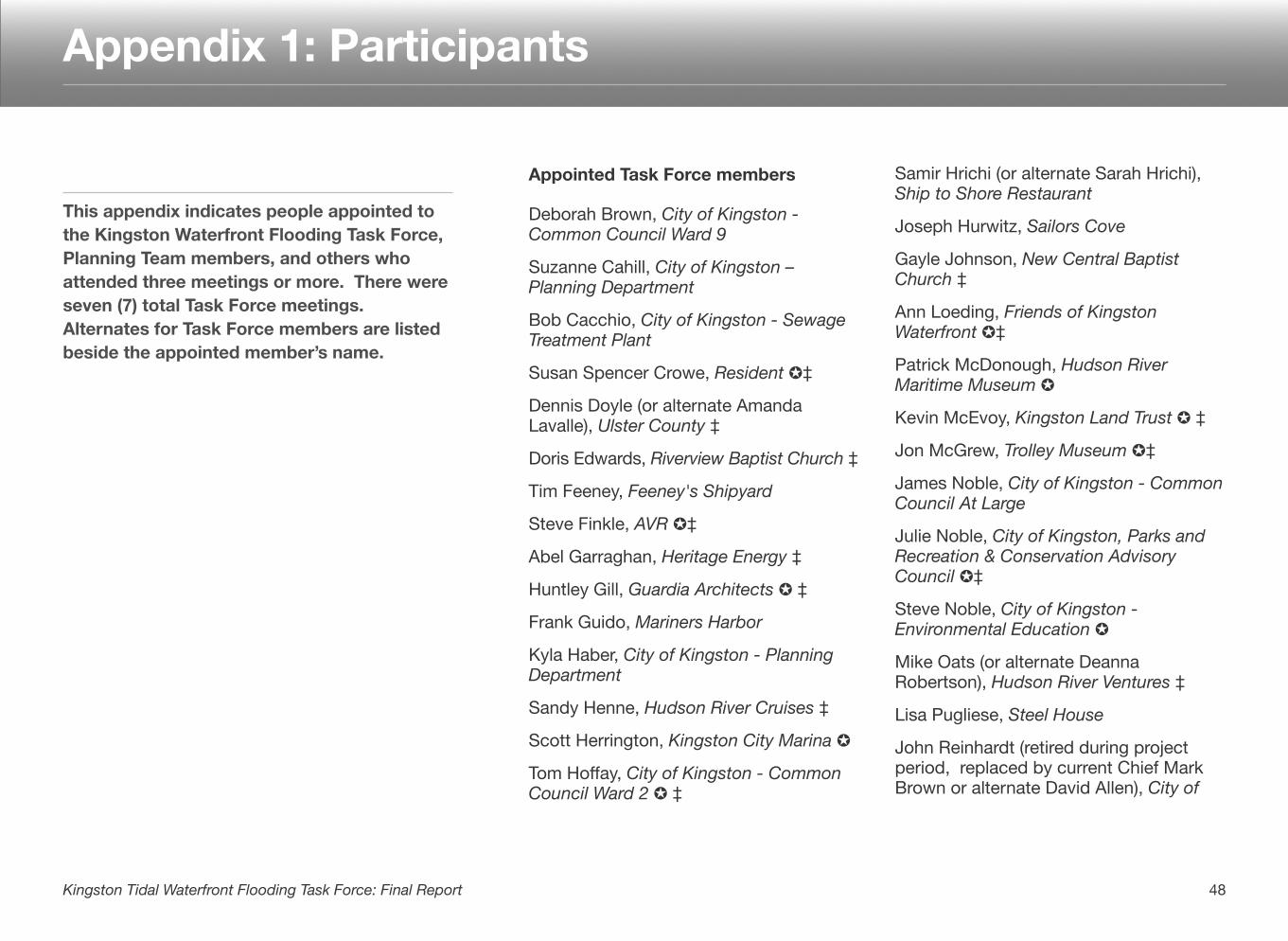
Appointed Task Force members
Deborah Brown, City of Kingston - Common Council Ward 9
Suzanne Cahill, City of Kingston – Planning Department
Bob Cacchio, City of Kingston - Sewage Treatment Plant
Susan Spencer Crowe, Resident ✪‡
Dennis Doyle (or alternate Amanda Lavalle), Ulster County ‡
Doris Edwards, Riverview Baptist Church ‡
Tim Feeney, Feeney's Shipyard
Steve Finkle, AVR ✪‡
Abel Garraghan, Heritage Energy ‡
Huntley Gill, Guardia Architects ✪ ‡
Frank Guido, Mariners Harbor
Kyla Haber, City of Kingston - Planning Department
Sandy Henne, Hudson River Cruises ‡
Scott Herrington, Kingston City Marina ✪
Tom Hoffay, City of Kingston - Common Council Ward 2 ✪ ‡
Samir Hrichi (or alternate Sarah Hrichi), Ship to Shore Restaurant
Joseph Hurwitz, Sailors Cove
Gayle Johnson, New Central Baptist Church ‡
Ann Loeding, Friends of Kingston Waterfront ✪‡
Patrick McDonough, Hudson River Maritime Museum ✪
Kevin McEvoy, Kingston Land Trust ✪ ‡
Jon McGrew, Trolley Museum ✪‡
James Noble, City of Kingston - Common Council At Large
Julie Noble, City of Kingston, Parks and Recreation & Conservation Advisory Council ✪‡
Steve Noble, City of Kingston - Environmental Education ✪
Mike Oats (or alternate Deanna Robertson), Hudson River Ventures ‡
Lisa Pugliese, Steel House
John Reinhardt (retired during project period, replaced by current Chief Mark Brown or alternate David Allen), City of
This appendix indicates people appointed to the Kingston Waterfront Flooding Task Force, Planning Team members, and others who attended three meetings or more. There were seven (7) total Task Force meetings. Alternates for Task Force members are listed beside the appointed member’s name.
48Kingston Tidal Waterfront Flooding Task Force: Final Report
Appendix 1: Participants
Kingston - Fire and Building Department ✪ ‡
Steve Schabot, City of Kingston - Parks and Recreation Board ✪‡
Mike Schupp, City of Kingston - Public Works
Jennifer Schwartz Berky, resident and urban planner ✪‡
Allan Shope, Clearwater ✪‡
Arthur Snyder, Ulster County Emergency Management ✪‡
Gregg Swanzey, City of Kingston - Economic Development ✪‡
Ralph Swenson, City of Kingston - City Engineer
Allen Winchell, City of Kingston - Sewage Treatment Plant
✪ Endorsed list of recommendations in this Report
‡ Attended 3 or more Task Force meetings
Planning Team Members
Suzanne Cahill, City of Kingston – Planning Department
Ona Ferguson, Consensus Building Institute
Emilie Hauser, NYSDEC Hudson River National Estuarine Research Reserve
JT Lockman, Catalysis Adaptation Partners, LLC
Mark Lowery, NYSDEC Office of Climate Change
Kristin Marcell, NYSDEC Hudson River Estuary Program / Cornell
Libby Murphy, NYSDEC Hudson River Estuary Program / Cornell
Julie Noble, City of Kingston – Parks and Recreation & Conservation Advisory Council
Barry Pendergrass, NYS Department of State
Sacha Spector, Scenic Hudson
Gregg Swanzey, City of Kingston - Economic Development
Christina Tobitsch, NYSDEC Hudson River National Estuarine Research Reserve and SCA
Others who attended at least 3 meetings
Jeff Anzevino, Scenic Hudson
Betsy Blair, NYSDEC HRNERR
Diane Dintruff, Esopus Environmental Board
Fran Dunwell, NYSDEC Hudson River Estuary Program
Jim Murac, Milone and MacBroom
David Railsback, ARCADIS
Steve Rosenberg, Scenic Hudson
Joan Williams Washington, Kingston Resident
49Kingston Waterfront Tidal Flooding Task Force: Final Report
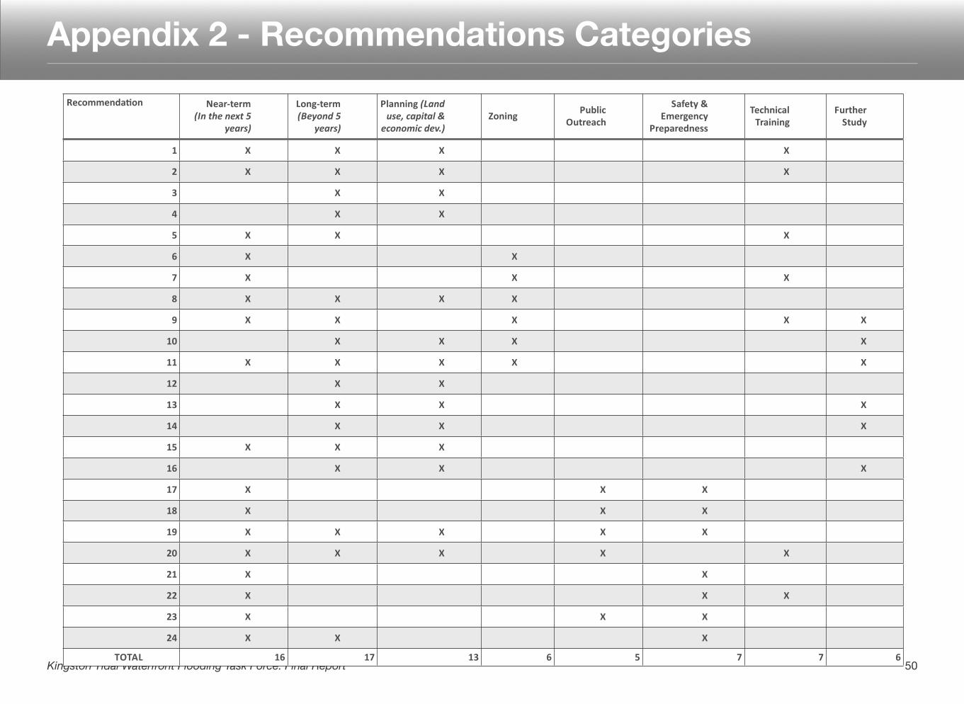
Appendix 2 - Recommendations Categories
50Kingston Tidal Waterfront Flooding Task Force: Final Report
Recommenda)on Near,term(In$the$next$5$
years)
Long,term(Beyond$5$
years)
Planning3(Land$use,$capital$&$
economic$dev.)Zoning Public3
Outreach
Safety3&3Emergency3
Preparedness
Technical3Training
Further3Study
1 X X X X
2 X X X X
3 X X
4 X X
5 X X X
6 X X
7 X X X
8 X X X X
9 X X X X X
10 X X X X
11 X X X X X
12 X X
13 X X X
14 X X X
15 X X X
16 X X X
17 X X X
18 X X X
19 X X X X X
20 X X X X X
21 X X
22 X X X
23 X X X
24 X X X
TOTAL 16 17 13 6 5 7 7 6
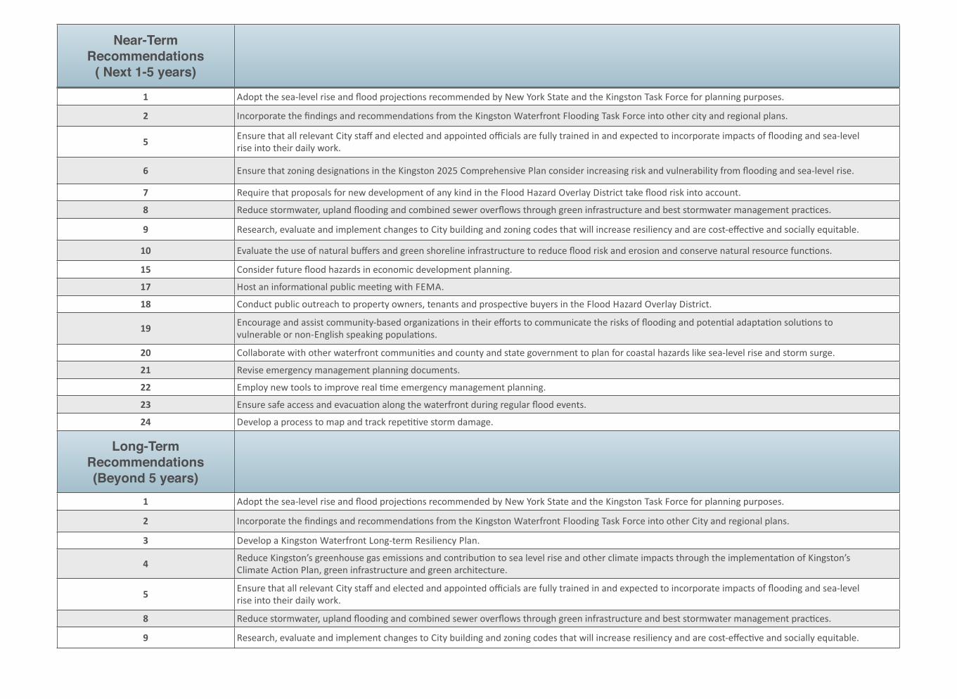
Near-Term Recommendations
( Next 1-5 years)1 Adopt,the,sea1level,rise,and,flood,projec:ons,recommended,by,New,York,State,and,the,Kingston,Task,Force,for,planning,purposes.
2 Incorporate,the,findings,and,recommenda:ons,from,the,Kingston,Waterfront,Flooding,Task,Force,into,other,city,and,regional,plans.
5 Ensure,that,all,relevant,City,staff,and,elected,and,appointed,officials,are,fully,trained,in,and,expected,to,incorporate,impacts,of,flooding,and,sea1level,rise,into,their,daily,work.
6 Ensure,that,zoning,designa:ons,in,the,Kingston,2025,Comprehensive,Plan,consider,increasing,risk,and,vulnerability,from,flooding,and,sea1level,rise.
7 Require,that,proposals,for,new,development,of,any,kind,in,the,Flood,Hazard,Overlay,District,take,flood,risk,into,account.
8 Reduce,stormwater,,upland,flooding,and,combined,sewer,overflows,through,green,infrastructure,and,best,stormwater,management,prac:ces.
9 Research,,evaluate,and,implement,changes,to,City,building,and,zoning,codes,that,will,increase,resiliency,and,are,cost1effec:ve,and,socially,equitable.
10 Evaluate,the,use,of,natural,buffers,and,green,shoreline,infrastructure,to,reduce,flood,risk,and,erosion,and,conserve,natural,resource,func:ons.
15 Consider,future,flood,hazards,in,economic,development,planning.
17 Host,an,informa:onal,public,mee:ng,with,FEMA.
18 Conduct,public,outreach,to,property,owners,,tenants,and,prospec:ve,buyers,in,the,Flood,Hazard,Overlay,District.
19 Encourage,and,assist,community1based,organiza:ons,in,their,efforts,to,communicate,the,risks,of,flooding,and,poten:al,adapta:on,solu:ons,to,vulnerable,or,non1English,speaking,popula:ons.
20 Collaborate,with,other,waterfront,communi:es,and,county,and,state,government,to,plan,for,coastal,hazards,like,sea1level,rise,and,storm,surge.
21 Revise,emergency,management,planning,documents.
22 Employ,new,tools,to,improve,real,:me,emergency,management,planning.
23 Ensure,safe,access,and,evacua:on,along,the,waterfront,during,regular,flood,events.
24 Develop,a,process,to,map,and,track,repe::ve,storm,damage.
Long-Term Recommendations (Beyond 5 years)
1 Adopt,the,sea1level,rise,and,flood,projec:ons,recommended,by,New,York,State,and,the,Kingston,Task,Force,for,planning,purposes.
2 Incorporate,the,findings,and,recommenda:ons,from,the,Kingston,Waterfront,Flooding,Task,Force,into,other,City,and,regional,plans.
3 Develop,a,Kingston,Waterfront,Long1term,Resiliency,Plan.,
4 Reduce,Kingston’s,greenhouse,gas,emissions,and,contribu:on,to,sea,level,rise,and,other,climate,impacts,through,the,implementa:on,of,Kingston’s,Climate,Ac:on,Plan,,green,infrastructure,and,green,architecture.
5 Ensure,that,all,relevant,City,staff,and,elected,and,appointed,officials,are,fully,trained,in,and,expected,to,incorporate,impacts,of,flooding,and,sea1level,rise,into,their,daily,work.
8 Reduce,stormwater,,upland,flooding,and,combined,sewer,overflows,through,green,infrastructure,and,best,stormwater,management,prac:ces.
9 Research,,evaluate,and,implement,changes,to,City,building,and,zoning,codes,that,will,increase,resiliency,and,are,cost1effec:ve,and,socially,equitable.
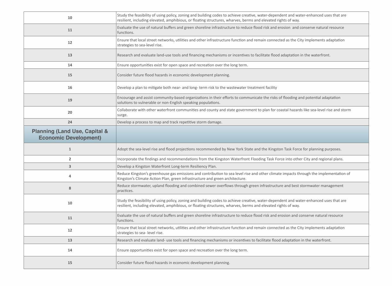
10 Study,the,feasibility,of,using,policy,,zoning,and,building,codes,to,achieve,crea:ve,,water1dependent,and,water1enhanced,uses,that,are,resilient,,including,elevated,,amphibious,,or,floa:ng,structures,,wharves,,berms,and,elevated,rights,of,way.
11 Evaluate,the,use,of,natural,buffers,and,green,shoreline,infrastructure,to,reduce,flood,risk,and,erosion,,and,conserve,natural,resource,func:ons.
12 Ensure,that,local,street,networks,,u:li:es,and,other,infrastructure,func:on,and,remain,connected,as,the,City,implements,adapta:on,strategies,to,sea1level,rise.
13 Research,and,evaluate,land1use,tools,and,financing,mechanisms,or,incen:ves,to,facilitate,flood,adapta:on,in,the,waterfront.,
14 Ensure,opportuni:es,exist,for,open,space,and,recrea:on,over,the,long,term.
15 Consider,future,flood,hazards,in,economic,development,planning.
16 Develop,a,plan,to,mi:gate,both,near1,and,long1,term,risk,to,the,wastewater,treatment,facility
19 Encourage,and,assist,community1based,organiza:ons,in,their,efforts,to,communicate,the,risks,of,flooding,and,poten:al,adapta:on,solu:ons,to,vulnerable,or,non1English,speaking,popula:ons.
20 Collaborate,with,other,waterfront,communi:es,and,county,and,state,government,to,plan,for,coastal,hazards,like,sea1level,rise,and,storm,surge.
24 Develop,a,process,to,map,and,track,repe::ve,storm,damage.
Planning (Land Use, Capital & Economic Development)!
1 Adopt,the,sea1level,rise,and,flood,projec:ons,recommended,by,New,York,State,and,the,Kingston,Task,Force,for,planning,purposes.
2 Incorporate,the,findings,and,recommenda:ons,from,the,Kingston,Waterfront,Flooding,Task,Force,into,other,City,and,regional,plans.
3 Develop,a,Kingston,Waterfront,Long1term,Resiliency,Plan.,
4 Reduce,Kingston’s,greenhouse,gas,emissions,and,contribu:on,to,sea,level,rise,and,other,climate,impacts,through,the,implementa:on,of,Kingston’s,Climate,Ac:on,Plan,,green,infrastructure,and,green,architecture.
8 Reduce,stormwater,,upland,flooding,and,combined,sewer,overflows,through,green,infrastructure,and,best,stormwater,management,prac:ces.
10 Study,the,feasibility,of,using,policy,,zoning,and,building,codes,to,achieve,crea:ve,,water1dependent,and,water1enhanced,uses,that,are,resilient,,including,elevated,,amphibious,,or,floa:ng,structures,,wharves,,berms,and,elevated,rights,of,way.
11 Evaluate,the,use,of,natural,buffers,and,green,shoreline,infrastructure,to,reduce,flood,risk,and,erosion,and,conserve,natural,resource,func:ons.
12 Ensure,that,local,street,networks,,u:li:es,and,other,infrastructure,func:on,and,remain,connected,as,the,City,implements,adapta:on,strategies,to,sea1,level,rise.
13 Research,and,evaluate,land1,use,tools,and,financing,mechanisms,or,incen:ves,to,facilitate,flood,adapta:on,in,the,waterfront.,
14 Ensure,opportuni:es,exist,for,open,space,and,recrea:on,over,the,long,term.
15 Consider,future,flood,hazards,in,economic,development,planning.
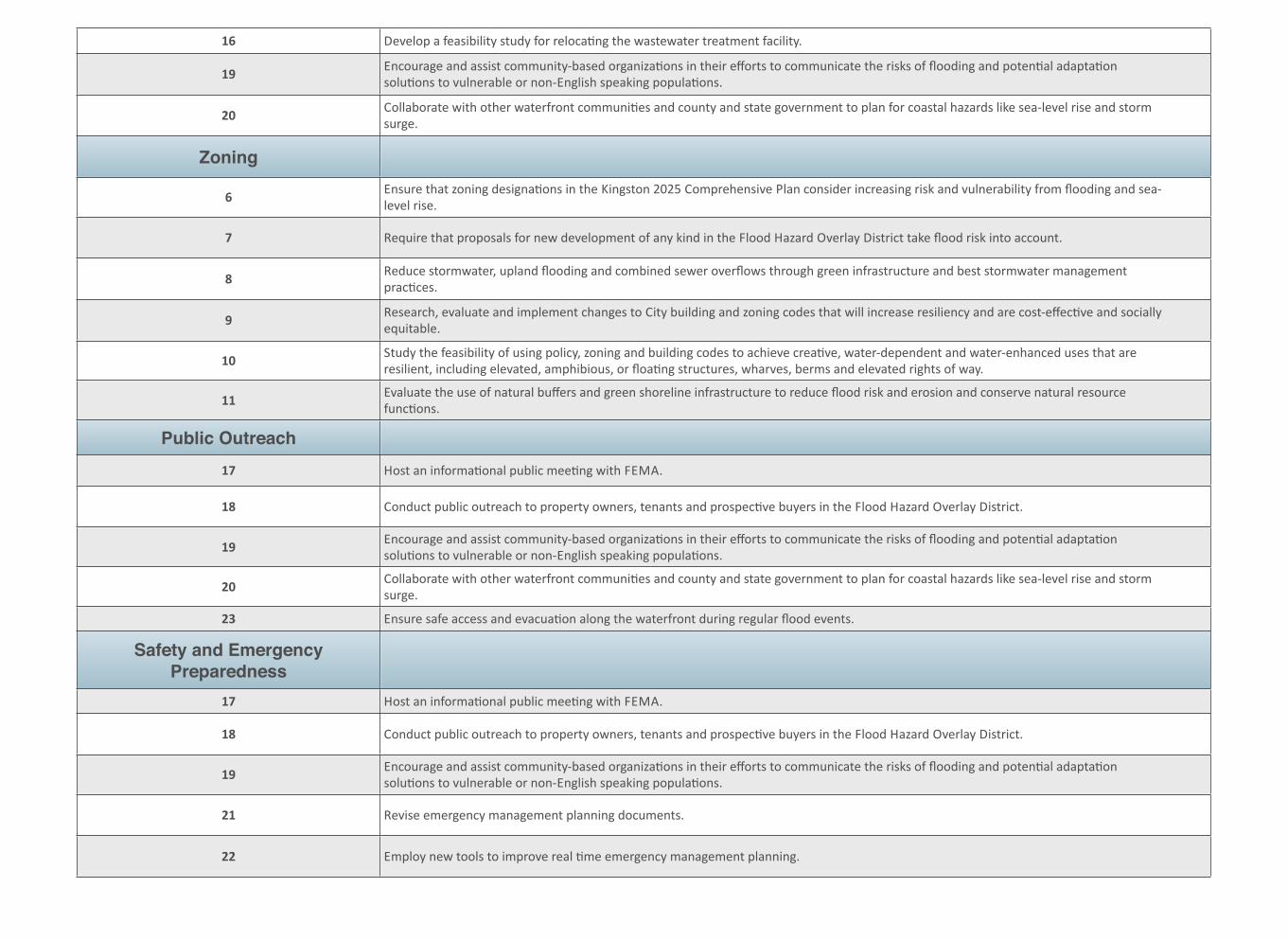
16 Develop,a,feasibility,study,for,reloca:ng,the,wastewater,treatment,facility.,
19 Encourage,and,assist,community1based,organiza:ons,in,their,efforts,to,communicate,the,risks,of,flooding,and,poten:al,adapta:on,solu:ons,to,vulnerable,or,non1English,speaking,popula:ons.
20 Collaborate,with,other,waterfront,communi:es,and,county,and,state,government,to,plan,for,coastal,hazards,like,sea1level,rise,and,storm,surge.
Zoning
6 Ensure,that,zoning,designa:ons,in,the,Kingston,2025,Comprehensive,Plan,consider,increasing,risk,and,vulnerability,from,flooding,and,sea1level,rise.
7 Require,that,proposals,for,new,development,of,any,kind,in,the,Flood,Hazard,Overlay,District,take,flood,risk,into,account.
8 Reduce,stormwater,,upland,flooding,and,combined,sewer,overflows,through,green,infrastructure,and,best,stormwater,management,prac:ces.
9 Research,,evaluate,and,implement,changes,to,City,building,and,zoning,codes,that,will,increase,resiliency,and,are,cost1effec:ve,and,socially,equitable.
10 Study,the,feasibility,of,using,policy,,zoning,and,building,codes,to,achieve,crea:ve,,water1dependent,and,water1enhanced,uses,that,are,resilient,,including,elevated,,amphibious,,or,floa:ng,structures,,wharves,,berms,and,elevated,rights,of,way.
11 Evaluate,the,use,of,natural,buffers,and,green,shoreline,infrastructure,to,reduce,flood,risk,and,erosion,and,conserve,natural,resource,func:ons.
Public Outreach17 Host,an,informa:onal,public,mee:ng,with,FEMA.
18 Conduct,public,outreach,to,property,owners,,tenants,and,prospec:ve,buyers,in,the,Flood,Hazard,Overlay,District.
19 Encourage,and,assist,community1based,organiza:ons,in,their,efforts,to,communicate,the,risks,of,flooding,and,poten:al,adapta:on,solu:ons,to,vulnerable,or,non1English,speaking,popula:ons.
20 Collaborate,with,other,waterfront,communi:es,and,county,and,state,government,to,plan,for,coastal,hazards,like,sea1level,rise,and,storm,surge.
23 Ensure,safe,access,and,evacua:on,along,the,waterfront,during,regular,flood,events.
Safety and Emergency Preparedness
17 Host,an,informa:onal,public,mee:ng,with,FEMA.
18 Conduct,public,outreach,to,property,owners,,tenants,and,prospec:ve,buyers,in,the,Flood,Hazard,Overlay,District.
19 Encourage,and,assist,community1based,organiza:ons,in,their,efforts,to,communicate,the,risks,of,flooding,and,poten:al,adapta:on,solu:ons,to,vulnerable,or,non1English,speaking,popula:ons.
21 Revise,emergency,management,planning,documents.,
22 Employ,new,tools,to,improve,real,:me,emergency,management,planning.
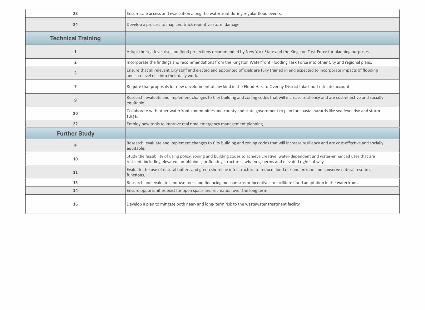
23 Ensure,safe,access,and,evacua:on,along,the,waterfront,during,regular,flood,events.
24 Develop,a,process,to,map,and,track,repe::ve,storm,damage.
Technical Training
1 Adopt,the,sea1level,rise,and,flood,projec:ons,recommended,by,New,York,State,and,the,Kingston,Task,Force,for,planning,purposes.
2 Incorporate,the,findings,and,recommenda:ons,from,the,Kingston,Waterfront,Flooding,Task,Force,into,other,City,and,regional,plans.
5 Ensure,that,all,relevant,City,staff,and,elected,and,appointed,officials,are,fully,trained,in,and,expected,to,incorporate,impacts,of,flooding,and,sea1level,rise,into,their,daily,work.
7 Require,that,proposals,for,new,development,of,any,kind,in,the,Flood,Hazard,Overlay,District,take,flood,risk,into,account.
9 Research,,evaluate,and,implement,changes,to,City,building,and,zoning,codes,that,will,increase,resiliency,and,are,cost1effec:ve,and,socially,equitable.
20 Collaborate,with,other,waterfront,communi:es,and,county,and,state,government,to,plan,for,coastal,hazards,like,sea1level,rise,and,storm,surge.
22 Employ,new,tools,to,improve,real,:me,emergency,management,planning.
Further Study
9 Research,,evaluate,and,implement,changes,to,City,building,and,zoning,codes,that,will,increase,resiliency,and,are,cost1effec:ve,and,socially,equitable.
10 Study,the,feasibility,of,using,policy,,zoning,and,building,codes,to,achieve,crea:ve,,water1dependent,and,water1enhanced,uses,that,are,resilient,,including,elevated,,amphibious,,or,floa:ng,structures,,wharves,,berms,and,elevated,rights,of,way.
11 Evaluate,the,use,of,natural,buffers,and,green,shoreline,infrastructure,to,reduce,flood,risk,and,erosion,and,conserve,natural,resource,func:ons.
13 Research,and,evaluate,land1use,tools,and,financing,mechanisms,or,incen:ves,to,facilitate,flood,adapta:on,in,the,waterfront.,
14 Ensure,opportuni:es,exist,for,open,space,and,recrea:on,over,the,long,term.
16 Develop,a,plan,to,mi:gate,both,near1,and,long1,term,risk,to,the,wastewater,treatment,facility
Accommodation, the use of strategies that allow the continued use of vulnerable lands, but that do not attempt to prevent flooding or inundation with shoreline flooding protection.
Adaptation, adjustment in natural or human systems in response to actual or expected climatic stimuli or their effects, which moderates harm or exploits beneficial opportunities.
Base flood, the flood that has a one percent chance of being equaled or exceed in any given year, also known as the "one-percent" or "100-year flood.
Base flood elevation, the computed elevation to which floodwater is anticipated to rise during the base flood, shown on flood insurance rate maps.
CEMP, comprehensive emergency management plan.
Climate Smart Planning, a planning evaluation tool for New York State communities.
Community Rating System, a voluntary incentive program of the National Flood Insurance Program (NFIP) that encourages communities to adopt floodplain management activities that exceed the NFIP requirements.
Conservation Easement, a power invested in a qualified private land conservation organization (often called a "land trust") or government (municipal, county, state or federal) to constrain, as to a specified land
area, the exercise of rights otherwise held by a landowner so as to achieve certain conservation purposes.
DEM, digital elevation model, a digital or 3-dimensional representation of a terrain's surface.
FEMA, Federal Emergency Management Agency.
Fortification, traditional coastal hardening techniques such as seawalls, and beach nourishment that attempt to maintain a static shoreline position.
FIRM, flood insurance rate maps, official map of a community on which FEMA has delineated both the special hazard areas and the risk premium zones applicable to the community.
FIS, flood insurance study (survey), A flood insurance survey is a compilation and presentation of flood risk data within a community. When a flood study is completed, the information and maps are assembled into an flood insurance study report, which contains detailed flood elevation data in flood profiles and data tables.
Freeboard, a factor of safety usually expressed in feet above a flood level for purposes of floodplain management.
GIS, geographic information system, a system designed to capture, store, manipulate, analyze, manage, and present all types of geographical data.
Appendix 3 - Glossary
55Kingston Tidal Waterfront Flooding Task Force: Final Report
Hazard, a dangerous phenomenon or condition that may cause loss of life, injury or other health impacts, property damage, loss of livelihoods and services, social and economic disruption, or environmental damage.
LiDAR, light detecting and ranging radar, a remote sensing technology used to make high-resolution maps.
MHHW, mean higher high water, the average of the higher high water height of each tidal day.
NFIP, National Flood Insurance Program.
NYHOPS, New York Harbor Observing and Prediction System, a model operated by the Stevens Institute to provide ocean and weather information for the Port of New York and New Jersey.
NYSDEC, New York State Department of Environmental Conservation.
NYSDOS, New York State Department of State.
Relocation, moving development out of harm’s way in a planned and controlled manner using techniques such as abandonment, relocation, avoidance.
Resilience (also Resiliency), the capacity of an individual, community, or institution to dynamically and effectively respond to shifting climate impact circumstances while continuing to function and prosper.
Risk assessment, a process to analyze both the probability of an event and the consequences.
Rolling Easement, a special type of easement placed along the shoreline to prevent property owners from holding back the sea but allowing any other type of use and activity on the land. As the sea advances, the easement automatically moves or "rolls" landward, and tidal lands become public.
SLR, sea-level rise, an increase in the mean level of the ocean.
Special Flood Hazard Area, the land area covered by the floodwaters of the base flood, as designated on NFIP maps.
USGS, United State Geoglogical Survey.
Vulnerability, the degree to which a system is susceptible to, and unable to cope with, adverse effects of climate change, including climate variability and extremes, or susceptible attribute or resource.
56Kingston Tidal Waterfront Flooding Task Force: Final Report
City of Kingston Studies and Plans
City of Kingston Climate Action Plan and 2010 Community-Wide & Local Government Operations Energy and Greenhouse Gas Emissions Inventory, published by the City of Kingston, NY (2012). http://kingstoncac.org/index.php/climate-action-plan
City of Kingston Local Waterfront Revitalization Program (LWRP), prepared by the City of Kingston Common Council (1992). http://docs.dos.ny.gov/communitieswaterfronts/LWRP/Kingston_C/Original/City%20of%20Kingston%201992.pdf
Oil Storage Facilities Study, Kingston, NY, prepared by Daniel Shuster, Olko Engineering, and Raymond, Parish, Pine & Weiner, Inc. (1981). (An analysis of the feasibility of relocating and/or consolidating existing oil storage and distribution facilities in order to recapture valuable waterfront property.) http://www.gpo.gov/fdsys/pkg/CZIC-tp692-5-s58-1982/pdf/CZIC-tp692-5-s58-1982.pdf
Waterfront Brownfield Opportunity Area Step 2 Nomination (August 19, 2010). http://www.kingston-ny.gov/filestorage/76/78/82/6765/boa_step_2_final_narrative.pdf
Municipal Climate Change Action and Adaptation Plans
Preparing for Climate Change in Groton, Connecticut: A Model for Communities in the Northeast (2011) http://www.icleiusa.org/library/documents/ICLEI_Final_Report_Groton_Coastal_Climate_Change_ProjectJP.pdf
State of New York Action Plan for Community Development Block Grant Program Disaster Recovery, prepared by New York State Homes and Community Renewal, Office of Community Renewal (April 2013). http://www.ny.gov/assets/documents/CDBGActionPlan.pdf
RESOURCES LIST
The following resources were either used or referred to during the Kingston Waterfront Flooding Task Force’s work.
57Kingston Tidal Waterfront Flooding Task Force: Final Report
Appendix 4 - Resources
Resilient and Adaptive Waterfront Strategies
Coastal Climate Resilience, Urban Waterfront Adaptive Strategies, prepared by New York City Department of City Planning (June 2013). http://www.nyc.gov/html/dcp/pdf/sustainable_communities/urban_waterfront_print.pdf
Coastal No Adverse Impact Handbook, Chapter 5: Mitigation. (May 2007). http://www.floods.org/NoAdverseImpact/CNAI_Handbook/CNAI_Handbook_Chapter5.pdf
Georgetown Climate Center Adaptation Tool Kit: Sea-Level Rise and Coastal Land Use, How Governments Can Use Land-Use Practices to Adapt to Sea-Level Rise, by Jessica Grannis (October 2011). http://www.georgetownclimate.org/resources/adaptation-tool-kit-sea-level-rise-and-coastal-land-use
Incorporating Sea Level Change Scenarios at the Local Level published by NOAA (2012). http://www.csc.noaa.gov/digitalcoast/_/pdf/slcscenarios.pdf
Planning and Building Livable, Safe, & Sustainable Communities: The Patchwork Quilt Approach by Edward A. Thomas and others, published by The Natural Hazard Mitigation Association (Updated June 8, 2011). http://stormsmart.org/uploads/patchwork-quilt/patchwork_quilt.pdf
Revitalizing Hudson Riverfronts: Illustrated Conservation & Development Strategies for Creating Healthy, Prosperous Communities. Eisenman, R. J. Anzevino, S. Rosenberg, and S.Spector (eds.), published by Scenic Hudson, Inc. (2010). http://www.scenichudson.org/ourwork/riverfrontcommunities/publications
Flooding and Stormwater Management, Flood Maps, and Flood Insurance
City of Kingston Zoning Code, Flood Hazard Overlay District § 405-26. http://ecode360.com/6727255#6727947
East Strand Flooding and Stormwater Management Analysis Draft, prepared by Milone and MacBroom, Inc., for the City of Kingston (April 5, 2013).http://www.kingston-ny.gov/filestorage/76/6654/6656/East_Strand_Street_Flooding_and_Stormwater_Management_Analysis_DRAFT_M%26M.pdf
FEMA Brochure on Flood Insurance Changes: Build Back Stronger- What you need to know. http://www.fema.gov/library/viewRecord.do?id=6712
FEMA Map Services Center. https://msc.fema.gov/webapp/wcs/stores/servlet/FemaWelcomeView?storeId=10001&catalogId=10001&langId=-1&userType=G
58Kingston Waterfront Tidal Flooding Task Force: Final Report
Rebuilding After Sandy, but With Costly New Rules by Tara Siegel Bernard, published by the New York Times (May 10, 2013). http://www.nytimes.com/2013/05/11/your-money/after-hurricane-sandy-rebuilding-under-higher-flood-insurance.html?smid=pl-share
Scenic Hudson Sea Level Rise Mapper. http://www.scenichudson.org/slr/mapper
New York Climate Change Reports and Resources
New York State 2100 Commission (2013) Recommendations to Improve the Strength and Resilience of the Empire State’s Infrastructure. http://www.rockefellerfoundation.org/blog/nys-2100-commission-report-building
ClimAID-Response to Climate Change in New York State (2011). http://www.nyserda.ny.gov/climaid
New York State Sea Level Rise Task Force Report (2010). http://www.dec.ny.gov/docs/administration_pdf/slrtffinalrep.pdf
New York State Climate Action Plan Interim Report(2011). http://www.dec.ny.gov/energy/80930.html
NYSDEC Climate Change, New Yorkers are Working on Many Fronts. http://www.dec.ny.gov/energy/44992.html
NYSDEC Hudson River Estuary Program & Climate Change. http://www.dec.ny.gov/lands/39786.html
Hudson River Sustainable Shorelines Project. http://www.hrnerr.org/hudson-river-sustainable-shorelines
Webinars
Using Floodplain Regulations to Help Communities Prepare for Climate Change. December 6, 2012. Georgetown Climate Center. http://www.georgetownclimate.org/floodplain-regulations
Bridging the Gap between Hazard Mitigation and Climate Adaptation December 18, 2012. Center for Clean Air Policy and the Natural Hazard Mitigation Association. http://ccap.org/event/bridging-the-gap-between-hazard-mitigation-and-climate-adaptation-webinar/
http://ccap.org/event/bridging-the-gap-between-hazard-mitigation-and-climate-adaptation-webinar/National Flood Insurance Program's Community Rating System: Overview, Determining CRS Eligibility and What CRS Could Mean for NYS Coastal Communities. June 6, 2013. New York State Climate Smart Communities program. http://www.dec.ny.gov/energy/84359.html
59Kingston Waterfront Tidal Flooding Task Force: Final Report
COAST: COastal Adaptation to Sea level rise Tool
Summary of COAST. http://catalysisadaptationpartners.com/uploads/3/1/4/8/3148042/coast_summary_111012.pdf
About the organization. http://catalysisadaptationpartners.com/index.html
Examples of previous COAST applications.
Merrill, S., P. Kirshen, D. Yakovleff, S. Lloyd, C. Keeley, and B. Hill. 2012. COAST in Action: 2012 Projects from New Hampshire and Maine. New England Environmental Finance Center. Series Report #12-05. Portland, Maine. http://catalysisadaptationpartners.com/uploads/3/1/4/8/3148042/cre_coast_final_report.pdf
Merrill, S., D. Yakovleff, S., Holman, D. Cooper, J., and P. Kirshen (2010) Valuing Mitigation Strategies: A GIS-based approach for climate adaptation analysis, Arc Users. http://www.esri.com/news/arcuser/1010/files/coast.pdf
60Kingston Waterfront Tidal Flooding Task Force: Final Report
Fortify
Adaptation options that “fortify” use hard or soft structures to prevent flood waters from reaching community assets. Examples of these techniques listed below. Some of these methods stabilize the shore and protect the shore from erosion, they will protect for flooding only to the extent that their height is higher than the flood level.
Hard
• Dikes, levees, floodwalls, and seawalls
• Revetments and bulkheads
• Groins,
• Detached breakwaters
• Floodgates or tidal barriers,
• Saltwater intrusion barriers,
• Dry floodproofing of buildings and infrastructure, and
• Raising existing defensive structures.
Soft or natural defenses
• Beach maintenance or nourishment,
• Dune preservation and building, and
• Wetland preservation and creation.
FLOODING ADAPTATION APPROACHES
Communities have many options for adapting to flooding at a specific site or along a reach of waterfront. These actions are categorized as do nothing, fortify, accommodate, and strategic relocation. The latter three are discussed below. The community can consider the risks, vulnerabilities, utility for protecting against flooding or inundation and other pros and cons of each option and what best fits community priorities. The following is a brief overview of some possible examples of flood adaptation approached.
61Kingston Tidal Waterfront Flooding Task Force: Final Report
Climate Adaptation Strategies
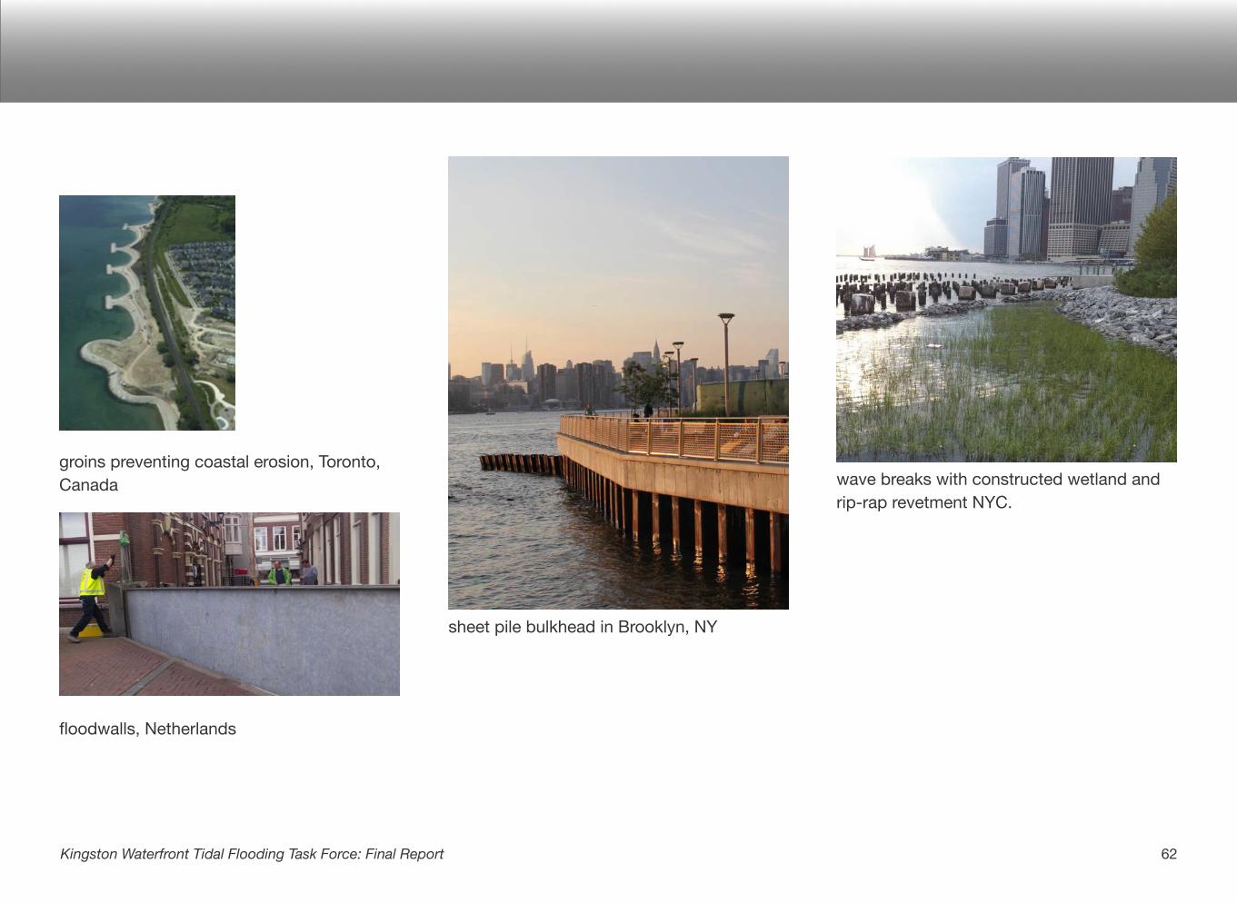
groins preventing coastal erosion, Toronto, Canada
floodwalls, Netherlands
sheet pile bulkhead in Brooklyn, NY
wave breaks with constructed wetland and rip-rap revetment NYC.
62Kingston Waterfront Tidal Flooding Task Force: Final Report
Pros
• May allow for continuation of current land use and development behind the barrier.
• Can be cost effective for areas with water-dependent uses, denser populations, or high value infrastructure at risk.
Cons
• Hard structures only provide protection until they fail or are overtopped
• Dramatic consequences if a barrier is overtopped.
• Likely to encourage development in high risk areas.
• Local liability of shoreline defense and its ongoing maintenance, including obtaining needed real estate.
• Will eventually fail due to design, maintenance or construction issues (ASFPM).Could limit future ability to accommodate or retreat.
• May disconnect community with the water.
• Could lose wetlands and beaches that exist between the water and hard structures.
• Hard barriers generally do not provide critical ecological functions such as provision of habitat for terrestrial and aquatic species, maintenance of water quality and protection of the surrounding riparian and intertidal environment.
• Hard structures tend to have high initial capital costs and potentially high ongoing maintenance and replacement costs.
63Kingston Waterfront Tidal Flooding Task Force: Final Report
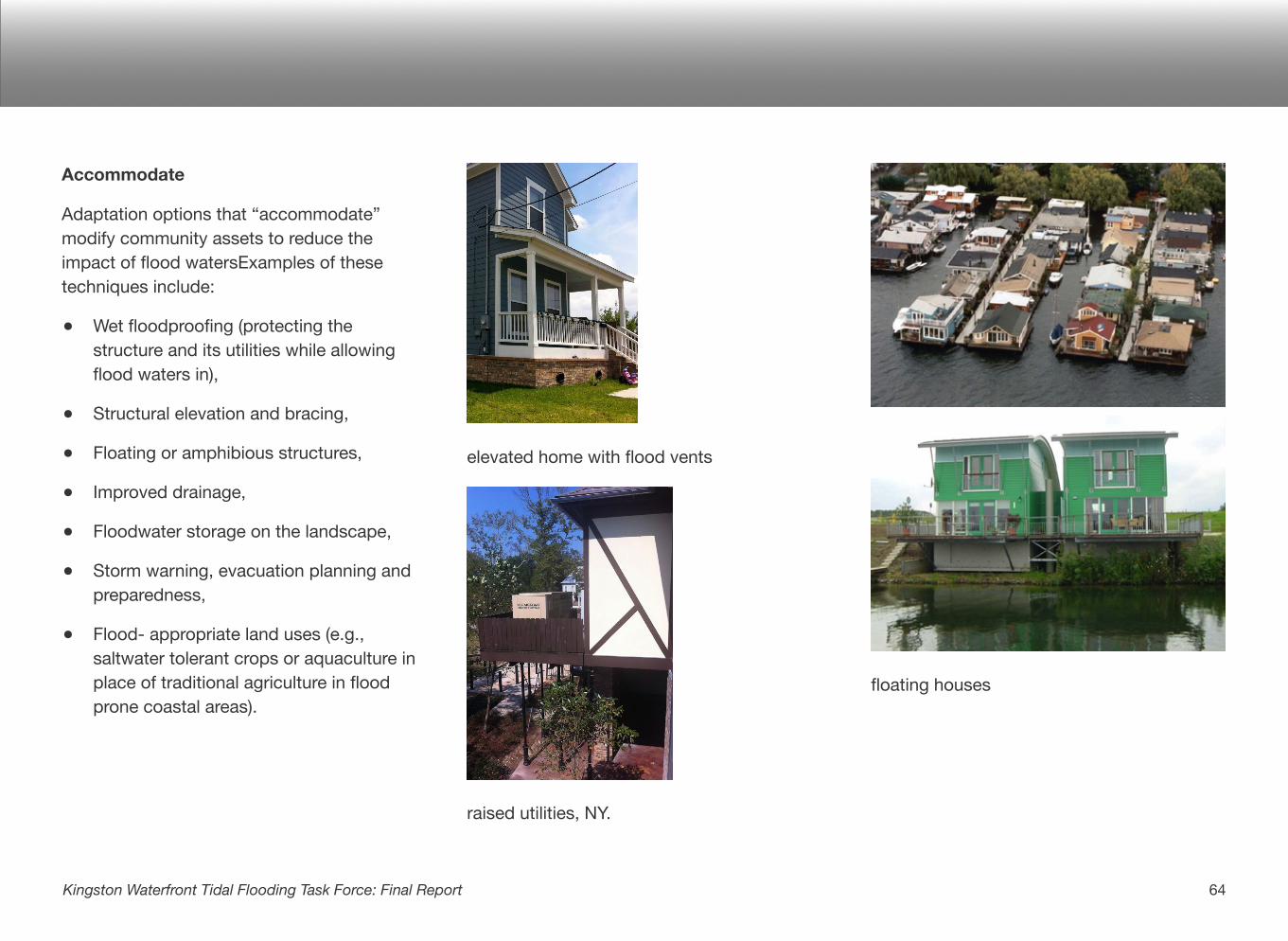
Accommodate
Adaptation options that “accommodate” modify community assets to reduce the impact of flood watersExamples of these techniques include:
• Wet floodproofing (protecting the structure and its utilities while allowing flood waters in),
• Structural elevation and bracing,
• Floating or amphibious structures,
• Improved drainage,
• Floodwater storage on the landscape,
• Storm warning, evacuation planning and preparedness,
• Flood- appropriate land uses (e.g., saltwater tolerant crops or aquaculture in place of traditional agriculture in flood prone coastal areas).
elevated home with flood vents
raised utilities, NY.
floating houses
64Kingston Waterfront Tidal Flooding Task Force: Final Report
Pros
• May allow for continuation of current land use.
• Can create new waterfront uses and opportunities.
• May allow for greater flexibility over time.
• May be more environmentally benign than some fortification measures.
Cons
• Access and activities will be limited during high water levels.
• May require a change in lifestyles
• May reduce or limit the value of existing structures
• May reduce or limit the use of existing structures
65Kingston Waterfront Tidal Flooding Task Force: Final Report
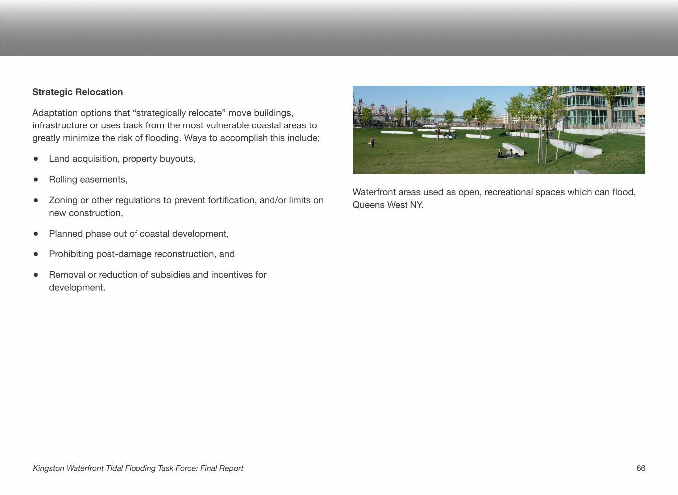
Strategic Relocation
Adaptation options that “strategically relocate” move buildings, infrastructure or uses back from the most vulnerable coastal areas to greatly minimize the risk of flooding. Ways to accomplish this include:
• Land acquisition, property buyouts,
• Rolling easements,
• Zoning or other regulations to prevent fortification, and/or limits on new construction,
• Planned phase out of coastal development,
• Prohibiting post-damage reconstruction, and
• Removal or reduction of subsidies and incentives for development.
Waterfront areas used as open, recreational spaces which can flood, Queens West NY.
66Kingston Waterfront Tidal Flooding Task Force: Final Report
Pros
• Can greatly minimize risk.
• Can be done incrementally as the sea level rises.
• Likely linked to low maintenance cost.
• Open spaces can provide economic benefit.
• Affords room for ecosystem resources to migrate and thrive as water levels rise.
Cons
• Loss of valuable waterfront land, infrastructure and tax base.
• Feasibility difficult in areas that are densely developed, have water-dependent uses and/or lack adequate land to retreat to.
• Possible loss of culturally, historically or socially important assets.
• Could be and politically challenging.
Other Options
It is possible to reduce the risk and impact of flooding on your community through a variety of other policy-related options, such as:
City operations, funding and decision-making
• Formally adopt sea level rise and flooding projections based on the latest scientific studies,
• Incorporate flooding risk into city and regional plans and planning,
• Develop a waterfront long term resiliency plan, and
• Train city staff and officials in flooding risk and tools.
Resilient structures
• Incorporate flood risk into city zoning and building code,
• Require new development to consider flood risks, and
• Mitigate flooding through green infrastructure and best stormwater management practices.
67Kingston Waterfront Tidal Flooding Task Force: Final Report
Collaboration and outreach
• Educate citizens on flood risks, changes to flood insurance and options to adapt,
• Participate, as a community in the Community Rating System of the NFIP, which helps communities can increase their resilience and lower their National Flood Insurance Plan premiums, and
• Collaborate with local and regional waterfront communities to better plan for flooding and sea level rise.
Emergency management
• Incorporate flood risk into emergency management plans and operations,
• Map and track areas of repetitive flood damage, and
• Utilize latest tools and technology (e.g., USGS stream gauges and NYHOPS model) to understand flood risk and improve real time emergency response.
Pros
• Allows community to buy time before making more significant decisions on how to adapt.
• May be more affordable than other adaptation actions.
• May be able to enact more rapidly than other adaptation actions.
• Could save residents money.
• Could provide better public safety.
Cons
• May not be sufficient as sea level rises and more frequentflooding and permanent inundation occurs.
• May reduce the sense of urgency for more intensive adaptation action.
In conclusion, there are a variety of approaches to flood adaptation for your community to consider. It is not necessary to choose one but evaluate the appropriateness of different options for different applications (residential, commercial, recreational, etc…) and scales (single site, area, or entire coastline). For more information, consult the sources listed below.
68Kingston Waterfront Tidal Flooding Task Force: Final Report
__________
Sources:
Coastal Adaptation to Sea Level Rise Tool (COAST), Catalysis Adaptation Partners
Urban Waterfront Adaptive Strategies, Coastal Climate Resilience, NYCPLANNING
Coastal Zone Management, IPCC Response Strategies Working Group Report
Adaptation options for buildings, Sutherland Shire Council, Australia
Allan Shope Architects
Hudson River Sustainable Shorelines
69Kingston Waterfront Tidal Flooding Task Force: Final Report
A great deal of analysis, mapping and additional materials were developed during the course of the Task Forces’ deliberations. The materials below and others are available for download at the Kingston CAC website: http://www.kingstoncac.org/index.php/initiatives/tidal-waterfront-flooding-task-force
1. Sea-Level Rise and Flood Zone Project Maps
2. List of Important Assets
3. Department of State Coastal Risk Assessment: Results and Maps
4. Waterfront Visioning: Results and Visualizations
5. Climate Smart Planning: results and recommendations
6. COAST Analysis: Results and Maps
7. Presentations and materials from Task Force meetings
Appendix 6 - Supplemental Materials
70Kingston Tidal Waterfront Flooding Task Force: Final Report