Embed Size (px)
Citation preview
Kinematics of the Danakil microplate
Graeme Eagles �, Richard Gloaguen, Cynthia EbingerDepartment of Geology, Royal Holloway University of London, Egham, Surrey, TW20 0EX, UK
Received 26 April 2002; received in revised form 5 July 2002; accepted 14 August 2002
Abstract
A refinement and extrapolation of recent motion estimates for the Danakil microplate, based on ancient kinematicindicators in the Afar region, describes the evolution of a microplate in the continental realm. The Danakil horst is anelevated part of this microplate, exposing a Precambrian basement within the Afar depression, the site of the Nubia^Somalia^Arabia triple junction. We compare evidence for strike- or oblique-slip faults in data from the Afardepression and southern Red Sea to small circles about published poles of rotation for the Danakil microplate withrespect to Nubia. A reconstruction about the preferred pole reunites lengths of a Precambrian shear zone on theNubia and Danakil sides and preserves a uniform basement fabric strike through Nubia, Danakil and Yemen. Sinceat least magnetic chron C5 (V11 Ma) Danakil rotated about a different pole with respect to Nubia than eitherSomalia or Arabia, but between chrons C5 and C2A Nubia^Danakil motion was a close approximation to Nubia^Somalia motion. Since C2A relative motions of the Danakil microplate have been independent of movements on anyof the neighbouring plate boundaries. We relate this to the onset of oceanic-type accretion within Afar. The resultingeastwards acceleration of Danakil was accommodated by westwards propagation of the Gulf of Aden rift that becamethe new, discrete, plate boundary between the Danakil microplate and the Somalia plate. Present-day activity suggeststhat the Red Sea and Aden rifts will link through Afar, thereby isolating the Danakil horst as a microcontinent on theArabian margin.7 2002 Elsevier Science B.V. All rights reserved.
Keywords: plate tectonics; Red Sea; Afar Depression; microplates
1. Introduction
Plate tectonics has led to the discovery of mi-
croplates. The evidence for their kinematics is bestpreserved in the oceans and at their margins,where they are often shown to have had a brief,simple, existence governed by local complicationsto the major plate pattern (e.g. plate boundaryjumps or migration of triple junctions) [1,2].Within deforming continental regions, where theage of each kinematic indicator must be indepen-dently assessed, the process of microplate forma-tion is poorly understood (e.g. [3,4]).
Nonetheless, due to their simplicity and predic-tiveness, models of plate kinematics are valuable
0012-821X / 02 / $ ^ see front matter 7 2002 Elsevier Science B.V. All rights reserved.PII: S 0 0 1 2 - 8 2 1 X ( 0 2 ) 0 0 9 1 6 - 0
* Corresponding author. Present address: Alfred WegenerInstitute for Polar and Marine Research, Postfach 120161,Bremerhaven D-27515, Germany. Tel.: +49-471-4831-1213;Fax: +49-471-4831-1149.E-mail addresses: [email protected] (G. Eagles),
[email protected] (R. Gloaguen),[email protected] (C. Ebinger).
EPSL 6398 7-10-02
Earth and Planetary Science Letters 203 (2002) 607^620
www.elsevier.com/locate/epsl
adjuncts to geological investigation of continentalmicroplate regions, which are characteristicallycomplex (e.g. the Falkland Plateau, Weddellia,the Australian margins, and the Caribbean). Ofwide signi¢cance are the minor motions of smallplates at the Mesozoic to Recent Paci¢c margin ofAntarctica (e.g. [5]) that have long hindered at-tempts to close the global plate circuit with thePaci¢c Ocean. In turn, this has a¡ected thoughtson hot-spot ¢xity and absolute palaeo-plate mo-tions (e.g. [6]).
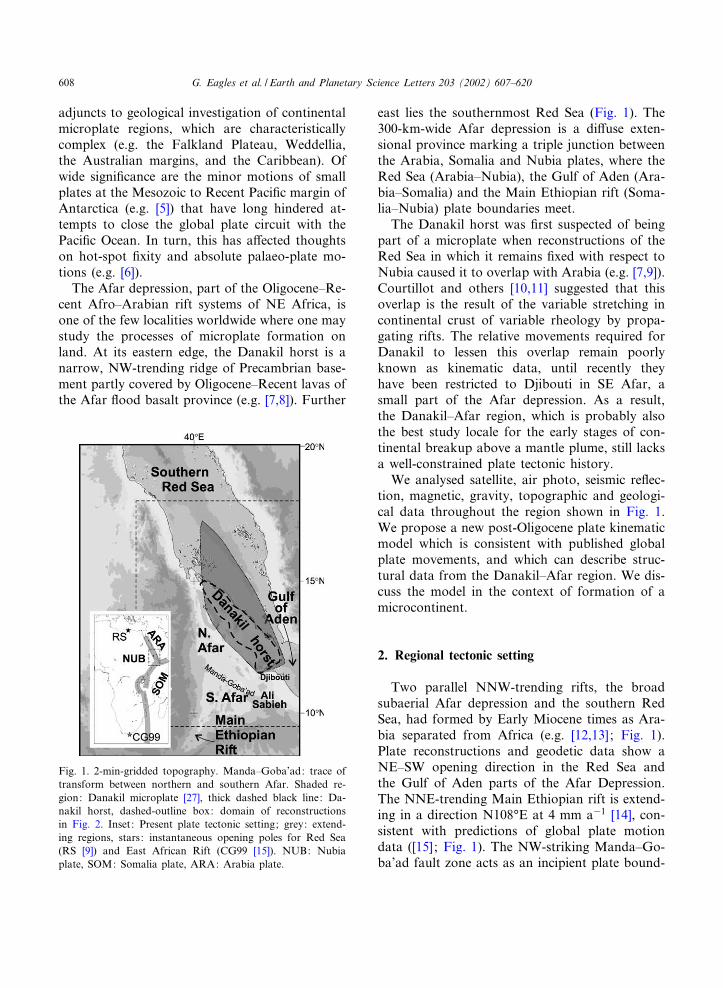
The Afar depression, part of the Oligocene^Re-cent Afro^Arabian rift systems of NE Africa, isone of the few localities worldwide where one maystudy the processes of microplate formation onland. At its eastern edge, the Danakil horst is anarrow, NW-trending ridge of Precambrian base-ment partly covered by Oligocene^Recent lavas ofthe Afar £ood basalt province (e.g. [7,8]). Further
east lies the southernmost Red Sea (Fig. 1). The300-km-wide Afar depression is a di¡use exten-sional province marking a triple junction betweenthe Arabia, Somalia and Nubia plates, where theRed Sea (Arabia^Nubia), the Gulf of Aden (Ara-bia^Somalia) and the Main Ethiopian rift (Soma-lia^Nubia) plate boundaries meet.
The Danakil horst was ¢rst suspected of beingpart of a microplate when reconstructions of theRed Sea in which it remains ¢xed with respect toNubia caused it to overlap with Arabia (e.g. [7,9]).Courtillot and others [10,11] suggested that thisoverlap is the result of the variable stretching incontinental crust of variable rheology by propa-gating rifts. The relative movements required forDanakil to lessen this overlap remain poorlyknown as kinematic data, until recently theyhave been restricted to Djibouti in SE Afar, asmall part of the Afar depression. As a result,the Danakil^Afar region, which is probably alsothe best study locale for the early stages of con-tinental breakup above a mantle plume, still lacksa well-constrained plate tectonic history.
We analysed satellite, air photo, seismic re£ec-tion, magnetic, gravity, topographic and geologi-cal data throughout the region shown in Fig. 1.We propose a new post-Oligocene plate kinematicmodel which is consistent with published globalplate movements, and which can describe struc-tural data from the Danakil^Afar region. We dis-cuss the model in the context of formation of amicrocontinent.
2. Regional tectonic setting
Two parallel NNW-trending rifts, the broadsubaerial Afar depression and the southern RedSea, had formed by Early Miocene times as Ara-bia separated from Africa (e.g. [12,13] ; Fig. 1).Plate reconstructions and geodetic data show aNE^SW opening direction in the Red Sea andthe Gulf of Aden parts of the Afar Depression.The NNE-trending Main Ethiopian rift is extend-ing in a direction N108‡E at 4 mm a31 [14], con-sistent with predictions of global plate motiondata ([15] ; Fig. 1). The NW-striking Manda^Go-ba’ad fault zone acts as an incipient plate bound-
Fig. 1. 2-min-gridded topography. Manda^Goba’ad: trace oftransform between northern and southern Afar. Shaded re-gion: Danakil microplate [27], thick dashed black line: Da-nakil horst, dashed-outline box: domain of reconstructionsin Fig. 2. Inset: Present plate tectonic setting; grey: extend-ing regions, stars: instantaneous opening poles for Red Sea(RS [9]) and East African Rift (CG99 [15]). NUB: Nubiaplate, SOM: Somalia plate, ARA: Arabia plate.
EPSL 6398 7-10-02
G. Eagles et al. / Earth and Planetary Science Letters 203 (2002) 607^620608
ary connecting the southern and northern parts ofthe rift system in Afar which have been approxi-mated to East African and Red Sea rifting, re-spectively (e.g. [13,16]). NE-directed sea£oorspreading in the Gulf of Aden propagated west-ward towards and, recently, into the Afar de-pression since 25 Ma [13]. NE-directed sea£oorspreading in the Red Sea commenced at V4 Ma([17] ; Fig. 1).
Sichler’s model [18] for the opening of the Afardepression proposes that Danakil moved like acrank-arm between Euler poles at its northwesternand southeastern extremities, as though somehow‘pinned’ there to the separating Nubia and Arabiaplates, respectively. Others [19,20] suggested theeastward rotation of Danakil was accompaniedby a similar, but opposite, movement of theAli^Sabieh block (Fig. 1) to the south. The re-stricted geographical focus of later studies andtheir consideration of only Pliocene^Recent faultshave given rise to con£icting assessments of thecrank-arm model. Souriot and Brun [21] foundthe crank-arm model to be consistent with faultpatterns in SE Afar. Neogene fault kinematic datain the Main Ethiopian rift (e.g. [22]) do not showthe strike-slip or highly oblique-slip motions pre-dicted by the crank-arm model. Three studies [23^25] have attempted to relate block movementsconstrained by palaeomagnetic data from a fewlocales in SE Afar to ‘duelling’ rifts propagatinginto Afar from the Red Sea and the Gulf of Aden.The model of Acton and Stein [24] is consistentwith the fault study in [21] but not with the crank-arm model. Acton and others [25] presented fur-ther palaeomagnetic results that do not supportthe crank-arm model.
The kinematic model of Collet and others [26](CEA in Fig. 2) shows independent movement ofDanakil since an Oligocene inception. It incorpo-rates the crank-arm model, but adds an early(pre-Miocene) phase of fast sinistral strike-slip be-tween the Danakil horst and Nubia. This phase isintroduced to remove Danakil from a gap in SWAfar when reconstructed using a least squares ¢tof the Arabian and Somalian coastlines and thelimits of basement outcrops to those of the west-ern Afar margin, which may not accurately markthe edges of the continental parts of the plates [9].
Although the model reunites African and ArabianPrecambrian shear zones expressed in a digitalterrain model, few of these features can be posi-tively identi¢ed as throughgoing on Danakil itself.
Le Pichon and Francheteau [9] determined in-dependent motions of Danakil by compositionfrom total reconstructions of the southernmostRed Sea and the Gulf of Aden, but had tomake assumptions about the shape of the conti-nent^ocean boundaries in both systems. To avoiddoing likewise, Chu and Gordon [27] analysed themost recent plate movements in the Red Sea re-gion, based on sea£oor spreading rates and onearthquake slip-vectors. As well as showing theapproximate shape of the present-day Danakilmicroplate they gave Euler poles for motions inthe region since magnetic anomaly chron C2A(about 3.2 Ma). These poles show that Danakilstill has resolvable motions with respect to bothNubia and Arabia, and that the crank-arm modelis not applicable to Danakil’s post-C2A tectonicsetting. However, the poles’ 95% con¢dence ellip-ses contain a set of statistically signi¢cant alter-natives that have rather di¡erent implications forAfro^Arabian rift kinematics and the evolution ofthe Afar plume province. This paper examinesthose alternatives.
3. Method
We assume initially that the Danakil horstshould ¢t tightly to the west Afar margin in re-constructions. To rotate it we used representativesof the range of statistically signi¢cant instantane-ous poles in [27]. These are simply taken from thecentre and extremes of the semi-major axis of thepreferred 95% con¢dence ellipse about the instan-taneous pole. Explicitly, given the very short time-scale of movement and the fact that successivestage poles in plate tectonic systems tend to beclosely spaced with respect to each other, we as-sume that these instantaneous poles will be closeto reconstruction poles for times earlier than 3.2Ma. For comparison we also used the total recon-struction poles of Le Pichon and Francheteau [9]and Collet and others [26]. The range of recon-structions is shown in Fig. 2. We were able imme-
EPSL 6398 7-10-02
G. Eagles et al. / Earth and Planetary Science Letters 203 (2002) 607^620 609
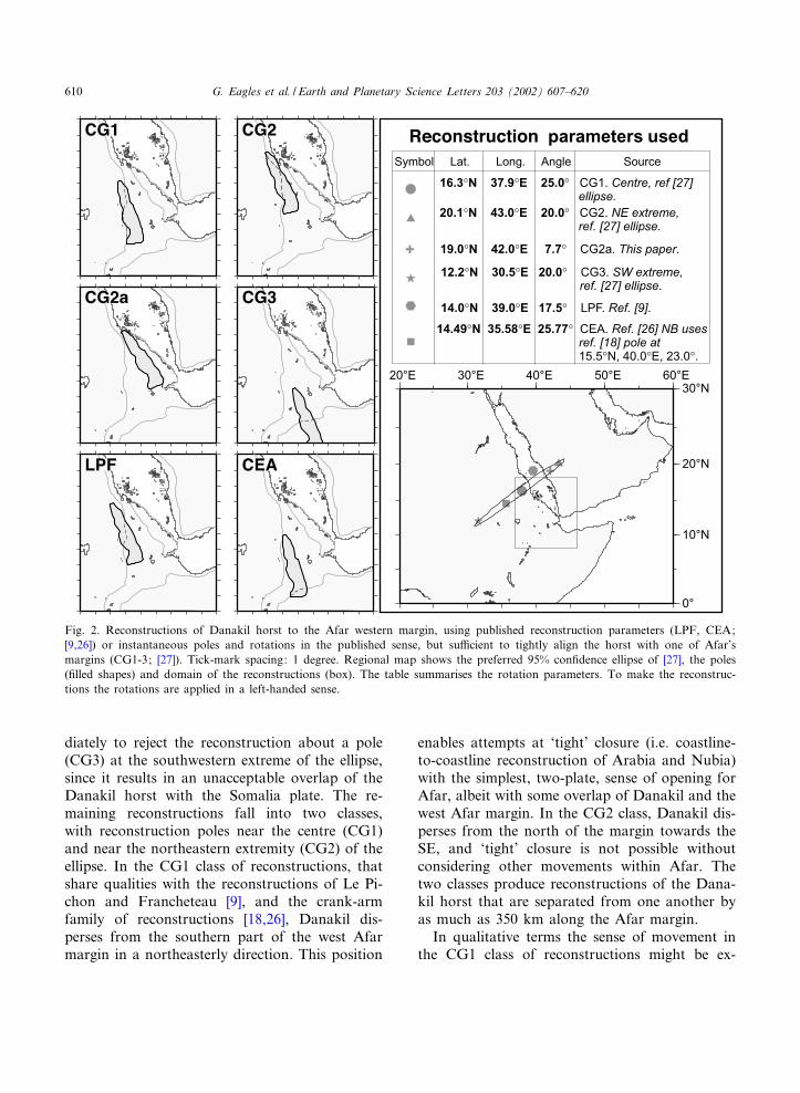
diately to reject the reconstruction about a pole(CG3) at the southwestern extreme of the ellipse,since it results in an unacceptable overlap of theDanakil horst with the Somalia plate. The re-maining reconstructions fall into two classes,with reconstruction poles near the centre (CG1)and near the northeastern extremity (CG2) of theellipse. In the CG1 class of reconstructions, thatshare qualities with the reconstructions of Le Pi-chon and Francheteau [9], and the crank-armfamily of reconstructions [18,26], Danakil dis-perses from the southern part of the west Afarmargin in a northeasterly direction. This position
enables attempts at ‘tight’ closure (i.e. coastline-to-coastline reconstruction of Arabia and Nubia)with the simplest, two-plate, sense of opening forAfar, albeit with some overlap of Danakil and thewest Afar margin. In the CG2 class, Danakil dis-perses from the north of the margin towards theSE, and ‘tight’ closure is not possible withoutconsidering other movements within Afar. Thetwo classes produce reconstructions of the Dana-kil horst that are separated from one another byas much as 350 km along the Afar margin.
In qualitative terms the sense of movement inthe CG1 class of reconstructions might be ex-
Fig. 2. Reconstructions of Danakil horst to the Afar western margin, using published reconstruction parameters (LPF, CEA;[9,26]) or instantaneous poles and rotations in the published sense, but su⁄cient to tightly align the horst with one of Afar’smargins (CG1-3; [27]). Tick-mark spacing: 1 degree. Regional map shows the preferred 95% con¢dence ellipse of [27], the poles(¢lled shapes) and domain of the reconstructions (box). The table summarises the rotation parameters. To make the reconstruc-tions the rotations are applied in a left-handed sense.
EPSL 6398 7-10-02
G. Eagles et al. / Earth and Planetary Science Letters 203 (2002) 607^620610
pressed as the result of undoing extension at apropagating ridge-tip, o¡set from the southern-most Red Sea, which is interacting with that inthe Gulf of Aden. This is an intuitively attractivemodel from which block rotations within parts ofAfar have been successfully predicted [23,24].However, it is di⁄cult to explain why a Danakilmicroplate should have been initiated and shouldcontinue to exist in such an otherwise simple sit-uation, especially because the Red Sea spreadingcentre remains well-established morphologicallyand energetically to the east of Danakil fromV18‡N to 14.5‡N (Fig. 1). That is, why shoulda s 200-km-long relay zone exist on the Red Searidge, instead of a simple transform? The CG2class of reconstruction has no immediate intuitiveappeal. Nonetheless, it uses a pole that is almostas well-constrained as CG1. Bearing in mind thatwe are assuming the pre-C2A relevance of theparameter set in [27], both classes deserve furtherattention.
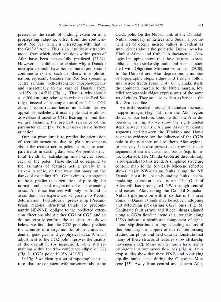
Our test procedure is to predict the orientationof tectonic structures due to plate movementsabout the reconstruction poles, in order to com-pare trends in existing data sets. We predict struc-tural trends by calculating small circles abouteach of the poles. These should correspond tothe azimuths of features acting purely in astrike-slip sense, or that were stationary on the£anks of extending rifts. Great circles, orthogonalto these, predict the orientation of pure dip-slipnormal faults and magmatic dikes in extendingareas. All these features will only be found inareas that have experienced Oligocene to Recentdeformation. Fortuitously, pre-existing (Precam-brian) regional structural trends are predomi-nantly NE-NNE, oblique to the predicted exten-sion directions about either CG1 or CG2, and sodo not greatly confuse the analysis. As shownbelow, we ¢nd that the CG2 pole class predictsthe azimuths of a large number of structures evi-dent in geological and geophysical data. A smalladjustment to the CG2 pole improves the qualityof the overall ¢t (by inspection), while still re-maining within the 95% con¢dence ellipse of [27](Fig. 2; CG2a pole: 19.0‡N, 42.0‡E).
In Fig. 3 we identify a set of topographic struc-tures that are consistent with movement about the
CG2a pole. On the Nubia £ank of the Danakil^Nubia boundary in Eritrea and Sudan a promi-nent set of deeply incised valleys is evident assmall circles about the pole (the Dzara, Anseba,Himbol^Afabet and Cub^Cub lineaments). Geo-logical mapping shows that these features expressoblique-slip to strike-slip faults and basins associ-ated with Oligocene^Miocene volcanism [29,30].In the Danakil and Afar depressions a numberof topographic steps, ridges and troughs followsmall-circle trends (Figs. 3, 4). On Danakil itself,the conjugate margin to the Nubia margin, lowrelief topographic ridges express arcs of the sameset of circles. They are also evident as bends in theRed Sea coastline.
An orthorecti¢ed mosaic of Landsat thematicmapper images (Fig. 4a) from the Afar regionshows similar tectonic trends within the Afar de-pression. In Fig. 4b we show the right-handedsteps between the Erta Ale and Alayta magmaticsegments and between the Tendaho and Hanlebasins as evidence for the in£uence of the CG2apole in the northern and southern Afar regions,respectively. It is also present as narrow basins orsegments of narrow curvilinear basins (e.g. Immi-no, Goba’ad). The Manda^Goba’ad discontinuityis sub-parallel to this trend. A simpli¢ed structurecontour map to the top early Miocene re£ectorshows major NW-striking faults along the NEDanakil horst, but basin-bounding faults accom-modating extension strike north. The Gulf ofAden rift has propagated NW through centraland eastern Afar, taking the Danakil^Somalia^Nubia triple junction with it, so that in this areaSomalia^Danakil trends may be actively adoptingand deforming pre-existing CG2a ones (Fig. 5).Conjugate fault arrays and Riedel shears alignedalong a CG2a £owline trend (e.g. roughly along12‡N) indicate a signi¢cant component of right-lateral slip distributed along extending sectors ofthis boundary. In support of our remote sensingstudies, air photo and ¢eld data demonstrate thatmany of these structural features show strike-slipmovements [32]. Many smaller faults have trendsorthogonal to our model £owlines (Fig. 4). Out-crop studies show that these NNE- and N-strikingdip-slip faults acted during the Oligocene^Mio-cene [33]. Away from central and eastern Afar,
EPSL 6398 7-10-02
G. Eagles et al. / Earth and Planetary Science Letters 203 (2002) 607^620 611
where fault patterns re£ect the changing plateboundary associated with the propagating Adenrift, lines of volcanoes fall along meridians to theCG2a pole. This disposition is consistent withtheir preferential formation along tensional fea-tures.
Basement lineations measured on the Landsatimage (Fig. 6) have a strike on the northern Da-nakil horst similar to those on the Nubia andArabian margins, which is consistent with thesmall (V7‡) anticlockwise rotation of such trendson Danakil implied by movement about the CG2apole. The CG1 class of reconstructions, whichtreats Afar as a two-plate system and in whichthe rotation pole lies along strike from the Dana-kil horst itself, generally implies much larger ro-tations (V17.5^25‡).
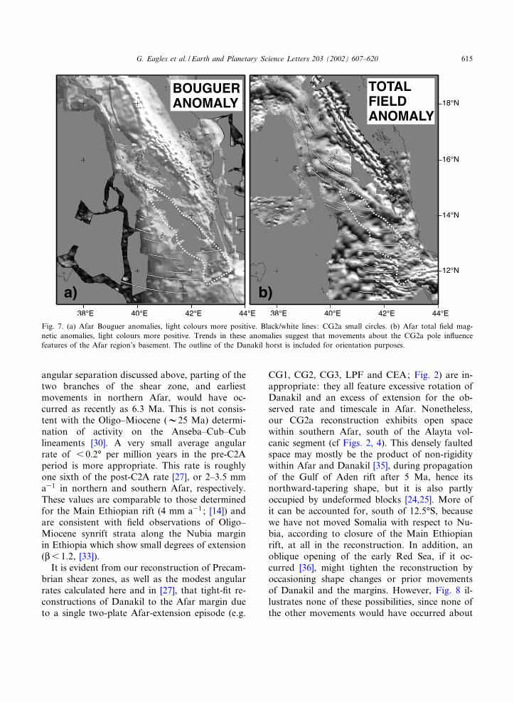
Bouguer gravity and total ¢eld magneticanomalies, which constrain the geometry of upper
crustal structures, also show several prominentWNW- to NW-trending features parallel to pre-dicted motions (Fig. 7a, b). An elongate Bougueranomaly low, continuing the NW trend of thenorthern coastline of Danakil from its northern-most tip to the western Red Sea escarpment, rep-resents a feature of considerable depth extent. In-terpretations of industry seismic-re£ection pro¢lesNE of the Danakil horst show that the gravityand magnetic lineaments correspond to EarlyMiocene NW-striking faults showing oblique-slipmovement ([34] ; D.G. Roberts, personal commu-nication, 2000) (Fig. 4b). This is consistent withthe prominent anomaly accommodating Mio-cene^post-Miocene wrenching movements aboutthe CG2a pole, as is the alignment, further alonga CG2a small circle from the anomaly, of a smallpublished set of dextral strike-slip nodal planesoriented VS70‡E [27].
Fig. 3. 1-km topography [28] in the Afar region. Thin black lines: small circles about the CG2a pole, lineaments D: Dzara,A: Anseba, H: Himbol^Afabet, C: Cub-Cub, N: unnamed lineaments, white arrows: subdued topography on the Danakil horst,including lengths of its coastline, dashed white outline: Danakil microplate from [27].
EPSL 6398 7-10-02
G. Eagles et al. / Earth and Planetary Science Letters 203 (2002) 607^620612
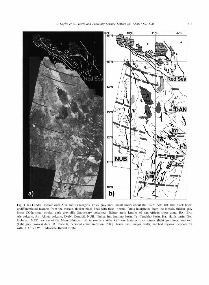
Fig. 4. (a) Landsat mosaic over Afar and its margins. Thick grey lines: small circles about the CG2a pole. (b) Thin black lines:undi¡erentiated features from the mosaic, thicker black lines with ticks: normal faults interpreted from the mosaic, thicker greylines: CG2a small circles, dark grey ¢ll : Quaternary volcanoes, lighter grey: lengths of pan-African shear zone, EA: ErtaAle volcano, Ay: Alayta volcano, DAN: Danakil, NUB: Nubia, Im: Immino basin, Te: Tendaho basin, Ha: Hanle basin, Go:Goba’ad, MER: section of the Main Ethiopian rift in southern Afar. O¡shore features from seismic (light grey lines) and well(light grey crosses) data [D. Roberts, personal communication, 2000]; black lines: major faults, hatched regions: depocentreswith s 3.6 s TWTT Miocene^Recent strata.
EPSL 6398 7-10-02
G. Eagles et al. / Earth and Planetary Science Letters 203 (2002) 607^620 613
4. Evolution of Afar
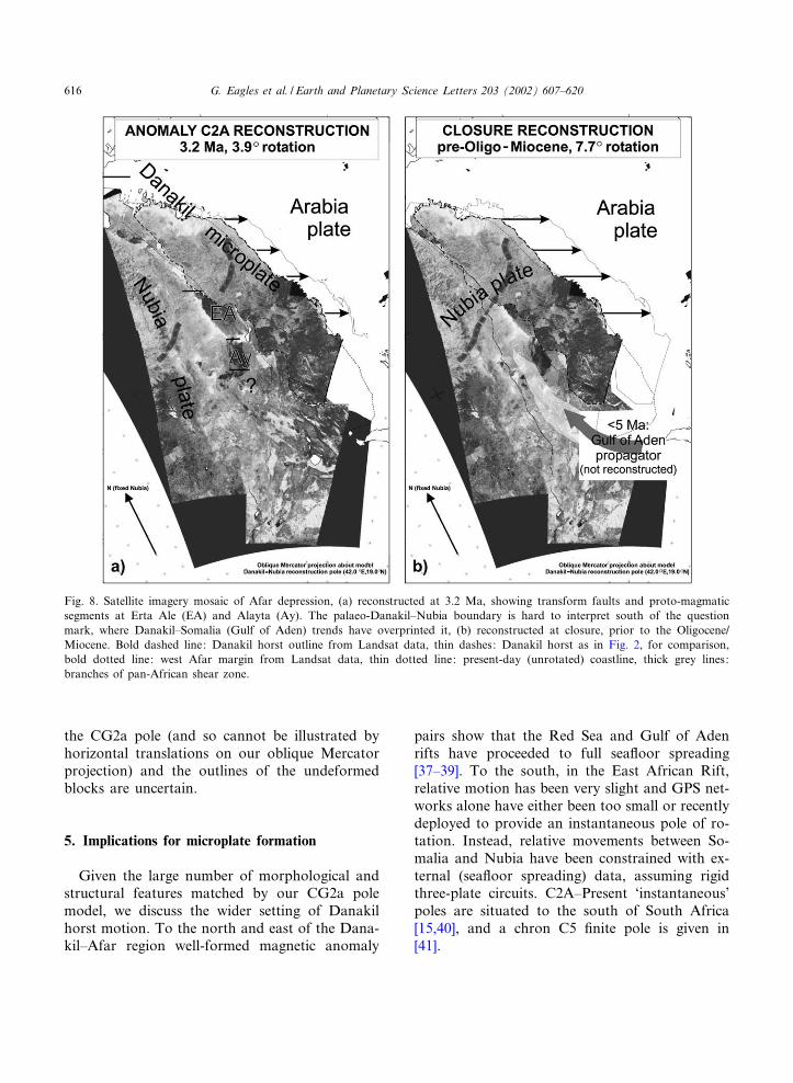
A reconstructed sequence of plate movementsprovides insights into the development of a micro-continent within a £ood basalt province. Fig. 8shows reconstructions of the Afar depression re-gion, using the CG2a pole. The reconstructionwas produced by making an oblique Mercatorprojection of the satellite data, using CG2a asthe axis of the projection. Since small circlesabout this will plot as horizontal lines on themap, moving the Danakil part of the data hori-zontally produces an accurate reconstruction.
Figure 8a shows a reconstruction at 3.2 Ma,made by assuming the extension rate in [27] tobe applicable for movement about our CG2apole. This reconstruction implies 36 km of ESE-directed movement between the western Afar es-carpment and the Danakil horst at 14.5‡N, and 63km at 11‡N, since 3.2 Ma. This implies extensionat rates of 11^20 mm a31, comparable to full ratesof ultra-slow to slow sea£oor spreading, as seenfor instance in the Red Sea just to the north.
Figure 8b shows a reconstruction that visuallyrealigns part of a Precambrian shear zone on thewestern Afar margin with its possible continua-tion on the northern Danakil horst. This ¢t re-quires that Danakil underwent 7.7‡ right-handedrotation about CG2a. At the post-C2A rates of
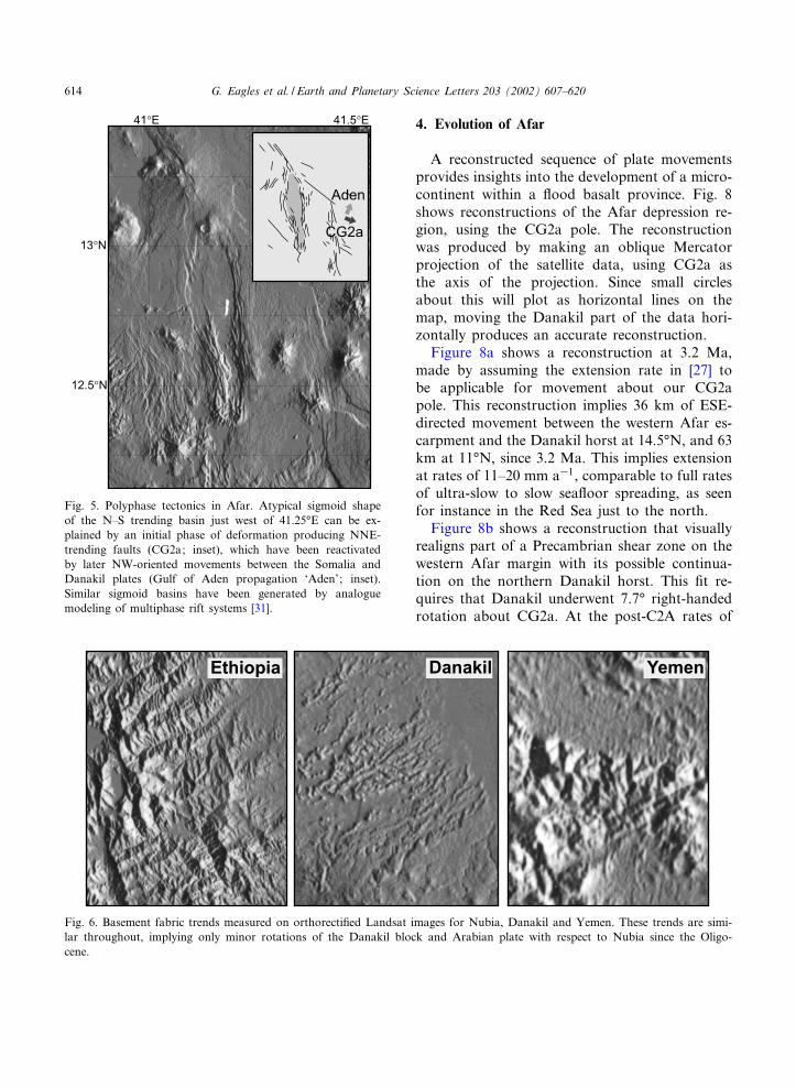
Fig. 5. Polyphase tectonics in Afar. Atypical sigmoid shapeof the N^S trending basin just west of 41.25‡E can be ex-plained by an initial phase of deformation producing NNE-trending faults (CG2a; inset), which have been reactivatedby later NW-oriented movements between the Somalia andDanakil plates (Gulf of Aden propagation ‘Aden’; inset).Similar sigmoid basins have been generated by analoguemodeling of multiphase rift systems [31].
Fig. 6. Basement fabric trends measured on orthorecti¢ed Landsat images for Nubia, Danakil and Yemen. These trends are simi-lar throughout, implying only minor rotations of the Danakil block and Arabian plate with respect to Nubia since the Oligo-cene.
EPSL 6398 7-10-02
G. Eagles et al. / Earth and Planetary Science Letters 203 (2002) 607^620614
angular separation discussed above, parting of thetwo branches of the shear zone, and earliestmovements in northern Afar, would have oc-curred as recently as 6.3 Ma. This is not consis-tent with the Oligo^Miocene (V25 Ma) determi-nation of activity on the Anseba^Cub^Cublineaments [30]. A very small average angularrate of 6 0.2‡ per million years in the pre-C2Aperiod is more appropriate. This rate is roughlyone sixth of the post-C2A rate [27], or 2^3.5 mma31 in northern and southern Afar, respectively.These values are comparable to those determinedfor the Main Ethiopian rift (4 mm a31 ; [14]) andare consistent with ¢eld observations of Oligo^Miocene synrift strata along the Nubia marginin Ethiopia which show small degrees of extension(L6 1.2, [33]).
It is evident from our reconstruction of Precam-brian shear zones, as well as the modest angularrates calculated here and in [27], that tight-¢t re-constructions of Danakil to the Afar margin dueto a single two-plate Afar-extension episode (e.g.
CG1, CG2, CG3, LPF and CEA; Fig. 2) are in-appropriate: they all feature excessive rotation ofDanakil and an excess of extension for the ob-served rate and timescale in Afar. Nonetheless,our CG2a reconstruction exhibits open spacewithin southern Afar, south of the Alayta vol-canic segment (cf Figs. 2, 4). This densely faultedspace may mostly be the product of non-rigiditywithin Afar and Danakil [35], during propagationof the Gulf of Aden rift after 5 Ma, hence itsnorthward-tapering shape, but it is also partlyoccupied by undeformed blocks [24,25]. More ofit can be accounted for, south of 12.5‡S, becausewe have not moved Somalia with respect to Nu-bia, according to closure of the Main Ethiopianrift, at all in the reconstruction. In addition, anoblique opening of the early Red Sea, if it oc-curred [36], might tighten the reconstruction byoccasioning shape changes or prior movementsof Danakil and the margins. However, Fig. 8 il-lustrates none of these possibilities, since none ofthe other movements would have occurred about
Fig. 7. (a) Afar Bouguer anomalies, light colours more positive. Black/white lines: CG2a small circles. (b) Afar total ¢eld mag-netic anomalies, light colours more positive. Trends in these anomalies suggest that movements about the CG2a pole in£uencefeatures of the Afar region’s basement. The outline of the Danakil horst is included for orientation purposes.
EPSL 6398 7-10-02
G. Eagles et al. / Earth and Planetary Science Letters 203 (2002) 607^620 615
the CG2a pole (and so cannot be illustrated byhorizontal translations on our oblique Mercatorprojection) and the outlines of the undeformedblocks are uncertain.
5. Implications for microplate formation
Given the large number of morphological andstructural features matched by our CG2a polemodel, we discuss the wider setting of Danakilhorst motion. To the north and east of the Dana-kil^Afar region well-formed magnetic anomaly
pairs show that the Red Sea and Gulf of Adenrifts have proceeded to full sea£oor spreading[37^39]. To the south, in the East African Rift,relative motion has been very slight and GPS net-works alone have either been too small or recentlydeployed to provide an instantaneous pole of ro-tation. Instead, relative movements between So-malia and Nubia have been constrained with ex-ternal (sea£oor spreading) data, assuming rigidthree-plate circuits. C2A^Present ‘instantaneous’poles are situated to the south of South Africa[15,40], and a chron C5 ¢nite pole is given in[41].
Fig. 8. Satellite imagery mosaic of Afar depression, (a) reconstructed at 3.2 Ma, showing transform faults and proto-magmaticsegments at Erta Ale (EA) and Alayta (Ay). The palaeo-Danakil^Nubia boundary is hard to interpret south of the questionmark, where Danakil^Somalia (Gulf of Aden) trends have overprinted it, (b) reconstructed at closure, prior to the Oligocene/Miocene. Bold dashed line: Danakil horst outline from Landsat data, thin dashes: Danakil horst as in Fig. 2, for comparison,bold dotted line: west Afar margin from Landsat data, thin dotted line: present-day (unrotated) coastline, thick grey lines:branches of pan-African shear zone.
EPSL 6398 7-10-02
G. Eagles et al. / Earth and Planetary Science Letters 203 (2002) 607^620616
5.1. Margins of the Danakil microplate
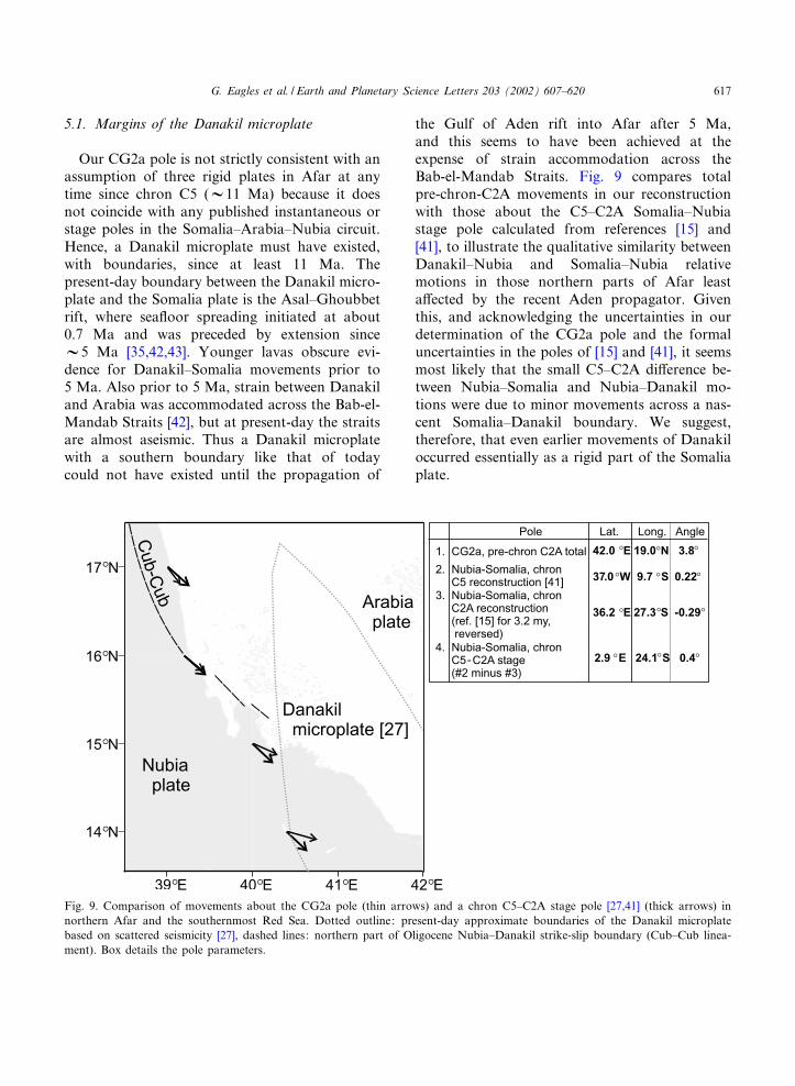
Our CG2a pole is not strictly consistent with anassumption of three rigid plates in Afar at anytime since chron C5 (V11 Ma) because it doesnot coincide with any published instantaneous orstage poles in the Somalia^Arabia^Nubia circuit.Hence, a Danakil microplate must have existed,with boundaries, since at least 11 Ma. Thepresent-day boundary between the Danakil micro-plate and the Somalia plate is the Asal^Ghoubbetrift, where sea£oor spreading initiated at about0.7 Ma and was preceded by extension sinceV5 Ma [35,42,43]. Younger lavas obscure evi-dence for Danakil^Somalia movements prior to5 Ma. Also prior to 5 Ma, strain between Danakiland Arabia was accommodated across the Bab-el-Mandab Straits [42], but at present-day the straitsare almost aseismic. Thus a Danakil microplatewith a southern boundary like that of todaycould not have existed until the propagation of
the Gulf of Aden rift into Afar after 5 Ma,and this seems to have been achieved at theexpense of strain accommodation across theBab-el-Mandab Straits. Fig. 9 compares totalpre-chron-C2A movements in our reconstructionwith those about the C5^C2A Somalia^Nubiastage pole calculated from references [15] and[41], to illustrate the qualitative similarity betweenDanakil^Nubia and Somalia^Nubia relativemotions in those northern parts of Afar leasta¡ected by the recent Aden propagator. Giventhis, and acknowledging the uncertainties in ourdetermination of the CG2a pole and the formaluncertainties in the poles of [15] and [41], it seemsmost likely that the small C5^C2A di¡erence be-tween Nubia^Somalia and Nubia^Danakil mo-tions were due to minor movements across a nas-cent Somalia^Danakil boundary. We suggest,therefore, that even earlier movements of Danakiloccurred essentially as a rigid part of the Somaliaplate.
Fig. 9. Comparison of movements about the CG2a pole (thin arrows) and a chron C5^C2A stage pole [27,41] (thick arrows) innorthern Afar and the southernmost Red Sea. Dotted outline: present-day approximate boundaries of the Danakil microplatebased on scattered seismicity [27], dashed lines: northern part of Oligocene Nubia^Danakil strike-slip boundary (Cub^Cub linea-ment). Box details the pole parameters.
EPSL 6398 7-10-02
G. Eagles et al. / Earth and Planetary Science Letters 203 (2002) 607^620 617
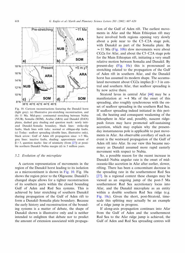
5.2. Evolution of the microplate
A cartoon representation of movements in theregion of the Danakil horst leading to its isolationas a microcontinent is shown in Fig. 10. Fig. 10ashows the region prior to the Oligocene. Danakil’schanged shape allows for a tighter reconstructionof its southern parts within the closed boundingGulf of Aden and Red Sea systems. This isachieved by later stretching of southern Danakilduring propagation of the Gulf of Aden rift toform a Danakil^Somalia plate boundary. Becausethe early history and reconstruction of the bound-ing systems is a matter of debate, the shape ofDanakil shown is illustrative only and is neitherintended to enlighten that debate nor to predictthe amount of extension associated with propaga-
tion of the Gulf of Aden rift. The earliest move-ments in Afar and the Main Ethiopian rift mayhave involved both regions opening very slowlyabout a pole near to the C5^C2A stage pole,with Danakil as part of the Somalia plate. ByV11 Ma (Fig. 10b) slow movements were aboutCG2a for Afar, and about the C5^C2A stage polefor the Main Ethiopian rift, initiating a very smallrelative motion between Somalia and Danakil. Bypresent-day (Fig. 10c) this is pronounced asstretching related to the propagation of the Gulfof Aden rift in southern Afar, and the Danakilhorst has assumed its modern shape. The accumu-lated movement about CG2a implies Ls 3 in cen-tral and southern Afar, that sea£oor spreading isby now active there.
Stratoid lavas in central Afar [44] may be amanifestation at V4 Ma of the onset of thisspreading, also roughly synchronous with the on-set of sea£oor spreading in the southern Red Sea.If sea£oor spreading indeed initiated in this peri-od, the heating and consequent weakening of thelithosphere in Afar and, possibly, nascent ridge-push forces may have promoted self-sustainingaccretion, which may explain why the present-day instantaneous pole is applicable to past move-ments in Afar. An observable corollary of such anevent is the westward propagation of the Gulf ofAden rift into Afar. In our view this became nec-essary as Danakil assumed more rapid easterlymovement with respect to Nubia.
So, a possible reason for the recent increase inDanakil^Nubia angular rate is the onset of mid-oceanic-like accretion in Afar after earlier, slower,rifting. There has been a concomitant decrease inthe spreading rate in the southernmost Red Sea[27]. In a regional context these changes may beviewed as an ongoing jump of the post-5 Masouthernmost Red Sea accretionary locus intoAfar, and the Danakil microplate as an entitywithin a double southern Red Sea ridge (e.g.Fig. 10c). Given the short, post-Stratoid, time-scale this splitting may actually be an exampleof a ridge jump in progress.
If along-axis propagation continues into Afarfrom the Gulf of Aden and the southernmostRed Sea to the Afar ridge jump is achieved, theGulf of Aden and Red Sea spreading centres will
Fig. 10. Cartoon reconstructions featuring the Danakil horst(light grey). (a) Illustrative pre-stretching reconstruction, and(b) 11 Ma. Mid-grey: continental stretching between Nubia(NUB), Somalia (SOM), Arabia (ARA) and Danakil (DAN)plates, dashed grey shading and question mark: newly initi-ated Danakil^Somalia boundary, black lines: strike-slipfaults, black lines with ticks: normal or oblique-slip faults.(c) Today: sea£oor spreading (double lines, illustrative only),black arrow: Gulf of Aden rift propagation since V5 Ma,grey lines: inactive faults, shading: approximate extent ofLs 3, question marks: line of seismicity (from [27]) at possi-ble northern Danakil^Nubia margin (d) in 5 million years.
EPSL 6398 7-10-02
G. Eagles et al. / Earth and Planetary Science Letters 203 (2002) 607^620618
connect in a future oceanic crust at a positionwest of Danakil. We may be seeing the ¢rst stagesof such an event in the recent tectonic quiescenceof the Bab-el-Mandab straits. In such a setting themodern Red Sea spreading centre between 14.5‡Nand 18‡N would be abandoned and Danakilwould become a microcontinent isolated seawardof a deep, narrow, oceanic basin o¡ the southernArabian Red Sea margin, but on the Arabia plate(Fig. 10d). There are obvious similarities in this toideas about the isolation of microcontinents oncontinental margins [4].
6. Conclusions
We propose a new model for plate motions inthe Afar rift system which is consistent with post-Pliocene global plate movements and which canexplain structural trends in the Danakil^Afar re-gion. Our model implies that independent move-ment of Danakil relative to Nubia, Arabia andSomalia has been sustained since at least chronC5, but has become signi¢cant since V5 Ma.The approximate position of a Euler pole describ-ing this independence is betrayed by the presenceof faults and aligned volcanoes. The earliest inde-pendent movements of the Danakil microplate in-itiated a slow excision from the Somalia plate, asa part of which it may have moved earlier withrespect to Nubia. The most recent, statisticallysigni¢cant, independent movement of the Danakilmicroplate can be related to the onset of oceanic-type accretion in Afar that promoted the ongoingpropagation of the neighbouring plate bound-aries. Thus, microplates can exist in intraconti-nental plate boundary settings and survive thetransition to sea£oor spreading. Furthermore,the Afar region may be a suitable test area forcontinental microplate formation.
Acknowledgements
Funding for this work was provided by NERCGrant NER/T/2000/00647. Many of the ¢gureswere prepared using the Generic Mapping Tools.We are grateful to our colleagues Bekele Abebe,
Chris Elders, Mary Fowler, Tesfaye Korme, KenMcClay, Ingrid Ukstins and Ellen Wolfenden fortheir support and valuable discussions.[BW]
References
[1] R.N. Hey, D.F. Naar, M.C. Kleinrock, J.P. Morgan, E.Morales, J.-G. Schilling, Microplate tectonics along asuperfast sea£oor spreading system near Easter Island,Nature 317 (1985) 320^325.
[2] S.F. Tebbens, S.C. Cande, Southeast Paci¢c tectonic evo-lution from Early Oligocene to Present, J. Geophys. Res.102 (1997) 12061^12084.
[3] M.C. Sengor, J.F. Dewey, Terranology: vice or virtue, in:J.F. Dewey, I.G. Gass, G.B. Curry, N.B.W. Harris, M.C.Sengor (Eds.), Allochthonous Terranes, Cambridge Uni-versity, Cambridge, MA, 1991, pp. 1^21.
[4] R.D. Mu«ller, C. Gaina, W. Roest, D.L. Hansen, A recipefor microcontinent formation, Geology 29 (2001) 203^206.
[5] R.D. Larter, A.P. Cunningham, P.F. Barker, K. Gohl,F.O. Nitsche, 2002. Tectonic evolution of the Paci¢c mar-gin of Antarctica. 1. Late Cretaceous tectonic reconstruc-tions. J. Geophys. Res., in press.
[6] S.C. Cande, J.M. Stock, R.D. Mu«ller, T. Ishihara, Ceno-zoic motion between East and West Antarctica, Nature404 (2000) 145^150.
[7] P.A. Mohr, Major volcano^tectonic lineament in theEthiopian Rift system, Nature 213 (1967) 664^665.
[8] C. Hofmann, V. Courtillot, G. Fe¤raud, P. Rochette, G.Yirgu, E. Ketefo, R. Pik, Timing of the Ethiopian £oodbasalt event and implications for plume birth and globalchange, Nature 389 (1997) 838^841.
[9] X. Le Pichon, J. Francheteau, A plate-tectonic analysis ofthe Red Sea^Gulf of Aden area, Tectonophysics 46 (1978)369^406.
[10] V. Courtillot, Propagating rifts and continental breakup,Tectonics 1 (1982) 239^250.
[11] V. Courtillot, F. Achache, F. Landre, N. Bonhommet, R.Montigny, G. Fe¤raud, Episodic spreading and rift prop-agation: new paleomagnetic and geochronological datafrom the Afar nascent passive margin, J. Geophys. Res.89 (1984) 3315^3333.
[12] I.A. Ukstins, P. Renne, E. Wolfenden, J. Baker, M. Men-zies, D. Ayalew, Matching conjugate volcanic rifted mar-gins: 40Ar/39Ar chronostratigraphy of pre- and synrift bi-modal £ood volcanism in Ethiopia and Yemen, EarthPlanet, Sci. Lett. 198 (2002) 289^306.
[13] I. Manighetti, P. Tapponnier, P.Y. Gillot, V. Courtillot,E. Jacques, J.C. Ruegg, G. King, Propagation of riftingalong the Arabia^Somalia plate boundary: into Afar,J. Geophys. Res. 103 (1998) 4947^4974.
[14] R. Bilham, R. Bendick, K. Larson, P. Mohr, J. Braun, S.Tesfaye, L. Asfaw, Secular and tidal strain across theMain Ethiopian Rift, Geophys. Res. Lett. 26 (1999)2789^2792.
EPSL 6398 7-10-02
G. Eagles et al. / Earth and Planetary Science Letters 203 (2002) 607^620 619
[15] D. Chu, R.G. Gordon, Evidence for motion between Nu-bia and Somalia along the southwest Indian ridge, Nature398 (1999) 64^66.
[16] N. Hayward, C. Ebinger, Variations in the along-axissegmentation of the Afar rift system, Tectonics 15(1996) 244^257.
[17] J. Cochran, A model for development of the Red Sea,Am. Assoc. Petrol. Geol. Bull. 67 (1983) 41^69.
[18] B. Sichler, La biellette danakile: un mode'le pour l’e¤volu-tion ge¤odynamique de l’Afar, Bull. Soc. Geol. Fr. 22(1980) 925^933.
[19] I. Manighetti, Dynamique des Syste'mes Extensifs enAfar, Ph.D. thesis, Inst. de Phys. du Globe de Paris,1993.
[20] L. Audin, Pe¤ne¤tration de la Dorsale d’Aden dans la De¤-pression Afar entre 20 et 4 Ma, Ph.D. thesis, Inst. dePhys. du Globe de Paris, 1999.
[21] T. Souriot, J.-P. Brun, Faulting and block rotation in theAfar triangle, East Africa: the Danakil ‘crank-arm’ mod-el, Geology 20 (1992) 911^914.
[22] M. Boccaletti, R. Mazzuoli, M. Bonini, T. Trua, B.Abebe, Plio-Quaternary volcanotectonic activity in thenorthern sector of the Main Ethiopian rift: relationshipswith oblique rifting, J. Afr. Earth Sci. 29 (1999) 679^698.
[23] P. Tapponnier, R. Armijo, I. Manighetti, V. Courtillot,Bookshelf faulting and horizontal block rotations betweenoverlapping rifts in southern Afar, Geophys. Res. Lett. 17(1990) 1^4.
[24] G.D. Acton, S. Stein, Block rotation and continental ex-tension in Afar: a comparison to oceanic microplate sys-tems, Tectonics 10 (1991) 501^526.
[25] G. Acton, A. Tessema, M. Jackson, R. Bilham, The tec-tonic and geomagnetic signi¢cance of paleomagnetic ob-servations from volcanic rocks from central Afar, EarthPlanet. Sci. Lett. 180 (2000) 225^241.
[26] B. Collet, H. Taud, J.F. Parrot, F. Bonavia, J. Chorowicz,A new kinematic approach for the Danakil block using aDigital Elevation Model representation, Tectonophysics316 (2000) 343^357.
[27] D. Chu, R.G. Gordon, Current plate motions across theRed Sea, Geophys. J. Int. 135 (1998) 313^328.
[28] D.A. Hastings, P.K. Dunbar, Development and assess-ment of the Global Land One-km Base Elevation digitalelevation model (GLOBE), ISPRS Arch. 32 (1998) 218^221.
[29] S.A. Drury, S.P. Kelley, S.M. Berhe, R.E.Ll. Collier, M.Abraha, Structures related to Red Sea evolution in north-ern Eritrea, Tectonics 13 (1994) 1371^1380.
[30] N.H. Kenea, C.J. Ebinger, D.C. Rex, Late Oligocene vol-canism and extension in the southern Red Sea hills, Su-dan, J. Geol. Soc. London 158 (2001) 285^294.
[31] M. Keep, K.R. McClay, Analogue modeling of multi-phase rift systems, Tectonophysics 273 (1997) 239^270.
[32] E. Abbate, P. Passerini, L. Zan, Strike-slip faults in a riftarea: a transect in the Afar Triangle, East Africa, Tecto-nophysics 241 (1995) 67^97.
[33] E. Wolfenden, C. Ebinger, I.A. Ukstins, G. Yirgu. Seg-mentation of a young volcanic passive margin: westernmargin of the southern Red Sea in Ethiopia, 2002, inpreparation.
[34] BP Exploration, Southern Red Sea, Regional review,1992, Ext. 64264.
[35] I. Manighetti, P. Tapponnier, V. Courtillot, Y. Gallet, E.Jacques, P.-Y. Gillot, Strain transfer between discon-nected, propagating rifts in Afar, J. Geophys. Res. 106(2001) 13613^13665.
[36] M.J. Makris, R. Rihm, Shear controlled evolution of theRed Sea: pull-apart model, Tectonophysics 198 (1991)441^466.
[37] H.A. Roeser, A detailed magnetic survey of the southernRed Sea, Geol. Jahrb. D13 (1975) 131^153.
[38] R.W. Girdler, P. Styles, Sea-£oor spreading in the westernGulf of Aden, Nature 271 (1974) 615^617.
[39] A.Y. Izzeldin, Seismic, gravity and magnetic surveys inthe central part of the Red Sea, their interpretation andimplications for the structure and evolution of the RedSea, Tectonophysics 143 (1987) 269^306.
[40] F. Jestin, P. Huchon, J.M. Gaulier, The Somalia plateand the East African Rift System: present-day kinematics,Geophys. J. Int. 116 (1994) 637^654.
[41] J. Lemaux II, R.G. Gordon, J.-Y. Royer, Location of theNubia^Somalia boundary along the Southwest IndianRidge, Geology 30 (2002) 339^442.
[42] H. Hebert, C. Deplus, P. Huchon, K. Khanbari, L.Audin, Lithospheric structure of the nascent west Gulfof Aden spreading center inferred from gravity data,J. Geophys. Res. 106 (2001) 26345^26363.
[43] R.S. Stein, P. Briole, J.G. Ruegg, P. Tapponnier, F.Gasse, Contemporary, Holocene and Quaternary defor-mation of the Asal Rift, Djibouti : implications for themechanics of slow spreading ridges, J. Geophys. Res. 96(1991) 21789^21806.
[44] B. Wolde, Spatial and temporal variations in the compo-sitions of Upper Miocene to Recent basic lavas in thenorthern Main Ethiopian Rift: implications for the causesof Cenozoic magmatism in Ethiopia, Geol. Rundsch. 85(1996) 380^389.
EPSL 6398 7-10-02
G. Eagles et al. / Earth and Planetary Science Letters 203 (2002) 607^620620