Embed Size (px)
Citation preview
KIA PUĀWAI A PUKEKOHEUnlock Pukekohe High-Level Project Plan
November 2019

ABBREVIATIONS
AT Auckland TransportBID Business Improvement DistrictCCO Council-controlled organisationthe Council Auckland CouncilHLPP High Level Project PlanLTP Long-term planPanuku Panuku Development Auckland
2 PUKEKOHE HLPP
CONTENTS
INTRODUCTION 5 Planning to unlock Pukekohe’s potential 7Mihi 8Panuku – who we are 9What we do – shaping spaces for Aucklanders to love 10
ABOUT THIS HIGH-LEVEL PROJECT PLAN 13What’s in the plan 14Why Pukekohe? 15Developing the Kia Puāwai a Pukekohe story 16Working with mana whenua 17Our partners 18
ABOUT PUKEKOHE 21A strategic location 22A diverse and growing community 24The Kia Puāwai a Pukekohe area and properties 26
VISION 29
THE PRINCIPLES THAT UNDERPIN OUR WORK 33
GOALS 37Goal 1 – Encourage new growth in the town centre 38Goal 2 – Improve access for all 39Goal 3 – Attract new businesses and critical services 40Goal 4 – Build local community identity 41
THE KEY MOVES – WHERE WE WILL 43 FOCUS OUR ENERGY AND EFFORTSThree precinct redevelopment key moves 45Three public realm key moves 49Two placemaking key moves 54A range of partnering opportunities 56
HOW WE PLAN TO IMPLEMENT THIS PROJECT 59Our approach to delivery 60Development of key properties 60Funding 63Other resources 63
INFORMATION USED TO DEVELOP THIS PLAN 65 Other plans and policies 66Transport infrastructure 70 Infrastructure capacity 71Property market dynamics and demand 72
COMMUNICATING WITH THE COMMUNITY 75Listening to the community 76What the community said 76Communications approach 77
NEXT STEPS 79 Dependencies 80Timeframes 81Monitoring 81
APPENDICES 83 Appendix 1: 84 Property map of town centre sites (excluding sites outside of the programme boundary)
Appendix 2: 85 Property map of all sites and the full extent of the programme area investment boundary
Appendix 3: 86Property schedule
3PUKEKOHE HLPP
4 PUKEKOHE HLPP

INTRODUCTION
5PUKEKOHE HLPP

6 PUKEKOHE HLPP
PLANNING TO UNLOCK PUKEKOHE’S POTENTIAL
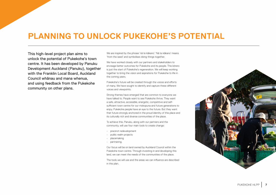
This high-level project plan aims to unlock the potential of Pukekohe’s town centre. It has been developed by Panuku Development Auckland (Panuku), together with the Franklin Local Board, Auckland Council whānau and mana whenua, and using feedback from the Pukekohe community on other plans.
We are inspired by the phrase ‘nā te kākano’. ‘Nā te kākano’ means ‘from the seed’ and symbolises doing things together.
We have worked closely with our partners and stakeholders to envisage better outcomes for Pukekohe and its people. This kōrero is just the start of Pukekohe’s regeneration. We will keep working together to bring the vision and aspirations for Pukekohe to life in the coming years.
Pukekohe’s future will be created through the voices and efforts of many. We have sought to identify and capture these different voices and viewpoints.
Strong themes have emerged that are common to everyone we have talked to. People want to see Pukekohe thrive. They want a safe, attractive, accessible, energetic, competitive and self-sufficient town centre for our mokopuna and future generations to enjoy. Pukekohe people have an eye to the future. But they want that future strongly anchored in the proud identity of this place and its culturally rich and diverse communities of the place.
To achieve this, Panuku, along with our partners and the community, will use four main tools to create change:
• precinct redevelopment• public realm projects• placemaking • partnering.
Our focus will be on land owned by Auckland Council within the Pukekohe town centre. Through investing in and developing this land, we can meet the needs of the communities of the place.
The tools we will use and the areas we can influence are described in this plan.
7PUKEKOHE HLPP
MIHI
WELCOME ONE. WELCOME ALL. YOU, FROM BEYOND THE HORIZON I HAVE TAKEN. I DRAW YOU NIGH, I DRAW YOU HITHER TO RAISE EXPECTATIONS AND TO FULFIL POTENTIAL.
Upward, onward until all is met and done and that which rises will endure still. From high it heralds divine aspirations, grounded in visions of new beginnings.
It empowers in essence our very being and pervades all that we have achieved. Let good be rife and may good health be assured, as guardianship defines a legacy given.
As destiny beckons, peace is mine. The sky itself seems to greet the earth, epitomising all I hold and revere; a token from that distant past. It abides as day and night without fail, with a gentle heart and a lively spirit.
NAU MAI TAKU ITI. PIKI MAI E TAKU RAHI. NĀKU KOE I TIKI ATU I TE PAE-O-TE-RANGI.
KA TŌIA MAI, KA KŪMEA MAI KIA EKE TANGAROA, EKE PANUKU.
Panuku, panuku, kia haumi e, kia hui e kia ara mai he tāiki ngāpara.
Ka whakairihia e te rangi hei hua tipua, ka poua ā-whenua hei tupuranga hōu.
Māna e huaki te mana tangata e hora ai aku mahi.
Kia hua ko te pai, kia piki ko te ora,
he tohu kaitiaki o taku tuakiri tuku iho.
Nōku te whiwhi, nōku te hūmārire. Ka tūhono a Rangi, ka tūhono ki a Papa,
taku taura here whanaungatanga; he mea nō tua whakarere mai.
E kore e memeha; tū te ao, tū te pō, mauri tau, mauri ora
8 PUKEKOHE HLPP
PANUKU – WHO WE ARE
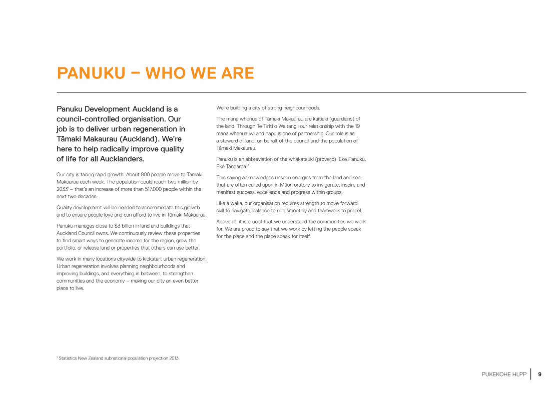
Panuku Development Auckland is a council-controlled organisation. Our job is to deliver urban regeneration in Tāmaki Makaurau (Auckland). We’re here to help radically improve quality of life for all Aucklanders.
Our city is facing rapid growth. About 800 people move to Tāmaki Makaurau each week. The population could reach two million by 20331 – that’s an increase of more than 517,000 people within the next two decades.
Quality development will be needed to accommodate this growth and to ensure people love and can afford to live in Tāmaki Makaurau.
Panuku manages close to $3 billion in land and buildings that Auckland Council owns. We continuously review these properties to find smart ways to generate income for the region, grow the portfolio, or release land or properties that others can use better.
We work in many locations citywide to kickstart urban regeneration. Urban regeneration involves planning neighbourhoods and improving buildings, and everything in between, to strengthen communities and the economy – making our city an even better place to live.
We’re building a city of strong neighbourhoods.
The mana whenua of Tāmaki Makaurau are kaitiaki (guardians) of the land. Through Te Tiriti o Waitangi, our relationship with the 19 mana whenua iwi and hapū is one of partnership. Our role is as a steward of land, on behalf of the council and the population of Tāmaki Makaurau.
Panuku is an abbreviation of the whakatauki (proverb) ‘Eke Panuku, Eke Tangaroa!’
This saying acknowledges unseen energies from the land and sea, that are often called upon in Māori oratory to invigorate, inspire and manifest success, excellence and progress within groups.
Like a waka, our organisation requires strength to move forward, skill to navigate, balance to ride smoothly and teamwork to propel.
Above all, it is crucial that we understand the communities we work for. We are proud to say that we work by letting the people speak for the place and the place speak for itself.
1 Statistics New Zealand subnational population projection 2013.
9PUKEKOHE HLPP

WHAT WE DO – SHAPING SPACES FOR AUCKLANDERS TO LOVE
TRANSFORMCreating change through urban renewal
In transform projects, we take the lead in urban renewal for selected parts of Tāmaki Makaurau. We work alongside others, using the council land we manage and our planning expertise.
Examples of transform projects are Wynyard Quarter and Manukau
UNLOCK / KIA PUAWAI
Unlocking development potential for others
We are the facilitator in unlock projects. We use our relationships to break down barriers and influence others (including our council whānau) to create development opportunities.
An example of an unlock project is Henderson
SUPPORTMaking the most of what we’ve got
Intensification is a key driver in the Auckland Plan. We support housing demands by enabling development of council-owned land.
E.g. Link Crescent, Whangaparāoa
Panuku’s structure is the first of its kind in New Zealand.
We work across many locations and projects – from large, long-term urban renewal projects, to small projects on specific sites.
We work in a commercial way for good public outcomes. We make a profit and deliver returns to the council. But we also make sure that our developments have positive outcomes for the communities we serve and are sustainable for the very long term.
Panuku has been set up to remove barriers and lead urban regeneration in Tāmaki Makaurau. To do this, we use three different types of projects:
• transform projects• unlock projects• support projects.
10 PUKEKOHE HLPP
11PUKEKOHE HLPP

12 PUKEKOHE HLPP
ABOUT THIS HIGH-LEVEL PROJECT PLAN
13PUKEKOHE HLPP

WHAT’S IN THE PLAN
This high-level project plan sets out the short, medium and long-term goals for the Kia Puāwai a Pukekohe programme.
The plan is the central document that allows Panuku to start regeneration work in the Pukekohe area. It enables us to assess, develop and dispose of sites, and investigate public realm and placemaking projects.
The plan sets out a vision, goals and key moves for the Kia Puāwai a Pukekohe project area; as shown in Figure 1. Framework of the high-level project plan.
This plan also:
• provides context for the programme and its individual projects, including their strategic fit with this high-level project plan, the other statutory and non-statutory plans that inform it, the market opportunities, statutory issues and stakeholder requirements outlines the existing and proposed projects covered by the programme, including the properties involved, the timeframes and the potential outcomes
• summarises our approach to community engagement
• describes our proposed funding strategy.
VISION The vision is the rationale behind all the decision-making in this plan. It describes what success looks like and guides how Pukekohe will develop so the vision can be achieved. The vision must be referred to at every stage of the project, and every stage must align with it. See Section 4 for more information on the vision.
GOALS The goals respond to Pukekohe’s current challenges and opportunities. There are four goals, which together provide direction for the key moves. See Section 6 for more information on the goals.
KEY MOVES Key moves are areas where Panuku can make a strong contribution and in�uence what happens. There are four categories of key moves in this plan:• precinct redevelopment
• public realm
• placemaking
• partnering
See section 7 for more information about the key moves.Figure 1. Framework of the high-level project plan
14 PUKEKOHE HLPP

WHY PUKEKOHE?
Pukekohe has been chosen as an Unlock location for the following reasons:
The council’s landholdings
Auckland Council controls a number of properties in the Pukekohe area – 27 of these are in the area covered by this plan and have potential for development. We could consider using these properties to spark private-sector investment and redevelopment, and to financially support other developments in Pukekohe.
Its growth potential
Pukekohe town centre is located in the middle of 1,300 hectares of Future Urban zoned land. There will be substantial residential and commercial growth on this land in the future, as well as in nearby suburbs which the town centre will be well placed to service. The town centre will also benefit from wider national growth, due to its connections to northern Waikato and the Bay of Plenty.
Its attractiveness
There is good demand in the Pukekohe property market for mixed-use residential, industrial and retirement properties. Demand for retail and office space is also growing as the population increases.
Strong community support for change
Feedback from the community on previous plans, such as the Auckland Unitary Plan, Pukekohe Area Plan and local board plans, supports investment in the town centre so that it continues to attract businesses and visitors.
Its working population
Pukekohe has a large resident working-age population. There is scope to develop employment opportunities in the town – employers will have access to a ready pool of local workers and residents will enjoy a greater range of job options.
Favourable zoning and good infrastructure
Pukekohe’s Town Centre zoning allows for a wide range of activities and buildings of between four and six storeys. The town centre is also well serviced by transport, has good stormwater, water supply and waste infrastructure, and enjoys good community facilities.
15PUKEKOHE HLPP
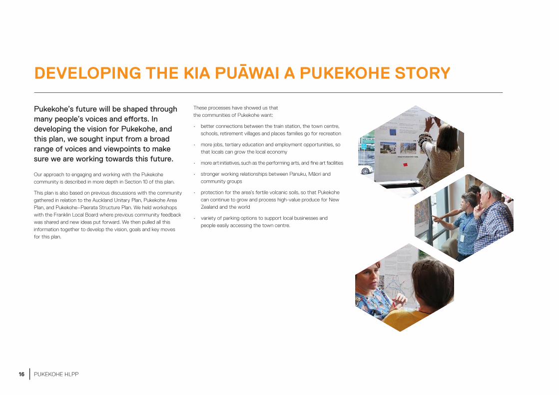
DEVELOPING THE KIA PUĀWAI A PUKEKOHE STORY
Pukekohe’s future will be shaped through many people’s voices and efforts. In developing the vision for Pukekohe, and this plan, we sought input from a broad range of voices and viewpoints to make sure we are working towards this future.
Our approach to engaging and working with the Pukekohe community is described in more depth in Section 10 of this plan.
This plan is also based on previous discussions with the community gathered in relation to the Auckland Unitary Plan, Pukekohe Area Plan, and Pukekohe–Paerata Structure Plan. We held workshops with the Franklin Local Board where previous community feedback was shared and new ideas put forward. We then pulled all this information together to develop the vision, goals and key moves for this plan.
These processes have showed us that the communities of Pukekohe want:
• better connections between the train station, the town centre, schools, retirement villages and places families go for recreation
• more jobs, tertiary education and employment opportunities, so that locals can grow the local economy
• more art initiatives, such as the performing arts, and fine art facilities
• stronger working relationships between Panuku, Māori and community groups
• protection for the area’s fertile volcanic soils, so that Pukekohe can continue to grow and process high-value produce for New Zealand and the world
• variety of parking options to support local businesses and people easily accessing the town centre.
16 PUKEKOHE HLPP

WORKING WITH MANA WHENUA
Panuku has had early kōrero and hui with three mana whenua iwi that identified as having strong associations with Pukekohe: Te Ākitai Waiohua, Ngāti Tamaoho, Ngāti Te Ata Waiohua.
In these early discussions, mana whenua expressed a desire to see their relationship with the whenua acknowledged as a means of unlocking potential for future generations and the prosperity of the place itself.
Strong themes that came out of these early hui were:
• whenua – acknowledging the unique relationship iwi have with the whenua, and acknowledging the whenua as a means of providing education, establishing common ground and creating independence
• the economy – investing in Pukekohe, so that whānau can spend more time here and have education, training, employment and business opportunities
• culture – celebrating identity and history, and developing spaces that enable cultural sharing as a way of establishing strong communities
• kaitiakitanga – strengthening our ability to care for and provide stewardship for the environment, and to live off the land
• mokopuna – meeting the needs of our mokopuna to grow and thrive in Pukekohe.
Following on from these early discussions, we are currently co-designing a partnership framework with mana whenua, using a wānanga engagement methodology.
The wānanga methodology uses Māori cultural concepts and protocols to seek input into solution design. It frames issues and problems in the context of participants’ own experiences.
Given the importance of this kaupapa to mana whenua, and the fact that this is the first time Panuku has engaged with mana whenua in this way, a level of flexibility is required, particularly around timeframes.
We will be guided by the phrase ‘Ki tai wīwī ki tai wāwā’, which means that we will remain flexible and willing to move from side to side, able to change direction if we become stuck or are heading the wrong way. We understand that doing things properly may take more time up front, but in the longer term will provide better outcomes.
17PUKEKOHE HLPP

OUR PARTNERS
In addition to mana whenua, Panuku will work closely with the following organisations and entities:
Auckland Transport – We will collaborate with Auckland Transport. Auckland Transport is the road controlling authority responsible for the transport network, has a regulatory role as the asset owner for all roads (excluding state highways) and is the transport specialist for Auckland Council. The parking sites identified in this plan are currently under Auckland Transport’s control and management. The future need for these sites has not yet been assessed by Auckland Transport. If sites (or part of a site) are considered surplus, they will be transferred to Auckland Council before being redeveloped with the approval of the Auckland Transport board. We will also work with Auckland Transport on investment projects.
Auckland Tourism, Events and Economic Development (ATEED) – ATEED will support us in attracting local economic development opportunities. It will also support us in relation to any significant events, and on developing the image of the town centre.
Franklin Local Board – We will partner with the Franklin Local Board, to align and prioritise projects, and engage with stakeholders and community groups. The board will support and collaborate with us on placemaking and events where appropriate.
Auckland Council departments – Our whānau within Auckland Council will support and guide us on a range of matters, from regulatory and planning requirements, to asset ownership and specialist support for stormwater, open space and community needs provision.
Pukekohe Business Association – We will help the business association to achieve its own goals, and potentially with our support, to create new opportunities.
18 PUKEKOHE HLPP

19PUKEKOHE HLPP
20 PUKEKOHE HLPP

ABOUT PUKEKOHE
21PUKEKOHE HLPP

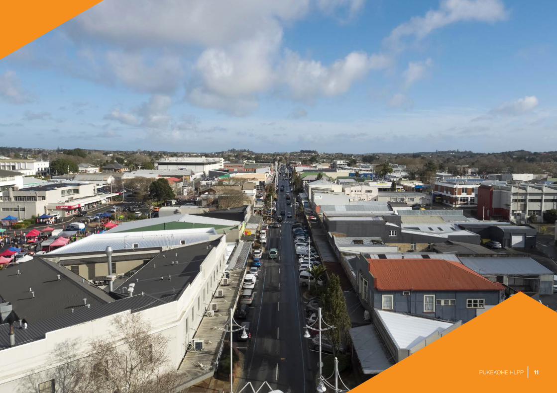
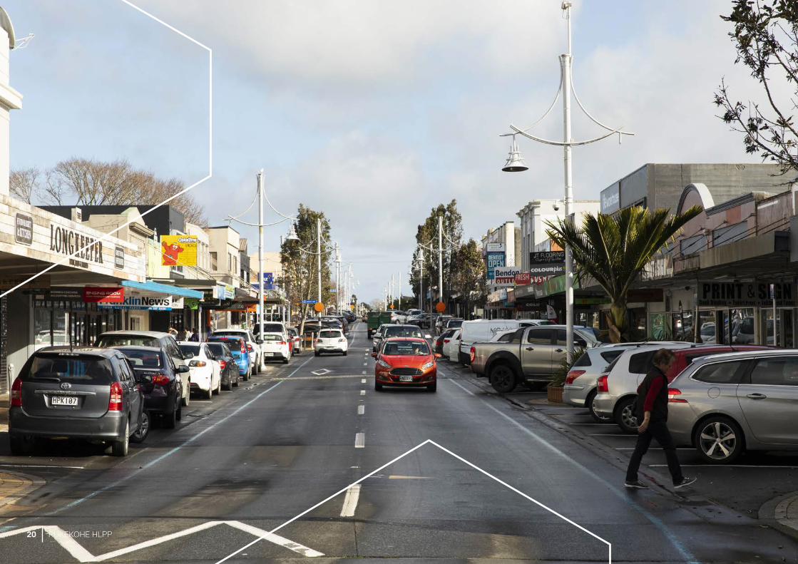
A STRATEGIC LOCATION
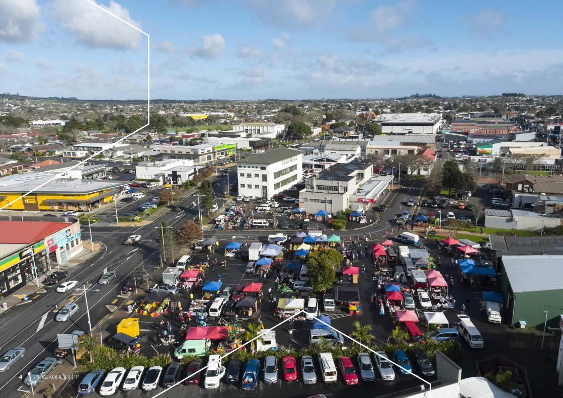
Pukekohe is an established rural centre, in the heart of the Franklin district and on the southern edge of the Tāmaki Makaurau region. It sits between the southern shore of the Manukau Harbour and the mouth of the Waikato River, approximately 50 kilometres south of Tāmaki Makaurau’s city centre.
Today, Pukekohe is the eighteenth most populated urban area in New Zealand with a population of 23,630 people.2
Pukekohe serves a wide rural catchment that contains some of New Zealand’s best soils and prime agricultural land. Horticultural production and dairy farming are long-established activities in the area, and Pukekohe’s economy remains firmly centred around them. The unique combination of fertile volcanic soils, climate and proximity to market have entrenched this role, and Pukekohe has an established reputation as an important market garden and horticultural hub. Potatoes and onions are grown intensively, along with other fresh produce. The area also continues to attract people seeking a rural lifestyle.
Pukekohe is well connected with transport infrastructure. The town is located on the North Island Main Trunk rail line. The section between Papakura and Pukekohe is planned to be electrified within the next 10 years, as part of the Auckland Transport Alignment Project. When this happens, the travel time to other key destinations in the Tāmaki Makaurau region, including the Auckland CBD, is expected to reduce. Pukekohe is connected to the rest of the North Island by the road network, including State Highway 1 and State Highway 22. The nearby communities of Paerata, Tūākau and Pokeno are all well connected by road to Pukekohe.
A ring road circles the town centre. The ring road was designed to remove through traffic, particularly heavy vehicle traffic, away from the town centre. At present, heavy vehicles are obliged to use this route, due to a limited number of crossings over the railway line. The ring road has served the town centre well. However, it also acts as a boundary between the commercial and residential areas, and we will explore ways to provide better connections across this road.
Pukekohe town centre is surrounded by low-density residential dwellings and farming-related activities. Larger retail centres in Manukau Road have created competition with the town centre. However, residents still enjoy the relaxed setting and easy access to community services and commercial amenities that the centre provides, including supermarkets, services, boutique clothing stores, specialty shops and locally owned cafés and eateries.
2 Figures from 2013 Census; will be updated to 2018 figure, when available.
22 PUKEKOHE HLPP

Figure 2. Pukekohe’s location in the Tāmaki Makaurau region
Auckland City Centre
Manukau
Pukekohe
Waiau Pa
Kingseat
Patumahoe
Paerata
Drury
Ararimu
Bombay
Pokeno
Tuakau
Waiuku
Hunua Ranges
23PUKEKOHE HLPP

A DIVERSE AND GROWING COMMUNITY
Pukekohe’s population was recorded as 23,630 people in the 2013 Census. This represents 1.4 per cent of the Tāmaki Makaurau region’s total population.
The community is also an aging one. Within Pukekohe, there are more people aged over 65 years, and within the 0 to 14 years age groups (compared to national averages). These demographic trends will influence the nature of the Pukekohe community over time. For example, the segment of the community aged over 65 years is expected to grow at twice the speed of the overall population.
Pukekohe has also been identified in the Auckland Plan as a priority satellite town. As a result, its population is expected to double to 50,000 people in the next 20 years. There could be greater growth in the number of family households in Pukekohe. If so, there will be higher population growth rates in the 0 to 14 years and 40 to 64 years age groups than those forecast from demographic statistics.
Figure 3 to Figure 6 show the current projections for various groups within the Pukekohe population. Once available, data from the 2018 Census data will be used to further inform planning.
Figure 3. Population projections by age, 2018
Figure 5. Ethnic distribution, 2013 Figure 6. Personal income distribution, 2013
Figure 4. Population projections by age, 2043
0 - 14
15 - 39
40 - 64
65 +
23%
32%
16%
29%
0 - 14
15 - 39
40 - 64
65 +
20%
30%
22%
28%
Up to $5,000
$5,001 - $10,000
$10,001 - $20,000
$20,001 - $30,000
$30,001 - $50,000
$50,001 +
5%
14%
17%
14%
28%
21%
European
Maori
Pacific Island
Asian
Other
2%
66%
17%
8%
6%
24 PUKEKOHE HLPP

25PUKEKOHE HLPP
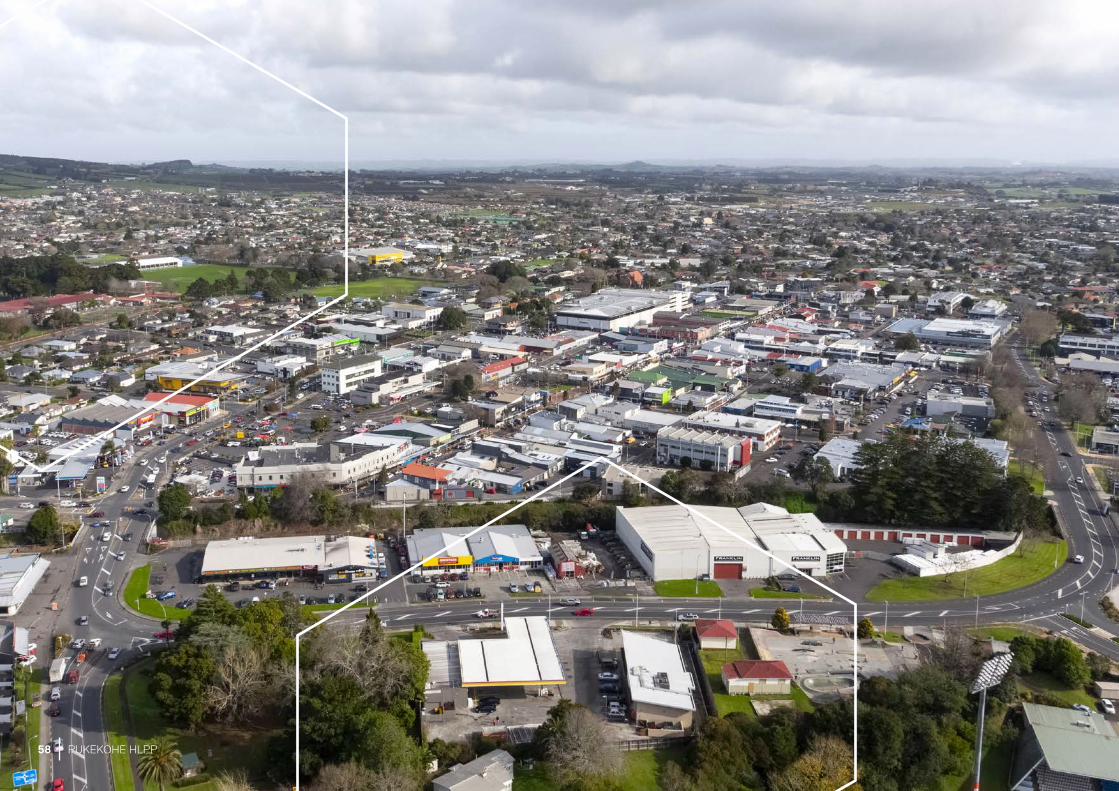
THE KIA PUĀWAI A PUKEKOHE PROJECT AREA AND PROPERTIES
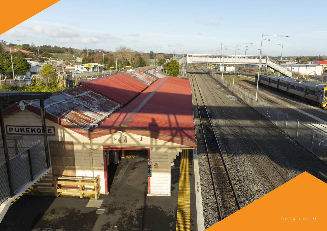
The Kia Puāwai a Pukekohe project focuses mainly on the historic town centre. It also includes some non-residential assets located just outside the ring road, including Pukekohe Railway Station, Auckland Council and Franklin Local Board offices, Pukekohe Library and War Memorial Hall, Bledisloe Park, Jubilee Pool, Pukekohe High School and Pukekohe Intermediate School.
There are also several properties that sit outside the project area, which may be included in the project as Support sites.
We will also ask the Council’s Finance and Performance Committee to consider contributing to small agreed projects outside of the boundary if they have clear benefits towards achieving the vision and goals.
The project boundary defines where Panuku will focus its investments and effort during the project. Our role within the project area will include preparing sites for development. This may involve amalgamating, and possibly acquiring, sites to enhance the value and scale of any potential developments on them.
Within the Unlock project area there is already a good concentration of Auckland Council, Auckland Transport and Crown-owned land. In total, there are 27 properties in the property portfolio we will manage as part of the project. These include eight street-level car parks, several small open spaces, three commercial properties (with tenants) and the Auckland Council offices at 82 Manukau Road. Combined, they represent approximately 5.5 hectares of land, valued at approximately $27 million (based on 2017 capital valuations, and excluding the Auckland Council offices).
These properties are spread throughout the town centre and wider suburban area. Several large sites within the town centre provide significant opportunities for redevelopment, for mixed residential and commercial, and employment uses.
26 PUKEKOHE HLPP
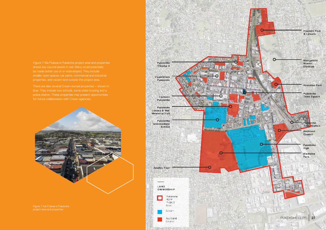
Figure 7. Kia Puāwai a Pukekohe project area and properties
Figure 7. Kia Puāwai a Pukekohe project area and properties shows key council assets in red. Many could potentially be made better use of or redeveloped. They include smaller open spaces, car parks, commercial and industrial properties, and vacant land outside the project area.
There are also several Crown-owned properties – shown in blue. They include two schools, some state housing and a police station. These properties may present opportunities for future collaboration with Crown agencies.
27PUKEKOHE HLPP
28 PUKEKOHE HLPP

VISION
29PUKEKOHE HLPP
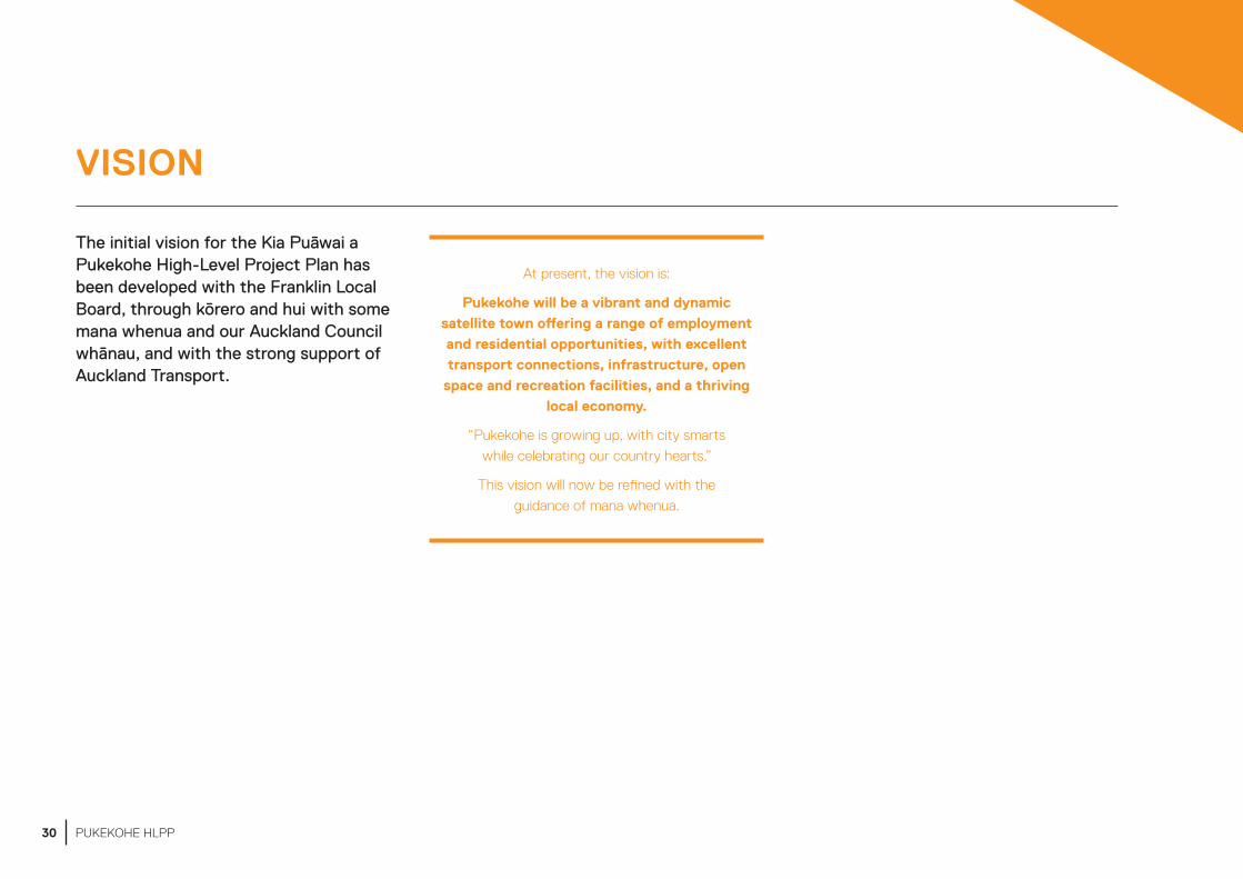
VISION
The initial vision for the Kia Puāwai a Pukekohe High-Level Project Plan has been developed with the Franklin Local Board, through kōrero and hui with some mana whenua and our Auckland Council whānau, and with the strong support of Auckland Transport.
At present, the vision is:
Pukekohe will be a vibrant and dynamic satellite town offering a range of employment and residential opportunities, with excellent transport connections, infrastructure, open
space and recreation facilities, and a thriving local economy.
“Pukekohe is growing up, with city smarts while celebrating our country hearts.”
This vision will now be refined with the guidance of mana whenua.
30 PUKEKOHE HLPP

31PUKEKOHE HLPP
32 PUKEKOHE HLPP

THE PRINCIPLES THAT UNDERPIN OUR WORK
33PUKEKOHE HLPP
THE PRINCIPLES THAT UNDERPIN OUR WORK
Panuku is the lead council agency involved in Pukekohe’s transformation and this high-level project plan represents the start of the Kia Puāwai a Pukekohe project.
More detailed planning, analysis and engagement will be needed as we confirm specific projects and investments. We will discuss our plans with our council whānau to ensure we align with their work, and work closely with community groups and the business association.
The following principles will guide the Kia Puāwai a Pukekohe project and all of our activities.
Precinct redevelopment
• Redevelop surplus council sites to unlock the potential of Pukekohe town centre and accommodate commercial and residential growth.
• Work to facilitate strategic outcomes on selected flagship council-owned sites to help achieve the vision.
• Seek to balance strategic and commercial outcomes. The costs and benefits of different projects will be considered to determine priorities.
Public realm investment
• Invest in public realm improvements and prioritise projects that create the greatest value towards achieving the vision.
• Take inspiration and guidance from local people, needs and themes to catalyse distinctive place-led design and develop strategic projects that are specific to Pukekohe and showcase the unique character and identity of the area.
• Focus on enhancing walking and cycling accessibility and ensuring the town centre caters for a wide variety of people including the young and old. Adopt exemplar universal design into projects to ensure people of all ages and abilities can use and enjoy public spaces within the town centre.
• Collaborate with mana whenua, who could in turn manaaki (support) local artists and community groups in strategic projects and initiatives through place making, public art, urban and architectural design.
Partnership
• Work with mana whenua who have a strong historical footprint in Pukekohe, so we can understand, respect and amplify their association with the whenua. Use a mana whenua-led approach to realise their aspirations for the place and their people. Explore and define any potential commercial, contractual and cultural opportunities through the project. It is through this relationship with mana whenua that we will in turn ensure Kia Puāwai a Pukekohe responds to and provides for the enhanced well-being of all Māori in the locale.
• Create wider opportunities by partnering with the Council, Franklin Local Board and mana whenua, and collaborating with landowners, key community groups and council organisations such as ATEED.
Placemaking
• Apply a ‘do, learn, do’ philosophy to inform future design. We will ensure the community play an active role in building their places through short term activations, such as pop-up events and workshops. We will experiment with new place-led initiatives to provide an opportunity to test ideas through short-term improvements for Pukekohe’s public realm. This participation and inclusion will enable better decision-making for Pukekohe’s future.
• Foster capacity and pride, in order to support long term resilience by empowering key community stakeholders. Engage with and empower local community stakeholders to ensure that the vision can be achieved and sustained into the future. This self-sufficiency is anticipated to include a continual programme of works that are led by community stakeholders well after the Kia Puāwai a Pukekohe project has been completed.
• Ngā Pou Herenga – ensure our approach to placemaking is strengthened and guided by recognising mana whenua values and in particular their role as kaitiaki. Placemaking will honour collective knowledge and understanding and support wellbeing and resilience.
34 PUKEKOHE HLPP
35PUKEKOHE HLPP
36 PUKEKOHE HLPP

GOALS
37PUKEKOHE HLPP

The Kia Puāwai a Pukekohe Programme goals are aligned with the outcomes sought by the Pukekohe Local Board Plan 2017 and the Pukekohe Area Plan 2014 – The goals respond to current challenges and aim to leverage opportunities.
Outcome – A competitive town centre
We must ensure that Pukekohe town centre benefits from the growth projected for southern Tāmaki Makaurau and northern Waikato.
We can capitalise on this forecast growth by enhancing and place-shaping the town centre. We will use the properties in our portfolio to spark this regeneration. This will:
• attract new visitors and residents
• improve employment opportunities
• serve the growing population
• protect the town centre from the increased competition from new centres in surrounding areas.
These approaches align with mana whenua’s aspirations for Pukekohe, which included the need to invest in the town, so that whānau can spend more time here.
To achieve this goal we will:
Grow up – attract higher density development in the town centre
• Pukekohe will benefit from greater public awareness of its many appealing attributes. Potential buyers and investors can capitalise on the town’s attractive main street, historic character and pedestrian friendly streets.
• These features can be used to attract new types of development in the centre, including a range of different living options, which will increase the density and activities on offer.
• As we plan for higher density development, we also need to create spaces and places where multi-cultural activities and sharing can occur.
Promote Pukekohe’s distinctive attributes and position the town centre for success
• We will highlight Pukekohe’s unique lifestyle and showcase its great amenities, services, shopping, dining and fresh produce markets – all located along a walkable and attractive main street, where people can mix and meet and enjoy what the town centre offers.
GOAL 1 – ENCOURAGE NEW GROWTH IN THE TOWN CENTRE
38 PUKEKOHE HLPP
Outcome – A safe, walkable and vibrant town centre
Pukekohe town centre currently has several challenges that need to be resolved for the vision to be achieved. These challenges include:
• the large scale of its street blocks, which makes them more difficult to walk around
• the constraints on pedestrians and cyclists created by the ring road around the town centre – the road is designed to keep through-traffic out of the town centre, but can also restrict access for the community living in the outer area
• the lack of residential development within the centre
• planning that has historically given priority to vehicles over pedestrians. This has led to ample provision for parking, but limited provision for sustainable transport options into the centre. While the transport options have improved in recent years, through new bus services and more frequent rail services, there are opportunities for more to be done, particularly for walking and cycling.
Our aim is to encourage more activities within the town centre. We will do this by upgrading public spaces, fostering residential and commercial development on council-owned sites, improving walking and cycling connections, and enhancing the vibrancy, accessibility, safety and character of the area.
We will also continue to acknowledge mana whenua’s relationship with Pukekohe as a place of education and independence.
To achieve this goal we will:
Make walking and cycling in the town centre more attractive
We will work with Auckland Transport to develop a safe, high-quality network for active transport within and to the town centre, across the ring road and to key destinations such as the train station, library, pool, stadium, cinema and high school.
This will involve:
• making it easier to get around the town centre
• establishing new walking and cycling routes across open spaces and council sites
• enhancing and upgrading streetscapes, and providing more outdoor seating
• working with developers to provide more connections through development sites
As a result, we expect it will become safer and easier for people to walk to the places they want to go. These measures will also support increased recreation, economic prosperity and social interaction.
Introduce fit-for-purpose parking management
• Fit-for-purpose parking supports economic development. We will work with Auckland Transport to make the most of car parking in the town centre.
• Some of the options we are exploring are parking in lanes, new signs for under-used parking sites, an awareness campaign about the Farmers building multi-level carpark and better pedestrian connections to less central sites.
Enhance the town centre by using public spaces for entertainment, events and activities
• We will support quality landscaping in public areas and more public art, such as murals and sculptures. These are also effective ways to express mana whenua’s strong cultural and historical association with Pukekohe.
• We will work out how to make better use of public spaces for outdoor performances, programmes and events. We will explore with local performers, organisers and community groups how to bring public spaces to life (into the evening and throughout the year), to support business vibrancy.
• Mana whenua have expressed a desire to keep rangatahi in Pukekohe. Creating a vibrant town centre with quality entertainment will be an important part of this.
GOAL 2 – IMPROVE ACCESS FOR ALL
39PUKEKOHE HLPP
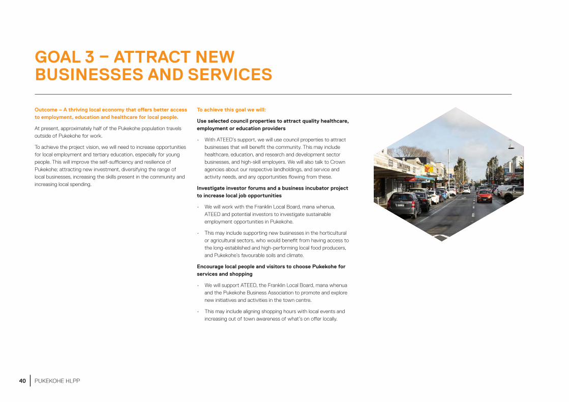
Outcome – A thriving local economy that offers better access to employment, education and healthcare for local people.
At present, approximately half of the Pukekohe population travels outside of Pukekohe for work.
To achieve the project vision, we will need to increase opportunities for local employment and tertiary education, especially for young people. This will improve the self-sufficiency and resilience of Pukekohe; attracting new investment, diversifying the range of local businesses, increasing the skills present in the community and increasing local spending.
To achieve this goal we will:
Use selected council properties to attract quality healthcare, employment or education providers
• With ATEED’s support, we will use council properties to attract businesses that will benefit the community. This may include healthcare, education, and research and development sector businesses, and high-skill employers. We will also talk to Crown agencies about our respective landholdings, and service and activity needs, and any opportunities flowing from these.
Investigate investor forums and a business incubator project to increase local job opportunities
• We will work with the Franklin Local Board, mana whenua, ATEED and potential investors to investigate sustainable employment opportunities in Pukekohe.
• This may include supporting new businesses in the horticultural or agricultural sectors, who would benefit from having access to the long-established and high-performing local food producers, and Pukekohe’s favourable soils and climate.
Encourage local people and visitors to choose Pukekohe for services and shopping
• We will support ATEED, the Franklin Local Board, mana whenua and the Pukekohe Business Association to promote and explore new initiatives and activities in the town centre.
• This may include aligning shopping hours with local events and increasing out of town awareness of what’s on offer locally.
GOAL 3 – ATTRACT NEW BUSINESSES AND SERVICES
40 PUKEKOHE HLPP

Outcome – Pukekohe’s diverse communities will be celebrated and reflected in the town centre
As the town centre continues to develop, it must still reflect its rich cultural and rural identity.
We can achieve this by making sure that people see themselves in the place they call home, starting with honouring mana whenua and their role as kaitiaki. We will also work to promote Pukekohe as a food producing destination, and incorporate more cultural influences into the design, naming, planning and development of public projects.
To achieve this goal we will:
Celebrate local identity in projects
• We will support placemaking activities that reflect and celebrate Pukekohe’s identities, taking inspiration from its diverse communities. We will also make sure that the built environment reflects the place and its local people.
• This could include changing place names to reflect cultures or commissioning artworks to be located around the town centre, as well as ensuring that new public spaces are safe and attractive for a diverse range of users and needs.
Embrace our Kia Puāwai a Pukekohe programme in partnership with mana whenua
We will work in good faith with mana whenua to understand, and give effect to:
• customary mana whenua interests in Pukekohe
• mana whenua aspirations for Pukekohe.
Reveal Pukekohe’s high-value food offering
• Increasing food security and economic resilience is important to Pukekohe’s ongoing success.
• We will help locals develop a food offering that reflects the quality of the produce that local producers grow.
• We will work with ATEED and the local business association to develop a brand for the town centre that reflects the area’s high-value produce. Events and activities could also be used to promote Pukekohe as a sustainable food hub and destination.
• Sustainable practices for growing and sharing kai was a theme that emerged through our kōrero with mana whenua. These practices will be a strong element in the story around kai for Pukekohe.
GOAL 4 – ENHANCE LOCAL COMMUNITY IDENTITY
41PUKEKOHE HLPP
42 PUKEKOHE HLPP

THE KEY MOVES – WHERE WE WILL FOCUS OUR ENERGY AND EFFORTS
43PUKEKOHE HLPP

THE KEY MOVES – WHERE WE WILL FOCUS OUR ENERGY AND EFFORTS
In this section we describe the key moves we will use to achieve the vision and goals.
The key moves are the areas where we intend to focus our energy and efforts. They are the projects where Panuku can make the biggest contribution, and include:
• three precinct redevelopment key moves
• three public realm investment key moves
• two placemaking key moves.
The key moves are not the only projects Panuku will be involved in. There are many opportunities to unlock Pukekohe’s potential. We will consider other projects as the project progresses and opportunities to partner with others arise.
However, Panuku’s resources alone will not be sufficient to achieve all the projects that have been identified in previous plans and through stakeholder and community engagement. We will need to work alongside others to make the vision for Pukekohe a reality.
44 PUKEKOHE HLPP

THREE PRECINCT REDEVELOPMENT KEY MOVES
The map opposite shows the three main precincts in the town centre that we plan to redevelop. The precincts contain properties or clusters of properties in important locations.
The key moves for these precincts will bring the town centre to life. They will better connect key areas within centre, so that people and activities can flow between them.
Our attention will be focussed on how land and buildings are used within the precincts. The future uses of these areas could improve the local economy. They could provide better and more varied jobs, education opportunities or housing choices.
Figure 8. The three precinct redevelopment areas
45PUKEKOHE HLPP
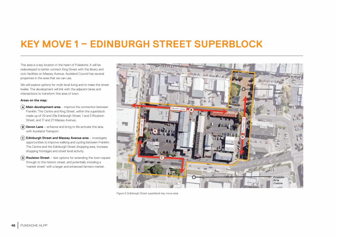
This area is a key location in the heart of Pukekohe. It will be redeveloped to better connect King Street with the library and civic facilities on Massey Avenue. Auckland Council has several properties in the area that we can use.
We will explore options for multi-level living and to make the street livelier. The development will link with the adjacent lanes and intersections to transform this area of town.
Areas on the map:
A Main development area – improve the connection between Franklin: The Centre and King Street, within the superblock made up of 29 and 29a Edinburgh Street, 1 and 3 Roulston Street, and 17 and 21 Massey Avenue.
B Devon Lane – enhance and bring to life activate this lane, with Auckland Transport.
C Edinburgh Street and Massey Avenue area – investigate opportunities to improve walking and cycling between Franklin: The Centre and the Edinburgh Street shopping area. Increase shopping frontages and street level activity.
D Roulston Street – test options for extending the town square through to this historic street, and potentially including a ‘market street’ with a larger and enhanced farmers market.
Figure 9. Edinburgh Street superblock key move area
KEY MOVE 1 – EDINBURGH STREET SUPERBLOCK
46 PUKEKOHE HLPP
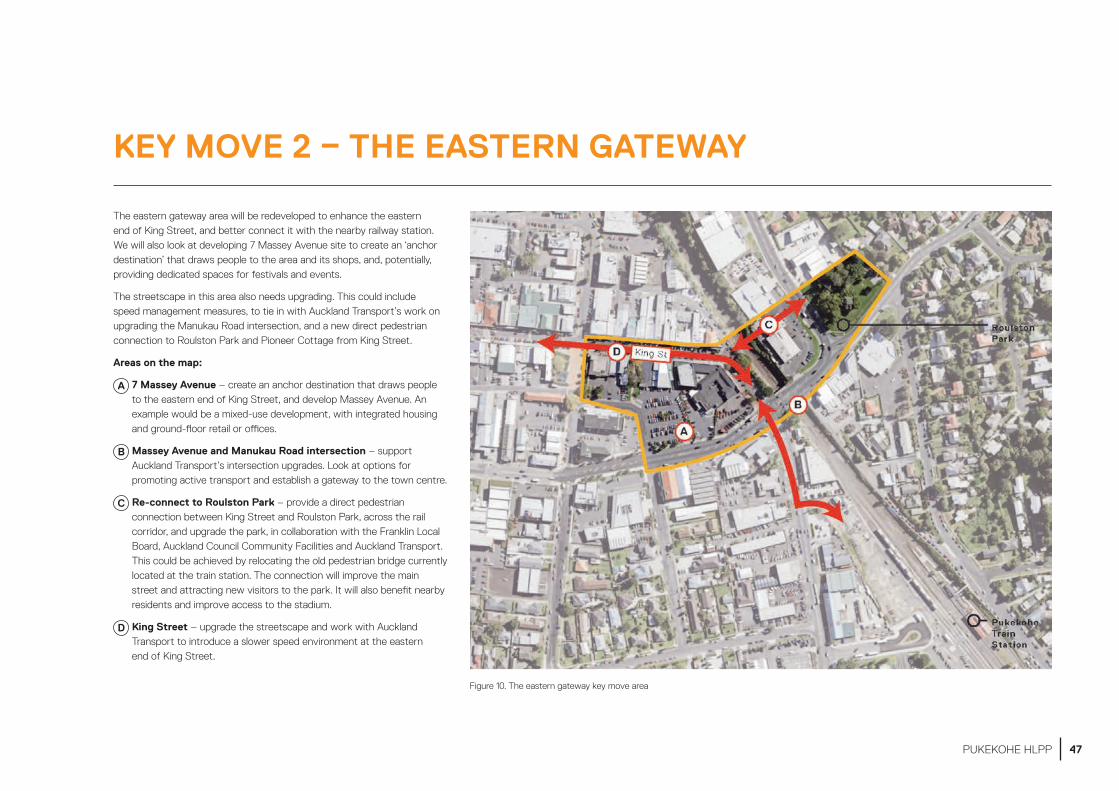
The eastern gateway area will be redeveloped to enhance the eastern end of King Street, and better connect it with the nearby railway station. We will also look at developing 7 Massey Avenue site to create an ‘anchor destination’ that draws people to the area and its shops, and, potentially, providing dedicated spaces for festivals and events.
The streetscape in this area also needs upgrading. This could include speed management measures, to tie in with Auckland Transport’s work on upgrading the Manukau Road intersection, and a new direct pedestrian connection to Roulston Park and Pioneer Cottage from King Street.
Areas on the map:
A 7 Massey Avenue – create an anchor destination that draws people to the eastern end of King Street, and develop Massey Avenue. An example would be a mixed-use development, with integrated housing and ground-floor retail or offices.
B Massey Avenue and Manukau Road intersection – support Auckland Transport’s intersection upgrades. Look at options for promoting active transport and establish a gateway to the town centre.
C Re-connect to Roulston Park – provide a direct pedestrian connection between King Street and Roulston Park, across the rail corridor, and upgrade the park, in collaboration with the Franklin Local Board, Auckland Council Community Facilities and Auckland Transport. This could be achieved by relocating the old pedestrian bridge currently located at the train station. The connection will improve the main street and attracting new visitors to the park. It will also benefit nearby residents and improve access to the stadium.
D King Street – upgrade the streetscape and work with Auckland Transport to introduce a slower speed environment at the eastern end of King Street.
Figure 10. The eastern gateway key move area
KEY MOVE 2 – THE EASTERN GATEWAY
47PUKEKOHE HLPP
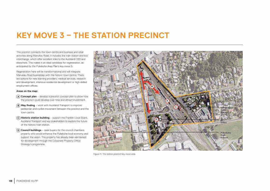
This precinct connects the town centre and business and retail activities along Manukau Road. It includes the train station and bus interchange, which offer excellent links to the Auckland CBD and elsewhere. This makes it an ideal candidate for regeneration, as anticipated by the Pukekohe Area Plan’s key move 5.
Regeneration here will be transformational and will integrate Manukau Road businesses with the historic town centre. There are options for new learning providers, medical services, research and development, intensive residential development or high-skilled employment offices.
Areas on the map:
A Concept plan – develop a precinct concept plan to show how the precinct could develop over time and attract investment.
B Way finding – work with Auckland Transport to improve pedestrian and cyclist movement between the precinct and the town centre.
C Historic station building – support the Franklin Local Board, Auckland Transport and key stakeholders to explore the future of the historic train station.
D Council buildings – seek buyers for the council chambers property who would enhance the Pukekohe local economy and support the vision. This property has already been earmarked for development through the Corporate Property Office Strategy’s programme.
Figure 11. The station precinct key move area
KEY MOVE 3 – THE STATION PRECINCT
48 PUKEKOHE HLPP
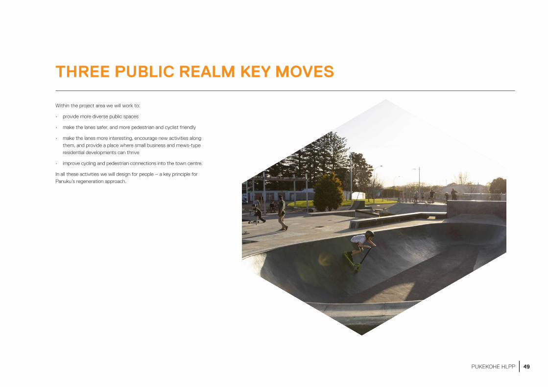
Within the project area we will work to:
• provide more diverse public spaces
• make the lanes safer, and more pedestrian and cyclist friendly
• make the lanes more interesting, encourage new activities along them, and provide a place where small business and mews-type residential developments can thrive
• improve cycling and pedestrian connections into the town centre.
In all these activities we will design for people – a key principle for Panuku’s regeneration approach.
THREE PUBLIC REALM KEY MOVES
49PUKEKOHE HLPP

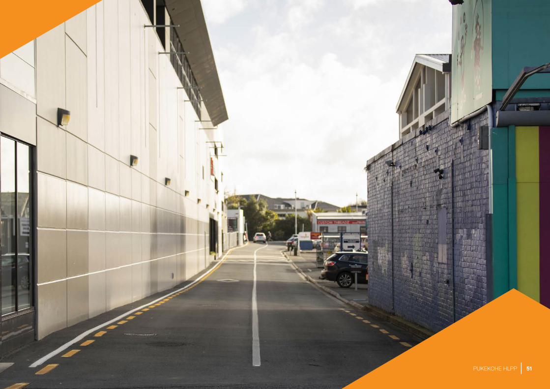
This key move focusses on selected lanes within the town centre.
Making these lanes more active and attractive will improve people’s access to the town centre and allow more intensive development on adjoining sites.
We will work with Auckland Transport to put in footpaths, lighting, parallel parking for delivery vehicles, trees and street art.
This will attract new businesses to these lanes, which alongside residential uses, will add vibrancy to the area.
Figure 12. Enliven the lanes key move areaFigure 13. Artist’s impression of potential lane improvements shows what a potential lane transformation might look like.
KEY MOVE 1 – ENLIVEN THE LANES
50 PUKEKOHE HLPP
51PUKEKOHE HLPP

We will work with Auckland Transport to improve access to and within the town centre, through projects that prioritise facilities for walking and cycling. These improvements will make it easier to move through the town, and provide links to amenities, services and schools.
Improvements may include upgrading certain intersections, and improving the western ends of King Street and Edinburgh Street. We will focus in particular on Edinburgh Street, which connects southern Pukekohe to Pukekohe High School, Pukekohe Intermediate, the town centre and cinema complex.
Other options are an urban tree programme (including new street trees) to enhance the green look and feel of the town centre, and speed management measures for vehicle traffic so roads are safer and easier to cross into the town centre.
The ring road’s function as a traffic and freight bypass will need to be considered in any investigations. Current and future land use also has to be taken into account. In the future, multi-level residential and commercial buildings, shops and cafés will potentially front the ring road.
Next steps:
• conduct a survey to understand how people currently walk and cycle around the town centre and use the open spaces within it
• assess the safety of the pedestrian crossing on Massey Avenue outside the Franklin Centre and work with AT to identify improvements
• investigate the needs of pedestrians and cyclist in the town centre and surrounds with AT, with a priority focus on Edinburgh Street
• investigate improving the safety of intersections in the town centre (such as at West Street, Queen Street and Edinburgh Street) with AT to make them easier to use.
Figure 14. Improve pedestrian and cyclist connections key move area
KEY MOVE 2 – IMPROVE PEDESTRIAN AND CYCLIST CONNECTIONS
52 PUKEKOHE HLPP

We will explore the feasibility of developing a new child, youth, or even all-age-friendly place to play opportunity, possibly at Roulston or Seddon Park.
Alternatively, we may contribute towards other play spaces outside the town centre, being developed by the local board or the Council, such as in Belmont.
KEY MOVE 3 – CREATE MORE PLACES TO PLAY
53PUKEKOHE HLPP

Placemaking is about creating public spaces that people use, care for and value.
Our placemaking key moves are all about recognising the importance of people-friendly scale and design, and fostering a sense of place.
Placemaking key moves for the areas we plan to focus our efforts on:
Farmers market – investigate relocating and expanding the Pukekohe Farmers Market within the Town Square, Roulston Street and King Street area.
Car parks – work with locals to explore potential future uses for the car park sites (which will occur as part of the precinct redevelopment key moves).
Figure 15. Placemaking key moves area
TWO PLACEMAKING KEY MOVES
54 PUKEKOHE HLPP

Enhancing the farmer’s market will grow Pukekohe’s identity and reputation as a food destination.
One option would be to relocate the market to the town square. Given the market is larger than the town square, we will look at options for extending the market southward into Roulston Street to create a genuine ‘market street’. This would enable larger and better weekly markets, and signature events that reflected Pukekohe’s identify and its food offerings.
As a first step, we will develop a market strategy that explores the nature and potential outcomes for an expanded farmers market. We will then test the options through a series of temporary activities, before any final plans are made.
This key move would also enable redevelopment of the Council’s 7 Massey Avenue property where the farmers market is currently located.
As work on the lanes and streetscapes progress (through the public realm key moves), we will work with local people, along with Auckland Transport, to explore how these areas could develop in the longer term. These may include:
• off-street carparks – testing selected off-street carparks for temporary alternative uses, such as events, if they are no longer required by Auckland Transport
• King and Roulston Street – exploring having events, such as markets, on Roulston Street; and exploring future options for streetscape upgrades on King Street
• outdoor dining – using sections of carparks along the southern side of King Street (where there is the most sunlight) to provide wider footpaths for outdoor dining
• short-term activities in lanes – making the lanes more interesting spaces, and making temporary changes to selected sections of lanes to investigate options for more permanent change.
KEY MOVE 1 – RELOCATE, GROW AND ENHANCE THE FARMERS MARKET
KEY MOVE 2 – PLACEMAKING TRIALS
55PUKEKOHE HLPP
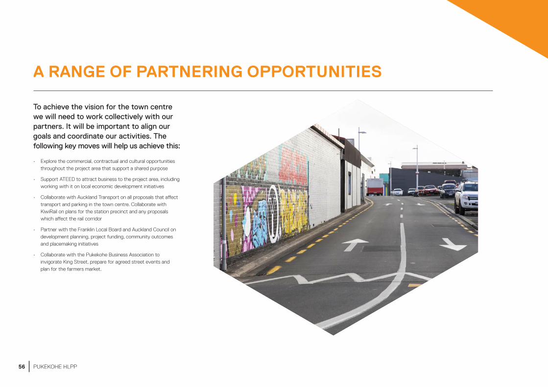
A RANGE OF PARTNERING OPPORTUNITIES
To achieve the vision for the town centre we will need to work collectively with our partners. It will be important to align our goals and coordinate our activities. The following key moves will help us achieve this:
• Explore the commercial, contractual and cultural opportunities throughout the project area that support a shared purpose
• Support ATEED to attract business to the project area, including working with it on local economic development initiatives
• Collaborate with Auckland Transport on all proposals that affect transport and parking in the town centre. Collaborate with KiwiRail on plans for the station precinct and any proposals which affect the rail corridor
• Partner with the Franklin Local Board and Auckland Council on development planning, project funding, community outcomes and placemaking initiatives
• Collaborate with the Pukekohe Business Association to invigorate King Street, prepare for agreed street events and plan for the farmers market.
56 PUKEKOHE HLPP
57PUKEKOHE HLPP
58 PUKEKOHE HLPP

HOW WE PLAN TO IMPLEMENT THIS PROJECT
59PUKEKOHE HLPP
OUR APPROACH TO DELIVERY
DEVELOPMENT OF KEY PROPERTIES
Our approach to delivering this high-level project plan builds on the town centre’s existing strengths, reflects inputs from stakeholders and market advice, and phases development to preserve future options.
Fundamental features of our approach are to:
• focus on the most valuable properties within the portfolio that are located within the town centre
• collaborate with Auckland Transport to regenerate the three development precincts
• prioritise effort on the three redevelopment precincts, as this work will have the greatest influence on achieving the goals
• focus on attracting quality employment opportunities, education providers and healthcare services
• catalyse new housing choices in the town centre, which are integrated with non-residential uses
• use the remainder of the portfolio outside of the town centre for housing and to generate financial return
• align the timing and priority of the public realm key moves with the adjacent redevelopment site sales.
We will use these approaches to set commercial priorities, focus our resources and ensure all stakeholders are working toward common goals.
The following tables provide details about the key properties in our portfolio, and the potential development opportunities they provide for achieving the vision and goals in this plan.
It is important to note that the carpark sites listed in the tables are controlled and managed by Auckland Transport. They will be assessed and, if suitable, approved by Auckland Transport for development. Some sites are subject to a designation for parking purposes, which would need to be uplifted by Auckland Transport.
60 PUKEKOHE HLPP

LocationNo. of sites Potential uses
Land area (m2)
Estimated timing (ready for development) Zone Potential development opportunities
Edinburgh super block – 1 & 3 Roulston St; 29, 29a & 33 Edinburgh St; 17 & 21 Massey Ave
7 Mixed use 6750 3 – 5 years Town Centre
These sites could catalyse change for the precinct. They would ideally be used for intensive mixed-use development, bringing life to the street fronts on Edinburgh Street, Massey Avenue, Roulston Street and Devon Lane.
Development should also improve connections across these streets to the library, Pukekohe Plaza and King Street.
7 Massey Ave 1 Mixed use 5191 2 – 5 years Town Centre
This site could provide a catalyst for change. It would ideally become a mixed-use anchor destination with active frontages to Massey Ave.
4 Tobin St 3 Mixed use 1460 2 – 5 years Town Centre
This carpark primarily serves the supermarket. It could provide a catalyst to upgrade and better connect this anchor destination. Its development could support north-facing mixed-use development along Seddon Lane.
9 Tobin St 1 Mixed use / Commercial
3687 2 – 5 years Town Centre
This site could provide for change for this precinct and would ideally incorporate a mixed-use development.
9 Hall St 1 Mixed use 889 1 – 4 years Town Centre
This site could provide an opportunity to create a modern development near the eastern end of the main street and would ideally incorporate a mixed-use development consisting of retail and residential.
24 Hall St 1 Mixed use 3148 1 – 4 years Town Centre
This site could provide for change to this area of town and would ideally incorporate a mixed-use development attracting locals to this part of town.
27 Tobin St 1 Residential 363 1 – 2 years Mixed Use
This site could provide for a residential extension of the neighbouring properties.
Land adjacent to 35 Tobin St
1 Residential 615 1 – 2 years Mixed Use
This site could provide for a residential extension of the neighbouring properties.
42 Seddon St1 Residential 300 1 – 2 years Mixed
UseThis site could provide for a residential extension of the neighbouring properties
22 Edinburgh St 1 Mixed use 1012 1 – 2 years Mixed Use
The property has specific planning restrictions, which include a titoki tree onsite, and has been included in a recent plan change to a category B building. However, the interior is not included.
82 Manukau Rd 1 Mixed use 13090 1 – 2 years Mixed Use
This site could provide a key opportunity to create a flagship development close to the rail network. The goal is a mixed-use development that is transformational with an anchoring activity, enhancing the availability of local jobs, enabling better access to healthcare and learning opportunities.
174, 176, 180, 182 Manukau Rd
4 Commercial/ Industrial
5894 1 – 3 years Business – Light Industry
These sites could provide a catalyst for change for the Manukau Road southern corridor and would ideally incorporate a large industrial, bulk retail outlet or other commercial development.
172 Manukau Rd 1 Commercial/ Industrial
512 1 – 2 years Business – Light Industry
This site could provide a catalyst for change for the Manukau Road southern corridor.
Table 1. Kia Puāwai a Pukekohe properties within the project area boundary
61PUKEKOHE HLPP
LocationNo. of sites Potential uses
Land area (m2)
Estimated timing (ready for development) Zone Potential development opportunities
2 Golding Rd 1 Residential 8204 1 – 3 years Future Urban Possible residential subdivision.
Land adjacent to 995 Paerata Rd
1 Residential 1012 1 – 2 years Open Space – Informal Recreation
Possible housing use on part of the site, noting overland flow paths.
Land adjacent to 176 Princess St West
1 Residential 1019 1 – 2 years Open Space – Informal Recreation
Possible housing use on part of the site, noting overland flow paths.
67 East St 1 Residential 815 1 – 2 years Open Space – Informal Recreation
Possible housing use.
Land adjacent 603 Buckland Rd
1 Residential 2977 1 – 2 years Future Urban Possible housing use on part of the site, noting proximity to a watercourse.
Land adjacent to 1173 Paerata Rd
1 Residential/ other
8491 1 – 3 years Future Urban Possible housing use, noting proximity to a watercourse and rail line.
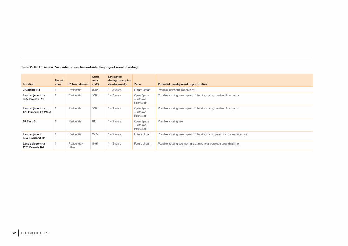
Table 2. Kia Puāwai a Pukekohe properties outside the project area boundary
62 PUKEKOHE HLPP

FUNDING
OTHER RESOURCES
The Kia Puāwai a Pukekohe project will require funding for capital projects and adequate resources to achieve progress.
The project has been approved by Auckland Council and is funded in the Long-Term Plan 2018–2028 through the reinvestment of proceeds from property sales across the wider Panuku portfolio.
Overall, Panuku is required to strike a balance between strategic outcomes, such as providing improved town centres, more housing choices and better public amenities, and ensuring that the council also optimises the commercial return from its property portfolio. By taking a regional approach to reinvestment, we are able to target
the areas of greatest need and achieve credible progress in all locations where we work.
We will prepare a business case for Kia Puāwai a Pukekohe. The business case will confirm the level of funding required for the capital programme. It will also estimate the net community benefits of undertaking the project.
As the lead agency within the project area, we will also seek to partner with others, combining funding and resourcing with other council organisations and community groups in order to get the best value out of the project’s funding envelope. For example, we will:
• advocate to the Franklin Local Board to allocate funding to support the Kia Puāwai a Pukekohe Project
• work with Auckland Council departments and council-controlled organisations, such as Auckland Transport, Healthy Waters, Corporate Property, Community Services and Facilities, and ATEED to reprioritise existing budgets, and integrate and align funding towards agreed project priorities
• collaborate with Auckland Transport to align agreed projects within the road corridor, such as safety and walking and cycling programmes.
These funding strategies will be developed following the adoption of the high-level project plan.
The Kia Puāwai a Pukekohe Project will be led by a project team of Panuku staff. These staff will draw from work areas across our organisation, including strategy, engagement, design, placemaking, development and portfolio management.
At various stages of the project, we will call on additional input and expertise from our partners, the wider council whānau, mana whenua, external reference groups, stakeholders and consultants.
63PUKEKOHE HLPP

64 PUKEKOHE HLPP

INFORMATION USED TO DEVELOP THIS PLAN
65PUKEKOHE HLPP

OTHER PLANS AND POLICIES
A number of other plans and policies have considered Pukekohe’s strategic role and structure. These plans reflect a broad understanding of Pukekohe as a rural satellite town, with significant potential for growth and intensification.
The following planning documents have informed this high-level project plan:
• Auckland Unitary Plan (operative in part 2016)• Auckland Plan 2050 (2018)• Long Term Plan 2018–2028• Franklin Local Board Plan (2017)• Pukekohe Area Plan (2014)• Pukekohe–Paerata Paths Plan (2018)• Draft Pukekohe–Paerata Structure Plan (2019)• Regional Land Transport Plan (2018)• Auckland Transport Alignment Project (2018)• Community Facilities Network Action Plan (2015)• Parks and Open Spaces Strategic Action Plan (2013).
AUCKLAND UNITARY PLAN
The Kia Puāwai a Pukekohe project focuses on the historic town centre and extends out to include several key facilities just beyond the ring road. The area encompasses a number of different land zone classifications, as shown in the map opposite.
Under the Unitary Plan, a Business: Town Centre zoning applies to an area centred on King Street and contained within the bounds of Tobin Street, Stadium Drive, the North Island Main Trunk (Railway) line, Massey Avenue and Wesley Street. It also applies to a small area to the south of Massey Avenue that contains the Pukekohe War Memorial Hall, the RSA and Franklin: The Centre. The town centre accommodates two Civic zoned spaces and a few pockets of Informal Recreation zoned parks and community facilities.
Buildings within the town centre are limited to 18m in height (generally four to six storeys), apart from three blocks on the northern side of King Street, which are limited to a height of 13m (to allow winter sun onto the southern footpath of King Street). Controls on building frontages apply throughout the centre. These controls seek to maximise activity on the streets, ensure building continuity along the street front, and enhance pedestrian amenity and safety. There are specific provisions in the Unitary Plan to protect the character of Pukekohe’s traditional main street.
The Unitary Plan adopts a different approach to parking in Pukekohe than in most other centres within Auckland. The approach reflects the town’s role as a satellite centre, which requires a minimum number of spaces to be provided for activities.
Beyond the Town Centre Zone, there is a mix of Business Mixed Use zone and Residential Terrace Housing and Apartment zone land. Further south, is the Pukekohe Intermediate School, Pukekohe High School and Bledisloe Park. The latter has a Sport and Active Recreation zoning and accommodates football, cricket and netball clubs, along with the public Jubilee swimming pool. Throughout the area, there are numerous scheduled notable trees and historic heritage buildings.
66 PUKEKOHE HLPP
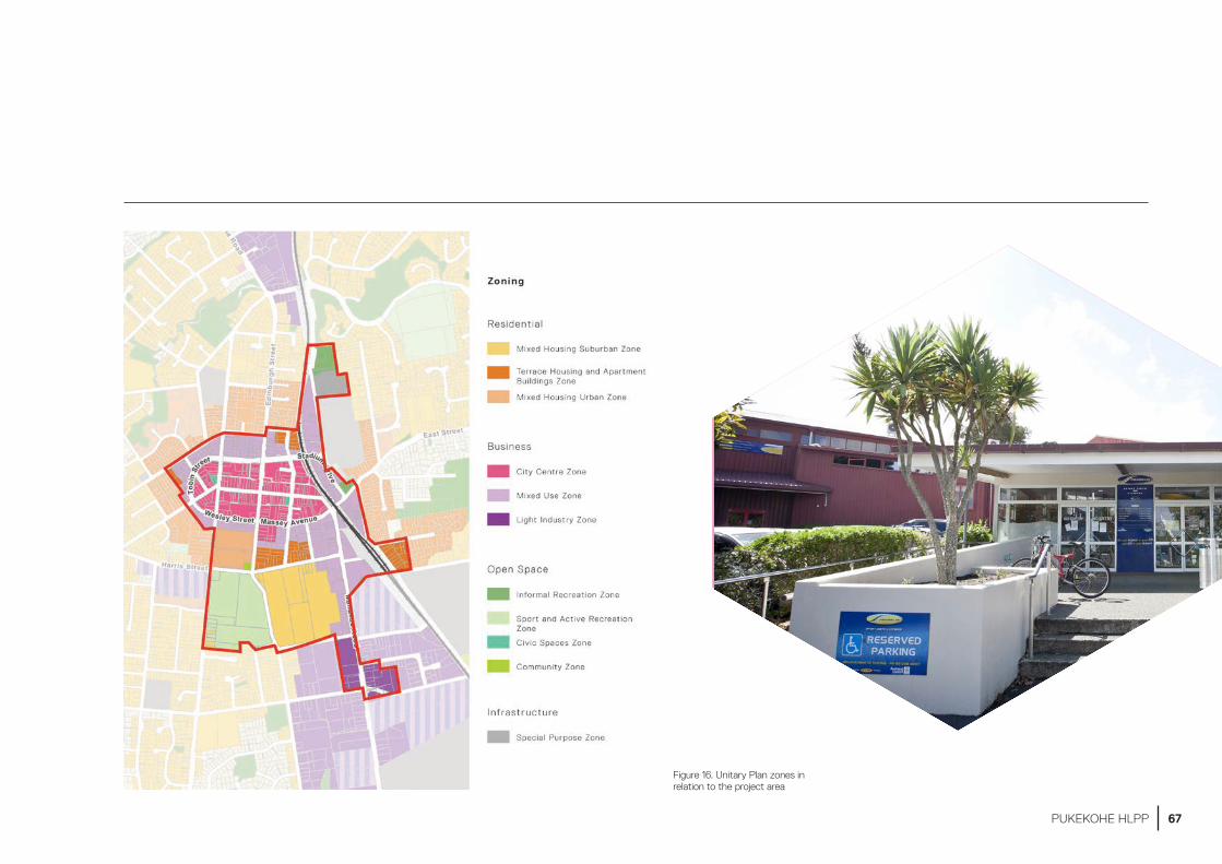
Figure 16. Unitary Plan zones in relation to the project area
67PUKEKOHE HLPP
AUCKLAND PLAN 2050
The Auckland Plan’s development strategy identifies Pukekohe as a rural node and satellite town within a multi-nodal system of main centres. In the future, Pukekohe will continue to service the surrounding rural communities, be connected to greater Auckland through state highways and rail (which is to be electrified), and will support significant business and residential growth (within the current urban areas and in greenfield locations).
The Auckland Plan recognises Pukekohe has the potential to function semi-independently from the main urban area of Auckland, and this will reduce the need for people to travel out of the area to access facilities, services and employment opportunities.
LONG-TERM PLAN 2018–2028
The Long-Term Plan 2018–2028 is a budget that sets out Auckland Council’s planned activities, services and investments for the next 10 years. Infrastructure requirements are considered over a long-term timeframe and are included in the 30-year Infrastructure Strategy.
Infrastructure identified in the long-term plan includes a longer-term initiative to increase the capacity of the Pukekohe reservoirs’ water supply.
FRANKLIN LOCAL BOARD PLAN 2017
The Franklin Local Board Plan is a 3-year strategic document that guides local board activity, funding and investment decisions for 2017 to 2020. This plan highlights the following important outcomes:
• dealing with growth effectively
• caring for the environment
• improving transport connections
• supporting a thriving local economy, with local jobs for local people
• providing a range of community facilities that meet the needs of a growing community.
The plan emphasises that growth will be focussed on Pukekohe’s existing town centre. This will help protect Franklin’s productive volcanic soils, and recognises both the importance of these soils for food production and the unique combination of soils, climate and proximity to market that occur around Pukekohe.
The local board also recognises how important it is for the community to feel ownership of and a connection with their local area. The plan supports a range of community-led placemaking activities and initiatives that reflect Franklin’s diversity and demographics.
PUKEKOHE–PAERATA PATHS PLAN 2018
This aspirational, non-statutory plan supports a vision for a network of walking, cycling and ecological connections throughout the region. These include several proposed, but as yet unfunded, paths that have the potential to connect Pukekohe and its heart to the wider area.
PUKEKOHE AREA PLAN 2014
This non-statutory plan supported the development of Pukekohe as a rural satellite town with future urban growth located in areas such as Paerata. Through key moves and actions, the plan supports local economic and employment opportunities to match population growth, increased local tertiary education opportunities, and development of land around the upgraded Pukekohe Railway Station for greater uses. Other key actions include the development of town centre character guidelines, improved accessibility and connectivity through the town centre (including improved pedestrian access across the ring road), and local improvements to enhance walking and cycling opportunities in the town centre.
Focusing growth on existing centres and protecting fertile soils used for local horticulture and agriculture is a key priority of the Auckland Plan and the Pukekohe Area Plan, and will be achieved through identification of Future Urban zoned land under the Unitary Plan.
68 PUKEKOHE HLPP

DRAFT PUKEKOHE–PAERATA STRUCTURE PLAN 2019
The Pukekohe–Paerata Structure Plan, once adopted, will apply to approximately 1,300 hectares of Future Urban zoned land in the wider Pukekohe area. The current draft plan shows the arrangement of various land uses (residential, business and parks) and infrastructure. It also shows how these areas connect to adjacent urban and rural areas and wider infrastructure networks. Important cultural values and natural features are also addressed.
The structure plan will refine the staging and timing of development of this land, and identify the mix and location of housing, employment, retail, commercial and community facilities, as well as necessary upgrades to water, wastewater, stormwater and transport that will be required to facilitate growth. It is anticipated that the final Pukekohe–Paerata Structure Plan will be recommended for adoption to the Auckland Council Planning Committee in late 2019.
REGIONAL LAND TRANSPORT PLAN 2018
The Regional Land Transport Plan 2018 is a 10-year investment programme prepared by Auckland Transport, together with the New Zealand Transport Agency and KiwiRail. The plan contains the entire transport investment programme for the region, enabled by all funding allocations (i.e. both from the government and Auckland Council through its Long-Term Plan 2018–2028), and must give effect to the Government Policy Statement on Land Transport. The government policy statement focuses on four strategic priorities: safety, access, environment and value for money.
Projects identified in the Regional Land Transport Plan that are relevant to Pukekohe include:
• State Highway 22 Drury to Paerata safe roads project
• Pukekohe rail electrification
• additional electric trains.
Other projects in the Regional Land Transport Plan that affect the wider area, such as the State Highway 1 Papakura to Bombay project, may also be relevant to Pukekohe.
AUCKLAND TRANSPORT ALIGNMENT PROJECT
The Auckland Transport Alignment Project is a joint project between Auckland Council, Auckland Transport and the government to determine an aligned strategic approach on transport for Auckland. This includes information and direction on Pukekohe. At present, the project is focusing on investment priorities for 2018 to 2028, based on an assumed funding envelope of $28 billion over the decade.
69PUKEKOHE HLPP

TRANSPORT INFRASTRUCTURE
PUKEKOHE RAILWAY STATION AND TRAIN SERVICES
The Auckland Plan and Pukekohe Area Plan identify Pukekohe as one of several growth areas that are a priority for planning and investment in the short term. The plans suggest that having higher frequency train services on the rail network to Pukekohe will positively affect the overall travel time to other key destinations in Tāmaki Makaurau and encourage the local community to use public transport.
The Pukekohe Railway Station (formally known as the Pukekohe Railway Station and Post and Telegraph Office) was established in 1875 at the eastern end of King Street. It was subsequently re-located a short distance south-east of the town centre and was upgraded in 2018 to include a bus interchange, park-and-ride and pedestrian overbridge. The project increased public transport patronage by connecting feeder bus services to the train station, along with providing good pedestrian and cycling connections.
Auckland’s electric rail network currently terminates at Papakura, where travellers transfer to diesel trains, which operate to Pukekohe every 20 minutes at peak times.
BUS NETWORK
A new public transport network was developed for Pukekohe in 2016. Bus provision is based on a mixture of three local services that serve the Pukekohe urban areas and four longer distance services that serve Paerata, Waiuku and Port Waikato. The three local bus routes run every 30 minutes, 7 days a week around Pukekohe, serving the town centre and shopping areas, and connecting with train services at the station.
PARKING
An Auckland Transport commissioned parking study for the Pukekohe town centre in 2019 made the following findings:
• Pukekohe town centre contains approximately 4000 carparks. Half are controlled by Auckland Transport and half by the private sector. Of these, 1000 are in public off-street lots. These lots are controlled by Auckland Transport or are in the Pukekohe Plaza building
• These carparks support access to the town centre. Some parking will always be required in a satellite town which serves a rural catchment. The carparks use a large amount of town centre land. Parking Surveys undertaken in 2018 show that even at peak times approximately 600 publicly provided car parks spaces in Pukekohe are vacant. This is a similar number of vacant spaces as there were in 2009 despite a significant (20%) increase in population. The study also found that some spaces are being used for all-day parking as a park-and-ride for train travel, as opposed to short-stay (i.e. visitor) parking.
EXISTING WALKING AND CYCLE NETWORK
While Pukekohe has an exceptionally good main street (King Street), other streets in the town centre could be improved to make walking and cycling easier. While there are connections for active transport modes in some reserves, there are currently few dedicated cycle facilities on Pukekohe’s streets.
70 PUKEKOHE HLPP
INFRASTRUCTURE CAPACITY
Auckland Council has made the following assessments of Pukekohe’s physical and social infrastructure capacity:
WATER SUPPLY
Pukekohe’s water supply is sourced from the Waikato River and treated at the Waikato water treatment plant. The existing supply network is reaching capacity to service this growing region. Watercare has a programme of investments in place to address this issue, as part of catering for the wider structure plan growth area.
WASTEWATER
The Wastewater network is predominantly a gravity system, supported by some pump stations. Wastewater is transferred to the Pukekohe wastewater treatment plant via the new pump station at the Pukekohe Raceway. Treated wastewater is discharged back into the Waikato River, and a 35-year discharge consent has recently been granted by the Waikato Regional Council. The existing network has capacity during dry weather, but is affected by infiltration during heavy rains.
The Pukekohe transmission pump station has recently been constructed to accommodate future flows from the Draft Pukekohe–Paerata Structure Plan area from undeveloped land zoned for residential use and forecast intensification within the existing urban area.
STORMWATER
The Kia Puāwai a Pukekohe Project straddles two stormwater catchments: the Whangapouri Creek catchment, and the Pukekohe South–Tuatenui catchment. Areas to the south, particularly around Pukekohe Intermediate School and Bledisloe Park, are susceptible to flooding.
In the Long-Term Plan 2018–2028, the council adopted a water-sensitive design approach to stormwater and flooding management. This means that most stormwater investments are likely to be relatively small projects, responding to growth as it occurs. The largest investments will be in future urban growth areas that are subject to significant flooding.
EDUCATION
The rolls at both Pukekohe Intermediate and Pukekohe High School are continuing to grow and, with projected demographic change and population growth, may soon reach capacity. There are limited education opportunities at tertiary level within Pukekohe, with only a few private providers located in the town centre.
COMMUNITY FACILITIES AND OPEN SPACE
The heart of Pukekohe has an unusually good range of open spaces, reserves and community facilities – including Bledisloe Park, the Jubilee Pools, the Franklin Pool and Leisure Centre, Roulston Park, the stadium, Seddon Park, the town square, the War Memorial Hall and Franklin: The Centre.
Auckland Council’s Parks and Open Spaces Strategic Action Plan and Community Facilities Network Plan provide frameworks for assessing open space and community facilities requirements. A community facilities provision assessment for Pukekohe–Paerata was completed in March 2019 and identified that, in general, new service provision should be directed towards greenfield growth areas, such as Paerata. For the existing urban area, the priority is to enhance existing facilities.
Although the existing open spaces and community facilities can accommodate some growth, with future growth there may be pressures, particularly on the library and Franklin Leisure Centre. The Franklin and Jubilee pools will require particular consideration to ensure they remain fit for purpose, and further indoor court facilities may be needed by 2026.
71PUKEKOHE HLPP
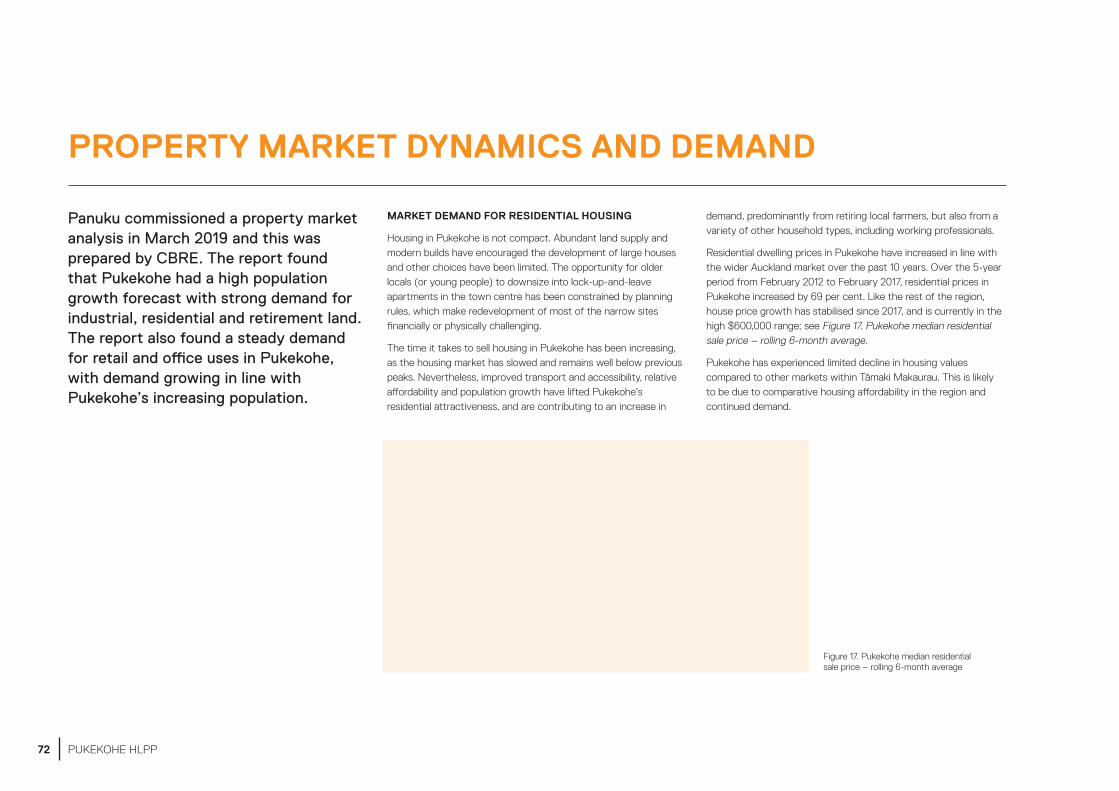
PROPERTY MARKET DYNAMICS AND DEMAND
Panuku commissioned a property market analysis in March 2019 and this was prepared by CBRE. The report found that Pukekohe had a high population growth forecast with strong demand for industrial, residential and retirement land. The report also found a steady demand for retail and office uses in Pukekohe, with demand growing in line with Pukekohe’s increasing population.
MARKET DEMAND FOR RESIDENTIAL HOUSING
Housing in Pukekohe is not compact. Abundant land supply and modern builds have encouraged the development of large houses and other choices have been limited. The opportunity for older locals (or young people) to downsize into lock-up-and-leave apartments in the town centre has been constrained by planning rules, which make redevelopment of most of the narrow sites financially or physically challenging.
The time it takes to sell housing in Pukekohe has been increasing, as the housing market has slowed and remains well below previous peaks. Nevertheless, improved transport and accessibility, relative affordability and population growth have lifted Pukekohe’s residential attractiveness, and are contributing to an increase in
demand, predominantly from retiring local farmers, but also from a variety of other household types, including working professionals.
Residential dwelling prices in Pukekohe have increased in line with the wider Auckland market over the past 10 years. Over the 5-year period from February 2012 to February 2017, residential prices in Pukekohe increased by 69 per cent. Like the rest of the region, house price growth has stabilised since 2017, and is currently in the high $600,000 range; see Figure 17. Pukekohe median residential sale price – rolling 6-month average.
Pukekohe has experienced limited decline in housing values compared to other markets within Tāmaki Makaurau. This is likely to be due to comparative housing affordability in the region and continued demand.
Figure 17. Pukekohe median residential sale price – rolling 6-month average
72 PUKEKOHE HLPP
RETIREMENT HOUSING SUPPLY AND DEMAND TRENDS
Pukekohe has 557 retirement units contained within seven retirement village complexes. Pukekohe also has 345 care beds, contained within four aged-care complexes. There are 50 dementia beds and 30 other beds; most of the latter beds are within assisted living suites that bridge the needs gap between serviced apartments and care beds.
There are generally between two and five new retirement complexes added in Pukekohe each decade. Looking forward, there is likely to be a demand for more retirement living options, with peak demand expected between 2020 and 2035.
HAUMARU HOUSING
There are four clusters of council-owned housing for older people within the Pukekohe urban area. Combined, these represent 75 units of the 1452 units within the Auckland-wide portfolio.
OFFICE SUPPLY AND DEMAND TRENDS
There are few office buildings with areas of over 1000m2 in Pukekohe. A total stock of just under 20,000m2 of office space currently services around 100 different tenants.
Growth in available office space over the next 25 years is estimated to be 32 per cent, with much of the supply coming from smaller-scale mixed-use developments. We anticipate these will have a small square metre footprint, but be higher quality options, predominantly targeted at the local business community.
RETAIL SUPPLY AND DEMAND TRENDS
Pukekohe’s retail premises are concentrated in four areas: Pukekohe Plaza, The Zone, Megacentre and the historic town centre. Combined, this equates to 88000m2 retail area, with 25,000m2 of this entering the market since 2010, and makes up approximately 28 per cent of Pukekohe’s total retail stock.
Retail vacancies in Pukekohe are low across all categories. The Pukekohe Plaza currently has only one unit available for lease (as at March 2019), and along King Street and Edinburgh Street there are only a few smaller shops that are available. This indicates a tight market with strong demand for retail space in the town centre.
There are no current vacancies in the large-format retail centres, but there are multiple sites available for design and build developments in the area.
INDUSTRIAL SUPPLY AND DEMAND TRENDS
Pukekohe’s industrial stock is made up of 139,395sqm and 151 buildings (these include Grade A, B and C industrial buildings). Pukekohe’s industrial vacancy rate is just below 1 per cent, compared to the rest of Tāmaki Makaurau, which is just over 1 per cent.
By 2045, Pukekohe’s industrial sector is expected to grow by 65 per cent. Pukekohe’s submarket of retail and wholesale trade sectors, as well as the predominantly local manufacturing businesses, will dominate demand for industrial space, catering for the projected population growth in the area.
BUSINESS ACTIVITY
There are 9370 people employed in 2586 businesses in Pukekohe. The town’s economy has been dynamic, growing by 58 per cent since 2000.
Pukekohe’s growth in the number of business has been comparable to broader Tāmaki Makaurau, but its employment growth has been higher than the Tāmaki Makaurau average (which was 50 per cent).
Based on population growth, it would be expected that Pukekohe’s business economy shows higher growth than Tāmaki Makaurau as a whole.
73PUKEKOHE HLPP
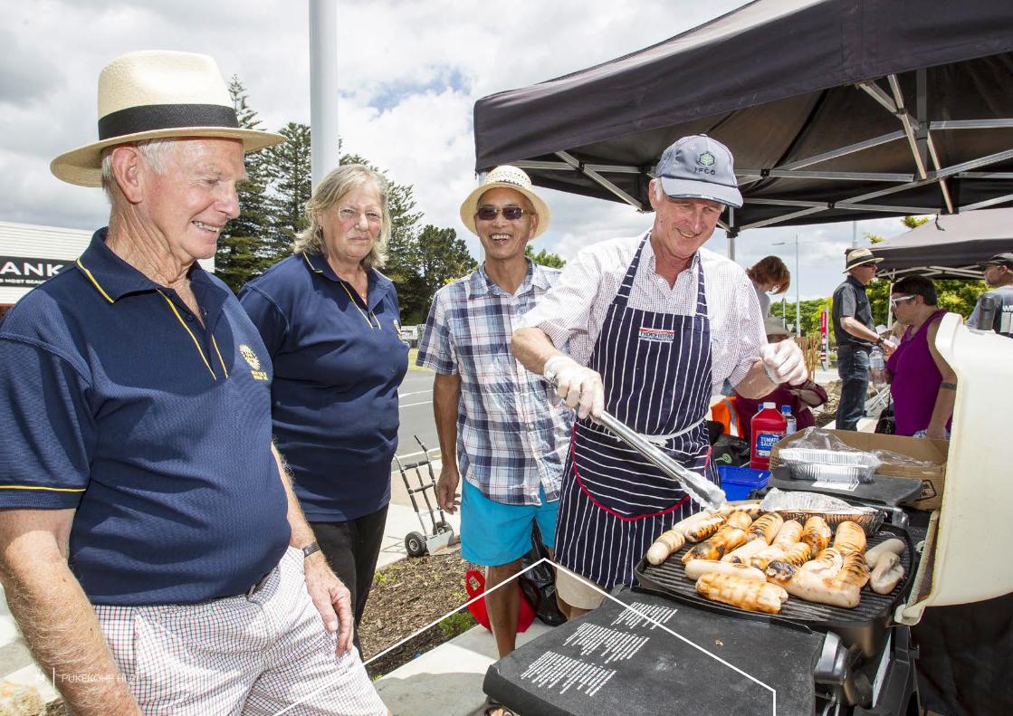
74 PUKEKOHE HLPP

COMMUNICATING WITH THE COMMUNITY
75PUKEKOHE HLPP

LISTENING TO THE COMMUNITY
WHAT THE COMMUNITY SAID
To be effective, we must take a fresh and bold approach to community and stakeholder engagement and communications. We will be proactive, collaborative and authentic in all of our key relationships.
A priority for Panuku is our ability to maintain positive momentum and to demonstrate quick wins. Establishing understanding, trust and credibility with people will help us prevent negative sentiment, which can often delay progress.
Previous community consultations and legacy planning in Pukekohe have informed this plan for Pukekohe. Through these channels we know that the people of Pukekohe care about their rural communities, and that Pukekohe is a place for locals. It’s a unique blend of country heart and soul, with an urban centre. We will deal specifically with this treasured sense of place in our community engagement planning.
THE RURAL HEART OF PUKEKOHE
Descriptors such as the ‘Tāmaki Makaurau’s food basket,’ ‘Tāmaki Makaurau’s market garden’ and ‘thriving rural market town’ are terms we heard regularly heard when engaging with the people of Pukekohe.
Markets and farming are vital elements of what makes Pukekohe a desirable place to live and work. We have heard that Pukekohe wants to retain and grow that point of distinction, even while the numbers of residents, jobs and businesses increase.
We will work with the rural community through Federated Farmers and other community representatives, to weave identity, lifestyle and the farming industry into all levels of planning. We’ll engage with the right people at the right time to ensure that the town centre growth reflects, and contributes to, the rural heart of Pukekohe.
A RURAL SERVICE HUB
We know from early engagement and previous planning that much of the Pukekohe’s workforce have vehicle-based businesses, and that many others use Pukekohe’s services to sustain their businesses and rural lifestyles. This includes people from a much wider catchment, including north Waikato.
Recognising that these are important considerations for the local board, businesses and the community, Panuku will work with our partners, Auckland Transport and key stakeholders to manage parking in town centre locations. We will engage early and collaboratively with:
• local trades
• town centre businesses through the business association
• rural business organisations
• private business.
LOCAL SELF-SUFFICIENCY
Pukekohe is proudly self-sufficient. We will work with local business and business partners to ensure that as Pukekohe grows and develops it retains its regional vibe and the ability to provide locals, and the rural community, with new opportunities while retaining its current offerings. We’ll engage with key stakeholder groups early and often throughout the life of the project.
76 PUKEKOHE HLPP

COMMUNICATIONS APPROACH
The crux of our communications approach is that it is place led. This approach helps to ensure that each development reflects the identity of the area, and that the collective aspirations and needs of the local community are achieved.
In Pukekohe, conversations will revolve around what could change and what the future may look like for the community. We will take the community on this journey with us as we explore local desire for growth, community initiatives and services, and parking requirements in the immediate future.
The local board and community will be invited to participate in messaging to our communities. This approach will show that Panuku is delivering on the desires of the community.
77PUKEKOHE HLPP
78 PUKEKOHE HLPP

NEXT STEPS
79PUKEKOHE HLPP

DEPENDENCIES
Timeframes shows the key dependencies for the Kia Puāwai a Pukekohe programme.
Table 3. Project dependencies
Key moves Nature of dependency
Precinct redevelopments
Approval from the Auckland Transport Board to release sites.
Appetite of the market to respond to potential sites for sale and appetite for the education, health and high-value employment sectors to invest in Pukekohe.
Public realm projects
Investment funding certainty and prioritisation. Agreement on scope and design with future asset owner.
Placemaking initiatives
Processes and approvals to access carpark sites for temporary activities.
80 PUKEKOHE HLPP
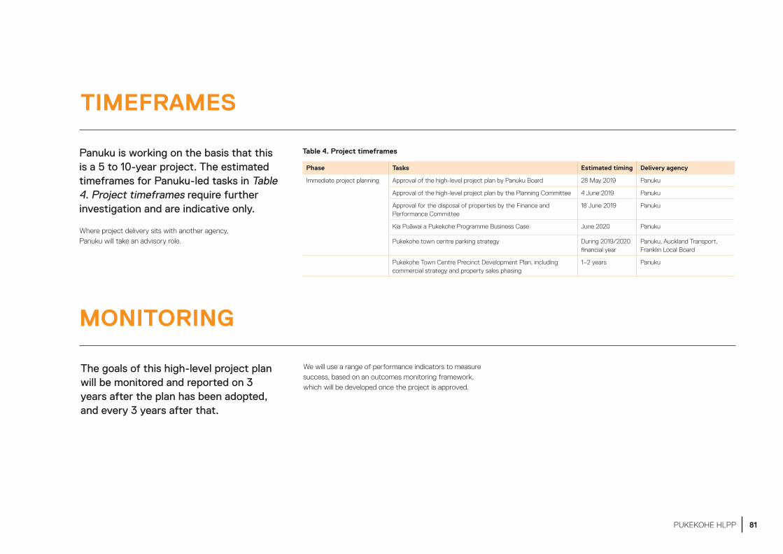
TIMEFRAMES
MONITORING
Panuku is working on the basis that this is a 5 to 10-year project. The estimated timeframes for Panuku-led tasks in Table 4. Project timeframes require further investigation and are indicative only.
Where project delivery sits with another agency, Panuku will take an advisory role.
The goals of this high-level project plan will be monitored and reported on 3 years after the plan has been adopted, and every 3 years after that.
We will use a range of performance indicators to measure success, based on an outcomes monitoring framework, which will be developed once the project is approved.
Phase Tasks Estimated timing Delivery agency
Immediate project planning Approval of the high-level project plan by Panuku Board 28 May 2019 Panuku
Approval of the high-level project plan by the Planning Committee 4 June 2019 Panuku
Approval for the disposal of properties by the Finance and Performance Committee
18 June 2019 Panuku
Kia Puāwai a Pukekohe Programme Business Case June 2020 Panuku
Pukekohe town centre parking strategy During 2019/2020 financial year
Panuku, Auckland Transport, Franklin Local Board
Pukekohe Town Centre Precinct Development Plan, including commercial strategy and property sales phasing
1–2 years Panuku
Table 4. Project timeframes
81PUKEKOHE HLPP
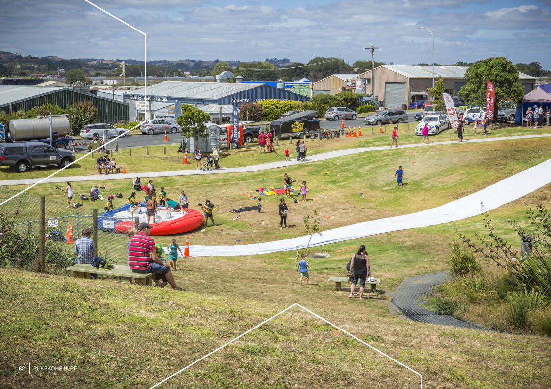
82 PUKEKOHE HLPP

83PUKEKOHE HLPP

APPENDIX 1: MAP OF TOWN CENTRE SITES
84 PUKEKOHE HLPP
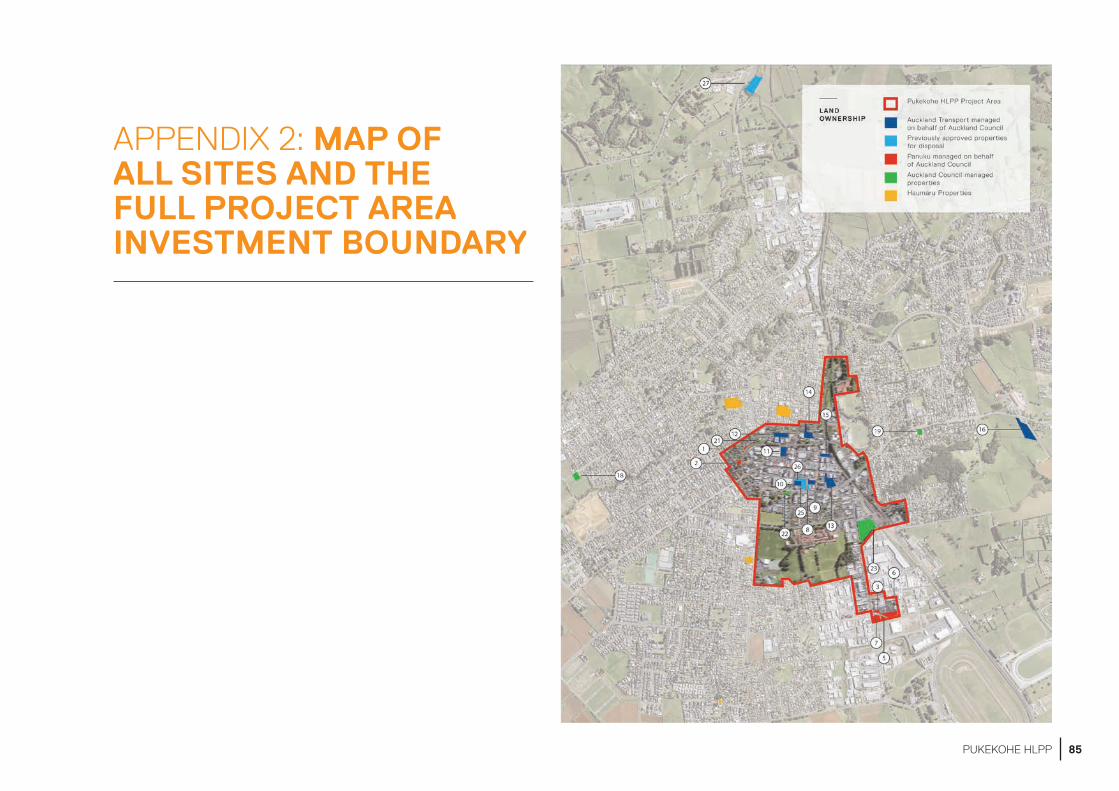
APPENDIX 2: MAP OF ALL SITES AND THE FULL PROJECT AREA INVESTMENT BOUNDARY
85PUKEKOHE HLPP
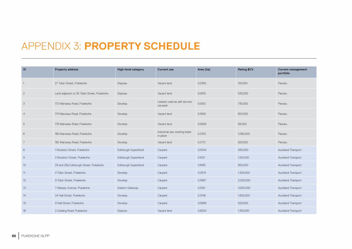
APPENDIX 3: PROPERTY SCHEDULE
ID Property address High-level category Current use Area (ha) Rating $CV Current management portfolio
1 27 Tobin Street, Pukekohe Dispose Vacant land 0.0363 130,000 Panuku
2 Land adjacent to 35 Tobin Street, Pukekohe Dispose Vacant land 0.0615 530,000 Panuku
3 172 Manukau Road, Pukekohe DevelopLeased; used as self-service carwash
0.0512 730,000 Panuku
4 174 Manukau Road, Pukekohe Develop Vacant land 0.1569 820,000 Panuku
5 176 Manukau Road, Pukekohe Develop Vacant land 0.0606 56,000 Panuku
6 180 Manukau Road, Pukekohe DevelopIndustrial use; existing lease in place
0.2153 1,080,000 Panuku
7 182 Manukau Road, Pukekohe Develop Vacant land 0.2172 920,000 Panuku
8 1 Roulston Street, Pukekohe Edinburgh Superblock Carpark 0.0544 565,000 Auckland Transport
9 3 Roulston Street, Pukekohe Edinburgh Superblock Carpark 0.1037 1,125,000 Auckland Transport
10 29 and 29a Edinburgh Street, Pukekohe Edinburgh Superblock Carpark 0.1695 850,000 Auckland Transport
11 4 Tobin Street, Pukekohe Develop Carpark 0.2674 1,425,000 Auckland Transport
12 9 Tobin Street, Pukekohe Develop Carpark 0.3687 2,025,000 Auckland Transport
13 7 Massey Avenue, Pukekohe Eastern Gateway Carpark 0.5191 4,925,000 Auckland Transport
14 24 Hall Street, Pukekohe Develop Carpark 0.3148 1,825,000 Auckland Transport
15 9 Hall Street, Pukekohe Develop Carpark 0.0889 520,000 Auckland Transport
16 2 Golding Road, Pukekohe Dispose Vacant land 0.8204 1,155,000 Auckland Transport
86 PUKEKOHE HLPP

ID Property address High-level category Current use Area (ha) Rating $CV Current management portfolio
17 Land adjacent to 995 Paerata Road, Pukekohe DisposeOpen space with no onsite amenities
0.1012 180,000 Auckland Council
18 Land adjacent to 176 Princess St West, Pukekohe DisposeOpen space with no onsite public amenities
0.1019 410,000 Auckland Council
19 67 East Street, Pukekohe DisposeOpen space with no onsite public amenities
0.0815 305,000 Auckland Council
20 Land adjacent to 603 Buckland Road, Pukekohe Dispose Stock pound 0.2977 280,000 Auckland Council
21 42 Seddon Street, Pukekohe Dispose Vacant land 0.0300 105,000 Auckland Council
22 22 Edinburgh Street, Pukekohe; Develop Plunket 0.10121,775,000
Auckland Council
23 82 Manukau Road, Pukekohe Station PrecinctCorporate property accommodation
1.3090 7,200,000 Auckland Council
24 17 Massey Avenue, Pukekohe Edinburgh Superblock Commercial use; leased 0.0452 500,000 Panuku
25 21 Massey Avenue, Pukekohe Edinburgh Superblock Commercial use; leased 0.2370 2,325,000 Panuku
26 33 Edinburgh Street, Pukekohe Edinburgh Superblock Commercial use; leased 0.1014 2,525,000 Panuku
27 Land adjacent to 1173 Paerata Road, Pukekohe Dispose Vacant land 0.8491 131,000 Panuku
Total (Excluding 82 Manukau Rd) Approx. 5.45ha Approx. $27,000,000
Key
Panuku-managed properties
Auckland Transport-managed properties
Auckland Council-managed properties
Previously approved Corporate Property, delegated to Panuku for disposal
Previously approved for disposal properties, managed by Panuku
87PUKEKOHE HLPP

CONTACTS
ENGAGEMENT ADVISOR
Jody Jackson-Becerra
PANUKU DEVELOPMENT AUCKLAND
PO Box 90343, Victoria Street West, Auckland 1142, New Zealand.
+64 9 336 8820
panuku.co.nz/pukekohe
facebook.com/PanukuAKL
IN PARTNERSHIP WITH:
88 PUKEKOHE HLPP


![[moves] - SátiradeCamilo · Desperation Moves BariBari Vulcan Punch Umanori Vulcan Punch Super Desperation Moves BariBari Vulcan Punch Hidden Super Desperation Moves Umanori Ultimate](https://img.pdfslide.us/doc/110x75/5e62005b6841776ac4332d47/moves-stiradecamilo-desperation-moves-baribari-vulcan-punch-umanori-vulcan.jpg)


![[moves] - Neo-Arcadia · moves, perform the motions of the moves using the buttons indicated to feint. Certain moves use alternate motions, they Certain moves use alternate motions,](https://img.pdfslide.us/doc/110x75/5e12441e05bfe76b6d1b9697/moves-neo-moves-perform-the-motions-of-the-moves-using-the-buttons-indicated.jpg)

![[moves] - Neo-Arcadianeo-arcadia.com/neoencyclopedia/3_count_bout_moves.pdf · 3 Count Bout [moves] ... Standing Moves Hell Stabs Low Hell Stab tap Knife Attack ... Grapple Moves](https://img.pdfslide.us/doc/110x75/5adf634d7f8b9ab4688c1265/moves-neo-arcadianeo-count-bout-moves-standing-moves-hell-stabs-low-hell.jpg)