Embed Size (px)
Citation preview

KHLONG: BANGKOK CANALS REVITALIZATION
By
Miss Dolruthai Jiarakul
A Thesis Submitted in Partial Fulfillment of the Requirements for the Degree
Doctor of Philosophy Program in Architectural Heritage Management and Tourism
International Program
Graduate School, Silpakorn University
Academic Year 2015
Copyright of Graduate School, Silpakorn University

The Graduate School, Silpakorn University has approved and accredited
the Thesis title of “Khlong: Bangkok Canals Revitalization” submitted by
Ms.Dolruthai Jiarakul as a partial fulfillment of the requirements for the degree of
Doctor of Philosophy in Architectural Heritage Management and Tourism
(International Program)
............................................................................
(Associate Professor Panjai Tantatsanawong, Ph.D.)
Dean of Graduate School
........../..................../..........
The Thesis Advisor
Professor William Chapman, Ph.D.
The Thesis Examaination Committee
.................................................... Chairman
(Kreangkrai Kirdsiri, Ph.D.)
............/......................../..............
.................................................... Member
(Professor Emeritus Ornsiri Panin)
............/......................../..............
.................................................... Member
(Professor William Chapman, Ph.D.)
............/......................../..............

iii
53056952 : MAJOR : ARCHITECTURAL HERITAGE MANAGEMENT AND TOURISM
KEY WORD : KHLONG / CANALS / WATERWAYS / RESTORATION / DEVELOPMENT
DOLRUTHAI JIARAKUL: KHLONG: BANGKOK CANALS REVITALIZA-
TION. THESIS ADVISOR : PROFESSOR WILLIAM CHAPMAN, Ph.D. 190 pp.
The study is aimed to argue that khlong in Bangkok that lie across the city
is still a valuable asset. It can be brought back to life.
Bangkok is similar to many cities around the world that is water bourn.
Canals are called khlong in Thai even though the definition is slightly different.
Khlong is very valuable to Bangkok as it is the origin of Bangkok. Without Khlong
Lat Bangkok excavation during the time of Ayutthaya, Bangkok would not have been
Bangkok today. But the development of Bangkok has shifted from water to land.
Khlong was then been neglected, encroached, and left in bad conditions. Water in
khlong is polluted. And khlong does not connect to the people as like before.
Problems related to khlong are increasing and awakening problem is the
flood in 2011. The flood make the people look back to khlong and seek for
revitalization.
Khlong revitalizations projects are initiated in many khlong and many
directions. Some are successful some are not. The researcher has concluded that
khlong can still be reviving in a sustainable development direction toward water-
based city that suit the geological attribute of Bangkok.
Program of Architectural Heritage Management and Tourism Graduate School, Silpakorn University
Student's signature ........................................ Academic Year 2015
Thesis Advisor's signature ........................................

iv
Acknowledgments
I would like to express my gratitute to communities and staff that I have
visited, learnt from, and experienced thoughout the research.
I would like to show my appreciation and thanks to my advisor, Professor
Dr. William Chapman for his patience, encouragement, inspiration, and advice for me
to complete this research and writting. I also thanks to Professor Emeritus Trungjai
Buranasomphob, the founder of this program. And also, I thank Professor Sunon
Palakavong Na Ayuddhaya, the director of this program for his contribution to the
program. I thank my examination committee including Dr. Kreangkrai Kirdsiri and
Professor Emeritus Ornsiri Panin who sacrificed valuable time for this thesis defense.
I thank Dr. Tiamsoon Sirisrisak for his advice and support on this research. I thank
Dr. Polladech Theerapappisit for his advice and motivation. I thank all professors
from various universities who have donated themselves to enhance my knowledge
and growth. I thank Ms. Thienrat Sakasuoarerk, Aj Supot, Khun Chai, Jeab, and other
university staffs who have facilitated me throughout the program.
I thank my friend Dr. Mubarak Al Najem in supporting and encouraging
me on completing this program. I thank all my friends who have supported me during
this research. I acknowledge kind help from my friend Kanittha Suksong in arranging
me interviews and Chatvadee Chaiaroondeekul in assisting me as I corrected my
writings. I also acknowledge wonderful help from colleagues throughout the program
particularly Rathirat Kheawmesuan, Jaroonsak Jurudhiranart, Dr. Pichet Teeranuson,
Dr. Rungsima Kullapat, and Em Ungjitpisal at the final stage of my writing and
accompany me on several research field trips.
Mostly, I would like to thank my family: Daoroong Jiarakul, Prasiddhi
Jiarakul, Akom Boonsaeng, Wasin Boonsaeng, Kanokeluck Pissathanporn, Pakpoom
Jiarakul, Nathinee Jiarakul, and Chompoonuj Jiarakul for their tremendous love,
encouragement and understanding they have for me throughout my life, without them
I would not have finished this dissertation.

v
Table of Contents
Page
Abstract ................................................................................................................... iii
Acknowledments..................................................................................................... iv
List of Tables ......................................................................................................... x
List of Figures ......................................................................................................... xi
Chapter
1 Introduction ................................................................................................ 1
Statement of Significance ................................................................... 1
Goals and Objectives .......................................................................... 4
Methodology ....................................................................................... 4
Scope of Study .................................................................................... 5
Definitions of Khlong ......................................................................... 5
Structure of the Study ......................................................................... 8
2 Canals and Khlong ..................................................................................... 9
History of Canals ................................................................................ 9
Ancient Canals .......................................................................... 10
Modern canals ........................................................................... 19
Impacts of Railways .................................................................. 22
History of Khlong in Thailand .......................................................... 22
Geography of Thailand ............................................................. 22
Ancestor Footsteps .................................................................... 25
Sukhothai ........................................................................... 25
Ayutthaya .......................................................................... 28
Canals and Khlong as Heritage ......................................................... 37
Information Document on Heritage Canals .............................. 37
Khlong, Part of UNESCO World Heritage ............................... 39
Conclusion ......................................................................................... 40
3 Development of Khlong in Bangkok ......................................................... 41
Early Development ............................................................................ 41
Thonburi ............................................................................................ 42

vi
Chapter Page
Rattanakosin before the Bowring treaty (1782 – 1855) .................... 46
Reign of King Rama I ................................................................. 47
Reign of King Rama II ............................................................... 53
Reign of King Rama III .............................................................. 55
Reign of King Rama IV (before the Bowring Treaty) ................ 57
Life of the People ........................................................................ 59
Rattanakosin after the Bowring Treaty (1855 – 1868) ...................... 61
Reign of King Rama IV (after the Bowring Treaty) ................... 62
Reign of King Rama V ............................................................... 68
Reign of King Rama VI to Reign of King Rama VII ................. 76
The National Economic and Social Development Plan .............. 78
Conclusion ......................................................................................... 78
4 Current Khlong in Bangkok ....................................................................... 80
Background Information of Bangkok ............................................... 80
Location ...................................................................................... 80
Geography ................................................................................... 81
Political ....................................................................................... 84
Physical ............................................................................................. 84
Numbers, Size, Lengths, and Depth ........................................... 84
Water Quality .............................................................................. 86
Special Type of khlong ...................................................................... 87
Historic Site ................................................................................ 87
Khlong Listed in Ancient Monuments, Antiques & National
Museums Act ..................................................................... 88
Khlong Filled or Covered by Roads ........................................... 91
East and West Banks ......................................................................... 92
Pattern from the Influence of Westerners ......................................... 94
Landscape Development and Infrastructures .................................... 96
Uses ................................................................................................... 99
Drainage and Flood Control ....................................................... 99

vii
Chapter Page
Discharge Wastewater and Sewerage ....................................... 100
Transportation ........................................................................... 101
Resource for Agriculture........................................................... 109
Culture and Natural Heritage Resource .................................... 110
Tourism and Recreation ............................................................ 120
Consumption ............................................................................. 126
Other Uses ................................................................................. 127
Conclusion ......................................................................................... 130
5 Discussion .................................................................................................. 131
Causes of Khlong Declining .............................................................. 131
Buildings and Structures Built from Urbanization ................... 131
Direction of City Development ................................................ 132
Government Policy ................................................................... 132
Related Issues .................................................................................... 133
Flooding .................................................................................... 133
The New Comers ...................................................................... 133
Water Quality ............................................................................ 134
Image of Khlong ....................................................................... 134
Bangkok, Future Drowned City ................................................ 135
Water Management ................................................................... 136
Other Factors ............................................................................. 138
Why Revive Bangkok Khlong? ......................................................... 138
The Importance of Khlong ........................................................ 138
Vision of Bangkok 2020 ........................................................... 139
The Existing Khlong ................................................................. 140
Movement Supporting the Revitalization of Khlong ................ 140
Khlong Revitalization Movement in Bangkok .................................. 141
Khlong Lad Prao ......................................................................... 141
Khlong Ong Ang ......................................................................... 142
Khlong Bang Lampu ................................................................... 144

viii
Chapter Page
Khlong Bang Bua ....................................................................... 145
Khlong Padung Krung Kasem .................................................... 147
Khlong Pream Prachakorn .......................................................... 149
Khlong Pasi Chareon .................................................................. 150
Khlong Bang Prathun ................................................................. 151
Directions in Bangkok Khlong Revival Movement .......................... 153
Conclusion ......................................................................................... 155
6 Waterway Revitalizations .......................................................................... 156
Definitions ......................................................................................... 156
Movement of “Inland Waterways” or “Canal” Revitalization ......... 157
Benefits of Waterway Revitalization ................................................ 157
Examples ........................................................................................... 159
Amsterdam, Netherlands ........................................................... 159
Cheonggyecheon Restoration Project, Seoul, South Korea ...... 163
Conclusion ......................................................................................... 167
7 Proposal ..................................................................................................... 168
Trait of Khlong Revitalization ........................................................... 169
Directions .......................................................................................... 169
Sustainability............................................................................. 169
Develop toward Water-Based City ........................................... 170
Holistic ...................................................................................... 170
Resource Management .............................................................. 171
Revitalization Organization ...................................................... 171
Keep Identity ............................................................................. 171
Compromise to Change ............................................................. 172
Stakeholder and Partnership .............................................................. 172
Government............................................................................... 172
Local communities .................................................................... 172
Schools and Universities ........................................................... 173
Business Owners ....................................................................... 173

ix
Chapter Page
Scholars ..................................................................................... 173
Tools .................................................................................................. 173
Interpretation ............................................................................. 173
Tourism and Recreation ............................................................ 174
Transportation Use .................................................................... 174
Conclusion ......................................................................................... 174
8 Conclusions and Recommendations .......................................................... 175
References ............................................................................................................... 178
Biography ................................................................................................................ 190

x
List of Tables
Tables Page
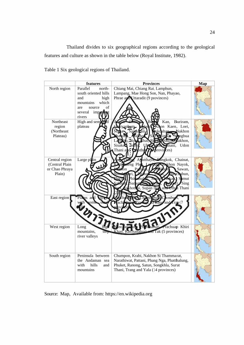
1 Six geological regions of Thailand ............................................................ 24
2 Reign, year and location of khlong lat excavation of
Chao Phraya River in Ayutthaya period ............................................ 33
3 Different agencies and numbers of khlong made ...................................... 72
4 Table shows the locks made during 1904-1910 ........................................ 74
5 Number and total length of Bangkok’s khlong, lamrang, and
lamkradong ........................................................................................ 85

xi
List of Figures
Figures Page
1 Khlong Lot Wat Rajanatda and Khlong Lot Wat Rajabophit that links
from khlong to khlong ................................................................... 7
2 Fertile area between the Tigris and Euphrates River in Mesopotamia .. 11
3 Illustration shows the Sumerians in southern Mesopotamia built city
walls and temples and dug canals for irrigation ............................ 11
4 Earthen jug depicts King Scorpion cuting the first irrigation canal ....... 12
5 Map of Ancient Egypt, the location of the Nile River, the Upper Egypt
and the Lower Egypt ..................................................................... 13
6 Suez Canal ............................................................................................. 14
7 Map of the Grand Canal, China ............................................................. 16
8 Grand Canal passing through Hangzhou city ........................................ 17
9 Grand Canal, China ................................................................................ 18
10 Canal du Midi, France............................................................................ 19
11 Pontcysyllte Aqueduct ........................................................................... 20
12 The great success of Erie Canal ............................................................. 21
13 Geological map of Thailand ................................................................... 23
14 Sukhothai ............................................................................................... 26
15 Map of Sukhothai that shows the flow of water to the city ................... 28
16 Satellite pictures of Nakon Chaisi (left) and Ayutthaya (right) ............. 29
17 Drawing of Ayutthaya shows water around the city as island and many
khlong pass through the city ........................................................ 31
18 Six khlong lat of Chao Phraya River (including the sixth khlong lat
which was made later in Rattanakosin)....................................... 34
19 The picture of Pan Tai Norasingh shrine and Goddess Srinual taken in
1987............................................................................................... 36
20 Bangkok Plan by La Loubre in 1687 shows the square city wall on the
Left On the right is Bangkok Fort to Wichaiyen Fort, built in the
Reing of King Narai Maharaj. This map reflects the importance
Of Thonburi or Bangkok during Ayutthaya .................................. 42

xii
Figures Page
21 Khlong Bangkok Yai in the past. There are settlement at khlong
Bangkok Yai from Ayutthaya period. In the reign of King Taksin,
it was the Location of nobility, especially the Chinese who
previously served King Taksin. Therefore the people call it
“Khlong Bang Kha Luang” or “Khlong Bang Luang” (kha luang
means nobility).............................................................................. 43
22 Khlong Khu Meaung Dorm, excavated during the reign of King Taksin,
Thonburi period. It was an important transportation route for
trading in the inner city ................................................................. 45
23 Khlong Khu Meaung of Thonburi and the city wall .............................. 45
24 The scenery of water-based community in Early Rattanakosin Period.
The communities were settled along the banks of rivers and
khlong. .......................................................................................... 47
25 Photograph of Khlong Rob Krung took at Damrong Satit Bridge to the
Golden Mountain by Chao Gawilawong Na Chiangmai .............. 48
26 Khlong Ong Ang .................................................................................... 49
27 Location of Khlong Rob Krung, Khlong Lot Wat Rajanatda, Khlong
Lot Wat Rajabophit, and Khlong Mahanak ................................. 50
28 Life in the past at Pak Khlong Mahanak ................................................ 51
29 Bird’s eye view of Khlong Bang Lampu from Wat Saket. Bridge across
the khlong was only a small wooden bridge. Khlong Mahanak is
on the right .................................................................................... 52
30 Six khlong lat of Chao Phraya River ..................................................... 54
31 Khlong Saen Saab at Chalhermlok 55 Bridge, Pratunam ...................... 56
32 Khlong Padung Krung Kasem in the past .............................................. 57
33 Khlong Padun Krung Kasem at Wat Dhevaraj Kunchon ...................... 58
34 Khlong khud in Rattanakosin before the Bowing Treaty ...................... 60
35 Khlong Tanon Trong when still in use for transportation ...................... 63
36 Khlong khud in Rattanakosin during the Reign of Rama IV after the
Bowing Treaty .............................................................................. 67
xiii
Figures Page
37 Khlong khud in Rattanakosin during the Reign of King Rama V .......... 75
38 Map showing the level of land ............................................................... 81
39 Chao Phrayra River: (a) the course prior to 1534 and subsequent
excavation; (b) the present course ................................................. 83
40 Map showing the 50 districts of Bangkok ............................................. 84
41 Khlong Saen Saeb .................................................................................. 86
42 The polluted khlong in Bangkok ............................................................ 87
43 Khlong Khu Meaung Derm with concrete embankments and walkways
along the khlong next to road ........................................................ 88
44 Khlong Bang Lampu, a section of Khlong Rob Krung with walkways
along the khlong ............................................................................ 89
45 Khlong Ong Ang, a section of Khlong Rob Krung with walkways on
each bank from the removal of Talad Sapan Lhek in 2015. ......... 89
46 Khlong Rob Krung (Khlong Ong-Ang and Khlong Bang Lampu ......... 90
47 Khlong Padung Krung Kasem .............................................................. 90
48 Khlong Sathorn in the old days .............................................................. 91
49 Khlong Sathorn view from the bridge ................................................... 92
50 Khlong Sathorn view from the road....................................................... 92
51 Khlong Bang Ramad .............................................................................. 93
52 Khlong Don Meaung and the houses along the khlong ......................... 93
53 Khlong Lam Pla Thiew .......................................................................... 94
54 The contrast pattern of khlong which was built during Rama V ........... 95
55 Khlong Wat Sang Krachai ..................................................................... 96
56 Khlong Bang Sai Kai ............................................................................. 96
57 A section of Khlong Wat Sang Krachai with almost no water ............. 97
58 Khlong Saen Saeb with walkways or bicycle lanes along ..................... 97
59 Khlong in Tao Poon Area ...................................................................... 98
60 Khlong Bang Lam Jiek .......................................................................... 98
61 Bicycle lane along Khlong Saen Saeb ................................................... 99
62 The drainage system in Bangkok, pipe, khlong, pump, retention areas,
giant tunnels, and flood prevention wall ....................................... 100

xiv
Figures Page
63 Pipe from households discharge to khlong ............................................ 101
64 Map shows Khlong Saen Saeb, Khlong Saen Saeb Extention, Khlong
Phra Kanhong, and Khlong Baan Pa ferry services ...................... 102
65 Map shows Khlong Saen Saab ferry piers ............................................. 103
66 Bangkok people use Khlong Saen Saab for transportation .................... 104
67 Khlong Saen Saab in the city area ......................................................... 104
68 Maps shows Khlong Phasi Chareon ferry piers ..................................... 106
69 Phasi Charoen ferry service ................................................................... 107
70 Postman delivering post via khlong, Khlong Pasi Chareon ................... 108
71 Khlong Bang Prathun ............................................................................. 108
72 Agriculture, Khlong Bang Prathun ........................................................ 109
73 Monks in a boat asking for alms, Khlong Bang Prathun. He is the only
monk that still ask for alms from water in Khlong Bang Prathun 110
74 People offering alms to monks on boat at Khlong Lam Pla Thiew on
Tak Bat Phra Roi Tang Reau tradition .......................................... 111
75 People offering alms to monks on boat at Khlong Lam Pla Thiew on
Tak Bat Phra Roi Tang Reau tradition ......................................... 112
76 Buddha Relic was placed in to a boat and cruise by the Royal Thai Navy
as part of Chak Phra Festival in 2015 ........................................... 113
77 Loy Krathong in 2015 at Khlong Bang Prathun .................................... 113
78 Loy Krathong in 2015 at Khlong Ong Ang, first time after the removal
of Talad Sapan Lhek ..................................................................... 114
79 Loy Krathong at Talad Hua Takae, Khlong Prawet Burirom in 2015 ....... 114
80 Feeding the fish, Khlong Bang Ramad .................................................. 115
81 Free the fish, Khlong Bang Lampu ........................................................ 115
82 Feed the fish, Wat Nimma Noradi, Khlong Pasi Chareon ..................... 116
83 Sapan Chang Rongsi, Khlong Khu Meaung Derm ................................ 117
84 Architecture along Khlong Khu Meaung Derm - Sapan Chareonrach
31 near Pak Khlong Talad ............................................................ 117
85 Architecture along the Khlong Khu Meaung Derm – Sapan Hok ......... 118
86 Wat Mon Dhop, Khlong Bang Ramad ................................................... 119

xv
Figures Page
87 Baan Don Mosque, Khlong Saen Saeb .................................................. 119
88 Wat Makkasan, Khlong Saen Saeb ........................................................ 120
89 Tourist pocket guide: Waterways Series ................................................ 121
90 Thai tourist on a khlong tour .................................................................. 123
91 Talad Nam Taling Chun ......................................................................... 124
92 Bicycle path along Khlong Saen Saeb (east) bank ................................ 125
93 Khlong and the bicycle lane on its banks from Big C LadPrao to
Asoke ........................................................................................... 125
94 Activity at Khlong Saen Thor, Bang Khun Thein ................................ 126
95 People using water from khlong to brush his tooth, Khlong Pasi
Chareon ........................................................................................ 127
96 Khlong Rangsit (Khlong Sip-si) as a territory of Bang Nam Preaw,
Chacheungsao and Nhong Jok District, Bangkok......................... 127
97 Interpretation near Khlong Khu Meaung Thonburi about Krung
Thonburi and its fort, khlong, and city wall .................................. 128
98 Sign identifies Khlong Padung Krung Kasem ....................................... 128
99 Information of Khlong Khu Meaung Derm and Phan Phiphop Lila
Bridge ............................................................................................ 129
100 Information given about Khlong Lot Wat Theptida and map of
Rattanakosin attraction sites ......................................................... 129
101 Cover of tourist guidebooks with talad nam or khlong presented ......... 135
102 Boundary pole of Bangkok standing away from the shoreline for more
than a kilometer............................................................................. 136
103 Khlong Ong Ang in the past .................................................................. 142
104 Khlong Ong Ang, when water transportation was widely use ............... 143
105 Picture of Sapan Lhek Market encroaching Khlong Ong Ang and the
picture of Khlong Ong Ang after the demolishing of Sapan Lhek
Market ........................................................................................... 143
106 Khlong Ong Ang on the Loy Krathong Festivals 2015, after the
demolition of Sapan Lhek Market and landscape adjustment ...... 144

xvi
Figures Page
107 The use of water treatment bike at Khlong Bang Lampu. The bike idea
was obtain from King Bhumibol Chiapattana Low Speed Surface
Aerator Model which aim to give oxygen to the water, attract
tourists, and enhance heath of the community .............................. 145
108 Khlong Bang Bua before the landscape adjustment .............................. 146
109 Khlong Bang Bua after the landscape adjustment ................................. 147
110 Khlong Padung Krung Kasem during the reign of King Rama VI. It is
khlong khu meaung without city wall like in the earlier khlong
khu meaung ................................................................................... 148
111 Talad Nam Khlong Padung Krung Kasem revival ................................ 149
112 Khlong Pream Prachakorn restoration ................................................... 150
113 The new ferry which is introduced in a trial phase in April 2016 ......... 151
114 Map of Khlong Bang Prathun shows the encroaching of urbanization to
the green area of Khlong Bang Prathun ........................................ 152
115 Khlong Bang Prathun with shade from trees ......................................... 153
116 Canals in Amsterdam ............................................................................. 160
117 Canal Cruise in Amsterdam ................................................................... 161
118 Canal Parade Gay Pride 2015, Amsterdam ............................................ 161
119 Houseboats in Amsterdam Canals ......................................................... 162
120 Canals Belt ............................................................................................ 162
121 Cheonggyecheon in the past .................................................................. 163
122 Cheonggyecheon Highway in 1990s ..................................................... 164
123 Cheonggyecheon .................................................................................... 165
124 Cheonggyecheon stream stretches in the city of Soul shows the nature
harmonizing in the city ................................................................. 166

1
1
Chapter 1
Introduction
1. Statement of Significance
Khlong have changed many times throughout the history of Bangkok. As
the focus of the city changed, roles and values of khlong may change too. Khlong are
part of the origin of Bangkok and they have witnessed and took part in many of the
city’s events as well as the ways of life of the people. They relate deeply to the
community and to the city form and functions. The connection of khlong and the city
has shown in many literatures, stories, arts, etc. They are also witnessed by the eyes of
Bangkok’s visitors and have been recognized through the appellation “Venice of the
East,” just like its ancestor, Ayutthaya. Many travel books and tourism websites
include a khlong visit as a part of Bangkok attraction list. But the current condition of
khlong presents a different picture. Many khlong have been neglected and are in bad
condition. The role of khlong is not obviously demonstrated clearly. Problems and
issues such as floods, pollution, and encroachment, arise more and more. If khlong
are really an important asset of the city, they should serve the city better. And in
return khlong should be treated differently, why aren’t they?
The word khlong was found in Mon word commonly meaning waterways
(The Royal Institute of Thailand, 1962), often translated into English as canals.
Khlong were vital for Thai community. People called Bangkok “The Venice of the
East” because of its khlong. And if Chao Phraya River is the artery of Thailand and
Bangkok is the heart, khlong is the ventrical.
Khlong were strongly related to the settlement of Rattanakosin replicates
predecessor, Ayutthaya. In 1767, after the fall of Ayutthaya, King Taksin moved the
capital down south along the Chao Phraya River. He named the capital Thonburi.
Thonburi is a capital with river runs through the middle. During those time waterways
were important. Khlong served for defense, governance communication,
transportation, trading, drainage, and in many other aspects.
In Rattanakosin, the capital shifted to the east side of Chao Phraya River.
The city still remained on both sides of the River but expanded more to the east.
Moats, which also served as khlong, were excavated further east during the reign of

2
Rama I and Rama IV to expand the city and accommodate the growth of population.
In early Rattanakosin the purposes of waterways were the same as in Thonburi.
Hundreds of boats and floating rafts plied the khlong, the river, or were erected on
stilts. More khlong were made and most were well maintained. Nearly all residential
and commercial structures were built along the river and khlong served communities
that were formed.
In the time of King Rama IV, in part as a result of the Bowring Treaty,
Bangkok needed waterways to serve more for irrigation and transport and less for
defensive function (Piyanat Boonnak, 1982). This also forward to the time of King
Rama V. Therefore a new form of khlong was initiated to develop land for irrigation,
mostly on the east side of Bangkok where the land was fertile. King Rama V also
established a department responsible especially for the maintenance of khlong called
Grom Khlong in 1902 (Piyanat Boonnak, 1982; Brummelhuis, 2007). It was a golden
time for khlong.
In the time of King Rama VI, the concept of khlong changed. No new
khlong was excavated. The development of city shifted increasingly from water to
land development. The policy in regards to khlong was mainly to maintain and solve
the new and previously existing problems. Problems that were obvious at the time
were the encroachment of khlong, the problems of shallow khlong and water quality.
One shallow khlong “solution” was to pile up the khlong and make a road instead.
From that time khlong in Bangkok decreased in importance. As many
khlong were filled in not many khlong were left and connected. The main purpose of
khlong was for drainage. At the present time priorities of life in Bangkok do not
involve khlong anymore. Bangkok has turned its back to khlong.
The decline of khlong in Bangkok was not evident to the public until the
big flood in 2011. The enormous rush of water covered most part of Thailand, across
65 of 77 provinces, including Bangkok. The flood began in the north of Thailand in
May 2011 and was widespread in July 2011. In some areas the flood persisted until
mid January 2012. The result was devastating, resulting in more than 680 deaths and
more than 13 million displaced or otherwise affected people. The World Bank has
estimated the recovery and reconstruction at 1.5 trillion baht over five years (The
World Bank, 2012). The flood was due to heavy rain, combined with multiple tropical

3
storms. For Bangkok, the city was for the most part protected by the government.
Still, the flood also affected various sectors, as the water had nowhere else to go.
According to the Thai Real Estate Information Center (REIC), as many as 300,000
homes were damaged in Bangkok (Aon Benfield, 2012). The city that once was rice
paddles and where life was deeply related to the water could no longer cope with the
water.
What is going on with numerous numbers of khlong in Bangkok?
Where did they go? Why aren’t they doing their roles for the city?
Sadly neglect, encroachment and misuse of khlong has left khlong in a dry,
dirty and seemingly hopeless condition. The Bangkok Metropolitan Administration
(BMA) has investigated in its 50 districts and found that more than 23,500 buildings
and houses encroach upon the public space of khlong (Dailynews, 2014). The
Bangkok population, estimated at over 10 million, creates about 2.4 million cubic
meter of wastewater per day and with not enough wastewater treatments plants. The
BMA has estimated the capacity of current wastewater treatment plants to only 42
percent of the overall wastewater. The remaining work is flittered (Department of
Environment, BMA, 2012). The level of water is monitored in most of the main
khlong for flood prevention purposes. But for most other khlong that blend in
communities, many lack water altogether.
Apart from the flood and other water issues, Bangkok development has
increased the number of other issues too. These include population density, loss of
community and culture, traffic, pollution, lack of green open spaces, decrease of the
quality of life, etc. Also, seeking for more development projects and using more
resources does not seem to solve Bangkok’s chaos.
Many government agencies, NGOs, private sector organizations and
companies, scholars and communities have turned back to khlong, the resource that
Bangkok currently has is ruined, damaged, or just remain as a shadow of their former
origin. Khlong seem to lie deadly in communities. But what if khlong can ease those
issues? Along with the trend of nostalgia, ideas and projects about khlong have begun
to rise. These initiations range from big to small, undertake by government and by the
community. But what will be the direction of the revitalization?
4
Bangkok is not alone in the idea of revitalization of waterways and canals.
Many other cities had also faced this issue of declining waterways, mostly due to the
development of railways and roads. Those ideas and projects have had some
successes; some still face challenges. What are these stories of revival? Can Bangkok
stories generate similar stories? Can Bangkok find the answer of “What is the
realistic revitalization potential of khlong?”
2. Goals and Objectives
1. To study the history of khlong
2. To study the present condition of khlong in Bangkok
3. To seek examples and lessons of other waterways revitalization
4. To propose revitalization guideline for khlong in Bangkok and make
suggestions
3. Methodology
The study is a qualitative research. Initially, the study started with the
survey of available waterway revitalization resources from books, proceedings of
conference, journals, abstracts, articles, reports, and internet.
The data collection included literature, individual interviews, observations,
and participant observations. The research design is flexible, advising to evidence
process of research.
The literature includes the relevant topic of canal history and khlong
history from a range of studies from the past to the present and from books,
photographs, maps, websites, research papers, journals and reports in Thai and
English.
Individual interviews were arranged with the key persons related to the
research. These include personnel from the Department of Drainage and Sewerage,
the BMA, personnel from the Bangkok Tourism Division, BMA, luminaries in the
wisdom of water management in the delta area of the Gulf of Thailand, and key
persons from communities along the selected khlong.
Observation included site surveys of physical conditions and uses among
various khlong in Bangkok in both by land and by water. It also included observations
of activities at talad nam (floating market) and talad rim nam (markets next to
waterways).

5
Participant observations included hands on experience activities of khlong
such as the transportation experience from Saen Saeb ferry and Pasi Chareon ferry,
tourism including cultural and eco-tourism, festivals, such as Loy Krathong and Tak
Batr Phra Roi, and other form of recreation.
The study also looks at other revitalizations projects to learn from. These
two cases from outside of Thailand were selected. These were projects in the
Netherlands and Korea.
The project from Amsterdam, Netherlands was selected because
Amsterdam and Bangkok are similar in many ways. Both are located near the shore
and face many similar problems. The development of water management in Bangkok
and Thailand also developed from the Dutch. As time passed, Amsterdam also used to
fill canals, much like Bangkok but revitalizations have brought Amsterdam to the next
chapter of continuing use.
Cheonggyecheon stream restoration project in Korea is a recent mega
project in Asian context. It was selected because of many interesting facts of the
project, which will be described in Chapter 6.
The information and data used then arranged, analyzed, and synthesized.
The issues of khlong were listed and analyzed from the information and data.
Together, this process was designed to meet the research objectives. The eight
chapters of the research meet the objectives of the overall projects
4. Scope of Study
Scope of area is in the area of Bangkok Metropolitan Administration area.
It includes both natural and man-made khlong. Clarifications of both terms are
included in topic 5.
5. Definitions of Khlong
The section explains the meaning of “khlong” in Thai language, which is
close to, but slightly different from the word “canal” the translation most often used.
The word “khlong” or “klong” (คลอง) derives from a Mon word,
commonly meaning “waterways” or sometimes simply “ways” (The Royal Institute of
Thailand, 1962). It often translated to “canal” in English, although the definition is

6
slightly different.
Khlong in the Dictionary of the Thai Royal Academy (2015) is (n.)
waterways or stream that is either natural or excavated to link with a river or sea
(translated by the researcher) (Office of the Royal Society, 2015) while canal in the
Oxford Dictionary of English is (n.) an artificial waterway constructed to allow the
passage of boats or ships inland or to convey water for irrigation (Oxford University
Press, 2015). The Information Document on Heritage Canals defines canals as a
human-engineered waterway. It may be of outstanding universal value from the point
of view of history or technology, either intrinsically or as an exceptional example
representative of this category of cultural property. The canal may be a monumental
work, the defining feature of a linear cultural landscape, or an integral component of
a complex cultural landscape (UNESCO, 1994).
The main difference in these definitions is that khlong can be referred to
either natural or artificial while a canal is artificial, meaning made by humans.
In general usage, the word khlong has a wider meaning extending to other
waterways or even streams. It might link to a river or sea or may link to other khlong
for example a khlong links from khlong to khlong like Khlong Lot in Bangkok. Some
khlong are natural and some are man-made too. Therefore sometimes the suffix dig
which is “khud” (ขดุ) is used along as “khlong khud” to clarify this issue (The Royal
Institute of Thailand, 1962).
There are also other terms of waterways in Thai such as kwae (แคว), khu
(ค)ู, lamkradong (ลํากระโดง) and lamrang (ลําราง). lamkradong is a small waterway
excavated from the large waterways to induct water to the rice field or field. Lamrang
is a small waterway that was excavated from the large waterways to induct or drain
water out of the rice field. Sometimes khlong is used together with proverb as khu
khlong (คคูลอง) and lam khlong (ลําคลอง) too.
“Moat” (n.) is defined by the Oxford Dictionary as a deep, wide ditch
surrounding a castle, fort, or town, typically filled with water and intended as a
defence against attack (Oxford University Press, 2015). Moat is referred as “khu
meaung” or “khlong khu meaung” in Thai.

7
Figure 1 Khlong Lot Wat Rajanatda and Khlong Lot Wat Rajabophit that links from
khlong to khlong
Source: Dolruthai Jiarakul, 2016

8
6. Structure of the Study
Chapter 1: The introduction gives background on the study including the
statement of the problem, goals and objectives of the study, methods used, the scope
of the study and the structure of the study.
Chapter 2: Canals and khlong. World history of canals trace back from the
ancient time to the modern time. The second part of this chapter describes khlong
history from Sukhothai and Ayutthaya. It also discusses the concept of canal as a
heritage.
Chapter 3: Development of khlong in Bangkok, which looks at the history
of khlong in Bangkok. How this history is important and how it relates to the city and
cultures.
Chapter 4: Current khlong in Bangkok. This chapter produces a picture of
the situation of khlong in Bangkok, including their physical condition, their role in
Bangkok, and other issues.
Chapter 5: Discussion. This includes issues related to the declined khlong.
What are the needs of Bangkok? And, what can revitalization bring?
Chapter 6: Waterway Revitalization. The chapter deals with trends in
waterways revitalization. It looks at the revitalization attempts in Netherlands and
Korea.
Chapter 7: Proposal. This chapter discusses future needs in research.
Chapter 8: Conclusions and Recommendations shows what has been
learnt, and also notes down the limitations and recommendations for further studies.

9
Chapter 2
Canals and Khlong
1. History of Canals
Before the early civilizations were established people lived in caves and
camps where they can get food and close to the drinking water, which is essential for
life. The water is usually comes from springs and lakes. When food and water were
insufficient people moved. As time passed populations increased and developed.
People started living together near the source of water for survival. And later people
developed agriculture for food supply. Canals were developed for irrigation and to
control water. The first civilization to arise and do so was in Mesopotamia (4,000
BC), followed by Egypt (3,000 BC), the Indus valley (2,500 BC) and China (1,200
BC).
In later instances canals were used for more than just irrigation. They were
also be used for navigation and transportation. Between 520 and 510 BC the Persian
Emperor, Darius I built a canal linking the Nile to the Red Sea in Egypt. This later
became the Suez Canal. Another well-known canal that combine the functions of
irrigation and transportation was the Grand Canal in China. It also was and still is the
longest canal today.
Many canals in Western Europe were built in the Middle Ages because of
commercial expansion (commercial revolution) in the twelfth century. In nineteenth
century France, Belgium, Holland and Germany developed inland waterways system
by building canals to connect their rivers (Columbia University, 1963).
Similarly, Russia connected the Baltic to the Black and Caspian seas by
rivers, lakes and canal systems. Later Soviet Union built a canal between the White
Sea and the Baltic (Columbia University, 1963).
In United States, which was not settled until the waterways in Europe had
been used for many years, the Erie Canal in New York was built in 1817 and opened
in its entirety in 1825. The canal transformed New York into a leading port of the

10
United States (New York State Canal Corporation) and facilitated the development of
the western states.
Canals were the part of commercial expansion and industrial evolution
worldwide. Many technologies were developed for the building and operation of these
waterways such as locks, dams and bridges. Construction extended the community
along the canals and made up new ports. With the development of railways, canals
started to decline. Some canals were abandoned and railways lead as a mean of
transportation until the arrival of the motor age.
1.1 Ancient Canals
a. Mesopotamia (4000 BC)
The oldest known canals built for irrigation were in places where the
civilization began. These included Mesopotamia (History World, n.d.), in what is now
Iraq and Syria, where the remains of pre historic work still exist (Water
Encyclopedia). The development of canals dated back to as early as fourth or fifth
millennium B.C.E (Garrett, 2014). This played an important role in the development
of Mesopotamia civilization.
The land of Mesopotamia is supplied with surface water by the two
major rivers, the Tigris and Euphrates Rivers. These waterways drained rugged
highlands of Anatolia and Zagros Mountains of Iran (Douglas L. Johnson, 2007). The
land was fertile with muddy alluvial soils that the stream brought, supporting date
palm and reeds. The land did not have much rainfall and had a limited water supply.
In some times, since they were located between the rivers, they faced floods. Both
floods and droughts were dramatic and unpredictable so the effort to control or
manage water was needed. Earthen walls were built along the rivers to hold back the
floodwater. The large canals were dug for water to get to their farms and smaller
irrigation ditches were dug to water their crops. Gates were put to control the water
from the canals to the field (Mollylarge, 2011). Irrigation systems were developed
and there was better access to water source throughout the year. This resulted in more
crops and harvests each year.

Figure 2 F
Source: Ac
content/upl
Figure 3 I
a
Source: Acc
mesopotami
ertile area b
ccessed Oc
loads/2013/
llustration s
and temples
cessed Oct
ian-irrigation
between the
ctober 28, 2
10/sumer_m
shows the S
and dug ca
tober 28, 20
n-system.
e Tigris and
2015, Avail
map_big.jpg
Sumerians i
anals for irri
015, Availab
Euphrates R
lable from h
g.
in southern
igation
ble from ht
River in Me
http://arthist
Mesopotam
ttp://www.sli
esopotamia
storyworlds.
mia built ci
ideshare.net/
11
.org/wp-
ity walls
/daminik/

riverbeds a
through the
be drained.
from the lo
productions
civilization
Pollock, 2
transformed
along the N
upstream p
Egypt,” no
rains in th
sediments t
the need o
water to mo
Figure 4 E
d
Source: P
Policy, Tho
Long
and made th
e canals to t
. Once the w
ower level
s were red
ns fall?: M
004). The
d the landsc
b. Egyp
The
Nile is fertil
art in the so
ow “the Del
he mountain
to the Nile
f food incr
ore land and
Earthen jug
display in th
Principles o
omas V. Cec
g use of the
he rivers hi
their field b
water evapo
soil. Scho
duced by t
Mesopotamia
fields then
cape of Mes
pt
Nile runs t
le and could
outh is calle
lta” (Miero
ns of Ethio
River Vall
reased. Egyp
d grow mor
depicts Ki
he Ashmole
of Water R
ch, p.6
e same met
igher than t
by gravity a
orated salt w
olars claime
the late of
a, n.d.; Me
n were ab
sopotamia to
through the
d be farmed
ed “Upper E
op, 2011).
opia on the
ley so they
yptian built
re food.
ing Scorpio
an Museum
Resources: H
thod affecte
the surround
nd got lock
was left beh
ed that the
f third mi
esopotamia:
andoned. I
o vast salty
e eastern p
d. Egypt w
Egypt” The
The people
e south to
could farm
up dikes a
on cutting t
m, Oxford, E
History, De
ed the soil.
ding plain.
ked. As a re
hind. Also s
soil becam
llennium (
: Economic
Irrigation h
wastelands
art of the S
as divided i
e downstream
e depended
bring floo
m. As the po
and irrigatio
the first irri
England)
evelopment,
Silt built u
Also water
esult, they c
salt raised u
me toxic an
(Collapse, w
c and Agr
had uninten
s (Pollock, 2
Sahara des
into two pa
am is called
d on the mo
odwater and
opulation in
on canals to
rigation can
, Managem
12
up in the
r moved
ould not
upwards
nd crops
why do
iculture;
ntionally
2004).
ert. Soil
arts. The
“Lower
onsoonal
d fertile
ncreased
o spread
nal (now
ment and

13
Figure 5 Map of Ancient Egypt, the location of the Nile River, the Upper Egypt and
the Lower Egypt
Source: Accessed October 28, 2015, Available from www.mapsofworld.com.
In ancient Egypt, canals were used for irrigation and also for
transportation. Egyptians were the first to have a man-made canal across its land.
This was later rebuilt many times before becoming the present “Suez Canal.”

14
Pharaoh Senusret III may have built the first canal connecting the Red Sea
and Nile River around 1850 BC using the east - west route (Andrews, 2014; Fisher,
2015). Subsequently the canal was neglected, silted up and rebuilt many times.
Throughout this over thousand years of changes it facilitated the trade from the delta
to the Red Sea rather than to the Mediterranean (Fisher, 2015).
Later, around 600 BC, a new canal construction had begun from Pelusian
branch of the Nile River to the northern end of the Bitter Lakes. At that time the Suez
Gulf extended further north, the canal needed to reach up to shore, the present Great
Bitter Lakes. The final canal was completed by the Persian King Darius (550-486 BC)
who had conquered ancient Egypt (Encyclopedia Brittannica, 1974). As the Suez Gulf
receded southward the additional canal was required. The first completion was during
the reign of Ptolemy II Philadelphus (285-246 BC). Again it was filled by silt and
abandoned and later revised during the time of Roman Emperor Trajan (98-117 AD)
(Peter Saundry, 2013). It then too became abandoned, silted and reopened, again,
many times.
The Suez Canal is an important international navigation canal. Its
geographic location helps in saving the distance, time and operating cost which makes
it special for Egypt and for the world (Importance & Advantages of Suez Canal,
2014).
Figure 6 Suez Canal
Source: Accessed October 28, 2015, Available from www.britannica.com

15
c. China
The history of the Grand Canal in China is representing of both the
ancient and the modern waterways because of its long and grand development. It is
the world longest man-made waterway, with the length of about 1,800 km long
(Grand Canal: Canal, China, 2014). It passes through four provinces from north to
south, Hebei, Shandong, Jiangsu and Zhejiang (Perkins, 2013). It is called “Da
Yunhe” in Mandarin Chinese, meaning the “Bridal on the Dragons,” because it run
across China’s five major west-east rivers and helps in controlling the floods in those
regions (McColl, 2005).
The oldest section of Grand Canal was made to transport soldiers
from the north to fight the Kingdom of Qi, present Shandong province, around 486
BC. This was during the Zhou Dynasty and was to enterprise of King Fuchai of the
State of Wu, present Jiangsu province (Perkins, 2013). This first effort was to connect
the Yangtze River and the Huai River that run west to east.
Between 605-618 AD Yangdi, the second emperor of the Sui
dynasty, connected many rivers and small canals to extend the Grand Canal from
Hangzhou north across the Yangzi to Yangzhou and the northwest to the capital city
of Luoyang. By 609 AD Grand Canal barges could transport from lower Yangzi
region up to northern China to strengthen the North and feed the capital area (Perkins,
2013). This took six years and the labors of thousands of peasants to complete
(McColl, 2005).
After 763 AD, during the Tang dynasty (618-907 AD), the Grand
Canal was the lifeline of the Chinese Empire. Kaifeng, the capital city of the Northern
Song dynasty (960-1127), was located near the junction of the early Grand Canal and
the Yellow River (Perkins, 2013).
The Grand Canal was completed in 1293 during the Mongol, Yuan
dynasty (1279-1368 AD). The first Yuan Emperor, Khubilai Khan restored and
shortened the distance from north to south by making two new waterways through the
south of Shandong province. Parts of these waterways were constructed over the top
of the mountain, demonstrating advance hydraulic techniques of Yuan engineers
(Perkins, 2013). The canal was also extended north to feed the capital and the armies
with rice from the south (McColl, 2005).

16
Figure 7 Map of the Grand Canal, China
Source: Accessed October 29, 2015, Available from https://people.hofstra.edu/geotrans/
eng/ch2en/conc2en/grandcanal.html.

17
As Yuan got weak, the Grand Canal fell into disrepair. But Emperor
Yongle of Ming dynasty reconstructed the canal and the canal was widened and
deepened (Perkins, 2013).
In 1411, Song Li solved the water flow problem by building a mile-
long dam with sluice gates. It formed a reservoir divided into sections by fourteen locks.
The gate could be opened and closed to control water (Perkins, 2013).
After the growth of railways in the late nineteenth century, the
Grand Canal fell into disrepair. The frequent flood of the Yellow River also damaged
the Grand Canal (Perkins, 2013).
The Grand Canal is still in use today. The southern part of canal,
especially the section from Hangzhou to the Yangzi River near Zhejiang, is heavily
used by barges to transport goods. The section north of Tsinan in western Shandong
has not been used since the eighteenth century because of heavy silt. Near Tuanjin,
Grand Canal is a major trade route with dams and locks to control the water and assist
the boats. North of Tianjin, it flows along the shallow Pai River to Dongzhou. The
northern sections of the Grand Canal freeze during the winter (Perkins, 2013).
Figure 8 Grand Canal passing through Hangzhou city
Source: Accessed October 28, 2015, Available from http://www.youlinmagazine.com/
story/grand-canal-of-china/NDI0#sthash.G2oZOZvg.dpbs,

18
In 1958, the Grand Canal Committee was established under the Minister of
Communication. By 1963, dams had been built on a 250-mile section of the canal in
northern Jiangsu province. It still facilitates navigation and provides drainage, flood
control, irrigation and water supply. Today most coal and industrial goods are
transported on the canal (Perkins, 2013).
In 2014, the Grand Canal of China was added to the heritage list. It follows
the (i) (iii) (iv) (vi) criteria (UNESCO).
Figure 9 Grand Canal, China
Source: Accessed October 9, 2015, Available from http://whc.unesco.org/en/list/1443.

19
1.2 Modern Canals
a. Europe
Canal building in Europe seemed to slip away after the Roman
Empire (Encyclopedia Brittannica, 1974). It was revived in the twelfth century by the
commercial expansion. Riverborne transportation increased and followed with
demographic and economic growth. The early navigable waterways were developed
to transport coal, timber and ore as well as to improve market links (Bella S. Galil,
2006).
A number of new technologies eventually emerged. There were the use
of stanches or flash locks, which helped to carry vessels over the shallow places. The
Low Countries uses the drainage of Marshland to develop the canal system. The first
example of pound lock was probably built at Vreeswijk, The Netherlands, in 1373 at the
junction of the canal from Utrecht with the River Lek. This system became widespread in
the fourteenth century. By the fifteenth century, the lock gate system improved with
additional paddles to control the flow of water in and out of the lock chamber
(Encyclopedia Brittannica, 1974). The sophisticated modern canal engineering evolved in
France in the sixteenth century, culminating in the Canal du Midi, arguably the world's
greatest civil-engineering project since the constructions of the Roman period. This, in
turn, inspired the Duke of Bridgewater to construct the first heavily engineered canal of
the Industrial Revolution in Great Britain (TICCIH, 1996).
Figure 10 Canal du Midi, France
Source: Accessed December 29, 2015, Available from http://whc.unesco.org/pg.cfm?
cid=31&l= en&id_site=770&gallery=1&&maxrows=19.

20
The explosion in waterway construction that followed in Britain
resulted in the construction of some 1,331 kilometers of navigation that gave England
the first integrated national system for the bulk transport of goods and materials in a
modern industrialized economy. A second frenetic outburst of activity occurred in
Britain in the period between 1789-1798 (stimulated by the Industrial Revolution) and
produced a further 1931 kilometers of artificial waterways. This generated so much
excitement that the climate was termed the "Canal Mania". The scale of civil
engineering applied to canal construction also grew ever more intense. Britain had
built some 58 kilometers of canal tunnel far more than existed in the rest of the world
at that time. Large iron and masonry aqueducts also form part of the heritage of that
first blooming of heroic-scale structures. These included the great Pontcysyllte
Aqueduct, at a height of 38.4 meters above the river Dee, still the loftiest navigable
canal aqueduct ever built (TICCIH, 1996).
Figure 11 Pontcysyllte Aqueduct
Source: Accessed December 29, 2015, Available from http://www.pontcysyllte-aqueduct.
com/trevor.html.
b. United States of America
The first canals and the canal building technology in the United
States came from Europe. They were small and took long time to build (Shaw, 1990).
The first large-scale canal project in the United States was the Erie Canal on July 4,

1817 at Ro
in its first
Rochester,
important p
encouraged
Figure 12 T
Source: Eri
nineteenth
Morganstei
me (Martin
year. The
Syracuse a
port of the
d further can
The great su
ie Canal, Ju
The
century e
in, 2004).
n Morganste
canals enh
and Buffalo
United Sta
nal building
uccess of Er
ulie Murray,
canal era in
economic b
Canals low
ein, 2004). I
hanced man
o. By 1840,
ates (Murra
g. The techn
rie Canal
, p.17
n the United
boom know
wered trans
It was popu
ny cities alo
New York
ay, 2005). T
nology was b
d States rep
wn as the
sportation c
ularly known
ong it. The
k had been
The success
brought to o
presented a
e market r
costs, conn
n as “Grand
ese included
transferred
s of the Eri
other states
major phas
revolution
nected east
21
d Canal”
d Utica,
d into an
ie Canal
.
se of the
(Martin
tern and

22
western markets, fueled economic growth and in some cases generated waterpower
for manufacturing.
The importance of the Erie Canal faded with the coming of the
railroads in the 1850s (Martin Morganstein, 2004). In 1903, the State of New York
join four canals together and the Erie Canal became part of the Barge Canal System
that opened in 1918 (Murray, 2005).
1.3 Impacts of Railways
With the development of rail transportation in the nineteenth century,
canals were threated, especially in the United States. The railways could carry more
people and more goods in less time compared to canals. In the latter nineteenth
century, rail companies made more profit and started buying the canals companies in
Great Britain. Canals were able to occupy only the niches markets that railways were
not able to access.
Canals were the main carriers in the United States and Great Britain.
But in continental Europe the impact was less because Europe consists the natural
rivers linked by artificial waterways. It makes for an international network that was
able to provide international transport without transshipment.
In other places canals could not compete with railways. The railway
dominated succeed in transportation up until the arrival of the motor age
(Encyclopedia Brittannica, 1974).
2. History of Khlong in Thailand
Water has a long history of a dominant role in the development of
Thailand and Bangkok in which many cities were considered water towns. This is due
to the fact that the landscape is alluvial and water is naturally abundant. Khlong were
used to control water, for transportation and later for agriculture. History suggests that
khlong construction in the Chao Phraya Delta dates back to at least early 1300’s
before the Europeans discovered the existence of the American continent (Hubbard,
1977; Pamornprawat, 2011).
2.1 Geography of Thailand
The geography of Thailand is characterized by large, medium and small
river basins, each of which consists of natural water resources in various forms, such as

23
pond, swamps, rivers and khlong. The land along the water is fertile and also useful in
many ways, a factor significant in the settlement of Thai people (THAICID, 2002).
Figure 13 Geological map of Thailand
Source: Accessed September 29, 2015, Available from http://www.mapofthailand.org/
geography-map/geological-map-of-thailand.
features and
Table 1 Six
North regi
Northeasregion
(NortheasPlateau)
Central reg(Central Pl
or Chao PhrPlain)
East regio
West regio
South regi
Source: Ma
Thailand d
d culture as
x geological
feon Paralle
south oand mountaare severalrivers
st
st )
High aplateau
gion ain raya
Large p
on Plains with hills
on Long mountariver v
on Peninsthe Awith mounta
ap, Availab
divides to si
s shown in th
l regions of
eatures el north-oriented hills
high ains which source of l important
and semi arid u
plain
and valleys some small
high ains, step alleys
ula between ndaman sea
hills and ains
ble from: htt
ix geograph
the table bel
f Thailand.
Chiang MaiLampang, MPhrae and U
Amnat ChChaiyaphumMaha SaPhanom, Lamphu, NSisaket, SThani and Y Ang ThongKamphaengNakhon NonthaburiPhichit, PhSakhon, SaBuri, Sukho(22 provincChachoengPrachinburiprovinces)
KanchanabuKhan, Ratch
Chumpon, KNarathiwat,Phuket, RanThani, Tran
tps://en.wik
hical region
low (Royal
Provini, Chiang Rai,Mae Hong SonUttaradit (9 pr
haroen, Buenm, Kalasin, arakham, MNakhon Sat
Nong Khai, Rourin, Ubon Yasothon (20
g, Ayutthaya,g Phet, Lopb
Pathom, i, Pathum Thitsanulok, Saamut Songkhothai, Supan Bces) sao, Chanthabi, Rayong, Sa
uri, Phetchabhanaburi and
Krabi, Nakhon, Pattani, Phannong, Satun, Sng and Yala (1
kipedia.org
ns according
Institute, 19
ces , Lamphun, n, Nan, Phayaovinces)
ng Kan, BKhon Kaen,
Mukdahan, Ntchasima, Noi Et, Sakon N
Ratchathani, provinces)
, Bangkok, Curi, Nakhon Nakhon
Thani, Phetcamut Prakan, hram, SaraburBuri and Utha
buri, Chonburi Kaeo and Tra
buri, PrachuapTak (5 provin
n Si Thammarng Nga, PhatthSongkhla, Sur14 provinces)
g to the ge
982).
ao,
Buriram, , Loei, Nakhon
Nongbua Nakhon, Udon
Chainat, Nayok, Sawan, chabun,
Samut ri, Sing ai Thani
ri, at (7
p Khiri nces)
arat, halung, rat
24
eological
Map
25
Bangkok is part of the Central Region, also known as “Chao Phraya
Plain” or “the heart of Thailand” (Thosarat, 1998).
2.2 Ancestors Footsteps
Thailand has history related closely to water. Thai ancestors developed
ways to live along the water effectively. Making khlong was one way in which people
changed or adapted the landscape to manage a land comprised of plain and swamp.
There are great numbers of khlong, natural, man-made and intermixed, of several
types according to function and form. Water also influenced how many towns were
from in the past - many followed the Khmer cosmological model, which waterways
represent the cosmic ocean. Hydraulic engineering was the most important part of
physical factors for those ancient Khmer planners (Jumsai, 1997). The reasons behind
man-made khlong and how they were used reflected believes and life of cities in the
past.
a. Sukhothai
Sukhothai is a city located far from the sea. It is located on foothill
plains between three rivers, the Ping, Yom, and Nan. But still water is not abundant.
Therefore Sukhothai developed a system to make water available throughout the year.
There were barrage and small dams to collect water from the rainy season and keep
them in khu meaung (moat) and ponds in the city.
Sukhothai has mountainous soil, which is hard and crumpy unable
to store water. Also there were no springs underground. Water humps are available in
some area. The fact that Sukhothai is located 12 kilometers away from Yom River,
and other rivers nearby are small and short added to its difficulties. Sukhothai area is
relatively dry (Department of Drainage and Sewerage, BMA, n.d.). Sukhothai also
faced problems about water: no water in a dry season, and floods in wet seasons.
Therefore, to solve the problem of water management, Sukhothai developed both
water conservation and irrigation systems. The solutions were versatile that it can also
be used for transportation, agriculture, and defensive purposes (Maimanee
Raksaphromraj, 2011). Sukhothai used “sarid phong,” a barrage or dike, to divert or
control direction of water from the mountain in the southwestern part to the city. The
water was then distributed to “threephong” and later to ponds called “traphang.”
(THAICID, 2002; Department of Drainage and Sewerage, BMA, n.d.)

is also used
Sarid phong
2 kilometer
keep the w
sarid phong
of Phra Ru
built in Su
other sarid
Departmen
long. The r
name “Ram
Figure 14 S
Source: Le
Sarid
Sarid
d to control
g were foun
rs away from
water in a re
g “Tamnop
uang. But ar
ukhothai pe
phong was
Tam
nt in its orig
reservoir is
mkhamhaeng
Sukhothai
egend of Sia
d phong
d phong is a
the directio
nd in many
m Sukhotha
servoir and
Phraruang
rchaeologist
riod. Later,
also found
mnop Phraru
ginal form. I
140 rai, h
g Reservoir
am Irrigatio
a barrage us
on as well a
areas in Su
ai city wall.
d control it t
g” because t
t and histor
, after mor
.
uang is now
It is built h
holds up to
r” (THAICI
on, Departm
sed to stop w
s to control
ukhothai. Th
. It was a rid
to khu meau
they believe
rians believ
re studies o
restored an
higher up to
380,000 cu
ID, 2002).
ment of Drain
water from
the force o
he first sari
dge between
ung. The in
ed it was bu
ve that it wa
on Sukhotha
nd maintaine
o 10.50 met
ubic meters
nage and Se
crossing an
of the tides t
id phong wa
en two moun
nhabitant ca
uilt from th
as ancient s
ai, the evid
ned by the Ir
ters and 487
. It is given
ewerage, p.
26
n area. It
to a city.
as found
ntains to
alled this
he power
structure
dence of
rrigation
7 meters
n a new
12.

27
Threeboon
Threeboon is a rampart that consists of three clay walls and three
khu. Threeboon is a rectangular shape. The inner wall was built from laterite while the
other two are built from clay. It was a big structure with the height of 8 meters and
khu was 30-40 meters wide. At the middle of each side there were an entrance and
fort.
The rectangular city plan systematically related to the location of a
religious site as well as the water management. At the center of the city is Wat
Mahatat. It was (and is) the symbol of Mount Meru, which is the center of the
universe in cosmological believes. Khu and walls are the symbols of Mahanatee
Sitandon and Satbripan.
In addition to its religious symbolism, threeboon was also used to
protect the city from the enemy and to take and drain water in the city. The water was
transferred via threeboon to many big ponds in the city to be an available water
resource throughout the year (THAICID, 2002).
Traphang
Traphang are big ponds in the city of Sukhothai. It is used to keep
water and as a territory of some religious sites.
There were four traphang in Sukhothai: Traphang Ngen, Traphang
Traguan, Traphang So, and Traphang Thong. They were located in the middle of the
city, occupying between 400 to 1,600 square meters. The water was transferred from
khu meaung to Trapang Ngen, Traphang Traguan, Tranphang So, and Traphang
Thong through pipes made from glazed clay. The pipe at the entrance is 45
centimeters wide while it is 18 centimeters wide on the exit. There was another type
of pipe found with equal width on both sides, so that both ends could be put together
(THAICID, 2002).

28
Figure 15 Map of Sukhothai that shows the flow of water to the city
Source: Accessed October 2, 2015, Available form http://www.lek-prapai.org/watch.php?id=487
b. Ayutthaya
Its long prosperous period of 400 years as a kingdom demonstrates
that Ayutthaya was well located and well managed. Because Ayutthaya is located at
the confluence of the three rivers, the Chao Phraya, Pasak and Lopburi River, it is an
island. In the water season water covers the area surrounding the capital. As a result
of its situation, Ayutthaya developed many ways to deal with water and was in deeply
connected to water.

the crest o
Ayutthaya
city of Ayu
found that
time of Dh
Padhone Pa
riverine are
waterfront
relationship
passing thr
Dhawarawa
Ayutthaya
Federal Dh
that used to
shifted its
Krungthep
comparison
Figure 16 S
Source: Me
In 13
of the three
later influen
Arch
Srisa
utthaya is f
Nakorn Ch
havaravadi.
agoda locat
ea and used
settlement
p to the cit
rough the
adi, 2015;
and Bangk
hawarawadi,
o be a big ri
location, re
Dhavarava
n of Nakon
Satellite pic
eaung Boran
350, King o
rivers, Ch
nced the lat
hetype of A
ak Valipodo
from Nakon
haisri was a
. The boun
ted at the c
d rivers and
t. Khu khl
ty (Khunso
middle lik
Maimanee
kok as it lo
, 2015). The
iver in Dhav
esulting in t
ati Sri Ayu
Chai Si and
ctures of Na
n Journal V
of U’Thong
hao Phraya
ter capitals,
Ayutthaya a
om (2012)
n Chaisi anc
a big settlem
ndaries me
center of th
d khlong as
long and
ong, 2010).
ke Ayuttha
Raksaphrom
ocated at th
e two rivers
varavati per
the movem
utthaya, 20
d Ayutthaya
akon Chaisr
Vol.38 No.3
selected a
River, Pas
Thonburi a
as a water
suggested t
cient city. H
ment compa
asured 3,60
e city. Nak
transportati
other anci
Nakon Ch
aya and B
mraj, 2011)
he border
s flow pass
riod. Later o
ment of peop
12) and th
a city is show
ri (left) and
July - Septe
location for
ak River, a
and Rattanak
city
that the arch
He studied
ared to othe
00 x 2,000
kon Chaisri
ion. It was t
ient settlem
haisri was a
angkok (V
). It was al
of the old
the city was
on the river
ple to other
he Bang Kh
wn in the fi
Ayutthaya (
ember 2012
r the new ca
and Lopbur
kosin.
hetype of th
Nakon Cha
er cities du
0 meters, w
was locate
the foundat
ments also
a city with
Valipodom,
lso a port c
delta (Val
s Bang Kae
r area shallo
r sites (Val
haem Strea
igure below
(right)
2 p.87
29
apital on
ri River.
he water
aisri and
uring the
with the
ed in the
tion of a
had a
h a river
Federal
city like
ipodom,
ew River
ower and
ipodom,
am. The
w.

30
Both Nakon Chaisri and Ayutthaya are located on the river, which
is the major means of transportation and communication. Both cities were surrounded
by water. And extensive uses of khlong are also found in both cities. They also both
possessed waterways that link to the seas to enhance the foreigners for trade and new
settlements. (Valipodom, Krungthep Dhavaravati Sri Ayutthaya, 2012). Khlong were
primarily made for the everyday life, transportation and defence.
Ayutthaya, water city
Ayutthaya measures about 5,500 rai, and is 3.5 kilometers wide and
4 kilometers long. The management challenge for water in Ayutthaya was to maintain
the natural course of water and make khlong to connect those natural courses, and to
create a water network inside and outside the city. This resulted in an effective
drainage system that protected the city from the force of water from the north and also
provided a fast drain out of the city.
The life of the people of Ayutthaya closely relate to the landscape.
People in Ayutthaya grew rice that was suitable for the areas that flooded and experienced
higher water levels than normal. Houses were elevated on stilts. Boats and rafts were made
for transportation. Therefore, even in a long month of floods in Ayuthhaya, people were not
much affected. The overall impact of khlong on the city of Ayutthaya was evidenced by a
total length of 140 kilometers of khlong, while roads were totaled only of 53 kilometers
(Department of Drainage and Sewerage, BMA, n.d.).
Before the establishment of Ayutthaya, three rivers - Lopburi River
in the north, Pa Sak River in the east, and Chao Phraya River in the south - bound
Ayutthaya. This was recorded in a note by Francois Henri Turpin (Department of
Drainage and Sewerage, BMA, n.d.). The note also mentioned that in some years
there was little rain yet, Ayutthaya was never lacked water. Later, there was khlong
excavation connecting the north and south. It was not only to use for transportation
but also for defence and trade. It was because of its location and its extensive that
Ayutthaya became an important port in that time.
Khlong in the city were made to quickly drain water in the rainy
season as well as to bring water into the city during the dry season. Khlong followed
grid system, north to south and east to west. Every khlong was connected to the river
to support the flow of water.

31
There were 99 city gates in Ayutthaya all located at the conjunction
of khlong and rivers (Department of Drainage and Sewerage, BMA, n.d.). The grid
system divided land into many small square plots. Temples, palace, and houses
followed an overall order pattern. Roads, soil roads and brick roads, were built
parallel to khlong to ease land transportation. There were also bridges built across
khlong.
The book Histoir naturelle et politique du royaume de Siam by
Nicolas Gervaise, French visitor to Ayutthaya, describes Ayutthaya as “Venice of the
East.” He mentioned that Ayutthaya became a port city not only because of its
location but also the wise water management of the king. Khlong were made to
connect the big rivers around the city as well as to other nearby settlements. These
eased the sea journey and inland journeys for both westerners and local inhabitants
(Department of Drainage and Sewerage, BMA, n.d.).
Figure 17 Drawing of Ayutthaya shows water around the city as island and many
khlong passing through the city
Source: Accessed October 2, 2015, Available from www.muangboranjournal.com.

32
Origin of Bangkok
Even though Ayutthaya had a good water management system, the
journey along the Chao Phraya River to and from the sea was not convenient. Because
the land was a low lying plain, the river was unpredictable (Department of City
Planning, BMA, 2009; Tanabe, 1977). Therefore, king of Ayutthaya had ordered
khlong lat (short cut canal) to be made to straighten and shorten the distances.
Bangkok’s first major khlong lat is Khlong Lat Bangkok Yai,
excavated in 1522 during the reign of Phra Chaiyarajadhiraj (Piyanat Boonnak, 1982;
Department of City Planning, BMA, 2009; Tanabe, 1977; Department of Drainage
and Sewerage, BMA, n.d.). The excavation started from Pak Num Khlong Bangkok
Noi, in front of the present Bangkok Noi Railway Station to Khlong Bangkok Yai, in
front of Wat Arun. It is known as Khlong Lat Bangkok Yai. Later, the main channel
of the river shifted to khlong lat and left the old course of Chao Phraya River as a
smaller channel, the present Khlong Bangkok Noi and Khlong Bangkok Yai
(Pisanbut, 2001; Department of Drainage and Sewerage, BMA, n.d.).
This major khlong excavation played an important role in the
development of Ayutthaya and later capital cities, Thonburi and Bangkok. It
shortened the distance of the journey for a day, or about 2.2 kilometers. This new
channel also shortened the distance for ships from Portugal and China to Ayutthaya
(Prakraiwan, 2012).
During the Ayutthaya period the area of present day Bangkok
considered of extensive khlong making in the area of Bangkok. Mostly this was for
transportation. New khlong were built to make it easier to move to and from
Ayutthaya and to shorten the distance of the natural waterways and to connect to other
waterways.
A story was told that before the Khlong Lat Bangkok Yai was
made, a man stopped and made breakfast on the bank of Chao Phraya River,
which is present Pak Khlong Bangkok Noi. After breakfast he traveled
south along Chao Phraya River to the area that is present Pak Khlong
Bangkok Yai, which took him a full day. As he prepared for dinner he
found out that he had forgotten a wood which was use to lock the lid when
pure water out. He then cooked the rice and walked across the land back to

33
get his wood. When he came back the rice was just cooked and about time
to use his wood. The story was told to imply that it took a day to reach
present Pak Khlong Bangkok Yai by water but waking took as little time as
to cook rice.
There are four other khlong lat excavation along the Chao Phraya
River excavations in Ayutthaya Period (Piyanat Boonnak, 1982; Tanabe, 1977).
These are shown in the table 2.
Table 2 Reign, year and location of khlong lat excavation of Chao Phraya River in
Ayutthaya Period
No Name Reign of
excavation Year of
excavation Location
1. Khlong Lat
Bangkok Yai
Phra
Chaiyarajadhiraj
1522
From present Pak Khlong Bangkok Noi to Wat Arun
2. Khlong Lat Bang
Kruai
Phra Maha Chakrabatr
1538 From Wat Chalorm to Wat Khi Lek
3. Khlong Lat Kret
Yai
Phra Chao Songtham 1608
At Tai Sam Kok from Pak Khlong Lad Prao down to Pak Khlong Bang Luang Chiang Rak
4. Khlong Lat Non
Phra Chao
Prasat Thong 1636
From Pak Khlong Mae Num Aom Non to Wat Khema
5. Khlong Lat Kret
Noi
Phra Chao Tai
Sa 1722
Pak Khlong Bang Bua Thong bight

34
Figure 18 Six khlong lat of Chao Phraya River (including the sixth khlong lat which
was made later in Rattanakosin)
Source: Adapted from Khlong in Bangkok, Piyanat Boonnak, p.19.

35
There were also khlong excavations linking Chao Phraya River to other
rivers not far from Bangkok. Khlong Samrong and Khlong Mahachai (Khlong
Mahachai Chonlamarg or Khlong Phra Buddha Chao Lhuang) were excavated
transversely for communication between Ayutthaya from the Chao Phraya River’s
main channel, to the east and west, which contributed the development of
communication to and from coastal provinces and capital (Piyanat Boonnak, 1982;
Tanabe, 1977). These two khlong allowed traffic to move easier. Both khlong were
excavated across the barren coastal area with very few populations during that time
(Tanabe, 1977; Brummelhuis, 2007).
Khlong Samrong, which already existed in that time, according to the
chronicle (Tanabe, 1977), was improved in 1498, during the reign of Phra Rama
Thibodi II (Piyanat Boonnak, 1982; Tanabe, 1977) linking the east bank of Chao
Phraya River to Bang Pakong River.
Khlong Mahachai, on the west, was excavated during the reign of Phra
Chao Seua and finished in the reign of Khun Lhuang Tai Sa. It linked the west bank
of Chao Phraya River to the mouth of Tha Chin River. There was a famous legendary
story told about the reason of this khlong excavation:
Phra Chao Seua visited Khlong Khok Kham in 1704, which was known
for its unwieldy and strong current. Pan Tai Norasingh, who was controlling the
vessel, struggled to maintain control over Ekkachai Royal Barge. In result, the
vessel’s bow hit a tree and broke down into the water. According to the law, Pan Tai
Norasingh must be decapitated. But Phra Chao Seua understood the situation and did
not want to punish Pan Tai Norasingh. But Pan Tai Norasingh insisted that there
should not be an exception against the law. So Phra Chao Seua had to order a
decapitation of Pan Tai Norasingh. After that, Phra Chao Suea called for shrine to be
built for Pan Tai Norasingh as his loyalty, honesty, integrity, and discipline to be
respect and recognized by the next generation. Also he ordered the straightening of
khlong to connect with Ta Chin River. The khlong was first known as Khlong Sanam
Cha and later renamed to Khlong Mahachai (Council of Cultural Affairs of Bang
Khun Thein, 2006).

36
Figure 19 The picture of Pan Tai Norasingh shrine and Goddess Srinual taken in 1987
Source: Accessed November 22, 2015, Available from http://www.sujitwongthes.com/
suvarnabhumi/ 2013/12/ suvarnabhumi-society-culture26122556.
The land also had advantages for irrigation because the level of water in
the river and paddy field was not much different. Dredging of khlong from river to the
required area was enough to get the water to every farm plot. The cultivation in
Ayutthaya was aimed at domestic consumption and irrigation was implement only to
support this requirement. The late time of the Ayutthaya period, rice was exported to
China and the nearby regions, except in the years of low cultivation, when rice was
saved for domestic consumption (THAICID, 2002).
Khlong Tub Nang was dug in 1498, during the reign of Phra Rama
Thibodi II, to link Khlong Samrong between Chao Phraya River to Bang Hia River to
south and to drain at the Gulf of Thailand at Bang Plee, Samut Prakarn Province.
The evidences of making khlong lat (short cut canals) and khlong cheum
(linking canals) implied that Bangkok was receiving attention from the rulers of
Ayutthaya, long before it was established as a capital. These khlong, along with the

37
natural khlong in the area had made communication to Bangkok and other cities
easier, a factor that also influenced the capital location selection of Bangkok in later
time (Piyanat Boonnak, 1982).
3. Canals and khlong as Heritage
Canals can be considered as heritage. They have significance and values in
many categories. This section demonstrates recognition of canals as heritage.
3.1 Information Document on Heritage Canals
The Information Document on Heritage Canals was established after a
meeting of experts on heritage canals in September 1994 to explore the nature and
extent of canals, and to examine the components of significance. The following
section cited from Information Document on Heritage Canals (UNESCO).
Areas and Values of Significance in the Canal Heritage
A Technology
Canals can serve a variety of purposes: irrigation, navigation, water-
power, flood mitigation, land-drainage, defence, and water-supply. The following are
the areas of technology that may be of significance:
1. The lining and waterproofing of the water channel;
2. The engineering structures of the embankments with reference to
comparative structural features in other areas of architecture and technology;
3. The development of sophistication in constructional methods;
4. The transfer of technologies.
B Economy
Canals contribute to the economy in a variety of ways, e.g. in terms of
economic development and the conveyance of goods and people. Canals were the first
effective man-made carriers of heavy bulk cargoes. Canals are of continuing
economic and recreational use. The following factors are important:
1. Nation building;
2. Agricultural development;
3. Industrial development;
4. Generation of wealth;
5. Development of engineering skills applied to other areas and industries.
6. Tourism

38
C Social Factors
The building of canals had social consequences:
1. The redistribution of wealth, with social and cultural results;
2. The movement of people and the interaction of cultural groups.
D Landscape
Such large-scale engineering works had and continue to have an
impact on the natural landscape. Related industrial activity and changing settlement
patterns cause visible changes to landscape forms and patterns.
Authenticity and Integrity
A. Authenticity depends holistically upon values and the relationships
between these values.
B. One distinctive feature of the canal as a heritage element is its
evolution over time. This is linked to how it was used during different periods and the
associated technological changes the canal underwent. The extent of these changes
may constitute a heritage element.
C. The authenticity and historical interpretation of a canal encompass
the connection between the real property (subject of the Convention), possible
movable property (boats, temporary navigation items) and the associated structures
(bridges, etc.) and landscape.
The International Canal Monument List
In 1996, the International Canal Monument List was prepared under the
auspices of the International Committee for the Conservation of the Industrial Heritage
(TICCIH) as one of a series of industry-by-industry lists for use by ICOMOS in providing
the world Heritage Committee a lists of “waterways” sites recommended as being of
international significance. The list is mainly concerned with waterways whose primary aim
was navigation and with the monuments that formed each line of waterway.
The list mentioned that internationally significant waterways might be
considered for World Heritage listing by conforming to one of the four monument types:
1. Individually significant structures or monuments along the line of a
canal or waterway;
2. Integrated industrial areas, either manufacturing or extractive, which
contain canals as an essential part of the industrial landscape;

39
3. Heritage transportation canal corridors, where significant lengths of
individual waterways and their infrastructure are considered of importance as a
particular type of cultural landscape.
4. Historic canal lines (largely confined to the line of the waterway
itself) where the surrounding cultural landscape is not necessarily largely, or wholly, a
creation of canal transport
The record of these documents shows that the designation of canals was in
the interest of UNESCO from 1994. But the focus on canals was more on industrial
purpose canals, which originally were aspects of inland navigation. These canals were
later made more focus along with the industrial heritage movement (ICOMOS).
3.2 Khlong, Part of UNESCO World Heritage
It is interesting that two important ancient cities mentioned earlier,
Sukhothai and Ayutthaya, have been listed in the UNESCO World Heritage list for
their outstanding universal values, which include the hydraulic management system.
The hydraulic management system also consisted the use of canals. They are listed in
the names of “Historic Town of Sukhothai and Associated Historic Towns” and
“Historic City of Ayutthaya.”
For the Historic Town of Sukhothai and Associated Historic Towns,
part of the brief synthesis outstanding universal value mention as follow;
In addition to being the place of pioneering achievements in
architecture and art, language and writing, religion and law, the historic
towns of the Sukhothai Kingdom were home to accomplished innovators in
hydraulic engineering. They modified the landscape of the kingdom in such
a way that water was dammed; reservoirs, ponds and canals were
constructed; flooding controlled; and water was brought to serve a variety
of agricultural, economic and ritual functions as well as to provide the
towns’ inhabitants with water for their daily lives, avenues of
communication, and protection in the form of city moats. From that day
onwards until the Rattanakosin period, the kings of Thailand have been
acknowledged for their ability to control the kingdom’s water.
(UNESCO)

40
For Historic City of Ayutthaya, part of the brief synthesis outstanding
universal value mention as follow;
Well-known from contemporary sources and maps, Ayutthaya
was laid out according to a systematic and rigid city planning grid,
consisting of roads, canals, and moats around all the principal structures.
The scheme took maximum advantage of the city’s position in the midst of
three rivers and had a hydraulic system for water management, which was
technologically extremely advanced and unique in the world.
(UNESCO)
Both outstanding universal values have mentioned the hydraulic
management system, including canals and moats. It recognizes the connection of
canals and moats to the cities as well as the importance role of canals and moats to the
cities in Thailand history. The connection of khlong and city also inherit to Bangkok.
4. Conclusion
Canals were part of community life from the rise of civilization, although in
different areas and different times, canals were developed differently. People have long
manipulated their living landscape for the convenience of their societies. With the rise of
civilization, canals were mainly used for consumption, agriculture, and to protect from
floods. They were a means to adapt and control water for living. Later in Europe and the
United States, canals were used mainly in transportation to support the growth of the
industrial development. The section on the world history of canals shows a sequence in
time from canals in a city context, rise of new technology, and intensingly use of canals.
The cycle was often similar throughout the world - a tale of rise and fall. The history also
demonstrated that canals and khlong are valued more than just for their function, but as
heritage as well. For Bangkok, the importance of khlong dates back to the time before
Rattanakosin, at least to the early 1300s. Native wisdom of the people in hydraulic
management employed khlong in various ways. Recognition of the hydraulic management
in the past capitals is also embedded in the UNESCO World Heritage lists as part of the
“Historic Town of Sukhothai and Associated Historic Towns” and “Historic City of
Ayutthaya.” Khlong were one of the most important city elements in city planning for
Thailand. Khlong continued to be important elements for Rattanakosin Capital. The history
of khlong in Bangkok is presented in the next chapter.
41
Chapter 3
Development of Khlong in Bangkok
1. Early Development
Before the construction of Khlong Lat Bangkok Yai, Bangkok area was small
village of agriculture, particularly of fruit. Ship journeys from Ayutthaya had to pass
through Khlong Bangkok Noi to Khlong Bang Rama and Khlong Dao Kanong before
exiting to the sea and not through the mouth of Chao Phraya River (Nonnat, 2012).
Khlong Dan, connection of the old course of Chao Phraya River and the Tachin River
was an important waterway. Khlong Dan was used in transportation, trade, and
military route in wars. Literature shown that Khlong Dan was used as a route the sea
since Ayutthaya period (Council of Cultural Affairs of Bang Khun Thein, 2006).
The present area of Bangkok became more important after the Khlong Lat
excavation because the new channel was convenient. With the introduction of more
fertile land, settlement moved to this area. Until 1557, during the reign of Somdej
Phra Maha Chakrabatr, the area was promoted to be “Meaung Thonburi Sri Maha
Samutr.” (Department of City Planning, BMA, 2009)
There are several foreign records of Bangkok after it had increased in
importance. De La Loubere, the French ambassador, who travelled Ayutthaya by ship
during the reign of King Narai Maharaj, noted that Bangkok was located about seven
leagues from the sea, and that the Siamese were not like to built their house along the
coasts, although it was located only a few days from town, but preferred to live along
the rivers that provide convenient transportation for trading with customers from the
sea. He also noted that fruit orchards in Bangkok extended along the river and
comprised numerous kinds of fruit (Department of City Planning, BMA, 2009).

Figure 20
Source: Le
2. Thonbur
King Taksi
idea of wat
It too was c
of Ayutthay
since the tim
of the Chao
Khlong Lat
the rainy se
suitable for
Bangkok P
On the righ
Narai Maha
during Ayu
egend of Sia
ri
After the fa
in founded
ter and khlo
closely relat
ya in its abu
me of Ayutt
Thonburi w
o Phraya Ri
t Bangkok Y
eason water
r agriculture
lan by La L
ht is Bangko
araj. This m
utthaya
am Irrigatio
all of Ayutth
the new cap
ong for the n
ted to the w
undant netw
thaya.
was located
iver. It had
Yai, across
r floods into
e.
Loubre in 16
ok Fort or W
map reflects
on, Departm
haya, it was
pital called
new capital
water. Water
work of khlo
southward
the new co
from the cit
o the planta
687 shows t
Wichaiyen F
s the import
ment of Drain
s difficult to
“Thonburi
l was not m
r manageme
ong. Also, T
of Ayutthay
ourse of the
ty. It is loca
ation areas a
the square c
Fort, built in
tance of Th
nage and Se
o revive the
Sri Mahasa
much differe
ent was also
Thonburi wa
ya on both w
e Chao Phra
ated in Chao
and makes
city wall on
in the reign
honburi or B
ewerage, p.
e capital. Th
amut” in 17
ent from Ay
o similar to
as an impor
west and ea
aya River, f
o Phraya Pla
the land fer
42
the left.
of King
Bangkok
74
herefore,
767. The
yutthaya.
the time
rtant city
ast banks
formerly
ain so in
rtile and

Therefore,
(Departmen
city was th
city initially
San, Khlon
Khlong Ba
khlong conn
Figure 21 K
Y
o
T
L
Source: Leg
suitable for
for example
and Bangka
The land on
it was su
nt of Draina
herefore mo
y too becau
ng Ton Sai
angkok Noi
necting to e
Khlong Ban
Yai from Ay
of nobility,
Therefore th
Luang” (kha
gend of Sia
The east b
r rice fields
e Woi Lamp
api Water F
n the west b
itable for
age and Sew
re on the w
use there we
i, Khlong B
i-Bangkok
each other, s
ngkok Yai in
yutthaya pe
especially
he people c
a luang mea
m Irrigation
bank was lo
s. It can be
pong Water
Field.
bank was m
fruit planta
werage, BM
west bank. S
ere numbers
Bang Lump
Yai. The w
suitable for
n the past. T
eriod. In the
the Chine
call it “Khlo
ans nobility
n, Departme
ow flat lan
seen that th
r Field, Pha
more upland
ation such
MA, n.d.). T
Settlements
s of khlong,
pu Lang, K
west bank a
transportat
There are se
e reign of K
se who pre
ong Bang K
)
ent of Drain
nd and easi
here were m
ayatai Water
d compared
as lychee
The initial d
were more
such as Kh
Khlong Ban
also consist
ion, irrigatio
ettlements a
King Taksin,
eviously se
Kha Luang”
nage and Se
ly flooded.
many water
r Field, Mah
to that on
and mang
developmen
e in that sid
hlong Mon,
ng Yee Kh
ted of man
on, and trad
at Khlong B
, it was the
erved King
” or “Khlon
ewerage, p.7
. Therefore
r fields in th
hamek Wat
43
the east.
goesteen
nt of the
de of the
Khlong
han, and
ny small
ding.
Bangkok
location
Taksin.
ng Bang
76-77
, it was
his area,
er Field,

44
Khlong Khu Meaung
To be an established capital, Thonburi needed to expand the city in order
to provide for people who had escaped from war. And it also needed to adjust the land
to serve defensive purposes.
Therefore “Khlong Khu Meaung” or “Khlong Rob Meaung” (city moat)
were dug on both sides of Chao Phraya River in 1771 (Chaikong, n.d.). The city wall
was also constructed along the khlong khu meaung (city moat) (Department of City
Planning, BMA, 2009). Khlong khu meaung was made to indicate the territory of the
city and as water resource for the community (THAICID, 2002). But mainly this later
canal was made for defensive purposes, though in the ten times of the war with Burma
fighting was never close to the capital. So Bangkok’s defensive works had never had
to serve their original purpose. Khlong were called differently according to their
location. These included Khlong Baan Noen, Khlong Baan Chang Lho, Khlong Baan
Kamin, Khlong Baan Moh and Khlong Wat Tai Talad (Department of Drainage and
Sewerage, BMA, n.d.; Department of City Planning, BMA, 2009). The total length
was about four kilometers. (Department of City Planning, BMA, 2009). Khlong Baan
Noen starts from Khlong Bangkok Noi to the Thonburi train station. Khlong Baan
Chang Lho starts from the later Thonburi train station to Khlong Wat Rakung. It is
called Baan Chang Lho because it flows past the Chang Lho community (chang lho
means caster). The Chang Lho community cast Buddha statues. Khlong Baan Kamin
starts from Khlong Wat Rakung to Khlong Mon, passing community that made kamin
and din so pong (kamin means turmeric, din so pong is white clay filler). Khlong
Baan Moh starts from Khlong Wat Chaeng (Wat Arun) to Khlong Bangkok Yai
(Department of Drainage and Sewerage, 2010).
Khlong Khu Meaung on the East side of Chao Phraya River which was
later named Khlong Khu Meaung Derm (derm means old, the name Khlong Khu
Meaung Derm is used at the present indicating that there is a new city moat which is
Khlong Rob Krung) started from the Pak Khlong in the north to Chao Phraya River a
little north of Pak Khlong Bangkok Noi and south of Pak Khlong to Chao Phraya
River at a little south to Pak Khlong Bangkok Yai near the former Vichaiprasit Fort
(Department of City Planning, BMA, 2009). There was no description of the length of
this khlong (Thai Encyclopedia for Youth, n.d.).

surrounded
(1767-1775
city and the
Figure 22
Source: Leg
Figure 23 K
Source: Do
After the
d with wate
5) as a King
e creation o
Khlong Kh
Thonburi p
inner city
gend of Sia
Khlong Khu
olruthai Jiara
excavation
r just like A
gdom, Thon
f the nation
hu Meaung
period. It wa
m Irrigation
u Meaung of
akul, 2016
n of both
Ayutthaya.
nburi was in
n. Khlong w
Derm, exc
as an impor
n, Departme
f Thonburi
khlong k
During the
ntended as
ere a center
cavated duri
rtant transpo
ent of Drain
and the city
khu meaun
e short peri
a fortress to
r part of its p
ing the reig
ortation rout
nage and Se
y wall
ng, Thonbu
iod of fiftee
own, protec
planning.
gn of King
ute for tradin
ewerage, p.
45
uri was
en years
cting the
Taksin,
ng in the
82-83.
46
3. Rattanakosin before the Bowring Treaty (1782 – 1855)
From his accession to the throne in 1782 when King Rama I established
Rattanakosin, river and khlong played an important role to the city. They were vital to
life of both the people and the city. They were mainly used in daily consumption,
transportation, and trading. They were also the foundation of the economy of Siam
(Department of Drainage and Sewerage, 2010). Therefore, water management was
one of the main tasks facing King Rama I, as well as in the reigns of King Rama II
and King Rama III.
Rattanakosin grew to the east side of Chao Phraya River. It overlapped the
previous capital of Thonburi (Wongthes, 2005). The reasons recorded in the Royal
Chronicle edited by Chao Phraya Thipakonrawong Mahakosathibodi (Kham Bunnag)
were that the location was better in war time as the area was a cape, while the west
bank was as eroding river bend. Also, the royal palace on the west bank was blocked
by Wat Chaeng (Wat Arun Rajawararam) and Wat Tai Talad (Wat Molilokayaram),
which made expansion difficult (Department of City Planning, BMA, 2009).
It took three years to complete the building of Rattanakosin. Soldiers were
recruited to construct the Grand Palace and Bawonsathanmonkol Palace (the Crown
Prince Palace). Some bricks are from the old city wall of Ayutthaya were also
utilized. The east fort (Vichayen fort) and the east wall were demolished to extend the
city (Department of City Planning, BMA, 2009).
Rattanakosin was built to be surrounded with water - in a way a replica
Ayutthaya. Because King Rama I had served Ayutthaya before it was destroyed, he
was familiar with the strategy of King Taksin. He noticed the uses and advantages of
the city as an island like Ayutthaya (Piyanat Boonnak, 1982). Rattanakosin would
share a number of traits with Ayutthaya. These include its location related to the river,
the location of the palace, the location of the crown prince palace, the location of wat,
the Golden Mount of Khlong Mahanak, and the division of land according to land use.
Moreover, the names of places were also adopted from Ayutthaya (Department of
City Planning, BMA, 2009; na Ayuthya, 2004).

47
Figure 24 The scenery of water-based community in Early Rattanakosin period. The
communities were settled along the banks of rivers and khlong.
Source: 225 years of Rattanakosin, Department of City Planning, p.59
3.1 Reign of King Rama I
Khlong Khu Meaung (Khlong Rob Krung)
The first khlong to be made during the reign of King Rama I was
Khlong Khu Meaung (city moat) to form a city moat for defensive purposes, as in
Ayutthaya and Thonburi (Piyanat Boonnak, 1982; Department of Drainage and
Sewerage, 2010). The old city wall was removed to extend to the north, east, and
south. The former Khlong Khu Meaung (Khlong Khu Meaung Derm) was dredged for
transportation uses. In 1785, the new Khlong Khu Meaung was excavated from Bang
Lumpu to Wat Sampleum called Khlong Rob Krung. Khlong Rob Krung (canal
surrounding the city) was excavated by thousands of Khmer soldiers. It was 7.098
kilometers length, 20 meters width, and 2.5 meters depth (na Ayuthya, 2004). It was

48
the first barrier against enemies in the wartime before the city wall and the Grand
Palace wall (Piyanat Boonnak, 1982).
More than just for defensive purposes, Khlong Rob Krung was also of
use in draining water, transporting people along the khlong, and as a boundary for the
city.
King Rama I gave the name of Khlong Rob Krung but the people often
refer to the khlong according to the places along it. The book Thai Live along the
Canal (2002) noted the names of Khlong Rob Krung as follows;
…From the beginning of the canal at Wat Bang Lam Phu Bon
(Wat Sangwet Wisayaram) down to Wat Saket, the canal was known as
Khlong Bang Lam Phu after the temple Wat Bang Lam Phu.
Figure 25 Photograph of Khlong Rob Krung took at Damrong Satit Bridge to the
Golden Mountain by Chao Gawilawong Na Chiangmai
Source: Accessed October 30, 2015, Available from http://www.sujitwongthes.com/?
attachment_id=11390.

49
The second stage of Khlong Rob Krung from Wat Saket to its outlet at
Wat Bophit Phimuk was known otherwise as Wat Choeng Lan - hence the name of
this part of the canal. Then the king ordered a wooden bridge joining Wat Sam Pluem
to Sampeng District. The bridge span pivoted so as to allow free passage of boats of
all sizes and soon became known as Saphan Han (turnable bridge). With the ever
increasing popularity of the bridge, the name of Khlong Saphan Han or Khlong
Taphan Han soon replaced the old name altogether.
Another factor were ethnic Mons of Sam Kok district, who carried
their jars and basins in their boats to the market at the entrance of Khlong Wat
Choeng Lan. There were times when people wanted to buy jars and basins and that
was the place to go. Pottery market of the time was established in Nirat Suphan, a
famous poem (Suphan Buri bound) written by the famous Thai poet Sunthon Phu.
With a multitude of jars and basins in that market, the name of Khlong
Wat Choeng Lan or Khlong Saphan Han was to suffer the same fate as those before
them. Khlong Saphan Han soon gave way to the name of Khlong Ong Ang - meaning
the canal of jars and basins. This was the last name that survives to our time even
though there were no jars and basins on sale there any more.
Figure 26 Khlong Ong Ang
Source: Centennial Memorial of Bangkok, Pitrpreecha, S.V., p.28

50
Khlong Lot
There were small khlong made to connect Khlong Rob Krung to the
former Khlong Khu Meaung. The two khlong are Khlong Lot Wat Rajanatda and
Khlong Lot Wat Rajabophit. Khlong Lot means a straight khlong linking the two other
khlong. The purpose of Khlong Lot was to provide water for people in the city walls
(Plainoi, 2002). “Inao,” a Thai literature by King Rama II mentioned about the
plentiful water of these Khlong Lot as follows:
“Khlong Lot stretches as far as the eyes can see, knows no
shortage of water even during an ebbing tide”
(Plainoi, 2002)
Figure 27 Location of Khlong Rob Krung, Khlong Lot Wat Rajanatda, Khlong Lot
Wat Rajabophit, and Khlong Mahanak
Source: Dolruthai Jiarakul, 2016

51
Khlong Mahanak
King Rama I not only made khlong for defensive and transportation
purposes, the king also made Khlong Mahanak near Wat Sakae (Wat Saket) for public
water festivities, as had been popular in Ayutthaya (Piyanat Boonnak, 1982;
Wongthes, 2005). This khlong was not included in the defensive strategy. This khlong
is well documented. The astrologer’s archives recorded that “In the year of small
serpant, in the Thai lesser era of 1159, coinciding with B.E. 2340 (1797), the digging
of Khlong Mahanak began” (Plainoi, 2002). The Rattanakosin Royal chronicle of
King Rama I by Chao Phraya Tipakormwong (Kham Boonnak) noted “…it is place
for Phra Nakorn people to gather by boat and play songs and sakkawa in the rainy
season, just like in Ayutthaya…” (Department of Drainage and Sewerage, 2010).
Khlong Mahanak also links the suburb to the city at the conjunction
between Khlong Mahanak and Khlong Rob Krung. It formed the market called “Talad
Nam Pak Khlong Mahanak.” The location is close to today’s important fruit market,
Mahanak Market, or Sapan Khao Market.
Figure 28 Life in the past at Pak Khlong Mahanak
Source: 225 Years of Rattanakosin, Department of City Planning, p.70

At that time
Figure 29 B
k
Source: Cen
interesting
Khu Meaun
lying betw
residence o
rice fields,
living down
Khlong
e it was use
Bird’s eye v
khlong was
ntennial Me
City Pl
The deg
fact. Khlon
ng lies at t
ween the fo
of vassal an
surroundin
n the south
g Mahanak
ed as the mo
view of Khl
only a sma
emorial of B
lanning
gree that K
ng were prim
the heart of
ormer Khlo
nd the peop
ng a small
at the area
served its p
ooring site f
long Bang L
all wooden b
Bangkok, Pi
King Rama I
marily also
f the city, G
ong Khu M
ple. The are
population
called Sam
purpose unt
for ships (Pl
Lampu from
bridge. Khlo
itrpreecha,
I used the la
used as a b
Grand Pala
Meaung and
ea outside K
n. The Chin
mpeng. Ever
til the reign
lainoi, 2002
m Wat Saket
ong Mahana
S. V., p.7.
and and khl
oundaries. T
ce and gov
d Khlong R
Khlong Rob
nese, mostl
ry zone had
n of King R
2).
et. Bridge ac
ak is on the
long wisely
The former
vernment bu
Rob Krung
b Krung con
ly merchan
d khlong as
52
Rama V.
cross the
right
y was an
r Khlong
uildings,
g is the
nsists of
ts, were
defining

53
mark except the suburbs. All khlong were connected, which also underwrote
commerce, and facilitated transportation. Bangkok was comprised of few people that
time, so all the people live along Chao Phraya River and khlong had access to water
for consumption and transportation (Piyanat Boonnak, 1982).
3.2 Reign of King Rama II
Khlong Lat Khuean Khan
During the reign of Rama II, evidence shows only one khlong made,
which was Khlong Lat Khuean Khan. It was constructed to link Nakhon Khuean
Khan to Khlong Ta Lao to Bangkok for transportation and communication. Khlong
were built by Chinese wage labors instead of the proletarian labor (corvée) as before.
This was because King Rama II decreased the time of proletarian service down to
three months and the Chinese wage labors are available and more effective. The
change introduced an economic revolution in Thailand. It shifted from “work to pay
loyalty” to “work for wages.” It also demonstrates that King Rama II had used the
people effectively, well employing their skills and potential. It took into account that
Chinese wage labors were more effective in civil constructions and Thais were better
as craftsman and agriculturists (Piyanat Boonnak, 1982).

54
Figure 30 Six khlong lat of Chao Phraya River
Source: Adapt from Khlong in Bangkok, Piyanat Boonnak, p.19.

55
3.3 Reign of King Rama III
In the time of Rama III, there were three khlong renovations - Khlong
Sunak Hon, Khlong Bang Khun Thein, and Khlong Phra Kanong, and two new
khlong excavations: Khlong Saen Saeb or Khlong Bang Kanhak and Khlong Nhue
Meaung Nakhon Khuean Khan.
Khlong Sunak Hon and Khlong Nhue Meaung Nakhon Khuean Khan
were important for communication and defence. Also, it was used in expanding the
power of the government to collect raw material from hinterland. Khlong Sunak Hon
linked Samut Sakhon and Samut Songkram and continued from Khlong Mahachai
Chonlamak and Ta Chin River to Mae Klong River. Khlong Nhue Meaung Nakhon
Khuean Khan linked Khlong Lat Khuean Khan. The latter was the first barrier for the
enemy advancing from the Gulf of Thailand and was also used for communication
(Piyanat Boonnak, 1982).
Khlong Bang Khun Thein, Khlong Phra Kanong, and Khlong Saen
Saab was important for trading, especially Khlong Saen Saab, which also connected
Bangkok to other nearby settlements. Even though the initial purpose was to use in
war, the khlong was soon proven convenient to the people as well. Khlong Saen Saab
was better maintained during the reign of King Rama IV and King Rama V (Piyanat
Boonnak, 1982). Khlong Saen Saab retains its importance up until today. It is one of
the few water transportation routes still used for transportation purposes in Bangkok.
The method used to deepen Khlong Sunak Hon in Rama III was to
employ buffalos stepping in to the water. This method was probably applied to deepen
other khlong during that time too (Piyanat Boonnak, 1982).
During the reign of King Rama III, there were many changes in
methods and physical character of khlong. First, the construction was more closely
related to military affairs. Secondly, Chinese labors were used, widely substituting for
proletarian labors (Tanabe, 1977).

Figure 31 K
Source: Leg
Khlong Sae
gend of Sia
en Saab at C
m Irrigation
Chalhermlok
n, Departme
k 55 Bridge
ent of Drain
, Pratunam
nage and Seewerage, p.9
56
96.

Khlong Pa
moat) to fa
meaung of
of the form
passed Khl
forts were a
to foreign p
(Piyanat Bo
that time. W
was not ve
Padung Kru
Figure 32 K
Source: Cen
3.4 Reign o
Khlong
The las
dung Krung
acilitate the
Siam (Depa
mer khu me
long Mahan
also built al
powers. Khl
oonnak, 198
Coloniz
Western cou
ery effectiv
ung Kasem
Khlong Pad
ntennial Me
of King Ra
g Padung K
st khlong to
g Kasem, b
e expanding
artment of D
eaung, from
nak to the C
long the kh
long Padung
82).
zation, how
untries had
ve in wars,
was never b
dung Krung
emorial of B
ama IV (bef
Krung Kase
o be made
built in 185
g population
Drainage an
m south of P
Chao Phray
long to mak
g Krung Ka
wever, woul
d advanced
considering
been used i
g Kasem in t
Bangkok, Pi
fore the Bo
em
before the
51. It was
n of that ti
nd Sewerage
Pak Khlong
ya River at
ke people fe
asem was th
ld play an i
technologie
g those tec
n war as wa
the past
itrpreecha,
wring Trea
e Bowring
made as a
me. It was
e, BMA, n.d
g at Wat K
Wat Devar
feel secure a
he last khu m
increasingly
es and weap
chnologies.
as its primar
S. V., p.82
aty)
Treaty (18
a khu meau
to be the
d.). It was b
Kaew Jam F
raj Kunshor
and send a m
meaung in T
y important
pons. Khu
Therefore,
ry purpose.
57
55) was
ung (city
last khu
built east
Fah, and
rn. Eight
message
Thailand
t role in
Meaung
Khlong

Figure 33 K
Source: Leg
Khlong Padu
gend of Sia
ung Krung
m Irrigation
Kasem at W
n, Departme
Wat Dhevara
ent of Drain
aj Kunchon
nage and Se
n
ewerage, p.
58
112.

59
3.5 Life of the People
The life of the people during that time strongly related to waterways,
or khlong. Khlong were used not only for daily consumption but also to move around,
to trade and to connect to other cities and rural settlements as well.
The relation of people to water can be seen from the houses along the
water. Houses were simply made of bamboo and other woods. There were also houses
of rafts in the water. Trades in Bangkok were in water - houses on water made
convenient to move around for trade. Not only that living on water is convenient for
transportation, but also suitable during the time of floods (Wongchongchaiharn,
2004). Bishop Pallegoix, arrived Bangkok during the reign of King Rama III
described Bangkok as follows:
The city is located on both sides of the river amidst fascinating
yearlong lush greenery. A number of sea vessels anchor in the river…Not
a single vehicle can be found in Bangkok. Everybody travels by boat.
Even in the center of the city or at a trading neighborhood only once in a
while can a brick – covered footpath be found (na Ayuthya, 2004).
The landscape of Bangkok before the Bowring Treaty was divided
into three sections by khlong and each section are also linked by khlong. This system
allowed for convenience access to and from Bangkok, which also sponsored the
sizable trading community called “Talad Nam,” or floating marking (Piyanat
Boonnak, 1982). The canal system also linked with the other rivers on both sides of
the plain. As khlong khu meaung were no longer important for defensive purposes,
they were still important for transportation and for daily consumption.

60
Figure 34 Khlong Khud in Rattanakosin before the Bowing Treaty
Source: Adapt from Khlong in Bangkok, Piyanat Boonnak, p.43
Khlong excavation in this period was the foundation of the water
transportation network to connect to the nearby cities and towns, which make it more
effective in both time and distance.
One point to mention is that in that time khlong were not intended
primarily for drainage. It was characteristic of the plain to have a large amount of
water. Despite the advantage for agriculture, however there were also disadvantages.
The rivers flooded time to time. There were records of a large flood in 1785, during
the reign of King Rama I. The tide was up to 8 feet 10 inches at Sanam Luang. And in
October 1819, during the reign of King Rama II, a flood resulted in the famine.
During the reign of King Rama III, in 1831, the flood covered the whole area of
Rattanakosin. However, the flood did not affect the city since houses were largely
elevated from the ground or many, in fact, floated on rafts. Transportation was already
61
mainly by water. Just the crops and agricultures were difficult to cultivate during
flood periods. Also disease, much of it waterborne, became a new factor as well.
4. Rattanakosin after the Bowring Treaty (1855-1868)
In the middle of the nineteenth century khlong still maintained their
use as transportation but served less for defensive purposes, which resulted in the end
of construction of khlong khu meaung. Khlong during this period were made primarily
to facilitate the growth of Thailand and Bangkok’s economy.
Land on the east bank was further developed for agriculture during
this period. Therefore, many new khlong were made. During the reign of King Rama
IV, to open more land for sugar cane, Khlong Chedi Bucha, Khlong Pasi Chareon,
Khlong Damnoen Saduak were made. Later, during the reign of King Rama V, when
rice played an important role, more khlong were made to expand the rice cultivation
area and also to facilitate transportation to the market. Major projects addressing these
needs included Khlong Sawat Pream Prachakorn, Khlong Prawet Buri Rom, and
Khlong Rangsit. As a result of increased production, Siam harvested more than four
million rai of rice (Department of Drainage and Sewerage, BMA, n.d.).
Bowring Treaty
The Bowring Treaty was an agreement signed on April 18, 1855
between the United Kingdom of Great Britain and Iceland, and the Kingdom of Siam
(Thailand). The treaty was named for Sir John Bowring, the treaty’s negotiator and
the governor of Hong Kong and Britain’s envoy. One article of the agreement,
number 8, resulted in a substantial increase in the size and number of khlong built
during this time. Other articles promoted trade in Siam, with the promise that
armaments must be sold to the government and opium must be sold to the opium
farmer. Siam government reserved the right to prohibit the export of salt, rice, and
fish when these articles were deemed to be scarce. An import tax was fixed at three
percent on all articles and the export tax was also fixed. This agreement changed the
economy from one of self sufficient to one focused on export. It shifted the economy
from monopoly to liberalized trade, a more that helped usher in a new system of
economics to currency (Piyanat Boonnak, 1982).

62
The Bowring Treaty granted extraterritoriality to foreigners in Siam.
This measure further attracted the westerners to come and trade in Siam as well as to
settle. The trading in and out of Siam was rapidly increasing. The number of cargo
ships also rapidly increased. The existing means of water transportation was not
enough for this expanded economy.
Bowring Treaty would have profound effects on Thailand, including
Bangkok. It further allowed the ways khlong would be developed in new directions.
4.1 Reign of King Rama IV (after the Bowring Treaty)
Khlong Tanon Trong
As the result from the Bowring Treaty, many westerners came to
Thailand. The government arranged for most westerners to live in the south of the
city, along the east side of Chao Phraya River, making traveling to trade in the city
inconvenient. As a result, westerners asked King Rama IV to locate a trading space in
the area south of Pak Khlong Phra Khanong to Bangna and made khlong lat from
Bang Khanak to Khlong Padung Krung Kasem. King Rama IV agreed, as he wanted
to support trade and he took advantages of avoid small problems from the foreigners
(Piyanat Boonnak, 1982).
Following these initiates, Khlong Tanon Trong was made in 1857,
reaching from Khlong Padung Krung Kasem to Phra Khanong. Soil from the land was
brought to make a road along the khlong, using the same name. The khlong’s
construction utilized the Chinese wage labors. After the excavation, westerners did
not move to this new area as planned (Piyanat Boonnak, 1982). Most preferred to live
near the city center. The new khlong was also called Khlong Voui Lamporng. In the
Reign of King Rama V, Khlong Tanon Trong changed the name to Khlong Hua
Lampong.

Figure 35 K
Source: Le
Khlong Tan
egend of Sia
on Trong w
am Irrigatio
when still in
on, Departm
use for tran
ment of Drain
nsportation
nage and Se
ewerage, p.
63
116.

64
Roads and Bridges
In 1861, the government made Chareon Krung Road and Silom Road,
the development long requested by westerners. Khlong Silom was made parallel to
the Silom Road during the same time. The government also constructed Bamrung
Meaung Road and Fueng Nakhon Road.
As the making of roads was always parallel to the making of khlong,
bridges were needed to allow for access both. The government solicited contributions
to build bridges, approaching members of the royal family, members of the nobility,
and local magnates. The feedback was great. The following were significant
additions:
1. Phra Chao Luk Thoe Krom Mun Witsanat Niphathon for Damrong
Stitya Bridge (Sapan Lhek)
2. Chao Phraya Borom Maha Srisuriyawong for Khlong Padung
Krung Kasem Bridge (Pitayasatian bridge)
3. Chao Phraya Pollathep for the bridge at the end of Khlong Bang
Rak
4. Phraya Chowdok Ratcha Sattee for the bridge over Khlong Wat Yan
Nawa kang Neua
5. Lhuang Maitri Vanich for the bridge over Khlong Wat Lao (Khlong
Wat Sutti Wararam) (Piyanat Boonnak, 1982)
This new transportation system was far more convenient for
westerners. Bridges were used more than during the early Rattanakosin period.
Reasons for Making Khlong
During this time many khlong were made to connect other cities such
as Nonthaburi, Makhon Chaisri, Manut Sakhon, Samut Songkram, and Satchaburi.
There were many reasons for building khlong. One reason was that King Rama IV
was interested in visiting other cities, both to worship at significant religious places
and to visit his people. Also, khlong improved the land and expand the rice
cultivation. The water, which was brought in by khlong, could be used in people’s
daily life and also as a means of transportation. Sometimes, when there was not
enough rain, people could use water from khlong for the rice cultivation as well
(Piyanat Boonnak, 1982).

65
Khlong Chedi Bhucha and Khlong Maha Sawat
At the year after the Bowring Treaty, the export of rice did not
increase. On the other hand, sugar became an important export product, a
development dating to the Burney Treaty enacted during the Reign of King Rama III.
The trade in sugar also gave good benefits. During the reign of King Rama III there
were no significant increase in khlong construction to promote the sugar trading, but
there was during the reign of King Rama IV. In fact, new khlong were made to
support the sugar trade. The land along Nakhon Chaisri River was an important
source of cane and sugar. Therefore, Khlong Chedi Bhucha was developed to
facilitate the transportation of cane to sugar factory at Nakhon Chaisri River. The date
of excavation and finishing is not certain.
In 1860, Khlong Maha Sawat was excavated to link the west bank of
Chao Phraya River to the east bank Nakhon Chaisri River (Tha Chin River) and
connect to Khlong Chedi Bhucha. The land along the khlong was given to the sons
and daughters of the king. However, some were too young to manage the land thus
the land was managed by representatives and much was left uncultivated, even though
the king had exempted the tax.
Khlong Maha Sawat continued to serve for cane and sugar
transportation from Nakhon Chaisri River and Khlong Chedi Bhucha to the west bank
of Chao Phraya River for trading too.
Khlong Pasi Charoen
In 1866, Phra Phasi Sombat Boribun asked that khlong be made from
Baan Don Gai dee (Donkadi) Samut Sakhon to Khlong Bangkok Yai for the purpose
of trade. King Rama IV was not certain that later revenues would cover the cost of the
excavation. But Phra Pasi Sombat Boribun suggested that the project not rely on
money from government and proposed two ideas. One was to collect the money from
the boats and rafts that enter the khlong. Another was to establish a gambling place in
Nakhon Chaisri and Samut Sakhon for three years to collect the money for the khlong
construction. And if it cannot cover the cost, the government might then assist. In the
end, King Rama IV used money from the opium tax that Phra Phasi Sombat Boribun
had to present to him. The King named it Khlong Pasi Chareon. The khlong turned
out to be an important route for transportation and a link from cities along Nakhon

66
Chaisri River to Bangkok. Phra Pasi Sombat Boribun also used this route to support
his own sugar trading from Don Gai Dee too (Piyanat Boonnak, 1982).
Khlong Damnoen Saduak
Towards the end of 1866, Chao Phraya Srisuriyawong was in charge of
the Khlong Damneon Saduak excavation. The khlong was finished in 1868. Chao
Phraya Srisuriyawong put up 80,000 baht and King Rama IV provided 32,000 baht
for the excavation of Khlong Damnoen Saduak. Chao Phraya Srisuriyawong’s
contribution came from the money left over from the money presented by King Rama
IV from the local sugar tax for the building of Petchaburi Palace. It was a remarkable
idea to show people that tax from their sugar was returned to help the local economy,
and a great example for the locals to develop their communities. When the excavation
was finished, Chao Phraya Srisuriyawong gave the land along the khlong to his wife,
siblings, descendants, and liegeman. Other people who wanted land had to pay him
money according to the amount of land they want, even though he was not a king and
the land ownership was not open to common people prior to the reign of King Rama
V. Chao Phraya Srisuriyawong was able to do so because he played an important role
to the politics in that time (Piyanat Boonnak, 1982).
Not only did Khlong Damneon Saduak link the Nakhon Chaisri and
the Mae Klong River, it also link Khlong Pasi Chareon to the west bank of Chao
Phraya River. Therefore, it eased the transportation along the Chao Phraya River, the
Nakhon Chaisri River, and the Mae Klong River communities including Rachaburi,
Samut Songkram, Samut Sakorn, Nakhon Chaisri, and Bangkok.
Other khlong
There were several final projects during the reign of Rama IV. In 1868,
Khlong Banglee, Khlong Lat Ok Yee San, and Khlong Lat Khun were built. The
wealthy people requested permission from the king to make Khlong Banglee and
Khlong Lat Ok Yee San as their contribution to the community. The government
made Khlong Lat Khun as the last khlong built during the reign of King Rama IV
(Piyanat Boonnak, 1982). As this time, khlong were primary constructed to enhance
trade as the result of the Bowring Treaty and also exposed new land and made
uncultivated land more valued. In 1867, just one year before the end of the Reign of
King Rama IV, rice had become the top export products of the country - finally

67
fulfilling the hopes of the Bowring Treaty. Khlong excavations to create more
cultivated land became more serious during the reign of King Rama V.
Figure 36 Khlong khud in Rattanakosin in the Reign of Rama IV after the Bowing
Treaty
Source: Adapted from Khlong in Bangkok, Piyanat Boonnak, p.62
Water Transportation Acts
The existing khlong used for transportation in the city faced
increasingly traffic issues due to large numbers of ships, boats, and rafts, as well as
from bad traffic control and poor mooring conditions. These issues affected Bangkok
especially. Therefore in 1857, King Rama IV enacted two acts about the water
transportation. These were the first acts about water transportation in Thailand. This
shows the final steps toward modernization during the reign of King Rama IV
(Piyanat Boonnak, 1982).

68
4.2 Reign of King Rama V
King Rama V followed the modernization policy of Rama IV (Piyanat
Boonnak, 1982). He was aware of the importance and the need of khlong for
transportation, trade, and agriculture, as evidenced in a section of his speech,
“…Khlong are important for the Kingdom of Siam. In each year, at least one khlong
should be made since it will increase prosperity of the country, Even though it costs
thousands and thousands baht, it is worth the investment…” (THAICID, 2002).
Khlong during this period were different than the earlier khlong in
many ways. There was the new use of khlong as channels to for water supply, and the
adaptation of western technology, including locks, reservoirs, and other innovations.
It was during this time that large numbers of khlong were constructed and new
departments and acts established. The period divides into two phases - the first phase
starting from 1870, two years after Rama V’s elevation to throne, and up to 1880; and
the second phase starting in 1886, up to the end of the king’s reign.
King Rama V emphasized the building of khlong over the making of
roads. As shown above, the first khlong to be made during his throne was Khlong
Sawadi Pream Prachakorn, built in 1870; the roads would wait until around 1887. The
king also enacted the first act about khlong in 1870, just two years after the beginning
of his reign. The king also ordered the act to be posted in newspaper for all the people
to read. The act covered such problems as waste disposal and the mooring of boats
and rafts. It stipulated that there be no settlement along the khlong to the city wall,
limit traffic in the khlong and set out rules for the building roads along the khlong.
The act also called for maintaining the banks and prohibited encroachment of trees
into the khlong.
A significant reason for khlong coming before roads was because King
Rama V noted that khlong were a traditional mean of transportation. They were
accustomed to the people. The making of khlong and the maintenance will be easier
than the new form of transportation introduced from the west, namely roads.
However, there were new establishments of companies for khlong excavation and a
new government department for managing the khlong, which were in fact the result of
western influence (Piyanat Boonnak, 1982).

69
King Rama V was aware that khlong were not only of benefit for
transportation and trade but also for the rice cultivation. This is due to the fact that
from 1867, one year before assuming his crown, sugar in the world market decreased
in price. Around that time, the Philippines took over the sugar trading by offering a
lower price than Thailand. On the other hand, rice, which was a new export product at
that time, had increased in importance according to the demands of the market. The
income from the rice export was 3,510,000 baht in 1867; this increased to 6,520,000
baht in 1870 (Tanthai, 1977). Rice export had rapidly increased and rice became the
leading export product (Brummelhuis, 2007; Piyanat Boonnak, 1982; Tanthai, 1977).
Rice was also the major source of tax revenues (Brummelhuis, 2007). This made King
Rama V put the effort in increasing rice production, including increasing amount of
land put into the rice cultivation, managing the water supply for rice cultivation, and
creating new transportation routes to the market in Bangkok.
The objective of khlong construction during the time of King Rama V
was for transportation and agriculture and not for defensive purposes as in earlier
times. Therefore, the new khlong appeared on the east side of Chao Phraya River,
because the soil on the east side of Chao Phraya River was more suitable for rice
cultivation than that on the west side (Piyanat Boonnak, 1982). Khlong projects in the
reign of King Rama V involved new khlong construction and maintenance of the
existing khlong, Khlong Prapa (water supply canal).
There were about one hundred new khlong built during this era. This
included 17 important routes, 48 khlong branches of Khlong Rangsit and Khlong
Prawet Buri Rom, and the construction of Khlong Udom Chonlajorn. Khlong Tha Kai
was a new khlong made during the reign of King Rama V too; but there is no
documentation of the excavation except in a note in the History of Agriculture
Ministry (Piyanat Boonnak, 1982). There were many other khlong, but there is little
documentation of their excavation. These khlong were all on the east side of Chao
Phraya River. They were Khlong Samsen, Khlong Bang Khun Phrom, Khlong
Orchon, Khlong Wat Phra Piren, Khlong Wat Jakrawat, Khlong Wat Sam Jeen (Wat
Trimitr), Khlong Meng Seng, Khlong Baan Dokmai, Khlong Wat Somanus, Khlong
Tok Tao, Khlong Som Poy, and Khlong Rang Ngeun (Piyanat Boonnak, 1982).

70
First Five Khlong
The first five new khlong in the reign of King Rama V were Khlong
Sawatdi Pream Prachakon, Khlong Nakhon Neaung Khet, Khlong Prawet Buri Rom,
branch of Khlong Tawee Watana, and Khlong Nara Pirom accordingly. These five
new khlong, constructed in the first five years of his reign, were made to connect
Bangkok with the nearby cities on the north, east, and west (Piyanat Boonnak, 1982).
End of Khlong Construction
Khlong in that time were made for transportation as well as to increase
rice cultivation. Hence, when the market price of rice decreased the government also
stopped the khlong excavation projects (Tanthai, 1977; Piyanat Boonnak, 1982).
There is evidence that khlong building was strongly related to the rice trade. During
the period 1880-1884, the rice market price dropped (Ingram, 1971) and in those
years there were no new khlong built (Piyanat Boonnak, 1982).
Khlong for Rice Cultivation
Khlong excavation started again in 1886 after the rice market price
increased again. There were 56 new khlong, 12 main khlong and other khlong
branches, built from 1886 to the end of the king’s reign. Most khlong were
constructed on the east or north sides of Bangkok for transportation and expanding
rice cultivation. Of this number only four khlong were built in Bangkok. They are
made with the roads with the same name such as Rachadamri (Piyanat Boonnak,
1982).
During this second phase rice exportation was ascendant and demand
for new cultivatable land increased. As a result, land became scarce (Brummelhuis,
2007). But the government did not have enough capital to invest in new khlong
excavation to accommodate expansion. Hence, the government persuaded wealthy
members of the royal family and government officers to invest in khlong excavation.
In return, the government would give the land ownership along the khlong to them.
And they would have rights to buy and sell those lands. Unfortunately, there was little
interest because the project required a big investment and they were not sure of the
return on capital (Piyanat Boonnak, 1982). Nonetheless, some members of the private
sector asked for the authorization of two khlong: Khlong Lhuang Peng and Khlong
Udom Chonlajorn, along with two branches of Khlong Udom Chonlajorn.

71
Soon afterward, other private investors focused on Phra Worawong Ter
Phra Ong Chao Saai Sanithawong, Phra Patibat Rachprasong, Phra Nana Pith Pasi,
and Lhuang Sathon Rachayut. Jorachim Grassi, an Italian engineer, was also
interested in these projects. Together, investors established the Siam Lands, Canals,
and Irrigation Company Limited.
In 1888, the government gave a sole concession the make khlong in
Siam to the Siam Lands, Canals, and Irrigation Company Limited for twenty-five
years. The government had to stop many khlong excavations in other cities in order
not to contravene the agreement. With the completion of khlong Siam Lands, Canals,
and Irrigation Company Limited would own the rights of the land along the khlong,
depending on the width of khlong (Piyanat Boonnak, 1982). The company had rights
to sell the land, priced by the width of the khlong on agreement with the government.
From the beginning, the company enjoyed success in making khlong, especially
Khlong Rangsit and its branches, for a total of 43 khlong (Piyanat Boonnak, 1982).
Khlong Rangsit was in Pathum Thani. It was once called Thung Luang
but was renamed Thung Rangsit. The khlong was made by excavating khlong to link
the Chao Phraya River with the Nakhon Nayok River as a main khlong. The project
then constructed a khlong network system and regulators and navigation locks to
control the water and transportation. The king gave the full name to the khlong that is
Khlong Rangsit Phrayunsak. It was the first irrigation canal in Thailand (THAICID,
2002).
The Siam Lands, Canals, and Irrigation Company Limited enjoyed a
good return but could not make sufficient number of khlong to match demand. This
resulted in a stasis of Siam’s economic growth. Therefore the government decided to
change the agreement, which it achieved in 1890. The agreement opened an
opportunity for other private agencies to make khlong (Piyanat Boonnak, 1982).
Later, the government approved the construction of Khlong Chareon,
Khlong Phra Racha Pimon, Khlong Phraya Bunlue, Khlong Sathon, and Khlong Bang
Plee Yai, also undertake by other private agencies (Piyanat Boonnak, 1982). In
addition, the government made direct investment in Khlong Niyom Yatra, Khlong
Rachdumri, and Khlong Pai Singto, as shown in the table below.

72
Table 3 Table shows different agencies and numbers of khlong made
Agencies making
khlong
Number of khlong Khlong names
Government 3 Khlong Niyom Yatra, Khlong Rachdamri,
and Khlong Pai Singhato
Private Agencies 10 (8 main khlong and
2 khlong branches)
Siam Lands,
Canals, and
Irrigation
Company Limited
43 (One main khlong
and 42 khlong
branches)
Khlong Rangsit (main khlong)
Total 56
The many new khlong excavations resulted not only in transportation,
trading, and rice cultivation but also enhanced new communities and settlements. This
is most obvious at Khlong Rangsit and its branch. After the excavation, a large
number of people moved to the area. The government promoted the area in
Thanyaburi in 1901. It was the same with Khlong Prawet Buri Rom and Khlong
Udom Chonlajorn. Eventually there was not enough land for settlements, a factor that
resulted in the making of other khlong branches.
Khlong Prapa
Khlong Prapa (water supply canal) was made during this time. Its
purpose was to provide an adequate water supply to around 333,000 people during
that time (Provincial Waterworks Authority, n.a.). There are three main reasons for
making Khlong Prapa in the reign of King Rama V (Puangsomjit, 2006).
First reason was the pressure to develop the country into a modern
nation. It was the time when westerners still considered further colonization in the
region. Siam was threatened by France and Great Britain and could not maintain
independence by the military forces alone but needed to rely on diplomacy
(Suwannanon, 1975). One negotiating factor was to become “modern.”

73
Second, the demands for public utility increased with economics
expansion. As many foreigners came to Siam, the number of houses, shops, palace,
markets, temples, and communities expanded to the outer city. These were a crucial
part of the Thai economy so that these new residents were in a position to make their
own demands. These included records of taxes and access to city utilities such as
electricity, water supply, roads, and health facilities (Sukhum, 2000).
Third, the densely of people in Bangkok and the high usage of water
affected water quality and peoples’ hygiene. Dr. Dan Bach Bradley mentioned in the
Bangkok Calendar Newspaper in 1836 that houses along the khlong were densely
encroaching into the water, making it easy to throw objects into khlong. Khlong
gradually became giant sewage systems. Toilets situated along the khlong made the
water even more dangerous (Piyanat Boonnak, 1982; Puangsomjit, 2006). Excrement
migrated with the tides and polluted the eyes and noses. Newly residents used the
water for washing and cooking. Cholera epidemics broke out in 1873, 1875, 1881,
1891, and 1900 during the reign of King Rama V (Puangsomjit, 2006).
As a result, King Rama V ordered the Sanitation Department to
provide a proper water supply for the city. He provided 3,000,000 baht to the
Sanitation Department. He also used western technology. In 1909, bringing an expert
from France to conduct a survey and make suggestions on water procurement for
Bangkok and initiate the project (Provincial Waterworks Authority, n.a.). The
Sanitation Department initially bought the land and established a reservoir at Khlong
Chiang Rak in Patum Thani. It then constructed khlong and installed water pumps in
order to deliver water to the treatment plants in Sam Sen. Steel pipes were installed
underground to distribute water throughout the city (Provincial Waterworks
Authority, n.a.). The project was completed during the reign of King Rama VI along
with the Water Supply Act to make sure that the people would not pollute the khlong
(Piyanat Boonnak, 1982).
Grom Khlong
It was evident that the government needed specific department to
manage the use and maintenance of the enormous number of khlong. As a result a
new “Grom Klong” (Canal Department) was established under the Ministry of
Agriculture on 13 June 1902. Homan Van de Heide, a Dutch expert from Java, was

74
recruited and assigned as the first Director General of Grom Khlong (THAICID,
2002; Piyanat Boonnak, 1982; Brummelhuis, 2007). He would be responsible for
water resources nationwide. This included the dredging works in Khlong Pasi
Chareon, Khlong Damneon Saduak, Khlong Saen Saab, Khlong Ta Gai, Khlong Bang
Khanak, Khlong Samrong, Khlong Prawet Buri Rom, etc. Navigation locks were also
introduced at Grom Khlong to make khlong navigable able throughout the year. New
canals and locks made between 1904 and 1910 include (Wongsanuprapat, 1941):
Table 4 Table shows the locks made during 1904-1910
Khlong Numbers
of locks
Name of locks Cost (baht)
Khlong Saen Saab 3 Sra Patumwan, Bang Khanak, and Ta
Khai with additional of a fee station
243,800
Khlong Pasi
Chareon
2 Inner Pasi Chareon and Outer Pasi
Chareon
149,000
Khlong Damnoen
Saduak
2 Bang Yang, Bang Nok Kwak 149,000
Khlong Prawet Buri
Rom
2 Phra Khahong and Tha Tua 181,041
Khlong Samrong 2 Samrong and Pak Ta Klong 181,445
Khlong Bang Hia 1 Bang Hia 581,696
Khlong Conservation Act Rattanakosin Era 121
The maintenance of existing khlong was also an important policy in the
reign of King Rama V. The King proclaimed the “Khlong Conservation Act
Rattanakosin Era 121” for the purpose of preventing khlong shallowness and the
abusive use of khlong (Piyanat Boonnak, 1982; THAICID, 2002). The king also set
new rules for vessel transportation and authorized the Minister of Agriculture to
collect money from vessels passing for the maintenance khlong. This act is still
applied up to the present (THAICID, 2002).

75
Roads and Khlong
Although there were roads made during the reign of King Rama V,
there was no filling of khlong. Khlong were well maintained in a way to coexist with
roads. The king adopted a city planning strategy that insured the khlong would
continue to benefit urban life. As a result, bridges were needed to link roads and to
cross khlong that ran parallel to roads. Bridges were an important part of development
during this time. They were developed to be both strong and beautiful (Piyanat
Boonnak, 1982).
Figure 37 Khlong Khud in Rattanakosin in the Reign of King Rama V
Source: Adapted from Khlong in Bangkok, Piyanat Boonnak, p.87

76
4.3 Reign of King Rama VI – Reign of King Rama VII
During the reign of King Rama VI, the khlong policy changed
dramatically. There was no new khlong in Bangkok during this reign (Piyanat
Boonnak, 1982). But there were still maintenance of the existing khlong.
Maintenances of existing khlong were necessary because many were
too shallow to use for transportation and agriculture, especially rice cultivation. The
maintenance occurred mostly on the west side of Chao Phraya River, such as the 1915
maintenance of Khlong Band Cheung Nhung in Taling Chan, and the 1916
maintenance of Khlong Bang Lanae Yai and Khlong Bang Mod in Bangkhunthein.
Work also occurred at Khlong Baan Sai and Khlong Wat Pho in Taling Chan (Piyanat
Boonnak, 1982).
Drought continued to be a problem and rice cultivation was damaged.
The king therefore appointed a committee lead by Luang Ratcha Buri Direkrit of the
Ministry of Agriculture to solve the problems and to request technical assistance from
the government of Great Britain (THAICID, 2002). Later Sir Thomas Ward, a British
expert, purposed several irrigation projects. These consisted of subprojects that could
be done one by one. This strategy allowed for gradual financial support. These
subprojects are as follows (Piyanat Boonnak, 1982)
1. Scheme of South Prasak
2. Scheme of Supan
3. Scheme of Chiang Rak and Bang Hia
4. Scheme of Nakhon Nayok
5. Scheme of North Pasak
Problems of khlong also affected the people in everyday life. Even
though water supply was improved it did not cover the whole city. Most was limited
to Sampeng and nearby areas. These were also problems with the city’s drainage
system and supply of water in case of fire (Piyanat Boonnak, 1982).
Several khlong were constructed outside of Bangkok during this time
but not inside Bangkok. Inside Bangkok the work on khlong was more involved with
solving the problems of khlong encroachment, water quality, and the shallow of
khlong, which increased day by day. Some khlong were shallow to the point that boats
could not pass. The approach to problems changed during this period. This including
not dredge khlong as before but filling them instead. This is due to the fact that the

77
government increasingly put roads ahead of khlong. This was in large part a response
to the growing number of automobiles. The record shows 251 cars during the reign of
King Rama V and just two years after the throne of King Rama VI the number
increased to 622 private motorcars, 347 of hire car, and 2,698 of rod-lark (cart)
(Piyanat Boonnak, 1982). And another factor was that people desired access to roads
more than the often dirty and smelly khlong. As land prices increased, the owners of
land pressed for the filling of more khlong.
The problems of khlong affected Bangkok in many ways. This
included changes in transportation, which eventually affected trade as well. Even
though the number of cars increased, automobiles were not sufficient to use for all
trading transportation. Therefore in getting goods to Bangkok, people had to use many
means of transportation, resulting in increases in delivery cost prices.
From the reign of King Rama VI, khlong decreased in importance but
there were still some khlong in use. As land transportation was developed, bridges
were needed. During the reign of King Rama VI included a series of “Chareon
Bridge.” They were Chareon Rat 31, Chareon Rach 32, Chareon Pas 33, Chareon Sri
34, Chareon Tas 35, and Chareon Sawat 36. Other projects included the construction
of Racha Thewi, Urupong, Ubon Rat, Chang Rong Sri, Moo, Mon, Saowanee, Thai
Utit, and Phra Ratcha Wang Suan Jitr Lada bridges (Piyanat Boonnak, 1982).
During the reign of King Rama VII, the problems of khlong and
solutions to these problems were almost the same as in the reign of King Rama VI.
No new khlong excavations or dredging occurred in Bangkok. Shallow khlong were
filled to create roads. Only some maintenance of khlong was done outside of the city.
There were also new bridges connecting the west and east banks of
Chao Phraya River. The Rama VI Bridge was built during the reign of King Rama VI.
Phra Putta Yodfa Bridge was built in the reign of King Rama VII, on the occasion of
the 150th anniversary of the establishment of Bangkok (Tungchontip, 2007). These
connections enhanced the rapid development of the west bank of Chao Phraya River.
These resulted in ten roads on the west banks during the reign of King Rama VII.
It had been shown that from the time of the reign of King Rama VI
khlong decreased in importance in the city. In contrast, roads increased their role.
During the reign of King Rama VII, many roads were made on both the east and west sides
of Chao Phraya River. On the east side roads were made for the existing communities for

78
daily use. On the west side there were ten new roads made for transportation and to expand
the city. Phra Phutta Yodfa Bride was the first land connection between the west and east
banks of Chao Phraya River (Piyanat Boonnak, 1982).
4.4 The National Economic and Social Development Plan
After the World War II, the world, including Thailand was faced
enormous economic problems. At the suggestion of the World Bank, the Thai
government developed a National and Economic and Social Development Plan
(Yothasmutr, 2008). The first National Economic and Social Development Plan was
implemented in 1961-1966.
Before 1961, Thailand faced poverty and a lack of basic facilities.
Therefore, the first National Economic and Social Development Plan emphasized
economic growth by developing the industry and promoting private investment. It
also focused on infrastructure development, such as transportation, energy, irrigation,
etc. to support the growth of industry and the well being of the people.
5. Conclusion
The history of khlong in Bangkok dates back to the time of Ayutthaya.
Since that time khlong have played an important role in Bangkok. Khlong history has
reflected different influences, forces, and concerns of the city in many aspects.
The Khlong Lat Bangkok excavation during the reign of Phra
Chaiyarajadhiraj, in the Ayutthaya period, is one of the most important changes made
to the landscape that created Bangkok. The new convenient waterway course played
an important role or the growth of Ayutthaya as well as the development of Bangkok
from a small fishing and agriculture community to a tollgate and major shipping route
and later a capital city of Thailand.
At the time of Thonburi and early Rattanakosin when Bangkok was
established, khlong were used as an important element for city planning, including the
use of transportation, city boundary, defensive and military purposes, communication,
resources of water, and as a tool in expanding the city. There were some khlong used
for the joy of the people as well, such as Khlong Mahanak. The idea of hydraulic
management during this time derived from the city’s predecessor, Ayutthaya. Khlong
also made the people feel at home, following the tragedy of the war. Chinese labor for
khlong excavation was introduced toward the end of this period, during the reign of

79
King Rama III. This time khlong reflected the strong relationship of people in
Bangkok and water, just as in Ayutthaya.
Later during the reign of King Rama IV, as the city expanded, the idea
of khlong khu meaung was still applied, but never really used. As the era of western
colonization approached the region, the technologies of the westerners were too
advanced for khlong khu meaung to effectively protect the city. Therefore, Khlong
Padung Krung Kasem made during this time, would be the last khlong khu meaung
made in Bangkok and Thailand.
After the Bowring Treaty in 1855, khlong were mainly made to support
the growth of agriculture, at first sugar cane and later rice cultivation. Khlong were
made to open more land for agriculture, especially land on the east bank, as well as to
facilitate the transportation for trading those products. Western technologies were
used to excavate khlong. Krom Khlong was undertaken by a Dutch expert, Homan
Van de Heide, who was assigned as the first director of the national canal
organization. Western ideas started to influence the water management.
Khlong enjoyed a golden age up until the shift of water to land around
the reign of King Rama VI. Following this time, there were no new khlong
excavations in Bangkok. Maintenance of khlong was not always dredging like before.
When khlong faced too many problems, filling was the solution. It was “time of
decline” for khlong.
The focus on economic growth with the National Economic and Social
Development plan also changed management of the city and the approach to khlong.
Many roads were made. Water resources from Khlong Prapa were widely expanded.
People moved into Bangkok, with a resulting increase in population. More wastewater
also was distributed to khlong. Gradually, people started to face away from khlong.
Khlong have been both on the rise and fall from the beginning of
Bangkok. The function and form of khlong change according to city’s context and the
needs of the city. Khlong were an important element of the city at the beginning.
These were also important in the time of trading. Then eventually lost their
importance as a result of the shift of water to land and increasing promotion of
industrial development. Less maintenance and recognition resulted in regression. The
current condition of khlong is described in the next chapter.

80
80
Chapter 4
Current Khlong in Bangkok
Despite their longtime neglected, khlong continue to have their special
characteristics and role in Bangkok as well as other important impacts on everyday
life. Each khlong has its own history, development, and changes, all of which result in
their current state. Some characters are shared, and some are unique.
The importance of khlong has decreased since the reign of King Rama VI.
With the filling and paving of khlong to provide roads following the first National
Economic and Social Development Plan of 1961-1966, few khlong are left compared to
the status they once had in history of Bangkok. Some khlong became drains for sewerage.
Houses once open to khlong, which served also as a transportation system, now faced
roads. In general, people and the city turned their back on khlong. As a result, the focus of
development and maintenance was not on khlong. Khlong essentially became a source of
pollution in the city, complete with the bad smell from the water, the floating waste, and
bad water quality. They were not asset for the city.
This chapter looks at the current condition of khlong in Bangkok today. It
demonstrates that even with modernization and the rise of land transportation, many
khlong are still intact and posses water-based character. Khlong still support ways of
life, vernacular architecture, and agriculture communities.
The chapter begins with a brief look at Bangkok and the Chao Phraya
River. It then looks at khlong in terms of their numbers, size, lengths, patterns,
physical appearance, uses, and agencies involved in their maintenance and repair.
1. Background Information of Bangkok
1.1 Location
Bangkok is the capital of Thailand. It is also the center of the country.
The city is located at latitude 13.45° North and longitude 100.28° East. It comprises
the area of 1,568.75 square meters.

Nonthaburi
Prakarn and
above the s
south. Allu
The land i
(Bangkok A
Figure 38 M
Source: Acc
The cit
i and Patum
d Gulf of Th
1.2 Geogra
Land
Bangko
sea level. T
uvium has f
is exuberan
Agricultural
Map showin
cessed Janua
ty is defin
mthani. On
hailand. We
aphy
ok is locate
The land gr
formed a de
nt, suitable
l Extension
ng the level
ary 30, 2016
ned by its
the east is
est are Samu
ed on a fla
radually slo
elta, which
for agricul
Office, n.d
of land
6, Available f
bordering
s Chacheng
ut Sakorn a
at plain. Its
pes down t
is a part o
lture such a
d.).
from http://w
provinces.
gsao. On th
nd Nakorn
elevation
to the Gulf
f the lower
as rice fiel
www.unigang
At the no
he south are
Pathom.
is 1.50 - 2
f of Thailan
r plain of T
ld and othe
g.com/Article
81
orth are
e Samut
2 meters
nd in the
Thailand.
er plants
e/8911.

82
Chao Phraya River
The Chao Phraya River crosses and divides the city in to two banks,
Phranakorn and Thonburi. The water from Chao Phraya River extends into both banks
via khlong lhak (main canals), built originally for people’s consumption and
agricultural activities.
The Chao Phraya River, which is the origin of khlong in Bangkok, was
also affected from the shifting from water to land. At the time that water was the main
means of transportation, the shape of Chao Phraya had already changed due to khlong
lat excavations. The current course of the river is shown in the following figure. The
river’s form influenced new routes and new settlements. With the rapid development
of Bangkok, the Chao Phraya River was not the same. This applied not only to the
course of the river, but the atmosphere of the river, the water quality, and much more,
given its importance to the city.
Chao Phraya water was used extensively for daily consumption and
economically to support the rapid growth of the city and amount of its population.
Also, as agriculture and industrial development sped up, there was no earlier plan for
the impacts in the long term. These now include the flooding, drought, water quality,
brackish water, land subsidence, and many conflicts in the use of water.

83
Figure 39 Chao Phrayra River: (a) the course prior to 1534 and subsequent
excavation; (b) the present course
Source: Reading Bangkok, Ross King, p.3
Climate
Bangkok’s climate is a humid tropical climate. It is influenced by two
types of monsoon, the Northeast Monsoon and Southeast Monsoon. The monsoon
allows for three seasons: summer, rainy season, and winter. Summer is from February
to April. Rainy season is from May to October. And winter is from November to
January. The average temperature taken in 2002 was 29.2 degrees Celsius. The
highest average temperature is 38 degrees Celsius. The lowest average is 19.2 degree
Celsius (Bangkok Agricultural Extension Office, n.d.).
Relative humidity in Bangkok is high throughout the year because of
the city’s location near the Gulf of Thailand. In 2002, the average humidity was 73
percent (Bangkok Agricultural Extension Office, n.d.).

Figure 40 M
Source: Ac
district_of_B
2. Physical
information
1,161 khlon
2,604,032 m
Nakhon) an
responsible
Sewerage, 2
1.3 Politica
Bangko
Map showing
cessed Janu
Bangkok on.
l
2.1 Numbe
Khlong
n given in
ng and 521
meters. The
nd 649 khl
e agencies a
2010).
al
ok is divided
g the 50 distri
uary 30, 20
ers, Size, Le
g in Bangko
the Depart
khu/ lamra
ere are 512
long on the
are shown i
d into 50 di
ricts of Bangk
016, Availab
engths, and
ok vary in s
tment of D
ang/ lamkra
khlong on
e west side
in the follo
stricts, 2,00
kok
ble from htt
d Depth
size, length
rainage and
dong in Ban
the east sid
of Chao P
wing table
08 communi
tp://en.wikipe
h, and depth
d Sewerage
ngkok, with
de of Chao P
Phraya Rive
(Departmen
ities.
edia.org/wiki
h. Accordin
e website th
h the total l
Phraya Riv
er (Thonbu
nt of Drain
84
i/List_of_
ng to the
here are
ength of
ver (Phra
uri). The
nage and

85
Table 5 Number and total length of Bangkok’s khlong, khu, lamrang, and
lamkradong
Source: Available from http://203.155.220.231/klong2553/klong01.pdf
The longest khlong in Bangkok is the Khlong Sean Saab. It is about 90
kilometers long and is divided into two parts; originally the khlong stretched from
Khlong Maha Nag to Hua Mak and from Hua Mak to Bang Pagong River. Because it
runs across the city, the khlong is currently used as a secondary transportation route
across the city on the east bank of Chao Phraya River.
Size of khlong in Bangkok can range from as small as 1 meter to about 80
meters (Department of Drainage and Sewerage, 2010). Many khlong in the city has
been encroached upon and the overall size has become smaller than in the past.
Responsible agency
Khlong Khu, lamrang, lamkradong Number Length
(meter) Number Length
(meter) Department of Drainage and
Sewerage
213 952,790 5 7,780
Other District Office
948 1,319,520 516 323,942
Total 1,161 2,272,310 521 331,722

86
Figure 41 Khlong Saen Saeb
Source: Dolruthai Jiarakul, 2015
2.2 Water Quality
Since the 1960s, Bangkok’s development has focused on economic
growth. The transportation system, by this period was on land. There were new roads
made. Khlong were used for drainage. Infrastructure, such as Khlong Prapa reduced
the importance of khlong as a water resource. Too much wastewater added to the
khlong resulted in water pollution.
Bangkok was expanding continuously and producing an enormous
amount of wastewater to the river and khlong. In 2012, the water usage in Bangkok
amounted to 2.419 cubic meters (Metropolitan Waterworks Authority, 2013), while
the wastewater capacity was 1,016,800 cubic meters per day, which was 42.02 percent
of the total usage (Department of Environment, Bangkok Metropolitan
Administration, 2013). This resulted in water pollution in many khlong. The dissolved
Oxygen (DO) of khlong is below 1 mg/l but different in areas. The BOD of most
khlong on the west bank of Chao Phraya River is between 4 – 10 mg/l. For the inner

87
and middle area of the east bank the BOD is more than 10 mg/l. In some high
population areas, the BOD is up to 30 – 50 mg/l (Strategy and Evaluation Department,
2012).
Solid waste in Chao Phraya River, which is the responsibility of the
Department of Environment, is about 18 tons per day. It starts from Rama VII Bridge to
Bangna and extends a total distance of 34 kilometers. The department uses 50 small boats
and 9 large boats (Paengie, 2015). The district offices are individually responsible for waste
collection along the khlong in their district (Department of Environment, Bangkok
Metropolitan Administration, 2013).
Figure 42 The polluted khlong in Bangkok
Source: Accessed December 24, 2015, Available from
http://bkkcanalcare.com/about2.php
3. Special Type of Khlong
3.1 Historic Site
Fine Arts Department lists 21 khlong in Bangkok as historic sites (Fine
Arts Department, n.d.). They are Khlong Khu Meaung Thonburi, Khlong Dan,
Khlong Ton Sai, Khlong Nakhonban (Khlong Wat Chaeng), Khlong Bang Yee Khan,
Khlong Bang Lamad, Khlong Bang Lampu Lang, Khlong Bang Sakae, Khlong Bang

88
Sai Gai, Khlong Prapa, Khlong Pream Prachakon, Khlong Pasi Chareon, Khlong
Mahanak, Khlong Maha Sawat, Khlong Mon, Khlong Maenam Aom, Khlong San,
and Khlong Saen Saeb (Fine Arts Department, n.d.).
The list of individual khlong does not include the present course of
current Chao Phraya River, which was once a khlong lat. This is the most significant
khlong in Bangkok. It is the origin of Bangkok and has continued to be an important
part of the city. But unfortunately, it is not yet listed in the Historic site in Ancient
Monuments, Antiques & National Museums Act. So, Historic site in Ancient
Monuments, Antiques & National Museums Act does not protect it.
3.2 Khlong Listed in Ancient Monuments, Antiques & National
Museums Act
Three out of the above 22 khlong, Khlong Khu Meaung Derm, Khlong
Rob Krung, and Khlong Padung Krung Kasem, are listed as national Historic Site
under the Ancient Monuments, Antiques & National Museums Act, issue 93, section
68 on 29 April 1976 by the Fine Arts Department. These three khlong share a primary
purpose serving the city as khlong khu meaung (moat).
Figure 43 Khlong Khu Meaung Derm with concrete embankments and walkways
along the khlong next to road
Source: Dolruthai Jiarakul, 2015

Figure 44 K
th
Source: Acc
PhotoDirectL
Bangkok.htm
Figure 45 K
b
Source: Acc
report/40189
Khlong Ban
he khlong
cessed Decem
tLink-g29391
ml#1112982
Khlong Ong
bank from th
cessed Dece
98,
ng Lampu, a
mber 22, 20
16-d7084940
08,
g Ang, a sec
he removal
ember 22, 2
a section of
015, Availab
0-i11324990
ction of Kh
of Talad Sa
2015, Availa
f Khlong Ro
ble from http
7-Pipit_Bang
hlong Rob K
apan Lhek i
able from ht
ob Krung wi
p://www.tripa
glamphu_Hi
Krung with
n 2015.
ttp://www.po
ith walkway
advisor.com/
istory_Museu
h walkways
osttoday.com
89
ys along
/Location
um-
on each
m/analysis/

90
Figure 46 Khlong Rob Krung (Khlong Ong Ang and Khlong Bang Lampu
Source: Dolruthai Jiarakul, 2015
Figure 47 Khlong Padung Krung Kasem
Source: Dolruthai Jiarakul, 2015
Existing khlong in Rattanakosin are Khlong Khu Meaung Derm,
Khlong Rob Krung, Khlong Padung Krung Kasem, Khlong Mahanak, the two Khlong
Lot, Khlong Lot Wat Rachanadda and Khlong Lot Wat Rachabopit, and Khlong Suan
Lhuang. Three khlong are listed in the Historic site under Ancient Monuments,
Antiques & National Museums Act. They are Khlong Khu Meaung Derm, Khlong
Ong Ang, and Khlong Padung Krung Kasem (Division of Policy and Planning,
Department of City Planning, 2011). These three khlong possess significant historical
value for Bangkok. They were made originally for defensive use. They are all
currently well maintained.

paved, and
during the
the method
the khlong.
khlong cou
Figure 48 K
Source: Cen
3.3 Khlong
As tran
covered. O
reign of Ki
d of using so
Later, beca
ld not be ac
Khlong Sath
ntennial Me
g Filled or C
nsportation s
One good ex
ing Rama V
oil from khlo
ause the de
ccessed anyw
horn in the o
emorial of B
Covered by
shifted from
xample is K
V. It was na
long excava
ecline of khl
way. It cann
old days
Bangkok, Pi
y Roads
m water to l
Khlong Sath
amed after
ation to mak
long, a road
not be seen
itrpreecha,
land, many
orn. Khlong
Lhuang Sat
ke roads and
d was built
from the ca
S. V., p.39.
khlong wer
g Sathorn w
athorn who
d sell the lan
on the khlo
ars users eit
91
re filled,
was built
initiated
nd along
ong. The
ther.

Figure 49 K
Source: Do
Figure 50 K
Source: Do
4. East and
while the e
more fruit
The manag
Bangkok, w
Khlong Sath
olruthai Jiara
Khlong Sath
olruthai Jiara
d West Ban
Most khlon
east are mo
orchards. K
gement of th
There are a
where house
horn view fr
akul, 2015
horn view fr
akul, 2015
nks
ng on the w
ore man-ma
Khlong on th
he east depe
also khlong
es are built
rom the brid
rom the roa
west bank of
ade khlong.
the east ban
ends much o
g with tradi
directly in
dge
d
f Chao Phra
The comm
nk of Chao
on the use o
itional style
the water o
aya River is
munities on
Phraya Riv
f water gate
e of water-b
or along the
s natural wa
the west b
ver are mor
e.
based settle
banks of th
92
aterways
bank are
re urban.
ement in
he rivers

or khlong.
The orienta
frontage. T
houses still
some do no
Figure 51 K
Source: Do
Figure 52 K
Source: Ac
gallery/ban
These types
ation of tra
The normal
l possess th
ot.
Khlong Ban
olruthai Jiara
Khlong Don
ccessed Dec
ngkok/20150
s of khlong
aditional ho
order is po
e complete
ng Ramad
akul, 2015
n Meaung an
cember 29,
0112-explor
can still be
ouses is typ
ontoon, sta
set of elem
nd the hous
2015, Avai
ring-don-m
e seen both
pically open
airs, sala (p
ments of trad
ses along the
ilable from
meaung-cana
in the city
n to the wa
avilion), an
ditional ver
e khlong
http://www
als.
and in the
ater with tra
nd verandah
rnacular hou
w.jakayanrid
93
suburbs.
aditional
h. Some
uses and
des.com/

are mostly
Figure 53 K
Source: Do
5. Pattern
developmen
ambitious c
this period
developmen
more linear
54.
Khlong in a
found in the
Khlong Lam
olruthai Jiara
from the In
The pattern
nt of khlon
character in
were made
nt was mos
r, compared
areas with l
e suburb are
m Pla Thiew
akul, 2015
nfluence of
n of khlong
ng during R
comparison
for agricult
tly carried o
d to the prev
less populat
eas.
w
f Westerner
changed dr
Rama V wa
n to khlong
ture and irr
out on the e
vious existi
tion typicall
rs
ramatically
as for agric
g in the prev
igation use,
east side of
ing khlong p
ly have mor
after the Bo
culture and
vious time. K
, following
the city. Th
pattern, as s
re green are
owring Tre
shows a f
Khlong buil
western ide
he new can
shown in th
94
ea. They
aty. The
far more
lt during
eas. This
als were
he figure

95
Figure 54 Contrast pattern of khlong, which was built during Rama V
Source: Reading Bangkok, Ross King, p.60

96
6. Landscape Development and Infrastructures
Concrete
An important point to mention is that many khlong have concrete banks,
both along their course and connected to both sides. These make for strong banks but
boats cannot pass. This has repercussion for the future opportunity of using boats
along these khlong. Many small khlong are in this condition. And, some khlong are
dry, with almost no water.
Figure 55 Khlong Wat Sang Krachai
Source: Dolruthai Jiarakul, 2015
Figure 56 Khlong Bang Sai Kai
Source: Dolruthai Jiarakul, 2015

97
Figure 57 A section of Khlong Wat Sang Krachai with almost no water
Source: Dolruthai Jiarakul, 2015
Walkways and Bicycle Lanes
There are a number of khlong with walkways or bicycle lanes. These are in
both suburbs and in the city. Orientations of structures along this category of khlong
vary. For most khlong in the suburban areas, structures tended to be oriented to the
water, while in the city there are examples both oriented to water and not. Examples
are shown in the following figures.
Figure 58 Khlong Saen Saeb with walkways or bicycle lanes along
Source: Dolruthai Jiarakul, 2015

98
Figure 59 Khlong in Tao Poon Area
Source: Accessed December 29, 2015, Available from http://www.jakayanrides.com/
gallery/bangkok/20150503-exploring-klongs-in-tao-poon-area/ on
Figure 60 Khlong Bang Lam Jiek
Source: Dolruthai Jiarakul, 2015
99
Figure 61 Bicycle lane along Khlong Saen Saeb
Source: Accessed December 29, 2015, Available from http://www.jakayanrides.com/
gallery/bangkok/20150103-cycling-klong-saen-saeb/,
7. Uses
Khlong in Bangkok may seem to have decreased importance but they still
serve the city and the people in many ways. Being more than just an open space for
the city, one of the important functions of khlong is to help in the drainage system and
prevent floods. Khlong are also used for transportation, not as much as in the past, but
they still play an important role in some areas. Khlong are consumption resources for
agriculture and daily use. In their heritage aspect, khlong are significant cultural
resources - the evidence of the origins, history, events, and growth of the community
and the city. They are where many culture and wisdom are contained. They also
provide tourism and recreation uses in many areas.
7.1 Drainage and Flood Control
Khlong are a part of the greater drainage system of Bangkok. This is
the primary function of khlong today. The objective is to drain the water out of
Bangkok in times of heavy rain (Department of Drainage, BMA, 2015).
Bangkok receives water from three primary sources: rain, streaming
from the north, and backwater, due to changes in the sea level (Therakomen, n.d.).

These sour
existing dra
total length
kilometers,
with the to
capacity of
Figure 62 T
tu
Source: Acc
mayor/pdf/1
Also many
rces have m
ainage syst
h of 6,188
158 pumpi
otal volume
f 155.50 cm
The drainag
unnels, and
cessed Janu
3_bangkok_
7.2 Discha
Most w
y khlong com
made floodin
em in Bang
8 kilometer
ing stations
e of 12.88
s, and flood
e system in
d flood preve
uary 6, 2016,
_10me.pdf.
rge Wastew
wastewater
mmunities
ng a prima
gkok consis
rs, 1,682 k
s with total
million cm
d wall with t
n Bangkok, p
ention wall
, Available f
water and S
is directly
throw their
ary problem
sts of the p
khlong wit
capacity of
m, 7 super
total length
pipe, khlong
from http://ap
Sewerage
discharged
r garbage in
m in Bangko
public drain
th the tota
f 1,638 cms
giants tunn
of 77 kilom
g, pump, ret
pcs.city. fuku
to khlong
nto the wat
ok every ye
nage pipes w
al length o
s, 25 retenti
nels with t
meters (BM
tention area
uoka.lg.jp/ do
without tre
ter, or khlon
100
ear. The
with the
of 2,604
on areas
the total
A, n.d.).
as, giant
ownload/
eatment.
ng. This

has resulted
areas, the w
is not only
drainage.
Figure 63 P
Source: Do
within the
They are K
Khlong Ba
2015).
d in pollute
water is blac
unpleasant
Pipe from ho
olruthai Jiara
7.3 Transp
There a
community
Khlong Saen
aan Pa, and
ed water an
ck and smel
t to see, but
ousehold di
akul, 2015
portation
are both lon
y. Only five
n Saeb, Kh
d Khong P
nd an unsigh
lly, especial
t it also blo
ischarge to k
ng distance
e khlong se
hlong Saen
Pasi Charoe
htly view fo
lly in dense
ocks the wa
khlong
e and short
erve as publ
Saeb Exten
en (Daoreuk
or people p
population
terways for
distance tr
lic transpor
nsion, Khlo
k Commun
passing by.
n areas. The
r transporta
ransportatio
rtation in B
ong Phra K
nications Co
101
In some
garbage
tion and
on needs
Bangkok.
Kanhong,
o., Ltd.,

Figure 64 M
K
Source: Ac
travel4.php
means for B
and adding
land-based
people use
unpredictab
transportati
stopping at
is operated
Departmen
running fro
ten baht an
Map shows
Kanhong, an
ccessed Janu
p.
Some k
Bangkok. T
structures,
one. Transp
khlong in
ble, while w
Saen Sa
Khlong
ion to avoid
t 27 piers fr
d by Family
nt, 2013; Da
om 05:30 to
nd rise to tw
Khlong Sae
nd Khlong B
uary 20, 20
khlong hav
his would r
such as pie
portation by
their daily
water traffic
aeb Ferry
g Saen Saeb
d the traffic
rom west to
y Transpor
aoreuk Com
21:00 ever
wenty baht, d
en Saeb, Kh
Baan Pa fer
16, Availab
ve potential
require chan
ers. This is d
y roads is m
y life or as
is more rel
b now serv
congested
o east across
rt (2002) C
mmunication
ry day and d
depending o
hlong Saen
rry services
ble from htt
to serve a
nges to pres
due to a cha
meant to be
part of the
iable.
ves as a fa
of Bangkok
s Bangkok
Co Ltd sinc
ns Co., Ltd
departing ev
on the dista
Saeb Exten
tp://www.ba
as a second
ent structur
ange from a
more conve
eir daily lif
ast and inex
k. It is a 17.
(Marine De
ce 1990 (T
d., 2015). T
very 1-12 m
ance. The du
nsion, Khlo
angkokcarfr
dary transp
res, such as
water-base
enient but t
fe. Roads t
xpensive m
24-kilomet
epartment, 2
TCIJ, 2014;
There are 7
minute. Fare
uration of t
102
ong Phra
ree.com/
portation
bridges,
ed city to
there are
traffic is
means of
er route,
2013). It
Marine
70 boats
s start at
the route

103
is about one hour. There were a total of 17,272,179 passengers in 2013 (Marine
Department, 2013).
The route starts from the Golden Mount Line at Panfa Leelard Pier
near the Democracy Monument and Khao San Road and then continues to Nida Line
at Pratunam Pier near the Central World and continues to Wat Sriboonreung Pier. The
names of the piers are as follows: Panfa Leelard Pier, Talad Bobae Pier, Sapan Hua
Chang Pier, Pratunam Pier, Chidlom Pier, Wireless Pier, Nana Nua Pies, Asoke Pier,
Prasanmit Pier, Ital Thai Pier, Wat Mai Chonglom Pier, Baandon Mosque Pier, Soi
Thonglor Pier, Charn Issara Pier, Vitjittra School Pier, Sapan Khlongtan Pier, The
Mall Ram 3 Pier, Ramkhamhaeng 29 Pier, Wat Thepleela Pier, Ramkhamhaeng 53
Pier, Sapan Mit Mahadthai Pier, Wat Klang Pier, The Mall Bangkapi Pier, Bangkapi
Pier, and Wat Sriboonreung Pier (Marine Department, 2013).
Although the Saen Saeb ferry does not connect to the Chaophraya
River ferry its piers are connected to many roads, junctions, nearby BTS stations, and
the MRT station. Baan Krua Nua Pier, for example, is near the BTS National Stadium
station. Sapan Hua Chang Pier is near BTS Ratchathewi Station. Chidlom Pier is near
the BTS Chidlom Station. Asoke Pier is near the MRT Petchaburi.
Figure 65 Map shows Khlong Saen Saeb ferry piers
Source: Accessed January 20, 2016, Available from http://khlongsaensaep.com/lines-
route-map.html.

104
Figure 66 Bangkok people use Khlong Saen Saeb for transportation
Source: Accessed December 20, 2015, Available from http://tcijthai.com/tcijthainews/
view.php?ids=3961retrieved.
Figure 67 Khlong Saen Saeb in the city area
Source: Accessed December 29, 2015, Available from http://depy-survivorthailand.
blogspot.com/2015/09/where-yo-travel-by-saen-saeb-express.html.
Saen Saeb Ferry Extension
Eventually, Bangkok extended the Saen Saeb ferry to the Min Buri
district. The all extension distance, with the extension was 11 kilometers with 14
piers. It was intended to take people from the suburb to the center more efficiently
(Daoreuk Communications Co., Ltd., 2015).

105
Phra Khanong
The people living along Khlong Phra Khanong initiated the ferry
service as an alternative means of transportation for the community during the traffic
hours. The distance is now about 9 kilometers with 13 piers (Marine Department,
2013). It links with On Nuch BTS Station and Phra Khanong BTS Station (Daoreuk
Communications Co., Ltd., 2015). There were 273,208 passengers in 2013 (Marine
Department, 2013).
Baan Pa
There are two piers along this route. These are the Phra Khanong Pier
and the Khlong Baan Pa Pier. These serve to transport people between Sukhumvit
Road and the Khlong Baan Pa Community, Pattanakan Road. The khlong links with
On Nuch BTS Station and Phra Khanong BTS Station (Daoreuk Communications
Co., Ltd., 2015).
Pasi Chareon Ferry
This ferry is a new project that opened on April 24, 2014. It was
originally a temporary project, aimed at assisting the road congestion on the west. Its
total length is 11.5 kilometers. The route consists of fifteen piers: P1-Pratunam Phasi
Charoen Pier, P2-U Rot Ma Sai 9, P3-Pracha Rath Bridge Pier, P4-Taksin Bridge –
Petchakasem Pier, P5-Wat Ang Kaew Pier, P6-Petchakasem 31 Pier, P7-Wat Rang
Bua Pier, P8-Petchakasem 35 Pier, P9-Petchakasem 37 Pier, P10-Petchakasem 39
Pier, P11-Wat Nimmanoradee Pier, P12-Kaset-Bang Khae Pier, P13-Kanchanaphisek
Bridge Pier, P14-Wat Muang Pier, and P15-Petchakasem 69 Pier. A trip from
Pratunam Phasi Charoen Pier to Phetchakasem 69 Pier takes about 50 minutes. The
Taksin Bridge - Phetchkasem Pier is linked to the Bang Wa BTS Station. Ten boats are
in service from 6:00 – 9:00 and 16:00 – 19:30 daily. Weekday boats depart every fifteen
minutes and weekend boats depart every thirty minutes (Bangkokbiznews, 2014).
The Phasi Chareon Ferry limits the speed of the boat to ten kilometers
per hour so as not to affect the houses along Khlong Pasi Chareon. It also utilizes GPS
to locate each boat.
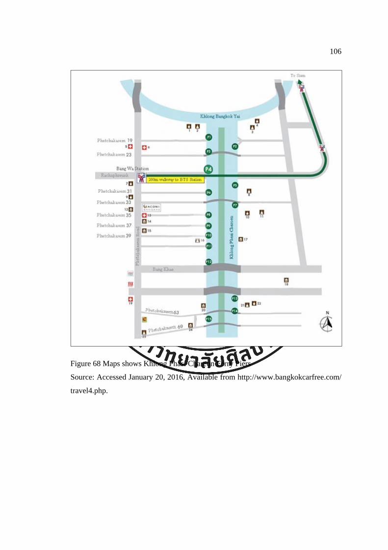
106
Figure 68 Maps shows Khlong Phasi Chareon Ferry Piers
Source: Accessed January 20, 2016, Available from http://www.bangkokcarfree.com/
travel4.php.

107
Figure 69 Phasi Charoen ferry service
Source: Accessed January 20, 2016, Available from http://www.tour-bangkok-legacies.
com/phasi-charoen-canal-boat.html.
In addition to the above-mentioned khlong, the transportation
department identified 28 khlong with transportation potential. These were Khlong
Pream Prachakorn, Khlong Bangkhen, Khlong Ladprao, Khlong Bang Sue, Khlong
Huay Kwang, Khlong Samsen, Khlong Padung Krung Kasem, Khlong Mahanak,
Khlong Lhum Pai, Khlong Jun, Khlong Tun, Khlong Phra Kanhong, Khlong Bangna,
Khlong Prawet Burirom, Khlong Lad Bua Khao, Khlong Shong, Khlong Saen Saeb,
Khlong Maha Sawat, Khlong Bangkok Noi, Khlong Chuk Phra, Khlong Bangkok
Yai, Khlong Pasi Chareon, Khlong Dan, Khlong Bang Khun Thein, Khlong Dai
Kanong, Khlong Bang Bon, Khlong Raja Montri, and Khlong Mahachai
(Rhiraksapitak, 2015).
For shorter distances, many communities still use khlong to get from
one place to another. For example, in Khlong Bang Prathun, Bang Khun Thein, a

108
morning boat takes children to school, just like a school bus. There are taxi boat
cruises along the khlong all day. People in the community can call the taxi via his
mobile phone and he will cruise to their house. Monks come in the morning to ask for
alms. Postmen still deliver post by boat in some area.
Figure 70 Postman delivering post via khlong, Khlong Pasi Chareon
Source: Nawin Meebunjong, 2016
Figure 71 Khlong Bang Prathun
Source: Nawin Meebunjong, 2016

109
7.4 Resources for Agriculture
Even though Bangkok has been urbanized, agriculture activities can
still be found in many areas. The data from Bangkok Agricultural Extension Office
shows that 26 districts, Nhongjok, Lad Krabang, Klong Sam Wa, Minburi, Saimai,
Prawet, Sapan soong, Bangkhen, Kanna Yao, Suan Lhuang, Beunggoom, Laksi, Don
Meaung, Bang Kapi, Wang Thonglhang, Ladprao, Bang Khunthein, Tawee Wattana,
Bang Bon, Toong Kru, Bang Kae, Jom Thong, Nhong Khame, Taling Chan, Pasi
Chareon, and Rad Burana, still support agriculture. The number of agricultural
households is 12,337, covering 180,305.49 rai. There are four types of agriculture in
Bangkok: rice, horticulture, fishing, and livestock (Department of City Planning,
2012). Water, one main factor for agriculture, comes from Chao Phraya River through
larger and smaller khlong to the fields.
Figure 72 Agriculture, Khlong Bang Prathun
Source: Dolruthai Jiarakul, 2015

110
7.5 Cultural and Natural Heritage Resources
This includes both tangible and intangible heritage. Tangible heritage is
defined in the UNESCO Operational Guidelines for the Implementation of the World
Heritage Convention, 2015 article 1 and article 2. Cultural heritage includes monuments,
groups of buildings, and sites, while natural heritage is natural features and natural sites
(UNESCO, 2015).
Tangible heritage of khlong are khlong itself, architecture along the
khlong, vernacular architecture, bridges, water gate, and many other associated sites.
Intangible heritage include skills, knowledge, food, occupation, and festivals – all
associated with khlong.
Because the origin of the people of Bangkok is from water, the
cultural resources are plentiful. The agriculture ways of rice, horticulture, fishing, and
livestock are strong expressions of local wisdom.
Local wisdom extends from living around fruit orchards, rice fields,
fishing communities, and the city. Each area has its own stories. Because the
geography is different, the people react differently and different cultures result.
Ways of Life and a Sense of Community
The way of water people still can be seen in some areas in Bangkok,
especially the suburb. They are such as the religion practice involving khlong and the
daily life that involve khlong.
Figure 73 Monks in a boat asking for alms, Khlong Bang Prathun. He is the only monk that still ask for alms from water in Khlong Bang Prathun (information from the interview of Nawin Meebanjong)
Source: Accessed January 20, 2016, Available from https://www.facebook.com/ KlongBangPrathun

111
Traditions and Festivals
There are few well-known traditions in the khlong in Bangkok area.
Examples include Tak Bat Phra Roi in Lad Krabang, and Chak Phra, in Thonburi, as
well as Loy Krathong, which stretches across the country.
Tak Bat Phra Roi tang Reua
Tak Bat Phra Roi (Alms giving to hundred monks on boats) is a Mon
tradition held on the first Sunday after the Buddhist Lent. This tradition passes from
generation to generation of Mon residing along Khlong Lam Pla Thiew. The ceremony is
held at Khlong Lam Pla Thiew, Wat Sutthaphote in Lad Krabang district. At the event,
about a hundred monks in the area will board the boats and stop to receive flowers,
candles, incense sticks, rice, other food, and desserts from the locals who gather along
Khlong Lam Pla Thiew. The food offering practice is similar to Tak Bat Devo Rohana but
instead of walking, boats are used (Tourism Division, Culture, Sports and Tourism
Department, BMA, n.d.). Later in the day typical Mon meals are presented to the monks
at Wat Sutthaphote. The food is served on antique tableware that locals brought from the
homes. In the afternoon boat racing is held along Khlong Lam Pla Thiew.
Figure 74 People offering alms to monks on boat at Khlong Lam Pla Thiew on Tak
Bat Phra Roi Tang Reau tradition
Source: Dolruthai Jiarakul, 2015

Figure 75 P
B
Source: Do
that have p
Departmen
Bangkok; i
Phra means
Phansa Day
to earth afte
month, acco
moveable p
Wat Nang
few hours i
Later the re
Khlong Ba
Bang Lhua
(Culture, Sp
Museum Pr
People offe
Bat Phra Ro
olruthai Jiara
Chak P
Chak P
practiced fo
nt, BMA, n
it is held in
s to carry a
y, the end o
er preaching
Chak P
ording to th
pavilion and
Chee and h
in the princi
elic is taken
angkok Noi
ang then Kh
ports and T
roject, Chul
ering alms t
oi Tang Rea
akul, 2015
Phra
Phra or Lak
or centuries
n.d.). The t
n Thonburi
a Buddha st
of the three
g to his mot
Phra festiva
he Thai cale
d carried on
heads along
ipal chapel,
n back to th
to Chao P
hlong Dan.
Tourism Dep
lalongkorn U
to monks on
au tradition
Phra is a f
s (Tourism
tradition is
area at Wa
tatue. It der
-months Ra
ther in heav
al is held o
endar. Durin
n a boat in a
g Khlong Ba
, while the m
he floating
Phraya Rive
The relic r
partment, B
University,
n boat at K
festival for
m Division,
held in th
at Nang Ch
rives from t
ains Retreat
ven (Namo,
on the seco
ng the event
a parade. Th
angkok Noi
monks, nov
procession.
er and to W
returns to W
BMA with re
n.d.).
Khlong Lam
both Brahm
Culture, Sp
he south o
hee, Khlong
the Buddha
t, the Lord
2002).
ond day of
t, a Buddha
he ceremony
i to Wat Ka
vices, and th
The proce
Wat Arun an
Wat Nang C
eference to
m Pla Thiew
mins and Bu
ports and T
of Thailand
g Chak Phr
a legend tha
Buddha cam
f the twelf
a relic is pla
y begins in
ai Tia and s
he people ea
ession exten
nd down to
Chee at abo
the Local B
112
w on Tak
uddhists
Tourism
d and in
ra. Chak
at on Ok
me back
fth lunar
ced on a
front of
stays for
at lunch.
nds from
Khlong
out 3pm
Bangkok

Figure 76 B
p
Source: Acc
detail/conten
specific loc
lunar mont
khlong, or p
as well as t
Figure 77 L
Source: Acc
Prathun.
Buddha Rel
part of Chak
cessed Marc
nt_id/9875.
Loy Kr
Loy Kr
cation or w
th. People w
ponds to pa
o ask for fo
Loy Krathon
cessed Marc
ic was plac
k Phra Festi
ch 8, 2016,
rathong
rathong is
waterway. T
will launch
ay respect to
orgiveness in
ng in 2015 a
ch 11, 2016,
ed in to a b
ival in 2015
Available fr
a nation-w
The festival
h their krath
o the Water
n polluting
at Khlong B
, Available f
boat and cru
rom http://w
wide festival
is on the f
hong (circu
r Goddess f
the water.
Bang Prathu
from https://
uise by the R
www3.navy.m
l. It does n
full moon n
ular floating
for their plen
un
/www.facebo
Royal Thai
mi.th/index.p
not take pla
night of the
g object) on
ntiful uses
ook.com/ Kl
113
Navy as
php/main/
ace at a
e twelfth
n rivers,
of water
ongBang

Figure 78 L
T
Source: Ac
บทความ_คล
Figure 79 L
Source: Acc
Loy Krathon
Talad Sapan
ccessed M
ลองโอง่อา่ง_ที
Loy Krathon
cessed March
ng in 2015
n Lhek
March 12, 2
ท่ีลอยกระทง
ng at Talad
h 12, 2016, A
at Khlong
2016, Avai
แห่งใหม-่-14
Hua Takae
Available from
Ong-Ang,
lable from
46
, Khlong Pr
m https://ww
first time a
http://www
rawet Buriro
w.facebook.c
after the rem
w.condotidd
om in 2015
com/seeyakh
114
moval of
doi.com/
,
hautakhe.

Figure 80 F
Source: Do
Figure 81 F
Source: Do
Spiritu
Feeding the
olruthai Jiara
Free the fish
olruthai Jiara
ual Activitie
fish, Khlon
akul, 2015
h, Khlong B
akul, 2015
es
ng Bang Ram
Bang Lampu
mad
u
115
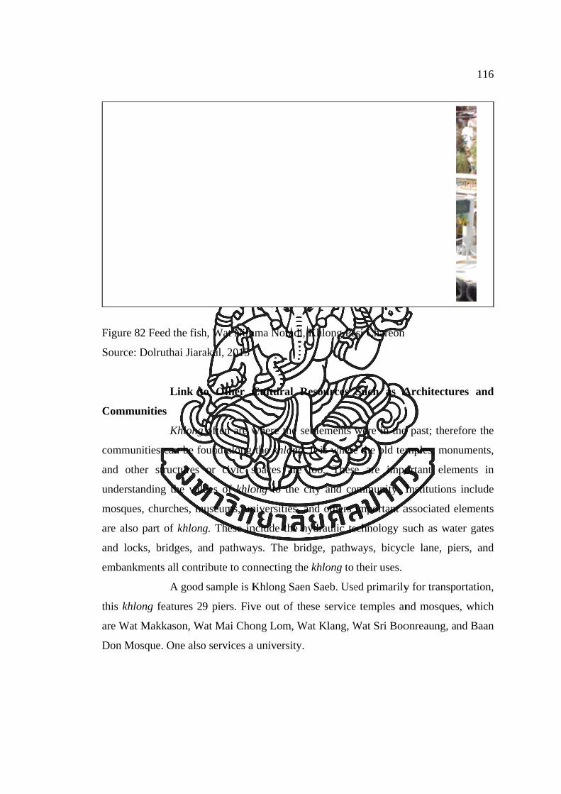
Figure 82 F
Source: Do
Communit
communitie
and other
understandi
mosques, c
are also pa
and locks,
embankmen
this khlong
are Wat Ma
Don Mosqu
Feed the fish
olruthai Jiara
Link t
ties
Khlong
es can be fo
structures
ing the val
churches, m
art of khlong
bridges, an
nts all contr
A good
g features 2
akkason, W
ue. One also
h, Wat Nim
akul, 2015
to Other C
g often are w
ound along
or civic s
ues of khlo
museums, un
g. These in
nd pathway
ribute to con
d sample is K
9 piers. Fiv
Wat Mai Cho
o services a
mma Noradi,
Cultural R
where the s
the khlong.
spaces are
ong to the c
niversities, a
nclude the h
ys. The bri
nnecting the
Khlong Sae
ve out of th
ong Lom, W
a university.
, Khlong Pa
Resources
ettlements w
. It is where
too. These
city and co
and others
hydraulic te
idge, pathw
e khlong to
en Saeb. Use
hese service
Wat Klang, W
asi Chareon
Such as A
were in the
e the old tem
e are impo
ommunity. I
important a
echnology s
ways, bicyc
their uses.
ed primarily
e temples an
Wat Sri Boo
Architectur
e past; there
mples, mon
ortant elem
Institutions
associated e
such as wat
cle lane, pi
y for transpo
nd mosques
onreaung, a
116
res and
efore the
numents,
ments in
include
elements
ter gates
ers, and
ortation,
s, which
nd Baan

117
Figure 83 Sapan Chang Rongsi, Khlong Khu Meaung Derm
Source: Accessed January 2, 2016, Available from http://www.manager.co.th/ Travel/
ViewNews.aspx?NewsID=9520000138995.
Figure 84 Architecture along the Khlong Khu Meaung Derm - Sapan Chareonrach 31
near Pak Khlong Talad
Source: Accessed January 2, 2016, Available from http://www.manager.co.th/ Travel/
ViewNews.aspx?NewsID=9520000138995.

118
Figure 85 Architecture along the Khlong Khu Meaung Derm – Sapan Hok
Source: Accessed January 2, 2016, Available from http://www.manager.co.th/ Travel/
ViewNews.aspx?NewsID=9520000138995.

119
Figure 86 Wat Mon Dhop, Khlong Bang Ramad
Source: Dolruthai Jiarakul, 2015
Figure 87 Baan Don Mosque, Khlong Saen Saeb
Source: Accessed January 6, 2016, Available from https://www.facebook.com/ Surao
Baandon.

120
Figure 88 Wat Makkasan, Khlong Saen Saeb
Source: Accessed January 6, 2016, Available from www.วดั.ไทย/วดัดสิหงษาราม-มกักะสนั.
7.6 Tourism and Recreation
Tourism
Khlong for tourism is an alternative use of khlong in Bangkok. There
are several cultural routes available for visitors. These include too a possible eco-
tourism route. Foreigners mostly seek to use khlong to provide a sense of the
authentic in the city, to link to other attractions, and to understand the way of life
along the khlong. Khlong are a valuable asset to tourism. They have a special
character, such as a friendly atmosphere. “For example, you can wave your hands to
people along the khlong while acting the same way on roads will look awkward,”
explained Rapeepat Katekosol, Tourism Development Specialist (interview February
5, 2016).
Khlong tourism route
The tourist pocket guide waterways series created by the Tourism
Division, Couture, Sports and Tourism Department, BMA suggests six routes for

waterways
Department
Figure 89 T
Source: Wa
represents B
includes ma
Suwannara
“inner Bang
tourism in
t, n.d.). Thes
Tourist pock
ater Series,
1. Chao
Chao
Bangkok as
any importa
2. Khlo
The
am, Baan B
gkok fruit o
n Bangkok
se are as fol
ket guide: W
Tourism Di
o Phraya Riv
o Phraya R
s a capital c
ant places o
ong Bangko
route includ
Bu, and Tal
orchard” at K
(Tourism
llows:
Waterways S
ivision, Cout
ver
River is the
city through
of varied age
ok Noi
des the Roy
ad Nam Ta
Khlong Ban
Division,
Series
ture, Sports
origin of k
h the main
e and style.
yal Barge M
aling Chun
ng Ramad.
Culture, Sp
and Tourism
khlong in B
artery of T
Museum, Wa
. It also inc
ports and
m Departme
Bangkok. T
Thailand. Th
at Sri Sudara
cludes the
121
Tourism
ent
The river
he route
am, Wat
route to

122
3. Khlong Bangkok Yai
This route focuses on the trade and residences of the nobility and
rich people of Bangkok. People also call Khlong Bangkok Yai “Khlong Bang
Lhuang.” This route links to Khlong Daan and to the sea on the south. The route was
not only an old trading route but also an old military route. The khlong has been
densely residential from the time of Ayutthaya. As a result, there are many important
wat, such as Wat Moleelokyaram, Wat Hong Rattanaram, and Wat Chee Chotikaram.
The khlong also features other important places, such as Ton Son Mosque, Wat
Intaram, Wat Pak Nam, Wat Nuan Noradis, Baan Sinlapin, and Talad Nam Khlong
Pasi Chareon at Wat Nimmanoradi. The route can be lengthened to Bangkok Sea at
Bang Khun Thein too.
4. Khlong Lad Dao Kanong
Khlong Dao Kanong is a natural watercourse. It is the east branch
of Chao Phraya River. The khlong forms the route to Talad Nam Wat Sai and the
Snake Garden at Thonburi. It has many wat, many containing beautiful artwork. The
khlong is one of the busiest transportation routes, because it links to Khlong Lat Pha
Ched Nha and Khlong Sanam Chai and to Khlong Bang Khun Thein, which was an
important route for the salt trading during the reign of King Rama VI. The route
further features the Snake Garden at Thonburi, Wat Nhung, Wat Nangnong, Wat Raja
O Rasaram, Khlong Daan (Khlong Sanam Chai), and Wat Sai.
5. Khlong Prawet Burirom
Khlong Prawet Burirom was excavated during the reign of King
Rama V to link the Bang Pakong River and the Chao Phraya River. The route starts
from Khlong Phra Kanong to Khlong Prawet Burirom. The beginning of the route is
confusing, as Khlong Phra Kanong is a natural khlong, so it is not as straight as
Khlong Prawet Burirom, which is man-made khlong. This route includes the Muslim
communities that were brought from Pattanee during the reign of King Rama III.
Muslims are also the majority race on this route. The route ends at Wat Kratum Sue
Pa. The route includes Talad Phra Kanong, Wat Tai, Wat Maha Bus, Wat Yang, Wat
Pak Bo, Wat Kajon Siri, Yami Allibdeh Mosque, Wat Kratum Sue Pa, Talad Hua
Takae, Wat Sutthapot, and Talad Luang Paeng.
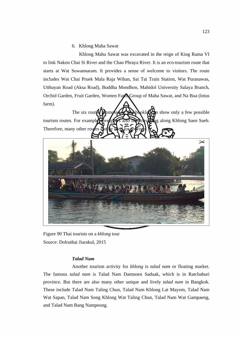
123
6. Khlong Maha Sawat
Khlong Maha Sawat was excavated in the reign of King Rama VI
to link Nakon Chai Si River and the Chao Phraya River. It is an eco-tourism route that
starts at Wat Suwannaram. It provides a sense of welcome to visitors. The route
includes Wat Chai Pruek Mala Raja Wihan, Sai Tai Train Station, Wat Puranawas,
Utthayan Road (Aksa Road), Buddha Mondhon, Mahidol University Salaya Branch,
Orchid Garden, Fruit Garden, Women Farm Group of Maha Sawat, and Na Bua (lotus
farm).
The six routes promoted in this booklet can show only a few possible
tourism routes. For example, foreigners also like travelling along Khlong Saen Saeb.
Therefore, many other routes can be used for tourism.
Figure 90 Thai tourists on a khlong tour
Source: Dolruthai Jiarakul, 2015
Talad Nam
Another tourism activity for khlong is talad nam or floating market.
The famous talad nam is Talad Nam Damnoen Saduak, which is in Ratchaburi
province. But there are also many other unique and lively talad nam in Bangkok.
These include Talad Nam Taling Chun, Talad Nam Khlong Lat Mayom, Talad Nam
Wat Sapan, Talad Nam Song Khlong Wat Taling Chun, Talad Nam Wat Gampaeng,
and Talad Nam Bang Nampeung.
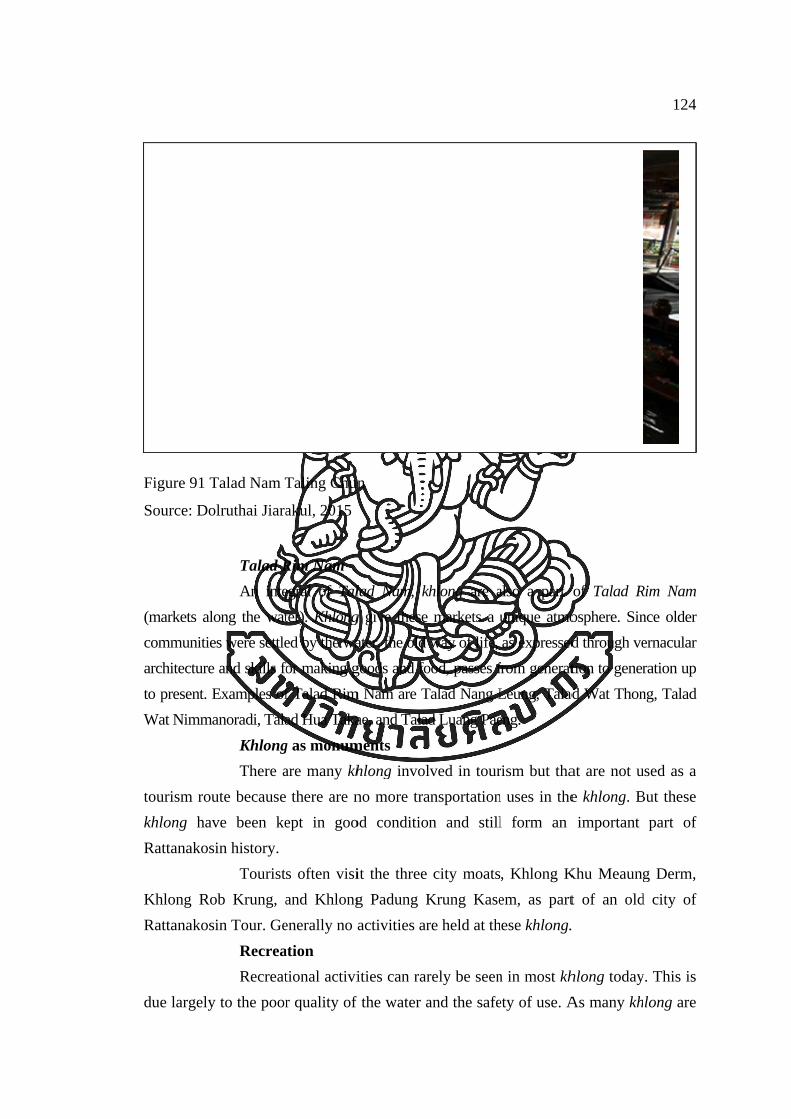
Figure 91 T
Source: Do
(markets alo
communitie
architecture
to present. E
Wat Nimma
tourism rou
khlong hav
Rattanakos
Khlong Ro
Rattanakos
due largely
Talad Nam T
olruthai Jiara
Talad R
An inte
ong the wat
es were settle
and skills fo
Examples of
anoradi, Tala
Khlong
There a
ute because
ve been ke
in history.
Tourist
ob Krung, a
in Tour. Ge
Recrea
Recreat
y to the poor
Taling Chun
akul, 2015
Rim Nam
egral of Tal
ter). Khlong
ed by the wa
for making g
f Talad Rim
ad Hua Taka
g as monum
are many kh
there are n
ept in goo
s often visi
and Khlong
enerally no a
ation
tional activi
r quality of
n
lad Nam, kh
g give these
ater, the old
goods and fo
m Nam are T
ae, and Talad
ments
hlong invol
no more tra
od condition
it the three
g Padung K
activities ar
ities can rar
f the water a
khlong are a
markets a u
way of life,
ood, passes f
Talad Nang L
d Luang Pae
lved in tour
ansportation
n and still
city moats
Krung Kase
re held at th
rely be seen
and the safe
also a part
unique atmo
as expressed
from generat
Leung, Talad
eng.
rism but tha
n uses in the
l form an
, Khlong K
em, as part
hese khlong.
n in most kh
ety of use. A
of Talad R
osphere. Sin
d through ve
tion to gener
ad Wat Thon
at are not u
e khlong. B
important
Khu Meaung
t of an old
hlong today
As many kh
124
Rim Nam
nce older
ernacular
ration up
ng, Talad
used as a
But these
part of
g Derm,
d city of
y. This is
long are

125
polluted, recreation seems impossible. This also includes the use of sideways along
the khlong, many of which are isolated.
The limitations of khlong used today have resulted in a lack of awareness
about khlong and add to the negative impacts on the condition of khlong.
Figure 92 Bicycle path along Khlong Saen Saeb (east) bank
Source: Accessed December 29, 2015, Available from http://www.jakayanrides.com/
gallery/125angkok/20150103-cycling-klong-saen-saeb.
Figure 93 Khlong and the bicycle lane on its banks from Big C Lad Prao to Asoke
Source: Accessed December 29, 2015, Available from http://www.jakayanrides.com/
rides-and-exploration/125angkok/big-c-ladphrao-to-asok.

126
Figure 94 Activity at Khlong Saen Thor, Bang Khun Thein
Source: Accessed January 18, 2016, Avialable from https://www.facebook.com/
LocalAlike/photos/a.690335564397935.1073741853.321685411262954/6903376277
31062/?type=3&theater.
7.7 Consumption
Outside the city, there still are people using water for consumption in
their daily life. They get water from khlong to clean themselves, bathing, washing
clothes, and even brushing their teeth. They use water from khlong to cook food as
well (interview Nawin Meebunjong).
Other than water, people also fish for daily consumption, as well as use
some vegetation found growing in khlong.

127
Figure 95 People using water from khlong to brush his tooth, Khlong Pasi Chareon
Source: Nawin Meebunjung, 2016
7.8 Other Uses
Other than the above uses of khlong in Bangkok, khlong are also used in
other ways. They often serve as boundaries between districts. They also form a part of the
image of the city. In many books, especially tourist books, khlong representing the
traditional way of life of Bangkok.
Figure 96 Khlong Rangsit (Khlong Sip-si) as a territory of Bang Nam Preaw,
Chacheungsao and Nhong Jok District, Bangkok
Source: Accessed March 8, 2016, Available from https://www.facebook.com/
thaitourismsociety.

128
Location and Information
Signs can be found along the khlong, typically on the banks. Mostly these
signs identify khlong names and sometimes provide information about the khlong, and
other kinds of information.
Figure 97 Interpretation near Khlong Khu Meaung Thonburi about Krung Thonburi
and its fort, khlong, and city wall
Source: Dolruthai Jiarakul, 2015
Figure 98 Sign identifies Khlong Padung Krung Kasem
Source: Dolruthai Jiarakul, 2015

129
Figure 99 Information of Khlong Khu Meaung Derm and Phan Phiphop Lila Bridge
Source: Dolruthai Jiarakul, 2015
Figure 100 Information given about Khlong Lot Wat Theptida and map of Rattanakosin
attraction sites
Source: Dolruthai Jiarakul, 2015

130
8. Conclusion
There are still numbers of khlong in Bangkok. But there are also many
important issues related to khlong. The issues will be discussed in the next chapter.

131
Chapter 5
Discussion
From the study of the history and current condition of Bangkok khlong, it
has been shown that khlong used to be a very important part of Bangkok. Their
decline is due to many factors. The three most important factors are urbanization, the
direction of city development, and government policy. These three main factors have
resulted in the deterioration of Bangkok’s khlong, in which many other ways, such as
flood, land erosion, pollution, quality of life, etc., remain important. These factors and
problems will be described in this chapter.
1. Cause of Khlong Declining
1.1 Buildings and Structures Built from Urbanization
Urbanization is in large part responsible for the current condition of
khlong in Bangkok. As Bangkok became an important port city after the excavation of
Khlong Lat Bangkok, it attracted more people and became more urban. Bangkok
developed from a small fishing and orchard village to a capital and also is now an
urbanized primate city. This is because the development and opportunity in Bangkok
attract people. Orchards have turned into real estate housing. Buildings and
infrastructures were built to support the increasing population of Bangkok. These
structures change the natural movement of water as well as uses of khlong.
The majority of houses in Bangkok discharge water directly in to
khlong. As a result, the water in most khlong is polluted. Biochemical Oxygen
Demand (BOD) in inner Bangkok, where there is a dense population is very high.
Also, urbanization has taken place without local wisdom. Each area is
different. These separate places have a deep understanding of the geological aspect of
the area as well as the cultural aspect of the people, which included beliefs and the
way of life to manage khlong well. Globalization takes away from the uniqueness of
places and leaves communities with no roots or attachment.

132
1.2 Direction of City Development
Over a nearly two hundred years period Bangkok has shifted from a
water-based city to a land-based city. This started with the influence of westerners
after the Bowring Treaty. There were more big trading ships in the river. As a result it
was not convenient for people to live on rafts. Another development was the
construction of more roads and bridges. Early on, the development of khlong and
roads was not exclusive. However, during the reign of King Rama VI, no more khlong
were excavated. Another factor was for shallow and dirty khlong to fill up. People
eventually wanted roads more than dirty khlong. The land price also got higher. This
is the beginning of khlong declining.
As this process of shifting continues there is less concern with khlong.
People also changed their house to face roads instead of khlong. The filling of khlong
has changed the relationship of khlong to the city. Khlong used to be everywhere and
were part of a linked network. Now, this system is broken. As an example, some
bridges are made so low that boats cannot pass during the water season.
1.3 Government Policy
In 1961, the first National Economic and Social Development Plan was
established and applied. The first toward third plans (1961 – 1976) focused on the
infrastructure of Bangkok (Pakkasem, 1988). The decision was to make clean water
accessible from pipes not from khlong. Government policies meant that khlong did
not have to be taken care of. They could be left as sewage pipes. In the fourth toward
sixth plans (1977 – 1991) Bangkok became a location for factories for the export of
products. Factories were encouraged and more wastewater was released into the
khlong.
The use of khlong is now mostly for flood prevention. Watergates are
built to control the flow of the water. Without a serious concern on other factors,
Watergates are an unnatural part of khlong. Humans have controlling the difficulty
flow of water. Communities gradually lose their collective knowledge and skills
related to the use of water. It also requires more manpower to maintain an effective
system. The water has become more still. Still water gets dirty easily.
All of these factors, including the zoning and housing policy, are
related to one other. The policies that encouraged the development of Bangkok made

133
it become more urbanized but neglected an understanding of the city’s geography.
More people means need for the more resources as well as creating more problems.
The land-based city has reduced the use of khlong. Neglected and dirty, khlong are
now less used.
2. Related Issues
2.1 Flooding
Bangkok is a fertile delta formed from the sediment from water. The
land is highly suitable for agriculture. The life of living with water, in floods, is
acceptable from time to time. In the past flooding did not affect the people of
Bangkok very much. Thai ancestors have long use collective wisdom in
understanding nature and living in harmony with it. Riverine society houses were
located next to the water and were elevated. People moved around using khlong. Also,
the making of khlong, lamrang, and lamkradoong in the city planning, involved
water. Agriculture activities were planned to be suitable for each season.
Shifting from a water-based to a land-based city left Bangkok people
with less sense of water. Concrete surfaces are increasing for roads, housing, and
factories. There is less soil for water to drain after the rain in the water season.
Together with the fact of the location of Bangkok and that there are fewer khlong and
the existing khlong are mostly in a bad condition, Bangkok definitely floods.
2.2 The New Comers
From the time of Rattanakosin, many people moved and settled in
Bangkok. In the old days most settlements were along khlong. And as mentioned
earlier, Bangkok is a primate city; it attracts increasingly more people to Bangkok to
seek a better life.
Many people that have moved near khlong do not have a particular set
of knowledge in living in harmonize with khlong. Therefore, the relationship to
khlong is not as strong among people with this set of knowledge. Some new
settlements, such as modern housing projects, do not take advantage of being next to
khlong. Some put high thick wall to prevent theft and prepare for floods. However,
they miss out on the values associated with khlong e.g. the open space, relaxation
from the water, recreation opportunities, and the possibilities of raising food and

134
creating occupations. Occupants of new houses also prefer open roads more than
khlong. When houses turn their back on khlong, especially with wall or hard concrete
embankments, the relationship between man and water is reduced too.
2.3 Water Quality
Khlong in Bangkok are polluted. According to the Pollution Control
Department the main cause of polluted water quality in Bangkok is untreated
municipal wastewater being discharged directly into the water. This includes
residential sewerage and industrial discharge. As Bangkok population grows more
wastewater is discharged into the water. The water cannot cope with the amount of
wastewater.
Water pollution was the first factor mentioned among the problems
facing Bangkok khlong. The use of khlong for transportation and recreation cannot be
well applied. For example, using khlong for transportation, the passengers must face
the odors that come from the polluted water. Also, during the trip, water might splash
into the face and body. There are many cons for the use of water transportation.
Recreation and water sports are not appropriate consideration water pollution as well.
2.4 Image of Khlong
In the past, people looked upon khlong as a channel of water resources.
They were the life of the people and the city. People lived along khlong. Making and
maintaining the number and quality of khlong was part of city management. Bangkok
was referred to as “The Venice of the East” from many foreigners point of view. In
the present day, khlong are being looked at as a channel for water disposal. Water for
daily consumption is available through the water supply channel, while disposal of
wastewater is directly to khlong. Khlong can hardly seen as link to the majority of
people in Bangkok.
In contrast to reality, talad nam are still presented as an image of
Bangkok on tourist websites and tourism books. The most popular talad nam
promoted for tourism is Talad Nam Damneon Saduak, which is not in Bangkok. Other
talad nam is not as popular.

Figure 101
Source: Ac
Bangkok, a
global warm
stable since
measureme
level has ri
rise of wate
the surface
risk being d
prevent this
annual bud
century wa
the philoso
absorb the
and other fl
the sinking
another ca
vegetation
Cover of to
ccessed Mar
2.5 Bangk
Scienti
are to be un
ming, cause
e the end o
ents which a
isen on ave
er results in
water. It m
drowned. T
s.
In the
dget to a sys
as on such d
ophy of “li
sudden infl
floatable hou
For Ba
g of land as
ause of Ba
with imper
ourist guide
rch 16, 2016
kok, Future
ist and scho
nder water in
es a rise in
of the last d
are availabl
rage of 1.7
n flooding o
makes many
Therefore, th
Netherland
stem of dik
defensive ba
iving with
luxes of wat
uses are the
angkok, the
s well as th
angkok’s be
rmeable str
ebooks with
6, Available
e Drowned
olars are con
n the near f
sea level.
de-glaciatio
le since the
± 0.3 mm/
of the coasta
y coastal citi
here are ma
ds, the gover
kes, dunes, a
arriers. But
water.” He
ter. There a
e passion of
risk is not o
he subsidenc
eing drown
ructures. Th
talad nam
e from www
City
ncerned tha
future. Clim
Although th
n, about 3,
late ninetee
/year since
al land, as w
ies around t
any attempts
rnment has
and sea wa
a more rec
ence waterw
are zones of
the people
only from th
ce of land.
ned. Urban
hese structu
or khlong p
w.google.com
at many coas
mate change
he sea leve
000 years a
enth century
1950 (Canz
well as saltw
the world, i
s undertake
devoted abo
lls. The foc
cent focus h
ways are b
f flood desig
(Ritter, 201
he rise of th
Drainage
nization ha
ures reduce
presented
om.
astal cities in
e outcomes,
el has staye
ago, the tid
y show that
zenave, 201
water intrus
including B
en by these
out 1 percen
cus in the tw
has been em
being conne
gnated. Hou
13).
he sea level
of ground
as replaced
evapotrans
135
ncluding
such as
d nearly
de gauge
t the sea
10). The
sion into
Bangkok,
cities to
nt of the
wentieth
mbracing
ected to
useboats
but also
water is
natural
spiration

and infiltra
surface run
and industr
subsidence
Bangkok s
Thien Distr
undergroun
people if
developmen
prevention
Bangkok. T
such as Nak
Figure 102
Source: Do
managemen
ation rates.
noff (Wallin
rial use and
of the land
tanding aw
rict.
Infrast
nd train, roa
the city i
nt may poin
In con
projects. A
These inclu
kon Rachas
Boundary
than a kilo
olruthai Jiara
2.6 Water
Water
nt involves
They caus
ng, 1987). A
d the reduce
d. The evide
way from th
tructure dev
ads, and hig
is under t
nt to some s
ntrast, the go
lso, many p
de the ideas
ima.
pole of Ba
ometer
akul, 2014
Manageme
does not
many agen
se a fall int
Also, the exc
ed sedimen
ence of this
he shoreline
velopment
ghways will
the sea. H
solutions.
overnment c
politicians p
s of shifting
angkok stan
ent
flow natur
ncies, the fl
to groundw
cessive use
nt from exis
s effect is s
e, more tha
in Bangkok
l not be abl
However, th
concentrate
propose proj
g the capita
nding away
rally in Ba
flow of wate
water level
of ground w
sting of dam
shown in th
an a kilome
k, such as
e to facilita
he ancient
es on the dev
jects to prev
al of Thailan
y from the
angkok tod
er is mainly
and an inc
water for m
ms also im
he boundary
eter in Ban
the sky tr
ate Bangkok
way wate
evelopment
vent the floo
and to a high
shoreline f
day. While
y controlled
136
crease in
municipal
mpact the
y pole of
ng Khun
rain, the
k and its
er-based
of flood
oding of
her city,
for more
khlong
d by the

137
Department of Drainage and Sewerage, BMA. There are three missions for the
departments (Department of Drainage and Sewerage, n.d.). First, is to develop the
public utilities infrastructure, drainage, and flood protection to support the growth of
the city as a livable safe city. Second, is to improve the environmental aspects of
water quality management to sustainable. And third, is to improve the performance of
the personnel of the Bureau.
A priority of the department is to drain and prevent Bangkok from
floods. The water is always treated as an enemy. The idea that water is an enemy is
obviously seen in the time of flooding. Not only does the department concentrate on
flood prevention but also the whole city tries to keep water away. During other times,
water levels are kept low to make sure the city drains well in the event of rain or
flood, not for other uses.
This “keep the water away relationship” has complicated Bangkok ‘s
management. The process began with the shift from a water-based city to a land-based
one. Houses that used to be elevated with boats kept below were replaced by house on
a reclaimed land dependent on cars. Trying to control the water and to cut off water
from the khlong were not understanding and not living harmoniously with the water.
In the past, people who lived along the khlong could use khlong efficiently.
Foreigners often mention these remarkable skills, such as traveling in small boats. By
keeping the water level low in the khlong and keeping the city dry, people do not have
the chance to practice these skills. Eventually these skills are lost.
As the connection to water decreased, activities in khlong decreased
too. Public awareness and involvement also decreased. In an interview at Talad Hua
Takae, Khlong Prawet Burirom, people opined strongly that taking care of khlong was
the government’s responsibility. That is to use law enforcement to protect khlong and
also for a government agency to maintenance of khlong, including overseeing their
cleanness, water quality, embankments, awareness signs, and dredging (Sattumsakul,
2016; Yamgasorn, 2016).
Blocking the natural flow of water to khlong by making dams and
watergates creates other problems. Watergates need to be managed and maintained.
They need a budget for that. People also sense a loss of nature from this artificial
control.

138
As mentioned in chapter 4, there are still agricultural activities in
Bangkok. In the time of dry season, the BMA will keep a good amount of water to
facilitate this activity. But in the event of unseasonal rain, water does not drain well to
khlong and other drainage systems. Conflicts arise as a result.
2.7 Other Factors
The filling of khlong and making more roads to deal with the
increasing number of cars are especially problematic. Too many cars not only made a
bad traffic but also generate a polluted air.
If such as skills and local knowledge do not pass from generation to
generation, the community will lose its identity and lose the sense of belonging to the
community. This results in less awareness and less protection of local resources.
Khlong are decline; they are more neglected and are gradually losing
their importance. The existing of khlong in some community are often unnoticed.
Some communities prefer to remove polluted khlong because they seem to have no
value. Monitoring and law enforcement have not been effectively applied. As a result,
existing problems of khlong, such as pollution and encroachment, have increased.
3. Why Revive Bangkok Khlong?
The successful revitalization of khlong in Bangkok can benefits in many
ways. These include improvements to the environment, improvements to the
appearance of Bangkok, the conservation of historic sites, value added to local skills,
an increase in revenue, more jobs opportunities, and the acceleration of new
investments, as many other cities have experienced.
3.1 The Importance of Khlong
Khlong are what makes Bangkok. The area of Bangkok originally was
a swamp. The use of khlong is well suited well with the geography. Until the making
of Khlong Lat Bangkok in 1522, during the period of Ayutthaya, Bangkok was barely
settled. The area became an important route for trading. It once then became Meaung
Thonburi Sri Maha Samutr and the site of the official custom’s house (Canen
Bangkok). Later, Bangkok was selected as the location of Siam’s capital, Thonburi,
after the fall of Ayutthaya.

139
Khlong are one of the oldest heritages from our Thai ancestors in
Bangkok. The wisdom of how to live harmony to the water has passed from
generations to generations and is gathered in khlong today. It includes: how to apply
khlong to the city; how to use water in everyday life; how to survive in the time of
flood or drought; how to make use of water; how to enjoy the living with water; and
much more.
The importance of khlong is also shown in many ways. For example,
khlong were behind the selection of Bangkok for a capital, replicating Ayutthaya. The
names of roads and places, traditions such as Royal Barges, Loy Krathong, and Tak
Batr Phra Roi, the belief of Naga, the understanding of Mount Meru, the singing of
Sagawa, the floating market, and many more all derive from Ayutthaya. In Bangkok
today, khlong are still a vital element in the flood prevention and drainage systems.
Khlong are the existing evidence of many historic events such as wars,
epidemic disease, trading, etc. They witnessed the growth and change of the city.
They were sometimes involved in those events, were the result of those events, or
were the outcome of those events. A study of the history of khlong will also lead to
more understanding of the political transition and economic growth of Bangkok.
Khlong in Bangkok have gained the reputation for uniqueness among
foreigners. Even though the name “Venice of the East” was used earlier in referring to
Ayutthaya (from Fernao Mendez Pinto in the letter to the Society of Jesus in Lisdon
in 1554). The appellation later referred to Bangkok, (notable by Salvatore Besso, an
Italian nobleman, in 1911). The image of khlong in foreigners’ eyes is still seen today
in many magazines and tourist books.
Each khlong consists a special heritage according to the settlement and
the geography surrounding it. A khlong can be pride of the community. It can be a
valuable asset in cultural, environmental, and economic ways.
3.2 Vision of Bangkok 2020
“The Vision of Bangkok 2020” in a BMA plan document noted that
Bangkok had potential for its economy, trading, and as a service center at the national
and regional level. It further offered that the city should be developed under the
principle of a “Sustainable Metropolis.” The plan also gives three guidelines for
development; gateway, green, and good life. Its authors suggested that by following

140
these guidelines Bangkok could be developed into a balance metropolis and could
provide a context for economic competition. Khlong can be an important part of this
sustainable metropolis.
Bangkok’s population, over 10 million, creates about 2.4 million cubic
meter of wastewater per day, much of it not processed through wastewater treatments
plants. The BMA has estimated the capacity of current wastewater treatment plants as
only 42 percent of the overall wastewater. The rest is flittered (Department of
Environment, BMA, 2012). The low level of water is monitored in most main khlong
for flood prevention purposes. But for many other khlong, especially those embedded
in communities, they lack water.
Apart from flooding and other water issues, Bangkok’s development
has increased other kinds of problems. These include population density, loss of
communities and cultures, high volumes of traffic, pollution, a lack of green open
spaces, and a diminution of the overall quality of life. Seeking more development
projects and using more resources do not seem to solve Bangkok’s chaos.
3.3 The Existing Khlong
There are numbers of khlong already embedded in Bangkok. They are
there for use, in education, in the economic, in the environment, among others. They
are there to connect to meanings of the city. They are there to explore other kinds of
heritage. They can turn into a valuable asset to the city if they are properly planned
and managed. On the other hand, ignoring khlong will not make khlong disappear.
The neglect, encroach, and misuse of khlong will lead simply to to a dry, dirty, and
hopeless remnants. This will only make khlong another problem for the city.
Therefore revitalizing khlong in a sustainable way may un-tap a valuable asset, which
will enhance the city’s environment, economy, and culture.
The fact of khlong inherited from our ancestors to today is never going
to be a threat. They actually present an opportunity for the city. Khlong can be a
valuable asset in the economic, environment, and social character of the city.
3.4 Movement Supporting the Revitalization of Khlong
In Bangkok today there are several movements that can help support
the revival of khlong. There is growing awareness about the environmental, including
issues such as global warming, pollution, and especially flood prevention. There is

141
also a movement for urban renewal and historic preservation. Tourism trends, such as
nostalgia and eco-tourism, also play an important role. The quest for a better quality
of life, such as more open green space, recreation areas, healthy food, and the search
for a meaningful city, all contribute to the possibility of khlong revival.
4. Khlong Revitalization Movement in Bangkok
Before the big flood of 2011, khlong were widely neglected. The use of
khlong is limited to the suburbs of Bangkok, for sewerage and some transportation.
The situation changed after the big flood, khlong have mentioned in the news and
people savant to learn more about the khlong that existed in Bangkok. At the time of
flooding, the concern was about the flow of the water, the capacity, and their drainage
route. But after the flood, many questions arose, such as: What if we have khlong in
better condition? Can they protect the city? Can they reduce the losses from flooding?
And later questions: What can we do to make use of khlong? How can we maintain
the condition of khlong? Can khlong still function more than as a drainage system?
And can khlong be connected to the city as they used to be in the past? Are they
suitable for the city? Indeed, many techniques and attempts have been applied to
khlong at many scales and in many locations.
There have been attempts at dredging. Dredging may lead to a better water
drainage system and more water capacity in flood prevention. Larger khlong usually
are dredged to 3 meters in depth and khlong branches are excavated to 2.5 meters
depth. Also, there has been a project focusing on removing encroaching buildings and
homes as well as the making of concrete banks. The BMA plans three stages to
address encroachment of buildings and homes over the next ten years. The first stage
is at nine main khlong with urgent need; Khlong Pream Prachakorn, Khlong Bang
Khen, Khlong Lad Prao, Khlong Song, Khlong Sam Wa, Khlong Lad Bua Khao,
Khlong Phraya Montri, Khlong Bang Sue, Khlong Prawet Burirom, and Khlong Phra
Kanong. The second stage includes less severe areas including 34 khlong. The third
stage includes 1,118 khlong, which is not seen as urgent since the khlong are small
and suffer less encroachment (Daily News, 2014).
4.1 Khlong Lad Prao
Dealing with the invasion of buildings and homes is not easy. Conflicts
arise in the process. One point to mention is that the project was done without a public
hearing. Therefore, the solution may not suit each project well.

rest have to
will affect
wisdom wi
create bette
main conc
sustainable
Rob Krung
years. The
registered a
Khlong On
of crime an
stories and
Ang has be
Khlong On
The
process.
Figure 103
Source: Ac
silom/silom
At Khlo
o live diffe
their lives.
ith the hope
er awarenes
ern is that
way.
4.2 Khlong
The sto
g, is also in
market gr
as a historic
ng Ang and
nd illegal in
links to the
The go
een revealed
ng Ang after
e next step
Khlong On
ccessed Ma
m.html.
ong Lad Pra
rently. The
. There are
e that this c
ss of khlon
t communit
g Ong Ang
ory of Sapan
nteresting. S
radually enc
c site in Ban
also it was
n migrants.
e residents.
vernment’s
d to public
r the new wo
for the Kh
ng Ang in th
arch 13, 20
ao, some fa
communiti
e attempts t
can bring to
ng and their
ties seek t
n Lhek Ma
Sapan Lhek
croached an
ngkok. The
claimed by
The marke
s interventio
after a very
ork was Lo
hlong Ong A
he past
016, Availa
amilies have
ies have to
to find com
ourism. Tou
r contributi
to live har
arket at Khl
k has been
nd covered
market furt
the governm
et itself has
on has been
y long time
y Krathong
Ang revital
able from h
e to leave th
adapt to a
mmunity un
urism can g
on to the q
rmoniously
ong Ong A
the market
d Khlong O
ther obstruc
ment contri
become an
n successful
. The first f
g, held in 20
ization is s
http://haab.c
he commun
new appro
niqueness an
generate mo
quality of l
with khlon
Ang, part of
t for more
Ong Ang, w
cted the dra
ibuted to a h
n old marke
l, and Khlo
festival was
015.
still in the p
catholic.or.t
142
nity. The
oach that
nd local
oney and
life. The
ng in a
f Khlong
than 30
which is
ainage of
high rate
et. It has
ong Ong
s held at
planning
th/silom/

143
Figure 104 Khlong Ong Ang, when water transportation was widely used
Source: Accessed January 20, 2016 Available from http://kanchanapisek.or.th/kp6/ sub/ book/
book.php?book=33&chap=3&page=t33-3-infodetail03.htmlandhttp://www.t-pageant.com/
2011/index.php?/topic/ 146639
Figure 105 Picture of Sapan Lhek Market encroaching Khlong Ong Ang and the
picture of Khlong Ong Ang after the demolishing of Sapan Lhek Market.
Source: Accessed January 20, 2016, Available from https://soclaimon. wordpress. com/
2015/10/23/กู๊ดบายสะพานเหลก็-สอ่ง-10/ and http://travel.kapook.com/view135203.html

144
Figure 106 Khlong Ong Ang on the Loy Krathong Festivals 2015, after the demolition of
Sapan Lhek Market and landscape adjustment
Source: Accessed January 20, 2016, Available from http://www.posttoday.com/ analysis/
report/401898
4.3 Khlong Bang Lampu
Khlong Bang Lumpu, another part of Khlong Rob Krung has also been
subject to revival attempts. The project was more concerned with the water quality of
khlong than encroachment. Actually, the movement of Khlong Bang Lampu revival
started in 2010, before the big flood in 2011.
Department of City Planning, with the BMA, recognizes Khlong Bang
Lampu as a prototype for khlong development. The process includes dredging, use of
EM, water treatment bike, landscape adjustments, and cultural activities. The Bang
Lampu Community is at the center of activities, working with other agencies. The
result is that Khlong Bang Lampu is clean and beautiful. The water quality has
improved that the aquatic life is thriving.
Although the project has been successful in many ways there are still
issues. For example, the use of a water treatment bikes cannot be fully applied due to
the limitation of parking space and lack of management personal etc.
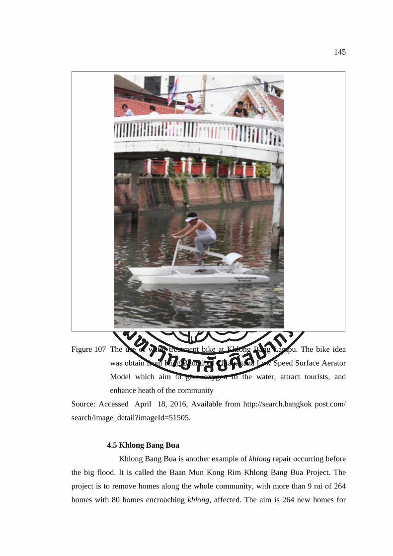
145
Figure 107 The use of water treatment bike at Khlong Bang Lampu. The bike idea
was obtain from King Bhumibol Chiapattana Low Speed Surface Aerator
Model which aim to give oxygen to the water, attract tourists, and
enhance heath of the community
Source: Accessed April 18, 2016, Available from http://search.bangkok post.com/
search/image_detail?imageId=51505.
4.5 Khlong Bang Bua
Khlong Bang Bua is another example of khlong repair occurring before
the big flood. It is called the Baan Mun Kong Rim Khlong Bang Bua Project. The
project is to remove homes along the whole community, with more than 9 rai of 264
homes with 80 homes encroaching khlong, affected. The aim is 264 new homes for

146
the community. Each person gets 5x10 meters land. New homes can be one of several
choices, a singe one-story house, a single double-story house, a double-story twin
house, or a row house. The community will rent the land from the Treasury
Department for 30 years at the rate of 1.50 baht per square wah per month. At first the
community fought the project, but the government compromised with the community
and organize many meeting to clarify the project. The project began with a
community forum to create a working group and housing group in 2004. The first
phase was in 2006, with nine homes, and followed with many more phases later. The
community Organizations Development Institute supported the project with 10.3
million baht for the infrastructure and 24 million baht for the house loans. The
community also founded housing cooperatives to manage the project (Kom Chad
Luek, 2015).
Home building has also brought the community together as an indirect
result. Community members help each other in moving and planning (Kom Chad
Luek, 2015).
Figure 108 Khlong Bang Bua before the landscape adjustment
Source: Accessed April 18, 2016, Available from http://www.komchadluek.net/
detail/20150823/212048.html.

147
Figure 109 Khlong Bang Bua after the landscape adjustment
Source: Accessed April 18, 2016, Available from http://www.komchadluek.net/
detail/20150823/212048.html.
4.6 Khlong Padung Krung Kasem
Another interesting project is the revival of floating market at Khlong
Padung Krung Kasem. Before the flood Khlong Padung Krung Kasem presented itself
almost as a dead monument; there were no activities in or along the khlong. The only
sign of interpretation was a story. It was only use as part of the drainage system in
Bangkok. The water level was kept low most of the time to be able to receive more
water in the water season.
In 2015, the Khlong Padung Krung Kasem Project was initiated in
response to the Government’s policy to promote tourism and develop new tourism
sites. There were three agencies joining this project: the Secretariat of the Prime
Minister, the Bangkok Metropolitan Administration, and the Tourism Authority of
Thailand (The Government Public Relations Department, 2015).
The Prime Minister Prayut Chan-o-cha initiated Khlong Padung
Krung Kasem Floating Market project. He mentioned that Khlong Padung Krung
Kasem was an important waterway in Thai history. It has several significant temples

148
along its side. The development of Khlong Padung Krung Kasem as a tourism
attraction would provide, he suggested an opportunity for visitors to learn more about
Thai culture and history (The Government Public Relations Department, 2015).
The project indeed does give live to the khlong. It was used for a
floating market, transportation, marketing, and tourism. It also promotes the
communities and other available markets and water markets in and around Bangkok.
Although the creation of Khlong Padung Krung Kasem as a floating market was
initiated by Prime Minister Prayut Chan-o-cha, the theme was developed later. The
theme of the market was presented as “5 talad bok, 6 talad nam,” which means 5 land
markets and 6 floating markets. The five land markets are Talad Nang Leung, Talad
Wat Thong, Talad Wat Nimmanoradi, Talad Hua Takae, and Talad Luang Paeng. The
six floating markets are Talad Nam Taling Chun, Talad Nam Khlong Lat Mayom,
Talad Nam Wat Sapan, Talad Nam Song Khlong Wat Taling Chun, Talad Nam Wat
Gampaeng, and Talad Nam Bang Nampeung. The markets are located in and around
Bangkok. Interpretation and marketing technique are effectively used and were
successful in utilizing the khlong and promoting tourism.
Figure 110 Khlong Padung Krung Kasem in the reign of King Rama VI. It is khlong
khu meaung without city wall like in the earlier khlong khu meaung
Source: Accessed April 18, 2016, Available from http://www.sujitwongthes.com/
2015/02/siam12022558.

149
Figure 111 Talad Nam Khlong Padung Krung Kasem Revival
Source: Accessed April 18, 2016, Available from http://www.siamrath.co.th/web/?q=
category/channel/scoopthai-politics.
4.7 Khlong Pream Prachakorn
In 2012, there was the Khlong Pream Prachakorn project, contributed
by Matichon Public Company Limited. After the launching of the project, there was a
good response from many agencies, as well as from the community. Schools and
monasteries were involved. They formed a club and network in doing so. The
principle of the project was to promote “knowledge mobilization, religion upholding,
and development all water resources and the rivers.” Activities included cleaning
campaigns that have been organized continually to the whole length of Khlong Pream
Prachakorn. This project is an undertaking of the private sector, which created
awareness about the khlong and contributed it to the community (Matichon Public
Co.,Ltd, 2012).

150
Figure 112 Khlong Pream Prachakorn restoration
Source: Accessed April 18, 2016, Available from http://info.matichon.co.th/report/2555/
pdf/socialsevice.pdf.
4.8 Khlong Pasi Chareon
In addition to the above efforts, there is also movement to revive
khlong for use in transportation. The Khlong Saen Saeb Ferry is known as the
transportation of choice from the city to the east of Bangkok. The current attempt is to
create a link to the west of Bangkok. That is the Khlong Pasi Chareon Ferry. But there
is not only the revival of transportation at Khlong Pasi Chareon but also cleaning,
dredging, and other cultural activities. Khlong awareness, awareness of the
architecture along the khlong, and awareness on life along the khlong were concerns
of the ferry service. Therefore, there is a speed limitation for the ferry. There is also
use of social media to promote the use of the ferry and to communicate with the
community at https://www.facebook.com/Pasrijaroenboat/. There are attempts in
making now for new ferry service. The new ferry is made in a different design from
older boats with window glass and GPS tracking system. Unfortunately, many found
the new design to be hot, as air did not flow very well. Details of transportation route
are already mentioned in Chapter 4.

151
Figure 113 The new ferry which is introduced in a trial phase in April 2016
Source: Accessed April 18, 2016, Available from https://www.facebook.com/Pasrijaroen boat.
4.8 Khlong Bang Prathun
After the big flood of 2011, local residents spent more time at their
home and realized that khlong was a part of their home. They also saw they were very
beautiful and realized that their homes were now being threat by urbanization. The
use of khlong was also decreasing. There used to be school ferries much like a school
bus full with students in the morning, but now this experience is rare. There is only
one monk using a boat asking for alms. Post is still delivered via boat but only by one
postman. The agricultural way of life is decreasing and is not passed to the up coming
generation. The contrast between locals and new comers is increasing. Wat Kaew
Paitoon, a site that used to be the center of the community, also had a decreasing role
in community life.

Figure 114
Source: Ac
and prepare
and stories
had helped
of living. T
of khlong a
Khlong Ba
with a big
success inv
They also
social. The
result was
community
skills are n
expanding
Map of K
the green a
ccessed Feb
At the beg
e the comm
of Khlong
bring awar
The commu
and making
ang Prathun
mall that w
volved the w
used socia
eir Faceboo
successful
y more than
now passed
awareness o
Khlong Bang
area of Khlo
bruary18, 20
inning, the
munity for th
Bang Prath
reness to the
unity becam
g of other a
too. One s
was coming
water treatm
l media to
k page is h
and the co
n before. A
d on to the
of the way o
g Prathun s
ong Bang P
016, Availab
objective o
he future. T
hun then ma
e communit
me stronger.
activities. C
significant a
g to the Khl
ment plan of
communic
https://www
ommunity b
Agriculture
e next gene
of life as pe
shows the e
Prathun
ble from htt
of the proje
he activitie
ake an exhi
ty. People n
Activities l
Children are
activity is t
long Bang
f the mall, th
cate within
w.facebook.c
became stro
activities w
eration. Th
eople along
encroaching
tps://www.g
ect was to
s were to do
ibition. The
now love an
later expand
e involved
that the com
Prathun are
he fence, an
the commu
com/KlongB
nger. They
were also re
heir objectiv
the khlong.
g of urbaniz
google map
slow down
ocument lo
e exhibition
nd cherish th
ded to the c
in the activ
mmunity ne
ea. The com
nd the pier e
unity and w
BangPrathu
y are proud
evived. Sto
ve continue
152
zation to
p.
n change
cal lives
process
heir way
cleaning
vities of
egotiated
mmunity
entrance.
with the
un. The
of their
ries and
es to be

153
Figure 115 Khlong Bang Prathun with shade from trees
Source: Accessed February 24, 2016, Available from https://www.facebook. com/
photo.php?fbid=1147479845263256&set=a.1147478281930079.1073742006.100000
037545554&type=3&theater.
5. Directions in Bangkok Khlong Revival Movement
Khlong revival projects in Bangkok are scattered. It can be seen that there
is no overall plan for the revival of khlong. As khlong are linked like a network, water
flows from one khlong to another khlong. Taking care and making one clean khlong
will not fully benefit the whole. But a pilot project is better than leaving khlong to
deteriorate to a worse condition. Also, there is no specific center or organization that
specializes in the revival of khlong.
Partnerships are important for the revival of khlong. The involvement of
government agencies, scholars, the private sector, social media, and the community
will increase the possibility of a successful project.
The revival plan is mostly concerned with water quality and the landscape.
Therefore, it neglects the value of heritage and other functions of khlong. Even though

154
the quality of water and landscape play an important role in revitalization, the
function and heritage of khlong are very important to the successful revival project
too. Function can benefit the community easily and heritage can make khlong unique
and special.
On the other hand, reviving the function of khlong linking khlong back to
everyday life as well as activities in khlong. The community and society will have
more connection to water. The awareness of khlong may also be enhanced.
Improving the quality of water is mostly done through the cleaning
projects. Those are mostly about getting rid of solid waste, dredging, and improving
the water flow and the look of the water. But the source of dirty water, from daily
consumption, is still not efficiently dealt with.
After a project is initiated many do not have a management team and
management plan. Therefore, revival or development cannot continue. Some projects
started with a supporting budget but without an effective plan after the project; no
budget or manpower is available afterward as well.
Tourism is sometimes used as a tool for the revitalization of khlong. It
gives khlong their livelihood. Tourism generates income. It gives pride back to the
community. However, the question of income distribution, effects on the
environment, effects on the culture, effects on uniqueness, and effects on normal life
have to be considered as well. Tourism can bring staged and generalized experience to
the tourist, which in long term will not benefit the tourism activity.
Interpretation can be useful in revitalization. For the example of Khlong
Padung Krung Kasem and Khlong Bang Prathun interpretation was being put forward.
Khlong Padung Krung Kasem presented a problem because the day-to-day sewage
created a dead monument. And yet, it is an important khlong. This khlong comprises
an important historic value for the city of Bangkok. Khlong Padung Krung Kasem
was not used for any water activities up until the recent initiation of the new project in
2015. Talad Nam Khlong Padung Krung Kasem use are meant to interpret all floating
markets and markets along the khlong in and around Bangkok. Even though the
floating market is staged it can be a compromise because of the quality of ideas
representing other markets. On the other hand, Khlong Bang Prathun uses
interpretation as a tool for the community to realize the beauty and the value of their

155
neglected khlong. Both have had good results. In some khlong such as Khlong Saen
Saeb, which is very rich in history and culture, interpretation has not been effectively
applied. It is an unfortunate loss of possible benefits.
Khlong can be used as a means of transportation. There is a plan to
develop water transport to be linked with rail transportation. This might be beneficial
to Bangkok as traffic is very bad. But the question of the effect from the use of
transportation has to be considered. In Khlong Saen Saeb water transportation is used.
There are complaint of noise and the strong tide from the ferry. This lowers the
quality of life for people in the area too. At Talad Nam Wat Sai where people came to
trade fruits and other products, increased tourism resulted in bigger boats being used.
Bigger boats affect the local boats. It results in a decreasing number of local residents
that come to trade. When there is no trade in the water, the Talad Nam did not attract
tourists anymore. Therefore, Talad Nam Wat Sai lost both local activity and tourist
activity.
6. Conclusion
Bangkok’s geography is suitable for a water-based city. Development of
Bangkok in the past has changed from water-based to land-based and many problems
have arisen. The revitalization of Bangkok khlong can improve the city. But this
process requires more work. Examples from the movement of revival projects in
Bangkok have shown some issues around khlong revitalization, such as the
community involvement, important of community hearings, the use of tourism,
interpretation as a tool, and many more.
The idea of revitalization in the worldwide content will be discussed in the
next chapter.

157
156
Chapter 6
Waterway Revitalizations
“Cities seek a waterfront that is a place of public enjoyment. They
want a waterfront where there is ample visual and physical public access –
all day, all year – to both the water and land. Cities also want a waterfront
that serves more than one purpose: they want it to be a place to work and to
live, as well as a place to play. In other words, they want a place that
contributes to the quality of life in all of its aspects – economic, social, and
cultural”.
(Seattle Department of Planning and Design, 2012)
The decline of waterways (river and canals) was not an uncommon issue.
Many cities in the world have faced a rapid industrialization and growth in which they
were not able to sustain their waterways that run through their unban areas. Recently,
many cities have started to realize the importance of their waterways. Therefore, there
has been a movement to revive or restore the waterways to promote public space,
tourism, and the well being of the people.
In the United Kingdom, Canada, and the United States, the waterways
have been restored focusing on the improving of navigability, while in Australia the
focus includes the improvement of water quality (Princeton University, 2013). The
movement for the revitalization of waterways has been developed over a few decades.
1. Definitions
Revitalization (definition by the Cambridge Dictionaries Online) is “the
process of making something grow, develop, or become successful again” (Cambridge
University Press, 2016). The definition of revitalization by the Oxford Dictionary is “the
action of imbuing something with new life and vitality” (Oxford University Press, 2016).

157
156
There are also words often used such as “Waterway Restoration,” which
according to the Princeton University Website is “the activity of restoring a canal or
river, including special features such as warehouse buildings, locks, boat lifts, and
boats.”
Words such as waterways renewal, waterways redevelopment, waterways
reconstruction are also used in these types of projects. In this research, revitalization
of Bangkok khlong is the process of making khlong grow, develop, strong, active, and
be successful for Bangkok and its people again.
2. Movement of “Inland Waterways” or “Canal” Revitalization
The global trends of tourism including community-based tourism, eco-
tourism, and sustainable tourism have an influence on the transforming tourism
activity in Bangkok. Planning and the revitalization of the urban waterfront has been a
focus in the US since the early 1960s. Revitalization has had an impact on many
European cities, especially the revitalization of the urban waterfront, in the 1970s and
1980s and Asian cities since the late 1980s and 1990s. Waterfronts have become an
area of interest for urban management and urban developers. Many waterfront
projects have been initiated and have expanded the development strategies of
waterfront areas to broader issues that can contribute to urban redevelopment as well.
The environmental awareness also plays an important role in the
restoration and revitalization of waterways.
3. Benefits of Waterway Revitalization
The benefits of waterways revitalization or waterways restoration have
been studied and scrutinized in many documents. Some are shown here.
“The restoration to navigation of canals and rivers has revitalized key
parts of the country’s transport and industrial heritage, generated jobs and
development and increased opportunities for leisure, recreation and
tourism.”
Waterways for Tomorrow, 2000

158
“Canals make a significant contribute to the Scottish economy. They
provide a valuable local amenity and resource for education, recreation,
and tourism as well as acting as a catalyst for change and creating the
opportunity for renaissance for many communities.”
Scotland’s Canals - An Asset for the Future, 2002
“Urban waterways have the potential to support healthy environments,
growing business and educational and recreational activities. By bringing
together the experience and expertise of multiple federal partners, we have
a chance to reconnect local residents, young people and community
groups with the environmental resources all around them.”
Lisa P. Jackson, EPA Administrator
“Restoration is the catalyst for redevelopment and regeneration in the
canal corridor, we’ve seen an investment of over £85 million across two
Local Authorities, creating over 300 jobs and the restored canal had been
the catalyst for two major district center developments”
Graham Birch, Chair, Huddersfield Canal Society (Canal & River Trust, The Inland
Waterways Association, n.d.)
The document Water Adds Value by the Canal & River Trust and The
Inland Waterways Association has carried out a research project to explore the
economic, social and environmental impacts of restoration projects in the last two
decades in Great Britain. The research sums up the benefits of waterways restoration
in three parts: economic benefits, social benefits, and environmental and heritage
benefits (Canal & River Trust, The Inland Waterways Association, n.d.).
In economics, waterways revitalization includes the short-term impacts, such
as a construction jobs, and more long-term impacts, such as increased in leisure and
tourism and the re-development of disused land and buildings. Revitalization has rescued
the future of many historic buildings and canal side can also be developed. Revitalization
also contributes to an increase in the number of visitors - and visitors spending - as well as

159
stimulating regeneration and development activities (Canal & River Trust, The Inland
Waterways Association, n.d.).
Social benefits are the social outcome from increased employment,
economic activities, and regeneration impacts. Benefits include a sense of community,
through campaigning and volunteering for local projects, as well as benefits to health,
through increased opportunities for walking and cycling (Canal & River Trust, The
Inland Waterways Association, n.d.).
In terms of environmental and heritage benefits, benefits include a
significant positive impact on many aspects of environment, such as the benefits of
biodiversity in flora and fauna and increased in green space. There are also benefits to
traffic (more people use towpath for commuting), drainage, and reduced carbon
dioxide emissions. The data shows that local people were seen as the engine behind
regeneration and played a fundamental role in maintaining the heritage of waterways
(Canal & River Trust, The Inland Waterways Association, n.d.).
From these studies it can be concluded that successful waterways
revitalization projects can benefit the city in many different areas. Revitalization can
lead to a better city.
4. Examples
4.1 Amsterdam, Netherlands
Amsterdam is a famous water city. The canals and harbors fill a quarter
surface of Amsterdam (Amsterdam Info, 2003). The earliest canals are the city
defensive structure. As the city expanded further than the old canals, they lost their
function as a defensive structure. But eventually, the canals were then used for
transportation and this new function made the city wealthy.
Later, as with many other cities, to make more roads and more space
Amsterdam filled in many of its canals. Some canals were filled for sanitation
purposes. Some new roads are still called “gracht” (canal) because they were once
canals (Gray, n.d.). The largest project to redefine the relationship of the city to its
canals was the construction of the Central Station in 1885. The station connected rail
and roads as well and left canals behind. The canals, as a result, were in a bad

condition. A
housing, an
Amsterdam
the advanta
to other wa
canals for m
Figure 116
Source: Acc
amsterdam-
After WWI
nd most hou
Beginn
m. This was
age of using
ater cities,
markets, pro
Canals in A
cessed Mar
-canals.
II, the numb
useboats are
ing in the 1
s recreation
g its canals
such as Bar
omenades, a
Amsterdam
ch 9, 2016,
mber of hous
e illegal (Ma
1950s, a ne
. There wer
as there are
rcelona, Co
and other pu
, Available f
seboats incr
aarten Claas
ew function
re canal tou
e more acce
openhagen,
ublic uses (M
from http://th
reased, beca
sen, 2013).
n for canals
ur operation
ess to canal
and Stockh
Maarten Cla
hetravelbunn
ause of the
s was introd
ns. Amsterd
ls there com
holm, which
aasen, 2013
ny.com/ 201
160
e lack of
duced in
dam has
mparison
h utilize
3).
13/07/03/

Figure 117
Source: Pla
100 kilome
passengers
attractions
around the
Figure 118
Source: Acc
photographe
Canal Crui
an Amsterd
Currently, t
eters (Amst
every year
of Amsterd
canals. (Ma
Canal Para
cessed Marc
ers/frank_wij
ise in Amste
dam Docum
there are 16
terdammer,
r. Canals to
dam. There a
aarten Claas
ade Gay Prid
ch 11, 2016
jn.
erdam
ment, p.3
65 canals in
2015). Am
ours are co
are many b
sen, 2013).
de 2015, Am
6, Available
Amsterdam
msterdam ca
onsidered to
usy events
msterdam
from http://w
m with the to
anals carry
o be one of
successfully
www.gettyim
total length
some three
f the most
y take place
mages.com/
161
of about
e million
popular
e on and
galleries/

recreationa
and many o
(A View on
waterways
Figure 119
Source: Ac
amsterdam/
UNESCO W
around the o
Figure 120
Source: Acc
Today, can
al activities,
other things
n Cities, n.d
Amsterdam
to the city i
Houseboat
ccessed Ma
/canals.htm
Amsterdam
World Herit
old city of A
Canals Bel
cessed Marc
nals in Ams
such as bo
s. Canals are
d.).
m provides
into everyda
s in Amster
arch 9, 20
m.
m also comp
tage list. It i
Amsterdam. I
lt
ch 9, 2016, A
sterdam are
oating and
e also home
a good
ay life of th
rdam Canals
016, Availab
prises a grou
is the Cana
It is made of
Available fro
e used for
skating, sp
e for many
example o
he people.
s
ble from h
up of canal
al Belt. The
f three canals
om http://ww
navigation,
pecial event
people who
of the proj
http://www.
ls that is lis
Canal Belt
s ringing the
ww.dutchams
, tourism ac
ts, restauran
o live in hou
ojects that
aviewonciti
sted in 201
is a concen
e old core of
sterdam. nl/c
162
ctivities,
nt boats,
useboats
involve
ies.com/
1 in the
ntric belt
the city.
anals.

was origina
fourteen wa
Figure 121
Source: Ac
org/uploads
for military
Cheonggye
project for
including p
economy, a
as a symbo
historical a
4.2 Cheon
Cheong
ally a seaso
aterways.
Cheonggye
ccessed Feb
s/media/K_
In the1
y, sanitary, a
In the
echeon. The
In 2002
Cheonggy
providing a
and nurturin
Becaus
olic task an
nd natural h
ggyecheon
ggyecheon
onally flowi
echeon in th
bruary 11, 2
_LEEInKeun
900s, the S
and flood co
e mid 19
ere were app
2, Lee Myu
echeon. He
an opportu
ng a breathin
e of the his
nd the entir
heritage (La
Restoratio
is a stream
ing brook th
he past
2016, Availa
n_Seoul_-_
South Korea
ontrol purpo
970s, an
proximately
ung-bak, Se
e believed
unity for d
ng place for
story of Che
re country o
ah, 2012).
on Project,
m that flows
hat develop
able from h
_River_Proje
an governm
oses.
elevated
y 168,000 ve
eoul’s new m
that the pro
development
r the city.
eonggyeche
of South K
Seoul, Sou
s through d
ed into a st
ttp://worldc
ect.pdf.
ment began t
highway
ehicles a da
mayor, prop
ojects woul
t, revitalizi
eon, the pro
Korea was e
uth Korea
downtown S
tream in 14
congress200
to cover the
was buil
ay on this hi
posed a res
ld benefit t
ing the do
oject was pr
eager to rev
163
Seoul. It
12, with
06. iclei.
e stream
lt over
ighway.
storation
the city,
owntown
rocessed
vive this

Figure 122
Source: Ac
org/uploads
along the re
in an urban
of Seoul - a
At the east
flowing fro
Cheonggye
ccessed Feb
s/media/K_
The projec
evitalized th
n setting. Th
and runs to
t end of the
om the north
echeon High
bruary 11, 2
_LEEInKeun
t was to cr
he old strea
he project st
the east an
e stream, it
h of Seoul.
hway in 199
2016, Availa
n_Seoul_-_
reate a 5.8
am of Cheon
tarts from th
nd exits the
is joined b
90s
able from h
_River_Proje
kilometers
nggyecheon
he Taepyeo
old fortified
by another s
http://world
ect.pdf.
landscape
n. It was abo
ong-ro distri
d Hanyang
stream calle
dcongress20
of green p
out restorin
ict - the ver
near the Ea
ed Junglang
164
006.iclei.
pathways
ng nature
ry center
ast Gate.
g-cheon,

Figure 123
Source: Ac
wordpress.c
residents an
visitors by
2011).
social bene
biodiversity
pollution. T
Plants spec
species inc
species inc
amphibians
is 3.3° to 5
Cheonggye
ccessed Fe
com/2014/0
Since its o
nd visitors.
the end of
The results
efits, and eco
Environme
y, reduction
The project
cies increas
creased from
creased from
s from 4 to
.9° C cooler
echeon
ebruary 11,
03/cheonggy
opening in
The stream
2008 (Com
s of the Ch
onomic ben
ntal benefi
n of the u
further incr
sed from 38
m 6 to 36,
m 15 to 1
8 (Revkin,
r than that a
2016, Av
yecheon-res
2005, Ch
m has becom
mmission for
heonggyech
nefits (Land
fits include
urban temp
reased the b
8 to 62, fi
, aquatic in
92, mamm
2009; Lee,
around the p
vailable fro
storation-pr
eonggyeche
me a tourist
r Architectu
heon projec
dscape Arch
providing
perature, an
biodiversity
sh species
nvertebrate
mals species
2006). The
parallel road
om https://c
roject.pdf.
eon has be
attraction,
ure and the
ct are envir
itecture Fou
flood pre
nd reduced
y by 639% f
increased f
species fro
increased
e temperatur
d, which is
carolineguil
een popular
drawing ab
Built Envir
ronmental b
undation, n.
evention, in
small par
from 2003
from 4 to
om 5 to 53
from 2 to
ure along the
about 4 to 7
165
llet.files.
r among
out 18.1
ronment,
benefits,
.d.).
ncreased
ticle air
to 2008.
25, bird
3, insect
o 4, and
e stream
7 blocks

166
away (Lee, 2006). The small particle air pollution is reduced by 35% from 74 to 48
micrograms per cubic meter (Revkin, 2009).
Figure 124 Cheonggyecheon stream stretches in the city of Soul shows the nature
harmonizing in the city
Source: Accessed April 19, 2016, Available from http://auracles.blogspot.com/2013/04/
seoulful-trip-day-3-4th-destination.html.
The social benefits are an increase in bus ridership by 15.1% and subway
ridership by 3.3% from 2003 to 2008 (Lee, 2006). The site also attracts about 64,000
visitors per day (Lee, 2006).
In economic terms, the project has increased the property value within 50
meters from the restoration by 30-50%. Business numbers have increased by 3.5% in
the Cheonggyecheon stream restoration area (Lee, 2006).
The case of Cheonggyecheon is a good example of where canal
revitalization, with the initiation from authority and community hearing process, has
contributed to the environmental, economic, social, and public identity of Seoul. The
project demonstrates revitalization creativity and the possibilities interested in mega
projects.

167
5. Conclusion
It can be concluded that revitalizing urban waterways can benefit cities in
many ways. Many cities with declining waterways have already started the movement
and have demonstrated success. Each waterways revitalization project is unique,
according to the context and aim of their projects.
These examples make the revitalization khlong in Bangkok appealing but
the process is definitely not easy. There are many challenges facing a successful
revitalization project. Different khlong need different approaches. Proposals for
khlong revitalization will be discussed in the next chapter.

169
168
Chapter 7
Proposal
“Sustainable development is a development that meets the need of
the present without compromising the ability of future generations to meet
their own need.” (Brundtland, 1987)
This study has shown that khlong are valuable assets for Bangkok. They
are part of the history of Bangkok from the origin. Khlong are suitable for the way of
living in the plain delta. In the past, the development of the city and the people has led
to khlong extending in different directions. Overtime, khlong decreased in use and
importance. Many were subsequently filled and neglected. Recently, the importance
of khlong has been raised to the public, one big contribution coming from the big
flood in 2011, especially as part in the drainage system of Bangkok. But some people
have also realized that khlong are more valuable to the city than just for drainage.
Therefore, attempts to revive khlong have been initiated. Some revitalization projects
have been successful and some not. This chapter presents a proposal for khlong
revitalization in Bangkok as a whole.
To accomplish the revitalization of khlong, it is important to establish
effective management collaborations, partnership agencies that authorize the holistic
management of khlong. This type of management will transform khlong into
economically beneficial assets, while preserving the heritage of the city. The
recreational use of khlong will also be part of authentic khlong and authentic khlong
proposal.
Revitalization should aim to provide a green city and improve the quality
of life of the people.

169
168
1. Trait of Khlong Revitalization
1. Khlong revitalization needs to consider the connection of geography to
the city. This understanding will lead to an appropriate land use scheme that respects
living with nature.
2. Khlong revitalization is a merging of conservation, restoration, and
development.
3. Khlong revitalization is not a start and finish process. It has to be
continuing as part of the city.
4. Khlong are connected as part of a network. Water flow in different
contexts. In other words, each khlong maybe revived differently, but all khlong are
connected.
5. Khlong revitalization success may not be indicated directly by increases
in income but by other benefits, such as environmental and social improvements.
There are also indirect benefits from khlong revitalization too.
6. Khlong revitalization requires multi-disciplinary skills and knowledge.
7. There is no prototype for khlong revitalization. Each khlong is unique
and should be dealt with differently.
2. Directions
The direction of revitalizing khlong must be to follow the idea of
sustainable development. Khlong should utilize the idea of a water-based city, as
water-based cities are suitable way of living in the area of plain delta like Bangkok.
2.1 Sustainability
Sustainable development will strive to create a balance between social,
economic, and environmental factors. With the balance of these three factors, khlong
have high potential to successfully connect Bangkok and its people. The revitalization
will be sustainable, successful, and beneficial if it meet the needs of community,
enhance the economy, and does not negatively affect the environment.
To be sustainable, khlong revitalization should be beneficial to the
community. And it should be self-sufficient. The management should find ways to
distribute income or other benefits to the community, as well as find ways to manage
future change.

170
2.2 Develop toward a Water-Based City
As Bangkok has geography suitable for a water-based city,
development of the city in a different direction will need greater effort and can create
problems such as floods. The development of the city back to a water-based city will
contribute much to any khlong revitalization projects in Bangkok. It does not mean
moving back and living as in old times, but to move on and make Bangkok a modern,
water-based city.
One tool to connect water to the city is to improve the physical
condition of khlong and put in more functions. Improvement of a physical condition
of khlong will enhance the friendliness of the city and make it usable and accessible.
Embankments and pathways should be built and maintained in a useable way.
Historical ceremonies and traditions should also be revived. Recreational activities in
the water and khlong banks and new events also must be encouraged. Accessible open
space should also be considered. Innovations in living with water should be
encouraged. For example, developers should consider elevating houses, fast boats
with less noise, water treatment products, and other considerations.
It is also important that efforts be made to connect khlong to other
important features, such as to the core of the city for transportation routes,
connections to important architecture, museums, and communities. These connections
can enhance tourism activities, including cultural routes as well.
2.3 Holistic
The revitalization of khlong holistically involves multi disciplinary
approaches, involvement of all stakeholders, and bringing all concerns into account.
These include community affairs, social interests, and the environment. To address
one aspect or solving one problem and ignore others may result in other problems.
To accomplish this, all information should be collected from every
stakeholder, including government agencies, communities, scholars, business owners, and
other interests. Therefore, a team with should be established accordingly.
The management team will evaluate khlong and their surroundings,
making decisions and planning. Planning for revitalization consists of a beginning
stage and extends to the ongoing process of implementing, evaluating, adaptation, and
again implementing.

171
2.4 Resource Management
Khlong need water to function but water is a limited resource. A
primate city such as Bangkok has difficulty in providing enough resources as well as
taking care of waste, including wastewater. Therefore, development of the country
needs to decrease the population density of Bangkok. This approach needs to be
applied to other provinces as well.
Awareness of sufficient use of water as well as the littering control
should be raised, not only for reviving khlong but also for the whole city.
2.5 Revitalization Organization
A non-profit, non-governmental organization is probably a first step in
taking care of khlong as a whole in Bangkok and in other provinces, and country at
large in revitalization projects.
The revitalization organization would aim to be the center of khlong
revitalization efforts. The task would involve giving all kinds of support to the
revitalization projects, including fund-raising, community communication, market
needs, and other knowledge.
The organization would be comprised of many stakeholders from
many khlong. They could use the organization to share their knowledge, seek
common help, enlist professions, and learn from others, while at the same time
promoting their ideas.
2.6 Keep Identity
The identity of individual khlong includes the attribute that makes one
particular khlong different from other khlong. It can be a sense of place, natural
character, built character, or culture.
Enhance the positive identity of khlong not only helps the meaning of a
place, but also is a valuable asset for tourism. Therefore, finding the true culture of
individual khlong, and their relationship to geography and early settlement is an
important first step.
The study of identity of place is important to the revitalization of
khlong. Different khlong are unique and should be dealt with accordingly. This
identity will be a solid foundation for khlong revitalization.

172
2.7 Compromise to Change
While keeping identity is important and is also an advantage for
revitalization but changes are necessary. The current condition of khlong might have
already been changed from the original condition. Therefore, changes are needed to
facilitate future uses of community. Changing and maintaining identity should be well
compromised.
3. Stakeholders and Partnership
Every stakeholder should be involved and support khlong revitalization
project to become a broader partnership. By involving all stakeholders, more aspects
will be taken into account in the revitalization process. Notably authority,
experiences, skills, knowledge, budget, and manpower all need to be applied.
3.1 Government
The government plays an important role in the development of the city
and its structure. The government should play active part in the revitalization process.
The government should invest in water treatment facilities for
Bangkok. Khlong should drain rain and water from the north as well as seawater,
while wastewater should be distributed elsewhere and treated before redistributing
into the khlong.
The government, in particular the BMA, should encourage public,
private, and voluntary sectors to be involved in the revitalize process. The government
can assist in the process by providing a revitalization guideline, outlining information
about skills, knowledge, and challenges; for example, clear guidelines to evaluate
khlong or guidelines to get funding and create partnerships for a project. Tax incentive
could also attract more revitalization projects.
Law enforcement has to be dealt with accordingly. The encroachment
of khlong by homes should be dealt with at an early stage, as many cases have shown
to have difficulty after a long period of time.
3.2 Local Communities
Local communities should have a clear vision of what they want to
achieve or to become. Involving local people in the revitalization process as well as
other activities will give a positive effect toward sustainable khlong revitalization.

173
Local participation can include access to khlong from their own homes.
That is the first thing an individual can do. When there is access there are possible
uses. When there are uses there is awareness. Littering the khlong can become less
common with the eyes of neighbors monitoring their khlong.
Local community members should see the benefit of khlong
revitalization. Therefore, they will see the importance of keeping khlong useable and
function.
3.3 Schools and Universities
Schools can contribute to khlong revitalization by involving young people
in the revitalization process. This can enhance the awareness of khlong and the
importance of khlong to their community. School children can pass on to their parents or
other adults the values they learn. As well as their awareness and attachment can continue
into adulthood.
3.4 Business Owners
Business owners are important in providing jobs and in generating new
investments that bring more money to the community.
3.5 Scholars
Scholars support the revitalization process by providing their expertise
and skills in the revitalization process.
4. Tools
Many tools can be applied in khlong revitalization. Three suggested tools
are given below.
4.1 Interpretation
Interpretation is a tool that gives meaning and understanding to khlong.
Interpretation gives khlong importance and attention for revitalization. The process of
identifying and interpreting places can be of use at the community level to increase
awareness and help connect of people to khlong or for tourism. Interpreting khlong
well will enhance not only touristic appreciation; tourists will be encouraged through
interpretation to spend more time participate more, and have more curiosity about
khlong. Interpretation needs to be effectively connected to the landscape of khlong,
that is the area around them, as well as history, architecture, and culture.

174
4.2 Tourism and Recreation
Tourism and recreational activities can be important tools for khlong
revitalization. Revitalization should also bring a fun livelihood of khlong back to the
city. In preparing for tourism and recreational activities, infrastructure has to be
prepared to underwrite activities such as access and transportation. Tourism can also
generate money for khlong revitalization. On the other hand, a community may
become proud of its khlong because others appreciate it. Talad Nam is one way to
promote tourism for khlong. Reviving historical traditions also can contribute to
khlong tourism. New festivals can also be tools for revitalizing khlong.
4.3 Transportation Use
Transportation is a way to bring khlong back to everyday use. As the
physical aspect of khlong is linear and link to many areas in the city. Transportation
use will also open more access for community. Larger number of people will be using
khlong and relate to their normal life. Trade and other form of business can also
advantage from the water-transportation. Innovation for water transportation maybe
created with less noise and pollution to suit better in Bangkok’s khlong context.
5. Conclusion
Bangkok khlong revitalization can be successful if stakeholders work
together and plan towards sustainable development. Khlong can be revived as
individual units but the process will be more effective as a whole. Tools such as
interpretation and tourism and recreation activities can be utilized. This chapter
suggests an overall direction for khlong revitalization project. To apply these ideas,
the context of each project should be studied.

175
175
Chapter 8
Conclusions and Recommendations
The researcher aims to untapped another heritage of Bangkok. It can be
concluded that even though khlong has decreased in numbers and importance there
are still available potential.
Conclusions
History of khlong is deeply related to the history of Bangkok. It has
significant values in being the origin of Bangkok. Moreover khlong is a heritage that
has been passed from generation to generation, at least from Ayutthaya period.
Looking broader to the world perspective, waterways or canals were
widely used from the origin of civilization as it brought the essence of life, water, to
the land and its people. They played an important role for many countries during the
industrial revolution. But in most countries, waterways had been replacing by the
development of railways. Only some countries continue to develop waterways along
with other infrastructure of the city, Amsterdam, for example.
The neglected waterways being untapped by the revitalization movement
in which environmental awareness is an important influence. In some countries,
revitalization is mainly purposed to restore ecology of the waterways, while other
places make use of it to bring all aspect of waterways back to the city. This includes
the heritage aspect as reflect in the ICOMOS attempt to list heritage canals. Many
studies have shown that success canals revitalization could benefits environment,
society, and also economy. Therefore, it is worth looking back into current condition
of khlong in Bangkok if it can be valuable asset to the city.

176
At the beginning of this research in 2010, the situation of khlong was
much ignored, however, the big flood in 2011 has changed the way people look at
khlong, at least some. Many maintenances and revitalization attempts have been made
by various sectors including the government, the BMA, private sector, NGOs,
scholars, and communities. The research therefore has developed into a different
direction. This study then includes the study of revitalization attempts and its result,
the needs of the city, and potential of khlong.
Meanwhile, other problems of Bangkok have been shown. The study
shows that khlong involve or can be related to some of the problems such as flood,
land erosion, pollution, quality of life, traffic, etc. Therefore, reviving khlong may
help in decreasing problems for the city.
It was large amount of information and suggestions, also in many
directions about khlong. The researcher has put revitalization movement mainly into
two directions. The first direction is avoiding water, which is by using water
management and water preventive structures, such as concrete banks Watergates. As a
result, khlong will be revived to be separate from the society. The second direction is
living with water by utilizing and planning uses of water to the city, which will result
in stronger connection of society to water. This second revitalization direction focuses
on the life of people and on heritage aspects to enhance people awareness for khlong.
The researcher suggests revitalization to be directed to the second
direction, which is toward a water-based city, as it is suitable for geological of
Bangkok. It also keeps cultural root of Bangkok, and Thailand. The researcher also
proposes suggestions on direction of revitalization projects of Bangkok. They are to
holistically and sustainably develop khlong and the city towards a water-based city
with the involvement of all stakeholders particularly the community and keep its
identity. In contrast, reviving khlong by separating khlong away from people and the
city will lead to less understanding in living with water. Living without this
understanding is difficult for Bangkok people, for city’s lowland condition. This may
result in dramatic loss in the event of flood, such as the one occurred in 2011.

177
177
Difficulty of this research
There is loads of information while difficulty of the revitalization is from
the water quality and water management policy.
Bangkok khlong are so rich in heritage in various ways. Each khlong is
unique. Without a deep study or research, community may not realize the real
potential of khlong. But with the study, stories related to the people will flows.
Khlong in Bangkok are varied in many ways. For example the different
nature between natural khlong and man-made khlong gives different possible potential
in transportation and making of embankments. Also the different background of each
khlong, gave each khlong special characteristics that might be unique and very
valuable.
Also khlong relate to community in many layers. They involve the
development of the city in policy level from the government, as well as also deeply
involve to the local community.
Recommendations for future research
In chapter 7, the researcher proposed general directions for khlong
revitalization. The researcher would like to note that the proposal need to be develop
in a partnership atmosphere individually along with deep research on particular site
prior to utilization. Challenges such as the question of authenticity, level of acceptable
changes have to be taken to account. Community must be involved with the
revitalization projects. Different projects may response differently. Staged heritage
may be effective in interpretation for some cases but keep identity will be the
foundation.
To develop khlong for tourism, the local community should find their
strength such as their identity as a based of their development. The capacity, fair
income distribution to all stakeholders and the maintenance of khlong should also be
taken to account. Tourism can affect local community in both positive and negative
ways, therefore, the community must decide whether they welcome tourism activities
or not. Or, how can tourism be apply with less impact to their daily lives.

178
References
A View on Cities. (n.d., n.d. n.d.). Amsterdam's Canals. Retrieved March 9, 2016,
from A View on Cities: http://www.aviewoncities.com/amster
dam/canals.htm
A Brief History of Suez Canal. (2014, August 7). Retrieved October 28, 2015, from
State Information Service: Your Gateway to Egypt:
http://www.sis.gov.eg/En/Templates/Articles/tmpArticles.aspx?CatID=28
72#.VjCN764rJTY
Anusasananan, J. (2012). Changes from the Expansion and Management of Lad
Mayom Floating Market. Bangkok: Silpakorn University.
Andrews, E. (2014, November 17). 9 Fascination Facts About the Suez Canal.
Retrieved October 28, 2015, from History.com:
http://www.history.com/news/9-fascinating-facts-about-the-suez-canal
Andriotis, K. (2005). Perceptions of and Preferences for tourism development:
Evidence from Crete. Journal of Hospitality & Tourism Research , 29 (1),
67 - 90.
Amsterdam Info. (2003, n.d. n.d.). Canals. Retrieved March 9, 2016, from
Amsterdam Info: http://www.amsterdam.info/canals/
Amsterdammer. (2015, June 18). Amsterdam FAQ. Retrieved March 9, 2016, from
Amsterdam FAQ: http://amsterdamfaq.com/1/amsterdam
Aon Benfield. (2012). 2011 Thailand Floods Event Recap Report: Impact
Forecasting-March 2012. Retrieved 2015 йил 11-July from Aon
Benfield:
http://thoughtleadership.aonbenfield.com/Documents/20120314_impact_f
orecasting_thailand_flood_event_recap.pdf
Bangkok Agricultural Extension Office. (n.d., n.d. n.d.). Basic Information of
Bangkok. Retrieved January 28, 2016, from Bankok Agricultural
Extension Office: http://www.bangkok.doae.go.th/ag/dataagri56.pdf
Bangkokbiznews. (2014, April 24). First day of Phasi Chareon Ferry is quiet.
Retrieved January 20, 2016, from Bangkokbiznews:
http://www.bangkokbiznews.com/news/detail/577518
Barrow, R. (2015, February 10). Phadung Krung Kasem Canal and Floating Market.
Retrieved February 11, 2016, from Richard Barrow in Thailand:
http://www.richardbarrow.com/2015/02/phadung-krung-kasem-canal-and-
floating-market/

179
Bella S. Galil, D. M. (2006). Chapter 4: Snakes and Ladders: Navigable Waterways as
Invasion Corridors. In J. L. John Davenport, The Ecology of
Transportation: Managing Mobility for the Environment (pp. 71-76).
Dordrecht: Springer.
BMA. (n.d., n.d. n.d.). Bangkok Flood Protection System. Retrieved January 6, 2016,
from Asian - Pacific City Summit:
http://apcs.city.fukuoka.lg.jp/download/mayor/pdf/13_bangkok_10me.pdf
BMA. (n.d.). Khlong Saen Saeb. Bangkok: BMA.
Bruce Douglas, M. T. (2001). Sea level Rise: History and Consequence. Miami,
Florida: Academic Press.
Bruce Prideaux, M. C. (2009). River Tourism. Oxfordshire: CAB International.
Brundtland, G. (1987). Our Common Future: The World Commission on Environment
and Development . Oxford.
Brummelhuis, H. T. (2007). King of the Waters: Homan van der Heide and the origin
of the modern irrigation in Siam. Chiang Mai: Silkworm Books.
British Waterways. (2003, n.d. n.d.). Waterways & Development plans. Retrieved
April 9, 2016, from
http://www.britishwaterways.co.uk/media/documents/publications/Water
ways_and_Development_Plans.pdf
Culture, Sports and Tourism Department. (2012). Old Canals tell City History.
Bangkok: Culture, Sports and Tourism Department.
Culture, Sports and Tourism Department, BMA with reference to the Local Bangkok
Museum Project, Chulalongkorn University. (n.d., n.d. n.d.). Chak Phra
Festival, Wat Nang Chee Chotikaram. Retrieved March 8, 2016, from
Living Cultural Sites: http://livingculturalsites.com/chapter22_02_02.html
CABE/Design Council. (n.d., n.d. n.d.). Cheonggyecheon Restoration Project.
Retrieved February 11, 2016, from European Centre for River
Restoration: http://www.ecrr.org/Portals/27/Cheonggyecheon%
20case%20study.pdf
Canzenave, R. J. (2010, June 18). Sea-Level Rise and Its Impact on Coastal Zones.
Science , 1517-1520.
Canal & River Trust, The Inland Waterways Association. (n.d., n.d. n.d.). Benefits of Waterway
Restoration. Retrieved January 10, 2016, from Waterways Association:
https://www.waterways.org.uk/waterways/restoration/
restoration_resources/pdfs/water_adds_value_benefits_of_waterways_restoration

180
Cambridge University Press. (2016, n.d. n.d.). Meaning of "revitalization" in the
English Dictionary. Retrieved March 19, 2016, from Cambridge
Dictionaries Online: http://dictionary.cambridge.org/dictionary/
english/revitalization
Cambridge Distionaries Online. (n.d., n.d. n.d.). Canal. Retrieved February 2, 2016,
from Cambridge Dictionary Online:
http://dictionary.cambridge.org/dictionary/english/canal
Chaikong, P. (n.d.). West Thonburi Khlong Ku Meaung is left just as drainage.
Retrieved October 30, 2015, from Lek - Prapai: http://www.lek-
prapai.org/watch.php?id=186
Christopher John Baker, P. P. (2009). A History of Thailand (2nd Edition).
Cambridge: Cambridge Press.
Columbia University. (1963). The Columbia Encyclopedia. 3rd edition. Columbia:
Columbia University Press.
Collapse, why do civilizations fall?: Mesopotamia. (n.d.). Retrieved October 27,
2015, from Annenberg Learner: http://www.learner.org/interactives/
collapse/mesopotamia_sub.html
Commission for Architecture and the Built Environment. (2011, January 1).
Cheonggyecheon Restoration Project. Retrieved February 11, 2016, from
Commission for Architecture and the Built Environment:
http://webarchive. nationalarchives.gov.uk/20110118095356/
http://www.cabe.org.uk/case-studies/cheonggyecheon-restoration-
project/evaluation
Council of Cultural Affairs of Bang Khun Thein. (2006). Bang Khun Thein Culture
Past to Present. Bangkok: Council of Cultural Affairs of Bang Khun
Thein.
Daily News. (2014, July 7). Start operating 20,000 home invasion, results in 10 years.
Retrieved April 17, 2016, from Daily News:
http://www.dailynews.co.th/bangkok/250546
Dailynews. (2014 йил 7-July). Begin the Operation of removing two thousand homes
and buildings encroaching khlong. Result will be seen in 10 years.
Retrieved 2015 йил 11-July from Dailynews: http://www.dailynews.
co.th/bangkok/250546
Dallen J. Timothy, S. W. (2015). Tourism and Trails: Cultural, Ecological and
Management Issues. Ontario: Channel View Publications.

181
Daoreuk Communications Co., Ltd. (2015, n.d. n.d.). Water Transportation.
Retrieved January 20, 2016, from Bangkok Car Free:
http://www.bangkokcarfree.com/travel4.php
Department of City Planning. (2012, June n.d.). Agricultural in Bangkok. Retrieved
January 28, 2016, from Department of City Planning:
http://cpd.bangkok.go.th:90/web2/strategy/DATA54_55/1AG.pdf
Department of City Planning, BMA. (2009). 225 Years of Rattanakosin. Bangkok:
Amarin Printing and Publishing.
Department of Environment, Bangkok Metropolitan Administration. (2013). Bangkok
State of the Environment 2012 (Revised Edition). Retrieved December 19,
2015, from Environment: http://www.bangkok.go.th/environment
Department of Environment, BMA. (2012). Waste and Wastewater Management by
Community. Retrieved 2015 йил 12-July from Environment:
http://www.bangkok.go.th/environment/
Department of Drainage and Sewerage. (n.d., n.d. n.d.). About. Retrieved March 2016,
18, from Department of Drainage and Sewerage: http://dds.bangkok.go.th/
about.php
Department of Drainage and Sewerage. (2010). Information of Ku Khlong. Retrieved
December 20, 2015, from Department of Drainage and Sewerage:
http://203.155.220.231/klong2553/klong02.pdf
Department of Drainage and Sewerage. (2010, n.a. n.a.). Khlong Ku Lamrang
Lamkradong. Retrieved December 22, 2015, from Information of khlong
ku lamrang lamkradong in Bangkok: http://203.155.220.231/
klong2553/klong03.pdf
Department of Drainage and Sewerage, BMA. (n.d.). Legend of Siam Irrigation.
Bangkok: Department of Drainage and Sewerage.
Department of Drainage, BMA. (2015). Khlong Conservation community. Bangkok:
Department of Drainage.
Division of Policy and Planning, City Planning Department, BMA. (2011, September
n.d.). Report of Registered Historical Site in Bangkok in 2011. Retrieved
February 22, 2016, from City Planning Department:
http://cpd.bangkok.go.th:90/web2/strategy/DATA54/AN_BKK54.pdf
Division of Policy and Planning, Department of City Planning. (2011). Report listed
of Historic Site in Bangkok in 2011. Retrieved December 19, 2015, from
Department of City Planning:
http://cpd.bangkok.go.th:90/web2/strategy/DATA54/AN_BKK54.pdf

182
Douglas L. Johnson, L. A. (2007). Land Degradation. 2nd edition. Oxford: Rowman &
Littlefield Publishers, INC.
Encyclopedia Britannica. (n.d.). Chao Phraya River. Retrieved 2015 йил 2015-October from
Place: http://global.britannica.com/place/Chao-Phraya-River
Encyclopedia Brittannica. (1974). Encyclopedia Britannica. 15th edition. Canals and
Inland Waterways. Chicago: Helen Hemingway Benton.
Fine Arts Department. (n.d., n.d. n.d.). Historical Site. Retrieved December 23, 2015,
from Fine Arts Department GIS System: http://www.gis.finearts.go.th/
gisweb/viewer.aspx
Fisher, W. B. (2015). Suez Canal. Retrieved October 28, 2015, from Encyclopedia
Britannica: http://www.britannica.com/topic/Suez-Canal
Fowler, D. D. (1980). MX cultural resources studies preliminary research design. San
Francisco: Woodward - Clyde Consultants.
Fredrickson, T. (2015, February 25). Bangkok's temporary floating market
(UPDATED). Retrieved February 11, 2016, from Bangkok Post Learning:
http://www.bangkokpost.com/learning/learning-from-news/483454/
bangkok-temporary-floating-market
Garrett, M. (2014). Encyclopedia of Transportation: Social Sciene and Policy.
California: SAGE Publications, Inc.
Gray, J. (n.d., n.d. n.d.). Lonely Planet Publications: Amsterdam. Retrieved March 9,
2016, from Massachusetts Institute of Technology:
http://web.mit.edu/zoz/Public/lp/lp-amsterdam.pdf
Grand Canal: Canal, China. (2014, March 3). Retrieved October 28, 2015, from Encyclopedia
Britannica: http://global.britannica.com/topic/Grand-Canal-China
Hubbard, R. V. (1977). Canal Construction in the Chao Phraya River System, Central
Thailand. Michigan: The Department of Geography and The Center for
South and Southeast Asian Studies University of Michigan Ann Arbor.
History World. (n.d.). History of Canals. Retrieved October 27, 2015, from World
History: http://www.historyworld.net/wrldhis/PlainText Histories.asp?
historyid=aa19
Homlert, K. (2016, February 5). Khlong and Tourism. (D. Jiarakul, Interviewer)
ICOMOS. (n.d.). The International Canal Monument List. Retrieved May 15, 2015,
from http://www.icomos.org/studies/canals.pdf
Ingram, J. C. (1971). Economic Change in Thailand 1850 - 1970. Stanford,
California, United States of America: Stanford University Press.
183
Importance & Advantages of Suez Canal. (2014, August 7). Retrieved October 28,
2015, from State Information Service: Your Gateway to Egypt:
http://www.sis.gov.eg/En/Templates/Articles/tmpArticles.aspx?CatID=28
74#.VjES7K4rJTY
Jumsai, S. (1997). Naga: Cultural Origins in Siam and the West Pacific. Bangkok:
Chalermnit Press and DD Books.
Jang, L. T. (2010, July 16). The Evolution from Transportation to Tourism: The Case
of New York Canal System. Retrieved December 16, 2015, from DOI:
10.1080/14616688.2010.494683
King, R. (2011). Reading Bangkok. Singapore: NUS Press.
Khunsong, S. (2010). The Cultural Development of Ancient Nakhon Pathom Prior to
the 14th Century A.D., PhD Theisi. Bangkok: Silpakorn University.
Kom Chad Luek. (2015, August 23). 'Bang Bua Model' recognized world wide as a
prototype to canal side community problem. Retrieved April 18, 2016,
from Kom Chad Luek Online: http://www.komchadluek.net/
detail/20150823/212048.html
Lah, T. (2012, September n.d.). The Dilemma of Cheonggyecheon Restoration in
Seoul. Retrieved February 11, 2016, from Prospernet:
http://prospernet.ias.unu.edu/wp-content/uploads/2012/09/SPC-learning-
case-2_final.pdf
Landscape Architecture Foundation. (n.d. йил n.d.-n.d.). Cheonggyecheon Stream
Restoration Project. Retrieved 2015 йил 25-June from Landscape
Performance Series: http://landscapeperformance.org/case-study-
briefs/cheonggyecheon-stream-restoration
Landscape Architecture Foundation. (n.d. йил n.d.-n.d.). Landscape Performance
Series. Retrieved 2015 йил 25-June from Landscape Performance:
http://landscapeperformance.org/case-study-briefs/cheonggyecheon-
stream-restoration
Lee, I.-K. (2006, n.d. n.d.). Cheong Gye Cheon Restoration Project. Retrieved April
19, 2016, from world congress: http://worldcongress2006.iclei.org/
uploads/media/K_LEEInKeun_Seoul_-_River_Project.pdf
Muang Boran Journal. (2012, October 24). The restoration of Wat Kaew Paitoon
Pavillon. Retrieved February 22, 2016, from Muang Boran Journal:
http://muangboranjournal.com/modules.php?name=News&file=article&si
d=3791
Murray, J. (2005). Erie Canal. Minnesota: ABDO Publishing Company.

184
Maarten Claasen, C. v. (2013, July n.d.). Plan Amsterdam. Retrieved March 9, 2016,
from Amsterdam: www.amsterdam.nl/planamsterdam/en.
Maimanee Raksaphromraj, T. P. (2011). Srisak Valipodon: Cultural Landscape and
the water management system in history (2) : Dhavaravati - Rattanakosin.
Retrieved 2015 йил 2-October from Lek-Prapai: http://www.lek-
prapai.org/watch.php?id=487
Marine Department. (2013, n.d. n.d.). Density of Khlong Saen Saeb derry in 2013.
Retrieved January 20, 2016, from Marine Department: http://www.md.
go.th/md/index.php/2014-01-19-05-02-28/2014-01-19-05-20-44/-1-1/65--
2556-2/file
Marine Department. (2013, n.d. n.d.). Density Statistic of 2013. Retrieved January 23,
2016, from Marine Department: http://www.md.go.th/md/index.php/2014-
01-19-05-02-28/2014-01-19-05-20-44/-1-1/64--2556-1/file
Martin Morganstein, J. H. (2004). Image of America: Erie Canal. San Francisco:
Arcadia Publishing.
Matichon Online. (2016, January 9). Splendid wooden pavillion, the last wok of Arwut
Ngenchooklin and Somjai Nimlek, is ready. Retrieved February 22, 2016,
from Matichon Online: http://www.matichon.co.th/news_
detail.php?newsid=1452308145
Matichon Public Co.,Ltd. (2012, n.d. n.d.). Activities for Social Contribution.
Retrieved April 18, 2016, from Matichon Annual Report 2012:
http://info.matichon.co.th/report/2555/
McColl, R. W. (2005). Encyclopedia of World Geography. New York: Facts On File,
Inc.
Meebanjong, N. (2014, April - June n.d.). Bang Prathun: Water of peacefulness. Lek -
Prapai Viriyapant Fpundation Newsletter , 18 (102), pp. 11-14.
Mesopotamia: Economic and Agriculture. (n.d.). Retrieved October 27, 2015, from
Wikipedia: https://en.wikipedia.org/wiki/Mesopotamia
Merriam - Webster. (n.d., n.d. n.d.). Canal. Retrieved Fabruary 2, 2016, from
Merriam - Webster Dictionary: http://www.merriam-webster.com/
dictionary/canal
Mieroop, M. V. (2011). A History of Ancient Egypt. West Sussex: John Wiley & Sons
Ltd.
Mollylarge. (2011, May 19). Irrigation in Ancient Mesopotamia. Retrieved October
28, 2015, from https://www.youtube.com/watch?v=5RP2KfewiJA

185
na Ayuthya, T. K. (2004). The Establishment of Bangkok: Construction and
Maintenance of Canals and Bridges. In C. P. Department, Portraits of
Bangkok 222 Years (p. 67). Bangkok: City Planning Department.
Namo. (2002, n.d. n.d.). Water related events & Festivals of Thailand. Retrieved
March 8, 2016, from Thaiways Magazine:
http://thaiwaysmagazine.com/thai_article/2803_water_festival/water_festi
val.html
National Park Service, U.S. Department of the Interior. (n.d., n.d. n.d.). Cultural
Resources. Retrieved from National Park Service:
http://www.nps.gov/acad/learn/management/rm_culturalresources.htm
New York State Canal Corporation. (n.d.). Canal History. Retrieved October 24,
2015, from canal Corporation: http://www.canals.ny.gov/history/
history.html
Nonnat, A. (2012). Dhonburi Sri Maha Samutr: from the root the base of Bangkok.
Retrieved 2015 йил 7-October from Lek Prapai: http://www.lek-
prapai.org/watch.php?id=594
Oxford University Press. (2015). definition. Retrieved 2015 йил 15-June from Oxford
Dictionaries: http://www.oxforddictionaries.com/definition/english/canal
Oxford University Press. (2016, n.d. n.d.). Definition of revitalization in English:.
Retrieved March 19, 2016, from Oxfrod Dictionaries :
http://www.oxforddictionaries.com/definition/english/revitalization
Office of the Royal Society. (2015). knowledges. Retrieved 2015 йил 15-June from Office of
the Royal Society: www.royin.go.th/?knowledges=คลอง-๑๕-ธันวาคม-๒๕๕๔
O'Neil, M. (2008). Bangkok: A Cultural History. Oxford: Oxford University Press.
Puangsomjit, T. (2006). The Birth of Waterworks Authority in the era of King Rama 5
and the Changes of Thai Way of Life.
Paengie. (2015, December 18). Department of Environment collect 18 tons of solid
waste and aquaric weed from Chao Phraya. Retrieved December 19,
2015, from Bangkok Metropolitan Administration:
http://www.bangkok.go.th/environment
Pakkasem, P. (1988). Leading issues in Thailand's development transformation 1960-
1990. Bangkok: National Economic and Social Development Board.
Pamornprawat, C. (2011 йил 4-May). History of Thai Irrigation. Retrieved 2015 йил
2-October from Information of Irrigation: http://kromchol.rid.go.th/
lproject/2010/index.php/2011-07-16-11-26-03/56-2011-05-04-06-45-54

186
Perkins, D. (2013). Encyclopedia of China: History and Culture. New York:
Routledge.
Peter Saundry, M. L. (2013, May 20). Suez Canal, Egypt. Retrieved October 28, 2015,
from The Encyclopedia of Earth: http://www.eoearth.org/view/
article/156309/
Piyanat Boonnak, D. B. (1982). Khlong in Bangkok. Bangkok: Chulalongkorn
University.
Pisanbut, P. (2001). Sampao Siam Tumnan Jek Bangkok. Bangkok: Nanmee Book.
Pitrpreecha, S. V. (2001). Centennial Memorial of Bangkok. Bangkok: A.B.
Publications.
Plainoi, S. (2002). Thai life along the Canal (translated by Suttinee Yavaprapas.
Bangkok: Office of the National Culture Commission.
Pollock, S. (2004). Ancient Mesopotamia. 5th edition. Cambridge: Cambridge
University Press.
Prakraiwan, T. (2012). Cultural Tourism Route of Thai Way of Life Along Bangkok
Canal. Bangkok: Silpakorn University.
Princeton University. (2013, n.d. n.d.). Waterway restoration. Retrieved April 9,
2016, from Waterway restoration:
http://www.princeton.edu/~achaney/tmve/wiki100k/docs/Waterway_resto
ration.html
Provincial Waterworks Authority. (n.a., n.a. n.a.). Water Supply in Thailand.
Retrieved December 7, 2015, from Provincial Waterworks Authority:
http://en.pwa.co.th/contents/about/history
Rak Bang Prathun . (2013, April n.d.). Witi Bang Prathun: Water and peacefulness.
Bangkok: Bang Prathun Lover.
Revkin, A. (2009, July 17). peeling back pavement to expose water havens. Retrieved
April 19, 2016, from New York Times: http://www.nytimes.com/
2009/07/17/world/asia/17daylight.html?_r=1
Ritter, K. (2013, June 16). Waterfrint cities plot ways to protect themselves from
devasting floods. Retrieved March 15, 2016, from SKIFT:
https://skift.com/2013/06/16/waterfront-cities-plot-ways-to-protect-
themselves-from-devastating-floods/
Rhiraksapitak, Y. (2015, August 11). Water Transport: Bangkokian Choice. Retrieved
January 23, 2016, from Daily News: http://www.dailynews.co.th/
bangkok/258632
Royal Institute. (1982). Thai geography (Vol. 1). Bangkok: Royal Institute.

187
Suwannanon, T. (1975). Economics and Politics Problems after the Bowring Treaty
from 1850 to 1910. Bangkok: Master Dissertation of Srinakarinxirot
University.
Sukhum, P. (2000). From Yommarat to Sukhumvit: Events in 4 dynasty. 3rd edition.
Bangkok: Chulalongkorn University Press.
Sattumsakul, C. (2016, January 12). Life at Hua Ta Kae. (D. Jiarakul, Interviewer)
Seattle Department of Planning and Design. (2012, n.d. n.d.). Waterfront Open Spaces
and Interfaces of Edge Environments. Retrieved January 3, 2016, from
http://depts.washington.edu/open2100/pdf/2_OpenSpaceTypes/Open_Spa
ce_Types/waterfront.pdf
Sithithanyakij, P. (2012). Chaophraya River Legend. Bangkok: Siam Knowleace.
Shaw, R. E. (1990). Canals for a Nation: The Canal Era in the United States 1970 -
1860. Lexington: University Press of Kentucky.
Strategy and Evaluation Department. (2012). Policy and Plan. Retrieved December
23, 2015, from Strategy and Evaluation Department:
http://203.155.220.230/bmainfo/docs/plans/1plan%20development%2012
%20year%20time%202%20(%202556-2559).pdf
Tanabe, S. (1977). Historical Geography of the Canal System in the Chao Phraya
River Delta: from the Ayutthaya period to the fourth reign of the
Ratanakosin dynasty. Journal of the Siam Society , 65 part 2, 24 - 72.
Tanthai, K. (1977). Canals and the economic system of Thailand (A.D. 1824 - 1910).
Bangkok: M.A. Thesis, Chulalongkorn University.
TCIJ. (2014, March 10). Saen Saab Boat, profitable or loss. Retrieved December 22,
2015, from tcijthai: http://www.tcijthai.com/office-
tcij/view.php?ids=3965
TICCIH. (1996, n.d. n.d.). International Canal Monuments List. Retrieved February
2, 2016, from ICOMOS: http://www.icomos.org/en/what-we-
do/involvement-in-international-conventions/world-heritage/thematic-
studies/116-english-categories/resources/publications/235-international-
canal-monuments-list
Thai Encyclopedia for Youth. (n.d.). Man - made canals in Thailand. Retrieved
October 29, 2015, from Thai Encyclopedia for youth:
http://kanchanapisek.or.th/kp6/sub/book/book.php?book=33&chap=3&pa
ge=t33-3-infodetail03.html
THAICID. (2002). History of Water Resources Development in Thailand. Bangkok:
THAICID.

188
The World Bank. (2012). Thai flood 2011: rapid assessment for resilient recovery
and reconsrtution planning: Overview (English). Retrieved 11 йил 2015-
July from The World Bank: http://documents.worldbank.org/curated/
en/2012/01/16360869/thai-flood-2011-rapid-assessment-resilient-
recovery-reconstruction-planning-vol-1-2-overview
The Government Public Relations Department. (2015, February 15). Floating Market
in the Heart of Bangkok. Retrieved February 11, 2016, from Inside
Thailand: http://thailand.prd.go.th/ewt_news.php? id=67&filename=index
The Royal Institute of Thailand. (1962). The Royal Institute of Thailand
Encyclopedia. Transportation , 5 , 2681. Bangkok: The Royal Institute of
Thailand.
Therakomen, S. (n.d., n.d. n.d.). Water Community Revitalization: An Urban Design
Project for Supporting the Use of Waterways in Modern Bangkok.
Retrieved January 6, 2016, from agaligo: http://depts.washington.
edu/agaligo/agaligo/naga/pdf/3.pdf
Thiramongkol, N. (1984). Geology of the lower Central Thailand. In J. T. Narong
Thiramongkol, Geomorphology of River and Coastal Plains Proceedings
of the Third Meeting of the Working Group on Geomorphology of River
and Coastal Plains. Bangkok: Department of Geology, Chulalongkorn
University.
Thosarat, C. H. (1998). Prehistoric Thailand from early Settlement to Sukhothai.
Bangkok: River Books.
Tourism Division, Culture, Sports and Tourism Department. (n.d., n.d. n.d.). Tourist
pocket guide: Waterways series . Tourist Pocket Guide . Bangkok: BMA.
Tourism Division, Culture, Sports and Tourism Department, BMA. (n.d., n.d. n.d.).
Bangkok tourist guide: Art and Culture of Thailand . Bangkok: BMA.
Topengpat, R. (2000). Floating Market: way of lives of agriculturist in the Central of
Thailand. Bangkok: Fine Arts Department.
Tungchontip, K. (2007, June 29). Krungtep: Primate City of Thailand. Retrieved
February 10, 2016, from Institute for Population and Social Research,
Mahidol University: http://www.ipsr.mahidol.ac.th/IPSR/
AnnualConference/ConferenceIII/Articles/Download/Article02.pdf
UNESCO. (1994, n.d. n.d.). canals94. Retrieved February 2, 2016, from UNESCO:
http://whc.unesco.org/archive/canals94.htm
_______. (1972, November 16). Convention Concerning the Protection of the World
Cultural and Natural Heritage. Retrieved March 2, 2016, from UNESCO:
http://whc.unesco.org/en/conventiontext

189
UNESCO. (n.d.). Historic City of Ayutthaya. Retrieved 2015 йил 19-September from
World Heritage List: http://whc.unesco.org/en/list/576
_______ . (n.d.). Historic Town of Sukhotai and Associated Historic Towns. Retrieved
2015 йил 19-September from World Heritage List:
http://whc.unesco.org/en/list/574
_______ . (2015, n.d. n.d.). Operational Guidelines for the Implementation of the
World Heritage Convention. Retrieved March 3, 2016, from World
Heritage Convention: http://whc.unesco.org/en/guidelines/
_______ . (n.d.). The Grand Canal. Retrieved October 29, 2015, from UNESCO
world Heritage Centre: http://whc.unesco.org/en/list/1443
Valipodom, S. (2015). Federal Dhawarawadi. Muang Boran , 41 (4).
_______ . (2012). Krungthep Dhavaravati Sri Ayutthaya. Muang Boran Journal , 38
(3), 82-92.
Vongvisessomjai, S. (2006). Chao Phraya Delta: Paddy Field Irrigation Area in
Tidal Deposit. Retrieved 2015 йил 1-October from
http://www.rid.go.th/thaicid/:
http://www.rid.go.th/thaicid/_5_article/2549/10_1ChaoPhraYaDelta.pdf
Water Encyclopedia . (n.d., n.d. n.d.). Canals. Retrieved February 2, 2016, from
Water Encyclopedia: http://www.waterencyclopedia.com/Bi-
Ca/index.html
_______ . (n.d.). Irrigation Systems, Ancient. Retrieved October 27, 2015, from Water
Encyclopedia: http://www.waterencyclopedia.com/Hy-La/Irrigation-
Systems-Ancient.html
Weiner, M. B. (2010, November 11). 7 Cities Ablot to Sink. Retrieved February 26,
2016, from U.S. News & World Report Travel:
http://travel.usnews.com/features/7_Cities_About_to_Sink/
Wongchongchaiharn, P. (2004). The Thai Culture in Bangkok from Westerners'
Viewpoints. Bangkok: Silpakorn University.
Wongsanuprapat, C. (1941). New and Old Khlong in Bangkok and Other City. In
History of Ministry of Agriculture. Bangkok: Soponpipatthanagan.
Wongthes, S. (2005). Bangkok: The Historical Bankground. Bangkok: Matichon.
Yamgasorn, O. (2016, January 12). Life at Hua Takae. (D. Jiarakul, Interviewer)
Yothasmutr, S. (2008, June 18-20). The Analysis of National Economic and Social
Development Plan on Co-operative Development Strategy in Thailand :
National Plan 1 - 10. Retrieved February 10, 2016, from Pirun Server:
http://pirun.ku.ac.th/~fecospy/ICoSHH08paper.pdf

190
Biography
Name – Surname Dolruthai Jiarakul
Permanent Address 193/25 Nonthaburi 9, Nonthaburi
Bangkraso, Meaung, Nonthaburi
Thailand 11000
Education
2000 High School Diploma (Science – Math)
Saint Joseph Convent School
2004 B.S. (Psychology)
Kasetsart University, Bangkok
2009 MBA (General Management)
Graduate School, Ramkhamhaeng University, Bangkok
2010 - present Ph.D. Candidate (Architectural Heritage Management
and Tourism), International Program
Graduate School, Silpakorn University, Bangkok