Embed Size (px)
Citation preview
Keystone XL Project – Montana Major Facility Siting Act Application
4-9 February 2009
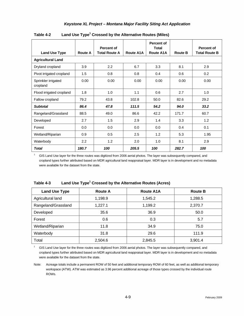
Table 4-2 Land Use Type1 Crossed by the Alternative Routes (Miles)
Land Use Type Route A Percent of
Total Route A Route A1A
Percent of Total
Route A1A Route B Percent of
Total Route B
Agricultural Land
Dryland cropland 3.9 2.2 6.7 3.3 8.1 2.9
Pivot irrigated cropland 1.5 0.8 0.8 0.4 0.6 0.2
Sprinkler irrigated cropland
0.00 0.00 0.00 0.00 0.00 0.00
Flood irrigated cropland 1.8 1.0 1.1 0.6 2.7 1.0
Fallow cropland 79.2 43.8 102.8 50.0 82.6 29.2
Subtotal 86.4 47.8 111.5 54.2 94.0 33.2
Rangeland/Grassland 88.5 49.0 86.6 42.2 171.7 60.7
Developed 2.7 1.5 2.9 1.4 3.3 1.2
Forest 0.0 0.0 0.0 0.0 0.4 0.1
Wetland/Riparian 0.9 0.5 2.5 1.2 5.3 1.95
Waterbody 2.2 1.2 2.0 1.0 8.1 2.9
Total 180.7 100 205.5 100 282.7 100 1 GIS Land Use layer for the three routes was digitized from 2006 aerial photos. The layer was subsequently compared, and
cropland types further attributed based on MDR agricultural land reappraisal layer. MDR layer is in development and no metadata were available for the dataset from the state.
Table 4-3 Land Use Type1 Crossed by the Alternative Routes (Acres)
Land Use Type Route A Route A1A Route B
Agricultural land 1,198.9 1,545.2 1,288.5
Rangeland/Grassland 1,227.1 1,199.2 2,370.7
Developed 35.6 36.9 50.0
Forest 0.6 0.3 5.7
Wetland/Riparian 11.8 34.9 75.0
Waterbody 31.8 29.6 111.9
Total 2,504.6 2,845.5 3,901.4 1 GIS Land Use layer for the three routes was digitized from 2006 aerial photos. The layer was subsequently compared, and
cropland types further attributed based on MDR agricultural land reappraisal layer. MDR layer is in development and no metadata were available for the dataset from the state.
Note: Acreage totals include a permanent ROW of 50 feet and additional temporary ROW of 60 feet, as well as additional temporary workspace (ATW). ATW was estimated as 3.96 percent additional acreage of those types crossed by the individual route ROWs.
Keystone XL Project – Montana Major Facility Siting Act Application
4-10 February 2009
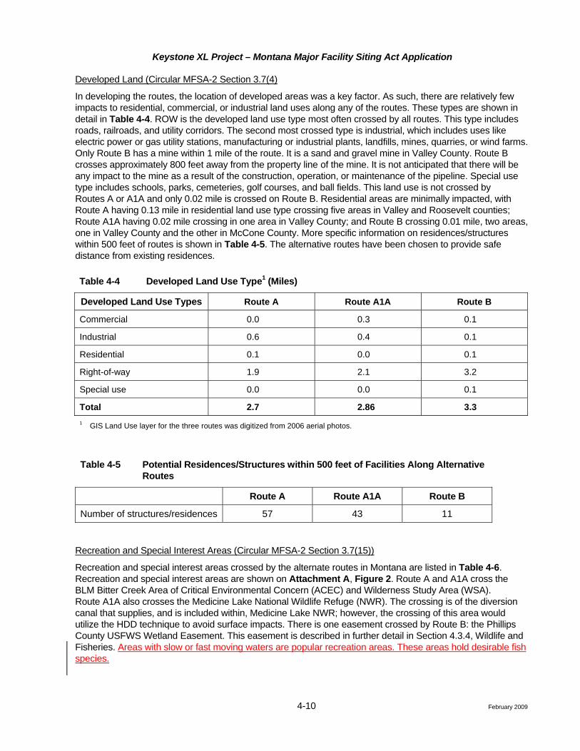
Developed Land (Circular MFSA-2 Section 3.7(4)
In developing the routes, the location of developed areas was a key factor. As such, there are relatively few impacts to residential, commercial, or industrial land uses along any of the routes. These types are shown in detail in Table 4-4. ROW is the developed land use type most often crossed by all routes. This type includes roads, railroads, and utility corridors. The second most crossed type is industrial, which includes uses like electric power or gas utility stations, manufacturing or industrial plants, landfills, mines, quarries, or wind farms. Only Route B has a mine within 1 mile of the route. It is a sand and gravel mine in Valley County. Route B crosses approximately 800 feet away from the property line of the mine. It is not anticipated that there will be any impact to the mine as a result of the construction, operation, or maintenance of the pipeline. Special use type includes schools, parks, cemeteries, golf courses, and ball fields. This land use is not crossed by Routes A or A1A and only 0.02 mile is crossed on Route B. Residential areas are minimally impacted, with Route A having 0.13 mile in residential land use type crossing five areas in Valley and Roosevelt counties; Route A1A having 0.02 mile crossing in one area in Valley County; and Route B crossing 0.01 mile, two areas, one in Valley County and the other in McCone County. More specific information on residences/structures within 500 feet of routes is shown in Table 4-5. The alternative routes have been chosen to provide safe distance from existing residences.
Table 4-4 Developed Land Use Type1 (Miles)
Developed Land Use Types Route A Route A1A Route B
Commercial 0.0 0.3 0.1
Industrial 0.6 0.4 0.1
Residential 0.1 0.0 0.1
Right-of-way 1.9 2.1 3.2
Special use 0.0 0.0 0.1
Total 2.7 2.86 3.3 1 GIS Land Use layer for the three routes was digitized from 2006 aerial photos.
Table 4-5 Potential Residences/Structures within 500 feet of Facilities Along Alternative Routes
Route A Route A1A Route B
Number of structures/residences 57 43 11
Recreation and Special Interest Areas (Circular MFSA-2 Section 3.7(15))
Recreation and special interest areas crossed by the alternate routes in Montana are listed in Table 4-6. Recreation and special interest areas are shown on Attachment A, Figure 2. Route A and A1A cross the BLM Bitter Creek Area of Critical Environmental Concern (ACEC) and Wilderness Study Area (WSA). Route A1A also crosses the Medicine Lake National Wildlife Refuge (NWR). The crossing is of the diversion canal that supplies, and is included within, Medicine Lake NWR; however, the crossing of this area would utilize the HDD technique to avoid surface impacts. There is one easement crossed by Route B: the Phillips County USFWS Wetland Easement. This easement is described in further detail in Section 4.3.4, Wildlife and Fisheries. Areas with slow or fast moving waters are popular recreation areas. These areas hold desirable fish species.
Keystone XL Project – Montana Major Facility Siting Act Application
4-11 February 2009
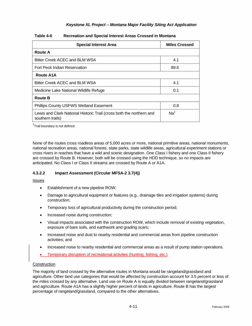
Table 4-6 Recreation and Special Interest Areas Crossed in Montana
Special Interest Area Miles Crossed
Route A
Bitter Creek ACEC and BLM WSA 4.1
Fort Peck Indian Reservation 89.6
Route A1A
Bitter Creek ACEC and BLM WSA 4.1
Medicine Lake National Wildlife Refuge 0.1
Route B
Phillips County USFWS Wetland Easement 0.8
Lewis and Clark National Historic Trail (cross both the northern and southern trails)
Na1
1Trail boundary is not defined.
None of the routes cross roadless areas of 5,000 acres or more, national primitive areas, national monuments, national recreation areas, national forests, state parks, state wildlife areas, agricultural experiment stations or cross rivers in reaches that have a wild and scenic designation. One Class I fishery and one Class II fishery are crossed by Route B. However, both will be crossed using the HDD technique, so no impacts are anticipated. No Class I or Class II streams are crossed by Route A or A1A.
4.3.2.2 Impact Assessment (Circular MFSA-2 3.7(4))
Issues
• Establishment of a new pipeline ROW;
• Damage to agricultural equipment or features (e.g., drainage tiles and irrigation systems) during construction;
• Temporary loss of agricultural productivity during the construction period;
• Increased noise during construction;
• Visual impacts associated with the construction ROW, which include removal of existing vegetation, exposure of bare soils, and earthwork and grading scars;
• Increased noise and dust to nearby residential and commercial areas from pipeline construction activities; and
• Increased noise to nearby residential and commercial areas as a result of pump station operations.
• Temporary disruption of recreational activites (hunting, fishing, etc.)
Construction
The majority of land crossed by the alternative routes in Montana would be rangeland/grassland and agriculture. Other land use categories that would be affected by construction account for 3.5 percent or less of the miles crossed by any alternative. Land use on Route A is equally divided between rangeland/grassland and agriculture. Route A1A has a slightly higher percent of lands in agriculture. Route B has the largest percentage of rangeland/grassland, compared to the other alternatives.
Keystone XL Project – Montana Major Facility Siting Act Application
4-12 February 2009
Surface disturbance to various land uses that would be caused by construction of the Project are summarized in Table 4-2. A relatively small, temporary loss of crops and forage land will occur in many agricultural and rangelands during construction. In areas where drainage tile is present, the tiles could be inadvertently damaged by the installation of the pipeline. Keystone will repair or restore drain tiles, fences, and lands that are temporarily disturbed during pipeline construction, as described in the CMRP. Section 4.3 of the CMRP also describes topsoil handling and reclamation practices designed to restore all types of agriculture land to its prior use.
Special interest areas crossed by the routes are shown in Table 4-6. Mitigation measures outlined in the CMRP will minimize impacts to these areas. Keystone will work with the appropriate agency or tribe to address issues related to crossing these special interest areas and implement minimization and mitigation measures as agreed to by the agency or tribe and Keystone.
Residences within 500 feet of a route will experience short-term inconvenience from construction equipment noise for a period of 1 week to 30 days. During construction, Keystone will be required to comply with any local construction noise requirements. For more information see Section 4.3.13.
Operation
No permanent structures can be constructed or placed on the permanent pipeline ROW for the entirety of the ROW lease period, representing a long-term future constraint on development of private land. The 50-foot-wide permanent ROW will be maintained in an open condition for the life of the pipeline facilities. No other operational impacts are anticipated to agriculture and rangeland or special management areas. If there are to be surface disturbances due to future maintenance activities, these will be reclaimed after the disturbance, utilizing measures described in the CMRP.
The impacts of aboveground facilities on visual resources will depend on the location of each individual facility and its visibility from the surrounding area. More detailed information on visual resources is provided in Section 4.3.10. Keystone has located the pump stations based on hydraulic and engineering design and access considerations, but also has considered impacts on aesthetics and sensitive environmental resources. Most pump stations are located on private land. Each alternative has one pump station on state-owned land, and Alternative A also has one pump station on Tribal land. All pump stations are in rangeland or non-irrigated agricultural land.
During operation of the pipeline, noise impacts associated with the electrically driven pump stations are expected to be minimal and limited to the vicinity of the facilities. Noise is addressed in Section 4.3.13.
Impact to Recreation (MFSA-2 3.7(16))
Project impacts to recreation areas are expected to be associated with construction. Adverse impacts to recreational aesthetics would be limited to upgrading existing access roads and pipeline and facility construction would be temporary. After construction the disturbed ROW would be permanently reclaimed and any disrupted recreational activities would resume. As the pipeline would be buried, no long-term impact to recreational activities are expected, however, disruption of recreational activites could occur during construction.
In order to assess the relationship of the affected recreational areas to the regional supply of recreation opportunities, a review of the Montana Statewide Comprehensive Outdoor Recreation Plan (SCORP) was conducted. Routes A, A1A, and B pass through Montana State Parks Region 6. Route B also passes through Region 7. According to the SCORP, the top four recreational facility needs in Region 6 are:
• Bike and pedestrian trails;
• Hunting lands;
Keystone XL Project – Montana Major Facility Siting Act Application
4-13 February 2009
• State parks; and
• Playgrounds.
Region 7 listed the following top four recreational facility needs:
• Lakes;
• Camping with hunting;
• RV dumping station; and
• Swimming pools.
Hunting can occur on Montana State Trust Lands and MFWP block management areas, and there is the potential for short-term recreational disruptions as construction passes through; however, hunting opportunities would still exist nearby on State Trust Lands which construction would not affect. Route A crosses the fewest miles of Montana State Trust Lands (approximately 13 miles); Route B crosses the most miles (approximately 35 miles); and Route B crosses an intermediate number of miles (19 miles). Any disrupted hunting opportunities on these lands would resume in the long-term as the land is reclaimed.
Impacts to the Bitter Creek ACEC by Routes A and A1A, and the Medicine Lake NWR by Route A1A, would be short-term during construction. Additionally, impacts would be very small and limited when compared to the total acreage of these recreational areas. While Route B would intercept the Lewis and Clark National Historic Trail, there are no campsites or other recreational facilities within 2 miles of where Route B crosses the Lewis and Clark National Historic Trail.
Land Management Plans (Circular MFSA-2, Section 3.4 (7)(b), 3.7(4))
Comprehensive land use plans were requested from all the potentially affected counties. Land use plans were received from Valley, Fallon, Daniels, and Sheridan counties, as well as from the Fort Peck Indian Reservation. After a review of the county and reservation land use plans, it has been determined that there are is no restrictions or land use planning concerns that would preclude pipeline construction. Route A1A would cross the diversion canal that supplies, and is included within, the Medicine Lake NWR; however, Keystone would cross this area utilizing the HDD technique. No other federal or state land use plans would prohibit pipeline construction.
4.3.2.3 Summary of Route-Specific Land Use Impacts
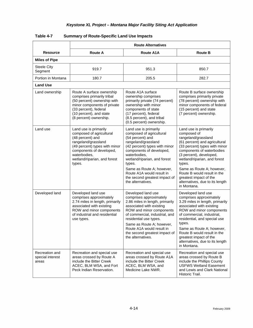
Route-specific impacts for land use are summarized in Table 4-7. Identified impacts will be substantially mitigated as discussed within this application and further outlined in the CMRP for all Routes. Based strictly on the relative lengths of the routes within the State of Montana and not taking into consideration the overall effect through Montana, South Dakota, and Nebraska, Route B has the greatest impacts. However, when the full Steele City Segment impacts are considered, frequently the additional length of Routes A and A1A would result in greater impacts.
Keystone XL Project – Montana Major Facility Siting Act Application
4-14 February 2009
Table 4-7 Summary of Route-Specific Land Use Impacts
Route Alternatives
Resource Route A Route A1A Route B
Miles of Pipe
Steele City Segment 919.7 951.3 850.7
Portion in Montana 180.7 205.5 282.7
Land Use
Land ownership Route A surface ownership comprises primarily tribal (50 percent) ownership with minor components of private (33 percent), federal (10 percent), and state (8 percent) ownership.
Route A1A surface ownership comprises primarily private (74 percent) ownership with minor components of state (17 percent), federal (8.5 percent), and tribal (0.5 percent) ownership.
Route B surface ownership comprises primarily private (78 percent) ownership with minor components of federal (15 percent) and state (7 percent) ownership.
Land use Land use is primarily composed of agricultural (48 percent) and rangeland/grassland (49 percent) types with minor components of developed, waterbodies, wetland/riparian, and forest types.
Land use is primarily composed of agricultural (54 percent) and rangeland/grassland (42 percent) types with minor components of developed, waterbodies, wetland/riparian, and forest types. Same as Route A; however, Route A1A would result in the second greatest impact of the alternatives.
Land use is primarily composed of rangeland/grassland (61 percent) and agricultural (33 percent) types with minor components of waterbodies (3 percent), developed, wetland/riparian, and forest types. Same as Route A; however, Route B would result in the greatest impact of the alternatives, due to its length in Montana.
Developed land Developed land use comprises approximately 2.74 miles in length, primarily associated with existing ROW and minor components of industrial and residential use types.
Developed land use comprises approximately 2.86 miles in length, primarily associated with existing ROW and minor components of commercial, industrial, and residential use types. Same as Route A; however, Route A1A would result in the second greatest impact of the alternatives.
Developed land use comprises approximately 3.29 miles in length, primarily associated with existing ROW and minor components of commercial, industrial, residential, and special use types. Same as Route A; however, Route B would result in the greatest impact of the alternatives, due to its length in Montana.
Recreation and special interest areas
Recreation and special use areas crossed by Route A include the Bitter Creek ACEC, BLM WSA, and Fort Peck Indian Reservation.
Recreation and special use areas crossed by Route A1A include the Bitter Creek ACEC, BLM WSA, and Medicine Lake NWR.
Recreation and special use areas crossed by Route B include the Phillips County USFWS Wetland Easement and Lewis and Clark National Historic Trail.
Keystone XL Project – Montana Major Facility Siting Act Application
4-47 February 2009
Operation
In order to reduce potential impacts to sensitive wildlife species as a result of maintenance activities, Keystone will consult with the appropriate state wildlife or land management agency prior to the initiation of maintenance activities beyond standard inspection measures.
Keystone will employ multiple safeguards to prevent a pipeline release. The chance of a spill occurring is very low and if a spill occurred, the volume is likely to be relatively small. In the unlikely event of a pipeline release, Keystone would initiate its ERP and emergency response teams would contain and clean up the spill. To minimize impacts to special status species, appropriate remedial measures will be implemented to meet federal and state standards designed to ensure protection of human health and environmental quality. Keystone will employ multiple safeguards to prevent and minimize impacts from a potential pipeline release. Broadly, these safeguards encompass routing (e.g., minimize stream crossings; avoidance of sensitive waterbodies, when feasible), material selection (e.g., steel grade, pipeline coating), engineering design (e.g., valve locations), pre-operational testing (e.g., hydrostatic testing, non-destructive testing of welds), continuous operational monitoring (e.g., SCADA, aerial surveillance, leak detection systems, in-line inspection tools), and emergency preparedness (e.g., Emergency Response Plan, pre-positioned personnel and equipment, on-going integrity management planning). Consequently, the chance of a spill occurring is low. Keystone has conservatively estimated (i.e., over-estimated risk) that the chance of a pipeline incident is no more than one spill in 8,400 years for any given mile of pipe. If a spill did occur, the volume is likely to be relatively small (i.e., 3 barrels or less) and would likely be contained within the pipeline trench. The simultaneous probability of a spill occurring, its location being in immediate proximity to surface water, and being of sufficient volume capable of escaping the trench and reaching a flowing stream is very low.
In the unlikely event of a pipeline release did reach surface waters (e.g., flowing streams, wetlands), Keystone would initiate its Emergency Response Plan, immediately notify the appropriate federal and state agencies, and Keystone teams would be immediately deployed to contain and cleanup the spill. The ERP contains detailed information on response times, personnel, training, and equipment that would be deployed in an emergency. Montana-specific details will be developed when the route is finalized, but prior to initiating pipeline operation.
If a spill affected surface waters, the appropriate remedial measures will be implemented to meet federal and state standards designed to ensure protection of human health and environmental quality. Remedial actions may include continued deployment of booms on surface waters, washing of rocky shorelines, controlled burns, excavation and removal of contaminated soils along shorelines and other affected areas, and allowing the contaminated soil to recover through natural environmental fate processes (e.g., evaporation, biodegradation). Decisions concerning site-specific remedial methods and extent of the cleanup will account for state-mandated remedial cleanup levels, potential effects to sensitive receptors, volume and extent of the contamination, potential violation of water quality standards, and the magnitude of adverse impacts caused by remedial activities. Corrective remedial actions will be dictated by federal regulations and enforced by the USEPA and PHMSA and the appropriate state agencies.Additional information on potential impacts to special status species resulting from a crude oil spill is provided in the Risk Assessment (Attachment D).
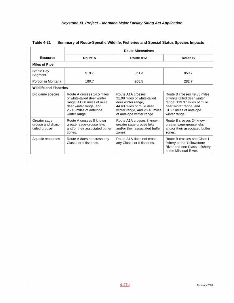
4.3.4.11 Summary of Route-Specific Wildlife, Fisheries and Special Status Species Impacts
Route-specific impacts for wildlife, fisheries, and special concern species are summarized in Table 4-21. Identified impacts will be substantially mitigated as discussed within this application and further outlined in the CMRP for all Routes. Based strictly on the relative lengths of the routes within the State of Montana and not taking into consideration the overall effect through Montana, South Dakota, and Nebraska, Route B has the greatest impacts. However, when the full Steele City Segment impacts are considered, frequently the additional length of Routes A and A1A would result in greater impacts.
Keystone XL Project – Montana Major Facility Siting Act Application
4-47a February 2009
Table 4-21 Summary of Route-Specific Wildlife, Fisheries and Special Status Species Impacts
Route Alternatives
Resource Route A Route A1A Route B
Miles of Pipe
Steele City Segment 919.7 951.3 850.7
Portion in Montana 180.7 205.5 282.7
Wildlife and Fisheries
Big game species Route A crosses 14.5 miles of white-tailed deer winter range, 41.68 miles of mule deer winter range, and 26.48 miles of antelope winter range.
Route A1A crosses 31.98 miles of white-tailed deer winter range, 44.63 miles of mule deer winter range, and 26.48 miles of antelope winter range.
Route B crosses 49.85 miles of white-tailed deer winter range, 119.37 miles of mule deer winter range, and 81.27 miles of antelope winter range.
Greater sage grouse and sharp-tailed grouse
Route A crosses 8 known greater sage-grouse leks and/or their associated buffer zones.
Route A1A crosses 8 known greater sage-grouse leks and/or their associated buffer zones.
Route B crosses 24 known greater sage-grouse leks and/or their associated buffer zones.
Aquatic resources Route A does not cross any Class I or II fisheries.
Route A1A does not cross any Class I or II fisheries.
Route B crosses one Class I fishery at the Yellowstone River and one Class II fishery at the Missouri River.
Keystone XL Project – Montana Major Facility Siting Act Application
4-48 February 2009
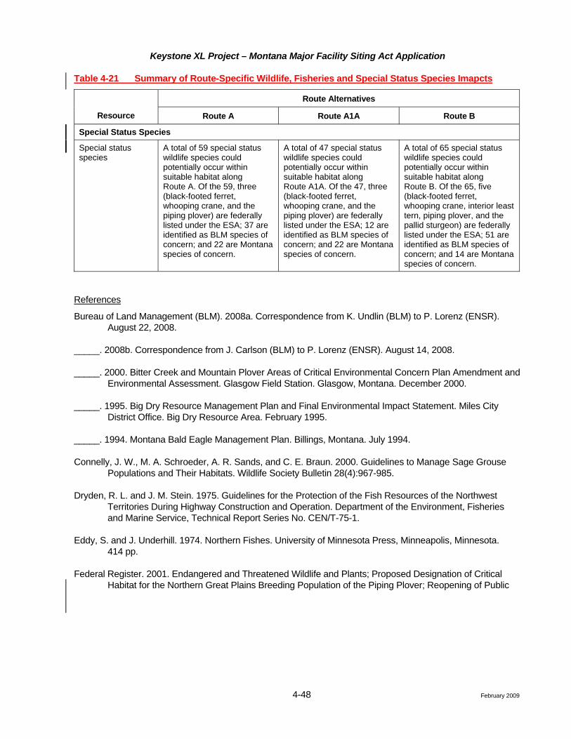
Table 4-21 Summary of Route-Specific Wildlife, Fisheries and Special Status Species Imapcts
Route Alternatives
Resource Route A Route A1A Route B
Special Status Species
Special status species
A total of 59 special status wildlife species could potentially occur within suitable habitat along Route A. Of the 59, three (black-footed ferret, whooping crane, and the piping plover) are federally listed under the ESA; 37 are identified as BLM species of concern; and 22 are Montana species of concern.
A total of 47 special status wildlife species could potentially occur within suitable habitat along Route A1A. Of the 47, three (black-footed ferret, whooping crane, and the piping plover) are federally listed under the ESA; 12 are identified as BLM species of concern; and 22 are Montana species of concern.
A total of 65 special status wildlife species could potentially occur within suitable habitat along Route B. Of the 65, five (black-footed ferret, whooping crane, interior least tern, piping plover, and the pallid sturgeon) are federally listed under the ESA; 51 are identified as BLM species of concern; and 14 are Montana species of concern.
References
Bureau of Land Management (BLM). 2008a. Correspondence from K. Undlin (BLM) to P. Lorenz (ENSR). August 22, 2008.
_____. 2008b. Correspondence from J. Carlson (BLM) to P. Lorenz (ENSR). August 14, 2008.
_____. 2000. Bitter Creek and Mountain Plover Areas of Critical Environmental Concern Plan Amendment and Environmental Assessment. Glasgow Field Station. Glasgow, Montana. December 2000.
_____. 1995. Big Dry Resource Management Plan and Final Environmental Impact Statement. Miles City District Office. Big Dry Resource Area. February 1995.
_____. 1994. Montana Bald Eagle Management Plan. Billings, Montana. July 1994.
Connelly, J. W., M. A. Schroeder, A. R. Sands, and C. E. Braun. 2000. Guidelines to Manage Sage Grouse Populations and Their Habitats. Wildlife Society Bulletin 28(4):967-985.
Dryden, R. L. and J. M. Stein. 1975. Guidelines for the Protection of the Fish Resources of the Northwest Territories During Highway Construction and Operation. Department of the Environment, Fisheries and Marine Service, Technical Report Series No. CEN/T-75-1.
Eddy, S. and J. Underhill. 1974. Northern Fishes. University of Minnesota Press, Minneapolis, Minnesota. 414 pp.
Federal Register. 2001. Endangered and Threatened Wildlife and Plants; Proposed Designation of Critical Habitat for the Northern Great Plains Breeding Population of the Piping Plover; Reopening of Public

Keystone XL Project – Montana Major Facility Siting Act Application
4-51 February 2009January 2009
The State of Montana’s water quality classifications for all streams crossed by each alternative can be found in Attachment J. The MFWP assigned fisheries value classes of I and II which are discussed in Section 4.3.4, Wildlife and Fisheries, and listed in Tables 4-13, 4-16, and 4-18.
Pollution due to storm water runoff during construction and reclamation will be controlled in accordance with the Storm Water Pollution Prevention Plan (SWPPP) that will be developed prior to permitting. The SWPPP will include descriptions of storm water management controls and BMPs to be implemented.
Sediment discharges are the major pollutant of concern from storm water due to increased erosion from the disturbed areas during construction activities and prior to final stabilization through completed reclamation. These discharges will be controlled throughout the entire project, with special attention committed at any wetland or waterbody crossings. Discharges will be controlled through measures such as vegetative buffers, silt fences, straw bale barriers, and permanent slope breakers (water bars), among others.
Other pollutants of concern are fuels, lubricants, and other hazardous materials. The control and containment of these pollutants will be detailed in the Spill Prevention, Containment, and Countermeasures (SPCC) Plan, which will be developed for each construction spread and submitted prior to construction.
Groundwater
Existing literature on the geology and groundwater hydrogeology of the counties in Montana affected by the Project were reviewed. Particular emphasis was placed on the location of shallow aquifers (i.e., those aquifers with a depth of less than 200 feet), depth to the shallow groundwater table, and expected use of the shallow aquifers within a few miles of the alternate routes. Availability of existing literature and published studies of the aquifers in this region vary. In areas where the level of detail is low, a considerable degree of uncertainty exists relative to groundwater resources. These locations include areas where estimates of the depth to the water table are based on regional groundwater elevation contours, and where water quality estimates are a general estimate of water quality based on regional or sometimes county-wide evaluations. Generally, areas where aquifers are heavily used or are potentially sensitive to contamination have more complete and available information. These areas may include shallow alluvial aquifers along major river drainages where the river alluvium is a major source of domestic and irrigation water supply.
All of the proposed pipeline alternative routes lie within the Great Plains physiographic province (Fenneman 1928). Continental glaciation during the Pleistocene covered most of northern Montana with a complex array of glacial drift and glacial outwash. This glacial material covers the bedrock aquifers in many areas and provides shallow alluvial groundwater for domestic and agricultural use in both current stream valleys and also from buried glacial paleochannels. In many cases, the buried paleochannels are not continuous, and serve as major sources of groundwater only for local use. In many areas of northern Montana, the glacial drift is fine-grained and relatively impermeable, thus it acts as a “confining layer” above the bedrock aquifers. Within this fine-grained drift, local paleochannels can be found, which can provide groundwater for ranches and small communities.
Three main aquifer types are found along the alternative routes in eastern Montana:
1. Unconsolidated alluvial and/or glacial aquifers;
2. Lower Tertiary aquifers, mainly in the Fort Union Formation; and
3. Upper Cretaceous aquifers, mainly in the Fox Hills and Hell Creek formations.
The most sensitive aquifers are the shallow alluvial aquifers found in unconsolidated alluvial and glacial sediments along major drainages. Sensitive groundwater resources are defined as those shallow groundwater areas that occur in permeable rock units or unconsolidated alluvium, or where the groundwater is used for
Keystone XL Project – Montana Major Facility Siting Act Application
4-52 February 2009
domestic or irrigation purposes (Smith et al. 2000). Locations where the proposed pipeline alternative routes will either cross or be within a few miles of an identified sensitive groundwater resource are indicated.
Phillips and Valley counties are crossed by all the alternatives as shown in Attachment A, Figure 2. These two counties were glaciated during the Pleistocene, and thus have a thick veneer of glacial till and drift, which is generally around 20 to 40 feet thick, but can reach approximately 100 feet thick (Whitehead 1996). This glacial till overlies the upper Cretaceous Judith River, Clagett, and Bearpaw formations. The glacial till is relatively impermeable, and acts as a “confining layer” above the upper Cretaceous bedrock aquifer found mainly in the Judith River Formation. The glacial till can contain locally permeable buried zones of coarse glacial outwash which may provide water for ranches. The upper Cretaceous Judith River Formation is the main aquifer and consists of sandstone and siltstone. The aquifer is confined, and the water table elevation ranges from 2,600 to 2,800 feet above mean sea level (amsl) (Libmeyer 1985). Groundwater quality ranges from Montana Class II with a specific conductance between 1,000 and 2,500 microSiemens/centimeter (µS/cm) at 25°Ctotal dissolved solid (TDS) content between 500 and 1,800 milligrams per liter (mg/L), to Montana class Class III with a specific conductance between 2,500 and 15,000 µS/cm at 25°C. TDS between 1,800 and 10,000 mg/L. The water table is from 150 to 500 feet deep based on drilling depths for recorded water wells (Smith et al. 2000).
A number of drainages in Phillips and Valley counties are considered sensitive groundwater resources and would be crossed by all alternatives. These include Frenchman Creek above Frenchman Reservoir; Rock Creek, which is considered sensitive due to the shallow alluvial aquifer; and Buggy Creek, which could be a sensitive groundwater resource depending on the depth to groundwater.
Water Supplies and Wells (Circular MFSA-2, Section 3.4(1)(v))
Along all the alternative routes within Montana, the municipal water supply systems identified are dependant on withdrawals from groundwater sources. These sources are often alluvial aquifers associated with streams and rivers. Private wells also are likely located along each of the alternatives. Source Water Protection Areas (SWPAs) were identified along all alternate routes. Identified SWPA reports were reviewed and analyzed.
SWPAs associated with each route are discussed in the respective sections. No SWPAs depending on surface waters were identified.
Floodplains
From a geomorphic perspective, floodplains are relatively low, flat areas of land that surround waterbodies and hold overflows during flood events. Floodplains are often associated with rivers and streams, where they consist of stream deposited sediments forming levels (or “terraces”) deposited at different times along the watercourse.
From a policy perspective, the Federal Emergency Management Agency (FEMA) defines a floodplain as being any land area susceptible to being inundated by waters from any source (FEMA 2005). Much of the basic inventory, regulation, and mitigation efforts for floodplains and flood mitigation (including the National Flood Insurance Program) have been led by FEMA. Executive Order 11988, Floodplain Management, states that actions by federal agencies shall avoid to the extent possible the long- and short-term adverse impacts associated with the occupancy and modification of floodplain development wherever there is a practicable alternative.
Each agency shall provide leadership and shall take action to reduce the risk of flood loss, to minimize the impact of floods on human safety, health and welfare, and to restore and preserve the natural and beneficial values served by floodplains in carrying out its responsibilities for: 1) acquiring, managing, and disposing of federal lands, and facilities; 2) providing federally undertaken, financed, or assisted construction and improvements; and 3) conducting federal activities and programs affecting land use, including but not limited to water and related land resources planning, regulating, and licensing activities.

Keystone XL Project – Montana Major Facility Siting Act Application
4-52a February 2009
Pump stations will not be located within the FEMA-defined 100-year floodplain.

Keystone XL Project – Montana Major Facility Siting Act Application
4-67 February 2009January 2009
4.3.5.5 Impact Assessment – All Routes (Circular MFSA-2, Sections 3.6(5) and 3.7(18))
Surface Water Issues
• Water quality degradation from temporary increases in suspended solids concentrations during in-stream construction activities or erosion from disturbed lands;
• Increased sedimentation in streams resulting from in-stream construction or nearby activities;
• Channel and bank modifications that affect channel morphology and stability;
• Reduced flows in streams where water is withdrawn for hydrostatic testing; and
• Water quality degradation in streams, lakes, impoundments, or surface water-based public water supplies from pipeline spills or leaks, or from spills or leaks of fuel, lubricants, or hazardous materials during construction or operation.
Construction
Waterbody Crossings (Circular MFSA-2, Section 3.8(1)(g))
Depending upon the construction technique used, the installation of the pipeline across waterbodies can cause the following impacts:
• Temporary degradation of water quality in the form of increased suspended solids concentrations;
• Sedimentation (deposition of solids introduced into suspension by construction activities); and
• Channel and bank modifications.
Keystone is proposing the following water crossing techniques (see CMRP).
• HDD;
• Open cut wet crossings;
• Open cut dry flumed crossings; and
• Open cut dry dam and pump crossings.
Since HDD does not involve any intended direct contact with the waterbody, channel bed, or banks, no impact is expected at these crossings. It is possible that a frac-out (drilling lubricant release) or inadvertent return of drilling lubricant could enter the waterbody. Open cut wet crossings involve the direct excavation of the channel and banks in contact with any flow present. HDD or dry crossing procedures will be considered at some crossings pending determination of crossing-specific resources (aquatic life), which may warrant extraordinary mitigation. At open cut wet crossings, the extent of increased suspended solids concentrations and downstream sedimentation impacts will depend on the flow conditions at the time of construction and the channel substrate. Measures related to managing spoil, timing, access, and equipment are included in the CMRP. These measures will limit impacts of increased suspended solids concentrations and downstream sedimentation. Most open cut crossings will be completed in 24 to 48 hours or less, dependent upon stream width. Larger open cut crossings may take upwards of 7 to 10 days.
Runoff and the resulting erosion of lands adjacent to waterbodies can lead to the introduction of solids into suspension and the deposition of sediment in-stream. The CMRP includes extensive procedures to limit the extent of disturbed land adjacent to waterbodies, to control erosion, and methods to prevent sediments from entering waterbodies or wetlands. These measures include BMPs, such as clearing limits, buffer strips, drainage diversion structures, and sediment barrier installations. Keystone will comply with the NPDES construction storm water permit process with respect to pipeline construction and operation. Keystone will
Keystone XL Project – Montana Major Facility Siting Act Application
4-68 February 2009
develop and file a SWPPP as part of the NPDES construction stormwater permitting effort. This plan will include BMPs to minimize soil erosion and sedimentation.
Open cut crossings will involve disturbance of stream banks and channel bottoms. During construction of open cut crossings where stream flow is present, temporary increases in suspended sediment are likely due to this disturbance. The CMRP includes procedures for limiting the extent of this disturbance and the restoration of disturbed areas. Restoration includes grading, stabilization, and revetment BMPs. These BMPs embrace bioengineering concepts, which encourage the restoration of natural streambanks.
Streams listed by Montana DEQ as not attaining designated beneficial uses are crossed by each alternative. Among those crossed, the following streams contain impairments due to sedimentation/siltation: Big Muddy Creek on Route A, the Poplar River and Big Muddy Creek on Route A1A, Cabin Creek on Route B.
The pipeline will be constructed under flood management structures (levees and drainage ditches) as well as river channels with potential for lateral scour. The pipeline will be buried at an adequate depth under channels, adjacent floodplains, and flood protection levees to avoid pipe exposure caused by channel degradation and lateral scour. Determination of the pipeline burial depth will be based on site-specific channel and hydrologic investigations where deemed necessary.
Hydrostatic Test Water Withdrawal and Discharge
Hydrostatic test sections will be approximately 30 miles (with a maximum of 50 miles) in length. The volume for a 50-mile test section of 36-inch pipe is approximately 14 million gallons (43 acre-feet). Recycling water between test sections will be maximized to reduce overall withdrawal volumes.
Depending on locations, state requirements, and availability, water will be obtained and withdrawn from nearby streams or privately owned reservoirs. Recycling water between test sections will reduce withdrawal volumes.
Water used for hydrostatic testing of the pipeline will be obtained from surface water resources. Depending on locations, state requirements, and availability, water will be obtained and withdrawn from nearby streams or privately owned reservoirs.
The volume for a 50-mile test section of 36-inch pipe is approximately 14 million gallons (43 acre-feet). Withdrawal rates and volumes will be designed to avoid impacts to aquatic life and downstream water users. If water is withdrawn from a sensitive surface water source during a low-flow period or at a time when particular flow are needed for other uses, habitat reductions for water-dependent resources (e.g., fisheries, aquatic invertebrates) could occur. A similar effect on surface water resources could occur if large withdrawals are made from aquifer zones that provide late-season baseflows to streams.
In accordance with the CMRP, hydrostatic test water withdrawls from surface waterodies would be made at controlled rates not to exceed 3,000 gallons per minute. Adequate flow rates will be maintained in the waterbody to provide for downstreamuses, in compliance with regulatory and permit requirements. Keystone does not anticipate any impacts to water uses by communities, agriculture, recreation, or fish and wildlife.
Hydrostatic test water will be discharged to the land surface at an approved location to the same source from which it was removed. Discharged water may evaporate or infiltrate into the soil or drainage where the water is released.
If water is withdrawn from a sensitive surface water source during a low-flow period or at a time when particular flow are needed for other uses, habitat reductions for water-dependent resources (e.g., fisheries, aquatic invertebrates) could occur. A similar effect on surface water resources could occur if large withdrawals are made from aquifer zones that provide late-season baseflows to streams.
Keystone XL Project – Montana Major Facility Siting Act Application
4-68a February 2009
Streams listed by Montana DEQ as not attaining designated beneficial uses are crossed by each alternative. Among those crossed, the following streams contain impairments due to low flow alterations and are proposed as potential hydrostatic test water sources: Frenchman Creek on all routes and Big Muddy Creek on Routes A and A1A.
In accordance with the CMRP, hydrostatic test water withdrawals from surface waterbodies will be made at controlled rates and with equipment that will minimize impacts on stream beds and aquatic life. Keystone will coordinate with federal and state agencies to further identify such water sources and seasonal concerns. Similarly, discharges of hydrostatic testing waters will be made such that water quality requirements are met. Discharge controls will include restrictions on pipeline dewatering rates, velocity control devices (such as splash pups or diffusers), and/or temporary synthetic channel linings.
Water quality will not be reduced by pipe cleaning or hydrostatic test waters because discharged water will be required to meet water quality standards imposed by the discharge permits issued by Montana DEQ for the permitted discharge locations. Water discharge rates will not exceed the daily discharge criteria referenced in the permits.

Keystone XL Project – Montana Major Facility Siting Act Application
4-99 February 2009
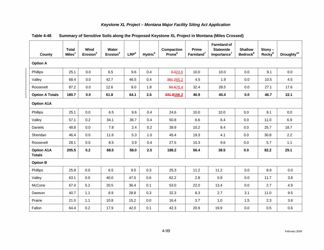
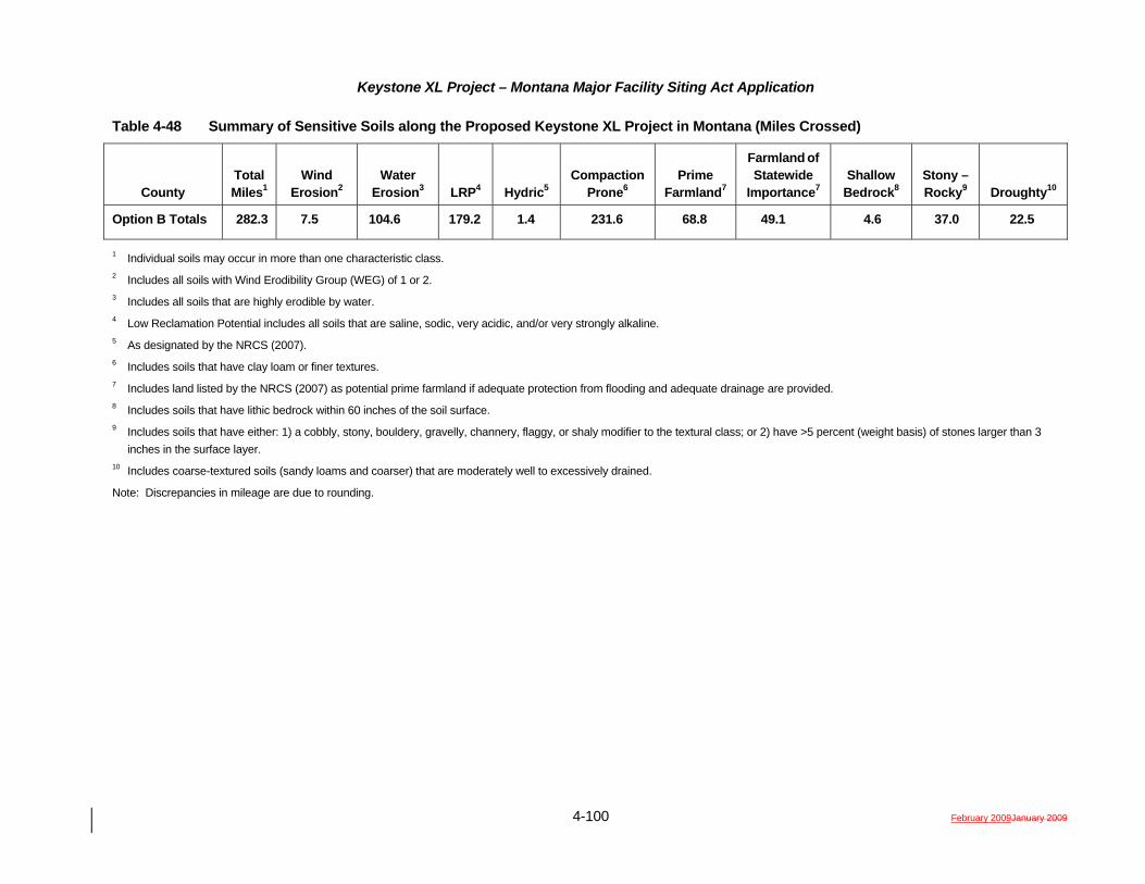
Table 4-48 Summary of Sensitive Soils along the Proposed Keystone XL Project in Montana (Miles Crossed)
County Total Miles1
Wind Erosion2
Water Erosion3 LRP4 Hydric5
Compaction Prone6
Prime Farmland7
Farmland of Statewide
Importance7 Shallow
Bedrock8 Stony – Rocky9 Droughty10
Option A
Phillips 25.1 0.0 6.5 9.6 0.4 0.024.6 10.0 10.0 0.0 9.1 0.0
Valley 68.4 0.0 42.7 46.5 0.4 381.265.2 4.5 1.9 0.0 10.5 4.5
Roosevelt 87.2 0.0 12.6 8.0 1.8 50.676.4 32.4 28.5 0.0 27.1 17.6
Option A Totals 180.7 0.0 61.8 64.1 2.6 431.8166.2 46.9 40.4 0.0 46.7 22.1
Option A1A
Phillips 25.1 0.0 6.5 9.6 0.4 24.6 10.0 10.0 0.0 9.1 0.0
Valley 57.1 0.2 34.1 36.7 0.4 50.8 6.6 6.4 0.0 11.0 6.9
Daniels 48.8 0.0 7.8 2.4 0.2 39.9 10.2 8.4 0.0 25.7 18.7
Sheridan 46.4 0.0 11.6 5.3 1.0 45.4 19.3 4.1 0.0 30.8 2.2
Roosevelt 28.1 0.0 8.5 3.9 0.4 27.5 10.3 9.6 0.0 5.7 1.1
Option A1A Totals
205.5 0.2 68.5 58.0 2.5 188.2 56.4 38.5 0.0 82.2 29.1
Option B
Phillips 25.8 0.0 6.5 9.5 0.3 25.3 11.2 11.2 0.0 8.9 0.0
Valley 63.1 0.0 40.0 47.5 0.6 62.2 2.8 0.9 0.0 11.7 3.8
McCone 67.4 5.2 20.5 36.4 0.1 53.0 22.0 13.4 0.0 2.7 4.9
Dawson 40.7 1.1 8.9 28.8 0.3 32.3 8.3 2.7 3.1 11.0 9.5
Prairie 21.0 1.1 10.8 15.2 0.0 16.4 3.7 1.0 1.5 2.3 3.8
Fallon 64.4 0.2 17.9 42.0 0.1 42.3 20.9 19.9 0.0 0.5 0.6
Keystone XL Project – Montana Major Facility Siting Act Application
4-100 February 2009January 2009
Table 4-48 Summary of Sensitive Soils along the Proposed Keystone XL Project in Montana (Miles Crossed)
County Total Miles1
Wind Erosion2
Water Erosion3 LRP4 Hydric5
Compaction Prone6
Prime Farmland7
Farmland of Statewide
Importance7 Shallow
Bedrock8 Stony – Rocky9 Droughty10
Option B Totals 282.3 7.5 104.6 179.2 1.4 231.6 68.8 49.1 4.6 37.0 22.5
1 Individual soils may occur in more than one characteristic class. 2 Includes all soils with Wind Erodibility Group (WEG) of 1 or 2. 3 Includes all soils that are highly erodible by water. 4 Low Reclamation Potential includes all soils that are saline, sodic, very acidic, and/or very strongly alkaline. 5 As designated by the NRCS (2007). 6 Includes soils that have clay loam or finer textures. 7 Includes land listed by the NRCS (2007) as potential prime farmland if adequate protection from flooding and adequate drainage are provided. 8 Includes soils that have lithic bedrock within 60 inches of the soil surface. 9 Includes soils that have either: 1) a cobbly, stony, bouldery, gravelly, channery, flaggy, or shaly modifier to the textural class; or 2) have >5 percent (weight basis) of stones larger than 3
inches in the surface layer. 10 Includes coarse-textured soils (sandy loams and coarser) that are moderately well to excessively drained.
Note: Discrepancies in mileage are due to rounding.
Keystone XL Project – Montana Major Facility Siting Act Application
4-139 February 2009
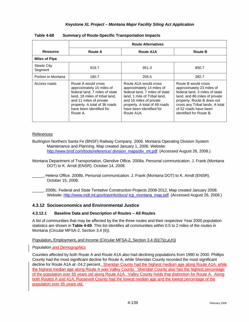
Table 4-68 Summary of Route-Specific Transportation Impacts
Route Alternatives
Resource Route A Route A1A Route B
Miles of Pipe
Steele City Segment 919.7 951.3 850.7
Portion in Montana 180.7 205.5 282.7
Access roads Route A would cross approximately 15 miles of federal land, 7 miles of state land, 18 miles of tribal land, and 11 miles of private property. A total of 36 roads have been identified for Route A.
Route A1A would cross approximately 14 miles of federal land, 7 miles of state land, 1 mile of Tribal land, and 16 miles of private property. A total of 49 roads have been identified for Route A1A.
Route B would cross approximately 23 miles of federal land, 3 miles of state land, and 86 miles of private property. Route B does not cross any Tribal lands. A total of 52 roads have been identified for Route B.
References
Burlington Northern Santa Fe (BNSF) Railway Company. 2006. Montana Operating Division System Maintenance and Planning. Map created January 1, 2006. Website: http://www.bnsf.com/tools/reference/ division_maps/div_mt.pdf. (Accessed August 26, 2008.)
Montana Department of Transportation, Glendive Office. 2008a. Personal communication. J. Frank (Montana DOT) to K. Arndt (ENSR). October 14, 2008.
_____, Helena Office. 2008b. Personal communication. J. Frank (Montana DOT) to K. Arndt (ENSR). October 15, 2008.
_____. 2008c. Federal and State Tentative Construction Projects 2008-2012. Map created January 2008. Website: http://www.mdt.mt.gov/travinfo/docs/ tcp_montana_map.pdf. (Accessed August 26, 2008.)
4.3.12 Socioeconomics and Environmental Justice
4.3.12.1 Baseline Data and Description of Routes – All Routes
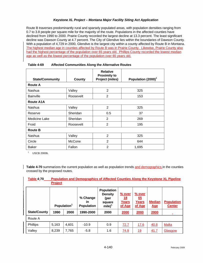
A list of communities that may be affected by the the three routes and their respective Year 2000 population statistics are shown in Table 4-69. This list identifies all communities within 0.5 to 2 miles of the routes in Montana (Circular MFSA-2, Section 3.4 (6)).
Population, Employment, and Income (Circular MFSA-2, Section 3.4 (6)(7)(c,e,h))
Population and Demographics
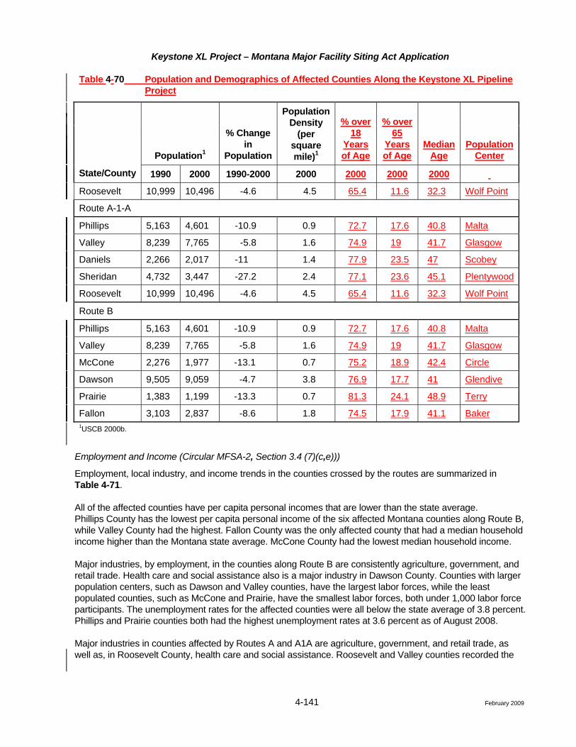
Counties affected by both Route A and Route A1A also had declining populations from 1990 to 2000. Phillips County had the most significant decline for Route A, while Sheridan County recorded the most significant decline for Route A1A at -24.2 percent. Sheridan County had the highest medium age along Route A1A, while the highest median age along Route A was Valley County. Sheridan County also has the highest percentage of the population over 65 years old along Route A1A. Valley County holds that distinction for Route A. Along both Routes A and A1A, Roosevelt County had the lowest median age and the lowest percentage of the population over 65 years old.
Keystone XL Project – Montana Major Facility Siting Act Application
4-140 February 2009
Route B traverses predominantly rural and sparsely populated areas, with population densities ranging from 0.7 to 3.8 people per square mile for the majority of the route. Populations in the affected counties have declined from 1990 to 2000. Prairie County recorded the largest decline at 13.3 percent. The least significant decline was Dawson County at 4.7 percent. The City of Glendive lies within the boundaries of Dawson County. With a population of 4,729 in 2000, Glendive is the largest city within a county affected by Route B in Montana. The highest median age in counties affected by Route B was in Prairie County. Likewise, Prairie County also had the highest percentage of the population over 65 years old. Phillips County recorded the lowest median age as well as the lowest percentage of the population over 65 years old.
Table 4-69 Affected Communities Along the Alternative Routes
State/Community County
Relative Proximity to
Project (miles) Population (2000)1 Route A Nashua Valley 2 325
Bainville Roosevelt 2 153
Route A1A Nashua Valley 2 325
Reserve Sheridan 0.5 37
Medicine Lake Sheridan 2 269
Froid Roosevelt 2 195
Route B
Nashua Valley 2 325
Circle McCone 2 644
Baker Fallon 2 1,695 1 USCB 2000b.
Table 4-70 summarizes the current population as well as population trends and demographics in the counties crossed by the proposed routes.
Table 4-70 Population and Demographics of Affected Counties Along the Keystone XL Pipeline Project
Population1
% Change in
Population
Population Density
(per square mile)1
% over 18
Years of Age
% over 65
Years of Age
Median Age
Population Center
State/County 1990 2000 1990-2000 2000 2000 2000 2000
Route A
Phillips 5,163 4,601 -10.9 0.9 72.7 17.6 40.8 Malta
Valley 8,239 7,765 -5.8 1.6 74.9 19 41.7 Glasgow
Keystone XL Project – Montana Major Facility Siting Act Application
4-141 February 2009
Table 4-70 Population and Demographics of Affected Counties Along the Keystone XL Pipeline Project
Population1
% Change in
Population
Population Density
(per square mile)1
% over 18
Years of Age
% over 65
Years of Age
Median Age
Population Center
State/County 1990 2000 1990-2000 2000 2000 2000 2000
Roosevelt 10,999 10,496 -4.6 4.5 65.4 11.6 32.3 Wolf Point
Route A-1-A
Phillips 5,163 4,601 -10.9 0.9 72.7 17.6 40.8 Malta
Valley 8,239 7,765 -5.8 1.6 74.9 19 41.7 Glasgow
Daniels 2,266 2,017 -11 1.4 77.9 23.5 47 Scobey
Sheridan 4,732 3,447 -27.2 2.4 77.1 23.6 45.1 Plentywood
Roosevelt 10,999 10,496 -4.6 4.5 65.4 11.6 32.3 Wolf Point
Route B
Phillips 5,163 4,601 -10.9 0.9 72.7 17.6 40.8 Malta
Valley 8,239 7,765 -5.8 1.6 74.9 19 41.7 Glasgow
McCone 2,276 1,977 -13.1 0.7 75.2 18.9 42.4 Circle
Dawson 9,505 9,059 -4.7 3.8 76.9 17.7 41 Glendive
Prairie 1,383 1,199 -13.3 0.7 81.3 24.1 48.9 Terry
Fallon 3,103 2,837 -8.6 1.8 74.5 17.9 41.1 Baker 1USCB 2000b.
Employment and Income (Circular MFSA-2, Section 3.4 (7)(c,e)))
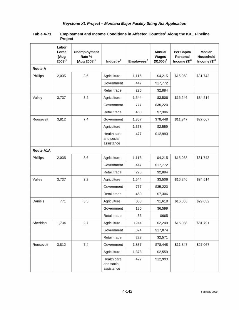
Employment, local industry, and income trends in the counties crossed by the routes are summarized in Table 4-71.
All of the affected counties have per capita personal incomes that are lower than the state average. Phillips County has the lowest per capita personal income of the six affected Montana counties along Route B, while Valley County had the highest. Fallon County was the only affected county that had a median household income higher than the Montana state average. McCone County had the lowest median household income.
Major industries, by employment, in the counties along Route B are consistently agriculture, government, and retail trade. Health care and social assistance also is a major industry in Dawson County. Counties with larger population centers, such as Dawson and Valley counties, have the largest labor forces, while the least populated counties, such as McCone and Prairie, have the smallest labor forces, both under 1,000 labor force participants. The unemployment rates for the affected counties were all below the state average of 3.8 percent. Phillips and Prairie counties both had the highest unemployment rates at 3.6 percent as of August 2008.
Major industries in counties affected by Routes A and A1A are agriculture, government, and retail trade, as well as, in Roosevelt County, health care and social assistance. Roosevelt and Valley counties recorded the
Keystone XL Project – Montana Major Facility Siting Act Application
4-141a February 2009
largest labor forces, while Daniels County, at 771 labor force participants, recorded the smallest. Roosevelt County recorded the lowest per capita personal income for both Route A and Route A1A. Roosevelt County also had the lowest median household income for both counties, as well as the highest unemployment rate, at 3.6 percentage points above the Montana state average.
The amount of skilled and semi-skilled labor in eastern Montana, and their corresponding average median wage is shown in Table 4-72. Counties within the eastern Montana region, employ 55 percent more skilled labor than they do semi-skilled labor. Additionally, skilled laborers earn an average median wage that is 71.5 percent greater than the average median wage of semi-skilled laborers.
Keystone XL Project – Montana Major Facility Siting Act Application
4-142 February 2009
Table 4-71 Employment and Income Conditions in Affected Counties1 Along the KXL Pipeline Project
Labor Force (Aug
2008)1
Unemployment Rate %
(Aug 2008)1 Industry2 Employees2
Annual Wages
($1000)2
Per Capita Personal
Income ($)3
Median Household Income ($)3
Route A
Agriculture 1,116 $4,215
Government 447 $17,772
Phillips 2,035 3.6
Retail trade 225 $2,884
$15,058 $31,742
Agriculture 1,544 $3,506
Government 777 $35,220
Valley 3,737 3.2
Retail trade 450 $7,306
$16,246 $34,514
Government 1,857 $78,448
Agriculture 1,378 $2,559
Roosevelt 3,812 7.4
Health care and social assistance
477 $12,993
$11,347 $27,067
Route A1A
Agriculture 1,116 $4,215
Government 447 $17,772
Phillips 2,035 3.6
Retail trade 225 $2,884
$15,058 $31,742
Agriculture 1,544 $3,506
Government 777 $35,220
Valley 3,737 3.2
Retail trade 450 $7,306
$16,246 $34,514
Agriculture 883 $1,618
Government 180 $6,599
Daniels 771 3.5
Retail trade 85 $665
$16,055 $29,052
Agriculture 1244 $2,249
Government 374 $17,074
Sheridan 1,734 2.7
Retail trade 228 $2,571
$16,038 $31,791
Government 1,857 $78,448
Agriculture 1,378 $2,559
Roosevelt 3,812 7.4
Health care and social assistance
477 $12,993
$11,347 $27,067

Keystone XL Project – Montana Major Facility Siting Act Application
4-145 February 2009
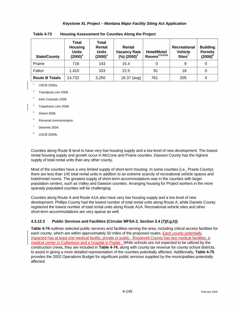
Table 4-73 Housing Assessment for Counties Along the Project
State/County
Total Housing
Units (2000)1
Total Rental Units
(2000)1
Rental Vacancy Rate
(%) (2000)1 Hotel/Motel Rooms2,3,4,5,6
Recreational Vehicle Sites7
Building Permits (2006)8
Prairie 718 143 15.4 0 9 0
Fallon 1,410 333 22.5 91 18 0
Route B Totals 14,732 3,250 16.37 (avg) 761 205 4 1 USCB 2000a.
2 Travelpost.com 2008.
3 AAA Colorado 2008.
4 Tripadvisor.com 2008.
5 Ockert 2008. 6 Personal communication.
7 Delorme 2004.
8 USCB 2000b.
Counties along Route B tend to have very low housing supply and a low level of new development. The lowest rental housing supply and growth occur in McCone and Prairie counties. Dawson County has the highest supply of total rental units than any other county.
Most of the counties have a very limited supply of short-term housing. In some counties (i.e., Prairie County) there are less than 145 total rental units in addition to an extreme scarcity of recreational vehicle spaces and hotel/motel rooms. The greatest supply of short-term accommodations was in the counties with larger population centers, such as Valley and Dawson counties. Arranging housing for Project workers in the more sparsely populated counties will be challenging.
Counties along Route A and Route A1A also have very low housing supply and a low level of new development. Phillips County had the lowest number of total rental units along Route A, while Daniels County registered the lowest number of total rental units along Route A1A. Recreational vehicle sites and other short-term accommodations are very sparse as well.
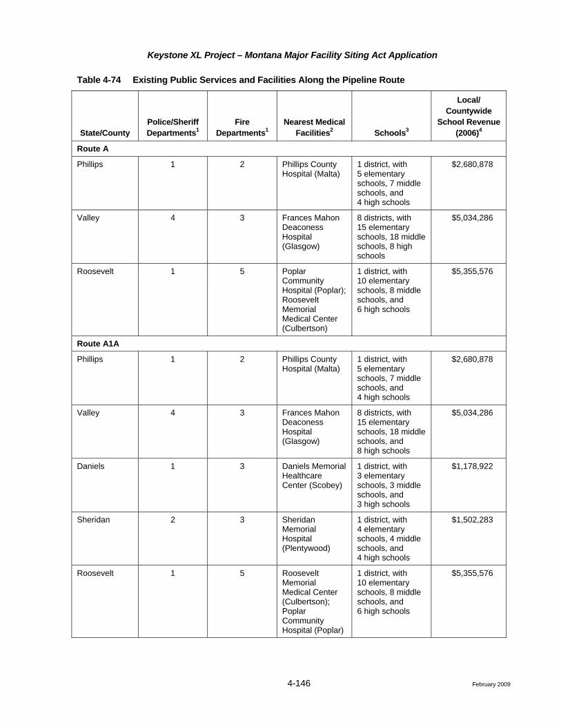
4.3.12.3 Public Services and Facilities (Circular MFSA-2, Section 3.4 (7)(f,g,h))
Table 4-74 outlines selected public services and facilities serving the area, including critical access facilities for each county, which are within approximately 50 miles of the proposed routes. Each county potentially impacted has at least one medical facility, private or public. Roosevelt County has two medical facilities, a medical center in Culbertson and a hospital in Poplar. While schools are not expected to be utilized by the construction crews, they are included in Table 4-74, along with county tax revenue for county school districts, to assist in giving a more detailed representation of the counties potentially affected. Additionally, Table 4-75 provides the 2002 Operations Budget for significant public services supplied by the municipalities potentially affected.
Keystone XL Project – Montana Major Facility Siting Act Application
4-146 February 2009
Table 4-74 Existing Public Services and Facilities Along the Pipeline Route
State/County Police/Sheriff Departments1
Fire Departments1
Nearest Medical Facilities2 Schools3
Local/ Countywide
School Revenue (2006)4
Route A
Phillips 1 2 Phillips County Hospital (Malta)
1 district, with 5 elementary schools, 7 middle schools, and 4 high schools
$2,680,878
Valley 4 3 Frances Mahon Deaconess Hospital (Glasgow)
8 districts, with 15 elementary schools, 18 middle schools, 8 high schools
$5,034,286
Roosevelt 1 5 Poplar Community Hospital (Poplar); Roosevelt Memorial Medical Center (Culbertson)
1 district, with 10 elementary schools, 8 middle schools, and 6 high schools
$5,355,576
Route A1A
Phillips 1 2 Phillips County Hospital (Malta)
1 district, with 5 elementary schools, 7 middle schools, and 4 high schools
$2,680,878
Valley 4 3 Frances Mahon Deaconess Hospital (Glasgow)
8 districts, with 15 elementary schools, 18 middle schools, and 8 high schools
$5,034,286
Daniels 1 3 Daniels Memorial Healthcare Center (Scobey)
1 district, with 3 elementary schools, 3 middle schools, and 3 high schools
$1,178,922
Sheridan 2 3 Sheridan Memorial Hospital (Plentywood)
1 district, with 4 elementary schools, 4 middle schools, and 4 high schools
$1,502,283
Roosevelt 1 5 Roosevelt Memorial Medical Center (Culbertson); Poplar Community Hospital (Poplar)
1 district, with 10 elementary schools, 8 middle schools, and 6 high schools
$5,355,576
Keystone XL Project – Montana Major Facility Siting Act Application
4-149 February 2009
In general, the availability of public services and their associated funding are functions of the size and population of the county and the number of larger communities in the county. There are multiple law enforcement providers, including the respective state patrols, county sheriffs, and local police departments. In many instances, mutual aid/cooperative agreements among agencies allow members of one agency to provide support or backup to other agencies in emergency situations.
A network of fire departments and districts provide fire protection and suppression services across the region. Many of the fire districts across the region are staffed by volunteers and are housed in stations located in the larger communities.
For each county affected there is at least one acute care facility either within the county crossed or in a neighboring county, providing emergency medical care and in several cases also serving as the base for local emergency medical response and transport services.
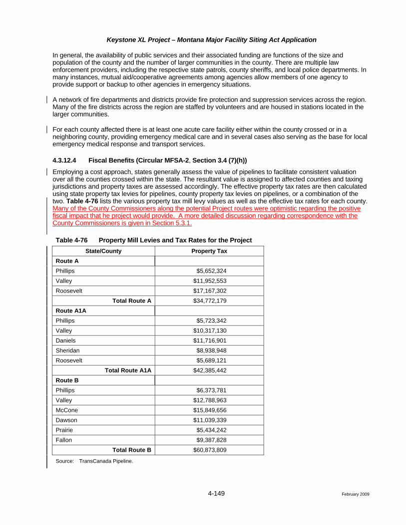
4.3.12.4 Fiscal Benefits (Circular MFSA-2, Section 3.4 (7)(h))
Employing a cost approach, states generally assess the value of pipelines to facilitate consistent valuation over all the counties crossed within the state. The resultant value is assigned to affected counties and taxing jurisdictions and property taxes are assessed accordingly. The effective property tax rates are then calculated using state property tax levies for pipelines, county property tax levies on pipelines, or a combination of the two. Table 4-76 lists the various property tax mill levy values as well as the effective tax rates for each county. Many of the County Commissioners along the potential Project routes were optimistic regarding the positive fiscal impact that he project would provide. A more detailed discussion regarding correspondence with the County Commissioners is given in Section 5.3.1.
Table 4-76 Property Mill Levies and Tax Rates for the Project State/County Property Tax
Route A Phillips $5,652,324
Valley $11,952,553
Roosevelt $17,167,302
Total Route A $34,772,179
Route A1A Phillips $5,723,342
Valley $10,317,130
Daniels $11,716,901
Sheridan $8,938,948
Roosevelt $5,689,121
Total Route A1A $42,385,442
Route B Phillips $6,373,781
Valley $12,788,963
McCone $15,849,656
Dawson $11,039,339
Prairie $5,434,242
Fallon $9,387,828
Total Route B $60,873,809
Source: TransCanada Pipeline.
Keystone XL Project – Montana Major Facility Siting Act Application
4-150 February 2009
Taxes levied by various state, county, or local taxing jurisdictions may include taxes on gross receipts from the sales of goods and services and corporate income taxes. Federal agencies also assess fees for use of public lands for activities such as pipeline and transmission line ROWs. These taxes and fees vary by region and have not been identified.
4.3.12.5 Environmental Justice (Circular MFSA-2, Section 3.4 (7)(d))
Executive Order 12898, Federal Actions to Address Environmental Justice in Minority Populations and Low-Income Populations (59 Federal Register 7629) requires that impacts on minority or low-income populations be taken into account when preparing environmental and socioeconomic analyses of projects or programs that are proposed, funded, or licensed by federal agencies. The Environmental Justice Guidance under NEPA prepared by the CEQ Guidance (1997) is commonly used in implementing Order 12898 in preparing NEPA documents. The State of Montana does not have a separate Environmental Justice Policy beyond the NEPA requirements.
The purpose of the Order is to avoid the disproportionate placement of any adverse environmental, economic, social, or health impacts from federal actions and policies on minority populations, low-income populations, and Indian tribes and to allow all portions of the population an opportunity to participate in the development of, compliance with, and enforcement of federal laws, regulations, and policies affecting human health of the environment regardless of race, color, national origin, or income. The provisions of the Order apply to programs involving Native Americans and Hispanic communities. These requirements will be addressed by: 1) ensuring broad distribution of public information on the Project through public scoping meetings; and 2) conducting government-to-government consultation with Native American groups either residing in or with historical ties to the area. Details regarding public scoping meeting dates and locations can be found in Section 5.3.
Tables 4-77 and 4-78 provide 2000 USCB statistics on race, ethnicity, and income status in affected counties and communities. Affected counties are those counties potentially crossed, affected communities in the proximity of the routes include those communities crossed by the routes (within 0.5 mile) as well as communities located within 2 miles of the routes. The sections below discuss the minority populations and low income populations potentially affected.
Minority Populations
The Council on Environmental Quality (CEQ) Guidance defines the term “minority population” to include people who identify themselves during the census as Black or African American, Asian or Pacific Islander, Native American or Alaskan Native, or Hispanic. Hispanic origin refers to ethnicity and language, not race, and may include people whose heritage is Puerto Rican, Cuban, Mexican, and Central or South American. For the purpose of this evaluation, all people who identified themselves as Hispanic are included as a minority population.
In accordance with the CEQ Guidance, minority populations should be identified where either: 1) the minority population in an affected area (e.g., a county or community) exceeds 50 percent; or 2) the minority population percentage of the affected area is meaningfully greater (1.5 times) than the minority population percentage in the general population of the surrounding area (e.g., the state, county, or other appropriate unit of geographical analysis) as shown in Figure 4-1. The surrounding area used for comparison of affected counties/communities were the state populations.
Based upon review of the 2000 USCB data, there are minority populations located in a few counties crossed and several communities in the proximity of the proposed routes. As described below, in some cases, there are minority populations occurring in portions of the counties crossed by the proposed routes that are “meaningfully greater” than their corresponding minority populations in the general population.
Keystone XL Project – Montana Major Facility Siting Act Application
4-158 February 2009
4.3.12.6 Environmental Justice – Impact Assessment
The environmental justice demographic analysis revealed significant low income populations residing along Route B and significant minority and low income populations along Routes A and A1A. Public participation is a goal of the NEPA process; this participation is especially important when low-income populations, minority populations or tribal populations have the potential to be affected by a Project. Therefore, Keystone has been engaged in public consultation since the Project was first announced in July 2008. As explained in detail in Chapter 5, Keystone is committed to ongoing and regular correspondence, communication, and consultation with all stakeholders. Keystone shares information about the Project and provides opportunities for identification and resolution of questions, issues, and concerns through a number of channels, including press releases, the Project website, e-mail, toll free telephone numbers, one-on-one discussions between landowners and land agents, and direct mailings. To date, Keystone’s public participation program included meetings with community leaders and open houses. Public participation and consultation are anticipated activities to help maintain positive public attitudes, and will continue throughout the life of the Project.
Route B does not traverse any Native American lands. Route A travels directly through the Fort Peck Indian Reservation, making this option less desirable. Route A1A avoids traveling directly through the Indian Reservation; however, this route is not as direct as Route B with respect to the overall Project.
Both short-term and long-term benefits will stem from increases in employment opportunities for the areas surrounding the Project route. Increased spending in the affected areas also will increase the income of benefit community businesses that will provide materials and services for the construction and operation of the pipeline/pumping stations. These businesses include and are not limited to hotels and motels, restaurants, gas stations, and grocery stores, as well as businesses that will potentially be involved in directly servicing pipeline construction and operation. Incomes are not expected to be affected in a negative manner. The affected incomes and subsequent compensation of ranchers and farmers are addressed in Section 4.3.12.7.
In addition, increases in state and local property tax revenues will provide additional monies to local governments, some of which may be used to support local social programs for minority and/or low income groups.
While portions of the pipeline routes are located in areas of significant minority populations and with families living below the poverty level, the Project also is located in areas with relatively few families living below the poverty level. As the project routes do not disproportionately impact minority populations or families living below the poverty level, it is not anticipated that the project will have negative affect on social cohesion.
4.3.12.7 Socioeconomics – Impact Assessment (Circular MFSA-2, Sections 3.4(7)(a), 3.7(3)(5))
Issues
• Compensation to landowners for conveyance of easements and restrictions and damage to land and property;
• Construction workforce demands on local infrastructure;
• Fiscal benefits from goods and services purchased locally and associated tax revenue generated; and
• Tax revenues generated by the pipeline.
Construction (Circular MFSA-2, Section 3.4 (7)(a))
Compensation for Damages to Land Use and Property
The Project will be constructed in predominantly rural, agricultural areas, where land uses such as ranching and farming are the main economic engines. Keystone will acquire pipeline easements from landowners and will provide landowners with monetary compensation for the conveyance of those easements. Construction activities will create the potential for damage to land and property, including drainage tiles, irrigation systems,

Keystone XL Project – Montana Major Facility Siting Act Application
4-158a February 2009
fences, and crop productivity. Keystone will restore damaged or disturbed lands and also will repair or restore drain tiles, irrigation systems, fences, and other items and features that are damaged or temporarily disturbed during construction. Mitigation measures for damage to land and property during construction are discussed in detail in the CMRP. Monetary compensation for damages would be agreed to in advance in the easement agreements and/or negotiated on a case-by-case basis with the individual landowner. Land use would return to its previous function, such as ranching and farming, once construction was completed. Ecological impacts are discussed in specific chapters throughout this application.
Keystone XL Project – Montana Major Facility Siting Act Application
4-159 February 2009
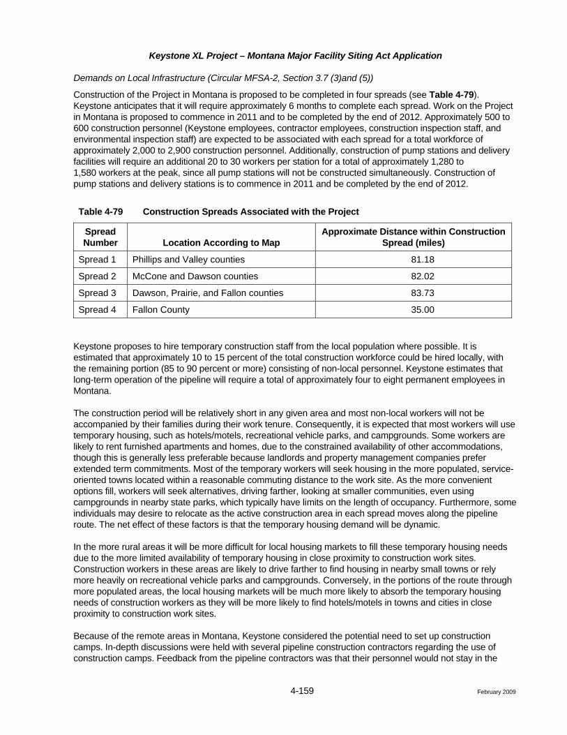
Demands on Local Infrastructure (Circular MFSA-2, Section 3.7 (3)and (5))
Construction of the Project in Montana is proposed to be completed in four spreads (see Table 4-79). Keystone anticipates that it will require approximately 6 months to complete each spread. Work on the Project in Montana is proposed to commence in 2011 and to be completed by the end of 2012. Approximately 500 to 600 construction personnel (Keystone employees, contractor employees, construction inspection staff, and environmental inspection staff) are expected to be associated with each spread for a total workforce of approximately 2,000 to 2,900 construction personnel. Additionally, construction of pump stations and delivery facilities will require an additional 20 to 30 workers per station for a total of approximately 1,280 to 1,580 workers at the peak, since all pump stations will not be constructed simultaneously. Construction of pump stations and delivery stations is to commence in 2011 and be completed by the end of 2012.
Table 4-79 Construction Spreads Associated with the Project
Spread Number Location According to Map
Approximate Distance within Construction Spread (miles)
Spread 1 Phillips and Valley counties 81.18
Spread 2 McCone and Dawson counties 82.02
Spread 3 Dawson, Prairie, and Fallon counties 83.73
Spread 4 Fallon County 35.00
Keystone proposes to hire temporary construction staff from the local population where possible. It is estimated that approximately 10 to 15 percent of the total construction workforce could be hired locally, with the remaining portion (85 to 90 percent or more) consisting of non-local personnel. Keystone estimates that long-term operation of the pipeline will require a total of approximately four to eight permanent employees in Montana.
The construction period will be relatively short in any given area and most non-local workers will not be accompanied by their families during their work tenure. Consequently, it is expected that most workers will use temporary housing, such as hotels/motels, recreational vehicle parks, and campgrounds. Some workers are likely to rent furnished apartments and homes, due to the constrained availability of other accommodations, though this is generally less preferable because landlords and property management companies prefer extended term commitments. Most of the temporary workers will seek housing in the more populated, service-oriented towns located within a reasonable commuting distance to the work site. As the more convenient options fill, workers will seek alternatives, driving farther, looking at smaller communities, even using campgrounds in nearby state parks, which typically have limits on the length of occupancy. Furthermore, some individuals may desire to relocate as the active construction area in each spread moves along the pipeline route. The net effect of these factors is that the temporary housing demand will be dynamic.
In the more rural areas it will be more difficult for local housing markets to fill these temporary housing needs due to the more limited availability of temporary housing in close proximity to construction work sites. Construction workers in these areas are likely to drive farther to find housing in nearby small towns or rely more heavily on recreational vehicle parks and campgrounds. Conversely, in the portions of the route through more populated areas, the local housing markets will be much more likely to absorb the temporary housing needs of construction workers as they will be more likely to find hotels/motels in towns and cities in close proximity to construction work sites.
Because of the remote areas in Montana, Keystone considered the potential need to set up construction camps. In-depth discussions were held with several pipeline construction contractors regarding the use of construction camps. Feedback from the pipeline contractors was that their personnel would not stay in the
Keystone XL Project – Montana Major Facility Siting Act Application
4-160 February 2009
construction camps, and that lodging such as motels and recreational parks would be preferred. Based on this information, as well as the Housing/Lodging Inventory, it was determined that construction camps will not be established.
Impacts to primary and secondary schools are projected to be minimal. It is projected that very few, if any, construction workers would bring school-aged children to the area.
Other construction-related impacts on local services may include increased demand for permits for vehicle load and width limits and local police assistance during construction at road crossings to facilitate traffic flow (for more information on roads see Section 4.3.11). In more rural sections of the proposed route, response times to highway or construction-related accidents may be lengthy, given communication, dispatch, and travel time considerations. In these areas, it may be necessary to provide on-site first responder services; however, Keystone will work with the local law enforcement, fire departments, and emergency medical services to determine the best course of action and coordinate for effective emergency response. Plans associated with these issues will be addressed in the ERP once the final design has been completed. With at least one medical facility in each potentially affected county, it is anticipated that the supply of health services for both public and Project use will be adequate. The degree of impact will vary from community to community, depending on the number of non-local workers and accompanying family members that temporarily reside in each community, the duration of their stay, and the size of the community. Although these factors are too indeterminate and variable to accurately predict the magnitude of impact, the effects will be short-term and, therefore, are not expected to be significant.
Short-term Fiscal Benefits
Taxes that may apply, other than property taxes levied by various state, county, or local taxing jurisdictions, include taxes on gross receipts from the sales of goods and services. These taxes and fees vary by region or locality and will be received only during the construction period (approximately 6 months).
Operation (Circular MFSA-2, Section 3.7 (5))
Demands on Local Infrastructure
The limited number of permanent employees associated with the Project will result in negligible long-term impacts on public services.
Long-term Fiscal Benefits
In the operation phase, the pipeline will increase the tax base in the states, counties, and communities crossed. Keystone has estimated a total of $34,772,179 and $42,385,442 in property taxes will be paid to counties along Route A and Route A1a, respectively. Additionally, Keystone has estimated that a total of approximately $60,873,809 million will be paid in property taxes during the first year of pipeline operation for Route B.
Keystone will employ multiple safeguards to prevent a pipeline release. The chance of a spill occurring is very low and if a spill occurred, the volume is likely to be relatively small. In the unlikely event of a pipeline release, Keystone would initiate its ERP and emergency response teams would contain and clean up the spill. To minimize impacts to the public, appropriate remedial measures will be implemented to meet federal and state standards designed to ensure protection of human health and environmental quality. Additional information on potential impacts to public health and safety resulting from a crude oil spill is provided in the Risk Assessment (Attachment D).
Environmental Justice
Risk analyses need to be conducted for all locations identified as having significant minority populations and low income populations.