Embed Size (px)
Citation preview
United StatesDepartment of Agriculture
Keys toSoil Taxonomy
Ninth Edition, 2003

Keys to Soil Taxonomy
By Soil Survey Staff
United States Department of Agriculture
Natural Resources Conservation Service
Ninth Edition, 2003
The United States Department of Agriculture (USDA) prohibits discrimination in all itsprograms and activities on the basis of race, color, national origin, gender, religion, age,disability, political beliefs, sexual orientation, and marital or family status. (Not all prohibitedbases apply to all programs.) Persons with disabilities who require alternative means forcommunication of program information (Braille, large print, audiotape, etc.) should contactUSDA’s TARGET Center at 202-720-2600 (voice and TDD).
To file a complaint of discrimination, write USDA, Director, Office of Civil Rights, Room326W, Whitten Building, 14th and Independence Avenue, SW, Washington, DC 20250-9410,or call 202-720-5964 (voice and TDD). USDA is an equal opportunity provider and employer.
Cover: A natric horizon with columnar structure in a Natrudoll from Argentina.
5
Table of Contents
Foreword .................................................................................................................................... 7
Chapter 1: The Soils That We Classify .................................................................................. 9
Chapter 2: Differentiae for Mineral Soils and Organic Soils ............................................... 11
Chapter 3: Horizons and Characteristics Diagnostic for the Higher Categories .................. 13
Chapter 4: Identification of the Taxonomic Class of a Soil ................................................. 37
Chapter 5: Alfisols ............................................................................................................... 41
Chapter 6: Andisols ............................................................................................................. 83
Chapter 7: Aridisols ........................................................................................................... 103
Chapter 8: Entisols ............................................................................................................. 129
Chapter 9: Gelisols ............................................................................................................ 149
Chapter 10: Histosols ........................................................................................................... 159
Chapter 11: Inceptisols ........................................................................................................ 165
Chapter 12: Mollisols .......................................................................................................... 193
Chapter 13: Oxisols ............................................................................................................. 237
Chapter 14: Spodosols ......................................................................................................... 253
Chapter 15: Ultisols ............................................................................................................. 263
Chapter 16: Vertisols ............................................................................................................ 285
Chapter 17: Family and Series Differentiae and Names ...................................................... 297
Chapter 18: Designations for Horizons and Layers ............................................................. 313
Appendix ............................................................................................................................... 319
Index ...................................................................................................................................... 325


7
Foreword
The publication Keys to Soil Taxonomy serves two purposes. It provides the taxonomickeys necessary for the classification of soils in a form that can be used easily in the field. Italso acquaints users of the taxonomic system with recent changes in the system. The previouseight editions of the Keys to Soil Taxonomy included all revisions of the original keys in SoilTaxonomy: A Basic System of Soil Classification for Making and Interpreting Soil Surveys(1975). The ninth edition of the of the Keys to Soil Taxonomy incorporates all changesapproved since the publication of the second edition of Soil Taxonomy (1999). We plan tocontinue issuing updated editions of the Keys to Soil Taxonomy as changes warrant neweditions.
The authors of the Keys to Soil Taxonomy are identified as the “Soil Survey Staff.” Thisterm is meant to include all of the soil classifiers in the National Cooperative Soil Surveyprogram and in the international community who have made significant contributions to theimprovement of the taxonomic system.
Micheal L. GoldenDirector, Soil Survey DivisionNatural Resources Conservation Service

9S
O
I
The word “soil,” like many common words, has severalmeanings. In its traditional meaning, soil is the natural mediumfor the growth of land plants, whether or not it has discerniblesoil horizons. This meaning is still the common understanding ofthe word, and the greatest interest in soil is centered on thismeaning. People consider soil important because it supportsplants that supply food, fibers, drugs, and other wants of humansand because it filters water and recycles wastes. Soil covers theearth’s surface as a continuum, except on bare rock, in areas ofperpetual frost or deep water, or on the bare ice of glaciers. Inthis sense, soil has a thickness that is determined by the rootingdepth of plants.
Soil in this text is a natural body comprised of solids(minerals and organic matter), liquid, and gases that occurs onthe land surface, occupies space, and is characterized by one orboth of the following: horizons, or layers, that aredistinguishable from the initial material as a result of additions,losses, transfers, and transformations of energy and matter or theability to support rooted plants in a natural environment. Thisdefinition is expanded from the 1975 version of Soil Taxonomyto include soils in areas of Antarctica where pedogenesis occursbut where the climate is too harsh to support the higher plantforms.
The upper limit of soil is the boundary between soil and air,shallow water, live plants, or plant materials that have not begunto decompose. Areas are not considered to have soil if thesurface is permanently covered by water too deep (typicallymore than 2.5 m) for the growth of rooted plants. The horizontalboundaries of soil are areas where the soil grades to deep water,barren areas, rock, or ice. In some places the separation betweensoil and nonsoil is so gradual that clear distinctions cannot bemade.
The lower boundary that separates soil from the nonsoilunderneath is most difficult to define. Soil consists of thehorizons near the earth’s surface that, in contrast to theunderlying parent material, have been altered by the interactionsof climate, relief, and living organisms over time. Commonly,soil grades at its lower boundary to hard rock or to earthymaterials virtually devoid of animals, roots, or other marks ofbiological activity. The lowest depth of biological activity,however, is difficult to discern and is often gradual. Forpurposes of classification, the lower boundary of soil is
arbitrarily set at 200 cm. In soils where either biological activityor current pedogenic processes extend to depthsgreater than 200 cm, the lower limit of the soil for classificationpurposes is still 200 cm. In some instances the more weaklycemented bedrocks (paralithic materials, defined later) havebeen described and used to differentiate soil series (seriescontrol section, defined later), even though the paralithicmaterials below a paralithic contact are not considered soil inthe true sense. In areas where soil has thin cemented horizonsthat are impermeable to roots, the soil extends as deep as thedeepest cemented horizon, but not below 200 cm. For certainmanagement goals, layers deeper than the lower boundary of thesoil that is classified (200 cm) must also be described if theyaffect the content and movement of water and air or otherinterpretative concerns.
In the humid tropics, earthy materials may extend to a depthof many meters with no obvious changes below the upper 1 or 2m, except for an occasional stone line. In many wet soils, gleyedsoil material may begin a few centimeters below the surface and,in some areas, continue down for several meters apparentlyunchanged with increasing depth. The latter condition can arisethrough the gradual filling of a wet basin in which the A horizonis gradually added to the surface and becomes gleyed beneath.Finally, the A horizon rests on a thick mass of gleyed materialthat may be relatively uniform. In both of these situations, thereis no alternative but to set the lower limit of soil at the arbitrarylimit of 200 cm.
Soil, as defined in this text, does not need to have discerniblehorizons, although the presence or absence of horizons and theirnature are of extreme importance in soil classification. Plantscan be grown under glass in pots filled with earthy materials,such as peat or sand, or even in water. Under proper conditionsall these media are productive for plants, but they are nonsoilhere in the sense that they cannot be classified in the samesystem that is used for the soils of a survey area, county, or evennation. Plants even grow on trees, but trees are regarded asnonsoil.
Soil has many properties that fluctuate with the seasons. Itmay be alternately cold and warm or dry and moist. Biologicalactivity is slowed or stopped if the soil becomes too cold or toodry. The soil receives flushes of organic matter when leaves fallor grasses die. Soil is not static. The pH, soluble salts, amount of
The Soils That We Classify
CHAPTER 1
10
organic matter and carbon-nitrogen ratio, numbers of micro-organisms, soil fauna, temperature, and moisture all change withthe seasons as well as with more extended periods of time. Soilmust be viewed from both the short-term and long-termperspective.
Buried Soils
A buried soil is covered with a surface mantle of new soilmaterial that either is 50 cm or more thick or is 30 to 50 cmthick and has a thickness that equals at least half the totalthickness of the named diagnostic horizons that are preserved inthe buried soil. A surface mantle of new material that does nothave the required thickness for buried soils can be used to
establish a phase of the mantled soil or even another soil seriesif the mantle affects the use of the soil.
Any horizons or layers underlying a plaggen epipedon areconsidered to be buried.
A surface mantle of new material, as defined here, is largelyunaltered, at least in the lower part. It may have a diagnosticsurface horizon (epipedon) and/or a cambic horizon, but it hasno other diagnostic subsurface horizons, all defined later.However, there remains a layer 7.5 cm or more thick that failsthe requirements for all diagnostic horizons, as defined later,overlying a horizon sequence that can be clearly identified as thesolum of a buried soil in at least half of each pedon. Therecognition of a surface mantle should not be based only onstudies of associated soils.
11
D
I
F
Soil taxonomy differentiates between mineral soils andorganic soils. To do this, first, it is necessary to distinguishmineral soil material from organic soil material. Second, it isnecessary to define the minimum part of a soil that should bemineral if a soil is to be classified as a mineral soil and theminimum part that should be organic if the soil is to beclassified as an organic soil.
Nearly all soils contain more than traces of both mineral andorganic components in some horizons, but most soils aredominantly one or the other. The horizons that are less thanabout 20 to 35 percent organic matter, by weight, haveproperties that are more nearly those of mineral than of organicsoils. Even with this separation, the volume of organic matter atthe upper limit exceeds that of the mineral material in the fine-earth fraction.
Mineral Soil Material
Mineral soil material (less than 2.0 mm in diameter) either:
1. Is saturated with water for less than 30 days (cumulative)per year in normal years and contains less than 20 percent (byweight) organic carbon; or
2. Is saturated with water for 30 days or more cumulative innormal years (or is artificially drained) and, excluding live roots,has an organic carbon content (by weight) of:
a. Less than 18 percent if the mineral fraction contains 60percent or more clay; or
b. Less than 12 percent if the mineral fraction contains noclay; or
c. Less than 12 + (clay percentage multiplied by 0.1)percent if the mineral fraction contains less than 60 percentclay.
Organic Soil Material
Soil material that contains more than the amounts of organiccarbon described above for mineral soil material is consideredorganic soil material.
In the definition of mineral soil material above, material thathas more organic carbon than in item 1 is intended to include
what has been called litter or an O horizon. Material that hasmore organic carbon than in item 2 has been called peat ormuck. Not all organic soil material accumulates in or underwater. Leaf litter may rest on a lithic contact and support forestvegetation. The soil in this situation is organic only in the sensethat the mineral fraction is appreciably less than half the weightand is only a small percentage of the volume of the soil.
Distinction Between Mineral Soils and OrganicSoils
Most soils are dominantly mineral material, but many mineralsoils have horizons of organic material. For simplicity in writingdefinitions of taxa, a distinction between what is meant by amineral soil and an organic soil is useful. To apply thedefinitions of many taxa, one must first decide whether the soilis mineral or organic. An exception is the Andisols (definedlater). These generally are considered to consist of mineral soils,but some may be organic if they meet other criteria for Andisols.Those that exceed the organic carbon limit defined for mineralsoils have a colloidal fraction dominated by short-range-orderminerals or aluminum-humus complexes. The mineral fractionin these soils is believed to give more control to the soilproperties than the organic fraction. Therefore, the soils areincluded with the Andisols rather than the organic soils definedlater as Histosols.
If a soil has both organic and mineral horizons, the relativethickness of the organic and mineral soil materials must beconsidered. At some point one must decide that the mineralhorizons are more important. This point is arbitrary and dependsin part on the nature of the materials. A thick layer of sphagnumhas a very low bulk density and contains less organic matter thana thinner layer of well-decomposed muck. It is much easier tomeasure the thickness of layers in the field than it is todetermine tons of organic matter per hectare. The definition of amineral soil, therefore, is based on the thickness of the horizons,or layers, but the limits of thickness must vary with the kinds ofmaterials. The definition that follows is intended to classify asmineral soils those that have both thick mineral soil layers andno more organic material than the amount permitted in the histicepipedon, which is defined in chapter 3.
In the determination of whether a soil is organic or mineral,the thickness of horizons is measured from the surface of thesoil whether that is the surface of a mineral or an organichorizon, unless the soil is buried as defined in chapter 1. Thus,
CHAPTER 2
Differentiae for Mineral Soils1 and Organic Soils
1 Mineral soils include all soils except the suborder Histels and the order Histosols.
12
any O horizon at the surface is considered an organic horizon ifit meets the requirements of organic soil material as definedlater, and its thickness is added to that of any other organichorizons to determine the total thickness of organic soilmaterials.
Definition of Mineral Soils
Mineral soils are soils that have either of the following:
1. Mineral soil materials that meet one or more of thefollowing:
a. Overlie cindery, fragmental, or pumiceous materials and/or have voids2 that are filled with 10 percent or less organicmaterials and directly below these materials have either adensic, lithic, or paralithic contact; or
b. When added with underlying cindery, fragmental, orpumiceous materials, total more than 10 cm between the soilsurface and a depth of 50 cm; or
c. Constitute more than one-third of the total thickness ofthe soil to a densic, lithic, or paralithic contact or have a totalthickness of more than 10 cm; or
d. If they are saturated with water for 30 days or more peryear in normal years (or are artificially drained) and haveorganic materials with an upper boundary within40 cm of the soil surface, have a total thickness of either:
(1) Less than 60 cm if three-fourths or more of theirvolume consists of moss fibers or if their bulk density,moist, is less than 0.1 g/cm3; or
(2) Less than 40 cm if they consist either of sapric orhemic materials, or of fibric materials with less than three-fourths (by volume) moss fibers and a bulk density, moist,of 0.1 g/cm3 or more; or
2. More than 20 percent, by volume, mineral soil materialsfrom the soil surface to a depth of 50 cm or to a glacic layer or adensic, lithic, or paralithic contact, whichever is shallowest; and
a. Permafrost within 100 cm of the soil surface; or
b. Gelic materials within 100 cm of the soil surface andpermafrost within 200 cm of the soil surface.
Definition of Organic Soils
Organic soils have organic soil materials that:
1. Do not have andic soil properties in 60 percent or more ofthe thickness between the soil surface and either a depth of 60cm or a densic, lithic, or paralithic contact or duripan ifshallower; and
2. Meet one or more of the following:
a. Overlie cindery, fragmental, or pumiceous materials and/or fill their interstices2 and directly below these materialshave a densic, lithic, or paralithic contact; or
b. When added with the underlying cindery, fragmental, orpumiceous materials, total 40 cm or more between the soilsurface and a depth of 50 cm; or
c. Constitute two-thirds or more of the total thickness of thesoil to a densic, lithic, or paralithic contact and have nomineral horizons or have mineral horizons with a totalthickness of 10 cm or less; or
d. Are saturated with water for 30 days or more per year innormal years (or are artificially drained), have an upperboundary within 40 cm of the soil surface, and have a totalthickness of either:
(1) 60 cm or more if three-fourths or more of theirvolume consists of moss fibers or if their bulk density,moist, is less than 0.1 g/cm3; or
(2) 40 cm or more if they consist either of sapric orhemic materials, or of fibric materials with less than three-fourths (by volume) moss fibers and a bulk density, moist,of 0.1 g/cm3 or more; or
e. Are 80 percent or more, by volume, from the soil surfaceto a depth of 50 cm or to a glacic layer or a densic, lithic, orparalithic contact, whichever is shallowest.
It is a general rule that a soil is classified as an organic soil(Histosol) if more than half of the upper 80 cm (32 in) of thesoil is organic or if organic soil material of any thickness restson rock or on fragmental material having interstices filled withorganic materials.
2 Materials that meet the definition of cindery, fragmental, or pumiceous but have morethan 10 percent, by volume, voids that are filled with organic soil materials are considered tobe organic soil materials.
13
D
I
A
This chapter defines the horizons and characteristics ofboth mineral and organic soils. It is divided into three parts—horizons and characteristics diagnostic for mineral soils,characteristics diagnostic for organic soils, and horizons andcharacteristics diagnostic for both mineral and organic soils.
The horizons and characteristics defined below are not in akey format. Some diagnostic horizons are mutually exclusive,and some are not. An umbric epipedon, for example, couldnot also be a mollic epipedon. A kandic horizon with clay films,however, could also meet the definition of an argillic horizon.
Horizons and CharacteristicsDiagnostic for Mineral Soils
The criteria for some of the following horizons andcharacteristics, such as histic and folistic epipedons, can be metin organic soils. They are diagnostic, however, only for themineral soils.
Diagnostic Surface Horizons:The Epipedon
The epipedon (Gr. epi, over, upon, and pedon, soil) is ahorizon that forms at or near the surface and in which most ofthe rock structure has been destroyed. It is darkened by organicmatter or shows evidence of eluviation, or both. Rock structureas used here and in other places in this taxonomy includes finestratification (less than 5 mm) in unconsolidated sediments(eolian, alluvial, lacustrine, or marine) and saprolite derivedfrom consolidated rocks in which the unweathered minerals andpseudomorphs of weathered minerals retain their relativepositions to each other.
Any horizon may be at the surface of a truncated soil. Thefollowing section, however, is concerned with eight diagnostichorizons that have formed at or near the soil surface. Thesehorizons can be covered by a surface mantle of new soilmaterial. If the surface mantle has rock structure, the top of theepipedon is considered the soil surface unless the mantle meetsthe definition of buried soils in chapter 1. If the soil includes aburied soil, the epipedon, if any, is at the soil surface and theepipedon of the buried soil is considered a buried epipedon andis not considered in selecting taxa unless the keys specificallyindicate buried horizons, such as those in Thapto-Histicsubgroups. A soil with a mantle thick enough to have a buried
soil has no epipedon if the soil has rock structure to the surfaceor has an Ap horizon less than 25 cm thick that is underlain bysoil material with rock structure. The melanic epipedon (definedbelow) is unique among epipedons. It forms commonly involcanic deposits and can receive fresh deposits of ash.Therefore, this horizon is permitted to have layers within andabove the epipedon that are not part of the melanic epipedon.
A recent alluvial or eolian deposit that retains stratifications(5 mm or less thick) or an Ap horizon directly underlain by suchstratified material is not included in the concept of the epipedonbecause time has not been sufficient for soil-forming processesto erase these transient marks of deposition and for diagnosticand accessory properties to develop.
An epipedon is not the same as an A horizon. It may includepart or all of an illuvial B horizon if the darkening by organicmatter extends from the soil surface into or through the Bhorizon.
Anthropic Epipedon
Required Characteristics
The anthropic epipedon shows some evidence of disturbanceby human activity and meets all of the requirements for a mollicepipedon, except for one or both of the following:
1. 1,500 milligrams per kilogram or more P2O
5 soluble in 1
percent citric acid and a regular decrease in P2O
5 to a depth of
125 cm; or
2. If the soil is not irrigated, all parts of the epipedon are dryfor 9 months or more in normal years.
Folistic Epipedon
Required Characteristics
The folistic epipedon is defined as a layer (one or morehorizons) that is saturated for less than 30 days (cumulative) innormal years (and is not artificially drained) and either:
1. Consists of organic soil material that:
a. Is 20 cm or more thick and either contains 75 percent ormore (by volume) Sphagnum fibers or has a bulk density,moist, of less than 0.1; or
b. Is 15 cm or more thick; or
CHAPTER 3
Horizons and Characteristics Diagnostic for the Higher Categories
14 Keys to Soil Taxonomy
2. Is an Ap horizon that, when mixed to a depth of 25 cm, hasan organic-carbon content (by weight) of:
a. 16 percent or more if the mineral fraction contains 60percent or more clay; or
b. 8 percent or more if the mineral fraction contains noclay; or
c. 8 + (clay percentage divided by 7.5) percent or more ifthe mineral fraction contains less than 60 percent clay.
Most folistic epipedons consist of organic soil material(defined in chapter 2). Item 2 provides for a folistic epipedonthat is an Ap horizon consisting of mineral soil material.
Histic Epipedon
Required Characteristics
The histic epipedon is a layer (one or more horizons) that ischaracterized by saturation (for 30 days or more, cumulative)and reduction for some time during normal years (or isartificially drained) and either:
1. Consists of organic soil material that:
a. Is 20 to 60 cm thick and either contains 75 percent ormore (by volume) Sphagnum fibers or has a bulk density,moist, of less than 0.1; or
b. Is 20 to 40 cm thick; or
2. Is an Ap horizon that, when mixed to a depth of 25 cm, hasan organic-carbon content (by weight) of:
a. 16 percent or more if the mineral fraction contains 60percent or more clay; or
b. 8 percent or more if the mineral fraction contains noclay; or
c. 8 + (clay percentage divided by 7.5) percent or more ifthe mineral fraction contains less than 60 percent clay.
Most histic epipedons consist of organic soil material(defined in chapter 2). Item 2 provides for a histic epipedon thatis an Ap horizon consisting of mineral soil material. A histicepipedon consisting of mineral soil material can also be part of amollic or umbric epipedon.
Melanic Epipedon
Required Characteristics
The melanic epipedon has both of the following:
1. An upper boundary at, or within 30 cm of, either themineral soil surface or the upper boundary of an organic layerwith andic soil properties (defined below), whichever isshallower; and
2. In layers with a cumulative thickness of 30 cm or morewithin a total thickness of 40 cm, all of the following:
a. Andic soil properties throughout; and
b. A color value, moist, and chroma (Munsell designations)of 2 or less throughout and a melanic index of 1.70 or lessthroughout; and
c. 6 percent or more organic carbon as a weighted averageand 4 percent or more organic carbon in all layers.
Mollic Epipedon
Required Characteristics
The mollic epipedon consists of mineral soil materials andhas the following properties:
1. When dry, either or both:
a. Structural units with a diameter of 30 cm or lessor secondary structure with a diameter of 30 cm or less; or
b. A moderately hard or softer rupture-resistance class;and
2. Rock structure, including fine (less than 5 mm)stratifications, in less than one-half of the volume of all parts;and
3. One of the following:
a. All of the following:
(1) Colors with a value of 3 or less, moist, and of 5 orless, dry; and
(2) Colors with chroma of 3 or less, moist; and
(3) If the soil has a C horizon, the mollic epipedon has acolor value at least 1 Munsell unit lower or chroma atleast 2 units lower (both moist and dry) than that of the Chorizon or the epipedon has at least 0.6 percent moreorganic carbon than the C horizon; or
b. A fine-earth fraction that has a calcium carbonateequivalent of 15 to 40 percent and colors with a value andchroma of 3 or less, moist; or
c. A fine-earth fraction that has a calcium carbonateequivalent of 40 percent or more and a color value, moist, of5 or less; and
4. A base saturation (by NH4OAc) of 50 percent or more;
and
5. An organic-carbon content of:
a. 2.5 percent or more if the epipedon has a color value,moist, of 4 or 5; or
b. 0.6 percent more than that of the C horizon (if one
Horizons and Characteristics Diagnostic for the Higher Categories 15
D
I
A
occurs) if the mollic epipedon has a color value less than 1Munsell unit lower or chroma less than 2 units lower (bothmoist and dry) than the C horizon; or
c. 0.6 percent or more; and
6. After mixing of the upper 18 cm of the mineral soil or of thewhole mineral soil if its depth to a densic, lithic, or paralithiccontact, petrocalcic horizon, or duripan (all defined below) isless than 18 cm, the minimum thickness of the epipedon is asfollows:
a. 25 cm if:
(1) The texture of the epipedon is loamy fine sand orcoarser throughout; or
(2) There are no underlying diagnostic horizons(defined below) and the organic-carbon content of theunderlying materials decreases irregularly with increasingdepth; or
(3) All of the following are 75 cm or more below themineral soil surface:
(a) The lower boundary of any argillic, cambic,natric, oxic, or spodic horizon (defined below); and
(b) The upper boundary of any petrocalcic horizon,duripan, fragipan, or identifiable secondary carbonates;or
b. 10 cm if the epipedon is finer than loamy fine sand(when mixed) and it is directly above a densic, lithic, orparalithic contact, a petrocalcic horizon, or a duripan; or
c. 18 to 25 cm and one-third or more of the total thicknessbetween the mineral soil surface and:
(1) The upper boundary of any identifiable secondarycarbonates, petrocalcic horizon, duripan, or fragipan;or
(2) The lower boundary of any argillic, cambic, natric,oxic, or spodic horizon; or
d. 18 cm if none of the above conditions apply; and
7. Phosphate:
a. Content less than 1,500 milligrams per kilogram solublein 1 percent citric acid; or
b. Content decreasing irregularly with increasing depthbelow the epipedon; or
c. Nodules are within the epipedon; and
8. Some part of the epipedon is moist for 90 days or more(cumulative) in normal years during times when the soiltemperature at a depth of 50 cm is 5 oC or higher, if the soil isnot irrigated; and
9. The n value (defined below) is less than 0.7.
Ochric Epipedon
The ochric epipedon fails to meet the definitions for any ofthe other seven epipedons because it is too thin or too dry, hastoo high a color value or chroma, contains too little organiccarbon, has too high an n value or melanic index, or is bothmassive and hard or harder when dry . Many ochric epipedonshave either a Munsell color value of 4 or more, moist, and 6 ormore, dry, or chroma of 4 or more, or they include an A or Aphorizon that has both low color values and low chroma but is toothin to be recognized as a mollic or umbric epipedon (and hasless than 15 percent calcium carbonate equivalent in the fine-earth fraction). Ochric epipedons also include horizons oforganic materials that are too thin to meet the requirements for ahistic or folistic epipedon.
The ochric epipedon includes eluvial horizons that are at ornear the soil surface, and it extends to the first underlyingdiagnostic illuvial horizon (defined below as an argillic, kandic,natric, or spodic horizon). If the underlying horizon is a Bhorizon of alteration (defined below as a cambic or oxichorizon) and there is no surface horizon that is appreciablydarkened by humus, the lower limit of the ochric epipedon is thelower boundary of the plow layer or an equivalent depth (18 cm)in a soil that has not been plowed. Actually, the same horizon inan unplowed soil may be both part of the epipedon and part ofthe cambic horizon; the ochric epipedon and the subsurfacediagnostic horizons are not all mutually exclusive. The ochricepipedon does not have rock structure and does not includefinely stratified fresh sediments, nor can it be an Ap horizondirectly overlying such deposits.
Plaggen Epipedon
The plaggen epipedon is a human-made surface layer 50 cmor more thick that has been produced by long-continuedmanuring.
A plaggen epipedon can be identified by several means.Commonly, it contains artifacts, such as bits of brick andpottery, throughout its depth. There may be chunks of diversematerials, such as black sand and light gray sand, as large as thesize held by a spade. The plaggen epipedon normally showsspade marks throughout its depth and also remnants of thinstratified beds of sand that were probably produced on the soilsurface by beating rains and were later buried by spading. A mapunit delineation of soils with plaggen epipedons would tend tohave straight-sided rectangular bodies that are higher than theadjacent soils by as much as or more than the thickness of theplaggen epipedon.
Umbric Epipedon
Required Characteristics
The umbric epipedon consists of mineral soil materials andhas the following properties:
16 Keys to Soil Taxonomy
1. When dry, either or both:
a. Structural units with a diameter of 30 cm or less orsecondary structure with a diameter of 30 cm or less; or
b. A moderately hard or softer rupture-resistance class; and
2. All of the following:
a. Colors with a value of 3 or less, moist, and of 5 or less,dry; and
b. Colors with chroma of 3 or less moist; and
c. If the soil has a C horizon, the umbric epipedon has acolor value at least 1 Munsell unit lower or chroma at least 2units lower (both moist and dry) than that of the C horizon orthe epipedon has at least 0.6 percent more organic carbonthan that of the C horizon; and
3. A base saturation (by NH4OAc) of less than 50 percent in
some or all parts; and
4. An organic-carbon content of:
a. 0.6 percent more than that of the C horizon (if oneoccurs) if the umbric epipedon has a color value less than 1Munsell unit lower or chroma less than 2 units lower (bothmoist and dry) than the C horizon; or
b. 0.6 percent or more; and
5. After mixing of the upper 18 cm of the mineral soil orof the whole mineral soil if its depth to a densic, lithic, orparalithic contact, petrocalcic horizon, or a duripan (all definedbelow) is less than 18 cm, the minimum thickness of theepipedon is as follows:
a. 25 cm if:
(1) The texture of the epipedon is loamy fine sand orcoarser throughout; or
(2) There are no underlying diagnostic horizons (definedbelow) and the organic-carbon content of the underlyingmaterials decreases irregularly with increasing depth; or
(3) All of the following are 75 cm or more below themineral soil surface:
(a) The lower boundary of any argillic, cambic,natric, oxic, or spodic horizon (defined below); and
(b) The upper boundary of any petrocalcic horizon,duripan, fragipan, or identifiable secondary carbonates;or
b. 10 cm if the epipedon is finer than loamy fine sand(when mixed) and it is directly above a densic, lithic, orparalithic contact, a petrocalcic horizon, or a duripan; or
c. 18 to 25 cm and one-third or more of the total thicknessbetween the mineral soil surface and:
(1) The upper boundary of any identifiable secondarycarbonates, petrocalcic horizon, duripan, or fragipan;or
(2) The lower boundary of any argillic, cambic, natric,oxic, or spodic horizon; or
c. 18 cm if none of the above conditions apply; and
6. Phosphate:
a. Content less than 1,500 milligrams per kilogram solublein 1 percent citric acid; or
b. Content decreasing irregularly with increasing depthbelow the epipedon; or
c. Nodules are within the epipedon; and
7. Some part of the epipedon is moist for 90 days or more(cumulative) in normal years during times when the soiltemperature at a depth of 50 cm is 5 oC or higher, if the soil isnot irrigated; and
8. The n value (defined below) is less than 0.7; and
9. The umbric epipedon does not have the artifacts, spademarks, and raised surfaces that are characteristic of the plaggenepipedon.
Diagnostic Subsurface HorizonsThe horizons described in this section form below the surface
of the soil, although in some areas they form directly below alayer of leaf litter. They may be exposed at the surface bytruncation of the soil. Some of these horizons are generallyregarded as B horizons, some are considered B horizons bymany but not all pedologists, and others are generally regardedas parts of the A horizon.
Agric Horizon
The agric horizon is an illuvial horizon that has formed undercultivation and contains significant amounts of illuvial silt, clay,and humus.
Required Characteristics
The agric horizon is directly below an Ap horizon and has thefollowing properties:
1. A thickness of 10 cm or more and either:
a. 5 percent or more (by volume) wormholes, includingcoatings that are 2 mm or more thick and have a value, moist,of 4 or less and chroma of 2 or less; or
b. 5 percent or more (by volume) lamellae that have athickness of 5 mm or more and have a value, moist, of 4 orless and chroma of 2 or less.
Horizons and Characteristics Diagnostic for the Higher Categories 17
D
I
A
Albic Horizon
The albic horizon is an eluvial horizon, 1.0 cm or more thick,that has 85 percent or more (by volume) albic materials (definedbelow). It generally occurs below an A horizon but may be at themineral soil surface. Under the albic horizon there generally isan argillic, cambic, kandic, natric, or spodic horizon or afragipan (defined below). The albic horizon may lie between aspodic horizon and either a fragipan or an argillic horizon, or itmay be between an argillic or kandic horizon and a fragipan. Itmay lie between a mollic epipedon and an argillic or natrichorizon or between a cambic horizon and an argillic, kandic, ornatric horizon or a fragipan. The albic horizon may separatehorizons that, if they were together, would meet therequirements for a mollic epipedon. It may separate lamellaethat together meet the requirements for an argillic horizon.These lamellae are not considered to be part of the albichorizon.
Argillic Horizon
An argillic horizon is normally a subsurface horizon with asignificantly higher percentage of phyllosilicate clay than theoverlying soil material. It shows evidence of clay illuviation.The argillic horizon forms below the soil surface, but it may beexposed at the surface later by erosion.
Required Characteristics
1. All argillic horizons must meet both of the followingrequirements:
a. One of the following:
(1) If the argillic horizon is coarse-loamy, fine-loamy,coarse-silty, fine-silty, fine, or very-fine or is loamy orclayey, including skeletal counterparts, it must be at least7.5 cm thick or at least one-tenth as thick as the sum of thethickness of all overlying horizons, whichever is greater;or
(2) If the argillic horizon is sandy or sandy-skeletal, itmust be at least 15 cm thick; or
(3) If the argillic horizon is composed entirely oflamellae, the combined thickness of the lamellae that are0.5 cm or more thick must be 15 cm or more; and
b. Evidence of clay illuviation in at least one of thefollowing forms:
(1) Oriented clay bridging the sand grains; or
(2) Clay films lining pores; or
(3) Clay films on both vertical and horizontal surfaces ofpeds; or
(4) Thin sections with oriented clay bodies that are morethan 1 percent of the section; or
(5) If the coefficient of linear extensibility is 0.04 orhigher and the soil has distinct wet and dry seasons, thenthe ratio of fine clay to total clay in the illuvial horizon isgreater by 1.2 times or more than the ratio in the eluvialhorizon; and
2. If an eluvial horizon remains and there is no lithologicdiscontinuity between it and the illuvial horizon and no plowlayer directly above the illuvial layer, then the illuvial horizonmust contain more total clay than the eluvial horizon within avertical distance of 30 cm or less, as follows:
a. If any part of the eluvial horizon has less than 15 percenttotal clay in the fine-earth fraction, the argillic horizon mustcontain at least 3 percent (absolute) more clay (10 percentversus 13 percent, for example); or
b. If the eluvial horizon has 15 to 40 percent total clay inthe fine-earth fraction, the argillic horizon must have at least1.2 times more clay than the eluvial horizon; or
c. If the eluvial horizon has 40 percent or more total clay inthe fine-earth fraction, the argillic horizon must contain atleast 8 percent (absolute) more clay (42 percent versus 50percent, for example).
Calcic Horizon
The calcic horizon is an illuvial horizon in which secondarycalcium carbonate or other carbonates have accumulated to asignificant extent.
Required Characteristics
The calcic horizon has all of the following properties:
1. Is 15 cm or more thick; and
2. Is not indurated or cemented to such a degree that it meetsthe requirements for a petrocalcic horizon; and
3. Has one or more of the following:
a. 15 percent or more CaCO3 equivalent (see below), and
its CaCO3 equivalent is 5 percent or more (absolute) higher
than that of an underlying horizon; or
b. 15 percent or more CaCO3 equivalent and 5 percent or
more (by volume) identifiable secondary carbonates; or
c. 5 percent or more calcium carbonate equivalent and has:
(1) Less than 18 percent clay in the fine-earth fraction; and
(2) A sandy, sandy-skeletal, coarse-loamy, or loamy-skeletal particle-size class; and
18 Keys to Soil Taxonomy
(3) 5 percent or more (by volume) identifiablesecondary carbonates or a calcium carbonate equivalent(by weight) that is 5 percent or more (absolute) higherthan that of an underlying horizon.
Cambic Horizon
A cambic horizon is the result of physical alterations,chemical transformations, or removals or of a combination oftwo or more of these processes.
Required Characteristics
The cambic horizon is an altered horizon 15 cm or morethick. If it is composed of lamellae, the combined thickness ofthe lamellae must be 15 cm or more. In addition, the cambichorizon must meet all of the following:
1. Has a texture of very fine sand, loamy very fine sand, orfiner; and
2. Shows evidence of alteration in one of the followingforms:
a. Aquic conditions within 50 cm of the soil surface orartificial drainage and all of the following:
(1) Soil structure or the absence of rock structure inmore than one-half of the volume; and
(2) Colors that do not change on exposure to air;and
(3) Dominant color, moist, on faces of peds or in thematrix as follows:
(a) Value of 3 or less and chroma of 0; or
(b) Value of 4 or more and chroma of 1 or less; or
(c) Any value, chroma of 2 or less, and redoxconcentrations; or
b. Does not have the combination of aquic conditionswithin 50 cm of the soil surface or artificial drainage andcolors, moist, as defined in item 2-a-(3) above, and has soilstructure or the absence of rock structure in more than one-half of the volume and one or more of the followingproperties:
(1) Higher chroma, higher value, redder hue, or higherclay content than the underlying horizon or an overlyinghorizon; or
(2) Evidence of the removal of carbonates or gypsum;and
3. Has properties that do not meet the requirements for ananthropic, histic, folistic, melanic, mollic, plaggen, or umbricepipedon, a duripan or fragipan, or an argillic, calcic, gypsic,
natric, oxic, petrocalcic, petrogypsic, placic, or spodic horizon;and
4. Is not part of an Ap horizon and does not have a brittlemanner of failure in more than 60 percent of the matrix.
Duripan
Required Characteristics
A duripan is a silica-cemented subsurface horizon with orwithout auxiliary cementing agents. It can occur in conjunctionwith a petrocalcic horizon.
A duripan must meet all of the following requirements:
1. The pan is cemented or indurated in more than 50 percentof the volume of some horizon; and
2. The pan shows evidence of the accumulation of opal orother forms of silica, such as laminar caps, coatings, lenses,partly filled interstices, bridges between sand-sized grains, orcoatings on rock and pararock fragments; and
3. Less than 50 percent of the volume of air-dry fragmentsslakes in 1N HCl even during prolonged soaking, but more than50 percent slakes in concentrated KOH or NaOH or inalternating acid and alkali; and
4. Because of lateral continuity, roots can penetrate the panonly along vertical fractures with a horizontal spacing of 10 cmor more.
Fragipan
Required Characteristics
To be identified as a fragipan, a layer must have all of thefollowing characteristics:
1. The layer is 15 cm or more thick; and
2. The layer shows evidence of pedogenesis within the horizonor, at a minimum, on the faces of structural units; and
3. The layer has very coarse prismatic, columnar, or blockystructure of any grade, has weak structure of any size, or ismassive. Separations between structural units that allow roots toenter have an average spacing of 10 cm or more on thehorizontal dimensions; and
4. Air-dry fragments of the natural soil fabric, 5 to 10 cm indiameter, from more than 50 percent of the layer slake whenthey are submerged in water; and
5. The layer has, in 60 percent or more of the volume, a firmor firmer rupture-resistance class, a brittle manner of failure ator near field capacity, and virtually no roots; and
6. The layer is not effervescent (in dilute HCl).
Horizons and Characteristics Diagnostic for the Higher Categories 19
D
I
A
Glossic Horizon
The glossic horizon (Gr. glossa, tongue) develops as a resultof the degradation of an argillic, kandic, or natric horizon fromwhich clay and free iron oxides are removed.
Required Characteristics
The glossic horizon is 5 cm or more thick and consists of:
1. An eluvial part, i.e., albic materials (defined below), whichconstitute 15 to 85 percent (by volume) of the glossic horizon;and
2. An illuvial part, i.e., remnants (pieces) of an argillic, kandic,or natric horizon (defined below).
Gypsic Horizon
The gypsic horizon is an illuvial horizon in which secondarygypsum has accumulated to a significant extent.
Required Characteristics
A gypsic horizon has all of the following properties:
1. Is 15 cm or more thick; and
2. Is not cemented or indurated to such a degree that it meetsthe requirements for a petrogypsic horizon; and
3. Is 5 percent or more gypsum and 1 percent or more (byvolume) secondary visible gypsum; and
4. Has a product of thickness, in cm, multiplied by the gypsumcontent percentage of 150 or more.
Thus, a horizon 30 cm thick that is 5 percent gypsumqualifies as a gypsic horizon if it is 1 percent or more (byvolume) visible gypsum and is not cemented or indurated tosuch a degree that it meets the requirements for a petrogypsichorizon.
The gypsum percentage can be calculated by multiplyingthe milliequivalents of gypsum per 100 g soil by themilliequivalent weight of CaSO
4.2H
2O, which is 0.086.
Kandic Horizon
Required Characteristics
The kandic horizon:
1. Is a vertically continuous subsurface horizon that underliesa coarser textured surface horizon. The minimum thickness ofthe surface horizon is 18 cm after mixing or 5 cm if the texturaltransition to the kandic horizon is abrupt and there is no densic,lithic, paralithic, or petroferric contact (defined below) within50 cm of the mineral soil surface; and
2. Has its upper boundary:
a. At the point where the clay percentage in the fine-earthfraction, increasing with depth within a vertical distance of15 cm or less, is either:
(1) 4 percent or more (absolute) higher than that in thesurface horizon if that horizon has less than 20 percenttotal clay in the fine-earth fraction; or
(2) 20 percent or more (relative) higher than that in thesurface horizon if that horizon has 20 to 40 percent totalclay in the fine-earth fraction; or
(3) 8 percent or more (absolute) higher than that in thesurface horizon if that horizon has more than 40 percenttotal clay in the fine-earth fraction; and
b. At a depth:
(1) Between 100 cm and 200 cm from the mineral soilsurface if the particle-size class is sandy or sandy-skeletalthroughout the upper 100 cm; or
(2) Within 100 cm from the mineral soil surface if theclay content in the fine-earth fraction of the surfacehorizon is 20 percent or more; or
(3) Within 125 cm from the mineral soil surface for allother soils; and
3. Has a thickness of either:
a. 30 cm or more; or
b. 15 cm or more if there is a densic, lithic, paralithic, orpetroferric contact within 50 cm of the mineral soil surfaceand the kandic horizon constitutes 60 percent or more of thevertical distance between a depth of 18 cm and the contact; and
4. Has a texture of loamy very fine sand or finer; and
5. Has an apparent CEC of 16 cmol(+) or less per kg clay (by1N NH
4OAc pH 7) and an apparent ECEC of 12 cmol(+) or less
per kg clay (sum of bases extracted with 1N NH4OAc pH 7 plus
1N KCl-extractable Al) in 50 percent or more of its thicknessbetween the point where the clay increase requirements are metand either a depth of 100 cm below that point or a densic, lithic,paralithic, or petroferric contact if shallower. (The percentage ofclay is either measured by the pipette method or estimated to be2.5 times [percent water retained at 1500 kPa tension minuspercent organic carbon], whichever is higher, but no more than100); and
6. Has a regular decrease in organic-carbon content withincreasing depth, no fine stratification, and no overlying layersmore than 30 cm thick that have fine stratification and/or anorganic-carbon content that decreases irregularly with increasingdepth.
20 Keys to Soil Taxonomy
Natric Horizon
Required Characteristics
The natric horizon has, in addition to the properties of theargillic horizon:
1. Either:
a. Columns or prisms in some part (generally the upperpart), which may break to blocks; or
b. Both blocky structure and eluvial materials, whichcontain uncoated silt or sand grains and extend more than 2.5cm into the horizon; and
2. Either:
a. An exchangeable sodium percentage (ESP) of 15 percentor more (or a sodium adsorption ratio [SAR] of 13 or more)in one or more horizons within 40 cm of its upper boundary;or
b. More exchangeable magnesium plus sodium thancalcium plus exchange acidity (at pH 8.2) in one or morehorizons within 40 cm of its upper boundary if the ESP is 15or more (or the SAR is 13 or more) in one or more horizonswithin 200 cm of the mineral soil surface.
Ortstein
Required Characteristics
Ortstein has all of the following:
1. Consists of spodic materials; and
2. Is in a layer that is 50 percent or more cemented; and
3. Is 25 mm or more thick.
Oxic Horizon
Required Characteristics
The oxic horizon is a subsurface horizon that does not haveandic soil properties (defined below) and has all of thefollowing characteristics:
1. A thickness of 30 cm or more; and
2. A texture of sandy loam or finer in the fine-earth fraction;and
3. Less than 10 percent weatherable minerals in the 50-to 200-micron fraction; and
4. Rock structure in less than 5 percent of its volume, unlessthe lithorelicts with weatherable minerals are coated withsesquioxides; and
5. A diffuse upper boundary, i.e., within a vertical distanceof 15 cm, a clay increase with increasing depth of:
a. Less than 4 percent (absolute) in its fine-earth fraction ifthe fine-earth fraction of the surface horizon contains lessthan 20 percent clay; or
b. Less than 20 percent (relative) in its fine-earth fraction ifthe fine-earth fraction of the surface horizon contains 20 to40 percent clay; or
c. Less than 8 percent (absolute) in its fine-earth fraction ifthe fine-earth fraction of the surface horizon contains 40percent or more clay); and
6. An apparent CEC of 16 cmol(+) or less per kg clay (by 1NNH
4OAc pH 7) and an apparent ECEC of 12 cmol(+) or less per
kg clay (sum of bases extracted with 1N NH4OAc pH 7 plus 1N
KCl-extractable Al). (The percentage of clay is either measuredby the pipette method or estimated to be 3 times [percent waterretained at 1500 kPa tension minus percent organic carbon],whichever value is higher, but no more than 100).
Petrocalcic Horizon
The petrocalcic horizon is an illuvial horizon in whichsecondary calcium carbonate or other carbonates haveaccumulated to the extent that the horizon is cemented orindurated.
Required Characteristics
A petrocalcic horizon must meet the following requirements:
1. The horizon is cemented or indurated by carbonates, with orwithout silica or other cementing agents; and
2. Because of lateral continuity, roots can penetrate only alongvertical fractures with a horizontal spacing of 10 cm or more;and
3. The horizon has a thickness of:
a. 10 cm or more; or
b. 1 cm or more if it consists of a laminar cap directlyunderlain by bedrock.
Petrogypsic Horizon
The petrogypsic horizon is an illuvial horizon, 10 cm or morethick, in which secondary gypsum has accumulated to the extentthat the horizon is cemented or indurated.
Required Characteristics
A petrogypsic horizon must meet the following requirements:
1. The horizon is cemented or indurated by gypsum, with orwithout other cementing agents; and
2. Because of lateral continuity, roots can penetrate only alongvertical fractures with a horizontal spacing of 10 cm or more;and
Horizons and Characteristics Diagnostic for the Higher Categories 21
D
I
A
3. The horizon is 10 cm or more thick; and
4. The horizon is 5 percent or more gypsum, and the productof its thickness, in cm, multiplied by the gypsum contentpercentage is 150 or more.
Placic Horizon
The placic horizon (Gr. base of plax, flat stone; meaning athin cemented pan) is a thin, black to dark reddish pan that iscemented by iron (or iron and manganese) and organic matter.
Required Characteristics
A placic horizon must meet the following requirements:
1. The horizon is cemented or indurated with iron or iron andmanganese and organic matter, with or without other cementingagents; and
2. Because of lateral continuity, roots can penetrate only alongvertical fractures with a horizontal spacing of 10 cm or more;and
3. The horizon has a minimum thickness of 1 mm and, whereassociated with spodic materials, is less than 25 mm thick.
Salic Horizon
A salic horizon is a horizon of accumulation of salts that aremore soluble than gypsum in cold water.
Required Characteristics
A salic horizon is 15 cm or more thick and has, for 90consecutive days or more in normal years:
1. An electrical conductivity (EC) equal to or greater than 30dS/m in the water extracted from a saturated paste; and
2. A product of the EC, in dS/m, and thickness, in cm,equal to 900 or more.
Sombric Horizon
A sombric horizon (F. sombre, dark) is a subsurface horizonin mineral soils that has formed under free drainage. It containsilluvial humus that is neither associated with aluminum, as is thehumus in the spodic horizon, nor dispersed by sodium, as iscommon in the natric horizon. Consequently, the sombrichorizon does not have the high cation-exchange capacity in itsclay that characterizes a spodic horizon and does not have thehigh base saturation of a natric horizon. It does not underlie analbic horizon.
Sombric horizons are thought to be restricted to the cool,moist soils of high plateaus and mountains in tropical orsubtropical regions. Because of strong leaching, their basesaturation is low (less than 50 percent by NH
4OAc).
The sombric horizon has a lower color value or chroma, or
both, than the overlying horizon and commonly contains moreorganic matter. It may have formed in an argillic, cambic, oroxic horizon. If peds are present, the dark colors are mostpronounced on surfaces of peds.
In the field a sombric horizon is easily mistaken for aburied A horizon. It can be distinguished from some buriedepipedons by lateral tracing. In thin sections the organicmatter of a sombric horizon appears more concentrated onpeds and in pores than uniformly dispersed throughout thematrix.
Spodic Horizon
A spodic horizon is an illuvial layer with 85 percent or morespodic materials (defined below).
Required Characteristics
A spodic horizon is normally a subsurface horizon underlyingan O, A, Ap, or E horizon. It may, however, meet the definitionof an umbric epipedon.
A spodic horizon must have 85 percent or more spodicmaterials in a layer 2.5 cm or more thick that is not part of anyAp horizon.
Other Diagnostic Soil Characteristics(Mineral Soils)
Diagnostic soil characteristics are features of the soil that areused in various places in the keys or in definitions of diagnostichorizons.
Abrupt Textural Change
An abrupt textural change is a specific kind of change thatmay occur between an ochric epipedon or an albic horizon andan argillic horizon. It is characterized by a considerable increasein clay content within a very short vertical distance in the zoneof contact. If the clay content in the fine-earth fraction of theochric epipedon or albic horizon is less than 20 percent, itdoubles within a vertical distance of 7.5 cm or less. If the claycontent in the fine-earth fraction of the ochric epipedon or thealbic horizon is 20 percent or more, there is an increase of 20percent or more (absolute) within a vertical distance of 7.5 cmor less (e.g., an increase from 22 to 42 percent) and the claycontent in some part of the argillic horizon is 2 times or morethe amount contained in the overlying horizon.
Normally, there is no transitional horizon between an ochricepipedon or an albic horizon and an argillic horizon, or thetransitional horizon is too thin to be sampled. Some soils,however, have a glossic horizon or interfingering of albicmaterials (defined below) in parts of the argillic horizon. Theupper boundary of such a horizon is irregular or evendiscontinuous. Sampling this mixture as a single horizon mightcreate the impression of a relatively thick transitional horizon,
�� ������������ ������
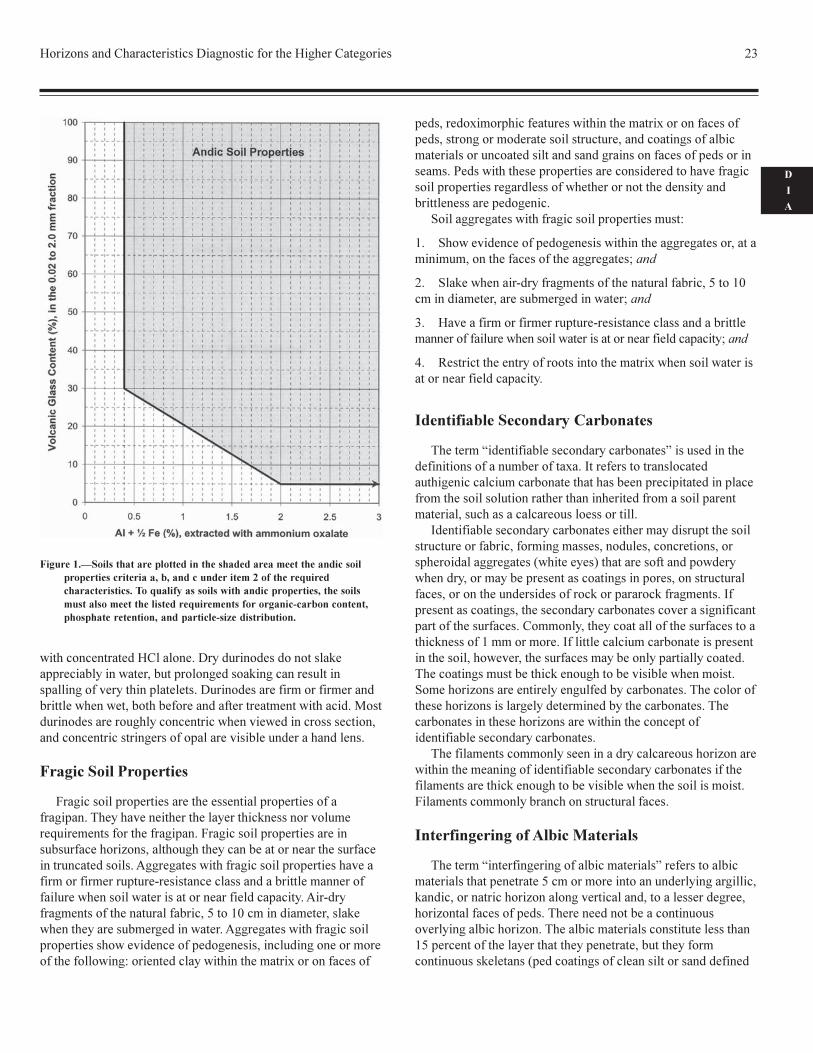
����� ���������������������� ��� ���� ������ ���������� ���� �������������� �������
�������������
����������������������� ��� ��� �������� ��� ������� �������� ����� � ����!�������!�����������������"�� ���� �!� �!����" �������� ������� ������������������������� �� ������!��������"������ ���� �� �!#��������������!���� $����������$�!����������� ��� �������� ��������!���� $�������� �� ��!��������� ����������� �������������������� ��� ����� � ����!�������!���������������������"�� ���" �������
������������� ���� ���
������ ��� ���� $�������������������� �������%
�� &���� �������������'������ ��
� ��������$ ��������������(� �!� �������$ �����!�������)�������'���
�� ��������$ ��������������*��������� �!� �������$ �����!������+��������'���
�� &���� ����(��������'������ ��
� ��������$ ��������������)��������'���
�� ��������$ �����!�������,��������'���
(� &���� ��� �������������!��������������������� ��!� � ������������� �!���������+-.������!!���� �!�����������$ ���������!�������/ �����/�� ��$��
.�� �$������ �����!�� ��������� ���������!�� �!��$��� �� �������������� ��� ���!�"����!������!����� ���� ����������!���!� ����� ��� ���� ����� �������� ��� $������� �������� �!� "" ��������"���� ���������!�"����� ���" ����� ��� ����� �� ��������� � ����0�!������������$ ������� � �!#������������ �!�!�������$����� �����$ �����0������������������0��������"������ �����!������� ���������!������$� ��������!�������� �����������!��������!���!� ����� ��� ��������������� $������������ ��� ��������� ���� ����� ����� �� ��� ����������$� �� ����� �������!�������!�� �!������������������ $��������� ���!���������������!��� �!#����� � �����!�"������
� ����������������
��!������"��"�������������� �������������"����������� ��� ��� ���������� ���"� ������ ������������!������� ������/���������"��������������������� ��� ������ � ��������!�1 ���"����2��������!������!�������� �� ���"� ����������3,+��!��������������������45���&���3,+��� ����������������!�!��� ������� ����� ������"�� � �!������" ������ ��� ������� �� ��� ��������������$��� ��� � ��������� ��$��� ��� � ��������� �� �����������"�������� �����!�������������� ���6�����������������!������!���
������������� ���� ���
���������� �0�!� ��� $� � �!������"��"����������� ��� ������������ ��������� ���+�"������������� ������ ��� ����� �!�������������� ��������������� ���6��������%
�� 7���������/� ������ ������������������������ %
� ���8��#��9��"������ ������� ��������� � ������� �� ��:�"��������������'���
�� �������!��������� ����!� ��((��; �� ����������������:�3:� #�����������'���
�� ��"���"� ���������������<+�"��������������'���
�� 7���������/� ������ ������ �"���"� ����������������+"����������������(:�"���������������" �������:�:�������:������0��� �!������������������� %
� ���8��#��9��"������ ������� ��������� � ������� �� :�*������������������/� ������ ����'���
�� ��$��� ��� � ��������������+�"����������������������:������:������ ����'���
�� =����8��#��9���"���������� ��������� � ����������+�)�+�>�8�= � ������������"������>�?�()��+���������
������� !�!� �� ���� ������������ ��������� �� ������ �!����
� ���������� ���� �
����!��������!������@������������ ��������������������� ��$��� �����������������!�!������� �!������� �� �����"��� �������������!���"��� ������� �!�����"���"� �������� ���������� ��+:����� �����6�$ �����������!������������!���� ������ ��������� �!������������������������ ���������"��� �������������"�� �������������� ��:��&�
������� ������ ����� ��������������
�������������������� ��������������&A�B��������� ���������!����������������������������� ��� �!�!������ ������ ����!������!������ ����7��������/��!�#�!�������������������� ��� ��((�; �������� �!��!���������� ��������!����&A�B�� ����� ���� ��!����������!�����������������!����������������!���������� �!������!����������� ������&A�B�� ������ ���� ��!���������!������ ���� �����!�� ����������������"����� ����!�����!������!����� �����!�� " ���� �!� �� ������������!�� �!��!��&A�B�!�������� ""�������������� �������$�������
���� ���
5����!�������������� �!�� �!������������� ����� ����������!�����!�� ��!���!��������� �! �����������������������������������A
���"����� �����" �� �!���������� ����������
������ ��5����!������ ��!������������������ ��!��AC� ������� ����������C&���������$��� ���� ��������!��������� ��!���
C��0���� �!�&� � ���������5 ��������������C ����& �� ���� �(
�
�
�
������������ ��!�C&�� ������5���!����!���!�������� �� ""��� ������� ���������"����� �!��� �� �� �����������" ��� ����$��������"� ��������5����!��� ���������������� �!����������������������������� �!� �������� ���������� �!��D���!����!��� ������ �������������������$���!���������������� �!��������������� ��������" �� ���$�������!��� �� �!������
��� ���������������
9� ������"��"������ ������������� ��"��"��������� �� " ��������� $�������������� �����������������$�������6������������������� " ���9� ������"��"������ ����������� ������0����� ����� �������� ����� ������� ���������� ��������� ��!�������� �� ���������� ������"��"������� $�� ���������������"����/����� ������ ��� �!� ��������� �������� ��������������� ������ ������� �����!�� " �������/!���� �������������� ��� ��� �����+�����:������! ��������� ������������ ��������� �!���� ������ �� ���������� �����"��"������������$!��������"�!� �����������!� �������������������������� %�������!��� ������������ ����������� ������
"�!�����!�����"����� ���������������� ����������� ������"�!�������� ������!�� ������������������ �!��� �� ����� ���� ��� ���������� ��!����� �!�� �!� � ������� �������"�!�������� ����;�!������������"��"������ �������!���!����� $���� �����"��"�������� �!���������������������������!������ �!����������� ���"�!� ����
��� �� ���������� ������"��"����������%
�� �����$!��������"�!� ��������������� �� �������� �� ��������������� ����������� �� ���'���
�� � �������� �/!����� �������������� ��� ��� �����+�����:�����! ������� ��������� �!���� ���'���
(� C $�� ����������������"����/����� ������ ��� �!� �������� ��������� ��������������� ������ ������� �����!�� " ���'���
*� .����������������������������������� �������������� ����� ������� �����!�� " ����
!� ���������� ���������� ��
���������1!���� ���������! ���� ���� ���2������!������!����������� ������������ � ��7�������������� ����� ��! ��� ����� ������ ���� ����� ��� �������"���"� ��!���"� ������������������������ ������� ��������!������ �����" ����� ��� �������� �� �� �� �������������������
7!���� ���������! ���� ���� ����������� ��!���"����������������������� ���������� �� ��������!���������������������"����! �� �� ������������������ �� �������� �!�"��!��������!�������� �����"������� ���� �� ����"����������������� �� �����������������!���!��������������" � ������� �������7�"������� ���� �� ������������! ���� ���� ������$��� �� ��� ��" �������������� �����&���������������� �� �������������� ������� ��������������������������7��������� ������ ���� �����"���������������������$������������ ����� ����������" �� ������ ��!������� �� ������������������� ��������$����������������������0���� ������������� ����!����� ���� ��������������������������0������� � ����!�������!��������� ���� ��������� ���� ���������������0���� �����������������"����!���� ���������! ���� ���� ����
������ ���������������������� �!���� �� ���������0��� ������������� �� ����!���� ���������! ���� ���� ����������� ������ ������������ ��������$�������������������������9� ����������������� ��������������� ��� ����
! ��� �� �����������������
���������1������ ��� ���� ����� ��� ��2����������� ���� ��� ����� ��"����� ���+���������������� ����!����� � � ����� �!������� �������0��� ��� �$���� �� �!����� ��������!� �������0��� ��� �������"�!������������!�������� �����������$����� � �������0�������� ����� ��� �������������������� ��+�"��������������� ������ �������"����� ��������������������������������� ����"�!��� �� �������� ���������� �!�!����!
������� ���������������������������������������������������������������������������������������������������������� �������!������������������������������������������������������������"���������������������������������������"��#�������������
24 Keys to Soil Taxonomy
by Brewer, 1976) 1 mm or more thick on the vertical faces ofpeds, which means a total width of 2 mm or more betweenabutting peds. Because quartz is such a common constituent ofsilt and sand, these skeletans are usually light gray when moistand nearly white when dry, but their color is determined in largepart by the color of the sand or silt fraction.
Required Characteristics
Interfingering of albic materials is recognized if albicmaterials:
1. Penetrate 5 cm or more into an underlying argillic or natrichorizon; and
2. Are 2 mm or more thick between vertical faces of abuttingpeds; and
3. Constitute less than 15 percent (by volume) of the layer thatthey penetrate.
Lamellae
A lamella is an illuvial horizon less than 7.5 cm thick. Eachlamella contains an accumulation of oriented silicate clay on orbridging sand and silt grains (and rock fragments if any arepresent). A lamella has more silicate clay than the overlyingeluvial horizon.
Required Characteristics
A lamella is an illuvial horizon less than 7.5 cm thick formedin unconsolidated regolith more than 50 cm thick. Each lamellacontains an accumulation of oriented silicate clay on or bridgingthe sand and silt grains (and coarse fragments if any arepresent). Each lamella is required to have more silicate clay thanthe overlying eluvial horizon.
Lamellae occur in a vertical series of two or more, and eachlamella must have an overlying eluvial horizon. (An eluvialhorizon is not required above the uppermost lamella if the soil istruncated.)
Lamellae may meet the requirements for either a cambic oran argillic horizon. A combination of two or more lamellae 15cm or more thick is a cambic horizon if the texture is very finesand, loamy very fine sand, or finer. A combination of two ormore lamellae meets the requirements for an argillic horizon ifthere is 15 cm or more cumulative thickness of lamellae that are0.5 cm or more thick and that have a clay content of either:
1. 3 percent or more (absolute) higher than in the overlyingeluvial horizon (e.g., 13 percent versus 10 percent) if any part ofthe eluvial horizon has less than 15 percent clay in the fine-earthfraction; or
2. 20 percent or more (relative) higher than in the overlyingeluvial horizon (e.g., 24 percent versus 20 percent) if all parts ofthe eluvial horizon have more than 15 percent clay in the fine-earth fraction.
Linear Extensibility (LE)
Linear extensibility (LE) helps to predict the potential of asoil to shrink and swell. The LE of a soil layer is the product ofthe thickness, in cm, multiplied by the COLE of the layer inquestion. The LE of a soil is the sum of these products for allsoil horizons.
Lithologic Discontinuities
Lithologic discontinuities are significant changes in particle-size distribution or mineralogy that represent differences inlithology within a soil. A lithologic discontinuity can also denotean age difference. For information on using horizon designationsfor lithologic discontinuities, see the Soil Survey Manual(USDA, SCS, 1993).
Not everyone agrees on the degree of change required for alithologic discontinuity. No attempt is made to quantifylithologic discontinuities. The discussion below is meant toserve as a guideline.
Several lines of field evidence can be used to evaluatelithologic discontinuities. In addition to mineralogical andtextural differences that may require laboratory studies, certainobservations can be made in the field. These include but are notlimited to the following:
1. Abrupt textural contacts.—An abrupt change inparticle-size distribution, which is not solely a change in claycontent resulting from pedogenesis, can often be observed.
2. Contrasting sand sizes.—Significant changes in sandsize can be detected. For example, if material containing mostlymedium sand or finer sand abruptly overlies material containingmostly coarse sand and very coarse sand, one can assume thatthere are two different materials. Although the materials may beof the same mineralogy, the contrasting sand sizes result fromdifferences in energy at the time of deposition by water and/orwind.
3. Bedrock lithology vs. rock fragment lithology in thesoil.—If a soil with rock fragments overlies a lithic contact, onewould expect the rock fragments to have a lithology similar tothat of the material below the lithic contact. If many of the rockfragments do not have the same lithology as the underlyingbedrock, the soil is not derived completely from the underlyingbedrock.
4. Stone lines.—The occurrence of a horizontal line ofrock fragments in the vertical sequence of a soil indicates thatthe soil may have developed in more than one kind of parentmaterial. The material above the stone line is most likelytransported, and the material below may be of different origin.
5. Inverse distribution of rock fragments.—A lithologicdiscontinuity is often indicated by an erratic distribution of rockfragments. The percentage of rock fragments decreases withincreasing depth. This line of evidence is useful in areas of soilsthat have relatively unweathered rock fragments.
6. Rock fragment weathering rinds.—Horizons
Horizons and Characteristics Diagnostic for the Higher Categories 25
D
I
A
containing rock fragments with no rinds that overlie horizonscontaining rocks with rinds suggest that the upper material is inpart depositional and not related to the lower part in time andperhaps in lithology.
7. Shape of rock fragments.—A soil with horizonscontaining angular rock fragments overlying horizons containingwell rounded rock fragments may indicate a discontinuity. Thisline of evidence represents different mechanisms of transport(colluvial vs. alluvial) or even different transport distances.
8. Soil color.—Abrupt changes in color that are not theresult of pedogenic processes can be used as indicators ofdiscontinuity.
9. Micromorphological features.—Marked differences inthe size and shape of resistant minerals in one horizon and not inanother are indicators of differences in materials.
Use of Laboratory Data
Discontinuities are not always readily apparent in the field. Inthese cases laboratory data are necessary. Even with laboratorydata, detecting discontinuities may be difficult. The decision is aqualitative or perhaps a partly quantitative judgment. Generalconcepts of lithology as a function of depth might include:
1. Laboratory data—visual scan.—The array oflaboratory data is assessed in an attempt to determine if a field-designated discontinuity is corroborated and if any data showevidence of a discontinuity not observed in the field. One mustsort changes in lithology from changes caused by pedogenicprocesses. In most cases the quantities of sand and coarserfractions are not altered significantly by soil-forming processes.Therefore, an abrupt change in sand size or sand mineralogy is aclue to lithologic change. Gross soil mineralogy and the resistantmineral suite are other clues.
2. Data on a clay-free basis.—A common manipulation inassessing lithologic change is computation of sand and siltseparates on a carbonate-free, clay-free basis (percent fraction,e.g., fine sand and very fine sand, divided by percent sand plussilt, times 100). Clay distribution is subject to pedogenic changeand may either mask inherited lithologic differences or producedifferences that are not inherited from lithology. The numericalarray computed on a clay-free basis can be inspected visually orplotted as a function of depth.
Another aid used to assess lithologic changes is computationof the ratios of one sand separate to another. The ratios can becomputed and examined as a numerical array, or they can beplotted. The ratios work well if sufficient quantities of the twofractions are available. Low quantities magnify changes inratios, especially if the denominator is low.
n Value
The n value (Pons and Zonneveld, 1965) characterizes therelation between the percentage of water in a soil under fieldconditions and its percentages of inorganic clay and humus. Then value is helpful in predicting whether a soil can be grazed by
livestock or can support other loads and in predicting whatdegree of subsidence would occur after drainage.
For mineral soil materials that are not thixotropic, the n valuecan be calculated by the following formula:
n = (A - 0.2R)/(L + 3H)In this formula, A is the percentage of water in the soil in
field condition, calculated on a dry-soil basis; R is thepercentage of silt plus sand; L is the percentage of clay; and H isthe percentage of organic matter (percent organic carbonmultiplied by 1.724).
Few data for calculations of the n value are available in theUnited States, but the critical n value of 0.7 can beapproximated closely in the field by a simple test of squeezing asoil sample in the hand. If the soil flows between the fingerswith difficulty, the n value is between 0.7 and 1.0 (slightly fluidmanner of failure class); if the soil flows easily between thefingers, the n value is 1 or more (moderately fluid or very fluidmanner of failure class).
Petroferric Contact
A petroferric (Gr. petra, rock, and L. ferrum, iron; implyingironstone) contact is a boundary between soil and a continuouslayer of indurated material in which iron is an important cementand organic matter is either absent or present only in traces. Theindurated layer must be continuous within the limits of eachpedon, but it may be fractured if the average lateral distancebetween fractures is 10 cm or more. The fact that this ironstonelayer contains little or no organic matter distinguishes it from aplacic horizon and an indurated spodic horizon (ortstein), bothof which contain organic matter.
Several features can aid in making the distinction between alithic contact and a petroferric contact. First, a petroferriccontact is roughly horizontal. Second, the material directlybelow a petroferric contact contains a high amount of iron(normally 30 percent or more Fe
2O
3). Third, the ironstone sheets
below a petroferric contact are thin; their thickness ranges froma few centimeters to very few meters. Sandstone, on the otherhand, may be thin or very thick, may be level-bedded or tilted,and may contain only a small percentage of Fe
2O
3. In the
Tropics, the ironstone is generally more or less vesicular.
Plinthite
Plinthite (Gr. plinthos, brick) is an iron-rich, humus-poormixture of clay with quartz and other minerals. It commonlyoccurs as dark red redox concentrations that usually form platy,polygonal, or reticulate patterns. Plinthite changes irreversiblyto an ironstone hardpan or to irregular aggregates on exposure torepeated wetting and drying, especially if it is also exposed toheat from the sun. The lower boundary of a zone in whichplinthite occurs generally is diffuse or gradual, but it may beabrupt at a lithologic discontinuity.
Generally, plinthite forms in a horizon that is saturated with
26 Keys to Soil Taxonomy
water for some time during the year. Initially, iron is normallysegregated in the form of soft, more or less clayey, red or darkred redox concentrations. These concentrations are notconsidered plinthite unless there has been enough segregation ofiron to permit their irreversible hardening on exposure torepeated wetting and drying. Plinthite is firm or very firm whenthe soil moisture content is near field capacity and hard whenthe moisture content is below the wilting point. Plinthite doesnot harden irreversibly as a result of a single cycle of drying andrewetting. After a single drying, it will remoisten and then canbe dispersed in large part if one shakes it in water with adispersing agent.
In a moist soil, plinthite is soft enough to be cut with a spade.After irreversible hardening, it is no longer considered plinthitebut is called ironstone. Indurated ironstone materials can bebroken or shattered with a spade but cannot be dispersed if oneshakes tham in water with a dispersing agent.
Resistant Minerals
Several references are made to resistant minerals in thistaxonomy. Obviously, the stability of a mineral in the soil is apartial function of the soil moisture regime. Where resistantminerals are referred to in the definitions of diagnostic horizonsand of various taxa, a humid climate, past or present, is alwaysassumed.
Resistant minerals are durable minerals in the 0.02 to 2.0 mmfraction. Examples are quartz, zircon, tourmaline, beryl,anatase, rutile, iron oxides and oxyhydroxides, 1:1 dioctahedralphyllosilicates (kandites), gibbsite, and hydroxy-alluminuminterlayered 2:1 minerals (USDA, in press).
Slickensides
Slickensides are polished and grooved surfaces and generallyhave dimensions exceeding 5 cm. They are produced when onesoil mass slides past another. Some slickensides occur at thelower boundary of a slip surface where a mass of soil movesdownward on a relatively steep slope. Slickensides resultdirectly from the swelling of clay minerals and shear failure.They are very common in swelling clays that undergo markedchanges in moisture content.
Spodic Materials
Spodic materials form in an illuvial horizon that normallyunderlies a histic, ochric, or umbric epipedon or an albichorizon. In most undisturbed areas, spodic materials underlie analbic horizon. They may occur within an umbric epipedon or anAp horizon.
A horizon consisting of spodic materials normally has anoptical-density-of-oxalate-extract (ODOE) value of 0.25 ormore, and that value is commonly at least 2 times as high as theODOE value in an overlying eluvial horizon. This increase in
ODOE value indicates an accumulation of translocated organicmaterials in an illuvial horizon. Soils with spodic materials showevidence that organic materials and aluminum, with or withoutiron, have been moved from an eluvial horizon to an illuvialhorizon.
Definition of Spodic Materials
Spodic materials are mineral soil materials that do not haveall of the properties of an argillic or kandic horizon; aredominated by active amorphous materials that are illuvial andare composed of organic matter and aluminum, with or withoutiron; and have both of the following:
1. A pH value in water (1:1) of 5.9 or less and an organic-carbon content of 0.6 percent or more; and
2. One or both of the following:
a. An overlying albic horizon that extends horizontallythrough 50 percent or more of each pedon and, directly underthe albic horizon, colors, moist (crushed and smoothedsample), as follows:
(1) Hue of 5YR or redder; or
(2) Hue of 7.5YR, color value of 5 or less, and chromaof 4 or less; or
(3) Hue of 10YR or neutral and a color value andchroma of 2 or less; or
(4) A color of 10YR 3/1; or
b. With or without an albic horizon and one of the colorslisted above or hue of 7.5YR, color value, moist, of 5 or less,chroma of 5 or 6 (crushed and smoothed sample), and one ormore of the following morphological or chemical properties:
(1) Cementation by organic matter and aluminum, withor without iron, in 50 percent or more of each pedon and avery firm or firmer rupture-resistance class in thecemented part; or
(2) 10 percent or more cracked coatings on sand grains;or
(3) Al + 1/2 Fe percentages (by ammonium oxalate)totaling 0.50 or more, and half that amount or less in anoverlying umbric (or subhorizon of an umbric) epipedon,ochric epipedon, or albic horizon; or
(4) An optical-density-of-oxalate-extract (ODOE) valueof 0.25 or more, and a value half as high or lower in anoverlying umbric (or subhorizon of an umbric) epipedon,ochric epipedon, or albic horizon.
Weatherable Minerals
Several references are made to weatherable minerals in thistaxonomy. Obviously, the stability of a mineral in a soil is a
Horizons and Characteristics Diagnostic for the Higher Categories 27
D
I
A
partial function of the soil moisture regime. Where weatherableminerals are referred to in the definitions of diagnostic horizonsand of various taxa in this taxonomy, a humid climate, eitherpresent or past, is always assumed. Examples of the mineralsthat are included in the meaning of weatherable minerals are all2:1 phyllosilicates, chlorite, sepiolite, palygorskite, allophane,1:1 trioctahedral phyllosilicates (serpentines), feldspars,feldspathoids, ferromagnesian minerals, glass, zeolites,dolomite, and apatite in the 0.02 to 2.0 mm fraction.
Obviously, this definition of the term “weatherable minerals”is restrictive. The intent is to include, in the definitions ofdiagnostic horizons and various taxa, onlythose weatherable minerals that are unstable in a humid climatecompared to other minerals, such as quartz and 1:1 lattice clays,but that are more resistant to weathering than calcite. Calcite,carbonate aggregates, gypsum, and halite are not consideredweatherable minerals because they are mobile in the soil. Theyappear to be recharged in some otherwise strongly weatheredsoils.
Characteristics Diagnostic forOrganic Soils
Following is a description of the characteristics that are usedonly with organic soils.
Kinds of Organic Soil MaterialsThree different kinds of organic soil materials are
distinguished in this taxonomy, based on the degree ofdecomposition of the plant materials from which the organicmaterials are derived. The three kinds are (1) fibric, (2) hemic,and (3) sapric. Because of the importance of fiber content in thedefinitions of these materials, fibers are defined before the kindsof organic soil materials.
Fibers
Fibers are pieces of plant tissue in organic soil materials(excluding live roots) that:
1. Are large enough to be retained on a 100-mesh sieve(openings 0.15 mm across) when the materials are screened; and
2. Show evidence of the cellular structure of the plants fromwhich they are derived; and
3. Either are 2 cm or less in their smallest dimension or aredecomposed enough to be crushed and shredded with thefingers.
Pieces of wood that are larger than 2 cm in cross sectionand are so undecomposed that they cannot be crushed andshredded with the fingers, such as large branches, logs, and
stumps, are not considered fibers but are considered coarsefragments (comparable to gravel, stones, and boulders inmineral soils).
Fibric Soil Materials
Fibric soil materials are organic soil materials that either:
1. Contain three-fourths or more (by volume) fibers afterrubbing, excluding coarse fragments; or
2. Contain two-fifths or more (by volume) fibers after rubbing,excluding coarse fragments, and yield color values and chromasof 7/1, 7/2, 8/1, 8/2, or 8/3 (fig. 2) on white chromatographic orfilter paper that is inserted into a paste made of the soil materialsin a saturated sodium-pyrophosphate solution.
Hemic Soil Materials
Hemic soil materials (Gr. hemi, half; implying intermediatedecomposition) are intermediate in their degree ofdecomposition between the less decomposed fibric and moredecomposed sapric materials. Their morphological features giveintermediate values for fiber content, bulk density, and watercontent. Hemic soil materials are partly altered both physicallyand biochemically.
Sapric Soil Materials
Sapric soil materials (Gr. sapros, rotten) are the most highlydecomposed of the three kinds of organic soil materials. Theyhave the smallest amount of plant fiber, the highest bulk density,and the lowest water content on a dry-weight basis at saturation.Sapric soil materials are commonly very dark gray to black.They are relatively stable; i.e., they change very little physicallyand chemically with time in comparison to other organic soilmaterials.
Sapric materials have the following characteristics:
1. The fiber content, after rubbing, is less than one-sixth (byvolume), excluding coarse fragments; and
2. The color of the sodium-pyrophosphate extract on whitechromatographic or filter paper is below or to the right of a linedrawn to exclude blocks 5/1, 6/2, and 7/3 (Munsell designations,fig. 2). If few or no fibers can be detected and the color of thepyrophosphate extract is to the left of or above this line, thepossibility that the material is limnic must be considered.
Humilluvic Material
Humilluvic material, i.e., illuvial humus, accumulates in thelower parts of some organic soils that are acid and have beendrained and cultivated. The humilluvic material has a C14 agethat is not older than the overlying organic materials. It has very
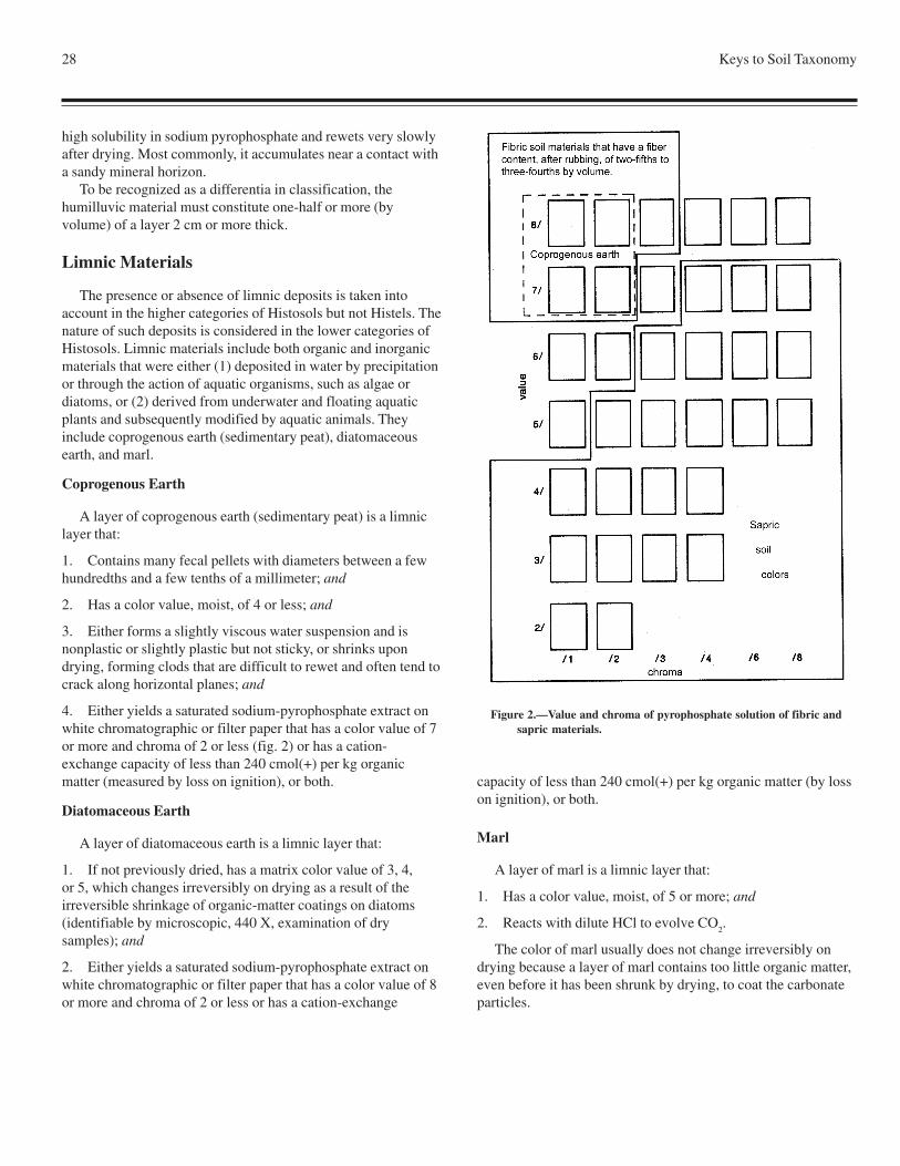
28 Keys to Soil Taxonomy
high solubility in sodium pyrophosphate and rewets very slowlyafter drying. Most commonly, it accumulates near a contact witha sandy mineral horizon.
To be recognized as a differentia in classification, thehumilluvic material must constitute one-half or more (byvolume) of a layer 2 cm or more thick.
Limnic Materials
The presence or absence of limnic deposits is taken intoaccount in the higher categories of Histosols but not Histels. Thenature of such deposits is considered in the lower categories ofHistosols. Limnic materials include both organic and inorganicmaterials that were either (1) deposited in water by precipitationor through the action of aquatic organisms, such as algae ordiatoms, or (2) derived from underwater and floating aquaticplants and subsequently modified by aquatic animals. Theyinclude coprogenous earth (sedimentary peat), diatomaceousearth, and marl.
Coprogenous Earth
A layer of coprogenous earth (sedimentary peat) is a limniclayer that:
1. Contains many fecal pellets with diameters between a fewhundredths and a few tenths of a millimeter; and
2. Has a color value, moist, of 4 or less; and
3. Either forms a slightly viscous water suspension and isnonplastic or slightly plastic but not sticky, or shrinks upondrying, forming clods that are difficult to rewet and often tend tocrack along horizontal planes; and
4. Either yields a saturated sodium-pyrophosphate extract onwhite chromatographic or filter paper that has a color value of 7or more and chroma of 2 or less (fig. 2) or has a cation-exchange capacity of less than 240 cmol(+) per kg organicmatter (measured by loss on ignition), or both.
Diatomaceous Earth
A layer of diatomaceous earth is a limnic layer that:
1. If not previously dried, has a matrix color value of 3, 4,or 5, which changes irreversibly on drying as a result of theirreversible shrinkage of organic-matter coatings on diatoms(identifiable by microscopic, 440 X, examination of drysamples); and
2. Either yields a saturated sodium-pyrophosphate extract onwhite chromatographic or filter paper that has a color value of 8or more and chroma of 2 or less or has a cation-exchange
capacity of less than 240 cmol(+) per kg organic matter (by losson ignition), or both.
Marl
A layer of marl is a limnic layer that:
1. Has a color value, moist, of 5 or more; and
2. Reacts with dilute HCl to evolve CO2.
The color of marl usually does not change irreversibly ondrying because a layer of marl contains too little organic matter,even before it has been shrunk by drying, to coat the carbonateparticles.
Figure 2.—Value and chroma of pyrophosphate solution of fibric andsapric materials.
Horizons and Characteristics Diagnostic for the Higher Categories 29
D
I
A
Thickness of Organic Soil Materials(Control Section of Histosols and Histels)
The thickness of organic materials over limnic materials,mineral materials, water, or permafrost is used to define theHistosols and Histels.
For practical reasons, an arbitrary control section has beenestablished for the classification of Histosols and Histels.Depending on the kinds of soil material in the surface layer, thecontrol section has a thickness of either 130 cm or 160 cm fromthe soil surface if there is no densic, lithic, or paralithic contact,thick layer of water, or permafrost within the respective limit.The thicker control section is used if the surface layer to a depthof 60 cm either contains three-fourths or more fibers derivedfrom Sphagnum, Hypnum, or other mosses or has a bulk densityof less than 0.1. Layers of water, which may be between a fewcentimeters and many meters thick in these soils, are consideredto be the lower boundary of the control section only if the waterextends below a depth of 130 or 160 cm, respectively. A densic,lithic, or paralithic contact, if shallower than 130 or 160 cm,constitutes the lower boundary of the control section. In somesoils the lower boundary is 25 cm below the upper limit ofpermafrost. An unconsolidated mineral substratum shallowerthan thoselimits does not change the lower boundary of the controlsection.
The control section of Histosols and Histels is dividedsomewhat arbitrarily into three tiers—surface, subsurface, andbottom tiers.
Surface Tier
The surface tier of a Histosol or Histel extends from the soilsurface to a depth of 60 cm if either (1) the materials within thatdepth are fibric and three-fourths or more of the fiber volume isderived from Sphagnum or other mosses or (2) the materialshave a bulk density of less than 0.1. Otherwise, the surface tierextends from the soil surface to a depth of 30 cm.
Some organic soils have a mineral surface layer less than 40cm thick as a result of flooding, volcanic eruptions, additions ofmineral materials to increase soil strength or reduce the hazardof frost, or other causes. If such a mineral layer is less than 30cm thick, it constitutes the upper part of the surface tier; if it is30 to 40 cm thick, it constitutes the whole surface tier and partof the subsurface tier.
Subsurface Tier
The subsurface tier is normally 60 cm thick. If the controlsection ends at a shallower depth (at a densic, lithic, orparalithic contact or a water layer or in permafrost), however,the subsurface tier extends from the lower boundary of thesurface tier to the lower boundary of the control section. It
includes any unconsolidated mineral layers that may be presentwithin those depths.
Bottom Tier
The bottom tier is 40 cm thick unless the control section hasits lower boundary at a shallower depth (at a densic, lithic, orparalithic contact or a water layer or in permafrost).
Thus, if the organic materials are thick, there are two possiblethicknesses of the control section, depending on the presence orabsence and the thickness of a surface mantle of fibric moss orother organic material that has a low bulk density (less than 0.1).If the fibric moss extends to a depth of 60 cm and is thedominant material within this depth (three-fourths or more of thevolume), the control section is 160 cm thick. If the fibric moss isthin or absent, the control section extends to a depth of 130 cm.
Horizons and CharacteristicsDiagnostic for Both Mineral andOrganic Soils
Following are descriptions of the horizons and characteristicsthat are diagnostic for both mineral and organic soils.
Aquic Conditions
Soils with aquic (L. aqua, water) conditions are those thatcurrently undergo continuous or periodic saturation andreduction. The presence of these conditions is indicated byredoximorphic features, except in Histosols and Histels, and canbe verified by measuring saturation and reduction, except inartificially drained soils. Artificial drainage is defined here asthe removal of free water from soils having aquic conditions bysurface mounding, ditches, or subsurface tiles to the extent thatwater table levels are changed significantly in connection withspecific types of land use. In the keys, artificially drained soilsare included with soils that have aquic conditions.
Elements of aquic conditions are as follows:
1. Saturation is characterized by zero or positive pressure inthe soil water and can generally be determined by observing freewater in an unlined auger hole. Problems may arise, however, inclayey soils with peds, where an unlined auger hole may fill withwater flowing along faces of peds while the soil matrix is andremains unsaturated (bypass flow). Such free water mayincorrectly suggest the presence of a water table, while theactual water table occurs at greater depth. Use of well sealedpiezometers or tensiometers is therefore recommended formeasuring saturation. Problems may still occur, however, ifwater runs into piezometer slits near the bottom of thepiezometer hole or if tensiometers with slowly reactingmanometers are used. The first problem can be overcome byusing piezometers with smaller slits and the second by usingtransducer tensiometry, which reacts faster than manometers.
30 Keys to Soil Taxonomy
Soils are considered wet if they have pressure heads greater than-1 kPa. Only macropores, such as cracks between peds orchannels, are then filled with air, while the soil matrix is usuallystill saturated. Obviously, exact measurements of the wet statecan be obtained only with tensiometers. For operationalpurposes, the use of piezometers is recommended as a standardmethod.
The duration of saturation required for creating aquicconditions varies, depending on the soil environment, and is notspecified.
Three types of saturation are defined:
a. Endosaturation.—The soil is saturated with water in alllayers from the upper boundary of saturation to a depth of200 cm or more from the mineral soil surface.
b. Episaturation.—The soil is saturated with water in oneor more layers within 200 cm of the mineral soil surface andalso has one or more unsaturated layers, with an upperboundary above a depth of 200 cm, below the saturated layer.The zone of saturation, i.e., the water table, is perched on topof a relatively impermeable layer.
c. Anthric saturation.—This term refers to a special kind ofaquic conditions that occur in soils that are cultivated andirrigated (flood irrigation). Soils with anthraquic conditionsmust meet the requirements for aquic conditions and inaddition have both of the following:
(1) A tilled surface layer and a directly underlyingslowly permeable layer that has, for 3 months or more innormal years, both:
(a) Saturation and reduction; and
(b) Chroma of 2 or less in the matrix; and
(2) A subsurface horizon with one or more of thefollowing:
(a) Redox depletions with a color value, moist, of 4or more and chroma of 2 or less in macropores; or
(b) Redox concentrations of iron; or
(c) 2 times or more the amount of iron (by dithionitecitrate) contained in the tilled surface layer.
2. The degree of reduction in a soil can be characterized bythe direct measurement of redox potentials. Directmeasurements should take into account chemical equilibria asexpressed by stability diagrams in standard soil textbooks.Reduction and oxidation processes are also a function of soilpH. Obtaining accurate measurements of the degree of reductionin a soil is difficult. In the context of this taxonomy, however,only a degree of reduction that results in reduced iron isconsidered, because it produces the visible redoximorphicfeatures that are identified in the keys. A simple field test isavailable to determine if reduced iron ions are present. A freshlybroken surface of a field-wet soil sample is treated with
alpha,alpha-dipyridyl in neutral, 1-normal ammonium-acetatesolution. The appearance of a strong red color on the freshlybroken surface indicates the presence of reduced iron ions. Apositive reaction to the alpha,alpha-dipyridyl field test forferrous iron (Childs, 1981) may be used to confirm the existenceof reducing conditions and is especially useful in situationswhere, despite saturation, normal morphological indicators ofsuch conditions are either absent or obscured (as by the darkcolors characteristic of melanic great groups). A negativereaction, however, does not imply that reducing conditions arealways absent. It may only mean that the level of free iron in thesoil is below the sensitivity limit of the test or that the soil is inan oxidized phase at the time of testing. Use of alpha,alpha-dipyridyl in a 10 percent acetic-acid solution is notrecommended because the acid is likely to change soilconditions, for example, by dissolving CaCO
3.
The duration of reduction required for creating aquicconditions is not specified.
3. Redoximorphic features associated with wetness result fromalternating periods of reduction and oxidation of iron andmanganese compounds in the soil. Reduction occurs duringsaturation with water, and oxidation occurs when the soil is notsaturated. The reduced iron and manganese ions are mobile andmay be transported by water as it moves through the soil.Certain redox patterns occur as a function of the patterns inwhich the ion-carrying water moves through the soil and as afunction of the location of aerated zones in the soil. Redoxpatterns are also affected by the fact that manganese is reducedmore rapidly than iron, while iron oxidizes more rapidly uponaeration. Characteristic color patterns are created by theseprocesses. The reduced iron and manganese ions may beremoved from a soil if vertical or lateral fluxes of water occur,in which case there is no iron or manganese precipitation in thatsoil. Wherever the iron and manganese are oxidized andprecipitated, they form either soft masses or hard concretions ornodules. Movement of iron and manganese as a result of redoxprocesses in a soil may result in redoximorphic features that aredefined as follows:
a. Redox concentrations.—These are zones of apparentaccumulation of Fe-Mn oxides, including:
(1) Nodules and concretions, which are cementedbodies that can be removed from the soil intact.Concretions are distinguished from nodules on the basis ofinternal organization. A concretion typically hasconcentric layers that are visible to the naked eye.Nodules do not have visible organized internal structure.Boundaries commonly are diffuse if formed in situ andsharp after pedoturbation. Sharp boundaries may be relictfeatures in some soils; and
(2) Masses, which are noncemented concentrations ofsubstances within the soil matrix; and
(3) Pore linings, i.e., zones of accumulation along pores
Horizons and Characteristics Diagnostic for the Higher Categories 31
D
I
A
that may be either coatings on pore surfaces orimpregnations from the matrix adjacent to the pores.
b. Redox depletions.—These are zones of low chroma(chromas less than those in the matrix) where either Fe-Mnoxides alone or both Fe-Mn oxides and clay have beenstripped out, including:
(1) Iron depletions, i.e., zones that contain low amountsof Fe and Mn oxides but have a clay content similar tothat of the adjacent matrix (often referred to as albans orneoalbans); and
(2) Clay depletions, i.e., zones that contain low amountsof Fe, Mn, and clay (often referred to as silt coatings orskeletans).
c. Reduced matrix.—This is a soil matrix that has lowchroma in situ but undergoes a change in hue or chromawithin 30 minutes after the soil material has been exposed toair.
d. In soils that have no visible redoximorphic features, areaction to an alpha,alpha-dipyridyl solution satisfies therequirement for redoximorphic features.
Field experience indicates that it is not possible to define aspecific set of redoximorphic features that is uniquelycharacteristic of all of the taxa in one particular category.Therefore, color patterns that are unique to specific taxa arereferenced in the keys.
Anthraquic conditions are a variant of episaturation and areassociated with controlled flooding (for such crops as wetlandrice and cranberries), which causes reduction processes in thesaturated, puddled surface soil and oxidation of reduced andmobilized iron and manganese in the unsaturated subsoil.
Cryoturbation
Cryoturbation (frost churning) is the mixing of the soil matrixwithin the pedon that results in irregular or broken horizons,involutions, accumulation of organic matter on the permafrosttable, oriented rock fragments, and silt caps on rock fragments.
Densic Contact
A densic contact (L. densus, thick) is a contact betweensoil and densic materials (defined below). It has no cracks,or the spacing of cracks that roots can enter is 10 cm ormore.
Densic Materials
Densic materials are relatively unaltered materials (do notmeet the requirements for any other named diagnostic horizonsor any other diagnostic soil characteristic) that have a
noncemented rupture-resistance class. The bulk density or theorganization is such that roots cannot enter, except in cracks.These are mostly earthy materials, such as till, volcanicmudflows, and some mechanically compacted materials, forexample, mine spoils. Some noncemented rocks can be densicmaterials if they are dense or resistant enough to keep rootsfrom entering, except in cracks.
Densic materials are noncemented and thus differ fromparalithic materials and the material below a lithic contact, bothof which are cemented.
Densic materials have, at their upper boundary, a densiccontact if they have no cracks or if the spacing of cracks thatroots can enter is 10 cm or more. These materials can be used todifferentiate soil series if the materials are within the seriescontrol section.
Gelic Materials
Gelic materials are mineral or organic soil materials thatshow evidence of cryoturbation (frost churning) and/or icesegregation in the active layer (seasonal thaw layer) and/or theupper part of the permafrost. Cryoturbation is manifested byirregular and broken horizons, involutions, accumulation oforganic matter on top of and within the permafrost, orientedrock fragments, and silt-enriched layers. The characteristicstructures associated with gelic materials include platy, blocky,or granular macrostructures; the structural results of sorting; andorbiculic, conglomeric, banded, or vesicular microfabrics. Icesegregation is manifested by ice lenses, vein ice, segregated icecrystals, and ice wedges. Cryopedogenic processes that lead togelic materials are driven by the physical volume change ofwater to ice, moisture migration along a thermal gradient in thefrozen system, or thermal contraction of the frozen material bycontinued rapid cooling.
Glacic Layer
A glacic layer is massive ice or ground ice in the form of icelenses or wedges. The layer is 30 cm or more thick and contains75 percent or more visible ice.
Lithic Contact
A lithic contact is the boundary between soil and a coherentunderlying material. Except in Ruptic-Lithic subgroups, theunderlying material must be virtually continuous within thelimits of a pedon. Cracks that can be penetrated by roots arefew, and their horizontal spacing is 10 cm or more. Theunderlying material must be sufficiently coherent when moist tomake hand-digging with a spade impractical, although thematerial may be chipped or scraped with a spade. The materialbelow a lithic contact must be in a strongly cemented or morecemented rupture-resistance class. Commonly, the material isindurated. The underlying material considered here does not
32 Keys to Soil Taxonomy
include diagnostic soil horizons, such as a duripan or apetrocalcic horizon.
A lithic contact is diagnostic at the subgroup level if itis within 125 cm of the mineral soil surface in Oxisols andwithin 50 cm of the mineral soil surface in all other mineralsoils. In organic soils the lithic contact must be within thecontrol section to be recognized at the subgroup level.
Paralithic Contact
A paralithic (lithiclike) contact is a contact between soil andparalithic materials (defined below) where the paralithicmaterials have no cracks or the spacing of cracks that roots canenter is 10 cm or more.
Paralithic Materials
Paralithic materials are relatively unaltered materials (do notmeet the requirements for any other named diagnostic horizonsor any other diagnostic soil characteristic) that have anextremely weakly cemented to moderately cemented rupture-resistance class. Cementation, bulk density, and the organizationare such that roots cannot enter, except in cracks. Paralithicmaterials have, at their upper boundary, a paralithic contact ifthey have no cracks or if the spacing of cracks that roots canenter is 10 cm or more. Commonly, these materials are partiallyweathered bedrock or weakly consolidated bedrock, such assandstone, siltstone, or shale. Paralithic materials can be used todifferentiate soil series if the materials are within the seriescontrol section. Fragments of paralithic materials 2.0 mm ormore in diameter are referred to as pararock fragments.
Permafrost
Permafrost is defined as a thermal condition in which amaterial (including soil material) remains below 0 oC for 2 ormore years in succession. Those gelic materials havingpermafrost contain the unfrozen soil solution that drivescryopedogenic processes. Permafrost may be cemented by iceor, in the case of insufficient interstitial water, may be dry. Thefrozen layer has a variety of ice lenses, vein ice, segregated icecrystals, and ice wedges. The permafrost table is in dynamicequilibrium with the environment.
Soil Moisture Regimes
The term “soil moisture regime” refers to the presence orabsence either of ground water or of water held at a tension ofless than 1500 kPa in the soil or in specific horizons duringperiods of the year. Water held at a tension of 1500 kPa or moreis not available to keep most mesophytic plants alive. Theavailability of water is also affected by dissolved salts. If a soilis saturated with water that is too salty to be available to mostplants, it is considered salty rather than dry. Consequently, a
horizon is considered dry when the moisture tension is 1500 kPaor more and is considered moist if water is held at a tension ofless than 1500 kPa but more than zero. A soil may becontinuously moist in some or all horizons either throughout theyear or for some part of the year. It may be either moist in winterand dry in summer or the reverse. In the Northern Hemisphere,summer refers to June, July, and August and winter refers toDecember, January, and February.
Normal Years
In the discussions that follow and throughout the keys, theterm “normal years” is used. A normal year is defined as a yearthat has plus or minus one standard deviation of the long-termmean annual precipitation. (Long-term refers to 30 years ormore.) Also, the mean monthly precipitation during a normalyear must be plus or minus one standard deviation of the long-term monthly precipitation for 8 of the 12 months. For the mostpart, normal years can be calculated from the mean annualprecipitation. When catastrophic events occur during a year,however, the standard deviations of the monthly means shouldalso be calculated. The term “normal years” replaces the terms“most years” and “6 out of 10 years,” which were used in the1975 edition of Soil Taxonomy (USDA, SCS, 1975).
Soil Moisture Control Section
The intent in defining the soil moisture control section is tofacilitate estimation of soil moisture regimes from climatic data.The upper boundary of this control section is the depth to whicha dry (tension of more than 1500 kPa, but not air-dry) soil willbe moistened by 2.5 cm of water within 24 hours. The lowerboundary is the depth to which a dry soil will be moistened by7.5 cm of water within 48 hours. These depths do not includethe depth of moistening along any cracks or animal burrows thatare open to the surface.
If 7.5 cm of water moistens the soil to a densic, lithic,paralithic, or petroferric contact or to a petrocalcic orpetrogypsic horizon or a duripan, the contact or the upperboundary of the cemented horizon constitutes the lowerboundary of the soil moisture control section. If a soil ismoistened to one of these contacts or horizons by 2.5 cm ofwater, the soil moisture control section is the boundary or thecontact itself. The control section of such a soil is consideredmoist if the contact or upper boundary of the cemented horizonhas a thin film of water. If that upper boundary is dry, the controlsection is considered dry.
The moisture control section of a soil extends approximately(1) from 10 to 30 cm below the soil surface if the particle-sizeclass of the soil is fine-loamy, coarse-silty, fine-silty, or clayey;(2) from 20 to 60 cm if the particle-size class is coarse-loamy;and (3) from 30 to 90 cm if the particle-size class is sandy. If thesoil contains rock and pararock fragments that do not absorb andrelease water, the limits of the moisture control section aredeeper. The limits of the soil moisture control section areaffected not only by the particle-size class but also by
Horizons and Characteristics Diagnostic for the Higher Categories 33
D
I
A
differences in soil structure or pore-size distribution or by otherfactors that influence the movement and retention of water in thesoil.
Classes of Soil Moisture Regimes
The soil moisture regimes are defined in terms of the level ofground water and in terms of the seasonal presence or absenceof water held at a tension of less than 1500 kPa in the moisturecontrol section. It is assumed in the definitions that the soilsupports whatever vegetation it is capable of supporting, i.e.,crops, grass, or native vegetation, and that the amount of storedmoisture is not being increased by irrigation or fallowing. Thesecultural practices affect the soil moisture conditions as long asthey are continued.
Aquic moisture regime.—The aquic (L. aqua, water)moisture regime is a reducing regime in a soil that is virtuallyfree of dissolved oxygen because it is saturated by water. Somesoils are saturated with water at times while dissolved oxygen ispresent, either because the water is moving or because theenvironment is unfavorable for micro-organisms (e.g., if thetemperature is less than 1 oC); such a regime is not consideredaquic.
It is not known how long a soil must be saturated before it issaid to have an aquic moisture regime, but the duration must beat least a few days, because it is implicit in the concept thatdissolved oxygen is virtually absent. Because dissolved oxygenis removed from ground water by respiration of micro-organisms, roots, and soil fauna, it is also implicit in the conceptthat the soil temperature is above biologic zero for some timewhile the soil is saturated. Biologic zero is defined as 5 oC inthis taxonomy. In some of the very cold regions of the world,however, biological activity occurs at temperatures below 5 oC.
Very commonly, the level of ground water fluctuates with theseasons; it is highest in the rainy season or in fall, winter, orspring if cold weather virtually stops evapotranspiration. Thereare soils, however, in which the ground water is always at orvery close to the surface. Examples are soils in tidal marshes orin closed, landlocked depressions fed by perennial streams.Such soils are considered to have a peraquic moisture regime.
Aridic and torric (L. aridus, dry, and L. torridus, hot anddry) moisture regimes.—These terms are used for the samemoisture regime but in different categories of the taxonomy.
In the aridic (torric) moisture regime, the moisture controlsection is, in normal years:
1. Dry in all parts for more than half of the cumulative daysper year when the soil temperature at a depth of 50 cm from thesoil surface is above 5 oC; and
2. Moist in some or all parts for less than 90 consecutive dayswhen the soil temperature at a depth of 50 cm is above 8 oC.
Soils that have an aridic (torric) moisture regime normallyoccur in areas of arid climates. A few are in areas of semiaridclimates and either have physical properties that keep them dry,
such as a crusty surface that virtually precludes the infiltration ofwater, or are on steep slopes where runoff is high. There is littleor no leaching in this moisture regime, and soluble saltsaccumulate in the soils if there is a source.
The limits set for soil temperature exclude from thesemoisture regimes soils in the very cold and dry polar regionsand in areas at high elevations. Such soils are considered to haveanhydrous conditions (defined earlier).
Udic moisture regime.—The udic (L. udus, humid) moistureregime is one in which the soil moisture control section is notdry in any part for as long as 90 cumulative days in normalyears. If the mean annual soil temperature is lower than 22 oCand if the mean winter and mean summer soil temperatures at adepth of 50 cm from the soil surface differ by 6 oC or more, thesoil moisture control section, in normal years, is dry in all partsfor less than 45 consecutive days in the 4 months following thesummer solstice. In addition, the udic moisture regime requires,except for short periods, a three-phase system, solid-liquid-gas,in part or all of the soil moisture control section when the soiltemperature is above5 oC.
The udic moisture regime is common to the soils of humidclimates that have well distributed rainfall; have enough rain insummer so that the amount of stored moisture plus rainfall isapproximately equal to, or exceeds, the amount ofevapotranspiration; or have adequate winter rains to rechargethe soils and cool, foggy summers, as in coastal areas. Watermoves downward through the soils at some time in normalyears.
In climates where precipitation exceeds evapotranspiration inall months of normal years, the moisture tension rarely reaches100 kPa in the soil moisture control section, although there areoccasional brief periods when some stored moisture is used. Thewater moves through the soil in all months when it is not frozen.Such an extremely wet moisture regime is called perudic (L. per,throughout in time, and L. udus, humid). In the names of mosttaxa, the formative element “ud” is used to indicate either a udicor a perudic regime; the formative element “per” is used inselected taxa.
Ustic moisture regime.—The ustic (L. ustus, burnt;implying dryness) moisture regime is intermediate between thearidic regime and the udic regime. Its concept is one of moisturethat is limited but is present at a time when conditions aresuitable for plant growth. The concept of the ustic moistureregime is not applied to soils that have permafrost or a cryic soiltemperature regime (defined below).
If the mean annual soil temperature is 22 oC or higher or ifthe mean summer and winter soil temperatures differ by lessthan 6 oC at a depth of 50 cm below the soil surface, the soilmoisture control section in areas of the ustic moisture regime isdry in some or all parts for 90 or more cumulative days innormal years. It is moist, however, in some part either for morethan 180 cumulative days per year or for 90 or more consecutivedays.
34 Keys to Soil Taxonomy
If the mean annual soil temperature is lower than 22 oC and ifthe mean summer and winter soil temperatures differ by 6 oC ormore at a depth of 50 cm from the soil surface, the soil moisturecontrol section in areas of the ustic moisture regime is dry insome or all parts for 90 or more cumulative days in normalyears, but it is not dry in all parts for more than half of thecumulative days when the soil temperature at a depth of 50 cmis higher than 5 oC. If in normal years the moisture controlsection is moist in all parts for 45 or more consecutive days inthe 4 months following the winter solstice, the moisture controlsection is dry in all parts for less than 45 consecutive days in the4 months following the summer solstice.
In tropical and subtropical regions that have a monsoonclimate with either one or two dry seasons, summer and winterseasons have little meaning. In those regions the moistureregime is ustic if there is at least one rainy season of 3 months ormore. In temperate regions of subhumid or semiarid climates,the rainy seasons are usually spring and summer or spring andfall, but never winter. Native plants are mostly annuals or plantsthat have a dormant period while the soil is dry.
Xeric moisture regime.—The xeric (Gr. xeros, dry) moistureregime is the typical moisture regime in areas of Mediterraneanclimates, where winters are moist and cool and summers arewarm and dry. The moisture, which falls during the winter, whenpotential evapotranspiration is at a minimum, is particularlyeffective for leaching. In areas of a xeric moisture regime, thesoil moisture control section, in normal years, is dry in all partsfor 45 or more consecutive days in the 4 months following thesummer solstice and moist in all parts for 45 or moreconsecutive days in the 4 months following the winter solstice.Also, in normal years, the moisture control section is moist insome part for more than half of the cumulative days per yearwhen the soil temperature at a depth of 50 cm from the soilsurface is higher than 6 oC or for 90 or more consecutive dayswhen the soil temperature at a depth of 50 cm is higher than 8oC. The mean annual soil temperature is lower than 22 oC, andthe mean summer and mean winter soil temperatures differ by 6oC or more either at a depth of 50 cm from the soil surface or ata densic, lithic, or paralithic contact if shallower.
Soil Temperature Regimes
Classes of Soil Temperature Regimes
Following is a description of the soil temperature regimesused in defining classes at various categoric levels in thistaxonomy.
Cryic (Gr. kryos, coldness; meaning very cold soils).—Soils in this temperature regime have a mean annual temperaturelower than 8 oC but do not have permafrost.
1. In mineral soils the mean summer soil temperature (June,July, and August in the Northern Hemisphere and December,
January, and February in the Southern Hemisphere) either at adepth of 50 cm from the soil surface or at a densic, lithic, orparalithic contact, whichever is shallower, is as follows:
a. If the soil is not saturated with water during some part ofthe summer and
(1) If there is no O horizon: lower than 15 oC; or
(2) If there is an O horizon: lower than 8 oC; or
b. If the soil is saturated with water during some part of thesummer and
(1) If there is no O horizon: lower than 13 oC; or
(2) If there is an O horizon or a histic epipedon: lowerthan 6 oC.
2. In organic soils the mean annual soil temperature is lowerthan 6 oC.
Cryic soils that have an aquic moisture regime commonly arechurned by frost.
Isofrigid soils could also have a cryic temperature regime. Afew with organic materials in the upper part are exceptions.
The concepts of the soil temperature regimes describedbelow are used in defining classes of soils in the low categories.
Frigid.—A soil with a frigid temperature regime iswarmer in summer than a soil with a cryic regime, but itsmean annual temperature is lower than 8 oC and the differencebetween mean summer (June, July, and August) and mean winter(December, January, and February) soil temperatures is morethan 6 oC either at a depth of 50 cm from the soil surface or at adensic, lithic, or paralithic contact, whichever is shallower.
Mesic.—The mean annual soil temperature is 8 oC or higherbut lower than 15 oC, and the difference between mean summerand mean winter soil temperatures is more than 6 oC either at adepth of 50 cm from the soil surface or at a densic, lithic, orparalithic contact, whichever is shallower.
Thermic.—The mean annual soil temperature is 15 oC orhigher but lower than 22 oC, and the difference between meansummer and mean winter soil temperatures is more than 6 oCeither at a depth of 50 cm from the soil surface or at a densic,lithic, or paralithic contact, whichever is shallower.
Hyperthermic.—The mean annual soil temperature is22 oC or higher, and the difference between mean summer andmean winter soil temperatures is more than 6 oC either at a depthof 50 cm from the soil surface or at a densic, lithic, or paralithiccontact, whichever is shallower.
If the name of a soil temperature regime has the prefix iso,the mean summer and mean winter soil temperatures differ byless than 6 oC at a depth of 50 cm or at a densic, lithic, orparalithic contact, whichever is shallower.
Isofrigid.—The mean annual soil temperature is lower than8 oC.
Horizons and Characteristics Diagnostic for the Higher Categories 35
D
I
A
Isomesic.—The mean annual soil temperature is 8 oC orhigher but lower than 15 oC.
Isothermic.—The mean annual soil temperature is 15 oC orhigher but lower than 22 oC.
Isohyperthermic.—The mean annual soil temperature is22 oC or higher.
Sulfidic Materials
Sulfidic materials contain oxidizable sulfur compounds. Theyare mineral or organic soil materials that have a pH value ofmore than 3.5 and that, if incubated as a layer 1 cm thick undermoist aerobic conditions (field capacity) at room temperature,show a drop in pH of 0.5 or more units to a pH value of 4.0 orless (1:1 by weight in water or in a minimum of water to permitmeasurement) within 8 weeks.
Sulfidic materials accumulate as a soil or sediment that ispermanently saturated, generally with brackish water. Thesulfates in the water are biologically reduced to sulfides as thematerials accumulate. Sulfidic materials most commonlyaccumulate in coastal marshes near the mouth of rivers thatcarry noncalcareous sediments, but they may occur infreshwater marshes if there is sulfur in the water. Upland sulfidicmaterials may have accumulated in a similar manner in thegeologic past.
If a soil containing sulfidic materials is drained or if sulfidicmaterials are otherwise exposed to aerobic conditions, thesulfides oxidize and form sulfuric acid. The pH value, whichnormally is near neutrality before drainage or exposure, maydrop below 3. The acid may induce the formation of iron andaluminum sulfates. The iron sulfate, jarosite, may segregate,forming the yellow redoximorphic concentrations thatcommonly characterize a sulfuric horizon. The transition fromsulfidic materials to a sulfuric horizon normally requires veryfew years and may occur within a few weeks. A sample ofsulfidic materials, if air-dried slowly in shade for about 2months with occasional remoistening, becomes extremelyacid.
Sulfuric Horizon
Required Characteristics
The sulfuric (L. sulfur) horizon is 15 cm or more thick and iscomposed of either mineral or organic soil material that has apH value of 3.5 or less (1:1 by weight in water or in a minimumof water to permit measurement) and shows evidence that thelow pH value is caused by sulfuric acid. The evidence is one ormore of the following:
1. Jarosite concentrations; or
2. Directly underlying sulfidic materials (defined above); or
3. 0.05 percent or more water-soluble sulfate.
Literature CitedBrewer, R. 1976. Fabric and Mineral Analysis of Soils.
Second edition. John Wiley and Sons, Inc. New York, NewYork.
Childs, C.W. 1981. Field Test for Ferrous Iron and Ferric-Organic Complexes (on Exchange Sites or in Water-SolubleForms) in Soils. Austr. J. of Soil Res. 19: 175-180.
Pons, L.J., and I.S. Zonneveld. 1965. Soil Ripeningand Soil Classification. Initial Soil Formation in AlluvialDeposits and a Classification of the Resulting Soils. Int. Inst.Land Reclam. and Impr. Pub. 13. Wageningen, The Netherlands.
United States Department of Agriculture, Natural ResourcesConservation Service, National Soil Survey Center. (In press.)Soil Survey Laboratory Methods Manual. Soil SurveyInvestigations Report 42, Version 4.0.
United States Department of Agriculture, Soil ConservationService. 1975. Soil Taxonomy: A Basic System of SoilClassification for Making and Interpreting Soil Surveys. SoilSurv. Staff. U.S. Dep. Agric. Handb. 436.
United States Department of Agriculture, Soil ConservationService. 1993. Soil Survey Manual. Soil Surv. Div. Staff. U.S.Dep. Agric. Handb. 18.

37
I
D
E
The taxonomic class of a specific soil can be determinedby using the keys that follow in this and other chapters. It isassumed that the reader is familiar with the definitions ofdiagnostic horizons and properties that are given in chapters 2and 3 of this publication and with the meanings of the termsused for describing soils given in the Soil Survey Manual. TheIndex at the back of this publication indicates the pages onwhich definitions of terms are given.
Standard rounding conventions should be used to determinenumerical values.
Soil colors (hue, value, and chroma) are used in many ofthe criteria that follow. Soil colors typically change value andsome change hue and chroma, depending on the water state.In many of the criteria of the keys, the water state is specified. Ifno water state is specified, the soil is considered to meetthe criterion if it does so when moist or dry or both moist anddry.
All of the keys in this taxonomy are designed in such a waythat the user can determine the correct classification of a soil bygoing through the keys systematically. The user must start at thebeginning of the “Key to Soil Orders” and eliminate, one byone, all classes that include criteria that do not fit the soil inquestion. The soil belongs to the first class listed for which itmeets all the required criteria.
In classifying a specific soil, the user of soil taxonomy beginsby checking through the “Key to Soil Orders” to determine thename of the first order that, according to the criteria listed,includes the soil in question. The next step isto go to the page indicated to find the “Key to Suborders” ofthat particular order. Then the user systematically goes throughthe key to identify the suborder that includes the soil, i.e., thefirst in the list for which it meets all the required criteria. Thesame procedure is used to find the great group class of the soilin the “Key to Great Groups” of the identified suborder.Likewise, going through the “Key to Subgroups” of that greatgroup, the user selects as the correct subgroup name the name ofthe first taxon for which the soil meets all of the requiredcriteria.
The family level is determined, in a similar manner, after thesubgroup has been determined. Chapter 17 can be used,as one would use other keys in this taxonomy, to determinewhich components are part of the family. The family,however, typically has more than one component, andtherefore the entire chapter must be used. The keys to controlsections for classes used as components of a family must be
used to determine the control section before use of the keys toclasses.
The descriptions and definitions of individual soil series arenot included in this text. Definitions of the series and of thecontrol section are given in chapter 17.
In the “Key to Soil Orders” and the other keys that follow,the diagnostic horizons and the properties mentioned do notinclude those below any densic, lithic, paralithic, or petroferriccontact. The properties of buried soils and the properties of asurface mantle are considered on the basis of whether or not thesoil meets the meaning of the term “buried soil” given in chapter 1.
If a soil has a surface mantle and is not a buried soil, the topof the original surface layer is considered the “soil surface” fordetermining depth to and thickness of diagnostic horizons andmost other diagnostic soil characteristics. The only properties ofthe surface mantle that are considered are soil temperature, soilmoisture (including aquic conditions), and any andic orvitrandic properties and family criteria.
If a soil profile includes a buried soil, the present soil surfaceis used to determine soil moisture and temperature as well asdepth to and thickness of diagnostic horizons and otherdiagnostic soil characteristics. Diagnostic horizons of the buriedsoil are not considered in selecting taxa unless the criteria in thekeys specifically indicate buried horizons, such as in Thapto-Histic subgroups. Most other diagnostic soil characteristics ofthe buried soil are not considered, but organic carbon if ofHolocene age, andic soil properties, base saturation, and allproperties used to determine family and series placement areconsidered.
Key to Soil Orders
A. Soils that have:
1. Permafrost within 100 cm of the soil surface; or
2. Gelic materials within 100 cm of the soil surface andpermafrost within 200 cm of the soil surface.
Gelisols, p. 149
B. Other soils that:
1. Do not have andic soil properties in 60 percent or moreof the thickness between the soil surface and either a depth of60 cm or a densic, lithic, or paralithic contact or duripan ifshallower; and
CHAPTER 4
Identification of the Taxonomic Class of a Soil
38 Keys to Soil Taxonomy
2. Have organic soil materials that meet one or more of thefollowing:
a. Overlie cindery, fragmental, or pumiceous materialsand/or fill their interstices1 and directly below thesematerials, have a densic, lithic, or paralithic contact;or
b. When added with the underlying cindery, fragmental,or pumiceous materials, total 40 cm or more between thesoil surface and a depth of 50 cm; or
c. Constitute two-thirds or more of the total thickness ofthe soil to a densic, lithic, or paralithic contact and haveno mineral horizons or have mineral horizons with a totalthickness of 10 cm or less; or
d. Are saturated with water for 30 days or more per yearin normal years (or are artificially drained), have an upperboundary within 40 cm of the soil surface, and have a totalthickness of either:
(1) 60 cm or more if three-fourths or more of theirvolume consists of moss fibers or if their bulk density,moist, is less than 0.1 g/cm3; or
(2) 40 cm or more if they consist either of sapric orhemic materials, or of fibric materials with less thanthree-fourths (by volume) moss fibers and a bulkdensity, moist, of 0.1 g/cm3 or more.
Histosols, p. 159
C. Other soils that do not have a plaggen epipedon or anargillic or kandic horizon above a spodic horizon, and have oneor more of the following:
1. A spodic horizon, an albic horizon in 50 percent or moreof each pedon, and a cryic soil temperature regime;or
2. An Ap horizon containing 85 percent or more spodicmaterials; or
3. A spodic horizon with all of the followingcharacteristics:
a. One or more of the following:
(1) A thickness of 10 cm or more; or
(2) An overlying Ap horizon; or
(3) Cementation in 50 percent or more of eachpedon; or
(4) A coarse-loamy, loamy-skeletal, or finer particle-size class and a frigid temperature regime in the soil; or
(5) A cryic temperature regime in the soil; and
b. An upper boundary within the following depths fromthe mineral soil surface: either
(1) Less than 50 cm; or
(2) Less than 200 cm if the soil has a sandy particle-size class in at least some part between the mineral soilsurface and the spodic horizon; and
c. A lower boundary as follows:
(1) Either at a depth of 25 cm or more below themineral soil surface or at the top of a duripan orfragipan or at a densic, lithic, paralithic, or petroferriccontact, whichever is shallowest; or
(2) At any depth,
(a) If the spodic horizon has a coarse-loamy,loamy-skeletal, or finer particle-size class and thesoil has a frigid temperature regime; or
(b) If the soil has a cryic temperature regime; and
d. Either:
(1) A directly overlying albic horizon in 50 percent ormore of each pedon; or
(2) No andic soil properties in 60 percent or more ofthe thickness either:
(a) Within 60 cm either of the mineral soil surfaceor of the top of an organic layer with andic soilproperties, whichever is shallower, if there is nodensic, lithic, or paralithic contact, duripan, orpetrocalcic horizon within that depth; or
(b) Between either the mineral soil surface or thetop of an organic layer with andic soil properties,whichever is shallower, and a densic, lithic, orparalithic contact, a duripan, or a petrocalcichorizon.
Spodosols, p. 253
D. Other soils that have andic soil properties in 60 percent ormore of the thickness either:
1. Within 60 cm either of the mineral soil surface or of thetop of an organic layer with andic soil properties, whicheveris shallower, if there is no densic, lithic, or paralithic contact,duripan, or petrocalcic horizon within that depth; or
2. Between either the mineral soil surface or the top of anorganic layer with andic soil properties, whichever isshallower, and a densic, lithic, or paralithic contact, aduripan, or a petrocalcic horizon.
Andisols, p. 83
E. Other soils that have either:
1 Materials that meet the definition of cindery, fragmental, or pumiceous but have morethan 10 percent, by volume, voids that are filled with organic soil materials are considered tobe organic soil materials.
Identification of the Taxonomic Class of a Soil 39
I
D
E
1. An oxic horizon that has its upper boundary within 150cm of the mineral soil surface and no kandic horizon that hasits upper boundary within that depth; or
2. 40 percent or more (by weight) clay in the fine-earthfraction between the mineral soil surface and a depth of 18cm (after mixing) and a kandic horizon that has theweatherable-mineral properties of an oxic horizon and has itsupper boundary within 100 cm of the mineral soil surface.
Oxisols, p. 237
F. Other soils that have:
1. A layer 25 cm or more thick, with an upper boundarywithin 100 cm of the mineral soil surface, that has eitherslickensides or wedge-shaped peds that have their long axestilted 10 to 60 degrees from the horizontal; and
2. A weighted average of 30 percent or more clay in thefine-earth fraction either between the mineral soil surface anda depth of 18 cm or in an Ap horizon, whichever is thicker,and 30 percent or more clay in the fine-earth fraction of allhorizons between a depth of 18 cm and either a depth of 50cm or a densic, lithic, or paralithic contact, a duripan, or apetrocalcic horizon if shallower; and
3. Cracks2 that open and close periodically.Vertisols, p. 285
G. Other soils that:
1. Have:
a. An aridic soil moisture regime; and
b. An ochric or anthropic epipedon; and
c. One or more of the following with the upper boundarywithin 100 cm of the soil surface: a cambic horizon with alower depth of 25 cm or more; a cryic temperature regimeand a cambic horizon; a calcic, gypsic, petrocalcic,petrogypsic, or salic horizon; or a duripan; or
d. An argillic or natric horizon; or
2. Have a salic horizon; and
a. Saturation with water in one or more layers within100 cm of the soil surface for 1 month or more during anormal year; and
b. A moisture control section that is dry in some or allparts at some time during normal years; and
c. No sulfuric horizon that has its upper boundary within150 cm of the mineral soil surface.
Aridisols, p. 103
H. Other soils that have either:
1. An argillic or kandic horizon, but no fragipan, and a basesaturation (by sum of cations) of less than 35 percent at oneof the following depths:
a. If the epipedon has a sandy or sandy-skeletal particle-size class throughout, either:
(1) 125 cm below the upper boundary of the argillichorizon (but no deeper than 200 cm below the mineralsoil surface) or 180 cm below the mineral soil surface,whichever is deeper; or
(2) At a densic, lithic, paralithic, or petroferriccontact if shallower; or
b. The shallowest of the following depths:
(1) 125 cm below the upper boundary of the argillicor kandic horizon; or
(2) 180 cm below the mineral soil surface; or
(3) At a densic, lithic, paralithic, or petroferriccontact; or
2. A fragipan and both of the following:
a. Either an argillic or a kandic horizon above, within, orbelow it or clay films 1 mm or more thick in one or moreof its subhorizons; and
b. A base saturation (by sum of cations) of less than35 percent at the shallowest of the following depths:
(1) 75 cm below the upper boundary of the fragipan;or
(2) 200 cm below the mineral soil surface; or
(3) At a densic, lithic, paralithic, or petroferriccontact.
Ultisols, p. 263
I. Other soils that have both of the following:
1. Either:
a. A mollic epipedon; or
b. Both a surface horizon that meets all the requirementsfor a mollic epipedon except thickness after the soil hasbeen mixed to a depth of 18 cm and a subhorizon morethan 7.5 cm thick, within the upper part of an argillic,kandic, or natric horizon, that meets the color, organic-carbon content, base saturation, and structurerequirements of a mollic epipedon but is separated fromthe surface horizon by an albic horizon; and
2 A crack is a separation between gross polyhedrons. If the surface is strongly self-mulching, i.e., a mass of granules, or if the soil is cultivated while cracks are open, the cracksmay be filled mainly by granular materials from the surface, but they are open in the sensethat the polyhedrons are separated. A crack is regarded as open if it controls the infiltrationand percolation of water in a dry, clayey soil.
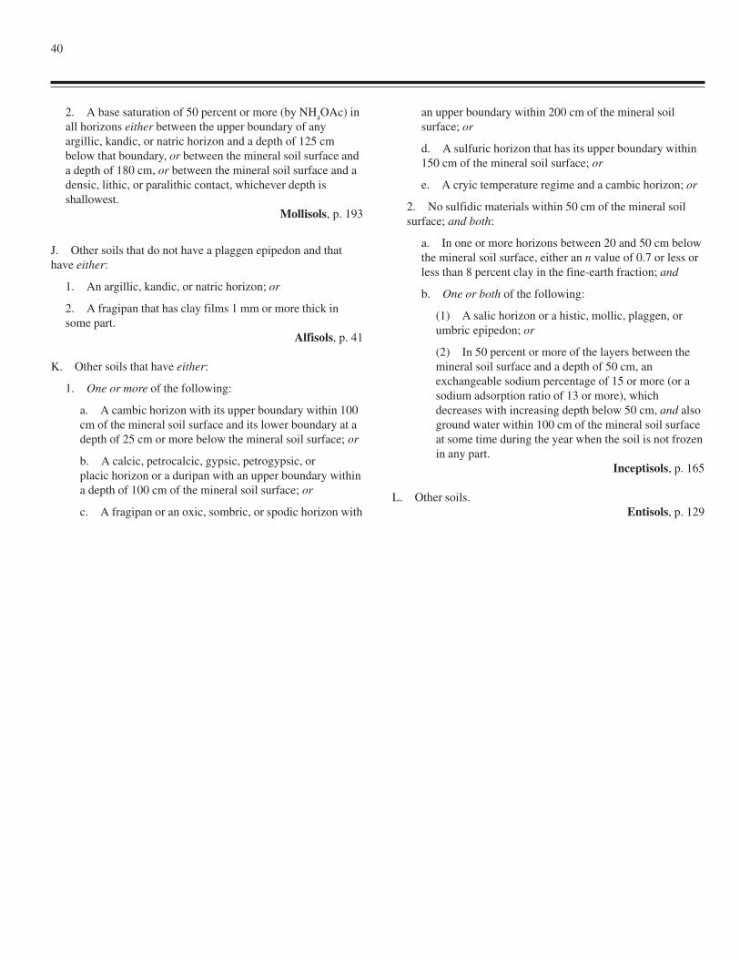
40
2. A base saturation of 50 percent or more (by NH4OAc) in
all horizons either between the upper boundary of anyargillic, kandic, or natric horizon and a depth of 125 cmbelow that boundary, or between the mineral soil surface anda depth of 180 cm, or between the mineral soil surface and adensic, lithic, or paralithic contact, whichever depth isshallowest.
Mollisols, p. 193
J. Other soils that do not have a plaggen epipedon and thathave either:
1. An argillic, kandic, or natric horizon; or
2. A fragipan that has clay films 1 mm or more thick insome part.
Alfisols, p. 41
K. Other soils that have either:
1. One or more of the following:
a. A cambic horizon with its upper boundary within 100cm of the mineral soil surface and its lower boundary at adepth of 25 cm or more below the mineral soil surface; or
b. A calcic, petrocalcic, gypsic, petrogypsic, orplacic horizon or a duripan with an upper boundary withina depth of 100 cm of the mineral soil surface; or
c. A fragipan or an oxic, sombric, or spodic horizon with
an upper boundary within 200 cm of the mineral soilsurface; or
d. A sulfuric horizon that has its upper boundary within150 cm of the mineral soil surface; or
e. A cryic temperature regime and a cambic horizon; or
2. No sulfidic materials within 50 cm of the mineral soilsurface; and both:
a. In one or more horizons between 20 and 50 cm belowthe mineral soil surface, either an n value of 0.7 or less orless than 8 percent clay in the fine-earth fraction; and
b. One or both of the following:
(1) A salic horizon or a histic, mollic, plaggen, orumbric epipedon; or
(2) In 50 percent or more of the layers between themineral soil surface and a depth of 50 cm, anexchangeable sodium percentage of 15 or more (or asodium adsorption ratio of 13 or more), whichdecreases with increasing depth below 50 cm, and alsoground water within 100 cm of the mineral soil surfaceat some time during the year when the soil is not frozenin any part.
Inceptisols, p. 165
L. Other soils.Entisols, p. 129
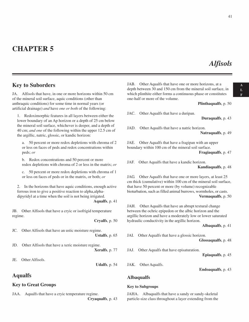
41
A
L
F
Key to SubordersJA. Alfisols that have, in one or more horizons within 50 cmof the mineral soil surface, aquic conditions (other thananthraquic conditions) for some time in normal years (orartificial drainage) and have one or both of the following:
1. Redoximorphic features in all layers between either thelower boundary of an Ap horizon or a depth of 25 cm belowthe mineral soil surface, whichever is deeper, and a depth of40 cm; and one of the following within the upper 12.5 cm ofthe argillic, natric, glossic, or kandic horizon:
a. 50 percent or more redox depletions with chroma of 2or less on faces of peds and redox concentrations withinpeds; or
b. Redox concentrations and 50 percent or moreredox depletions with chroma of 2 or less in the matrix; or
c. 50 percent or more redox depletions with chroma of 1or less on faces of peds or in the matrix, or both; or
2. In the horizons that have aquic conditions, enough activeferrous iron to give a positive reaction to alpha,alpha-dipyridyl at a time when the soil is not being irrigated.
Aqualfs, p. 41
JB. Other Alfisols that have a cryic or isofrigid temperatureregime.
Cryalfs, p. 50
JC. Other Alfisols that have an ustic moisture regime.Ustalfs, p. 65
JD. Other Alfisols that have a xeric moisture regime.Xeralfs, p. 77
JE. Other Alfisols.Udalfs, p. 54
Aqualfs
Key to Great Groups
JAA. Aqualfs that have a cryic temperature regime.Cryaqualfs, p. 43
JAB. Other Aqualfs that have one or more horizons, at adepth between 30 and 150 cm from the mineral soil surface, inwhich plinthite either forms a continuous phase or constitutesone-half or more of the volume.
Plinthaqualfs, p. 50
JAC. Other Aqualfs that have a duripan.Duraqualfs, p. 43
JAD. Other Aqualfs that have a natric horizon.Natraqualfs, p. 49
JAE. Other Aqualfs that have a fragipan with an upperboundary within 100 cm of the mineral soil surface.
Fragiaqualfs, p. 47
JAF. Other Aqualfs that have a kandic horizon.Kandiaqualfs, p. 48
JAG. Other Aqualfs that have one or more layers, at least 25cm thick (cumulative) within 100 cm of the mineral soil surface,that have 50 percent or more (by volume) recognizablebioturbation, such as filled animal burrows, wormholes, or casts.
Vermaqualfs, p. 50
JAH. Other Aqualfs that have an abrupt textural changebetween the ochric epipedon or the albic horizon and theargillic horizon and have a moderately low or lower saturatedhydraulic conductivity in the argillic horizon.
Albaqualfs, p. 41
JAI. Other Aqualfs that have a glossic horizon.Glossaqualfs, p. 48
JAJ. Other Aqualfs that have episaturation.Epiaqualfs, p. 45
JAK. Other Aqualfs.Endoaqualfs, p. 43
Albaqualfs
Key to Subgroups
JAHA. Albaqualfs that have a sandy or sandy-skeletalparticle-size class throughout a layer extending from the
CHAPTER 5
Alfisols
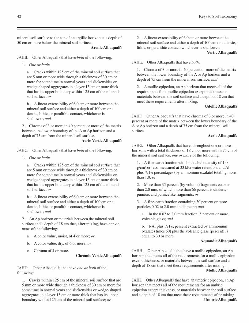
42 Keys to Soil Taxonomy
mineral soil surface to the top of an argillic horizon at a depth of50 cm or more below the mineral soil surface.
Arenic Albaqualfs
JAHB. Other Albaqualfs that have both of the following:
1. One or both:
a. Cracks within 125 cm of the mineral soil surface thatare 5 mm or more wide through a thickness of 30 cm ormore for some time in normal years and slickensides orwedge-shaped aggregates in a layer 15 cm or more thickthat has its upper boundary within 125 cm of the mineralsoil surface; or
b. A linear extensibility of 6.0 cm or more between themineral soil surface and either a depth of 100 cm or adensic, lithic, or paralithic contact, whichever isshallower; and
2. Chroma of 3 or more in 40 percent or more of the matrixbetween the lower boundary of the A or Ap horizon and adepth of 75 cm from the mineral soil surface.
Aeric Vertic Albaqualfs
JAHC. Other Albaqualfs that have both of the following:
1. One or both:
a. Cracks within 125 cm of the mineral soil surface thatare 5 mm or more wide through a thickness of 30 cm ormore for some time in normal years and slickensides orwedge-shaped aggregates in a layer 15 cm or more thickthat has its upper boundary within 125 cm of the mineralsoil surface; or
b. A linear extensibility of 6.0 cm or more between themineral soil surface and either a depth of 100 cm or adensic, lithic, or paralithic contact, whichever isshallower; and
2. An Ap horizon or materials between the mineral soilsurface and a depth of 18 cm that, after mixing, have one ormore of the following:
a. A color value, moist, of 4 or more; or
b. A color value, dry, of 6 or more; or
c. Chroma of 4 or more.Chromic Vertic Albaqualfs
JAHD. Other Albaqualfs that have one or both of thefollowing:
1. Cracks within 125 cm of the mineral soil surface that are5 mm or more wide through a thickness of 30 cm or more forsome time in normal years and slickensides or wedge-shapedaggregates in a layer 15 cm or more thick that has its upperboundary within 125 cm of the mineral soil surface; or
2. A linear extensibility of 6.0 cm or more between themineral soil surface and either a depth of 100 cm or a densic,lithic, or paralithic contact, whichever is shallower.
Vertic Albaqualfs
JAHE. Other Albaqualfs that have both:
1. Chroma of 3 or more in 40 percent or more of the matrixbetween the lower boundary of the A or Ap horizon and adepth of 75 cm from the mineral soil surface; and
2. A mollic epipedon, an Ap horizon that meets all of therequirements for a mollic epipedon except thickness, ormaterials between the soil surface and a depth of 18 cm thatmeet these requirements after mixing.
Udollic Albaqualfs
JAHF. Other Albaqualfs that have chroma of 3 or more in 40percent or more of the matrix between the lower boundary of theA or Ap horizon and a depth of 75 cm from the mineral soilsurface.
Aeric Albaqualfs
JAHG. Other Albaqualfs that have, throughout one or morehorizons with a total thickness of 18 cm or more within 75 cm ofthe mineral soil surface, one or more of the following:
1. A fine-earth fraction with both a bulk density of 1.0g/cm3 or less, measured at 33 kPa water retention, and Alplus 1/2 Fe percentages (by ammonium oxalate) totaling morethan 1.0; or
2. More than 35 percent (by volume) fragments coarserthan 2.0 mm, of which more than 66 percent is cinders,pumice, and pumicelike fragments; or
3. A fine-earth fraction containing 30 percent or moreparticles 0.02 to 2.0 mm in diameter; and
a. In the 0.02 to 2.0 mm fraction, 5 percent or morevolcanic glass; and
b. [(Al plus 1/2 Fe, percent extracted by ammoniumoxalate) times 60] plus the volcanic glass (percent) isequal to 30 or more.
Aquandic Albaqualfs
JAHH. Other Albaqualfs that have a mollic epipedon, an Aphorizon that meets all of the requirements for a mollic epipedonexcept thickness, or materials between the soil surface and adepth of 18 cm that meet these requirements after mixing.
Mollic Albaqualfs
JAHI. Other Albaqualfs that have an umbric epipedon, an Aphorizon that meets all of the requirements for an umbricepipedon except thickness, or materials between the soil surfaceand a depth of 18 cm that meet these requirements after mixing.
Umbric Albaqualfs
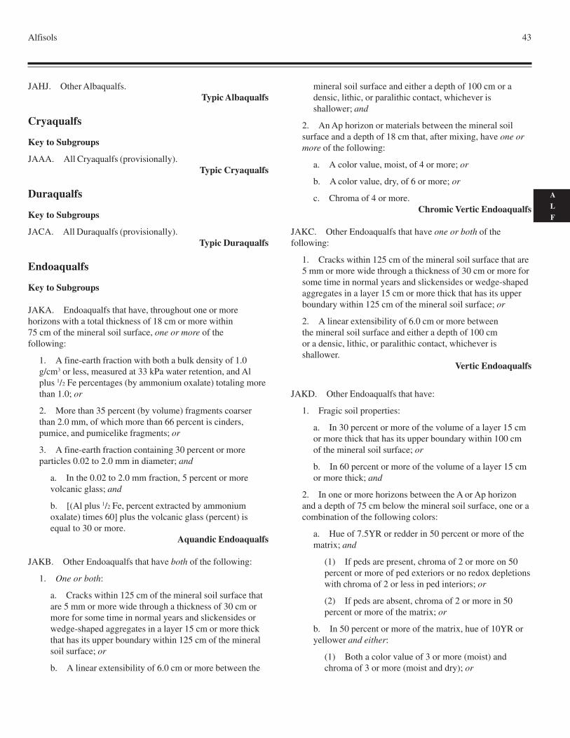
Alfisols 43
A
L
F
JAHJ. Other Albaqualfs.Typic Albaqualfs
Cryaqualfs
Key to Subgroups
JAAA. All Cryaqualfs (provisionally).Typic Cryaqualfs
Duraqualfs
Key to Subgroups
JACA. All Duraqualfs (provisionally).Typic Duraqualfs
Endoaqualfs
Key to Subgroups
JAKA. Endoaqualfs that have, throughout one or morehorizons with a total thickness of 18 cm or more within75 cm of the mineral soil surface, one or more of thefollowing:
1. A fine-earth fraction with both a bulk density of 1.0g/cm3 or less, measured at 33 kPa water retention, and Alplus 1/2 Fe percentages (by ammonium oxalate) totaling morethan 1.0; or
2. More than 35 percent (by volume) fragments coarserthan 2.0 mm, of which more than 66 percent is cinders,pumice, and pumicelike fragments; or
3. A fine-earth fraction containing 30 percent or moreparticles 0.02 to 2.0 mm in diameter; and
a. In the 0.02 to 2.0 mm fraction, 5 percent or morevolcanic glass; and
b. [(Al plus 1/2 Fe, percent extracted by ammoniumoxalate) times 60] plus the volcanic glass (percent) isequal to 30 or more.
Aquandic Endoaqualfs
JAKB. Other Endoaqualfs that have both of the following:
1. One or both:
a. Cracks within 125 cm of the mineral soil surface thatare 5 mm or more wide through a thickness of 30 cm ormore for some time in normal years and slickensides orwedge-shaped aggregates in a layer 15 cm or more thickthat has its upper boundary within 125 cm of the mineralsoil surface; or
b. A linear extensibility of 6.0 cm or more between the
mineral soil surface and either a depth of 100 cm or adensic, lithic, or paralithic contact, whichever isshallower; and
2. An Ap horizon or materials between the mineral soilsurface and a depth of 18 cm that, after mixing, have one ormore of the following:
a. A color value, moist, of 4 or more; or
b. A color value, dry, of 6 or more; or
c. Chroma of 4 or more.Chromic Vertic Endoaqualfs
JAKC. Other Endoaqualfs that have one or both of thefollowing:
1. Cracks within 125 cm of the mineral soil surface that are5 mm or more wide through a thickness of 30 cm or more forsome time in normal years and slickensides or wedge-shapedaggregates in a layer 15 cm or more thick that has its upperboundary within 125 cm of the mineral soil surface; or
2. A linear extensibility of 6.0 cm or more betweenthe mineral soil surface and either a depth of 100 cmor a densic, lithic, or paralithic contact, whichever isshallower.
Vertic Endoaqualfs
JAKD. Other Endoaqualfs that have:
1. Fragic soil properties:
a. In 30 percent or more of the volume of a layer 15 cmor more thick that has its upper boundary within 100 cmof the mineral soil surface; or
b. In 60 percent or more of the volume of a layer 15 cmor more thick; and
2. In one or more horizons between the A or Ap horizonand a depth of 75 cm below the mineral soil surface, one or acombination of the following colors:
a. Hue of 7.5YR or redder in 50 percent or more of thematrix; and
(1) If peds are present, chroma of 2 or more on 50percent or more of ped exteriors or no redox depletionswith chroma of 2 or less in ped interiors; or
(2) If peds are absent, chroma of 2 or more in 50percent or more of the matrix; or
b. In 50 percent or more of the matrix, hue of 10YR oryellower and either:
(1) Both a color value of 3 or more (moist) andchroma of 3 or more (moist and dry); or
44 Keys to Soil Taxonomy
(2) Chroma of 2 or more if there are no redoxconcentrations.
Aeric Fragic Endoaqualfs
JAKE. Other Endoaqualfs that have fragic soil properties:
1. In 30 percent or more of the volume of a layer 15 cm ormore thick that has its upper boundary within 100 cm of themineral soil surface; or
2. In 60 percent or more of the volume of a layer 15 cm ormore thick.
Fragic Endoaqualfs
JAKF. Other Endoaqualfs that have a sandy or sandy-skeletalparticle-size class throughout a layer extending from the mineralsoil surface to the top of an argillic horizon at a depth of 50 to100 cm below the mineral soil surface.
Arenic Endoaqualfs
JAKG. Other Endoaqualfs that have a sandy or sandy-skeletalparticle-size class throughout a layer extendingfrom the mineral soil surface to the top of an argillichorizon at a depth of 100 cm or more below the mineral soilsurface.
Grossarenic Endoaqualfs
JAKH. Other Endoaqualfs that have both:
1. A mollic epipedon, an Ap horizon that meets all of therequirements for a mollic epipedon except thickness, ormaterials between the soil surface and a depth of 18 cm thatmeet these requirements after mixing; and
2. In one or more horizons between the A or Ap horizonand a depth of 75 cm below the mineral soil surface, one or acombination of the following colors:
a. Hue of 7.5YR or redder in 50 percent or more of thematrix; and
(1) If peds are present, chroma of 2 or more on 50percent or more of ped exteriors or no redox depletionswith chroma of 2 or less in ped interiors; or
(2) If peds are absent, chroma of 2 or more in 50percent or more of the matrix; or
b. In 50 percent or more of the matrix, hue of 10YR oryellower and either:
(1) Both a color value of 3 or more (moist) andchroma of 3 or more; or
(2) Chroma of 2 or more if there are no redoxconcentrations.
Udollic Endoaqualfs
JAKI. Other Endoaqualfs that have both:
1. An umbric epipedon, an Ap horizon that meets all of therequirements for an umbric epipedon except thickness, ormaterials between the soil surface and a depth of 18 cm thatmeet these requirements after mixing; and
2. In one or more horizons between the A or Ap horizonand a depth of 75 cm below the mineral soil surface, one or acombination of the following colors:
a. Hue of 7.5YR or redder in 50 percent or more of thematrix; and
(1) If peds are present, chroma of 2 or more on 50percent or more of ped exteriors or no redox depletionswith chroma of 2 or less in ped interiors; or
(2) If peds are absent, chroma of 2 or more in 50percent or more of the matrix; or
b. In 50 percent or more of the matrix, hue of 10YR oryellower and either:
(1) Both a color value of 3 or more (moist) andchroma of 3 or more; or
(2) Chroma of 2 or more if there are no redoxconcentrations.
Aeric Umbric Endoaqualfs
JAKJ. Other Endoaqualfs that have, in one or more horizonsbetween the A or Ap horizon and a depth of 75 cm below themineral soil surface, in 50 percent or more of the matrix, one ora combination of the following colors:
1. Hue of 7.5YR or redder; and
a. If peds are present, chroma of 2 or more (both moistand dry) on 50 percent or more of ped exteriors or noredox depletions with chroma of 2 or less (both moist anddry) in ped interiors; or
b. If peds are absent, chroma of 2 or more (both moistand dry); or
2. Hue of 10YR or yellower and either:
a. Both a color value of 3 or more (moist) and chroma of3 or more (moist and dry); or
b. Chroma of 2 or more (both moist and dry) and noredox concentrations.
Aeric Endoaqualfs
JAKK. Other Endoaqualfs that have a mollic epipedon, an Aphorizon that meets all of the requirements for a mollic epipedonexcept thickness, or materials between the soil surface and adepth of 18 cm that meet these requirements after mixing.
Mollic Endoaqualfs
JAKL. Other Endoaqualfs that have an umbric epipedon, anAp horizon that meets all of the requirements for an umbric
Alfisols 45
A
L
F
epipedon except thickness, or materials between the soil surfaceand a depth of 18 cm that meet these requirements after mixing.
Umbric Endoaqualfs
JAKM. Other Endoaqualfs.Typic Endoaqualfs
Epiaqualfs
Key to Subgroups
JAJA. Epiaqualfs that have all of the following:
1. One or both:
a. Cracks within 125 cm of the mineral soil surface thatare 5 mm or more wide through a thickness of 30 cm ormore for some time in normal years and slickensides orwedge-shaped aggregates in a layer 15 cm or more thickthat has its upper boundary within 125 cm of the mineralsoil surface; or
b. A linear extensibility of 6.0 cm or more between themineral soil surface and either a depth of 100 cm or adensic, lithic, or paralithic contact, whichever isshallower; and
2. In one or more horizons between the A or Ap horizonand a depth of 75 cm below the mineral soil surface, in 50percent or more of the matrix, one or a combination of thefollowing colors:
a. Hue of 7.5YR or redder; and
(1) If peds are present, chroma of 2 or more (bothmoist and dry) on 50 percent or more of ped exteriorsor no redox depletions with chroma of 2 or less (bothmoist and dry) in ped interiors; or
(2) If peds are absent, chroma of 2 or more (bothmoist and dry); or
b. Hue of 10YR or yellower and either:
(1) Both a color value of 3 or more (moist)and chroma of 3 or more (moist and dry); or
(2) Chroma of 2 or more (both moist and dry) and noredox concentrations; and
3. An Ap horizon or materials between the mineral soilsurface and a depth of 18 cm that, after mixing, have one ormore of the following:
a. A color value, moist, of 4 or more; or
b. A color value, dry, of 6 or more; or
c. Chroma of 4 or more.Aeric Chromic Vertic Epiaqualfs
JAJB. Other Epiaqualfs that have both of the following:
1. One or both:
a. Cracks within 125 cm of the mineral soil surface thatare 5 mm or more wide through a thickness of 30 cm ormore for some time in normal years and slickensides orwedge-shaped aggregates in a layer 15 cm or more thickthat has its upper boundary within 125 cm of the mineralsoil surface; or
b. A linear extensibility of 6.0 cm or more between themineral soil surface and either a depth of 100 cm or adensic, lithic, or paralithic contact, whichever isshallower; and
2. In one or more horizons between the A or Ap horizonand a depth of 75 cm below the mineral soil surface, in 50percent or more of the matrix, one or a combination of thefollowing colors:
a. Hue of 7.5YR or redder; and
(1) If peds are present, chroma of 2 or more (bothmoist and dry) on 50 percent or more of ped exteriorsor no redox depletions with chroma of 2 or less (bothmoist and dry) in ped interiors; or
(2) If peds are absent, chroma of 2 or more (bothmoist and dry); or
b. Hue of 10YR or yellower and either:
(1) Both a color value of 3 or more (moist) andchroma of 3 or more (moist and dry); or
(2) Chroma of 2 or more (both moist and dry) and noredox concentrations.
Aeric Vertic Epiaqualfs
JAJC. Other Epiaqualfs that have both of the following:
1. One or both:
a. Cracks within 125 cm of the mineral soil surface thatare 5 mm or more wide through a thickness of 30 cm ormore for some time in normal years and slickensides orwedge-shaped aggregates in a layer 15 cm or more thickthat has its upper boundary within 125 cm of the mineralsoil surface; or
b. A linear extensibility of 6.0 cm or more between themineral soil surface and either a depth of 100 cm or adensic, lithic, or paralithic contact, whichever isshallower; and
2. An Ap horizon or materials between the mineral soilsurface and a depth of 18 cm that, after mixing, have one ormore of the following:
46 Keys to Soil Taxonomy
a. A color value, moist, of 4 or more; or
b. A color value, dry, of 6 or more; or
c. Chroma of 4 or more.Chromic Vertic Epiaqualfs
JAJD. Other Epiaqualfs that have one or both of thefollowing:
1. Cracks within 125 cm of the mineral soil surface that are5 mm or more wide through a thickness of 30 cm or more forsome time in normal years and slickensides or wedge-shapedaggregates in a layer 15 cm or more thick that has its upperboundary within 125 cm of the mineral soil surface; or
2. A linear extensibility of 6.0 cm or more between themineral soil surface and either a depth of 100 cm or a densic,lithic, or paralithic contact, whichever is shallower.
Vertic Epiaqualfs
JAJE. Other Epiaqualfs that have, throughout one or morehorizons with a total thickness of 18 cm or more within75 cm of the mineral soil surface, one or more of thefollowing:
1. A fine-earth fraction with both a bulk density of 1.0g/cm3 or less, measured at 33 kPa water retention, and Alplus 1/2 Fe percentages (by ammonium oxalate) totaling morethan 1.0; or
2. More than 35 percent (by volume) fragments coarserthan 2.0 mm, of which more than 66 percent is cinders,pumice, and pumicelike fragments; or
3. A fine-earth fraction containing 30 percent or moreparticles 0.02 to 2.0 mm in diameter; and
a. In the 0.02 to 2.0 mm fraction, 5 percent or morevolcanic glass; and
b. [(Al plus 1/2 Fe, percent extracted by ammoniumoxalate) times 60] plus the volcanic glass (percent) isequal to 30 or more.
Aquandic Epiaqualfs
JAJF. Other Epiaqualfs that have:
1. Fragic soil properties:
a. In 30 percent or more of the volume of a layer 15 cmor more thick that has its upper boundary within 100 cmof the mineral soil surface; or
b. In 60 percent or more of the volume of a layer 15 cmor more thick; and
2. In one or more horizons between the A or Ap horizonand a depth of 75 cm below the mineral soil surface, in 50
percent or more of the matrix, one or a combination of thefollowing colors:
a. Hue of 7.5YR or redder; and
(1) If peds are present, chroma of 2 or more (bothmoist and dry) on 50 percent or more of ped exteriorsor no redox depletions with chroma of 2 or less (bothmoist and dry) in ped interiors; or
(2) If peds are absent, chroma of 2 or more (bothmoist and dry); or
b. Hue of 10YR or yellower and either:
(1) Both a color value of 3 or more (moist) andchroma of 3 or more (moist and dry); or
(2) Chroma of 2 or more (both moist and dry) and noredox concentrations.
Aeric Fragic Epiaqualfs
JAJG. Other Epiaqualfs that have fragic soil properties:
1. In 30 percent or more of the volume of a layer 15 cm ormore thick that has its upper boundary within 100 cm of themineral soil surface; or
2. In 60 percent or more of the volume of a layer 15 cm ormore thick.
Fragic Epiaqualfs
JAJH. Other Epiaqualfs that have a sandy or sandy-skeletalparticle-size class throughout a layer extending from the mineralsoil surface to the top of an argillic horizon at a depth of 50 to100 cm below the mineral soil surface.
Arenic Epiaqualfs
JAJI. Other Epiaqualfs that have a sandy or sandy-skeletalparticle-size class throughout a layer extending from the mineralsoil surface to the top of an argillic horizon at a depth of 100 cmor more below the mineral soil surface.
Grossarenic Epiaqualfs
JAJJ. Other Epiaqualfs that have:
1. An umbric epipedon, an Ap horizon that meets all of therequirements for an umbric epipedon except thickness, ormaterials between the soil surface and a depth of 18 cm thatmeet these requirements after mixing; and
2. In one or more horizons between the A or Ap horizonand a depth of 75 cm below the mineral soil surface, in 50percent or more of the matrix, one or a combination of thefollowing colors:
a. Hue of 7.5YR or redder; and
(1) If peds are present, chroma of 2 or more (both
Alfisols 47
A
L
F
moist and dry) on 50 percent or more of ped exteriorsor no redox depletions with chroma of 2 or less (bothmoist and dry) in ped interiors; or
(2) If peds are absent, chroma of 2 or more (bothmoist and dry); or
b. Hue of 10YR or yellower and either:
(1) Both a color value of 3 or more (moist) andchroma of 3 or more (moist and dry); or
(2) Chroma of 2 or more (both moist and dry) and noredox concentrations.
Aeric Umbric Epiaqualfs
JAJK. Other Epiaqualfs that have both:
1. A mollic epipedon, an Ap horizon that meets all of therequirements for a mollic epipedon except thickness, ormaterials between the soil surface and a depth of 18 cm thatmeet these requirements after mixing; and
2. In 50 percent or more of the matrix in one or morehorizons between the A or Ap horizon and a depth of 75 cmbelow the mineral soil surface, one or a combination of thefollowing colors:
a. Hue of 7.5YR or redder; and
(1) If peds are present, chroma of 2 or more on 50percent or more of ped exteriors or no redox depletionswith chroma of 2 or less in ped interiors; or
(2) If peds are absent, chroma of 2 or more in 50percent or more of the matrix; or
b. Hue of 10YR or yellower and either:
(1) Both a color value of 3 or more (moist) andchroma of 3 or more; or
(2) Chroma of 2 or more if there are no redoxconcentrations.
Udollic Epiaqualfs
JAJL. Other Epiaqualfs that have, in one or more horizonsbetween the A or Ap horizon and a depth of 75 cm below themineral soil surface, in 50 percent or more of the matrix, one ora combination of the following colors:
1. Hue of 7.5YR or redder; and
a. If peds are present, chroma of 2 or more (both moistand dry) on 50 percent or more of ped exteriors or noredox depletions with chroma of 2 or less (both moist anddry) in ped interiors; or
b. If peds are absent, chroma of 2 or more (both moistand dry); or
2. Hue of 10YR or yellower and either:
a. Both a color value of 3 or more (moist) and chroma of3 or more (moist and dry); or
b. Chroma of 2 or more (both moist and dry) and noredox concentrations.
Aeric Epiaqualfs
JAJM. Other Epiaqualfs that have a mollic epipedon, an Aphorizon that meets all of the requirements for a mollic epipedonexcept thickness, or materials between the soil surface and adepth of 18 cm that meet these requirements after mixing.
Mollic Epiaqualfs
JAJN. Other Epiaqualfs that have an umbric epipedon, an Aphorizon that meets all of the requirements for an umbricepipedon except thickness, or materials between the soil surfaceand a depth of 18 cm that meet these requirements after mixing.
Umbric Epiaqualfs
JAJO. Other Epiaqualfs.Typic Epiaqualfs
Fragiaqualfs
Key to Subgroups
JAEA. Fragiaqualfs that have one or more layers, at least 25cm thick (cumulative) within 100 cm of the mineral soil surface,that have 25 percent or more (by volume) recognizablebioturbation, such as filled animal burrows, wormholes, or casts.
Vermic Fragiaqualfs
JAEB. Other Fragiaqualfs that have, between the A or Aphorizon and a fragipan, a horizon with 50 percent or morechroma of 3 or more if hue is 10YR or redder or of 4 or more ifhue is 2.5Y or yellower.
Aeric Fragiaqualfs
JAEC. Other Fragiaqualfs that have 5 percent or more (byvolume) plinthite in one or more horizons within 150 cm of themineral soil surface.
Plinthic Fragiaqualfs
JAED. Other Fragiaqualfs that have an Ap horizon with acolor value, moist, of 3 or less and a color value, dry, of 5 orless (crushed and smoothed sample) or materials between thesoil surface and a depth of 18 cm that have these color valuesafter mixing.
Humic Fragiaqualfs
JAEE. Other Fragiaqualfs.Typic Fragiaqualfs
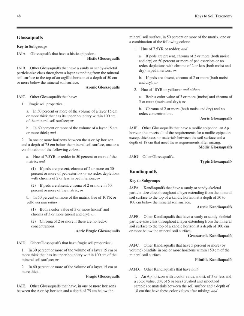
48 Keys to Soil Taxonomy
Glossaqualfs
Key to Subgroups
JAIA. Glossaqualfs that have a histic epipedon.Histic Glossaqualfs
JAIB. Other Glossaqualfs that have a sandy or sandy-skeletalparticle-size class throughout a layer extending from the mineralsoil surface to the top of an argillic horizon at a depth of 50 cmor more below the mineral soil surface.
Arenic Glossaqualfs
JAIC. Other Glossaqualfs that have:
1. Fragic soil properties:
a. In 30 percent or more of the volume of a layer 15 cmor more thick that has its upper boundary within 100 cmof the mineral soil surface; or
b. In 60 percent or more of the volume of a layer 15 cmor more thick; and
2. In one or more horizons between the A or Ap horizonand a depth of 75 cm below the mineral soil surface, one or acombination of the following colors:
a. Hue of 7.5YR or redder in 50 percent or more of thematrix; and
(1) If peds are present, chroma of 2 or more on 50percent or more of ped exteriors or no redox depletionswith chroma of 2 or less in ped interiors; or
(2) If peds are absent, chroma of 2 or more in 50percent or more of the matrix; or
b. In 50 percent or more of the matrix, hue of 10YR oryellower and either:
(1) Both a color value of 3 or more (moist) andchroma of 3 or more (moist and dry); or
(2) Chroma of 2 or more if there are no redoxconcentrations.
Aeric Fragic Glossaqualfs
JAID. Other Glossaqualfs that have fragic soil properties:
1. In 30 percent or more of the volume of a layer 15 cm ormore thick that has its upper boundary within 100 cm of themineral soil surface; or
2. In 60 percent or more of the volume of a layer 15 cm ormore thick.
Fragic Glossaqualfs
JAIE. Other Glossaqualfs that have, in one or more horizonsbetween the A or Ap horizon and a depth of 75 cm below the
mineral soil surface, in 50 percent or more of the matrix, one ora combination of the following colors:
1. Hue of 7.5YR or redder; and
a. If peds are present, chroma of 2 or more (both moistand dry) on 50 percent or more of ped exteriors or noredox depletions with chroma of 2 or less (both moist anddry) in ped interiors; or
b. If peds are absent, chroma of 2 or more (both moistand dry); or
2. Hue of 10YR or yellower and either:
a. Both a color value of 3 or more (moist) and chroma of3 or more (moist and dry); or
b. Chroma of 2 or more (both moist and dry) and noredox concentrations.
Aeric Glossaqualfs
JAIF. Other Glossaqualfs that have a mollic epipedon, an Aphorizon that meets all of the requirements for a mollic epipedonexcept thickness, or materials between the soil surface and adepth of 18 cm that meet these requirements after mixing.
Mollic Glossaqualfs
JAIG. Other Glossaqualfs.Typic Glossaqualfs
Kandiaqualfs
Key to Subgroups
JAFA. Kandiaqualfs that have a sandy or sandy-skeletalparticle-size class throughout a layer extending from the mineralsoil surface to the top of a kandic horizon at a depth of 50 to100 cm below the mineral soil surface.
Arenic Kandiaqualfs
JAFB. Other Kandiaqualfs that have a sandy or sandy-skeletalparticle-size class throughout a layer extending from the mineralsoil surface to the top of a kandic horizon at a depth of 100 cmor more below the mineral soil surface.
Grossarenic Kandiaqualfs
JAFC. Other Kandiaqualfs that have 5 percent or more (byvolume) plinthite in one or more horizons within 150 cm of themineral soil surface.
Plinthic Kandiaqualfs
JAFD. Other Kandiaqualfs that have both:
1. An Ap horizon with a color value, moist, of 3 or less anda color value, dry, of 5 or less (crushed and smoothedsample) or materials between the soil surface and a depth of18 cm that have these color values after mixing; and
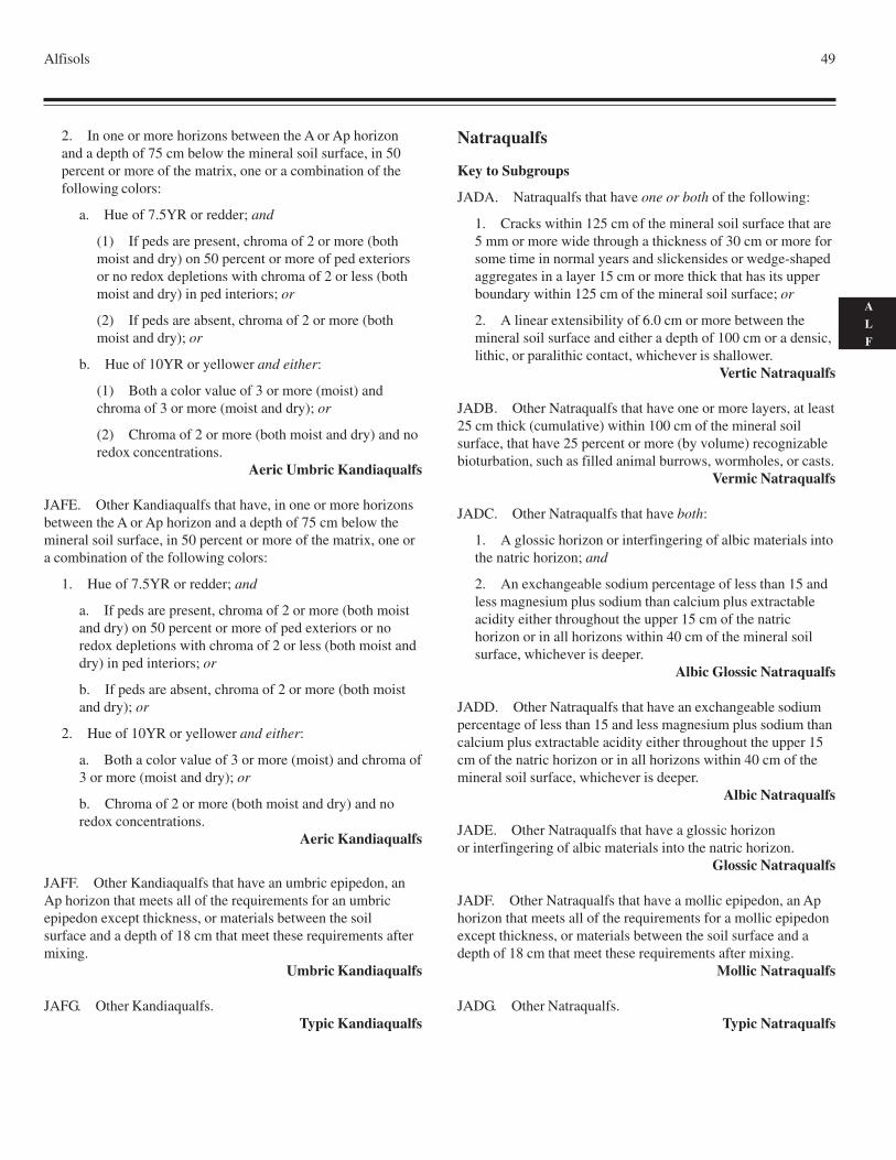
Alfisols 49
A
L
F
2. In one or more horizons between the A or Ap horizonand a depth of 75 cm below the mineral soil surface, in 50percent or more of the matrix, one or a combination of thefollowing colors:
a. Hue of 7.5YR or redder; and
(1) If peds are present, chroma of 2 or more (bothmoist and dry) on 50 percent or more of ped exteriorsor no redox depletions with chroma of 2 or less (bothmoist and dry) in ped interiors; or
(2) If peds are absent, chroma of 2 or more (bothmoist and dry); or
b. Hue of 10YR or yellower and either:
(1) Both a color value of 3 or more (moist) andchroma of 3 or more (moist and dry); or
(2) Chroma of 2 or more (both moist and dry) and noredox concentrations.
Aeric Umbric Kandiaqualfs
JAFE. Other Kandiaqualfs that have, in one or more horizonsbetween the A or Ap horizon and a depth of 75 cm below themineral soil surface, in 50 percent or more of the matrix, one ora combination of the following colors:
1. Hue of 7.5YR or redder; and
a. If peds are present, chroma of 2 or more (both moistand dry) on 50 percent or more of ped exteriors or noredox depletions with chroma of 2 or less (both moist anddry) in ped interiors; or
b. If peds are absent, chroma of 2 or more (both moistand dry); or
2. Hue of 10YR or yellower and either:
a. Both a color value of 3 or more (moist) and chroma of3 or more (moist and dry); or
b. Chroma of 2 or more (both moist and dry) and noredox concentrations.
Aeric Kandiaqualfs
JAFF. Other Kandiaqualfs that have an umbric epipedon, anAp horizon that meets all of the requirements for an umbricepipedon except thickness, or materials between the soilsurface and a depth of 18 cm that meet these requirements aftermixing.
Umbric Kandiaqualfs
JAFG. Other Kandiaqualfs.Typic Kandiaqualfs
Natraqualfs
Key to Subgroups
JADA. Natraqualfs that have one or both of the following:
1. Cracks within 125 cm of the mineral soil surface that are5 mm or more wide through a thickness of 30 cm or more forsome time in normal years and slickensides or wedge-shapedaggregates in a layer 15 cm or more thick that has its upperboundary within 125 cm of the mineral soil surface; or
2. A linear extensibility of 6.0 cm or more between themineral soil surface and either a depth of 100 cm or a densic,lithic, or paralithic contact, whichever is shallower.
Vertic Natraqualfs
JADB. Other Natraqualfs that have one or more layers, at least25 cm thick (cumulative) within 100 cm of the mineral soilsurface, that have 25 percent or more (by volume) recognizablebioturbation, such as filled animal burrows, wormholes, or casts.
Vermic Natraqualfs
JADC. Other Natraqualfs that have both:
1. A glossic horizon or interfingering of albic materials intothe natric horizon; and
2. An exchangeable sodium percentage of less than 15 andless magnesium plus sodium than calcium plus extractableacidity either throughout the upper 15 cm of the natrichorizon or in all horizons within 40 cm of the mineral soilsurface, whichever is deeper.
Albic Glossic Natraqualfs
JADD. Other Natraqualfs that have an exchangeable sodiumpercentage of less than 15 and less magnesium plus sodium thancalcium plus extractable acidity either throughout the upper 15cm of the natric horizon or in all horizons within 40 cm of themineral soil surface, whichever is deeper.
Albic Natraqualfs
JADE. Other Natraqualfs that have a glossic horizonor interfingering of albic materials into the natric horizon.
Glossic Natraqualfs
JADF. Other Natraqualfs that have a mollic epipedon, an Aphorizon that meets all of the requirements for a mollic epipedonexcept thickness, or materials between the soil surface and adepth of 18 cm that meet these requirements after mixing.
Mollic Natraqualfs
JADG. Other Natraqualfs.Typic Natraqualfs
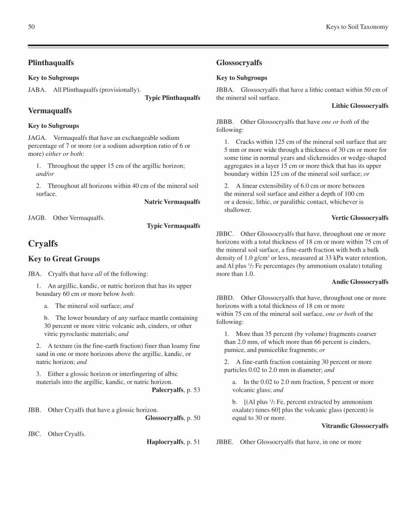
50 Keys to Soil Taxonomy
Plinthaqualfs
Key to Subgroups
JABA. All Plinthaqualfs (provisionally).Typic Plinthaqualfs
Vermaqualfs
Key to Subgroups
JAGA. Vermaqualfs that have an exchangeable sodiumpercentage of 7 or more (or a sodium adsorption ratio of 6 ormore) either or both:
1. Throughout the upper 15 cm of the argillic horizon;and/or
2. Throughout all horizons within 40 cm of the mineral soilsurface.
Natric Vermaqualfs
JAGB. Other Vermaqualfs.Typic Vermaqualfs
Cryalfs
Key to Great Groups
JBA. Cryalfs that have all of the following:
1. An argillic, kandic, or natric horizon that has its upperboundary 60 cm or more below both:
a. The mineral soil surface; and
b. The lower boundary of any surface mantle containing30 percent or more vitric volcanic ash, cinders, or othervitric pyroclastic materials; and
2. A texture (in the fine-earth fraction) finer than loamy finesand in one or more horizons above the argillic, kandic, ornatric horizon; and
3. Either a glossic horizon or interfingering of albicmaterials into the argillic, kandic, or natric horizon.
Palecryalfs, p. 53
JBB. Other Cryalfs that have a glossic horizon.Glossocryalfs, p. 50
JBC. Other Cryalfs.Haplocryalfs, p. 51
Glossocryalfs
Key to Subgroups
JBBA. Glossocryalfs that have a lithic contact within 50 cm ofthe mineral soil surface.
Lithic Glossocryalfs
JBBB. Other Glossocryalfs that have one or both of thefollowing:
1. Cracks within 125 cm of the mineral soil surface that are5 mm or more wide through a thickness of 30 cm or more forsome time in normal years and slickensides or wedge-shapedaggregates in a layer 15 cm or more thick that has its upperboundary within 125 cm of the mineral soil surface; or
2. A linear extensibility of 6.0 cm or more betweenthe mineral soil surface and either a depth of 100 cmor a densic, lithic, or paralithic contact, whichever isshallower.
Vertic Glossocryalfs
JBBC. Other Glossocryalfs that have, throughout one or morehorizons with a total thickness of 18 cm or more within 75 cm ofthe mineral soil surface, a fine-earth fraction with both a bulkdensity of 1.0 g/cm3 or less, measured at 33 kPa water retention,and Al plus 1/2 Fe percentages (by ammonium oxalate) totalingmore than 1.0.
Andic Glossocryalfs
JBBD. Other Glossocryalfs that have, throughout one or morehorizons with a total thickness of 18 cm or morewithin 75 cm of the mineral soil surface, one or both of thefollowing:
1. More than 35 percent (by volume) fragments coarserthan 2.0 mm, of which more than 66 percent is cinders,pumice, and pumicelike fragments; or
2. A fine-earth fraction containing 30 percent or moreparticles 0.02 to 2.0 mm in diameter; and
a. In the 0.02 to 2.0 mm fraction, 5 percent or morevolcanic glass; and
b. [(Al plus 1/2 Fe, percent extracted by ammoniumoxalate) times 60] plus the volcanic glass (percent) isequal to 30 or more.
Vitrandic Glossocryalfs
JBBE. Other Glossocryalfs that have, in one or more
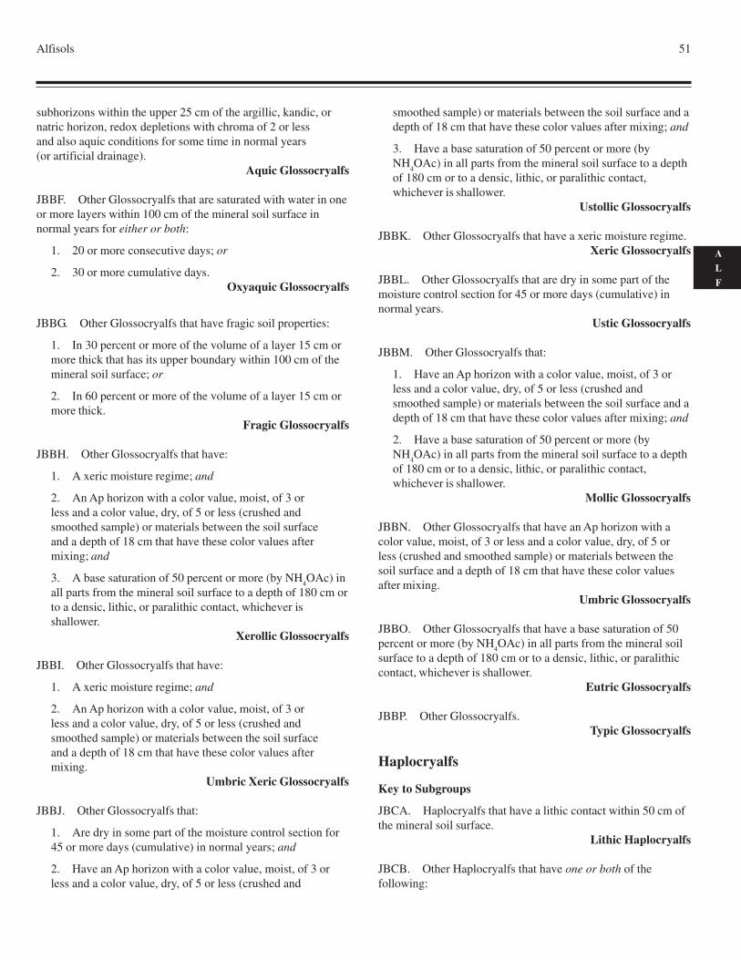
Alfisols 51
A
L
F
subhorizons within the upper 25 cm of the argillic, kandic, ornatric horizon, redox depletions with chroma of 2 or lessand also aquic conditions for some time in normal years(or artificial drainage).
Aquic Glossocryalfs
JBBF. Other Glossocryalfs that are saturated with water in oneor more layers within 100 cm of the mineral soil surface innormal years for either or both:
1. 20 or more consecutive days; or
2. 30 or more cumulative days.Oxyaquic Glossocryalfs
JBBG. Other Glossocryalfs that have fragic soil properties:
1. In 30 percent or more of the volume of a layer 15 cm ormore thick that has its upper boundary within 100 cm of themineral soil surface; or
2. In 60 percent or more of the volume of a layer 15 cm ormore thick.
Fragic Glossocryalfs
JBBH. Other Glossocryalfs that have:
1. A xeric moisture regime; and
2. An Ap horizon with a color value, moist, of 3 orless and a color value, dry, of 5 or less (crushed andsmoothed sample) or materials between the soil surfaceand a depth of 18 cm that have these color values aftermixing; and
3. A base saturation of 50 percent or more (by NH4OAc) in
all parts from the mineral soil surface to a depth of 180 cm orto a densic, lithic, or paralithic contact, whichever isshallower.
Xerollic Glossocryalfs
JBBI. Other Glossocryalfs that have:
1. A xeric moisture regime; and
2. An Ap horizon with a color value, moist, of 3 orless and a color value, dry, of 5 or less (crushed andsmoothed sample) or materials between the soil surfaceand a depth of 18 cm that have these color values aftermixing.
Umbric Xeric Glossocryalfs
JBBJ. Other Glossocryalfs that:
1. Are dry in some part of the moisture control section for45 or more days (cumulative) in normal years; and
2. Have an Ap horizon with a color value, moist, of 3 orless and a color value, dry, of 5 or less (crushed and
smoothed sample) or materials between the soil surface and adepth of 18 cm that have these color values after mixing; and
3. Have a base saturation of 50 percent or more (byNH
4OAc) in all parts from the mineral soil surface to a depth
of 180 cm or to a densic, lithic, or paralithic contact,whichever is shallower.
Ustollic Glossocryalfs
JBBK. Other Glossocryalfs that have a xeric moisture regime.Xeric Glossocryalfs
JBBL. Other Glossocryalfs that are dry in some part of themoisture control section for 45 or more days (cumulative) innormal years.
Ustic Glossocryalfs
JBBM. Other Glossocryalfs that:
1. Have an Ap horizon with a color value, moist, of 3 orless and a color value, dry, of 5 or less (crushed andsmoothed sample) or materials between the soil surface and adepth of 18 cm that have these color values after mixing; and
2. Have a base saturation of 50 percent or more (byNH
4OAc) in all parts from the mineral soil surface to a depth
of 180 cm or to a densic, lithic, or paralithic contact,whichever is shallower.
Mollic Glossocryalfs
JBBN. Other Glossocryalfs that have an Ap horizon with acolor value, moist, of 3 or less and a color value, dry, of 5 orless (crushed and smoothed sample) or materials between thesoil surface and a depth of 18 cm that have these color valuesafter mixing.
Umbric Glossocryalfs
JBBO. Other Glossocryalfs that have a base saturation of 50percent or more (by NH
4OAc) in all parts from the mineral soil
surface to a depth of 180 cm or to a densic, lithic, or paralithiccontact, whichever is shallower.
Eutric Glossocryalfs
JBBP. Other Glossocryalfs.Typic Glossocryalfs
Haplocryalfs
Key to Subgroups
JBCA. Haplocryalfs that have a lithic contact within 50 cm ofthe mineral soil surface.
Lithic Haplocryalfs
JBCB. Other Haplocryalfs that have one or both of thefollowing:
52 Keys to Soil Taxonomy
1. Cracks within 125 cm of the mineral soil surface that are5 mm or more wide through a thickness of 30 cm or more forsome time in normal years and slickensides or wedge-shapedaggregates in a layer 15 cm or more thick that has its upperboundary within 125 cm of the mineral soil surface; or
2. A linear extensibility of 6.0 cm or more betweenthe mineral soil surface and either a depth of 100 cmor a densic, lithic, or paralithic contact, whichever isshallower.
Vertic Haplocryalfs
JBCC. Other Haplocryalfs that have, throughout one or morehorizons with a total thickness of 18 cm or more within 75 cm ofthe mineral soil surface, a fine-earth fraction with both a bulkdensity of 1.0 g/cm3 or less, measured at 33 kPa water retention,and Al plus 1/2 Fe percentages (by ammonium oxalate) totalingmore than 1.0.
Andic Haplocryalfs
JBCD. Other Haplocryalfs that have, throughout one ormore horizons with a total thickness of 18 cm or morewithin 75 cm of the mineral soil surface, one or both of thefollowing:
1. More than 35 percent (by volume) fragmentscoarser than 2.0 mm, of which more than 66 percentis cinders, pumice, and pumicelike fragments; or
2. A fine-earth fraction containing 30 percent or moreparticles 0.02 to 2.0 mm in diameter; and
a. In the 0.02 to 2.0 mm fraction, 5 percent or morevolcanic glass; and
b. [(Al plus 1/2 Fe, percent extracted by ammoniumoxalate) times 60] plus the volcanic glass (percent) isequal to 30 or more.
Vitrandic Haplocryalfs
JBCE. Other Haplocryalfs that have, in one or more horizonswithin 75 cm of the mineral soil surface, redox depletions withchroma of 2 or less and also aquic conditions for some time innormal years (or artificial drainage).
Aquic Haplocryalfs
JBCF. Other Haplocryalfs that are saturated with water in oneor more layers within 100 cm of the mineral soil surface innormal years for either or both:
1. 20 or more consecutive days; or
2. 30 or more cumulative days.Oxyaquic Haplocryalfs
JBCG. Other Haplocryalfs that have an argillic horizon that:
1. Consists entirely of lamellae; or
2. Is a combination of two or more lamellae and one ormore subhorizons with a thickness of 7.5 to 20 cm, each layerwith an overlying eluvial horizon; or
3. Consists of one or more subhorizons that are more than20 cm thick, each with an overlying eluvial horizon, andabove these horizons there are either:
a. Two or more lamellae with a combined thickness of 5cm or more (that may or may not be part of the argillichorizon); or
b. A combination of lamellae (that may or may not bepart of the argillic horizon) and one or more parts of theargillic horizon 7.5 to 20 cm thick, each with an overlyingeluvial horizon.
Lamellic Haplocryalfs
JBCH. Other Haplocryalfs that have a sandy or sandy-skeletalparticle-size class throughout the upper 75 cm of the argillic,kandic, or natric horizon or throughout the entire argillic,kandic, or natric horizon if it is less than 75 cm thick.
Psammentic Haplocryalfs
JBCI. Other Haplocryalfs that have:
1. An argillic, kandic, or natric horizon that is 35 cm or lessthick; and
2. No densic, lithic, or paralithic contact within 100 cm ofthe mineral soil surface.
Inceptic Haplocryalfs
JBCJ. Other Haplocryalfs that have:
1. A xeric moisture regime; and
2. An Ap horizon with a color value, moist, of 3 or less anda color value, dry, of 5 or less (crushed and smoothedsample) or materials between the soil surface and a depth of18 cm that have these color values after mixing; and
3. A base saturation of 50 percent or more (by NH4OAc) in
all parts from the mineral soil surface to a depth of 180 cm orto a densic, lithic, or paralithic contact, whichever isshallower.
Xerollic Haplocryalfs
JBCK. Other Haplocryalfs that have:
1. A xeric moisture regime; and
2. An Ap horizon with a color value, moist, of 3 or less anda color value, dry, of 5 or less (crushed and smoothedsample) or materials between the soil surface and a depth of18 cm that have these color values after mixing.
Umbric Xeric Haplocryalfs
JBCL. Other Haplocryalfs that:
Alfisols 53
A
L
F
1. Are dry in some part of the moisture control section for45 or more days (cumulative) in normal years; and
2. Have an Ap horizon with a color value, moist, of 3 orless and a color value, dry, of 5 or less (crushed andsmoothed sample) or materials between the soil surface and adepth of 18 cm that have these color values after mixing; and
3. Have a base saturation of 50 percent or more (byNH
4OAc) in all parts from the mineral soil surface to a depth
of 180 cm or to a densic, lithic, or paralithic contact,whichever is shallower.
Ustollic Haplocryalfs
JBCM. Other Haplocryalfs that have a xeric moisture regime.Xeric Haplocryalfs
JBCN. Other Haplocryalfs that are dry in some part of themoisture control section for 45 or more days (cumulative) innormal years.
Ustic Haplocryalfs
JBCO. Other Haplocryalfs that:
1. Have an Ap horizon with a color value, moist, of 3 orless and a color value, dry, of 5 or less (crushed andsmoothed sample) or materials between the soil surface and adepth of 18 cm that have these color values after mixing; and
2. Have a base saturation of 50 percent or more (byNH
4OAc) in all parts from the mineral soil surface to a depth
of 180 cm or to a densic, lithic, or paralithic contact,whichever is shallower.
Mollic Haplocryalfs
JBCP. Other Haplocryalfs that have an Ap horizon with acolor value, moist, of 3 or less and a color value, dry, of 5 orless (crushed and smoothed sample) or materials between thesoil surface and a depth of 18 cm that have these color valuesafter mixing.
Umbric Haplocryalfs
JBCQ. Other Haplocryalfs that have a base saturation of 50percent or more (by NH
4OAc) in all parts from the mineral soil
surface to a depth of 180 cm or to a densic, lithic, or paralithiccontact, whichever is shallower.
Eutric Haplocryalfs
JBCR. Other Haplocryalfs.Typic Haplocryalfs
Palecryalfs
Key to Subgroups
JBAA. Palecryalfs that have, throughout one or more horizonswith a total thickness of 18 cm or more within 75 cm of the
mineral soil surface, a fine-earth fraction with both a bulkdensity of 1.0 g/cm3 or less, measured at 33 kPa water retention,and Al plus 1/2 Fe percentages (by ammonium oxalate) totalingmore than 1.0.
Andic Palecryalfs
JBAB. Other Palecryalfs that have, throughout one ormore horizons with a total thickness of 18 cm or more within 75cm of the mineral soil surface, one or both of thefollowing:
1. More than 35 percent (by volume) fragments coarserthan 2.0 mm, of which more than 66 percent is cinders,pumice, and pumicelike fragments; or
2. A fine-earth fraction containing 30 percent or moreparticles 0.02 to 2.0 mm in diameter; and
a. In the 0.02 to 2.0 mm fraction, 5 percent or morevolcanic glass; and
b. [(Al plus 1/2 Fe, percent extracted by ammoniumoxalate) times 60] plus the volcanic glass (percent) isequal to 30 or more.
Vitrandic Palecryalfs
JBAC. Other Palecryalfs that have, in one or more horizonswithin 100 cm of the mineral soil surface, redox depletions withchroma of 2 or less and also aquic conditions for some time innormal years (or artificial drainage).
Aquic Palecryalfs
JBAD. Other Palecryalfs that are saturated with water in oneor more layers within 100 cm of the mineral soil surface innormal years for either or both:
1. 20 or more consecutive days; or
2. 30 or more cumulative days.Oxyaquic Palecryalfs
JBAE. Other Palecryalfs that have a xeric moisture regime.Xeric Palecryalfs
JBAF. Other Palecryalfs that are dry in some part of themoisture control section for 45 or more days (cumulative) innormal years.
Ustic Palecryalfs
JBAG. Other Palecryalfs that:
1. Have an Ap horizon with a color value, moist, of 3 orless and a color value, dry, of 5 or less (crushed andsmoothed sample) or materials between the soil surface and adepth of 18 cm that have these color values after mixing; and
2. Have a base saturation of 50 percent or more (byNH
4OAc) in all parts from the mineral soil surface to a depth
54 Keys to Soil Taxonomy
of 180 cm or to a densic, lithic, or paralithic contact,whichever is shallower.
Mollic Palecryalfs
JBAH. Other Palecryalfs that have an Ap horizon with a colorvalue, moist, of 3 or less and a color value, dry, of 5 or less(crushed and smoothed sample) or materials between the soilsurface and a depth of 18 cm that have these color values aftermixing.
Umbric Palecryalfs
JBAI. Other Palecryalfs.Typic Palecryalfs
Udalfs
Key to Great Groups
JEA. Udalfs that have a natric horizon.Natrudalfs, p. 62
JEB. Other Udalfs that have:
1. A glossic horizon; and
2. In the argillic or kandic horizon, discrete nodules, 2.5 to30 cm in diameter, that:
a. Are enriched with iron and extremely weaklycemented to indurated; and
b. Have exteriors with either a redder hue or a higherchroma than the interiors.
Ferrudalfs, p. 55
JEC. Other Udalfs that have both:
1. A glossic horizon; and
2. A fragipan with an upper boundary within 100 cm of themineral soil surface.
Fraglossudalfs, p. 55
JED. Other Udalfs that have a fragipan with an upperboundary within 100 cm of the mineral soil surface.
Fragiudalfs, p. 55
JEE. Other Udalfs that:
1. Do not have a densic, lithic, paralithic, or petroferriccontact within 150 cm of the mineral soil surface; and
2. Have a kandic horizon; and
3. Within 150 cm of the mineral soil surface, either:
a. Do not have a clay decrease with increasing depth of20 percent or more (relative) from the maximum claycontent [Clay is measured noncarbonate clay or based on
the following formula: Clay % = 2.5(% water retained at1500 kPa tension - % organic carbon), whichever value isgreater, but no more than 100]; or
b. Have 5 percent or more (by volume) skeletans onfaces of peds in the layer that has a 20 percent lower claycontent and, below that layer, a clay increase of 3 percentor more (absolute) in the fine-earth fraction.
Kandiudalfs, p. 61
JEF. Other Udalfs that have a kandic horizon.Kanhapludalfs, p. 62
JEG. Other Udalfs that:
1. Do not have a densic, lithic, or paralithic contact within150 cm of the mineral soil surface; and
2. Within 150 cm of the mineral soil surface, either:
a. Do not have a clay decrease with increasing depth of20 percent or more (relative) from the maximum claycontent [Clay is measured noncarbonate clay or based onthe following formula: Clay % = 2.5(% water retained at1500 kPa tension - % organic carbon), whichever value isgreater, but no more than 100]; or
b. Have 5 percent or more (by volume) skeletans onfaces of peds in the layer that has a 20 percent lower claycontent and, below that layer, a clay increase of 3 percentor more (absolute) in the fine-earth fraction; and
3. Have an argillic horizon with one or more of thefollowing:
a. In 50 percent or more of the matrix of one or moresubhorizons in its lower one-half, hue of 7.5YR or redderand chroma of 5 or more; or
b. In 50 percent or more of the matrix of horizons thattotal more than one-half the total thickness, hue of 2.5YRor redder, value, moist, of 3 or less, and value, dry, of 4 orless; or
c. Many coarse redox concentrations with hue of 5YR orredder or chroma of 6 or more, or both, in one or moresubhorizons; or
4. Have a frigid temperature regime and all of thefollowing:
a. An argillic horizon that has its upper boundary 60 cmor more below both:
(1) The mineral soil surface; and
(2) The lower boundary of any surface mantlecontaining 30 percent or more vitric volcanic ash,cinders, or other vitric pyroclastic materials; and
Alfisols 55
A
L
F
b. A texture (in the fine-earth fraction) finer than loamyfine sand in one or more horizons above the argillichorizon; and
c. Either a glossic horizon or interfingering of albicmaterials into the argillic horizon.
Paleudalfs, p. 63
JEH. Other Udalfs that have, in all subhorizons in the upper100 cm of the argillic horizon or throughout the entire argillichorizon if less than 100 cm thick, more than 50 percent colorsthat have all of the following:
1. Hue of 2.5YR or redder; and
2. Value, moist, of 3 or less; and
3. Dry value no more than 1 unit higher than the moistvalue.
Rhodudalfs, p. 65
JEI. Other Udalfs that have a glossic horizon.Glossudalfs, p. 56
JEJ. Other Udalfs.Hapludalfs, p. 58
Ferrudalfs
Key to Subgroups
JEBA. Ferrudalfs that have, in one or more horizons within 60cm of the mineral soil surface, redox depletions with chroma of2 or less and also aquic conditions for some time in normalyears (or artificial drainage).
Aquic Ferrudalfs
JEBB. Other Ferrudalfs.Typic Ferrudalfs
Fragiudalfs
Key to Subgroups
JEDA. Fragiudalfs that have, throughout one or more horizonswith a total thickness of 18 cm or more within 75 cm of themineral soil surface, a fine-earth fraction with both a bulkdensity of 1.0 g/cm3 or less, measured at 33 kPa water retention,and Al plus 1/2 Fe percentages (by ammonium oxalate) totalingmore than 1.0.
Andic Fragiudalfs
JEDB. Other Fragiudalfs that have, throughout one or morehorizons with a total thickness of 18 cm or more within 75 cm ofthe mineral soil surface, one or both of the following:
1. More than 35 percent (by volume) fragments coarser
than 2.0 mm, of which more than 66 percent is cinders,pumice, and pumicelike fragments; or
2. A fine-earth fraction containing 30 percent or moreparticles 0.02 to 2.0 mm in diameter; and
a. In the 0.02 to 2.0 mm fraction, 5 percent or morevolcanic glass; and
b. [(Al plus 1/2 Fe, percent extracted by ammoniumoxalate) times 60] plus the volcanic glass (percent) isequal to 30 or more.
Vitrandic Fragiudalfs
JEDC. Other Fragiudalfs that have, in one or more horizonswithin 40 cm of the mineral soil surface, redox depletions withchroma of 2 or less and also aquic conditions for some time innormal years (or artificial drainage).
Aquic Fragiudalfs
JEDD. Other Fragiudalfs that are saturated with water in oneor more layers above the fragipan in normal years for either orboth:
1. 20 or more consecutive days; or
2. 30 or more cumulative days.Oxyaquic Fragiudalfs
JEDE. Other Fragiudalfs.Typic Fragiudalfs
Fraglossudalfs
Key to Subgroups
JECA. Fraglossudalfs that have, throughout one or morehorizons with a total thickness of 18 cm or more within 75 cm ofthe mineral soil surface, a fine-earth fraction with both a bulkdensity of 1.0 g/cm3 or less, measured at 33 kPa water retention,and Al plus 1/2 Fe percentages (by ammonium oxalate) totalingmore than 1.0.
Andic Fraglossudalfs
JECB. Other Fraglossudalfs that have, throughout one or morehorizons with a total thickness of 18 cm or more within 75 cm ofthe mineral soil surface, one or both of the following:
1. More than 35 percent (by volume) fragments coarserthan 2.0 mm, of which more than 66 percent is cinders,pumice, and pumicelike fragments; or
2. A fine-earth fraction containing 30 percent or moreparticles 0.02 to 2.0 mm in diameter; and
a. In the 0.02 to 2.0 mm fraction, 5 percent or morevolcanic glass; and
b. [(Al plus 1/2 Fe, percent extracted by ammonium
56 Keys to Soil Taxonomy
oxalate) times 60] plus the volcanic glass (percent) isequal to 30 or more.
Vitrandic Fraglossudalfs
JECC. Other Fraglossudalfs that have, in one or moresubhorizons within the upper 25 cm of the argillic or kandichorizon, redox depletions with chroma of 2 or less and alsoaquic conditions for some time in normal years (or artificialdrainage).
Aquic Fraglossudalfs
JECD. Other Fraglossudalfs that are saturated with water inone or more layers above the fragipan in normal years for eitheror both:
1. 20 or more consecutive days; or
2. 30 or more cumulative days.Oxyaquic Fraglossudalfs
JECE. Other Fraglossudalfs.Typic Fraglossudalfs
Glossudalfs
Key to Subgroups
JEIA. Glossudalfs that have both:
1. One or both of the following:
a. Cracks within 125 cm of the mineral soil surface thatare 5 mm or more wide through a thickness of 30 cm ormore for some time in normal years and slickensides orwedge-shaped aggregates in a layer 15 cm or more thickthat has its upper boundary within 125 cm of the mineralsoil surface; or
b. A linear extensibility of 6.0 cm or more between themineral soil surface and either a depth of 100 cm or adensic, lithic, or paralithic contact, whichever isshallower; and
2. Redox depletions with chroma of 2 or less in layers thatalso have aquic conditions in normal years (or artificialdrainage) either:
a. Within the upper 25 cm of the argillic horizon if itsupper boundary is within 50 cm of the mineral soilsurface; or
b. Within 75 cm of the mineral soil surface if the upperboundary of the argillic horizon is 50 cm or more belowthe mineral soil surface.
Aquertic Glossudalfs
JEIB. Other Glossudalfs that have both:
1. Saturation with water in one or more layers within 100
cm of the mineral soil surface in normal years for either orboth:
a. 20 or more consecutive days; or
b. 30 or more cumulative days; and
2. One or both of the following:
a. Cracks within 125 cm of the mineral soil surface thatare 5 mm or more wide through a thickness of 30 cm ormore for some time in normal years and slickensides orwedge-shaped aggregates in a layer 15 cm or more thickthat has its upper boundary within 125 cm of the mineralsoil surface; or
b. A linear extensibility of 6.0 cm or more between themineral soil surface and either a depth of 100 cm or adensic, lithic, or paralithic contact, whichever is shallower.
Oxyaquic Vertic Glossudalfs
JEIC. Other Glossudalfs that have one or both of thefollowing:
1. Cracks within 125 cm of the mineral soil surface that are5 mm or more wide through a thickness of 30 cm or more forsome time in normal years and slickensides or wedge-shapedaggregates in a layer 15 cm or more thick that has its upperboundary within 125 cm of the mineral soil surface; or
2. A linear extensibility of 6.0 cm or more between themineral soil surface and either a depth of 100 cm or a densic,lithic, or paralithic contact, whichever is shallower.
Vertic Glossudalfs
JEID. Other Glossudalfs that have both:
1. In one or more subhorizons within the upper 25 cm ofthe argillic horizon, redox depletions with chroma of 2 or lessand also aquic conditions for some time in normal years (orartificial drainage); and
2. Throughout one or more horizons with a total thicknessof 18 cm or more within 75 cm of the mineral soil surface,one or more of the following:
a. A fine-earth fraction with both a bulk density of 1.0g/cm3 or less, measured at 33 kPa water retention, and Alplus 1/2 Fe percentages (by ammonium oxalate) totalingmore than 1.0; or
b. More than 35 percent (by volume) fragments coarserthan 2.0 mm, of which more than 66 percent is cinders,pumice, and pumicelike fragments; or
c. A fine-earth fraction containing 30 percent or moreparticles 0.02 to 2.0 mm in diameter; and
(1) In the 0.02 to 2.0 mm fraction, 5 percent or morevolcanic glass; and
Alfisols 57
A
L
F
(2) [(Al plus 1/2 Fe, percent extracted by ammoniumoxalate) times 60] plus the volcanic glass (percent) isequal to 30 or more.
Aquandic Glossudalfs
JEIE. Other Glossudalfs that have, throughout one or morehorizons with a total thickness of 18 cm or more within 75 cm ofthe mineral soil surface, a fine-earth fraction with both a bulkdensity of 1.0 g/cm3 or less, measured at 33 kPa water retention,and Al plus 1/2 Fe percentages (by ammonium oxalate) totalingmore than 1.0.
Andic Glossudalfs
JEIF. Other Glossudalfs that have, throughout one or morehorizons with a total thickness of 18 cm or more within 75 cm ofthe mineral soil surface, one or both of the following:
1. More than 35 percent (by volume) fragments coarserthan 2.0 mm, of which more than 66 percent is cinders,pumice, and pumicelike fragments; or
2. A fine-earth fraction containing 30 percent or moreparticles 0.02 to 2.0 mm in diameter; and
a. In the 0.02 to 2.0 mm fraction, 5 percent or morevolcanic glass; and
b. [(Al plus 1/2 Fe, percent extracted by ammoniumoxalate) times 60] plus the volcanic glass (percent) isequal to 30 or more.
Vitrandic Glossudalfs
JEIG. Other Glossudalfs that have both:
1. Fragic soil properties:
a. In 30 percent or more of the volume of a layer 15 cmor more thick that has its upper boundary within 100 cmof the mineral soil surface; or
b. In 60 percent or more of the volume of a layer 15 cmor more thick; and
2. Redox depletions with chroma of 2 or less in layers thatalso have aquic conditions in normal years (or artificialdrainage) either:
a. Within the upper 25 cm of the argillic horizon if itsupper boundary is within 50 cm of the mineral soilsurface; or
b. Within 75 cm of the mineral soil surface if the upperboundary of the argillic horizon is 50 cm or more belowthe mineral soil surface.
Fragiaquic Glossudalfs
JEIH. Other Glossudalfs that have both:
1. In one or more subhorizons within 75 cm of the mineralsoil surface, redox depletions with chroma of 2 or less and
also aquic conditions for some time in normal years (orartificial drainage); and
2. A sandy or sandy-skeletal particle-size class throughout alayer extending from the mineral soil surface to the top of theargillic horizon at a depth of 50 cm or more below themineral soil surface.
Aquic Arenic Glossudalfs
JEII. Other Glossudalfs that have, in one or more subhorizonswithin the upper 25 cm of the argillic horizon, redox depletionswith chroma of 2 or less and also aquic conditions for some timein normal years (or artificial drainage).
Aquic Glossudalfs
JEIJ. Other Glossudalfs that have both:
1. Saturation with water in one or more layers within 100cm of the mineral soil surface in normal years for either orboth:
a. 20 or more consecutive days; or
b. 30 or more cumulative days; and
2. A sandy or sandy-skeletal particle-size class throughout alayer extending from the mineral soil surface to the top of theargillic horizon at a depth of 50 cm or more below themineral soil surface.
Arenic Oxyaquic Glossudalfs
JEIK. Other Glossudalfs that are saturated with water in oneor more layers within 100 cm of the mineral soil surface innormal years for either or both:
1. 20 or more consecutive days; or
2. 30 or more cumulative days.Oxyaquic Glossudalfs
JEIL. Other Glossudalfs that have fragic soil properties:
1. In 30 percent or more of the volume of a layer 15 cm ormore thick that has its upper boundary within 100 cm of themineral soil surface; or
2. In 60 percent or more of the volume of a layer 15 cm ormore thick.
Fragic Glossudalfs
JEIM. Other Glossudalfs that have a sandy or sandy-skeletalparticle-size class throughout a layer extending from the mineralsoil surface to the top of an argillic horizon at a depth of 50 cmor more below the mineral soil surface.
Arenic Glossudalfs
JEIN. Other Glossudalfs that have a glossic horizon less than50 cm in total thickness.
Haplic Glossudalfs
58 Keys to Soil Taxonomy
JEIO. Other Glossudalfs.Typic Glossudalfs
Hapludalfs
Key to Subgroups
JEJA. Hapludalfs that have a lithic contact within 50 cm of themineral soil surface.
Lithic Hapludalfs
JEJB. Other Hapludalfs that have all of the following:
1. One or both of the following:
a. Cracks within 125 cm of the mineral soil surface thatare 5 mm or more wide through a thickness of 30 cm ormore for some time in normal years and slickensides orwedge-shaped aggregates in a layer 15 cm or more thickthat has its upper boundary within 125 cm of the mineralsoil surface; or
b. A linear extensibility of 6.0 cm or more between themineral soil surface and either a depth of 100 cm or adensic, lithic, or paralithic contact, whichever isshallower; and
2. Redox depletions with chroma of 2 or less in layers thatalso have aquic conditions in normal years (or artificialdrainage) either:
a. Within the upper 25 cm of the argillic horizon if itsupper boundary is within 50 cm of the mineral soilsurface; or
b. Within 75 cm of the mineral soil surface if the upperboundary of the argillic horizon is 50 cm or more belowthe mineral soil surface; and
3. An Ap horizon or materials between the mineral soilsurface and a depth of 18 cm that, after mixing, have one ormore of the following:
a. A color value, moist, of 4 or more; or
b. A color value, dry, of 6 or more; or
c. Chroma of 4 or more.Aquertic Chromic Hapludalfs
JEJC. Other Hapludalfs that have both:
1. One or both of the following:
a. Cracks within 125 cm of the mineral soil surface thatare 5 mm or more wide through a thickness of 30 cm ormore for some time in normal years and slickensides orwedge-shaped aggregates in a layer 15 cm or more thickthat has its upper boundary within 125 cm of the mineralsoil surface; or
b. A linear extensibility of 6.0 cm or more between themineral soil surface and either a depth of 100 cm or adensic, lithic, or paralithic contact, whichever isshallower; and
2. Redox depletions with chroma of 2 or less in layers thatalso have aquic conditions in normal years (or artificialdrainage) either:
a. Within the upper 25 cm of the argillic horizon if itsupper boundary is within 50 cm of the mineral soilsurface; or
b. Within 75 cm of the mineral soil surface if the upperboundary of the argillic horizon is 50 cm or more belowthe mineral soil surface.
Aquertic Hapludalfs
JEJD. Other Hapludalfs that have both:
1. Saturation with water in one or more layers within 100cm of the mineral soil surface in normal years for either orboth:
a. 20 or more consecutive days; or
b. 30 or more cumulative days; and
2. One or both of the following:
a. Cracks within 125 cm of the mineral soil surface thatare 5 mm or more wide through a thickness of 30 cm ormore for some time in normal years and slickensides orwedge-shaped aggregates in a layer 15 cm or more thickthat has its upper boundary within 125 cm of the mineralsoil surface; or
b. A linear extensibility of 6.0 cm or more between themineral soil surface and either a depth of 100 cm or adensic, lithic, or paralithic contact, whichever is shallower.
Oxyaquic Vertic Hapludalfs
JEJE. Other Hapludalfs that have both:
1. One or both of the following:
a. Cracks within 125 cm of the mineral soil surface thatare 5 mm or more wide through a thickness of 30 cm ormore for some time in normal years and slickensides orwedge-shaped aggregates in a layer 15 cm or more thickthat has its upper boundary within 125 cm of the mineralsoil surface; or
b. A linear extensibility of 6.0 cm or more between themineral soil surface and either a depth of 100 cm or adensic, lithic, or paralithic contact, whichever isshallower; and
2. An Ap horizon or materials between the mineral soilsurface and a depth of 18 cm that, after mixing, have one ormore of the following:
Alfisols 59
A
L
F
a. A color value, moist, of 4 or more; or
b. A color value, dry, of 6 or more; or
c. Chroma of 4 or more.Chromic Vertic Hapludalfs
JEJF. Other Hapludalfs that have one or both of the following:
1. Cracks within 125 cm of the mineral soil surface that are5 mm or more wide through a thickness of 30 cm or more forsome time in normal years and slickensides or wedge-shapedaggregates in a layer 15 cm or more thick that has its upperboundary within 125 cm of the mineral soil surface; or
2. A linear extensibility of 6.0 cm or more betweenthe mineral soil surface and either a depth of 100 cm ora densic, lithic, or paralithic contact, whichever is shallower.
Vertic Hapludalfs
JEJG. Other Hapludalfs that have, throughout one or morehorizons with a total thickness of 18 cm or more within 75 cm ofthe mineral soil surface, a fine-earth fraction with both a bulkdensity of 1.0 g/cm3 or less, measured at 33 kPa water retention,and Al plus 1/2 Fe percentages (by ammonium oxalate) totalingmore than 1.0.
Andic Hapludalfs
JEJH. Other Hapludalfs that have, throughout one or morehorizons with a total thickness of 18 cm or more within 75 cm ofthe mineral soil surface, one or both of the following:
1. More than 35 percent (by volume) fragments coarserthan 2.0 mm, of which more than 66 percent is cinders,pumice, and pumicelike fragments; or
2. A fine-earth fraction containing 30 percent or moreparticles 0.02 to 2.0 mm in diameter; and
a. In the 0.02 to 2.0 mm fraction, 5 percent or morevolcanic glass; and
b. [(Al plus 1/2 Fe, percent extracted by ammoniumoxalate) times 60] plus the volcanic glass (percent) isequal to 30 or more.
Vitrandic Hapludalfs
JEJI. Other Hapludalfs that have both:
1. Fragic soil properties:
a. In 30 percent or more of the volume of a layer 15 cmor more thick that has its upper boundary within 100 cmof the mineral soil surface; or
b. In 60 percent or more of the volume of a layer 15 cmor more thick; and
2. Redox depletions with chroma of 2 or less in layers that
also have aquic conditions in normal years (or artificialdrainage) either:
a. Within the upper 25 cm of the argillic horizon if itsupper boundary is within 50 cm of the mineral soilsurface; or
b. Within 75 cm of the mineral soil surface if the upperboundary of the argillic horizon is 50 cm or more belowthe mineral soil surface.
Fragiaquic Hapludalfs
JEJJ. Other Hapludalfs that have both:
1. Fragic soil properties:
a. In 30 percent or more of the volume of a layer 15 cmor more thick that has its upper boundary within 100 cmof the mineral soil surface; or
b. In 60 percent or more of the volume of a layer 15 cmor more thick; and
2. Saturation with water in one or more layers within 100cm of the mineral soil surface in normal years for either orboth:
a. 20 or more consecutive days; or
b. 30 or more cumulative days.Fragic Oxyaquic Hapludalfs
JEJK. Other Hapludalfs that have both:
1. In one or more horizons within 75 cm of the mineral soilsurface, redox depletions with chroma of 2 or less and alsoaquic conditions for some time in normal years (or artificialdrainage); and
2. A sandy or sandy-skeletal particle-size classthroughout a layer extending from the mineral soil surface tothe top of an argillic horizon at a depth of 50 cm ormore.
Aquic Arenic Hapludalfs
JEJL. Other Hapludalfs that have both:
1. Saturation with water in one or more layers within 100cm of the mineral soil surface in normal years for either orboth:
a. 20 or more consecutive days; or
b. 30 or more cumulative days; and
2. A sandy or sandy-skeletal particle-size class throughout alayer extending from the mineral soil surface to the top of theargillic horizon at a depth of 50 cm or more below themineral soil surface.
Arenic Oxyaquic Hapludalfs
60 Keys to Soil Taxonomy
JEJM. Other Hapludalfs that have anthraquic conditions.Anthraquic Hapludalfs
JEJN. Other Hapludalfs that have:
1. An abrupt textural change; and
2. Redox depletions with chroma of 2 or less in layers thatalso have aquic conditions in normal years (or artificialdrainage) either:
a. Within the upper 25 cm of the argillic horizon if itsupper boundary is within 50 cm of the mineral soilsurface; or
b. Within 75 cm of the mineral soil surface if the upperboundary of the argillic horizon is 50 cm or more belowthe mineral soil surface; and
3. A base saturation (by sum of cations) of less than 60percent at a depth of 125 cm from the top of the argillichorizon, at a depth of 180 cm from the mineral soil surface,or directly above a densic, lithic, or paralithic contact,whichever is shallowest.
Albaquultic Hapludalfs
JEJO. Other Hapludalfs that have both:
1. An abrupt textural change; and
2. Redox depletions with chroma of 2 or less in layers thatalso have aquic conditions in normal years (or artificialdrainage) either:
a. Within the upper 25 cm of the argillic horizon if itsupper boundary is within 50 cm of the mineral soilsurface; or
b. Within 75 cm of the mineral soil surface if the upperboundary of the argillic horizon is 50 cm or more belowthe mineral soil surface.
Albaquic Hapludalfs
JEJP. Other Hapludalfs that have both:
1. Interfingering of albic materials in the upper part of theargillic horizon; and
2. Redox depletions with chroma of 2 or less in layers thatalso have aquic conditions in normal years (or artificialdrainage) either:
a. Within the upper 25 cm of the argillic horizon if itsupper boundary is within 50 cm of the mineral soilsurface; or
b. Within 75 cm of the mineral soil surface if the upperboundary of the argillic horizon is 50 cm or more belowthe mineral soil surface.
Glossaquic Hapludalfs
JEJQ. Other Hapludalfs that have both:
1. Redox depletions with chroma of 2 or less in layers thatalso have aquic conditions in normal years (or artificialdrainage) either:
a. Within the upper 25 cm of the argillic horizon if itsupper boundary is within 50 cm of the mineral soilsurface; or
b. Within 75 cm of the mineral soil surface if the upperboundary of the argillic horizon is 50 cm or more belowthe mineral soil surface; and
2. A base saturation (by sum of cations) of less than 60percent at a depth of 125 cm from the top of the argillichorizon, at a depth of 180 cm from the mineral soil surface,or directly above a densic, lithic, or paralithic contact,whichever is shallowest.
Aquultic Hapludalfs
JEJR. Other Hapludalfs that have both:
1. An Ap horizon that has a color value, moist, of 3 or lessand a color value, dry, of 5 or less (crushed and smoothedsample) or materials between the soil surface and a depth of18 cm that have these color values after mixing; and
2. Redox depletions with chroma of 2 or less in layers thatalso have aquic conditions in normal years (or artificialdrainage) either:
a. Within the upper 25 cm of the argillic horizon if itsupper boundary is within 50 cm of the mineral soilsurface; or
b. Within 75 cm of the mineral soil surface if the upperboundary of the argillic horizon is 50 cm or more belowthe mineral soil surface.
Aquollic Hapludalfs
JEJS. Other Hapludalfs that have redox depletions withchroma of 2 or less in layers that also have aquic conditions innormal years (or artificial drainage) either:
1. Within the upper 25 cm of the argillic horizon if its upperboundary is within 50 cm of the mineral soil surface; or
2. Within 75 cm of the mineral soil surface if the upperboundary of the argillic horizon is 50 cm or more below themineral soil surface.
Aquic Hapludalfs
JEJT. Other Hapludalfs that have both:
1. A mollic epipedon, an Ap horizon that meets all of therequirements for a mollic epipedon except thickness, ormaterials between the soil surface and a depth of 18 cm thatmeet these requirements after mixing; and
Alfisols 61
A
L
F
2. Saturation with water in 1 or more layers within 100cm of the mineral soil surface in normal years for either orboth:
a. 20 or more consecutive days; or
b. 30 or more cumulative days.Mollic Oxyaquic Hapludalfs
JEJU. Other Hapludalfs that are saturated with water in one ormore layers within 100 cm of the mineral soil surface in normalyears for either or both:
1. 20 or more consecutive days; or
2. 30 or more cumulative days.Oxyaquic Hapludalfs
JEJV. Other Hapludalfs that have fragic soil properties:
1. In 30 percent or more of the volume of a layer 15 cm ormore thick that has its upper boundary within 100 cm of themineral soil surface; or
2. In 60 percent or more of the volume of a layer 15 cm ormore thick.
Fragic Hapludalfs
JEJW. Other Hapludalfs that have an argillic horizon that:
1. Consists entirely of lamellae; or
2. Is a combination of two or more lamellae and one ormore subhorizons with a thickness of 7.5 to 20 cm, each layerwith an overlying eluvial horizon; or
3. Consists of one or more subhorizons that are more than20 cm thick, each with an overlying eluvial horizon, andabove these horizons there are either:
a. Two or more lamellae with a combined thickness of 5cm or more (that may or may not be part of the argillichorizon); or
b. A combination of lamellae (that may or may not bepart of the argillic horizon) and one or more parts of theargillic horizon 7.5 to 20 cm thick, each with an overlyingeluvial horizon.
Lamellic Hapludalfs
JEJX. Other Hapludalfs that have a sandy particle-size classthroughout the upper 75 cm of the argillic horizon or throughoutthe entire argillic horizon if it is less than 75 cm thick.
Psammentic Hapludalfs
JEJX. Other Hapludalfs that have a sandy or sandy-skeletalparticle-size class throughout a layer extending from the mineralsoil surface to the top of an argillic horizon at a depth of 50 cmor more.
Arenic Hapludalfs
JEJZ. Other Hapludalfs that have interfingering of albicmaterials in one or more subhorizons of the argillic horizon.
Glossic Hapludalfs
JEJZa. Other Hapludalfs that have:
1. An argillic, kandic, or natric horizon that is 35 cm or lessthick; and
2. No densic, lithic, or paralithic contact within 100 cm ofthe mineral soil surface.
Inceptic Hapludalfs
JEJZb. Other Hapludalfs that have a base saturation (by sumof cations) of less than 60 percent at a depth of 125 cm belowthe top of the argillic horizon, at a depth of 180 cm below themineral soil surface, or directly above a densic, lithic, orparalithic contact, whichever is shallowest.
Ultic Hapludalfs
JEJZc. Other Hapludalfs that have a mollic epipedon, an Aphorizon that meets all of the requirements for a mollic epipedonexcept thickness, or materials between the soil surface and adepth of 18 cm that meet these requirements after mixing.
Mollic Hapludalfs
JEJZd. Other Hapludalfs.Typic Hapludalfs
Kandiudalfs
Key to Subgroups
JEEA. Kandiudalfs that have both:
1. In one or more horizons within 75 cm of the mineral soilsurface, redox depletions with chroma of 2 or less and alsoaquic conditions for some time in normal years (or artificialdrainage); and
2. 5 percent or more (by volume) plinthite in one or morehorizons within 150 cm of the mineral soil surface.
Plinthaquic Kandiudalfs
JEEB. Other Kandiudalfs that have, in one or more horizonswithin 75 cm of the mineral soil surface, redox depletions withchroma of 2 or less and also aquic conditions for some time innormal years (or artificial drainage).
Aquic Kandiudalfs
JEEC. Other Kandiudalfs that are saturated with water in oneor more layers within 100 cm of the mineral soil surface innormal years for either or both:
1. 20 or more consecutive days; or
2. 30 or more cumulative days.Oxyaquic Kandiudalfs
62 Keys to Soil Taxonomy
JEED. Other Kandiudalfs that have both:
1. A sandy or sandy-skeletal particle-size class throughout alayer extending from the mineral soil surface to the top of akandic horizon at a depth of 50 to 100 cm; and
2. 5 percent or more (by volume) plinthite in one or morehorizons within 150 cm of the mineral soil surface.
Arenic Plinthic Kandiudalfs
JEEE. Other Kandiudalfs that have both:
1. A sandy or sandy-skeletal particle-size class throughout alayer extending from the mineral soil surface to the top of akandic horizon at a depth of 100 cm or more; and
2. 5 percent or more (by volume) plinthite in one or morehorizons within 150 cm of the mineral soil surface.
Grossarenic Plinthic Kandiudalfs
JEEF. Other Kandiudalfs that have a sandy or sandy-skeletalparticle-size class throughout a layer extending from the mineralsoil surface to the top of a kandic horizon at a depth of 50 to100 cm.
Arenic Kandiudalfs
JEEG. Other Kandiudalfs that have a sandy or sandy-skeletalparticle-size class throughout a layer extending from the mineralsoil surface to the top of a kandic horizon at a depth of 100 cmor more.
Grossarenic Kandiudalfs
JEEH. Other Kandiudalfs that have 5 percent or more (byvolume) plinthite in one or more horizons within 150 cm of themineral soil surface.
Plinthic Kandiudalfs
JEEI. Other Kandiudalfs that have, in all subhorizons in theupper 100 cm of the kandic horizon or throughout the entirekandic horizon if less than 100 cm thick, more than 50 percentcolors that have all of the following:
1. Hue of 2.5YR or redder; and
2. Value, moist, of 3 or less; and
3. Dry value no more than 1 unit higher than the moistvalue.
Rhodic Kandiudalfs
JEEJ. Other Kandiudalfs that have a mollic epipedon, an Aphorizon that meets all of the requirements for a mollic epipedonexcept thickness, or materials between the soil surface and adepth of 18 cm that meet these requirements after mixing.
Mollic Kandiudalfs
JEEK. Other Kandiudalfs.Typic Kandiudalfs
Kanhapludalfs
Key to Subgroups
JEFA. Kanhapludalfs that have a lithic contact within 50 cm ofthe mineral soil surface.
Lithic Kanhapludalfs
JEFB. Other Kanhapludalfs that have, in one ormore horizons within 75 cm of the mineral soil surface,redox depletions with chroma of 2 or less and also aquicconditions for some time in normal years (or artificialdrainage).
Aquic Kanhapludalfs
JEFC. Other Kanhapludalfs that are saturated with water inone or more layers within 100 cm of the mineral soil surface innormal years for either or both:
1. 20 or more consecutive days; or
2. 30 or more cumulative days.Oxyaquic Kanhapludalfs
JEFD. Other Kanhapludalfs that have, in all subhorizons in theupper 100 cm of the kandic horizon or throughout the entirekandic horizon if less than 100 cm thick, more than 50 percentcolors that have all of the following:
1. Hue of 2.5YR or redder; and
2. Value, moist, of 3 or less; and
3. Dry value no more than 1 unit higher than the moistvalue.
Rhodic Kanhapludalfs
JEFE. Other Kanhapludalfs.Typic Kanhapludalfs
Natrudalfs
Key to Subgroups
JEAA. Natrudalfs that have one or both of the following:
1. Cracks within 125 cm of the mineral soil surface thatare 5 mm or more wide through a thickness of 30 cm ormore for some time in normal years and slickensides orwedge-shaped aggregates in a layer 15 cm or more thickthat has its upper boundary within 125 cm of the mineralsoil surface; or
2. A linear extensibility of 6.0 cm or more between themineral soil surface and either a depth of 100 cm or a densic,lithic, or paralithic contact, whichever is shallower.
Vertic Natrudalfs
JEAB. Other Natrudalfs that have:
Alfisols 63
A
L
F
1. Either a glossic horizon or interfingering of albicmaterials into the natric horizon; and
2. Redox depletions with chroma of 2 or less in layers thatalso have aquic conditions in normal years (or artificialdrainage) either:
a. Within the upper 25 cm of the natric horizon if itsupper boundary is within 50 cm of the mineral soilsurface; or
b. Within 75 cm of the mineral soil surface if the upperboundary of the natric horizon is 50 cm or more below themineral soil surface.
Glossaquic Natrudalfs
JEAC. Other Natrudalfs that have redox depletions withchroma of 2 or less in layers that also have aquic conditions innormal years (or artificial drainage) either:
1. Within the upper 25 cm of the natric horizon if its upperboundary is within 50 cm of the mineral soil surface; or
2. Within 75 cm of the mineral soil surface if the upperboundary of the natric horizon is 50 cm or more below themineral soil surface.
Aquic Natrudalfs
JEAD. Other Natrudalfs.Typic Natrudalfs
Paleudalfs
Key to Subgroups
JEGA. Paleudalfs that have one or both of the following:
1. Cracks within 125 cm of the mineral soil surface that are5 mm or more wide through a thickness of 30 cm or more forsome time in normal years and slickensides or wedge-shapedaggregates in a layer 15 cm or more thick that has its upperboundary within 125 cm of the mineral soil surface; or
2. A linear extensibility of 6.0 cm or more between themineral soil surface and either a depth of 100 cm or a densic,lithic, or paralithic contact, whichever is shallower.
Vertic Paleudalfs
JEGB. Other Paleudalfs that have, throughout one or morehorizons with a total thickness of 18 cm or more within 75 cm ofthe mineral soil surface, a fine-earth fraction with both a bulkdensity of 1.0 g/cm3 or less, measured at 33 kPa water retention,and Al plus 1/2 Fe percentages (by ammonium oxalate) totalingmore than 1.0.
Andic Paleudalfs
JEGC. Other Paleudalfs that have, throughout one or morehorizons with a total thickness of 18 cm or more within 75 cm ofthe mineral soil surface, one or both of the following:
1. More than 35 percent (by volume) fragments coarserthan 2.0 mm, of which more than 66 percent is cinders,pumice, and pumicelike fragments; or
2. A fine-earth fraction containing 30 percent or moreparticles 0.02 to 2.0 mm in diameter; and
a. In the 0.02 to 2.0 mm fraction, 5 percent or morevolcanic glass; and
b. [(Al plus 1/2 Fe, percent extracted by ammoniumoxalate) times 60] plus the volcanic glass (percent) isequal to 30 or more.
Vitrandic Paleudalfs
JEGD. Other Paleudalfs that have anthraquic conditions.Anthraquic Paleudalfs
JEGE. Other Paleudalfs that have both:
1. Fragic soil properties:
a. In 30 percent or more of the volume of a layer 15 cmor more thick that has its upper boundary within 100 cmof the mineral soil surface; or
b. In 60 percent or more of the volume of a layer 15 cmor more thick; and
2. Redox depletions with chroma of 2 or less in layers thatalso have aquic conditions in normal years (or artificialdrainage) either:
a. Within the upper 25 cm of the argillic horizon if itsupper boundary is within 50 cm of the mineral soilsurface; or
b. Within 75 cm of the mineral soil surface if the upperboundary of the argillic horizon is 50 cm or more belowthe mineral soil surface.
Fragiaquic Paleudalfs
JEGF. Other Paleudalfs that have both:
1. In one or more horizons within 75 cm of the mineral soilsurface, redox depletions with chroma of 2 or less and alsoaquic conditions for some time in normal years (or artificialdrainage); and
2. 5 percent or more (by volume) plinthite in one or morehorizons within 150 cm of the mineral soil surface.
Plinthaquic Paleudalfs
JEGG. Other Paleudalfs that have both:
1. In one or more horizons within 75 cm of the mineral soilsurface, redox depletions with chroma of 2 or less and alsoaquic conditions for some time in normal years (or artificialdrainage); and
2. A glossic horizon or, in the upper part of the argillic
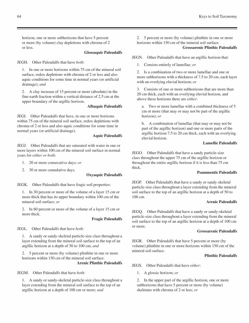
64 Keys to Soil Taxonomy
horizon, one or more subhorizons that have 5 percentor more (by volume) clay depletions with chroma of 2or less.
Glossaquic Paleudalfs
JEGH. Other Paleudalfs that have both:
1. In one or more horizons within 75 cm of the mineral soilsurface, redox depletions with chroma of 2 or less and alsoaquic conditions for some time in normal years (or artificialdrainage); and
2. A clay increase of 15 percent or more (absolute) in thefine-earth fraction within a vertical distance of 2.5 cm at theupper boundary of the argillic horizon.
Albaquic Paleudalfs
JEGI. Other Paleudalfs that have, in one or more horizonswithin 75 cm of the mineral soil surface, redox depletions withchroma of 2 or less and also aquic conditions for some time innormal years (or artificial drainage).
Aquic Paleudalfs
JEGJ. Other Paleudalfs that are saturated with water in one ormore layers within 100 cm of the mineral soil surface in normalyears for either or both:
1. 20 or more consecutive days; or
2. 30 or more cumulative days.Oxyaquic Paleudalfs
JEGK. Other Paleudalfs that have fragic soil properties:
1. In 30 percent or more of the volume of a layer 15 cm ormore thick that has its upper boundary within 100 cm of themineral soil surface; or
2. In 60 percent or more of the volume of a layer 15 cm ormore thick.
Fragic Paleudalfs
JEGL. Other Paleudalfs that have both:
1. A sandy or sandy-skeletal particle-size class throughout alayer extending from the mineral soil surface to the top of anargillic horizon at a depth of 50 to 100 cm; and
2. 5 percent or more (by volume) plinthite in one or morehorizons within 150 cm of the mineral soil surface.
Arenic Plinthic Paleudalfs
JEGM. Other Paleudalfs that have both:
1. A sandy or sandy-skeletal particle-size class throughout alayer extending from the mineral soil surface to the top of anargillic horizon at a depth of 100 cm or more; and
2. 5 percent or more (by volume) plinthite in one or morehorizons within 150 cm of the mineral soil surface.
Grossarenic Plinthic Paleudalfs
JEGN. Other Paleudalfs that have an argillic horizon that:
1. Consists entirely of lamellae; or
2. Is a combination of two or more lamellae and one ormore subhorizons with a thickness of 7.5 to 20 cm, each layerwith an overlying eluvial horizon; or
3. Consists of one or more subhorizons that are more than20 cm thick, each with an overlying eluvial horizon, andabove these horizons there are either:
a. Two or more lamellae with a combined thickness of 5cm or more (that may or may not be part of the argillichorizon); or
b. A combination of lamellae (that may or may not bepart of the argillic horizon) and one or more parts of theargillic horizon 7.5 to 20 cm thick, each with an overlyingeluvial horizon.
Lamellic Paleudalfs
JEGO. Other Paleudalfs that have a sandy particle-sizeclass throughout the upper 75 cm of the argillic horizon orthroughout the entire argillic horizon if it is less than 75 cmthick.
Psammentic Paleudalfs
JEGP. Other Paleudalfs that have a sandy or sandy-skeletalparticle-size class throughout a layer extending from the mineralsoil surface to the top of an argillic horizon at a depth of 50 to100 cm.
Arenic Paleudalfs
JEGQ. Other Paleudalfs that have a sandy or sandy-skeletalparticle-size class throughout a layer extending from the mineralsoil surface to the top of an argillic horizon at a depth of 100 cmor more.
Grossarenic Paleudalfs
JEGR. Other Paleudalfs that have 5 percent or more (byvolume) plinthite in one or more horizons within 150 cm of themineral soil surface.
Plinthic Paleudalfs
JEGS. Other Paleudalfs that have either:
1. A glossic horizon; or
2. In the upper part of the argillic horizon, one or moresubhorizons that have 5 percent or more (by volume)skeletans with chroma of 2 or less; or
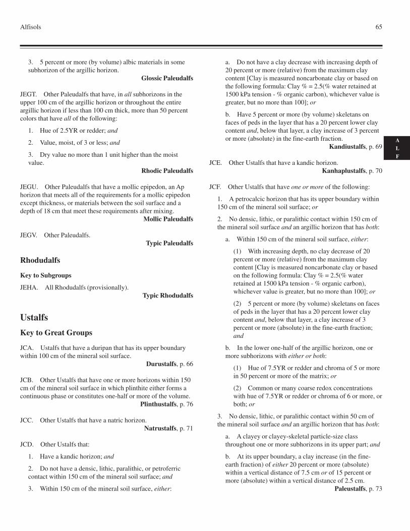
Alfisols 65
A
L
F
3. 5 percent or more (by volume) albic materials in somesubhorizon of the argillic horizon.
Glossic Paleudalfs
JEGT. Other Paleudalfs that have, in all subhorizons in theupper 100 cm of the argillic horizon or throughout the entireargillic horizon if less than 100 cm thick, more than 50 percentcolors that have all of the following:
1. Hue of 2.5YR or redder; and
2. Value, moist, of 3 or less; and
3. Dry value no more than 1 unit higher than the moistvalue.
Rhodic Paleudalfs
JEGU. Other Paleudalfs that have a mollic epipedon, an Aphorizon that meets all of the requirements for a mollic epipedonexcept thickness, or materials between the soil surface and adepth of 18 cm that meet these requirements after mixing.
Mollic Paleudalfs
JEGV. Other Paleudalfs.Typic Paleudalfs
Rhodudalfs
Key to Subgroups
JEHA. All Rhodudalfs (provisionally).Typic Rhodudalfs
Ustalfs
Key to Great Groups
JCA. Ustalfs that have a duripan that has its upper boundarywithin 100 cm of the mineral soil surface.
Durustalfs, p. 66
JCB. Other Ustalfs that have one or more horizons within 150cm of the mineral soil surface in which plinthite either forms acontinuous phase or constitutes one-half or more of the volume.
Plinthustalfs, p. 76
JCC. Other Ustalfs that have a natric horizon.Natrustalfs, p. 71
JCD. Other Ustalfs that:
1. Have a kandic horizon; and
2. Do not have a densic, lithic, paralithic, or petroferriccontact within 150 cm of the mineral soil surface; and
3. Within 150 cm of the mineral soil surface, either:
a. Do not have a clay decrease with increasing depth of20 percent or more (relative) from the maximum claycontent [Clay is measured noncarbonate clay or based onthe following formula: Clay % = 2.5(% water retained at1500 kPa tension - % organic carbon), whichever value isgreater, but no more than 100]; or
b. Have 5 percent or more (by volume) skeletans onfaces of peds in the layer that has a 20 percent lower claycontent and, below that layer, a clay increase of 3 percentor more (absolute) in the fine-earth fraction.
Kandiustalfs, p. 69
JCE. Other Ustalfs that have a kandic horizon.Kanhaplustalfs, p. 70
JCF. Other Ustalfs that have one or more of the following:
1. A petrocalcic horizon that has its upper boundary within150 cm of the mineral soil surface; or
2. No densic, lithic, or paralithic contact within 150 cm ofthe mineral soil surface and an argillic horizon that has both:
a. Within 150 cm of the mineral soil surface, either:
(1) With increasing depth, no clay decrease of 20percent or more (relative) from the maximum claycontent [Clay is measured noncarbonate clay or basedon the following formula: Clay % = 2.5(% waterretained at 1500 kPa tension - % organic carbon),whichever value is greater, but no more than 100]; or
(2) 5 percent or more (by volume) skeletans on facesof peds in the layer that has a 20 percent lower claycontent and, below that layer, a clay increase of 3percent or more (absolute) in the fine-earth fraction;and
b. In the lower one-half of the argillic horizon, one ormore subhorizons with either or both:
(1) Hue of 7.5YR or redder and chroma of 5 or morein 50 percent or more of the matrix; or
(2) Common or many coarse redox concentrationswith hue of 7.5YR or redder or chroma of 6 or more, orboth; or
3. No densic, lithic, or paralithic contact within 50 cm ofthe mineral soil surface and an argillic horizon that has both:
a. A clayey or clayey-skeletal particle-size classthroughout one or more subhorizons in its upper part; and
b. At its upper boundary, a clay increase (in the fine-earth fraction) of either 20 percent or more (absolute)within a vertical distance of 7.5 cm or of 15 percent ormore (absolute) within a vertical distance of 2.5 cm.
Paleustalfs, p. 73
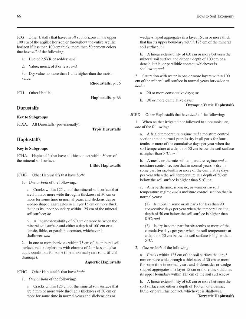
66 Keys to Soil Taxonomy
JCG. Other Ustalfs that have, in all subhorizons in the upper100 cm of the argillic horizon or throughout the entire argillichorizon if less than 100 cm thick, more than 50 percent colorsthat have all of the following:
1. Hue of 2.5YR or redder; and
2. Value, moist, of 3 or less; and
3. Dry value no more than 1 unit higher than the moistvalue.
Rhodustalfs, p. 76
JCH. Other Ustalfs.Haplustalfs, p. 66
Durustalfs
Key to Subgroups
JCAA. All Durustalfs (provisionally).Typic Durustalfs
Haplustalfs
Key to Subgroups
JCHA. Haplustalfs that have a lithic contact within 50 cm ofthe mineral soil surface.
Lithic Haplustalfs
JCHB. Other Haplustalfs that have both:
1. One or both of the following:
a. Cracks within 125 cm of the mineral soil surface thatare 5 mm or more wide through a thickness of 30 cm ormore for some time in normal years and slickensides orwedge-shaped aggregates in a layer 15 cm or more thickthat has its upper boundary within 125 cm of the mineralsoil surface; or
b. A linear extensibility of 6.0 cm or more between themineral soil surface and either a depth of 100 cm or adensic, lithic, or paralithic contact, whichever isshallower; and
2. In one or more horizons within 75 cm of the mineral soilsurface, redox depletions with chroma of 2 or less and alsoaquic conditions for some time in normal years (or artificialdrainage).
Aquertic Haplustalfs
JCHC. Other Haplustalfs that have both:
1. One or both of the following:
a. Cracks within 125 cm of the mineral soil surface thatare 5 mm or more wide through a thickness of 30 cm ormore for some time in normal years and slickensides or
wedge-shaped aggregates in a layer 15 cm or more thickthat has its upper boundary within 125 cm of the mineralsoil surface; or
b. A linear extensibility of 6.0 cm or more between themineral soil surface and either a depth of 100 cm or adensic, lithic, or paralithic contact, whichever isshallower; and
2. Saturation with water in one or more layers within 100cm of the mineral soil surface in normal years for either orboth:
a. 20 or more consecutive days; or
b. 30 or more cumulative days.Oxyaquic Vertic Haplustalfs
JCHD. Other Haplustalfs that have both of the following:
1. When neither irrigated nor fallowed to store moisture,one of the following:
a. A frigid temperature regime and a moisture controlsection that in normal years is dry in all parts for four-tenths or more of the cumulative days per year when thesoil temperature at a depth of 50 cm below the soil surfaceis higher than 5 oC; or
b. A mesic or thermic soil temperature regime and amoisture control section that in normal years is dry insome part for six-tenths or more of the cumulative daysper year when the soil temperature at a depth of 50 cmbelow the soil surface is higher than 5 oC; or
c. A hyperthermic, isomesic, or warmer iso soiltemperature regime and a moisture control section that innormal years:
(1) Is moist in some or all parts for less than 90consecutive days per year when the temperature at adepth of 50 cm below the soil surface is higher than8 oC; and
(2) Is dry in some part for six-tenths or more of thecumulative days per year when the soil temperature ata depth of 50 cm below the soil surface is higher than5 oC;
2. One or both of the following:
a. Cracks within 125 cm of the soil surface that are 5mm or more wide through a thickness of 30 cm or morefor some time in normal years and slickensides or wedge-shaped aggregates in a layer 15 cm or more thick that hasits upper boundary within 125 cm of the soil surface; or
b. A linear extensibility of 6.0 cm or more between thesoil surface and either a depth of 100 cm or a densic,lithic, or paralithic contact, whichever is shallower.
Torrertic Haplustalfs
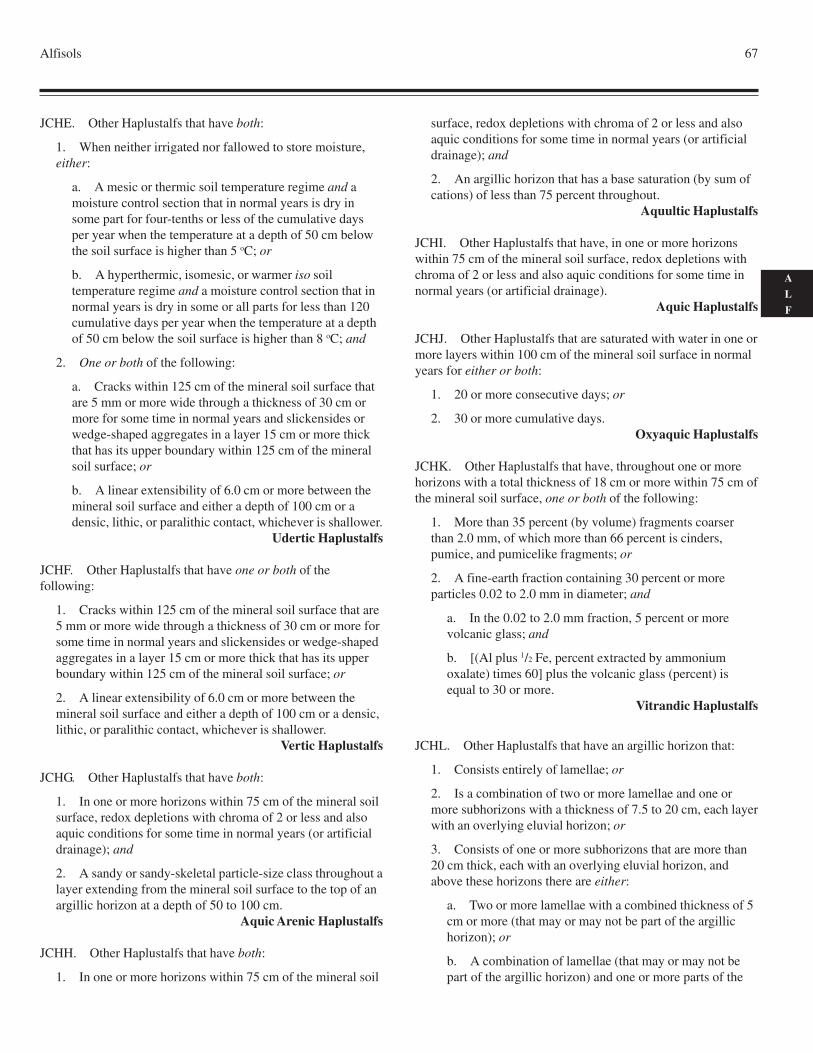
Alfisols 67
A
L
F
JCHE. Other Haplustalfs that have both:
1. When neither irrigated nor fallowed to store moisture,either:
a. A mesic or thermic soil temperature regime and amoisture control section that in normal years is dry insome part for four-tenths or less of the cumulative daysper year when the temperature at a depth of 50 cm belowthe soil surface is higher than 5 oC; or
b. A hyperthermic, isomesic, or warmer iso soiltemperature regime and a moisture control section that innormal years is dry in some or all parts for less than 120cumulative days per year when the temperature at a depthof 50 cm below the soil surface is higher than 8 oC; and
2. One or both of the following:
a. Cracks within 125 cm of the mineral soil surface thatare 5 mm or more wide through a thickness of 30 cm ormore for some time in normal years and slickensides orwedge-shaped aggregates in a layer 15 cm or more thickthat has its upper boundary within 125 cm of the mineralsoil surface; or
b. A linear extensibility of 6.0 cm or more between themineral soil surface and either a depth of 100 cm or adensic, lithic, or paralithic contact, whichever is shallower.
Udertic Haplustalfs
JCHF. Other Haplustalfs that have one or both of thefollowing:
1. Cracks within 125 cm of the mineral soil surface that are5 mm or more wide through a thickness of 30 cm or more forsome time in normal years and slickensides or wedge-shapedaggregates in a layer 15 cm or more thick that has its upperboundary within 125 cm of the mineral soil surface; or
2. A linear extensibility of 6.0 cm or more between themineral soil surface and either a depth of 100 cm or a densic,lithic, or paralithic contact, whichever is shallower.
Vertic Haplustalfs
JCHG. Other Haplustalfs that have both:
1. In one or more horizons within 75 cm of the mineral soilsurface, redox depletions with chroma of 2 or less and alsoaquic conditions for some time in normal years (or artificialdrainage); and
2. A sandy or sandy-skeletal particle-size class throughout alayer extending from the mineral soil surface to the top of anargillic horizon at a depth of 50 to 100 cm.
Aquic Arenic Haplustalfs
JCHH. Other Haplustalfs that have both:
1. In one or more horizons within 75 cm of the mineral soil
surface, redox depletions with chroma of 2 or less and alsoaquic conditions for some time in normal years (or artificialdrainage); and
2. An argillic horizon that has a base saturation (by sum ofcations) of less than 75 percent throughout.
Aquultic Haplustalfs
JCHI. Other Haplustalfs that have, in one or more horizonswithin 75 cm of the mineral soil surface, redox depletions withchroma of 2 or less and also aquic conditions for some time innormal years (or artificial drainage).
Aquic Haplustalfs
JCHJ. Other Haplustalfs that are saturated with water in one ormore layers within 100 cm of the mineral soil surface in normalyears for either or both:
1. 20 or more consecutive days; or
2. 30 or more cumulative days.Oxyaquic Haplustalfs
JCHK. Other Haplustalfs that have, throughout one or morehorizons with a total thickness of 18 cm or more within 75 cm ofthe mineral soil surface, one or both of the following:
1. More than 35 percent (by volume) fragments coarserthan 2.0 mm, of which more than 66 percent is cinders,pumice, and pumicelike fragments; or
2. A fine-earth fraction containing 30 percent or moreparticles 0.02 to 2.0 mm in diameter; and
a. In the 0.02 to 2.0 mm fraction, 5 percent or morevolcanic glass; and
b. [(Al plus 1/2 Fe, percent extracted by ammoniumoxalate) times 60] plus the volcanic glass (percent) isequal to 30 or more.
Vitrandic Haplustalfs
JCHL. Other Haplustalfs that have an argillic horizon that:
1. Consists entirely of lamellae; or
2. Is a combination of two or more lamellae and one ormore subhorizons with a thickness of 7.5 to 20 cm, each layerwith an overlying eluvial horizon; or
3. Consists of one or more subhorizons that are more than20 cm thick, each with an overlying eluvial horizon, andabove these horizons there are either:
a. Two or more lamellae with a combined thickness of 5cm or more (that may or may not be part of the argillichorizon); or
b. A combination of lamellae (that may or may not bepart of the argillic horizon) and one or more parts of the
68 Keys to Soil Taxonomy
argillic horizon 7.5 to 20 cm thick, each with an overlyingeluvial horizon.
Lamellic Haplustalfs
JCHM. Other Haplustalfs that have a sandy particle-size classthroughout the upper 75 cm of the argillic horizon or throughoutthe entire argillic horizon if it is less than 75 cm thick.
Psammentic Haplustalfs
JCHN. Other Haplustalfs that have both:
1. A sandy or sandy-skeletal particle-size class throughout alayer extending from the mineral soil surface to the top of anargillic horizon at a depth of 50 cm or more; and
2. When neither irrigated nor fallowed to store moisture,one of the following:
a. A frigid temperature regime and a moisture controlsection that in normal years is dry in all parts for four-tenths or more of the cumulative days per year when thesoil temperature at a depth of 50 cm below the soil surfaceis higher than 5 oC; or
b. A mesic or thermic soil temperature regimeand a moisture control section that in normal yearsis dry in some part for six-tenths or more of thecumulative days per year when the soil temperatureat a depth of 50 cm below the soil surface is higherthan 5 oC; or
c. A hyperthermic, isomesic, or warmer iso soiltemperature regime and a moisture control section that innormal years:
(1) Is moist in some or all parts for less than 90consecutive days per year when the temperature at adepth of 50 cm below the soil surface is higher than8 oC; and
(2) Is dry in some part for six-tenths or more of thecumulative days per year when the soil temperature at adepth of 50 cm below the soil surface is higher than5 oC.
Arenic Aridic Haplustalfs
JCHO. Other Haplustalfs that have a sandy or sandy-skeletalparticle-size class throughout a layer extending from the mineralsoil surface to the top of an argillic horizon at a depth of 50 cmor more.
Arenic Haplustalfs
JCHP. Other Haplustalfs that have both:
1. A calcic horizon with its upper boundary within 100 cmof the mineral soil surface; and
2. When neither irrigated nor fallowed to store moisture,one of the following:
a. A frigid temperature regime and a moisture controlsection that in normal years is dry in all parts for four-tenths or more of the cumulative days per year when thesoil temperature at a depth of 50 cm below the soil surfaceis higher than 5 oC; or
b. A mesic or thermic soil temperature regime and amoisture control section that in normal years is dry insome part for six-tenths or more of the cumulative daysper year when the soil temperature at a depth of 50 cmbelow the soil surface is higher than 5 oC; or
c. A hyperthermic, isomesic, or warmer iso soiltemperature regime and a moisture control section that innormal years:
(1) Is moist in some or all parts for less than 90consecutive days per year when the temperature at adepth of 50 cm below the soil surface is higher than8 oC; and
(2) Is dry in some part for six-tenths or more of thecumulative days per year when the soil temperature at adepth of 50 cm below the soil surface is higher than 5oC.
Calcidic Haplustalfs
JCHQ. Other Haplustalfs that, when neither irrigated norfallowed to store moisture, have one of the following:
1. A frigid temperature regime and a moisture controlsection that in normal years is dry in all parts for four-tenthsor more of the cumulative days per year when the soiltemperature at a depth of 50 cm below the soil surface ishigher than 5 oC; or
2. A mesic or thermic soil temperature regime and amoisture control section that in normal years is dry in somepart for six-tenths or more of the cumulative days per yearwhen the soil temperature at a depth of 50 cm below the soilsurface is higher than 5 oC; or
3. A hyperthermic, isomesic, or warmer iso soiltemperature regime and a moisture control section that innormal years:
a. Is moist in some or all parts for less than 90consecutive days per year when the temperature at a depthof 50 cm below the soil surface is higher than 8 oC; and
b. Is dry in some part for six-tenths or more of thecumulative days per year when the soil temperature at adepth of 50 cm below the soil surface is higher than 5 oC.
Aridic Haplustalfs
Alfisols 69
A
L
F
JCHR. Other Haplustalfs that have a CEC of less than 24cmol(+)/kg clay (by 1N NH
4OAc pH 7) in 50 percent or more
either of the argillic horizon if less than 100 cm thick or of itsupper 100 cm.
Kanhaplic HaplustalfsJCHS. Other Haplustalfs that have:
1. An argillic, kandic, or natric horizon that is 35 cm or lessthick; and
2. No densic, lithic, or paralithic contact within 100 cm ofthe mineral soil surface.
Inceptic Haplustalfs
JCHT. Other Haplustalfs that have both:
1. A calcic horizon with its upper boundary within 100 cmof the mineral soil surface; and
2. When neither irrigated nor fallowed to store moisture,one of the following:
a. A frigid temperature regime and a moisture controlsection that in normal years is dry in some or all parts forless than 105 cumulative days per year when thetemperature at a depth of 50 cm below the soil surface ishigher than 5 oC; or
b. A mesic or thermic soil temperature regime and amoisture control section that in normal years is dry insome part for four-tenths or less of the cumulative daysper year when the temperature at a depth of 50 cm belowthe soil surface is higher than 5 oC; or
c. A hyperthermic, isomesic, or warmer iso soiltemperature regime and a moisture control section that innormal years is dry in some or all parts for less than 120cumulative days per year when the temperature at a depthof 50 cm below the soil surface is higher than 8 oC.
Calcic Udic Haplustalfs
JCHU. Other Haplustalfs that have an argillic horizon with abase saturation (by sum of cations) of less than 75 percentthroughout.
Ultic Haplustalfs
JCHV. Other Haplustalfs that have a calcic horizon with itsupper boundary within 100 cm of the mineral soil surface.
Calcic Haplustalfs
JCHW. Other Haplustalfs that, when neither irrigated norfallowed to store moisture, have one of the following:
1. A frigid temperature regime and a moisture controlsection that in normal years is dry in some or all parts forless than 105 cumulative days per year when the temperatureat a depth of 50 cm below the soil surface is higher than 5 oC;or
2. A mesic or thermic soil temperature regime and amoisture control section that in normal years is dry in somepart for four-tenths or less of the cumulative days per yearwhen the temperature at a depth of 50 cm below the soilsurface is higher than 5 oC; or
3. A hyperthermic, isomesic, or warmer iso soiltemperature regime and a moisture control section that innormal years is dry in some or all parts for less than 120cumulative days per year when the temperature at a depth of50 cm below the soil surface is higher than 8 oC.
Udic Haplustalfs
JCHX. Other Haplustalfs.Typic Haplustalfs
Kandiustalfs
Key to Subgroups
JCDA. Kandiustalfs that have a sandy or sandy-skeletalparticle-size class throughout a layer extending from the mineralsoil surface to the top of a kandic horizon at a depth of 100 cmor more.
Grossarenic Kandiustalfs
JCDB. Other Kandiustalfs that have both:
1. In one or more horizons within 75 cm of the mineral soilsurface, redox depletions with chroma of 2 or less and alsoaquic conditions for some time in normal years (or artificialdrainage); and
2. A sandy or sandy-skeletal particle-size class throughout alayer extending from the mineral soil surface to the top of akandic horizon at a depth of 50 to 100 cm.
Aquic Arenic Kandiustalfs
JCDC. Other Kandiustalfs that have 5 percent or more (byvolume) plinthite in one or more horizons within 150 cm of themineral soil surface.
Plinthic Kandiustalfs
JCDD. Other Kandiustalfs that have, in one or more horizonswithin 75 cm of the mineral soil surface, redox depletions withchroma of 2 or less and also aquic conditions for some time innormal years (or artificial drainage).
Aquic Kandiustalfs
JCDE. Other Kandiustalfs that have both:
1. A sandy or sandy-skeletal particle-size class throughout alayer extending from the mineral soil surface to the top of akandic horizon at a depth of 50 to 100 cm; and
2. When neither irrigated nor fallowed to store moisture,either:
70 Keys to Soil Taxonomy
a. A mesic or thermic soil temperature regime and amoisture control section that in normal years is dry insome part for six-tenths or more of the cumulative daysper year when the soil temperature at a depth of 50 cmbelow the soil surface is higher than 5 oC; or
b. A hyperthermic, isomesic, or warmer iso soiltemperature regime and a moisture control section that innormal years:
(1) Is moist in some or all parts for less than 90consecutive days per year when the temperature at adepth of 50 cm below the soil surface is higher than8 oC; and
(2) Is dry in some part for six-tenths or more of thecumulative days per year when the soil temperature at adepth of 50 cm below the soil surface is higher than 5oC.
Arenic Aridic Kandiustalfs
JCDF. Other Kandiustalfs that have a sandy or sandy-skeletalparticle-size class throughout a layer extending from the mineralsoil surface to the top of a kandic horizon at a depth of 50 to100 cm.
Arenic Kandiustalfs
JCDG. Other Kandiustalfs that, when neither irrigated norfallowed to store moisture, have either:
1. A mesic or thermic soil temperature regime and amoisture control section that in normal years is dry in somepart for six-tenths or more of the cumulative days per yearwhen the soil temperature at a depth of 50 cm below the soilsurface is higher than 5 oC; or
2. A hyperthermic, isomesic, or warmer iso soiltemperature regime and a moisture control section that innormal years:
a. Is moist in some or all parts for less than 90consecutive days per year when the temperature at a depthof 50 cm below the soil surface is higher than 8 oC; and
b. Is dry in some part for six-tenths or more of thecumulative days per year when the soil temperature at adepth of 50 cm below the soil surface is higher than5 oC.
Aridic Kandiustalfs
JCDH. Other Kandiustalfs that, when neither irrigated norfallowed to store moisture, have either:
1. A mesic or thermic soil temperature regime and amoisture control section that in normal years is dry in somepart for 135 cumulative days or less per year when thetemperature at a depth of 50 cm below the soil surface ishigher than 5 oC; or
2. A hyperthermic, isomesic, or warmer iso soiltemperature regime and a moisture control section that innormal years is dry in some or all parts for less than 120cumulative days per year when the temperature at a depth of50 cm below the soil surface is higher than 8 oC.
Udic Kandiustalfs
JCDI. Other Kandiustalfs that have, in all subhorizons in theupper 100 cm of the kandic horizon or throughout the entirekandic horizon if less than 100 cm thick, more than 50 percentcolors that have all of the following:
1. Hue of 2.5YR or redder; and
2. Value, moist, of 3 or less; and
3. Dry value no more than 1 unit higher than the moistvalue.
Rhodic Kandiustalfs
JCDJ. Other Kandiustalfs.Typic Kandiustalfs
Kanhaplustalfs
Key to Subgroups
JCEA. Kanhaplustalfs that have a lithic contact within 50 cmof the mineral soil surface.
Lithic Kanhaplustalfs
JCEB. Other Kanhaplustalfs that have, in one or morehorizons within 75 cm of the mineral soil surface, redoxdepletions with chroma of 2 or less and also aquic conditions forsome time in normal years (or artificial drainage).
Aquic Kanhaplustalfs
JCEC. Other Kanhaplustalfs that, when neither irrigated norfallowed to store moisture, have either:
1. A mesic or thermic soil temperature regime and amoisture control section that in normal years is dry in somepart for six-tenths or more of the cumulative days per yearwhen the soil temperature at a depth of 50 cm below the soilsurface is higher than 5 oC; or
2. A hyperthermic, isomesic, or warmer iso soiltemperature regime and a moisture control section that innormal years:
a. Is moist in some or all parts for less than 90consecutive days per year when the temperature at a depthof 50 cm below the soil surface is higher than 8 oC; and
b. Is dry in some part for six-tenths or more of thecumulative days per year when the soil temperature at adepth of 50 cm below the soil surface is higher than5 oC.
Aridic Kanhaplustalfs
Alfisols 71
A
L
F
JCED. Other Kanhaplustalfs that, when neither irrigated norfallowed to store moisture, have either:
1. A mesic or thermic soil temperature regime and amoisture control section that in normal years is dry in somepart for 135 cumulative days or less per year when thetemperature at a depth of 50 cm below the soil surface ishigher than 5 oC; or
2. A hyperthermic, isomesic, or warmer iso soiltemperature regime and a moisture control section that innormal years is dry in some or all parts for less than 120cumulative days per year when the temperature at a depth of50 cm below the soil surface is higher than 8 oC.
Udic Kanhaplustalfs
JCEE. Other Kanhaplustalfs that have, in all subhorizons inthe upper 100 cm of the kandic horizon or throughout the entirekandic horizon if less than 100 cm thick, more than 50 percentcolors that have all of the following:
1. Hue of 2.5YR or redder; and
2. Value, moist, of 3 or less; and
3. Dry value no more than 1 unit higher than the moistvalue.
Rhodic Kanhaplustalfs
JCEF. Other Kanhaplustalfs.Typic Kanhaplustalfs
Natrustalfs
Key to Subgroups
JCCA. Natrustalfs that have a salic horizon that has its upperboundary within 75 cm of the mineral soil surface.
Salidic Natrustalfs
JCCB. Other Natrustalfs that have all of the following:
1. Visible crystals of gypsum or other salts more solublethan gypsum, or both, within 40 cm of the soil surface; and
2. When neither irrigated nor fallowed to store moisture,one of the following:
a. A frigid temperature regime and a moisture controlsection that in normal years is dry in all parts for four-tenths or more of the cumulative days per year when thesoil temperature at a depth of 50 cm below the soil surfaceis higher than 5 oC; or
b. A mesic or thermic soil temperature regime and amoisture control section that in normal years is dry insome part for six-tenths or more of the cumulative daysper year when the soil temperature at a depth of 50 cmbelow the soil surface is higher than 5 oC; or
c. A hyperthermic, isomesic, or warmer iso soiltemperature regime and a moisture control section that innormal years:
(1) Is moist in some or all parts for less than 90consecutive days per year when the temperature at adepth of 50 cm below the soil surface is higher than8 oC; and
(2) Is dry in some part for six-tenths or more of thecumulative days per year when the soil temperature at adepth of 50 cm below the soil surface is higher than 5oC; and
3. One or both of the following:
a. Cracks within 125 cm of the mineral soil surface thatare 5 mm or more wide through a thickness of 30 cm ormore for some time in normal years and slickensides orwedge-shaped aggregates in a layer 15 cm or more thickthat has its upper boundary within 125 cm of the mineralsoil surface; or
b. A linear extensibility of 6.0 cm or more between themineral soil surface and either a depth of 100 cm or adensic, lithic, or paralithic contact, whichever is shallower.
Leptic Torrertic Natrustalfs
JCCC. Other Natrustalfs that have both of the following:
1. When neither irrigated nor fallowed to store moisture,one of the following:
a. A frigid temperature regime and a moisture controlsection that in normal years is dry in all parts for four-tenths or more of the cumulative days per year when thesoil temperature at a depth of 50 cm below the soil surfaceis higher than 5 oC; or
b. A mesic or thermic soil temperature regime and amoisture control section that in normal years is dry insome part for six-tenths or more of the cumulative daysper year when the soil temperature at a depth of 50 cmbelow the soil surface is higher than 5 oC; or
c. A hyperthermic, isomesic, or warmer iso soiltemperature regime and a moisture control section that innormal years:
(1) Is moist in some or all parts for less than 90consecutive days per year when the temperature at adepth of 50 cm below the soil surface is higher than8 oC; and
(2) Is dry in some part for six-tenths or more of thecumulative days per year when the soil temperature at adepth of 50 cm below the soil surface is higher than 5oC; and
2. One or both of the following:
72 Keys to Soil Taxonomy
a. Cracks within 125 cm of the mineral soil surface thatare 5 mm or more wide through a thickness of 30 cm ormore for some time in normal years and slickensides orwedge-shaped aggregates in a layer 15 cm or more thickthat has its upper boundary within 125 cm of the mineralsoil surface; or
b. A linear extensibility of 6.0 cm or more between themineral soil surface and either a depth of 100 cm or adensic, lithic, or paralithic contact, whichever is shallower.
Torrertic Natrustalfs
JCCD. Other Natrustalfs that have both:
1. In one or more horizons within 75 cm of the mineral soilsurface, redox depletions with chroma of 2 or less and alsoaquic conditions for some time in normal years (or artificialdrainage); and
2. One or both of the following:
a. Cracks within 125 cm of the mineral soil surface thatare 5 mm or more wide through a thickness of 30 cm ormore for some time in normal years and slickensides orwedge-shaped aggregates in a layer 15 cm or more thickthat has its upper boundary within 125 cm of the mineralsoil surface; or
b. A linear extensibility of 6.0 cm or more between themineral soil surface and either a depth of 100 cm or adensic, lithic, or paralithic contact, whichever is shallower.
Aquertic Natrustalfs
JCCE. Other Natrustalfs that have both of the following:
1. Visible crystals of gypsum or other salts more solublethan gypsum, or both, within 40 cm of the mineral soilsurface; and
2. When neither irrigated nor fallowed to store moisture,one of the following:
a. A frigid temperature regime and a moisture controlsection that in normal years is dry in all parts for four-tenths or more of the cumulative days per year when thesoil temperature at a depth of 50 cm below the soil surfaceis higher than 5 oC; or
b. A mesic or thermic soil temperature regime and amoisture control section that in normal years is dry insome part for six-tenths or more of the cumulative daysper year when the soil temperature at a depth of 50 cmbelow the soil surface is higher than 5 oC; or
c. A hyperthermic, isomesic, or warmer iso soiltemperature regime and a moisture control section that innormal years:
(1) Is moist in some or all parts for less than 90
consecutive days per year when the temperature at adepth of 50 cm below the soil surface is higher than8 oC; and
(2) Is dry in some part for six-tenths or more of thecumulative days per year when the soil temperature ata depth of 50 cm below the soil surface is higher than5 oC.
Aridic Leptic Natrustalfs
JCCF. Other Natrustalfs that have one or both of thefollowing:
1. Cracks within 125 cm of the mineral soil surface that are5 mm or more wide through a thickness of 30 cm or more forsome time in normal years and slickensides or wedge-shapedaggregates in a layer 15 cm or more thick that has its upperboundary within 125 cm of the mineral soil surface; or
2. A linear extensibility of 6.0 cm or more betweenthe mineral soil surface and either a depth of 100 cm ora densic, lithic, or paralithic contact, whichever is shallower.
Vertic Natrustalfs
JCCG. Other Natrustalfs that have both:
1. In one or more horizons within 75 cm of the mineral soilsurface, redox depletions with chroma of 2 or less and alsoaquic conditions for some time in normal years (or artificialdrainage); and
2. A sandy or sandy-skeletal particle-size class throughout alayer extending from the mineral soil surface to the top of anargillic horizon at a depth of 50 cm or more.
Aquic Arenic Natrustalfs
JCCH. Other Natrustalfs that have, in one or more horizonswithin 75 cm of the mineral soil surface, redox depletions withchroma of 2 or less and also aquic conditions for some time innormal years (or artificial drainage).
Aquic Natrustalfs
JCCI. Other Natrustalfs that have a sandy or sandy-skeletalparticle-size class throughout a layer extending from the mineralsoil surface to the top of an argillic horizon at a depth of 50 cmor more.
Arenic Natrustalfs
JCCJ. Other Natrustalfs that have a petrocalcic horizon thathas its upper boundary within 150 cm of the mineral soilsurface.
Petrocalcic Natrustalfs
JCCK. Other Natrustalfs that have visible crystals of gypsum
Alfisols 73
A
L
F
or other salts more soluble than gypsum, or both, within 40 cmof the mineral soil surface.
Leptic Natrustalfs
JCCL. Other Natrustalfs that have both of the following:
1. An exchangeable sodium percentage of less than 15 (or asodium adsorption ratio of less than 13) in 50 percent ormore of the natric horizon; and
2. When neither irrigated nor fallowed to store moisture,one of the following:
a. A frigid temperature regime and a moisture controlsection that in normal years is dry in all parts for four-tenths or more of the cumulative days per year when thesoil temperature at a depth of 50 cm below the soil surfaceis higher than 5 oC; or
b. A mesic or thermic soil temperature regime and amoisture control section that in normal years is dry insome part for six-tenths or more of the cumulative daysper year when the soil temperature at a depth of 50 cmbelow the soil surface is higher than 5 oC; or
c. A hyperthermic, isomesic, or warmer iso soiltemperature regime and a moisture control section that innormal years:
(1) Is moist in some or all parts for less than 90consecutive days per year when the temperature at adepth of 50 cm below the soil surface is higher than8 oC; and
(2) Is dry in some part for six-tenths or more of thecumulative days per year when the soil temperature at adepth of 50 cm below the soil surface is higher than 5oC.
Haplargidic Natrustalfs
JCCM. Other Natrustalfs that have both:
1. When neither irrigated nor fallowed to store moisture, oneof the following:
a. A frigid soil temperature regime and a moisturecontrol section that in normal years is dry in all parts forfour-tenths or more of the cumulative days per year whenthe temperature at a depth of 50 cm below the soil surfaceis higher than 5 °C; or
b. A mesic or thermic soil temperature regime and amoisture control section that, in 6 normal years, is dry insome part for six-tenths or more of the cumulative daysper year when the soil temperature at a depth of 50 cmbelow the soil surface is higher than 5 °C; or
c. A hyperthermic, an isomesic, or a warmer iso soiltemperature regime and a moisture control section that, innormal years:
(1) Is moist in some or all parts for fewer than 90consecutive days per year when the temperature at a depthof 50 cm below the soil surface is higher than 8 °C; and
(2) Is dry in some part for six-tenths or more of thecumulative days per year when the temperature at a depthof 50 cm below the soil surface is higher than 5 °C; and
2. A glossic horizon or interfingering of albic materials intothe natric horizon.
Aridic Glossic Natrustalfs
JCCN. Other Natrustalfs that, when neither irrigated norfallowed to store moisture, have one of the following:
1. A frigid temperature regime and a moisture controlsection that in normal years is dry in all parts for four-tenthsor more of the cumulative days per year when the soiltemperature at a depth of 50 cm below the soil surface ishigher than 5 oC; or
2. A mesic or thermic soil temperature regime and amoisture control section that in normal years is dry in somepart for six-tenths or more of the cumulative days per yearwhen the soil temperature at a depth of 50 cm below the soilsurface is higher than 5 oC; or
3. A hyperthermic, isomesic, or warmer iso soiltemperature regime and a moisture control section that innormal years:
a. Is moist in some or all parts for less than 90consecutive days per year when the temperature at a depthof 50 cm below the soil surface is higher than 8 oC; and
b. Is dry in some part for six-tenths or more of thecumulative days per year when the soil temperature at adepth of 50 cm below the soil surface is higher than 5 oC.
Aridic Natrustalfs
JCCO. Other Natrustalfs that have an Ap horizon with a colorvalue, moist, of 3 or less and a color value, dry, of 5 or less(crushed and smoothed sample) or materials between the soilsurface and a depth of 18 cm that have these color values aftermixing.
Mollic Natrustalfs
JCCP. Other Natrustalfs.Typic Natrustalfs
Paleustalfs
Key to Subgroups
JCFA. Paleustalfs that have both:
1. One or both of the following:
a. Cracks within 125 cm of the mineral soil surface that
74 Keys to Soil Taxonomy
are 5 mm or more wide through a thickness of 30 cm ormore for some time in normal years and slickensides orwedge-shaped aggregates in a layer 15 cm or more thickthat has its upper boundary within 125 cm of the mineralsoil surface; or
b. A linear extensibility of 6.0 cm or more between themineral soil surface and either a depth of 100 cm or adensic, lithic, or paralithic contact, whichever isshallower; and
2. In one or more horizons within 75 cm of the mineral soilsurface, redox depletions with chroma of 2 or less and alsoaquic conditions for some time in normal years (or artificialdrainage).
Aquertic Paleustalfs
JCFB. Other Paleustalfs that have both:
1. One or both of the following:
a. Cracks within 125 cm of the mineral soil surface thatare 5 mm or more wide through a thickness of 30 cm ormore for some time in normal years and slickensides orwedge-shaped aggregates in a layer 15 cm or more thickthat has its upper boundary within 125 cm of the mineralsoil surface; or
b. A linear extensibility of 6.0 cm or more between themineral soil surface and either a depth of 100 cm or adensic, lithic, or paralithic contact, whichever isshallower; and
2. Saturation with water in one or more layers within 100cm of the mineral soil surface in normal years for either orboth:
a. 20 or more consecutive days; or
b. 30 or more cumulative days.Oxyaquic Vertic Paleustalfs
JCFC. Other Paleustalfs that have both:
1. When neither irrigated nor fallowed to store moisture,either:
a. A mesic or thermic soil temperature regime and amoisture control section that in normal years is dry insome part for four-tenths or less of the time (cumulative)per year when the temperature at a depth of 50 cm belowthe soil surface is higher than 5 oC; or
b. A hyperthermic, isomesic, or warmer iso soiltemperature regime and a moisture control section that innormal years is dry in some or all parts for less than 120cumulative days per year when the temperature at a depthof 50 cm below the soil surface is higher than 8 oC; and
2. One or both of the following:
a. Cracks within 125 cm of the mineral soil surface thatare 5 mm or more wide through a thickness of 30 cm ormore for some time in normal years and slickensides orwedge-shaped aggregates in a layer 15 cm or more thickthat has its upper boundary within 125 cm of the mineralsoil surface; or
b. A linear extensibility of 6.0 cm or more between themineral soil surface and either a depth of 100 cm or adensic, lithic, or paralithic contact, whichever is shallower.
Udertic Paleustalfs
JCFD. Other Paleustalfs that have one or both of thefollowing:
1. Cracks within 125 cm of the mineral soil surface that are5 mm or more wide through a thickness of 30 cm or more forsome time in normal years and slickensides or wedge-shapedaggregates in a layer 15 cm or more thick that has its upperboundary within 125 cm of the mineral soil surface; or
2. A linear extensibility of 6.0 cm or more between themineral soil surface and either a depth of 100 cm or a densic,lithic, or paralithic contact, whichever is shallower.
Vertic Paleustalfs
JCFE. Other Paleustalfs that have both:
1. In one or more horizons within 75 cm of the mineral soilsurface, redox depletions with chroma of 2 or less and alsoaquic conditions for some time in normal years (or artificialdrainage); and
2. A sandy or sandy-skeletal particle-size class throughout alayer extending from the mineral soil surface to the top of anargillic horizon at a depth of 50 to 100 cm.
Aquic Arenic Paleustalfs
JCFF. Other Paleustalfs that have, in one or more horizonswithin 75 cm of the mineral soil surface, redox depletions withchroma of 2 or less and also aquic conditions for some time innormal years (or artificial drainage).
Aquic Paleustalfs
JCFG. Other Paleustalfs that are saturated with water in one ormore layers within 100 cm of the mineral soil surface in normalyears for either or both:
1. 20 or more consecutive days; or
2. 30 or more cumulative days.Oxyaquic Paleustalfs
JCFH. Other Paleustalfs that have an argillic horizon that:
1. Consists entirely of lamellae; or
2. Is a combination of two or more lamellae and one or
Alfisols 75
A
L
F
more subhorizons with a thickness of 7.5 to 20 cm, each layerwith an overlying eluvial horizon; or
3. Consists of one or more subhorizons that are more than20 cm thick, each with an overlying eluvial horizon, andabove these horizons there are either:
a. Two or more lamellae with a combined thickness of 5cm or more (that may or may not be part of the argillichorizon); or
b. A combination of lamellae (that may or may not bepart of the argillic horizon) and one or more parts of theargillic horizon 7.5 to 20 cm thick, each with an overlyingeluvial horizon.
Lamellic Paleustalfs
JCFI. Other Paleustalfs that have a sandy particle-size classthroughout the upper 75 cm of the argillic horizon or throughoutthe entire argillic horizon if it is less than 75 cm thick.
Psammentic Paleustalfs
JCFJ. Other Paleustalfs that have both:
1. A sandy or sandy-skeletal particle-size class throughout alayer extending from the mineral soil surface to the top of anargillic horizon at a depth of 50 to 100 cm; and
2. When neither irrigated nor fallowed to store moisture,one of the following:
a. A frigid temperature regime and a moisture controlsection that in normal years is dry in all parts for four-tenths or more of the time (cumulative) per year when thesoil temperature at a depth of 50 cm below the soil surfaceis higher than 5 oC; or
b. A mesic or thermic soil temperature regime and amoisture control section that in normal years is dry insome part for six-tenths or more of the time (cumulative)per year when the soil temperature at a depth of 50 cmbelow the soil surface is higher than 5 oC; or
c. A hyperthermic, isomesic, or warmer iso soiltemperature regime and a moisture control section that innormal years:
(1) Is moist in some or all parts for less than 90consecutive days per year when the temperature at adepth of 50 cm below the soil surface is higher than8 oC; and
(2) Is dry in some part for six-tenths or more of thecumulative days per year when the soil temperature ata depth of 50 cm below the soil surface is higher than5 oC.
Arenic Aridic Paleustalfs
JCFK. Other Paleustalfs that have a sandy or sandy-skeletal
particle-size class throughout a layer extending from the mineralsoil surface to the top of an argillic horizon at a depth of 100 cmor more.
Grossarenic Paleustalfs
JCFL. Other Paleustalfs that have a sandy or sandy-skeletalparticle-size class throughout a layer extending from the mineralsoil surface to the top of an argillic horizon at a depth of 50 to100 cm.
Arenic Paleustalfs
JCFM. Other Paleustalfs that have 5 percent or more (byvolume) plinthite in one or more horizons within 150 cm of themineral soil surface.
Plinthic Paleustalfs
JCFN. Other Paleustalfs that have a petrocalcic horizon thathas its upper boundary within 150 cm of the mineral soilsurface.
Petrocalcic Paleustalfs
JCFO. Other Paleustalfs that have both:
1. When neither irrigated nor fallowed to store moisture,either:
a. A frigid temperature regime and a moisture controlsection that in normal years is dry in all parts for four-tenths or more of the time (cumulative) per year when thesoil temperature at a depth of 50 cm below the soil surfaceis higher than 5 oC; or
b. A mesic or thermic soil temperature regime and amoisture control section that in normal years is dry insome part for six-tenths or more of the time (cumulative)per year when the soil temperature at a depth of 50 cmbelow the soil surface is higher than 5 oC; or
c. A hyperthermic, isomesic, or warmer iso soiltemperature regime and a moisture control section that innormal years:
(1) Is moist in some or all parts for less than 90consecutive days per year when the temperature at adepth of 50 cm below the soil surface is higher than8 oC; and
(2) Is dry in some part for six-tenths or more of thecumulative days per year when the soil temperature ata depth of 50 cm below the soil surface is higher than5 oC; and
2. A calcic horizon either within 100 cm of the mineral soilsurface if the weighted average particle-size class of theupper 50 cm of the argillic horizon is sandy, or within 60 cmif it is loamy, or within 50 cm if it is clayey, and carbonatesin all horizons above the calcic horizon.
Calcidic Paleustalfs
76 Keys to Soil Taxonomy
JCFP. Other Paleustalfs that, when neither irrigated norfallowed to store moisture, have:
1. A frigid temperature regime and a moisture controlsection that in normal years is dry in all parts for four-tenthsor more of the time (cumulative) per year when the soiltemperature at a depth of 50 cm below the soil surface ishigher than 5 oC; or
2. A mesic or thermic soil temperature regime and amoisture control section that in normal years is dry in somepart for six-tenths or more of the time (cumulative) per yearwhen the soil temperature at a depth of 50 cm below the soilsurface is higher than 5 oC; or
3. A hyperthermic, isomesic, or warmer iso soiltemperature regime and a moisture control section that innormal years:
a. Is moist in some or all parts for less than 90consecutive days per year when the temperature at a depthof 50 cm below the soil surface is higher than 8 oC; and
b. Is dry in some part for six-tenths or more of thecumulative days per year when the soil temperature at adepth of 50 cm below the soil surface is higher than 5 oC.
Aridic Paleustalfs
JCFQ. Other Paleustalfs that have a CEC of less than 24cmol(+)/kg clay (by 1N NH
4OAc pH 7) in 50 percent or more
either of the argillic horizon if less than 100 cm thick or of itsupper 100 cm.
Kandic Paleustalfs
JCFR. Other Paleustalfs that have, in all subhorizons in theupper 100 cm of the argillic horizon or throughout the entireargillic horizon if less than 100 cm thick, more than 50 percentcolors that have all of the following:
1. Hue of 2.5YR or redder; and
2. Value, moist, of 3 or less; and
3. Dry value no more than 1 unit higher than the moistvalue.
Rhodic Paleustalfs
JCFS. Other Paleustalfs that have an argillic horizon with abase saturation (by sum of cations) of less than 75 percentthroughout.
Ultic Paleustalfs
JCFT. Other Paleustalfs that, when neither irrigated norfallowed to store moisture, have either:
1. A mesic or thermic soil temperature regime and a
moisture control section that in normal years is dry in somepart for four-tenths or less of the time (cumulative) per yearwhen the temperature at a depth of 50 cm below the soilsurface is higher than 5 oC; or
2. A hyperthermic, isomesic, or warmer iso soiltemperature regime and a moisture control section that innormal years is dry in some or all parts for less than 120cumulative days per year when the temperature at a depth of50 cm below the soil surface is higher than 8 oC.
Udic Paleustalfs
JCFU. Other Paleustalfs.Typic Paleustalfs
Plinthustalfs
Key to Subgroups
JCBA. All Plinthustalfs (provisionally).Typic Plinthustalfs
Rhodustalfs
Key to Subgroups
JCGA. Rhodustalfs that have a lithic contact within 50 cm ofthe mineral soil surface.
Lithic Rhodustalfs
JCGB. Other Rhodustalfs that have a CEC of less than 24cmol(+)/kg clay (by 1N NH
4OAc pH 7) in 50 percent or more
either of the argillic horizon if less than 100 cm thick or of itsupper 100 cm.
Kanhaplic Rhodustalfs
JCGC. Other Rhodustalfs that, when neither irrigated norfallowed to store moisture, have either:
1. A mesic or thermic soil temperature regime and amoisture control section that in normal years is dry in somepart for four-tenths or less of the time (cumulative) per yearwhen the temperature at a depth of 50 cm below the soilsurface is higher than 5 oC; or
2. A hyperthermic, isomesic, or warmer iso soiltemperature regime and a moisture control section that innormal years is dry in some or all parts for less than 120cumulative days per year when the temperature at a depth of50 cm below the soil surface is higher than 8 oC.
Udic Rhodustalfs
JCGD. Other Rhodustalfs.Typic Rhodustalfs
Alfisols 77
A
L
F
Xeralfs
Key to Great Groups
JDA. Xeralfs that have a duripan that has its upper boundarywithin 100 cm of the mineral soil surface.
Durixeralfs, p. 77
JDB. Other Xeralfs that have a natric horizon.Natrixeralfs, p. 80
JDC. Other Xeralfs that have a fragipan with an upperboundary within 100 cm of the mineral soil surface.
Fragixeralfs, p. 78
JDD. Other Xeralfs that have one or more horizons within 150cm of the mineral soil surface in which plinthite either forms acontinuous phase or constitutes one-half or more of the volume.
Plinthoxeralfs, p. 82
JDE. Other Xeralfs that have, in all subhorizons in the upper100 cm of the argillic or kandic horizon or throughout the entireargillic or kandic horizon if less than 100 cm thick, more than50 percent colors that have all of the following:
1. Hue of 2.5YR or redder; and
2. Value, moist, of 3 or less; and
3. Dry value no more than 1 unit higher than the moistvalue.
Rhodoxeralfs, p. 82
JDF. Other Xeralfs that have one or more of the following:
1. A petrocalcic horizon that has its upper boundary within150 cm of the mineral soil surface; or
2. No densic, lithic, or paralithic contact within 150 cm ofthe mineral soil surface and an argillic or kandic horizon thathas both:
a. Within 150 cm of the mineral soil surface, either:
(1) With increasing depth, no clay decrease of 20percent or more (relative) from the maximum claycontent [Clay is measured noncarbonate clay or basedon the following formula: Clay % = 2.5(% waterretained at 1500 kPa tension - % organic carbon),whichever value is greater, but no more than 100];or
(2) 5 percent or more (by volume) skeletans on facesof peds in the layer that has a 20 percent lower claycontent and, below that layer, a clay increase of 3percent or more (absolute) in the fine-earth fraction;and
b. A base at a depth of 150 cm or mre; or
3. No densic, lithic, or paralithic contact within 50 cm ofthe mineral soil surface and an argillic or kandic horizon thathas within 15 cm of its upper boundary both:
a. A clayey, clayey-skeletal, fine, or very-fine particle-size class; and
b. A clay increase, in the fine-earth fraction, of either 20percent or more (absolute) within a vertical distance of 7.5cm or of 15 percent or more (absolute) within a verticaldistance of 2.5 cm.
Palexeralfs, p. 80
JDG. Other Xeralfs.Haploxeralfs, p. 78
Durixeralfs
Key to Subgroups
JDAA. Durixeralfs that have a natric horizon.Natric Durixeralfs
JDAB. Other Durixeralfs that have, above the duripan, one orboth of the following:
1. Cracks that are 5 mm or more wide through a thicknessof 30 cm or more for some time in normal years andslickensides or wedge-shaped aggregates in a layer 15 cm ormore thick; or
2. A linear extensibility of 6.0 cm or more.Vertic Durixeralfs
JDAC. Other Durixeralfs that have, in one or moresubhorizons within the argillic horizon, redox depletions withcroma of 2 or less and also aquic conditions for some time innormal years (or artificial drainage).
Aquic Durixeralfs
JDAD. Other Durixeralfs that have both:
1. An argillic horizon that has both:
a. A clayey particle-size class throughout somesubhorizon 7.5 cm or more thick; and
b. At its upper boundary or within some part, a clayincrease either of 20 percent or more (absolute) within avertical distance of 7.5 cm or of 15 percent or more(absolute) within a vertical distance of 2.5 cm, in the fine-earth fraction; and
2. A duripan that is strongly cemented or less cemented inall subhorizons.
Abruptic Haplic Durixeralfs
78 Keys to Soil Taxonomy
JDAE. Other Durixeralfs that have an argillic horizon that hasboth:
1. A clayey particle-size class throughout some subhorizon7.5 cm or more thick; and
2. At its upper boundary or within some part, a clayincrease either of 20 percent or more (absolute) within avertical distance of 7.5 cm or of 15 percent or more(absolute) within a vertical distance of 2.5 cm, in the fine-earth fraction.
Abruptic Durixeralfs
JDAF. Other Durixeralfs that have a duripan that is stronglycemented or less cemented in all subhorizons.
Haplic Durixeralfs
JDAG. Other Durixeralfs.Typic Durixeralfs
Fragixeralfs
Key to Subgroups
JDCA. Fragixeralfs that have, throughout one or morehorizons with a total thickness of 18 cm or more within 75 cm ofthe mineral soil surface, a fine-earth fraction with both a bulkdensity of 1.0 g/cm3 or less, measured at 33 kPa water retention,and Al plus 1/2 Fe percentages (by ammonium oxalate) totalingmore than 1.0.
Andic Fragixeralfs
JDCB. Other Fragixeralfs that have, throughout one ormore horizons with a total thickness of 18 cm or morewithin 75 cm of the mineral soil surface, one or both of thefollowing:
1. More than 35 percent (by volume) fragments coarserthan 2.0 mm, of which more than 66 percent is cinders,pumice, and pumicelike fragments; or
2. A fine-earth fraction containing 30 percent or moreparticles 0.02 to 2.0 mm in diameter; and
a. In the 0.02 to 2.0 mm fraction, 5 percent or morevolcanic glass; and
b. [(Al plus 1/2 Fe, percent extracted by ammoniumoxalate) times 60] plus the volcanic glass (percent) isequal to 30 or more.
Vitrandic Fragixeralfs
JDCC. Other Fragixeralfs that have an Ap horizon with a colorvalue, moist, of 3 or less and a color value, dry, of 5 or ess(crushed and smoothed sample) or materials between the soilsurface and a depth of 18 cm that have these color values aftermixing.
Mollic Fragixeralfs
JDCD. Other Fragixeralfs that have, in one or more horizonswithin 40 cm of the mineral soil surface, redox depletions withchroma of 2 or less and also aquic conditions for some time innormal years (or artificial drainage).
Aquic Fragixeralfs
JDCE. Other Fragixeralfs that, above the fragipan, do not havean argillic or kandic horizon with clay films on both vertical andhorizontal faces of any peds.
Inceptic Fragixeralfs
JDCF. Other Fragixeralfs.Typic Fragixeralfs
Haploxeralfs
Key to Subgroups
JDGA. Haploxeralfs that have both:
1. A lithic contact within 50 cm of the mineral soil surface;and
2. A color value, moist, of 3 or less and 0.7 percent or moreorganic carbon either throughout an Ap horizon orthroughout the upper 10 cm of an A horizon.
Lithic Mollic Haploxeralfs
JDGB. Other Haploxeralfs that have both:
1. A lithic contact within 50 cm of the mineral soil surface;and
2. An argillic or kandic horizon that is discontinuoushorizontally in each pedon.
Lithic Ruptic-Inceptic Haploxeralfs
JDGC. Other Haploxeralfs that have a lithic contact within 50cm of the mineral soil surface.
Lithic Haploxeralfs
JDGD. Other Haploxeralfs that have one or both of thefollowing:
1. Cracks within 125 cm of the mineral soil surface that are5 mm or more wide through a thickness of 30 cm or more forsome time in normal years and slickensides or wedge-shapedaggregates in a layer 15 cm or more thick that has its upperboundary within 125 cm of the mineral soil surface; or
2. A linear extensibility of 6.0 cm or more between themineral soil surface and either a depth of 100 cm or a densic,lithic, or paralithic contact, whichever is shallower.
Vertic Haploxeralfs
JDGE. Other Haploxeralfs that have both:
1. In one or more horizons within 75 cm of the mineral soilsurface, redox depletions with chroma of 2 or less and also
Alfisols 79
A
L
F
aquic conditions for some time in normal years (or artificialdrainage); and
2. Throughout one or more horizons with a total thicknessof 18 cm or more within 75 cm of the mineral soil surface,one or more of the following:
a. A fine-earth fraction with both a bulk density of 1.0g/cm3 or less, measured at 33 kPa water retention, and Alplus 1/2 Fe percentages (by ammonium oxalate) totalingmore than 1.0; or
b. More than 35 percent (by volume) fragments coarserthan 2.0 mm, of which more than 66 percent is cinders,pumice, and pumicelike fragments; or
c. A fine-earth fraction containing 30 percent or moreparticles 0.02 to 2.0 mm in diameter; and
(1) In the 0.02 to 2.0 mm fraction, 5 percent or morevolcanic glass; and
(2) [(Al plus 1/2 Fe, percent extracted by ammoniumoxalate) times 60] plus the volcanic glass (percent) isequal to 30 or more.
Aquandic Haploxeralfs
JDGF. Other Haploxeralfs that have, throughout one or morehorizons with a total thickness of 18 cm or more within 75 cm ofthe mineral soil surface, a fine-earth fraction with both a bulkdensity of 1.0 g/cm3 or less, measured at 33 kPa water retention,and Al plus 1/2 Fe percentages (by ammonium oxalate) totalingmore than 1.0.
Andic Haploxeralfs
JDGG. Other Haploxeralfs that have, throughout one or morehorizons with a total thickness of 18 cm or more within 75 cm ofthe mineral soil surface, one or both of the following:
1. More than 35 percent (by volume) fragments coarserthan 2.0 mm, of which more than 66 percent is cinders,pumice, and pumicelike fragments; or
2. A fine-earth fraction containing 30 percent or moreparticles 0.02 to 2.0 mm in diameter; and
a. In the 0.02 to 2.0 mm fraction, 5 percent or morevolcanic glass; and
b. [(Al plus 1/2 Fe, percent extracted by ammoniumoxalate) times 60] plus the volcanic glass (percent) isequal to 30 or more.
Vitrandic Haploxeralfs
JDGH. Other Haploxeralfs that have both:
1. Fragic soil properties:
a. In 30 percent or more of the volume of a layer 15 cm
or more thick that has its upper boundary within 100 cmof the mineral soil surface; or
b. In 60 percent or more of the volume of a layer 15 cmor more thick; and
2. Redox depletions with chroma of 2 or less in layers thatalso have aquic conditions in normal years (or artificialdrainage) either:
a. Within the upper 25 cm of the argillic or kandichorizon if its upper boundary is within 50 cm of themineral soil surface; or
b. Within 75 cm of the mineral soil surface if the upperboundary of the argillic or kandic horizon is 50 cm ormore below the mineral soil surface.
Fragiaquic Haploxeralfs
JDGI. Other Haploxeralfs that have both:
1. In one or more horizons within 75 cm of the mineral soilsurface, redox depletions with chroma of 2 or less and alsoaquic conditions for some time in normal years (or artificialdrainage); and
2. An argillic or kandic horizon that has a base saturation(by sum of cations) of less than 75 percent in one or moresubhorizons within its upper 75 cm or above a densic, lithic,or paralithic contact, whichever is shallower.
Aquultic Haploxeralfs
JDGJ. Other Haploxeralfs that have, in one or more horizonswithin 75 cm of the mineral soil surface, redox depletions withchroma of 2 or less and also aquic conditions for some time innormal years (or artificial drainage).
Aquic Haploxeralfs
JDGK. Other Haploxeralfs that have an exchangeable sodiumpercentage of 15 or more (or a sodium adsorption ratio of 13 ormore) in one or more subhorizons of the argillic or kandichorizon.
Natric Haploxeralfs
JDGL. Other Haploxeralfs that have fragic soil properties:
1. In 30 percent or more of the volume of a layer 15 cm ormore thick that has its upper boundary within 100 cm of themineral soil surface; or
2. In 60 percent or more of the volume of a layer 15 cm ormore thick.
Fragic Haploxeralfs
JDGM. Other Haploxeralfs that have an argillic horizon that:
1. Consists entirely of lamellae; or
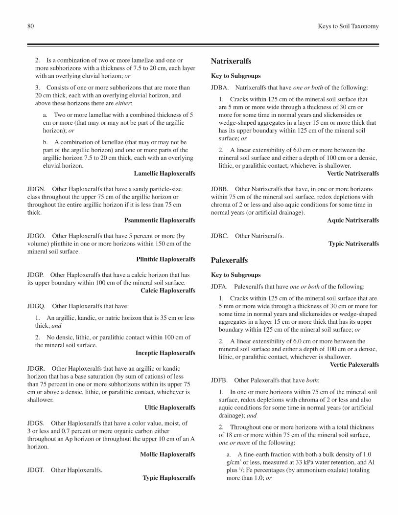
80 Keys to Soil Taxonomy
2. Is a combination of two or more lamellae and one ormore subhorizons with a thickness of 7.5 to 20 cm, each layerwith an overlying eluvial horizon; or
3. Consists of one or more subhorizons that are more than20 cm thick, each with an overlying eluvial horizon, andabove these horizons there are either:
a. Two or more lamellae with a combined thickness of 5cm or more (that may or may not be part of the argillichorizon); or
b. A combination of lamellae (that may or may not bepart of the argillic horizon) and one or more parts of theargillic horizon 7.5 to 20 cm thick, each with an overlyingeluvial horizon.
Lamellic Haploxeralfs
JDGN. Other Haploxeralfs that have a sandy particle-sizeclass throughout the upper 75 cm of the argillic horizon orthroughout the entire argillic horizon if it is less than 75 cmthick.
Psammentic Haploxeralfs
JDGO. Other Haploxeralfs that have 5 percent or more (byvolume) plinthite in one or more horizons within 150 cm of themineral soil surface.
Plinthic Haploxeralfs
JDGP. Other Haploxeralfs that have a calcic horizon that hasits upper boundary within 100 cm of the mineral soil surface.
Calcic Haploxeralfs
JDGQ. Other Haploxeralfs that have:
1. An argillic, kandic, or natric horizon that is 35 cm or lessthick; and
2. No densic, lithic, or paralithic contact within 100 cm ofthe mineral soil surface.
Inceptic Haploxeralfs
JDGR. Other Haploxeralfs that have an argillic or kandichorizon that has a base saturation (by sum of cations) of lessthan 75 percent in one or more subhorizons within its upper 75cm or above a densic, lithic, or paralithic contact, whichever isshallower.
Ultic Haploxeralfs
JDGS. Other Haploxeralfs that have a color value, moist, of3 or less and 0.7 percent or more organic carbon eitherthroughout an Ap horizon or throughout the upper 10 cm of an Ahorizon.
Mollic Haploxeralfs
JDGT. Other Haploxeralfs.Typic Haploxeralfs
Natrixeralfs
Key to Subgroups
JDBA. Natrixeralfs that have one or both of the following:
1. Cracks within 125 cm of the mineral soil surface thatare 5 mm or more wide through a thickness of 30 cm ormore for some time in normal years and slickensides orwedge-shaped aggregates in a layer 15 cm or more thick thathas its upper boundary within 125 cm of the mineral soilsurface; or
2. A linear extensibility of 6.0 cm or more between themineral soil surface and either a depth of 100 cm or a densic,lithic, or paralithic contact, whichever is shallower.
Vertic Natrixeralfs
JDBB. Other Natrixeralfs that have, in one or more horizonswithin 75 cm of the mineral soil surface, redox depletions withchroma of 2 or less and also aquic conditions for some time innormal years (or artificial drainage).
Aquic Natrixeralfs
JDBC. Other Natrixeralfs.Typic Natrixeralfs
Palexeralfs
Key to Subgroups
JDFA. Palexeralfs that have one or both of the following:
1. Cracks within 125 cm of the mineral soil surface that are5 mm or more wide through a thickness of 30 cm or more forsome time in normal years and slickensides or wedge-shapedaggregates in a layer 15 cm or more thick that has its upperboundary within 125 cm of the mineral soil surface; or
2. A linear extensibility of 6.0 cm or more between themineral soil surface and either a depth of 100 cm or a densic,lithic, or paralithic contact, whichever is shallower.
Vertic Palexeralfs
JDFB. Other Palexeralfs that have both:
1. In one or more horizons within 75 cm of the mineral soilsurface, redox depletions with chroma of 2 or less and alsoaquic conditions for some time in normal years (or artificialdrainage); and
2. Throughout one or more horizons with a total thicknessof 18 cm or more within 75 cm of the mineral soil surface,one or more of the following:
a. A fine-earth fraction with both a bulk density of 1.0g/cm3 or less, measured at 33 kPa water retention, and Alplus 1/2 Fe percentages (by ammonium oxalate) totalingmore than 1.0; or
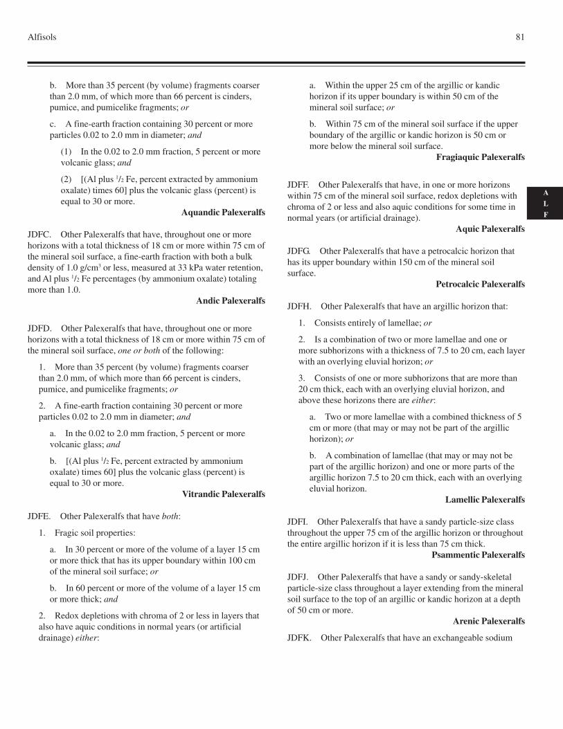
Alfisols 81
A
L
F
b. More than 35 percent (by volume) fragments coarserthan 2.0 mm, of which more than 66 percent is cinders,pumice, and pumicelike fragments; or
c. A fine-earth fraction containing 30 percent or moreparticles 0.02 to 2.0 mm in diameter; and
(1) In the 0.02 to 2.0 mm fraction, 5 percent or morevolcanic glass; and
(2) [(Al plus 1/2 Fe, percent extracted by ammoniumoxalate) times 60] plus the volcanic glass (percent) isequal to 30 or more.
Aquandic Palexeralfs
JDFC. Other Palexeralfs that have, throughout one or morehorizons with a total thickness of 18 cm or more within 75 cm ofthe mineral soil surface, a fine-earth fraction with both a bulkdensity of 1.0 g/cm3 or less, measured at 33 kPa water retention,and Al plus 1/2 Fe percentages (by ammonium oxalate) totalingmore than 1.0.
Andic Palexeralfs
JDFD. Other Palexeralfs that have, throughout one or morehorizons with a total thickness of 18 cm or more within 75 cm ofthe mineral soil surface, one or both of the following:
1. More than 35 percent (by volume) fragments coarserthan 2.0 mm, of which more than 66 percent is cinders,pumice, and pumicelike fragments; or
2. A fine-earth fraction containing 30 percent or moreparticles 0.02 to 2.0 mm in diameter; and
a. In the 0.02 to 2.0 mm fraction, 5 percent or morevolcanic glass; and
b. [(Al plus 1/2 Fe, percent extracted by ammoniumoxalate) times 60] plus the volcanic glass (percent) isequal to 30 or more.
Vitrandic Palexeralfs
JDFE. Other Palexeralfs that have both:
1. Fragic soil properties:
a. In 30 percent or more of the volume of a layer 15 cmor more thick that has its upper boundary within 100 cmof the mineral soil surface; or
b. In 60 percent or more of the volume of a layer 15 cmor more thick; and
2. Redox depletions with chroma of 2 or less in layers thatalso have aquic conditions in normal years (or artificialdrainage) either:
a. Within the upper 25 cm of the argillic or kandichorizon if its upper boundary is within 50 cm of themineral soil surface; or
b. Within 75 cm of the mineral soil surface if the upperboundary of the argillic or kandic horizon is 50 cm ormore below the mineral soil surface.
Fragiaquic Palexeralfs
JDFF. Other Palexeralfs that have, in one or more horizonswithin 75 cm of the mineral soil surface, redox depletions withchroma of 2 or less and also aquic conditions for some time innormal years (or artificial drainage).
Aquic Palexeralfs
JDFG. Other Palexeralfs that have a petrocalcic horizon thathas its upper boundary within 150 cm of the mineral soilsurface.
Petrocalcic Palexeralfs
JDFH. Other Palexeralfs that have an argillic horizon that:
1. Consists entirely of lamellae; or
2. Is a combination of two or more lamellae and one ormore subhorizons with a thickness of 7.5 to 20 cm, each layerwith an overlying eluvial horizon; or
3. Consists of one or more subhorizons that are more than20 cm thick, each with an overlying eluvial horizon, andabove these horizons there are either:
a. Two or more lamellae with a combined thickness of 5cm or more (that may or may not be part of the argillichorizon); or
b. A combination of lamellae (that may or may not bepart of the argillic horizon) and one or more parts of theargillic horizon 7.5 to 20 cm thick, each with an overlyingeluvial horizon.
Lamellic Palexeralfs
JDFI. Other Palexeralfs that have a sandy particle-size classthroughout the upper 75 cm of the argillic horizon or throughoutthe entire argillic horizon if it is less than 75 cm thick.
Psammentic Palexeralfs
JDFJ. Other Palexeralfs that have a sandy or sandy-skeletalparticle-size class throughout a layer extending from the mineralsoil surface to the top of an argillic or kandic horizon at a depthof 50 cm or more.
Arenic Palexeralfs
JDFK. Other Palexeralfs that have an exchangeable sodium
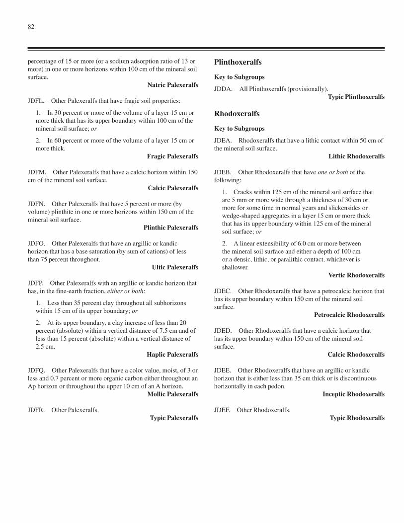
82
percentage of 15 or more (or a sodium adsorption ratio of 13 ormore) in one or more horizons within 100 cm of the mineral soilsurface.
Natric Palexeralfs
JDFL. Other Palexeralfs that have fragic soil properties:
1. In 30 percent or more of the volume of a layer 15 cm ormore thick that has its upper boundary within 100 cm of themineral soil surface; or
2. In 60 percent or more of the volume of a layer 15 cm ormore thick.
Fragic Palexeralfs
JDFM. Other Palexeralfs that have a calcic horizon within 150cm of the mineral soil surface.
Calcic Palexeralfs
JDFN. Other Palexeralfs that have 5 percent or more (byvolume) plinthite in one or more horizons within 150 cm of themineral soil surface.
Plinthic Palexeralfs
JDFO. Other Palexeralfs that have an argillic or kandichorizon that has a base saturation (by sum of cations) of lessthan 75 percent throughout.
Ultic Palexeralfs
JDFP. Other Palexeralfs with an argillic or kandic horizon thathas, in the fine-earth fraction, either or both:
1. Less than 35 percent clay throughout all subhorizonswithin 15 cm of its upper boundary; or
2. At its upper boundary, a clay increase of less than 20percent (absolute) within a vertical distance of 7.5 cm and ofless than 15 percent (absolute) within a vertical distance of2.5 cm.
Haplic Palexeralfs
JDFQ. Other Palexeralfs that have a color value, moist, of 3 orless and 0.7 percent or more organic carbon either throughout anAp horizon or throughout the upper 10 cm of an A horizon.
Mollic Palexeralfs
JDFR. Other Palexeralfs.Typic Palexeralfs
Plinthoxeralfs
Key to Subgroups
JDDA. All Plinthoxeralfs (provisionally).Typic Plinthoxeralfs
Rhodoxeralfs
Key to Subgroups
JDEA. Rhodoxeralfs that have a lithic contact within 50 cm ofthe mineral soil surface.
Lithic Rhodoxeralfs
JDEB. Other Rhodoxeralfs that have one or both of thefollowing:
1. Cracks within 125 cm of the mineral soil surface thatare 5 mm or more wide through a thickness of 30 cm ormore for some time in normal years and slickensides orwedge-shaped aggregates in a layer 15 cm or more thickthat has its upper boundary within 125 cm of the mineralsoil surface; or
2. A linear extensibility of 6.0 cm or more betweenthe mineral soil surface and either a depth of 100 cmor a densic, lithic, or paralithic contact, whichever isshallower.
Vertic Rhodoxeralfs
JDEC. Other Rhodoxeralfs that have a petrocalcic horizon thathas its upper boundary within 150 cm of the mineral soilsurface.
Petrocalcic Rhodoxeralfs
JDED. Other Rhodoxeralfs that have a calcic horizon thathas its upper boundary within 150 cm of the mineral soilsurface.
Calcic Rhodoxeralfs
JDEE. Other Rhodoxeralfs that have an argillic or kandichorizon that is either less than 35 cm thick or is discontinuoushorizontally in each pedon.
Inceptic Rhodoxeralfs
JDEF. Other Rhodoxeralfs.Typic Rhodoxeralfs
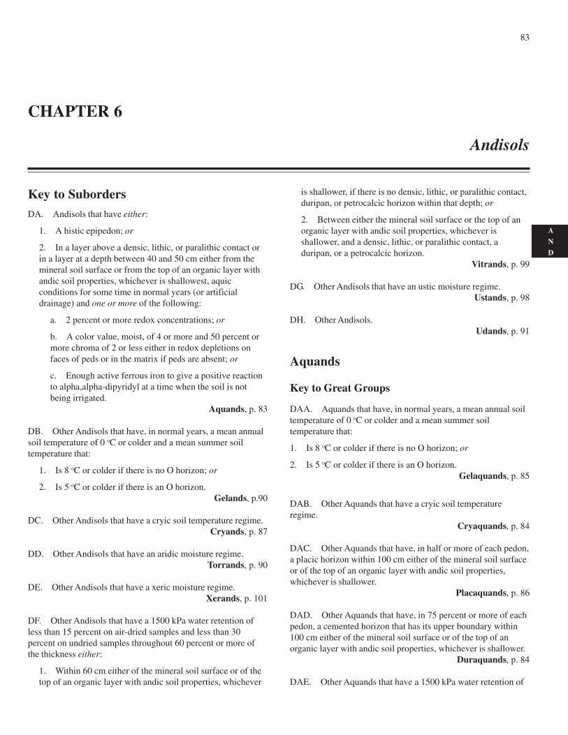
83
A
N
D
Key to SubordersDA. Andisols that have either:
1. A histic epipedon; or
2. In a layer above a densic, lithic, or paralithic contact orin a layer at a depth between 40 and 50 cm either from themineral soil surface or from the top of an organic layer withandic soil properties, whichever is shallowest, aquicconditions for some time in normal years (or artificialdrainage) and one or more of the following:
a. 2 percent or more redox concentrations; or
b. A color value, moist, of 4 or more and 50 percent ormore chroma of 2 or less either in redox depletions onfaces of peds or in the matrix if peds are absent; or
c. Enough active ferrous iron to give a positive reactionto alpha,alpha-dipyridyl at a time when the soil is notbeing irrigated.
Aquands, p. 83
DB. Other Andisols that have, in normal years, a mean annualsoil temperature of 0 oC or colder and a mean summer soiltemperature that:
1. Is 8 oC or colder if there is no O horizon; or
2. Is 5 oC or colder if there is an O horizon.Gelands, p.90
DC. Other Andisols that have a cryic soil temperature regime.Cryands, p. 87
DD. Other Andisols that have an aridic moisture regime.Torrands, p. 90
DE. Other Andisols that have a xeric moisture regime.Xerands, p. 101
DF. Other Andisols that have a 1500 kPa water retention ofless than 15 percent on air-dried samples and less than 30percent on undried samples throughout 60 percent or more ofthe thickness either:
1. Within 60 cm either of the mineral soil surface or of thetop of an organic layer with andic soil properties, whichever
is shallower, if there is no densic, lithic, or paralithic contact,duripan, or petrocalcic horizon within that depth; or
2. Between either the mineral soil surface or the top of anorganic layer with andic soil properties, whichever isshallower, and a densic, lithic, or paralithic contact, aduripan, or a petrocalcic horizon.
Vitrands, p. 99
DG. Other Andisols that have an ustic moisture regime.Ustands, p. 98
DH. Other Andisols.Udands, p. 91
Aquands
Key to Great Groups
DAA. Aquands that have, in normal years, a mean annual soiltemperature of 0 oC or colder and a mean summer soiltemperature that:
1. Is 8 oC or colder if there is no O horizon; or
2. Is 5 oC or colder if there is an O horizon.Gelaquands, p. 85
DAB. Other Aquands that have a cryic soil temperatureregime.
Cryaquands, p. 84
DAC. Other Aquands that have, in half or more of each pedon,a placic horizon within 100 cm either of the mineral soil surfaceor of the top of an organic layer with andic soil properties,whichever is shallower.
Placaquands, p. 86
DAD. Other Aquands that have, in 75 percent or more of eachpedon, a cemented horizon that has its upper boundary within100 cm either of the mineral soil surface or of the top of anorganic layer with andic soil properties, whichever is shallower.
Duraquands, p. 84
DAE. Other Aquands that have a 1500 kPa water retention of
CHAPTER 6
Andisols
84 Keys to Soil Taxonomy
less than 15 percent on air-dried samples and less than 30percent on undried samples throughout 60 percent or more ofthe thickness either:
1. Within 60 cm either of the mineral soil surface or of thetop of an organic layer with andic soil properties, whicheveris shallower, if there is no densic, lithic, or paralithic contactwithin that depth; or
2. Between either the mineral soil surface or the topof an organic layer with andic soil properties,whichever is shallower, and a densic, lithic, or paralithiccontact.
Vitraquands, p. 86
DAF. Other Aquands that have a melanic epipedon.Melanaquands, p. 85
DAG. Other Aquands that have episaturation.Epiaquands, p. 85
DAH. Other Aquands.Endoaquands, p. 84
Cryaquands
Key to Subgroups
DABA. Cryaquands that have a lithic contact within 50 cmeither of the mineral soil surface or of the top of an organic layerwith andic soil properties, whichever is shallower.
Lithic Cryaquands
DABB. Other Cryaquands that have a histic epipedon.Histic Cryaquands
DABC. Other Cryaquands that have, at a depth between 25and 100 cm either from the mineral soil surface or from the top ofan organic layer with andic soil properties, whichever is shallower,a layer 10 cm or more thick with more than 3.0 percent organiccarbon and the colors of a mollic epipedon throughout,underlying one or more horizons with a total thickness of 10 cmor more that have a color value, moist, 1 unit or more higher andan organic-carbon content 1 percent or more (absolute) lower.
Thaptic Cryaquands
DABD. Other Cryaquands.Typic Cryaquands
Duraquands
Key to Subgroups
DADA. Duraquands that have a histic epipedon.Histic Duraquands
DADB. Other Duraquands that have extractable bases (byNH
4OAc) plus 1N KCl-extractable Al3+ totaling less than 2.0
cmol(+)/kg in the fine-earth fraction of one or more horizonswith a total thickness of 30 cm or more at a depth between 25and 100 cm either from the mineral soil surface or from the topof an organic layer with andic soil properties, whichever isshallower.
Acraquoxic Duraquands
DADC. Other Duraquands that have, at a depth between 25and 100 cm either from the mineral soil surface or from the topof an organic layer with andic soil properties, whichever isshallower, a layer 10 cm or more thick with more than 3.0percent organic carbon and the colors of a mollic epipedonthroughout, underlying one or more horizons with a totalthickness of 10 cm or more that have a color value, moist, 1 unitor more higher and an organic-carbon content 1 percent or more(absolute) lower.
Thaptic Duraquands
DADD. Other Duraquands.Typic Duraquands
Endoaquands
Key to Subgroups
DAHA. Endoaquands that have a lithic contact within 50 cmeither of the mineral soil surface or of the top of an organic layerwith andic soil properties, whichever is shallower.
Lithic Endoaquands
DAHB. Other Endoaquands that have a horizon 15 cm ormore thick that has 20 percent or more (by volume) cementedsoil material and has its upper boundary within 100 cm either ofthe mineral soil surface or of the top of an organic layer withandic soil properties, whichever is shallower.
Duric Endoaquands
DAHC. Other Endoaquands that have a histic epipedon.Histic Endoaquands
DAHD. Other Endoaquands that have more than 2.0cmol(+)/kg Al3+ (by 1N KCl) in the fine-earth fraction of oneor more horizons with a total thickness of 10 cm or more at adepth between 25 and 50 cm either from the mineral soilsurface or from the top of an organic layer with andic soilproperties, whichever is shallower.
Alic Endoaquands
DAHE. Other Endoaquands that have, on undried samples, a1500 kPa water retention of 70 percent or more throughout alayer 35 cm or more thick within 100 cm either of the mineral
Andisols 85
A
N
D
soil surface or of the top of an organic layer with andic soilproperties, whichever is shallower.
Hydric Endoaquands
DAHF. Other Endoaquands that have, at a depth between 25and 100 cm either from the mineral soil surface or from the topof an organic layer with andic soil properties, whichever isshallower, a layer 10 cm or more thick with more than 3.0percent organic carbon and the colors of a mollic epipedonthroughout, underlying one or more horizons with a totalthickness of 10 cm or more that have a color value, moist, 1 unitor more higher and an organic-carbon content 1 percent or more(absolute) lower.
Thaptic Endoaquands
DAHG. Other Endoaquands.Typic Endoaquands
Epiaquands
Key to Subgroups
DAGA. Epiaquands that have a horizon 15 cm or more thickthat has 20 percent or more (by volume) cemented soil materialand has its upper boundary within 100 cm either of the mineralsoil surface or of the top of an organic layer with andic soilproperties, whichever is shallower.
Duric Epiaquands
DAGB. Other Epiaquands that have a histic epipedon.Histic Epiaquands
DAGC. Other Epiaquands that have more than 2.0cmol(+)/kg Al3+ (by 1N KCl) in the fine-earth fraction of one ormore horizons with a total thickness of 10 cm or more at a depthbetween 25 and 50 cm either from the mineral soil surface orfrom the top of an organic layer with andic soil properties,whichever is shallower.
Alic Epiaquands
DAGD. Other Epiaquands that have, on undried samples, a1500 kPa water retention of 70 percent or more throughout alayer 35 cm or more thick within 100 cm either of the mineralsoil surface or of the top of an organic layer with andic soilproperties, whichever is shallower.
Hydric Epiaquands
DAGE. Other Epiaquands that have, at a depth between 25and 100 cm either from the mineral soil surface or from the topof an organic layer with andic soil properties, whichever isshallower, a layer 10 cm or more thick with more than 3.0percent organic carbon and the colors of a mollic epipedonthroughout, underlying one or more horizons with a totalthickness of 10 cm or more that have a color value, moist, 1 unit
or more higher and an organic-carbon content 1 percent or more(absolute) lower.
Thaptic Epiaquands
DAGF. Other Epiaquands.Typic Epiaquands
Gelaquands
Key to Subgroups
DAAA. Gelaquands that have a histic epipedon.Histic Gelaquands
DAAB. Other Gelaquands that have, at a depth between 25and 100 cm either from the mineral soil surface or from the topof an organic layer with andic soil properties, whichever isshallower, a layer 10 cm or more thick with more than 3.0percent organic carbon and the colors of a mollic epipedonthroughout, underlying one or more horizons with a totalthickness of 10 cm or more that have a color value, moist, 1 unitor more higher and an organic-carbon content 1 percent or more(absolute) lower.
Thaptic Gelaquands
DAAC. Other Gelaquands.Typic Gelaquands
Melanaquands
Key to Subgroups
DAFA. Melanaquands that have a lithic contact within50 cm either of the mineral soil surface or of the top of anorganic layer with andic soil properties, whichever is shallower.
Lithic Melanaquands
DAFB. Other Melanaquands that have extractable bases (byNH
4OAc) plus 1N KCl-extractable Al3+ totaling less than 2.0
cmol(+)/kg in the fine-earth fraction of one or more horizonswith a total thickness of 30 cm or more at a depth between 25and 100 cm either from the mineral soil surface or from the topof an organic layer with andic soil properties, whichever isshallower.
Acraquoxic Melanaquands
DAFC. Other Melanaquands that have both:
1. On undried samples, a 1500 kPa water retention of 70percent or more throughout a layer 35 cm or more thickwithin 100 cm either of the mineral soil surface or of the topof an organic layer with andic soil properties, whichever isshallower; and
2. More than 6.0 percent organic carbon and the colors of a
86 Keys to Soil Taxonomy
mollic epipedon throughout a layer 50 cm or more thickwithin 60 cm either of the mineral soil surface or of the top ofan organic layer with andic soil properties, whichever isshallower.
Hydric Pachic Melanaquands
DAFD. Other Melanaquands that have, on undried samples, a1500 kPa water retention of 70 percent or more throughout alayer 35 cm or more thick within 100 cm either of the mineralsoil surface or of the top of an organic layer with andic soilproperties, whichever is shallower.
Hydric Melanaquands
DAFE. Other Melanaquands that have more than 6.0 percentorganic carbon and the colors of a mollic epipedon throughout alayer 50 cm or more thick within 60 cm either of the mineral soilsurface or of the top of an organic layer with andic soilproperties, whichever is shallower.
Pachic Melanaquands
DAFF. Other Melanaquands that have, at a depth between 40and 100 cm either from the mineral soil surface or from the topof an organic layer with andic soil properties, whichever isshallower, a layer 10 cm or more thick with more than 3.0percent organic carbon and the colors of a mollic epipedonthroughout, underlying one or more horizons with a totalthickness of 10 cm or more that have a color value, moist, 1 unitor more higher and an organic-carbon content 1 percent or more(absolute) lower.
Thaptic Melanaquands
DAFG. Other Melanaquands.Typic Melanaquands
Placaquands
Key to Subgroups
DACA. Placaquands that have a lithic contact within50 cm either of the mineral soil surface or of the top of anorganic layer with andic soil properties, whichever is shallower.
Lithic Placaquands
DACB. Other Placaquands that have both:
1. A histic epipedon; and
2. A horizon 15 cm or more thick that has 20 percent ormore (by volume) cemented soil material and has its upperboundary within 100 cm either of the mineral soil surface orof the top of an organic layer with andic soil properties,whichever is shallower.
Duric Histic Placaquands
DACC. Other Placaquands that have a horizon 15 cm or morethick that has 20 percent or more (by volume) cemented soil
material and has its upper boundary within 100 cm either of themineral soil surface or of the top of an organic layer with andicsoil properties, whichever is shallower.
Duric Placaquands
DACD. Other Placaquands that have a histic epipedon.Histic Placaquands
DACE. Other Placaquands that have, at a depth between 25and 100 cm either from the mineral soil surface or from the topof an organic layer with andic soil properties, whichever isshallower, a layer 10 cm or more thick with more than 3.0percent organic carbon and the colors of a mollic epipedonthroughout, underlying one or more horizons with a totalthickness of 10 cm or more that have a color value, moist, 1 unitor more higher and an organic-carbon content 1 percent or more(absolute) lower.
Thaptic Placaquands
DAFF. Other Placaquands.Typic Placaquands
Vitraquands
Key to Subgroups
DAEA. Vitraquands that have a lithic contact within50 cm either of the mineral soil surface or of the top ofan organic layer with andic soil properties, whichever isshallower.
Lithic Vitraquands
DAEB. Other Vitraquands that have a horizon 15 cm or morethick that has 20 percent or more (by volume) cemented soilmaterial and has its upper boundary within 100 cm either of themineral soil surface or of the top of an organic layer with andicsoil properties, whichever is shallower.
Duric Vitraquands
DAEC. Other Vitraquands that have a histic epipedon.Histic Vitraquands
DAED. Other Vitraquands that have, at a depth between 25and 100 cm either from the mineral soil surface or from the topof an organic layer with andic soil properties, whichever isshallower, a layer 10 cm or more thick with more than 3.0percent organic carbon and the colors of a mollic epipedonthroughout, underlying one or more horizons with a totalthickness of 10 cm or more that have a color value, moist, 1 unitor more higher and an organic-carbon content 1 percent or more(absolute) lower.
Thaptic Vitraquands
DAEE. Other Vitraquands.Typic Vitraquands
Andisols 87
A
N
D
Cryands
Key to Great Groups
DCA. Cryands that have, in 75 percent or more of each pedon,a cemented horizon that has its upper boundary within 100 cmeither of the mineral soil surface or of the top of an organic layerwith andic soil properties, whichever is shallower.
Duricryands, p. 87
DCB. Other Cryands that have, on undried samples, a 1500kPa water retention of 100 percent or more, by weightedaverage, throughout either:
1. One or more layers with a total thickness of 35 cmbetween the mineral soil surface or the top of an organiclayer with andic soil properties, whichever is shallower,and 100 cm from the mineral soil surface or from the top of an organic layer with andic soil properties, whicheveris shallower, if there is no densic, lithic, or paralithic contact,duripan, or petrocalcic horizon within that depth; or
2. 60 percent or more of the horizon thickness betweeneither the mineral soil surface or the top of an organic layerwith andic soil properties, whichever is shallower, and adensic, lithic, or paralithic contact, a duripan, or a petrocalcichorizon.
Hydrocryands, p. 89
DCC. Other Cryands that have a melanic epipedon.Melanocryands, p. 89
DCD. Other Cryands that have a layer that meets the depth,thickness, and organic-carbon requirements for a melanicepipedon.
Fulvicryands, p. 87
DCE. Other Cryands that have a 1500 kPa water retention ofless than 15 percent on air-dried samples and less than 30percent on undried samples throughout 60 percent or more ofthe thickness either:
1. Within 60 cm either of the mineral soil surface or ofthe top of an organic layer with andic soil properties,whichever is shallower, if there is no densic, lithic, orparalithic contact, duripan, or petrocalcic horizon withinthat depth; or
2. Between either the mineral soil surface or the top of anorganic layer with andic soil properties, whichever isshallower, and a densic, lithic, or paralithic contact, aduripan, or a petrocalcic horizon.
Vitricryands, p. 89
DCF. Other Cryands.Haplocryands, p. 88
Duricryands
Key to Subgroups
DCAA. Duricryands that have, in some subhorizon at a depthbetween 50 and 100 cm either from the mineral soil surface orfrom the top of an organic layer with andic soil properties,whichever is shallower, aquic conditions for some time in normalyears (or artificial drainage) and one or more of the following:
1. 2 percent or more redox concentrations; or
2. A color value, moist, of 4 or more and 50 percent ormore chroma of 2 or less either in redox depletions on facesof peds or in the matrix if peds are absent; or
3. Enough active ferrous iron to give a positive reaction toalpha,alpha-dipyridyl at a time when the soil is not beingirrigated.
Aquic Duricryands
DCAB. Other Duricryands that have no horizons with morethan 2.0 cmol(+)/kg Al3+ (by 1N KCl) in the fine-earth fractionand with a total thickness of 10 cm or more at a depth between25 and 50 cm either from the mineral soil surface or from thetop of an organic layer with andic properties, whichever isshallower.
Eutric Duricryands
DCAC. Other Duricryands.Typic Duricryands
Fulvicryands
Key to Subgroups
DCDA. Fulvicryands that have a lithic contact within 50 cmeither of the mineral soil surface or of the top of an organic layerwith andic soil properties, whichever is shallower.
Lithic Fulvicryands
DCDB. Other Fulvicryands that have both:
1. No horizons with more than 2.0 cmol(+)/kg Al3+ (by 1NKCl) in the fine-earth fraction and with a total thickness of 10cm or more at a depth between 25 and 50 cm either from themineral soil surface or from the top of an organic layer withandic properties, whichever is shallower; and
2. Throughout a layer 50 cm or more thick within 60 cmeither of the mineral soil surface or of the top of an organiclayer with andic properties, whichever is shallower:
a. More than 6.0 percent organic carbon, by weightedaverage; and
b. More than 4.0 percent organic carbon in all parts.Eutric Pachic Fulvicryands
88 Keys to Soil Taxonomy
DCDC. Other Fulvicryands that have no horizons with morethan 2.0 cmol(+)/kg Al3+ (by 1N KCl) in the fine-earth fractionand with a total thickness of 10 cm or more at a depth between25 and 50 cm either from the mineral soil surface or from thetop of an organic layer with andic properties, whichever isshallower.
Eutric Fulvicryands
DCDD. Other Fulvicryands that have, throughout a layer 50cm or more thick within 60 cm either of the mineral soil surfaceor of the top of an organic layer with andic soil properties,whichever is shallower:
1. More than 6.0 percent organic carbon, by weightedaverage; and
2. More than 4.0 percent organic carbon in all parts.Pachic Fulvicryands
DCDE. Other Fulvicryands that have a 1500 kPa waterretention of less than 15 percent on air-dried samples and lessthan 30 percent on undried samples throughout one or morelayers that have andic soil properties and have a total thicknessof 25 cm or more within 100 cm either of the mineral soilsurface or of the top of an organic layer with andic soilproperties, whichever is shallower.
Vitric Fulvicryands
DCDF. Other Fulvicryands.Typic Fulvicryands
Haplocryands
Key to Subgroups
DCFA. Haplocryands that have a lithic contact within 50 cmeither of the mineral soil surface or of the top of an organic layerwith andic soil properties, whichever is shallower.
Lithic Haplocryands
DCFB. Other Haplocryands that have, in some subhorizon at adepth between 50 and 100 cm either from the mineral soilsurface or from the top of an organic layer with andic soilproperties, whichever is shallower, aquic conditions for sometime in normal years (or artificial drainage) and one or more ofthe following:
1. 2 percent or more redox concentrations; or
2. A color value, moist, of 4 or more and 50 percent ormore chroma of 2 or less either in redox depletions on facesof peds or in the matrix if peds are absent; or
3. Enough active ferrous iron to give a positive reaction toalpha,alpha-dipyridyl at a time when the soil is not beingirrigated.
Aquic Haplocryands
DCFC. Other Haplocryands that are saturated with waterwithin 100 cm of the mineral soil surface in normal years foreither or both:
1. 20 or more consecutive days; or
2. 30 or more cumulative days.
Oxyaquic Haplocryands
DCFD. Other Haplocryands that have more than 2.0cmol(+)/kg Al3+ (by 1N KCl) in the fine-earth fraction of one ormore horizons with a total thickness of 10 cm or more at a depthbetween 25 and 50 cm either from the mineral soil surface orfrom the top of an organic layer with andic soil properties,whichever is shallower.
Alic Haplocryands
DCFE. Other Haplocryands that have an ablic horizonoverlying a cambic horizon in 50 percent or more in each pedonor have a spodic horizon in 50 percent or more of each pedon.
Spodic Haplocryands
DCFF. Other Haplocryands that have extractable bases (byNH
4OAc) plus 1N KCl-extractable Al3+ totaling less than 2.0
cmol(+)/kg in the fine-earth fraction of one or more horizonswith a total thickness of 30 cm or more at a depth between 25 and100 cm either from the mineral soil surface or from the top of anorganic layer with andic soil properties, whichever is shallower.
Acrudoxic Haplocryands
DCFG. Other Haplocryands that have a 1500 kPa waterretention of less than 15 percent on air-dried samples and lessthan 30 percent on undried samples throughout one or morelayers that have andic soil properties and have a total thicknessof 25 cm or more within 100 cm either of the mineral soilsurface or of the top of an organic layer with andic soilproperties, whichever is shallower.
Vitric Haplocryands
DCFH. Other Haplocryands that have, at a depth between 25and 100 cm either from the mineral soil surface or from the topof an organic layer with andic soil properties, whichever isshallower, a layer 10 cm or more thick with more than 3.0percent organic carbon and the colors of a mollic epipedonthroughout, underlying one or more horizons with a totalthickness of 10 cm or more that have a color value, moist, 1 unitor more higher and an organic-carbon content 1 percent or more(absolute) lower.
Thaptic Haplocryands
DCFI. Other Haplocryands that have a xeric moisture regime.Xeric Haplocryands
DCFJ. Other Haplocryands.Typic Haplocryands
Andisols 89
A
N
D
Hydrocryands
Key to Subgroups
DCBA. Hydrocryands that have a lithic contact within 50 cmeither of the mineral soil surface or of the top of an organic layerwith andic soil properties, whichever is shallower.
Lithic Hydrocryands
DCBB. Other Hydrocryands that have a placic horizon within100 cm either of the mineral soil surface or of the top of anorganic layer with andic soil properties, whichever is shallower.
Placic Hydrocryands
DCBC. Other Hydrocryands that have, in one or morehorizons at a depth between 50 and 100 cm either from themineral soil surface or from the top of an organic layer withandic soil properties, whichever is shallower, aquic conditionsfor some time in normal years (or artificial drainage) and one ormore of the following:
1. 2 percent or more redox concentrations; or
2. A color value, moist, of 4 or more and 50 percentor more chroma of 2 or less either in redox depletionson faces of peds or in the matrix if peds are absent; or
3. Enough active ferrous iron to give a positive reaction toalpha,alpha-dipyridyl at a time when the soil is not beingirrigated.
Aquic Hydrocryands
DCBD. Other Hydrocryands that have, at a depth between 25and 100 cm either from the mineral soil surface or from the topof an organic layer with andic soil properties, whichever isshallower, a layer 10 cm or more thick with more than 3.0percent organic carbon and the colors of a mollic epipedonthroughout, underlying one or more horizons with a totalthickness of 10 cm or more that have a color value, moist, 1 unitor more higher and an organic-carbon content 1 percent or more(absolute) lower.
Thaptic Hydrocryands
DCBE. Other Hydrocryands.Typic Hydrocryands
Melanocryands
Key to Subgroups
DCCA. Melanocryands that have a lithic contact within50 cm either of the mineral soil surface or of the top of anorganic layer that has andic soil properties, whichever isshallower.
Lithic Melanocryands
DCCB. Other Melanocryands that have a 1500 kPa waterretention of less than 15 percent on air-dried samples and lessthan 30 percent on undried samples throughout one or morelayers that have andic soil properties and have a total thicknessof 25 cm or more within 100 cm either of the mineral soilsurface or of the top of an organic layer with andic soilproperties, whichever is shallower.
Vitric Melanocryands
DCCC. Other Melanocryands.Typic Melanocryands
Vitricryands
Key to Subgroups
DCEA. Vitricryands that have a lithic contact within50 cm either of the mineral soil surface or of the top of anorganic layer that has andic soil properties, whichever isshallower.
Lithic Vitricryands
DCEB. Other Vitricryands that have, in one or more horizonsat a depth between 50 and 100 cm either from the mineral soilsurface or from the top of an organic layer with andic soilproperties, whichever is shallower, aquic conditions for sometime in normal years (or artificial drainage) and one or more ofthe following:
1. 2 percent or more redox concentrations; or
2. A color value, moist, of 4 or more and 50 percent ormore chroma of 2 or less either in redox depletions on facesof peds or in the matrix if peds are absent; or
3. Enough active ferrous iron to give a positive reaction toalpha,alpha-dipyridyl at a time when the soil is not beingirrigated.
Aquic Vitricryands
DCEC. Other Vitricryands that are saturated with water in oneor more layers within 100 cm of the mineral soil surface innormal years for either or both:
1. 20 or more consecutive days; or
2. 30 or more cumulative days.Oxyaquic Vitricryands
DCED. Other Vitricryands that have an albic horizonoverlying a cambic horizon in 50 percent or more in each pedonor have a spodic horizon in 50 percent or more of each pedon.
Spodic Vitricryands
DCEE. Other Vitricryands that have, at a depth between 25
90 Keys to Soil Taxonomy
and 100 cm either from the mineral soil surface or from the topof an organic layer with andic soil properties, whichever isshallower, a layer 10 cm or more thick with more than 3.0percent organic carbon and the colors of a mollic epipedonthroughout, underlying one or more horizons with a totalthickness of 10 cm or more that have a color value, moist, 1 unitor more higher and an organic-carbon content 1 percent or more(absolute) lower.
Thaptic Vitricryands
DCEF. Other Vitricryands that have a xeric moisture regimeand a mollic or umbric epipedon.
Humic Xeric Vitricryands
DCEG. Other Vitricryands that have a xeric moisture regime.Xeric Vitricryands
DCEH. Other Vitricryands that have an argillic or kandichorizon that has both:
1. An upper boundary within 125 cm either of the mineralsoil surface or of the top of an organic layer with andic soilproperties, whichever is shallower; and
2. A base saturation (by sum of cations) of less than 35percent throughout the upper 50 cm or throughout the entireargillic or kandic horizon if it is less than 50 cm thick.
Ultic Vitricryands
DCEI. Other Vitricryands that have an argillic or kandichorizon that has its upper boundary within 125 cm either of themineral soil surface or of the top of an organic layer with andicsoil properties, whichever is shallower.
Alfic Vitricryands
DCEJ. Other Vitricryands that have a mollic or umbricepipedon.
Humic Vitricryands
DCEK. Other Vitricryands.Typic Vitricryands
Gelands
Key to Great Groups
DBA. All Gelands are considered Vitrigelands.Vitrigelands, p. 90
Vitrigelands
Key to Subgroups
DBAA. Vitrigelands that have a mollic or umbric epipedon.Humic Vitrigelands
DBAB. Other Vitrigelands.Typic Vitrigelands
Torrands
Key to Great Groups
DDA. Torrands that have, in 75 percent or more of eachpedon, a cemented horizon that has its upper boundary within100 cm either of the mineral soil surface or of the top of anorganic layer with andic soil properties, whichever isshallower.
Duritorrands, p. 90
DDB. Other Torrands that have, on air-dried samples, a 1500kPa water retention of less than 15 percent throughout 60percent or more of the thickness either:
1. Within 60 cm either of the mineral soil surface or of thetop of an organic layer with andic soil properties, whicheveris shallower, if there is no densic, lithic, or paralithic contact,duripan, or petrocalcic horizon within that depth; or
2. Between either the mineral soil surface or the top of anorganic layer with andic soil properties, whichever isshallower, and a densic, lithic, or paralithic contact, aduripan, or a petrocalcic horizon.
Vitritorrands, p. 91
DDC. Other Torrands.Haplotorrands, p. 91
Duritorrands
Key to Subgroups
DDAA. Duritorrands that have a petrocalcic horizon that hasits upper boundary within 100 cm of the mineral soil surface.
Petrocalcic Duritorrands
DDAB. Other Duritorrands that have, on air-dried samples, a1500 kPa water retention of less than 15 percent throughout 60percent or more of the thickness either:
1. Between either the mineral soil surface or the top of anorganic layer with andic soil properties, whichever isshallower, if there is no paralithic contact or duripan withinthat depth, and a point 60 cm below that depth; or
2. Between either the mineral soil surface or the top of anorganic layer with andic soil properties, whichever isshallower, and a paralithic contact or a duripan.
Vitric Duritorrands
DDAC. Other Duritorrands.Typic Duritorrands
Andisols 91
A
N
D
Haplotorrands
Key to Subgroups
DDCA. Haplotorrands that have a lithic contact within 50 cmof the mineral soil surface.
Lithic Haplotorrands
DDCB. Other Haplotorrands that have a horizon 15 cm ormore thick that has 20 percent or more (by volume) cementedsoil material and has its upper boundary within 100 cm of themineral soil surface.
Duric Haplotorrands
DDCC. Other Haplotorrands that have a calcic horizon that hasits upper boundary within 125 cm of the mineral soil surface.
Calcic Haplotorrands
DDCD. Other Haplotorrands.Typic Haplotorrands
Vitritorrands
Key to Subgroups
DDBA. Vitritorrands that have a lithic contact within 50 cm ofthe mineral soil surface.
Lithic Vitritorrands
DDBB. Other Vitritorrands that have a horizon 15 cm or morethick that has 20 percent or more (by volume) cemented soilmaterial and has its upper boundary within 100 cm of themineral soil surface.
Duric Vitritorrands
DDBC. Other Vitritorrands that have, in one or more horizonsat a depth between 50 and 100 cm from the mineral soil surface,aquic conditions for some time in normal years (or artificialdrainage) and one or more of the following:
1. 2 percent or more redox concentrations; or
2. A color value, moist, of 4 or more and 50 percent ormore chroma of 2 or less either in redox depletions on facesof peds or in the matrix if peds are absent; or
3. Enough active ferrous iron to give a positive reaction toalpha,alpha-dipyridyl at a time when the soil is not beingirrigated.
Aquic Vitritorrands
DDBD. Other Vitritorrands that have a calcic horizon that hasits upper boundary within 125 cm of the mineral soil surface.
Calcic Vitritorrands
DDBE. Other Vitritorrands.Typic Vitritorrands
Udands
Key to Great Groups
DHA. Udands that have, in half or more of each pedon, aplacic horizon within 100 cm either of the mineral soil surfaceor of the top of an organic layer with andic soil properties,whichever is shallower.
Placudands, p. 97
DHB. Other Udands that have, in 75 percent or more of eachpedon, a cemented horizon that has its upper boundary within100 cm either of the mineral soil surface or of the top of anorganic layer with andic soil properties, whichever is shallower.
Durudands, p. 91
DHC. Other Udands that have a melanic epipedon.Melanudands, p. 96
DHD. Other Udands that have, on undried samples, a 1500kPa water retention of 100 percent or more, by weightedaverage, throughout either:
1. One or more layers with a total thickness of 35 cmbetween the mineral soil surface or the top of an organiclayer with andic soil properties, whichever is shallower,and 100 cm from the mineral soil surface or from thetop of an organic layer with andic soil properties,whichever is shallower, if there is no densic, lithic, orparalithic contact, duripan, or petrocalcic horizon within thatdepth; or
2. 60 percent or more of the horizon thickness betweeneither the mineral soil surface or the top of an organic layerwith andic soil properties, whichever is shallower, and adensic, lithic, or paralithic contact, a duripan, or a petrocalcichorizon.
Hydrudands, p. 95
DHE. Other Udands that have a layer that meets the depth,thickness, and organic-carbon requirements for a melanicepipedon.
Fulvudands, p. 92
DHF. Other Udands.Hapludands, p. 93
Durudands
Key to Subgroups
DHBA. Durudands that have, in one or more horizons abovethe cemented horizon, aquic conditions for some time in normalyears (or artificial drainage) and one or more of the following:
1. 2 percent or more redox concentrations; or
92 Keys to Soil Taxonomy
2. A color value, moist, of 4 or more and 50 percent ormore chroma of 2 or less either in redox depletions on facesof peds or in the matrix if peds are absent; or
3. Enough active ferrous iron to give a positive reaction toalpha,alpha-dipyridyl at a time when the soil is not beingirrigated.
Aquic Durudands
DHBB. Other Durudands that have no horizons with morethan 2.0 cmol(+)/kg Al3+ (by 1N KCl) in the fine-earth fractionand with a total thickness of 10 cm or more at a depth between25 and 50 cm either from the mineral soil surface or from thetop of an organic layer with andic properties, whichever isshallower.
Eutric Durudands
DHBC. Other Durudands that have extractable bases (byNH
4OAc) plus 1N KCl-extractable Al3+ totaling less than 2.0
cmol(+)/kg in the fine-earth fraction of one or more horizonswith a total thickness of 30 cm or more at a depth between 25cm either from the mineral soil surface or from the top of anorganic layer with andic soil properties, whichever is shallower,and the cemented horizon.
Acrudoxic Durudands
DHBD. Other Durudands that have, on undried samples, a1500 kPa water retention of 70 percent or more throughout alayer 35 cm or more thick above the cemented horizon.
Hydric Durudands
DHBE. Other Durudands that have more than 6.0 percentorganic carbon and the colors of a mollic epipedon throughout alayer 50 cm or more thick within 60 cm either of the mineral soilsurface or of the top of an organic layer with andic soilproperties, whichever is shallower.
Pachic Durudands
DHBF. Other Durudands.Typic Durudands
Fulvudands
Key to Subgroups
DHEA. Fulvudands that have both:
1. A lithic contact within 50 cm either of the mineral soilsurface or of the top of an organic layer with andic soilproperties, whichever is shallower; and
2. No horizons with more than 2.0 cmol(+)/kg Al3+ (by 1NKCl) in the fine-earth fraction and with a total thickness of 10cm or more at a depth between 25 cm from the mineral soil
surface or from the top of an organic layer with andic soilproperties, whichever is shallower, and the lithic contact.
Eutric Lithic Fulvudands
DHEB. Other Fulvudands that have a lithic contact within 50cm either of the mineral soil surface or of the top of an organiclayer with andic soil properties, whichever is shallower.
Lithic Fulvudands
DHEC. Other Fulvudands that have, in one or more horizonsat a depth between 50 and 100 cm either from the mineral soilsurface or from the top of an organic layer with andic soilproperties, whichever is shallower, aquic conditions for sometime in normal years (or artificial drainage) and one or more ofthe following:
1. 2 percent or more redox concentrations; or
2. A color value, moist, of 4 or more and 50 percent ormore chroma of 2 or less either in redox depletions on facesof peds or in the matrix if peds are absent; or
3. Enough active ferrous iron to give a positive reaction toalpha,alpha-dipyridyl at a time when the soil is not beingirrigated.
Aquic Fulvudands
DHED. Other Fulvudands that are saturated with water within100 cm of the mineral soil surface in normal years for either orboth:
1. 20 or more consecutive days; or
2. 30 or more cumulative daysOxyaquic Fulvudands
DHEE. Other Fulvudands that have, on undried samples, a1500 kPa water retention of 70 percent or more throughout alayer 35 cm or more thick within 100 cm either of the mineralsoil surface or of the top of an organic layer with andic soilproperties, whichever is shallower.
Hydric Fulvudands
DHEF. Other Fulvudands that have extractable bases (byNH
4OAc) plus 1N KCl-extractable Al3+ totaling less than 2.0
cmol(+)/kg in the fine-earth fraction of one or more horizonswith a total thickness of 30 cm or more at a depth between 25and 100 cm either from the mineral soil surface or from the topof an organic layer with andic soil properties, whichever isshallower.
Acrudoxic Fulvudands
DHEG. Other Fulvudands that have an argillic or kandichorizon that has both:
Andisols 93
A
N
D
1. An upper boundary within 125 cm either of the mineralsoil surface or of the top of an organic layer with andic soilproperties, whichever is shallower; and
2. A base saturation (by sum of cations) of less than 35percent throughout its upper 50 cm.
Ultic Fulvudands
DHEH. Other Fulvudands that have both:
1. No horizons with more than 2.0 cmol(+)/kg Al3+ (by 1NKCl) in the fine-earth fraction and with a total thickness of 10cm or more at a depth between 25 and 50 cm either from themineral soil surface or from the top of an organic layer withandic soil properties, whichever is shallower; and
2. Throughout a layer 50 cm or more thick within 60 cmeither of the mineral soil surface or of the top of an organiclayer with andic soil properties, whichever is shallower:
a. More than 6.0 percent organic carbon, by weightedaverage; and
b. More than 4.0 percent organic carbon in all parts.Eutric Pachic Fulvudands
DHEI. Other Fulvudands that have no horizons with more than2.0 cmol(+)/kg Al3+ (by 1N KCl) in the fine-earth fraction andwith a total thickness of 10 cm or more at a depth between 25and 50 cm either from the mineral soil surface or from the top ofan organic layer with andic soil properties, whichever isshallower.
Eutric Fulvudands
DHEJ. Other Fulvudands that have, throughout a layer 50 cmor more thick within 60 cm either of the mineral soil surface orof the top of an organic layer with andic soil properties,whichever is shallower:
1. More than 6.0 percent organic carbon, by weightedaverage; and
2. More than 4.0 percent organic carbon in all parts.Pachic Fulvudands
DHEK. Other Fulvudands that have, at a depth between 40and 100 cm either from the mineral soil surface or from the topof an organic layer with andic soil properties, whichever isshallower, a layer 10 cm or more thick with more than 3.0percent organic carbon and the colors of a mollic epipedonthroughout, underlying one or more horizons with a totalthickness of 10 cm or more that have a color value, moist, 1 unitor more higher and an organic-carbon content 1 percent or more(absolute) lower.
Thaptic Fulvudands
DHEL. Other Fulvudands.Typic Fulvudands
Hapludands
Key to Subgroups
DHFA. Hapludands that have a lithic contact within 50 cmeither of the mineral soil surface or of the top of an organic layerwith andic soil properties, whichever is shallower.
Lithic Hapludands
DHFB. Other Hapludands that have anthraquic conditions.Anthraquic Hapludands
DHFC. Other Hapludands that have both:
1. A horizon 15 cm or more thick that has 20 percent ormore (by volume) cemented soil material and has its upperboundary within 100 cm either of the mineral soil surface orof the top of an organic layer with andic soil properties,whichever is shallower; and
2. In one or more horizons at a depth between 50 and 100cm either from the mineral soil surface or from the top of anorganic layer with andic soil properties, whichever isshallower, aquic conditions for some time in normal years (orartificial drainage) and one or more of the following:
a. 2 percent or more redox concentrations; or
b. A color value, moist, of 4 or more and 50 percent ormore chroma of 2 or less either in redox depletions onfaces of peds or in the matrix if peds are absent; or
c. Enough active ferrous iron to give a positive reactionto alpha,alpha-dipyridyl at a time when the soil is notbeing irrigated.
Aquic Duric Hapludands
DHFD. Other Hapludands that have a horizon 15 cm or morethick that has 20 percent or more (by volume) cemented soilmaterial and has its upper boundary within 100 cm either of themineral soil surface or of the top of an organic layer with andicsoil properties, whichever is shallower.
Duric Hapludands
DHFE. Other Hapludands that have, in one or more horizonsat a depth between 50 and 100 cm either from the mineral soilsurface or from the top of an organic layer with andic soilproperties, whichever is shallower, aquic conditions for sometime in normal years (or artificial drainage) and one or more ofthe following:
1. 2 percent or more redox concentrations; or
94 Keys to Soil Taxonomy
2. A color value, moist, of 4 or more and 50 percent ormore chroma of 2 or less either in redox depletions on facesof peds or in the matrix if peds are absent; or
3. Enough active ferrous iron to give a positive reaction toalpha,alpha-dipyridyl at a time when the soil is not beingirrigated.
Aquic Hapludands
DHFF. Other Hapludands that are saturated with water within100 cm of the mineral soil surface in normal years for either orboth:
1. 20 or more consecutive days; or
2. 30 or more cumulative daysOxyaquic Hapludands
DHFG. Other Hapludands that have more than 2.0cmol(+)/kg Al3+ (by 1N KCl) in the fine-earth fraction of one ormore horizons with a total thickness of 10 cm or more at a depthbetween 25 and 50 cm either from the mineral soil surface orfrom the top of an organic layer with andic soil properties,whichever is shallower.
Alic Hapludands
DHFH. Other Hapludands that have both:
1. Extractable bases (by NH4OAc) plus 1N KCl-extractable
Al3+ totaling less than 2.0 cmol(+)/kg in the fine-earthfraction of one or more horizons with a total thickness of 30cm or more at a depth between 25 and 100 cm either from themineral soil surface or from the top of an organic layer withandic soil properties, whichever is shallower; and
2. On undried samples, a 1500 kPa water retention of 70percent or more throughout a layer 35 cm or more thickwithin 100 cm either of the mineral soil surface or of the topof an organic layer with andic soil properties, whichever isshallower.
Acrudoxic Hydric Hapludands
DHFI. Other Hapludands that have, at a depth between 25 and100 cm either from the mineral soil surface or from the top of anorganic layer with andic soil properties, whichever is shallower,both:
1. Extractable bases (by NH4OAc) plus 1N KCl-extractable
Al3+ totaling less than 2.0 cmol(+)/kg in the fine-earthfraction of one or more horizons with a total thickness of 30cm or more; and
2. A layer 10 cm or more thick with more than 3.0 percentorganic carbon and the colors of a mollic epipedonthroughout, underlying one or more horizons with a totalthickness of 10 cm or more that have a color value, moist, 1
unit or more higher and an organic-carbon content 1 percentor more (absolute) lower.
Acrudoxic Thaptic Hapludands
DHFJ. Other Hapludands that have both:
1. Extractable bases (by NH4OAc) plus 1N KCl-extractable
Al3+ totaling less than 2.0 cmol(+)/kg in the fine-earthfraction of one or more horizons with a total thickness of 30cm or more at a depth between 25 and 100 cm either from themineral soil surface or from the top of an organic layer withandic soil properties, whichever is shallower; and
2. An argillic or kandic horizon that has both:
a. An upper boundary within 125 cm either of themineral soil surface or of the top of an organic layer withandic soil properties, whichever is shallower; and
b. A base saturation (by sum of cations) of less than 35percent throughout its upper 50 cm.
Acrudoxic Ultic Hapludands
DHFK. Other Hapludands that have extractable bases (byNH
4OAc) plus 1N KCl-extractable Al3+ totaling less than 2.0
cmol(+)/kg in the fine-earth fraction of one or more horizonswith a total thickness of 30 cm or more at a depth between 25and 100 cm either from the mineral soil surface or from the topof an organic layer with andic soil properties, whichever isshallower.
Acrudoxic Hapludands
DHFL. Other Hapludands that have a 1500 kPa waterretention of less than 15 percent on air-dried samples and lessthan 30 percent on undried samples throughout one or morelayers that have andic soil properties and have a total thicknessof 25 cm or more within 100 cm either of the mineral soilsurface or of the top of an organic layer with andic soilproperties, whichever is shallower.
Vitric Hapludands
DHFM. Other Hapludands that have both:
1. On undried samples, a 1500 kPa water retention of 70percent or more throughout a layer 35 cm or more thickwithin 100 cm either of the mineral soil surface or of the topof an organic layer with andic soil properties, whichever isshallower; and
2. At a depth between 25 and 100 cm either from themineral soil surface or from the top of an organic layer withandic soil properties, whichever is shallower, a layer 10 cmor more thick with more than 3.0 percent organic carbon andthe colors of a mollic epipedon throughout, underlying one ormore horizons with a total thickness of 10 cm or more that
Andisols 95
A
N
D
have a color value, moist, 1 unit or more higher and anorganic-carbon content 1 percent or more (absolute) lower.
Hydric Thaptic Hapludands
DHFN. Other Hapludands that have, on undried samples, a1500 kPa water retention of 70 percent or more throughout alayer 35 cm or more thick within 100 cm either of the mineralsoil surface or of the top of an organic layer with andic soilproperties, whichever is shallower.
Hydric Hapludands
DHFO. Other Hapludands that have both:
1. A sum of extractable bases of more than 25.0cmol(+)/kg in the fine-earth fraction throughout one or morehorizons with a total thickness of 15 cm or more at a depthbetween 25 and 75 cm either from the mineral soil surface orfrom the top of an organic layer with andic soil properties,whichever is shallower; and
2. At a depth between 25 and 100 cm either from themineral soil surface or from the top of an organic layer withandic soil properties, whichever is shallower, a layer 10 cmor more thick with more than 3.0 percent organic carbon andthe colors of a mollic epipedon throughout, underlying one ormore horizons with a total thickness of 10 cm or more thathave a color value, moist, 1 unit or more higher and anorganic-carbon content 1 percent or more (absolute) lower.
Eutric Thaptic Hapludands
DHFP. Other Hapludands that have, at a depth between 25and 100 cm either from the mineral soil surface or from the topof an organic layer with andic soil properties, whichever isshallower, a layer 10 cm or more thick with more than 3.0percent organic carbon and the colors of a mollic epipedonthroughout, underlying one or more horizons with a totalthickness of 10 cm or more that have a color value, moist, 1 unitor more higher and an organic-carbon content 1 percent or more(absolute) lower.
Thaptic Hapludands
DHFQ. Other Hapludands that have a sum of extractable basesof more than 25.0 cmol(+)/kg in the fine-earth fractionthroughout one or more horizons with a total thickness of 15 cmor more at a depth between 25 and 75 cm either from themineral soil surface or from the top of an organic layer withandic soil properties, whichever is shallower.
Eutric Hapludands
DHFR. Other Hapludands that have an oxic horizon that hasits upper boundary within 125 cm either of the mineral soilsurface or of the top of an organic layer with andic soilproperties, whichever is shallower.
Oxic Hapludands
DHFS. Other Hapludands that have an argillic or kandichorizon that has both:
1. An upper boundary within 125 cm either of the mineralsoil surface or of the top of an organic layer with andic soilproperties, whichever is shallower; and
2. A base saturation (by sum of cations) of less than 35percent throughout its upper 50 cm.
Ultic Hapludands
DHFT. Other Hapludands that have an argillic or kandichorizon that has its upper boundary within 125 cm either of themineral soil surface or of the top of an organic layer with andicsoil properties, whichever is shallower.
Alfic Hapludands
DHFU. Other Hapludands.Typic Hapludands
Hydrudands
Key to Subgroups
DHDA. Hydrudands that have a lithic contact within 50 cmeither of the mineral soil surface or of the top of an organic layerwith andic soil properties, whichever is shallower.
Lithic Hydrudands
DHDB. Other Hydrudands that have, in one or more horizonsat a depth between 50 and 100 cm either from the mineral soilsurface or from the top of an organic layer with andic soilproperties, whichever is shallower, aquic conditions for sometime in normal years (or artificial drainage) and one or more ofthe following:
1. 2 percent or more redox concentrations; or
2. A color value, moist, of 4 or more and 50 percent ormore chroma of 2 or less either in redox depletions on facesof peds or in the matrix if peds are absent; or
3. Enough active ferrous iron to give a positive reaction toalpha,alpha-dipyridyl at a time when the soil is not beingirrigated.
Aquic Hydrudands
DHDC. Other Hydrudands that have, at a depth between 25and 100 cm either from the mineral soil surface or from the topof an organic layer with andic soil properties, whichever isshallower, both:
1. Extractable bases (by NH4OAc) plus 1N KCl-extractable
Al3+ totaling less than 2.0 cmol(+)/kg in the fine-earthfraction of one or more horizons with a total thickness of 30cm or more; and
96 Keys to Soil Taxonomy
2. A layer 10 cm or more thick with more than 3.0 percentorganic carbon and the colors of a mollic epipedonthroughout, underlying one or more horizons with a totalthickness of 10 cm or more that have a color value, moist, 1unit or more higher and an organic-carbon content 1 percentor more (absolute) lower.
Acrudoxic Thaptic Hydrudands
DHDD. Other Hydrudands that have extractable bases (byNH
4OAc) plus 1N KCl-extractable Al3+ totaling less than 2.0
cmol(+)/kg in the fine-earth fraction of one or more horizonswith a total thickness of 30 cm or more at a depth between 25 and100 cm either from the mineral soil surface or from the top of anorganic layer with andic soil properties, whichever is shallower.
Acrudoxic Hydrudands
DHDE. Other Hydrudands that have, at a depth between 25 and100 cm either from the mineral soil surface or from the top of anorganic layer with andic soil properties, whichever is shallower,a layer 10 cm or more thick with more than 3.0 percent organiccarbon and the colors of a mollic epipedon throughout,underlying one or more horizons with a total thickness of 10 cmor more that have a color value, moist, 1 unit or more higher andan organic-carbon content 1 percent or more (absolute) lower.
Thaptic Hydrudands
DHDF. Other Hydrudands that have a sum of extractablebases of more than 25.0 cmol(+)/kg in the fine-earth fractionthroughout one or more horizons with a total thickness of 15 cmor more at a depth between 25 and 75 cm either from themineral soil surface or from the top of an organic layer withandic soil properties, whichever is shallower.
Eutric Hydrudands
DHDG. Other Hydrudands that have an argillic or kandichorizon that has both:
1. An upper boundary within 125 cm either of the mineralsoil surface or of the top of an organic layer with andic soilproperties, whichever is shallower; and
2. A base saturation (by sum of cations) of less than 35percent throughout its upper 50 cm.
Ultic Hydrudands
DHDH. Other Hydrudands.Typic Hydrudands
Melanudands
Key to Subgroups
DHCA. Melanudands that have a lithic contact within 50 cmeither of the mineral soil surface or of the top of an organic layerthat has andic soil properties, whichever is shallower.
Lithic Melanudands
DHCB. Other Melanudands that have anthraquic conditions.Anthraquic Melanudands
DHCC. Other Melanudands that have, in one or more horizonsat a depth between 50 and 100 cm either from the mineral soilsurface or from the top of an organic layer with andic soilproperties, whichever is shallower, aquic conditions for sometime in normal years (or artificial drainage) and one or more ofthe following:
1. 2 percent or more redox concentrations; or
2. A color value, moist, of 4 or more and 50 percent ormore chroma of 2 or less either in redox depletions on facesof peds or in the matrix if peds are absent; or
3. Enough active ferrous iron to give a positive reaction toalpha,alpha-dipyridyl at a time when the soil is not beingirrigated.
Aquic Melanudands
DHCD. Other Melanudands that have both:
1. Extractable bases (by NH4OAc) plus 1N KCl-extractable
Al3+ totaling less than 2.0 cmol(+)/kg in the fine-earthfraction of one or more horizons with a total thickness of 30cm or more at a depth between 25 and 100 cm either from themineral soil surface or from the top of an organic layer withandic soil properties, whichever is shallower; and
2. A 1500 kPa water retention of less than 15 percent onair-dried samples and less than 30 percent on undriedsamples throughout one or more layers that have andic soilproperties and have a total thickness of 25 cm or more within100 cm either of the mineral soil surface or of the top of anorganic layer with andic soil properties, whichever isshallower.
Acrudoxic Vitric Melanudands
DHCE. Other Melanudands that have both:
1. Extractable bases (by NH4OAc) plus 1N KCl-extractable
Al3+ totaling less than 2.0 cmol(+)/kg in the fine-earthfraction of one or more horizons with a total thickness of 30cm or more at a depth between 25 and 100 cm either from themineral soil surface or from the top of an organic layer withandic soil properties, whichever is shallower; and
2. On undried samples, a 1500 kPa water retention of 70percent or more throughout a layer 35 cm or more thickwithin 100 cm either of the mineral soil surface or of the topof an organic layer with andic soil properties, whichever isshallower.
Acrudoxic Hydric Melanudands
DHCF. Other Melanudands that have extractable bases (byNH
4OAc) plus 1N KCl-extractable Al3+ totaling less than 2.0
cmol(+)/kg in the fine-earth fraction of one or more horizons
Andisols 97
A
N
D
with a total thickness of 30 cm or more at a depth between 25and 100 cm either from the mineral soil surface or from the topof an organic layer with andic soil properties, whichever isshallower.
Acrudoxic Melanudands
DHCG. Other Melanudands that have both:
1. More than 6.0 percent organic carbon and the colors of amollic epipedon throughout a layer 50 cm or more thickwithin 60 cm either of the mineral soil surface or of the top ofan organic layer with andic soil properties, whichever isshallower; and
2. A 1500 kPa water retention of less than 15 percent onair-dried samples and less than 30 percent on undriedsamples throughout one or more layers that have andic soilproperties and have a total thickness of 25 cm or more within100 cm either of the mineral soil surface or of the top of anorganic layer with andic soil properties, whichever isshallower.
Pachic Vitric Melanudands
DGCH. Other Melanudands that have a 1500 kPa waterretention of less than 15 percent on air-dried samples and lessthan 30 percent on undried samples throughout one or morelayers that have andic soil properties and have a total thicknessof 25 cm or more within 100 cm either of the mineral soilsurface or of the top of an organic layer with andic soilproperties, whichever is shallower.
Vitric Melanudands
DHCI. Other Melanudands that have both:
1. On undried samples, a 1500 kPa water retention of 70percent or more throughout a layer 35 cm or more thickwithin 100 cm either of the mineral soil surface or of the topof an organic layer with andic soil properties, whichever isshallower; and
2. More than 6.0 percent organic carbon and the colors of amollic epipedon throughout a layer 50 cm or more thickwithin 60 cm either of the mineral soil surface or of the top ofan organic layer with andic soil properties, whichever isshallower.
Hydric Pachic Melanudands
DHCJ. Other Melanudands that have more than 6.0 percentorganic carbon and the colors of a mollic epipedon throughout alayer 50 cm or more thick within 60 cm either of the mineral soilsurface or of the top of an organic layer with andic soilproperties, whichever is shallower.
Pachic Melanudands
DHCK. Other Melanudands that have, on undried samples, a1500 kPa water retention of 70 percent or more throughout a
layer 35 cm or more thick within 100 cm either of the mineralsoil surface or of the top of an organic layer with andic soilproperties, whichever is shallower.
Hydric Melanudands
DHCL. Other Melanudands that have, at a depth between 40and 100 cm either from the mineral soil surface or from the topof an organic layer with andic soil properties, whichever isshallower, a layer 10 cm or more thick with more than 3.0percent organic carbon and the colors of a mollic epipedonthroughout, underlying one or more horizons with a totalthickness of 10 cm or more that have a color value, moist, 1 unitor more higher and an organic-carbon content 1 percent or more(absolute) lower.
Thaptic Melanudands
DHCM. Other Melanudands that have an argillic or kandichorizon that has both:
1. An upper boundary within 125 cm either of the mineralsoil surface or of the top of an organic layer with andic soilproperties, whichever is shallower; and
2. A base saturation (by sum of cations) of less than 35percent throughout its upper 50 cm.
Ultic Melanudands
DHCN. Other Melanudands that have a sum of extractablebases of more than 25.0 cmol(+)/kg in the fine-earth fractionthroughout one or more horizons with a total thickness of 15 cmor more at a depth between 25 and 75 cm either from themineral soil surface or from the top of an organic layer withandic soil properties, whichever is shallower.
Eutric Melanudands
DHCO. Other Melanudands.Typic Melanudands
Placudands
Key to Subgroups
DHAA. Placudands that have a lithic contact within50 cm either of the mineral soil surface or of the top of anorganic layer that has andic soil properties, whichever isshallower.
Lithic Placudands
DHAB. Other Placudands that have, in one or more horizonsat a depth between 50 cm either from the mineral soil surface orfrom the top of an organic layer with andic soil properties,whichever is shallower, and the placic horizon, aquic conditionsfor some time in normal years (or artificial drainage) and one ormore of the following:
1. 2 percent or more redox concentrations; or

98 Keys to Soil Taxonomy
2. A color value, moist, of 4 or more and 50 percent ormore chroma of 2 or less either in redox depletions on facesof peds or in the matrix if peds are absent; or
3. Enough active ferrous iron to give a positive reaction toalpha,alpha-dipyridyl at a time when the soil is not beingirrigated.
Aquic Placudands
DHAC. Other Placudands that have extractable bases (byNH
4OAc) plus 1N KCl-extractable Al3+ totaling less than 2.0
cmol(+)/kg in the fine-earth fraction of one or more horizonswith a total thickness of 30 cm or more at a depth between 25cm either from the mineral soil surface or from the top of anorganic layer with andic soil properties, whichever is shallower,and the placic horizon.
Acrudoxic Placudands
DHAD. Other Placudands that have, on undried samples, a1500 kPa water retention of 70 percent or more throughout alayer 35 cm or more thick within 100 cm either of the mineralsoil surface or of the top of an organic layer with andic soilproperties, whichever is shallower.
Hydric Placudands
DHAE. Other Placudands.Typic Placudands
Ustands
Key to Great Groups
DGA. Ustands that have, in 75 percent or more of each pedon,a cemented horizon that has its upper boundary within 100 cmeither of the mineral soil surface or of the top of an organic layerwith andic soil properties, whichever is shallower.
Durustands, p. 98
DGB. Other Ustands.Haplustands, p. 98
Durustands
Key to Subgroups
DGAA. Durustands that have, in one or more horizons at adepth between 50 and 100 cm either from the mineral soilsurface or from the top of an organic layer with andic soilproperties, whichever is shallower, aquic conditions for sometime in normal years (or artificial drainage) and one or more ofthe following:
1. 2 percent or more redox concentrations; or
2. A color value, moist, of 4 or more and 50 percent or
more chroma of 2 or less either in redox depletions on facesof peds or in the matrix if peds are absent; or
3. Enough active ferrous iron to give a positive reaction toalpha,alpha-dipyridyl at a time when the soil is not beingirrigated.
Aquic Durustands
DGAB. Other Durustands that have, at a depth between 25and 100 cm either from the mineral soil surface or from the topof an organic layer with andic soil properties, whichever isshallower, a layer 10 cm or more thick with more than 3.0percent organic carbon and the colors of a mollic epipedonthroughout, underlying one or more horizons with a totalthickness of 10 cm or more that have a color value, moist, 1 unitor more higher and an organic-carbon content 1 percent or more(absolute) lower.
Thaptic Durustands
DGAC. Other Durustands that have a melanic, mollic, orumbric epipedon.
Humic Durustands
DGAD. Other Durustands.Typic Durustands
Haplustands
Key to Subgroups
DGBA. Haplustands that have a lithic contact within 50 cmeither of the mineral soil surface or of the top of an organic layerwith andic soil properties, whichever is shallower.
Lithic Haplustands
DGBB. Other Haplustands that have, in one or more horizonsat a depth between 50 and 100 cm either from the mineral soilsurface or from the top of an organic layer with andic soilproperties, whichever is shallower, aquic conditions for sometime in normal years (or artificial drainage) and one or more ofthe following:
1. 2 percent or more redox concentrations; or
2. A color value, moist, of 4 or more and 50 percent ormore chroma of 2 or less either in redox depletions on facesof peds or in the matrix if peds are absent; or
3. Enough active ferrous iron to give a positive reaction toalpha,alpha-dipyridyl at a time when the soil is not beingirrigated.
Aquic Haplustands
DGBC. Other Haplustands that have both:
1. Extractable bases (by NH4OAc) plus 1N KCl-extractable
Andisols 99
A
N
D
Al3+ totaling less than 15.0 cmol(+)/kg in the fine-earthfraction throughout one or more horizons with a totalthickness of 60 cm or more within 75 cm either of themineral soil surface or of the top of an organic layer withandic soil properties, whichever is shallower; and
2. A 1500 kPa water retention of less than 15 percent onair-dried samples and less than 30 percent on undriedsamples throughout one or more layers that have andic soilproperties and have a total thickness of 25 cm or more within100 cm either of the mineral soil surface or of the top of anorganic layer with andic soil properties, whichever isshallower.
Dystric Vitric Haplustands
DGBD. Other Haplustands that have a 1500 kPa waterretention of less than 15 percent on air-dried samples and lessthan 30 percent on undried samples throughout one or morelayers that have andic soil properties and have a total thicknessof 25 cm or more within 100 cm either of the mineral soilsurface or of the top of an organic layer with andic soilproperties, whichever is shallower.
Vitric Haplustands
DGBE. Other Haplustands that have more than 6.0 percentorganic carbon and the colors of a mollic epipedon throughout alayer 50 cm or more thick within 60 cm either of the mineral soilsurface or of the top of an organic layer with andic soilproperties, whichever is shallower.
Pachic Haplustands
DGBF. Other Haplustands that have, at a depth between 25and 100 cm either from the mineral soil surface or from the topof an organic layer with andic soil properties, whichever isshallower, a layer 10 cm or more thick with more than 3.0percent organic carbon and the colors of a mollic epipedonthroughout, underlying one or more horizons with a totalthickness of 10 cm or more that have a color value, moist, 1 unitor more higher and an organic-carbon content 1 percent or more(absolute) lower.
Thaptic Haplustands
DGBG. Other Haplustands that have a calcic horizon that hasits upper boundary within 125 cm either of the mineral soilsurface or of the top of an organic layer with andic soilproperties, whichever is shallower.
Calcic Haplustands
DGBH. Other Haplustands that have extractable bases (byNH
4OAc) plus 1N KCl-extractable Al3+ totaling less than 15.0
cmol(+)/kg in the fine-earth fraction throughout one or morehorizons with a total thickness of 60 cm or more within 75 cmeither of the mineral soil surface or of the top of an organic layerwith andic soil properties, whichever is shallower.
Dystric Haplustands
DGBI. Other Haplustands that have an oxic horizon that hasits upper boundary within 125 cm either of the mineral soilsurface or of the top of an organic layer with andic soilproperties, whichever is shallower.
Oxic Haplustands
DGBJ. Other Haplustands that have an argillic or kandichorizon that has both:
1. An upper boundary within 125 cm either of the mineralsoil surface or of the top of an organic layer with andic soilproperties, whichever is shallower; and
2. A base saturation (by sum of cations) of less than 35percent throughout the upper 50 cm or throughout the entireargillic or kandic horizon if it is less than 50 cm thick.
Ultic Haplustands
DGBK. Other Haplustands that have an argillic or kandichorizon that has its upper boundary within 125 cm either of themineral soil surface or of the top of an organic layer with andicsoil properties, whichever is shallower.
Alfic Haplustands
DGBL. Other Haplustands that have a melanic, mollic, orumbric epipedon.
Humic Haplustands
DGBM. Other Haplustands.Typic Haplustands
Vitrands
Key to Great Groups
DFA. Vitrands that have an ustic moisture regime.Ustivitrands, p. 100
DFB. Other Vitrands.Udivitrands, p. 99
Udivitrands
Key to Subgroups
DFBA. Udivitrands that have a lithic contact within 50 cmeither of the mineral soil surface or of the top of an organic layerwith andic soil properties, whichever is shallower.
Lithic Udivitrands
DFBB. Other Udivitrands that have, in one or more horizonsat a depth between 50 and 100 cm either from the mineral soilsurface or from the top of an organic layer with andic soilproperties, whichever is shallower, aquic conditions for sometime in normal years (or artificial drainage) and one or more ofthe following:
100 Keys to Soil Taxonomy
1. 2 percent or more redox concentrations; or
2. A color value, moist, of 4 or more and 50 percent ormore chroma of 2 or less either in redox depletions on facesof peds or in the matrix if peds are absent; or
3. Enough active ferrous iron to give a positive reaction toalpha,alpha-dipyridyl at a time when the soil is not beingirrigated.
Aquic Udivitrands
DFBC. Other Udivitrands that are saturated with water within100 cm of the mineral soil surface in normal years for either orboth:
1. 20 or more consecutive days; or
2. 30 or more cumulative daysOxyaquic Udivitrands
DFBD. Other Udivitrands that have, at a depth between 25and 100 cm either from the mineral soil surface or from the topof an organic layer with andic soil properties, whichever isshallower, a layer 10 cm or more thick with more than 3.0percent organic carbon and the colors of a mollic epipedonthroughout, underlying one or more horizons with a totalthickness of 10 cm or more that have a color value, moist, 1 unitor more higher and an organic-carbon content 1 percent or more(absolute) lower.
Thaptic Udivitrands
DFBE. Other Udivitrands that have both:
1. An argillic or kandic horizon that has its upper boundarywithin 125 cm of the mineral soil surface or of the upperboundary of an organic layer with andic soil properties,whichever is shallower; and
2. A base saturation (by sum of cations) of less than 35percent throughout the upper 50 cm of the argillic or kandichorizon.
Ultic Udivitrands
DFBF. Other Udivitrands that have an argillic or kandichorizon that has its upper boundary within 125 cm of themineral soil surface or of the upper boundary of an organic layerwith andic soil properties, whichever is shallower.
Alfic Udivitrands
DFBG. Other Udivitrands that have a melanic, mollic, orumbric epipedon.
Humic Udivitrands
DFBH. Other Udivitrands.Typic Udivitrands
Ustivitrands
Key to Subgroups
DFAA. Ustivitrands that have a lithic contact within 50 cmeither of the mineral soil surface or of the top of an organic layerwith andic soil properties, whichever is shallower.
Lithic Ustivitrands
DFAB. Other Ustivitrands that have, in one or more horizonsat a depth between 50 and 100 cm either from the mineral soilsurface or from the top of an organic layer with andic soilproperties, whichever is shallower, aquic conditions for sometime in normal years (or artificial drainage) and one or more ofthe following:
1. 2 percent or more redox concentrations; or
2. A color value, moist, of 4 or more and 50 percent ormore chroma of 2 or less either in redox depletions on facesof peds or in the matrix if peds are absent; or
3. Enough active ferrous iron to give a positive reaction toalpha,alpha-dipyridyl at a time when the soil is not beingirrigated.
Aquic Ustivitrands
DFAC. Other Ustivitrands that have, at a depth between 25and 100 cm either from the mineral soil surface or from the top ofan organic layer with andic soil properties, whichever is shallower,a layer 10 cm or more thick with more than 3.0 percent organiccarbon and the colors of a mollic epipedon throughout,underlying one or more horizons with a total thickness of 10 cmor more that have a color value, moist, 1 unit or more higher andan organic-carbon content 1 percent or more (absolute) lower.
Thaptic Ustivitrands
DFAD. Other Ustivitrands that have a calcic horizon that hasits upper boundary within 125 cm either of the mineral soilsurface or of the top of an organic layer with andic soilproperties, whichever is shallower.
Calcic Ustivitrands
DFAE. Other Ustivitrands that have a melanic, mollic, orumbric epipedon.
Humic Ustivitrands
DFAF. Other Ustivitrands.Typic Ustivitrands
Andisols 101
A
N
D
Xerands
Key to Great Groups
DEA. Xerands that have a 1500 kPa water retention of lessthan 15 percent on air-dried samples and less than 30 percent onundried samples throughout 60 percent or more of the thicknesseither:
1. Within 60 cm either of the mineral soil surface or of thetop of an organic layer with andic soil properties, whicheveris shallower, if there is no densic, lithic, or paralithic contact,duripan, or petrocalcic horizon within that depth; or
2. Between either the mineral soil surface or the top of anorganic layer with andic soil properties, whichever isshallower, and a densic, lithic, or paralithic contact, aduripan, or a petrocalcic horizon.
Vitrixerands, p. 102
DEB. Other Xerands that have a melanic epipedon.Melanoxerands, p. 101
DEC. Other Xerands.Haploxerands, p. 101
Haploxerands
Key to Subgroups
DECA. Haploxerands that have a lithic contact within 50 cmof the mineral soil surface or of the top of an organic layer withandic soil properties, whichever is shallower.
Lithic Haploxerands
DECB. Other Haploxerands that have, in one or morehorizons at a depth between 50 and 100 cm either from themineral soil surface or from the top of an organic layer withandic soil properties, whichever is shallower, aquic conditionsfor some time in normal years (or artificial drainage) and one ormore of the following:
1. 2 percent or more redox concentrations; or
2. A color value, moist, of 4 or more and 50 percent ormore chroma of 2 or less either in redox depletions on facesof peds or in the matrix if peds are absent; or
3. Enough active ferrous iron to give a positive reaction toalpha,alpha-dipyridyl at a time when the soil is not beingirrigated.
Aquic Haploxerands
DECC. Other Haploxerands that have, at a depth between25 and 100 cm from the mineral soil surface or from the top ofan organic layer with andic soil properties, whichever is
shallower, a layer 10 cm or more thick with more than 3.0percent organic carbon and the colors of a mollic epipedonthroughout, underlying one or more horizons with a totalthickness of 10 cm or more that have a color value, moist, 1 unitor more higher and an organic-carbon content 1 percent or more(absolute) lower.
Thaptic Haploxerands
DECD. Other Haploxerands that have a calcic horizon that hasits upper boundary within 125 cm of the mineral soil surface.
Calcic Haploxerands
DECE. Other Haploxerands that have an argillic or kandichorizon that has both:
1. An upper boundary within 125 cm of the mineral soilsurface or of the top of an organic layer with andic soilproperties, whichever is shallower; and
2. A base saturation (by sum of cations) of less than 35percent throughout its upper 50 cm.
Ultic Haploxerands
DECF. Other Haploxerands that have both:
1. A mollic or umbric epipedon; and
2. An argillic or kandic horizon that has its upper boundarywithin 125 cm of the mineral soil surface or of the top of anorganic layer with andic soil properties, whichever isshallower.
Alfic Humic Haploxerands
DECG. Other Haploxerands that have an argillic or kandichorizon that has its upper boundary within 125 cm of themineral soil surface or of the top of an organic layer with andicsoil properties, whichever is shallower.
Alfic Haploxerands
DECH. Other Haploxerands that have a mollic or umbricepipedon.
Humic Haploxerands
DECI. Other Haploxerands.Typic Haploxerands
Melanoxerands
Key to Subgroups
DEBA. Melanoxerands that have more than 6.0 percentorganic carbon and the colors of a mollic epipedon throughout alayer 50 cm or more thick within 60 cm either of the mineral soilsurface or of the top of an organic layer with andic soilproperties, whichever is shallower.
Pachic Melanoxerands
102 Keys to Soil Taxonomy
DEBB. Other Melanoxerands.Typic Melanoxerands
Vitrixerands
Key to Subgroups
DEAA. Vitrixerands that have a lithic contact within 50 cm ofthe mineral soil surface or of the top of an organic layer withandic soil properties, whichever is shallower.
Lithic Vitrixerands
DEAB. Other Vitrixerands that have, in one or more horizonsat a depth between 50 and 100 cm either from the mineral soilsurface or from the top of an organic layer with andic soilproperties, whichever is shallower, aquic conditions for sometime in normal years (or artificial drainage) and one or more ofthe following:
1. 2 percent or more redox concentrations; or
2. A color value, moist, of 4 or more and 50 percent ormore chroma of 2 or less either in redox depletions on facesof peds or in the matrix if peds are absent; or
3. Enough active ferrous iron to give a positive reaction toalpha,alpha-dipyridyl at a time when the soil is not beingirrigated.
Aquic Vitrixerands
DEAC. Other Vitrixerands that have, at a depth between 25and 100 cm from the mineral soil surface or from the top ofan organic layer with andic soil properties, whichever isshallower, a layer 10 cm or more thick with more than 3.0percent organic carbon and the colors of a mollic epipedonthroughout, underlying one or more horizons with a totalthickness of 10 cm or more that have a color value, moist, 1 unit
or more higher and an organic-carbon content 1 percent or more(absolute) lower.
Thaptic Vitrixerands
DEAD. Other Vitrixerands that have both:
1. A melanic, mollic, or umbric epipedon; and
2. An argillic or kandic horizon that has its upper boundarywithin 125 cm of the mineral soil surface or of the top of anorganic layer with andic soil properties, whichever is shallower.
Alfic Humic Vitrixerands
DEAE. Other Vitrixerands that have an argillic or kandichorizon that has both:
1. An upper boundary within 125 cm either of the mineralsoil surface or of the top of an organic layer with andic soilproperties, whichever is shallower; and
2. A base saturation (by sum of cations) of less than35 percent throughout the upper 50 cm or throughout theentire argillic or kandic horizon if it is less than 50 cm thick.
Ultic Vitrixerands
DEAF. Other Vitrixerands that have an argillic or kandichorizon that has its upper boundary within 125 cm of themineral soil surface or of the top of an organic layer with andicsoil properties, whichever is shallower.
Alfic Vitrixerands
DEAG. Other Vitrixerands that have a melanic, mollic, orumbric epipedon.
Humic Vitrixerands
DEAH. Other Vitrixerands.Typic Vitrixerands
103
A
R
I
Key to SubordersGA. Aridisols that have a cryic soil temperature regime.
Cryids, p. 118
GB. Other Aridisols that have a salic horizon that has its upperboundary within 100 cm of the soil surface.
Salids, p. 127
GC. Other Aridisols that have a duripan that has its upperboundary within 100 cm of the soil surface.
Durids, p. 121
GD. Other Aridisols that have a gypsic or petrogypsichorizon that has its upper boundary within 100 cm of the soilsurface and do not have a petrocalcic horizon overlying thesehorizons.
Gypsids, p. 124
GE. Other Aridisols that have an argillic or natric horizon anddo not have a petrocalcic horizon that has an upper boundarywithin 100 cm of the soil surface.
Argids, p. 103
GF. Other Aridisols that have a calcic or petrocalcic horizonthat has its upper boundary within 100 cm of the soil surface.
Calcids, p. 111
GG. Other Aridisols.Cambids, p. 114
Argids
Key to Great Groups
GEA. Argids that have a duripan or a petrocalcic orpetrogypsic horizon that has its upper boundary within 150 cmof the soil surface.
Petroargids, p. 111
GEB. Other Argids that have a natric horizon.Natrargids, p. 108
GEC. Other Argids that do not have a densic, lithic, or
paralithic contact within 50 cm of the soil surface and haveeither:
1. A clay increase of 15 percent or more (absolute) within avertical distance of 2.5 cm either within the argillic horizonor at its upper boundary; or
2. An argillic horizon that extends to 150 cm or more fromthe soil surface, that does not have a clay decrease withincreasing depth of 20 percent or more (relative) from themaximum clay content, and that has, in 50 percent or more ofthe matrix in some part between 100 and 150 cm, either:
a. Hue of 7.5YR or redder and chroma of 5 or more;or
b. Hue of 7.5YR or redder and value, moist, of 3 or lessand value, dry, of 4 or less.
Paleargids, p. 110
GED. Other Argids that have a gypsic horizon that has itsupper boundary within 150 cm of the soil surface.
Gypsiargids, p. 105
GEE. Other Argids that have a calcic horizon that has its upperboundary within 150 cm of the soil surface.
Calciargids, p. 103
GEF. Other Argids.Haplargids, p. 106
Calciargids
Key to Subgroups
GEEA. Calciargids that have a lithic contact within 50 cm ofthe soil surface.
Lithic Calciargids
GEEB. Other Calciargids that have both:
1. One or both of the following:
a. Cracks within 125 cm of the soil surface that are 5mm or more wide through a thickness of 30 cm or morefor some time in normal years and slickensides or wedge-shaped aggregates in a layer 15 cm or more thick that hasits upper boundary within 125 cm of the soil surface; or
b. A linear extensibility of 6.0 cm or more between the
CHAPTER 7
Aridisols
104 Keys to Soil Taxonomy
soil surface and either a depth of 100 cm or a densic,lithic, or paralithic contact if shallower; and
2. A moisture control section that is dry in all parts for lessthan three-fourths of the time (cumulative) when the soiltemperature is 5 oC or higher at a depth of 50 cm and a soilmoisture regime that borders on xeric.
Xerertic Calciargids
GEEC. Other Calciargids that have both:
1. One or both of the following:
a. Cracks within 125 cm of the soil surface that are 5mm or more wide through a thickness of 30 cm or morefor some time in normal years and slickensides or wedge-shaped aggregates in a layer 15 cm or more thick that hasits upper boundary within 125 cm of the soil surface; or
b. A linear extensibility of 6.0 cm or more between thesoil surface and either a depth of 100 cm or a densic,lithic, or paralithic contact if shallower; and
2. A moisture control section that is dry in all parts for lessthan three-fourths of the time (cumulative) when the soiltemperature is 5 oC or higher at a depth of 50 cm and a soilmoisture regime that borders on ustic.
Ustertic Calciargids
GEED. Other Calciargids that have one or both of thefollowing:
1. Cracks within 125 cm of the soil surface that are 5 mmor more wide through a thickness of 30 cm or more for sometime in normal years and slickensides or wedge-shapedaggregates in a layer 15 cm or more thick that has its upperboundary within 125 cm of the soil surface; or
2. A linear extensibility of 6.0 cm or more between the soilsurface and either a depth of 100 cm or a densic, lithic, orparalithic contact if shallower.
Vertic Calciargids
GEEE. Other Calciargids that are either:
1. Irrigated and have aquic conditions for some time innormal years in one or more layers within 100 cm of the soilsurface; or
2. Saturated with water in one or more layers within100 cm of the soil surface for 1 month or more in normalyears.
Aquic Calciargids
GEEF. Other Calciargids that have:
1. A sandy or sandy-skeletal particle-size class throughout alayer extending from the soil surface to the top of an argillichorizon at a depth of 50 cm or more; and
2. A moisture control section that is dry in all parts for lessthan three-fourths of the time (cumulative) when the soiltemperature at a depth of 50 cm is 5 oC or higher and a soilmoisture regime that borders on ustic.
Arenic Ustic Calciargids
GEEG. Other Calciargids that have a sandy or sandy-skeletalparticle-size class throughout a layer extending from the soilsurface to the top of an argillic horizon at a depth of 50 cm ormore.
Arenic Calciargids
GEEH. Other Calciargids that have the following combinationof characteristics:
1. Have one or more horizons, within 100 cm of the soilsurface and with a combined thickness of 15 cm or more, thatcontain 20 percent or more (by volume) durinodes or arebrittle and have at least a firm rupture-resistance class whenmoist; and
2. Are dry in all parts of the moisture control section forless than three-fourths of the time (cumulative) when the soiltemperature is 5 oC or higher at a depth of 50 cm and have asoil moisture regime that borders on xeric.
Durinodic Xeric Calciargids
GEEI. Other Calciargids that have one or more horizons,within 100 cm of the soil surface and with a combined thicknessof 15 cm or more, that contain 20 percent or more (by volume)durinodes or are brittle and have at least a firm rupture-resistance class when moist.
Durinodic Calciargids
GEEJ. Other Calciargids that:
1. Are dry in all parts of the moisture control sectionfor less than three-fourths of the time (cumulative) whenthe soil temperature at a depth of 50 cm is 5 oC or higher andhave a soil moisture regime that borders on xeric;and
2. Have one or more horizons, within 100 cm of the soilsurface and with a combined thickness of 15 cm or more, thatcontain 20 percent or more (by volume) nodules orconcretions.
Petronodic Xeric Calciargids
GEEK. Other Calciargids that:
1. Are dry in all parts of the moisture control sectionfor less than three-fourths of the time (cumulative) whenthe soil temperature at a depth of 50 cm is 5 oC or higher andhave a soil moisture regime that borders on ustic;and
2. Have one or more horizons, within 100 cm of the soil
Aridisols 105
A
R
I
surface and with a combined thickness of 15 cm or more, thatcontain 20 percent or more (by volume) nodules orconcretions.
Petronodic Ustic Calciargids
GEEL. Other Calciargids that have one or more horizons,within 100 cm of the soil surface and with a combined thicknessof 15 cm or more, that contain 20 percent or more (by volume)nodules or concretions.
Petronodic Calciargids
GEEM. Other Calciargids that have both:
1. A moisture control section that is dry in all parts for lessthan three-fourths of the time (cumulative) when the soiltemperature is 5 oC or higher at a depth of 50 cm and a soilmoisture regime that borders on xeric; and
2. Throughout one or more horizons with a total thicknessof 18 cm or more within 75 cm of the soil surface, one orboth of the following:
a. More than 35 percent (by volume) fragments coarserthan 2.0 mm, of which more than 66 percent is cinders,pumice, and pumicelike fragments; or
b. A fine-earth fraction containing 30 percent or moreparticles 0.02 to 2.0 mm in diameter, of which 5 percentor more is volcanic glass, and [(Al plus 1/2 Fe, percentextracted by ammonium oxalate) times 60] plus thevolcanic glass (percent) is 30 or more.
Vitrixerandic Calciargids
GEEN. Other Calciargids that have, throughout one or morehorizons with a total thickness of 18 cm or more within 75 cm ofthe soil surface, one or both of the following:
1. More than 35 percent (by volume) fragments coarserthan 2.0 mm, of which more than 66 percent is cinders,pumice, and pumicelike fragments; or
2. A fine-earth fraction containing 30 percent or moreparticles 0.02 to 2.0 mm in diameter, of which 5 percent ormore is volcanic glass, and [(Al plus 1/2 Fe, percent extractedby ammonium oxalate) times 60] plus the volcanic glass(percent) is 30 or more.
Vitrandic Calciargids
GEEO. Other Calciargids that are dry in all parts of themoisture control section for less than three-fourths of the time(cumulative) when the soil temperature at a depth of 50 cm is5 oC or higher and have a soil moisture regime that borders onxeric.
Xeric Calciargids
GEEP. Other Calciargids that are dry in all parts of the
moisture control section for less than three-fourths of the time(cumulative) when the soil temperature at a depth of 50 cm is5 oC or higher and have a soil moisture regime that borders onustic.
Ustic Calciargids
GEEQ. Other Calciargids.Typic Calciargid
Gypsiargids
Key to Subgroups
GEDA. Gypsiargids that are either:
1. Irrigated and have aquic conditions for some time innormal years in one or more layers within 100 cm of the soilsurface; or
2. Are saturated with water in one or more layers within100 cm of the soil surface for 1 month or more in normalyears.
Aquic Gypsiargids
GEDB. Other Gypsiargids that have one or more horizons,within 100 cm of the soil surface and with a combined thicknessof 15 cm or more, that either contain 20 percent or more (byvolume) durinodes or are brittle and have at least a firm rupture-resistance class when moist.
Durinodic Gypsiargids
GEDC. Other Gypsiargids that have both:
1. A moisture control section that is dry in all parts for lessthan three-fourths of the time (cumulative) when the soiltemperature is 5 oC or higher at a depth of 50 cm and a soilmoisture regime that borders on xeric; and
2. Throughout one or more horizons with a total thicknessof 18 cm or more within 75 cm of the soil surface, one orboth of the following:
a. More than 35 percent (by volume) fragments coarserthan 2.0 mm, of which more than 66 percent is cinders,pumice, and pumicelike fragments; or
b. A fine-earth fraction containing 30 percent or moreparticles 0.02 to 2.0 mm in diameter, of which 5 percentor more is volcanic glass, and [(Al plus 1/2 Fe, percentextracted by ammonium oxalate) times 60] plus thevolcanic glass (percent) is 30 or more.
Vitrixerandic Gypsiargids
GEDD. Other Gypsiargids that have, throughout one or morehorizons with a total thickness of 18 cm or more within 75 cm ofthe soil surface, one or both of the following:
106 Keys to Soil Taxonomy
1. More than 35 percent (by volume) fragments coarserthan 2.0 mm, of which more than 66 percent is cinders,pumice, and pumicelike fragments; or
2. A fine-earth fraction containing 30 percent or moreparticles 0.02 to 2.0 mm in diameter, of which 5 percent ormore is volcanic glass, and [(Al plus 1/2 Fe, percent extractedby ammonium oxalate) times 60] plus the volcanic glass(percent) is 30 or more.
Vitrandic Gypsiargids
GEDE. Other Gypsiargids that are dry in all parts of themoisture control section for less than three-fourths of the time(cumulative) when the soil temperature at a depth of 50 cm is5 oC or higher and have a soil moisture regime that borders onxeric.
Xeric Gypsiargids
GEDF. Other Gypsiargids that are dry in all parts of themoisture control section for less than three-fourths of the time(cumulative) when the soil temperature is 5 oC or higher at adepth of 50 cm and have a soil moisture regime that borders onustic.
Ustic Gypsiargids
GEDG. Other Gypsiargids.Typic Gypsiargids
Haplargids
Key to Subgroups
GEFA. Haplargids that have:
1. A lithic contact within 50 cm of the soil surface; and
2. An argillic horizon that is discontinuous throughout eachpedon.
Lithic Ruptic-Entic Haplargids
GEFB. Other Haplargids that have:
1. A lithic contact within 50 cm of the soil surface;and
2. A moisture control section that is dry in all parts for lessthan three-fourths of the time (cumulative) when the soiltemperature is 5 oC or higher at a depth of 50 cm and a soilmoisture regime that borders on xeric.
Lithic Xeric Haplargids
GEFC. Other Haplargids that have:
1. A lithic contact within 50 cm of the soil surface; and
2. A moisture control section that is dry in all parts for lessthan three-fourths of the time (cumulative) when the soil
temperature is 5 oC or higher at a depth of 50 cm and a soilmoisture regime that borders on ustic.
Lithic Ustic Haplargids
GEFD. Other Haplargids that have a lithic contact within 50cm of the soil surface.
Lithic Haplargids
GEFE. Other Haplargids that have both:
1. One or both of the following:
a. Cracks within 125 cm of the soil surface that are 5mm or more wide through a thickness of 30 cm or morefor some time in normal years and slickensides or wedge-shaped aggregates in a layer 15 cm or more thick thathas its upper boundary within 125 cm of the soil surface;or
b. A linear extensibility of 6.0 cm or more between thesoil surface and either a depth of 100 cm or a densic,lithic, or paralithic contact if shallower; and
2. A moisture control section that is dry in all parts for lessthan three-fourths of the time (cumulative) when the soiltemperature is 5 oC or higher at a depth of 50 cm and a soilmoisture regime that borders on xeric.
Xerertic Haplargids
GEFF. Other Haplargids that have both:
1. One or both of the following:
a. Cracks within 125 cm of the soil surface that are 5mm or more wide through a thickness of 30 cm or morefor some time in normal years and slickensides or wedge-shaped aggregates in a layer 15 cm or more thick that hasits upper boundary within 125 cm of the soil surface; or
b. A linear extensibility of 6.0 cm or more between thesoil surface and either a depth of 100 cm or a densic,lithic, or paralithic contact if shallower; and
2. A moisture control section that is dry in all parts for lessthan three-fourths of the time (cumulative) when the soiltemperature is 5 oC or higher at a depth of 50 cm and a soilmoisture regime that borders on ustic.
Ustertic Haplargids
GEFG. Other Haplargids that have one or both of thefollowing:
1. Cracks within 125 cm of the soil surface that are 5 mmor more wide through a thickness of 30 cm or more for sometime in normal years and slickensides or wedge-shapedaggregates in a layer 15 cm or more thick that has its upperboundary within 125 cm of the soil surface; or
2. A linear extensibility of 6.0 cm or more between the soil
Aridisols 107
A
R
I
surface and either a depth of 100 cm or a densic, lithic, orparalithic contact if shallower.
Vertic Haplargids
GEFH. Other Haplargids that are either:
1. Irrigated and have aquic conditions for some time innormal years in one or more layers within 100 cm of the soilsurface; or
2. Saturated with water in one or more layers within 100cm of the soil surface for 1 month or more in normal years.
Aquic Haplargids
GEFI. Other Haplargids that have:
1. A sandy or sandy-skeletal particle-size class throughout alayer extending from the soil surface to the top of an argillichorizon at a depth of 50 cm or more; and
2. A moisture control section that is dry in all parts for lessthan three-fourths of the time (cumulative) when the soiltemperature at a depth of 50 cm is 5 oC or higher and a soilmoisture regime that borders on ustic.
Arenic Ustic Haplargids
GEFJ. Other Haplargids that have a sandy or sandy-skeletalparticle-size class throughout a layer extending from the soilsurface to the top of an argillic horizon at a depth of 50 cm ormore.
Arenic Haplargids
GEFK. Other Haplargids that have:
1. One or more horizons, within 100 cm of the soil surfaceand with a combined thickness of 15 cm or more, that contain20 percent or more (by volume) durinodes or are brittle andhave at least a firm rupture-resistance class when moist; and
2. A moisture control section that is dry in all parts for lessthan three-fourths of the time (cumulative) when the soiltemperature is 5 oC or higher at a depth of 50 cm and a soilmoisture regime that borders on xeric.
Durinodic Xeric Haplargids
GEFL. Other Haplargids that have one or more horizons,within 100 cm of the soil surface and with a combined thicknessof 15 cm or more, that contain 20 percent or more (by volume)durinodes or are brittle and have at least a firm rupture-resistance class when moist.
Durinodic Haplargids
GEFM. Other Haplargids that:
1. Have one or more horizons, within 100 cm of the soilsurface and with a combined thickness of 15 cm or more, thatcontain 20 percent or more (by volume) nodules orconcretions; and
2. Are dry in all parts of the moisture control section forless than three-fourths of the time (cumulative) when the soiltemperature at a depth of 50 cm is 5 oC or higher and have asoil moisture regime that borders on ustic.
Petronodic Ustic Haplargids
GEFN. Other Haplargids that have one or more horizons,within 100 cm of the soil surface and with a combined thicknessof 15 cm or more, that contain 20 percent or more (by volume)nodules or concretions.
Petronodic Haplargids
GEFO. Other Haplargids that have both:
1. A moisture control section that is dry in all parts for lessthan three-fourths of the time (cumulative) when the soiltemperature is 5 oC or higher at a depth of 50 cm and a soilmoisture regime that borders on xeric; and
2. Throughout one or more horizons with a total thicknessof 18 cm or more within 75 cm of the soil surface, one orboth of the following:
a. More than 35 percent (by volume) fragments coarserthan 2.0 mm, of which more than 66 percent is cinders,pumice, and pumicelike fragments; or
b. A fine-earth fraction containing 30 percent or moreparticles 0.02 to 2.0 mm in diameter, of which 5 percentor more is volcanic glass, and [(Al plus 1/2 Fe, percentextracted by ammonium oxalate) times 60] plus thevolcanic glass (percent) is 30 or more.
Vitrixerandic Haplargids
GEFP. Other Haplargids that have, throughout one or morehorizons with a total thickness of 18 cm or more within 75 cm ofthe soil surface, one or both of the following:
1. More than 35 percent (by volume) fragments coarserthan 2.0 mm, of which more than 66 percent is cinders,pumice, and pumicelike fragments; or
2. A fine-earth fraction containing 30 percent or moreparticles 0.02 to 2.0 mm in diameter, of which 5 percent ormore is volcanic glass, and [(Al plus 1/2 Fe, percent extractedby ammonium oxalate) times 60] plus the volcanic glass(percent) is 30 or more.
Vitrandic Haplargids
GEFQ. Other Haplargids that are dry in all parts of themoisture control section for less than three-fourths of the time(cumulative) when the soil temperature at a depth of 50 cm is5 oC or higher and have a soil moisture regime that borders onxeric.
Xeric Haplargids
GEFR. Other Haplargids that are dry in all parts of the
108 Keys to Soil Taxonomy
moisture control section for less than three-fourths of the time(cumulative) when the soil temperature is 5 oC or higher at adepth of 50 cm and have a soil moisture regime that borders onustic.
Ustic Haplargids
GEFS. Other Haplargids.Typic Haplargids
Natrargids
Key to Subgroups
GEBA. Natrargids that have both of the following:
1. A lithic contact within 50 cm of the soil surface; and
2. A moisture control section that is dry in all parts for lessthan three-fourths of the time (cumulative) when the soiltemperature is 5 oC or higher at a depth of 50 cm and a soilmoisture regime that borders on xeric.
Lithic Xeric Natrargids
GEBB. Other Natrargids that have both of the following:
1. A lithic contact within 50 cm of the soil surface; and
2. A moisture control section that is dry in all parts for lessthan three-fourths of the time (cumulative) when the soiltemperature is 5 oC or higher at a depth of 50 cm and a soilmoisture regime that borders on ustic.
Lithic Ustic Natrargids
GEBC. Other Natrargids that have a lithic contact within 50cm of the soil surface.
Lithic Natrargids
GEBD. Other Natrargids that:
1. Are dry in all parts of the moisture control section lessthan three-fourths of the time (cumulative) when the soiltemperature at a depth of 50 cm is 5 oC or higher and themoisture regime borders a xeric regime; and
2. Have one or both of the following:
a. Cracks within 125 cm of the soil surface that are 5mm or more wide through a thickness of 30 cm or morefor some time in most years, slickensides, or wedge-shaped aggregates in a layer 15 cm or more thick that hasits upper boundary within 125 cm of the soil surface; or
b. A linear extensibility of 6.0 cm or more between thesoil surface and either a depth of 100 cm or a densic,lithic, or paralithic contact, whichever is shallower.
Xerertic Natrargids
GEBE. Other Natrargids that:
1. Are dry in all parts of the moisture control section lessthan three-fourths of the time (cumulative) when the soiltemperature at a depth of 50 cm is 5 oC or higher and themoisture regime borders an ustic regime; and
2. Have one or both of the following:
a. Cracks within 125 cm of the soil surface that are 5mm or more wide through a thickness of 30 cm or morefor some time in most years, slickensides, or wedge-shaped aggregates in a layer 15 cm or more thick that hasits upper boundary within 125 cm of the soil surface; or
b. A linear extensibility of 6.0 cm or more between thesoil surface and either a depth of 100 cm or a densic,lithic, or paralithic contact, whichever is shallower.
Ustertic Natrargids
GEBF. Other Natrargids that have one or both of thefollowing:
1. Cracks within 125 cm of the soil surface that are 5 mmor more wide through a thickness of 30 cm or more for sometime in normal years and slickensides or wedge-shapedaggregates in a layer 15 cm or more thick that has its upperboundary within 125 cm of the soil surface; or
2. A linear extensibility of 6.0 cm or more between the soilsurface and either a depth of 100 cm or a densic, lithic, orparalithic contact, whichever is shallower.
Vertic Natrargids
GEBG. Other Natrargids that are either:
1. Irrigated and have aquic conditions for some time innormal years in one or more layers within 100 cm of the soilsurface; or
2. Saturated with water in one or more layers within100 cm of the soil surface for 1 month or more in normalyears.
Aquic Natrargids
GEBH. Other Natrargids that meet both of the following:
1. Have one or more horizons, within 100 cm of the soilsurface and with a combined thickness of 15 cm or more, thatcontain 20 percent or more (by volume) durinodes or arebrittle and have at least a firm rupture-resistance class whenmoist; and
2. Are dry in all parts of the moisture control sectionfor less than three-fourths of the time (cumulative)when the soil temperature is 5 oC or higher at a depthof 50 cm and have a soil moisture regime that borders onxeric.
Durinodic Xeric Natrargids
GEBI. Other Natrargids that have one or more horizons,
Aridisols 109
A
R
I
within 100 cm of the soil surface and with a combined thicknessof 15 cm or more, that contain 20 percent or more (by volume)durinodes or are brittle and have at least a firm rupture-resistance class when moist.
Durinodic Natrargids
GEBJ. Other Natrargids that have one or more horizons,within 100 cm of the soil surface and with a combined thicknessof 15 cm or more, that contain 20 percent or more (by volume)nodules or concretions.
Petronodic Natrargids
GEBK. Other Natrargids that have:
1. Skeletans covering 10 percent or more of the surfaces ofpeds at a depth 2.5 cm or more below the upper boundary ofthe natric horizon; and
2. A moisture control section that is dry in all parts for lessthan three-fourths of the time (cumulative) when the soiltemperature is 5 oC or higher at a depth of 50 cm and a soilmoisture regime that borders on ustic.
Glossic Ustic Natrargids
GEBL. Other Natrargids that have:
1. An exchangeable sodium percentage of less than 15 (oran SAR of less than 13) in 50 percent or more of the natrichorizon; and
2. A moisture control section that is dry in all parts for lessthan three-fourths of the time (cumulative) when the soiltemperature is 5 oC or higher at a depth of 50 cm and a soilmoisture regime that borders on ustic.
Haplic Ustic Natrargids
GEBM. Other Natrargids that have:
1. An exchangeable sodium percentage of less than 15(or an SAR of less than 13) in 50 percent or more of thenatric horizon; and
2. A moisture control section that is dry in all parts for lessthan three-fourths of the time (cumulative) when the soiltemperature is 5 oC or higher at a depth of 50 cm and a soilmoisture regime that borders on xeric.
Haploxeralfic Natrargids
GEBN. Other Natrargids that have an exchangeable sodiumpercentage of less than 15 (or an SAR of less than 13) in 50percent or more of the natric horizon.
Haplic Natrargids
GEBO. Other Natrargids that have both:
1. A moisture control section that is dry in all parts for less
than three-fourths of the time (cumulative) when the soiltemperature is 5 oC or higher at a depth of 50 cm and a soilmoisture regime that borders on xeric; and
2. Throughout one or more horizons with a total thicknessof 18 cm or more within 75 cm of the soil surface, one orboth of the following:
a. More than 35 percent (by volume) fragments coarserthan 2.0 mm, of which more than 66 percent is cinders,pumice, and pumicelike fragments; or
b. A fine-earth fraction containing 30 percent or moreparticles 0.02 to 2.0 mm in diameter, of which 5 percentor more is volcanic glass, and [(Al plus 1/2 Fe, percentextracted by ammonium oxalate) times 60] plus thevolcanic glass (percent) is 30 or more.
Vitrixerandic Natrargids
GEBP. Other Natrargids that have, throughout one or morehorizons with a total thickness of 18 cm or more within 75 cm ofthe soil surface, one or both of the following:
1. More than 35 percent (by volume) fragments coarserthan 2.0 mm, of which more than 66 percent is cinders,pumice, and pumicelike fragments; or
2. A fine-earth fraction containing 30 percent or moreparticles 0.02 to 2.0 mm in diameter, of which 5 percent ormore is volcanic glass, and [(Al plus 1/2 Fe, percent extractedby ammonium oxalate) times 60] plus the volcanic glass(percent) is 30 or more.
Vitrandic Natrargids
GEBQ. Other Natrargids that are dry in all parts of themoisture control section for less than three-fourths of the time(cumulative) when the soil temperature at a depth of 50 cm is5 oC or higher and have a soil moisture regime that borders onxeric.
Xeric Natrargids
GEBR. Other Natrargids that are dry in all parts of themoisture control section for less than three-fourths of the time(cumulative) when the soil temperature at a depth of 50 cm is5 oC or higher and have a soil moisture regime that borders onustic.
Ustic Natrargids
GEBS. Other Natrargids that have skeletans covering 10percent or more of the surfaces of peds at a depth 2.5 cm ormore below the upper boundary of the natric horizon.
Glossic Natrargids
GEBT. Other Natrargids.Typic Natrargids
110 Keys to Soil Taxonomy
Paleargids
Key to Subgroups
GECA. Paleargids that have one or both of the following:
1. Cracks within 125 cm of the soil surface that are5 mm or more wide through a thickness of 30 cm ormore for some time in normal years and slickensides orwedge-shaped aggregates in a layer 15 cm or more thick thathas its upper boundary within 125 cm of the soil surface; or
2. A linear extensibility of 6.0 cm or more between the soilsurface and either a depth of 100 cm or a densic, lithic, orparalithic contact, whichever is shallower.
Vertic Paleargids
GECB. Other Paleargids that are either:
1. Irrigated and have aquic conditions for some time innormal years in one or more layers within 100 cm of the soilsurface; or
2. Saturated with water in one or more layers within 100cm of the soil surface for 1 month or more in normal years.
Aquic Paleargids
GECC. Other Paleargids that have:
1. A sandy or sandy-skeletal particle-size class throughout alayer extending from the mineral soil surface to the top of anargillic horizon at a depth of 50 cm or more; and
2. A moisture control section that is dry in all parts for lessthan three-fourths of the time (cumulative) when the soiltemperature is 5 oC or higher at a depth of 50 cm and a soilmoisture regime that borders on ustic.
Arenic Ustic Paleargids
GECD. Other Paleargids that have a sandy or sandy-skeletalparticle-size class throughout a layer extending from the mineralsoil surface to the top of an argillic horizon at a depth of 50 cmor more.
Arenic Paleargids
GECE. Other Paleargids that have a calcic horizon that has itsupper boundary within 150 cm of the soil surface.
Calcic Paleargids
GECF. Other Paleargids that have:
1. One or more horizons, within 100 cm of the soil surfaceand with a combined thickness of 15 cm or more, that contain20 percent or more (by volume) durinodes or are brittle andhave at least a firm rupture-resistance class when moist; and
2. A moisture control section that is dry in all parts for lessthan three-fourths of the time (cumulative) when the soil
temperature is 5 oC or higher at a depth of 50 cm and a soilmoisture regime that borders on xeric.
Durinodic Xeric Paleargids
GECG. Other Paleargids that have one or more horizons,within 100 cm of the soil surface and with a combined thicknessof 15 cm or more, that contain 20 percent or more (by volume)durinodes or are brittle and have at least a firm rupture-resistance class when moist.
Durinodic Paleargids
GECH. Other Paleargids that:
1. Have one or more horizons, within 100 cm of the soilsurface and with a combined thickness of 15 cm or more, thatcontain 20 percent or more (by volume) nodules orconcretions; and
2. Are dry in all parts of the moisture control section forless than three-fourths of the time (cumulative) when the soiltemperature at a depth of 50 cm is 5 oC or higher and have asoil moisture regime that borders on ustic.
Petronodic Ustic Paleargids
GECI. Other Paleargids that have one or more horizons,within 100 cm of the soil surface and with a combined thicknessof 15 cm or more, that contain 20 percent or more (by volume)nodules or concretions.
Petronodic Paleargids
GECJ. Other Paleargids that have both:
1. A moisture control section that is dry in all parts for lessthan three-fourths of the time (cumulative) when the soiltemperature is 5 oC or higher at a depth of 50 cm and a soilmoisture regime that borders on xeric; and
2. Throughout one or more horizons with a total thicknessof 18 cm or more within 75 cm of the soil surface, one orboth of the following:
a. More than 35 percent (by volume) fragments coarserthan 2.0 mm, of which more than 66 percent is cinders,pumice, and pumicelike fragments; or
b. A fine-earth fraction containing 30 percent or moreparticles 0.02 to 2.0 mm in diameter, of which 5 percentor more is volcanic glass, and [(Al plus 1/2 Fe, percentextracted by ammonium oxalate) times 60] plus thevolcanic glass (percent) is 30 or more.
Vitrixerandic Paleargids
GECK. Other Paleargids that have, throughout one or morehorizons with a total thickness of 18 cm or more within 75 cm ofthe soil surface, one or both of the following:
1. More than 35 percent (by volume) fragments coarser
Aridisols 111
A
R
I
than 2.0 mm, of which more than 66 percent is cinders,pumice, and pumicelike fragments; or
2. A fine-earth fraction containing 30 percent or moreparticles 0.02 to 2.0 mm in diameter, of which 5 percent ormore is volcanic glass, and [(Al plus 1/2 Fe, percent extractedby ammonium oxalate) times 60] plus the volcanic glass(percent) is 30 or more.
Vitrandic Paleargids
GECL. Other Paleargids that are dry in all parts of themoisture control section for less than three-fourths of the time(cumulative) when the soil temperature is 5 oC or higher at adepth of 50 cm and have a soil moisture regime that borders onxeric.
Xeric Paleargids
GECM. Other Paleargids that are dry in all parts of themoisture control section for less than three-fourths of the time(cumulative) when the soil temperature is 5 oC or higher at adepth of 50 cm and have a soil moisture regime that borders onustic.
Ustic Paleargids
GECN. Other Paleargids.Typic Paleargids
Petroargids
Key to Subgroups
GEAA. Petroargids that meet both of the following:
1. Have a petrogypsic horizon that has its upper boundarywithin 150 cm of the soil surface; and
2. Are dry in all parts of the moisture control section forless than three-fourths of the time (cumulative) when the soiltemperature is 5 oC or higher at a depth of 50 cm and have asoil moisture regime that borders on ustic.
Petrogypsic Ustic Petroargids
GEAB. Other Petroargids that have a petrogypsic horizon thathas its upper boundary within 150 cm of the soil surface.
Petrogypsic Petroargids
GEAC. Other Petroargids that have:
1. A duripan that has its upper boundary within 150 cm ofthe soil surface; and
2. A moisture control section that is dry in all parts for lessthan three-fourths of the time (cumulative) when the soiltemperature is 5 oC or higher at a depth of 50 cm and a soilmoisture regime that borders on xeric.
Duric Xeric Petroargids
GEAD. Other Petroargids that have a duripan that has itsupper boundary within 150 cm of the soil surface.
Duric Petroargids
GEAE. Other Petroargids that have a natric horizon.Natric Petroargids
GEAF. Other Petroargids that have a moisture control sectionthat is dry in all parts for less than three-fourths of the time(cumulative) when the soil temperature is 5 oC or higher at adepth of 50 cm and have a soil moisture regime that borders onxeric.
Xeric Petroargids
GEAG. Other Petroargids that have a moisture control sectionthat is dry in all parts for less than three-fourths of the time(cumulative) when the soil temperature is 5 oC or higher at adepth of 50 cm and have a soil moisture regime that borders onustic.
Ustic Petroargids
GEAH. Other Petroargids.Typic Petroargids
Calcids
Key to Great Groups
GFA. Calcids that have a petrocalcic horizon that has its upperboundary within 100 cm of the soil surface.
Petrocalcids, p. 113
GFB. Other Calcids.Haplocalcids, p. 111
Haplocalcids
Key to Subgroups
GFBA. Haplocalcids that have:
1. A lithic contact within 50 cm of the soil surface; and
2. A moisture control section that is dry in all parts for lessthan three-fourths of the time (cumulative) when the soiltemperature is 5 oC or higher at a depth of 50 cm and a soilmoisture regime that borders on xeric.
Lithic Xeric Haplocalcids
GFBB. Other Haplocalcids that have:
1. A lithic contact within 50 cm of the soil surface; and
2. A moisture control section that is dry in all parts for lessthan three-fourths of the time (cumulative) when the soil
112 Keys to Soil Taxonomy
temperature is 5 oC or higher at a depth of 50 cm and a soilmoisture regime that borders on ustic.
Lithic Ustic Haplocalcids
GFBC. Other Haplocalcids that have a lithic contact within 50cm of the soil surface.
Lithic Haplocalcids
GFBD. Other Haplocalcids that have:
1. Cracks within 125 cm of the soil surface that are 5 mmor more wide through a thickness of 30 cm or more for sometime in normal years and slickensides or wedge-shapedaggregates in a layer 15 cm or more thick that has its upperboundary within 125 cm of the soil surface; or
2. A linear extensibility of 6.0 cm or more between the soilsurface and either a depth of 100 cm or a densic, lithic, orparalithic contact, whichever is shallower.
Vertic Haplocalcids
GFBE. Other Haplocalcids that:
1. Are either:
a. Irrigated and have aquic conditions for some time innormal years in one or more layers within 100 cm of thesoil surface; or
b. Saturated with water in one or more layers within 100cm of the soil surface for 1 month or more in normalyears; and
2. Have one or more horizons, within 100 cm of the soilsurface and with a combined thickness of 15 cm or more, thatcontain 20 percent or more (by volume) durinodes or arebrittle and have at least a firm rupture-resistance class whenmoist.
Aquic Durinodic Haplocalcids
GFBF. Other Haplocalcids that are either:
1. Irrigated and have aquic conditions for some time innormal years in one or more layers within 100 cm of the soilsurface; or
2. Saturated with water in one or more layers within 100cm of the soil surface for 1 month or more in normal years.
Aquic Haplocalcids
GFBG. Other Haplocalcids that have:
1. A duripan that has its upper boundary within 150 cm ofthe surface; and
2. A moisture control section that is dry in all parts for lessthan three-fourths of the time (cumulative) when the soil
temperature is 5 oC or higher at a depth of 50 cm and a soilmoisture regime that borders on xeric.
Duric Xeric Haplocalcids
GFBH. Other Haplocalcids that have a duripan that has itsupper boundary within 150 cm of the surface.
Duric Haplocalcids
GFBI. Other Haplocalcids that have:
1. One or more horizons, within 100 cm of the soil surfaceand with a combined thickness of 15 cm or more, that contain20 percent or more (by volume) durinodes or are brittle andhave at least a firm rupture-resistance class when moist; and
2. A moisture control section that is dry in all parts for lessthan three-fourths of the time (cumulative) when the soiltemperature is 5 oC or higher at a depth of 50 cm and a soilmoisture regime that borders on xeric.
Durinodic Xeric Haplocalcids
GFBJ. Other Haplocalcids that have one or more horizons,within 100 cm of the soil surface and with a combined thicknessof 15 cm or more, that contain 20 percent or more (by volume)durinodes or are brittle and have at least a firm rupture-resistance class when moist.
Durinodic Haplocalcids
GFBK. Other Haplocalcids that have:
1. One or more horizons, within 100 cm of the soil surfaceand with a combined thickness of 15 cm or more, that contain20 percent or more (by volume) nodules or concretions; and
2. A moisture control section that is dry in all parts for lessthan three-fourths of the time (cumulative) when the soiltemperature is 5 oC or higher at a depth of 50 cm and a soilmoisture regime that borders on xeric.
Petronodic Xeric Haplocalcids
GFBL. Other Haplocalids that:
1. Have one or more horizons, within 100 cm of the soilsurface and with a combined thickness of 15 cm or more, thatcontain 20 percent or more (by volume) nodules orconcretions; and
2. Are dry in all parts of the moisture control sectionfor less than three-fourths of the time (cumulative)when the soil temperature at a depth of 50 cm is 5 oC orhigher and have a soil moisture regime that borders on ustic.
Petronodic Ustic Haplocalcids
GFBM. Other Haplocalcids that have one or more horizons,within 100 cm of the soil surface and with a combined thickness
Aridisols 113
A
R
I
of 15 cm or more, that contain 20 percent or more (by volume)nodules or concretions.
Petronodic Haplocalcids
GFBN. Other Haplocalcids that have both:
1. A horizon at least 25 cm thick within 100 cm of the soilsurface that has an exchangeable sodium percentage of 15 ormore (or an SAR of 13 or more) during at least 1 month innormal years; and
2. A moisture control section that is dry in all parts for lessthan three-fourths of the time (cumulative) when the soiltemperature at a depth of 50 cm is 5 oC or higher and a soilmoisture regime that borders on xeric.
Sodic Xeric Haplocalcids
GFBO. Other Haplocalcids that meet both of the following:
1. Have, in a horizon at least 25 cm thick within 100 cm ofthe soil surface, an exchangeable sodium percentage of 15 ormore (or an SAR of 13 or more) during at least 1 month innormal years; and
2. Are dry in all parts of the moisture control section forless than three-fourths of the time (cumulative) when the soiltemperature at a depth of 50 cm is 5 oC or higher and have asoil moisture regime that borders on ustic.
Sodic Ustic Haplocalcids
GFBP. Other Haplocalcids that have, in a horizon at least 25cm thick within 100 cm of the mineral soil surface, anexchangeable sodium percentage of 15 or more (or an SAR of13 or more) during at least 1 month in normal years.
Sodic Haplocalcids
GFBQ. Other Haplocalcids that have both:
1. A moisture control section that is dry in all parts for lessthan three-fourths of the time (cumulative) when the soiltemperature is 5 oC or higher at a depth of 50 cm and a soilmoisture regime that borders on xeric; and
2. Throughout one or more horizons with a total thicknessof 18 cm or more within 75 cm of the soil surface, one orboth of the following:
a. More than 35 percent (by volume) fragments coarserthan 2.0 mm, of which more than 66 percent is cinders,pumice, and pumicelike fragments; or
b. A fine-earth fraction containing 30 percent or moreparticles 0.02 to 2.0 mm in diameter, of which 5 percentor more is volcanic glass, and [(Al plus 1/2 Fe, percentextracted by ammonium oxalate) times 60] plus thevolcanic glass (percent) is 30 or more.
Vitrixerandic Haplocalcids
GFBR. Other Haplocalcids that have, throughout one or morehorizons with a total thickness of 18 cm or more within 75 cm ofthe soil surface, one or both of the following:
1. More than 35 percent (by volume) fragments coarserthan 2.0 mm, of which more than 66 percent is cinders,pumice, and pumicelike fragments; or
2. A fine-earth fraction containing 30 percent or moreparticles 0.02 to 2.0 mm in diameter, of which 5 percent ormore is volcanic glass, and [(Al plus 1/2 Fe, percent extractedby ammonium oxalate) times 60] plus the volcanic glass(percent) is 30 or more.
Vitrandic Haplocalcids
GFBS. Other Haplocalcids that are dry in all parts of themoisture control section for less than three-fourths of the time(cumulative) when the soil temperature is 5 oC or higher at adepth of 50 cm and have a soil moisture regime that borders onxeric.
Xeric Haplocalcids
GFBT. Other Haplocalcids that are dry in all parts of themoisture control section for less than three-fourths of the time(cumulative) when the soil temperature is 5 oC or higher at adepth of 50 cm and have a soil moisture regime that borders onustic.
Ustic Haplocalcids
GFBU. Other Haplocalcids.Typic Haplocalcids
Petrocalcids
Key to Subgroups
GFAA. Petrocalcids that are either:
1. Irrigated and have aquic conditions for some time innormal years in one or more layers within 100 cm of the soilsurface; or
2. Saturated with water in one or more layers within 100cm of the soil surface for 1 month or more in normal years.
Aquic Petrocalcids
GFAB. Other Petrocalcids that have a natric horizon.Natric Petrocalcids
GFAC. Other Petrocalcids that have both of the following:
1. An argillic horizon that has its upper boundary within100 cm of the soil surface; and
2. A moisture control section that is dry in all parts for lessthan three-fourths of the time (cumulative) when the soil
114 Keys to Soil Taxonomy
temperature is 5 oC or higher at a depth of 50 cm and a soilmoisture regime that borders on xeric.
Xeralfic Petrocalcids
GFAD. Other Petrocalcids that have both of the following:
1. An argillic horizon that has its upper boundary within100 cm of the soil surface; and
2. A moisture control section that is dry in all parts for lessthan three-fourths of the time (cumulative) when the soiltemperature is 5 oC or higher at a depth of 50 cm and a soilmoisture regime that borders on ustic.
Ustalfic Petrocalcids
GFAE. Other Petrocalcids that have an argillic horizon thathas its upper boundary within 100 cm of the soil surface.
Argic Petrocalcids
GFAF. Other Petrocalcids that have:
1. A calcic horizon overlying the petrocalcic horizon; and
2. A lithic contact within 50 cm of the soil surface.Calcic Lithic Petrocalcids
GFAG. Other Petrocalcids that have a calcic horizon overlyingthe petrocalcic horizon.
Calcic Petrocalcids
GFAH. Other Petrocalcids that are dry in all parts of themoisture control section for less than three-fourths of the time(cumulative) when the soil temperature is 5 oC or higher at adepth of 50 cm and have a soil moisture regime that borders onxeric.
Xeric Petrocalcids
GFAI. Other Petrocalcids that are dry in all parts of themoisture control section for less than three-fourths of the time(cumulative) when the soil temperature is 5 oC or higher at adepth of 50 cm and have a soil moisture regime that borders onustic.
Ustic Petrocalcids
GFAJ. Other Petrocalcids.Typic Petrocalcids
Cambids
Key to Great Groups
GGA. Cambids that are either:
1. Irrigated and have aquic conditions for some time innormal years in one or more layers within 100 cm of the soilsurface; or
2. Saturated with water in one or more layers within100 cm of the soil surface for 1 month or more in normalyears.
Aquicambids, p. 114
GGB. Other Cambids that have a duripan or a petrocalcic orpetrogypsic horizon that has its upper boundary within 150 cmof the soil surface.
Petrocambids, p. 117
GGC. Other Cambids that have an anthropic epipedon.Anthracambids, p. 114
GGD. Other Cambids.Haplocambids, p. 115
Anthracambids
Key to Subgroups
GGCA. All Anthracambids.Typic Anthracambids
Aquicambids
Key to Subgroups
GGAA. Aquicambids that have, in a horizon at least 25 cmthick within 100 cm of the soil surface, an exchangeable sodiumpercentage of 15 or more (or an SAR of 13 or more) during atleast 1 month in normal years.
Sodic Aquicambids
GGAB. Other Aquicambids that:
1. Have one or more horizons, within 100 cm of the soilsurface and with a combined thickness of 15 cm or more, thatcontain 20 percent or more (by volume) durinodes or arebrittle and have at least a firm rupture-resistance class whenmoist; and
2. Are dry in all parts of the moisture control section forless than three-fourths of the time (cumulative) when the soiltemperature is 5 oC or higher at a depth of 50 cm and have asoil moisture regime that borders on xeric.
Durinodic Xeric Aquicambids
GGAC. Other Aquicambids that have one or more horizons,within 100 cm of the soil surface and with a combined thicknessof 15 cm or more, that contain 20 percent or more (by volume)durinodes or are brittle and have at least a firm rupture-resistance class when moist.
Durinodic Aquicambids
GGAD. Other Aquicambids that have one or more horizons,within 100 cm of the soil surface and with a combined thickness
Aridisols 115
A
R
I
of 15 cm or more, that contain 20 percent or more (by volume)nodules or concretions.
Petronodic Aquicambids
GGAE. Other Aquicambids that have both:
1. A moisture control section that is dry in all parts for lessthan three-fourths of the time (cumulative) when the soiltemperature is 5 oC or higher at a depth of 50 cm and a soilmoisture regime that borders on xeric; and
2. Throughout one or more horizons with a total thicknessof 18 cm or more within 75 cm of the soil surface, one orboth of the following:
a. More than 35 percent (by volume) fragments coarserthan 2.0 mm, of which more than 66 percent is cinders,pumice, and pumicelike fragments; or
b. A fine-earth fraction containing 30 percent or moreparticles 0.02 to 2.0 mm in diameter, of which 5 percentor more is volcanic glass, and [(Al plus 1/2 Fe, percentextracted by ammonium oxalate) times 60] plus thevolcanic glass (percent) is 30 or more.
Vitrixerandic Aquicambids
GGAF. Other Aquicambids that have, throughout one or morehorizons with a total thickness of 18 cm or more within 75 cm ofthe soil surface, one or both of the following:
1. More than 35 percent (by volume) fragments coarserthan 2.0 mm, of which more than 66 percent is cinders,pumice, and pumicelike fragments; or
2. A fine-earth fraction containing 30 percent or moreparticles 0.02 to 2.0 mm in diameter, of which 5 percent ormore is volcanic glass, and [(Al plus 1/2 Fe, percent extractedby ammonium oxalate) times 60] plus the volcanic glass(percent) is 30 or more.
Vitrandic Aquicambids
GGAG. Other Aquicambids that have an irregular decrease incontent of organic carbon from a depth of 25 cm either to adepth of 125 cm or to a densic, lithic, or paralithic contact ifshallower.
Fluventic Aquicambids
GGAH. Other Aquicambids that are dry in all parts of themoisture control section for less than three-fourths of the time(cumulative) when the soil temperature is 5 oC or higher at adepth of 50 cm and have a soil moisture regime that borders onxeric.
Xeric Aquicambids
GGAI. Other Aquicambids that are dry in all parts of themoisture control section for less than three-fourths of the time(cumulative) when the soil temperature is 5 oC or higher at a
depth of 50 cm and have a soil moisture regime that borders onustic.
Ustic Aquicambids
GGAJ. Other Aquicambids.Typic Aquicambids
Haplocambids
Key to Subgroups
GGDA. Haplocambids that have:
1. A lithic contact within 50 cm of the soil surface; and
2. A moisture control section that is dry in all parts for lessthan three-fourths of the time (cumulative) when the soiltemperature is 5 oC or higher at a depth of 50 cm and a soilmoisture regime that borders on xeric.
Lithic Xeric Haplocambids
GGDB. Other Haplocambids that have:
1. A lithic contact within 50 cm of the soil surface; and
2. A moisture control section that is dry in all parts for lessthan three-fourths of the time (cumulative) when the soiltemperature is 5 oC or higher at a depth of 50 cm and a soilmoisture regime that borders on ustic.
Lithic Ustic Haplocambids
GGDC. Other Haplocambids that have a lithic contact within50 cm of the soil surface.
Lithic Haplocambids
GGDD. Other Haplocambids that have:
1. One or both of the following:
a. Cracks within 125 cm of the soil surface that are 5mm or more wide through a thickness of 30 cm or morefor some time in normal years and slickensides or wedge-shaped aggregates in a layer 15 cm or more thick that hasits upper boundary within 125 cm of the soil surface; or
b. A linear extensibility of 6.0 cm or more between thesoil surface and either a depth of 100 cm or a densic,lithic, or paralithic contact if shallower; and
2. A moisture control section that is dry in all parts for lessthan three-fourths of the time (cumulative) when the soiltemperature is 5 oC or higher at a depth of 50 cm and a soilmoisture regime that borders on xeric.
Xerertic Haplocambids
GGDE. Other Haplocambids that have:
1. One or both of the following:
a. Cracks within 125 cm of the soil surface that are 5
116 Keys to Soil Taxonomy
mm or more wide through a thickness of 30 cm or morefor some time in normal years and slickensides or wedge-shaped aggregates in a layer 15 cm or more thick that hasits upper boundary within 125 cm of the soil surface; or
b. A linear extensibility of 6.0 cm or more between thesoil surface and either a depth of 100 cm or a densic,lithic, or paralithic contact if shallower; and
2. A moisture control section that is dry in all parts for lessthan three-fourths of the time (cumulative) when the soiltemperature is 5 oC or higher at a depth of 50 cm and a soilmoisture regime that borders on ustic.
Ustertic Haplocambids
GGDF. Other Haplocambids that have at least one of thefollowing:
1. Cracks within 125 cm of the soil surface that are 5 mmor more wide through a thickness of 30 cm or more for sometime in normal years and slickensides or wedge-shapedaggregates in a layer 15 cm or more thick that has its upperboundary within 125 cm of the soil surface; or
2. A linear extensibility of 6.0 cm or more between the soilsurface and either a depth of 100 cm or a densic, lithic, orparalithic contact, whichever is shallower.
Vertic Haplocambids
GGDG. Other Haplocambids that have both of the following:
1. One or more horizons, within 100 cm of the soil surfaceand with a combined thickness of 15 cm or more, thatcontain 20 percent or more (by volume) durinodes or arebrittle and have at least a firm rupture-resistance class whenmoist; and
2. A moisture control section that is dry in all parts for lessthan three-fourths of the time (cumulative) when the soiltemperature at a depth of 50 cm is 5 oC or higher and a soilmoisture regime that borders on xeric.
Durinodic Xeric Haplocambids
GGDH. Other Haplocambids that have one or more horizons,within 100 cm of the soil surface and with a combined thicknessof 15 cm or more, that contain 20 percent or more (by volume)durinodes or are brittle and have at least a firm rupture-resistance class when moist.
Durinodic Haplocambids
GGDI. Other Haplocambids that have:
1. One or more horizons, within 100 cm of the soil surfaceand with a combined thickness of 15 cm or more, that contain20 percent or more (by volume) nodules or concretions; and
2. A moisture control section that is dry in all parts for lessthan three-fourths of the time (cumulative) when the soil
temperature at a depth of 50 cm is 5 oC or higher and a soilmoisture regime that borders on xeric.
Petronodic Xeric Haplocambids
GGDJ. Other Haplocambids that:
1. Have one or more horizons, within 100 cm of the soilsurface and with a combined thickness of 15 cm or more, thatcontain 20 percent or more (by volume) nodules orconcretions; and
2. Are dry in all parts of the moisture control section forless than three-fourths of the time (cumulative) when the soiltemperature at a depth of 50 cm is 5 oC or higher and have asoil moisture regime that borders on ustic.
Petronodic Ustic Haplocambids
GGDK. Other Haplocambids that have one or more horizons,within 100 cm of the soil surface and with a combined thicknessof 15 cm or more, that contain 20 percent or more (by volume)nodules or concretions.
Petronodic Haplocambids
GGDL. Other Haplocambids that have both:
1. A horizon at least 25 cm thick within 100 cm of the soilsurface that has an exchangeable sodium percentage of 15 ormore (or an SAR of 13 or more) during at least 1 month innormal years; and
2. A moisture control section that is dry in all parts for lessthan three-fourths of the time (cumulative) when the soiltemperature at a depth of 50 cm is 5 oC or higher and a soilmoisture regime that borders on xeric.
Sodic Xeric Haplocambids
GGDM. Other Haplocambids that meet both of the following:
1. Have, in a horizon at least 25 cm thick within 100 cm ofthe soil surface, an exchangeable sodium percentage of 15 ormore (or an SAR of 13 or more) during at least 1 month innormal years; and
2. Are dry in all parts of the moisture control section forless than three-fourths of the time (cumulative) when the soiltemperature at a depth of 50 cm is 5 oC or higher and have asoil moisture regime that borders on ustic.
Sodic Ustic Haplocambids
GGDN. Other Haplocambids that have, in a horizon at least25 cm thick within 100 cm of the soil surface, an exchangeablesodium percentage of 15 or more (or an SAR of 13 or more)during at least 1 month in normal years.
Sodic Haplocambids
GGDO. Other Haplocambids that have both:
1. A moisture control section that is dry in all parts
Aridisols 117
A
R
I
for less than three-fourths of the time (cumulative) when thesoil temperature is 5 oC or higher at a depth of 50 cm and asoil moisture regime that borders on xeric; and
2. Throughout one or more horizons with a total thicknessof 18 cm or more within 75 cm of the soil surface, one orboth of the following:
a. More than 35 percent (by volume) fragments coarserthan 2.0 mm, of which more than 66 percent is cinders,pumice, and pumicelike fragments; or
b. A fine-earth fraction containing 30 percent or moreparticles 0.02 to 2.0 mm in diameter, of which 5 percentor more is volcanic glass, and [(Al plus 1/2 Fe, percentextracted by ammonium oxalate) times 60] plus thevolcanic glass (percent) is 30 or more.
Vitrixerandic Haplocambids
GGDP. Other Haplocambids that have, throughout one ormore horizons with a total thickness of 18 cm or more within 75cm of the soil surface, one or both of the following:
1. More than 35 percent (by volume) fragments coarserthan 2.0 mm, of which more than 66 percent is cinders,pumice, and pumicelike fragments; or
2. A fine-earth fraction containing 30 percent or moreparticles 0.02 to 2.0 mm in diameter, of which 5 percent ormore is volcanic glass, and [(Al plus 1/2 Fe, percent extractedby ammonium oxalate) times 60] plus the volcanic glass(percent) is 30 or more.
Vitrandic Haplocambids
GGDQ. Other Haplocambids that:
1. Are dry in all parts of the moisture control section forless than three-fourths of the time (cumulative) when the soiltemperature at a depth of 50 cm is 5 oC or higher and have asoil moisture regime that borders on xeric; and
2. Have an irregular decrease in content of organic carbonfrom a depth of 25 cm either to a depth of 125 cm or to adensic, lithic, or paralithic contact if shallower.
Xerofluventic Haplocambids
GGDR. Other Haplocambids that:
1. Are dry in all parts of the moisture control section forless than three-fourths of the time (cumulative) when the soiltemperature at a depth of 50 cm is 5 oC or higher and have asoil moisture regime that borders on ustic; and
2. Have an irregular decrease in content of organic carbonfrom a depth of 25 cm either to a depth of 125 cm or to adensic, lithic, or paralithic contact if shallower.
Ustifluventic Haplocambids
GGDS. Other Haplocambids that have an irregular decrease in
content of organic carbon from a depth of 25 cm either to adepth of 125 cm or to a densic, lithic, or paralithic contact ifshallower.
Fluventic Haplocambids
GGDT. Other Haplocambids that are dry in all parts of themoisture control section for less than three-fourths of the time(cumulative) when the soil temperature at a depth of 50 cm is5 oC or higher and have a soil moisture regime that borders onxeric.
Xeric Haplocambids
GGDU. Other Haplocambids that are dry in all parts of themoisture control section for less than three-fourths of the time(cumulative) when the soil temperature at a depth of 50 cm is5 oC or higher and have a soil moisture regime that borders onustic.
Ustic Haplocambids
GGDV. Other Haplocambids.Typic Haplocambids
Petrocambids
Key to Subgroups
GGBA. Petrocambids that have, in a horizon at least 25 cmthick within 100 cm of the soil surface, an exchangeable sodiumpercentage of 15 or more (or an SAR of 13 or more) during atleast 1 month in normal years.
Sodic Petrocambids
GGBB. Other Petrocambids that have both:
1. A moisture control section that is dry in all parts for lessthan three-fourths of the time (cumulative) when the soiltemperature is 5 oC or higher at a depth of 50 cm and a soilmoisture regime that borders on xeric; and
2. Throughout one or more horizons with a total thicknessof 18 cm or more within 75 cm of the soil surface, one orboth of the following:
a. More than 35 percent (by volume) fragments coarserthan 2.0 mm, of which more than 66 percent is cinders,pumice, and pumicelike fragments; or
b. A fine-earth fraction containing 30 percent or moreparticles 0.02 to 2.0 mm in diameter, of which 5 percentor more is volcanic glass, and [(Al plus 1/2 Fe, percentextracted by ammonium oxalate) times 60] plus thevolcanic glass (percent) is 30 or more.
Vitrixerandic Petrocambids
GGBC. Other Petrocambids that have, throughout one or morehorizons with a total thickness of 18 cm or more within 75 cm ofthe soil surface, one or both of the following:
118 Keys to Soil Taxonomy
1. More than 35 percent (by volume) fragments coarserthan 2.0 mm, of which more than 66 percent is cinders,pumice, and pumicelike fragments; or
2. A fine-earth fraction containing 30 percent or moreparticles 0.02 to 2.0 mm in diameter, of which 5 percent ormore is volcanic glass, and [(Al plus 1/2 Fe, percent extractedby ammonium oxalate) times 60] plus the volcanic glass(percent) is 30 or more.
Vitrandic Petrocambids
GGBD. Other Petrocambids that are dry in all parts of themoisture control section for less than three-fourths of the time(cumulative) when the soil temperature at a depth of 50 cm is5 oC or higher and have a soil moisture regime that borders onxeric.
Xeric Petrocambids
GGBE. Other Petrocambids that are dry in all parts of themoisture control section for less than three-fourths of the time(cumulative) when the soil temperature at a depth of 50 cm is5 oC or higher and have a soil moisture regime that borders onustic.
Ustic Petrocambids
GGBF. Other Petrocambids.Typic Petrocambids
Cryids
Key to Great Groups
GAA. Cryids that have a salic horizon that has its upperboundary within 100 cm of the soil surface.
Salicryids, p. 121
GAB. Other Cryids that have a duripan or a petrocalcic orpetrogypsic horizon that has its upper boundary within 100 cmof the soil surface.
Petrocryids, p. 120
GAC. Other Cryids that have a gypsic horizon that has itsupper boundary within 100 cm of the soil surface.
Gypsicryids, p. 119
GAD. Other Cryids that have an argillic or natric horizon.Argicryids, p. 118
GAE. Other Cryids that have a calcic horizon that has itsupper boundary within 100 cm of the soil surface.
Calcicryids, p. 119
GAF. Other Cryids.Haplocryids, p. 120
Argicryids
Key to Subgroups
GADA. Argicryids that have a lithic contact within 50 cm ofthe soil surface.
Lithic Argicryids
GADB. Other Argicryids that have one or both of thefollowing:
1. Cracks within 125 cm of the soil surface that are 5 mmor more wide throughout a thickness of 30 cm or more forsome time in normal years and slickensides or wedge-shapedaggregates in a layer 15 cm or more thick that has its upperboundary within 125 cm of the mineral soil surface; or
2. A linear extensibility of 6.0 cm or more between themineral soil surface and either a depth of 100 cm or a densic,lithic, or paralithic contact, whichever is shallower.
Vertic Argicryids
GADC. Other Argicryids that have a natric horizon that has itsupper boundary within 100 cm of the soil surface.
Natric Argicryids
GADD. Other Argicryids that have both:
1. A moisture control section that is dry in all parts for lessthan three-fourths of the time (cumulative) when the soiltemperature is 5 oC or higher at a depth of 50 cm and a soilmoisture regime that borders on xeric; and
2. Throughout one or more horizons with a total thicknessof 18 cm or more within 75 cm of the soil surface, one orboth of the following:
a. More than 35 percent (by volume) fragments coarserthan 2.0 mm, of which more than 66 percent is cinders,pumice, and pumicelike fragments; or
b. A fine-earth fraction containing 30 percent or moreparticles 0.02 to 2.0 mm in diameter, of which 5 percentor more is volcanic glass, and [(Al plus 1/2 Fe, percentextracted by ammonium oxalate) times 60] plus thevolcanic glass (percent) is 30 or more.
Vitrixerandic Argicryids
GADE. Other Argicryids that have, throughout one or morehorizons with a total thickness of 18 cm or more within 75 cm ofthe soil surface, one or both of the following:
1. More than 35 percent (by volume) fragments coarserthan 2.0 mm, of which more than 66 percent is cinders,pumice, and pumicelike fragments; or
2. A fine-earth fraction containing 30 percent or moreparticles 0.02 to 2.0 mm in diameter, of which 5 percent ormore is volcanic glass, and [(Al plus 1/2 Fe, percent extracted
Aridisols 119
A
R
I
by ammonium oxalate) times 60] plus the volcanic glass(percent) is 30 or more.
Vitrandic Argicryids
GADF. Other Argicryids that are dry in all parts of themoisture control section for less than three-fourths of the time(cumulative) when the soil temperature is 5 oC or higher at adepth of 50 cm and have a soil moisture regime that borders onxeric.
Xeric Argicryids
GADG. Other Argicryids that are dry in all parts of themoisture control section for less than three-fourths of the time(cumulative) when the soil temperature is 5 oC or higher at adepth of 50 cm and have a soil moisture regime that borders onustic.
Ustic Argicryids
GADH. Other Argicryids.Typic Argicryids
Calcicryids
Key to Subgroups
GAEA. Calcicryids that have a lithic contact within 50 cm ofthe soil surface.
Lithic Calcicryids
GAEB. Other Calcicryids that have both:
1. A moisture control section that is dry in all parts for lessthan three-fourths of the time (cumulative) when the soiltemperature is 5 oC or higher at a depth of 50 cm and a soilmoisture regime that borders on xeric; and
2. Throughout one or more horizons with a total thicknessof 18 cm or more within 75 cm of the soil surface, one orboth of the following:
a. More than 35 percent (by volume) fragments coarserthan 2.0 mm, of which more than 66 percent is cinders,pumice, and pumicelike fragments; or
b. A fine-earth fraction containing 30 percent or moreparticles 0.02 to 2.0 mm in diameter, of which 5 percentor more is volcanic glass, and [(Al plus 1/2 Fe, percentextracted by ammonium oxalate) times 60] plus thevolcanic glass (percent) is 30 or more.
Vitrixerandic Calcicryids
GAEC. Other Calcicryids that have, throughout one or morehorizons with a total thickness of 18 cm or more within 75 cm ofthe soil surface, one or both of the following:
1. More than 35 percent (by volume) fragments coarser
than 2.0 mm, of which more than 66 percent is cinders,pumice, and pumicelike fragments; or
2. A fine-earth fraction containing 30 percent or moreparticles 0.02 to 2.0 mm in diameter, of which 5 percent ormore is volcanic glass, and [(Al plus 1/2 Fe, percent extractedby ammonium oxalate) times 60] plus the volcanic glass(percent) is 30 or more.
Vitrandic Calcicryids
GAED. Other Calcicryids that are dry in all parts of themoisture control section for less than three-fourths of the time(cumulative) when the soil temperature is 5 oC or higher at adepth of 50 cm and have a soil moisture regime that borders onxeric.
Xeric Calcicryids
GAEE. Other Calcicryids that are dry in all parts of themoisture control section for less than three-fourths of the time(cumulative) when the soil temperature is 5 oC or higher at adepth of 50 cm and have a soil moisture regime that borders onustic.
Ustic Calcicryids
GAEF. Other Calcicryids.Typic Calcicryids
Gypsicryids
Key to Subgroups
GACA. Gypsicryids that have a calcic horizon.Calcic Gypsicryids
GACB. Other Gypsicryids that have both:
1. A moisture control section that is dry in all partsfor less than three-fourths of the time (cumulative)when the soil temperature is 5 oC or higher at a depthof 50 cm and a soil moisture regime that borders on xeric;and
2. Throughout one or more horizons with a total thicknessof 18 cm or more within 75 cm of the soil surface, one orboth of the following:
a. More than 35 percent (by volume) fragments coarserthan 2.0 mm, of which more than 66 percent is cinders,pumice, and pumicelike fragments; or
b. A fine-earth fraction containing 30 percent or moreparticles 0.02 to 2.0 mm in diameter, of which 5 percentor more is volcanic glass, and [(Al plus 1/2 Fe, percentextracted by ammonium oxalate) times 60] plus thevolcanic glass (percent) is 30 or more.
Vitrixerandic Gypsicryids
120 Keys to Soil Taxonomy
GACC. Other Gypsicryids that have, throughout one or morehorizons with a total thickness of 18 cm or more within 75 cm ofthe soil surface, one or both of the following:
1. More than 35 percent (by volume) fragments coarserthan 2.0 mm, of which more than 66 percent is cinders,pumice, and pumicelike fragments; or
2. A fine-earth fraction containing 30 percent or moreparticles 0.02 to 2.0 mm in diameter, of which 5 percent ormore is volcanic glass, and [(Al plus 1/2 Fe, percent extractedby ammonium oxalate) times 60] plus the volcanic glass(percent) is 30 or more.
Vitrandic Gypsicryids
GACD. Other Gypsicryids.Typic Gypsicryids
Haplocryids
Key to Subgroups
GAFA. Haplocryids that have a lithic contact within 50 cm ofthe soil surface.
Lithic Haplocryids
GAFB. Other Haplocryids that have one or both of thefollowing:
1. Cracks within 125 cm of the soil surface that are 5 mmor more wide throughout a thickness of 30 cm or more forsome time in normal years and slickensides or wedge-shaped aggregates in a layer 15 cm or more thick that hasits upper boundary within 125 cm of the mineral soil surface;or
2. A linear extensibility of 6.0 cm or more between themineral soil surface and either a depth of 100 cm or a densic,lithic, or paralithic contact, whichever is shallower.
Vertic Haplocryids
GAFC. Other Haplocryids that have both:
1. A moisture control section that is dry in all parts for lessthan three-fourths of the time (cumulative) when the soiltemperature is 5 oC or higher at a depth of 50 cm and a soilmoisture regime that borders on xeric; and
2. Throughout one or more horizons with a total thicknessof 18 cm or more within 75 cm of the soil surface, one orboth of the following:
a. More than 35 percent (by volume) fragments coarserthan 2.0 mm, of which more than 66 percent is cinders,pumice, and pumicelike fragments; or
b. A fine-earth fraction containing 30 percent or moreparticles 0.02 to 2.0 mm in diameter, of which 5 percentor more is volcanic glass, and [(Al plus 1/2 Fe, percent
extracted by ammonium oxalate) times 60] plus thevolcanic glass (percent) is 30 or more.
Vitrixerandic Haplocryids
GAFD. Other Haplocryids that have, throughout one or morehorizons with a total thickness of 18 cm or more within 75 cm ofthe soil surface, one or both of the following:
1. More than 35 percent (by volume) fragments coarserthan 2.0 mm, of which more than 66 percent is cinders,pumice, and pumicelike fragments; or
2. A fine-earth fraction containing 30 percent or moreparticles 0.02 to 2.0 mm in diameter, of which 5 percent ormore is volcanic glass, and [(Al plus 1/2 Fe, percent extractedby ammonium oxalate) times 60] plus the volcanic glass(percent) is 30 or more.
Vitrandic Haplocryids
GAFE. Other Haplocryids that are dry in all parts of themoisture control section for less than three-fourths of the time(cumulative) when the soil temperature is 5 oC or higher at adepth of 50 cm and have a soil moisture regime that borders onxeric.
Xeric Haplocryids
GAFF. Other Haplocryids that are dry in all parts of themoisture control section for less than three-fourths of the time(cumulative) when the soil temperature is 5 oC or higher at adepth of 50 cm and have a soil moisture regime that borders onustic.
Ustic Haplocryids
GAFG. Other Haplocryids.Typic Haplocryids
Petrocryids
Key to Subgroups
GABA. Petrocryids that:
1. Have a duripan that is strongly cemented or lesscemented in all subhorizons and has its upper boundarywithin 100 cm of the soil surface; and
2. Are dry in all parts of the moisture control section forless than three-fourths of the time (cumulative) when the soiltemperature is 5 oC or higher at a depth of 50 cm and have asoil moisture regime that borders on xeric.
Xereptic Petrocryids
GABB. Other Petrocryids that:
1. Have a duripan that has its upper boundary within 100cm of the soil surface; and
2. Are dry in all parts of the moisture control section for
Aridisols 121
A
R
I
less than three-fourths of the time (cumulative) when the soiltemperature is 5 oC or higher at a depth of 50 cm and have asoil moisture regime that borders on xeric.
Duric Xeric Petrocryids
GABC. Other Petrocryids that have a duripan that has itsupper boundary within 100 cm of the soil surface.
Duric Petrocryids
GABD. Other Petrocryids that have a petrogypsic horizonthat has its upper boundary within 100 cm of the soilsurface.
Petrogypsic Petrocryids
GABE. Other Petrocryids that are dry in all parts of themoisture control section for less than three-fourths of the time(cumulative) when the soil temperature is 5 oC or higher at adepth of 50 cm and have a soil moisture regime that borders onxeric.
Xeric Petrocryids
GABF. Other Petrocryids that are dry in all parts of themoisture control section for less than three-fourths of the time(cumulative) when the soil temperature is 5 oC or higher at adepth of 50 cm and have a soil moisture regime that borders onustic.
Ustic Petrocryids
GABG. Other Petrocryids.Typic Petrocryids
Salicryids
Key to Subgroups
GAAA. Salicryids that are saturated with water in one or morelayers within 100 cm of the soil surface for 1 month or more innormal years.
Aquic Salicryids
GAAB. Other Salicryids.Typic Salicryids
Durids
Key to Great Groups
GCA. Durids that have a natric horizon above theduripan.
Natridurids, p. 123
GCB. Other Durids that have an argillic horizon above theduripan.
Argidurids, p. 121
GCC. Other Durids.Haplodurids, p. 122
Argidurids
Key to Subgroups
GCBA. Argidurids that have, above the duripan, one or bothof the following:
1. Cracks between the soil surface and the top of theduripan that are 5 mm or more wide through a thickness of30 cm or more for some time in normal years andslickensides or wedge-shaped aggregates in a layer 15 cm ormore thick that has its upper boundary above the duripan; or
2. A linear extensibility of 6.0 cm or more between the soilsurface and the top of the duripan.
Vertic Argidurids
GCBB. Other Argidurids that are either:
1. Irrigated and have aquic conditions for some time innormal years in one or more layers within 100 cm of the soilsurface; or
2. Saturated with water in one or more layers within100 cm of the soil surface for 1 month or more in normalyears.
Aquic Argidurids
GCBC. Other Argidurids that have the following combinationof characteristics:
1. An argillic horizon that has 35 percent or more clay inthe fine-earth fraction of some part; and either
a. A clay increase of 15 percent or more (absolute)within a vertical distance of 2.5 cm either within theargillic horizon or at its upper boundary; or
b. If there is an Ap horizon directly above the argillichorizon, a clay increase of 10 percent or more (absolute)at the upper boundary of the argillic horizon; and
2. A moisture control section that is dry in all parts for lessthan three-fourths of the time (cumulative) when the soiltemperature is 5 oC or higher at a depth of 50 cm and a soilmoisture regime that borders on xeric.
Abruptic Xeric Argidurids
GCBD. Other Argidurids that have an argillic horizon that has35 percent or more clay in the fine-earth fraction of some part;and either
1. A clay increase of 15 percent or more (absolute) within avertical distance of 2.5 cm within the argillic horizon or at itsupper boundary; or
2. If there is an Ap horizon directly above the argillic
122 Keys to Soil Taxonomy
horizon, a clay increase of 10 percent or more (absolute) atthe upper boundary of the argillic horizon.
Abruptic Argidurids
GCBE. Other Argidurids that have:
1. A duripan that is strongly cemented or less cemented inall subhorizons; and
2. A moisture control section that is dry in all parts for lessthan three-fourths of the time (cumulative) when the soiltemperature is 5 oC or higher at a depth of 50 cm and a soilmoisture regime that borders on xeric.
Haploxeralfic Argidurids
GCBF. Other Argidurids that have a duripan that is stronglycemented or less cemented in all subhorizons.
Argidic Argidurids
GCBG. Other Argidurids that have both:
1. A moisture control section that is dry in all parts for lessthan three-fourths of the time (cumulative) when the soiltemperature is 5 oC or higher at a depth of 50 cm and a soilmoisture regime that borders on xeric; and
2. Throughout one or more horizons with a total thicknessof 18 cm or more within 75 cm of the soil surface, one orboth of the following:
a. More than 35 percent (by volume) fragments coarserthan 2.0 mm, of which more than 66 percent is cinders,pumice, and pumicelike fragments; or
b. A fine-earth fraction containing 30 percent or moreparticles 0.02 to 2.0 mm in diameter, of which 5 percentor more is volcanic glass, and [(Al plus 1/2 Fe, percentextracted by ammonium oxalate) times 60] plus thevolcanic glass (percent) is 30 or more.
Vitrixerandic Argidurids
GCBH. Other Argidurids that have, throughout one or morehorizons with a total thickness of 18 cm or more within 75 cm ofthe soil surface, one or both of the following:
1. More than 35 percent (by volume) fragments coarserthan 2.0 mm, of which more than 66 percent is cinders,pumice, and pumicelike fragments; or
2. A fine-earth fraction containing 30 percent or moreparticles 0.02 to 2.0 mm in diameter, of which 5 percent ormore is volcanic glass, and [(Al plus 1/2 Fe, percent extractedby ammonium oxalate) times 60] plus the volcanic glass(percent) is 30 or more.
Vitrandic Argidurids
GCBI. Other Argidurids that have a moisture control section
that is dry in all parts for less than three-fourths of the time(cumulative) when the soil temperature is 5 oC or higher at adepth of 50 cm and have a soil moisture regime that borders onxeric.
Xeric Argidurids
GCBJ. Other Argidurids that have a moisture control sectionthat is dry in all parts for less than three-fourths of the time(cumulative) when the soil temperature at a depth of 50 cm is5 oC or higher and have a soil moisture regime that borders onustic.
Ustic Argidurids
GCBK. Other Argidurids.Typic Argidurids
Haplodurids
Key to Subgroups
GCCA. Haplodurids that:
1. Have a duripan that is strongly cemented or lesscemented in all subhorizons; and
2. Are either:
a. Irrigated and have aquic conditions for some time innormal years in one or more layers within 100 cm of thesoil surface; or
b. Saturated with water in one or more layers within 100cm of the soil surface for 1 month or more in normalyears.
Aquicambidic Haplodurids
GCCB. Other Haplodurids that are either:
1. Irrigated and have aquic conditions for some time innormal years in one or more layers within 100 cm of the soilsurface; or
2. Saturated with water in one or more layers within100 cm of the soil surface for 1 month or more in normalyears.
Aquic Haplodurids
GCCC. Other Haplodurids that have:
1. A duripan that is strongly cemented or less cemented inall subhorizons; and
2. A mean annual soil temperature lower than 22 oC, adifference of 5 oC or more between mean summer and meanwinter soil temperatures at a depth of 50 cm, and a soilmoisture regime that borders on xeric.
Xereptic Haplodurids
Aridisols 123
A
R
I
GCCD. Other Haplodurids that have a duripan that is stronglycemented or less cemented in all subhorizons.
Cambidic Haplodurids
GCCE. Other Haplodurids that have:
1. A moisture control section that is dry in all parts forthree-fourths of the time (cumulative) or less when the soiltemperature at a depth of 50 cm is 5 oC or higher and a soilmoisture regime that borders on xeric; and
2. Throughout one or more horizons with a total thicknessof 18 cm or more within 75 cm of the soil surface, one orboth of the following:
a. More than 35 percent (by volume) fragments coarserthan 2.0 mm, of which more than 66 percent is cinders,pumice, and pumicelike fragments; or
b. A fine-earth fraction containing 30 percent or moreparticles 0.02 to 2.0 mm in diameter, of which 5 percentor more is volcanic glass, and [(Al plus 1/2 Fe, percentextracted by ammonium oxalate) times 60] plus thevolcanic glass (percent) is 30 or more.
Vitrixerandic Haplodurids
GCCF. Other Haplodurids that have, throughout one or morehorizons with a total thickness of 18 cm or more within 75 cm ofthe soil surface, one or both of the following:
1. More than 35 percent (by volume) fragments coarserthan 2.0 mm, of which more than 66 percent is cinders,pumice, and pumicelike fragments; or
2. A fine-earth fraction containing 30 percent or moreparticles 0.02 to 2.0 mm in diameter, of which 5 percent ormore is volcanic glass, and [(Al plus 1/2 Fe, percent extractedby ammonium oxalate) times 60] plus the volcanic glass(percent) is 30 or more.
Vitrandic Haplodurids
GCCG. Other Haplodurids that have a mean annual soiltemperature lower than 22 oC, a difference of 5 oC or morebetween mean summer and mean winter soil temperatures ata depth of 50 cm, and a soil moisture regime that borders onxeric.
Xeric Haplodurids
GCCH. Other Haplodurids that have a moisture controlsection that is dry in all parts for less than three-fourths of thetime (cumulative) when the soil temperature at a depth of 50 cmis 5 oC or higher and have a soil moisture regime that borders onustic.
Ustic Haplodurids
GCCI. Other Haplodurids.Typic Haplodurids
Natridurids
Key to Subgroups
GCAA. Natridurids that have, above the duripan, one or bothof the following:
1. Cracks between the soil surface and the top of theduripan that are 5 mm or more wide through a thickness of30 cm or more for some time in normal years andslickensides or wedge-shaped aggregates in a layer 15 cmor more thick that has its upper boundary above the duripan;or
2. A linear extensibility of 6.0 cm or more between the soilsurface and the top of the duripan.
Vertic Natridurids
GCAB. Other Natridurids that meet both of the following:
1. Have a duripan that is strongly cemented or lesscemented in all subhorizons; and
2. Are either:
a. Irrigated and have aquic conditions for some time innormal years in one or more layers within 100 cm of thesoil surface; or
b. Saturated with water in one or more layers within100 cm of the soil surface for 1 month or more in normalyears.
Aquic Natrargidic Natridurids
GCAC. Other Natridurids that are either:
1. Irrigated and have aquic conditions for some time innormal years in one or more layers within 100 cm of the soilsurface; or
2. Saturated with water in one or more layers within 100cm of the soil surface for 1 month or more in normal years.
Aquic Natridurids
GCAD. Other Natridurids that have the following combinationof characteristics:
1. A duripan that is strongly cemented or less cemented inall subhorizons; and
2. A moisture control section that is dry in all parts for lessthan three-fourths of the time (cumulative) when the soiltemperature is 5 oC or higher at a depth of 50 cm and a soilmoisture regime that borders on xeric.
Natrixeralfic Natridurids
124 Keys to Soil Taxonomy
GCAE. Other Natridurids that have a duripan that is stronglycemented or less cemented in all subhorizons.
Natrargidic Natridurids
GCAF. Other Natridurids that have both:
1. A moisture control section that is dry in all parts for lessthan three-fourths of the time (cumulative) when the soiltemperature is 5 oC or higher at a depth of 50 cm and a soilmoisture regime that borders on xeric; and
2. Throughout one or more horizons with a total thicknessof 18 cm or more within 75 cm of the soil surface, one orboth of the following:
a. More than 35 percent (by volume) fragments coarserthan 2.0 mm, of which more than 66 percent is cinders,pumice, and pumicelike fragments; or
b. A fine-earth fraction containing 30 percent or moreparticles 0.02 to 2.0 mm in diameter, of which 5 percentor more is volcanic glass, and [(Al plus 1/2 Fe, percentextracted by ammonium oxalate) times 60] plus thevolcanic glass (percent) is 30 or more.
Vitrixerandic Natridurids
GCAG. Other Natridurids that have, throughout oneor more horizons with a total thickness of 18 cm or more within75 cm of the soil surface, one or both of the following:
1. More than 35 percent (by volume) fragments coarserthan 2.0 mm, of which more than 66 percent is cinders,pumice, and pumicelike fragments; or
2. A fine-earth fraction containing 30 percent or moreparticles 0.02 to 2.0 mm in diameter, of which 5 percent ormore is volcanic glass, and [(Al plus 1/2 Fe, percent extractedby ammonium oxalate) times 60] plus the volcanic glass(percent) is 30 or more.
Vitrandic Natridurids
GCAH. Other Natridurids that have a moisture control sectionthat is dry in all parts for less than three-fourths of the time(cumulative) when the soil temperature is 5 oC or higher at a depthof 50 cm and have a soil moisture regime that borders on xeric.
Xeric Natridurids
GCAI. Other Natridurids.Typic Natridurids
Gypsids
Key to Great Groups
GDA. Gypsids that have a petrogypsic or petrocalcic horizonthat has its upper boundary within 100 cm of the soil surface.
Petrogypsids, p. 127
GDB. Other Gypsids that have a natric horizon that has itsupper boundary within 100 cm of the soil surface.
Natrigypsids, p. 126
GDC. Other Gypsids that have an argillic horizon that has itsupper boundary within 100 cm of the soil surface.
Argigypsids, p. 124
GDD. Other Gypsids that have a calcic horizon that has itsupper boundary within 100 cm of the soil surface.
Calcigypsids, p. 125
GDE. Other Gypsids.Haplogypsids, p. 125
Argigypsids
Key to Subgroups
GDCA. Argigypsids that have a lithic contact within 50 cm ofthe soil surface.
Lithic Argigypsids
GDCB. Other Argigypsids that have:
1. Cracks within 125 cm of the soil surface that are 5 mmor more wide through a thickness of 30 cm or more for sometime in normal years and slickensides or wedge-shapedaggregates in a layer 15 cm or more thick that has its upperboundary within 125 cm of the soil surface; or
2. A linear extensibility of 6.0 cm or more between the soilsurface and either a depth of 100 cm or a densic, lithic, orparalithic contact, whichever is shallower.
Vertic Argigypsids
GDCC. Other Argigypsids that have a calcic horizon overlyingthe gypsic horizon.
Calcic Argigypsids
GDCD. Other Argigypsids that have one or more horizons,within 100 cm of the soil surface and with a combined thicknessof 15 cm or more, that contain 20 percent or more (by volume)durinodes, nodules, or concretions.
Petronodic Argigypsids
GDCE. Other Argigypsids that have both:
1. A moisture control section that is dry in all parts for lessthan three-fourths of the time (cumulative) when the soiltemperature is 5 oC or higher at a depth of 50 cm and a soilmoisture regime that borders on xeric; and
2. Throughout one or more horizons with a total thicknessof 18 cm or more within 75 cm of the soil surface, one orboth of the following:
a. More than 35 percent (by volume) fragments coarser
Aridisols 125
A
R
I
than 2.0 mm, of which more than 66 percent is cinders,pumice, and pumicelike fragments; or
b. A fine-earth fraction containing 30 percent or moreparticles 0.02 to 2.0 mm in diameter, of which 5 percentor more is volcanic glass, and [(Al plus 1/2 Fe, percentextracted by ammonium oxalate) times 60] plus thevolcanic glass (percent) is 30 or more.
Vitrixerandic Argigypsids
GDCF. Other Argigypsids that have, throughout one or morehorizons with a total thickness of 18 cm or more within 75 cm ofthe soil surface, one or both of the following:
1. More than 35 percent (by volume) fragments coarserthan 2.0 mm, of which more than 66 percent is cinders,pumice, and pumicelike fragments; or
2. A fine-earth fraction containing 30 percent or moreparticles 0.02 to 2.0 mm in diameter, of which 5 percent ormore is volcanic glass, and [(Al plus 1/2 Fe, percent extractedby ammonium oxalate) times 60] plus the volcanic glass(percent) is 30 percent or more.
Vitrandic Argigypsids
GDCG. Other Argigypsids that have a moisture control sectionthat is dry in all parts for less than three-fourths of the time(cumulative) when the soil temperature at a depth of 50 cm is 5 oCor higher and have a soil moisture regime that borders on xeric.
Xeric Argigypsids
GDCH. Other Argigypsids that have a moisture control sectionthat is dry in all parts for less than three-fourths of the time(cumulative) when the soil temperature at a depth of 50 cm is 5 oCor higher and have a soil moisture regime that borders on ustic.
Ustic Argigypsids
GDCI. Other Argigypsids.Typic Argigypsids
Calcigypsids
Key to Subgroups
GDDA. Calcigypsids that have a lithic contact within 50 cm ofthe soil surface.
Lithic Calcigypsids
GDDB. Other Calcigypsids that have one or more horizons,within 100 cm of the soil surface and with a combined thicknessof 15 cm or more, that contain 20 percent or more (by volume)durinodes, nodules, or concretions.
Petronodic Calcigypsids
GDDC. Other Calcigypsids that have both:
1. A moisture control section that is dry in all parts for less
than three-fourths of the time (cumulative) when the soiltemperature is 5 oC or higher at a depth of 50 cm and a soilmoisture regime that borders on xeric; and
2. Throughout one or more horizons with a total thicknessof 18 cm or more within 75 cm of the soil surface, one orboth of the following:
a. More than 35 percent (by volume) fragments coarserthan 2.0 mm, of which more than 66 percent is cinders,pumice, and pumicelike fragments; or
b. A fine-earth fraction containing 30 percent or moreparticles 0.02 to 2.0 mm in diameter, of which 5 percentor more is volcanic glass, and [(Al plus 1/2 Fe, percentextracted by ammonium oxalate) times 60] plus thevolcanic glass (percent) is 30 or more.
Vitrixerandic Calcigypsids
GDDD. Other Calcigypsids that have, throughout one or morehorizons with a total thickness of 18 cm or more within 75 cm ofthe soil surface, one or both of the following:
1. More than 35 percent (by volume) fragments coarserthan 2.0 mm, of which more than 66 percent is cinders,pumice, and pumicelike fragments; or
2. A fine-earth fraction containing 30 percent or moreparticles 0.02 to 2.0 mm in diameter, of which 5 percent ormore is volcanic glass, and [(Al plus 1/2 Fe, percent extractedby ammonium oxalate) times 60] plus the volcanic glass(percent) is 30 or more.
Vitrandic Calcigypsids
GDDE. Other Calcigypsids that have a moisture controlsection that is dry in all parts for less than three-fourths of thetime (cumulative) when the soil temperature at a depth of 50 cmis 5 oC or higher and have a soil moisture regime that borders onxeric.
Xeric Calcigypsids
GDDF. Other Calcigypsids that have a moisture controlsection that is dry in all parts for less than three-fourths of the time(cumulative) when the soil temperature at a depth of 50 cm is 5 oCor higher and have a soil moisture regime that borders on ustic.
Ustic Calcigypsids
GDDG. Other Calcigypsids.Typic Calcigypsids
Haplogypsids
Key to Subgroups
GDEA. Haplogypsids that have a lithic contact within 50 cmof the soil surface.
Lithic Haplogypsids
126 Keys to Soil Taxonomy
GDEB. Other Haplogypsids that have a gypsic horizonthat has its upper boundary within 18 cm of the soilsurface.
Leptic Haplogypsids
GDEC. Other Haplogypsids that have, in a horizon at least25 cm thick within 100 cm of the mineral soil surface, anexchangeable sodium percentage of 15 or more (or an SAR of13 or more) during at least 1 month in normal years.
Sodic Haplogypsids
GDED. Other Haplogypsids that have one or more horizons,within 100 cm of the soil surface and with a combined thicknessof 15 cm or more, that contain 20 percent or more (by volume)durinodes, nodules, or concretions.
Petronodic Haplogypsids
GDEE. Other Haplogypsids that have both:
1. A moisture control section that is dry in all parts for lessthan three-fourths of the time (cumulative) when the soiltemperature is 5 oC or higher at a depth of 50 cm and a soilmoisture regime that borders on xeric; and
2. Throughout one or more horizons with a total thicknessof 18 cm or more within 75 cm of the soil surface, one orboth of the following:
a. More than 35 percent (by volume) fragments coarserthan 2.0 mm, of which more than 66 percent is cinders,pumice, and pumicelike fragments; or
b. A fine-earth fraction containing 30 percent or moreparticles 0.02 to 2.0 mm in diameter, of which 5 percentor more is volcanic glass, and [(Al plus 1/2 Fe, percentextracted by ammonium oxalate) times 60] plus thevolcanic glass (percent) is 30 or more.
Vitrixerandic Haplogypsids
GDEF. Other Haplogypsids that have, throughout oneor more horizons with a total thickness of 18 cm or more within75 cm of the soil surface, one or both of thefollowing:
1. More than 35 percent (by volume) fragments coarserthan 2.0 mm, of which more than 66 percent is cinders,pumice, and pumicelike fragments; or
2. A fine-earth fraction containing 30 percent or moreparticles 0.02 to 2.0 mm in diameter, of which 5 percent ormore is volcanic glass, and [(Al plus 1/2 Fe, percent extractedby ammonium oxalate) times 60] plus the volcanic glass(percent) is 30 or more.
Vitrandic Haplogypsids
GDEG. Other Haplogypsids that have a moisture control
section that is dry in all parts for less than three-fourths of the time(cumulative) when the soil temperature at a depth of 50 cm is 5 oCor higher and have a soil moisture regime that borders on xeric.
Xeric Haplogypsids
GDEH. Other Haplogypsids that have a moisture controlsection that is dry in all parts for less than three-fourths of thetime (cumulative) when the soil temperature at a depth of 50 cmis 5 oC or higher and have a soil moisture regime that borders onustic.
Ustic Haplogypsids
GDEI. Other Haplogypsids.Typic Haplogypsids
Natrigypsids
Key to Subgroups
GDBA. Natrigypsids that have a lithic contact within 50 cm ofthe soil surface.
Lithic Natrigypsids
GDBB. Other Natrigypsids that have:
1. Cracks within 125 cm of the soil surface that are 5 mmor more wide through a thickness of 30 cm or more for sometime in normal years and slickensides or wedge-shapedaggregates in a layer 15 cm or more thick that has its upperboundary within 125 cm of the soil surface; or
2. A linear extensibility of 6.0 cm or more between the soilsurface and either a depth of 100 cm or a densic, lithic, orparalithic contact, whichever is shallower.
Vertic Natrigypsids
GDBC. Other Natrigypsids that have one or more horizons,within 100 cm of the soil surface and with a combined thicknessof 15 cm or more, that contain 20 percent or more (by volume)durinodes, nodules, or concretions.
Petronodic Natrigypsids
GDBD. Other Natrigypsids that have both:
1. A moisture control section that is dry in all parts for lessthan three-fourths of the time (cumulative) when the soiltemperature is 5 oC or higher at a depth of 50 cm and a soilmoisture regime that borders on xeric; and
2. Throughout one or more horizons with a total thicknessof 18 cm or more within 75 cm of the soil surface, one orboth of the following:
a. More than 35 percent (by volume) fragments coarserthan 2.0 mm, of which more than 66 percent is cinders,pumice, and pumicelike fragments; or
Aridisols 127
A
R
I
b. A fine-earth fraction containing 30 percent or moreparticles 0.02 to 2.0 mm in diameter, of which 5 percentor more is volcanic glass, and [(Al plus 1/2 Fe, percentextracted by ammonium oxalate) times 60] plus thevolcanic glass (percent) is 30 or more.
Vitrixerandic Natrigypsids
GDBE. Other Natrigypsids that have, throughout one or morehorizons with a total thickness of 18 cm or more within 75 cm ofthe soil surface, one or both of the following:
1. More than 35 percent (by volume) fragments coarserthan 2.0 mm, of which more than 66 percent is cinders,pumice, and pumicelike fragments; or
2. A fine-earth fraction containing 30 percent or moreparticles 0.02 to 2.0 mm in diameter, of which 5 percent ormore is volcanic glass, and [(Al plus 1/2 Fe, percent extractedby ammonium oxalate) times 60] plus the volcanic glass(percent) is 30 or more.
Vitrandic Natrigypsids
GDBF. Other Natrigypsids that have a moisture controlsection that is dry in all parts for less than three-fourths of thetime (cumulative) when the soil temperature at a depth of 50 cmis 5 oC or higher and have a soil moisture regime that borders onxeric.
Xeric Natrigypsids
GDBG. Other Natrigypsids that have a moisture controlsection that is dry in all parts for less than three-fourths of thetime (cumulative) when the soil temperature at a depth of 50 cmis 5 oC or higher and have a soil moisture regime that borders onustic.
Ustic Natrigypsids
GDBH. Other Natrigypsids.Typic Natrigypsids
Petrogypsids
Key to Subgroups
GDAA. Petrogypsids that have a petrocalcic horizon that hasits upper boundary within 100 cm of the soil surface.
Petrocalcic Petrogypsids
GDAB. Other Petrogypsids that have a calcic horizonoverlying the petrogypsic horizon.
Calcic Petrogypsids
GDAC. Other Petrogypsids that have both:
1. A moisture control section that is dry in all parts for lessthan three-fourths of the time (cumulative) when the soil
temperature is 5 oC or higher at a depth of 50 cm and a soilmoisture regime that borders on xeric; and
2. Throughout one or more horizons with a total thicknessof 18 cm or more within 75 cm of the soil surface, one orboth of the following:
a. More than 35 percent (by volume) fragments coarserthan 2.0 mm, of which more than 66 percent is cinders,pumice, and pumicelike fragments; or
b. A fine-earth fraction containing 30 percent or moreparticles 0.02 to 2.0 mm in diameter, of which 5 percentor more is volcanic glass, and [(Al plus 1/2 Fe, percentextracted by ammonium oxalate) times 60] plus thevolcanic glass (percent) is 30 or more.
Vitrixerandic Petrogypsids
GDAD. Other Petrogypsids that have, throughout oneor more horizons with a total thickness of 18 cm or more within75 cm of the soil surface, one or both of thefollowing:
1. More than 35 percent (by volume) fragments coarserthan 2.0 mm, of which more than 66 percent is cinders,pumice, and pumicelike fragments; or
2. A fine-earth fraction containing 30 percent or moreparticles 0.02 to 2.0 mm in diameter, of which 5 percent ormore is volcanic glass, and [(Al plus 1/2 Fe, percent extractedby ammonium oxalate) times 60] plus the volcanic glass(percent) is 30 or more.
Vitrandic Petrogypsids
GDAE. Other Petrogypsids that have a moisture controlsection that is dry in all parts for less than three-fourths of thetime (cumulative) when the soil temperature at a depth of 50 cmis 5 oC or higher and have a soil moisture regime that borders onxeric.
Xeric Petrogypsids
GDAF. Other Petrogypsids that have a moisture controlsection that is dry in all parts for less than three-fourths of thetime (cumulative) when the soil temperature at a depth of 50 cmis 5 oC or higher and have a soil moisture regime that borders onustic.
Ustic PetrogypsidsGDAG. Other Petrogypsids.
Typic Petrogypsids
Salids
Key to Great Groups
GBA. Salids that are saturated with water in one or more
128
layers within 100 cm of the mineral soil surface for 1 month ormore in normal years.
Aquisalids, p. 128
GBB. Other Salids.Haplosalids, p. 128
Aquisalids
Key to Subgroups
GBAA. Aquisalids that have a gypsic or petrogypsichorizon that has its upper boundary within 100 cm of the soilsurface.
Gypsic Aquisalids
GBAB. Other Aquisalids that have a calcic or petrocalcichorizon that has an upper boundary within 100 cm of the soilsurface.
Calcic AquisalidsGBAC. Other Aquisalids.
Typic Aquisalids
Haplosalids
Key to Subgroups
GBBA. Haplosalids that have a duripan that has its upperboundary within 100 cm of the soil surface.
Duric Haplosalids
GBBB. Other Haplosalids that have a petrogypsic horizon thathas its upper boundary within 100 cm of the soil surface.
Petrogypsic Haplosalids
GBBC. Other Haplosalids that have a gypsic horizon that hasits upper boundary within 100 cm of the soil surface.
Gypsic Haplosalids
GBBD. Other Haplosalids that have a calcic horizon that hasits upper boundary within 100 cm of the soil surface.
Calcic Haplosalids
GBBE. Other Haplosalids.Typic Haplosalids
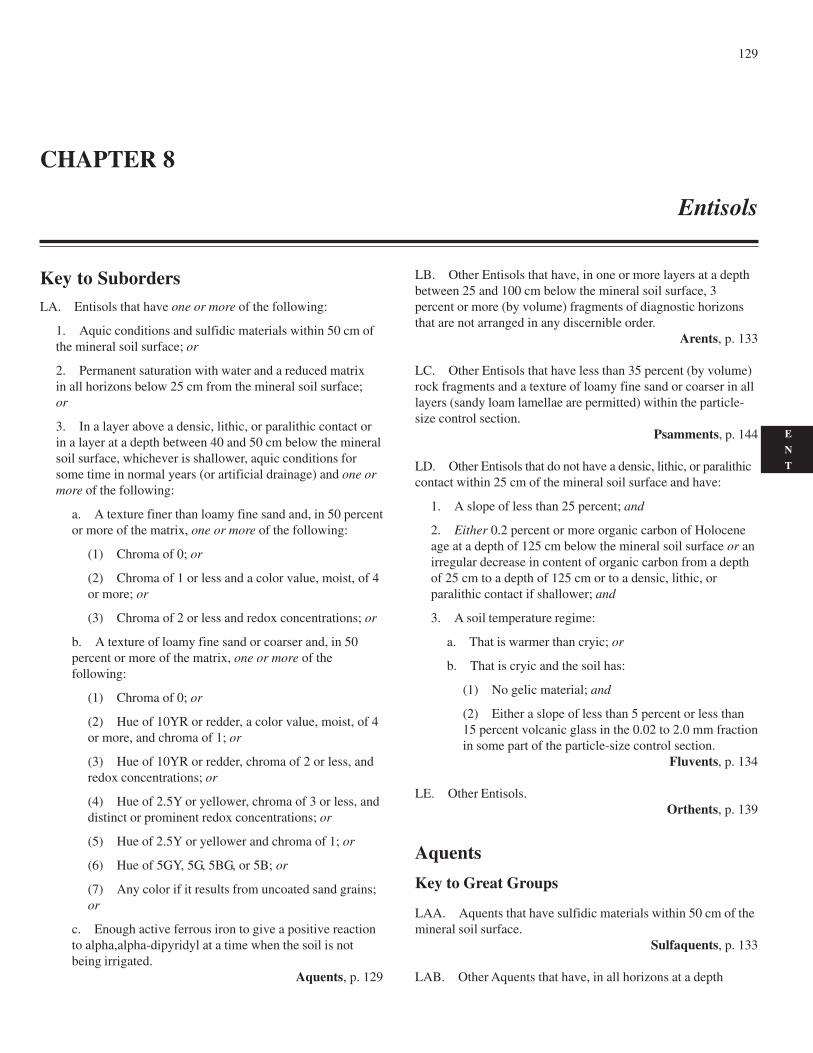
129
E
N
T
Key to SubordersLA. Entisols that have one or more of the following:
1. Aquic conditions and sulfidic materials within 50 cm ofthe mineral soil surface; or
2. Permanent saturation with water and a reduced matrixin all horizons below 25 cm from the mineral soil surface;or
3. In a layer above a densic, lithic, or paralithic contact orin a layer at a depth between 40 and 50 cm below the mineralsoil surface, whichever is shallower, aquic conditions forsome time in normal years (or artificial drainage) and one ormore of the following:
a. A texture finer than loamy fine sand and, in 50 percentor more of the matrix, one or more of the following:
(1) Chroma of 0; or
(2) Chroma of 1 or less and a color value, moist, of 4or more; or
(3) Chroma of 2 or less and redox concentrations; or
b. A texture of loamy fine sand or coarser and, in 50percent or more of the matrix, one or more of thefollowing:
(1) Chroma of 0; or
(2) Hue of 10YR or redder, a color value, moist, of 4or more, and chroma of 1; or
(3) Hue of 10YR or redder, chroma of 2 or less, andredox concentrations; or
(4) Hue of 2.5Y or yellower, chroma of 3 or less, anddistinct or prominent redox concentrations; or
(5) Hue of 2.5Y or yellower and chroma of 1; or
(6) Hue of 5GY, 5G, 5BG, or 5B; or
(7) Any color if it results from uncoated sand grains;or
c. Enough active ferrous iron to give a positive reactionto alpha,alpha-dipyridyl at a time when the soil is notbeing irrigated.
Aquents, p. 129
LB. Other Entisols that have, in one or more layers at a depthbetween 25 and 100 cm below the mineral soil surface, 3percent or more (by volume) fragments of diagnostic horizonsthat are not arranged in any discernible order.
Arents, p. 133
LC. Other Entisols that have less than 35 percent (by volume)rock fragments and a texture of loamy fine sand or coarser in alllayers (sandy loam lamellae are permitted) within the particle-size control section.
Psamments, p. 144
LD. Other Entisols that do not have a densic, lithic, or paralithiccontact within 25 cm of the mineral soil surface and have:
1. A slope of less than 25 percent; and
2. Either 0.2 percent or more organic carbon of Holoceneage at a depth of 125 cm below the mineral soil surface or anirregular decrease in content of organic carbon from a depthof 25 cm to a depth of 125 cm or to a densic, lithic, orparalithic contact if shallower; and
3. A soil temperature regime:
a. That is warmer than cryic; or
b. That is cryic and the soil has:
(1) No gelic material; and
(2) Either a slope of less than 5 percent or less than15 percent volcanic glass in the 0.02 to 2.0 mm fractionin some part of the particle-size control section.
Fluvents, p. 134
LE. Other Entisols.Orthents, p. 139
Aquents
Key to Great Groups
LAA. Aquents that have sulfidic materials within 50 cm of themineral soil surface.
Sulfaquents, p. 133
LAB. Other Aquents that have, in all horizons at a depth
CHAPTER 8
Entisols
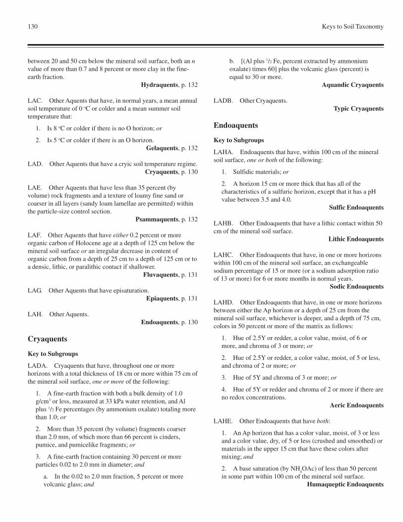
130 Keys to Soil Taxonomy
between 20 and 50 cm below the mineral soil surface, both an nvalue of more than 0.7 and 8 percent or more clay in the fine-earth fraction.
Hydraquents, p. 132
LAC. Other Aquents that have, in normal years, a mean annualsoil temperature of 0 oC or colder and a mean summer soiltemperature that:
1. Is 8 oC or colder if there is no O horizon; or
2. Is 5 oC or colder if there is an O horizon.Gelaquents, p. 132
LAD. Other Aquents that have a cryic soil temperature regime.Cryaquents, p. 130
LAE. Other Aquents that have less than 35 percent (byvolume) rock fragments and a texture of loamy fine sand orcoarser in all layers (sandy loam lamellae are permitted) withinthe particle-size control section.
Psammaquents, p. 132
LAF. Other Aquents that have either 0.2 percent or moreorganic carbon of Holocene age at a depth of 125 cm below themineral soil surface or an irregular decrease in content oforganic carbon from a depth of 25 cm to a depth of 125 cm or toa densic, lithic, or paralithic contact if shallower.
Fluvaquents, p. 131
LAG. Other Aquents that have episaturation.Epiaquents, p. 131
LAH. Other Aquents.Endoaquents, p. 130
Cryaquents
Key to Subgroups
LADA. Cryaquents that have, throughout one or morehorizons with a total thickness of 18 cm or more within 75 cm ofthe mineral soil surface, one or more of the following:
1. A fine-earth fraction with both a bulk density of 1.0g/cm3 or less, measured at 33 kPa water retention, and Alplus 1/2 Fe percentages (by ammonium oxalate) totaling morethan 1.0; or
2. More than 35 percent (by volume) fragments coarserthan 2.0 mm, of which more than 66 percent is cinders,pumice, and pumicelike fragments; or
3. A fine-earth fraction containing 30 percent or moreparticles 0.02 to 2.0 mm in diameter; and
a. In the 0.02 to 2.0 mm fraction, 5 percent or morevolcanic glass; and
b. [(Al plus 1/2 Fe, percent extracted by ammoniumoxalate) times 60] plus the volcanic glass (percent) isequal to 30 or more.
Aquandic Cryaquents
LADB. Other Cryaquents.Typic Cryaquents
Endoaquents
Key to Subgroups
LAHA. Endoaquents that have, within 100 cm of the mineralsoil surface, one or both of the following:
1. Sulfidic materials; or
2. A horizon 15 cm or more thick that has all of thecharacteristics of a sulfuric horizon, except that it has a pHvalue between 3.5 and 4.0.
Sulfic Endoaquents
LAHB. Other Endoaquents that have a lithic contact within 50cm of the mineral soil surface.
Lithic Endoaquents
LAHC. Other Endoaquents that have, in one or more horizonswithin 100 cm of the mineral soil surface, an exchangeablesodium percentage of 15 or more (or a sodium adsorption ratioof 13 or more) for 6 or more months in normal years.
Sodic Endoaquents
LAHD. Other Endoaquents that have, in one or more horizonsbetween either the Ap horizon or a depth of 25 cm from themineral soil surface, whichever is deeper, and a depth of 75 cm,colors in 50 percent or more of the matrix as follows:
1. Hue of 2.5Y or redder, a color value, moist, of 6 ormore, and chroma of 3 or more; or
2. Hue of 2.5Y or redder, a color value, moist, of 5 or less,and chroma of 2 or more; or
3. Hue of 5Y and chroma of 3 or more; or
4. Hue of 5Y or redder and chroma of 2 or more if there areno redox concentrations.
Aeric Endoaquents
LAHE. Other Endoaquents that have both:
1. An Ap horizon that has a color value, moist, of 3 or lessand a color value, dry, of 5 or less (crushed and smoothed) ormaterials in the upper 15 cm that have these colors aftermixing; and
2. A base saturation (by NH4OAc) of less than 50 percent
in some part within 100 cm of the mineral soil surface.Humaqueptic Endoaquents
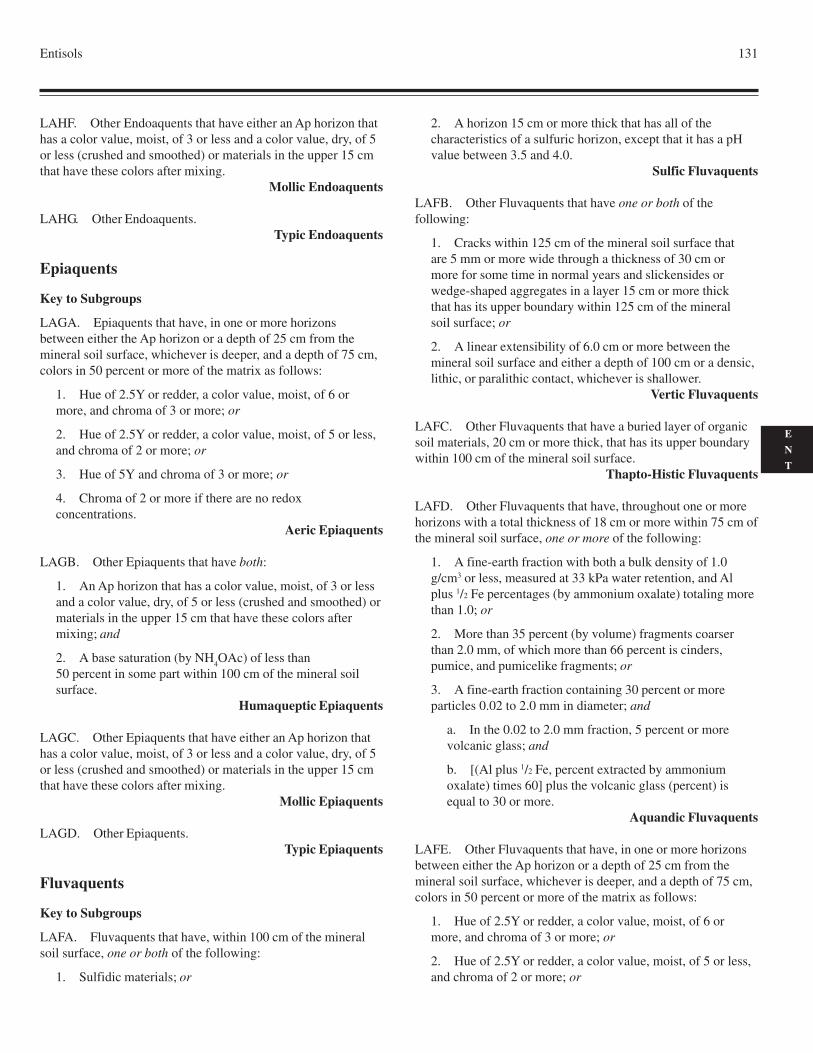
Entisols 131
E
N
T
LAHF. Other Endoaquents that have either an Ap horizon thathas a color value, moist, of 3 or less and a color value, dry, of 5or less (crushed and smoothed) or materials in the upper 15 cmthat have these colors after mixing.
Mollic Endoaquents
LAHG. Other Endoaquents.Typic Endoaquents
Epiaquents
Key to Subgroups
LAGA. Epiaquents that have, in one or more horizonsbetween either the Ap horizon or a depth of 25 cm from themineral soil surface, whichever is deeper, and a depth of 75 cm,colors in 50 percent or more of the matrix as follows:
1. Hue of 2.5Y or redder, a color value, moist, of 6 ormore, and chroma of 3 or more; or
2. Hue of 2.5Y or redder, a color value, moist, of 5 or less,and chroma of 2 or more; or
3. Hue of 5Y and chroma of 3 or more; or
4. Chroma of 2 or more if there are no redoxconcentrations.
Aeric Epiaquents
LAGB. Other Epiaquents that have both:
1. An Ap horizon that has a color value, moist, of 3 or lessand a color value, dry, of 5 or less (crushed and smoothed) ormaterials in the upper 15 cm that have these colors aftermixing; and
2. A base saturation (by NH4OAc) of less than
50 percent in some part within 100 cm of the mineral soilsurface.
Humaqueptic Epiaquents
LAGC. Other Epiaquents that have either an Ap horizon thathas a color value, moist, of 3 or less and a color value, dry, of 5or less (crushed and smoothed) or materials in the upper 15 cmthat have these colors after mixing.
Mollic Epiaquents
LAGD. Other Epiaquents.Typic Epiaquents
Fluvaquents
Key to Subgroups
LAFA. Fluvaquents that have, within 100 cm of the mineralsoil surface, one or both of the following:
1. Sulfidic materials; or
2. A horizon 15 cm or more thick that has all of thecharacteristics of a sulfuric horizon, except that it has a pHvalue between 3.5 and 4.0.
Sulfic Fluvaquents
LAFB. Other Fluvaquents that have one or both of thefollowing:
1. Cracks within 125 cm of the mineral soil surface thatare 5 mm or more wide through a thickness of 30 cm ormore for some time in normal years and slickensides orwedge-shaped aggregates in a layer 15 cm or more thickthat has its upper boundary within 125 cm of the mineralsoil surface; or
2. A linear extensibility of 6.0 cm or more between themineral soil surface and either a depth of 100 cm or a densic,lithic, or paralithic contact, whichever is shallower.
Vertic Fluvaquents
LAFC. Other Fluvaquents that have a buried layer of organicsoil materials, 20 cm or more thick, that has its upper boundarywithin 100 cm of the mineral soil surface.
Thapto-Histic Fluvaquents
LAFD. Other Fluvaquents that have, throughout one or morehorizons with a total thickness of 18 cm or more within 75 cm ofthe mineral soil surface, one or more of the following:
1. A fine-earth fraction with both a bulk density of 1.0g/cm3 or less, measured at 33 kPa water retention, and Alplus 1/2 Fe percentages (by ammonium oxalate) totaling morethan 1.0; or
2. More than 35 percent (by volume) fragments coarserthan 2.0 mm, of which more than 66 percent is cinders,pumice, and pumicelike fragments; or
3. A fine-earth fraction containing 30 percent or moreparticles 0.02 to 2.0 mm in diameter; and
a. In the 0.02 to 2.0 mm fraction, 5 percent or morevolcanic glass; and
b. [(Al plus 1/2 Fe, percent extracted by ammoniumoxalate) times 60] plus the volcanic glass (percent) isequal to 30 or more.
Aquandic Fluvaquents
LAFE. Other Fluvaquents that have, in one or more horizonsbetween either the Ap horizon or a depth of 25 cm from themineral soil surface, whichever is deeper, and a depth of 75 cm,colors in 50 percent or more of the matrix as follows:
1. Hue of 2.5Y or redder, a color value, moist, of 6 ormore, and chroma of 3 or more; or
2. Hue of 2.5Y or redder, a color value, moist, of 5 or less,and chroma of 2 or more; or
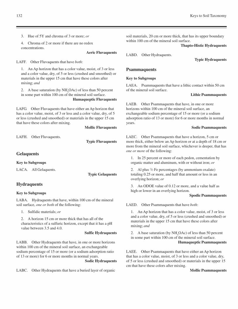
132 Keys to Soil Taxonomy
soil materials, 20 cm or more thick, that has its upper boundarywithin 100 cm of the mineral soil surface.
Thapto-Histic Hydraquents
LABD. Other Hydraquents.Typic Hydraquents
Psammaquents
Key to Subgroups
LAEA. Psammaquents that have a lithic contact within 50 cmof the mineral soil surface.
Lithic Psammaquents
LAEB. Other Psammaquents that have, in one or morehorizons within 100 cm of the mineral soil surface, anexchangeable sodium percentage of 15 or more (or a sodiumadsorption ratio of 13 or more) for 6 or more months in normalyears.
Sodic Psammaquents
LAEC. Other Psammaquents that have a horizon, 5 cm ormore thick, either below an Ap horizon or at a depth of 18 cm ormore from the mineral soil surface, whichever is deeper, that hasone or more of the following:
1. In 25 percent or more of each pedon, cementation byorganic matter and aluminum, with or without iron; or
2. Al plus 1/2 Fe percentages (by ammonium oxalate)totaling 0.25 or more, and half that amount or less in anoverlying horizon; or
3. An ODOE value of 0.12 or more, and a value half ashigh or lower in an overlying horizon.
Spodic Psammaquents
LAED. Other Psammaquents that have both:
1. An Ap horizon that has a color value, moist, of 3 or lessand a color value, dry, of 5 or less (crushed and smoothed) ormaterials in the upper 15 cm that have these colors aftermixing; and
2. A base saturation (by NH4OAc) of less than 50 percent
in some part within 100 cm of the mineral soil surface.Humaqueptic Psammaquents
LAEE. Other Psammaquents that have either an Ap horizonthat has a color value, moist, of 3 or less and a color value, dry,of 5 or less (crushed and smoothed) or materials in the upper 15cm that have these colors after mixing.
Mollic Psammaquents
3. Hue of 5Y and chroma of 3 or more; or
4. Chroma of 2 or more if there are no redoxconcentrations.
Aeric Fluvaquents
LAFF. Other Fluvaquents that have both:
1. An Ap horizon that has a color value, moist, of 3 or lessand a color value, dry, of 5 or less (crushed and smoothed) ormaterials in the upper 15 cm that have these colors aftermixing; and
2. A base saturation (by NH4OAc) of less than 50 percent
in some part within 100 cm of the mineral soil surface.Humaqueptic Fluvaquents
LAFG. Other Fluvaquents that have either an Ap horizon thathas a color value, moist, of 3 or less and a color value, dry, of 5or less (crushed and smoothed) or materials in the upper 15 cmthat have these colors after mixing.
Mollic Fluvaquents
LAFH. Other Fluvaquents.Typic Fluvaquents
Gelaquents
Key to Subgroups
LACA. All Gelaquents.Typic Gelaquents
Hydraquents
Key to Subgroups
LABA. Hydraquents that have, within 100 cm of the mineralsoil surface, one or both of the following:
1. Sulfidic materials; or
2. A horizon 15 cm or more thick that has all of thecharacteristics of a sulfuric horizon, except that it has a pHvalue between 3.5 and 4.0.
Sulfic Hydraquents
LABB. Other Hydraquents that have, in one or more horizonswithin 100 cm of the mineral soil surface, an exchangeablesodium percentage of 15 or more (or a sodium adsorption ratioof 13 or more) for 6 or more months in normal years.
Sodic Hydraquents
LABC. Other Hydraquents that have a buried layer of organic
Entisols 133
E
N
T
LAEF. Other Psammaquents.Typic Psammaquents
Sulfaquents
Key to Subgroups
LAAA. Sulfaquents that have, in some horizons at a depthbetween 20 and 50 cm below the mineral soil surface, either orboth:
1. An n value of 0.7 or less; or
2. Less than 8 percent clay in the fine-earth fraction.Haplic Sulfaquents
LAAB. Other Sulfaquents that have a histic epipedon.Histic Sulfaquents
LAAC. Other Sulfaquents that have a buried layer of organicsoil materials, 20 cm or more thick, that has its upper boundarywithin 100 cm of the mineral soil surface.
Thapto-Histic Sulfaquents
LAAD. Other Sulfaquents.Typic Sulfaquents
Arents
Key to Great Groups
LBA. Arents that have an ustic moisture regime.Ustarents, p. 133
LBB. Other Arents that have a xeric moisture regime.Xerarents, p. 133
LBC. Other Arents that have an aridic (or torric) moistureregime.
Torriarents, p. 133
LBD. Other Arents.Udarents, p. 133
Torriarents
Key to Subgroups
LBCA. Torriarents that have, in one or more horizons within100 cm of the mineral soil surface, 3 percent or more fragmentsof a natric horizon.
Sodic Torriarents
LBCB. Other Torriarents that have, within 100 cm of the
mineral soil surface, 3 percent or more fragments of a duripan ora petrocalcic horizon;
Duric Torriarents
LBCC. Other Torriarents.Haplic Torriarents
Udarents
Key to Subgroups
LBDA. Udarents that have 3 percent or more fragments of anargillic horizon in some horizon within 100 cm of the mineralsoil surface and have a base saturation (by sum of cations) of 35percent or more in all parts within 100 cm of the mineral soilsurface.
Alfic Udarents
LBDB. Other Udarents that have 3 percent or more fragmentsof an argillic horizon in some horizon within 100 cm of themineral soil surface.
Ultic Udarents
LBDC. Other Udarents that have 3 percent or more fragmentsof a mollic epipedon in some horizon within 100 cm of themineral soil surface and have a base saturation (by sum ofcations) of 35 percent or more in all parts within 100 cm of themineral soil surface.
Mollic Udarents
LBDD. Other Udarents.Haplic Udarents
Ustarents
Key to Subgroups
LBAA. All Ustarents.Haplic Ustarents
Xerarents
Key to Subgroups
LBBA. Xerarents that have, in one or more horizons within100 cm of the mineral soil surface, 3 percent or more fragmentsof a natric horizon.
Sodic Xerarents
LBBB. Other Xerarents that have, within 100 cm of themineral soil surface, 3 percent or more fragments of a duripan ora petrocalcic horizon.
Duric Xerarents
LBBC. Other Xerarents that have fragments of an argillic
134 Keys to Soil Taxonomy
horizon with a base saturation (by sum of cations) of 35 percentor more within 100 cm of the mineral soil surface.
Alfic Xerarents
LBBD. Other Xerarents.Haplic Xerarents
Fluvents
Key to Great Groups
LDA. Fluvents that that have, in normal years, a mean annualsoil temperature of 0 oC or colder and a mean summer soiltemperature that:
1. Is 8 oC or colder if there is no O horizon; or
2. Is 5 oC or colder if there is an O horizon.Gelifluvents, p. 134
LDB. Other Fluvents that have a cryic soil temperatureregime.
Cryofluvents, p. 134
LDC. Other Fluvents that have a xeric moisture regime.Xerofluvents, p. 138
LDD. Other Fluvents that have an ustic moisture regime.Ustifluvents, p. 137
LDE. Other Fluvents that have an aridic (or torric) moistureregime.
Torrifluvents, p. 134
LDF. Other Fluvents.Udifluvents, p. 136
Cryofluvents
Key to Subgroups
LDBA. Cryofluvents that have, throughout one or morehorizons with a total thickness of 18 cm or more within 75 cm ofthe mineral soil surface, a fine-earth fraction with both a bulkdensity of 1.0 g/cm3 or less, measured at 33 kPa water retention,and percent aluminum plus 1/2 the iron percentage (byammonium oxalate) totaling more than 1.0.
Andic Cryofluvents
LDDB. Other Cryofluvents that have, throughout one or morehorizons with a total thickness of 18 cm or more within 75 cm ofthe mineral soil surface, one or both of the following:
1. More than 35 percent (by volume) fragments coarserthan 2.0 mm, of which more than 66 percent is cinders,pumice, and pumicelike fragments; or
2. A fine-earth fraction containing 30 percent or moreparticles 0.02 to 2.0 mm in diameter; and
a. In the 0.02 to 2.0 mm fraction, 5 percent or morevolcanic glass; and
b. [(Al plus 1/2 Fe, percent extracted by ammoniumoxalate) times 60] plus the volcanic glass (percent) isequal to 30 or more.
Vitrandic Cryofluvents
LDBC. Other Cryofluvents that have, in one or more horizonswithin 50 cm of the mineral soil surface, redox depletions withchroma of 2 or less and also aquic conditions for some time innormal years (or artificial drainage).
Aquic Cryofluvents
LDBD. Other Cryofluvents that are saturated with water inone or more layers within 100 cm of the mineral soil surface innormal years for either or both:
1. 20 or more consecutive days; or
2. 30 or more cumulative days.Oxyaquic Cryofluvents
LDBE. Other Cryofluvents that have either an Ap horizon thathas a color value, moist, of 3 or less and a color value, dry, of 5or less (crushed and smoothed) or materials in the upper 15 cmthat have these colors after mixing.
Mollic Cryofluvents
LDBF. Other Cryofluvents.Typic Cryofluvents
Gelifluvents
Key to Subgroups
LDAA. Gelifluvents that have, in one or more horizons within100 cm of the mineral soil surface, both redox depletions withchroma of 2 or less and aquic conditions for some time innormal years (or artificial drainage).
Aquic Gelifluvents
LDAB. Other Gelifluvents.Typic Gelifluvents
Torrifluvents
Key to Subgroups
LDEA. Torrifluvents that have:
1. One or both of the following:
a. Cracks within 125 cm of the mineral soil surface thatare 5 mm or more wide through a thickness of 30 cm or
Entisols 135
E
N
T
more for some time in normal years and slickensides orwedge-shaped aggregates in a layer 15 cm or more thickthat has its upper boundary within 125 cm of the mineralsoil surface; or
b. A linear extensibility of 6.0 cm or more between themineral soil surface and either a depth of 100 cm or adensic, lithic, or paralithic contact, whichever isshallower; and
2. A moisture control section that, in normal years, is dry inall its parts for less than three-fourths of the cumulative daysper year when the soil temperature at a depth of 50 cm fromthe soil surface is 5 oC or higher; and
3. An aridic (or torric) moisture regime that borders onustic.
Ustertic Torrifluvents
LDEB. Other Torrifluvents that have one or both of thefollowing:
1. Cracks within 125 cm of the soil surface that are5 mm or more wide through a thickness of 30 cm or more forsome time in most normal years and slickensides or wedge-shaped aggregates in a layer 15 cm or more thick that has itsupper boundary within 125 cm of the soil surface; or
2. A linear extensibility of 6.0 cm or more between the soilsurface and either a depth of 100 cm or a densic, lithic, orparalithic contact, whichever is shallower.
Vertic Torrifluvents
LDEC. Other Torrifluvents that have:
1. A moisture control section that, in normal years, is dry inall its parts for less than three-fourths of the cumulative daysper year when the soil temperature at a depth of 50 cm fromthe soil surface is 5 oC or higher; and
2. A thermic, mesic, or frigid soil temperature regime andan aridic (or torric) moisture regime that borders on xeric;and
3. Throughout one or more horizons with a total thicknessof 18 cm or more within 75 cm of the mineral soil surface,one or both of the following:
a. More than 35 percent (by volume) fragments coarserthan 2.0 mm, of which more than 66 percent is cinders,pumice, and pumicelike fragments; or
b. A fine-earth fraction containing 30 percent or moreparticles 0.02 to 2.0 mm in diameter; and
(1) In the 0.02 to 2.0 mm fraction, 5 percent or morevolcanic glass; and
(2) [(Al plus 1/2 Fe, percent extracted by ammonium
oxalate) times 60] plus the volcanic glass (percent) isequal to 30 or more.
Vitrixerandic Torrifluvents
LDED. Other Torrifluvents that have, throughout one or morehorizons with a total thickness of 18 cm or more within 75 cm ofthe mineral soil surface, one or both of the following:
1. More than 35 percent (by volume) fragments coarserthan 2.0 mm, of which more than 66 percent is cinders,pumice, and pumicelike fragments; or
2. A fine-earth fraction containing 30 percent or moreparticles 0.02 to 2.0 mm in diameter; and
a. In the 0.02 to 2.0 mm fraction, 5 percent or morevolcanic glass; and
b. [(Al plus 1/2 Fe, percent extracted by ammoniumoxalate) times 60] plus the volcanic glass (percent) isequal to 30 or more.
Vitrandic Torrifluvents
LDEE. Other Torrifluvents that have, in one or more horizonswithin 100 cm of the soil surface, both redox depletions withchroma of 2 or less and aquic conditions for some time innormal years (or artificial drainage).
Aquic Torrifluvents
LDEF. Other Torrifluvents that are saturated with water in oneor more layers within 150 cm of the soil surface in normal yearsfor either or both:
1. 20 or more consecutive days; or
2. 30 or more cumulative days.Oxyaquic Torrifluvents
LDEG. Other Torrifluvents that have:
1. A horizon within 100 cm of the mineral soil surface thatis 15 cm or more thick and that either has 20 percent or more(by volume) durinodes or is brittle and has a firm rupture-resistance class when moist; and
2. A moisture control section that, in normal years, is dry inall its parts for less than three-fourths of the cumulative daysper year when the soil temperature at a depth of 50 cm fromthe soil surface is 5 oC or higher; and
3. A thermic, mesic, or frigid soil temperature regimeand an aridic (or torric) moisture regime that borders onxeric.
Duric Xeric Torrifluvents
LDEH. Other Torrifluvents that have a horizon within 100 cmof the mineral soil surface that is 15 cm or more thick and that
136 Keys to Soil Taxonomy
either has 20 percent or more (by volume) durinodes or is brittleand has a firm rupture-resistance class when moist.
Duric Torrifluvents
LDEI. Other Torrifluvents that have both:
1. A moisture control section that, in normal years, is dry inall its parts for less than three-fourths of the cumulative daysper year when the soil temperature at a depth of 50 cm fromthe soil surface is 5 oC or higher; and
2. An aridic (or torric) moisture regime that borders onustic.
Ustic Torrifluvents
LDEJ. Other Torrifluvents that have both:
1. A moisture control section that, in normal years, is dry inall its parts for less than three-fourths of the cumulative daysper year when the soil temperature at a depth of 50 cm fromthe soil surface is 5 oC or higher; and
2. A thermic, mesic, or frigid soil temperature regime andan aridic (or torric) moisture regime that borders on xeric.
Xeric Torrifluvents
LDEK. Other Torrifluvents that have an anthropic epipedon.Anthropic Torrifluvents
LDEL. Other Torrifluvents.Typic Torrifluvents
Udifluvents
Key to Subgroups
LDFA. Udifluvents that have both:
1. One or both of the following:
a. Cracks within 125 cm of the mineral soil surface thatare 5 mm or more wide through a thickness of 30 cm ormore for some time in normal years and slickensides orwedge-shaped aggregates in a layer 15 cm or more thickthat has its upper boundary within 125 cm of the mineralsoil surface; or
b. A linear extensibility of 6.0 cm or more between themineral soil surface and either a depth of 100 cm or adensic, lithic, or paralithic contact, whichever isshallower; and
2. Either or both of the following:
a. In one or more horizons within 50 cm of the mineralsoil surface, redox depletions with chroma of 2 or less andalso aquic conditions for some time in normal years (orartificial drainage); or
b. In one or more horizons within 100 cm of the mineralsoil surface, a color value, moist, of 4 or more and eitherchroma of 0 or hue of 5GY, 5G, 5BG, or 5B and also aquicconditions for some time in normal years (or artificialdrainage).
Aquertic Udifluvents
LDFB. Other Udifluvents that have one or both of thefollowing:
1. Cracks within 125 cm of the mineral soil surface that are5 mm or more wide through a thickness of 30 cm or more forsome time in normal years and slickensides or wedge-shapedaggregates in a layer 15 cm or more thick that has its upperboundary within 125 cm of the mineral soil surface; or
2. A linear extensibility of 6.0 cm or more between themineral soil surface and either a depth of 100 cm or a densic,lithic, or paralithic contact, whichever is shallower.
Vertic Udifluvents
LDFC. Other Udifluvents that have, throughout one or morehorizons with a total thickness of 18 cm or more within 75 cm ofthe mineral soil surface, a fine-earth fraction with both a bulkdensity of 1.0 g/cm3 or less, measured at 33 kPa water retention,and Al plus 1/2 Fe percentages (by ammonium oxalate) totalingmore than 1.0.
Andic Udifluvents
LDFD. Other Udifluvents that have, throughout one or morehorizons with a total thickness of 18 cm or more within 75 cm ofthe mineral soil surface, one or both of the following:
1. More than 35 percent (by volume) fragments coarserthan 2.0 mm, of which more than 66 percent is cinders,pumice, and pumicelike fragments; or
2. A fine-earth fraction containing 30 percent or moreparticles 0.02 to 2.0 mm in diameter; and
a. In the 0.02 to 2.0 mm fraction, 5 percent or morevolcanic glass; and
b. [(Al plus 1/2 Fe, percent extracted by ammoniumoxalate) times 60] plus the volcanic glass (percent) isequal to 30 or more.
Vitrandic Udifluvents
LDFE. Other Udifluvents that have either:
1. In one or more horizons within 50 cm of the mineral soilsurface, redox depletions with chroma of 2 or less and alsoaquic conditions for some time in normal years (or artificialdrainage); or
2. In one or more horizons within 100 cm of the mineralsoil surface, a color value, moist, of 4 or more and either
Entisols 137
E
N
T
chroma of 0 or hue of 5GY, 5G, 5BG, or 5B and also aquicconditions for some time in normal years (or artificialdrainage).
Aquic Udifluvents
LDFF. Other Udifluvents that are saturated with water in oneor more layers within 100 cm of the mineral soil surface innormal years for either or both:
1. 20 or more consecutive days; or
2. 30 or more cumulative days.Oxyaquic Udifluvents
LDFG. Other Udifluvents that have either an Ap horizon thathas a color value, moist, of 3 or less and a color value, dry, of 5or less (crushed and smoothed) or materials in the upper 15 cmthat have these colors after mixing.
Mollic Udifluvents
LDFH. Other Udifluvents.Typic Udifluvents
Ustifluvents
Key to Subgroups
LDDA. Ustifluvents that have both:
1. One or both of the following:
a. Cracks within 125 cm of the mineral soil surface thatare 5 mm or more wide through a thickness of 30 cm ormore for some time in normal years and slickensides orwedge-shaped aggregates in a layer 15 cm or more thickthat has its upper boundary within 125 cm of the mineralsoil surface; or
b. A linear extensibility of 6.0 cm or more between themineral soil surface and either a depth of 100 cm or adensic, lithic, or paralithic contact, whichever isshallower; and
2. Either or both of the following:
a. In one or more horizons within 50 cm of the mineralsoil surface, redox depletions with chroma of 2 or less andalso aquic conditions for some time in normal years (orartificial drainage); or
b. In one or more horizons within 150 cm of the mineralsoil surface, a color value, moist, of 4 or more and eitherchroma of 0 or hue of 5GY, 5G, 5BG, or 5B and also aquicconditions for some time in normal years (or artificialdrainage).
Aquertic Ustifluvents
LDDB. Other Ustifluvents that have both of the following:
1. When neither irrigated nor fallowed to store moisture,one of the following:
a. A frigid temperature regime and a moisture controlsection that, in normal years, is dry in all parts for four-tenths or more of the cumulative days per year when thesoil temperature at a depth of 50 cm below the soil surfaceis higher than 5 oC; or
b. A mesic or thermic soil temperature regime and amoisture control section that, in normal years, is dry insome part for six-tenths or more of the cumulative daysper year when the soil temperature at a depth of 50 cmbelow the soil surface is higher than 5 oC; or
c. A hyperthermic, isomesic, or warmer iso soiltemperature regime and a moisture control section that,in normal years, remains moist in some or all parts forless than 90 consecutive days per year when thetemperature at a depth of 50 cm below the soil surface ishigher than 8 oC; and
2. One or both of the following:
a. Cracks within 125 cm of the mineral soil surface thatare 5 mm or more wide through a thickness of 30 cm ormore for some time in normal years and slickensides orwedge-shaped aggregates in a layer 15 cm or more thickthat has its upper boundary within 125 cm of the mineralsoil surface; or
b. A linear extensibility of 6.0 cm or more betweenthe mineral soil surface and either a depth of 100 cm ora densic, lithic, or paralithic contact, whichever isshallower.
Torrertic Ustifluvents
LDDC. Other Ustifluvents that have one or both of thefollowing:
1. Cracks within 125 cm of the mineral soil surface thatare 5 mm or more wide through a thickness of 30 cm ormore for some time in normal years and slickensides orwedge-shaped aggregates in a layer 15 cm or more thick thathas its upper boundary within 125 cm of the mineral soilsurface; or
2. A linear extensibility of 6.0 cm or more between themineral soil surface and either a depth of 100 cm or a densic,lithic, or paralithic contact, whichever is shallower.
Vertic Ustifluvents
LDDD. Other Ustifluvents that have anthraquic conditions.Anthraquic Ustifluvents
138 Keys to Soil Taxonomy
LDDE. Other Ustifluvents that have either:
1. In one or more horizons within 50 cm of the mineral soilsurface, redox depletions with chroma of 2 or less and alsoaquic conditions for some time in normal years (or artificialdrainage); or
2. In one or more horizons within 150 cm of the mineralsoil surface, a color value, moist, of 4 or more and eitherchroma of 0 or hue of 5GY, 5G, 5BG, or 5B and also aquicconditions for some time in normal years (or artificialdrainage).
Aquic Ustifluvents
LDDF. Other Ustifluvents that are saturated with water in oneor more layers within 150 cm of the mineral soil surface innormal years for either or both:
1. 20 or more consecutive days; or
2. 30 or more cumulative days.Oxyaquic Ustifluvents
LDDG. Other Ustifluvents that, when neither irrigated norfallowed to store moisture, have one of the following:
1. A frigid soil temperature regime and a moisture controlsection that, in normal years, is dry in all parts for four-tenthsor more of the cumulative days per year when the soiltemperature at a depth of 50 cm below the soil surface ishigher than 5 oC; or
2. A mesic or thermic soil temperature regime and amoisture control section that, in normal years, is dry in somepart for six-tenths or more of the cumulative days per yearwhen the soil temperature at a depth of 50 cm below the soilsurface is higher than 5 oC; or
3. A hyperthermic, isomesic, or warmer iso soiltemperature regime and a moisture control section that, innormal years, is moist in some or all parts for less than 180cumulative days per year when the temperature at a depth of50 cm below the soil surface is higher than 8 oC.
Aridic Ustifluvents
LDDH. Other Ustifluvents that, when neither irrigated norfallowed to store moisture, have one of the following:
1. A frigid soil temperature regime and a moisture controlsection that, in normal years, is dry in some or all parts forless than 105 cumulative days per year when the soiltemperature at a depth of 50 cm below the soil surface ishigher than 5 oC; or
2. A mesic or thermic soil temperature regime and amoisture control section that, in normal years, is dry in somepart for less than four-tenths of the cumulative days per yearwhen the temperature at a depth of 50 cm below the soilsurface is higher than 5 oC; or
3. A hyperthermic, isomesic, or warmer iso soiltemperature regime and a moisture control section that, innormal years, is dry in some or all parts for less than 120cumulative days per year when the temperature at a depth of50 cm below the soil surface is higher than 8 oC.
Udic Ustifluvents
LDDI. Other Ustifluvents that have either an Ap horizon thathas a color value, moist, of 3 or less and a color value, dry, of 5or less (crushed and smoothed) or materials in the upper 15 cmthat have these colors after mixing.
Mollic Ustifluvents
LDDJ. Other Ustifluvents.Typic Ustifluvents
Xerofluvents
Key to Subgroups
LDCA. Xerofluvents that have one or both of the following:
1. Cracks within 125 cm of the mineral soil surface that are5 mm or more wide through a thickness of 30 cm or more forsome time in normal years and slickensides or wedge-shapedaggregates in a layer 15 cm or more thick that has its upperboundary within 125 cm of the mineral soil surface; or
2. A linear extensibility of 6.0 cm or more betweenthe mineral soil surface and either a depth of 100 cmor a densic, lithic, or paralithic contact, whichever isshallower.
Vertic Xerofluvents
LDCB. Other Xerofluvents that have:
1. In one or more horizons within 50 cm of the mineral soilsurface, redox depletions with chroma of 2 or less and alsoaquic conditions for some time in normal years (or artificialdrainage); or
2. In one or more horizons within 150 cm of the mineralsoil surface, a color value, moist, of 4 or more and eitherchroma of 0 or hue bluer than 10Y and also aquic conditionsfor some time in normal years (or artificial drainage); and
3. Throughout one or more horizons with a total thicknessof 18 cm or more within 75 cm of the mineral soil surface,one or more of the following:
a. A fine-earth fraction with both a bulk density of 1.0g/cm3 or less, measured at 33 kPa water retention, and Alplus 1/2 Fe percentages (by ammonium oxalate) totalingmore than 1.0; or
b. More than 35 percent (by volume) fragments coarserthan 2.0 mm, of which more than 66 percent is cinders,pumice, and pumicelike fragments; or
Entisols 139
E
N
T
c. A fine-earth fraction containing 30 percent or moreparticles 0.02 to 2.0 mm in diameter; and
(1) In the 0.02 to 2.0 mm fraction, 5 percent or morevolcanic glass; and
(2) [(Al plus 1/2 Fe, percent extracted by ammoniumoxalate) times 60] plus the volcanic glass (percent) isequal to 30 or more.
Aquandic Xerofluvents
LDCC. Other Xerofluvents that have, throughout one or morehorizons with a total thickness of 18 cm or more within 75 cm ofthe mineral soil surface, a fine-earth fraction with both a bulkdensity of 1.0 g/cm3 or less, measured at 33 kPa water retention,and Al plus 1/2 Fe percentages (by ammonium oxalate) totalingmore than 1.0.
Andic Xerofluvents
LDCD. Other Xerofluvents that have, throughout one or morehorizons with a total thickness of 18 cm or more within 75 cm ofthe mineral soil surface, one or both of the following:
1. More than 35 percent (by volume) fragments coarserthan 2.0 mm, of which more than 66 percent is cinders,pumice, and pumicelike fragments; or
2. A fine-earth fraction containing 30 percent or moreparticles 0.02 to 2.0 mm in diameter; and
a. In the 0.02 to 2.0 mm fraction, 5 percent or morevolcanic glass; and
b. [(Al plus 1/2 Fe, percent extracted by ammoniumoxalate) times 60] plus the volcanic glass (percent) isequal to 30 or more.
Vitrandic Xerofluvents
LDCE. Other Xerofluvents that have either:
1. In one or more horizons within 50 cm of the mineral soilsurface, redox depletions with chroma of 2 or less and alsoaquic conditions for some time in normal years (or artificialdrainage); or
2. In one or more horizons within 150 cm of the mineralsoil surface, a color value, moist, of 4 or more and eitherchroma of 0 or hue of 5GY, 5G, 5BG, or 5B or aquicconditions for some time in normal years.
Aquic Xerofluvents
LDCF. Other Xerofluvents that are saturated with water in oneor more layers within 150 cm of the mineral soil surface innormal years for either or both:
1. 20 or more consecutive days; or
2. 30 or more cumulative days.Oxyaquic Xerofluvents
LDCG. Other Xerofluvents that have a horizon within 100 cmof the mineral soil surface that is 15 cm or more thick and thateither has 20 percent or more (by volume) durinodes or is brittleand has a firm rupture-resistance class when moist.
Durinodic Xerofluvents
LDCH. Other Xerofluvents that have either an Ap horizon thathas a color value, moist, of 3 or less and a color value, dry, of 5or less (crushed and smoothed) or materials in the upper 15 cmthat have these colors after mixing.
Mollic Xerofluvents
LDCI. Other Xerofluvents.Typic Xerofluvents
Orthents
Key to Great Groups
LEA. Orthents that have, in normal years, a mean annual soiltemperature of 0 oC or colder and a mean summer soiltemperature that:
1. Is 8 oC or colder if there is no O horizon; or
2. Is 5 oC or colder if there is an O horizon.Gelorthents, p. 140
LEB. Other Orthents that have a cryic soil temperature regime.Cryorthents, p. 139
LEC. Other Orthents that have an aridic (or torric) moistureregime.
Torriorthents, p. 140
LEC. Other Orthents that have a xeric moisture regime.Xerorthents, p. 144
LED. Other Orthents that have an ustic moisture regime.Ustorthents, p. 142
LEF. Other Orthents.Udorthents, p. 141
Cryorthents
Key to Subgroups
LEBA. Cryorthents that have a lithic contact within 50 cm ofthe mineral soil surface.
Lithic Cryorthents
LEBB. Other Cryorthents that have, throughout oneor more horizons with a total thickness of 18 cm or more within75 cm of the mineral soil surface, one or both of the following:
140 Keys to Soil Taxonomy
1. More than 35 percent (by volume) fragments coarserthan 2.0 mm, of which more than 66 percent is cinders,pumice, and pumicelike fragments; or
2. A fine-earth fraction containing 30 percent or moreparticles 0.02 to 2.0 mm in diameter; and
a. In the 0.02 to 2.0 mm fraction, 5 percent or morevolcanic glass; and
b. [(Al plus 1/2 Fe, percent extracted by ammoniumoxalate) times 60] plus the volcanic glass (percent) isequal to 30 or more.
Vitrandic Cryorthents
LEBC. Other Cryorthents that have, in one or more horizonswithin 50 cm of the mineral soil surface, redox depletions withchroma of 2 or less and also aquic conditions for some time innormal years (or artificial drainage).
Aquic Cryorthents
LEDD. Other Cryorthents that are saturated with water in oneor more layers within 100 cm of the mineral soil surface innormal years for either or both:
1. 20 or more consecutive days; or
2. 30 or more cumulative days.Oxyaquic Cryorthents
LEBE. Other Cryorthents that have lamellae within 200 cm ofthe mineral soil surface.
Lamellic Cryorthents
LEBF. Other Cryorthents.Typic Cryorthents
Gelorthents
Key to Subgroups
LEAA. Gelorthents that are saturated with water in one ormore layers within 100 cm of the mineral soil surface in normalyears for either or both:
1. 20 or more consecutive days; or
2. 30 or more cumulative days.Oxyaquic Gelorthents
LEAB. Other Gelorthents.Typic Gelorthents
Torriorthents
Key to Subgroups
LECA. Torriorthents that have:
1. A lithic contact within 50 cm of the soil surface; and
2. A moisture control section that, in normal years, is dry inall its parts for less than three-fourths of the cumulative daysper year when the soil temperature at a depth of 50 cm fromthe soil surface is 5 oC or higher; and
3. A hyperthermic, thermic, mesic, frigid, or iso soiltemperature regime and an aridic (or torric) moisture regimethat borders on ustic.
Lithic Ustic Torriorthents
LECB. Other Torriorthents that have:
1. A lithic contact within 50 cm of the soil surface; and
2. A moisture control section that, in normal years, is dry inall its parts for less than three-fourths of the cumulative daysper year when the soil temperature at a depth of 50 cm fromthe soil surface is 5 oC or higher; and
3. A thermic, mesic, or frigid soil temperature regime andan aridic (or torric) moisture regime that borders on xeric.
Lithic Xeric Torriorthents
LECC. Other Torriorthents that have a lithic contact within 50cm of the soil surface.
Lithic Torriorthents
LECD. Other Torriorthents that have:
1. One or both of the following:
a. Cracks within 125 cm of the soil surface that are 5mm or more wide through a thickness of 30 cm or morefor some time in normal years and slickensides or wedge-shaped aggregates in a layer 15 cm or more thick that hasits upper boundary within 125 cm of the soil surface; or
b. A linear extensibility of 6.0 cm or more between thesoil surface and either a depth of 100 cm or a densic,lithic, or paralithic contact, whichever is shallower; and
2. A moisture control section that, in normal years, is dry inall its parts for less than three-fourths of the cumulative daysper year when the soil temperature at a depth of 50 cm fromthe soil surface is 5 oC or higher; and
3. A thermic, mesic, or frigid soil temperature regime andan aridic (or torric) moisture regime that borders on xeric.
Xerertic Torriorthents
LECE. Other Torriorthents that have:
1. One or both of the following:
a. Cracks within 125 cm of the soil surface that are 5mm or more wide through a thickness of 30 cm or morefor some time in normal years and slickensides or wedge-shaped aggregates in a layer 15 cm or more thick thathas its upper boundary within 125 cm of the soil surface;or
Entisols 141
E
N
T
b. A linear extensibility of 6.0 cm or more between thesoil surface and either a depth of 100 cm or a densic,lithic, or paralithic contact, whichever is shallower; and
2. A moisture control section that, in normal years, is dry inall its parts for less than three-fourths of the cumulative daysper year when the soil temperature at a depth of 50 cm fromthe soil surface is 5 oC or higher; and
3. An aridic (or torric) moisture regime that borders onustic.
Ustertic Torriorthents
LECF. Other Torriorthents that have one or both of thefollowing:
1. Cracks within 125 cm of the soil surface that are 5 mmor more wide through a thickness of 30 cm or more for sometime in normal years and slickensides or wedge-shapedaggregates in a layer 15 cm or more thick that has its upperboundary within 125 cm of the soil surface; or
2. A linear extensibility of 6.0 cm or more between the soilsurface and either a depth of 100 cm or a densic, lithic, orparalithic contact, whichever is shallower.
Vertic Torriorthents
LECG. Other Torriorthents that have, throughout one or morehorizons with a total thickness of 18 cm or more within 75 cm ofthe soil surface, one or both of the following:
1. More than 35 percent (by volume) fragments coarserthan 2.0 mm, of which more than 66 percent is cinders,pumice, and pumicelike fragments; or
2. A fine-earth fraction containing 30 percent or moreparticles 0.02 to 2.0 mm in diameter; and
a. In the 0.02 to 2.0 mm fraction, 5 percent or morevolcanic glass; and
b. [(Al plus 1/2 Fe, percent extracted by ammoniumoxalate) times 60] plus the volcanic glass (percent) isequal to 30 or more.
Vitrandic Torriorthents
LECH. Other Torriorthents that have, in one or more horizonswithin 100 cm of the soil surface, redox depletions with chromaof 2 or less and also aquic conditions for some time in normalyears (or artificial drainage).
Aquic Torriorthents
LECI. Other Torriorthents that are saturated with water in oneor more layers within 150 cm of the soil surface in normal yearsfor either or both:
1. 20 or more consecutive days; or
2. 30 or more cumulative days.Oxyaquic Torriorthents
LECJ. Other Torriorthents that have a horizon within 100 cmof the soil surface that is 15 cm or more thick and that either has20 percent or more (by volume) durinodes or is brittle and has afirm rupture-resistance class when moist.
Duric Torriorthents
LEBC. Other Torriorthents that have both:
1. A moisture control section that, in normal years, is dry inall its parts for less than three-fourths of the cumulative daysper year when the soil temperature at a depth of 50 cm fromthe soil surface is 5 oC or higher; and
2. A hyperthermic, thermic, mesic, frigid, or iso soiltemperature regime and an aridic (or torric) moisture regimethat borders on ustic.
Ustic Torriorthents
LECL. Other Torriorthents that have both:
1. A moisture control section that, in normal years, is dry inall its parts for less than three-fourths of the cumulative daysper year when the soil temperature at a depth of 50 cm fromthe soil surface is 5 oC or higher; and
2. A thermic, mesic, or frigid soil temperature regimeand an aridic (or torric) moisture regime that borders onxeric.
Xeric Torriorthents
LECM. Other Torriorthents.Typic Torriorthents
Udorthents
Key to Subgroups
LEFA. Udorthents that have a lithic contact within 50 cm ofthe mineral soil surface.
Lithic Udorthents
LEFB. Other Udorthents that have, throughout one or morehorizons with a total thickness of 18 cm or more within 75 cm ofthe mineral soil surface, one or both of the following:
1. More than 35 percent (by volume) fragments coarserthan 2.0 mm, of which more than 66 percent is cinders,pumice, and pumicelike fragments; or
2. A fine-earth fraction containing 30 percent or moreparticles 0.02 to 2.0 mm in diameter; and
142 Keys to Soil Taxonomy
a. In the 0.02 to 2.0 mm fraction, 5 percent or morevolcanic glass; and
b. [(Al plus 1/2 Fe, percent extracted by ammoniumoxalate) times 60] plus the volcanic glass (percent) isequal to 30 or more.
Vitrandic Udorthents
LEFC. Other Udorthents that have, in one or more horizonswithin 100 cm of the mineral soil surface, redox depletions withchroma of 2 or less and also aquic conditions for some time innormal years (or artificial drainage).
Aquic Udorthents
LEFD. Other Udorthents that are saturated with water in oneor more layers within 150 cm of the mineral soil surface innormal years for either or both:
1. 20 or more consecutive days; or
2. 30 or more cumulative days.Oxyaquic Udorthents
LEFE. Other Udorthents that have 50 percent or more (byvolume) wormholes, wormcasts, and filled animal burrowsbetween either the Ap horizon or a depth of 25 cm from themineral soil surface, whichever is deeper, and either a depth of100 cm or a densic, lithic, paralithic, or petroferric contact,whichever is shallower.
Vermic Udorthents
LEFF. Other Udorthents.Typic Udorthents
Ustorthents
Key to Subgroups
LEEA. Ustorthents that have:
1. A lithic contact within 50 cm of the mineral soil surface;and
2. When neither irrigated nor fallowed to store moisture,one of the following:
a. A frigid temperature regime and a moisturecontrol section that, in normal years, is dry in all parts forfour-tenths or more of the cumulative days per year whenthe soil temperature at a depth of 50 cm below the soilsurface is higher than 5 oC; or
b. A mesic or thermic soil temperature regime and amoisture control section that, in normal years, is dry insome part for six-tenths or more of the cumulative daysper year when the soil temperature at a depth of 50 cmbelow the soil surface is higher than 5 oC; or
c. A hyperthermic, isomesic, or warmer iso soiltemperature regime and a moisture control section that, innormal years, remains moist in some or all parts for lessthan 90 consecutive days per year when the temperatureat a depth of 50 cm below the soil surface is higher than8 oC.
Aridic Lithic Ustorthents
LEEB. Other Ustorthents that have a lithic contact within 50cm of the mineral soil surface.
Lithic Ustorthents
LEEC. Other Ustorthents that have both:
1. One or both of the following:
a. Cracks within 125 cm of the mineral soil surface thatare 5 mm or more wide through a thickness of 30 cm ormore for some time in normal years and slickensides orwedge-shaped aggregates in a layer 15 cm or more thickthat has its upper boundary within 125 cm of the mineralsoil surface; or
b. A linear extensibility of 6.0 cm or more between themineral soil surface and either a depth of 100 cm or adensic, lithic, or paralithic contact, whichever isshallower; and
2. When neither irrigated nor fallowed to store moisture,one of the following:
a. A frigid temperature regime and a moisture controlsection that, in normal years, is dry in all parts for four-tenths or more of the cumulative days per year when thesoil temperature at a depth of 50 cm below the soil surfaceis higher than 5 oC; or
b. A mesic or thermic soil temperature regime and amoisture control section that, in normal years, is dry insome part for six-tenths or more of the cumulative daysper year when the soil temperature at a depth of 50 cmbelow the soil surface is higher than 5 oC; or
c. A hyperthermic, isomesic, or warmer iso soiltemperature regime and a moisture control section that, innormal years, remains moist in some or all parts for lessthan 90 consecutive days per year when the temperatureat a depth of 50 cm below the soil surface is higher than8 oC.
Torrertic Ustorthents
LEED. Other Ustorthents that have one or both of thefollowing:
1. Cracks within 125 cm of the mineral soil surface that are5 mm or more wide through a thickness of 30 cm or more forsome time in normal years and slickensides or wedge-shaped
Entisols 143
E
N
T
aggregates in a layer 15 cm or more thick that has its upperboundary within 125 cm of the mineral soil surface; or
2. A linear extensibility of 6.0 cm or more between themineral soil surface and either a depth of 100 cm or a densic,lithic, or paralithic contact, whichever is shallower.
Vertic Ustorthents
LEEE. Other Ustorthents that have anthraquic conditions.Anthraquic Ustorthents
LEEF. Other Ustorthents that have, in one or more horizonswithin 100 cm of the mineral soil surface, redox depletions withchroma of 2 or less and also aquic conditions for some time innormal years (or artificial drainage).
Aquic Ustorthents
LEEG. Other Ustorthents that are saturated with water in oneor more layers within 150 cm of the mineral soil surface innormal years for either or both:
1. 20 or more consecutive days; or
2. 30 or more cumulative days.Oxyaquic Ustorthents
LEEH. Other Ustorthents that have a horizon within 100cm of the mineral soil surface that is 15 cm or more thickand that either has 20 percent or more (by volume) durinodes oris brittle and has a firm rupture-resistance class when moist.
Durinodic Ustorthents
LEEI. Other Ustorthents that have both:
1. When neither irrigated nor fallowed to store moisture,one of the following:
a. A frigid temperature regime and a moisture controlsection that, in normal years, is dry in all parts for four-tenths or more of the cumulative days per year when thesoil temperature at a depth of 50 cm below the soil surfaceis higher than 5 oC; or
b. A mesic or thermic soil temperature regime and amoisture control section that, in normal years, is dry insome part for six-tenths or more of the cumulative daysper year when the soil temperature at a depth of 50 cmbelow the soil surface is higher than 5 oC; or
c. A hyperthermic, isomesic, or warmer iso soiltemperature regime and a moisture control section that, innormal years, remains moist in some or all parts for lessthan 90 consecutive days per year when the temperatureat a depth of 50 cm below the soil surface is higher than8 oC; and
2. Throughout one or more horizons with a total thickness
of 18 cm or more within 75 cm of the soil surface, one orboth of the following:
a. More than 35 percent (by volume) fragments coarserthan 2.0 mm, of which more than 66 percent is cinders,pumice, and pumicelike fragments; or
b. A fine-earth fraction containing 30 percent or moreparticles 0.02 to 2.0 mm in diameter; and
(1) In the 0.02 to 2.0 mm fraction, 5 percent or morevolcanic glass; and
(2) [(Al plus 1/2 Fe, percent extracted by ammoniumoxalate) times 60] plus the volcanic glass (percent) isequal to 30 or more.
Vitritorrandic Ustorthents
LEEJ. Other Ustorthents that have, throughout one or morehorizons with a total thickness of 18 cm or more within 75 cm ofthe soil surface, one or both of the following:
1. More than 35 percent (by volume) fragments coarserthan 2.0 mm, of which more than 66 percent is cinders,pumice, and pumicelike fragments; or
2. A fine-earth fraction containing 30 percent or moreparticles 0.02 to 2.0 mm in diameter; and
a. In the 0.02 to 2.0 mm fraction, 5 percent or morevolcanic glass; and
b. [(Al plus 1/2 Fe, percent extracted by ammoniumoxalate) times 60] plus the volcanic glass (percent) isequal to 30 or more.
Vitrandic Ustorthents
LEEK. Other Ustorthents that, when neither irrigated norfallowed to store moisture, have one of the following:
1. A frigid soil temperature regime and a moisture controlsection that, in normal years, is dry in all parts for four-tenthsor more of the cumulative days per year when the soiltemperature at a depth of 50 cm below the soil surface ishigher than 5 oC; or
2. A mesic or thermic soil temperature regime and amoisture control section that, in normal years, is dry in somepart for six-tenths or more of the cumulative days per yearwhen the soil temperature at a depth of 50 cm below the soilsurface is higher than 5 oC; or
3. A hyperthermic, isomesic, or warmer iso soiltemperature regime and a moisture control section that, innormal years, is moist in some or all parts for less than 180cumulative days per year when the temperature at a depth of50 cm below the soil surface is higher than 8 oC.
Aridic Ustorthents
144 Keys to Soil Taxonomy
LEEL. Other Ustorthents that, when neither irrigated norfallowed to store moisture, have one of the following:
1. A frigid soil temperature regime and a moisture controlsection that, in normal years, is dry in some or all parts forless than 105 cumulative days per year when the soiltemperature at a depth of 50 cm below the soil surface ishigher than 5 oC; or
2. A mesic or thermic soil temperature regime and amoisture control section that, in normal years, is dry in somepart for less than four-tenths of the cumulative days per yearwhen the temperature at a depth of 50 cm below the soilsurface is higher than 5 oC; or
3. A hyperthermic, isomesic, or warmer iso soiltemperature regime and a moisture control section that, innormal years, is dry in some or all parts for less than 120cumulative days per year when the temperature at a depth of50 cm below the soil surface is higher than 8 oC.
Udic Ustorthents
LEEM. Other Ustorthents that have 50 percent or more (byvolume) wormholes, wormcasts, and filled animal burrowsbetween either the Ap horizon or a depth of 25 cm from themineral soil surface, whichever is deeper, and either a depth of100 cm or a densic, lithic, paralithic, or petroferric contact,whichever is shallower.
Vermic Ustorthents
LEEN. Other Ustorthents.Typic Ustorthents
Xerorthents
Key to Subgroups
LEDA. Xerorthents that have a lithic contact within 50 cm ofthe mineral soil surface.
Lithic Xerorthents
LEDB. Other Xerorthents that have, throughout one or morehorizons with a total thickness of 18 cm or more within 75 cm ofthe mineral soil surface, one or both of the following:
1. More than 35 percent (by volume) fragments coarserthan 2.0 mm, of which more than 66 percent is cinders,pumice, and pumicelike fragments; or
2. A fine-earth fraction containing 30 percent or moreparticles 0.02 to 2.0 mm in diameter; and
a. In the 0.02 to 2.0 mm fraction, 5 percent or morevolcanic glass; and
b. [(Al plus 1/2 Fe, percent extracted by ammoniumoxalate) times 60] plus the volcanic glass (percent) isequal to 30 or more.
Vitrandic Xerorthents
LEDC. Other Xerorthents that have, in one or more horizonswithin 100 cm of the mineral soil surface, redox depletions withchroma of 2 or less and also aquic conditions for some time innormal years (or artificial drainage).
Aquic Xerorthents
LEDD. Other Xerorthents that are saturated with water in oneor more layers within 150 cm of the mineral soil surface innormal years for either or both:
1. 20 or more consecutive days; or
2. 30 or more cumulative days.Oxyaquic Xerorthents
LEDE. Other Xerorthents that have a horizon within 100 cmof the mineral soil surface that is 15 cm or more thick and thateither has 20 percent or more (by volume) durinodes or is brittleand has a firm rupture-resistance class when moist.
Durinodic Xerorthents
LEDF. Other Xerorthents that have a base saturation (byNH
4OAc) of less than 60 percent in all horizons at a depth
between 25 and 75 cm below the mineral soil surface surface orin the horizon directly above a root-limiting layer that is at ashallower depth.
Dystric Xerorthents
LEDG. Other Xerorthents.Typic Xerorthents
Psamments
Key to Great Groups
LCA. Psamments that have a cryic soil temperature regime.Cryopsamments, p. 145
LCB. Other Psamments that have an aridic (or torric) moistureregime.
Torripsamments, p. 146
LCC. Other Psamments that have, in the 0.02 to 2.0 mmfraction within the particle-size control section, a total of morethan 90 percent (by weighted average) resistant minerals.
Quartzipsamments, p. 145
LCD. Other Psamments that have an ustic moisture regime.Ustipsamments, p. 147
LCE. Other Psamments that have a xeric moisture regime.Xeropsamments, p. 148
LCF. Other Psamments.Udipsamments, p. 147
Entisols 145
E
N
T
Cryopsamments
Key to Subgroups
LCAA. Cryopsamments that have a lithic contact within 50 cmof the mineral soil surface.
Lithic Cryopsamments
LCAB. Other Cryopsamments that have, in one or morehorizons within 50 cm of the mineral soil surface, redoxdepletions with chroma of 2 or less and also aquic conditions forsome time in normal years (or artificial drainage).
Aquic Cryopsamments
LCAC. Other Cryopsamments that are saturated with water inone or more layers within 100 cm of the mineral soil surface innormal years for either or both:
1. 20 or more consecutive days; or
2. 30 or more cumulative days.Oxyaquic Cryopsamments
LCAD. Other Cryopsamments that have, throughout one ormore horizons with a total thickness of 18 cm or more within 75cm of the mineral soil surface, a fine-earth fraction containing 5percent or more volcanic glass, and [(Al plus 1/2 Fe, percentextracted by ammonium oxalate) times 60] plus the volcanicglass (percent) is 30 or more.
Vitrandic Cryopsamments
LCAE. Other Cryopsamments that have a horizon 5 cm ormore thick that has one or more of the following:
1. In 25 percent or more of each pedon, cementation byorganic matter and aluminum, with or without iron; or
2. Al plus 1/2 Fe percentages (by ammonium oxalate)totaling 0.25 or more, and half that amount or less in anoverlying horizon; or
3. An ODOE value of 0.12 or more, and a value half ashigh or lower in an overlying horizon.
Spodic Cryopsamments
LCAF. Other Cryopsamments that have lamellae within 200cm of the mineral soil surface.
Lamellic Cryopsamments
LCAG. Other Cryopsamments.Typic Cryopsamments
Quartzipsamments
Key to Subgroups
LCCA. Quartzipsamments that have a lithic contact within 50cm of the mineral soil surface.
Lithic Quartzipsamments
LCCB. Other Quartzipsamments that have both:
1. In one or more horizons within 100 cm of the mineralsoil surface, redox depletions with chroma of 2 or less andalso aquic conditions for some time in normal years (orartificial drainage); and
2. A horizon, 5 cm or more thick, either below an Aphorizon or at a depth of 18 cm or more from the mineral soilsurface, whichever is deeper, that has one or more of thefollowing:
a. In 25 percent or more of each pedon, cementationby organic matter and aluminum, with or without iron; or
b. Al plus 1/2 Fe percentages (by ammonium oxalate)totaling 0.25 or more, and half that amount or less in anoverlying horizon; or
c. An ODOE value of 0.12 or more, and a value half ashigh or lower in an overlying horizon.
Aquodic Quartzipsamments
LCCC. Other Quartzipsamments that have, in one ormore horizons within 100 cm of the mineral soil surface,redox depletions with chroma of 2 or less and also aquicconditions for some time in normal years (or artificial drainage).
Aquic Quartzipsamments
LCCD. Other Quartzipsamments that are saturated with waterin one or more layers within 100 cm of the mineral soil surfacein normal years for either or both:
1. 20 or more consecutive days; or
2. 30 or more cumulative days.Oxyaquic Quartzipsamments
LCCE. Other Quartzipsamments that meet all of thefollowing:
1. Have an ustic moisture regime; and
2. Have a clay fraction with a CEC of 16 cmol(+) or lessper kg clay (by NH
4OAc pH 7); and
146 Keys to Soil Taxonomy
3. The sum of the weighted average silt plus 2 timesthe weighted average clay (both by weight) is more than 5.
Ustoxic Quartzipsamments
LCCF. Other Quartzipsamments that meet all of the following:
1. Have a udic moisture regime; and
2. Have a clay fraction with a CEC of 16 cmol(+) or lessper kg clay (by NH
4OAc pH 7); and
3. The sum of the weighted average silt plus 2 times theweighted average clay (both by weight) is more than 5.
Udoxic Quartzipsamments
LCCG. Other Quartzipsamments that have 5 percent or more(by volume) plinthite in one or more horizons within 100 cm ofthe mineral soil surface.
Plinthic Quartzipsamments
LCCH. Other Quartzipsamments that have both:
1. Lamellae within 200 cm of the mineral soil surface; and
2. An ustic moisture regime.Lamellic Ustic Quartzipsamments
LCCI. Other Quartzipsamments that have lamellae within 200cm of the mineral soil surface.
Lamellic Quartzipsamments
LCCJ. Other Quartzipsamments that have an ustic moistureregime.
Ustic Quartzipsamments
LCCK. Other Quartzipsamments that have a xeric moistureregime.
Xeric Quartzipsamments
LCCL. Other Quartzipsamments that have a horizon, 5 cm ormore thick, either below an Ap horizon or at a depth of 18 cm ormore from the mineral soil surface, whichever is deeper, that hasone or more of the following:
1. In 25 percent or more of each pedon, cementationby organic matter and aluminum, with or without iron;or
2. Al plus 1/2 Fe percentages (by ammonium oxalate)totaling 0.25 or more, and half that amount or less in anoverlying horizon; or
3. An ODOE value of 0.12 or more, and a value half ashigh or lower in an overlying horizon.
Spodic Quartzipsamments
LCCM. Other Quartzipsamments.Typic Quartzipsamments
Torripsamments
Key to Subgroups
LCBA. Torripsamments that have a lithic contact within 50 cmof the soil surface.
Lithic Torripsamments
LCBB. Other Torripsamments that are saturated with water inone or more layers within 150 cm of the mineral soil surface innormal years for either or both:
1. 20 or more consecutive days; or
2. 30 or more cumulative daysOxyaquic Torripsamments
LCBC. Other Torripsamments that have, throughout one ormore horizons with a total thickness of 18 cm or more within 75cm of the mineral soil surface, a fine-earth fraction containing 5percent or more volcanic glass, and [(Al plus 1/2 Fe, percentextracted by ammonium oxalate) times 60] plus the volcanicglass (percent) is 30 or more.
Vitrandic Torripsamments
LCBD. Other Torripsamments that have a horizon within 100cm of the soil surface that is 15 cm or more thick and that eitherhas 20 percent or more (by volume) durinodes or is brittle andhas a firm rupture-resistance class when moist.
Haploduridic Torripsamments
LCBE. Other Torripsamments that have both:
1. A moisture control section that, in normal years, is dry inall its parts for less than three-fourths of the cumulative daysper year when the soil temperature at a depth of 50 cm fromthe soil surface is 5 oC or higher; and
2. An aridic (or torric) moisture regime that borders onustic.
Ustic Torripsamments
LCBF. Other Torripsamments that have both:
1. A moisture control section that, in normal years, is dry inall its parts for less than three-fourths of the cumulative daysper year when the soil temperature at a depth of 50 cm fromthe soil surface is 5 oC or higher; and
2. A thermic, mesic, or frigid soil temperature regime andan aridic (or torric) moisture regime that borders on xeric.
Xeric Torripsamments
LCBG. Other Torripsamments that have, in all horizons from adepth of 25 to 100 cm, more than 50 percent colors that have allof the following:
1. Hue of 2.5YR or redder; and
Entisols 147
E
N
T
2. A color value, moist, of 3 or less; and
3. A dry value no more than 1 unit higher than the moistvalue.
Rhodic Torripsamments
LCBH. Other Torripsamments.Typic Torripsamments
Udipsamments
Key to Subgroups
LCFA. Udipsamments that have a lithic contact within 50 cmof the mineral soil surface.
Lithic Udipsamments
LCFB. Other Udipsamments that have, in one or morehorizons within 100 cm of the mineral soil surface, redoxdepletions with chroma of 2 or less and also aquic conditions forsome time in normal years (or artificial drainage).
Aquic Udipsamments
LCFC. Other Udipsamments that are saturated with water inone or more layers within 100 cm of the mineral soil surface innormal years for either or both:
1. 20 or more consecutive days; or
2. 30 or more cumulative days.Oxyaquic Udipsamments
LCFD. Other Udipsamments that have a horizon, 5 cm ormore thick, either below an Ap horizon or at a depth of 18 cm ormore from the mineral soil surface, whichever is deeper, that hasone or more of the following:
1. In 25 percent or more of each pedon, cementation byorganic matter and aluminum, with or without iron; or
2. Al plus 1/2 Fe percentages (by ammonium oxalate)totaling 0.25 or more, and half that amount or less in anoverlying horizon; or
3. An ODOE value of 0.12 or more, and a value half ashigh or lower in an overlying horizon.
Spodic Udipsamments
LCFE. Other Udipsamments that have lamellae within 200 cmof the mineral soil surface.
Lamellic Udipsamments
LCFF. Other Udipsamments that have a surface horizonbetween 25 and 50 cm thick that meets all of the requirementsfor a plaggen epipedon except thickness.
Plagganthreptic Udipsamments
LCFG. Other Udipsamments.Typic Udipsamments
Ustipsamments
Key to Subgroups
LCDA. Ustipsamments that have a lithic contact within 50 cmof the mineral soil surface.
Lithic Ustipsamments
LCDB. Other Ustipsamments that have, in one ormore horizons within 100 cm of the mineral soil surface, distinctor prominent redox concentrations and also aquic conditions forsome time in normal years (or artificial drainage).
Aquic Ustipsamments
LCDC. Other Ustipsamments that are saturated with water inone or more layers within 100 cm of the mineral soil surface innormal years for either or both:
1. 20 or more consecutive days; or
2. 30 or more cumulative days.Oxyaquic Ustipsamments
LCDD. Other Ustipsamments that, when neither irrigated norfallowed to store moisture, have one of the following:
1. A frigid soil temperature regime and a moisture controlsection that, in normal years, is dry in all parts for four-tenthsor more of the cumulative days per year when the soiltemperature at a depth of 50 cm below the soil surface ishigher than 5 oC; or
2. A mesic or thermic soil temperature regime and amoisture control section that, in normal years, is dry in somepart for six-tenths or more of the cumulative days per yearwhen the soil temperature at a depth of 50 cm below the soilsurface is higher than 5 oC; or
3. A hyperthermic, isomesic, or warmer iso soiltemperature regime and a moisture control section that, innormal years, is moist in some or all parts for less than 180cumulative days per year when the temperature at a depth of50 cm below the soil surface is higher than 8 oC.
Aridic Ustipsamments
LCDE. Other Ustipsamments that have lamellae within 200cm of the mineral soil surface.
Lamellic Ustipsamments
LCDF. Other Ustipsamments that have, in all horizons from adepth of 25 to 100 cm, more than 50 percent colors that have allof the following:
148
1. Hue of 2.5YR or redder; and
2. A color value, moist, of 3 or less; and
3. A dry value no more than 1 unit higher than the moistvalue.
Rhodic Ustipsamments
LCDG. Other Ustipsamments.Typic Ustipsamments
Xeropsamments
Key to Subgroups
LCEA. Xeropsamments have a lithic contact within 50 cm ofthe mineral soil surface.
Lithic Xeropsamments
LCEB. Other Xeropsamments that have both:
1. In one or more horizons within 100 cm of the mineralsoil surface, distinct or prominent redox concentrations andalso aquic conditions for some time in normal years (orartificial drainage); and
2. A horizon within 100 cm of the mineral soil surface thatis 15 cm or more thick and that either has 20 percent or more(by volume) durinodes or is brittle and has a firm rupture-resistance class when moist.
Aquic Durinodic Xeropsamments
LCEC. Other Xeropsamments that have, in one or morehorizons within 100 cm of the mineral soil surface, distinct orprominent redox concentrations and also aquic conditions forsome time in normal years (or artificial drainage).
Aquic Xeropsamments
LCED. Other Xeropsamments that are saturated with water inone or more layers within 100 cm of the mineral soil surface innormal years for either or both:
1. 20 or more consecutive days; or
2. 30 or more cumulative days.Oxyaquic Xeropsamments
LCEE. Other Xeropsamments that have, throughout one ormore horizons with a total thickness of 18 cm or more within 75cm of the mineral soil surface, a fine-earth fraction containing 5percent or more volcanic glass, and [(Al plus 1/2 Fe, percentextracted by ammonium oxalate) times 60] plus the volcanicglass (percent) is 30 or more.
Vitrandic Xeropsamments
LCEF. Other Xeropsamments that have a horizon within100 cm of the mineral soil surface that is 15 cm or more thickand that either has 20 percent or more (by volume) durinodes oris brittle and has a firm rupture-resistance class when moist.
Durinodic Xeropsamments
LCEG. Other Xeropsamments that have lamellae within 200cm of the mineral soil surface.
Lamellic Xeropsamments
LCEH. Other Xeropsamments that have a base saturation(by NH
4OAc) of less than 60 percent in all horizons at a depth
between 25 and 75 cm below the mineral soil surface or in thehorizon directly above a root-limiting layer that is at ashallower depth.
Dystric Xeropsamments
LCEI. Other Xeropsamments.Typic Xeropsamments
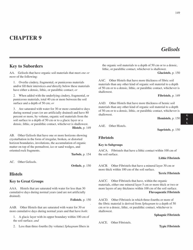
149
G
E
L
Key to SubordersAA. Gelisols that have organic soil materials that meet one ormore of the following:
1. Overlie cindery, fragmental, or pumiceous materialsand/or fill their interstices and directly below these materialshave either a densic, lithic, or paralithic contact; or
2. When added with the underlying cindery, fragmental, orpumiceous materials, total 40 cm or more between the soilsurface and a depth of 50 cm; or
3. Are saturated with water for 30 or more cumulative daysduring normal years (or are artificially drained) and have 80percent or more, by volume, organic soil materials from thesoil surface to a depth of 50 cm or to a glacic layer or adensic, lithic, or paralithic contact, whichever is shallowest.
Histels, p. 149
AB. Other Gelisols that have one or more horizons showingcryoturbation in the form of irregular, broken, or distortedhorizon boundaries, involutions, the accumulation of organicmatter on top of the permafrost, ice or sand wedges, andoriented rock fragments.
Turbels, p. 154
AC. Other Gelisols.Orthels, p. 150
Histels
Key to Great Groups
AAA. Histels that are saturated with water for less than 30cumulative days during normal years (and are not artificiallydrained).
Folistels, p. 150.
AAB. Other Histels that are saturated with water for 30 ormore cumulative days during normal years and that have both:
1. A glacic layer with its upper boundary within 100 cm ofthe soil surface; and
2. Less than three-fourths (by volume) Sphagnum fibers in
the organic soil materials to a depth of 50 cm or to a densic,lithic, or paralithic contact, whichever is shallower.
Glacistels, p. 150
AAC. Other Histels that have more thickness of fibric soilmaterials than any other kind of organic soil material to a depthof 50 cm or to a densic, lithic, or paralithic contact, whichever isshallowest.
Fibristels, p. 149
AAD. Other Histels that have more thickness of hemic soilmaterials than any other kind of organic soil material to a depthof 50 cm or to a densic, lithic, or paralithic contact, whichever isshallowest.
Hemistels, p. 150
AAE. Other Histels.Sapristels, p. 150
Fibristels
Key to Subgroups
AACA. Fibristels that have a lithic contact within 100 cm ofthe soil surface.
Lithic Fibristels
AACB. Other Fibristels that have a mineral layer 30 cm ormore thick within 100 cm of the soil surface.
Terric Fibristels
AACC. Other Fibristels that have, within the organicmaterials, either one mineral layer 5 cm or more thick or two ormore layers of any thickness within 100 cm of the soil surface.
Fluvaquentic Fibristels
AACD. Other Fibristels in which three-fourths or more ofthe fibric material is derived from Sphagnum to a depth of 50cm or to a densic, lithic, or paralithic contact, whichever isshallowest.
Sphagnic Fibristels
AACE. Other Fibristels.Typic Fibristels
CHAPTER 9
Gelisols
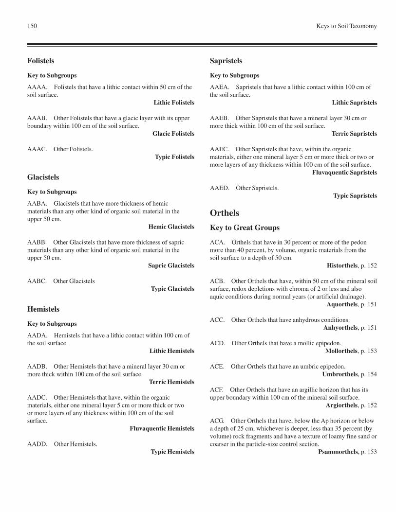
150 Keys to Soil Taxonomy
Folistels
Key to Subgroups
AAAA. Folistels that have a lithic contact within 50 cm of thesoil surface.
Lithic Folistels
AAAB. Other Folistels that have a glacic layer with its upperboundary within 100 cm of the soil surface.
Glacic Folistels
AAAC. Other Folistels.Typic Folistels
Glacistels
Key to Subgroups
AABA. Glacistels that have more thickness of hemicmaterials than any other kind of organic soil material in theupper 50 cm.
Hemic Glacistels
AABB. Other Glacistels that have more thickness of sapricmaterials than any other kind of organic soil material in theupper 50 cm.
Sapric Glacistels
AABC. Other GlacistelsTypic Glacistels
Hemistels
Key to Subgroups
AADA. Hemistels that have a lithic contact within 100 cm ofthe soil surface.
Lithic Hemistels
AADB. Other Hemistels that have a mineral layer 30 cm ormore thick within 100 cm of the soil surface.
Terric Hemistels
AADC. Other Hemistels that have, within the organicmaterials, either one mineral layer 5 cm or more thick or twoor more layers of any thickness within 100 cm of the soilsurface.
Fluvaquentic Hemistels
AADD. Other Hemistels.Typic Hemistels
Sapristels
Key to Subgroups
AAEA. Sapristels that have a lithic contact within 100 cm ofthe soil surface.
Lithic Sapristels
AAEB. Other Sapristels that have a mineral layer 30 cm ormore thick within 100 cm of the soil surface.
Terric Sapristels
AAEC. Other Sapristels that have, within the organicmaterials, either one mineral layer 5 cm or more thick or two ormore layers of any thickness within 100 cm of the soil surface.
Fluvaquentic Sapristels
AAED. Other Sapristels.Typic Sapristels
Orthels
Key to Great Groups
ACA. Orthels that have in 30 percent or more of the pedonmore than 40 percent, by volume, organic materials from thesoil surface to a depth of 50 cm.
Historthels, p. 152
ACB. Other Orthels that have, within 50 cm of the mineral soilsurface, redox depletions with chroma of 2 or less and alsoaquic conditions during normal years (or artificial drainage).
Aquorthels, p. 151
ACC. Other Orthels that have anhydrous conditions.Anhyorthels, p. 151
ACD. Other Orthels that have a mollic epipedon.Mollorthels, p. 153
ACE. Other Orthels that have an umbric epipedon.Umbrorthels, p. 154
ACF. Other Orthels that have an argillic horizon that has itsupper boundary within 100 cm of the mineral soil surface.
Argiorthels, p. 152
ACG. Other Orthels that have, below the Ap horizon or belowa depth of 25 cm, whichever is deeper, less than 35 percent (byvolume) rock fragments and have a texture of loamy fine sand orcoarser in the particle-size control section.
Psammorthels, p. 153
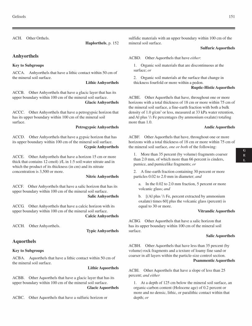
Gelisols 151
G
E
L
ACH. Other Orthels.Haplorthels, p. 152
Anhyorthels
Key to Subgroups
ACCA. Anhyorthels that have a lithic contact within 50 cm ofthe mineral soil surface.
Lithic Anhyorthels
ACCB. Other Anhyorthels that have a glacic layer that has itsupper boundary within 100 cm of the mineral soil surface.
Glacic Anhyorthels
ACCC. Other Anhyorthels that have a petrogypsic horizon thathas its upper boundary within 100 cm of the mineral soilsurface.
Petrogypsic Anhyorthels
ACCD. Other Anhyorthels that have a gypsic horizon that hasits upper boundary within 100 cm of the mineral soil surface.
Gypsic Anhyorthels
ACCE. Other Anhyorthels that have a horizon 15 cm or morethick that contains 12 cmol(-)/L in 1:5 soil:water nitrate and inwhich the product of its thickness (in cm) and its nitrateconcentration is 3,500 or more.
Nitric Anhyorthels
ACCF. Other Anhyorthels that have a salic horizon that has itsupper boundary within 100 cm of the mineral soil surface.
Salic Anhyorthels
ACCG. Other Anhyorthels that have a calcic horizon with itsupper boundary within 100 cm of the mineral soil surface.
Calcic Anhyorthels
ACCH. Other Anhyorthels.Typic Anhyorthels
Aquorthels
Key to Subgroups
ACBA. Aquorthels that have a lithic contact within 50 cm ofthe mineral soil surface.
Lithic Aquorthels
ACBB. Other Aquorthels that have a glacic layer that has itsupper boundary within 100 cm of the mineral soil surface.
Glacic Aquorthels
ACBC. Other Aquorthels that have a sulfuric horizon or
sulfidic materials with an upper boundary within 100 cm of themineral soil surface.
Sulfuric Aquorthels
ACBD. Other Aquorthels that have either:
1. Organic soil materials that are discontinuous at thesurface; or
2. Organic soil materials at the surface that change inthickness fourfold or more within a pedon.
Ruptic-Histic Aquorthels
ACBE. Other Aquorthels that have, throughout one or morehorizons with a total thickness of 18 cm or more within 75 cm ofthe mineral soil surface, a fine-earth fraction with both a bulkdensity of 1.0 g/cm3 or less, measured at 33 kPa water retention,and Al plus 1/2 Fe percentages (by ammonium oxalate) totalingmore than 1.0.
Andic Aquorthels
ACBF. Other Aquorthels that have, throughout one or morehorizons with a total thickness of 18 cm or more within 75 cm ofthe mineral soil surface, one or both of the following:
1. More than 35 percent (by volume) fragments coarserthan 2.0 mm, of which more than 66 percent is cinders,pumice, and pumicelike fragments; or
2. A fine-earth fraction containing 30 percent or moreparticles 0.02 to 2.0 mm in diameter; and
a. In the 0.02 to 2.0 mm fraction, 5 percent or morevolcanic glass; and
b. [(Al plus 1/2 Fe, percent extracted by ammoniumoxalate) times 60] plus the volcanic glass (percent) isequal to 30 or more.
Vitrandic Aquorthels
ACBG. Other Aquorthels that have a salic horizon thathas its upper boundary within 100 cm of the mineral soilsurface.
Salic Aquorthels
ACBH. Other Aquorthels that have less than 35 percent (byvolume) rock fragments and a texture of loamy fine sand orcoarser in all layers within the particle-size control section.
Psammentic Aquorthels
ACBI. Other Aquorthels that have a slope of less than 25percent; and either
1. At a depth of 125 cm below the mineral soil surface, anorganic-carbon content (Holocene age) of 0.2 percent ormore and no densic, lithic, or paralithic contact within thatdepth; or
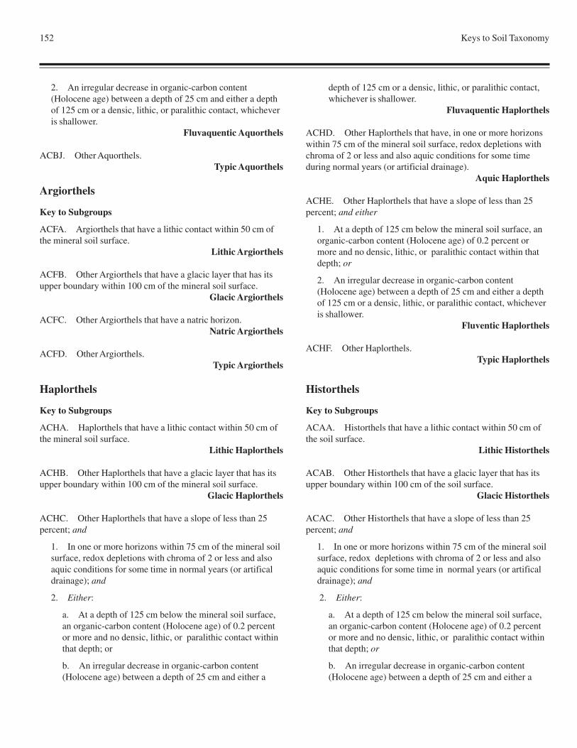
152 Keys to Soil Taxonomy
2. An irregular decrease in organic-carbon content(Holocene age) between a depth of 25 cm and either a depthof 125 cm or a densic, lithic, or paralithic contact, whicheveris shallower.
Fluvaquentic Aquorthels
ACBJ. Other Aquorthels.Typic Aquorthels
Argiorthels
Key to Subgroups
ACFA. Argiorthels that have a lithic contact within 50 cm ofthe mineral soil surface.
Lithic Argiorthels
ACFB. Other Argiorthels that have a glacic layer that has itsupper boundary within 100 cm of the mineral soil surface.
Glacic Argiorthels
ACFC. Other Argiorthels that have a natric horizon.Natric Argiorthels
ACFD. Other Argiorthels.Typic Argiorthels
Haplorthels
Key to Subgroups
ACHA. Haplorthels that have a lithic contact within 50 cm ofthe mineral soil surface.
Lithic Haplorthels
ACHB. Other Haplorthels that have a glacic layer that has itsupper boundary within 100 cm of the mineral soil surface.
Glacic Haplorthels
ACHC. Other Haplorthels that have a slope of less than 25percent; and
1. In one or more horizons within 75 cm of the mineral soilsurface, redox depletions with chroma of 2 or less and alsoaquic conditions for some time in normal years (or artificaldrainage); and
2. Either:
a. At a depth of 125 cm below the mineral soil surface,an organic-carbon content (Holocene age) of 0.2 percentor more and no densic, lithic, or paralithic contact withinthat depth; or
b. An irregular decrease in organic-carbon content(Holocene age) between a depth of 25 cm and either a
depth of 125 cm or a densic, lithic, or paralithic contact,whichever is shallower.
Fluvaquentic Haplorthels
ACHD. Other Haplorthels that have, in one or more horizonswithin 75 cm of the mineral soil surface, redox depletions withchroma of 2 or less and also aquic conditions for some timeduring normal years (or artificial drainage).
Aquic Haplorthels
ACHE. Other Haplorthels that have a slope of less than 25percent; and either
1. At a depth of 125 cm below the mineral soil surface, anorganic-carbon content (Holocene age) of 0.2 percent ormore and no densic, lithic, or paralithic contact within thatdepth; or
2. An irregular decrease in organic-carbon content(Holocene age) between a depth of 25 cm and either a depthof 125 cm or a densic, lithic, or paralithic contact, whicheveris shallower.
Fluventic Haplorthels
ACHF. Other Haplorthels.Typic Haplorthels
Historthels
Key to Subgroups
ACAA. Historthels that have a lithic contact within 50 cm ofthe soil surface.
Lithic Historthels
ACAB. Other Historthels that have a glacic layer that has itsupper boundary within 100 cm of the soil surface.
Glacic Historthels
ACAC. Other Historthels that have a slope of less than 25percent; and
1. In one or more horizons within 75 cm of the mineral soilsurface, redox depletions with chroma of 2 or less and alsoaquic conditions for some time in normal years (or artificaldrainage); and
2. Either:
a. At a depth of 125 cm below the mineral soil surface,an organic-carbon content (Holocene age) of 0.2 percentor more and no densic, lithic, or paralithic contact withinthat depth; or
b. An irregular decrease in organic-carbon content(Holocene age) between a depth of 25 cm and either a
Gelisols 153
G
E
L
depth of 125 cm or a densic, lithic or paralithic contact,which ever is shallower.
Fluvaquentic Historthels
ACAD. Other Historthels that have a slope of less than 25percent; and either
1. At a depth of 125 cm below the mineral soil surface, anorganic-carbon content (Holocene age) of 0.2 percent ormore and no densic, lithic, or paralithic contact within thatdepth; or
2. An irregular decrease in organic-carbon content(Holocene age) between a depth of 25 cm and either a depthof 125 cm or a densic, lithic or paralithic contact, which everis shallower.
Fluventic Historthels
ACAE. Other Historthels that have more than 40 percent, byvolume, organic soil materials from the soil surface to a depth of50 cm in 75 percent or less of the pedon.
Ruptic Historthels
ACAF. Other Historthels.Typic Historthels
Mollorthels
Key to Subgroups
ACDA. Mollorthels that have a lithic contact within 50 cm ofthe mineral soil surface.
Lithic Mollorthels
ACDB. Other Mollorthels that have a glacic layer thathas its upper boundary within 100 cm of the mineral soilsurface.
Glacic Mollorthels
ACDC. Other Mollorthels that have one or both of thefollowing:
1. Cracks within 125 cm of the mineral soil surface that are5 mm or more wide through a thickness of 30 cm or more forsome time during normal years and slickensides or wedge-shaped aggregates in a layer 15 cm or more thick that has itsupper boundary within 125 cm of the mineral soil surface; or
2. A linear extensibility of 6.0 cm or more betweenthe mineral soil surface and either a depth of 100 cmor a densic, lithic, or paralithic contact, whichever isshallowest.
Vertic Mollorthels
ACDD. Other Mollorthels that have, throughout one or morehorizons with a total thickness of 18 cm or more within 75 cm of
the mineral soil surface, a fine-earth fraction with both a bulkdensity of 1.0 g/cm3 or less, measured at 33 kPa water retention,and Al plus 1/2 Fe percentages (by ammonium oxalate) totalingmore than 1.0.
Andic Mollorthels
ACDE. Other Mollorthels that have, throughout one or morehorizons with a total thickness of 18 cm or more within 75 cm ofthe mineral soil surface, one or both of the following:
1. More than 35 percent (by volume) fragments coarserthan 2.0 mm, of which more than 66 percent is cinders,pumice, and pumicelike fragments; or
2. A fine-earth fraction containing 30 percent or moreparticles 0.02 to 2.0 mm in diameter; and
a. In the 0.02 to 2.0 mm fraction, 5 percent or morevolcanic glass; and
b. [(Al plus 1/2 Fe, percent extracted by ammoniumoxalate) times 60] plus the volcanic glass (percent) isequal to 30 or more.
Vitrandic Mollorthels
ACDF. Other Mollorthels that have:
1. A mollic epipedon 40 cm or more thick with a texturefiner than loamy fine sand; and
2. A slope of less than 25 percent.Cumulic Mollorthels
ACDG. Other Mollorthels that have, in one or more horizonswithin 100 cm of the mineral soil surface, distinct or prominentredox concentrations and also aquic conditions for some timeduring normal years (or artificial drainage).
Aquic Mollorthels
ACDH. Other Mollorthels.Typic Mollorthels
Psammorthels
Key to Subgroups
ACGA. Psammorthels that have a lithic contact within 50 cmof the mineral soil surface.
Lithic Psammorthels
ACGB. Other Psammorthels that have a glacic layer thathas its upper boundary within 100 cm of the mineral soilsurface.
Glacic Psammorthels
ACGC. Other Psammorthels that have a horizon 5 cm or morethick that has one or more of the following:
154 Keys to Soil Taxonomy
1. In 25 percent or more of each pedon, cementation byorganic matter and aluminum, with or without iron; or
2. Al plus 1/2 Fe percentages (by ammonium oxalate)totaling 0.25 or more, and half that amount or less in anoverlying horizon; or
3. An ODOE value of 0.12 or more, and a value half ashigh or lower in an overlying horizon.
Spodic Psammorthels
ACGD. Other Psammorthels.Typic Psammorthels
Umbrorthels
Key to Subgroups
ACEA. Umbrorthels that have a lithic contact within 50 cm ofthe mineral soil surface.
Lithic Umbrorthels
ACEB. Other Umbrorthels that have a glacic layer that has itsupper boundary within 100 cm of the mineral soil surface.
Glacic Umbrorthels
ACEC. Other Umbrorthels that have one or both of thefollowing:
1. Cracks within 125 cm of the mineral soil surface thatare 5 mm or more wide through a thickness of 30 cm or morefor some time during normal years and slickensides orwedge-shaped aggregates in a layer 15 cm or more thick thathas its upper boundary within 125 cm of the mineral soilsurface; or
2. A linear extensibility of 6.0 cm or more between themineral soil surface and either a depth of 100 cm or a densic,lithic, or paralithic contact, whichever is shallowest.
Vertic Umbrorthels
ACED. Other Umbrorthels that have, throughout one or morehorizons with a total thickness of 18 cm or more within 75 cm ofthe mineral soil surface, a fine-earth fraction with both a bulkdensity of 1.0 g/cm3 or less, measured at 33 kPa water retention,and Al plus 1/2 Fe percentages (by ammonium oxalate) totalingmore than 1.0.
Andic Umbrorthels
ACEE. Other Umbrorthels that have, throughout one or morehorizons with a total thickness of 18 cm or more within 75 cm ofthe mineral soil surface, one or both of the following:
1. More than 35 percent (by volume) fragments coarserthan 2.0 mm, of which more than 66 percent is cinders,pumice, and pumicelike fragments; or
2. A fine-earth fraction containing 30 percent or moreparticles 0.02 to 2.0 mm in diameter; and
a. In the 0.02 to 2.0 mm fraction, 5 percent or morevolcanic glass; and
b. [(Al plus 1/2 Fe, percent extracted by ammoniumoxalate) times 60] plus the volcanic glass (percent) isequal to 30 or more.
Vitrandic Umbrorthels
ACEF. Other Umbrorthels that have:
1. An umbric epipedon 40 cm or more thick with a texturefiner than loamy fine sand; and
2. A slope of less than 25 percent.Cumulic Umbrorthels
ACEG. Other Umbrorthels that have, in one or more horizonswithin 100 cm of the mineral soil surface, distinct or prominentredox concentrations and also aquic conditions for some timeduring normal years (or artificial drainage).
Aquic Umbrorthels
ACEH. Other Umbrorthels.Typic Umbrorthels
Turbels
Key to Great Groups
ABA. Turbels that have in 30 percent or more of the pedonmore than 40 percent, by volume, organic materials from thesoil surface to a depth of 50 cm.
Histoturbels, p. 155
ABB. Other Turbels that have, within 50 cm of the mineralsoil surface, redox depletions with chroma of 2 or less and alsoaquic conditions during normal years (or artificial drainage).
Aquiturbels, p. 155
ABC. Other Turbels that have anhydrous conditions.Anhyturbels, p. 155
ABD. Other Turbels that have a mollic epipedon.Molliturbels, p. 156
ABE. Other Turbels that have an umbric epipedon.Umbriturbels, p. 156
ABF. Other Turbels that have less than 35 percent (by volume)rock fragments and a texture of loamy fine sand or coarser in alllayers within the particle-size control section.
Psammoturbels, p. 156
Gelisols 155
G
E
L
ABG. Other Turbels.Haploturbels, p. 155
Anhyturbels
Key to Subgroups
ABCA. Anhyturbels that have a lithic contact within 50 cm ofthe mineral soil surface.
Lithic Anhyturbels
ABCB. Other Anhyturbels that have a glacic layer with itsupper boundary within 100 cm of the mineral soil surface.
Glacic Anhyturbels
ABCC. Other Anhyturbels that have a petrogypsic horizonwith its upper boundary within 100 cm of the mineral soilsurface.
Petrogypsic Anhyturbels
ABCD. Other Anhyturbels that have a gypsic horizonwith its upper boundary within 100 cm of the mineral soilsurface.
Gypsic Anhyturbels
ABCE. Other Anhyturbels that have a horizon 15 cm or morethick that contains 12 cmol(-)/L nitrate in 1:5 soil:water extractand in which the product of its thickness (in cm) and its nitrateconcentration is 3,500 or more.
Nitric Anhyturbels
ABCF. Other Anhyturbels that have a salic horizonthat has its upper boundary within 100 cm of the mineral soilsurface.
Salic Anhyturbels
ABCG. Other Anhyturbels that have a calcic horizonthat has its upper boundary within 100 cm of the mineral soilsurface.
Calcic Anhyturbels
ABCH. Other Anhyturbels.Typic Anhyturbels
Aquiturbels
Key to Subgroups
ABBA. Aquiturbels that have a lithic contact within 50 cm ofthe mineral soil surface.
Lithic Aquiturbels
ABBB. Other Aquiturbels that have a glacic layer with itsupper boundary within 100 cm of the mineral soil surface.
Glacic Aquiturbels
ABBC. Other Aquiturbels that have a sulfuric horizon orsulfidic materials with an upper boundary within 100 cm of themineral soil surface.
Sulfuric Aquiturbels
ABBD. Other Aquiturbels that have either:
1. Organic soil materials that are discontinous at thesurface; or
2. Organic soil materials at the surface that change inthickness fourfold or more within a pedon.
Ruptic-Histic Aquiturbels
ABBE. Other Aquiturbels that have less than 35 percent (byvolume) rock fragments and a texture of loamy fine sand orcoarser in all layers within the particle-size control section.
Psammentic Aquiturbels
ABBF. Other Aquiturbels.Typic Aquiturbels
Haploturbels
Key to Subgroups
ABGA. Haploturbels that have a lithic contact within 50 cm ofthe mineral soil surface.
Lithic Haploturbels
ABGB. Other Haploturbels that have a glacic layer that has anupper boundary within 100 cm of the mineral soil surface.
Glacic Haploturbels
ABGC. Other Haploturbels that have, in one or more horizonswithin 100 cm of the mineral soil surface, distinct or prominentredox concentrations and also aquic conditions for some timeduring normal years (or artificial drainage).
Aquic Haploturbels
ABGD. Other Haploturbels.Typic Haploturbels
Histoturbels
Key to Subgroups
ABAA. Histoturbels that have a lithic contact within 50 cm ofthe soil surface.
Lithic Histoturbels
ABAB. Other Histoturbels that have a glacic layer with itsupper boundary within 100 cm of the soil surface.
Glacic Histoturbels
ABAC. Other Histoturbels that have more than 40 percent, by
156 Keys to Soil Taxonomy
volume, organic soil materials from the soil surface to a depth of50 cm in 75 percent or less of the pedon.
Ruptic Histoturbels
ABAD. Other Histoturbels.Typic Histoturbels
Molliturbels
Key to Subgroups
ABDA. Molliturbels that have a lithic contact within 50 cm ofthe mineral soil surface.
Lithic Molliturbels
ABDB. Other Molliturbels that have a glacic layer that has itsupper boundary within 100 cm of the mineral soil surface.
Glacic Molliturbels
ABDC. Other Molliturbels that have one or both of thefollowing:
1. Cracks within 125 cm of the mineral soil surface thatare 5 mm or more wide through a thickness of 30 cm or morefor some time during normal years and slickensides orwedge-shaped aggregates in a layer 15 cm or more thick thathas its upper boundary within 125 cm of the mineral soilsurface; or
2. A linear extensibility of 6.0 cm or more between themineral soil surface and either a depth of 100 cm or a densic,lithic, or paralithic contact, whichever is shallowest.
Vertic Molliturbels
ABDD. Other Molliturbels that have, throughout one or morehorizons with a total thickness of 18 cm or more within 75 cm ofthe mineral soil surface, a fine-earth fraction with both a bulkdensity of 1.0 g/cm3 or less, measured at 33 kPa water retention,and Al plus 1/2 Fe percentages (by ammonium oxalate) totalingmore than 1.0.
Andic Molliturbels
ABDE. Other Molliturbels that have, throughout one or morehorizons with a total thickness of 18 cm or more within 75 cm ofthe mineral soil surface, one or both of the following:
1. More than 35 percent (by volume) fragments coarserthan 2.0 mm, of which more than 66 percent is cinders,pumice, and pumicelike fragments; or
2. A fine-earth fraction containing 30 percent or moreparticles 0.02 to 2.0 mm in diameter; and
a. In the 0.02 to 2.0 mm fraction, 5 percent or morevolcanic glass; and
b. [(Al plus 1/2 Fe, percent extracted by ammonium
oxalate) times 60] plus the volcanic glass (percent) isequal to 30 or more.
Vitrandic Molliturbels
ABDF. Other Molliturbels that have:
1. A mollic epipedon 40 cm or more thick with a texturefiner than loamy fine sand; and
2. A slope of less than 25 percent.Cumulic Molliturbels
ABDG. Other Molliturbels that have, in one or more horizonswithin 100 cm of the mineral soil surface, distinct or prominentredox concentrations and also aquic conditions for some timeduring normal years (or artificial drainage).
Aquic Molliturbels
ABDH. Other Molliturbels.Typic Molliturbels
Psammoturbels
Key to Subgroups
ABFA. Psammoturbels that have a lithic contact within 50 cmof the mineral soil surface.
Lithic Psammoturbels
ABFB. Other Psammoturbels that have a glacic layer that hasits upper boundary within 100 cm of the mineral soil surface.
Glacic Psammoturbels
ABFC. Other Psammoturbels that have a horizon 5 cm ormore thick that has one or more of the following:
1. In 25 percent or more of each pedon, cementationby organic matter and aluminum, with or without iron;or
2. Al plus 1/2 Fe percentages (by ammonium oxalate)totaling 0.25 or more, and half that amount or less in anoverlying horizon; or
3. An ODOE value of 0.12 or more, and a value half ashigh or lower in an overlying horizon.
Spodic Psammoturbels
ABFD. Other Psammoturbels.Typic Psammoturbels
Umbriturbels
Key to Subgroups
ABEA. Umbriturbels that have a lithic contact within 50 cm ofthe mineral soil surface.
Lithic Umbriturbels
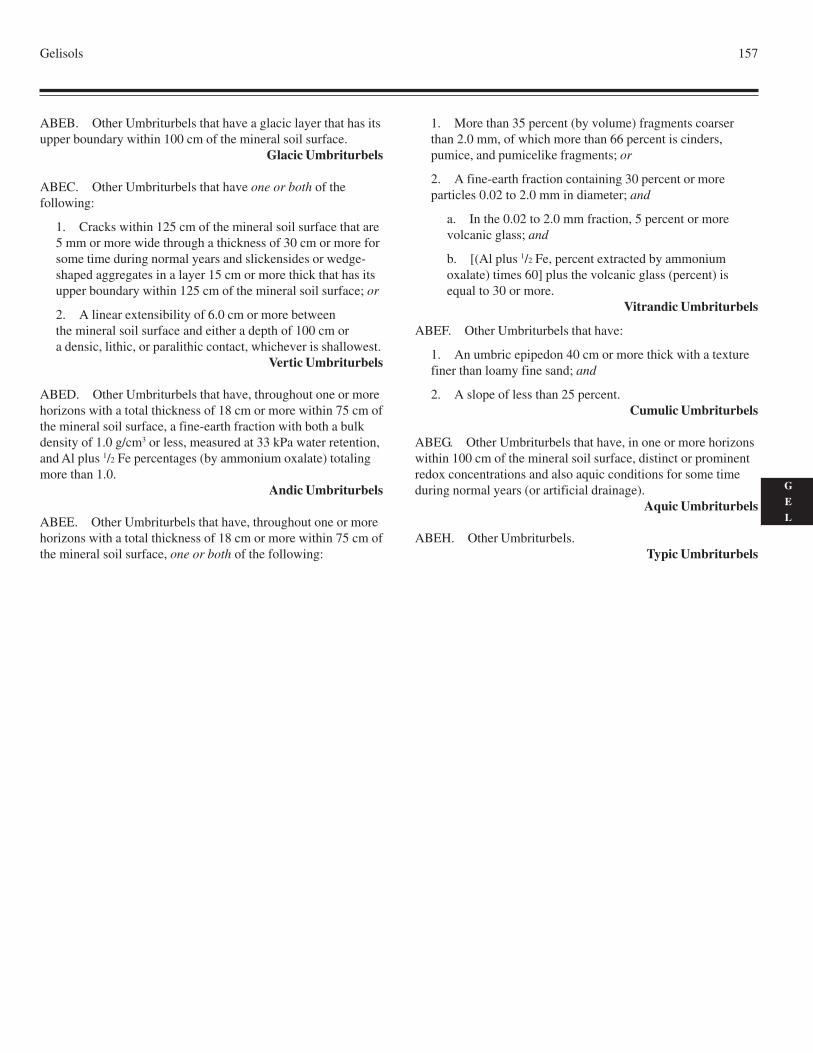
Gelisols 157
G
E
L
ABEB. Other Umbriturbels that have a glacic layer that has itsupper boundary within 100 cm of the mineral soil surface.
Glacic Umbriturbels
ABEC. Other Umbriturbels that have one or both of thefollowing:
1. Cracks within 125 cm of the mineral soil surface that are5 mm or more wide through a thickness of 30 cm or more forsome time during normal years and slickensides or wedge-shaped aggregates in a layer 15 cm or more thick that has itsupper boundary within 125 cm of the mineral soil surface; or
2. A linear extensibility of 6.0 cm or more betweenthe mineral soil surface and either a depth of 100 cm ora densic, lithic, or paralithic contact, whichever is shallowest.
Vertic Umbriturbels
ABED. Other Umbriturbels that have, throughout one or morehorizons with a total thickness of 18 cm or more within 75 cm ofthe mineral soil surface, a fine-earth fraction with both a bulkdensity of 1.0 g/cm3 or less, measured at 33 kPa water retention,and Al plus 1/2 Fe percentages (by ammonium oxalate) totalingmore than 1.0.
Andic Umbriturbels
ABEE. Other Umbriturbels that have, throughout one or morehorizons with a total thickness of 18 cm or more within 75 cm ofthe mineral soil surface, one or both of the following:
1. More than 35 percent (by volume) fragments coarserthan 2.0 mm, of which more than 66 percent is cinders,pumice, and pumicelike fragments; or
2. A fine-earth fraction containing 30 percent or moreparticles 0.02 to 2.0 mm in diameter; and
a. In the 0.02 to 2.0 mm fraction, 5 percent or morevolcanic glass; and
b. [(Al plus 1/2 Fe, percent extracted by ammoniumoxalate) times 60] plus the volcanic glass (percent) isequal to 30 or more.
Vitrandic Umbriturbels
ABEF. Other Umbriturbels that have:
1. An umbric epipedon 40 cm or more thick with a texturefiner than loamy fine sand; and
2. A slope of less than 25 percent.Cumulic Umbriturbels
ABEG. Other Umbriturbels that have, in one or more horizonswithin 100 cm of the mineral soil surface, distinct or prominentredox concentrations and also aquic conditions for some timeduring normal years (or artificial drainage).
Aquic Umbriturbels
ABEH. Other Umbriturbels.Typic Umbriturbels

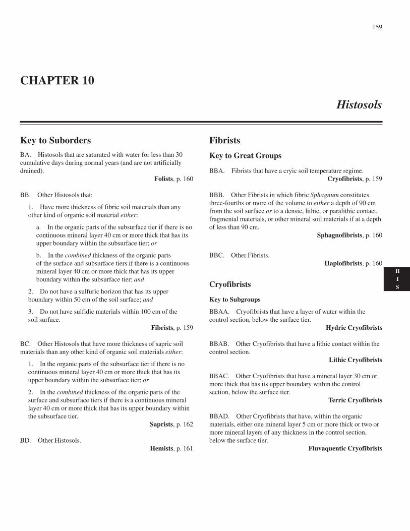
159
H
I
S
Key to SubordersBA. Histosols that are saturated with water for less than 30cumulative days during normal years (and are not artificiallydrained).
Folists, p. 160
BB. Other Histosols that:
1. Have more thickness of fibric soil materials than anyother kind of organic soil material either:
a. In the organic parts of the subsurface tier if there is nocontinuous mineral layer 40 cm or more thick that has itsupper boundary within the subsurface tier; or
b. In the combined thickness of the organic partsof the surface and subsurface tiers if there is a continuousmineral layer 40 cm or more thick that has its upperboundary within the subsurface tier; and
2. Do not have a sulfuric horizon that has its upperboundary within 50 cm of the soil surface; and
3. Do not have sulfidic materials within 100 cm of thesoil surface.
Fibrists, p. 159
BC. Other Histosols that have more thickness of sapric soilmaterials than any other kind of organic soil materials either:
1. In the organic parts of the subsurface tier if there is nocontinuous mineral layer 40 cm or more thick that has itsupper boundary within the subsurface tier; or
2. In the combined thickness of the organic parts of thesurface and subsurface tiers if there is a continuous minerallayer 40 cm or more thick that has its upper boundary withinthe subsurface tier.
Saprists, p. 162
BD. Other Histosols.Hemists, p. 161
Fibrists
Key to Great Groups
BBA. Fibrists that have a cryic soil temperature regime.Cryofibrists, p. 159
BBB. Other Fibrists in which fibric Sphagnum constitutesthree-fourths or more of the volume to either a depth of 90 cmfrom the soil surface or to a densic, lithic, or paralithic contact,fragmental materials, or other mineral soil materials if at a depthof less than 90 cm.
Sphagnofibrists, p. 160
BBC. Other Fibrists.Haplofibrists, p. 160
Cryofibrists
Key to Subgroups
BBAA. Cryofibrists that have a layer of water within thecontrol section, below the surface tier.
Hydric Cryofibrists
BBAB. Other Cryofibrists that have a lithic contact within thecontrol section.
Lithic Cryofibrists
BBAC. Other Cryofibrists that have a mineral layer 30 cm ormore thick that has its upper boundary within the controlsection, below the surface tier.
Terric Cryofibrists
BBAD. Other Cryofibrists that have, within the organicmaterials, either one mineral layer 5 cm or more thick or two ormore mineral layers of any thickness in the control section,below the surface tier.
Fluvaquentic Cryofibrists
CHAPTER 10
Histosols
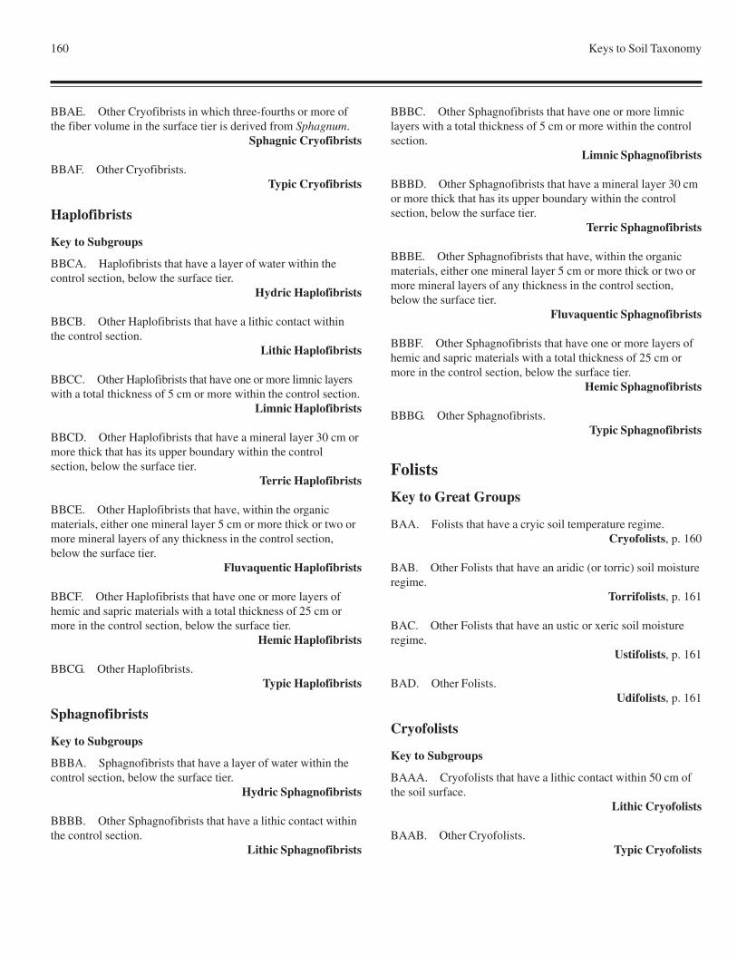
160 Keys to Soil Taxonomy
BBAE. Other Cryofibrists in which three-fourths or more ofthe fiber volume in the surface tier is derived from Sphagnum.
Sphagnic Cryofibrists
BBAF. Other Cryofibrists.Typic Cryofibrists
Haplofibrists
Key to Subgroups
BBCA. Haplofibrists that have a layer of water within thecontrol section, below the surface tier.
Hydric Haplofibrists
BBCB. Other Haplofibrists that have a lithic contact withinthe control section.
Lithic Haplofibrists
BBCC. Other Haplofibrists that have one or more limnic layerswith a total thickness of 5 cm or more within the control section.
Limnic Haplofibrists
BBCD. Other Haplofibrists that have a mineral layer 30 cm ormore thick that has its upper boundary within the controlsection, below the surface tier.
Terric Haplofibrists
BBCE. Other Haplofibrists that have, within the organicmaterials, either one mineral layer 5 cm or more thick or two ormore mineral layers of any thickness in the control section,below the surface tier.
Fluvaquentic Haplofibrists
BBCF. Other Haplofibrists that have one or more layers ofhemic and sapric materials with a total thickness of 25 cm ormore in the control section, below the surface tier.
Hemic Haplofibrists
BBCG. Other Haplofibrists.Typic Haplofibrists
Sphagnofibrists
Key to Subgroups
BBBA. Sphagnofibrists that have a layer of water within thecontrol section, below the surface tier.
Hydric Sphagnofibrists
BBBB. Other Sphagnofibrists that have a lithic contact withinthe control section.
Lithic Sphagnofibrists
BBBC. Other Sphagnofibrists that have one or more limniclayers with a total thickness of 5 cm or more within the controlsection.
Limnic Sphagnofibrists
BBBD. Other Sphagnofibrists that have a mineral layer 30 cmor more thick that has its upper boundary within the controlsection, below the surface tier.
Terric Sphagnofibrists
BBBE. Other Sphagnofibrists that have, within the organicmaterials, either one mineral layer 5 cm or more thick or two ormore mineral layers of any thickness in the control section,below the surface tier.
Fluvaquentic Sphagnofibrists
BBBF. Other Sphagnofibrists that have one or more layers ofhemic and sapric materials with a total thickness of 25 cm ormore in the control section, below the surface tier.
Hemic Sphagnofibrists
BBBG. Other Sphagnofibrists.Typic Sphagnofibrists
Folists
Key to Great Groups
BAA. Folists that have a cryic soil temperature regime.Cryofolists, p. 160
BAB. Other Folists that have an aridic (or torric) soil moistureregime.
Torrifolists, p. 161
BAC. Other Folists that have an ustic or xeric soil moistureregime.
Ustifolists, p. 161
BAD. Other Folists.Udifolists, p. 161
Cryofolists
Key to Subgroups
BAAA. Cryofolists that have a lithic contact within 50 cm ofthe soil surface.
Lithic Cryofolists
BAAB. Other Cryofolists.Typic Cryofolists
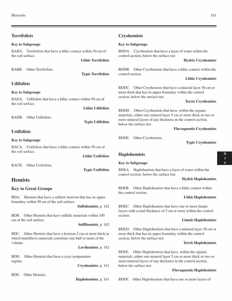
Histosols 161
H
I
S
Torrifolists
Key to Subgroups
BABA. Torrifolists that have a lithic contact within 50 cm ofthe soil surface.
Lithic Torrifolists
BABB. Other Torrifolists.Typic Torrifolists
Udifolists
Key to Subgroups
BADA. Udifolists that have a lithic contact within 50 cm ofthe soil surface.
Lithic Udifolists
BADB. Other Udifolists.Typic Udifolists
Ustifolists
Key to Subgroups
BACA. Ustifolists that have a lithic contact within 50 cm ofthe soil surface.
Lithic Ustifolists
BACB. Other Ustifolists.Typic Ustifolists
Hemists
Key to Great Groups
BDA. Hemists that have a sulfuric horizon that has its upperboundary within 50 cm of the soil surface.
Sulfohemists, p. 162
BDB. Other Hemists that have sulfidic materials within 100cm of the soil surface.
Sulfihemists, p. 162
BDC. Other Hemists that have a horizon 2 cm or more thick inwhich humilluvic materials constitute one-half or more of thevolume.
Luvihemists, p. 162
BDD. Other Hemists that have a cryic temperatureregime.
Cryohemists, p. 161
BDE. Other Hemists.Haplohemists, p. 161
Cryohemists
Key to Subgroups
BDDA. Cryohemists that have a layer of water within thecontrol section, below the surface tier.
Hydric Cryohemists
BDDB. Other Cryohemists that have a lithic contact within thecontrol section.
Lithic Cryohemists
BDDC. Other Cryohemists that have a mineral layer 30 cm ormore thick that has its upper boundary within the controlsection, below the surface tier.
Terric Cryohemists
BDDD. Other Cryohemists that have, within the organicmaterials, either one mineral layer 5 cm or more thick or two ormore mineral layers of any thickness in the control section,below the surface tier.
Fluvaquentic Cryohemists
BDDE. Other Cryohemists.Typic Cryohemists
Haplohemists
Key to Subgroups
BDEA. Haplohemists that have a layer of water within thecontrol section, below the surface tier.
Hydric Haplohemists
BDEB. Other Haplohemists that have a lithic contact withinthe control section.
Lithic Haplohemists
BDEC. Other Haplohemists that have one or more limniclayers with a total thickness of 5 cm or more within the controlsection.
Limnic Haplohemists
BDED. Other Haplohemists that have a mineral layer 30 cm ormore thick that has its upper boundary within the controlsection, below the surface tier.
Terric Haplohemists
BDEE. Other Haplohemists that have, within the organicmaterials, either one mineral layer 5 cm or more thick or two ormore mineral layers of any thickness in the control section,below the surface tier.
Fluvaquentic Haplohemists
BDEF. Other Haplohemists that have one or more layers of
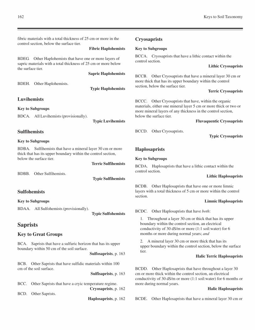
162 Keys to Soil Taxonomy
fibric materials with a total thickness of 25 cm or more in thecontrol section, below the surface tier.
Fibric Haplohemists
BDEG. Other Haplohemists that have one or more layers ofsapric materials with a total thickness of 25 cm or more belowthe surface tier.
Sapric Haplohemists
BDEH. Other Haplohemists.Typic Haplohemists
Luvihemists
Key to Subgroups
BDCA. All Luvihemists (provisionally).Typic Luvihemists
Sulfihemists
Key to Subgroups
BDBA. Sulfihemists that have a mineral layer 30 cm or morethick that has its upper boundary within the control section,below the surface tier.
Terric Sulfihemists
BDBB. Other Sulfihemists.Typic Sulfihemists
Sulfohemists
Key to Subgroups
BDAA. All Sulfohemists (provisionally).Typic Sulfohemists
Saprists
Key to Great Groups
BCA. Saprists that have a sulfuric horizon that has its upperboundary within 50 cm of the soil surface.
Sulfosaprists, p. 163
BCB. Other Saprists that have sulfidic materials within 100cm of the soil surface.
Sulfisaprists, p. 163
BCC. Other Saprists that have a cryic temperature regime.Cryosaprists, p. 162
BCD. Other Saprists.Haplosaprists, p. 162
Cryosaprists
Key to Subgroups
BCCA. Cryosaprists that have a lithic contact within thecontrol section.
Lithic Cryosaprists
BCCB. Other Cryosaprists that have a mineral layer 30 cm ormore thick that has its upper boundary within the controlsection, below the surface tier.
Terric Cryosaprists
BCCC. Other Cryosaprists that have, within the organicmaterials, either one mineral layer 5 cm or more thick or two ormore mineral layers of any thickness in the control section,below the surface tier.
Fluvaquentic Cryosaprists
BCCD. Other Cryosaprists.Typic Cryosaprists
Haplosaprists
Key to Subgroups
BCDA. Haplosaprists that have a lithic contact within thecontrol section.
Lithic Haplosaprists
BCDB. Other Haplosaprists that have one or more limniclayers with a total thickness of 5 cm or more within the controlsection.
Limnic Haplosaprists
BCDC. Other Haplosaprists that have both:
1. Throughout a layer 30 cm or thick that has its upperboundary within the control section, an electricalconductivity of 30 dS/m or more (1:1 soil:water) for 6months or more during normal years; and
2. A mineral layer 30 cm or more thick that has itsupper boundary within the control section, below the surfacetier.
Halic Terric Haplosaprists
BCDD. Other Haplosaprists that have throughout a layer 30cm or more thick within the control section, an electricalconductivity of 30 dS/m or more (1:1 soil:water) for 6 months ormore during normal years.
Halic Haplosaprists
BCDE. Other Haplosaprists that have a mineral layer 30 cm or
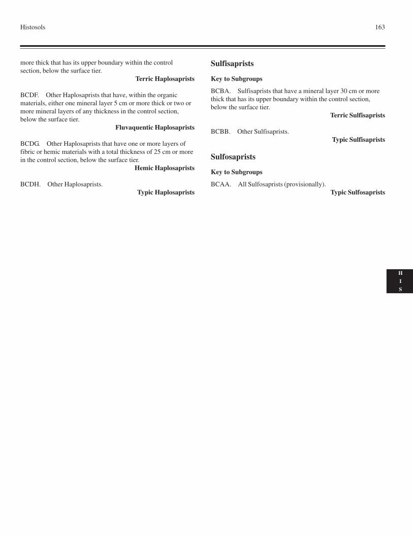
Histosols 163
H
I
S
more thick that has its upper boundary within the controlsection, below the surface tier.
Terric Haplosaprists
BCDF. Other Haplosaprists that have, within the organicmaterials, either one mineral layer 5 cm or more thick or two ormore mineral layers of any thickness in the control section,below the surface tier.
Fluvaquentic Haplosaprists
BCDG. Other Haplosaprists that have one or more layers offibric or hemic materials with a total thickness of 25 cm or morein the control section, below the surface tier.
Hemic Haplosaprists
BCDH. Other Haplosaprists.Typic Haplosaprists
Sulfisaprists
Key to Subgroups
BCBA. Sulfisaprists that have a mineral layer 30 cm or morethick that has its upper boundary within the control section,below the surface tier.
Terric Sulfisaprists
BCBB. Other Sulfisaprists.Typic Sulfisaprists
Sulfosaprists
Key to Subgroups
BCAA. All Sulfosaprists (provisionally).Typic Sulfosaprists

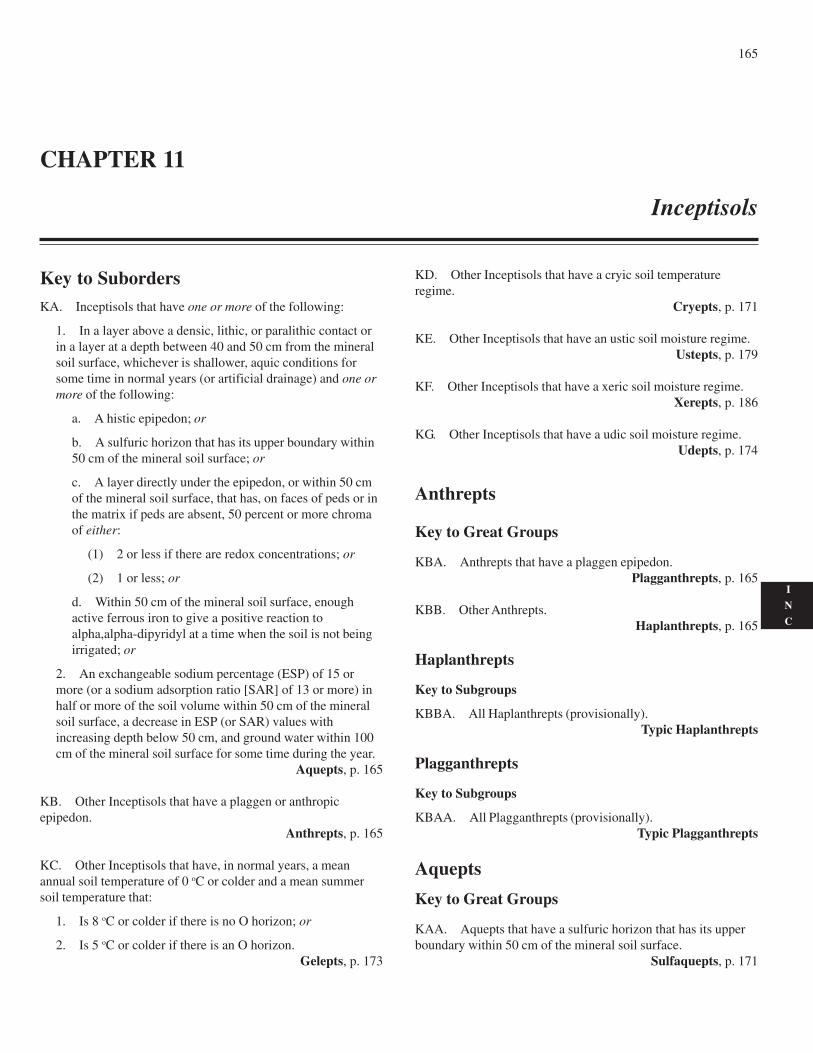
165
I
N
C
Key to SubordersKA. Inceptisols that have one or more of the following:
1. In a layer above a densic, lithic, or paralithic contact orin a layer at a depth between 40 and 50 cm from the mineralsoil surface, whichever is shallower, aquic conditions forsome time in normal years (or artificial drainage) and one ormore of the following:
a. A histic epipedon; or
b. A sulfuric horizon that has its upper boundary within50 cm of the mineral soil surface; or
c. A layer directly under the epipedon, or within 50 cmof the mineral soil surface, that has, on faces of peds or inthe matrix if peds are absent, 50 percent or more chromaof either:
(1) 2 or less if there are redox concentrations; or
(2) 1 or less; or
d. Within 50 cm of the mineral soil surface, enoughactive ferrous iron to give a positive reaction toalpha,alpha-dipyridyl at a time when the soil is not beingirrigated; or
2. An exchangeable sodium percentage (ESP) of 15 ormore (or a sodium adsorption ratio [SAR] of 13 or more) inhalf or more of the soil volume within 50 cm of the mineralsoil surface, a decrease in ESP (or SAR) values withincreasing depth below 50 cm, and ground water within 100cm of the mineral soil surface for some time during the year.
Aquepts, p. 165
KB. Other Inceptisols that have a plaggen or anthropicepipedon.
Anthrepts, p. 165
KC. Other Inceptisols that have, in normal years, a meanannual soil temperature of 0 oC or colder and a mean summersoil temperature that:
1. Is 8 oC or colder if there is no O horizon; or
2. Is 5 oC or colder if there is an O horizon.Gelepts, p. 173
KD. Other Inceptisols that have a cryic soil temperatureregime.
Cryepts, p. 171
KE. Other Inceptisols that have an ustic soil moisture regime.Ustepts, p. 179
KF. Other Inceptisols that have a xeric soil moisture regime.Xerepts, p. 186
KG. Other Inceptisols that have a udic soil moisture regime.Udepts, p. 174
Anthrepts
Key to Great Groups
KBA. Anthrepts that have a plaggen epipedon.Plagganthrepts, p. 165
KBB. Other Anthrepts.Haplanthrepts, p. 165
Haplanthrepts
Key to Subgroups
KBBA. All Haplanthrepts (provisionally).Typic Haplanthrepts
Plagganthrepts
Key to Subgroups
KBAA. All Plagganthrepts (provisionally).Typic Plagganthrepts
Aquepts
Key to Great Groups
KAA. Aquepts that have a sulfuric horizon that has its upperboundary within 50 cm of the mineral soil surface.
Sulfaquepts, p. 171
CHAPTER 11
Inceptisols
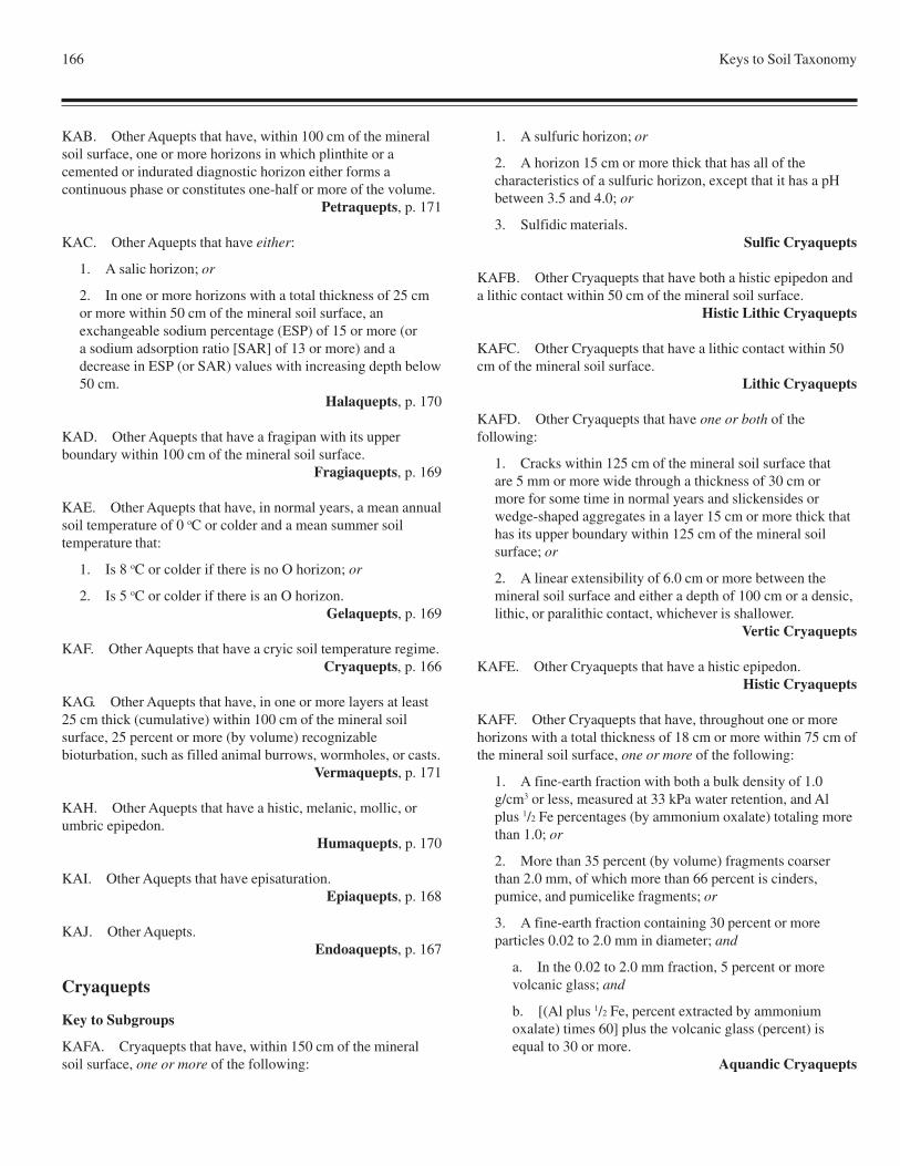
166 Keys to Soil Taxonomy
KAB. Other Aquepts that have, within 100 cm of the mineralsoil surface, one or more horizons in which plinthite or acemented or indurated diagnostic horizon either forms acontinuous phase or constitutes one-half or more of the volume.
Petraquepts, p. 171
KAC. Other Aquepts that have either:
1. A salic horizon; or
2. In one or more horizons with a total thickness of 25 cmor more within 50 cm of the mineral soil surface, anexchangeable sodium percentage (ESP) of 15 or more (ora sodium adsorption ratio [SAR] of 13 or more) and adecrease in ESP (or SAR) values with increasing depth below50 cm.
Halaquepts, p. 170
KAD. Other Aquepts that have a fragipan with its upperboundary within 100 cm of the mineral soil surface.
Fragiaquepts, p. 169
KAE. Other Aquepts that have, in normal years, a mean annualsoil temperature of 0 oC or colder and a mean summer soiltemperature that:
1. Is 8 oC or colder if there is no O horizon; or
2. Is 5 oC or colder if there is an O horizon.Gelaquepts, p. 169
KAF. Other Aquepts that have a cryic soil temperature regime.Cryaquepts, p. 166
KAG. Other Aquepts that have, in one or more layers at least25 cm thick (cumulative) within 100 cm of the mineral soilsurface, 25 percent or more (by volume) recognizablebioturbation, such as filled animal burrows, wormholes, or casts.
Vermaquepts, p. 171
KAH. Other Aquepts that have a histic, melanic, mollic, orumbric epipedon.
Humaquepts, p. 170
KAI. Other Aquepts that have episaturation.Epiaquepts, p. 168
KAJ. Other Aquepts.Endoaquepts, p. 167
Cryaquepts
Key to Subgroups
KAFA. Cryaquepts that have, within 150 cm of the mineralsoil surface, one or more of the following:
1. A sulfuric horizon; or
2. A horizon 15 cm or more thick that has all of thecharacteristics of a sulfuric horizon, except that it has a pHbetween 3.5 and 4.0; or
3. Sulfidic materials.Sulfic Cryaquepts
KAFB. Other Cryaquepts that have both a histic epipedon anda lithic contact within 50 cm of the mineral soil surface.
Histic Lithic Cryaquepts
KAFC. Other Cryaquepts that have a lithic contact within 50cm of the mineral soil surface.
Lithic Cryaquepts
KAFD. Other Cryaquepts that have one or both of thefollowing:
1. Cracks within 125 cm of the mineral soil surface thatare 5 mm or more wide through a thickness of 30 cm ormore for some time in normal years and slickensides orwedge-shaped aggregates in a layer 15 cm or more thick thathas its upper boundary within 125 cm of the mineral soilsurface; or
2. A linear extensibility of 6.0 cm or more between themineral soil surface and either a depth of 100 cm or a densic,lithic, or paralithic contact, whichever is shallower.
Vertic Cryaquepts
KAFE. Other Cryaquepts that have a histic epipedon.Histic Cryaquepts
KAFF. Other Cryaquepts that have, throughout one or morehorizons with a total thickness of 18 cm or more within 75 cm ofthe mineral soil surface, one or more of the following:
1. A fine-earth fraction with both a bulk density of 1.0g/cm3 or less, measured at 33 kPa water retention, and Alplus 1/2 Fe percentages (by ammonium oxalate) totaling morethan 1.0; or
2. More than 35 percent (by volume) fragments coarserthan 2.0 mm, of which more than 66 percent is cinders,pumice, and pumicelike fragments; or
3. A fine-earth fraction containing 30 percent or moreparticles 0.02 to 2.0 mm in diameter; and
a. In the 0.02 to 2.0 mm fraction, 5 percent or morevolcanic glass; and
b. [(Al plus 1/2 Fe, percent extracted by ammoniumoxalate) times 60] plus the volcanic glass (percent) isequal to 30 or more.
Aquandic Cryaquepts
Inceptisols 167
I
N
C
KAFG. Other Cryaquepts that have a slope of less than 25percent; and
1. At a depth of 125 cm below the mineral soil surface, anorganic-carbon content (Holocene age) of 0.2 percent ormore and no densic, lithic, or paralithic contact within thatdepth; or
2. An irregular decrease in organic-carbon content(Holocene age) between a depth of 25 cm and either a depthof 125 cm below the mineral soil surface or a densic, lithic,or paralithic contact, whichever is shallower.
Fluvaquentic Cryaquepts
KAFH. Other Cryaquepts that have both:
1. Chroma of 3 or more in 40 percent or more of the matrixof one or more horizons at a depth between 15 and 50 cmfrom the mineral soil surface; and
2. A mollic or umbric epipedon.Aeric Humic Cryaquepts
KAFI. Other Cryaquepts that have chroma of 3 or more in 40percent or more of the matrix of one or more horizons at a depthbetween 15 and 50 cm from the mineral soil surface.
Aeric Cryaquepts
KAFJ. Other Cryaquepts that have a mollic or umbricepipedon.
Humic Cryaquepts
KAFK. Other Cryaquepts.Typic Cryaquepts
Endoaquepts
Key to Subgroups
KAJA. Endoaquepts that have, within 150 cm of the mineralsoil surface, one or more of the following:
1. A sulfuric horizon; or
2. A horizon 15 cm or more thick that has all of thecharacteristics of a sulfuric horizon, except that it has a pHbetween 3.5 and 4.0; or
3. Sulfidic materials.Sulfic Endoaquepts
KAJB. Other Endoaquepts that have a lithic contact within 50cm of the mineral soil surface.
Lithic Endoaquepts
KAJC. Other Endoaquepts that have one or both of thefollowing:
1. Cracks within 125 cm of the mineral soil surface that are
5 mm or more wide through a thickness of 30 cm or more forsome time in normal years and slickensides or wedge-shapedaggregates in a layer 15 cm or more thick that has its upperboundary within 125 cm of the mineral soil surface; or
2. A linear extensibility of 6.0 cm or more between themineral soil surface and either a depth of 100 cm or a densic,lithic, or paralithic contact, whichever is shallower.
Vertic Endoaquepts
KAJD. Other Endoaquepts that have, throughout one or morehorizons with a total thickness of 18 cm or more within 75 cm ofthe mineral soil surface, one or more of the following:
1. A fine-earth fraction with both a bulk density of 1.0g/cm3 or less, measured at 33 kPa water retention, and Alplus 1/2 Fe percentages (by ammonium oxalate) totaling morethan 1.0; or
2. More than 35 percent (by volume) fragments coarserthan 2.0 mm, of which more than 66 percent is cinders,pumice, and pumicelike fragments; or
3. A fine-earth fraction containing 30 percent or moreparticles 0.02 to 2.0 mm in diameter; and
a. In the 0.02 to 2.0 mm fraction, 5 percent or morevolcanic glass; and
b. [(Al plus 1/2 Fe, percent extracted by ammoniumoxalate) times 60] plus the volcanic glass (percent) isequal to 30 or more.
Aquandic Endoaquepts
KAJE. Other Endoaquepts that have, in one or more horizonsbetween the A or Ap horizon and a depth of 75 cm below themineral soil surface, one of the following colors:
1. Hue of 7.5YR or redder in 50 percent or more of thematrix; and
a. If peds are present, either chroma of 2 or more on 50percent or more of ped exteriors or no redox depletionswith chroma of 2 or less in ped interiors; or
b. If peds are absent, a chroma of 2 or more in 50percent or more of the matrix; or
2. In 50 percent or more of the matrix, hue of 10YR oryellower; and either
a. Both a color value, moist, and chroma of 3 or more;or
b. Chroma of 2 or more if there are no redoxconcentrations; and
3. A slope of less than 25 percent; and
a. At a depth of 125 cm below the mineral soil surface,an organic-carbon content (Holocene age) of 0.2 percent
168 Keys to Soil Taxonomy
or more and no densic, lithic, or paralithic contact withinthat depth; or
b. An irregular decrease in organic-carbon content(Holocene age) between a depth of 25 cm and either adepth of 125 cm below the mineral soil surface or adensic, lithic, or paralithic contact, whichever is shallower.
Fluventic Endoaquepts
KAJF. Other Endoaquepts that have a slope of less than 25percent; and
1. At a depth of 125 cm below the mineral soil surface, anorganic-carbon content (Holocene age) of 0.2 percent ormore and no densic, lithic, or paralithic contact within thatdepth; or
2. An irregular decrease in organic-carbon content(Holocene age) between a depth of 25 cm and either a depthof 125 cm below the mineral soil surface or a densic, lithic,or paralithic contact, whichever is shallower.
Fluvaquentic Endoaquepts
KAJG. Other Endoaquepts that have fragic soil properties:
1. In 30 percent or more of the volume of a layer 15 cm ormore thick that has its upper boundary within 100 cm of themineral soil surface; or
2. In 60 percent or more of the volume of a layer 15 cm ormore thick.
Fragic Endoaquepts
KAJH. Other Endoaquepts that have, in one or more horizonsbetween the A or Ap horizon and a depth of 75 cm below themineral soil surface, one of the following colors:
1. Hue of 7.5YR or redder in 50 percent or more of thematrix; and
a. If peds are present, either chroma of 2 or more on 50percent or more of ped exteriors or no redox depletionswith chroma of 2 or less in ped interiors; or
b. If peds are absent, chroma of 2 or more in 50 percentor more of the matrix; or
2. In 50 percent or more of the matrix, hue of 10YR oryellower and either:
a. Both a color value, moist, and chroma of 3 or more;or
b. Chroma of 2 or more if there are no redoxconcentrations.
Aeric Endoaquepts
KAJI. Other Endoaquepts that have:
1. A color value, moist, of 3 or less and a color value, dry,
of 5 or less (crushed and smoothed) in the Ap horizon or inthe upper 15 cm after mixing; and
2. A base saturation (by NH4OAc) of less than 50 percent
in some part within 100 cm of the mineral soil surface.Humic Endoaquepts
KAJJ. Other Endoaquepts that have a color value, moist, of 3or less and a color value, dry, of 5 or less (crushed andsmoothed) either in the Ap horizon or in the upper 15 cm aftermixing.
Mollic Endoaquepts
KAJK. Other Endoaquepts.Typic Endoaquepts
Epiaquepts
Key to Subgroups
KAIA. Epiaquepts that have one or both of the following:
1. Cracks within 125 cm of the mineral soil surface that are5 mm or more wide through a thickness of 30 cm or more forsome time in normal years and slickensides or wedge-shapedaggregates in a layer 15 cm or more thick that has its upperboundary within 125 cm of the mineral soil surface; or
2. A linear extensibility of 6.0 cm or more between themineral soil surface and either a depth of 100 cm or a densic,lithic, or paralithic contact, whichever is shallower.
Vertic Epiaquepts
KAIB. Other Epiaquepts that have, throughout one or morehorizons with a total thickness of 18 cm or more within 75 cm ofthe mineral soil surface, one or more of the following:
1. A fine-earth fraction with both a bulk density of 1.0g/cm3 or less, measured at 33 kPa water retention, and Alplus 1/2 Fe percentages (by ammonium oxalate) totaling morethan 1.0; or
2. More than 35 percent (by volume) fragments coarserthan 2.0 mm, of which more than 66 percent is cinders,pumice, and pumicelike fragments; or
3. A fine-earth fraction containing 30 percent or moreparticles 0.02 to 2.0 mm in diameter; and
a. In the 0.02 to 2.0 mm fraction, 5 percent or morevolcanic glass; and
b. [(Al plus 1/2 Fe, percent extracted by ammoniumoxalate) times 60] plus the volcanic glass (percent) isequal to 30 or more.
Aquandic Epiaquepts
KAIC. Other Epiaquepts that have a slope of less than 25percent; and
Inceptisols 169
I
N
C
1. At a depth of 125 cm below the mineral soil surface, anorganic-carbon content (Holocene age) of 0.2 percent ormore and no densic, lithic, or paralithic contact within thatdepth; or
2. An irregular decrease in organic-carbon content(Holocene age) between a depth of 25 cm and either a depthof 125 cm below the mineral soil surface or a densic, lithic,or paralithic contact, whichever is shallower.
Fluvaquentic Epiaquepts
KAID. Other Epiaquepts that have fragic soil properties:
1. In 30 percent or more of the volume of a layer 15 cm ormore thick that has its upper boundary within 100 cm of themineral soil surface; or
2. In 60 percent or more of the volume of a layer 15 cm ormore thick.
Fragic Epiaquepts
KAIE. Other Epiaquepts that have, in one or more horizonsbetween the A or Ap horizon and a depth of 75 cm below themineral soil surface, one of the following colors:
1. Hue of 7.5YR or redder in 50 percent or more of thematrix; and
a. If peds are present, either chroma of 2 or more on 50percent or more of ped exteriors or no redox depletionswith chroma of 2 or less in ped interiors; or
b. If peds are absent, chroma of 2 or more in 50 percentor more of the matrix; or
2. In 50 percent or more of the matrix, hue of 10YR oryellower and either:
a. Both a color value, moist, and chroma of 3 or more;or
b. Chroma of 2 or more if there are no redoxconcentrations.
Aeric Epiaquepts
KAIF. Other Epiaquepts that have both:
1. A color value, moist, of 3 or less and a color value, dry,of 5 or less (crushed and smoothed) in the Ap horizon or inthe upper 15 cm after mixing; and
2. A base saturation (by NH4OAc) of less than
50 percent in some part within 100 cm of the mineralsoil surface.
Humic Epiaquepts
KAIG. Other Epiaquepts that have a color value, moist, of 3 orless and a color value, dry, of 5 or less (crushed and smoothed)either in the Ap horizon or in the upper 15 cm after mixing.
Mollic Epiaquepts
KAIH. Other Epiaquepts.Typic Epiaquepts
Fragiaquepts
Key to Subgroups
KADA. Fragiaquepts that have, in 50 percent or more of thematrix of one or more horizons either between the plow layer anda depth of 75 cm below the mineral soil surface or, if there is noplow layer, between depths of 15 and 75 cm, chroma of either:
1. 3 or more; or
2. 2 or more if there are no redox concentrations.Aeric Fragiaquepts
KADB. Other Fragiaquepts that have a histic, mollic, orumbric epipedon.
Humic Fragiaquepts
KADC. Other Fragiaquepts.Typic Fragiaquepts
Gelaquepts
Key to Subgroups
KAEA. Gelaquepts that have a lithic contact within 50 cm ofthe mineral soil surface.
Lithic Gelaquepts
KAEB. Other Gelaquepts that have a histic epipedon.Histic Gelaquepts
KAEC. Other Gelaquepts that have, throughout one or morehorizons with a total thickness of 18 cm or more within 75 cm ofthe mineral soil surface, one or more of the following:
1. A fine-earth fraction with both a bulk density of 1.0g/cm3 or less, measured at 33 kPa water retention, and Al plus1/2 Fe percentages (by ammonium oxalate) totaling more than1.0; or
2. More than 35 percent (by volume) fragments coarserthan 2.0 mm, of which more than 66 percent is cinders,pumice, and pumicelike fragments; or
3. A fine-earth fraction containing 30 percent or moreparticles 0.02 to 2.0 mm in diameter; and
a. In the 0.02 to 2.0 mm fraction, 5 percent or morevolcanic glass; and
b. [(Al plus 1/2 Fe, percent extracted by ammoniumoxalate) times 60] plus the volcanic glass (percent) isequal to 30 or more.
Aquandic Gelaquepts
170 Keys to Soil Taxonomy
KAED. Other Gelaquepts that have a slope of less than 25percent; and
1. At a depth of 125 cm below the mineral soil surface, anorganic-carbon content (Holocene age) of 0.2 percent ormore and no densic, lithic, or paralithic contact within thatdepth; or
2. An irregular decrease in organic-carbon content(Holocene age) between a depth of 25 cm and either a depthof 125 cm below the mineral soil surface or a densic, lithic,or paralithic contact, whichever is shallower.
Fluvaquentic Gelaquepts
KAEE. Other Gelaquepts that have a mollic or umbricepipedon.
Humic Gelaquepts
KAEF. Other Gelaquepts.Typic Gelaquepts
Halaquepts
Key to Subgroups
KACA. Halaquepts that have one or both of the following:
1. Cracks within 125 cm of the mineral soil surface that are5 mm or more wide through a thickness of 30 cm or more forsome time in normal years and slickensides or wedge-shapedaggregates in a layer 15 cm or more thick that has its upperboundary within 125 cm of the mineral soil surface; or
2. A linear extensibility of 6.0 cm or more between themineral soil surface and either a depth of 100 cm or a densic,lithic, or paralithic contact, whichever is shallower.
Vertic Halaquepts
KACB. Other Halaquepts that have, throughout one or morehorizons with a total thickness of 18 cm or more within 75 cm ofthe mineral soil surface, one or more of the following:
1. A fine-earth fraction with both a bulk density of 1.0g/cm3 or less, measured at 33 kPa water retention, and Alplus 1/2 Fe percentages (by ammonium oxalate) totaling morethan 1.0; or
2. More than 35 percent (by volume) fragments coarserthan 2.0 mm, of which more than 66 percent is cinders,pumice, and pumicelike fragments; or
3. A fine-earth fraction containing 30 percent or moreparticles 0.02 to 2.0 mm in diameter; and
a. In the 0.02 to 2.0 mm fraction, 5 percent or morevolcanic glass; and
b. [(Al plus 1/2 Fe, percent extracted by ammoniumoxalate) times 60] plus the volcanic glass (percent) isequal to 30 or more.
Aquandic Halaquepts
KACC. Other Halaquepts that have a horizon 15 cm or morethick that has 20 percent or more (by volume) cemented orindurated soil material and has its upper boundary within 100cm either of the mineral soil surface or of the top of an organiclayer with andic soil properties, whichever is shallower.
Duric Halaquepts
KACD. Other Halaquepts that have chroma of 3 or more in 40percent or more of the matrix of one or more horizons at a depthbetween 15 and 75 cm from the mineral soil surface.
Aeric Halaquepts
KACE. Other Halaquepts.Typic Halaquepts
Humaquepts
Key to Subgroups
KAHA. Humaquepts that have an n value of either:
1. More than 0.7 (and less than 8 percent clay) in one ormore layers at a depth between 20 and 50 cm from themineral soil surface; or
2. More than 0.9 in one or more layers at a depthbetween 50 and 100 cm.
Hydraquentic Humaquepts
KAHB. Other Humaquepts that have a histic epipedon.Histic Humaquepts
KAHC. Other Humaquepts that have, throughout one or morehorizons with a total thickness of 18 cm or more within 75 cm ofthe mineral soil surface, one or more of the following:
1. A fine-earth fraction with both a bulk density of 1.0g/cm3 or less, measured at 33 kPa water retention, and Alplus 1/2 Fe percentages (by ammonium oxalate) totaling morethan 1.0; or
2. More than 35 percent (by volume) fragments coarserthan 2.0 mm, of which more than 66 percent is cinders,pumice, and pumicelike fragments; or
3. A fine-earth fraction containing 30 percent or moreparticles 0.02 to 2.0 mm in diameter; and
a. In the 0.02 to 2.0 mm fraction, 5 percent or morevolcanic glass; and
b. [(Al plus 1/2 Fe, percent extracted by ammonium
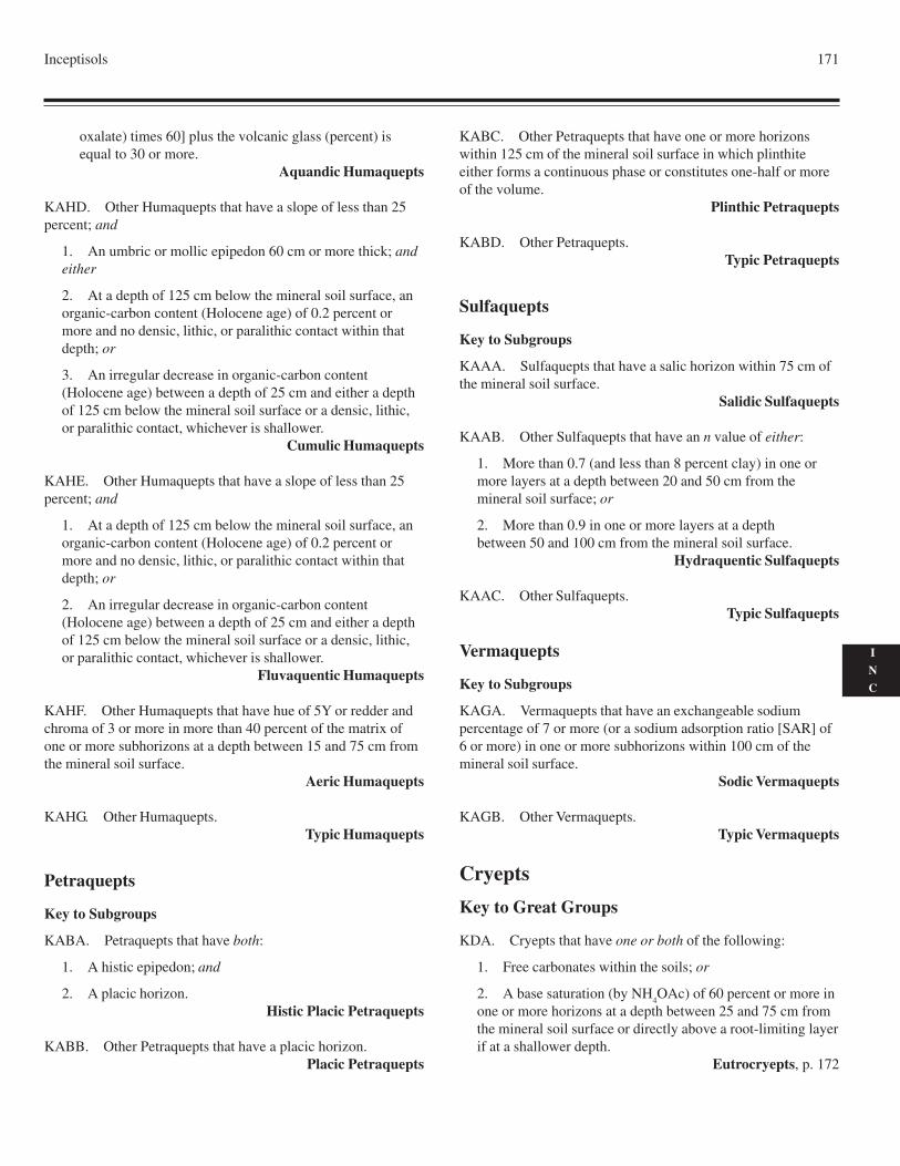
Inceptisols 171
I
N
C
oxalate) times 60] plus the volcanic glass (percent) isequal to 30 or more.
Aquandic Humaquepts
KAHD. Other Humaquepts that have a slope of less than 25percent; and
1. An umbric or mollic epipedon 60 cm or more thick; andeither
2. At a depth of 125 cm below the mineral soil surface, anorganic-carbon content (Holocene age) of 0.2 percent ormore and no densic, lithic, or paralithic contact within thatdepth; or
3. An irregular decrease in organic-carbon content(Holocene age) between a depth of 25 cm and either a depthof 125 cm below the mineral soil surface or a densic, lithic,or paralithic contact, whichever is shallower.
Cumulic Humaquepts
KAHE. Other Humaquepts that have a slope of less than 25percent; and
1. At a depth of 125 cm below the mineral soil surface, anorganic-carbon content (Holocene age) of 0.2 percent ormore and no densic, lithic, or paralithic contact within thatdepth; or
2. An irregular decrease in organic-carbon content(Holocene age) between a depth of 25 cm and either a depthof 125 cm below the mineral soil surface or a densic, lithic,or paralithic contact, whichever is shallower.
Fluvaquentic Humaquepts
KAHF. Other Humaquepts that have hue of 5Y or redder andchroma of 3 or more in more than 40 percent of the matrix ofone or more subhorizons at a depth between 15 and 75 cm fromthe mineral soil surface.
Aeric Humaquepts
KAHG. Other Humaquepts.Typic Humaquepts
Petraquepts
Key to Subgroups
KABA. Petraquepts that have both:
1. A histic epipedon; and
2. A placic horizon.Histic Placic Petraquepts
KABB. Other Petraquepts that have a placic horizon.Placic Petraquepts
KABC. Other Petraquepts that have one or more horizonswithin 125 cm of the mineral soil surface in which plinthiteeither forms a continuous phase or constitutes one-half or moreof the volume.
Plinthic Petraquepts
KABD. Other Petraquepts.Typic Petraquepts
Sulfaquepts
Key to Subgroups
KAAA. Sulfaquepts that have a salic horizon within 75 cm ofthe mineral soil surface.
Salidic Sulfaquepts
KAAB. Other Sulfaquepts that have an n value of either:
1. More than 0.7 (and less than 8 percent clay) in one ormore layers at a depth between 20 and 50 cm from themineral soil surface; or
2. More than 0.9 in one or more layers at a depthbetween 50 and 100 cm from the mineral soil surface.
Hydraquentic Sulfaquepts
KAAC. Other Sulfaquepts.Typic Sulfaquepts
Vermaquepts
Key to Subgroups
KAGA. Vermaquepts that have an exchangeable sodiumpercentage of 7 or more (or a sodium adsorption ratio [SAR] of6 or more) in one or more subhorizons within 100 cm of themineral soil surface.
Sodic Vermaquepts
KAGB. Other Vermaquepts.Typic Vermaquepts
Cryepts
Key to Great Groups
KDA. Cryepts that have one or both of the following:
1. Free carbonates within the soils; or
2. A base saturation (by NH4OAc) of 60 percent or more in
one or more horizons at a depth between 25 and 75 cm fromthe mineral soil surface or directly above a root-limiting layerif at a shallower depth.
Eutrocryepts, p. 172
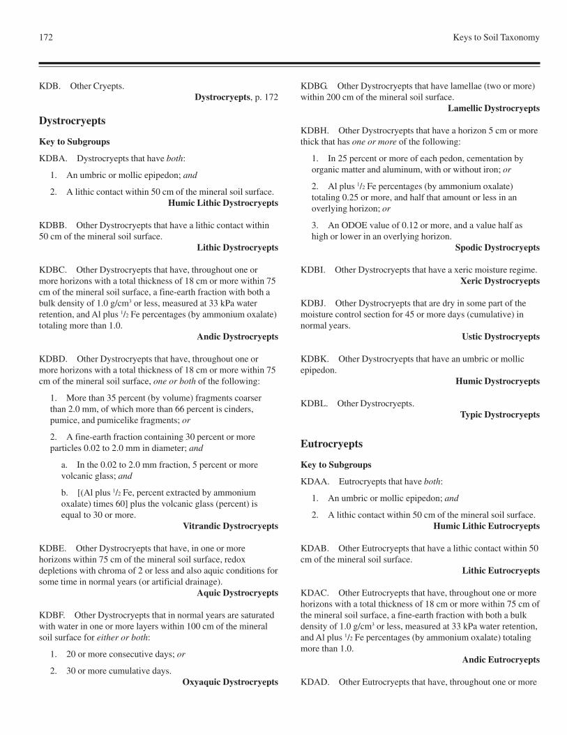
172 Keys to Soil Taxonomy
KDB. Other Cryepts.Dystrocryepts, p. 172
Dystrocryepts
Key to Subgroups
KDBA. Dystrocryepts that have both:
1. An umbric or mollic epipedon; and
2. A lithic contact within 50 cm of the mineral soil surface.Humic Lithic Dystrocryepts
KDBB. Other Dystrocryepts that have a lithic contact within50 cm of the mineral soil surface.
Lithic Dystrocryepts
KDBC. Other Dystrocryepts that have, throughout one ormore horizons with a total thickness of 18 cm or more within 75cm of the mineral soil surface, a fine-earth fraction with both abulk density of 1.0 g/cm3 or less, measured at 33 kPa waterretention, and Al plus 1/2 Fe percentages (by ammonium oxalate)totaling more than 1.0.
Andic Dystrocryepts
KDBD. Other Dystrocryepts that have, throughout one ormore horizons with a total thickness of 18 cm or more within 75cm of the mineral soil surface, one or both of the following:
1. More than 35 percent (by volume) fragments coarserthan 2.0 mm, of which more than 66 percent is cinders,pumice, and pumicelike fragments; or
2. A fine-earth fraction containing 30 percent or moreparticles 0.02 to 2.0 mm in diameter; and
a. In the 0.02 to 2.0 mm fraction, 5 percent or morevolcanic glass; and
b. [(Al plus 1/2 Fe, percent extracted by ammoniumoxalate) times 60] plus the volcanic glass (percent) isequal to 30 or more.
Vitrandic Dystrocryepts
KDBE. Other Dystrocryepts that have, in one or morehorizons within 75 cm of the mineral soil surface, redoxdepletions with chroma of 2 or less and also aquic conditions forsome time in normal years (or artificial drainage).
Aquic Dystrocryepts
KDBF. Other Dystrocryepts that in normal years are saturatedwith water in one or more layers within 100 cm of the mineralsoil surface for either or both:
1. 20 or more consecutive days; or
2. 30 or more cumulative days.Oxyaquic Dystrocryepts
KDBG. Other Dystrocryepts that have lamellae (two or more)within 200 cm of the mineral soil surface.
Lamellic Dystrocryepts
KDBH. Other Dystrocryepts that have a horizon 5 cm or morethick that has one or more of the following:
1. In 25 percent or more of each pedon, cementation byorganic matter and aluminum, with or without iron; or
2. Al plus 1/2 Fe percentages (by ammonium oxalate)totaling 0.25 or more, and half that amount or less in anoverlying horizon; or
3. An ODOE value of 0.12 or more, and a value half ashigh or lower in an overlying horizon.
Spodic Dystrocryepts
KDBI. Other Dystrocryepts that have a xeric moisture regime.Xeric Dystrocryepts
KDBJ. Other Dystrocryepts that are dry in some part of themoisture control section for 45 or more days (cumulative) innormal years.
Ustic Dystrocryepts
KDBK. Other Dystrocryepts that have an umbric or mollicepipedon.
Humic Dystrocryepts
KDBL. Other Dystrocryepts.Typic Dystrocryepts
Eutrocryepts
Key to Subgroups
KDAA. Eutrocryepts that have both:
1. An umbric or mollic epipedon; and
2. A lithic contact within 50 cm of the mineral soil surface.Humic Lithic Eutrocryepts
KDAB. Other Eutrocryepts that have a lithic contact within 50cm of the mineral soil surface.
Lithic Eutrocryepts
KDAC. Other Eutrocryepts that have, throughout one or morehorizons with a total thickness of 18 cm or more within 75 cm ofthe mineral soil surface, a fine-earth fraction with both a bulkdensity of 1.0 g/cm3 or less, measured at 33 kPa water retention,and Al plus 1/2 Fe percentages (by ammonium oxalate) totalingmore than 1.0.
Andic Eutrocryepts
KDAD. Other Eutrocryepts that have, throughout one or more
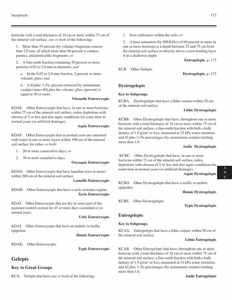
Inceptisols 173
I
N
C
horizons with a total thickness of 18 cm or more within 75 cm ofthe mineral soil surface, one or both of the following:
1. More than 35 percent (by volume) fragments coarserthan 2.0 mm, of which more than 66 percent is cinders,pumice, and pumicelike fragments; or
2. A fine-earth fraction containing 30 percent or moreparticles 0.02 to 2.0 mm in diameter; and
a. In the 0.02 to 2.0 mm fraction, 5 percent or morevolcanic glass; and
b. [(Al plus 1/2 Fe, percent extracted by ammoniumoxalate) times 60] plus the volcanic glass (percent) isequal to 30 or more.
Vitrandic Eutrocryepts
KDAE. Other Eutrocryepts that have, in one or more horizonswithin 75 cm of the mineral soil surface, redox depletions withchroma of 2 or less and also aquic conditions for some time innormal years (or artificial drainage).
Aquic Eutrocryepts
KDAF. Other Eutrocryepts that in normal years are saturatedwith water in one or more layers within 100 cm of the mineralsoil surface for either or both:
1. 20 or more consecutive days; or
2. 30 or more cumulative days.Oxyaquic Eutrocryepts
KDAG. Other Eutrocryepts that have lamellae (two or more)within 200 cm of the mineral soil surface.
Lamellic Eutrocryepts
KDAH. Other Eutrocryepts that have a xeric moisture regime.Xeric Eutrocryepts
KDAI. Other Eutrocryepts that are dry in some part of themoisture control section for 45 or more days (cumulative) innormal years.
Ustic Eutrocryepts
KDAJ. Other Eutrocryepts that have an umbric or mollicepipedon.
Humic Eutrocryepts
KDAK. Other Eutrocryepts.Typic Eutrocryepts
Gelepts
Key to Great Groups
KCA. Gelepts that have one or both of the following:
1. Free carbonates within the soils; or
2. A base saturation (by NH4OAc) of 60 percent or more inone or more horizons at a depth between 25 and 75 cm fromthe mineral soil surface or directly above a root-limiting layerif at a shallower depth.
Eutrogelepts, p. 173
KCB. Other Gelepts.Dystrogelepts, p. 173
Dystrogelepts
Key to Subgroups
KCBA. Dystrogelepts that have a lithic contact within 50 cmof the mineral soil surface.
Lithic Dystrogelepts
KCBB. Other Dystrogelepts that have, throughout one or morehorizons with a total thickness of 18 cm or more within 75 cm ofthe mineral soil surface, a fine-earth fraction with both a bulkdensity of 1.0 g/cm3 or less, measured at 33 kPa water retention,and Al plus 1/2 Fe percentages (by ammonium oxalate) totalingmore than 1.0.
Andic Dystrogelepts
KCBC. Other Dystrogelepts that have, in one or morehorizons within 75 cm of the mineral soil surface, redoxdepletions with chroma of 2 or less and also aquic conditions forsome time in normal years (or artificial drainage).
Aquic Dystrogelepts
KCBD. Other Dystrogelepts that have a mollic or umbricepipedon.
Humic Dystrogelepts
KCBE. Other Dystrogelepts.Typic Dystrogelepts
Eutrogelepts
Key to Subgroups
KCAA. Eutrogelepts that have a lithic contact within 50 cm ofthe mineral soil surface.
Lithic Eutrogelepts
KCAB. Other Eutrogelepts that have, throughout one or morehorizons with a total thickness of 18 cm or more within 75 cm ofthe mineral soil surface, a fine-earth fraction with both a bulkdensity of 1.0 g/cm3 or less, measured at 33 kPa water retention,and Al plus 1/2 Fe percentages (by ammonium oxalate) totalingmore than 1.0.
Andic Eutrogelepts
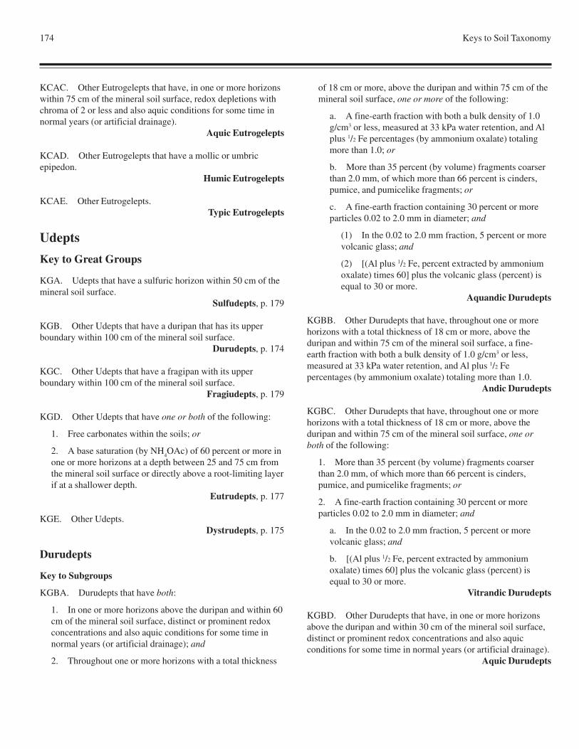
174 Keys to Soil Taxonomy
KCAC. Other Eutrogelepts that have, in one or more horizonswithin 75 cm of the mineral soil surface, redox depletions withchroma of 2 or less and also aquic conditions for some time innormal years (or artificial drainage).
Aquic Eutrogelepts
KCAD. Other Eutrogelepts that have a mollic or umbricepipedon.
Humic Eutrogelepts
KCAE. Other Eutrogelepts.Typic Eutrogelepts
Udepts
Key to Great Groups
KGA. Udepts that have a sulfuric horizon within 50 cm of themineral soil surface.
Sulfudepts, p. 179
KGB. Other Udepts that have a duripan that has its upperboundary within 100 cm of the mineral soil surface.
Durudepts, p. 174
KGC. Other Udepts that have a fragipan with its upperboundary within 100 cm of the mineral soil surface.
Fragiudepts, p. 179
KGD. Other Udepts that have one or both of the following:
1. Free carbonates within the soils; or
2. A base saturation (by NH4OAc) of 60 percent or more in
one or more horizons at a depth between 25 and 75 cm fromthe mineral soil surface or directly above a root-limiting layerif at a shallower depth.
Eutrudepts, p. 177
KGE. Other Udepts.Dystrudepts, p. 175
Durudepts
Key to Subgroups
KGBA. Durudepts that have both:
1. In one or more horizons above the duripan and within 60cm of the mineral soil surface, distinct or prominent redoxconcentrations and also aquic conditions for some time innormal years (or artificial drainage); and
2. Throughout one or more horizons with a total thickness
of 18 cm or more, above the duripan and within 75 cm of themineral soil surface, one or more of the following:
a. A fine-earth fraction with both a bulk density of 1.0g/cm3 or less, measured at 33 kPa water retention, and Alplus 1/2 Fe percentages (by ammonium oxalate) totalingmore than 1.0; or
b. More than 35 percent (by volume) fragments coarserthan 2.0 mm, of which more than 66 percent is cinders,pumice, and pumicelike fragments; or
c. A fine-earth fraction containing 30 percent or moreparticles 0.02 to 2.0 mm in diameter; and
(1) In the 0.02 to 2.0 mm fraction, 5 percent or morevolcanic glass; and
(2) [(Al plus 1/2 Fe, percent extracted by ammoniumoxalate) times 60] plus the volcanic glass (percent) isequal to 30 or more.
Aquandic Durudepts
KGBB. Other Durudepts that have, throughout one or morehorizons with a total thickness of 18 cm or more, above theduripan and within 75 cm of the mineral soil surface, a fine-earth fraction with both a bulk density of 1.0 g/cm3 or less,measured at 33 kPa water retention, and Al plus 1/2 Fepercentages (by ammonium oxalate) totaling more than 1.0.
Andic Durudepts
KGBC. Other Durudepts that have, throughout one or morehorizons with a total thickness of 18 cm or more, above theduripan and within 75 cm of the mineral soil surface, one orboth of the following:
1. More than 35 percent (by volume) fragments coarserthan 2.0 mm, of which more than 66 percent is cinders,pumice, and pumicelike fragments; or
2. A fine-earth fraction containing 30 percent or moreparticles 0.02 to 2.0 mm in diameter; and
a. In the 0.02 to 2.0 mm fraction, 5 percent or morevolcanic glass; and
b. [(Al plus 1/2 Fe, percent extracted by ammoniumoxalate) times 60] plus the volcanic glass (percent) isequal to 30 or more.
Vitrandic Durudepts
KGBD. Other Durudepts that have, in one or more horizonsabove the duripan and within 30 cm of the mineral soil surface,distinct or prominent redox concentrations and also aquicconditions for some time in normal years (or artificial drainage).
Aquic Durudepts
Inceptisols 175
I
N
C
KGBE. Other Durudepts.Typic Durudepts
Dystrudepts
Key to Subgroups
KGEA. Dystrudepts that have both:
1. A lithic contact within 50 cm of the mineral soil surface;and
2. An umbric or mollic epipedon.Humic Lithic Dystrudepts
KGEB. Other Dystrudepts that have a lithic contact within 50cm of the mineral soil surface.
Lithic Dystrudepts
KGEC. Other Dystrudepts that have one or both of thefollowing:
1. Cracks within 125 cm of the mineral soil surface that are5 mm or more wide through a thickness of 30 cm or more forsome time in normal years and slickensides or wedge-shapedaggregates in a layer 15 cm or more thick that has its upperboundary within 125 cm of the mineral soil surface; or
2. A linear extensibility of 6.0 cm or more betweenthe mineral soil surface and either a depth of 100 cmor a densic, lithic, or paralithic contact, whichever isshallower.
Vertic Dystrudepts
KGED. Other Dystrudepts that have both:
1. In one or more horizons within 60 cm of the mineral soilsurface, redox depletions with chroma of 2 or less and alsoaquic conditions for some time in normal years (or artificialdrainage); and
2. Throughout one or more horizons with a total thicknessof 18 cm or more within 75 cm of the mineral soil surface,one or more of the following:
a. A fine-earth fraction with both a bulk density of 1.0g/cm3 or less, measured at 33 kPa water retention, and Alplus 1/2 Fe percentages (by ammonium oxalate) totalingmore than 1.0; or
b. More than 35 percent (by volume) fragments coarserthan 2.0 mm, of which more than 66 percent is cinders,pumice, and pumicelike fragments; or
c. A fine-earth fraction containing 30 percent or moreparticles 0.02 to 2.0 mm in diameter; and
(1) In the 0.02 to 2.0 mm fraction, 5 percent or morevolcanic glass; and
(2) [(Al plus 1/2 Fe, percent extracted by ammoniumoxalate) times 60] plus the volcanic glass (percent) isequal to 30 or more.
Aquandic Dystrudepts
KGEE. Other Dystrudepts that have both:
1. In one or more horizons with a total thickness of 18 cmor more within 75 cm of the mineral soil surface, a fine-earthwith both a bulk density of 1.0 g/cm3 or less, measured at33 kPa water retention, and Al plus 1/2 Fe percentages (byammonium oxalate) totaling more than 1.0; and
2. Saturation with water within 100 cm of the mineral soilsurface in normal years for either or both:
a. 20 or more consecutive days; or
b. 30 or more cumulative days.Andic Oxyaquic Dystrudepts
KGEF. Other Dystrudepts that have, throughout one or morehorizons with a total thickness of 18 cm or more within 75 cm ofthe mineral soil surface, a fine-earth fraction with both a bulkdensity of 1.0 g/cm3 or less, measured at 33 kPa water retention,and Al plus 1/2 Fe percentages (by ammonium oxalate) totalingmore than 1.0.
Andic Dystrudepts
KGEG. Other Dystrudepts that have, throughout one or morehorizons with a total thickness of 18 cm or more within 75 cm ofthe mineral soil surface, one or both of the following:
1. More than 35 percent (by volume) fragments coarserthan 2.0 mm, of which more than 66 percent is cinders,pumice, and pumicelike fragments; or
2. A fine-earth fraction containing 30 percent or moreparticles 0.02 to 2.0 mm in diameter; and
a. In the 0.02 to 2.0 mm fraction, 5 percent or morevolcanic glass; and
b. [(Al plus 1/2 Fe, percent extracted by ammoniumoxalate) times 60] plus the volcanic glass (percent) isequal to 30 or more.
Vitrandic Dystrudepts
KGEH. Other Dystrudepts that have both:
1. Fragic soil properties:
a. In 30 percent or more of the volume of a layer 15 cmor more thick that has its upper boundary within 100 cmof the mineral soil surface; or
b. In 60 percent or more of the volume of a layer 15 cmor more thick; and
2. In one or more horizons within 60 cm of the mineral soil
176 Keys to Soil Taxonomy
surface, redox depletions with chroma of 2 or less and alsoaquic conditions in normal years (or artificial drainage).
Fragiaquic Dystrudepts
KGEI. Other Dystrudepts that have a slope of less than 25percent; and
1. In one or more horizons within 60 cm of the mineral soilsurface, redox depletions with chroma of 2 or less and alsoaquic conditions for some time in normal years (or artificialdrainage); and
2. Either:
a. At a depth of 125 cm below the mineral soil surface,an organic-carbon content (Holocene age) of 0.2 percentor more and no densic, lithic, or paralithic contact withinthat depth; or
b. An irregular decrease in organic-carbon content(Holocene age) between a depth of 25 cm and either adepth of 125 cm below the mineral soil surface or adensic, lithic, or paralithic contact, whichever is shallower.
Fluvaquentic Dystrudepts
KGEJ. Other Dystrudepts that have both:
1. An umbric or mollic epipedon; and
2. In one or more horizons within 60 cm of the mineral soilsurface, redox depletions with chroma of 2 or less and alsoaquic conditions for some time in normal years (or artificialdrainage).
Aquic Humic Dystrudepts
KGEK. Other Dystrudepts that have, in one or more horizonswithin 60 cm of the mineral soil surface, redox depletions withchroma of 2 or less and also aquic conditions for some time innormal years (or artificial drainage).
Aquic Dystrudepts
KGEL. Other Dystrudepts that in normal years are saturatedwith water in one or more layers within 100 cm of the mineralsoil surface for either or both:
1. 20 or more consecutive days; or
2. 30 or more cumulative days.Oxyaquic Dystrudepts
KGEM. Other Dystrudepts that have fragic soil properties:
1. In 30 percent or more of the volume of a layer 15 cm ormore thick that has its upper boundary within 100 cm of themineral soil surface; or
2. In 60 percent or more of the volume of a layer 15 cm ormore thick.
Fragic Dystrudepts
KGEN. Other Dystrudepts that have lamellae (two or more)within 200 cm of the mineral soil surface.
Lamellic Dystrudepts
KGEO. Other Dystrudepts that have both:
1. An umbric or mollic epipedon; and
2. A sandy particle-size class throughout the particle-sizecontrol section.
Humic Psammentic Dystrudepts
KGEP. Other Dystrudepts that have a slope of less than 25percent; and
1. An umbric or mollic epipedon; and
2. Either:
a. At a depth of 125 cm below the mineral soil surface,an organic-carbon content (Holocene age) of 0.2 percentor more and no densic, lithic, or paralithic contact withinthat depth; or
b. An irregular decrease in organic-carbon content(Holocene age) between a depth of 25 cm and either adepth of 125 cm below the mineral soil surface or adensic, lithic, or paralithic contact, whichever is shallower.
Fluventic Humic Dystrudepts
KGEQ. Other Dystrudepts that have a slope of less than 25percent; and either
1. At a depth of 125 cm below the mineral soil surface, anorganic-carbon content (Holocene age) of 0.2 percent ormore and no densic, lithic, or paralithic contact within thatdepth; or
2. An irregular decrease in organic-carbon content(Holocene age) between a depth of 25 cm and either a depthof 125 cm below the mineral soil surface or a densic, lithic,or paralithic contact, whichever is shallower.
Fluventic Dystrudepts
KGER. Other Dystrudepts that have a horizon 5 cm or morethick that has one or more of the following:
1. In 25 percent or more of each pedon, cementation byorganic matter and aluminum, with or without iron; or
2. Al plus 1/2 Fe percentages (by ammonium oxalate)totaling 0.25 or more, and half that amount or less in anoverlying horizon; or
3. An ODOE value of 0.12 or more, and a value half ashigh or lower in an overlying horizon.
Spodic Dystrudepts
KGES. Other Dystrudepts that have in 50 percent or more ofthe soil volume between a depth of 25 cm from the mineral soil
Inceptisols 177
I
N
C
surface and either a depth of 100 cm or a densic, lithic, orparalithic contact if shallower:
1. A CEC (by 1N NH4OAc pH 7) of less than 24 cmol(+)
per kg clay; or
2. Both a ratio of measured clay in the fine-earth fraction topercent water retained at 1500 kPa tension of 0.6 or moreand the following: the CEC (by 1N NH
4OAc pH 7) divided
by the product of three times [percent water retained at 1500kPa tension minus percent organic carbon (but no more than1.00)] is less than 24.
Oxic Dystrudepts
KGET. Other Dystrudepts that have an umbric or mollicepipedon that is 50 cm or more thick.
Humic Pachic Dystrudepts
KGEU. Other Dystrudepts that have an umbric or mollicepipedon.
Humic Dystrudepts
KGEV. Other Dystrudepts that have both:
1. In each pedon a cambic horizon that includes 10 to 50percent (by volume) illuvial parts that otherwise meet therequirements for an argillic, kandic, or natric horizon; and
2. A base saturation (by sum of cations) of 35 percent ormore either at a depth of 125 cm from the top of the cambichorizon or directly above a densic, lithic, or paralithic contactif shallower.
Ruptic-Alfic Dystrudepts
KGEW. Other Dystrudepts that have in each pedon a cambichorizon that includes 10 to 50 percent (by volume) illuvial partsthat otherwise meet the requirements for an argillic, kandic, ornatric horizon.
Ruptic-Ultic Dystrudepts
KGEX. Other Dystrudepts.Typic Dystrudepts
Eutrudepts
Key to Subgroups
KGDA. Eutrudepts that have both:
1. An umbric or mollic epipedon; and
2. A lithic contact within 50 cm of the mineral soil surface.Humic Lithic Eutrudepts
KGDB. Other Eutrudepts that have a lithic contact within 50cm of the mineral soil surface.
Lithic Eutrudepts
KGDC. Other Eutrudepts that have both:
1. One or both of the following:
a. Cracks within 125 cm of the mineral soil surface thatare 5 mm or more wide through a thickness of 30 cm ormore for some time in normal years and slickensides orwedge-shaped aggregates in a layer 15 cm or more thickthat has its upper boundary within 125 cm of the mineralsoil surface; or
b. A linear extensibility of 6.0 cm or more between themineral soil surface and either a depth of 100 cm or adensic, lithic, or paralithic contact, whichever isshallower; and
2. In one or more horizons within 60 cm of the mineral soilsurface, redox depletions with chroma of 2 or less and alsoaquic conditions for some time in normal years (or artificialdrainage).
Aquertic Eutrudepts
KGDD. Other Eutrudepts that have one or both of thefollowing:
1. Cracks within 125 cm of the mineral soil surface that are5 mm or more wide through a thickness of 30 cm or more forsome time in normal years and slickensides or wedge-shapedaggregates in a layer 15 cm or more thick that has its upperboundary within 125 cm of the mineral soil surface; or
2. A linear extensibility of 6.0 cm or more between themineral soil surface and either a depth of 100 cm or a densic,lithic, or paralithic contact, whichever is shallower.
Vertic Eutrudepts
KGDE. Other Eutrudepts that have, throughout one or morehorizons with a total thickness of 18 cm or more within 75 cm ofthe mineral soil surface, a fine-earth fraction with both a bulkdensity of 1.0 g/cm3 or less, measured at 33 kPa water retention,and Al plus 1/2 Fe percentages (by ammonium oxalate) totalingmore than 1.0.
Andic Eutrudepts
KGDF. Other Eutrudepts that have, throughout one ormore horizons with a total thickness of 18 cm or morewithin 75 cm of the mineral soil surface, one or both of thefollowing:
1. More than 35 percent (by volume) fragments coarserthan 2.0 mm, of which more than 66 percent is cinders,pumice, and pumicelike fragments; or
2. A fine-earth fraction containing 30 percent or moreparticles 0.02 to 2.0 mm in diameter; and
a. In the 0.02 to 2.0 mm fraction, 5 percent or morevolcanic glass; and
178 Keys to Soil Taxonomy
b. [(Al plus 1/2 Fe, percent extracted by ammoniumoxalate) times 60] plus the volcanic glass (percent) isequal to 30 or more.
Vitrandic Eutrudepts
KGDG. Other Eutrudepts that have anthraquic conditions.Anthraquic Eutrudepts
KGDH. Other Eutrudepts that have both:
1. Fragic soil properties:
a. In 30 percent or more of the volume of a layer 15 cmor more thick that has its upper boundary within 100 cmof the mineral soil surface; or
b. In 60 percent or more of the volume of a layer 15 cmor more thick; and
2. In one or more horizons within 60 cm of the mineral soilsurface, redox depletions with chroma of 2 or less and alsoaquic conditions in normal years (or artificial drainage).
Fragiaquic Eutrudepts
KGDI. Other Eutrudepts that have a slope of less than 25percent; and
1. In one or more horizons within 60 cm of the mineral soilsurface, redox depletions with chroma of 2 or less and alsoaquic conditions for some time in normal years (or artificialdrainage); and
2. Either:
a. At a depth of 125 cm below the mineral soil surface,an organic-carbon content (Holocene age) of 0.2 percentor more and no densic, lithic, or paralithic contact withinthat depth; or
b. An irregular decrease in organic-carbon content(Holocene age) between a depth of 25 cm and eithera depth of 125 cm below the mineral soil surface ora densic, lithic, or paralithic contact, whichever isshallower.
Fluvaquentic Eutrudepts
KGDJ. Other Eutrudepts that:
1. Have, in one or more horizons within 60 cm of themineral soil surface, redox depletions with chroma of 2 orless and also aquic conditions for some time in normal years(or artificial drainage); and
2. Do not have free carbonates throughout any horizonwithin 100 cm of the mineral soil surface.
Aquic Dystric Eutrudepts
KGDK. Other Eutrudepts that have, in one or more horizonswithin 60 cm of the mineral soil surface, redox depletions with
chroma of 2 or less and also aquic conditions for some time innormal years (or artificial drainage).
Aquic Eutrudepts
KGDL. Other Eutrudepts that in normal years are saturatedwith water in one or more layers within 100 cm of the mineralsoil surface for either or both:
1. 20 or more consecutive days; or
2. 30 or more cumulative days.Oxyaquic Eutrudepts
KGDM. Other Eutrudepts that have fragic soil properties:
1. In 30 percent or more of the volume of a layer 15 cm ormore thick that has its upper boundary within 100 cm of themineral soil surface; or
2. In 60 percent or more of the volume of a layer 15 cm ormore thick.
Fragic Eutrudepts
KGDN. Other Eutrudepts that have lamellae (two or more)within 200 cm of the mineral soil surface.
Lamellic Eutrudepts
KGDO. Other Eutrudepts that have a slope of less than 25percent; and
1. Do not have free carbonates throughout anyhorizon within 100 cm of the mineral soil surface; and either
2. Have, at a depth of 125 cm below the mineral soilsurface, an organic-carbon content (Holocene age) of 0.2percent or more and no densic, lithic, or paralithic contactwithin that depth; or
3. Have an irregular decrease in organic-carbon content(Holocene age) between a depth of 25 cm and either a depthof 125 cm below the mineral soil surface or a densic, lithic,or paralithic contact, whichever is shallower.
Dystric Fluventic Eutrudepts
KGDP. Other Eutrudepts that have a slope of less than 25percent; and either
1. At a depth of 125 cm below the mineral soil surface, anorganic-carbon content (Holocene age) of 0.2 percent ormore and no densic, lithic, or paralithic contact within thatdepth; or
2. An irregular decrease in organic-carbon content(Holocene Age) between a depth of 25 cm and either a depthof 125 cm below the mineral soil surface or a densic, lithic,or paralithic contact, whichever is shallower.
Fluventic Eutrudepts
KGDQ. Other Eutrudepts that have a sandy or sandy-skeletal
Inceptisols 179
I
N
C
particle-size class in all horizons within 50 cm of the mineralsoil surface.
Arenic Eutrudepts
KGDR. Other Eutrudepts that do not have free carbonatesthroughout any horizon within 100 cm of the mineral soilsurface.
Dystric Eutrudepts
KGDS. Other Eutrudepts that have 40 percent or more freecarbonates, including coarse fragments as much as 75 mm indiameter, in all horizons between the top of the cambic horizonand either a depth of 100 cm from the mineral soil surface or adensic, lithic, or paralithic contact if shallower.
Rendollic Eutrudepts
KGDT. Other Eutrudepts that have an umbric or mollicepipedon.
Humic Eutrudepts
KGDU. Other Eutrudepts that have a cambic horizon thatincludes 10 to 50 percent (by volume) illuvial parts thatotherwise meet the requirements for an argillic, kandic, or natrichorizon.
Ruptic-Alfic Eutrudepts
KGDV. Other Eutrudepts.Typic Eutrudepts
Fragiudepts
Key to Subgroups
KGCA. Fragiudepts that have, throughout one or morehorizons with a total thickness of 18 cm or more within 75 cm ofthe mineral soil surface, a fine-earth fraction with both a bulkdensity of 1.0 g/cm3 or less, measured at 33 kPa water retention,and Al plus 1/2 Fe percentages (by ammonium oxalate) totalingmore than 1.0.
Andic Fragiudepts
KGCB. Other Fragiudepts that have, throughout one or morehorizons with a total thickness of 18 cm or more within 75 cm ofthe mineral soil surface, one or both of the following:
1. More than 35 percent (by volume) fragments coarserthan 2.0 mm, of which more than 66 percent is cinders,pumice, and pumicelike fragments; or
2. A fine-earth fraction containing 30 percent or moreparticles 0.02 to 2.0 mm in diameter; and
a. In the 0.02 to 2.0 mm fraction, 5 percent or morevolcanic glass; and
b. [(Al plus 1/2 Fe, percent extracted by ammoniumoxalate) times 60] plus the volcanic glass (percent) isequal to 30 or more.
Vitrandic Fragiudepts
KGCC. Other Fragiudepts that have, in one or more horizonswithin 30 cm of the mineral soil surface, distinct or prominentredox concentrations and also aquic conditions for some time innormal years (or artificial drainage).
Aquic Fragiudepts
KGCD. Other Fragiudepts that have an umbric or mollicepipedon.
Humic Fragiudepts
KGCE. Other Fragiudepts.Typic Fragiudepts
Sulfudepts
Key to Subgroups
KGAA. All Sulfudepts (provisionally).Typic Sulfudepts
Ustepts
Key to Great Groups
KEA. Ustepts that have a duripan that has its upper boundarywithin 100 cm of the mineral soil surface.
Durustepts, p. 181
KEB. Other Ustepts that both:
1. Have a calcic horizon with its upper boundarywithin 100 cm of the mineral soil surface or a petrocalcichorizon that has its upper boundary within 150 cm of themineral soil surface; and
2. Are either calcareous or have a texture of loamy finesand or coarser in all parts above the calcic or petrocalcichorizon, after the soil between the mineral soil surface and adepth of 18 cm has been mixed.
Calciustepts, p. 180
KEC. Other Ustepts that have both of the following:
1. No free carbonates within 200 cm of the mineral soilsurface; and
2. A base saturation (by NH4OAc) of less than 60 percent
in all horizons at a depth between 25 and 75 cm from themineral soil surface.
Dystrustepts, p. 181
180 Keys to Soil Taxonomy
KED. Other Ustepts.Haplustepts, p. 182
Calciustepts
Key to Subgroups
KEBA. Calciustepts that have a petrocalcic horizon and alithic contact within 50 cm of the mineral soil surface.
Lithic Petrocalcic Calciustepts
KEBB. Other Calciustepts that have a lithic contact within 50cm of the mineral soil surface.
Lithic Calciustepts
KEBC. Other Calciustepts that have both:
1. One or both of the following:
a. Cracks within 125 cm of the mineral soil surface thatare 5 mm or more wide through a thickness of 30 cm ormore for some time in normal years and slickensides orwedge-shaped aggregates in a layer 15 cm or more thickthat has its upper boundary within 125 cm of the mineralsoil surface; or
b. A linear extensibility of 6.0 cm or more between themineral soil surface and either a depth of 100 cm or adensic, lithic, or paralithic contact, whichever isshallower; and
2. When neither irrigated nor fallowed to store moisture,one of the following:
a. A frigid temperature regime and a moisture controlsection that in normal years is dry in all parts for four-tenths or more of the cumulative days per year when thetemperature at a depth of 50 cm below the soil surface ishigher than 5 oC; or
b. A mesic or thermic soil temperature regime and amoisture control section that in normal years is dry insome or all parts for six-tenths or more of the cumulativedays per year when the temperature at a depth of 50 cmbelow the soil surface is higher than 5 oC; or
c. A hyperthermic, isomesic, or warmer iso soiltemperature regime and a moisture control section that innormal years:
(1) Is moist in some or all parts for fewer than 90consecutive days per year when the temperature at adepth of 50 cm below the soil surface is higher than8 oC; and
(2) Is dry in some or all parts for six-tenths or moreof the cumulative days per year when the temperature
at a depth of 50 cm below the soil surface is higherthan 5 oC.
Torrertic Calciustepts
KEBD. Other Calciustepts that have one or both of thefollowing:
1. Cracks within 125 cm of the mineral soil surface that are5 mm or more wide through a thickness of 30 cm or more forsome time in normal years and slickensides or wedge-shapedaggregates in a layer 15 cm or more thick that has its upperboundary within 125 cm of the mineral soil surface; or
2. A linear extensibility of 6.0 cm or more between themineral soil surface and either a depth of 100 cm or a densic,lithic, or paralithic contact, whichever is shallower.
Vertic Calciustepts
KEBE. Other Calciustepts that have a petrocalcic horizon thathas its upper boundary within 100 cm of the mineral soilsurface.
Petrocalcic Calciustepts
KEBF. Other Calciustepts that have a gypsic horizon that hasits upper boundary within 100 cm of the mineral soil surface.
Gypsic Calciustepts
KEBG. Other Calciustepts that have, in one or more horizonswithin 75 cm of the mineral soil surface, redox depletions withchroma of 2 or less and also aquic conditions for some time innormal years (or artificial drainage).
Aquic Calciustepts
KEBH. Other Calciustepts that have, when neither irrigatednor fallowed to store moisture, one of the following:
1. A frigid temperature regime and a moisture controlsection that in normal years is dry in all parts for four-tenthsor more of the cumulative days per year when thetemperature at a depth of 50 cm below the soil surface ishigher than 5 oC; or
2. A mesic or thermic soil temperature regime and amoisture control section that in normal years is dry in someor all parts for six-tenths or more of the cumulative days peryear when the temperature at a depth of 50 cm below the soilsurface is higher than 5 oC; or
3. A hyperthermic, isomesic, or warmer iso soiltemperature regime and a moisture control section that innormal years:
a. Is moist in some or all parts for fewer than 90consecutive days per year when the temperature at a depthof 50 cm below the soil surface is higher than 8 oC; and
Inceptisols 181
I
N
C
b. Is dry in some or all parts for six-tenths or moreof the cumulative days per year when the temperatureat a depth of 50 cm below the soil surface is higher than5 oC.
Aridic Calciustepts
KEBI. Other Calciustepts that have, when neither irrigated norfallowed to store moisture, either:
1. A mesic or thermic soil temperature regime and amoisture control section that in normal years is dry in someor all parts for four-tenths or less of the consecutive days peryear when the temperature at a depth of 50 cm below the soilsurface is higher than 5 oC; or
2. A hyperthermic, isomesic, or warmer iso soiltemperature regime and a moisture control section thatin normal years is dry in some or all parts for fewerthan 120 cumulative days per year when the temperatureat a depth of 50 cm below the soil surface is higher than8 oC.
Udic Calciustepts
KEBJ. Other Calciustepts.Typic Calciustepts
Durustepts
Key to Subgroups
KEAA. All Durustepts (provisionally).Typic Durustepts
Dystrustepts
Key to Subgroups
KECA. Dystrustepts that have a lithic contact within 50 cm ofthe mineral soil surface.
Lithic Dystrustepts
KECB. Other Dystrustepts that have both:
1. When neither irrigated nor fallowed to store moisture,one of the following:
a. A frigid soil temperature regime and a moisturecontrol section that in normal years is dry in all parts forfour-tenths or more of the cumulative days per year whenthe temperature at a depth of 50 cm below the soil surfaceis higher than 5 oC; or
b. A mesic or thermic soil temperature regime and amoisture control section that, in 6 normal years, is dry insome part for six-tenths or more of the cumulative daysper year when the soil temperature at a depth of 50 cmbelow the soil surface is higher than 5 oC; or
c. A hyperthermic, isomesic, or warmer iso soiltemperature regime and a moisture control section that innormal years:
(1) Is moist in some or all parts for fewer than 90consecutive days per year when the temperature at adepth of 50 cm below the soil surface is higher than8 oC; and
(2) Is dry in some part for six-tenths or more of thecumulative days per year when the temperature at adepth of 50 cm below the soil surface is higher than5 oC; and
2. One or both of the following:
a. Cracks within 125 cm of the mineral soil surface thatare 5 mm or more wide through a thickness of 30 cm ormore for some time in normal years and slickensides orwedge-shaped aggregates in a layer 15 cm or more thickthat has its upper boundary within 125 cm of the mineralsoil surface; or
b. A linear extensibility of 6.0 cm or more between themineral soil surface and either a depth of 100 cm or adensic, lithic, or paralithic contact, whichever is shallower.
Torrertic Dystrustepts
KECC. Other Dystrustepts that have one or both of thefollowing:
1. Cracks within 125 cm of the mineral soil surface that are5 mm or more wide through a thickness of 30 cm or more forsome time in normal years and slickensides or wedge-shapedaggregates in a layer 15 cm or more thick that has its upperboundary within 125 cm of the mineral soil surface; or
2. A linear extensibility of 6.0 cm or more between themineral soil surface and either a depth of 100 cm or a densic,lithic, or paralithic contact, whichever is shallower.
Vertic Dystrustepts
KECD. Other Dystrustepts that have, throughout one or morehorizons with a total thickness of 18 cm or more within 75 cm ofthe mineral soil surface, a fine-earth fraction with both a bulkdensity of 1.0 g/cm3 or less, measured at 33 kPa water retention,and Al plus 1/2 Fe percentages (by ammonium oxalate) totalingmore than 1.0.
Andic Dystrustepts
KECE. Other Dystrustepts that have, throughout oneor more horizons with a total thickness of 18 cm or more within75 cm of the mineral soil surface, one or both of the following:
1. More than 35 percent (by volume) fragments coarserthan 2.0 mm, of which more than 66 percent is cinders,pumice, and pumicelike fragments; or
182 Keys to Soil Taxonomy
2. A fine-earth fraction containing 30 percent or moreparticles 0.02 to 2.0 mm in diameter; and
a. In the 0.02 to 2.0 mm fraction, 5 percent or morevolcanic glass; and
b. [(Al plus 1/2 Fe, percent extracted by ammoniumoxalate) times 60] plus the volcanic glass (percent) isequal to 30 or more.
Vitrandic Dystrustepts
KECF. Other Dystrustepts that have, in one or more horizonswithin 75 cm of the mineral soil surface, redox depletions withchroma of 2 or less and also aquic conditions for some time innormal years (or artificial drainage).
Aquic Dystrustepts
KECG. Other Dystrustepts that have a slope of less than 25percent; and either
1. At a depth of 125 cm below the mineral soil surface, anorganic-carbon content (Holocene age) of 0.2 percent ormore and no densic, lithic, or paralithic contact within thatdepth; or
2. An irregular decrease in organic-carbon content(Holocene age) between a depth of 25 cm and either a depthof 125 cm below the mineral soil surface or a densic, lithic,or paralithic contact, whichever is shallower.
Fluventic Dystrustepts
KECH. Other Dystrustepts that, when neither irrigated norfallowed to store moisture, have one of the following;:
1. A frigid soil temperature regime and a moisture controlsection that in normal years is dry in all parts for four-tenthsor more of the cumulative days per year when thetemperature at a depth of 50 cm below the soil surface ishigher than 5 oC; or
2. A mesic or thermic soil temperature regime and amoisture control section that in normal years is dry in someor all parts for six-tenths or more of the cumulative days peryear when the soil temperature at a depth of 50 cm below thesoil surface is higher than 5 oC; or
3. A hyperthermic, isomesic, or warmer iso soiltemperature regime and a moisture control section that innormal years:
a. Is moist in some or all parts for fewer than 90consecutive days per year when the temperature at a depthof 50 cm below the soil surface is higher than 8 oC; and
b. Is dry in some part for six-tenths or more of thecumulative days per year when the temperature at a depthof 50 cm below the soil surface is higher than 5 oC.
Aridic Dystrustepts
KECI. Other Dystrustepts that have in 50 percent or more ofthe soil volume between a depth of 25 cm from the mineral soilsurface and either a depth of 100 cm or a densic, lithic, orparalithic contact if shallower:
1. A CEC (by 1N NH4OAc pH 7) of less than 24 cmol(+)
per kg clay; or
2. Both a ratio of measured clay in the fine-earth fraction topercent water retained at 1500 kPa tension of 0.6 or moreand the following: the CEC (by 1N NH
4OAc pH 7) divided
by the product of three times [percent water retained at 1500kPa tension minus percent organic carbon (but no more than1.00)] is less than 24.
Oxic Dystrustepts
KECJ. Other Dystrustepts that have an umbric or mollicepipedon.
Humic Dystrustepts
KECK. Other Dystrustepts.Typic Dystrustepts
Haplustepts
Key to Subgroups
KEDA. Haplustepts that have:
1. A lithic contact within 50 cm of the mineral soil surface;and
2. When neither irrigated nor fallowed to store moisture,either:
a. A frigid temperature regime and a moisture controlsection that in normal years is dry in all parts for four-tenths or more of the cumulative days per year when thetemperature at a depth of 50 cm below the soil surface ishigher than 5 oC; or
b. A mesic or thermic soil temperature regime and amoisture control section that in normal years is dry insome part for six-tenths or more of the cumulative daysper year when the temperature at a depth of 50 cm belowthe soil surface is higher than 5 oC; or
c. A hyperthermic, isomesic, or warmer iso soiltemperature regime and a moisture control section that innormal years:
(1) Is moist in some or all parts for fewer than 90consecutive days per year when the temperature at adepth of 50 cm below the soil surface is higher than8 oC; and
(2) Is dry in some part for six-tenths or more of thecumulative days per year when the temperature at a
Inceptisols 183
I
N
C
depth of 50 cm below the soil surface is higher than5 oC.
Aridic Lithic Haplustepts
KEDB. Other Haplustepts that have a lithic contact within 50cm of the mineral soil surface.
Lithic Haplustepts
KEDC. Other Haplustepts that have both:
1. When neither irrigated nor fallowed to store moisture,one of the following:
a. A frigid soil temperature regime and a moisturecontrol section that in normal years is dry in some or allparts for fewer than 105 cumulative days per year whenthe temperature at a depth of 50 cm below the soil surfaceis higher than 5 oC; or
b. A mesic or thermic soil temperature regime and amoisture control section that in normal years is dry insome part for less than four-tenths of the cumulative daysper year when the temperature at a depth of 50 cm belowthe soil surface is higher than 5 oC; or
c. A hyperthermic, isomesic, or warmer iso soiltemperature regime and a moisture control section that innormal years is dry in some or all parts for fewer than 120cumulative days per year when the temperature at a depthof 50 cm below the soil surface is higher than 8 oC; and
2. One or both of the following:
a. Cracks within 125 cm of the mineral soil surface thatare 5 mm or more wide through a thickness of 30 cm ormore for some time in normal years and slickensides orwedge-shaped aggregates in a layer 15 cm or more thickthat has its upper boundary within 125 cm of the mineralsoil surface; or
b. A linear extensibility of 6.0 cm or more between themineral soil surface and either a depth of 100 cm or adensic, lithic, or paralithic contact, whichever is shallower.
Udertic Haplustepts
KEDD. Other Haplustepts that have both:
1. When neither irrigated nor fallowed to store moisture,one of the following:
a. A frigid soil temperature regime and a moisturecontrol section that in normal years is dry in all parts forfour-tenths or more of the cumulative days per year whenthe temperature at a depth of 50 cm below the soil surfaceis higher than 5 oC; or
b. A mesic or thermic soil temperature regime and amoisture control section that in normal years is dry insome part for six-tenths or more of the cumulative days
per year when the temperature at a depth of 50 cm belowthe soil surface is higher than 5 oC; or
c. A hyperthermic, isomesic, or warmer iso soiltemperature regime and a moisture control section that innormal years:
(1) Is moist in some or all parts for fewer than 90consecutive days per year when the temperature at adepth of 50 cm below the soil surface is higher than8 oC; and
(2) Is dry in some part for six-tenths or more of thecumulative days per year when the temperature at adepth of 50 cm below the soil surface is higher than5 oC; and
2. One or both of the following:
a. Cracks within 125 cm of the mineral soil surface thatare 5 mm or more wide through a thickness of 30 cm ormore for some time in normal years and slickensides orwedge-shaped aggregates in a layer 15 cm or more thickthat has its upper boundary within 125 cm of the mineralsoil surface; or
b. A linear extensibility of 6.0 cm or more between themineral soil surface and either a depth of 100 cm or adensic, lithic, or paralithic contact, whichever is shallower.
Torrertic Haplustepts
KEDE. Other Haplustepts that have one or both of thefollowing:
1. Cracks within 125 cm of the mineral soil surface that are5 mm or more wide through a thickness of 30 cm or more forsome time in normal years and slickensides or wedge-shapedaggregates in a layer 15 cm or more thick that has its upperboundary within 125 cm of the mineral soil surface; or
2. A linear extensibility of 6.0 cm or more between themineral soil surface and either a depth of 100 cm or a densic,lithic, or paralithic contact, whichever is shallower.
Vertic Haplustepts
KEDF. Other Haplustepts that have, throughout one or morehorizons with a total thickness of 18 cm or more within 75 cm ofthe mineral soil surface, a fine-earth fraction with both a bulkdensity of 1.0 g/cm3 or less, measured at 33 kPa water retention,and Al plus 1/2 Fe percentages (by ammonium oxalate) totalingmore than 1.0.
Andic Haplustepts
KEDG. Other Haplustepts that have, throughout one or morehorizons with a total thickness of 18 cm or more within 75 cm ofthe mineral soil surface, one or both of the following:
1. More than 35 percent (by volume) fragments coarser
184 Keys to Soil Taxonomy
than 2.0 mm, of which more than 66 percent is cinders,pumice, and pumicelike fragments; or
2. A fine-earth fraction containing 30 percent or moreparticles 0.02 to 2.0 mm in diameter; and
a. In the 0.02 to 2.0 mm fraction, 5 percent or morevolcanic glass; and
b. [(Al plus 1/2 Fe, percent extracted by ammoniumoxalate) times 60] plus the volcanic glass (percent) isequal to 30 or more.
Vitrandic Haplustepts
KEDH. Other Haplustepts that have anthraquic conditions.Anthraquic Haplustepts
KEDI. Other Haplustepts that have, in one or more horizonswithin 75 cm of the mineral soil surface, redox depletions withchroma of 2 or less and also aquic conditions for some time innormal years (or artificial drainage).
Aquic Haplustepts
KEDJ. Other Haplustepts that in normal years are saturatedwith water in one or more layers within 100 cm of the mineralsoil surface for either:
1. 20 or more consecutive days; or
2. 30 or more cumulative days.Oxyaquic Haplustepts
KEDK. Other Haplustepts that have in 50 percent or more ofthe soil volume between a depth of 25 cm from the mineral soilsurface and either a depth of 100 cm or a densic, lithic, orparalithic contact if shallower:
1. A CEC (by 1N NH4OAc pH 7) of less than 24 cmol(+)
per kg clay; or
2. Both a ratio of measured clay in the fine-earth fraction topercent water retained at 1500 kPa tension of 0.6 or moreand the following: the CEC (by 1N NH
4OAc pH 7) divided
by the product of three times [percent water retained at 1500kPa tension minus percent organic carbon (but no more than1.00)] is less than 24.
Oxic Haplustepts
KEDL. Other Haplustepts that have lamellae (two or more)within 200 cm of the mineral soil surface.
Lamellic Haplustepts
KEDM. Other Haplustepts that have a slope of less than 25percent; and
1. When neither irrigated nor fallowed to store moisture,one of the following:
a. A frigid soil temperature regime and a moisture
control section that in normal years is dry in all parts forfour-tenths or more of the cumulative days per year whenthe temperature at a depth of 50 cm below the soil surfaceis higher than 5 oC; or
b. A mesic or thermic soil temperature regime and amoisture control section that in normal years is dry insome part for six-tenths or more of the cumulative daysper year when the temperature at a depth of 50 cm belowthe soil surface is higher than 5 oC; or
c. A hyperthermic, isomesic, or warmer iso soiltemperature regime and a moisture control section that innormal years:
(1) Is moist in some or all parts for fewer than 90consecutive days per year when the temperature at adepth of 50 cm below the soil surface is higher than8 oC; and
(2) Is dry in some part for six-tenths or more of thecumulative days per year when the temperature at adepth of 50 cm below the soil surface is higher than5 oC; and
2. Either:
a. At a depth of 125 cm below the mineral soil surface,an organic-carbon content (Holocene age) of 0.2 percentor more and no densic, lithic, or paralithic contact withinthat depth; or
b. An irregular decrease in organic-carbon content(Holocene age) between a depth of 25 cm and eithera depth of 125 cm below the mineral soil surface ora densic, lithic, or paralithic contact, whichever isshallower.
Torrifluventic Haplustepts
KEDN. Other Haplustepts that have a slope of less than 25percent; and
1. When neither irrigated nor fallowed to store moisture,one of the following:
a. A frigid soil temperature regime and a moisturecontrol section that in normal years is dry in some or allparts for fewer than 105 cumulative days per year whenthe temperature at a depth of 50 cm below the soil surfaceis higher than 5 oC; or
b. A mesic or thermic soil temperature regime and amoisture control section that in normal years is dry insome part for less than four-tenths of the cumulative daysper year when the temperature at a depth of 50 cm belowthe soil surface is higher than 5 oC; or
c. A hyperthermic, isomesic, or warmer iso soiltemperature regime and a moisture control section that innormal years is dry in some or all parts for fewer than 120
Inceptisols 185
I
N
C
cumulative days per year when the temperature at a depthof 50 cm below the soil surface is higher than 8 oC; and
2. Either:
a. At a depth of 125 cm below the mineral soil surface,an organic-carbon content (Holocene age) of 0.2 percentor more and no densic, lithic, or paralithic contact withinthat depth; or
b. An irregular decrease in organic-carbon content(Holocene age) between a depth of 25 cm and either adepth of 125 cm below the mineral soil surface or adensic, lithic, or paralithic contact, whichever is shallower.
Udifluventic Haplustepts
KEDO. Other Haplustepts that have a slope of less than 25percent; and either
1. At a depth of 125 cm below the mineral soil surface, anorganic-carbon content (Holocene age) of 0.2 percent ormore and no densic, lithic, or paralithic contact within thatdepth; or
2. An irregular decrease in organic-carbon content(Holocene age) between a depth of 25 cm and either a depthof 125 cm below the mineral soil surface or a densic, lithic,or paralithic contact, whichever is shallower.
Fluventic Haplustepts
KEDP. Other Haplustepts that have a gypsic horizon thathas its upper boundary within 100 cm of the mineral soilsurface.
Gypsic Haplustepts
KEDQ. Other Haplustepts that have both:
1. A calcic horizon that has its upper boundary within 100cm of the mineral soil surface; and
2. When neither irrigated nor fallowed to store moisture,one of the following:
a. A frigid soil temperature regime and a moisturecontrol section that in normal years is dry in all parts forfour-tenths or more of the cumulative days per year whenthe temperature at a depth of 50 cm below the soil surfaceis higher than 5 oC; or
b. A mesic or thermic soil temperature regime and amoisture control section that in normal years is dry insome part for six-tenths or more of the cumulative daysper year when the temperature at a depth of 50 cm belowthe soil surface is higher than 5 oC; or
c. A hyperthermic, isomesic, or warmer iso soiltemperature regime and a moisture control section that innormal years:
(1) Is moist in some or all parts for fewer than 90
consecutive days per year when the temperature at adepth of 50 cm below the soil surface is higher than8 oC; and
(2) Is dry in some part for six-tenths or more of thecumulative days per year when the temperature at adepth of 50 cm below the soil surface is higher than5 oC.
Haplocalcidic Haplustepts
KEDR. Other Haplustepts that have both:
1. A calcic horizon that has its upper boundary within 100cm of the mineral soil surface; and
2. When neither irrigated nor fallowed to store moisture,one of the following:
a. A frigid soil temperature regime and a moisturecontrol section that in normal years is dry in some or allparts for fewer than 105 cumulative days per year whenthe temperature at a depth of 50 cm below the soil surfaceis higher than 5 oC; or
b. A mesic or thermic soil temperature regime and amoisture control section that in normal years is dry insome part for less than four-tenths of the cumulative daysper year when the temperature at a depth of 50 cm belowthe soil surface is higher than 5 oC; or
c. A hyperthermic, isomesic, or warmer iso soiltemperature regime and a moisture control section that innormal years is dry in some or all parts for fewer than 120cumulative days per year when the temperature at a depthof 50 cm below the soil surface is higher than 8 oC.
Calcic Udic Haplustepts
KEDS. Other Haplustepts that have a calcic horizon that hasits upper boundary within 100 cm of the mineral soil surface.
Calcic Haplustepts
KEDT. Other Haplustepts that, when neither irrigated norfallowed to store moisture, have one of the following:
1. A frigid soil temperature regime and a moisture controlsection that in normal years is dry in all parts for four-tenthsor more of the cumulative days per year when thetemperature at a depth of 50 cm below the soil surface ishigher than 5 oC; or
2. A mesic or thermic soil temperature regime and amoisture control section that in normal years is dry in somepart for six-tenths or more of the cumulative days per yearwhen the temperature at a depth of 50 cm below the soilsurface is higher than 5 oC; or
3. A hyperthermic, isomesic, or warmer iso soiltemperature regime and a moisture control section that innormal years:
186 Keys to Soil Taxonomy
a. Is moist in some or all parts for fewer than 90consecutive days per year when the temperature at a depthof 50 cm below the soil surface is higher than 8 oC; and
b. Is dry in some part for six-tenths or more of thecumulative days per year when the temperature at adepth of 50 cm below the soil surface is higher than5 oC.
Aridic Haplustepts
KEDU. Other Haplustepts that have a base saturation (by sumof cations) of less than 60 percent in some horizon betweeneither an Ap horizon or a depth of 25 cm from the mineral soilsurface, whichever is deeper, and either a depth of 75 cm belowthe mineral soil surface or a densic, lithic, or paralithic contact,whichever is shallower.
Dystric Haplustepts
KEDV. Other Haplustepts that, when neither irrigated norfallowed to store moisture, have one of the following:
1. A frigid soil temperature regime and a moisture controlsection that in normal years is dry in some or all parts forfewer than 105 cumulative days per year when thetemperature at a depth of 50 cm below the soil surface ishigher than 5 oC; or
2. A mesic or thermic soil temperature regime and amoisture control section that in normal years is dry in somepart for less than four-tenths of the cumulative days per yearwhen the temperature at a depth of 50 cm below the soilsurface is higher than 5 oC; or
3. A hyperthermic, isomesic, or warmer iso soiltemperature regime and a moisture control section that innormal years is dry in some or all parts for fewer than 120cumulative days per year when the temperature at a depth of50 cm below the soil surface is higher than 8 oC.
Udic Haplustepts
KEDW. Other Haplustepts.Typic Haplustepts
Xerepts
Key to Great Groups
KFA. Xerepts that have a duripan that has its upper boundarywithin 100 cm of the mineral soil surface.
Durixerepts, p. 187
KFB. Other Xerepts that both:
1. Have a calcic horizon with its upper boundarywithin 100 cm of the mineral soil surface or a petrocalcichorizon with its upper boundary within 150 cm of the mineralsoil surface; and
2. Are calcareous in all parts above the calcic or petrocalcichorizon, after the soil between the mineral soil surface and adepth of 18 cm has been mixed.
Calcixerepts, p. 186
KFC. Other Xerepts that have a fragipan that has its upperboundary within 100 cm of the mineral soil surface.
Fragixerepts, p. 189
KFD. Other Xerepts that have both of the following:
1. No free carbonates within 200 cm of the mineral soilsurface; and
2. A base saturation (by NH4OAc) of less than 60 percent
in all horizons at a depth between 25 and 75 cm from themineral soil surface.
Dystroxerepts, p. 187
KFE. Other Xerepts.Haploxerepts, p. 189
Calcixerepts
Key to Subgroups
KFBA. Calcixerepts that have a lithic contact within 50 cm ofthe mineral soil surface.
Lithic Calcixerepts
KFBB. Other Calcixerepts that have one or both of thefollowing:
1. Cracks within 125 cm of the mineral soil surface thatare 5 mm or more wide through a thickness of 30 cm ormore for some time in normal years and slickensides orwedge-shaped aggregates in a layer 15 cm or more thick thathas its upper boundary within 125 cm of the mineral soilsurface; or
2. A linear extensibility of 6.0 cm or more between themineral soil surface and either a depth of 100 cm or a densic,lithic, or paralithic contact, whichever is shallower.
Vertic Calcixerepts
KFBC. Other Calcixerepts that have a petrocalcic horizon thathas its upper boundary within 100 cm of the mineral soilsurface.
Petrocalcic Calcixerepts
KFBD. Other Calcixerepts that have an exchangeable sodiumpercentage of 15 or more (or a sodium adsorption ratio [SAR]of 13 or more) in one or more subhorizons within 100 cm of themineral soil surface.
Sodic Calcixerepts
KFBE. Other Calcixerepts that have, throughout one or more
Inceptisols 187
I
N
C
horizons with a total thickness of 18 cm or more within 75 cm ofthe mineral soil surface, one or both of the following:
1. More than 35 percent (by volume) fragments coarserthan 2.0 mm, of which more than 66 percent is cinders,pumice, and pumicelike fragments; or
2. A fine-earth fraction containing 30 percent or moreparticles 0.02 to 2.0 mm in diameter; and
a. In the 0.02 to 2.0 mm fraction, 5 percent or morevolcanic glass; and
b. [(Al plus 1/2 Fe, percent extracted by ammoniumoxalate) times 60] plus the volcanic glass (percent) isequal to 30 or more.
Vitrandic Calcixerepts
KFBF. Other Calcixerepts that have, in one or more horizonswithin 75 cm of the mineral soil surface, redox depletions withchroma of 2 or less and also aquic conditions for some time innormal years (or artificial drainage).
Aquic Calcixerepts
KFBG. Other Calcixerepts.Typic Calcixerepts
Durixerepts
Key to Subgroups
KFAA. Durixerepts that have both:
1. In one or more horizons above the duripan andwithin 30 cm of the mineral soil surface, distinct orprominent redox concentrations and also aquic conditions forsome time in normal years (or artificial drainage); and
2. Throughout one or more horizons with a total thicknessof 18 cm or more, above the duripan and within 75 cm of themineral soil surface, one or more of the following:
a. A fine-earth fraction with both a bulk density of 1.0 g/cm3 or less, measured at 33 kPa water retention, and Alplus 1/2 Fe percentages (by ammonium oxalate) totalingmore than 1.0; or
b. More than 35 percent (by volume) fragments coarserthan 2.0 mm, of which more than 66 percent is cinders,pumice, and pumicelike fragments; or
c. A fine-earth fraction containing 30 percent or moreparticles 0.02 to 2.0 mm in diameter; and
(1) In the 0.02 to 2.0 mm fraction, 5 percent or morevolcanic glass; and
(2) [(Al plus 1/2 Fe, percent extracted by ammonium
oxalate) times 60] plus the volcanic glass (percent) isequal to 30 or more.
Aquandic Durixerepts
KFAB. Other Durixerepts that have, throughout one or morehorizons with a total thickness of 18 cm or more, above theduripan and within 75 cm of the mineral soil surface, a fine-earth fraction with both a bulk density of 1.0 g/cm3 or less,measured at 33 kPa water retention, and Al plus 1/2 Fepercentages (by ammonium oxalate) totaling more than 1.0.
Andic Durixerepts
KFAC. Other Durixerepts that have, throughout one or morehorizons with a total thickness of 18 cm or more, above theduripan and within 75 cm of the mineral soil surface, one orboth of the following:
1. More than 35 percent (by volume) fragments coarserthan 2.0 mm, of which more than 66 percent is cinders,pumice, and pumicelike fragments; or
2. A fine-earth fraction containing 30 percent or moreparticles 0.02 to 2.0 mm in diameter; and
a. In the 0.02 to 2.0 mm fraction, 5 percent or morevolcanic glass; and
b. [(Al plus 1/2 Fe, percent extracted by ammoniumoxalate) times 60] plus the volcanic glass (percent) isequal to 30 or more.
Vitrandic Durixerepts
KFAD. Other Durixerepts that have, in one or more horizonsabove the duripan and within 30 cm of the mineral soil surface,distinct or prominent redox concentrations and also aquicconditions for some time in normal years (or artificial drainage).
Aquic Durixerepts
KFAE. Other Durixerepts that have a duripan that is stronglycemented or less cemented in all subhorizons.
Entic Durixerepts
KFAF. Other Durixerepts.Typic Durixerepts
Dystroxerepts
Key to Subgroups
KFDA. Dystroxerepts that have both:
1. A lithic contact within 50 cm of the mineral soil surface;and
2. An umbric or mollic epipedon.Humic Lithic Dystroxerepts
188 Keys to Soil Taxonomy
KFDB. Other Dystroxerepts that have a lithic contact within50 cm of the mineral soil surface.
Lithic Dystroxerepts
KFDC. Other Dystroxerepts that have both:
1. In one or more horizons within 75 cm of the mineral soilsurface, redox depletions with chroma of 2 or less and alsoaquic conditions for some time in normal years (or artificialdrainage); and
2. Throughout one or more horizons with a total thicknessof 18 cm or more within 75 cm of the mineral soil surface,one or more of the following:
a. A fine-earth fraction with both a bulk density of 1.0g/cm3 or less, measured at 33 kPa water retention, and Alplus 1/2 Fe percentages (by ammonium oxalate) totalingmore than 1.0; or
b. More than 35 percent (by volume) fragments coarserthan 2.0 mm, of which more than 66 percent is cinders,pumice, and pumicelike fragments; or
c. A fine-earth fraction containing 30 percent or moreparticles 0.02 to 2.0 mm in diameter; and
(1) In the 0.02 to 2.0 mm fraction, 5 percent or morevolcanic glass; and
(2) [(Al plus 1/2 Fe, percent extracted by ammoniumoxalate) times 60] plus the volcanic glass (percent) isequal to 30 or more.
Aquandic Dystroxerepts
KFDD. Other Dystroxerepts that have, throughout one ormore horizons with a total thickness of 18 cm or more within 75cm of the mineral soil surface, a fine-earth fraction with both abulk density of 1.0 g/cm3 or less, measured at 33 kPa waterretention, and Al plus 1/2 Fe percentages (by ammonium oxalate)totaling more than 1.0.
Andic Dystroxerepts
KFDE. Other Dystroxerepts that have, throughout one or morehorizons with a total thickness of 18 cm or more within 75 cm ofthe mineral soil surface, one or both of the following:
1. More than 35 percent (by volume) fragments coarserthan 2.0 mm, of which more than 66 percent is cinders,pumice, and pumicelik fragments; or
2. A fine-earth fraction containing 30 percent or moreparticles 0.02 to 2.0 mm in diameter; and
a. In the 0.02 to 2.0 mm fraction, 5 percent or morevolcanic glass; and
b. [(Al plus 1/2 Fe, percent extracted by ammonium
oxalate) times 60] plus the volcanic glass (percent) isequal to 30 or more.
Vitrandic Dystroxerepts
KFDF. Other Dystroxerepts that have both:
1. Fragic soil properties:
a. In 30 percent or more of the volume of a layer 15 cmor more thick that has its upper boundary within 100 cmof the mineral soil surface; or
b. In 60 percent or more of the volume of a layer 15 cmor more thick; and
2. In one or more horizons within 75 cm of the mineral soilsurface, redox depletions with chroma of 2 or less and alsoaquic conditions in normal years (or artificial drainage).
Fragiaquic Dystroxerepts
KFDG. Other Dystroxerepts that have a slope of less than 25percent; and
1. In one or more horizons within 75 cm of the mineral soilsurface, redox depletions with chroma of 2 or less and alsoaquic conditions for some time in normal years (or artificialdrainage); and
2. Either:
a. At a depth of 125 cm below the mineral soil surface,an organic-carbon content (Holocene age) of 0.2 percentor more and no densic, lithic, or paralithic contact withinthat depth; or
b. An irregular decrease in organic-carbon content(Holocene age) between a depth of 25 cm and either adepth of 125 cm below the mineral soil surface or adensic, lithic, or paralithic contact, whichever is shallower.
Fluvaquentic Dystroxerepts
KFDH. Other Dystroxerepts that have, in one or morehorizons within 75 cm of the mineral soil surface, redoxdepletions with chroma of 2 or less and also aquic conditions forsome time in normal years (or artificial drainage).
Aquic Dystroxerepts
KFDI. Other Dystroxerepts that in normal years are saturatedwith water in one or more layers within 100 cm of the mineralsoil surface for either or both:
1. 20 or more consecutive days; or
2. 30 or more cumulative days.Oxyaquic Dystroxerepts
KFDJ. Other Dystroxerepts that have fragic soil properties:
1. In 30 percent or more of the volume of a layer 15 cm or
Inceptisols 189
I
N
C
more thick that has its upper boundary within 100 cm of themineral soil surface; or
2. In 60 percent or more of the volume of a layer 15 cm ormore thick.
Fragic Dystroxerepts
KFDK. Other Dystroxerepts that have a slope of less than 25percent; and
1. An umbric or mollic epipedon; and
2. Either:
a. At a depth of 125 cm below the mineral soil surface,an organic-carbon content (Holocene age) of 0.2 percentor more and no densc, lithic, or paralithic contact withinthat depth; or
b. An irregular decrease in organic-carbon content(Holocene age) between a depth of 25 cm and eithera depth of 125 cm below the mineral soil surface ora densic, lithic, or paralithic contact, whichever isshallower.
Fluventic Humic Dystroxerepts
KFDL. Other Dystroxerepts that have a slope of less than 25percent; and either
1. At a depth of 125 cm below the mineral soil surface, anorganic-carbon content (Holocene age) of 0.2 percent ormore and no densic, lithic, or paralithic contact within thatdepth; or
2. An irregular decrease in organic-carbon content(Holocene age) between a depth of 25 cm and either a depthof 125 cm below the mineral soil surface or a densic, lithic,or paralithic contact, whichever is shallower.
Fluventic Dystroxerepts
KFDM. Other Dystroxerepts that have an umbric or mollicepipedon.
Humic Dystroxerepts
KFDN. Other Dystroxerepts.Typic Dystroxerepts
Fragixerepts
Key to Subgroups
KFCA. Fragixerepts that have, throughout one or morehorizons with a total thickness of 18 cm or more within 75 cm ofthe mineral soil surface, a fine-earth fraction with both a bulkdensity of 1.0 g/cm3 or less, measured at 33 kPa water retention,and Al plus 1/2 Fe percentages (by ammonium oxalate) totalingmore than 1.0.
Andic Fragixerepts
KFCB. Other Fragixerepts that have, throughout one or morehorizons with a total thickness of 18 cm or more within 75 cm ofthe mineral soil surface, one or both of the following:
1. More than 35 percent (by volume) fragments coarserthan 2.0 mm, of which more than 66 percent is cinders,pumice, and pumicelike fragments; or
2. A fine-earth fraction containing 30 percent or moreparticles 0.02 to 2.0 mm in diameter; and
a. In the 0.02 to 2.0 mm fraction, 5 percent or morevolcanic glass; and
b. [(Al plus 1/2 Fe, percent extracted by ammoniumoxalate) times 60] plus the volcanic glass (percent) isequal to 30 or more.
Vitrandic Fragixerepts
KFCC. Other Fragixerepts that have, in one or more horizonswithin 30 cm of the mineral soil surface, distinct or prominentredox concentrations and also aquic conditions for some time innormal years (or artificial drainage).
Aquic Fragixerepts
KFCD. Other Fragixerepts that have an umbric or mollicepipedon.
Humic Fragixerepts
KFCE. Other Fragixerepts.Typic Fragixerepts
Haploxerepts
Key to Subgroups
KFEA. Haploxerepts that have both:
1. A lithic contact within 50 cm of the mineral soil surface;and
2. An umbric or mollic epipedon.Humic Lithic Haploxerepts
KFEB. Other Haploxerepts that have a lithic contact within 50cm of the mineral soil surface.
Lithic Haploxerepts
KFEC. Other Haploxerepts that have one or both of thefollowing:
1. Cracks within 125 cm of the mineral soil surface that are5 mm or more wide through a thickness of 30 cm or more forsome time in normal years and slickensides or wedge-shapedaggregates in a layer 15 cm or more thick that has its upperboundary within 125 cm of the mineral soil surface; or
2. A linear extensibility of 6.0 cm or more betweenthe mineral soil surface and either a depth of 100 cm
190 Keys to Soil Taxonomy
or a densic, lithic, or paralithic contact, whichever isshallower.
Vertic Haploxerepts
KFED. Other Haploxerepts that have both:
1. In one or more horizons within 75 cm of the mineral soilsurface, redox depletions with chroma of 2 or less and alsoaquic conditions for some time in normal years (or artificialdrainage); and
2. Throughout one or more horizons with a total thicknessof 18 cm or more within 75 cm of the mineral soil surface,one or more of the following:
a. A fine-earth fraction with both a bulk density of 1.0g/cm3 or less, measured at 33 kPa water retention, and Alplus 1/2 Fe percentages (by ammonium oxalate) totalingmore than 1.0; or
b. More than 35 percent (by volume) fragments coarserthan 2.0 mm, of which more than 66 percent is cinders,pumice, and pumicelike fragments; or
c. A fine-earth fraction containing 30 percent or moreparticles 0.02 to 2.0 mm in diameter; and
(1) In the 0.02 to 2.0 mm fraction, 5 percent or morevolcanic glass; and
(2) [(Al plus 1/2 Fe, percent extracted by ammoniumoxalate) times 60] plus the volcanic glass (percent) isequal to 30 or more.
Aquandic Haploxerepts
KFEE. Other Haploxerepts that have both:
1. In one or more horizons with a total thickness of 18 cmor more within 75 cm of the mineral soil surface, a fine-earthfraction with both a bulk density of 1.0 g/cm3 or less,measured at 33 kPa water retention, and Al plus 1/2 Fepercentages (by ammonium oxalate) totaling more than 1.0.
2. Saturation with water within 100 cm of the mineral soilsurface in normal years for either or both:
a. 20 or more consecutive days; or
b. 30 or more cumulative days.Andic Oxyaquic Haploxerepts
KFEF. Other Haploxerepts that have, throughout one or morehorizons with a total thickness of 18 cm or more within 75 cm ofthe mineral soil surface, a fine-earth fraction with both a bulkdensity of 1.0 g/cm3 or less, measured at 33 kPa water retention,and Al plus 1/2 Fe percentages (by ammonium oxalate) totalingmore than 1.0.
Andic Haploxerepts
KFEG. Other Haploxerepts that have both:
1. Saturation with water within 100 cm of the mineral soilsurface in normal years for either or both:
a. 20 or more consecutive days; or
b. 30 or more cumulative days; and
2. Throughout one or more horizons with a total thicknessof 18 cm or more within 75 cm of the mineral soil surface,one or more of the following:
a. More than 35 percent (by volume) fragments coarserthan 2.0 mm, of which more than 66 percent is cinders,pumice, and pumicelike fragments; or
b. A fine-earth fraction containing 30 percent or moreparticles 0.02 to 2.0 mm in diameter; and
(1) In the 0.02 to 2.0 mm fraction, 5 percent or morevolcanic glass; and
(2) [(Al plus 1/2 Fe percentages extracted byammonium oxalate) times 60] plus the volcanic glass(percent) is equal to 30 or more.
Oxyaquic Vitrandic Haploxerepts
KFEH. Other Haploxerepts that have, throughout one or morehorizons with a total thickness of 18 cm or more within 75 cm ofthe mineral soil surface, one or both of the following:
1. More than 35 percent (by volume) fragments coarserthan 2.0 mm, of which more than 66 percent is cinders,pumice, and pumicelike fragments; or
2. A fine-earth fraction containing 30 percent or moreparticles 0.02 to 2.0 mm in diameter; and
a. In the 0.02 to 2.0 mm fraction, 5 percent or morevolcanic glass; and
b. [(Al plus 1/2 Fe, percent extracted by ammoniumoxalate) times 60] plus the volcanic glass (percent) isequal to 30 or more.
Vitrandic Haploxerepts
KFEI. Other Haploxerepts that have a gypsic horizon within100 cm of the mineral soil surface.
Gypsic Haploxerepts
KFEJ. Other Haploxerepts that have, in one or more horizonswithin 75 cm of the mineral soil surface, redox depletions withchroma of 2 or less and also aquic conditions for some time innormal years (or artificial drainage).
Aquic Haploxerepts
KFEK. Other Haploxerepts that have lamellae (two or more)within 200 cm of the mineral soil surface.
Lamellic Haploxerepts
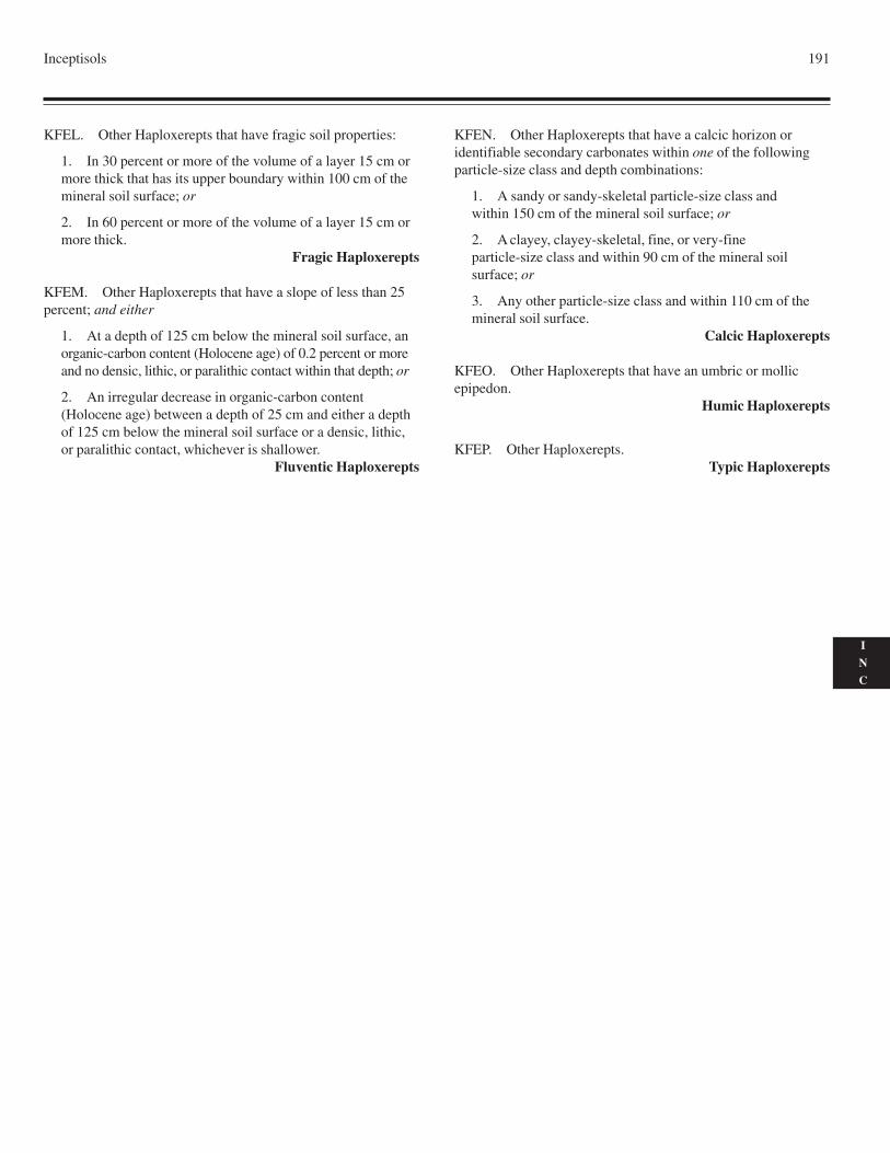
Inceptisols 191
I
N
C
KFEL. Other Haploxerepts that have fragic soil properties:
1. In 30 percent or more of the volume of a layer 15 cm ormore thick that has its upper boundary within 100 cm of themineral soil surface; or
2. In 60 percent or more of the volume of a layer 15 cm ormore thick.
Fragic Haploxerepts
KFEM. Other Haploxerepts that have a slope of less than 25percent; and either
1. At a depth of 125 cm below the mineral soil surface, anorganic-carbon content (Holocene age) of 0.2 percent or moreand no densic, lithic, or paralithic contact within that depth; or
2. An irregular decrease in organic-carbon content(Holocene age) between a depth of 25 cm and either a depthof 125 cm below the mineral soil surface or a densic, lithic,or paralithic contact, whichever is shallower.
Fluventic Haploxerepts
KFEN. Other Haploxerepts that have a calcic horizon oridentifiable secondary carbonates within one of the followingparticle-size class and depth combinations:
1. A sandy or sandy-skeletal particle-size class andwithin 150 cm of the mineral soil surface; or
2. A clayey, clayey-skeletal, fine, or very-fineparticle-size class and within 90 cm of the mineral soilsurface; or
3. Any other particle-size class and within 110 cm of themineral soil surface.
Calcic Haploxerepts
KFEO. Other Haploxerepts that have an umbric or mollicepipedon.
Humic Haploxerepts
KFEP. Other Haploxerepts.Typic Haploxerepts

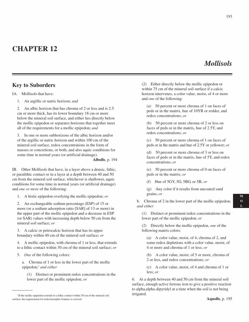
193
M
O
L
Key to SubordersIA. Mollisols that have:
1. An argillic or natric horizon; and
2. An albic horizon that has chroma of 2 or less and is 2.5cm or more thick, has its lower boundary 18 cm or morebelow the mineral soil surface, and either lies directly belowthe mollic epipedon or separates horizons that together meetall of the requirements for a mollic epipedon; and
3. In one or more subhorizons of the albic horizon and/orof the argillic or natric horizon and within 100 cm of themineral soil surface, redox concentrations in the form ofmasses or concretions, or both, and also aquic conditions forsome time in normal years (or artificial drainage).
Albolls, p. 194
IB. Other Mollisols that have, in a layer above a densic, lithic,or paralithic contact or in a layer at a depth between 40 and 50cm from the mineral soil surface, whichever is shallower, aquicconditions for some time in normal years (or artificial drainage)and one or more of the following:
1. A histic epipedon overlying the mollic epipedon; or
2. An exchangeable sodium percentage (ESP) of 15 ormore (or a sodium adsorption ratio [SAR] of 13 or more) inthe upper part of the mollic epipedon and a decrease in ESP(or SAR) values with increasing depth below 50 cm from themineral soil surface; or
3. A calcic or petrocalcic horizon that has its upperboundary within 40 cm of the mineral soil surface; or
4. A mollic epipedon, with chroma of 1 or less, that extendsto a lithic contact within 30 cm of the mineral soil surface; or
5. One of the following colors:
a. Chroma of 1 or less in the lower part of the mollicepipedon;1 and either
(1) Distinct or prominent redox concentrations in thelower part of the mollic epipedon; or
(2) Either directly below the mollic epipedon orwithin 75 cm of the mineral soil surface if a calcichorizon intervenes, a color value, moist, of 4 or moreand one of the following:
(a) 50 percent or more chroma of 1 on faces ofpeds or in the matrix, hue of 10YR or redder, andredox concentrations; or
(b) 50 percent or more chroma of 2 or less onfaces of peds or in the matrix, hue of 2.5Y, andredox concentrations; or
(c) 50 percent or more chroma of 1 on faces ofpeds or in the matrix and hue of 2.5Y or yellower; or
(d) 50 percent or more chroma of 3 or less onfaces of peds or in the matrix, hue of 5Y, and redoxconcentrations; or
(e) 50 percent or more chroma of 0 on faces ofpeds or in the matrix; or
(f) Hue of 5GY, 5G, 5BG, or 5B; or
(g) Any color if it results from uncoated sandgrains; or
b. Chroma of 2 in the lower part of the mollic epipedon;and either
(1) Distinct or prominent redox concentrations in thelower part of the mollic epipedon; or
(2) Directly below the mollic epipedon, one of thefollowing matrix colors:
(a) A color value, moist, of 4, chroma of 2, andsome redox depletions with a color value, moist, of4 or more and chroma of 1 or less; or
(b) A color value, moist, of 5 or more, chroma of2 or less, and redox concentrations; or
(c) A color value, moist, of 4 and chroma of 1 orless; or
6. At a depth between 40 and 50 cm from the mineral soilsurface, enough active ferrous iron to give a positive reactionto alpha,alpha-dipyridyl at a time when the soil is not beingirrigated.
Aquolls, p. 195
CHAPTER 12
Mollisols
1 If the mollic epipedon extends to a lithic contact within 30 cm of the mineral soilsurface, the requirement for redoximorphic features is waived.
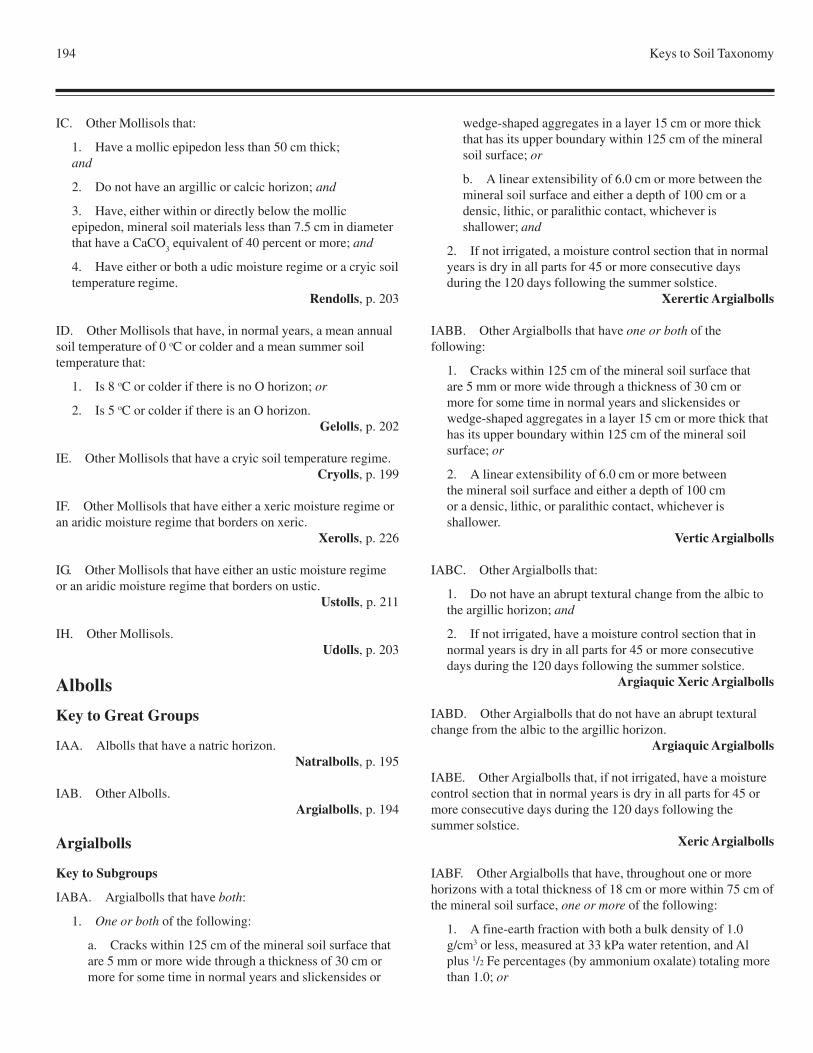
194 Keys to Soil Taxonomy
IC. Other Mollisols that:
1. Have a mollic epipedon less than 50 cm thick;and
2. Do not have an argillic or calcic horizon; and
3. Have, either within or directly below the mollicepipedon, mineral soil materials less than 7.5 cm in diameterthat have a CaCO
3 equivalent of 40 percent or more; and
4. Have either or both a udic moisture regime or a cryic soiltemperature regime.
Rendolls, p. 203
ID. Other Mollisols that have, in normal years, a mean annualsoil temperature of 0 oC or colder and a mean summer soiltemperature that:
1. Is 8 oC or colder if there is no O horizon; or
2. Is 5 oC or colder if there is an O horizon.Gelolls, p. 202
IE. Other Mollisols that have a cryic soil temperature regime.Cryolls, p. 199
IF. Other Mollisols that have either a xeric moisture regime oran aridic moisture regime that borders on xeric.
Xerolls, p. 226
IG. Other Mollisols that have either an ustic moisture regimeor an aridic moisture regime that borders on ustic.
Ustolls, p. 211
IH. Other Mollisols.Udolls, p. 203
Albolls
Key to Great Groups
IAA. Albolls that have a natric horizon.Natralbolls, p. 195
IAB. Other Albolls.Argialbolls, p. 194
Argialbolls
Key to Subgroups
IABA. Argialbolls that have both:
1. One or both of the following:
a. Cracks within 125 cm of the mineral soil surface thatare 5 mm or more wide through a thickness of 30 cm ormore for some time in normal years and slickensides or
wedge-shaped aggregates in a layer 15 cm or more thickthat has its upper boundary within 125 cm of the mineralsoil surface; or
b. A linear extensibility of 6.0 cm or more between themineral soil surface and either a depth of 100 cm or adensic, lithic, or paralithic contact, whichever isshallower; and
2. If not irrigated, a moisture control section that in normalyears is dry in all parts for 45 or more consecutive daysduring the 120 days following the summer solstice.
Xerertic Argialbolls
IABB. Other Argialbolls that have one or both of thefollowing:
1. Cracks within 125 cm of the mineral soil surface thatare 5 mm or more wide through a thickness of 30 cm ormore for some time in normal years and slickensides orwedge-shaped aggregates in a layer 15 cm or more thick thathas its upper boundary within 125 cm of the mineral soilsurface; or
2. A linear extensibility of 6.0 cm or more betweenthe mineral soil surface and either a depth of 100 cmor a densic, lithic, or paralithic contact, whichever isshallower.
Vertic Argialbolls
IABC. Other Argialbolls that:
1. Do not have an abrupt textural change from the albic tothe argillic horizon; and
2. If not irrigated, have a moisture control section that innormal years is dry in all parts for 45 or more consecutivedays during the 120 days following the summer solstice.
Argiaquic Xeric Argialbolls
IABD. Other Argialbolls that do not have an abrupt texturalchange from the albic to the argillic horizon.
Argiaquic Argialbolls
IABE. Other Argialbolls that, if not irrigated, have a moisturecontrol section that in normal years is dry in all parts for 45 ormore consecutive days during the 120 days following thesummer solstice.
Xeric Argialbolls
IABF. Other Argialbolls that have, throughout one or morehorizons with a total thickness of 18 cm or more within 75 cm ofthe mineral soil surface, one or more of the following:
1. A fine-earth fraction with both a bulk density of 1.0g/cm3 or less, measured at 33 kPa water retention, and Alplus 1/2 Fe percentages (by ammonium oxalate) totaling morethan 1.0; or
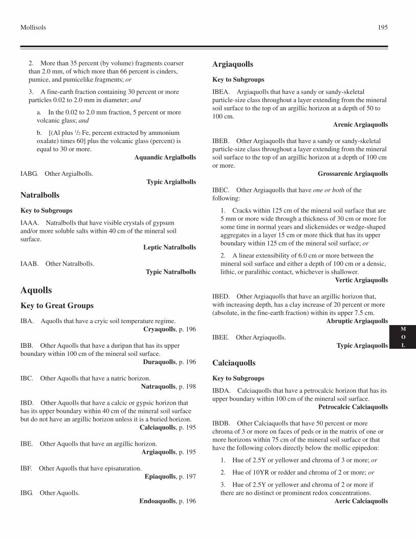
Mollisols 195
M
O
L
2. More than 35 percent (by volume) fragments coarserthan 2.0 mm, of which more than 66 percent is cinders,pumice, and pumicelike fragments; or
3. A fine-earth fraction containing 30 percent or moreparticles 0.02 to 2.0 mm in diameter; and
a. In the 0.02 to 2.0 mm fraction, 5 percent or morevolcanic glass; and
b. [(Al plus 1/2 Fe, percent extracted by ammoniumoxalate) times 60] plus the volcanic glass (percent) isequal to 30 or more.
Aquandic Argialbolls
IABG. Other Argialbolls.Typic Argialbolls
Natralbolls
Key to Subgroups
IAAA. Natralbolls that have visible crystals of gypsumand/or more soluble salts within 40 cm of the mineral soilsurface.
Leptic Natralbolls
IAAB. Other Natralbolls.Typic Natralbolls
Aquolls
Key to Great Groups
IBA. Aquolls that have a cryic soil temperature regime.Cryaquolls, p. 196
IBB. Other Aquolls that have a duripan that has its upperboundary within 100 cm of the mineral soil surface.
Duraquolls, p. 196
IBC. Other Aquolls that have a natric horizon.Natraquolls, p. 198
IBD. Other Aquolls that have a calcic or gypsic horizon thathas its upper boundary within 40 cm of the mineral soil surfacebut do not have an argillic horizon unless it is a buried horizon.
Calciaquolls, p. 195
IBE. Other Aquolls that have an argillic horizon.Argiaquolls, p. 195
IBF. Other Aquolls that have episaturation.Epiaquolls, p. 197
IBG. Other Aquolls.Endoaquolls, p. 196
Argiaquolls
Key to Subgroups
IBEA. Argiaquolls that have a sandy or sandy-skeletalparticle-size class throughout a layer extending from the mineralsoil surface to the top of an argillic horizon at a depth of 50 to100 cm.
Arenic Argiaquolls
IBEB. Other Argiaquolls that have a sandy or sandy-skeletalparticle-size class throughout a layer extending from the mineralsoil surface to the top of an argillic horizon at a depth of 100 cmor more.
Grossarenic Argiaquolls
IBEC. Other Argiaquolls that have one or both of thefollowing:
1. Cracks within 125 cm of the mineral soil surface that are5 mm or more wide through a thickness of 30 cm or more forsome time in normal years and slickensides or wedge-shapedaggregates in a layer 15 cm or more thick that has its upperboundary within 125 cm of the mineral soil surface; or
2. A linear extensibility of 6.0 cm or more between themineral soil surface and either a depth of 100 cm or a densic,lithic, or paralithic contact, whichever is shallower.
Vertic Argiaquolls
IBED. Other Argiaquolls that have an argillic horizon that,with increasing depth, has a clay increase of 20 percent or more(absolute, in the fine-earth fraction) within its upper 7.5 cm.
Abruptic Argiaquolls
IBEE. Other Argiaquolls.Typic Argiaquolls
Calciaquolls
Key to Subgroups
IBDA. Calciaquolls that have a petrocalcic horizon that has itsupper boundary within 100 cm of the mineral soil surface.
Petrocalcic Calciaquolls
IBDB. Other Calciaquolls that have 50 percent or morechroma of 3 or more on faces of peds or in the matrix of one ormore horizons within 75 cm of the mineral soil surface or thathave the following colors directly below the mollic epipedon:
1. Hue of 2.5Y or yellower and chroma of 3 or more; or
2. Hue of 10YR or redder and chroma of 2 or more; or
3. Hue of 2.5Y or yellower and chroma of 2 or more ifthere are no distinct or prominent redox concentrations.
Aeric Calciaquolls
196 Keys to Soil Taxonomy
IBDC. Other Calciaquolls.Typic Calciaquolls
Cryaquolls
Key to Subgroups
IBAA. Cryaquolls that have one or both of the following:
1. Cracks within 125 cm of the mineral soil surface thatare 5 mm or more wide through a thickness of 30 cm ormore for some time in normal years and slickensides orwedge-shaped aggregates in a layer 15 cm or more thick thathas its upper boundary within 125 cm of the mineral soilsurface; or
2. A linear extensibility of 6.0 cm or more betweenthe mineral soil surface and either a depth of 100 cmor a densic, lithic, or paralithic contact, whichever isshallower.
Vertic Cryaquolls
IBAB. Other Cryaquolls that have a histic epipedon.Histic Cryaquolls
IBAC. Other Cryaquolls that have a buried layer of organicsoil materials, 20 cm or more thick, that has its upper boundarywithin 100 cm of the mineral soil surface.
Thapto-Histic Cryaquolls
IBAD. Other Cryaquolls that have, throughout one or morehorizons with a total thickness of 18 cm or more within 75 cm ofthe mineral soil surface, one or more of the following:
1. A fine-earth fraction with both a bulk density of 1.0g/cm3 or less, measured at 33 kPa water retention, and Alplus 1/2 Fe percentages (by ammonium oxalate) totaling morethan 1.0; or
2. More than 35 percent (by volume) fragments coarserthan 2.0 mm, of which more than 66 percent is cinders,pumice, and pumicelike fragments; or
3. A fine-earth fraction containing 30 percent or moreparticles 0.02 to 2.0 mm in diameter; and
a. In the 0.02 to 2.0 mm fraction, 5 percent or morevolcanic glass; and
b. [(Al plus 1/2 Fe, percent extracted by ammoniumoxalate) times 60] plus the volcanic glass (percent) isequal to 30 or more.
Aquandic Cryaquolls
IBAE. Other Cryaquolls that have an argillic horizon.Argic Cryaquolls
IBAF. Other Cryaquolls that have a calcic horizon eitherwithin or directly below the mollic epipedon.
Calcic Cryaquolls
IBAG. Other Cryaquolls that have a mollic epipedon 50 cm ormore thick.
Cumulic Cryaquolls
IBAH. Other Cryaquolls.Typic Cryaquolls
Duraquolls
Key to Subgroups
IBBA. Duraquolls that have a natric horizon.Natric Duraquolls
IBBB. Other Duraquolls that have, above the duripan, one orboth of the following:
1. Cracks that are 5 mm or more wide through a thicknessof 30 cm or more for some time in normal years andslickensides or wedge-shaped aggregates in a layer 15 cm ormore thick; or
2. A linear extensibility of 6.0 cm or more.Vertic Duraquolls
IBBC. Other Duraquolls that have an argillic horizon.Argic Duraquolls
IBBD. Other Duraquolls.Typic Duraquolls
Endoaquolls
Key to Subgroups
IBGA. Endoaquolls that have a lithic contact within 50 cm ofthe mineral soil surface.
Lithic Endoaquolls
IBGB. Other Endoaquolls that have both:
1. One or both of the following:
a. Cracks within 125 cm of the mineral soil surface thatare 5 mm or more wide through a thickness of 30 cm ormore for some time in normal years and slickensides orwedge-shaped aggregates in a layer 15 cm or more thickthat has its upper boundary within 125 cm of the mineralsoil surface; or
b. A linear extensibility of 6.0 cm or more between the
Mollisols 197
M
O
L
mineral soil surface and either a depth of 100 cm or adensic, lithic, or paralithic contact, whichever isshallower; and
2. A mollic epipedon 60 cm or more thick.Cumulic Vertic Endoaquolls
IBGC. Other Endoaquolls that have both of the following:
1. One or both of the following:
a. Cracks within 125 cm of the mineral soil surface thatare 5 mm or more wide through a thickness of 30 cm ormore for some time in normal years and slickensides orwedge-shaped aggregates in a layer 15 cm or more thickthat has its upper boundary within 125 cm of the mineralsoil surface; or
b. A linear extensibility of 6.0 cm or more between themineral soil surface and either a depth of 100 cm or adensic, lithic, or paralithic contact, whichever isshallower; and
2. A slope of less than 25 percent; and either
a. An organic-carbon content of 0.3 percent or more inall horizons within 125 cm of the mineral soil surface; or
b. An irregular decrease in organic-carbon content froma depth of 25 cm to a depth of 125 cm or to a densic,lithic, or paralithic contact if shallower.
Fluvaquentic Vertic Endoaquolls
IBGD. Other Endoaquolls that have one or both of thefollowing:
1. Cracks within 125 cm of the mineral soil surface that are5 mm or more wide through a thickness of 30 cm or more forsome time in normal years and slickensides or wedge-shapedaggregates in a layer 15 cm or more thick that has its upperboundary within 125 cm of the mineral soil surface; or
2. A linear extensibility of 6.0 cm or more between themineral soil surface and either a depth of 100 cm or a densic,lithic, or paralithic contact, whichever is shallower.
Vertic Endoaquolls
IBGE. Other Endoaquolls that have a histic epipedon.Histic Endoaquolls
IBGF. Other Endoaquolls that have a buried layer of organicsoil materials, 20 cm or more thick, that has its upper boundarywithin 100 cm of the mineral soil surface.
Thapto-Histic Endoaquolls
IBGG. Other Endoaquolls that have, throughout one or morehorizons with a total thickness of 18 cm or more within 75 cm ofthe mineral soil surface, one or more of the following:
1. A fine-earth fraction with both a bulk density of 1.0g/cm3 or less, measured at 33 kPa water retention, and Alplus 1/2 Fe percentages (by ammonium oxalate) totaling morethan 1.0; or
2. More than 35 percent (by volume) fragments coarserthan 2.0 mm, of which more than 66 percent is cinders,pumice, and pumicelike fragments; or
3. A fine-earth fraction containing 30 percent or moreparticles 0.02 to 2.0 mm in diameter; and
a. In the 0.02 to 2.0 mm fraction, 5 percent or morevolcanic glass; and
b. [(Al plus 1/2 Fe, percent extracted by ammoniumoxalate) times 60] plus the volcanic glass (percent) isequal to 30 or more.
Aquandic Endoaquolls
IBGH. Other Endoaquolls that have a horizon, 15 cm or morethick within 100 cm of the mineral soil surface, that either has20 percent or more (by volume) durinodes or is brittle and has afirm rupture-resistance class when moist.
Duric Endoaquolls
IBGI. Other Endoaquolls that have a mollic epipedon 60 cmor more thick.
Cumulic Endoaquolls
IBGJ. Other Endoaquolls that have a slope of less than 25percent; and either
1. An organic-carbon content of 0.3 percent or more in allhorizons within 125 cm of the mineral soil surface; or
2. An irregular decrease in organic-carbon content from adepth of 25 cm to a depth of 125 cm or to a densic, lithic, orparalithic contact if shallower.
Fluvaquentic Endoaquolls
IBGK. Other Endoaquolls.Typic Endoaquolls
Epiaquolls
Key to Subgroups
IBFA. Epiaquolls that have both of the following:
1. One or both of the following:
a. Cracks within 125 cm of the mineral soil surface thatare 5 mm or more wide through a thickness of 30 cm ormore for some time in normal years and slickensides orwedge-shaped aggregates in a layer 15 cm or more thickthat has its upper boundary within 125 cm of the mineralsoil surface; or
198 Keys to Soil Taxonomy
b. A linear extensibility of 6.0 cm or more between themineral soil surface and either a depth of 100 cm or adensic, lithic, or paralithic contact, whichever isshallower; and
2. A mollic epipedon 60 cm or more thick.Cumulic Vertic Epiaquolls
IBFB. Other Epiaquolls that have both:
1. One or both of the following:
a. Cracks within 125 cm of the mineral soil surface thatare 5 mm or more wide through a thickness of 30 cm ormore for some time in normal years and slickensides orwedge-shaped aggregates in a layer 15 cm or more thickthat has its upper boundary within 125 cm of the mineralsoil surface; or
b. A linear extensibility of 6.0 cm or more between themineral soil surface and either a depth of 100 cm or adensic, lithic, or paralithic contact, whichever isshallower; and
2. A slope of less than 25 percent; and either
a. An organic-carbon content of 0.3 percent or more inall horizons within 125 cm of the mineral soil surface; or
b. An irregular decrease in organic-carbon content froma depth of 25 cm to a depth of 125 cm or to a densic,lithic, or paralithic contact if shallower.
Fluvaquentic Vertic Epiaquolls
IBFC. Other Epiaquolls that have one or both of thefollowing:
1. Cracks within 125 cm of the mineral soil surface that are5 mm or more wide through a thickness of 30 cm or more forsome time in normal years and slickensides or wedge-shapedaggregates in a layer 15 cm or more thick that has its upperboundary within 125 cm of the mineral soil surface; or
2. A linear extensibility of 6.0 cm or more between themineral soil surface and either a depth of 100 cm or a densic,lithic, or paralithic contact, whichever is shallower.
Vertic Epiaquolls
IBFD. Other Epiaquolls that have a histic epipedon.Histic Epiaquolls
IBFE. Other Epiaquolls that have a buried layer of organic soilmaterials, 20 cm or more thick, that has its upper boundarywithin 100 cm of the mineral soil surface.
Thapto-Histic Epiaquolls
IBFF. Other Epiaquolls that have, throughout one or more
horizons with a total thickness of 18 cm or more within 75 cm ofthe mineral soil surface, one or more of the following:
1. A fine-earth fraction with both a bulk density of 1.0g/cm3 or less, measured at 33 kPa water retention, and Alplus 1/2 Fe percentages (by ammonium oxalate) totaling morethan 1.0; or
2. More than 35 percent (by volume) fragments coarserthan 2.0 mm, of which more than 66 percent is cinders,pumice, and pumicelike fragments; or
3. A fine-earth fraction containing 30 percent or moreparticles 0.02 to 2.0 mm in diameter; and
a. In the 0.02 to 2.0 mm fraction, 5 percent or morevolcanic glass; and
b. [(Al plus 1/2 Fe, percent extracted by ammoniumoxalate) times 60] plus the volcanic glass (percent) isequal to 30 or more.
Aquandic Epiaquolls
IBFG. Other Epiaquolls that have a horizon, 15 cm or morethick within 100 cm of the mineral soil surface, that either has20 percent or more (by volume) durinodes or is brittle and has afirm rupture-resistance class when moist.
Duric Epiaquolls
IBFH. Other Epiaquolls that have a mollic epipedon 60 cm ormore thick.
Cumulic Epiaquolls
IBFI. Other Epiaquolls that have a slope of less than 25percent; and either
1. An organic-carbon content of 0.3 percent or more in allhorizons within 125 cm of the mineral soil surface; or
2. An irregular decrease in organic-carbon content from adepth of 25 cm to a depth of 125 cm or to a densic, lithic, orparalithic contact if shallower.
Fluvaquentic Epiaquolls
IBFJ. Other Epiaquolls.Typic Epiaquolls
Natraquolls
Key to Subgroups
IBCA. Natraquolls that have one or both of the following:
1. Cracks within 125 cm of the mineral soil surface thatare 5 mm or more wide through a thickness of 30 cm ormore for some time in normal years and slickensides orwedge-shaped aggregates in a layer 15 cm or more thick that
Mollisols 199
M
O
L
has its upper boundary within 125 cm of the mineral soilsurface; or
2. A linear extensibility of 6.0 cm or more between themineral soil surface and either a depth of 100 cm or a densic,lithic, or paralithic contact, whichever is shallower.
Vertic Natraquolls
IBCB. Other Natraqolls that have a glossic horizon orinterfingering of albic materials into the natric horizon.
Glossic Natraquolls
IBCC. Other Natraquolls.Typic Natraquolls
Cryolls
Key to Great Groups
IEA. Cryolls that have a duripan that has its upper boundarywithin 100 cm of the mineral soil surface.
Duricryolls, p. 200
IEB. Other Cryolls that have a natric horizon.Natricryolls, p. 202
IEC. Other Cryolls that have both:
1. An argillic horizon that has its upper boundary 60 cm ormore below the mineral soil surface; and
2. A texture finer than loamy fine sand in all horizonsabove the argillic horizon.
Palecryolls, p. 202
IED. Other Cryolls that have an argillic horizon.Argicryolls, p. 199
IEE. Other Cryolls that:
1. Have a calcic or petrocalcic horizon that has itsupper boundary within 100 cm of the mineral soil surface;and
2. In all parts above the calcic or petrocalcic horizon, afterthe materials between the soil surface and a depth of 18 cmhave been mixed, either are calcareous or have a texture ofloamy fine sand or coarser.
Calcicryolls, p. 200
IEF. Other Cryolls.Haplocryolls, p. 201
Argicryolls
Key to Subgroups
IEDA. Argicryolls that have a lithic contact within 50 cm ofthe mineral soil surface.
Lithic Argicryolls
IEDB. Other Argicryolls that have one or both of the following:
1. Cracks within 125 cm of the mineral soil surface that are5 mm or more wide through a thickness of 30 cm or more forsome time in normal years and slickensides or wedge-shapedaggregates in a layer 15 cm or more thick that has its upperboundary within 125 cm of the mineral soil surface; or
2. A linear extensibility of 6.0 cm or more between themineral soil surface and either a depth of 100 cm or a densic,lithic, or paralithic contact, whichever is shallower.
Vertic Argicryolls
IEDC. Other Argicryolls that have, throughout one or morehorizons with a total thickness of 18 cm or more within 75 cm ofthe mineral soil surface, a fine-earth fraction with both a bulkdensity of 1.0 g/cm3 or less, measured at 33 kPa water retention,and Al plus 1/2 Fe percentages (by ammonium oxalate) totalingmore than 1.0.
Andic Argicryolls
IEDD. Other Argicryolls that have, throughout one or morehorizons with a total thickness of 18 cm or more within 75 cm ofthe soil surface, one or both of the following:
1. More than 35 percent (by volume) fragments coarserthan 2.0 mm, of which more than 66 percent is cinders,pumice, and pumicelike fragments; or
2. A fine-earth fraction containing 30 percent or moreparticles 0.02 to 2.0 mm in diameter; and
a. In the 0.02 to 2.0 mm fraction, 5 percent or morevolcanic glass; and
b. [(Al plus 1/2 Fe, percent extracted by ammoniumoxalate) times 60] plus the volcanic glass (percent) isequal to 30 or more.
Vitrandic Argicryolls
IEDE. Other Argicryolls that have an argillic horizon that,with increasing depth, has a clay increase of 20 percent or more(absolute, in the fine-earth fraction) within its upper 7.5 cm.
Abruptic Argicryolls
IEDF. Other Argicryolls that have, in one or more horizons
200 Keys to Soil Taxonomy
within 100 cm of the mineral soil surface, redox depletions withchroma of 2 or less and also aquic conditions for some time innormal years (or artificial drainage).
Aquic Argicryolls
IEDG. Other Argicryolls that in normal years are saturatedwith water in one or more layers within 100 cm of the mineralsoil surface for either or both:
1. 20 or more consecutive days; or
2. 30 or more cumulative days.Oxyaquic Argicryolls
IEDH. Other Argicryolls that have both:
1. A mollic epipedon that is 40 cm or more thick and has atexture finer than loamy fine sand; and
2. A calcic horizon within 100 cm of the mineral soilsurface.
Calcic Pachic Argicryolls
IEDI. Other Argicryolls that have a mollic epipedon that is40 cm or more thick and has a texture finer than loamy finesand.
Pachic Argicryolls
IEDJ. Other Argicryolls that have a calcic horizon within 100cm of the mineral soil surface.
Calcic Argicryolls
IEDK. Other Argicryolls that have either:
1. Above the argillic horizon, an albic horizon or a horizonthat has color values too high for a mollic epipedon andchroma too high for an albic horizon; or
2. A glossic horizon, or interfingering of albic materialsinto the upper part of the argillic horizon, or skeletans ofclean silt and sand covering 50 percent or more of the facesof peds in the upper 5 cm of the argillic horizon.
Alfic Argicryolls
IEDL. Other Argicryolls that have an ustic moistureregime.
Ustic Argicryolls
IEDM. Other Argicryolls that have a xeric moistureregime.
Xeric Argicryolls
IEDN. Other Argicryolls.Typic Argicryolls
Calcicryolls
Key to Subgroups
IEEA. Calcicryolls that have a lithic contact within 50 cm ofthe mineral soil surface.
Lithic Calcicryolls
IEEB. Other Calcicryolls that have, throughout one or morehorizons with a total thickness of 18 cm or more within 75 cm ofthe mineral soil surface, one or both of the following:
1. More than 35 percent (by volume) fragments coarserthan 2.0 mm, of which more than 66 percent is cinders,pumiceous, and pumicelike fragments; or
2. A fine-earth fraction containing 30 percent or moreparticles 0.02 to 2.0 mm in diameter; and
a. In the 0.02 to 2.0 mm fraction, 5 percent or morevolcanic glass; and
b. [(Al plus 1/2 Fe, percent extracted by ammoniumoxalate) times 60] plus the volcanic glass (percent) isequal to 30 or more.
Vitrandic Calcicryolls
IEEC. Other Calcicryolls that have a petrocalcic horizon thathas its upper boundary within 100 cm of the mineral soil surface.
Petrocalcic Calcicryolls
IEED. Other Calcicryolls that have a mollic epipedon that is 40cm or more thick and has a texture finer than loamy fine sand.
Pachic Calcicryolls
IEEE. Other Calcicryolls that have an ustic moisture regime.Ustic Calcicryolls
IEEF. Other Calcicryolls that have a xeric moisture regime.Xeric Calcicryolls
IEEG. Other Calcicryolls.Typic Calcicryolls
Duricryolls
Key to Subgroups
IEAA. Duricryolls that have an argillic horizon.Argic Duricryolls
IEAB. Other Duricryolls that have a calcic horizon above theduripan.
Calcic Duricryolls
Mollisols 201
M
O
L
IEAC. Other Duricryolls.Typic Duricryolls
Haplocryolls
Key to Subgroups
IEFA. Haplocryolls that have a lithic contact within 50 cm ofthe mineral soil surface.
Lithic Haplocryolls
IEFB. Other Haplocryolls that have one or both of thefollowing:
1. Cracks within 125 cm of the mineral soil surface that are5 mm or more wide through a thickness of 30 cm or more forsome time in normal years and slickensides or wedge-shapedaggregates in a layer 15 cm or more thick that has its upperboundary within 125 cm of the mineral soil surface; or
2. A linear extensibility of 6.0 cm or more between themineral soil surface and either a depth of 100 cm or a densic,lithic, or paralithic contact, whichever is shallower.
Vertic Haplocryolls
IEFC. Other Haplocryolls that have, throughout one or morehorizons with a total thickness of 18 cm or more within 75 cm ofthe mineral soil surface, a fine-earth fraction with both a bulkdensity of 1.0 g/cm3 or less, measured at 33 kPa water retention,and Al plus 1/2 Fe percentages (by ammonium oxalate) totalingmore than 1.0.
Andic Haplocryolls
IEFD. Other Haplocryolls that have, throughout one or morehorizons with a total thickness of 18 cm or more within 75 cm ofthe mineral soil surface, one or both of the following:
1. More than 35 percent (by volume) fragments coarserthan 2.0 mm, of which more than 66 percent is cinders,pumice, and pumicelike fragments; or
2. A fine-earth fraction containing 30 percent or moreparticles 0.02 to 2.0 mm in diameter; and
a. In the 0.02 to 2.0 mm fraction, 5 percent or morevolcanic glass; and
b. [(Al plus 1/2 Fe, percent extracted by ammoniumoxalate) times 60] plus the volcanic glass (percent) isequal to 30 or more.
Vitrandic Haplocryolls
IEFE. Other Haplocryolls that have:
1. A mollic epipedon that is 40 cm or more thick and has atexture finer than loamy fine sand; and
2. An irregular decrease in organic-carbon content from adepth of 25 cm below the mineral soil surface to a depth of
125 cm or to a densic, lithic, or paralithic contact ifshallower; and
3. A slope of less than 25 percent; and
4. In one or more horizons within 100 cm of the mineralsoil surface, distinct or prominent redox concentrations andalso aquic conditions for some time in normal years (orartificial drainage).
Aquic Cumulic Haplocryolls
IEFF. Other Haplocryolls that have:
1. A mollic epipedon that is 40 cm or more thick and has atexture finer than loamy fine sand; and
2. An irregular decrease in organic-carbon content from adepth of 25 cm below the mineral soil surface to a depth of125 cm or to a densic, lithic, or paralithic contact ifshallower; and
3. A slope of less than 25 percent.Cumulic Haplocryolls
IEFG. Other Haplocryolls that have both:
1. A slope of less than 25 percent; and either
a. An organic-carbon content of 0.3 percent or more at adepth of 125 cm below the mineral soil surface; or
b. An irregular decrease in organic-carbon content froma depth of 25 cm to a depth of 125 cm or to a densic,lithic, or paralithic contact if shallower; and
2. In one or more horizons within 100 cm of the mineralsoil surface, distinct or prominent redox concentrations andalso aquic conditions for some time in normal years (orartificial drainage).
Fluvaquentic Haplocryolls
IEFH. Other Haplocryolls that have, in one or more horizonswithin 100 cm of the mineral soil surface, distinct or prominentredox concentrations and also aquic conditions for some time innormal years (or artificial drainage).
Aquic Haplocryolls
IEFI. Other Haplocryolls that in normal years are saturatedwith water in one or more layers within 100 cm of the mineralsoil surface for either or both:
1. 20 or more consecutive days; or
2. 30 or more cumulative days.Oxyaquic Haplocryolls
IEFJ. Other Haplocryolls that have both:
1. A mollic epipedon that is 40 cm or more thick and has atexture finer than loamy fine sand; and
202 Keys to Soil Taxonomy
2. A calcic horizon within 100 cm of the mineral soilsurface.
Calcic Pachic Haplocryolls
IEFK. Other Haplocryolls that have a mollic epipedon that is40 cm or more thick and has a texture finer than loamy fine sand.
Pachic Haplocryolls
IEFL. Other Haplocryolls that have a slope of less than 25percent; and either
1. An organic-carbon content of 0.3 percent or more at adepth of 125 cm below the mineral soil surface; or
2. An irregular decrease in organic-carbon content from adepth of 25 cm to a depth of 125 cm or to a densic, lithic, orparalithic contact if shallower.
Fluventic Haplocryolls
IEFM. Other Haplocryolls that have a calcic horizon within100 cm of the mineral soil surface.
Calcic Haplocryolls
IEFN. Other Haplocryolls that have an ustic moisture regime.Ustic Haplocryolls
IEFO. Other Haplocryolls that have a xeric moisture regime.Xeric Haplocryolls
IEFP. Other Haplocryolls.Typic Haplocryolls
Natricryolls
Key to Subgroups
IEBA. All Natricryolls.Typic Natricryolls
Palecryolls
Key to Subgroups
IECA. Palecryolls that have, in one or more horizons within100 cm of the mineral soil surface, redox depletions withchroma of 2 or less and also aquic conditions for some time innormal years (or artificial drainage).
Aquic Palecryolls
IECB. Other Palecryolls that in normal years are saturatedwith water in one or more layers within 100 cm of the mineralsoil surface for either or both:
1. 20 or more consecutive days; or
2. 30 or more cumulative days.Oxyaquic Palecryolls
IECC. Other Palecryolls that have an argillic horizon that,with increasing depth, has a clay increase of 20 percent or more(absolute, in the fine-earth fraction) within its upper 7.5 cm.
Abruptic Palecryolls
IECD. Other Palecryolls that have a mollic epipedon that is40 cm or more thick and has a texture finer than loamy finesand.
Pachic Palecryolls
IECE. Other Palecryolls that have an ustic moisture regime.Ustic Palecryolls
IECF. Other Palecryolls that have a xeric moisture regime.Xeric Palecryolls
IECG. Other Palecryolls.Typic Palecryolls
Gelolls
Key to Great Groups
IDA. All Gelolls.Haplogelolls, p. 202
Haplogelolls
Key to Subgroups
IDAA. Haplogelolls that have a lithic contact within 50 cm ofthe mineral soil surface.
Lithic Haplogelolls
IDAB. Other Haplogelolls that have, throughout one or morehorizons with a total thickness of 18 cm or more within 75 cm ofthe mineral soil surface, a fine-earth fraction with both a bulkdensity of 1.0 g/cm3 or less, measured at 33 kPa water retention,and Al plus 1/2 Fe percentages (by ammonium oxalate) totalingmore than 1.0.
Andic Haplogelolls
IDAC. Other Haplogelolls that have, in one or more horizonswithin 100 cm of the mineral soil surface, distinct or prominentredox concentrations and also aquic conditions for some time innormal years (or artificial drainage).
Aquic HaplogelollsIDAD. Other Haplogelolls that have:
1. A mollic epipedon that is 40 cm or more thick and has atexture finer than loamy fine sand; and
2. An irregular decrease in organic-carbon content from a
Mollisols 203
M
O
L
depth of 25 cm below the mineral soil surface to a depth of 125cm or a densic, lithic, or paralithic contact if shallower.
Cumulic Haplogelolls
IDAE. Other Haplogelolls.Typic Haplogelolls
Rendolls
Key to Great Groups
ICA. Rendolls that have a cryic soil temperature regime.Cryrendolls, p. 203
ICB. Other Rendolls.Haprendolls, p. 203
Cryrendolls
Key to Subgroups
ICAA. Cryrendolls that have a lithic contact within 50 cm ofthe mineral soil surface.
Lithic Cryrendolls
ICAB. Other Cryrendolls.Typic Cryrendolls
Haprendolls
Key to Subgroups
ICBA. Haprendolls that have a lithic contact within 50 cm ofthe mineral soil surface.
Lithic Haprendolls
ICBB. Other Haprendolls that have one or both of thefollowing:
1. Cracks within 125 cm of the mineral soil surface that are5 mm or more wide through a thickness of 30 cm or more forsome time in normal years and slickensides or wedge-shapedaggregates in a layer 15 cm or more thick that has its upperboundary within 125 cm of the mineral soil surface; or
2. A linear extensibility of 6.0 cm or more between themineral soil surface and either a depth of 100 cm or a densic,lithic, or paralithic contact, whichever is shallower.
Vertic Haprendolls
ICBC. Other Haprendolls that have a cambic horizon.Inceptic Haprendolls
ICBD. Other Haprendolls that have a color value, dry, of 6 or
more either in the upper 18 cm of the mollic epipedon, aftermixing, or in an Ap horizon 18 cm or more thick.
Entic Haprendolls
ICBE. Other Haprendolls.Typic Haprendolls
Udolls
Key to Great Groups
IHA. Udolls that have a natric horizon.Natrudolls, p. 209
IHB. Other Udolls that:
1. Have a calcic or petrocalcic horizon that has its upperboundary within 100 cm of the mineral soil surface; and
2. Do not have an argillic horizon above the calcic orpetrocalcic horizon; and
3. In all parts above the calcic or petrocalcic horizon, afterthe materials between the soil surface and a depth of 18 cmhave been mixed, either are calcareous or have a texture ofloamy fine sand or coarser.
Calciudolls, p. 206
IHC. Other Udolls that have one or more of the following:
1. A petrocalcic horizon that has its upper boundary within150 cm of the mineral soil surface; or
2. All of the following:
a. No densic, lithic, or paralithic contact within 150 cmof the mineral soil surface; and
b. Within 150 cm of the mineral soil surface, a claydecrease, with increasing depth, of less than 20 percent(relative) from the maximum clay content (noncarbonateclay); and
c. An argillic horizon with one or more of the following:
(1) In 50 percent or more of the matrix of one ormore subhorizons in its lower half, hue of 7.5YR orredder and chroma of 5 or more; or
(2) In 50 percent or more of the matrix of horizonsthat total more than one-half the total thickness, hue of2.5YR or redder, a value, moist, of 3 or less, and avalue, dry, of 4 or less; or
(3) Many redox concentrations with hue of 5YR orredder or chroma of 6 or more, or both, in one or moresubhorizons; or
3. A frigid temperature regime; and both
204 Keys to Soil Taxonomy
a. An argillic horizon that has its upper boundary 60 cmor more below the mineral soil surface; and
b. A texture finer than loamy fine sand in all horizonsabove the argillic horizon.
Paleudolls, p. 210
IHD. Other Udolls that have an argillic horizon.Argiudolls, p. 204
IHE. Other Udolls that have a mollic epipedon that:
1. Either below an Ap horizon or below a depth of 18 cmfrom the mineral soil surface, contains 50 percent or more(by volume) wormholes, wormcasts, or filled animalburrows; and
2. Either rests on a lithic contact or has a transition zone tothe underlying horizon in which 25 percent or more of thesoil volume consists of discrete wormholes, wormcasts, oranimal burrows filled with material from the mollic epipedonand from the underlying horizon.
Vermudolls, p. 210
IHF. Other Udolls.Hapludolls, p. 207
Argiudolls
Key to Subgroups
IHDA. Argiudolls that have a lithic contact within 50 cm ofthe mineral soil surface.
Lithic Argiudolls
IHDB. Other Argiudolls that have both:
1. Aquic conditions for some time in normal years (orartificial drainage) either:
a. Within 40 cm of the mineral soil surface, in horizonsthat also have redoximorphic features; or
b. Within 75 cm of the mineral soil surface, in one ormore horizons with a total thickness of 15 cm or more thathave one or more of the following:
(1) A color value, moist, of 4 or more and redoxdepletions with chroma of 2 or less; or
(2) Hue of 10YR or redder and chroma of 2 or less;or
(3) Hue of 2.5Y or yellower and chroma of 3 or less;and
2. One or both of the following:
a. Cracks within 125 cm of the mineral soil surface thatare 5 mm or more wide through a thickness of 30 cm or
more for some time in normal years and slickensides orwedge-shaped aggregates in a layer 15 cm or more thickthat has its upper boundary within 125 cm of the mineralsoil surface; or
b. A linear extensibility of 6.0 cm or more between themineral soil surface and either a depth of 100 cm or adensic, lithic, or paralithic contact, whichever is shallower.
Aquertic Argiudolls
IHDC. Other Argiudolls that have both:
1. One or both of the following:
a. Cracks within 125 cm of the mineral soil surface thatare 5 mm or more wide through a thickness of 30 cm ormore for some time in normal years and slickensides orwedge-shaped aggregates in a layer 15 cm or more thickthat has its upper boundary within 125 cm of the mineralsoil surface; or
b. A linear extensibility of 6.0 cm or more between themineral soil surface and either a depth of 100 cm or adensic, lithic, or paralithic contact, whichever isshallower; and
2. In normal years saturation with water in one or morelayers within 100 cm of the mineral soil surface for either orboth:
a. 20 or more consecutive days; or
b. 30 or more cumulative days.Oxyaquic Vertic Argiudolls
IHDD. Other Argiudolls that have:
1. A mollic epipedon that has a texture finer than loamyfine sand and that is either:
a. 40 cm or more thick in a frigid temperature regime; or
b. 50 cm or more thick; and
2. One or both of the following:
a. Cracks within 125 cm of the mineral soil surface thatare 5 mm or more wide through a thickness of 30 cm ormore for some time in normal years and slickensides orwedge-shaped aggregates in a layer 15 cm or more thickthat has its upper boundary within 125 cm of the mineralsoil surface; or
b. A linear extensibility of 6.0 cm or more between themineral soil surface and either a depth of 100 cm or adensic, lithic, or paralithic contact, whichever is shallower.
Pachic Vertic Argiudolls
IHDE. Other Argiudolls that have:
1. Above the argillic horizon, an albic horizon or a horizon
Mollisols 205
M
O
L
that has color values too high for a mollic epipedon andchroma too high for an albic horizon; or
2. A glossic horizon, or interfingering of albic materialsinto the upper part of the argillic horizon, or skeletans ofclean silt and sand covering 50 percent or more of the facesof peds in the upper 5 cm of the argillic horizon; and
3. Either:
a. Cracks within 125 cm of the mineral soil surface thatare 5 mm or more wide through a thickness of 30 cm ormore for some time in normal years and slickensides orwedge-shaped aggregates in a layer 15 cm or more thickthat has its upper boundary within 125 cm of the mineralsoil surface; or
b. A linear extensibility of 6.0 cm or more between themineral soil surface and either a depth of 100 cm or adensic, lithic, or paralithic contact, whichever is shallower.
Alfic Vertic Argiudolls
IHDF. Other Argiudolls that have one or both of thefollowing:
1. Cracks within 125 cm of the mineral soil surface that are5 mm or more wide through a thickness of 30 cm or more forsome time in normal years and slickensides or wedge-shapedaggregates in a layer 15 cm or more thick that has its upperboundary within 125 cm of the mineral soil surface; or
2. A linear extensibility of 6.0 cm or more between themineral soil surface and either a depth of 100 cm or a densic,lithic, or paralithic contact, whichever is shallower.
Vertic Argiudolls
IHDG. Other Argiudolls that have, throughout one or morehorizons with a total thickness of 18 cm or more within 75 cm ofthe mineral soil surface, a fine-earth fraction with both a bulkdensity of 1.0 g/cm3 or less, measured at 33 kPa water retention,and Al plus 1/2 Fe percentages (by ammonium oxalate) totalingmore than 1.0.
Andic Argiudolls
IHDH. Other Argiudolls that have, throughout one or morehorizons with a total thickness of 18 cm or more within 75 cm ofthe mineral soil surface, one or both of the following:
1. More than 35 percent (by volume) fragments coarserthan 2.0 mm, of which more than 66 percent is cinders,pumice, and pumicelike fragments; or
2. A fine-earth fraction containing 30 percent or moreparticles 0.02 to 2.0 mm in diameter; and
a. In the 0.02 to 2.0 mm fraction, 5 percent or morevolcanic glass; and
b. [(Al plus 1/2 Fe, percent extracted by ammonium
oxalate) times 60] plus the volcanic glass (percent) isequal to 30 or more.
Vitrandic Argiudolls
IHDI. Other Agriudolls that have both:
1. Aquic conditions for some time normal years (orartificial drainage) either:
a. Within 40 cm of the mineral soil surface, in horizonsthat also have redoximorphic features; or
b. Within 75 cm of the mineral soil surface, in one ormore horizons with a total thickness of 15 cm or more thathave one or more of the following:
(1) A color value, moist, of 4 or more and redoxdepletions with chroma of 2 or less; or
(2) Hue of 10YR or redder and chroma of 2 or less;or
(3) Hue of 2.5Y or yellower and chroma of 3 or less;and
2. A mollic epipedon that has a texture finer than loamyfine sand and that is either:
a. 40 cm or more thick in a frigid temperature regime; or
b. 50 cm or more thick.Aquic Pachic Agriudolls
IHDJ. Other Argiudolls that have a mollic epipedon that has atexture finer than loamy fine sand and that is either:
1. 40 cm or more thick in a frigid temperature regime; or2. 50 cm or more thick.
Pachic Argiudolls
IHDK. Other Argiudolls that have aquic conditions for sometime in normal years (or artificial drainage) either:
1. Within 40 cm of the mineral soil surface, in horizons thatalso have redoximorphic features; or
2. Within 75 cm of the mineral soil surface, in one or morehorizons with a total thickness of 15 cm or more that haveone or more of the following:
a. A color value, moist, of 4 or more and redoxdepletions with chroma of 2 or less; or
b. Hue of 10YR or redder and chroma of 2 or less; or
c. Hue of 2.5Y or yellower and chroma of 3 or less.Aquic Argiudolls
IHDL. Other Argiudolls that in normal years are saturated withwater in one or more layers within 100 cm of the mineral soilsurface for either or both:
206 Keys to Soil Taxonomy
1. 20 or more consecutive days; or
2. 30 or more cumulative days.Oxyaquic Argiudolls
IHDM. Other Argiudolls that have an argillic horizon that:
1. Consists entirely of lamellae; or
2. Is a combination of two or more lamellae and one ormore subhorizons with a thickness of 7.5 to 20 cm, each layerwith an overlying eluvial horizon; or
3. Consists of one or more subhorizons that are morethan 20 cm thick, each with an overlying eluvial horizon, andabove these horizons there are either:
a. Two or more lamellae with a combined thickness of 5cm or more (that may or may not be part of the argillichorizon); or
b. A combination of lamellae (that may or may not bepart of the argillic horizon) and one or more parts of theargillic horizon 7.5 to 20 cm thick, each with an overlyingeluvial horizon.
Lamellic Argiudolls
IHDN. Other Argiudolls that have a sandy particle-size classthroughout the upper 75 cm of the argillic horizon or throughoutthe entire argillic horizon if it is less than 75 cm thick.
Psammentic Argiudolls
IHDO. Other Argiudolls that have a sandy or sandy-skeletalparticle-size class throughout a layer extending from the mineralsoil surface to the top of an argillic horizon at a depth of 50 cmor more.
Arenic Argiudolls
IHDP. Other Argiudolls that have an argillic horizon that, withincreasing depth, has a clay increase of 20 percent or more(absolute, in the fine-earth fraction) within its upper 7.5 cm.
Abruptic Argiudolls
IHDQ. Other Argiudolls that have:
1. Above the argillic horizon, an albic horizon or a horizonthat has color values too high for a mollic epipedon andchroma too high for an albic horizon; or
2. A glossic horizon, or interfingering of albic materialsinto the upper part of the argillic horizon, or skeletans ofclean silt and sand covering 50 percent or more of the facesof peds in the upper 5 cm of the argillic horizon.
Alfic Argiudolls
IHDR. Other Argiudolls that have an apparent CEC of less
than 24 cmol(+)/kg clay (by 1N NH4OAc pH 7) in 50 percent or
more either of the argillic horizon if less than 100 cm thick or ofits upper 100 cm.
Oxic Argiudolls
IHDS. Other Argiudolls that have a calcic horizon within 100cm of the mineral soil surface.
Calcic Argiudolls
IHDT. Other Argiudolls.Typic Argiudolls
Calciudolls
Key to Subgroups
IHBA. Calciudolls that have a lithic contact within 50 cm ofthe mineral soil surface.
Lithic Calciudolls
IHBB. Other Calciudolls that have one or both of thefollowing:
1. Cracks within 125 cm of the mineral soil surface thatare 5 mm or more wide through a thickness of 30 cm ormore for some time in normal years and slickensides orwedge-shaped aggregates in a layer 15 cm or more thick thathas its upper boundary within 125 cm of the mineral soilsurface; or
2. A linear extensibility of 6.0 cm or more between themineral soil surface and either a depth of 100 cm or a densic,lithic, or paralithic contact, whichever is shallower.
Vertic Calciudolls
IHBC. Other Calciudolls that have, in one or more horizonswithin 75 cm of the mineral soil surface, redox depletions withchroma of 2 or less and also aquic conditions for some time innormal years (or artificial drainage).
Aquic Calciudolls
IHBD. Other Calciudolls that have a slope of less than 25percent; and either:
1. An organic-carbon content of 0.3 percent or more at a depthof 125 cm below the mineral soil surface; or
2. An irregular decrease in organic-carbon content from adepth of 25 cm to a depth of 125 cm or to a lithic or paralithiccontact if shallower.
Fluventic Calciudolls
IHBE. Other Calciudolls.Typic Calciudolls
Mollisols 207
M
O
L
Hapludolls
Key to Subgroups
IHFA. Hapludolls that have a lithic contact within 50 cm ofthe mineral soil surface.
Lithic Hapludolls
IHFB. Other Hapludolls that have both:
1. Aquic conditions for some time in normal years (orartificial drainage) either:
a. Within 40 cm of the mineral soil surface, in horizonsthat also have redoximorphic features; or
b. Within 75 cm of the mineral soil surface, in one ormore horizons with a total thickness of 15 cm or more thathave one or more of the following:
(1) A color value, moist, of 4 or more and redoxdepletions with chroma of 2 or less; or
(2) Hue of 10YR or redder and chroma of 2 or less;or
(3) Hue of 2.5Y or yellower and chroma of 3 or less;and
2. One or both of the following:
a. Cracks within 125 cm of the mineral soil surface thatare 5 mm or more wide through a thickness of 30 cm ormore for some time in normal years and slickensides orwedge-shaped aggregates in a layer 15 cm or more thickthat has its upper boundary within 125 cm of the mineralsoil surface; or
b. A linear extensibility of 6.0 cm or more between themineral soil surface and either a depth of 100 cm or adensic, lithic, or paralithic contact, whichever is shallower.
Aquertic Hapludolls
IHFC. Other Hapludolls that have both:
1. One or both of the following:
a. Cracks within 125 cm of the mineral soil surface thatare 5 mm or more wide through a thickness of 30 cm ormore for some time in normal years and slickensides orwedge-shaped aggregates in a layer 15 cm or more thickthat has its upper boundary within 125 cm of the mineralsoil surface; or
b. A linear extensibility of 6.0 cm or more between themineral soil surface and either a depth of 100 cm or adensic, lithic, or paralithic contact, whichever isshallower; and
2. A mollic epipedon that has a texture finer than loamyfine sand and that is either:
a. 40 cm or more thick in a frigid temperature regime; or
b. 50 cm or more thick.Pachic Vertic Hapludolls
IHFD. Other Hapludolls that have one or both of thefollowing:
1. Cracks within 125 cm of the mineral soil surface thatare 5 mm or more wide through a thickness of 30 cm ormore for some time in normal years and slickensides orwedge-shaped aggregates in a layer 15 cm or more thick thathas its upper boundary within 125 cm of the mineral soilsurface; or
2. A linear extensibility of 6.0 cm or more between themineral soil surface and either a depth of 100 cm or a densic,lithic, or paralithic contact, whichever is shallower.
Vertic Hapludolls
IHFE. Other Hapludolls that have, throughout one or morehorizons with a total thickness of 18 cm or more within 75 cm ofthe mineral soil surface, a fine-earth fraction with both a bulkdensity of 1.0 g/cm3 or less, measured at 33 kPa water retention,and aluminum plus 1/2 iron percentages (by ammonium oxalate)totaling more than 1.0.
Andic Hapludolls
IHFF. Other Hapludolls that have, throughout one or morehorizons with a total thickness of 18 cm or more within 75 cm ofthe mineral soil surface, one or both of the following:
1. More than 35 percent (by volume) fragments coarserthan 2.0 mm, of which more than 66 percent is cinders,pumice, and pumicelike fragments; or
2. A fine-earth fraction containing 30 percent or moreparticles 0.02 to 2.0 mm in diameter; and
a. In the 0.02 to 2.0 mm fraction, 5 percent or morevolcanic glass; and
b. [(Al plus 1/2 Fe, percent extracted by ammoniumoxalate) times 60] plus the volcanic glass (percent) isequal to 30 or more.
Vitrandic Hapludolls
IHFG. Other Hapludolls that have:
1. Either:
a. A frigid soil temperature regime and a mollicepipedon 40 cm or more thick, of which less than 50percent has a sandy or sandy-skeletal particle-size class,and there is no densic or paralithic contact and no sandyor sandy-skeletal particle-size class at a depth between 40and 50 cm from the mineral soil surface; or
b. A mollic epipedon 60 cm or more thick, of which 50
208 Keys to Soil Taxonomy
percent or more of the thickness has a texture finer thanloamy fine sand; and
2. Either 0.3 percent or more organic carbon at a depthof 125 cm below the mineral soil surface or an irregulardecrease in organic-carbon content from a depth of 25 cm toa depth of 125 cm or to a densic, lithic, or paralithic contactif shallower; and
3. A slope of 25 percent or less; and
4. In one or more horizons within 75 cm of the mineral soilsurface, redox depletions with chroma of 2 or less and alsoaquic conditions for some time in normal years (or artificialdrainage).
Aquic Cumulic Hapludolls
IHFH. Other Hapludolls that have:
1. Either:
a. A frigid soil temperature regime and a mollicepipedon 40 cm or more thick, of which less than 50percent has a sandy or sandy-skeletal particle-size class,and there is no densic or paralithic contact and no sandyor sandy-skeletal particle-size class at a depth between 40and 50 cm from the mineral soil surface; or
b. A mollic epipedon 60 cm or more thick, of which 50percent or more of the thickness has a texture finer thanloamy fine sand; and
2. Either 0.3 percent or more organic carbon at a depthof 125 cm below the mineral soil surface or an irregulardecrease in organic-carbon content from a depth of 25 cm toa depth of 125 cm or to a densic, lithic, or paralithic contactif shallower; and
3. A slope of 25 percent or less.Cumulic Hapludolls
IHFI. Other Hapludolls that have both:
1. Aquic conditions for some time in normal years (orartificial drainage) either:
a. Within 40 cm of the mineral soil surface, in horizonsthat also have redoximorphic features; or
b. Within 75 cm of the mineral soil surface, in one ormore horizons with a total thickness of 15 cm or more thathave one or more of the following:
(1) A color value, moist, of 4 or more and redoxdepletions with chroma of 2 or less; or
(2) Hue of 10YR or redder and chroma of 2 or less; or
(3) Hue of 2.5Y or yellower and chroma of 3 or less;and
2. A slope of less than 25 percent; and either
a. An organic-carbon content of 0.3 percent or more at adepth of 125 cm below the mineral soil surface; or
b. An irregular decrease in organic-carbon content froma depth of 25 cm to a depth of 125 cm or to a densic,lithic, or paralithic contact if shallower.
Fluvaquentic Hapludolls
IHFJ. Other Hapludolls that have a slope of less than 25percent; and either
1. An organic-carbon content of 0.3 percent or more at a depthof 125 cm below the mineral soil surface; or
2. An irregular decrease in organic-carbon content from adepth of 25 cm to a depth of 125 cm or to a densic, lithic, orparalithic contact if shallower.
Fluventic Hapludolls
IHFK. Other Hapludolls that have both:
1. Aquic conditions for some time normal years (orartificial drainage) either:
a. Within 40 cm of the mineral soil surface, in horizonsthat also have redoximorphic features; or
b. Within 75 cm of the mineral soil surface, in one ormore horizons with a total thickness of 15 cm or more thathave one or more of the following:
(1) A color value, moist, of 4 or more and redoxdepletions with chroma of 2 or less; or
(2) Hue of 10YR or redder and chroma of 2 or less;or
(3) Hue of 2.5Y or yellower and chroma of 3 or less;and
2. A mollic epipedon that has a texture finer than loamyfine sand and that is either:
a. 40 cm or more thick in a frigid temperature regime; or
b. 50 cm or more thick.Aquic Pachic Hapludolls
IHFL. Other Hapludolls that have a mollic epipedon that has atexture finer than loamy fine sand and that is either:
1. 40 cm or more thick in a frigid temperature regime; or
2. 50 cm or more thick.Pachic Hapludolls
IHFM. Other Hapludolls that have aquic conditions for sometime in normal years (or artificial drainage) either:
Mollisols 209
M
O
L
1. Within 40 cm of the mineral soil surface, in horizons thatalso have redoximorphic features; or
2. Within 75 cm of the mineral soil surface, in one or morehorizons with a total thickness of 15 cm or more that haveone or more of the following:
a. A color value, moist, of 4 or more and redoxdepletions with chroma of 2 or less; or
b. Hue of 10YR or redder and chroma of 2 or less; or
c. Hue of 2.5Y or yellower and chroma of 3 or less.Aquic Hapludolls
IHFN. Other Hapludolls that in normal years are saturatedwith water in one or more layers within 100 cm of the mineralsoil surface for either or both:
1. 20 or more consecutive days; or
2. 30 or more cumulative days.Oxyaquic Hapludolls
IHFO. Other Hapludolls that have both:
1. A mollic epipedon 60 cm or more thick that has a texturefiner than loamy fine sand and contains 50 percent or more(by volume) wormholes, wormcasts, or filled animal burrowseither below an Ap horizon or below a depth of 18 cm fromthe mineral soil surface; and
2. Either do not have a cambic horizon and do not, in thelower part of the mollic epipedon, meet all of therequirements for a cambic horizon, except for the colorrequirements, or have carbonates throughout either thecambic horizon or the lower part of the mollic epipedon.
Vermic Hapludolls
IHFP. Other Hapludolls that have a calcic horizon within 100cm of the mineral soil surface.
Calcic Hapludolls
IHFQ. Other Hapludolls that either:
1. Do not have a cambic horizon and do not, in any part ofthe mollic epipedon below 25 cm from the mineral soilsurface, meet all of the requirements for a cambic horizon,except for the color requirements; or
2. Have free carbonates throughout the cambic horizon orin all parts of the mollic epipedon below a depth of 25 cmfrom the mineral soil surface.
Entic Hapludolls
IHFR. Other Hapludolls.Typic Hapludolls
Natrudolls
Key to Subgroups
IHAA. Natrudolls that have a petrocalcic horizon that has itsupper boundary within 100 cm of the mineral soil surface.
Petrocalcic Natrudolls
IHAB. Other Natrudolls that have both:
1. Visible crystals of gypsum and/or more soluble saltswithin 40 cm of the mineral soil surface; and
2. One or both of the following:
a. Cracks within 125 cm of the mineral soil surface thatare 5 mm or more wide through a thickness of 30 cm ormore for some time in normal years and slickensides orwedge-shaped aggregates in a layer 15 cm or more thickthat has its upper boundary within 125 cm of the mineralsoil surface; or
b. A linear extensibility of 6.0 cm or more between themineral soil surface and either a depth of 100 cm or adensic, lithic, or paralithic contact, whichever is shallower.
Leptic Vertic Natrudolls
IHAC. Other Natrudolls that have:
1. A glossic horizon or interfingering of albic materials intothe natric horizon; and
2. One or both of the following:
a. Cracks within 125 cm of the mineral soil surface thatare 5 mm or more wide through a thickness of 30 cm ormore for some time in normal years and slickensides orwedge-shaped aggregates in a layer 15 cm or more thickthat has its upper boundary within 125 cm of the mineralsoil surface; or
b. A linear extensibility of 6.0 cm or more betweenthe mineral soil surface and either a depth of 100 cm ora densic, lithic, or paralithic contact, whichever isshallower.
Glossic Vertic Natrudolls
IHAD. Other Natrudolls that have one or both of thefollowing:
1. Cracks within 125 cm of the mineral soil surface that are5 mm or more wide through a thickness of 30 cm or more forsome time in normal years and slickensides or wedge-shapedaggregates in a layer 15 cm or more thick that has its upperboundary within 125 cm of the mineral soil surface; or
2. A linear extensibility of 6.0 cm or more betweenthe mineral soil surface and either a depth of 100 cm
210 Keys to Soil Taxonomy
or a densic, lithic, or paralithic contact, whichever isshallower.
Vertic Natrudolls
IHAE. Other Natrudolls that have visible crystals of gypsumand/or more soluble salts within 40 cm of the mineral soilsurface.
Leptic Natrudolls
IHAF. Other Natrudolls that have a glossic horizon orinterfingering of albic materials into the natric horizon.
Glossic Natrudolls
IHAG. Other Natrudolls that have a calcic horizon within 100cm of the mineral soil surface.
Calcic Natrudolls
IHAH. Other Natrudolls.Typic Natrudolls
Paleudolls
Key to Subgroups
IHCA. Paleudolls that have one or both of the following:
1. Cracks within 125 cm of the mineral soil surface that are5 mm or more wide through a thickness of 30 cm or more forsome time in normal years and slickensides or wedge-shapedaggregates in a layer 15 cm or more thick that has its upperboundary within 125 cm of the mineral soil surface; or
2. A linear extensibility of 6.0 cm or more between themineral soil surface and either a depth of 100 cm or a densic,lithic, or paralithic contact, whichever is shallower.
Vertic Paleudolls
IHCB. Other Paleudolls that have a petrocalcic horizon within150 cm of the mineral soil surface.
Petrocalcic Paleudolls
IHCC. Other Paleudolls that have both:
1. Aquic conditions for some time normal years (orartificial drainage) either:
a. Within 40 cm of the mineral soil surface, in horizonsthat also have redoximorphic features; or
b. Within 75 cm of the mineral soil surface, in one ormore horizons with a total thickness of 15 cm or more thathave one or more of the following:
(1) A color value, moist, of 4 or more and redoxdepletions with chroma of 2 or less; or
(2) Hue of 10YR or redder and chroma of 2 or less;or
(3) Hue of 2.5Y or yellower and chroma of 3 or less;and
2. A mollic epipedon that has a texture finer than loamyfine sand and that is either:
a. 40 cm or more thick in a frigid temperature regime; or
b. 50 cm or more thick.Aquic Pachic Paleudolls
IHCD. Other Paleudolls that have a mollic epipedon that has atexture finer than loamy fine sand and that is 50 cm or more thick.
Pachic Paleudolls
IHCE. Other Paleudolls that have, in one or more subhorizonswithin 75 cm of the mineral soil surface, redox depletions withchroma of 2 or less and also aquic conditions for some time innormal years (or artificial drainage).
Aquic Paleudolls
IHCF. Other Paleudolls that in normal years are saturated withwater in one or more layers within 100 cm of the mineral soilsurface for either or both:
1. 20 or more consecutive days; or
2. 30 or more cumulative days.Oxyaquic Paleudolls
IHCG. Other Paleudolls that:
1. Have a calcic horizon that has its upper boundary within100 cm of the mineral soil surface; and
2. In all parts above the calcic horizon, after the materialsbetween the soil surface and a depth of 18 cm have beenmixed, either are calcareous or have a texture of loamy finesand or coarser.
Calcic Paleudolls
IHCH. Other Paleudolls.Typic Paleudolls
Vermudolls
Key to Subgroups
IHEA. Vermudolls that have a lithic contact within 50 cm ofthe mineral soil surface.
Lithic Vermudolls
IHEB. Other Vermudolls that have a mollic epipedon less than75 cm thick.
Haplic Vermudolls
IHEC. Other Vermudolls.Typic Vermudolls
Mollisols 211
M
O
L
Ustolls
Key to Great Groups
IGA. Ustolls that have a duripan that has its upper boundarywithin 100 cm of the mineral soil surface.
Durustolls, p. 216
IGB. Other Ustolls that have a natric horizon.Natrustolls, p. 222
IGC. Other Ustolls that:
1. Have either a calcic or gypsic horizon that has its upperboundary within 100 cm of the mineral soil surface or apetrocalcic horizon that has its upper boundary within 150cm of the mineral soil surface; and
2. Do not have an argillic horizon above the calcic, gypsic,or petrocalcic horizon; and
3. In all parts above the calcic, gypsic, or petrocalcichorizon, after the materials between the soil surface and adepth of 18 cm have been mixed, either are calcareous orhave a texture of loamy fine sand or coarser.
Calciustolls, p. 215
IGD. Other Ustolls that have either:
1. A petrocalcic horizon that has its upper boundary within150 cm of the mineral soil surface; or
2. An argillic horizon that has one or both of the following:
a. With increasing depth, no clay decrease of 20 percentor more (relative) from the maximum clay content(noncarbonate clay) within 150 cm of the mineral soilsurface (and there is no densic, lithic, or paralithic contactwithin that depth); and either
(1) Hue of 7.5YR or redder and chroma of 5 or morein the matrix; or
(2) Common redox concentrations with hueof 7.5YR or redder or chroma of 6 or more, orboth; or
b. 35 percent or more clay in its upper part and a clayincrease either of 20 percent or more (absolute) within avertical distance of 7.5 cm or of 15 percent or more(absolute) within a vertical distance of 2.5 cm, in the fine-earth fraction (and there is no densic, lithic, or paralithiccontact within 50 cm of the mineral soil surface).
Paleustolls, p. 224
IGE. Other Ustolls that have an argillic horizon.Argiustolls, p. 211
IGF. Other Ustolls that have a mollic epipedon that:
1. Either below an Ap horizon or below a depth of 18 cmfrom the mineral soil surface, contains 50 percent or more(by volume) wormholes, wormcasts, or filled animalburrows; and
2. Either rests on a lithic contact or has a transition zone tothe underlying horizon in which 25 percent or more of thesoil volume consists of discrete wormholes, wormcasts, oranimal burrows filled with material from the mollic epipedonand from the underlying horizon.
Vermustolls, p. 226
IGG. Other Ustolls.Haplustolls, p. 217
Argiustolls
Key to Subgroups
IGEA. Argiustolls that have both:
1. A lithic contact within 50 cm of the mineral soil surface;and
2. When neither irrigated nor fallowed to store moisture,have one of the following:
a. A frigid temperature regime and a moisture controlsection that in normal years is dry in all parts for four-tenths or more of the cumulative days per year when thesoil temperature at a depth of 50 cm below the soil surfaceis higher than 5 oC; or
b. A mesic or thermic soil temperature regime and amoisture control section that in normal years is dry insome or all parts for six-tenths or more of the cumulativedays per year when the soil temperature at a depth of 50cm below the soil surface is higher than 5 oC; or
c. A hyperthermic, isomesic, or warmer iso soiltemperature regime and a moisture control section that innormal years:
(1) Is moist in some or all parts for fewer than 90consecutive days per year when the soil temperature ata depth of 50 cm below the soil surface is higher than8 oC; and
(2) Is dry in some or all parts for six-tenths or moreof the cumulative days per year when the soiltemperature at a depth of 50 cm below the soil surfaceis higher than 5 oC.
Aridic Lithic Argiustolls
IGEB. Other Argiustolls that have both:
1. A lithic contact within 50 cm of the mineral soil surface;and
2. Above the argillic horizon, either an albic horizon or a
212 Keys to Soil Taxonomy
horizon that has color values too high for a mollic epipedonand chroma too high for an albic horizon.
Alfic Lithic Argiustolls
IGEC. Other Argiustolls that have a lithic contact within 50cm of the mineral soil surface.
Lithic Argiustolls
IGED. Other Argiustolls that have both:
1. In one or more horizons within 100 cm of the mineralsoil surface, redox depletions with a chroma of 2 or less andalso aquic conditions for some time in normal years (orartificial drainage); and:
2. One or both of the following:
a. Cracks within 125 cm of the mineral soil surface thatare 5 mm or more wide through a thickness of 30 cm ormore for some time in normal years and slickensides orwedge-shaped aggregates in a layer 15 cm or more thickthat has its upper boundary within 125 cm of the mineralsoil surface; or
b. A linear extensibility of 6.0 cm or more between themineral soil surface and either a depth of 100 cm or adensic, lithic, or paralithic contact, whichever is shallower.
Aquertic Argiustolls
IGEE. Other Argiustolls that have both:
1. One or both of the following:
a. Cracks within 125 cm of the mineral soil surface thatare 5 mm or more wide through a thickness of 30 cm ormore for some time in normal years and slickensides orwedge-shaped aggregates in a layer 15 cm or more thickthat has its upper boundary within 125 cm of the mineralsoil surface; or
b. A linear extensibility of 6.0 cm or more between themineral soil surface and either a depth of 100 cm or adensic, lithic, or paralithic contact, whichever isshallower; and
2. When neither irrigated nor fallowed to store moisture,have one of the following:
a. A frigid temperature regime and a moisture controlsection that in normal years is dry in all parts for four-tenths or more of the cumulative days per year when thesoil temperature at a depth of 50 cm below the soil surfaceis higher than 5 oC; or
b. A mesic or thermic soil temperature regime and amoisture control section that in normal years is dry insome or all parts for six-tenths or more of the cumulativedays per year when the soil temperature at a depth of 50cm below the soil surface is higher than 5 oC; or
c. A hyperthermic, isomesic, or warmer iso soiltemperature regime and a moisture control section that innormal years:
(1) Is moist in some or all parts for fewer than 90consecutive days per year when the soil temperature ata depth of 50 cm below the soil surface is higher than8 oC; and
(2) Is dry in some or all parts for six-tenths or moreof the cumulative days per year when the soiltemperature at a depth of 50 cm below the soil surfaceis higher than 5 oC.
Torrertic Argiustolls
IGEF. Other Argiustolls that have all of the following:
1. A mollic epipedon that has a texture finer than loamyfine sand and that is either:
a. 40 cm or more thick in a frigid temperature regime; or
b. 50 cm or more thick; and.
2. One or both of the following:
a. Cracks within 125 cm of the mineral soil surface thatare 5 mm or more wide through a thickness of 30 cm ormore for some time in normal years and slickensides orwedge-shaped aggregates in a layer 15 cm or more thickthat has its upper boundary within 125 cm of the mineralsoil surface; or
b. A linear extensibility of 6.0 cm or more between themineral soil surface and either a depth of 100 cm or adensic, lithic, or paralithic contact, whichever isshallower; and
3. When neither irrigated nor fallowed to store moisture,either:
a. A mesic or thermic temperature regime and a moisturecontrol section that in normal years is dry in some part forfour-tenths or less of the cumulative days per year whenthe soil temperature at a depth of 50 cm below the soilsurface is higher than 5 oC; or
b. A hyperthermic, isomesic, or warmer iso soiltemperature regime and a moisture control section that innormal years is dry in some or all parts for fewer than 120cumulative days per year when the soil temperature at adepth of 50 cm below the soil surface is higher than 8 oC.
Pachic Udertic Argiustolls
IGEG. Other Argiustolls that have both:
1. One or both of the following:
a. Cracks within 125 cm of the mineral soil surface thatare 5 mm or more wide through a thickness of 30 cm ormore for some time in normal years and slickensides or
Mollisols 213
M
O
L
wedge-shaped aggregates in a layer 15 cm or more thickthat has its upper boundary within 125 cm of the mineralsoil surface; or
b. A linear extensibility of 6.0 cm or more between themineral soil surface and either a depth of 100 cm or adensic, lithic, or paralithic contact, whichever isshallower; and
2. When neither irrigated nor fallowed to store moisture,either:
a. A mesic or thermic soil temperature regime and amoisture control section that in normal years is dry insome part for four-tenths or less of the cumulative daysper year when the soil temperature at a depth of 50 cmbelow the soil surface is higher than 5 oC; or
b. A hyperthermic, isomesic, or warmer iso soiltemperature regime and a moisture control section that innormal years is dry in some or all parts for fewer than 120cumulative days per year when the soil temperature at adepth of 50 cm below the soil surface is higher than 8 oC.
Udertic Argiustolls
IGEH. Other Argiustolls that have both:
1. One or both of the following:
a. Cracks within 125 cm of the mineral soil surface thatare 5 mm or more wide through a thickness of 30 cm ormore for some time in normal years and slickensides orwedge-shaped aggregates in a layer 15 cm or more thickthat has its upper boundary within 125 cm of the mineralsoil surface; or
b. A linear extensibility of 6.0 cm or more between themineral soil surface and either a depth of 100 cm or adensic, lithic, or paralithic contact, whichever isshallower; and
2. A mollic epipedon that has a texture finer than loamyfine sand and that is either:
a. 40 cm or more thick in a frigid temperature regime;or
b. 50 cm or more thick.Pachic Vertic Argiustolls
IGEI. Other Argiustolls that have one or both of the following:
1. Cracks within 125 cm of the mineral soil surface that are5 mm or more wide through a thickness of 30 cm or more forsome time in normal years and slickensides or wedge-shapedaggregates in a layer 15 cm or more thick that has its upperboundary within 125 cm of the mineral soil surface; or
2. A linear extensibility of 6.0 cm or more between the
mineral soil surface and either a depth of 100 cm or a densic,lithic, or paralithic contact, whichever is shallower.
Vertic Argiustolls
IGEJ. Other Argiustolls that have, throughout one or morehorizons with a total thickness of 18 cm or more within 75 cm ofthe mineral soil surface, a fine-earth fraction with both a bulkdensity of 1.0 g/cm3 or less, measured at 33 kPa water retention,and Al plus 1/2 Fe percentages (by ammonium oxalate) totalingmore than 1.0.
Andic Argiustolls
IGEK. Other Argiustolls that have both:
1. When neither irrigated nor fallowed to store moisture,one of the following:
a. A frigid temperature regime and a moisture controlsection that in normal years is dry in all parts for four-tenths or more of the cumulative days per year when thesoil temperature at a depth of 50 cm below the soil surfaceis higher than 5 oC; or
b. A mesic or thermic soil temperature regime and amoisture control section that in normal years is dry insome or all parts for six-tenths or more of the cumulativedays per year when the soil temperature at a depth of 50cm below the soil surface is higher than 5 oC; or
c. A hyperthermic, isomesic, or warmer iso soiltemperature regime and a moisture control section that innormal years:
(1) Is moist in some or all parts for fewer than 90consecutive days per year when the soil temperature ata depth of 50 cm below the soil surface is higher than8 oC; and
(2) Is dry in some or all parts for six-tenths or moreof the cumulative days per year when the soiltemperature at a depth of 50 cm below the soil surfaceis higher than 5 oC; and
2. Throughout one or more horizons with a total thicknessof 18 cm or more within 75 cm of the mineral soil surface,one or both of the following:
a. More than 35 percent (by volume) fragments coarserthan 2.0 mm, of which more than 66 percent is cinders,pumice, and pumicelike fragments; or
b. A fine-earth fraction containing 30 percent or moreparticles 0.02 to 2.0 mm in diameter; and
(1) In the 0.02 to 2.0 mm fraction, 5 percent or morevolcanic glass; and
(2) [(Al plus 1/2 Fe, percent extracted by ammonium
214 Keys to Soil Taxonomy
oxalate) times 60] plus the volcanic glass (percent) isequal to 30 or more.
Vitritorrandic Argiustolls
IGEL. Other Argiustolls that have, throughout one ormore horizons with a total thickness of 18 cm or morewithin 75 cm of the mineral soil surface, one or both of thefollowing:
1. More than 35 percent (by volume) fragments coarserthan 2.0 mm, of which more than 66 percent is cinders,pumice, and pumicelike fragments; or
2. A fine-earth fraction containing 30 percent or moreparticles 0.02 to 2.0 mm in diameter; and
a. In the 0.02 to 2.0 mm fraction, 5 percent or morevolcanic glass; and
b. [(Al plus 1/2 Fe, percent extracted by ammoniumoxalate) times 60] plus the volcanic glass (percent) isequal to 30 or more.
Vitrandic Argiustolls
IGEM. Other Argiustolls that have, in one or more horizonswithin 100 cm of the mineral soil surface, redox depletions withchroma of 2 or less and also aquic conditions for some time innormal years (or artificial drainage).
Aquic Argiustolls
IGEN. Other Argiustolls that in normal years are saturatedwith water in one or more layers within 100 cm of the mineralsoil surface for either or both:
1. 20 or more consecutive days; or
2. 30 or more cumulative days.Oxyaquic Argiustolls
IGEO. Other Argiustolls that have a mollic epipedon that has atexture finer than loamy fine sand and that is either:
1. 40 cm or more thick in a frigid temperature regime; or
2. 50 cm or more thick.Pachic Argiustolls
IGEP. Other Argiustolls that have either:
1. Above the argillic horizon, an albic horizon or a horizonthat has color values too high for a mollic epipedon andchroma too high for an albic horizon; or
2. A glossic horizon, or interfingering of albic materialsinto the upper part of the argillic horizon, or skeletans ofclean silt and sand covering 50 percent or more of the facesof peds in the upper 5 cm of the argillic horizon.
Alfic Argiustolls
IGEQ. Other Argiustolls that have both:
1. A calcic horizon with its upper boundary within 100 cmof the mineral soil surface; and
2. When neither irrigated nor fallowed to store moisture,one of the following:
a. A frigid temperature regime and a moisture controlsection that in normal years is dry in all parts for four-tenths or more of the cumulative days per year when thesoil temperature at a depth of 50 cm below the soil surfaceis higher than 5 oC; or
b. A mesic or thermic soil temperature regime and amoisture control section that in normal years is dry insome part for six-tenths or more of the cumulative daysper year when the soil temperature at a depth of 50 cmbelow the soil surface is higher than 5 oC; or
c. A hyperthermic, isomesic, or warmer iso soiltemperature regime and a moisture control section that innormal years:
(1) Is moist in some or all parts for fewer than 90consecutive days per year when the soil temperature ata depth of 50 cm below the soil surface is higher than8 oC; and
(2) Is dry in some part for six-tenths or more of thecumulative days per year when the soil temperature ata depth of 50 cm below the soil surface is higher than5 oC.
Calcidic Argiustolls
IGER. Other Argiustolls that, when neither irrigated norfallowed to store moisture, have one of the following:
1. A frigid temperature regime and a moisture controlsection that in normal years is dry in all parts for four-tenthsor more of the cumulative days per year when the soiltemperature at a depth of 50 cm below the soil surface ishigher than 5 oC; or
2. A mesic or thermic soil temperature regime and amoisture control section that in normal years is dry in someor all parts for six-tenths or more of the cumulative days peryear when the soil temperature at a depth of 50 cm below thesoil surface is higher than 5 oC; or
3. A hyperthermic, isomesic, or warmer iso soiltemperature regime and a moisture control section that innormal years:
a. Is moist in some or all parts for fewer than 90consecutive days per year when the soil temperature at adepth of 50 cm below the soil surface is higher than 8 oC;and
Mollisols 215
M
O
L
b. Is dry in some or all parts for six-tenths or more of thecumulative days per year when the soil temperature at adepth of 50 cm below the soil surface is higher than5 oC.
Aridic Argiustolls
IGES. Other Argiustolls that, when neither irrigated norfallowed to store moisture, have either:
1. A mesic or thermic soil temperature regime and amoisture control section that in normal years is dry in somepart for four-tenths or less of the cumulative days per yearwhen the soil temperature at a depth of 50 cm below the soilsurface is higher than 5 oC; or
2. A hyperthermic, isomesic, or warmer iso soiltemperature regime and a moisture control section that innormal years is dry in some or all parts for fewer than 120cumulative days per year when the soil temperature at a depthof 50 cm below the soil surface is higher than 8 oC.
Udic Argiustolls
IGET. Other Argiustolls that have a brittle horizon that iswithin 100 cm of the mineral soil surface, is 15 cm or morethick, and has either some opal coatings or 20 percent or more(by volume) durinodes.
Duric Argiustolls
IGEU. Other Argiustolls.Typic Argiustolls
Calciustolls
Key to Subgroups
IGCA. Calciustolls that have a salic horizon that has its upperboundary within 75 cm of the mineral soil surface.
Salidic Calciustolls
IGCB. Other Calciustolls that have a petrocalcic horizon and alithic contact within 50 cm of the mineral soil surface.
Lithic Petrocalcic Calciustolls
IGCC. Other Calciustolls that have a lithic contact within 50cm of the mineral soil surface.
Lithic Calciustolls
IGCD. Other Calciustolls that have both:
1. One or both of the following:
a. Cracks within 125 cm of the mineral soil surface thatare 5 mm or more wide through a thickness of 30 cm ormore for some time in normal years and slickensides orwedge-shaped aggregates in a layer 15 cm or more thick
that has its upper boundary within 125 cm of the mineralsoil surface; or
b. A linear extensibility of 6.0 cm or more between themineral soil surface and either a depth of 100 cm or adensic, lithic, or paralithic contact, whichever isshallower; and
2. When neither irrigated nor fallowed to store moisture,one of the following:
a. A frigid temperature regime and a moisture controlsection that in normal years is dry in all parts for four-tenths or more of the cumulative days per year when thesoil temperature at a depth of 50 cm below the soil surfaceis higher than 5 oC; or
b. A mesic or thermic soil temperature regime and amoisture control section that in normal years is dry insome or all parts for six-tenths or more of the cumulativedays per year when the soil temperature at a depth of 50cm below the soil surface is higher than 5 oC; or
c. A hyperthermic, isomesic, or warmer iso soiltemperature regime and a moisture control section that innormal years:
(1) Is moist in some or all parts for fewer than 90consecutive days per year when the soil temperature ata depth of 50 cm below the soil surface is higher than8 oC; and
(2) Is dry in some or all parts for six-tenths or moreof the cumulative days per year when the soiltemperature at a depth of 50 cm below the soil surfaceis higher than 5 oC.
Torrertic Calciustolls
IGCE. Other Calciustolls that have both:
1. One or both of the following:
a. Cracks within 125 cm of the mineral soil surface thatare 5 mm or more wide through a thickness of 30 cm ormore for some time in normal years and slickensides orwedge-shaped aggregates in a layer 15 cm or more thickthat has its upper boundary within 125 cm of the mineralsoil surface; or
b. A linear extensibility of 6.0 cm or more between themineral soil surface and either a depth of 100 cm or adensic, lithic, or paralithic contact, whichever isshallower; and
2. When neither irrigated nor fallowed to store moisture,either:
a. A mesic or thermic soil temperature regime and amoisture control section that in normal years is dry in
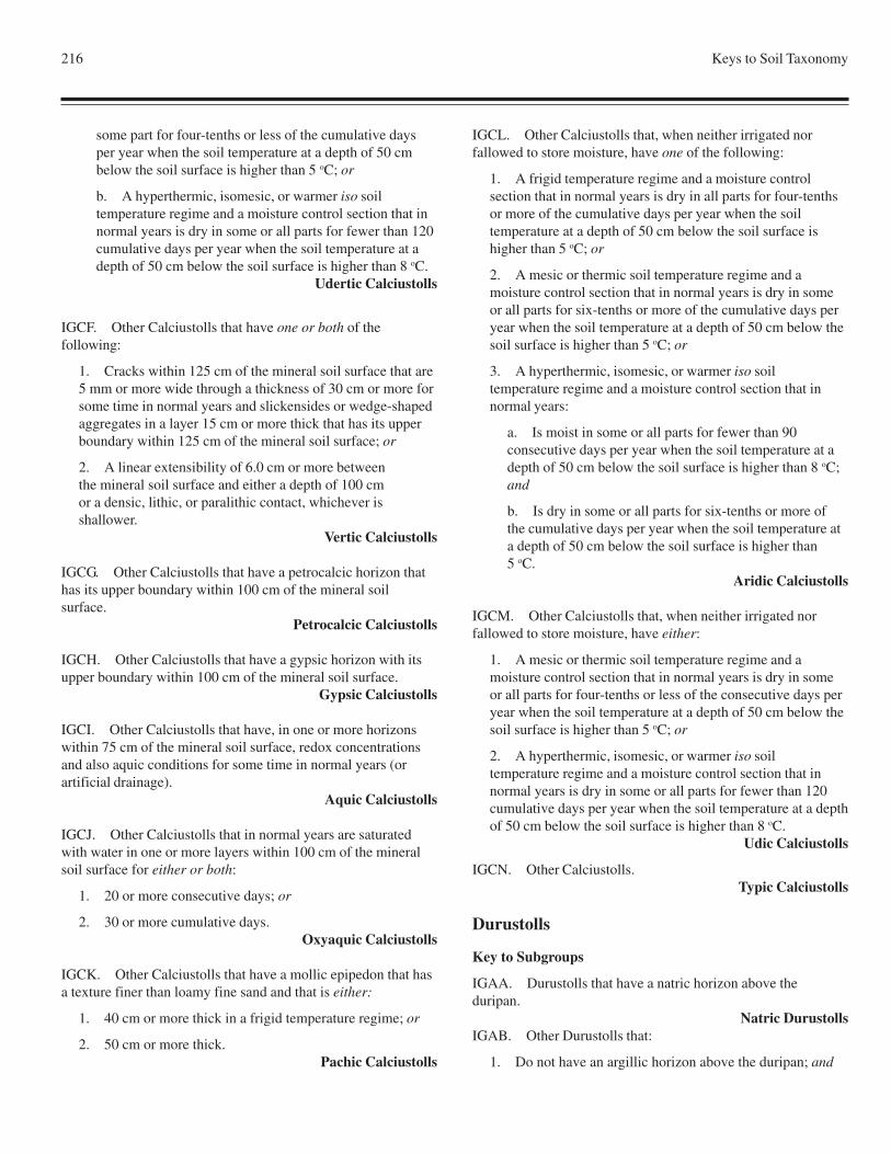
216 Keys to Soil Taxonomy
some part for four-tenths or less of the cumulative daysper year when the soil temperature at a depth of 50 cmbelow the soil surface is higher than 5 oC; or
b. A hyperthermic, isomesic, or warmer iso soiltemperature regime and a moisture control section that innormal years is dry in some or all parts for fewer than 120cumulative days per year when the soil temperature at adepth of 50 cm below the soil surface is higher than 8 oC.
Udertic Calciustolls
IGCF. Other Calciustolls that have one or both of thefollowing:
1. Cracks within 125 cm of the mineral soil surface that are5 mm or more wide through a thickness of 30 cm or more forsome time in normal years and slickensides or wedge-shapedaggregates in a layer 15 cm or more thick that has its upperboundary within 125 cm of the mineral soil surface; or
2. A linear extensibility of 6.0 cm or more betweenthe mineral soil surface and either a depth of 100 cmor a densic, lithic, or paralithic contact, whichever isshallower.
Vertic Calciustolls
IGCG. Other Calciustolls that have a petrocalcic horizon thathas its upper boundary within 100 cm of the mineral soilsurface.
Petrocalcic Calciustolls
IGCH. Other Calciustolls that have a gypsic horizon with itsupper boundary within 100 cm of the mineral soil surface.
Gypsic Calciustolls
IGCI. Other Calciustolls that have, in one or more horizonswithin 75 cm of the mineral soil surface, redox concentrationsand also aquic conditions for some time in normal years (orartificial drainage).
Aquic Calciustolls
IGCJ. Other Calciustolls that in normal years are saturatedwith water in one or more layers within 100 cm of the mineralsoil surface for either or both:
1. 20 or more consecutive days; or
2. 30 or more cumulative days.Oxyaquic Calciustolls
IGCK. Other Calciustolls that have a mollic epipedon that hasa texture finer than loamy fine sand and that is either:
1. 40 cm or more thick in a frigid temperature regime; or
2. 50 cm or more thick.Pachic Calciustolls
IGCL. Other Calciustolls that, when neither irrigated norfallowed to store moisture, have one of the following:
1. A frigid temperature regime and a moisture controlsection that in normal years is dry in all parts for four-tenthsor more of the cumulative days per year when the soiltemperature at a depth of 50 cm below the soil surface ishigher than 5 oC; or
2. A mesic or thermic soil temperature regime and amoisture control section that in normal years is dry in someor all parts for six-tenths or more of the cumulative days peryear when the soil temperature at a depth of 50 cm below thesoil surface is higher than 5 oC; or
3. A hyperthermic, isomesic, or warmer iso soiltemperature regime and a moisture control section that innormal years:
a. Is moist in some or all parts for fewer than 90consecutive days per year when the soil temperature at adepth of 50 cm below the soil surface is higher than 8 oC;and
b. Is dry in some or all parts for six-tenths or more ofthe cumulative days per year when the soil temperature ata depth of 50 cm below the soil surface is higher than5 oC.
Aridic Calciustolls
IGCM. Other Calciustolls that, when neither irrigated norfallowed to store moisture, have either:
1. A mesic or thermic soil temperature regime and amoisture control section that in normal years is dry in someor all parts for four-tenths or less of the consecutive days peryear when the soil temperature at a depth of 50 cm below thesoil surface is higher than 5 oC; or
2. A hyperthermic, isomesic, or warmer iso soiltemperature regime and a moisture control section that innormal years is dry in some or all parts for fewer than 120cumulative days per year when the soil temperature at a depthof 50 cm below the soil surface is higher than 8 oC.
Udic Calciustolls
IGCN. Other Calciustolls.Typic Calciustolls
Durustolls
Key to Subgroups
IGAA. Durustolls that have a natric horizon above theduripan.
Natric DurustollsIGAB. Other Durustolls that:
1. Do not have an argillic horizon above the duripan; and
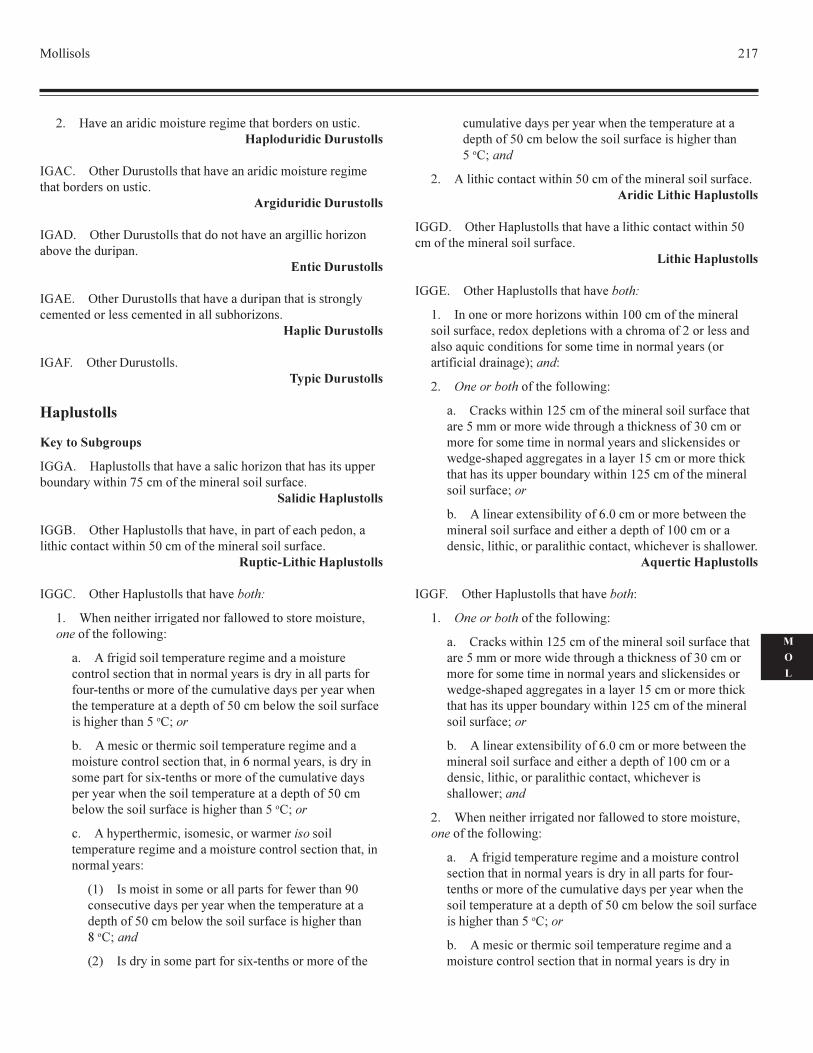
��������� ���
�
�
�
� �� ������������������ �� ��� ���������� ������������������������� ����
���� ��� ��������������������� ������������������ �� ��� ��������� �����������
������������ ����
���� ��� ���������������������������� ������������������������ ��� ����� ��
�������� ����
���! ��� ��������������������� ������� ������������������"� � �� ������ ���� � �� ��������������������
��������� ����
���# ��� �������������������� ����
�����������
���������������
���� � ����������������� ������������������������������� ��������"�$�������%�����&��� ���� ������������&��
���������� ����
���' ��� ��� ����������������� (���� �����&� ���� ���(�����������������$������%)�����&��� ���� ������������&��
�������������� ����
���� ��� ��� ����������������� ������
� *� ��� ��� ��������� ������&����$ ��������� �������� (�����&��� �&����$���+
� ��&������������ � ����� �� ��� �������������� ��������� ���������������������" ���������"�������� �����&��&���,� ����������� ��&��� ���������� ���"�� ��" ���$� ��� �� � ����� ������� ����&�%)����� ��$��� ���������&�� ������� �������%���-���
� ��� ��������� ����������� � ����� �� ��� ������������� ���������� ����������(����.��������" ���(������"������ � ����&�����/,� ����������� ��&��� ���������� ���"� ��" ���$� ���� ������� � ����� ������� ����&�%)���� ��$��� ���������&�� �������� �������%���-���
� ���" ��� ����(����� ���(����$��� ��������� � ����� �� ��� �������������� ���������� ����������(����������" ���+
0�1 ��������������� �������� �����&���& $ �������2)���� ����� ���"�� ��" ���$� ���� �� � ����� ������ ����&�%)����� ��$��� ���������&�� �������� ������3���-����
0�1 �����"������� � ����&�����/,� ����������� ��&���
��������� ���"�� ��" ���$� ���� �� � ����� ������ ����&�%)����� ��$��� ���������&�� �������� ������%���-����
� �����������������$������%)�����&��� ���� ������������&�� ������������� ����
���� ��� ��� ����������������� ������������������$������%)����&��� ���� ������������&��
��������� ����
���! ��� ��� ����������������� ������
� ����� ������� ����������$�������))�����&��� ���� �����������&�� (�� ��/�� � ������$��������������&������� ������������4���������������&������ ���� �����������" ����0������&������������� 1-����+
� ������������&��� �&����$���+
� ����5��$��������%�����&��� ���� ������������&�� ������� �%���������� �$�� ���������������5� ����&�6)��������� �&������ ���� �����������" ������������5 ���� ����$ �� ,��� ������ ��� ���������" ���%���������� �����5�������������� ���������"�$��������%�����&��� ���� �����������&�� -���
� ����� ��� /� ��������"��&�.)���������� �� �$ ���� ��� ������������&�� ����� ��� ����� ����&��))��������� ����(�������(���� �����������������(�$���� � �����������$ �
������������ ����
���# ��� ��� ����������������� �����+
� ������������&��� �&����$���+
� ����5��$��������%�����&��� ���� ������������&�� ������� �%���������� �$�� ���������������5� ����&�6)��������� �&������ ���� �����������" ������������5 ���� ����$ �� ,��� ������ ��� ���������" ���%���������� �����5�������������� ���������"�$��������%�����&��� ���� �����������&�� -���
� ����� ��� /� ��������"��&�.)���������� �� �$ ���� ��� ������������&�� ����� ��� ����� ����&��))��������� ����(�������(���� �����������������(�$���� � ����������$ �-����
� *� ��� ��� ��������� ������&����$ ��������� �������� (�����&��� �&����$���+
� ��&������� � ����� �� ��� �������������� ��������� ���������������������" ���������"�������� �����&���&���,� ����������� ��&��� ���������� ���"�� ��" ���$� ���� ������ � ����� ������� ����&�%)����� ��$��� ���������&�� ������� �������%���-���
� ��� ��������� ����������� � ����� �� ��� ������������� ���������� ���������������������" ���������"���
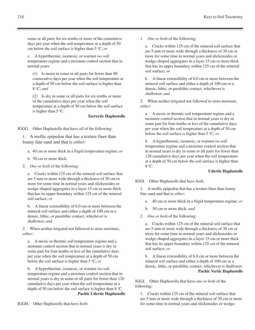
218 Keys to Soil Taxonomy
some or all parts for six-tenths or more of the cumulativedays per year when the soil temperature at a depth of 50cm below the soil surface is higher than 5 oC; or
c. A hyperthermic, isomesic, or warmer iso soiltemperature regime and a moisture control section that innormal years:
(1) Is moist in some or all parts for fewer than 90consecutive days per year when the soil temperature ata depth of 50 cm below the soil surface is higher than8 oC; and
(2) Is dry in some or all parts for six-tenths or moreof the cumulative days per year when the soiltemperature at a depth of 50 cm below the soil surfaceis higher than 5 oC.
Torrertic Haplustolls
IGGG. Other Haplustolls that have all of the following:
1. A mollic epipedon that has a texture finer thanloamy fine sand and that is either:
a. 40 cm or more thick in a frigid temperature regime; or
b. 50 cm or more thick.
2. One or both of the following:
a. Cracks within 125 cm of the mineral soil surface thatare 5 mm or more wide through a thickness of 30 cm ormore for some time in normal years and slickensides orwedge-shaped aggregates in a layer 15 cm or more thickthat has its upper boundary within 125 cm of the mineralsoil surface; or
b. A linear extensibility of 6.0 cm or more between themineral soil surface and either a depth of 100 cm or adensic, lithic, or paralithic contact, whichever isshallower; and
3. When neither irrigated nor fallowed to store moisture,either:
a. A mesic or thermic soil temperature regime and amoisture control section that in normal years is dry insome part for four-tenths or less of the cumulative daysper year when the soil temperature at a depth of 50 cmbelow the soil surface is higher than 5 oC; or
b. A hyperthermic, isomesic, or warmer iso soiltemperature regime and a moisture control section that innormal years is dry in some or all parts for fewer than 120cumulative days per year when the soil temperature at adepth of 50 cm below the soil surface is higher than 8 oC.
Pachic Udertic Haplustolls
IGGH. Other Haplustolls that have both:
1. One or both of the following:
a. Cracks within 125 cm of the mineral soil surface thatare 5 mm or more wide through a thickness of 30 cm ormore for some time in normal years and slickensides orwedge-shaped aggregates in a layer 15 cm or more thickthat has its upper boundary within 125 cm of the mineralsoil surface; or
b. A linear extensibility of 6.0 cm or more between themineral soil surface and either a depth of 100 cm or adensic, lithic, or paralithic contact, whichever isshallower; and
2. When neither irrigated nor fallowed to store moisture,either:
a. A mesic or thermic soil temperature regime and amoisture control section that in normal years is dry insome part for four-tenths or less of the cumulative daysper year when the soil temperature at a depth of 50 cmbelow the soil surface is higher than 5 oC; or
b. A hyperthermic, isomesic, or warmer iso soiltemperature regime and a moisture control section thatin normal years is dry in some or all parts for fewer than120 cumulative days per year when the soil temperatureat a depth of 50 cm below the soil surface is higher than8 oC.
Udertic Haplustolls
IGGI. Other Haplustolls that have both:
1. A mollic epipedon that has a texture finer than loamyfine sand and that is either:
a. 40 cm or more thick in a frigid temperature regime; or
b. 50 cm or more thick; and
2. One or both of the following:
a. Cracks within 125 cm of the mineral soil surface thatare 5 mm or more wide through a thickness of 30 cm ormore for some time in normal years and slickensides orwedge-shaped aggregates in a layer 15 cm or more thickthat has its upper boundary within 125 cm of the mineralsoil surface; or
b. A linear extensibility of 6.0 cm or more between themineral soil surface and either a depth of 100 cm or adensic, lithic, or paralithic contact, whichever is shallower.
Pachic Vertic Haplustolls
IGGJ. Other Haplustolls that have one or both of thefollowing:
1. Cracks within 125 cm of the mineral soil surface thatare 5 mm or more wide through a thickness of 30 cm or morefor some time in normal years and slickensides or wedge-
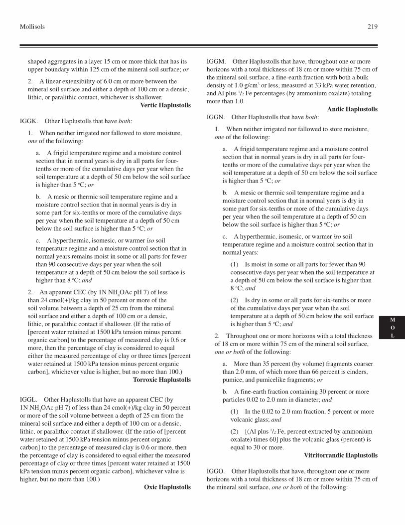
Mollisols 219
M
O
L
shaped aggregates in a layer 15 cm or more thick that has itsupper boundary within 125 cm of the mineral soil surface; or
2. A linear extensibility of 6.0 cm or more between themineral soil surface and either a depth of 100 cm or a densic,lithic, or paralithic contact, whichever is shallower.
Vertic Haplustolls
IGGK. Other Haplustolls that have both:
1. When neither irrigated nor fallowed to store moisture,one of the following:
a. A frigid temperature regime and a moisture controlsection that in normal years is dry in all parts for four-tenths or more of the cumulative days per year when thesoil temperature at a depth of 50 cm below the soil surfaceis higher than 5 oC; or
b. A mesic or thermic soil temperature regime and amoisture control section that in normal years is dry insome part for six-tenths or more of the cumulative daysper year when the soil temperature at a depth of 50 cmbelow the soil surface is higher than 5 oC; or
c. A hyperthermic, isomesic, or warmer iso soiltemperature regime and a moisture control section that innormal years remains moist in some or all parts for fewerthan 90 consecutive days per year when the soiltemperature at a depth of 50 cm below the soil surface ishigher than 8 oC; and
2. An apparent CEC (by 1N NH4OAc pH 7) of less
than 24 cmol(+)/kg clay in 50 percent or more of thesoil volume between a depth of 25 cm from the mineralsoil surface and either a depth of 100 cm or a densic,lithic, or paralithic contact if shallower. (If the ratio of[percent water retained at 1500 kPa tension minus percentorganic carbon] to the percentage of measured clay is 0.6 ormore, then the percentage of clay is considered to equaleither the measured percentage of clay or three times [percentwater retained at 1500 kPa tension minus percent organiccarbon], whichever value is higher, but no more than 100.)
Torroxic Haplustolls
IGGL. Other Haplustolls that have an apparent CEC (by1N NH
4OAc pH 7) of less than 24 cmol(+)/kg clay in 50 percent
or more of the soil volume between a depth of 25 cm from themineral soil surface and either a depth of 100 cm or a densic,lithic, or paralithic contact if shallower. (If the ratio of [percentwater retained at 1500 kPa tension minus percent organiccarbon] to the percentage of measured clay is 0.6 or more, thenthe percentage of clay is considered to equal either the measuredpercentage of clay or three times [percent water retained at 1500kPa tension minus percent organic carbon], whichever value ishigher, but no more than 100.)
Oxic Haplustolls
IGGM. Other Haplustolls that have, throughout one or morehorizons with a total thickness of 18 cm or more within 75 cm ofthe mineral soil surface, a fine-earth fraction with both a bulkdensity of 1.0 g/cm3 or less, measured at 33 kPa water retention,and Al plus 1/2 Fe percentages (by ammonium oxalate) totalingmore than 1.0.
Andic HaplustollsIGGN. Other Haplustolls that have both:
1. When neither irrigated nor fallowed to store moisture,one of the following:
a. A frigid temperature regime and a moisture controlsection that in normal years is dry in all parts for four-tenths or more of the cumulative days per year when thesoil temperature at a depth of 50 cm below the soil surfaceis higher than 5 oC; or
b. A mesic or thermic soil temperature regime and amoisture control section that in normal years is dry insome part for six-tenths or more of the cumulative daysper year when the soil temperature at a depth of 50 cmbelow the soil surface is higher than 5 oC; or
c. A hyperthermic, isomesic, or warmer iso soiltemperature regime and a moisture control section that innormal years:
(1) Is moist in some or all parts for fewer than 90consecutive days per year when the soil temperature ata depth of 50 cm below the soil surface is higher than8 oC; and
(2) Is dry in some or all parts for six-tenths or moreof the cumulative days per year when the soiltemperature at a depth of 50 cm below the soil surfaceis higher than 5 oC; and
2. Throughout one or more horizons with a total thicknessof 18 cm or more within 75 cm of the mineral soil surface,one or both of the following:
a. More than 35 percent (by volume) fragments coarserthan 2.0 mm, of which more than 66 percent is cinders,pumice, and pumicelike fragments; or
b. A fine-earth fraction containing 30 percent or moreparticles 0.02 to 2.0 mm in diameter; and
(1) In the 0.02 to 2.0 mm fraction, 5 percent or morevolcanic glass; and
(2) [(Al plus 1/2 Fe, percent extracted by ammoniumoxalate) times 60] plus the volcanic glass (percent) isequal to 30 or more.
Vitritorrandic Haplustolls
IGGO. Other Haplustolls that have, throughout one or morehorizons with a total thickness of 18 cm or more within 75 cm ofthe mineral soil surface, one or both of the following:
220 Keys to Soil Taxonomy
1. More than 35 percent (by volume) fragments coarserthan 2.0 mm, of which more than 66 percent is cinders,pumice, and pumicelike fragments; or
2. A fine-earth fraction containing 30 percent or moreparticles 0.02 to 2.0 mm in diameter; and
a. In the 0.02 to 2.0 mm fraction, 5 percent or morevolcanic glass; and
b. [(Al plus 1/2 Fe, percent extracted by ammoniumoxalate) times 60] plus the volcanic glass (percent) isequal to 30 or more.
Vitrandic Haplustolls
IGGP. Other Haplustolls that have:
1. Either:
a. A frigid soil temperature regime and a mollicepipedon 40 cm or more thick, of which less than 50percent has a sandy or sandy-skeletal particle-size class,and there is no densic or paralithic contact and no sandyor sandy-skeletal particle-size class at a depth between 40and 50 cm from the mineral soil surface; or
b. A mollic epipedon that is 50 cm or more thick and hasa texture finer than loamy fine sand; and
2. An irregular decrease in organic-carbon content from adepth of 25 cm below the mineral soil surface to a depth of125 cm or to a densic, lithic, or paralithic contact ifshallower; and
3. A slope of less than 25 percent; and
4. In one or more horizons within 100 cm of the mineralsoil surface, redox depletions with chroma of 2 or less andalso aquic conditions for some time in normal years (orartificial drainage).
Aquic Cumulic Haplustolls
IGGQ. Other Haplustolls that have:
1. Either:
a. A frigid soil temperature regime and a mollicepipedon 40 cm or more thick, of which less than 50percent has a sandy or sandy-skeletal particle-size class,and there is no densic or paralithic contact and no sandyor sandy-skeletal particle-size class at a depth between 40and 50 cm from the mineral soil surface; or
b. A mollic epipedon that is 50 cm or more thick and hasa texture finer than loamy fine sand; and
2. An irregular decrease in organic-carbon content from adepth of 25 cm below the mineral soil surface to a depth of125 cm or to a densic, lithic, or paralithic contact ifshallower; and
3. A slope of less than 25 percent.Cumulic Haplustolls
IGGR. Other Haplustolls that have anthraquic conditions.Anthraquic Haplustolls
IGGS. Other Haplustolls that have both:
1. In one or more horizons within 100 cm of the mineralsoil surface, redox depletions with chroma of 2 or less andalso aquic conditions for some time in normal years (orartificial drainage); and
2. A slope of less than 25 percent; and either
a. An organic-carbon content of 0.3 percent or more at adepth of 125 cm below the mineral soil surface; or
b. An irregular decrease in organic-carbon content froma depth of 25 cm to a depth of 125 cm or to a densic,lithic, or paralithic contact if shallower.
Fluvaquentic Haplustolls
IGGT. Other Haplustolls that have, in one or more horizonswithin 100 cm of the mineral soil surface, redox depletionswith chroma of 2 or less and also aquic conditions for sometime in most years (or artificial drainage).
Aquic Haplustolls
IGGU. Other Haplustolls that have a mollic epipedon that hasa texture finer than loamy fine sand and that is either:
1. 40 cm or more thick in a frigid temperature regime; or
2. 50 cm or more thick.Pachic Haplustolls
IGGV. Other Haplustolls that in normal years are saturatedwith water in one or more layers within 100 cm of the mineralsoil surface for either or both:
1. 20 or more consecutive days; or
2. 30 or more cumulative days.Oxyaquic Haplustolls
IGGW. Other Haplustolls that have both:
1. When neither irrigated nor fallowed to store moisture,one of the following:
a. A frigid temperature regime and a moisture controlsection that in normal years is dry in all parts for four-tenths or more of the cumulative days per year when thesoil temperature at a depth of 50 cm below the soil surfaceis higher than 5 oC; or
b. A mesic or thermic soil temperature regime and amoisture control section that in normal years is dry in
Mollisols 221
M
O
L
some part for six-tenths or more of the cumulative daysper year when the soil temperature at a depth of 50 cmbelow the soil surface is higher than 5 oC; or
c. A hyperthermic, isomesic, or warmer iso soiltemperature regime and a moisture control section that innormal years:
(1) Is moist in some or all parts for fewer than 90consecutive days per year when the soil temperature ata depth of 50 cm below the soil surface is higher than8 oC; and
(2) Is dry in some or all parts for six-tenths or moreof the cumulative days per year when the soiltemperature at a depth of 50 cm below the soil surfaceis higher than 5 oC; and
2. A slope of less than 25 percent; and either
a. An organic-carbon content of 0.3 percent or more at adepth of 125 cm below the mineral soil surface; or
b. An irregular decrease in organic-carbon content froma depth of 25 cm to a depth of 125 cm or to a densic,lithic, or paralithic contact if shallower.
Torrifluventic Haplustolls
IGGX. Other Haplustolls that:
1. When neither irrigated nor fallowed to store moisture,have one of the following:
a. A frigid temperature regime and a moisture controlsection that in normal years is dry in all parts for four-tenths or more of the cumulative days per year when thesoil temperature at a depth of 50 cm below the soil surfaceis higher than 5 oC; or
b. A mesic or thermic soil temperature regime and amoisture control section that in normal years is dry insome part for six-tenths or more of the cumulative daysper year when the soil temperature at a depth of 50 cmbelow the soil surface is higher than 5 oC; or
c. A hyperthermic, isomesic, or warmer iso soiltemperature regime and a moisture control section that innormal years:
(1) Is moist in some or all parts for fewer than 90consecutive days per year when the soil temperature ata depth of 50 cm below the soil surface is higher than8 oC; and
(2) Is dry in some or all parts for six-tenths or moreof the cumulative days per year when the soiltemperature at a depth of 50 cm below the soil surfaceis higher than 5 oC; and
2. Either:
a. Do not have a cambic horizon and do not, in any partof the mollic epipedon below 25 cm from the mineral soilsurface, meet all of the requirements for a cambic horizonexcept color; or
b. Have free carbonates throughout the cambic horizonor in all parts of the mollic epipedon below a depth of 25cm from the mineral soil surface.
Torriorthentic Haplustolls
IGGY. Other Haplustolls that, when neither irrigated norfallowed to store moisture, have one of the following:
1. A frigid temperature regime and a moisture controlsection that in normal years is dry in all parts for four-tenthsor more of the cumulative days per year when the soiltemperature at a depth of 50 cm below the soil surface ishigher than 5 oC; or
2. A mesic or thermic soil temperature regime and amoisture control section that in normal years is dry in somepart for six-tenths or more of the cumulative days per yearwhen the soil temperature at a depth of 50 cm below the soilsurface is higher than 5 oC; or
3. A hyperthermic, isomesic, or warmer iso soiltemperature regime and a moisture control section that innormal years:
a. Is moist in some or all parts for fewer than 90consecutive days per year when the soil temperature at adepth of 50 cm below the soil surface is higher than 8 oC;and
b. Is dry in some or all parts for six-tenths or more of thecumulative days per year when the soil temperature at adepth of 50 cm below the soil surface is higher than 5 oC.
Aridic Haplustolls
IGGZ. Other Haplustolls that have a slope of less than 25percent; and either
1. An organic-carbon content of 0.3 percent or more at adepth of 125 cm below the mineral soil surface; or
2. An irregular decrease in organic-carbon content from adepth of 25 cm to a depth of 125 cm or to a densic, lithic, orparalithic contact if shallower.
Fluventic Haplustolls
IGGZa. Other Haplustolls that have a brittle horizon that iswithin 100 cm of the mineral soil surface, is 15 cm or morethick, and has either some opal coatings or 20 percent or more(by volume) durinodes.
Duric Haplustolls
222 Keys to Soil Taxonomy
IGGZb. Other Haplustolls that:
1. When neither irrigated nor fallowed to store moisture,have either:
a. A mesic or thermic soil temperature regime and amoisture control section that in normal years is dry insome part for four-tenths or less of the cumulative daysper year when the soil temperature at a depth of 50 cmbelow the soil surface is higher than 5 oC; or
b. A hyperthermic, isomesic, or warmer iso soiltemperature regime and a moisture control section that innormal years is dry in some or all parts for fewer than 120days per year when the soil temperature at a depth of 50cm below the soil surface is higher than 8 oC; and
2. Either do not have a cambic horizon and do not, in thelower part of the mollic epipedon, meet the requirements fora cambic horizon, except for the color requirements, or havecarbonates throughout either the cambic horizon or the lowerpart of the mollic epipedon.
Udorthentic Haplustolls
IGGZc. Other Haplustolls that, when neither irrigated norfallowed to store moisture, have either:
1. A mesic or thermic soil temperature regime and amoisture control section that in normal years is dry in somepart for four-tenths or less of the cumulative days per yearwhen the soil temperature at a depth of 50 cm below the soilsurface is higher than 5 oC; or
2. A hyperthermic, isomesic, or warmer iso soiltemperature regime and a moisture control section that innormal years is dry in some or all parts for fewer than 120days per year when the soil temperature at a depth of 50 cmbelow the soil surface is higher than 8 oC.
Udic Haplustolls
IGGZd. Other Haplustolls that either:
1. Do not have a cambic horizon and do not, in any part ofthe mollic epipedon below 25 cm from the mineral soilsurface, meet all of the requirements for a cambic horizonexcept color; or
2. Have free carbonates throughout the cambic horizon orin all parts of the mollic epipedon below a depth of 25 cmfrom the mineral soil surface.
Entic Haplustolls
IGGZe. Other Haplustolls.Typic Haplustolls
Natrustolls
Key to Subgroups
IGBA. Natrustolls that have all of the following:
1. Visible crystals of gypsum and/or more soluble saltswithin 40 cm of the mineral soil surface; and
2. One or both of the following:
a. Cracks within 125 cm of the mineral soil surface thatare 5 mm or more wide through a thickness of 30 cm ormore for some time in normal years and slickensides orwedge-shaped aggregates in a layer 15 cm or more thickthat has its upper boundary within 125 cm of the mineralsoil surface; or
b. A linear extensibility of 6.0 cm or more between themineral soil surface and either a depth of 100 cm or adensic, lithic, or paralithic contact, whichever isshallower;
3. When neither irrigated nor fallowed to store moisture,have one of the following:
a. A frigid temperature regime and a moisture controlsection that in normal years is dry in all parts for four-tenths or more of the cumulative days per year when thesoil temperature at a depth of 50 cm below the soil surfaceis higher than 5 oC; or
b. A mesic or thermic soil temperature regime and amoisture control section that in normal years is dry insome or all parts for six-tenths or more of the cumulativedays per year when the soil temperature at a depth of 50cm below the soil surface is higher than 5 oC; or
c. A hyperthermic, isomesic, or warmer iso soiltemperature regime and a moisture control section that innormal years:
(1) Is moist in some or all parts for fewer than 90consecutive days per year when the soil temperature ata depth of 50 cm below the soil surface is higher than8 oC; and
(2) Is dry in some or all parts for six-tenths or moreof the cumulative days per year when the soiltemperature at a depth of 50 cm below the soil surfaceis higher than 5 oC.
Leptic Torrertic Natrustolls
IGBB. Other Natrustolls that have both:
1. One or both of the following:
Mollisols 223
M
O
L
a. Cracks within 125 cm of the mineral soil surface thatare 5 mm or more wide through a thickness of 30 cm ormore for some time in normal years and slickensides orwedge-shaped aggregates in a layer 15 cm or more thickthat has its upper boundary within 125 cm of the mineralsoil surface; or
b. A linear extensibility of 6.0 cm or more between themineral soil surface and either a depth of 100 cm or adensic, lithic, or paralithic contact, whichever isshallower; and
2. When neither irrigated nor fallowed to store moisture,have one of the following:
a. A frigid temperature regime and a moisture controlsection that in normal years is dry in all parts for four-tenths or more of the cumulative days per year when thesoil temperature at a depth of 50 cm below the soil surfaceis higher than 5 oC; or
b. A mesic or thermic soil temperature regime and amoisture control section that in normal years is dry insome or all parts for six-tenths or more of the cumulativedays per year when the soil temperature at a depth of 50cm below the soil surface is higher than 5 oC; or
c. A hyperthermic, isomesic, or warmer iso soiltemperature regime and a moisture control section that innormal years:
(1) Is moist in some or all parts for fewer than 90consecutive days per year when the soil temperature ata depth of 50 cm below the soil surface is higher than8 oC; and
(2) Is dry in some or all parts for six-tenths or moreof the cumulative days per year when the soiltemperature at a depth of 50 cm below the soil surfaceis higher than 5 oC.
Torrertic Natrustolls
IGBC. Other Natrustolls that have both of the following:
1. Visible crystals of gypsum and/or more soluble saltswithin 40 cm of the mineral soil surface; and
2. One or both of the following:
a. Cracks within 125 cm of the mineral soil surface thatare 5 mm or more wide through a thickness of 30 cm ormore for some time in normal years and slickensides orwedge-shaped aggregates in a layer 15 cm or more thickthat has its upper boundary within 125 cm of the mineralsoil surface; or
b. A linear extensibility of 6.0 cm or more between themineral soil surface and either a depth of 100 cm or adensic, lithic, or paralithic contact, whichever is shallower.
Leptic Vertic Natrustolls
IGBD. Other Natrustolls that have both:
1. A glossic horizon or interfingering of albic materials intoa natric horizon; and
2. One or both of the following:
a. Cracks within 125 cm of the mineral soil surface thatare 5 mm or more wide through a thickness of 30 cm ormore for some time in normal years and slickensides orwedge-shaped aggregates in a layer 15 cm or more thickthat has its upper boundary within 125 cm of the mineralsoil surface; or
b. A linear extensibility of 6.0 cm or more betweenthe mineral soil surface and either a depth of 100 cm ora densic, lithic, or paralithic contact, whichever isshallower.
Glossic Vertic Natrustolls
IGBE. Other Natrustolls that have one or both of thefollowing:
1. Cracks within 125 cm of the mineral soil surface that are5 mm or more wide through a thickness of 30 cm or more forsome time in normal years and slickensides or wedge-shapedaggregates in a layer 15 cm or more thick that has its upperboundary within 125 cm of the mineral soil surface; or
2. A linear extensibility of 6.0 cm or more between themineral soil surface and either a depth of 100 cm or a densic,lithic, or paralithic contact, whichever is shallower.
Vertic Natrustolls
IGBF. Other Natrustolls that have both:
1. Visible crystals of gypsum or of more soluble salts, orboth, within 40 cm of the mineral soil surface; and
2. When neither irrigated nor fallowed to store moisture,have one of the following:
a. A frigid temperature regime and a moisture controlsection that in normal years is dry in all parts for four-tenths or more of the cumulative days per year when thesoil temperature at a depth of 50 cm below the soil surfaceis higher than 5 oC; or
b. A mesic or thermic soil temperature regime and amoisture control section that in normal years is dry insome or all parts for six-tenths or more of the cumulativedays per year when the soil temperature at a depth of 50cm below the soil surface is higher than 5 oC; or
c. A hyperthermic, isomesic, or warmer iso soiltemperature regime and a moisture control section that innormal years:
(1) Is moist in some or all parts for fewer than 90consecutive days per year when the soil temperature at
224 Keys to Soil Taxonomy
a depth of 50 cm below the soil surface is higher than8 oC; and
(2) Is dry in some or all parts for six-tenths or moreof the cumulative days per year when the soiltemperature at a depth of 50 cm below the soil surfaceis higher than 5 oC.
Aridic Leptic Natrustolls
IGBG. Other Natrustolls that have visible crystals of gypsumor of more soluble salts, or both, within 40 cm of the mineralsoil surface.
Leptic Natrustolls
IGBH. Other Natrustolls that have, in one or more horizons ata depth between 50 and 100 cm from the mineral soil surface,aquic conditions for some time in normal years (or artificialdrainage) and one of the following:
1. 50 percent or more chroma of 1 or less and hue of 2.5Yor yellower; or
2. 50 percent or more chroma of 2 or less and redoxconcentrations; or
3. 50 percent or more chroma of 2 or less and also a higherexchangeable sodium percentage (or sodium adsorptionratio) between the mineral soil surface and a depth of 25 cmthan in the underlying horizon.
Aquic Natrustolls
IGBI. Other Natrustolls that, when neither irrigated norfallowed to store moisture, have one of the following:
1. A frigid temperature regime and a moisture controlsection that in normal years is dry in all parts for four-tenthsor more of the cumulative days per year when the soiltemperature at a depth of 50 cm below the soil surface ishigher than 5 oC; or
2. A mesic or thermic soil temperature regime and amoisture control section that in normal years is dry in somepart for six-tenths or more of the cumulative days per yearwhen the soil temperature at a depth of 50 cm below the soilsurface is higher than 5 oC; or
3. A hyperthermic, isomesic, or warmer iso soiltemperature regime and a moisture control section that innormal years:
a. Is moist in some or all parts for fewer than 90consecutive days per year when the soil temperature at adepth of 50 cm below the soil surface is higher than 8 oC;and
b. Is dry in some or all parts for six-tenths or more of thecumulative days per year when the soil temperature at adepth of 50 cm below the soil surface is higher than 5 oC.
Aridic Natrustolls
IGBJ. Other Natrustolls that have a horizon, 15 cm or morethick within 100 cm of the mineral soil surface, that either has20 percent or more (by volume) durinodes or is brittle and has afirm rupture-resistance class when moist.
Duric Natrustolls
IGBK. Other Natrustolls that have a glossic horizon orinterfingering of albic materials into a natric horizon.
Glossic Natrustolls
IGBL. Other Natrustolls.Typic Natrustolls
Paleustolls
Key to Subgroups
IGDA. Paleustolls that have both:
1. One or both of the following:
a. Cracks within 125 cm of the mineral soil surface thatare 5 mm or more wide through a thickness of 30 cm ormore for some time in normal years and slickensides orwedge-shaped aggregates in a layer 15 cm or more thickthat has its upper boundary within 125 cm of the mineralsoil surface; or
b. A linear extensibility of 6.0 cm or more between themineral soil surface and either a depth of 100 cm or adensic, lithic, or paralithic contact, whichever isshallower; and
2. When neither irrigated nor fallowed to store moisture,one of the following:
a. A frigid temperature regime and a moisture controlsection that in normal years is dry in all parts for less thanfour-tenths of the cumulative days per year when the soiltemperature at a depth of 50 cm below the soil surface ishigher than 5 oC; or
b. A mesic or thermic soil temperature regime and amoisture control section that in normal years is dry insome or all parts for six-tenths or more of the cumulativedays per year when the soil temperature at a depth of 50cm below the soil surface is higher than 5 oC; or
c. A hyperthermic, isomesic, or warmer iso soiltemperature regime and a moisture control section that innormal years:
(1) Is moist in some or all parts for fewer than 90consecutive days per year when the soil temperature ata depth of 50 cm below the soil surface is higher than8 oC; and
(2) Is dry in some or all parts for six-tenths or moreof the cumulative days per year when the soil
Mollisols 225
M
O
L
temperature at a depth of 50 cm below the soil surfaceis higher than 5 oC.
Torrertic Paleustolls
IGDB. Other Paleustolls that have both:
1. One or both of the following:
a. Cracks within 125 cm of the mineral soil surface thatare 5 mm or more wide through a thickness of 30 cm ormore for some time in normal years and slickensides orwedge-shaped aggregates in a layer 15 cm or more thickthat has its upper boundary within 125 cm of the mineralsoil surface; or
b. A linear extensibility of 6.0 cm or more between themineral soil surface and either a depth of 100 cm or adensic, lithic, or paralithic contact, whichever isshallower; and
2. When neither irrigated nor fallowed to store moisture,either:
a. A mesic or thermic soil temperature regime and amoisture control section that in normal years is dry insome part for four-tenths or less of the cumulative daysper year when the soil temperature at a depth of 50 cmbelow the soil surface is higher than 5 oC; or
b. A hyperthermic, isomesic, or warmer iso soiltemperature regime and a moisture control section that innormal years is dry in some or all parts for fewer than 120cumulative days per year when the soil temperature at adepth of 50 cm below the soil surface is higher than 8 oC.
Udertic Paleustolls
IGDC. Other Paleustolls that have one or both of thefollowing:
1. Cracks within 125 cm of the mineral soil surface thatare 5 mm or more wide through a thickness of 30 cm ormore for some time in normal years and slickensides orwedge-shaped aggregates in a layer 15 cm or more thickthat has its upper boundary within 125 cm of the mineralsoil surface; or
2. A linear extensibility of 6.0 cm or more between themineral soil surface and either a depth of 100 cm or adensic, lithic, or paralithic contact, whichever is shallower.
Vertic Paleustolls
IGDD. Other Paleustolls that have, in one or more horizonswithin 100 cm of the mineral soil surface, redox depletions withchroma of 2 or less and also aquic conditions for some time innormal years (or artificial drainage).
Aquic Paleustolls
IGDE. Other Paleustolls that have a mollic epipedon that has a
texture finer than loamy fine sand and that is 50 cm or morethick.
Pachic Paleustolls
IGDF. Other Paleustolls that have a petrocalcic horizon within150 cm of the mineral soil surface.
Petrocalcic Paleustolls
IGDG. Other Paleustolls that:
1. Have a calcic horizon within one of the followingparticle-size class (by weighted average in the particle-sizecontrol section) and depth combinations:
a. Sandy or sandy-skeletal and within 100 cm of themineral soil surface; or
b. Clayey, clayey-skeletal, fine, or very-fine and within50 cm of the mineral soil surface; or
c. Any other class and within 60 cm of the mineral soilsurface; and
2. When neither irrigated nor fallowed to store moisture,have one of the following:
a. A frigid temperature regime and a moisture controlsection that in normal years is dry in all parts for less thanfour-tenths of the cumulative days per year when the soiltemperature at a depth of 50 cm below the soil surface ishigher than 5 oC; or
b. A mesic or thermic soil temperature regime and amoisture control section that in normal years is dry insome part for six-tenths or more of the cumulative daysper year when the soil temperature at a depth of 50 cmbelow the soil surface is higher than 5 oC; or
c. A hyperthermic, isomesic, or warmer iso soiltemperature regime and a moisture control section that innormal years:
(1) Is moist in some or all parts for fewer than 90consecutive days per year when the soil temperature ata depth of 50 cm below the soil surface is higher than8 oC; and
(2) Is dry in some or all parts for six-tenths or moreof the cumulative days per year when the soiltemperature at a depth of 50 cm below the soil surfaceis higher than 5 oC.
Calcidic Paleustolls
IGDH. Other Paleustolls that, when neither irrigated norfallowed to store moisture, have one of the following:
1. A frigid temperature regime and a moisture controlsection that in normal years is dry in all parts for less thanfour-tenths of the cumulative days per year when the soil
226 Keys to Soil Taxonomy
temperature at a depth of 50 cm below the soil surface ishigher than 5 oC; or
2. A mesic or thermic soil temperature regime and amoisture control section that in normal years is dry in somepart for six-tenths or more of the cumulative days per yearwhen the soil temperature at a depth of 50 cm below the soilsurface is higher than 5 oC; or
3. A hyperthermic, isomesic, or warmer iso soiltemperature regime and a moisture control section that innormal years:
a. Is moist in some or all parts for fewer than 90consecutive days per year when the soil temperature at adepth of 50 cm below the soil surface is higher than 8 oC;and
b. Is dry in some or all parts for six-tenths or more of thecumulative days per year when the soil temperature at adepth of 50 cm below the soil surface is higher than 5 oC.
Aridic Paleustolls
IGDI. Other Paleustolls that, when neither irrigated norfallowed to store moisture, have either:
1. A mesic or thermic soil temperature regime and amoisture control section that in normal years is dry in somepart for four-tenths or less of the cumulative days per yearwhen the soil temperature at a depth of 50 cm below the soilsurface is higher than 5 oC; or
2. A hyperthermic, isomesic, or warmer iso soiltemperature regime and a moisture control section that innormal years is dry in some or all parts for fewer than 120cumulative days per year when the soil temperature at a depthof 50 cm below the soil surface is higher than 8 oC.
Udic Paleustolls
IGDJ. Other Paleustolls have a calcic horizon within one ofthe following particle-size class (by weighted average in theparticle-size control section) and depth combinations:
1. Sandy or sandy-skeletal and within 100 cm of themineral soil surface; or
2. Clayey, clayey-skeletal, fine, or very-fine and within 50cm of the mineral soil surface; or
3. Any other class and within 60 cm of the mineral soilsurface.
Calcic Paleustolls
IGDK. Other Paleustolls that are calcareous throughout afterthe surface soil has been mixed to a depth of 18 cm.
Entic Paleustolls
IGDL. Other Paleustolls.Typic Paleustolls
Vermustolls
Key to Subgroups
IGFA. Vermustolls that have a lithic contact within 50 cm ofthe mineral soil surface.
Lithic Vermustolls
IGFB. Other Vermustolls that have, in one or more horizonswithin 100 cm of the mineral soil surface, redox depletions withchroma of 2 or less and also aquic conditions for some time innormal years (or artificial drainage).
Aquic Vermustolls
IGFC. Other Vermustolls that have a mollic epipedon 75 cm ormore thick.
Pachic Vermustolls
IGFD. Other Vermustolls that have a mollic epipedon less than50 cm thick.
Entic Vermustolls
IGFE. Other Vermustolls.Typic Vermustolls
Xerolls
Key to Great Groups
IFA. Xerolls that have a duripan within 100 cm of the mineralsoil surface.
Durixerolls, p. 229
IFB. Other Xerolls that have a natric horizon.Natrixerolls, p. 234
IFC. Other Xerolls that have either:
1. A petrocalcic horizon that has its upper boundary within150 cm of the mineral soil surface; or
2. An argillic horizon that has one or both of the following:
a. With increasing depth, no clay decrease of 20 percentor more (relative) from the maximum clay content(noncarbonate clay) within 150 cm of the mineral soilsurface (and there is no densic, lithic, or paralithic contactwithin that depth); and either
(1) Hue of 7.5YR or redder and chroma of 5 or morein the matrix; or
(2) Common redox concentrations with hueof 7.5YR or redder or chroma of 6 or more, or both;or
b. A clayey or clayey-skeletal particle-size class in its
Mollisols 227
M
O
L
upper part and, at its upper boundary, a clay increaseeither of 20 percent or more (absolute) within a verticaldistance of 7.5 cm or of 15 percent or more (absolute)within a vertical distance of 2.5 cm, in the fine-earthfraction (and there is no densic, lithic, or paralithic contactwithin 50 cm of the mineral soil surface).
Palexerolls, p. 234
IFD. Other Xerolls that:
1. Have a calcic or gypsic horizon that has its upperboundary within 150 cm of the mineral soil surface; and
2. In all parts above the calcic or gypsic horizon, after thesurface soil has been mixed to a depth of 18 cm, either arecalcareous or have a texture of loamy fine sand or coarser.
Calcixerolls, p. 229
IFE. Other Xerolls that have an argillic horizon.Argixerolls, p. 227
IFF. Other Xerolls.Haploxerolls, p. 231
Argixerolls
Key to Subgroups
IFEA. Argixerolls that have both:
1. A lithic contact within 50 cm of the mineral soil surface;and
2. A base saturation (by sum of cations) of 75 percent orless in one or more horizons between either the mineral soilsurface or an Ap horizon, whichever is deeper, and the lithiccontact.
Lithic Ultic Argixerolls
IFEB. Other Argixerolls that have a lithic contact within 50 cmof the mineral soil surface.
Lithic Argixerolls
IFEC. Other Argixerolls that have both:
1. An aridic moisture regime; and
2. One or both of the following:
a. Cracks within 125 cm of the mineral soil surface thatare 5 mm or more wide through a thickness of 30 cm ormore for some time in normal years and slickensides orwedge-shaped aggregates in a layer 15 cm or more thickthat has its upper boundary within 125 cm of the mineralsoil surface; or
b. A linear extensibility of 6.0 cm or more betweenthe mineral soil surface and either a depth of 100 cm or
a densic, lithic, or paralithic contact, whichever isshallower.
Torrertic Argixerolls
IFED. Other Argixerolls that have one or both of thefollowing:
1. Cracks within 125 cm of the mineral soil surface that are5 mm or more wide through a thickness of 30 cm or more forsome time in normal years and slickensides or wedge-shapedaggregates in a layer 15 cm or more thick that has its upperboundary within 125 cm of the mineral soil surface; or
2. A linear extensibility of 6.0 cm or more between themineral soil surface and either a depth of 100 cm or a densic,lithic, or paralithic contact, whichever is shallower.
Vertic Argixerolls
IFEE. Other Argixerolls that have, throughout one or morehorizons with a total thickness of 18 cm or more within 75 cm ofthe mineral soil surface, a fine-earth fraction with both a bulkdensity of 1.0 g/cm3 or less, measured at 33 kPa water retention,and Al plus 1/2 Fe percentages (by ammonium oxalate) totalingmore than 1.0.
Andic Argixerolls
IFEF. Other Argixerolls that have both:
1. An aridic moisture regime; and
2. Throughout one or more horizons with a total thicknessof 18 cm or more within 75 cm of the mineral soil surface,one or both of the following:
a. More than 35 percent (by volume) fragments coarserthan 2.0 mm, of which more than 66 percent is cinders,pumice, and pumicelike fragments; or
b. A fine-earth fraction containing 30 percent or moreparticles 0.02 to 2.0 mm in diameter; and
(1) In the 0.02 to 2.0 mm fraction, 5 percent or morevolcanic glass; and
(2) [(Al plus 1/2 Fe, percent extracted by ammoniumoxalate) times 60] plus the volcanic glass (percent) isequal to 30 or more.
Vitritorrandic Argixerolls
IFEG. Other Argixerolls that have, throughout one or morehorizons with a total thickness of 18 cm or more within 75 cm ofthe mineral soil surface, one or both of the following:
1. More than 35 percent (by volume) fragments coarserthan 2.0 mm, of which more than 66 percent is cinders,pumice, and pumicelike fragments; or
2. A fine-earth fraction containing 30 percent or moreparticles 0.02 to 2.0 mm in diameter; and
228 Keys to Soil Taxonomy
a. In the 0.02 to 2.0 mm fraction, 5 percent or morevolcanic glass; and
b. [(Al plus 1/2 Fe, percent extracted by ammoniumoxalate) times 60] plus the volcanic glass (percent) isequal to 30 or more.
Vitrandic Argixerolls
IFEH. Other Argixerolls that have both:
1. In one or more horizons within 75 cm of the mineral soilsurface, redox depletions with chroma of 2 or less and alsoaquic conditions for some time in normal years (or artificialdrainage); and
2. A base saturation (by sum of cations) of 75 percentor less in one or more horizons between either an Ap horizonor a depth of 25 cm from the mineral soil surface, whicheveris deeper, and either a depth of 75 cm or a densic, lithic, orparalithic contact, whichever is shallower.
Aquultic Argixerolls
IFEI. Other Argixerolls that have, in one or more horizonswithin 75 cm of the mineral soil surface, redox depletions withchroma of 2 or less and also aquic conditions for some time innormal years (or artificial drainage).
Aquic Argixerolls
IFEJ. Other Argixerolls that in normal years are saturated withwater in one or more layers within 100 cm of the mineral soilsurface for either or both:
1. 20 or more consecutive days; or
2. 30 or more cumulative days.Oxyaquic Argixerolls
IFEK. Other Argixerolls that have either:
1. Above the argillic horizon, an albic horizon or a horizonthat has color values too high for a mollic epipedon andchroma too high for an albic horizon; or
2. A glossic horizon, or interfingering of albic materialsinto the upper part of the argillic horizon, or skeletans ofclean silt and sand covering 50 percent or more of the facesof peds in the upper 5 cm of the argillic horizon.
Alfic Argixerolls
IFEL. Other Argixerolls that have both:
1. A calcic horizon or identifiable secondary carbonateswithin one of the following particle-size class (by weightedaverage in the particle-size control section) and depthcombinations:
a. Sandy or sandy-skeletal and within 150 cm of themineral soil surface; or
b. Clayey, clayey-skeletal, fine, or very-fine and within90 cm of the mineral soil surface; or
c. Any other class and within 110 cm of the mineral soilsurface; and
2. A mollic epipedon that is 50 cm or more thick and has atexture finer than loamy fine sand.
Calcic Pachic Argixerolls
IFEM. Other Argixerolls that have both:
1. A mollic epipedon that is 50 cm or more thick and has atexture finer than loamy fine sand; and
2. A base saturation (by sum of cations) of 75 percent orless in one or more horizons between either an Ap horizon ora depth of 25 cm from the mineral soil surface, whichever isdeeper, and either a depth of 75 cm or a densic, lithic, orparalithic contact, whichever is shallower.
Pachic Ultic Argixerolls
IFEN. Other Argixerolls that have a mollic epipedon that is 50cm or more thick and has a texture finer than loamy fine sand.
Pachic Argixerolls
IFEO. Other Argixerolls that have both:
1. An aridic moisture regime; and
2. A horizon within 100 cm of the mineral soil surface thatis 15 cm or more thick and either has 20 percent or more (byvolume) durinodes or is brittle and has a firm rupture-resistance class when moist.
Argiduridic Argixerolls
IFEP. Other Argixerolls that have a horizon within 100 cm ofthe mineral soil surface that is 15 cm or more thick and eitherhas 20 percent or more (by volume) durinodes or is brittle andhas a firm rupture-resistance class when moist.
Duric Argixerolls
IFEQ. Other Argixerolls that have both:
1. An aridic moisture regime; and
2. A calcic horizon or identifiable secondary carbonateswithin one of the following particle-size class (by weightedaverage in the particle-size control section) and depthcombinations:
a. Sandy or sandy-skeletal and within 150 cm of themineral soil surface; or
b. Clayey, clayey-skeletal, fine, or very-fine and within90 cm of the mineral soil surface; or
c. Any other class and within 110 cm of the mineral soilsurface.
Calciargidic Argixerolls
Mollisols 229
M
O
L
IFER. Other Argixerolls that have an aridic moisture regime.Aridic Argixerolls
IFES. Other Argixerolls that have a calcic horizon oridentifiable secondary carbonates within one of the followingparticle-size class (by weighted average in the particle-sizecontrol section) and depth combinations:
1. Sandy or sandy-skeletal and within 150 cm of themineral soil surface; or
2. Clayey, clayey-skeletal, fine, or very-fine and within 90cm of the mineral soil surface; or
3. Any other class and within 110 cm of the mineral soilsurface.
Calcic Argixerolls
IFET. Other Argixerolls that have a base saturation (by sum ofcations) of 75 percent or less in one or more horizons betweeneither an Ap horizon or a depth of 25 cm from the mineral soilsurface, whichever is deeper, and either a depth of 75 cm or adensic, lithic, or paralithic contact, whichever is shallower.
Ultic Argixerolls
IFEU. Other Argixerolls.Typic Argixerolls
Calcixerolls
Key to Subgroups
IFDA. Calcixerolls that have a lithic contact within 50 cm ofthe mineral soil surface.
Lithic Calcixerolls
IFDB. Other Calcixerolls that have one or both of thefollowing:
1. Cracks within 125 cm of the mineral soil surface thatare 5 mm or more wide through a thickness of 30 cm ormore for some time in normal years and slickensides orwedge-shaped aggregates in a layer 15 cm or more thick thathas its upper boundary within 125 cm of the mineral soilsurface; or
2. A linear extensibility of 6.0 cm or more betweenthe mineral soil surface and either a depth of 100 cmor a densic, lithic, or paralithic contact, whichever isshallower.
Vertic Calcixerolls
IFDC. Other Calcixerolls that have, in one or more horizonswithin 75 cm of the mineral soil surface, redox concentrationsand also aquic conditions for some time in normal years (orartificial drainage).
Aquic Calcixerolls
IFDD. Other Calcixerolls that in normal years are saturatedwith water in one or more layers within 100 cm of the mineralsoil surface for either or both:
1. 20 or more consecutive days; or
2. 30 or more cumulative days.Oxyaquic Calcixerolls
IFDE. Other Calcixerolls that have a mollic epipedon that is50 cm or more thick and has a texture finer than loamy finesand.
Pachic Calcixerolls
IFDF. Other Calcixerolls that have, throughout one or morehorizons with a total thickness of 18 cm or more within 75 cm ofthe mineral soil surface, one or both of the following:
1. More than 35 percent (by volume) fragments coarserthan 2.0 mm, of which more than 66 percent is cinders,pumice, and pumicelike fragments; or
2. A fine-earth fraction containing 30 percent or moreparticles 0.02 to 2.0 mm in diameter, of which 5 percent ormore is volcanic glass, and [(Al plus 1/2 Fe, percent extractedby ammonium oxalate) times 60] plus the volcanic glass(percent) is equal to 30 or more.
Vitrandic Calcixerolls
IFDG. Other Calcixerolls that have an aridic moisture regime.Aridic Calcixerolls
IFDH. Other Calcixerolls that have a mollic epipedon that has,below any Ap horizon, 50 percent or more (by volume)wormholes, wormcasts, or filled animal burrows.
Vermic Calcixerolls
IFDI. Other Calcixerolls.Typic Calcixerolls
Durixerolls
Key to Subgroups
IFAA. Durixerolls that have, above the duripan, one or both ofthe following:
1. Cracks that are 5 mm or more wide through a thicknessof 30 cm or more for some time in normal years andslickensides or wedge-shaped aggregates in a layer 15 cm ormore thick; or
2. A linear extensibility of 6.0 cm or more.Vertic Durixerolls
IFAB. Other Durixerolls that have both:
1. An aridic moisture regime; and
230 Keys to Soil Taxonomy
2. Throughout one or more horizons with a total thicknessof 18 cm or more within 75 cm of the mineral soil surface,one or both of the following:
a. More than 35 percent (by volume) fragments coarserthan 2.0 mm, of which more than 66 percent is cinders,pumice, and pumicelike fragments; or
b. A fine-earth fraction containing 30 percent or moreparticles 0.02 to 2.0 mm in diameter; and
(1) In the 0.02 to 2.0 mm fraction, 5 percent or morevolcanic glass; and
(2) [(Al plus 1/2 Fe, percent extracted by ammoniumoxalate) times 60] plus the volcanic glass (percent) isequal to 30 or more.
Vitritorrandic Durixerolls
IFAC. Other Durixerolls that have, throughout one or morehorizons with a total thickness of 18 cm or more within 75 cm ofthe mineral soil surface, one or both of the following:
1. More than 35 percent (by volume) fragments coarserthan 2.0 mm, of which more than 66 percent is cinders,pumice, and pumicelike fragments; or
2. A fine-earth fraction containing 30 percent or moreparticles 0.02 to 2.0 mm in diameter; and
a. In the 0.02 to 2.0 mm fraction, 5 percent or morevolcanic glass; and
b. [(Al plus 1/2 Fe, percent extracted by ammoniumoxalate) times 60] plus the volcanic glass (percent) isequal to 30 or more.
Vitrandic Durixerolls
IFAD. Other Durixerolls that have, in one or more horizonsabove the duripan, redox depletions with chroma of 2 or lessand also aquic conditions for some time in normal years (orartificial drainage).
Aquic Durixerolls
IFAE. Other Durixerolls that have:
1. An aridic moisture regime; and
2. An argillic horizon that, with increasing depth, has a clayincrease either of 20 percent or more (absolute) within avertical distance of 7.5 cm or of 15 percent or more(absolute) within a vertical distance of 2.5 cm; and
3. A duripan that is neither very strongly cemented norindurated in any subhorizon.
Paleargidic Durixerolls
IFAF. Other Durixerolls that have both:
1. An aridic moisture regime; and
2. An argillic horizon that, with increasing depth, has a clayincrease either of 20 percent or more (absolute) within avertical distance of 7.5 cm or of 15 percent or more(absolute) within a vertical distance of 2.5 cm.
Abruptic Argiduridic Durixerolls
IFAG. Other Durixerolls that:
1. Have an aridic moisture regime; and
2. Do not have an argillic horizon above the duripan; and
3. Have a duripan that is neither very strongly cementednor indurated in any subhorizon.
Cambidic Durixerolls
IFAH. Other Durixerolls that:
1. Have an aridic moisture regime; and
2. Do not have an argillic horizon above the duripan.Haploduridic Durixerolls
IFAI. Other Durixerolls that have:
1. An aridic moisture regime; and
2. A duripan that is neither very strongly cemented norindurated in any subhorizon.
Argidic Durixerolls
IFAJ. Other Durixerolls that have an aridic moistureregime.
Argiduridic Durixerolls
IFAK. Other Durixerolls that have both:
1. An argillic horizon that, with increasing depth, has a clayincrease either of 20 percent or more (absolute) within avertical distance of 7.5 cm or of 15 percent or more(absolute) within a vertical distance of 2.5 cm; and
2. A duripan that is neither very strongly cemented norindurated in any subhorizon.
Haplic Palexerollic Durixerolls
IFAL. Other Durixerolls that have an argillic horizon that,with increasing depth, has a clay increase either of 20 percentor more (absolute) within a vertical distance of 7.5 cm or of15 percent or more (absolute) within a vertical distance of 2.5cm.
Palexerollic Durixerolls
IFAM. Other Durixerolls that:
1. Have a duripan that is neither very strongly cementednor indurated in any subhorizon; and
2. Do not have an argillic horizon above the duripan.Haplic Haploxerollic Durixerolls
Mollisols 231
M
O
L
IFAN. Other Durixerolls that do not have an argillic horizonabove the duripan.
Haploxerollic Durixerolls
IFAO. Other Durixerolls that have a duripan that is neithervery strongly cemented nor indurated in any subhorizon.
Haplic Durixerolls
IFAP. Other Durixerolls.Typic Durixerolls
Haploxerolls
Key to Subgroups
IFFA. Haploxerolls that have both:
1. A lithic contact within 50 cm of the mineral soil surface;and
2. A base saturation (by sum of cations) of 75 percent orless in one or more horizons between either the mineral soilsurface or an Ap horizon, whichever is deeper, and the lithiccontact.
Lithic Ultic Haploxerolls
IFFB. Other Haploxerolls that have a lithic contact within 50cm of the mineral soil surface.
Lithic Haploxerolls
IFFC. Other Haploxerolls that have both:
1. An aridic moisture regime; and
2. One or both of the following:
a. Cracks within 125 cm of the mineral soil surface thatare 5 mm or more wide through a thickness of 30 cm ormore for some time in normal years and slickensides orwedge-shaped aggregates in a layer 15 cm or more thickthat has its upper boundary within 125 cm of the mineralsoil surface; or
b. A linear extensibility of 6.0 cm or more between themineral soil surface and either a depth of 100 cm or adensic, lithic, or paralithic contact, whichever is shallower.
Torrertic Haploxerolls
IFFD. Other Haploxerolls that have one or both of thefollowing:
1. Cracks within 125 cm of the mineral soil surface that are5 mm or more wide through a thickness of 30 cm or more forsome time in normal years and slickensides or wedge-shapedaggregates in a layer 15 cm or more thick that has its upperboundary within 125 cm of the mineral soil surface; or
2. A linear extensibility of 6.0 cm or more between the
mineral soil surface and either a depth of 100 cm or a densic,lithic, or paralithic contact, whichever is shallower.
Vertic Haploxerolls
IFFE. Other Haploxerolls that have throughout one or morehorizons with a total thickness of 18 cm or more within 75 cm ofthe mineral soil surface, a fine-earth fraction with both a bulkdensity of 1.0 g/cm3 or less, measured at 33 kPa water retention,and Al plus 1/2 Fe percentages (by ammonium oxalate) totalingmore than 1.0.
Andic Haploxerolls
IFFF. Other Haploxerolls that have both:
1. An aridic moisture regime; and
2. Throughout one or more horizons with a total thicknessof 18 cm or more within 75 cm of the mineral soil surface,one or both of the following:
a. More than 35 percent (by volume) fragments coarserthan 2.0 mm, of which more than 66 percent is cinders,pumice, and pumicelike fragments; or
b. A fine-earth fraction containing 30 percent or moreparticles 0.02 to 2.0 mm in diameter; and
(1) In the 0.02 to 2.0 mm fraction, 5 percent or morevolcanic glass; and
(2) [(Al plus 1/2 Fe, percent extracted by ammoniumoxalate) times 60] plus the volcanic glass (percent) isequal to 30 or more.
Vitritorrandic Haploxerolls
IFFG. Other Haploxerolls that have, throughout one or morehorizons with a total thickness of 18 cm or more within 75 cm ofthe mineral soil surface, one or both of the following:
1. More than 35 percent (by volume) fragments coarserthan 2.0 mm, of which more than 66 percent is cinders,pumice, and pumicelike fragments; or
2. A fine-earth fraction containing 30 percent or moreparticles 0.02 to 2.0 mm in diameter; and
a. In the 0.02 to 2.0 mm fraction, 5 percent or morevolcanic glass; and
b. [(Al plus 1/2 Fe, percent extracted by ammoniumoxalate) times 60] plus the volcanic glass (percent) isequal to 30 or more.
Vitrandic Haploxerolls
IFFH. Other Haploxerolls that have:
1. A mollic epipedon that is 50 cm or more thick and has atexture finer than loamy fine sand; and
2. An irregular decrease in organic-carbon content from a
232 Keys to Soil Taxonomy
depth of 25 cm below the mineral soil surface to a depth of125 cm or to a densic, lithic, or paralithic contact ifshallower; and
3. A slope of less than 25 percent; and
4. In one or more horizons within 75 cm of the mineral soilsurface, redox depletions with chroma of 2 or less and alsoaquic conditions for some time in normal years (or artificialdrainage).
Aquic Cumulic Haploxerolls
IFFI. Other Haploxerolls that have:
1. A mollic epipedon that is 50 cm or more thick and has atexture finer than loamy fine sand; and
2. An irregular decrease in organic-carbon content from adepth of 25 cm below the mineral soil surface to a depth of125 cm or to a densic, lithic, or paralithic contact ifshallower; and
3. A slope of less than 25 percent; and
4. A base saturation (by sum of cations) of 75 percent orless in one or more horizons between either an Ap horizon ora depth of 25 cm from the mineral soil surface, whichever isdeeper, and either a depth of 75 cm or a densic, lithic, orparalithic contact, whichever is shallower.
Cumulic Ultic Haploxerolls
IFFJ. Other Haploxerolls that have:
1. A mollic epipedon that is 50 cm or more thick and has atexture finer than loamy fine sand; and
2. An irregular decrease in organic-carbon content from adepth of 25 cm below the mineral soil surface to a depth of125 cm or to a densic, lithic, or paralithic contact ifshallower; and
3. A slope of less than 25 percent.Cumulic Haploxerolls
IFFK. Other Haploxerolls that have both:
1. In one or more horizons within 75 cm of the mineral soilsurface, redox depletions with chroma of 2 or less and alsoaquic conditions for some time in normal years (or artificialdrainage); and
2. A slope of less than 25 percent; and either
a. An organic-carbon content of 0.3 percent or morein all horizons within 125 cm of the mineral soil surface;or
b. An irregular decrease in organic-carbon content from
a depth of 25 cm to a depth of 125 cm or to a densic,lithic, or paralithic contact if shallower.
Fluvaquentic Haploxerolls
IFFL. Other Haploxerolls that have both:
1. In one or more horizons within 75 cm of the mineral soilsurface, redox depletions with chroma of 2 or less and alsoaquic conditions for some time in normal years (or artificialdrainage); and
2. A horizon, 15 cm or more thick within 100 cm of themineral soil surface, that either has 20 percent or more (byvolume) durinodes or is brittle and has a firm rupture-resistance class when moist.
Aquic Duric Haploxerolls
IFFM. Other Haploxerolls that have both:
1. In one or more horizons within 75 cm of the mineral soilsurface, redox depletions with chroma of 2 or less and alsoaquic conditions for some time in normal years (or artificialdrainage); and
2. A base saturation (by sum of cations) of 75 percent orless in one or more horizons between either an Ap horizon ora depth of 25 cm from the mineral soil surface, whichever isdeeper, and either a depth of 75 cm or a densic, lithic, orparalithic contact, whichever is shallower.
Aquultic Haploxerolls
IFFN. Other Haploxerolls that have, in one or more horizonswithin 75 cm of the mineral soil surface, redox depletions withchroma of 2 or less and also aquic conditions for some time innormal years (or artificial drainage).
Aquic Haploxerolls
IFFO. Other Haploxerolls that in normal years are saturatedwith water in one or more layers within 100 cm of the mineralsoil surface for either or both:
1. 20 or more consecutive days; or
2. 30 or more cumulative days.Oxyaquic Haploxerolls
IFFP. Other Haploxerolls that have both:
1. A mollic epipedon that is 50 cm or more thick and has atexture finer than loamy fine sand; and
2. A calcic horizon or identifiable secondary carbonateswithin one of the following particle-size class (by weightedaverage in the particle-size control section) and depthcombinations:
Mollisols 233
M
O
L
a. Sandy or sandy-skeletal and within 150 cm of themineral soil surface; or
b. Clayey, clayey-skeletal, fine, or very-fine and within90 cm of the mineral soil surface; or
c. Any other class and within 110 cm of the mineral soilsurface.
Calcic Pachic Haploxerolls
IFFQ. Other Haploxerolls that have both:
1. A mollic epipedon that is 50 cm or more thick and has atexture finer than loamy fine sand; and
2. A base saturation (by sum of cations) of 75 percent orless in one or more horizons between either an Ap horizon ora depth of 25 cm from the mineral soil surface, whichever isdeeper, and either a depth of 75 cm or a densic, lithic, orparalithic contact, whichever is shallower.
Pachic Ultic Haploxerolls
IFFR. Other Haploxerolls that have a mollic epipedon that is50 cm or more thick and has a texture finer than loamy finesand.
Pachic Haploxerolls
IFFS. Other Haploxerolls that have:
1. An aridic moisture regime; and
2. A slope of less than 25 percent; and either
a. An organic-carbon content of 0.3 percent or morein all horizons within 125 cm of the mineral soil surface;or
b. An irregular decrease in organic-carbon content froma depth of 25 cm to a depth of 125 cm or to a densic,lithic, or paralithic contact if shallower.
Torrifluventic Haploxerolls
IFFT. Other Haploxerolls that have both:
1. An aridic moisture regime; and
2. A horizon within 100 cm of the mineral soil surface thatis 15 cm or more thick and either has 20 percent or more (byvolume) durinodes or is brittle and has a firm rupture-resistance class when moist.
Duridic Haploxerolls
IFFU. Other Haploxerolls that have both:
1. An aridic moisture regime; and
2. A calcic horizon or identifiable secondary carbonateswithin one of the following particle-size class (by weightedaverage in the particle-size control section) and depthcombinations:
a. Sandy or sandy-skeletal and within 150 cm of themineral soil surface; or
b. Clayey, clayey-skeletal, fine, or very-fine and within90 cm of the mineral soil surface; or
c. Any other class and within 110 cm of the mineral soilsurface.
Calcidic Haploxerolls
IFFV. Other Haploxerolls that have both:
1. An aridic moisture regime; and
2. A sandy particle-size class in all horizons within 100 cmof the mineral soil surface.
Torripsammentic Haploxerolls
IFFW. Other Haploxerolls that:
1. Have an aridic moisture regime; and
2. Either:
a. Do not have a cambic horizon and do not, in any partof the mollic epipedon below 25 cm from the mineral soilsurface, meet all of the requirements for a cambic horizonexcept color; or
b. Have free carbonates throughout the cambic horizonor in all parts of the mollic epipedon below a depth of 25cm from the mineral soil surface.
Torriorthentic Haploxerolls
IFFX. Other Haploxerolls that have an aridic moisture regime.Aridic Haploxerolls
IFFY. Other Haploxerolls that have a horizon within 100 cmof the mineral soil surface that is 15 cm or more thick and eitherhas 20 percent or more (by volume) durinodes or is brittle andhas a firm rupture-resistance class when moist.
Duric Haploxerolls
IFFZ. Other Haploxerolls that have a sandy particle-size classin all horizons within 100 cm of the mineral soil surface.
Psammentic Haploxerolls
IFFZa. Other Haploxerolls that have a slope of less than 25percent; and either
1. An organic-carbon content of 0.3 percent or more in allhorizons within 125 cm of the mineral soil surface; or
2. An irregular decrease in organic-carbon content from adepth of 25 cm to a depth of 125 cm or to a densic, lithic, orparalithic contact if shallower.
Fluventic Haploxerolls
IFFZb. Other Haploxerolls that have a mollic epipedon that
234 Keys to Soil Taxonomy
has granular structure and that has, below any Ap horizon, 50percent or more (by volume) wormholes, wormcasts, or filledanimal burrows.
Vermic Haploxerolls
IFFZc. Other Haploxerolls that have a calcic horizon oridentifiable secondary carbonates within one of the followingparticle-size class (by weighted average in the particle-sizecontrol section) and depth combinations:
1. Sandy or sandy-skeletal and within 150 cm of themineral soil surface; or
2. Clayey, clayey-skeletal, fine, or very-fine and within 90cm of the mineral soil surface; or
3. Any other class and within 110 cm of the mineral soilsurface.
Calcic Haploxerolls
IFFZd. Other Haploxerolls that:
1. Do not have a cambic horizon and do not, in the lowerpart of the mollic epipedon, meet all of the requirements for acambic horizon except color; and
2. Have a base saturation (by sum of cations) of75 percent or less in one or more horizons between eitheran Ap horizon or a depth of 25 cm from the mineral soilsurface, whichever is deeper, and either a depth of 75 cm or adensic, lithic, or paralithic contact, whichever is shallower.
Entic Ultic Haploxerolls
IFFZe. Other Haploxerolls that have a base saturation (by sumof cations) of 75 percent or less in one or more horizonsbetween either an Ap horizon or a depth of 25 cm from themineral soil surface, whichever is deeper, and either a depth of75 cm or a densic, lithic, or paralithic contact, whichever isshallower.
Ultic Haploxerolls
IFFZf. Other Haploxerolls that either:
1. Do not have a cambic horizon and do not, in any part ofthe mollic epipedon below 25 cm from the mineral soilsurface, meet all of the requirements for a cambic horizonexcept color; or
2. Have free carbonates throughout the cambic horizon orin all parts of the mollic epipedon below a depth of 25 cmfrom the mineral soil surface.
Entic Haploxerolls
IFFZg. Other Haploxerolls.Typic Haploxerolls
Natrixerolls
Key to Subgroups
IFBA. Natrixerolls that have one or both of the following:
1. Cracks within 125 cm of the mineral soil surface that are5 mm or more wide through a thickness of 30 cm or more forsome time in normal years and slickensides or wedge-shapedaggregates in a layer 15 cm or more thick that has its upperboundary within 125 cm of the mineral soil surface; or
2. A linear extensibility of 6.0 cm or more between themineral soil surface and either a depth of 100 cm or a densic,lithic, or paralithic contact, whichever is shallower.
Vertic Natrixerolls
IFBB. Other Natrixerolls that have both:
1. In one or more horizons within 75 cm of the mineral soilsurface, redox depletions with chroma of 2 or less and alsoaquic conditions for some time in normal years (or artificialdrainage); and
2. A horizon, 15 cm or more thick within 100 cm of themineral soil surface, that either has 20 percent or more (byvolume) durinodes or is brittle and has a firm rupture-resistance class when moist.
Aquic Duric Natrixerolls
IFBC. Other Natrixerolls that have, in one or more horizonswithin 75 cm of the mineral soil surface, redox depletions withchroma of 2 or less and also aquic conditions for some time innormal years (or artificial drainage).
Aquic Natrixerolls
IFBD. Other Natrixerolls that have an aridic moisture regime.Aridic Natrixerolls
IFBE. Other Natrixerolls that have a horizon within 100 cm ofthe mineral soil surface that is 15 cm or more thick and eitherhas 20 percent or more (by volume) durinodes or is brittle andhas a firm rupture-resistance class when moist.
Duric Natrixerolls
IFBF. Other Natrixerolls.Typic Natrixerolls
Palexerolls
Key to Subgroups
IFCA. Palexerolls that have one or both of the following:
1. Cracks within 125 cm of the mineral soil surface that are
Mollisols 235
M
O
L
5 mm or more wide through a thickness of 30 cm or more forsome time in normal years and slickensides or wedge-shapedaggregates in a layer 15 cm or more thick that has its upperboundary within 125 cm of the mineral soil surface; or
2. A linear extensibility of 6.0 cm or more between themineral soil surface and either a depth of 100 cm or a densic,lithic, or paralithic contact, whichever is shallower.
Vertic Palexerolls
IFCB. Other Palexerolls that have, throughout one or morehorizons with a total thickness of 18 cm or more within 75 cm ofthe mineral soil surface, one or both of the following:
1. More than 35 percent (by volume) fragments coarserthan 2.0 mm, of which more than 66 percent is cinders,pumice, and pumicelike fragments; or
2. A fine-earth fraction containing 30 percent or moreparticles 0.02 to 2.0 mm in diameter; and
a. In the 0.02 to 2.0 mm fraction, 5 percent or morevolcanic glass; and
b. [(Al plus 1/2 Fe, percent extracted by ammoniumoxalate) times 60] plus the volcanic glass (percent) isequal to 30 or more.
Vitrandic Palexerolls
IFCC. Other Palexerolls that have, in one or more horizonswithin 75 cm of the mineral soil surface, redox depletions withchroma of 2 or less and also aquic conditions for some time innormal years (or artificial drainage).
Aquic Palexerolls
IFCD. Other Palexerolls that have a mollic epipedon that is 50cm or more thick and has a texture finer than loamy fine sand.
Pachic Palexerolls
IFCE. Other Palexerolls that have both:
1. An aridic moisture regime; and
2. A petrocalcic horizon that has its upper boundary within150 cm of the mineral soil surface.
Petrocalcidic Palexerolls
IFCF. Other Palexerolls that have a horizon, 15 cm or morethick within 100 cm of the mineral soil surface, that either has20 percent or more (by volume) durinodes or is brittle and has afirm rupture-resistance class when moist.
Duric Palexerolls
IFCG. Other Palexerolls that have an aridic moisture regime.Aridic Palexerolls
IFCH. Other Palexerolls that have a petrocalcic horizon thathas its upper boundary within 150 cm of the mineral soilsurface.
Petrocalcic Palexerolls
IFCI. Other Palexerolls that have a base saturation of 75percent or less in one or more subhorizons either within theargillic horizon if more than 50 cm thick or within its upper 50cm.
Ultic Palexerolls
IFCJ. Other Palexerolls that have an argillic horizon that haseither:
1. Less than 35 percent clay in the upper part; or
2. At its upper boundary, a clay increase that is both lessthan 20 percent (absolute) within a vertical distance of 7.5cm and less than 15 percent (absolute) within a verticaldistance of 2.5 cm, in the fine-earth fraction.
Haplic Palexerolls
IFCK. Other Palexerolls.Typic Palexerolls

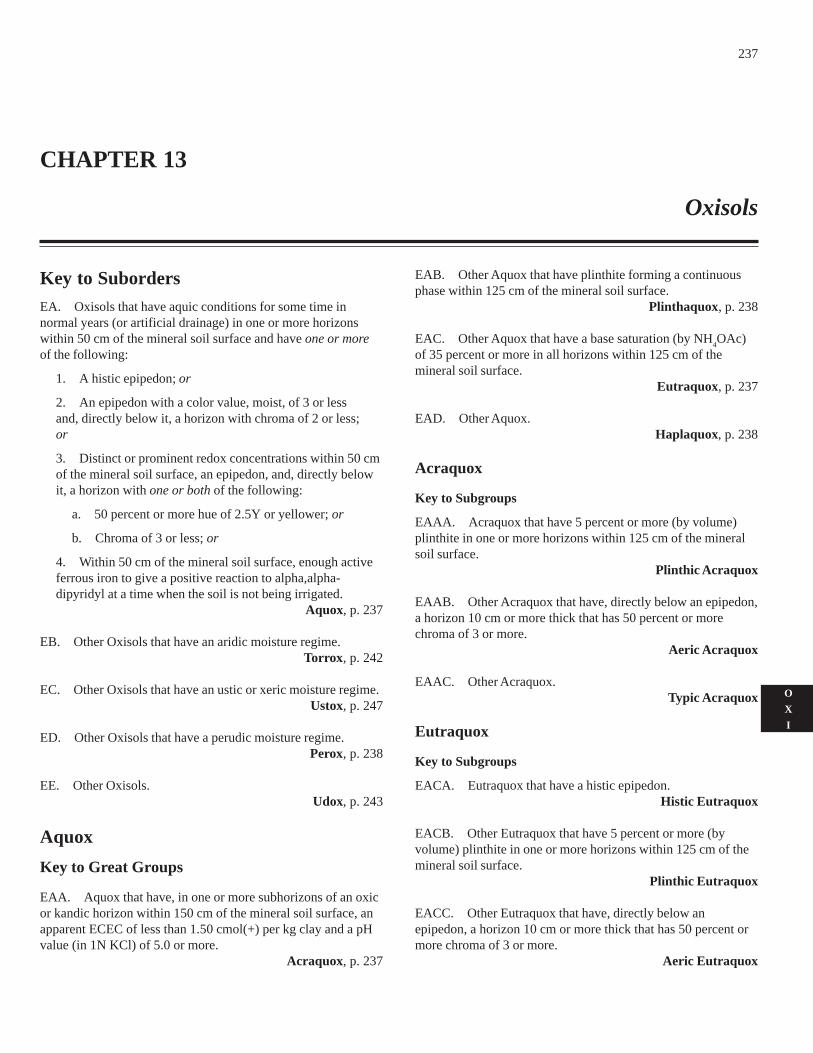
237
O
X
I
Key to SubordersEA. Oxisols that have aquic conditions for some time innormal years (or artificial drainage) in one or more horizonswithin 50 cm of the mineral soil surface and have one or moreof the following:
1. A histic epipedon; or
2. An epipedon with a color value, moist, of 3 or lessand, directly below it, a horizon with chroma of 2 or less;or
3. Distinct or prominent redox concentrations within 50 cmof the mineral soil surface, an epipedon, and, directly belowit, a horizon with one or both of the following:
a. 50 percent or more hue of 2.5Y or yellower; or
b. Chroma of 3 or less; or
4. Within 50 cm of the mineral soil surface, enough activeferrous iron to give a positive reaction to alpha,alpha-dipyridyl at a time when the soil is not being irrigated.
Aquox, p. 237
EB. Other Oxisols that have an aridic moisture regime.Torrox, p. 242
EC. Other Oxisols that have an ustic or xeric moisture regime.Ustox, p. 247
ED. Other Oxisols that have a perudic moisture regime.Perox, p. 238
EE. Other Oxisols.Udox, p. 243
Aquox
Key to Great Groups
EAA. Aquox that have, in one or more subhorizons of an oxicor kandic horizon within 150 cm of the mineral soil surface, anapparent ECEC of less than 1.50 cmol(+) per kg clay and a pHvalue (in 1N KCl) of 5.0 or more.
Acraquox, p. 237
EAB. Other Aquox that have plinthite forming a continuousphase within 125 cm of the mineral soil surface.
Plinthaquox, p. 238
EAC. Other Aquox that have a base saturation (by NH4OAc)
of 35 percent or more in all horizons within 125 cm of themineral soil surface.
Eutraquox, p. 237
EAD. Other Aquox.Haplaquox, p. 238
Acraquox
Key to Subgroups
EAAA. Acraquox that have 5 percent or more (by volume)plinthite in one or more horizons within 125 cm of the mineralsoil surface.
Plinthic Acraquox
EAAB. Other Acraquox that have, directly below an epipedon,a horizon 10 cm or more thick that has 50 percent or morechroma of 3 or more.
Aeric Acraquox
EAAC. Other Acraquox.Typic Acraquox
Eutraquox
Key to Subgroups
EACA. Eutraquox that have a histic epipedon.Histic Eutraquox
EACB. Other Eutraquox that have 5 percent or more (byvolume) plinthite in one or more horizons within 125 cm of themineral soil surface.
Plinthic Eutraquox
EACC. Other Eutraquox that have, directly below anepipedon, a horizon 10 cm or more thick that has 50 percent ormore chroma of 3 or more.
Aeric Eutraquox
CHAPTER 13
Oxisols
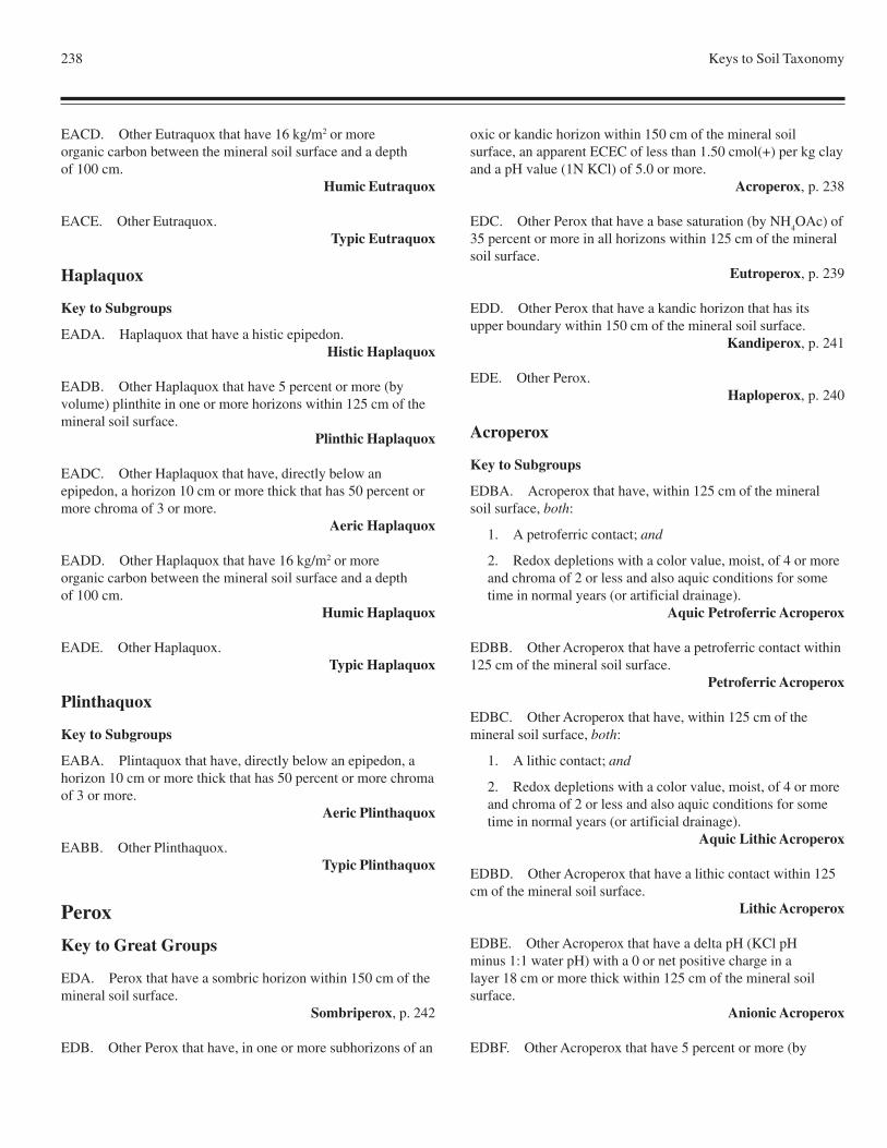
238 Keys to Soil Taxonomy
EACD. Other Eutraquox that have 16 kg/m2 or moreorganic carbon between the mineral soil surface and a depthof 100 cm.
Humic Eutraquox
EACE. Other Eutraquox.Typic Eutraquox
Haplaquox
Key to Subgroups
EADA. Haplaquox that have a histic epipedon.Histic Haplaquox
EADB. Other Haplaquox that have 5 percent or more (byvolume) plinthite in one or more horizons within 125 cm of themineral soil surface.
Plinthic Haplaquox
EADC. Other Haplaquox that have, directly below anepipedon, a horizon 10 cm or more thick that has 50 percent ormore chroma of 3 or more.
Aeric Haplaquox
EADD. Other Haplaquox that have 16 kg/m2 or moreorganic carbon between the mineral soil surface and a depthof 100 cm.
Humic Haplaquox
EADE. Other Haplaquox.Typic Haplaquox
Plinthaquox
Key to Subgroups
EABA. Plintaquox that have, directly below an epipedon, ahorizon 10 cm or more thick that has 50 percent or more chromaof 3 or more.
Aeric Plinthaquox
EABB. Other Plinthaquox.Typic Plinthaquox
Perox
Key to Great Groups
EDA. Perox that have a sombric horizon within 150 cm of themineral soil surface.
Sombriperox, p. 242
EDB. Other Perox that have, in one or more subhorizons of an
oxic or kandic horizon within 150 cm of the mineral soilsurface, an apparent ECEC of less than 1.50 cmol(+) per kg clayand a pH value (1N KCl) of 5.0 or more.
Acroperox, p. 238
EDC. Other Perox that have a base saturation (by NH4OAc) of
35 percent or more in all horizons within 125 cm of the mineralsoil surface.
Eutroperox, p. 239
EDD. Other Perox that have a kandic horizon that has itsupper boundary within 150 cm of the mineral soil surface.
Kandiperox, p. 241
EDE. Other Perox.Haploperox, p. 240
Acroperox
Key to Subgroups
EDBA. Acroperox that have, within 125 cm of the mineralsoil surface, both:
1. A petroferric contact; and
2. Redox depletions with a color value, moist, of 4 or moreand chroma of 2 or less and also aquic conditions for sometime in normal years (or artificial drainage).
Aquic Petroferric Acroperox
EDBB. Other Acroperox that have a petroferric contact within125 cm of the mineral soil surface.
Petroferric Acroperox
EDBC. Other Acroperox that have, within 125 cm of themineral soil surface, both:
1. A lithic contact; and
2. Redox depletions with a color value, moist, of 4 or moreand chroma of 2 or less and also aquic conditions for sometime in normal years (or artificial drainage).
Aquic Lithic Acroperox
EDBD. Other Acroperox that have a lithic contact within 125cm of the mineral soil surface.
Lithic Acroperox
EDBE. Other Acroperox that have a delta pH (KCl pHminus 1:1 water pH) with a 0 or net positive charge in alayer 18 cm or more thick within 125 cm of the mineral soilsurface.
Anionic Acroperox
EDBF. Other Acroperox that have 5 percent or more (by
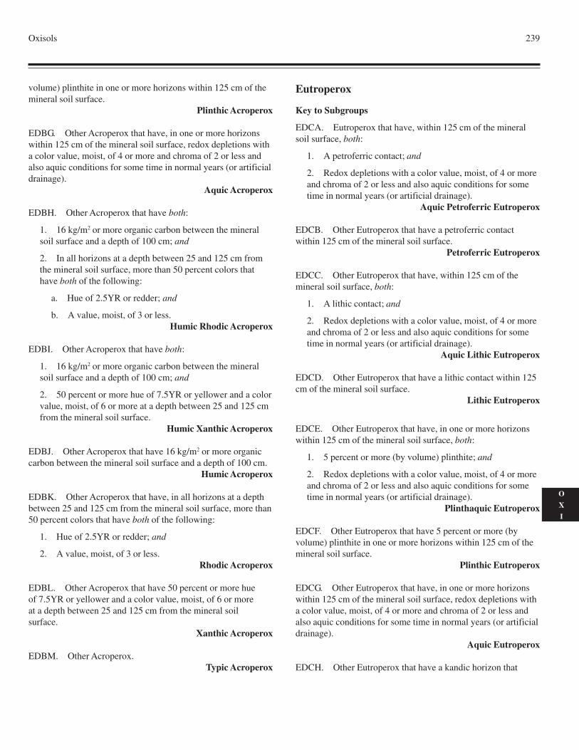
Oxisols 239
O
X
I
volume) plinthite in one or more horizons within 125 cm of themineral soil surface.
Plinthic Acroperox
EDBG. Other Acroperox that have, in one or more horizonswithin 125 cm of the mineral soil surface, redox depletions witha color value, moist, of 4 or more and chroma of 2 or less andalso aquic conditions for some time in normal years (or artificialdrainage).
Aquic Acroperox
EDBH. Other Acroperox that have both:
1. 16 kg/m2 or more organic carbon between the mineralsoil surface and a depth of 100 cm; and
2. In all horizons at a depth between 25 and 125 cm fromthe mineral soil surface, more than 50 percent colors thathave both of the following:
a. Hue of 2.5YR or redder; and
b. A value, moist, of 3 or less.Humic Rhodic Acroperox
EDBI. Other Acroperox that have both:
1. 16 kg/m2 or more organic carbon between the mineralsoil surface and a depth of 100 cm; and
2. 50 percent or more hue of 7.5YR or yellower and a colorvalue, moist, of 6 or more at a depth between 25 and 125 cmfrom the mineral soil surface.
Humic Xanthic Acroperox
EDBJ. Other Acroperox that have 16 kg/m2 or more organiccarbon between the mineral soil surface and a depth of 100 cm.
Humic Acroperox
EDBK. Other Acroperox that have, in all horizons at a depthbetween 25 and 125 cm from the mineral soil surface, more than50 percent colors that have both of the following:
1. Hue of 2.5YR or redder; and
2. A value, moist, of 3 or less.Rhodic Acroperox
EDBL. Other Acroperox that have 50 percent or more hueof 7.5YR or yellower and a color value, moist, of 6 or moreat a depth between 25 and 125 cm from the mineral soilsurface.
Xanthic Acroperox
EDBM. Other Acroperox.Typic Acroperox
Eutroperox
Key to Subgroups
EDCA. Eutroperox that have, within 125 cm of the mineralsoil surface, both:
1. A petroferric contact; and
2. Redox depletions with a color value, moist, of 4 or moreand chroma of 2 or less and also aquic conditions for sometime in normal years (or artificial drainage).
Aquic Petroferric Eutroperox
EDCB. Other Eutroperox that have a petroferric contactwithin 125 cm of the mineral soil surface.
Petroferric Eutroperox
EDCC. Other Eutroperox that have, within 125 cm of themineral soil surface, both:
1. A lithic contact; and
2. Redox depletions with a color value, moist, of 4 or moreand chroma of 2 or less and also aquic conditions for sometime in normal years (or artificial drainage).
Aquic Lithic Eutroperox
EDCD. Other Eutroperox that have a lithic contact within 125cm of the mineral soil surface.
Lithic Eutroperox
EDCE. Other Eutroperox that have, in one or more horizonswithin 125 cm of the mineral soil surface, both:
1. 5 percent or more (by volume) plinthite; and
2. Redox depletions with a color value, moist, of 4 or moreand chroma of 2 or less and also aquic conditions for sometime in normal years (or artificial drainage).
Plinthaquic Eutroperox
EDCF. Other Eutroperox that have 5 percent or more (byvolume) plinthite in one or more horizons within 125 cm of themineral soil surface.
Plinthic Eutroperox
EDCG. Other Eutroperox that have, in one or more horizonswithin 125 cm of the mineral soil surface, redox depletions witha color value, moist, of 4 or more and chroma of 2 or less andalso aquic conditions for some time in normal years (or artificialdrainage).
Aquic Eutroperox
EDCH. Other Eutroperox that have a kandic horizon that
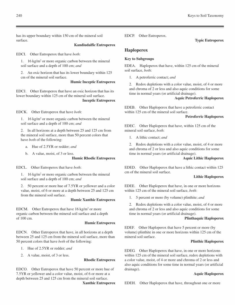
240 Keys to Soil Taxonomy
has its upper boundary within 150 cm of the mineral soilsurface.
Kandiudalfic Eutroperox
EDCI. Other Eutroperox that have both:
1. 16 kg/m2 or more organic carbon between the mineralsoil surface and a depth of 100 cm; and
2. An oxic horizon that has its lower boundary within 125cm of the mineral soil surface.
Humic Inceptic Eutroperox
EDCJ. Other Eutroperox that have an oxic horizon that has itslower boundary within 125 cm of the mineral soil surface.
Inceptic Eutroperox
EDCK. Other Eutroperox that have both:
1. 16 kg/m2 or more organic carbon between the mineralsoil surface and a depth of 100 cm; and
2. In all horizons at a depth between 25 and 125 cm fromthe mineral soil surface, more than 50 percent colors thathave both of the following:
a. Hue of 2.5YR or redder; and
b. A value, moist, of 3 or less.Humic Rhodic Eutroperox
EDCL. Other Eutroperox that have both:
1. 16 kg/m2 or more organic carbon between the mineralsoil surface and a depth of 100 cm; and
2. 50 percent or more hue of 7.5YR or yellower and a colorvalue, moist, of 6 or more at a depth between 25 and 125 cmfrom the mineral soil surface.
Humic Xanthic Eutroperox
EDCM. Other Eutroperox that have 16 kg/m2 or moreorganic carbon between the mineral soil surface and a depthof 100 cm.
Humic Eutroperox
EDCN. Other Eutroperox that have, in all horizons at a depthbetween 25 and 125 cm from the mineral soil surface, more than50 percent colors that have both of the following:
1. Hue of 2.5YR or redder; and
2. A value, moist, of 3 or less.Rhodic Eutroperox
EDCO. Other Eutroperox that have 50 percent or more hue of7.5YR or yellower and a color value, moist, of 6 or more at adepth between 25 and 125 cm from the mineral soil surface.
Xanthic Eutroperox
EDCP. Other Eutroperox.Typic Eutroperox
Haploperox
Key to Subgroups
EDEA. Haploperox that have, within 125 cm of the mineralsoil surface, both:
1. A petroferric contact; and
2. Redox depletions with a color value, moist, of 4 or moreand chroma of 2 or less and also aquic conditions for sometime in normal years (or artificial drainage).
Aquic Petroferric Haploperox
EDEB. Other Haploperox that have a petroferric contactwithin 125 cm of the mineral soil surface.
Petroferric Haploperox
EDEC. Other Haploperox that have, within 125 cm of themineral soil surface, both:
1. A lithic contact; and
2. Redox depletions with a color value, moist, of 4 or moreand chroma of 2 or less and also aquic conditions for sometime in normal years (or artificial drainage).
Aquic Lithic Haploperox
EDED. Other Haploperox that have a lithic contact within 125cm of the mineral soil surface.
Lithic Haploperox
EDEE. Other Haploperox that have, in one or more horizonswithin 125 cm of the mineral soil surface, both:
1. 5 percent or more (by volume) plinthite; and
2. Redox depletions with a color value, moist, of 4 or moreand chroma of 2 or less and also aquic conditions for sometime in normal years (or artificial drainage).
Plinthaquic Haploperox
EDEF. Other Haploperox that have 5 percent or more (byvolume) plinthite in one or more horizons within 125 cm of themineral soil surface.
Plinthic Haploperox
EDEG. Other Haploperox that have, in one or more horizonswithin 125 cm of the mineral soil surface, redox depletions witha color value, moist, of 4 or more and chroma of 2 or less andalso aquic conditions for some time in normal years (or artificialdrainage).
Aquic Haploperox
EDEH. Other Haploperox that have, throughout one or more
Oxisols 241
O
X
I
horizons with a total thickness of 18 cm or more within 75 cm ofthe mineral soil surface, a fine-earth fraction with both a bulkdensity of 1.0 g/cm3 or less, measured at 33 kPa water retention,and Al plus 1/2 Fe percentages (by ammonium oxalate) totalingmore than 1.0.
Andic Haploperox
EDEI. Other Haploperox that have both:
1. 16 kg/m2 or more organic carbon between the mineralsoil surface and a depth of 100 cm; and
2. In all horizons at a depth between 25 and 125 cm fromthe mineral soil surface, more than 50 percent colors thathave both of the following:
a. Hue of 2.5YR or redder; and
b. A value, moist, of 3 or less.Humic Rhodic Haploperox
EDEJ. Other Haploperox that have both:
1. 16 kg/m2 or more organic carbon between the mineralsoil surface and a depth of 100 cm; and
2. 50 percent or more hue of 7.5YR or yellower and a colorvalue, moist, of 6 or more at a depth between 25 and 125 cmfrom the mineral soil surface.
Humic Xanthic Haploperox
EDEK. Other Haploperox that have 16 kg/m2 or more organiccarbon between the mineral soil surface and a depth of 100 cm.
Humic Haploperox
EDEL. Other Haploperox that have, in all horizons at a depthbetween 25 and 125 cm from the mineral soil surface, more than50 percent colors that have both of the following:
1. Hue of 2.5YR or redder; and
2. A value, moist, of 3 or less.Rhodic Haploperox
EDEM. Other Haploperox that have 50 percent or more hue of7.5YR or yellower and a color value, moist, of 6 or more at adepth between 25 and 125 cm from the mineral soil surface.
Xanthic Haploperox
EDEN. Other Haploperox.Typic Haploperox
Kandiperox
Key to Subgroups
EDDA. Kandiperox that have, within 125 cm of the mineralsoil surface, both:
1. A petroferric contact; and
2. Redox depletions with a color value, moist, of 4 or moreand chroma of 2 or less and also aquic conditions for sometime in normal years (or artificial drainage).
Aquic Petroferric Kandiperox
EDDB. Other Kandiperox that have a petroferric contactwithin 125 cm of the mineral soil surface.
Petroferric Kandiperox
EDDC. Other Kandiperox that have, within 125 cm of themineral soil surface, both:
1. A lithic contact; and
2. Redox depletions with a color value, moist, of 4 or moreand chroma of 2 or less and also aquic conditions for sometime in normal years (or artificial drainage).
Aquic Lithic Kandiperox
EDDD. Other Kandiperox that have a lithic contact within 125cm of the mineral soil surface.
Lithic Kandiperox
EDDE. Other Kandiperox that have, in one or more horizonswithin 125 cm of the mineral soil surface, both:
1. 5 percent or more (by volume) plinthite; and
2. Redox depletions with a color value, moist, of 4 or moreand chroma of 2 or less and also aquic conditions for sometime in normal years (or artificial drainage).
Plinthaquic Kandiperox
EDDF. Other Kandiperox that have 5 percent or more (byvolume) plinthite in one or more horizons within 125 cm of themineral soil surface.
Plinthic Kandiperox
EDDG. Other Kandiperox that have, in one or more horizonswithin 125 cm of the mineral soil surface, redox depletions witha color value, moist, of 4 or more and chroma of 2 or less andalso aquic conditions for some time in normal years (or artificialdrainage).
Aquic Kandiperox
EDDH. Other Kandiperox that have, throughout one or morehorizons with a total thickness of 18 cm or more within 75 cm ofthe mineral soil surface, a fine-earth fraction with both a bulkdensity of 1.0 g/cm3 or less, measured at 33 kPa water retention,and Al plus 1/2 Fe percentages (by ammonium oxalate) totalingmore than 1.0.
Andic Kandiperox
EDDI. Other Kandiperox that have both:
242 Keys to Soil Taxonomy
1. 16 kg/m2 or more organic carbon between the mineralsoil surface and a depth of 100 cm; and
2. In all horizons at a depth between 25 and 125 cm fromthe mineral soil surface, more than 50 percent colors thathave both of the following:
a. Hue of 2.5YR or redder; and
b. A value, moist, of 3 or less.Humic Rhodic Kandiperox
EDDJ. Other Kandiperox that have both:
1. 16 kg/m2 or more organic carbon between the mineralsoil surface and a depth of 100 cm; and
2. 50 percent or more hue of 7.5YR or yellower and a colorvalue, moist, of 6 or more at a depth between 25 and 125 cmfrom the mineral soil surface.
Humic Xanthic Kandiperox
EDDK. Other Kandiperox that have 16 kg/m2 or moreorganic carbon between the mineral soil surface and a depthof 100 cm.
Humic Kandiperox
EDDL. Other Kandiperox that have, in all horizonsat a depth between 25 and 125 cm from the mineral soil surface,more than 50 percent colors that have both of the following:
1. Hue of 2.5YR or redder; and
2. A value, moist, of 3 or less.Rhodic Kandiperox
EDDM. Other Kandiperox that have 50 percent or morehue of 7.5YR or yellower and a color value, moist, of 6 or moreat a depth between 25 and 125 cm from the mineral soil surface.
Xanthic Kandiperox
EDDN. Other Kandiperox.Typic Kandiperox
Sombriperox
Key to Subgroups
EDAA. Sombriperox that have a petroferric contact within125 cm of the mineral soil surface.
Petroferric Sombriperox
EDAB. Other Sombriperox that have a lithic contact within125 cm of the mineral soil surface.
Lithic Sombriperox
EDAC. Other Sombriperox that have 16 kg/m2 or more
organic carbon between the mineral soil surface and a depth of100 cm.
Humic Sombriperox
EDAD. Other Sombriperox.Typic Sombriperox
Torrox
Key to Great Groups
EBA. Torrox that have, in one or more subhorizons of an oxicor kandic horizon within 150 cm of the mineral soil surface, anapparent ECEC of less than 1.50 cmol(+) per kg clay and a pHvalue (1N KCl) of 5.0 or more.
Acrotorrox, p. 242
EBB. Other Torrox that have a base saturation (by NH4OAc)
of 35 percent or more in all horizons within 125 cm of themineral soil surface.
Eutrotorrox, p. 242
EBC. Other Torrox.Haplotorrox, p. 243
Acrotorrox
Key to Subgroups
EBAA. Acrotorrox that have a petroferric contact within 125cm of the mineral soil surface.
Petroferric Acrotorrox
EBAB. Other Acrotorrox that have a lithic contact within 125cm of the mineral soil surface.
Lithic Acrotorrox
EBAC. Other Acrotorrox.Typic Acrotorrox
Eutrotorrox
Key to Subgroups
EBBA. Eutrotorrox that have a petroferric contact within 125cm of the mineral soil surface.
Petroferric Eutrotorrox
EBBB. Other Eutrotorrox that have a lithic contact within 125cm of the mineral soil surface.
Lithic Eutrotorrox
EBBC. Other Eutrotorrox.Typic Eutrotorrox
Oxisols 243
O
X
I
Haplotorrox
Key to Subgroups
EBCA. Haplotorrox that have a petroferric contact within 125cm of the mineral soil surface.
Petroferric Haplotorrox
EBCB. Other Haplotorrox that have a lithic contact within 125cm of the mineral soil surface.
Lithic Haplotorrox
EBCC. Other Haplotorrox.Typic Haplotorrox
Udox
Key to Great Groups
EEA. Udox that have a sombric horizon within 150 cm of themineral soil surface.
Sombriudox, p. 247
EEB. Other Udox that have, in one or more subhorizons of anoxic or kandic horizon within 150 cm of the mineral soilsurface, an apparent ECEC of less than 1.50 cmol(+) per kg clayand a pH value (1N KCl) of 5.0 or more.
Acrudox, p. 243
EEC. Other Udox that have a base saturation (by NH4OAc) of
35 percent or more in all horizons within 125 cm of the mineralsoil surface.
Eutrudox, p. 244
EED. Other Udox that have a kandic horizon that has its upperboundary within 150 cm of the mineral soil surface.
Kandiudox, p. 246
EEE. Other Udox.Hapludox, p. 245
Acrudox
Key to Subgroups
EEBA. Acrudox that have, within 125 cm of the mineral soilsurface, both:
1. A petroferric contact; and
2. Redox depletions with a color value, moist, of 4 or moreand chroma of 2 or less and also aquic conditions for sometime in normal years (or artificial drainage).
Aquic Petroferric Acrudox
EEBB. Other Acrudox that have a petroferric contact within125 cm of the mineral soil surface.
Petroferric Acrudox
EEBC. Other Acrudox that have, within 125 cm of the mineralsoil surface, both:
1. A lithic contact; and
2. Redox depletions with a color value, moist, of 4 or moreand chroma of 2 or less and also aquic conditions for sometime in normal years (or artificial drainage).
Aquic Lithic Acrudox
EEBD. Other Acrudox that have a lithic contact within 125 cmof the mineral soil surface.
Lithic Acrudox
EEBE. Other Acrudox that have, within 125 cm of the mineralsoil surface, both:
1. A delta pH (KCl pH minus 1:1 water pH) witha 0 or net positive charge in a layer 18 cm or more thick; and
2. Redox depletions with a color value, moist, of 4 or moreand chroma of 2 or less and also aquic conditions for sometime in normal years (or artificial drainage).
Anionic Aquic Acrudox
EEBF. Other Acrudox that have a delta pH (KCl pH minus 1:1water pH) with a 0 or net positive charge in a layer 18 cm ormore thick within 125 cm of the mineral soil surface.
Anionic Acrudox
EEBG. Other Acrudox that have 5 percent or more (byvolume) plinthite in one or more horizons within 125 cm of themineral soil surface.
Plinthic Acrudox
EEBH. Other Acrudox that have, in one or more horizonswithin 125 cm of the mineral soil surface, redox depletions witha color value, moist, of 4 or more and chroma of 2 or less andalso aquic conditions for some time in normal years (or artificialdrainage).
Aquic Acrudox
EEBI. Other Acrudox that have a base saturation (byNH
4OAc) of 35 percent or more in all horizons within 125 cm
of the mineral soil surface.Eutric Acrudox
EEBJ. Other Acrudox that have both:
1. 16 kg/m2 or more organic carbon between the mineralsoil surface and a depth of 100 cm; and
244 Keys to Soil Taxonomy
2. In all horizons at a depth between 25 and 125 cm fromthe mineral soil surface, more than 50 percent colors thathave both of the following:
a. Hue of 2.5YR or redder; and
b. A value, moist, of 3 or less.Humic Rhodic Acrudox
EEBK. Other Acrudox that have both:
1. 16 kg/m2 or more organic carbon between the mineralsoil surface and a depth of 100 cm; and
2. 50 percent or more hue of 7.5YR or yellower and a colorvalue, moist, of 6 or more at a depth between 25 and 125 cmfrom the mineral soil surface.
Humic Xanthic Acrudox
EEBL. Other Acrudox that have 16 kg/m2 or more organiccarbon between the mineral soil surface and a depth of 100 cm.
Humic Acrudox
EEBM. Other Acrudox that have, in all horizons at a depthbetween 25 and 125 cm from the mineral soil surface, more than50 percent colors that have both of the following:
1. Hue of 2.5YR or redder; and
2. A value, moist, of 3 or less.Rhodic Acrudox
EEBN. Other Acrudox that have 50 percent or more hueof 7.5YR or yellower and a color value, moist, of 6 or moreat a depth between 25 and 125 cm from the mineral soil surface.
Xanthic Acrudox
EEBO. Other Acrudox.Typic Acrudox
Eutrudox
Key to Subgroups
EECA. Eutrudox that have, within 125 cm of the mineral soilsurface, both:
1. A petroferric contact; and
2. Redox depletions with a color value, moist, of 4 or moreand chroma of 2 or less and also aquic conditions for sometime in normal years (or artificial drainage).
Aquic Petroferric Eutrudox
EECB. Other Eutrudox that have a petroferric contact within125 cm of the mineral soil surface.
Petroferric Eutrudox
EECC. Other Eutrudox that have, within 125 cm of themineral soil surface, both:
1. A lithic contact; and
2. Redox depletions with a color value, moist, of 4 or moreand chroma of 2 or less and also aquic conditions for sometime in normal years (or artificial drainage).
Aquic Lithic Eutrudox
EECD. Other Eutrudox that have a lithic contact within 125cm of the mineral soil surface.
Lithic Eutrudox
EECE. Other Eutrudox that have, in one or more horizonswithin 125 cm of the mineral soil surface, both:
1. 5 percent or more (by volume) plinthite; and
2. Redox depletions with a color value, moist, of 4 or moreand chroma of 2 or less and also aquic conditions for sometime in normal years (or artificial drainage).
Plinthaquic Eutrudox
EECF. Other Eutrudox that have 5 percent or more (byvolume) plinthite in one or more horizons within 125 cm of themineral soil surface.
Plinthic Eutrudox
EECG. Other Eutrudox that have, in one or more horizonswithin 125 cm of the mineral soil surface, redox depletions witha color value, moist, of 4 or more and chroma of 2 or less andalso aquic conditions for some time in normal years (or artificialdrainage).
Aquic Eutrudox
EECH. Other Eutrudox that have a kandic horizon that has itsupper boundary within 150 cm of the mineral soil surface.
Kandiudalfic Eutrudox
EECI. Other Eutrudox that have both:
1. 16 kg/m2 or more organic carbon between the mineralsoil surface and a depth of 100 cm; and
2. An oxic horizon that has its lower boundary within 125cm of the mineral soil surface.
Humic Inceptic Eutrudox
EECJ. Other Eutrudox that have an oxic horizon that has itslower boundary within 125 cm of the mineral soil surface.
Inceptic Eutrudox
EECK. Other Eutrudox that have both:
1. 16 kg/m2 or more organic carbon between the mineralsoil surface and a depth of 100 cm; and
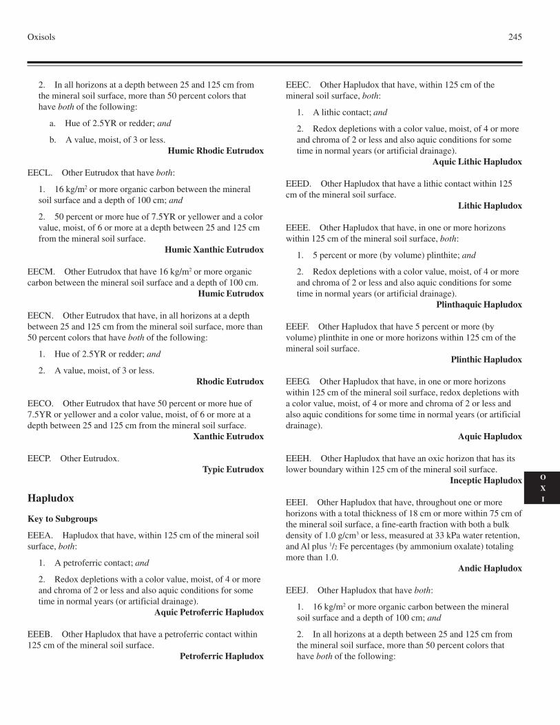
Oxisols 245
O
X
I
2. In all horizons at a depth between 25 and 125 cm fromthe mineral soil surface, more than 50 percent colors thathave both of the following:
a. Hue of 2.5YR or redder; and
b. A value, moist, of 3 or less.Humic Rhodic Eutrudox
EECL. Other Eutrudox that have both:
1. 16 kg/m2 or more organic carbon between the mineralsoil surface and a depth of 100 cm; and
2. 50 percent or more hue of 7.5YR or yellower and a colorvalue, moist, of 6 or more at a depth between 25 and 125 cmfrom the mineral soil surface.
Humic Xanthic Eutrudox
EECM. Other Eutrudox that have 16 kg/m2 or more organiccarbon between the mineral soil surface and a depth of 100 cm.
Humic Eutrudox
EECN. Other Eutrudox that have, in all horizons at a depthbetween 25 and 125 cm from the mineral soil surface, more than50 percent colors that have both of the following:
1. Hue of 2.5YR or redder; and
2. A value, moist, of 3 or less.Rhodic Eutrudox
EECO. Other Eutrudox that have 50 percent or more hue of7.5YR or yellower and a color value, moist, of 6 or more at adepth between 25 and 125 cm from the mineral soil surface.
Xanthic Eutrudox
EECP. Other Eutrudox.Typic Eutrudox
Hapludox
Key to Subgroups
EEEA. Hapludox that have, within 125 cm of the mineral soilsurface, both:
1. A petroferric contact; and
2. Redox depletions with a color value, moist, of 4 or moreand chroma of 2 or less and also aquic conditions for sometime in normal years (or artificial drainage).
Aquic Petroferric Hapludox
EEEB. Other Hapludox that have a petroferric contact within125 cm of the mineral soil surface.
Petroferric Hapludox
EEEC. Other Hapludox that have, within 125 cm of themineral soil surface, both:
1. A lithic contact; and
2. Redox depletions with a color value, moist, of 4 or moreand chroma of 2 or less and also aquic conditions for sometime in normal years (or artificial drainage).
Aquic Lithic Hapludox
EEED. Other Hapludox that have a lithic contact within 125cm of the mineral soil surface.
Lithic Hapludox
EEEE. Other Hapludox that have, in one or more horizonswithin 125 cm of the mineral soil surface, both:
1. 5 percent or more (by volume) plinthite; and
2. Redox depletions with a color value, moist, of 4 or moreand chroma of 2 or less and also aquic conditions for sometime in normal years (or artificial drainage).
Plinthaquic Hapludox
EEEF. Other Hapludox that have 5 percent or more (byvolume) plinthite in one or more horizons within 125 cm of themineral soil surface.
Plinthic Hapludox
EEEG. Other Hapludox that have, in one or more horizonswithin 125 cm of the mineral soil surface, redox depletions witha color value, moist, of 4 or more and chroma of 2 or less andalso aquic conditions for some time in normal years (or artificialdrainage).
Aquic Hapludox
EEEH. Other Hapludox that have an oxic horizon that has itslower boundary within 125 cm of the mineral soil surface.
Inceptic Hapludox
EEEI. Other Hapludox that have, throughout one or morehorizons with a total thickness of 18 cm or more within 75 cm ofthe mineral soil surface, a fine-earth fraction with both a bulkdensity of 1.0 g/cm3 or less, measured at 33 kPa water retention,and Al plus 1/2 Fe percentages (by ammonium oxalate) totalingmore than 1.0.
Andic Hapludox
EEEJ. Other Hapludox that have both:
1. 16 kg/m2 or more organic carbon between the mineralsoil surface and a depth of 100 cm; and
2. In all horizons at a depth between 25 and 125 cm fromthe mineral soil surface, more than 50 percent colors thathave both of the following:
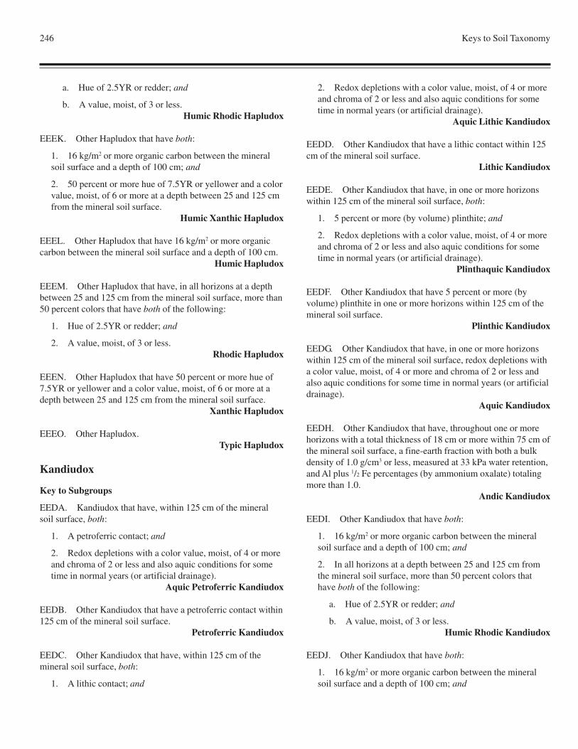
246 Keys to Soil Taxonomy
a. Hue of 2.5YR or redder; and
b. A value, moist, of 3 or less.Humic Rhodic Hapludox
EEEK. Other Hapludox that have both:
1. 16 kg/m2 or more organic carbon between the mineralsoil surface and a depth of 100 cm; and
2. 50 percent or more hue of 7.5YR or yellower and a colorvalue, moist, of 6 or more at a depth between 25 and 125 cmfrom the mineral soil surface.
Humic Xanthic Hapludox
EEEL. Other Hapludox that have 16 kg/m2 or more organiccarbon between the mineral soil surface and a depth of 100 cm.
Humic Hapludox
EEEM. Other Hapludox that have, in all horizons at a depthbetween 25 and 125 cm from the mineral soil surface, more than50 percent colors that have both of the following:
1. Hue of 2.5YR or redder; and
2. A value, moist, of 3 or less.Rhodic Hapludox
EEEN. Other Hapludox that have 50 percent or more hue of7.5YR or yellower and a color value, moist, of 6 or more at adepth between 25 and 125 cm from the mineral soil surface.
Xanthic Hapludox
EEEO. Other Hapludox.Typic Hapludox
Kandiudox
Key to Subgroups
EEDA. Kandiudox that have, within 125 cm of the mineralsoil surface, both:
1. A petroferric contact; and
2. Redox depletions with a color value, moist, of 4 or moreand chroma of 2 or less and also aquic conditions for sometime in normal years (or artificial drainage).
Aquic Petroferric Kandiudox
EEDB. Other Kandiudox that have a petroferric contact within125 cm of the mineral soil surface.
Petroferric Kandiudox
EEDC. Other Kandiudox that have, within 125 cm of themineral soil surface, both:
1. A lithic contact; and
2. Redox depletions with a color value, moist, of 4 or moreand chroma of 2 or less and also aquic conditions for sometime in normal years (or artificial drainage).
Aquic Lithic Kandiudox
EEDD. Other Kandiudox that have a lithic contact within 125cm of the mineral soil surface.
Lithic Kandiudox
EEDE. Other Kandiudox that have, in one or more horizonswithin 125 cm of the mineral soil surface, both:
1. 5 percent or more (by volume) plinthite; and
2. Redox depletions with a color value, moist, of 4 or moreand chroma of 2 or less and also aquic conditions for sometime in normal years (or artificial drainage).
Plinthaquic Kandiudox
EEDF. Other Kandiudox that have 5 percent or more (byvolume) plinthite in one or more horizons within 125 cm of themineral soil surface.
Plinthic Kandiudox
EEDG. Other Kandiudox that have, in one or more horizonswithin 125 cm of the mineral soil surface, redox depletions witha color value, moist, of 4 or more and chroma of 2 or less andalso aquic conditions for some time in normal years (or artificialdrainage).
Aquic Kandiudox
EEDH. Other Kandiudox that have, throughout one or morehorizons with a total thickness of 18 cm or more within 75 cm ofthe mineral soil surface, a fine-earth fraction with both a bulkdensity of 1.0 g/cm3 or less, measured at 33 kPa water retention,and Al plus 1/2 Fe percentages (by ammonium oxalate) totalingmore than 1.0.
Andic Kandiudox
EEDI. Other Kandiudox that have both:
1. 16 kg/m2 or more organic carbon between the mineralsoil surface and a depth of 100 cm; and
2. In all horizons at a depth between 25 and 125 cm fromthe mineral soil surface, more than 50 percent colors thathave both of the following:
a. Hue of 2.5YR or redder; and
b. A value, moist, of 3 or less.Humic Rhodic Kandiudox
EEDJ. Other Kandiudox that have both:
1. 16 kg/m2 or more organic carbon between the mineralsoil surface and a depth of 100 cm; and
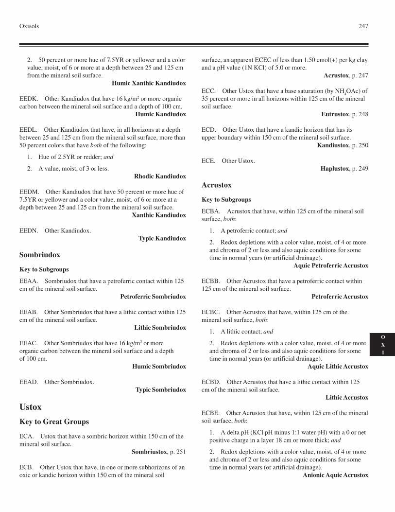
Oxisols 247
O
X
I
2. 50 percent or more hue of 7.5YR or yellower and a colorvalue, moist, of 6 or more at a depth between 25 and 125 cmfrom the mineral soil surface.
Humic Xanthic Kandiudox
EEDK. Other Kandiudox that have 16 kg/m2 or more organiccarbon between the mineral soil surface and a depth of 100 cm.
Humic Kandiudox
EEDL. Other Kandiudox that have, in all horizons at a depthbetween 25 and 125 cm from the mineral soil surface, more than50 percent colors that have both of the following:
1. Hue of 2.5YR or redder; and
2. A value, moist, of 3 or less.Rhodic Kandiudox
EEDM. Other Kandiudox that have 50 percent or more hue of7.5YR or yellower and a color value, moist, of 6 or more at adepth between 25 and 125 cm from the mineral soil surface.
Xanthic Kandiudox
EEDN. Other Kandiudox.Typic Kandiudox
Sombriudox
Key to Subgroups
EEAA. Sombriudox that have a petroferric contact within 125cm of the mineral soil surface.
Petroferric Sombriudox
EEAB. Other Sombriudox that have a lithic contact within 125cm of the mineral soil surface.
Lithic Sombriudox
EEAC. Other Sombriudox that have 16 kg/m2 or moreorganic carbon between the mineral soil surface and a depthof 100 cm.
Humic Sombriudox
EEAD. Other Sombriudox.Typic Sombriudox
Ustox
Key to Great Groups
ECA. Ustox that have a sombric horizon within 150 cm of themineral soil surface.
Sombriustox, p. 251
ECB. Other Ustox that have, in one or more subhorizons of anoxic or kandic horizon within 150 cm of the mineral soil
surface, an apparent ECEC of less than 1.50 cmol(+) per kg clayand a pH value (1N KCl) of 5.0 or more.
Acrustox, p. 247
ECC. Other Ustox that have a base saturation (by NH4OAc) of
35 percent or more in all horizons within 125 cm of the mineralsoil surface.
Eutrustox, p. 248
ECD. Other Ustox that have a kandic horizon that has itsupper boundary within 150 cm of the mineral soil surface.
Kandiustox, p. 250
ECE. Other Ustox.Haplustox, p. 249
Acrustox
Key to Subgroups
ECBA. Acrustox that have, within 125 cm of the mineral soilsurface, both:
1. A petroferric contact; and
2. Redox depletions with a color value, moist, of 4 or moreand chroma of 2 or less and also aquic conditions for sometime in normal years (or artificial drainage).
Aquic Petroferric Acrustox
ECBB. Other Acrustox that have a petroferric contact within125 cm of the mineral soil surface.
Petroferric Acrustox
ECBC. Other Acrustox that have, within 125 cm of themineral soil surface, both:
1. A lithic contact; and
2. Redox depletions with a color value, moist, of 4 or moreand chroma of 2 or less and also aquic conditions for sometime in normal years (or artificial drainage).
Aquic Lithic Acrustox
ECBD. Other Acrustox that have a lithic contact within 125cm of the mineral soil surface.
Lithic Acrustox
ECBE. Other Acrustox that have, within 125 cm of the mineralsoil surface, both:
1. A delta pH (KCl pH minus 1:1 water pH) with a 0 or netpositive charge in a layer 18 cm or more thick; and
2. Redox depletions with a color value, moist, of 4 or moreand chroma of 2 or less and also aquic conditions for sometime in normal years (or artificial drainage).
Anionic Aquic Acrustox
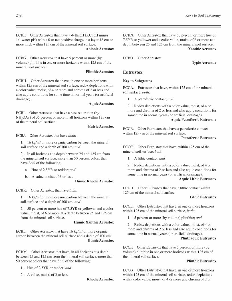
248 Keys to Soil Taxonomy
ECBF. Other Acrustox that have a delta pH (KCl pH minus1:1 water pH) with a 0 or net positive charge in a layer 18 cm ormore thick within 125 cm of the mineral soil surface.
Anionic Acrustox
ECBG. Other Acrustox that have 5 percent or more (byvolume) plinthite in one or more horizons within 125 cm of themineral soil surface.
Plinthic Acrustox
ECBH. Other Acrustox that have, in one or more horizonswithin 125 cm of the mineral soil surface, redox depletions witha color value, moist, of 4 or more and chroma of 2 or less andalso aquic conditions for some time in normal years (or artificialdrainage).
Aquic Acrustox
ECBI. Other Acrustox that have a base saturation (byNH
4OAc) of 35 percent or more in all horizons within 125 cm
of the mineral soil surface.Eutric Acrustox
ECBJ. Other Acrustox that have both:
1. 16 kg/m2 or more organic carbon between the mineralsoil surface and a depth of 100 cm; and
2. In all horizons at a depth between 25 and 125 cm fromthe mineral soil surface, more than 50 percent colors thathave both of the following:
a. Hue of 2.5YR or redder; and
b. A value, moist, of 3 or less.Humic Rhodic Acrustox
ECBK. Other Acrustox that have both:
1. 16 kg/m2 or more organic carbon between the mineralsoil surface and a depth of 100 cm; and
2. 50 percent or more hue of 7.5YR or yellower and a colorvalue, moist, of 6 or more at a depth between 25 and 125 cmfrom the mineral soil surface.
Humic Xanthic Acrustox
ECBL. Other Acrustox that have 16 kg/m2 or more organiccarbon between the mineral soil surface and a depth of 100 cm.
Humic Acrustox
ECBM. Other Acrustox that have, in all horizons at a depthbetween 25 and 125 cm from the mineral soil surface, more than50 percent colors that have both of the following:
1. Hue of 2.5YR or redder; and
2. A value, moist, of 3 or less.Rhodic Acrustox
ECBN. Other Acrustox that have 50 percent or more hue of7.5YR or yellower and a color value, moist, of 6 or more at adepth between 25 and 125 cm from the mineral soil surface.
Xanthic Acrustox
ECBO. Other Acrustox.Typic Acrustox
Eutrustox
Key to Subgroups
ECCA. Eutrustox that have, within 125 cm of the mineralsoil surface, both:
1. A petroferric contact; and
2. Redox depletions with a color value, moist, of 4 ormore and chroma of 2 or less and also aquic conditions forsome time in normal years (or artificial drainage).
Aquic Petroferric Eutrustox
ECCB. Other Eutrustox that have a petroferric contactwithin 125 cm of the mineral soil surface.
Petroferric Eutrustox
ECCC. Other Eutrustox that have, within 125 cm of themineral soil surface, both:
1. A lithic contact; and
2. Redox depletions with a color value, moist, of 4 ormore and chroma of 2 or less and also aquic conditions forsome time in normal years (or artificial drainage).
Aquic Lithic Eutrustox
ECCD. Other Eutrustox that have a lithic contact within125 cm of the mineral soil surface.
Lithic Eutrustox
ECCE. Other Eutrustox that have, in one or more horizonswithin 125 cm of the mineral soil surface, both:
1. 5 percent or more (by volume) plinthite; and
2. Redox depletions with a color value, moist, of 4 ormore and chroma of 2 or less and also aquic conditions forsome time in normal years (or artificial drainage).
Plinthaquic Eutrustox
ECCF. Other Eutrustox that have 5 percent or more (byvolume) plinthite in one or more horizons within 125 cm ofthe mineral soil surface.
Plinthic Eutrustox
ECCG. Other Eutrustox that have, in one or more horizonswithin 125 cm of the mineral soil surface, redox depletionswith a color value, moist, of 4 or more and chroma of 2 or
Oxisols 249
O
X
I
less and also aquic conditions for some time in normal years (orartificial drainage).
Aquic Eutrustox
ECCH. Other Eutrustox that have a kandic horizon that has itsupper boundary within 150 cm of the mineral soil surface.
Kandiustalfic Eutrustox
ECCI. Other Eutrustox that have both:
1. 16 kg/m2 or more organic carbon between the mineralsoil surface and a depth of 100 cm; and
2. An oxic horizon that has its lower boundary within 125cm of the mineral soil surface.
Humic Inceptic Eutrustox
ECCJ. Other Eutrustox that have an oxic horizon that has itslower boundary within 125 cm of the mineral soil surface.
Inceptic Eutrustox
ECCK. Other Eutrustox that have both:
1. 16 kg/m2 or more organic carbon between the mineralsoil surface and a depth of 100 cm; and
2. In all horizons at a depth between 25 and 125 cm fromthe mineral soil surface, more than 50 percent colors thathave both of the following:
a. Hue of 2.5YR or redder; and
b. A value, moist, of 3 or less.Humic Rhodic Eutrustox
ECCL. Other Eutrustox that have both:
1. 16 kg/m2 or more organic carbon between the mineralsoil surface and a depth of 100 cm; and
2. 50 percent or more hue of 7.5YR or yellower and a colorvalue, moist, of 6 or more at a depth between 25 and 125 cmfrom the mineral soil surface.
Humic Xanthic Eutrustox
ECCM. Other Eutrustox that have 16 kg/m2 or more organiccarbon between the mineral soil surface and a depth of 100 cm.
Humic Eutrustox
ECCN. Other Eutrustox that have, in all horizons at a depthbetween 25 and 125 cm from the mineral soil surface, more than50 percent colors that have both of the following:
1. Hue of 2.5YR or redder; and
2. A value, moist, of 3 or less.Rhodic Eutrustox
ECCO. Other Eutrustox that have 50 percent or more hue of
7.5YR or yellower and a color value, moist, of 6 or more at adepth between 25 and 125 cm from the mineral soil surface.
Xanthic Eutrustox
ECCP. Other Eutrustox.Typic Eutrustox
Haplustox
Key to Subgroups
ECEA. Haplustox that have, within 125 cm of the mineral soilsurface, both:
1. A petroferric contact; and
2. Redox depletions with a color value, moist, of 4 or moreand chroma of 2 or less and also aquic conditions for sometime in normal years (or artificial drainage).
Aquic Petroferric Haplustox
ECEB. Other Haplustox that have a petroferric contact within125 cm of the mineral soil surface.
Petroferric Haplustox
ECEC. Other Haplustox that have, within 125 cm of themineral soil surface, both:
1. A lithic contact; and
2. Redox depletions with a color value, moist, of 4 or moreand chroma of 2 or less and also aquic conditions for sometime in normal years (or artificial drainage).
Aquic Lithic Haplustox
ECED. Other Haplustox that have a lithic contact within 125cm of the mineral soil surface.
Lithic Haplustox
ECEE. Other Haplustox that have, in one or more horizonswithin 125 cm of the mineral soil surface, both:
1. 5 percent or more (by volume) plinthite; and
2. Redox depletions with a color value, moist, of 4 or moreand chroma of 2 or less and also aquic conditions for sometime in normal years (or artificial drainage).
Plinthaquic Haplustox
ECEF. Other Haplustox that have 5 percent or more (byvolume) plinthite in one or more horizons within 125 cm of themineral soil surface.
Plinthic Haplustox
ECEG. Other Haplustox that have, within 125 cm of themineral soil surface, both:
1. The lower boundary of the oxic horizon; and
250 Keys to Soil Taxonomy
2. Redox depletions with a color value, moist, of 4 or moreand chroma of 2 or less and also aquic conditions for sometime in normal years (or artificial drainage).
Aqueptic Haplustox
ECEH. Other Haplustox that have, in one or more horizonswithin 125 cm of the mineral soil surface, redox depletions witha color value, moist, of 4 or more and chroma of 2 or less andalso aquic conditions for some time in normal years (or artificialdrainage).
Aquic Haplustox
ECEI. Other Haplustox that are saturated with water in one ormore layers within 100 cm of the mineral soil surface in normalyears for either or both:
1. 20 or more consecutive days; or
2. 30 or more cumulative days.Oxyaquic Haplustox
ECEJ. Other Haplustox that have an oxic horizon that hasits lower boundary within 125 cm of the mineral soil surface.
Inceptic Haplustox
ECEK. Other Haplustox that have both:
1. 16 kg/m2 or more organic carbon between the mineralsoil surface and a depth of 100 cm; and
2. In all horizons at a depth between 25 and 125 cm fromthe mineral soil surface, more than 50 percent colors thathave both of the following:
a. Hue of 2.5YR or redder; and
b. A value, moist, of 3 or less.Humic Rhodic Haplustox
ECEL. Other Haplustox that have both:
1. 16 kg/m2 or more organic carbon between the mineralsoil surface and a depth of 100 cm; and
2. 50 percent or more hue of 7.5YR or yellower and a colorvalue, moist, of 6 or more at a depth between 25 and 125 cmfrom the mineral soil surface.
Humic Xanthic Haplustox
ECEM. Other Haplustox that have 16 kg/m2 or moreorganic carbon between the mineral soil surface and a depthof 100 cm.
Humic Haplustox
ECEN. Other Haplustox that have, in all horizons at a depthbetween 25 and 125 cm from the mineral soil surface, more than50 percent colors that have both of the following:
1. Hue of 2.5YR or redder; and
2. A value, moist, of 3 or less.Rhodic Haplustox
ECEO. Other Haplustox that have 50 percent or more hueof 7.5YR or yellower and a color value, moist, of 6 or moreat a depth between 25 and 125 cm from the mineral soilsurface.
Xanthic Haplustox
ECEP. Other Haplustox.Typic Haplustox
Kandiustox
Key to Subgroups
ECDA. Kandiustox that have, within 125 cm of the mineralsoil surface, both:
1. A petroferric contact; and
2. Redox depletions with a color value, moist, of 4 or moreand chroma of 2 or less and also aquic conditions for sometime in normal years (or artificial drainage).
Aquic Petroferric Kandiustox
ECDB. Other Kandiustox that have a petroferric contactwithin 125 cm of the mineral soil surface.
Petroferric Kandiustox
ECDC. Other Kandiustox that have, within 125 cm of themineral soil surface, both:
1. A lithic contact; and
2. Redox depletions with a color value, moist, of 4 or moreand chroma of 2 or less and also aquic conditions for sometime in normal years (or artificial drainage).
Aquic Lithic Kandiustox
ECDD. Other Kandiustox that have a lithic contact within 125cm of the mineral soil surface.
Lithic Kandiustox
ECDE. Other Kandiustox that have, in one or more horizonswithin 125 cm of the mineral soil surface, both:
1. 5 percent or more (by volume) plinthite; and
2. Redox depletions with a color value, moist, of 4 or moreand chroma of 2 or less and also aquic conditions for sometime in normal years (or artificial drainage).
Plinthaquic Kandiustox
ECDF. Other Kandiustox that have 5 percent or more (byvolume) plinthite in one or more horizons within 125 cm of themineral soil surface.
Plinthic Kandiustox
Oxisols 251
O
X
I
ECDG. Other Kandiustox that have, in one or more horizonswithin 125 cm of the mineral soil surface, redox depletions witha color value, moist, of 4 or more and chroma of 2 or less andalso aquic conditions for some time in normal years (or artificialdrainage).
Aquic Kandiustox
ECDH. Other Kandiustox that have both:
1. 16 kg/m2 or more organic carbon between the mineralsoil surface and a depth of 100 cm; and
2. In all horizons at a depth between 25 and 125 cm fromthe mineral soil surface, more than 50 percent colors thathave both of the following:
a. Hue of 2.5YR or redder; and
b. A value, moist, of 3 or less.Humic Rhodic Kandiustox
ECDI. Other Kandiustox that have both:
1. 16 kg/m2 or more organic carbon between the mineralsoil surface and a depth of 100 cm; and
2. 50 percent or more hue of 7.5YR or yellower and a colorvalue, moist, of 6 or more at a depth between 25 and 125 cmfrom the mineral soil surface.
Humic Xanthic Kandiustox
ECDJ. Other Kandiustox that have 16 kg/m2 or more organiccarbon between the mineral soil surface and a depth of 100 cm.
Humic Kandiustox
ECDK. Other Kandiustox that have, in all horizons at a depth
between 25 and 125 cm from the mineral soil surface, more than50 percent colors that have both of the following:
1. Hue of 2.5YR or redder; and
2. A value, moist, of 3 or less.Rhodic Kandiustox
ECDL. Other Kandiustox that have 50 percent or more hue of7.5YR or yellower and a color value, moist, of 6 or more at adepth between 25 and 125 cm from the mineral soil surface.
Xanthic Kandiustox
ECDM. Other Kandiustox.Typic Kandiustox
Sombriustox
Key to Subgroups
ECAA. Sombriustox that have a petroferric contact within 125cm of the mineral soil surface.
Petroferric Sombriustox
ECAB. Other Sombriustox that have a lithic contact within125 cm of the mineral soil surface.
Lithic Sombriustox
ECAC. Other Sombriustox that have 16 kg/m2 or more organiccarbon between the mineral soil surface and a depth of 100 cm.
Humic Sombriustox
ECAD. Other Sombriustox.Typic Sombriustox

253
S
P
O
Key to SubordersCA. Spodosols that have aquic conditions for some time innormal years (or artificial drainage) in one or more horizonswithin 50 cm of the mineral soil surface and have one or both ofthe following:
1. A histic epipedon; or
2. Within 50 cm of the mineral soil surface, redoximorphicfeatures in an albic or a spodic horizon.
Aquods, p. 253
CB. Other Spodosols that have, in normal years, a meanannual soil temperature of 0 oC or colder and a mean summersoil temperature that:
1. Is 8 oC or colder if there is no O horizon; or
2. Is 5 oC or colder if there is an O horizon.Gelods, p. 257
CC. Other Spodosols that have a cryic soil temperatureregime.
Cryods, p. 255
CD. Other Spodosols that have 6.0 percent or more organiccarbon in a layer 10 cm or more thick within the spodic horizon.
Humods, p. 257
CE. Other Spodosols.Orthods, p. 258
Aquods
Key to Great Groups
CAA. Aquods that have a cryic soil temperature regime.Cryaquods, p. 254
CAB. Other Aquods that have less than 0.10 percent iron (byammonium oxalate) in 75 percent or more of the spodic horizon.
Alaquods, p. 253
CAC. Other Aquods that have a fragipan with its upperboundary within 100 cm of the mineral soil surface.
Fragiaquods, p. 255
CAD. Other Aquods that have a placic horizon within 100 cmof the mineral soil surface in 50 percent or more of each pedon.
Placaquods, p. 255
CAE. Other Aquods that have, in 90 percent or more of eachpedon, a cemented soil layer that has its upper boundary within100 cm of the mineral soil surface.
Duraquods, p. 254
CAF. Other Aquods that have episaturation.Epiaquods, p. 255
CAG. Other Aquods.Endoaquods, p. 254
Alaquods
Key to Subgroups
CABA. Alaquods that have a lithic contact within 50 cm of themineral soil surface.
Lithic Alaquods
CABB. Other Alaquods that have, in 90 percent or more ofeach pedon, a cemented soil layer that does not slake in waterafter air drying and has its upper boundary within 100 cm of themineral soil surface.
Duric Alaquods
CABC. Other Alaquods that have a histic epipedon.Histic Alaquods
CABD. Other Alaquods that have both:
1. Within 200 cm of the mineral soil surface, an argillic orkandic horizon that has a base saturation of 35 percent ormore (by sum of cations) in some part; and
2. A sandy or sandy-skeletal particle-size class throughout alayer extending from the mineral soil surface to the top of aspodic horizon at a depth of 75 to 125 cm.
Alfic Arenic Alaquods
CABE. Other Alaquods that have both:
1. An argillic or kandic horizon within 200 cm of themineral soil surface; and
CHAPTER 14
Spodosols
254 Keys to Soil Taxonomy
2. A sandy or sandy-skeletal particle-size class throughout alayer extending from the mineral soil surface to the top of aspodic horizon at a depth of 75 to 125 cm.
Arenic Ultic Alaquods
CABF. Other Alaquods that have both:
1. An umbric epipedon; and
2. A sandy or sandy-skeletal particle-size class throughout alayer extending from the mineral soil surface to the top of aspodic horizon at a depth of 75 cm or more.
Arenic Umbric Alaquods
CABG. Other Alaquods that have a sandy or sandy-skeletalparticle-size class throughout a layer extending from the mineralsoil surface to the top of a spodic horizon at a depth of 75 to 125cm.
Arenic Alaquods
CABH. Other Alaquods that have a sandy or sandy-skeletalparticle-size class throughout a layer extending from the mineralsoil surface to the top of a spodic horizon at a depth of 125 cmor more.
Grossarenic Alaquods
CABI. Other Alaquods that have, within 200 cm of the mineralsoil surface, an argillic or kandic horizon that has a basesaturation of 35 percent or more (by sum of cations) in somepart.
Alfic Alaquods
CABJ. Other Alaquods that have an argillic or kandic horizonwithin 200 cm of the mineral soil surface.
Ultic Alaquods
CABK. Other Alaquods that have an ochric epipedon.Aeric Alaquods
CABL. Other Alaquods.Typic Alaquods
Cryaquods
Key to Subgroups
CAAA. Cryaquods that have a lithic contact within 50 cm ofthe mineral soil surface.
Lithic Cryaquods
CAAB. Other Cryaquods that have a placic horizon within100 cm of the mineral soil surface in 50 percent or more of eachpedon.
Placic Cryaquods
CAAC. Other Cryaquods that have, in 90 percent or more of
each pedon, a cemented soil layer that does not slake in waterafter air drying and has its upper boundary within 100 cm of themineral soil surface.
Duric Cryaquods
CAAD. Other Cryaquods that have andic soil propertiesthroughout horizons that have a total thickness of 25 cm or morewithin 75 cm either of the mineral soil surface or of the top of anorganic layer with andic soil properties, whichever is shallower.
Andic Cryaquods
CAAE. Other Cryaquods that have a spodic horizon less than10 cm thick in 50 percent or more of each pedon.
Entic Cryaquods
CAAF. Other Cryaquods.Typic Cryaquods
Duraquods
Key to Subgroups
CAEA. Duraquods that have a histic epipedon.Histic Duraquods
CAEB. Other Duraquods that have andic soil propertiesthroughout horizons that have a total thickness of 25 cm ormore within 75 cm either of the mineral soil surface or of thetop of an organic layer with andic soil properties, whichever isshallower.
Andic Duraquods
CAEC. Other Duraquods.Typic Duraquods
Endoaquods
Key to Subgroups
CAGA. Endoaquods that have a lithic contact within 50 cm ofthe mineral soil surface.
Lithic Endoaquods
CAGB. Other Endoaquods that have a histic epipedon.Histic Endoaquods
CAGC. Other Endoaquods that have andic soil propertiesthroughout horizons that have a total thickness of 25 cm or morewithin 75 cm either of the mineral soil surface or of the top of anorganic layer with andic soil properties, whichever is shallower.
Andic Endoaquods
CAGD. Other Endoaquods that have an argillic or kandichorizon within 200 cm of the mineral soil surface.
Argic Endoaquods
Spodosols 255
S
P
O
CAGE. Other Endoaquods that have an umbric epipedon.Umbric Endoaquods
CAGF. Other Endoaquods.Typic Endoaquods
Epiaquods
Key to Subgroups
CAFA. Epiaquods that have a lithic contact within 50 cm ofthe mineral soil surface.
Lithic Epiaquods
CAFB. Other Epiaquods that have a histic epipedon.Histic Epiaquods
CAFC. Other Epiaquods that have andic soil propertiesthroughout horizons that have a total thickness of 25 cm or morewithin 75 cm either of the mineral soil surface or of the top of anorganic layer with andic soil properties, whichever is shallower.
Andic Epiaquods
CAFD. Other Epiaquods that have, within 200 cm of themineral soil surface, an argillic or kandic horizon that has a basesaturation of 35 percent or more (by sum of cations) in somepart.
Alfic Epiaquods
CAFE. Other Epiaquods that have an argillic or kandichorizon within 200 cm of the mineral soil surface.
Ultic Epiaquods
CAFF. Other Epiaquods that have an umbric epipedon.Umbric Epiaquods
CAFG. Other Epiaquods.Typic Epiaquods
Fragiaquods
Key to Subgroups
CACA. Fragiaquods that have a histic epipedon.Histic Fragiaquods
CACB. Other Fragiaquods that have a surface horizon 30 cmor more thick that meets all of the requirements for a plaggenepipedon except thickness.
Plagganthreptic Fragiaquods
CACC. Other Fragiaquods that have an argillic or kandichorizon within 200 cm of the mineral soil surface.
Argic Fragiaquods
CACD. Other Fragiaquods.Typic Fragiaquods
Placaquods
Key to Subgroups
CADA. Placaquods that have andic soil properties throughouthorizons that have a total thickness of 25 cm or more within 75cm either of the mineral soil surface or of the top of an organiclayer with andic soil properties, whichever is shallower.
Andic Placaquods
CADB. Other Placaquods.Typic Placaquods
Cryods
Key to Great Groups
CCA. Cryods that have a placic horizon within 100 cm ofthe mineral soil surface in 50 percent or more of each pedon.
Placocryods, p. 257
CCB. Other Cryods that have, in 90 percent or more of eachpedon, a cemented soil layer that does not slake in water afterair drying and has its upper boundary within 100 cm of themineral soil surface.
Duricryods, p. 255
CCC. Other Cryods that have 6.0 percent or more organiccarbon throughout a layer 10 cm or more thick within the spodichorizon.
Humicryods, p. 256
CCD. Other Cryods.Haplocryods, p. 256
Duricryods
Key to Subgroups
CCBA. Duricryods that have both:
1. Redoximorphic features in one or more horizonswithin 75 cm of the mineral soil surface and also aquicconditions for some time in normal years (or artificialdrainage); and
2. Andic soil properties throughout horizons that have atotal thickness of 25 cm or more within 75 cm either of themineral soil surface or of the top of an organic layer withandic soil properties, whichever is shallower.
Aquandic Duricryods
CCBB. Other Duricryods that have andic soil properties
256 Keys to Soil Taxonomy
throughout horizons that have a total thickness of 25 cm or morewithin 75 cm either of the mineral soil surface or of the top of anorganic layer with andic soil properties, whichever is shallower.
Andic Duricryods
CCBC. Other Duricryods that have redoximorphic features inone or more horizons within 75 cm of the mineral soil surfaceand also aquic conditions for some time in normal years (orartificial drainage).
Aquic Duricryods
CCBD. Other Duricryods that are saturated with water in oneor more layers within 100 cm of the mineral soil surface innormal years for either or both:
1. 20 or more consecutive days; or
2. 30 or more cumulative days.Oxyaquic Duricryods
CCBE. Other Duricryods that have 6.0 percent or moreorganic carbon throughout a layer 10 cm or more thick withinthe spodic horizon.
Humic Duricryods
CCBF. Other Duricryods.Typic Duricryods
Haplocryods
Key to Subgroups
CCDA. Haplocryods that have a lithic contact within 50 cm ofthe mineral soil surface.
Lithic Haplocryods
CCDB. Other Haplocryods that have both:
1. Redoximorphic features in one or more horizonswithin 75 cm of the mineral soil surface and also aquicconditions for some time in normal years (or artificialdrainage); and
2. Andic soil properties throughout horizons that have atotal thickness of 25 cm or more within 75 cm either of themineral soil surface or of the top of an organic layer withandic soil properties, whichever is shallower.
Aquandic Haplocryods
CCDC. Other Haplocryods that have andic soil propertiesthroughout horizons that have a total thickness of 25 cm or morewithin 75 cm either of the mineral soil surface or of the top of anorganic layer with andic soil properties, whichever is shallower.
Andic Haplocryods
CCDD. Other Haplocryods that have redoximorphic featuresin one or more horizons within 75 cm of the mineral soil surface
and also aquic conditions for some time in normal years (orartificial drainage).
Aquic Haplocryods
CCDE. Other Haplocryods that are saturated with water in oneor more layers within 100 cm of the mineral soil surface innormal years for either or both:
1. 20 or more consecutive days; or
2. 30 or more cumulative days.Oxyaquic Haplocryods
CCDF. Other Haplocryods that have 1.1 percent or lessorganic carbon in the upper 10 cm of the spodic horizon.
Entic Haplocryods
CCDG. Other Haplocryods.Typic Haplocryods
Humicryods
Key to Subgroups
CCCA. Humicryods that have a lithic contact within 50 cm ofthe mineral soil surface.
Lithic Humicryods
CCCB. Other Humicryods that have both:
1. Redoximorphic features in one or more horizonswithin 75 cm of the mineral soil surface and also aquicconditions for some time in normal years (or artificialdrainage); and
2. Andic soil properties throughout horizons that have atotal thickness of 25 cm or more within 75 cm either of themineral soil surface or of the top of an organic layer withandic soil properties, whichever is shallower.
Aquandic Humicryods
CCCC. Other Humicryods that have andic soil propertiesthroughout horizons that have a total thickness of 25 cm ormore within 75 cm either of the mineral soil surface or of the topof an organic layer with andic soil properties, whichever isshallower.
Andic Humicryods
CCCD. Other Humicryods that have redoximorphic features inone or more horizons within 75 cm of the mineral soil surfaceand also aquic conditions for some time in normal years (orartificial drainage).
Aquic Humicryods
CCCE. Other Humicryods that are saturated with water in oneor more layers within 100 cm of the mineral soil surface innormal years for either or both:
Spodosols 257
S
P
O
1. 20 or more consecutive days; or
2. 30 or more cumulative days.Oxyaquic Humicryods
CCCF. Other Humicryods.Typic Humicryods
Placocryods
Key to Subgroups
CCAA. Placocryods that have andic soil properties throughouthorizons that have a total thickness of 25 cm or more within 75cm either of the mineral soil surface or of the top of an organiclayer with andic soil properties, whichever is shallower.
Andic Placocryods
CCAB. Other Placocryods that have 6.0 percent or moreorganic carbon in a layer 10 cm or more thick within the spodichorizon.
Humic Placocryods
CCAC. Other Placocryods.Typic Placocryods
Gelods
Key to Great Groups
CBA. Gelods that have 6.0 percent or more organic carbonthroughout a layer 10 cm or more thick within the spodichorizon.
Humigelods, p. 257
CBB. Other Gelods.Haplogelods, p. 257
Haplogelods
Key to Subgroups
CBBA. Haplogelods that have a lithic contact within 50 cm ofthe mineral soil surface.
Lithic Haplogelods
CBBB. Other Haplogelods that have andic soil propertiesthroughout horizons that have a total thickness of 25 cm or morewithin 75 cm either of the mineral soil surface or of the top of anorganic layer with andic soil properties, whichever is shallower.
Andic Haplogelods
CBBC. Other Haplogelods that have redoximorphic features
in one or more horizons within 75 cm of the mineral soil surfaceand also aquic conditions for some time in normal years (orartificial drainage).
Aquic Haplogelods
CBBD. Other Haplogelods.Typic Haplogelods
Humigelods
Key to Subgroups
CBAA. Humigelods that have a lithic contact within 50 cm ofthe mineral soil surface.
Lithic Humigelods
CBAB. Other Humigelods that have andic soil propertiesthroughout horizons that have a total thickness of 25 cm ormore within 75 cm either of the mineral soil surface or of thetop of an organic layer with andic soil properties, whichever isshallower.
Andic Humigelods
CBAC. Other Humigelods that have redoximorphic features inone or more horizons within 75 cm of the mineral soil surfaceand also aquic conditions for some time in normal years (orartificial drainage).
Aquic Humigelods
CBAD. Other Humigelods.Typic Humigelods
Humods
Key to Great Groups
CDA. Humods that have a placic horizon within 100 cm of themineral soil surface in 50 percent or more of each pedon.
Placohumods, p. 258
CDB. Other Humods that have, in 90 percent or more of eachpedon, a cemented soil layer that does not slake in water afterair drying and has its upper boundary within 100 cm of themineral soil surface.
Durihumods, p. 258
CDC. Other Humods that have a fragipan with its upperboundary within 100 cm of the mineral soil surface.
Fragihumods, p. 258
CDD. Other Humods.Haplohumods, p. 258
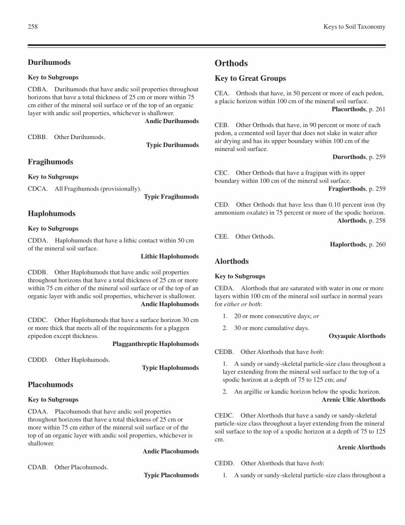
258 Keys to Soil Taxonomy
Durihumods
Key to Subgroups
CDBA. Durihumods that have andic soil properties throughouthorizons that have a total thickness of 25 cm or more within 75cm either of the mineral soil surface or of the top of an organiclayer with andic soil properties, whichever is shallower.
Andic Durihumods
CDBB. Other Durihumods.Typic Durihumods
Fragihumods
Key to Subgroups
CDCA. All Fragihumods (provisionally).Typic Fragihumods
Haplohumods
Key to Subgroups
CDDA. Haplohumods that have a lithic contact within 50 cmof the mineral soil surface.
Lithic Haplohumods
CDDB. Other Haplohumods that have andic soil propertiesthroughout horizons that have a total thickness of 25 cm or morewithin 75 cm either of the mineral soil surface or of the top of anorganic layer with andic soil properties, whichever is shallower.
Andic Haplohumods
CDDC. Other Haplohumods that have a surface horizon 30 cmor more thick that meets all of the requirements for a plaggenepipedon except thickness.
Plagganthreptic Haplohumods
CDDD. Other Haplohumods.Typic Haplohumods
Placohumods
Key to Subgroups
CDAA. Placohumods that have andic soil propertiesthroughout horizons that have a total thickness of 25 cm ormore within 75 cm either of the mineral soil surface or of thetop of an organic layer with andic soil properties, whichever isshallower.
Andic Placohumods
CDAB. Other Placohumods.Typic Placohumods
Orthods
Key to Great Groups
CEA. Orthods that have, in 50 percent or more of each pedon,a placic horizon within 100 cm of the mineral soil surface.
Placorthods, p. 261
CEB. Other Orthods that have, in 90 percent or more of eachpedon, a cemented soil layer that does not slake in water afterair drying and has its upper boundary within 100 cm of themineral soil surface.
Durorthods, p. 259
CEC. Other Orthods that have a fragipan with its upperboundary within 100 cm of the mineral soil surface.
Fragiorthods, p. 259
CED. Other Orthods that have less than 0.10 percent iron (byammonium oxalate) in 75 percent or more of the spodic horizon.
Alorthods, p. 258
CEE. Other Orthods.Haplorthods, p. 260
Alorthods
Key to Subgroups
CEDA. Alorthods that are saturated with water in one or morelayers within 100 cm of the mineral soil surface in normal yearsfor either or both:
1. 20 or more consecutive days; or
2. 30 or more cumulative days.Oxyaquic Alorthods
CEDB. Other Alorthods that have both:
1. A sandy or sandy-skeletal particle-size class throughout alayer extending from the mineral soil surface to the top of aspodic horizon at a depth of 75 to 125 cm; and
2. An argillic or kandic horizon below the spodic horizon.Arenic Ultic Alorthods
CEDC. Other Alorthods that have a sandy or sandy-skeletalparticle-size class throughout a layer extending from the mineralsoil surface to the top of a spodic horizon at a depth of 75 to 125cm.
Arenic Alorthods
CEDD. Other Alorthods that have both:
1. A sandy or sandy-skeletal particle-size class throughout a
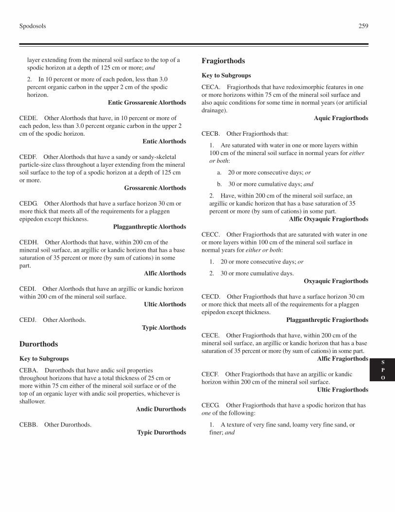
Spodosols 259
S
P
O
layer extending from the mineral soil surface to the top of aspodic horizon at a depth of 125 cm or more; and
2. In 10 percent or more of each pedon, less than 3.0percent organic carbon in the upper 2 cm of the spodichorizon.
Entic Grossarenic Alorthods
CEDE. Other Alorthods that have, in 10 percent or more ofeach pedon, less than 3.0 percent organic carbon in the upper 2cm of the spodic horizon.
Entic Alorthods
CEDF. Other Alorthods that have a sandy or sandy-skeletalparticle-size class throughout a layer extending from the mineralsoil surface to the top of a spodic horizon at a depth of 125 cmor more.
Grossarenic Alorthods
CEDG. Other Alorthods that have a surface horizon 30 cm ormore thick that meets all of the requirements for a plaggenepipedon except thickness.
Plagganthreptic Alorthods
CEDH. Other Alorthods that have, within 200 cm of themineral soil surface, an argillic or kandic horizon that has a basesaturation of 35 percent or more (by sum of cations) in somepart.
Alfic Alorthods
CEDI. Other Alorthods that have an argillic or kandic horizonwithin 200 cm of the mineral soil surface.
Ultic Alorthods
CEDJ. Other Alorthods.Typic Alorthods
Durorthods
Key to Subgroups
CEBA. Durorthods that have andic soil propertiesthroughout horizons that have a total thickness of 25 cm ormore within 75 cm either of the mineral soil surface or of thetop of an organic layer with andic soil properties, whichever isshallower.
Andic Durorthods
CEBB. Other Durorthods.Typic Durorthods
Fragiorthods
Key to Subgroups
CECA. Fragiorthods that have redoximorphic features in oneor more horizons within 75 cm of the mineral soil surface andalso aquic conditions for some time in normal years (or artificialdrainage).
Aquic Fragiorthods
CECB. Other Fragiorthods that:
1. Are saturated with water in one or more layers within100 cm of the mineral soil surface in normal years for eitheror both:
a. 20 or more consecutive days; or
b. 30 or more cumulative days; and
2. Have, within 200 cm of the mineral soil surface, anargillic or kandic horizon that has a base saturation of 35percent or more (by sum of cations) in some part.
Alfic Oxyaquic Fragiorthods
CECC. Other Fragiorthods that are saturated with water in oneor more layers within 100 cm of the mineral soil surface innormal years for either or both:
1. 20 or more consecutive days; or
2. 30 or more cumulative days.Oxyaquic Fragiorthods
CECD. Other Fragiorthods that have a surface horizon 30 cmor more thick that meets all of the requirements for a plaggenepipedon except thickness.
Plagganthreptic Fragiorthods
CECE. Other Fragiorthods that have, within 200 cm of themineral soil surface, an argillic or kandic horizon that has a basesaturation of 35 percent or more (by sum of cations) in some part.
Alfic Fragiorthods
CECF. Other Fragiorthods that have an argillic or kandichorizon within 200 cm of the mineral soil surface.
Ultic Fragiorthods
CECG. Other Fragiorthods that have a spodic horizon that hasone of the following:
1. A texture of very fine sand, loamy very fine sand, orfiner; and
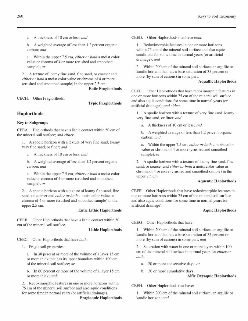
260 Keys to Soil Taxonomy
a. A thickness of 10 cm or less; and
b. A weighted average of less than 1.2 percent organiccarbon; and
c. Within the upper 7.5 cm, either or both a moist colorvalue or chroma of 4 or more (crushed and smoothedsample); or
2. A texture of loamy fine sand, fine sand, or coarser andeither or both a moist color value or chroma of 4 or more(crushed and smoothed sample) in the upper 2.5 cm.
Entic Fragiorthods
CECH. Other Fragiorthods.Typic Fragiorthods
Haplorthods
Key to Subgroups
CEEA. Haplorthods that have a lithic contact within 50 cm ofthe mineral soil surface; and either
1. A spodic horizon with a texture of very fine sand, loamyvery fine sand, or finer; and
a. A thickness of 10 cm or less; and
b. A weighted average of less than 1.2 percent organiccarbon; and
c. Within the upper 7.5 cm, either or both a moist colorvalue or chroma of 4 or more (crushed and smoothedsample); or
2. A spodic horizon with a texture of loamy fine sand, finesand, or coarser and either or both a moist color value orchroma of 4 or more (crushed and smoothed sample) in theupper 2.5 cm.
Entic Lithic Haplorthods
CEEB. Other Haplorthods that have a lithic contact within 50cm of the mineral soil surface.
Lithic Haplorthods
CEEC. Other Haplorthods that have both:
1. Fragic soil properties:
a. In 30 percent or more of the volume of a layer 15 cmor more thick that has its upper boundary within 100 cmof the mineral soil surface; or
b. In 60 percent or more of the volume of a layer 15 cmor more thick; and
2. Redoximorphic features in one or more horizons within75 cm of the mineral soil surface and also aquic conditionsfor some time in normal years (or artificial drainage).
Fragiaquic Haplorthods
CEED. Other Haplorthods that have both:
1. Redoximorphic features in one or more horizonswithin 75 cm of the mineral soil surface and also aquicconditions for some time in normal years (or artificialdrainage); and
2. Within 200 cm of the mineral soil surface, an argillic orkandic horizon that has a base saturation of 35 percent ormore (by sum of cations) in some part.
Aqualfic Haplorthods
CEEE. Other Haplorthods that have redoximorphic features inone or more horizons within 75 cm of the mineral soil surfaceand also aquic conditions for some time in normal years (orartificial drainage); and either
1. A spodic horizon with a texture of very fine sand, loamyvery fine sand, or finer; and
a. A thickness of 10 cm or less; and
b. A weighted average of less than 1.2 percent organiccarbon; and
c. Within the upper 7.5 cm, either or both a moist colorvalue or chroma of 4 or more (crushed and smoothedsample); or
2. A spodic horizon with a texture of loamy fine sand, finesand, or coarser and either or both a moist color value orchroma of 4 or more (crushed and smoothed sample) in theupper 2.5 cm.
Aquentic Haplorthods
CEEF. Other Haplorthods that have redoximorphic features inone or more horizons within 75 cm of the mineral soil surfaceand also aquic conditions for some time in normal years (orartificial drainage).
Aquic Haplorthods
CEEG. Other Haplorthods that have:
1. Within 200 cm of the mineral soil surface, an argillic orkandic horizon that has a base saturation of 35 percent ormore (by sum of cations) in some part; and
2. Saturation with water in one or more layers within 100cm of the mineral soil surface in normal years for either orboth:
a. 20 or more consecutive days; or
b. 30 or more cumulative days.Alfic Oxyaquic Haplorthods
CEEH. Other Haplorthods that have:
1. Within 200 cm of the mineral soil surface, an argillic orkandic horizon; and
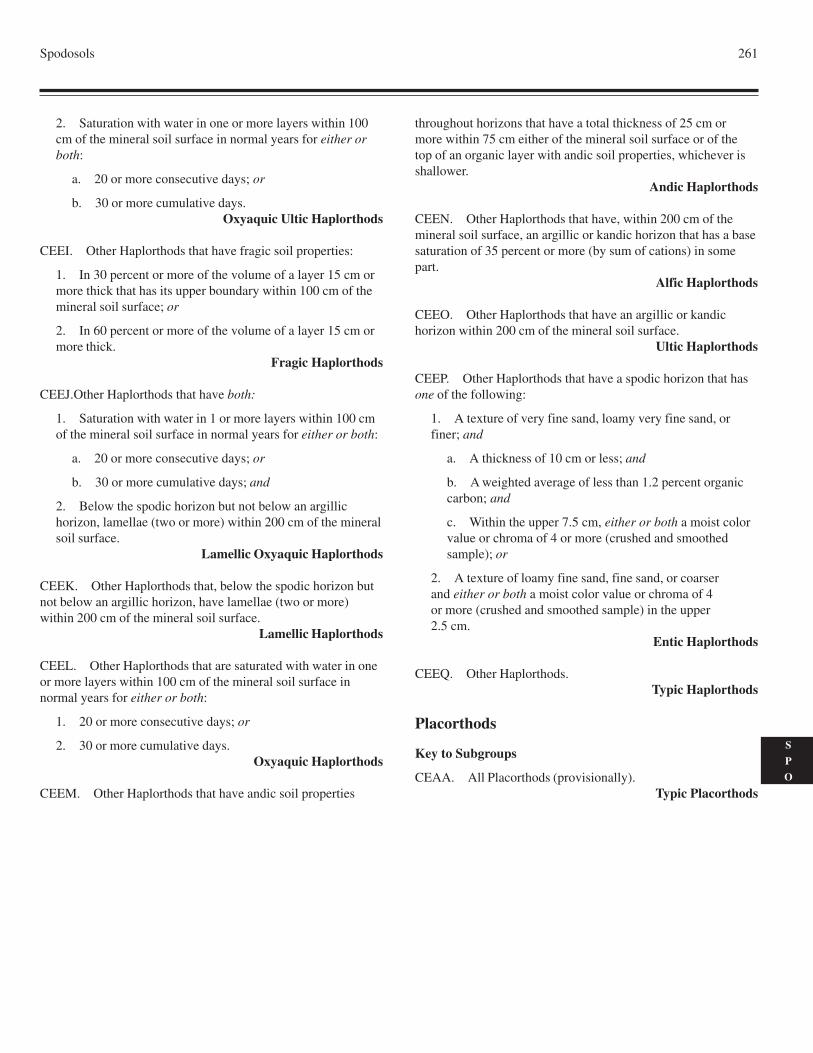
Spodosols 261
S
P
O
2. Saturation with water in one or more layers within 100cm of the mineral soil surface in normal years for either orboth:
a. 20 or more consecutive days; or
b. 30 or more cumulative days.Oxyaquic Ultic Haplorthods
CEEI. Other Haplorthods that have fragic soil properties:
1. In 30 percent or more of the volume of a layer 15 cm ormore thick that has its upper boundary within 100 cm of themineral soil surface; or
2. In 60 percent or more of the volume of a layer 15 cm ormore thick.
Fragic Haplorthods
CEEJ.Other Haplorthods that have both:
1. Saturation with water in 1 or more layers within 100 cmof the mineral soil surface in normal years for either or both:
a. 20 or more consecutive days; or
b. 30 or more cumulative days; and
2. Below the spodic horizon but not below an argillichorizon, lamellae (two or more) within 200 cm of the mineralsoil surface.
Lamellic Oxyaquic Haplorthods
CEEK. Other Haplorthods that, below the spodic horizon butnot below an argillic horizon, have lamellae (two or more)within 200 cm of the mineral soil surface.
Lamellic Haplorthods
CEEL. Other Haplorthods that are saturated with water in oneor more layers within 100 cm of the mineral soil surface innormal years for either or both:
1. 20 or more consecutive days; or
2. 30 or more cumulative days.Oxyaquic Haplorthods
CEEM. Other Haplorthods that have andic soil properties
throughout horizons that have a total thickness of 25 cm ormore within 75 cm either of the mineral soil surface or of thetop of an organic layer with andic soil properties, whichever isshallower.
Andic Haplorthods
CEEN. Other Haplorthods that have, within 200 cm of themineral soil surface, an argillic or kandic horizon that has a basesaturation of 35 percent or more (by sum of cations) in somepart.
Alfic Haplorthods
CEEO. Other Haplorthods that have an argillic or kandichorizon within 200 cm of the mineral soil surface.
Ultic Haplorthods
CEEP. Other Haplorthods that have a spodic horizon that hasone of the following:
1. A texture of very fine sand, loamy very fine sand, orfiner; and
a. A thickness of 10 cm or less; and
b. A weighted average of less than 1.2 percent organiccarbon; and
c. Within the upper 7.5 cm, either or both a moist colorvalue or chroma of 4 or more (crushed and smoothedsample); or
2. A texture of loamy fine sand, fine sand, or coarserand either or both a moist color value or chroma of 4or more (crushed and smoothed sample) in the upper2.5 cm.
Entic Haplorthods
CEEQ. Other Haplorthods.Typic Haplorthods
Placorthods
Key to Subgroups
CEAA. All Placorthods (provisionally).Typic Placorthods

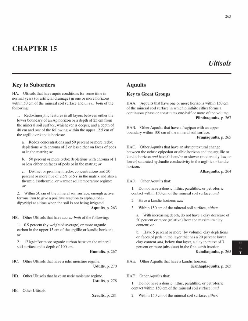
263
U
L
T
Key to SubordersHA. Ultisols that have aquic conditions for some time innormal years (or artificial drainage) in one or more horizonswithin 50 cm of the mineral soil surface and one or both of thefollowing:
1. Redoximorphic features in all layers between either thelower boundary of an Ap horizon or a depth of 25 cm fromthe mineral soil surface, whichever is deeper, and a depth of40 cm and one of the following within the upper 12.5 cm ofthe argillic or kandic horizon:
a. Redox concentrations and 50 percent or more redoxdepletions with chroma of 2 or less either on faces of pedsor in the matrix; or
b. 50 percent or more redox depletions with chroma of 1or less either on faces of peds or in the matrix; or
c. Distinct or prominent redox concentrations and 50percent or more hue of 2.5Y or 5Y in the matrix and also athermic, isothermic, or warmer soil temperature regime;or
2. Within 50 cm of the mineral soil surface, enough activeferrous iron to give a positive reaction to alpha,alpha-dipyridyl at a time when the soil is not being irrigated.
Aquults, p. 263
HB. Other Ultisols that have one or both of the following:
1. 0.9 percent (by weighted average) or more organiccarbon in the upper 15 cm of the argillic or kandic horizon;or
2. 12 kg/m2 or more organic carbon between the mineralsoil surface and a depth of 100 cm.
Humults, p. 267
HC. Other Ultisols that have a udic moisture regime.Udults, p. 270
HD. Other Ultisols that have an ustic moisture regime.Ustults, p. 278
HE. Other Ultisols.Xerults, p. 281
Aquults
Key to Great Groups
HAA. Aquults that have one or more horizons within 150 cmof the mineral soil surface in which plinthite either forms acontinuous phase or constitutes one-half or more of the volume.
Plinthaquults, p. 267
HAB. Other Aquults that have a fragipan with an upperboundary within 100 cm of the mineral soil surface.
Fragiaquults, p. 265
HAC. Other Aquults that have an abrupt textural changebetween the ochric epipedon or albic horizon and the argillic orkandic horizon and have 0.4 cm/hr or slower (moderately low orlower) saturated hydraulic conductivity in the argillic or kandichorizon.
Albaquults, p. 264
HAD. Other Aquults that:
1. Do not have a densic, lithic, paralithic, or petroferriccontact within 150 cm of the mineral soil surface; and
2. Have a kandic horizon; and
3. Within 150 cm of the mineral soil surface, either:
a. With increasing depth, do not have a clay decrease of20 percent or more (relative) from the maximum claycontent; or
b. Have 5 percent or more (by volume) clay depletionson faces of peds in the layer that has a 20 percent lowerclay content and, below that layer, a clay increase of 3percent or more (absolute) in the fine-earth fraction.
Kandiaquults, p. 265
HAE. Other Aquults that have a kandic horizon.Kanhaplaquults, p. 265
HAF. Other Aquults that:
1. Do not have a densic, lithic, paralithic, or petroferriccontact within 150 cm of the mineral soil surface; and
2. Within 150 cm of the mineral soil surface, either:
CHAPTER 15
Ultisols
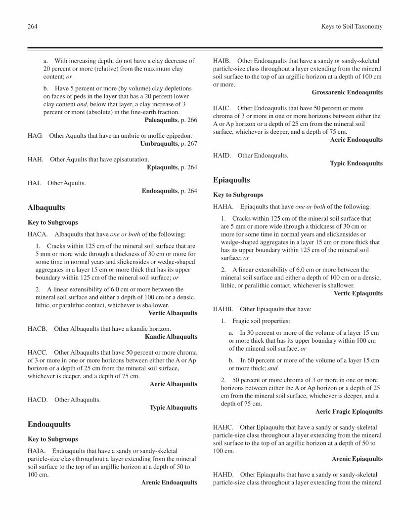
264 Keys to Soil Taxonomy
a. With increasing depth, do not have a clay decrease of20 percent or more (relative) from the maximum claycontent; or
b. Have 5 percent or more (by volume) clay depletionson faces of peds in the layer that has a 20 percent lowerclay content and, below that layer, a clay increase of 3percent or more (absolute) in the fine-earth fraction.
Paleaquults, p. 266
HAG. Other Aquults that have an umbric or mollic epipedon.Umbraquults, p. 267
HAH. Other Aquults that have episaturation.Epiaquults, p. 264
HAI. Other Aquults.Endoaquults, p. 264
Albaquults
Key to Subgroups
HACA. Albaquults that have one or both of the following:
1. Cracks within 125 cm of the mineral soil surface that are5 mm or more wide through a thickness of 30 cm or more forsome time in normal years and slickensides or wedge-shapedaggregates in a layer 15 cm or more thick that has its upperboundary within 125 cm of the mineral soil surface; or
2. A linear extensibility of 6.0 cm or more between themineral soil surface and either a depth of 100 cm or a densic,lithic, or paralithic contact, whichever is shallower.
Vertic Albaquults
HACB. Other Albaquults that have a kandic horizon.Kandic Albaquults
HACC. Other Albaquults that have 50 percent or more chromaof 3 or more in one or more horizons between either the A or Aphorizon or a depth of 25 cm from the mineral soil surface,whichever is deeper, and a depth of 75 cm.
Aeric Albaquults
HACD. Other Albaquults.Typic Albaquults
Endoaquults
Key to Subgroups
HAIA. Endoaquults that have a sandy or sandy-skeletalparticle-size class throughout a layer extending from the mineralsoil surface to the top of an argillic horizon at a depth of 50 to100 cm.
Arenic Endoaquults
HAIB. Other Endoaquults that have a sandy or sandy-skeletalparticle-size class throughout a layer extending from the mineralsoil surface to the top of an argillic horizon at a depth of 100 cmor more.
Grossarenic Endoaquults
HAIC. Other Endoaquults that have 50 percent or morechroma of 3 or more in one or more horizons between either theA or Ap horizon or a depth of 25 cm from the mineral soilsurface, whichever is deeper, and a depth of 75 cm.
Aeric Endoaquults
HAID. Other Endoaquults.Typic Endoaquults
Epiaquults
Key to Subgroups
HAHA. Epiaquults that have one or both of the following:
1. Cracks within 125 cm of the mineral soil surface thatare 5 mm or more wide through a thickness of 30 cm ormore for some time in normal years and slickensides orwedge-shaped aggregates in a layer 15 cm or more thick thathas its upper boundary within 125 cm of the mineral soilsurface; or
2. A linear extensibility of 6.0 cm or more between themineral soil surface and either a depth of 100 cm or a densic,lithic, or paralithic contact, whichever is shallower.
Vertic Epiaquults
HAHB. Other Epiaquults that have:
1. Fragic soil properties:
a. In 30 percent or more of the volume of a layer 15 cmor more thick that has its upper boundary within 100 cmof the mineral soil surface; or
b. In 60 percent or more of the volume of a layer 15 cmor more thick; and
2. 50 percent or more chroma of 3 or more in one or morehorizons between either the A or Ap horizon or a depth of 25cm from the mineral soil surface, whichever is deeper, and adepth of 75 cm.
Aeric Fragic Epiaquults
HAHC. Other Epiaquults that have a sandy or sandy-skeletalparticle-size class throughout a layer extending from the mineralsoil surface to the top of an argillic horizon at a depth of 50 to100 cm.
Arenic Epiaquults
HAHD. Other Epiaquults that have a sandy or sandy-skeletalparticle-size class throughout a layer extending from the mineral
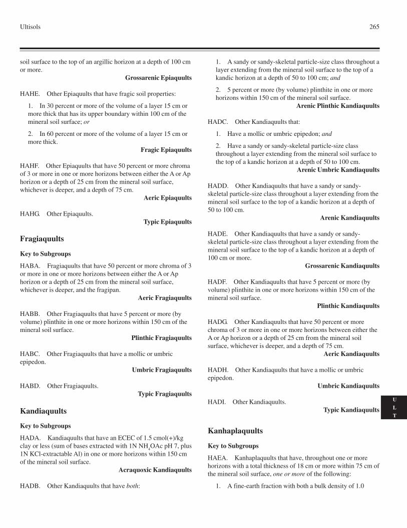
Ultisols 265
U
L
T
soil surface to the top of an argillic horizon at a depth of 100 cmor more.
Grossarenic Epiaquults
HAHE. Other Epiaquults that have fragic soil properties:
1. In 30 percent or more of the volume of a layer 15 cm ormore thick that has its upper boundary within 100 cm of themineral soil surface; or
2. In 60 percent or more of the volume of a layer 15 cm ormore thick.
Fragic Epiaquults
HAHF. Other Epiaquults that have 50 percent or more chromaof 3 or more in one or more horizons between either the A or Aphorizon or a depth of 25 cm from the mineral soil surface,whichever is deeper, and a depth of 75 cm.
Aeric Epiaquults
HAHG. Other Epiaquults.Typic Epiaquults
Fragiaquults
Key to Subgroups
HABA. Fragiaquults that have 50 percent or more chroma of 3or more in one or more horizons between either the A or Aphorizon or a depth of 25 cm from the mineral soil surface,whichever is deeper, and the fragipan.
Aeric Fragiaquults
HABB. Other Fragiaquults that have 5 percent or more (byvolume) plinthite in one or more horizons within 150 cm of themineral soil surface.
Plinthic Fragiaquults
HABC. Other Fragiaquults that have a mollic or umbricepipedon.
Umbric Fragiaquults
HABD. Other Fragiaquults.Typic Fragiaquults
Kandiaquults
Key to Subgroups
HADA. Kandiaquults that have an ECEC of 1.5 cmol(+)/kgclay or less (sum of bases extracted with 1N NH
4OAc pH 7, plus
1N KCl-extractable Al) in one or more horizons within 150 cmof the mineral soil surface.
Acraquoxic Kandiaquults
HADB. Other Kandiaquults that have both:
1. A sandy or sandy-skeletal particle-size class throughout alayer extending from the mineral soil surface to the top of akandic horizon at a depth of 50 to 100 cm; and
2. 5 percent or more (by volume) plinthite in one or morehorizons within 150 cm of the mineral soil surface.
Arenic Plinthic Kandiaquults
HADC. Other Kandiaquults that:
1. Have a mollic or umbric epipedon; and
2. Have a sandy or sandy-skeletal particle-size classthroughout a layer extending from the mineral soil surface tothe top of a kandic horizon at a depth of 50 to 100 cm.
Arenic Umbric Kandiaquults
HADD. Other Kandiaquults that have a sandy or sandy-skeletal particle-size class throughout a layer extending from themineral soil surface to the top of a kandic horizon at a depth of50 to 100 cm.
Arenic Kandiaquults
HADE. Other Kandiaquults that have a sandy or sandy-skeletal particle-size class throughout a layer extending from themineral soil surface to the top of a kandic horizon at a depth of100 cm or more.
Grossarenic Kandiaquults
HADF. Other Kandiaquults that have 5 percent or more (byvolume) plinthite in one or more horizons within 150 cm of themineral soil surface.
Plinthic Kandiaquults
HADG. Other Kandiaquults that have 50 percent or morechroma of 3 or more in one or more horizons between either theA or Ap horizon or a depth of 25 cm from the mineral soilsurface, whichever is deeper, and a depth of 75 cm.
Aeric Kandiaquults
HADH. Other Kandiaquults that have a mollic or umbricepipedon.
Umbric Kandiaquults
HADI. Other Kandiaquults.Typic Kandiaquults
Kanhaplaquults
Key to Subgroups
HAEA. Kanhaplaquults that have, throughout one or morehorizons with a total thickness of 18 cm or more within 75 cm ofthe mineral soil surface, one or more of the following:
1. A fine-earth fraction with both a bulk density of 1.0
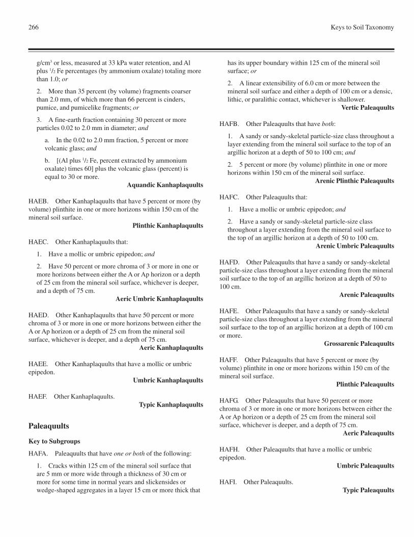
266 Keys to Soil Taxonomy
g/cm3 or less, measured at 33 kPa water retention, and Alplus 1/2 Fe percentages (by ammonium oxalate) totaling morethan 1.0; or
2. More than 35 percent (by volume) fragments coarserthan 2.0 mm, of which more than 66 percent is cinders,pumice, and pumicelike fragments; or
3. A fine-earth fraction containing 30 percent or moreparticles 0.02 to 2.0 mm in diameter; and
a. In the 0.02 to 2.0 mm fraction, 5 percent or morevolcanic glass; and
b. [(Al plus 1/2 Fe, percent extracted by ammoniumoxalate) times 60] plus the volcanic glass (percent) isequal to 30 or more.
Aquandic Kanhaplaquults
HAEB. Other Kanhaplaquults that have 5 percent or more (byvolume) plinthite in one or more horizons within 150 cm of themineral soil surface.
Plinthic Kanhaplaquults
HAEC. Other Kanhaplaquults that:
1. Have a mollic or umbric epipedon; and
2. Have 50 percent or more chroma of 3 or more in one ormore horizons between either the A or Ap horizon or a depthof 25 cm from the mineral soil surface, whichever is deeper,and a depth of 75 cm.
Aeric Umbric Kanhaplaquults
HAED. Other Kanhaplaquults that have 50 percent or morechroma of 3 or more in one or more horizons between either theA or Ap horizon or a depth of 25 cm from the mineral soilsurface, whichever is deeper, and a depth of 75 cm.
Aeric Kanhaplaquults
HAEE. Other Kanhaplaquults that have a mollic or umbricepipedon.
Umbric Kanhaplaquults
HAEF. Other Kanhaplaquults.Typic Kanhaplaquults
Paleaquults
Key to Subgroups
HAFA. Paleaquults that have one or both of the following:
1. Cracks within 125 cm of the mineral soil surface thatare 5 mm or more wide through a thickness of 30 cm ormore for some time in normal years and slickensides orwedge-shaped aggregates in a layer 15 cm or more thick that
has its upper boundary within 125 cm of the mineral soilsurface; or
2. A linear extensibility of 6.0 cm or more between themineral soil surface and either a depth of 100 cm or a densic,lithic, or paralithic contact, whichever is shallower.
Vertic Paleaquults
HAFB. Other Paleaquults that have both:
1. A sandy or sandy-skeletal particle-size class throughout alayer extending from the mineral soil surface to the top of anargillic horizon at a depth of 50 to 100 cm; and
2. 5 percent or more (by volume) plinthite in one or morehorizons within 150 cm of the mineral soil surface.
Arenic Plinthic Paleaquults
HAFC. Other Paleaquults that:
1. Have a mollic or umbric epipedon; and
2. Have a sandy or sandy-skeletal particle-size classthroughout a layer extending from the mineral soil surface tothe top of an argillic horizon at a depth of 50 to 100 cm.
Arenic Umbric Paleaquults
HAFD. Other Paleaquults that have a sandy or sandy-skeletalparticle-size class throughout a layer extending from the mineralsoil surface to the top of an argillic horizon at a depth of 50 to100 cm.
Arenic Paleaquults
HAFE. Other Paleaquults that have a sandy or sandy-skeletalparticle-size class throughout a layer extending from the mineralsoil surface to the top of an argillic horizon at a depth of 100 cmor more.
Grossarenic Paleaquults
HAFF. Other Paleaquults that have 5 percent or more (byvolume) plinthite in one or more horizons within 150 cm of themineral soil surface.
Plinthic Paleaquults
HAFG. Other Paleaquults that have 50 percent or morechroma of 3 or more in one or more horizons between either theA or Ap horizon or a depth of 25 cm from the mineral soilsurface, whichever is deeper, and a depth of 75 cm.
Aeric Paleaquults
HAFH. Other Paleaquults that have a mollic or umbricepipedon.
Umbric Paleaquults
HAFI. Other Paleaquults.Typic Paleaquults
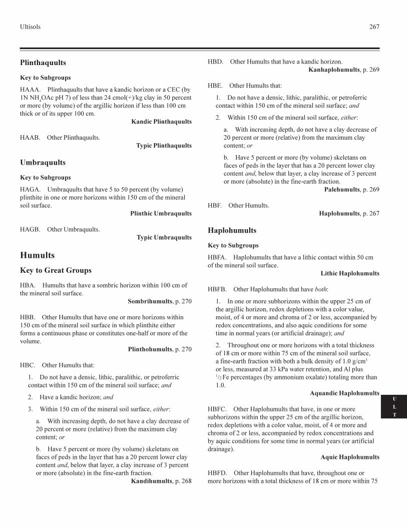
�������� ��
�
�
�
����������
�������������
���� ���������������������������������������������������� !�!
�"���#�$��%������������&��'���($)�*���������+,�#������
���'������������'�$��%�������*���������������%����������� ,,��'����������%������##��� ,,��'�
�������������������
��-� "����� �������������������������������
�� �����
�������������
�.�� �'��������������������+����+,�#���������������'�$#�������������������'�������������/������ +,��'��%�����'��������������%����
������������������
�.-� "������'�������������������������
�������
�����������������
-�� �'�������������������'�������������/������ ,,��'��%����'���������������%����
����������� 0�#���,
--� "������'����������������������'�������������/����� +,��'��%�����'���������������%�������/�����#���������������%��'���������������#�����������������������1���%����'�����%��������'��
������������� 0�#���,
-�� "������'���������2
� 3�������������������0�������0�#���������0����#����%�������������/������ +,��'��%�����'���������������%���4����
�� ��������������������4����
5� 6������ +,��'��%�����'���������������%���0�������2
�� 6�������������*���#��0������������������������������%�,�#����������'�������������$�%��'�����'�7�'�'������������4��
�� ����+�#����������'������������'�$�������������%������%�#�����������������������������,�#���������/������������������0�����/�����������0������������������%�5�#���������'�������������$��������%���1������%��������
����������� 0�#����8
-3� "������'���������������������������������������������� 0�#����9
-�� "������'���������2
� 3�������������������0�������0�#���������0����#����%�������������/������ +,��'��%�����'���������������%���4����
�� 6������ +,��'��%�����'���������������%���0�������2
�� 6�������������*���#��0������������������������������%�,�#����������'�������������$�%��'�����'�7�'�'������������4��
�� ����+�#����������'������������'�$�������������%������%�#�����������������������������,�#���������/������������������0�����/�����������0������������������%�5�#���������'�������������$��������%���1������%��������
���������� 0�#����9
-:� "������'���������������� 0�#����
���������
�������������
-:�� �#����'��������������������������������/������+,��'�%�����'���������������%����
������������������
-:-� "������#����'�����������������2
� ;���������'����������������/�����������##����+��'��%������*�������������0�����7���#��������/�����������������0'����0��%�&����'������������'���%����������0�����'#������������7���������������0���������������������������%�����'���'��������'�����������������%������������*�$4����
�� <����*������������'�������������/����������������������%� 8��'����'����/������+��'��%�����'���������������%���0��%���1������%��������/�������������������������%� �,�*)�'�
�������0�'�����������55�� ��/��������������0��������#����)��:��#�������*��������''����'��7�����$��������*�'�������� �,�
��������������������
-:�� "������#����'��������������0�����������'���������������/�����������##����+��'��%�������*�������������0����7���#��������/�����������������0�'����0��%�&����'�����������'���%����������0�����'#�������������7���������������������������������������%�����'����'��������'�����������������%�����������*�$�
�����������������
-:3� "������#����'��������������0������*�����������'�������������/�����������������������%� 8��'����'����/������+
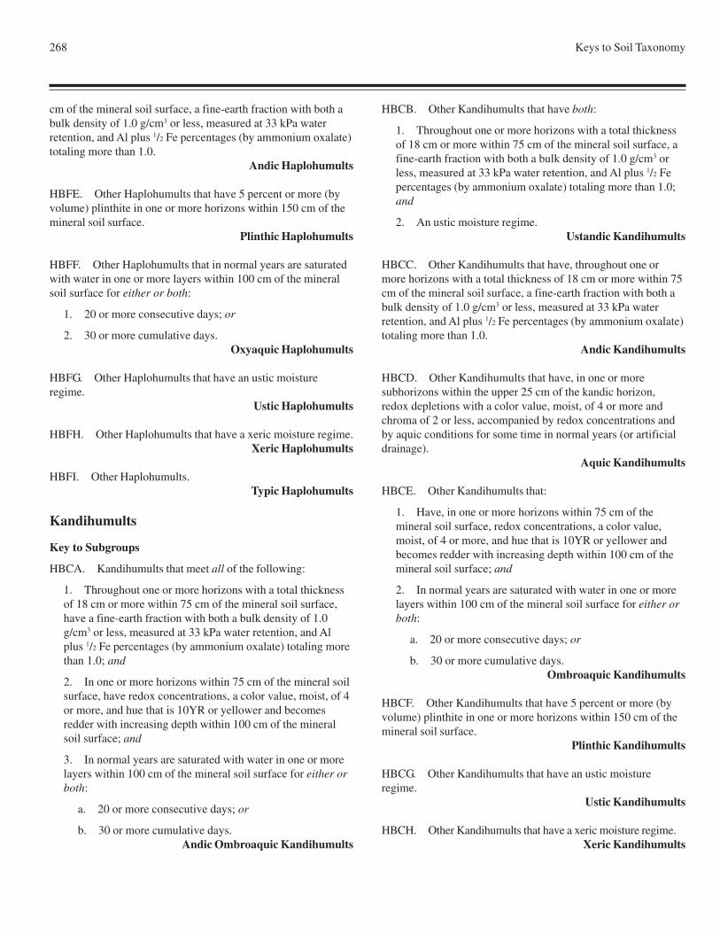
268 Keys to Soil Taxonomy
cm of the mineral soil surface, a fine-earth fraction with both abulk density of 1.0 g/cm3 or less, measured at 33 kPa waterretention, and Al plus 1/2 Fe percentages (by ammonium oxalate)totaling more than 1.0.
Andic Haplohumults
HBFE. Other Haplohumults that have 5 percent or more (byvolume) plinthite in one or more horizons within 150 cm of themineral soil surface.
Plinthic Haplohumults
HBFF. Other Haplohumults that in normal years are saturatedwith water in one or more layers within 100 cm of the mineralsoil surface for either or both:
1. 20 or more consecutive days; or
2. 30 or more cumulative days.Oxyaquic Haplohumults
HBFG. Other Haplohumults that have an ustic moistureregime.
Ustic Haplohumults
HBFH. Other Haplohumults that have a xeric moisture regime.Xeric Haplohumults
HBFI. Other Haplohumults.Typic Haplohumults
Kandihumults
Key to Subgroups
HBCA. Kandihumults that meet all of the following:
1. Throughout one or more horizons with a total thicknessof 18 cm or more within 75 cm of the mineral soil surface,have a fine-earth fraction with both a bulk density of 1.0g/cm3 or less, measured at 33 kPa water retention, and Alplus 1/2 Fe percentages (by ammonium oxalate) totaling morethan 1.0; and
2. In one or more horizons within 75 cm of the mineral soilsurface, have redox concentrations, a color value, moist, of 4or more, and hue that is 10YR or yellower and becomesredder with increasing depth within 100 cm of the mineralsoil surface; and
3. In normal years are saturated with water in one or morelayers within 100 cm of the mineral soil surface for either orboth:
a. 20 or more consecutive days; or
b. 30 or more cumulative days.Andic Ombroaquic Kandihumults
HBCB. Other Kandihumults that have both:
1. Throughout one or more horizons with a total thicknessof 18 cm or more within 75 cm of the mineral soil surface, afine-earth fraction with both a bulk density of 1.0 g/cm3 orless, measured at 33 kPa water retention, and Al plus 1/2 Fepercentages (by ammonium oxalate) totaling more than 1.0;and
2. An ustic moisture regime.Ustandic Kandihumults
HBCC. Other Kandihumults that have, throughout one ormore horizons with a total thickness of 18 cm or more within 75cm of the mineral soil surface, a fine-earth fraction with both abulk density of 1.0 g/cm3 or less, measured at 33 kPa waterretention, and Al plus 1/2 Fe percentages (by ammonium oxalate)totaling more than 1.0.
Andic Kandihumults
HBCD. Other Kandihumults that have, in one or moresubhorizons within the upper 25 cm of the kandic horizon,redox depletions with a color value, moist, of 4 or more andchroma of 2 or less, accompanied by redox concentrations andby aquic conditions for some time in normal years (or artificialdrainage).
Aquic Kandihumults
HBCE. Other Kandihumults that:
1. Have, in one or more horizons within 75 cm of themineral soil surface, redox concentrations, a color value,moist, of 4 or more, and hue that is 10YR or yellower andbecomes redder with increasing depth within 100 cm of themineral soil surface; and
2. In normal years are saturated with water in one or morelayers within 100 cm of the mineral soil surface for either orboth:
a. 20 or more consecutive days; or
b. 30 or more cumulative days.Ombroaquic Kandihumults
HBCF. Other Kandihumults that have 5 percent or more (byvolume) plinthite in one or more horizons within 150 cm of themineral soil surface.
Plinthic Kandihumults
HBCG. Other Kandihumults that have an ustic moistureregime.
Ustic Kandihumults
HBCH. Other Kandihumults that have a xeric moisture regime.Xeric Kandihumults
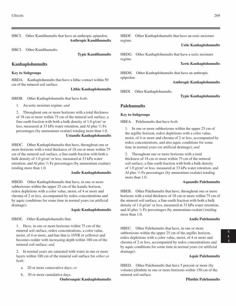
Ultisols 269
U
L
T
HBCI. Other Kandihumults that have an anthropic epipedon.Anthropic Kandihumults
HBCJ. Other Kandihumults.Typic Kandihumults
Kanhaplohumults
Key to Subgroups
HBDA. Kanhaplohumults that have a lithic contact within 50cm of the mineral soil surface.
Lithic Kanhaplohumults
HBDB. Other Kanhaplohumults that have both:
1. An ustic moisture regime; and
2. Throughout one or more horizons with a total thicknessof 18 cm or more within 75 cm of the mineral soil surface, afine-earth fraction with both a bulk density of 1.0 g/cm3 orless, measured at 33 kPa water retention, and Al plus 1/2 Fepercentages (by ammonium oxalate) totaling more than 1.0.
Ustandic Kanhaplohumults
HBDC. Other Kanhaplohumults that have, throughout one ormore horizons with a total thickness of 18 cm or more within 75cm of the mineral soil surface, a fine-earth fraction with both abulk density of 1.0 g/cm3 or less, measured at 33 kPa waterretention, and Al plus 1/2 Fe percentages (by ammonium oxalate)totaling more than 1.0.
Andic Kanhaplohumults
HBDD. Other Kanhaplohumults that have, in one or moresubhorizons within the upper 25 cm of the kandic horizon,redox depletions with a color value, moist, of 4 or more andchroma of 2 or less, accompanied by redox concentrations andby aquic conditions for some time in normal years (or artificialdrainage).
Aquic Kanhaplohumults
HBDE. Other Kanhaplohumults that:
1. Have, in one or more horizons within 75 cm of themineral soil surface, redox concentrations, a color value,moist, of 4 or more, and hue that is 10YR or yellower andbecomes redder with increasing depth within 100 cm of themineral soil surface; and
2. In normal years are saturated with water in one or morelayers within 100 cm of the mineral soil surface for either orboth:
a. 20 or more consecutive days; or
b. 30 or more cumulative days.Ombroaquic Kanhaplohumults
HBDF. Other Kanhaplohumults that have an ustic moistureregime.
Ustic Kanhaplohumults
HBDG. Other Kanhaplohumults that have a xeric moistureregime.
Xeric Kanhaplohumults
HBDH. Other Kanhaplohumults that have an anthropicepipedon.
Anthropic Kanhaplohumults
HBDI. Other Kanhaplohumults.Typic Kanhaplohumults
Palehumults
Key to Subgroups
HBEA. Palehumults that have both:
1. In one or more subhorizons within the upper 25 cm ofthe argillic horizon, redox depletions with a color value,moist, of 4 or more and chroma of 2 or less, accompanied byredox concentrations, and also aquic conditions for sometime in normal years (or artificial drainage); and
2. Throughout one or more horizons with a totalthickness of 18 cm or more within 75 cm of the mineralsoil surface, a fine-earth fraction with both a bulk densityof 1.0 g/cm3 or less, measured at 33 kPa water retention, andAl plus 1/2 Fe percentages (by ammonium oxalate) totalingmore than 1.0.
Aquandic Palehumults
HBEB. Other Palehumults that have, throughout one or morehorizons with a total thickness of 18 cm or more within 75 cm ofthe mineral soil surface, a fine-earth fraction with both a bulkdensity of 1.0 g/cm3 or less, measured at 33 kPa water retention,and Al plus 1/2 Fe percentages (by ammonium oxalate) totalingmore than 1.0.
Andic Palehumults
HBEC. Other Palehumults that have, in one or moresubhorizons within the upper 25 cm of the argillic horizon,redox depletions with a color value, moist, of 4 or more andchroma of 2 or less, accompanied by redox concentrations andby aquic conditions for some time in normal years (or artificialdrainage).
Aquic Palehumults
HBED. Other Palehumults that have 5 percent or more (byvolume) plinthite in one or more horizons within 150 cm of themineral soil surface.
Plinthic Palehumults
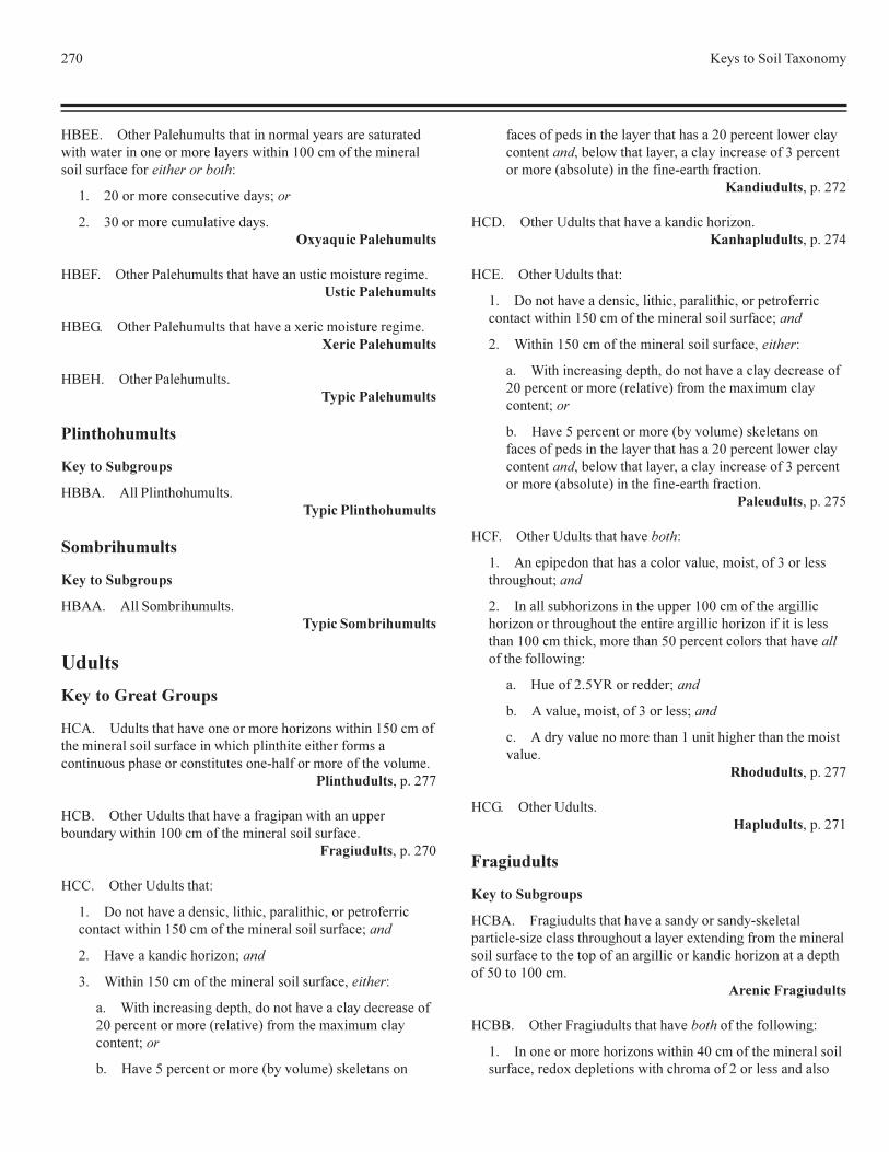
��� �������� �������
����� ������� ����� ������������ ��������������������������������������� ������������������� ���������� �� ���� ���� ����������������!
�� ����������������"������#���
�� $������������ ��"������������������ ������
���%� ������� ����� �������"�������������������&������������ ������
���'� ������� ����� �������"�������������������&������������ ������
����� ������� ����� ���������� ������
������������
��������������
���(� ( �� ������� ����������� � ������
��� ������
��������������
��((� ( ���)������ ������������� ������
������
�������� ����� ���
�*(� +�� �������"��������������,����������-����� ��������� ��� ���� �������������. ������������ �������������.�����������������/�� ������� ����" ����
���� ������0�.�����
�*�� �����+�� �������"���� ��&�.�����������..��)�������������������� ���������� ��� ���� ����
�����������0�.�����
�**� �����+�� ����!
�� 1�����"����������0� ����0�.��� ����0���.�� �����������������-����� ���������� ��� ���� ���#��
�� ��"����2���������,�#��
$� 3������-����� ���������� ��� ���� ���0�������!
�� 3������������&���.�0�������"����� ������������ ���.������������4�� ��"�5� ��������������� ������#���
)� ��"��-�.������������4)��" ���5��2� ������
����� �.���������� �����������������.������ ����� ��������0�)� ����� ����0���� ������������ �$�.�����������4�)� ��5������� ���/����� ������
�����������0�.�����
�*1� �����+�� �������"����2���������,����� ���������0�.����6
�*�� �����+�� ����!
�� 1�����"����������0� ����0�.��� ����0���.�� �����������������-����� ���������� ��� ���� ���#��
�� 3������-����� ���������� ��� ���� ���0�������!
�� 3������������&���.�0�������"����� ������������ ���.������������4�� ��"�5� ��������������� ������#���
)� ��"��-�.������������4)��" ���5��2� ������ ����� �.���������� �����������������.������ ����� ��������0�)� ����� ����0���� ������������ �$�.�����������4�)� ��5������� ���/����� ������
���������0�.����-
�*%� �����+�� �������"������!
�� (���.�.�������������� ��"� ��0����0� �$��� ������&��#��
�� 7��� ���)���,����������..���������� ������&� �����,�������&��������������&� ������,��� ������ �����������������20���������-��.������� ��������"���� ���� ���&!
�� ���� ���-89���������#��
)� (�"� ��0����0� �$��� ���#��
�� (�����"� ���������������������&��������������"� ���
� ��������0�.�����
�*'� �����+�� ������������0�.�����
� ��������
��������������
�*�(� %��&���� �������"�����������������/�2� �� .���� �/��,��� �������&����� ������������&� ������������ �� ���� ��������.� ������&� �����2���������,��������.� �-����������
����������������
�*��� �����%��&���� �������"������� ���� ���&!
�� 7��������������,���������6����� ���������� ��� ��� ���0��������. ��������������� ����� ��������� �
Ultisols 271
U
L
T
aquic conditions for some time in normal years (or artificialdrainage); and
2. 5 percent or more (by volume) plinthite in one or morehorizons within 150 cm of the mineral soil surface.
Plinthaquic Fragiudults
HCBC. Other Fragiudults that meet both of the following:
1. Meet one or more of the following:
a. Have a glossic horizon above the fragipan; or
b. Do not have, above the fragipan, an argillic or kandichorizon that has clay films on both vertical and horizontalsurfaces of any structural aggregates; or
c. Between the argillic or kandic horizon and thefragipan, have one or more horizons with 50 percent ormore chroma of 3 or less and with a clay content 3 percentor more (absolute, in the fine-earth fraction) lower thanthat in both the argillic or kandic horizon and the fragipan;and
2. In one or more horizons within 40 cm of the mineral soilsurface, have redox depletions with chroma of 2 or less andalso aquic conditions for some time in normal years (orartificial drainage).
Glossaquic Fragiudults
HCBD. Other Fragiudults that have, in one or moresubhorizons above the fragipan and within the upper 25 cm ofthe argillic or kandic horizon, redox depletions with chroma of 2or less and also aquic conditions for some time in normal years(or artificial drainage).
Aquic Fragiudults
HCBE. Other Fragiudults that have 5 percent or more (byvolume) plinthite in one or more horizons within 150 cm of themineral soil surface.
Plinthic Fragiudults
HCBF. Other Fragiudults that meet one or more of thefollowing:
1. Have a glossic horizon above the fragipan; or
2. Do not have, above the fragipan, an argillic or kandichorizon that has clay films on both vertical and horizontalsurfaces of any structural aggregates; or
3. Between the argillic or kandic horizon and the fragipan,have one or more horizons with 50 percent or more chromaof 3 or less and with a clay content 3 percent or more(absolute, in the fine-earth fraction) lower than that in boththe argillic or kandic horizon and the fragipan.
Glossic Fragiudults
HCBG. Other Fragiudults that have a color value, moist, of 3
or less and a color value, dry, of 5 or less (crushed andsmoothed sample) in either:
1. An Ap horizon that is 18 cm or more thick; or
2. The surface layer after mixing of the upper 18 cm.Humic Fragiudults
HCBH. Other Fragiudults.Typic Fragiudults
Hapludults
Key to Subgroups
HCGA. Hapludults that have either or both:
1. In each pedon, a discontinuous lithic contact within 50cm of the mineral soil surface; and
2. In each pedon, a discontinuous argillic horizon that isinterrupted by ledges of bedrock.
Lithic-Ruptic-Entic Hapludults
HCGB. Other Hapludults that have a lithic contact within 50cm of the mineral soil surface.
Lithic Hapludults
HCGC. Other Hapludults that have one or both of thefollowing:
1. Cracks within 125 cm of the mineral soil surface thatare 5 mm or more wide through a thickness of 30 cm ormore for some time in normal years and slickensides orwedge-shaped aggregates in a layer 15 cm or more thick thathas its upper boundary within 125 cm of the mineral soilsurface; or
2. A linear extensibility of 6.0 cm or more between themineral soil surface and either a depth of 100 cm or a densic,lithic, or paralithic contact, whichever is shallower.
Vertic Hapludults
HCGD. Other Hapludults that have both:
1. Fragic soil properties:
a. In 30 percent or more of the volume of a layer 15 cmor more thick that has its upper boundary within 100 cmof the mineral soil surface; or
b. In 60 percent or more of the volume of a layer 15 cmor more thick; and
2. In one or more layers within 75 cm of the mineral soilsurface, redox depletions with a color value, moist, of 4 ormore and chroma of 2 or less, accompanied by redoxconcentrations, and also aquic conditions for some time innormal years (or artificial drainage).
Fragiaquic Hapludults
272 Keys to Soil Taxonomy
HCGE. Other Hapludults that have both:
1. A sandy or sandy-skeletal particle-size class throughout alayer extending from the mineral soil surface to the top of anargillic horizon at a depth of 50 to 100 cm; and
2. In one or more subhorizons within the upper 60 cmof the argillic horizon, redox depletions with a color value,moist, of 4 or more and chroma of 2 or less, accompanied byredox concentrations, and also aquic conditions for sometime in normal years (or artificial drainage).
Aquic Arenic Hapludults
HCGF. Other Hapludults that have, in one or moresubhorizons within the upper 60 cm of the argillic horizon,redox depletions with a color value, moist, of 4 or more andchroma of 2 or less, accompanied by redox concentrations andby aquic conditions for some time in normal years (or artificialdrainage).
Aquic Hapludults
HCGG. Other Hapludults that have fragic soil properties:
1. In 30 percent or more of the volume of a layer 15 cm ormore thick that has its upper boundary within 100 cm of themineral soil surface; or
2. In 60 percent or more of the volume of a layer 15 cm ormore thick.
Fragic Hapludults
HCGH. Other Hapludults that in normal years are saturatedwith water in one or more layers within 100 cm of the mineralsoil surface for either or both:
1. 20 or more consecutive days; or
2. 30 or more cumulative days.Oxyaquic Hapludults
HCGI. Other Hapludults that have an argillic horizon that:
1. Consists entirely of lamellae; or
2. Is a combination of two or more lamellae and one ormore subhorizons with a thickness of 7.5 to 20 cm, each layerwith an overlying eluvial horizon; or
3. Consists of one or more subhorizons that are morethan 20 cm thick, each with an overlying eluvial horizon, andabove these horizons there are either:
a. Two or more lamellae with a combined thickness of 5cm or more (that may or may not be part of the argillichorizon); or
b. A combination of lamellae (that may or may not bepart of the argillic horizon) and one or more parts of the
argillic horizon 7.5 to 20 cm thick, each with an overlyingeluvial horizon.
Lamellic Hapludults
HCGJ. Other Hapludults that have a sandy particle-size classthroughout the upper 75 cm of the argillic horizon or throughoutthe entire argillic horizon if it is less than 75 cm thick.
Psammentic Hapludults
HCGK. Other Hapludults that have a sandy or sandy-skeletalparticle-size class throughout a layer extending from the mineralsoil surface to the top of an argillic horizon at a depth of 50 to100 cm.
Arenic Hapludults
HCGL. Other Hapludults that have a sandy or sandy-skeletalparticle-size class throughout a layer extending from the mineralsoil surface to the top of an argillic horizon at a depth of 100 cmor more.
Grossarenic Hapludults
HCGM. Other Hapludults that have:
1. No densic, lithic, or paralithic contact within 50 cm ofthe mineral soil surface; and
2. An argillic horizon 25 cm or less thick.Inceptic Hapludults
HCGN. Other Hapludults that have a color value, moist, of 3or less and a color value, dry, of 5 or less (crushed andsmoothed sample) in either:
1. An Ap horizon that is 18 cm or more thick; or
2. The surface layer after mixing of the upper 18 cm.Humic Hapludults
HCGO. Other Hapludults.Typic Hapludults
Kandiudults
Key to Subgroups
HCCA. Kandiudults that have:
1. A sandy or sandy-skeletal particle-size class throughout alayer extending from the mineral soil surface to the top of akandic horizon at a depth of 50 to 100 cm; and
2. 5 percent or more (by volume) plinthite in one ormore horizons within 150 cm of the mineral soil surface; and
3. In one or more layers either within 75 cm of the mineralsoil surface or, if the chroma throughout the upper 75 cm
Ultisols 273
U
L
T
results from uncoated sand grains, within the upper 12.5 cmof the kandic horizon, redox depletions with a color value,moist, of 4 or more and chroma of 2 or less, accompanied byredox concentrations, and also aquic conditions for sometime in normal years (or artificial drainage).
Arenic Plinthaquic Kandiudults
HCCB. Other Kandiudults that have both:
1. A sandy or sandy-skeletal particle-size class throughout alayer extending from the mineral soil surface to the top of akandic horizon at a depth of 50 to 100 cm; and
2. In one or more layers either within 75 cm of the mineralsoil surface or, if the chroma throughout the upper 75 cmresults from uncoated sand grains, within the upper 12.5 cmof the kandic horizon, redox depletions with a color value,moist, of 4 or more and chroma of 2 or less, accompanied byredox concentrations, and also aquic conditions for sometime in normal years (or artificial drainage).
Aquic Arenic Kandiudults
HCCC. Other Kandiudults that have both:
1. A sandy or sandy-skeletal particle-size class throughout alayer extending from the mineral soil surface to the top of akandic horizon at a depth of 50 to 100 cm; and
2. 5 percent or more (by volume) plinthite in one or morehorizons within 150 cm of the mineral soil surface.
Arenic Plinthic Kandiudults
HCCD. Other Kandiudults that have both:
1. A sandy or sandy-skeletal particle-size classthroughout a layer extending from the mineral soil surface tothe top of a kandic horizon at a depth of 50 to 100 cm; and
2. In all subhorizons in the upper 75 cm of the kandichorizon or throughout the entire kandic horizon if it is lessthan 75 cm thick, more than 50 percent colors that have all ofthe following:
a. Hue of 2.5YR or redder; and
b. A value, moist, of 3 or less; and
c. A dry value no more than 1 unit higher than the moistvalue.
Arenic Rhodic Kandiudults
HCCE. Other Kandiudults that have a sandy or sandy-skeletalparticle-size class throughout a layer extending from the mineralsoil surface to the top of a kandic horizon at a depth of 50 to100 cm.
Arenic Kandiudults
HCCF. Other Kandiudults that have both:
1. A sandy or sandy-skeletal particle-size classthroughout a layer extending from the mineral soil surface tothe top of a kandic horizon at a depth of 100 cm or more; and
2. 5 percent or more (by volume) plinthite in one or morehorizons within 150 cm of the mineral soil surface.
Grossarenic Plinthic Kandiudults
HCCG. Other Kandiudults that have a sandy or sandy-skeletalparticle-size class throughout a layer extending from the mineralsoil surface to the top of a kandic horizon at a depth of 100 cmor more.
Grossarenic Kandiudults
HCCH. Other Kandiudults that have both:
1. An ECEC of 1.5 cmol(+)/kg clay or less (sum of basesextracted with 1N NH
4OAc pH 7, plus 1N KCl-extractable
Al) in one or more horizons within 150 cm of the mineral soilsurface; and
2. 5 percent or more (by volume) plinthite in one or morehorizons within 150 cm of the mineral soil surface.
Acrudoxic Plinthic Kandiudults
HCCI. Other Kandiudults that have an ECEC of 1.5cmol(+)/kg clay or less (sum of bases extracted with 1NNH
4OAc pH 7, plus 1N KCl-extractable Al) in one or more
horizons within 150 cm of the mineral soil surface.Acrudoxic Kandiudults
HCCJ. Other Kandiudults that have both:
1. 5 percent or more (by volume) plinthite in one or morehorizons within 150 cm of the mineral soil surface; and
2. In one or more layers within 75 cm of the mineral soilsurface, redox depletions with a color value, moist, of 4 ormore and chroma of 2 or less, accompanied by redoxconcentrations, and also aquic conditions for some time innormal years (or artificial drainage).
Plinthaquic Kandiudults
HCCK. Other Kandiudults that have both:
1. In one or more layers within 75 cm of the mineral soilsurface, redox depletions with a color value, moist, of 4 ormore and chroma of 2 or less, accompanied by redoxconcentrations, and also aquic conditions for some time innormal years (or artificial drainage); and
2. Throughout one or more horizons with a total thicknessof 18 cm or more within 75 cm of the mineral soil surface,one or more of the following:
a. A fine-earth fraction with both a bulk density of 1.0g/cm3 or less, measured at 33 kPa water retention, and Al
274 Keys to Soil Taxonomy
plus 1/2 Fe percentages (by ammonium oxalate) totalingmore than 1.0; or
b. More than 35 percent (by volume) fragments coarserthan 2.0 mm, of which more than 66 percent is cinders,pumice, and pumicelike fragments; or
c. A fine-earth fraction containing 30 percent or moreparticles 0.02 to 2.0 mm in diameter; and
(1) In the 0.02 to 2.0 mm fraction, 5 percent or morevolcanic glass; and
(2) [(Al plus 1/2 Fe, percent extracted by ammoniumoxalate) times 60] plus the volcanic glass (percent) isequal to 30 or more.
Aquandic Kandiudults
HCCL. Other Kandiudults that have, throughout one or morehorizons with a total thickness of 18 cm or more within 75 cm ofthe mineral soil surface, a fine-earth fraction with both a bulkdensity of 1.0 g/cm3 or less, measured at 33 kPa water retention,and Al plus 1/2 Fe percentages (by ammonium oxalate) totalingmore than 1.0.
Andic Kandiudults
HCCM. Other Kandiudults that have, in one or more layerswithin 75 cm of the mineral soil surface, redox depletions with acolor value, moist, of 4 or more and chroma of 2 or less,accompanied by redox concentrations and by aquic conditionsfor some time in normal years (or artificial drainage).
Aquic Kandiudults
HCCN. Other Kandiudults that have 5 percent or more (byvolume) plinthite in one or more horizons within 150 cm of themineral soil surface.
Plinthic Kandiudults
HCCO. Other Kandiudults that:
1. Have, in one or more horizons within 75 cm of themineral soil surface, redox concentrations, a color value,moist, of 4 or more, and hue that is 10YR or yellower andbecomes redder with increasing depth within 100 cm of themineral soil surface; and
2. In normal years are saturated with water in one or morelayers within 100 cm of the mineral soil surface for either orboth:
a. 20 or more consecutive days; or
b. 30 or more cumulative days.Ombroaquic Kandiudults
HCCP. Other Kandiudults that in normal years are saturated
with water in one or more layers within 100 cm of the mineralsoil surface for either or both:
1. 20 or more consecutive days; or
2. 30 or more cumulative days.Oxyaquic Kandiudults
HCCQ. Other Kandiudults that have a sombric horizon within150 cm of the mineral soil surface.
Sombric Kandiudults
HCCR. Other Kandiudults that have, in all subhorizons in theupper 75 cm of the kandic horizon or throughout the entirekandic horizon if it is less than 75 cm thick, more than 50percent colors that have all of the following:
1. Hue of 2.5YR or redder; and
2. A value, moist, of 3 or less; and
3. A dry value no more than 1 unit higher than the moistvalue.
Rhodic Kandiudults
HCCS. Other Kandiudults.Typic Kandiudults
Kanhapludults
Key to Subgroups
HCDA. Kanhapludults that have a lithic contact within 50 cmof the mineral soil surface.
Lithic Kanhapludults
HCDB. Other Kanhapludults that have both:
1. 5 percent or more (by volume) plinthite in one or morehorizons within 150 cm of the mineral soil surface; and
2. In one or more layers within 75 cm of the mineral soilsurface, redox depletions with a color value, moist, of 4 ormore and chroma of 2 or less, accompanied by redoxconcentrations, and also aquic conditions for some time innormal years (or artificial drainage).
Plinthaquic Kanhapludults
HCDC. Other Kanhapludults that have both:
1. A sandy or sandy-skeletal particle-size class throughout alayer extending from the mineral soil surface to the top of akandic horizon at a depth of 50 to 100 cm; and
2. 5 percent or more (by volume) plinthite in one or morehorizons within 150 cm of the mineral soil surface.
Arenic Plinthic Kanhapludults
Ultisols 275
U
L
T
HCDD. Other Kanhapludults that have a sandy or sandy-skeletal particle-size class throughout a layer extending from themineral soil surface to the top of a kandic horizon at a depth of50 to 100 cm.
Arenic Kanhapludults
HCDE. Other Kanhapludults that have an ECEC of 1.5cmol(+)/kg clay or less (sum of bases extracted with 1NNH
4OAc pH 7, plus 1N KCl-extractable Al) in one or more
horizons within 150 cm of the mineral soil surface.Acrudoxic Kanhapludults
HCDF. Other Kanhapludults that have both:
1. Fragic soil properties:
a. In 30 percent or more of the volume of a layer 15 cmor more thick that has its upper boundary within 100 cmof the mineral soil surface; or
b. In 60 percent or more of the volume of a layer 15 cmor more thick; and
2. In one or more layers within 75 cm of the mineral soilsurface, redox depletions with a color value, moist, of 4 ormore and chroma of 2 or less, accompanied by redoxconcentrations, and also aquic conditions for some time innormal years (or artificial drainage).
Fragiaquic Kanhapludults
HCDG. Other Kanhapludults that have, throughout one ormore horizons with a total thickness of 18 cm or more within 75cm of the mineral soil surface, a fine-earth fraction with both abulk density of 1.0 g/cm3 or less, measured at 33 kPa waterretention, and Al plus 1/2 Fe percentages (by ammonium oxalate)totaling more than 1.0.
Andic Kanhapludults
HCDH. Other Kanhapludults that have, in one or more layerswithin 75 cm of the mineral soil surface, redox depletions with acolor value, moist, of 4 or more and chroma of 2 or less,accompanied by redox concentrations and by aquic conditionsfor some time in normal years (or artificial drainage).
Aquic Kanhapludults
HCDI. Other Kanhapludults that:
1. Have, in one or more horizons within 75 cm of themineral soil surface, redox concentrations, a color value,moist, of 4 or more, and hue that is 10YR or yellower andbecomes redder with increasing depth within 100 cm of themineral soil surface; and
2. In normal years are saturated with water in one or morelayers within 100 cm of the mineral soil surface for either orboth:
a. 20 or more consecutive days; or
b. 30 or more cumulative days.Ombroaquic Kanhapludults
HCDJ. Other Kanhapludults that in normal years are saturatedwith water in one or more layers within 100 cm of the mineralsoil surface for either or both:
1. 20 or more consecutive days; or
2. 30 or more cumulative days.Oxyaquic Kanhapludults
HCDK. Other Kanhapludults that have 5 percent or more (byvolume) plinthite in one or more horizons within 150 cm of themineral soil surface.
Plinthic Kanhapludults
HCDL. Other Kanhapludults that have fragic soilproperties:
1. In 30 percent or more of the volume of a layer 15 cm ormore thick that has its upper boundary within 100 cm of themineral soil surface; or
2. In 60 percent or more of the volume of a layer 15 cm ormore thick.
Fragic Kanhapludults
HCDM. Other Kanhapludults that have, in all subhorizons inthe upper 50 cm of the kandic horizon or throughout the entirekandic horizon if it is less than 50 cm thick, more than 50percent colors that have all of the following:
1. Hue of 2.5YR or redder; and
2. A value, moist, of 3 or less; and
3. A dry value no more than 1 unit higher than the moistvalue.
Rhodic Kanhapludults
HCDN. Other Kanhapludults.Typic Kanhapludults
Paleudults
Key to Subgroups
HCEA. Paleudults that have one or both of the following:
1. Cracks within 125 cm of the mineral soil surface thatare 5 mm or more wide through a thickness of 30 cm ormore for some time in normal years and slickensides orwedge-shaped aggregates in a layer 15 cm or more thick thathas its upper boundary within 125 cm of the mineral soilsurface; or
276 Keys to Soil Taxonomy
2. A linear extensibility of 6.0 cm or more between themineral soil surface and either a depth of 100 cm or a densic,lithic, or paralithic contact, whichever is shallower.
Vertic Paleudults
HCEB. Other Paleudults that have a horizon 5 cm or morethick, either below an Ap horizon or at a depth of 18 cm or morefrom the mineral soil surface, whichever is deeper, that has oneor more of the following:
1. In 25 percent or more of each pedon, cementation byorganic matter and aluminum, with or without iron; or
2. Al plus 1/2 Fe percentages (by ammonium oxalate)totaling 0.25 or more, and half that amount or less in anoverlying horizon; or
3. An ODOE value of 0.12 or more, and a value half ashigh or lower in an overlying horizon.
Spodic Paleudults
HCEC. Other Paleudults that have:
1. In one or more layers either within 75 cm of the mineralsoil surface or, if the chroma throughout the upper 75 cmresults from uncoated sand grains, within the upper 12.5 cmof the argillic horizon, redox depletions with a color value,moist, of 4 or more and chroma of 2 or less, accompanied byredox concentrations, and also aquic conditions for sometime in normal years (or artificial drainage); and
2. A sandy or sandy-skeletal particle-size class throughout alayer extending from the mineral soil surface to the top of anargillic horizon at a depth of 50 cm or more; and
3. 5 percent or more (by volume) plinthite in one or morehorizons within 150 cm of the mineral soil surface.
Arenic Plinthaquic Paleudults
HCED. Other Paleudults that have both:
1. A sandy or sandy-skeletal particle-size class throughout alayer extending from the mineral soil surface to the top of anargillic horizon that is 50 cm or more below the mineral soilsurface; and
2. In one or more layers either within 75 cm of the mineralsoil surface or, if the chroma throughout the upper 75 cmresults from uncoated sand grains, within the upper 12.5 cmof the argillic horizon, redox depletions with a color value,moist, of 4 or more and chroma of 2 or less, accompanied byredox concentrations, and also aquic conditions for sometime in normal years (or artificial drainage).
Aquic Arenic Paleudults
HCEE. Other Paleudults that have anthraquic conditions.Anthraquic Paleudults
HCEF. Other Paleudults that have both:
1. 5 percent or more (by volume) plinthite in one or morehorizons within 150 cm of the mineral soil surface; and
2. In one or more layers either within 75 cm of the mineralsoil surface or, if the chroma throughout the upper 75 cmresults from uncoated sand grains, within the upper 12.5 cmof the argillic horizon, redox depletions with a color value,moist, of 4 or more and chroma of 2 or less, accompanied byredox concentrations, and also aquic conditions for sometime in normal years (or artificial drainage).
Plinthaquic Paleudults
HCEG. Other Paleudults that have both:
1. Fragic soil properties:
a. In 30 percent or more of the volume of a layer 15 cmor more thick that has its upper boundary within 100 cmof the mineral soil surface; or
b. In 60 percent or more of the volume of a layer 15 cmor more thick; and
2. In one or more layers within 75 cm of the mineral soilsurface, redox depletions with a color value, moist, of 4 ormore and chroma of 2 or less, accompanied by redoxconcentrations, and also aquic conditions for some time innormal years (or artificial drainage).
Fragiaquic Paleudults
HCEH. Other Paleudults that have, in one or more layerswithin 75 cm of the mineral soil surface, redox depletionswith a color value, moist, of 4 or more and chroma of 2 orless, accompanied by redox concentrations and by aquicconditions for some time in normal years (or artificial drainage).
Aquic Paleudults
HCEI. Other Paleludults that in normal years are saturatedwith water in one or more layers within 100 cm of the mineralsoil surface for either or both:
1. 20 or more consecutive days; or
2. 30 or more cumulative days.Oxyaquic Paleudults
HCEJ. Other Paleudults that have an argillic horizon that:
1. Consists entirely of lamellae; or
2. Is a combination of two or more lamellae and one ormore subhorizons with a thickness of 7.5 to 20 cm, each layerwith an overlying eluvial horizon; or
3. Consists of one or more subhorizons that are morethan 20 cm thick, each with an overlying eluvial horizon, andabove these horizons there are either:
Ultisols 277
U
L
T
a. Two or more lamellae with a combined thickness of 5cm or more (that may or may not be part of the argillichorizon); or
b. A combination of lamellae (that may or may not bepart of the argillic horizon) and one or more parts of theargillic horizon 7.5 to 20 cm thick, each with an overlyingeluvial horizon.
Lamellic Paleudults
HCEK. Other Paleudults that have both:
1. A sandy or sandy-skeletal particle-size class throughout alayer extending from the mineral soil surface to the top of anargillic horizon at a depth of 50 to 100 cm; and
2. 5 percent or more (by volume) plinthite in one or morehorizons within 150 cm of the mineral soil surface.
Arenic Plinthic Paleudults
HCEL. Other Paleudults that have a sandy particle-size classthroughout the upper 75 cm of the argillic horizon or throughoutthe entire argillic horizon if it is less than 75 cm thick.
Psammentic Paleudults
HCEM. Other Paleudults that have both:
1. A sandy or sandy-skeletal particle-size class throughout alayer extending from the mineral soil surface to the top of anargillic horizon at a depth of 100 cm or more; and
2. 5 percent or more (by volume) plinthite in one or morehorizons within 150 cm of the mineral soil surface.
Grossarenic Plinthic Paleudults
HCEN. Other Paleudults that have 5 percent or more (byvolume) plinthite in one or more horizons within 150 cm of themineral soil surface.
Plinthic Paleudults
HCEO. Other Paleudults that have both:
1. A sandy or sandy-skeletal particle-size class throughout alayer extending from the mineral soil surface to the top of anargillic horizon at a depth of 50 to 100 cm; and
2. In all subhorizons in the upper 75 cm of the argillichorizon or throughout the entire argillic horizon if it is lessthan 75 cm thick, more than 50 percent colors that have all ofthe following:
a. Hue of 2.5YR or redder; and
b. A value, moist, of 3 or less; and
c. A dry value no more than 1 unit higher than the moistvalue.
Arenic Rhodic Paleudults
HCEP. Other Paleudults that have a sandy or sandy-skeletalparticle-size class throughout a layer extending from the mineralsoil surface to the top of an argillic horizon at a depth of 50 to100 cm.
Arenic Paleudults
HCEQ. Other Paleudults that have a sandy or sandy-skeletalparticle-size class throughout a layer extending from the mineralsoil surface to the top of an argillic horizon at a depth of 100 cmor more.
Grossarenic Paleudults
HCER. Other Paleudults that have fragic soil properties:
1. In 30 percent or more of the volume of a layer 15 cm ormore thick that has its upper boundary within 100 cm of themineral soil surface; or
2. In 60 percent or more of the volume of a layer 15 cm ormore thick.
Fragic Paleudults
HCES. Other Paleudults that have, in all subhorizons in theupper 75 cm of the argillic horizon or throughout the entireargillic horizon if it is less than 75 cm thick, more than 50percent colors that have all of the following:
1. Hue of 2.5YR or redder; and
2. A value, moist, of 3 or less; and
3. A dry value no more than 1 unit higher than the moistvalue.
Rhodic Paleudults
HCET. Other Paleudults.Typic Paleudults
Plinthudults
Key to Subgroups
HCAA. All Plinthudults.Typic Plinthudults
Rhodudults
Key to Subgroups
HCFA. Rhodudults that have a lithic contact within 50 cm ofthe mineral soil surface.
Lithic Rhodudults
HCFB. Other Rhodudults that have a sandy particle-size classthroughout the upper 75 cm of the argillic horizon or throughoutthe entire argillic horizon if it is less than 75 cm thick.
Psammentic Rhodudults
278 Keys to Soil Taxonomy
HCFC. Other Rhodudults.Typic Rhodudults
Ustults
Key to Great Groups
HDA. Ustults that have one or more horizons within 150cm of the mineral soil surface in which plinthite either formsa continuous phase or constitutes one-half or more of thevolume.
Plinthustults, p. 281
HDB. Other Ustults that:
1. Do not have a densic, lithic, paralithic, or petroferriccontact within 150 cm of the mineral soil surface; and
2. Have a kandic horizon; and
3. Within 150 cm of the mineral soil surface, either:
a. With increasing depth, do not have a clay decrease of20 percent or more (relative) from the maximum claycontent; or
b. Have 5 percent or more (by volume) skeletans onfaces of peds in the layer that has a 20 percent lower claycontent and, below that layer, a clay increase of 3 percentor more (absolute) in the fine-earth fraction.
Kandiustults, p. 279
HDC. Other Ustults that have a kandic horizon.Kanhaplustults, p. 280
HDD. Other Ustults that:
1. Do not have a densic, lithic, paralithic, or petroferriccontact within 150 cm of the mineral soil surface; and
2. Within 150 cm of the mineral soil surface, either:
a. With increasing depth, do not have a clay decrease of20 percent or more (relative) from the maximum claycontent; or
b. Have 5 percent or more (by volume) skeletans onfaces of peds in the layer that has a 20 percent lower claycontent and, below that layer, a clay increase of 3 percentor more (absolute) in the fine-earth fraction.
Paleustults, p. 281
HDE. Other Ustults that have both:
1. An epipedon that has a color value, moist, of 3 or lessthroughout; and
2. In all subhorizons in the upper 100 cm of the argillichorizon or throughout the entire argillic horizon if it is less
than 100 cm thick, more than 50 percent colors that have allof the following:
a. Hue of 2.5YR or redder; and
b. A value, moist, of 3 or less; and
c. A dry value no more than 1 unit higher than the moistvalue.
Rhodustults, p. 281
HDF. Other Ustults.Haplustults, p. 278
Haplustults
Key to Subgroups
HDFA. Haplustults that have a lithic contact within 50 cm ofthe mineral soil surface.
Lithic Haplustults
HDFB. Other Haplustults that have a petroferric contactwithin 100 cm of the mineral soil surface.
Petroferric Haplustults
HDFC. Other Haplustults that have, in one or more layers bothwithin the upper 12.5 cm of the argillic horizon and within 75cm of the mineral soil surface, redox depletions with a colorvalue, moist, of 4 or more and chroma of 2 or less, accompaniedby redox concentrations and by aquic conditions for some timein normal years (or artificial drainage).
Aquic Haplustults
HDFD. Other Haplustults that have a sandy or sandy-skeletalparticle-size class throughout a layer extending from the mineralsoil surface to the top of an argillic horizon at a depth of 50 cmor more below the mineral soil surface.
Arenic Haplustults
HDFE. Other Haplustults that:
1. Have, in one or more horizons within 75 cm of themineral soil surface, redox concentrations, a color value,moist, of 4 or more, and hue that is 10YR or yellower andbecomes redder with increasing depth within 100 cm of themineral soil surface; and
2. In normal years are saturated with water in one or morelayers within 100 cm of the mineral soil surface for either orboth:
a. 20 or more consecutive days; or
b. 30 or more cumulative days.Ombroaquic Haplustults
HDFF. Other Haplustults that have 5 percent or more (by
Ultisols 279
U
L
T
volume) plinthite in one or more horizons within 150 cm of themineral soil surface.
Plinthic Haplustults
HDFG. Other Haplustults that have a CEC (by 1N NH4OAc
pH 7) of less than 24 cmol(+)/kg clay in 50 percent or more ofthe entire argillic horizon if less than 100 cm thick or of itsupper 100 cm.
Kanhaplic Haplustults
HDFH. Other Haplustults.Typic Haplustults
Kandiustults
Key to Subgroups
HDBA. Kandiustults that have an ECEC of 1.5 cmol(+)/kgclay or less (sum of bases extracted with 1N NH
4OAc pH 7, plus
1N KCl-extractable Al) in one or more horizons within 150 cmof the mineral soil surface.
Acrustoxic Kandiustults
HDBB. Other Kandiustults that have, in one or more layerswithin 75 cm of the mineral soil surface, redox depletions with acolor value, moist, of 4 or more and chroma of 2 or less,accompanied by redox concentrations and by aquic conditionsfor some time in normal years (or artificial drainage).
Aquic Kandiustults
HDBC. Other Kandiustults that have both:
1. A sandy or sandy-skeletal particle-size class throughout alayer extending from the mineral soil surface to the top of akandic horizon at a depth of 50 cm or more; and
2. 5 percent or more (by volume) plinthite in one or morehorizons within 150 cm of the mineral soil surface.
Arenic Plinthic Kandiustults
HDBD. Other Kandiustults that have a sandy or sandy-skeletalparticle-size class throughout a layer extending from the mineralsoil surface to the top of a kandic horizon at a depth of 50 cm ormore.
Arenic Kandiustults
HDBE. Other Kandiustults that have both:
1. Throughout one or more horizons with a total thicknessof 18 cm or more within 75 cm of the mineral soil surface, afine-earth fraction with both a bulk density of 1.0 g/cm3 orless, measured at 33 kPa water retention, and Al plus 1/2 Fepercentages (by ammonium oxalate) totaling more than 1.0;and
2. When neither irrigated nor fallowed to store moisture,either:
a. A mesic or thermic soil temperature regime and amoisture control section that is dry in some part for 135 orfewer of the cumulative days per year when thetemperature at a depth of 50 cm below the soil surface ishigher than 5 oC; or
b. A hyperthermic, isomesic, or warmer iso soiltemperature regime and a moisture control section that isdry in some or all parts for fewer than 120 cumulativedays per year when the temperature at a depth of 50 cmbelow the soil surface is higher than 8 oC.
Udandic Kandiustults
HDBF. Other Kandiustults that have, throughout one or morehorizons with a total thickness of 18 cm or more within 75 cm ofthe mineral soil surface, a fine-earth fraction with both a bulkdensity of 1.0 g/cm3 or less, measured at 33 kPa water retention,and Al plus 1/2 Fe percentages (by ammonium oxalate) totalingmore than 1.0.
Andic Kandiustults
HDBG. Other Kandiustults that have 5 percent or more (byvolume) plinthite in one or more horizons within 150 cm of themineral soil surface.
Plinthic Kandiustults
HDBH. Other Kandiustults that, when neither irrigated norfallowed to store moisture, have either:
1. A thermic, mesic, or colder soil temperature regime anda moisture control section that in normal years is dry in somepart for more than four-tenths of the cumulative days per yearwhen the soil temperature at a depth of 50 cm below the soilsurface is higher than 5 oC; or
2. A hyperthermic, isomesic, or warmer iso soiltemperature regime and a moisture control section that innormal years:
a. Is moist in some or all parts for fewer than 90consecutive days per year when the temperature at a depthof 50 cm below the soil surface is higher than 8 oC; and
b. Is dry in some part for six-tenths or more of thecumulative days per year when the soil temperature at adepth of 50 cm below the soil surface is higher than 5 oC.
Aridic Kandiustults
HDBI. Other Kandiustults that, when neither irrigated norfallowed to store moisture, have either:
1. A mesic or thermic soil temperature regime and amoisture control section that in normal years is dry in somepart for 135 or fewer of the cumulative days per year whenthe temperature at a depth of 50 cm below the soil surface ishigher than 5 oC; or
2. A hyperthermic, isomesic, or warmer iso soil
280 Keys to Soil Taxonomy
temperature regime and a moisture control section that innormal years is dry in some or all parts for fewer than 120cumulative days per year when the temperature at a depth of50 cm below the soil surface is higher than 8 oC.
Udic Kandiustults
HDBJ. Other Kandiustults that have, in all subhorizons in theupper 50 cm of the kandic horizon or throughout the entirekandic horizon if it is less than 75 cm thick, more than 50percent colors that have all of the following:
1. Hue of 2.5YR or redder; and
2. A value, moist, of 3 or less; and
3. A dry value no more than 1 unit higher than the moistvalue.
Rhodic Kandiustults
HDBK. Other Kandiustults.Typic Kandiustults
Kanhaplustults
Key to Subgroups
HDCA. Kanhaplustults that have a lithic contact within 50 cmof the mineral soil surface.
Lithic Kanhaplustults
HDCB. Other Kanhaplustults that have an ECEC of 1.5cmol(+)/kg clay or less (sum of bases extracted with 1NNH
4OAc pH 7, plus 1N KCl-extractable Al) in one or more
horizons within 150 cm of the mineral soil surface.Acrustoxic Kanhaplustults
HDCC. Other Kanhaplustults that have, in one or more layerswithin 75 cm of the mineral soil surface, redox depletions with acolor value, moist, of 4 or more and chroma of 2 or less,accompanied by redox concentrations and by aquic conditionsfor some time in normal years (or artificial drainage).
Aquic Kanhaplustults
HDCD. Other Kanhaplustults that have a sandy or sandy-skeletal particle-size class throughout a layer extending from themineral soil surface to the top of a kandic horizon at a depth of50 to 100 cm.
Arenic Kanhaplustults
HDCE. Other Kanhaplustults that have both:
1. Throughout one or more horizons with a total thicknessof 18 cm or more within 75 cm of the mineral soil surface, afine-earth fraction with both a bulk density of 1.0 g/cm3 or
less, measured at 33 kPa water retention, and Al plus 1/2 Fepercentages (by ammonium oxalate) totaling more than 1.0;and
2. When neither irrigated nor fallowed to store moisture,either:
a. A mesic or thermic soil temperature regime and amoisture control section that in normal years is dry insome part for 135 or fewer of the cumulative days per yearwhen the temperature at a depth of 50 cm below the soilsurface is higher than 5 oC; or
b. A hyperthermic, isomesic, or warmer iso soiltemperature regime and a moisture control section that innormal years is dry in some or all parts for fewer than 120cumulative days per year when the temperature at a depthof 50 cm below the soil surface is higher than 8 oC.
Udandic Kanhaplustults
HDCF. Other Kanhaplustults that have, throughout one ormore horizons with a total thickness of 18 cm or more within 75cm of the mineral soil surface, a fine-earth fraction with both abulk density of 1.0 g/cm3 or less, measured at 33 kPa waterretention, and Al plus 1/2 Fe percentages (by ammonium oxalate)totaling more than 1.0.
Andic Kanhaplustults
HDCG. Other Kanhaplustults that have 5 percent or more (byvolume) plinthite in one or more horizons within 150 cm of themineral soil surface.
Plinthic Kanhaplustults
HDCH. Other Kanhaplustults that:
1. Have, in one or more horizons within 75 cm of themineral soil surface, redox concentrations, a color value,moist, of 4 or more, and hue that is 10YR or yellower andbecomes redder with increasing depth within 100 cm of themineral soil surface; and
2. In normal years are saturated with water in one or morelayers within 100 cm of the mineral soil surface for either orboth:
a. 20 or more consecutive days; or
b. 30 or more cumulative days.Ombroaquic Kanhaplustults
HDCI. Other Kanhaplustults that, when neither irrigated norfallowed to store moisture, have either:
1. A thermic, mesic, or colder soil temperature regime anda moisture control section that in normal years is dry in somepart for more than four-tenths of the cumulative days per year
Ultisols 281
U
L
T
when the soil temperature at a depth of 50 cm below the soilsurface is higher than 5 oC; or
2. A hyperthermic, isomesic, or warmer iso soiltemperature regime and a moisture control section that innormal years:
a. Is moist in some or all parts for fewer than 90consecutive days per year when the temperature at adepth of 50 cm below the soil surface is higher than 8 oC;and
b. Is dry in some part for six-tenths or more of thecumulative days per year when the soil temperatureat a depth of 50 cm below the soil surface is higher than5 oC.
Aridic Kanhaplustults
HDCJ. Other Kanhaplustults that, when neither irrigated norfallowed to store moisture, have either:
1. A mesic or thermic soil temperature regime and amoisture control section that in normal years is dry in somepart for 135 or fewer of the cumulative days per year whenthe temperature at a depth of 50 cm below the soil surface ishigher than 5 oC; or
2. A hyperthermic, isomesic, or warmer iso soiltemperature regime and a moisture control section that innormal years is dry in some or all parts for fewer than 120cumulative days per year when the temperature at a depth of50 cm below the soil surface is higher than 8 oC.
Udic Kanhaplustults
HDCK. Other Kanhaplustults that have, in all subhorizons inthe upper 50 cm of the kandic horizon or throughout the entirekandic horizon if it is less than 50 cm thick, more than 50percent colors that have all of the following:
1. Hue of 2.5YR or redder; and
2. A value, moist, of 3 or less; and
3. A dry value no more than 1 unit higher than the moistvalue.
Rhodic Kanhaplustults
HDCL. Other Kanhaplustults.Typic Kanhaplustults
Paleustults
Key to Subgroups
HDDA. All Paleustults.Typic Paleustults
Plinthustults
Key to Subgroups
HDAA. Plinthustults that have:
1. A densic, lithic, paralithic, or petroferric contactwithin 150 cm of the mineral soil surface; or
2. Within 150 cm of the mineral soil surface, both:
a. With increasing depth, a clay decrease of 20percent or more (relative) from the maximum claycontent; and
b. Less than 5 percent (by volume) skeletans on faces ofpeds in the layer that has a 20 percent lower clay contentor, below that layer, a clay increase of less than 3 percent(absolute) in the fine-earth fraction.
Haplic Plinthustults
HDAB. Other Plinthustults.Typic Plinthustults
Rhodustults
Key to Subgroups
HDEA. Rhodustults that have a lithic contact within 50 cm ofthe mineral soil surface.
Lithic Rhodustults
HDEB. Other Rhodustults that have a sandy particle-size classthroughout the upper 75 cm of the argillic horizon or throughoutthe entire argillic horizon if it is less than 75 cm thick.
Psammentic Rhodustults
HDEC. Other Rhodustults.Typic Rhodustults
Xerults
Key to Great Groups
HEA. Xerults that:
1. Do not have a densic, lithic, or paralithic contactwithin 150 cm of the mineral soil surface; and
2. Within 150 cm of the mineral soil surface, either:
a. With increasing depth, do not have a clay decrease of20 percent or more (relative) from the maximum claycontent; or
b. Have 5 percent or more (by volume) skeletans on
282 Keys to Soil Taxonomy
faces of peds or 5 percent or more (by volume) plinthite,or both, in the layer that has a 20 percent lower claycontent and, below that layer, a clay increase of 3 percentor more (absolute) in the fine-earth fraction.
Palexerults, p. 282
HEB. Other Xerults.Haploxerults, p. 282
Haploxerults
Key to Subgroups
HEBA. Haploxerults that have both:
1. A lithic contact within 50 cm of the mineral soil surface;and
2. In each pedon, a discontinuous argillic or kandic horizonthat is interrupted by ledges of bedrock.
Lithic Ruptic-Inceptic Haploxerults
HEBB. Other Haploxerults that have a lithic contact within 50cm of the mineral soil surface.
Lithic Haploxerults
HEBC. Other Haploxerults that have, in one or moresubhorizons within the upper 25 cm of the argillic or kandichorizon, redox depletions with a color value, moist, of 4 or moreand chroma of 2 or less, accompanied by redox concentrationsand by aquic conditions for some time in normal years (orartificial drainage).
Aquic Haploxerults
HEBD. Other Haploxerults that have, throughout one or morehorizons with a total thickness of 18 cm or more within 75 cm ofthe mineral soil surface, a fine-earth fraction with both a bulkdensity of 1.0 g/cm3 or less, measured at 33 kPa water retention,and Al plus 1/2 Fe percentages (by ammonium oxalate) totalingmore than 1.0.
Andic Haploxerults
HEBE. Other Haploxerults that have an argillic or kandichorizon that:
1. Consists entirely of lamellae; or
2. Is a combination of two or more lamellae and one ormore subhorizons with a thickness of 7.5 to 20 cm, each layerwith an overlying eluvial horizon; or
3. Consists of one or more subhorizons that are morethan 20 cm thick, each with an overlying eluvial horizon,andabove these horizons there are either:
a. Two or more lamellae with a combined thickness of 5
cm or more (that may or may not be part of the argillic orkandic horizon); or
b. A combination of lamellae (that may or maynot be part of the argillic or kandic horizon) andone or more parts of the argillic or kandic horizon7.5 to 20 cm thick, each with an overlying eluvial horizon.
Lamellic Haploxerults
HEBF. Other Haploxerults that have a sandy particle-size classthroughout the upper 75 cm of the argillic or kandic horizon orthroughout the entire horizon if it is less than 75 cm thick.
Psammentic Haploxerults
HEBG. Other Haploxerults that have a sandy or sandy-skeletalparticle-size class throughout a layer extending from the mineralsoil surface to the top of an argillic or kandic horizon at a depthof 50 to 100 cm.
Arenic Haploxerults
HEBH. Other Haploxerults that have a sandy or sandy-skeletalparticle-size class throughout a layer extending from the mineralsoil surface to the top of an argillic or kandic horizon at a depthof 100 cm or more.
Grossarenic Haploxerults
HEBI. Other Haploxerults.Typic Haploxerults
Palexerults
Key to Subgroups
HEAA. Palexerults that have both:
1. In one or more subhorizons within the upper 25 cm ofthe argillic or kandic horizon, redox depletions with a colorvalue, moist, of 4 or more and chroma of 2 or less,accompanied by redox concentrations, and also aquicconditions for some time in normal years (or artificialdrainage); and
2. Throughout one or more horizons with a total thicknessof 18 cm or more within 75 cm of the mineral soil surface,a fine-earth fraction with both a bulk density of 1.0 g/cm3
or less, measured at 33 kPa water retention, and Al plus1/2 Fe percentages (by ammonium oxalate) totaling more than1.0.
Aquandic Palexerults
HEAB. Other Palexerults that have, in one or moresubhorizons within the upper 25 cm of the argillic or kandichorizon, redox depletions with a color value, moist, of 4 or moreand chroma of 2 or less, accompanied by redox concentrations

Ultisols 283
U
L
T
and by aquic conditions for some time in normal years (orartificial drainage).
Aquic Palexerults
HEAC. Other Palexerults that have, throughout one or morehorizons with a total thickness of 18 cm or more within 75 cm ofthe mineral soil surface, a fine-earth fraction with both a bulk
density of 1.0 g/cm3 or less, measured at 33 kPa water retention,and Al plus 1/2 Fe percentages (by ammonium oxalate) totalingmore than 1.0.
Andic Palexerults
HEAD. Other Palexerults.Typic Palexerults

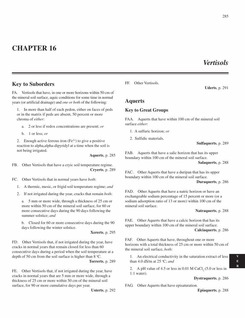
285
V
E
R
Key to SubordersFA. Vertisols that have, in one or more horizons within 50 cm ofthe mineral soil surface, aquic conditions for some time in normalyears (or artificial drainage) and one or both of the following:
1. In more than half of each pedon, either on faces of pedsor in the matrix if peds are absent, 50 percent or morechroma of either:
a. 2 or less if redox concentrations are present; or
b. 1 or less; or
2. Enough active ferrous iron (Fe2+) to give a positivereaction to alpha,alpha-dipyridyl at a time when the soil isnot being irrigated.
Aquerts, p. 285
FB. Other Vertisols that have a cryic soil temperature regime.Cryerts, p. 289
FC. Other Vertisols that in normal years have both:
1. A thermic, mesic, or frigid soil temperature regime; and
2. If not irrigated during the year, cracks that remain both:
a. 5 mm or more wide, through a thickness of 25 cm ormore within 50 cm of the mineral soil surface, for 60 ormore consecutive days during the 90 days following thesummer solstice; and
b. Closed for 60 or more consecutive days during the 90days following the winter solstice.
Xererts, p. 295
FD. Other Vertisols that, if not irrigated during the year, havecracks in normal years that remain closed for less than 60consecutive days during a period when the soil temperature at adepth of 50 cm from the soil surface is higher than 8 oC.
Torrerts, p. 289
FE. Other Vertisols that, if not irrigated during the year, havecracks in normal years that are 5 mm or more wide, through athickness of 25 cm or more within 50 cm of the mineral soilsurface, for 90 or more cumulative days per year.
Usterts, p. 292
CHAPTER 16
Vertisols
FF. Other Vertisols.Uderts, p. 291
Aquerts
Key to Great Groups
FAA. Aquerts that have within 100 cm of the mineral soilsurface either:
1. A sulfuric horizon; or
2. Sulfidic materials.Sulfaquerts, p. 289
FAB. Aquerts that have a salic horizon that has its upperboundary within 100 cm of the mineral soil surface.
Salaquerts, p. 288
FAC. Other Aquerts that have a duripan that has its upperboundary within 100 cm of the mineral soil surface.
Duraquerts, p. 286
FAD. Other Aquerts that have a natric horizon or have anexchangeable sodium percentage of 15 percent or more (or asodium adsorption ratio of 13 or more) within 100 cm of themineral soil surface.
Natraquerts, p. 288
FAE. Other Aquerts that have a calcic horizon that has itsupper boundary within 100 cm of the mineral soil surface.
Calciaquerts, p. 286
FAF. Other Aquerts that have, throughout one or morehorizons with a total thickness of 25 cm or more within 50 cm ofthe mineral soil surface, both:
1. An electrical conductivity in the saturation extract of lessthan 4.0 dS/m at 25 oC; and
2. A pH value of 4.5 or less in 0.01 M CaCl2 (5.0 or less in
1:1 water).Dystraquerts, p. 286
FAG. Other Aquerts that have episaturation.Epiaquerts, p. 288
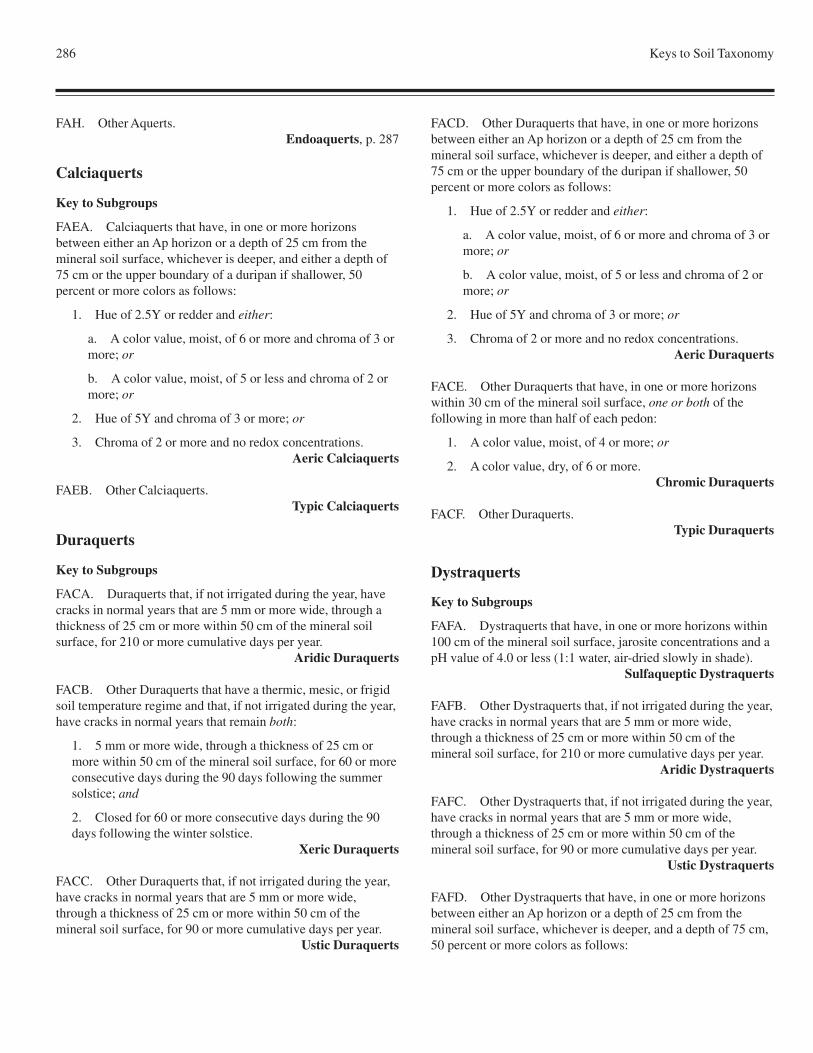
286 Keys to Soil Taxonomy
FAH. Other Aquerts.Endoaquerts, p. 287
Calciaquerts
Key to Subgroups
FAEA. Calciaquerts that have, in one or more horizonsbetween either an Ap horizon or a depth of 25 cm from themineral soil surface, whichever is deeper, and either a depth of75 cm or the upper boundary of a duripan if shallower, 50percent or more colors as follows:
1. Hue of 2.5Y or redder and either:
a. A color value, moist, of 6 or more and chroma of 3 ormore; or
b. A color value, moist, of 5 or less and chroma of 2 ormore; or
2. Hue of 5Y and chroma of 3 or more; or
3. Chroma of 2 or more and no redox concentrations.Aeric Calciaquerts
FAEB. Other Calciaquerts.Typic Calciaquerts
Duraquerts
Key to Subgroups
FACA. Duraquerts that, if not irrigated during the year, havecracks in normal years that are 5 mm or more wide, through athickness of 25 cm or more within 50 cm of the mineral soilsurface, for 210 or more cumulative days per year.
Aridic Duraquerts
FACB. Other Duraquerts that have a thermic, mesic, or frigidsoil temperature regime and that, if not irrigated during the year,have cracks in normal years that remain both:
1. 5 mm or more wide, through a thickness of 25 cm ormore within 50 cm of the mineral soil surface, for 60 or moreconsecutive days during the 90 days following the summersolstice; and
2. Closed for 60 or more consecutive days during the 90days following the winter solstice.
Xeric Duraquerts
FACC. Other Duraquerts that, if not irrigated during the year,have cracks in normal years that are 5 mm or more wide,through a thickness of 25 cm or more within 50 cm of themineral soil surface, for 90 or more cumulative days per year.
Ustic Duraquerts
FACD. Other Duraquerts that have, in one or more horizonsbetween either an Ap horizon or a depth of 25 cm from themineral soil surface, whichever is deeper, and either a depth of75 cm or the upper boundary of the duripan if shallower, 50percent or more colors as follows:
1. Hue of 2.5Y or redder and either:
a. A color value, moist, of 6 or more and chroma of 3 ormore; or
b. A color value, moist, of 5 or less and chroma of 2 ormore; or
2. Hue of 5Y and chroma of 3 or more; or
3. Chroma of 2 or more and no redox concentrations.Aeric Duraquerts
FACE. Other Duraquerts that have, in one or more horizonswithin 30 cm of the mineral soil surface, one or both of thefollowing in more than half of each pedon:
1. A color value, moist, of 4 or more; or
2. A color value, dry, of 6 or more.Chromic Duraquerts
FACF. Other Duraquerts.Typic Duraquerts
Dystraquerts
Key to Subgroups
FAFA. Dystraquerts that have, in one or more horizons within100 cm of the mineral soil surface, jarosite concentrations and apH value of 4.0 or less (1:1 water, air-dried slowly in shade).
Sulfaqueptic Dystraquerts
FAFB. Other Dystraquerts that, if not irrigated during the year,have cracks in normal years that are 5 mm or more wide,through a thickness of 25 cm or more within 50 cm of themineral soil surface, for 210 or more cumulative days per year.
Aridic Dystraquerts
FAFC. Other Dystraquerts that, if not irrigated during the year,have cracks in normal years that are 5 mm or more wide,through a thickness of 25 cm or more within 50 cm of themineral soil surface, for 90 or more cumulative days per year.
Ustic Dystraquerts
FAFD. Other Dystraquerts that have, in one or more horizonsbetween either an Ap horizon or a depth of 25 cm from themineral soil surface, whichever is deeper, and a depth of 75 cm,50 percent or more colors as follows:
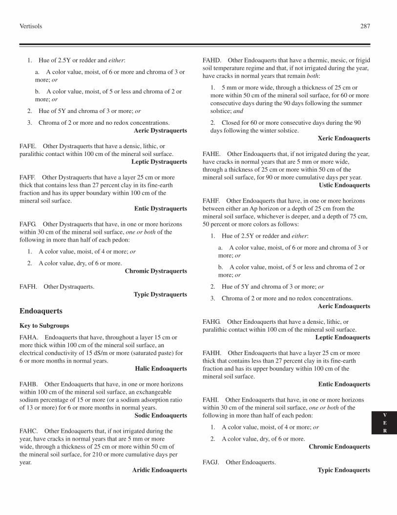
Vertisols 287
V
E
R
1. Hue of 2.5Y or redder and either:
a. A color value, moist, of 6 or more and chroma of 3 ormore; or
b. A color value, moist, of 5 or less and chroma of 2 ormore; or
2. Hue of 5Y and chroma of 3 or more; or
3. Chroma of 2 or more and no redox concentrations.Aeric Dystraquerts
FAFE. Other Dystraquerts that have a densic, lithic, orparalithic contact within 100 cm of the mineral soil surface.
Leptic Dystraquerts
FAFF. Other Dystraquerts that have a layer 25 cm or morethick that contains less than 27 percent clay in its fine-earthfraction and has its upper boundary within 100 cm of themineral soil surface.
Entic Dystraquerts
FAFG. Other Dystraquerts that have, in one or more horizonswithin 30 cm of the mineral soil surface, one or both of thefollowing in more than half of each pedon:
1. A color value, moist, of 4 or more; or
2. A color value, dry, of 6 or more.Chromic Dystraquerts
FAFH. Other Dystraquerts.Typic Dystraquerts
Endoaquerts
Key to Subgroups
FAHA. Endoaquerts that have, throughout a layer 15 cm ormore thick within 100 cm of the mineral soil surface, anelectrical conductivity of 15 dS/m or more (saturated paste) for6 or more months in normal years.
Halic Endoaquerts
FAHB. Other Endoaquerts that have, in one or more horizonswithin 100 cm of the mineral soil surface, an exchangeablesodium percentage of 15 or more (or a sodium adsorption ratioof 13 or more) for 6 or more months in normal years.
Sodic Endoaquerts
FAHC. Other Endoaquerts that, if not irrigated during theyear, have cracks in normal years that are 5 mm or morewide, through a thickness of 25 cm or more within 50 cm ofthe mineral soil surface, for 210 or more cumulative days peryear.
Aridic Endoaquerts
FAHD. Other Endoaquerts that have a thermic, mesic, or frigidsoil temperature regime and that, if not irrigated during the year,have cracks in normal years that remain both:
1. 5 mm or more wide, through a thickness of 25 cm ormore within 50 cm of the mineral soil surface, for 60 or moreconsecutive days during the 90 days following the summersolstice; and
2. Closed for 60 or more consecutive days during the 90days following the winter solstice.
Xeric Endoaquerts
FAHE. Other Endoaquerts that, if not irrigated during the year,have cracks in normal years that are 5 mm or more wide,through a thickness of 25 cm or more within 50 cm of themineral soil surface, for 90 or more cumulative days per year.
Ustic Endoaquerts
FAHF. Other Endoaquerts that have, in one or more horizonsbetween either an Ap horizon or a depth of 25 cm from themineral soil surface, whichever is deeper, and a depth of 75 cm,50 percent or more colors as follows:
1. Hue of 2.5Y or redder and either:
a. A color value, moist, of 6 or more and chroma of 3 ormore; or
b. A color value, moist, of 5 or less and chroma of 2 ormore; or
2. Hue of 5Y and chroma of 3 or more; or
3. Chroma of 2 or more and no redox concentrations.Aeric Endoaquerts
FAHG. Other Endoaquerts that have a densic, lithic, orparalithic contact within 100 cm of the mineral soil surface.
Leptic Endoaquerts
FAHH. Other Endoaquerts that have a layer 25 cm or morethick that contains less than 27 percent clay in its fine-earthfraction and has its upper boundary within 100 cm of themineral soil surface.
Entic Endoaquerts
FAHI. Other Endoaquerts that have, in one or more horizonswithin 30 cm of the mineral soil surface, one or both of thefollowing in more than half of each pedon:
1. A color value, moist, of 4 or more; or
2. A color value, dry, of 6 or more.Chromic Endoaquerts
FAGJ. Other Endoaquerts.Typic Endoaquerts
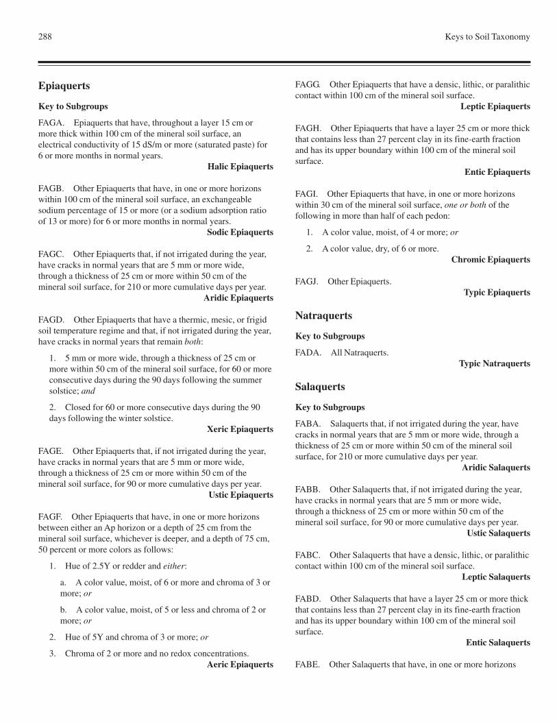
288 Keys to Soil Taxonomy
Epiaquerts
Key to Subgroups
FAGA. Epiaquerts that have, throughout a layer 15 cm ormore thick within 100 cm of the mineral soil surface, anelectrical conductivity of 15 dS/m or more (saturated paste) for6 or more months in normal years.
Halic Epiaquerts
FAGB. Other Epiaquerts that have, in one or more horizonswithin 100 cm of the mineral soil surface, an exchangeablesodium percentage of 15 or more (or a sodium adsorption ratioof 13 or more) for 6 or more months in normal years.
Sodic Epiaquerts
FAGC. Other Epiaquerts that, if not irrigated during the year,have cracks in normal years that are 5 mm or more wide,through a thickness of 25 cm or more within 50 cm of themineral soil surface, for 210 or more cumulative days per year.
Aridic Epiaquerts
FAGD. Other Epiaquerts that have a thermic, mesic, or frigidsoil temperature regime and that, if not irrigated during the year,have cracks in normal years that remain both:
1. 5 mm or more wide, through a thickness of 25 cm ormore within 50 cm of the mineral soil surface, for 60 or moreconsecutive days during the 90 days following the summersolstice; and
2. Closed for 60 or more consecutive days during the 90days following the winter solstice.
Xeric Epiaquerts
FAGE. Other Epiaquerts that, if not irrigated during the year,have cracks in normal years that are 5 mm or more wide,through a thickness of 25 cm or more within 50 cm of themineral soil surface, for 90 or more cumulative days per year.
Ustic Epiaquerts
FAGF. Other Epiaquerts that have, in one or more horizonsbetween either an Ap horizon or a depth of 25 cm from themineral soil surface, whichever is deeper, and a depth of 75 cm,50 percent or more colors as follows:
1. Hue of 2.5Y or redder and either:
a. A color value, moist, of 6 or more and chroma of 3 ormore; or
b. A color value, moist, of 5 or less and chroma of 2 ormore; or
2. Hue of 5Y and chroma of 3 or more; or
3. Chroma of 2 or more and no redox concentrations.Aeric Epiaquerts
FAGG. Other Epiaquerts that have a densic, lithic, or paralithiccontact within 100 cm of the mineral soil surface.
Leptic Epiaquerts
FAGH. Other Epiaquerts that have a layer 25 cm or more thickthat contains less than 27 percent clay in its fine-earth fractionand has its upper boundary within 100 cm of the mineral soilsurface.
Entic Epiaquerts
FAGI. Other Epiaquerts that have, in one or more horizonswithin 30 cm of the mineral soil surface, one or both of thefollowing in more than half of each pedon:
1. A color value, moist, of 4 or more; or
2. A color value, dry, of 6 or more.Chromic Epiaquerts
FAGJ. Other Epiaquerts.Typic Epiaquerts
Natraquerts
Key to Subgroups
FADA. All Natraquerts.Typic Natraquerts
Salaquerts
Key to Subgroups
FABA. Salaquerts that, if not irrigated during the year, havecracks in normal years that are 5 mm or more wide, through athickness of 25 cm or more within 50 cm of the mineral soilsurface, for 210 or more cumulative days per year.
Aridic Salaquerts
FABB. Other Salaquerts that, if not irrigated during the year,have cracks in normal years that are 5 mm or more wide,through a thickness of 25 cm or more within 50 cm of themineral soil surface, for 90 or more cumulative days per year.
Ustic Salaquerts
FABC. Other Salaquerts that have a densic, lithic, or paralithiccontact within 100 cm of the mineral soil surface.
Leptic Salaquerts
FABD. Other Salaquerts that have a layer 25 cm or more thickthat contains less than 27 percent clay in its fine-earth fractionand has its upper boundary within 100 cm of the mineral soilsurface.
Entic Salaquerts
FABE. Other Salaquerts that have, in one or more horizons
Vertisols 289
V
E
R
within 30 cm of the mineral soil surface, 50 percent or morecolors as follows:
1. A color value, moist, of 4 or more; or
2. A color value, dry, of 6 or more; or
3. Chroma of 3 or more.Chromic Salaquerts
FABF. Other Salaquerts.Typic Salaquerts
Sulfaquerts
Key to Subgroups
FAAA. Sulfaquerts that have a salic horizon within 75 cm ofthe mineral soil surface.
Salic Sulfaquerts
FAAB. Other Sulfaquerts that do not have a sulfuric horizonwithin 100 cm of the mineral soil surface.
Sulfic Sulfaquerts
FAAC. Other Sulfaquerts.Typic Sulfaquerts
Cryerts
Key to Great Groups
FBA. Cryerts that have 10 kg/m2 or more organic carbonbetween the mineral soil surface and a depth of 50 cm.
Humicryerts, p. 289
FBB. Other Cryerts.Haplocryerts, p. 289
Haplocryerts
Key to Subgroups
FBBA. Haplocryerts that have, in one or more horizons within100 cm of the mineral soil surface, an exchangeable sodiumpercentage of 15 or more (or a sodium adsorption ratio of 13 ormore) for 6 or more months in normal years.
Sodic Haplocryerts
FBBB. Other Haplocryerts that have, in one or more horizonswithin 30 cm of the mineral soil surface, 50 percent or morecolors as follows:
1. A color value, moist, of 4 or more; or
2. A color value, dry, of 6 or more; or
3. Chroma of 3 or more.Chromic Haplocryerts
FBBC. Other Haplocryerts.Typic Haplocryerts
Humicryerts
Key to Subgroups
FBAA. Humicryerts that have, in one or more horizons within100 cm of the mineral soil surface, an exchangeable sodiumpercentage of 15 or more (or a sodium adsorption ratio of 13 ormore) for 6 or more months in normal years.
Sodic Humicryerts
FBAB. Other Humicryerts.Typic Humicryerts
Torrerts
Key to Great Groups
FDA. Torrerts that have a salic horizon that has its upperboundary within 100 cm of the soil surface.
Salitorrerts, p. 290
FDB. Other Torrerts that have a gypsic horizon that has itsupper boundary within 100 cm of the soil surface.
Gypsitorrerts, p. 290
FDC. Other Torrerts that have a calcic or petrocalcic horizonthat has its upper boundary within 100 cm of the soil surface.
Calcitorrerts, p. 289
FDD. Other Torrerts.Haplotorrerts, p. 290
Calcitorrerts
Key to Subgroups
FDCA. Calcitorrerts that have a petrocalcic horizon that hasits upper boundary within 100 cm of the soil surface.
Petrocalcic Calcitorrerts
FDCB. Other Calcitorrerts that have a densic, lithic, orparalithic contact, or the upper boundary of a duripan, within100 cm of the soil surface.
Leptic Calcitorrerts
FDCC. Other Calcitorrerts that have a layer 25 cm or morethick that contains less than 27 percent clay in its fine-earth
290 Keys to Soil Taxonomy
fraction and has its upper boundary within 100 cm of the soilsurface.
Entic Calcitorrerts
FDCD. Other Calcitorrerts that have, in one or more horizonswithin 30 cm of the soil surface, 50 percent or more colors asfollows:
1. A color value, moist, of 4 or more; or
2. A color value, dry, of 6 or more; or
3. Chroma of 3 or more.Chromic Calcitorrerts
FDCE. Other Calcitorrerts.Typic Calcitorrerts
Gypsitorrerts
Key to Subgroups
FDBA. Gypsitorrerts that have, in one or more horizons within30 cm of the soil surface, 50 percent or more colors as follows:
1. A color value, moist, of 4 or more; or
2. A color value, dry, of 6 or more; or
3. Chroma of 3 or more.Chromic Gypsitorrerts
FDBB. Other Gypsitorrerts.Typic Gypsitorrerts
Haplotorrerts
Key to Subgroups
FDDA. Haplotorrerts that have, throughout a layer 15 cm ormore thick within 100 cm of the soil surface, an electricalconductivity of 15 dS/m or more (saturated paste) for 6 or moremonths in normal years.
Halic Haplotorrerts
FDDB. Other Haplotorrerts that have, in one or more horizonswithin 100 cm of the soil surface, an exchangeable sodiumpercentage of 15 or more (or a sodium adsorption ratio of 13 ormore) for 6 or more months in normal years.
Sodic Haplotorrerts
FDDC. Other Haplotorrerts that have a densic, lithic, orparalithic contact, or the upper boundary of a duripan, within100 cm of the soil surface.
Leptic Haplotorrerts
FDDD. Other Haplotorrerts that have a layer 25 cm or more
thick that contains less than 27 percent clay in its fine-earthfraction and has its upper boundary within 100 cm of the soilsurface.
Entic Haplotorrerts
FDDE. Other Haplotorrerts that have, in one or more horizonswithin 30 cm of the soil surface, 50 percent or more colors asfollows:
1. A color value, moist, of 4 or more; or
2. A color value, dry, of 6 or more; or
3. Chroma of 3 or more.Chromic Haplotorrerts
FDDF. Other Haplotorrerts.Typic Haplotorrerts
Salitorrerts
Key to Subgroups
FDAA. Salitorrerts that have, in one or more horizons within100 cm of the soil surface, aquic conditions for some time innormal years (or artificial drainage) and either:
1. Redoximorphic features; or
2. Enough active ferrous iron (Fe2+) to give a positivereaction to alpha,alpha-dipyridyl at a time when the soil isnot being irrigated.
Aquic Salitorrerts
FDAB. Other Salitorrerts that have a densic, lithic, orparalithic contact, or the upper boundary of a duripan orpetrocalcic horizon, within 100 cm of the soil surface.
Leptic Salitorrerts
FDAC. Other Salitorrerts that have a layer 25 cm or morethick that contains less than 27 percent clay in its fine-earthfraction and has its upper boundary within 100 cm of the soilsurface.
Entic Salitorrerts
FDAD. Other Salitorrerts that have, in one or more horizonswithin 30 cm of the soil surface, 50 percent or more colors asfollows:
1. A color value, moist, of 4 or more; or
2. A color value, dry, of 6 or more; or
3. Chroma of 3 or more.Chromic Salitorrerts
FDAE. Other Salitorrerts.Typic Salitorrerts
Vertisols 291
V
E
R
Uderts
Key to Great Groups
FFA. Uderts that have, throughout one or more horizons with atotal thickness of 25 cm or more within 50 cm of the mineralsoil surface, both:
1. An electrical conductivity in the saturation extract of lessthan 4.0 dS/m at 25 oC; and
2. A pH value of 4.5 or less in 0.01 M CaCl2 (5.0 or less
in saturated paste).Dystruderts, p. 291
FFB. Other Uderts.Hapluderts, p. 291
Dystruderts
Key to Subgroups
FFAA. Dystruderts that have, in one or more horizonswithin 100 cm of the mineral soil surface, aquic conditionsfor some time in normal years (or artificial drainage) andeither:
1. Redoximorphic features; or
2. Enough active ferrous iron (Fe2+) to give a positivereaction to alpha,alpha-dipyridyl at a time when the soil isnot being irrigated.
Aquic Dystruderts
FFAB. Other Dystruderts that are saturated with water in oneor more layers within 100 cm of the mineral soil surface innormal years for either or both:
1. 20 or more consecutive days; or
2. 30 or more cumulative days.Oxyaquic Dystruderts
FFAC. Other Dystruderts that have a densic, lithic, orparalithic contact within 100 cm of the mineral soil surface.
Leptic Dystruderts
FFAD. Other Dystruderts that have a layer 25 cm or morethick that contains less than 27 percent clay in its fine-earthfraction and has its upper boundary within 100 cm of themineral soil surface.
Entic Dystruderts
FFAE. Other Dystruderts that have, in one or more horizonswithin 30 cm of the mineral soil surface, 50 percent or morecolors as follows:
1. A color value, moist, of 4 or more; or
2. A color value, dry, of 6 or more; or
3. Chroma of 3 or more.Chromic Dystruderts
FFAF. Other Dystruderts.Typic Dystruderts
Hapluderts
Key to Subgroups
FFBA. Hapluderts that have a lithic contact within 50 cm ofthe mineral soil surface.
Lithic Hapluderts
FFBB. Other Hapluderts that have, in one or more horizonswithin 100 cm of the mineral soil surface, aquic conditionsfor some time in normal years (or artificial drainage) and either:
1. Redoximorphic features; or
2. Enough active ferrous iron (Fe2+) to give a positivereaction to alpha,alpha-dipyridyl at a time when the soil isnot being irrigated.
Aquic Hapluderts
FFBC. Other Hapluderts that are saturated with water in oneor more layers within 100 cm of the mineral soil surface innormal years for:
1. 20 or more consecutive days; or
2. 30 or more cumulative days.Oxyaquic Hapluderts
FFBD. Other Hapluderts that have a densic, lithic,or paralithic contact within 100 cm of the mineral soil surface.
Leptic Hapluderts
FFBE. Other Hapluderts that have a layer 25 cm or more thickthat contains less than 27 percent clay in its fine-earth fractionand has its upper boundary within 100 cm of the mineral soilsurface.
Entic Hapluderts
FFBF. Other Hapluderts that have, in one or more horizonswithin 30 cm of the mineral soil surface, 50 percent or morecolors as follows:
1. A color value, moist, of 4 or more; or
2. A color value, dry, of 6 or more; or
3. Chroma of 3 or more.Chromic Hapluderts
FFBG. Other Hapluderts.Typic Hapluderts
292 Keys to Soil Taxonomy
Usterts
Key to Great Groups
FEA. Usterts that have, throughout one or more horizons witha total thickness of 25 cm or more within 50 cm of the mineralsoil surface, both:
1. An electrical conductivity in the saturation extract of lessthan 4.0 dS/m at 25 oC; and
2. A pH value of 4.5 or less in 0.01 M CaCl2 (5.0 or less in
saturated paste).Dystrusterts, p. 292
FEB. Other Usterts that have a salic horizon that has its upperboundary within 100 cm of the mineral soil surface.
Salusterts, p. 294
FEC. Other Usterts that have a gypsic horizon that has itsupper boundary within 100 cm of the mineral soil surface.
Gypsiusterts, p. 293
FED. Other Usterts that have a calcic or petrocalcic horizonthat has its upper boundary within 100 cm of the mineral soilsurface.
Calciusterts, p. 292
FEE. Other Usterts.Haplusterts, p. 293
Calciusterts
Key to Subgroups
FEDA. Calciusterts that have a lithic contact within 50 cm ofthe mineral soil surface.
Lithic Calciusterts
FEDB. Other Calciusterts that have, throughout a layer 15 cmor more thick within 100 cm of the mineral soil surface, anelectrical conductivity of 15 dS/m or more (saturated paste) for6 or more months in normal years.
Halic Calciusterts
FEDC. Other Calciusterts that have, in one or more horizonswithin 100 cm of the mineral soil surface, an exchangeablesodium percentage of 15 or more (or a sodium adsorption ratioof 13 or more) for 6 or more months in normal years.
Sodic Calciusterts
FEDD. Other Calciusterts that have a petrocalcic horizon thathas its upper boundary within 100 cm of the mineral soilsurface.
Petrocalcic Calciusterts
FEDE. Other Calciusterts that, if not irrigated during the year,have cracks in normal years that are 5 mm or more wide,through a thickness of 25 cm or more within 50 cm of themineral soil surface, for 210 or more cumulative days per year.
Aridic Calciusterts
FEDF. Other Calciusterts that, if not irrigated during the year,have cracks in normal years that are 5 mm or more wide,through a thickness of 25 cm or more within 50 cm of themineral soil surface, for less than 150 cumulative days per year.
Udic Calciusterts
FEDG. Other Calciusterts that have a densic, lithic, orparalithic contact, or the upper boundary of a duripan, within100 cm of the mineral soil surface.
Leptic Calciusterts
FEDH. Other Calciusterts that have a layer 25 cm or morethick that contains less than 27 percent clay in its fine-earthfraction and has its upper boundary within 100 cm of themineral soil surface.
Entic Calciusterts
FEDI. Other Calciusterts that have, in one or more horizonswithin 30 cm of the mineral soil surface, 50 percent or morecolors as follows:
1. A color value, moist, of 4 or more; or
2. A color value, dry, of 6 or more; or
3. Chroma of 3 or more.Chromic Calciusterts
FEDJ. Other Calciusterts.Typic Calciusterts
Dystrusterts
Key to Subgroups
FEAA. Dystrusterts that have a lithic contact within 50 cm ofthe mineral soil surface.
Lithic Dystrusterts
FEAB. Other Dystrusterts that have, in one or more horizonswithin 100 cm of the mineral soil surface, aquic conditionsfor some time in normal years (or artificial drainage) and either:
1. Redoximorphic features; or
2. Enough active ferrous iron (Fe2+) to give a positivereaction to alpha,alpha-dipyridyl at a time when the soil isnot being irrigated.
Aquic Dystrusterts
FEAC. Other Dystrusterts that, if not irrigated during the year,
Vertisols 293
V
E
R
have cracks in normal years that are 5 mm or more wide,through a thickness of 25 cm or more within 50 cm of themineral soil surface, for 210 or more cumulative days peryear.
Aridic Dystrusterts
FEAD. Other Dystrusterts that, if not irrigated during the year,have cracks in normal years that are 5 mm or more wide,through a thickness of 25 cm or more within 50 cm of themineral soil surface, for less than 150 cumulative days.
Udic Dystrusterts
FEAE. Other Dystrusterts that have a densic, lithic, orparalithic contact, or the upper boundary of a duripan, within100 cm of the mineral soil surface.
Leptic Dystrusterts
FEAF. Other Dystrusterts that have a layer 25 cm or morethick that contains less than 27 percent clay in its fine-earthfraction and has its upper boundary within 100 cm of themineral soil surface.
Entic Dystrusterts
FEAG. Other Dystrusterts that have, in one or more horizonswithin 30 cm of the mineral soil surface, 50 percent or morecolors as follows:
1. A color value, moist, of 4 or more; or
2. A color value, dry, of 6 or more; or
3. Chroma of 3 or more.Chromic Dystrusterts
FEAH. Other Dystrusterts.Typic Dystrusterts
Gypsiusterts
Key to Subgroups
FECA. Gypsiusterts that have a lithic contact within 50 cm ofthe mineral soil surface.
Lithic Gypsiusterts
FECB. Other Gypsiusterts that have, throughout a layer 15 cmor more thick within 100 cm of the mineral soil surface, anelectrical conductivity of 15 dS/m or more (saturated paste) for6 or more months in normal years.
Halic Gypsiusterts
FECC. Other Gypsiusterts that have, in one or more horizonswithin 100 cm of the mineral soil surface, an exchangeablesodium percentage of 15 or more (or a sodium adsorption ratioof 13 or more) for 6 or more months in normal years.
Sodic Gypsiusterts
FECD. Other Gypsiusterts that, if not irrigated during the year,have cracks in normal years that are 5 mm or morewide, through a thickness of 25 cm or more within 50 cm of themineral soil surface, for 210 or more cumulative days per year.
Aridic Gypsiusterts
FECE. Other Gypsiusterts that, if not irrigated during the year,have cracks in normal years that are 5 mm or more wide,through a thickness of 25 cm or more within 50 cm of themineral soil surface, for less than 150 cumulative days per year.
Udic Gypsiusterts
FECF. Other Gypsiusterts that have a densic, lithic, orparalithic contact, or the upper boundary of a duripan orpetrocalcic horizon, within 100 cm of the mineral soil surface.
Leptic Gypsiusterts
FECG. Other Gypsiusterts that have a layer 25 cm or morethick that contains less than 27 percent clay in its fine-earthfraction and has its upper boundary within 100 cm of themineral soil surface.
Entic Gypsiusterts
FECH. Other Gypsiusterts that have, in one or more horizonswithin 30 cm of the mineral soil surface, 50 percent or morecolors as follows:
1. A color value, moist, of 4 or more; or
2. A color value, dry, of 6 or more; or
3. Chroma of 3 or more.Chromic Gypsiusterts
FECI. Other Gypsiusterts.Typic Gypsiusterts
Haplusterts
Key to Subgroups
FEEA. Haplusterts that have a lithic contact within 50 cm ofthe mineral soil surface.
Lithic Haplusterts
FEEB. Other Haplusterts that have, throughout a layer 15 cmor more thick within 100 cm of the mineral soil surface, anelectrical conductivity of 15 dS/m or more (saturated paste) for6 or more months in normal years.
Halic Haplusterts
FEEC. Other Haplusterts that have, in one or more horizonswithin 100 cm of the mineral soil surface, an exchangeablesodium percentage of 15 or more (or a sodium adsorption ratioof 13 or more) for 6 or more months in normal years.
Sodic Haplusterts
294 Keys to Soil Taxonomy
FEED. Other Haplusterts that have a petrocalcic horizon thathas its upper boundary within 150 cm of the mineral soilsurface.
Petrocalcic Haplusterts
FEEE. Other Haplusterts that have a gypsic horizon that hasits upper boundary within 150 cm of the mineral soil surface.
Gypsic Haplusterts
FEEF. Other Haplusterts that have a calcic horizon that has itsupper boundary within 150 cm of the mineral soil surface.
Calcic Haplusterts
FEEG. Other Haplusterts that have both:
1. A densic, lithic, or paralithic contact within 100 cm ofthe mineral soil surface; and
2. If not irrigated during the year, cracks in normal yearsthat are 5 mm or more wide, through a thickness of 25 cm ormore within 50 cm of the mineral soil surface, for 210 ormore cumulative days per year.
Aridic Leptic Haplusterts
FEEH. Other Haplusterts that, if not irrigated during the year,have cracks in normal years that are 5 mm or more wide,through a thickness of 25 cm or more within 50 cm of themineral soil surface, for 210 or more cumulative days per year.
Aridic Haplusterts
FEEI. Other Haplusterts that have both:
1. A densic, lithic, or paralithic contact within 100 cm ofthe mineral soil surface; and
2. If not irrigated during the year, cracks in 6 or more out of10 years that are 5 mm or more wide, through a thickness of25 cm or more within 50 cm of the mineral soil surface, forless than 150 cumulative days per year.
Leptic Udic Haplusterts
FEEJ. Other Haplusterts that have both:
1. A layer 25 cm or more thick that contains less than 27percent clay in its fine-earth fraction and has its upperboundary within 100 cm of the mineral soil surface; and
2. If not irrigated during the year, cracks in normal yearsthat are 5 mm or more wide, through a thickness of 25 cm ormore within 50 cm of the mineral soil surface, for less than150 cumulative days per year.
Entic Udic Haplusterts
FEEK. Other Haplusterts that have both:
1. In one or more horizons within 30 cm of the mineral soilsurface, 50 percent or more colors as follows:
a. A color value, moist, of 4 or more; or
b. A color value, dry, of 6 or more; or
c. Chroma of 3 or more; and
2. If not irrigated during the year, cracks in normal yearsthat are 5 mm or more wide, through a thickness of 25 cm ormore within 50 cm of the mineral soil surface, for less than150 cumulative days per year.
Chromic Udic Haplusterts
FEEL. Other Haplusterts that, if not irrigated during theyear, have cracks in normal years that are 5 mm or more wide,through a thickness of 25 cm or more within 50 cm of themineral soil surface, for less than 150 cumulative days peryear.
Udic Haplusterts
FEEM. Other Haplusterts that have a densic, lithic, orparalithic contact, or the upper boundary of a duripan, within100 cm of the mineral soil surface.
Leptic Haplusterts
FEEN. Other Haplusterts that have a layer 25 cm or morethick that contains less than 27 percent clay in its fine-earthfraction and has its upper boundary within 100 cm of themineral soil surface.
Entic Haplusterts
FEEO. Other Haplusterts that have, in one or more horizonswithin 30 cm of the mineral soil surface, 50 percent or morecolors as follows:
1. A color value, moist, of 4 or more; or
2. A color value, dry, of 6 or more; or
3. Chroma of 3 or more.Chromic Haplusterts
FEEP. Other Haplusterts.Typic Haplusterts
Salusterts
Key to Subgroups
FEBA. Salusterts that have a lithic contact within 50 cm of themineral soil surface.
Lithic Salusterts
FEBB. Other Salusterts that have, in one or more horizonswithin 100 cm of the mineral soil surface, an exchangeablesodium percentage of 15 or more (or a sodium adsorption ratioof 13 or more) for 6 or more months in normal years.
Sodic Salusterts
Vertisols 295
V
E
R
FEBC. Other Salusterts that have, in one or more horizonswithin 100 cm of the mineral soil surface, aquic conditions forsome time in normal years (or artificial drainage) and either:
1. Redoximorphic features; or
2. Enough active ferrous iron (Fe2+) to give a positivereaction to alpha,alpha-dipyridyl at a time when the soil isnot being irrigated.
Aquic Salusterts
FEBD. Other Salusterts that, if not irrigated during theyear, have cracks in normal years that are 5 mm or more wide,through a thickness of 25 cm or more within 50 cm of themineral soil surface, for 210 or more cumulative days peryear.
Aridic Salusterts
FEBE. Other Salusterts that have a densic, lithic, or paralithiccontact, or the upper boundary of a duripan or petrocalcichorizon, within 100 cm of the mineral soil surface.
Leptic Salusterts
FEBF. Other Salusterts that have a layer 25 cm or more thickthat contains less than 27 percent clay in its fine-earth fractionand has its upper boundary within 100 cm of the mineral soilsurface.
Entic Salusterts
FEBG. Other Salusterts that have, in one or more horizonswithin 30 cm of the mineral soil surface, 50 percent or morecolors as follows:
1. A color value, moist, of 4 or more; or
2. A color value, dry, of 6 or more; or
3. Chroma of 3 or more.Chromic Salusterts
FEBH. Other Salusterts.Typic Salusterts
Xererts
Key to Great Groups
FCA. Xererts that have a duripan that has its upper boundarywithin 100 cm of the mineral soil surface.
Durixererts, p. 295
FCB. Other Xererts that have a calcic or petrocalcic horizonthat has its upper boundary within 100 cm of the mineral soilsurface.
Calcixererts, p. 295
FCC. Other Xererts.Haploxererts, p. 296
Calcixererts
Key to Subgroups
FCBA. Calcixererts that have a lithic contact within 50 cm ofthe mineral soil surface.
Lithic Calcixererts
FCBB. Other Calcixererts that have a petrocalcic horizon thathas its upper boundary within 100 cm of the mineral soilsurface.
Petrocalcic Calcixererts
FCBC. Other Calcixererts that, if not irrigated during theyear, have cracks in normal years that remain 5 mm or morewide, through a thickness of 25 cm or more within 50 cm ofthe mineral soil surface, for 180 or more consecutive days.
Aridic Calcixererts
FCBD. Other Calcixererts that have a densic, lithic, orparalithic contact within 100 cm of the mineral soil surface.
Leptic Calcixererts
FCBE. Other Calcixererts that have a layer 25 cm or morethick that contains less than 27 percent clay in its fine-earthfraction and has its upper boundary within 100 cm of themineral soil surface.
Entic Calcixererts
FCBF. Other Calcixererts that have, in one or more horizonswithin 30 cm of the mineral soil surface, 50 percent or morecolors as follows:
1. A color value, moist, of 4 or more; or
2. A color value, dry, of 6 or more; or
3. Chroma of 3 or more.Chromic Calcixererts
FCBG. Other Calcixererts.Typic Calcixererts
Durixererts
Key to Subgroups
FCAA. Durixererts that have, throughout a layer 15 cm ormore thick above the duripan, an electrical conductivity of 15dS/m or more (saturated paste) for 6 or more months in normalyears.
Halic Durixererts
296
FCAB. Other Durixererts that have, in one or more horizonsabove the duripan, an exchangeable sodium percentage of 15 ormore (or a sodium adsorption ratio of 13 or more) for 6 or moremonths in normal years.
Sodic Durixererts
FCAC. Other Durixererts that have, in one or more horizonsabove the duripan, aquic conditions for some time in normalyears (or artificial drainage) and either:
1. Redoximorphic features; or
2. Enough active ferrous iron (Fe2+) to give a positivereaction to alpha,alpha-dipyridyl at a time when the soil isnot being irrigated.
Aquic Durixererts
FCAD. Other Durixererts that, if not irrigated during the year,have cracks in normal years that remain 5 mm or more wide,through a thickness of 25 cm or more above the duripan, for 180or more consecutive days.
Aridic Durixererts
FCAE. Other Durixererts that, if not irrigated during the year,have cracks in normal years that remain 5 mm or more wide,through a thickness of 25 cm or more above the duripan, for lessthan 90 consecutive days.
Udic Durixererts
FCAF. Other Durixererts that have a duripan that is notindurated in any subhorizon.
Haplic Durixererts
FCAG. Other Durixererts that have, in one or more horizonswithin 30 cm of the mineral soil surface, 50 percent or morecolors as follows:
1. A color value, moist, of 4 or more; or
2. A color value, dry, of 6 or more; or
3. Chroma of 3 or more.Chromic Durixererts
FCAH. Other Durixererts.Typic Durixererts
Haploxererts
Key to Subgroups
FCCA. Haploxererts that have a lithic contact within 50 cm ofthe mineral soil surface.
Lithic Haploxererts
FCCB. Other Haploxererts that have, throughout a layer 15 cmor more thick within 100 cm of the mineral soil surface, an
electrical conductivity of 15 dS/m or more (saturated paste) for6 or more months in normal years.
Halic Haploxererts
FCCC. Other Haploxererts that have, in one or more horizonswithin 100 cm of the mineral soil surface, an exchangeablesodium percentage of 15 or more (or a sodium adsorption ratioof 13 or more) for 6 or more months in normal years.
Sodic Haploxererts
FCCD. Other Haploxererts that, if not irrigated during theyear, have cracks in normal years that remain 5 mm or morewide, through a thickness of 25 cm or more within 50 cm of themineral soil surface, for 180 or more consecutive days.
Aridic Haploxererts
FCCE. Other Haploxererts that have, in one or more horizonswithin 100 cm of the mineral soil surface, aquic conditions forsome time in normal years (or artificial drainage) and either:
1. Redoximorphic features; or
2. Enough active ferrous iron (Fe2+) to give a positivereaction to alpha,alpha-dipyridyl at a time when the soil isnot being irrigated.
Aquic Haploxererts
FCCF. Other Haploxererts that, if not irrigated duringthe year, have cracks in normal years that remain 5 mm or morewide, through a thickness of 25 cm or more within 50cm of the mineral soil surface, for less than 90 consecutive days.
Udic Haploxererts
FCCG. Other Haploxererts that have a densic, lithic, orparalithic contact within 100 cm of the mineral soil surface.
Leptic Haploxererts
FCCH. Other Haploxererts that have a layer 25 cm or morethick that contains less than 27 percent clay in its fine-earthfraction and has its upper boundary within 100 cm of themineral soil surface.
Entic Haploxererts
FCCI. Other Haploxererts that have, in one or more horizonswithin 30 cm of the mineral soil surface, 50 percent or morecolors as follows:
1. A color value, moist, of 4 or more; or
2. A color value, dry, of 6 or more; or
3. Chroma of 3 or more.Chromic Haploxererts
FCCJ. Other Haploxererts.Typic Haploxererts
297
F
A
M
Families and series serve purposes that are largely pragmatic,the series name is abstract, and the technical family name isdescriptive. In this chapter the descriptive terms used in thenames of families are defined, the control sections to which theterms apply are given, and the criteria, including the taxa inwhich they are used, are indicated.
Family Differentiae for Mineral Soils andMineral Layers of Some Organic Soils
The following differentiae are used to distinguish families ofmineral soils and the mineral layers of some organic soils withina subgroup. The class names of these components are used toform the family name. The components are listed and defined inthe same sequence in which the components appear in the familynames.
Particle-size classesMineralogy classesCation-exchange activity classesCalcareous and reaction classesSoil temperature classesSoil depth classesRupture-resistance classesClasses of coatingsClasses of cracks
Particle-Size Classes and Their Substitutes
Definition of Particle-Size Classes and Their Substitutes forMineral Soils
The first part of the family name is the name of either aparticle-size class or a substitute for a particle-size class. Theterm particle-size class is used to characterize the grain-sizecomposition of the whole soil, including both the fine earth andthe rock and pararock fragments up to the size of a pedon, but itexcludes organic matter and salts more soluble than gypsum.Substitutes for particle-size classes are used for soils that haveandic soil properties or a high content of volcanic glass, pumice,or cinders.
The particle-size classes of this taxonomy represent acompromise between conventional divisions in pedologic andengineering classifications. Engineering classifications have setthe limit between sand and silt at a diameter of 74 microns,
while pedologic classifications have set it at either 50 or 20microns. Engineering classifications have been based on grain-size percentages, by weight, in the soil fraction less than 74 mmin diameter, while textural classes in pedologic classificationshave been based on percentages, by weight, in the fraction lessthan 2.0 mm in diameter. In engineering classifications, theseparate very fine sand (diameter between 50 and 100 micronsor 0.05 and 0.1 mm) has been subdivided at 74 microns. Indefining the particle-size classes for this taxonomy, a similardivision has been made, but in a different way. Soil materialsthat have a texture of fine sand or loamy fine sand normallyhave an appreciable amount of very fine sand, most of which iscoarser than 74 microns. A silty sediment, such as loess, mayalso contain an appreciable amount of very fine sand, most ofwhich is finer than 74 microns. Thus, in the design of particle-size classes for this taxonomy, the very fine sand has beenallowed to “float.” It is included with the sand if the texture(fine-earth fraction) of a soil is sand, loamy fine sand, orcoarser. It is treated as silt, however, if the texture is very finesand, loamy very fine sand, sandy loam, silt loam, or finer.
No single set of particle-size classes seems adequate to serveas family differentiae for all of the different kinds of soil. Thus,this taxonomy provides 2 generalized and 11 more narrowlydefined classes, which permit relatively fine distinctionsbetween families of soils for which particle size is important,while providing broader groupings for soils in which narrowlydefined particle-size classes would produce undesirableseparations. Thus, the term “clayey” is used for some soilfamilies to indicate a clay content of 35 percent (30 percent inVertisols) or more in specific horizons, while in other familiesthe more narrowly defined terms “fine” and “very-fine” indicatethat these horizons have a clay content either of 35 (30 percentin Vertisols) to 60 percent or of 60 percent or more in their fine-earth fraction. Fine earth refers to particles smaller than 2.0 mmin diameter. Rock fragments are particles 2.0 mm or more indiameter that are strongly cemented or more resistant to ruptureand include all particles with horizontal dimensions smaller thanthe size of a pedon. Cemented fragments 2.0 mm or more indiameter that are in a rupture-resistance class that is lesscemented than the strongly cemented class are referred to aspararock fragments. Pararock fragments, like rock fragments,include all particles between 2.0 mm and a horizontal dimensionsmaller than the size of a pedon. Most pararock fragments arebroken into fragments 2.0 mm or less in diameter during thepreparation of samples for particle-size analysis in the
CHAPTER 17
Family and Series Differentiae and Names
298 Keys to Soil Taxonomy
laboratory. Therefore, pararock fragments are generally includedwith the fine earth in the particle-size classes, although cinders,pumice, and pumicelike fragments are treated as fragments inthe substitutes for classes, regardless of their rupture-resistanceclass.
Substitutes for particle-size classes are used for soils thathave andic soil properties or a high content of volcanic glass,pumice, or cinders. These materials cannot be readily dispersed,and the results of dispersion vary. Consequently, normalparticle-size classes do not adequately characterize thesecomponents. Substitutes for particle-size class names are usedfor those parts of soils that have andic soil properties or a highamount of volcanic glass, pumice, or cinders, as is the case withAndisols and many Andic and Vitrandic subgroups of other soilorders. Some Spodosols, whether identified in Andic subgroupsor not, have andic soil properties in some horizons within theparticle-size control section, and particle-size substitute classnames are used for these horizons.
Neither a particle-size class name nor a substitute for aparticle-size class name is used for Psamments, Psammaquents,and Psammentic subgroups that are in a sandy particle-sizeclass. These taxa have, by definition, either a sandy particle-sizeclass or an ashy substitute class. The sandy particle-size class isconsidered redundant in the family name. The ashy substituteclass, however, is named, if appropriate in these taxa.
Particle-size class names are applied, although withreservations, to spodic horizons and other horizons that do nothave andic soil properties but contain significant amounts ofallophane, imogolite, ferrihydrite, or aluminum-humuscomplexes. The isotic mineralogy class (defined below) ishelpful in identifying these particle-size classes.
In general, the weighted average particle-size class of thewhole particle-size control section (defined below) determineswhat particle-size class name is used as a component of thefamily name.
Strongly Contrasting Particle-Size Classes
If the particle-size control section consists of two parts withstrongly contrasting particle-size or substitute classes (listedbelow), if both parts are 12.5 cm or more thick (including partsnot in the control section), and if the transition zone betweenthem is less than 12.5 cm thick, both class names are used. Forexample, the family particle-size class is sandy over clayey if allof the following criteria are met: the soil meets criterion D(listed below) under the control section for particle-size classesor their substitutes; any Ap horizon is less than 30 cm thick; theweighted average particle-size class of the upper 30 cm of thesoil is sandy; the weighted average of the lower part is clayey;and the transition zone is less than 12.5 cm thick. If a substitutename applies to one or more parts of the particle-size controlsection and the parts are not strongly contrasting classes, thename of the thickest part (cumulative) is used as the soil familyname.
Aniso Class
If the particle-size control section includes more than onepair of the strongly contrasting classes, listed below, then thesoil is assigned to an aniso class named for the pair of adjacentclasses that contrast most strongly. The aniso class is consideredpart of the particle-size class name and is set off by commasafter the particle-size name. An example is a sandy over clayey,aniso, mixed, active, mesic Aridic Haplustoll.
Generalized Particle-Size Classes
Two generalized particle-size classes, loamy and clayey, areused for shallow classes (defined below) and for soils in Arenic,Grossarenic, and Lithic subgroups. The clayey class is used forall strongly contrasting particle-size classes with more than 35percent clay (30 percent in Vertisols). The loamy particle-sizeclass is used for contrasting classes, where appropriate, tocharacterize the lower part of the particle-size control section.The generalized classes, where appropriate, are also used for allstrongly contrasting particle-size classes that include a substituteclass. For example, loamy over pumiceous or cindery (not fine-loamy over pumiceous or cindery) is used.
Six generalized classes, defined later in this chapter, are usedfor Terric subgroups of Histosols and Histels.
Control Section for Particle-Size Classes or TheirSubstitutes in Mineral Soils
The particle-size and substitute class names listed below areapplied to certain horizons, or to the soil materials withinspecific depth limits, that have been designated as the particle-size control section. The lower boundary of the control sectionmay be at a specified depth (in centimeters) below the mineralsoil surface or below the upper boundary of an organic layerwith andic soil properties, or it may be at the upper boundary ofa root-limiting layer. Unless otherwise indicated, the followingare considered root-limiting layers in this chapter: a duripan; afragipan; petrocalcic, petrogypsic, and placic horizons;continuous ortstein; and densic, lithic, paralithic, and petroferriccontacts. The following list of particle-size control sections forparticular kinds of mineral soils is arranged as a key. This key,like other keys in this taxonomy, is designed in such a way thatthe reader makes the correct classification by going through thekey systematically, starting at the beginning and eliminating oneby one all classes that include criteria that do not fit the soil inquestion. The soil belongs to the first class for which it meets allof the criteria listed. The upper boundary of an argillic, natric, orkandic horizon is used in the following key. This boundary is notalways obvious. If one of these horizons is present but the upperboundary is irregular or broken, as in an A/B or B/A horizon, thedepth at which half or more of the volume has the fabric of anargillic, natric, or kandic horizon should be considered the upperboundary.
Family and Series Differentiae and Names 299
F
A
M
Key to the Control Section for Particle-Size Classes or TheirSubstitutes in Mineral Soils
A. For mineral soils that have a root-limiting layer (listedabove) within 36 cm of the mineral soil surface or below theupper boundary of organic soil materials with andic soilproperties, whichever is shallower: From the mineral soilsurface or the upper boundary of the organic soil materials withandic soil properties, whichever is shallower, to the root-limitinglayer; or
B. For Andisols: Between either the mineral soil surface or theupper boundary of an organic layer with andic soil properties,whichever is shallower, and the shallower of the following: (a) adepth 100 cm below the starting point or (b) a root-limitinglayer; or
C. For those Alfisols, Ultisols, and great groups of Aridisolsand Mollisols, excluding soils in Lamellic subgroups, that havean argillic, kandic, or natric horizon that has its upper boundarywithin 100 cm of the mineral soil surface and its lower boundaryat a depth of 25 cm or more below the mineral soil surface orthat are in a Grossarenic or Arenic subgroup, use 1 through 4below. For other soils, go to D below.
1. Strongly contrasting particle-size classes (defined andlisted later) within or below the argillic, kandic, or natrichorizon and within 100 cm of the mineral soil surface: Theupper 50 cm of the argillic, kandic, or natric horizon or to adepth of 100 cm, whichever is deeper, but not below theupper boundary of a root-limiting layer; or
2. All parts of the argillic, kandic, or natric horizon in orbelow a fragipan: Between a depth of 25 cm from the mineralsoil surface and the top of the fragipan; or
3. A fragipan at a depth of less than 50 cm below the top ofthe argillic, kandic, or natric horizon: Between the upperboundary of the argillic, kandic, or natric horizon and the topthe fragipan; or
4. Other soils that meet C above: Either the whole argillic,kandic, or natric horizon if 50 cm or less thick or the upper50 cm of the horizon if more than 50 cm thick.
D. For those Alfisols, Ultisols, and great groups of Aridisolsand Mollisols that are in a Lamellic subgroup or have an argillic,kandic, or natric horizon that has its upper boundary at a depthof 100 cm or more from the mineral surface and that are not in aGrossarenic or Arenic subgroup: Between the lower boundary ofan Ap horizon or a depth of 25 cm from the mineral soil surface,whichever is deeper, and 100 cm below the mineral soil surfaceor a root-limiting layer, whichever is shallower; or
E. For other soils that have an argillic or natric horizon thathas its lower boundary at a depth of less than 25 cm from themineral surface: Between the upper boundary of the argillicor natric horizon and a depth of 100 cm below the mineral
soil surface or a root-limiting layer, whichever is shallower;or
F. All other mineral soils: Between the lower boundary of anAp horizon or a depth of 25 cm below the mineral soil surface,whichever is deeper, and the shallower of the following: (a) adepth of 100 cm below the mineral soil surface or (b) a root-limiting layer.
Key to the Particle-Size and Substitute Classes of MineralSoils
This key, like other keys in this taxonomy, is designed in sucha way that the reader makes the correct classification by goingthrough the key systematically, starting at the beginning andeliminating one by one all classes that include criteria that donot fit the soil or layer in question. The class or substitute namefor each layer within the control section must be determinedfrom the key. If any two layers meet the criteria for stronglycontrasting particle-size classes (listed below), the soil is namedfor that strongly contrasting class. If more than one pair meetsthe criteria for strongly contrasting classes, the soil is also in ananiso class named for the pair of adjacent classes that contrastmost strongly. If the soil has none of the strongly contrastingclasses, the weighted average soil materials within the particle-size control section generally determine the class. Exceptionsare soils that are not strongly contrasting and that have asubstitute class name for one or more parts of the controlsection. In these soils the class or substitute name of the thickest(cumulative) part within the control section is used to determinethe family name.
A. Mineral soils that have, in the thickest part of the controlsection (if the control section is not in one of the stronglycontrasting particle-size classes listed below), or in a part of thecontrol section that qualifies as an element in one of the stronglycontrasting particle-size classes listed below, or throughout thecontrol section, a fine-earth component (including associatedmedium and finer pores) of less than 10 percent of the totalvolume and that meet one of the following sets of substituteclass criteria:
1. Have, in the whole soil, more than 60 percent (byweight) volcanic ash, cinders, lapilli, pumice, andpumicelike1 fragments and, in the fraction coarser than 2.0mm, two-thirds or more (by volume) pumice and/orpumicelike fragments.
Pumiceousor
2. Have, in the whole soil, more than 60 percent (byweight) volcanic ash, cinders, lapilli, pumice, and pumicelike
1 Pumicelike—vesicular pyroclastic materials other than pumice that have an apparentspecific gravity (including vesicles) of less than 1.0 g/cm3.
300 Keys to Soil Taxonomy
fragments and, in the fraction coarser than 2.0 mm, less thantwo-thirds (by volume) pumice and pumicelike fragments.
Cinderyor
3. Other mineral soils that have a fine-earth component ofless than 10 percent (including associated medium and finerpores) of the total volume.
Fragmentalor
B. Other mineral soils that have a fine-earth component of 10percent or more (including associated medium and finer pores)of the total volume and meet, in the thickest part of the controlsection (if the control section is not in one of the stronglycontrasting particle-size classes listed below), or in a part of thecontrol section that qualifies as an element in one of the stronglycontrasting particle-size classes listed below, or throughout thecontrol section, one of the following sets of substitute classcriteria:
1. They:
a. Have andic soil properties and have a watercontent at 1500 kPa tension of less than 30 percent onundried samples and less than 12 percent on driedsamples; or
b. Do not have andic soil properties, have a total of 30percent or more of the fine-earth fraction in the 0.02 to 2.0mm fraction, and have (by grain count) 30 percent or moreof that fraction consisting of volcanic glass, glassaggregates, glass-coated grains, and other vitricvolcaniclastics; and
c. Have one of the following;
(1) A total of 35 percent or more (by volume) rockand pararock fragments, of which two-thirds or more(by volume) is pumice or pumicelike fragments.
Ashy-pumiceousor
(2) 35 percent or more (by volume) rock fragments.Ashy-skeletal
or
(3) Less than 35 percent (by volume) rock fragments.Ashy
or
2. Have a fine-earth fraction that has andic soil propertiesand that has a water content at 1500 kPa tension of 12percent or more on air-dried samples or of 30 to 100 percenton undried samples; and
a. Have a total of 35 percent or more (by volume) rock
and pararock fragments, of which two-thirds or more (byvolume) is pumice or pumicelike fragments.
Medial-pumiceousor
b. Have 35 percent or more (by volume) rockfragments.
Medial-skeletalor
c. Have less than 35 percent (by volume) rockfragments.
Medialor
3. Have a fine-earth fraction that has andic soil propertiesand that has a water content at 1500 kPa tension of 100percent or more on undried samples; and
a. Have a total of 35 percent or more (by volume) rockand pararock fragments, of which two-thirds or more (byvolume) is pumice or pumicelike fragments.
Hydrous-pumiceousor
b. Have 35 percent or more (by volume) rock fragments.Hydrous-skeletal
or
c. Have less than 35 percent (by volume) rockfragments.
Hydrousor
Note: In the following classes, “clay” excludes clay-sizecarbonates. Carbonates of clay size are treated as silt. If the ratioof percent water retained at 1500 kPa tension to the percentageof measured clay is 0.25 or less or 0.6 or more in half or more ofthe particle-size control section or part of the particle-sizecontrol section in strongly contrasting classes, then thepercentage of clay is estimated by the following formula: Clay% = 2.5(% water retained at 1500 kPa tension - % organiccarbon).
C. Other mineral soils that, in the thickest part of the controlsection (if part of the control section has a substitute forparticle-size class and is not in one of the strongly contrastingparticle-size classes listed below), or in a part of the controlsection that qualifies as an element in one of the stronglycontrasting particle-size classes listed below, or throughout thecontrol section, meet one of the following sets of particle-sizeclass criteria:
1. Have 35 percent or more (by volume) rock fragmentsand a fine-earth fraction with a texture of sand or loamy
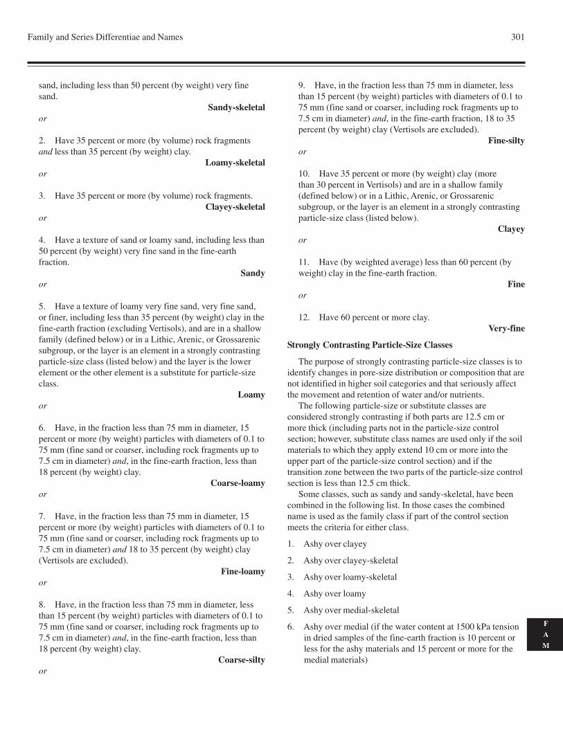
Family and Series Differentiae and Names 301
F
A
M
sand, including less than 50 percent (by weight) very finesand.
Sandy-skeletalor
2. Have 35 percent or more (by volume) rock fragmentsand less than 35 percent (by weight) clay.
Loamy-skeletalor
3. Have 35 percent or more (by volume) rock fragments.Clayey-skeletal
or
4. Have a texture of sand or loamy sand, including less than50 percent (by weight) very fine sand in the fine-earthfraction.
Sandyor
5. Have a texture of loamy very fine sand, very fine sand,or finer, including less than 35 percent (by weight) clay in thefine-earth fraction (excluding Vertisols), and are in a shallowfamily (defined below) or in a Lithic, Arenic, or Grossarenicsubgroup, or the layer is an element in a strongly contrastingparticle-size class (listed below) and the layer is the lowerelement or the other element is a substitute for particle-sizeclass.
Loamyor
6. Have, in the fraction less than 75 mm in diameter, 15percent or more (by weight) particles with diameters of 0.1 to75 mm (fine sand or coarser, including rock fragments up to7.5 cm in diameter) and, in the fine-earth fraction, less than18 percent (by weight) clay.
Coarse-loamyor
7. Have, in the fraction less than 75 mm in diameter, 15percent or more (by weight) particles with diameters of 0.1 to75 mm (fine sand or coarser, including rock fragments up to7.5 cm in diameter) and 18 to 35 percent (by weight) clay(Vertisols are excluded).
Fine-loamyor
8. Have, in the fraction less than 75 mm in diameter, lessthan 15 percent (by weight) particles with diameters of 0.1 to75 mm (fine sand or coarser, including rock fragments up to7.5 cm in diameter) and, in the fine-earth fraction, less than18 percent (by weight) clay.
Coarse-siltyor
9. Have, in the fraction less than 75 mm in diameter, lessthan 15 percent (by weight) particles with diameters of 0.1 to75 mm (fine sand or coarser, including rock fragments up to7.5 cm in diameter) and, in the fine-earth fraction, 18 to 35percent (by weight) clay (Vertisols are excluded).
Fine-siltyor
10. Have 35 percent or more (by weight) clay (morethan 30 percent in Vertisols) and are in a shallow family(defined below) or in a Lithic, Arenic, or Grossarenicsubgroup, or the layer is an element in a strongly contrastingparticle-size class (listed below).
Clayeyor
11. Have (by weighted average) less than 60 percent (byweight) clay in the fine-earth fraction.
Fineor
12. Have 60 percent or more clay.Very-fine
Strongly Contrasting Particle-Size Classes
The purpose of strongly contrasting particle-size classes is toidentify changes in pore-size distribution or composition that arenot identified in higher soil categories and that seriously affectthe movement and retention of water and/or nutrients.
The following particle-size or substitute classes areconsidered strongly contrasting if both parts are 12.5 cm ormore thick (including parts not in the particle-size controlsection; however, substitute class names are used only if the soilmaterials to which they apply extend 10 cm or more into theupper part of the particle-size control section) and if thetransition zone between the two parts of the particle-size controlsection is less than 12.5 cm thick.
Some classes, such as sandy and sandy-skeletal, have beencombined in the following list. In those cases the combinedname is used as the family class if part of the control sectionmeets the criteria for either class.
1. Ashy over clayey
2. Ashy over clayey-skeletal
3. Ashy over loamy-skeletal
4. Ashy over loamy
5. Ashy over medial-skeletal
6. Ashy over medial (if the water content at 1500 kPa tensionin dried samples of the fine-earth fraction is 10 percent orless for the ashy materials and 15 percent or more for themedial materials)
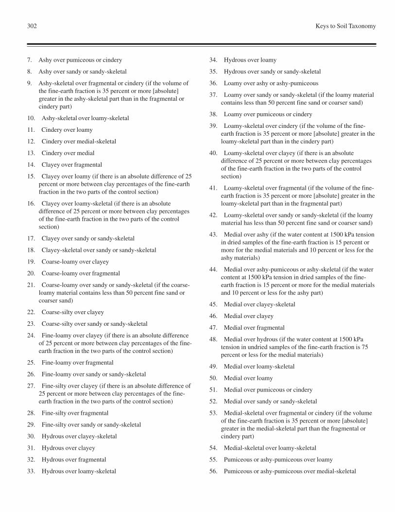
302 Keys to Soil Taxonomy
7. Ashy over pumiceous or cindery
8. Ashy over sandy or sandy-skeletal
9. Ashy-skeletal over fragmental or cindery (if the volume ofthe fine-earth fraction is 35 percent or more [absolute]greater in the ashy-skeletal part than in the fragmental orcindery part)
10. Ashy-skeletal over loamy-skeletal
11. Cindery over loamy
12. Cindery over medial-skeletal
13. Cindery over medial
14. Clayey over fragmental
15. Clayey over loamy (if there is an absolute difference of 25percent or more between clay percentages of the fine-earthfraction in the two parts of the control section)
16. Clayey over loamy-skeletal (if there is an absolutedifference of 25 percent or more between clay percentagesof the fine-earth fraction in the two parts of the controlsection)
17. Clayey over sandy or sandy-skeletal
18. Clayey-skeletal over sandy or sandy-skeletal
19. Coarse-loamy over clayey
20. Coarse-loamy over fragmental
21. Coarse-loamy over sandy or sandy-skeletal (if the coarse-loamy material contains less than 50 percent fine sand orcoarser sand)
22. Coarse-silty over clayey
23. Coarse-silty over sandy or sandy-skeletal
24. Fine-loamy over clayey (if there is an absolute differenceof 25 percent or more between clay percentages of the fine-earth fraction in the two parts of the control section)
25. Fine-loamy over fragmental
26. Fine-loamy over sandy or sandy-skeletal
27. Fine-silty over clayey (if there is an absolute difference of25 percent or more between clay percentages of the fine-earth fraction in the two parts of the control section)
28. Fine-silty over fragmental
29. Fine-silty over sandy or sandy-skeletal
30. Hydrous over clayey-skeletal
31. Hydrous over clayey
32. Hydrous over fragmental
33. Hydrous over loamy-skeletal
34. Hydrous over loamy
35. Hydrous over sandy or sandy-skeletal
36. Loamy over ashy or ashy-pumiceous
37. Loamy over sandy or sandy-skeletal (if the loamy materialcontains less than 50 percent fine sand or coarser sand)
38. Loamy over pumiceous or cindery
39. Loamy-skeletal over cindery (if the volume of the fine-earth fraction is 35 percent or more [absolute] greater in theloamy-skeletal part than in the cindery part)
40. Loamy-skeletal over clayey (if there is an absolutedifference of 25 percent or more between clay percentagesof the fine-earth fraction in the two parts of the controlsection)
41. Loamy-skeletal over fragmental (if the volume of the fine-earth fraction is 35 percent or more [absolute] greater in theloamy-skeletal part than in the fragmental part)
42. Loamy-skeletal over sandy or sandy-skeletal (if the loamymaterial has less than 50 percent fine sand or coarser sand)
43. Medial over ashy (if the water content at 1500 kPa tensionin dried samples of the fine-earth fraction is 15 percent ormore for the medial materials and 10 percent or less for theashy materials)
44. Medial over ashy-pumiceous or ashy-skeletal (if the watercontent at 1500 kPa tension in dried samples of the fine-earth fraction is 15 percent or more for the medial materialsand 10 percent or less for the ashy part)
45. Medial over clayey-skeletal
46. Medial over clayey
47. Medial over fragmental
48. Medial over hydrous (if the water content at 1500 kPatension in undried samples of the fine-earth fraction is 75percent or less for the medial materials)
49. Medial over loamy-skeletal
50. Medial over loamy
51. Medial over pumiceous or cindery
52. Medial over sandy or sandy-skeletal
53. Medial-skeletal over fragmental or cindery (if the volumeof the fine-earth fraction is 35 percent or more [absolute]greater in the medial-skeletal part than the fragmental orcindery part)
54. Medial-skeletal over loamy-skeletal
55. Pumiceous or ashy-pumiceous over loamy
56. Pumiceous or ashy-pumiceous over medial-skeletal
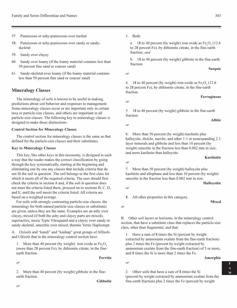
�������������� ��������������������� ���
�
�
�
��� �������� ����� ����������� �����������
��� �������� ����� ����������� ������ ������� ���� ������
�!� ���������������
"�� ���������������#����������������������������� ��� ��������������������� ���������� ��� ��$
"%� ���� ������������������#����������������������������� �� ���������������������� ���������� ��� ��$
������������ �
&�����������'����� ��� �� � ��(�����)��� ���������� ��'��������� ��)���� ����)������������� ��� � ��������'������������������'����� � �����������������������������������������*�������������� �+����� � ,��������� ������������������������������ �+����� � ��&��������(��'� ��������������'����� � �� � �'�������� ����� ��� �������� �
������������������ ���������������
&����������� �������������������'����� � �� ����� ����� ���������������������������� �+����� � ���������� �) ������ �
������ ���������������
&�� � ��,��� �������� �� ������� ���*�����,�� �� �'������ �����(�������������������� � ���������������� ����������)��'���'�����'������ ��� � �����������,� ������'��������)�'�����'�������������'�����)������������� � ���������������������������������������� �������-�� ������&��� ����)����' ����������� ����� ����(������������ ��������������-���������������&���� ��� �������� ����� ����������������� �������.���,�������� �������-�� ������� ������������������������ ��������,�������������� ������ �/,�0,��,���1,����������� �������� ���������������� ����.���������������)� �������(��'���������'��
���� ��� �(���� ����'��������� ���'���������� �+����� � ,������������'������)������������������ �+����� � ���� �) ������ ����'����,����� �������������� �����1*����� ��������� �������������,���*��#���)��������� ����������������� �������*�$, ����������,��� ���&�����2����-��������������������� ������ ���� ������,� ����������������*�,���������2������3���� �����
.� 4*� �� ����5 ���6����5 �����6�'�����'���� ����.��� �� ���7��� �� ���������������������'���������� �����������8
%� 9���������:����������#)��(��'��$��������*���� ����4
�
#����������;������������$,�)�������������������,����������������������������
��������
;� 9���������:����������#)��(��'��$�'�)) �������������������������������
����������
�� /���8
�� %�����:����������#)��(��'��$�������*���� ����4
��#%;�"
���;������������$,�)�������������������,��������������������������<����
)� %�����:����������#)��(��'��$�'�)) ������������������������������
�������
:� %�����:����������#)��(��'��$�������*���� ����4
��#%;�"
���;������������$,�)�������������������,���������������������������
������������
�� %�����:����������#)��(��'��$�'�)) ������������������������������
��������
"� 9��������������������#)��(��'��$� ������������ ������ ���,��� ���,��������,����������%8%��������*�����'�;8%������������� ����'�)) ��������� ������%����������#)�(��'��$� �������������������������� ����������;������� �+�<�������� �������������������� ����
�����������
�� 9��������������������#)��(��'��$������� ������� ��������������������������� ������%����������#)��(��'��$ �������������������������� ����������;������� �+��
������������
�� .������������������ ������� �����'���� ���
��
/� 4����� ��������� ��������+�� ,����������������'��������� ������,������������� �) ���������� ������������� �������������� �+���� ,���������������'������,��������8
%� 3������ ������������ �������#��������)��(��'���*�������)������������*����������������������������������$��� �;����� ��������#��������)��(��'����*�������)�����������*����������������������������������$�������������,��������� �������� �����������;����� ��������
���������
;� 4����� ��� ������������� ������������ ������#��������)��(��'����*�������)������������*���������������������������������$���� �;����� ��������#��������)��(��'��
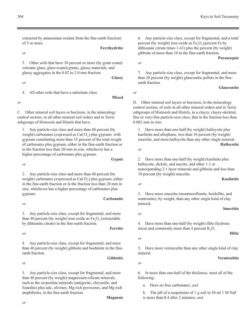
��: =�� ��������&�*�����
�*�������)������������*����������������������������������$�������������
�������������
�� 4����� ��� ������������������������������#)��'����������$���������'�� ,�'�� �������'���� ,�'�� ���������� ,���'�� ���''��'��� �����������;����;���������������
��������
:� .��������� ��� ������������� �) ���������� � ���
��
0� 4������������� ��������� ��������+�� ,����������������'��������� ������,���������������������� �������� �������&����� �)'���� ����3� �� �� ����3� ��� ����������8
%� .������������ �+����� ��������������:����������#)�(��'��$����)����� �#�*��� ��� �0�04
�$���� �'�� ��,�(���
'�� ������ �������'�����������������������������������(��'��������)����� ���� �'�� ��,������������������������������������������������������� ������;�������� �+�,�(����������� ����'������������'��������)����� ���� �'�� ���
�������
;� .������������ �+����� ��������������:����������#)�(��'��$����)����� �#�*��� ��� �0�04
�$���� �'�� ��,�������
������������������������������������������������ ������;������� �+�,�(����������� �����'������������'��������)����� ���� '�� ���
�����������
�� .������������ �+����� ,��*������������'������,�������������:����������#)��(��'��$�������*���� ���
�4
��#�*������)��
)�������������������$����������������������������������
��
:� .������������ �+����� ,��*������������'������,�������������:����������#)��(��'��$�'�)) �������)�����������������������������������
����������
�� .������������ �+����� ,��*������������'������,�������������:����������#)��(��'��$���'�� ���� ��������������� , ����� ����� ����������������� �#����'�����,����� �����,�����+�����$���� �����,�������� ,�9'����������*��� ,����9'����������)��� ,����������������������������
�������
"� .������������ �+����� ,��*������������'������,�������������������#)��(��'��$�������*���� ���
�4
��#�����������)�
���������������������� �%�:�$���� �������������#)��(��'��$'�)) �����������������%�����������������������������
�����������
�� .������������ �+����� ,��*������������'������,�������������;����������#)��(��'��$�'����������������� ����������������������������
�����������
�� 4������������� ��������� ��������+�� ,����������������'��������� ������,���� ��� �������������������������� �������&����� �)'���� ����3� �� �� ����3� ��� ,������������,�������� ������,��������������������������� �+����� ,������������������������ ���������;������� �+�8
%� 3�����������������������#)��(��'��$������� ������� ���������������������,��� ������%����������#)��(��'��$ �������,��������������� ������������������� ��'�����������
������������
;� 3�����������������������#)��(��'��$� ������������ ������ ���,��� ���,�����������,����������%8%�������*�����'�;8%�������������� ����'�)) ��������� �����%����������#)��(��'��$� ��������
�����������
�� 3��������� ��������#���������������,�)��������,�������������$,�)��(��'��,���������������� ��'��� ������������������
��������
:� 3�����������������������#)��(��'��$��������#����� ����$�����������������������:���������=
�4�
�������
�� 3������������������������������������ ��'��� ������������������
!����������
"� >�������������������������������� �� ,���������������������(��'8
�� 3���������������)����� <����
)� &����3������ � ��� �������%�'� �������������%�9����� �������������:�������;������� <����
Family and Series Differentiae and Names 305
F
A
M
c. The ratio of 1500 kPa water to measured clay is 0.6 ormore.
Isoticor
7. All other soils in this category.Mixed
or
E. All other mineral soil layers or horizons, in the mineralogycontrol section, that have:
1. More than 40 percent (by weight) (70 percent by graincount) mica and stable mica pseudomorphs in the 0.02 to0.25 mm fraction.
Micaceousor
2. More than 25 percent (by weight) (45 percent by graincount) mica and stable mica pseudomorphs in the 0.02 to0.25 mm fraction.
Paramicaceousor
3. In more than one-half of the thickness, all of thefollowing:
a. No free carbonates; and
b. The pH of a suspension of 1 g soil in 50 ml 1 M NaFis more than 8.4 after stirring for 2 minutes; and
c. A ratio of 1500 kPa water to measured clay of 0.6 ormore.
Isoticor
4. More than 90 percent (by weight or grain count) silicaminerals (quartz, chalcedony, or opal) and other resistantminerals in the 0.02 to 2.0 mm fraction.
Siliceousor
5. All other properties.Mixed
Cation-Exchange Activity Classes
The cation-exchange activity classes help in makinginterpretations of mineral assemblages and of the nutrient-holding capacity of soils in mixed and siliceous mineralogyclasses of clayey, clayey-skeletal, coarse-loamy, coarse-silty,fine, fine-loamy, fine-silty, loamy, loamy-skeletal, and very-fineparticle-size classes. Cation-exchange activity classes are notassigned to Histosols and Histels, and they are not assigned to
Oxisols and “kandi” and “kanhap” great groups and subgroupsof Alfisols and Ultisols because assigning such classes to themwould be redundant. Cation-exchange activity classes are notassigned to the sandy, sandy-skeletal, or fragmental particle-sizeclass because the low clay content causes cation-exchangeactivity classes to be less useful and less reliable.
The cation-exchange capacity (CEC) is determined byNH
4OAc at pH 7 on the fine-earth fraction. The CEC of the
organic matter, sand, silt, and clay is included in thedetermination. The criteria for the classes use ratios of CEC tothe percent, by weight, of silicate clay, both by weighted averagein the control section. In the following classes “clay” excludesclay-size carbonates. If the ratio of percent water retained at1500 kPa tension to the percentage of measured clay is 0.25 orless or 0.6 or more in half or more of the particle-size controlsection (or part in contrasting families), then the percentage ofclay is estimated by the following formula: Clay % = 2.5(%water retained at 1500 kPa tension - % organic carbon).
Control Section for Cation-Exchange Activity Classes
The control section for cation-exchange activity classes is thesame as that used to determine the particle-size and mineralogyclasses. For soils with strongly contrasting particle-size classes,where both named parts of the control section use a cation-exchange activity class, the class associated with the particle-size class that has the most clay is named. For example, in apedon with a classification of loamy over clayey, mixed, active,calcareous, thermic Typic Udorthent, the cation-exchangeactivity class “active” is associated with the clayey part of thecontrol section.
Key to Cation-Exchange Activity Classes
A. Soils that are not Histosols, Histels, or Oxisols, that are notin “kandi” or “kanhap” great groups or subgroups of Alfisolsand Ultisols, that are in either a mixed or siliceous mineralogyclass, that are not in a fragmental, sandy, or sandy-skeletalparticle-size class or any substitute for a particle-size class, andthat have a ratio of cation-exchange capacity (by NH
4OAc at pH
7) to clay (percent by weight) of:
1. 0.60 or more.Superactive
2. 0.40 to 0.60.Active
3. 0.24 to 0.40.Semiactive
4. Less than 0.24.Subactive
or
B. All other soils: No cation-exchange activity classes used.
306 Keys to Soil Taxonomy
Calcareous and Reaction Classes of Mineral Soils
The presence or absence of carbonates, soil reaction, and thepresence of high concentrations of aluminum in mineral soils aretreated together because they are so intimately related. There arefour classes—calcareous, acid, nonacid, and allic. These aredefined later, in the key to calcareous and reaction classes. Theclasses are not used in all taxa, nor is more than one used in thesame taxa.
Use of the Calcareous and Reaction Classes
The calcareous, acid, and nonacid classes are used in thenames of the families of Entisols, Aquands, and Aquepts, exceptthey are not used in any of the following:
1. Duraquands and Placaquands
2. Sulfaquepts, Fragiaquepts, and Petraquepts
3. Sandy, sandy-skeletal, cindery, pumiceous, or fragmentalfamilies
4. Families with carbonatic or gypsic mineralogy
The calcareous class, in addition to those listed above, isused in the names of the families of Aquolls, except it is notused with any of the following:
1. Calciaquolls, Natraquolls, and Argiaquolls
2. Cryaquolls and Duraquolls that have an argillic horizon
3. Families with carbonatic or gypsic mineralogy
The allic class is used only in families of Oxisols.
Control Section for Calcareous and Reaction Classes
The control section for the calcareous class is one of thefollowing:
1. Soils with a root-limiting layer that is 25 cm or less belowthe mineral soil surface: A 2.5-cm-thick layer directly above theroot-limiting layer.
2. Soils with a root-limiting layer that is 26 to 50 cm belowthe mineral soil surface: The layer between a depth of 25 cmbelow the mineral soil surface and the root-limiting layer.
3. All other listed soils: Between a depth of 25 and 50 cmbelow the mineral soil surface.
The control section for the acid, nonacid, and allic classes isthe same as that for particle-size classes.
Key to Calcareous and Reaction Classes
A. Oxisols that have a layer, 30 cm or more thick within thecontrol section, that contains more than 2 cmol(+) of KCl-extractable Al per kg soil in the fine-earth fraction.
Allic
B. Other listed soils that, in the fine-earth fraction,
effervesce (in cold dilute HCl) in all parts of the controlsection.
Calcareous
C. Other listed soils with a pH of less than 5.0 in 0.01 M CaCl2
(1:2) (about pH 5.5 in H2O, 1:1) throughout the control section.
Acid
D. Other listed soils with a pH of 5.0 or more in 0.01 M CaCl2
(1:2) in some or all layers in the control section.Nonacid
It should be noted that a soil containing dolomite iscalcareous and that effervescence of dolomite, when treated withcold dilute HCl, is slow.
The calcareous, acid, nonacid, and allic classes are listed inthe family name, when appropriate, following the mineralogyand cation-exchange activity classes.
Soil Temperature Classes
Soil temperature classes, as named and defined here, are usedas part of the family name in both mineral and organic soils.Temperature class names are used as part of the family nameunless the criteria for a higher taxon carry the same limitation.Thus, frigid is implied in all cryic suborders, great groups, andsubgroups and would be redundant if used in the names offamilies within these classes.
The Celsius (centigrade) scale is the standard. It is assumedthat the temperature is that of a soil that is not being irrigated.
Control Section for Soil Temperature
The control section for soil temperature either is at a depth of50 cm from the soil surface or is at the upper boundary of aroot-limiting layer, whichever is shallower. The soil temperatureclasses, defined in terms of the mean annual soil temperatureand the difference between mean summer and mean wintertemperatures, are determined by the following key.
Key to Soil Temperature Classes
A. Gelisols and Gelic suborders and great groups that have amean annual soil temperature as follows:
1. -10 oC or lower.Hypergelic
or
2. -4 oC to -10 oC.Pergelic
or
3. +1 oC to -4 oC.Subgelic
or
Family and Series Differentiae and Names 307
F
A
M
B. Other soils that have a difference in soil temperature of6 oC or more between mean summer (June, July, and August inthe Northern Hemisphere) and mean winter (December, January,and February in the Northern Hemisphere) and a mean annualsoil temperature of:
1. Lower than 8 oC (47 oF).Frigid
or
2. 8 oC (47 oF) to 15 oC (59 oF).Mesic
or
3. 15 oC (59 oF) to 22 oC (72 oF).Thermic
or
4. 22 oC (72 oF) or higher.Hyperthermic
or
C. All other soils that have a mean annual soil temperature asfollows:
1. Lower than 8 oC (47 oF).Isofrigid
or
2. 8 oC (47 oF) to 15 oC (59 oF).Isomesic
or
3. 15 oC (59 oF) to 22 oC (72 oF).Isothermic
or
4. 22 oC (72 oF) or higher.Isohyperthermic
Soil Depth Classes
Soil depth classes are used in all families that have a root-limiting layer at a specified depth from the mineral soil surface,except for those families in Lithic subgroups and those with afragipan. The root-limiting layers included in soil depth classesare duripans; petrocalcic, petrogypsic, and placic horizons;continuous ortstein (90 percent or more); and densic, lithic,paralithic, and petroferric contacts. Soil depth classes forHistosols and Histels are given later in this chapter. One soildepth class name, “shallow,” is used to characterize certainmineral soil families that have one of the depths indicated in thefollowing key.
Key to Soil Depth Classes
A. Oxisols that are less than 100 cm deep (from the mineralsoil surface) to a root-limiting layer and are not in a Lithicsubgroup.
Shallowor
B. Soils in all other mineral soil orders that are less than 50 cmdeep (from the mineral soil surface) to a root-limiting layer andare not in a Lithic subgroup.
Shallowor
C. All other mineral soils: No soil depth class used.
Rupture-Resistance Classes
In this taxonomy, some partially cemented soilmaterials, such as durinodes, serve as differentiae incategories above the family, while others, such as partiallycemented spodic materials (ortstein), do not. No singlefamily, however, should include soils both with and withoutpartially cemented horizons. In Spodosols, a partiallycemented spodic horizon is used as a family differentia.The following rupture-resistance class is defined for familiesof Spodosols:
A. Spodosols that have an ortstein horizon.Ortstein
or
B. All other soils: No rupture-resistance class used.
Classes of Coatings (on Sands)
Despite the emphasis given to particle-size classes in thistaxonomy, variability remains in the sandy particle-size class,which includes sands and loamy sands. Some sands are veryclean, i.e., almost completely free of silt and clay, while othersare mixed with appreciable amounts of finer grains. Clay ismore efficient at coating sand than is silt. A weighted averagesilt (by weight) plus 2 times the weighted average clay (byweight) of more than 5 makes a reasonable division of the sandsat the family level. Two classes of Quartzipsamments aredefined in terms of their content of silt plus 2 times their contentof clay.
Control Section for Classes of Coatings
The control section for classes of coatings is the same as thatfor particle-size classes or their substitutes and for mineralogyclasses.
308 Keys to Soil Taxonomy
Key to Classes of Coatings
A. Quartzipsamments that have a sum of the weighted averagesilt (by weight) plus 2 times the weighted average clay of morethan 5.
Coatedor
B. Other Quartzipsamments.Uncoated
Classes of Permanent Cracks
Some Hydraquents consolidate or shrink after drainage andbecome Fluvaquents or Humaquepts. In the process they canform polyhedrons roughly 12 to 50 cm in diameter, dependingon their n value and texture. These polyhedrons are separated bycracks that range in width from 2 mm to more than 1 cm. Thepolyhedrons may shrink and swell with changes in the moisturecontent of the soils, but the cracks are permanent and can persistfor several hundreds of years, even if the soils are cultivated.The cracks permit rapid movement of water through the soils,either vertically or laterally. Such soils may have the sametexture, mineralogy, and other family properties as soils that donot form cracks or that have cracks that open and close with theseasons. Soils with permanent cracks are very rare in the UnitedStates.
Control Section for Classes of Permanent Cracks
The control section for classes of permanent cracks is fromthe base of any plow layer or 25 cm from the soil surface,whichever is deeper, to 100 cm below the soil surface.
Key to Classes of Permanent Cracks
A. Fluvaquents or Humaquepts that have, throughout a layer50 cm or more thick, continuous, permanent, lateral and verticalcracks 2 mm or more wide, spaced at average lateral intervals ofless than 50 cm.
Crackedor
B. All other Fluvaquents and Humaquepts: No class ofpermanent cracks used.
Family Differentiae for Histosols andHistels
Most of the differentiae that are used to distinguish familiesof Histosols and Histels have already been defined, eitherbecause they are used as differentiae in mineral soils as well asHistosols and Histels or because their definitions are used forthe classification of some Histosols and Histels in categorieshigher than the family. In the following descriptions, differentiae
not previously mentioned are defined and the classes in whichthey are used are enumerated.
The order in which family classes, if appropriate for aparticular family, are placed in the technical family names ofHistosols and Histels is as follows:
Particle-size classesMineralogy classes, including the nature of limnic deposits in
HistosolsReaction classesSoil temperature classesSoil depth classes (used only in Histosols)
Particle-Size Classes
Particle-size classes are used only for the family names ofTerric subgroups of Histosols and Histels. The classes aredetermined from the properties of the mineral soil materials inthe control section through use of the key to particle-sizeclasses. The classes are more generalized than those for soils inother orders.
Control Section for Particle-Size Classes
The particle-size control section is the upper 30 cm of themineral layer or of that part of the mineral layer that is withinthe control section for Histosols and Histels (given in chapter 3),whichever is thicker.
Key to Particle-Size Classes of Histosols and Histels
A. Terric subgroups of Histosols and Histels thathave (by weighted average) in the particle-size controlsection:
1. A fine-earth component of less than 10 percent(including associated medium and finer pores) of the totalvolume.
Fragmentalor
2. A texture (of the fine earth) of sand or loamy sand,including less than 50 percent (by weight) very fine sand inthe fine-earth fraction.
Sandy or sandy-skeletalor
3. Less than 35 percent clay in the fine-earth fraction and acontent of rock fragments of 35 percent or more of the totalvolume.
Loamy-skeletalor
4. A content of rock fragments of 35 percent or more of thetotal volume.
Clayey-skeletalor
Family and Series Differentiae and Names 309
F
A
M
5. A clay content of 35 percent or more in the fine-earthfraction.
Clayeyor
6. All other Terric subgroups of Histosols and Histels.Loamy
or
B. All other Histosols and Histels: No particle-size class used.
Mineralogy Classes
There are three different kinds of mineralogy classesrecognized for families in certain great groups and subgroups ofHistosols. The first kind is the ferrihumic soil material definedbelow. The second is three types of limnic materials—coprogenous earth, diatomaceous earth, and marl, defined inchapter 3. The third is mineral layers of Terric subgroups. Thekey to mineralogy classes for these mineral layers is the same asthat for mineral soils. Terric subgroups of Histels also have thesame mineralogy classes as those for mineral soils.
Ferrihumic Mineralogy Class
Ferrihumic soil material, i.e., bog iron, is an authigenic(formed in place) deposit consisting of hydrated iron oxidemixed with organic matter, either dispersed and soft or cementedinto large aggregates, in a mineral or organic layer that has all ofthe following characteristics:
1. Saturation with water for more than 6 months per year (orartificial drainage);
2. 2 percent or more (by weight) iron concretions havinglateral dimensions ranging from less than 5 to more than 100mm and containing 10 percent or more (by weight) free ironoxide (7 percent or more Fe) and 1 percent or more (by weight)organic matter; and
3. A dark reddish or brownish color that changes little ondrying.
The ferrihumic mineralogy class is used for families ofFibrists, Hemists, and Saprists, but it is not used forSphagnofibrists and Sphagnic subgroups of other great groups.If the ferrihumic class is used in the family name of a Histosol,no other mineralogy classes are used in that family because thepresence of iron is considered to be by far the most importantmineralogical characteristic.
Mineralogy Classes Applied Only to Limnic Subgroups
Limnic materials (defined in chapter 3) with a thickness of 5cm or more are mineralogy class criteria if the soil does not alsohave ferrihumic mineralogy. The following family classes areused: coprogenous, diatomaceous, and marly.
Control Section for the Ferrihumic Mineralogy Class andMineralogy Classes Applied to Limnic Subgroups
The control section for the ferrihumic mineralogy class andthe classes applied to Limnic subgroups is the same as thecontrol section for Histosols.
Mineralogy Classes Applied Only to Terric Subgroups
For Histosols and Histels in Terric subgroups, use the samekey to mineralogy classes as that used for mineral soils unless aHistosol also has ferrihumic mineralogy.
Control Section for Mineralogy Classes Applied Only toTerric Subgroups
For Terric subgroups of Histosols and Histels, use the samecontrol section for mineralogy classes as that used for theparticle-size classes.
Key to Mineralogy Classes
A. Histosols (except for Folists), Sphagnofibrists, andSphagnic subgroups of other great groups that have ferrihumicsoil material within the control section for Histosols.
Ferrihumicor
B. Other Histosols that have, within the control section forHistosols, limnic materials, 5 cm or more thick, that consist of:
1. Coprogenous earth.Coprogenous
or
2. Diatomaceous earth.Diatomaceous
or
3. Marl.Marly
or
C. Histels and other Histosols in Terric subgroups: Use the keyto mineralogy classes for mineral soils.
or
D. All other Histels and Histosols: No mineralogy class used.
Reaction Classes
Reaction classes are used in all families of Histosols andHistels. The two classes recognized are defined in the followingkey:
A. Histosols and Histels that have a pH value, on undriedsamples, of 4.5 or more (in 0.01 M CaCl
2) in one or more
310 Keys to Soil Taxonomy
layers of organic soil materials within the control section forHistosols.
Euicor
B. All other Histosols and Histels.Dysic
Soil Temperature Classes
The soil temperature classes of Histosols are determinedthrough use of the same key and definitions as those used formineral soils. Histels have the same temperature classes as otherGelisols.
Soil Depth Classes
Soil depth classes refer to the depth to a root-limiting layer, afragmental particle-size class, or a cindery or pumiceoussubstitute class. The root-limiting layers included in soil depthclasses of Histosols are duripans; petrocalcic, petrogypsic, andplacic horizons; continuous ortstein; and densic, lithic,paralithic, and petroferric contacts. The following key is usedfor families in all subgroups of Histosols. The shallow class isnot used in the suborder Folists.
Key to Soil Depth Classes
A. Histosols that are less than 18 cm deep to a root-limitinglayer, to a fragmental particle-size class, or to a cindery orpumiceous substitute class.
Microor
B. Other Histosols, excluding Folists, that have a root-limitinglayer, a fragmental particle-size class, or a cindery or pumiceoussubstitute class at a depth between 18 and 50 cm from the soilsurface.
Shallowor
C. All other Histosols: No soil depth class used.
Series Differentiae Within a FamilyThe function of the series is pragmatic, and differences
within a family that affect the use of a soil should be consideredin classifying soil series. The separation of soils at the serieslevel of this taxonomy can be based on any property that is usedas criteria at higher levels in the system. The criteria mostcommonly used include presence of, depth to, thickness of, andexpression of horizons and properties diagnostic for the highercategories and differences in texture, mineralogy, soil moisture,soil temperature, and amounts of organic matter. The limits ofthe properties used as differentiae must be more narrowly
defined than the limits for the family. The properties used,however, must be reliably observable or be inferable from othersoil properties or from the setting or vegetation.
The differentiae used must be within the series controlsection. Differences in soil or regolith that are outside the seriescontrol section and that have not been recognized as seriesdifferentiae but are relevant to potential uses of certain soils areconsidered as a basis for phase distinctions.
Control Section for the Differentiation of Series
The control section for the soil series is similar to that for thefamily, but it differs in a few important respects. The particle-size and mineralogy control sections for families end at theupper boundary of a fragipan, duripan, or petrocalcic horizonbecause these horizons have few roots. In contrast to the controlsection for the series, the thickness of such horizons is not takeninto account in the control sections for the family. The seriescontrol section includes materials starting at the soil surface andalso the first 25 cm below a densic or paralithic contact if itsupper boundary is less than 125 cm below the mineral soilsurface. Properties of horizons and layers below the particle-sizecontrol section, a depth between 100 and 150 cm (or to 200 cmif in a diagnostic horizon) from the mineral soil surface, also areconsidered.
Key to the Control Section for the Differentiation of Series
The part of a soil to be considered in differentiating serieswithin a family is as follows:
A. Mineral soils that have permafrost within 150 cm of thesoil surface: From the soil surface to the shallowest of thefollowing:
1. A lithic or petroferric contact; or
2. A depth of 100 cm if the depth to permafrost is less than75 cm; or
3. 25 cm below the upper boundary of permafrost ifthat boundary is 75 cm or more below the soil surface; or
4. 25 cm below a densic or paralithic contact; or
5. A depth of 150 cm; or
B. Other mineral soils: From the soil surface to the shallowestof the following:
1. A lithic or petroferric contact; or
2. A depth of either 25 cm below a densic or paralithiccontact or 150 cm below the soil surface, whichever isshallower, if there is a densic or paralithic contact within 150cm; or
3. A depth of 150 cm if the bottom of the deepestdiagnostic horizon is less than 150 cm from the soil surface;or
Family and Series Differentiae and Names 311
F
A
M
4. The lower boundary of the deepest diagnostic horizon ora depth of 200 cm, whichever is shallower, if the lowerboundary of the deepest diagnostic horizon is 150 cm ormore below the soil surface; or
C. Organic soils (Histosols and Histels): From the soil surfaceto the shallowest of the following:
1. A lithic or petroferric contact; or
2. A depth of 25 cm below a densic or paralithic contact; or
3. A depth of 100 cm if the depth to permafrost is less than75 cm; or
4. 25 cm below the upper boundary of permafrost if thatboundary is between a depth of 75 and 125 cm below the soilsurface; or
5. The base of the bottom tier

313
H
O
R
This chapter describes soil layers and genetic soil horizons.The genetic horizons are not the equivalent of the diagnostichorizons of Soil Taxonomy. While designations of genetichorizons express a qualitative judgment about the kinds ofchanges that are believed to have taken place in a soil,diagnostic horizons are quantitatively defined features that areused to differentiate between taxa. A diagnostic horizon mayencompass several genetic horizons, and the changes implied bygenetic horizon designations may not be large enough to justifyrecognition of different diagnostic horizons.
Master Horizons and LayersThe capital letters O, L, A, E, B, C, R, and W represent the
master horizons and layers of soils. These letters are the basesymbols to which other characters are added to complete thedesignations. Most horizons and layers are given a singlecapital-letter symbol; some require two.
O horizons or layers: Layers dominated by organicmaterial. Some are saturated with water for long periods orwere once saturated but are now artificially drained; othershave never been saturated.
Some O layers consist of undecomposed or partiallydecomposed litter (such as leaves, needles, twigs, moss, andlichens) that has been deposited on the surface. They may be ontop of either mineral or organic soils. Other O layers consist oforganic material that was deposited under saturated conditionsand has decomposed to varying stages. The mineral fraction ofsuch material constitutes only a small percentage of the volumeof the material and generally much less than half of its weight.Some soils consist entirely of materials designated as Ohorizons or layers.
An O layer may be on the surface of a mineral soil, or it maybe at any depth below the surface if it is buried. A horizonformed by the illuviation of organic material into a mineralsubsoil is not an O horizon, although some horizons that haveformed in this manner contain considerable amounts of organicmatter.
L horizons or layers: Limnic horizons or layers includeboth organic and mineral limnic materials that were either (1)deposited in water by precipitation or through the actions of
aquatic organisms, such as algae and diatoms, or (2) derivedfrom underwater and floating aquatic plants and subsequentlymodified by aquatic animals.
L horizons or layers include coprogenous earth, (sedimentarypeat), diatomaceous earth, and marl. They occur only inHistosols. They have only the following subordinatedistinctions: co, di, or ma. They do not have the subordinatedistinctions of the other master horizons and layers.
A horizons: Mineral horizons that have formed at thesurface or below an O horizon. They exhibit obliteration of allor much of the original rock structure1 and show one or both ofthe following: (1) an accumulation of humified organic matterclosely mixed with the mineral fraction and not dominated byproperties characteristic of E or B horizons (defined below) or(2) properties resulting from cultivation, pasturing, or similarkinds of disturbance.
If a surface horizon has properties of both A and E horizonsbut the feature emphasized is an accumulation of humifiedorganic matter, it is designated as an A horizon. In some areas,such as areas of warm, arid climates, the undisturbed surfacehorizon is less dark than the adjacent underlying horizon andcontains only small amounts of organic matter. It has amorphology distinct from the C layer, although the mineralfraction is unaltered or only slightly altered by weathering. Sucha horizon is designated as an A horizon because it is at thesurface. Recent alluvial or eolian deposits that retain finestratification are not considered to be A horizons unlesscultivated.
E horizons: Mineral horizons in which the main feature isthe loss of silicate clay, iron, aluminum, or some combination ofthese, leaving a concentration of sand and silt particles. Thesehorizons exhibit obliteration of all or much of the original rockstructure.
An E horizon is most commonly differentiated from anunderlying B horizon in the same sequum by a color of highervalue or lower chroma, or both, by coarser texture, or by acombination of these properties. In some soils the color of the Ehorizon is that of the sand and silt particles, but in many soilscoatings of iron oxides or other compounds mask the color ofthe primary particles. An E horizon is most commonlydifferentiated from an overlying A horizon by its lighter color. Itgenerally contains less organic matter than the A horizon. An Ehorizon is commonly near the surface, below an O or A horizonand above a B horizon, but eluvial horizons that are within orbetween parts of the B horizon or extend to depths greater than
CHAPTER 18
Designations for Horizons and Layers
1 Rock structure includes fine stratification in unconsolidated soil materials as well aspseudomorphs of weathered minerals that retain their positions relative to each other and tounweathered minerals in saprolite.
314 Keys to Soil Taxonomy
those of normal observation can be assigned the letter E if theyare pedogenic.
B horizons: Horizons that have formed below an A, E, or Ohorizon. They are dominated by the obliteration of all or muchof the original rock structure and show one or more of thefollowing:
1. Illuvial concentration of silicate clay, iron, aluminum,humus, carbonates, gypsum, or silica, alone or incombination;
2. Evidence of the removal or addition of carbonates;
3. Residual concentration of oxides;
4. Coatings of sesquioxides that make the horizonconspicuously lower in color value, higher in chroma, orredder in hue, without apparent illuviation of iron;
5. Alteration that forms silicate clay or liberates oxides, orboth, and that forms a granular, blocky, or prismatic structureif volume changes accompany changes in moisture content;
6. Brittleness; or
7. Strong gleying.
All of the different kinds of B horizons are, or wereoriginally, subsurface horizons. Included as B horizons, wherecontiguous to other genetic horizons, are layers of illuvialconcentration of carbonates, gypsum, or silica that are the resultof pedogenic processes (and may or may not be cemented) andbrittle layers that show other evidence of alteration, such asprismatic structure or illuvial accumulation of clay.
Examples of layers that are not B horizons are layers inwhich clay films either coat rock fragments or cover finelystratified unconsolidated sediments, regardless of whether thefilms were formed in place or by illuviation; layers into whichcarbonates have been illuviated but that are not contiguous to anoverlying genetic horizon; and layers with gleying but no otherpedogenic changes.
C horizons or layers: Horizons or layers, excluding stronglycemented and harder bedrock, that are little affected bypedogenic processes and lack the properties of O, A, E, or Bhorizons. Most are mineral layers. The material of C layers maybe either like or unlike the material from which the solum haspresumably formed. The C horizon may have been modified,even if there is no evidence of pedogenesis.
Included as C layers are sediment, saprolite, bedrock, andother geologic materials that are moderately cemented or lesscemented. The excavation difficulty in these materialscommonly is low or moderate. Some soils form in material thatis already highly weathered, and if such material does not meetthe requirements for A, E, or B horizons, it is designated by theletter C. Changes that are not considered pedogenic are thosenot related to the overlying horizons. Some layers that haveaccumulations of silica, carbonates, gypsum, or more solublesalts are included in C horizons, even if cemented. If a cemented
layer formed through pedogenic processes, however, it isconsidered a B horizon.
R layers: Strongly cemented to indurated bedrock.Granite, basalt, quartzite, limestone, and sandstone are
examples of bedrock designated by the letter R. The excavationdifficulty commonly exceeds high. The R layer is sufficientlycoherent when moist to make hand-digging with a spadeimpractical, although the layer may be chipped or scraped.Some R layers can be ripped with heavy power equipment. Thebedrock may have cracks, but these are generally too few andtoo small to allow root penetration. The cracks may be coated orfilled with clay or other material.
W layers: WaterThis symbol indicates water layers within or beneath the soil.
The water layer is designated as Wf if it is permanently frozenand as W if it is not permanently frozen. The W (or Wf)designation is not used for shallow water, ice, or snow above thesoil surface.
Transitional and Combination HorizonsHorizons dominated by properties of one master horizon but
having subordinate properties of another.—Two capital-lettersymbols are used for such transitional horizons, e.g., AB, EB,BE, or BC. The first of these symbols indicates that theproperties of the horizon so designated dominate the transitionalhorizon. An AB horizon, for example, has characteristics of bothan overlying A horizon and an underlying B horizon, but it ismore like the A horizon than the B horizon.
In some cases a horizon can be designated as transitionaleven if one of the master horizons to which it presumably formsa transition is not present. A BE horizon may be recognized in atruncated soil if its properties are similar to those of a BEhorizon in a soil from which the overlying E horizon has notbeen removed by erosion. A BC horizon may be recognizedeven if no underlying C horizon is present; it is transitional toassumed parent materials.
Horizons with two distinct parts that have recognizableproperties of the two kinds of master horizons indicated by thecapital letters.—The two capital letters designating suchcombination horizons are separated by a virgule (/), e.g., E/B, B/E, or B/C. Most of the individual parts of one horizoncomponent are surrounded by the other. The designation may beused even when horizons similar to one or both of thecomponents are not present, provided that the separatecomponents can be recognized in the combination horizon. Thefirst symbol is that of the horizon with the greater volume.
Single sets of horizon designators do not cover all situations;therefore, some improvising is needed. For example, ArgicUdipsamments have lamellae that are separated from each otherby eluvial layers. Because it is generally not practical todescribe each lamella and eluvial layer as a separate horizon, thehorizons can be combined but the components described
Designations for Horizons and Layers 315
H
O
R
separately. One horizon then has several lamellae and eluviallayers and can be designated an “E and Bt” horizon. Thecomplete horizon sequence for these soils could be: Ap-Bw-Eand Bt1-E and Bt2-C.
Suffix SymbolsLowercase letters are used as suffixes to designate specific
kinds of master horizons and layers. The term “accumulation” isused in many of the definitions of such horizons to indicate thatthese horizons must contain more of the material in questionthan is presumed to have been present in the parent material.The suffix symbols and their meanings are as follows:
a Highly decomposed organic material
This symbol is used with O to indicate the most highlydecomposed organic materials, which have a fiber contentof less than 17 percent (by volume) after rubbing.
b Buried genetic horizon
This symbol is used in mineral soils to indicateidentifiable buried horizons with major genetic featuresthat were developed before burial. Genetic horizons mayor may not have formed in the overlying material, whichmay be either like or unlike the assumed parent material ofthe buried soil. This symbol is not used in organic soils,nor is it used to separate an organic layer from a minerallayer.
c Concretions or nodules
This symbol indicates a significant accumulation ofconcretions or nodules. Cementation is required. Thecementing agent commonly is iron, aluminum, manganese,or titanium. It cannot be silica, dolomite, calcite, or moresoluble salts.
co Coprogenous earth
This symbol, used only with L, indicates a limnic layerof coprogenous earth (or sedimentary peat).
d Physical root restriction
This symbol indicates noncemented, root-restrictinglayers in naturally occurring or human-made sediments ormaterials. Examples are dense basal till, plowpans, andother mechanically compacted zones.
di Diatomaceous earth
This symbol, used only with L, indicates a limnic layerof diatomaceous earth.
e Organic material of intermediate decomposition
This symbol is used with O to indicate organicmaterials of intermediate decomposition. The fiber content
of these materials is 17 to 40 percent (by volume) afterrubbing.
f Frozen soil or water
This symbol indicates that a horizon or layer containspermanent ice. The symbol is not used for seasonallyfrozen layers or for dry permafrost.
ff Dry permafrost
This symbol indicates a horizon or layer that iscontinually colder than 0 oC and does not contain enoughice to be cemented by ice. This suffix is not used forhorizons or layers that have a temperature warmer than0 oC at some time of the year.
g Strong gleying
This symbol indicates either that iron has been reducedand removed during soil formation or that saturation withstagnant water has preserved it in a reduced state. Most ofthe affected layers have chroma of 2 or less, and manyhave redox concentrations. The low chroma can representeither the color of reduced iron or the color of uncoatedsand and silt particles from which iron has been removed.The symbol g is not used for materials of low chroma thathave no history of wetness, such as some shales or Ehorizons. If g is used with B, pedogenic change inaddition to gleying is implied. If no other pedogenicchange besides gleying has taken place, the horizon isdesignated Cg.
h Illuvial accumulation of organic matter
This symbol is used with B to indicate theaccumulation of illuvial, amorphous, dispersiblecomplexes of organic matter and sesquioxides if thesesquioxide component is dominated by aluminum but ispresent only in very small quantities. The organo-sesquioxide material coats sand and silt particles. In somehorizons these coatings have coalesced, filled pores, andcemented the horizon. The symbol h is also used incombination with s as “Bhs” if the amount of thesesquioxide component is significant but the color valueand chroma, moist, of the horizon are 3 or less.
i Slightly decomposed organic material
This symbol is used with O to indicate the leastdecomposed of the organic materials. The fiber content ofthese materials is 40 percent or more (by volume) afterrubbing.
j Accumulation of jarosite
Jarosite is a potassium or iron sulfate mineral that iscommonly an alteration product of pyrite that has beenexposed to an oxidizing environment. Jarosite has hue of
316 Keys to Soil Taxonomy
2.5Y or yellower and normally has chroma of 6 or more,although chromas as low as 3 or 4 have been reported.
jj Evidence of cryoturbation
Evidence of cryoturbation includes irregular andbroken horizon boundaries, sorted rock fragments, andorganic soil materials occurring as bodies and brokenlayers within and/or between mineral soil layers. Theorganic bodies and layers are most commonly at thecontact between the active layer and the permafrost.
k Accumulation of carbonates
This symbol indicates an accumulation of alkaline-earth carbonates, commonly calcium carbonate.
m Cementation or induration
This symbol indicates continuous or nearly continuouscementation. It is used only for horizons that are morethan 90 percent cemented, although they may be fractured.The cemented layer is physically root-restrictive. Thepredominant cementing agent (or the two dominantcementing agents) may be indicated by adding definedletter suffixes, singly or in pairs. The horizon suffix kmindicates cementation by carbonates; qm, cementation bysilica; sm, cementation by iron; ym, cementation bygypsum; kqm, cementation by lime and silica; and zm,cementation by salts more soluble than gypsum.
ma Marl
This symbol, used only with L, indicates a limnic layerof marl.
n Accumulation of sodium
This symbol indicates an accumulation ofexchangeable sodium.
o Residual accumulation of sesquioxides
This symbol indicates a residual accumulation ofsesquioxides.
p Tillage or other disturbance
This symbol indicates a disturbance of the surface layerby mechanical means, pasturing, or similar uses. Adisturbed organic horizon is designated Op. A disturbedmineral horizon is designated Ap even though it is clearlya former E, B, or C horizon.
q Accumulation of silica
This symbol indicates an accumulation of secondarysilica.
r Weathered or soft bedrock
This symbol is used with C to indicate cemented layers
(moderately cemented or less cemented). Examples areweathered igneous rock and partly consolidatedsandstone, siltstone, or shale. The excavation difficulty islow to high.
s Illuvial accumulation of sesquioxides and organic matter
This symbol is used with B to indicate an accumulationof illuvial, amorphous, dispersible complexes of organicmatter and sesquioxides if both the organic-matter andsesquioxide components are significant and if either thecolor value or chroma, moist, of the horizon is 4 or more.The symbol is also used in combination with h as “Bhs” ifboth the organic-matter and sesquioxide components aresignificant and if the color value and chroma, moist, are 3or less.
ss Presence of slickensides
This symbol indicates the presence of slickensides.Slickensides result directly from the swelling of clayminerals and shear failure, commonly at angles of 20 to 60degrees above horizontal. They are indicators that othervertic characteristics, such as wedge-shaped peds andsurface cracks, may be present.
t Accumulation of silicate clay
This symbol indicates an accumulation of silicate claythat either has formed within a horizon and subsequentlyhas been translocated within the horizon or has beenmoved into the horizon by illuviation, or both. At leastsome part of the horizon should show evidence of clayaccumulation either as coatings on surfaces of peds or inpores, as lamellae, or as bridges between mineral grains.
v Plinthite
This symbol indicates the presence of iron-rich, humus-poor, reddish material that is firm or very firm when moistand hardens irreversibly when exposed to the atmosphereand to repeated wetting and drying.
w Development of color or structure
This symbol is used with B to indicate the developmentof color or structure, or both, with little or no apparentilluvial accumulation of material. It should not be used toindicate a transitional horizon.
x Fragipan character
This symbol indicates a genetically developed layerthat has a combination of firmness and brittleness andcommonly a higher bulk density than the adjacent layers.Some part of the layer is physically root-restrictive.
y Accumulation of gypsum
This symbol indicates an accumulation of gypsum.
Designations for Horizons and Layers 317
H
O
R
z Accumulation of salts more soluble than gypsum
This symbol indicates an accumulation of salts that aremore soluble than gypsum.
Conventions for Using Letter SuffixesMany master horizons and layers that are symbolized by a
single capital letter have one or more lowercase letter suffixes.The following rules apply:
1. Letter suffixes should directly follow the capital letter.
2. More than three suffixes are rarely used.
3. If more than one suffix is needed, the following letters, ifused, are written first: a, d, e, h, i, r, s, t, and w. Except in theBhs or Crt2 horizon designations, none of these letters areused in combination in a single horizon.
4. If more than one suffix is needed and the horizon is notburied, the following symbols, if used, are written last: c, f, g,m, v, and x. Some examples: Btc, Bkm, and Bsv.
5. If a horizon is buried, the suffix b is written last. It isused only for buried mineral soils.
A B horizon that has a significant accumulation of clay andalso shows evidence of a development of color or structure, orboth, is designated Bt (t has precedence over w, s, and h). A Bhorizon that is gleyed or has accumulations of carbonates,sodium, silica, gypsum, or salts more soluble than gypsum orresidual accumulations of sesquioxides carries the appropriatesymbol: g, k, n, q, y, z, or o. If illuvial clay also is present, tprecedes the other symbol: Bto.
Unless needed for explanatory purposes, the suffixes h, s, andw are not used with g, k, n, q, y, z, or o.
Vertical SubdivisionCommonly, a horizon or layer identified by a single letter or
a combination of letters has to be subdivided. For this purpose,Arabic numerals are added to the letters of the horizondesignation. These numerals follow all the letters. Within a Chorizon, for example, successive layers may be designated C1,C2, C3, etc. If the lower part is gleyed and the upper part isnot gleyed, the layers may be designated C1-C2-Cg1-Cg2 orC-Cg1-Cg2-R.
These conventions apply whatever the purpose of thesubdivision. In many soils a horizon that could be identifiedby a single set of letters is subdivided because of the need torecognize differences in morphological features, such asstructure, color, or texture. These divisions are numberedconsecutively with Arabic numerals, but the numbering starts
again with 1 wherever in the profile any letter of the horizonsymbol changes, e.g., Bt1-Bt2-Btk1-Btk2 (not Bt1-Bt2-Btk3-Btk4). The numbering of vertical subdivisions within ahorizon is not interrupted at a discontinuity (indicated by anumerical prefix) if the same letter combination is used inboth materials, e.g., Bs1-Bs2-2Bs3-2Bs4 (not Bs1-Bs2-2Bs1-2Bs2).
During sampling for laboratory analyses, thick soil horizonsare sometimes subdivided even though differences inmorphology are not evident in the field. These subdivisions areidentified by Arabic numerals that follow the respective horizondesignations. For example, four layers of a Bt horizon sampledby 10-cm increments are designated Bt1, Bt2, Bt3, and Bt4. Ifthe horizon has already been subdivided because of differencesin morphological features, the set of Arabic numerals thatidentifies the additional sampling subdivisions follows the firstnumeral. For example, three layers of a Bt2 horizon sampled by10-cm increments are designated Bt21, Bt22, and Bt23. Thedescriptions for each of these sampling subdivisions can be thesame, and a statement indicating that the horizon has beensubdivided only for sampling purposes can be added.
DiscontinuitiesArabic numerals are used as prefixes to horizon designations
(preceding the letters A, E, B, C, and R) to indicatediscontinuities in mineral soils. These prefixes are distinct fromthe Arabic numerals that are used as suffixes denoting verticalsubdivisions.
A discontinuity that can be identified by a number prefix is asignificant change in particle-size distribution or mineralogy thatindicates a difference in the material from which the horizonshave formed and/or a significant difference in age, unless thatdifference in age is indicated by the suffix b. Symbols thatidentify discontinuities are used only when they can contributesubstantially to an understanding of the relationships amonghorizons. The stratification common to soils that formed inalluvium is not designated as a discontinuity, unless particle-sizedistribution differs markedly from layer to layer (i.e., particle-size classes are strongly contrasting), even though genetichorizons may have formed in the contrasting layers.
Where a soil has formed entirely in one kind of material, thewhole profile is understood to be material 1 and the numberprefix is omitted from the symbol. Similarly, the uppermostmaterial in a profile consisting of two or more contrastingmaterials is understood to be material 1, but the number isomitted. Numbering starts with the second layer of contrastingmaterial, which is designated 2. Underlying contrasting layersare numbered consecutively. Even when the material of a layerbelow material 2 is similar to material 1, it is designated 3 in thesequence; the numbers indicate a change in materials, not typesof material. Where two or more consecutive horizons haveformed in the same kind of material, the same prefix number is2 Indicates weathered bedrock or saprolite in which clay films are present.
318
applied to all the designations of horizons in that material: Ap-E-Bt1-2Bt2-2Bt3-2BC. The suffix numbers designatingsubdivisions of the Bt horizon continue in consecutive orderacross the discontinuity.
If an R layer is present below a soil that has formed inresiduum and if the material of the R layer is judged to be likethe material from which the soil has developed, the Arabic-number prefix is not used. The prefix is used, however, if it isthought that the R layer would produce material unlike that inthe solum, e.g., A-Bt-C-2R or A-Bt-2R. If part of the solum hasformed in residuum, the symbol R is given the appropriateprefix: Ap-Bt1-2Bt2-2Bt3-2C1-2C2-2R.
A buried horizon (designated by the letter b) presents specialproblems. It is obviously not in the same deposit as theoverlying horizons. Some buried horizons, however, haveformed in material that is lithologically like the overlyingdeposit. A prefix is not used to distinguish material of such aburied horizon. If the material in which a horizon of a buriedsoil has formed is lithologically unlike the overlying material,however, the discontinuity is indicated by a number prefix andthe symbol for the buried horizon also is used, e.g., Ap-Bt1-Bt2-BC-C-2ABb-2Btb1-2Btb2-2C.
Discontinuities between different kinds of layers in organicsoils are not identified. In most cases such differences areidentified either by letter-suffix designations if the different
layers are organic or by the master symbol if the different layersare mineral.
Use of the Prime SymbolIf two or more horizons of the same kind are separated by
one or more horizons of a different kind in a pedon, identicalletter and number symbols can be used for those horizons thathave the same characteristics. For example, the sequence A-E-Bt-E-Btx-C identifies a soil that has two E horizons. Toemphasize this characteristic, the prime symbol (´) is addedafter the master-horizon symbol of the lower of the twohorizons that have identical designations, e.g., A-E-Bt-E´-Btx-C.The prime symbol, when appropriate, is applied to the capital-letter horizon designation, and any lowercase letter symbolsfollow it: B´t. The prime symbol is used only when the letterdesignations of the two layers in question are completelyidentical. In the rare cases when three layers have identical lettersymbols, double prime symbols can be used for the lowest ofthese layers: E´´.
The same principle applies in designating layers of organicsoils. The prime symbol is used only to distinguish two or morehorizons that have identical symbols, e.g., Oi-C-O´i-C´ (whenthe soil has two identical Oi layers) or Oi-C-Oe-C´ (when thetwo C layers are of the same kind).
319
Appendix
Laboratory Methods for Soil TaxonomyThe standard laboratory methods upon which the operational
definitions of this edition of Soil Taxonomy are based aredescribed in the Soil Survey Laboratory Methods Manual(USDA, in press). Copies of standard laboratory data sheets areincluded with the typifying pedons in the chapters on soil ordersin this edition of Soil Taxonomy. For specific information aboutan analytical procedure, these data sheets should be checked andreference should be made to the Soil Survey LaboratoryMethods Manual. Much of the information included in thisappendix is derived from “Soil Survey Laboratory Methods forCharacterizing Physical and Chemical Properties andMineralology of Soils” (Kimble, Knox, and Holzhey, 1993).Also, the information is summarized the Soil Survey LaboratoryInformation Manual (USDA, NRCS, 1995).
Pedon characterization data, or any soil survey data, are mostuseful when the operations for collecting the data are wellunderstood. The mental pictures and conceptual definitions thataid in visualizing properties and processes often differ from theinformation supplied by an analysis. Also, results differ bymethod, even though two methods may carry the same name orthe same concept. There is uncertainty in comparing one bit ofdata with another without knowledge of how both bits weregathered. Operational definitions, definitions tied to a specificmethod, are needed. This soil taxonomy has many class limits(at all levels) that are based on chemical or physical propertiesdetermined in the laboratory. One can question a given limit, butthat is not the purpose of this appendix. This appendix is writtento show what procedures are used for given class limits. Byusing specific class limits, everyone will come to the sameclassification if they follow the same procedures.
This taxonomy is based almost entirely on criteria that aredefined operationally. One example is the definition of particle-size classes. There is no one definition of clay that works wellfor all soils. Hence, an operation for testing the validity of a claymeasurement and a default operation for those situations wherethe clay measurement is not valid are defined. The defaultmethod is based on a water content at 1500 kPa and on contentof organic carbon.
Data Elements Used in Classifying Soils
Detailed explanations of laboratory methods are given in theSoil Survey Laboratory Methods Manual (USDA, in press).
Each method is listed by code on the data sheet at the beginningof the chapters describing soil orders. On the data sheetspresented with each order, the method code is shown for eachdetermination made. These data sheets should be consulted forreference to the Soil Survey Laboratory Methods Manual. Thismanual specifies method codes for pedon sampling, samplehandling, site selection, sample collection, and samplepreparation.
The units of measure reported on the data sheets are not SIunits. Following are SI conversions:
1 meq/100 g = 1 cmol(+)/kg1 mmho/cm = 1 dS/m15 bar = 1500 kPa1/3 bar = 33 kPa1/10 bar = 10 kPa
In this taxonomy the terms (1) particle-size analysis (sizeseparates), (2) texture, and (3) particle-size classes are all used.Particle-size analysis is needed to determine texture andparticle-size classes. Texture differs from particle-size class inthat texture includes only the fine-earth fraction (less than 2mm), while particle size includes both the fraction less than 2mm in size and the fraction equal to or more than 2 mm.
Atterberg limits are determined on the fraction less than 0.4mm in size. Plasticity index is the difference in water contentbetween liquid limit and plastic limit. It is the range of watercontent over which a soil paste can be deformed withoutbreaking, but it does not include flow as a liquid underoperationally defined conditions. Liquid limit is the minimumwater content at which the paste begins to flow as a liquid.Samples that do not deform without breaking at any watercontent are reported as NP, nonplastic. Operational definitionsare in the Annual Book of ASTM Standards (ASTM, 1998).
Bulk density is obtained typically by equilibration of Saran-coated natural fabric clods at designated pressure differentials.Bulk densities are determined at two or more water contents.For coarse textured and moderately coarse textured soils, theyare determined when the sample is at 10 kPa suction and whenovendry. For soils of medium and finer texture, the bulkdensities are determined when the sample is at 33 kPa suctionand when ovendry.
Bulk density determined at 33 kPa suction is used to convertother analytical results to a volumetric basis (for example, kg oforganic carbon per m3).
Coefficient of linear extensibility (COLE) is a derived value.
320 Keys to Soil Taxonomy
It is computed from the difference in bulk density between amoist clod and an ovendry clod. It is based on the shrinkage of anatural soil clod between a water content of 33 kPa (10 kPa forsandier soils) and ovendry.
Linear extensibility (LE) of a soil layer is the product of thethickness, in centimeters, multiplied by the COLE of the layer inquestion. The LE of a soil is the sum of these products for allsoil horizons. COLE multiplied by 100 is called linearextensibility percent (LEP).
Water retention difference (WRD) is computed from waterretentions at 33 kPa (10 kPa for sandier soils) and 1500 kPasuction. It is converted to cm of water per cm of soil through useof the bulk density. The 33 or 10 kPa water is determined bydesorption of the natural fabric clods, and the 1500 kPa water isdetermined by desorption of crushed soil.
Organic carbon data in the National Soil Survey Laboratory(NSSL) data base have been determined mostly by wet digestion(Walkley, 1935). Because of environmental concerns aboutwaste products, however, that procedure is no longer in use. Theonly procedure that is currently used to determine organiccarbon is a dry combustion procedure that determines thepercent of total carbon. The content of organic carbon isdetermined by subtracting the amount of carbon contributed bycarbonates from total carbon data. The content of organiccarbon determined by this computation is very close to thecontent determined by the wet digestion procedure.
Nitrogen in the NSSL data base is reported as a percentage ofthe total dry weight. A soil sample is combusted at hightemperature with oxygen to release NOx, and the N2 ismeasured by thermal conductivity detection.
Iron and aluminum extracted by citrate dithionite areremoved in a single extraction. They are measured by atomicabsorption and reported as a percentage of the total dry weight.The iron is primarily from ferric oxides (hematite, magnetite)and iron oxyhydroxides (goethite). Aluminum substituted intothese minerals is extracted simultaneously. The dithionitereduces the ferric iron, and the citrate stabilizes the iron bychelation. Iron and aluminum bound in organic matter areextracted if the citrate is a stronger chelator than the organicmolecules. Manganese extracted by this procedure also isrecorded. The iron extracted is commonly related to the claydistribution within a pedon.
Extractable bases (calcium, magnesium, sodium, andpotassium) are extracted with ammonium acetate buffered at pH7. They are equilibrated, filtered in an auto-extractor, andmeasured by atomic absorption. They are reported as meq/100 gsoil. The bases are extracted from the cation-exchange complexby displacement with ammonium ions. The term “extractablebases” is used instead of “exchangeable bases” because solublesalts and some bases from carbonates can be included in theextract.
Sum of bases is the sum of the calcium, magnesium, sodium,and potassium described in the previous paragraph.
Extractable acidity is the acidity released from the soil by a
barium chloride-triethanolamine solution buffered at pH 8.2. Itincludes all the acidity generated by replacement of thehydrogen and aluminum from permanent and pH-dependentexchange sites. It is reported as meq/100 g soil. Extractableacidity data are reported on some data sheets as exchangeableacidity and on others as exchangeable H+.
Extractable aluminum is exchangeable aluminum extractedby 1N KCl. It is a major constituent only in strongly acid soils(pH of less than 5.0). Aluminum will precipitate if the pH risesabove 4.5 to 5.0 during analysis. The extractant KCl usuallyaffects the soil pH 1 unit or less. Extractable aluminum ismeasured at the NSSL by atomic absorption. Many laboratoriesmeasure the aluminum by titration with a base to thephenopthalein end point. Titration measures exchangeableacidity as well as extractable aluminum. Soils with a pH below4.0 or 4.5 are likely to have values determined by atomicabsorption similar to values determined by titration because verylittle hydrogen is typically on the exchange complex. If there is alarge percentage of organic matter, however, some hydrogenmay be present. For some soils it is important to know whichprocedure was used. Extractable aluminum is reported as meq/100 g soil.
Aluminum saturation is the amount of KCl-extractable Aldivided by extractable bases (extracted by ammonium acetate)plus the KCl-extractable Al. It is expressed as percent. A generalrule of thumb is that if there is more than 50 percent Alsaturation, Al problems in the soil are likely. The problems maynot be related to Al toxicity but to a deficiency of calcium and/or magnesium.
Cation-exchange capacity (CEC) by ammonium acetate (atpH 7), by sum of cations (at pH 8.2), and by bases plusaluminum is given on the data sheets in the chapters on soilorders. The CEC depends on the method of analysis as well asthe nature of the exchange complex. CEC by sum of cations atpH 8.2 is calculated by adding the sum of bases and theextractable acidity. CEC by ammonium acetate is measured atpH 7. CEC by bases plus aluminum, or effective cation-exchange capacity (ECEC), is derived by adding the sum ofbases and KCl-extractable Al. Aluminum extracted by 1N KCl isnegligible if the extractant pH rises toward 5.5. ECEC then isequal to extractable bases. CEC and ECEC are reported on thedata sheets as meq/100 g soil.
The reported CEC may differ from the CEC of the soil at itsnatural pH. The standard methods allow the comparison of onesoil with another even though the pH of the extractant differsfrom the pH of the natural soil. Cation-exchange capacity byammonium acetate and by sum of cations applies to all soils.CEC at pH 8.2 is not reported if the soil contains free carbonatesbecause bases are extracted from the carbonates. The effectiveCEC (ECEC) is reported only for acid soils. ECEC is notreported for soils having soluble salts, although it can becalculated by subtracting the soluble components from theextractable components. ECEC also may be defined as basesplus aluminum plus hydrogen. That is the more common
Appendix 321
definition for agronomic interpretations. This taxonomyspecifies bases plus aluminum.
Generally, the ECEC is less than the CEC at pH 7, which inturn is less than the CEC at pH 8.2. If the soil is dominated bypositively charged colloids (e.g., iron oxides), however, thetrend is reversed. Most soils have negatively charged colloids,which cause the CEC to increase with increasing pH. Thisdifference in CEC is commonly called the pH-dependent orvariable charge. The CEC at the soil pH can be estimated byplotting the CEC of the soil vs. the pH of the extractant on agraph and reading the CEC at the soil pH.
CEC measurements at pH levels other than those described inthe paragraphs above and CEC derived by use of other cationswill yield somewhat different results. It is important to know theprocedure, pH, and cation used before evaluating CEC data orcomparing data from different sources.
Base saturation is reported on the data sheets as percent ofthe CEC. It is reported as CEC by sum of cations at pH 8.2 andby ammonium acetate at pH 7. Base saturation by ammoniumacetate is equal to the sum of the bases extracted by ammoniumacetate, divided by the CEC (by ammonium acetate), andmultiplied by 100. If extractable calcium is not reported on thedata sheet because of free carbonates or salts in the sample, thenthe base saturation is assumed to be 100 percent.
Base saturation percentage by sum of cations is equal to thesum of bases extracted by ammonium acetate, divided by theCEC (by sum of cations), and multiplied by 100. This value isnot reported if either extractable calcium or extractable acidityis omitted.
Differences between the two methods of determining basesaturation reflect the amount of the pH-dependent CEC. Classdefinitions in this taxonomy specify which method is used.
The sum of exchangeable cations is considered equal to thesum of bases extracted by ammonium acetate unless carbonates,gypsum, or other salts are present. When these salts are present,the sum of the bases extracted by ammonium acetate typicallyexceeds 100 percent of the CEC. Therefore, a base saturation of100 percent is assumed. The amount of calcium from carbonatesis usually much larger than the amount of magnesium from thecarbonates. Extractable calcium is not shown on the data sheet ifmore than a trace (more than 0.4 percent) of carbonates(reported as calcium carbonate) is present or if calculated basesaturation exceeds 110 percent, based on CEC by ammoniumacetate at pH 7.
Calcium carbonate equivalent is the amount of carbonates inthe soil as measured by treating the sample with HCl. Theevolved carbon dioxide is measured manometrically. Theamount of carbonate is then calculated as a calcium carbonateequivalent regardless of the form of carbonates (dolomite,sodium carbonate, magnesium carbonate, etc.) in the sample.Calcium carbonate equivalent is reported as a percentage of thetotal dry weight of the sample. It can be reported on materialthat is less than 2 mm or less than 20 mm in size.
Calcium sulfate as gypsum is determined by extraction in
water and precipitation in acetone. The amount of gypsum isreported as a percentage of the total dry weight of the fractionless than 2 mm in size and the fraction less than 20 mm in size.Drying soils to oven-dryness, the standard base for reporting thedata, removes part of the water of hydration from the gypsum.Many measured values, particularly water retention values, mustbe recalculated to compensate for the weight of the water ofhydration lost during drying.
pH is measured in water and in salts. The pH measured inwater is determined in distilled water typically mixed 1:1 withdry soil. The pH measured in potassium chloride is determinedin 1N KCl solution mixed 1:1 with soil. The pH measured incalcium chloride is determined in 0.01M CaCl
2 solution mixed
2:1 with soil.The pH is measured by a pH meter in a soil-water or soil-salt
solution. The extent of the dilution is shown in the heading onthe data sheets. A ratio of 1:1 means one part dry soil and onepart water, by weight.
Measurement of pH in a dilute salt solution is commonbecause it tends to mask seasonal variations in pH. Readings in0.01M CaCl
2 tend to be uniform regardless of the time of year.
Readings in 1N KCl also tend to be uniform. The former aremore popular in regions with less acid soils. The latter are morepopular in regions with more acid soils. If KCl is used to extractexchangeable aluminum, the pH reading (in KCl) shows the pHat which the aluminum was extracted.
The pH may also be measured in 1N sodium fluoride. Thismeasurement is usually used to identify soils that are dominatedby short-range-order minerals, such as Andisols and Spodosols.In soils that have a significant component of poorly orderedminerals, such as the soils in the isotic mineralogy class, the pHin NaF will be greater than 8.5. Soils with free carbonates alsohave high pH values in NaF. Therefore, care must be taken ininterpreting these data.
Water-soluble cations and anions are determined in waterextracted from a saturated paste. The cations include calcium,magnesium, sodium, and potassium, and the anions includecarbonate, bicarbonate, sulfate, chloride, nitrate, fluoride,phosphate, silicate, and borate. The cations and anions can bereported as cmol(+)/l.
Exchangeable sodium percentage (ESP) is reported as apercentage of the CEC by ammonium acetate at pH 7. Water-soluble sodium is converted to meq/100 g soil. This value issubtracted from extractable sodium, divided by the CEC (byammonium acetate), and multiplied by 100. An ESP of morethan 15 percent is used in this taxonomy as a criterion for thenatric horizon.
Sodium adsorption ratio (SAR) was developed as a measureof irrigation water quality. Water-soluble sodium is divided bywater-soluble calcium and magnesium. The formula is SAR =Na/[(Ca+Mg)/2]0.5. An SAR of 13 or more is used as an alternateto the ESP criterion for the natric horizon.
Electrical conductivity (EC) is the conductivity of the waterextracted from saturated paste. The EC is used to determine the
��� ���������� �����
�������������������������������������������������������������������
������������������������������������������������������������������������������������������������������� ����������� �����������������!���"��������������������
����������� ��� ������������������������������������������������"������������������"�����������#�$$$�� �% ��������������������&������� ����������������������������������������������������������������������������������������������������������������"������"������������ �� �����������
���� ����������������������������� ������� ��� �������� ���������������"������� ����������������������������%������$����������������������������'�����(�� ������������������������������������������������"���������"������������������������������� �������������������� ���� ��������������������������������������������� �������������)�������������������������������������������������" ������������������� ��������������������������������������������������� �������������������������������������������������������������*���������������������!��������������������������������������������������������������������������������������+������������������������������������������ ������������,��������������������������������������������������������������������������� ������������
������������������������������� �� ������� �����������������"������� ��������������������������"��������"��������-�������������������������������� ������������������� ���� �����������������"����������������������������������������������� ����������������������������������������������� ��!�������������������������������.���"��������������������������� ���������"���������������������
������������������������������������ �����������������"��������"����������������������� �����������������"��������������������"������������������������������ ������������"�������������������������������������������������!������!��������"������������
���� ���� ������������������������������������������������������� ������������������������������������������������������������������� �����������������������/'����0�����������1�������#2334��)"���$�($� ���������!����������������������������������������������.��������%���������(�����$�(���������5�6'�������������($!����������� ����"�����#�����������������������6��������������������� �� ���������������������������������������� ������&�$$$��������#$���������� �����������������������������������"��"��������&($���������������(�$����
����������������������������������������������������������������������������������������/����������#�($$�� �% +�6�4��������������������������/�������������������#�($$
� �% 4����� �������� � ����� ������������������ �����
������������!�"�#�����������������������������������������.�� ��������� ��"���������������������������'�3�������������� ������������������������������������'�7�$�������������
�������������������� �������"�����������"�������������������� ��"���"�����
�������$������������������������������������������������������������������������������������ ����������������)�������������������������"������� �#� ����������������������&����������������������������������� ����������������������������������������� ������������������������������������������ ���������� �������������������������������������������������������������������������������� ���������1�����������������
%����������������$����������������������������������������������.��� ����������������������������������������������������������������������������������
�� ����� �������������������������������������������������������������� ������������������������������������8!�������������������������������������������������� ���������������
8!������������������������/8-,4���������������������!������������"�������������������������%��������������������������������������� ������������������������������������������������������������"��������������������������������������������� ���������
��������������������������������� ���������������������������������������������������%���������� �""���������������������� ����������
+��� ���������������������������������������� �������������1�����������������������"�������������� ����������������)���������$$� �������������������������������������������������������������������������������������9�������"�������������������������������������������� ��������������������"����������������)����������������������������������������&��'������������������� ����/:,)����������4�
������������ �������� ������� � ���� ��
;������������������� ��������"����������������������������������� ��������� �������������������<�/,����=�������>�������"��%���������=��������#$�%+�>�����������%����=��>4���������"��#$�� ���������������������������������� ��������"���"����������"��������������������������������?�������.����������������������������������������������������������������"������������������������������������#$$����
-��������������"���������������������������������������%�� ��������������%�������������������%�� ����� �����!��������������������������������������� ������������������������������������������������������������������� ��� ������%����������������.���
����������#($$�%+�������������������������������������������������������������!��.�������������������������������$�@�����������������������������������������������������������������������������������������������������������������"������������ �������<�A����B�C���(/B������������������#($$�%+���������!�B�� ��������"�4��D�����������
)������� ���
�������������������������������������������$�&��������!����������������������������������������������$�&����������<�/#4���!���������������/%���������������������������������4����������������������������$��(���"���E�/�4�������������������!��.����"�������������������������������������E�/�4�� �������������������������������������"���������������������������������������#($$�%+�E�/&4������������������������������������������������������������� ���������������������������������"�����������������������������E�/(4���� ����������� �����E�����/@4��������������������� ����������������������� �������������������������������#($$�%+������������������������������ �������������������������������������������������������������������������
����������A?A�"����������������������'�7�����������"������������������������������ �����������������������������������������������"��#$$�������������������/F4�% ������� �������� �������������������������������� ���������������������� �<�����������$����%��������E�$��!$����%���������������E�$��!$�(�����������������E�$�(!$�7�������������������E�������������$�7������������� ������������������������������������������������� �����������������"������������������#($$�%+�����������������$��(����������$�@�������������������A?A�"�������������������������������������-�������#($$�%+����������������$�@������������������������������������������������������������������������������������������������������� �������������������������������$�������������������������������������� ����������� ������
)��������A?A�����'�3�����#($$�%+�������������������#�(�������������� �������������������������"�����������A�!
��������"���)����������������������� ���'!�������������� ��)�� ������"��%��������������������������������� �������������������������������������������������������������������������������������������� �������������������������������������������������������
� ���������� ���
)����������������� ����� �����1����������#223��)�����G%���) 1�����������;���&�$3��,�&�#3!2(��
'���� �����0��������������1�������#233��)������+����������,���������1������������� �������:��������,������������� �1�����������D������)��������+�������<�@2!73�
���"����H�1��?�I�����������A���'�.�����#22�����������J�"������1���������A���������.�� �+�����������A��������+�������������1������� ���������( �)������������) ����������)�����������?��������������������) 1�����+�"��##@�����G��'����������� �)��6K���������
:������������,������������) �����������5�������-�������A������������������#22(�����������J�"���������������1�������5����������������A���������������J�"����������������������� ������-�����&(�
:������������,������������) �����������5�������-�������A������������������5����������������A��������/���������4���������J�"������1������1���������������������� ������-�����&���;������&�$�
9��%�����)��#2�(��)��?������������1��������,��������� �6� �����A��"������5��� �����������H��) �������(<�(23!@$2�
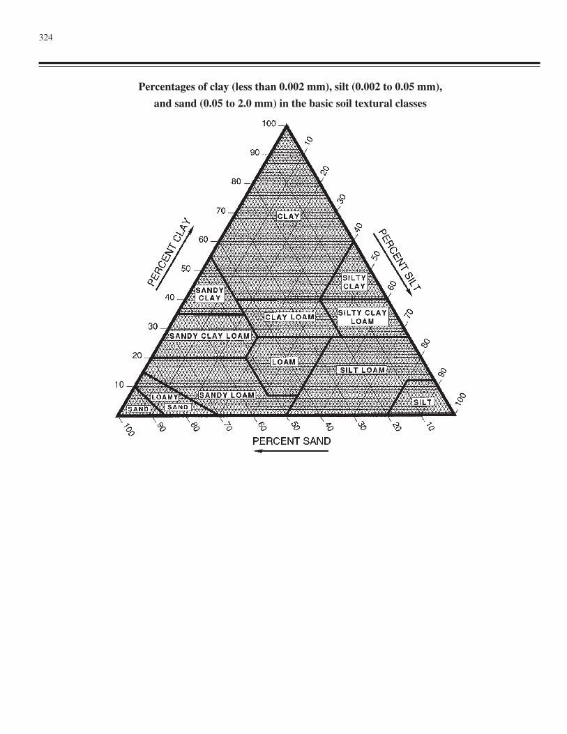
324
Percentages of clay (less than 0.002 mm), silt (0.002 to 0.05 mm),
and sand (0.05 to 2.0 mm) in the basic soil textural classes
325
Index
A
A horizons. See Horizons and layers.Abrupt textural change ............................................................ 21Acraquox ............................................................................... 237Acroperox .............................................................................. 238Acrotorrox ............................................................................. 242Acrudox ................................................................................. 243Acrustox ................................................................................. 247Agric horizon ........................................................................... 16Alaquods ................................................................................ 253Albaqualfs ................................................................................ 41Albaquults .............................................................................. 264Albic horizon ........................................................................... 17Albic materials ......................................................................... 22Albolls ................................................................................... 194Alfisols ..................................................................................... 41Alorthods ............................................................................... 258Andic soil properties ................................................................ 22Andisols ................................................................................... 83Anhydrous conditions .............................................................. 22Anhyorthels ............................................................................ 151Anhyturbels ............................................................................ 155Aniso class ............................................................................. 298Anthracambids ....................................................................... 114Anthrepts ............................................................................... 165Anthropic epipedon ................................................................. 13Aqualfs ..................................................................................... 41Aquands ................................................................................... 83Aquents .................................................................................. 129Aquepts .................................................................................. 165Aquerts ................................................................................... 285Aquic conditions ...................................................................... 29Aquic moisture regime. See Soil moisture regimes.Aquicambids .......................................................................... 114Aquisalids .............................................................................. 128Aquiturbels ............................................................................ 155Aquods ................................................................................... 253Aquolls ................................................................................... 195Aquorthels ............................................................................. 151Aquox .................................................................................... 237Aquults ................................................................................... 263Arents ..................................................................................... 133Argialbolls ............................................................................. 194Argiaquolls ............................................................................ 195
Argicryids .............................................................................. 118Argicryolls ............................................................................. 199Argids .................................................................................... 103Argidurids .............................................................................. 121Argigypsids ............................................................................ 124Argillic horizon ........................................................................ 17Argiorthels ............................................................................. 152Argiudolls .............................................................................. 204Argiustolls .............................................................................. 211Argixerolls ............................................................................. 227Aridic moisture regime. See Soil moisture regimes.Aridisols ................................................................................ 103
B
B horizons. See Horizons and layers.Bottom tier ............................................................................... 29Buried soils .............................................................................. 10
C
C horizons or layers. See Horizons and layers.Calcareous and reaction classes for mineral soils .................. 306Calciaquerts ........................................................................... 286Calciaquolls ........................................................................... 195Calciargids ............................................................................. 103Calcic horizon .......................................................................... 17Calcicryids ............................................................................. 119Calcicryolls ............................................................................ 200Calcids ....................................................................................111Calcigypsids ........................................................................... 125Calcitorrerts ........................................................................... 289Calciudolls ............................................................................. 206Calciustepts ............................................................................ 180Calciusterts ............................................................................ 292Calciustolls ............................................................................ 215Calcixerepts ........................................................................... 186Calcixererts ............................................................................ 295Calcixerolls ............................................................................ 229Cambic horizon ........................................................................ 18Cambids ................................................................................. 114Cation-exchange activity classes for mineral soils ................ 305Coatings (classes) on sands ................................................... 307Coefficient of linear extensibility (COLE) .............................. 22Control section of Histosols and Histels .................................. 29
326 Keys to Soil Taxonomy
Coprogenous earth. See Organic soil material.Cryalfs ..................................................................................... 50Cryands .................................................................................... 87Cryaqualfs ................................................................................ 43Cryaquands .............................................................................. 84Cryaquents ............................................................................. 130Cryaquepts ............................................................................. 166Cryaquods .............................................................................. 254Cryaquolls .............................................................................. 196Cryepts ................................................................................... 171Cryerts ................................................................................... 289Cryic temperature regime. See Soil temperature
regimes.Cryids ..................................................................................... 118Cryods .................................................................................... 255Cryofibrists ............................................................................ 159Cryofluvents .......................................................................... 134Cryofolists ............................................................................. 160Cryohemists ........................................................................... 161Cryolls ................................................................................... 199Cryopsamments ..................................................................... 145Cryorthents ............................................................................ 139Cryosaprists ........................................................................... 162Cryoturbation ........................................................................... 31Cryrendolls ............................................................................ 203
D
Densic contact .......................................................................... 31Densic materials ....................................................................... 31Diagnostic subsurface horizons ............................................... 16Diagnostic surface horizons ..................................................... 13Diatomaceous earth. See Organic soil material.Discontinuities identified by horizon designators .................. 317Duraqualfs ............................................................................... 43Duraquands .............................................................................. 84Duraquerts ............................................................................. 286Duraquods .............................................................................. 254Duraquolls ............................................................................. 196Duricryands ............................................................................. 87Duricryods ............................................................................. 255Duricryolls ............................................................................. 200Durids .................................................................................... 121Durihumods ........................................................................... 258Durinodes ................................................................................ 22Duripan .................................................................................... 18Duritorrands ............................................................................. 90Durixeralfs ............................................................................... 77Durixerepts ............................................................................ 187Durixererts ............................................................................. 295Durixerolls ............................................................................. 229Durorthods ............................................................................. 259Durudands ................................................................................ 91Durudepts .............................................................................. 174
Durustalfs ................................................................................. 66Durustands ............................................................................... 98Durustepts .............................................................................. 181Durustolls ............................................................................... 216Dystraquerts ........................................................................... 286Dystrocryepts ......................................................................... 172Dystrogelepts ......................................................................... 173Dystroxerepts ......................................................................... 187Dystrudepts ............................................................................ 175Dystruderts ............................................................................. 292Dystrustepts ........................................................................... 181Dystrusterts ............................................................................ 291
E
E horizons. See Horizons and layers.Endoaqualfs ............................................................................. 43Endoaquands ............................................................................ 84Endoaquents ........................................................................... 130Endoaquepts .......................................................................... 167Endoaquerts ........................................................................... 287Endoaquods ........................................................................... 254Endoaquolls ........................................................................... 196Endoaquults ........................................................................... 264Entisols .................................................................................. 129Epiaqualfs ................................................................................ 45Epiaquands .............................................................................. 85Epiaquents ............................................................................. 131Epiaquepts ............................................................................. 168Epiaquerts .............................................................................. 288Epiaquods .............................................................................. 255Epiaquolls .............................................................................. 197Epiaquults .............................................................................. 264Epipedon .................................................................................. 13Eutraquox............................................................................... 237Eutrocryepts ........................................................................... 172Eutrogelepts ........................................................................... 173Eutroperox ............................................................................. 239Eutrotorrox ............................................................................ 242Eutrudepts .............................................................................. 177Eutrudox ................................................................................ 244Eutrustox ................................................................................ 248
F
Family differentiae for Histosols and Histels ........................ 308Family differentiae for mineral soils ...................................... 297Ferrudalfs ................................................................................. 55Fibers. See Organic soil material.Fibric soil materials. See Organic soil material.Fibristels ................................................................................ 149Fibrists ................................................................................... 159Fluvaquents ............................................................................ 131Fluvents ................................................................................. 134
Index 327
Folistels .................................................................................. 150Folistic epipedon ..................................................................... 13Folists .................................................................................... 160Fragiaqualfs ............................................................................. 47Fragiaquepts ........................................................................... 169Fragiaquods ........................................................................... 255Fragiaquults ........................................................................... 265Fragic soil properties ............................................................... 23Fragihumods .......................................................................... 258Fragiorthods ........................................................................... 259Fragipan ................................................................................... 18Fragiudalfs ............................................................................... 55Fragiudepts ............................................................................ 179Fragiudults ............................................................................. 270Fragixeralfs .............................................................................. 78Fragixerepts ........................................................................... 189Fraglossudalfs .......................................................................... 55Frigid temperature regime. See Soil temperature regimes.Fulvicryands ............................................................................ 87Fulvudands ............................................................................... 92
G
Gelands .................................................................................... 90Gelaquands .............................................................................. 85Gelaquents ............................................................................. 132Gelaquepts ............................................................................. 169Gelepts ................................................................................... 173Gelic materials ......................................................................... 31Gelifluvents ............................................................................ 134Gelisols .................................................................................. 149Gelods .................................................................................... 257Gelolls .................................................................................... 202Gelorthents ............................................................................. 140Glacic layer .............................................................................. 31Glacistels ............................................................................... 150Glossaqualfs ............................................................................. 48Glossic horizon ........................................................................ 19Glossocryalfs ........................................................................... 50Glossudalfs .............................................................................. 56Gypsiargids ............................................................................ 105Gypsic horizon ......................................................................... 19Gypsicryids ............................................................................ 119Gypsids .................................................................................. 124Gypsitorrerts .......................................................................... 290Gypsiusterts ........................................................................... 293
H
Halaquepts ............................................................................. 170Haplanthrepts ......................................................................... 165Haplaquox .............................................................................. 238Haplargids .............................................................................. 106Haplocalcids ........................................................................... 111
Haplocambids ........................................................................ 115Haplocryalfs ............................................................................. 51Haplocryands ........................................................................... 88Haplocryerts .......................................................................... 289Haplocryids ............................................................................ 120Haplocryods ........................................................................... 256Haplocryolls .......................................................................... 201Haplodurids ........................................................................... 122Haplofibrists .......................................................................... 160Haplogelods ........................................................................... 257Haplogelolls ........................................................................... 202Haplogypsids ......................................................................... 125Haplohemists ......................................................................... 161Haplohumods ......................................................................... 258Haplohumults ......................................................................... 267Haploperox ............................................................................ 240Haplorthels ............................................................................ 152Haplorthods ........................................................................... 260Haplosalids ............................................................................ 128Haplosaprists ......................................................................... 162Haplotorrands .......................................................................... 91Haplotorrerts .......................................................................... 290Haplotorrox ............................................................................ 243Haploturbels .......................................................................... 155Haploxeralfs ............................................................................ 78Haploxerands ......................................................................... 101Haploxerepts .......................................................................... 189Haploxererts .......................................................................... 296Haploxerolls .......................................................................... 231Haploxerults ........................................................................... 282Hapludalfs ................................................................................ 58Hapludands .............................................................................. 93Hapluderts .............................................................................. 291Hapludolls .............................................................................. 207Hapludox ............................................................................... 245Hapludults .............................................................................. 271Haplustalfs ............................................................................... 66Haplustands ............................................................................. 98Haplustepts ............................................................................ 182Haplusterts ............................................................................. 293Haplustolls ............................................................................. 217Haplustox ............................................................................... 249Haplustults ............................................................................. 278Haprendolls ............................................................................ 203Hemic soil materials. See Organic soil material.Hemistels ............................................................................... 150Hemists .................................................................................. 161Histels .................................................................................... 149Histic epipedon ........................................................................ 14Historthels .............................................................................. 152Histosols ................................................................................ 159Histoturbels ............................................................................ 155Horizons and layers ............................................................... 313
A horizons .......................................................................... 313
328 Keys to Soil Taxonomy
B horizons .......................................................................... 314C horizons or layers ........................................................... 314E horizons .......................................................................... 313L horizons or layers ........................................................... 313O horizons or layers ........................................................... 313R layers .............................................................................. 314W layers ............................................................................. 314
Humaquepts ........................................................................... 170Humicryerts ........................................................................... 289Humicryods ............................................................................ 256Humigelods ............................................................................ 257Humilluvic material. See Organic soil material.Humods .................................................................................. 257Humults .................................................................................. 267Hydraquents ........................................................................... 132Hydrocryands ........................................................................... 89Hydrudands .............................................................................. 95Hyperthermic temperature regime. See Soil temperature
regimes.
I
Identifiable secondary carbonates ........................................... 23Inceptisols .............................................................................. 165Interfingering of albic materials .............................................. 23Isofrigid temperature regime. See Soil temperature
regimes.Isohyperthermic temperature regime. See Soil temperature
regimes.Isomesic temperature regime. See Soil temperature
regimes.Isothermic temperature regime. See Soil temperature
regimes.
K
Kandiaqualfs ............................................................................ 48Kandiaquults .......................................................................... 265Kandic horizon ........................................................................ 19Kandihumults ......................................................................... 268Kandiperox ............................................................................ 241Kandiudalfs .............................................................................. 61Kandiudox ............................................................................. 246Kandiudults ............................................................................ 272Kandiustalfs ............................................................................. 69Kandiustox ............................................................................. 250Kandiustults ........................................................................... 279Kanhaplaquults ...................................................................... 265Kanhaplohumults ................................................................... 269Kanhapludalfs .......................................................................... 62Kanhapludults ........................................................................ 274Kanhaplustalfs ......................................................................... 70Kanhaplustults ....................................................................... 280Key to soil orders ..................................................................... 37
L
L horizons or layers. See Horizons and layers.Lamellae .................................................................................. 24Limnic materials. See Organic soil material and Horizons
and layers.Linear extensibility (LE) .......................................................... 24Lithic contact ........................................................................... 31Lithologic discontinuities ........................................................ 24Luvihemists ............................................................................ 162
M
Marl. See Organic soil material.Melanaquands .......................................................................... 85Melanic epipedon .................................................................... 14Melanocryands ......................................................................... 89Melanoxerands ....................................................................... 101Melanudands ............................................................................ 96Mesic temperature regime. See Soil temperature
regimes.Mineral soil material ................................................................ 11Mineral soils ............................................................................ 12Mineralogy classes for Histosols and Histels ........................ 309Mineralogy classes for mineral soils ..................................... 303Mollic epipedon ....................................................................... 14Mollisols ................................................................................ 193Molliturbels ........................................................................... 156Mollorthels ............................................................................ 153
N
n value ..................................................................................... 25Natralbolls ............................................................................. 195Natraqualfs ............................................................................... 49Natraquerts ............................................................................ 288Natraquolls ............................................................................ 198Natrargids .............................................................................. 108Natric horizon .......................................................................... 20Natricryolls ............................................................................ 202Natridurids ............................................................................. 123Natrigypsids ........................................................................... 126Natrixeralfs .............................................................................. 80Natrixerolls ............................................................................ 234Natrudalfs ................................................................................ 62Natrudolls .............................................................................. 209Natrustalfs ................................................................................ 71Natrustolls .............................................................................. 222Normal years ............................................................................ 32
O
O horizons or layers. See Horizons and layers.Ochric epipedon ....................................................................... 15
Index 329
Organic soil material ................................................................ 11Fibers ................................................................................... 27Fibric soil materials ............................................................. 27Hemic soil materials ............................................................ 27Humilluvic material ............................................................. 27Limnic materials .................................................................. 28
Coprogenous earth ........................................................... 28Diatomaceous earth ......................................................... 28Marl ................................................................................. 28
Sapric soil materials ............................................................. 27Organic soils ............................................................................ 12Orthels ................................................................................... 150Orthents ................................................................................. 139Orthods .................................................................................. 258Ortstein .................................................................................... 20Oxic horizon ............................................................................ 20Oxisols ................................................................................... 237
P
Paleaquults ............................................................................. 266Paleargids............................................................................... 110Palecryalfs ............................................................................... 53Palecryolls ............................................................................. 202Palehumults ............................................................................ 269Paleudalfs ................................................................................ 63Paleudolls .............................................................................. 210Paleudults .............................................................................. 275Paleustalfs ................................................................................ 73Paleustolls .............................................................................. 224Paleustults .............................................................................. 281Palexeralfs ............................................................................... 80Palexerolls ............................................................................. 234Palexerults ............................................................................. 282Paralithic contact ..................................................................... 32Paralithic materials .................................................................. 32Particle-size classes for Histosols and Histels ....................... 308Particle-size classes for mineral soils .................................... 297Permafrost ................................................................................ 32Permanent cracks (classes) in mineral soils ........................... 308Perox ...................................................................................... 238Petraquepts ............................................................................ 171Petroargids ..............................................................................111Petrocalcic horizon .................................................................. 20Petrocalcids ........................................................................... 113Petrocambids ......................................................................... 117Petrocryids ............................................................................. 120Petroferric contact ................................................................... 25Petrogypsic horizon ................................................................. 20Petrogypsids .......................................................................... 127Placaquands ............................................................................. 86Placaquods ............................................................................. 255Placic horizon .......................................................................... 21Placocryods ............................................................................ 257
Placohumods .......................................................................... 258Placorthods ............................................................................ 261Placudands ............................................................................... 97Plagganthrepts ....................................................................... 165Plaggen epipedon ..................................................................... 15Plinthaqualfs ............................................................................ 50Plinthaquox ............................................................................ 238Plinthaquults .......................................................................... 267Plinthite .................................................................................... 25Plinthohumults ....................................................................... 270Plinthoxeralfs ........................................................................... 82Plinthudults ............................................................................ 277Plinthustalfs ............................................................................. 76Plinthustults ........................................................................... 281Prime symbol in horizon designators ..................................... 318Psammaquents ....................................................................... 132Psamments ............................................................................. 144Psammorthels ......................................................................... 153Psammoturbels ....................................................................... 156
Q
Quartzipsamments ................................................................. 145
R
R layers. See Horizons and layers.Ratio, 15 kPa water to clay .................................................... 300Ratio, CEC to clay ................................................................. 305Reaction classes for Histosols and Histels ............................. 309Rendolls ................................................................................. 203Resistant minerals .................................................................... 26Rhodoxeralfs ............................................................................ 82Rhodudalfs ............................................................................... 65Rhodudults ............................................................................. 277Rhodustalfs .............................................................................. 76Rhodustults ............................................................................ 281Rock fragments ...................................................................... 297Rock structure .......................................................................... 13Rounding ................................................................................. 37Rupture-resistance classes for mineral soils .......................... 307
S
Salaquerts .............................................................................. 288Salic horizon ............................................................................ 21Salicryids ............................................................................... 121Salids ..................................................................................... 127Salitorrerts ............................................................................. 290Salusterts ................................................................................ 294Sapric soil materials. See Organic soil material.Sapristels ................................................................................ 150Saprists .................................................................................. 162Series control section ............................................................. 310
330 Keys to Soil Taxonomy
Series differentiae within a family ......................................... 310Slickensides ............................................................................. 26Soil ............................................................................................. 9Soil color, water state criteria .................................................. 37Soil depth classes for Histosols and Histels .......................... 310Soil depth classes for mineral soils ........................................ 307Soil moisture regimes .............................................................. 32
Aquic ................................................................................... 33Aridic and torric .................................................................. 33Udic ..................................................................................... 33Ustic ..................................................................................... 33Xeric .................................................................................... 34
Soil temperature classes for Histosols and Histels ................ 310Soil temperature classes for mineral soils .............................. 306Soil temperature regimes ......................................................... 34
Cryic .................................................................................... 34Frigid ................................................................................... 34Hyperthermic ....................................................................... 34Isofrigid ............................................................................... 34Isohyperthermic ................................................................... 35Isomesic ............................................................................... 35Isothermic ............................................................................ 35Mesic ................................................................................... 34Thermic ................................................................................ 34
Sombric horizon ...................................................................... 21Sombrihumults ....................................................................... 270Sombriperox .......................................................................... 242Sombriudox ........................................................................... 247Sombriustox ........................................................................... 251Sphagnofibrists ...................................................................... 160Spodic horizon ......................................................................... 21Spodic materials ...................................................................... 26Spodosols ............................................................................... 253Strongly contrasting particle-size classes .............................. 301Subsurface tier ......................................................................... 29Suffix symbols in horizon designators ................................... 315
Conventions for using letter suffixes ................................. 317Vertical subdivision ........................................................... 317
Sulfaquents ............................................................................ 133Sulfaquepts ............................................................................ 171Sulfaquerts ............................................................................. 289Sulfidic materials ..................................................................... 35Sulfihemists ........................................................................... 162Sulfisaprists ........................................................................... 163Sulfohemists .......................................................................... 162Sulfosaprists ........................................................................... 163Sulfudepts .............................................................................. 179Sulfuric horizon ....................................................................... 35Surface tier ............................................................................... 29
T
Thermic temperature regime. See Soil temperatureregimes.
Torrands ................................................................................... 90Torrerts .................................................................................. 289Torriarents .............................................................................. 133Torric moisture regime. See Soil moisture regimes.Torrifluvents .......................................................................... 134Torrifolists ............................................................................. 161Torriorthents .......................................................................... 140Torripsamments ..................................................................... 146Torrox .................................................................................... 242Transitional and combination horizons .................................. 314Turbels ................................................................................... 154
U
Udalfs ...................................................................................... 54Udands ..................................................................................... 91Udarents ................................................................................. 133Udepts .................................................................................... 174Uderts .................................................................................... 291Udic moisture regime. See Soil moisture regimes.Udifluvents ............................................................................ 136Udifolists ............................................................................... 161Udipsamments ....................................................................... 147Udivitrands .............................................................................. 99Udolls .................................................................................... 203Udorthents ............................................................................. 141Udox ...................................................................................... 243Udults .................................................................................... 270Ultisols ................................................................................... 263Umbraquults .......................................................................... 267Umbric epipedon ..................................................................... 15Umbriturbels .......................................................................... 156Umbrorthels ........................................................................... 154Ustalfs ...................................................................................... 65Ustands .................................................................................... 98Ustarents ................................................................................ 133Ustepts ................................................................................... 179Usterts .................................................................................... 292Ustic moisture regime. See Soil moisture regimes.Ustifluvents ............................................................................ 137Ustifolists ............................................................................... 161Ustipsamments ....................................................................... 147Ustivitrands ............................................................................ 100Ustolls .................................................................................... 211Ustorthents ............................................................................. 142Ustox ...................................................................................... 247Ustults .................................................................................... 278
V
Vermaqualfs ............................................................................. 50Vermaquepts .......................................................................... 171Vermudolls ............................................................................. 210
Index 331
Vermustolls ............................................................................ 226Vertisols ................................................................................. 285Vitrands .................................................................................... 99Vitraquands .............................................................................. 86Vitricryands ............................................................................. 89Vitrigelands .............................................................................. 90Vitritorrands ............................................................................. 91Vitrixerands ........................................................................... 102
W
W layers. See Horizons and layers.Weatherable minerals ............................................................... 26
X
Xeralfs ..................................................................................... 77Xerands .................................................................................. 101Xerarents ................................................................................ 133Xerepts ................................................................................... 186Xererts ................................................................................... 295Xeric moisture regime. See Soil moisture regimes.Xerofluvents .......................................................................... 138Xerolls ................................................................................... 226Xeropsamments ..................................................................... 148Xerorthents ............................................................................ 144Xerults ................................................................................... 281
332S
O
I
D
I
F
D
I
A
II
D
E
The Soils That We Classify
Differentiae for Mineral Soils and Organic Soils
A
L
F
A
N
D
A
R
I
E
N
T
G
E
L
H
I
S
I
N
C
M
O
L
O
X
I
S
P
O
U
L
T
V
E
R
F
A
M
H
O
R
Horizons and Characteristics Diagnostic for the Higher Categories
Andisols
Identification of the Taxonomic Class of a Soil
Designations for Horizons and Layers
Family and Series Differentiae and Names
Vertisols
Ultisols
Spodosols
Oxisols
Mollisols
Inceptisols
Histosols
Gelisols
Entisols
Aridisols
Alfisols