Embed Size (px)
Citation preview
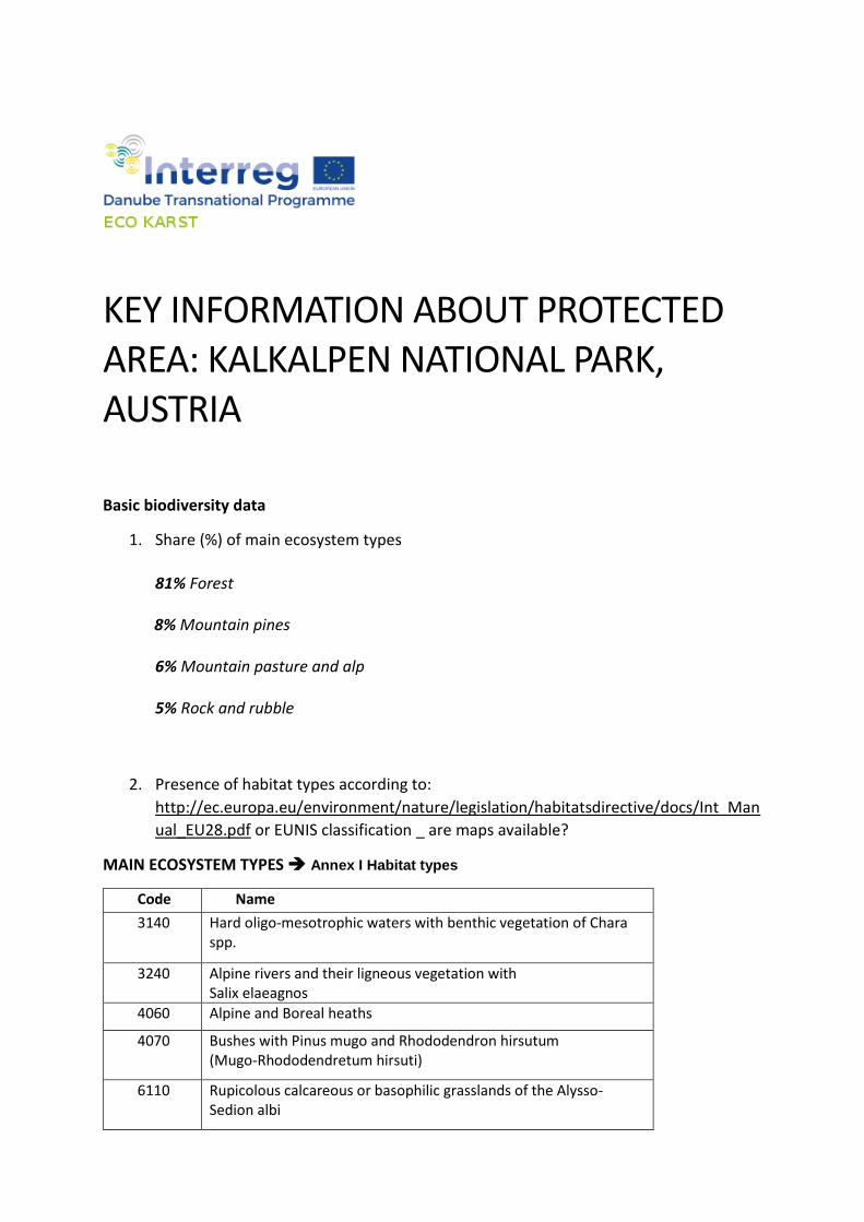
KEY INFORMATION ABOUT PROTECTED AREA: KALKALPEN NATIONAL PARK, AUSTRIA
Basic biodiversity data
1. Share (%) of main ecosystem types
81% Forest
8% Mountain pines
6% Mountain pasture and alp
5% Rock and rubble
2. Presence of habitat types according to:
http://ec.europa.eu/environment/nature/legislation/habitatsdirective/docs/Int_Man
ual_EU28.pdf or EUNIS classification _ are maps available?
MAIN ECOSYSTEM TYPES Annex I Habitat types
Code Name
3140 Hard oligo-mesotrophic waters with benthic vegetation of Chara spp.
3240 Alpine rivers and their ligneous vegetation with Salix elaeagnos
4060 Alpine and Boreal heaths
4070 Bushes with Pinus mugo and Rhododendron hirsutum (Mugo-Rhododendretum hirsuti)
6110 Rupicolous calcareous or basophilic grasslands of the Alysso-Sedion albi
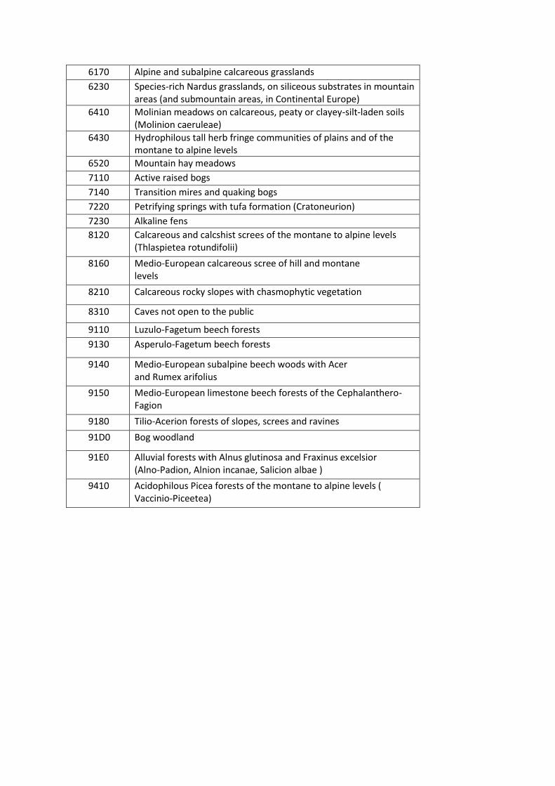
6170 Alpine and subalpine calcareous grasslands
6230 Species-rich Nardus grasslands, on siliceous substrates in mountain areas (and submountain areas, in Continental Europe)
6410 Molinian meadows on calcareous, peaty or clayey-silt-laden soils (Molinion caeruleae)
6430 Hydrophilous tall herb fringe communities of plains and of the montane to alpine levels
6520 Mountain hay meadows
7110 Active raised bogs
7140 Transition mires and quaking bogs
7220 Petrifying springs with tufa formation (Cratoneurion)
7230 Alkaline fens
8120 Calcareous and calcshist screes of the montane to alpine levels (Thlaspietea rotundifolii)
8160 Medio-European calcareous scree of hill and montane levels
8210 Calcareous rocky slopes with chasmophytic vegetation
8310 Caves not open to the public
9110 Luzulo-Fagetum beech forests
9130 Asperulo-Fagetum beech forests
9140 Medio-European subalpine beech woods with Acer and Rumex arifolius
9150 Medio-European limestone beech forests of the Cephalanthero-Fagion
9180 Tilio-Acerion forests of slopes, screes and ravines
91D0 Bog woodland
91E0 Alluvial forests with Alnus glutinosa and Fraxinus excelsior (Alno-Padion, Alnion incanae, Salicion albae )
9410 Acidophilous Picea forests of the montane to alpine levels ( Vaccinio-Piceetea)
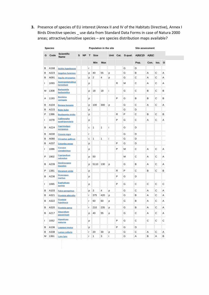
3. Presence of species of EU interest (Annex II and IV of the Habitats Directive), Annex I
Birds Directive species _ use data from Standard Data Forms in case of Natura 2000
areas; attractive/sensitive species – are species distribution maps available?
Species Population in the site Site assessment
G
Code
Scientific S
NP
T
Size
Unit
Cat.
D.qual.
A|B|C|D
A|B|C
Name
Min Max Pop. Con. Iso. Gl
B A168 Actitis hypoleucos r G D
B A223 Aegolius funereus p 40 55 p G B A C A
B A091 Aquila chrysaetos p 2 4 p G C A C A
I 1093
Austropotamobius
p
R
M
C
A C A
torrentium
M 1308
Barbastella
p 18
18 i
G
C
B C B
barbastellus
A 1193
Bombina
p
P
G
B
B C B
variegata
B A104 Bonasa bonasia p 100 300 p G C A C A
B A215 Bubo bubo p G D
P 1386 Buxbaumia viridis p R P C B C B
I 1078
Callimorpha
p
P
G
C
A C A
quadripunctaria
B
A224
Caprimulgus
c 1
1 i
G
D
europaeus
B A030 Ciconia nigra r G D
B A080 Circaetus gallicus c 1 1 i G D
B A207 Columba oenas p P G D
I 1086
Cucujus
p
P
M
C
A C A
cinnaberinus
P 1902
Cypripedium
p 50
M
C
A C A
calceolus
B
A239
Dendrocopos
p 5110
130 p
G
B
A C A
leucotos
P 1381 Dicranum viride p R P C B C B
B
A236
Dryocopus
p
P
G
D
martius
I 1065
Euphydryas
p
P
G
C
C C C
aurinia
B A103 Falco peregrinus p 3 4 p G C A C A
B A321 Ficedula albicollis r 375 420 p G B A C A
B
A322
Ficedula
r 60
60 p
G
B
A C A
hypoleuca
B A320 Ficedula parva r 210 235 p G B A C A
B
A217
Glaucidium
p 40
55 p
G
C
A C A
passerinum
I 1052
Hypodryas
p
P
G
C
C C C
maturna
B A106 Lagopus mutus p P G D
B A338 Lanius collurio r 20 30 p G C A C A
M 1361 Lynx lynx r 1 3 i G A B A B
Group: A = Amphibians, B = Birds, F = Fish, I = Invertebrates, M = Mammals, P =
Plants, R = Reptiles S: in case that the data on species are sensitive and therefore
have to be blocked for any public access enter: yes
NP: in case that a species is no longer present in the site enter: x (optional)
Type: p = permanent, r = reproducing, c = concentration, w = wintering (for plant
and non-migratory species use permanent)
Unit: i = individuals, p = pairs or other units according to the Standard list of
population units and codes in accordance with Article 12 and 17 reporting (see reference portal)
Abundance categories (Cat.): C = common, R = rare, V = very rare, P =
present - to fill if data are deficient (DD) or in addition to population size information
Data quality: G = 'Good' (e.g. based on surveys); M = 'Moderate' (e.g. based on
partial data with some extrapolation); P = 'Poor' (e.g. rough estimation); VP = 'Very poor' (use this category only, if no even a rough estimation of the population size can be made, in this case the fields for population size can remain empty, but the field "Abundance categories" has to be filled in)
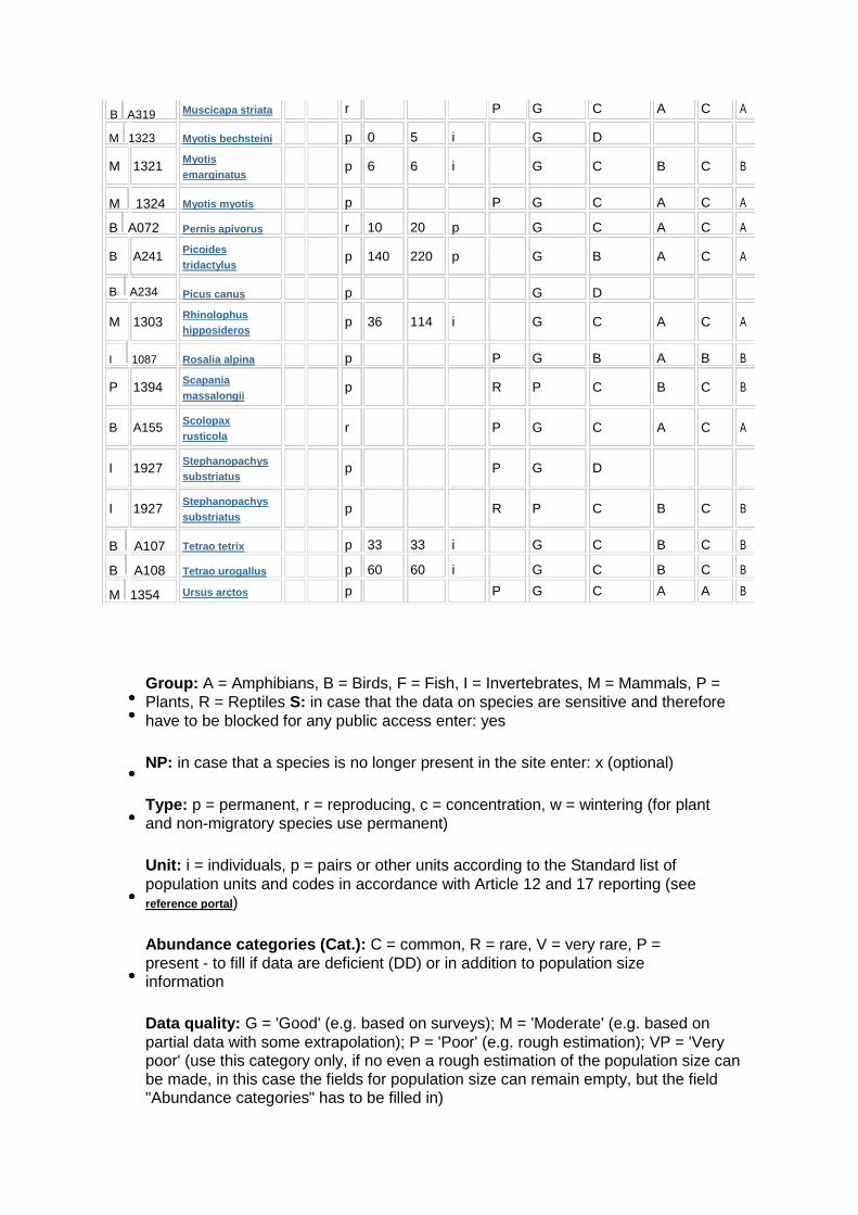
B A319
M 1323 M 1321
M 1324
B A072 B A241
B A234
M 1303
I 1087 P 1394
B A155
I 1927
I 1927
B A107
B A108
M 1354
Muscicapa striata r P G C A C A
Myotis bechsteini
p 0
5 i
G
D
Myotis
p 6
6 i
G
C B C B
emarginatus
Myotis myotis
p
P
G
C A C A
Pernis apivorus
r 10
p
G
C A C A 20
Picoides
p 140
220 p
G
B A C A
tridactylus
Picus canus
p
G
D
Rhinolophus
p 36
114 i
G
C A C A
hipposideros
Rosalia alpina
p
P
G
B A B B
Scapania
p
R
P
C B C B
massalongii
Scolopax
r
P
G
C A C A
rusticola
Stephanopachys
p
P
G
D
substriatus
Stephanopachys
p
R
P
C B C B
substriatus
Tetrao tetrix
p 33
i
G
C B C B
33
Tetrao urogallus
p 60
i
G
C B C B 60
Ursus arctos
p
P
G
C A A B
4. Brief description of formal designation (legal status) and managing organisation
(max. 100 words)
Ownership: 50 % Upper Austria, 50 % Federal Government of Austria Most of the area belongs to the Republic of Austria (88 % Federal Forests), only little area is private land: 12 % protected by long term contracts 89 % are designated as Zone A – that means “nature zone, non-intervention zone” 11 % are designated as Zone B – i.e. management zone, e.g. the Alpine pastures and mountain meadows. The NP is part of the European network of protected areas (Natura 2000 site) And it is an internationally important wetland area, that means RAMSAR site, because of the karst landscape, the streams and springs.
Management goals are:
• protection of nature – to leave nature to itself, to enable wilderness. Wilderness is much older than mankind. Wilderness creates diversity
• education The NP offers visitor programs for adults as well as for school children. Our Rangers guide about 12.000 visitors per year through the National Park.
• research several research and monitoring programs are run by the NP. We have a water laboratory, where the quality of the springs and their water is permanently monitored.
• recreation The National Park area is a place for recreation, to experience nature with all senses. There are only some restrictions for visitors, e.g.: wetlands are strictly protected
Has a management plan been adopted for the protected area (please describe in few
sentences)?
We have a national park plan, but we will get a new next year. (not official yet)
Business plan: http://www.kalkalpen.at/system/web/GetDocument.ashx?fileid=910787 (in
German)
Which sectors have the most significant impact on biodiversity in the area (please rate 3-
high, 2-medium, 1-low)?
Agriculture 1 (only mountain pastures and meadows)
Forestry 0
Hunting and fisheries 0
Nature conservation 3
Tourism 2
Water management 0
Transportation 0
Industry 0
Households 0
Land ownership – please assess the percentage of land owned publicly or privately:
Agricultural land
Public: ___4__%; Private: __2__%
Forests
Public: __80___%; Private: _9___%
Other land
Public: __3___%; Private: _2___%
What are the main threats to biodiversity in the protected area?
Illegal logging
Pollution
Illegal dumping
Urban expansion
Soil erosion
Land use intensification
Other:
Bark beetle => Management, Noise, timber extraction, soil erosion, soil
compaction
Mountain pasture management => Wetland habitats are trampled by cows
Tourism => Hiking, biking, ski tour, climbing, canyoning, paragliding => Noise,
disturbance of wild animals, soil erosion, pollution
Natural disturbance => Avalanche, wind, bark beetle, fire, flood
Neobiota
Where do you see the main opportunities for pro-biodiversity business (PBB) development
related to the protected area?
Tourism: we have partnership program for tourism agencies, accommodations, restaurants,
museums, etc.
http://www.kalkalpen.at/system/web/sonderseite.aspx?menuonr=221800038&detailonr=2
21800038&sprache=2
Agriculture: selling products
Sport activities: guided tours (adventure agenturs)
Alpine pastures: selling products to hiking and biking tourists
Companies: contract with regional companies, who are allowed to use our Kalkalpen
national parc partner-logo for their PR (create “green companies”)
Who are the main stakeholders you can identify at this early stage that will be involved in
the process of mapping ecosystem services and biodiversity opportunities and generating
the action plan for opportunities to come true?
We have more than 20 different groups of stakeholders:, very important external
organizations are:
Curatorship: board of trustee (advisory function refering national parc affords and
activities)
Mayors of 18 communities: contract between national parc and community refering
the receipt of the appearance of the cultural landscape and sustainable economic
activities
Agency of Leader Region: agency with is responsible for the natural development of
the region, precessing of European project and money
National parc partners: companies, restaurants, accomadations which have a
contract with the parc organisation concerning the use of our label
Regional chamber of agriculture
Regional chamber of economy and business
Partner schools (elementary schools)
Tourism agenturies
State forestry (ÖBf)
Farmers who have contract with parc organisation
Farmers who sell their products with the national parc label
Development projects
hiking trails, bicycle and mountainbike tracks, thematic trails, bridle path
three visitor centres in the region
a hotel
Alpine pastures: energy and solar power, water
Guided Tours: education and training of national parc ranger
Wide range of guided tour program
Partnership program with tourism agencies, accommodations, restaurants,
museums, etc.
Agriculture: selling products
…
Conflicts:
A lot of discussions about our wild animal management: release of lynxs in the parc
area
Bark beetle managment: we have more than 75 % wilderness area without bark
beetle manangement
General discussions about our wilderness area, where humans aren’t allowed to
influence the nature.
Local topics, we discuss in our region:
What is the identity in the region?
How is it possible to gain added value in a region with a protected area without mass
tourism and big industry
Bark beetle and wild animal management
Development of the national parc region as „green region“ e.g: biosphere reserve


![yrS{zBzB|BzDC }A~DCq B B A >B}AzDCR bW W]BaWp P}A~DCq B B ...helton/osiris/tensegrity.pdf · p$p$p$p$p$php$p$p$p$p$p$p$p$p$p$p / \a} p ed a w y](https://img.pdfslide.us/doc/110x75/5caa4de188c9938c0b8dec2e/yrszbzbbzdc-adcq-b-b-a-bazdcr-bw-wbawp-padcq-b-b-heltonosiris-.jpg)


![Rules of Probability. The additive rule P[A B] = P[A] + P[B] – P[A B] and if P[A B] = P[A B] = P[A] + P[B]](https://img.pdfslide.us/doc/110x75/5697c0121a28abf838ccc5b4/rules-of-probability-the-additive-rule-pa-b-pa-pb-pa-.jpg)