Embed Size (px)
Citation preview
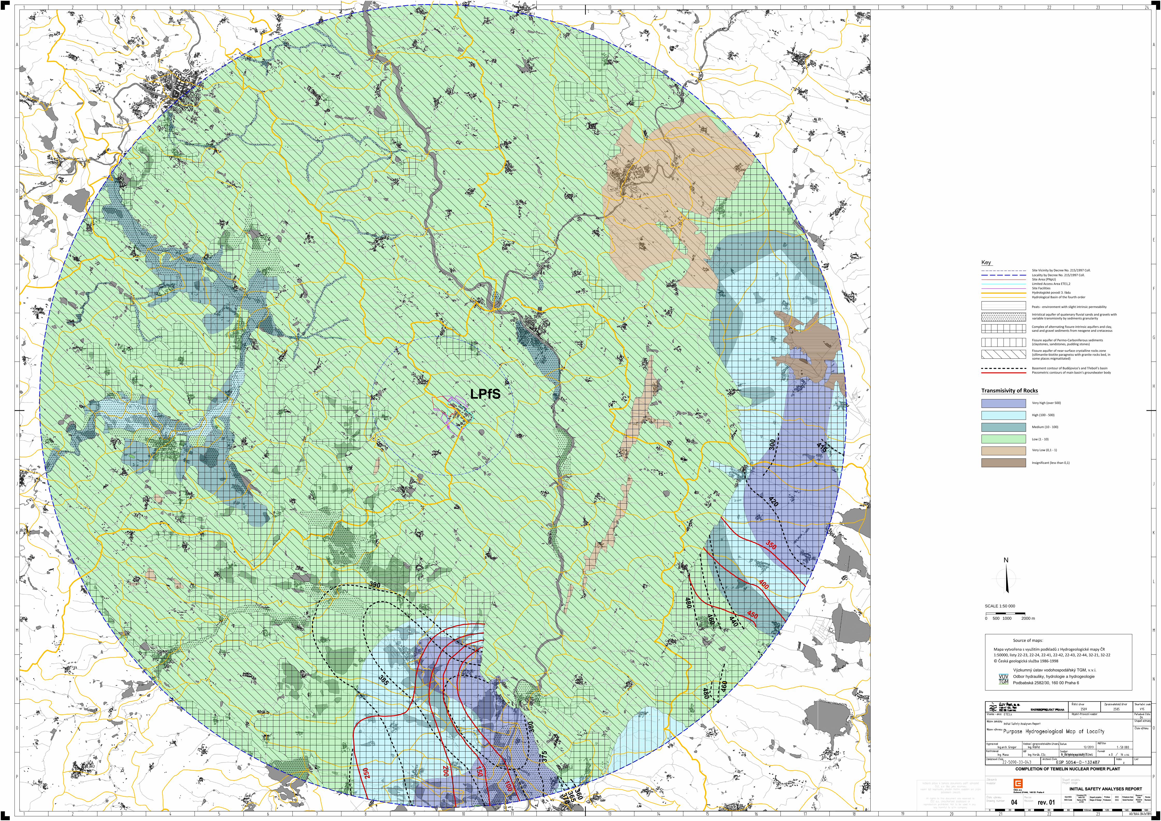
LPfS
3
9
0
3
8
5
200
2
5
0
1
5
0
1
0
0
3
8
0
375
3
6
0
3
6
5
3
7
0
4
8
0
4
6
0
4
4
0
4
5
0
4
0
0
3
5
0
4
2
0
300
4
1
5
4
8
0
4
6
0
Locality by Decree No. 215/1997 Coll.Site Area (PNpU)Limited Access Area ETE1,2
Key
Site FacilitiesHydrologické povodí 3. řáduHydrological Basin of the fourth order
Site Vicinity by Decree No. 215/1997 Coll.
Intristical aquifer of quatenary fluvial sands and gravels withvariable transmisivity by sediments granularity
Fissure aquifer of Permo-Carboniferous sediments(claystones, sandstones, pudding stones)
Complex of alternating fissure-intrinsic aquifers and clay,sand and gravel sediments from neogene and cretaceous
Basement contour of Budějovice's and Třeboň's basinPiezometric contours of main basin's groundwater body
Fissure aquifer of near-surface crystalline rocks zone(sillimanite-biotite paragneiss with granite rocks bed, insome places migmatitated)
Peats - environment with slight intrinsic permeability
Very high (over 500)
High (100 - 500)
Medium (10 - 100)
Low (1 - 10)
Very Low (0,1 - 1)
Insignificant (less than 0,1)
Transmisivity of Rocks
ČEZ, a.s.
Duhová 2/1444, 140 53 Praha 4
0 20 40 60 80 100mm 120 140
Označení PSnebo SOKód KKS Stupeň projektu Profese DCC Pořadové číslo
Rezervníznak Revize
KKS Code Profession DCC Serial NumberName of PSor SO
Stage of Design Reservemark
Revision
INITIAL SAFETY ANALYSES REPORT
160
COMPLETION OF TEMELIN NUCLEAR POWER PLANT
N
SCALE 1:50 000
0 2000 m500 1000
ČEZ, a.s.
Duhová 2/1444, 140 53 Praha 4
0 20 40 60 80 100mm 120 140
Označení PSnebo SOKód KKS Stupeň projektu Profese DCC Pořadové číslo
Rezervníznak Revize
KKS Code Profession DCC Serial NumberName of PSor SO
Stage of Design Reservemark
Revision
INITIAL SAFETY ANALYSES REPORT
160
COMPLETION OF TEMELIN NUCLEAR POWER PLANT
Mapa vytvořena s využitím podkladů z Hydrogeologické mapy ČR1:50000, listy 22-23, 22-24, 22-41, 22-42, 22-43, 22-44, 32-21, 32-22© Česká geologická služba 1986-1998
Source of maps:
Výzkumný ústav vodohospodářský TGM, v.v.i.
Odbor hydrauliky, hydrologie a hydrogeologie
Podbabská 2582/30, 160 00 Praha 6