Embed Size (px)
Citation preview

U.S. Department of Transportation Federal Highway Administration Western Federal Lands Highway Division Vancouver, Washington
February 2012
Ketchum-Challis Highway Improvement Project
Environmental Assessment


Ketchum-Challis Highway Improvement Project EA February 2012
Executive Summary i
EXECUTIVE SUMMARY
The Western Federal Lands Highway Division of the Federal Highway Administration, (FHWA), in partnership with the U.S. Forest Service (USFS) and the Idaho Transportation Department (ITD), is planning to reconstruct approximately 2.5 miles of Forest Highway 26 in Custer County, Idaho (Figure 1-1). This road is also known as State Highway 75 (SH 75).
The proposed Ketchum-Challis Highway Improvement Project is located along the Salmon River in the Sawtooth National Recreation Area (Sawtooth NRA), just south of the border between the Sawtooth NRA and the Salmon-Challis National Forest (S-CNF). The proposed project would begin between mileposts (MPs) 205 and 206 and would end near Peach Creek, approximately 500 feet short of MP 208. The project area includes a reach of the Salmon River known locally as the Narrows.
SH 75 provides key access to the heart of south-central Idaho. It links to other state highways, connecting communities in Custer County and Blaine County and providing one of the few east-west links across central Idaho. Much of the landscape is relatively undisturbed and offers excellent visual opportunities. Tourists and motorists travel this route to enjoy the surrounding forests, river, and roadside recreational opportunities. The route passes through the Sawtooth NRA, which was established in 1972 to protect the scenic, natural, historic, pastoral, fish, wildlife, and recreation values of the area.
The purpose of the Ketchum-Challis Highway Improvement project is to reduce safety hazards and alleviate slope instability concerns along a portion of SH 75. Under current conditions, frequent rockfalls and debris slides from steep and unstable cut slopes above the roadway pose a safety hazard to traveling motorists. Fill slope instabilities have undermined and narrowed the roadway, creating variable and substandard pavement widths. These conditions pose safety concerns for the users of SH 75, As a roadway administered under the Forest Highways Program, SH 75 must provide safe and adequate transportation access to and through National Forest System lands for visitors, recreationists, resource users, and others.
Two alternatives are evaluated in this Environmental Assessment (EA): the No Action Alternative and the Proposed Action Alternative. The Proposed Action Alternative was developed to address the project’s purpose and need.
The No Action Alternative would leave the road in its current state. Under this alternative, no improvements would be made to SH 75. ITD would continue to perform road maintenance, particularly intensive from winter to spring.
The Proposed Action Alternative would improve approximately 2.5 miles of SH 75 to address safety and maintenance issues. SH 75 would be reconstructed along the existing alignment between approximately MP 205.5 and MP 208 to provide two 11-foot lanes with 2-foot shoulders and an additional foot of shoulder on the fill side at guardrail installations. Road construction would address current deficiencies in the condition of the roadway by widening and installing guardrails along the existing road, using measures to reduce rockfall, constructing fill-side retaining walls, and installing cross-drain culverts with riprap outlet protection. The frequent and dangerous rockfall would be addressed through rock scaling, bolting, attenuator fencing, and both pinned and contoured rockfall mesh. Construction of retaining walls and installation of improved drainage systems would address instabilities in the fill-side slope.
The scenic beauty of the project area is widely recognized. Several project features—including the roadway, rockfall reduction measures, retaining walls, and guardrails—would change the visual character of the highway corridor. Based on the scale of the proposed action relative to the surrounding landscape,

Ketchum-Challis Highway Improvement Project EA February 2012
Executive Summary ii
the visual condition of the project area would not be consistent with current Sawtooth NRA management direction for the area. USFS would have to enact a non-significant, procedural amendment to the Sawtooth National Forest (SNF) Land and Resource Management Plan (Forest Plan), correcting the visual quality objective for the project area. FHWA is developing the rockfall reduction design in cooperation with the SNF. The design would meet the purpose and need of the project and would fulfill the requirements of the Sawtooth NRA by being consistent with resource management direction.
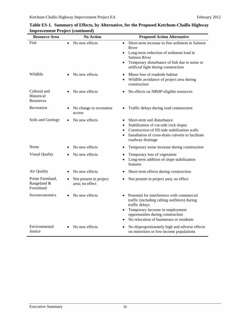
The potential effects of the alternatives are summarized in Table ES-1 and are fully described in Chapter 4. Adverse effects resulting from the Proposed Action Alternative would be minimized through the incorporation of impact avoidance and minimization measures into the project design. Based on the implementation of these measures, as well as additional measures to mitigate for effects on visual resources, the Proposed Action Alternative would not be expected to result in any substantial adverse effects.
Table ES-1. Summary of Effects, by Alternative, for the Proposed Ketchum-Challis Highway Improvement Project
Resource Area No Action Proposed Action Alternative
Transportation, Circulation, and Safety
No change in access Continued operational
safety deficiencies
Two-hour road closures, twice daily (one in a.m., one in p.m.), during road construction after Labor Day and before Memorial Day
Traffic delays not to exceed 15 minutes between Memorial Day and Labor Day
Pullout at Holman Creek closed to public, used as staging area
Road widening Guardrail installation Correction of fill-side instability Reduced risk of rockfall
Land Use No right-of-way acquisition
Right-of-way acquisition (approximately 3 acres)
Project consistent with SNF goals and objectives and Custer County Comprehensive Plan
Non-significant Forest Plan amendment to correct the visual quality objective for the project area
Vegetation No new vegetation loss Some side-casting with
grading operations
Clearing of approximately 10 acres, including approximately 100 trees above the road and approximately 40 trees below the road
Revegetation with native species
Water Resources No reduction in annual sediment load in Salmon River
Short-term increase in fine sediment in Salmon River
Long-term reduction of sediment load in Salmon River
Wetlands No new encroachment on wetlands
No reduction in sediments delivered to wetlands
Approximately 0.1 acre encroachment into palustrine forested wetland
Reduction in sediments delivered to wetlands
Ketchum-Challis Highway Improvement Project EA February 2012
Table ES-1. Summary of Effects, by Alternative, for the Proposed Ketchum-Challis Highway Improvement Project (continued)
Executive Summary iii
Resource Area No Action Proposed Action Alternative
Fish No new effects Short-term increase in fine sediment in Salmon River
Long-term reduction of sediment load in Salmon River
Temporary disturbance of fish due to noise or artificial light during construction
Wildlife No new effects Minor loss of roadside habitat Wildlife avoidance of project area during
construction
Cultural and Historical Resources
No new effects No effects on NRHP-eligible resources
Recreation No change to recreation access
Traffic delays during road construction
Soils and Geology No new effects Short-term soil disturbance Stabilization of cut-side rock slopes Construction of fill-side stabilization walls Installation of cross-drain culverts to facilitate
roadway drainage
Noise No new effects Temporary noise increase during construction
Visual Quality No new effects Temporary loss of vegetation Long-term addition of slope stabilization
features
Air Quality No new effects Short-term effects during construction
Prime Farmland, Rangeland & Forestland
Not present in project area; no effect
Not present in project area; no effect
Socioeconomics No new effects Potential for interference with commercial traffic (including rafting outfitters) during traffic delays
Temporary increase in employment opportunities during construction
No relocation of businesses or residents
Environmental Justice
No new effects No disproportionately high and adverse effects on minorities or low-income populations


Ketchum-Challis Highway Improvement Project EA February 2012
Table of Contents v
TABLE OF CONTENTS
Executive Summary ....................................................................................................................................... i
List of Abbreviations ................................................................................................................................. viii
1 Project Description ............................................................................................................................. 1-1
1.1 Location of the Proposed Project ............................................................................................... 1-1
1.2 Scope and Nature of the Proposed Project................................................................................. 1-1
1.3 Jurisdiction ................................................................................................................................. 1-1
1.4 Interagency Collaboration ......................................................................................................... 1-3
1.5 Funding ...................................................................................................................................... 1-3
2 Purpose and Need for the Project ....................................................................................................... 2-1
2.1 Existing Road Conditions and Deficiencies .............................................................................. 2-1
2.2 Road Uses .................................................................................................................................. 2-3
2.3 Traffic Volumes ......................................................................................................................... 2-3
2.4 Accident History ........................................................................................................................ 2-4
3 Alternatives Considered ..................................................................................................................... 3-1
3.1 No Action Alternative ............................................................................................................... 3-1
3.2 Proposed Action Alternative – Reconstruction ......................................................................... 3-1
3.3 Alternatives Considered but not Advanced ............................................................................... 3-6
4 Affected Environment and Environmental Consequences ................................................................ 4-1
4.1 Transportation and Circulation .................................................................................................. 4-1
4.2 Land Use .................................................................................................................................... 4-3
4.3 Vegetation .................................................................................................................................. 4-5
4.4 Water Resources ...................................................................................................................... 4-11
4.5 Wetlands .................................................................................................................................. 4-18
4.6 Fish ....................................................................................................................................... 4-21
4.7 Wildlife .................................................................................................................................... 4-31
4.8 Cultural and Historical Resources ........................................................................................... 4-41
4.9 Recreation ................................................................................................................................ 4-43
4.10 Soils and Geology .................................................................................................................... 4-46
4.11 Noise ....................................................................................................................................... 4-49
4.12 Visual Quality .......................................................................................................................... 4-51
4.13 Hazardous Materials ................................................................................................................ 4-57
4.14 Air Quality ............................................................................................................................... 4-58

Ketchum-Challis Highway Improvement Project EA February 2012
Table of Contents vi
4.15 Socioeconomics ....................................................................................................................... 4-60
4.16 Environmental Justice .............................................................................................................. 4-62
5 Section 4(f) Evaluation ...................................................................................................................... 5-1
6 Irreversible or Irretrievable Commitment of Resources .................................................................... 6-1
7 Summary of Impact Avoidance and Minimization Measures ............................................................ 7-1
8 Permits and Approvals ....................................................................................................................... 8-1
9 Coordination and Consultation .......................................................................................................... 9-1
9.1 Interagency Collaboration ......................................................................................................... 9-1
9.2 Public Involvement .................................................................................................................... 9-1
9.3 List of Preparers ......................................................................................................................... 9-2
10 References ........................................................................................................................................ 10-1
LIST OF TABLES
Table ES-1. Summary of Effects, by Alternative, for the Proposed Ketchum-Challis Highway Improvement Project ........................................................................................................... ii
Table 2-1. Current and Projected Estimates for Traffic Volumes on SH 75 in the Project Area ...... 2-3
Table 4-1. Special-status Plant Species Analyzed for Suitable Habitat and Potential Impacts within the Project Analysis Area................................................................................................. 4-6
Table 4-2. Special-status Fish Species and Designated Critical Habitat within the Project Analysis Area ................................................................................................................. 4-23
Table 4-3. Special-status Wildlife Species Analyzed for Suitable Habitat and Potential Impacts within the Project Analysis Area ................................................................................... 4-34
Table 4-4. Cultural Properties near or within the Ketchum-Challis Highway Improvement Project APE .................................................................................................................... 4-41
Table 4-5. Employment and Per Capita Income Trends in Custer County, Idaho, 2000 through 2010 .................................................................................................................. 4-61
Table 4-6. Percent of Stanley, Challis, Custer County, and Idaho Residents by Race, 2010 ......... 4-63
Table 4-7. Poverty Estimates for Custer County and Idaho, 2009 .................................................. 4-63
Table 7-1. Summary of Impact Avoidance Minimization Measures ................................................ 7-1
Table 9-1. Public Concerns about the Ketchum-Challis Highway Improvement Project ................. 9-2

Ketchum-Challis Highway Improvement Project EA February 2012
Table of Contents vii
LIST OF FIGURES
Figure 1-1. Project Vicinity Map ........................................................................................................ 1-2
Figure 2-1. Rockfall on SH 75 ............................................................................................................ 2-2
Figure 3-1. Typical Roadway Section (Conceptual Design), Proposed Action Alternative .............. 3-3
Figure 3-2. Typical Roadway Section with Guardrail and Wall (Conceptual Design), Proposed Action Alternative ............................................................................................ 3-3
Figure 3-3. Examples of Potential Remedies and Treatments for Rockfall ....................................... 3-4
Figure 3-4. Typical Section (Conceptual Design) for Cross-drain Outlet Protection Features .......... 3-5
Figure 3-5. Typical Roadway Section (Conceptual Design) Considered for Alternative A .............. 3-7
Figure 3-6. Retaining Wall and Rockfall Ditch (Conceptual Design) Considered for Alternative A .................................................................................................................... 3-7
Figure 3-7. Alternative Project Alignment Dropped from Further Consideration ............................. 3-9
Figure 4-1. Upper Salmon River Subbasin ....................................................................................... 4-13
Figure 4-2. Population Trends in Custer County, Idaho, 2000 through 2010 .................................. 4-60

Ketchum-Challis Highway Improvement Project EA February 2012
List of Abbreviations viii
LIST OF ABBREVIATIONS
ADT average daily traffic
APE area of potential effect
BLM Bureau of Land Management
BMPs best management practices
CEQ Council on Environmental Quality
EA environmental assessment
EIS environmental impact statement
EPA Environmental Protection Agency
ESA Endangered Species Act
FHWA Federal Highway Administration
Forest Plan Sawtooth National Forest Land and Resource Management Plan, as amended
GHG greenhouse gases
IDEQ Idaho Department of Environmental Quality
ITD Idaho Transportation Department
LWCFA Land and Water Conservation Fund Act
MIS management indicator species
MP milepost
NAAQS National Ambient Air Quality Standards
NEPA National Environmental Policy Act
NMFS National Marine Fisheries Service
NRHP National Register of Historic Places
OHWM ordinary high water mark
S-CNF Salmon-Challis National Forest
Sawtooth NRA Sawtooth National Recreation Area
SH 75 State Highway 75
SHPO State Historic Preservation Office
SNF Sawtooth National Forest
SWPPP stormwater pollution prevention plan
USC United States Code
USFS U.S. Forest Service
USFWS U.S. Fish and Wildlife Service

Ketchum-Challis Highway Improvement Project EA February 2012
Project Description 1-1
1 PROJECT DESCRIPTION
1.1 Location of the Proposed Project
The Western Federal Lands Highway Division of the Federal Highway Administration (FHWA), in cooperation with the Idaho Transportation Department (ITD) and U.S. Forest Service (USFS), proposes to reconstruct approximately 2.5 miles of Forest Highway 26, also known as State Highway 75 (SH 75), in Custer County, Idaho (Figure 1-1). The project area is located along the Salmon River in the Sawtooth National Recreation Area (Sawtooth NRA), just south of the border between the Sawtooth NRA and the Salmon-Challis National Forest (S-CNF). The project area includes a reach of the Salmon River known locally as the Narrows.
The proposed project would begin between mileposts (MPs) 205 and 206 on SH 75 and would end near Peach Creek, approximately 500 feet short of MP 208. The project area is located in Township 11N, Range 15E, Sections 25, 26, and 27, Boise Meridian. SH 75 parallels the Salmon River through moderate to steep terrain that supports coniferous forests, sagebrush/grassland, and riparian vegetation.
1.2 Scope and Nature of the Proposed Project
FHWA proposes to improve and upgrade a segment of SH 75. Road construction would include widening the existing road, using measures to reduce rockfall, installing cross-drain culverts with riprap outlet protection, constructing fill-side retaining walls, and conducting the secondary activities needed to support these actions. FHWA would construct two 11-foot lanes with 2-foot shoulders. Guardrails would be installed towards the Salmon River to protect motorists from the steep fill and the walls. The frequent and dangerous rockfall would be addressed by using scaling, bolting, attenuator fencing, and both pinned and contoured rockfall mesh.
1.3 Jurisdiction
ITD is responsible for maintenance of the road through the project corridor, maintaining a 100-foot right-of-way (50 feet on each side of the roadway centerline) through both National Forest System and private lands. Additional right-of-way would be necessary for the roadway improvements proposed under the Proposed Action Alternative.
ITD classifies SH 75 as a rural minor arterial according to the guidelines of the American Association of State Highway and Transportation Officials (AASHTO), A Policy on Geometric Design of Highways and Streets (2004). This manual provides guidance for design standards for the nation’s highway system. The primary purpose of an arterial is to link cities, larger towns, and other traffic generators that are capable of attracting travel over relatively long distances. Arterials are expected to provide for relatively high travel speeds with minimal interference to through traffic movements. The route is part of the Salmon River Scenic Byway, as designated by ITD. It is not on the National Highway System.

Ketchum-Challis Highway Improvement Project EA February 2012
Project Description 1-2
Figure 1-1. Project Vicinity Map

Ketchum-Challis Highway Improvement Project EA February 2012
Project Description 1-3
1.4 Interagency Collaboration
FHWA assembled a team of social, economic, and environmental specialists in the early stages of project development to coordinate public participation, confirm engineering design criteria, identify environmental issues, and develop project alternatives. This interagency team consists of representatives of USFS, ITD, and FHWA, and it acts as a steering committee for project development activities during the conceptual and design phases of the proposed project. FHWA has entered into two memoranda of understanding with USFS. These memoranda establish the process whereby FHWA may appropriate and transfer interests in National Forest System land for highway purposes.
1.5 Funding
Funding for the project would come from the Public Lands Highway Program, which is financed by the Federal Highway Trust Fund. The Public Lands Highway Program funds improvements to Forest Highways, which are selected public roads wholly or partly within, adjacent to, and serving the National Forest System. These roads are necessary for the protection, administration, and utilization of the National Forest System and for the use and development of its resources. In Idaho, FHWA, USFS, and ITD administer the Public Lands Highway Program jointly. If the Proposed Action Alternative were selected, construction of this project would likely begin in the fall of 2012. The timing of project completion would depend on funding availability.


Ketchum-Challis Highway Improvement Project EA February 2012
Purpose and Need for the Project 2-1
2 PURPOSE AND NEED FOR THE PROJECT
The purpose of the Ketchum-Challis Highway Improvement project is to reduce safety hazards and to alleviate slope instability concerns along a portion of SH 75. Frequent rockfall resulting from steep and unstable cut slopes above the roadway poses a safety hazard to traveling motorists. Fill slope instabilities have undermined and narrowed the roadway, creating variable and substandard pavement widths. These conditions create safety concerns for the users of SH 75, a key state highway that provides access between communities in Custer County and Blaine County in south-central Idaho. As a roadway administered under the Forest Highways Program, SH 75 must provide safe and adequate transportation access to and through National Forest System lands for visitors, recreationists, resource users, and others.
The primary conditions requiring relief are as follows:
Substantial rockfall onto the road from the high, steep, cut slopes occurs regularly, as does natural rockfall from above the cut slopes. Motorists often must maneuver around fallen rock, creating a safety hazard and disrupting traffic flow. ITD maintenance crews must make frequent trips to remove rock from the roadway and ditches.
Multiple localized instabilities exist along the fill side of the road. Surface erosion of the embankment soils due to runoff, snowmelt, and loosely compacted, overly steep fill slopes has caused these instabilities. Plugged culverts and debris chutes on the uphill side of the road create concentrated runoff that makes these problems worse. The instabilities have encroached into the travel lane, narrowing the existing travel lane in places and creating hazardous conditions.
The existing pavement is in poor to fair condition, and it is raveling in some areas. The average pavement width varies between 20 and 24 feet, with narrow or nonexistent shoulders and insufficient room for guardrails.
These and other deficiencies are described in greater detail below. Although the other deficiencies are not necessarily the primary drivers for the proposed action, many would be addressed through reconstruction activities under the Proposed Action Alternative.
2.1 Existing Road Conditions and Deficiencies
Approximately 1 mile of the existing alignment near MP 206 lies on a narrow bench above the Salmon River. This bench is excavated into the granite bedrock of a rock formation known as the Idaho Batholith. The bedrock is highly fractured, with several wedge-shaped blocks on the slope. These conditions, combined with rainfall and frost action, create a severe rockfall hazard.
For these reasons, rock and debris often fall directly onto the roadway, sometimes blocking one lane or the whole roadway (Figure 2-1). In addition to creating a severe safety hazard for motorists, rockfall and other debris occasionally enter the Salmon River, contributing to sudden increases in fine sediment input, as well as hazards affecting recreational users of the river. Moreover, the rockfall hazard causes lane closures and creates uncertainty for local residents using the roadway, as well as for tourists. ITD maintenance crews regularly devote time and resources to rock removal. During the spring, crews come through the corridor several times per day to clear rocks from the roadway. Significant rockfalls and debris slides, necessitating lane closures for cleanup, occur an average of once a month. Extremely large boulders fall approximately once a year, requiring blasting or other intensive efforts for removal.

Ketchum-Challis Highway Improvement Project EA February 2012
Purpose and Need for the Project 2-2
Figure 2-1. Rockfall on SH 75
The outside portion of the road is supported on a high, side-cast embankment that extends all the way down to the river in many areas. The river is eroding the bank under the roadway. Higher up the fill slope, runoff and snowmelt have contributed to surface erosion of the embankment soils, resulting in instabilities at numerous sites along the fill side of the road. Damaged or plugged culverts and debris chutes on the uphill side of the road have resulted in concentrated runoff that makes the problems worse. These factors have contributed to roadway settlement in several locations along the proposed project corridor. Slope failures have encroached into the travel lane, creating a hazardous condition. This settlement requires frequent maintenance and pavement patches.
The road was constructed at its present width with a chip seal surface in 1956. Spot improvements, including patching and overlays, have occurred since then. The existing roadway is narrower than the standard width in some places, and the condition of the road surface ranges from poor to fair. Pavement raveling occurs, and several instabilities are present. Rockfall has damaged the pavement in places. The average width of the current pavement is 22 feet, but it varies from 20 to 24 feet with narrow or nonexistent shoulders. There is no protection for errant vehicles that may drive off the road and into the Salmon River. The high, steep, relatively unprotected slopes above the river present a potential for severe accidents, especially for tourists and motorists who are unfamiliar with the roadway’s dangers and who may be distracted by the scenery along the route.

Ketchum-Challis Highway Improvement Project EA February 2012
Purpose and Need for the Project 2-3
2.2 Road Uses
The proposed project lies within the Sawtooth NRA, which is bordered on the north by the S-CNF, on the east by the Boise National Forest, and on the south by the Sawtooth National Forest (SNF). ITD has designated the route as a scenic byway intended to display outstanding scenic beauty and a well-managed, changing landscape.
SH 75 is a rural arterial route that serves nearby National Forest System lands for a large portion of central Idaho. It ultimately connects Boise on the west to southwest Montana on the east via SH 21 and U.S. 93. It links the communities of Stanley, Sunbeam, Clayton, and Challis. The route is the only major east-west transportation corridor through central Idaho. It provides access to private property inholdings in the Sawtooth NRA and the S-CNF. It is also a mail route and school bus route, and it provides access for commercial supply and delivery to nearby small communities.
The road corridor provides access to numerous recreational opportunities on National Forest System lands, including campgrounds, trailheads, roadside pullouts for fishing and river use access, interpretive sites, and scenic vistas. The corridor also provides the principal access for protection, administration, and use of a major portion of the Sawtooth NRA. Recreational activities include camping, picnicking, backpacking, rock climbing, photography, rafting, kayaking, trail bike riding, horseback riding, cross-country skiing, boating, fishing, hunting, and snowmobiling. Several river guides transport rafters and anglers through the proposed project corridor daily.
In addition to recreation, the route serves various other users of National Forest System lands in the Sawtooth NRA. Logging trucks and other vehicles involved in timber harvest use SH 75 to access adjacent National Forest System lands. During the summer, cattle and sheep graze the valleys and mountain pastures and are trucked over the route. Mining companies and private individuals access mining claims via the project corridor. ITD manages and maintains the road year-round.
2.3 Traffic Volumes
The average daily traffic (ADT) is the average number of vehicles that travel the route each day over the course of a year. Traffic travel is counted in both directions. Traffic count information obtained from ITD showed the traffic volume from 2000 to 2010 ranged from 590 to 670 vehicles per day with an ADT of 600 in 2010. Of that, approximately 12 percent was commercial traffic.
Design of new roads or improvements to existing roads should not be based solely on current traffic volumes alone; it should also incorporate future traffic volumes expected to occur over the design life of the road. Twenty years is the widely accepted design life for rural minor arterial roads. Future traffic volumes are estimated by applying an annual growth factor to the current traffic volume. For design purposes, the ADT for this project is inflated by a growth factor of 1 percent per year over 20 years. Inflating the 2010 ADT of 600 by 1 percent annually to 2032 gives an estimated design ADT of 750 (Table 2-1).
Table 2-1. Current and Projected Estimates for Traffic Volumes on SH 75 in the Project Area
Time Frame ADT (vehicles per day)
Current (2010) 600
Construction Start (2012) 610
Design Life (2032) 750
Source: ITD (2011)

Ketchum-Challis Highway Improvement Project EA February 2012
Purpose and Need for the Project 2-4
2.4 Accident History
Available data collected from ITD (2011) indicate that four accidents were reported in the project area during 2007 and 2008. Of these, two resulted in injury, and there were no fatalities. The reported causes were overturning and running off the roadway into the guardrail. The available information does not indicate that these accidents resulted from the road deficiencies described above, or that accidents occurred at higher rates in the project corridor when compared to other areas. Nevertheless, rockfall and unstable slopes along the narrow road pose a real risk of contributing to future accidents.

Ketchum-Challis Highway Improvement Project EA February 2012
Alternatives Considered 3-1
3 ALTERNATIVES CONSIDERED
This section describes the No Action Alternative and one build alternative. The build alternative is the Proposed Action Alternative. Options for additional alternatives were limited by the physical and logistical constraints inherent in the project area setting. For example, the location of the existing roadway between steep cut slopes and the Salmon River eliminated the possibility of alternative alignments on the north side of the river. Similarly, environmental concerns, public opposition, and substantially higher project costs rendered infeasible an alternative that would follow an alignment on the south side of the river (for additional discussion, see Section 3.3, Alternatives Considered but not Advanced). Available options were limited to a range of design alternatives for the proposed action.
3.1 No Action Alternative
Under the No Action Alternative, no improvements would be made to SH 75 between approximately MP 205.5 and MP 208. ITD would continue routine maintenance.
SH 75 would not be improved through the No Action Alternative, resulting in the following continuing conditions:
Substantial rockfall from high, steep, cut slopes onto the road Multiple localized instabilities along the fill side of the road Surface erosion of highly erodible embankment soils due to runoff, snowmelt, and loosely
compacted (side-cast) and over-steep fill slopes Plugged culverts and debris chutes on the uphill side of the road, causing concentrated runoff that
makes erosion worse Hazardous conditions caused by runoff, snowmelt, and loosely compacted, over-steep fill slopes Continued costly and frequent maintenance efforts to keep SH 75 open
Rockfall clearing is a frequent event. During the spring, crews come through the corridor several times per day to clear rocks from the roadway. Significant rockfalls and debris slides, necessitating lane closures for cleanup, take place an average of once a month. Extremely large boulders fall approximately once a year, requiring blasting or other intensive efforts for removal.
Ultimately, the No Action Alternative would not meet the purpose and need of the proposed project. It would not reduce safety hazards and alleviate slope instability concerns along SH 75.
3.2 Proposed Action Alternative – Reconstruction
Under the Proposed Action Alternative, FHWA would improve and upgrade SH 75. Road construction would include widening the existing road, using measures to reduce rockfall, installing cross-drain culverts with riprap outlet protection, constructing fill-side retaining walls, placing guardrails, and conducting the secondary activities needed to support these actions. The western project terminus would be located immediately west of the Narrows, where the safety hazards associated with rockfall and slope failure are greatest. The eastern project terminus would be located immediately east of Pebble Beach, another area where rockfall occurs frequently.

Ketchum-Challis Highway Improvement Project EA February 2012
Alternatives Considered 3-2
3.2.1 Description of the Alternative
SH 75 would be reconstructed along the existing alignment between approximately MP 205.5 and MP 208 to provide two 11-foot lanes with 2-foot shoulders (Figure 3-1) and an additional foot of shoulder on the fill side at guardrail installations. Road construction would include widening the existing road, using measures to reduce rockfall, installing cross-drain culverts with riprap outlet protection, constructing fill-side retaining walls, and the secondary activities needed to support these actions. The fill-side instabilities would be corrected in most areas by constructing fill-side retaining walls (Figure 3-2).
The frequent and dangerous rockfall would be addressed through a combination of methods. In cooperation with Sawtooth NRA staff, FHWA is developing a rockfall reduction design that meets both the purpose and need of the project and the resource management direction of the Sawtooth NRA.
Some or all of the following measures would be considered in the design to reduce the risk for dangerous rockfall from the cut slopes (Figure 3-3):
Scaling (removal of loose rocks) Bolting (anchoring larger blocks into the slope by using a drilled and grouted steel bar that is
subsequently tensioned from a small steel plate on the rock surface) Attenuator fencing (an upslope catchment area that catches rockfall and funnels it down the slope
below a draped mesh and into the ditch) Contoured or pinned mesh (wire mesh that either drapes freely on the slope and is anchored at the
top, or is pinned to the surface with a uniform pattern of rock bolts over the application area)
The horizontal alignment of the roadway would not shift substantially from the existing alignment (generally less than 5 feet), and the vertical alignment would be raised no more than approximately 1 foot. Fill to raise the roadbed elevation would be placed, and retaining walls would be installed where needed to fix the unstable fill-side areas.
The fill-side walls would generally be 5 to 10 feet tall, and they would range from approximately 100 to 1,200 feet long. Sculpted shotcrete (i.e., sprayed concrete) facing would be placed on the walls. Construction of the walls would be accomplished by using heavy machinery to clear the area and remove the existing roadway fill where needed to create a structural excavation area. Some excavation would occur beyond the wall face to allow for construction.
Some wall construction would occur at night, necessitating use of artificial light. A series of lights would be installed along the roadway, casting light on the work area.
Dangerous slopes would be stabilized in locations where rockfall poses hazards to traffic and requires frequent maintenance. Trim blasting may be used to remove rock or other material if other means are insufficient. Up to two shots would be used per day to remove zones of unstable rock.
Cross-drain culverts would be constructed where needed to relieve runoff from roadside ditches. Culverts would also be used to pass water under the highway where the terrain forms natural drainage features (draws, swales, etc.). Approximately 30 new 24-inch-diameter culverts would be installed to facilitate drainage. Twenty-four of them would replace existing culverts; the remainder would be new installations. Outlet protection, consisting of approximately 30 feet of riprap, would be placed below approximately 12 culverts that empty onto steep slopes (Figure 3-4). Where conditions would allow, rock headwalls would be constructed at cross-drain culvert inlets to prevent culvert damage.

Ketchum-Challis Highway Improvement Project EA February 2012
Alternatives Considered 3-3
Figure 3-1. Typical Roadway Section (Conceptual Design), Proposed Action Alternative
Figure 3-2. Typical Roadway Section with Guardrail and Wall (Conceptual Design), Proposed Action Alternative

Ketchum-Challis Highway Improvement Project EA February 2012
Alternatives Considered 3-4
Figure 3-3. Examples of Potential Remedies and Treatments for Rockfall

Ketchum-Challis Highway Improvement Project EA February 2012
Alternatives Considered 3-5
Figure 3-4. Typical Section (Conceptual Design) for Cross-drain Outlet Protection Features
Water would be needed during construction and for the application of shotcrete. An average of five truckloads of water per day (an estimated 1.4 million gallons for dust control and an estimated 32 thousand gallons for shotcrete) would be drawn from the Salmon River or nearby water sources.
Some construction activities may take place outside the construction limits. This would require ground disturbance, occupation, or clearing. Such activities may include material extraction, material wasting, water retrieval, or staging. The only site currently designated for ancillary use is the pullout area at Holman Creek, approximately 7 miles east of MP 208, which would be designated as a staging area. The pullout, which is approximately 200 feet wide and 1,000 feet long, would be closed to public use during construction (likely autumn 2012 through autumn 2014 for Phase 1). Materials stored at the site would include equipment, fuel, crushed rock, and other construction supplies. Within the construction limits, the existing ITD staging and storage site near MP 207 would be used to deposit material generated from the project for ITD’s future use. Waste material deposited at that site would generally consist of large, angular rock, greater than 3 feet in diameter. In addition, one travel lane on SH 75 in the project area would be closed to traffic while construction was underway. Some equipment storage would likely occur in the closed lane.
Commercial and non-commercial locations might also be used as ancillary sites. Commercial source sites are established locations that have provided material to public and private entities on a regular basis over the last 2 years, have appropriate state and local permits, and do not require expansion outside their currently established and permitted area. A commercial material source could be used by the construction contractor.
ITD currently maintains an easement across National Forest System lands and a 100-foot right-of-way (50 feet on each side of the roadway centerline) through private lands. A new easement would be needed across National Forest System lands to allow ITD access to maintain the roadway and facilities installed as a result of the Proposed Action Alternative. A letter of consent for easement would be obtained from USFS granting this access. Across privately owned parcels (between approximately MP 207 and MP 208), the Proposed Action Alternative would require acquisition of additional right-of-way for the

Ketchum-Challis Highway Improvement Project EA February 2012
Alternatives Considered 3-6
roadway improvements. Approximately 3 acres of additional right-of-way would be needed from privately owned parcels for the Proposed Action Alternative.
Costs to implement the Proposed Action Alternative have been calculated. The estimated cost to construct the Proposed Action Alternative would range between $15 million and $20 million.
3.2.2 Phasing
The project would be constructed in two phases, divided between the western (Phase 1) and eastern (Phase 2) portions of the project area (Figure 1-1). Phase 1, covering the area between the project’s western terminus (approximately MP 205.5) and the end of the Narrows (approximately MP 206.5), would be constructed under two separate contracts. To minimize traffic delays, the first contract issued for Phase 1 would include rock scaling only and would take place in the fall of 2012 and the spring of 2013. The second contract for Phase 1 would involve the work needed to reconstruct the road and would take place in 2013 and 2014. Phase 2 would involve road reconstruction in the area between approximately MP 206.5 and the project’s eastern terminus near MP 208. Work timing on Phase 2 would depend on available funding, but likely would not require more than one construction season, assuming that the work could begin in the spring when the weather would be suitable for construction.
3.2.3 How the Alternative Meets Purpose and Need
This alternative would meet the purpose and need by stabilizing slopes and improving operational safety of the road. It would reduce safety hazards on a 2.5-mile portion of a main east-west traffic artery through south-central Idaho. Road reconstruction would address current deficiencies in the condition of the roadway by widening and installing guardrails along the existing road, using measures to reduce rockfall, constructing fill-side retaining walls, and installing cross-drain culverts with riprap outlet protection.
The frequent and dangerous rockfall would be addressed using rock scaling, bolting, attenuator fencing, and both pinned and contoured rockfall mesh. The fill-side instabilities in most areas would be corrected by constructing fill-side walls. Fill slope erosion due to concentrated runoff from plugged culverts and debris chutes would be addressed through construction of cross-drain culverts. New guardrails on the river side of the road would protect motorists from the steep fill and walls. In addition, new pavement would provide the uniform width necessary to accommodate two 11-foot travel lanes and two 2-foot shoulders throughout the entire project corridor, with an additional foot of shoulder on the fill side at guardrail installations. The frequency of rockfall cleanup efforts by ITD maintenance crews would likely decrease.
3.3 Alternatives Considered but not Advanced
The following alternatives were considered and discussed early in the project development phase. They were dismissed from further development for the reasons discussed below.
3.3.1 Alternative A – Larger Project Template
In 2005, FHWA developed a preliminary design with a much larger template than what is now proposed (Section 3.2). The project would have included reconstruction of the road along the existing corridor (more or less), flattening sharp curves, and modifying the road grade. The roadway would have provided two 11-foot lanes with 3-foot shoulders (Figure 3-5) and an additional foot of shoulder on the fill side at guardrail installations. The construction would have consisted of rock cut excavation, embankment construction, retaining walls, drainage facilities, new pavement, and miscellaneous improvements such as

Ketchum-Challis Highway Improvement Project EA February 2012
Alternatives Considered 3-7
shoulder widening, turnouts, and walking paths near the river. While the pavement width would not have been substantially wider than under the Proposed Action Alternative, Alternative A would have added retaining walls to stabilize the fill slopes and a much larger template to accommodate a rockfall ditch and barrier (Figure 3-6). It would also have involved much larger hillside cuts. The estimated cost to construct Alternative A would have been between $20 million and $25 million.
FHWA, USFS, and ITD subsequently determined that the alternative was not feasible due to potential environmental impacts. As a result, the agencies scaled the project back to address the rockfall by using other means such as scaling, bolting, attenuator fencing, and both pinned and contoured rockfall mesh.
Figure 3-5. Typical Roadway Section (Conceptual Design) Considered for Alternative A
Figure 3-6. Retaining Wall and Rockfall Ditch (Conceptual Design) Considered for Alternative A

Ketchum-Challis Highway Improvement Project EA February 2012
Alternatives Considered 3-8
3.3.2 Alternative B – Develop New Alignment, South Side of Salmon River
FHWA investigated an option to develop a new alignment on the south side of the Salmon River. Under this alternative, the road would have been reconstructed along the existing road corridor, except that the area from MP 205.6 to MP 207.1 would have been bypassed by crossing the Salmon River and constructing the road on a new location (Figure 3-7). This alternative would have involved two large clear-span bridges across the Salmon River and one smaller bridge or a large culvert across Warm Springs Creek. The authors of the corridor management plan Salmon River Scenic Byway expressed a preference for building a new section of highway across the river, while retaining the existing highway as a one-way, scenic bypass (Salmon River Scenic Byway Advisory Committee 2007).
The possible presence of hot springs on the west side of the lower Salmon River crossing would have been a complicating factor. This realignment would have also required excavation in residual granitic soils and granite bedrock, as well as a large cut in glacial soils, to the north of Warm Springs Creek. An additional expense associated with this alternative would have been rehabilitating the slopes and the grade along the existing alignment to mitigate future impacts on the river.
Because of the environmentally sensitive nature of the Salmon River, three-span bridges with relatively long (150-foot) center spans would have been proposed. This design would have been necessary to keep the pier construction out of the river, or at least near the edges of the stream flow. The three-span arrangement would not have been particularly efficient, and it would have been very costly. Other complicating factors would have been the remote location, limited work windows for in-stream work, maintenance of traffic flow at the bridge ends during construction, steep-terrain access to pier locations, unstable slopes above the road at the bridge ends, severe skew crossing the river, possible thermal features, and seismic design requirements. The estimated cost to construct Alternative B would have been between $30 million and $35 million.
Alternative B was not advanced due to the environmental concerns and the high project costs. Based on input received during the public involvement process, primary environmental concerns included potential effects on recreational opportunities, vegetation, fish, and eligibility of the Salmon River for designation as a Wild and Scenic River.

Ketchum-Challis Highway Improvement Project EA February 2012
Alternatives Considered 3-9
Figure 3-7. Alternative Project Alignment Dropped from Further Consideration


Ketchum-Challis Highway Improvement Project EA February 2012
Affected Environment and Environmental Consequences 4-1 Transportation and Circulation
4 AFFECTED ENVIRONMENT AND ENVIRONMENTAL CONSEQUENCES
Discussions in this chapter characterize the affected environment of the project site and study area, analyze the potential environmental effects of the Ketchum-Challis Highway Improvement Project, and identify measures that would be implemented as part of the Proposed Action Alternative to avoid or minimize potential adverse effects. The elements of the environment considered in this analysis include transportation, land use, vegetation (including threatened, endangered, and sensitive species), water resources, wetlands, fish and wildlife (including threatened, endangered, and sensitive species), cultural and historic resources, recreation, soils and geology, noise, visual quality, hazardous materials, air quality, socioeconomics, and environmental justice.
The analysis for most resources considered a 200-foot-wide corridor along SH 75 from approximately MP 205.5 to approximately MP 208. The analysis area varies for some resources. For example, when observing economic conditions, it is useful to look at the county in which a proposed project occurs, as well as nearby communities.
Analyses of the effects of the Proposed Action Alternative consider both project construction and project operation. Potential operational impacts would include increased traffic noise or additional runoff from new impervious surface. Construction-related impacts could be both temporary and permanent; temporary impacts would be related to construction methods and would occur over the short term, before the project was completed, while permanent (long-term) effects would continue following project completion. Temporary construction impacts might include traffic delays, while permanent construction impacts could include the effects of the rockfall reduction measures.
Several terms are used in this chapter to describe the types of effects that may occur from the project. Each of these terms has a particular regulatory definition and meaning. NEPA requires consideration of potential effects, which are defined in terms of context and intensity. Context means the significance of an action in terms of society as a whole, the affected region, the affected interests, and the locality. Both short-term (construction) and long-term (operational) effects are relevant. Intensity refers to the severity of an effect, which may be either beneficial, adverse, or both. It also relates to the degree to which an action may establish a precedent for future actions with significant effects.
The implementing regulations for NEPA (40 CFR 1508.7) define cumulative effects as “the impact on the environment which results from the incremental impact of the action when added to other past, present and reasonably foreseeable future actions, regardless of what agency (federal or non-federal) or person undertakes such other actions.” Cumulative effects can result from individually minor but collectively significant actions that occur over time.
4.1 Transportation and Circulation
4.1.1 Affected Environment
SH 75 is a rural arterial route that serves the adjacent National Forest System lands for a large portion of central Idaho. It ultimately connects Boise on the west to southwest Montana on the east via SH 21 and U.S. 93. The road corridor provides access to numerous recreational opportunities on National Forest System lands and serves as the only major east-west transportation corridor through central Idaho.

Ketchum-Challis Highway Improvement Project EA February 2012
Affected Environment and Environmental Consequences 4-2 Transportation and Circulation
It provides access to private property inholdings in the Sawtooth NRA and the S-CNF. It is also a mail route and school bus route, and it provides access for commercial supply and delivery to nearby small communities. The existing conditions of the road, including deficiencies in safety and reliability of travel, are described in Section 2.1.
4.1.2 Effects of the Alternatives
No Action Alternative. Under the No Action Alternative, SH 75 would continue to serve residential, forest, recreational, and commercial traffic through the project area. The safety deficiencies, rockfall hazards, and maintenance issues described in Section 2.1 would not be addressed, however. The road conditions would continue to deteriorate, and long-term maintenance needs would increase. The potential for safety hazards and temporary lane closures due to rockfall or roadway settlement would persist at current levels or would increase as cut and fill slopes continued to deteriorate.
Proposed Action Alternative. Under the Proposed Action Alternative, SH 75 would also continue to serve residential, forest, recreational, and commercial traffic. Several features of this alternative would substantially improve the stability and operational safety of the road, compared to current conditions. The improvements would also likely reduce the amount of maintenance effort needed to clear rocks from the road. The fill-side reconstruction would require less frequent maintenance because the frequency of runoff and slide events would decrease. Routine maintenance would still include repairing pavement damage and striping, as required.
During project construction, portions of SH 75 in the project area would be reduced to one travel lane. While the road would not be fully closed, delays in traffic flow would occur while some construction activities were underway. During the spring and fall construction periods, up to two road closures per day, lasting up to 2 hours apiece, would be needed on work days to accommodate construction equipment and activities. At all other times, including during nighttime work, the road would remain open; vehicles passing through the project area would be delayed for no more than 15 minutes.
Maintenance crews would continue to visit the area, both to address rockfall from unsecured slopes in nearby areas and to maintain the rockfall reduction measures. For example, ditches would require occasional debris removal, and rocks trapped in rockfall mesh would have to be removed. The frequency with which rockfall and clean-up efforts would necessitate lane closures would likely decrease, however, improving the reliability of travel through the project corridor.
4.1.3 Impact Avoidance and Minimization
With the implementation of impact avoidance and mitigation measures, effects on transportation during construction would be minimal. In the area where a travel lane would be closed, traffic lights or flaggers would be positioned at each end of the lane closure to enable alternate one-way traffic passage. Construction activities would be planned to minimize delays during the peak recreational use season. Scheduled road closures would occur only during the off-season (before Memorial Day and after Labor Day), and would last no more than 2 hours apiece. The schedule for these closures would be established in cooperation with local communities and would be advertised in advance to give highway users ample opportunities to adjust travel plans. To minimize the potential for interference with school bus schedules and rafting company shuttles, scheduled closures would likely occur during the late morning and early afternoon on work days. Emergency vehicles would always be allowed to pass through the project area with the minimum delay possible.

Ketchum-Challis Highway Improvement Project EA February 2012
Affected Environment and Environmental Consequences 4-3 Land Use
A traffic control plan would be developed and implemented during construction to reduce congestion and traffic delays. Before the first construction season, FHWA would implement a public outreach plan to notify road users of anticipated delays.
4.2 Land Use
4.2.1 Affected Environment
The 2.5-mile-long project corridor extends from approximately MP 205.5 to approximately 500 feet short of MP 208. The project corridor from MP 205.5 to approximately 1,000 feet east of MP 207 is on an ITD easement across National Forest System land managed by the Sawtooth NRA, while the remaining project corridor extends through a group of privately owned parcels. The privately owned land at the east end of the project corridor is a mix of agricultural use, permanent residences, and recreational cabins. One known business, consisting of a sound and video recording studio, is located in the corridor. The entire project corridor is located within the Sawtooth NRA. National Forest System lands within the project corridor are managed according to the 2003 SNF Land and Resource Management Plan, as amended (Forest Plan; USFS 2003), which also includes specific management guidance for Sawtooth NRA. The project corridor is located within SNF’s Management Area 3 and is governed by the management prescription category of Wild and Scenic Rivers and Their Corridors, in addition to SNF and Sawtooth NRA prescriptions.
The construction activities would affect a corridor of varying width, depending on the slope and construction requirements, but the overall total area of effect would be approximately 10 acres. The work at Pebble Beach (about a quarter mile long near the end of the project) would encompass approximately half of this estimated area and is located within the cluster of privately owned parcels.
Land use on privately owned parcels on the east end of the project corridor and on the SH 75 right-of-way between them is governed by Custer County’s zoning code and comprehensive plan, as well as Sawtooth NRA requirements for private land owners (36 CFR 292.14-292.16). Zoning and comprehensive plan designations for these parcels are as follows: transitional agriculture and agriculture. The county’s overall land use goal is to provide for a variety of land uses that meet the needs of the residents of Custer County, maintain the rural nature of the area, manage growth, and preserve private property and rights. One of the county transportation goals is to continue improvements to the local, state, and federal highway and road systems (Custer County 2006). The agriculture designation maintains viable tracts of agricultural and rangeland, while the transitional agriculture designation provides a transition between areas in the county that are designated for agricultural use and areas that may be suitable for other types of development, which are consistent with existing agricultural uses (Custer County 2006).
4.2.2 Effects of the Alternatives
No Action Alternative. The No Action Alternative would not result in any changes in land ownership or land use. There would be no right-of-way acquisition under the No Action Alternative. Any future development within the project corridor would be affected by the limited availability of privately owned parcels, as well as Sawtooth NRA requirements for private land owners.
Proposed Action Alternative. As noted in Section 1.3, Jurisdiction, ITD currently maintains an easement across National Forest System lands and a 100-foot right-of-way (50 feet on each side of the roadway centerline) through private lands. Approximately 3 acres of additional right-of-way on private lands

Ketchum-Challis Highway Improvement Project EA February 2012
Affected Environment and Environmental Consequences 4-4 Land Use
would be needed for the roadway improvements proposed under the Proposed Action Alternative. Consequently, some small slivers of existing privately owned parcels (between approximately MP 207 and MP 208) would be acquired for right-of-way. These acquisitions would constitute a small change in land ownership within the project corridor. Landowners would be compensated fairly for any loss of property under the Uniform Relocation Assistance and Real Property Acquisition Policies Act of 1970, as amended. A letter of consent for easement would be obtained from the USFS. The letter would grant access to maintain the roadway and facilities installed as a result of the Proposed Action Alternative.
Goals pertaining to the Salmon River are found in the Management Area 3 portion of the Forest Plan (USFS 2003). The following goals/objectives listed in the plan are applicable to the project:
Provide and maintain a safe and efficient forest transportation system that meets resource management and access needs while mitigating for effects that contribute to resource degradation (Forest-wide management goal FRGO001).
Manage both federal and private lands to ensure the preservation and protection of the natural, scenic, historic, pastoral, and fish and wildlife values and to provide for the enhancement of the associated recreational values in accordance with Public Law 92-400 (Standard 0301 for Management Area 3).
Management actions, including salvage harvest, may only degrade aquatic, terrestrial, and watershed resource conditions in temporary (up to 3 years) or short-term (3- to 15-year) periods and must be designed to avoid degradation of existing conditions in the long term (greater than 15 years) (Standard 0317 for Management Area 3).
Manage federal and private lands to retain a pastoral or natural-appearing landscape consistent with the scenic values for which the Sawtooth NRA was established (Objective 0384 for Management Area 3).
Work cooperatively with ITD to reduce effects on fish habitat and water quality in the Salmon River from SH 75 (Objective 0384 for Management Area 3).
Construct all new road facilities to comply with the Sawtooth NRA design theme (Objective 03139 for Management Area 3).
The Proposed Action Alternative would be consistent with the goals and objectives listed above. The project would improve the safety of a vital east-west highway providing access through the national forest. The areas that would be disturbed by the project would be rehabilitated following construction and should be fully restored within the temporary (3-year) timeframe.
Based on the scale of the proposed action relative to the surrounding landscape, the visual condition of the project area would not be consistent with current Sawtooth NRA management direction for the area. USFS would have to enact a non-significant, procedural amendment to the Forest Plan, correcting the visual quality objective for the project area. See Section 4.12.3, Visual Quality—Effects of the Alternatives, for more detailed discussion of potential impacts on visual resources, as well as the mitigation measures that would be implemented to minimize them.
The Proposed Action Alternative would be consistent with the Custer County Comprehensive Plan’s land use goal of providing various land uses that meet the needs of the residents, maintaining the rural nature

Ketchum-Challis Highway Improvement Project EA February 2012
Affected Environment and Environmental Consequences 4-5 Vegetation
of the area, managing growth, and preserving private property and rights, as well as the Plan’s transportation goal of continuing improvements to the local, state, and federal highway and road systems.
4.2.3 Cumulative Effects
The analysis area for cumulative effects pertaining to land use for this project includes Sawtooth NRA and portions of the S-CNF that are next to the project area. Past, present, and reasonably foreseeable future actions that may affect land ownership and use in the analysis area include road construction and maintenance (including hazardous tree removal), timber sales, mining activities, grazing, and residential and recreational development. These activities could result in changes in ownership and the use of privately owned lands. However, restrictions on use and development of private lands within Sawtooth NRA would minimize or prohibit changes that would adversely affect its character. The past effects combined with anticipated future effects and effects of this project would not likely result in a meaningful change in land ownership and use within the area of potential effect.
4.3 Vegetation
4.3.1 Affected Environment
The proposed project area includes the current roadway above the Salmon River channel, adjacent upper slopes, and some lower terraces near the river. The upper banks directly above cut-slopes on the current roadbed are primarily dominated by a sagebrush-bunchgrass community. Primary species include big sagebrush (Artemisia tridentata), bitterbrush (Purshia tridentata), bluebunch wheatgrass (Pseudoroegneria spicata), needlegrass (Hesperostipa sp.), Indian ricegrass (Acnatherum hymenoides), buckwheat (Eriogonum spp.), Idaho fescue (Festuca idahoensis), prairie junegrass (Koeleria macrantha), lupine (Lupinus sp.), and pussytoes (Antennaria sp.). A coniferous community of Douglas-fir (Pseudotsuga menziesii) with common snowberry (Symphoricarpos albus) is also present in a few areas. Many of these areas also have at least a minor component of rubber rabbitbrush (Ericameria nauseosus) or slender wheatgrass (Elymus trachycaulus). A few seep areas have produced small pockets of two or three cottonwood trees (Populus sp.) along the existing roadway. Vegetation adjacent to the Salmon River is patchy and is dominated by intermittent bands of willow and emergent wetland vegetation, such as reed canarygrass (Phalaris arundinacea), sedges (Carex spp.), horsetails (Equisetum spp.), and spikerush (Eleocharis spp.).
Several species of invasive plant species occur in intermittent populations along the roadway. These species include spotted knapweed (Centaurea stoebe ssp. micranthos) and cheatgrass (Bromus tectorum). Current weed management includes periodic herbicide applications along the SH 75 corridor by the Custer County Weed Maintenance Department. Introduced species, primarily reed canarygrass, are present in some wetland areas along the Salmon River. Disturbed sites and steep roadsides are dominated by cheatgrass and smooth brome (Bromus inermis). Vegetation is currently affected by recreational use to a certain degree, particularly in areas that do not have a steep egress from the roadway to the Salmon River.
In accord with the Endangered Species Act (ESA), FHWA (as the federal agency of record) must ensure that any actions it approves will not jeopardize the continued existence of endangered or threatened species or result in the destruction or adverse modification of their designated critical habitat. To meet this requirement, FHWA initiated consultation with U.S. Fish and Wildlife Service (USFWS) and National Marine Fisheries Service (NMFS) concerning the potential effects of the proposed action on ESA-listed and candidate species. The Biological Assessment prepared for this project

Ketchum-Challis Highway Improvement Project EA February 2012
Affected Environment and Environmental Consequences 4-6 Vegetation
(CH2M HILL 2011a) contains detailed descriptions of the distribution, conservation status, life history, and habitat requirements of these species, along with an in-depth analysis of the potential effects of the Proposed Action Alternative.
The National Forest Management Act requires that “habitats for all existing native and desired non-native plants, fish, and wildlife species will be managed in order to maintain at least viable populations of such species.” To meet this requirement, USFS identifies sensitive species, which include endemic species and those with declining populations that are particularly susceptible to habitat changes or impacts from activities. Similar to the Biological Assessment, the Biological Evaluation for this project (CH2M HILL 2011b) contains detailed descriptions of the distribution, conservation status, life history, and habitat requirements of these species, along with an in-depth analysis of the potential effects of the proposed action.
The following information is summarized from the Biological Assessment and Biological Evaluation (CH2M HILL 2011a,b). Twenty-one ESA-listed or USFS sensitive plants were analyzed for suitable habitat and potential effects. One plant listed as threatened under the ESA and one USFS sensitive plant species have the potential to occur in the project area (Table 4-1). The other 19 species are not expected to occur within the project analysis area based on the lack of suitable habitat; those species are not addressed further in this analysis.
Table 4-1. Special-status Plant Species Analyzed for Suitable Habitat and Potential Impacts within the Project Analysis Area
Species General Habitat Requirements Status Suitable Habitat in
Project Analysis Area
Ute Ladies’-tresses (Spiranthes diluvialis)
Moist soils in mesic or wet meadows near springs, lakes, or perennial streams
ESA listed: Threatened
No1
Pink Agoseris (Agoseris lackschewitzii)
Sub-alpine wet meadows where soil is saturated throughout the growing season
USFS Sensitive
No
Lemhi Milkvetch (Astragalus aquilonius)
Typically unstable, steep banks, sandy washes, and gullies within the shrub-steppe zone at lower elevations
USFS Sensitive
No
White Cloud Milkvetch (Astragalus vexilliflexus var. nubilus)
Subalpine and alpine sagebrush and scree slopes
USFS Sensitive
No
Slender Moonwort (Botrychium lineare)
Heavily forested, grassy meadows, fen-like seeps, and gravelly roadsides at high elevations
USFS Sensitive
No
Least Moonwort Grapefern (Botrychium simplex)
Shaded understory of western redcedar and lodgepole pine to open wet meadows
USFS Sensitive
No
Bryum Moss (Bryum calobryoides)
Rocks and soil in shaded to exposed boulder fields, montane to alpine meadows, cliffs, and outcrops
USFS Sensitive
No
Flexible Alpine Collomia (Collomia debilis var. camporum)
Cirques and other alpine habitats on stabilized talus and rocky outcrops
USFS Sensitive
No

Ketchum-Challis Highway Improvement Project EA February 2012
Table 4-1. Special-status Plant Species Analyzed for Suitable Habitat and Potential Impacts within the Project Analysis Area (continued)
Affected Environment and Environmental Consequences 4-7 Vegetation
Species General Habitat Requirements Status Suitable Habitat in
Project Analysis Area
Douglass’ Wavewing (Cymopterus douglassii)
Alpine and subalpine slopes, ridges, and summits on calcareous or dolomitic substrates
USFS Sensitive
No
Idaho Douglasia (Douglasia idahoensis)
Subalpine forest with gravelly soils derived from granitic parent material
USFS Sensitive
No
Pointed/Rockcress Draba (Draba globosa)
Alpine tundra and sub-alpine zones on low rocky limestone and granitic gravel ridges, talus, and rocky outcrops
USFS Sensitive
No
Stanley’s Whitlow-grass (Draba trichocarpa)
Steep slopes on granitic parent material USFS
Sensitive No
Guardian Buckwheat (Eriogonum meledonum)
Unstable scree slopes on granitic parent materials
USFS Sensitive
No
Sacajawea’s Bitterroot (Lewisia sacajaweana)
Montane and subalpine habitats ranging from 5,000 to 9,500 feet, typically on rocky ridges or decomposed granitic substrate
USFS Sensitive
No
Lemhi Penstemon (Penstemon lemhiensis)
Typically below or near the lower extent of Douglas-fir or lodgepole pine forest in open ponderosa pine and grasslands, typically on gravelly soils; frequently along roadways
USFS Sensitive
Yes
Least Phacelia (Phacelia minutissima)
Ephemerally moist, bare-soil areas of riparian zones and meadows in sagebrush-steppe and lower montane forest, particularly aspen
USFS Sensitive
No
Salmon (Idaho) Twin Bladderpod (Physaria didymocarpa var. lyrata)
Sparsely vegetated talus and rocky slopes of volcanic origin, including scablands, shale banks, and gravel
USFS Sensitive
No
Marsh’s Bluegrass (Poa abbreviata var. marshii)
Soil pockets in high alpine scree and talus.
USFS Sensitive
No
Wholeleaf Goldenweed /Bugleg Haplopappus (Pyrrocoma insecticruris)
Sagebrush and grass meadows between 5,000 and 6,000 feet in elevation
USFS Sensitive
No
Stanley Thlaspi (Thlaspi idahoense var. aileeniae)
Steep slopes on whitish sand among small rocks on sagebrush flats
USFS Sensitive
No
Idaho Range Lichen (Xanthoparmelia idahoensis)
Steep, relatively barren heavy calcareous or clay soil in mountain sagebrush communities
USFS Sensitive
No
Source: CH2M HILL (2011a,b) 1 Suitable habitat for Ute Ladies’-tresses is not present in the project area, but it may occur nearby in the Sawtooth NRA.

Ketchum-Challis Highway Improvement Project EA February 2012
Affected Environment and Environmental Consequences 4-8 Vegetation
Ute Ladies’-tresses
Ute ladies’-tresses (Spiranthes diluvialis) is listed as threatened under the ESA. This plant is a perennial, terrestrial orchid that may exhibit prolonged dormancy. It can persist underground for several years before leaves emerge above ground, and it may not consistently flower in consecutive years. This plant is distinguished by its unique flowers that are white to ivory, clustered in a spike arrangement at the top of the stem.
This orchid is found in moist soils in mesic or wet meadows near springs, lakes, or perennial streams. The species primarily occurs in areas where the vegetation is relatively open and not overly dense, overgrown, or overgrazed. The plant is commonly found along gravelly streamside reaches with a sand-silt texture and is generally absent from areas with clayey soil, forested overstory, or stagnant water. Recent survey data indicate that the orchid tolerates naturally disturbed sites, such as point bars, because certain types of disturbance help maintain suitable habitat conditions, especially conditions related to plant community composition, structure, and seral stage.
Ute ladies’-tresses is known to occur in eight states, including Idaho. Although USFWS does not consider Custer County as having occupied habitat for this species (USFWS 2011), the USFS botanist on the Sawtooth NRA indicated that habitat for this species may occur on National Forest System lands nearby. The closest known populations for this species are more than 100 miles from the project area, in the southeast corner of Idaho and on different watersheds than the Salmon River (Fertig et al. 2005). Wetland surveys of the project area were completed in September 2010; no emergent marsh wetlands were identified that could potentially provide suitable habitat.
Lemhi Penstemon
Lemhi penstemon (Penstemon lemhiensis) is a USFS sensitive species. This is a biennial or short-lived perennial that is endemic to Lemhi County and adjacent counties in Montana.
Lemhi penstemon is an early seral species that requires bare soil to become established. It appears to depend on small-scale disturbances. It has adapted to manmade disturbed sites, such as road cuts and fills, and it responds favorably after fire. It occurs in a variety of habitats, including dry grasslands; three-tipped sage (Artemisia tripartita), Idaho fescue (Festuca idahoensis), and big sagebrush and needle-and-thread (Stipa comata) communities; mountain big sagebrush and bluebunch wheatgrass; open conifer ponderosa pine (Pinus ponderosa) or Douglas-fir and grass lands; and ecotones between forest and shrub-steppe.
Populations have been found on the S-CNF. Habitat for this species exists in upland areas and road verges within the project area. This species has a high potential for occurrence given the upland characteristics in the project area. No clearance surveys for this species have been completed for the project area.
4.3.2 Effects of the Alternatives
No Action Alternative. No vegetation would be removed under the No-Action Alternative. Indirect effects would potentially include loss of some vegetation with current road maintenance and recreational use. No other changes to vegetation would be anticipated with the No-Action Alternative. This assessment is based on the assumption that the human use patterns for the roadway would remain at a rate and frequency similar to current conditions.

Ketchum-Challis Highway Improvement Project EA February 2012
Affected Environment and Environmental Consequences 4-9 Vegetation
Proposed Action Alternative. Road construction and slope stabilization under the Proposed Action Alternative would result in short-term and long-term effects. Minor clearing and grubbing would be conducted to prepare the project site for construction. Since much of the work area is already part of the existing transportation facility, the area is sparsely vegetated. Construction is anticipated to affect primarily uplands and very limited wetlands.
Above the roadway, rock scaling would entail removal of approximately 100 trees that would pose a risk of dislodging rocks onto the road. Below the roadway, approximately 30 small trees (less than 16 inches in diameter at breast height) and approximately 10 large trees (greater than 16 inches in diameter at breast height) would be removed.
Construction activities such as clearing, grubbing, excavation, and material import would increase the risk of spreading noxious weeds. Construction equipment could serve as a carrier for the dispersal of weed seeds from outside the project area and between sites within the project area. Weeds may also be accidentally introduced to the area from infested rock and aggregate sources.
Additional construction activities may take place outside the construction limits that would require ground disturbance, occupation, or clearing, potentially resulting in some additional effects on vegetation. Such activities may include material extraction, material wasting, water retrieval, or staging.
Ute ladies’-tresses
The Proposed Action Alternative would have no effect on Ute ladies’-tresses because the project area is more than 100 miles from any known occurrences of this species. Furthermore, no suitable habitat for this species occurs in the project area. FHWA is consulting with USFWS and anticipates concurrence with this determination.
Lemhi Penstemon
Suitable habitat for Lemhi penstemon is present in the project footprint, known populations occur nearby, and no clearance surveys have been conducted or are anticipated in suitable habitat for the species in the project area. Potentially suitable habitat for Lemhi penstemon would be disturbed during project implementation. The extent of disturbance would be limited to a small area, however. For these reasons, the USFS Biological Evaluation indicated that the project may impact individuals or habitat, but not likely to lead to a trend toward federal listing or reduced viability for the species (CH2M HILL 2011b).
4.3.3 Impact Avoidance and Minimization
The measures described below and in the revegetation plan for the project (Rinehart 2011) would be used to avoid or minimize effects on vegetation in the project area and to prevent and control the spread of noxious weeds. Based on the implementation of these measures, temporarily disturbed areas would be expected to return to preproject conditions over time. Revegetation and monitoring of cut and fill slopes and disturbed areas would be conducted in accordance with the revegetation plan for the project (Rinehart 2011). In addition, the Biological Assessment prepared for this project (CH2M HILL 2011a) identifies conservation measures to minimize the potential for detrimental effects on terrestrial species. Those measures, listed below, would be implemented to minimize the potential for adverse effects on

Ketchum-Challis Highway Improvement Project EA February 2012
Affected Environment and Environmental Consequences 4-10 Vegetation
vegetation as a result of road construction and slope stabilization under the Proposed Action Alternative. Additional measures from the project revegetation plan would also be implemented.
Ground-disturbing activities, such as construction clearing and vegetation removal, would be limited to those areas identified in the construction contract or to preapproved commercial or noncommercial sites.
All trees removed from below the roadway to facilitate roadway expansion would be left on the hillslope between the river and the road.
Trees removed from above the road would be stockpiled for later use by USFS or would become the property of the construction contractor for off-site disposal.
All erosion control materials would be certified weed-free.
Use of the staging area would be limited to the existing disturbed area.
Shrub removal would be conducted in a manner that would leave root mass in place for stabilization purposes. Shrubs cut back to ground level during construction would be expected re-sprout from the roots following construction.
All disturbed areas would be revegetated as a part of the action.
Following completion of each project phase, waste materials would be removed, and bare surfaces within the work area for that phase would be scarified before revegetation. Should fill be needed, it would be covered with topsoil or material from a suitable source and would be revegetated with native species.
Site rehabilitation after construction would be conducted in accordance with the revegetation plan for the project (Rinehart 2011), and it would include establishing long-term erosion and sediment protection measures using riprap, plantings, erosion control fabric, seed, and mulch.
Upon project completion, excess material generated would be removed.
Rehabilitation of all disturbed areas would be conducted through planting with native seed mixes or plants. If native stock could not be obtained, soil-stabilizing vegetation (seed or plants) that would not lead to propagation of exotic species would be used.
All plantable areas (i.e., sites other than rock slopes, rock ditches, or retaining walls) disturbed by construction would be mulched and planted with native seed mixes and plants.
Disturbed areas would be seeded and planted with a mixture of native species that are present in the project area. Seed sources would be from the project area or sources acclimated to the region.
Plantings and seeding would be completed in the fall following construction completion.
As appropriate and where conditions are suitable, native trees would be planted in groupings of two to three below the base of proposed cross-drain culverts.
Establishment and monitoring of vegetation along the project alignment would be conducted under the guidance and supervision of a USFS revegetation specialist.
Site rehabilitation areas would be monitored for planting success and weed invasion according to the revegetation plan developed for the project.

Ketchum-Challis Highway Improvement Project EA February 2012
Affected Environment and Environmental Consequences 4-11 Water Resources
The following measures would be implemented to control noxious weeds before, during, and after construction:
o All construction vehicles would be washed before entering the project site to minimize the spread of noxious weeds.
o If noxious weeds were found within or next to construction sites, the area would be avoided and would be treated by hand-pulling weeds or via chemicals, practices, limitations, and terms that have been approved by federal regulatory agencies at the time of intended use.
o Before entry into the area, heavy equipment would be washed under high pressure to remove all visible plant parts, dirt, and material that may carry noxious weed seeds or invasive life forms. If warranted, the same equipment would be cleaned again before leaving.
o Gravel or borrow material source sites with noxious weed species present would not be used unless effective treatment or other mitigation measures were implemented.
o Materials used in rehabilitation would be certified as weed-free. o Revegetation would utilize native species, and would be implemented on all disturbed
areas. o For five growing seasons following implementation, areas disturbed through construction
activities would be monitored for noxious weeds. All noxious weeds would be treated according to current agency policies and procedures.
4.3.4 Cumulative Effects
The analysis area for cumulative effects pertaining to vegetation for this project is the Upper Salmon River subbasin. Past, present, and reasonably foreseeable future actions that may affect the vegetation of the analysis area include road construction and maintenance (including hazardous tree removal), timber sales, mining activities, grazing, power line construction and maintenance (including hazard tree removal), and residential and recreational development. These activities could result in alteration or removal of vegetation, introduction and spread of noxious weeds, and/or disturbance of soil conditions. Revegetation efforts associated with the Proposed Action Alternative, combined with efforts by agencies to control noxious weeds in the project area, would aid in minimizing impacts on vegetation. Incremental impacts from the Proposed Action Alternative, when added to the past, present, and reasonably foreseeable future actions, would not result in measurable impacts on vegetation.
4.4 Water Resources
4.4.1 Affected Environment
The Salmon River closely parallels SH 75 through the project area. Streams that are nearby but that are outside of the project area include Peach Creek, Marshall Creek, and Warm Springs Creek, all of which flow into the Salmon River (Figure 1-1). The river’s headwaters are in the Sawtooth and Lemhi valleys of central and eastern Idaho and are fed by snows from the Sawtooth and Salmon River Mountains to the south and the Clearwater and Bitterroot Mountains to the north.
Downstream of the project area, the Salmon River is designated as a National Recreational River under the National Wild and Scenic Rivers Act. Based on its scenic, recreational, geologic, hydrologic, fish, and heritage values, the portion of the Salmon River within the project area has been identified as eligible for listing as a Wild and Scenic River, with a Recreational classification (USFS 2003). Per Section 5(d)(1)

Ketchum-Challis Highway Improvement Project EA February 2012
Affected Environment and Environmental Consequences 4-12 Water Resources
of the Wild and Scenic Rivers Act, the eligibility determination by USFS does not obligate other federal agencies to take actions to protect river values. Rather, protection of the river’s free flow, water quality, and other values occurs through other agency authorities. Examples of authorities for protecting river-related values include the Clean Water Act for free flow and water quality, the ESA for plant and animal species within a river corridor, and the Archaeologic Resources Protection Act for cultural resources. The river is a popular destination for recreation activities, including fishing and rafting. Section 4.6 of this EA discusses fish, and Section 4.9 describes the recreational resources in the project area.
The project is located in the Upper Salmon River subbasin (Figure 4-1). The descriptions below are based on text from the Idaho Department of Environmental Quality (IDEQ) Upper Salmon River Sub-basin Assessment and Total Maximum Daily Load (IDEQ 2003) and the Biological Assessment prepared for this project (CH2M HILL 2011a).
The Upper Salmon River subbasin contains 2,425 square miles of land area with 5,711 miles of stream. The northern boundary of the subbasin is bordered by the Frank Church River of No Return Wilderness. The western extent is bordered by the Sawtooth Mountains. To the south are the Boulder Mountains and Galena Summit where the headwaters of the Salmon River originate. The eastern boundary runs along the Pahsimeroi Mountains of the Lost River Range. The Boulder-White Cloud Mountains run through the center of the subbasin. This mountainous terrain has produced many steep valley stream systems and glacial lakes and troughs that feed the headwaters of the Salmon River (IDEQ 2003).
The Salmon River is a large and powerful river capable of moving large amounts of sediment. The sediment is naturally produced in the mainstem and tributary stream valleys by snowmelt runoff and thunderstorms. Much of the floodplain has been converted to cropland. Riverbanks have been altered by the construction of numerous dikes and diversions associated with residential development, agriculture, and SH 75. Much of the natural sinuosity of the river downstream of the project area has been reduced in an effort to protect residential and agricultural lands on either side of the river channel (CH2M HILL 2011a).
Historic stream flow records indicate that annual peaks near Stanley vary from 1,500 to 5,700 cubic feet per second (USGS 2000). Mainstem base flow is estimated to be approximately 500 to 800 cubic feet per second.
The overall condition of water quality within the Upper Salmon River subbasin is generally considered to be functioning at risk (CH2M HILL 2011a). This determination is based on IDEQ’s (2003) designation of the mainstem river and several tributary streams as impaired waters, due to pollutants. Pollutant sources include sediment, water temperature, general biota, and habitat condition. Pollution sources are linked to activities on public and private lands in the respective drainages. Temperature is a concern throughout the Salmon River Basin. Riparian shading in the project area is limited and likely provides little thermal refugia; this condition is, however, largely attributable to the climatic and physical characteristics of the area (CH2M HILL 2011a).

Ketchum-Challis Highway Improvement Project EA February 2012
Affected Environment and Environmental Consequences 4-13 Water Resources
Figure 4-1. Upper Salmon River Subbasin Source: USGS 2011
Ketchum-Challis Highway Improvement Project EA February 2012
Affected Environment and Environmental Consequences 4-14 Water Resources
Overall flow and hydrology conditions within the Upper Salmon River subbasin are considered to be functioning appropriately for drainage network increases and functioning at unacceptable risk for changes in peak and base flow (CH2M HILL 2011a). Patterns of peak, high, low, and base flows in the project area have been altered relative to historic conditions. Road construction and changes in forest cover have likely had substantial influence on the subbasin’s flow and hydrologic characteristics. Road densities in many areas of the subbasin are high, and large fire events have resulted in observable changes to both peak and base flows within the drainage. Following the designation of the Sawtooth NRA in 1972, implementation of land management strategies by USFS has had positive influences on forest cover and road density locally. In response, flow and hydrology characteristics near the project area are functioning at a relatively higher level than the subbasin overall (CH2M HILL 2011a). Irrigation diversions that originate on both federal and non-federal lands throughout the subbasin are creating local effects on the natural flow regimes of tributary streams.
4.4.2 Effects of the Alternatives
No Action Alternative. Under the No Action Alternative, sedimentation from plugged culverts and debris chutes could impair the water quality of the Salmon River. Rockfall and other debris from the project area would continue to enter the Salmon River, contributing to occasional, sudden increases in fine sediment input.
Proposed Action Alternative. Based on an evaluation of potential effects on aquatic and riparian habitat elements, the Proposed Action Alternative would likely maintain conditions of water quality and flow in the project area (CH2M HILL 2011a). No in-stream work is proposed. Some of the design measures proposed to stabilize the steep slopes would include improving the roadway’s drainage, likely leading to long-term decreases in sediment input. Short-term and long-term effects on water quality and flow are discussed in greater detail in the following subsections.
Short-term Effects
Water would be needed for dust control and other construction techniques and for the application of shotcrete. An average of five truckloads of water per day (an estimated 1.4 million gallons for dust control and an estimated 32 thousand gallons for shotcrete) would be drawn from the Salmon River or nearby water sources. This amount represents less than one-half of 1 percent of the minimum estimated base flow within the mainstem Salmon River (500 cubic feet per second, which equates to more than 323 million gallons per day). As such, water use would not likely have substantial effects on water availability.
Construction effects on surface water would generally result from earthwork, concrete work, paving, stockpiling, equipment leaks or spills, material transport, and storm drainage. Work involving ground disturbance, slope stabilization, or shotcrete application would have the potential to release sedimentation and other contaminants into the water. Operation and maintenance (including refueling) of construction vehicles could pose a risk of contamination due to spills. Similarly, uncured concrete could be carried to local streams by rainwater. Based on the distance between the faces of retaining walls and the river (a slope distance of approximately 60 feet), shotcrete applied to retaining walls would be unlikely to enter the river. Fresh shotcrete would be thick enough so that it could not run down the slope into the river. Shotcrete application for rockfall reduction would occur above the road, even farther from the river, resulting in virtually no chance that a potential spill could reach the river.

Ketchum-Challis Highway Improvement Project EA February 2012
Affected Environment and Environmental Consequences 4-15 Water Resources
Long-term Effects
The project would not have any permanent adverse impacts on water resources in the project area, including the Salmon River. All of the proposed roadway improvements would be constructed well above the OHWM of the river. Therefore, there would be no change in the river’s shape or function. The alignment and width of the highway would essentially remain the same; therefore, the hydrology of the Salmon River basin would not be affected.
Construction of new cross-drain culverts would likely improve drainage in the project area, compared to current conditions. These culverts would improve drainage by reducing areas of concentrated runoff; in addition, they would reduce the amount of water that collects on or next to the roadway. Culverts treated with outlet protection measures would dissipate energy, reduce runoff velocity, and decrease the erosion potential of stormwater runoff. Over the long term, the baseline flow and hydrology conditions in the Salmon River would be maintained (CH2M HILL 2011a). ITD would maintain and clean the culverts and ditches.
In the long term, the project would likely result in a slight benefit to water quality because it would decrease the areas of concentrated runoff and debris coming down from the steep slopes. Fill slope stabilization and anticipated reductions in the frequency of rockfall from the project area would also limit the input of fine sediments to the Salmon River below the roadway.
USFS (2012) evaluated this project’s consistency with the requirements of the Wild and Scenic Rivers Act and determined that the Proposed Action Alternative would not impact the eligibility of river segments within the project area for Wild and Scenic River status. The free-flowing conditions in the Salmon River would be maintained, and project activities would not compromise the values for which the river was initially found to be eligible for addition to the National Wild and Scenic River System.
4.4.3 Impact Avoidance and Minimization
Construction-related effects from the Proposed Action Alternative would be temporary and would be minimized or prevented through proper selection and implementation of best management practices (BMPs). The stormwater pollution prevention plan (SWPPP) would include temporary sediment and erosion control plans, which would be developed under the supervision of a qualified sediment and erosion control specialist. A SWPPP is required to obtain a National Pollutant Discharge Elimination System (NPDES) permit. Temporary sediment and erosion control measures would be installed before any work involving ground disturbance, slope stabilization, or shotcrete application. With the proper erosion and sediment control measures in place, sediment from the project would likely have only minor short-term effects on water quality during construction. Implementation of BMPs and a project-specific pollution and erosion control plan would protect water quality from contamination by petroleum products and other chemicals.
Project actions would follow all provisions of the federal Clean Water Act and provisions for maintenance of water quality standards as described by IDEQ. Project activities would be conducted in compliance with all applicable state and federal laws and processes as administered in Idaho (for example, Clean Water Act Section 404 permits). Based on implementation of these measures, construction activities under the Proposed Action Alternative would not likely result in adverse effects on water quality or stream flow in the project area.

Ketchum-Challis Highway Improvement Project EA February 2012
Affected Environment and Environmental Consequences 4-16 Water Resources
To minimize the potential for adverse effects due to water use, FHWA would work with staff from the SNF to identify appropriate drafting sites available for use by the contractor. The construction contractor would be required to obtain all applicable permits for use of water from the Salmon River or its tributaries.
Any fertilizer and organic matter deemed necessary to achieve revegetation objectives would be applied in the late fall or early winter (before accumulation of snow), as needed, during and following construction. This would reduce runoff, and the small area of application would not result in a substantial addition of nutrients to waters in the project area. Inorganic fertilizer would not be applied to the ground surface within 50 feet of live water. Other permanent erosion control measures would include revegetation with native seed mixes or plants, per the revegetation plan for the project (Rinehart 2011).
Because the conservation measures and BMPs identified below would be implemented as part of the project, the potential risk of short-term effects on water quality due to upslope construction activities would be low. These measures are described in greater detail in the Biological Assessment for this project (CH2M HILL 2011a). Measures to prevent water resources from being contaminated would include the following:
If the construction contractor identified any non-commercial sites for project use, the sites would have to undergo separate NEPA clearance. Final site selection would be coordinated with USFS staff to ensure compliance with SNF, NMFS, and USFWS standards.
All plantable areas (i.e., sites other than rock slopes, rock ditches, or retaining walls) disturbed by construction would be mulched and planted with native seed mixes and plants.
All revegetation and monitoring of areas disturbed by project activities would be conducted in accordance with the revegetation plan for the project (Rinehart 2011).
Appropriate temporary sediment and erosion control BMPs would be put into place before construction could begin, and they would be maintained in working order throughout the construction period and until vegetation was established. Examples of BMPs that could be used include silt fences, sediment logs, bonded fiber matrix, and check dams.
To minimize the transport of sediment into the Salmon River during construction, BMPs such as straw wattles and silt and barrier fences would be installed before any ground-disturbing activities. Barriers would be placed around areas to be disturbed to prevent sediment from entering a stream directly or indirectly, including by way of roads and ditches. Such barriers would be maintained throughout construction and would be removed only when construction ended and erosion control was assured. Captured sediment would be disposed of so it would not be reintroduced into stream channels.
A supply of erosion control materials (e.g., silt fence and straw bales) would be kept on site to respond to sediment emergencies.
Refueling of construction vehicles and equipment (except for large equipment such as track-mounted cranes) would occur at the Holman Creek staging area or other ancillary sites. These sites would be at least 150 feet away from wetlands, streams, rivers, or other waterbodies and would avoid topographically low areas where runoff water could pool or concentrate. FHWA conducted resource surveys at the Holman Creek site, and it has been cleared for this use.

Ketchum-Challis Highway Improvement Project EA February 2012
Affected Environment and Environmental Consequences 4-17 Water Resources
Oil-absorbing floating booms and other equipment, such as pads and absorbent “peanuts” appropriate for the size of the area and nearby waterbodies, would be kept onsite during all phases of construction.
To prevent fuel spills entering the Salmon River, absorbent pads would be used when fueling and operating power equipment. Appropriate spill containment measures would be provided for all construction equipment. Containment measures would be implemented to prevent pollutants or construction and demolition materials from entering the Salmon River.
All mud and dirt would be removed from machinery, vehicles, hand tools, and footwear before entering the project site.
Construction equipment would be inspected regularly for fluid leaks. Any external oil, grease, dirt, and caked mud found would be removed.
Any leaks or accumulations of grease would be corrected before entering areas that drain directly to streams or wetlands. Use of equipment with damaged hoses, fittings, lines, or tanks that have the potential to release pollutants into any waterway would not be permitted.
Washing construction equipment would not be permitted on the project site. Wash and rinse water would be kept from entering any river or stream.
Any waste liquids generated at the staging areas would be stored temporarily and under a cover on an impervious surface until they could be transported properly and dealt with at a facility approved for treatment of hazardous materials.
Before any excavation of retaining walls or any areas needed for the construction of the walls, reinforced silt fence would be installed at the toe of the walls for their entire length.
Before rockfall reduction work, temporary collection barriers would be placed along the road to minimize the inadvertent transport and deposition of rockfall and waste material into the river. Construction of temporary collection barriers may include hanging mats from the walls to deflect rocks away from the road or erecting jersey barriers.
If feasible, a secondary barrier would be constructed below the roadway near MP 206 to further minimize the risk of errant rocks entering the river.
In areas of soil cut slopes construction, the slopes would be treated within 7 days of disturbance to minimize soil erosion. The exposed slopes would be treated with a bonded fiber matrix or a tack mulch.
All waste materials (excess rocks and dirt generated from scaling) would be collected in the roadway and deposited at off-site locations.
Uncured concrete would not be allowed to come in contact with flowing water.
Spill containment measures would be implemented at the location on the roadway where concrete would be mixed. The shotcrete mixer would be staged on the roadway, and a hose would be used to pump the shotcrete to the application site where the nozzle operator would apply it to the wall face.
Before applying shotcrete at the job site, the contractor would be required to build a test panel offsite and demonstrate that the nozzle operator is experienced and capable of producing the desired product. This would include proficiency in applying the shotcrete with minimal overspray or excess application that might cause it to slump.

Ketchum-Challis Highway Improvement Project EA February 2012
Affected Environment and Environmental Consequences 4-18 Wetlands
No use of herbicides would occur without prerequisite consideration of the potential effects on sensitive species, including fish species protected under the ESA.
Permanent erosion control measures would include revegetation with native seed mixes and plants, as well as riprap protection for cross-drain culvert outlets.
The construction project area would be inspected as required under the NPDES Construction General Permit until the soil stabilized and temporary sediment and erosion control measures were removed. The permit would require that inspections be conducted at least once every 7 calendar days during the construction season or at least once every 14 calendar days and within 24 hours of the end of a storm event of 0.5 inch or greater, as specified in the SWPPP. During winter construction shut-downs, the entire site would be temporarily stabilized, and inspection would occur at least once every month until soils reached final stabilization.
4.4.4 Cumulative Effects
Water quality has been an issue of concern in the Upper Salmon River subbasin. Numerous factors—including mining, warm season grazing, grazing overutilization of riparian areas, timber harvest and its associated roads, introduction of exotic fish and plant species, residential and recreational development, and human-caused stream alteration and diversion of surface waters—have contributed to degraded water quality and stream-flow conditions throughout the subbasin. Legacy mining activities within the Upper Salmon River subbasin produced long-lasting and widespread heavy metals contamination that is now being remediated under the auspices of the Comprehensive Environmental Response, Compensation, and Liability Act of 1980. Past mining activities have also affected habitats within portions of many tributaries to the Salmon River. Numerous restoration projects have been completed, are under construction, or are planned in the Upper Salmon River subbasin to offset historic management and land use practices. These projects have resulted in dramatic improvement in water quality for many miles of streams in the Upper Salmon River subbasin. The waters of the Salmon River in the Upper Salmon River subbasin have been identified as an essential component of anadromous fish and bull trout restoration in Idaho (IDEQ 2003; CH2M HILL 2011a).
The Proposed Action Alternative would address slope instabilities and hazardous conditions from rockfall and debris on the roadway, and it would improve drainage by reducing areas of concentrated runoff. Reducing these areas of concentrated runoff could benefit water quality, but not necessarily to a measurable extent. Combined with past, present, and reasonably foreseeable future actions, the Proposed Action Alternative would not be expected to result in an appreciable change in water quality or water quantity.
4.5 Wetlands
The following section evaluates the potential effects of the alternatives on the single wetland located within the project area. The project area has 0.08 acre of potentially jurisdictional wetland.
4.5.1 Affected Environment
The project area is located in Northwest Region 9, within the U.S. Department of Agriculture’s Land Resource Region E: Rocky Mountain Forests and Rangeland, a subregion of the Western Mountains, Valleys, and Coast Region (U.S. Army Corps of Engineers 2010). The ecoregion consists of the Rocky Mountains and associated ranges, plateaus, park lands, and valleys, extending from New Mexico to the United States/Canada border. The mountains are rugged and glaciated, rising up to 14,000 feet in the

Ketchum-Challis Highway Improvement Project EA February 2012
Affected Environment and Environmental Consequences 4-19 Wetlands
southern part of the range. Slopes tend to be forested, with valleys dominated by shrubs and grasses (Natural Resources Conservation Service 2006). Wetlands in the subregion are primarily associated with meadows, lake shores, and streams. Shrub- and emergent-dominated wetlands on mineral soils occur in floodplains and riparian zones in mountains throughout the region, and dominant species vary with location elevation and other factors. Forested wetlands occur in floodplains, springs, seeps, adjacent to running waters, and in other areas with high water tables. Although they are numerous in some areas, wetlands in this region generally are small and scattered. Vegetation within this region is categorized using Region 9 facultative ratings (Reed 1988; Reed et al. 1993; and Natural Resources Conservation Service 2010).
The project area is parallel and directly adjacent to the Salmon River within the Salmon River watershed. The Salmon River flows to the Snake River, which flows into the Columbia River, and then into the Pacific Ocean.
One wetland has been identified within the project area. This is a Category IV1, palustrine forested wetland, covering 0.08 acre, adjacent to an unnamed ephemeral drainage that flows to the Salmon River approximately 0.25 mile before the eastern project terminus. This slope wetland is dominated by black cottonwood (Populus balsamifera) and field horsetail (Equisetum arvense). The wetland is rated as Category IV because it lacks the potential to provide elevated levels of ecological function based on landscape position, hydrologic regime, general and specific habitat features, and surface-water storage potential (Berglund and McEldowney 2008). The wetland may be subject to federal regulation under the Clean Water Act through significant nexus determination, as it is adjacent to an ephemeral waterway (non-relatively permanent waterway) that flows directly into the Salmon River—a traditional navigable water. Final determination of the jurisdictional status of the wetland would be the responsibility of the U.S. Army Corps of Engineers. On the assumption that the wetland falls under the jurisdiction of the U.S. Army Corps of Engineers, however, FHWA would apply for a permit under Section 404 of the Clean Water Act.
Other wetlands are likely present nearby, outside the analysis area for this EA. The delineation report for wetlands and other waters of the United States identified three potential wetlands adjacent to the Salmon River outside of the project study area (CH2M HILL 2011c). These and other, larger and less isolated wetlands in the vicinity likely provide greater ecological function than the wetland that has been identified in the project area.
4.5.2 Effects of the Alternatives
No Action Alternative. Under the No Action Alternative, there would be no change in the effects of SH 75 on wetlands. There would be no direct loss of wetlands or their functions, and the frequency with which road maintenance repair activities result in disturbance of wetlands in the analysis area would remain unchanged.
Proposed Action Alternative. Under the Proposed Action Alternative, approximately 0.08 acre of palustrine forested wetland would be affected by construction, resulting in loss of habitat due to clearing and/or filling. Portions of the wetland not directly affected by ground-disturbing activities may experience sediment-laden surface water runoff from the construction site, contaminants in stormwater runoff
1 Category IV wetlands are generally small and isolated and lack vegetative diversity (Berglund and McEldowney 2008).
Ketchum-Challis Highway Improvement Project EA February 2012
Affected Environment and Environmental Consequences 4-20 Wetlands
from the road, and accidental spills of materials used at the construction site. In addition, construction activities such as clearing, grubbing, excavation, and material importation would increase the risk of spreading noxious weeds. No other wetlands are found in the project area, and no additional effects on wetlands would likely occur. Based on the low functional rating of the wetland in the project area, as well as the presence of other, larger wetlands or potential wetlands nearby, project-related effects would not likely substantially reduce the overall potential for the project vicinity to provide wetland functions.
4.5.3 Impact Avoidance and Minimization
Potential effects on wetlands were avoided to the extent possible by incorporating avoidance and minimization measures into the design of the project. Such measures include road alignment adjustments, steepened slopes, and retaining walls. Temporary, construction-related effects on wetlands would be minimized through implementation of appropriate erosion and sediment control BMPs, revegetation of cleared areas, appropriate BMPs to control invasive weeds, and an emergency spill plan. The potential for project activities to contribute to wetland degradation through the introduction of noxious weeds would be minimized through implementation of the measures identified in Section 4.3.3. The potential for project activities to result in delivery of contaminants or excess sediments to wetlands would be minimized through implementation of the measures identified in Section 4.4.3.
If necessary, compensation for impacts on wetlands would be determined collaboratively with the U.S. Army Corps of Engineers, preferably through use of a wetland mitigation bank. Because anticipated impacts would not exceed the threshold value of 0.5 acre, the Proposed Action Alternative may qualify for coverage under a Nationwide Permit 14 (Linear Transportation Crossings) with the U.S. Army Corps of Engineers, in which case compensatory mitigation would not be required. Based on the above considerations, FHWA has determined that there is no practical alternative to the proposed construction in wetlands, and the Proposed Alternative includes all practicable measures to minimize harm to wetlands.
4.5.4 Cumulative Effects
The analysis area for cumulative effects pertaining to wetlands for this project is the Upper Salmon River subbasin. Past, present, and reasonably foreseeable future actions that may affect the vegetation of the analysis area include road construction and maintenance (including hazardous tree removal), timber sales, mining activities, grazing, and residential and recreational development. These activities could result in alteration or removal of vegetation, introduction and spread of noxious weeds, and disturbance of soil conditions. Revegetation efforts associated with the Proposed Action Alternative, combined with efforts by agencies to control noxious weeds in the project area, would aid in minimizing impacts on wetlands.
The Upper Salmon River subbasin includes more than 26,000 acres of wetland habitat (Bottum 2004). Approximately 40 percent of the wetland and deepwater habitat in this subbasin occurs in areas administered to maintain natural resource values, including Research Natural Areas, designated wilderness areas, and conservation easements (Bottum 2004). Based on the low functional rating of the wetland in the project area, as well as the abundance of wetlands in the analysis area, project-related effects would not likely substantially reduce the overall potential for the project vicinity to provide wetland functions. Incremental effects from the Proposed Action Alternative, when added to past, present, and reasonably foreseeable future actions, would not result in measurable changes in the function of wetlands within the Upper Salmon River subbasin.

Ketchum-Challis Highway Improvement Project EA February 2012
Affected Environment and Environmental Consequences 4-21 Fish
4.6 Fish
This section evaluates the potential effects of the alternatives on fish and fish habitat in the project area. Information in the discussions below was drawn from the Biological Assessment and Biological Evaluation that were prepared for the project (CH2M HILL 2011a,b).
4.6.1 Affected Environment
A variety of fish species use habitats in the project area. The existing condition of fish habitat is described below, followed by discussions of species that have special status under ESA or under USFS management direction. Descriptions of the existing condition of fish habitat apply to all species of fish, regardless of their regulatory status.
Fish Habitat
The project analysis area is located along the mainstem of the Salmon River, within the Upper Salmon River subbasin (Hydrologic Unit Code 17060201). The subbasin is described in greater detail in Section 4.4, Water Resources, and in the Biological Assessment prepared for this project (CH2M HILL 2011a). Discussions in this subsection focus on several key aspects of fish habitat, namely, water quality, water quantity (i.e., peak, high, low, and base flows), watershed conditions, riparian habitat, substrate, habitat connectivity, and the presence of invasive species. Existing conditions and potential effects of the alternatives on water quality and water quantity are discussed in Section 4.4. Those discussions are summarized below in the context of fish habitat.
As noted in Section 4.4.1, the overall condition of water quality within the Upper Salmon River subbasin is generally considered to be functioning at risk (CH2M HILL 2011a). That condition indicates moderate levels of contamination and fine sediment, as well as temperatures that may be elevated, but not necessarily to levels that impair production of species that rely on cool water (NMFS 1996).
With regard to water quantity, overall flow and hydrology conditions within the Upper Salmon River subbasin are considered to be functioning appropriately for drainage network increases and functioning at unacceptable risk for changes in peak and base flow. As a result of a result of numerous water diversions, as well as historic and current land use activities, patterns of peak, high, low, and base flows have been altered relative to historic conditions (CH2M HILL 2011a). Increased peak flows can cause redd scouring, channel widening, stream incision, and increased sedimentation. Streams with reduced flow are more susceptible to seasonal temperature extremes in both winter and summer (NMFS 1996).
Watershed conditions within the Upper Salmon River subbasin have been influenced by livestock grazing, past and current mining, irrigation withdrawals, dams and ditch networks, residential development, recreation, road construction and maintenance, timber harvest, noxious weed infestation, and wildfire (CH2M HILL 2011a). Outside of wilderness areas, watersheds of the subbasin typically exhibit high road densities. Roads are located within the valley bottoms of many streams, including the Salmon River. In recent years, the occurrence of several large wildfire events dramatically decreased the amount of forest cover in many watersheds. Pine beetle infestation in the area increases the potential for high-intensity fires to continue into the future. Legacy mining has resulted in substantial impacts on watershed conditions throughout the subbasin, specifically in the Thompson Creek and Slate Creek portions. Overall, watershed conditions in the subbasin no longer reflect natural conditions within the range of desired conditions and are considered to be functioning at risk (CH2M HILL 2011a).
Ketchum-Challis Highway Improvement Project EA February 2012
Affected Environment and Environmental Consequences 4-22 Fish
The riparian corridor in the project area is degraded relative to historic or natural conditions. To some extent, development of SH 75 on the north side of the Salmon River in the project area increased the erosion potential in an area consisting of a steep, unstable slope with a sparse and discontinuous riparian corridor. Road construction likely contributed to channel confinement, which was naturally limited by the existing topography and steep slopes in the project area. Despite these factors, aquatic habitat diversity and complexity remain relatively high under baseline conditions (CH2M HILL 2011a).
Sediment and substrate conditions in the project area, although somewhat altered relative to historic conditions, still provide clean gravels and substrate of variable size. The project area is considered to provide suitable spawning and rearing habitat for Chinook salmon and steelhead (CH2M HILL 2011a). Sediment levels in the project area likely exceed natural levels. IDEQ (2003) has identified the river segment that includes the project area as not supporting beneficial uses due to sediment and temperature.
No barriers to migration have been identified along the mainstem of the Salmon River in the project area, although are present in some tributaries in the subbasin. The presence of exotic brook trout in the Salmon River poses a threat to populations of bull trout and other native species (CH2M HILL 2011a).
Based on the integration of species and habitat pathways, which takes into account all of the conditions described above, the project area is characterized as follows:
Functioning appropriately for large woody debris
Functioning at risk for substrate embeddedness, pool frequency, pool quality/large pools, and off-channel habitat
Functioning at unacceptable risk for physical barriers and refugia within the Upper Salmon River subbasin (CH2M HILL 2011a)
Special-status Fish Species
In accord with ESA, FHWA has initiated consultation with USFWS and NMFS concerning potential effects of the Proposed Action Alternative on ESA-listed species and their designated or proposed critical habitat. The Biological Assessment (CH2M HILL 2011a) provides comprehensive descriptions of the distribution, conservation status, life history, and habitat requirements of these species, along with an in-depth analysis of the potential effects of the proposed action. The Upper Salmon River subbasin supports populations of Snake River spring/summer Chinook salmon, Snake River steelhead, Snake River sockeye, and Columbia River bull trout, as well as designated critical habitat for all four species. Discussions in this document are based on the analyses and effects determinations that are presented in the Biological Assessment. Consultation with USFWS and NMFS is underway; FHWA anticipates concurrence with the determinations that are summarized below.
The National Forest Management Act requires National Forests to maintain viable populations of “native and desired nonnative vertebrate species . . . well distributed in the planning area.” To meet this requirement, National Forests and other management units identify sensitive species (species with declining populations that are particularly susceptible to habitat changes or impacts from activities). One USFS sensitive species, westslope cutthroat trout, occurs in the Salmon River near the project area. Similar to the Biological Assessment, the Biological Evaluation for this project (CH2M HILL 2011b) contains detailed descriptions of the distribution, conservation status, life history, and habitat requirements of USFS sensitive species, along with an in-depth analysis of the potential effects of the proposed action.
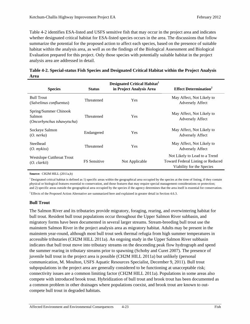
Ketchum-Challis Highway Improvement Project EA February 2012
Affected Environment and Environmental Consequences 4-23 Fish
Table 4-2 identifies ESA-listed and USFS sensitive fish that may occur in the project area and indicates whether designated critical habitat for ESA-listed species occurs in the area. The discussions that follow summarize the potential for the proposed action to affect each species, based on the presence of suitable habitat within the analysis area, as well as on the findings of the Biological Assessment and Biological Evaluation prepared for this project. Only those species with potentially suitable habitat in the project analysis area are addressed in detail.
Table 4-2. Special-status Fish Species and Designated Critical Habitat within the Project Analysis Area
Species Status Designated Critical Habitat1
in Project Analysis Area Effect Determination2
Bull Trout (Salvelinus confluentus)
Threatened Yes May Affect, Not Likely to
Adversely Affect
Spring/Summer Chinook Salmon (Oncorhynchus tshawytscha)
Threatened Yes May Affect, Not Likely to
Adversely Affect
Sockeye Salmon (O. nerka)
Endangered Yes May Affect, Not Likely to
Adversely Affect
Steelhead (O. mykiss)
Threatened Yes May Affect, Not Likely to
Adversely Affect
Westslope Cutthroat Trout (O. clarkii) FS Sensitive Not Applicable
Not Likely to Lead to a Trend Toward Federal Listing or Reduced
Viability for the Species
Source: CH2M HILL (2011a,b) 1 Designated critical habitat is defined as 1) specific areas within the geographical area occupied by the species at the time of listing, if they contain physical or biological features essential to conservation, and those features that may require special management considerations or protection; and 2) specific areas outside the geographical area occupied by the species if the agency determines that the area itself is essential for conservation. 2 Effects of the Proposed Action Alternative are summarized here and explained in greater detail in Section 4.6.3.
Bull Trout
The Salmon River and its tributaries provide migratory, foraging, rearing, and overwintering habitat for bull trout. Resident bull trout populations occur throughout the Upper Salmon River subbasin, and migratory forms have been documented in several larger streams. Stream-breeding bull trout use the mainstem Salmon River in the project analysis area as migratory habitat. Adults may be present in the mainstem year-round, although most bull trout seek thermal refugia from high summer temperatures in accessible tributaries (CH2M HILL 2011a). An ongoing study in the Upper Salmon River subbasin indicates that bull trout move into tributary streams on the descending peak flow hydrograph and spend the summer rearing in tributary streams prior to spawning (Schoby and Curet 2007). The presence of juvenile bull trout in the project area is possible (CH2M HILL 2011a) but unlikely (personal communication, M. Moulton, USFS Aquatic Resources Specialist, December 9, 2011). Bull trout subpopulations in the project area are generally considered to be functioning at unacceptable risk; connectivity issues are a common limiting factor (CH2M HILL 2011a). Populations in some areas also compete with introduced brook trout. Hybridization of bull trout and brook trout has been documented as a common problem in other drainages where populations coexist, and brook trout are known to out-compete bull trout in degraded habitats.

Ketchum-Challis Highway Improvement Project EA February 2012
Affected Environment and Environmental Consequences 4-24 Fish
Sockeye Salmon
Wild, anadromous Snake River sockeye salmon are functionally extinct, but they have been protected under ESA since 1991. Remnant individual fish are taken for a captive broodstock program. Resident sockeye still produce anadromous smolts and are considered a critical source of genetic diversity to help minimize reduced fitness of the sockeye salmon population caused by inbreeding. The closest remaining spawning area for sockeye salmon is at Redfish Lake, approximately 20 miles south-southwest (30 river miles) of the proposed project area. In the fall of 1996, 120 adult sockeye (progeny of the eight sockeye captured at Redfish Lake weir in 1993 and raised in captivity) were released in Redfish Lake. These fish constructed approximately 42 redds, primarily at the inlet area of the lake. Approximately 1,500 sockeye returned to Redfish Lake in 2010, up from approximately 940 the previous year.
The project analysis area occurs within designated critical habitat for Snake River sockeye salmon. Adult sockeye migrate through the project analysis area to lakes in the Upper Salmon River subbasin, with most upstream migration likely occurring during August and September (CH2M HILL 2011a). Out-migrating juvenile sockeye pass through the area during high spring flows (typically late April through May). Population trends for this species are influenced primarily by factors outside of the subbasin. The overall status of the species is considered to be functioning at unacceptable risk, with a high potential for extinction (CH2M HILL 2011a). The population near the project area is considered to be functioning at risk for subpopulation size, persistence, and genetic integrity. Sockeye salmon are functioning appropriately for growth and survival and life history diversity (CH2M HILL 2011a).
Chinook Salmon
In Idaho, Chinook salmon are found only in the Snake River below Hells Canyon Dam and in accessible tributaries of the Clearwater and Salmon Rivers. Key factors influencing the status of spring/summer Chinook salmon are habitat degradation, hydropower, artificial propagation, disease, predation and competition from introduced species, and overfishing (Lee et al. 1997). The mainstem Salmon River is, and historically has been, a migratory corridor and spawning and rearing habitat for spring/summer Chinook salmon. The project analysis area provides habitat for all life stages of Chinook salmon and includes some of the best remaining high-quality spawning habitat in the entire Snake River basin. No areas of concentrated spawning have been observed in the portion of the Salmon River immediately downslope of the project area; evidence of spawning is, however, occasionally seen (personal communication, M. Moulton, USFS Aquatic Resources Specialist, December 9, 2011). Spring/summer Chinook salmon begin migrating through the project analysis area in the spring and hold for various intervals of time in the river during their migration to spawning grounds. Spawning begins in August and extends through late September. Chinook salmon population numbers are currently severely depressed relative to historic numbers. Although relatively strong watershed level subpopulations occur within the subbasin, Chinook salmon populations are still considered functioning at risk at the subbasin level and in the project area (CH2M HILL 2011a).
Steelhead
Steelhead are widely distributed throughout the SNF, Sawtooth NRA, and S-CNF. Current populations occupy from 45 to 50 percent of watersheds within the basin. Steelhead populations have suffered declines due to the same factors described for Chinook salmon. Most of the steelhead in the mainstem Salmon River are hatchery fish or are genetically influenced by hatchery stocks and have very low natural spawning success. Wild steelhead represent a small percentage of the current steelhead population in the upper mainstem Salmon River (Kiefer 1995). The project area provides spawning habitat for adult

Ketchum-Challis Highway Improvement Project EA February 2012
Affected Environment and Environmental Consequences 4-25 Fish
steelhead and summer and winter rearing, foraging, and refuge habitats for juveniles. The area also serves as a migratory corridor for all life stages. Steelhead spawning occurs throughout the low- and mid-elevation stream reaches of the Upper Salmon River subbasin and typically occurs within the project analysis area. Adult steelhead migrate to and from spawning tributaries from the first of February to June. Juvenile steelhead can be present any time of the year. Overall, wild subbasin populations in the project area are depressed relative to historic numbers and are considered to be functioning at risk (CH2M HILL 2011a).
Westslope Cutthroat Trout
Westslope cutthroat trout are widely distributed throughout the S-CNF and are known to occur on the Sawtooth NRA. This species is known to occur in all waters potentially affected by the proposed project. The project analysis area has suitable spawning habitat and overwintering areas within the project reach of the Salmon River. Suitable foraging and summer rearing habitat occurs in all waters as well.
4.6.2 Effects of the Alternatives
No Action Alternative. Under the No Action Alternative, existing conditions in the project area would be maintained. The effects of ongoing rockfall and sedimentation would not be modified by slope stabilization or drainage improvement measures. Related fluvial and riparian processes would be similarly unaffected by project activities. Plugged culverts and debris chutes could contribute to impairment of the water quality of the Salmon River. Rockfall and other debris from the project area would continue to enter the Salmon River, contributing to occasional sudden increases in fine sediment input. In areas used for spawning, fine sediment could affect fish by clogging the interstitial spaces within the substrate, thus interfering with oxygenation of developing eggs.
Proposed Action Alternative. The following assessment, drawn from the Biological Assessment for this project (CH2M HILL 2011a), is based on potential effects on ESA-listed species, but it applies to all fish species in the project area. Discussions of potential effects on individual special-status species follow the discussion of effects on fish habitat.
Fish Habitat
Overall, the Proposed Action Alternative would be expected to maintain the condition of fish habitat in the project area (CH2M HILL 2011a). The following paragraphs provide additional information about the potential effects of the Proposed Action Alternative on the aspects of fish habitat that were described in Section 4.6.1, Affected Environment.
Potential short- and long-term effects of the Proposed Action Alternative on water quality and flow regimes are discussed in detail in Section 4.4.3 (Impact Avoidance and Minimization, Water Resources). Based on the analysis presented there, the Proposed Action Alternative would likely maintain water quality and flow conditions in the project area. Some of the design measures proposed to stabilize steep slopes would improve roadway drainage, likely leading to long-term decreases in sediment input. The following paragraphs discuss these findings in the context of fish habitat.
Road construction and slope stabilization would result in soil disturbance within the project area. One of the primary risks for fish would be the transfer of sediment, rock, or other debris into the Salmon River. All proposed construction activities with the potential to disturb soils would be conducted on slopes well above the Salmon River. Over the long term, cross-drain culverts treated with outlet protection measures would dissipate energy, reduce runoff velocity, and decrease the erosion potential of stormwater runoff.

Ketchum-Challis Highway Improvement Project EA February 2012
Affected Environment and Environmental Consequences 4-26 Fish
In addition, the baseline flow and hydrology conditions in the Salmon River would be maintained over the long term (CH2M HILL 2011a). Drainage would improve with ditch relief culverts and cross-drains. No short-term or long-term effects on flow or hydrology in the Salmon River would be expected to occur as a result of the proposed action.
Watershed conditions, riparian habitat, and sediment and substrate conditions would be maintained as a result of project implementation (CH2M HILL 2011a). No stream-adjacent vegetation would be removed during construction, so no project-related effects on stream shading or water temperatures would occur. Road maintenance following construction (for example, sanding) would continue to affect the river, but not to an extent that would be greater than current conditions. ITD would continue to maintain SH 75. Therefore, road density and location would not change as a result of this project. Project activities would not be expected to result in any adverse effects on the amount, size, or composition of substrates in the Salmon River in the project area.
A key factor in determining habitat connectivity is the incidence of human activities, noise, light, or other conditions that might deter fish from passing through a particular reach of stream. The following paragraphs address this factor.
Based on the distance of most proposed construction activities from fish-bearing waters, noise and overhead activities associated with construction would not likely be sufficient to disturb adult fish migrating through the project area. All work on and above the roadway would be at least 75 horizontal feet and 35 vertical feet away from the Salmon River and would likely be imperceptible to fish in the water below. Slope distances between the roadway and the river in the project area range between approximately 60 feet and more than 200 feet. Work on the slope below the road (e.g., construction of retaining walls and installation of riprap outlet protection for cross-drain culverts) would have a greater potential of generating noise or activity that could disturb fish. At sufficient levels, disturbance could deter fish from using the portions of the Salmon River in the project area, potentially interfering with migration or other essential behaviors. Such effects would occur only during periods of active construction work; fish would likely not be deterred from using the waters of the Salmon River in the project area at other times. Although construction of redds or other spawning activity would likely occur during the proposed construction period, all construction activities would take place far enough away so that they would not disturb fish or fertilized eggs in the gravel.
Noise and vibration associated with blasting may disturb or injure fish in nearby waters. All blasting conducted under the Proposed Action Alternative would occur at least 120 feet from the Salmon River.
The use of artificial lighting in association with nighttime construction of retaining walls could potentially affect the behavior of fish in the area. Many anadromous species migrate primarily at night, increasing the potential that night lighting may interfere with migration (personal communication, M. Moulton, USFS Aquatic Resources Specialist, December 9, 2011). Studies in the Pacific Northwest indicate that nighttime lighting may contribute to changes in fish distribution and migration behavior. The extent to which this poses a risk of real harm to fish, however, has yet to be determined (Nightingale and Simenstad 2002). Records indicate that spawning occurs only occasionally in the portion of the river downslope of the area where night lighting would occur (i.e., the Narrows).
Many streams in the Upper Salmon River subbasin support invasive aquatic species such as the New Zealand mudsnail, as well as harmful pathogens such as Myxobolus cerebralis (a parasite that causes neurological damage in fish, commonly called whirling disease). Many of these species are practically

Ketchum-Challis Highway Improvement Project EA February 2012
Affected Environment and Environmental Consequences 4-27 Fish
invisible to the naked eye and impossible to detect if attached to heavy equipment. Equipment used to draft, dip, store, or deploy water can be exposed to a variety of invasive organisms, leading to an elevated risk of spreading aquatic invasive organisms from contaminated to uncontaminated sources.
Special-status Fish Species
Bull Trout
Bull trout in the Salmon River would not experience any short- or long-term effects as a result of habitat and water quality degradation relative to disturbance of upslope sediments in the project area. Temporary avoidance of holding cover and reduced migration during construction activity resulting from noise and activity associated with construction would be unlikely due to the distance of construction from the Salmon River. No long-term deleterious impacts would occur as a result of the proposed project. Based on these considerations, therefore, the Proposed Action Alternative may affect but would not be likely to adversely affect Columbia River bull trout or their critical habitat over the short or long term (CH2M HILL 2011a).
Sockeye Salmon
Sockeye salmon in the project analysis area likely would not experience any short- or long-term degradation of habitat or water quality as a result of ground-disturbing construction activities upslope of the river in the project area. No temporary avoidance of migratory holding cover would likely occur due to project-related activities and noises. Sockeye salmon use the Salmon River as a migratory corridor to access upstream lakes for fall spawning, rearing, and out-migration in the spring. Based on the low likelihood of effects on fish habitat, combined with the species’ minimal use of the area, the Proposed Action Alternative may affect but would not be likely to adversely affect Columbia River sockeye salmon or their critical habitat over the short or long term (CH2M HILL 2011a).
Chinook Salmon
Construction activities during August and September would overlap the Chinook spawning season. Adult Chinook salmon would be present in the Salmon River next to the project area. In addition, juvenile Chinook salmon would likely be in the Salmon River during nearly all of the proposed construction, and fertilized Chinook salmon eggs and alevin would occupy gravels in newly developed redds from mid-September through the winter until emergence.
With the implementation of conservation measures, fish in the mainstem would not likely experience any short- or long-term habitat and water quality degradation resulting from ground-disturbing activities upslope of the river in the project area. Adult Chinook salmon would not likely avoid the area or be displaced during construction hours because of noise and other activities, as all activities would occur well upslope of the water’s edge. All blasting would be limited to the conditions outlined in the Biological Assessment for this project. Under these conditions, blasting would occur at a distance and charge weight that would preclude the risk of adverse effects associated with noise and/or injury (CH2M HILL 2011a). In addition, no long-term impacts would likely occur. Based on these considerations, therefore, the Proposed Action Alternative may affect but would not be likely to adversely affect Snake River spring/summer Chinook salmon or their critical habitat over the short or long term (CH2M HILL 2011a).

Ketchum-Challis Highway Improvement Project EA February 2012
Affected Environment and Environmental Consequences 4-28 Fish
Steelhead
Steelhead in the Salmon River would not likely experience any short- or long-term degradation of habitat or water quality as a result of ground-disturbing activities upslope of the river in the project area. Noise and construction activities would not likely result in temporary avoidance of spawning or rearing areas or migratory holding cover. For these reasons, the Proposed Action Alternative may affect but would not be likely to adversely affect Snake River steelhead or their critical habitat over the short or long term (CH2M HILL 2011a).
Westslope Cutthroat Trout
The potential for short-term effects due to deposition of fine sediment into spawning areas under the Proposed Action Alternative would be extremely low, because BMPs would minimize the potential for sediment to be transported into the Salmon River. Over the long term, Proposed Action Alternative and associated drainage and sediment alterations would maintain habitat conditions for westslope cutthroat trout, providing a net long-term benefit for the species. For these reasons, the project may impact individuals or habitat, but would not likely lead to a trend toward federal listing or reduced viability for the species (CH2M HILL 2011b).
4.6.3 Impact Avoidance and Minimization
Construction-related effects on fish resources from the Proposed Action Alternative would be temporary and would largely follow those described for Water Quality (Section 4.4). These effects would be minimized or prevented through proper selection and implementation of BMPs. The SWPPP would include temporary sediment and erosion control plans, which would be developed under the supervision of a qualified sediment and erosion control specialist. Because the conservation measures and BMPs identified in Section 4.4.3 would be implemented as part of the project, the potential risk of short-term effects on water quality due to upslope construction activities would be low.
All proposed construction activities with the potential to disturb soils would be implemented in a manner that would minimize the potential for fines, sediment, or debris to be transferred into live water. Based on the implementation of sediment and erosion control measures, the Proposed Action Alternative would be unlikely to alter existing water quality conditions.
The potential for adverse effects on fish due to water draws would be minimized by the requirement to implement appropriate means and methods (including fish screens) for any withdrawals from the river. In addition, the construction contractor would have to obtain all applicable permits for use of water from the Salmon River or its tributaries, further reducing the risk for adverse effects on water quality or water quantity.
To maintain large woody debris recruitment conditions in the project area, all trees removed from below the roadway would be left on the fill-side slope. All disturbed soils and any fill would be revegetated with a mix of native species. Native vegetation would likely return to preproject conditions over time. Disturbed sites would be replanted and reseeded with a mix of site-specific, native species after construction completion. Any shrubs cut back to ground level during construction would be expected re-sprout from the roots after construction completion. The implementation of these measures would minimize the potential for adverse effects on watershed conditions, riparian habitat, and sediment and substrate conditions.

Ketchum-Challis Highway Improvement Project EA February 2012
Affected Environment and Environmental Consequences 4-29 Fish
Any blasting would be limited to the conditions outlined in the Biological Assessment for this project. Under these conditions, blasting would occur at a distance and charge weight that would preclude the risk of adverse effects associated with noise and/or injury (CH2M HILL 2011a). For these reasons, noise and other construction-related disturbance would not likely cause fish to avoid the area or to be displaced during construction hours.
The implementation of conservation measures to minimize the amount of light cast on the Salmon River would minimize the potential for adverse effects associated with artificial lighting. In addition, reinforced silt fencing installed at the toe of the retaining walls would block light, further reducing the potential for downcast light to illuminate the water surface of the river below. For these reasons, combined with the low incidence of spawning in the portion of the river downslope of the area where night lighting would occur, nighttime lighting would be unlikely to affect fish adversely to any measurable extent.
The risk of spreading aquatic invasive organisms from contaminated to uncontaminated sources equipment under the Proposed Action Alternative would be minimized through implementation of preventive measures (Section 4.6.3). All equipment would be properly cleaned before being used in the area.
Two major components of the conservation measures for minimizing potential detrimental effects on fish habitat would be preventing deleterious materials from entering the water and reducing impacts associated with construction (CH2M HILL 2011a). Implementation of these measures would minimize the risk of adverse effects on all fish species. Measures to protect water resources in the project area are described in Section 4.4.3. In addition, the following measures would be implemented under the Proposed Action Alternative to minimize the levels of impacts specific to fish resources in the project area:
Disturbance effects from blasting would be minimized. All blasting would be at least 120 feet (slope distance) from the Salmon River, and explosive charge weights would not exceed the conditions established in consultation with NMFS and USFWS (CH2M HILL 2011a).
During night work requiring artificial light, all lighting would be directed away from the river and the water surface to the extent feasible. As necessary, hoods or screens would be placed on lights to minimize the amount of backlight or dispersed light cast toward the water surface.
To maintain large woody debris recruitment conditions in the project area, all trees removed from below the roadway to facilitate roadway expansion would be left on the hillslope between the river and the road.
No use of herbicides would occur without prerequisite consideration of the potential effects on sensitive species, including fish species protected under the ESA.
Any withdrawals of water from the Salmon River or other fish-bearing waters would be conducted consistent with applicable fish screening standards (NMFS 1997). Water drafting sites would be identified in advance through coordination with an aquatics specialist to avoid spawning and key rearing areas. All drafting equipment and operations would meet screening criteria of openings no greater than 3/32 inch, with approach velocities less than 0.40 foot per second.
To prevent the potential spread of invasive aquatic organisms or diseases, the following measures would be implemented:
o Maps would be obtained to indicate where aquatic invasive organisms occur in watersheds in which operations would take place.

Ketchum-Challis Highway Improvement Project EA February 2012
Affected Environment and Environmental Consequences 4-30 Fish
o All water withdrawal equipment would be properly cleaned before use in the area. o All equipment with internal tanks (e.g., water tenders) and an unknown sanitization
history would be disinfected before use in the project area. o Water would not be allowed to be dumped directly from one stream or lake into another. o Contractors moving equipment from areas where whirling disease and other invasive
aquatic organisms occur to areas where they are not known would be required to clean and sanitize equipment before moving it.
o Sucking organic and bottom material into water intakes would be avoided when drafting from streams or ponds.
o Cleaning and sanitation would be conducted in areas with no potential to deliver effluent to waterways. Areas would be designated for cleaning and sanitation of heavy equipment to reduce the spread of noxious weeds and unwanted organisms.
o Backpack spray pumps or similar cleaning devices would be used to clean all portable tanks, leaving sanitizing solution in contact with the surface being sanitized for at least 10 minutes before rinsing.
o Water tenders would be sanitized by circulating sanitizing solution from a self-supporting foam collar tank (e.g., pumpkin tank) for 10 minutes.
Sanitation effluent would be disposed of in sanitary sewers if possible. If sanitary sewers were not available, sanitation effluent could be applied to roads in areas with no potential to deliver the solution to waterways. Care would be taken to avoid exposing the public or areas outside of the road right-of-way to the sanitation effluent as it was being applied.
Treated water would not be dumped into any stream, lake, or on areas where it could migrate into any waterbody.
4.6.4 Cumulative Effects
The following discussion applies to all fish species, including ESA-listed and USFS sensitive species. Any changes in the condition of aquatic habitat under the Proposed Action Alternative would affect all associated species. The analysis area for cumulative effects pertaining to fish is the Upper Salmon River subbasin, primarily upstream of the project area. Past, present, and reasonably foreseeable future actions with the potential to affect wildlife species in this analysis area include road construction and maintenance, hazardous tree removal, timber sales, mining activities, grazing, and residential and recreational development. These activities have resulted in reduced function and simplification of in-stream habitats for all fish species, as well as disturbance and displacement from areas of suitable habitat. The amount of undisturbed habitat in the cumulative effects analysis area is substantial. The analysis area consists almost entirely of USFS-managed lands under a mandate that emphasizes the long-term conservation of all resources, including fish and wildlife. The area affected by road construction and slope stabilization under the Proposed Action Alternative would be less than 10 acres, and most disturbed areas would be revegetated with native plant species. In addition, the Proposed Action Alternative would involve no in-stream work, thereby avoiding any direct effects on aquatic environments. The potential for cumulative effects on fish populations directly reliant on the project reach or seasonally present during migrations would be negligible.
The Proposed Action Alternative would not be expected to have any short-term effects on water quality, water quantity, watershed conditions, riparian habitat, substrate, habitat connectivity, or the presence of invasive species in the Upper Salmon River subbasin. Slope stabilization and drainage improvement measures could lead to long-term reductions in sediment input, but not necessarily to a measurable extent.

Ketchum-Challis Highway Improvement Project EA February 2012
Affected Environment and Environmental Consequences 4-31 Wildlife
Incremental effects from the Proposed Action Alternative, when added to the past, present, and reasonably foreseeable future actions, would not result in measurable changes in the condition of fish habitat within the Upper Salmon River subbasin. This conclusion is based primarily on the environmental effects over the large spatial scales that exert population-level controls over highly migratory (anadromous) salmonids and some bull trout life-history forms.
4.7 Wildlife
This section evaluates the potential effects of the alternatives on wildlife species and habitat in the project area. Information in the discussions below was drawn from the Biological Assessment and Biological Evaluation that were prepared for the project (CH2M HILL 2011a,b). Similar to the discussions of other resource areas, the first four subsections below describe the existing condition of wildlife habitat in the project area, evaluate the potential effects of the alternatives, identify measures that would be implemented to avoid or minimize adverse effects, and assess cumulative effects. Some species that may occur in the project area have special status under ESA or under USFS management direction. Existing conditions and potential effects on these species are addressed in Section 4.7.5.
4.7.1 Affected Environment
Wildlife habitat in the project corridor and adjacent areas consists of vegetation and other features. Most areas outside of the maintained road right-of-way are dominated by sagebrush-bunchgrass communities. Coniferous forest communities dominated by Douglas-fir are present in some areas, and some seep areas have produced small pockets of cottonwood trees (Section 4.3, Vegetation). Outside of areas influenced by the existing roadway, the baseline condition of terrestrial habitats in the project analysis area is generally good. Much of the grassland habitat on private land in the project vicinity has, however, been heavily altered by cattle grazing. Large mammals that may be found in the project area include elk, mule deer, black bear, bighorn sheep, mountain goat, and mountain lion. Numerous species of birds and small mammals breed and forage in the various habitat types in the project area, and pools of standing water along the lower benches of the Salmon River provide habitat for amphibians. Rock outcroppings and talus provide shelter for reptiles.
Based on its location along the valley bottom of the Salmon River, the project area likely serves as a corridor for species traveling between valleys to the west (such as those near Stanley) and the east (such as those near Challis). Data from ITD (2011) do not, however, indicate that vehicle-wildlife collisions are a common occurrence in the project area. Of more than 2,200 vehicle-wildlife collisions documented on highways throughout Idaho in 2009 and 2010, none occurred on the stretch of SH 75 between Custer and Stanley.
4.7.2 Effects of the Alternatives
No Action Alternative. Under the No Action Alternative, there would be no change in the effects of SH 75 on wildlife. There would be no direct loss of habitat, and the frequency with which road maintenance repair activities result in disturbance of animals in the analysis area would remain unchanged.
Proposed Action Alternative. The Proposed Action Alternative would not likely result in any substantial adverse effects on wildlife, including habitat loss, habitat fragmentation, displacement, avoidance, or direct mortality. Road construction and slope stabilization would result in a minor loss of roadside habitat, but ample habitat would remain in areas outside of the project corridor. Wildlife would continue to use

Ketchum-Challis Highway Improvement Project EA February 2012
Affected Environment and Environmental Consequences 4-32 Wildlife
habitats in the project area at rates similar to existing conditions, largely avoiding the highway corridor in favor of suitable habitat in areas away from human disturbance. The proposed action would not likely result in any increases in traffic speeds or traffic volumes in the project area, so the risk of wildlife-vehicle collisions would not change over the long term. In the short term, while project work was underway, construction-related truck traffic could result in an elevated risk of collisions, particularly when deer and elk move down from higher elevations during autumn.
Most road construction work would be confined to the area within the existing alignment, so direct effects on wildlife habitat as a result of road construction would be minimal. To the extent that the existing roadway contributes to habitat degradation and fragmentation, it would continue to do so under the proposed action. Stabilization of steep slopes and rocky outcrops above the roadway may reduce the availability of cover sites for reptiles and small mammals in the project area, and some animals may be displaced to similar habitat in adjoining areas.
Some sagebrush habitat (estimated to be less than 10 acres) would be cleared within the project limits between the existing roadway and the river. Rock scaling would entail the removal of approximately 100 trees that pose a risk of dislodging rocks above the road. Below the roadway, approximately 30 small trees (less than 16 inches in diameter at breast height) and approximately 10 large trees (greater than 16 inches in diameter at breast height) would be removed.
Removal of roadside vegetation would not increase habitat fragmentation because the highway corridor would not be substantially widened, and the distance wildlife must travel between areas of suitable habitat on either side of the roadway would not appreciably change. New guardrails would not be expected to dissuade most species from crossing the road. Based on these findings, habitat fragmentation resulting from the Proposed Action Alternative would be negligible.
Construction activities under the Proposed Action Alternative would result in temporary increases in human activity within the project corridor and noise levels nearby. Animals in the project area and nearby areas subject to loud noises from construction equipment would likely be displaced from the area while construction activities were underway.
Blasting to remove rock and other material would generate high-intensity, short-duration noise, affecting areas as far as 1 mile from the project area. Wildlife may react to such sudden, loud noises with a startle response or by flushing from nests, foraging areas, resting sites, or other use areas. Frequent repetition of such disturbance could lead to abandonment of reproductive sites such as nests or dens, possibly reducing reproductive success during the seasons in which the disturbance occurred. Occasional, sporadic blasts, however (e.g., no more than two blasts per day, over 1 or 2 weeks), would not be expected to result in abandonment. Animals displaced by noise and human activity would likely return to the area after the degree of disturbance returned to preproject levels; therefore, temporary disturbance due to construction activities would not likely result in any long-term changes in wildlife use of the project area.
No new travel lanes would be added under the Proposed Action Alternative, and there would be no change in posted speed limits. Compared to current conditions, therefore, the Proposed Action Alternative would not be expected to result in any substantial changes in traffic volumes or travel speeds along SH 75 in the project area. For these reasons, the risk of vehicle-wildlife collisions would not be expected to change.
Ketchum-Challis Highway Improvement Project EA February 2012
Affected Environment and Environmental Consequences 4-33 Wildlife
4.7.3 Impact Avoidance and Minimization
The potential for project activities to contribute to habitat degradation through vegetation disturbance or the introduction of noxious weeds would be minimized through implementation of the measures identified in Section 4.3.3. The following additional measures would be implemented to minimize the potential for adverse effects on wildlife as a result of road construction and slope stabilization under the Proposed Action Alternative:
Areas cleared for road construction activities would be revegetated, minimizing the potential for long-term habitat fragmentation. Permanent habitat loss would likely be minimal.
To minimize the potential for disturbance of nesting migratory birds, shrubs and trees would be removed during the non-nesting season (i.e., before April 1 or after August 1 of each year).
All equipment used for construction would have sound control devices no less effective than those provided on the original equipment. All equipment would have muffled exhaust.
To minimize the potential for noise disturbance, posts for signs and guardrails would be driven or augured into the ground without using jackhammers.
To maintain large woody debris recruitment conditions in the project area and to provide potential habitat for wildlife species such as pileated woodpeckers and fishers, all trees removed from below the roadway to facilitate roadway expansion would be left on the hillslope between the river and the road.
4.7.4 Cumulative Effects
The following discussion applies to all wildlife species, including ESA-listed and USFS sensitive species. The Proposed Action Alternative would not likely result in any measurable changes in the availability or condition of habitat for any species in analysis area, regardless of their habitat associations.
The analysis area for cumulative effects pertaining to wildlife is defined by the watersheds that contain the project area, as well as neighboring watersheds—an area totaling approximately 114,000 acres. Past, present, and reasonably foreseeable future actions with the potential to affect wildlife species in this analysis area include road construction and maintenance (including hazardous tree removal), timber sales, mining activities, grazing, and residential and recreational development. These activities have resulted in fragmentation and loss of wildlife habitat, as well as disturbance and displacement from areas of suitable habitat. The amount of undisturbed habitat in the cumulative effects analysis area is substantial, however. The analysis area consists almost entirely of lands managed by USFS with a mandate for long-term conservation of all resources, including wildlife. The area affected by road construction and slope stabilization under the Proposed Action Alternative would be less than 10 acres, and most disturbed areas would be revegetated with native plant species. The amount of area affected by human disturbance and permanent habitat loss associated with the Proposed Action Alternative would, therefore, be minute relative to the size of the analysis area; the potential for cumulative effects on wildlife species would be negligible.
The Proposed Action Alternative would not likely result in any appreciable effects on any wildlife species, including habitat loss, habitat fragmentation, displacement, avoidance, or direct mortality in the project area or neighboring watersheds. Incremental effects from the proposed action, when added to the past, present, and reasonably foreseeable future actions, would not likely result in measurable changes in the condition of wildlife or wildlife habitat in the analysis area.

Ketchum-Challis Highway Improvement Project EA February 2012
Affected Environment and Environmental Consequences 4-34 Wildlife
4.7.5 Special-status Species
In accordance with ESA, FHWA (as the federal agency of record) is required to ensure that any actions it approves will not jeopardize the continued existence of endangered or threatened species or result in the destruction or adverse modification of their designated critical habitat. To meet this requirement, FHWA initiated consultation with USFWS concerning the potential effects of the proposed action on ESA-listed and candidate species. One ESA-listed wildlife species, Canada lynx, may occur within the area influenced by the proposed action. Three additional species that are candidates for listing (greater sage-grouse, yellow-billed cuckoo, and wolverine) may also occur. No designated critical habitat for listed species occurs in the project corridor or its vicinity. The Biological Assessment prepared for this project (CH2M HILL 2011a) contains detailed descriptions of the distribution, conservation status, life history, and habitat requirements of these species, along with an in-depth analysis of the potential effects of the proposed action. Discussions in this document are based on the analyses and effects determinations that are presented in the Biological Assessment. Consultation with USFWS is underway; FHWA anticipates concurrence with the determinations for ESA-listed species, summarized below.
The National Forest Management Act requires National Forests to maintain viable populations of “native and desired nonnative vertebrate species . . . well distributed in the planning area.” To meet this requirement, National Forests and other management units (including the Sawtooth NRA) identify management indicator species (MIS), to represent habitat types that are thought to be sensitive to management activities. In addition, USFS identifies sensitive species, which are species with declining populations that are particularly susceptible to habitat changes or impacts from activities. Similar to the Biological Assessment, the Biological Evaluation for this project (CH2M HILL 2011b) contains detailed descriptions of the distribution, conservation status, life history, and habitat requirements of these species, along with an in-depth analysis of the potential effects of the proposed action.
Table 4-3 lists the ESA-listed species, candidates for listing, USFS sensitive species, and management indicator species that may occur in the project area; and summarizes the habitat requirements of these species. The table also indicates the potential for the proposed action to affect each species, based on the presence of suitable habitat within the analysis area. The discussions that follow summarize the findings of the Biological Assessment and Biological Evaluation prepared for this project. Only those species with occupied suitable habitat in the project analysis area are addressed in detail.
Table 4-3. Special-status Wildlife Species Analyzed for Suitable Habitat and Potential Impacts within the Project Analysis Area
Species General Habitat Requirements Status Suitable Habitat in
Project Analysis Area
Birds
Harlequin Duck (Histrionicus histrionicus)
Nests near water along cold, clear, low-gradient streams in a variety of nesting substrates.
USFS Sensitive
Yes (migration)
Greater Sage-grouse (Centrocercus urophasiunus)
Nests in relatively tall sagebrush with native grass and forb understory. Males perform courtship displays in nearby openings (leks).
ESA Candidate, USFS MIS
Yes (breeding)

Ketchum-Challis Highway Improvement Project EA February 2012
Table 4-3. Special-status Wildlife Species Analyzed for Suitable Habitat and Potential Impacts within the Project Analysis Area (continued)
Affected Environment and Environmental Consequences 4-35 Wildlife
Species General Habitat Requirements Status Suitable Habitat in
Project Analysis Area
Mountain Quail (Oreortyx pictus)
Winters and nests in shrub-dominated thickets or drainages and typically moves to higher forested habitats during the summer.
USFS Sensitive
No
Common Loon (Gavia immer)
Nests on floating mats or bogs on large lakes with abundant fish and on forested, tundra, or rocky shorelines.
USFS Sensitive
No
Bald Eagle (Haliaeetus leucocephalus)
Is closely associated with lakes and large rivers (which provide foraging habitat) with mature trees; nests near open water in late-successional forest with low levels of human disturbance.
USFS Sensitive
Yes (foraging)
Northern Goshawk (Accipiter gentilis)
Nests in mature coniferous forests; forages in riparian and mixed coniferous and aspen forests interspersed with small clearings.
USFS Sensitive
Yes (foraging)
Peregrine Falcon (Falco peregrinus)
Far-ranging flier typically nests on cliff ledges within 2 miles of water.
USFS Sensitive
Yes (foraging)
Yellow-billed Cuckoo (Coccyzus americanus)
Species is closely associated with riparian forest with cottonwood overstory and dense willow understory.
ESA Candidate
No
Flammulated Owl (Otus flammeolus)
Breeds in mature and old Douglas-fir, ponderosa pine, mixed conifer, or aspen with moderate density of large trees and snags.
USFS Sensitive
Yes (foraging)
Great Gray Owl (Strix nebulosa)
Species is associated with mature coniferous and mixed coniferous forests interspersed with small clearings.
USFS Sensitive
No
Boreal Owl (Aegolius funereus)
Species is associated with high-elevation spruce-fir forest; nests in woodpecker cavities of dense trees with an open understory and multi-layered canopy.
USFS Sensitive
No
White-headed Woodpecker (Picoides albolarvatus)
Species is associated with abundance of large-diameter pine trees (particularly ponderosa pine) with relatively open canopy, and snags and stumps for nest cavities.
USFS Sensitive
No
Northern Three-toed Woodpecker (Picoides dorsalis)
Species is associated with mature conifer and mixed conifer forests; favors dead standing timber left by disease, insect infestation, or stand-replacing fires.
USFS Sensitive
Yes (foraging)
Pileated Woodpecker (Dryocopus pileatus)
Species is associated with dense (40% canopy), mature forests with large snags or trees for nests and with stumps, logs, and woody debris.
USFS MIS Yes (foraging)

Ketchum-Challis Highway Improvement Project EA February 2012
Table 4-3. Special-status Wildlife Species Analyzed for Suitable Habitat and Potential Impacts within the Project Analysis Area (continued)
Affected Environment and Environmental Consequences 4-36 Wildlife
Mammals
Gray wolf (Canis lupus)
Requires adequate prey base and areas with low levels of human use.
USFS Sensitive
Yes (foraging)
Canada lynx (Lynx canadensis)
Species is associated with boreal forest, primarily lodgepole pine, Engelmann spruce, and subalpine pine; dens in mature forests with substantial coarse woody debris; forages in areas with high densities of small-diameter trees.
ESA Listed: Threatened
No
Fisher (Martes pennanti) Dens in dense-canopy mature to old-growth spruce-fir forests; forages in a variety of habitats, often in riparian zones or areas with dense understories of young conifers, shrubs, and herbaceous cover.
USFS Sensitive
Yes (foraging)
Wolverine (Gulo gulo) Species is associated with high mountain forests with dense conifers and low levels of human disturbance; dens in rock piles and woody debris.
ESA Candidate,
USFS Sensitive
Yes (migration)
Bighorn Sheep (Ovis canadensis)
Species is associated with steep, rugged “escape” terrain, grasses and forbs for forage, and limited cover of tall vegetation.
USFS Sensitive
Yes (unoccupied)
Pygmy Rabbit (Brachylagus idahoensis)
Is closely associated with clumps of tall, dense sagebrush coupled with deep, loose-textured soils for burrow construction.
USFS Sensitive
No
Spotted Bat (Euderma maculatum)
Species is associated with caves; roosts in rock crevices on steep cliff faces; forages near roosts over forest openings and mountain meadows, riparian areas, and wetlands.
USFS Sensitive
Yes (foraging)
Western (Townsend’s) Big-eared Bat (Corynorhinus townsendii)
Hibernates in caves, rock outcrops, and mine shafts; roosts in hollow trees and snags; forages on moths along edge of habitats with water and in forested areas.
USFS Sensitive
Yes (foraging)
Amphibians
Columbia Spotted Frog (Rana luteiventris)
Species is associated with fish-free, spring-fed creeks and ponds; variety of moist habitats from vernal pools, to alpine lakes, to slow-moving waters in sagebrush.
USFS Sensitive
Yes (foraging)
Source: CH2M HILL (2011a,b)
Greater Sage-grouse
Greater sage-grouse are highly dependent on sagebrush for cover and food and are considered to be a sagebrush obligate species. Sagebrush habitat is present in the project area, although there are no documented records of sage-grouse observations within 5 miles. The Proposed Action Alternative would likely have no effect on sage grouse or potential habitat for the species. The sagebrush habitat within the project area is located along the existing road, and the project would not likely cause any additional habitat fragmentation beyond that which already exists. The proposed project would not likely result in

Ketchum-Challis Highway Improvement Project EA February 2012
Affected Environment and Environmental Consequences 4-37 Wildlife
additional human activity in suitable habitat in the area or disturbance of lek sites, compared to current conditions. The project would not contribute to future listing of sage grouse or destruction of high-quality habitat or lek areas.
Bald Eagle
Bald eagles are known to nest and winter in the Sawtooth NRA and forage along the Salmon River within the project area during winter. There are no documented records of bald eagle nests within 5 miles of the project area. Bald eagles typically do not nest near areas with high human use. The breeding season for bald eagles in Idaho extends from January through August.
Based on the absence of nest sites in the project area, the Proposed Action Alternative would not be likely to affect bald eagle nesting habitat or reproduction. Under the Proposed Action Alternative, noise and human activity from project construction may displace eagles from foraging areas along the river near the project area over a period that includes at least two breeding seasons (Section 3.2.1). In addition, construction would include loud noises, such as blasting; therefore, the Proposed Action Alternative would have a greater likelihood of disturbing bald eagles than current conditions, under which road repairs are completed on an occasional, as-needed basis. Based on the availability of suitable foraging habitat along other stretches of river nearby, the effects of disturbance or displacement under the Proposed Action Alternative would likely be minimal. The removal of large cottonwood trees would reduce the availability of potential perch sites, possibly interfering with foraging opportunities in the future. No stream-adjacent trees would be removed, however. The trees that would be removed are next to or above the highway and are unlikely to be used as perches by foraging bald eagles. For these reasons, the proposed action might affect individuals or habitat, but would not likely lead to a trend toward federal listing or reduced viability for the bald eagle.
Northern Goshawk
There are no documented observations of goshawks within 5 miles of the project area. Approximately 12 northern goshawks nest territories have been identified on the north zone of the S-CNF, which is more than 10 miles from the project area. On the Sawtooth NRA, the closest known breeding territory is approximately 11 miles from the project area. Goshawks typically avoid areas of intensive human use. Individual goshawks may, however, use forested habitat in the riparian corridor and nearby for foraging. Under the Proposed Action Alternative, noise and human activity from project construction might disturb goshawks that are in or near the project area. Construction would occur over a prolonged period and would include some blasting; therefore, the Proposed Action Alternative would have a greater likelihood of disturbing northern goshawks than current conditions under which road repairs are completed on an occasional, as-needed basis. For these reasons, the proposed action may affect individuals or habitat, but would not likely lead to a trend toward federal listing or reduced viability for the northern goshawk.
Peregrine Falcon
Peregrine falcons are known to nest on the Sawtooth NRA and the S-CNF; falcons may forage in riparian areas and wetlands in the project area. There are no documented observations of peregrine falcons within 5 miles of the project area, and there are no suitable nest sites (rock ledges on tall cliffs) in the project area. Individual falcons may use riparian and wetland habitats near the Salmon River for foraging, however. Noise and human activity from project construction may disturb peregrine falcons that are in or near the project area. Construction would occur over a prolonged period and would include some blasting; therefore, the Proposed Action Alternative would have a greater likelihood of disturbing peregrine falcons

Ketchum-Challis Highway Improvement Project EA February 2012
Affected Environment and Environmental Consequences 4-38 Wildlife
than current conditions under which road repairs are completed on an occasional, as-needed basis. For this reason, the proposed project might impact individuals or habitat, but would not likely lead to a trend toward federal listing or reduced viability for the peregrine falcon.
Flammulated Owl
Flammulated owls are known to nest on the Sawtooth NRA and the S-CNF (including within the Salmon River Canyon), but there are no documented observations of this species within 5 miles of the project area. No suitable nest sites (cavities in large ponderosa pine or Douglas-fir trees or snags) would be removed for road construction or slope stabilization. Flammulated owls forage by gleaning insect prey (primarily moths) from foliage and could be present in the area during construction; noise and human activity from project construction might disturb flammulated owls that are in or near the project area. Construction would occur over a prolonged period and would include some blasting; therefore, the Proposed Action Alternative would have a greater likelihood of disturbing flammulated owls than current conditions under which road repairs are conducted on an occasional, as-need basis. For these reasons, the proposed project might impact individuals or habitat, but would not likely lead to a trend toward federal listing or reduced viability for the flammulated owl.
Northern Three-toed Woodpecker
Three-toed woodpeckers are known to occur on the Sawtooth NRA, typically associated with mature forests that have been affected by outbreaks of bark beetles, stand-replacing fires, or both. Optimal foraging habitat includes large snags (12 to 16 inches in diameter at breast height and 20 to 40 feet tall) in high densities (42 to 52 snags per acre) (Spahr et al. 1991). Foraging habitat may be available in forested areas adjacent to the project area (personal communication, R. Garwood, USFS Wildlife Biologist, December 5, 2011). Under the Proposed Action Alternative, tree-clearing for road construction and slope stabilization might reduce the availability of foraging habitat in the project area compared to current levels. Based on potential impacts on suitable winter habitat, the proposed project may affect individuals or habitat, but would not likely lead to a trend toward federal listing or reduced viability for the northern three-toed woodpecker.
Pileated Woodpecker
Pileated woodpeckers are considered rare within the S-CNF, but they are not rare on the Sawtooth NRA. There have been several observations of pileated woodpeckers in the Salmon River Canyon Area in the last few decades, including some within 5 miles of the project area. No snags that provide suitable nesting sites occur within the project area. Douglas-fir and cottonwood trees in the project area may provide suitable foraging habitat; however, pileated woodpeckers typically show a strong preference for foraging on snags and downed logs (CH2M HILL 2011b). Based on the lack of suitable nesting habitat and the marginal quality of potential foraging habitat in the project analysis area, the proposed project would have no impact on pileated woodpeckers or their primary habitat.
Gray Wolf
Wolves can use a variety of habitats; the availability of an adequate prey base is a key factor in determining the suitability of an area for wolves. In addition, human activities have been shown to influence the distribution and survival of wolves (Mladenoff et al. 1995). The absence of wolves from areas with high levels of human activity may be the result of increased mortality rates or simply a behavioral avoidance (Carroll et al. 2003). Preferred prey items include deer, elk, and moose
Ketchum-Challis Highway Improvement Project EA February 2012
Affected Environment and Environmental Consequences 4-39 Wildlife
(Sime et al. 2010), but wolves will take smaller mammals, birds, fish, and carrion. Each pack defends a territory from encroachment by other wolves. Packs are typically made up of a dominant breeding pair, their offspring, and other non-related animals. The 2010 Wolf Conservation and Management in Idaho Progress Report (Holyan et al. 2011) indicates that two wolf packs have been documented in the vicinity of the project area. These are the Yankee Fork and Buffalo Ridge packs. Animals from these or other packs may forage within the project area. Based on the level of human activity and the availability of sites with suitable features away from the highway, it is unlikely that wolves would establish sensitive sites (e.g., dens, rendezvous sites) in the project area.
Other than occasional movements by transient animals, wolves are not expected to occupy habitat in the immediate project area regularly. Additionally, the immediate project area supports high levels of human activity, including camping, rafting, and uses associated with the highway. Consequently, construction activities could deter wolves from using the project area temporarily, but no long-term effects would be expected, and the project would be unlikely to contribute to habitat fragmentation. For these reasons, the Proposed Action Alternative would not be expected to result in substantive direct or indirect effects on gray wolves.
Canada Lynx
Neither suitable foraging habitat nor suitable denning sites are found in the project analysis area. The project area is within the Casino-Rough and Robinson Bar-Beaver lynx analysis units for the SNF. The project area is not within predicted habitat for Canada lynx. The closest occupied habitat is approximately 80 miles away, in the eastern portions of the S-CNF. There are no documented observations of Canada lynx within 5 miles of the project area. A Canada lynx linkage zone passes through the project area. This linkage zone, identified by the steering committee responsible for developing management direction for Canada lynx (USFS 2007), connects potential lynx habitat on two different portions of the S-CNF.
Based on the distance of the project area from areas known or expected to support populations of Canada lynx or suitable denning or foraging habitat for the species, the proposed action would have no effect on Canada lynx. The project area is located along an existing highway; road construction and slope stabilization under the proposed action likely would not cause any additional habitat fragmentation beyond that which already exists and would be expected to continue under the No Action Alternative. Compared to current conditions, the Proposed Action Alternative likely would not likely result in additional human activity in the area.
Wolverine
Three observations of wolverines have been documented within 5 miles of the project area in recent years. These observations indicate that wolverines may use the river corridor for travel. No suitable denning habitat is present in the project area, and the presence of human activity along the project area makes denning extremely unlikely.
In the short term, the proposed action may affect but would not likely adversely affect the wolverine or its potential prey base. Noise and vibration associated with blasting and human construction activity would likely temporarily displace any wolverines that may be present in the project area. The project analysis area may provide suitable travel corridors and foraging habitat for this species. No high-quality breeding habitat, consisting of mature or old-growth conifer stands, would be affected. The project area is located along an existing highway; road construction and slope stabilization under the proposed action likely would not cause any additional habitat fragmentation beyond that which already exists and

Ketchum-Challis Highway Improvement Project EA February 2012
Affected Environment and Environmental Consequences 4-40 Wildlife
would be expected to continue under the No Action Alternative. Compared to current conditions, the completion of the Proposed Action Alternative likely would not result in additional human activity in the area.
Fisher
Fishers have been documented in riparian habitats on the North Fork Ranger District of the S-CNF, approximately 30 miles north of the project area. Fishers have not been confirmed on the Sawtooth NRA since the 1980s. There are no documented observations of fishers within 5 miles of the project area. No denning habitat (old-growth or late-successional coniferous forest) is present in the project area. Potential wintertime foraging habitat (forested areas, including young and mature cover types) is present, however. Under the Proposed Action Alternative, tree clearing for road construction and slope stabilization might reduce the availability of this habitat in the project area from current levels. Based on potential impacts on suitable winter habitat, the proposed project may affect individuals or habitat, but would not likely lead to a trend toward federal listing or reduced viability for the fisher.
Spotted Bat
There are no documented occurrences of spotted bat within 5 miles of the project area. The species is one of the rarest bats in the United States, however, and documented observations are extremely uncommon, even in areas where spotted bats are known or expected to occur. In Idaho, spotted bats have been observed foraging together with other bat species. Observations of other bat species along the Salmon River near the project area, combined with the presence of water and conifer trees, suggest this area could provide suitable foraging habitat for spotted bats. Spotted bats appear to depend on prominent rock-faced cliffs for roosting. It is likely that spotted bats migrate to areas with warmer climates and year-round populations of insect prey during winter, so construction activities conducted in the winter months would be unlikely to affect this species. If any spotted bats were in the project area during summer and used rock faces in the project area for roosting, slope stabilization activities under the proposed action could cause disturbance or even injury of individual bats. The risk of injury would be low, however, because any bats that may be present in areas undergoing rock scaling would likely leave the area in response to noise and human activity. Thus, they would not be present when rock scaling activities were underway. Based on the low likelihood of the species occurring in the project area and the low risk of injury, the proposed project might affect individuals or habitat, but would not likely lead to a trend toward federal listing or reduced viability for the spotted bat.
Western Big-eared Bat
Big-eared bats have been documented on the Sawtooth NRA and the S-CNF, but there are no documented observations of this species within 5 miles of the project area. Riparian habitat in the analysis area provides suitable foraging habitat. No mine shafts or other features with the potential to function as nursery or hibernation habitat occur within the project analysis area. No large-scale removal of riparian habitat would occur under the proposed action. Based on the avoidance of effects on riparian habitat and lack of hibernacula, the proposed project might impact individuals or habitat, but would not likely lead to a trend toward federal listing or reduced viability for the western big-eared bat.
Columbia Spotted Frog
Columbia spotted frogs have been documented on the Sawtooth NRA and the S-CNF, but there are no documented observations of this species within 5 miles of the project area. This species is highly aquatic

Ketchum-Challis Highway Improvement Project EA February 2012
Affected Environment and Environmental Consequences 4-41 Cultural and Historical Resources
and breeds in permanent bodies of water, including lakes, ponds, slow streams, and marshes. No such habitat is present in the project area. Columbia spotted frogs can move considerable distances from water after breeding, often frequenting mixed conifer and subalpine forests, grasslands, and shrub lands of sagebrush and rabbitbrush. Adult frogs may use the Peach Creek drainage, shortly beyond the eastern end of the project corridor, for foraging or over-wintering. Based on the potential for the species to be present in the area while construction activities are underway, the proposed project might affect individuals or habitat, but would not likely lead to a trend toward federal listing or reduced viability for the Columbia spotted frog.
4.8 Cultural and Historical Resources
Southern Idaho has a long history of human occupation dating back to the Paleo-Indian period and into the Euro-American period. The region has a number of archaeological sites from the Paleo-Indian, Archaic, and Ethnographic periods of Native American occupation. Within the area of potential effect (APE) defined for the archaeological and historical survey report for this project (FHWA 2011), there is evidence of Northern Shoshone living and using the area until the U.S. Army campaign to remove them to reservations in the late 1800s. The Euro-American history of the area dates back to the 19th century, beginning with fur traders; by the 1860s, prospectors arrived in search of valuable minerals. Both Native American archaeological sites and historic mining sites are found near the project area. The area also has a history of ranching and recreational uses.
4.8.1 Affected Environment
The archaeological and historical survey report for this project documents the cultural resource investigations for the project (FHWA 2011). The report includes findings from a records research conducted at the Idaho State Historic Preservation Office (SHPO), as well as results of coordination with USFS about existing cultural resources sites. The APE for this project includes all of the area within which direct, indirect, and cumulative project effects on cultural resources could reasonably be expected to occur. The APE extends 50 feet on each side of the centerline of SH 75, from MP 205 near Marshall Creek to the eastern project terminus, approximately 500 feet west of the Peach Creek crossing. The APE also includes two areas upslope of the roadway—one near MP 206 (often referred to as the Narrows) and one near MP 207.5 (commonly known as Pebble Beach). Approximately 3,000 linear feet of the APE, from MP 205 to approximately MP 205.5, lie west of the western project terminus and would not be subject to any direct or indirect effects from project construction. Four previously documented archaeological sites occur near the APE; two additional sites were investigated for this project (Table 4-4).
Table 4-4. Cultural Properties near or within the Ketchum-Challis Highway Improvement Project APE
Site No. Property Type NRHP
Eligibility Location
Relative to APE
10CR1233 Prehistoric artifact scatter Eligible Outside
10CR1868 Mining ditches Ineligible Outside
10CR1870 Prehistoric artifact scatter Eligible Outside
10CR1871 Mining tailings and debris Ineligible Outside
N/A (Peach Creek Culvert) Road culvert Ineligible Inside
N/A (SH 75) Linear road Ineligible Inside N/A = not applicable

Ketchum-Challis Highway Improvement Project EA February 2012
Affected Environment and Environmental Consequences 4-42 Cultural and Historical Resources
Sites identified through archival research were surveyed on September 9 and 10, 2009, September 10 and 11, 2010, and October 7, 2011. The sites were field visited and examined to confirm their locations within or around the APE. If the eligibility of a site for listing in the NRHP was not previously documented, the site’s eligibility status was determined from the surveys. With the exception of the extremely steep terrain above the Narrows, the entire APE was surveyed using meandering 66-foot-wide parallel transects that were oriented similar to the project alignment that parallels the existing and proposed roadways. The survey verified that two of the previously documented sites, 10CR1233 and 10CR1870, are eligible for NRHP listing. Both sites are near, but are not within, the APE for the proposed project. Two other previously documented sites, 10CR1868 and 10CR1871, are outside and adjacent to the APE, but they are ineligible for listing in the NRHP (FHWA 2011). The surveys also identified two historic sites: the Peach Creek culvert on SH 75 and a section of SH 75 believed to have been constructed before 1964 and modified in 1964. The survey report recommended that neither of the newly identified historic sites be considered NRHP-eligible.
In addition to consulting with SHPO, FHWA has initiated government-to-government tribal consultation concerning potential effects on cultural properties in the APE. Consultation is ongoing with the Nez Perce, Shoshone-Bannock, and Shoshone-Paiute Tribes.
4.8.2 Effects of the Alternatives
No Action Alternative. The No Action Alternative would result in no change over present conditions. Thus, there would be no construction- or operations-related effects on historic or archaeological resources.
Proposed Action Alternative. The proposed project would avoid all previously documented cultural and historical sites, including NRHP-eligible sites. No additional NRHP-eligible sites were identified through field visits conducted for this project. Based on these findings, no historic properties would be affected, and the project would have no adverse effects on any NRHP-eligible sites (FHWA 2011).
4.8.3 Impact Avoidance and Minimization
As designed, the proposed project would have no effect on any NRHP-eligible cultural or archaeological sites in the APE, which would be avoided by the proposed action. FHWA has submitted the cultural resource survey report for review and anticipates SHPO’s concurrence with a determination of no historic properties affected. If the project design changed and extended into the boundary of an NRHP-eligible site, consultation mitigation would be required. Mitigation would incorporate a research design that would provide an adequate sample of the site. The research design and sample size would be determined through consultations with the Idaho SHPO, ITD, FHWA, and associated tribes.
The archaeological and historical survey report does not recommend any additional information-gathering or survey activities, avoidance measures, monitoring, or mitigation for either of the NRHP-eligible sites near the APE, based on the project design as of October 2011. In addition, no mitigation would be necessary for potential effects on other known sites in or near the APE, because those sites are not eligible for NRHP listing. Although Peach Creek is not in the APE for the project area, the 2010 archaeological survey identified both sides of Peach Creek north of SH 75 as having the potential to contain subsurface cultural deposits (FHWA 2011). The report recommends cultural resource monitoring for any project-related, ground-disturbing activities that may occur on either side of Peach Creek, upstream or downstream of SH 75.

Ketchum-Challis Highway Improvement Project EA February 2012
Affected Environment and Environmental Consequences 4-43 Recreation
Construction limits would be fenced off to create “no-work” zones, which would protect NRHP-eligible cultural resource sites. The construction contract would also include an unanticipated discovery clause.
If unknown archaeological sites were inadvertently disturbed during construction, construction work in the area would be discontinued until an archaeologist or cultural resource specialist could assess the site. Additionally, FHWA, SHPO, and local tribes should be notified and consulted about any discovered archaeological/historical site so that, should protective or recovery measures be necessary, they could be implemented. If recovery measures were necessary, mitigation planning would occur in consultation with FHWA, SHPO, and consulting tribes.
4.8.4 Cumulative Effects
The analysis area for the cumulative effects related to cultural resources includes portions of the Sawtooth NRA and the S-CNF adjacent to the APE for this project. Past and present activities that may have or may affect cultural resources include improvements, use, and maintenance of SH 75; timber sales and related road-building; recreational activities (rafting, fishing, hunting, and hiking); and hazardous tree removal. Future activities include use and maintenance of SH 75 and recreational facilities.
As currently designed, improvements to SH 75 would not affect NRHP-eligible cultural resources. The baseline conditions of cultural resources in the APE before the original construction of SH 75 are unknown. Construction of the highway could have affected cultural resources. Nevertheless, the actions identified above have not substantially altered the overall condition of cultural resources in the analysis area, and they are not likely to result in substantial alterations in the future. Therefore, the incremental effects of this project, when added to past, present, and reasonably foreseeable future actions, would not result in substantial cumulative effects on cultural resources.
4.9 Recreation
4.9.1 Affected Environment
The project area falls within the Sawtooth NRA, which is an internationally recognized destination with heavy recreational use, particularly during the summer season. The Salmon River corridor between Stanley and Clayton has 8 developed campgrounds with 125 units (typically open from June through September), approximately 40 designated dispersed campsites, along with picnic areas, hot springs, and scenic and historic overlooks. Recreational activities in the project area include river floating, kayaking, fishing, soaking in hot springs, and driving for pleasure. Nearby portions of the Sawtooth NRA offer opportunities for many other activities, such as camping, backpacking, horse and llama packing, hunting, fishing, boating, hiking, mountain biking, horseback riding, trail-bike riding, cross-country skiing, and snowmobiling.
In recognition of the exceptional recreational opportunities offered within a remarkably scenic river environment, the Salmon River has been nominated for inclusion in the national Wild and Scenic Rivers system. Also, SH 75 between Stanley and Challis is part of the Salmon River Scenic Byway, as designated by ITD. Driving for pleasure to view scenic landscapes is one of the route’s major functions.
Whitewater rafting on the Salmon River is a popular activity between mid-May and September, with peak use occurring in July and August (USFS 2006). Several outfitter, guide, and river-running operations conduct tours on and near the Salmon River in the project area, under the terms of special use permits issued by USFS. Between 9,000 and 12,000 patrons of commercial river-running outfitters float segments

Ketchum-Challis Highway Improvement Project EA February 2012
Affected Environment and Environmental Consequences 4-44 Recreation
of the Salmon River along SH 75 annually (GAO 1999; USFS 2006). In addition to these users, many kayakers and other independent boaters float this stretch of river every year. To protect salmon spawning areas, USFS closes this part of the river to boating from September 3 to September 22 every year.
Travelers from Challis and other communities to the east must pass through the project area to reach recreation areas to the west. Recreation destinations along SH 75 west of the project area (toward Stanley) include six developed campgrounds and numerous river access points. Three designated dispersed campsites occur near Marshall Creek, approximately 500 feet west of the western project terminus. There is an additional designated dispersed campsite across the Salmon River, approximately 500 feet south of the project area. The Yankee Fork Road, approximately 3 miles west of the project area, provides access to campgrounds, trailheads, and other recreational opportunities in the historic Yankee Fork mining district. The Custer Motorway (Forest Service Road 070) provides alternate access to the mining district from Challis. That road is recommended for high-clearance vehicles only, and it is closed to wheeled vehicles from November 15 through May 1 every year. This closure is necessary to provide resource protection to the road surface and drainage structures. The closure also provides for historical winter use of the area by the public (S-CNF Order Number 04-13-11-007, 21 April 2011). The road is closed annually when plowing begins on or after November 15. The closure applies to all wheeled vehicles; snowmobiles, skis, snowshoes, and foot travel are still allowed.
From Stanley and other communities to the west, travelers must pass through the project area to reach recreation areas further east. Two developed campgrounds, two trailheads, and several river access points are found along SH 75 east of the project area. The river-running outfitters that operate in the project area are based in Stanley.
One designated recreation site occurs within the project area. This is the Indian Riffles scenic overlook, near the western end of the project area, featuring picnic tables, a paved path, and restrooms, as well as views of the Salmon River and opportunities to watch spawning Chinook salmon (USFS 2011a).
4.9.2 Effects of the Alternatives
No Action Alternative. The No Action Alternative is not expected to result in any effects on the availability of or access to recreational opportunities within or near the project area. Occasional lane closures would continue to occur when fallen rock must be removed from the roadway. Rockfall and other debris from the project area would continue to enter the Salmon River, posing a safety hazard to rafters on the river.
Proposed Action Alternative. During temporary road closures for construction, persons traveling along SH 75 would not be able to pass through the project area for periods lasting up to 2 hours. These and other construction-related delays would occur from the fall of 2012 through the completion of Phase 1 in 2014. Depending on the status of funding for Phase 2, delays could extend into an additional construction season. Access from the east to the Yankee Fork mining district would be limited during these periods. The district would continue to be accessible from Challis, at least from May through mid-November, via the Custer Motorway.
Up to two scheduled road closures of no more than 2 hours apiece would occur each work day during the off-season (before Memorial Day and after Labor Day). During these times, motorists would temporarily be unable to travel through the project area to reach recreation sites on the opposite side, potentially detracting from the recreational experience. Persons needing to pass through the project area to reach
Ketchum-Challis Highway Improvement Project EA February 2012
Affected Environment and Environmental Consequences 4-45 Recreation
put-in or take-out sites on the river may also face delays. River-running outfitters may find it necessary to adjust trip schedules or even cancel some trips. Rock falling from construction areas could pose a safety hazard to people on the river.
When road reconstruction and rockfall stabilization are complete, access to recreation sites within and near the project area would return to existing conditions. Over the long term, lane closures for removal of fallen rock would likely be less frequent than under current conditions. Anticipated reductions in the frequency of rockfall from the project area would also reduce the risk of injury to rafters on the Salmon River below. No long-term adverse impacts on the quality or quantity of recreational opportunities would be anticipated from construction of the Proposed Action Alternative. As noted in Section 4.4, Water Resources, USFS (2012) determined that the Proposed Action Alternative would not impact the eligibility of river segments within the project area for Wild and Scenic River status.
4.9.3 Impact Avoidance and Minimization
The periods when scheduled road closures would occur would be outside of the peak rafting season: nearly all commercial rafting trips occur after late May and before early September. In addition, scheduled delays in September would overlap the period when the river is typically closed to protect spawning salmon. For these reasons, the impact on rafting opportunities would likely be minimal.
The schedule for 2-hour closures would be established in cooperation with local communities and would be advertised in advance to give highway users ample opportunity to adjust travel plans. To minimize the potential for interference with school bus schedules, scheduled closures would likely occur during late morning and early afternoon on work days. At all other times, the road would be open with delays not exceeding 15 minutes.
The following measures would be implemented to minimize the potential for traffic delays to interfere with access to recreational opportunities during construction under the Proposed Action Alternative:
Traffic delays on SH 75 would last no more than 15 minutes at most times.
During the off-season (before Memorial Day and after Labor Day), up to two scheduled road closures of no more than 2 hours apiece would be allowed each work day.
Road closure schedules would be established in cooperation with local communities and would be advertised in advance to give highway users ample opportunity to adjust travel plans.
To avoid effects on boating traffic on the Salmon River, some construction activities would occur at night.
Before rockfall reduction work, temporary collection barriers would be placed along the road to minimize the inadvertent transport and deposition of rockfall and waste material into the river. Construction of temporary collection barriers could include erecting jersey barriers or hanging mats from the walls to deflect rocks away from the road.
If feasible, a secondary barrier would be constructed below the roadway near MP 206 to further minimize the risk of errant rocks entering the river.
During project construction, signs would be posted at river access sites to notify boaters of the construction project.
FHWA would continue to work with rafting outfitters to explore the feasibility of different options to minimize the risk of injury to rafters during construction work.

Ketchum-Challis Highway Improvement Project EA February 2012
Affected Environment and Environmental Consequences 4-46 Soils and Geology
4.9.4 Cumulative Effects
The analysis area for cumulative impacts pertaining to recreation includes the Sawtooth NRA and portions of the S-CNF that are accessible via SH 75. Past activities that may have affected recreational access and opportunities in the analysis area include road construction and maintenance, timber sales, mining activities, and trail construction and use. Pertinent present and future activities include ongoing road maintenance, management of recreational opportunities on National Forest System lands, and issuance of special use permits for outfitters. Based on a review of the schedules of proposed actions for the Sawtooth NRA and the S-CNF, no projects are expected to result in road or river closures in the analysis area during the time frame when project activities may cause traffic delays on SH 75.
Past, present, and reasonably foreseeable future activities have generally contributed to long-term increases in the availability of and access to recreational opportunities in the analysis area. Despite potential short-term decreases in accessibility due to traffic delays during construction, anticipated reductions in rockfall hazards under the Proposed Action Alternative would be expected to contribute to the trend toward improved access. However, any such improvements would probably not occur to a measurable extent. Incremental impacts from the Proposed Action Alternative, when added to other past, present, and reasonably foreseeable future actions, would not result in an appreciable change in recreational opportunities or access to recreational sites in or near the project area.
4.10 Soils and Geology
4.10.1 Affected Environment
This stretch of SH 75 winds through a geologic terrain consisting of bedrock overlain by variable thicknesses of alluvial and colluvial soil deposits (FHWA 2004, 2005). The highway traverses steep slopes created by downcutting of the Salmon River into the underlying bedrock since the last glacial epoch.
In the western steep-walled canyon section of the project (the Narrows) the bedrock is overlain by a layer of colluvium deposited on steep sideslopes. Colluvium consists of unconsolidated, angular soil and rock particles that have been transported downslope over short distances, primarily by gravity. The thickness of the colluvium in the project area varies from less than 3 feet to more than 10 feet. The particle sizes vary greatly, forming a mix of silt, sand, and gravel with some angular cobbles and scattered boulders. Existing vegetated slopes in stable colluvium are approximately 38 degrees.
In the eastern portion of the project, large flat terraces consist of silt, sand, gravel, and boulders called alluvium, formed during ancient, high-volume flows of the Salmon River. Variable thicknesses of alluvium overlie the granitic bedrock. Alluvium has usually been transported over substantial distances; consequently it contains mostly sub-rounded to well-rounded particles.
The bedrock unit consists of granitic rock of the 81-million-year-old Idaho batholith, an extensive intrusive mass that is the primary rock unit in most of central Idaho. It varies from hard massive fresh rock displaying little or no weathering to highly broken and fractured rock displaying deep weathering that has completely disintegrated to gravelly silt, sand, and clay. Seams of decomposed rock, varying from an inch or less to several feet wide with larger pockets, are present in variable orientations.
Where the bedrock is less weathered and decomposed, it is moderately to highly jointed, with joint sets that are largely discontinuous and often curvilinear. Joint spacing ranges from a few inches to more than

Ketchum-Challis Highway Improvement Project EA February 2012
Affected Environment and Environmental Consequences 4-47 Soils and Geology
10 feet (Cornforth Consultants 2011). Some of the open joints are filled with soil. Localized slope failures are controlled by joint planes that parallel the road or intersecting joints that direct wedges of rock toward the road. These conditions have combined with weathering and erosion due to rainfall and frost action to remove the support provided by the soil matrix, creating a rockfall hazard. Substantial rockfall from the high, steep, existing cut slopes onto the road occurs regularly, as well as natural rockfall from above the cut slopes.
Seismicity in the project area is moderate. The project is located in an east-west oriented lobe of higher seismic activity connected to the seismic belt where the Borah Peak (Challis) earthquake occurred in 1983 (FHWA 2004, 2005). The epicenter of the Borah Peak earthquake (magnitude 6.9) was located approximately 40 miles east of the project, and it illustrates the potential for large earthquakes in this active seismic zone.
Fill slopes in the project area were constructed by side-casting excavated material into the canyon, resulting in loosely compacted and over-steep slopes. Runoff and snowmelt have contributed to surface erosion of the highly erodible embankment soils, resulting in instabilities at numerous sites along the fill side of the road. Damaged or plugged culverts and debris chutes on the uphill side of the road have resulted in concentrated runoff that makes the problems worse. The current instability, erosion, and variable revegetation of the slope are primarily due to sheet flow from the roadway and concentrations of runoff due to inadequate cross drainage and plugged culverts (FHWA 2005).
4.10.2 Effects of the Alternatives
No Action Alternative. Under the No Action Alternative, current conditions would continue, including rockfalls causing hazardous conditions. Erosion of unstable fill embankment soils combined with plugged culverts could cause soil erosion into the Salmon River. Under the No Action Alternative, rockfall would continue to pose a safety hazard and would require frequent maintenance to preserve existing fill embankments and remove rockfall debris.
Proposed Action Alternative. The Proposed Action Alternative would reconstruct the road along the existing alignment. Activities that would affect soils and geologic conditions would include rockfall reduction, installation of cross-drain culverts with riprap outlet protection, and construction of fill-side walls.
Construction activities would create new soil cut slopes in approximately the first half mile and the last quarter mile of the project. The horizontal alignment of the roadway would not shift substantially from the existing alignment (generally less than 5 feet) (CH2M HILL 2011a). Construction activities would affect a corridor of varying width, depending on slope and construction requirements, but the overall total area of impact would be approximately 10 acres.
Fill-side instabilities would be corrected by construction of retaining walls (FHWA 2005, 2010a,b). Heavy machinery would be used to clear the area and to remove existing roadway fill where needed to conduct a structural excavation area. Some excavation would occur beyond the wall face to allow for construction. This distance would be up to 5 feet in most cases.
The frequent rockfall would be addressed through surficial treatment and reinforcement of the current highway cuts and upper slope area (holding blocks in place or removing them) or protection measures to control rockfalls once they come loose (FHWA 2010a,b; Cornforth Consultants 2011). Limited blast

Ketchum-Challis Highway Improvement Project EA February 2012
Affected Environment and Environmental Consequences 4-48 Soils and Geology
scaling might be used where blocks were too large to remove by hand. The following measures may be used to reduce the risk of dangerous rockfall from the cut slopes:
Scaling (removal of loose rocks)
Bolting (anchoring larger blocks into the slope using a drilled and grouted steel bar that would subsequently be tensioned from a small steel plate on the rock surface)
Attenuator fencing (upslope catchment area that would catch rockfall and funnel it down the slope below a draped mesh and into the ditch)
Contoured and anchored mesh (wire mesh that would be anchored at the top or at strategic locations to control the descent of rockfalls, or that would be pinned to the surface with a uniform pattern of rock bolts over the application area to hold potential rockfalls in place)
The risk that rocks might enter the Salmon River during scaling would be minimal (CH2M HILL 2011a). If scaled rock were not captured within the construction barrier, it would likely be captured on the road surface or on the slope below the road.
Construction of new cross-drain culverts would improve drainage in the project area, reducing instability and erosion of the fill slopes. Culverts treated with outlet protection measures would dissipate energy, reduce runoff velocity, and decrease the erosion potential of stormwater runoff.
4.10.3 Impact Avoidance and Minimization
The potential for project activities to contribute to erosion due to vegetation disturbance would be minimized through implementation of the measures identified in Section 4.3.3. Measures implemented to avoid water quality degradation due to sedimentation (Section 4.4.3), including development of a SWPPP and installation of BMPs, would further reduce the potential for erosion. The following additional measures would minimize the level of effect on soils and geologic resources from the Proposed Action Alternative:
Silt fences or wattles would be placed below the toe of the slope to trap sediment before any excavation for the retaining walls or embankment construction. Wattles would be placed at designated intervals on new fill slopes.
Wattles would be placed at culvert inlets before any rock scaling or disturbance of cut slopes. Exposed cut slopes or embankments would be sprayed with a bonded fiber matrix or tack mulch for stabilization until permanent revegetation occurred.
Temporary check dams would be installed upslope of culvert inlets in the ditch before any ditch construction or culvert installations, and wattles would be installed at the inlets of the culverts. To minimize the potential for erosion, outlet protection features would be installed on the fill slopes below new cross-drain culverts, thereby dissipating water energy and reducing runoff velocity.
Temporary roadway protection barriers would be placed along the road before rockfall reduction work to retain scaled rock debris for removal and to restrict waste material from being transported into the river or damaging the existing roadway.
Where feasible, to reduce the potential impacts of fill-side erosion, part of the project’s permanent sediment and erosion control would include curbing to those areas of the project with evidence of erosion rills on the fill slope. Curbing outlets would be suitably armored to prevent fill slope scour. Outlets would be monitored over time to ensure the effectiveness of curbing.

Ketchum-Challis Highway Improvement Project EA February 2012
Affected Environment and Environmental Consequences 4-49 Noise
Permanent erosion control measures would include revegetation with native plants and/or application of a seed mix in accordance with the revegetation plan for the project (Rinehart 2011), as well as riprap installation.
After project completion, cross-drain culverts would be monitored during a suitable rainfall event to confirm adequate function.
4.10.4 Cumulative Effects
The analysis area for cumulative effects on soils and geology for this project is the Upper Salmon River subbasin. In addition to the identified effects associated with the Proposed Action Alternative, other past, present, and future impacts on the soils and geology have been identified and are discussed below.
Past activities include construction, use, and maintenance of the existing road, construction and uses of residential property, timber sales and related road building, mining activities, and recreational trail construction and use. Present and future activities include ongoing construction, maintenance, and uses of residential property and roads, as well as efforts to reduce sediment loading.
Along with the proposed project, most of these activities have contributed, and would likely continue to contribute, to erosion as vegetated areas are exposed or disturbed for various periods. Some of these activities increase the amount of impervious surfaces in the area, resulting in more stormwater runoff with potentially higher velocities, increasing erosion. The Proposed Action Alternative would address slope instabilities and would improve drainage in the project area. Such improvements would likely reduce the risk of slope failures, but not necessarily to a measurable extent. The incremental effects of this proposed project, when added to other past, present, and reasonably foreseeable future actions, would not likely result in an appreciable change in the condition of soils and geologic features in the analysis area, and could result in a minor beneficial cumulative impact.
4.11 Noise
4.11.1 Affected Environment
Potential sensitive receptors (i.e., sites where perceptible changes in noise levels would be likely to cause annoyance) in the project area include several residences along the highway near Peach Creek and across the river near Robinson Bar, a recording studio near Peach Creek, and a primitive campground near Marshall Creek. The closest developed campgrounds are 3,000 feet (Lower O’Brien Campground) and 4,500 feet (Upper O’Brien Campground) west of the project area. Three dispersed campsites (i.e., sites where camping occurs outside of developed campgrounds) are located near SH 75 approximately 500 feet west of the project area; another is approximately 500 feet to the south, across the Salmon River.
The dominant features of the acoustic environment in the project area are natural sounds, such as wind and the Salmon River, as well as traffic noise from SH 75. Traffic volume (i.e., the number of vehicles per unit of time) is one of the primary factors determining highway traffic noise levels. Average traffic volumes on SH 75 approximate 600 to 700 vehicles per day (ranging from approximately 400 vehicles per day in winter to approximately 1,200 vehicles per day in summer). These volumes are comparatively low, even for rural highways in central Idaho. As a result, traffic noise in the project area is not substantial. Between 2000 and 2010, average daily volumes in the project area ranged from 590 vehicles per day to 670 vehicles per day (Section 2.3, Traffic Volumes).

Ketchum-Challis Highway Improvement Project EA February 2012
Affected Environment and Environmental Consequences 4-50 Noise
4.11.2 Effects of the Alternatives
Under either alternative, traffic volumes and associated noise levels would likely continue to increase. No new travel lanes would be added under the proposed action; therefore, increases under that alternative would not likely be substantially greater than under current conditions.
Construction activities under the Proposed Action Alternative would result in temporary increases in noise levels within the project corridor and nearby areas. Construction noise may be audible at residences, businesses, campgrounds, designated dispersed campsites, and picnic areas, and may possibly be heard by rafters and other recreational users of the Salmon River. The most prevalent source of construction noise would be equipment powered by internal combustion (typically diesel) engines. Construction noise differs from traffic noise in several ways:
Construction noise lasts only as long as construction is underway, and it is usually limited to daylight hours when most construction activity occurs. For this project, some road construction might also occur during the evening or nighttime hours, particularly during the summer season, when daytime access to recreational sites in and near the project area would be a high priority. All areas where night work might be required are at least 1,500 feet from the closest residence or business.
Construction noise is intermittent and variable, depending on the type of operation, location and function of the equipment, and the equipment usage cycle. Traffic noise, in contrast, is typically more continuous and is present before, during, and after construction activities are completed.
Trim blasting may be used to remove rock or other material in areas with a high risk of rockfall. When it occurred, blasting would generate high-intensity, short-duration noise.
4.11.3 Impact Avoidance and Minimization
The following measures would be implemented to minimize the levels of impacts from noise generation during construction of the proposed action:
All equipment used would have to be in compliance with FHWA’s standard noise mitigation measures. All equipment would have sound control devices no less effective than those provided on the original equipment. All equipment would have muffled exhaust.
All equipment would comply with pertinent Environmental Protection Agency (EPA) noise standards.
Construction vehicles would be prohibited from using compression release engine brakes (Jake brakes) within 1,000 feet of businesses, residences, or campgrounds, except in emergency situations.
Drivers of vehicles associated with construction activities would be instructed to drive slowly and avoid excessive brake noise in the vicinity of the recording studio near Peach Creek.
No construction would be performed within 100 feet of any occupied residence on Sundays, legal holidays, or between the hours of 10:00 p.m. and 6:00 a.m. on other days.
Audible warnings and signage would alert area residents and visitors that blasting would occur.
Blasting would be limited to small, controlled shots to remove zones of unstable rock. There would be no more than two blast shots per day.

Ketchum-Challis Highway Improvement Project EA February 2012
Affected Environment and Environmental Consequences 4-51 Visual Quality
Signs would be posted warning area residents and visitors that blasting would be occurring in the area, and audible warnings such as a horn or whistle would occur before each blast.
Posts for signs and guardrails would be driven or augured into the ground without the use of jackhammers.
Should a specific noise impact complaint occur during construction, one or more of the following measures may be required:
o Shutting off idling equipment when possible o Rescheduling construction operations to avoid periods of noise annoyance identified in
the complaint o Notifying nearby residents when extremely noisy work would occur o Installing temporary or portable acoustic barriers around stationary construction noise
sources, if possible.
With these measures in place, no substantial noise problems would likely occur during construction activities.
4.11.4 Cumulative Effects
The analysis area for cumulative impacts pertaining to noise includes all areas within 1 mile of the project area. Past, present, and reasonably foreseeable future actions potentially affecting noise levels in the analysis area include use of SH 75, residential construction and uses, and forest management activities such as logging and hazard tree removal. The effects of these actions on the acoustic environment are minimal and of short duration. Therefore, the incremental impacts from the Proposed Action Alternative, when added to other past, present, and reasonably foreseeable future actions, would not result in a long-term measurable change in noise in the analysis area.
4.12 Visual Quality
4.12.1 Affected Environment
The scenic beauty of the project area is widely recognized. Much of the landscape is relatively undisturbed and offers numerous opportunities for recreation and aesthetic enjoyment. The Sawtooth NRA, which encompasses the project area, was established in 1972 “to assure the preservation and protection of the natural, scenic, historic, pastoral, and fish and wildlife values and to provide for the enhancement of recreational values.” Public Law 92-400, which established the Sawtooth NRA, emphasizes preservation of the visual resource as a backdrop for recreational pursuits.
The project area supports a rugged, diverse landscape. The Salmon River and other streams in the area are generally characterized by fast-moving, high-gradient water. Small waterfalls, pools, and small islands are usually part of the visual character of water features. Except during runoff periods, the water is clear enough to reveal streambed features. Vegetation is irregular, consisting of evergreen forests, sagebrush, riparian vegetation, and bare rock.
Visual evidence of past glaciation is abundant. High-relief landforms typify the Sawtooth NRA; steep sidewalls are often enhanced with irregular patches and stringers of conifer-aspen vegetation mixed with exposed granitic rock. Above these landforms are the highly glaciated mountains, characterized by white to light gray or tan peaks and ridges, typically having jagged crestlines and glacier-carved cirques.

Ketchum-Challis Highway Improvement Project EA February 2012
Affected Environment and Environmental Consequences 4-52 Visual Quality
SH 75 between Stanley and Challis is part of the Salmon River Scenic Byway, as designated by ITD. Designation as a scenic byway is an indicator that scenic resources in the area are especially attractive and important to the public. The project area is dominated by cliffs and steep slopes that limit the Salmon River to a narrow canyon; SH 75 is the dominant structural element in the landscape. The highway parallels the river corridor, providing opportunities to view the diverse region. Other recreational use areas within viewing distance of the project area include picnic areas, pull-offs, and interpretive sites. The hill slopes above and below SH 75 are visible from the Salmon River. Rockfall in the project area frequently exposes new rock faces that stand out from surrounding weathered surfaces.
Management direction for the scenic environment in the Forest Plan requires evaluation of a proposal’s consistence with inventoried visual quality objectives. The visual resource report for this project (Phillips 2011) includes an assessment of the current landscape conditions in the project area, relative to the visual quality objective rating adopted in the Forest Plan. Based on the presence of the highway, along with developments such as guardrails and activities like ditch-cleaning work, the condition of the project area is consistent with the adopted visual quality objective of Partial Retention (Phillips 2011). This rating allows for management activities that may be evident to the casual visitor, but which remain visually subordinate to the characteristic landscape.
In addition, management guidelines in the Forest Plan state that management activities and facility development in scenic byway corridors with management plans should be sensitive to the goals contained within the corridor management plans. Pertinent goals in the corridor management plan for the Salmon River Scenic Byway include preserving the rural scenic character of the corridor and important views, as well as promoting safety measures for roadway users including motorists, pedestrians, and nonmotorized vehicles (Salmon River Scenic Byway Advisory Committee 2007).
The Salmon River Scenic Byway corridor management plan includes the following strategy for view corridor protection:
The visual or scenic quality is a very important value for the corridor. The objective is for management activities to remain invisible to visitors. This is especially true for the foreground areas (up to ½ mile from the viewer). Protection of the view corridor also applies to middle-ground and background areas. Road building and infrastructure development should minimize visual impact along the byway. Future installation of additional power lines along the byway should be minimized. When there are disturbances, incorporate vegetation screening to camouflage and blend the disturbance with its surrounding landscape. Materials should blend in with the backgrounds from a distance. Timber and mineral harvests visible from the byway should be discouraged. Billboards harm the visual appeal of the byway and are prohibited. Metal guardrails are recommended over concrete jersey barriers. To further ensure high visual quality standards along the byway, interpretive information will encourage the protection and stewardship of the corridor (Salmon River Scenic Byway Advisory Committee 2007).
4.12.2 Effects of the Alternatives
No Action Alternative. Under the No Action Alternative, no road reconstruction or slope stabilization would occur. Management and administration of visual resources in the project area would remain unchanged. Existing trends in effects on visual resources in the project area would continue in their

Ketchum-Challis Highway Improvement Project EA February 2012
Affected Environment and Environmental Consequences 4-53 Visual Quality
current status, and the project area this would continue to meet the adopted visual quality objective of Partial Retention.
Proposed Action Alternative. Based on the scale of the anticipated effects of the proposed action relative to the surrounding landscape, USFS has determined that the visual quality objective for the project area would have to be corrected to ensure consistency between the area’s character and its classification. The process of correcting the visual quality objective through the enactment of a non-significant, procedural amendment to the Forest Plan is described below. This correction would occur before starting project work. The subsequent subsection describes the effects of the proposed action on the visual character of the project area. Comparisons to the visual quality objective for the project area in that subsection refer to the corrected objective, following the non-significant Forest Plan amendment.
Overall, due to the small area affected (approximately 0.25 linear mile), the rural scenic character of the corridor would be preserved, and views would not be obscured. As noted in Section 4.4, Water Resources, USFS (2012) determined that the Proposed Action Alternative would not impact the eligibility of river segments within the project area for Wild and Scenic River status.
Non-significant Forest Plan Amendment
Based on the scale of the proposed action relative to the characteristic landscape, the visual resource report for this project indicated that the visual quality objective for the project area would have to be corrected to a rating of Modification to bring the proposed project and the site into compliance with management direction regarding the scenic environment (Phillips 2011). While a highway can, under certain conditions, meet a visual quality objective of Partial Retention, the combination of retaining walls, guardrail, and wire mesh rockfall protection, all within the foreground viewshed, would warrant a correction to Modification. A visual quality objective of Modification provides for management activities that may visually dominate the original characteristic landscape (Phillips 2011).
To correct the visual quality objective for the project area, USFS would have to enact a non-significant, procedural amendment to the Forest Plan. This amendment would apply to the project area foreground, defined as 0.25 mile from SH 75 and the Salmon River, an area of 832 acres. The Forest Service Manual (section 1926.51) identifies criteria to consider in determining whether an amendment is significant or non-significant. Changes to land management plans that are not significant can result from the following:
Actions that do not significantly alter the multiple use goals and objectives for long-term land and resource management
Adjustments of management area boundaries or management prescriptions resulting from further on-site analysis when the adjustments do not cause significant changes in the multiple-use goals and objectives for long-term land and resource management
Minor changes in standards and guidelines
Opportunities for additional projects or activities that will contribute to achievement of the management prescriptions.
The non-significant Forest Plan amendment under the Proposed Action Alternative would be consistent with highway development of the magnitude anticipated under the proposed action, and it would not negatively affect the long-term relationship between levels of goods and services (Phillips 2011). Furthermore, correcting the visual quality objective would not limit the Forest’s ability to impose

Ketchum-Challis Highway Improvement Project EA February 2012
Affected Environment and Environmental Consequences 4-54 Visual Quality
requirements on the design of facilities to comply with, or sometimes to exceed, expectations and requirements for minimizing effects on the aesthetic environment.
Project Effects
Road reconstruction and slope stabilization under the proposed action would result in both short-term and long-term modifications to the visual character of the project area. In the short term, site preparation and roadway improvements would entail some clearing of existing vegetation, as well as additional disturbance of unvegetated areas. Much of the work area is already part of the existing transportation facility and is, therefore, sparsely vegetated. Rock scaling would entail removal of approximately 100 trees that could dislodge rocks onto the road from above. Below the roadway, approximately 30 small trees (less than 16 inches in diameter at breast height) and approximately 10 large trees (greater than 16 inches in diameter at breast height) would be removed. Because the trees occur along the project fringes in low densities or even more typically as individual specimens, their removal likely would not greatly affect the visual resource.
Temporary sediment and erosion control measures would be made of natural materials and would not be expected to detract substantially from the visual character of the highway corridor. Similarly, widening the roadway from 24 to 26 feet and deepening the existing ditches would not affect the visual character of the project area.The long-term visual effects of construction-related ground disturbance would likely be minimal. After approximately 10 years, any new cut slopes would likely be well vegetated or would have a weathered look that would blend with the surrounding rock slopes. The project components with the greatest potential for long-term effects on visual resources would include the rock scaling, rockfall reduction measures, guardrails, retaining walls, drainage structures, and roadside signage. The following paragraphs describe the visual effects of these components.
In areas where rock scaling would be conducted, newly exposed rock faces would be lighter and brighter than those with a patina acquired over time. Although new faces are frequently exposed due to rockfall under existing conditions, the proportion of bright surfaces to weathered surfaces would likely be higher under the Proposed Action Alternative than under current conditions. Over time, however, the relative amounts of bright surfaces and weathered surfaces would likely return to current proportions.
The effects of wire mesh used for rockfall reduction would include incongruent color and texture, shading, patterns created by overlapping mesh panels, mesh anchors, and the linear features of the bottoms of mesh panels. Views of mesh tend to attract viewer attention, as do monolithic rock-slope cutouts. Following scaling completion, three sites within the project area with prominent rock protrusions would remain, potentially creating undesired sightlines of the mesh from the highway. The strong linear feature created by the cut bottom of the mesh would create a forced sightline of this feature and, as a result, would attract viewer attention. Due to the extensive use of mesh on this project and because it would be located within the viewers’ immediate foreground, additional mitigation measures would be necessary in order for this project to meet the corrected visual quality objective for the area.
Attenuator fences would include materials and forms incongruent with the landscape. The location of these structures well above the highway, along with screening by landforms and vegetation within the folds and slope breaks of the draws, would limit their visibility to motorists.
In areas where rock scaling would be impossible, bolting would be used to secure larger rock faces and boulders to the hillside. Rock bolts would be cut flush with the rock face, and the faceplate would be

Ketchum-Challis Highway Improvement Project EA February 2012
Affected Environment and Environmental Consequences 4-55 Visual Quality
the only visible feature. Primary visual concerns associated with rock bolting would include any rockwork required on the subject rock face to affix the bolt and the bolt faceplate.
New retaining walls, constructed to secure fill-side areas, would be visible from the river and from some scenic pullouts along the highway. The walls would generally be 5 to 10 feet tall and would range from approximately 100 to 1,200 feet long.
At approximately 12 locations along the corridor, outlet protection features would be installed on the fill slopes below new cross-drain culverts to minimize the potential for erosion by dissipating water energy and reducing runoff velocity. These features, consisting of riprap on the slope between the highway and the river, would be visible from some areas.
4.12.3 Impact Avoidance and Minimization
The potential for project activities to result in long-term changes in the visual quality of vegetation in the project area would be minimized through implementation of the measures identified in Section 4.3.3., Impact Avoidance and Minimization, Water Quality Over time, temporarily disturbed areas would be expected to return to preproject conditions.
Application of aesthetic treatments to disturbed areas, cut slopes, retaining walls, and slope stabilization measures would further reduce effects on visual resources in the project area. In consultation with USFS visual resource specialists, FHWA incorporated elements into the project design to minimize the potential impacts of the Proposed Action Alternative on visual resources in the project area. These measures are described below. Based on the sensitivity of the visual resources in the project area, additional measures would have to be implemented to ensure consistency with the corrected visual quality objective for the project area and to avoid significant impacts on the resource. These are described in Section 4.12.4, below.
The following measures would be implemented to minimize the potential for impacts on visual resources as a result of road construction and slope stabilization under the Proposed Action Alternative:
To ensure consistency with USFS management direction for the project area, the design of the aesthetic treatments would be coordinated by consulting with staff from USFS.
Disposal of waste materials would be conducted consistent with scenic guidelines for the Sawtooth NRA.
To the extent possible, fill would be covered with topsoil.
Where possible, cut-slope stabilization would be accomplished through scaling rather than bolting because scaling would leave no visible hardware.
Following rock drilling completion, visible traces of drill cores would be hand-worked or chiseled to remove evidence of half cylinders. Smooth edges would be roughened to obscure incongruent lines and textures of the drill path.
Where rock faces would be cut to receive rock bolts or face plates, cutting would be minimized so that the worked surfaces would not be visible beyond the edge of the hardware. Depending on adjacent rock color, coloring could be applied to accelerate development of a visible patina.
Rock bolt cut ends and faceplates would be colored to match or blend into adjacent rock colors. Typically, either self-weathering steel or a patina-inducing product would be applied to galvanized surfaces.

Ketchum-Challis Highway Improvement Project EA February 2012
Affected Environment and Environmental Consequences 4-56 Visual Quality
To minimize the visual impact of mesh draped around rock protrusions, the mesh would be cut around the protrusions to avoid large bulges in the mesh face.
Measures to minimize the visual impact of mesh use would include the following:
o Mesh Color—The most important factor related to reducing the visual impact of the mesh would be to color the mesh so that it would blend, as much as possible, with the rock slope against which it would be set. The mesh would either be powder-coated or would be treated with a weathering agent. The color treatment(s) used for mesh would also be applied to mesh anchors.
o Mesh Slope-forming—This describes how closely the contoured rockfall mesh would match the shape of the slope. The closer the fit, the lower the degree of visual impact. The project design would maximize mesh contact with the slope as much as possible. Benefits would be increased slope stability and, as a result, increased vegetation regeneration potential that may exceed what currently exists. Other benefits would be reduction of side and profile views of mesh raised above the surface of the slope. The suspended wire catchment areas between the posts of attenuator fences would be pulled or tied back into the slope, generally conforming to the topography of the draws in which they would be located. This would reduce the amount of suspended structure, which typically provides the greatest degree of visual impact associated with these features.
Attenuator fence posts, along with associated fasteners and other hardware, would be colored to reduce the potential of reflectivity from these metal elements. With the incorporation of this and the preceding measure, the visual impacts of attenuator fencing would be consistent with the corrected visual quality objective for the project area.
The visual effect of new retaining walls would be minimized by the placement of sculpted shotcrete on the vertical surfaces. Color would be applied to shotcrete surfaces to mimic the existing color palette in the project area.
Steel W-beam guardrails would be either self-weathering steel or galvanized steel treated to resemble natural surfaces. No additional mitigation would be necessary to ensure consistency of the guardrails with the corrected visual quality objective for the project area.
To eliminate the reflective galvanized surfaces on the reverse of the signs, the back sides (including straps and braces) would be painted dark brown.
If the revegetation specialist deemed conditions suitable, native trees might be planted in groupings of two to three below the base of the proposed cross-drain culverts. With growth, the trees would block views of the riprapped areas, reducing the visual impact of the erosion-control features.
Disturbed areas would be revegetated in accordance with the revegetation plan for the project (Rinehart 2011), minimizing the potential for long-term changes in visual quality. Upon completing construction, waste materials would be removed, and bare surfaces would be scarified and revegetated. In some areas, erosion control fabric would be used to minimize soil loss while new vegetation became established.
4.12.4 Mitigation Measures
As noted above, the extensive use of mesh in foreground areas would necessitate the implementation of mitigation measures in order for the project to meet the corrected visual quality objective for the area (Phillips 2011). In its current form, the project design does not address the strong linear feature created by
Ketchum-Challis Highway Improvement Project EA February 2012
Affected Environment and Environmental Consequences 4-57 Hazardous Materials
the cut bottom of the mesh. Potential visual mitigation for this would be to vary the height of the bottom of the mesh. Many of the slopes in the project area would accommodate this approach, having prominent rock seams at an elevation corresponding to the bottom or sides of proposed mesh panels (Phillips 2011).
In four focus areas, additional mitigation for visual impacts could be accomplished through revegetation, possibly to an extent that would exceed the current condition of visual quality. These focus areas include the following (Phillips 2011):
Bases of retaining walls—Benches would be created to support retaining walls. Wherever possible, the benches should be considered as candidates for topsoil and shrub plantings. If walls could be developed to accept this treatment, this should be considered. Benefits would include screening a portion of the wall from both highway and river users, thereby reducing the walls’ visual effect.
Culvert outlets—Plantings of willow, alder, or other native shrubs would have a higher likelihood of success at culvert outlets due to the relatively higher availability of water, compared to other sites. The added visual benefit, other than breaking up the slope in a naturalistic pattern, would be to screen culvert outlets from the highway and river.
Mesh slopes—An additional benefit of maximizing mesh contact with the slopes would be that, in places where soil was present, vegetation would have more potential to establish because the slope would be relatively stabilized. This would benefit the visual resource by effectively covering the mesh with vegetation wherever present. The goal would be to stabilize as much of the slope as possible by using pinned mesh and bio-erosion control mats beneath the mesh so that grasses, forbs, and shrubs could establish to the degree necessary to make the slope somewhat more stable.
Slope near MP 207.6—This section has a low profile and could possibly be stabilized by grading. Critical to recontouring this slope would be its active revegetation to provide additional stability.
4.12.5 Cumulative Effects
The analysis area for cumulative effects pertaining to visual quality includes the Salmon River valley between Stanley and Clayton, as well as all portions of the Sawtooth NRA and the S-CNF that are visible from SH 75 and the river. Past, present, and reasonably foreseeable future actions that may affect the visual quality of the analysis area include road construction and maintenance, timber sales, mining activities, and residential development on private land. With the exception of the construction of SH 75, these actions have not substantially altered the overall natural feeling of the analysis area, and they are not expected to result in substantial alterations in the future. Incremental effects on visual quality from the Proposed Action Alternative, when added to other past, present, and reasonably foreseeable future actions, would not result in a measurable change in the visual character of the analysis area.
4.13 Hazardous Materials
The U.S. Environmental Protection Agency listing of federal Superfund sites (i.e., the National Priorities List) does not include any locations within 1 mile of the project area. Similarly, the Comprehensive Environmental Response, Compensation, and Liability Information System listing for Custer County, which indicates potential and confirmed contaminated properties that are under investigation, does not include any locations within 1 mile of the project site. In addition, no sites listed under the Resource Conservation and Recovery Act occur within or next to the project area.
Ketchum-Challis Highway Improvement Project EA February 2012
Affected Environment and Environmental Consequences 4-58 Air Quality
Under the Proposed Action Alternative, spills of hazardous materials could occur during project construction. BMPs for the avoidance and minimization of the effects of any such spills are described in Section 4.4, Water Resources. Before starting construction activities, a SWPPP would be developed and implemented. In the event of a hazardous material spill, the responses detailed in the SWPPP would be implemented.
4.14 Air Quality
4.14.1 Affected Environment
The Clean Air Act, last amended in 1990, requires that the EPA establish National Ambient Air Quality Standards (NAAQS; 40 CFR 50) for pollutants that cause harm to public health and the environment. Areas where air pollution levels do not exceed the air pollution thresholds established in the NAAQS are designated as “attainment” areas. Areas where air pollution levels persistently exceed the NAAQS may be designated as “non-attainment” areas. An area that has been designated as non-attainment in the past, but that now complies with the NAAQS, is classified as a “maintenance” area.
Wildfires and vehicle exhaust create the primary effects on air quality in the area. A mixture of gases and fine particles emitted by burning biomass negatively affects air quality. Emissions produced by vehicles, especially internal combustion engines, include hydrocarbons, carbon monoxide, nitrogen oxides, particulate matter, sulfur oxide, volatile organic carbons, and carbon dioxide. Carbon dioxide, nitrogen oxide, and sulfur oxide trap heat in the atmosphere and are often referred to as greenhouse gas (GHG) emissions. These emissions have been shown to have a variety of negative effects on public health and the natural environment. Dust from unpaved roads also adversely affects air quality in the project area.
Overall air quality within the SH 75 corridor is considered to be excellent. The surrounding Sawtooth Wilderness is designated a “Mandatory Class I” air quality area by the Clean Air Act, and also as an “airshed of interest” where measurements of haze, light extinction, plume color, and plume contrast are taken routinely to monitor visibility (USFS 2011b). The area is an attainment area for all regulated pollutants (EPA 2011).
4.14.2 Effects of the Alternatives
No Action Alternative. The effects of the No Action Alternative, which define the baseline condition of air quality influences in the project area, are associated primarily with visitor traffic, including dust and exhaust from gasoline and diesel combustion, as well as dust and exhaust from maintenance activities. The No Action Alternative would not result in any new effects on air quality.
Proposed Action Alternative. The air quality effects of the Proposed Action Alternative can be separated into short-term or temporary effects due to construction and long-term or permanent effects from project operation. Effects on air quality are defined as relative emission increases above baseline conditions.
Short-term Effects
Under the Proposed Action Alternative, there would be an increase in short-term emissions associated with construction activities. Construction emissions would include direct impacts, such as road dust generated on or near the project site, as well as indirect emissions, such as those generated by off-site, portable, concrete batch plants and other ancillary activities. Construction activities would take place over several construction seasons; during these times, there would be an increase in dust and exhaust

Ketchum-Challis Highway Improvement Project EA February 2012
Affected Environment and Environmental Consequences 4-59 Air Quality
from gasoline- and diesel-combustion associated with activities such as slope stabilization and culvert placement.
Long-term Effects
No long-term or regional adverse effects on air quality would be anticipated. Given that a primary objective of this project is to repair multiple, localized instabilities along the fill side of the road, this project would likely have a long-term beneficial effect on air quality since the proposed rehabilitation, resurfacing, and restoration activities would preclude the need for more extensive construction and maintenance activities in the future.
4.14.3 Impact Avoidance and Minimization
Measures have been established to minimize airborne dust and emissions during construction. Given that construction activities would be of limited duration and intensity, short-term air quality impacts under the Proposed Action Alternative would be low. Although it is not expected that the Proposed Action Alternative would have long-term or regional adverse effects on air quality, IDEQ has developed Rules for the Control of Air Pollution in Idaho (IDAPA 58.01.01.650 and .01.651) requiring operators to take reasonable precautions to minimize fugitive dust from becoming airborne. Some of the measures that would constitute reasonable precautions are as follows:
Apply water or a stabilizing agent to exposed surfaces and roadways in sufficient quantities to prevent generation of dust plumes.
Moisten or cover excavated soil piles. Discontinue construction activities that occur on unpaved surfaces during windy conditions. Clean wheels and undercarriages of vehicles leaving the project and moving onto paved public
roads to minimize dirt track-out. Cover all trucks associated with the project that are carrying soil, rock, or other loose materials
with tarps or other enclosures before entering public roadways to minimize fugitive emissions. Limit traffic speeds on unpaved roads to 10 mph to minimize entrainment of particulate
emissions (IDEQ 2011).
The Council on Environmental Quality (CEQ) has prepared a draft guidance document to assist federal agencies in the consideration of effects of GHG emissions and climate change throughout the National Environmental Policy Act (NEPA) process (CEQ 2010). It is certain that neither the No Action Alternative nor the Proposed Action Alternative would emit an excess of 25,000 metric tons of carbon dioxide equivalent per year, which is the threshold CEQ uses to determine when an agency should consider mitigation measures. Nonetheless, GHG emissions during construction may be voluntarily mitigated by the following measures:
Implement vehicle idling and equipment emissions measures. Encourage carpooling and the use of shuttle vans among construction workers to minimize
construction-related traffic and associated emissions. Locate staging areas as close to construction sites as practicable to minimize driving distances
between staging areas and construction sites. Locate staging areas in previously disturbed or graveled areas to minimize soil and vegetation
disturbance where practicable. Use alternative fuels for generators at construction sites such as propane or solar, or use electrical
power where practicable.

Ketchum-Challis Highway Improvement Project EA February 2012
Affected Environment and Environmental Consequences 4-60 Socioeconomics
4.14.4 Cumulative Effects
For this project, the analysis area for the consideration of cumulative effects on air quality is the Upper Salmon River subbasin. Historically, forest fires have had the most substantial effect on air quality in the analysis area. Emissions and airborne dust from vehicles and equipment have affected and will continue to affect air quality in the Upper Salmon River subbasin. Given the relatively low occurrence of these activities and the current attainment status of the corridor, however, the associated effects on air quality would be minimal.
Incremental effects from either the No Action or Proposed Action Alternative, when combined with past, present, and reasonably foreseeable future actions, would not result in significant, adverse cumulative impacts on air quality. The Proposed Action Alternative would likely have a net positive impact on air quality by preventing the need for more extensive measures to repair and maintain the affected portion of SH 75.
4.15 Socioeconomics
4.15.1 Affected Environment
SH 75 is a critical east-west transportation route in south-central Idaho. The roadway connects many of the area’s communities and provides access to recreational and tourist opportunities. The segment of SH 75 that includes the project corridor provides a direct connection between the communities of Stanley and Challis, as well as enabling access to the Sawtooth NRA.
The project corridor is located in Custer County. The county’s population of 4,368 ranked 38 out of Idaho’s 44 counties in 2010 (Idaho Department of Labor 2010). Custer County’s residential population has been increasing since 2006, following a decreasing trend between 2000 and 2005 (Figure 4-2). Out of the county’s 4,368 residents in 2010, 63 resided in Stanley, and 1,080 resided in Challis (U.S. Census Bureau 2010a).
Figure 4-2. Population Trends in Custer County, Idaho, 2000 through 2010 Source: U.S. Census Bureau (2010b).
The area accessed by SH 75 between Stanley and Challis is served by Challis School District 181. There is an elementary school for students from kindergarten through the eighth grade in Stanley. The district’s only high school is in Challis; high-school students who live west of the project corridor are transported through the corridor to attend school.
0
1,000
2,000
3,000
4,000
2000 2001 2002 2003 2004 2005 2006 2007 2008 2009 2010

Ketchum-Challis Highway Improvement Project EA February 2012
Affected Environment and Environmental Consequences 4-61 Socioeconomics
Custer County public services near the project corridor that may use SH 75 include ambulance, fire protection, law enforcement, and postal services. Ambulance services, volunteer fire departments, and search and rescue units are located in both Stanley and Challis (Custer County 2006). Law enforcement is provided by the Custer County Sheriff’s Department, along with the Idaho State Police, Idaho Department of Fish and Game, Idaho State Brand Inspector, BLM Federal Officers, and USFS Federal Officers (Custer County 2006). U.S. Postal Service delivery to rural portions of the county is provided through highway contracts (Custer County 2006).
In 2010, industries accounting for most of the county’s jobs were government (30 percent), natural resources (23 percent), leisure and hospitality (16 percent), and trade, utilities, and transportation (14 percent) (Idaho Department of Labor 2010). Only 5 percent of the land in Custer County is privately owned, so many jobs within the county are associated with management of the publicly owned lands, such as Sawtooth NRA, and the resources offered by those lands (Idaho Department of Labor 2010).
The civilian labor force in Custer County has been increasing since 2007 after experiencing a mostly decreasing trend since 2001 (Table 4-5). Unemployment in the county was low (less than 5 percent) from 2005 through 2008, but it has been increasing since then due to the national recession (Table 4-5). Between 2000 and 2008, the per capita income in the county was lower than for Idaho State; however, it was higher than Idaho State’s population in 2009 (Table 4-5).
Table 4-5. Employment and Per Capita Income Trends in Custer County, Idaho, 2000 through 2010
Year 2000 2001 2002 2003 2004 2005 2006 2007 2008 2009 2010 Civilian Labor Force Number of Workers
2,600 2,692 2,555 2,523 2,545 2,568 2,506 2,324 2,451 2,664 2,557
Percent Unemployed
5.5 6.0 6.4 6.0 5.5 4.7 3.6 3.2 4.3 5.3 7.4
Per Capita Income ($) Custer County 22,531 24,272 23,546 24,603 24,870 27,173 28,412 31,008 32,257 33,596 NA Idaho 24,683 25,642 26,007 26,438 28,414 29,594 31,585 32,734 33,062 31,857 NA
Source: Idaho Department of Labor (2010). NA = not available.
4.15.2. Effects of the Alternatives
No Action Alternative. The No Action Alternative would have no effect on socioeconomics in the project corridor. Travel through the project corridor would continue to be affected by road restrictions and hazards caused by rockfall and debris. ITD’s annual maintenance of SH 75 would continue to include periodic work to repair rockfalls and associated road damage.
Proposed Action Alternative. The proposed improvements to SH 75 would increase the safety and reliability of travel through the project corridor. Local and county trends in population location, distribution, and density would not be expected to change noticeably because most of the land is publicly owned. The proposed action would not affect land use or land ownership in the region (Section 4.2, Land Use). For purposes of complying with NEPA, CEQ regulations state that “the weighing of the merits and drawbacks of the various alternatives need not be displayed in a monetary cost-benefit analysis and should not be when there are important qualitative considerations” (40 CFR 1502.23).

Ketchum-Challis Highway Improvement Project EA February 2012
Affected Environment and Environmental Consequences 4-62 Environmental Justice
Travel patterns for workers, businesses, public service providers, and travelers using the project corridor would be affected during construction due to weekday traffic delays and 2-hour road closures. Some users may alter their patterns temporarily to minimize delays. Operations at the recording studio next to the highway could be interrupted. Commercial outfitting operations, including rafting, hunting, and fishing outfitters, may have to reschedule or cancel some trips due to traffic delays. These effects would last only as long as project construction.
The construction project would provide a short-term increase in construction-related employment opportunities. Businesses in nearby communities may also experience some increase in sales due to the influx of construction workers during the construction period.
No relocation of residents or businesses would be likely under the Proposed Action Alternative. Consequently, no relocation impacts would occur as a result of this project. Implementing regulations for the Uniform Act (49 CFR 24.305) specify that compensation for loss of business applies only in situations where businesses are displaced. There is no provision to pay for the loss of business due to changes in travel patterns or other causes identified above.
4.15.3 Impact Avoidance and Minimization
Measures to minimize impacts associated with traffic delays and road closures are described in Section 4.1.3. Measures to minimize noise-related impacts are described in Section 4.11.3. With the implementation of these measures, the proposed project would not likely substantially affect the socioeconomics of the area or the project corridor.
4.16 Environmental Justice
4.16.1. Affected Environment
On February 11, 1994, President Clinton signed Executive Order 12898, Federal Actions to Address Environmental Justice in Minority Populations and Low-income Populations. In accord with his order, the Proposed Action Alternative was reviewed to determine whether it would result in “…disproportionately high and adverse human health and environmental effects … on minorities and low-income populations.”
As discussed in Section 4.2, Land Use, the project corridor is located entirely within the Sawtooth NRA, primarily on National Forest System lands. A few privately owned properties are located at the east end of the corridor on the north side of the highway; however, not all of these properties include residences. Within the project corridor, SH 75 is primarily used to travel between communities within south-central Idaho, including Stanley and Challis, and to access recreational and tourist opportunities. As a primary transportation route within Custer County, effects on environmental justice are discussed at the county scale.
The racial characteristics of the population in Custer County are generally similar to the overall makeup of the state, but with a smaller proportion of minority populations (Table 4-6). The poverty rate in the county is lower than the statewide rate, although the poverty rate for children is slightly higher than the statewide rate (Table 4-7).

Ketchum-Challis Highway Improvement Project EA February 2012
Affected Environment and Environmental Consequences 4-63 Environmental Justice
Table 4-6. Percent of Stanley, Challis, Custer County, and Idaho Residents by Race, 2010
Category Stanley Challis Custer County Idaho Population 63 1,080 4,368 1,567,582 White (%) 100.0 93.6 96.4 89.1 Black (%) 0.0 0.1 0.2 0.6 American Indian or Alaska Native (%) 0.0 0.8 0.6 1.4 Asian (%) 0.0 0.3 < 0.1 1.2 Native Hawaiian or Other Pacific Islander (%) 0.0 0.0 < 0.1 0.1 Other (includes multiple races) (%) 0.0 5.2 1.0 7.6 Hispanic or Latino origin (can be of any race) (%) 0.0 7.2 4.0 11.2 Source: U.S. Census Bureau (2010b,c).
Table 4-7. Poverty Estimates for Custer County and Idaho, 2009
Age Category Custer County
Number (Percent) Idaho
Number (Percent) All ages (2009) 569 (13.4) 217,528 (14.4) Under age 18 (2009) 169 (19.4) 76,630 (18.5) Ages 5 to 17 (2009) 108 (16.9) 47,402 (16.4) Source: U.S. Census Bureau (2010d).
No Native American reservations are located in or near the project corridor. Custer County is located within the area historically occupied by the Shoshone-Bannock Tribes (Idaho Museum of Natural History 2010), although their reservation (Fort Hall) is located in southeast Idaho, just north of Pocatello. Less than 1 percent of Custer County residents are Native American or Alaska Native (Table 4-6).
4.16.2. Effects of the Alternatives
No Action Alternative. The No-action Alternative would have no effect on minorities and low-income populations in the communities surrounding project corridor.
Proposed Action Alternative. Due to the relatively narrow width of the proposed project and the sparse population within the project corridor, no residents or businesses would have to be displaced or relocated as a result of the project. Also, the short-term, construction-related impacts and long-term impacts and benefits would affect all SH 75 users equally. Opportunities for employment during project construction and the long-term road safety improvements would extend to minorities and low-income residents in nearby communities, potentially benefiting these groups. No minority or low-income populations have been identified that would be adversely impacted by the proposed project; therefore, the proposed action would not result in disproportionately high and adverse effects on minorities or low-income populations per Executive Order 12898.

Ketchum-Challis Highway Improvement Project EA February 2012
Section 4(f) Evaluation 5-1
5 SECTION 4(F) EVALUATION
Section 4(f) of the Department of Transportation Act of 1966 affords protection to publicly owned parks, recreation areas, and wildlife and waterfowl refuges, as well as to publicly or privately owned historic sites. Section 4(f) prohibits the Secretary of Transportation from approving the use of a 4(f) resource unless there is no feasible and prudent alternative to its use, and the action includes all possible planning to minimize harm to the property resulting from the use. The proposed action does not constitute the use of a Section 4(f) property and no further evaluation is needed.


Ketchum-Challis Highway Improvement Project EA February 2012
Irreversible or Irretrievable Commitment of Resources 6-1
6 IRREVERSIBLE OR IRRETRIEVABLE COMMITMENT OF RESOURCES
Irreversible commitments are those that cannot be regained, such as the extinction of a species, the expenditure of federal funds, or the removal and use of fossil fuels. Irretrievable commitments are those that are gone for a time, such as loss of production, harvest, or use of renewable resources. Fossil fuels, labor, and construction materials such as aggregate would be irreversibly expended by construction of the proposed project. Labor and fossil fuels would be consumed during operation of construction equipment for grading, material movement, and construction activities. In addition, labor and natural resources would be used in the fabrication and preparation of construction materials. Construction would also require an expenditure of federal funds that could not be used for any other projects.


Ketchum-Challis Highway Improvement Project EA February 2012
Summary of Impact Avoidance and Minimization Measures 7-1
7 SUMMARY OF IMPACT AVOIDANCE AND MINIMIZATION MEASURES
Table 7-1. summarizes the measures that would be implemented to avoid or minimize adverse effects associated with construction of the Proposed Action Alternative. Many of the measures apply to more than one resource. As appropriate, the list of impact avoidance and minimization measures for each resource refers to other resources with applicable measures. Based on the sensitivity of the visual resources in the project area, additional measures would have to be implemented to avoid significant impacts on that resource. Those measures are described in Section 4.12.4.
Table 7-1. Summary of Impact Avoidance Minimization MeasuresResource Area Measures
Transportation and Circulation
Traffic delays on SH 75 would last no more than 15 minutes at most times. Scheduled road closures would occur only during the off-season (before Memorial Day and
after Labor Day), and would last no more than 2 hours apiece. Road closure schedules would be established in cooperation with local communities and
would be advertised in advance to give highway users ample opportunities to adjust travel plans.
To minimize the potential for interference with school bus schedules and rafting company shuttles, scheduled closures would likely occur during the late morning and early afternoon on work days.
Emergency vehicles would always be allowed to pass through the project area with the minimum delay possible.
In the area where a travel lane would be closed, traffic lights or flaggers would be positioned at each end of the lane closure to enable alternate one-way traffic passage.
A traffic control plan would be developed and implemented during construction to reduce congestion and traffic delays.
Before the first construction season, FHWA would implement a public outreach plan to notify road users of anticipated delays.
Vegetation Ground-disturbing activities, such as construction clearing and vegetation removal, would be limited to those areas identified in the construction contract or to preapproved commercial or noncommercial sites.
All trees removed from below the roadway to facilitate roadway expansion would be left on the hillslope between the river and the road.
All erosion control materials would be certified weed-free. All disturbed areas would be revegetated as a part of the action. Upon project completion, excess material generated would be removed. Rehabilitation of all disturbed areas would be conducted through planting with native seed
mixes or plants. If native stock could not be obtained, soil-stabilizing vegetation (seed or plants) that would not lead to propagation of exotic species would be used.
All plantable areas (i.e., sites other than rock slopes, rock ditches, or retaining walls) disturbed by construction would be mulched and planted with native seed mixes and plants.
Disturbed areas would be seeded and planted with a mixture of native species that are present in the project area. Seed sources would be from the project area or sources acclimated to the region.
Plantings and seeding would be completed in the fall following construction completion. As appropriate and where conditions are suitable, native trees would be planted in groupings
of two to three below the base of proposed cross-drain culverts. Establishment and monitoring of vegetation along the project alignment would be conducted
under the guidance and supervision of a USFS revegetation specialist. Site rehabilitation areas would be monitored for planting success and weed invasion according
to the revegetation plan developed for the project.

Ketchum-Challis Highway Improvement Project EA February 2012
Table 7-1. Summary of Impact Avoidance Minimization Measures (continued)
Summary of Impact Avoidance and Minimization Measures 7-2
Resource Area Measures
Vegetation (continued)
The following measures would be implemented to control noxious weeds before, during, and after construction:
o All construction vehicles would be washed before entering the project site to minimize the spread of noxious weeds.
o If noxious weeds were found within or next to construction sites, the area would be avoided and would be treated by hand-pulling weeds or via chemicals, practices, limitations, and terms that have been approved by federal regulatory agencies at the time of intended use.
o Heavy equipment would be high-pressure washed before entry into the project area, to remove all visible plant parts, dirt, and material that may carry noxious weed seeds or invasive life forms. If warranted, the same equipment would be cleaned again before leaving.
o Gravel or borrow material source sites with noxious weed species present would not be used unless effective treatment or other mitigation measures were implemented.
o Materials used in rehabilitation would be certified as weed-free. o Revegetation would utilize native species, and would be implemented on all disturbed
areas. For five growing seasons following implementation, areas disturbed through construction
activities would be monitored for noxious weeds. All noxious weeds would be treated according to current agency policies and procedures.
Water Resources
Project actions would follow all provisions of the Clean Water Act and provisions for maintenance of water quality standards as described by IDEQ. Project activities would be in compliance with all applicable federal laws and processes as administered in Idaho (for example, Clean Water Act Section 404 permits).
The construction contractor would be required to obtain all applicable permits for use of water from the Salmon River or its tributaries.
Appropriate sediment and erosion control BMPs, such as straw wattles and silt and barrier fences, would be installed before any ground-disturbing activities to minimize the transport of sediment into the Salmon River during construction. Barriers would be placed around areas to be disturbed, to prevent sediment from entering a stream directly or indirectly, including by way of roads and ditches. Such barriers would be maintained throughout construction and would be removed only when construction ended and erosion control was assured. Captured sediment would be disposed of so it would not be reintroduced into stream channels.
A supply of erosion control materials (e.g., silt fence and straw bales) would be kept on site to respond to sediment emergencies.
Refueling of construction vehicles and equipment (except for large equipment such as track-mounted cranes) would occur at the Holman Creek staging area or other ancillary sites. These sites would be at least 150 feet away from wetlands, streams, rivers, or other waterbodies, and would avoid topographically low areas where runoff water could pool or concentrate. FHWA conducted resource surveys at the Holman Creek site, and it has been cleared for this use.
Oil-absorbing floating booms and other equipment, such as pads and absorbent “peanuts” appropriate for the size of the area and nearby waterbodies, would be kept onsite during all phases of construction.
To prevent fuel spills entering the Salmon River, absorbent pads would be used when fueling and operating power equipment. Appropriate spill containment measures would be provided for all construction equipment. Containment measures would be implemented to prevent pollutants or construction and demolition materials from entering the Salmon River.
All mud and dirt would be removed from machinery, vehicles, hand tools, and footwear before entering the project site.
Construction equipment would be inspected regularly for fluid leaks. Any external oil, grease, dirt, and caked mud found would be removed.

Ketchum-Challis Highway Improvement Project EA February 2012
Table 7-1. Summary of Impact Avoidance Minimization Measures (continued)
Summary of Impact Avoidance and Minimization Measures 7-3
Resource Area Measures
Water Resources (continued)
Any leaks or accumulations of grease would be corrected before entering areas that drain directly to streams or wetlands. Use of equipment with damaged hoses, fittings, lines, or tanks that have the potential to release pollutants into any waterway would not be permitted.
Washing construction equipment would not be permitted on the project site. Wash and rinse water would be kept from entering any river or stream.
Any waste liquids generated at the staging areas would be stored temporarily and under a cover on an impervious surface until they could be transported properly and dealt with at a facility approved for treatment of hazardous materials.
Before any excavation of retaining walls or any areas needed for the construction of the walls, reinforced silt fence would be installed at the toe of the walls for their entire length.
If feasible, a secondary barrier would be constructed below the roadway near MP 206 to further minimize the risk of errant rocks entering the river.
In areas of soil cut slopes construction, the slopes would be treated within 7 days of disturbance to minimize soil erosion. The exposed slopes would be treated with a bonded fiber matrix or a tack mulch.
Uncured concrete would not be allowed to come in contact with flowing water. The application of shotcrete would occur no closer to the river than the retaining wall faces, a
slope distance of approximately 60 feet. Spill containment measures would be implemented at the location on the roadway where
concrete would be mixed. The shotcrete mixer would be staged on the roadway, and a hose would be used to pump the shotcrete to the application site where the nozzle operator would apply it to the wall face.
Before applying shotcrete at the job site, the contractor would be required to build a test panel offsite and demonstrate that the nozzle operator is experienced and capable of producing the desired product. This would include proficiency in applying the shotcrete with minimal overspray or excess application that might cause it to slump.
No use of herbicides would occur without prerequisite consideration of the potential effects on sensitive species, including fish species protected under the ESA.
Wetlands See measures for Vegetation (noxious weeds) and Water Resources (sediment and contaminant delivery).
Fish Disturbance effects from blasting would be minimized. All blasting would be at least 120 feet (slope distance) from the Salmon River, and explosive charge weights would not exceed the conditions established in consultation with NMFS and USFWS (CH2M HILL 2011a).
During night work requiring artificial light, all lighting would be directed away from the river and the water surface to the extent feasible. As necessary, hoods or screens would be placed on lights to minimize the amount of backlight or dispersed light cast toward the water surface.
To maintain large woody debris recruitment conditions in the project area, all trees removed from below the roadway to facilitate roadway expansion would be left on the hillslope between the river and the road.
No use of herbicides would occur without prerequisite consideration of the potential effects on sensitive species, including fish species protected under the ESA.
Any withdrawals of water from the Salmon River or other fish-bearing waters would be conducted consistent with applicable fish screening standards (NMFS 1997). Water drafting sites would be identified in advance through coordination with an aquatics specialist to avoid spawning and key rearing areas. All drafting equipment and operations would meet screening criteria of openings no greater than 3/32 inch, with approach velocities less than 0.40 foot per second.
To prevent the potential spread of invasive aquatic organisms or diseases, the following measures would be implemented:
o Maps would be obtained to indicate where aquatic invasive organisms occur in watersheds in which operations would take place.

Ketchum-Challis Highway Improvement Project EA February 2012
Table 7-1. Summary of Impact Avoidance Minimization Measures (continued)
Summary of Impact Avoidance and Minimization Measures 7-4
Resource Area Measures
Fish (continued) o All water withdrawal equipment would be properly cleaned before use in the area. o All equipment with internal tanks (e.g., water tenders) and an unknown sanitization
history would be disinfected before use in the project area. o Water would not be allowed to be dumped directly from one stream or lake into another. o Contractors moving equipment from areas where whirling disease and other invasive
aquatic organisms occur to areas where they are not known would be required to clean and sanitize equipment before moving it.
o Sucking organic and bottom material into water intakes would be avoided when drafting from streams or ponds.
o Cleaning and sanitation would be conducted in areas with no potential to deliver effluent to waterways. Areas would be designated for cleaning and sanitation of heavy equipment to reduce the spread of noxious weeds and unwanted organisms.
o Backpack spray pumps or similar cleaning devices would be used to clean all portable tanks, leaving sanitizing solution in contact with the surface being sanitized for at least 10 minutes before rinsing.
o Water tenders would be sanitized by circulating sanitizing solution from a self-supporting foam collar tank (e.g., pumpkin tank) for 10 minutes.
Sanitation effluent would be disposed of in sanitary sewers if possible. If sanitary sewers were not available, sanitation effluent could be applied to roads in areas with no potential to deliver the solution to waterways. Care would be taken to avoid exposing the public or areas outside of the road right-of-way to the sanitation effluent as it was being applied.
Treated water would not be dumped into any stream, lake, or on areas where it could migrate into any waterbody.
Also see measures for Water Quality.
Wildlife To minimize the potential for disturbance of nesting migratory birds, shrubs and trees would be removed during the non-nesting season (i.e., before April 1 or after August 1 of each year).
All equipment used for construction would have sound control devices no less effective than those provided on the original equipment. All equipment would have muffled exhaust.
To minimize the potential for noise disturbance, posts for signs and guardrails would be driven or augured into the ground without using jackhammers.
To maintain large woody debris recruitment conditions in the project area and to provide potential habitat for wildlife species such as pileated woodpeckers and fishers, all trees removed from below the roadway to facilitate roadway expansion would be left on the hillslope between the river and the road.
Also see measures for Vegetation.
Cultural and Historical Resources
Consultation with SHPO underway. If unknown archaeological sites were inadvertently disturbed during construction, construction
work in the area would be discontinued until an archaeologist or cultural resource specialist could assess the site.
If recovery measures were necessary, mitigation planning would occur in consultation with FHWA, SHPO, and consulting tribes.
Recreation Construction activities would be planned to minimize delays during the peak recreational use season.
If feasible, a secondary barrier would be constructed below the roadway near MP 206 to further minimize the risk of errant rocks entering the river.
During project construction, signs would be posted at river access sites to notify boaters of the construction project.
Also see measures for Transportation and Circulation.

Ketchum-Challis Highway Improvement Project EA February 2012
Table 7-1. Summary of Impact Avoidance Minimization Measures (continued)
Summary of Impact Avoidance and Minimization Measures 7-5
Resource Area Measures
Soils and Geology
A SWPPP, including temporary and permanent sediment and erosion control plans, would be developed under the supervision of the qualified certified sediment and erosion control specialist.
Appropriate temporary sediment and erosion control BMPs would be put into place before construction could begin, and they would be maintained in working order throughout the construction period and until vegetation was established.
Silt fences or wattles would be placed below the toe of the slope to trap sediment before any excavation for the retaining walls or embankment construction. Wattles would be placed at designated intervals on new fill slopes.
Wattles would be placed at culvert inlets before any rock scaling or disturbance of cut slopes. Exposed cut slopes or embankments would be sprayed with a bonded fiber matrix or tack mulch for stabilization until permanent revegetation occurred.
Temporary check dams would be installed upslope of culvert inlets in the ditch before any ditch construction or culvert installations, and wattles would be installed at the inlets of the culverts. To minimize the potential for erosion, outlet protection features would be installed on the fill slopes below new cross-drain culverts, thereby dissipating water energy and reducing runoff velocity.
Temporary roadway protection barriers would be placed along the road before rockfall reduction work to retain scaled rock debris for removal and to restrict waste material from being transported into the river or damaging the existing roadway.
Where feasible, to reduce the potential impacts of fill-side erosion, part of the project’s permanent sediment and erosion control would include curbing to those areas of the project with evidence of erosion rills on the fill slope. Curbing outlets would be suitably armored to prevent fill slope scour. Outlets would be monitored over time to ensure the effectiveness of curbing.
Permanent erosion control measures would include revegetation with native plants and/or application of a seed mix, as well as riprap installation.
After project completion, cross-drain culverts would be monitored during a suitable rainfall event to confirm adequate function.
Also see measures for Vegetation and Water Resources.
Noise All equipment would have sound control devices no less effective than those provided on the original equipment. All equipment would have muffled exhaust.
All equipment would comply with pertinent EPA noise standards. Construction vehicles would be prohibited from using compression release engine brakes
(Jake brakes) within 1,000 feet of businesses, residences, or campgrounds, except in emergency situations.
Drivers of vehicles associated with construction activities would be instructed to drive slowly and avoid excessive brake noise in the vicinity of the recording studio near Peach Creek.
No construction would be performed within 100 feet of any occupied residence on Sundays, legal holidays, or between the hours of 10:00 p.m. and 6:00 a.m. on other days.
Audible warnings and signage would alert area residents and visitors that blasting would occur.
Posts for signs and guardrails would be driven or augured into the ground without the use of jackhammers.
Should a specific noise impact complaint occur during construction, one or more of the following measures may be required:
o Shutting off idling equipment when possible o Rescheduling construction operations to avoid periods of noise annoyance identified in
the complaint o Notifying nearby residents when extremely noisy work would occur o Installing temporary or portable acoustic barriers around stationary construction noise
sources, if possible.

Ketchum-Challis Highway Improvement Project EA February 2012
Table 7-1. Summary of Impact Avoidance Minimization Measures (continued)
Summary of Impact Avoidance and Minimization Measures 7-6
Resource Area Measures
Visual Quality Disposal of waste materials would be conducted consistent with scenic guidelines for the Sawtooth NRA.
To the extent possible, fill would be covered with topsoil. Where possible, cut-slope stabilization would be accomplished through scaling rather than
bolting because scaling would leave no visible hardware. Following rock drilling completion, visible traces of drill cores would be hand-worked or
chiseled to remove evidence of half cylinders. Smooth edges would be roughened to obscure incongruent lines and textures of the drill path.
Where rock faces would be cut to receive rock bolts or face plates, cutting would be minimized so that the worked surfaces would not be visible beyond the edge of the hardware. Depending on adjacent rock color, coloring could be applied to accelerate development of a visible patina.
Rock bolt cut ends and faceplates would be colored to match or blend into adjacent rock colors. Typically, either self-weathering steel or a patina-inducing product would be applied to galvanized surfaces.
Measures to minimize the visual impact of mesh use would include the following: o Mesh Color—The most important factor related to reducing the visual impact of the
mesh would be to color the mesh so that it would blend, as much as possible, with the rock slope against which it would be set. The mesh would either be powder-coated or would be treated with a weathering agent. The color treatment(s) used for mesh would also be applied to anchors.
o Mesh Slope-forming—This describes how closely the contoured rockfall mesh would match the shape of the slope. The closer the fit, the lower the degree of visual impact. The project design would maximize mesh contact with the slope as much as possible. Benefits would be increased slope stability and, as a result, increased vegetation regeneration potential that may exceed what currently exists. Other benefits would be reduction of side and profile views of mesh raised above the surface of the slope.
The suspended wire catchment areas between the posts of attenuator fences would be pulled or tied back into the slope, generally conforming to the topography of the draws in which they would be located. This would reduce the amount of suspended structure, which typically provides the greatest degree of visual impact associated with these features.
Attenuator fence posts, along with associated fasteners and other hardware, would be colored to reduce the potential of reflectivity from these metal elements.
The visual effect of new retaining walls would be minimized by the placement of sculpted shotcrete on the vertical surfaces.
To eliminate the reflective galvanized surfaces on the reverse of the signs, the back sides (including straps and braces) would be painted dark brown.
Also see measures for Vegetation and Water Resources.
Air Quality Apply water or a stabilizing agent to exposed surfaces and roadways in sufficient quantities to prevent generation of dust plumes.
Moisten or cover excavated soil piles. Discontinue construction activities that occur on unpaved surfaces during windy conditions. Clean wheels and undercarriages of vehicles leaving the project and moving onto paved public
roads to minimize dirt track-out. Cover all trucks associated with the project that are carrying soil, rock, or other loose materials
with tarps or other enclosures before entering public roadways to minimize fugitive emissions. Limit traffic speeds on unpaved roads to 10 mph to minimize entrainment of particulate
emissions (IDEQ 2011).
Socioeconomics See measures for Transportation and Circulation, as well as measures for Noise.

Ketchum-Challis Highway Improvement Project EA February 2012
Permits and Approvals 8-1
8 PERMITS AND APPROVALS
Required permits and approvals would be obtained prior to construction. The following permits and approvals are expected to be required for implementation of the Proposed Action Alternative:
Section 404 Authorization – U.S. Army Corps of Engineers Section 401 Water Quality Certification – IDEQ NPDES General Stormwater Construction – IDEQ


Ketchum-Challis Highway Improvement Project EA February 2012
Coordination and Consultation 9-1
9 COORDINATION AND CONSULTATION
9.1 Interagency Collaboration
FHWA assembled a team of social, economic, and environmental specialists in the early stages of project development to coordinate public participation, confirm engineering design criteria, identify environmental issues, and develop project alternatives. This interagency team consists of representatives of USFS, ITD, and FHWA, and it acts as a steering committee for project development activities during the conceptual and design phases of the proposed project.
9.2 Public Involvement
An integral part of an environmental review is engaging the public in the decision-making process. The goal of public involvement is to develop public awareness and understanding of the project, receive input from potentially affected parties, and consider public issues and concerns during project development. For the Ketchum-Challis Highway Improvement Project, the concerned public consists primarily of recreation users and companies, other local businesses, residents, and environmental and conservation groups.
FHWA has solicited public input throughout the development of the Ketchum-Challis Highway Improvement Project. FHWA conducted a public meeting in Stanley on August 29, 2006. During that meeting, local residents and members of the business community raised issues about the economic effects on commercial rafting companies, recreation users, and tourists; traffic delays (affecting commuters, local business traffic, mail carriers, loggers, miners, construction workers, USFS workers, school bus drivers and parents transporting children to school, and emergency vehicles); the range of proposed alternatives; and the construction schedules.
The proposed action has undergone substantial modifications since it was first proposed in 1998. These modifications were based on public input received at public meetings in 2006 and 2011, project costs, and FHWA’s commitment to manage projects so that the public would experience the least inconvenience during construction. An example of the evolving form of the project is seen in the location of the project termini. Before March 2011, the project included a new crossing at Peach Creek that would have replaced the current substandard crossing structure and provided aquatic organism passage. Due to a shortage of available funds, however, the proposed project was scaled back to include only the section of road with the most pressing fill failures and areas where rockfall reduction is most needed. To minimize project costs and environmental impacts, the Proposed Action Alternative would not improve sharp curves or modify the road grade. To minimize modifications to the existing visual character of the landscape, the roadway would be widened only enough to accommodate 2-foot shoulders, and rockfall ditches would not be added.
In 2011, FHWA responded to the public’s concerns, modified the project, presented the refined Proposed Action Alternative to the public at two public open houses (one in Challis on October 18 and one in Stanley on October 19), and solicited public comment during the sessions. In addition, a letter and a flyer were sent to people in the immediate area and to stakeholders such as river-rafting companies, recreation users, government representatives, and other interested parties.
The concerns most frequently voiced in the comments FHWA received are outlined in Table 9-1. FHWA’s efforts to address these concerns can be found in the sections of this EA, as listed in the table.

Ketchum-Challis Highway Improvement Project EA February 2012
Coordination and Consultation 9-2
Table 9-1. Public Concerns about the Ketchum-Challis Highway Improvement Project
Comment Section(s) in EA Where Comment is Addressed
Traffic delays during project construction would interfere with student transport, emergency services, and commercial traffic through the project corridor.
4.1—Transportation and Circulation
Traffic delays during project construction would interfere with rafting operations.
4.9—Recreation
Rock falling from construction areas could endanger people on the Salmon River; measures to exclude people from affected portions of the river could result in adverse effects on outfitting companies.
4.9—Recreation
Construction of rockfall reduction measures and retaining walls would adversely affect the visual character of the project area.
4.12—Visual Quality
The scenic byway corridor management plan has been ignored. 4.12—Visual Quality
Stanley businesses would be adversely affected by the construction schedule.
4.15—Socioeconomics
FHWA should consider assessing effects on local businesses and compensate them for economic losses.
4.15—Socioeconomics
FHWA should assess the effects of multiyear construction projects, particularly on rafting companies.
4.15—Socioeconomics/ 4.9—Recreation
9.3 List of Preparers
This EA was prepared by the following:
Federal Highway Administration, Western Federal Lands Highway Division o Mike Odom, Project Manager, engineering technical assistance o Erin Chipps, Environmental Protection Specialist
Robert Peccia & Associates, Inc. o Brian Wacker, PE, Consultant Project Manager o Scott Randall, PE, transportation and circulation o Dan Norderud, Quality Control
Parametrix, Inc. o Karen Cantillon, NEPA Manager, Public Involvement Lead o Lisa Gilbert, soils and geology o Mike Hall, wildlife, recreation, noise, visual quality, hazardous materials o Phoebe Johannessen, water resources o Shawn Kelley, cultural and historical resources o Jennifer Lundberg, Section 4(f) evaluation o Gary Maynard, Wild & Scenic Rivers Act Section 7 determination o Mike Parton, fish o Ann Radil, air quality o Margaret Spence, land use, socioeconomics, environmental justice, GIS o Colin Worsley, vegetation, wetlands

Ketchum-Challis Highway Improvement Project EA February 2012
References 10-1
10 REFERENCES
Berglund, J. and R. McEldowney. 2008. Montana Wetland Assessment Method. Montana Department of Transportation (MDT). Updated: March 2008.
Bottum, E. 2004. Wetland conservation strategy for the high valleys of the Salmon River, Idaho. Idaho Conservation Data Center, Idaho Department of Fish and Game, Boise. 34 pages plus appendices.
Carroll, C., M. K. Phillips, N. H. Schumaker, and D. W. Smith. 2003. Impacts of landscape change on wolf restoration success: planning a reintroduction program based on static and dynamic spatial models. Conservation Biology. Volume 17, pages 536 to 548.
CEQ (Council on Environmental Quality). 2010. Draft NEPA Guidance on Consideration of the Effects of Climate Change and Greenhouse Gas Emissions. Available at http://ceq.hss.doe.gov/nepa/regs/Consideration_of_Effects_of_GHG_Draft_NEPA_Guidance_FINAL_02182010.pdf. Accessed August 1, 2011.
CH2M HILL. 2011a. Biological Assessment for the Ketchum-Challis Highway Improvement Project, Idaho Public Forest Highway 26-1(1). Prepared for the U.S. Fish and Wildlife Service and National Marine Fisheries Service on behalf of the Federal Highway Administration, Western Federal Lands Highway Division.
CH2M HILL. 2011b. Vegetation, Wildlife, and Fisheries Biological Evaluation Report for the Ketchum-Challis Highway Improvement Project. Prepared for the Salmon-Challis National Forest and Sawtooth National Forest, Sawtooth National Recreation Area on behalf of the Federal Highway Administration, Western Federal Lands Highway Division.
CH2M HILL. 2011c. Wetland Delineation and Other Waters of the U.S. Report for the Ketchum-Challis Highway Improvement Project. Prepared for the Salmon-Challis National Forest and Sawtooth National Forest, Sawtooth National Recreation Area on behalf of the Federal Highway Administration, Western Federal Lands Highway Division.
Cornforth Consultants, Inc. 2011. Ketchum-Challis Highway Intermediate Rockfall Mitigation Design, ID PFH 26-1(1) Task Order No. T-11-005, Report No. GM17-11. May 23.
Custer County. 2006. Custer County Comprehensive Plan. Adopted February 25, 2004. Revised December 11, 2006.
EPA (U.S. Environmental Protection Agency). 2011. EPA Greenbook: Nonattainment Status for Each County by Year for Idaho Including Previous 1-Hour Ozone Counties as of August 30, 2011. Available at http://www.epa.gov/airquality/greenbk/anayo_id.html. Accessed September 30, 2011.
Fertig, W., R. Black and P. Wolken. 2005. Rangewide status review of Ute ladies’-tresses (Spiranthes diluvialis). Prepared for the U.S. Fish and Wildlife Service and Central Utah Water Conservancy District.

Ketchum-Challis Highway Improvement Project EA February 2012
References 10-2
FHWA (Federal Highway Administration). 2004. Geotechnical Report No. 2-04, Geotechnical Investigation. Sawtooth National Forest, Sawtooth National Recreation Area, Ketchum-Challis Highway, Idaho PFH26-1 (1) State Route 75, Warm Springs Section MP 205.4 TO MP 208.1, 4.3 KM (2.7 MI), Custer County Idaho, April.
FHWA (Federal Highway Administration). 2005. Geotechnical Report No. 11-05, Wall Investigation. Sawtooth National Forest, Sawtooth National Recreation Area, Ketchum-Challis Highway, Idaho PFH26-1 (1) State Route 75, Warm Springs Section MP 205.4 TO MP 208.1, 4.3 KM (2.7 MI), Custer County Idaho, March.
FHWA (Federal Highway Administration). 2010a. Western Federal Lands Highway Division Geotechnical Report No. GR11-10, Preliminary Rock Slope Design Report, Part A. Ketchum-Challis Highway, Sawtooth National Recreation Area, Stanley, Idaho, Western Federal Lands Highway Division, Vancouver, Washington, August.
FHWA (Federal Highway Administration). 2010b. Western Federal Lands Highway Division Geotechnical Report No. GR11-10, Preliminary Rock Slope Design Report, Part B. Ketchum-Challis Highway, Sawtooth National Recreation Area, Stanley, Idaho, Western Federal Lands Highway Division, Vancouver, Washington, August.
FHWA (Federal Highway Administration). 2011. Archaeological and Historical Survey Report for the Ketchum-Challis Highway Improvement Project; Archaeological Survey of Idaho. Report no. ID PFH26-1(1). Western Federal Lands Highway Division.
GAO (General Accounting Office). 1999. Funding the Sawtooth National Recreation Area. GAO Report to the Chairman, Subcommittee on Forests and Public Land Management, Committee on Energy and Natural Resources, U.S. Senate. GAO/RCED-99-47.
Holyan, J., K. Holder, J. Cronce, and C. Mack. 2011. Wolf conservation and management in Idaho; progress report 2010. Nez Perce Tribe Wolf Recovery Project, P.O. Box 365, Lapwai, Idaho. 90pp. Available at http://www.nezperce.org/programs/wildlife_program.htm.
Idaho Department of Labor. 2010. Custer County Work Force Trends, September 2011. Available at http://labor.idaho.gov/publications/lmi/pubs/CusterProfile.pdf. Accessed September 26, 2011.
Idaho Museum of Natural History. 2010. The Peoples of Idaho: Native Settlers. Idaho Museum of Natural History Digital Atlas of Idaho. Website available at http://imnh.isu.edu/digitalatlas/geog/native/text/main.htm. Accessed October 5, 2011.
IDEQ (Idaho Department of Environmental Quality). 2003. Upper Salmon River Subbasin Assessment and TMDL. Boise, ID. January 2003.
IDEQ (Idaho Department of Environmental Quality). 2011. Air Quality in Idaho: Controlling Fugitive Dust at Construction Sites. Available at http://www.deq.idaho.gov/media/61836-fugitive_dust_brochure_0708.pdf. Accessed September 30, 2011.
ITD (Idaho Transportation Department). 2011. ADT and Crash info & statistics. Idaho Transportation Department Office of Highway Safety. Available online: http://itd.idaho.gov. Accessed November 8, 2011.

Ketchum-Challis Highway Improvement Project EA February 2012
References 10-3
Kiefer, S. 1995. Steelhead population data. IDFG Annual Monitoring Report. IDFG, Boise, ID.
Lee, D.C., J.R. Sedell, B.E. Rieman, R.F. Thurow, and J.E. Williams. 1997. Broadscale Assessment of Aquatic Species and Habitats. Volume III, Chapter 4. USFS General Technical Report PNW-GTR-405. Portland, Oregon.
Mladenoff, D.J., T.A. Sickley, R.G. Haight, and A.P. Wydeven. 1995. A regional landscape analysis and prediction of favorable gray wolf habitat in the northern Great Lakes Region. Conservation Biology. Volume 9(2), pages 279 to 294.
Natural Resources Conservation Service. 2006. Land Resource Regions and Major Land Resource Areas of the United States, the Caribbean, and the Pacific Basin. Agriculture Handbook 296. Washington, D.C.: U.S. Department of Agriculture.
Natural Resources Conservation Service. 2010. PLANTS Database. http://plants.usda.gov/, accessed September 8, 2010.
Nightingale, B. and C. Simenstad. 2002. Artificial night-lighting effects on salmon and other fishes in the Northwest. Proceedings from symposium: Ecological Consequences of Artificial Night Lighting Conference. Los Angeles, California, February 23-24, 2002.
NMFS (National Marine Fisheries Service). 1996. Making Endangered Species Act Determinations of Effect for Individual and Grouped Actions at the Watershed Scale. U.S. Department of Commerce, NOAA.
NMFS (National Marine Fisheries Service). 1997. Fish screening criteria for anadromous salmonids. National Marine Fisheries Service, Southwest Region, Santa Rosa, CA.
Phillips, M. 2011. Visual resource report for the Ketchum-Challis Highway, SH 75, Reconstruction Project (ID PFH 26-1(1)). Sawtooth National Recreation Area, Sawtooth National Forest.
Reed, P.B., Jr. 1988. National List of Plant Species that Occur in Wetlands: 1988 National Summary. U.S. Fish and Wildlife Service, Washington, DC.
Reed, P.B., D. Peters, J. Goudzwaard, I. Lines, and F. Weimann. 1993. Supplement to list of plants that occur in wetlands: Northwest (Region 9). Supplement to Biological Report 88 (26.9) May 1988.
Rinehart, S.M. 2011. Draft revegetation plan for the Ketchum-Challis Highway Project, ID PFH 26-1(1). Prepared for FHWA, Western Federal Lands Highway Division. U.S. Forest Service, Missoula, MT. December 6, 2011.
Salmon River Scenic Byway Advisory Committee. 2007. Salmon River Scenic Byway corridor management plan. Prepared by Planmakers and J-U-B ENGINEERS, Inc.
Schoby, G.P. and T. Curet. 2007. Seasonal Migrations of Bull Trout, Westslope Cutthroat Trout, and Rainbow Trout in the Upper Salmon River Basin. Idaho Department of Fish and Game. 56 pp.
Sime, C.A., V. Asher, L. Bradley, K. Laudon, N. Lance, M. Ross, and J. Steuber. 2010. Montana gray wolf conservation and management 2009 annual report. Montana Fish, Wildlife & Parks. Helena, Montana. 173pp.

Ketchum-Challis Highway Improvement Project EA February 2012
References 10-4
Spahr, R., L. Armstrong, D. Atwood, and M. Rath. 1991. Threatened, Endangered, and Sensitive Species of the Intermountain Region. Ogden, UT.
U.S. Army Corps of Engineers. 2010. Regional Supplement to the Corps of Engineers Wetland Delineation Manual: Western Mountains, Valleys, and Coast Region, Version 2.0.
U.S. Census Bureau. 2010a. Profile of General Population and Housing Characteristics: 2010. American FactFinder. Available at http://factfinder2.census.gov/faces/tableservices/jsf/pages/productview.xhtml?src=bkmk. Accessed October 5, 2011.
U.S. Census Bureau. 2010b. Table 1. Intercensal Estimates of the Resident Population for Counties of Idaho: April 1, 2000 to July 1, 2010 (CO-EST00INT-01-16). Source: U.S. Census Bureau, Population Division. Release Date: September 2011. Available at http://www.census.gov/popest/intercensal/county/CO-EST00INT-01.html. Accessed October 6, 2011.
U.S. Census Bureau. 2010c. Custer County QuickFacts. Available at http://quickfacts.census.gov/qfd/states/16/16037.html. Accessed October 5, 2011.
U.S. Census Bureau. 2010d. Table 1: 2009 Poverty and Median Income Estimates – Counties. U.S. Census Bureau, Small Area Estimates Branch. Available at http://www.census.gov/did/www/saipe/data/statecounty/data/2009.html. Accessed September 26, 2011.
USFS (U.S. Forest Service). 2003. Sawtooth National Forest Land and Resource Management Plan.
USFS (U.S. Forest Service). 2006. Sawtooth National Recreation Area commercial rafting data.
USFS (U.S. Forest Service). 2007. Northern Rockies lynx management direction Final EIS. U.S. Forest Service, Region 1, Missoula, Montana. March 23, 2007.
USFS (U.S. Forest Service). 2011a. Salmon-Challis National Forest Visitor Atlas. Available at http://www.fs.fed.us/r4/sc/maps/. Accessed September 9, 2011.
USFS (U.S. Forest Service). 2011b. Sawtooth Wilderness General Information. Available at http://www.fs.fed.us/air/technical/class_1/wilds.php?recordID=68. Accessed September 30, 2011.
USFS (U.S. Forest Service). 2012. Wild and Scenic River Act Section 7 Determination. Approved by Barbara A. Garcia, Deputy Area Ranger, Sawtooth National Recreation Area, Ketchum, Idaho.
USFWS (U.S. Fish and Wildlife Service). 2011. List of Endangered, Threatened, Proposed, and Candidate Species, with Associated Proposed Critical Habitats. Updated May 9, 2011. U.S. Fish and Wildlife Service – Idaho Fish and Wildlife Office. Boise, Idaho.
USGS (U.S. Geological Survey). 2000. USGS Water Resources Data, Idaho. Available at: http://waterdata.usgs.gov/id/nwis/sw.
USGS (U.S. Geological Survey). 2011. Study area map for instream flow characterization of Upper Salmon River Basin streams, Central Idaho. Available at http://id.water.usgs.gov/projects/salmon_streamflow/map.html.