Embed Size (px)
Citation preview
Kenny Lake Ventures, LLC
A Solution to Iron County’s Cedar Valley Over Drafting of Ground Water
Introduction
Most Iron County residents share a diminishing resource: ground water pumped from wells in the
valleys west of the major faults that mark the beginning of the Colorado Plateau. The vast majority of
the water used in central Iron County comes from layered sand and gravel aquifers under the valleys.
Radioactive dating has shown that most of the water supply is quite old, having been deposited during
cooler and wetter times that triggered the expansion of Lake Bonneville, about 18,000 years ago. Today
our withdrawals of old water exceed annual replacement (“recharge”) by nearly 10,000 acre-feet (the
amount of water that would cover 10,000 acres of land, one foot deep) every year. This “over drafting”
has caused disruptive surface settlement in parts of Cedar Valley
Development of New Water Sources
As one alternative to Cedar Valley over-pumping, Iron County residents may be asked in about seven
years to pay hundreds of millions of their tax dollars for construction of wells and pipelines to import
25,000 acre-feet of water from the West Desert of Beaver County. Another, much cheaper method to
develop additional water for Iron County is to begin now to explore for and develop additional local
water supplies known to exist in the mountains that surround us.
Our prolific valley aquifer systems are bounded on the east, west, and south by high mountains
containing thick, porous sandstones and fractured volcanic and granitic bedrock. Most of the
precipitation in the county falls directly on these mountains, as shown by measured amounts of rain and
water content of snow. For example, average annual accumulation at Midway, near the summit of
Highway 14, is about 40 inches, compared to about nine to12 inches on the valley floors. Precipitation
on Stoddard Mountain, Iron Mountain, and the Harmony Mountains exceeds 20 inches, twice the
amount that falls in the valleys.
Why We Must Look to the Mountains for More Water
Virtually all of the published scientific reports about water in Iron County agree that little of the water
falling in the surrounding mountains flows underground into the valley aquifers. Much of it flows to the
southeast deep in the subsurface, following shattered rocks exposed in NW to SE fracture systems. The
recharge to the valley aquifers is primarily from direct soaking in (“infiltration”) of melting snow and
rainfall, and infiltration of runoff water from the beds of streams such as Coal Creek, Parowan Creek,
and Kanarra Creek that enter the valleys from the east. Surface water that reaches Quichapa Lake and
Little Salt Lake is eventually lost to evaporation, as the lake floors consist of “impermeable” (tight)
clays that transmit little water into the underlying aquifers.
1671 W 546 S Cedar City, UT 84720 T. (435) 590-8705 [email protected]
Page 2 A Solution to Cedar Valley’s Over Drafting of Ground Water
The good news is that all of this “lost” water is replaced each year by alpine precipitation. Surface water
flowing westward in streams from the Markagunt and Kolob portions of the Colorado Plateau is
available to be captured in new reservoirs, and the water transferred into the western valleys through
pipelines that could drive hydroelectric turbines to generate renewable energy.
Infiltrating precipitation (high quality ground water) can be produced from carefully located
wells drilled into the porous and/or fractured bedrock in the mountainous portions of Iron
County. For example, Brian Head town recently completed a well near their Town Hall that produces
more than 2,000 gallons per minute from fractured and porous pebbly sandstones about 1,500 feet below
ground. Many of the best wells in neighboring Washington County are already developed in fractured
granitic bedrock along the western edge of New Harmony Valley, and in the porous and permeable
Navajo and Kayenta Formation bedrock sandstones that occur in much of Washington County.
Why New Approaches are Necessary
Exploration for new water is risky. Political risk--for example risk associated with transferring water
rights out of Cedar Valley-- appears to be bigger than the geologic risk of finding new water in the
bedrock aquifers of Iron County. Because of that risk, until now there has not been a mechanism to
fund new water exploration. State, County, or private funds on the order of $1,000,000 must be raised.
Summary
Exploration of bedrock aquifers in the mountains of Iron County could result in the identification of
more renewable water than is currently pumped (“over drafted”) from the sand and gravel aquifers
under Cedar Valley. Average annual precipitation records show that water production from the bedrock
aquifers in the mountainous areas of the county can be sustained without damaging existing flows from
the springs and creeks now tapped for use.
Local scientists, engineers, and public officials can work together to develop more of the water available
from the bedrock aquifers and mountain streams in Iron County. Enough new, high quality, water will
be found to support present needs and anticipated future growth.
Let's go get it now!
Utah Professional Geologist No. 5280804-2250
January 14, 2016
1671 W 546 S Cedar City, UT 84720 T. (435) 590-8705 [email protected]
SUBMISSION OF WATER DEVELOPMENT PROJECTS:A SOLUTION TO OVER DRAFTING OF CEDAR VALLEY, IRON COUNTY, UTAH
____________________________________________________________________________
Through the development of scientific studies defining the aquifer within the Cedar Basin, it has been documentedthat additional water resources will be necessary to sustain the growth and further development of the area. Withoutmore water the future economic development will be impacted by the availability and cost of existing water suppliesto accommodate only the growth capable within our current water budget.
____________________________________________________________________________
Name and Address of Author Name, Title, and Address of Co-Author
Gary F. Player, Geologist Roice Nelson, Geoscientist1671 W 546 S 2155 W 700 S, No. 31Cedar City, Utah 84720 Cedar City, Utah [email protected] [email protected]
This submittal describes an opportunity to develop ground water from the porous andfractured bedrock aquifers within the western and eastern boundaries of the Cedar Valleybasin as defined by the Utah Division of Water Rights (UDWR).
Each well capable of 2,000 gallons per minute would produce 4.456 cubic feet per second, or8.836 acre-feet per day. Therefore, one well pumped for 365 days each year would providemore than 3,200 acre-feet. Likely infiltration rates from average annual precipitation in thoseportions of the surrounding mountains within the basin are in excess of 20,000 acre-feet peryear.
Exploratory wells would be the start of an eventual larger set of wells utilized to reduce overdrafting of the Cedar Valley Basin alluvial aquifer system. Water could be utilized forindustrial, agricultural, and culinary purposes.
C:\Users\Gary\Google Drive\Gary's Folder\AQUA\CICWCD\LABEL FOR UDWR CEDAR VALLEY SUBMISSIONS011415.wpd
STANDARD FORM 2015-1 (06/2015)
SUBMISSION OF WATER DEVELOPMENT PROJECTS:RE-ENTRY OF THE ARCo THREE PEAKS EXPLORATORY OIL WELL
____________________________________________________________________________
Through the development of scientific studies defining the aquifer within the Cedar Basin it has been documented that additionalwater resources will be necessary to sustain the growth and further development of the area. Without water the future economicdevelopment will be impacted by the availability and cost of existing water supplies to accommodate only the growth capablewithin our current water budget. This form is being circulated to document additional water supply sources that could be utilizedto further alleviate the water deficit in the aquifer, as well as provide water for the future residents of the valley. This form willbe evaluated for completeness of content. Please ensure that the proposed project is fully defined and information to substantiatethe claim is submitted for a complete evaluation.
____________________________________________________________________________Name and Address of Applicant Name, Title, and Address of authorized Agent
Gary F. Player H. Roice Nelson, Jr.1671 W 546 S 2155 W 700 S, No. 31Cedar City, Utah 84720 Cedar City, Utah [email protected] [email protected]
A. Provide names, addresses, phone numbers and email addresses of those who filled out this form.
See above.
B. Project Description With Vital Details.1. Scope of Work and Project Description2. Type of System or Facility3. Quantity of Water Anticipated4. Scientific Analysis of Water Resource5. Uses (irrigation, culinary, industrial, etc.)6. Years Resource is Available7. Constructability8. Additional information to describe resource and availability (additional sheets provided)
B.1. This project is an opportunity to develop ground water from the fractured quartz monzonitebedrock aquifer within the western portion of the Cedar Valley basin as defined by the UtahDivision of Water Rights (UDWR). The availability of water would be proven initially with therecompletion of one abandoned exploratory oil well along Iron Springs Road. That ARCo wellwas drilled on private lands. The well would be re-entered and tested with perforations throughexisting casing at depths ranging from 2,490 to 2,610 feet below ground level, with projectedsustainable productivity of more than 2,000 gallons per minute. Produced water could bepumped into a reservoir constructed in Iron Springs Creek, and allowed to percolate into theCedar Valley alluvial basin. Water could eventually be conducted approximately 6 miles to thesoutheast via pipeline to industrial and residential consumers along Utah Highway 56.
B.2. This well would be one of an eventual larger set of wells utilized to reduce over drafting ofthe Cedar Valley Basin alluvial aquifer system. Water could be utilized for both industrial andculinary purposes. The well location is near to existing power lines and roads so that onlyminimal new development would be necessary to test the concept.
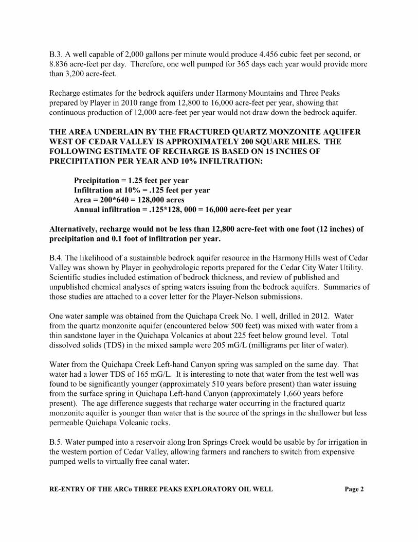
B.3. A well capable of 2,000 gallons per minute would produce 4.456 cubic feet per second, or8.836 acre-feet per day. Therefore, one well pumped for 365 days each year would provide morethan 3,200 acre-feet.
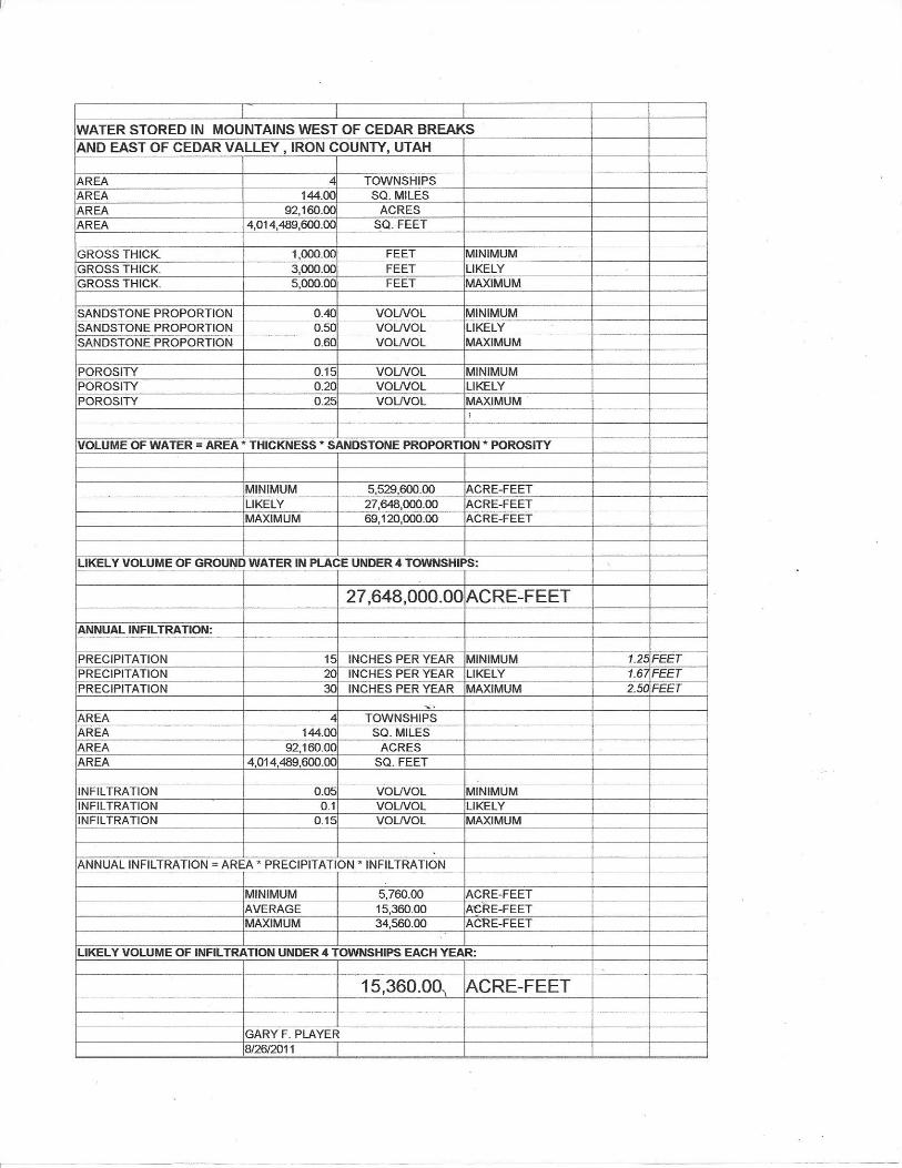
Recharge estimates for the bedrock aquifers under Harmony Mountains and Three Peaksprepared by Player in 2010 range from 12,800 to 16,000 acre-feet per year, showing thatcontinuous production of 12,000 acre-feet per year would not draw down the bedrock aquifer.
THE AREA UNDERLAIN BY THE FRACTURED QUARTZ MONZONITE AQUIFERWEST OF CEDAR VALLEY IS APPROXIMATELY 200 SQUARE MILES. THEFOLLOWING ESTIMATE OF RECHARGE IS BASED ON 15 INCHES OFPRECIPITATION PER YEAR AND 10% INFILTRATION:
Precipitation = 1.25 feet per yearInfiltration at 10% = .125 feet per yearArea = 200*640 = 128,000 acresAnnual infiltration = .125*128, 000 = 16,000 acre-feet per year
Alternatively, recharge would not be less than 12,800 acre-feet with one foot (12 inches) ofprecipitation and 0.1 foot of infiltration per year.
B.4. The likelihood of a sustainable bedrock aquifer resource in the Harmony Hills west of CedarValley was shown by Player in geohydrologic reports prepared for the Cedar City Water Utility. Scientific studies included estimation of bedrock thickness, and review of published andunpublished chemical analyses of spring waters issuing from the bedrock aquifers. Summaries ofthose studies are attached to a cover letter for the Player-Nelson submissions.
One water sample was obtained from the Quichapa Creek No. 1 well, drilled in 2012. Waterfrom the quartz monzonite aquifer (encountered below 500 feet) was mixed with water from athin sandstone layer in the Quichapa Volcanics at about 225 feet below ground level. Totaldissolved solids (TDS) in the mixed sample were 205 mG/L (milligrams per liter of water).
Water from the Quichapa Creek Left-hand Canyon spring was sampled on the same day. Thatwater had a lower TDS of 165 mG/L. It is interesting to note that water from the test well wasfound to be significantly younger (approximately 510 years before present) than water issuingfrom the surface spring in Quichapa Left-hand Canyon (approximately 1,660 years beforepresent). The age difference suggests that recharge water occurring in the fractured quartzmonzonite aquifer is younger than water that is the source of the springs in the shallower but lesspermeable Quichapa Volcanic rocks.
B.5. Water pumped into a reservoir along Iron Springs Creek would be usable by for irrigation inthe western portion of Cedar Valley, allowing farmers and ranchers to switch from expensivepumped wells to virtually free canal water.
RE-ENTRY OF THE ARCo THREE PEAKS EXPLORATORY OIL WELL Page 2
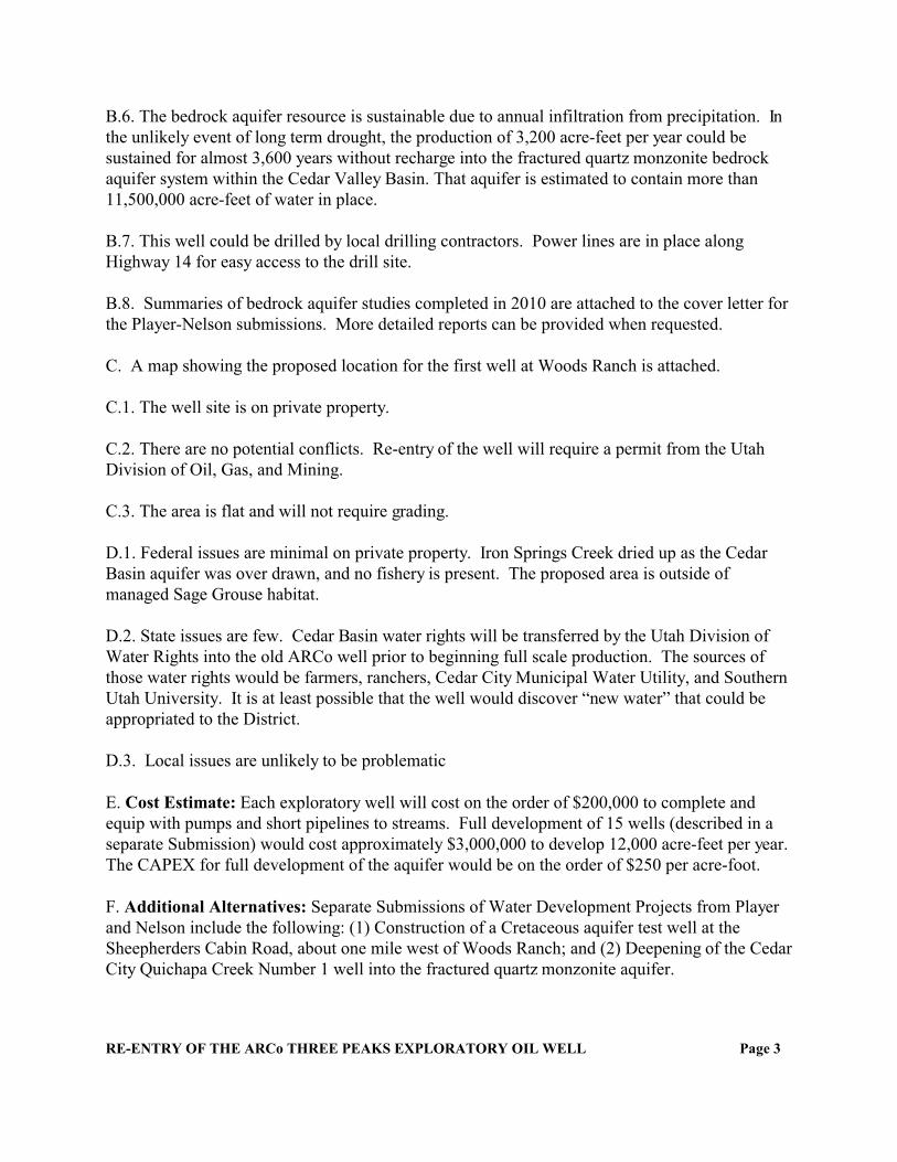
B.6. The bedrock aquifer resource is sustainable due to annual infiltration from precipitation. Inthe unlikely event of long term drought, the production of 3,200 acre-feet per year could besustained for almost 3,600 years without recharge into the fractured quartz monzonite bedrockaquifer system within the Cedar Valley Basin. That aquifer is estimated to contain more than11,500,000 acre-feet of water in place.
B.7. This well could be drilled by local drilling contractors. Power lines are in place alongHighway 14 for easy access to the drill site.
B.8. Summaries of bedrock aquifer studies completed in 2010 are attached to the cover letter forthe Player-Nelson submissions. More detailed reports can be provided when requested.
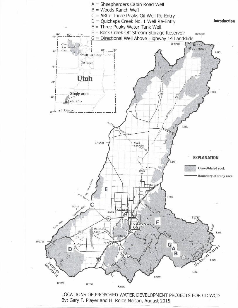
C. A map showing the proposed location for the first well at Woods Ranch is attached.
C.1. The well site is on private property.
C.2. There are no potential conflicts. Re-entry of the well will require a permit from the UtahDivision of Oil, Gas, and Mining.
C.3. The area is flat and will not require grading.
D.1. Federal issues are minimal on private property. Iron Springs Creek dried up as the CedarBasin aquifer was over drawn, and no fishery is present. The proposed area is outside ofmanaged Sage Grouse habitat.
D.2. State issues are few. Cedar Basin water rights will be transferred by the Utah Division ofWater Rights into the old ARCo well prior to beginning full scale production. The sources ofthose water rights would be farmers, ranchers, Cedar City Municipal Water Utility, and SouthernUtah University. It is at least possible that the well would discover “new water” that could beappropriated to the District.
D.3. Local issues are unlikely to be problematic
E. Cost Estimate: Each exploratory well will cost on the order of $200,000 to complete andequip with pumps and short pipelines to streams. Full development of 15 wells (described in aseparate Submission) would cost approximately $3,000,000 to develop 12,000 acre-feet per year. The CAPEX for full development of the aquifer would be on the order of $250 per acre-foot.
F. Additional Alternatives: Separate Submissions of Water Development Projects from Playerand Nelson include the following: (1) Construction of a Cretaceous aquifer test well at theSheepherders Cabin Road, about one mile west of Woods Ranch; and (2) Deepening of the CedarCity Quichapa Creek Number 1 well into the fractured quartz monzonite aquifer.
RE-ENTRY OF THE ARCo THREE PEAKS EXPLORATORY OIL WELL Page 3
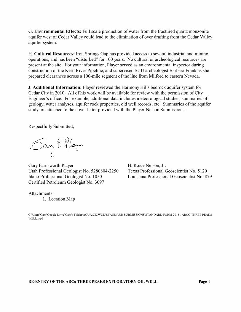
G. Environmental Effects: Full scale production of water from the fractured quartz monzoniteaquifer west of Cedar Valley could lead to the elimination of over drafting from the Cedar Valleyaquifer system.
H. Cultural Resources: Iron Springs Gap has provided access to several industrial and miningoperations, and has been “disturbed” for 100 years. No cultural or archeological resources arepresent at the site. For your information, Player served as an environmental inspector duringconstruction of the Kern River Pipeline, and supervised SUU archeologist Barbara Frank as sheprepared clearances across a 100-mile segment of the line from Milford to eastern Nevada.
J. Additional Information: Player reviewed the Harmony Hills bedrock aquifer system forCedar City in 2010. All of his work will be available for review with the permission of CityEngineer’s office. For example, additional data includes meteorological studies, summaries ofgeology, water analyses, aquifer rock properties, old well records, etc. Summaries of the aquiferstudy are attached to the cover letter provided with the Player-Nelson Submissions.
Respectfully Submitted,
Gary Farnsworth Player H. Roice Nelson, Jr.Utah Professional Geologist No. 5280804-2250 Texas Professional Geoscientist No. 5120Idaho Professional Geologist No. 1050 Louisiana Professional Geoscientist No. 879Certified Petroleum Geologist No. 3097
Attachments:1. Location Map
C:\Users\Gary\Google Drive\Gary's Folder\AQUA\CICWCD\STANDARD SUBMISSIONS\STANDARD FORM 20151 ARCO THREE PEAKSWELL.wpd
RE-ENTRY OF THE ARCo THREE PEAKS EXPLORATORY OIL WELL Page 4
STANDARD FORM 2015-1 (06/2015)
SUBMISSION OF WATER DEVELOPMENT PROJECTS:DEEPENING AND TESTING THE QUICHAPA CREEK NO. 1 EXPLORATORY WELL
____________________________________________________________________________
Through the development of scientific studies defining the aquifer within the Cedar Basin it has been documented that additionalwater resources will be necessary to sustain the growth and further development of the area. Without water the future economicdevelopment will be impacted by the availability and cost of existing water supplies to accommodate only the growth capablewithin our current water budget. This form is being circulated to document additional water supply sources that could be utilizedto further alleviate the water deficit in the aquifer, as well as provide water for the future residents of the valley. This form willbe evaluated for completeness of content. Please ensure that the proposed project is fully defined and information to substantiatethe claim is submitted for a complete evaluation.
____________________________________________________________________________Name and Address of Applicant Name, Title, and Address of authorized Agent
Gary F. Player H. Roice Nelson, Jr.1671 W 546 S 2155 W 700 S, No. 31Cedar City, Utah 84720 Cedar City, Utah [email protected] [email protected]
A. Provide names, addresses, phone numbers and email addresses of those who filled out this form.
See above.
B. Project Description With Vital Details.1. Scope of Work and Project Description2. Type of System or Facility3. Quantity of Water Anticipated4. Scientific Analysis of Water Resource5. Uses (irrigation, culinary, industrial, etc.)6. Years Resource is Available7. Constructability8. Additional information to describe resource and availability (additional sheets provided)
B.1. This project is an opportunity to develop ground water from the fractured quartz monzonitebedrock aquifer within the western portion of the Cedar Valley basin as defined by the UtahDivision of Water Rights (UDWR). The availability of large quantities of water would beproven initially with the deepening of one 702 feet deep, suspended water well near theconvergence of the left and right-hand canyon branches of Quichapa Creek. That Cedar City wellwas drilled on SITLA lands. The well should be re-entered and deepened to approximately 1,200feet below ground level, with projected sustainable productivity of up to 2,000 gallons perminute. Produced water could initially be pumped into an existing Cedar City culinary waterpipeline now carrying waters from two Quichapa Creek springs. Produced water could also beinjected into one or more existing Quichipa Lake wells, and allowed to percolate into the CedarValley alluvial basin.
B.2. This well would be one of an eventual larger set of wells utilized to reduce over drafting ofthe Cedar Valley Basin alluvial aquifer system. Water could be utilized for industrial,agricultural, and culinary purposes. The well location is near to existing power lines, pipelines,and roads so that only minimal new development would be necessary to test the concept.
B.3. A well capable of 2,000 gallons per minute would produce 4.456 cubic feet per second, or8.836 acre-feet per day. Therefore, one well pumped for 365 days each year would provide morethan 3,200 acre-feet.
The ARCo well drilled in Iron Springs Gap disclosed about 4,000 feet of intrusive quartzmonzonite, while at least 3,000 feet are revealed at the outcrops (surface exposures) in the PineValley Mountains.
Recharge estimates for the fractured bedrock aquifers prepared by Player in 2010 range from12,800 to 16,000 acre-feet per year, showing that continuous production of 12,000 acre-feet peryear would not draw down the bedrock aquifer:
THE AREA UNDERLAIN BY THE FRACTURED QUARTZ MONZONITE AQUIFERWEST OF CEDAR VALLEY IS APPROXIMATELY 200 SQUARE MILES. THEFOLLOWING ESTIMATE OF RECHARGE IS BASED ON 15 INCHES OFPRECIPITATION PER YEAR AND 10% INFILTRATION:
Precipitation = 1.25 feet per yearInfiltration at 10% = .125 feet per yearArea = 200*640 = 128,000 acresAnnual infiltration = .125*128, 000 = 16,000 acre-feet per year
Alternatively, recharge would not be less than 12,800 acre-feet with one foot (12 inches) ofprecipitation and 0.1 foot of infiltration per year.
B.4. The likelihood of a sustainable bedrock aquifer resource in the Harmony Hills west of CedarValley was shown by Player in geohydrologic reports prepared for the Cedar City Water Utility. Scientific studies included estimation of bedrock thickness, and review of published andunpublished chemical analyses of spring waters issuing from the bedrock aquifers. Summaries ofthose studies are attached to the cover letter accompanying this Submission.
One water sample was obtained from the Quichapa Creek No. 1 well, drilled in 2012. Waterfrom the quartz monzonite aquifer (encountered below 500 feet) was mixed with water from athin sandstone layer in the Quichapa Volcanics at about 225 feet below ground level. Totaldissolved solids (TDS) in the mixed sample were 205 mG/L (milligrams per liter of water).
Water from the Quichapa Creek Left-hand Canyon spring was sampled on the same day. Thatwater had a lower TDS of 165 mG/L. It is interesting to note that water from the test well wasfound to be significantly younger (approximately 510 years before present) than water issuingfrom the surface spring in Quichapa Left-hand Canyon (approximately 1,660 years beforepresent). The age difference suggests that recharge water occurring in the fractured quartzmonzonite aquifer is younger than water that is the source of the springs in the shallower but lesspermeable Quichapa Volcanic rocks.
DEEPENING AND TESTING THE QUICHAPA CREEK NO. 1 EXPLORATORY WELL Page 2
B.5. Water pumped into a pipeline along Quichapa Creek would be usable by for culinary waterof irrigation in the western portion of Cedar Valley. Alternatively, the “new” water could beused to recharge the Cedar Valley aquifer system through drawn down Quichapa Lake wells.
B.6. The bedrock aquifer resource is sustainable due to annual infiltration from precipitation (seeabove). In the unlikely event of long term drought, the production of 3,200 acre-feet per yearcould be sustained for more than 3,600 years without any recharge into the fractured quartzmonzonite bedrock aquifer system (at least 3,000 feet thick, with 3 percent fracture porosity)beneath the westernmost portion of the Cedar Valley Basin. That aquifer is estimated to containmore than 11,500,000 acre-feet of water in place.
B.7. This well could be deepened and completed by local drilling contractors. Power lines and aroad are in place for easy access to the drill site.
B.8. Summaries of bedrock aquifer studies completed in 2010 are attached to the cover letter. More detailed reports can be provided when requested.
C. A map showing the location of the Quichapa Creek No. 1 well is attached.
C.1. The Quichapa Creek well was drilled on SITLA lands.
C.2. Agreements with nearby surface owners at Quichapa Creek is likely. Power lines and waterlines already cross the Bumble Bee Road right of way.
C.3. Roads and pipelines are already constructed. The well head (casing) is in place.
D.1. Federal issues are minimal at Quichapa Creek. The entire proposed area is outside ofmanaged Sage Grouse Habitat.
D.2. State issues are few. Cedar Basin water rights will be transferred by the Utah Division ofWater Rights into the ARCo well prior to beginning full scale production. The sources of thosewater rights would be farmers, ranchers, Cedar City Municipal Water Utility, and Southern UtahUniversity. It is at least possible that the well would discover “new water” that could beappropriated to the District. Permits to reenter the well must be obtained from the Utah Divisionof Water Rights.
D.3. Local issues are few.
E. Cost Estimate: Costs to reenter the well will be on the order of $150,000 to complete andequip with pumps and a short pipeline (less than 100 feet).
DEEPENING AND TESTING THE QUICHAPA CREEK NO. 1 EXPLORATORY WELL Page 3
F. Additional Alternatives: Separate Submissions of Water Development Projects from Playerand Nelson include the following: (1) Construction of a Cretaceous aquifer test well at theSheepherders Cabin Road, about one mile west of Woods Ranch; and (2) Reentry of the ARCoThree Peaks No. 1 Exploratory Oil Well.
G. Environmental Effects: Injection of water into Quichapa Lake wells would aid in therecharge of Cedar Valley Basin aquifer(s)
H. Cultural Resources: No cultural or archeological resources are present at the site. The sitewas inspected and cleared prior to commencement of drilling in 2012. For your information,Player served as an environmental inspector during construction of the Kern River Pipeline, andsupervised SUU archeologist Barbara Frank as she prepared clearances across a 100-milesegment of the line from Milford to eastern Nevada.
I. Additional Information: Player reviewed the fractured quartz monzonite bedrock aquifersystem for Cedar City in 2010. All of his work will be available for review with the permissionof City Engineer’s office. For example, additional data includes meteorological studies,summaries of geology, water analyses, aquifer rock properties (matrix porosity and fracturesystems), old well records, etc. Summaries of the aquifer study are attached to the cover letterthat accompanies this Submission.
Respectfully Submitted,
Gary Farnsworth Player H. Roice Nelson, Jr.Utah Professional Geologist No. 5280804-2250 Texas Professional Geoscientist No. 5120Idaho Professional Geologist No. 1050 Louisiana Professional Geoscientist No. 879Certified Petroleum Geologist No. 3097
Attachments:1. Location Map
C:\Users\Gary\Google Drive\Gary's Folder\AQUA\CICWCD\STANDARD SUBMISSIONS\STANDARD FORM 20151 QUICHAPA CREEKWELL REENTRY.wpd
DEEPENING AND TESTING THE QUICHAPA CREEK NO. 1 EXPLORATORY WELL Page 4

STANDARD FORM 2015-1 (06/2015)
SUBMISSION OF WATER DEVELOPMENT PROJECTS:CRETACEOUS BEDROCK WELL AT SHEEPHERDERS CABIN ROAD
____________________________________________________________________________
Through the development of scientific studies defining the aquifer within the Cedar Basin it has been documented that additionalwater resources will be necessary to sustain the growth and further development of the area. Without water the future economicdevelopment will be impacted by the availability and cost of existing water supplies to accommodate only the growth capablewithin our current water budget. This form is being circulated to document additional water supply sources that could be utilizedto further alleviate the water deficit in the aquifer, as well as provide water for the future residents of the valley. This form willbe evaluated for completeness of content. Please ensure that the proposed project is fully defined and information to substantiatethe claim is submitted for a complete evaluation.
____________________________________________________________________________Name and Address of Applicant Name, Title, and Address of authorized Agent
Gary F. Player H. Roice Nelson, Jr.1671 W 546 S 2155 W 700 S, No. 31Cedar City, Utah 84720 Cedar City, Utah [email protected] [email protected]
A. Provide names, addresses, phone numbers and email addresses of those who filled out this form.
See above.
B. Project Description With Vital Details.1. Scope of Work and Project Description2. Type of System or Facility3. Quantity of Water Anticipated4. Scientific Analysis of Water Resource5. Uses (irrigation, culinary, industrial, etc.)6. Years Resource is Available7. Constructability8. Additional information to describe resource and availability (additional sheets provided)
B.1. This project is an opportunity to develop ground water from porous bedrock aquifers withinthe eastern portion of the Cedar Valley basin as defined by the Utah Division of Water Rights(UDWR). The availability of water would be proven initially with the completion of one wellsouth of Utah Highway 14. The first well would be drilled along Sheepherders Cabin Road onlands owned by Southern Utah University. The well would be drilled to a depth of 500 to 1,000feet, with projected sustainable productivity of 1,000 to 1,500 gallons per minute. Producedwater would be pumped into a tributary of Crow Creek, and allowed to flow down Crow Creekto its intersection with Ashdown Creek (where it becomes Coal Creek). Water could then bedirected to a proposed off stream storage facility along Rock Creek, or be allowed to flow intoCedar Valley via existing stream channels and newly constructed canals.
B.2. This well would be one of an eventual larger set of wells utilized to stabilize flow in theCoal Creek drainage system throughout the spring and summer months. Water could be utilizedfor both agricultural and culinary purposes. The well location is near to existing power lines andCrow Creek so that only minimal new development would be necessary to test the concept.
B.3. Each well capable of 1,000 gallons per minute would produce 2.228 cubic feet per second,or 4.418 acre-feet per day. Therefore, one well pumped for 182 days each year would provideslightly more than 800 acre-feet. Eventual development of only five wells could provide about4,000 acre-feet in the same period of time. A development of 15 wells, each producing 1,000gallons per minute, would provide approximately 12,000 acre-feet in six months, allowing wellsin the valley floor to be shut-in, so that all over-drafting of the valley aquifers could beeliminated. Recharge estimates for the bedrock aquifers prepared by Player in 2010 range from10,000 to 15,000 acre-feet per year, showing that continuous production of 12,000 acre-feet peryear would not draw down the bedrock aquifer.
B.4. The likelihood of a sustainable bedrock aquifer resource in the western portion of theMarkagunt Plateau was shown by Player in geohydrologic reports prepared for the Cedar CityWater Utility. Scientific studies included estimation of bedrock thickness, laboratorymeasurements of aquifer porosity, and review of published and unpublished chemical analyses ofspring waters issuing from the bedrock aquifers. Summaries of those studies are attached to acover letter delivered with this Submission.
Water samples from Cedar City springs developed in Right Hand Canyon, south of Coal Creek,averaged 230 -250 mG/L of Total Dissolved Solids (TDS), comparable to water developed inCedar Valley. One sample collected by Player from the “piped spring” exiting CretaceousStraight Cliffs Sandstones due east of the major landslide along Highway 14 was analyzed at theSUU water laboratory in December of 2014. That sample had at a TDS of 230 mG/L, the sameas the waters issuing from springs in Cretaceous bedrock at Right Hand Canyon.
B.5. Water pumped into Coal Creek would be usable by for irrigation in Cedar Valley, allowingfarmers and ranchers to switch from expensive pumped wells to virtually free canal water. Waterstored at Rock Creek (to be described in a future Submission) or other CICWCD facilities alongCoal Creek would be suitable for domestic and industrial use after suspended solids settled outduring residency in reservoirs.
B.6. The bedrock aquifer resource is sustainable due to annual infiltration from precipitation. Inthe unlikely event of long term drought, the production of 4,000 acre-feet per year could besustained for more than 6,900 years without recharge to that portion of the bedrock aquifersystem within the Cedar Valley Basin estimated to contain more than 27,648,000 acre-feet ofwater in place.
B.7. This well could be drilled by local drilling contractors. Power lines are in place near theSheepherders Cabin Road for easy access to the drill site. Produced water could be piped to aCrow Creek tributary within an economical and short (less than 500 feet) PVC pipeline.
B.8. Summaries of bedrock aquifer studies completed in 2010 are attached to the cover letterreferenced above. More detailed reports can be provided when requested.
CRETACEOUS BEDROCK WELL AT SHEEPHERDERS CABIN ROAD Page 2
C. A map showing the proposed location for the first well at Sheepherders Cabin road isattached.
C.1. The first test well would be drilled on lands owned by Southern Utah University.
C.2. Rapid agreement with surface owners at SUU is likely. Power lines and water lines willcross an SUU right of way, requiring negotiated access.
C.3. The proposed test well location is on private, developed lands. A well at SheepherdersCabin Road would require a power line to be constructed across an SUU road. Produced watercould be directed to Crow Creek through a tributary channel, less than 500 feet away from theproposed drill site.
D.1. Federal issues are minimal on private property. Crow Creek and Coal Creek are bothcertified as having no fishery. The entire proposed area is outside of designated Sage GrouseHabitat.
D.2. State issues are few. Proposed stream flow maintenance could be done at rates that do notexceed 35 cubic feet per second, rates routinely exceeded naturally during spring run off. CedarBasin water rights will be transferred by the Utah Division of Water Rights into each well priorto beginning full scale production. The sources of those water rights would be farmers, ranchers,Cedar City Municipal Water Utility, and Southern Utah University. It is at least possible that thewells would discover “new water” that could be appropriated to the District.
D.3. Local issues are unlikely to be problematic.
E. Cost Estimate: An exploratory well will cost on the order of $200,000 to complete and equipwith pumps and short pipelines to streams. A full scale development of 15 wells would costapproximately $3,000,000 to produce 12,000 acre-feet per year. The CAPEX for fulldevelopment of the aquifer would be on the order of $250 per acre-foot.
F. Additional Alternatives: Separate Submissions of Water Development Projects from Playerand Nelson include the following: (1) A re-entry of the ARCo Three Peaks well to test thefractured quartz monzonite aquifer at Iron Springs; and (2) Deepening of the Cedar CityQuichapa Creek Number 1 well into the fractured quartz monzonite aquifer.
F. Environmental Effects: Continuous summertime flow of Coal Creek could possibly allowthe establishment of a trout fishery. Eventual construction of off-stream storage at Rock Creekwould allow development of both trout and bass fisheries.
H. Cultural Resources: No cultural or archeological resources are present at the site. For yourinformation, Player served as an environmental inspector during construction of the Kern RiverPipeline, and supervised SUU archeologist Barbara Frank as she prepared clearances across a100-mile segment of the line from Milford to eastern Nevada.
CRETACEOUS BEDROCK WELL AT SHEEPHERDERS CABIN ROAD Page 3
I. Additional Information: Player reviewed the Markagunt Plateau bedrock aquifer system forCedar City in 2010. All of his work will be available for review with the permission of the CityEngineer’s office. For example, additional data includes meteorological studies, summaries ofgeology, water analyses, aquifer rock properties (matrix porosity and fracture systems), old wellrecords, etc. Summaries of the aquifer study are attached to the cover letter accompanying thisSubmission.
Respectfully Submitted,
Gary Farnsworth Player H. Roice Nelson, Jr.Utah Professional Geologist No. 5280804-2250 Texas Professional Geoscientist No. 5120Idaho Professional Geologist No. 1050 Louisiana Professional Geoscientist No. 879Certified Petroleum Geologist No. 3097
Attachments:1. Location Map
C:\Users\Gary\Google Drive\Gary's Folder\AQUA\CICWCD\STANDARD SUBMISSIONS\STANDARD FORM 20151 SHEEPHERDERSCABIN WELL.wpd
CRETACEOUS BEDROCK WELL AT SHEEPHERDERS CABIN ROAD Page 4
STANDARD FORM 2015-1 (06/2015)
SUBMISSION OF WATER DEVELOPMENT PROJECTS:EXPLORATORY WELL AT THE WATER TANK NEAR THREE PEAKS REC AREA
____________________________________________________________________________
Through the development of scientific studies defining the aquifer within the Cedar Basin it has been documented that additionalwater resources will be necessary to sustain the growth and further development of the area. Without water the future economicdevelopment will be impacted by the availability and cost of existing water supplies to accommodate only the growth capablewithin our current water budget. This form is being circulated to document additional water supply sources that could be utilizedto further alleviate the water deficit in the aquifer, as well as provide water for the future residents of the valley. This form willbe evaluated for completeness of content. Please ensure that the proposed project is fully defined and information to substantiatethe claim is submitted for a complete evaluation.
____________________________________________________________________________Name and Address of Applicant Name, Title, and Address of authorized Agent
Gary F. Player Roice Nelson1671 W 546 S 2155 W 700 S, No. 31Cedar City, Utah 84720 Cedar City, Utah [email protected] [email protected]
A. Provide names, addresses, phone numbers and email addresses of those who filled out this form.
See above.
B. Project Description With Vital Details.1. Scope of Work and Project Description2. Type of System or Facility3. Quantity of Water Anticipated4. Scientific Analysis of Water Resource5. Uses (irrigation, culinary, industrial, etc.)6. Years Resource is Available7. Constructability8. Additional information to describe resource and availability (additional sheets provided)
B.1. This project is an opportunity to develop ground water from the fractured quartz monzonitebedrock aquifer within the western portion of the Cedar Valley basin as defined by the UtahDivision of Water Rights (UDWR). The availability of large quantities of water would beproven by a well drilled adjacent to the water storage tank at the west end of Mid Valley Road inEnoch. Produced water could initially be pumped into the existing CICWCD tank now used topressurize a culinary water pipeline.
B.2. This well would be one of an eventual larger set of wells utilized to reduce over drafting ofthe Cedar Valley Basin alluvial aquifer system. Water could be utilized for industrial,agricultural, and culinary purposes. The well location is near to existing power lines, pipelines,and roads so that only minimal new development would be necessary to test the concept.
B.3. A well capable of 2,000 gallons per minute would produce 4.456 cubic feet per second, or8.836 acre-feet per day. Therefore, one well pumped for 365 days each year would provide morethan 3,200 acre-feet. The ARCo well drilled in Iron Springs Gap disclosed about 4,000 feet ofintrusive quartz monzonite, while about 3,000 feet are revealed at the outcrops (surfaceexposures) in the Pine Valley Mountains and Three Peaks east of Iron Springs Gap.
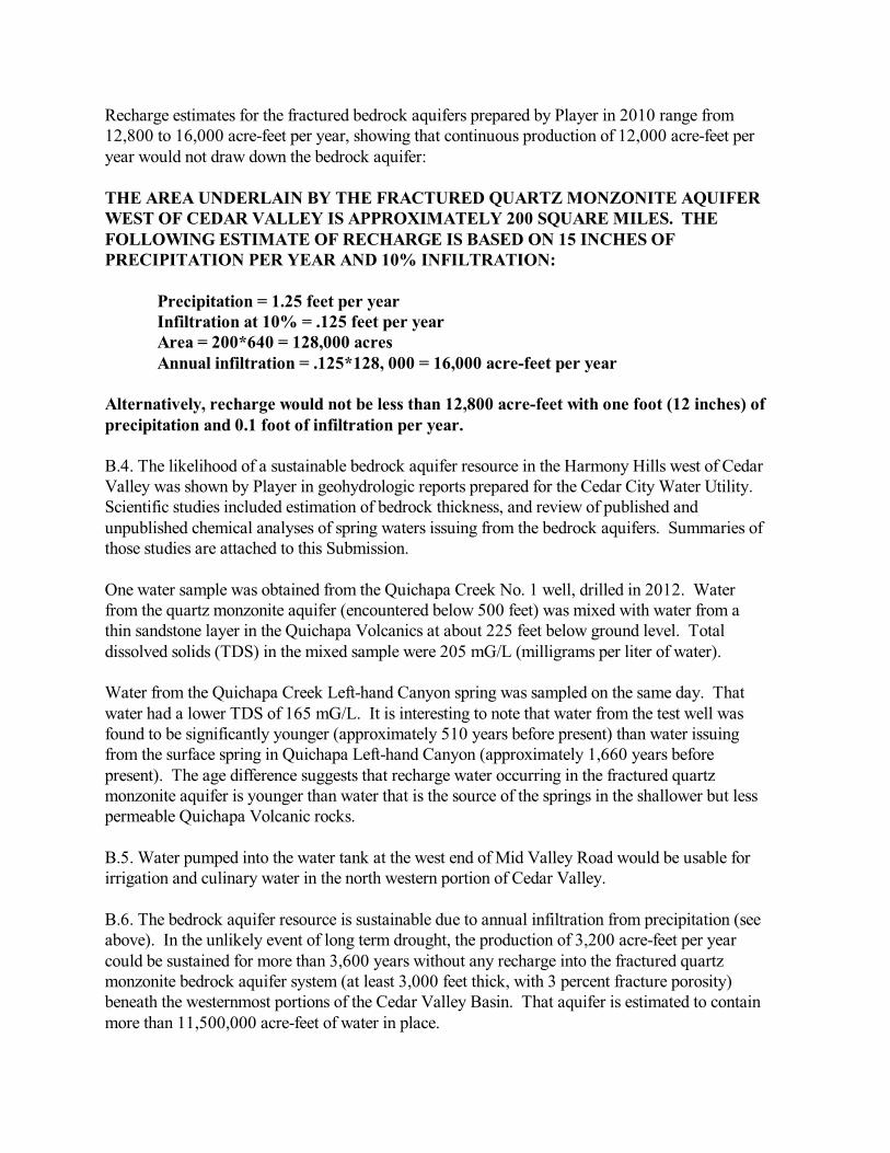
Recharge estimates for the fractured bedrock aquifers prepared by Player in 2010 range from12,800 to 16,000 acre-feet per year, showing that continuous production of 12,000 acre-feet peryear would not draw down the bedrock aquifer:
THE AREA UNDERLAIN BY THE FRACTURED QUARTZ MONZONITE AQUIFERWEST OF CEDAR VALLEY IS APPROXIMATELY 200 SQUARE MILES. THEFOLLOWING ESTIMATE OF RECHARGE IS BASED ON 15 INCHES OFPRECIPITATION PER YEAR AND 10% INFILTRATION:
Precipitation = 1.25 feet per yearInfiltration at 10% = .125 feet per yearArea = 200*640 = 128,000 acresAnnual infiltration = .125*128, 000 = 16,000 acre-feet per year
Alternatively, recharge would not be less than 12,800 acre-feet with one foot (12 inches) ofprecipitation and 0.1 foot of infiltration per year.
B.4. The likelihood of a sustainable bedrock aquifer resource in the Harmony Hills west of CedarValley was shown by Player in geohydrologic reports prepared for the Cedar City Water Utility. Scientific studies included estimation of bedrock thickness, and review of published andunpublished chemical analyses of spring waters issuing from the bedrock aquifers. Summaries ofthose studies are attached to this Submission.
One water sample was obtained from the Quichapa Creek No. 1 well, drilled in 2012. Waterfrom the quartz monzonite aquifer (encountered below 500 feet) was mixed with water from athin sandstone layer in the Quichapa Volcanics at about 225 feet below ground level. Totaldissolved solids (TDS) in the mixed sample were 205 mG/L (milligrams per liter of water).
Water from the Quichapa Creek Left-hand Canyon spring was sampled on the same day. Thatwater had a lower TDS of 165 mG/L. It is interesting to note that water from the test well wasfound to be significantly younger (approximately 510 years before present) than water issuingfrom the surface spring in Quichapa Left-hand Canyon (approximately 1,660 years beforepresent). The age difference suggests that recharge water occurring in the fractured quartzmonzonite aquifer is younger than water that is the source of the springs in the shallower but lesspermeable Quichapa Volcanic rocks.
B.5. Water pumped into the water tank at the west end of Mid Valley Road would be usable forirrigation and culinary water in the north western portion of Cedar Valley.
B.6. The bedrock aquifer resource is sustainable due to annual infiltration from precipitation (seeabove). In the unlikely event of long term drought, the production of 3,200 acre-feet per yearcould be sustained for more than 3,600 years without any recharge into the fractured quartzmonzonite bedrock aquifer system (at least 3,000 feet thick, with 3 percent fracture porosity)beneath the westernmost portions of the Cedar Valley Basin. That aquifer is estimated to containmore than 11,500,000 acre-feet of water in place.
B.7. This well could be deepened and completed by local drilling contractors. Power lines and aroad are in place for easy access to the drill site.
B.8. Several residential wells have been drilled within one to two miles of the water tank. Welllogs available from the UDWR show that weathered soils are underlain by “rocks” variouslydescribed as “layers of rocks with water,” “gravel,” and “granite.” Water levels in all of thewells were reported as 150 to 300 feet below ground level. A well at the SW corner of section 7,T. 35 S., R. 11 W. produced 200 gallons per minute with 40 feet of drawdown in 6" casing fromperforations ranging from 240 to 420 feet below ground. The closest well log in section 14 of T.35 S., R. 12 W. first reported “Rocks” at 240 feet BGL. All of the residential wells wereterminated after the shallowest occurrence of ground water, generally described as wateroccurring in gravel or rock “layers.” These could best be interpreted as fracture systems inbedrock.
Summaries of bedrock aquifer studies completed in 2010 are attached. More detailed reports canbe provided when requested.
C. A map showing the location of the Water Tank well is attached.
C.1. The water tank was constructed on lands controlled by CICWCD.
C.2. Agreements with surface owners is likely. Power lines and water lines are in place.
C.3. Local issues are not likely to arise.
D.1. Federal issues are minimal. The entire proposed area is outside of managed Sage GrouseHabitat.
D.2. State issues are few. Cedar Basin water rights will be transferred by the Utah Division ofWater Rights into the Water Tank well prior to beginning full scale production. The sources ofthose water rights would be farmers, ranchers, Cedar City Municipal Water Utility, and SouthernUtah University. It is at least possible that the well would discover “new water” that could beappropriated to the District. Permits to reenter the well must be obtained from the Utah Divisionof Water Rights.
D.3. Local issues are few.
E. Cost Estimate: Costs to drill the well will be on the order of $150,000 to complete and equipwith pumps and a short pipeline to the water tank.
Submission of Water Development Project: Three Peaks Water Tank WellGary F. Player, Utah Professional Geologist No. 5280804-2250Roice Nelson, Texas Professional Geoscientist No. 5120, Page 3
F. Additional Alternatives: Separate Submissions of Water Development Projects from Playerand Nelson include the following: (1) Construction of a Cretaceous aquifer test well at theSheepherders Cabin Road, about one mile west of Woods Ranch; (2) Construction of aCretaceous aquifer test well at Woods Ranch Park; (3) Reentry of the ARCo Three Peaks No. 1Exploratory Oil Well; (4) Construction of an approximately 6,000 acre-feet off-stream storagereservoir at Rock Creek, upstream from Rusty’s Ranch House restaurant; (5) Re-entry andcompletion to1,200 feet of the Cedar City Quichapa Creek No. 1 well; (6) Construction of adirectional well through the Straight Cliffs (Cretaceous) rocks above the major landslide alongHighway 14. That well could drain water from the bedrock cliff south of the Highway andreduce the danger of recurring landslides southeast of the highway; and (7) Construction ofsufficient wells in the bedrock aquifer(s) to eliminate over drafting of the Cedar Valley Basinaquifer(s).
G. Environmental Effects: The proposed location is barren, having been cleared prior toconstruction of the CICWCD water tank.
H. Cultural Resources: No cultural or archeological resources are present at the site. For yourinformation, Player served as an environmental inspector during construction of the Kern RiverPipeline, and supervised SUU archeologist Barbara Frank as she prepared clearances across a100-mile segment of the line from Milford to eastern Nevada.
I. Additional Information: Player reviewed the fractured quartz monzonite bedrock aquifersystem for Cedar City in 2010. All of his work will be available for review with the permissionof City Engineer’s office. For example, additional data includes meteorological studies,summaries of geology, water analyses, aquifer rock properties (matrix porosity and fracturesystems), old well records, etc. Summaries of the aquifer study are attached to this Submission.
Respectfully Submitted,
Gary Farnsworth Player Roice NelsonUtah Professional Geologist No. 5280804-2250 Texas Professional Geoscientist No. 5120Idaho Professional Geologist No. 1050 Louisiana Professional Geoscientist No. 879Certified Petroleum Geologist No. 3097
Attachments:
Submission of Water Development Project: Three Peaks Water Tank WellGary F. Player, Utah Professional Geologist No. 5280804-2250Roice Nelson, Texas Professional Geoscientist No. 5120, Page 4
1. Location Map2.
C:\Users\Gary\Google Drive\Gary's Folder\AQUA\CICWCD\STANDARD SUBMISSIONS\STANDARD FORM 20151 WATER TANK WELLAT THREE PEAKS REC AREA.wpd
Submission of Water Development Project: Three Peaks Water Tank WellGary F. Player, Utah Professional Geologist No. 5280804-2250Roice Nelson, Texas Professional Geoscientist No. 5120, Page 5
STANDARD FORM 2015-1 (06/2015)
SUBMISSION OF WATER DEVELOPMENT PROJECTS:WOODS RANCH WELL
____________________________________________________________________________
Through the development of scientific studies defining the aquifer within the Cedar Basin it has been documented that additionalwater resources will be necessary to sustain the growth and further development of the area. Without water the future economicdevelopment will be impacted by the availability and cost of existing water supplies to accommodate only the growth capablewithin our current water budget. This form is being circulated to document additional water supply sources that could be utilizedto further alleviate the water deficit in the aquifer, as well as provide water for the future residents of the valley. This form willbe evaluated for completeness of content. Please ensure that the proposed project is fully defined and information to substantiatethe claim is submitted for a complete evaluation.
____________________________________________________________________________Name and Address of Applicant Name, Title, and Address of authorized Agent
Gary F. Player Roice Nelson1671 W 546 S 2155 W 700 S, No. 31Cedar City, Utah 84720 Cedar City, Utah [email protected] [email protected]
A. Provide names, addresses, phone numbers and email addresses of those who filled out this form.
See above.
B. Project Description With Vital Details.1. Scope of Work and Project Description2. Type of System or Facility3. Quantity of Water Anticipated4. Scientific Analysis of Water Resource5. Uses (irrigation, culinary, industrial, etc.)6. Years Resource is Available7. Constructability8. Additional information to describe resource and availability (additional sheets provided)
B.1. This project is an opportunity to develop ground water from porous bedrock aquifers withinthe eastern portion of the Cedar Valley basin as defined by the Utah Division of Water Rights(UDWR). The availability of water would be proven initially with the completion of one welladjacent to Utah Highway 14. The first well would be drilled at Woods Ranch Park on landsowned by Iron County. The well would be drilled to a depth of 500 to 1,000 feet, with projectedsustainable productivity of 1,000 to 1,500 gallons per minute. Produced water would be pumpedinto Crow Creek, and allowed to flow down Crow Creek to its intersection with Ashdown Creek(where it becomes Coal Creek). Water could then be directed to a proposed storage facility alongRock Creek, or be allowed to flow into Cedar Valley via existing stream channels and newlyconstructed canals.
B.2. This well would be one of an eventual larger set of wells utilized to stabilize flow in theCoal Creek drainage system throughout the spring and summer months. Water could be utilizedfor both agricultural and culinary purposes. The well location is near to existing power lines andCrow Creek so that only minimal new development would be necessary to test the concept.
B.3. Each well capable of 1,000 gallons per minute would produce 2.228 cubic feet per second,or 4.418 acre-feet per day. Therefore, one well pumped for 182 days each year would provideslightly more than 800 acre-feet. As described in a separate Submission, eventual developmentof only five wells could provide about 4,000 acre-feet in the same period of time. Adevelopment of 15 wells, each producing 1,000 gallons per minute, would provide approximately12,000 acre-feet in six months, allowing wells in the valley floor to be shut-in, so that all over-drafting of the valley aquifers could be eliminated.
Recharge estimates for the bedrock aquifers prepared by Player in 2010 range from 10,000 to15,000 acre-feet per year, showing that continuous production of 12,000 acre-feet per year wouldnot draw down the bedrock aquifer.
B.4. The likelihood of a sustainable bedrock aquifer resource in the western portion of theMarkagunt Plateau was shown by Player in geohydrologic reports prepared for the Cedar CityWater Utility. Scientific studies included estimation of bedrock thickness, laboratorymeasurements of aquifer porosity, and review of published and unpublished chemical analyses ofspring waters issuing from the bedrock aquifers. Summaries of those studies are attached to thisSubmission.
Water samples from Cedar City springs developed in Right Hand Canyon, south of Coal Creek,averaged 230 -250 mG/L of Total Dissolved Solids (TDS), comparable to water developed inCedar Valley. One sample collected by Player from the “piped spring” exiting CretaceousStraight Cliffs Sandstones due east of the major landslide along Highway 14 was analyzed at theSUU water laboratory in December of 2014. That sample had at a TDS of 230 mG/L, the sameas the waters issuing from springs in Cretaceous bedrock at Right Hand Canyon.
B.5. Water pumped into Coal Creek would be usable by for irrigation in Cedar Valley, allowingfarmers and ranchers to switch from expensive pumped wells to virtually free canal water. Waterstored at Rock Creek (described in a separate Submission) or other CICWCD facilities alongCoal Creek would be suitable for domestic and industrial use after suspended solids were settledout during residency in reservoirs.
B.6. The bedrock aquifer resource is sustainable due to annual infiltration from precipitation. Inthe unlikely event of long term drought, the production of 800 acre-feet per year could besustained for more than 34,000 years without recharge in the bedrock aquifer system within theCedar Valley Basin estimated to contain more than 27,648,000 acre-feet of water in place.
B.7. This well could be drilled by local drilling contractors. Power lines are in place alongHighway 14 for easy access to the drill site. Produced water could be piped to Crow Creekwithin an economical and short (generally less than 500 feet) PVC pipeline.
B.8. Summaries of bedrock aquifer studies completed in 2010 are attached. More detailedreports can be provided when requested.
C. A map showing the proposed location for the first well at Woods Ranch is attached.
C.1. The first test well would be drilled at Woods Ranch Park on lands owned by Iron County.
C.2. Agreements with surface owners at Woods Ranch is assured. Power lines and water lineswill cross the Highway 14 right of way, requiring negotiated access.
C.3. The proposed test well location is on private, developed lands. A well at Woods Ranchwould require a power line to be constructed across Highway 14. Produced water could bedirected to Crow Creek through an existing culvert under Highway 14, or through a new pipelineto be buried under the right of way if such a culvert does not exist.
D.1. Federal issues are minimal on county-owned property. Crow Creek and Coal Creek are bothcertified as having no fishery. The entire proposed area is outside of designated Sage GrouseHabitat.
D.2. State issues are few. Proposed stream flow maintenance will be done at rates that do notexceed 35 cubic feet per second, rates routinely exceeded during spring run off. Cedar Basinwater rights will be transferred by the Utah Division of Water Rights into each well prior tobeginning full scale production. The sources of those water rights would be farmers, ranchers,Cedar City Municipal Water Utility, and Southern Utah University. It is at least possible that thewells would discover “new water” that could be appropriated to the District.
D.3. Iron County Commission has already approved an exploratory well at Woods Ranch. Thedrilling permit from UDWR has expired, and must be renewed.
E. Cost Estimate: Each exploratory well will cost on the order of $200,000 to complete andequip with pumps and short pipelines to streams. Full development of 15 wells (described in aseparate Submission) would cost approximately $3,000,000 to develop 12,000 acre-feet per year. The CAPEX for full development of the aquifer would be on the order of $250 per acre-foot.
F. Additional Alternatives: Separate Submissions of Water Development Projects from Playerand Nelson include the following: (1) Construction of another Cretaceous aquifer test well at theSheepherders Cabin Road, about one mile west of Woods Ranch; (2) A re-entry of the ARCoThree Peaks well to test the fractured quartz monzonite aquifer at Iron Springs; (3) Deepening ofthe Cedar City Quichapa Creek Number 1 well into the fractured quartz monzonite aquifer; (4)Construction of an approximately 6,000 acre-feet off-stream storage reservoir at Rock Creek,upstream from Rusty’s Ranch House restaurant; (5) Construction of a test well into the fracturedquartz monzonite aquifer east of Three Peaks Park, adjacent to the CICWCD water storage tank;(6) Construction of a directional well through the Straight Cliffs (Cretaceous) rocks above themajor landslide along Highway 14. That well could drain water from the bedrock and reduce thedanger of recurring landslides southeast of the highway; and (7) Construction of sufficient wells
Submission of Water Development Project: Woods Ranch Exploratory Well Gary F. Player, Utah Professional Geologist No. 5280804-2250Roice Nelson, Texas Professional Geoscientist No. 5120, Page 3
in the bedrock aquifer(s) to eliminate over-drafting of the Cedar Valley Basin aquifer(s).
G. Environmental Effects: Continuous summertime flow of Coal Creek could possibly allowthe establishment of a trout fishery. Construction of off-stream storage at Rock Creek wouldallow development of both trout and bass fisheries.
H. Cultural Resources: Woods Ranch is a developed Iron County park that has been“disturbed” for 50 years. The proposed well site is at the NE corner of an open field that hasbeen used by Boy Scouts, families and others for camping and athletics. No cultural orarcheological resources are present at the site. For your information, Player served as anenvironmental inspector during construction of the Kern River Pipeline, and supervised SUUarcheologist Barbara Frank as she prepared clearances across a 100-mile segment of the line fromMilford to eastern Nevada.
I. Additional Information: Player reviewed the Markagunt Plateau bedrock aquifer system forCedar City in 2010. All of his work will be available for review with the permission of CityEngineer’s office. For example, additional data includes meteorological studies, summaries ofgeology, water analyses, aquifer rock properties (matrix porosity and fracture systems), old wellrecords, etc. Summaries of the aquifer study are attached to this Submission.
Respectfully Submitted,
Gary Farnsworth Player Roice NelsonUtah Professional Geologist No. 5280804-2250 Texas Professional Geoscientist No. 5120Idaho Professional Geologist No. 1050 Louisiana Professional Geoscientist No. 879Certified Petroleum Geologist No. 3097
Attachments:1. Location Map2.
C:\Users\Gary\Google Drive\Gary's Folder\AQUA\CICWCD\STANDARD SUBMISSIONS\STANDARD FORM 20151 WOODS RANCHWELL.wpd
Submission of Water Development Project: Woods Ranch Exploratory Well Gary F. Player, Utah Professional Geologist No. 5280804-2250Roice Nelson, Texas Professional Geoscientist No. 5120, Page 4