Embed Size (px)
Citation preview

Nevada Exploration Inc. | Reno, Nevada TSX.V: NGE | OTC: NVDEFwww.nevadaexploration.com
TSX.V: NGE OTCQB: NVDEF
Kelly Creek Project Scorpion Drilling Update
January 2018

Nevada Exploration Inc. | Reno, Nevada TSX.V: NGE | OTC: NVDEFwww.nevadaexploration.com
Disclaimer
This Presentation contains certain "forward-looking statements" including, without limitation, expectations, beliefs, plans and
objectives regarding the timing and nature of estimated future exploration, success of exploration activities, and potential transactions
and ventures discussed. Among the important factors that could cause actual results to differ materially from those indicated by such
forward-looking statements are the risks inherent in mineral exploration, the need to obtain additional financing, environmental
permits, the availability of needed personnel and equipment for exploration and development, fluctuations in the price of minerals,
and general economic conditions.
Wade A. Hodges, CEO of Nevada Exploration Inc., is the Qualified Person, as defined in National Instrument 43-101, and has prepared
the technical and scientific information contained in this Presentation.

Nevada Exploration Inc. | Reno, Nevada TSX.V: NGE | OTC: NVDEFwww.nevadaexploration.com
Kelly Creek Basin
Represents a 1,000 km2 underexplored covered search space along the Cortez Trend, with >70 Moz Au discovered in and near to the ranges immediately surrounding the Basin
NGE’s Kelly Creek Project
Generated based on a systematic, hydrogeochemistry-supported, regional exploration program, which discovered highly-enriched Au in groundwater over shallow bedrock at the Project
NGE has completed a comprehensive geophysical program to project the important structural controls seen in the exposed ranges beneath the Project
NGE has completed systematic Scorpion and other drill sampling to characterize the geochemistry of the groundwater, alluvial cover, and bedrock at the Project to confirm the presence of a mineralized hydrothermal system consistent in scale and composition with a world-class gold deposit
Location and Geologic SettingKelly Creek Project
KellyCreekProject
Inset forlaterslides
Gold Deposits

Nevada Exploration Inc. | Reno, Nevada TSX.V: NGE | OTC: NVDEFwww.nevadaexploration.com
Geology of adjacent major depositsLone Tree (5Moz) - Newmont
Geologic setting and ore controls
Structural controls: the principal ore host at Lone Tree is the Powerline Fault, which strikes NNW, dips steeply to the west, and has a strike length of over 2.4 km; and within the Powerline Fault, the gold mineralization is largely confined to a narrower subzone of intense fracturing and faulting known as the Wayne zone, which is pinched and offset at both ends of Lone Tree Hill by major cross-structures
Host units: gold mineralization occurs in the iron-rich rocks of the Valmy Formation, Antler Sequence, and HavallahSequence, largely as a result of increased permeability due to damage zones along high-angle faults
Significant features for exploration in the area
Major N-S high-angle fault corridors
Strong Au anomaly in rock, soil and groundwater with As, Sb, Hg, Sb, and Tl, but with low Ag/Au<~5 and low base metals Cu+Pb+Zn<~500-1000 ppm
Gold associated with arsenopyrite and multiple stages of pyrite
Powerline Fault

Nevada Exploration Inc. | Reno, Nevada TSX.V: NGE | OTC: NVDEFwww.nevadaexploration.com
Geology of adjacent major depositsMarigold (8Moz) – SSR Mining
100 meters
Source: SSR Mining
NI 43-101 Technical Report on the Marigold Mine
Humboldt County, Nevada
Effective date: November 19, 2014
Geologic setting and ore controls
Structural controls: the Marigold orebodies are largely confined to broad damage zones of increased permeability near fault corridors that were active during mineralization, which are offset, pinch, and swell along a strike length of 10 km
Host units: gold mineralization occurs disseminated in the iron-rich rocks of the Valmy Formation, Antler Sequence, and Havallah Sequence, as well as near dikes, largely as a result of increased permeability within high-angle fault corridors that were active during mineralization
Significant features for exploration
Major N-S high-angle fault corridors
Silicification, argillization, and decalcification of carbonate-bearing lithologies.
Strong Au anomaly in rock and soil with As, Sb, Hg, Sb, and Tl, but with low Ag/Au<~5 and low base metals Cu+Pb+Zn<~500-1000 ppm
Gold associated with arsenopyrite and multiple stages of pyrite

Nevada Exploration Inc. | Reno, Nevada TSX.V: NGE | OTC: NVDEFwww.nevadaexploration.com
Major deposits south of the Kelly Creek Project, at southern end of Kelly Creek Basin
Exposed geologic units and majormapped structures exposed south of the Project
Kelly Creek ProjectNevada Exploration
Marigold (8Moz)SSR Mining
Kelly Creek ProjectNevada ExplorationLone Tree (5Moz)
Newmont
5 km
5 km
Havallah Fm. Siltsone, meta-volc, chert, sandstone, and limestone
Valmy & Harmony Fms.Quartzite, argillite, meta-basalt & chert
Antler SequenceLimestone conglomerate,limestone, sandstone,and siltstone
N NProspect pitsIndicating areasof historicalmininginterest
Intrusion

Nevada Exploration Inc. | Reno, Nevada TSX.V: NGE | OTC: NVDEFwww.nevadaexploration.com
Major mapped structures projected beneathcover supported by air magnetic geophysics
Major mapped structures projectedbeneath cover supported by gravity geophysics
5 km
5 km
N N
N-S
str
uct
ura
l fab
ric
Gra
vity
hig
h(s
hal
low
bed
rock
)
East
ern
fla
nk
Marigold (8Moz)SSR Mining
Lone Tree (5Moz)Newmont
N-S
str
uct
ura
l fab
ric

Nevada Exploration Inc. | Reno, Nevada TSX.V: NGE | OTC: NVDEFwww.nevadaexploration.com
Major mapped structures projected beneathcover supported by seismic geophysics
Major mapped structures projectedbeneath cover supported by CSAMT geophysics
North end ofMarigold deposit
N-S
str
uct
ura
l fab
ric
North end ofMarigold deposit
N-S
str
uct
ura
l fab
ric

Nevada Exploration Inc. | Reno, Nevada TSX.V: NGE | OTC: NVDEFwww.nevadaexploration.com
Kelly Creek Project Geologic SettingResults of mapping and geophysical programs
Marigold(8Moz)
Lone Tree(5Moz)
Kelly CreekProject
Gra
vity
hig
h(s
hal
low
bed
rock
)
East
ern
fla
nk
Host units and controls of gold mineralization
Gold mineralization at Marigold is scattered through broad mineralized fault zones that cut through iron-rich quartzite, siltstone and limestone units. At Lone Tree, higher-grade gold mineralization is focused within a major fault zone that also cuts through iron-rich quartzite, siltstone and limestone units
While the favorable host rock units are widespread at both deposits, the mineralization at Lone Tree and Marigold is confined primarily to major and minor fault zones
Oxidized mineralization at both Marigold and Lone Tree started at depths of 75 m and continued to depths greater than 450 m, becoming more un-oxidized with depth. SSR is currently exploring beneath Marigold at depths >900 m
Projection of favourable geology at Kelly Creek Project
Based on the combined gravity, air magnetic, seismic, and CSAMT datasets, the favourable geology (host units and structural controls) associated with the adjacent Lone Tree and Marigold deposits project northwards to the Kelly Creek Project area, under relatively shallow cover
Gravitygeophysics

Nevada Exploration Inc. | Reno, Nevada TSX.V: NGE | OTC: NVDEFwww.nevadaexploration.com
Scorpion Drilling ProgramGeochemistry of Groundwater, Alluvium, and Bedrock
2016 – 2017 Scorpion drill program
The Scorpion holes were positioned to follow up on the targets defined by the enriched Au in groundwater identified by earlier GeoprobeTM
sampling and wide-spaced drilling, coincident with the prospective structural and bedrock setting identified by the comprehensive geophysics datasets and earlier drilling
The Scorpion program was designed to collect groundwater, alluvium, and top of bedrock samples across these target areas for the purpose of constraining the geochemical footprint in both two and three dimensions to focus the next-stage of deeper bedrock drilling
The program consisted of 61 holes totalling 5,864 m, with an average depth of 95 m
Of the 61 holes, 41 holes encountered bedrock, at an average depth of 84 m, which allowed for widespread bedrock mapping and sampling
From the 61 holes, 552 water samples were collected, on average every 10 m downhole, providing important geochemistry across the project, especially in areas of deeper bedrock where the Scorpion could not sample bedrock directly

Nevada Exploration Inc. | Reno, Nevada TSX.V: NGE | OTC: NVDEFwww.nevadaexploration.com
INSER
Scorpion and other boreholes near the Kelly Creek Project with groundwater samples
Au in groundwater at and nearthe Kelly Creek Project
Lone Tree (5Moz)Newmont
5 km
5 km
Au (ppt)>7
>10>15>30
N N
Marigold (8Moz)SSR Mining
Inset fornextslides
Au in groundwaterat Lone Tree

Nevada Exploration Inc. | Reno, Nevada TSX.V: NGE | OTC: NVDEFwww.nevadaexploration.com
WaterSb (ppb)
>1>2>3>4
As and Sb in groundwaterSupporting Au-associated geochemistry
1,000m
1,000m
WaterAs (ppb)
>50>100>200
N
N
Boreholes withgroundwater samples
Lone Tree
Lone Tree
Boreholes withgroundwater samples
As in groundwater
Zones of enriched Au also supported by anomalous concentrations of As(200 ppb As > 98th percentile seen across Nevada)
While no As-in-groundwater data is available at Lone Tree, the Au mineralization at Lone Tree is strongly associated with high As in bedrock
Sb in groundwater
Zones of enriched Au also supported by anomalous concentrations of Sb(4 ppb Sb > 96th percentile seen across Nevada)
While only very limited Sb-in-groundwater data is available at Lone Tree, the Au mineralization at Lone Tree is strongly associated with high Sb in bedrock

Nevada Exploration Inc. | Reno, Nevada TSX.V: NGE | OTC: NVDEFwww.nevadaexploration.com
Au in groundwater and bedrockCombined results from Scorpion and earlier drilling
Au in groundwater
The lateral extent of the Au footprint at the project is of a comparable size, and perhaps larger, than that seen at Lone Tree suggesting presence of a large, robust, mineralized system
The geometry of the zones of enriched Au in groundwater form discrete parallel NNW lineaments seen at both Lone Tree and Kelly Creek (dashed lines) and are consistent with the broader NNW trending zones of enrichment seen in the As and Sb on the previous slide, which together present compelling evidence supporting oxidizing mineralization at depth within secondary zones of structural extension, marking potential conduits of enhanced primary fluid flow related to the primary N-S fabric
Au in bedrock
While they did not target the enriched Au-in-groundwater lineaments, some of the earlier deeper drill holes and the latest Scorpion drill holes located proximal to these lineaments have defined two clusters of >0.1 g/t gold-in-bedrock, covering areas at least 700 m x 300 m and 1,000 m x 600 m respectively, which confirm the system is mineralized over a larger area than previously known
WaterAu (ppt)
>7>10>15>30
BedrockAu (g/t)
>0.1
Drill holes withbedrock samples
Boreholes withgroundwater samples
Au in groundwaterat Lone Tree
A B
A-B sectionin next Slide
Lone TreeAu Deposit
1,000m
1,000m
N
N

Nevada Exploration Inc. | Reno, Nevada TSX.V: NGE | OTC: NVDEFwww.nevadaexploration.com
E-W Cross Section (A – B) Au in groundwater and bedrock
Scorpion 3D geochemistry
Groundwater sampled on ~10 m intervals; alluvium sampled on 1.5 m intervals, and bedrock (where encountered) sampled on 1.5 m intervals
Of ~450 alluvium samples in section A-B, average Au was 6 ppb with max of 13 ppb (i.e. consistently low)
In contrast to uniformly low Au in alluvium, the Au in groundwater showed a clear vector of enrichment towards bottom of holes at eastern end of the section
Zone of highest Au in groundwater corresponded to highest Au-in-bedrock in section A-B, with bedrock samples from KCBS-45, KCBS-46, and KCBS-47 all encountering >0.1 g/t Au at shallow depths
Results show a clear pattern of Au-in-groundwater dispersion related to the enriched Au-in-bedrock, against a uniformly-low Au-in-alluvium background, which emphasizes that the Au-in-groundwater enrichment is independent from that in the alluvium
100 m
KCB
S48
KCB
S47
KCB
S46
KCB
S45
Au in Groundwater
cove
r
KCBS47: 0.1 g/t Au at bedrock contact
KCBS46: Terminated at 0.1 g/t Au in bedrock
bed
rock
KCB
S47
KCBS45: 11 m avg. 0.1 g/t Au in bedrock
>4ppt
>7ppt >10ppt >15ppt
Groundwater sampledevery 10m
12
0m
A B
Nevada Exploration Inc. | Reno, Nevada TSX.V: NGE | OTC: NVDEFwww.nevadaexploration.com
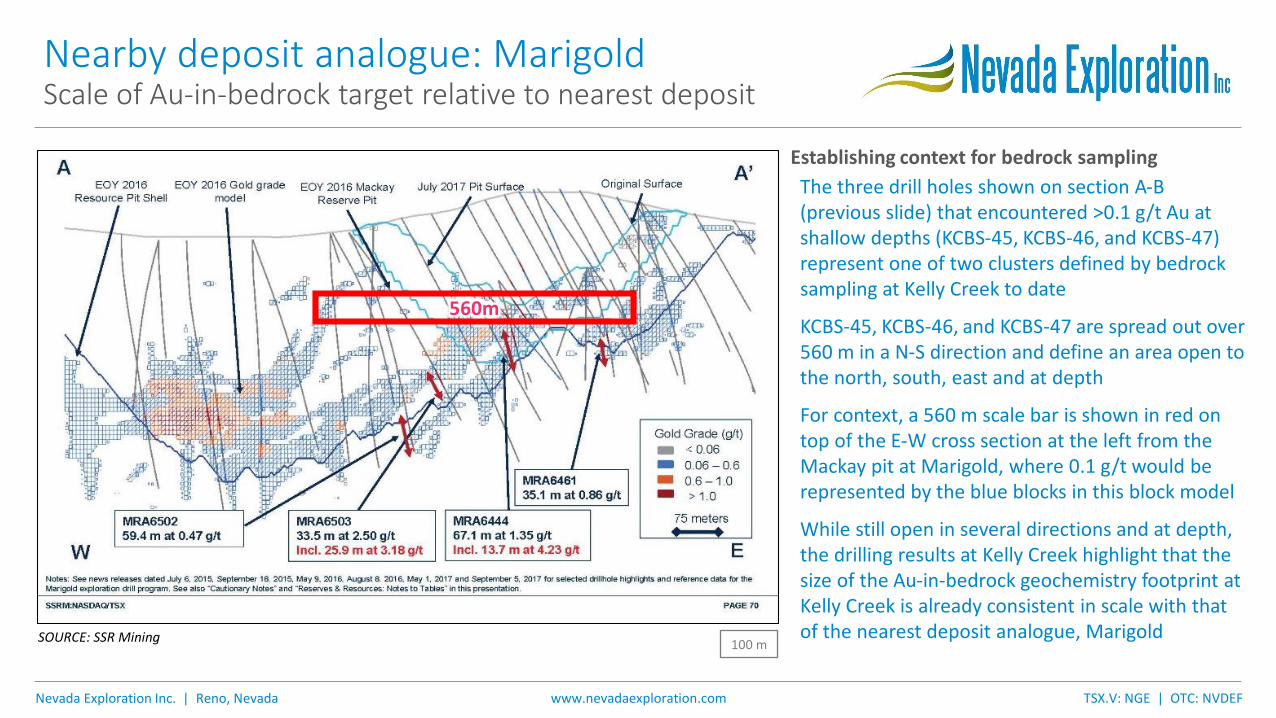
Nearby deposit analogue: MarigoldScale of Au-in-bedrock target relative to nearest deposit
SOURCE: SSR Mining
Establishing context for bedrock sampling
The three drill holes shown on section A-B (previous slide) that encountered >0.1 g/t Au at shallow depths (KCBS-45, KCBS-46, and KCBS-47) represent one of two clusters defined by bedrock sampling at Kelly Creek to date
KCBS-45, KCBS-46, and KCBS-47 are spread out over 560 m in a N-S direction and define an area open to the north, south, east and at depth
For context, a 560 m scale bar is shown in red on top of the E-W cross section at the left from the Mackay pit at Marigold, where 0.1 g/t would be represented by the blue blocks in this block model
While still open in several directions and at depth, the drilling results at Kelly Creek highlight that the size of the Au-in-bedrock geochemistry footprint at Kelly Creek is already consistent in scale with that of the nearest deposit analogue, Marigold
560m
100 m

Nevada Exploration Inc. | Reno, Nevada TSX.V: NGE | OTC: NVDEFwww.nevadaexploration.com
Scorpion program summaryVectoring under cover with 3D geochemistry
Focusing the target
The large favourable geologic setting and geochemistry footprint at Kelly Creek is consistent in terms of scale with those related to the Lone Tree and Marigold systems
Within the large Kelly Creek system, the Au in groundwater defines discrete parallel NNW-trending linear zones of enrichment bounded by the primary N-S structural fabric that runs parallel to Lone Tree and north from Marigold
These focused, linear zones of enrichment, cutting through this large favourable system (further described in Critical Components table in later slides) are consistent with geometry of mineralization hosted by secondary zones of structural extension (Riedel-style shears) known to provide important ore-controls at many of Nevada’s major deposits
By integrating 3D geochemistry with conventional project-scale geology, the results of the Scorpion drilling program have provided an otherwise missing crosshair to constrain this large, favourable, gold-bearing system down to clear and focused next-stage targets to test for the confluence of the critical components needed to support larger volumes of higher-grade mineralization
Marigold(8Moz)
Lone Tree(5Moz)
Inset fornext slide(looking upfrom below)
Au in groundwater

Nevada Exploration Inc. | Reno, Nevada TSX.V: NGE | OTC: NVDEFwww.nevadaexploration.com
Updated geologic modelIntegrating earlier drilling results to test and improve model
Red disks = bedrock samples >0.1gpt
EHP Hole IDs for core boxes in next slides
EHP-1
EHP-2
EHP-7EHP-11
Oil & Gas mud rotary drill hole drilled in footwall of structural corridor on western flank
Untested structural zoneon eastern flank
bedrock
surface
surface
alluvium
Poorly tested structural corridoron western flank
Area of shallowbedrock
Au in groundwater in alluvium
Historic scout drilling results
Holes not directed by the latest geologic model based on 3D geochemistry and comprehensive geophysics, and as a result, largely failed to test the focused targets now defined by the Au-in-groundwater lineaments anchored by the clusters of >0.1 g/t Au-in-bedrock
Where earlier drill holes did get close to major structural zones (see core holes with white labels to left and shown on following slides), as projected by the latest geochemistry and geophysical results, they encountered significant prospective geologic units (e.g. major damage zones along high-angle faults, alteration over large intervals, and anomalous gold and trace-element chemistry) highlighting both favorable geology and scale, which further improves the latest geologic model
Looking up
W E

Nevada Exploration Inc. | Reno, Nevada TSX.V: NGE | OTC: NVDEFwww.nevadaexploration.com
Western flank – earlier core drilling
EHP-1
EHP-2 EHP-11
EHP-1 (angled -55° to E): penetrated a major zone of fault damage throughout the entire hole from top of bedrock at 110 m (361 ft) to TD at 240 m (787 ft) - multiple periods of fault deformation, clay, calcite, pyrite, quartz, barite, gypsum and remobilized carbon veining and anomalous geochemistry
EHP-2 (angled -70° to E): was drilled 177 m east of EHP-1 to penetrate the eastern footwall of the fault zone encountered in EHP-1 and to establish the thickness of the western-flank structural corridor which extends in hole EHP-2 from the top of bedrock at 129 m (423 ft) to 290 m (951 ft), plus minor structures until TD at 509 m (1,670 ft). Together with EHP-1, a steeply dipping structural zone that is at least 274 m wide (still open to the west) with significant alteration and anomalous geochemistry
EHP-11 (vertical): 786 m south of EHP-2, penetrated the same major structural corridor from the top of bedrock at 137 m (449 ft) to TD at 298 m (978 ft). Together with EHP-1 & EHP-2 adds significant N-S extent to the structural corridor showing important alteration and anomalous geochemistry as represented by the intervals shown
Core boxes labelled in feet

Nevada Exploration Inc. | Reno, Nevada TSX.V: NGE | OTC: NVDEFwww.nevadaexploration.com
Eastern flank – earlier core drilling
EHP-7
EHP-7
EHP-7 (angled -60° to E): is still several hundred meters west of the completely untested eastern flank structural corridor associated with the largest gold in groundwater anomaly, angled to the east off of the bedrock high, and it encountered alluvium from the surface to its TD at 313m (1,027 ft)
Importantly, the drill hole encountered highly angular fragments (suggesting a nearby source area) of quartzite and conglomerate with argillic alteration plus calcite and quartz veining and a definite increase in gold and trace-element geochemistry at the very bottom of the drill hole coincident with the location of projected bedrock from CSAMT geophysics
These projections, together with the coincident overlying significant multi-element groundwater chemistry plume, define a large enough bedrock target area to host another Lone Tree-style gold deposit
Core boxes labelled in feet

Nevada Exploration Inc. | Reno, Nevada TSX.V: NGE | OTC: NVDEFwww.nevadaexploration.com
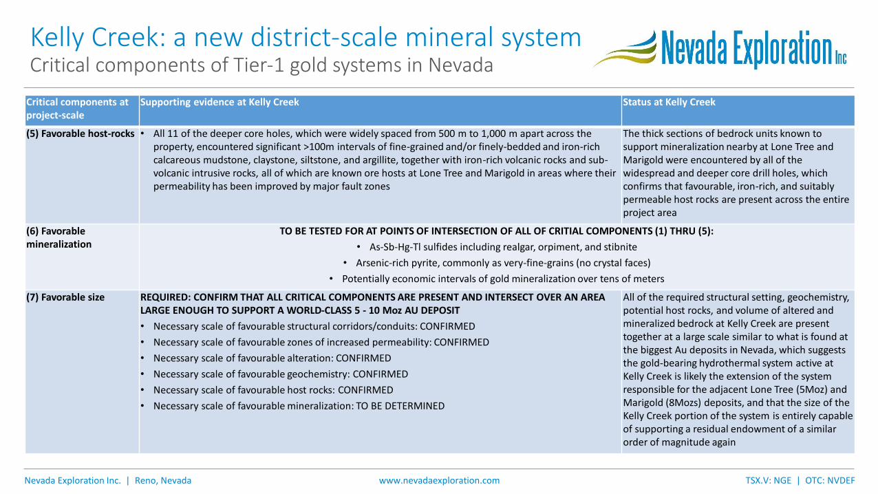
Kelly Creek: a new district-scale mineral systemCritical components of Tier-1 gold systems in Nevada
Critical components at project-scale
Supporting evidence at Kelly Creek Status at Kelly Creek
(1) Favorable structural corridors or other conduits of increased permeability
• Primary structural patterns seen in the air magnetic, gravity, seismic and CSAMT geophysics, strongly suggest a large block of shallow bedrock has been affected by the intersection of a series of major N-S, high-angle faults, and subparallel meandering and merging major fault corridors continuing from the known gold-bearing structures parallel to Lone Tree and due north of Marigold
• Parallel, linear zones of enriched hydrogeochemistry, as described in (4) below, suggest high densities of sympathetic minimal displacement extensional faults at slight angles to the strike of the primary shear zones characteristic of Riedel structural systems
• The thick intervals of favourable alteration and geochemistry encountered by wide-spaced, earlier core drilling, as described below in (3) and (4), further confirm the presence of the conduits described above, and importantly, that they were in fact active, controlling hydrothermal fluid movement through a large volume of potential host rocks
The primary and secondary structural fabric seen in the geophysics, core drilling, and hydrogeochemistry, plus the thick sections of alteration and geochemistry seen in the drilling, support the presence of significant reactivated high-angle structural conduits associated with a hydrothermal system of a size necessary support the formation of a major mineral system
(2) Favorable zones of increased permeability in contact with the pathways above
• Multiple, continuous zones of highly broken, low rock-quality designation (RQD) rocks from core provide evidence that wall rock permeability has been improved as a result of extensive structural damage along at least three 15 km long corridors, known to be up to 274 m in width
• Numerous 100 m core intervals of multi-episodic clay, calcite, pyrite, quartz, barite, gypsum and remobilized carbon veinlets highlight zones of enhanced fluid flow along extensionally reactivated high-angle faults and low-angle thrust zones
• Damaged margins of iron-rich dikes, sills, and volcanic rocks interlayered with favorable iron-rich calacareous sedimentary stratigraphy and sedimentary debris flow breccias show improved permeability over a large area
Veining and structural damage seen in the core drilling confirm that the permeability of the units proximal to the significant favorable structural conduits has been improved over large areas, processes that are well suited to support gold deposition

Nevada Exploration Inc. | Reno, Nevada TSX.V: NGE | OTC: NVDEFwww.nevadaexploration.com
Kelly Creek: a new district-scale mineral systemCritical components of Tier-1 gold systems in Nevada
Critical components at project-scale
Supporting evidence at Kelly Creek Status at Kelly Creek
(3) Favorable alteration • Earlier core and RC drilling intersected many 100 m intervals of bleaching, Illite and/or kaolinite/dickite-bearing alteration commonly associated with Carlin-Type gold deposits
• Earlier drilling also encountered 100 m intervals of decalcification and carbon remobilization, with extensive disseminated pyrite below the zone of oxidation, and narrow zones of structural jasperiod
• Deeper core drilling encountered large intervals of oxidized bedrock over the entire project area, in some cases to depths of 300 m below the bedrock surface
Thick and wide-spread intervals of hydrothermal alteration, oxidation, decalcification, and carbon remobilization confirm a large hydrothermal system was active at Kelly Creek, and mark the style of alteration and mineralization associated with Nevada’s largest gold deposits, which together are indicative of a favorable mineralizing environment
(4) Favorable geochemistry
• Two clusters of top-of-bedrock samples containing >0.1 g/t Au, covering areas at least 700 m x 300 m and 1,000 m x 600 m respectively, demonstrate that the hydrothermal system was gold-bearing (“pregnant”), and that the gold-bearing fluids were mobile over significant portions of the system
• The even wider-spread, weakly to moderately anomalous gold and trace-element footprint consistently seen in the bedrock proximal to the high-angle conduits (described in (1) above) is associated with at least three separate major shear zones with significant strike lengths of 15 km
• The geochemical package encountered in the areas of bedrock gold mineralization, namely Au with As, Hg, Sb, and Tl, but with both low Ag (Ag/Au <~5) and low base metals (Cu+Pb+Zn <~500-1000 ppm), is indicative of Carlin-type mineralization
• In areas of extensive fault damage, Au is seen to correlate with low-levels of Cu in a manner similar to that used to guide exploration along high-angle mineralized structures at the nearby Marigold mine
• The bedrock geochemistry footprint is also supported by a strong hydrogeochemistry footprint characterized by enriched Au in groundwater covering an area approx. 5 km long N-S by 4 km wide E-W, with three focused zones of even higher enrichment 5 km long and 600 m wide defining parallel lineaments at slight angles to and bounded by primary N-S structural conduits
The geochemistry seen across the project, including large areas of gold mineralization, is consistent in terms of size and composition with the footprints associated with many of Nevada’s largest deposits, which confirms all of: (i) that the system’s hydrothermal fluids were pregnant; (ii) that the pregnant fluids were present across large areas of the system; and (iii) that the pregnant fluids could potentially source economic gold mineralization where provided with favourable depositional conditions, namely suitably-permeable iron-rich host rocks
Nevada Exploration Inc. | Reno, Nevada TSX.V: NGE | OTC: NVDEFwww.nevadaexploration.com
Kelly Creek: a new district-scale mineral systemCritical components of Tier-1 gold systems in Nevada
Critical components at project-scale
Supporting evidence at Kelly Creek Status at Kelly Creek
(5) Favorable host-rocks • All 11 of the deeper core holes, which were widely spaced from 500 m to 1,000 m apart across the property, encountered significant >100m intervals of fine-grained and/or finely-bedded and iron-rich calcareous mudstone, claystone, siltstone, and argillite, together with iron-rich volcanic rocks and sub-volcanic intrusive rocks, all of which are known ore hosts at Lone Tree and Marigold in areas where their permeability has been improved by major fault zones
The thick sections of bedrock units known to support mineralization nearby at Lone Tree and Marigold were encountered by all of the widespread and deeper core drill holes, which confirms that favourable, iron-rich, and suitably permeable host rocks are present across the entire project area
(6) Favorable mineralization
TO BE TESTED FOR AT POINTS OF INTERSECTION OF ALL OF CRITIAL COMPONENTS (1) THRU (5):
• As-Sb-Hg-Tl sulfides including realgar, orpiment, and stibnite
• Arsenic-rich pyrite, commonly as very-fine-grains (no crystal faces)
• Potentially economic intervals of gold mineralization over tens of meters
(7) Favorable size REQUIRED: CONFIRM THAT ALL CRITICAL COMPONENTS ARE PRESENT AND INTERSECT OVER AN AREA LARGE ENOUGH TO SUPPORT A WORLD-CLASS 5 - 10 Moz AU DEPOSIT
• Necessary scale of favourable structural corridors/conduits: CONFIRMED
• Necessary scale of favourable zones of increased permeability: CONFIRMED
• Necessary scale of favourable alteration: CONFIRMED
• Necessary scale of favourable geochemistry: CONFIRMED
• Necessary scale of favourable host rocks: CONFIRMED
• Necessary scale of favourable mineralization: TO BE DETERMINED
All of the required structural setting, geochemistry, potential host rocks, and volume of altered and mineralized bedrock at Kelly Creek are present together at a large scale similar to what is found at the biggest Au deposits in Nevada, which suggests the gold-bearing hydrothermal system active at Kelly Creek is likely the extension of the system responsible for the adjacent Lone Tree (5Moz) and Marigold (8Mozs) deposits, and that the size of the Kelly Creek portion of the system is entirely capable of supporting a residual endowment of a similar order of magnitude again
Nevada Exploration Inc. | Reno, Nevada TSX.V: NGE | OTC: NVDEFwww.nevadaexploration.com
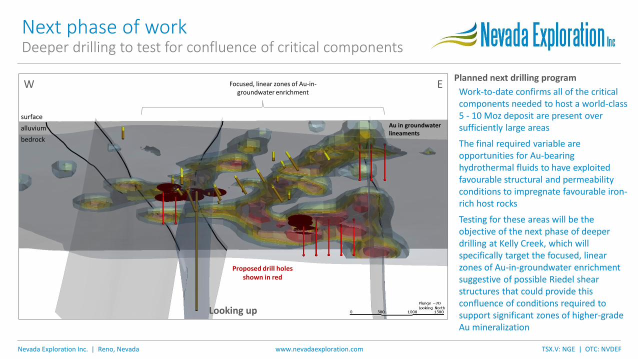
Planned next drilling program
Work-to-date confirms all of the critical components needed to host a world-class 5 - 10 Moz deposit are present over sufficiently large areas
The final required variable are opportunities for Au-bearing hydrothermal fluids to have exploited favourable structural and permeability conditions to impregnate favourable iron-rich host rocks
Testing for these areas will be the objective of the next phase of deeper drilling at Kelly Creek, which will specifically target the focused, linear zones of Au-in-groundwater enrichment suggestive of possible Riedel shear structures that could provide this confluence of conditions required to support significant zones of higher-grade Au mineralization
Next phase of workDeeper drilling to test for confluence of critical components
bedrock
surface
surface
alluvium
Focused, linear zones of Au-in-groundwater enrichment
Proposed drill holes shown in red
Au in groundwater lineaments
Looking up
W E
Nevada Exploration Inc. | Reno, Nevada TSX.V: NGE | OTC: NVDEFwww.nevadaexploration.com
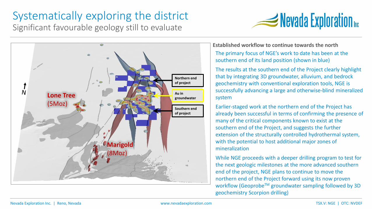
Established workflow to continue towards the north
The primary focus of NGE’s work to date has been at the southern end of its land position (shown in blue)
The results at the southern end of the Project clearly highlight that by integrating 3D groundwater, alluvium, and bedrock geochemistry with conventional exploration tools, NGE is successfully advancing a large and otherwise-blind mineralized system
Earlier-staged work at the northern end of the Project has already been successful in terms of confirming the presence of many of the critical components known to exist at the southern end of the Project, and suggests the further extension of the structurally controlled hydrothermal system, with the potential to host additional major zones of mineralization
While NGE proceeds with a deeper drilling program to test for the next geologic milestones at the more advanced southern end of the project, NGE plans to continue to move the northern end of the Project forward using its now proven workflow (GeoprobeTM groundwater sampling followed by 3D geochemistry Scorpion drilling)
Systematically exploring the districtSignificant favourable geology still to evaluate
Au ingroundwater
Southern end of project
Northern end of project
Marigold(8Moz)
Lone Tree(5Moz)

Nevada Exploration Inc. | Reno, Nevada TSX.V: NGE | OTC: NVDEFwww.nevadaexploration.com
SummaryCurrent project status and next milestones
• Scorpion drill results have confirmed that the hydrothermal system active at Kelly Creek is gold-bearing over large areas, with enriched Au in groundwater anchored to at least two clusters of >0.1 g/t Au-in-bedrock covering areas consistent in size with the geochemical footprints of the nearest major gold deposits
• Together with the earlier drilling and structural interpretation, the combined datasets establish the following critical components are present at the scale required to host a world-class deposit: favourable structural setting, suitable wall-rock permeability, characteristic geochemistry, suitable host rocks, and significant volume of altered and mineralized bedrock
• NGE’s updated geologic model suggests that the gold-bearing hydrothermal system active at Kelly Creek is likely the extension of the system responsible for Lone Tree (5 Moz) and Marigold (8 Mozs), with potential to support major additional mineralization
• The next phase of work at Kelly Creek will consist of deeper drilling to test for areas where Au-bearing hydrothermal fluids were able to exploit favourable structural and permeability conditions to impregnate favourable iron-rich host rocks (all of which are now known to exist) at the scale required to source a major deposit
• This deeper drilling will target the discrete lineaments (within the larger favourable system) defined by enriched Au in groundwater established by the 3D Scorpion program, which now provides an otherwise missing crosshair to advance this important district-scale project