Embed Size (px)
Citation preview
Kathmandu Valley Resilient Plan for Urban Transportation System
September 22,2016
Ichiro Kobayashi
Team Leader, JICA RRNE Project
2
Kathmandu Valley Resilient Plan
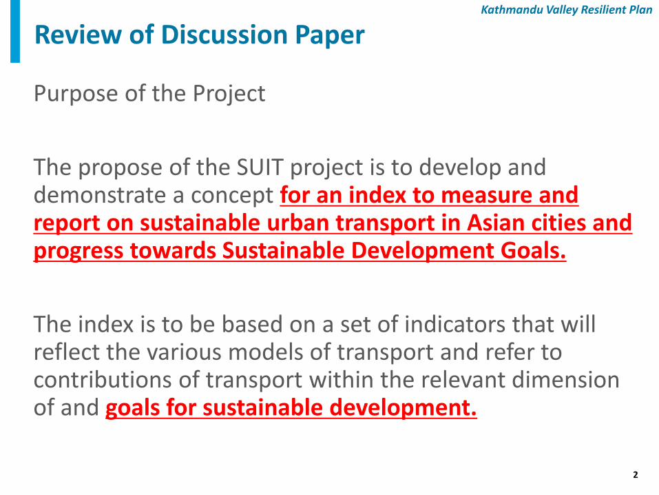
Purpose of the Project
The propose of the SUIT project is to develop and demonstrate a concept for an index to measure and report on sustainable urban transport in Asian cities and progress towards Sustainable Development Goals.
The index is to be based on a set of indicators that will reflect the various models of transport and refer to contributions of transport within the relevant dimension of and goals for sustainable development.
Review of Discussion Paper
3
Kathmandu Valley Resilient Plan
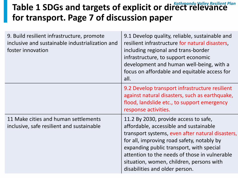
Table 1 SDGs and targets of explicit or direct relevance for transport. Page 7 of discussion paper
9. Build resilient infrastructure, promote inclusive and sustainable industrialization and foster innovation
9.1 Develop quality, reliable, sustainable and resilient infrastructure for natural disasters, including regional and trans-border infrastructure, to support economic development and human well-being, with a focus on affordable and equitable access for all.
9.2 Develop transport infrastructure resilient against natural disasters, such as earthquake, flood, landslide etc., to support emergency response activities.
11 Make cities and human settlements inclusive, safe resilient and sustainable
11.2 By 2030, provide access to safe, affordable, accessible and sustainable transport systems, even after natural disasters, for all, improving road safety, notably by expanding public transport, with special attention to the needs of those in vulnerable situation, women, children, persons with disabilities and older person.
4
Kathmandu Valley Resilient Plan
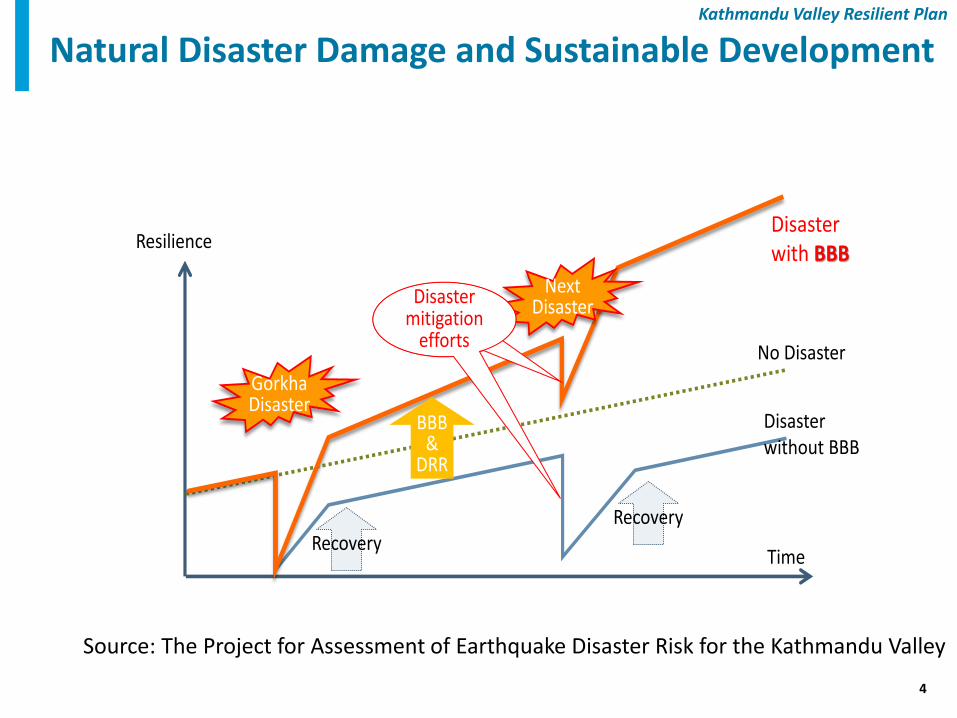
Natural Disaster Damage and Sustainable Development
Resilience
Time
No Disaster
Disasterwithout BBB
Disasterwith BBB
BBB&
DRR
GorkhaDisaster
NextDisasterDisaster
mitigation efforts
Disaster mitigation
efforts
RecoveryRecovery
Source: The Project for Assessment of Earthquake Disaster Risk for the Kathmandu Valley
5
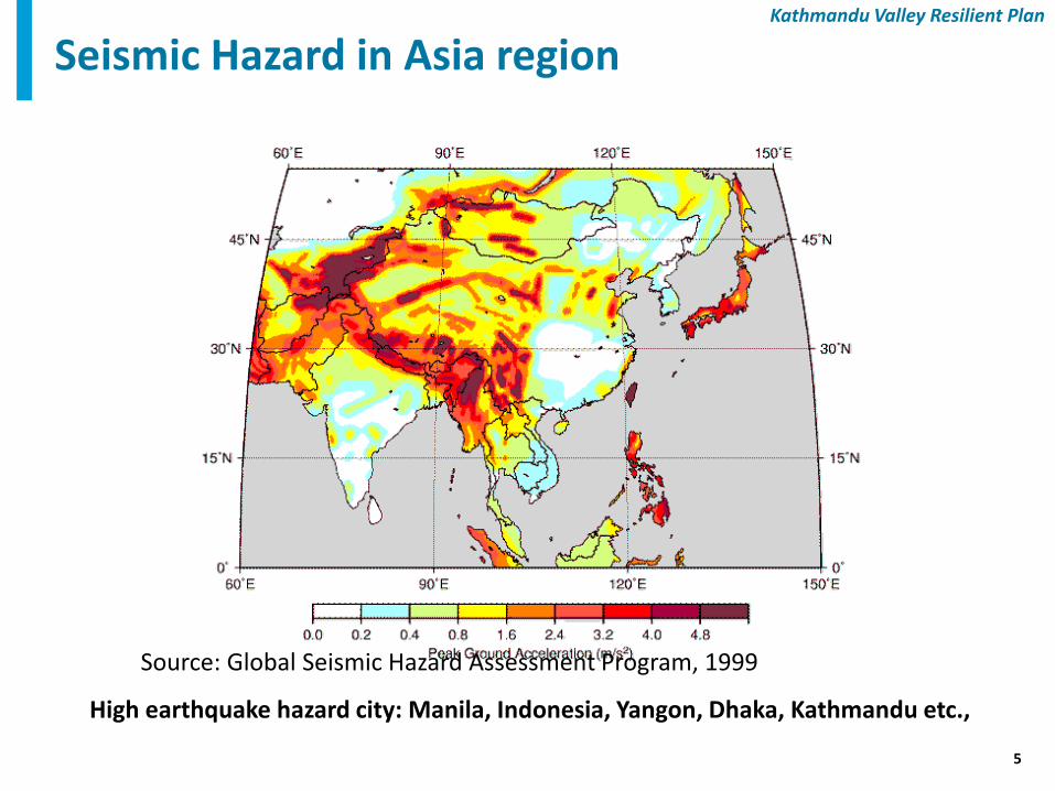
Kathmandu Valley Resilient Plan
Seismic Hazard in Asia region
High earthquake hazard city: Manila, Indonesia, Yangon, Dhaka, Kathmandu etc.,
Source: Global Seismic Hazard Assessment Program, 1999
6
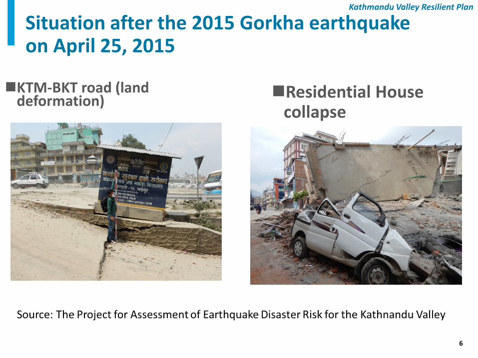
Kathmandu Valley Resilient Plan
Situation after the 2015 Gorkha earthquake on April 25, 2015
KTM-BKT road (land deformation)
Residential House collapse
7
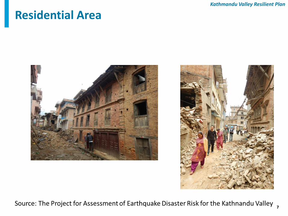
Kathmandu Valley Resilient Plan
Residential Area
8
Kathmandu Valley Resilient Plan
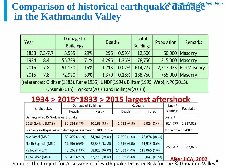
Comparison of historical earthquake damage in the Kathmandu Valley
8
1934 > 2015~1833 > 2015 largest aftershock
2015 Gorkha (M7.8) 50,984 (8.3%) 40,166 (6.5%) 1,713 (0.1%) 9,024 (0.4%) 614,777 2,517,023
Mid Nepal (M8.0) 53,465 (20.9%) 74,941 (29.3%) 17,695 (1.3%) 146,874 (10.6%)
North Bagmati (M6.0) 17,796 (6.9%) 28,345 (11.1%) 2,616 (0.2%) 21,913 (1.6%)
KV local (M5.7) 46,596 (18.2%) 68,820 (26.9%) 14,333 (1.0%) 119,066 (8.6%)
1934 Bihar (M8.4) 58,701 (22.9%) 77,773 (30.4%) 19,523 (1.4%) 162,041 (11.7%)
Assessmet / Damage 0.84 1.69 2.77 4.40
Comparison of the 2015 damage with North Bagmati scenario (in %)
Damage of 2015 Gorkha earthquake Current
Scenario earthquakes and damage assessment of 2002 project At the time ot 2002
256,203 1,387,826
EarthquakesDamage of Buildings Casualty No. of
BuildingsPopulation
Heavily Partly Death Injured
After JICA, 2002
YearTotal
BuildingsPopulation Remarks
1833 7.3-7.7 3,565 29% 296 0.59% 12,500 50,000 Masonry
1934 8.4 55,739 71% 4,296 1.36% 78,750 315,000 Masonry
2015 7.8 91,150 15% 1,713 0.07% 614,777 2,517,023 RC+Masonry
2015 7.8 72,920 39% 1,370 0.18% 188,750 755,000 Masonry
Damage to
BuildingsDeaths
(references: Oldham(1883), Rana(1935), UNDP(1994), Bilham(1995, Web), NPC(2015),
Ohsumi(2015) , Sapkota(2016) and Bollinger(2016))
Source: The Project for Assessment of Earthquake Disaster Risk for the Kathmandu Valley
9
Kathmandu Valley Resilient Plan
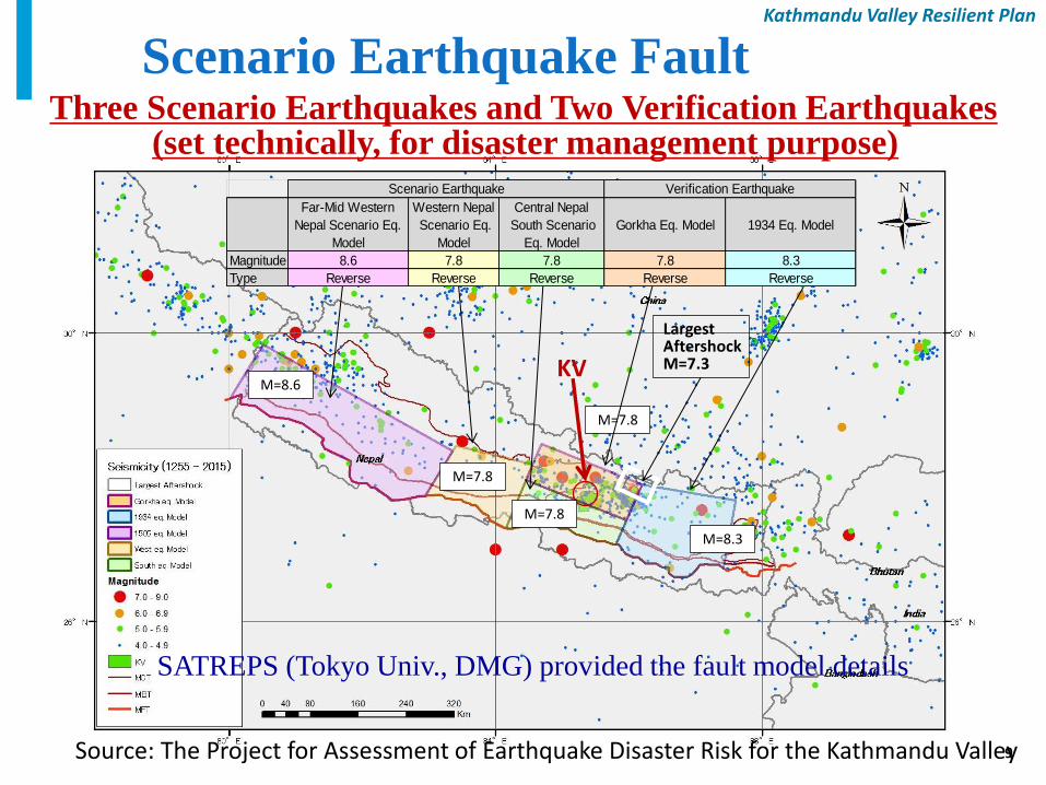
9
KV
SATREPS (Tokyo Univ., DMG) provided the fault model details
M=8.6
M=7.8
M=7.8
M=7.8
M=8.3
Largest Aftershock M=7.3
Far-Mid Western
Nepal Scenario Eq.
Model
Western Nepal
Scenario Eq.
Model
Central Nepal
South Scenario
Eq. Model
Gorkha Eq. Model 1934 Eq. Model
Magnitude 8.6 7.8 7.8 7.8 8.3
Type Reverse Reverse Reverse Reverse Reverse
Scenario Earthquake Verification Earthquake
Scenario Earthquake Fault Model Three Scenario Earthquakes and Two Verification Earthquakes
(set technically, for disaster management purpose)
Source: The Project for Assessment of Earthquake Disaster Risk for the Kathmandu Valley
10
Kathmandu Valley Resilient Plan
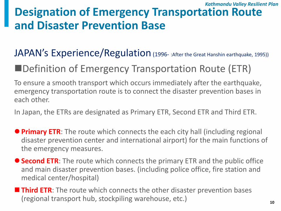
JAPAN’s Experience/Regulation (1996- :After the Great Hanshin earthquake, 1995))
Definition of Emergency Transportation Route (ETR) To ensure a smooth transport which occurs immediately after the earthquake, emergency transportation route is to connect the disaster prevention bases in each other.
In Japan, the ETRs are designated as Primary ETR, Second ETR and Third ETR.
Primary ETR: The route which connects the each city hall (including regional disaster prevention center and international airport) for the main functions of the emergency measures.
Second ETR: The route which connects the primary ETR and the public office and main disaster prevention bases. (including police office, fire station and medical center/hospital)
Third ETR: The route which connects the other disaster prevention bases (regional transport hub, stockpiling warehouse, etc.)
Designation of Emergency Transportation Route and Disaster Prevention Base
11
Kathmandu Valley Resilient Plan
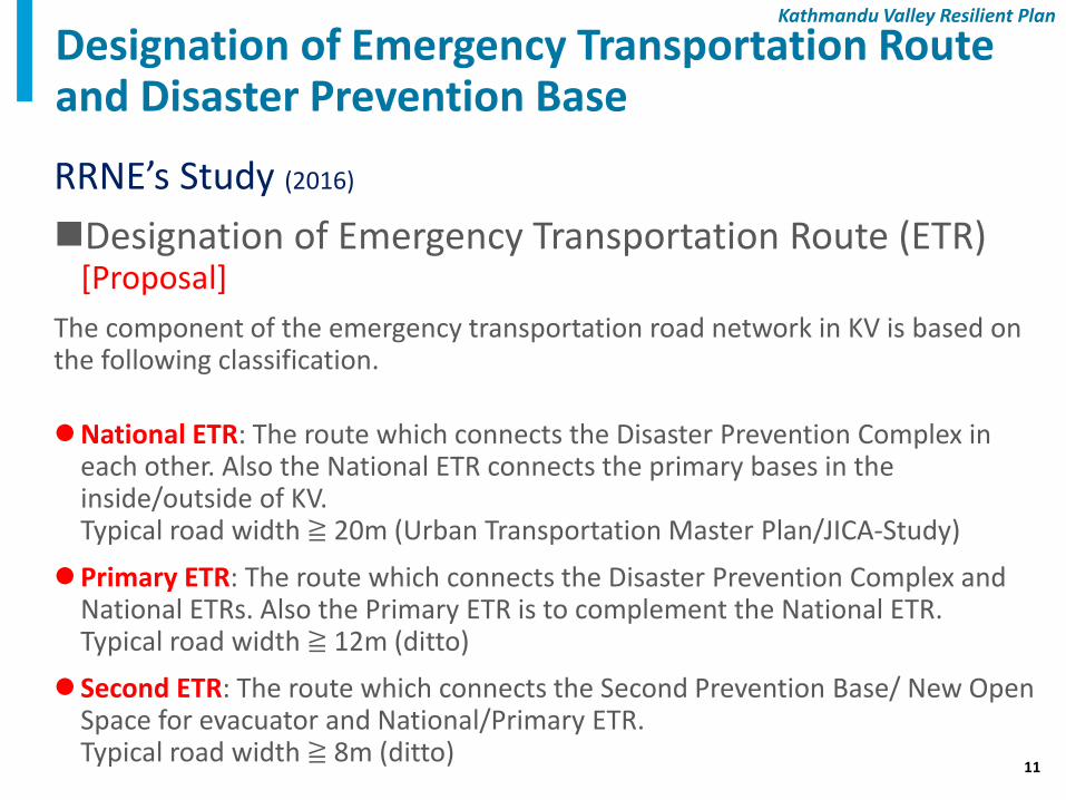
RRNE’s Study (2016)
Designation of Emergency Transportation Route (ETR) [Proposal]
The component of the emergency transportation road network in KV is based on the following classification.
National ETR: The route which connects the Disaster Prevention Complex in each other. Also the National ETR connects the primary bases in the inside/outside of KV.
Typical road width ≧ 20m (Urban Transportation Master Plan/JICA-Study)
Primary ETR: The route which connects the Disaster Prevention Complex and National ETRs. Also the Primary ETR is to complement the National ETR.
Typical road width ≧ 12m (ditto)
Second ETR: The route which connects the Second Prevention Base/ New Open Space for evacuator and National/Primary ETR.
Typical road width ≧ 8m (ditto)
Designation of Emergency Transportation Route and Disaster Prevention Base
12
Kathmandu Valley Resilient Plan
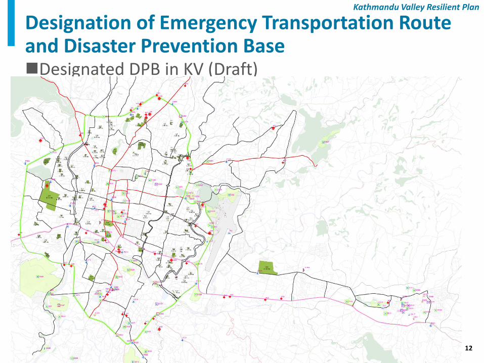
Designated DPB in KV (Draft)
Designation of Emergency Transportation Route and Disaster Prevention Base
13
Kathmandu Valley Resilient Plan
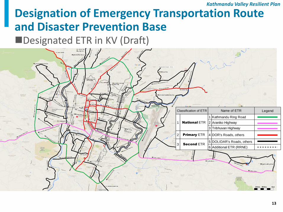
Designated ETR in KV (Draft)
Legend
1 Kathmandu Ring Road
2 Araniko Highway
3 Tribhuvan Highway
2 Primary ETR 4 DOR's Roads, others
5 DOLIDAR's Roads, others
6 Additional ETR (RRNE)
Classification of ETR Name of ETR
1 National ETR
3 Second ETR
Designation of Emergency Transportation Route and Disaster Prevention Base
14
Kathmandu Valley Resilient Plan
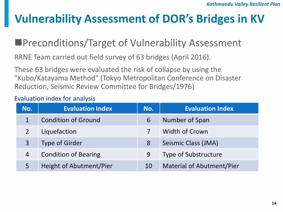
Preconditions/Target of Vulnerability Assessment RRNE Team carried out field survey of 63 bridges (April 2016).
These 63 bridges were evaluated the risk of collapse by using the "Kubo/Katayama Method" (Tokyo Metropolitan Conference on Disaster Reduction, Seismic Review Committee for Bridges/1976)
Evaluation index for analysis
Vulnerability Assessment of DOR’s Bridges in KV
No. Evaluation Index No. Evaluation Index
1 Condition of Ground 6 Number of Span
2 Liquefaction 7 Width of Crown
3 Type of Girder 8 Seismic Class (JMA)
4 Condition of Bearing 9 Type of Substructure
5 Height of Abutment/Pier 10 Material of Abutment/Pier
15
Kathmandu Valley Resilient Plan
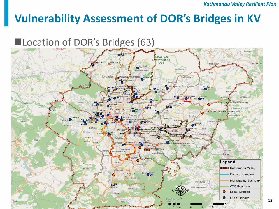
Location of DOR’s Bridges (63)
Vulnerability Assessment of DOR’s Bridges in KV
16
Kathmandu Valley Resilient Plan
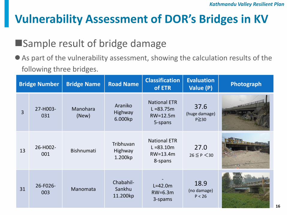
Sample result of bridge damage As part of the vulnerability assessment, showing the calculation results of the
following three bridges.
Vulnerability Assessment of DOR’s Bridges in KV
Bridge Number Bridge Name Road Name Classification
of ETR Evaluation Value (P)
Photograph
3 27-H003-
031 Manohara
(New)
Araniko Highway 6.000kp
National ETR L =83.75m RW=12.5m
5-spans
37.6 (huge damage)
P≧30
13 26-H002-
001 Bishnumati
Tribhuvan Highway 1.200kp
National ETR L =83.10m RW=13.4m
8-spans
27.0 26 ≦ P <30
31 26-F026-
003 Manomata
Chabahil-Sankhu
11.200kp
- L=42.0m
RW=6.3m 3-spams
18.9 (no damage)
P < 26
17
Kathmandu Valley Resilient Plan
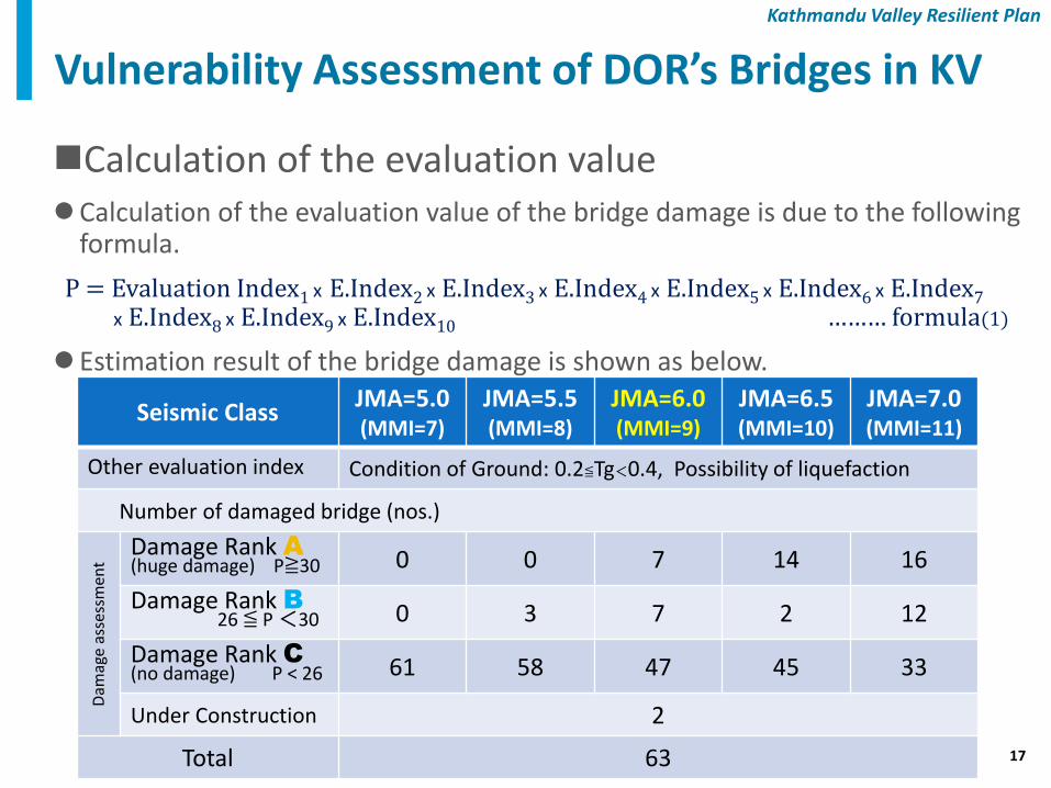
Calculation of the evaluation value Calculation of the evaluation value of the bridge damage is due to the following
formula.
P = Evaluation Index1 x E.Index2 x E.Index3 x E.Index4 x E.Index5 x E.Index6 x E.Index7
x E.Index8 x E.Index9 x E.Index10 ……… formula(1)
Estimation result of the bridge damage is shown as below.
Vulnerability Assessment of DOR’s Bridges in KV
Seismic Class JMA=5.0 (MMI=7)
JMA=5.5 (MMI=8)
JMA=6.0 (MMI=9)
JMA=6.5 (MMI=10)
JMA=7.0 (MMI=11)
Other evaluation index Condition of Ground: 0.2≦Tg<0.4, Possibility of liquefaction
Number of damaged bridge (nos.)
Dam
age
asse
ssm
ent
Damage Rank A
(huge damage) P≧30 0 0 7 14 16
Damage Rank B
26 ≦ P <30 0 3 7 2 12
Damage Rank C
(no damage) P < 26 61 58 47 45 33
Under Construction 2
Total 63
18
Kathmandu Valley Resilient Plan
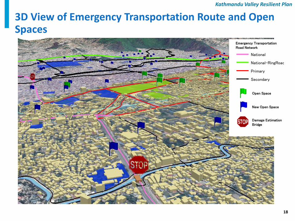
3D View of Emergency Transportation Route and Open Spaces
Open Space
New Open Space
Damage Estimation Bridge
Secondary
Primary
National-RingRoad
National
Emergency Transportation Road Network
19
Kathmandu Valley Resilient Plan
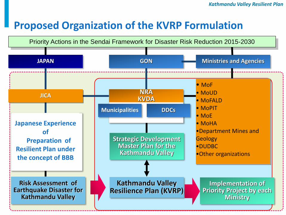
Proposed Organization of the KVRP Formulation
GON
NRA KVDA
Ministries and Agencies
・
Strategic Development Master Plan for the Kathmandu Valley
JAPAN
DDCs Municipalities
Kathmandu Valley Resilience Plan (KVRP)
Japanese Experience of
Preparation of Resilient Plan under the concept of BBB
Priority Actions in the Sendai Framework for Disaster Risk Reduction 2015-2030
Risk Assessment of Earthquake Disaster for
Kathmandu Valley
JICA
Implementation of Priority Project by each
Ministry
• MoF • MoUD • MoFALD • MoPIT • MoE • MoHA •Department Mines and Geology •DUDBC •Other organizations
20
Kathmandu Valley Resilient Plan
Thank You


![For a Cleaner and Greener Kathmandu Valley · CMC-1 INSTITUTEOFCURRENTWORLDAPA1RS OTFOR PUBLICATION] WITHOUTWRITER’SCONSENT ForacleanerandgreenerKathmanduValley Kathmandu,Nepal](https://img.pdfslide.us/doc/110x75/5f8d69b78a59e65a1925ce3f/for-a-cleaner-and-greener-kathmandu-cmc-1-instituteofcurrentworldapa1rs-otfor-publication.jpg)


![Diesel Power Generation Kathmandu Valley, Nepalfinal] Report_DG Set Study_Nepal.pdf · Diesel Power Generation Kathmandu Valley, Nepal ... ELECTRICITY GENERATION AND DEMAND, ... NEA](https://img.pdfslide.us/doc/110x75/5b1de9ab7f8b9a45138b514c/diesel-power-generation-kathmandu-valley-final-reportdg-set-studynepalpdf.jpg)