Embed Size (px)
Citation preview
KARL W. BUTZER, Chicago
LATE PLEISTOCENE DEPOSITS OF THE KOM OMBO PLAIN,
UPPER EGYPT
Introduction
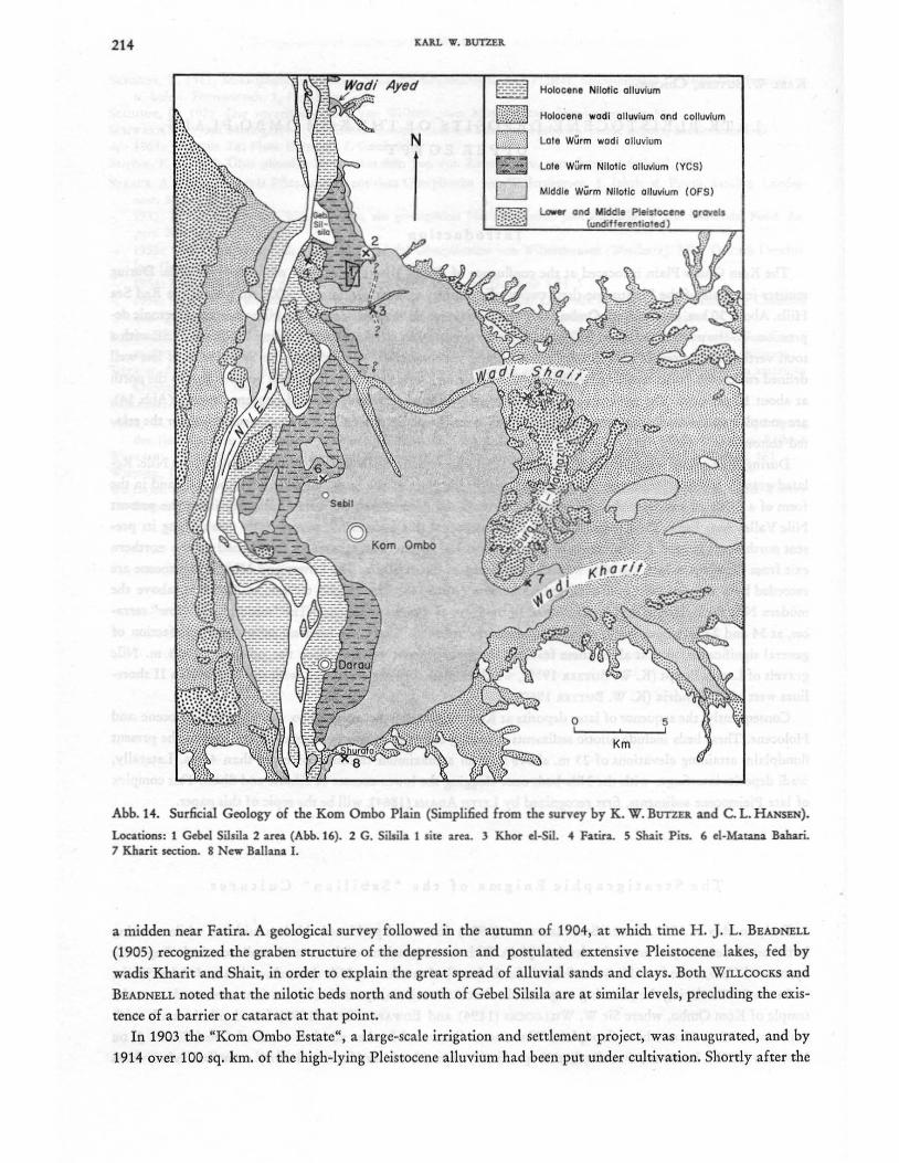
The Kom Ombo Plain is located at the confluence of Wadis Kharit and Shait with the river Nile. During moister intervals of the Pleistocene these two wadis drained an area of almost 26,000 sq. km. in the Red Sea
Hills. About 30 km. east of Kom Ombo both wadis converge on the east bank of the Nile via a large tectonic depression. To the north this graben is flanked by two systems of en echelon faults trending WNW and ESE with a total vertical displacement of well over 100 m. Along the southern margin of the plain is a system of less well defined en echelon faults trending roughly E-W delineating a hinge line from which the bedrock dips to the north at about 10 per cent. The structural details, obscured by a considerable depth of Pleistocene deposits .(Abb. 14),
are complex and several transversal fracture zones cross the plain. A late Tertiary age is suggested for the related tectonics.
During the earliest stages of the Pleistocene, Wadis Kharit and Shait formed a major source of the Nile. Related gravels are still fragmentarily preserved within the plain at the Burg el-Makhazin (Abb. 14), and in the form of a 25 to 30 km. wide channel swinging through the deserts west of Kom Ombo, rejoining the present Nile Valley near Esna. The Lower Pleistocene Nile dissected this ancient fill, permanently ~stablishing its present north-south course. A bifurcation of tectono-erosional origin was eventually established at the northern exit from the plain, where the Nile washed both flanks of Gebel Silsila. The Lower and Middle Pleistocene are recorded by a series of Nile and wadi gravel terraces (Abb. 14). The "high" terrace, at 40-55 m. above the
modern Nile floodplain, is deeply weathered in the form of a rotlehm paleosol. The "middle" and "low" terraces, at 34 and 22 m. respectively, are only moderately rubefied. There has been no subsequent rubefaction of
general significance, so that all of these features are probably not younger than the rubefied 10-13 m. Nile gravels of Lower Egypt (K. W. BUTZER 1959), which in their turn are correlated with the Tyrrhenian II shorelines west of Alexandria (K. W. BUTZER 1960).
Consequently, the sequence of later deposits at Kom Ombo can be assigned to the Upper Pleistocene and Holocene. These beds include nilotic sediments sweeping across the plain to at least 18 km. east of the present floodplain, attaining elevations of 23 m. above it, with a maximum thickness of more than 40 m. Laterally,
wadi deposits interfinger with the Nile beds once clogging the lower courses of Kharit and Shait. This complex of late Pleistocene sediments, first recognized by LEITH ADAMS (1864), will be the topic of this paper.
The Stratigraphic Enigma of the "Sebilian" Cultures
Early in May of 1882, GEORG SCHWEINFURTH (1901) discovered prehistoric kitchen middens while working in the northwestern quarter of the desolate plain. Rich concentrations of bone and molluscs, including Nile oyster and Unio, were found in what Schweinfurth described as a former Nile channel southeast of Gebel Silsila.
In the 1890's during the planning stages of the first Aswan Dam, sporadic observations were made near the temple of Kom Ombo, where Sir W. WILLCOCKS (1894) and EDWARD HULL (1896) found nilotic muds with mollusca to 12 or 15 m. above floodplain. WILLCOCKS discovered further middens south of Gebel Silsila. J. DE MORGAN (1897), however, was the first to specifically report stone artifacts, primarily carnelian flakes, from
214 J(ARL W. BUTZER.
© Kom Ombo
Holoclne Nllatlc alluvium
Holocene wadi alluvium and colluvium
Lote Wurm wadi alluvium
Lote Wurm Nilolic alluvium (YeS)
Middle Wurm Nllotlc aJ/uvium (OFS)
L..ower and Middle Pleistocene
o I
Km
I
5 ,
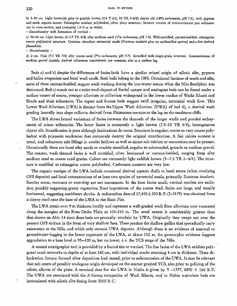
Abb. 14. Surficial Geology of the Kom Ombo Plain (Simplified from the survey by K. W. BUTZn and C. L. HANSEN).
Locations, 1 Gebel Silsila 2 area (Abb. 16). 2 G. SiLsila 1 site area. 3 Khor cl-Sil. 4 Fatira. 5 Sbair Pits. 6 el-Marana Bahan. 7 Kharit section. 8 New Ballana I.
a midden near Fatira. A geological survey followed in the autumn of 1904, at which time H. J. L. BEADNELL
(1905) recognized the graben structure of the depression and postulated extensive Pleistocene lakes, fed by
wadis Kharit and Shait, in order to explain the great spread of alluvial sands and clays. Both WILLCOCKS and
BEADNELL noted that the nilotic beds north and south of Gebel Silsila are at similar levels, precluding the exis
tence of a barrier or cataract at that point.
In 1903 the "Korn Ombo Estate", a large-scale irrigation and settlement project, was inaugurated, and by
1914 over 100 sq. km. of the high-lying Pleistocene alluvium had been put under cultivation. Shortly after the

LATE PLEISTOCENE DEPOSITS OF THE KOM OMBO PLAIN, UPPER EGYPT 215
war EDMOND VIGNARD' (1923) discovered and published a sequence of new Paleolithic industries described as Sebilian I, II, and III, from a series of platform-like ridges situated 3 km. west of Kom Ombo. VIGNARD inter
preted these cultures as occupation sites on the shores of a progressively shrinking lake that had been dammed
up behind Gebel Silsila for most of Paleolithic times. Desiccation of the lake and the alleged bogs (tourbieres)
was attributed both to failure of the eastern watercourses and to incision of the Nile through the supposed Silsila barrier. Momentous as the archeological implications of the Sebilian cultures were, question was soon raised
as to their exact age and their relationships with the Paleolithic and Neolithic cultures of Europe and of North Africa.
The valuable Pleistocene survey of the Nile Valley by K. S. SANDFORD and W. J. ARKELL devoted consider
.able time to the western third of the Kom Ombo Plain during the winter of 1929/30 and the spring of 1931.
The late Pleistocene alluvial series were designated as the "Sebilian Silts" although no unequivocal association
'of geologically stratified sites with the "Sebilian Silts" was shown for Upper Egypt. SANDFORD and ARKELL
(1933) attributed the nilotic alluvium to riverine marshes. They emphasized that the Sebilian III sites were
found on the silts, in longitudinal arrangements suggesting riverbank settlement during temporary stages of
equilibrium as the Nile incised its bed into the "Sebilian Silts" at the close of the Pleistocene. ,The Sebilian I was
believed (but not conclusively shown) to be contemporary with the silts proper, the Sebilian II belonging to
the incipient phase of downcutting.
Pre his tor i c Sal vag e W 0 r k d uri n g 1962/63
Largely in view of the continuing stratigraphic uncertainty of the Sebilian industries, the significance of
VIGNARD'S archeological work was not fully appreciated.
In 1960 the UNESCO campaign to salvage archeology in the areas to be flooded by the projected High Dam
at Aswan focused new attention to the prehistoric heritage of southern Egypt. Although downstream of the
High Dam, the Kom Ombo Plain was also to be affected. Most of the Nubians were scheduled for resettlement
in those parts of the plain that had not already been brought under irrigation by the Kom Ombo Estate prior
to World War II. Bulldozing and grading activities began in 1961 and a year later two missions received concessions for prehistoric salvage in the areas threatened. A group from the National Museum of Canada and
University of Toronto, under the direction of DR. P. E. L. SMITH, excavated several major sites and collected
materials from over 30 others. It also included DR. ROBERT J. FULTON of the Geological Survey of Canada for
six weeks in 1963. A Yale expedition, under DR. C. A. REED, excavated two major sites near GebelSilsila.Both
expeditions had previously carried out a joint archeological survey. The writer and CARL L. HANSEN, both from
the University of Wisconsin, were attached to the Yale group to study the Pleistocene setting of the plain.
The Wisconsin team spent a total of four months in the Aswan-Kom Ombo area between October 3, 1962
and March 29, 1963, with interruptions for work in Nubia, on the Red Sea coast, at the Kurkur Oasis and
around Luxor. In the Kom Ombo area, bedrock, surficial geology and geomorphology of a 1500 sq. km. area
were mapped at 1:100,000 (the largest scale maps available). A part of the surficial geology map is reproduced
in simplified form (Abb. 14). Several hundred sediment samples were tested in the field laboratory at Aswan.
Over 25 major Abney level transe~ts were run at 1 :1250 employing 3rd order bench marks of the Survey of
Egypt. Detailed 1 :2500 maps were prepared of significant areas. Sedimentological analyses (hydrometer, wet
sieving, volumetric carbonate determination, pH) were subsequently carried out at the University of Wis
consin. Studies of the heavy minerals, clay minerals and soluble salts are currently underway.
21'6 KARL W. BUTZER
Up per PIe i s to c e n eSt rat i g rap h y (I): Bas a 1 San d san d Marl s
The Upper Pleistocene sequence at Kom Ombo is stratigraphically separated from the Middle Pleistocene
"low terrace" by phases of dissection and rubefaction. The oldest deposits are only preserved on the peripheries
of the Kom Ombo Plain: (a) in pits dug in the floor of Wadi Shurafa 500 m. north of the new village Ballana
II, (b) in the lower course of Wadi Ayed, near Silwa Qibli, and (c) in three minor south bank' tributaries at
the mouth of Wadi Shait1• The general facies of these first Upper Pleistocene beds is that of semiconsolidated,
medium to coarse sandy marls, with basal gravels in Wadi Shait. Maximum elevations observed: in Wadi Shu
rafa 103 m. (+ 13 m.), Wadi Shait 107.5 m. (+ 19 m.), Wadi Ayed 99 m. (+ 10.5 m.). Since these deposits
have all been strongly eroded their former relative elevation can be estimated at + 20 m.2 or possibly more.
Stratification is conspicuous only where gravel lenses are interdigited. Sorting of the fines (under 2 mm.) is
invariably poor. Structure is typically subangular, coarse polyhedral, with some prismatic alignment. Salt
concretions occur on rare occasions, although secondary evaporites derived from overlying beds are common
on the faces of vertical cracks. Calcareous root-casts or infillings are abundant. Limonitic staining, suggesting
seasonal groundwater-logging, is common in many horizons.
The intercalated gravels are of heterogeneous lithology, usually derived from older Pleistocene terraces, pre
sumably by sheetflooding. Transport distances were short so that little modification of pebble shape is apparent.
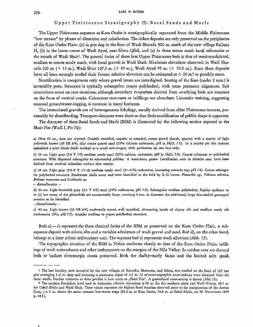
The character of these Basal Sands and Marls (BSM) is illustrated by the following section exposed in the
Shait Pits (Wadi I, Pit 21):
a) Over 55 cm., base not exposed. Crudely stratified, angular to rounded, coarse gravel (basalt, quartz) with a matrix of light yellowish brown (10 YR 6/4), silty coarse quartz sand (11 0/0 calcium carbonate; pH in H20, 7.5). In a nearby pit this stratum embedded a mint felsite blade worked as a crude end-scraper, with patination on one face only.
b) 25 cm. Light gray (2.5 Y 7/2) medium sandy marl (23% calcium carbonate; pH in H20, 7.5). Coarse columnar to polyhedral structure. With dispersed sub angular to subrounded pebbles. A waterworn proto- Levalloisian core in dolerite may have been derived from evolved Acheulian surface sites nearby.
c) 35 cm. Light gray (2.5-5 Y 1/1-2) medium sandy marl (21-310f0 carbonates, increasing towards top; pH 7.6). Coarse subangular polyhedral structure. Freshwater shells occur and were identified in the field by E. G. LEIGH: Planorbis sp., Valvata nilotica, Bulinus truncatus and Corbicula sp. - disconformity -
d) 10 cm. Light brownish gray (2.5 Y 6/2) marl (240/0 carbonates, pH 7.5). Suba.ngular medium polyhedral. Similar molluscs as in (c) but many of the planorbids are uncommonly large, attaining 5 mm. in diameter. An additional, large thin-shelled gastropod remains to be identified. - disconformity -
e) 40 cm. Light brown (10 YR 6/4) moderately sorted, well stratified, alternating bands of clayey silt and medium sandy silt (carbonates 100/0, pH 7.7). Angular medium to coarse polyhedral structure.
\
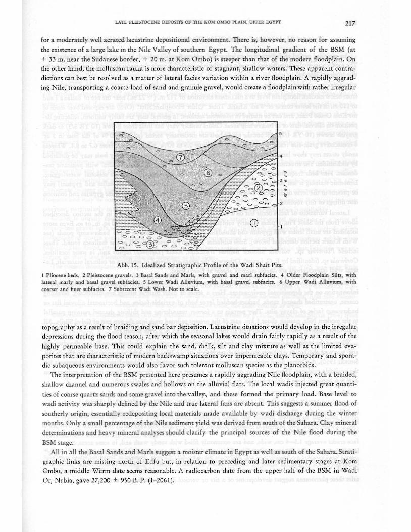
Beds a) - c) represent the three classical facies of the BSM as preserved on the Kom Ombo Plain, a sub
aqueous deposit with nilotic silts and a variable admixture of wadi gravel and sand. Bed d), on the other hand,
belongs to a later nilotic sedimentary unit. The topmost bed e) represents wadi alluvium (Abb. 15).
The topographic situation of the BSM in Nubia conforms closely to that of the Kom Ombo Plain: infill
ings of wadi embouchures and other embayments on the margins of the Nile Valley. In neither area are channel
beds or backset rivermargin strata preserved. Both the chalky-marly facies and the limitc;:d salts speak,
1 The last locality, now occupied by the new villages of Korosko, Shaturma, and Sebua, was studied on the basis of 123 test pits averaging 1-2 m. deep and attaining a maximum depth of 4.2 m. 12 microstratigraphic cross-sections were obtained from the three wadis. Further reference to these profiles is here made as "Shait Pits". A generalized cross-section is shown (Abb.15).
2 The modern floodplain level used to determine relative elevations is 90 m. for the southern plain and Wadi Kharit, 88.5 m. for Gebel Silsila and Wadi Shait. These values represent the highest flood maxima observed prior to the inauguration of the Aswan Dam, i. e. 9 m. above the mean summer low-water stage (81.0 m. at Kom Ombo, 79.4 m. at Gebel Silsila, see W. WILLCOCKS 1899 p. 44 f.).
LATE PLEISTOCENE DEPOSITS OF THE KOM OMBO PLAIN, UPPER. EGYPT 217
for a moderately well aerated lacustrine depositional environment. There is, however, no reason for assuming
the existence of a large lake in the Nile Valley of southern Egypt. The longitudinal gradient of the BSM (at
+ 33 ffi. near the Sudanese border, + 20 ffi. at Kom Ombo) is steeper than that of the modern floodplain. On
the other hand, the molluscan fauna is more d,aracteristic of stagnant, shallow waters. These apparent contra
dictions can best be resolved as a matter of lateral facies variation within a river floodplain. A rapidly aggrad
ing Nile, transporting a coarse load of sand and granule gravel, would create a floodplain with rather irregular
== 2
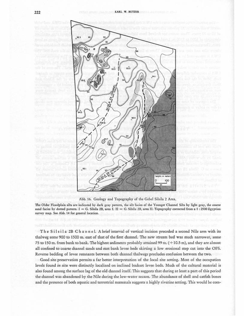
Abb.15. Idealized Stratigraphic Profile of the Wadi Shait Pits.
• , • •
1 Pliocene bed". 2 Pleistocene gravels. 3 Basal Sands and Marls, with gravel and marl subfacies .... Older FloOdplain Silts, with lateral marly and basal gravel subfacies. 5 Lower Wadi Alluvium, with basal gravel subfacies . 6 Upper Wadi Alluvium, w ith coarser and finer subfacies. 7 Subrecent Wadi Wash. Not to scale.
topography as a result of braiding and sand bar deposition. Lacustrine situations would develop in the irregular
depressions during the flood season, after which the seasonal lakes would drain fairly rapidly as a result of the
highly permeable base. This could explain the sand, chalk, silt and clay mixture as well as the limited eva
porites that are d,.racteristic of modern backswamp situations over impermeable clays. Temporary and spora
dic subaqueous environments would also favor such tolerant molluscan species as the planorbids.
The interpretation of the BSM presented here presumes a rapidly aggrading Nile fl oodplain, with a braided,
shallow channel and numerous swales and hollows on the alluvial flats . The local wadis injected great quanti
ties of coarse quartz sands and some gravel into the valley, and these formed the primary load. Base level to
wadi activity was sharply defined by the Nile and true lateral fans are absent. This suggests a summer flood of
southerly origin, essentially redepositing local materials made available by wadi discharge during the winter
months. Only a small percentage of the Nile sediment yield was derived from south of the Sahara. Clay mineral
determinations and heavy mineral analyses should clarify the principal sources of the Nile flood during the
BSM stage.
All in all the Basal Sands and Marls suggest a moister climate in Egypt as well as south of the Sahara. Strati
graphic links are missing north of Edfu but, in relation to preceding and later sedimentary stages at Kom
Ombo, a middle Wiirm date seems reasonable. A radiocarbon date from the upper half of the BSM in Wadi
Or, Nubia, gave 27,200 ± 950 B. P. (1- 2061).
218 KARL VI. BUTZER.
Up per PIe i s t 0 c en est rat i g rap h y (II): 0 Ide r ' Flood p I a inS i Its
An extended period of downcutting, to below the modern floodplain level, followed deposition of the BSM. The total absence of contemporary deposits or paleosols precludes any paleo-environmental interpretation for this erosional interval.
Subsequent sedimentation is characterized by horizontal, sandy to clayey silts of fluvial origin. These rise from below modern floodplain level to a maximum elevation of 112 m. (+ 22 m.) near the site of Ballana I and
to 110 m. in the lower course of Wadi Kharit. These "Older Floodplain Silts" (OFS) are exposed over much of the Kom Ombo Plain, and can be studied in numerous sections. In general they are fairly uniform, reflecting deposition on alluvial flats or in backswamp areas. Colors usually vary but little from brown (10 YR 5/3) to dark grayish brown (10 YR 4/2). All but the sandy beds are moderately sorted (at least 90 % of the fines in 3 or 4 consecutive grain-size fractions). Carbonates vary from 0.5 to 100/0, pH values run from 6.7 to 8.4. Whereas sandy strata may show laminations and generally conspicuous stratification, the clayey beds may be disturbed
by slickensides. The structure is most commonly angular, coarse to very coarse polyhedral with prismatic tendencies. Fine beds frequently show pyrolusite stains or dendrites, suggestive of some seasonal waterlogging. Limonitic staining is less common. Secondary calcium carbonates andlor salts (both halite and gypsum) may
be present in the form of dispersed 2-5 mm. concretions, nodular bands, rare crystalline gypsum and common cast fillings of tiny rootlets.
Lateral variations of facies occur but on a very localized scale only. Thus bed d), in the section described above from the Shait Pits, typifies a marly subfacies sometimes occupying areas of 100 sq. m. or so. Even more localized are small lenses with gypsum and abundant organic matter, recording small backswamp ponds (see Wadi Kharit section described below). Such subfacies account for practically all of the mollusca found. These include Planorbis sp., valvata nilotica Bulinus truncatus, Radix (Limnaea) lagotis and, in some localities,
Corbicula sp. (identified by E. G. LEIGH). Otherwise the strata are devoid of mollusca or cultural materials. Lat€1ral wadi intercalations are almost entirely absent at Kom Ombo.
Extended exposures along an east-west ditch, about 1.5 km. northeast of Silsila Station, provided additional information on the depositional environment. Here a series of older channel fillings are intersected, revealing coarse, unstratified channel sands, backset-bedded levee beds of variable facies, and horizontal alluvial flat or backswamp facies of clayey silts. They pertain to a former meandering and shifting channel running parallel to the modern Nile, passing about 1 km. east of the present railroad track into the gap east of Gebel Silsila. All in all these massive, horizontal silts exhibit all the classic attributes of a river floodplain.
Whereas the sands and dispersed pebbles found in the OFS are primarily derived from Egypt" the clay, silt and many of the heavy minerals are more characteristic of the Blue Nile-Atbara drainage basin (see N. M. SHUKRI 1950). A summer flood regime analogous to but more vigorous than that of today would account for the available evidence. There is nothing conclusive to suggest a moister climate in Egypt itself. A radiocarbon date was obtained from a clayey marl in the Shait Pits: 18,300 ± 310 B. P. (1-2060).
After deposition of the OFS was completed fluvial erosion reduced the silt spreads of the Kom Ombo Plain to a gently sloping surface dropping from 102-106 m. in the mouths of Wadis Kharit and Shait, to 94-96 m. in Nile proximity. The exact nature of this denudation is uncertain although it can best be explained
by wadi washing. Of some interest in the paleosol that developed at this time or shortly thereafter. Epigenetic crack networks frequently penetrate to depths of 1.5 m., exhibiting polygonal structures at the surface. Subsur-
, face cracks average 1.5-4'cm. wide, and are commonly filled with sandy wash and, in some areas, mixed car
bonate-halite cements. Where evaporites are present two classes of polygons commonly occur together: "major" polygons 75 to 250 cm. in diameter, with 3-5 cm. wide crack fillings (salt and carbonates), and "minor" crack networks a few cm. in diameter, with wash-filled cracks 0.5-3 cm. in width. In combination with the slicken
sides these phenomena suggest development of a tirs or vertisol in a hydromorphic environment.

LATE PLEISTOCENE DEPOSITS OF mE KOM OMBO PLAIN, UPPER EGYPT 219
Up per Pie i s to c e n est rat i g rap h y (III): You n g e r C han n e lSi It s
During the terminal stages of the late Pleistocene the Nile once again aggraded it~ bed tc;> well above the
present floodplain. More characteristic than the heavy minerals was the sudden influx of exotic gravel from the
central Sudan: flint, chert, chalcedony, agate, jasper and carnelian. Similar lithologica~ materials are absent
from the OFS. Most of these younger nilotic beds are fine-grained, however, although highly variable facies
are another important field characteristic. Textural classes range from coarse sands to clayey silts, primarily in
relation to rapid changes of sedimentary environment close to the low-water channel and its immediate banks.
Few, fine, horizontal deposits pertaining to alluvial flats or backswamps have been preserved. Instead the beds
are areally confined within the older alluvia, and usually exhibit complex horizontal and inclined strata sug
gestive of multiple channel shifts. In Egyptian Nubia these "Younger Channel Silts" (YCS) attain re~ative
elevations of + 23 m. (and possibly more), on the Kom Ombo Plain + 13 m. They have not been recorded further north.
Stratification is conspicuous and sorting of coarse beds is moderate to good. Fine beds range from silty sands
to clayey silts and are poorly sorted. Structure varies correspondingly from single-grain to a~gular, medium
to coarse polyhedral or platy. Except in beds of coarse sands, colors are a monotonous pale brown (10 YR 6/3).
Carbonate content is highly variable, pH values range from 7.1 to 8.2. Calcareous salt concretions are not in
frequent and may be concentrated in fluvial beds through erosion and secondary deposition. Rootcasts are very
common, particularly in relation to silty levee beds. Evidence of groundwater oxidation is negligible.
Gravel is usually found dispersed in channel beds, but may attain sandy gravel texture as in a series of
stream-bed gravel bars south of Darau. Pebbles seldom exceed 2 cm. in length and gravel strata include a high
percentage of quartz granules, with the exotic pebbles complemented by quartz in the medium pebble class
(0.6-2.0 cm). Good rounding is the rule. The vigor of stream transport leaves no doubt that Ethiopia was enjoying its third late Pleistocene pluvial substage at this time.
The present floodplain in the Kom Ombo area is narrow and that associated with the YCS was only little
wider. Several minor arms cut through the OFS along the eastern bank, however, and the Silsila Gap was used
as a secondary or flood-season channel through most of this period. Freshwater molluscs (Unio willcocksi, Cor
bicula sp., Cleopatra bulimoides, and very rare Etheria elliptica) line these ancient channels. And late Paleolithic archeological sites, commonly with fish and mammalian bone, dot their courses as well.
Unpublished radiocarbon dates (kindly communicated to the writer by P. E. L. SMITH, also SMITH 1964) from
a variety of archeological sites stratified within these channel deposits suggest a late Wiirm age, approximately
17,000 -12,500 B. P., for the YCS. At the beginning of the Holocene the Nile reverted to downcutting. Mid
Holocene silts, at relative levels of + 5-8 m, and with Neolithic industries, are present inNubia but are absent
at Kom Ombo. The narrow Holocene floodplain, commonly bounded by bedrock or Pleistocene terraces, has not preserved their traces if they did indeed exist.
Up per Pie i s to c e n est rat i g rap h y (IV): Lower Wad i A 11 u v i u m
At about the same time that the YCS were being deposited along the western margins of the Kom Ombo
Plain, Wadis Kharit and Shait were also active. The sequence of deposits is perhaps best illustrated by a section near the mouth of the former wadi:
a) Over 130 cm, base not exposed. Inhomogeneous, dark grayish brown (10 YR 3-412) medium-sandy silt (lOfJ/o carbonates, pH 7.0). Sub angular coarse polyhedral to prismatic structure. Calcareous salt concretions (2-7 mm) common, while limonite and pyrolusite staining suggest groundwater-logging. Valvata nilotica and Bulinu$ truncatus are present according to field identifications by E. G. LEIGH. .
- semi-disconformity -
220 KARL W. BUTZER
b) 5-20 cm. Light brownish gray to grayish brown (2.5 Y 6/2, 10 YR,5-6/2) clayey silt (18% carbonates, pH 7.1), with gypsum and much organic matter. Subangular medium polyhedral, often platy structure. Stratum consists of semicontinuous pan sediments cut in cross-section, and averaging 1.5-3 m in width. - disconformity with formation of vertisol -
c) 10--40 cm. Light brown (5-7.5 YR 6/4) silty medium sand (1% carbonates, pH 7.5). Well-stratified, current-bedded; subangular coarse polyhedral structure. Contains abundant terrestrial snails (Zootecus insularis plus an unidentified species) and a few derived planorbids. - disconformity -
d) 2 cm. Pink (7.5 YR 7/4) silty coarse sand (7% carbonates, pH 7.7). Stratified with single-grain structure. Concentrations of medium gravel (mainly derived calcareous concretions) are common, also as a surface lag.
Beds a) and b) despite the differences of facies both have a similar mixed orlgm of nilotic silts, gypsum
and halite evaporites and local wadi sands. Both beds belong to the OFS. Occasional laminae of sands and silts,
some of them current-bedded, suggest wadi washing during the low-water season when the Nile floodplain was
desiccated. Bed c) stands out as a strict wadi deposit of fluvial nature and analogous beds can be found under a
surface veneer of coarse, younger alluvium or colluvium widespread in the lower reaches of Wadis Kharit and
Sharit and their tributaries. The topset and foreset beds suggest swift irregular, torrential wadi flow. This
Lower Wadi Alluvium (L W A) is distinct from the Upper Wadi Alluvium (UW A) of bed d), a detrital wash
grading laterally into slope colluvia derived from Pleistocene terraces or the lag on the sandstone cliffs.
The L WA shows lateral variations of facies between the channels of the larger wadis and ponded embayments of minor tributaries. The latter facies is commonly a light brown (7.5-10 YR 6/4), homogeneous
clayey silt. Stratification is poor although laminations do occur. Structure is angular, coarse to very coarse polyhedral with prismatic tendencies that commonly destroy the original stratification. A fair calcite content is
usual, and calcareous salt fillings in rootlet hollows as well as minor saltveinlets or concretions may be present.
Occasionally there are basal silty sands or crudely stratified, angular to sub rounded, granule or medium gravel. The coarser, wadi channel facies is well stratified, often laminated or current-bedded, ranging from silty
medium sand to coarse sand grades. Colors are commonly light reddish brown (5-7.5 YR 5-6/4). The struc
ture is modified to subangular coarse polyhedral. Carbonate contents ar~ very low.
The organic vestiges of the L W A include occasional derived aquatic shells in basal strata (when overlying
OFS deposits) and local concentrations of at least two species of terrestrial snails, primarily Zootecus insularis.
Rootlet zones, rootcasts or rOQt-drip are not uncommon. -In the finer facies small, vertical rootlets are exclusive, possibly suggesting grassy vegetation. Root impressions of the coarse wadi facies are large, and usually
horizontal, suggesting semidesert shrubs. A radiocarbon date of 17,400 ± 300 B. P. (I-2179) was obtained from
a clayey marl near the base of the L WA in the Shait Pits.
The L WA attain over 9 m thickness locally and represent a well-graded wadi floor alluvium now truncated
along the margins of the Kom Ombo Plain at 102-111 m. The areal' extent is considerably greater than
that shown on Abb. 14 since these beds are generally overlain by UWA. Originally they swept out over the
present OFS surface in the form of very shallow fans. These predate the shallow gullies that sporadically carry
rainwaters to the Nile, and which only contain UW A deposits. Although there is no evidence of seasonal or groundwater-logging in the lower exposures of the L W A, at about 102 m, the geomorphic evidence sllggests
aggradation to a base level at 95-100 m, but no lower, i. e. the YCS stage of the Nile.
A second stratigraphic tool is provided by a buried tirs or vertiso!' The fine facies of the L W A exhibits poly
gonal crack networks to depths of at least 140 em, with individual cracks attaining 4 em in thickness. These de
hydration fissures formed after deposition had ceased, prior to sedimentation of the UWA. It may be relevant
that salt crusts of possibly analogous origin developed on the coarser grained YCS, also prior to gullying of the
nilotic alluvia of the plain. A terminal date for the LWA in Nubia is given by Y -1377, 8890 ± 160 B. P.
The UWA are associated with the A-Group occupation of Wadi Kharit, and in Nubia e.uivalent beds are
intercalated with nilotic silts dating from 3000 B. C.

LATE PLEISTOCENE DEPOSITS OF THE'KOM OMBO PLAIN, UPPER EGYPT 221
The paleoclimatic implications of the L W A can best be understood in comparison with the UW A and with
recent wadi activity. At present coherent water flow is only experienced by Wadis Shait andKharit as intervals of 10 to 20 years. These waters are derived from higher portions of the Red Sea Hills catchment area, attaining
elevations of 1000 to 1S00 m. Local rainfall near Kom Ombo has not sufficed for surface runoff since at least
1903. The occasional spates of Kharit and Shait leave ponds of muddy waters behind, in which fine laminae of
clayey silts and clay are deposited. There is little or no redeposition of coarser materials in the wadi bed. The
UW A is represented by a coarse lag of colluvial origin as well as by coarse wadi alluvium. This implies heavy,
torrential local rains as well as accelerated activity by the major wadis. Mid-Holocene climate was distinctly
moister than that of today, even though overall conditions would still have qualified as "arid". The case of the
L W A is somewhat different. Colluvial wash is not conspicuous, and coarse materials are rare except in channel
beds. Most of the fine alluvium can be interpreted as a clayey facies on the alluvial flats of the Kharit and
Shait floodplains, drowning the mouths of minor tributaries. Either sheetflooding was impeded by a vegetative
mat, as is suggested by the root-casts, or local rains were of moderate intensity only. Possibly both factors were
involved. In any case, late Wiirm climate of Upper Egypt was also "pluvial" in character.
The interval of time separating the UW A and L W A was probably brief and the local climate was about
as dry as today is suggested by slow dissection of the major wadis.
The G e 010 g i cal Set tin g 0 f the G e bel S i 1 s i I a "2" Sit e s
The relationship of the late Paleolithic cultures to the geological and geomorphic features of the Kom Ombo
Plain can best be illustrated by an example from the northern exit of the plain. Here the geological setting of
several sites, collected or excavated by M. A. Baumhoff and H. Walter for the Yale Expedition, was studied in detail by the writer (Abb. 14, 16 und 17). One of the sites, Gebel Silsila 2A, represents a surface scatter of
archeological remains denuded from deposits related to a first stream channel ("Silsila 2A Channel"). The site
known as G. Silsila 2B consists of two stratified site complexes (I and II) with an adjacent surface scatter, all
related to a second channel ("Silsila 2B Channel"). The geomorphic evolution of this local scene can be outlined
as follows.
The S i 1 s i 1 a 2A C han n eLAn initial period of stream bed scour and aggradation of the YCS is
recorded by a minor Nile arm swinging eastwards past the present village of Fatira and then turning north
through the Silsila Gap (Abb. 14 und 16). The channel was some 1 SO-200 m. wide, primarily a zone ofhomogeneous, coarse quartz sands. Rare pebbles of 6-12 mm. quartz occur while shell of Unio and Cleopatra bulimoi
des abound. Laterally there may be backset-bedded levee deposits, mainly sandy silts. Most of these channel sedi
ments have been badly scoured by wind action, and reduced to yardangs with a local relief of 2 to 6 m. The highest deposits lie at 99.2 m., suggesting a former maximum channel level just above 100m. (+ 13 m).
The yardangs of the G. Silsila 2A site pertain to the levee beds of the western bank of this first channel. The rich but heterogeneous industries appear to come from the uppermost strata, above 98 m. In one case, a con
siderable number of flakes, blades and flaking waste were found within a large slab of halite-cemented duri
crust. It had been lowered through undermining of the softer sediments below. Originally this crust formed
the surface during a considerable period of time following the abandonment of the channel. Whether there
originally was much vertical stratigraphy at G. Silsila 2A is difficult to assess today.
The ecological setting of the site can only be inferred from its riverside location. What little bone is pre
served i"s generally wind-abraded, and may originally have been waterworn. Identification of some of the bone
seems possible. Those levee beds which are preserved show frequent root drip and occasional pieces of calcified
wood. Most of the root casts and fillings pertain to lower plants however. By analogy, the G. Silsila 2A site locations were probably little different from those of the 2B sites.
222 KARL W. BUTZER
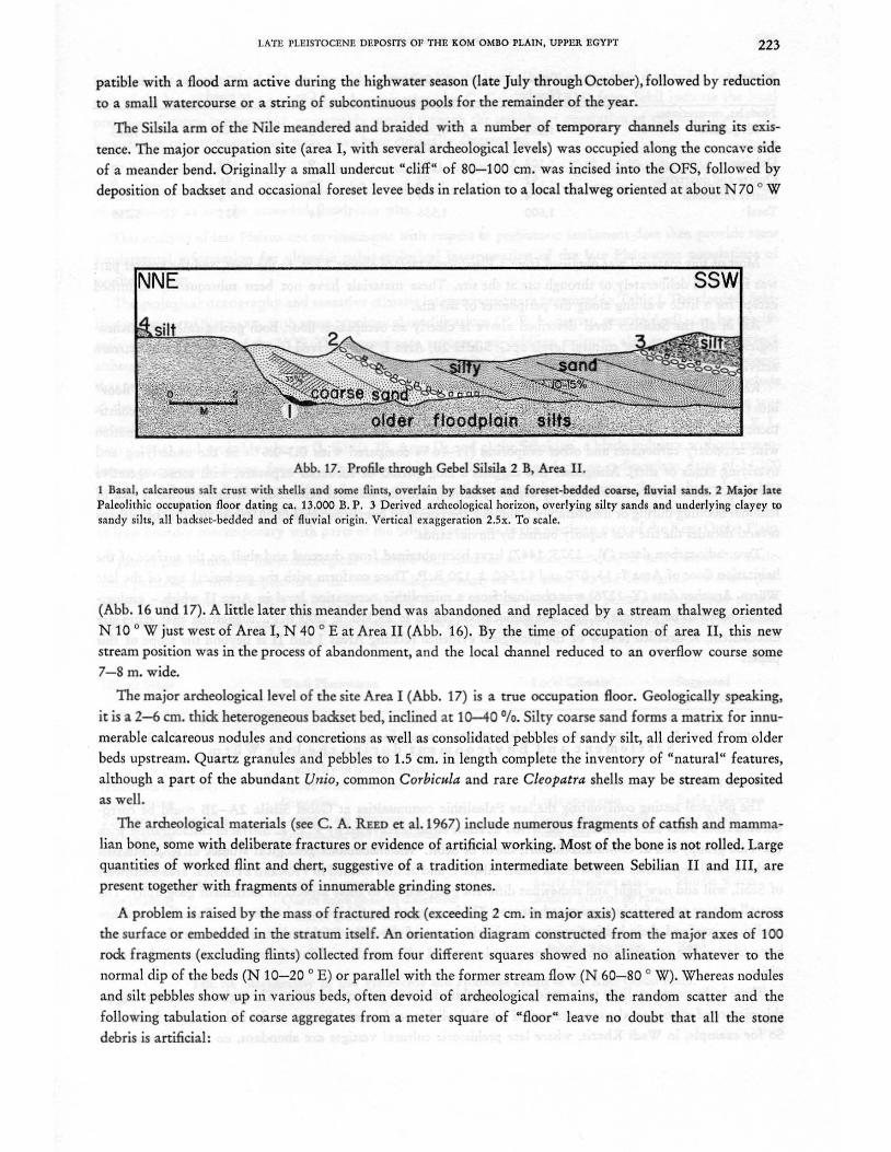
Abb. 16. Geology and Topography of the Gebel Silsila 2 Area.
The Older Floodplain silts are indicated by dark gray pattern, the silt facies of the Younger Channel Silts by light gray, the coarse sand facies by dotted pattern . I = G. Silsila lB. area I. II = G. Silsila 2B, area II. Topography corrected from a 1 : 2500 Egyptian survey map. See Abb. 14 for general location.
The S i lsi I a 2B C han n e I. A brief interval of vertical incision preceded a second Nile arm with its
thalweg some 900 to 1500 m. east of that of the first channel. The new stream bed was much narrower, some
75 to 150 m. from bank to bank. The highest sediments probably attained 99 m. (+ 10.5 m), and they are almost
all confined to coarse channel sands and east bank levee beds skirting a low erosional step cut into the OFS.
Reverse bedding of levee remnants between both channel thalwegs precludes confusion between the two.
Good site preservation permits a far better interpretation of the local site setting. Most of the occupation
levels found in situ were distinctly localized on inclined backset levee beds. Much of the cultural material is
also found among the surface lag of the old channel itself. This suggests that during at least a part of this period
the dlannel was abandoned by the N ile during the low-water season. The abundance of shell and catfish bones
and the presence of both aquatic and terrestrial mammals suggests a highly riverine setting. This would be com-
LATE. PLEISTOCE.Nl~ DEPOSITS OF THE KOM OMBO PLAIN, UPPER EGYPT 223
patible with a flood arm active during the high water season (late July through October), followed by reduction
to a small watercourse or a string of subcontinuous pools for the remainder of the year.
The Silsila arm of the Nile meandered and braided with a number of temporary channels during its exis
tence. The major occupation site (area I, with several archeological levels) was occupied along the concave side
of a meander bend. Originally a small undercut "cliff" of 80-100 cm. was incised into the OFS, followed by
deposition of backset and occasional foreset levee beds in relation to a local thalweg oriented at about N70 0 W
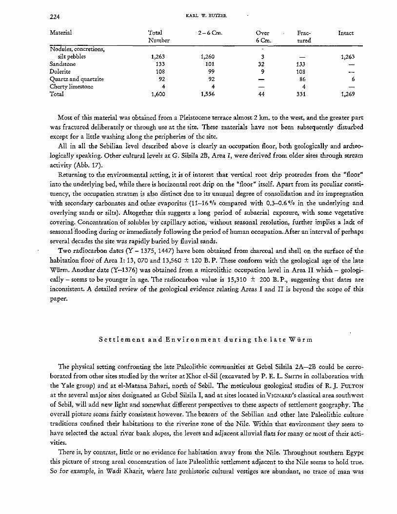
Abb. 17. Profile through Gebel Silsil. 2 B, Are. II.
1 Basal, calcareous salt crust with shells and some flints, overlain by badtset and foreset-bedded coarse, fluvial sands. 2 Major late Paleolithic occupation floor dating ca. 13.000 B. P. 3 Derived ard1cological horizon, overlying silty sands and underlying claycy to sandy silts, all backsct-bcdded and of fluvial origin. Vcrtical cxaggcration 2.5x. To scale.
(Abb. 16 und 17). A little later this meander bend was abandoned and replaced by a stream thalweg oriented
N 10 0 W just west of Area I, N 40 0 E at Area II (Abb. 16). By the time of occupation of area II, this new
stream position was in the process of abandonment, and the local channel reduced to an overflow course some 7-8 m. wide.
The major archeological level of the site Area I (Abb. 17) is a true occupation floor. Geologically speaking,
it is a 2-{' cm. thick heterogeneous backset bed, inclined at 10-40 Ofo. Silty coarse sand forms a matrix for innu
merable calcareous nodules and concretions as well as consolidated pebbles of sandy silt, all derived from older
beds upstream. Quartz granules and pebbles to 1.5 cm. in length complete the inventory of "natural" features,
although a part of the abundant Unio, common Corbicula and rare Cleopatra shells may be stream deposited
as well.
The archeological materials (see C. A. REED et al. 1967) include numerous fragments of catfish and mamma
lian bone, some with deliberate fractures or evidence of artificial working. Most of the bone is not rolled. Large
quantities of worked flint and chert, suggestive of a tradition intermediate between Sebilian II and III, are
present together with fragments of innumerable grinding stones.
A problem is raised by the mass of fractured rock (exceeding 2 cm. in major axis) scattered at random across
the surface or embedded in the stratum itself. An orientation diagram constructed from the major axes of 100
rock fragments (excluding flints) collected from four different squares showed no alineation whatever to the
normal dip of the beds (N 10-20 0 E) or parallel with the former stream flow (N 60-80 0 W). Whereas nodules
and silt pebbles show up in various beds, often devoid of archeological remains, the random scatter and the
following tabulation of coarse aggregates from a meter square of "floor" leave no doubt that all the stone
debris is artificial:
224 KARL W. BUTZER
Material Total 2-6Cm. Over Frac- Intact Number 6Cm. tured
Nodules, concretions, silt pebbles 1,263 1,260 3 1,263
Sandstone 133 101 32 133 Dolerite 108 99 9 108 Quartz and quartzite 92 92 86 6 Cherty limestone 4 4 4 Total 1,600 1,556 44 331 1,269
Most of this material was obtained from a Pleistocene terrace almost 2 km. to the west, and the greater part
was fractured deliberately or through use at the site. These materials have not been subsequently disturbed
except fDr a little washing along the peripheries of the site.
All in all the Sebilian level described abDve is clearly an occupation floor, both geologically and archeo
logically speaking. Other cultural levels at G. Silsila 2B, Area I, were derived from older sites through stream
activity (Abb. 17).
Returning to the environmental setting, it is of interest that vertical root drip protrudes from the "floor"
into the underlying bed, while there is horizontal root drip on the "floor" itself. Apart from its peculiar consti
tuency, the occupation stratum is also distinct due to its unusual degree of consolidation and its impregnation
with secondary carbonates and other evaporites (11-16 % compared with 0.3-0.6 % in the underlying and
overlying sands or silts). Altogether this suggests a long period of subaerial exposure, with some vegetative
covering. Concentration of solubles by capillary action, without seasonal resolution, further implies a lack of
seasonal flooding during or immediately following the period of human occupation. After an interval of perhaps
several decades the site was rapidly buried by fluvial sands.
Two radiocarbDn dates (Y - 1375, 1447) have been Dbtained from charcoal and shell Dn the surface Df the
habitation floor of Area I: 13, 070 and 13,560 ± 120 B. P. These conform with the geolDgical age of the late
Wiirm. Another date (Y-1376) was obtained from a microlithic occupation level in Area II which - geologi
cally - seems to be YDunger in age. The radiocarbDn value is 15,310 ± 200 B. P., suggesting that dates are
inconsistent. A detailed review Df the geological evidence relating Areas I and II is beyond the SCDpe of this
paper.
Settlement and Environment during the late Wiirm
The physical setting confronting the late Paleolithic communities at Gebel Silsila 2A-2B could be corro
borated from other sites studied by the writer at Khor el-Sil (excavated by P. E. L. SMITH in collaboration with
the Yale group) and at el-Matana Bahari, north of Sebil. The meticulous geological studies of R.J. FULTON
at the several major sites designated as Gebel Silsila I, and at sites located in VIGNARD'S classical area southwest
of Sebil, will add new light and somewhat different perspectives to these aspects of settlement geography. The
overall picture seems fairly consistent however. The bearers of the SebiHan and other late Paleolithic culture
traditions confined their habitations to the riverine zone of the Nile. Within that environment they seem to
have selected the actual river bank slopes, the levees and adjacent alluvial flats for many or most of their acti
vities.
There is, by contrast, little or no evidence for habitation away from the Nile. Throughout southern Egypt
this picture of strong areal concentration of late Paleolithic settlement adjacent to the Nile seems to hold true.
So for example, in Wadi Kharit, where late prehistoric cultural vestiges are abundant, no trace of man was
LATE PLEISTOCENE DEPOSITS OF THE KOM OMBO PLAIN, UPPER EGYPT 225
found in situ in either the L W A or any older deposits. Yet the local climate was moister than today for at least
part of the late Wiirm. The early faunal determinations by C. GAILLARD (1934) from Sebil indicate the local presence of steppe species which presumably ranged through the semidesert vegetation of the wadi floors. The
localization of settlement may, then, have been cultrually determined.
A similar problem is raised by the absence of cultural materials from the OFS. Unlike the BSM, preserved in a semi-lacustrine facies, the OFS do exhibit occasional river bank and levee exposures. These are as devoid
of archeology as are the extended floodplain silts.
This analysis of late Pleistocene environments with respect to prehistoric settlement does then provide some fundamental information for ultimate paleo-ecological interpretation of the late Pleistocene populations of
'southern Egypt.
The geological stratigraphy and tentative climatic interpretations are presented in Table I. The classical Sebilian industries of VIGNARD, with some typological modifications (P. E. L. SMITH, unpublished), can be specifi
cally related to a part of the YCS. The approximate sequence of Sebilian cultures also seems to be correct, although the geological investigation of R. J. FOL ToN at Sebil will consider this problem in detail. It is pertinent that several other industries identified by P. E. L. SMITH, have also been related to the same strata. These include
a) the Menchian characterized by many scrapers and burins with Aurignacian affinities; b) the Silsilian, a true
microlithic industry with microburins, bladelets and occasional geometric forms found at G. Silsila 1 (P. E. L. SMITH 1964) and probably also at G. Silsila 2B, Area II; and c) the Sebekian, a blade industry without micro
burins or geometric forms, found overlying the Silsilan at G. Silsila I and giving radiocarbon dates of 14,100
and 14,240 B. C. (p. E. L. SMITH 1964). In view of this the Sebilian neither represents the totality of the late
Wiirm at Kom Ombo, nor does it represent the only cultural variant of the region. Several other industries are at least broadly contemporary with parts of the Sebilian sequence in the northern part of the Kom Ombo Plain.
Just as publication of the archeological materials will enhance our understanding of late Paleolithic settlement patterns, so will completion of the sedimentological analyses and study of the biological materials (col
lected by the Canadian and Yale expeditions) add to and possibly modify the paleo-environmental picture.
Publication of the radiocarbon dates just obtained or in process will also improve the stratigraphic framework.
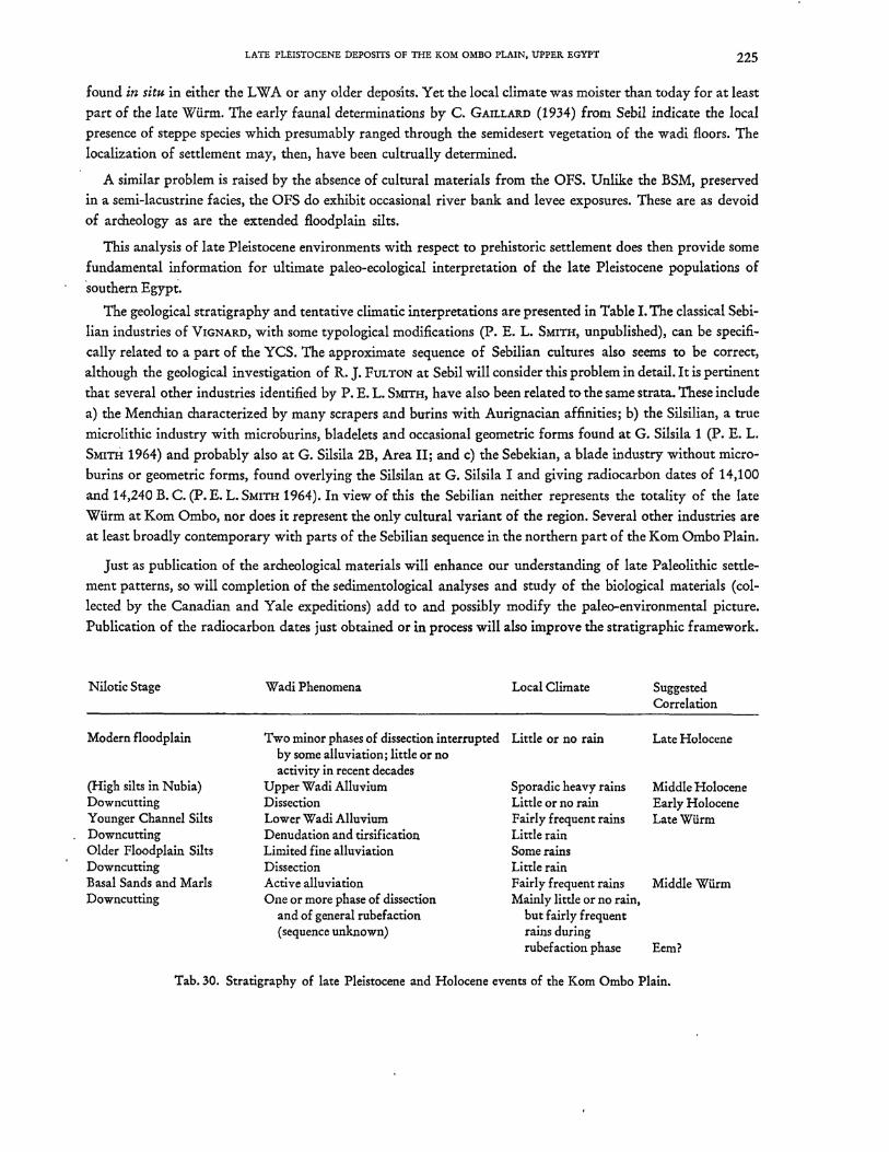
Nilotic Stage Wadi Phenomena Local Climate Suggested Correlation
Modern floodplain Two minor phases of dissection interrupted Little or no rain Late Holocene by some alluviation; little or no activity in recent decades
(High silts in Nubia) Upper Wadi Alluvium Sporadic heavy rains Middle Holocene Downcutting Dissection Little or no rain Early Holocene Younger Channel Silts Lower Wadi Alluvium Fairly frequent rains LateWUrm Downcutting Denudation and tirsification Little rain Older Floodplain Silts Limited fine alluviation Some rains Downcutting Dissection Little rain Basal Sands and Marls Active alluviation Fairly frequent rains MiddleWUrm Downcutting One or more phase of dissection Mainly little or no rain,
and of general rubefaction but fairly frequent (sequence unknown) rains during
rubefaction phase Eem?
Tab. 30. Stratigraphy of late Pleistocene and Holocene events of the Kom Ombo Plain.
226 KAllL VI. BVTZElI.
Zusammenfassung
Jung-Pleistozane Ablagerungen der Kom Ombo-Ebene, Oberagypten
Auf Grund einer quarciirgeologisdlen Detailuntersuchung 1962/63 wird das Jung-Pleistozan der Kom OmboEbene in drei nilotische Aufschiittungsphasen aufgegliedert:
a) "Basale Sande und Mergel" (Basal Sands and Marls). Wahrend des Mittelwiirms wurden Mittel- bis Grobsande von einem reiBenden Wildbach bis 20 m iiber der heutigen Nilebene abgelagert. Diese Quarzsande sind vorwiegend ortlicher Herkunfl:, von den Wadis dem Nil zugefiihrt und von den Sommerfluten auf breiter Oberschwemmungsebene umgelagert. Vorubergehend bildeten sich Seen in den Niederungen der schwachgewellten Sandfluren.
b) "lUtere Auelehme" (Older Floodplain Silts). 1m frUben Spatwiinn wurdeneinformigeAuelehmeaufeiner breiten Oberschwemmungsebene ostlich Kom Ombo von den sommerlichen Hochfluten bis in + 23 m abgesetzt. Der Ton- und Schluff'anteil der Sedimente geht vorwiegend auf die basaltischen Verwitterungsboden Athiopiens zuruck, und weist damit auf einen zweiten Pluvialabschnitt im Sommerregengebiet siidlich der Sahara hin. DeutHche Anzeichen versciirkten Wadiabflusses im Winterregengebiet Agyptens fehien aber.
c) 'DJiingere FluBbettlehme" (YoungerChannelSilts). Etwa.15 000 bis 10 500 v. Chr. schiittete der Nil emeut sein Bett auf. Verschiedene FluBverzweigungen maandrierten iiber die westliche Kom Ombo-Ebene in + 13 m. Die Fazies der Scb.ichten wechselt schnell in kleinen Raumen und weist auf FluBbett- und Dammuferbildungen hin. FluBkiese mittelsudanesischer Herkunfl: (Feuerstein, Chalzedon, Achat, Jaspis, Kameol) treten jetzt erstmalig auf. Etwa gleichzeitig erfolgte eine bedeutungsvolle Aufschfittungsphase der ortlichen Wadis ( .. Lower Wadi Alluvium"), so daB man auf einen synchro~en Pluvialabschnitt im Winter- und Sommerregengebiet schlieBen kann.
Auf Grund der fossilen Boden und der Zerschneidungsepochen wird eine palaoklimatische Gliederung des jfingeren Quartlirs vorgescblagen.
Die stratigraphischen VerhaItnisse der spatpalaolithischen Industrien, u. a. die Sebil-Kulturen VIGNARDS, konnten nach vierzig Jahren endlich geologisch definiert werden. Sie treten als z. T. ungesoorte Freilandssiedlungen in den Dammuferscbichten der "Jiingeren FluBbettlehme" auf. In den fiber 40 m machtigen "lUteren Auelehmen" findet man keine Hinweise menschlicber Besiedlung. Gelegentlich treten mittelpaHiolithische Artefakte in den "Basalen Sanden und Mergeln· aufa.
Manuskript eingereicht: Herbst 1964.
II 'l1tia study was supported in part by grants from the National Science Foundation (No. <3-23777) and the U. S. State Department (No. SCC-29629) both to the Peabody Museum of Natural History, Yale University. Substantial financial aids as well as the facilities for the laboratory work were generously provided by the University of Wisconsin. The writer is pleased to acknowledge the collaboration of CARL L. HANSEN in all phases of the work. EGBERT G. LEIGH identilied many of the molluses in the field. P. E. L. SMITH provided information as well as useful suggestions on the manuscript. Yale radiocarbon dates were made available through the courtesy of C. A. Reed and M. Stuiver. Maps and diagrams were drawn by the Cartographic Laboratory of the University of Wisconsin.
LATE PLEISTOCENB DBPOSITS OF THE XOM OMBO PLAIN, UPPER. BGYPT 227
R.EFER.ENCES
ADAMS, A. L., WOODWARD, S. P. and FALCONER, H. 1864: Notes on the geology of a portion of the Nile Valley north of the Second Cataract in Nubia. Quart. Journ. Geol. Soc. 20 pp.6-19
BEADNELL, H. J. L. 1905: The relations of the Eocene and Cretaceous systems in the Esna-Aswan reach of the Nile Valley Quart. Journ. Geol. Soc. 61 pp. 667-678
BUTZER, K. W. 1959: Contributions to the Pleistocene geology of the Nile Valley. Erdkunde 13 pp. 46-67 -, 1960: On the Pleistocene shorelines of Arabs' Gulf, Egypt. Journ. Ge,o!' 68 pp. 626-637 -, 1964: Pleistocene palaeoclimates of the Kurkur Oasis. The Canadian Geogr. 8 pp. 125-141
BUTZER, K. W. and HANSEN, C. L. 1965: On Pleistocene evolution of the Nile Valley in southern Egypt. The Canadian Geogr.9 pp. 74-83
_ GAILLARD, C. 1934: Contribution a l'etude de la faune prehistorique de l':£gypte. Arch. Mus. Hist. Nat. Lyon 14
HULL, E. 1896: Observations on the geology-of the Nile Valley and the evidence of the greater volume of the river at a former period. Quart. Journ. Geol. Soc. 52 pp. 308-319
MORGAN, J. DE 1897: Recherches sur les origines de l':£gypte. Vol. 1. Paris
RBED, C. A., BAUMHOFP, M.A., BUTZER, K. W., WALTER, H. and BOLOYAN, D.S.: Preliminary report on the archaeological aspects of the research of the Yale University Prehistoric Expedition to Nubia, 1962-1963. Ann. du Service (in print).
SANDFORD, K. S. and ARXELL, W. J. 1933: Paleolithic man and the Nile Valley in Nubia and Upper Egypt. Univ. Chicago Oriental lnst. Pub!. 17
SCHWE1NFURTH, G. 1901: Am westlichen Rande des Nilthales zwischen Farschut und Kom Ombo. Petermann's Mitt. 47 pp.1-10
SHUlOlI, N. M. 1950: The mineralogy of some Nile sediments. Quart. Journ. Geol. Soc. 105 pp.511-534 SMITH, P. E. L. 1964: Radiocarbon dating of a late Paleolithic culture from Egypt. Science 145 p.811 VIGNARD, E. 1923: Une nouvelle industrie lithique: Ie .. Sebilien". Bull. lnst. Fran~. Archeel. Orient. 22 pp.1-76 WILLCOCKS, W. 1899: Egyptian irrigation.- London
Anschrift des Verfassers: Prof. Dr. K. W. Butzer, University of Chicago, Department of Anthropology, Chicago Illinois 60637,1126 East 59th street.