Embed Size (px)
Citation preview
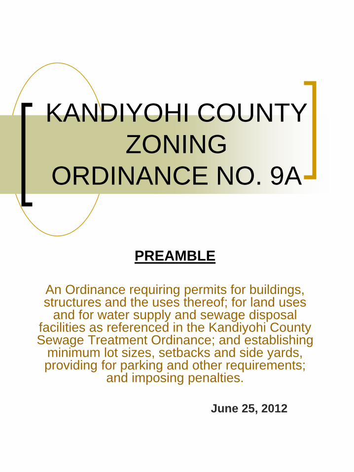
KANDIYOHI COUNTY
ZONING
ORDINANCE NO. 9A
PREAMBLE
An Ordinance requiring permits for buildings, structures and the uses thereof; for land uses
and for water supply and sewage disposal facilities as referenced in the Kandiyohi County Sewage Treatment Ordinance; and establishing
minimum lot sizes, setbacks and side yards, providing for parking and other requirements;
and imposing penalties.
June 25, 2012
Kandiyohi County Zoning Ordinance
i
This Ordinance shall be in full force and effect upon due passage and publication in the manner provided by law: Recommended by Planning Commission: Date: March 30, 1992 Signed: _____________________________________ Chair, Planning Commission Approved: April 21, 1992 _____________________________________ Chair, County Board Attest: _____________________________________ County Auditor Published: April 28, 1992 AMENDED Recommended by Planning Commission: Date: June 13, 1994 Signed: ______________________________ Chair, Planning Commission Amendments Passed and Approved: October 5, 1994 _____________________________________ Chair, County Board Attest: _____________________________________ County Auditor Published December 13, 1994 AMENDED Recommended by Planning Commission: Date: August 10, 1998 Signed: _____________________________________ Chair, Planning Commission Amendments Passed and Approved: September 15, 1998 _____________________________________ Chair, County Board Attest: _____________________________________ County Auditor Published September 23, 1998 AMENDED Recommended by Planning Commission: Date: May 13, 2002 Signed: _____________________________________
Chair, Planning Commission Amendments Passed and Approved: June 4, 2002 _____________________________________ Chair, County Board Attest: _____________________________________ County Auditor Published June 18, 2002
Kandiyohi County Zoning Ordinance
ii
AMENDED Amendments Passed and Approved: May 7, 2002 _____________________________________ Chair, County Board Attest: _____________________________________ County Auditor Published May 29, 2002
AMENDED Recommended by Planning Commission: Date: April 7, 2003 Signed: ________________________________________ Chair, Planning Commission Amendments Passed and Approved: May 6, 2003 _________________________________________ Chair, County Board Attest: _________________________________________ County Auditor Published: June 11, 2003
AMENDED
Recommended by Planning Commission: April 12, 2004 Signed: _________________________________________ Chair, Planning Commission Amendments Passed and Approved: May 18, 2004 __________________________________________ Chair, County Board Attest: _________________________________________ County Auditor Published: June 4, 2004
AMENDED Recommended by Planning Commission: February 7, 2005 Signed: __________________________________________ Chair, Planning Commission Amendments Passed and Approved: March 1, 2005 __________________________________________ Chair, County Board Attest: __________________________________________ County Auditor Published: March 18, 2005
Kandiyohi County Zoning Ordinance
iii
AMENDED Recommended by Planning Commission: April 11, 2005 Signed: _________________________________________ Chair, Planning Commission Amendments Passed and Approved: April 19, 2005 __________________________________________ Chair, County Board Attest: _________________________________________ County Auditor Published: April 22, 2005 AMENDED Recommended by Planning Commission: January 9, 2006 Signed: __________________________________________ Chair, Planning Commission Amendments Passed and Approved: January 17, 2006 __________________________________________ Chair, County Board Attest: __________________________________________ County Auditor Published: January 20, 2006
AMENDED Recommended by Planning Commission: February 13, 2006 Signed: __________________________________________ Chair, Planning Commission Amendments Passed and Approved: February 21, 2006 ___________________________________________ Chair, County Board Attest: __________________________________________ County Auditor Published: February 24, 2006
AMENDED Recommended by Planning Commission: April 10, 2006 Signed: __________________________________________ Chair, Planning Commission Amendments Passed and Approved: April 18, 2006 ___________________________________________ Chair, County Board Attest: ___________________________________________ County Auditor Published: April 21, 2006
Kandiyohi County Zoning Ordinance
iv
AMENDED Recommended by Planning Commission: August 7, 2006 Signed: ___________________________________________ Chair, Planning Commission Amendments Passed and Approved: August 15, 2006 ___________________________________________ Chair, County Board Attest: ___________________________________________ County Auditor Published: September 22, 2006 Recommended by Planning Commission: February 11, 2008 Signed: ___________________________________________ Chair, Planning Commission Amendments Passed and Approved: February 19, 2008 ____________________________________________ Chair, County Board Attest: ____________________________________________ County Auditor Published: February 29, 2008 Recommended by Planning Commission: February 7, 2011 Signed: ____________________________________________ Chair, Planning Commission Amendments Passed and Approved: February 15, 2011 ____________________________________________ Chair, County Board Attest: ____________________________________________ County Auditor Published: February 23, 2011 Recommended by Planning Commission: September 12, 2011 Signed: ____________________________________________ Chair, Planning Commission Amendments Passed and Approved: September 20, 2011 ____________________________________________ Chair, County Board Attest: ____________________________________________ County Auditor Published: September 26, 2011
Kandiyohi County Zoning Ordinance
v
Recommended by Planning Commission: June 11, 2012 Signed: ____________________________________________ Chair, Planning Commission Amendments Passed and Approved: June 19, 2012 ____________________________________________ Chair, County Board Attest: ____________________________________________ County Auditor Published: June 25, 2012 TABLE OF CONTENTS CHAPTER 1: TITLE AND APPLICATION…………………………………………………………. 1 1-1 TITLE……………………………………………………………………………………………… 1 1-2 PURPOSE…………………….……………………………………………………………....…… 1 1-3 JURISDICTION…………………………………………………………………………………… 1 1-4 AUTHORITY……………………………………...………………………………………………. 2 1-5 APPLICATION OF RULES………………………………………..………………………….…. 2 1-6 DEFINITIONS…………………………………………………………………………………….. 3 CHAPTER 2: ADMINISTRATION………………………………………………………………….. 15 2-1 ZONING ADMINISTRATOR…………………………………………………………………… 15 2-2 BOARD OF ADJUSTMENT…………………………………………………………………….. 16 2-3 PLANNING COMMISSION…………………………….………………………………………. 20 2-4 CONDITIONAL USE PERMITS………………………………………………………………… 21 2-5 ZONING PROCEDURES………………………………………………………………………… 24 2-6 LAND USE PERMITS…………………………………………………………………………… 26 2-7 ENVIRONMENTAL REVIEW….……………………………………………………………… 27 2-8 UTILITY/ESSENTIAL SERVICES PERMITS………………………………………………… 27 2-9 VIOLATIONS AND PENALITIES……………………………………………………………… 28 2-10 ENFORCEMENT………………………………………………………………………………... 29 CHAPTER 3: NON-CONFORMING LOTS, STRUCTURES AND USES………………………... 29 3-1 PURPOSE………………………………………………………………………………………… 29 3-2 LEGAL NON-CONFORMING LOTS (LOTS OF RECORD)…………………………………... 29 3-3 LEGAL NON-CONFORMING STRUCTURES………………………………………………… 30 3-4 LEGAL NON-CONFORMING USES…………………………………………………………… 31 CHAPTER 4: GENERAL ZONING DISTRICT PROVISIONS……………………………………. 32 4-1 CLASSIFICATION OF DISTRICTS…………………………………………………………….. 32 4-2 ZONING MAP……………………………………………………………………………………. 32 4-3 DISTRICT BOUNDARIES………………………………………………………………………. 33 4-4 FUTURE DETACHMENT………………………………………………………………………. 33 4-5 SPECIAL DISTRICTS…………………………………………………………………………… 33 CHAPTER 5: A-1 AGRICULTURAL PRESERVATION DISTRICT……………………………... 33 5-1 PURPOSE…………………………………………………………………………………………. 33 5-2 BUILDING ELIGIBILITIES……………………………………………………………………… 34 5-3 PERMITTED USES……………………………………………………………………………….. 35
Kandiyohi County Zoning Ordinance
vi
5-4 CONDITIONAL USES……………………………………………………………………………. 36 5-5 ACCESSORY USES ………………………...……………………………………………………. 37 5-6 HEIGHT AND YARD REGULATIONS…………………………………………………………. 38 CHAPTER 7: A-2 GENERAL AGRICULTURAL DISTRICT…………………………………….. 40 7-1 PURPOSE………………………………………………………………………………………….. 40 7-2 PERMITTED USES……………………………………………………………………………….. 40 7-3 CONDITIONAL USES……………………………………………………………………………. 41 7-4 ACCESSORY USES ………………………...……………………………………………………. 42 7-5 HEIGHT AND YARD REGULATIONS ………………………………………………………… 43 CHAPTER 10: R-1 SHORELAND RESIDENTIAL MANAGEMENT DISTRICT……………….. 45 10-1 PURPOSE………………………………………………………………………………………… 45 10-2 PERMITTED USES………………………………………………………………………….……45 10-3 CONDITIONAL USES…………………………………………………………………………... 45 10-4 ACCESSORY USES ………………………..…………………………………………………… 46 10-5 HEIGHT AND YARD REGULATIONS ……………………………………………………….. 46 CHAPTER 11: RM SHORELAND RESOURCE MANAGEMENT DISTRICT…………………... 48 11-1 PURPOSE………………………………………………………………………………………… 48 11-2 PERMITTED USES……………………………………………………………………………… 48 11-3 CONDITIONAL USES………………………………………………………………………….. 49 11-4 ACCESSORY USES……………………………………………………………………………... 50 11-5 HEIGHT AND YARD REGULATIONS………………………………………………………... 50 CHAPTER 12: GENERAL REGULATIONS FOR SHORELAND DISTRICTS………………….. 51 12-1 GENERAL REGULATIONS……………………………………………………………………. 51 12-2 SPECIAL DISTRICTS…………………………………………………………………………… 56 12-3 PLANNED UNIT DEVELOPMENTS (PUD’S)………………………………………………… 56 12-4 DIMENSIONAL REQUIREMENTS AND ADDITIONAL PERFORMANCE STANDARDS FOR SHORELAND DEVELOPMENT…………………………………………………………. 64 12-5 ADDITIONAL SPECIAL PROVISIONS……………………………………………………….. 64 12-6 STANDARDS FOR COMMERCIAL, INDUSTRIAL, PUBLIC AND SEMI PUBLIC USES 67 12-7 AGRICULTURAL……………………………………………………………………………….. 68 CHAPTER 14: R-2 COMMUNITY RESIDENCE DISTRICT……………………………………... 69 14-1 PURPOSE………………………………………………………………………………………… 69 14-2 PERMITTED USES……………………………………………………………………………… 69 14-3 CONDITIONAL USES………………………………………………………………………….. 70 14-4 ACCESSORY USES…………………………………………………………………………….. 70 14-5 HEIGHT AND YARD REGULATIONS …..…………………………………………………… 71 14-6 PLANNED UNIT DEVELOPMENTS (PUD’S)………………………………………………… 72 CHAPTER 16: R-3 RURAL RESIDENTIAL DISTRICT……………………………………………...75 16-1 PURPOSE…………………………………………………………………………………………. 75 16-2 PERMITTED USES………………………………………………………………………………. 75 16-3 CONDITIONAL USES………………………………………………………………………….... 76 16-4 ACCESSORY USES…………………………………………………………………………….....76 16-5 HEIGHT AND YARD REGULATIONS………………………………………………………….77
Kandiyohi County Zoning Ordinance
vii
16-6 PLANNED UNIT DEVELOPMENTS (PUD’S)…………………………………………………78 CHAPTER 18: CI COMMERCIAL/INDUSTRIAL DISTRICT……………………………………. 81 18-1 PURPOSE………………………………………………………………………………………… 81 18-2 PERMITTED USES……………………………………………………………………………… 81 18-3 CONDITIONAL USES…………………………………………………………………………... 82 18-4 ACCESSORY USES …………………………………………………………………………….. 83 18-5 HEIGHT AND YARD REGULATIONS …..…………………………………………………… 83 CHAPTER 28: WIND ENERGY CONVERSION SYSTEMS………………………………………. 83 28-1 PURPOSE………………………………………………………………………………………… 83 28-2 DEFINITIONS…………………………………………………………………………………… 84 28-3 PROCEDURES…………………………………………………………………………………... 85 28-4 AGGREGATED PROJECTS…………………………………………………………………….. 86 28-5 DISTRICT REGULATIONS ………...…..…………………………………………………….. 86 28-6 SETBACKS WIND TURBINES AND METERLOLGICAL TOWERS……………………….. 87 28-7 SAFETY DESIGN STANDARDS……………………………………………………………… 88 28-8 STANDARDS…………………………………………………………………………………… 88 28-9 OTHER APPLICABLE STANDARDS………………………………………………………… 89 28-10 INTERFERENCE……………………………………………………………………………… 89 28-11 AVOIDANCE AND MITIGATION OF DAMAGES TO PUBLIC INFRASTRUCTURE…. 89 CHAPTER 30: SIGN REGULATIONS….………………………………………………………….. 90 30-1 PURPOSE………………………………………………………………………………………… 90 30-2 PERMITS REQUIRED…………………………………………………………………………...90 30-3 PROHIBITED SIGNS……………………………………………………………………………. 91 30-4 GENERAL PROVISIONS……………………………………………………………………….. 91 30-5 SIGNS PERMITTED IN A-1, A-2, R-1, R-2 AND RM DISTRICTS…………………………... 92 30-6 SIGNS PERMITTED IN CI DISTRICT…………………………………………………………. 93 30-7 OFF PREMISE ADVERTISING SIGNS/BILLBOARDS……………………………………..... 93 CHAPTER 32: MINING…………………………………………………………………………......... 94 32-1 PURPOSE………………………………………………………………………………………… 94 32-2 ADMINISTRATION…………………………………………………………………………...... 94 32-3 TIME LIMITS……………………………………………………………………………………. 94 32-4 INFORMATION REQUIRED…………………………………………………………………… 94 32-5 PERFORMANCE STANDARDS……………………………………………………………….. 94 32-6 LAND RECLAMATION………………………………………………………………………… 96 32-7 SURETY REQUIREMENTS……………………………………………………………………. 96 CHAPTER 34: CONSERVATION SUBDIVISIONS………………………………………………… 97 34-1 PURPOSE………………………………………………………………………………………… 97 34-2 CONDITIONAL USE PERMIT REQUIRED…………………………………………………… 97 34-3 GENERAL REGULATIONS……………………………………………………………………. 97 34-4 DEVELOPMENT AND DENSITY STANDARDS…………………………………………….. 98 34-5 OPEN SPACE STANDARDS…………………………………………………………………… 98 34-6 MAINTENANCE AND ADMINISTRATION REQUIREMENTS…………………………….. 99 34-7 SUBDIVISION DESIGN………………………………………………………………………… 100
Kandiyohi County Zoning Ordinance
viii
CHAPTER 36: HOME OCCUPATIONS………………………………………………………………100 36-1 PURPOSE………………………………………………………………………………………… 100 36-2 HOME OCCPUATION…………………..…………………………………………………….. 100 36-3 HOME EXTENDED BUSINESS………………………………………………………………. 100 CHAPTER 40: PERFORMANCE STANDARDS…………………………………………………….. 102 40-1 PURPOSE………………………………………………………………………………………… 102 40-2 STANDARDS…………………………………………………………………………………..... 102 40-3 KENNELS………………………………………………………………………………………... 103 40-4 BED AND BREAKFAST FACILITIES………………………………………………………..... 103 40-5 HEIGHT REGULATIONS………………………………………………………………………. 104 40-6 YARD REGULATIONS…………………………………………………………………………. 104 40-7 YARD LANDSCAPING…………………………………………………………………………. 105 40-8 STORAGE OF MATERIALS……………………………………………………………………. 105 40-9 PUBLIC RIGHT OF WAY……………………………………………………………………... 105 40-10 WATER SYSTEMS…………………………………………………………………………….. 105 40-11 MOBILE HOME PARK LOCATIONS………………………………………………………… 106 CHAPTER 42: PARKING AND LOADING REGULATIONS…………………………………….....106 42-1 INTRODUCTION……………………………………………………………………………….. 106 42-2 STANDARDS…………………….……………………………………………………………… 106 42-3 DESIGN AND MAINTENANCE OF OFF-STREET PARKING AREAS…………………….. 106 42-4 YARDS…………………………..……………………………………………………………..... 107 42-5 BUFFER FENCES AND PLANTING SCREENS………………………………………………. 107 42-6 REQUIRED NUMBER OF ON-SITE PARKING SPACES…………………………………...... 107 CHAPTER 44: SCENIC TRAIL STANDARDS……………………………………………………. 109 44-1 PURPOSE…………………………………………………………………………………........... 109 44-2 DEFINITIONS…………………………………………………………………………………… 109 44-3 PROHIBITED USES…………………………………………………………………………….. 109 44-4 PROHIBITED SIGNS……………………………………………………………………………. 110 44-5 PLATTED LANDS………………………………………………………………………………. 110 CHAPTER 46: WETLAND CONSERVATION……………………………………………………. 110 46-1 PURPOSE……………………………………………………………………………………....... 110 46-2 LOCAL GOVERNMENTAL UNIT…………………………………………………………...... 110 46-3 WETLANDS, DNR PROTECTED………………………………………………………………. 111 APPENDEX A, KANDIYOHI COUNTY LAKE AND RIVER INVENTORY……………………… 112
Kandiyohi County 1 Zoning Ordinance
CHAPTER 1: TITLE AND APPLICATION 1-1 TITLE This Ordinance shall be known and may be cited and referred to as the "Kandiyohi County Zoning Ordinance #9A," when referred to herein; it shall be known as "this Ordinance." 1-2 PURPOSE This Ordinance is adopted for the purposes of: 1. Promoting the public health, safety, and general welfare. 2. Providing for orderly development of land for agricultural, residential, commercial/industrial,
recreational and public land uses. 3. Protecting and preserving the natural environment of the County. 4. Protecting and preserving agricultural land uses. 5. Encouraging the protection of historic and aesthetic resources in the County. 6. Providing for the conservation of natural resources, water resources, and energy resources. 7. Minimizing congestion in the public rights-of-way. 8. Preventing overcrowding of land and undue concentration of structures by regulating land use, building
construction, yard and setbacks. 9. Providing for the administration of this Ordinance. 10. Defining the powers and duties of the Zoning Administrator, Board of Adjustment, the Planning
Commission, and the County Board in relation to this Ordinance. 11. Promoting cooperation between the County and Townships in the administration of this Ordinance. 1-3 JURISDICTION 1. The provisions of this Ordinance shall apply to all the areas of Kandiyohi County outside the
incorporated limits of municipalities. 2. Pursuant to Minnesota Statutes 394.24, as may be amended from time to time and County policy, the
County’s adopted Comprehensive Plan, as amended, shall serve as the basis upon which land use and development shall be regulated. This Ordinance shall not conflict with and shall be based upon and implement the County’s Comprehensive Plan.
3. In interpreting and applying the provisions of this Ordinance, they shall be held to be the minimum
requirements for the promotion of the public health, safety, comfort, convenience and general welfare.
Where the provisions of this Ordinance impose greater restrictions than those of any statute, other
Kandiyohi County 2 Zoning Ordinance
ordinance or regulation, the provisions of this Ordinance shall be controlling. Where the provisions of
any statute, other ordinance or regulation impose greater restrictions than this Ordinance, the provisions
of such statute, other ordinance or regulation shall be controlling.
4. Conformity with this Ordinance.
a. No building or structure shall be erected, converted, enlarged, constructed, moved or altered, and no building, structure or land shall be used for any purpose nor in any manner which is not in conformity with the provisions of this Ordinance and without a land use permit being issued.
b. No yard or lot existing at the time of passage of this Ordinance shall be reduced in dimension or area below the minimum requirements set forth herein. Yards or lots created after the effective date of this Ordinance shall meet at least the minimum requirements established by this Ordinance.
5. Except as herein provided, no building, structure or premises shall hereafter be used or occupied and no building permit shall be issued that does not conform to the requirements established by this Ordinance.
6. Whenever in any zoning district a use is neither specifically permitted nor denied, the use shall be
considered prohibited. 7. It is hereby declared to be the intention of the County that the provisions of this Ordinance are
separable in accordance with the following:
a. If any court of competent jurisdiction shall adjudge any provision of this Ordinance to be invalid, such judgment shall not affect any other provisions of this Ordinance not specifically included in said judgment.
b. If any court of competent jurisdiction shall adjudge invalid the application of any provision of this Ordinance to a particular property, building, or other structure, such judgment shall not affect the application of said provision to any other property, building, or structure not specifically included in said judgment.
1-4 AUTHORITY This Ordinance is enacted pursuant to the authority granted by Minnesota Statutes, Section 394.21 to 394.37. 1-5 APPLICATION OF RULES 1-5-1 Word Usage The language contained in this Ordinance shall be interpreted in accordance with the following rules as applicable: 1. The singular includes the plural and the plural the singular. 2. The present includes the past and future tenses, and the future tense includes the present tense. 3. The word “shall” is mandatory, and the word “may” is permissive.
Kandiyohi County 3 Zoning Ordinance
4. The masculine gender includes the feminine gender. 5. In the event of conflicting provisions the more restrictive shall apply. 6. The provisions of this Ordinance shall be construed and interpreted to give full force and effect to its
intent and purposes. 7. In their interpretation and application, the provisions of this Ordinance shall be held to be the minimum
requirements for the promotion of health, safety, and welfare. 8. Except as this Ordinance specifically provides, no structure or land shall be used or occupied for any
purpose or in any manner which is not in conformity with this Ordinance. 9. Meanings of words, unless otherwise defined herein, shall have the meaning given in other applicable
Kandiyohi County Ordinances, State Statutes and Rules, and federal laws. 1-5-2 Permitted Uses Permitted use of land or buildings, as hereinafter listed, shall be permitted in the districts indicated under
the conditions specified. No building or land shall be devoted to any use other than a use permitted
hereinafter in the zoning district in which such building, structure or land shall be located, except for the
following:
1. Uses lawfully established prior to the effective date of this Ordinance.
2. Conditional Uses allowed in accordance with Chapter 2, section 2-4.
1-5-3 Conditional Uses
Conditional uses of land or buildings, as hereinafter listed, may be allowed in the district indicated, subject
to the issuance of Conditional Use Permits, in accordance with the provisions of Chapter 2, section 2-4. 1-6 DEFINITIONS The following words or terms, whenever they occur in this Ordinance, are defined as follows:
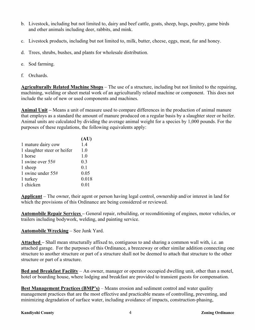
Accessory Structure – A structure detached from a principal building located on the same lot and customarily incidental and subordinate to the principal building or use. Accessory Use – A use subordinate to and serving the principal use on the same lot, which is compatible with and customarily incidental to the principal use. Agriculture Use – The use of land for the growing and/or production and wholesale distribution of field crops, livestock, and livestock products for the production of income or own use, including but not limited to the following: a. Field crops, including but not limited to, barley, beans, corn, hay, oats, potatoes, rye, sorghum, and
sunflowers.
Kandiyohi County 4 Zoning Ordinance
b. Livestock, including but not limited to, dairy and beef cattle, goats, sheep, hogs, poultry, game birds and other animals including deer, rabbits, and mink.
c. Livestock products, including but not limited to, milk, butter, cheese, eggs, meat, fur and honey. d. Trees, shrubs, bushes, and plants for wholesale distribution. e. Sod farming. f. Orchards. Agriculturally Related Machine Shops – The use of a structure, including but not limited to the repairing, machining, welding or sheet metal work of an agriculturally related machine or component. This does not include the sale of new or used components and machines. Animal Unit – Means a unit of measure used to compare differences in the production of animal manure that employs as a standard the amount of manure produced on a regular basis by a slaughter steer or heifer. Animal units are calculated by dividing the average animal weight for a species by 1,000 pounds. For the purposes of these regulations, the following equivalents apply: (AU) 1 mature dairy cow 1.4 1 slaughter steer or heifer 1.0 1 horse 1.0 1 swine over 55# 0.3 1 sheep 0.1 1 swine under 55# 0.05 1 turkey 0.018 1 chicken 0.01 Applicant – The owner, their agent or person having legal control, ownership and/or interest in land for which the provisions of this Ordinance are being considered or reviewed. Automobile Repair Services – General repair, rebuilding, or reconditioning of engines, motor vehicles, or trailers including bodywork, welding, and painting service. Automobile Wrecking – See Junk Yard. Attached – Shall mean structurally affixed to, contiguous to and sharing a common wall with, i.e. an attached garage. For the purposes of this Ordinance, a breezeway or other similar addition connecting one structure to another structure or part of a structure shall not be deemed to attach that structure to the other structure or part of a structure. Bed and Breakfast Facility – An owner, manager or operator occupied dwelling unit, other than a motel, hotel or boarding house, where lodging and breakfast are provided to transient guests for compensation. Best Management Practices (BMP’s) – Means erosion and sediment control and water quality management practices that are the most effective and practicable means of controlling, preventing, and minimizing degradation of surface water, including avoidance of impacts, construction-phasing,
Kandiyohi County 5 Zoning Ordinance
minimizing the length of time soil areas are exposed, prohibitions, and other management practices published by state or designated area-wide planning agencies. Block – An area of land within a subdivision that is entirely bounded by streets, or by streets and the exterior boundary or boundaries of the subdivision, or a combination of the above with a river or lake. Bluff – Bluff means a topographic feature such as a hill, cliff or embankment having the following characteristics (an area with an average slope of less than eighteen (18) percent over a distance for fifty (50) feet or more shall not be considered part of the bluff): a. Part or the entire feature is located in a shoreland area. b. The slope rises at least twenty-five (25) feet above the ordinary high water level of the water body. c. The grade of the slope from the toe of the bluff to a point twenty-five (25) feet or more above the
ordinary high water level averages thirty (30) percent or greater. d. The slope must drain toward the water body. Bluff Impact Zone – Bluff impact zone means a bluff and land located within twenty (20) feet from the top of a bluff. Board of Adjustment – The official Board with the authority to order the issuance of variances, hear and
decide appeals from and review any order, requirement, decision, or determination made by any
administrative official charged with enforcing any ordinance adopted by the County, order the issuance of
permits for buildings in areas designated for future public use on an official map and perform such other
duties as required by the official controls.
Boathouse – A structure designed and used solely for the storage of boats or boating equipment. Buildable Lot Area – The contiguous area of a lot which is sufficient in area and physically capable of accommodating the construction of sewage treatment systems, buildings, and driveways, while still providing adequate setbacks. Land located below the delineation line of a delineated wetland cannot be included in calculating the buildable lot area. Building – Any structure having a roof that may provide shelter, or enclosure of persons, animals, or property of any kind. Building, Agricultural – A structure on agricultural land designed, constructed, and used to house farm implements, livestock, or agricultural produce or products grown or raised on the premises. Building Eligibility – The eligibility to apply for and be issued a building permit for a single-family home under the provisions of this Ordinance. Building Height – See Height of Building. Building Line – A line parallel to the ordinary high water level or road right of way touching that part of a building closest to the ordinary high water level or road right of way. Building Setback Line – A line parallel to a lot line or the ordinary high water level at the required setback beyond which a structure may not extend. Cabin – A structure used seasonally or intermittently as sleeping quarters.
Kandiyohi County 6 Zoning Ordinance
Cluster Development – A subdivision development planned and constructed to group housing units into relatively tight patterns while preserving agricultural or providing a unified network of commonly owned open space, making the most efficient use of the natural amenities of the land, and meeting overall density regulations of this Ordinance and the Subdivision Ordinance. Commercial Use – The principal use of land or buildings for the sale, lease, rental or trade of products, goods and services. Commissioner – The commissioner of the Department of Natural Resources. Common Ownership – Ownership that is either direct or beneficial, by the same person, corporation or other entity of fifty (50) percent or greater interest in the subject parcels. Community Water and Sewer Systems – Utilities systems serving a group of buildings, lot, or an area of the County, with the design and construction of such utility system as approved by the County and the State of Minnesota. Comprehensive Plan – The documents that make up the Comprehensive Plan for the County. Conditional Use – Such use of land which is permitted within a zoning district pursuant to a conditional use permit issued by the County Board, pursuant to the procedure provided herein and actually issued by the Zoning Administrator, which use is specifically limited to the conditions of the use permit or if no use is specified, use is limited to the application which was filed to obtain the conditional use permit. Conservation Subdivision – A method of subdivision characterized by common open space and clustered compact lots, with the purpose of creating greater community value through open space amenities for homeowners and protection of natural resources. Site designs incorporate standards of low impact development, such as the use of private roads, preservation of trees, shoreline, unique resources, and scenic vistas. These developments emphasize on-site retention and infiltration through the preservation of native vegetation within the shore impact zone, use of pervious surfaces, rain gardens, and swales. Contiguous Lots – Parcels of land that have a common lot line or boundary. Parcels that only touch at a single point or are separated by a public road, railroad, trail or similar right-of-way shall not be considered a contiguous lot. County – Kandiyohi County. County Board – Kandiyohi County Board of Commissioners. Deck – A horizontal, unenclosed platform with or without attached railings, seats, trellises, or other features, attached or functionally related to a principal use or site. Depth of Lot – The mean horizontal distance between the mean front street and the mean rear lot line. The greater frontage of a corner lot is its depth, and its lesser frontage is its width. District – A section of the County for which the regulations governing the height, area, use of buildings and premises are the same.
Kandiyohi County 7 Zoning Ordinance
Dock – A narrow platform or structure extending water ward from the shoreline intended for ingress and egress for moored watercraft or seaplanes or to provide access to deeper water for swimming, fishing, or other water-oriented recreational activities. Duplex – A building on a single lot containing two (2) dwelling units, each of which is totally separated from the other by an un-pierced wall extending from basement to roof. Dwelling – A structure or portion thereof that is used primarily for human habitation. Dwelling, Single Family – A building containing one (1) dwelling unit and that is not attached to any other dwelling by any means and is surrounded by open space or yards. Dwelling Site – A designated location for residential use by one or more persons using temporary or movable shelter, including camping and recreational vehicle sites. Dwelling, Town House – A one-family dwelling in a row of at least three (3) such units in which each unit has its own front and rear access to the outside, no unit is located over another unit, and each unit is separated from any other unit by one (1) or more vertical common fire resistant walls. Dwelling, Twin – A building containing two (2) single family dwelling units on separate lots that are totally separated from each other by an un-pierced wall extending from basement to roof. The common wall shall be located on a lot line. Dwelling Unit – One (1) or more rooms, designed, occupied, or intended for occupancy as separate living quarters, with cooking, sleeping, and sanitary facilities provided within the dwelling unit for the exclusive use of a single family maintaining a household. Easement – The right of a person, or government agency to use public or private land, owned by another, for a specific purpose. Essential Services – Services and utilities needed for the health, safety, and general welfare throughout the County, such as underground, surface, or overhead electrical, gas, telephone, steam, water, sewerage, and other utilities and the equipment and appurtenances necessary for such systems to furnish an adequate level of service for the area in which they are located. Extractive Use – The use of land for surface or subsurface removal of sand, gravel, rock, industrial minerals, other nonmetallic minerals, and peat not regulated under Minnesota Statutes, Sections 93.44 to 93.51. Family – Any number of individual’s living together on the premises or a single housekeeping unit as distinguished from a group occupying a boarding house, lodging house or hotel. Feedlot – A lot or building or a group of lots or buildings intended for the confined feeding, breeding, raising or holding of animals, including but not limited to, areas specifically designed for confinement in which manure may accumulate or any area where the concentration of animals is such that a vegetative cover cannot be maintained. Fish House and/or Dark House – A shelter used for angling or spearing on the ice on any water.
Kandiyohi County 8 Zoning Ordinance
Flood Plain – That continuous area adjacent to a water course, whose elevation is equal to or below the elevation of the highest flood level of record; and any land or higher elevation having an area of less than two acres, which is completely surrounded by land having an elevation equal to or lower than the elevation of the highest flood level of record. Floodway – The channel and those portions of the flood plains adjoining the channel that are reasonably required to carry and discharge the flood water or flood flow of a specific size without unduly raising upstream water surface elevation. Floor Area – The sum of the gross horizontal areas of the several floors of a building measured from the exterior walls, including basements and attached accessory building. Garage, Private – A structure attached to the principal residential dwelling, constructed to house motor vehicles and related maintenance equipment. Garage, Public – Any premises, except those described as a private garage, used for the storage or care of power-driven vehicles, or where any such vehicles are equipped for operation, repair or are kept for remuneration, hire or sale. Government Lot – The fractional part of a section (public land survey) protracted by office procedures from field notes and designated by boundary limits, area and number (not always) on the township plat. A typical U.S. patent description could be: “Government Lot 1, Section 2, T 122N R36W of the 5th Principal Meridian”. Guest Cottage – A structure used as a dwelling unit that may contain sleeping spaces and kitchen and bathroom facilities in addition to those provided in the primary dwelling unit on a lot. Habitable Space – A space in a building for living, sleeping, eating, or cooking. Bathrooms, toilet rooms, closets, halls, storage or utility spaces and similar areas are not considered habitable spaces. Hardship – As defined in Minnesota Statutes, Chapter 394. Height of Building – The vertical distance between the highest adjoining ground level at the building or ten (10) feet above the lowest ground level, whichever is lower, and the highest point of a flat roof or average height of the highest gable of a pitched or hipped roof. Highway – Any public thoroughfare or vehicular right-of-way with a Federal or State numerical route designation; any public thoroughfare or vehicular right-of-way with a County numerical route designation. Home Extended Business – An occupation or profession engaged in by the occupant of a dwelling unit, within said dwelling unit or accessory structure, which involves the storage of a limited amount of vehicles and equipment; repair; service or assembly requiring equipment other than customarily found in a home; or the storage of stock in trade incidental to the performance of a service. The proposed activity shall only include the sale of merchandise incidental to the Home Extended Business. Home Occupation – Any occupation or profession engaged in by the occupant of a dwelling, which is clearly secondary to the principal use, when carried on within the dwelling unit and not in an accessory building, and which shows no activity other than activity normally present in a residential dwelling unit.

Kandiyohi County 9 Zoning Ordinance
Hydric Soil – For the purposes of this Ordinance hydric soils shall include land located below the delineation line of a delineated wetland. Impervious Surface – A constructed hard surface that either prevents or retards the entry of water into the soil and causes water to run off the surface in greater quantities and at an increased rate of flow than prior to development. Examples, including but not limited to: rooftops, sidewalks, patios, driveways, parking lots, storage areas, and concrete asphalt or gravel roads. Industrial Use – The use of land or buildings for the production, manufacture, warehousing, storage or transfer of goods, products, commodities or other wholesale items. Intensive Vegetation Clearing – The complete removal of trees or shrubs in a contiguous patch, strip, row or block. Junk Yard – Land or buildings where waste, discarded or salvaged materials are brought, sold, exchanged, stored, cleaned, packed, disassembled or handled, including, but not limited to, scrap metal, rags, paper, rubber products, glass products, lumber products and products resulting from the wrecking of automobiles or other vehicles. Kennel – Any lot or premises on which more than three (3) dogs six (6) months of age or older are kept, either owned or permanently or temporarily boarded. Livestock – Any animals, including but not limited to cattle, swine, sheep, poultry, fowl, or other animals except dogs, domestic cats, and caged birds owned by the resident of a premises and kept as pets. Lot, (Parcel or Tract) – An area of land designated by metes and bounds, registered land survey, plat or other accepted means, and separated from other parcels or portions by said description for the purpose of sale, lease, transfer or separation thereof. For the purposes of this Ordinance, a lot, parcel, or tract shall be considered to be an individual building site that shall be occupied by no more than one (1) dwelling unit. Lot, (Parcel or Tract) of Record – Any lot, parcel or tract that was recorded by deed or filed as a separate lot, parcel or tract in the Office of the County Recorder on or before the effective date of this Ordinance. Lot Area – The land area within the lot lines. Lot Corner – A lot with at least two (2) sides fronting on a road. Lot Coverage – Determined by dividing that area of a lot that is covered by impervious surface or roofed areas by the gross area of that lot. Lot, Double Frontage – An interior lot having frontage on two streets. Lot Depth – The average horizontal distance from the front lot line to the rear lot line. The greater frontage of a corner lot is its depth, and its lesser frontage is its width. Lot, Interior – A lot other than a corner lot.
Kandiyohi County 10 Zoning Ordinance
Lot Lines – The lines bounding a lot, as defined herein. When a lot line abuts a road, street, avenue, park or other public property, except an alley, such line shall be known as a street line, and when a lot line abuts on an alley, it shall be known as an alley line. Lot Width – The horizontal distance between the side lot lines of a lot measured at the building setback line, location of the principal building and, if applicable, ordinary high water level.
Manufacturing – Establishments engaged in the mechanical or chemical transformation of material or substances into new products, including the assembling of component parts, the creation of products, and the blending of materials, such as oils, plastics, resins, or liquors. Manure Storage Area, Structure or Facility – Shall have the meaning given in Minnesota Rules, part 7020.0300 subpart 14; or successor rules. Marina – Either an inland or offshore commercial mooring facility for the concentrated mooring of five (5) or more watercraft or seaplanes wherein commercial ancillary services common to marinas are provided. A Minnesota Department of Natural Resources permit shall be required for a marina. Marquee – A canopy or covering structure projecting from and attached to a building. Motel – A building or group of buildings used primarily for the temporary residence of motorists or travelers. Mobile Home – A mobile home is living quarters designed for transportation after fabrication on streets and highways on its own wheels or on flatbed or other trailers, and arriving at the site where it is to be occupied as a dwelling complete and ready for occupancy, except for minor and incidental unpacking and assembly operations, location on jacks or permanent foundations, connection to utilities and the like. For purposes of zoning, the terms "manufactured home" and "mobile home" shall be interchangeable. Mooring – Any containment of free-floating watercraft that provides a fixed fastening for the craft. Mooring Facility – A concentrated area intended solely for the mooring or containment of watercraft or seaplanes by docks, mooring buoys, or other means. Mooring Site – A mooring space used by a single watercraft. Non-Conforming Uses – A use lawfully in existence on the effective date of this Ordinance and not conforming to the regulations for the district in which it is situated. Non-riparian – A lot or parcel which is located within shorelands but not abutting public waters. Official Control – Official Control shall have the meaning given in Minnesota Statutes, section 394.22 subdivision 6; or successor statutes. Open Space – Land used for agricultural, natural habitat, pedestrian corridors and/or recreational purposes that is undivided, permanently protected from future development and under common ownership. Ordinary High Water Level – Means a mark delineating the highest water level that has been maintained for sufficient period of time to leave evidence upon the landscape. The ordinary high water level is
Kandiyohi County 11 Zoning Ordinance
commonly that point where the natural vegetation changes from predominantly aquatic to predominantly terrestrial. For watercourses, the ordinary high water level is the elevation of the top of the bank of the channel. For reservoirs and flowages, the ordinary high water level is the operating elevation of the normal summer pool. Out lot – Land shown on a plat that may be deemed un-buildable because of topography or soils or land that is a remnant either too small or odd shaped for development. Persons – Any individual firm, partnership, corporation, company, association, joint stock association or body politic; includes any trustee, receiver, assignee, or other similar representative thereof. Planned Unit Development – A method of land use or development characterized by a unified site design for a number of dwelling units or dwelling sites on a parcel, whether for sale, rent or lease, and that incorporates clustering of these units or sites to provide areas of common open space, and a mix of structure types and land uses. These developments may be organized and operated as residential or commercial enterprises such as individual dwelling units, town-homes, condominiums, time-share condominiums, cooperatives, common interest communities, shared-interest communities, campgrounds, recreational vehicle parks, resorts, hotels, motels or any combination of these. Planned unit developments shall also include any conversion of pre-existing structures and land uses in order to utilize this method of development. All planned unit developments shall contain at least three (3) contiguous acres of lot area above delineated wetlands, with a minimum lot width of three hundred (300) feet. Planning Commission – Kandiyohi County Planning Commission. Plat – The drawing or map of a subdivision prepared for filing of record pursuant to Minnesota Statutes, chapter 505; or successor statutes, and containing all elements and requirements set forth in all official controls adopted pursuant to Minnesota Statutes, chapter 394 and 505; or successor statutes. Plat, Final – A drawing or map of a subdivision, meeting all of the requirements of the County and in such form as required by the Office of the County Recorder. Plat, Preliminary – The preliminary drawing or map, prepared by a Licensed Land Surveyor, indicating the proposed layout of the subdivision to be submitted to the Planning Commission for its consideration. Plot – A tract other than one unit of a recorded plat or subdivision and occupied and used or intended to be occupied and used as an individual site and improved or intended to be improved by the erection thereon of buildings and having a frontage upon a public road or highway or upon a traveled or used road and including as a minimum such open spaces as required under this Ordinance. Premises – A lot or plot with the required front, side and rear yards for a dwelling or other uses as allowed under this Ordinance. Protected Water – Water bodies or watercourses so identified on the Public Waters Wetlands Inventory/Map published by the Minnesota Department of Natural Resources, State of Minnesota. Public Water – A body of water capable of substantial beneficial public use. This shall be construed to mean, for the purposes of these regulations, any body of water that has the potential to support any type of recreational pursuit or water supply purpose. Any waters as defined in Minnesota Statutes, Section 103G.005, Subdivisions 15 and 18.
Kandiyohi County 12 Zoning Ordinance
Recreational Equipment – Travel trailers including those which telescope or fold down, chassis mounted campers, house cars, motor homes, tent trailers, slip in campers, and converted buses that provide temporary human living quarters. Regional Flood – A flood which is representative of large floods known to have occurred generally in Minnesota and reasonably characteristic of what can be expected to occur on an average frequency in the magnitude of the one hundred (100) year recurrence interval. Residential Program – Shall have the meaning given in Minnesota Statutes, section 245A.02, subdivision 14; or successor statutes. Riding Academy/Stable – A riding facility in which horses not owned by the property owner are kept for commercial use including boarding, breeding, hire, sale, show and training. Rip Rap – Coarse stones, boulders, cobbles, or artificial broken rock fragments loosely laid against an existing bank or shore for the purpose of preventing or controlling erosion. Riparian – A lot or parcel that abuts public waters. Road – A public right-of-way affording primary access by pedestrians and vehicles to abutting properties, whether designed as a street, highway, thoroughfare, parkway, throughway, road, avenue, boulevard, land, place, or however otherwise designated. Semipublic Use – The use of land by a private, nonprofit organization to provide a public service that is ordinarily open to some persons outside the regular constituency of the organization. Sensitive Resource Management – The preservation and management of area unsuitable for development in their natural state due to constraints such as shallow soils over groundwater or bedrock, highly erosive or expansive soils, steep slopes, susceptibility to flooding, or occurrence of flora or fauna in need of special protection. Setback – The minimum horizontal distance between a structure, individual sewage treatment system, or other facility, and a road, property line, top of bluff, or the ordinary high water level of a lake, stream, river, or other protected water. Sewage Treatment Ordinance – The Kandiyohi County Sewage Treatment Ordinance #27. Sewage Treatment System – A septic tank and soil absorption system or other individual or cluster type sewage treatment system. Shore Impact Zone – Land located between the ordinary high water level of public water and a line parallel to it at a setback of fifty (50) percent of the structure setback. Shoreland – Land located within the following distances from public water: a. One thousand (1,000) feet from the ordinary high water level of a lake, pond or flowage. b. Three hundred (300) feet from a river or stream, or the landward extent of a flood plain designated by
Ordinance on such a river or stream whichever is greater.
Kandiyohi County 13 Zoning Ordinance
c. The limits of shorelands may be reduced whenever the waters involved are bounded by topographic divides that extend landward from the waters for lesser distances and when approved by the Commissioner.
Sidewall Height, Accessory Structures – The distance between the lowest ground level to the bearing point of the rafter. Sign – Any letters, words, figures, design, symbol, trademark, or numbers, illuminated or non-illuminated, which is intended to attract attention to any place, business, subject, person, firm, corporation, public performance, article, machine or merchandise whatsoever, which is painted, printed, or constructed and displayed in any manner visible to the general public out of doors for recognized advertising purposes. Sign, Advertising /Billboard – A sign which directs attention to a business, commodity, service, activity or entertainment not conducted, sold or offered upon the premises where such sign is located. Sign, Business – A sign that directs attention to a business or profession or to a commodity, service or entertainment sold or offered upon the premises where such sign is located. Sign, Illuminated – Any sign that is lighted by an artificial light source either directed upon it or illuminated from an interior source. Sign, Integral – A sign carrying the name of a building, date of erection, citations, commemorative tablets or the like carved in stone, concrete or similar material or made of bronze, aluminum or other permanent type of construction and made an integral part of the structure. Sign, Location – A lot, premise, building, wall or any place whatsoever upon which a sign is located. Sign, Nameplate – A sign that states the name or address, or both, of an occupant or business on the lot where the sign is located. Sign, Portable – A sign so designed as to be moveable from one location to another and which is not permanently attached to the ground or any structure. Sign, Real Estate – A sign placed upon a property advertising that particular property for sale, rent or lease. Sign, Temporary – A sign placed on a lot or parcel of land for a period not to exceed ten (10) days out of any twelve (12) month period. Sign, Wall-Flat – One affixed directly to the exterior wall of screening surface and confined within the limits thereof and which projects from that surface less than twelve (12) inches at all points. Significant Historic Site – Any archaeological site, standing structure, or other property that meets the criteria for eligibility to the National Register of Historic Places or is listed in the State Register of Historic Sites, or is determined to be an un-platted cemetery that falls under the provisions of Minnesota Statutes, Section 307.08. A historic site meets these if it is presently listed on either register or if it is determined to meet the qualifications for listing after review by the Minnesota state archaeologist or the director of the Minnesota Historical Society. All un-platted cemeteries are automatically considered to be significant historic sites.
Kandiyohi County 14 Zoning Ordinance
Steep Slope – Land where agricultural activity or development is either not recommended or described as poorly suited due to slope steepness and the site's soil characteristics, as mapped and described in available County soil surveys or other technical reports, unless appropriate design and construction techniques and farming practices are used in accordance with the provisions of this Ordinance. Where specific information is not available, steep slopes are lands having average slopes over twelve (12) percent, as measured over horizontal distances of fifty (50) feet or more that are not bluffs. Story – That portion of a building included between the surface of any floor and the surface of the next floor above it or, if there is no floor above it, the space between the floor and the ceiling next above it. Story Above Grade – Any story having its finished floor entirely above grade, except that a basement shall be considered as a story above grade where the finished surface of the floor above the basement is: More than six (6) feet above grade plane; More than six (6) feet above the finished ground level for more than fifty (50) percent of the total building perimeter; More than twelve (12) feet above finished ground level at any point. Story, Half – That portion of a building under a gable, hip or gambrel roof, the wall plates of which, on at least two (2) opposite exterior walls, are not more than two (2) feet above the floor of such story. Structure – Anything constructed, the use of which requires more or less permanent location on the ground or attached to something having a permanent location on the ground. Structural Alterations – Any change other than incidental repairs, in the supporting members of a building or structure, such as bearing walls, columns, beams, girders or foundations. Subdivision – The creation of one (1) or more lots under the provisions of this Ordinance. The term includes re-subdivision and, where it is appropriate to the context, relates either to the process of subdividing or to the land subdivided.
Subdivision Ordinance – The Kandiyohi County Subdivision Ordinance #9B. Surface Water-Oriented Commercial Use – The use of land for commercial purposes where access to
and use of a surface water feature is an integral part of the normal conductance of business. Marinas,
resorts and restaurants with transient docking facilities are examples of such use.
Toe of the Bluff – The point on a bluff where there is, as visually observed a clearly identifiable break in the slope, from gentler to steeper slope above. If no break in the slope is apparent, the toe of the bluff shall be determined to be the lower end of a fifty (50) foot segment, measured on the ground, with an average slope exceeding eighteen (18) percent. Top of the Bluff – The point on a bluff where there is, as visually observed a clearly identifiable break in the slope, from steeper to gentler slope above. If no break in the slope is apparent, the top of the bluff shall be determined to be the upper end of a fifty (50) foot segment, measured on the ground, with an average slope exceeding eighteen (18) percent. Unincorporated Area – The geographical area lying outside of incorporated municipalities.
Kandiyohi County 15 Zoning Ordinance
Unit – For the purpose of determining density limitations in residential areas, a unit shall consist of a single-family residential equivalent. Use – The purpose for which land or premises or a building thereon is designated, arranged, or intended, or for which it is or may be occupied or maintained. Variance – Any modification or variation of official controls where it is determined that, by reason of exceptional circumstances, the strict enforcement of the official controls would cause unnecessary hardship. Water-oriented Accessory Structure or Facility – “Water-oriented accessory structure or facility” means a small, above ground building or other improvement, except stairways, fences, docks, and retaining walls, which, because of the relationship of its use to a surface water feature, reasonably needs to be located closer to public waters than the normal structure setback. Examples of such structures and facilities include boathouses, gazebos, screen houses, pump houses, and detached decks. Wetland – A surface water feature classified as a wetland in the United States Fish & Wildlife Service Circular No. 39 (1971 edition). Yard – Any space in the same lot with a building open and unobstructed from the ground to the sky. Yard, Front – A yard extending across the front of the lot between the side yard lines and lying between the center line of the road or highway and the nearest line of the building. Yard, Rear – An open space unoccupied except for accessory buildings on the same lot with a building between the rear lines of the building and the rear line of the lot, for the full width of the lot. Yard, Side – An open, unoccupied space on the same lot with a building between the building and the side line of the lot and extending from the front lot line to the rear of the back yard.
CHAPTER 2: ADMINISTRATION
2-1 ZONING ADMINISTRATOR
The office of the Zoning Administrator is hereby established, for which the County Board may appoint
such employee or employees of the County, as it may deem proper. 2-1-1 Duties and Responsibilities The Zoning Administrator shall perform the following duties: 1. Enforce and administer this Ordinance as authorized in Chapter 2, section 2-10. 2. Maintain the County Zoning Map as required in Chapter 4, section 4-2. 3. Issue permits as required by this Ordinance. 4. Maintain permanent and current records of this Ordinance, including but not limited to maps,
amendments, variances, and conditional use permits.
Kandiyohi County 16 Zoning Ordinance
5. Receive, file and forward all applications for appeals, amendments, variances, conditional uses, or other
matters to the designated official bodies.
6. Institute in the name of the County any appropriate actions or proceedings to prevent, to restrain, to correct, or to abate a violation or threatened violation.
7. Conduct inspections of land, buildings, or structures at reasonable times, determine compliance with
and enforce the provisions of this Ordinance
8. Provide and maintain public information relative to matters arising out of this Ordinance. 2-2 BOARD OF ADJUSTMENT 2-2-1 Creation and Membership 1. A Board of Adjustment is hereby established and vested with such authority as is hereinafter provided
and as provided by Minnesota Statutes 394.27 or successor statutes. Such Board of Adjustment shall consist of five (5) members; one (1) member shall be appointed from each County Board District. At least three (3) members of the Board of Adjustment shall be residents of the portion of the County outside the corporate limits of municipalities. Additionally, at least one (1) member of the Board of Adjustment shall be a member of the Planning Commission whose term shall coincide with the term he has on the Planning Commission.
2. Each member shall serve for a period of three (3) years, and the terms of the members shall be
staggered so that no more than two (2) terms expire in any one (1) year. The term of each member shall begin on January 1 and continue through December 31 of the last year of the term provided however, that any member shall continue to serve after the expiration of their term until a successor is appointed. Members will be limited to three (3) consecutive terms of appointment. Any member who misses three (3) consecutive meetings without a reasonable excuse may be replaced by the County Board.
3. No elected officer of the County or any employee of the County shall serve as a member of the Board
of Adjustment. 4. The members of the Board of Adjustment may be paid compensation in an amount determined by the
County Board and may be paid their necessary expenses in attending meetings of the Board of Adjustment and in their conduct of the business of the Board of Adjustment.
5. Any questions of whether a particular issue involves a conflict of interest sufficient to disqualify a
Board of Adjustment member from voting thereon, shall be decided by majority vote of all Board of Adjustment members present except the member who is being challenged.
6. The County Board may call for the removal of any Board of Adjustment member for non-performance
of duty or misconduct in office and may fill vacancies for any unexpired term. 2-2-2 Organization 1. The Board of Adjustment shall annually elect a Chair and Vice Chair from among its members and it
shall appoint a Secretary who need not be a member of the Board of Adjustment. It shall adopt rules
Kandiyohi County 17 Zoning Ordinance
for the transaction of its business. Such rules may include provisions for the giving of oaths to witnesses and the filing of written briefs by the parties. The Board of Adjustment shall provide a public record of its proceedings which shall include the minutes of its meetings, its findings and the action taken on each matter heard by it, including the final order.
2. Meetings of the Board of Adjustment shall be held at the call of the Chair and at such other times as the
Board of Adjustment in its rules of procedure may specify. 2-2-3 Duties and Responsibilities The Board of Adjustment shall have the exclusive power to: 1. Hear and decide appeals from and review any order, requirement, decision or determination made by
any administrative official charged with enforcing any ordinances adopted pursuant to the provisions of Minnesota Statutes 394.21 and 394.27, as they may be amended from time to time. Appeals may be taken by any person aggrieved or by any officer, department, board, municipality or other unit of government;
2. Order the issuance of permits for buildings in the area designated for future public use on an official
map. 3. Perform other duties as required by the official controls. 4. The Board of Adjustment shall have the exclusive power to order issuance of variances from the
requirements of any official control including restrictions placed on non-conformities. Variances shall only be permitted when they are in harmony with the general purpose and intent of the official control and when the variances are consistent with the Comprehensive Plan. Variances may be granted when the applicant for the variance establishes that there are practical difficulties in complying with the official control. “Practical difficulties” as used in connection with the granting of a variance, means that the property owner proposes to use the property in a reasonable manner not permitted by an official control; the plight of the landowner is due to circumstances unique to the property not created by the landowner; and the variance, if granted will not alter the essential character of the locality. Economic considerations alone do not constitute practical difficulties. Practical difficulties include, but are not limited to, inadequate access to direct sunlight for solar energy systems. Variances shall be granted for earth sheltered construction as defined in Minnesota Statutes 216C.06 subdivision 14, as they may be amended from time to time when in harmony with the official controls. No variance may be granted that would allow any use that is not allowed in the zoning district in which the subject property is located. The Board of Adjustment may impose conditions in the granting of variances. A condition must be directly related to and must bear a rough proportionality to the impact created by the variance.
2-2-4 Appeals 1. The Board of Adjustment shall act upon all questions as they may arise in the administration of this
Ordinance, and it shall hear and decide appeals from and review any order, requirements, decision, or determination made by any administrative official charged with enforcing this Ordinance. Such appeal may be made by any person, firm or corporation aggrieved; or by any officer, department, board of a town, municipality, county or state.
Kandiyohi County 18 Zoning Ordinance
2. The appeal shall be filed with the Zoning Administrator within thirty (30) days of the action that is being appealed and shall include specifically the order, requirement, decision, or determination which is being appealed, the requested remedy, and shall state the reasons for appeal. The Zoning Administrator shall prepare a report and refer the appeal to the Board of Adjustment for a decision. The appeal shall be heard at a public hearing by the Board of Adjustment. The Board of Adjustment shall give due notice thereof to the appellant and the officer from whom the appeal is taken and to the public. The Board of Adjustment shall make its decision in compliance with Minnesota Statutes 15.99 as may be amended from time to time.
3. The filing of an appeal stays all proceeding and furtherance of the action appealed from unless the
Board of Adjustment to whom the appeal is taken certifies that by reason of the facts stated in the certificate a stay would cause imminent peril to life or property.
4. The Board of Adjustment may reverse or affirm wholly or partly or may modify the order, requirement,
decision or determination appealed from and to that end shall have all of the powers of the officer from whom the appeal was taken and may direct issuance of the permit. The reason for the Board of Adjustment’s decision shall be stated in writing.
2-2-5 Fees To defray administrative costs of processing Appeals, a fee shall be paid by the applicant. Such fee shall be established by resolution of the County Board. 2-2-6 Variances 1. The property owner applying for a variance shall submit to the Zoning Administrator a completed
variance application stating the practical difficulty present, and provide all other information required by the Zoning Administrator. The Zoning Administrator shall prepare a report and refer the application to the Board of Adjustment for consideration.
2. The Board of Adjustment shall hold a public hearing on the request pursuant to Minnesota Statutes
394.26 as it may be amended from time to time. At least ten (10) days before the date of the hearing a
notice of the hearing shall be mailed according to the provisions of M.S. 394.26 Subdivision 2 as it may
be amended from time to time to property owners, and also to the township clerk of the affected
township.
3. The applicant or his representative shall appear before the Board of Adjustment in order to answer questions concerning the proposed variance.
4. Variances shall be limited to the original structure described in the application. 5. Variances shall be granted in accordance with Minnesota Statutes Chapter 394, as it may be amended
from time to time, In addition, a variance shall not be granted unless all of the following can be found as fact:
a. The variance is in harmony with the general purposes and intent of the official control.
b. The variance is consistent with the comprehensive plan.
Kandiyohi County 19 Zoning Ordinance
c. The property owner is proposing to use the property in a reasonable manner not permitted by the official control.
d. The alleged practical difficulty is due to circumstances unique to the property and not created by the property owner.
e. The issuance of a variance will maintain the essential character of the locality.
f. The alleged practical difficulty involves more than economic considerations. 2-2-7 Decision 1. The Board of Adjustment shall make its decision by the adoption of an order either approving or
denying the variance or appeal. The Board of Adjustment shall adopt findings of fact supporting its order. The Board of Adjustment shall make its decision in compliance with Minnesota Statutes 15.99 as may be amended from time to time.
2. The Zoning Administrator shall send written notice of the Board of Adjustment’s action to the applicant
within ten (10) days of final action. 3. A copy of any order issued by the Board of Adjustment for property within the Shoreland District shall
be filed with the Commissioner of Natural Resources or the Commissioner’s designated representative within ten (10) days of final action.
4. A certified copy of any order issued by the Board of Adjustment acting upon an appeal from an order,
requirement, or decision or determination by an administrative official, or a request for a variance, shall be filed with the Office of the County Recorder. The order issued by the Board of Adjustment shall include the legal description of the property involved. The Zoning Administrator shall be responsible for the document recording requirements of this section and shall maintain records of the variance request.
5. All decisions by the Board of Adjustment in granting variances or in hearing appeals from any
administrative order, requirement, decision or determination shall be final, except that any aggrieved person or persons, or any department, board or commission of the jurisdiction, or of the state shall have the right to appeal the decision to the Kandiyohi County District Court on questions of law and fact. The appeal shall be made within thirty (30) days after receipt by the applicant of notice of the decision.
2-2-8 Expiration/Extension of Variance 1. A variance shall expire one (1) year from the date of issuance if the variance is not utilized. 2. An applicant or landowner cannot request the re-hearing of a variance request or appeal for a period of
one (1) year. An applicant or landowner may request the re-hearing of a request for a variance or an appeal that has been denied when substantial new information is obtained which is relevant to the issue. The Board of Adjustment shall then re-hear the issue at another duly called public hearing.
3. If necessary, an extension of a variance shall be requested in writing and filed with the Zoning
Administrator at least thirty (30) days before the expiration date of the original variance. The request for extension shall state facts showing a good faith attempt to utilize the variance in the allowed one (1)
Kandiyohi County 20 Zoning Ordinance
year. Upon receipt of a request for a variance extension, the Zoning Administrator shall review the request and make a decision to grant or deny the extension based on the information submitted. At staff’s discretion, the request may be referred to the Board of Adjustment. No extension shall be for more than one (1) year, after which if the variance is not utilized the variance would become void. In no case shall more than one (1) variance extension be approved for an individual variance request.
2-2-9 Fees To defray administrative costs of processing requests for Variance Permits, a fee shall be paid by the applicant. Such fee shall be established by resolution of the County Board. 2-3 PLANNING COMMISSION 2-3-1 Creation and Membership 1. The Planning Commission is hereby established and vested with such authority as is hereinafter
provided by Minnesota Statutes 394.21 through 394.37, as they may be amended from time to time. 2. The members of the Planning Commission shall be appointed by the County Board. The Planning
Commission shall consist of seven (7) members, and one (1) of these members shall be a member of the County Board who shall be appointed annually; one (1) member shall be appointed from each County Board District; and one (1) member shall be an “at-large” position. At least three (3) members shall be residents of the portion of the County outside the incorporated limits of municipalities. No more than one (1) voting member of the Commission shall be an officer or employee of the County.
3. The term of each member shall be for three (3) years except for the County Board member. The terms
shall be staggered so than no more than two (2) terms expire in any one (1) year. The term of each member shall begin on January 1 and continue through December 31 of the last year of the term provided however, that any member shall continue to serve after the expiration of their term until a successor is appointed. Members will be limited to three (3) consecutive terms of appointment. Any member who misses three (3) consecutive meetings without a reasonable excuse may be replaced by the County Board.
4. The members of the Planning Commission may be compensated in an amount determined by the
County Board and may be paid their necessary expenses in attending meetings of the Planning Commission and in the conduct of business of the Planning Commission.
5. No voting member of the Planning Commission shall have received during the two (2) years prior to
appointment, any substantial portion of his income from business operations involving the development of land with the County for urban and urban related purposes.
6. Any question of when a particular issue involves a conflict of interest is sufficient to disqualify a
regular Planning Commission member from voting thereon shall be decided by a majority vote of all members except the member who is being challenged.
7. The County Board may remove any members of the Planning Commission for non-performance of duty
or misconduct in office and may fill vacancies for any unexpired term.
Kandiyohi County 21 Zoning Ordinance
2-3-2 Organization 1. The Planning Commission shall annually elect a Chair and a Secretary from its members. It may also
elect any other officers it deems necessary. The Planning Commission may also appoint a person not a member of the Planning Commission to take and keep minutes and be responsible for general clerical duties of the Planning Commission. The Planning Commission shall cooperate with the Zoning Administrator and other employees of the County in preparing and recommending to the County Board for adoption a comprehensive plan and recommendations for plan execution in the form of official controls and other measures, and amendments thereto.
2. The Planning Commission shall meet on a regular basis as determined by the Planning Commission. 2-3-3 Duties and Responsibilities 1. The Planning Commission shall act as an advisory body to the County Board. The Planning
Commission shall forward all findings and recommendations to the County Board. 2. The Planning Commission shall have authority to perform duties and any other duties and
responsibilities as may be assigned by the County Board from time to time. 3. The Planning Commission shall review all applications for conditional use permits, plans for
subdivision, and requests for amendment to official controls and submit findings and recommendation to the County Board.
4. The Planning Commission shall conduct public hearings on adoption or amendment to official controls,
conditional use permits and subdivision applications. 5. The Planning Commission may upon the request of the County Board, review any comprehensive plans
and official controls and any plans for public land acquisition and development sent to the County for that purpose by any local unit of government or any state or federal agency and shall report thereon in writing to the County Board.
2-4 CONDITIONAL USE PERMITS 2-4-1 Criteria for Granting 1. Conditional uses may be approved, by the County Board, upon a showing by the applicant that
standards and criteria stated in the Ordinance will be satisfied, and for any and only the uses or purposes for which such permits are required or permitted by the provisions of this Ordinance. Such standards and criteria shall include both general requirements for all conditional uses and, insofar as practicable, requirements specific to each designated conditional use. In granting a conditional use permit the County Board shall consider the effect of the proposed use upon the health, safety, and general welfare of occupants of surrounding lands.
2-4-2 Application 1. The property owner applying for a conditional use permit shall submit to the Zoning Administrator a
completed conditional use permit application. The applicant shall demonstrate compliance with the
Kandiyohi County 22 Zoning Ordinance
requirements for the conditional use permit and shall include on the application all information required by the Zoning Administrator.
2. Upon receipt of the application and other prescribed materials for a requested Conditional Use Permit, a
time and place shall be set for a public hearing before the Planning Commission as provided hereunder. In all cases, mailed notice of the public hearing shall be as provided under Minnesota Statutes 394.26 Subdivision 2, as may be amended from time to time. The current records on file in the office of the County Assessor shall be deemed sufficient for determining mailing addresses herein.
3. The applicant or his representative shall appear before the Planning Commission in order to answer
questions concerning the proposed conditional use permit. 2-4-3 Findings 1. The Planning Commission shall recommend no conditional use unless said Planning Commission shall
find: a. That the conditional use will not be injurious to the use and enjoyment of other property in the
immediate vicinity for the purposes already permitted, nor substantially diminish and impair property values within the immediate vicinity.
b. That the establishment of the conditional use will not impede the normal and orderly development
and improvement of surrounding vacant property for uses predominant in the area. c. That adequate utilities, access roads, drainage, off-street parking and loading space, and other
necessary facilities have been or are being provided. d. That adequate measures have been or will be taken to prevent or control offensive odor, fumes,
dust, noise, and vibration, so that none of these will constitute a nuisance, and to control lighted signs and other lights in such a manner that no disturbance to neighboring properties will result.
e. That the proposed use is allowed with a conditional use permit in the designated district in which it
is proposed. f. That the proposed use is in harmony with the goals and objectives of the Comprehensive Plan. g. That the proposed use has the ability to meet the standards of the Zoning Ordinance. h. That the proposed use will not have significant negative impacts on groundwater, surface water, or
air quality if operated according to all applicable Federal, State, and County regulations, including the conditions placed on the permit.
2-4-4 Report to the County Board 1. The Planning Commission shall make a recommendation to the County Board in a timeframe so as to
comply with Minnesota Statutes 15.99, as it may be amended from time to time. Following the closing of the public hearing and formulation of the Planning Commission’s recommendation, the Zoning Administrator shall report the findings and recommendations of the Planning Commission to the County Board.
Kandiyohi County 23 Zoning Ordinance
2-4-5 County Board Action 1. The County Board shall take action on the conditional use permit following receipt of the findings and
recommendations by the Planning Commission so as to comply with Minnesota Statutes 15.99, as it may be amended from time to time. Should the Planning Commission fail to provide findings and a recommendation in a timely manner, the County Board shall take action so as to comply with Minnesota Statutes 15.99, as may be amended from time to time.
2. The County Board shall have the option to set and hold additional public hearings in accordance with
Minnesota Statutes 394.26 as may be amended from time to time. 3. In ordering the issuance of a conditional use permit, the County Board shall include any conditions
required to attain the objectives of the comprehensive plan, comply with official controls, and protect the public interest.
4. The Zoning Administrator shall send written notice of the County Board action to the applicant within
ten (10) days of final action. 5. Copies of all conditional use permits within Shoreland Districts shall be forwarded to the
Commissioner of the Department of Natural Resources within ten (10) days of final action. 6. A certified copy of any conditional use permit shall be filed with the Office of the County Recorder.
The conditional use permit shall include the legal description of the property involved, owner’s name and any conditions stipulated upon approval by the County Board.
2-4-6 Conformity Required, Expiration, Revocation, Duration 1. Any use permitted under the terms of any conditional use permit shall be established and conducted in
conformity with the terms of the permit and of any condition designated in connection therewith. Any deviation from the conditions or uses approved may be considered grounds for suspension or revocation of the conditional use permit by the County Board.
2. A conditional use permit shall remain in effect for so long as the conditions of the permit are observed,
unless the County Board has set a time limit on the permit. 3. A conditional use permit shall expire one (1) year from the date of issuance if the permit is not utilized,
except for uses which are transient by nature, including but not limited to gravel pits and asphalt hot mix plants.
4. Except for uses which are transient by nature, including but not limited to gravel pits and asphalt hot
mix plants, any permitted conditional use which is discontinued for a period of one (1) year or more shall be required to re-apply for a conditional use permit before re-establishing the use.
5. No application for a conditional use permit shall be resubmitted for a period of one (1) year from the
date of an order of denial of such request, except the Planning Commission may permit a new application, if in the opinion of the Planning Commission, new evidence or a change of circumstances warrant it.
Kandiyohi County 24 Zoning Ordinance
6. In the event that any of the conditions set forth in a permit are violated, the County Board shall have the authority to revoke the conditional use permit.
2-4-7 Fees
To defray administrative costs of processing requests for Conditional Use Permits, a fee shall be paid by
the applicant. Such fee shall be established by resolution of the County Board.
2-5 ZONING PROCEDURES 2-5-1 Amendments 1. This Ordinance and the official zoning map may be amended whenever the public necessity, general
welfare, or the goals and policies of the County as reflected in the Comprehensive Plan or changes in the conditions in the County require such amendment by following the procedure specified in this Chapter, and in accord with the applicable provision of Minnesota Statutes 394.21 to 394.37.
2. Types of Amendments:
a. A change in district boundaries. b. A change in district regulations.
c. A change in any other provision of this ordinance.
3. The procedure for amendment of this Ordinance or official zoning map shall be initiated by one of the
following three methods:
a. A petition of the owner or owners of a specific property. b. A recommendation of the Planning Commission. c. By action of the County Board.
2-5-2 Amendment Procedure – Property Owners: The procedures for a property owner to initiate an amendment to this ordinance or the official zoning map are as follows. 1. An application for an amendment shall be filed with the Zoning Administrator on the prescribed form. 2. Upon receipt in proper form of the application and other requested material, the Zoning Administrator
shall set the date of the public hearing before the Planning Commission in accordance with the public hearing requirements, Section 394.26 of the Minnesota Statutes. Failure of any property owner or occupant to receive such notice shall not invalidate the proceeding, provided a bona-fide attempt to give such notice has been made.
Kandiyohi County 25 Zoning Ordinance
3. The Planning Commission shall hold the public hearing, adopt findings based upon the evidence established during the hearing and provide a recommendation to the County Board.
2-5-3 Amendment Procedure – Planning Commission: The procedures for the Planning Commission to initiate an amendment to this ordinance or the official zoning map are as follows. 1. The Planning Commission shall pass a motion recommending an amendment to this ordinance or the
official zoning map. 2. The Zoning Administrator shall set a date for the public hearing before the Planning Commission in
accordance with the public hearing requirement, Section 394.26 of the Minnesota Statutes. Failure of any property owner or occupant to receive such notice shall not invalidate the proceeding. Provided a bona-fide attempt to give such notice had been made. County-wide amendments to this ordinance or the official zoning map need not be mailed to property owners or surrounding property owners affected by such an amendment.
3. The Planning Commission shall hold the public hearing, adopt findings based upon the evidence established during the hearing and provide a recommendation to the County Board within ninety (90) days of the Planning Commission’s scheduled public hearing date.
2-5-4 Amendment Procedure – County Board: The procedures for the County Board to initiate an amendment to this ordinance or the official zoning map are as follows. 1. The County Board shall pass a motion indicating their intent to amend this ordinance or the official
zoning map. 2. The County Board shall submit their motion to the Planning Commission for review. 3. The Zoning Administrator shall set a date for the public hearing before the Planning Commission in
accordance with the public hearing requirement, Section 394.26 of the Minnesota Statutes. Failure of any property owner or occupant to receive such notice shall not invalidate the proceeding. Provided a bona-fide attempt to give such notice had been made. County-wide amendments to this ordinance or the official zoning map need not be mailed to property owners or surrounding property owners affected by such an amendment.
4. The Planning Commission shall hold the public hearing, adopt findings based upon the evidence
established during the hearing and provide a recommendation to the County Board within ninety (90) days of the Planning Commission’s scheduled public hearing date.
2-5-5 Action and Authorization 1. The County Board shall act on the proposed amendment within ninety (90) days of the receipt of the
findings and recommendations of the Planning Commission. 2. The County Board shall have the option to hold whatever public hearings it deems advisable.
Kandiyohi County 26 Zoning Ordinance
3. Approval of any amendments to this Ordinance, or official zoning map shall require a majority vote of all members of the County Board.
4. A certified copy of any zoning amendment shall be filed with the Office of the County Recorder. 2-5-6 Fees To defray the administrative costs of processing requests to amend this ordinance or the official zoning map a fee not exceeding administrative costs shall be paid by the petitioner. The County Board shall determine such fee. 2-5-7 Effective Date
The amendment shall become effective upon adoption by the County Board and publication, or on such date after publication as the County Board designate. 2-6 LAND USE PERMITS 2-6-1 Land Use Permit 1. Hereafter, no person shall erect, alter, or move any building or part thereof without first securing a Land
Use Permit from the County for the proposed structure. Additions and alterations shall include decks, signs and those grading and filling activities not exempt in Chapter 12, section 12-1-7 of this ordinance. No land use permit shall be required for an interior alteration. No permit shall be issued where a proposed setback does not comply with the planning of future road construction, such information shall be furnished by the County Engineer. The change of outside dimensions, height, and or structural alterations requires a permit. No permit shall be required for a deck, patio, concrete slab, asphalt driveway, or the like, with an average height of less than twelve (12) inches above grade, provided the structure is located outside of the shore impact zone. Only water orientated accessory structures are permitted within the shore or bluff impact zone.
2. Application for a Land Use Permit shall be made to the Zoning Administrator on blank forms to be
furnished by the County. Each application for a permit to construct or alter a building shall be accompanied by a plan drawn to scale showing the dimensions of the lot or parcel to be built upon and the size and location of the building and accessory buildings to be erected. Applications for any kind of Land Use Permit shall contain such other information as may be deemed necessary for the proper enforcement of this Ordinance or any other, including information that a compliant sewage treatment system will be provided. The Zoning Administrator shall issue the Land Use Permit only after determining that the plans together with the application, comply with the terms of this Ordinance, except where such setback does not comply with the planning of future road construction, such information shall be furnished by the County Engineer. Land Use Permits shall be required to be commenced within one (1) year from the date of issuance. If at any point the project is abandoned for a period of one (1) year the permit shall be void.
3. A Land Use Permit shall not be required for one accessory building if the building will be placed no
closer than five (5) feet to the side yard lot line, does not exceed one hundred twenty (120) square feet, is less than ten (10) feet in height, and meets all other ordinance requirements.
4. Land Use Permits may not be granted for development on designated out lots.
Kandiyohi County 27 Zoning Ordinance
5. Land Use Permit fees and other fees as may be established by resolution of the County Board shall be
collected by the Zoning Administrator for deposit with the County and credited to the general revenue fund.
2-7 ENVIRONMENTAL REVIEW 2-7-1 Cost of Preparation and Review 1. The county shall be reimbursed by the applicant for any expenditure for professional services for review
of an environmental assessment worksheet (EAW), environmental impact statement (EIS), or an alternative urban area wide review (AUAR) application.
2. The county shall have the right to contract for services to prepare and/or review an EAW, EIS, or
AUAR. 3. No permit for an action for which an EAW, EIS, or AUAR is required shall be issued until all costs of
preparation and review which are to be paid by the applicant are paid, all information required is supplied, and until the environmental review process has been completed as provided by law.
2-7-2 Fees
To defray administrative costs of processing requests for EAW, EIS, or an AUAR, a fee shall be paid by the applicant. Such fee shall be established by resolution of the County Board. 2-8 UTILITY/ESSENTIAL SERVICES PERMITS 2-8-1 Permits and Information Filing Requirements for Essential Services Essential Services are not subject to height, yard or setback requirements or permits, except as provided
below: 1. Minor Essential Services. All underground telephone lines, pipelines for local distribution,
underground transmission lines, overhead utility lines, and electric transmission lines less than 100 kv, gas regulator services, electric substations and similar essential services structures, as well as public utility buildings not customarily considered industrial in use are minor essential services, and are permitted uses in all zoning districts subject to the following:
a. Before construction of any essential services, the owner shall file with the Zoning Administrator
such maps and drawings of the proposed service relating to site location as shall be requested. The Zoning Administrator shall consult the County Engineer and make suggestions to the owner as to modifications considered desirable under this Ordinance. Failure by the Zoning Administrator to respond within ninety (90) days of receipt of such maps or plans shall constitute approval.
b. This section shall be exempt from the minimum lot size requirements to permit a lot area less than
the minimum required for the district in which the building or structure is located. 2. Major Essential Services. A Conditional Use Permit shall be required for all transmissions pipelines
(i.e., pipelines not required for local distributing network), and overhead transmission and substation
Kandiyohi County 28 Zoning Ordinance
lines greater than or equal to 100 kv shall be subject to the following procedural requirements. Unless specifically exempted herein, all activities in this section shall be conducted only under a conditional use permit issued pursuant to this chapter. A conditional use permit is not needed under this section to maintain, reconstruct or relocate existing lines or facilities where the general line and confirmation thereof remains essentially the same unless the construction is within the traveled roadway. When the proposed activity is within the traveled roadway, a permit or other authorization shall be obtained from the responsible road authority. Emergency work otherwise requiring a filing or application shall be accomplished provided filing or application is made as soon thereafter as possible.
a. The application for the conditional use permit shall outline the siting process that was utilized to
select the site and shall address the relationship of the site to the following factors:
1. Site requirements for the facility; 2. Traffic generation, road access; 3. Adverse effects on the environment, especially those that cannot be mitigated and/or
reversed; 4. Potential for the pollution of air, groundwater, surface water; 5. Effects on existing and planned land uses in the area; 6. Need for services and infrastructure.
b. The applicant shall file with the Zoning Administrator all maps and other pertinent information as
deemed necessary for the Planning Commission to review the proposed project.
c. The Zoning Administrator shall transmit the map and accompanying information to the Planning Commission for its review and recommendations regarding the project’s relationship to the Comprehensive Plan and parts thereof.
d. The Planning Commission shall hold the necessary public hearings as prescribed in this chapter for
Conditional Uses. e. In consideration of an application for a conditional use permit the Planning Commission shall
consider:
1. The operational plan and potential for future expansion; 2. The landscape treatment options and requirements for screening where appropriate; 3. The security and design standards to prevent trespassing; and 4. The access and parking needs for the site.
2-9 VIOLATIONS AND PENALTIES Any person, firm or corporation who shall violate any of the provisions hereof or who shall fail to comply with any of the provisions or who shall make any false statement in any document required to be submitted under the provisions hereof, shall be guilty of a misdemeanor and, upon conviction thereof, shall be punished by a fine and/or by imprisonment as authorized by law for punishment of a misdemeanor. Each day that a violation continues shall constitute a separate offense.
Kandiyohi County 29 Zoning Ordinance
2-10 ENFORCEMENT 2-10-1 Procedure 1. This Ordinance shall be administered and enforced by the Zoning Administrator, who is hereby,
designated the enforcing officer. 2. Any development project or land use operation that has been stopped by the Zoning Administrator for
any reason whatsoever shall not again be resumed until the reason for the stoppage has been completely removed.
3. In the event of a violation or a threatened violation of this Ordinance, the County Board or any member
thereof, in addition to other remedies, may institute appropriate actions or proceedings to prevent, restrain, correct or abate such violations or threatened violations, and it shall be the duty of the County Attorney to institute such action.
4. Any taxpayer or taxpayers of the County may institute mandamus proceedings in the Kandiyohi County
District Court to compel specific performance by the proper official or officials of any duty required by this Ordinance.
CHAPTER 3: NON-CONFORMING LOTS, STRUCTURES, AND USES
3-1 PURPOSE It is the purpose of this Ordinance to provide for the regulation of non-conforming lots, buildings, structures and uses and to specify those requirements, circumstances, and conditions under which non-conforming buildings, structures and uses will be operated and maintained. This Ordinance establishes separate districts, each of which is an appropriate area for the location of uses that are permitted in that district. It is necessary and consistent with the establishment of these districts that non-conforming lots, buildings, structures and uses not be permitted to continue without restriction. Furthermore, it is the intent of this Ordinance that all non-conforming uses shall be eventually brought into conformity. 3-2 LEGAL NONCONFORMING LOTS (LOTS OF RECORD) 1. Any parcel or lot in the R-1, and RM districts which legally existed prior to April 28, 1992 but fails to
meet the current required lot size or width required by the zoning district may be utilized in compliance with all other requirements of this Ordinance subject to the following provisions:
2. A nonconforming single lot of record located within a shoreland area may be allowed as a building site
without variances from lot size requirements, provided that:
a. All structure and septic system setback distance requirements can be met; b. Type 1 sewage treatment system consistent with Minnesota Rules, chapter 7080, can be installed or
the lot is connected to a public sewer; and c. The impervious surface coverage does not exceed 25 percent of the lot.
Kandiyohi County 30 Zoning Ordinance
3. In a group of two or more contiguous lots of record under a common ownership, an individual lot must be considered as a separate parcel of land for the purpose of sale or development, if it meets the following requirements:
a. The lot must be at least 66 percent of the dimensional standard for lot width and lot size for the
shoreland classification consistent with Minnesota Rules, chapter 6120;
b. The lot must be connected to a public sewer, if available, or must be suitable for the installation of a Type 1 sewage treatment system consistent with Minnesota Rules, chapter 7080, and local government controls;
c. Impervious surface coverage must not exceed 25 percent of each lot; and d. Development of the lot is consistent with the Kandiyohi County Comprehensive Land Use Plan.
4. A lot subject to section 3-2, #3 not meeting the requirements of section 3-2, #3 must be combined with
the one or more contiguous lots so they equal one or more conforming lots as much as possible. 5. Notwithstanding section 3-2, #3, contiguous nonconforming lots of record in shoreland areas under a
common ownership must be able to be sold or purchased individually if each lot contained a habitable residential dwelling at the time the lots came under common ownership and the lots are suitable for, or served by, a sewage treatment system consistent with the requirements of section 115.55 and Minnesota Rules, chapter 7080, or connected to a public sewer.
6. In evaluating all variances, zoning and building permit applications, or conditional use requests, the
zoning authority shall require the property owner to address, when appropriate, storm water runoff management, reducing impervious surfaces, increasing setback, restoration of wetlands, vegetative buffers, sewage treatment and water supply capabilities, and other conservation-designed actions.
7. A portion of a conforming lot may be separated from an existing parcel as long as the remainder of the
existing parcel meets the lot size and sewage system requirements of the zoning district for a new lot and the newly created parcel is combined with an adjacent parcel.
3-3 NONCONFORMING STRUCTURES
1. Any structure that legally exists but is not in compliance with the requirements of this Ordinance for the district in which the structure exists may be utilized through repair, replacement, restoration, maintenance or improvement, but not expansion except as provided below.
2. If the nonconformity or occupancy of a nonconforming structure is discontinued for more than one year, or the structure is damaged by fire or other peril to the extent of fifty (50) percent or more of its market value as indicated in the records of the County Assessor at the time of damage and no building permit has been applied for within one hundred and eighty (180) days of when the structure was damaged, it shall be removed, and any construction thereafter shall be in compliance with the provisions of this Ordinance. If a building permit has been applied for within one hundred and eighty (180) days of when the structure was damaged, reasonable conditions may be placed upon the zoning or building permit in order to mitigate any newly created impacts on adjacent properties or water bodies.

Kandiyohi County 31 Zoning Ordinance
3. A legal non-conforming structure which is only non-conforming due to an encroachment into a required setback may be expanded in compliance with all other ordinance requirements provided that:
a. The expansion will not decrease the distance between the structure and the applicable lot line or
ordinary high water level, and the proposed expansion will not be located in the shore and or bluff impact zone.
b. A legal non-conforming structure may be expanded up to fifty (50) percent of the square footage
(existing footprint) of the structure subject to compliance with all other applicable setbacks and building dimension regulations in the district. Second story expansions shall be calculated toward the fifty (50) percent. All expansions shall be calculated on an accumulative basis to determine maximum expansion size of a non-conforming structure.
c. A legal non-conforming structure may be expanded up to one hundred (100) percent of the
square footage (existing footprint) of the structure subject to compliance with all applicable setbacks and building dimension regulations in the district. Second story expansions shall be calculated toward the one hundred (100) percent. All expansions shall be calculated on an accumulative basis to determine maximum expansion size of a non-conforming structure.
d. Aside from the existing non-conforming setback, the site and building shall comply with the
performance standards of this Ordinance.
4. No structural alteration to any non-conforming structure shall exceed fifty (50) percent of the current market value as determined by the County Assessor, unless permanently changed to a conforming use.
5. Normal maintenance of a non-conforming structure is permitted. Maintenance may include necessary non-structural repairs and incidental alterations that do not enlarge or intensify the use of the structure.
6. When a nonconforming structure in the shoreland district with less than 50 percent of the required setback from the water is destroyed by fire or other peril to greater than 50 percent of its estimated market value, as indicated in the records of the county assessor at the time of damage, the structure setback may be increased if practicable and reasonable conditions are placed upon a zoning or building permit to mitigate created impacts on the adjacent properties or water bodies.
3-4 LEGAL NON-CONFORMING USES Any use which legally exists, but is not a permitted use under the current Ordinance, may be allowed to continue subject to the following provisions:
1. When a lawful, non-conforming use of any structure or parcel of land in any district has been changed
to a conforming use, it shall not thereafter be changed to any non-conforming use. 2. A nonconforming use shall not be enlarged, or intensified except in conformity with the provisions of
this Ordinance.
Kandiyohi County 32 Zoning Ordinance
3. A lawful, non-conforming use of a structure or parcel of land may be changed to lessen the non-
conformity of use. Once a non-conforming structure or parcel of land has been changed, it shall not thereafter be so altered to increase the non-conformity.
4. A non-conforming use that has been discontinued for a period of twelve (12) or more months shall not
be reestablished, and any further use shall be in compliance with this Ordinance. 5. A structure that is a legal non-conforming use, or which contains a legal non-conforming use, and is
damaged by any cause to the extent of less than fifty (50) percent of its current market value, as determined by the County Assessor, may be re-established within twelve (12) months of the original damage, subject to meeting all other requirements of this Ordinance.
6. If a structure that is a legal non-conforming use or which contains a legal nonconforming use is
damaged by fifty (50) percent or more of its current market value as determined by the County Assessor, any further use if the structure is rebuilt, shall be in compliance with the regulations of this Ordinance.
7. Maintenance of a building or other structure containing or used by a non-conforming use will be
allowed to include only necessary non-structural repair and incidental alterations which do not extend or intensify the non-conforming building or use.
8. In the event a change in the zoning classification for a district renders a use non-conforming as a result
of such change, the use shall be permitted to continue subject to provisions 1 through 7 in this subdivision.
CHAPTER 4: GENERAL ZONING DISTRICT PROVISIONS
4-1 CLASSIFICATION OF DISTRICTS For the purpose of this Ordinance, the County is hereby divided into classes of districts designated as follows:
A. Agricultural Districts A-1 Agricultural Preservation District A-2 General Agricultural District B. Residential Districts: R-2 Community Residence District R-3 Rural Residential District C. Shoreland Districts: R-1 Shoreland Residential Management District RM Shoreland Resource Management District D. Commercial/Industrial District: CI Commercial/Industrial District 4-2 ZONING MAP The location and boundaries of the districts established by this Ordinance are hereby set forth on the zoning maps and flood plain district overlay map, and said maps are hereby made a part of this Ordinance; said maps shall be known as the "County Zoning Maps." Said maps, consisting of sheets and all notations, references and data shown thereon are hereby incorporated by reference into this Ordinance and shall be as much a part of it as if all were fully described herein. It shall be the responsibility of the Zoning Administrator to maintain said maps. Amendments thereto shall be recorded in the Office of the County
Kandiyohi County 33 Zoning Ordinance
Recorder on said Zoning Maps within thirty (30) days after official publication of amendments. The official Zoning Maps shall be kept on file in the Zoning Administrator's office as designated by the County Board. 4-3 DISTRICT BOUNDARIES The boundaries between districts are, unless otherwise indicated, the center lines of highways, roads, streets, alleys or railroad rights-of-way or such lines extended or lines parallel or perpendicular thereto, or section, half-section, quarter-section, quarter-quarter section or other fractional section lines of the United States public land surveys as established by law. 4-4 FUTURE DETACHMENT Any land detached from an incorporated municipality and placed under the jurisdiction of this Ordinance in the future shall be placed in the A-1 Agricultural Preservation District, or A-2 General Agricultural District until placed in another district by action of the County Board after recommendation of the Planning Commission. 4-5 SPECIAL DISTRICTS 1. The purpose of special districts is to allow for limited and compatible planned expansion of existing
land uses in the unincorporated communities in the County. The County recognizes the existence of the small rural unincorporated communities that were developed some time ago and which include a mixture of land uses. Thus, special districts have been designated for flexibility within standards related to public health and safety for the unincorporated communities of Hawick, Priam, Roseland, and Svea. Existing commercial uses shall be considered permitted uses subject to any applicable performance standards contained in chapters 40 and 42 of this ordinance. Special districts may be exempted from the setbacks required by this ordinance and be governed by setbacks of existing buildings as determined by the Zoning Administrator.
2. The North Highway 23 corridor from the junction of Highway 23/71 at Eagle Lake continuing north to
the Stearns County line, for the purpose of four lane expansion, all structures or other developed use, must meet a setback of two hundred (200) feet from the centerline to the building line. As the four-lane is developed the setback shall remain one hundred fifty (150) feet from the centerline of the nearest lane in accordance with the district performance standards.
CHAPTER 5: A-1 AGRICULTURAL PRESERVATION DISTRICT
5-1 PURPOSE This District is intended primarily for application in those areas of the County where it is desirable, because of the high quality of soils, availability of water and highly productive capability of the land, to preserve, promote, maintain and enhance the use of land that has been historically tilled. The land in this district also needs to be protected from poorly planned and scattered residential and other non-agricultural development. To protect and preserve natural areas and retain major areas of natural ground cover for conservation purposes. To stabilize increases in public expenditures for public services such as roads, road maintenance, snow removal, schools, police, and fire protection.
Kandiyohi County 34 Zoning Ordinance
As a permitted use, agriculture often includes such activities as the intense use of farm equipment and machinery; plowing during dry and windy conditions; the raising of livestock and fowl; the use of soil amendments, including manure, herbicides, and pesticides; and storage of manure. These activities may occur during any twenty-four (24) hour period. Thus, grantees, transferees and buyers in an A-1 District may be subject to odor, dirt, dust, insects, and noise, arising from such operations. While these activities may be considered nuisances in a more urban setting, they are common in an agricultural community and vital to the sustenance of an agricultural economy. Pursuant to MN Statute 561.19, agricultural activities shall not be considered a public nuisance, provided such activities do not violate any State statute, rule, or other law. 5-2 BUILDING ELIGIBILITIES 1. Detached single-family dwellings may be located individually or clustered to maintain a one (1) home
per forty (40) acre density. For the purposes of this section of the zoning ordinance, a government lot shall be considered a quarter-quarter section provided it contains at least thirty (30) acres of land above ordinary high water.
2. One (1) per forty (40) per Quarter-Quarter Section Building Eligibilities. A parcel consisting of forty
(40) acres or more or a complete quarter-quarter section shall have one (1) Building Eligibility; each additional forty (40) acres or complete quarter-quarter section shall provide an additional Building Eligibility.
3. Existing Parcel Building Eligibilities. A parcel created prior to September 23, 1998 not having
Building Eligibility pursuant to this density requirement shall have one (1) building eligibility. 4. Verification of Building Eligibilities. A building eligibility shall be verified by the Zoning Department
only if a residence utilizing the eligibility can meet all requirements of this Ordinance, the subdivision ordinance, the ISTS ordinance and any other ordinances, rules, or statutes. Verification shall be valid only as of the day of verification and commitment to writing by the Zoning Department. Building eligibilities may not be transferred if the land has any one of the following characteristics:
a. Land that has an existing dwelling; or b. Land that has an existing commercial use or other non-agricultural use; or c. Land that is not entirely under common ownership; or d. Land that does not have a suitable building site due to a covenant, easement, conservation easement
or deed restriction, unless and until such time as said covenant, easement or restriction is dissolved or rescinded; or
e. Land that does not have a suitable building site due to natural features, such as but not limited to
wetlands, floodplains, high water and steep slopes; or f. Land that does not have a conforming building site without a variance.
5. Utilization of Building Eligibilities. A building eligibility shall be utilized when a structure used as a
residence is placed on the parcel with the building eligibility or when a parcel is subdivided and the sale
Kandiyohi County 35 Zoning Ordinance
includes a building eligibility. The removal or rendering uninhabitable of a structure containing a residence makes available the building eligibility used by that structure.
6. Transfer of one (1) per forty (40) Building Eligibilities. Building eligibilities may be transferred from
one parcel to another in accordance with the following rules:
a. A building eligibility must be available for transfer. b. The transfer of a building eligibility shall occur between adjacent quarter-quarter sections or
Government lot, or the transfer of a building eligibility may be used to increase a permitted density on contiguous land that is under the same ownership.
c. The transfer of eligibility shall be accomplished by the approval of an application for transfer by the Zoning Administrator. The application shall clearly state the PID number and legal description of the sending and receiving parcels; shall bear the notarized signatures of the respective owners, and shall clearly state the number of eligibilities both used and unused on each parcel before and after the transfer. Subsequent to approval a copy of the approved application or other documentation of the transfer shall be recorded by the Zoning Administrator in the Office of the County Recorder against all affected parcels.
d. A title opinion or title insurance policy issued within thirty (30) days of the transfer of the tract from
which the building eligibility will be conveyed sufficient to determine all owners of the tract and all lien holders, and a document from all lien holders approving the building eligibility.
e. Transfers that would result in a violation of the other provisions of this Ordinance shall not be
permitted. f. A parcel may only send or receive a building eligibility, not both. g. The maximum number of building eligibilities that may be transferred onto a quarter-quarter section
or Government lot is three (3); therefore limiting each quarter-quarter section or Government lot to a maximum of four (4) residential dwellings.
5-3 PERMITTED USES The following uses shall be permitted in the A-1 Agricultural Preservation District: 1. Agricultural uses. 2. Single family dwelling. 3. Private garage and storage sheds, subject to the regulations in Chapter 5 section 5-6, #21 of this
Ordinance. 4. Home Occupation as regulated in Chapter 36 of this Ordinance. 5. One (1) cabin not exceeding six hundred (600) square feet.
Kandiyohi County 36 Zoning Ordinance
6. Temporary or seasonal roadside stands with adequate off street parking. The number of stands must not exceed one (1) per parcel.
7. Nurseries and tree farms. 8. Flood control and watershed structures, erosion control structures and farmland drainage systems. 9. Residential programs meeting Minnesota Statutes section 245A.11, subdivision 2 or successor statutes. 10. Public recreation facilities owned or operated by County or other governmental agencies including but
not limited to, parks, recreational areas, wildlife areas, game refuges, and forest preserves. 11. Minor essential service facilities and structures, as regulated in Chapter 2, section 2-8 of this Ordinance. 12. Designated historical sites and areas. 13. Non Commercial and Meteorological Wind Energy Conversion Systems (WECS) as regulated in
Chapter 28 of this Ordinance. 14. Town halls. 15. Agricultural feedlots under three hundred (300) animal units, subject to section 5-6 of this Chapter. 5-4 CONDITIONAL USES The following uses may be allowed in the A-1 Agricultural Preservation District, subject to the issuance of a Conditional Use Permit as provided in Chapter 2, section 2-4 of this Ordinance. 1. Home Extended Business as regulated in Chapter 36 of this Ordinance. 2. Restaurants.
3. Solid waste processing facilities and sanitary landfills. 4. Agricultural processing facilities. 5. Agricultural related machinery shop. 6. Airports, landing strips and airport facilities. 7. Commercial bulk liquid storage having a capacity of ten thousand (10,000) gallons or more of oil,
gasoline, liquid fertilizer, chemicals, and similar liquids. 8. Residential programs meeting Minnesota Statutes section 245A.11, subdivision 3, and juvenile
residential programs as referenced in Minnesota Statutes section 245A.11, subdivision 2 or successor statutes.
9. Storage rental facilities.
Kandiyohi County 37 Zoning Ordinance
10. Kennels, for properties of five (5) acres or more. 11. Communication service and utility towers, including cellular phone towers. 12. Outdoor commercial recreation uses including but not limited to golf courses, driving ranges, shooting
and hunting clubs, archery ranges, and skating rinks. 13. Automobile sales, repair and servicing, with a maximum of ten (10) vehicles on site, and shall not be
the principle use on the site. 14. Bed and Breakfast establishments as regulated in Chapter 40 of this Ordinance. 15. Government storage and maintenance facilities. 16. Riding academies; stables. 17. Cemetery. 18. Churches, church related buildings and parsonage. 19. Commercial Wind Energy Conversion Systems (WECS) as regulated in Chapter 28 of this Ordinance. 20. Mining and Extractive use as regulated in Chapter 32 of this Ordinance. 21. Asphalt and concrete mixing plants as regulated in Chapter 32 of this Ordinance. 22. Veterinary clinics and associated facilities necessary for animal health care. 23. Major essential service facilities and structures, as regulated in Chapter 2, section 2-8 of this Ordinance. 24. Agricultural feedlots containing more than three hundred (300) animal units or expansions of feedlots
of more than three hundred (300) animal units. A letter of review from the County Feedlot Officer shall be in the applicants file at the time of application.
25. Other uses deemed to be of the same general character as those permitted and conditional uses listed
above. 5-5 ACCESSORY USES The following shall be Accessory Uses within the A-1 Agricultural Preservation District: 1. Structures designed for the storage of agricultural products and machinery. 2. Private garage and storage sheds. 3. Private swimming pool. 4. Livestock, buildings and pens.
Kandiyohi County 38 Zoning Ordinance
5. Accessory buildings or structures and uses customarily incidental to the permitted or conditional uses listed in sections 5-3 and 5-4 of this Chapter when located on the same property.
5-6 HEIGHT AND YARD REGULATIONS 1. Density: Each quarter-quarter or Government lot may provide a parcel of land for the purpose of
constructing one (1) single-family dwelling. Additional dwellings may be constructed using the procedures outlined in section 5-2 of this Chapter. A maximum of one (1) dwelling shall be allowed per parcel.
2. Lot Area: Two and a half (2½) acres minimum, with at least one (1) acre of buildable lot area. 3. Lot Width: Two hundred (200) feet minimum. 4. Depth of lot: Two hundred (200) feet, minimum. 5. Front Yard Setback:
a. One hundred fifty (150) feet from the centerline of a Principal Arterial. b. One hundred thirty (130) feet from the centerline of a Minor Arterial & Major Collector. c. One hundred (100) feet from the centerline of a Minor Collector. d. Eighty (80) feet from the centerline of a Local Road and Unclassified Roads. e. Road setbacks may be altered without a variance to conform to existing buildings provided the
existing and proposed buildings are not located in the road right-of-way. 6. Side Yard Setback: Ten (10) feet. 7. Rear Yard Setback: Ten (10) feet. 8. Boundary Line Setback from a Residential District: Fifty (50) feet. 9. Corner lots on roads classified as principal arterial, minor arterial and major collector shall meet the
setback from both roads plus twenty (20) feet. 10. Dwelling Height: Thirty (30) feet and two and a half (2½) stories maximum. 11. Percent of lot coverage allowed: Thirty (30) percent, maximum. 12. New residences shall be set back one-quarter (¼) mile from existing feedlots greater than or equal to
three hundred (300) animal units. This provision does not apply to dwellings that are owned by family or an employee of the animal feedlot, or if the new residence is built to replace an existing residence.
13. New feedlots greater than or equal to three hundred (300) animal units shall be set back one-quarter (¼)
mile from an existing residence. This provision does not apply to dwellings that are owned by family or an employee of the animal feedlot.
14. Setbacks from a city with a population of ten thousand (10,000) or more are as follows:
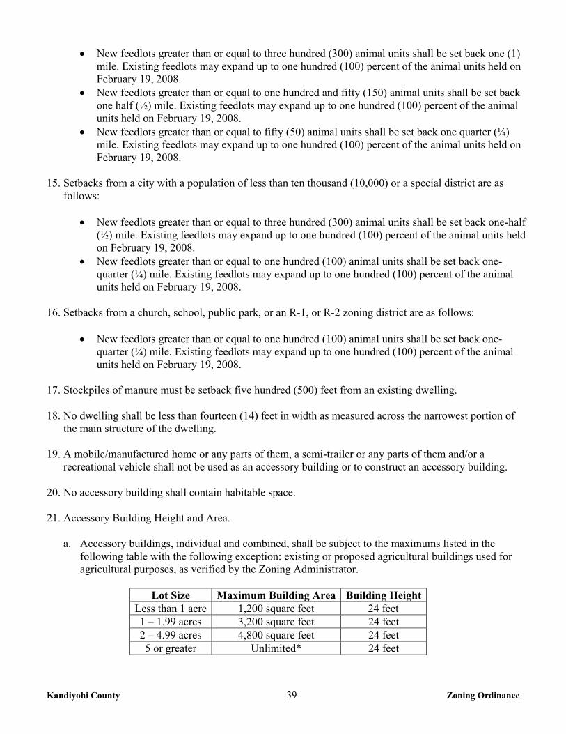
Kandiyohi County 39 Zoning Ordinance
New feedlots greater than or equal to three hundred (300) animal units shall be set back one (1) mile. Existing feedlots may expand up to one hundred (100) percent of the animal units held on February 19, 2008.
New feedlots greater than or equal to one hundred and fifty (150) animal units shall be set back one half (½) mile. Existing feedlots may expand up to one hundred (100) percent of the animal units held on February 19, 2008.
New feedlots greater than or equal to fifty (50) animal units shall be set back one quarter (¼) mile. Existing feedlots may expand up to one hundred (100) percent of the animal units held on February 19, 2008.
15. Setbacks from a city with a population of less than ten thousand (10,000) or a special district are as
follows:
New feedlots greater than or equal to three hundred (300) animal units shall be set back one-half (½) mile. Existing feedlots may expand up to one hundred (100) percent of the animal units held on February 19, 2008.
New feedlots greater than or equal to one hundred (100) animal units shall be set back one-quarter (¼) mile. Existing feedlots may expand up to one hundred (100) percent of the animal units held on February 19, 2008.
16. Setbacks from a church, school, public park, or an R-1, or R-2 zoning district are as follows:
New feedlots greater than or equal to one hundred (100) animal units shall be set back one-
quarter (¼) mile. Existing feedlots may expand up to one hundred (100) percent of the animal units held on February 19, 2008.
17. Stockpiles of manure must be setback five hundred (500) feet from an existing dwelling. 18. No dwelling shall be less than fourteen (14) feet in width as measured across the narrowest portion of
the main structure of the dwelling. 19. A mobile/manufactured home or any parts of them, a semi-trailer or any parts of them and/or a
recreational vehicle shall not be used as an accessory building or to construct an accessory building.
20. No accessory building shall contain habitable space. 21. Accessory Building Height and Area.
a. Accessory buildings, individual and combined, shall be subject to the maximums listed in the following table with the following exception: existing or proposed agricultural buildings used for agricultural purposes, as verified by the Zoning Administrator.
Lot Size Maximum Building Area Building Height
Less than 1 acre 1,200 square feet 24 feet 1 – 1.99 acres 3,200 square feet 24 feet 2 – 4.99 acres 4,800 square feet 24 feet 5 or greater Unlimited* 24 feet
Kandiyohi County 40 Zoning Ordinance
* Parcels five (5) acres or greater will only be limited by the maximum lot coverage and building height.
b. A garage attached to the dwelling shall not be considered in the calculation of the total cumulative
residential accessory building area.
CHAPTER 7 A-2 GENERAL AGRICULTURAL DISTRICT 7-1 PURPOSE This district is intended primarily for application in those areas of the County where it is desirable to be retained for general farming activities including cash crop products and animal husbandry; to regulate the encroachment on agricultural land by non-farm land uses; to protect and preserve natural areas and retain major areas of natural ground cover for conservation purposes; and to stabilize increases in public expenditures for public services such as roads, road maintenance, snow removal, schools, police, and fire protection. As a permitted use, agriculture often includes such activities as the intense use of farm equipment and machinery; plowing during dry and windy conditions; the raising of livestock and fowl; the use of soil amendments, including manure, herbicides, and pesticides; and storage of manure. These activities may occur during any twenty-four (24) hour period. Thus, grantees, transferees and buyers in an A-2 District may be subject to odor, dirt, dust, insects, and noise, arising from such operations. While these activities may be considered nuisances in a more urban setting, they are common in an agricultural community and vital to the sustenance of an agricultural economy. Pursuant to MN Statute 561.19, agricultural activities shall not be considered a public nuisance, provided such activities do not violate any State statute, rule, or other law. 7-2 PERMITTED USES The following uses shall be permitted in the A-2 General Agricultural District: 1. Agricultural uses. 2. Single family dwelling. 3. Private garage and storage sheds subject to the regulations in Chapter 7, section 7-5 #21 of this
Ordinance. 4. Home Occupation as regulated in Chapter 36 of this Ordinance. 5. One (1) cabin not exceeding six hundred (600) square feet. 6. Temporary or seasonal roadside stands with adequate off street parking. The number of stands must not
exceed one (1) per parcel. 7. Nurseries and tree farms. 8. Flood control and watershed structures, erosion control structures and farmland drainage systems.
Kandiyohi County 41 Zoning Ordinance
9. Residential programs meeting Minnesota Statutes section 245A.11, subdivision 2 or successor statutes. 10. Public recreation facilities owned or operated by County or other governmental agencies including but
not limited to, parks, recreational areas, wildlife areas, game refuges, and forest preserves. 11. Minor essential service facilities and structures, as regulated in Chapter 2, section 2-8 of this Ordinance. 12. Designated historical sites and areas. 13. Non Commercial and Meteorological Wind Energy Conversion Systems (WECS) as regulated in
Chapter 28 of this Ordinance. 14. Town halls. 15. Agricultural feedlots under three hundred (300) animal units, subject to section 7-5 of this Chapter. 7-3 CONDITIONAL USES The following uses may be allowed in the A-2 General Agricultural District, subject to the issuance of a Conditional Use Permit as provided in Chapter 2, section 2-4 of this Ordinance. 1. Home Extended Business as regulated in Chapter 36 of this Ordinance. 2. Restaurants.
3. Solid waste processing facilities and sanitary landfills. 4. Agricultural processing facilities. 5. Agricultural related machinery shop. 6. Airports, landing strips and airport facilities. 7. Commercial bulk liquid storage having a capacity of ten thousand (10,000) gallons or more of oil,
gasoline, liquid fertilizer, chemicals, and similar liquids. 8. Residential programs meeting Minnesota Statutes section 245A.11, subdivision 3 and juvenile
residential programs as referenced in Minnesota Statutes section 245A.11, subdivision 2 or successor statutes.
9. Storage rental facilities.
10. Kennels, for properties of five (5) acres or more. 11. Communication service and utility towers, including cellular phone towers. 12. Outdoor commercial recreation uses including but not limited to golf courses, driving ranges, shooting
and hunting clubs, archery ranges, and skating rinks.
Kandiyohi County 42 Zoning Ordinance
13. Automobile sales, repair, and service, with a maximum of ten (10) vehicles on site, and shall not be the principle use on the site.
14. Bed and Breakfast establishments as regulated in Chapter 40 of this Ordinance. 15. Government storage and maintenance facilities. 16. Riding academies; stables. 17. Cemetery. 18. Churches, church related buildings and parsonage. 19. Commercial Wind Energy Conversion Systems (WECS) as regulated in Chapter 28 of this Ordinance. 20. Conservation Subdivisions as regulated in Chapter 34 of this Ordinance. 21. Mining and Extractive use as regulated in Chapter 32 of this Ordinance. 22. Asphalt and concrete mixing plants as regulated in Chapter 32 of this Ordinance. 23. Veterinary clinics and associated facilities necessary for animal health care. 24. Major essential service facilities and structures, as regulated in Chapter 2, section 2-8 of this Ordinance. 25. Agricultural feedlots containing more than three hundred (300) animal units or expansions of feedlots
of more than three hundred (300) animal units. A letter of review from the County Feedlot Officer shall be in the applicants file at the time of application.
26. Other uses deemed to be of the same general character as those permitted and conditional uses listed
above. 7-4 ACCESSORY USES The following shall be Accessory Uses within the A-2 General Agricultural District: 1. Structures designed for the storage of agricultural products and machinery. 2. Private garage and storage sheds. 3. Private swimming pool. 4. Livestock, buildings and pens. 5. Accessory buildings or structures and uses customarily incidental to the permitted or conditional uses
listed in sections 7-2 and 7-3 of this Chapter when located on the same property.
Kandiyohi County 43 Zoning Ordinance
7-5 HEIGHT AND YARD REGULATIONS 1. Density: A maximum of four (4) building eligibilities per quarter-quarter or government lot shall be
allowed. A maximum of one (1) dwelling shall be allowed per parcel. A parcel created prior to February 24, 2006 not having a building eligibility pursuant to this density requirement shall have one (1) building eligibility.
2. Lot Area: Two and a half (2½) acres minimum, with at least one (1) acre of buildable lot area. 3. Lot Width: Two hundred (200) feet minimum. 4. Depth of lot: Two hundred (200) feet, minimum. 5. Front Yard Setback:
a. One hundred fifty (150) feet from the centerline of a Principal Arterial. b. One hundred thirty (130) feet from the centerline of a Minor Arterial & Major Collector. c. One hundred (100) feet from the centerline of a Minor Collector. d. Eighty (80) feet from the centerline of a Local Road and Unclassified Roads. e. Road setbacks may be altered without a variance to conform to existing buildings provided the
existing and proposed buildings are not located in the road right-of-way. 6. Side Yard Setback: Ten feet (10). 7. Rear Yard Setback: Ten feet (10). 8. Boundary Line Setback from a Residential District: Fifty (50) feet. 9. Corner lots on roads classified as principal arterial, minor arterial and major collectors shall meet the
setback from both roads plus twenty (20) feet. 10. Dwelling Height: Thirty (30) feet and two and a half (2½) stories maximum. 11. Percent of lot coverage allowed: Thirty (30) percent, maximum. 12. New residences shall be set back one-quarter (¼) mile from existing feedlots greater than or equal to
three hundred (300) animal units. This provision does not apply to dwellings that are owned by family or an employee of the animal feedlot, or if the new residence is built to replace an existing residence.
13. New feedlots greater than or equal to three hundred (300) animal units shall be set back one-quarter (¼)
mile from an existing residence. This provision does not apply to dwellings that are owned by family or an employee of the animal feedlot.
14. Setbacks from a city with a population of ten thousand (10,000) or more are as follows:
New feedlots greater than or equal to three hundred (300) animal units shall be set back one (1)
mile. Existing feedlots may expand up to one hundred (100) percent of the animal units held on February 19, 2008.
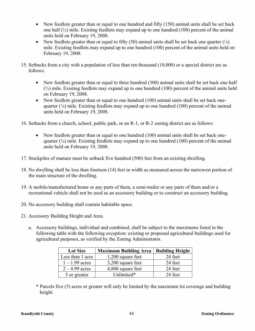
Kandiyohi County 44 Zoning Ordinance
New feedlots greater than or equal to one hundred and fifty (150) animal units shall be set back one half (½) mile. Existing feedlots may expand up to one hundred (100) percent of the animal units held on February 19, 2008.
New feedlots greater than or equal to fifty (50) animal units shall be set back one quarter (¼) mile. Existing feedlots may expand up to one hundred (100) percent of the animal units held on February 19, 2008.
15. Setbacks from a city with a population of less than ten thousand (10,000) or a special district are as
follows:
New feedlots greater than or equal to three hundred (300) animal units shall be set back one-half (½) mile. Existing feedlots may expand up to one hundred (100) percent of the animal units held on February 19, 2008.
New feedlots greater than or equal to one hundred (100) animal units shall be set back one-quarter (¼) mile. Existing feedlots may expand up to one hundred (100) percent of the animal units held on February 19, 2008.
16. Setbacks from a church, school, public park, or an R-1, or R-2 zoning district are as follows:
New feedlots greater than or equal to one hundred (100) animal units shall be set back one-
quarter (¼) mile. Existing feedlots may expand up to one hundred (100) percent of the animal units held on February 19, 2008.
17. Stockpiles of manure must be setback five hundred (500) feet from an existing dwelling. 18. No dwelling shall be less than fourteen (14) feet in width as measured across the narrowest portion of
the main structure of the dwelling. 19. A mobile/manufactured home or any parts of them, a semi-trailer or any parts of them and/or a
recreational vehicle shall not be used as an accessory building or to construct an accessory building. 20. No accessory building shall contain habitable space. 21. Accessory Building Height and Area.
a. Accessory buildings, individual and combined, shall be subject to the maximums listed in the following table with the following exception: existing or proposed agricultural buildings used for agricultural purposes, as verified by the Zoning Administrator.
Lot Size Maximum Building Area Building Height
Less than 1 acre 1,200 square feet 24 feet 1 – 1.99 acres 3,200 square feet 24 feet 2 – 4.99 acres 4,800 square feet 24 feet 5 or greater Unlimited* 24 feet
* Parcels five (5) acres or greater will only be limited by the maximum lot coverage and building
height.
Kandiyohi County 45 Zoning Ordinance
b. A garage attached to the dwelling shall not be considered in the calculation of the total cumulative residential accessory building area.
CHAPTER 10 R-1 SHORELAND RESIDENTIAL MANAGEMENT DISTRICT
10-1 PURPOSE The uncontrolled use of shorelands within the unincorporated area of the County, affects the public health, safety, and general welfare not only by contributing to pollution of public waters, but also by impairing the local tax base. Therefore, it is in the best interest of the public health, safety and welfare to provide for the wise subdivision, use and development of shorelands of public waters. The Legislature of Minnesota has delegated responsibility to local governments of the State to regulate the subdivision, use and development of the shorelands of public waters and thus preserve and enhance the quality of surface waters, conserve the economic and natural environmental values of shorelands and provide for the wise use of waters and related land resources. This responsibility is hereby recognized by the County. 10-2 PERMITTED USES The following uses shall be permitted in the R-1 Shoreland Residential Management District: 1. Agricultural uses, except feedlots. 2. Single family dwelling. 3. Twin home dwelling. 4. Private garage and storage sheds subject to the regulations in Chapter 10, section 10-5 #15 of this
Ordinance. 5. Home Occupations as regulated in Chapter 36 of this Ordinance.
6. Residential programs meeting Minnesota Statutes section 245A.11, subdivision 2 or successor statutes. 7. Parks and other public recreation facilities owned or operated by County or other governmental
agencies. 8. Designated historical sites and areas. 9. A mooring facility containing not more than four (4) mooring sites, and to be intended for use by the
property owner only. 10. Minor essential service facilities and structures, as regulated in Chapter 2, section 2-8 of this Ordinance. 10-3 CONDITIONAL USES The following uses may be allowed in the R-1 Residential Shoreland Management District, subject to the issuance of a Conditional Use Permit as provided in Chapter 2, section 2-4 of this Ordinance.
Kandiyohi County 46 Zoning Ordinance
1. Public and private campgrounds for parcels of five (5) acres or more. 2. Golf clubhouse, country club. 3. Public sewage treatment facilities. 4. Recreation oriented commercial establishments. 5. Cemetery. 6. Churches; church related buildings and parsonage. 7. Planned unit developments, subject to the administrative procedures of Chapter 12 section 12-3. 8. Bed and Breakfast establishments as regulated in Chapter 40 of this Ordinance. 9. A mooring facility containing more than four (4) mooring sites. Intended for use by the property owner
only, and must meet the controlled access size standards in Chapter 12 section 12-5-3. 10. Home Extended Business as regulated in Chapter 36 of this Ordinance. 11. Residential programs meeting Minnesota Statutes section 245A.11, subdivision 3, and juvenile
residential programs as referenced in Minnesota Statutes section 245A.11, subdivision 2 or successor statutes.
12. Major essential service facilities and structures, as regulated in Chapter 2, section 2-8 of this Ordinance. 13. Other uses deemed to be of the same general character as those permitted and conditional uses listed
above. 10-4 ACCESSORY USES The following shall be Accessory Uses within the R-1 Shoreland Residential Management District: 1. Private garage and storage sheds. 2. Private swimming pool. 3. Accessory buildings or structures and uses customarily incidental to the permitted or conditional uses
listed in sections 10-2 and 10-3 of this Chapter when located on the same property. 10-5 HEIGHT AND YARD REGULATIONS 1. Density: A maximum of one (1) dwelling per parcel. 2. Lot Area, and Width Standards are found in Chapter 12 section 12-4 of this Ordinance. 3. Percent of lot coverage allowed: Twenty Five (25) percent, maximum.
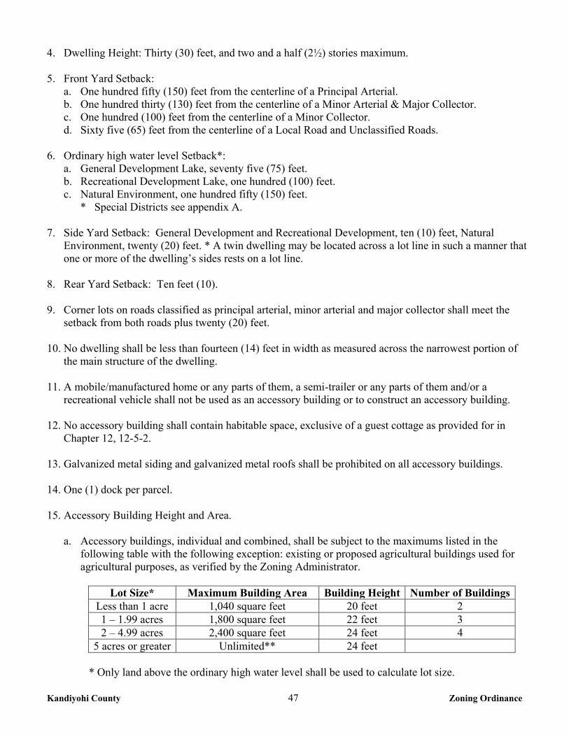
Kandiyohi County 47 Zoning Ordinance
4. Dwelling Height: Thirty (30) feet, and two and a half (2½) stories maximum. 5. Front Yard Setback:
a. One hundred fifty (150) feet from the centerline of a Principal Arterial. b. One hundred thirty (130) feet from the centerline of a Minor Arterial & Major Collector. c. One hundred (100) feet from the centerline of a Minor Collector. d. Sixty five (65) feet from the centerline of a Local Road and Unclassified Roads.
6. Ordinary high water level Setback*: a. General Development Lake, seventy five (75) feet. b. Recreational Development Lake, one hundred (100) feet. c. Natural Environment, one hundred fifty (150) feet.
* Special Districts see appendix A. 7. Side Yard Setback: General Development and Recreational Development, ten (10) feet, Natural
Environment, twenty (20) feet. * A twin dwelling may be located across a lot line in such a manner that one or more of the dwelling’s sides rests on a lot line.
8. Rear Yard Setback: Ten feet (10). 9. Corner lots on roads classified as principal arterial, minor arterial and major collector shall meet the
setback from both roads plus twenty (20) feet. 10. No dwelling shall be less than fourteen (14) feet in width as measured across the narrowest portion of
the main structure of the dwelling. 11. A mobile/manufactured home or any parts of them, a semi-trailer or any parts of them and/or a
recreational vehicle shall not be used as an accessory building or to construct an accessory building.
12. No accessory building shall contain habitable space, exclusive of a guest cottage as provided for in Chapter 12, 12-5-2.
13. Galvanized metal siding and galvanized metal roofs shall be prohibited on all accessory buildings. 14. One (1) dock per parcel. 15. Accessory Building Height and Area.
a. Accessory buildings, individual and combined, shall be subject to the maximums listed in the following table with the following exception: existing or proposed agricultural buildings used for agricultural purposes, as verified by the Zoning Administrator.
Lot Size* Maximum Building Area Building Height Number of Buildings
Less than 1 acre 1,040 square feet 20 feet 2 1 – 1.99 acres 1,800 square feet 22 feet 3 2 – 4.99 acres 2,400 square feet 24 feet 4
5 acres or greater Unlimited** 24 feet
* Only land above the ordinary high water level shall be used to calculate lot size.
Kandiyohi County 48 Zoning Ordinance
** Parcels five (5) acres or greater will only be limited by the maximum lot coverage and building height.
b. A garage attached to the dwelling shall not be considered in the calculation of the total cumulative
residential accessory building area. However an attached garage shall not exceed the square footage of the outside dimension of the dwelling.
c. The maximum sidewall height of an accessory building on parcels less than five (5) acres shall not
exceed sixteen (16) feet. d. Accessory buildings shall be a maximum of one and a half (1 ½) stories.
CHAPTER 11 RM SHORELAND RESOURCE MANAGEMENT DISTRICT
11-1 PURPOSE
The purpose of the RM Shoreland Resource Management District is to recognize the need for proper management of shoreland areas that are not conducive to high density residential development because of physical limitations, sensitive resources, or development patterns set forth in the Comprehensive Plan. The district is intended to limit the impacts of high density residential development while allowing for low density residential development and general agricultural, recreational, and resource management uses including properly regulated extractive uses, habitat management, and forest management. 11-2 PERMITTED USES The following uses shall be permitted in the RM Shoreland Resource Management District: 1. Agricultural uses, except feedlots. 2. Single family dwellings. 3. Private garage and storage sheds subject to the regulations in Chapter 11, section 11-5 #17 of this
Ordinance. 4. Home Occupations as regulated in Chapter 36 of this Ordinance.
5. One (1) cabin not exceeding six hundred (600) square feet. 6. Forest Management, as regulated in Chapter 12 of this Ordinance. 7. Flood control and watershed structures, erosion control structures and farmland drainage systems. 8. Residential programs meeting Minnesota Statutes section 245A.11, subdivision 2 or successor statutes. 9. Public recreation facilities owned or operated by County or other governmental agencies including but
not limited to, parks, recreational areas, wildlife areas, game refuges, and forest preserves. 10. Designated historical sites and areas.
Kandiyohi County 49 Zoning Ordinance
11. Animal feedlots under ten (10) animal units, as regulated in Chapter 12 section 12-7 of this Ordinance. 12. Meteorological Wind Energy Conversion Systems (WECS) as regulated in Chapter 28 of this
Ordinance.
13. A mooring facility containing not more than four (4) mooring sites, and to be intended for use by the property owner only.
14. Minor essential service facilities and structures, as regulated in Chapter 2, section 2-8 of this
Ordinance. 11-3 CONDITIONAL USES The following uses may be allowed in the RM Shoreland Resource Management District, subject to the issuance of a Conditional Use Permit as provided in Chapter 2, section 2-4 of this Ordinance. 1. Public and private campgrounds for parcels of five (5) acres or more. 2. Golf course including clubhouse and driving range. 3. Public sewage treatment facilities. 4. Recreation oriented commercial establishments. 5. Cemetery. 6. Churches; church related buildings and parsonage. 7. Bed and Breakfast establishments as regulated in Chapter 40 of this Ordinance.
8. A mooring facility containing more than four (4) mooring sites. Intended for use by the property owner only, and must meet the controlled access size standards in Chapter 12 section 12-5-3.
9. Home Extended Business as regulated in Chapter 36 of this Ordinance.
10. Residential programs meeting Minnesota Statutes section 245A.11, subdivision 3, and juvenile residential programs as referenced in Minnesota Statutes section 245A.11, subdivision 2 or successor statutes.
11. Kennels, for properties of five (5) acres or more. 12. Non-Commercial Wind Energy Conversion Systems (WECS) as regulated in Chapter 28 of this
Ordinance. 13. Mining and Extractive use as regulated in Chapter 32 of this Ordinance. 14. Asphalt and concrete mixing plants as regulated in Chapter 32 of this Ordinance. 15. Conservation Subdivisions as regulated in Chapter 34 of this Ordinance.
Kandiyohi County 50 Zoning Ordinance
16. Major essential service facilities and structures, as regulated in Chapter 2, section 2-8 of this Ordinance. 17. Other uses deemed to be of the same general character as those permitted and conditional uses listed
above. 11-4 ACCESSORY USES The following shall be Accessory Uses within the RM Shoreland Resource Management District: 1. Private garage and storage sheds. 2. Private swimming pool. 3. Accessory buildings or structures and uses customarily incidental to the permitted or conditional uses
listed in sections 11-2 and 11-3 of this Chapter when located on the same property. 11-5 HEIGHT AND YARD REGULATIONS 1. Density: A maximum of four (4) building eligibilities per quarter-quarter or government lot shall be
allowed. A maximum of one (1) dwelling shall be allowed per parcel. A parcel created prior to February 24, 2006 not having a building eligibility pursuant to this density requirement shall have one (1) building eligibility.
2. Lot Area: Two and a half (2½) acres minimum, with at least one (1) acre of buildable lot area. 3. Lot Width: Two hundred (200) feet, minimum. 4. Depth of lot: Two hundred (200) feet, minimum. 5. Front Yard Setback:
a. One hundred fifty (150) feet from the centerline of a Principal Arterial. b. One hundred thirty (130) feet from the centerline of a Minor Arterial & Major Collector. c. One hundred (100) feet from the centerline of a Minor Collector. d. Eighty (80) feet from the centerline of a Local Road and Unclassified Roads.
6. Ordinary high water level Setback*: a. General Development Lake, seventy five (75) feet. b. Recreational Development Lake, one hundred (100) feet. c. Natural Environment, one hundred fifty (150) feet. * Special Districts see appendix A.
7. Side Yard Setback: General Development and Recreational Development Lakes, ten (10) feet, Natural
Environment Lakes, twenty (20) feet. All classes of rivers, twenty (20) feet. 8. Rear Yard Setback: Ten feet (10). 9. Corner lots on roads classified as principal arterial, minor arterial and major collectors shall meet the
setback from both roads plus twenty (20) feet.
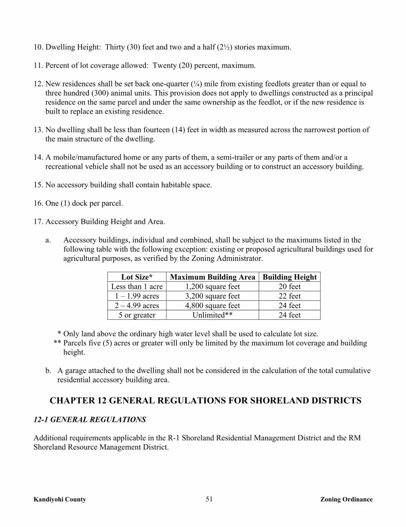
Kandiyohi County 51 Zoning Ordinance
10. Dwelling Height: Thirty (30) feet and two and a half (2½) stories maximum. 11. Percent of lot coverage allowed: Twenty (20) percent, maximum. 12. New residences shall be set back one-quarter (¼) mile from existing feedlots greater than or equal to
three hundred (300) animal units. This provision does not apply to dwellings constructed as a principal residence on the same parcel and under the same ownership as the feedlot, or if the new residence is built to replace an existing residence.
13. No dwelling shall be less than fourteen (14) feet in width as measured across the narrowest portion of
the main structure of the dwelling. 14. A mobile/manufactured home or any parts of them, a semi-trailer or any parts of them and/or a
recreational vehicle shall not be used as an accessory building or to construct an accessory building. 15. No accessory building shall contain habitable space. 16. One (1) dock per parcel. 17. Accessory Building Height and Area.
a. Accessory buildings, individual and combined, shall be subject to the maximums listed in the following table with the following exception: existing or proposed agricultural buildings used for agricultural purposes, as verified by the Zoning Administrator.
Lot Size* Maximum Building Area Building Height
Less than 1 acre 1,200 square feet 20 feet 1 – 1.99 acres 3,200 square feet 22 feet 2 – 4.99 acres 4,800 square feet 24 feet 5 or greater Unlimited** 24 feet
* Only land above the ordinary high water level shall be used to calculate lot size.
** Parcels five (5) acres or greater will only be limited by the maximum lot coverage and building height.
b. A garage attached to the dwelling shall not be considered in the calculation of the total cumulative
residential accessory building area.
CHAPTER 12 GENERAL REGULATIONS FOR SHORELAND DISTRICTS 12-1 GENERAL REGULATIONS Additional requirements applicable in the R-1 Shoreland Residential Management District and the RM Shoreland Resource Management District.
Kandiyohi County 52 Zoning Ordinance
12-1-1 Shoreland Areas All lakes lying wholly or partly within the County shall be classified under one of the following classifications: General Development; Recreational Development; and Natural Environment lakes. All rivers and streams flowing within Kandiyohi County shall be classified under one of the following classifications: Transitional Rivers, Agricultural Rivers and Tributary Streams. The classification of each such lake, river or stream shall be according to the classification made by the Minnesota Department of Natural Resources, which classifications are hereby adopted by reference and shall be used for all purposes under this Ordinance. See Appendix A- Kandiyohi County Lake and River Inventory.
12-1-2 Structures Within Shoreland Areas In all shoreland areas, no structure shall be placed at an elevation such that the lowest floor, including a basement floor is less than three (3) feet above the highest known water level, or the ordinary high water level, whichever is higher. In those instances where insufficient data on known high water levels is available, the ordinary high water level shall be the estimated high water elevation. 12-1-3 Fish House and Dark House Storage
1. The fish house and/or a dark house may be stored on a tract of land without obtaining a building permit.
For the purposes of definition, a fish house and/or dark house is not considered to be an accessory structure. The following standards shall apply: a. The fish house and/or dark house shall maintain minimum building setbacks as required by this
ordinance.
b. The fish house and/or dark house shall be licensed as required by the Minnesota Fishing Regulations.
c. There shall be a maximum of two fish houses and/or dark houses per tax parcel.
12-1-4 Boathouses
New boathouses are prohibited. A deck may be permitted to be built on the roof of an existing boathouse if
it does not obstruct neighboring property owners’ views, or exceed twelve (12) inches in height, and it is
the only water oriented accessory structure in the impact zone on the property. It may have a safety railing
that is open in nature with a maximum height of forty-two (42) inches.
12-1-5 Water Oriented Accessory Structures
Under a validly issued shoreland alteration permit, a lot may have one (1) deck or patio no other water
oriented accessory structures are permitted. The structure must be treated to reduce visibility as viewed
from public waters and adjacent shorelands by vegetation, topography, increased setbacks, color, or other
means acceptable to the Zoning Administrator assuming summer, leaf-on conditions. The structure may
not obstruct neighboring property owners’ views or exceed twenty-four (24) inches in height, and cannot
occupy an area greater than one hundred sixty (160) square feet. It may have a safety railing that is open in
nature with a maximum height of forty-two (42) inches. The structure must be setback at least five (5) feet
from the Ordinary high water level. For bluffs and steep slopes, the setback shall be five (5) feet from the
top of the bluff or steep slope.
Kandiyohi County 53 Zoning Ordinance
12-1-6 Recreational Equipment
1. Recreational equipment located on a tract of land without a permanent dwelling must be currently
licensed and located behind the building line. If hook-up to an individual sewage treatment system or public sewer is requested a land use permit shall be required. The parking of one (1) item of recreational equipment by a guest on the property shall be allowed for a period not to exceed thirty (30) calendar days per year.
2. The parking of one (1) recreational equipment by a guest on the property with a permanent dwelling shall be allowed for a period not to exceed thirty (30) calendar days per year, provided the recreational equipment shall not be hooked up to an individual sewage treatment system or public sewer, and be located behind the building line.
3. A homeowner may store personal recreation equipment provided it may not be hooked up to sewer and water.
12-1-7 Alterations within the Shoreland 1. No person shall cause any work, change of course, digging, or other alterations below the ordinary high
water level of lakes, streams or rivers, without a permit from the Minnesota Department of Natural Resources.
2. Alterations of vegetation and topography within the shoreland area shall be regulated to prevent erosion
into public waters, fix nutrients, preserve shoreland aesthetics, preserve historic values, prevent bank slumping, and protect fish and wildlife habitat.
3. Vegetation alterations, grading and filling and excavations necessary for the construction and maintenance of public and private roads and streets as specified in a recorded plat and for the construction and backfilling of structures, sidewalks, sewage treatment systems, and establishment of lawns under validly issued permits, where applicable, do not require the issuance of a separate permit or approval. It is further provided that the Zoning Administrator at his discretion may require a Conditional Use Permit for excavation for other shoreland alteration projects that have significant erosion or environmental damage potential. Erosion control plans shall be submitted with any application in shorelands.
4. Removal or alteration of vegetation is allowed subject to the following standards.
a. Within the shoreland and/or bluff impact zone, the removal of vegetation shall be limited to prevent erosion into public waters, and to preserve the natural character of the shoreland. Removal shall be restricted within a strip paralleling the lakeshore and extending inland a specified distance from the normal high water mark. The specified distance is established according to lake classification:
(1) Natural Environment Lakes: Seventy-five (75) feet from the ordinary high water level. (2) Recreational Development Lake: Fifty (50) feet from the ordinary high water level.
(3) General Development Lakes: Fifty (50) feet from the ordinary high water level.
Kandiyohi County 54 Zoning Ordinance
b. To allow a viewing corridor to the water from the principal dwelling, twenty-five (25) percent of the lot width, or a maximum of fifty (50) feet, whichever is less, may have up to twenty (20) percent of the trees trimmed or selectively cut. In the remaining footage, trimming and selective cutting shall maintain sufficient cover to screen cars, dwellings, and other structures from view from the water assuming summer leaf on conditions. Naturally dead or diseased trees may be removed regardless of their location on the property.
5. In all cases, the following general standards shall be observed:
a. Along rivers, existing shading of water surfaces shall be preserved.
b. Intensive vegetation removal shall be prohibited within the shore and bluff impact zone, and on steep slopes.
c. Natural shrubbery shall be preserved as far as practicable. Where removal is necessary for
construction of any structure or use except permitted principal structure, shrubbery must be replaced with other vegetation, which is equally suitable in retarding surface run-off and soil erosion.
d. No structure shall be placed in any area which will require grading and/or filling which results in impairment of public waters by reason of erosion and sedimentation, violate provisions of statewide standards for management of flood plain areas, or result in impairment of fish or aquatic life.
12-1-8 Front Yard and Shoreland Setback Adjustments When an existing building line violates the required setback, any new structure shall maintain the existing building line setback. No variance shall be required if the existing building line setback is met, unless the existing building line setback is within the shore impact zone, bluff impact zone or road right-of-way. No decks, addition, or porches may be constructed closer to the front yard street or shoreline than the existing building line setback without a variance, with the exception of one water oriented accessory structure if built according to section 12-1-5 of this Chapter. 12-1-9 A Shoreland Alteration Permit Shall be Required For 1. The movement of more than five (5) cubic yards of material on steep slopes or within shore and/or bluff
impact zones unless the Zoning Administrator determines there is a potential for erosion necessitating a Condition Use Permit. This shall only be allowed one (1) time per tax parcel.
2. The movement of more than fifty (50) cubic yards of material located outside of steep slopes or shore and/or bluff impact zones unless the Zoning Administrator determines there is a potential for erosion necessitating a Conditional Use Permit. This shall only be allowed one (1) time per tax parcel.
3. Retaining walls may be allowed where there is a demonstrated need, the design is consistent with the existing uses in the area, and the wall doesn’t impair the natural character of the shoreline. However, within steep slopes, bluff and/or shore impact zones, retaining wall construction shall only be allowed where erosion problems preclude the use of vegetation.
4. The repair and reconstruction of existing walls may be allowed by permit subject to review by the
Zoning Administrator.
Kandiyohi County 55 Zoning Ordinance
5. The establishment of a sand beach area to a maximum size of one hundred fifty (150) square feet. Sand
beach areas shall not be established on slopes exceeding ten (10) percent. The sand must be washed,
free of pollutants and nutrients.
6. The planting of trees and vegetation in the shoreland area is encouraged by the Environmental Services
Department and may be conducted without a permit. 12-1-10 Topographical Alterations The following considerations and conditions must be met for all construction permits, shoreland alteration permits, conditional use permits, variances, and subdivision approvals for topographical alterations in shoreland areas. 1. The smallest amount of bare ground is exposed for the shortest time feasible.
2. Temporary ground cover, such as mulch, is used and permanent ground cover, such as sod is planted.
3. Methods to prevent erosion and trap sediment are employed. 4. Fill is established to accepted engineering standards.
5. Grading or filling any type 2,3,4,5,6,7 or 8 wetland must be evaluated* to determine how extensively
the proposed activity would affect the following functional qualities of the wetland:
a. Sediment and pollutant trapping and retention.
b. Storage of surface runoff to prevent or reduce flood damage.
c. Fish and wildlife habitat.
d. Recreational use.
e. Shoreline or bank stabilization.
f. Noteworthiness, including special qualities such as historic significance, critical habitat for endangered plants and animals, or others.
*This evaluation shall include a determination of whether the wetland alteration being proposed requires permits, reviews or approvals by other local, State, or Federal agencies such as a watershed district, the Minnesota Department of Natural Resources, or the United States Army Corps of Engineers. The applicant will be so advised.
6. Plans to place fill or excavated material on steep slopes must not create finished slopes of thirty (30)
percent or greater and must result in a stable slope.
7. Fill or excavated material must not be placed in bluff impact zones. 8. Alterations of topography shall be allowed only if they are accessory to permitted or conditional uses.

Kandiyohi County 56 Zoning Ordinance
12-2 SPECIAL DISTRICTS 12-2-1 Special District Within the Shoreland Management Districts, the County Board shall be allowed to zone certain portions of the R-1 Shoreland Residential Management District or the RM Shoreland Resource Management District as a special district. 12-2-2 Requirements That land subject to a special district classification shall consist of those shoreland areas of any lake which, because of unusual typography or substantial elevation or high water level, would require variances for substantially all of the proposed lots to be developed, or where it is necessary to provide additional protection to the lake than is provided by the present requirements of the R-1 Shoreland Residential Management District or the RM Shoreland Resource Management District. 12-2-3 Procedure Any person seeking to have the property classified as a special district shall, in verified petition, set forth the legal description of the property involved and the requested provisions to apply within the special district. The County Board as well as the Planning Commission and the Zoning Administrator may petition to have any property within the R-1 Shoreland Residential Management District or the RM Shoreland Resource Management District classified as a special district. 12-2-4 Findings Required Upon filing of a petition requesting the classification as a special district, the public hearing shall be held by the Planning Commission with notice to all property owners within three hundred (300) feet of the proposed special district and with notice to the Minnesota Department of Natural Resources. After said public hearing, the Planning Commission shall make recommendations as to the requirements that shall apply within the special district then being considered. The County Board, after giving due consideration to the recommendation of the Planning Commission and after such further investigation as is considered appropriate, shall have the power to create a special district and within that district to vary or modify the strict application of this regulation or to impose more severe restrictions or requirements of the R-1 Shoreland Residential Management District or the RM Shoreland Resource Management District shall require approval of the Department of Natural Resources. 12-3 PLANNED UNIT DEVELOPMENTS (PUD’S) 12-3-1 Types Permissible Planned unit developments (PUD’S) are allowed for new projects on undeveloped land, redevelopment of previously built sites, or conversions of existing buildings and land. 12-3-2 Processing Planned unit developments must be processed as a conditional use. Approval cannot occur until the environmental review process (EAW/EIS), where required, is complete.
Kandiyohi County 57 Zoning Ordinance
12-3-3 Application The applicant for a PUD must submit the following documents prior to final action being taken on the application request. 1. The applicant for a PUD shall simultaneously follow the Subdivision Ordinance to secure both
preliminary and final plat design approval from the Planning Commission and County Board. When a PUD is a combined commercial and residential development, the preliminary plat must indicate and distinguish which building and portions of the project are residential, commercial or a combination of the two.
2. A completed Minnesota Department of Natural Resources “Cluster/PUD Evaluation Worksheet”.
3. A property owner’s association agreement (for residential PUD’S) with mandatory membership, and all in accordance with the requirements of section 12-3-4, of this Chapter.
4. Deed restrictions, covenants, permanent easement or other instrument that: a. Properly address future vegetative and topographic alterations, construction of additional buildings,
beaching of watercraft, and construction of commercial buildings in residential PUD’S. b. Ensure the long-term preservation and maintenance of open space in accordance with the criteria
and analysis specified in section 12-3-5 of this Chapter.
5. When necessary, a master plan/drawing describing the project and the floor plan for all commercial structures to be occupied.
6. Provisions for public streets shall meet the requirements of the Kandiyohi County Subdivision
Ordinance. The Local Fire Chief with jurisdiction shall review private roads.
7. Those additional documents as requested by the Zoning Administrator, which are necessary to explain how the PUD will be designed and will function.
8. Site "suitable area" evaluation. Proposed new or expansions to existing planned unit developments
must be evaluated using the following procedures and standards to determine the suitable area for the dwelling unit/dwelling site density evaluation in this section. a. The project parcel must be divided into tiers by locating one or more lines approximately parallel to
a line that identifies the ordinary high water level at the following intervals, proceeding landward:
Shoreland Tier Dimensions Unsewered Sewered
General Development Lakes First Tier 200 feet 200 feet
Second and Additional Tiers 267 feet 200 feet Recreational Development Lakes 267 feet 267 feet
Natural Environmental Lakes 400 feet 320 feet All River Classes 300 feet 300 feet
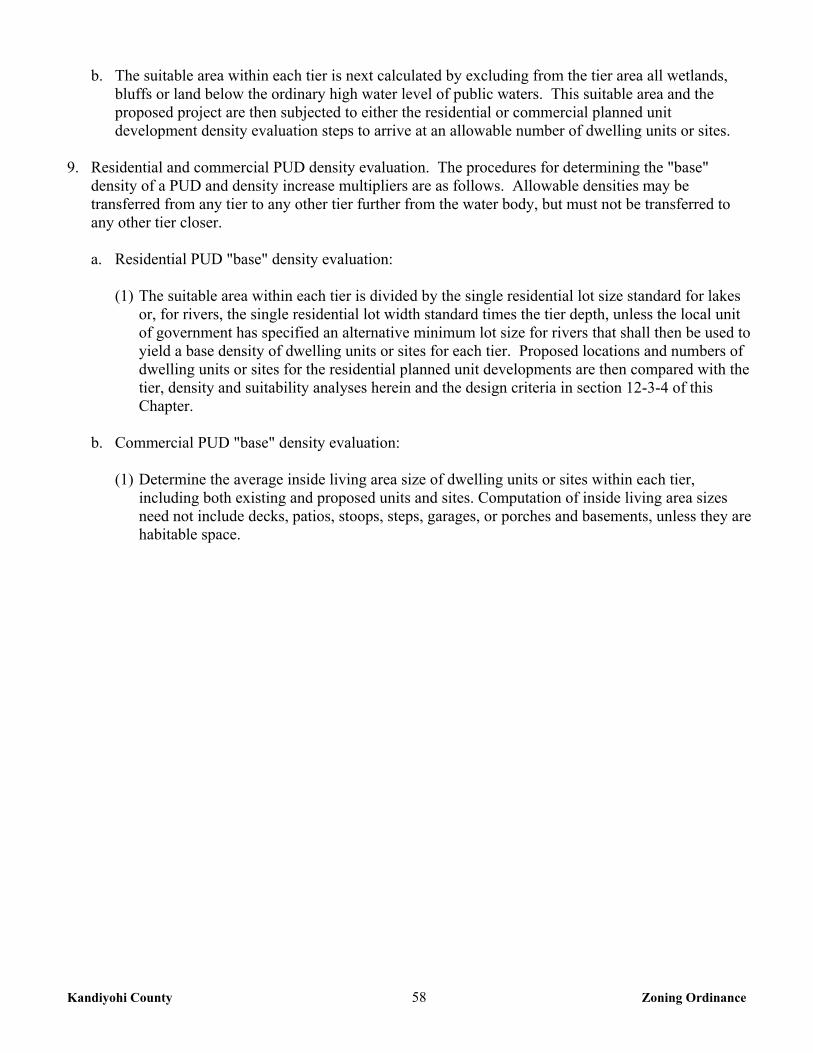
Kandiyohi County 58 Zoning Ordinance
b. The suitable area within each tier is next calculated by excluding from the tier area all wetlands, bluffs or land below the ordinary high water level of public waters. This suitable area and the proposed project are then subjected to either the residential or commercial planned unit development density evaluation steps to arrive at an allowable number of dwelling units or sites.
9. Residential and commercial PUD density evaluation. The procedures for determining the "base"
density of a PUD and density increase multipliers are as follows. Allowable densities may be transferred from any tier to any other tier further from the water body, but must not be transferred to any other tier closer.
a. Residential PUD "base" density evaluation:
(1) The suitable area within each tier is divided by the single residential lot size standard for lakes or, for rivers, the single residential lot width standard times the tier depth, unless the local unit of government has specified an alternative minimum lot size for rivers that shall then be used to yield a base density of dwelling units or sites for each tier. Proposed locations and numbers of dwelling units or sites for the residential planned unit developments are then compared with the tier, density and suitability analyses herein and the design criteria in section 12-3-4 of this Chapter.
b. Commercial PUD "base" density evaluation:
(1) Determine the average inside living area size of dwelling units or sites within each tier, including both existing and proposed units and sites. Computation of inside living area sizes need not include decks, patios, stoops, steps, garages, or porches and basements, unless they are habitable space.
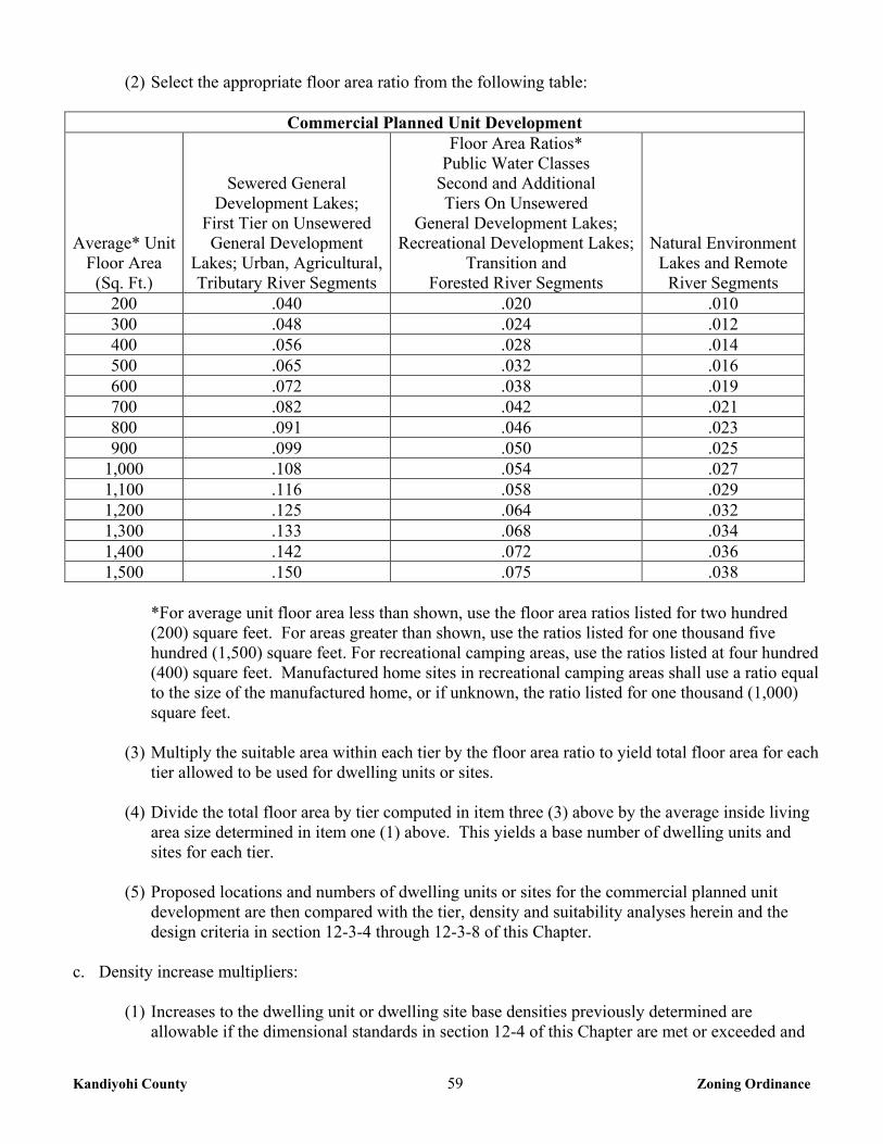
Kandiyohi County 59 Zoning Ordinance
(2) Select the appropriate floor area ratio from the following table:
Commercial Planned Unit Development
Average* Unit Floor Area
(Sq. Ft.)
Sewered General Development Lakes;
First Tier on Unsewered General Development
Lakes; Urban, Agricultural, Tributary River Segments
Floor Area Ratios* Public Water Classes
Second and Additional Tiers On Unsewered
General Development Lakes; Recreational Development Lakes;
Transition and Forested River Segments
Natural Environment Lakes and Remote
River Segments 200 .040 .020 .010 300 .048 .024 .012 400 .056 .028 .014 500 .065 .032 .016 600 .072 .038 .019 700 .082 .042 .021 800 .091 .046 .023 900 .099 .050 .025
1,000 .108 .054 .027 1,100 .116 .058 .029 1,200 .125 .064 .032 1,300 .133 .068 .034 1,400 .142 .072 .036 1,500 .150 .075 .038
*For average unit floor area less than shown, use the floor area ratios listed for two hundred (200) square feet. For areas greater than shown, use the ratios listed for one thousand five hundred (1,500) square feet. For recreational camping areas, use the ratios listed at four hundred (400) square feet. Manufactured home sites in recreational camping areas shall use a ratio equal to the size of the manufactured home, or if unknown, the ratio listed for one thousand (1,000) square feet.
(3) Multiply the suitable area within each tier by the floor area ratio to yield total floor area for each
tier allowed to be used for dwelling units or sites. (4) Divide the total floor area by tier computed in item three (3) above by the average inside living
area size determined in item one (1) above. This yields a base number of dwelling units and sites for each tier.
(5) Proposed locations and numbers of dwelling units or sites for the commercial planned unit
development are then compared with the tier, density and suitability analyses herein and the design criteria in section 12-3-4 through 12-3-8 of this Chapter.
c. Density increase multipliers:
(1) Increases to the dwelling unit or dwelling site base densities previously determined are allowable if the dimensional standards in section 12-4 of this Chapter are met or exceeded and
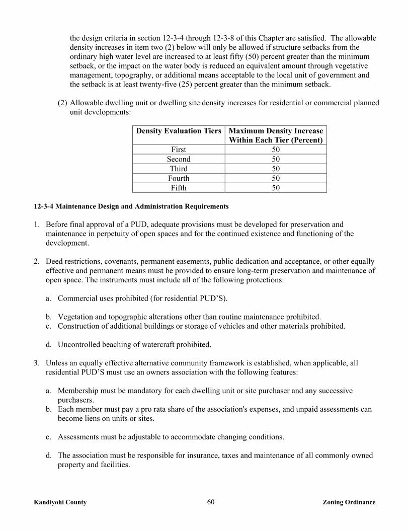
Kandiyohi County 60 Zoning Ordinance
the design criteria in section 12-3-4 through 12-3-8 of this Chapter are satisfied. The allowable density increases in item two (2) below will only be allowed if structure setbacks from the ordinary high water level are increased to at least fifty (50) percent greater than the minimum setback, or the impact on the water body is reduced an equivalent amount through vegetative management, topography, or additional means acceptable to the local unit of government and the setback is at least twenty-five (25) percent greater than the minimum setback.
(2) Allowable dwelling unit or dwelling site density increases for residential or commercial planned
unit developments:
Density Evaluation Tiers Maximum Density Increase Within Each Tier (Percent)
First 50 Second 50 Third 50 Fourth 50 Fifth 50
12-3-4 Maintenance Design and Administration Requirements 1. Before final approval of a PUD, adequate provisions must be developed for preservation and
maintenance in perpetuity of open spaces and for the continued existence and functioning of the development.
2. Deed restrictions, covenants, permanent easements, public dedication and acceptance, or other equally
effective and permanent means must be provided to ensure long-term preservation and maintenance of open space. The instruments must include all of the following protections:
a. Commercial uses prohibited (for residential PUD’S).
b. Vegetation and topographic alterations other than routine maintenance prohibited. c. Construction of additional buildings or storage of vehicles and other materials prohibited. d. Uncontrolled beaching of watercraft prohibited.
3. Unless an equally effective alternative community framework is established, when applicable, all
residential PUD’S must use an owners association with the following features:
a. Membership must be mandatory for each dwelling unit or site purchaser and any successive purchasers.
b. Each member must pay a pro rata share of the association's expenses, and unpaid assessments can become liens on units or sites.
c. Assessments must be adjustable to accommodate changing conditions.
d. The association must be responsible for insurance, taxes and maintenance of all commonly owned
property and facilities.
Kandiyohi County 61 Zoning Ordinance
12-3-5 Open Space Requirements PUD’S must contain open space meeting all of the following criteria: 1. At least fifty (50) percent of the total area must be preserved as open space.
2. Dwelling units or sites, road rights-of-way, or land covered by road surfaces, parking areas or
structures, except water-oriented accessory structures or facilities, are developed areas and shall not be included in the computation of minimum open space.
3. Open space must include areas with physical characteristics unsuitable for development in their natural
state, and areas containing significant historic sites or un-platted cemeteries.
4. Open space may include outdoor recreational facilities for use by owners of dwelling units or sites, by guests staying in commercial dwelling units or sites, and by the general public.
5. Open space may include subsurface sewage treatment systems if the use of the space is restricted to
avoid adverse impacts on the systems.
6. Open space must not include commercial facilities or uses, but may contain water-oriented accessory structures or facilities.
7. The appearance of open space areas, including topography, vegetation, and allowable uses, must be
preserved by use of restrictive deed covenants, permanent easements, public dedication and acceptance, or other equally effective and permanent means.
8. The shore impact zone, based on normal structure setbacks, must be included as open space. For
residential PUD’S, at least fifty (50) percent of the shore impact zone area of existing developments or at least seventy (70) percent of the shore impact zone area of new developments must be preserved in its natural or existing state. For commercial PUD’S, at least fifty (50) percent of the shore impact zone must be preserved in its natural state.
12-3-6 Erosion Control and Storm Water Management Erosion control and storm water management plans must be developed and the PUD must: Be designed, and the construction managed, to minimize the likelihood of serious erosion occurring either during or after construction. This must be accomplished by limiting the amount and length of time of bare ground exposure. Temporary ground covers, sediment entrapment facilities, vegetated buffer strips, or other appropriate techniques must be used to minimize erosion impacts on surface water features. Erosion control plans approved by a soil and water conservation district may be required if project size and site physical characteristics warrant. 12-3-7 Dwelling Units Dwelling units or sites must be clustered into one or more groups and located on suitable areas of the development. They must be designed and located to meet or exceed the following dimensional standards for the relevant shoreland classification: setback from the ordinary high water level, elevation above the
Kandiyohi County 62 Zoning Ordinance
surface water features, and maximum height. Setbacks from the ordinary high water level must be increased in accordance with section 12-3-3 #9c of this Chapter for developments with density increases. 12-3-8 Shore Recreation Facilities 1. Shore recreation facilities including, but not limited to, swimming areas, docks and watercraft mooring
areas and launching ramps, must be centralized and located in areas suitable for them. Evaluation of suitability must include consideration of land slope, water depth, vegetation, soils, depth to groundwater and bedrock, or other relevant factors. The number of spaces provided for continuous beaching, mooring or docking of watercraft must not exceed one (1) for each allowable dwelling unit or site in the first tier (notwithstanding existing mooring sites in an existing commercially used harbor). Launching ramp facilities, including a small dock for loading and unloading equipment, may be provided for use by occupants of dwelling units or sites located in other tiers.
2. Structures, parking areas and other facilities must be treated to reduce visibility as viewed from public
waters and adjacent shorelands by vegetation, topography, increased setbacks, color or other means acceptable to the local unit of government, assuming summer, leaf-on conditions. Vegetative and topographic screening must be preserved, if existing, or may be required to be provided.
3. Accessory structures and facilities, except water-oriented accessory structures, must meet the required
principal structure setback and must be centralized. 4. Water-oriented accessory structures and facilities may be allowed if they meet or exceed design
standards contained in section 12-1-5 of this Chapter and are centralized. 12-3-9 Conversions Local governments may allow existing resorts or other land uses and facilities to be converted to residential planned unit developments if all of the following standards are met: 1. The conversions of resorts may be allowed provided a conditional use permit has been approved by the
County. In resort conversions, units must remain the same type of use that was initially allowed, cabins must remain cabin sites and recreational vehicles must remain recreational vehicle sites. Resort conversions are subject to the following standards and additional standards may be required by the County Board if deemed necessary for health, safety, and welfare purposes.
2. Proposed conversions must be initially evaluated using the same procedures for residential planned unit
developments involving all new construction. Inconsistencies between existing features of the development and these standards must be identified. Resort conversions are exempt from the conventional minimum land tract requirement.
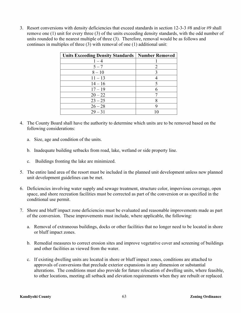
Kandiyohi County 63 Zoning Ordinance
3. Resort conversions with density deficiencies that exceed standards in section 12-3-3 #8 and/or #9 shall
remove one (1) unit for every three (3) of the units exceeding density standards, with the odd number of units rounded to the nearest multiple of three (3). Therefore, removal would be as follows and continues in multiples of three (3) with removal of one (1) additional unit:
Units Exceeding Density Standards Number Removed
1 – 4 1 5 – 7 2 8 – 10 3 11 – 13 4 14 – 16 5 17 – 19 6 20 – 22 7 23 – 25 8 26 – 28 9 29 – 31 10
4. The County Board shall have the authority to determine which units are to be removed based on the
following considerations: a. Size, age and condition of the units.
b. Inadequate building setbacks from road, lake, wetland or side property line.
c. Buildings fronting the lake are minimized.
5. The entire land area of the resort must be included in the planned unit development unless new planned unit development guidelines can be met.
6. Deficiencies involving water supply and sewage treatment, structure color, impervious coverage, open space, and shore recreation facilities must be corrected as part of the conversion or as specified in the conditional use permit.
7. Shore and bluff impact zone deficiencies must be evaluated and reasonable improvements made as part of the conversion. These improvements must include, where applicable, the following:
a. Removal of extraneous buildings, docks or other facilities that no longer need to be located in shore
or bluff impact zones.
b. Remedial measures to correct erosion sites and improve vegetative cover and screening of buildings and other facilities as viewed from the water.
c. If existing dwelling units are located in shore or bluff impact zones, conditions are attached to
approvals of conversions that preclude exterior expansions in any dimension or substantial alterations. The conditions must also provide for future relocation of dwelling units, where feasible, to other locations, meeting all setback and elevation requirements when they are rebuilt or replaced.
Kandiyohi County 64 Zoning Ordinance
12-4 DIMENSIONAL REQUIREMENTS AND ADDITIONAL PERFORMANCE STANDARDS FOR SHORELAND DEVELOPMENT 12-4-1 Lot Area, Width, and Square Feet of Land Above a Delineated Wetland The lot area (in square feet) and lot width standards (in feet) for single residential lots created after the date of enactment of this Ordinance for the lake and river/stream classifications are the following:
R-1 Shoreland Residential Management District
Lake Classification Riparian Non-Riparian Sq. Ft. Above Wetland Area Width Area Width
Natural Environment 80,000 200 80,000 200 40,000 Recreational Development 40,000 150 40,000 150 40,000
General Development 20,000 100 40,000 150 20,000 RM Resource Management District
Lake Classification Riparian Non-Riparian Sq. Ft. Above Wetland Acres Width Area Width
Natural Environment 2.5 200 2.5 200 40,000 Recreational Development 2.5 200 2.5 200 40,000
General Development 2.5 200 2.5 200 40,000 River/Stream Lot Width Standards. There are no minimum lot size requirements for rivers and streams. The lot width standards for single, residential developments for the river/stream classifications are the following:
Classification Width Sq. Ft. Above Wetland Transitional 250 20,000 Agricultural 150 20,000
Tributary 100 20,000 12-5 ADDITIONAL SPECIAL PROVISIONS 12-5-1 Performance Standards 1. Residential subdivisions with dwelling unit densities exceeding those in the tables in section 12-4 of
this Chapter can only be allowed if designed and approved as residential PUD’S in section 12-3 of this Chapter. Only land above the ordinary high water level of public waters can be used to meet lot area standards, and lot width standards must be met at both the ordinary high water level and at the building line.
12-5-2 Guest Cottage One (1) guest cottage may be permitted on a lot, provided the following standards are met:
a. A guest cottage must not cover more than seven hundred (700) square feet of land surface and must
not exceed fifteen (15) feet in height.
Kandiyohi County 65 Zoning Ordinance
b. A guest cottage may be constructed within the roof system of an accessory structure and shall be limited in size and height as provided in Chapter 10, 10-5, #15.
12-5-3 Controlled Accesses Lots intended as controlled accesses to public waters or as recreation areas for use by owners of non-riparian lots within subdivisions are permissible and must meet or exceed the following standards: 1. They must meet the width and size requirements for residential lots, and be suitable in their natural state
for residential development. A maximum of one (1) controlled access lot per development shall be allowed with a maximum of four (4) moorings.
2. They must be jointly owned by all purchasers of lots in the subdivision or by all purchasers of non-
riparian lots in the subdivision who are provided riparian access rights on the access lot. 3. Covenants or other equally effective legal instruments must be developed that specify which lot owners
have authority to use the access lot and what activities are allowed. The activities may include watercraft launching, loading, storing, beaching, mooring or docking. They must also include other outdoor recreational activities that do not significantly conflict with general public use of the public water or the enjoyment of normal property rights by adjacent property owners.
4. Examples of the non-significant conflict activities include swimming, sunbathing or picnicking. The
covenants must limit the total number of watercraft allowed to be continuously moored, docked or stored over water, and must require centralization of all common facilities and activities in the most suitable locations on the lot to minimize topographic and vegetation alterations. They must also require all parking areas, storage buildings, and other facilities to be screened by vegetation or topography as much as practical from view from the public water, assuming summer, leaf-on conditions.
12-5-4 Placement, Design and Height of Structures 1. Placement of structures on lots. When more than one setback applies to a site, structures and facilities
must be located to meet all setbacks. Where structures exist on the adjoining lots on both sides of a proposed building site, structure setbacks may be altered without a variance to conform to the adjoining setbacks from the ordinary high water level provided the proposed building site is not located in a shore impact zone, or bluff impact zone. Road setbacks may be altered without a variance to conform to accessory buildings on neighboring lots provided the proposed building site is not located in the road right-of-way. Structures shall be located as follows:
Lakes
Classification Structure Setback Sewage Treatment System Setback Natural Environment 150 150
Recreational Development 100 75 General Development 75 50
Rivers Classification Structure Setback Sewage Treatment System Setback
Agricultural and Tributary 100 75 Transitional 150 100
Kandiyohi County 66 Zoning Ordinance
2. Additional structure setbacks. The following additional structure setbacks apply, regardless of the classification of the water body:
Setback From Setback (in feet) Top of Bluff 30
Un-platted Cemetery 50 12-5-5 Bluff Impact Zones
Structures and accessory facilities, except stairways and landings, and a water oriented accessory
structure as identified in Chapter 12 section 12-1-5 of this Ordinance must not be placed within bluff impact zones.
12-5-6 Uses Without Water Oriented Needs Uses without water-oriented needs must be located on lots or parcels without public waters frontage, or,
if located on lots or parcels with public waters frontage, must either be set back double the normal ordinary high water level setback or be substantially screened from view from the water by vegetation or topography, assuming summer, leaf-on conditions.
12-5-7 Stairways, Lifts and Landings 1. Stairways and lifts are the preferred alternative to major topographic alterations for achieving access up
and down bluffs and steep slopes to shore areas. A Shoreland Alteration Permit is required for stairways and lifts and they must meet the following design requirements:
a. Stairways and lifts must not exceed four (4) feet in width on residential lots. Wider stairways may
be used for commercial properties, public open space recreational properties, and planned unit developments.
b. Landings for stairways and lifts on residential lots must not exceed thirty-two (32) square feet in
area. Landings larger than thirty-two (32) square feet may be used for commercial properties, public open space recreational properties and planned unit developments.
c. Canopies or roofs are not allowed on stairways, lifts or landings. d. Stairways, lifts and landings may be constructed above the ground on posts or pilings, or in ground,
provided they are designed and built in a manner that ensures control of soil erosion. e. Stairways, lifts and landings must be located in the most visually inconspicuous portions of lots, as
viewed from the surface of the public water assuming summer, leaf-on conditions, whenever practical.
f. One (1) stairway and one (1) lift are allowed on each residential lot.
12-5-8 Significant Historic Sites
No structure may be placed on a significant historic site in a manner that affects the value of the site unless adequate information about the site has been removed and documented in a public repository.
Kandiyohi County 67 Zoning Ordinance
12-5-9 Steep Slopes The Zoning Administrator must evaluate possible soil erosion impacts and development visibility from public waters before issuing a permit for construction of sewage treatment systems, roads, driveways, structures or other improvements on steep slopes. When determined necessary, conditions must be attached to issue permits to prevent erosion and to preserve existing vegetation screening of structures, vehicles and other facilities as viewed from the surface of public waters, assuming summer, leaf-on vegetation. 12-5-10 Public and Private Roads Public and private roads and parking areas must be designed to take advantage of natural vegetation and topography to achieve maximum screening from view from public waters. Roads, driveways and parking areas must meet structure setbacks from the ordinary high water level and must not be placed within bluff and shore impact zones, when other reasonable and feasible placement alternatives exist. If no alternatives exist, they may be placed within these areas and must be designed to minimize adverse impacts. Public and private watercraft access ramps, approach roads and access-related parking areas may be placed within shore impact zones provided the vegetative screening and erosion control conditions of this subpart are met. 12-5-11 Storm Water Management 1. When possible, existing natural drainage way, wetlands and vegetated soil surfaces must be used to
convey, store, filter and retain storm water runoff before discharge to public waters. Development must be planned and conducted in a manner that will minimize the extent of disturbed areas, runoff velocities, erosion potential, and reduce and delay runoff volumes. Disturbed areas must be stabilized and protected as soon as possible and facilities or methods used to retain sediment on the site.
2. When development density, topographic features and soil and vegetation conditions are not sufficient to
adequately handle storm water runoff using natural features and vegetation, various types of constructed facilities such as diversions, settling basins, skimming devices, dikes, waterways, and ponds may be used. Preference must be given to designs using surface drainage, vegetation and infiltration rather than buried pipes and manmade materials and facilities.
3. Impervious surface coverage of lots must not exceed twenty-five (25) percent of the lot area. 4. A qualified individual must provide documentation that constructed storm water management facilities
are designed and installed that adhere to erosion control measure standards and specifications contained in the MPCA publication “Protecting Water Quality in Urban Areas”; or successor publication.
5. New constructed storm water outfalls to public waters must provide for filtering or settling of suspended solids and skimming of surface debris before discharge.
12-6 STANDARDS FOR COMMERCIAL, INDUSTRIAL, PUBLIC AND SEMIPUBLIC USES Surface water-oriented commercial uses and industrial, public or semipublic uses with similar needs to have access to and use of public waters may be located on parcels or lots with frontage on public waters. Those uses with water-oriented needs must meet the following standards:
Kandiyohi County 68 Zoning Ordinance
1. In addition to meeting impervious coverage limits, setbacks and other zoning standards in this Ordinance, the uses must be designed to incorporate topographic and vegetative screening of parking areas and structures.
2. Uses that require short-term watercraft mooring for patrons must centralize these facilities and design
them to avoid obstructions of navigation and to be the minimum size necessary to meet the need. 3. Uses that depend on patrons arriving by watercraft may use signs and lighting to convey needed
information to the public, subject to the following general standards:
a. No advertising signs or supporting facilities for signs may be placed in or upon public waters. Signs conveying information or safety messages may be placed in or on public waters by a public authority or under a permit issued by the County Sheriff.
b. Signs may be placed, when necessary, within the shore impact zone if they are designed and sized
to be the minimum necessary to convey needed information. They must only convey the location and name of the establishment and the general types of goods or services available. The signs must not contain other detailed information such as product brands and prices, must not be located higher than ten feet above the ground, and must not exceed thirty-two (32) square feet in size. If illuminated by artificial lights, the lights must be shielded or directed to prevent illumination out across public waters.
c. Other outside lighting may be located within the shore impact zone or over public waters if it is
used primarily to illuminate potential safety hazards and is shielded or otherwise directed to prevent direct illumination out across public waters. This does not preclude use of navigational lights.
d. Uses without water-oriented needs must be located on lots or parcels without public waters
frontage, or, if located on lots or parcels with public waters frontage, must either be set back double the normal ordinary high water level setback or be substantially screened from view from the water by vegetation or topography, assuming summer, leaf-on conditions.
12-7 AGRICULTURAL General cultivation farming, grazing, nurseries, horticulture, truck farming, sod farming and wild crop harvesting are permitted uses if steep slopes and shore and bluff impact zones are maintained in permanent vegetation or operated under an approved conservation plan (Resource Management Systems) consistent with the field office technical guides of the local soil and water conservation districts or the United States Soil Conservation Service, as provided by a qualified individual or agency. The shore impact zone for parcels with permitted agricultural land uses is equal to a line parallel to and fifty (50) feet from the ordinary high water level. Animal feedlots must meet the following standards: 1. A new animal feedlot greater than 9.99 animal units or a manure storage area shall not be constructed
within a Shoreland District. Existing feedlots in a Flood Plain District shall not be expanded. 2. An existing animal feedlot of ten (10) animal units or more located in a Shoreland District may be
expanded to a capacity of nine hundred ninety nine (999) animal units by conditional use permit as provided for in Chapter 2, 2-4 of this Ordinance. An existing animal feedlot or a manure storage area expanding in a shoreland district shall not locate any portion of the expanded animal feedlot or the
Kandiyohi County 69 Zoning Ordinance
manure storage area closer to the ordinary high water level than any existing portion of the animal feedlot or the manure storage area.
3. Animal Density Regulations. A manure application plan may be required when there are domestic
animals other than customary household pets.
a. Dogs, cats and other domestic animals customarily kept as pets, are not subject to the Animal Density regulations.
b. On parcels of less than two (2) acres, only dogs, cats, and other domestic animals customarily kept as pets are permitted.
c. On parcels of at least two (2) acres, one (1) animal unit per pasture-able acre is permitted, with the
number of acres rounded up to the nearest whole number, to a maximum of 9.99 animal units. d. On any parcel where there are animals, manure must also be handled in an environmentally sound
and nuisance free manner as follows. Manure that is stored must be protected from surface water runoff; manure must be removed from the property or spread at least once every six (6) months and so that flies and odors are kept to a minimum.
CHAPTER 14 R-2 COMMUNITY RESIDENCE DISTRICT
14-1 PURPOSE The R-2 Community Residence District is intended to recognize and encourage high density residential development in unincorporated communities and in areas adjacent to urban development where municipal utilities are or may become available, and where such development relates substantially to the development pattern set forth in the Comprehensive Plan. 14-2 PERMITTED USES The following uses shall be permitted within the R-2 Community Residence District: 1. Agricultural uses, except feedlots. 2. Single family dwelling. 3. Twin dwelling. 4. Private garage and storage sheds subject to the regulations in Chapter 14, section 14-5 #15 of this
Ordinance. 5. Home Occupations as regulated in Chapter 36 of this Ordinance. 6. Residential programs meeting Minnesota Statutes section 245A.11, subdivision 2 or successor statutes. 7. Parks and other public recreation facilities owned or operated by County or other governmental
agencies.
Kandiyohi County 70 Zoning Ordinance
8. Designated historical sites and areas. 9. Minor essential service facilities and structures, as regulated in Chapter 2, section 2-7 of this Ordinance. 14-3 CONDITIONAL USES The following uses may be allowed in the R-2 Community Residence District, subject to the issuance of a Conditional Use Permit as provided in Chapter 2, section 2-4 of this Ordinance. 1. Municipal administration buildings, police and fire stations, community center buildings, public
libraries, post office and other municipal service buildings, except those customarily considered industrial in use.
2. Golf courses, including clubhouses and driving ranges operated for commercial purposes. 3. Public schools; private schools having a curriculum equivalent to a public elementary or public high
school. 4. Public swimming pool. 5. Home Extended Business as regulated in Chapter 36 of this Ordinance. 6. Residential programs meeting Minnesota Statutes section 245A.11, subdivision 3, and juvenile
residential programs as referenced in Minnesota Statutes section 245A.11, subdivision 2 or successor statutes.
7. Cemetery. 8. Churches, church related buildings and parsonage. 9. Mobile home parks as regulated in Chapter 40, section 40-10 of this Ordinance. 10. Major essential service facilities and structures, as regulated in Chapter 2, section 2-7 of this Ordinance. 11. Other uses deemed to be of the same general character as those permitted and conditional uses listed
above. 14-4 ACCESSORY USES The following shall be Accessory Uses within an R-2 Community Residence District: 1. Private garage and storage sheds. 2. Private swimming pool. 3. Accessory buildings or structures and uses customarily incidental to the permitted or conditional uses
listed in sections 14-2 and 14-3 of this Chapter when located on the same property.
Kandiyohi County 71 Zoning Ordinance
14-5 HEIGHT AND YARD REGULATIONS 1. Density: A maximum of one (1) dwelling shall be allowed per parcel. 2. Lot Area (minimum):
a. Single dwelling with public sewer, or clustered off site individual sewage treatment system, fifteen thousand (15,000) square feet.
b. Single dwelling with on site individual sewage treatment system; twenty thousand (20,000) square
feet, with at least twenty thousand (20,000) square feet of land above the wetland delineation line. 3. Lot Width: One hundred (100) feet minimum. 4. Depth of lot: One hundred fifty (150) feet, minimum. 5. Percent of lot coverage allowed: Thirty (30) percent, maximum. 6. Dwelling Height: Thirty (30) feet, and two and a half (2½) stories maximum. 7. Front Yard Setback:
a. One hundred fifty (150) feet from the centerline of a Principal Arterial. b. One hundred thirty (130) feet from the centerline of a Minor Arterial & Major Collector. c. One hundred (100) feet from the centerline of a Minor Collector. d. Sixty five (65) feet from the centerline of a Local Road and Unclassified Roads. e. Road setbacks may be altered without a variance to conform to existing buildings provided the
existing and proposed buildings are not located in the road right-of-way. 8. Side Yard Setback: Ten (10) feet. * A twin dwelling may be located across a lot line in such a manner
that one or more of the dwelling’s sides rests on a lot line. 9. Rear Yard Setback: Ten feet (10). 10. Corner lots on roads classified as principal arterial, minor arterial and major collector shall meet the
setback from both roads plus twenty (20) feet. 11. No dwelling shall be less than fourteen (14) feet in width as measured across the narrowest portion of
the main structure of the dwelling. 12. A mobile/manufactured home or any parts of them, a semi-trailer or any parts of them and/or a
recreational vehicle shall not be used as an accessory building or to construct an accessory building. 13. No accessory building shall contain habitable space.
14. Galvanized metal siding and galvanized metal roofs shall be prohibited on all accessory buildings.
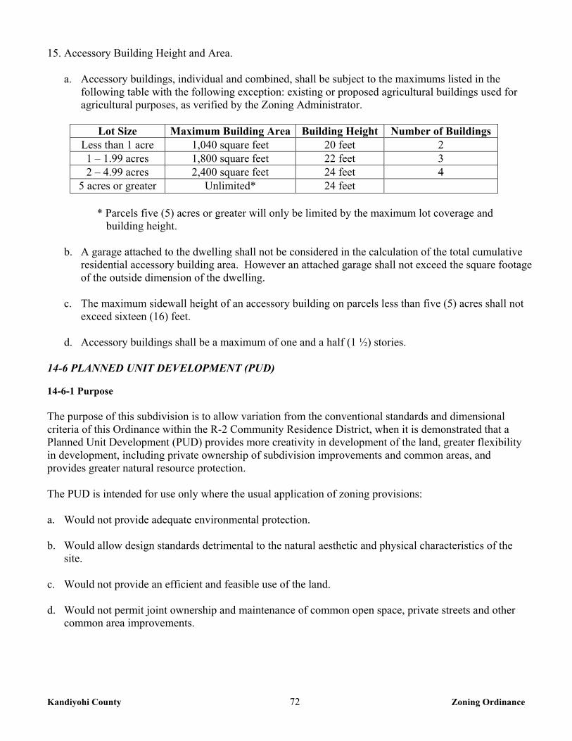
Kandiyohi County 72 Zoning Ordinance
15. Accessory Building Height and Area.
a. Accessory buildings, individual and combined, shall be subject to the maximums listed in the following table with the following exception: existing or proposed agricultural buildings used for agricultural purposes, as verified by the Zoning Administrator.
Lot Size Maximum Building Area Building Height Number of Buildings
Less than 1 acre 1,040 square feet 20 feet 2 1 – 1.99 acres 1,800 square feet 22 feet 3 2 – 4.99 acres 2,400 square feet 24 feet 4
5 acres or greater Unlimited* 24 feet
* Parcels five (5) acres or greater will only be limited by the maximum lot coverage and building height.
b. A garage attached to the dwelling shall not be considered in the calculation of the total cumulative
residential accessory building area. However an attached garage shall not exceed the square footage of the outside dimension of the dwelling.
c. The maximum sidewall height of an accessory building on parcels less than five (5) acres shall not exceed sixteen (16) feet.
d. Accessory buildings shall be a maximum of one and a half (1 ½) stories. 14-6 PLANNED UNIT DEVELOPMENT (PUD)
14-6-1 Purpose The purpose of this subdivision is to allow variation from the conventional standards and dimensional criteria of this Ordinance within the R-2 Community Residence District, when it is demonstrated that a Planned Unit Development (PUD) provides more creativity in development of the land, greater flexibility in development, including private ownership of subdivision improvements and common areas, and provides greater natural resource protection. The PUD is intended for use only where the usual application of zoning provisions: a. Would not provide adequate environmental protection. b. Would allow design standards detrimental to the natural aesthetic and physical characteristics of the
site. c. Would not provide an efficient and feasible use of the land. d. Would not permit joint ownership and maintenance of common open space, private streets and other
common area improvements.
Kandiyohi County 73 Zoning Ordinance
14-6-2 Conditional Use Permit Required A conditional use permit shall be required for any planned unit development. The applicant for a PUD shall simultaneously follow the Subdivision Ordinance to secure both preliminary and final plat design approval from the Planning Commission and County Board. 14-6-3 General Regulations 1. All other development regulations of the zoning district not specified in this subdivision shall apply to a
PUD. 2. The application for a Conditional Use Permit shall state precisely the reasons for requesting the
consideration of the property for a PUD. 3. The land that is to be set aside as open space shall be clearly indicated on the plan. Provisions for
recreational area and for continual maintenance of that area not dedicated and accepted by the County shall be required. Provisions for public streets shall meet the requirements of the Subdivision Ordinance and be approved by the County Engineer. The Local Fire Chief with jurisdiction shall review private roads.
4. No conveyance of property within the PUD shall take place until the property is platted in conformance
with the provisions of this Subdivision and the Subdivision Ordinance. All By-laws, Property Owner’s Association Articles of Incorporation and Protective Covenants must be filed with the recorded plat.
5. The uses and the lot dimensions in the PUD shall be those uses allowed for in the zoning district. 6. There is to be provided within the tract, or immediately adjacent thereto, parking spaces in private
garages or off-street parking areas in accordance with the requirements of Chapter 42 of this Ordinance.
7. Private streets, drives, access ways and common parking areas must be protected by recorded deed covenants assuring their availability to and maintenance by all residents of the project.
14-6-5 Site Design 1. The number of principal use structures that may be constructed within the PUD shall be determined by
dividing the net build able acreage of the project area by the required lot area per unit that is required in the district. The net build able acreage shall be defined as the project area less the land area dedicated for public streets, private streets, and land below a wetland delineation line.
2. Deviation from the applicable requirements for lot area, lot dimensions, yards, setbacks, location of
parking areas and public street frontage may be allowed but only if such deviation is consistent with the total design of the PUD.
3. Permitted maximum site coverage in the PUD shall not exceed the maximum permitted site coverage in
the district; however, site coverage may be calculated on the total land involved in the planned unit development.
Kandiyohi County 74 Zoning Ordinance
4. The common open space, any other common properties, individual properties, and all other elements of the PUD shall be so planned that they will achieve a unified scheme of integrated planning and a harmonious selection and efficient distribution of uses.
5. The proposed PUD shall be of such size, composition, and arrangement that its construction, marketing
and operation are feasible as a complete unit, without dependence on any subsequent unit or development.
14-6-6 Maintenance and Administration Requirements 1. Before final approval of a PUD, adequate provisions must be developed for preservation and
maintenance in perpetuity of open spaces and for the continued existence and functioning of the development.
2. Deed restrictions, covenants, permanent easements, public dedication and acceptance, or other equally
effective and permanent means must be provided to ensure long-term preservation and maintenance of open space.
3. Unless an equally effective alternative community framework is established, when applicable, all
residential PUD’S must use an owners association with the following features:
a. Membership must be mandatory for each dwelling unit or site purchaser and any successive purchasers.
b. Each member must pay a pro rata share of the association's expenses, and unpaid assessments can
become liens on units or sites.
c. Assessments must be adjustable to accommodate changing conditions. d. The association must be responsible for insurance, taxes and maintenance of all commonly owned
property and facilities.
4. Failure to Begin Planned Unit Development. If no construction has begun or no use established in the Planned Unit Development within one (1) year from the final approval of the final development plan, the final development plan shall lapse and be of no further effect. In its discretion and for good cause, the County Board may extend for one (1) additional year the period for the beginning of construction.
14-6-7 Open Space Requirements 1. PUD’S must contain open space meeting all of the following criteria: 2. At least fifty (50) percent of the total area must be preserved as open space. 3. Dwelling units or sites, road rights-of-way, or land covered by road surfaces, parking areas or
structures, are developed areas and shall not be included in the computation of minimum open space.
4. Common open space must be suitably improved for its intended use, but common open space containing natural features worthy of preservation may be left unimproved. The buildings, structures and improvements which are permitted in the common open space must appropriate to the uses which
Kandiyohi County 75 Zoning Ordinance
are authorized for the common open space and must conserve and enhance the amenities of the common open space, having regard to its topography and unimproved condition.
5. Open space may include outdoor recreational facilities for use by owners of dwelling units or sites. 6. Open space may include subsurface sewage treatment systems if the use of the space is restricted to
avoid adverse impacts on the systems. 7. The appearance of open space areas, including topography, vegetation, and allowable uses, must be
preserved by use of restrictive deed covenants, permanent easements, public dedication and acceptance, or other equally effective and permanent means.
8. If the final development plan provides for buildings or structure improvements in the common open
space, the developer must provide a bond, cash, or irrevocable letter of credit, that the buildings, structures, and improvements will be completed. The County Board shall release the bond or other assurance when the buildings, structures, or improvements have been completed according to the development plan.
9. The construction and provision of all of the common open spaces and public and recreational facilities
that are shown on the final development plan must proceed at the same rate as the construction of the principal structures of the PUD.
CHAPTER 16 R-3 RURAL RESIDENTIAL DISTRICT
16-1 PURPOSE The R-3 Rural Residential District is intended to recognize low-density residential development in areas where vacant land is marginal or non-feasible for agricultural uses, has become subject to single family residential development, and where such development relates substantially to the development pattern set forth in the Comprehensive Plan. 16-2 PERMITTED USES The following uses shall be permitted within the R-3 Rural Residential District: 1. Agricultural uses, except feedlots. 2. Single family dwelling. 3. Private garage and storage sheds subject to the regulations in Chapter 16, section 16-5 #15 of this
Ordinance. 4. Home Occupations as regulated in Chapter 36 of this Ordinance. 5. Residential programs meeting Minnesota Statutes section 245A.11, subdivision 2 or successor statutes. 6. Meteorological Wind Energy Conversion Systems (WECS) as regulated in Chapter 28 of this
Ordinance.
Kandiyohi County 76 Zoning Ordinance
7. Parks and other public recreation facilities owned or operated by County or other governmental agencies.
8. Designated historical sites and areas. 9. Minor essential service facilities and structures, as regulated in Chapter 2, section 2-8 of this Ordinance. 16-3 CONDITIONAL USES The following uses may be allowed in the R-3 Rural Residential District, subject to the issuance of a Conditional Use Permit as provided in Chapter 2, section 2-4 of this Ordinance. 1. Municipal administration buildings, police and fire stations, community center buildings, public
libraries, post office and other municipal service buildings, except those customarily considered industrial in use.
2. Golf courses, including clubhouses and driving ranges operated for commercial purposes. 3. Public schools; private schools having a curriculum equivalent to a public elementary or public high
school. 4. Public swimming pool. 5. Home Extended Business as regulated in Chapter 36 of this Ordinance. 6. Residential programs meeting Minnesota Statutes section 245A.11, subdivision 3, and juvenile
residential programs as referenced in Minnesota Statutes section 245A.11, subdivision 2 or successor statutes.
7. Cemetery. 8. Churches, church related buildings and parsonage. 9. Non-Commercial Wind Energy Conversion Systems (WECS) as regulated in Chapter 28 of this
Ordinance. 10. Mobile home parks as regulated in Chapter 40, section 40-11 of this Ordinance. 11. Major essential service facilities and structures, as regulated in Chapter 2, section 2-8 of this Ordinance. 12. Other uses deemed to be of the same general character as those permitted and conditional uses listed
above. 16-4 ACCESSORY USES The following shall be Accessory Uses within an R-3 Rural Residential District: 1. Private garage and storage sheds.
Kandiyohi County 77 Zoning Ordinance
2. Private swimming pool. 3. Accessory buildings or structures and uses customarily incidental to the permitted or conditional uses
listed in sections 16-2 and 16-3 of this Chapter when located on the same property. 16-5 HEIGHT AND YARD REGULATIONS 1. Density: A maximum of one (1) dwelling shall be allowed per parcel. 2. Lot Area: Two and a half (2½) acres minimum, with at least one (1) acre of buildable lot area. 3. Lot Width: Two hundred (200) feet, minimum. 4. Depth of lot: Two hundred (200) feet, minimum. 5. Percent of lot coverage allowed: Thirty (30) percent, maximum. 6. Dwelling Height: Thirty (30) feet, and two and a half (2½) stories maximum.
7. Front Yard Setback:
a. One hundred fifty (150) feet from the centerline of a Principal Arterial. b. One hundred thirty (130) feet from the centerline of a Minor Arterial & Major Collector. c. One hundred (100) feet from the centerline of a Minor Collector. d. Eighty (80) feet from the centerline of a Local Road and Unclassified Roads. e. Road setbacks may be altered without a variance to conform to existing buildings provided the
existing and proposed buildings are not located in the road right-of-way.
8. Side Yard Setback: Ten (10) feet. 9. Rear Yard Setback: Ten feet (10). 10. Corner lots on roads classified as principal arterial, minor arterial and major collector shall meet the
setback from both roads plus twenty (20) feet. 11. No dwelling shall be less than fourteen (14) feet in width as measured across the narrowest portion of
the main structure of the dwelling. 12. A mobile/manufactured home or any parts of them, a semi-trailer or any parts of them and/or a
recreational vehicle shall not be used as an accessory building or to construct an accessory building. 13. No accessory building shall contain habitable space.
14. Galvanized metal siding and galvanized metal roofs shall be prohibited on all accessory buildings.
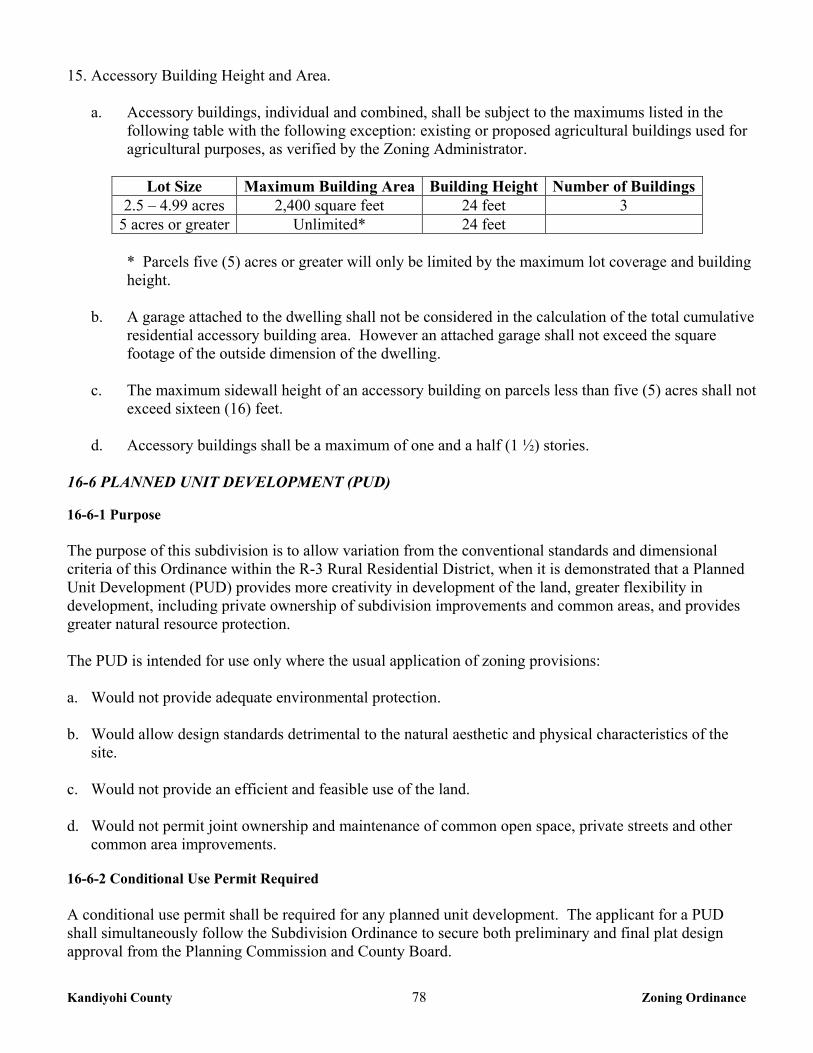
Kandiyohi County 78 Zoning Ordinance
15. Accessory Building Height and Area.
a. Accessory buildings, individual and combined, shall be subject to the maximums listed in the following table with the following exception: existing or proposed agricultural buildings used for agricultural purposes, as verified by the Zoning Administrator.
Lot Size Maximum Building Area Building Height Number of Buildings
2.5 – 4.99 acres 2,400 square feet 24 feet 3 5 acres or greater Unlimited* 24 feet
* Parcels five (5) acres or greater will only be limited by the maximum lot coverage and building height.
b. A garage attached to the dwelling shall not be considered in the calculation of the total cumulative
residential accessory building area. However an attached garage shall not exceed the square footage of the outside dimension of the dwelling.
c. The maximum sidewall height of an accessory building on parcels less than five (5) acres shall not
exceed sixteen (16) feet.
d. Accessory buildings shall be a maximum of one and a half (1 ½) stories.
16-6 PLANNED UNIT DEVELOPMENT (PUD)
16-6-1 Purpose The purpose of this subdivision is to allow variation from the conventional standards and dimensional criteria of this Ordinance within the R-3 Rural Residential District, when it is demonstrated that a Planned Unit Development (PUD) provides more creativity in development of the land, greater flexibility in development, including private ownership of subdivision improvements and common areas, and provides greater natural resource protection. The PUD is intended for use only where the usual application of zoning provisions: a. Would not provide adequate environmental protection. b. Would allow design standards detrimental to the natural aesthetic and physical characteristics of the
site. c. Would not provide an efficient and feasible use of the land. d. Would not permit joint ownership and maintenance of common open space, private streets and other
common area improvements. 16-6-2 Conditional Use Permit Required A conditional use permit shall be required for any planned unit development. The applicant for a PUD shall simultaneously follow the Subdivision Ordinance to secure both preliminary and final plat design approval from the Planning Commission and County Board.
Kandiyohi County 79 Zoning Ordinance
16-6-3 General Regulations 1. All other development regulations of the zoning district not specified in this Subdivision shall apply to
a PUD. 2. The application for a Conditional Use Permit shall state precisely the reasons for requesting the
consideration of the property for a PUD. 3. The land that is to be set aside as open space shall be clearly indicated on the plan. Provisions for
recreational area and for continual maintenance of that area not dedicated and accepted by the County shall be required. Provisions for public streets shall meet the requirements of the Subdivision Ordinance and be approved by the County Engineer. The Local Fire Chief with jurisdiction shall review private roads.
4. No conveyance of property within the PUD shall take place until the property is platted in conformance
with the provisions of this Subdivision and the Subdivision Ordinance. All By-laws, Property Owner’s Association Articles of Incorporation and Protective Covenants must be filed with the recorded plat.
5. The uses and the lot dimensions in the PUD shall be those uses allowed for in the zoning district. 6. There is to be provided within the tract, or immediately adjacent thereto, parking spaces in private
garages or off-street parking areas in accordance with the requirements of Chapter 42 of this Ordinance.
7. Private streets, drives, access ways and common parking areas must be protected by recorded deed covenants assuring their availability to and maintenance by all residents of the project.
16-6-5 Site Design 1. The number of principal use structures that may be constructed within the PUD shall be determined by
dividing the net build able acreage of the project area by the required lot area per unit that is required in the district. The net build able acreage shall be defined as the project area less the land area dedicated for public streets, private streets, and land below a wetland delineation line.
2. Deviation from the applicable requirements for lot area, lot dimensions, yards, setbacks, location of
parking areas and public street frontage may be allowed but only if such deviation is consistent with the total design of the PUD.
3. Permitted maximum site coverage in the PUD shall not exceed the maximum permitted site coverage in
the district; however, site coverage may be calculated on the total land involved in the planned unit development.
4. The common open space, any other common properties, individual properties, and all other elements of
the PUD shall be so planned that they will achieve a unified scheme of integrated planning and a harmonious selection and efficient distribution of uses.
5. The proposed PUD shall be of such size, composition, and arrangement that its construction, marketing
and operation are feasible as a complete unit, without dependence on any subsequent unit or development.
Kandiyohi County 80 Zoning Ordinance
16-6-6 Maintenance and Administration Requirements 1. Before final approval of a PUD, adequate provisions must be developed for preservation and
maintenance in perpetuity of open spaces and for the continued existence and functioning of the development.
2. Deed restrictions, covenants, permanent easements, public dedication and acceptance, or other equally
effective and permanent means must be provided to ensure long-term preservation and maintenance of open space.
3. Unless an equally effective alternative community framework is established, when applicable, all
residential PUD’S must use an owners association with the following features:
a. Membership must be mandatory for each dwelling unit or site purchaser and any successive purchasers.
b. Each member must pay a pro rata share of the association's expenses, and unpaid assessments can
become liens on units or sites. c. Assessments must be adjustable to accommodate changing conditions. d. The association must be responsible for insurance, taxes and maintenance of all commonly owned
property and facilities.
4. Failure to Begin Planned Unit Development. If no construction has begun or no use established in the Planned Unit Development within one (1) year from the final approval of the final development plan, the final development plan shall lapse and be of no further effect. In its discretion and for good cause, the County Board may extend for one (1) additional year the period for the beginning of construction.
16-6-7 Open Space Requirements 1. PUD’S must contain open space meeting all of the following criteria: 2. At least fifty (50) percent of the total area must be preserved as open space. 3. Dwelling units or sites, road rights-of-way, or land covered by road surfaces, parking areas or
structures, are developed areas and shall not be included in the computation of minimum open space.
4. Common open space must be suitably improved for its intended use, but common open space containing natural features worthy of preservation may be left unimproved. The buildings, structures and improvements which are permitted in the common open space must appropriate to the uses which are authorized for the common open space and must conserve and enhance the amenities of the common open space, having regard to its topography and unimproved condition.
5. Open space may include outdoor recreational facilities for use by owners of dwelling units or sites. 6. Open space may include subsurface sewage treatment systems if the use of the space is restricted to
avoid adverse impacts on the systems.
Kandiyohi County 81 Zoning Ordinance
7. The appearance of open space areas, including topography, vegetation, and allowable uses, must be preserved by use of restrictive deed covenants, permanent easements, public dedication and acceptance, or other equally effective and permanent means.
8. If the final development plan provides for buildings or structure improvements in the common open
space, the developer must provide a bond, cash, or irrevocable letter of credit, that the buildings, structures, and improvements will be completed. The County Board shall release the bond or other assurance when the buildings, structures, or improvements have been completed according to the development plan.
9. The construction and provision of all of the common open spaces and public and recreational facilities
that are shown on the final development plan must proceed at the same rate as the construction of the principal structures of the PUD.
CHAPTER 18 CI COMMERCIAL/INDUSTRIAL DISTRICT
18-1 PURPOSE The CI Commercial/Industrial District is intended to provide adequate space for general retail, wholesale, office and service activities located in growth and development areas. It is also intended to allow compact and convenient limited highway-oriented commercial/industrial business, closely related to existing urban areas in the County and at standards that will not impair the traffic carrying capabilities of abutting roads and highways. 18-2 PERMITTED USES The following uses shall be permitted within the CI Commercial/Industrial District: 1. Agricultural uses, except feedlots. 2. Churches. 3. Retail uses conducted entirely within a building. 4. Veterinarian clinic. 5. The offices of members of recognized professions including but not limited to, doctors of medicine,
optometry, dentistry, and chiropractors, engineers, lawyers and architects. 6. Financial institutions. 7. Storage rental facilities. 8. Nurseries/garden store. 9. Wholesale business. 10. Warehouse.
Kandiyohi County 82 Zoning Ordinance
11. Transportation or freight terminal. 12. Billboards as regulated in Chapter 30 of this Ordinance. 13. Minor essential service facilities and structures, subject to Chapter 2, section 2-8.
14. Meteorological Wind Energy Conversion Systems (WECS) as regulated in Chapter 28 of this
Ordinance. 15. Railroad right-of-way. 16. Adult Entertainment Establishments as regulated in the Kandiyohi County Adult Entertainment
Establishments Ordinance. 18-3 CONDITIONAL USES The following uses may be permitted in the CI Commercial/Industrial District, subject to the issuance of a Conditional Use Permit as provided in Chapter 2, section 2-4 of this Ordinance. 1. Retail sales and/or service with outdoor storage and/or display. 2. Auto sales, repair and or salvage yard. 3. Machinery, equipment sales, storage and service. 4. Contractor offices, shops and yards. 5. Manufacturing. 6. Gas and convenience store. 7. Major essential service facilities and structures, subject to Chapter 2, section 2-8. 8. Communication service and utility towers, including cellular phone towers. 9. Non-Commercial and Commercial Wind Energy Conversion Systems (WECS) as regulated in Chapter
28 of this Ordinance. 10. Mining and Extractive Use as regulated in Chapter 32 of this Ordinance. 11. Asphalt and concrete mixing plants as regulated in Chapter 32 of this Ordinance. 12. Hotel/Motel. 13. Other uses deemed to be of the same general character as those permitted and conditional uses listed
above.
Kandiyohi County 83 Zoning Ordinance
18-4 ACCESSORY USES The following shall be Permitted Accessory Uses in the CI Commercial/Industrial District: 1. Accessory buildings or structures and uses customarily incidental to the permitted or conditional uses
listed in sections 18-2 and 18-3 of this Chapter when located on the same property. 2. Signs as regulated by Chapter 30 of this Ordinance. 18-5 HEIGHT AND YARD REGULATIONS 1. Lot Area: One (1) acre minimum, with at least one (1) acre of buildable lot area. 2. Lot Width: One Hundred fifty (150) feet, minimum. 3. Depth of lot: One hundred fifty (150) feet, minimum. 4. Building Height: Forty (40) feet. 5. Percent of lot coverage allowed: Seventy Five (75) percent, maximum. 6. Front Yard Setback:
a. One hundred fifty (150) feet from the centerline of a Principal Arterial. b. One hundred thirty (130) feet from the centerline of a Minor Arterial & Major Collector. c. One hundred (100) feet from the centerline of a Minor Collector. d. Eighty (80) feet from the centerline of a Local Road and Unclassified Roads. e. Road setbacks may be altered without a variance to conform to existing buildings provided the
proposed building site is not located in the road right-of-way. 7. Side Yard Setback: Ten (10) feet. Front yard setbacks shall apply to side yards adjoining a street on
corner lots. 8. Rear Yard Setback: Ten (10) feet. 9. Boundary Line Setback from a Residential District: Fifty (50) feet. 10. Corner lots on roads classified as principal arterial, minor arterial and major collector shall meet the
setback from both roads plus twenty (20) feet.
CHAPTER 28 WIND ENERGY CONVERSION SYSTEMS
28-1 PURPOSE The purpose of this chapter is regulate the installation and operation of Wind Energy Conversion Systems (WECS) within the County not otherwise subject to siting and oversight by the State of Minnesota under the Minnesota Statute 216F as may be amended from time to time.
Kandiyohi County 84 Zoning Ordinance
28-2 DEFINITIONS
WECS - Wind Energy Conversion System – An electrical generating facility comprised of one (1) or more wind turbines and accessory facilities, including but not limited to: power lines, transformers, substations and metrological towers that operate by converting the kinetic energy of wind into electrical energy. The energy maybe used on-site or distributed into the electrical grid. Aggregated Project – Aggregated projects are those which are developed and operated in a coordinated fashion, but which have multiple entities separately owning one (1) or more of the individual WECS within the larger project. Associated infrastructure such as power lines and transformers that service the facility may be owned by a separate entity but are also included as part of the aggregated project. Commercial WECS – A WECS of equal to or greater than 40 kW in total name plate generating capacity. Non-Commercial WECS – A WECS of less than 40 kW in total name plate generating capacity. Fall Zone – The area, defined as the furthest distance from the tower base, in which a guyed tower will collapse in the event of a structural failure. This area is less than the total height of the structure. Feeder Line – Any power line that carries electrical power from one (1) or more wind turbines or individual transformers associated with individual wind turbines to the point of interconnection with the electric power grid, in the case of interconnection with the high voltage transmission systems the point of interconnection shall be the substation serving the WECS. Meteorological Tower – For the purposes of this Chapter, meteorological towers are those towers which are erected primarily to measure wind speed and directions plus other data relevant to siting WECS. Meteorological towers do not include towers and equipment used by airports, the Minnesota Department of Transportation, or other similar applications to monitor weather conditions. Public Conservation Lands – Land owned in fee title by State or Federal agencies and managed specifically for conservation purposes, including but not limited to State Wildlife Management Areas, State Parks, State Scientific and Natural Areas, Federal Wildlife Refuges and Waterfowl Production Areas. For the purposes of this Chapter, public conservation lands will also include lands owned in fee title by non-profit conservation organizations. Public conservation lands do not include private lands upon which conservation easements have been sold to public agencies or non-profit conservation organizations. Property Line – The boundary line of the area over which the entity applying for a WECS permit has legal control for the purposes of installation of a WECS. This control may be attained through fee title ownership, easement, or other appropriate contractual relationship between the project developer and landowner. Rotor Diameter – The diameter of the circle described by the moving rotor blades. Substations – Any electrical facility designed to convert electricity produced by wind turbines to a voltage greater than 35,000 volts (35 KV) for interconnection with high voltage transmission lines shall be located outside of the road right of way.
Kandiyohi County 85 Zoning Ordinance
Total Height – The highest point, above ground level, reached by a rotor tip or any other part of the WECS. Tower – Towers include vertical structures that support the electrical generator, rotor blades, or meteorological equipment. Tower Height – The total height of the WECS exclusive of the rotor blades. Transmission Line – Those electrical power lines that carry voltages of at least 69,000 volts (69 KV) and are primarily used to carry electric energy over medium to long distances rather than directly interconnecting and supplying electric energy to retail customers. Wind Turbine – A wind turbine is any piece of electrical generating equipment that converts the kinetic energy of blowing wind into electrical energy through the use of airfoils or similar devices to capture the wind. 28-3 PROCEDURES Land Use/Building Permits, Conditional Use Permits and Variances shall be applied for and reviewed under the procedures established in this Ordinance. 1. The application for all WECS shall include the following information:
The names of project applicant. The name of the project owner. The legal description and address of the project. A description of the project including: Number, type, name plate generating capacity, tower height,
rotor diameter, and total height of all wind turbines and means of interconnecting with the electrical grid.
Site layout, including the location of property lines, wind turbines, electrical wires, interconnection points with the electrical grid, and all related accessory structures. The site layout shall include distances and be drawn to scale.
Engineer’s certification. Documentation of land ownership or legal control of the property.
2. The application for Commercial WECS shall also include:
The latitude and longitude of individual wind turbines. A USGS topographical map, or map with similar data, of the property and surrounding area,
including any other WECS within ten (10) rotor diameters of the Proposed WECS. Location of all known Communications Towers within two (2) miles of the proposed WECS. Decommissioning Plan. Description of potential impacts on nearby WECS and wind resources on adjacent properties. Any additional information as may be requested by the Zoning Administrator.
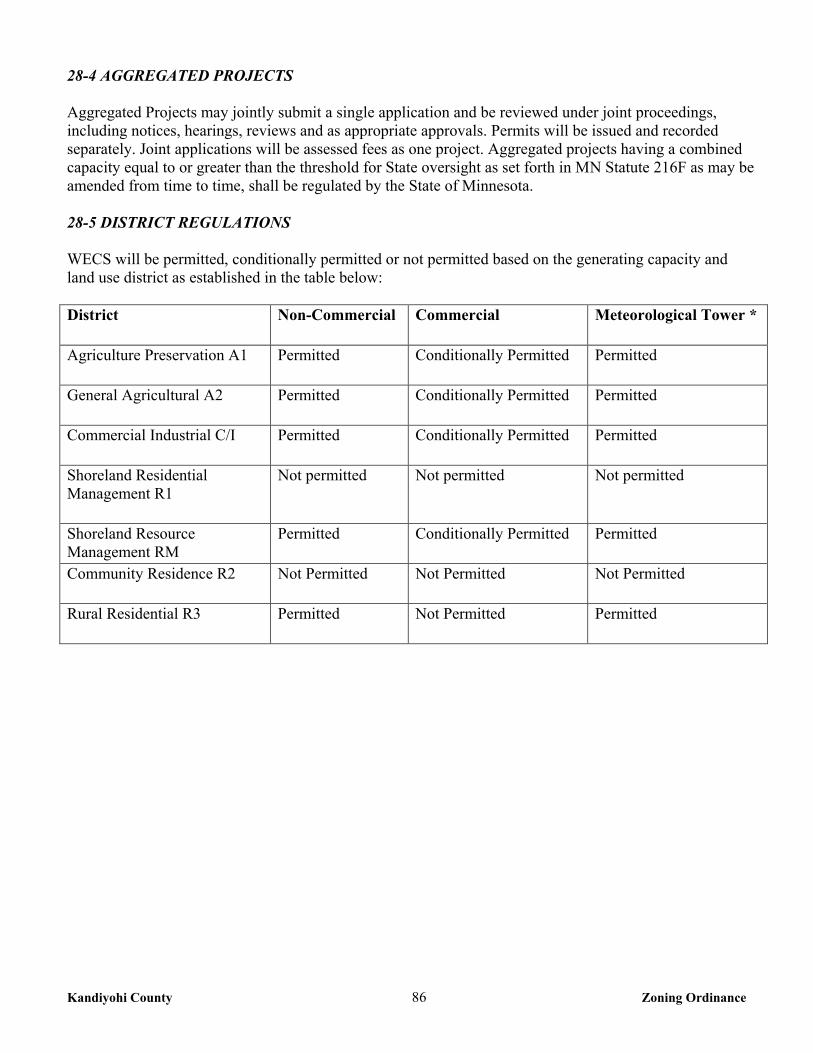
Kandiyohi County 86 Zoning Ordinance
28-4 AGGREGATED PROJECTS Aggregated Projects may jointly submit a single application and be reviewed under joint proceedings, including notices, hearings, reviews and as appropriate approvals. Permits will be issued and recorded separately. Joint applications will be assessed fees as one project. Aggregated projects having a combined capacity equal to or greater than the threshold for State oversight as set forth in MN Statute 216F as may be amended from time to time, shall be regulated by the State of Minnesota. 28-5 DISTRICT REGULATIONS WECS will be permitted, conditionally permitted or not permitted based on the generating capacity and land use district as established in the table below: District Non-Commercial Commercial Meteorological Tower *
Agriculture Preservation A1 Permitted Conditionally Permitted Permitted
General Agricultural A2 Permitted Conditionally Permitted Permitted
Commercial Industrial C/I Permitted Conditionally Permitted Permitted
Shoreland Residential Management R1
Not permitted Not permitted Not permitted
Shoreland Resource Management RM
Permitted Conditionally Permitted Permitted
Community Residence R2 Not Permitted Not Permitted Not Permitted
Rural Residential R3 Permitted Not Permitted Permitted
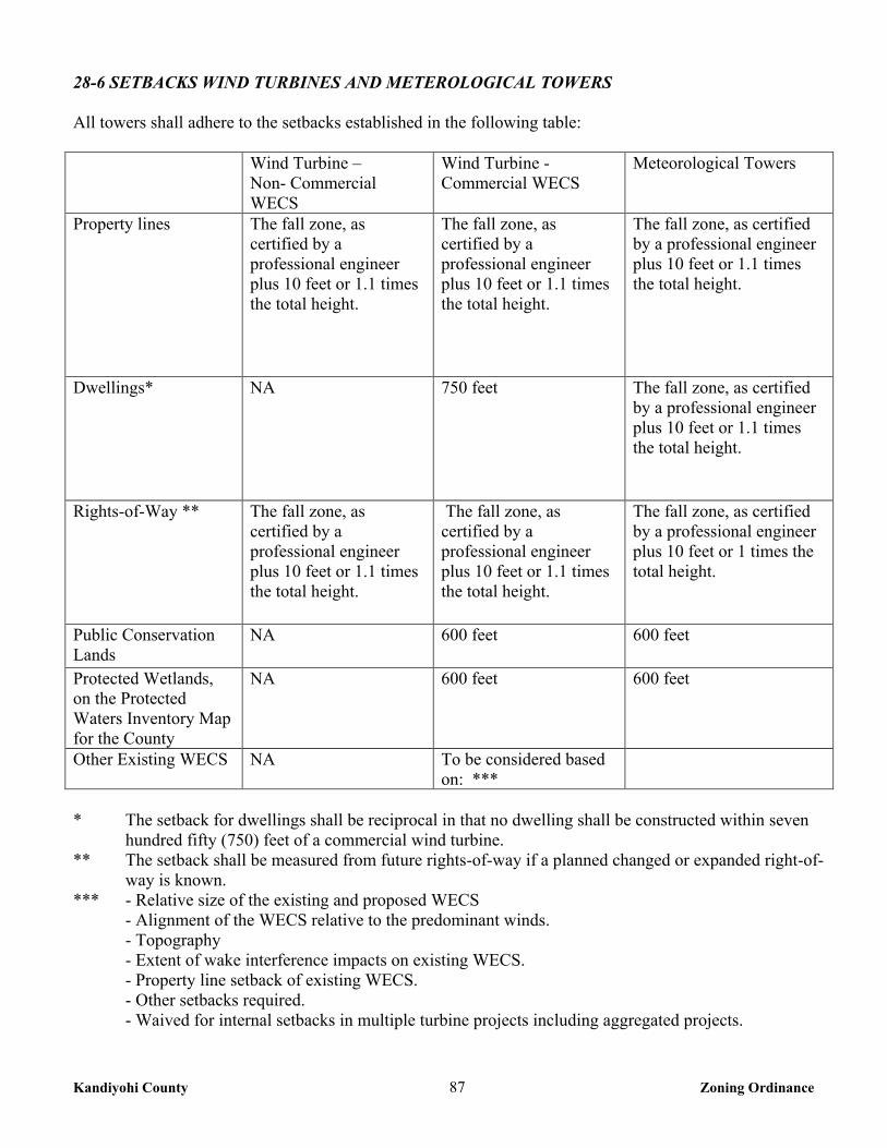
Kandiyohi County 87 Zoning Ordinance
28-6 SETBACKS WIND TURBINES AND METEROLOGICAL TOWERS All towers shall adhere to the setbacks established in the following table: Wind Turbine –
Non- Commercial WECS
Wind Turbine - Commercial WECS
Meteorological Towers
Property lines The fall zone, as certified by a professional engineer plus 10 feet or 1.1 times the total height.
The fall zone, as certified by a professional engineer plus 10 feet or 1.1 times the total height.
The fall zone, as certified by a professional engineer plus 10 feet or 1.1 times the total height.
Dwellings* NA 750 feet The fall zone, as certified by a professional engineer plus 10 feet or 1.1 times the total height.
Rights-of-Way ** The fall zone, as certified by a professional engineer plus 10 feet or 1.1 times the total height.
The fall zone, as certified by a professional engineer plus 10 feet or 1.1 times the total height.
The fall zone, as certified by a professional engineer plus 10 feet or 1 times the total height.
Public Conservation Lands
NA 600 feet 600 feet
Protected Wetlands, on the Protected Waters Inventory Map for the County
NA 600 feet 600 feet
Other Existing WECS NA To be considered based on: ***
* The setback for dwellings shall be reciprocal in that no dwelling shall be constructed within seven
hundred fifty (750) feet of a commercial wind turbine. ** The setback shall be measured from future rights-of-way if a planned changed or expanded right-of-
way is known. *** - Relative size of the existing and proposed WECS
- Alignment of the WECS relative to the predominant winds. - Topography
- Extent of wake interference impacts on existing WECS. - Property line setback of existing WECS. - Other setbacks required.
- Waived for internal setbacks in multiple turbine projects including aggregated projects.
Kandiyohi County 88 Zoning Ordinance
28-7 SAFETY DESIGN STANDARDS 1. Engineering Certification – For all WECS, the manufacture’s engineer or another qualified engineer
shall certify that the turbine, foundation and tower design of the WECS is within accepted professional standards, given local soil and climate conditions.
2. Clearance – Rotor blades or airfoils must maintain at least twelve (12) feet of clearance between their
lowest point and the ground.
3. Warnings: a. For all Commercial WECS, a sign or signs shall be posted on the tower, transformer and substation
warning of high voltage. Signs with emergency contact information shall also be posted on the turbine or at another suitable point.
b. For all guyed towers, visible and reflective objects, such as plastic sleeves, reflectors or tape, shall
be placed on the guy wire anchor points and along the outer and innermost guy wires up to a height of eight (8) feet above the ground. Visible fencing shall be installed around anchor points of guy wires. Consideration shall be given to painted aviation warnings on metrological towers of less than two hundred (200) feet.
28-8 STANDARDS 1. Total Height – Non-Commercial WECS shall have a total height of less than two hundred (200) feet.
2. Tower Configuration – All wind turbines, which are part of a commercial WECS, shall be installed
with a tubular, monopole type tower. Meteorological towers may be guyed.
3. Color and Finish – All wind turbines and towers that are part of a commercial WECS shall be white, grey or another non-obtrusive color. Blades may be black in order to facilitate deicing. Finishes shall be matt or non-reflective. Exceptions may be made for metrological towers, where concerns exist relative to aerial spray applicators.
4. Lighting – Lighting, including lighting intensity and frequency of strobe, shall adhere to but not exceed
requirements established by Federal Aviation Administration permits and regulations. Red strobe lights are preferred for night-time illumination to reduce impacts on migrating birds. Red pulsating incandescent lights should be avoided. Exceptions may be made for metrological towers, where concerns exist relative to aerial spray applicators.
5. Other Signage – All signage on site shall comply with Chapter 30 of this Ordinance. The manufacturers
or owner’s company name and/or logo may be placed upon the nacelle compartment containing the electrical generator, of the WECS.
6. Feeder Lines – All communications and feeder lines, equal to or less than 34.5 kV in capacity, installed
as part of a WECS shall be buried where reasonably feasible. Feeder lines installed as part of a WECS shall not be considered an essential service. This standard applies to all feeder lines subject to Kandiyohi County authority.
Kandiyohi County 89 Zoning Ordinance
7. Waste Disposal – Solid and Hazardous wastes, including but not limited to crates, packaging materials, damaged or worn parts, as well as used oils and lubricants, shall be removed from the site promptly and disposed of in accordance with all applicable local, state and federal regulations.
8. Discontinuation and Decommissioning - A WECS shall be considered a discontinued use after one (1)
year without energy production, unless a plan is developed and submitted to the Kandiyohi County Zoning Administrator outlining the steps and schedule for returning the WECS to service. All WECS and accessory facilities shall be removed to four (4) feet below ground level within ninety (90) days of the discontinuation of use. Each Commercial WECS shall have a decommissioning plan outlining the anticipated means and cost of removing WECS at the end of their serviceable life or upon becoming a discontinued use. The cost estimates shall be made by a competent party; such as a Professional Engineer, a contractor capable of decommissioning or a person with suitable expertise or experience with decommissioning. The plan shall also identify the financial resources that will be available to pay for the decommissioning and removal of the WECS and accessory facilities.
9. Orderly Development – Upon issuance of a conditional use permit, all Commercial WECS shall notify the Environmental Quality Board Power Plant Siting Act program Staff of the project location and details on the survey form specified by the Environmental Quality Board.
28-9 OTHER APPLICABLE STANDARDS 1. Noise – All WECS shall comply with Minnesota Rules 7030 governing noise. 2. Electrical Codes and Standards – All WECS and accessory equipment and facilities shall comply with
the National Electrical Code and other applicable standards. 3. Federal Aviation Administration– All WECS shall comply with FAA standards and permits.
4. Uniform Building Code – All WECS shall comply with the Uniform Building Code adopted by the
State of Minnesota. 28-10 INTERFERENCE
The applicant shall minimize or mitigate interference with electromagnetic communications, such as radio, telephone, microwaves, or television signals caused by any WECS. The applicant shall notify all communication tower operators within two miles of the proposed WECS location upon application to the county for permits. No WECS shall be constructed so as to interfere with County or Minnesota Department of Transportation microwave transmissions.
28-11 AVOIDANCE AND MITIGATION OF DAMAGES TO PUBLIC INFRASTRUCTURE
1. Roads – Applicants shall:
Identify all county, city or township roads to be used for the purpose of transporting WECS, substation parts, cement, and/or equipment for construction, operation or maintenance of the WECS and obtain applicable weight and size permits from the impacted road authority (ies) prior to construction. Conduct a pre-construction survey, in coordination with the impacted local road authority (ies) to determine existing road conditions. The survey shall include photographs and a written agreement to document the condition of the public facility. Be responsible for restoring or paying damages as agreed to by the applicable road authority (ies) sufficient to restore the road(s) and bridges to preconstruction conditions.
Kandiyohi County 90 Zoning Ordinance
2. Drainage System – The applicant shall be responsible for immediate repair of damage to public drainage systems stemming from construction, operation or maintenance of the WECS.
CHAPTER 30 SIGN REGULATIONS
30-1 PURPOSE The purpose of this Chapter is to regulate the location, size, placement and certain features of signs to enable the public to locate goods, services and facilities; to prevent competition for attention; to prevent hazards to life and property; and to protect the natural roadside aesthetics throughout the County. 30-2 PERMITS REQUIRED Except as otherwise provided in this Ordinance, no sign shall be erected, constructed, altered, rebuilt, or relocated until a sign permit for the sign has been issued. However, no permit will be required under this Ordinance for the following signs: 1. A real estate sign for the purpose of selling, renting or leasing a single parcel, not in excess of thirty two
(32) square feet per surface and with no more that two (2) surfaces, may be placed within the front yard of the property.
2. There shall be no more than one temporary sign on any lot, and such sign shall not exceed thirty two
(32) square feet per surface with no more than two (2) surfaces, which may remain on site a maximum of ten (10) days out of any twelve (12) month period.
3. Election signs provided such signs are removed within ten (10) days following the election to which the
sign is related. No election sign shall be permitted more than two (2) months preceding the election to which the sign relates.
4. Names of buildings, dates of erection, commemorative tablets and the like, when carved into stone,
concrete or similar materials or made of bronze, steel, aluminum, or other permanent type of construction and made an integral part of the structure.
5. Signs on private property requesting “No Trespassing”, “No Hunting” etc. 6. Any signs authorized by a governmental unit and approved by the County such as directional, street
name, traffic, safety, danger and parking signs. 7. One area identification sign, not to exceed thirty-two (32) square feet per surface with no more than two
(2) surfaces, shall be allowed for each street entrance to a development or municipality. 8. The changing of the advertising copy or message on an approved painted or printed sign or on a theater
marquee and similar approved signs which are specifically designed for the use of replaceable copy. 9. Maintenance, painting, re-painting, cleaning and other normal maintenance and repair of a sign or a
sign structure unless a structural change is made. 10. One nameplate sign for each dwelling not to exceed eight (8) square feet per surface with no more than
two (2) surfaces. Such sign may indicate the name of occupant, and address.
Kandiyohi County 91 Zoning Ordinance
30-3 PROHIBITED SIGNS 1. No sign shall, by reason of position, shape or color interfere in any way with the proper functioning or
purpose of a traffic sign or signal. 2. No private sign shall be erected that resembles any official marker erected by a government agency nor
shall any private sign display words such as “stop” or “danger”, or otherwise constitute a traffic hazard. 3. No sign shall contain any indecent or obscene picture or wording. 4. On any right-of-way of any highway except as otherwise provided by law or as allowed in this
Ordinance, or allowed by the Commissioner of the Minnesota Department of Transportation. 5. Which has flashing or moving lights resembling emergency vehicles or equipment. 6. No sign shall be painted directly on the roof or outside wall of a building. 7. No sign shall be painted on fences, rocks, or similar structures or features, nor shall paper or similar
signs be attached directly to a building wall with adhesive or similar means. 30-4 GENERAL PROVISIONS 1. Private signs, other than public utility warning signs, are prohibited within public rights-of-way and
easements, or on any other public property. 2. Illuminated signs may be permitted, but devices giving off an intermittent or rotating beam of light shall
be prohibited. Flood lighting shall be focused upon the sign. No lighting for signs shall directly reflect light beams onto any public street, or residential structure. Signs may not be illuminated beyond any lot line.
3. No sign in excess of three (3) square feet per surface with no more than two (2) surfaces shall be less
than five hundred (500) feet from the intersection of a public road and a railroad, provided that advertising may be affixed to or location adjacent to a building at such intersection in such a manner as not to cause any greater obstruction of vision than that caused by the building itself.
4. All signs shall be set back from the right-of-way of public roads not less than ten (10) feet from the
closest part of the sign. All signs shall be set back ten (10) feet from adjacent property lines. 5. No sign shall be permitted that obstructs any window, door, fire escape, stairway or opening intended to
provide light, air, ingress or egress of any building or structure. 6. Signs that may be or hereafter become rotted, unsafe or unsightly shall be repaired or removed by the
owner or lessee of the property upon which the sign stands upon notice by the Zoning Administrator. The County may remove signs located within the right-of-way of County roads at any time without notice.
7. In any district, banners, ribbons, flags, animal displays, inflatables, lights or beacons directed skyward,
pieces of sculpture, fountains or other displays or features which do not clearly fall within the definition of a sign, but which direct attention to an object, product, activity, person, institution, organization or
Kandiyohi County 92 Zoning Ordinance
business, shall require a sign permit. Mobile signs on wheels or otherwise capable of being moved from place to place shall conform to the provisions of this Ordinance just as permanently affixed signs.
8. Real estate development project sales signs may be erected for the purpose of selling or promoting a
real estate development project.
a. Such signs shall not exceed thirty-two (32) square feet per surface with no more than two (2) surfaces.
b. Only one (1) such sign shall be erected on each road frontage with a maximum of two (2) such signs
per project. c. Such signs shall be removed when the project is eighty (80) percent completed, sold or leased. d. Such signs shall not be located closer than one hundred (100) feet to any existing residence.
9. Banners, pennants, ribbons, flags, beacons and temporary signs may be used for grand openings, special events and holidays, but must be removed after the event or a maximum of ten (10) days, whichever is shorter. No business or property may utilize such signs more than three times in a calendar year.
10. The regulations contained herein do not apply to signs painted, attached by adhesive or otherwise
attached directly to or visible through windows and glass portions of doors. 30-5 SIGNS PERMITTED IN A-1, A-2, R-1, R-2, R-3, AND RM DISTRICTS
The following signs are permitted and regulations established for the A-1, A-2, R-1, R-2, R-3, and RM zoning districts: 1. One sign for each permitted non-residential use or use by conditional use permit. Such signs shall not
exceed twelve (12) square feet per surface with no more than two (2) surfaces. On principal arterial, and minor arterial streets, signs shall not exceed thirty-two (32) square feet per surface with no more than two (2) surfaces.
2. Symbols, statutes, sculptures and integrated architectural features on buildings may be illuminated by
flood lights provided the source of light is not visible from a public right-of-way or adjacent property. 3. No sign shall exceed ten (10) feet in height above the average grade level. 4. Crop demonstration signs advertising the use of a particular variety, brand, or type of agricultural plant,
chemical or tillage.
5. Agricultural product signs indicting that the proprietor of a farm is a dealer in seed, fertilizer, or other
agricultural products only when such dealership is incidental to the primary agricultural business on the
farm.
6. One identification sign, not to exceed thirty-two (32) square feet per surface with no more than two (2)
surfaces for the following uses: church, school, hospital, parks, recreation areas, and business signs advertising goods and products raised and sold on the premises or similar uses. Such signs shall be
Kandiyohi County 93 Zoning Ordinance
solely for the purpose of displaying the name of the use and its activities and services. It may be illuminated, but not flashing.
30-6 SIGNS PERMITTED IN THE CI DISTRICT The following signs are permitted and regulations established for the CI zoning district: 1. The aggregate square footage of sign space per lot, including all sign surfaces, shall not exceed two
hundred fifty (250) square feet. 2. No sign shall extend in height above the parapet wall of any principal building, except that one (1) free
standing sign shall be allowed not exceeding twenty-five (25) feet in height above the average grade. 3. No sign shall be mounted on a structure on or above the roofline. 4. For the purposes of selling or promoting a commercial or an industrial project, one real estate sales sign
not to exceed a total of one hundred (100) square feet per surface with no more than two (2) surfaces, may be erected upon the project site.
30-7 OFF PREMISE ADVERTISING SIGNS/BILLBOARDS. 1. An off-premise advertising sign/billboard is a sign that directs attention to a business, product, service,
sale, activity or entertainment not conducted on the premises on which the sign is located. 2. Accept as otherwise specifically permitted in this Ordinance, off-premise advertising signs are
regulated as follows:
a. Off-premise advertising signs/billboards are restricted to the CI district. b. Off-premise advertising signs/billboards are considered a principal use of property and may not
occupy any parcel with an existing structure or use. c. One (1) off-premise advertising sign/billboard shall be permitted not to exceed one hundred (100)
square feet per surface with no more than two (2) surfaces. d. An off-premise advertising sign/billboard shall not be located closer than 600 feet horizontal
distance from any other off-premise advertising sign/billboard measured in any direction. Off-premise advertising signs/billboards shall not exceed thirty (30) feet above the average ground level at the base of the sign.
e. An off-premise advertising sign/billboard shall not be erected within fifty (50) feet of any adjoining
residence district.
Kandiyohi County 94 Zoning Ordinance
CHAPTER 32 MINING AND EXTRACTIVE USES 32-1 PURPOSE The purpose of this Chapter is to control mining operations so as to minimize conflicts with adjacent land uses and to ensure that the mining area is reclaimed with a use compatible with the Comprehensive Plan and completely restored at the completion of the mining operation. The operations covered by this Section shall be hot asphalt mix plants, and the mining, crushing, washing, refining, or processing of sand, gravel, rock, and soil and the removal thereof from the site. 32-2 ADMINISTRATION 1. Mining operations shall be allowed in the following districts: A-1, A-2, RM and CI by conditional use
permit. Any person, firm, corporation, or governmental unit desiring to commence, expand or enlarge a commercial mining, processing or similar activity shall comply with the requirements of this Chapter.
2. Asphalt and concrete mixing plants may be allowed in the following districts: A-1, A-2, RM and CI by
conditional use permit. The Planning Commission will address each application to determine that it meets with Chapter 1, section 1-2 of this Ordinance.
3. Borrow pits designated within the plans or proposals for a public or private road project shall be
excluded from the provisions of this Chapter, provided the County Engineer and Zoning Administrator have approved the plans or proposals for the project.
32-3 TIME LIMITS 1. Conditional Use Permits for mining activities shall have the following time limits:
a. A Conditional Use Permit for a site under forty (40) acres shall be valid for a maximum of ten (10) years, and shall have a compliance certification conducted at five (5) years from permit issuance.
b. A Conditional Use Permit for a site over forty (40) acres shall be valid for a maximum of thirty (30)
years, and shall have a compliance certification conducted every ten (10) years. 32-4 INFORMATION REQUIRED 1. In addition to the Conditional Use Permit application, the applicant shall submit a Mining and
Reclamation Site Plan on a form provided by the Zoning Administrator and approved by the County Board.
2. The Mining and Reclamation Site Plan shall be submitted along with the completed Conditional Use
Permit application. 3. Any other information requested by the Zoning Administrator, Planning Commission, or County Board
as necessary to protect the public’s safety, health and general welfare. 32-5 PERFORMANCE STANDARDS For mining operations approved after the date of adoption of this ordinance.
Kandiyohi County 95 Zoning Ordinance
32-5-1 General Provisions All equipment used for mining and extraction operations shall be constructed, maintained and operated in a manner to minimize, as far as practical, noise, dust and vibrations adversely affecting the surrounding property. 32-5-2 Water Resources The mining operation shall be conducted in such a manner as to minimize interference with the surface water drainage outside of the boundaries of the mining operation. 32-5-3 Safety Fencing Safety fencing may be required around all or portions of the mining operations at the discretion of the County. 32-5-4 Mining Access Roads The County Highway Engineer shall approve the location of the intersection of mining access roads with any public roads. 32-5-5 Screening Barrier To minimize problems of dust and noise and to shield mining operations from public view, a screening barrier may be required between the mining site and adjacent properties. 32-5-6 Setbacks 1. Mining operations shall not be conducted closer than two hundred (200) feet to any residence existing
on the approval date of the mining conditional use permit. 2. Mining operations shall not be conducted closer than thirty (30) feet to any property line, or within
thirty (30) feet of the right-of-way line of any existing or platted street, road, or highway, except that excavating may be conducted within such limits in order to reduce the elevation thereof in conformity to the existing or platted street, road or highway engineering plans.
3. Sloping requirements near property lines may be required. 4. Processing machinery must be located consistent with setback standards for structures from ordinary
high water levels of public waters and from bluffs. 32-5-7 Hours of Operation All hours of operation shall be set in the conditional use permit. 32-5-8 Unauthorized Storage Vehicles, equipment, or materials not associated with the mining facility or not in operable condition shall not be kept or stored at the facility, except as specifically authorized in the conditional use permit.
Kandiyohi County 96 Zoning Ordinance
32-5-9 Entrance Sign A sign shall be posted at the entrance of the site that clearly states the date of the permit issuance, hours of operation, duration of permit, the operator’s phone number and the Zoning Office phone number. 32-5-10 Seeding Topsoil, Overburden, and Berms All stockpiling of topsoil, overburden, and screening berms shall be seeded down to a grass or other appropriate vegetative cover to minimize erosion. 32-6 LAND RECLAMATION All mining sites shall be reclaimed immediately after the permit expires. The following standards shall apply, and may be modified to provide for unique conditions: 1. All buildings, structures, and equipment incidental to the permit shall be dismantled and removed
within six (6) months after the conditional use permit expires, or is terminated. 2. All reclamation activities must be completed within one year from the time the conditional use permit
expires, or is terminated. 3. All aggregate stockpiles or stockpiles of other material must be removed or eliminated prior to the
completion of reclamation. 4. A seeding and mulching plan shall be reviewed by the Natural Resource Conservation Service (NRCS)
and their recommendations given to the Zoning Administrator for approval. 5. The peaks and depressions of the area shall be graded and back filled to a surface which will result in a
gently rolling topography in substantial conformity to the site’s pre-mining conditions, and which will minimize erosion due to rainfall. If the land is to be restored to crop production, no slope shall exceed twelve (12%) percent (8:1). If the restoration is not for crop production, no grade shall exceed twenty- five (25%) percent (4:1). These standards may be modified to accommodate a specific restoration plan.
6. Reclaimed areas shall be surfaced with a soil of a quality and depth consistent with the topsoil of pre-
mining existing conditions. The topsoil shall be seeded, sodded, or planted. Such planting shall adequately retard soil erosion.
7. The finished grade shall be such that it will not adversely affect the surrounding land or future
development of the site and shall be consistent with the end use plan. 32-7 SURETY REQUIREMENTS The applicant shall provide a bond, or an irrevocable letter of credit to the County in the amount of one thousand dollars ($1,000) per acre or a minimum of twenty five thousand dollars ($25,000), whichever is greater, to assure proper reclamation of the site after completion of the operation.
Kandiyohi County 97 Zoning Ordinance
CHAPTER 34 CONSERVATION SUBDIVISIONS
34-1 PURPOSE The purpose of this section is to allow flexibility in the subdivision of land in the A-2 and RM Districts which results in the preservation of productive farmland, natural resources, wildlife habitat and open space in the County and will not result in service burden to local government units, will not create land use conflicts, will reduce the amount of new roads and allow flexibility in road specifications for roads serving residences in the Conservation Subdivision and will not adversely impact the environment. The Conservation Subdivision is intended for use only where the usual application of zoning provisions:
a. Would not provide adequate environmental protection. b. Would allow design standards detrimental to the natural aesthetic and physical characteristics of the
site. c. Would not provide an efficient and feasible use of the land. d. Would not permit joint ownership and maintenance of common open space, private streets and other
common area improvements. 34-2 CONDITIONAL USE PERMIT REQUIRED A conditional use permit shall be required for any Conservation Subdivision. The applicant for a Conservation Subdivision shall simultaneously follow the Subdivision Ordinance to secure both preliminary and final plat design approval from the Planning Commission and County Board. 34-3 GENERAL REGULATIONS 1. All other development regulations of the zoning district not specified in this subdivision or specified, as
a condition to the Conditional Use Permit shall apply to a Conservation Subdivision. 2. The application for a Conditional Use Permit shall state precisely the reasons for requesting the
consideration of the property for a Conservation Subdivision. 3. The land that is to be set aside as open or common area shall be clearly indicated on the plan.
Provisions for recreational area and for continual maintenance of that area not dedicated and accepted by the County shall be required. Provisions for public streets shall meet the requirements of the Subdivision Ordinance and must be approved by the County Engineer. The Local Fire Chief with jurisdiction shall review private roads.
4. No conveyance of property within the Conservation Subdivision shall take place until the property is
platted in conformance with the provisions of this Subdivision and applicable to the Subdivision Ordinance. All By-laws, Property Owner’s Association Articles of Incorporation and Protective Covenants must be approved by the Planning Commission and County Board and filed with the recorded plat.
5. The uses in the Conservation Subdivision shall be those uses allowed in the zoning district.
Kandiyohi County 98 Zoning Ordinance
6. There is to be provided within the tract, or immediately adjacent thereto, parking spaces in private
garages or off-street parking areas in accordance with the requirement of Chapter 42 of this Ordinance. 7. Private streets, drives, access-ways and common parking areas must be protected by recorded deed
covenants assuring their availability to and maintenance by all residents of the project. 8. All lots in Conservation Subdivisions shall be contiguous to each other. It is within the discretion of the
Planning Commission to make the determination that the lots in a Conservation Subdivision do not have to be contiguous to each other.
34-4 DEVELOPMENT AND DENSITY STANDARDS 1. The minimum size of a Conservation Subdivision is ten (10) acres. 2. Land used to determine maximum building eligibility must be contiguous and under single control. A
minimum of fifty (50) percent of the total parcel proposed for a Conservation Subdivision must consist of wetlands, wooded land, steep slopes, or other land that is not reasonably considered agricultural land.
3. A maximum density of ten (10) lots shall be allowed per quarter-quarter section or Government Lot
provided the quarter-quarter section or Government Lot is thirty (30) acres or greater. If less than thirty (30) acres, the property owner shall be allowed to have the number of lots that is in accordance with the percentage of land they own. EXAMPLE: If 14 acres are available, the following formula would be implemented: 14 divided by 40 = 35%: .35 x 10 = 3.5. (any number after the decimal point that is 5 or above is rounded up). Therefore the property owner is allowed 4 lots in his/her Conservation Subdivision. The lots of a conservation subdivision that is greater than forty (40) acres may be clustered on a single quarter-quarter section, Government Lot, or part thereof, but shall not exceed the maximum overall density allowed.
4. When two (2) or more parties own acreage in the same quarter-quarter section or Government Lot, they
shall be allowed to have the number of lots that is in accordance with the percentage of land they own. EXAMPLE: If owner one owns 14 acres and owner two owns 26 acres the following formula would be implemented: 26 divided by 40 = 65%, 14 divided by 40 = 35%: .65 x 10 = 6.5, .35 x 10 = 3.5. (any number after the decimal point that is 5 or above is rounded up). Therefore the property owner with 26 acres is allowed 7 lots in his/her Conservation Subdivision and the property owner with 14 acres is allowed 4 lots in his/her Conservation Subdivision.
5. Only land above the ordinary high water level of public waters can be used to determine the allowable
density. 34-5 OPEN SPACE STANDARDS 1. Lot area, road rights-of-way, and/or land designated for private roadways are developed areas and shall
not be included in the computation of minimum open space. 2. At least seventy five (75) percent of the total acreage in the application, including developable and un-
developable land, shall be designated as open space for natural habitat, active or passive recreation, conservation or preservation, and or ISTS systems, including conservation for agricultural uses.
Kandiyohi County 99 Zoning Ordinance
3. No more than fifty (50) percent of the designated open space shall consist of un-developable land, such as protected wetlands, or floodplains.
4. Common open space must be suitably improved for its intended use, but common open space
containing natural features worthy of preservation may be left unimproved. The buildings, structures and improvements which are permitted in the common open space must be appropriate to the uses which are authorized for the common open space and must conserve and enhance the amenities of the common open space, having regard to its topography and unimproved condition.
5. Open space may include; outdoor recreational facilities for use by owners of dwelling units, individual
sewage treatment systems, water wells, and general agricultural practices. 6. The appearance of open space areas, including topography, vegetation, and allowable uses, must be
preserved by use of restrictive deed covenants, permanent easements, public dedication and acceptance, or other equally effective and permanent means.
34-6 MAINTENANCE AND ADMINISTRATION REQUIREMENTS 1. Before final approval of a Conservation Subdivision, adequate provisions must be developed for
preservation and maintenance in perpetuity of open spaces and for the continued existence and functioning of the development.
2. Deed restrictions, covenants, permanent easements, public dedication and acceptance, or other equally
effective and permanent means must be provided to ensure long-term preservation and maintenance of open space.
3. Unless an equally effective alternative community framework is established, when applicable, all
Conservation Subdivisions must use an owners association with the following features:
a. Membership must be mandatory for each dwelling unit or site purchaser and any successive purchasers.
b. Each member must pay a pro rata share of the association's expenses, and unpaid assessments can
become liens on units or sites. c. Assessments must be adjustable to accommodate changing conditions. d. The association must be responsible for insurance, taxes and maintenance of all commonly owned
property and facilities.
4. Failure to Begin Conservation Subdivision. If no construction has begun or no use established in the Planned Unit Development within one (1) year from the final approval of the final development plan, the final development plan shall lapse and be of no further effect. In its discretion and for good cause, the County Board may extend for one (1) additional year the period for the beginning of construction.
Kandiyohi County 100 Zoning Ordinance
34-7 SUBDIVISION DESIGN All subdivision designs shall take into account surrounding land uses and shall be so designed that the layout of lots and streets and the placement of structures shall result in the minimum disruption or conflict in the adjacent land uses and agricultural operations.
CHAPTER 36 HOME OCCUPATIONS and HOME EXTENDED BUSINESSES
36-1 PURPOSE The purpose of this chapter is to provide a means through the establishment of specific standards and procedures by which home occupations may be conducted in residential, resource management and agricultural districts without jeopardizing land use harmony and compatibility, and the health, safety, and general welfare of the surrounding neighborhood. 36-2 HOME OCCUPATION A home occupation shall be allowed as a permitted use in the A-1, A-2, R-1, R-2, R-3, and RM districts provided that it meets the requirements of this Ordinance herein and the following: 1. The home occupation shall be clearly incidental and subordinate to the residential use of the property. 2. The home occupation shall be conducted only by persons residing on the premises. No person other
than the residents of the premises shall be employed or engaged in such home occupation. 3. Operation of the home occupation shall be limited to the residential dwelling and any attached garage. 4. The use of any accessory buildings for storage or business activity is prohibited. 5. The outdoor display or storage of goods, equipment or other materials used for the home occupation is
prohibited. 6. The home occupation shall not generate excessive customer or client traffic that is detrimental to the
character of the surrounding properties. 7. There shall be no indication of offensive noise, vibration, smoke, dust, odors, heat or glare at or beyond
the property line. 8. Signs as regulated in chapter 30, section 30-5 #1 of this Ordinance. 9. Parking shall meet the requirements chapter 42 of this Ordinance. 36-3 HOME EXTENDED BUSINESS A home extended business shall be allowed as a conditional use in the A-1, A-2, R-1, R-2, R-3, and RM districts provided that it meets the requirements of this Ordinance herein and the following. 1. The home extended business shall be located on the homestead property of the business owner.
Kandiyohi County 101 Zoning Ordinance
2. Operation of the home extended business shall be restricted to the residential dwelling and accessory buildings on the same parcel.
3. The number of non-resident employees shall not:
a. Exceed one (1) in an R-1, R-2, or R-3 district; and b. Exceed four (4) in an A-1, A-2, or RM district.
c. For purposes of this provision, non-resident employees shall only include employees, business
partners, independent contractors or other persons affiliated with the home extended business working at the site as part of the home extended business.
4. The home extended business shall not generate excessive customer or client traffic that is detrimental to
the character of the surrounding properties. 5. All on-site production, assembly, sales, and service shall be conducted within a building approved for
the home extended business. 6. Signs as regulated in chapter 30, section 30-5 #1 of this Ordinance. 7. Parking shall meet the requirements chapter 42 of this Ordinance. 8. Additional performance standards for the R-1, R-2, and R-3 districts.
a. Outdoor storage of equipment, supplies, or products is prohibited. b. For parcels less than ten (10) acres, the size of accessory structure use for home extended
businesses shall not exceed zoning district standards for non-agricultural accessory buildings.
c. For parcels ten (10) acres or greater the size of accessory structure use for home extended businesses shall not occupy more than six thousand four hundred (6,400) square feet of accessory building floor space.
9. Additional performance standards for the A-1, A-2 and RM districts.
a. Outdoor storage shall be screened from view from public roads, and adjoining residential districts.
b. For parcels less than five (5) acres, the size of accessory structure use for home extended businesses shall not exceed zoning district standards for non-agricultural accessory buildings.
c. For parcels five (5) acres or greater the size of accessory structure use for home extended businesses shall not occupy more than twelve thousand (12,000) square feet of accessory building floor space.
10. Additional conditions may be imposed by the Planning Commission and County Board to ensure that
the proposed use is compatible with the surrounding uses.
Kandiyohi County 102 Zoning Ordinance
CHAPTER 40 PERFORMANCE STANDARDS
40-1 PURPOSE It is the intent of this Chapter to provide that uses of lands and buildings in all districts excluding agricultural uses shall be established and maintained with proper appearance from streets and adjoining properties and to provide that each permitted use shall be a good neighbor to adjoining properties by applying the following controls: 40-2 STANDARDS 40-2-1 Noise All uses shall comply with the standards governing noise as regulated by the Minnesota Pollution Control Agency (MPCA). 40-2-2 Odors All uses shall comply with the standards governing odor emissions as regulated by the Minnesota Pollution Control Agency (MPCA). 40-2-3 Glare and Heat Uses producing glare or heat shall be performed within a completely enclosed building in such a manner as to make such glare and heat completely imperceptible from any point along the property line. 40-2-4 Exterior Lighting In all districts, any lighting used to illuminate an off-street parking area, sign or other structure shall be installed so as to deflect light away from any adjoining property or from public streets. Direct or sky-reflected glare, whether from floodlights or from high temperature processes such as combustion or welding, shall not be directed onto any adjoining property. The source of lights shall be hooded or controlled in some manner so as not to light adjacent property or create a traffic hazard. 40-2-5 Vibration All uses producing vibration shall be conducted in such a manner as to make the vibration completely imperceptible from any point along the property line. 40-2-6 Emissions All uses shall comply with the standards governing air emissions as regulated by the Minnesota Pollution Control Agency (MPCA). 40-2-7 Direct Discharge of Waste All uses shall comply with the standards governing air emissions as regulated by the Minnesota Pollution Control Agency (MPCA).
Kandiyohi County 103 Zoning Ordinance
40-2-8 Hazardous Materials All uses shall comply with the standards governing hazardous materials as regulated by the Minnesota Pollution Control Agency (MPCA). 40-2-9 Explosives and flammable materials All uses involving the manufacture, storage or use of explosive or flammable materials shall comply with all applicable regulations, including the Minnesota Building Code and the Minnesota Uniform Fire Code and shall meet the following requirements: 1. All uses involving the manufacture, storage or use of explosive or flammable materials shall employ
best management practices and the provision of adequate safety devices to guard against the hazards of fire and explosion and adequate for fighting and fire suppression devices standard in the industry.
2. The storage of any flammable liquid shall be subject to the requirements established under the Uniform
Fire Code and review by the State Fire Marshall. 40-2-10 Water Pollution All uses shall comply with the standards governing water pollution as regulated by the Minnesota Pollution Control Agency (MPCA). 40-3 KENNELS 1. Kennels shall comply with the following standards:
a. Kennels must be located on a parcel with a minimum size of five (5) acres.
b. No more than forty (40) dogs over six (6) months of age may be kept on the kennel property, including no more than ten (10) unsterilized female dogs over six (6) months of age.
c. Kennels or shelters and dog runs may not be located within five hundred (500) feet of an existing
residence except that of the kennel owner.
d. Dogs must be confined or under direct control of the kennel operator or staff at all times. Outdoor kennel areas shall be fenced. Fencing shall consist of durable materials, with a minimum height of six (6) feet, and shall deter dogs from escaping over, under, or through the fence.
40-4 BED AND BREAKFAST FACILITIES
1. Bed and Breakfast facilities shall comply with the following standards: a. The lot must meet the minimum lot size standard of the applicable district. b. The exterior appearance of the structure shall not be altered from its single family character. c. All guestrooms shall be located within the principal residential structure.
Kandiyohi County 104 Zoning Ordinance
d. The total number of guestrooms shall be limited to five (5). e. Primary entrance to all guestrooms shall be from within the dwelling. f. Food service shall be limited to breakfast. All food preparation and service facilities shall comply
with County and State Health standards. g. The occupants shall include registered guests, the owner, manager or operator, and not more than
two (2) employees. h. Dining facilities are not open to the public but limited to residents, employees and registered guests. i. No cooking facilities shall be allowed in the guest rooms. j. The facility shall have at least one (1) parking stall per guest room, one (1) parking stall per
employee and two (2) parking stalls for the owner, manager or operator. 40-5 HEIGHT REGULATIONS 1. The following structures are exempt from the height provisions set forth in other sections of this
Ordinance.
a. Monuments.
b. Flag Poles.
c. Grain Elevators.
d. Church spires, belfries, or domes which do not contain usable space.
e. Water Towers. f. Chimneys, smokestacks or cooling towers.
g. Radio, cellular or television transmission towers. h. Essential service structures.
i. Wind Energy Conversion Systems and Meteorological Towers.
40-6 YARD REGULATIONS Measurements shall be taken from the nearest point of the wall or a building by the lot line in question, subject to the following qualifications: 1. Cornices, canopies, or eaves may extend into the required front, side, and/or rear yard setbacks a
distance not exceeding four (4) feet, six (6) inches.
Kandiyohi County 105 Zoning Ordinance
2. A landing may extend into the required front, side, and/or rear yard setbacks not more than four (4) feet, six (6) inches if the landing is forty two (42) inches or less in height above the ground level. Such a structure may have an open railing not to exceed forty-two (42) inches in height.
3. A second story deck may extend into the required front, side, and/or rear yard setbacks not more than
four (4) feet six (6) inches if the deck is not supported in any way to the ground. 4. Fences erected from the building line to the ordinary high water level shall not exceed a height of four
(4) feet and have at least ninety (90) percent of the surface uniformly open and unobstructed unless the adjoining lot is a public park or public access.
5. On double frontage lots, the required front yard shall be provided on both streets. 6. The required front yard of a corner lot shall not contain any wall, fence or other structure, tree, shrub or
other growth that may cause danger to traffic on a road or public road by obscuring the view. 40-7 YARD LANDSCAPING In the CI Commercial/Industrial District, all required yards shall be either open landscaped as green areas or be left in a natural state, except as provided by Chapter 42, section 42-4 of this Ordinance. If any yards are to be landscaped, they shall be landscaped attractively with lawn, tree, shrubs, etc. Any areas left in a natural state shall be properly maintained in an aesthetic and well-kept condition. Yards adjoining any of the Classes of Residential Districts shall be landscaped with planting buffer screens. Plans for such screens shall be submitted as a part of the application for building permit and installed as a part of the initial construction. 40-8 STORAGE OF MATERIALS In the CI Commercial/Industrial District, open storage of materials in any required front, side, or rear yard setback shall be prohibited. Any other outside storage shall be located or screened so as not to be visible from any of the Classes of Residential Districts. 40-9 PUBLIC RIGHT OF WAY 1. Bales and stacks of hay, straw, cornstalks, or the like, as well as piles of dirt, manure, or the like, are to
be set back a distance of one hundred fifty (150) feet or more from the center of any public road during the period from November 1 to April 1.
2. There shall be no tree planting within seventy-five (75) feet from the top of ditch bank of any County
drainage ditch. 40-10 WATER SYSTEMS 1. Public water facilities, including pipe fittings, hydrants, etc., shall be installed and maintained as
required by standards and specifications as established by the County Board and the Minnesota Department of Health standards for water quality.
2. Where public water facilities are not available, the County Board may by ordinance grant a franchise
for such water facilities, to serve all properties within the area where a complete and adequate
Kandiyohi County 106 Zoning Ordinance
community water distribution system is designed, and complete plans for the system are submitted to and approved by the County Board and the Minnesota Department of Health.
3. Individual wells shall be constructed and maintained according to standards and regulations approved
by the County Board and the Minnesota Department of Health. The standards and regulations shall be those found in the Minnesota Water Well Code.
4. Private wells shall be placed in areas not subject to flooding and upslope from any source of
contamination. Wells already existing in areas subject to flooding shall be flood proofed, in accordance with procedures established in Statewide Standards and Criteria for the Management of Flood Plain Areas of Minnesota.
40-11 MOBILE HOME PARK LOCATIONS All Mobile Home Parks hereafter constructed or altered shall comply with the requirements of the Kandiyohi County Ordinance #18, Section G.
CHAPTER 42 PARKING AND LOADING REGULATIONS 42-1 INTRODUCTION All parking hereafter constructed or maintained shall conform to the provisions of this Chapter and any other ordinances or regulations of the County. 42-2 STANDARDS
1. Parking spaces for residential parking shall be on the same lot as the residential dwelling.
2. Off-street parking areas in any district shall not be utilized for open storage of goods or for the storage of vehicles that are inoperable, for sale or for rent.
3. Loading areas shall be sufficient to meet the requirement of the use and shall provide adequate area for parking and maneuvering on the site without impact on adjacent properties or the public right-of-way.
42-3 DESIGN AND MAINTENANCE OF OFF-STREET PARKING AREAS
1. Off-street parking areas shall be improved with a durable and dustless surface. Such areas shall be so graded and drained as to dispose of all surface water accumulation within the parking area in accordance with an approved stormwater management plan. These requirements shall also apply to open sales lots. Durable and dustless surface may include crushed rock and similar treatment. Parking areas for six (6) or fewer vehicles shall be exempt from the provisions of this section.
2. A parking space shall be at least nine (9) feet wide by twenty (20) feet long. In considering parking lots, a standard of three hundred (300) square feet per parking space shall be used to compute total requirements including maneuvering areas.
Kandiyohi County 107 Zoning Ordinance
3. Existing off-street parking spaces existing on or before the effective date of this ordinance shall not be reduced in number unless said number exceeds the requirements set forth herein for a similar use.
4. Required on-site parking space shall be provided on the same lot as the principal building or use, except that combined or joint parking facilities may be provided for one (1) or more buildings or uses in the CI Commercial/Industrial District, provided that the total number of spaces shall equal the sum of the requirements for each building or use.
42-4 YARDS 1. On-site parking and loading facilities shall not be subject to the front yard, side yard, and rear yard
regulations for the use district in which parking is located, except that:
a. In a CI Commercial/Industrial District, no parking or loading space shall be located ten (10) feet of any property line that abuts a road or highway right-of-way, or any Residential or Agricultural District except for railroad loading areas.
42-5 BUFFER FENCES AND PLANTING SCREENS On-site parking and loading areas or abutting Residential Districts shall be screened by a buffer fence of adequate design or a planting buffer screen; plans of such screen or fence shall be submitted for approval as a part of the required site plan, and such fence or landscaping shall be installed as a part of the required site plan, and such fence or landscaping shall be installed as a part of the initial construction. 42-6 REQUIRED NUMBER OF ON-SITE PARKING SPACES 1. On-site parking areas of sufficient size to provide parking for patrons, customers, suppliers, visitors and
employees shall be provided on the premises of each use. Where fractional spaces result, the parking spaces required shall be construed to be the nearest whole number. The minimum number of required on-site parking spaces for uses shall be as follows:
a. One Family Dwelling- Two (2) spaces per dwelling unit. b. Multiple Dwelling or Mobile Home Park- One (1) parking space per dwelling unit, apartment unit
or mobile home berth.
c. Churches- One (1) parking space for each four (4) seats, based on the design capacity of the main seating area.
d. Public Elementary, Junior High School or Similar of Private School- Two (2) parking spaces for
each classroom. e. Municipal Administration Buildings, Community Center, Public Library, Museum, Art Galleries,
Post Office and other Public Service Buildings- One (1) parking space for each five hundred (500) square feet of floor area in the principal structure.
Kandiyohi County 108 Zoning Ordinance
f. Golf Course, Golf Clubhouse, Country Club, Swimming Club, Tennis Club, Public Swimming Pool- Twenty (20) spaces, plus one (1) space for each five hundred (500) square feet of floor area in the principal structure.
g. Professional Offices, Medical and Dental Clinics and Animal Hospital- One (1) parking space for
each five hundred (500) square feet of floor area. h. Office Buildings- One (1) parking space for each five hundred (500) square feet of floor area. i. Shopping Center- Where several business uses are grouped together according to a general
development plan, on-site automobile parking shall be provided in a ratio of not less than three (3) square feet of gross parking area for each one (1) square foot of gross floor area; separate on-site space shall be provided for loading and unloading.
j. Automobile Service Station- Four (4) parking spaces plus two (2) parking spaces for each stall; such
parking spaces shall be in addition to parking space required for gas pump areas. k. Auto Sales, Trailer Sales, Marine and Boat Sales, Implement Sales, Garden Supply Store, Building
Materials Sales, Auto Repair- One (1) parking space for each five hundred (500) square feet of floor area.
l. Bowling Alley- Five (5) parking spaces for each bowling lane. m. Drive-in Restaurant- Twenty (20) parking spaces or one (1) space for each twenty (20) square feet
of floor area whichever is greater.
n. Motel or Motor Hotel- One (1) parking space for each rental room or suite. o. Assembly or Exhibition Hall, Auditorium, Theater or Sports Area- One (1) parking space for each
four (4) seats, based upon design capacity. p. Restaurant, Cafe, Nightclub, Tavern or Bar- One (1) parking space for each seventy-five (75) square
feet of customer floor area. q. Retail Stores and Service Establishments- One (1) parking space for each one hundred (100) square
feet of floor area. r. Research, Experimental or Testing Stations- One (1) parking space for each employee on the major
shift or one (1) off-street parking space for each five hundred (500) square feet of gross floor area within the building, whichever is the greater.
s. Storage, Wholesale, or Warehouse Establishments- One (1) parking space for each two (2)
employees on the major shift or one (1) parking space for each two thousand (2,000) square feet of floor area, whichever is the greater, plus one (1) space for each company motor vehicle when customarily kept on the premises.
t. Manufacturing or Processing Plant- One (1) off-street parking space for each two (2) employees on
the major shift or one (1) off-street parking space for each one thousand (1,000) square feet of gross
Kandiyohi County 109 Zoning Ordinance
floor area within the building, whichever is the greater, plus one (1) space for each company motor vehicle when customarily kept on the premises.
u. The parking space requirement for a use not specifically mentioned herein shall be the same as
required for a use of similar nature, as determined by the Zoning Administrator based on a parking study and/or industry standards.
CHAPTER 44 SCENIC TRAIL STANDARDS
44-1 PURPOSE These standards are intended to allow for the orderly development of the land surrounding the Minnesota Department of Natural Resources Glacial Lakes State Trail in the County. 44-2 DEFINITIONS For the purpose of this Chapter the following definitions shall apply.
44-2-1 Commercial Business The selling or vending of any item or service to include but not limited to food, beverages, souvenirs, craft items, repair or rental services, or any other saleable item or service. This definition shall not include electric transmission lines or any public utility line or service that may cross the trail right-of-way at a right angle, more or less. 44-2-2 DNR Scenic Trail That tract of land that was formerly the Burlington Northern Rail Road right-of-way that originates near the northeast edge of Willmar (Kandiyohi Township), and extends northeasterly to the Stearns County line (Roseville Township), commonly known as Glacial Lakes State Trail. 44-3 PROHIBITED USES 44-3-1 Agricultural and Shoreland Resource Management Districts 1. There shall be no commercial, industrial or agricultural business or structures located within fifty (50)
feet of the right-of-way of the DNR Scenic Trail in Agricultural or Shoreland Resource Management Districts.
2. Dwellings or accessory structures shall be setback a minimum of fifty (50) feet from the right-of-way of
the DNR Scenic Trail. 44-3-2 Residential Districts 1. There shall be no commercial or industrial business or structures located within twenty-five (25) feet of
the right-of-way of the DNR Scenic Trail in Residential Districts. 2. Dwellings or accessory structures shall be setback a minimum of twenty-five (25) feet from the right-
of-way of the DNR Scenic Trail.
Kandiyohi County 110 Zoning Ordinance
44-4 PROHIBITED SIGNS 1. There shall be no advertising signs or advertisements of any other nature within fifty (50) feet of the
right-of-way of the DNR Scenic Trail in any Agricultural or Shoreland Resource Management District, or within twenty-five (25) feet in any Residential District, unless such signs or advertisements are of the type and nature which conform to the natural appearance of it’s surrounding.
a. All signs shall utilize only white, green or brown colors. b. No sign so permitted shall have an advertising area greater than two hundred (200) square inches or
be at a total height of five (5) feet above grade. c. Only one (1) sign shall be placed within fifty (50) feet of the DNR Scenic Trail in an Agricultural or
Shoreland Resource Management District, twenty-five (25) feet in Residential Districts per lot of record as of date of adoption of this section.
44-5 PLATTED LANDS 1. Properties adjacent to the DNR Scenic Trail that are to be platted for new homes, business or other
development, shall abide by the standards adopted in this Chapter. In addition, a vegetative screen or buffer will be provided by the developer or owner of the newly platted lands.
a. The vegetative screen shall be established when natural buffers are lacking and in a manner to aid in
screening the visual and audible effects of the adjacent land use. b. The vegetative screen shall consist of a minimum of two (2) rows of shrubs or trees that are suited
to the planting site and conditions. c. The trees shall be properly planted and maintained by the owner.
CHAPTER 46 WETLAND CONSERVATION
46-1 PURPOSE The County finds that wetlands serve a variety of beneficial functions. Wetlands maintain water quality; reduce flooding and erosion; provide food and habitat for wildlife; provide open space; and are an integral part of the County’s environment. Wetlands are important physical, educational, ecological, aesthetic, recreational and economic assets to the county. They are critical to the County’s storm water management and other aspects of health, safety and general welfare. Regulating wetlands and the land uses around them are therefore in the public interest. 46-2 LOCAL GOVERNMENT UNIT (LGU) In all the unincorporated and incorporated areas of the County, the Environmental Services Director shall have the delegated responsibility to act as the Local Government Unit (LGU), (unless a City Council and/or a delegate has been authorized to administrate the Wetland Conservation Act) representative to administer the Wetland Conservation Act of 1991, as amended, and the accompanying rules of the Minnesota Board of
Kandiyohi County 111 Zoning Ordinance
Water and Soil Resources. The Zoning Administrator shall notify permit applicants to contact their LGU for the requirements of the Wetland Conservation Act. 46-3 WETLANDS, DNR PROTECTED 1. All protected wetlands in the unincorporated areas shown on the Protected Waters Inventory Map for
the County, shall be subject to the following requirements, except as otherwise stated in this Ordinance:
a. The lowest floor elevation of buildings shall be three (3) feet above the ordinary high water level of the wetland or one (1) foot above the one hundred (100) year flood elevation.
b. Structures shall maintain a seventy-five (75) foot setback from the ordinary high water level.
c. Individual sewage treatment systems shall maintain a fifty (50) foot setback from the ordinary high
water level.
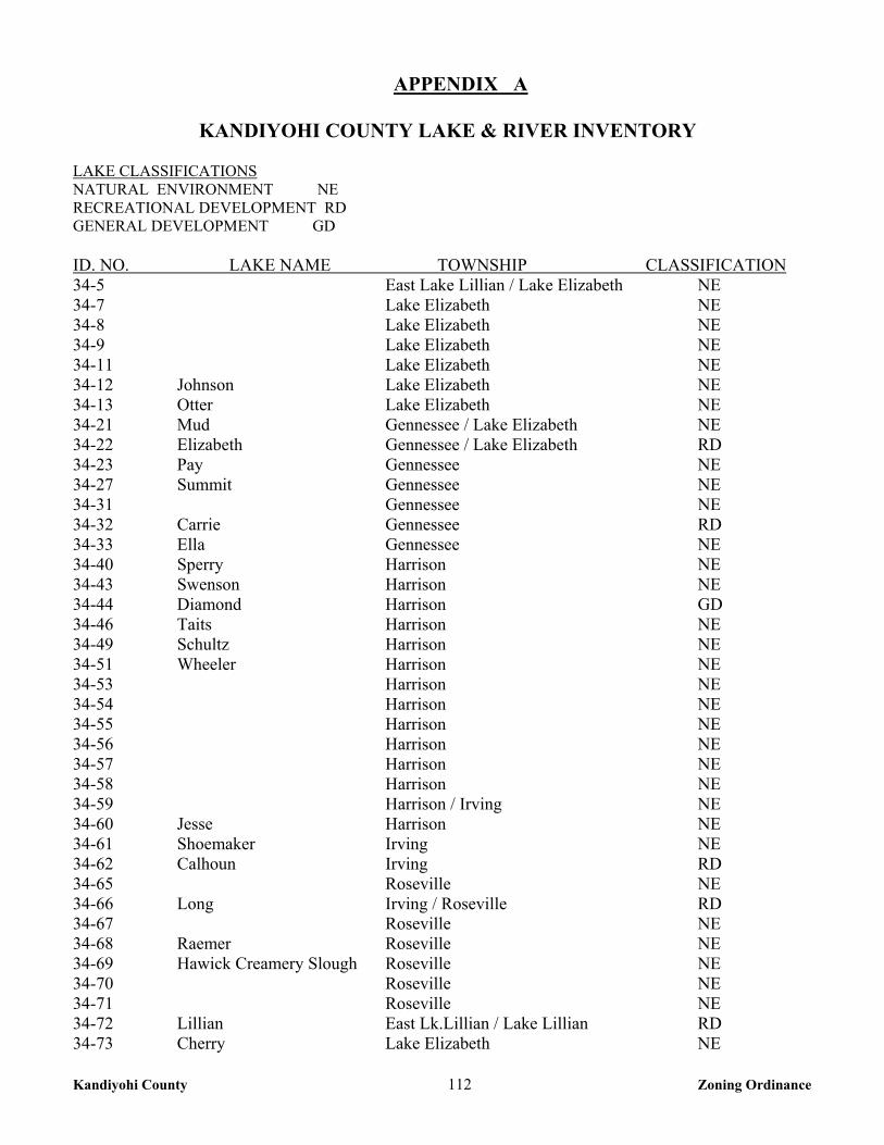
Kandiyohi County 112 Zoning Ordinance
APPENDIX A
KANDIYOHI COUNTY LAKE & RIVER INVENTORY LAKE CLASSIFICATIONS NATURAL ENVIRONMENT NE RECREATIONAL DEVELOPMENT RD GENERAL DEVELOPMENT GD ID. NO. LAKE NAME TOWNSHIP CLASSIFICATION 34-5 East Lake Lillian / Lake Elizabeth NE 34-7 Lake Elizabeth NE 34-8 Lake Elizabeth NE 34-9 Lake Elizabeth NE 34-11 Lake Elizabeth NE 34-12 Johnson Lake Elizabeth NE 34-13 Otter Lake Elizabeth NE 34-21 Mud Gennessee / Lake Elizabeth NE 34-22 Elizabeth Gennessee / Lake Elizabeth RD 34-23 Pay Gennessee NE 34-27 Summit Gennessee NE 34-31 Gennessee NE 34-32 Carrie Gennessee RD 34-33 Ella Gennessee NE 34-40 Sperry Harrison NE 34-43 Swenson Harrison NE 34-44 Diamond Harrison GD 34-46 Taits Harrison NE 34-49 Schultz Harrison NE 34-51 Wheeler Harrison NE 34-53 Harrison NE 34-54 Harrison NE 34-55 Harrison NE 34-56 Harrison NE 34-57 Harrison NE 34-58 Harrison NE 34-59 Harrison / Irving NE 34-60 Jesse Harrison NE 34-61 Shoemaker Irving NE 34-62 Calhoun Irving RD 34-65 Roseville NE 34-66 Long Irving / Roseville RD 34-67 Roseville NE 34-68 Raemer Roseville NE 34-69 Hawick Creamery Slough Roseville NE 34-70 Roseville NE 34-71 Roseville NE 34-72 Lillian East Lk.Lillian / Lake Lillian RD 34-73 Cherry Lake Elizabeth NE
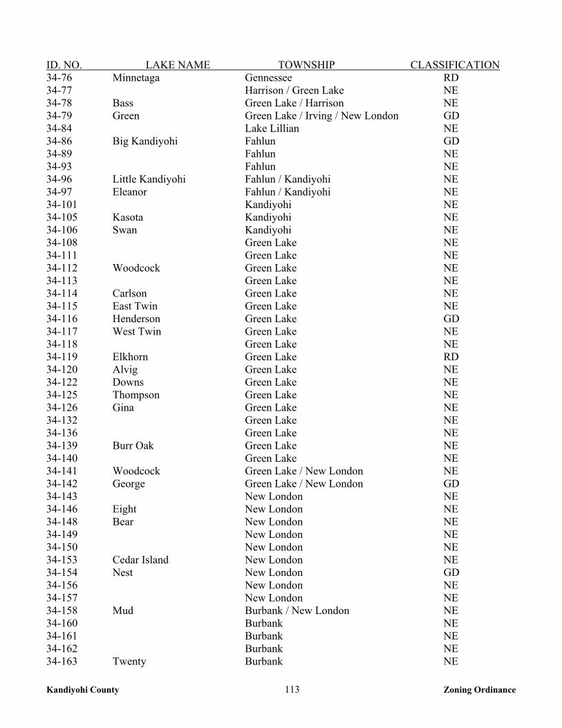
Kandiyohi County 113 Zoning Ordinance
ID. NO. LAKE NAME TOWNSHIP CLASSIFICATION 34-76 Minnetaga Gennessee RD 34-77 Harrison / Green Lake NE 34-78 Bass Green Lake / Harrison NE 34-79 Green Green Lake / Irving / New London GD 34-84 Lake Lillian NE 34-86 Big Kandiyohi Fahlun GD 34-89 Fahlun NE 34-93 Fahlun NE 34-96 Little Kandiyohi Fahlun / Kandiyohi NE 34-97 Eleanor Fahlun / Kandiyohi NE 34-101 Kandiyohi NE 34-105 Kasota Kandiyohi NE 34-106 Swan Kandiyohi NE 34-108 Green Lake NE 34-111 Green Lake NE 34-112 Woodcock Green Lake NE 34-113 Green Lake NE 34-114 Carlson Green Lake NE 34-115 East Twin Green Lake NE 34-116 Henderson Green Lake GD 34-117 West Twin Green Lake NE 34-118 Green Lake NE 34-119 Elkhorn Green Lake RD 34-120 Alvig Green Lake NE 34-122 Downs Green Lake NE 34-125 Thompson Green Lake NE 34-126 Gina Green Lake NE 34-132 Green Lake NE 34-136 Green Lake NE 34-139 Burr Oak Green Lake NE 34-140 Green Lake NE 34-141 Woodcock Green Lake / New London NE 34-142 George Green Lake / New London GD 34-143 New London NE 34-146 Eight New London NE 34-148 Bear New London NE 34-149 New London NE 34-150 New London NE 34-153 Cedar Island New London NE 34-154 Nest New London GD 34-156 New London NE 34-157 New London NE 34-158 Mud Burbank / New London NE 34-160 Burbank NE 34-161 Burbank NE 34-162 Burbank NE 34-163 Twenty Burbank NE
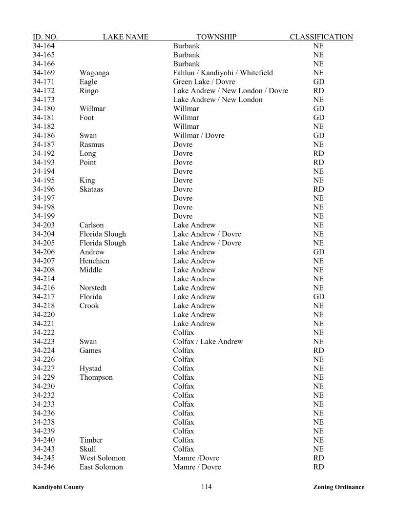
Kandiyohi County 114 Zoning Ordinance
ID. NO. LAKE NAME TOWNSHIP CLASSIFICATION 34-164 Burbank NE 34-165 Burbank NE 34-166 Burbank NE 34-169 Wagonga Fahlun / Kandiyohi / Whitefield NE 34-171 Eagle Green Lake / Dovre GD 34-172 Ringo Lake Andrew / New London / Dovre RD 34-173 Lake Andrew / New London NE 34-180 Willmar Willmar GD 34-181 Foot Willmar GD 34-182 Willmar NE 34-186 Swan Willmar / Dovre GD 34-187 Rasmus Dovre NE 34-192 Long Dovre RD 34-193 Point Dovre RD 34-194 Dovre NE 34-195 King Dovre NE 34-196 Skataas Dovre RD 34-197 Dovre NE 34-198 Dovre NE 34-199 Dovre NE 34-203 Carlson Lake Andrew NE 34-204 Florida Slough Lake Andrew / Dovre NE 34-205 Florida Slough Lake Andrew / Dovre NE 34-206 Andrew Lake Andrew GD 34-207 Henchien Lake Andrew NE 34-208 Middle Lake Andrew NE 34-214 Lake Andrew NE 34-216 Norstedt Lake Andrew NE 34-217 Florida Lake Andrew GD 34-218 Crook Lake Andrew NE 34-220 Lake Andrew NE 34-221 Lake Andrew NE 34-222 Colfax NE 34-223 Swan Colfax / Lake Andrew NE 34-224 Games Colfax RD 34-226 Colfax NE 34-227 Hystad Colfax NE 34-229 Thompson Colfax NE 34-230 Colfax NE 34-232 Colfax NE 34-233 Colfax NE 34-236 Colfax NE 34-238 Colfax NE 34-239 Colfax NE 34-240 Timber Colfax NE 34-243 Skull Colfax NE 34-245 West Solomon Mamre /Dovre RD 34-246 East Solomon Mamre / Dovre RD
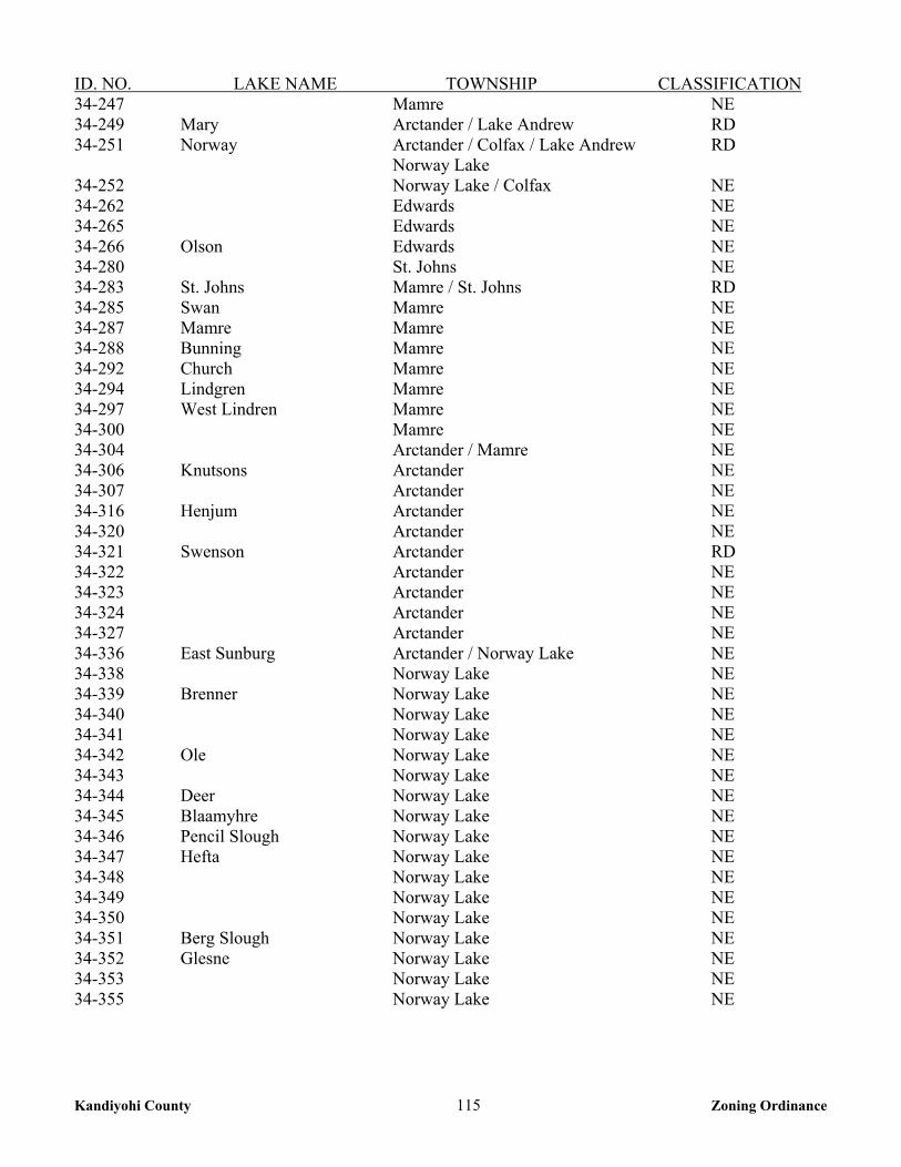
Kandiyohi County 115 Zoning Ordinance
ID. NO. LAKE NAME TOWNSHIP CLASSIFICATION 34-247 Mamre NE 34-249 Mary Arctander / Lake Andrew RD 34-251 Norway Arctander / Colfax / Lake Andrew RD Norway Lake 34-252 Norway Lake / Colfax NE 34-262 Edwards NE 34-265 Edwards NE 34-266 Olson Edwards NE 34-280 St. Johns NE 34-283 St. Johns Mamre / St. Johns RD 34-285 Swan Mamre NE 34-287 Mamre Mamre NE 34-288 Bunning Mamre NE 34-292 Church Mamre NE 34-294 Lindgren Mamre NE 34-297 West Lindren Mamre NE 34-300 Mamre NE 34-304 Arctander / Mamre NE 34-306 Knutsons Arctander NE 34-307 Arctander NE 34-316 Henjum Arctander NE 34-320 Arctander NE 34-321 Swenson Arctander RD 34-322 Arctander NE 34-323 Arctander NE 34-324 Arctander NE 34-327 Arctander NE 34-336 East Sunburg Arctander / Norway Lake NE 34-338 Norway Lake NE 34-339 Brenner Norway Lake NE 34-340 Norway Lake NE 34-341 Norway Lake NE 34-342 Ole Norway Lake NE 34-343 Norway Lake NE 34-344 Deer Norway Lake NE 34-345 Blaamyhre Norway Lake NE 34-346 Pencil Slough Norway Lake NE 34-347 Hefta Norway Lake NE 34-348 Norway Lake NE 34-349 Norway Lake NE 34-350 Norway Lake NE 34-351 Berg Slough Norway Lake NE 34-352 Glesne Norway Lake NE 34-353 Norway Lake NE 34-355 Norway Lake NE
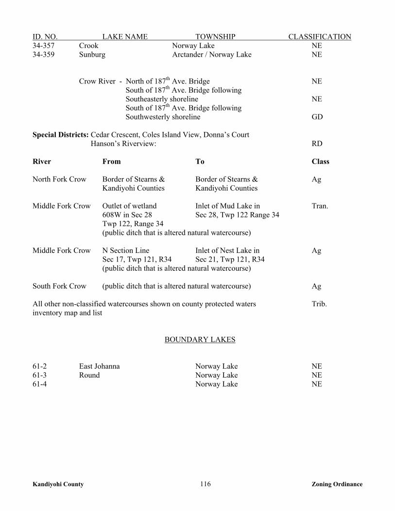
Kandiyohi County 116 Zoning Ordinance
ID. NO. LAKE NAME TOWNSHIP CLASSIFICATION 34-357 Crook Norway Lake NE 34-359 Sunburg Arctander / Norway Lake NE
Crow River - North of 187th Ave. Bridge NE South of 187th Ave. Bridge following Southeasterly shoreline NE
South of 187th Ave. Bridge following Southwesterly shoreline GD
Special Districts: Cedar Crescent, Coles Island View, Donna’s Court Hanson’s Riverview: RD River From To Class North Fork Crow Border of Stearns & Border of Stearns & Ag Kandiyohi Counties Kandiyohi Counties Middle Fork Crow Outlet of wetland Inlet of Mud Lake in Tran. 608W in Sec 28 Sec 28, Twp 122 Range 34 Twp 122, Range 34 (public ditch that is altered natural watercourse) Middle Fork Crow N Section Line Inlet of Nest Lake in Ag Sec 17, Twp 121, R34 Sec 21, Twp 121, R34 (public ditch that is altered natural watercourse) South Fork Crow (public ditch that is altered natural watercourse) Ag All other non-classified watercourses shown on county protected waters Trib. inventory map and list
BOUNDARY LAKES 61-2 East Johanna Norway Lake NE 61-3 Round Norway Lake NE 61-4 Norway Lake NE