Embed Size (px)
Citation preview

Background Report
June 2010Date endorsed by WAPC
KandiwalLayout Plan 1
AmendmentsAmendment 1 - October 2012

_________________________________________________________________________________________________________ Kandiwal Community Layout Plan No. 1 - April 2010
- A -
CONTENTS
CONTENTS .....................................................................................................................................................A
CONTACTS...................................................................................................................................................... I
LIST OF ACRONYMS USED IN THIS REPORT..................................................................................... II
EXECUTIVE SUMMARY ...........................................................................................................................III
PREAMBLE..........................................................................................................................................................III DEVELOPMENT AT KANDIWAL ............................................................................................................................. V
1 BACKGROUND ..................................................................................................................................... 1
1.1 LOCATION & PHYSICAL GEOGRAPHY ...................................................................................................... 1 1.2 CLIMATE ................................................................................................................................................... 1 1.3 HISTORY.................................................................................................................................................... 1
2. EXISTING SITUATION......................................................................................................................... 3
2.1 GOVERNANCE .......................................................................................................................................... 3 2.3 NATIVE TITLE .............................................................................................................................................. 5 2.4 CULTURE ................................................................................................................................................... 5 2.5 ABORIGINAL HERITAGE ............................................................................................................................ 6 2.6 POPULATION ............................................................................................................................................. 7 2.7 HOUSING ..................................................................................................................................................... 8 2.8 FLOODING & DRAINAGE.............................................................................................................................. 9 2.10 ACCESS & DEDICATED ROADS ................................................................................................................ 10 2.11 INTERNAL ROAD LAYOUT.......................................................................................................................... 10 2.12 COMMUNITY AND SOCIAL SERVICES ....................................................................................................... 10 2.13 ELECTRICITY SUPPLY ................................................................................................................................. 12 2.14 WASTEWATER ........................................................................................................................................... 13 2.15 RUBBISH DISPOSAL & TIP SITE .................................................................................................................. 13 2.16 AIRSTRIP .................................................................................................................................................. 14 2.17 OUTSTATIONS .......................................................................................................................................... 14 2.18 STOCKYARDS........................................................................................................................................ 14 2.19 GARDEN/HORTICULTURE......................................................................................................................... 15
3. PLANNING FRAMEWORK.............................................................................................................. 15
STATE PLANNING POLICIES ............................................................................................................................... 15 SHIRE OF WYNDHAM EAST KIMBERLEY TOWN PLANNING SCHEME ................................................................... 15 SHIRE OF WYNDHAM EAST KIMBERLEY LOCAL PLANNING STRATEGY................................................................ 16
4. COMMUNITY ASPIRATIONS............................................................................................................. 16

_________________________________________________________________________________________________________ Kandiwal Community Layout Plan No.1 - April 2010
- B -
6. DEVELOPMENT PROJECTS & REQUIRED IMPROVEMENTS............................................................. 17
DESIGN SUMMARY ........................................................................................................................................... 17 RUBBISH TIP....................................................................................................................................................... 17 RESTRUCTURING & RELOCATION OF THE SOLAR POWER SYSTEM TO LOT U4. ...................................................... 18 HOUSING.......................................................................................................................................................... 18 ROAD LAYOUT .................................................................................................................................................. 18 STORMWATER DRAINAGE ................................................................................................................................. 18 NO-GO AREA .................................................................................................................................................. 18
7. CONSULTATION SUMMARY ........................................................................................................ 19
8. PLANS........................................................................................................................................................ 21
9. ENDORSEMENTS.................................................................................................................................... 22
KANDIWAL ABORIGINAL CORPORATION - ENDORSEMENT ............................................................. A DIRECTOR DIRECTOR .............................................................................................................................. A WUNAMBAL GAAMBERA ABORIGINAL CORPORATION - ENDORSEMENT.................................................... B SHIRE OF WYNDHAM – EAST KIMBERLEY - ENDORSEMENT ........................................................................ C WESTERN AUSTRALIAN PLANNING COMMISSION ENDORSEMENT .............................................................. D
REFERENCES & INFORMATION .............................................................................................................E
_________________________________________________________________________________________________________ Kandiwal Community Layout Plan No. 1 - April 2010
- i -
CONTACTS COMMUNITY CONTACTS
Name Kandiwal Aboriginal Corporation (KAC)
Related Organisations 'Wirraway Tours': Chris Brown c/o KAC, Kandiwal Mitchell Plateau Association (MPA) Chairperson – [email protected] P.O. Box 4143, Eaglemont, Vic 3084
Office Manager Marlene Goonack
Chairperson Catherine Goonack
Tel 08 9191 4405
Fax 08 9161 4077
Postal Address PMB 2 Kununurra WA 6437
Email c/o [email protected]
AGENCY CONTACTS
SERVICE CONTACT PEOPLE
Shire of Wyndham/East Kimberley
Environmental Health Officer Kelly Cripps. Tel: 9168 4100
Town Planner Jennifer Ninyette tel: 08 9168 4100 [email protected]
Department of Housing
Capital Works and Maintenance Peter Smith. Tel: 9222 8128 / 0408 934 835 [email protected]
Housing David Carpenter. Tel: 9222 4817 [email protected]
Essential Services Graham McCafferty. Tel: 9222 4818 Fax: 9222 8137 [email protected]
Indigenous Housing Services Maureen. O’Meara Tel: 9168 1588 [email protected]
Kimberley Regional Service Providers
Essential Services Program [Broome office] Rob Imbre. Tel: 9192 1641.
Department of Planning
Town Planning / Layout Plans Simon Davis. Tel: 08 9264 7632 [email protected]
Main Switchboard [Perth] Tel: 08 9264 7777
Dept. Regional Development & Lands
Indigenous Land Reserves Peter Broekmeulen Tel: 08 6168 0600 [email protected]

_________________________________________________________________________________________________________ Kandiwal Community Layout Plan No.1 - April 2010
- ii -
List of Acronyms used in this Report
AACAP ATSIC Army Community Assistance Program
ABG Australian Broadband Guarantee
ALT Aboriginal Lands Trust
AHA Aboriginal Heritage Act (WA) 1972
ATSIC Aboriginal and Torres Strait Islander Commission
BOM Bureau of Meteorology
CAT Kimberley Centre of Appropriate Technologies
CDEP Community Development Employment Program
CLP Community Layout Plan
CFC Caring for Country Initiative
CRA Conzinc Riotinto Australia
DET Department of Education & Training
DoH Department of Housing
DIA Department of Indigenous Affairs
DoP Department of Planning
EHNS Environmental Health Needs Survey
ILUA Indigenous Land Use Agreement (under the Native Title Act 1993)
KAC Kandiwal Aboriginal Corporation
KRSP Kimberley Regional Service Providers
MPA Mitchell Plateau Association
NNTT National Native Title Tribunal
NTA Native Title Act (Commonwealth) 1993
NTRB Native Title Representative Body
PBC Prescribed Body Corporate (under the NTA, representing traditional owners)
RAESP Remote Area Essential Services Program
RIHS Regional Indigenous Health Service
SOTA School of the Air
WAPC Western Australia Planning Commission
WGAC Wunambal Gaambera Aboriginal Corporation
WNAC Winun Ngari Aboriginal Corporation
WNTO Wunambal Ngauwudu Traditional Owners

_________________________________________________________________________________________________________ Kandiwal Community Layout Plan No.1 - April 2010
- iii -
EXECUTIVE SUMMARY
Preamble The Kandiwal Community Layout Plan No. 1 has been prepared over a two year period between 2007 and 2009 to facilitate development, including the construction of a school / training centre, teacher and community housing and other infrastructure. It replaces the draft Kandiwal as-constructed survey diagrams 1997. which included a lot layout, and modification in 2004.
The table below summarises the main issues concerning the planning, development and provision of services within Kandiwal, covered in more detail in the body of this report. Table 1 - Infrastructure and essential/social service characteristics at Kandiwal
Infrastructure/service Indicator
Community Characteristics
Drinking water
One bore at community, tested regularly by KRSP. Water quality considered to be within Guidelines. Quantity of water unknown.
Native title Uunguu Native Title Claim (WAD6033/99) is registered by the NNTT and covers 25909.45sqkm.
Land Tenure Settlement and infrastructure located on land with secure and appropriate tenure: 200ha Crown Reserve 42514 under management order to the Aboriginal Lands Trust, with a 4.38ha portion of the Reserve to be leased to KAC under agreement with Wunambal Gaabera Aboriginal Corporation of Kalumburu dated 17th February 2010, of which 4488m2 is sub-leased to Kimberley Dreamtime Tours P/L.
Flood Community area located on land whereon flood is not expected to risk safety or infrastructure. Seasonal run-off experienced, but flooding not considered to be an issue. Stormwater bund to north of community.
Emergency assistance
Nearest police and medical assistance at Kununurra and Derby, 9-12 hours drive. Seasonal road access only. Approx 2 hour flight time.
Education No school at community, but school of the air available.
Health Nearest health clinic located at Kalumburu

_________________________________________________________________________________________________________ Kandiwal Community Layout Plan No.1 - April 2010
- iv -
190Kms – 4-5 hour drive, only seasonally accessible. Monthly outreach RFDS service to community.
Governance KAC is a registered corporation under the CATSI Act. The Community has a designated office with phone and fax and is supported by a coordinator.
Employment & enterprise opportunities
Incorporated community has potential enterprises with tourism and land-management ventures.
Transport Unregistered (CASA Not listed) Bush Airstrip year round access proximate to settlement. Road access is unsealed and seasonal April – Dec.
Food Fish and meat food sources obtained locally, proximate to community. Food supplies flown in weekly.
Electricity Operated by the community with limited KRSP support . Current system inadequate for current needs.
CLP No. 1 plans for future expansion of the community and existing infrastructure and land-uses and provides a future lot layout and road design.
The major purpose of the CLP is to guide the growth and development of Kandiwal by providing a layout of existing structures and future land-use and development of the community. The CLP addresses future growth issues regarding education, training, health, housing and infrastructure - power, communications, sewerage and water supply.
The CLP has been prepared by the Mitchell Plateau Association in collaboration with the Kandiwal Aboriginal Corporation to ensure that the plan reflects the community's aspirations. Sinclair Knight Merz has provided survey data and produced future lot layout and design. Additional technical input has been provided by a number of government and non-government agencies, including the Department of Planning, as detailed in the appendix.
The Mitchell Plateau Association Inc is registered as a public benevolent institution and endorsed as a deductible gift recipient (ABN: 61 770 497 047). The Association aims to provide support to the Kandiwal Aboriginal Corporation in its development plans, in particular the pursuit of education, training and facilities.
This Community Layout Plan outlines a clear and straightforward way for Kandiwal to develop in a co-ordinated and efficient manner and in accordance with the aspirations of the Kandiwal community.

_________________________________________________________________________________________________________ Kandiwal Community Layout Plan No.1 - April 2010
- v -
Development at Kandiwal
The following initiatives, development and works are needed to implement CLP No. 1:
Within the next year:
1. Build education and training centre on Lot S1 with two teacher houses on Lots 18 & 19 (Dept. Ed & Training)
2. Build six houses and indigenous education worker accommodation in Stage 1 & 2 areas (DoH)
3. Install Broadband communications system – (Mitchell Plateau Association)
4. Replace the existing power supply system – (KAC & MPA)
5. Construct horticultural enclosures around Lots H1 & H2 – (Kandiwal Aboriginal Corp & Mitchell Plateau Assoc.)
6. Build a multi-purpose cool room on Lot C4 - (Mitchell Plateau Association)
7. Erect workshop on Lot W1 - (KAC)
8. Define & grade internal road network – (Kandiwal Aboriginal Corporation)
9. Identify the location of the new community tip approximately 4 kms SE of the community, subject to appropriate land tenure – (Kandiwal Aboriginal Corporation & Centre for Appropriate Technology)
Within the next 5 years:
10. Construct health clinic – (KAC, MPA & RIHS) 11. Construct new administration building – (KAC & MPA) 12. Undertake public drinking water source protection assessment –(KRSP & KAC/MPA) 13. Construct store – (KAC) 14. Construct cultural and tour centre – (KAC) 15. Construct 15 houses – (DoH) 16. Construct additional teacher housing – (DET) 17. Expand food production enclosures – (KAC) 18. Construct sports facilities & oval – (KAC / MPA)
Within the next 10 years:
19. Expand the education & training centre and teacher accommodation - (DET) 20. Undertake review of CLP No. 1 and population forecast (DoP) 21. Construct additional 15 houses, subject to population demand – (DoH/KAC) 22. Construct environmental sewer plant, subject to population growth – (KAC)
Within the next 15 years:
23. Construct additional housing as required - (DoH/KAC)

_________________________________________________________________________________________________________ Kandiwal Community Layout Plan No. 1 - April 2010
- 1 -
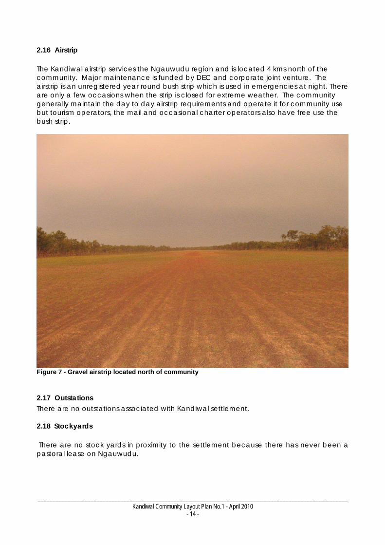
1 BACKGROUND 1.1 Location & Physical Geography Kandiwal is a remote community and is now a growing tourism centre located in the ancient Uunguu wilderness consisting of savannah, palm forests on a plateau ranging down to the sea. Ngauwudu is the region between the Mitchell and Lawley Rivers part of which is the Kandiwal Mob country (see context plans). Ngauwudu has year round water in the Camp Creek system fed by the airstrip swamp, passing beside Kandiwal settlement, running off the plateau into the Mitchell River leading to the Mitchell Falls. Soils are old rock weathered material and generally not suitable for agriculture. The underlying rock is variable and fractured providing many avenues for the summer rains to percolate into the aquifers. Kandiwal is 245 Kms from the Gibb river road just off the Port Warrender Road and some 550 Kms from Kununurra and 640 Kms from Derby. It is also 190 Kms south of Kalumburu. The main portion of the community is set in the Camp Creek Valley some 30 kms from the coast providing good cyclone protection (see context maps). 1.2 Climate The climate at Kandiwal is moderated due to its location 30km inland and at an elevation of 275 metres. It has a mean monthly maximum temperature of 36 degrees and a minimum of 9.7 degrees. Kandiwal has an annual mean average of 116 clear days and 94 cloudy days. It has a rain fall annual average of 1548mm which falls primarily in the December - March period. The strongest winds occur in January from the west with a mean monthly maximum of 40km/h but it is an area that has cyclones with five passing by in living memory of local residents. January is also the month for the maximum number calm days. The direction of prevailing winds change throughout the course of the year, depending on the season: west in the wet and east in the dry. 1.3 History The history recounted here is as put forward by community members. The Kandiwal community are the Wunambal Ngauwudu people, whose old people first saw the white man in 1920s. Relocation from country, by coercion and force, began in the 1930s.

_________________________________________________________________________________________________________ Kandiwal Community Layout Plan No.1 - April 2010
- 2 -
The majority of the Wunambal people were coerced west to Kunmunya mission during the 1940s and 50s, by issuing of rations to encourage change in cultural attitudes and practices. Eventually the Kunmunya mission was closed due to funding constraints and the majority of those living there were again moved further south to Wotjulam camp, closer to Derby, for ease of government access. Wotjulum was later closed and people were made to relocate again to Mowanjum, just outside Derby (see Jebb 2008 for a written history by the Mowanjum people). The Ngauwudu mob began trying to return to their traditional country in the 1950s. In the mid 1960s Conzinc Riotinto Australia constructed an exploration camp for several years on the present site of Kandiwal. When the miners left they auctioned everything but the concrete foundations. The Ngauwudu mob took over the Kandiwal site to create the Kandiwal community of today. The current steel sheds and housing were built in the 1990s The three Ngauwudu Reserve Leases were vested to Kandiwal Aboriginal Corporation (KAC) in 1987 for 99 years. KAC was the first independent Indigenous corporation in the northern Kimberly. KAC was recently redfined and registered as a Ngauwudu Traditional Owner only Corporation under the CATSI Act transition to comply with Native Title requirements. The WNTO have had a physical and economic community development plan for Ngauwudu since the 1980s and have been sidelined and left on their own until two years ago. MPA saw how this group of Australians had been treated and the potential for the community that KAC had presented in 2001 and decided to provide help. 1.4 Previous Land-Use Plans The first Kandiwal plans were a survey and lot design in 1997 prepared by Troppo Architects P/L in 1997. This was used as the basis for providing a building licence by the Shire of Wyndham East Kimberly Building Surveyor. The next plan was created for the Department of Housing by Sinclair Knight & Merz in Association with Monsoon Architects & Planners in 2004 using the same base survey as 1997 for the purpose of constructing two houses and associated infrastructure. Neither surveys were formally endorsed by the community, Shire, or Western Australian Planning Commission. The first two plans did not address land-use requirements or community aspirations for education and health facilities and did not incorporate community development or the KAC Ngauwudu management and tourism development plans that had been prepared in 2000 (WGAC 2000). The only community input was to the houses. The survey diagrams were held by the Shire of Wyndham East Kimberley. 1.5 CLP No. 1

_________________________________________________________________________________________________________ Kandiwal Community Layout Plan No.1 - April 2010
- 3 -
This 2010 Kandiwal Community Layout Plan No. 1 is based on the 2004 as-built survey plan and has extended the survey to cover additional development aspirations proposed by the Kandiwal community. The proposed development is in response to Wunambal people wanting a better environment for educating their children, to move them away from the poor social conditions of regional centres and to pursue their legitimate development opportunities on Ngauwudu to create a future for their children. CLP No. 1 is primarily aimed at addressing the current shortfall in education, training, health and infrastructure as well as laying the foundation for economic development.
2. EXISTING SITUATION
2.1 Governance
Kandiwal Aboriginal Corporation (KAC) represents the Ngauwudu (Mitchell Plateau) mob of Wunambal people, who are the traditional owners of the area, including the area of the Kandiwal settlement. The membership of KAC was recently redefined under the Commonwealth CATSI Act (2006) as representing traditional owners. KAC complies operationally with ORIC corporate requirements. Annual reports can be obtained from www.orac.gov.au. Kandiwal settlement and the broader Ngauwudu region fall within the Uunguu Native Title Claim (Federal Court number WAD6033/99). The PBC representing the native title holders, when determined, is likely to be the Wunambal Gaambera Aboriginal Corporation (WGAC). There is an understanding between WGAC and KAC for the Wunambal Ngauwudu traditional owners to hold the ALT Ngauwudu leases and for a future ILUA agreement (under the Native Title Act) for KAC to control and manage all activities in Ngauwudu country, subject to native title being determined. There is no registered ILUA to that effect at the present time. 2.2 Land Tenure
The settlement is located on Lot 25 Crown Reserve 42514, with a mangement order to the Aboriginal Lands Trust (see figure below). CR 42514 has a total area of 200.03 hectares.
Figure 1 - Kandiwal community office

_________________________________________________________________________________________________________ Kandiwal Community Layout Plan No.1 - April 2010
- 4 -
Within the main Crown Reserve is situated a lease to Wunambal Gaambera Aboriginal Corporation totalling 4.38 hectares, currently being transferred to KAC.
A 4488sqm portion of the Wunambal lease is sub-leased to Kimberley Dreamtime Tours. The eastern boundary of this lease is defined by Camp Creek.
Tenure Crown Reserve Lot Details Lot 25, CR 42514
Status Order / Interest Management Order: for use & benefit of Aboriginal people
Primary Interest Holder Aboriginal Lands Trust Area 200.03 hectares
Limitations/Interests/ Encumbrances/Notifications
lease of portion to Wunambal Gaambera Aboriginal Corporation of Kalumburu. Sub-lease to Dreamtime Tours P/L.
Figure 2 - Land tenure at Kandiwal (refer to full land ownership plan in appendices)
Freehold
There is no freehold in proximity to Kandiwal settlement or within the Ngauwudu region.
Pastoral Lease There are no Pastoral Leases in the Ngauwudu region.
Crown Reserve Kandiwal is located on an ALT indigenous community Crown Reserve 42514.
_________________________________________________________________________________________________________ Kandiwal Community Layout Plan No.1 - April 2010
- 5 -
2.3 Native Title Kandiwal and Ngauwudu are located within the Registered Uunguu native title claim area (Federal Court number WAD6033/99). As this is a registered claim, claimants have the procedural right to negotiate under the Native Title Act in matters that may affect traditional rights and interests. The claim area is 25,909.45 sqkm. Subject to determination of native title, it is anticipated that an ILUA between KAC and WGAC will be registered for KAC to manage interests in Ngauwudu country. An enlarged native title claim map is included in the appendices.
Figure 3 - Uunguu native title claim showing location of Kandiwal (see appendices for enlarged
version) 2.4 Culture The Kandiwal settlement is the current home of the Ngauwudu mob, the main group of the Wunambal people who are part of the Uunguu Native Title Claimant group. The Wunambal people, due to the history outlined above, are disbursed throughout several communities in the Kimberley. Those not living at Kandiwal visit in the dry and do not live there at present because of the shortage of housing and the limitations of school of the air for their children's education. The Ngauwudu people want to return to country if assisted by education and employment opportunities offered by the growing tourism potential in the region. The Wunambal people are a single cultural and language group but with cultural connections to Ngarinyin and Worrora peoples through the ''Wandjina'' cult. The Wunambal believe that Wandjina and Wunggurr ancestors created the country in the Dreamtime and laid down the law for all living things in the country. The cultural land management practices based on Wandjina-Wungurr law are detailed further in WGAC (2001)1.
1 This document is available at http://savanna.cdu.edu.au/downloads/ngauwudu.pdf
_________________________________________________________________________________________________________ Kandiwal Community Layout Plan No.1 - April 2010
- 6 -
As the Wanjina-Wunggurr cult moves further to the south and east it appears to weaken in importance with regard to mythological and religious life of the tribal groups than it does for Wunambal, Worrora and Ngarinyin peoples. The movement of Wandjina and Wunggurr in the Dreaming place the epicentre of the cult near Wanalirri on Gibb River station in Ngarinyin country. From here they headed in all directions but principally back towards the coast (west and north). Hence the main tribes that were affected were the three north-west tribes, Wunambal, Worrora and Ngarinyin. Ngauwudu was a regional food source for a couple of months a year and culturally the Wunambal people have an attitude of sharing, provided everyone does the right thing by nature, the food sources and the people. This culture provides the framework for them being involved in tourism development as well as land management and conservation. It also provides a strength of attidude, with long memories of people that do the wrong thing. 2.5 Aboriginal Heritage The Aboriginal Heritage Protection Act 1972 came after mining exploration had traversed the Ngauwudu region and these activities have significantly affected the local indigenous attitude to looking after their heritage. The following discussion of heritage matters derives from consultation with the community. All Aboriginal heritage sites are protected under the Aboriginal Heritage Act 1972 regardless of whether those sites are registered or not and visitors and developers must abide by this legislation. No-Go Area There are no No-go areas in the Kandiwal settlement. There are several areas within the Crown Reserve and along Camp Creek that are kept secret so as not to attract the attention of tour operators or tourists for fear of desecration. As a result there are no such sites shown on CLP No. 1. Registered Sites Most Ngauwudu cultural and secret sites of significance to the Wunambal people are not registered. No formal search has been undertaken for this background report principally because the community knows everything about their cultural sites. The community is also very wary about the subject because of past indiscriminate practices by outsiders including an exploration company, that disrespected local heritage, including at Munnurru –the King Edward River crossing entrance to Ngauwudu and the Mitchell Falls National Park (MFNP). A Management licence has been obtained by KAC from the Lands Department covering Munurru to protect and manage access to the registered sites.

_________________________________________________________________________________________________________ Kandiwal Community Layout Plan No.1 - April 2010
- 7 -
Built Heritage There is nothing that could be describe as heritage that the community sees as worth keeping. The traditional ways have not been used since the 1970’s. The reality is that it is essential to replace the iron sheds with properly designed homes. 2.6 Population Previous Population The population at Kandiwal has historically fluctuated. This situation to a large extent is due to the schedule of SOTA school camps which are planned for Christmas at the start of the wet in Broome or Derby. As a result on many years the families that travel to camp get cut off from road access back to Kandiwal. For many years flying back was outside their reach so they had to wait until April to return. The changing circumstances over the last two years, arising from tourism developments and lobbying by KAC, have enabled a large proportion of the community to fly back to Kandiwal after camp. Estimated Current Population Kandiwal has had residents living full-time at the community since 2005. The number of residents at any one time varies depending on road access and what activities or meetings are occurring. and the state of the road to get back to Kandiwal being the primary influences. Official figures for Kandiwal are dependent on external administrative support available to fill out ABS or Health forms and as a result these figures are unreliable. The community has undertaken its own survey of the Wunambal people to provide a base for the creation of the development plan. Kandiwal estimates its 2009 population as numbering 33, of which 18 are Children, 7 adult females and 8 adult males. Estimated Future Population Migration to Kandiwal can be expected due to affiliations with family members living in other settlements in the region, including Mowanjum, Nulundgundah, Fitzroy, One Arm Point, Broome and Kalumburu migrating back to Kandiwal to a better environment for educating their children, to move them away from the poor social conditions of regional centres and to pursue their legitimate development opportunities on Ngauwudu to create a future for their children. The community anticipates the population to grow to 65 people in the next two years or so, subject to housing construction, of which 30 are children, 17 adult females and 18 adult males. This estimation does not include teachers and administration support personnel. The estimated aspirational population for Kandiwal over a 15-year period is around 170 residents by 2021. Migration to and from the community will be influenced among other things by the employment opportunities, family networks and obligations, services and infrastructure available in the community including the provision of housing.

_________________________________________________________________________________________________________ Kandiwal Community Layout Plan No.1 - April 2010
- 8 -
Design Population & Estimated Housing Demand Based on the community's aspirational population, CLP No. 2 assumes a design population of around 170 residents. This figure should be re-evaluated when the CLP is next updated (ie. roughly every five years).
Based on a residential density of five people per house, the community would require 34 houses in total to accommodate a population of 170. 2.7 Housing Number & type of dwellings There are 5 existing residential lots at the community, on Lots 2, 5, 7, 11, 14. This includes three houses, a kitchen and a shed occupied at present. Two of the houses and an ablution block were built by Dept of Housing in 2004 as standard suburban houses. The remainder of buildings including the School and KAC Administration (office) sheds, which are steel framed iron clad structures, and two toilets were constructed at various times in 1990s. Quality of dwellings Apart from the two 2004 buildings that are still waiting on hand rails around the verandah, all the remaining buildings require upgrading due to little or no normal household amenities.
Figure 4 - Existing housing at Kandiwal
Residential areas CLP No. 1 plans for 45 residential lots in total, with 35 lots being for future residential for community members and 3 being for future teacher housing.

_________________________________________________________________________________________________________ Kandiwal Community Layout Plan No.1 - April 2010
- 9 -
Expansion of the community is proposed in three stages and in three discrete areas. For reasons of efficiency, each stage should be completed before expansion to subsequent stages. There are seven lots (4,7 -10,12 &13) designated for future residential lots in the existing central part of the community. The Department of Planning advises that development of Stage 2 should be subject to the identification and development of a new tip site. Funding of future residential development Agreements-in-Principle between KAC, DET and DoH for four to six community houses, two teacher houses and education worker accommodation to be constructed in 2010 are subject to various conditions including an endorsed CLP. Growth of the community and implementation of the CLP is contingent on fulfilling the in-principle-agreement. . 2.8 Flooding & Drainage There has not been any flooding of Kandiwal in community memory. A recent cyclone in December 2009 delivered 550 mm in three days measured by the community without direct effect on the living area or damage to community housing and infrastructure. Access roads are restricted for a period of time after heavy deluge. As a mitigation measure against flooding, a run-off diversion bund lies east of the existing community. There is no formal drainage. 2.9 Water Supply The drinking water supply for the community and the existing tourism operation to the north of the community (see context plan) come from a single bore without treatment south of the community via a 50kl water tank above the existing community. Generally the water quality would be described as good. KRSP inspect and test the supply regularly since current bore equipment was installed in 2005. Potential additional supplies of bore water have been identified north-east of the community, on the eastern side of the Creek, as noted on the context plan. A ground water analysis using exploration data is being pursued. Other explored and capped bores are known to the community but for cultural reasons and to some extent practical reasons are not proposed as additional supplies for the community at present. The Camp Creek that flows past the community also provide a steady flow of water throughout the dry season and will be used for food production irrigation. Subject to final results of grey water irrigation trial the public open spaces and sports oval will be irrigated by grey water as in other bush towns across Australia.

_________________________________________________________________________________________________________ Kandiwal Community Layout Plan No.1 - April 2010
- 10 -
2.10 Access & Dedicated Roads Ngauwudu operates like an island rather than a mainland location. Although the Port Warrender Road travels past the community and is approximately 62km to Kalumburu Road, there is no gazetted road between the community and Kalumburu road. Road access is only possible between April and December. This road access is all unsealed. The Gibb River Road has its own reputation with tourists for its quality. Whilst tourists do not pass through the community it is the community's view that they do destroy the surrounding roads and river crossings. Most of the community's food and supplies come in on a mail plane from Kununurra. Currently all materials and construction equipment come in by road in the dry season. The funding of road construction and maintenance to Mitchell Falls National Park and airstrip grading on Ngauwudu comes through DEC with corporate joint venture funding. The Kalumburu Road works are funded by the East Kimberley Shire and Gibb River Road by Main Roads. 2.11 Internal Road Layout All internal community roads are unsealed and because there is no vehicular traffic through the community dust is not a problem at the present time. Sealing of Roads is not seen as a likely priority for ten years or until population growth of the community necessitates it. The expansion of the CLP requires the grading of new roads in the eastern portion and improvement of tracks in the western portion of the community. None of the existing or new roads are proposed by the community to be named at present. The lot numbers provide sufficient identification of houses. 2.12 Community and Social Services The Kandiwal community services primarily are associated with health on a monthly or emergency basis and are generally focussed on the KAC administration building where communications are currently centred. These services are provided by RFDS. Store There is no Store in Kandiwal at present. A store is planned to be constructed by KAC in collaboration with tother operators in 2011 on Lot B1. It is proposed to be run as a joint venture between operators and KAC as a “Not for Profit” operation. It is not likely to sell fuel for some time. The nearest fuel stops are on the Kalumburu Road at Drysdale river station to the south and Kalumburu to the north. Any emergency supplies are currently delivered by the existing tourism operator to the north of the community. School / Training Twelve Children are educated via School Of The Air at present, in a shed on Lot 8.

_________________________________________________________________________________________________________ Kandiwal Community Layout Plan No.1 - April 2010
- 11 -
Lots S1-S3 in the Stage 2 area of the settlement are designated as the future location of a school. Office The KAC Administration office (shed) is located in the centre of the village on Lot C1. It currently has phone and fax. Broadband connections are anticipated in 2010. The office is also to be fitted in 2010 by MPA with new computerised equipment. It has two part-time staff. Clinic There is no clinic at present. RFDS nurses visit monthly and provide emergency services for such things as premature births or serious injuries. A clinic building is planned for 2011 by KAC in conjunction with MPA. Lot C5 is classified for this purpose. Maintenance Workshop / Storage A workshop(the size of a double garage, materials already on site) used for maintenance materials store with a small workshop is anticipated for final erection in 2010. Lot W1 is designated for this land-se. Given that this workshop is to be used for storage and small minor repairs, the standard industrial buffer has not been included on the layout plan.
Figure 5 - Telstra utilities lot with storage workshop in background
_________________________________________________________________________________________________________ Kandiwal Community Layout Plan No.1 - April 2010
- 12 -
Recreation Centre Lot C6 is set aside for a future recreation centre to be built by KAC in conjunction with MPA. 2.13 Electricity Supply Present capacity & location The current hybrid system (solar/Generator) installed on Lot U2 is inadequate for the existing community. The generator delivers 13 KW of power. The solar panels are poorly located and the government fuel allowance does not adequately cover the cost of running the diesel generator. Delivery of fuel to this remote location is expensive. The control system requires external maintenance and service.. A new expandable 24 hour 240 volt solar low maintenance system is anticipated to be installed in 2010. Lot U4 is designated for this land-use. The Federal Government RASP program and Mitchell Plateau Association charity have agreed in-principle to jointly fund the work.
Figure 6 - Existing solar panels
_________________________________________________________________________________________________________ Kandiwal Community Layout Plan No.1 - April 2010
- 13 -
2.14 Wastewater Existing buildings use a local septic style system without any detrimental effects. Recently grey water has been separated from black to irrigate an orchard development trial. This approach to development is expected to continue for the next five years when sufficient buildings and population demand will make it economical for an environmental system to be installed. Lot U3 is set aside for this purpose should the future system not require any environmental buffers. The future system is currently envisaged as a remote site package system (no ponds). 2.15 Rubbish Disposal & Tip Site The settlement has a weekly refuse collection and community clean-up conducted by KAC. The refuse is generally household rubbish. The current community tip is located outside of Reserve 42514 on UCL and in close proximity to the Stage 2 development area. The existing tip site is located just outside the juncture of a recommended 500m buffer from the drinking water bore. The Department of Planning advises that these land uses are highly incompatible. Given the small size of the community at the present time this may not be a problem, however the Department of Planning advises that future Stage 2 expansion should not be implemented until such time that: 1) a drinking water protection assessment has been undertaken, 2) a future rubbish tip site location has been identified and secured in light of the drinking water protection assessment and other identified constraints. The Environmental Protection Authority recommends a 2000 metre buffer around 'Class 2 & 3' putrescible landfill sites, which is what a future household rubbish tip for a settlement with 170 residents is likely to be classified as. A future rubbish tip site was identified two years ago with CAT, and KAC has applied for a lease (2kms by 1km) from the Lands Department adjacent to Reserve 42514 which is accessible all-year, and located about 3 kms away from incompatible land uses. [NB. The location of the future rubbish tip site has not been identified in the production of CLP No. 1 and is not included on the plan-set. The Department of Planning advises that the location of the proposed site should be included in any future amendment to the plan and prior to development of Stage 2]
_________________________________________________________________________________________________________ Kandiwal Community Layout Plan No.1 - April 2010
- 14 -
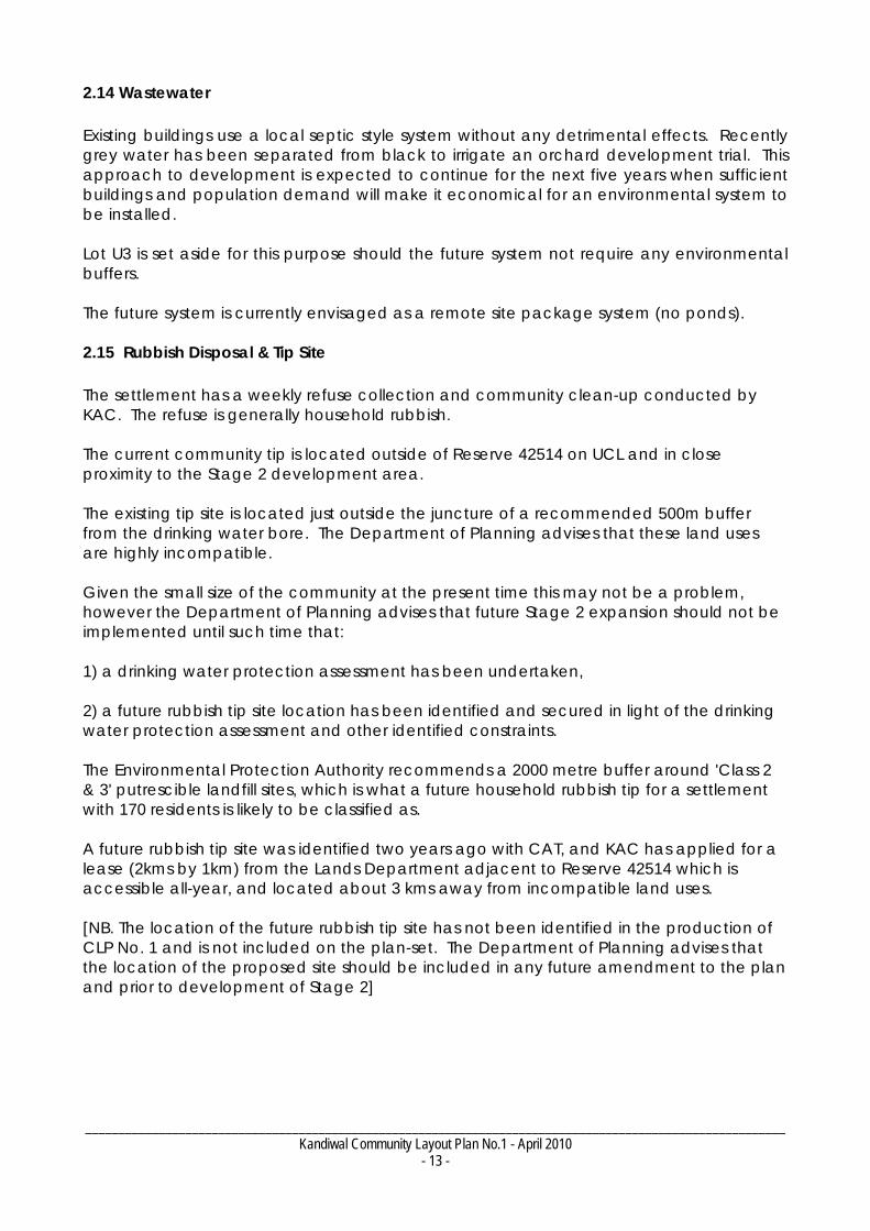
2.16 Airstrip The Kandiwal airstrip services the Ngauwudu region and is located 4 kms north of the community. Major maintenance is funded by DEC and corporate joint venture. The airstrip is an unregistered year round bush strip which is used in emergencies at night. There are only a few occasions when the strip is closed for extreme weather. The community generally maintain the day to day airstrip requirements and operate it for community use but tourism operators, the mail and occasional charter operators also have free use the bush strip.
Figure 7 - Gravel airstrip located north of community 2.17 Outstations There are no outstations associated with Kandiwal settlement. 2.18 Stockyards There are no stock yards in proximity to the settlement because there has never been a pastoral lease on Ngauwudu.

_________________________________________________________________________________________________________ Kandiwal Community Layout Plan No.1 - April 2010
- 15 -
2.19 Garden/Horticulture Lots H1 and H2 are classified 'Rural' for horticultural purposes. Production has been located close to the Creek for easy irrigation access and some soil base. The quality of the soil requires organic growing methods and soil preparation. 2.20 Tourism There is an existing seasonal tourism camp to the north of the community, proximate to Camp Creek. Kimberley Dreamtime Tours P/L has its own sub-lease from Wunambal Aboriginal Corporation. The tourism camp is only occupied for six months of the year. The area is classified as 'Commercial' on the CLP No.1 Context Plan.
3. PLANNING FRAMEWORK State Planning Policies State Planning Policies (SPPs) are prepared and adopted by the WAPC under statutory procedures set out in section 26 of the Planning and Development Act 2005.
The WAPC and local governments must have 'due regard' to the provisions of State Planning Policies when preparing or amending town planning schemes and when making decisions on planning matters. The State Administrative Tribunal is also required to take account of SPPs when determining appeals.
The following SPPs were given due regard in the preparation of Kandiwal CLP No.1:
SPP 3 – Urban Growth and Management;
SPP3.2 Planning for Aboriginal Communities; and
SPP2.7 Public Drinking Water Source
Land Use Buffers for Aboriginal Communities In 2007, consultants Arup prepared the draft ‘Land Use Buffers for Aboriginal Communities in Western Australia’ report on behalf of the Department for Planning & Infrastructure (DPI). The report defines minimum separation distance buffers specifically suited to the range, scale and type of infrastructure typical of remote Aboriginal communities. All buffers specified in this CLP are based on that report. Shire of Wyndham East Kimberley Town Planning Scheme The Kandiwal community is not located within the area covered by any Planning Scheme, and there are no interim development orders in place, meaning that land use and development in the community has historically been unregulated. However building and development approvals should be issued in accordance with Kandiwal CLP No. 1.
Should Kandiwal CLP No. 1 be incorporated in the Local Planning Scheme in future then an appropriate area for classification of a 'Settlement' zone is the existing boundary of Lot 25 Crown Reserve 42514. Future planning approval is to be issued in accordance with the endorsed Kandiwal CLP No.1

_________________________________________________________________________________________________________ Kandiwal Community Layout Plan No.1 - April 2010
- 16 -
Shire of Wyndham East Kimberley Local Planning Strategy The Local Planning Strategy adopted by the Shire provides a vision for the growth and development of the Shire over a 10-15 year time frame.
The Strategy acknowledges Community Layout Plans that have been produced for permanent communities within the Shire. The Strategy accepts that the Shire does not have the capacity to incorporate remote CLPs into its current scheme but will continue to provide building regulation oversight.
The Strategy identifies the need for an expanded Local Planning Scheme area.
4. COMMUNITY ASPIRATIONS The ideas behind community improvements noted by the Kandiwal Aboriginal Corporation when developing Community Layout Plan No. 1 are listed below. Not all of these aspirations can be incorporated into a CLP, but have been noted as a record of a more general community improvement plan.
1. To provide the power and other infrastructure for a school and training facilities. 2. To provide a better environment with more opportunity for the community children to have a future that is not available in the Kimberley cities. 3. To have the community properly housed and allow all Wunambal people to be part of the Ngauwudu regional development. 4. To facilitate and manage the expansion of and get employment in tourism operations and their support services in Ngauwudu. 5. To have health facilities and services of an Australian community to be made available in Kandiwal at the appropriate times not only for the community but also for the development of tourism. 6. To become self sufficient in fresh food at a cheaper cost and for better health. 7. To control and manage Ngauwudu to secure and protect the cultural and secret areas from visitor activity. 8. To finally implement the sustainable community and tourism development plan for Ngauwudu that KAC presented KLC 15 years ago with KAC as the administrators on behalf of the Uunguu traditional Owners.

_________________________________________________________________________________________________________ Kandiwal Community Layout Plan No.1 - April 2010
- 17 -
6. DEVELOPMENT PROJECTS & REQUIRED IMPROVEMENTS Design Summary The future plans for Kandiwal community have been refined over several years and draws on advice from relevant government agencies, suppliers and organisations associated with indigenous development across Australia.
The general design principles of the plan are:
1. Maintain adequate separation between incompatible uses. Define a road network that is suitable for all uses, including water, electricity and other services.
2. Plan for future growth by developing new residential lots. 3. Allocate land for a range of land uses that may be needed in the future. 4. Do all this on land that is physically appropriate and economic to develop.
The Kandiwal Community Layout Plan No. 1 shows a layout for all proposed improvements to Kandiwal, with inferred current and future land uses. The following provides a brief explanation of the design principles and required improvements that are shown on the plan.
The design of Land Use Elements The community recognises the limitations of the Reserve and the terrain on which it is placed. The community was located with a clear focus on Camp Creek for practical and traditional reasons. All elements of the Layout Plan have been positioned with three over riding themes. The first is to keep the critical mass of the community close together for the engagement of everyone in community business in traditional ways. The second is to find locations that are practical and cheap to build on with in the available space and particularly can handle wet conditions. Thirdly was to maintain as much natural vegetation as possible. This has dictated that the community expansion set out in the CLP is hard up against the western boundary of the Reserve.
The major and most pressing development projects are summarised below:
Rubbish Tip The most pressing need for the settlement is to secure a suitable new tip-site location, subject to constraints including land tenure and location of drinking water sources and creek systems. The Department of Planning advises that this should be undertaken before substantial expansion of the settlement or growth in population. Remediation of the existing tip site should then follow.

_________________________________________________________________________________________________________ Kandiwal Community Layout Plan No.1 - April 2010
- 18 -
Restructuring & relocation of the solar power system to Lot U4. A new expandable 24 hour 240 volt solar low maintenance system is to be installed on Lot U4 in 2010 by KAC and MPA. The new system utilises or retains 97% of the existing system. However the retention of the diesel generator is only as a stand –by facility in an emergency. The solar system is intended as a stand-alone operation.
Housing The community has an aspiration that housing construction is to be used as part of adult training programs. Simple prefabricated kit style housing accommodation can be erected and completed in approximately four week by trainees with supervision with short specialist trades visiting to make the appropriate connections. This type of housing is designed for cyclone zones, is significantly cheaper and quicker to construct. A skilled local remote work force will be able continue housing development and maintenance. Based on the above, the CLP provides for future housing land as follows:
Priority 1 (short term) – 4-6 houses, Education Worker Accommodation, Store, Clinic
Priority 2 (medium term) – 10 houses
Priority 3 (medium to long term) – 15 Houses
Priority 4 (long term) – 6 Houses The stages of house construction will be subject to education and training facilities. The Department of Planning advises that the development of Stage 2 should be subject to identification and development of a new tip site, and development of residential Lots 34, 36, 38, 40 in Stage 3 should be subject to verification of the rocky site's suitability. Further, development of these sites should not occur in close proximity to the horticultural area until such time as these lots are connected to reticulated sewerage. Road Layout The expansion of the CLP provides for 20 metre wide new road reserves in Stages 2 and 3. None of the existing or new roads are proposed to be named at present. Stormwater Drainage Storm water occurs in Kandiwal between December and March. Road contouring and diversion works in and around the existing village are sufficient at present. The new siting of community expansion has taken these aspects into consideration. The new road layout continues this technique. No-go Area There are no 'no-go' areas within the living area.

_________________________________________________________________________________________________________ Kandiwal Community Layout Plan No.1 - April 2010
- 19 -
7. CONSULTATION SUMMARY MPA – Kandiwal CLP Consultation Summary The Mitchell Plateau Association began consultation for the Kandiwal CLP in November 2007. Preparation of CLP No. 1 is the result of on-going consultation by MPA with the community representatives and a range of agencies, authorities, non-government organisations from October 2007 to January 2010. Face to Face consultations undertaken by MPA are listed below: MARCH 08 – Perth
D. Indigenous Affairs MAY 08 – Perth &Broome
D. Industry & Resources / D. Planning & Lands / D. Indigenous Affairs / Indigenous Co-ordination Council / National Native Title Tribunal / Kimberley Land Council / Kandiwal Aboriginal Corporation
AUG 08 – Broome & Kandiwal
Kimberley Land Council / Kandiwal Aboriginal Corporation JAN 09 – Melbourne
Minister FAHCSIA – Jenny Macklin MP APRIL 09 – Derby
Kandiwal Aboriginal Corporation / Winun Ngari Aboriginal Corporation SEPT 09 – Perth
D. Education & Training / Energy / Cool Room companies / RIO OCT 09 – Melbourne
D. Family Assistance, Housing, Community Services & Indigenous Affairs OCT 09 – Melbourne
Bureau of Meteorology DEC 09 – Perth

_________________________________________________________________________________________________________ Kandiwal Community Layout Plan No.1 - April 2010
- 20 -
D. Education & Training / Energy / Dept. Housing Service / D. Indigenous Affairs / SKM
The list of organisations MPA has been in contact with by Email or telephone is below:- Organisation Contact Kandiwal Aboriginal Corporation – Directors C. Goonack Wunambal Gaambera Aboriginal Corporation Esther Waina Kimberley Land Council
Rob Powrie
Sinclair,Knights & Merz
Adrian Day
Wyndham -East Kimberley Shire K.Cripps J Ninyette Australian Bureau of Meteorology K Jarrott
Sustainable Energy Development Office (Office of Energy) V. Greenhalgh
State Land Services, Department of Regional Development & Lands.
M. Raven
Department of Planning Ashley Randell Simon Davis
Department of Education & Training P Pustkuchen
Department of Industry & Resources R. Burton
Department of Indigenous Affairs & ALT D.Lanangan B Gorring Department of Housing M. O’Meara
J Butterworth Department of Environment & Conservation D Moncreif Department of Water J Phelps
National Native Title Tribunal (NNTT) T. Weaver
Department of Health –infrastructure Regional Area Clinic - Health / Sewerage
c. Edward G Moffat K Fuster
Kimberley Regional Service Providers Toot

_________________________________________________________________________________________________________ Kandiwal Community Layout Plan No.1 - April 2010
- 21 -
8. PLANS
1. Living Area Plan
2. Context Plan 1
3. Context Plan 2
4. Context Plan 3
5. Land Tenure Plan

edge
of
PSM 1
PSM 13
PSM 5
W1
2
C9
6
7 9
10
11
12
13
14
bough shed
PSM 6
PSM 7
rocky outcrop
rocky outcrop
gravel pit
rocky outcrop
rubbish tip
rocky
rocky outcrop
pit
263
264
265
265
266
266
267
267
268
268
269
269
270
270
270
270
271
271
271
272
272
273
273
274
274
275
276
277
278
279
280
281
282
283
284
285
5
schoolopen area
T1 / house
T2 / house
T3 / house
49
47
45
43
48
4146
4439
3742
35
34
36
38
40
C3
C2
U2
C4
E2
C8
U4
U5
C5151617
18
19
20
2122
23 24
25
26
27
2829
30 31
32
33
B1
C7
F
F
H
H
toilet
toilet
T
Telstracompound
rocky outcrop
ablution
S3
S2
S1
general store andcultural centre
T
future coolroom
T
H2
P
sportscentre
C6
PSM 4
C1
KANDIWAL STAGE 3HOUSING
futuresolar power
U3
generatorshed
concreteslab
school stage 2
school stage 2
health clinic
KACadmin
85m fuel storage buffer
500mbore
buffer
500m bore buffer
500m rubbish tip buffer
U1
shedshed
Gibb River Kalumburu Road
approx 62km
tourism/commercial area approx 150m
airstrip approx 4km
Mitchell Falls NP approx 15km
281
workshop/store
Kandiwal community
ground
H1
bore
app
rox
330m
KANDIWALSTAGE 2HOUSINGru
bbis
h tip
app
rox
200m
200m generator shed buffer
PILBARA
MID-WESTGASCOYNE
WHEATBELT
GREAT SOUTHERNSOUTH-WEST
PEELPERTH
GOLDFIELDS-ESPERANCE
KIMBERLEY
Derby
WA CLP location map
Broome
GEOCENTRIC DATUM OF AUSTRALIA
0
metres
N
Planning for Aboriginal Communities
NOTE : This CLP does not constitute development approvalrelevant
tofor
incorporatedof
Materialsof
Water
It is the responsibility of the developer to ensure that allconsents, approvals, licences and clearances are in place priorcommencing physical works on site. Organisations responsiblesuch matters may include landowner, local government,community council, native title representative body, DepartmentEnvironment & Conservation, Aboriginal CulturalCommittee, Environmental Protection Authority, DepartmentConsumer & Employment Protection and Department of
Plan dateCommunity endorsedLocal government endorsedWAPC endorsedAmended
April 2010Community layout plan status
Produced by:Mapping & GeoSpatial Data BranchDepartment of Planning, WAOn behalf of:Western Australian Planning CommissionCopyright © June 2010
Base information supplied by the WesternAustralian Land Information Authority,LI 430-2009-2
aerial or mast
landmark areaboundary
bottom of ridge
fencegate
ridge line or levee
Legend
industrial
future residential
community
open space / bush
road reserve
business /commercial
public utility
rural
existing residential
pedestrian access
future road
Land use areas
tree
survey marker
water pipe
phone boxTelstra cable
future water pipe
electrical cablepower pole
bore
hydrantH
P
F fuel storage
existing cadastre
existing building
12 future layout andLot no.
fuel service
Features
water tankT
10 20 30 40 50
As-constructed detail supplied by SinclairKnight Merz. Survey date December 2009
contour140
CLP derived from Kandiwal Draft CommunityLayout Plan as supplied by Mitchell PlateauAssociation and Kandiwal Aboriginal Corporation
Z:\Projects\country_planning\pacp\Kandiwal\CLP_Kandiwal_A3z51_09Jun10.dgn
Port Warrender
GIBB
RIVE
RKA
LUM
BURU
Edw
ard
River
River
Moran
River
Mitchell
Lawley
Mor
gan
King
Regional CLP location map
Legend
crown reserve
N
Map not to scale
Shire of Wyndham-East Kimberley
River
Roe
Rive
r
ROAD
River
Kandiwalcommunity
Gib
b R
iver
Wyn
dham
Roa
d ap
prox
96
km
surveyed track
kitchen
April 2010
June 2010May 2010
Kandiwal community layout plan No. 1 - living area
PSM 5
SSM MON 2
rubbish tip
266
268
268
270
270
272
272274
274
276
278
285
rocky outcrop
bore 1/93
28028
2
284
278
500m
borebuffer
500m
bore
buffe
r
500m rubbish tip buffer
279
2000mrubbish
tipbuffer
WARRENDER
PORT
PORT
WAR
REN
DER
Gibb River Kalumburu Roadapprox 60km
RO
AD
ROAD
GEOCENTRIC DATUM OF AUSTRALIA
0
metres
N
Planning for Aboriginal Communities
NOTE : This CLP does not constitute development approvalrelevant
tofor
incorporatedof
Materialsof
Water
It is the responsibility of the developer to ensure that allconsents, approvals, licences and clearances are in place priorcommencing physical works on site. Organisations responsiblesuch matters may include landowner, local government,community council, native title representative body, DepartmentEnvironment & Conservation, Aboriginal CulturalCommittee, Environmental Protection Authority, DepartmentConsumer & Employment Protection and Department of
Plan dateCommunity endorsedLocal government endorsedWAPC endorsedAmended
April 2010Community layout plan status
Produced by:Mapping & GeoSpatial Data BranchDepartment of Planning, WAOn behalf of:Western Australian Planning CommissionCopyright © June 2010
Base information supplied by the WesternAustralian Land Information Authority,LI 430-2009-2
fencegate
Legend
industrial
future residential
community
open space / bush
road reserve
business /commercial
public utility
rural
existing residential
pedestrian access
future road
Land use areas
survey marker
water pipe
future water pipe
existing cadastre
existing building
Features
10 20 30 40 50
Z:\Projects\country_planning\pacp\Kandiwal\CLP_Kandiwa_context_A3z51_09Jun10.dgn
As-constructed detail supplied by SinclairKnight Merz. Survey date December 2009
sub-lease boundry
Aboriginal LandTrust
landmark areaboundary
contour140
ridge line or levee
bore
see Kandiwal living area plan
watercourse
CLP derived from Kandiwal Draft CommunityLayout Plan as supplied by Mitchell PlateauAssociation and Kandiwal Aboriginal Corporation
surveyed track
minor unsealedroad (Landgate)
track (Landgate)
future layout
April 2010
June 2010May 2010
Kandiwal community layout plan No. 1 - context and surrounds No.1
rubbish tip
bore 1/93
WARRENDER
PORT
PORT
WAR
REN
DER
Gibb River Kalumburu Roadapprox 60km
500m rubbish tip buffer
2000m rubbish tip buffer
500m bore buffer
500m
bore
buffe
r
airstrip
airstrip buffer
Planning for Aboriginal Communities
GEOCENTRIC DATUM OF AUSTRALIA
0
metres
NOTE : This CLP does not constitute development approvalrelevant
tofor
incorporatedof
Materialsof
Water
It is the responsibility of the developer to ensure that allconsents, approvals, licences and clearances are in place priorcommencing physical works on site. Organisations responsiblesuch matters may include landowner, local government,community council, native title representative body, DepartmentEnvironment & Conservation, Aboriginal CulturalCommittee, Environmental Protection Authority, DepartmentConsumer & Employment Protection and Department of
Plan dateCommunity endorsedLocal government endorsedWAPC endorsedAmended
April 2010Community Layout Plan Status
Produced by:Mapping & GeoSpatial Data BranchDepartment of Planning, WAOn behalf of:Western Australian Planning CommissionCopyright © June 2010
Base information supplied by the WesternAustralian Land Information Authority,LI 430-2009-2
N
100 200 300 400 500
CLP derived from Kandiwal Draft CommunityLayout Plan as supplied by Mitchell PlateauAssociation and Kandiwal Aboriginal Corporation
As-constructed detail supplied by SinclairKnight Merz. Survey date December 2009
Legend
industrial
future residential
community
open space / bush
road reserve
business /commercial
public utility
rural
existing residential
pedestrian access
future road
Land use areas
water pipe
future water pipe
existing cadastre
Features
sub-lease boundry
Aboriginal LandTrust
bore
watercourse
surveyed track
landmark areaboundary
future layout
non-perennial lake
track (Landgate)
minor unsealedroad (Landgate)
Kandiwal
ROAD
ROAD
Z:\Projects\country_planning\pacp\Kandiwal\CLP_Kandiwa_context_A3z51_09Jun10.dgn
April 2010
June 2010May 2010
Kandiwal community layout plan No. 1 - context and surrounds No.2

rubbish tip
Camp
Creek
Camp
Creek
Mitchell
River
Mitchell
River
Mitchell Falls
airstrip buffer
PORT
WARRENDER
WARRENDER
PORT
Gibb River Kalumburu Roadapprox 55km
airstrip
Kandiwal
GEOCENTRIC DATUM OF AUSTRALIA
0
metres
N
Planning for Aboriginal Communities
NOTE : This CLP does not constitute development approvalrelevant
tofor
incorporatedof
Materialsof
Water
It is the responsibility of the developer to ensure that allconsents, approvals, licences and clearances are in place priorcommencing physical works on site. Organisations responsiblesuch matters may include landowner, local government,community council, native title representative body, DepartmentEnvironment & Conservation, Aboriginal CulturalCommittee, Environmental Protection Authority, DepartmentConsumer & Employment Protection and Department of
Plan dateCommunity endorsedLocal government endorsedWAPC endorsedAmended
April 2010Community layout plan status
Produced by:Mapping & GeoSpatial Data BranchDepartment of Planning, WAOn behalf of:Western Australian Planning CommissionCopyright * June 2010
Base information supplied by the WesternAustralian Land Information Authority,LI 430-2009-2
1500500 1000
CLP derived from Kandiwal Draft CommunityLayout Plan as supplied by Mitchell PlateauAssociation and Kandiwal Aboriginal Corporation
As-constructed detail supplied by SinclairKnight Merz. Survey date December 2009
cadastre
future layout
Legend
landmark areaboundary
watercourse
non-perennial lake
track (Landgate)
minor unsealedroad (Landgate)
ROAD
ROAD
Z:\Projects\country_planning\pacp\Kandiwal\CLP_Kandiwa_context3_A3z51_09Jun10.dgn
April 2010
June 2010May 2010
Kandiwal community layout plan No. 1 - context and surrounds No.3

Crown Reserve 42514Aboriginal Lands Trust
200.03 ha
Lot 25
Lease to Wunambal GaamberaAboriginal Corporation of Kalumburu
4.38 ha
4488 m2
Sub-Lease to KimberleyDreamtime Tours Pty Ltd
Planning for Aboriginal Communities
existing cadastre
Legend
GEOCENTRIC DATUM OF AUSTRALIA
0
metres
NOTE : This CLP does not constitute development approvalrelevant
tofor
incorporatedof
Materialsof
Water
It is the responsibility of the developer to ensure that allconsents, approvals, licences and clearances are in place priorcommencing physical works on site. Organisations responsiblesuch matters may include landowner, local government,community council, native title representative body, DepartmentEnvironment & Conservation, Aboriginal CulturalCommittee, Environmental Protection Authority, DepartmentConsumer & Employment Protection and Department of
Plan dateCommunity endorsedLocal government endorsedWAPC endorsedAmended
April 2010Community Layout Plan Status
Land use areas
Features
Base information supplied by the WesternAustralian Land Information Authority,LI 430-2009-2
N
crown reserve
unalocated crownland
Produced by:Mapping & GeoSpatial Data BranchDepartment of Planning, WAOn behalf of:Western Australian Planning CommissionCopyright © June 2010
As-constructed detail supplied by SinclairKnight Merz. Survey date December 2009
future layout
sub-lease boundry
50 100 150 200
Aboriginal LandTrust
CLP derived from Kandiwal Draft CommunityLayout Plan as supplied by Mitchell PlateauAssociation and Kandiwal Aboriginal Corporation
watercourse
Z:\Projects\country_planning\pacp\Kandiwal\CLP_Kandiwal_LandOwnership_A3z51_09Jun10.dgn
Kandiwal community layout plan No. 1 - land ownership
April 2010
June 2010May 2010
_________________________________________________________________________________________________________ Kandiwal Community Layout Plan No.1 - April 2010
- 22 -
9. ENDORSEMENTS


_________________________________________________________________________________________________________ Kandiwal Community Layout Plan No. 1 - April 2010
- e -
REFERENCES & INFORMATION Jebb, M. 2008 Mowanjum 50 Years: Community History. Mowanjum Aboriginal Community & Mowanjum Artists Spirit of the Wandjina Aboriginal Corporation, Derby, WA. Wunambal-Gaambera Aboriginal Corporation (WGAC) 2000 Ngauwudu Management Plan: Land of Wandjina & Wunggurr. Available at http://savanna.cdu.edu.au/downloads/ngauwudu.pdf
APPENDICES Native Title Map showing Uunguu native title claim area.

Planning for Aboriginal Communities
Uunguu native title claim and surrounds (April 2010)
Legend
registered nativetitle claims
community
town
native titledetermination
GEOCENTRIC DATUM OF AUSTRALIA
N
0
Produced by:Mapping & GeoSpatial Data BranchDepartment of Planning, WAOn behalf of:Western Australian Planning CommissionCopyright © March 2010
Base information supplied by the WesternAustralian Land Information Authority,LI 430-2009-2
kilometres
5 10 15 20 25
Z:\Projects\country_planning\pacp\Kandiwal\Kandiwal_NativeTitle_A3pol_22Apr10.dgn
Native Title data valid on 23rd March 2010
PILBARA
MID-WESTGASCOYNE
WHEATBELT
GREAT SOUTHERNSOUTH-WEST
PEELPERTH
GOLDFIELDS-ESPERANCE
KIMBERLEYDerby
WA CLP location map
Broome
local govermentarea boundry
Marra Garra
Carson River
King Anna
Warbon Bay
Lull Bay
Honeymoon BeachPago
Mcgowan Island
Kalumburu
Marunbabidi
Pantijan
Borninyun
Kunmunya
Djaworrada
MajaddinLearr
Hall Point
Koolan
ROAD
WYNDHAM
RIVER
GIBB
Shire of Derby -
West Kimberley
Shire of Wyndham -
East Kimberley
Montague
Sound
Brunswick Bay
Camden
Sound
DoubtfulBay
Prince FrederickHarbour
York Sound
Admiralty Gulf
INDIAN OCEAN
Kandiwal
NapierBroome Bay
VansittartBay
primary road
TIMOR SEA
Dambimangari RNTCWAD6061/1998
Uunguu RNTCWAD6033/1999
Balanggarra (combination) RNTCWAD6027/1998
Balanggarra #3 RNTCWAD6004/2000
Wanjina Wunggurr WillingginWAD6015/1999

AMENDMENTS


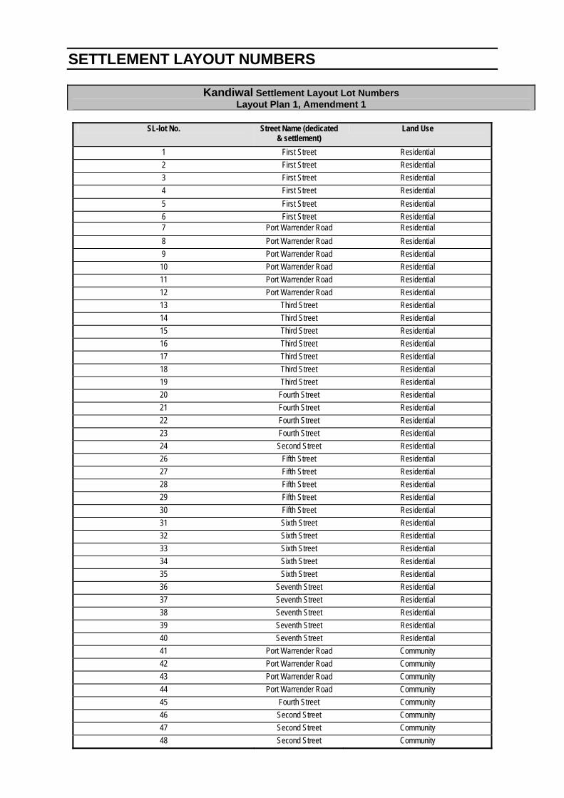
SETTLEMENT LAYOUT NUMBERS
Kandiwal Settlement Layout Lot Numbers Layout Plan 1, Amendment 1
SL-lot No. Street Name (dedicated
& settlement) Land Use
1 First Street Residential
2 First Street Residential
3 First Street Residential
4 First Street Residential
5 First Street Residential
6 First Street Residential 7 Port Warrender Road Residential
8 Port Warrender Road Residential
9 Port Warrender Road Residential
10 Port Warrender Road Residential
11 Port Warrender Road Residential
12 Port Warrender Road Residential
13 Third Street Residential
14 Third Street Residential
15 Third Street Residential
16 Third Street Residential
17 Third Street Residential
18 Third Street Residential
19 Third Street Residential
20 Fourth Street Residential
21 Fourth Street Residential
22 Fourth Street Residential
23 Fourth Street Residential
24 Second Street Residential
26 Fifth Street Residential
27 Fifth Street Residential
28 Fifth Street Residential
29 Fifth Street Residential
30 Fifth Street Residential
31 Sixth Street Residential
32 Sixth Street Residential
33 Sixth Street Residential
34 Sixth Street Residential
35 Sixth Street Residential
36 Seventh Street Residential
37 Seventh Street Residential
38 Seventh Street Residential
39 Seventh Street Residential
40 Seventh Street Residential
41 Port Warrender Road Community
42 Port Warrender Road Community
43 Port Warrender Road Community
44 Port Warrender Road Community
45 Fourth Street Community
46 Second Street Community
47 Second Street Community
48 Second Street Community

SL-lot No. Street Name (dedicated & settlement)
Land Use
49 Port Warrender Road Commercial
50 Port Warrender Road Public Utility
51 Fourth Street Public Utility
53 Port Warrender Road Industrial
60 Port Warrender Road Community
65 - Public Utility
108 - Rural
305 - Commercial
306 - Public Utility
307 - Public Utility