Embed Size (px)
Citation preview
Science Team meeting #22JAXA TKSC/RESTEC HQ, Tsukuba/Tokyo, February 2016
K&C 22, Phase 3 and 4:
Characterization of wetlands in Ethiopia and Sudan
Lisa‐Maria RebeloInternational Water Management Institute (IWMI)Regional office for South East Asia and the Mekong
Vientiane, LAOS


Investigate the use of multi‐source data (optical and SAR imagery, terrain data, vegetation and wetness indices, field data) for characterizing and mapping wetlands in the Ethiopian Highlands
Evaluate the effectiveness of the Random Forest (RF) classifier for mapping broad wetland types in comparison to Maximum Likelihood and Neural Network classifiers
Develop an understanding of the dynamics of wetland functioning in tropical ecosystems and their response and adaptation to natural factors and anthropogenic factors
Data Type Data Details Year and Season
ALOS‐PALSAR
Fine Beam Single mode (FBS), HH, 12.5 m , level 1.5
FB Dual mode, HH and HV, 12.5 m, level 1.5
2009, 2010, 2011 – Dry
2008, 2009, 2010 –Wet
ALOS‐AVNIR 4 bands (B,G,R,NIR) 2009 – Dry
ALOS‐PRISM
DSM 5 m res. ALOS‐PRISM
SRTM DEM 90 m res.
Landsat TM‐5
6 bands (B,G,R,NIR, MIR5,MIR7), 30 m res.
2010 – Dry
2009, 2010, 2011 –Wet
Terrain Derivatives
Slope, Plan convexity,Min. curvature, etc.
Slope
Image Textures
Mean, Variance, Entropy, etc.
Landsat Variance:
Vegetation/ Water Indices
NDVI, EVI, EVI2, WDVI, etc.
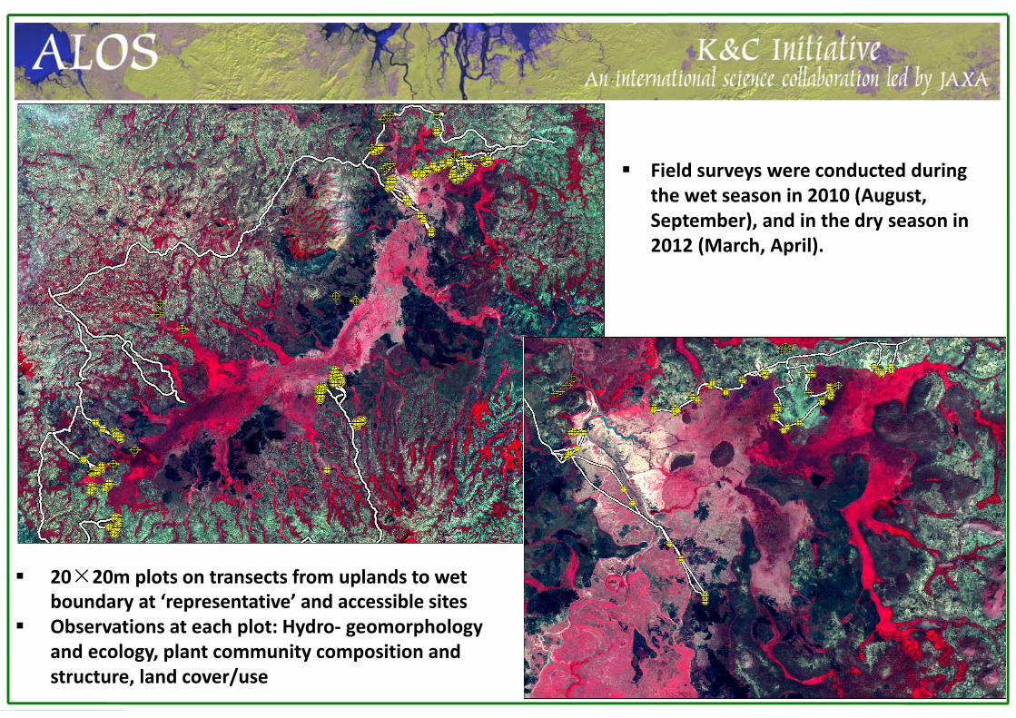
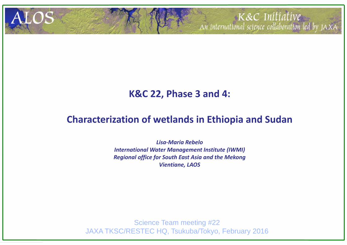
Field surveys were conducted during the wet season in 2010 (August, September), and in the dry season in 2012 (March, April).
20×20m plots on transects from uplands to wet boundary at ‘representative’ and accessible sites
Observations at each plot: Hydro‐ geomorphology and ecology, plant community composition and structure, land cover/use

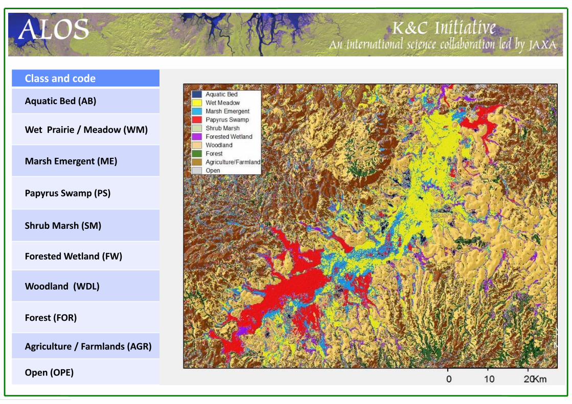
Class and code Description
Aquatic Bed (AB) Open water, ponds and streams, permanent or seasonal
Wet Prairie / Meadow (WM) Meadows dominated by Graminoids (including C4 grasses), mixed withherbaceous species; may be difficult to distinguish from ‘Sedge Meadow’
Marsh Emergent (ME) Marsh areas dominated by sedges, medium to tall emergent communities, found in association with area dominated by tall, dense grasses
Papyrus Swamp (PS) Swamp dominated by Papyrus cyperus, a 3‐4m tall plant forming dense permanent extensive cover, found on waterlogged soils or floating mats.
Shrub Marsh (SM) Area dominated by medium to tall Fabaceae shrubs forming mainly small patches found associated with Papyrus Swamp
Forested Wetland (FW) Seasonally inundated Syzygium g. / Ficus spp. forest
Woodland (WDL) Combretum c. /Terminalia b. woodland; Coffea arabica shrubs found in denser forested areas found along wetland boundaries
Forest (FOR) Densely forested area, small patches mainly found in ‘remote areas’, i.e., higher altitudes (mountain tops), steep slopes, away from inhabited areas
Agriculture / Farmlands (AGR) Area of crops dominated by maize/sorghum , guizotia v. (herbaceous), and tef grass
Open (OPE) Open area dominated by bare land with sparse short grass

A global inventory of permanent and temporary surface waters at a spatial resolution of the order of 1 km has yet to be achieved with current technologies and represents a “grand challenge” of the earth monitoring sciences
Existing estimates of global wetland extents are highly dissimilar, there is a lack of baseline information using consistent, coherent and current observations
Global Inundation Extent from Multi‐Satellites (GIEMS) measurements are expressed as the inundated fraction of an equal area grid of 27.8‐km cell resolution at the monthly time‐scale over a multi‐year time period
o suitable for global hydrological modeling and surface gas exchange modelso too coarse for hydro‐ecological applications that require discriminating between individual and
distinct inundation boundaries
The process of downscaling, i.e. the conversion of coarse remote sensing data to a finer spatial resolution by means of spatial disaggregation, represents a promising prospect for producing higher resolution global surface water maps

A globally applicable method for downscaling coarse resolution surface water estimates
Fluet‐Chouinard, E., B. Lehner, L.‐M. Rebelo, et al., 2015. Development of a global inundation map at high spatial resolution from topographic downscaling of coarse scale remote sensing data, Remote Sensing of Environment 158:348‐361
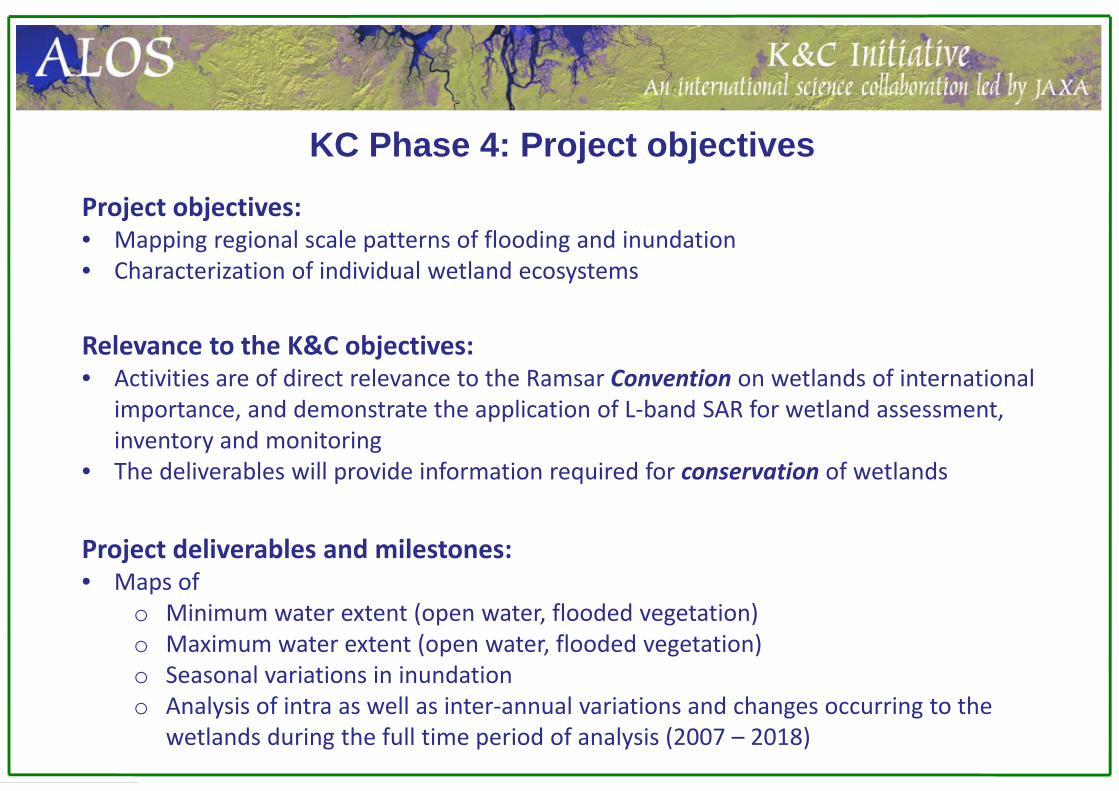
KC Phase 4: Project objectivesProject objectives:• Mapping regional scale patterns of flooding and inundation • Characterization of individual wetland ecosystems
Relevance to the K&C objectives:• Activities are of direct relevance to the Ramsar Convention on wetlands of international
importance, and demonstrate the application of L‐band SAR for wetland assessment, inventory and monitoring
• The deliverables will provide information required for conservation of wetlands
Project deliverables and milestones:• Maps of
o Minimum water extent (open water, flooded vegetation)o Maximum water extent (open water, flooded vegetation)o Seasonal variations in inundationo Analysis of intra as well as inter‐annual variations and changes occurring to the
wetlands during the full time period of analysis (2007 – 2018)
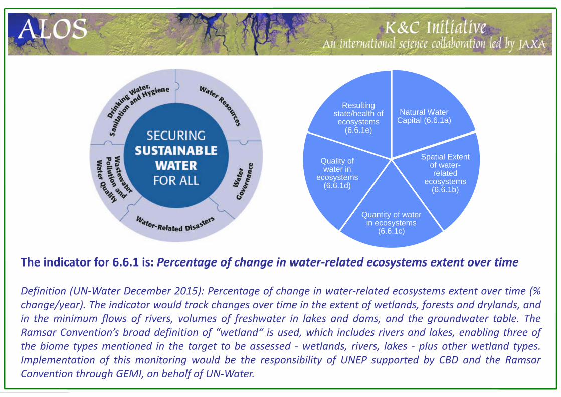
The indicator for 6.6.1 is: Percentage of change in water‐related ecosystems extent over time
Definition (UN‐Water December 2015): Percentage of change in water‐related ecosystems extent over time (%change/year). The indicator would track changes over time in the extent of wetlands, forests and drylands, andin the minimum flows of rivers, volumes of freshwater in lakes and dams, and the groundwater table. TheRamsar Convention’s broad definition of “wetland“ is used, which includes rivers and lakes, enabling three ofthe biome types mentioned in the target to be assessed ‐ wetlands, rivers, lakes ‐ plus other wetland types.Implementation of this monitoring would be the responsibility of UNEP supported by CBD and the RamsarConvention through GEMI, on behalf of UN‐Water.
Natural Water Capital (6.6.1a)
Spatial Extent of water-related
ecosystems (6.6.1b)
Quantity of water in ecosystems
(6.6.1c)
Quality of water in
ecosystems (6.6.1d)
Resulting state/health of ecosystems
(6.6.1e)

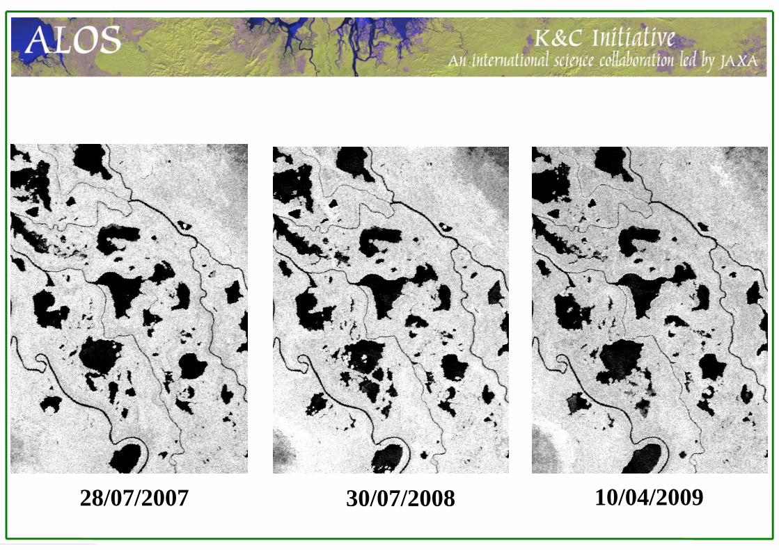
28/07/2007 30/07/2008 10/04/2009
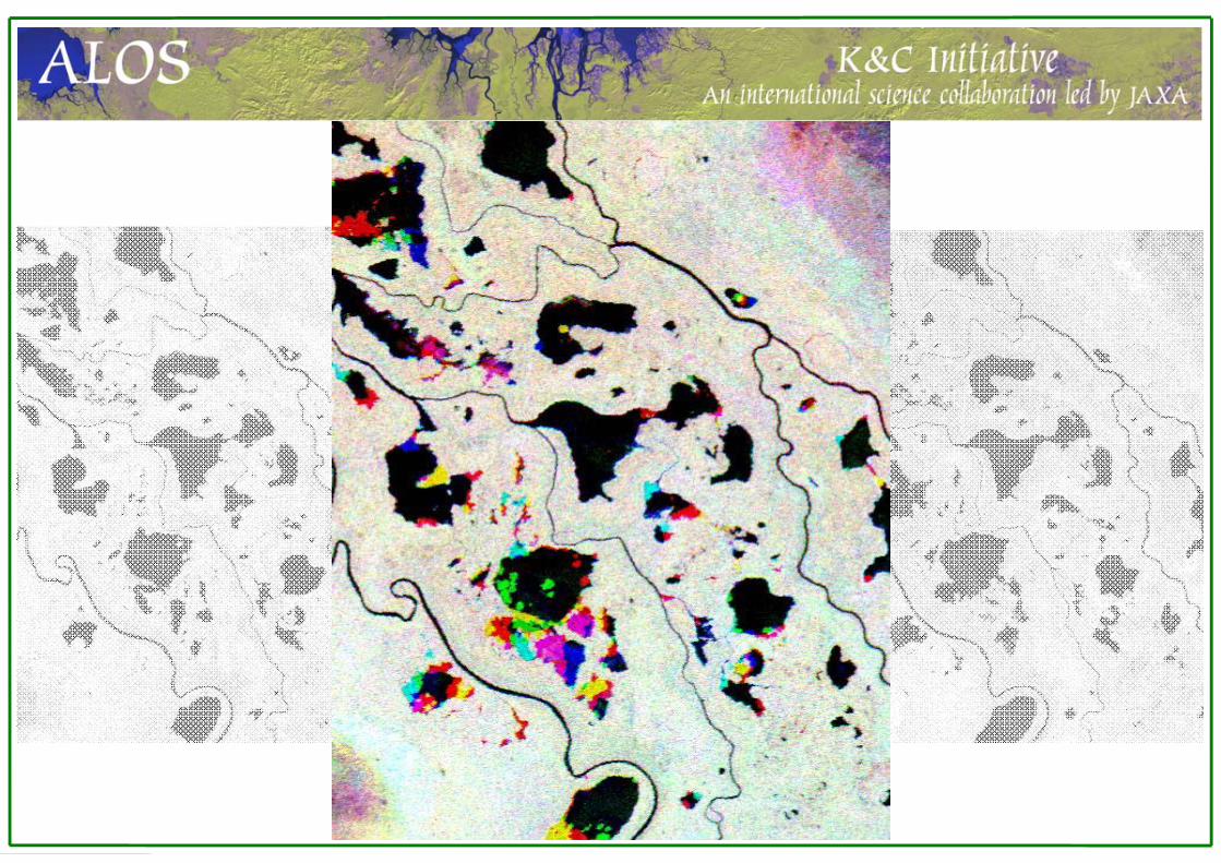
16/05/200830/07/2008
Thank you!


![11.[6 16]characterization of soils at angacha district in southern ethiopia](https://img.pdfslide.us/doc/110x75/557d21bed8b42a3d3d8b53a7/116-16characterization-of-soils-at-angacha-district-in-southern-ethiopia.jpg)