Embed Size (px)
Citation preview

Issue: 1 Rev A 8/17/2017
K-Mobile User Manual for Smartphones

K-MATIC | 1
Legal Notices K-MATIC
Blundellsands House,
34-44 Mersey View,
Brighton le Sands,
Liverpool,
L22 6QB, UK
www.K-Matic.com
Copyright and trademarks © 2017, K-MATIC Limited. All rights reserved.
K-MATIC & the K logo are trademarks of K-MATIC Limited, registered in the UK and in other countries.
Microsoft, Access, SQL Server, and Windows, and Windows are registered trademarks or trademarks of Microsoft Corporation in the United States and/or other countries.
Bluetooth is the registered trademark of Bluetooth SIG, Inc.
Trimble is the registered trademark of Trimble Navigation Limited.
All other trademarks are the property of their respective owners.

K-MATIC | 2
Table of Contents Copyright and trademarks .......................................................................................... 1
K-Mobile Overview ..................................................................................................... 3
K-Mobile – Job Manager ............................................................................................ 5
K-Mobile – Map View ................................................................................................. 7
K-Mobile – Satellite Information ............................................................................... 10
K-Mobile – About ...................................................................................................... 12
K-Mobile – Sync ....................................................................................................... 13
K-Mobile – Record Now ........................................................................................... 14
_GEOM (Feature Geometry) ................................................................................. 14
K-Mobile – Data View ............................................................................................... 20
K-Mobile – Settings .................................................................................................. 21
K-Mobile – Power Down ........................................................................................... 27

K-MATIC | 3
K-Mobile Overview
K-Mobile has a Home page from which everything is accessed:
K-Mobile Title Bar: Displays the version number of K-Mobile, which may be required for technical support issues.
Job Manager: Is where your jobs (assignments) are managed; creation of new jobs, opening existing jobs and finishing jobs. On the Home page the current open (active) job name is displayed and the number of ongoing jobs; jobs that have not yet been finished.
Map View: Displays all the features in the currently open job against a background map. In the Map View features can be navigated to, edited and deleted as well as created.
Satellite Information: Displays the current status of the GNSS position.
About: Displays the Company Name and Current User Name and is where you can check for software updates.
Sync: Is where K-Mobile downloads the latest data collection forms and transfers jobs to or receives jobs and assignments from K-Portal or K-Console.

K-MATIC | 4
Record Now: Starts the process of creating a new feature (based on your selected form) at your current location and prompts you to fill out the information and attributes required for the selected feature. Data View: Lists all the features recorded in the current job. The features can be filtered by feature or attribute, edited and viewed on a map. Settings: Is where the K-Mobile configuration options, collection schema, workflows, GNSS and coordinate projection settings and external sensor input options are defined. Power Down: Shuts down the K-Mobile application.

K-MATIC | 5
K-Mobile – Job Manager Is where your jobs (assignments) are managed; creating new jobs, opening existing jobs and finishing jobs. Only one job can be open in K-Mobile at time, the name of the open job is displayed in the Job Manager section on the Home page. All other jobs that are not yet finished are listed in the Job Manager and termed as ongoing. The number of which can also be seen in the Job Manager section on the Home page.
Toolbox The toolbox has three options to help manage jobs: Before deleting jobs make sure you have finished with them and transferred them to K-Portal or K-Console as there is no recovery available for deleted jobs.
Show all/ Hide finished
Toggles between showing all jobs (including the finished ones) and just showing the ongoing jobs (those not finished).
Delete job Deletes the selected job. A no/yes prompt appears for cancelation or confirmation.

K-MATIC | 6
Delete all finished
Deletes all finished jobs. A no/yes prompt appears for cancelation or confirmation.
Finish Select a job from the list and tap Finish to finish the job. A no/yes prompt appears for cancelation or confirmation. Finish enables the Job Manager screen to be tidied using the Show All/ Hide Finished filter. A finished job can be opened again.
New Job Opens the Jobcard page with the following set fields: The form Jobcard.jsn (…K-Matic/ Forms) can be edited if required in the K-Portal or K-Console Form Designer (and transferred to K-Mobile like a form) to expand on or change these fields:
Name Type in the job name.
User
Filled in automatically. Tap the field to change it if required.
DateCreated
Filled in automatically. Tap the field to change it if required.
TimeCreated
Filled in automatically. Tap the field to change it if required.
To cancel out of the new job creation.
To accept the creation of the new job and return to the Job Manager. Where the newly created job can be selected and opened.
Open Opens the selected job and makes it active. Opening a job closes the Job Manager and returns to the Home page. A job has to be selected and opened to return to the Home page.

K-MATIC | 7
K-Mobile – Map View
Displays all the features in the currently open job against a background map. In the Map View features can be navigated to, edited and deleted as well as created. The Map View generally centres on the users current GNSS position. The user can pan around the map to review the surrounding area by dragging the map in the required direction. Note: Panning the map and zooming to a feature (from the Data View) turns off the GNSS centring. To enable it again tap GNSS centring.
Current GNSS position.
Map sync If moving to a new area, where the background map overlays have not previously been downloaded, once in the area tap Map Sync to synchronise and download the maps.
Tap to return to the Map View whilst the map sync continues in the background.
Select to cancel the map sync. A no/yes prompt appears for cancelation or confirmation.
GNSS recentre
As the smartphone moves the map does not automatically reposition to keep the current GNSS position in the centre of the map. Tap to recentre the map on the current GNSS position.

K-MATIC | 8
GNSS centering
Tap to turn on GNSS centring and recentre the map on the current GNSS position.
Zoom out
Tap to zoom out.
Zoom in
Tap to zoom in.
Pan Tap and drag with your finger or pen.
Scale The ground distance displayed by the map across the
width of the screen.
GNSS precision
Estimated precision of the GNSS position.
Toolbox The toolbox has five options to help manage the map view and in the Feature Geometry View is accessed
from .
Map overlays
Opens the Map overlays, where all available map overlays are displayed. Tap () the matrix box for the level (scale) the overlay should be displayed at. An overlay is displayed based on the Zoom Level (Street - National). Street being the largest scale (highest zoom level) and National being the smallest scale (lowest zoom level).
Cancel Tap to exit and discard changes.
Zoom Open up an additional layers selection box for the map if available.
Up Select an overlay and tap Up to move it up one in the list.
Down Select an overlay and tap Down to move it down one in the list.

K-MATIC | 9
OK Tap to accept the changes
and return to the Map View.
Delete feature
Deletes the selected feature and returns to the Home page. There is no no/yes prompt the feature is deleted immediately.
Navigation Select a feature and Navigation to choose between a navigational direction arrow on the Map View or Google Maps; to start guidance and directions to that feature from your current location. If using the navigational arrow turn it off by selecting Toolbox/ Navigation.
Select from background
Toggles the ability to select a feature from the background map. When it is disabled the message ‘Background selection disabled’ briefly appears.
Zoom job extents
Zoom to the extents of the features in the open job.
Record Starts the process of creating a new feature (based on your selected form) at your current location and prompts you to fill out the information and attributes required for the selected feature. For further information refer to the Record Now section.
Edit Select a feature and tap Edit to open the data form and make changes to the attributes. For further information refer to the Record Now section.
Home
Tap to return to the Home page.

K-MATIC | 10
K-Mobile – Satellite Information Displays the current status of the GNSS position.
If no position fix is available it is red and displays NO Fix with 0 or 1 satellites (Sats).
If a position fix is available and within the target accuracy in Settings it is blue and displays the precision (repeatability) of the position along with the number of satellites (Sats) used to compute the position.

K-MATIC | 11
If a position fix is available and larger than the target accuracy in Settings it is orange. If Record Now is attempted when the GNSS position does not meet the target accuracy this warning message appears however the feature and geometry can still be recorded if required.
Tapping on the Satellite Information provides additional information such as coordinates and speed, bearing. Note: The accuracy is dependent on hardware purchased to run K-Mobile on. From high accuracy handhelds (cm), to mapping based devices (3-5m) and smartphone GNSS accuracy, which is ~10m. There is no proper statistical quality control from a smartphone GNSS and the accuracy can be significantly worse or better than 10m, even if the GNSS quality indicates it is 4m as this is an indicator of the repeatability (precision) of a position, which might be repeatable to within 4m, but may not be very accurate in relation to the ‘true’ coordinate therefore may not be located in the expected location on the background map. The accuracy of a smart phone is also affect by the smart phone location settings, which may vary from phone to phone: High accuracy: GNSS, Wi-Fi and mobile networks Battery Saving: WiFi and mobile networks Device only: GNSS only.
Tap to return to the Home page.

K-MATIC | 12
K-Mobile – About
Displays the Company Name and Current User Name and is where you can check for software updates. Check for updates
Opens up the download page, where the latest version can be downloaded. It does not download and install automatically. Tip: Check the K-Mobile version number in the Home page title bar prior to checking for updates.
Ok Returns to the Home page.

K-MATIC | 13
K-Mobile – Sync
Sync is where K-Mobile downloads the latest data collection forms and transfers jobs to or receives jobs and assignments from K-Portal or K-Console wirelessly via K-Cloud. All data transfers from/ to K-Mobile are manual, however they can be automatically picked up or sent to K-Cloud by K-Portal or K-Console. For further information refer to the Settings section and the K-Portal or K-Console user manuals. Note: When the smartphone and PC connect to K-Cloud wirelessly. Assignments/ jobs are transferred via K-Cloud and are stored on the K-Cloud server until retrieved at which point they are no longer stored on K-Cloud.
Send jobs Tap to manually transfer any jobs with changes in them or the changes from the currently open job, depending on the Settings, to K-Cloud.
Receive jobs Tap to manually receive any new jobs (assignments) assigned to your smartphone from K-Cloud.
Update forms Tap to update the forms to the latest version on K-Cloud.
Home
Tap to return to the Home page.
K-MATIC | 14
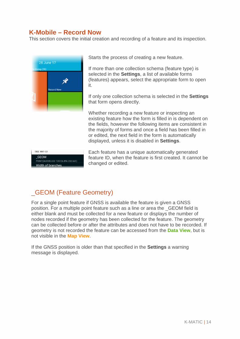
K-Mobile – Record Now This section covers the initial creation and recording of a feature and its inspection.
Starts the process of creating a new feature. If more than one collection schema (feature type) is selected in the Settings, a list of available forms (features) appears, select the appropriate form to open it. If only one collection schema is selected in the Settings that form opens directly. Whether recording a new feature or inspecting an existing feature how the form is filled in is dependent on the fields, however the following items are consistent in the majority of forms and once a field has been filled in or edited, the next field in the form is automatically displayed, unless it is disabled in Settings.
Each feature has a unique automatically generated feature ID, when the feature is first created. It cannot be changed or edited.
_GEOM (Feature Geometry) For a single point feature if GNSS is available the feature is given a GNSS position. For a multiple point feature such as a line or area the _GEOM field is either blank and must be collected for a new feature or displays the number of nodes recorded if the geometry has been collected for the feature. The geometry can be collected before or after the attributes and does not have to be recorded. If geometry is not recorded the feature can be accessed from the Data View, but is not visible in the Map View. If the GNSS position is older than that specified in the Settings a warning message is displayed.

K-MATIC | 15
_GEOM: Single point feature: To change the position tap the _GEOM field to open the Feature Geometry View, which is based on the Map View. The Map View controls are in the top tool bar, for further information refer to the Map View section. The point feature position controls are in the bottom tool bar.
Tap the map to select the location required or tap to change the location to the current GNSS position.
Current GNSS position.
Current feature location.
Tap to cancel out of the Feature Geometry View, discard any changes and return to the form. A no/yes prompt appears for cancelation or confirmation.
To accept the new position location, whether it is GNSS or manually selected and return to the form.

K-MATIC | 16
_GEOM: Multiple point features: line or area features need the individual nodes (points) making up the feature recording. Tap the _GEOM field to access the Feature Geometry View, which is based on the Map View. The Map View controls are in the top tool bar, for further information refer to the Map View section. The line and area feature collection controls are in the bottom tool bar. A line or area feature can either be recorded automatically as the smartphone moves; so where the field user walks around the feature a node (point) is collected at a minimum distance interval defined in the Settings or the field user can walk the feature and pause to stop at appropriate locations, such as a change in direction and record a node of the feature manually. By default the capture of lines and areas uses manual nodes, opposed to automatically.
To record a line/ area using nodes, move to the first point of the feature:
Tap to record the node. A yellow square appears where it is. Move to the second point of the feature and tap again to record the point. A green line joins the points.
To record a line/ area automatically, move to the start of the feature:
Tap the Toolbox and Auto record start to start recording and walk the feature. If the automatic position recording needs pausing, for example to walk round an obstacle from the Toolbox tap Auto record pause and when ready tap Auto record start to start it again.
The different recording techniques can be mixed within a feature and the map can also be tapped to add in a manual position.
Toolbox/ Cancel Tap to cancel out of the Feature Geometry View, discard any changes and return to the form. A no/yes prompt appears for cancelation or confirmation.
Toolbox/ Suspend linear feature
Whilst recording a line/ area feature, it may make sense to record additional features whilst close by; Suspend linear feature allows this and returns to the Home page when tapped, so another feature can be

K-MATIC | 17
recorded/ edited or other action taken. The next time the feature type that was suspended is selected from the Record Now menu a prompt appears: Continue with xxxx feature? Continue opens the feature and Cancel opens up a new form for that feature. If cancelled the feature can still be edited and the geometry recording continued via the Map View or Data View.
Tap to delete the last recorded node and repeat as required. No confirmation message is provided, the delete is instant. There is no redo option. If recording automatically pause first before deleting.
Tap to end the geometry recording, save it and return back to the form and continue adding/ editing the attribute information.
When an area features geometry recording is finished the last point is joined up to the first and if there are any numeric calculated fields such as length or area, the values are automatically computed and entered to the form. Numeric and Text fields – manual entry
Tap field to enter in value/ description as required. If the value entered does not conform to the restrictions set in the K-Portal or K-Console Form Designer, such as number of decimal palaces and length permitted an error message displays and the field value is not accepted until it meets the format permitted.
Numberic fields – calculated or external sensor input entry
Any automatically calculated numeric fields such as length and area have their values automatically entered to fields as soon as they are available. Any fields requiring input from an external sensor work on a trigger from the sensor passing the information to K-Mobile once the field in selected in K-Mobile.
Photograph fields Tap to open the photograph field, which opens to show an existing photograph if one exists or a blank photo. The controls are:
Open camera: opens the smartphones camera application.
Cancel: to delete the photograph and return to the form.
Edit: to mark up the photograph with freehand line work. The photo can only be marked up immediately after it has been taken. Additional line work cannot be added

K-MATIC | 18
once it has been saved as part of the feature and the form is displayed again.
Cancel: to remove the line work that has not yet been saved and return to the form. If previous line work has been accepted, that cannot be removed as it has been written to the image.
Accept: to save the line work, write it to image and return to the photograph page. Once accepted the line work cannot be removed.
Remove: to remove the line work that has not yet been saved and remain on the edit photograph page. If previous line work has been accepted that cannot be removed as it has been written to the image.
Accept: to save photograph and return to the form, where the name of the photograph is entered in the field. Note: the file name of the photograph is based on the unique automatically generated feature ID and the photographs are stored in the folder …K-Matic/ MobileData/ JobName/ UniqueID-photo.jpg.
Drawing/ Sketch fields Tap to open the sketch pad. The controls are:
Clear To remove any sketch work on the pad.
Save To save the sketch and return to the form. Note: the file name of the sketch is based on the unique automatically generated feature ID and the sketches are stored in the folder …K-Matic/ MobileData/ JobName/ UniqueID-Sketch Pad.jpg.
Cancel To delete the sketch and return to the form.

K-MATIC | 19
Data and Time fields There are two types of time/ date fields; Collected and Updated. Both are automatically filled in based on the smartphone settings. If the field has been set to read only in the K-Portal or K-Console Form Designer, this field cannot be edited. Collected fields are only filled in when a feature is first created. Updated fields are automatically updated whenever the feature is inspected. To change the time/ date values in the form tap the field to display the available options of: Select current time and/or date: selects from the smartphone. Select time and/or date: manual selection from the clock or calendar.
Mandatory Mandatory fields must be completed before the feature can be saved. If a mandatory field has not been filled in the feature is not saved and a message displays indicating the field that needs data entry.
Read only fields Any fields set as read only in the K-Portal or K-Console Form Designer cannot be edited when in inspection workflow, they can be edited when in collection workflow, as defined in Settings.
Cancel To exit out of the new feature form and not save the new feature or any changes made to an existing feature. A no/yes prompt appears for cancelation or confirmation.
Accept To save the new feature or any changes made to an existing feature and return to the; Home page, Map View or Data View, depending how the form was accessed.

K-MATIC | 20
K-Mobile – Data View
The Data View lists all the features recorded in the current job, including those without geometry (positions). The features can be filtered by feature or attribute, edited and viewed on a map. The information provided in the list for each feature by default is its: Feature Type Feature ID Date and time of initial data collection.
Three additional attributes can be displayed by setting it up for each feature in the K-Portal or K-Console Form Designer; Data view labels field. For further information refer to the Record Now section.
Toolbox Filter by feature
Select to display a list of feature types (forms). Select one to display in the Data List and tap OK.
Filter by attribute
Select to open a Filter Search, enter in the attribute name or value and tap OK.
To reset either of the filters and display all features, tap Home and access the Data View again.
Map Select a feature and tap to open the Map View centred on the selected feature.
Edit Select a feature and tap Edit to open the data form and make changes to the attributes. For further information refer to the Record Now section.
Home
Tap to return to the Home page.

K-MATIC | 21
K-Mobile – Settings
Settings is where the K-Mobile configuration options, collection schema, workflows, GNSS and coordinate projection settings and external sensor input options are defined. For all items, tap to enter and:
Tap to exit out of the setting and not save any changes made to either the individual settings or all settings, depending on location. Exiting from an individual setting does not bring up a prompt, however when exiting from all settings a no/yes prompt appears for cancelation or confirmation.
Tap to save any changes made to either the individual settings or all settings, depending on location.
Company name Needs entering once, when K-Mobile is first started. It needs to be exactly the same Company Name as provided via e-mail from KOREC and entered into K-Portal or K-Console. These must be the same if this smartphone is to receive and transfer data to and from K-Portal or K-Console via K-Cloud. K-Mobile must be restarted for this change to take effect.
Friendly device ID Enter in a unique ID in accordance with your company guidelines.
Current user Enter in your unique User Name, this should be the same one entered in to K-Portal or K-Console under Settings/ Users/ User Management.
Current collection schema
Lists all available forms (features). Select the form(s) required for selection in the Record Now list. This selection can be changed at any point and is not tied to a job.
Preferred workflow Collection: Collects one record per feature. Inspection: Collects the updated and additional records about a feature for each inspection. These additional records are not visible as independent records, just the latest information about the feature is.

K-MATIC | 22
Admin Section Admin email
Currently not required for K-Mobile as it is defined in K-Portal or K-Console.
Pin entry required?
True: K-Mobile asks for a PIN after login. False: K-Mobile does not ask for a PIN after login (default). The pin cannot be changed and is generated in K-Portal or K-Console using an algorithm to create a PIN code from the number and letters in the user and company names. If the user has forgotten their PIN it can always be retrieved from K-Portal or K-Console in Settings/ Users/ User Management.
Generate full GUIDs?
GUID: Globally unique identifier. When a feature is created a unique ID is created and assigned to it. True: Creates a 32 digit globally unique ID throughout any K-MATIC software. False: Creates a 6 digit unique ID in your company setup of K-Mobile and K-Portal/ K-Console (default).
Office sync method
Via Cloud-Complete Job: When synchronising via the cloud the entire job is synchronised (default). Via Cloud-Change only: When synchronising via the cloud only the new features or features with edits from a job are synchronised. This creates a job file of the same name, but different 4 digit identifier. Most used when in inspection workflow.
Auto queue job on job change
True: Automatically queues the previously active job for transfer to K-Cloud when the active job changes (default). False: Only transfers the currently open job to K-Cloud when synchronising.
Job creation control
User Managed: User can create a new job when they like (default). New week/ new job: Automatically starts a new job at the start of a new week. New day/ new job: Automatically starts a new job at the start of a new day.

K-MATIC | 23
Tracking server
Where the location tracking data is sent to. This is automatically configured based on the company name. If it needs to be different it is configured during the setup of an enterprise system.
Tracking
interval The time between the positions of the smartphone being sent to the tracking server. Options are: Off, 1, 5, 15 (default), 30, 60 minutes. Turn off if no continuous internet connectivity.
Tracking audio
Primarily used in lone worker situations: Enabled: Records any audio and transmits it to the tracking server at the defined tracking interval. Disabled: Does not record any audio (default).
Lone worker checkin
On: If lone worker is enabled a message appears periodically requesting the lone worked to confirm they are ok. Currently available on Windows Mobile devices only. Off: (default).
Lone worker email recipient
If lone worker is enabled, an alarm button is established on the device. The alarm button is a defined hardware key and currently available on Windows Mobile devices only. Enter in the email address of the person to receive alerts including, the user name and last position trigged, from the activation of this button by a lone worker.
Lone worker SMS recipient
If lone worker is enabled, an alarm button is established on the device. Enter in the mobile phone number of the person to receive text alerts including, the user name and last position trigged, from the activation of this button by a lone worker.
Prevent user deleting records
Yes: Stops the user deleting features and jobs. No: Allows the user to delete features and jobs (default).

K-MATIC | 24
OS maps location
External: SD Card Internal: On Device The path on an Android device would be My Files/ Internal Storage/ K-Matic/ OS Data internally and My Files/ SD Card/ Android/ data/ com.Kmatic.Kmobile/files/ OS Data external, this folder is created automatically.
Duplicate parent geometry for inspections
Yes: Duplicates the feature geometry (position) of the original record in the inspection record so it can be updated/ edited if required. No: Maintains the feature geometry (position) of the original record (default).
Allow the device to be wiped remotely
Yes: Allows jobs to be remotely (wirelessly) deleted from the device available using K-Portal only. No: Jobs can only be deleted on the device directly (default).
Display dynamic length of feature
Yes: The length of the line or area is displayed in the bottom left corner of the Feature Geometry View and updated dynamically as additional nodes are added. No: The length is not displayed (default).
Record node position of linear features
Yes: Records the individual nodes as data records in their own right which are given the suffix of FeatureType_Line_Node in the Data View and displayed as red points in the Map View. No: Records the nodes as part of the feature only (default).
GNSS Section GNSS antenna height (TH)
Enter in the true height (height from ground to antenna phase centre) of the GNSS antenna in metres. If using a smartphone it is not essential and for receivers with 3-5 metres of precision, entering it approximately is adequate, especially if the receiver/ GNSS antenna is held in the hand. For centimetre accuracy though the antenna should be on a pole and the height should be entered as accurately as possible.

K-MATIC | 25
Coordinate projection
Coordinate systems options are: UKOSTN Ireland 1975 ITM UTM Select the correct one for your location and background maps.
GNSS marker style
Standard: (default). Full screen: Not currently available.
GNSS enabled
Yes: Turns on GNSS (default). No: Turns off GNSS. GNSS if available is still tracked, just not used. K-Mobile needs restarting for this change to take effect.
GNSS driver
Controls the connection between K-Mobile and the GNSS receiver: Standard: Select if using a smartphone. TrimbleSDK: Select if using a Trimble® GNSS receiver.
Target GNSS accuracy
Enter in the accuracy requirement in metres for the data being collected. It needs to be a realistic value for your GNSS receiver. For example if 2m is entered with a smart phone, the warning message: “Current accuracy is greater than target accuracy” is likely to appear constantly. For further information refer to the Satellite Information section.
Photo Section Specify field name for photo prefix
Enter in a prefix for the naming of photographs, leave it blank to accept the default naming based on the unique automatically generated feature ID.
Transmit thumbnail photos
Select what size photographs to transmit to K-Cloud. Consider the type of internet connection available for the synchronisation of data. Options are: Original 640 320 (default) 160

K-MATIC | 26
Advanced Section Laser com port
Specify the smartphones com port to use for connection to the external laser device. Options are: Off (default) Com 1 Com 2 …. Com 9.
Laser mode
For use with Trimble Geo 7 series handhelds only, not smartphone devices.
External Bluetooth device com port
Specify the com port for use with any BluetoothTM external sensor. Options are: Off (default) Com 1 Com 2 …. Com 9.
Min distance between auto recorded nodes
Enter the minimum distance in metres the GNSS has to leave before recording another node in automatic mode when collecting the geometry of a line or area feature.
Auto advanced field enter
When filling in a form (recording a feature) after the first field is selected, a value entered and saved, the user can either automatically advance to the next field: True (default) or go back to the form: False.
Extent of WMS map request
In the Map View when map sync is used, the maps are downloaded based on the current GNSS position and the extent value defined here, in square metres. Options are: 1000 2000 3000 4000 5000 (default)

K-MATIC | 27
K-Mobile – Power Down
Tap to shut down the K-Mobile application. A no/yes prompt appears for cancelation or confirmation. It does not power down the smartphone.