Embed Size (px)
Citation preview
R""E EIVE. MAR 0 4 2003
Nova. ScotiaUtility and Review Board
JUST BOUNDARIES
Recommendations for
Effective Representation for the People of Nova Scotia
The Final Report of the
Nova Scotia Provincial Electoral
Boundaries Commission
(August, 2002)
Dr. J. Colin DoddsChair
Provincial Electoral Boundaries Commission
ECEIV£MAr? 0 4 2003
Nov""s .'Vtif OL Cotlatty and Review Board
JUST BOUNDARIES
Recommendations for
Effective Representation for the People of Nova Scotia
The Final Report of the
Nova Scotia Provincial Electoral
Boundaries Commission
(August, 2002)
Dr. J. Colin DoddsChair
Provincial Electoral Boundaries Commission
Third Floor, Summit Place160I Lower Water StreetPO Box 1543 CRGHalifax, Nova ScotiaCanada B31 2Y3
Bus: 902 424-3725Fax: 902 424-5872Email: [email protected]
Our File Number:
August 30, 2002
The Honourable Michael BakerAttorney GeneralProvince ofNova ScotiaHalifax, Nova Scotia
Dear Mr. Baker,
Dr. Andrew Molloy
'[ fc_ .. /( ('v--d.:U( 1r.....~{)~Ms. Candace Thomas
~hr~u--~Mr. Ian Spencer
Mrs. Anne L. Dillman
We are pleased to submit the Final Report of the Nova Scotia Provincial ElectoralBoundaries Commission. This Report contains the Commission's unanimous recommendationsfor changes to the Province's electoral boundaries for consideration by the Legislative Assembly
ova Scotia.
M~~rvJ'--
~F.Kitz ~Q~{!).L?~Dr. Ronald G. Landes
D '. J. Colin DoddsChair
CitN-cib~
~ Printed on paper that~ contains n:cycled fibre
PREFACE
If the public's response to the work of the Provincial Electoral Boundaries Commission is
any indication, then democracy is alive and well in Nova Scotia. The Commission wishes to
thank all those involved in the public consultation process for making their views known.
Commission members were particularly impressed by the individual Nova Scotians
unaffiliated with municipal units or political parties - who stepped forward and shared, with
passion and clarity, their particular visions of effective representation. While the public may not
agree with all recommendations, the Commission acknowledges it has been aided greatly in its
work by the public's interest and participation.
The Commission wishes to thank its support staff for their tremendous work: Mrs.
Loretta Bell, the Commission's bilingual secretary; Mr. Bill Cordy, the Commission's executive
assistant; and Mr. Lawrence O'Neil, the Commission's legal counsel. The Commission also
wishes to thank Ms. Colleen Devereaux for the additional secretarial support she provided to the
Commission.
The Provincial Electoral Boundaries Commission also acknowledges the following
people for their contribution to the electoral boundary redistribution process: the Honourable
Michael Baker, Chair and the other members of the Select Committee on Establishing an
Electoral Boundaries Commission of the Nova Scotia House of Assembly; the Honourable
Murray Scott, Speaker of the Nova Scotia House of Assembly; Mr. Dale Robbins, Director of
Administration, Office of the Speaker; Mr. Paul Read, Audio Technician and his staff at
Legislative Television; Ms. Janet Willwerth, Chief Electoral Officer (Acting) for the Province of
Nova Scotia; Mr. Tony Mathews, Mapping Services Co-ordinator, Nova Scotia Electoral Office;
Mr. Dennis Pilkey, Director, Nova Scotia Statistics Agency; and Mr. Brian MacLeod, Research
and Statistics Officer, Nova Scotia Statistics Agency.
1.
2.
3.
4.
5.
6.
7.
8.
TABLE OF CONTENTS
Introduction
Provincial Electoral Boundaries Commission:Structure and Operation
Terms of Reference
Analysis and Interpretation of the Terms of Reference
The Public .Consultation Process
Data Base and Data Analysis
The Entitlement System
A. Table One: County Population and County SeatEntitlements: 1991 and 2001
B. Table Two: 1991 and 2001 ConstituencyPopulation and Constituency Seat Entitlements forthe Current Electoral Districts
C. Table Three: 2001 Seat Entitlements by Electorsfor Current Electoral Districts
The Proposed Electoral Redistribution
A. Table Four: Proposed Provincial Electoral Districts2002: Electors and Seat Entitlements (sorted by seatentitlements, lowest to highest)
B. Table Five: Seat Entitlements, Actual and ProposedSeats by Region
C. List and Maps:1. Electoral Districts (list)2. Map: Industrial Cape Breton Inset3. Map: South Shore Area Inset4. Map: Guysborough - Eastern Shore Area Inset5. Map: Halifax Metro Area Inset6. Map: Cole Harbour Area Inset7. Map: Dartmouth Area Inset8. Map: Bedford Area Inset
1
3
5
6
15
19
............................. 22
............................. 25
............................. 28
............................. 31
............................. 33
............................. 34
............................. 39
............................. 5152535455565758
9.
10.
11.
9. Map: Halifax Peninsula Area Inset10. Map: Clayton Park and Fairview Areas Inset
Overview of Proposed Changes to theCurrent Electoral Districts
Descriptions for Proposed Boundaries
Implementing the Final Report and OtherRecommendations
5960
............................. 61
............................. 65
73
Appendices
A.B.C.D.E.F.G.H.
I
Information Package: Questions for Public CommentPublic Hearings Schedule (First Round)First Round ofPublic Hearings: PresentersFirst Round ofPublic Hearings: Written SubmissionsPublic Hearings Schedule (Second Round)Second Round ofPublic Hearings: PresentersSecond Round ofPublic Hearings: Written SubmissionsData Issues and Data Modelling
Table Six: 2001 Data for Recommended ElectoralDistricts
Queens County Data Revision
7879808183848690
9597
1
1: INTRODUCTION
One crucial component of a democratic system is the electoral process, encompassing
how individuals are recruited to run for office, how citizens vote and under what conditions, and
how those votes are counted and transformed into government authority - determined in a
parliamentary system by the number of seats won in the legislature. An often overlooked, yet
extremely important, aspect of the electoral process is how electoral boundaries for those;
constituencies are drawn and by whom.
A significant change in the drawing of electoral boundaries occurred in Nova Scotia in
1991, when, by an all-party agreement, an independent Electoral Boundaries Commission was
established to recommend new constituency boundaries for the Legislative Assembly of Nova
Scotia. A similar process was continued on November 30, 2001, when the Select Committee on
Establishing an Electoral Boundaries Commission of the Nova Scotia House of Assembly
established, for the second time, an independent Electoral Boundaries Commission for the
province.
While a number of provinces use an independent commission to restructure legislative
electoral districts or constituencies, Nova Scotia is unique in terms of the size of its two
commissions: six members in 1991-1992 and nine members in 2001-2002. These commissions
are the largest ever established in Canada to this point and make Nova Scotia a leader in
recognizing'that a commission that deals with legislative representation should itself be broadly
representative in nature. It is the view of the Commission that the knowledge that such
representation provides to an independent commission is invaluable.
2
For its Final Report, the Provincial Electoral Boundaries Commission has chosen the title
Just Boundaries: Recommendations for Effective Representation for the People of Nova Scotia.
As defined in the Houghton Mifflin Canadian Dictionary of the English Language (Markham,
Ontario: Houghton Mifflin Canada, 1982: p. 711), the word "just" has several meanings, which
include the following definitions: honourable and fair, equitable, valid within the law, legitimate,
suitable, fitting, sound, well-founded. In making its recommendations for possible revisions in
the province's electoral boundaries, the Commission has sought to meet these high standards. In
particular, the Commission, based on its Terms of Reference, which are themselves grounded on
the Canadian Charter of Rights and Freedoms (Section 3) - as interpreted by the Supreme Court
of Canada in the Carter case (Reference re Provincial Electoral Boundaries [Saskatchewan]),
has made recommendations which it feels will provide a pattern of effective representation for
the province ofNova Scotia as a whole - in other words, just boundaries.
Another definition of the term "just" means "merely" or "only." The Commission feels
that this definition of the term is applicable as well. Provincial electoral boundaries provide a
way of adding up votes in provincial general elections two-to-three times a decade. Provincial
electoral boundaries determine where an individual's vote will be counted - that's all! While the
Commission recognizes that the public has concerns that provincial electoral boundaries might
affect other aspects of their lives, and some of the oral and written presentations referenced this,
the Commission feels that electoral boundary revisions do not, in themselves, affect the
following: school districts, postal codes, shopping patterns, religious communities, and family
units. Once created, electoral districts are primarily a way for adding up votes.
3
Having said that, however, the Commission does recognize that changing boundaries will
have a significant impact on current MLAs, party organizations, and party activists. While many
electors in Nova Scotia may not be concerned with specific electoral boundaries except at
election times, party organizations and party representatives have a continuing interest and
concern for such matters. As a result, the Commission, in its Final Report, has sought to
minimize such disruptions, except where it has had to do so in order to produce effective
representation for the people of Nova Scotia as a whole.
2: PROVINCIAL ELECTORAL BOUNDARIES COMMISSION:
STRUCTURE AND OPERATION
The Provincial Electoral Boundaries Commission was established on November 30,
2001, when the Select Committee on Establishing an Electoral Boundaries Commission of the
Nova Scotia House of Assembly issued its Report. The Commission was composed of nine
people, with Dr. 1. Colin Dodds (Halifax) appointed as Chair. The other menlbers of the
Commission were as follows: Mrs. Anne L. Dillman (Musquodoboit Valley), Mr. Douglas Hill
(Lunenburg), Mr. John F. Kitz (Halifax), Dr. Ronald G. Landes (Dartmouth), M. Hayden Landry
(Tusket), Dr. Andrew Molloy (Cape Breton Regional Municipality), Mr. Ian Spencer
(Antigonish), and Ms. Candace Thomas (Dartmouth). The staff of the Commission consisted of
two people, a bilingual secretary and an executive assistant. Dr. Landes, a member of the
Commission, was asked to serve as Director of the Commission, responsible for organizing and
running the office of the Commission on a day-to-day basis.
4
During the course of its work, the Commission held fourteen business meetings, on the
following dates:
January 12, 2002January 25, 2002February 23, 2002 .March 23, 2002April 6-7, 2002April 26-27, 2002May 4, 2002
June 1, 2002June 15,2002June 22, 2002June 26, 2002July 29-30, 2002August 8, 2002August 30,2002
For twelve of its fourteen business meetings, all members were present. Eight of nine
members were present for the other two meetings. All members were present for those business
meetings which dealt with boundary recommendations for both the Interim and Final Reports, as
well as for the consideration of and revisions to both Reports.
In order to ensure the independence and non-partisanship of the Commission from the
outset, the following operating procedures were adopted by the Commission at its meeting of
January 12, 2002:
1. All matters dealt with by the Commission are part of the public record. No privatemeetings and consultations will be held by the Commission for any individual orgroup.
2. Members of the Commission must refrain from any overt partisan participationduring the tenure of the Commission.
3. During the course of its meetings and deliberations, the Commission will notconsider the partisan implications of any of its recommendations.
With respect to the public consultation process, the Commission agreed it would not
consider any proposed boundary changes for its Interim Report until after the First Round of
Public Hearings had been completed. Similarly, no proposed boundary changes were
5
recommended by the Commission for its Final Report until after the Second Round of Public
Hearings had been completed, until transcripts of those hearings were reviewed by Commission
members, and until the Commission had reviewed all written submissions. Such procedures were
adopted by the Commission to ensure that the public consultation process was real and effective.
3: TERMS OF REFERENCE
The following Terms of Reference for the Provincial Electoral Boundaries Commission
were established by the Select Committee on Establishing an Electoral Boundaries Commission
of the Legislative Assembly of Nova Scotia in its Report (pp. 4-5) ofNovember 30,2001.
Terms of Reference for the Provincial Boundaries CommissionIn keeping with the constitutional right to effective representation, the Committee recommendsthe following terms of reference for the Provincial Boundaries Commission in determining theProvince's electoral boundaries:
The primary factors to be considered by the Provincial Boundaries Commission to ensureeffective representation are:1. of paramount importance, relative parity of voting power achieved through
constituencies of equal electoral population to the extent reasonably possible;2. geography, and in particular the difficulty in representing a large physical area;3. community history;4. community interests, and5. minority representation, including, in particular, representation of the Acadian and
Black peoples ofNova Scotia.
Based on the most recent population and electoral statistics available to the ProvincialBoundaries Commission, the Commission is to delineate electoral boundaries to achieve a 52member Legislative Assembly, not counting any additional member authorized pursuant toSection 6 of the House ofAssembly Act.
The Provincial Boundaries Commission is to be governed by the general principle that aconstituency should not deviate by greater or lesser than 25 per cent from the averagenumber of electors per constituency, except in extraordinary circumstances.Extraordinary circumstances are the desire to promote minority representation by NovaScotia's Acadian and Black communities.
6
The Commission is to be guided by the principle that deviations from parity of voting power areonly justified on the ground that they contribute to better government of the populace as a whole,giving due weight to regional issues within the populace and geographic factors within theterritory governed.
After considering the preceding criteria, county boundaries should be followed where possible,reflecting the historical use of cou!lty lines in delineating Nova Scotia's electoral map.
In considering minority representation, the Commission shall seek out the advice, support andcooperation of, in particular, representatives of the Acadian and Black communities in NovaScotia.
In discharging its mandate, the Provincial Boundaries Commission shall conduct such hearings,and hear such representations and consider such other infonnation, at such times and places as itdeems advisable, respecting existing electoral districts and the establishment of new electoraldistricts in the Province, and the area, name, representation and implementation of those electoraldistricts.
Responsibilities of the Provincial Boundaries CommissionThe Commission will hold public meetings and prepare a preliminary report. After making thispreliminary report public, the Commission will hold further public meetings and will thenprepare a final report.
Time for Completion of the Provincial Boundaries Commission ReportThe Committee recommends that the Provincial Boundaries Commission complete and submitits report to the Attorney General of Nova Scotia, as designate of the premier of Nova Scotia onor before the 30th day of May 2002, or as immediately thereafter as is reasonably possible, but inno case later than in time for consideration of the Commission's recommendation by theLegislature at the Spring sitting of the House of Assembly in 2002.
4: ANALYSIS AND INTERPRETATION OF THETERMS OF REFERENCE
The Provincial Electoral Boundaries Commission spent a considerable amount of time
discussing its Tenns of Reference and the Carter case. The Commission's Tenns of Reference
are based on, drawn directly from, and infused with the Carter case.
7
The Carter Case
The Supreme Court of Canada's decision in the Carter case on June 6, 1991 (Reference re
Provincial Electoral Boundaries [Saskatchewan)) remains the only judgment made to date by
the Supreme Court on the drawing of electoral boundaries in Canada. On an appeal from a case
dealing with the drawing of provincial electoral boundaries in Saskatchewan, the Supreme Court
of Canada delineated a number of factors that may need to be taken into account in drawing
electoral boundaries at both the federal and provincial levels of government. Citing Section 3 of
the Canadian Charter of Rights and Freedoms, which grants the right to vote in federal and
provincial elections to Canadian citizens, the Supreme Court ruled that the right to vote meant, in
fact, the right to effective representation based on the relative parity of voting power. Moreover,
decisions with respect to the drawing of provincial electoral boundaries were subject to the
process ofjudicial review under Section 3 of the Charter.
Writing for the majority In the Carter case, Madame Justice Beverly McLachlin
interpreted the purpose of the electoral process in a liberal democracy to be that of effective
representation, not simply the right to cast a ballot. Rejecting the American notion of absolute
equality of voting power and based, instead, on the Canadian historical experience and tradition,
the Supreme Court asserted that the concept of effective representation must be predicated on the
relative parity of voting power among citizens. Perfect or absolute parity or equality of voting
power is both unattainable and undesirable in the Canadian context: other factors - such as
geography, historical traditions, community interests, minority representation - maybe taken
into account in the drawing of electoral boundaries. Thus, the key idea is not the equality or
8
parity of voting power but the relative parity of voting power, that is, an "approximate equality"
in the voting power of citizens. At the same time, however, the Supreme Court of Canada
indicated in the Carter decision that numbers are not unimportant - "due weight" must be given
"to voter parity but admits other considerations where necessary."
Deviations from voter parity, based on such considerations as geography, community
interests, and minority representation, must be justifiable by providing or contributing "to better
government of the populace as a whole." Thus, the question becomes one of how extensive are
the deviations allowed from parity of voting power by the concept of relative parity of voting
power. The Canadian practice, both before and after the Canadian Charter of Rights and
Freedoms and the Carter decision, has been to use a ± factor (plus-or-minus factor) as a way of
operationalizing the idea of relative parity of voting power.
A ± factor is the percentage by which· a given constituency may be over or under the
average constituency (parity of voting power), based on either population or electors. The ±
factor allows for recognition of factors, such as geography, community interests, community
history, and minority representation, in the drawing of electoral boundaries. In the Carter case,
the Supreme Court of Canada did not approve of, or stipulate, any specific ± factor that would be
automatically acceptable. The constitutionality of a specific ± factor (e.g., 10 percent, 25 percent)
is dependent on how it has been used in a particular electoral redistribution. As a general rule,
according to the Supreme Court of Canada, any deviations greater than the specified ± factor
(assuming one has been established) would have to be based and justified "on the ground that
they contribute to better government of the populace as a whole ...."
9
The impact of the Supreme Court's ruling in the Carter case has been significant in the
drawing of electoral boundaries in Canada: it has asserted the power ofjudicial review over both
provincial and federal electoral redistributions and it has specified the factors that may need to be
considered in such exercises. However, as mentioned earlier, the Carter case did not define or
approve of a specific ± factor a priori, nor did it define what it meant by such key terms as
relative parity of voting power or community interests. As a result, such concepts are "elastic"
in terms of both their interpretation and application in specific contexts.
The legislative-mandated Terms of Reference given to the Provincial Electoral
Boundaries Commission reflect the Nova Scotia House of Assembly's assessment of how the
Supreme Court's decision in the Carter case is to be applied in redrawing provincial electoral
boundaries in the province of Nova Scotia. Key phrases and ideas from the Carter case
(effective representation, relative parity of voting power) are incorporated into the Terms of
Reference for the Provincial Electoral Boundaries Commission. The Terms of Reference for the
Nova Scotia Provincial Electoral Boundaries Commission have been presented, in their entirety,
in the previous section of this Report. The Commission's understanding and interpretation of the
specifics of these Terms of Reference are presented below.
Terms of Reference
During its Public Consultation Process, the Commission did seek the public's views on
the appropriate number of seats in the Nova Scotia House of Assembly. However, the
Commission' recognized that the number of seats in the Nova Scotia House 'of Assembly is
specifically set by the Terms of Reference given to the Commission: that number is 52, plus one
possible additional member to represent the aboriginal community (Section 6 of the House of
10
Assembly Act). As a result, the Commission's recommendations are based on a 52-seat
Legislature.
The basis for the Commission's deliberations and recommendations was described in the
following phrases in the Terms of Reference: "constituencies of equal electoral population,"
"based on the most recent population and electoral statistics available," and "average number of
electors per constituency" established the framework for the Commission's deliberations and
recommendations. Population was understood to mean all individuals residing in the province.
Electors are those persons who have a right to vote in an election. The terms population and
electors, therefore, refer to different bases. The Commission, for both its Interim and Final
Reports, therefore considered, and used, both types of data. For its seat entitlement index, which
was used to determine potential changes in electoral boundaries and recommend specific
boundary proposals, the Commission used electors, defined as those Canadian citizens residing
in Nova Scotia 18 years and older.
The Commission was instructed to consider five primary factors in order to ensure
effective representation: (1.) relative parity of voting power achieved through constituencies of
equal electoral population to the extent reasonably possible (2.) geography (3.) community
history (4.) community interests and (5.) minority representation. All five factors would need to
be considered in the Commission's proposals, but the factors would not be of equal weight. Not
only was relative parity of voting power listed as the first of the five primary variables, it was the
only variable described as "of paramount importance." The Commission notes that the word
paramount means "of chief concern or importance; primary; foremost" and "supreme in rank,
power, or authorityH (Houghton Mifflin Canadian Dictionary of the English Language, p. 951).
11
In other words, relative parity of voting power was the most fundamental or significant factor
among the five primary variables. The Commission's interpretation was that, if there was a
conflict between relative parity of voting power and the other primary variables, then relative
parity of voting power would take precedence.
Four paragraphs after listing the Commission's primary factors for consideration, the
Terms of Reference also indicated that "after [emphasis added] considering the preceding
criteria" - which included the five primary factors, one of which was of "paramount importance"
- "county boundaries should be followed where possible, reflecting the historical use of county
lines in delineating Nova Scotia's electoral map." If county boundary lines are not listed in the
series of primary factors then, logically, they must be considered, at least, secondary factors that
are not as important as the primary factors. Thus, if necessary in order to achieve relative parity
of voting power and to reflect factors of geography, community history, community interests,
and minority representation, county boundary lines might be crossed in recommending revised
electoral constituencies.
Until the 1991-1992 electoral redistribution in Nova Scotia, county boundaries had
always· served as the explicit basis for electoral districts. Each county was given one seat, with
more populous counties granted additional representation. The number of seats for each county
was determined by the Legislature, with revised constituency boundaries drawn within county
lines. Because of the impact of the Canadian Charter of Rights and Freedoms and the Carter
case, this pattern changed in 1992. The previous Provincial Electoral Boundaries Commission
recommended constituency boundaries which crossed county lines in five places. The need to
12
cross county boundary lines is a direct consequence of the "paramount importance" of "relative
parityofvoting power."
The present Provincial Electoral Boundaries Commission has sought to limit the crossing
of county lines, except when it has been deemed necessary to achieve effective representation for
the province of Nova Scotia as a whole. Thus, the current Commission has recommended
revised electoral districts which cross county lines in six places. However, counties still serve as
the basis for the proposed electoral districts. For example, counties such as Shelburne,
Richmond, Antigonish, and Inverness each are recommended for a single legislative seat.
Others, such as Pictou and Cumberland, have electoral districts created within county
boundaries. Even when county lines have had to be crossed, the Commission has used a county
as the basis of a constituency, as in the recommended electoral districts of Victoria - The Lakes
or Guysborough - Sheet Harbour.
In making its recommendations, the Commission was given a ± factor of 25 percent,
which could be used to accommodate the various factors (geography, community history,
community interests, minority representation) inside constituencies of different electoral size.
For example, the Commission considered it appropriate that, in most cases, rural constituencies
could have fewer electors residing in larger geographical areas while, in most cases, urban
constituencies could have more electors residing in smaller geographical areas. However, the
disparities between rural and urban constituencies would still have to be within the ± 25 percent
range in order to produce effective representation based on relative parity of voting power.
Thus, as a general rule of thumb, more rural constituencies would be on the minus side and more
urban constituencies on the plus side of the Commission's ± factor of 25 percent.
13
The Commission's view of its ± factor of 25 percent was that the ± factor set the
minimum and maximum variations the Commission might use in accommodating the various
significant factors inside the key dictum of relative parity of voting power. The number of
recommended constituencies that would be close to either the minimum or maximum variations
allowed was a matter within the Commission's discretion.
The only exception to this pattern of constituencies within the ± 25 percent factor would
be with respect to minority representation. The Commission's Terms of Reference indicate that
constituencies should not differ by more than 25 percent "except in extraordinary
circumstances." The Commission's Terms of Reference explicitly define what those
extraordinary circumstances are, namely, "the desire to promote minority representation by Nova
Scotia's Acadian and Black communities." The Commission interpreted these instructions,
which it called the "extraordinary circumstances clause," to mean that, except for the issue of
minority representation, all other constituencies would need to fall within the stipulated ± factor
of 25 percent.
The Commission's Terms of Reference thus specified a series of factors which would
have a bearing on its recommendations regarding electoral boundaries for the Nova Scotia House
of Assembly: five primary factors, one of which was of paramount importance; county
boundaries; and an "exceptional circumstances clause" with respect to minority representation
for Nova Scotia's Acadian and Black communities. All of these factors would somehow have to
be considered and reconciled in the Commission's recommendations. Since there is no precise
way to reconcile these factors, the Commission acknowledges the need to make ')udgment calls"
in recommending a pattern of effective representation for the people ofNova Scotia.
14
The Commission notes that some public reaction to the Interim Report came from an
apparent misunderstanding of the Terms of Reference as a "total package" of factors, all of
which had to be considered. Instead, the tendency for some of the criticisms was to "cherry
pick" from the Commission's TeIms of Reference, that is, to select one factor, such as
community interests or county boundaries, and to base the argument on that factor alone, usually
ignoring or rej ecting the Commission's primary factor of "relative parity of voting power,"
which was of "paramount importance." In contrast, in both its Interim and Final Reports, the
Commission has sought to consider its Terms of Reference as a total package of factors which
would have to be analyzed and implemented in making recommendations for possible changes in
the province's electoral boundaries.
A final element of the Commission's Terms of Reference was a submission date of "on
or before the 30th day of May 2002, or as immediately thereafter as is reasonably possible, but in
no case later than in time for consideration of the Commission's recommendation by the
Legislature at the Spring sitting of the House of Assembly in 2002." The Commission worked
hard to try to meet this deadline. However, given its mandated two-rounds of province-wide
public hearings and the extensive number of oral and written submissions which it received, the
Commission requested, and was granted, two extensions to its deadline: first, to June 30, 2002
and second, to August 31, 2002. Having completed its work at its meeting of August 30, 2002,
the Commission sought a final extension to mid-September, 2002, for the sole purpose of
submitting its Final Report to the Nova Scotia House of Assembly.
15
5: THE PUBLIC CONSULTATION PROCESS
In order to maximize the public's participation in the electoral boundary revision process,
the Provincial Electoral Boundaries Commission adopted the following procedures.
First, the Commission developed its own web site: www.nspebc.ca.This site could also
be accessed through the web site for the government of Nova Scotia: www.gov.ns.ca. The web
site was used to provide updates on the Commission's work, background materials on the nature
of electoral redistributions, announcements for both the First and Second Round of Public
Hearings, transcripts for both rounds of public hearings, publication of the Commission's Interim
and Final Reports, and contact information (phone numbers, a fax number, and an e-mail
address). Also, the web site contained a "make a comment" section by which the public could
contact the Commission directly.
A second innovative feature of the Commission's public consultation process was its
Information Package, which also was posted on its web site. In an attempt to engage the public
for the First Round of Public Hearings, the Information Package contained the most recent
electoral and population data for Nova Scotia (at that time, 1999), as well as a series of ten
questions for public comment. These questions asked about the number of seats in the
Legislature; the use of protected constituencies - especially for minority representation; how the
Commission might make use of its ± factor of 25 percent; and possible differences in the
population size of rural and urban constituencies. The complete list of questions in the
Commission's Information Package can be found in Appendix A of this Report. The
16
Commission is of the opinion that the Information Package helped to spur, as well as to focus,
the public's participation in the ensuing consultation process.
In order to help bring the work of the Commission to the public's attention, the Chair of
the Commission, Dr. 1. Colin Dodds, participated in a number of media interviews. Several news
releases were also sent to various media outlets. As well, the Commission's schedules for both
its First and Second Round of Public Hearings were advertised province-wide, as well as in local
newspapers. The Commission also notified all current MLAs and municipal units about its work.
The date for the release of the Commission's Interim Report was also advertised province-wide.
A special concern of the Select Committee was that the Commission "seek out the
advice, support and cooperation of, in particular, representatives of the Acadian and Black
communities in Nova Scotia" with respect to minority representation. In addition to the
opportunity for representatives of both groups to appear at both rounds of public hearings, the
Commission sought to enhance that consultation process in the following ways.
For the Acadian community, the Commission hired a bilingual secretary. The
Commission also accepted submissions in either of Canada's official languages. Several public
hearings were designated as bilingual, with simultaneous translation provided. During the First
Round of Public Hearings, bilingual sessions were held in Dartmouth (February 22, 2002), Port
Hawkesbury (March 15,2002), Church Point (March 22, 2002), and Yarmouth (AprilS, 2002).
During the Second Round of Public Hearings a bilingual session was held in Port Hawkesbury
(June 3, 2002). Any submission made in French at the public hearings or any written submission
in French was translated and provided to all Commission members.
17
For the Black community, a public hearing was held at the Black Cultural Centre during
both rounds of public hearings (February 23, 2002 and May 29, 2002). In order to encourage the
participation of the Black community in its public consultation process, the Commission's Chair
wrote letters to prominent members of the Black community in the ,Preston area before the
Second Round ofPublic Hearings commenced.
Finally, the Commission adopted a user-friendly policy in the public consultation
process. The Commission sought to acknowledge all submissions, to provide any reasonable
information request, to answer as promptly as possible all telephone messages, and to provide a
friendly and open atmosphere at the public hearings. For example, after the advertisement of the
Commission's First Round of Public Hearings, requests for additional hearing sites were
received from four areas. The Commission, after considering these requests, agreed to add an
additional public hearing in Baddeck. Similarly, at the public's. request, an additional hearing
was added in Amherst during the Second Round of Public Hearings.
The significance of the Commission's Public Consultation Process can be seen both in
the number of participants in the electoral boundary review process and the impact of that
participation on the Commission's recommendations.
The First Round of Public Hearings (Appendix B) included 14 public hearings held over
12 days. A total of 72 individuals presented their views to the Commission at the public hearings
(Appendix C). A further 73 members of the public provided written submissions to the
Commission during the First Round of Public Hearings (Appendix D).
18
The Second Round of Public Hearings (Appendix E) included 11 public hearings held
over 10 days. Presenters included 152 concerned citizens (Appendix F). A further 179 written
submissions were received by the Commission (Appendix G).
The totals for the public's participation in both sets of public hearings are as follows: (1.)
25 public hearings held over 22 days (2.) 224 presenters at the public hearings and (3.) 252
written presentations submitted to the Commission. If telephone calls, media coverage, and
attendance at the public hearings by non-presenters are included, then the public was certainly
involved in the Commission's Public Consultation Process.
The second significant impact of the Commission's consultative process can be seen in
changes made to its recommendations between the Commission's Interim and Final Reports. As
the Commission stressed in its Interim Report, the initial recommendations of the Commission
were a "work in progress rather than a series of decisions cast in concrete." The Commission
listened to the public's reaction to its Interim Report, reviewed transcripts from the public
hearings, analyzed the submissions it received, and altered its recommendations in a number of
areas. In its Final Report the Commission changed its recommendations from those of the
Interim Report in a number of respects. To be specific, these were the number of constituencies
which fell under its "extraordinary circumstances clause," the size (both population -'and
geography) of the recommended constituencies based on Victoria and Guysborough Counties,
the allocation of seats along both the South Shore and Eastern Shore, the boundary line between
Cumberland North and Cumberland South, and the distribution and population size of a number
of the constituencies in Halifax County. Such significant changes in the Commission's
19
recommendations between its Interim and Final Reports demonstrate the considerable impact of
the public's role in the electoral boundary revision process.
6: DATA BASE AND DATA ANALYSIS
This section presents and explains the data base employed and the process of data
analysis. All data for the Commission were prepared and analyzed by the Statistics Division of
the Nova Scotia Department of Finance. The Statistics Division within the Department of
Finance is the Nova Scotia Statistics Agency and acts under the authority of the Nova Scotia
Statistics AcL In this role the Statistics Division is the provincial focal point for working with
Statistics Canada.
Population Estimates
The initial task was to align the 2001 population counts with the 52 constituencies. These
data allowed the Commission to compare population and seat entitlements for current electoral
districts in 1991 and 2001, thus showing which constituencies had gained or lost population and
seat entitlements during the last decade.
To generate 2001 population and elector estimates for current and proposed ridings for
the Commission's Final Report, the Nova Scotia Statistics Agency proceeded as follows. After
the initial release by Statistics Canada of the 2001 population estimates for the province ofNova
Scotia on March 12, 2002, the Nova Scotia Statistics Agency used statistical modelling to refine
the data during the course of the Commission's work. As these statistics became available, the
Commission used them, applYing the revised numbers to existing and proposed boundary lines.
20
Given its Tenns of Reference, the Commission also considered not only total population
counts but electors. Electors are defined as those citizens who are eligible to vote. Electors,
thus, are a smaller group than the total population. In Nova Scotia, electors are defined as
Canadian citizens 18 years of age and older (total population minus those individuals 17 and
under and minus immigrants 18 years and older). The population estimate was thus reduced in
terms of its total numbers in producing the data set of electors, because those under 18 and
immigrants 18 and over were eliminated. As a result, while the initial 2001 population estimate
for Nova Scotia was 908,007, the number of electors was estimated to be seventy-six percent of
the province's total population.
Boundary Review and Analysis
The next step was to take total estimated electors in 2001 and allocate them to current
electoral boundaries. This calculation provided the Commission with the estimated number of
electors for each of the 52 current provincial electoral districts in 2001, which was then used to
determine the estimated seat entitlement for each current electoral district.
While such calculations· appear relatively straightforward, they are, in fact, more
complicated in actual practice. As Statistics Canada collects its population data in units called
dissemination areas, these units do not necessarily confonn either to current or proposed
electoral constituency boundaries. A specific boundary line (current or proposed) may actually
cross through one or more dissemination areas. When that happens, the dissemination area must
be divided and population numbers assigned to the constituencies on either side of a boundary
line. Electors are then detennined for each constituency as indicated above.
21
As needed, the allocation of the population within one dissemination area into two - or
occasionally three - constituencies is based on the Nova Scotia Statistics Agency's experience
and judgment. By looking at road networks, population centres, and population densities, an
informed estimate can be made.. Such divisions and assignment of dissemination areas were
made by the Nova Scotia Statistics Agency, not by the Provincial Electoral Boundaries
Commission.
In preparing the population and elector estimates for both current and proposed electoral
boundaries, the Nova Scotia Statistics Agency employed the following software programs:
MapInfo Professional Geographic Infonnation System (GIS), Microsoft Access and Excel, and
Beyond 20/20 Professional Browser. A more detailed description of data issues has been written
for the Commission by the Nova Scotia Statistics Agency and is presented in Appendix H of this
Report. Appendix H also contains a sample of the more detailed data which the Commission
used in preparing its boundary recommendations.
Once a possible revision in the boundary lines between constituencies was recommended
by the Commission and/or its staff, the Nova Scotia Statistics Agency was asked to redraw the
boundary lines and to produce a new set of statistics for the revised constituencies. The
Commission's staff worked with the staff at the Nova Scotia Statistics Agency in utilizing its
GIS program. The program showed on the screen the constituencies and the dissemination areas
(with population numbers). Once the revised line was added to the GIS file, the dissemination
areas were assigned and divided as appropriate by the Nova Scotia Statistics Agency. A new set
of statistics and constituency maps with the revised boundary lines were given to the
Commission.
22
The Commission decided if the proposed changes worked or if further possible variations
or changes needed to be considered. This process was repeated until the Commission agreed that
the proposed changes were those that it wished to recommend in its Final Report. The
recommended boundaries were then sent to the Nova Scotia Electoral Office for preparation of
the revised maps.
7: THE ENTITLEMENT SYSTEM
Crucial to the work of the Commission is its use of an entitlement system for both
counties and constituencies. The entitlement system creates an index indicating the extent to
which each county or constituency either is above or below the provincial average. A county or
constituency that meets the provincial average would have an entitlement index of 1.00. An
entitlement index of 1.20 means the county or constituency is 20 percent above the average,
while an entitlement index of .85 indicates the county or constituency is 15 percent below the
provincial average.
The entitlement system reveals whether a constituency meets the principle of relative
parity of voting power. With a plus-or-minus factor of 25 percent, the Commission may
establish constituencies whose entitlement numbers range from .75 to 1.25. Any entitlement
below .75 or above 1.25 would have to be based on "extraordinary circumstances" in relation to
minority representation, as defined in the Commission's Tenns ofReference.
The tenn county seat entitlement means the number of legislative seats each county
would have based on its population or its electors. The seat entitlement for each county is
23
calculated as follows. The province's total population or total electors is divided by 52, which
produces the average number of people or electors for each constituency. Then, the number of
people or electors in each county is divided by the average population or elector size to produce
that county's seat entitlement.
A similar procedure is followed to produce constituency seat entitlements: the number
of people or electors in each constituency is divided by the provincial average of people or
electors to produce the seat entitlement for a particular constituency.
The seat entitlement system provides a consistent basis for comparing counties and
constituencies with respect to relative parity of voting power, because it focuses on each unit's
relative entitlement share, rather than on the absolute number of people or electors. As a result,
entitlement numbers between various data sets become comparable. For example, a seat
entitlement of 1.20 based on population has the same meaning as a seat entitlement of 1.20 based
on electors: in both cases, the seat entitlement is 20 percent above average. As the data in the
following three tables indicate, the absolute numbers change depending on the year and whether
or not the base is population or electors, but the relative entitlement shares for most
constituencies remain approximately the same. These data are the basis for many of the
Commission's recommendations.
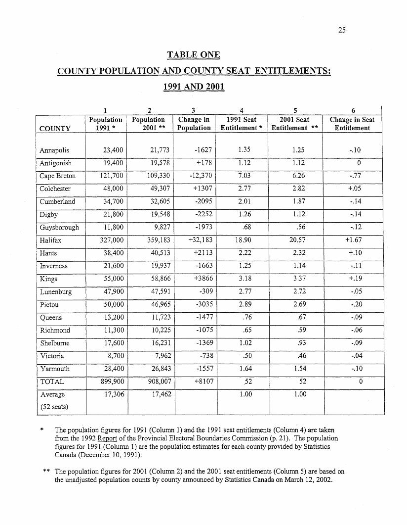
County Population and Seat Entitlements: 1991 and 2001
Table One presents county population and county seat entitlements for 1991 and 2001,
and calculates changes between 1991 and 2001. Columns 1 and 2 present the population
estimates for each county in 1991 and 2001. Column 3 presents population gains or losses by
24
county during the past decade. Columns 4 and 5 show seat entitlements by county in both 1991
and 2001, and Column 6 presents changes in seat entitlements during the last ten years. The 1991
county population and county seat entitlements are taken from the previous Commission's Report
of March, 1992 (p. 21), while the 2001 population and seat entitlements are based on the 2001
census provided by Statistics Canada.
Table One indicates the population of Nova Scotia grew by only 8,107 from 1991 to
2001. Five counties recorded population increases from 1991 to 2001. Four of the five counties
experiencing increases are in, or near, the centre of the province (Halifax, Colchester, Hants and
Kings). Antigonish is the only exception. Halifax is by far the fastest growing county (+32,183
or +9.8 percent). Kings is second (+3,866 or +7.0 percent) and Hants is third (+2,113 or +5.5
percent).
Thirteen counties recorded population decreases from 1991 to 2001. Cape Breton (
12,370) experienced by far the largest absolute population decrease. Three other counties
experienced population decreases of greater than 2000 [Pictou (-3,035), Digby (-2252) and
Cumberland (-2095)]. Four counties experienced relative population decreases of greater than
10 percent [Guysborough (-16.7 percent), Queens (-11.2 percent), Digby (-10.3 percent) and
Cape Breton(-10.2 percent)].
25
TABLE ONE
COUNTY POPULATION AND COUNTY SEAT ENTITLEMENTS:
1991 AND 2001
1 2 3 4 5 6Population Population Change in 1991 Seat 2001 Seat Change in Seat
COUNTY 1991 * 2001 ** Population Entitlement * Entitlement ** Entitlement
Annapolis 23,400 21,773 -1627 1.35 1.25 -.10
Antigonish 19,400 19,578 +178 1.12 1.12 0
Cape Breton 121,700 109,330 -12,370 7.03 6.26 -.77
Colchester 48,000 49,307 +1307 2.77 2.82 +.05
Cumberland 34,700 32,605 -2095 2.01 1.87 -.14
Digby 21,800 19,548 -2252 1.26 1.12 -.14
Guysborough 11,800 9,827 -1973 .68 .56 -.12
Halifax 327,000 359,183 +32,183 18.90 20.57 +1.67
Hants 38,400 40,513 +2113 2.22 2.32 +.10
Inverness 21,600 19,937 -1663 1.25 1.14 -.11
Kings 55,000 58,866 +3866 3.18 3.37 +.19
Lunenburg 47,900 47,591 -309 2.77 2.72 -.05
Pictou 50,000 46,965 -3035 2.89 2.69 -.20
Queens 13,200 11,723 -1477 .76 .67 -.09
Richmond 11,300 10,225 -1075 .65 .59 -.06
Shelburne 17,600 16,231 -1369 1.02 .93 -.09
Victoria 8,700 ·7,962 -738 ..50 .46 -.04
Yarmouth 28,400 26,843 -1557 1.64 1.54 -.10
TOTAL 899,900 908,007 +8107 ,52 52 0
Average 17,306 17,462 1.00 1.00
(52 seats)
*. .
The population figures for 1991 (Column 1) and the 1991 seat entitlements (Column 4) are takenfrom the 1992 Report of the Provincial Electoral Boundaries Commission (p. 21). The populationfigures for 1991 (Column 1) are the population estimates for each county provided by StatisticsCanada (December 10, 1991).
** The population figures for 2001 (Column 2) and the 2001 seat entitlements (Column 5) are based onthe unadjusted population counts by county announced by Statistics Canada on March 12,2002.
26
These increases and decreases reveal that, based on population, Halifax County has
increased its seat entitlement the most (+1.67), followed by Kings County (+.19). Cape Breton
County has decreased its seat entitlement the most (-.77), followed by Pictou County (-.20). The
data also reveal that four counties have 2001 seat entitlements, based on population, below .75
[Victoria (.46), Guysborough (.56), Richmond (.59) and Queens (.67)].
The Commission notes the increase in the relative share of the province's population
contained in Halifax County: in 2001 the population of Halifax County was 39.6 percent of the
provincial total, compared to 36.3 percent in 1991. In 1971, Halifax County's share of the
provincial population total was 33.1 percent, up from 25.2 percent in 1951 (1978 Report of the
Select Committee on Electoral Boundaries, Appendix E). Thus, in fifty years Halifax County's
share of the province's total population has increased from 25 to 40 percent.
27
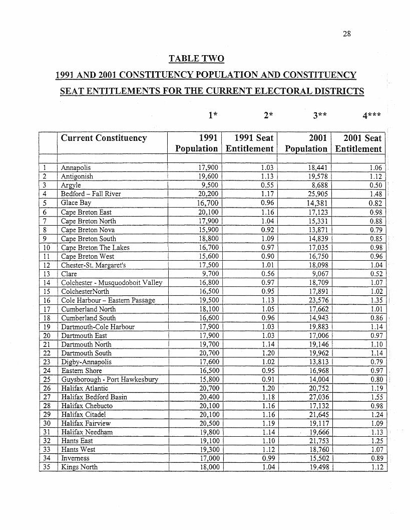
Current Constituency Population and Seat Entitlements: 1991 and 2001
Table Two presents population and seat entitlement data for the current 52 constituencies
for 1991 and 2001. Table Two helped the Commission identify areas where boundary changes
may be necessary.
The data reveal six current constituencies with seat entitlements equal to or greater than
1.25 based on population. In order, they are Halifax Bedford Basin (1.55), Bedford - Fall River
(1.48), Cole Harbour - Eastern Passage (1.35), Timberlea - Prospect (1.35), Sackville
Beaverbank (1.31), and Hants East (1.25).
The data also reveal six current constituencies with seat entitlements less than .75 based
on population. In order, these constituencies are Victoria (.47), Argyle (.50), Clare (.52), Preston
(.59), Richmond (.59) and Queens (.67).
Current Constituency Estimated Electors and Seat Entitlements: 2001
Table Three presents seat entitlements based on electors for the current 52 constituencies
for 2001. Data are not available for 1991, as the basis for recommending constituency
boundaries in 1991 was estimated population, not electors. Table Three helped the Commission
identify the eleven current constituencies in which boundary changes might be necessary. Given
the Commission's Terms of Reference, estimated electors by constituency, not estimated
population by constituency, was employed to recommend constituency boundaries.
28
TABLE TWO
1991 AND 2001 CONSTITUENCY POPULATION AND CONSTITUENCY
SEAT ENTITLEMENTS FOR THE CURRENT ELECTORAL DISTRICTS
1* 2* 3** 4***
Current Constituency 1991 1991 Seat 2001 2001 SeatPopulation Entitlement Population Entitlement
1 Annapolis 17,900 1.03 18,441 1.062 Antigonish 19,600 1.13 19,578 1.123 Argyle 9,500 0.55 8,688 0.504 Bedford - Fall River 20,200 1.17 25,905 1.485 Glace Bay 16,700 0.96 14,381 0.826 Cape Breton East 20,100 1.16 17,123 0.987 Cape Breton North 17,900 1.04 15,331 0.888 Cape Breton Nova 15,900 0.92 13,871 0.799 Cape Breton South 18,800 1.09 14,839 0.8510 Cape Breton The Lakes 16,700 0.97 17,035 0.9811 Cape Breton West 15,600 0.90 16,750 0.9612 Chester-St. Margaret's 17,500 1.01 18,098 1.0413 Clare 9,700 0.56 9,067 0.5214 Colchester - Musquodoboit Valley 16,800 0.97 18,709 1.0715 ColchesterNorth 16,500 0.95 17,891 1.0216 Cole Harbour - Eastern Passage 19,500 1.13 23,576 1.3517 Cumberland North 18,100 1.05 17,662 1.0118 Cumberland South 16,600 0.96 14,943 0.8619 Dartmouth-Cole Harbour 17,900 1.03 19,883 1.1420 Dartmouth East 17,900 1.03 17,006 0.9721 Dartmouth North 19,700 1.14 19,146 1.1022 Dartmouth South 20,700 1.20 19,962 1.1423 Digby-Annapolis 17,600 1.02 13,813 0.7924 Eastern Shore 16,500 0.95 16,968 0.9725 Guysborough - Port Hawkesbury 15,800 0.91 14,004 0.8026 Halifax Atlantic 20,700 1.20 20,752 1.1927 Halifax Bedford Basin 20,400 1.18 27,036 1.5528 Halifax Chebucto 20,100 1.16 17,132 0.9829 Halifax Citadel 20,100 1.16 21,645 1.2430 Halifax Fairview 20,500 1.19 19,117 1.0931 Halifax Needham 19,800 1.14 19,666 1.1332 Hants East 19,100 1.10 21,753 1.2533 Hants West 19,300 1.12 18,760 1.0734 Inverness 17,000 0.99 15,502 0.8935 Kings North 18,000 1.04 19,498 1.12
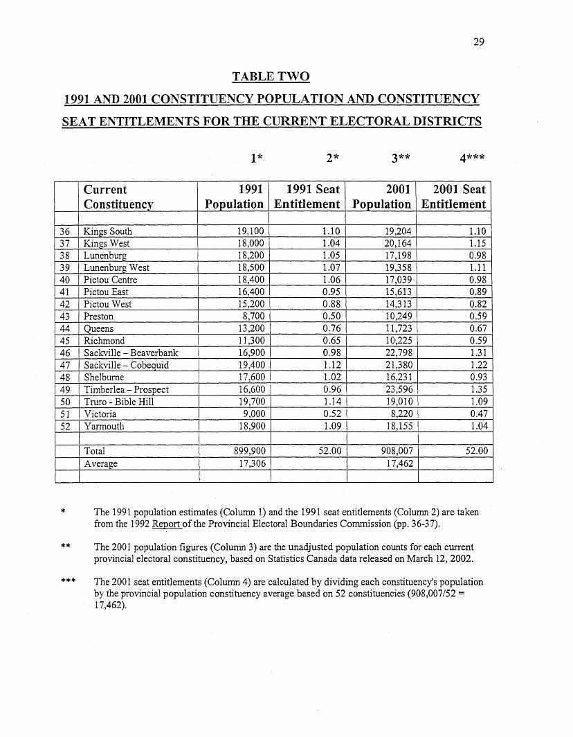
29
TABLE TWO
1991 AND 2001 CONSTITUENCY POPULATION AND CONSTITUENCY
SEAT ENTITLEMENTS FOR THE CURRENT ELECTORAL DISTRICTS
1* 2* 3** 4***
Current 1991 1991 Seat 2001 2001 SeatConstituency Population Entitlement Population Entitlement
36 Kings South 19,100 1.10 19,204 1.1037 Kings West 18,000 1.04 20,164 1.1538 Lunenburg 18,200 1.05 17,198 0.9839 Lunenburg West 18,500 1.07 19,358 1.1140 Pictou Centre 18,400 1.06 17,039 0.9841 Pictou East 16,400 0.95 15,613 0.8942 Pictou West 15,200 0.88 14,313 0.8243 Preston 8,700 0.50 10,249 0.5944 Queens 13,200 0.76 11,723 0.6745 Richmond 11,300 0.65 10',225 0.5946 Sackville - Beaverbank 16,900 0.98 22,798 1.3147 Sackville Cobequid 19,400 1.12 21,380 1.2248 Shelburne 17,600 1.02 16,231 0.9349 Timberlea - Prospect 16,600 0.96 23,596 1.3550 Truro - Bible Hill 19,700 1.14 19,010 1.0951 Victoria 9,000 0.52 8,220 0.4752 Yarmouth 18,900 1.09 18,155 1.04
Total 899,900 52.00 908,007 52.00Average 17,306 17,462
*
**
***
The 1991 population estimates (Column 1) and the 1991 seat entitlements (Column 2) are takenfrom the 1992 Report of the Provincial Electoral Boundaries Commission (pp. 36-37).
The 2001 population figures (Column 3) are the unadjusted population counts for each currentprovincial electoral constituency, based on Statistics Canada data released on March 12,2002.
The 2001 seat entitlements (Column 4) are calculated by dividing each constituency's populationby the provincial population constituency average based on 52 constituencies (908,007/52 =17,462).
30
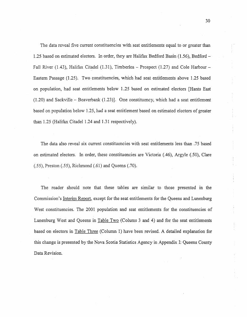
The data reveal five current constituencies with seat entitlements equal to or greater than
1.25 based on estimated electors. In order, they are Halifax Bedford Basin (1.56), Bedford
Fall River (1.43), Halifax Citadel (1.31), Timberlea - Prospect (1.27) and Cole Harbour
Eastern Passage (1.25). Two constituencies, which had seat entitlements above 1.25 based
on population, had seat entitlements below 1.25 based on estimated electors [Hants East
(1.20) and Sackville - Beaverbank (1.23)]. One constituency, which had a seat entitlement
based on population below 1.25, had a seat entitlement based on estimated electors of greater
than 1.25 (Halifax Citadel 1.24 and 1.31 respectively).
The data also reveal six current constituencies with seat entitlements less than .75 based
on estimated electors. In order, these constituencies are Victoria (.46), Argyle (.50), Clare
(.55), Preston (.55), Richmond (.61) and Queens (.70).
The reader should note that these tables are similar to those presented in the
Commission's Interim Report, except for the seat entitlements for the Queens and Lunenburg
West constituencies. The 2001 population and seat entitlements for the constituencies of
Lunenburg West and Queens in Table Two (Colums 3 and 4) and for the seat entitlements
based on electors in Table Three (Column 1) have been revised. A detailed explanation for
this change is presented by the Nova Scotia Statistics Agency in Appendix I: Queens County
Data Revision.
TABLE THREE
2001 SEAT ENTITLEMENTS BY ELECTORS FOR
CURRENT ELECTORAL DISTRICTS *
Current Constituency 2001 SeatEntitlement
1 Annapolis 1.082 Antigonish 1.093 Argyle 0.504 Bedford - Fall River 1.435 Cape Breton Centre 0.846 Glace Bay 1.017 Cape Breton North 0.898 Cape Breton Nova 0.809 Cape Breton South 0.8910 Cape Breton The Lakes 0.9311 Cape Breton West 0.9712 Chester - S1. Margaret's 1.0813 Clare 0.5514 Colchester - Musquodoboit Valley 1.0515 Colchester North 1.0116 Cole Harbour - Eastern Passage 1.2517 Cumberland North 1.0318 Cumberland South 0.8819 Dartmouth - Cole Harbour 1.0920 Dartmouth East 0.9621 Dartmouth North 1.1022 Dartmouth South 1.1723 Digby - Annapolis 0.8224 Eastern Shore 0.9625 Guysborough - Port Hawkesbury 0.8226 Halifax Atlantic· 1.1627 Halifax Bedford Basin 1.5628 Halifax Chebucto 1.0329 Halifax Citadel 1.3130 Halifax Fairview 1.1331 HalifaxNeedham 1.1832 Hants East 1.2033 Hants West 1.0934 Inverness 0.8735 Kings North 1.11
31
TABLE THREE
2001 SEAT ENTITLEMENTS BY ELECTORS FOR
CURRENT ELECTORAL DISTRICTS *
Current Constituency 2001 SeatEntitlement
36 Kings South 1.1037 Kings West 1.1238 Lunenburg 1.0239 Lunenburg West 1.1440 Pictou Centre 1.0041 Pictou East 0.9142 Pictou West 0.8443 Preston 0.5544 Queens 0.7045 Richmond 0.6146 Sackville - Beaverbank 1.2347 Sackville - Cobequid 1.1748 Shelburne 0.9349 Timberlea - Prospect 1.2750 Truro - Bible Hill 1.1051 Victoria 0.4652 Yarmouth 1.03
32
* Electors are defined as Canadian citizens 18 years of age and older (total population minus thoseindividuals 17 and under and minus immigrants 18 years and older).
33
8: THE PROPOSED ELECTORAL REDISTRIBUTION
In preparing its Final Report, the Commission worked on the premise that all previous
decisions and recommendations in its Interim Report were "on the table." The Commission
started with a clean slate and re-worked through its Terms of Reference, based on the information
the public had provided during both the First and Second Round of Public Hearings, on updated
statistics provided by the Nova Scotia Statistics Agency, and on its own additional analysis. In
Table Four the Commission presents its data (electors and seat entitlements) for its recommended
electoral districts. The recommendations are presented in the order that the Commission actually
made them - beginning with the number of seats in the Legislature and the issue of minority
representation, through areas of possible seat loss and seat gain, to the specifics of particular
electoral boundaries.
The initial issue for the Commission to consider was the size of the Legislature. As
previously noted, the Commission's Terms of Reference specified the number of seats. As a
result, the Commission's first recommendation simply reaffirms the continuation of a 52-seat
Legislature.
1.. The Commission reaffirms the continuation of "a 52-member Legislative Assembly, not
counting any additional member authorized pursuant to Section 6 of the House of Assembly
Act."
34
TABLE FOUR
PROPOSED ELECTORAL DISTRICTS 2002:ELECTORS AND SEAT ENTITLEMENTS(sorted by seat entitlement, lowest to highest)
1* 2**Proposed Constituency 2001 2001 Seat
Electors Entitlement
3 Argyle 6,718 0.5043 Preston 7,335 0.5513 Clare 7,337 0.5545 Richmond 8,060 0.6025 Guysborough - Sheet Harbour 10,383 0.7851 Victoria - The Lakes 10,413 0.7844 Queens 10,534 0.7924 Eastern Shore 10,569 0.7923 Digby - Annapolis 10,860 0.8242 Pictou West 11,107 0.838 Cape Breton Nova 11,107 0.8316 Cole Harbour - Eastern Passage 11,477 0.8618 Cumberland South 11,662 0.8841 Pictou East 12,069 0.915 Cape Breton Centre 12,168 0.9148 Shelburne 12,371 0.9340 Pictou Centre 13,251 0.9915 Colchester North 13,270 1.006 Glace Bay 13,378 1.004 Waverley - Fall River 13,490 1.0114 Colchester - Musquodoboit Valley 13,649 1.0217 Cumberland North 13,707 1.0352 Yannouth 13,749 1.0312 Lunenburg 13,782 1.0338 Lunenburg West 13,783 1.037 Cape Breton North 13,825 1.041 Annapolis 14,321 1.0846 Hammonds Plains - Upper Sack:ville 14,407 1.0833 Hants West 14,485 1.092 Antigonish 14,522 1.0936 Kings South 14,621 1.1035 Kings North 14,742 1.119 Cape Breton South 14,804 1.1137 Kings West 14,870 1.1249 Chester - S1. Margaret's 14,892 1.1250 Truro - Bible Hill 14,898 1.1234 Inverness 14,961 1.1247 Sackville - Cobequid 14,980 1.1211 Cape Breton West 15,026 1.1339 Timberlea - Prospect 15,053 1.13
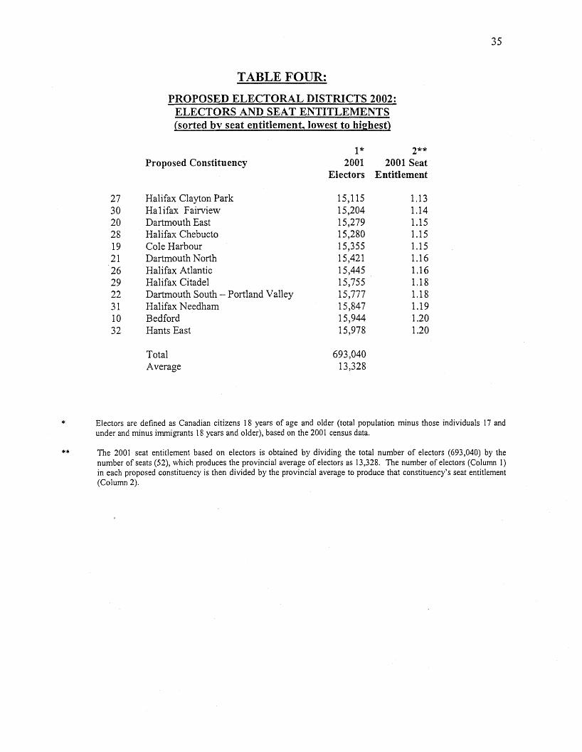
35
TABLE FOUR:
PROPOSED ELECTORAL DISTRICTS 2002:ELECTORS AND SEAT ENTITLEMENTS(sorted by seat entitlement, lowest to highest)
1* 2**Proposed Constituency 2001 2001 Seat
Electors Entitlement
27 Halifax Clayton Park 15,115 1.1330 Halifax Fairview 15,204 1.1420 Dartmouth East 15,279 1.1528 Halifax Chebucto 15,280 1.1519 Cole Harbour 15,355 1.1521 Dartmouth North 15,421 1.1626 Halifax Atlantic 15,445 1.1629 Halifax Citadel 15,755 1.1822 Dartmouth South - Portland Valley 15,777 1.1831 Halifax Needham 15,847 1.1910 Bedford 15,944 1.2032 Hants East 15,978 1.20
Total 693,040Average 13,328
* Electors are defined as Canadian citizens 18 years of age and older (total population minus those individuals 17 andunder and minus immigrants 18 years and older), based on the 2001 census data.
** The 2001 seat entitlement based on electors is obtained by dividing the total number of electors (693,040) by thenumber of seats (52), which produces the provincial average of electors as 13,328. The number of electors (Column 1)in each proposed constituency is then divided by the provincial average to produce that constituency's seat entitlement(Column 2).
36
The Commission reviewed the use of the five protected constituencies created in 1992.
The Commission decided not to continue to use the term "protected constituencies," but instead
use the "extraordinary circumstances clause" contained in its Terms of Reference. To assist in
making recommendations with respect to representation by Nova Scotia's Acadian and Black
communities, the Commission obtained 1996 Census data from Statistics Canada. The data
obtained were the estimated number of Nova Scotians whose mother tongue is French, whose
home language is French, and who are a visible minority, black. The data were obtained for each
county and selected municipal districts and subdivisions within counties.
A brief overview of these Statistics Canada data reveals an estimated 35,040 Nova
Scotians whose mother tongue is French, 19,955 whose home language is French, and 18,155
who are visible minority, black. In percentage terms these estimates equal 3.8 percent, 2.2
percent and 2.0 percent of the Nova Scotia population. These results suggest both minorities are
substantial in number and greater than an average constituency.
In three counties the percentage of the population whose mother tongue is French
exceeded 20 percent: Digby (33 percent), Richmond (29 percent) and Yarmouth (23 percent).
Within the District of Clare in Digby County, 70 percent of the population have French as their
mother tongue, while in the District of Argyle within Yarmouth County, that percentage is 54
percent.
Nova Scotia's black population is spread more evenly throughout the province than is its
Acadian population. Only three counties report black population percentages above 3 percent and
37
all three are under 4 percent [Guysborough (3.9 percent), Halifax (3.5 percent) and Digby (3.1
percent)]. In absolute tenns, however, 66 percent of all black Nova Scotians (12,005 of 18,155)
reside in Halifax County. Of these, about 2,500 reside within the Preston riding, with another
2,500 residing in the north end of the fonner city of Halifax in the Halifax Needham constituency.
Given the absolute size of these two constituencies (Preston 7,335 electors and Halifax Needham
15,847 electors), however, the percentage of black voters in Preston is considerably higher.
2. The Commission recommends that the four constituencies for minority
representation be retained as they currently exist (Clare, Argyle, Richmond, and Preston).
(In its Interim Report, the Commission had recommended three constituencies for inclusion under
its "extraordinary circumstances clause:" Clare, Argyle and Preston. The Victoria riding was the
fifth protected constituency in 1992, but the basis of protection was geography, which is not an
"extraordinary circumstance" as specified in the current Commission's Terms ofReference.)
The use of the term "protected constituencies" in the 1992 redistribution and the current
Commission's "extraordinary circumstances clause" for minority representation has generated
considerable public comment. The Commission feels that this method of encouraging minority
representation should be re-evaluated during the next electoral redistribution.
3. The Commission recommends, during the next electoral redistribution, that the
Provincial Electoral Boundaries Commission re-evaluate the method of encouraging
minority representation.
38
Following the Commission's recommendation regarding the use of its "extraordinary
circumstances clause" with respect to minority representation, the Commission proceeded to
determine which, if any, constituencies might remain as they are currently constituted and which
areas of the province, if any, might be either over-represented or under-represented. In Table
Five the Commission presents its data regarding electors and seat entitlements by region for the
province. The review of the data in both Table Five, along with that in Tables Two and Three,
indicated that Halifax County was under-represented and that Cape Breton Island was over-
represented. Each specific constituency was then reviewed in terms of its own size and in tenus
of neighbouring or contiguous constituencies in relation to the question of under-representation
and over-representation in the House of Assembly.
4, The Commission recommends no change in the current electoral boundaries of the
following twenty-five constituencies:
AnnapolisAntigonishArgyleClareColchester-Musquodoboit ValleyColchester NorthCumberland NorthCumberland SouthDigby-AnnapolisHalifax AtlanticHalifax FairviewHants EastHants West
Kings NorthKings SouthKings WestLunenburgPictou CentrePictou EastPictou WestPrestonRichmondShelburneTruro-Bible HillYarmouth
(In its Interim Report, the Commission recommended no changes to 19 constituencies.)
39
TABLE FIVE
SEAT ENTITLEMENTS, ACTUAL AND PROPOSED SEATS BY REGION
1 2 3 4 5
Region Counties Included Electors in Seat Current Number of
in Each Region Each Region Entitlement Number of Seats
2001 (from by RegionI
Seats2 Proposed by
Table Six) Region3
Cape Breton, Victoria,
Cape Breton Inverness, Richmond 113,742 8.53 10.24 9.00
Antigonish,
Northeastern Guysborough, Pictou, 121,619 9.12 9.45 9.43
Colchester,
Cumberland
Hants, Kings,
Annapolis Valley Annapolis 91,732 6.89 6.25 6.25
Digby, Yarmouth,
Southwestern Shelburne, Queens, 94,889 7.12 8.38 8.32
Lunenburg
Halifax Halifax 271,058 20.34 17.68 19.00
All Regions693,040
52.00 52.00 52.00
Average 13,328
ElectorslRiding
Source: This table used data from Table Six and the reader should note that it is the work of the Provincial ElectoralBoundaries Commission, not that of the Nova Scotia Statistics Agency.
IElectors in each constituency divided by 13,328, the average number of electors.
2Four current constituencies are split between regions. Digby-Annapolis has 75 percent of its electors in Digby Countyand 25 percent in Annapolis County; Chester - S1. Margaret's is 63 percent Lunenburg County and 37 percent HalifaxCounty; Colchester - Musquodoboit Valley is 69 percent Colchester County and 31 percent Halifax County; andGuysborough - Port Hawkesbury is 76 percent Guysborough County and 24 percent Inverness County.
JFour proposed constituencies are split between regions. Two are unchanged (Digby - Annapolis and ColchesterMusquodoboit Valley). Boundary changes are recommended for the current Chester - S1. Margaret's constituency, whichalters the split 57 percent Lunenburg County and 43 percent Halifax County. Guysborough - Sheet Harbour, a newproposed constituency, is 74 percent Guysborough County and 26 percent Halifax County.
40
After concluding which constituencies could remain as they are currently constituted, the
Commission returned to the issues of under-representation and over-representation in various
regions of the province. After reviewing the available data, the Commission concluded that
Cape Breton Island was over-represented by one seat.
5. The Commission recommends that the number of seats on Cape Breton Island be
reduced from ten full-seats to nine full-seats.
The Commission's next task was to examine where a constituency on Cape Breton Island
might be eliminated. A number of possibilities were reviewed. Because it was centrally-located
and because its elimination would be the least disruptive on the current pattern of constituencies,
the Commission concluded it would recommend the elimination of the Cape Breton The Lakes
constituency.
6. The Commission recommends the elimination of the Cape Breton The Lakes
constituency and its reallocation among its neighbouring constituencies. (In its Interim
Report, the Commission made a similar recommendation regarding the Cape Breton The Lakes
constituency.)
The decision to recommend the loss of one riding on Cape Breton Island necessitated a
review of all of the other ridings on Cape Breton Island.
As previously noted in its second recommendation, the Commission has already
recommended that the Richmond constituency be included under the "extraordinary
41
circumstances clause." (The Interim Report had not included Richmond in this category and had
recommended that the Town of Port Hawkesbury be added to the Richmond constituency.)
7. The Commission recommends that the Town of Port Hawkesbury be part of the
Inverness constituency:
With the return of the Town of Port Hawkesbury to the Inverness constituency, the
Commission then considered whether or not all of Inverness County might be included in one
constituency.. The current constituency of Inverness does not include the top portion of
Inverness County from the Cape Breton Highlands National Park north, which is in the current
constituency ofVictoria.
8. The Commission recommends that the top portion of Inverness County from the
Cape Breton Highlands National Park north be returned to the Inverness constituency.
(The Commission's Interim Report also made this recommendation.)
The Commission's recommendations (numbers seven and eight) reunite Inverness
County as one constituency. However, a result of recommendation eight is to reduce the current
constituency of Victoria in terms of both its population/electors and geography. In 1992 the
previous Commission had made Victoria a "protected constituency," based on geography.
Because of the instructions given to the Commission for its use of the "extraordinary
circumstances clause," Victoria cannot be assessed in a similar manner in this redistribution.
Victoria County has a seat entitlement based on electors (Table Three) of 0.46 -less than
half of a seat entitlement. In order to expand the electoral base of a Victoria-based constituency
42
the CommissIon recommends that the Victoria constituency be expanded to include some of the
rural areas of the fonner constituency of Cape Breton The Lakes and that the new constituency
be called Victoria - The Lakes. This proposed change maintains the primarily rural nature of the
current Victoria constituency.
9. The Commission recommends that the Victoria constituency lose the area in
Inverness County of Cape Breton Highlands National Park and north to Meat Cove to the
Inverness constituency and gain some of the rural area of the former constituency of Cape
Breton The Lakes, with the name of the revised constituency to be Victoria - The Lakes.
The County of Victoria has a current seat entitlement of 0.46, well below the
Commission's ± factor of 25 percent. The revised constituency of Victoria - The Lakes has an
estimated seat entitlement based on electors in Table Four of .78, just over the minus variance
allowed of 25 percent.
(In the Commission's Interim Report, the recommended constituency of Victoria - The
Lakes was larger both geographically and in tenns of electors. In response to the public's
concerns, the geographical size of the proposed constituency has been reduced and the electoral
size has been reduced as well, from a seat entitlement of 0.99 in the Interim Report to one of 0.78
in the Final Report.)
Those parts of the Cape Breton The Lakes constituency not allocated to the
recommended riding of Victoria - The Lakes were reallocated to the ridings of Cape Breton
North, Cape Breton South, and Cape Breton West. The major change to Cape Breton West
43
concerns the placement of the Eskasoni Reserve. (In its Interim Report, the Commission had
recommended all of the land on the peninsula north of East Bay be included in the Victoria
The Lakes constituency, including the Eskasoni Reserve.)
10. The Commission recommends that the Cape Breton West constituency gain the area
on the north side of East Bay along highway 216 to and including the Eskasoni Reserve.
The remaining areas in Cape Breton County have had some changes recommended to
their boundaries, outlined in the following sections of this Report, but the current constituencies
of Cape Breton North, Cape Breton South, Cape Breton Nova, Cape Breton Centre, and Glace
Bay remain in place, even though the Commission has recommended some alterations of
constituency boundaries.
Having dealt with the various constituencies on Cape Breton Island, the Commission
turned its attention to mainland Nova Scotia. As noted in its second recommendation, no
changes are recommended in the constituencies from Shelburne, through Yarmouth to
Annapolis, Kings, and Colchester Counties, and Pictou, Hants, Antigonish and Cumberland
Counties. In its Interim Report, the Commission had recommended a revision in the boundary
line between Cumberland North and Cumberland South. In its Final Report the Commission is
recommending no change in this area.
11. The Commission recommends no change in the boundary line between Cumberland
North and Cumberland South.
44
In its Interim Report, the Commission recommended a major restructuring of
constituency boundaries along the South Shore of Nova Scotia, including the elimination of the
Lunenburg West constituency. In its Final Report, the Commission is recommending that the
existing constituencies along the South Shore be maintained, but with some changes in their
current electoral boundaries.
With respect to the Queens constituency, which is below the ± factor of 25 percent, with
a current seat entitlement based on electors of .70 (Table Three), the Commission recommends
an expansion into Lunenburg County.
12. The Commission recommends that the current constituency of Queens be expanded
to include the southwest corner of the current constituency of Lunenburg West.
This expansion of Queens increases its seat entitlement from .70 to an estimated .79
(Table Four), so that it falls within the Commission's ± factor of 25 percent. (The area included
in the Queens constituency from Lunenburg County in the Commission's Final Report is smaller
than the area recommended in its Interim Report).
For Lunenburg County, the Commission recommends the following boundaries.
13. As previously noted in its fourth recommendation, the Commission is
recommending no change in the boundaries of the Lunenburg constituency.
45
14. The Commission recommends the retention of the present Lunenburg West
constituency, but with the southwest corner of that constituency being added to Queens.
15. The Commission recommends the retention of the current constituency of Chester-
S1. Margaret's, but with an expansion of its eastern boundary further into Halifax County.
The current constituency of Guysborough - Port Hawkesbury has been altered, by
recommending the addition of the town of Port Hawkesbury to Inverness (recommendation
seven). This change would leave Guysborough County as a seat, with an entitlement well-below
the ± factor of 25 percent. In its Interim Report, the Commission recommended extending the
Guysborough constituency along the Eastern Shore of Halifax County, creating a new
constituency called Guysborough - Eastern Shore. In this Final Report, the Commission is
recommending a constituency that is smaller than the one recommended in its Interim Report in
terms ofboth the number of electors and the geographic base of the constituency.
16. The Commission recommends that a seat based on Guysborough County be
extended westward into Halifax County to include the Sheet Harbour area. The
Commission recommends that the new constituency be called Guysborough - Sheet
Harbour.
The new proposed constituency of Guysborough - Sheet Harbour would have an
estimated seat entitlement based on electors of .78 (Table Four), which is within the
Commission's ± factor of 25 percent. (The Interim Report's constituency of Guysborough
Eastern Shore had an estimated seat entitlement of .95). Thus, the proposed constituency of
Guysborough - Sheet Harbour is smaller in terms of both geography and electors compared to
46
the Commission's Interim Report recommendation for a Guysborough - Eastern Shore
constituency. Thus, Guysborough County, rather than possibly being divided between several
constituencies, serves as the basis of a revised constituency.
In its Interim Report the Eastern Shore constituency had been reallocated to neighbouring
constituencies. In this Final Report, the Commission is recommending a revised Eastern Shore
constituency.
17. The Commission recommends that the current Eastern Shore constituency be
maintained, but reduced in its geographic base with the recommended loss of the Sheet
Harbour area to the Guysborough-based constituency.
The new constituency of Eastern Shore is smaller both in terms of its geographic base
and electors than the present constituency of Eastern Shore. The current constituency of Eastern
Shore has a seat entitlement based on electors of 0.96 (Interim Report, Table Three, p. 15),
while the proposed constituency of Eastern Shore in the Commission's Final Report has a seat
entitlement based on electors of 0.79.
The final set of recommendations for possible boundary revisions concern the remaining
areas inside Halifax County. As much as was possible, the Commission wanted the communities
of Bedford, Sackville, and Cole Harbour to serve as the core for individual constituencies inside
Halifax County. The Commission also sought to increase the representation for Halifax
Regional Municipality (HRM), given the County's expanding population and electoral base.
47
18. The Commission recommends one additional fuH-seatbe added to Halifax County,
with that seat being created in the Fall River area. The Commission recommends that the
name of this new seat be Waverley - Fall River.
The recommended addition of a new seat in the Waverley - Fall River area necessitated a
major redrawing of electoral boundaries in Halifax County. As a general rule, the Commission
recommended constituencies in the downtown cores of HRM that would be on the high-end of'
the ± factor of 25 percent.
As previously noted in its fourth recommendation, no change is recommended in the
constituencies of Halifax Atlantic, Halifax Fairview, and Preston. Existing constituencies are
recommended to be maintained in the Dartmouth and Cole Harbour areas, while significant
changes are recommended in the Bedford and Hammonds Plains areas of Halifax County. Minor
readjustments of boundaries are recommended in the following constituencies: Halifax Citadel,
Halifax Needham, Halifax Chebucto, Sackville - Cobequid, Dartmouth North, Dartmouth South,
Dartmouth East, Cole Harbour - Eastern Passage, Timberlea - Prospect. More significant
changes are recommended to Dartmouth - Cole Harbour, Halifax Bedford Basin, Sackville
Beaverbank, and Bedford - Fall River.
In Dartmouth, the current constituency of Dartmouth - Cole Harbour loses an area in
Woodlawn to Dartmouth East and expands south into Colby Village. The new constituency of
Waverley - Fall River gains the Beaver Bank area from the current Sackville - Beaver Bank
constituency and the Waverley - Fall River area from the current constituency of Bedford - Fall
River. Sackville - Beaver Bank loses Beaver Bank to Waverley - Fall River and becomes the
48
Hammonds Plains - Upper Sackville constituency. Bedford - Fall River loses the Fall River area
to the new constituency of Waverley - Fall River and gains on its western and southern
boundaries. Halifax Bedford Basin loses its northern area to the new constituency of Bedford and
is renamed Halifax Clayton Park.
19. The Commission recommends a series of significant boundary changes in the
western portion of Halifax County.
If the Nova Scotia House of Assembly accepts the above recommendations, the
Commission is of the opinion that a pattern of effective representation for the people of Nova
Scotia would be provided. As Table Four illustrates, considerable variation is recommended
among the 52 proposed electoral districts. Four constituencies (Argyle, Preston, Clare, and
Richmond) have a ± factor of less than 25 percent and all four fall under the Commission's
"extraordinary circumstances clause" for minority representation.
constituencies are within the stipulated ± factor of 25 percent.
The remaining 48
During its Public Consultation Process, the Commission received numerous comments
about the perceived differences in the roles of rural versus urban MLAs. Part of those
differences concerned the large geographical size of rural constituencies. In recognizing such
concerns, the Commission has generally sought to have rural constituencies fall near the minus
factor of25 percent and the urban constituencies near the plus factor of25 percept. For example,
based on electors, twelve of the thirteen largest constituencies are in Halifax County, while
geographically-large rural constituencies, such as Victoria - The Lakes and Guysborough
Sheet Harbour, are twenty-two percent below the electoral average.
49
The pattern of proposed electoral districts can also be viewed on a regional basis, as
previously presented in Table Five. For many reporting purposes, the 18 counties of Nova
Scotia are divided into five regions: Cape Breton, Northeastern, Annapolis Valley, Southwestern
and Halifax. Table Five presents current seat entitlements, the proposed number of seats, and the
current number of seats for each of these five regions.
Table Five reveals that, if the Commission's recommendations are accepted, the Cape
Breton region would still have slightly more 'seats', based on electors than it is entitled to.
Alternatively, the Halifax region (Halifax County) would continue to have slightly fewer 'seats'
that it is entitled to. The other three regions would see only modest changes.
Given the data presented in Table Five, the Commission feels that a pattern of effective
representation is being recommended for the people ofNova Scotia.
The following pages provide more detail on the Commission's proposed changes: a list of
proposed electoral district names, as well as nine maps are included. These maps provide detail
for the proposed boundary changes in the following areas: Industrial Cape Breton, the South
Shore area, the Guysborough Eastern Shore area, a Metro Area insert, the Cole Harbour area,
Dartmouth, Bedford, the Halifax Peninsula, and the Clayton Park and Fairview areas.
Having outlined the broad changes of the Commission's proposed ~lterations in the
provinces electoral boundaries, Section Nine indicates, on a constituency-by-constituency basis,
how current electoral boundaries will be affected if the Commission's recommendations are

50
implemented. Section Ten describes in detail the proposed boundaries for the recommended
electoral districts.
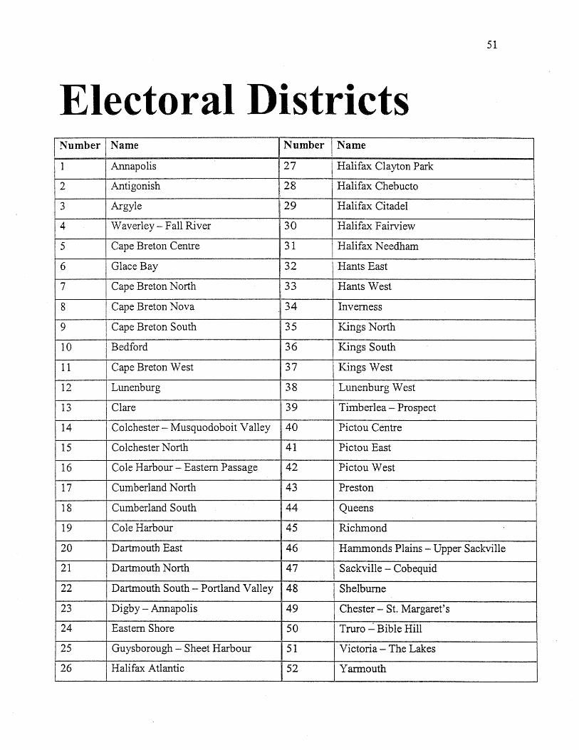
Electoral Districts
51
Number Name Number Name
1 Annapolis 27 Halifax Clayton Park
2 Antigonish 28 Halifax Chebucto
3 Argyle 29 Halifax Citadel
4 Waverley - Fall River 30 Halifax Fairview
5 Cape Breton Centre 31 Halifax Needham
6 Glace Bay 32 Hants East
7 Cape Breton North 33 Hants West
8 Cape Breton Nova 34 Inverness
9 Cape Breton South 35 Kings North
10 Bedford 36 Kings South
11 Cape Breton West 37 Kings West
12 Lunenburg 38 Lunenburg West
13 Clare 39 Timberlea - Prospect
14 Colchester - Musquodoboit Valley 40 Pictou Centre
15 Colchester North 41 Pictou East
16 Cole Harbour - Eastern Passage 42 Pictou West
17 Cumberland North 43 Preston
18 Cumberland South 44 Queens
19 Cole Harbour 45 Richmond
20 Dartmouth East 46 Hammonds Plains - Upper Sackville
21 Dartmouth North 47 Sackville - Cobequid
22 Dartmouth South - Portland Valley 48 Shelburne
23 Digby - Annapolis 49 Chester - S1. Margaret's
24 Eastern Shore 50 Truro ~ Bible Hill
25 Guysborough - Sheet Harbour 51 Victoria - The Lakes
26 Halifax Atlantic 52 Yarmouth
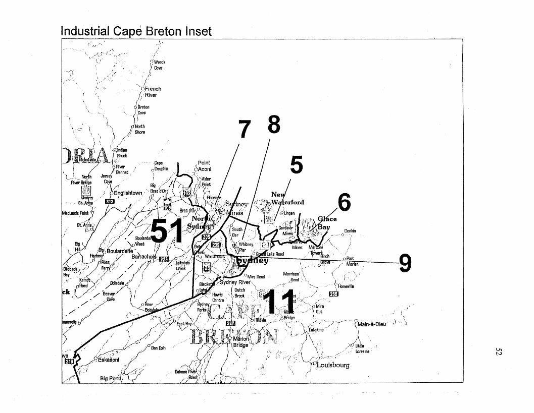
Industrial Cape Breton Inset
VItv
"\<·· .•~f
5
7 8
Dankin"" .... {)- ",
7/ I~> ••/ \"". )
Mines ~~'nj '~" /I Towen\, . I '. ;' 9" ~,- ,,'-'(j~U Ull\IH10ll0 ", 'BlI'ch o Port
~n~bt\ '('ll;uildiiu ; I Gsova - 1" Morienr/ ... ~._ .__.0 r.' r'
Mm.,\- .;: ;:)~)Homeville
nr)'
"Cepe b'O
I Point~DaUPhin.. .,..I....~BA. coniI " t, f \'\Alder/£1'-, r
h __
I.,;'--)
(
\,
.~~ r;,/ ,r.
i .l. ~,:' \
\. "l
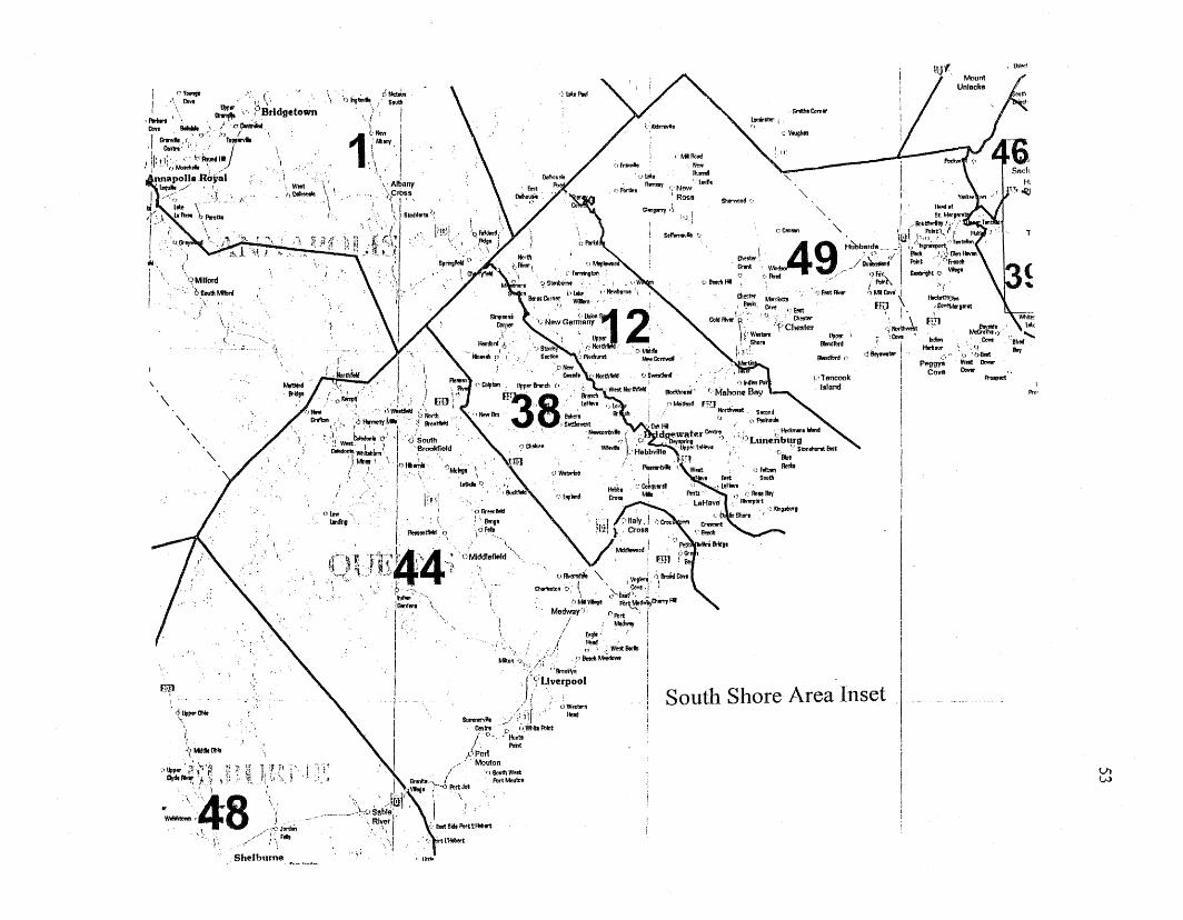
tllW
IRoo'
T
81I11d.......
!loy
, U1ioclIIj"
l1tl'1!11
Hsilour ':J,"",i"- l)'''O&st
peggyS Wilt I)mr
Cove I)mr "~tptct
'\,
SITiIhIComtr
,;. VllUghlll
,) kOJ,tb"'1
of'!!l:m1So.1I1
Sherwood f_.
'\, I ., Hoed.,
c eon_ '\, I St Merger.• . ' ? !lobll1irityF., ..7 '149' " PIlk1t:{/f~T,"
, o>..ttr I . H~bard,S' tl:il), u. ,',! M~' '._ "" ..,/' ....--:";" ....~~'1loeeI1Hl1' (, Rued ~j Ou~ \ PIlllt ",:~ GlonHavtrt: ..// "row /·fr!r!ell
d1_ ., •. ' .' : PIlk1~ Sll!llright (J w.gt
/,~' ~lts. r:!'MtJlv.... 'SMlCovt'i ;'f
Gol:lIIvtr'~.' " J,.;, ••,~ ffi) \ ~\. ;(."llr' \! ,,COVIM,rIf- :""...., ,," ...
I' ,.... ... ! .,...:..l. om,d:: BIondllltd T ',Cove
til.... llIondll>rd C' d B.r-!lII' !IPTancook !
Island I
III
IiII
SeIfomtvh rJ
cMlRuIidNewAu....'il.ovllt
NewRoss
GI8lgl'l1'f
",:iGmnIlold!. ~. 8"191\OFdt
o""~.
IWnntllel:l 0
, <'
r Iitft,.
. \ '0 ..,&vio e5 !k~'. J So.1II
'J I
1t,tIew !,'AAJfII'( II '.1
'. \' I~ f\. Albany;,prt>ss," ,
\, I. \ ISlX>d6tr!ll "J
J'~~ .
: ~
OlbwIJndil.
tf,:-·'.,~·~ .l!4~~~~'"4'''".. ~~. C)'Mlddlefield",.-",:" "t~~1 12, j t " ,
,. \ '.", : I. . ,) I'IvtMtl8le " I vog~ .ri, hid OlYl. p.._-:;,_ O>orlolllX>n c>' ( .Cove-l'
"of"", . , \ ,}-bit;,;:.!Gw1I.... "- () ~,VIog! pur~dviif"5ryHl
I -", Me~r (. PIlrt IIii Medwoy I
I \ / &gle' ,
I.,' '..~/{ ,~"" ';WO!ltIlrin I
P/ib:)n' fJ :.-.1.-' ~! ? 9!!dIMe!6DW1 I:,~.:~(.~11:·~Brao~ !
I J':'Uverpool
I· _ >Iil) ,";:-:- ! South Shore Area Inset
Cmlrl "'p uvn.IlIP1ll1t
I j 'O"'l\Jn18" Pmt
I;;\Poil
//' Mouton
i\. / "JSOvlhWOIt
'Gn!n""",- PurtMoutDnI \1109'! .,£ PIlrtJol
'. \ I"'~l"~"\~ .' /~l, j.. _'---- '-;C)Sab,e~.,. I,
',R"\rI, ..:. £ost Sid. Pl!rttHolJert
<.). .,,;;' tHtbort
"~\">'"f6~~('r=~\. ,. I I.· .. ',
~ .. ',' b.lt.l.nlo -q' . '. 6 South, :l Wilt" I ' 1 I '. Brookfield
CoIedona Wl1ib1l>lm." •J)J.tl~ i '. ,f)Hb~'',(" I
\ WIlt(,\loIloIIolo
\,
Shelburne
\"\
. ~ ~
00II
, :t,~PtrOMo
,
lor..... .' .•I '\ Cove (I . \ ~.... \:)"
,flrin \ " ~ ,".' BridgetownCove IllIhllIl8 " .0 e.ntf.iW.I er.wI. ." <) ••...) /
'f Cmtri"j,j. JTlJ9Ilnlll
I jilt I; .' bRou"dHl• i -' '"Moteh,,1t \
.nnapoll.RbY~1'toquh// ,)
!-<;'·.!;,KIs, ~. y'r(:1 lin- 'b ......tllIr \.,I .
~ ,1 \.\
I ' \. \ \OMllrold
\
6Seulll .....\'
-- t ,,/,.
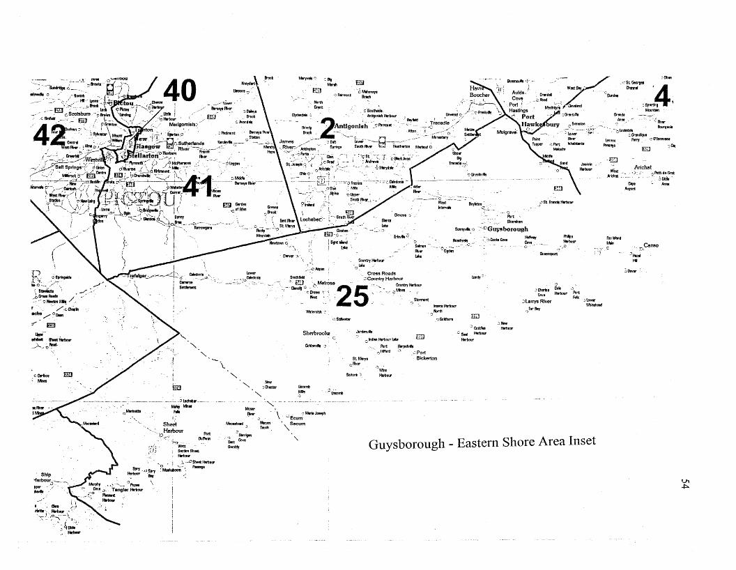
Vl~
cObon
';'!Iv1r1Iovrg....
Arichllt.):~. '=-~:;.tht
M"~t....lI"et
·"o.Canso"""",
HI
:,!lovar
,'St GeorgBI '4Qlllllltl
1:Spor!Jl9
Movn!llilGnnde
M.. ,-
,(-;loVIsd~Gnndque -17&<:ootso
• fony -'~ :,C!I
EJ
WtotAM:h1ll: ,
-0
Fox!rl!sldMtiI
llnnox!'!mg.
)lDWllI'y",ilIllleod
"'"""'HIlrbOlll'
g:J
;='SlrrtncilllllrltOlll'
"'-7<West!l8y •Crtindel ".-
_"lbod' 'IlInd",
Meoh~~~ ,CI<lvolllnd "
,~Gnntvik
'J:::Qltril. Colo .J
Cove Hriovr Port
Jlal'1'}'!l River F1lIx
.}orlbry
::NewHIlril.ur
Lundy""
TIiJ
:JCoddl!rJc S,,", HmOUl'
HriOlll'
PortShoMlhIlll
SlIIlII)'\'f&·':' ':c,cGuysborough
·7·JCoobCove::'" :::urc· ' ,,' 0u","1ll"';~',0
QGoldboro
""""'HrlI.lIl'Nor1ll
':)
IT;)
~oImon-- Ib~:: "-coo,;;;--" ,C.-
Glen.." J
&t1vJ&B
.)WileHriour
-"'::..>.:}
Guysborough - Eastern Shore Area Inset
o hdiltl Hriolll' tal
Port lllrpeMlJ."~Mf·J c~. Port
Bickerton
Jon!"""*'
fill
St Mrrttcliver
Sonorl -~
'cMlhonayt.:) F!rm>nt I!oach
cSIiIImlr
~u;,;"rril
Em
Wtl>ml!h 'J
Gofd!lnYile '~
Sherbrookec
~':' ':1lIgMonll
liscorTtMIs.)
'\.
Otnver '::>",CounllyHriOlll'
._:,cAsplln i 'ol!b
Snil!lfteld' ~: Cross RoadsJ, €lJ "",MelrO!I8=Country Harbour
::.---Gtn~ <;', '., '25," ""- Counlly Hrb,ourc=' :' :~: ',",' c
Wiles
. __ ',; Stormont
New)QlISl:r!i'
"'"~ \. C:ecumClMerioJooeph
"Ne<:um' • Secum
r..dr '"
""'"
,,-
.} /lerriglln£rmtCoveOuodily
Moollllheod 'J
lDWllI'
~:::. ';" ~~.;}> taredonil
\.'--
PortM'Im
"'"
Caredmtil lo.__ . ~.,...U:'_
ill!
\..<-.;.""0
Witt; SeclfonSlleet, Hrbovt
___ c_ -olDdltlllll'---
'. ""'" Wil..F*
I
SheclHarbour
'~O
:!~
I\_.~J
o '! ,~\..~.Q~Harbaur
.Q.:' :""111.";-., f'tl!lroge
'..
- "oMrilIltl
f:
t
";J.;~-,\" .':.~~':
::, Ilrioar
ShIp'farbour.--..,
.,)'"Pllr.....
cCri!cu mJ; Mnes
'n '~~~~e -/,
),.lhftlbodt ".·--oNowtan~ /.
r', /oQllptlacke /0!lolrl
T' mJ
!Wt '.@Mot lI!loetl!llrltolll'
".)...'O~·
....."bOIl 40., - 0 ", ~..__ "',- .' I . ... ,....... .._, <.. QJ.. /..... '. . ~_"""": ..... Ti-.,./..;;" 0 - .- --f...• ~ ."...., ..........~.,- ",..., 2 ' ',.,,' o PomqVIt "'." ,~.,.,.:: ;,/'
'
-, / ,III lJO"', ~ \'''tJ "'~~I~(O I .' . ... .. . \\ntl,gonIsh ,.',. , ",Mx>n '::. ,~.~" 0,\.,:".,...",,"= ~.,...~ ... R!! ,.... ..... ,.' ......,.f!!I S"","_ '0_ • , c"" .•' . ''',.....:{;l~ ..-,;...; /~..~ J r';;;,;.:.( ·"i· =';~. :':"'" .. '::..~;:. T;:: ...... 042;" ",.~~\..... ow I'~.c-il!1os_.... " " ." .. ,.... ;. .. .. i)~o..;-, ..
i~~c':::~~;~~7.a;;;~;?:--~ .... "~~;~~;3~'~!~'0~~:-:'-'i' .' ... _~.Il1"'~,-,:'~,"Sa"S~r1ngS:;~l:',kmlro ,~,;/?,'a.m...,'~'::::"'~ :'='..A:'................. '_,,' ....0,;. co,. '., , ... _.... ......0....c':2~~"~~.~'{I!!ii~ .•~~ )~.t= ..... ~:....... ._IIt.rvII.O::'-,' ....-'~,<, :,,-~,~ •/ ~",4.'f'f ,:~.,.;..,r,:1J1\[1Jflj.',. I rnl Gorden Gnlont • ._''''~( i \ .. 'jo;""~'l>¢"""-'1' .', 0'",J~(ylX?o.~\,;:J:t'~:~...~
. . I
f,I
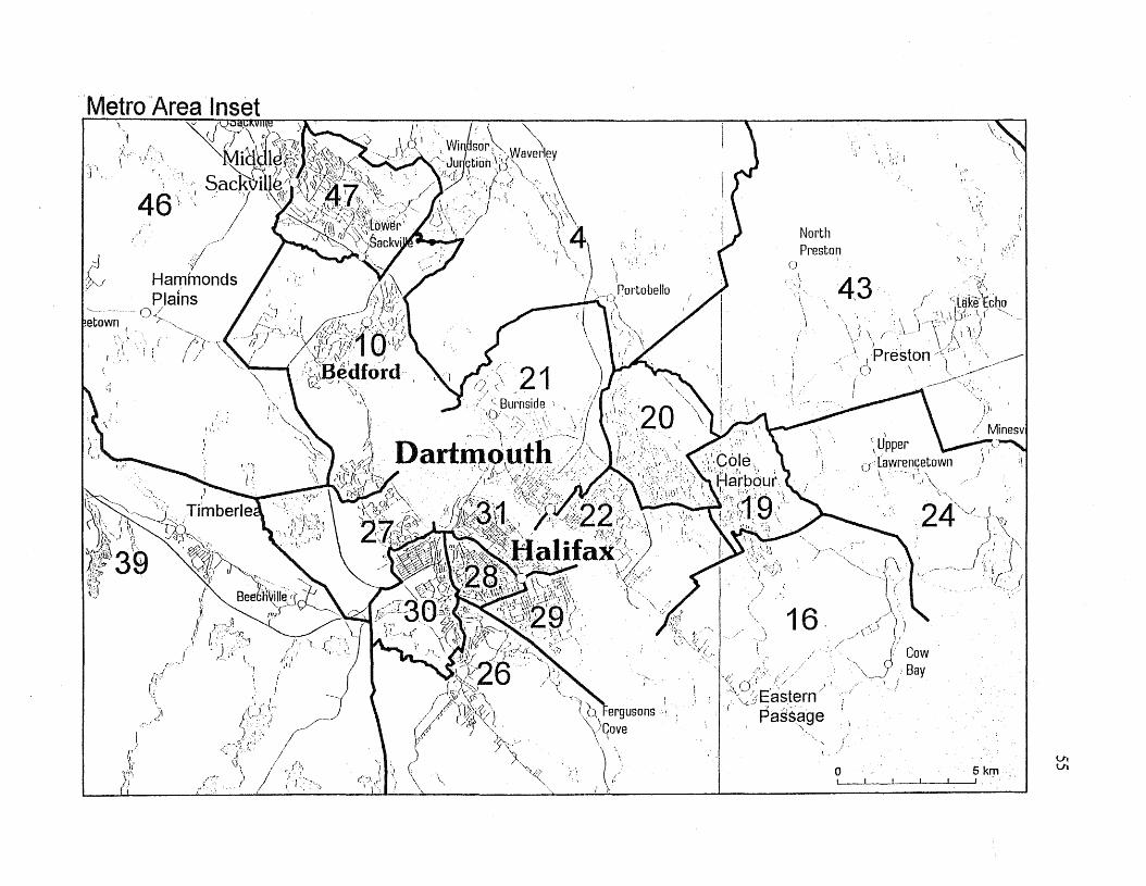
o 5kmI I I I , "
VIVI
;',1,,;1\\ .'.~
24"""',j \
. -'r'~)~'>\,
fl" \/ 'I i('.. ')
~- ./',.-- ':').[:' J
_ 1
'\ Upperu'~aw~enqetown
\, '-",',1
i
43 ";>'f!.,. r' (;lilke"Echo' ;' ".\.\~,. \. ( -"'.
, ) 'f'" J ,)''\ ' \ ~!,\../ ' )\'
I 'Preston )\-' .:.-__---o \. .)..<~~
NorthPreston
o
'':;,0':''.' ) i
\, :j EasternI .... - - ',,' ,.... ,
Passage'\"
""',.i.,b t-ergusons\JCove
'1'.:'; ),
I>_"rPortobello
---~\_.\
46') ,I
f ',I, ': f(
-)
I
-j,</v
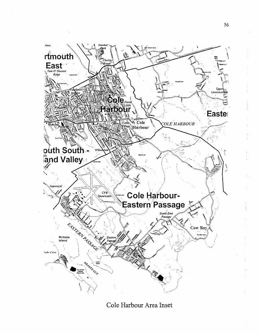
McNabsIsland
Cole Harbour Area Inset
)(
56
\, i
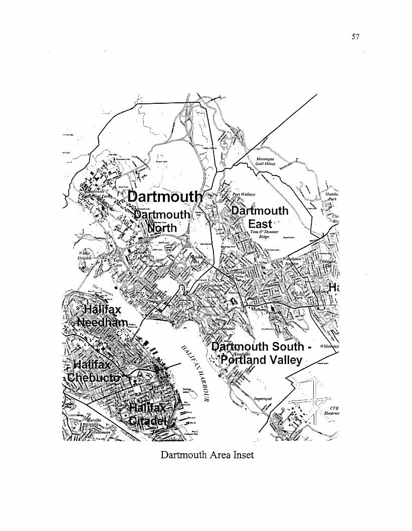
Dartmouth Area Inset
57
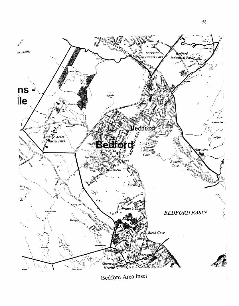
ucasville
nsfie~
Bedford Area Inset
58
.':" .
BEDFORD BASIN
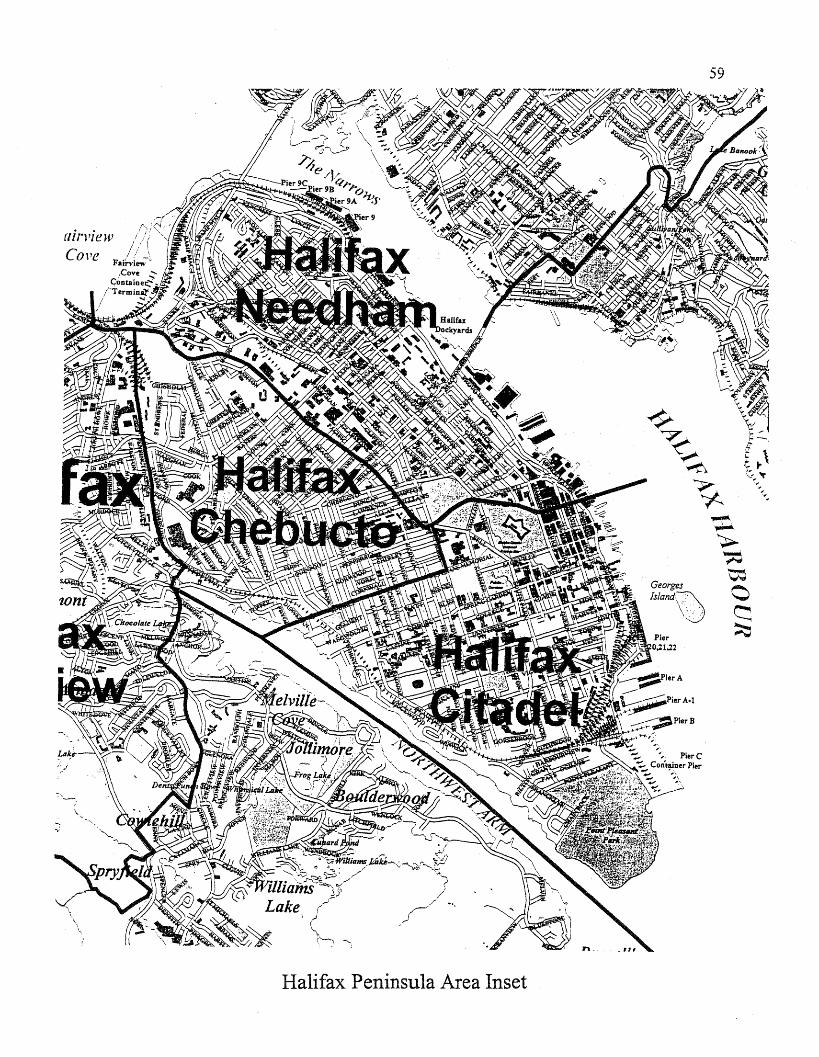
airl'iew
\
\\.,
Halifax Peninsula Area Inset
59
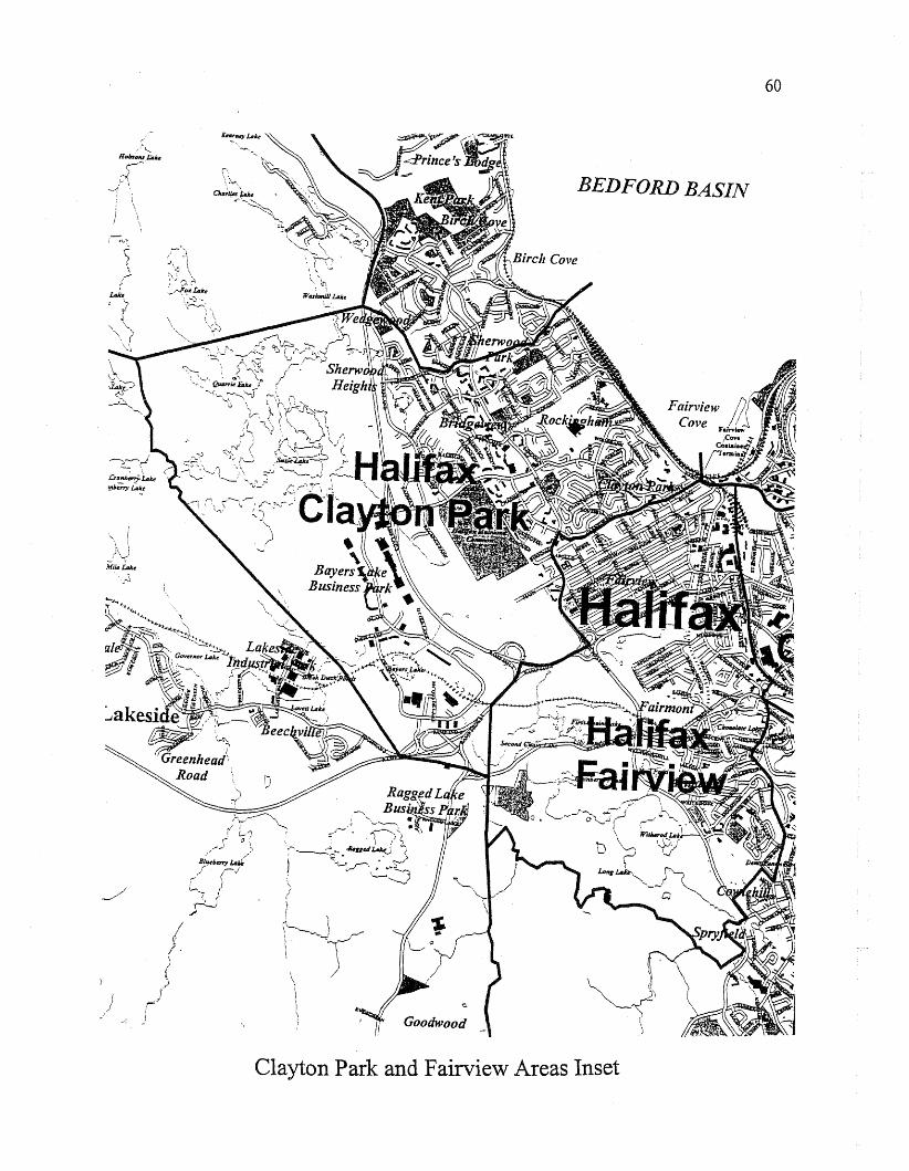
~~, '.
.crallb~lAlce
I~~W:
...,.5"--r
lAh
\. I~ \i)\~- \
Miu,u.ke
-' ..::l
)
;-~')I ,"
~\c \·'\';/"'-,,:'1
'~,-.Fo/.·t"lcel ....':)'·...\-............
r () ....-_1 '">
Bi;bnr-y lAli'·
c::~ /~VC, f;--
>\f \
~/
Goodwood
BEDFORD BASIN
60
Clayton Park and Fairview Areas Inset
61
9: OVERVIEW OF PROPOSED CHANGES TO THE CURRENTELECTORAL DISTRICTS
The following list of constituencies uses current constituency numbers and namesas adopted in 1992 and as outlined in the current House of Assembly Act. Thedetailed boundary descriptions of current constituencies can be located at http://www.gov.ns.cal1egislature/legalstatues/housassm.htm.
This overview outlines the broad changes being proposed to current provincial electoralboundaries - these do not provide legal descriptions of the new constituencies. A more detailedoutline of each new or altered constituency is provided in Section Ten.
If no change to an existing constituency is recommended, its current legal description canbe found in the House of Assembly Act. Maps for existing electoral districts can be found underthe "Site Map" for the Government of Nova Scotia's web site athttp://www.gov.ns.callegislature/site map.html. Under House of Assembly, go to "NS ElectionsOffice" and click on Electoral Districts.
(1) Annapolis: No Change
(2) Antigonish: No Change
(3) Argyle: No Change
(4) Bedford - Fall River: Loses the Fall River and Waverley areas and gains part of BedfordBasin, as well as an area along the Hammonds Plains Road (including Giles Avenue andthe Peerless subdivision). It becomes the new constituency of Bedford and becomesconstituency number 10.
(5) Cape Breton Centre: Expands west to include New Victoria.
(6) Glace Bay: Loses a small area at its southern tip to Cape Breton West.
(7) Cape Breton North: Expands southward toward Sydney to include upper North Sydneyas far as Balls Creek and expands westward to include Point Aconi.
(8) Cape Breton Nova: Loses New Victoria and expands southward into Sydney.
(9) Cape Breton South: In the north, loses part of the Ashby area to Cape Breton Nova andexpands south around the harbour to Balls Creek, including the Coxheath area.
(10) Cape Breton The Lakes: This constituency has been reallocated to Victoria, Cape BretonSouth, Cape Breton North, and Cape Breton West.
62
(11) Cape Breton West: Remains substantially the same, with minor adjustments to itsboundaries with Cape Breton South, Cape Breton Centre, and Glace Bay. Gains the areaon the north side of East Bay along highway 216 to include the Eskasoni Reserve.
(12) Chester - St. Margaret's: Expands eastward along Highway 333 to include West Doverand Bayside. The constituency number changes from 12 to 49.
(13) Clare: No Change
(14) Colchester - Musquodoboit Valley: No Change
(15) Colchester North: No Change
(16) Cole Harbour -Eastern Passage: Loses an area south of the Circumferential Highwayto Dartmouth South, loses an area of Morris Lake and the eastern side of Morris Lake toDartmouth South, and loses an area south of Portland Street in Cole Harbour to ColeHarbour.
(17) Cumberland North: No Change
(18) Cumberland South: No Change
(19) Dartmouth - Cole Harbour: Loses an area in Woodlawn to Dartmouth East and an areaon its eastern boundary to Eastern Shore; it expands south into Colby Village. Theconstituency name is changed to Cole Harbour.
(20) Dartmouth East: Loses a northern area to Waverley - Fall River and gains an area inWoodlawn.
(21) Dartmouth North: Minor change to its northern boundary and gains an area on itssouthern boundary along Lake Banook from Dartmouth South.
(22) Dartmouth South: Loses the area north of Lake Banook as far as Hawthorne Street toDartmouth North. Gains an area south of the Circumferential Highway from ColeHarbour - Eastern Passage and gains an area of Morris Lake as well as the Portland Hillssubdivision. Constituency is renamed Dartmouth South-Portland Valley.
(23) Digby - Annapolis: No Change
(24) Eastern Shore: Gains an area on its western boundary from Dartmouth - Cole Harbourand loses an area on its eastern boundary to Guysborough - Sheet Harbour.
(25) Guysborough - Port Hawkesbury: Loses Port Hawkesbury to Inverness and gains theSheet Harbour area on its western boundary from the Eastern 'Shore. Constituency isrenamed Guysborough - Sheet Harbour.
63
(26) Halifax Atlantic: No Change
(27) Halifax Bedford Basin: Loses a northern area to Bedford. The remaining area becomesHalifax Clayton Park.
(28) Halifax Chebucto: Gains an area at its southern boundary between Quinpool Road andJubilee Road from Halifax Citadel.
(29) Halifax Citadel: Loses a small area east of Citadel Hill to Halifax Needham and loses anarea at its northwestern boundary to Halifax Chebucto.
(30) Halifax Fairview: No Change
(31) Halifax Needham: Gains an area east of Citadel Hill from Halifax Citadel.
(32) Hants East: No Change
(33) Hants West: No Change
(34) Inverness: Gains the northern area of Inverness County form Victoria and gains PortHawkesbury from Guysborough - Port Hawkesbury.
(35) Kings North: No Change
(36) Kings South: No Change
(37) Kings West: No Change
(38) Lunenburg: No change in boundaries, but the constituency number is changed from 38to 12.
(39) Lunenburg West: Loses an area south of the 103 from Risser's Beach Provincial Park tothe Queens County line, including Italy Cross. The constituency number changes from 39to 38.
(40) Pictou Centre: No Change
(41) Pictou East: No Change
(42) Pictou West: No Change
(43) Preston: No Change
(44) Queens: Gains an area on its eastern boundary from Lunenburg West south of Highway103, through Italy Cross, and to Risser's Beach Provincial Park.
64
(45) Richmond: No Change
(46) Sackville - Beaver Bank: Loses Beaver Bank to Waverley - Fall River, retainsHammonds Plains and Upper Sackville; becomes the constituency of Hammonds Plains Upper Sackville.
(47) Sackville - Cobequid: Minor changes to its northern boundary along Second Lake.
(48) Shelburne: No Change
(49) Timberlea - Prospect: Loses the Bayside and West Dover areas to Chester - St.Margaret's. Constituency number changes from 49 to 39.
(50) Truro - Bible Hill: No Change
(51) Victoria: Loses the top of Inverness County to Inverness and gains some of the ruralareas of the former Cape Breton The Lakes constituency.
(52) Yarmouth: No Change
65
10: DESCRIPTIONS FOR PROPOSED BOUNDARIES
Please note: The following boundary descriptions are not designed to be official legaldescriptions for the revised electoral boundaries. The official legal boundary descriptions will beprepared by the Nova Scotia Electoral Office once the House of Assembly has approved allconstituency boundaries and names.
1. Annapolis: No Change
2. Antigonish: No Change
3. Argyle: No Change
4. Waverley - Fall River: On the west it is bounded from the point where the Rail Lineintersects with the Hants County line, then along the Rail Line south to the point where itintersects with the Beaver Bank Road. Then it goes along the Beaverbank - WindsorJunction Road to a point south of Ashlea Drive. At that point it proceeds south to SecondLake and then east through Second Lake to where it meets the Rail Line just south ofCottage Lane. From that point it follows the Rail Line to where it intersects withHighway 102. Then it goes south along Highway 102 to Rocky Lake to where it followsthe south shore of Rocky Lake to a point on Route 2 just north of the Bedford IndustrialPark. Then south along Route 2 to the Bedford Bypass (Highway 101) and then southalong Highway 101 to Windmill Road, and along Windmill Road to where it intersectsWright Brook. Then it follows Wright Brook north to the CN Rail Line and east alongthe CN Rail Line to a point east of Anderson Lake. From that point the boundary linegoes east to the north tip of Lake Charles. From there it proceeds to the east, just south ofMeadow Walk to the Preston boundary line. On the east it is bounded by the Preston andColchester - Musquodoboit Valley constituencies. It is bounded on the north by theHants County boundary line.
5. Cape Breton Centre: It is bounded on the north by the Atlantic Ocean and on the westby Sydney Harbour. The south boundary runs from Sydney Harbour north of South Bar,through Kilkenny Lake to the Devco Rail Line (New Waterford Branch). It then followsNorthwest Brook to the Devco Rail Line (Glace Bay Branch), where it follows the RailLine east to Gardiner Road. It follows Gardiner Road to Highway 4 and along Highway4 to a point just west of the Sydney Airport. From there it goes south to Renwick Brookand then follows Renwick Brook to the Glace Bay boundary. The east boundaryproceeds from the Atlantic Ocean west of Row Street, south to the intersection of PhalenRoad and Reserve Street, and then south east to Renwick Brook.
6. Glace Bay: It is bounded on the north and east by the Atlantic Ocean. The westboundary runs from the Atlantic Ocean west of Row Street, south to the intersection ofPhalen Road and Reserve Street, and then southeast to Renwick Brook. The south
66
boundary follows Renwick Brook east to Highway 255 and along Highway 255 to whereit intersects with Big Glace Bay Lake.
7. Cape Breton North: It is bounded on the east by Sydney Harbour and the NorthwestAnn to Balls Creek, and on the north by the Atlantic Ocean. The remaining boundaryruns from Balls Creek along Highway 125 north to Highway 105. Then west alongHighway 105 to Highway .162 (Prince Mine Road) and along Highway 162 north to theAtlantic Ocean.
8. Cape Breton Nova: It is bounded on the west by Sydney Harbour and the southwestarm to Muggah Creek, and then it follows Muggah Creek to Ferry Street. It runs alongFerry Street to Inglis Street and along Inglis Street to Prince Street, then east on PrinceStreet to Townsend Street and along Townsend Street to High Street. Then along HighStreet to Whitney Avenue and along Whitney Avenue to Hospital Street, then alongHospital Street to a point just east of Cabot Street. From that point the boundary runssouth along the east side of Cabot Street to Cottage Road. It then runs along CottageStreet to the point where Cottage Road intersects with Cottage Crescent. From that pointit goes east to Highway 125. Its east boundary proceeds along Highway 125 North to apoint on Highway 125 east of Cossitt Lake, where it proceeds south of Grand Lake Road(Highway 4) to a point south of Gardiner Road, and then north to Gardiner Road andalong Gardiner Road to the Devco Rail Line (Glace Bay Branch). It follows the DevcoRail Line west to Northwest Brook to the Devco Rail Line (New Waterford Branch). It isthen bounded on the north from the Devco Rail Line, west through Kilkenny Lake, andthen north of South Bar to Sydney Harbour. It includes the Sydney Reserve.
9. Cape Breton South: It is bounded on the west by the Northwest Arm to a point onHighway 125 just south of Balls Creek. From that point it proceeds to a point just westof Blackett's Lake. From that .point it follows the Sydney River to where the SydneyRiver intersects with Highway 125. From that point it follows Highway 125 to a pointeast of the intersection of Cottage Road and Cottage Crescent. From that point it goes tothe point where Cottage Road and Cottage Crescent intersect. From that point it followsCottage Road west to a point just east of Cabot Street. Then it goes north along the eastside of Cabot Street to Hospital Street. Then it goes along Hospital Street to WhitneyAvenue, Whitney Avenue to High Street, High Street to Townsend Street, TownsendStreet to Prince Street, Prince Street to Inglis Street, Inglis Street to Ferry Street. Then itproceeds along Ferry Street to Muggah Creek and follows Muggah Creek to the SouthWest Ann of Sydney Harbour. It includes the Membertou Reserve.
10. Bedford: On the west it is bounded from a point on the Sackville River south ofParklane Drive to a point on the Hammonds Plains Road just east of the intersection ofHammonds Plains Road and the Kearney Lake Road. .The boundary then proceeds fromthat point east through Bluewater Road to a point on Highway 102 east of Paper MillLake. It then proceeds south along Highway 102 to a point on Highway 102 just east ofEdward Laurie Drive. From that point it proceeds south just east of Heathside Crescentto a point just north of Farnham Gate Road. It then goes east just north of Farnham GateRoad to Dunbrack Street. From that point it goes east through Sherwood Park and then
67
north of Tremont Drive to the Bedford Basin. It is bounded on the north from a point onthe Sackville River just south of Parklane Drive east along the Sackville River to a pointjust south of Memory Lane. From that point it proceeds along Highway 101 to where itintersects with Highway 102. It then proceeds north along Highway 102 to a point justwest of Rocky Lake and from that point it follows the South Shore of Rocky Lake to apoint on Route 2 just north of the Bedford Industrial Park. From that point it goes southalong Route 2 to the Bedford Bypass (Highway 101) and then along the Bedford Bypassto Windmill Road. Then south along Windmill Road to Wright Brook. Then it followsWright Brook to the Bedford Basin. It is bounded on the east by the Bedford Basin.
11. Cape Breton West: It is bounded on the south by Richmond County and the east andnorth by the Atlantic Ocean. On the west the boundary line proceeds from the RichmondCounty line through East Bay to a point south of Castle Bay. From that point it followsthe west and north boundaries of Eskasoni Reserve to the northeast comer of EskasoniReserve. From there it goes to a point just west of Blackett's Lake. From that point itfollows the Sydney River to Highway 125. It then follows Highway 125 to a point eastof Cossitt Lake. From there it proceeds south of Grand Lake Road (Highway 4) to apoint south of Gardiner Road. At that point it goes north to Grand Lake Road and thenfollows Grand Lake Road to the Sydney Airport and then it goes south to RenwickBrook. Then it follows Renwick Brook to Highway 255 and then follows Highway 255to where it intersects with Big Glace Bay Lake. It includes Caribou Marsh Reserve andEskasoni Reserve.
12. Lunenburg: No Change
13. Clare: No Change
14. Colchester - Musguodoboit Valley: No Change
15. Colchester North: No Change
16. Cole Harbour-Eastern Passage: It is bounded as follows: from a point in HalifaxHarbour, east of Eisner Cove, it proceeds through Eisner Cove and along the northboundary of CFB Shearwater to Morris Lake and then through Morris Lake to a point onCaldwell Road where it intersects with Astral Drive. Then it goes north along CaldwellRoad to a point on Caldwell Road just south of Deerbrooke Drive. From there itproceeds south of Deerbrooke Drive to Colby Drive, then east along Colby Drive towhere it intersects with Lakeshire Cresent. From that point it goes east through the northend of Bissett Lake and across Bissett Road to Cole Harbour. It then proceeds souththrough Cole Harbour to the Atlantic Ocean. On the west side it is bounded by HalifaxHarbour and on the south by the Atlantic Ocean.
17. Cumberland North: No Change
18. Cumberland South: No Change
68
19. Cole Harbour: On the north it is bounded by Main Street (Highway 7). On the west theboundary goes south, from a point on Main Street north of Lucien Drive, along the eastside of Lucien Drive and then north of Carlson Crescent to Settle Lake. Then it goessouth through Settle Lake and follows the brook to Cole Harbour Road. It proceeds weston Cole Harbour to a point just west ofDonegal Drive. From that point it goes south justwest of Chaswood Drive to a point west of Astral Drive. .Then it goes east to the pointwhere Caldwell Road intersects with Astral Drive. From that point it goes north alongCaldwell Road to a point just south of Deerbrooke Drive, then south of Deerbrooke Driveto Colby Drive and along Colby Drive to where Colby Drive intersects with LakeshireCrescent. From there the boundary line goes through the north end of Bissett Lake andthen east through Bissett Road to Cole Harbour. Then it goes north in Cole Harbour towhere the brook flows into Cole Harbour, then it follows the brook north to Broom Lakeand from Broom Lake it goes north to Highway 7 (Main Street).
20. Dartmouth East: On the west it is bounded, from a point in Lake Charles just south ofMeadow Walk, by a line that goes south through Lake Charles, through the ShubenacadieCanal and then through Lake MicMac to Highway 111. From there it goes alongHighway 111 to Portland Street and then east along Portland Street to Settle Brook. Itthen follows Settle Brook north to Settle Lake and then it goes north through Settle Lake.From the north shore of Settle Lake it goes west just north of Carlson Crescent to a pointeast of Lucien Drive. From that point it goes north just east of Lucien Drive to MainStreet. It then follows Main Street to a point just west of where it intersects with ForestHills Parkway. From that point it goes north through Loon Lake and continues goingnorth along the east side of Highway 107 to a point east of Barry's Run. From there itgoes west through Barry's Run and then south of Meadow Walk to Lake Charles.
21. Dartmouth North: On the west it is bounded by Bedford Basin and The Narrows. Onthe north from a point in the Bedford Basin it goes to Wright Brook and then followsWright Brook to where it intersects with the Rail Line. It then follows the Rail Line to apoint east of Anderson Lake. From that point it goes east to the north shore of LakeCharles. From there it goes south through Lake Charles, through the Shubenacadie Canaland South through Lake MicMac. It then goes through Lake Banook to HawthorneStreet. Then it proceeds along Hawthorne Street to Crichton Avenue. It then proceedsnorth along Crichton Avenue to where Crichton Avenue intersects with Crichton ParkRoad and then along Crichton Park Road to Thistle Street. It then follows Thistle Streetto Wyse Road, then Wyse Road to Nantucket Avenue. It then goes along NantucketAvenue to Halifax Harbour.
22. Dartmouth South - Portland Valley: From a point in Halifax Harbour the boundaryline goes to Nantucket Avenue, along Nantucket Avenue to Wyse Road, along WyseRoad to Thistle Street and along Thistle Street to where Thistle Street intersects withCrichton Park Road. Then it follows Crichton Park Road to Crichton' Avenue. It thenproceeds along Crichton Avenue to Hawthorne Street and then along Hawthorne Street toa point just north of Sullivan's Pond. It then goes north through Lake Banook to Highway111. It then goes south along Highway 111 to Portland Street, and then east alongPortland Street to a point just west of Donegal Drive. From that point it goes south just
69
west of Chaswood Drive to a point west of Astral Drive. From that point it goes westthrough Morris Lake and then follows the north boundary of CFB Shearwater to EisnerCove and then to Halifax Harbour. On the west it is bounded by Halifax Harbour.
23. Digby - Annapolis: No Change
24. Eastern Shore: On the west the boundary runs from a point on Main Street north ofBroom Lake, south through Broom Lake and then follows the brook south to ColeHarbour Road. From there it goes to the Atlantic Ocean through Cole Harbour. On thenorth it is bounded by Preston and Colchester-Musquodoboit Valley constituencies to apoint on the Colchester-Musquodoboit Valley boundary north of Mooseland. From thatpoint it proceeds south to the northest comer of the boundary for Tangier Grand LakeWilderness Area. It follows that boundary south and then west to a point east ofNewcombe Lake. From that point it goes through Newcombe Lake and then throughNewcombe Brooke to Ship Harbour. It then goes south through Ship Harbour to theAtlantic Ocean west of Wolfe's Island. On the south it is bounded by the Atlantic Ocean.
25. Guysborough - Sheet Harbour: On the east it is bounded by the strait of Canso andChedabucto Bay. On the north, beginning at the Strait of Canso it is bounded by theCounty of Antigonish boundary line and then by the county of Pictou boundary line tothe County of Halifax boundary line. From that point it follows the County of Halifaxboundary line south to where it intersects with the south boundary of the ColchesterMusquodoboit Valley riding boundary line. It then follows theColchester-MusquodoboitValley boundary line to a point just west of Mooseland. From that point it goes to thenortheast comer of the boundary for Tangier Grand Lake Wilderness Area. It followsthat boundary south and then west to a point east of Newcombe Lake. From that point itgoes through Newcombe Lake to Newcombe Brook. It then follows Newcombe Brook toShip Harbour and then south through Ship Harbour to the Atlantic Ocean west of Wolfe'sIsland.
26. Halifax Atlantic: No Change
27. Halifax Clayton Park: The north boundary runs from the Bedford Basin to SherwoodPoint and then it goes west between Torrington Drive and Tremont Drive. It continuesthrough Sherwood Park to a point on Dunbrack Street just east of Farnham Gate Road.From there it goes west, just north ofFarnham Gate Road, to a point east of Scotch Road.It then proceeds north through Sherwood Heights to a point north of Heathside Crescent.From there it goes to Highway 102. At that point it proceeds to the south shore of AshLake and then south to Susie's Lake. From the west shore of Susie's Lake it goes southto Black Duck Ponds and follows the east shore ofBlack Duck Ponds. From there it goesto a point on Highway 103 just west of Lakelands Blvd. From that point it goes to a pointjust east of the intersection of Highway 333 and S1. Margaret's Bay Road. At that point itgoes north to the intersection of Highway 103 with the Rail Line and from that point tothe intersection of Highway 102 and Highway 103. From there it follows Highway 102to the Northwest Arm Drive, then along Northwest Arm Drive to a point just south of
70
Glenforest Drive. Then it proceeds south of Glenforest Drive and Vimy Drive to a pointin the Bedford Basin. On the east it is bounded by the Bedford Basin.
28. Halifax Chebucto: From the point where Kempt Road intersects the Rail Line theboundary follows the Rail Line to Chebucto Road, then along Chebucto Road to theArmdale Rotary and then into the northwest arm. Then from a point in the northwest armwest of Jubilee Road it follows Jubilee Road to Robie Street, north along Robie Street toWindsor Street and along Windsor Street to Kempt Road. Then it follows Kempt Roadto the point where Kempt Road intersects with the Rail Line.
29. Halifax Citadel: It is bounded on the east, south and west by Halifax Harbour and theNorthwest Ann. On the north it is bounded as follows: from a point in the northwest armalong Jubilee Road to Robie Street, north on Robie Street to Cogswell Street; alongCogswell Street to Rainnie Drive, Rainnie Drive to Duke Street and along Duke Street tothe Halifax Harbour. It also includes Sable Island.
30. Halifax Fairview: No Change
31. Halifax Needham: - It is bounded on the north and east by the Bedford Basin andHalifax Harbour. From the Bedford Basin the boundary goes to a point on Kempt Roadjust east of Vimy Avenue. From that point it goes along Kempt Road to Windsor Street,Windsor Street to Quinpool Road and Quinpool Road to Cogswell Street. On the south itruns along Cogswell Street to Rainnie Drive, Rainnie Drive to Duke Street and alongDuke Street to the Halifax Harbour.
32. Hants East: No Change
33. Hants West: No Change
34. Inverness: The County of Inverness.
35. Kings North: No Change
36. Kings South: No Change
37. Kings West: No Change
38. Lunenburg West: The west boundary is as follows: the west boundary of LunenburgCounty from the Annapolis County line south to Highway 103. Then it follows Highway103 east to a point east of Cranberry Lake. From that point it goes through CranberryLake to its north shore and from there it proceeds to the south shore of Sarty Lake. Itthen' goes across Highway 103 and through Wallace Lake to Oikle Lake and then souththrough Brown Lake to Risser's Beach Provincial Park and into the Atlantic Ocean westof Cape LeHave Island. On the north is bounded by the Annapolis County line, on theeast by the Lunenburg riding line and on the south by the Atlantic Ocean.

71
39. Timberlea - Prospect: On the east it follows the west boundary of Halifax Atlantic fromPennant Bay north to Long Lake. From that point it goes west along the South Shore ofLong Lake and then to a point on 81. Margaret's Bay Road just west of Second ChainLake. From that point it proceeds to a point on Highway 103 just west of Lakelands Blvd.From there it goes along the East Shore of Black Duck Ponds and north to Susie's Lake.Then it proceeds north to the South Shore of Ash Lake. From Ash Lake it proceeds westthrough the pond and Maple Lake and then from Maple Lake it proceeds to Cox's Lake.From Cox's Lake it proceeds west to the Hammonds Plains Road south of Yankeetown.From there it proceeds south along the Hammonds Plains Road through Exit 5 to theintersection with Highway 3 just east ofUpper Tantallon and then it goes south, just westof Hubley Lake Road to a point on Nine Mile River just north Highway 333. It thenfollows Nine Mile River south to Shad Bay and then it goes south through Shad Bay tothe Atlantic Ocean. It is bounded on the south by the Atlantic Ocean.
40. Pictou Centre: No Change
41. Pictou East: No Change
42. Pictou West: No Change
43. Preston: No Change
44. Oueens: The County of Queens and a portion of Lunenburg County as follows: from apoint on the western boundary of Lunenburg County where it intersects with Highway103 the boundary follows Highway 103 east to a point east of Cranberry Lake. From thatpoint on Highway 103 the boundary goes through Cranberry Lake to its north shore.From there it proceeds to the south shore of Sarty Lake. From that point it crossesHighway 103 through Wallace Lake to Oikle Lake, then it goes south through BrownLake to Risser's Beach Provincial Park and into the Atlantic Ocean west of Cape LeHaveIsland.
45. Richmond: The County of Richmond.
46. Hammonds Plains - Upper SackvilIe: From a point on the Halifax County Boundaryline just west of Pockwock Lake the boundary line goes south through Stillwater Lake tothe Hammonds Plains Road. It then proceeds north along the Hammonds Plains Road toa point just west of Yankeetown. From that point it proceeds east to Cox's Lake and thenit goes east through Maple Lake and the Pond to the South Shore of Ash Lake. Fromthere it goes east to a point on Highway 102 just east of Beechwood Terrace. It thenproceeds north along Highway 102 to a point just west of Paper Mill Lake and then westthrough Bluewater Road to a point on the Hammonds Plains Road just east of theinter'section of Hammonds Plains Road and Kearney Lake Raod. It then goes north to apoint on the Sackville River just south of Parklane Drive and then west along theSackville River to a point south of the Beaverbank Road. From that point it goes northalong the Beaverbank Road to where it intersects with the Rail Line. It follows the Rail
72
Line north to the Halifax County line. On the north it is bounded by the Halifax Countyline.
47. Sackville - Cobequid: From a point where the Beaverbank Road intersects with theBeaverbank Windsor Junction Road, the west boundary goes south along the BeaverBank Road to a point in the Sackville River south of Park Lane Drive and then followsthe Sackville River to a point south of Memory Lane. From there it follows Highway101 to the intersection with Highway 102. It then follows Highway 102 north to thepoint where it intersects with the eN Rail Line. From that point it follows the CN RailLine to a point south of Cottage Lane, then through Second Lake to a point south ofAshlea Drive. From there is goes to the Beaverbank - Windsor Junction Road andfollows it to where it intersects with the Beaverbank Road.
48. Shelburne: No Change
49. Chester - Sf. Margaret's: On the west it is bounded by the Municipality of the Districtof Chester western boundary line. On the north it is bounded by the Kings County line towhere it intersects with the eastern boundary line of the municipality of the District ofChester to where it intersects with the Halifax County line. It then follows the HalifaxCounty line east to a point just west of Pockwock Lake. It then proceeds south throughStillwater Lake to the Hammonds Plains Road (Highway 213). It then follows Highway213 south to where it intersects with Highway 3, just east ofUpper Tantallon. From thereit goes south, just west of Hubley Lake Road to a point on Nine Mile River just north ofHighway 333. From that point it goes south along Nine Mile River to Shad Bay and thensouth through Shad Bay to the Atlantic Ocean. It is bounded on the south by the AtlanticOcean.
50. Truro - Bible Hill: No Change
51. Victoria - The Lakes: It is bounded on the west by the Inverness County line and on thenorth and east by the Atlantic Ocean. On the south it is bounded as follows: from a pointin the Bras D'Or Lakes through East Bay to a point south of the west boundary ofEskasoni Reserve. From that point it follows the west and east boundaries of EskasoniReserve to the northeast comer of Eskasoni Reserve. From there is goes to a point westof Blackett's Lake on the Cape Breton South boundary line, then to a point on Highway125 south of Balls Creek. It then follows Highway 125 to Highway 105, then west onHighway 105 to Highway 162 and along Highway 162 to its end and the north to theAtlantic Ocean. It includes Wagmatcook Reserve.
52. Yarmouth: No Change
i3
11: IMPLEMENTING THE FINAL REPORT
AND OTHER RECOMMENDATIONS
Given the Commission's Tenus of Reference to establish "new electoral districts in the
Province, and the area, name, representation and implementation of those electoral districts," the
Commission, as a way of concluding its Final Report, wishes to bring the following matters to
the attention of the Nova Scotia House of Assembly.
In order to allow a smooth transition to new electoral boundaries, the Commission feels
that it is essential that a set-period of time be allowed for the Nova Scotia Electoral Office to
implement new electoral boundaries.
20. The Commission recommends that the proposed new electoral boundaries become
law not later than six months after being adopted by the Nova Scotia House of Assembly.
The detailed boundary descriptions provided by the Commission in the previous section
of this Report are not seen by the Commission as legal descriptions. Precise legal boundary
descriptions should be written by the Nova Scotia Electoral Office before the new boundaries are
incorporated into the House of Assembly Act.
74
21. The Commission recommends the boundary descriptions provided in its Final
Report be reviewed by the Nova Scotia Electoral Office, with the Nova Scotia Electoral
Office preparing the official legal boundary descriptions.
22. The Commission recommends the Nova Scotia Electoral Office begin revising, on a
without prejudice basis, the provincial electoral boundaries as soon as the Commission's
Final Report is tabled in the Nova Scotia House of Assembly.
In preparing the official legal boundary descriptions, the Nova Scotia Electoral Office
may find minor problems or discrepancies in the recommended boundary descriptions. As well,
once the House of Assembly Act has been revised, other minor boundary issues may arise before
the next redistribution. The Commission feels that the Nova Scotia Electoral Office should be
given the authority to deal with such matters, as long as such revisions do not substantially alter
the recommendations of the Commission. In total, any such minor revisions to handle such
problems as street extensions or subdivision expansions should not change any constituency by
more than 300 people.
23. The Commission recommends that the Nova Scotia Electoral Office be granted the
authority to make minor changes in the province's electoral boundaries, as long as such
changes do not alter the population in any constituency by more than 300 people.
In addition to questions relating to the implementation of its Report, the Commission
feels obligated to comment, as well, on other related matters.
75
The Commission notes the 1992 Provincial Electoral Boundaries Commission
recommended additional support services for MLAs representing geographically-large rural
constituencies. The Commission feels the pattern of effective representation for the people of
Nova Scotia which has been recommended in this Report could be further enhanced by such
greater constituency support.
24. The Commission recommends additional constituency offices and support staff for
rural MLAs in geographicaliy-Iarge constituencies.
Geographically-large constituencies also increase the difficulty in election administration
for the Nova Scotia Electoral Office; as a consequence, they may need more than one Returning
Officer.
25. The Commission recommends additional Returning Officers be authorized for the
large rural ridings.
One of the problems faced by the current Commission concerned the timing of the release
of the 2001 data by Statistics Canada. The 2001 Census numbers were not released until March
12,2002. Age and gender data were released on July 16, 2002 and, therefore, were not available
for the Commission's use. Immigration data from the 2001 Census will not be released until
January 21, 2003. As a result, both age and immigration data had to be modelled, as described in
Appendix H. The Commission is of the opinion that use of the latest Census data for estimating
the number of electors would be of assistance in the electoral redistribution process.
76
26. The Commission recommends the Provincial Electoral Boundaries Commission be
appointed six months after the release of the decennial census.
While the Commission tried to work within the Statistics Canada data dissemination area
boundaries, it was not always possible to do so.
27. The Commission recommends that the Nova Scotia Statistics Agency, on behalf of
the Province, work with Statistics Canada so that the data collected in future censuses
conform to existing provincial electoral boundaries.
Appendix A:
Appendix B:
Appendix C:
Appendix D:
Appendix E:
Appendix F:
Appendix G:
Appendix H:
Appendix I:
APPENDICES
Infonnation Package: Questions for Public Comment
Provincial Electoral Boundaries Commission Public Hearings Schedule(First Round)
Presenters: First Round of Public Hearings
Written Submissions: First Round of Public Hearings
Provincial Electoral Boundaries Commission Public Hearings Schedule(Second Round)
Presenters: Second Round of Public Hearings
Written Submission: Second Round of Public Hearings
Data Issues and Data Modelling
Queens County Data Revision
77
78
APPENDIX A
INFORMATION PACKAGEQUESTIONS FOR PUBLIC COMMENT
The Commission is pleased to receive public comment on any matter relating to its terms
of reference. In preparing its initial recommendations, the Commission is particularly interested
in hearing the public's views on the following matters.
1. The current number of seats in the Nova Scotia House of Assembly is 52, plus onepossible seat for the aboriginal community. Should the number of seats in the provinciallegislature remain at its current number; should the number of seats be increased; orshould the number of seats be decreased?
2. If the number of seats in the House of Assembly remains at 52 plus 1 and as HalifaxCounty (Halifax Regional Municipality) may be entitled to additional seats because of itsincreased population, what areas of the province might have their current level ofrepresentation reduced?
3. If Halifax County gained additional seats, where in Halifax County might those seats beadded?
4. Should the present constituencies in Clare, Argyle, and Richmond be retained as theycurrently exist?
50 Should the present constituency of Preston be retained as it currently exists?
6. Should the current constituency ofVictoria be retained as it currently exists?
7. Should the Commission seek to create constituencies that fall close to the minimum andmaximum populations allowed by the ± factor of 25 percent?
8. Should the Commission seek to achieve population equality between constituencies?
9. Should a difference be made in the population size of rural and urban constituencies?
10. If it is not possible to achieve relative parity of voting power between constituenciesusing county boundaries, should the Commission, ifnecessary, cross county boundarylines in recommending revised constituency boundaries?
79APPENDIXB
PROVINCIAL ELECTORAL BOUNDARIES COMMISSIONPUBLIC HEARINGS SCHEDULE
(First Round)
1. Dartmouth: Friday, February 22, 2002, 6:00 p.m. - 9:00 p.m.Location: L'ecole du Carrefour - 201 Avenue du Portage
2. Cole Harbour: Saturday, February 23, 2002, 12:00 p.m. - 2:00 p.m.Location: Forest Hill United Church Hall- 80 Chameau Crescent
3. Preston: Saturday, February 23, 2002, 7:00 p.m. - 9:00 p.m.Location: Black Cultural Centre - 1149 Main Street
4. Lunenburg: Friday, March 1,2002,6:00 p.m. - 9:00 p.m.Location: Lunenburg Academy - Kaulback Street
5. Timberlea: Saturday, March 2, 2002, 12:00 p.m. - 2:00 p.m.Location: Beechville, Lakeside, Timberlea Elementary School 22-24 James Street
6. SackviIIe: Saturday, March 2, 2002, 7:00 p.m. - 9:00 p.m.Location: Sackville Firehall- 1 Metropolitan Avenue
7. Amherst: Friday, March 8, 2002,6:00 p.m. - 9:00 p.m.Location: WandlYn Inn - 1539 Southampton Road
8. Stellarton: Saturday, March 9, 2002, 2:00 p.m. - 4:00 p.m.Location: Museum of Industry - 147 North Ford Street
9. Port Hawkesbury: Friday, March 15,2002, 6:00 p.m. - 9:00 p.m.Location: Maritime Inn - 71 7 Reeves Street
10. Sydney: Saturday, March 16,2002,2:00 pm - 5:00 p.m.Location: Delta Sydney - 300 Esplanade
11. Baddeck: Sunday, March 17, 2002, 1:00 p.m. - 3:00 p.m.Location: Inverary Inn - Shore Road
12. Church Point: Friday, March 22, 2002, 6:00 p.m. - 9:00 p.m.Location: Universite Sainte Anne - 1695 Route 1
13. Wolfville: Saturday, March 23,2002,2:00 p.m. - 5:00 p.m.Location: Old Orchard Inn - 153 Greenwich Road
14. Yarmouth: Friday, AprilS, 2002, 7:00 p.m. - 9:00 p.m.Location: Rodd Grand HoteI- 41 7 Main Street
APPENDIXC
PRESENTERS: FIRST ROUND OFPUBLIC HEARINGS
80
February 22, 2002 - Dartmouth March 15, 2002 - Port Hawkesbury
1. Mr. Darcy Truen2. Ms. Tracey Preeper
February 23,2002 - Cole Harbour
3. Mr. Alan Brown4. Mr. James Lynch5. Mr. Darrell Dexter6. Mr. Ron Cooper
February 23, 2002 - Preston
34.35.36.37.38.39.40.41.42.43.44.45.
Mr. Frank SutherlandMs. Anna GuzdziolMr. Billy Joe MacLeanMr. Christopher WestMs. Yvette AucoinMs. Gabriel LeBlancMr. Yvon SamsonMr. Michel SamsonMr. Richard CottonMr. Charles MacDonaldMr. Gerald MacDonaldMr. Paul Desveaux
7. Ms. Yvonne Atwell8. Mr. Ray Curran9. Dr. Rowland C. Marshall10. Mr. Stewart Sparks
March 1, 2002 - Lunenburg
11. Dr. John Leefe12. Mr. Chris MacNeil13. Mr. Paul ProssJ4. Mr. Brian McIntosh
March 2, 2002 - Timberlea
15. Mr. William EstabrooksJ6. Mr. Rollie Thompson17. Ms. Maureen MacDonald18. Ms. Susan Klabunde19. Mr. Howard Epstein20. Dr. Ed Kinley21. Mr. Bruce Holland22. Mr. Robert Burchell23. Mr. Reg Rankin24. Mr. Peter Delefes25. Ms. Jodi Asbel-Clarke
March 2, 2002 - Sackville
March 16, 2002 - Sydney
46. Mr. Gordon Gosse47. Mr. Paul MacEwan48. Mr. Manning MacDonald49. Mr. John Shaw50. Mr. Frank Corbett
March 17, 2002 - Baddeck
51. Ms. Pamela Morrison52. Mr. Bruce Morrison53. Mr. Vincent MacLean54. Mr. Wayne Crawford55. Mr. Richard Collis56. Mr. John Graham MacInnis57. Mr. Steven MacAskill58. Mr. Jim Morrow
March 22, 2002 - Church Point
59. M. Cyrille LeBlanc60. M. Jean Melanson61. Mr. Wayne Gaudet62. Mr. Dan Gaudet
March 23, 2002 - Wolfville26. Mr. Kevin Deveaux27. Mr. Archie Fader28. Mr. Steve Taylor29. Mr. Robert Short30. Mr. G~ry Hines
March 8, 2002 - Amherst
63.64.65.66.67.68.
Mr. Martin BellMr. George HawkinsMr. David HendsbeeMr. John MorrisonMs. Doreen RobertsMs. Clare Jefferson
33. Mr. Ken McKenna
March 9, 2002 - Stellarton
April 5, 2002 - Yarmouth31.32.
Ms. Susan MacDonaldMr. Ralph Wightman
69.70.71.72.
Mr. Peter BoudreauMr. Aldric D'EntremontMs. Bonnie ShandMr. Robert C. Rhodenizer
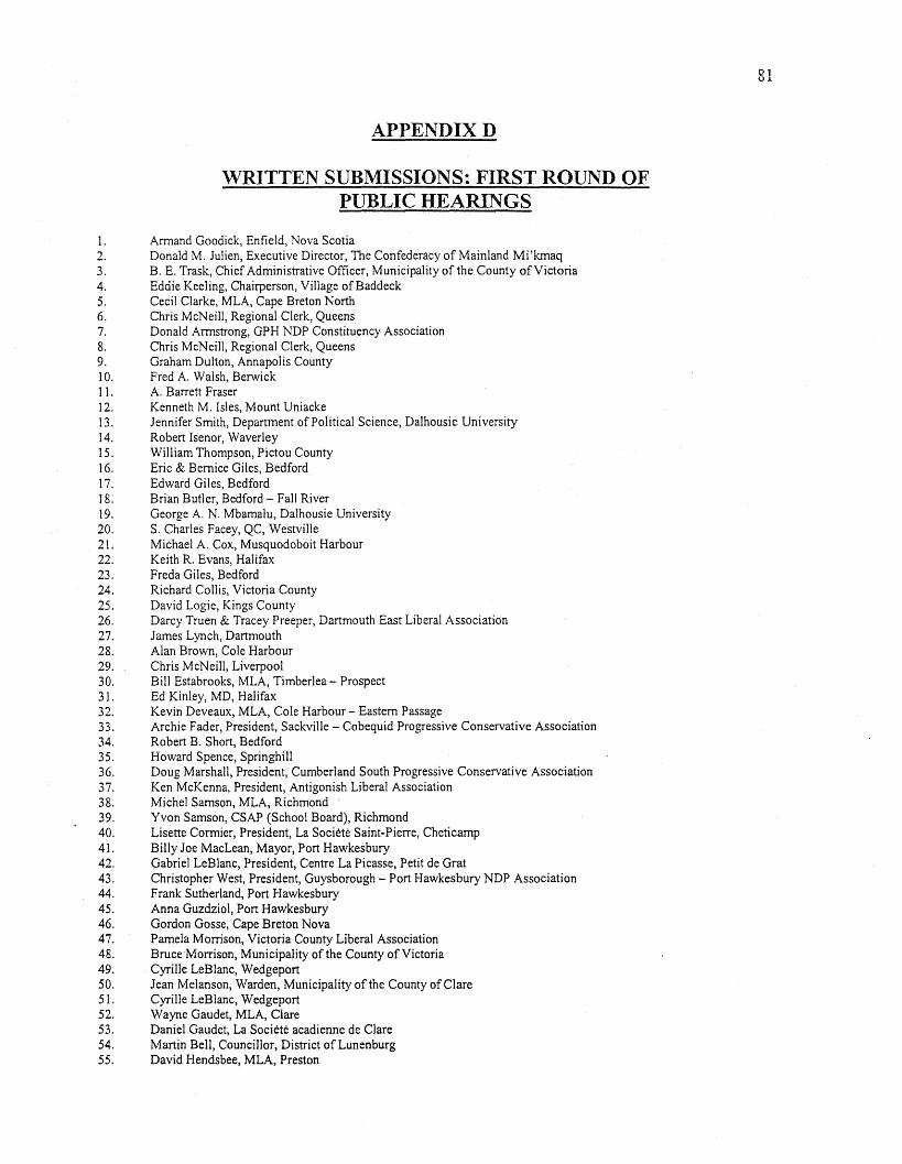
APPENDIXD
WRITTEN SUBMISSIONS: FIRST ROUND OFPUBLIC HEARINGS
I. Armand Goodick, Enfield, Nova Scotia2. Donald M. Julien, Executive Director, The Confederacy of Mainland Mi'kmaq3. B. E. Trask, Chief Administrative Officer, Municipality of the County of Victoria4. Eddie Keeling, Chairperson, Village of Baddeck5. Cecil Clarke, MLA, Cape Breton North6. Chris McNeill, Regional Clerk, Queens7. Donald Armstrong, GPH NDP Constituency Association8. Chris McNeill, Regional Clerk, Queens9. Graham Dulton, Annapolis County10. Fred A. Walsh, BerwickII. A. Barrett Fraser12. Kenneth M. Isles, Mount Uniacke13. Jennifer Smith, Department of Political Science, Dalhousie University14. Robert Isenor, Waverley15. William Thompson, Pictou County16. Eric & Bernice Giles, Bedford17. Edward Giles, Bedford18. Brian Butler, Bedford - Fall River19. George A. N. Mbamalu, Dalhousie University20. S. Charles Facey, QC, Westville21. Michael A. Cox, Musquodoboit Harbour22. Keith R. Evans, Halifax23. Freda Giles, Bedford24. Richard Collis, Victoria County25. David Logie, Kings County26. Darcy Truen & Tracey Preeper, Dartmouth East Liberal Association27. James Lynch, Dartmouth28. Alan Brown, Cole Harbour29. Chris McNeill, Liverpool30. Bill Estabrooks, MLA, Timberlea - Prospect31. Ed Kinley, MD, Halifax32. Kevin Deveaux, MLA, Cole Harbour- Eastern Passage33. Archie Fader, President, Sackville - Cobequid Progressive Conservative Association34. Robert B. Short, Bedford35. Howard Spence, Springhill36. Doug Marshall, President, Cumberland South Progressive Conservative Association37. Ken McKenna, President, Antigonish Liberal Association38. Michel Samson, MLA, Richmond39. Yvon Samson, CSAP (School Board), Richmond40. Lisette Cormier, President, La Societe Saint-Pierre, Cheticamp41, Billy Joe MacLean, Mayor, Port Hawkesbury42. Gabriel LeBlanc, President, Centre La Picasse, Petit de Grat43. Christopher West, President, Guysborough - Port Hawkesbury NDP Association44. Frank Sutherland, Port Hawkesbury45. Anna Guzdziol, Port Hawkesbury46. Gordon Gosse, Cape Breton Nova47. Pamela Morrison, Victoria County Liberal Association48. Bruce'Morrison, Municipality of the County of Victoria49. Cyrille LeBlanc, Wedgeport50. Jean Melanson, Warden, Municipality of the County of Clare51. Cyrille LeBlanc, Wedgeport52. Wayne Gaudet, MLA, Clare53. Daniel Gaudet, La Societe acadienne de Clare54. Martin Bell, Councillor, District of Lunenburg55. David Hendsbee, MLA, Preston
81
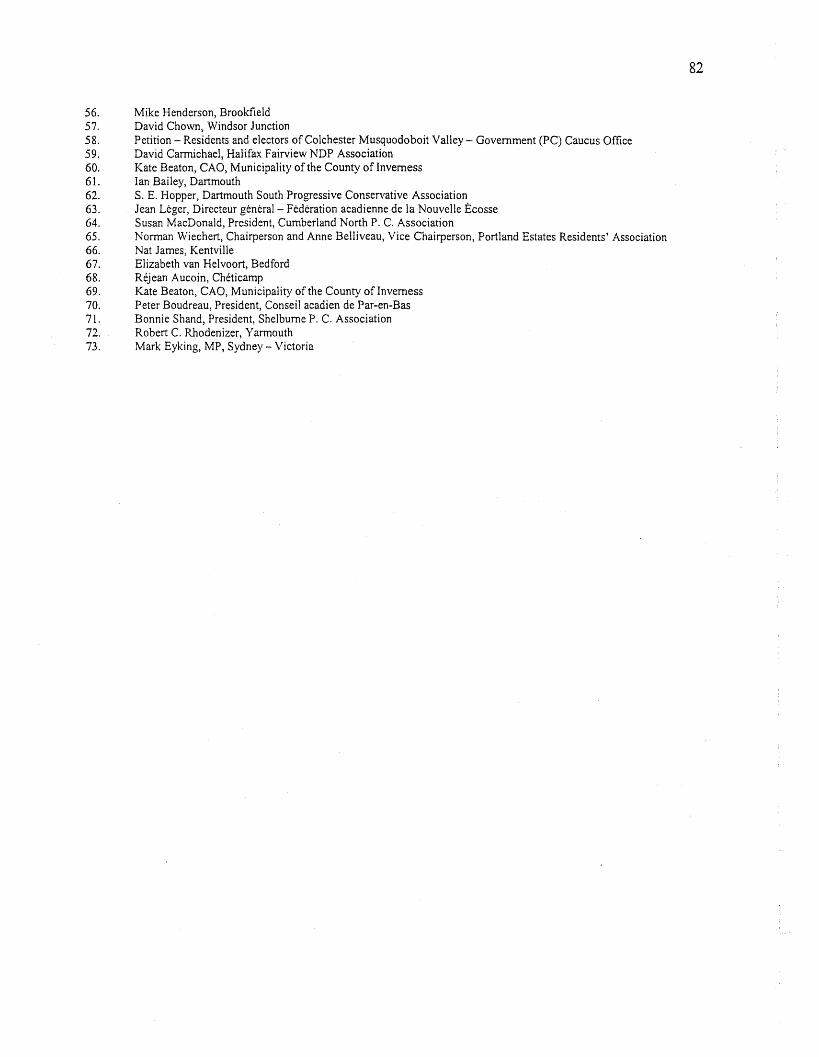
56. Mike Henderson, Brookfield57. David Chown, Windsor Junction58. Petition - Residents and electors ofCo1chester Musquodoboit Valley- Government (PC) Caucus Office59. David Carmichael, Halifax Fairview NDP Association60. Kate Beaton, CAO, Municipality of the County ofInverness61. Ian Bailey, Dartmouth62. S. E. Hopper, Dartmouth South Progressive Conservative Association63. Jean Leger, Directeur general- Federationacadienne de la Nouvelle Ecosse64. Susan MacDonald, President, Cumberland North P. C. Association65. Norman Wiechert, Chairperson and Anne Belliveau, Vice Chairperson, Portland Estates Residents' Association66. Nat James, Kentvi11e67. Elizabeth van Helvoort, Bedford68. Rejean Aucoin, Cheticamp69. Kate Beaton, CAO, Municipality of the County of Inverness70. Peter Boudreau, President, Conseil acadien de Par-en-Bas71. Bonnie Shand, President, Shelburne P. C. Association72. Robert C. Rhodenizer, Yarmouth73. Mark Eyking, MP, Sydney- Victoria
82
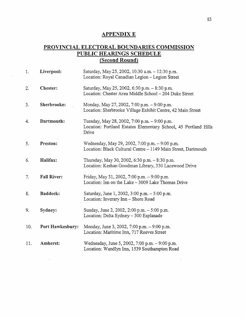
83
APPENDIXE
PROVINCIAL ELECTORAL BOUNDARIES COMMISSIONPUBLIC HEARINGS SCHEDULE
(Second Round)
1. Liverpool: Saturday, May 25,2002,10:30 a.m. - 12:30 p.m.Location: Royal Canadian Legion - Legion Street
2. Chester: Saturday, May 25, 2002, 6:30 p.m. - 8:30 p.m.Location: Chester Area Middle School - 204 Duke Street
3. Sherbrooke: Monday, May 27, 2002, 7:00 p.m. - 9:00 p.m.Location: Sherbrooke Village Exhibit Centre, 42 Main Street
4. Dartmouth: Tuesday, May 28, 2002, 7:00 p.m. - 9:00 p.m.Location: Portland Estates Elementary School, 45 Portland HillsDrive
5. Preston: Wednesday, May 29, 2002,7:00 p.m. - 9:00 p.m.Location: Black Cultural Centre - 1149 Main Street, Dartmouth
6. Halifax: Thursday, May 30, 2002, 6:30 p.m. - 8:30 p.m.Location: Keshan Goodman Library, 330 Lacewood Drive
7. Fall River: Friday, May 31, 2002, 7:00 p.m. - 9:00 p.m.Location: Inn on the Lake - 3009 Lake Thomas Drive
8. Baddeck: Saturday, June 1,2002,3:00 p.m. - 5:00 p.m.Location: Inverary Inn - Shore Road
9. Sydney: Sunday, June 2,2002,2:00 p.m. - 5:00 p.m.Location: Delta Sydney - 300 Esplanade
10. Port Hawkesbury: Monday, June 3, 2002, 7:00 p.m. - 9:00 p.m.Location: Maritime Inn, 71 7 Reeves Street
11. Amherst: Wednesday, June 5, 2002, 7:00 p.m. - 9:00 p.m.Location: Wandlyn Inn, 1539 Southampton Road

APPENDIXF
PRESENTERS: SECOND ROUND OFPUBLIC HEARINGS
May 25, 2002 - Liverpool
L Mr. Charles Copelin 40. Mr. Darren Brown
2. Mr. Chris McNeill 41. Mr. James Palmer
3. Mr. Gordon Warrington 42. Ms. Margaret Merlin
4. Mr. Bob Stafford 43. Ms. Susan Myers-Levy
5. Mr. David Ferguson 44. Mr. Brad Pellerin
6. Mr. Ken Wilkinson 45. Mr. A. Rennie Beaver
7. Mr. Bill Cox 46. Ms. Norma Richardson
8. Mr. Martin Bell 47. Mr. Ray White
9. Mr. Ron Lane 48. Ms. Gail Martin
10. Ms. Marie Dechman 49. Mr. Merlyn Joudrey
11. Ms. Sharon Ritcey 50. Mr. Sandy Cameron
12. Ms. Beverley Burlock 51. Mr. David Clark
13. Mayor John Leefe14. Mr. David Crooker May 28, 2002 - Dartmouth15. Mr. Win Seaton16. Mr. Owen Hamlin 52. Ms. Carolyn Scott17. Mr. Arnold Meisner 53. Mr. AlfHopkins18. Ms. Karen Dempsey 54. Mr. Tom Harmes19. Ms. Darlene Norman 55. Mr. Bob Horne20. Mr. Angus Fields 56. Mr. Eugene Deveaux
57. Mr. Harry Lownds
May 25, 2002 - Chester 58. Mr. Kevin Deveaux59. Mr. Colin MacEachern
21. Mr. Elmer Garber 60. Ms. Frances Tornscha
22. Mr. Brian McIntosh 61. Ms. Nancy Witherspoon
23. Mr. Jack Wentzell 62. Mr. HermanLong
24. Ms. Lila 0'Connor 63. Mr. John Bonn
25. Mr. Bill Brohm 64. Mr. Neil Bowlby
26. Ms. Gail Smith 65. Mr. Kelly Rambeau
27. Mr. Danny Haughn 66. Mr. Darrell Dexter
28. Mr. John Chataway 67. Mr. David Nantes
29. Ms. Bea Larder 68. Mr. Terry Degen
30. Ms. Wanda Broome31. Ms. Pauline Himmelman May 29,2002 - Preston32. Mr. Bruce Webber33. Mr. Stuart Davidson 69. Mr. David Hensbee34. Ms. Kirkje Johnson 70. Mr. John Meehan35. Mr. Doug Quinn 71. Mr. Jim Britten
72. Ms. Jessie Debaie
May 27, 2002 - Sherbrooke 73. Ms. Kim Thompson74. Mr. Alan Brown
36. Mr. Lloyd Hines 75. Mr. William Dooks
37. Mr. Dan McDougall 76. Ms. Jennifer Waring
38. Mr. Bill Innis 77. Mr. David Hensbee
39. Ms. Dorothy Britten 78. Ms. Judy McBride
84
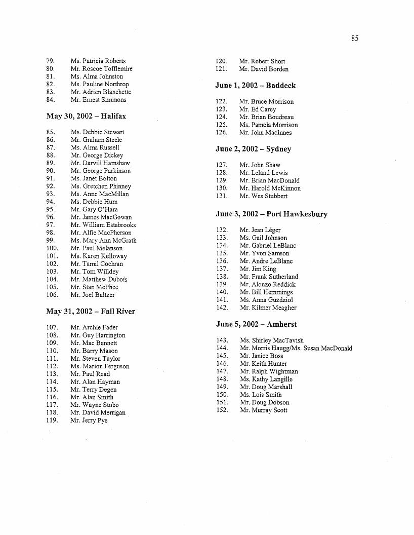
79. Ms. Patricia Roberts80. Mr. Roscoe Tofflemire81. Ms. Alma Johnston82. Ms. Pauline Northrop83. Mr. Adrien Blanchette84. Mr. Ernest Simmons
May 30, 2002 - Halifax
85. Ms. Debbie Stewart86. Mr. Graham Steele87. Ms. Alma Russell88. Mr. George Dickey89. Mr. Darvill Hamshaw90. Mr. George Parkinson91. Ms. Janet Bolton92. Ms. Gretchen Phinney93. Ms. Anne MacMillan94. Ms. Debbie Hum95. Mr. Gary O'Hara96. Mr. James MacGowan97. Mr. William Estabrooks98. Mr. Alfie MacPherson99. Ms. Mary Ann McGrath100. Mr. Paul Melanson101. Ms. Karen Kelloway102. Mr. Tamil Cochran103. Mr. Tom Willdey104. Mr. Matthew Dubois105. Mr. Stan McPhee106. Mr. Joel Baltzer
May 31, 2002 - Fall River
85
120. Mr. Robert Short121. Mr. David Borden
June 1, 2002 - Baddeck
122. Mr. Bruce Morrison123. Mr. Ed Carey124. Mr. Brian Boudreau125. Ms. Pamela Morrison126. Mr. John MacInnes
June 2, 2002 - Sydney
127. Mr. John Shaw128. Mr. Leland Lewis129. Mr. Brian MacDonald130. Mr. Harold McKinnon131. Mr. Wes Stubbert
June 3, 2002 - Port Hawkesbury
132. Mr. Jean Leger133. Ms. Gail Johnson134. Mr. Gabriel LeBlanc135. Mr. Yvon Samson136. Mr. Andre LeBlanc137. Mr. Jim King138. Mr. Frank Sutherland139. Mr. Alonzo Reddick140. Mr. Bill Hemmings141. Ms. Anna Guzdziol142. Mr. Kilmer Meagher
June 5, 2002 - Amherst107.108.109.110.111.112.113.114.115.116.117.118.119.
Mr. Archie FaderMr. Guy HarringtonMr. Mac BennettMr. Barry MasonMr. Steven TaylorMs. Marion FergusonMr. Paul ReadMr. Alan HaymanMr. Terry DegenMr. Alan SmithMr. Wayne StoboMr. David MerriganMr. Jerry Pye
143.144.145.146.147.148.149.150.151.152.
Ms. Shirley MacTavishMr. Morris HaugglMs. Susan MacDonaldMr. Janice BossMr. Keith HunterMr. Ralph WightmanMs. Kathy LangilleMr. Doug MarshallMs. Lois SmithMr. Doug DobsonMr. Murray Scott
APPENDIXG
WRITTEN SUBMISSIONS: SECOND ROUND OFPUBLIC HEARINGS *
1. Bill Innis2. Colin MacEachern3. David Hensbee, MLA, Preston4. Kevin Estabrooks, Hammonds Plains5. Wayne Kennedy6. Linda Garber7. Michael A. Broomfield, Musquodoboit Harbour8. John Leefe, Mayor, Municipality of Queens9. Debbie Darrow10. Terence M. Ward, Chester Basin11. Mellissa Hopkins12. Daniel Haughn13. Karen Schlick, Eastern Shore14. Aileen Heisler, Chester15. Wally Zinck, Chester16. Alexander Michael Ward17. Janice Munroe, Eastern Shore18. Jim Britten, Head of Jeddore19. James J. Cruddas, Liverpool20. Joyce Lachance, Eastern Shore21. Duncan Kennedy, Pleasant Harbour22. Greg Brown, Dartmouth23. Douglas Foster, Cape Breton Regional Municipality24. Janet Willwerth, Chief Electoral Officer25. Peter Ineson, Halifax26. Graham Gaetz, Canso27. Heather Taylor, Eastern Shore28. Molly Gammon, Mosher River29. Carolyn Thomas, East Preston30. Jim Britten, Head of Jeddore31. Howard Epstein, Halifax32. Allistair K. Scott, Sydney33. Mrs. Walsh, Head of Jeddore34. Edna Baker, Lake Charlotte35. Ruth and Clarence Blakeney36. Michelle Falkenham37. John Wood, Sober Island38. Hume Smith, Chester39. Bobby Harrington40. Martin E. Bell, Lunenburg County41. Davie Crooker, North Queens Board ofTrade42. John G. Leefe, Mayor, Region of Queens Municipality43. Queens County Liberal Association44. Ken Wilkinson, Queens County45. Bob Stafford, Liverpool46. Chris McNeill, Queens P. C. Association47. Harry Freeman, Queens County48. Beverly Day Burlock, Port Mouton49. C. Arnold Meisner, Liverpool
86
50. Bruce M. Webber51. Pauline Hirnrnelman52. Dan Haughn53. Jack Wentzell, Warden, Municipality of the District of Lunenburg54. Elmer Garber, Lunenburg P. C. Association55. Brian McIntosh, Lunenburg County56. Gail Smith57. Wanda J. Broome58. Bea Larder59. Eugene Deveaux, Eastern Passage60. Neil Bowlby, Eastern Passage61. Carolyn Scott, Cole Harbour Eastern Passage Liberal Association62. Alfred Hopkins, Eastern Shore P. C. Association63. Dale Wilson, Eastern Passage64. Colin MacEachern - Frances Tomscha, Dartmouth South Liberal Association65. Guysborough - Port Hawkesbury P. C. Association66. Barry Barnet, MLA, Sackville Beaver Bank67. Lorraine Williamson, Clayton Park68. Eileen Allen, Prince's Lodge69. Maynard and Eileen Boutilier, Mushaboom70. Eldon and Eleanor Rudolph, Musquodoboit Harbour71. Lloyd Hines, Warden, Municipality of the District of Guysborough72. Bill Innis73. Darren C. Brown, West Jeddore74. Margaret Merlin75. Susan Levy, Sheet Harbour and Area Chamber of Commerce76. Brad Pellerin, Guysborough - Port Hawkesbury Liberal Association77. A. Rennie Beaver, Chairman, Guysborough County Regional Development Authority78. Norma Richardson, Mosher River79. Ray White80. Gail Martin, President, The United Board ofTrade, Mosher River81. Guysborough - Port Hawkesbury P. C. Association82. Alan Brown, Cole Harbour83. Bill Estabrooks, MLA, Timberlea - Prospect84. Anne MacMillan, Wedgewood Park85. Alma Russell, Kearney Lake86. Graham Steele, MLA, Halifax Fairview87. Karen Kelloway, Tremont Drive, Halifax88. Petition, Residents, Kearney Lake, Halifax89. Chris Wheeler90. Charles Rutt, President, Eastern Shore Liberal Association91. Gary and Valerie Jakeman, Cow Bay92. Tracy Walker, Cow Bay93. Melanie Hopkins, Blandford94. John and Thelma Clark, Aspotogan95. Richard Meagher96. Violet Sellick and Paul Melanson, Tremont Drive, Halifax97. Greg MacKay, President, Greater Prince's Lodge Residents Association98. Alex Handyside, West Porters Lake99. David O'Neil, Dartmouth100. Bob Stafford, Liverpool101. David Nantes, Dartmouth102. Richard Vine, Dartmouth103. Jim Simon, Lakeview104. Arthur H. Young, Deputy Warden, Municipality of the District ofLunenburg105. Don Downe, MLA, Lunenburg West
87
106. John Shaw, Sydney107. Leland Lewis, Sydney108. James K. Harper, Chairman, Preston Area Board of Trade109. Michael MacDonald, Dartmouth110. Leo Van Dijk, Dartmouth111. Shaunna Scott, Executive Director, Guysborough County112. Chris McLaren, Hubley113. W. H. Mont, Mayor, Springhill114. Lisa Brown, Cow Bay115. Laurette Deveau, Secretary, Strategic Plan Steering Committee, Cheticamp116. Steven D. Colclough117. Stan McPhee118. Leon Robertson, Queens County119. Kim Whitaker, Eastern Shore120. Dan Moscovitch121. Judy Greenwood-Hill, Musquodoboit Harbour122. Gail MacLennan, Eastern Passage123. James Fanning, Head of Jeddore124. Russell Fisher, Springhill125. Neil Wood126. Jean Leger, Directeur General, Federation Acadienne de la Nouvelle-Ecosse, Dartmouth127. Malcolm Bennett, V. P., Sackville Cobequid P. C. Association128. Unknown, Sackville Area129. Jim King, Deputy Mayor, Port Hawkesbury130. Greg Capstick and Terry Degen, Dartmouth East P.C. Association131. Alan G. Hayman, Municipal Enterprises Limited132. Bruce Morrison and John MacKillop, Victoria P. C. Association133. Harold McKinnon, President, Cape Breton the Lakes Liberal Association134. Brian MacDonald, Executive Director, Sydney Downtown Development Association135. John Shaw, Sydney136. Alonzo Reddick, Antigonish - Guysborough Black Development Association137. William Hemmings, Deputy Mayor, Mulgrave138. Gail Johnson, Deputy Warden, Richmond County139. Frank R. Sutherland, Port Hawkesbury140. Shirley MacTavish, Amherst141. Morris Haugg, Cumberland North142. David Dewar, Wallace143. George Latta, Malagash144. Bill Casey, MP, Cumberland Cochester145. Ian Bailey, Dartmouth146. John D. Bonn, Dartmouth147. Joel Baltzer, Halifax Bedford Basin148. Angela Jessop, 19 Tremont Drive, Halifax149. Darlene Guite, Blandford150. Halifax Bedford Basin P. C. Association151. John Chataway, MLA, Chester - St. Margaret's152. Jim Matthews, President, Dartmouth - Cole Harbour NDP Association153. Barry J. Mason, Bedford154. Norma J. Young, Lunenburg County155. Petition, Residents of Eastern Shore156. Pamela Morrison, President, Victoria Liberal Association157. Judy Greenwood-Hill, Ostrea Lake158. Frank Fraser159. Roy T. Pennell, Halifax160. Pat Shaw, Halifax161. Dr. Martin Gillis, Liverpool
88
89
162. Angus J. Fields, Lunenburg NDP Association163. Arthur H. Young, Deputy Warden, Municipality of the District of Lunenburg164. Tim Olive, MLA, Dartmouth South165. Andre Saindon, Musquodoboit Harbour166. Petition re Cow Bay, Residents of Eastern Passage and Cow Bay167. Marion E. Dean, Advocate Harbour168. Victoria P.C. Association169. Roger Middleton, Bedford170. Chris D. Tyler, 16 Tremont Drive, Halifax171. Judy R. Baker, Eastern Shore172. Arthur Mansen, Halifax173. Sharon Ritcey, Pleasantville174. Don Downe, MLA, Lunenburg West, Petition from residents of Lunenburg West175. Frank Fraser, Mayor, Town of Canso176. Gabriel LeBlanc177. James Palmer, Jeddore178. Colin 1. MacDonald, Port Hawkesbury179. Marjorie Irene Dooks, Head of Jeddore
* The deadline for submissions to the Commission was June 15, 2002. Any submissions received after thatdate have been sent to the Speaker's Office for consideration by the Legislature.
90
APPENDIXH
DATA ISSUES AND DATA MODELLING
Census Releases
For the 2001 Census of Population, raw Census numbers, total population and dwellings,
were not released until March 12, 2002, and the required working files were not available until
late March. By this time, the Commission, given its timelines, was well-advanced in its planning
and preliminary analysis. As a result, data based on the 1996 Census and 1999 Taxfiler data were
used in the preliminary work and for the Commission's Information Package and the First Round
of Public Hearings. Age data were released on July 16, 2002 and immigration data will not be
released until January 21, 2003. Both of these releases were too late to be used in the
Commission's work. Immigration data from the 1996 Census and age data from the 1999
Taxfiler information were used to model the number of electors, as explained in the body of the
Report.
Geography
For the 2001 Census of Pqpulation, Statistics Canada introduced the Data Dissemination
Area (DA). The DA is the lowest level of data disaggregation that data, other than total
population and dwellings, are released. Previously data .were collected and released by
Enumeration Area (EA). While the data continue to be collected by EA, they are released by DA
to reduce the amount of data that were suppressed to protect confidentiality. Historically,
provincial electoral boundaries and census boundaries have not coincided. This means that, for
the Commission, 1991 EAs, 1996 EAs and 2001 DAs were apportioned to current and proposed
91
electoral districts. While the majority of the 1397 small dissemination areas fell cleanly within
electoral boundaries, some were apportioned based on approximate share to two or more
districts.
Census Coverage
• 2001 unadjusted census numbers for total population were the only ones available at the time
of the Commission's deliberations. Although subsequent adjustments for under-coverage will
be made at the provincial level in September of 2003, this provincial adjustment will then be
prorated based upon the present distribution of the unadjusted numbers. The unadjusted
Census numbers, therefore, are a reasonable basis for determining shares of population
within the province.
• Statistics Canada counts people at their usual place of residence, which means that -
o People from other provinces are counted in their home province - including students.
o Transients/homeless are counted where they are living, if they are able to be
enumerated.
o People from other countries are counted if they are, or expect to be, resident in
Canada for more than six months.
• Citizenship is determined from the Census long form, which is collected from 20 percent
(one in five) of all persons resident in Canada. These results are used to estimate the full 100
percent citizenship number.
92
Data Modelling
The Statistics Division has used the data sources shown below in modelling information
for use by the Electoral Boundaries Commission, as outlined in the following:
• For comparative purposes, 1991 and 1996 Census of Population data and 1999 Taxfiler data
were used in helping to prepare population estimates, based on the new 2001 Census of
Population, by county and provincial electoral district.
• Data at the enumeration area level for 1991, 1996, and 2001 and postal walk level for 1999
Taxfiler data were allocated to the previous (1991) electoral districts.
• Data from the 2001 Census were allocated for the proposed Electoral Districts. This was an
iterative procedure done in conjunction with Commission staff and several variations were
done to arrive at the proposed boundaries included in the Commission's Report.
• Population estimates were provided by county and electoral district (existing and proposed)
for total population, as well as an estimate for number of electors.
• Number of electors was estimated as follows:
o The percentage of citizens for each of the counties and 1991 electoral boundaries was
calculated from the 1996 Census of Population, because the 2001 citizenship
information will not be released until January 21, 2003.
o This percentage was applied to the 2001 unadjusted population for the counties and
the 1991 electoral boundaries.
o For the proposed boundaries, the percentage of citizens for the 1991 electoral district
most closely representing the proposed district was used. For the new proposed
93
districts, an average of the neighbouring districts most representative of the new
district was used.
• A similar approach for the population 18 and over was used. In this case, 1999
Taxfiler data was used to estimate the population by age for each county and
electoral district, because the 2001 age data was not released until July 16, 2002.
The more recent Taxfiler data was deemed to be more representative of the age
distribution than the 1996 Census figures.
Data Sample
An example of the data given to the Commission by the Nova Scotia Statistics Agency is
presented in Table Six: 2001 Data for Recommended Electoral Districts. Table Six is the set of
numbers received by the Commission on August 1, 2002, which includes all of the final
boundary revisions approved by the Commission at its meeting of July 29-30, 2002. It is the
basis for the data presented in the Commission's Final Report in Tables Four and Five.
Column 1 is the estimated 2001 population for each of the 52 recommended electoral
districts. By dividing a constituencies population by the provincial district average (17,462), the
seat entitlement index for that constituency can be determined. Column 2 is the estimated
percentage of those eighteen and older in each proposed constituency. By multiplying Column 1
by Column 2, the number of people 18 years and over is obtained for each of the 52
constituencies. The last two rows in Table Six (Columns 1 and 3) show the difference between
total population and those eighteen and over: the provincial population total is 908,007, while the
number ofpeople 18 and over is estimated to be 704,345.
94
Column 4 presents the estimated percentage of Canadian citizens for each of the 52
electoral districts. By multiplying Column 3 by Column 4, the number of electors (eligible
voters) is calculated for each recommended electoral districts. Column 5 thus reflects the
Reports definition of electors as those Canadian citizens 18 years and older. Note that the
number of estimated electors is 693,040, with an average constituency size of 13,328, while for
population the figure is 908,007, with an average constituency size of 17,462.
The final column in Table Six presents each constituency's percentage of the electors
average (estimated electors in each constituency divided by the provincial district average of
13,328). Column 6 shows that the proposed redistribution, based on electors, would create
electoral districts from 50.4 percent to 119.9 percent of the provincial average. Column 6 is the
basis for the Commission's seat entitlement index based on electors. For example, Hants East's
percent of provincial average is 119.9, which creates an entitlement index for that constituency
of 1.20.
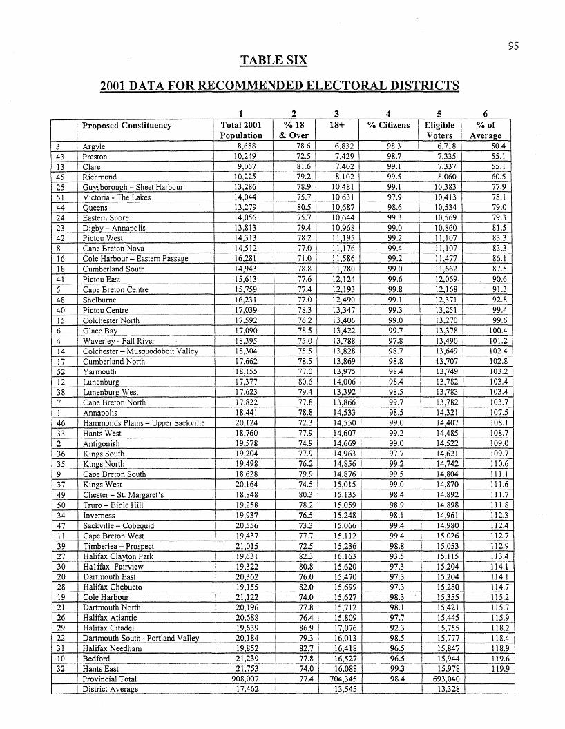
TABLE SIX
2001 DATA FOR RECOMMENDED ELECTORAL DISTRICTS
95
1 2 3 4 5 6Proposed Constituency Total 2001 0/0 18 18+ 0/0 Citizens Eligible 0/0 of
Population & Over Voters Average3 Argyle 8,688 78.6 6,832 98.3 6,718 50.4
43 Preston 10,249 72.5 7,429 98.7 7,335 55.1
13 Clare 9,067 81.6 7,402 99.1 7,337 55.1
45 Richmond 10,225 79.2 8,102 99.5 8,060 60.5
25 Guysborough - Sheet Harbour 13,286 78.9 10,481 99.1 10,383 77.9
51 Victoria - The Lakes 14,044 75.7 10,631 97.9 10,413 78.144 Queens 13,279 80.5 10,687 98.6 10,534 79.024 Eastern Shore 14,056 75.7 10,644 99.3 10,569 79.323 Digby - Annapolis 13,813 79.4 10,968 99.0 10,860 81.542 Pictou West 14,313 78.2 11,195 99.2 11,107 83.38 Cape Breton Nova 14,512 77.0 11,176 99.4 11,107 83.316 Cole Harbour - Eastern Passage 16,281 71.0 11,586 99.2 11,477 86.1
18 Cumberland South 14,943 78.8 11,780 99.0 11,662 87.541 Pictou East 15,613 77.6 12,124 99.6 12,069 90.65 Cape Breton Centre 15,759 77.4 12,193 99.8 12,168 91.348 Shelburne 16,231 77.0 12,490 99.1 12,371 92.840 Pictou Centre 17,039 78.3 13,347 99.3 13,251 99.415 Colchester North 17,592 76.2 13,406 99.0 13,270 99.6
6 Glace Bay 17,090 78.5 13,422 99.7 13,378 100.44 Waverley - Fall River 18,395 75.0 13,788 97.8 13,490 101.214 Colchester - Musquodoboit Valley 18,304 75.5 13,828 98.7 13,649 102.4
17 Cumberland North 17,662 78.5 13,869 98.8 13,707 102.852 Yarmouth 18,155 77.0 13,975 98.4 13,749 103.212 Lunenburg 17,377 80.6 14,006 98.4 13,782 103.4
38 Lunenburg West 17,623 79.4 13,392 98.5 13,783 103.47 Cape Breton North 17,822 77.8 13,866 99.7 13,782 103.7
1 Annapolis 18,441 78.8 14,533 98.5 14,321 107.546 Hammonds Plains - Upper Sackville 20,124 72.3 14,550 99.0 14,407 108.1
33 Hants West 18,760 77.9 14,607 99.2 14,485 108.7
2 Antigonish 19,578 74.9 14,669 99.0 14,522 109.0
36 Kings South 19,204 77.9 14,963 97.7 14,621 109.735 Kings North 19,498 76.2 14,856 99.2 14,742 110.6
9 Cape Breton South 18,628 79.9 14,876 99.5 14,804 111.1
37 Kings West 20,164 74.5 15,015 99.0 14,870 111.649 Chester - St. Margaret's 18,848 80.3 15,135 98.4 14,892 111.7
50 Truro - Bible Hill 19,258 78.2 15,059 98.9 14,898 111.834 Inverness 19,937 76.5 15,248 98.1 14,961 112.347 SackviIle - Cobequid 20,556 73.3 15,066 99.4 14,980 112.411 Cape Breton West 19,437 77.7 15,112 99.4 15,026 112.739 Timberlea - Prospect 21,015 72.5 15,236 98.8 15,053 112.927 Halifax Clayton Park 19,631 82.3 16,163 93.5 15,115 113.430 Hal ifax Fairview 19,322 80.8 15,620 97.3 15,204 114.120 Dartmouth East 20,362 76.0 15,470 97.3 15,204 114.128 Halifax Chebucto 19,155 82.0 15,699 97.3 15,280 114.719 Cole Harbour 21,122 74.0 15,627 98.3 15,355 115.221 Dartmouth North 20,196 77.8 15,712 98.1 15,421 115.726 Halifax Atlantic 20,688 76.4 15,809 97.7 15,445 115.929 Halifax Citadel 19,639 86.9 17,076 92.3 15,755 118.222 Dartmouth South - Portland Valley 20,184 79.3 16,013 98.5 15,777 118.431 Halifax Needham 19,852 82.7 16,418 96.5 15,847 118.910 Bedford 21,239 77.8 16,527 96.5 15,944 119.632 Hants East 21,753 74.0 16,088 99.3 15,978 119.9
Provincial Total 908,007 77.4 704,345 98.4 693,040District Average 17,462 13,545 13,328
TABLE SIX (continued)
Notes:Percent population 18 & over is based on 1999 Taxfiler data for the 1991 Electoral Districts. The percentage of theclosest representative district is applied to the new district structure.
Percent of Citizens is from the 1996 Census of Population data for the 1991 Electoral Districts. The percentage of theclosest representative district is applied to the new district structure.
Source:Statistics Canada - 2001 Census of Population, unadjustedStatistics Division, Nova Scotia Department of Finance - data modelled to provincial electoral districts.
96
97
APPENDIX I
QUEENS COUNTY DATA REVISION
In its Interim Report (Table Two, p. 14), Queens County and the Queens constituency
was listed as having a 2001 population of 12,486 and a seat ,entitlement of 0.72, while in terms
of electors (Interim Report, Table Three, p. 16) Queens was listed as having 9,905 electors and
a seat entitlement of 0.74. The last number of 0.74, which had been rounded off, was in fact
0.7445. Given how close this seat entitlement was to the -25 percent factor in the
Commission's Terms of Reference, the Commission was asked, during the Second Round of
Public Hearings, to consider adding the Maitland Bridge area of Annapolis County to Queens
in order to reach the -25 percent variance allowed (thus negating the possibility of expanding
the Queens riding into Lunenburg County).
The Commission analyzed this idea and produced the numbers for this possible
scenario, fully expecting that the seat entitlement for Queens, based on electors in 2001, would
be nudged past the -25 percent variance level. Contrary to expectations, the numbers for
Queens actually dropped. The Nova Scotia Statistics Agency was asked to investigate this data
discrepancy and resolve the issue. As a result, the Nova Scotia Statistics Agency informed the
Provincial Electoral Boundaries Commission of an error in the data set provided to the
Commission by the Agency.
Two of the 1397 dissemination areas in the data set had been assigned to the wrong
constituency: one had been assigned to Queens rather than to Lunenburg West and one was
98
assigned to Halifax Needham rather than to Halifax Chebucto. The Halifax Needham and
Halifax Chebucto error had no impact on the Commission's deliberations, because it was
correctly accounted for in subsequent major revisions to boundaries in the Metro area.
Similarly, in responding to the. public consultations, boundary reviews for Queens and
Lunenburg for the Final Report used the corrected allocation. The major problem with the
error was in developing an expectation of maintaining a degree of status quo for Queens. The
population and electors were overestimated in Queens and underestimated in Lunenburg West.
The 2001 population in Queens should have been shown as 11,723 instead of 12,486 and in
Lunenburg West it should have been 19,358 instead of 18,595. While this error did not
materially affect the original recommendations in the Commission's Interim Report, the seat
entitlements for these two constituencies needed to be altered as well, with that for Queen's
decreasing and that for Lunenburg West increasing. The Final Report reflects these
adjustments.