Embed Size (px)
Citation preview
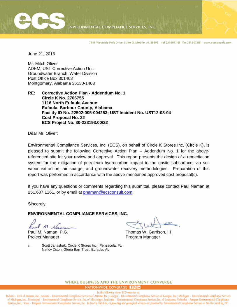
June 21, 2016 Mr. Mitch Oliver ADEM, UST Corrective Action Unit Groundwater Branch, Water Division Post Office Box 301463 Montgomery, Alabama 36130-1463 RE: Corrective Action Plan - Addendum No. 1
Circle K No. 2706755 1116 North Eufaula Avenue Eufaula, Barbour County, Alabama Facility ID No. 22502-005-004253; UST Incident No. UST12-08-04 Cost Proposal No. 22 ECS Project No. 30-223193.00/22
Dear Mr. Oliver:
Environmental Compliance Services, Inc. (ECS), on behalf of Circle K Stores Inc. (Circle K), is
pleased to submit the following Corrective Action Plan – Addendum No. 1 for the above-
referenced site for your review and approval. This report presents the design of a remediation
system for the mitigation of petroleum hydrocarbon impact to the onsite subsurface, via soil
vapor extraction, air sparge, and groundwater recovery methodologies. Preparation of this
report was performed in accordance with the above-mentioned approved cost proposal(s).
If you have any questions or comments regarding this submittal, please contact Paul Naman at
251.607.1161, or by email at [email protected].
Sincerely, ENVIRONMENTAL COMPLIANCE SERVICES, INC.
Paul M. Naman, P.G. Thomas W. Garrison, III Project Manager Program Manager c: Scott Janashak, Circle K Stores Inc., Pensacola, FL Nancy Dixon, Gloria Barr Trust, Eufaula, AL


Corrective Action Plan - Addendum No. 1 Page ii Circle K Site No. 2706755, 1116 North Eufaula Avenue, Eufaula, Barbour County, Alabama June 21, 2016
2016-06-17 CK6755 CAP Add Rpt.docx
TABLE OF CONTENTS
SITE INFORMATION .................................................................................................................. 1
SITE IDENTIFICATION ............................................................................................................... 1
SITE CONTACT INFORMATION ................................................................................................ 1
INFORMATION ABOUT CURRENT RELEASE .......................................................................... 1
REPORT CERTIFICATION ......................................................................................................... 2
1.0 INTRODUCTION ............................................................................................................. 3
1.1 Site Location and Description .............................................................................. 3
2.0 SITE HISTORY AND CHARACTERIZATION .................................................................. 3
2.1 Receptors/Potential Receptors............................................................................. 5 2.2 Groundwater Assessment .................................................................................... 5
3.0 REMEDIAL ACTION ........................................................................................................ 6
3.1 Remedial Objectives ............................................................................................ 6 3.2 Pilot Testing ......................................................................................................... 6 3.3 Permitting ............................................................................................................ 7 3.4 Remediation System Design ................................................................................ 8 3.5 Proposed Recovery Well Installation .................................................................... 9 3.6 Proposed Air Sparge Well Installation .................................................................. 9 3.7 Trenching and Piping ........................................................................................... 9 3.8 Remediation System Components ..................................................................... 10 3.9 Remediation System Operation and Maintenance ............................................. 12 3.10 Estimated Time to Achieve Objectives ............................................................... 13
4.0 PROPOSED SAMPLING REQUIREMENTS ................................................................. 13
4.1 Air Emissions ..................................................................................................... 13 4.2 Waste Water Discharge ..................................................................................... 14 4.3 Groundwater Monitoring Events ......................................................................... 14
5.0 SCHEDULE AND REPORTING .................................................................................... 14
5.1 Schedule ............................................................................................................ 14 5.2 Reporting ........................................................................................................... 15
6.0 COSTS .......................................................................................................................... 16
7.0 LIMITATIONS ................................................................................................................ 17

Corrective Action Plan - Addendum No. 1 Page iiiCircle K Site No. 2706755, 1116 North Eufaula Avenue, Eufaula, Barbour County, Alabama June 21, 2016
2016-06-17 CK6755 CAP Add Rpt.docx
FIGURES
Figure 1 Site Location MapFigure 2 Site MapFigure 3 Benzene Iso-Concentration Map for March 18-19, 2016Figure 4 Trenching and Well Location MapFigure 5 Radius of Influence and Well Location MapFigure 6 Process Flow and Instrumentation Diagram
TABLES
Table 1 Summary of Liquid Level DataTable 2 Summary of Groundwater Analytical Data (BTEX, MTBE, Naphthalene)Table 3 Summary of Groundwater Analytical Data (1,2-Dichloroethane, 1,2-Dibro-
moethane, Lead)
APPENDICES
Appendix A Cost Proposal No. 27 (CP-27): System Installation and StartupAppendix B Cost Proposal No. 28 (CP-28): UIC Permit ApplicationAppendix C Cost Proposal No. 29 (CP-29): Initial 3 Months of Operation and Maintenance

Corrective Action Plan - Addendum No. 1 Page 1 of 17 Circle K Site No. 2706755, 1116 North Eufaula Avenue, Eufaula, Barbour County, Alabama June 21, 2016
2016-06-17 CK6755 CAP Add Rpt.docx
SITE INFORMATION
Date of Report: June 21, 2016
SITE IDENTIFICATION
Facility ID: 22502-005-004253
UST Incident No: UST12-08-04 (Current)
UST98-09-12 (NFA)
Agency Contact: Mitch Oliver, ADEM, UST Corrective Action Unit
Site Name: Circle K No. 2706755
Site Street Address: 1116 North Eufaula Avenue
Eufaula, Barbour County, Alabama
Latitude / Longitude: 31.913092° / (-) 85.148908°
SITE CONTACT INFORMATION
UST Owner/Operator: Circle K Stores Inc.
Address: 25 West Cedar Street, Suite M. Pensacola, FL 32502
Telephone: (850) 549-2879
Contact: Scott Janashak, Environmental Manager
Property Owner: Circle K Stores Inc.
Address: 25 West Cedar Street, Suite M. Pensacola, FL 32502
Telephone: (850) 549-2879
Consultant/Contractor: Environmental Compliance Services, Inc.
Address: 7856 Westside Park Drive, Mobile, AL 36695
Telephone: (251) 607-1161
Contact Name: Paul M. Naman
Analytical Laboratory: Accutest Laboratories
Address: 500 Ambassador Caffery Pkwy, Scott, LA 70583
Telephone: (337) 237-4775
INFORMATION ABOUT CURRENT RELEASE
Date Discovered: August 2012
Estimated Quantity of Release: Unknown
Source of Release: STP Sump Failure
Current UST(s) Size & Contents: (1) 10,000-gallon Gasoline & (2) 6,000-gallon Gasoline

Corrective Action Plan - Addendum No. 1 Page 3 of 17 Circle K Site No. 2706755, 1116 North Eufaula Avenue, Eufaula, Barbour County, Alabama June 21, 2016
2016-06-17 CK6755 CAP Add Rpt.docx
1.0 INTRODUCTION
This Corrective Action Plan (CAP) Addendum No. 1 has been prepared by Environmental
Compliance Services, Inc. (ECS), on behalf of Circle K Stores, Inc. (Circle K), as approved by
the Alabama Department of Environmental Management (ADEM) in correspondence titled
“Approval of Cost Proposal CP#22 (Changed from #19) for CAP Development,” dated March
12, 2015.
ECS has reviewed the CAP, as prepared by S&ME, Inc. (S&ME), dated December 8, 2014, and
the subsequent ADEM correspondence dated January 20, 2015 which requested the submittal
of a CAP Addendum. Additional assessment and remedial action of the petroleum hydrocarbon
plume has been conducted since the submittal of the December 2014 CAP. This CAP
Addendum No. 1 has been prepared to present additional remedial design approach and
techniques to support and accelerate the mitigation of the localized petroleum hydrocarbon
impact and in accordance with Cost Proposal #22 (CP-22), as approved by ADEM in
correspondence dated March 12, 2015.
1.1 Site Location and Description
The Circle K No. 2706755 facility is located at 1116 North Eufaula Avenue, within the city/town
limits of Eufaula, Barbour County, Alabama, and the site location is illustrated on Figure 1
(henceforth referred to as the “site”).
The facility is currently owned and operated by the Gulf Coast business unit of Circle K located
in Pensacola, Florida. Based on site visits conducted by ECS in 2015 and 2016, the site is
developed with a one-story building, three underground storage tanks (USTs), and associated
fuel canopies with dispensers. Onsite USTs consist of one 10,000 gallon gasoline UST, and
two 6,000 gallon gasoline USTs. Site features, UST system layout, and monitoring well
locations are illustrated on Figure 2.
2.0 SITE HISTORY AND CHARACTERIZATION
Various phases of assessment and remedial activities have been conducted by previous
consultants at the site since the initial discovery of a release by Crown Petroleum Corporation
(Crown) dating back to November 1997. The release reported and assessed under UST
Incident No. UST98-09-12 was subsequently closed by ADEM through issuance of a No Further
Action (NFA) letter dated October 10, 2012.
In August 2012, a release was discovered and reported by Circle K following repairs made to
both the regular and premium UST submersible-turbine pump (STP) sumps. Follow-up

Corrective Action Plan - Addendum No. 1 Page 4 of 17 Circle K Site No. 2706755, 1116 North Eufaula Avenue, Eufaula, Barbour County, Alabama June 21, 2016
2016-06-17 CK6755 CAP Add Rpt.docx
assessments and remedial activities were conducted by S&ME from September 2012 to
September 2014, which included the installation of recovery wells, off-site monitoring wells, free
product recovery [both manual and high-vacuum events (HVE)], groundwater and surface water
sampling, and the completion of a CAP.
Based on a review of multiple monitoring and free product recovery reports, S&ME has
completed twenty-four Mobile-Enhanced Multiphase Extraction (MEME) events at the site from
September 2013 to January 2015, ranging from 8 hours to 24 hours in duration. A total of
approximately 2,147 pounds of hydrocarbons and approximately 38,100 gallons of petroleum-
impacted groundwater have reportedly been removed during the MEME events. In addition,
manual recovery efforts have been conducted on a bi-monthly basis by S&ME from May 2014 to
January 2015 which has reportedly resulted in the recovery of approximately 83.95 gallons.
As directed by ADEM, S&ME completed a CAP dated December 8, 2014, which proposed the
use of Multi-pump Dual-Phase Extraction (MDPE) for restoration of groundwater quality at the
site. Following review of the CAP, ADEM issued correspondence dated January 20, 2015,
which cited several deficiencies and requested an addendum be completed and submitted
following the requested revisions.
As recommended for the completion of additional downgradient delineation of impacted
groundwater, ECS completed the installation of ten additional monitoring wells (MW-35 through
MW-44) located on the Barr Property. Access was granted by executors of the Gloria Barr Trust
in the form of an executed Right-of-Entry Agreement.
Mobile-enhanced multiphase extraction (MEME) events have been conducted at the site from
September 2013 to June 2016 by ECS and S&ME, ranging from 8 hours to 24 hours in duration.
In addition, manual recovery efforts were conducted on a bi-monthly basis from May 2014 to
January 2015.
Circle K transferred environmental consulting responsibilities from S&ME to ECS for this site in
February 2015. Currently, MEME events are being conducted on an approximate monthly
schedule and triannual groundwater monitoring is being done.
During the March 2016 sampling event, all site monitoring wells were located and observed to be in good condition with the exception of MW-9, which was observed to be obstructed at approximately 4 feet below ground surface (BGS). In addition, free-phase product was encountered at well locations MW-29, MW-32, EW-2, EW-14, RW-1, RW-3, and RW-4 during the March 2016 sampling event, at thicknesses ranging from 0.03 feet to 8.42 feet. Historical liquid level data is summarized in Table 1.

Corrective Action Plan - Addendum No. 1 Page 5 of 17 Circle K Site No. 2706755, 1116 North Eufaula Avenue, Eufaula, Barbour County, Alabama June 21, 2016
2016-06-17 CK6755 CAP Add Rpt.docx
Based on the most recent groundwater sampling event conducted in March 2016, the samples
collected from wells MW-22, MW-35, and MW-38 contained levels of benzene in excess of the
applicable site-specific target levels (SSTLs) standard, as summarized in Table 2.
2.1 Receptors/Potential Receptors
Results of previous sensitive-receptor surveys completed by S&ME reported that no private
water supply wells were located within 1,000 feet of the site and no public water supply wells
are located within 1 mile of the site. However, based on Figure 1 - USGS Topographic Map
from S&ME “Groundwater Monitoring and Free Product Recovery Report” dated March 5, 2015,
a public water supply well is indicated as being located approximately 3,550 feet (0.67 miles)
north-northeast of the site, which is within the 1-mile radius.
According to the USGS Topographical Map, the nearest surface water body is an unnamed
tributary of Deep River, located approximately 1,500 feet west of the source area. ECS is not
aware of any other sensitive receptors which are reported to exist at this time.
2.2 Groundwater Assessment
A comprehensive groundwater sampling and gauging event was conducted on March 18 and
19, 2016. Depths to groundwater were detected to have ranged from 1.48 feet below top of
casing (TOC) in MW-39 to 15.37 feet below TOC in MW-32, with an interpreted groundwater
gradient of approximately 0.063 feet per foot (ft/ft) in the south-southwesterly direction. Free
phase product was detected monitoring wells MW-29 (0.48 feet), MW-32 (8.42 feet), EW-2 (6.67
feet), EW-14 (0.14 feet), RW-1 (8.40 feet), RW-3 (0.03 feet), and RW-4 (6.32 feet) during the
March 2016 gauging event. A summary of liquid level gauging and free phase product
thicknesses are presented on Table 1.
Groundwater samples collected by ECS in March 2016 were submitted to Accutest Laboratories
(Accutest) in Scott, Louisiana, under chain of custody, and analyzed for dissolved-phase
benzene, toluene, ethylbenzene, and total xylenes (BTEX), methyl tertiary-butyl ether (MTBE),
and naphthalene by EPA Method 8260B. Groundwater samples were not obtained from site
wells in which free phase product was detected during the March 2016 sampling event.
Reported dissolved-phase constituent concentrations were compared to SSTLs computed for
each site well. Dissolved-phase benzene was reported to have exceeded the applicable SSTL
in groundwater samples obtained from site wells MW-22, MW-35, and MW-38. A summary of
historical groundwater analytical data and applicable well specific SSTLs are presented on
Tables 2 and 3. A benzene iso-concentration map for the March 2016 sampling event is
presented as Figure 3.

Corrective Action Plan - Addendum No. 1 Page 6 of 17 Circle K Site No. 2706755, 1116 North Eufaula Avenue, Eufaula, Barbour County, Alabama June 21, 2016
2016-06-17 CK6755 CAP Add Rpt.docx
3.0 REMEDIAL ACTION
ECS has reviewed the CAP dated December 8, 2014, as prepared by S&ME, and the
subsequent ADEM CAP review correspondence dated January 20, 2015. The preparation of
this CAP Addendum No. 1 has been prepared utilizing the information submitted in the
December 2014 CAP. ECS concurs with the use of dual-phase extraction (DPE) for recovery of
groundwater and subsurface vapors for use as free phase product reduction. This remedial
technology utilizes down-well pumps for the recovery of total fluids and a vacuum blower which
provides recovery of subsurface vapors, or soil-vapor extraction (SVE). Additionally, ECS
proposes the implementation of air sparge technology to aid in mitigation of elevated dissolved-
phase benzene concentrations reported in groundwater. The remedial design and approach are
further evaluated in the following sections of this report.
3.1 Remedial Objectives
Remedial objectives for this site shall include:
The removal of recoverable free phase product from site wells to thicknesses of less than 1/8 inches (<0.01 foot), or greatest extent practicable, as determined by ECS and ADEM personnel;
Mitigation of select dissolved-phase petroleum hydrocarbons, including BTEX, MTBE, and naphthalene to concentrations less than the applicable well specific SSTLs; and
Maintain the safeguarding of public and environmental health. The addition, removal, or alteration of remedial objectives may be proposed by ECS or ADEM
as remedial activities progress.
3.2 Pilot Testing
ECS has not conducted pilot testing at this site. The remedial design proposed in this report
has been performed upon reliance of the pilot test information submitted in the Pilot Test
Summary report, dated September 22, 2014, as attached as Appendix II of the December 2014
CAP. As such, the following pilot test information was utilized in preparing the remedial design:
Pilot testing was performed utilizing groundwater pumping and soil vapor extraction technologies;
Maximum groundwater drawdown was realized at a horizontal distance of approximately 29 feet from the pilot test extraction point;

Corrective Action Plan - Addendum No. 1 Page 7 of 17 Circle K Site No. 2706755, 1116 North Eufaula Avenue, Eufaula, Barbour County, Alabama June 21, 2016
2016-06-17 CK6755 CAP Add Rpt.docx
Minimum vacuum influence was realized at a distance of 7 feet from the pilot test extraction point, with data extrapolation realizing a maximum vacuum radius of influence (ROI) of 12 feet. The low value of vacuum ROI was assumed to be based on the low duration of the pilot test (12 hours) and minimal capacity of the pilot test blower [pilot test utilized a regenerative blower capable of 88 cfm at 3.5 inches of mercury gauge (inHgg)];
A design ROI of 20 feet may be utilized for vapor and groundwater recovery design;
Groundwater recovery rates are anticipated to be approximately 2.0 gallons per minute (GPM) per recovery well;
Subsurface air flow recovery rates were observed to be between 60-100 standard cubic feet per minute (SCFM) at wellhead vacuums of 14 inHgg as based on previous MEME events; and 40-50 SCFM at wellhead vacuums of 8 inHgg based on pilot testing of groundwater pumping with SVE technologies.
Air sparging technology was not evaluated during the pilot testing phases conducted during the
December 2014 CAP preparation. Air sparge technology introduces compressed ambient air at
depth below the dissolved-phase impact zone. The introduction of air into the groundwater
provides a two-fold benefit: the stripping of dissolved-phase and adsorbed phase petroleum
hydrocarbons from the subsurface, which is then recovered via the SVE system, and increases
the dissolved-oxygen (DO) content of the saturated zone which stimulates the aerobic
degradation potential of naturally existing petroleum degradation microbes. ECS recommends
air sparge technology be utilized in conjunction with the proposed MPE technology. Based on
air sparge use in similar lithologies in which air sparge ROIs are typically equal to or greater
than vacuum extraction ROIs, ECS utilized an air sparge ROI of 20 feet for the purposes of this
remedial design.
3.3 Permitting
The following permits are deemed to be required prior to conducting remediation system
installation activities. These permits include the following:
Permit Type Permitting Agency
Class V Injection Well System – Air Sparge ADEM – UIC Program
Air Discharge Permit – SVE and Air Stripper ADEM – Air Division
Building Permit – Land Disturbance City of Eufaula, Alabama
Electrical Permit City of Eufaula, Alabama
Sanitary Sewer Discharge Permit City of Eufaula, Alabama
Upon approval of this CAP Addendum, ECS will commence with obtaining the appropriate
permits. ECS anticipates that permit approval process to require approximately 60 days to
complete.

Corrective Action Plan - Addendum No. 1 Page 8 of 17 Circle K Site No. 2706755, 1116 North Eufaula Avenue, Eufaula, Barbour County, Alabama June 21, 2016
2016-06-17 CK6755 CAP Add Rpt.docx
3.4 Remediation System Design
This remedial approach will consist of the use of DPE, the combined use of total fluids recovery
with SVE, and air sparge technologies. Total fluids recovery and vapor extraction will be
conducted utilizing a liquid ring pump (LRP). An LRP is a high-vacuum high-flow blower able to
provide combined extraction of fluids and vapors through the use of downwell droptubes,
colloquially known as stinger tubes or stingers. Air sparging will be conducted through the use of
an air compressor.
ECS proposes to utilize ten DPE wells for the recovery of total fluids (groundwater and free
phase product) and subsurface vapors. These wells will be comprised of eight existing site
wells (RW-1, RW-2, RW-3, RW-4, RW-5, EW-2, EW-12, and EW-14) and two proposed
recovery wells (PRW-6 and PRW-7). Proposed recovery wells PRW-6 and PRW-7 have been
preliminarily located on the eastern portion of the southern adjacent site (Gloria Barr Trust
property) in order to provide recovery of plume migration along the utility corridor.
Five air sparge wells will be installed for the injection of ambient compressed air into the
subsurface (PAS-1, PAS-2, PAS-3, PAS-4, and PAS-5). The proposed air sparge wells have
been positioned within the vicinity of the dissolved-benzene plume in order to maximize their
efficiency.
Operation of the system will commence with recovery of subsurface fluids (free phase product
and impacted groundwater) and soil vapors from the ten recovery wells. Subsurface fluids and
vapors will be extracted via downwell stinger tubes installed in each recovery well. The stinger
tube inlets can be adjusted vertically in order to vary the volume of fluid and vapor recovery and
increase the zone of influence and groundwater drawdown. Recovered fluidswill be processed
through an onsite groundwater treatment system, comprised of an oil/water separator (OWS),
air stripper, particle filters, and liquid carbon vessels, prior to discharge to the municipal sanitary
sewer system. Recovered free phase product will be stored within an above ground storage
tank located within the remediation system compound. Recovered soil vapors will be treated
through the use an oxidizer unit, as based on emission calculations, prior to discharge to
atmosphere. As vapor concentrations diminish over the duration of the vapor recovery efforts,
the use of vapor treatment is typically limited to the initial 6 to 12 months of operation.
Upon groundwater gauging confirmation that free phase product thickness in site wells is
measured to be less than 0.05 feet, air sparge operation will commence. Air sparging will
consist of injecting compressed ambient air into the five proposed air sparge wells to accelerate
recovery of dissolved-phase petroleum hydrocarbons and promote aerobic subsurface
conditions.

Corrective Action Plan - Addendum No. 1 Page 9 of 17 Circle K Site No. 2706755, 1116 North Eufaula Avenue, Eufaula, Barbour County, Alabama June 21, 2016
2016-06-17 CK6755 CAP Add Rpt.docx
Proposed recovery and air sparge well locations with trench locations are identified on Figure 4
and a Radius of Influence Map is presented on Figure 5. A conceptual process flow and
instrumentation diagram is presented as Figure 6.
3.5 Proposed Recovery Well Installation
Proposed recovery wells PRW-6 and PRW-7 are to be installed on the eastern portion of the
southern adjacent property (Gloria Barr Trust property). Groundwater in this vicinity has been
gauged at depths ranging from 1.24 to 5.79 feet below TOC, with an average depth of 3.71 feet
below TOC. Based on this information, ECS proposes to install these recovery wells to total
depths of 18 feet below ground surface (BGS). The lower 15 feet of the wells will be completed
with 4-inch nominal diameter Schedule 40 polyvinyl chloride (PVC) 0.02-inch slotted screen
pipe, with the remaining 3 feet comprised of 4 inch nominal diameter Schedule 40 PVC riser
pipe. The well annulus will be completed with filter sand will be placed approximately 0.5 - 1
feet above the top of screen depth; followed by a 1-2 feet thick layer of hydrated bentonite seal;
and the remainder of the well annulus completed with portland cement grout. It should be noted
that these wells will be installed with screen potentially below the water table. However, to
assure the recovery wells do not short circuit during operation, the screen interval needs to be
terminated at 3 feet BGS. During pumping conditions, the water table will be drawn down into
the well screen.
3.6 Proposed Air Sparge Well Installation
Proposed air sparge wells will be installed on the central, southern and eastern portions of the
subject site and on the northeastern portion of the southern adjacent property (Gloria Barr Trust
property). Air sparge wells will be set at a total depth of approximately 15 to 20 feet below
average static groundwater levels for the vicinity. Air sparge wells will be constructed with lower
2 feet consisting of 2-inch nominal diameter, Schedule 40 PVC, 0.010-inch slotted screen, with
the remainder of the well comprised of 2-inch nominal diameter, Schedule 40 PVC solid riser
pipe. The well annulus will be completed with filter sand placed approximately 2 feet above the
top of screen depth; followed by 2-foot thick layer of hydrated bentonite seal; and the remainder
of the well annulus completed with portland cement grout.
3.7 Trenching and Piping
Piping between the remediation system compound and the remediation and sparge wells will be
constructed in subsurface trenches. Trenches will be excavated to a depth of approximately 24
inches below grade and widths not to exceed 36 inches. DPE piping will be constructed of
minimum 3-inch nominal diameter, PVC Schedule 40 header pipes with individual branch piping
consisting of minimum 2-inch nominal diameter, PVC Schedule 40 pipe. The DPE piping will be

Corrective Action Plan - Addendum No. 1 Page 10 of 17 Circle K Site No. 2706755, 1116 North Eufaula Avenue, Eufaula, Barbour County, Alabama June 21, 2016
2016-06-17 CK6755 CAP Add Rpt.docx
grouped into three zones as follows: Zone 1 consisting of RW-2, EW-12, and RW-3; Zone 2
consisting of RW-1, EW-2, and EW-14; and Zone 3 consisting of RW-4, RW-5, PRW-6, and
PRW-7. Ball valves will be installed at the DPE manifold within the remediation system
compound to provide overall zone control and at each recovery wellhead for individual well
operation. The downwell stingers will consist of approximate 1-inch nominal diameter
petroleum-resistant vacuum-rated hose. The stinger hose inlet depth are adjusted over the
system operation in order to maximize recovery efforts and increase influence and/or
groundwater drawdown.
Air sparge delivery piping (compressed air delivery to each air sparge well) will consist of
minimum ½-inch nominal diameter, PVC Schedule 80 pipe installed between the air sparge
delivery manifold and each air sparge wellhead. Sparge air delivery will be controlled at a
manifold with appropriate valve control, pressure gauge, and volumetric flow meter installed.
Piping connections will consist of solvent welded PVC couplings and elbows. Trenches will be
backfilled and compacted utilizing a suitable fill material with the top 2 to 6 inches finished to
match existing grade (concrete, asphalt, or grass cover).
Pressure testing of the compressed air piping (air sparge), utilizing a minimum pressure of 50
psig, is recommended prior to completing the trench installation activities.
The proposed trench and pipe locations are identified on Figure 3.
3.8 Remediation System Components
The following presents a list of recommended major remedial equipment, with their minimum
operational capabilities, which should be employed to ensure efficient operation of the remedial
technologies:
LRP: the LRP shall be capable of providing a minimum of 500 CFM at a vacuum of 22 inHgg. However, in order to limit design complications associated with electrical panel sizing, an LRP capable of 300 CFM at a vacuum of 22 inHgg may be substituted for use at this site. In the event a 300 CFM LRP is utilized, then operation of the recovery wells may be staged in cycles, comprised of operating select recovery wells for a set duration, then deactivating and operating a different set of recovery wells for a different duration. A minimum 80-gallon air/water separator will be installed prior to the LRP blower inlet for the removal of liquids from within the SVE stream. A transfer pump (centrifugal or worm gear type) will be installed to transfer accumulated liquids to the groundwater treatment system for processing and discharge. Appropriate sensors, alarms, and gauges will be installed to allow for automatic operation and collection of operational parameters during operational and maintenance (O&M) visits.

Corrective Action Plan - Addendum No. 1 Page 11 of 17 Circle K Site No. 2706755, 1116 North Eufaula Avenue, Eufaula, Barbour County, Alabama June 21, 2016
2016-06-17 CK6755 CAP Add Rpt.docx
Air Compressor – Sparge Air Delivery: It is anticipated that each sparge well will be operated at a flow rate of 2 to 5 CFM. Typical sustained application pressures, based on remedial activities within similar lithology, are approximately 10 to 30 PSI. Breaking pressures of up to 60 to 80 PSI may be experienced during initial operation. As such, the air sparge air compressor should be capable of supplying a flow rate of approximately 25 CFM at 100 PSI.
Groundwater Treatment Unit: The groundwater treatment unit will consist of, at a minimum, an oil/water separator (OWS), and stripper, particle bag filters, appropriate transfer pumps, activated carbon (see Liquid Phase Granular Activated Carbon section below), associated controls provide automatic operation, and appropriate sensors to detect alarm conditions and provide automated shutdown of the system. The groundwater treatment system should be rated to process and discharge a flow rate of approximately 30 GPM. Following processing through the carbon vessels, treated water will be discharged to the municipal sanitary sewer system, under permitted conditions. Separated free phase product will be gravity drained to an above ground storage tank (recommended minimum 100-gallon capacity). Accumulated free phase product will be periodically removed and transported off-site at a licensed disposal facility as required.
Liquid Phase Granular Activated Carbon: As stated in the December 2014 CAP, carbon vessels, capable of containing a minimum of 1,000 pounds of granular activated carbon (GAC) are to be installed within the remediation compound area. Liquid phase GAC is utilized as part of the groundwater treatment system process, prior to sanitary sewer discharge.
Oxidizer Unit – SVE Blower Emission Treatment: As stated in the December 2014 CAP, vapor concentrations in excess of 2,500 parts per million (PPM) are anticipated during initial operation of the remediation system. The oxidizer should be sized to handle the appropriate inflow per the specification of the LRP utilized, assumed to be capable of minimum flow rate of 500 CFM or 300 CFM. As SVE emissions typically diminish exponentially over the operational period, ECS recommends utilizing an oxidizer capable of operating in both thermal and catalytic methods. ECS estimates that the oxidizer will be required for the initial 6 to 12 months of operation of the remediation system. Additional use of the oxidizer will be determined on a quarterly basis as based on emissions calculations and communications with ADEM personnel.
Control Panel: A National Electrical Manufacturers Association (NEMA) 4 rated control panel will be installed within the remediation compound. The control panel will house applicable controls, relays, motor starts, and other logic controls required for the operation of the remediation system equipment.
Telemetric Connectivity: ECS recommends providing telemetric communication connection to the remediation system control panel to allow for remote surveillance and operation.

Corrective Action Plan - Addendum No. 1 Page 12 of 17 Circle K Site No. 2706755, 1116 North Eufaula Avenue, Eufaula, Barbour County, Alabama June 21, 2016
2016-06-17 CK6755 CAP Add Rpt.docx
Equipment Enclosure: In order to provide security of equipment, protection of inclement weather, and reduce noise emission from energized equipment, an equipment enclosure may be utilized. Typical equipment enclosures consist of enclosed trailers or intermodal storage containers (e.g., conex box).
Compound Fencing: In order to provide protection of the remediation equipment and general public, a fence will be constructed along the perimeter of the remediation system compound (assumed 20-feet by 40 feet compound area, to be situated south of the existing Circle K building, west of the onsite shed). Fencing will consist of 8-foot high chain-link construction with privacy slats/fabric installed around the perimeter of the compound (20 feet by 40 feet area). Two 10 feet chain-link gates will be installed along the street-facing portion of the fence to allow for personnel and equipment egress during the system operational period. Appropriate safety placards (e.g., Authorized Personnel Only, Electric Shock Warning, Emergency Contacts, etc.) will be installed on the fencing during operation.
Installation of Utilities: In order to properly operate the remediation equipment, ECS will procure utility services consisting of electrical, natural or propane gas, sanitary sewer, and telecommunications.
3.9 Remediation System Operation and Maintenance
Remediation system operation and maintenance (O&M) visits will be conducted as required to
fulfill sampling and operational data collection requirements. Personnel are expected to be
onsite daily during the initial 5-7 days of startup activities. O&M visits will then be conducted
weekly during the first month of operation, twice monthly for the next two months, and once
monthly thereafter during system operation Upon notification from the telemetry system that an
alarm condition exists, personnel will be dispatched to the site within 24-48 hours of notification,
for troubleshooting, repair, and restart of the system. Should the system become inoperable
during this time, information will be relayed to the ADEM personnel concerning the exact cause
of the malfunction/breakage, current status of repair, and expected date of system restart.
On-site personnel will obtain system readings to include, but not limited to:
LRP blower operational status, runtime, flow gauge readings, vacuum gauge readings, pressure gauge readings;
Concentration measurements of recovered vapors by the LRP blower utilizing an organic vapor analyzer;
Record volume of total fluids recovered, treated, and discharged to the sanitary sewer;
Check the volume of free phase product recovered within the product storage tank. Organize for removal, transport, and disposal of accumulated free phase transport as required;

Corrective Action Plan - Addendum No. 1 Page 13 of 17 Circle K Site No. 2706755, 1116 North Eufaula Avenue, Eufaula, Barbour County, Alabama June 21, 2016
2016-06-17 CK6755 CAP Add Rpt.docx
Obtain treated water effluent samples as required per the applicable permit regulations;
Ensure cycling and recovery of groundwater pumps, adjust air delivery pressures as necessary;
Air sparge and/or pump air delivery compressor(s) status, runtime, flow gauge readings, pressure gauge readings, cycling of air sparge well operation, and adjust as necessary to maintain consistent operation;
Operational parameters for the sparge system, including water level gauging data and biosparging operational parameter field screening from surrounding monitoring wells to observe groundwater mounding and sparge ROI measurements;
Recording of vacuum measurements and groundwater depths from monitoring wells of various radial distances from the extraction wells in order to calculate observed ROI. Perimeter wells utilized for vacuum and groundwater gauging will be determined at the direction of the project engineer;
Conduct groundwater sampling and gauging as required;
Maintain equipment and compound to ensure safe and continuous operation. Equipment cleaning and maintenance will be conducted on an “as-needed-basis” and per the applicable manufacturer’s maintenance guidelines; and
Conduct system optimization activities as directed by the project engineer.
3.10 Estimated Time to Achieve Objectives
ECS has designed this remediation system to achieve the remedial objectives over a duration of
approximately 2 years (24 months) operational time. It is understood, that upon achieving
remedial objectives, a groundwater monitoring period of approximately 1 year (12 months) will
be conducted in which remedial objectives must be maintained. ECS will confer with ADEM
concerning possible amendments to the remediation system in order to expedite the time to
achieve remedial objectives.
4.0 PROPOSED SAMPLING REQUIREMENTS
4.1 Air Emissions
In order to ensure compliance with ADEM air emissions guidelines, ECS will monitor the influent
and effluent blower emissions. Air samples will be collected from the LRP blower effluent (pre-
treatment) and following processing through the oxidizer (post-treatment) on a monthly basis.
Air samples will be submitted to an approved laboratory, under chain-of-custody protocol, for

Corrective Action Plan - Addendum No. 1 Page 14 of 17 Circle K Site No. 2706755, 1116 North Eufaula Avenue, Eufaula, Barbour County, Alabama June 21, 2016
2016-06-17 CK6755 CAP Add Rpt.docx
analysis of vapor-phase BTEX and MTBE via EPA Method 8260 and total petroleum
hydrocarbons (TPH) via EPA Method 8015.
4.2 Waste Water Discharge
Water samples will be obtained from the groundwater treatment system influent and effluent.
Groundwater treatment system influent samples will be obtained on a monthly basis. Influent
samples aid in calculating the quantity of dissolved-phase petroleum hydrocarbons recovered
via the submersible recovery pumps. Influent samples will be submitted to an approved
laboratory for analysis of dissolved-phase BTEX and MTBE via EPA Method 8260, and TPH via
EPA Method 8015.
Groundwater treatment system effluent samples will be obtained and analyzed based on the
parameters and frequency set forth by the City of Eufaula public works department.
4.3 Groundwater Monitoring Events
Groundwater monitoring events will be conducted on a quarterly basis. Each event will consist
of collecting groundwater levels, detection of free phase product, and purging and sampling of
select site wells. Monitoring wells MW-1, MW-7, MW-11, MW-15, MW-16, MW-19, MW-20,
MW-21, MW-22, and MW-33 though MW-44 are proposed to be sampled on a quarterly basis
and analyzed for BTEX, MTBE, and naphthalene via EPA Method 8260. Samples will be
submitted to an approved laboratory.
5.0 SCHEDULE AND REPORTING
5.1 Schedule
Upon confirmation of ADEM approval of this CAP Addendum No. 1, ECS will commence with
the installation of the proposed remediation system. It is anticipated that approximately 120
days will be required to complete the installation activities required for this site specific system.
Installation activities are to include (but not limited to):
Procurement of necessary permits;
Installation of additional recovery and air sparge wells;
Procurement of applicable equipment;
Trench and pipe construction;
Wellhead and manifold assembly;
Equipment placement and connections within the system compound;
Utility connections;
Final permitted activities review and permissions;

Corrective Action Plan - Addendum No. 1 Page 15 of 17 Circle K Site No. 2706755, 1116 North Eufaula Avenue, Eufaula, Barbour County, Alabama June 21, 2016
2016-06-17 CK6755 CAP Add Rpt.docx
Upon completion of the installation activities, a 1 day “bump test” will be performed which
ensures that all connections and equipment are operating correctly and efficiently. At the
conclusion, an additional 2 weeks will be required for “wet testing”, in which an effluent sample
from the groundwater treatment system will be collected to ensure compliance with the City of
Eufaula sanitary sewer discharge regulations. Upon approval to commence discharge to the
sanitary sewer, ECS will activate the onsite remediation system. The anticipated duration of
remediation system operation is 12 to 24 months. Upon achieving remedial objectives, ECS will
request a cessation of corrective action. Following cessation of corrective action, post-remedial
site monitoring will be conducted for a duration of approximately 1 year. Should site remedial
objectives be maintained during the post-remedial monitoring period, then a request for no
further action (NFA) required will be submitted. Upon confirmation of NFA status,
abandonment, removal, and site closure activities will be conducted, which are anticipated to
require 3 weeks to complete.
A summation of the projected schedule is as follows:
SCOPE DURATION
Installation Activities 120 days following approval of the CAP Addendum No. 1
Bump Test 1 day
Wet Testing 14 days
Remediation System Activation Within 3 days following approval from City of Eufaula to discharge to sanitary sewer
Remediation System Operation Approximately 24 months
Post-Remediation Monitoring 12 months following ADEM approval of cessation of corrective action
Request for NFA 30 days following final post-remediation monitoring quarterly groundwater sampling event
Site Closure Activities To be completed within 3 weeks of NFA notification.
5.2 Reporting
The following reporting schedule will be adhered to upon confirmation of this CAP Addendum
No. 1:
REPORT SUBMITTAL DATE AND NOTES
Remediation System Delivery Notification 15 days following delivery of remediation equipment to site.
Remediation System Activation Notification
15 days following remediation system activation.
Corrective Action Plan - Addendum No. 1 Page 16 of 17Circle K Site No. 2706755, 1116 North Eufaula Avenue, Eufaula, Barbour County, Alabama June 21, 2016
2016-06-17 CK6755 CAP Add Rpt.docx
REPORT SUBMITTAL DATE AND NOTES
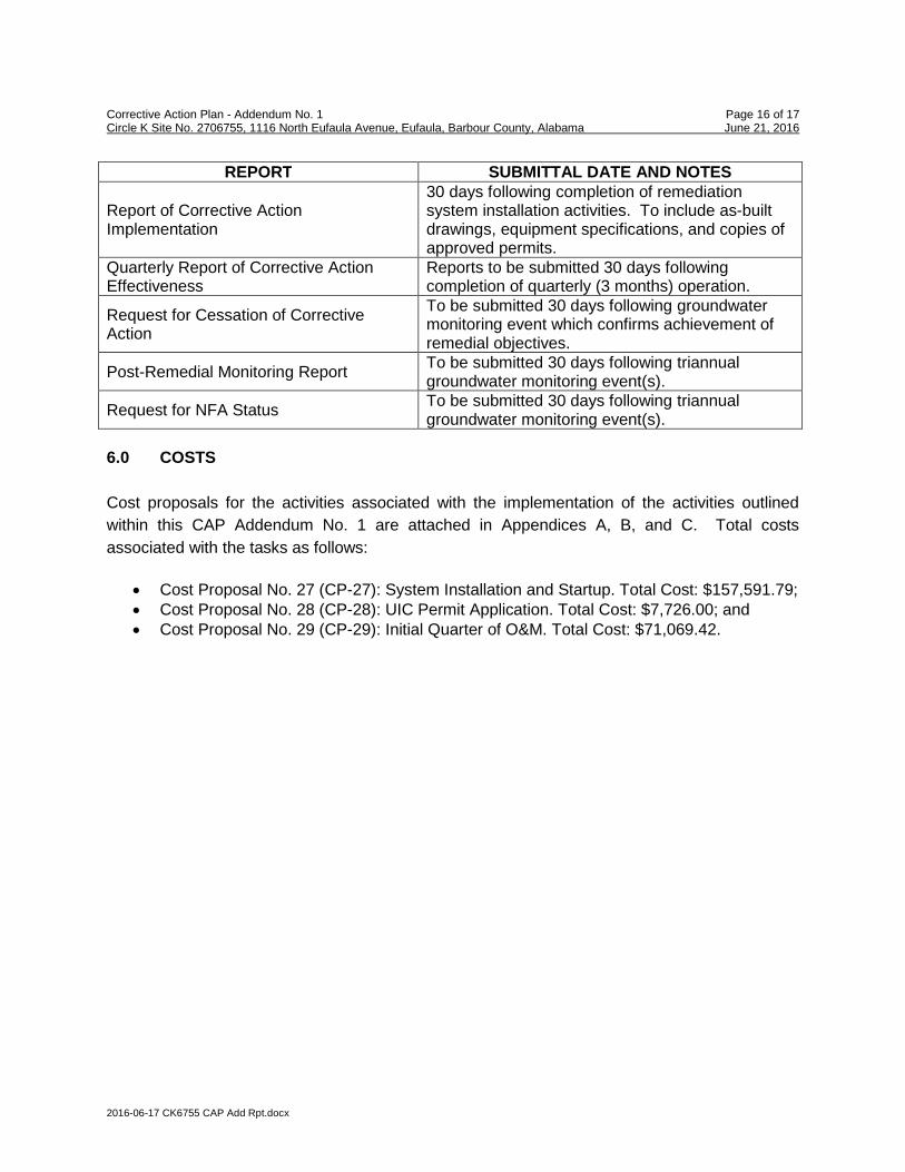
Report of Corrective ActionImplementation
30 days following completion of remediationsystem installation activities. To include as-builtdrawings, equipment specifications, and copies ofapproved permits.
Quarterly Report of Corrective ActionEffectiveness
Reports to be submitted 30 days followingcompletion of quarterly (3 months) operation.
Request for Cessation of CorrectiveAction
To be submitted 30 days following groundwatermonitoring event which confirms achievement ofremedial objectives.
Post-Remedial Monitoring ReportTo be submitted 30 days following triannualgroundwater monitoring event(s).
Request for NFA StatusTo be submitted 30 days following triannualgroundwater monitoring event(s).
6.0 COSTS
Cost proposals for the activities associated with the implementation of the activities outlined
within this CAP Addendum No. 1 are attached in Appendices A, B, and C. Total costs
associated with the tasks as follows:
• Cost Proposal No. 27 (CP-27): System Installation and Startup. Total Cost: $157,591.79;• Cost Proposal No. 28 (CP-28): UIC Permit Application. Total Cost: $7,726.00; and• Cost Proposal No. 29 (CP-29): Initial Quarter of O&M. Total Cost: $71,069.42.

Corrective Action Plan - Addendum No. 1 Page 17 of 17 Circle K Site No. 2706755, 1116 North Eufaula Avenue, Eufaula, Barbour County, Alabama June 21, 2016
2016-06-17 CK6755 CAP Add Rpt.docx
7.0 LIMITATIONS
This report has been prepared for the exclusive use of Circle K Stores Inc. for specific
application to the referenced site in Eufaula, Alabama. The corrective action plan and remedial
design are performed based on the scope-of-work and level of effort as approved by ADEM and
with resources adequate only for that scope-of-work. Our findings have been developed in
accordance with generally accepted standards of geology and hydrogeology practices in the
State of Alabama, available information, and our professional judgment. No other warranty is
expressed or implied.
The data that are presented in this report are indicative of conditions that existed at the precise
locations sampled and at the time the samples were collected. Additionally, the data obtained
from samples would be interpreted as being meaningful with respect to parameters indicated in
the laboratory report. No additional information can be logically be inferred from these data.
Conclusions and recommendations set forth herein are applicable only to the facts and
conditions described at the time of this report.

FIGURES


TABLES

Well ID
Date
Liquid Level
Measured
Well
Diameter
(in)
Screen
Interval
(ft)
Top of
Casing
Elevation
(ft)
Depth
to Product
(ft, BGS)
Depth
to Water
(ft, BGS)
Free
Product
Thickness
(ft)
Water
Table
Elevation
(ft)
09/24/07 -- 9.40 0.00 226.46
03/06/08 -- 7.80 0.00 228.06
04/14/08 -- 7.72 0.00 228.14
05/20/08 -- 8.68 0.00 227.18
07/31/08 -- 9.60 0.00 226.26
04/15/09 -- 6.84 0.00 229.02
08/17/09 -- 7.75 0.00 228.11
01/11/10 -- 7.25 0.00 228.61
05/06/10 -- 6.90 0.00 228.96
08/26/10 -- 8.96 0.00 226.90
12/16/10 -- 8.50 0.00 227.36
04/19/11 -- 8.43 0.00 227.43
01/30/12 -- 8.85 0.00 227.01
05/29/12 -- 9.22 0.00 226.64
09/18/12 -- 9.98 0.00 225.88
10/08/13 -- 8.08 0.00 227.78
12/19/13 -- 7.42 0.00 228.44
05/28/14 -- 7.17 0.00 228.69
05/29/14 -- 6.89 0.00 228.97
05/29/14 -- 6.89 0.00 242.17
06/18/14 -- 7.26 0.00 241.80
07/10/14 -- 7.98 0.00 241.08
09/28/14 -- 11.73 0.00 237.33
01/28/15 -- 6.78 0.00 242.28
04/21/15 -- 6.17 0.00 242.89
11/22/15 -- 6.58 0.00 242.48
03/18/16 -- 6.36 0.00 242.70
09/24/07 -- 12.75 0.00 222.70
03/06/08 -- 10.37 0.00 225.08
04/14/08 -- 10.00 0.00 225.45
05/20/08 -- 10.25 0.00 225.20
NOTES:
BGS - Below Ground Surface / ft - feet / ND - No Data / Water Table Elevation (WTE) adjusted by [WTE - (FP Thickness x 0.78)]
Table 1: Summary of Liquid Level Data
Circle K Site No. 2706755
1116 North Eufaula Avenue
Eufaula, Alabama
UST Incident No. UST12-08-04
MW-1 0.5 12.0 - 15.0
235.86
249.06
MW-2 0.5 12.0 - 18.0 235.45
Tables_6755 1-PN.xlsx Page 1 of 27

Table 1: Summary of Liquid Level Data
Circle K Site No. 2706755
1116 North Eufaula Avenue
Eufaula, Alabama
UST Incident No. UST12-08-04
Well ID
Date
Liquid Level
Measured
Well
Diameter
(in)
Screen
Interval
(ft)
Top of
Casing
Elevation
(ft)
Depth
to Product
(ft, BGS)
Depth
to Water
(ft, BGS)
Free
Product
Thickness
(ft)
Water
Table
Elevation
(ft)
07/31/08 -- 15.47 0.00 219.98
04/15/09 -- 10.99 0.00 224.46
08/17/09 -- 11.53 0.00 223.92
01/11/10 -- 9.37 0.00 226.08
05/06/10 -- 10.64 0.00 224.81
08/26/10 -- 12.58 0.00 222.87
12/16/10 -- 12.58 0.00 222.87
04/19/11 -- 16.59 0.00 218.86
01/30/12 -- 10.57 0.00 224.88
05/29/12 -- 14.88 0.00 220.57
09/18/12 -- 16.30 0.00 219.15
04/13 - 04/15
04/24/13 8.31 8.55 0.24 226.62
09/10/13 8.35 10.10 1.75 226.25
10/08/13 10.26 13.58 3.32 223.99
12/10/13 8.11 11.43 3.32 226.14
12/19/13 7.45 12.40 4.95 226.44
01/02/14 6.71 11.90 5.19 227.13
04/22/14 5.84 13.41 7.57 227.47
05/08/14 6.82 13.93 7.11 226.60
05/15/14 7.23 10.82 3.59 226.96
05/21/14 7.60 11.31 3.71 226.56
05/28/14 7.90 11.58 3.68 226.27
05/29/14 8.87 9.40 0.53 239.28
06/05/14 8.45 12.58 4.13 238.91
06/18/14 9.12 10.44 1.32 238.86
06/19/14 9.91 9.96 0.05 238.35
06/25/14 10.11 12.26 2.15 237.69
07/01/14 10.15 12.15 2.00 237.68
NOTES:
BGS - Below Ground Surface / ft - feet / ND - No Data / Water Table Elevation (WTE) adjusted by [WTE - (FP Thickness x 0.78)]
MW-2 0.5 12.0 - 18.0 235.45
WELL ABANDONED
EW-2 4.0 5.0 - 20.0
234.98
248.27
Tables_6755 1-PN.xlsx Page 2 of 27

Table 1: Summary of Liquid Level Data
Circle K Site No. 2706755
1116 North Eufaula Avenue
Eufaula, Alabama
UST Incident No. UST12-08-04
Well ID
Date
Liquid Level
Measured
Well
Diameter
(in)
Screen
Interval
(ft)
Top of
Casing
Elevation
(ft)
Depth
to Product
(ft, BGS)
Depth
to Water
(ft, BGS)
Free
Product
Thickness
(ft)
Water
Table
Elevation
(ft)
07/10/14 9.93 12.15 2.22 237.85
07/11/14 10.75 10.82 0.07 237.50
07/22/14 9.38 11.77 2.39 238.36
07/28/14 9.01 11.52 2.51 238.71
08/01/14 9.01 10.74 1.73 238.88
08/05/14 9.27 10.45 1.18 238.74
08/06/14 9.87 9.98 0.11 238.38
08/12/14 10.27 10.35 0.08 237.98
08/19/14 9.61 10.22 0.61 238.53
08/20/14 9.91 10.12 0.21 238.31
08/26/14 10.66 11.34 0.68 237.46
09/03/14 9.84 11.14 1.30 238.14
09/04/14 10.18 10.20 0.02 238.09
09/09/14 10.03 11.19 1.16 237.98
09/16/14 8.85 10.14 1.29 239.14
09/17/14 9.35 9.42 0.07 238.90
09/25/14 9.73 9.76 0.03 238.53
09/28/14 9.73 9.93 0.20 238.50
10/08/14 10.05 11.03 0.98 238.00
10/16/14 9.26 9.96 0.70 238.86
10/24/14 9.57 10.98 1.41 238.39
11/05/14 9.21 11.66 2.45 238.52
11/10/14 10.08 10.37 0.29 238.13
11/19/14 9.74 10.63 0.89 238.33
11/24/14 9.14 10.32 1.18 238.87
12/03/15 9.55 9.61 0.06 238.71
12/08/14 9.51 9.57 0.06 238.75
12/15/14 9.60 9.71 0.11 238.65
01/06/15 7.60 10.78 3.18 239.97
NOTES:
BGS - Below Ground Surface / ft - feet / ND - No Data / Water Table Elevation (WTE) adjusted by [WTE - (FP Thickness x 0.78)]
EW-2 4.0 5.0 - 20.0 248.27
Tables_6755 1-PN.xlsx Page 3 of 27

Table 1: Summary of Liquid Level Data
Circle K Site No. 2706755
1116 North Eufaula Avenue
Eufaula, Alabama
UST Incident No. UST12-08-04
Well ID
Date
Liquid Level
Measured
Well
Diameter
(in)
Screen
Interval
(ft)
Top of
Casing
Elevation
(ft)
Depth
to Product
(ft, BGS)
Depth
to Water
(ft, BGS)
Free
Product
Thickness
(ft)
Water
Table
Elevation
(ft)
01/12/15 8.82 9.21 0.39 239.36
01/20/15 9.08 9.66 0.58 239.06
01/28/15 9.22 9.97 0.75 238.89
04/21/15 8.05 9.97 1.92 239.80
11/22/15 7.73 9.33 1.60 240.19
03/18/16 6.94 13.61 6.67 239.86
09/24/07 -- 12.72 0.00 223.23
03/06/08 -- 10.87 0.00 225.08
04/14/08 -- 10.86 0.00 225.09
05/20/08 -- 11.82 0.00 224.13
07/31/08 -- 12.91 0.00 223.04
04/15/09 -- 9.91 0.00 226.04
08/17/09 -- 11.03 0.00 224.92
01/11/10 -- 10.25 0.00 225.70
05/06/10 -- 10.28 0.00 225.67
08/26/10 -- 12.36 0.00 223.59
12/16/10 -- 7.70 0.00 228.25
04/19/11 -- 11.38 0.00 224.57
01/30/12 -- 11.55 0.00 224.40
05/29/12 -- 12.33 0.00 223.62
09/18/12 -- 13.34 0.00 222.61
10/08/13 -- 13.11 0.00 222.84
12/19/13 -- 9.21 0.00 226.74
05/29/14 -- 8.75 0.00 227.20
05/29/14 -- 8.75 0.00 240.45
09/28/14 -- 13.33 0.00 235.87
01/28/15 -- 8.68 0.00 240.52
04/21/15 -- 8.30 0.00 240.90
11/22/15 -- 9.02 0.00 240.18
03/18/16 -- 8.82 0.00 240.38
MW-7A 12/19/13 0.5 13.0 - 16.0 249.09 -- 4.26 0.00 244.83
NOTES:
BGS - Below Ground Surface / ft - feet / ND - No Data / Water Table Elevation (WTE) adjusted by [WTE - (FP Thickness x 0.78)]
MW-7 0.5 13.0 - 16.0
235.95
249.20
EW-2 4.0 5.0 - 20.0 248.27
Tables_6755 1-PN.xlsx Page 4 of 27

Table 1: Summary of Liquid Level Data
Circle K Site No. 2706755
1116 North Eufaula Avenue
Eufaula, Alabama
UST Incident No. UST12-08-04
Well ID
Date
Liquid Level
Measured
Well
Diameter
(in)
Screen
Interval
(ft)
Top of
Casing
Elevation
(ft)
Depth
to Product
(ft, BGS)
Depth
to Water
(ft, BGS)
Free
Product
Thickness
(ft)
Water
Table
Elevation
(ft)
05/29/02 ND ND ND 230.06
11/21/02 ND ND ND 231.21
02/26/03 ND ND ND 231.31
10/29/03 ND ND ND 231.05
02/12/04 ND ND ND 231.63
12/19/13 -- 4.63 0.00 ND
05/29/14 -- 2.29 0.00 ND
05/29/14 -- 2.29 0.00 246.42
09/28/14 -- 3.23 0.00 245.48
04/21/15
11/22/15 -- 1.45 0.00 247.26
03/18/16 -- 2.08 0.00 246.63
05/29/02 ND ND ND 227.53
11/21/02 ND ND ND 228.45
02/26/03 ND ND ND 228.67
10/29/03 ND ND ND 228.02
02/12/04 ND ND ND 228.89
10/08/13 ND 11.71 ND ND
12/19/13 ND 7.59 ND ND
05/29/14 ND 7.09 ND ND
05/29/14 -- 7.09 0.00 242.53
09/28/14 -- 11.64 0.00 237.98
01/28/15 -- 7.48 0.00 242.14
04/21/15 -- 6.44 0.00 243.18
11/22/15 -- 6.65 0.00 242.97
03/18/16 -- 6.54 0.00 243.08
MW-11A 12/19/13 0.5 ND 249.64 -- 4.43 0.00 245.21
09/24/07 -- 12 0.00 224.01
03/06/08 -- 10.65 0.00 225.36
04/14/08 -- 10.45 0.00 225.56
05/20/08 -- 11.46 0.00 224.55
07/31/08 -- 11.98 0.00 224.03
04/15/09 -- 8.98 0.00 227.03
NOTES:
BGS - Below Ground Surface / ft - feet / ND - No Data / Water Table Elevation (WTE) adjusted by [WTE - (FP Thickness x 0.78)]
MW-12 0.5 ND 236.01
WELL OBSTRUCTED AT 4.04'
MW-11 0.5 12.0 - 15.0
ND
249.62
MW-9 0.5 12.0 - 15.0
ND
248.71
Tables_6755 1-PN.xlsx Page 5 of 27
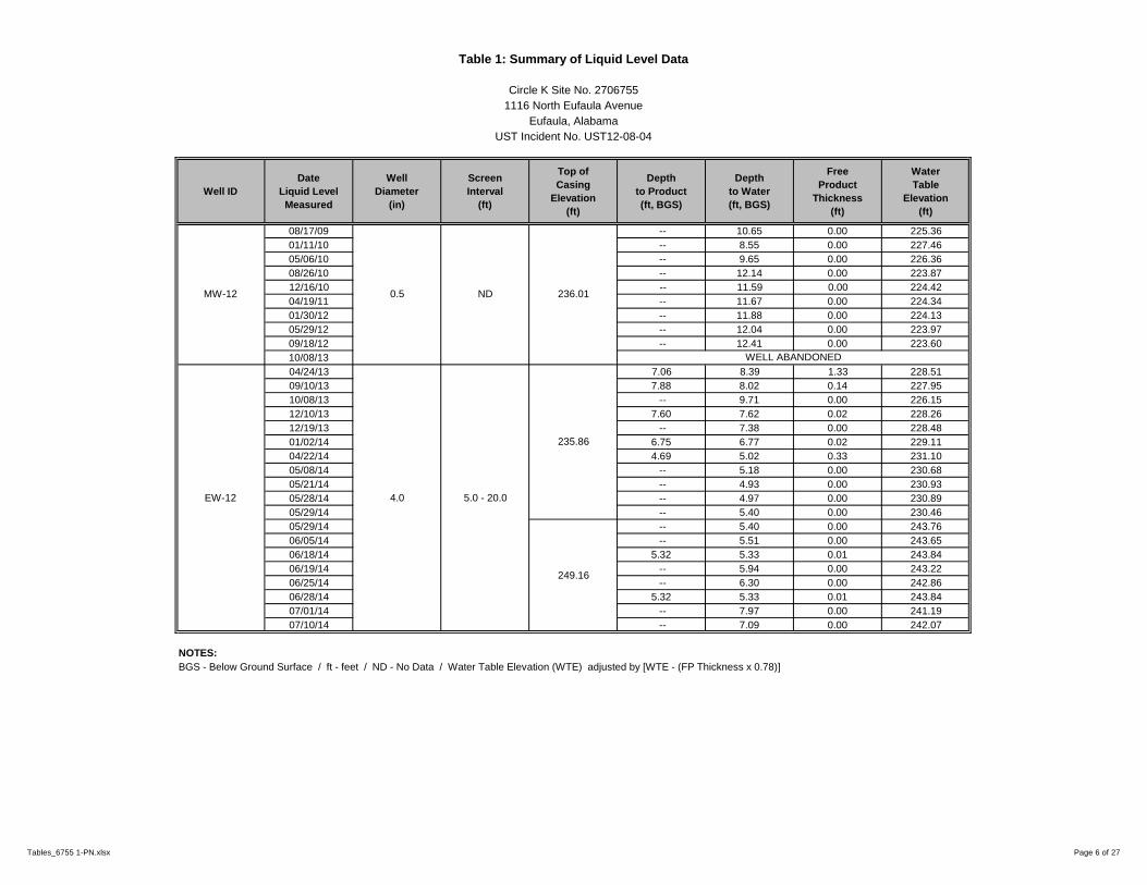
Table 1: Summary of Liquid Level Data
Circle K Site No. 2706755
1116 North Eufaula Avenue
Eufaula, Alabama
UST Incident No. UST12-08-04
Well ID
Date
Liquid Level
Measured
Well
Diameter
(in)
Screen
Interval
(ft)
Top of
Casing
Elevation
(ft)
Depth
to Product
(ft, BGS)
Depth
to Water
(ft, BGS)
Free
Product
Thickness
(ft)
Water
Table
Elevation
(ft)
08/17/09 -- 10.65 0.00 225.36
01/11/10 -- 8.55 0.00 227.46
05/06/10 -- 9.65 0.00 226.36
08/26/10 -- 12.14 0.00 223.87
12/16/10 -- 11.59 0.00 224.42
04/19/11 -- 11.67 0.00 224.34
01/30/12 -- 11.88 0.00 224.13
05/29/12 -- 12.04 0.00 223.97
09/18/12 -- 12.41 0.00 223.60
10/08/13
04/24/13 7.06 8.39 1.33 228.51
09/10/13 7.88 8.02 0.14 227.95
10/08/13 -- 9.71 0.00 226.15
12/10/13 7.60 7.62 0.02 228.26
12/19/13 -- 7.38 0.00 228.48
01/02/14 6.75 6.77 0.02 229.11
04/22/14 4.69 5.02 0.33 231.10
05/08/14 -- 5.18 0.00 230.68
05/21/14 -- 4.93 0.00 230.93
05/28/14 -- 4.97 0.00 230.89
05/29/14 -- 5.40 0.00 230.46
05/29/14 -- 5.40 0.00 243.76
06/05/14 -- 5.51 0.00 243.65
06/18/14 5.32 5.33 0.01 243.84
06/19/14 -- 5.94 0.00 243.22
06/25/14 -- 6.30 0.00 242.86
06/28/14 5.32 5.33 0.01 243.84
07/01/14 -- 7.97 0.00 241.19
07/10/14 -- 7.09 0.00 242.07
NOTES:
BGS - Below Ground Surface / ft - feet / ND - No Data / Water Table Elevation (WTE) adjusted by [WTE - (FP Thickness x 0.78)]
WELL ABANDONED
EW-12 4.0 5.0 - 20.0
235.86
249.16
MW-12 0.5 ND 236.01
Tables_6755 1-PN.xlsx Page 6 of 27

Table 1: Summary of Liquid Level Data
Circle K Site No. 2706755
1116 North Eufaula Avenue
Eufaula, Alabama
UST Incident No. UST12-08-04
Well ID
Date
Liquid Level
Measured
Well
Diameter
(in)
Screen
Interval
(ft)
Top of
Casing
Elevation
(ft)
Depth
to Product
(ft, BGS)
Depth
to Water
(ft, BGS)
Free
Product
Thickness
(ft)
Water
Table
Elevation
(ft)
07/11/14 -- 6.88 0.00 242.28
07/22/14 -- 5.45 0.00 243.71
07/28/14 -- 5.65 0.00 243.51
08/01/14 -- 7.12 0.00 242.04
08/12/14 -- 8.46 0.00 240.70
08/19/14 -- 8.44 0.00 240.72
08/20/14 -- 9.17 0.00 239.99
08/26/14 -- 9.21 0.00 239.95
09/03/14 -- 10.27 0.00 238.89
09/09/14 -- 9.92 0.00 239.24
09/28/14 -- 9.07 0.00 240.09
10/16/14 -- 8.52 0.00 240.64
10/24/14 -- 8.72 0.00 240.44
11/10/14 -- 10.6 0.00 238.56
11/19/14 -- 9.24 0.00 239.92
11/24/14 -- 8.87 0.00 240.29
12/08/14 -- 9.66 0.00 239.50
12/15/14 -- 9.32 0.00 239.84
01/06/15 -- 7.12 0.00 242.04
01/12/15 -- 7.50 0.00 241.66
01/20/15 -- 8.12 0.00 241.04
01/28/15 8.14 8.16 0.02 241.02
04/21/15 7.14 7.16 0.02 242.02
11/22/15 7.53 7.58 0.05 241.62
03/18/16 -- 7.76 0.00 241.40
09/24/07 -- 11.70 0.00 223.13
03/06/08 -- 10.50 0.00 224.33
04/14/08 -- 10.36 0.00 224.47
05/20/08 -- 11.33 0.00 223.50
07/31/08 -- 12.05 0.00 222.78
04/15/09 -- 9.76 0.00 225.07
NOTES:
BGS - Below Ground Surface / ft - feet / ND - No Data / Water Table Elevation (WTE) adjusted by [WTE - (FP Thickness x 0.78)]
EW-12 4.0 5.0 - 12.0 249.16
MW-14 0.5 12.0 - 15.0 234.83
Tables_6755 1-PN.xlsx Page 7 of 27

Table 1: Summary of Liquid Level Data
Circle K Site No. 2706755
1116 North Eufaula Avenue
Eufaula, Alabama
UST Incident No. UST12-08-04
Well ID
Date
Liquid Level
Measured
Well
Diameter
(in)
Screen
Interval
(ft)
Top of
Casing
Elevation
(ft)
Depth
to Product
(ft, BGS)
Depth
to Water
(ft, BGS)
Free
Product
Thickness
(ft)
Water
Table
Elevation
(ft)
08/17/09 -- 10.56 0.00 224.27
01/11/10 -- 8.78 0.00 226.05
05/06/10 -- 9.86 0.00 224.97
08/26/10 -- 11.80 0.00 223.03
12/16/10 -- 11.12 0.00 223.71
04/19/11 -- 11.70 0.00 223.13
01/30/12 -- 11.05 0.00 223.78
05/29/12 -- 11.55 0.00 223.28
09/18/12 -- 12.01 0.00 222.82
04/23/13
04/24/13 -- 7.15 0.00 227.66
09/10/13 10.13 10.16 0.03 224.67
10/08/13 12.98 13.09 0.11 221.81
12/10/13 9.45 9.46 0.01 225.36
12/19/13 9.61 9.81 0.20 225.16
01/02/14 6.99 7.14 0.15 227.79
04/22/14 7.10 7.25 0.15 227.68
05/08/14 8.19 8.33 0.14 226.59
05/15/14 7.75 7.77 0.02 227.06
05/21/14 8.32 8.42 0.10 226.47
05/28/14 8.75 8.79 0.04 226.05
05/29/14 9.05 9.07 0.02 239.12
06/05/14 9.31 9.33 0.02 238.86
06/18/14 9.50 9.53 0.03 238.66
06/25/14 9.80 9.83 0.03 238.36
07/01/14 10.22 10.24 0.02 237.95
07/10/14 10.42 10.45 0.03 237.74
07/11/14 -- 10.81 0.00 237.36
07/22/14 9.51 9.55 0.04 238.65
NOTES:
BGS - Below Ground Surface / ft - feet / ND - No Data / Water Table Elevation (WTE) adjusted by [WTE - (FP Thickness x 0.78)]
MW-14 0.5 12.0 - 15.0 234.83
WELL ABANDONED
EW-14 4.0 5.0 - 20.0
234.81
248.17
Tables_6755 1-PN.xlsx Page 8 of 27

Table 1: Summary of Liquid Level Data
Circle K Site No. 2706755
1116 North Eufaula Avenue
Eufaula, Alabama
UST Incident No. UST12-08-04
Well ID
Date
Liquid Level
Measured
Well
Diameter
(in)
Screen
Interval
(ft)
Top of
Casing
Elevation
(ft)
Depth
to Product
(ft, BGS)
Depth
to Water
(ft, BGS)
Free
Product
Thickness
(ft)
Water
Table
Elevation
(ft)
07/28/14 9.65 9.71 0.06 238.51
08/01/14 -- 9.81 0.00 238.36
08/05/14 9.48 9.56 0.08 238.67
08/06/14 9.97 9.98 0.01 238.20
08/12/14 9.83 9.85 0.02 238.34
08/19/14 9.93 9.97 0.04 238.23
08/20/14 -- 10.20 0.00 237.97
08/26/14 10.58 10.60 0.02 237.59
09/03/14 -- 10.27 0.00 237.90
09/04/14 -- 10.43 0.00 237.74
09/09/14 10.65 10.67 0.02 237.52
09/16/14 -- 9.27 0.00 238.90
09/17/14 9.51 9.53 0.02 238.66
09/25/14 9.89 9.93 0.04 238.27
09/28/14 9.93 9.97 0.04 238.23
10/08/14 -- 10.45 0.00 237.72
10/16/14 9.54 9.58 0.04 238.62
10/24/14 9.89 9.92 0.03 238.27
11/05/14 9.90 9.93 0.03 238.26
11/10/14 10.64 10.66 0.02 237.53
11/19/14 10.48 10.49 0.01 237.69
11/24/14 -- 9.50 0.00 238.67
12/08/15 10.25 10.28 0.03 237.91
12/15/14 10.41 10.43 0.02 237.76
01/06/15 -- 8.18 0.00 239.99
01/12/15 8.59 8.61 0.02 239.58
01/20/15 9.64 9.65 0.01 238.53
01/28/15 9.88 9.91 0.03 238.28
4/21/15 -- 9.10 0.00 239.07
11/22/15 8.54 8.57 0.03 239.62
03/18/16 8.18 8.32 0.14 239.96
NOTES:
BGS - Below Ground Surface / ft - feet / ND - No Data / Water Table Elevation (WTE) adjusted by [WTE - (FP Thickness x 0.78)]
EW-14 4.0 5.0 - 20.0 248.17
Tables_6755 1-PN.xlsx Page 9 of 27

Table 1: Summary of Liquid Level Data
Circle K Site No. 2706755
1116 North Eufaula Avenue
Eufaula, Alabama
UST Incident No. UST12-08-04
Well ID
Date
Liquid Level
Measured
Well
Diameter
(in)
Screen
Interval
(ft)
Top of
Casing
Elevation
(ft)
Depth
to Product
(ft, BGS)
Depth
to Water
(ft, BGS)
Free
Product
Thickness
(ft)
Water
Table
Elevation
(ft)
09/24/07 -- 11.15 0.00 222.69
03/06/08 -- 9.74 0.00 224.10
04/14/08 -- 9.63 0.00 224.21
05/20/08 -- 10.65 0.00 223.19
07/31/08 -- 11.60 0.00 222.24
04/15/09 -- 8.89 0.00 224.95
08/17/09 -- 11.75 0.00 222.09
01/11/10 -- 9.04 0.00 224.80
05/06/10 -- 9.40 0.00 224.44
08/26/10 -- 10.95 0.00 222.89
12/16/10 -- 10.19 0.00 223.65
04/19/11 -- 10.30 0.00 223.54
01/30/12 -- 10.03 0.00 223.81
05/29/12 -- 10.87 0.00 222.97
09/18/12 -- 11.40 0.00 222.44
10/08/13 -- 5.87 0.00 227.97
12/19/13 -- 8.85 0.00 224.99
05/15/14 -- 8.02 0.00 225.82
09/24/07 -- 11.15 0.00 222.69
03/06/08 -- 9.74 0.00 224.10
04/14/08 -- 9.63 0.00 224.21
05/20/08 -- 10.65 0.00 223.19
07/31/08 -- 11.60 0.00 222.24
04/15/09 -- 8.89 0.00 224.95
08/17/09 -- 11.75 0.00 222.09
01/11/10 -- 9.04 0.00 224.80
05/06/10 -- 9.40 0.00 224.44
08/26/10 -- 10.95 0.00 222.89
12/16/10 -- 10.19 0.00 223.65
NOTES:
BGS - Below Ground Surface / ft - feet / ND - No Data / Water Table Elevation (WTE) adjusted by [WTE - (FP Thickness x 0.78)]
MW-15 0.5 12.0 - 15.0 233.84
Tables_6755 1-PN.xlsx Page 10 of 27

Table 1: Summary of Liquid Level Data
Circle K Site No. 2706755
1116 North Eufaula Avenue
Eufaula, Alabama
UST Incident No. UST12-08-04
Well ID
Date
Liquid Level
Measured
Well
Diameter
(in)
Screen
Interval
(ft)
Top of
Casing
Elevation
(ft)
Depth
to Product
(ft, BGS)
Depth
to Water
(ft, BGS)
Free
Product
Thickness
(ft)
Water
Table
Elevation
(ft)
04/19/11 -- 10.30 0.00 223.54
01/30/12 -- 10.03 0.00 223.81
05/29/12 -- 10.87 0.00 222.97
09/18/12 -- 11.40 0.00 222.44
10/08/13 -- 5.87 0.00 227.97
12/19/13 -- 8.85 0.00 224.99
05/15/14 -- 8.02 0.00 225.82
05/28/14 -- 9.47 0.00 224.37
05/29/14 -- 8.78 0.00 225.06
05/29/14 -- 8.78 0.00 237.90
06/18/14 -- 9.23 0.00 237.45
07/10/14 -- 10.29 0.00 236.39
09/28/14 -- 11.75 0.00 234.93
01/28/15 -- 8.49 0.00 238.19
04/21/15 -- 7.78 0.00 238.90
11/22/15 -- 8.86 0.00 237.82
03/18/16 -- 8.12 0.00 238.56
MW-15A 12/19/13 0.5 ND 247.17 -- 5.29 0.00 241.88
09/24/07 -- 11.63 0.00 221.94
03/06/08 -- 10.00 0.00 223.57
04/14/08 -- 9.98 0.00 223.59
05/20/08 -- 11.00 0.00 222.57
07/31/08 -- 11.97 0.00 221.60
04/15/09 -- 9.02 0.00 224.55
08/17/09 -- 10.36 0.00 223.21
01/11/10 -- 8.76 0.00 224.81
05/06/10 -- 9.37 0.00 224.20
08/26/10 -- 11.67 0.00 221.90
12/16/10 -- 11.07 0.00 222.50
04/19/11 -- 10.85 0.00 222.72
01/30/12 -- 10.64 0.00 222.93
NOTES:
BGS - Below Ground Surface / ft - feet / ND - No Data / Water Table Elevation (WTE) adjusted by [WTE - (FP Thickness x 0.78)]
MW-15 0.5 12.0 - 15.0
233.84
246.68
MW-16 0.5 14.0 - 17.0 233.57
Tables_6755 1-PN.xlsx Page 11 of 27
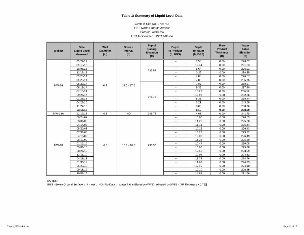
Table 1: Summary of Liquid Level Data
Circle K Site No. 2706755
1116 North Eufaula Avenue
Eufaula, Alabama
UST Incident No. UST12-08-04
Well ID
Date
Liquid Level
Measured
Well
Diameter
(in)
Screen
Interval
(ft)
Top of
Casing
Elevation
(ft)
Depth
to Product
(ft, BGS)
Depth
to Water
(ft, BGS)
Free
Product
Thickness
(ft)
Water
Table
Elevation
(ft)
05/29/12 -- 7.50 0.00 226.07
09/18/12 -- 12.34 0.00 221.23
10/08/13 -- 6.64 0.00 226.93
12/19/13 -- 3.22 0.00 230.35
05/28/14 -- 7.00 0.00 226.57
05/29/14 -- 7.82 0.00 225.75
05/29/14 -- 7.82 0.00 238.97
06/18/14 -- 9.39 0.00 237.40
07/10/14 -- 10.27 0.00 236.52
09/28/14 -- 13.93 0.00 232.86
01/28/15 -- 8.35 0.00 238.44
04/21/15 -- 3.21 0.00 243.58
11/22/15 -- 8.03 0.00 238.76
03/18/16 -- 8.19 0.00 238.60
MW-16A 12/19/13 0.5 ND 246.76 -- 4.98 0.00 241.78
09/24/07 -- 10.00 0.00 226.55
03/06/08 -- 11.25 0.00 225.30
04/14/08 -- 11.11 0.00 225.44
05/20/08 -- 10.12 0.00 226.43
07/31/08 -- 13.23 0.00 223.32
04/15/09 -- 10.06 0.00 226.49
08/17/09 -- 11.25 0.00 225.30
01/11/10 -- 10.47 0.00 226.08
05/06/10 -- 10.65 0.00 225.90
08/26/10 -- 12.56 0.00 223.99
12/16/10 -- 12.03 0.00 224.52
04/19/11 -- 11.79 0.00 224.76
01/30/12 -- 11.62 0.00 224.93
05/29/12 -- 12.45 0.00 224.10
09/18/12 -- 10.10 0.00 226.45
10/08/13 -- 14.89 0.00 221.66
NOTES:
BGS - Below Ground Surface / ft - feet / ND - No Data / Water Table Elevation (WTE) adjusted by [WTE - (FP Thickness x 0.78)]
MW-16 0.5 14.0 - 17.0
233.57
246.79
MW-18 0.5 15.0 - 18.0 236.55
Tables_6755 1-PN.xlsx Page 12 of 27

Table 1: Summary of Liquid Level Data
Circle K Site No. 2706755
1116 North Eufaula Avenue
Eufaula, Alabama
UST Incident No. UST12-08-04
Well ID
Date
Liquid Level
Measured
Well
Diameter
(in)
Screen
Interval
(ft)
Top of
Casing
Elevation
(ft)
Depth
to Product
(ft, BGS)
Depth
to Water
(ft, BGS)
Free
Product
Thickness
(ft)
Water
Table
Elevation
(ft)
12/19/13 -- 10.69 0.00 225.86
05/28/14 -- 10.55 0.00 226.00
05/29/14 -- 10.10 0.00 226.45
05/29/14 -- 10.10 0.00 239.70
06/18/14 -- 10.62 0.00 239.18
07/10/14 -- 11.52 0.00 238.28
08/05/14 -- 10.21 0.00 239.59
09/28/14 -- 14.91 0.00 234.89
01/28/15 -- 9.81 0.00 239.99
04/21/15 -- 9.20 0.00 240.60
11/22/15 -- 9.71 0.00 240.09
03/18/16 -- 9.47 0.00 240.33
05/28/14 -- 8.51 0.00 241.37
05/29/14 -- 8.39 0.00 241.49
05/29/14 -- 8.39 0.00 241.49
06/18/14 -- 8.99 0.00 240.89
07/10/14 -- 9.92 0.00 239.96
09/28/14 -- 6.35 0.00 243.53
01/28/15 -- 7.96 0.00 241.92
04/21/15 -- 5.86 0.00 244.02
11/22/15 -- 8.44 0.00 241.44
03/18/16 -- 8.10 0.00 241.78
09/24/07 -- 10.50 0.00 225.90
03/06/08 -- 11.77 0.00 224.63
04/14/08 -- 11.77 0.00 224.63
05/20/08 -- 12.80 0.00 223.60
07/31/08 -- 13.75 0.00 222.65
04/15/09 -- 10.98 0.00 225.42
08/17/09 -- 11.93 0.00 224.47
01/11/10 -- 11.24 0.00 225.16
05/06/10 -- 11.34 0.00 225.06
08/26/10 -- 13.28 0.00 223.12
12/16/10 -- 12.61 0.00 223.79
NOTES:
BGS - Below Ground Surface / ft - feet / ND - No Data / Water Table Elevation (WTE) adjusted by [WTE - (FP Thickness x 0.78)]
MW-20 0.5 16.2 - 19.2 236.40
MW-18 0.5 15.0 - 18.0
236.55
249.80
MW-19 0.5 ND 249.88
Tables_6755 1-PN.xlsx Page 13 of 27

Table 1: Summary of Liquid Level Data
Circle K Site No. 2706755
1116 North Eufaula Avenue
Eufaula, Alabama
UST Incident No. UST12-08-04
Well ID
Date
Liquid Level
Measured
Well
Diameter
(in)
Screen
Interval
(ft)
Top of
Casing
Elevation
(ft)
Depth
to Product
(ft, BGS)
Depth
to Water
(ft, BGS)
Free
Product
Thickness
(ft)
Water
Table
Elevation
(ft)
04/19/11 -- 12.26 0.00 224.14
01/30/12 -- 12.27 0.00 224.13
05/29/12 -- 13.11 0.00 223.29
09/18/12 -- 13.76 0.00 222.64
10/08/13 -- 16.19 0.00 220.21
12/19/13 -- 10.69 0.00 225.71
05/28/14 -- 10.86 0.00 225.54
05/29/14 -- 10.38 0.00 226.02
05/29/14 -- 10.38 0.00 239.17
06/18/14 -- 10.88 0.00 238.67
07/10/14 -- 11.85 0.00 237.70
09/28/14 -- 16.18 0.00 233.37
01/28/15 -- 10.05 0.00 239.50
04/21/15 -- 9.40 0.00 240.15
11/22/15 -- 10.39 0.00 239.16
03/18/16 -- 9.73 0.00 239.82
09/24/07 -- 11.76 0.00 222.43
03/06/08 -- 10.34 0.00 223.85
04/14/08 -- 10.22 0.00 223.97
05/20/08 -- 10.25 0.00 223.94
07/31/08 -- 12.00 0.00 222.19
04/15/09 -- 9.69 0.00 224.50
08/17/09 -- 10.40 0.00 223.79
01/11/10 -- 9.47 0.00 224.72
05/06/10 -- 9.64 0.00 224.55
08/26/10 -- 11.65 0.00 222.54
12/16/10 -- 10.75 0.00 223.44
04/19/11 -- 10.92 0.00 223.27
01/30/12 -- 10.35 0.00 223.84
05/29/12 -- 11.3 0.00 222.89
09/18/12 -- 11.67 0.00 222.52
NOTES:
BGS - Below Ground Surface / ft - feet / ND - No Data / Water Table Elevation (WTE) adjusted by [WTE - (FP Thickness x 0.78)]
MW-21 0.5 13.2 - 16.2 234.19
MW-20 0.5 16.2 - 19.2
236.40
249.55
Tables_6755 1-PN.xlsx Page 14 of 27

Table 1: Summary of Liquid Level Data
Circle K Site No. 2706755
1116 North Eufaula Avenue
Eufaula, Alabama
UST Incident No. UST12-08-04
Well ID
Date
Liquid Level
Measured
Well
Diameter
(in)
Screen
Interval
(ft)
Top of
Casing
Elevation
(ft)
Depth
to Product
(ft, BGS)
Depth
to Water
(ft, BGS)
Free
Product
Thickness
(ft)
Water
Table
Elevation
(ft)
10/08/13 -- 13.21 0.00 220.98
12/19/13 -- 9.51 0.00 224.68
05/15/14 -- 8.46 0.00 225.73
05/28/14 -- 9.85 0.00 224.34
05/29/14 -- 9.49 0.00 224.70
05/29/14 -- 9.49 0.00 237.97
06/18/14 -- 9.96 0.00 237.50
07/10/14 -- 10.96 0.00 236.50
08/05/14 -- 9.91 0.00 237.55
09/28/14 -- 13.20 0.00 234.26
01/28/15 -- 9.17 0.00 238.29
04/21/15 -- 8.58 0.00 238.88
11/22/15 -- 9.10 0.00 238.36
03/18/16 -- 8.83 0.00 238.63
09/24/07 -- 11.73 0.00 221.05
03/06/08 -- 9.77 0.00 223.01
04/14/08 -- 9.75 0.00 223.03
05/20/08 -- 10.67 0.00 222.11
07/31/08 -- 11.91 0.00 220.87
04/15/09 -- 9.19 0.00 223.59
08/17/09 -- 10.25 0.00 222.53
01/11/10 -- 10.85 0.00 221.93
09/24/07 -- 12.6 0.00 220.18
03/06/08 -- 10.74 0.00 222.04
04/14/08 -- 10.68 0.00 222.10
05/20/08 -- 11.8 0.00 220.98
07/31/08 -- 12.95 0.00 219.83
04/15/09 -- 9.75 0.00 223.03
08/17/09 -- 11.07 0.00 221.71
01/11/10 -- 10.35 0.00 222.43
05/06/10 -- 10.52 0.00 222.26
NOTES:
BGS - Below Ground Surface / ft - feet / ND - No Data / Water Table Elevation (WTE) adjusted by [WTE - (FP Thickness x 0.78)]
MW-22 0.5 13.0 - 16.0 232.78
MW-21 0.5 13.2 - 16.2
234.19
247.46
Tables_6755 1-PN.xlsx Page 15 of 27

Table 1: Summary of Liquid Level Data
Circle K Site No. 2706755
1116 North Eufaula Avenue
Eufaula, Alabama
UST Incident No. UST12-08-04
Well ID
Date
Liquid Level
Measured
Well
Diameter
(in)
Screen
Interval
(ft)
Top of
Casing
Elevation
(ft)
Depth
to Product
(ft, BGS)
Depth
to Water
(ft, BGS)
Free
Product
Thickness
(ft)
Water
Table
Elevation
(ft)
08/26/10 -- 11.65 0.00 221.13
12/16/10 -- 11.46 0.00 221.32
04/19/11 -- 10.61 0.00 222.17
01/30/12 -- 10.42 0.00 222.36
05/29/12 -- 11.26 0.00 221.52
09/18/12 -- 12.18 0.00 220.60
10/08/13 -- 13.11 0.00 219.67
12/19/13 -- 8.78 0.00 224.00
05/21/14 -- 9.69 0.00 223.09
05/29/14 -- 8.69 0.00 224.09
09/28/14 -- 13.16 0.00 232.82
01/28/15 -- 8.28 0.00 237.70
04/21/15 -- 7.59 0.00 238.39
11/22/15 -- 8.28 0.00 237.70
03/18/16 -- 8.00 0.00 237.98
09/24/07 -- 12.60 0.00 221.82
03/06/08 -- 10.74 0.00 223.68
04/14/08 -- 10.68 0.00 223.74
05/20/08 -- 11.80 0.00 222.62
07/31/08 -- 12.95 0.00 221.47
04/15/09 -- 9.75 0.00 224.67
08/17/09 -- 11.07 0.00 223.35
01/11/10 -- 10.35 0.00 224.07
05/06/10 -- 10.52 0.00 223.90
08/26/10 -- 12.45 0.00 221.97
12/16/10 -- 11.79 0.00 222.63
04/19/11 -- 11.46 0.00 222.96
01/30/12 -- 11.44 0.00 222.98
10/08/13 -- 17.25 0.00 217.17
12/19/13 -- 9.57 0.00 224.85
05/29/14 -- 9.29 0.00 225.13
NOTES:
BGS - Below Ground Surface / ft - feet / ND - No Data / Water Table Elevation (WTE) adjusted by [WTE - (FP Thickness x 0.78)]
MW-23 0.5 17.0 - 20.0 234.42
MW-22 0.5 13.0 - 16.0
232.78
245.98
Tables_6755 1-PN.xlsx Page 16 of 27

Table 1: Summary of Liquid Level Data
Circle K Site No. 2706755
1116 North Eufaula Avenue
Eufaula, Alabama
UST Incident No. UST12-08-04
Well ID
Date
Liquid Level
Measured
Well
Diameter
(in)
Screen
Interval
(ft)
Top of
Casing
Elevation
(ft)
Depth
to Product
(ft, BGS)
Depth
to Water
(ft, BGS)
Free
Product
Thickness
(ft)
Water
Table
Elevation
(ft)
09/28/14 -- 17.04 0.00 230.49
01/28/15 -- 8.97 0.00 238.56
04/21/15 -- 8.09 0.00 239.44
11/22/15 -- 9.09 0.00 238.44
03/18/16 -- 8.70 0.00 238.83
10/08/13 -- 9.98 0.00 ND
12/19/13 -- 7.55 0.00 ND
04/22/14 -- 4.78 0.00 ND
05/29/14 -- 6.70 0.00 ND
09/28/14 -- 6.28 0.00 242.64
01/28/15 -- 5.38 0.00 243.54
04/21/15 -- 5.41 0.00 243.51
11/22/15 -- 6.71 0.00 242.21
03/18/16 -- 4.55 0.00 244.37
10/08/13 -- 6.47 0.00 ND
12/19/13 -- 7.21 0.00 ND
05/29/14 -- 7.65 0.00 ND
09/28/14 -- 10.30 0.00 238.70
01/28/15 -- 6.81 0.00 242.19
04/21/15 -- 6.11 0.00 242.89
11/22/15 -- 5.85 0.00 243.15
03/18/16 -- 5.47 0.00 243.53
10/08/13 -- 6.49 0.00 ND
12/19/13 -- 7.47 0.00 ND
01/02/14 -- 4.55 0.00 ND
04/22/14 -- 3.65 0.00 ND
05/29/14 -- 4.80 0.00 ND
09/28/14 -- 6.18 0.00 242.74
01/28/15 -- 4.71 0.00 244.21
04/21/15 -- 4.08 0.00 244.84
11/22/15 -- 4.69 0.00 244.23
03/18/16 -- 4.64 0.00 244.28
09/10/13 -- 10.54 0.00 ND
10/08/13 -- 12.61 0.00 ND
12/10/13 -- 10.03 0.00 ND
12/19/13 -- 9.70 0.00 ND
01/02/14 -- 8.29 0.00 ND
NOTES:
BGS - Below Ground Surface / ft - feet / ND - No Data / Water Table Elevation (WTE) adjusted by [WTE - (FP Thickness x 0.78)]
MW-26 1.5 10.0 - 13.0
ND
248.92
MW-27 1.5 13.2 - 16.2 ND
MW-24 1.5 10.0 - 13.0
ND
248.92
MW-25 1.5 10.0 - 13.0
ND
249.00
MW23 0.5 10.0 - 13.0 247.53
Tables_6755 1-PN.xlsx Page 17 of 27

Table 1: Summary of Liquid Level Data
Circle K Site No. 2706755
1116 North Eufaula Avenue
Eufaula, Alabama
UST Incident No. UST12-08-04
Well ID
Date
Liquid Level
Measured
Well
Diameter
(in)
Screen
Interval
(ft)
Top of
Casing
Elevation
(ft)
Depth
to Product
(ft, BGS)
Depth
to Water
(ft, BGS)
Free
Product
Thickness
(ft)
Water
Table
Elevation
(ft)
04/22/14 -- 7.81 0.00 ND
05/29/14 -- 9.23 0.00 ND
05/29/14 -- 9.23 0.00 240.03
06/05/14 -- 9.53 0.00 239.73
07/28/14 -- 10.03 0.00 239.23
08/01/14 -- 9.37 0.00 239.89
09/28/14 -- 9.75 0.00 239.51
01/28/15 -- 8.85 0.00 240.41
04/21/15 -- 8.64 0.00 240.62
11/22/15 -- 9.06 0.00 240.20
03/18/16 -- 8.71 0.00 240.55
04/23/13 -- 9.98 0.00 ND
09/10/13 -- 10.43 0.00 ND
10/08/13 -- 12.48 0.00 ND
12/19/13 -- 10.04 0.00 ND
04/22/14 -- 6.71 0.00 ND
05/29/14 -- 9.17 0.00 ND
05/29/14 -- 9.17 0.00 240.04
06/05/14 -- 9.83 0.00 239.38
07/28/14 -- 10.24 0.00 238.97
08/01/14 -- 9.90 0.00 239.31
09/28/14 -- 10.44 0.00 238.77
01/28/15 -- 8.97 0.00 240.24
04/21/15 -- 8.89 0.00 240.32
11/22/15 -- 9.95 0.00 239.26
03/18/16 -- 8.54 0.00 240.67
09/10/13 7.17 11.54 4.37 ND
10/08/13 7.01 10.96 3.95 ND
12/10/13 7.45 11.37 3.92 ND
12/19/13 -- 8.68 0.00 ND
01/02/14 -- 9.93 0.00 ND
05/28/14 8.50 8.87 0.37 ND
05/29/14 8.84 9.14 0.30 ND
NOTES:
BGS - Below Ground Surface / ft - feet / ND - No Data / Water Table Elevation (WTE) adjusted by [WTE - (FP Thickness x 0.78)]
MW-29 1.5 10.0 - 13.0 ND
MW-27 1.5 13.2 - 16.2
ND
249.26
MW-28 1.5 12.9 - 15.9
ND
249.21
Tables_6755 1-PN.xlsx Page 18 of 27

Table 1: Summary of Liquid Level Data
Circle K Site No. 2706755
1116 North Eufaula Avenue
Eufaula, Alabama
UST Incident No. UST12-08-04
Well ID
Date
Liquid Level
Measured
Well
Diameter
(in)
Screen
Interval
(ft)
Top of
Casing
Elevation
(ft)
Depth
to Product
(ft, BGS)
Depth
to Water
(ft, BGS)
Free
Product
Thickness
(ft)
Water
Table
Elevation
(ft)
05/29/14 8.84 9.14 0.30 239.37
06/05/14 9.18 9.33 0.15 239.07
06/25/14 9.55 9.77 0.22 238.68
07/01/14 9.79 9.93 0.14 238.46
07/22/14 8.94 9.61 0.67 239.19
07/28/14 9.39 9.67 0.28 238.83
08/01/14 9.58 9.93 0.35 238.62
08/12/14 9.51 9.88 0.37 238.69
08/26/14 10.05 10.61 0.56 238.11
09/28/14 9.72 10.23 0.51 238.45
10/16/14 9.03 9.12 0.09 239.23
10/24/14 9.45 9.50 0.05 238.82
01/28/15 8.57 8.64 0.07 239.69
04/21/15 8.00 8.09 0.09 240.26
11/22/15 -- 7.82 -- 240.46
03/18/16 7.66 8.14 0.48 240.51
10/08/13 -- 11.57 0.00 ND
12/19/13 -- 9.18 0.00 ND
05/29/14 -- 9.02 0.00 ND
09/28/14 -- 13.12 0.00 234.64
01/28/15 -- 8.84 0.00 238.92
04/21/15 -- 7.93 0.00 239.83
11/22/15 -- 8.18 0.00 239.58
03/18/16 -- 8.07 0.00 239.69
09/10/13 9.83 14.99 5.16 ND
10/08/13 11.69 15.74 4.05 ND
12/10/13 9.20 12.40 3.20 ND
12/19/13 10.20 13.12 2.92 ND
05/08/14 9.10 9.44 0.34 ND
05/15/14 7.57 7.76 0.19 ND
05/21/14 -- 9.00 0.00 ND
05/28/14 -- 9.35 0.00 ND
05/29/14 -- 9.49 0.00 ND
NOTES:
BGS - Below Ground Surface / ft - feet / ND - No Data / Water Table Elevation (WTE) adjusted by [WTE - (FP Thickness x 0.78)]
MW-30 1.5 1.0 - 15.0
ND
247.76
MW-31 2.0 13.0 - 16.0 ND
MW-29 1.5 10.0 - 13.0 248.28
Tables_6755 1-PN.xlsx Page 19 of 27

Table 1: Summary of Liquid Level Data
Circle K Site No. 2706755
1116 North Eufaula Avenue
Eufaula, Alabama
UST Incident No. UST12-08-04
Well ID
Date
Liquid Level
Measured
Well
Diameter
(in)
Screen
Interval
(ft)
Top of
Casing
Elevation
(ft)
Depth
to Product
(ft, BGS)
Depth
to Water
(ft, BGS)
Free
Product
Thickness
(ft)
Water
Table
Elevation
(ft)
05/29/14 -- 9.49 0.00 239.01
06/05/14 -- 9.84 0.00 238.66
06/18/14 10.09 10.41 0.32 238.34
06/19/14 10.40 10.41 0.01 238.10
06/25/14 -- 10.38 0.00 238.12
07/01/14 -- 10.67 0.00 237.83
07/10/14 11.02 11.14 0.12 237.45
07/11/14 11.20 11.21 0.01 237.30
07/22/14 10.87 10.90 0.03 237.62
07/28/14 10.32 10.37 0.05 238.17
08/01/14 10.58 10.59 0.01 237.92
08/12/14 10.21 10.22 0.01 238.29
08/19/14 -- 10.01 0.00 238.49
08/20/14 -- 10.17 0.00 238.33
09/03/14 -- 10.39 0.00 238.11
09/04/14 -- 10.43 0.00 238.07
09/28/14 -- 10.75 0.00 237.75
10/16/14 -- 9.48 0.00 239.02
01/28/15 -- 8.92 0.00 239.58
04/21/15 -- 8.95 0.00 239.55
11/22/15 -- 9.18 0.00 239.32
03/18/16 -- 8.71 0.00 239.79
04/23/13 10.14 10.33 0.19 ND
09/10/13 9.18 14.98 5.80 ND
10/08/13 13.27 15.90 2.63 ND
12/10/13 9.19 14.14 4.95 ND
12/19/13 8.86 13.35 4.49 ND
01/02/14 9.54 11.17 1.63 ND
04/22/14 8.10 9.48 1.38 ND
05/08/13 -- 8.82 0.00 ND
05/21/14 -- 10.91 0.00 ND
NOTES:
BGS - Below Ground Surface / ft - feet / ND - No Data / Water Table Elevation (WTE) adjusted by [WTE - (FP Thickness x 0.78)]
MW-31 2.0 13.0 - 16.0 248.50
MW-32 2.0 13.5 - 16.5 ND
Tables_6755 1-PN.xlsx Page 20 of 27

Table 1: Summary of Liquid Level Data
Circle K Site No. 2706755
1116 North Eufaula Avenue
Eufaula, Alabama
UST Incident No. UST12-08-04
Well ID
Date
Liquid Level
Measured
Well
Diameter
(in)
Screen
Interval
(ft)
Top of
Casing
Elevation
(ft)
Depth
to Product
(ft, BGS)
Depth
to Water
(ft, BGS)
Free
Product
Thickness
(ft)
Water
Table
Elevation
(ft)
05/28/14 -- 9.22 0.00 ND
05/29/14 -- 9.42 0.00 ND
05/29/14 -- 9.42 0.00 239.11
06/05/14 -- 9.73 0.00 238.80
06/18/14 -- 9.98 0.00 238.55
06/19/14 -- 10.36 0.00 238.17
06/25/14 -- 10.35 0.00 238.18
07/01/14 -- 10.57 0.00 237.96
07/10/14 10.91 10.92 0.01 237.62
07/11/14 11.12 11.13 0.01 237.41
07/22/14 -- 10.31 0.00 238.22
07/28/14 10.20 10.21 0.01 238.33
08/01/14 -- 9.59 0.00 238.94
08/12/14 -- 9.89 0.00 238.64
08/19/14 -- 9.92 0.00 238.61
08/20/14 -- 10.09 0.00 238.44
09/03/14 -- 10.29 0.00 238.24
09/04/14 -- 10.36 0.00 238.17
09/28/14 -- 9.92 0.00 238.61
10/16/14 -- 9.30 0.00 239.23
01/28/15 -- 9.94 0.00 238.59
04/21/15 -- 9.26 0.00 239.27
11/22/15 -- 9.47 0.00 239.06
03/18/16 6.95 15.37 8.42 239.73
12/10/13 -- 5.79 0.00 222.48
12/19/13 -- 4.94 0.00 223.33
04/17/14 -- 4.17 0.00 224.10
06/11/14 -- 5.64 0.00 235.82
09/28/14 -- 5.48 0.00 235.98
04/21/15 -- 4.64 0.00 236.82
11/22/15 -- 4.32 0.00 237.14
03/18/16 -- 4.14 0.00 237.32
NOTES:
BGS - Below Ground Surface / ft - feet / ND - No Data / Water Table Elevation (WTE) adjusted by [WTE - (FP Thickness x 0.78)]
MW-32 2.0 13.5 - 16.5
ND
248.53
MW-33 2.0 3.4 - 23.4
228.27
241.46
Tables_6755 1-PN.xlsx Page 21 of 27

Table 1: Summary of Liquid Level Data
Circle K Site No. 2706755
1116 North Eufaula Avenue
Eufaula, Alabama
UST Incident No. UST12-08-04
Well ID
Date
Liquid Level
Measured
Well
Diameter
(in)
Screen
Interval
(ft)
Top of
Casing
Elevation
(ft)
Depth
to Product
(ft, BGS)
Depth
to Water
(ft, BGS)
Free
Product
Thickness
(ft)
Water
Table
Elevation
(ft)
12/10/13 -- 2.60 0.00 217.73
12/19/13 -- 2.05 0.00 218.28
04/17/14 -- 1.24 0.00 219.09
06/11/14 -- 2.95 0.00 235.72
09/28/14 -- 2.82 0.00 235.85
04/21/15 -- 1.45 0.00 237.22
11/22/15 -- 1.86 0.00 236.81
03/18/16 -- 1.37 0.00 237.30
07/31/14 -- 4.58 0.00 236.79
11/22/15 4.76 4.85 0.09 236.59
03/18/16 -- 4.15 0.00 237.22
08/01/14 -- 2.66 0.00 235.31
11/22/15 -- 3.12 0.00 234.85
03/18/16 -- 2.65 0.00 235.32
08/06/14 -- 3.79 0.00 233.86
11/22/15 -- 4.35 0.00 233.30
03/18/16 -- 3.89 0.00 233.76
08/12/14 -- 4.35 0.00 233.30
11/22/15 -- 2.67 0.00 232.86
03/18/16 -- 2.53 0.00 233.00
08/19/14 -- 1.45 0.00 235.08
11/22/15 -- 2.11 0.00 234.42
03/18/16 -- 1.48 0.00 235.05
11/22/15 -- 3.18 0.00 232.91
03/18/16 -- 2.98 0.00 233.11
11/22/15 -- 2.55 0.00 232.70
03/18/16 -- 2.32 0.00 232.93
11/22/15 -- 6.82 0.00 228.19
03/18/16 -- 6.62 0.00 228.39
11/22/15 -- 3.81 0.00 229.34
03/18/16 -- 3.90 0.00 229.25
11/22/15 -- 6.61 0.00 228.30
03/18/16 -- 6.67 0.00 228.24
NOTES:
BGS - Below Ground Surface / ft - feet / ND - No Data / Water Table Elevation (WTE) adjusted by [WTE - (FP Thickness x 0.78)]
MW-44 2.0 1.0 - 11.0 234.91
MW-42 2.0 1.0 - 11.0 235.01
MW-43 2.0 1.0 - 11.0 233.15
MW-40 2.0 1.0 - 11.0 236.09
MW-41 2.0 1.0 - 11.0 235.25
MW-38 2.0 2.0 - 15.0 235.53
MW-39 2.0 2.0 - 15.0 236.53
MW-36 2.0 2.0 - 15.0 237.97
MW-37 2.0 2.0 - 15.0 237.65
MW-34 2.0 3.6 - 23.6
220.33
238.67
MW-35 2.0 2.0 - 15.0 241.37
Tables_6755 1-PN.xlsx Page 22 of 27

Table 1: Summary of Liquid Level Data
Circle K Site No. 2706755
1116 North Eufaula Avenue
Eufaula, Alabama
UST Incident No. UST12-08-04
Well ID
Date
Liquid Level
Measured
Well
Diameter
(in)
Screen
Interval
(ft)
Top of
Casing
Elevation
(ft)
Depth
to Product
(ft, BGS)
Depth
to Water
(ft, BGS)
Free
Product
Thickness
(ft)
Water
Table
Elevation
(ft)
07/31/14 -- 9.39 0.00 238.10
08/01/14 -- 9.56 0.00 237.93
08/06/14 -- 9.81 0.00 237.68
08/12/14 -- 9.45 0.00 238.04
08/19/14 -- 9.79 0.00 237.70
08/20/14 -- 9.98 0.00 237.51
08/26/14 -- 10.10 0.00 237.39
09/03/14 -- 10.15 0.00 237.34
09/04/14 -- 10.22 0.00 237.27
09/09/14 -- 10.12 0.00 237.37
09/14/14 -- 9.33 0.00 238.16
09/17/14 -- 9.77 0.00 237.72
09/25/14 -- 9.81 0.00 237.68
09/28/14 -- 9.84 0.00 237.65
10/08/14 -- 10.19 0.00 237.30
10/16/14 -- 9.78 0.00 237.71
10/24/14 -- 10.48 0.00 237.01
11/05/14 -- 9.89 0.00 237.60
11/10/14 -- 9.97 0.00 237.52
11/19/14 -- 9.48 0.00 238.01
11/24/14 -- 9.75 0.00 237.74
12/03/15 -- 9.85 0.00 237.64
12/08/14 -- 9.82 0.00 237.67
12/15/14 -- 11.62 0.00 235.87
01/06/15 -- 8.52 0.00 238.97
01/12/15 -- 9.36 0.00 238.13
01/20/15 -- 10.08 0.00 237.41
01/28/15 -- 10.31 0.00 237.18
04/21/15 -- 8.95 0.00 238.54
11/22/15 -- 9.40 0.00 238.09
03/18/16 6.88 15.28 8.40 238.76
NOTES:
BGS - Below Ground Surface / ft - feet / ND - No Data / Water Table Elevation (WTE) adjusted by [WTE - (FP Thickness x 0.78)]
RW-1 4.0 2.9 - 22.9 247.49
Tables_6755 1-PN.xlsx Page 23 of 27

Table 1: Summary of Liquid Level Data
Circle K Site No. 2706755
1116 North Eufaula Avenue
Eufaula, Alabama
UST Incident No. UST12-08-04
Well ID
Date
Liquid Level
Measured
Well
Diameter
(in)
Screen
Interval
(ft)
Top of
Casing
Elevation
(ft)
Depth
to Product
(ft, BGS)
Depth
to Water
(ft, BGS)
Free
Product
Thickness
(ft)
Water
Table
Elevation
(ft)
07/31/14 -- 7.11 0.00 242.19
08/01/14 -- 7.42 0.00 241.88
08/06/14 -- 7.67 0.00 241.63
08/12/14 -- 7.56 0.00 241.74
08/26/14 -- 7.61 0.00 241.69
09/09/14 -- 7.05 0.00 242.25
09/28/14 -- 6.65 0.00 242.65
10/16/14 -- 6.47 0.00 242.83
10/24/14 -- 6.63 0.00 242.67
11/10/14 -- 6.37 0.00 242.93
11/19/14 6.05 6.07 0.02 243.25
11/24/14 -- 5.43 0.00 243.87
12/08/14 5.98 6.00 0.02 243.32
12/15/14 5.59 5.66 0.07 243.69
01/06/15 4.14 4.21 0.07 245.14
01/12/15 -- 4.61 0.00 244.69
01/20/15 4.55 4.66 0.11 244.73
01/28/15 4.70 4.77 0.07 244.58
04/21/15 3.26 3.71 0.45 245.94
11/22/15 3.96 3.99 0.03 245.33
03/18/16 -- 3.24 0.00 246.06
NOTES:
BGS - Below Ground Surface / ft - feet / ND - No Data / Water Table Elevation (WTE) adjusted by [WTE - (FP Thickness x 0.78)]
RW-2 4.0 3.0 - 23.0 249.30
Tables_6755 1-PN.xlsx Page 24 of 27
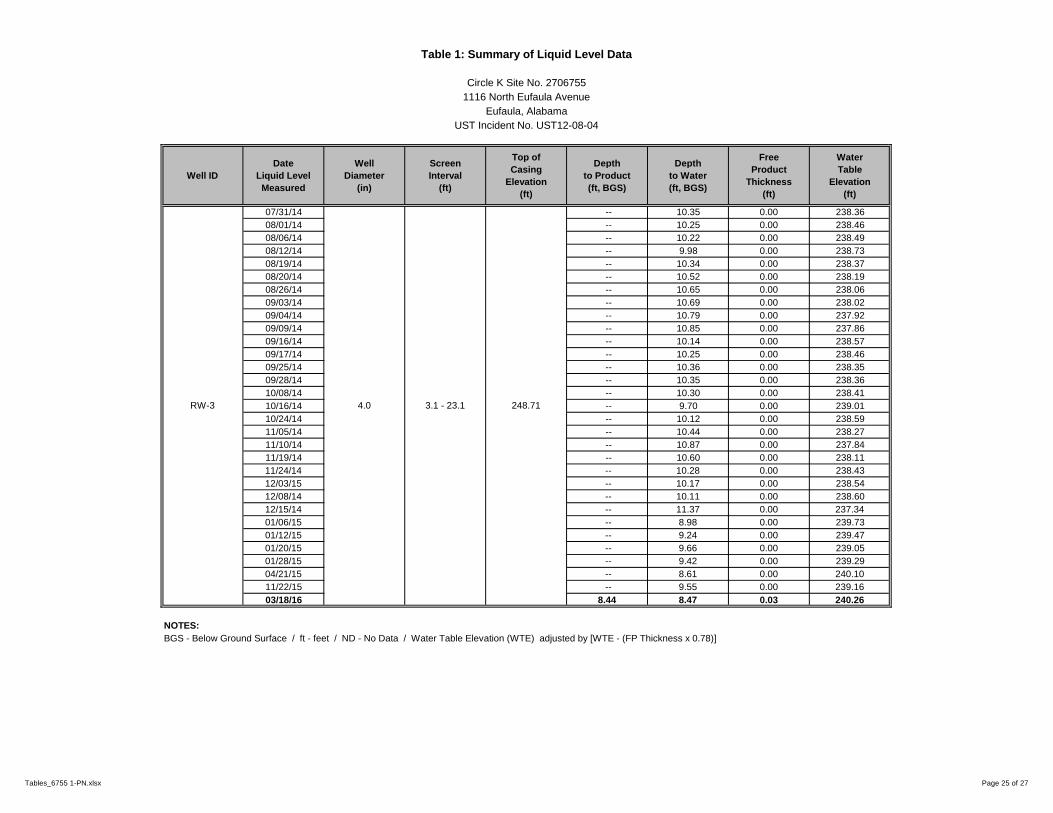
Table 1: Summary of Liquid Level Data
Circle K Site No. 2706755
1116 North Eufaula Avenue
Eufaula, Alabama
UST Incident No. UST12-08-04
Well ID
Date
Liquid Level
Measured
Well
Diameter
(in)
Screen
Interval
(ft)
Top of
Casing
Elevation
(ft)
Depth
to Product
(ft, BGS)
Depth
to Water
(ft, BGS)
Free
Product
Thickness
(ft)
Water
Table
Elevation
(ft)
07/31/14 -- 10.35 0.00 238.36
08/01/14 -- 10.25 0.00 238.46
08/06/14 -- 10.22 0.00 238.49
08/12/14 -- 9.98 0.00 238.73
08/19/14 -- 10.34 0.00 238.37
08/20/14 -- 10.52 0.00 238.19
08/26/14 -- 10.65 0.00 238.06
09/03/14 -- 10.69 0.00 238.02
09/04/14 -- 10.79 0.00 237.92
09/09/14 -- 10.85 0.00 237.86
09/16/14 -- 10.14 0.00 238.57
09/17/14 -- 10.25 0.00 238.46
09/25/14 -- 10.36 0.00 238.35
09/28/14 -- 10.35 0.00 238.36
10/08/14 -- 10.30 0.00 238.41
10/16/14 -- 9.70 0.00 239.01
10/24/14 -- 10.12 0.00 238.59
11/05/14 -- 10.44 0.00 238.27
11/10/14 -- 10.87 0.00 237.84
11/19/14 -- 10.60 0.00 238.11
11/24/14 -- 10.28 0.00 238.43
12/03/15 -- 10.17 0.00 238.54
12/08/14 -- 10.11 0.00 238.60
12/15/14 -- 11.37 0.00 237.34
01/06/15 -- 8.98 0.00 239.73
01/12/15 -- 9.24 0.00 239.47
01/20/15 -- 9.66 0.00 239.05
01/28/15 -- 9.42 0.00 239.29
04/21/15 -- 8.61 0.00 240.10
11/22/15 -- 9.55 0.00 239.16
03/18/16 8.44 8.47 0.03 240.26
NOTES:
BGS - Below Ground Surface / ft - feet / ND - No Data / Water Table Elevation (WTE) adjusted by [WTE - (FP Thickness x 0.78)]
RW-3 4.0 3.1 - 23.1 248.71
Tables_6755 1-PN.xlsx Page 25 of 27

Table 1: Summary of Liquid Level Data
Circle K Site No. 2706755
1116 North Eufaula Avenue
Eufaula, Alabama
UST Incident No. UST12-08-04
Well ID
Date
Liquid Level
Measured
Well
Diameter
(in)
Screen
Interval
(ft)
Top of
Casing
Elevation
(ft)
Depth
to Product
(ft, BGS)
Depth
to Water
(ft, BGS)
Free
Product
Thickness
(ft)
Water
Table
Elevation
(ft)
07/31/14 -- 9.36 0.00 237.35
08/01/14 -- 9.53 0.00 237.18
08/06/14 -- 9.80 0.00 236.91
08/12/14 -- 9.51 0.00 237.20
08/19/14 -- 9.76 0.00 236.95
08/20/14 -- 9.97 0.00 236.74
08/26/14 -- 10.06 0.00 236.65
09/03/14 -- 10.06 0.00 236.65
09/04/14 -- 10.17 0.00 236.54
09/09/14 -- 10.10 0.00 236.61
09/16/14 -- 9.27 0.00 237.44
09/17/14 -- 9.43 0.00 237.28
09/25/14 -- 9.76 0.00 236.95
09/28/14 -- 9.80 0.00 236.91
10/08/14 -- 9.88 0.00 236.83
10/16/14 -- 9.07 0.00 237.64
10/24/14 -- 9.73 0.00 236.98
11/05/14 -- 9.81 0.00 236.90
11/10/14 -- 9.78 0.00 236.93
11/19/14 -- 9.85 0.00 236.86
11/24/14 -- 9.55 0.00 237.16
12/03/15 -- 9.54 0.00 237.17
12/08/14 -- 9.45 0.00 237.26
12/15/14 -- 9.98 0.00 236.73
01/06/15 -- 8.37 0.00 238.34
01/12/15 -- 8.80 0.00 237.91
01/20/15 -- 9.03 0.00 237.68
01/28/15 -- 9.17 0.00 237.54
04/21/15 -- 8.21 0.00 238.50
11/22/15 -- 8.77 0.00 237.94
03/18/16 6.97 13.29 6.32 238.35
NOTES:
BGS - Below Ground Surface / ft - feet / ND - No Data / Water Table Elevation (WTE) adjusted by [WTE - (FP Thickness x 0.78)]
RW-4 4.0 2.9 - 22.9 246.71
Tables_6755 1-PN.xlsx Page 26 of 27

Table 1: Summary of Liquid Level Data
Circle K Site No. 2706755
1116 North Eufaula Avenue
Eufaula, Alabama
UST Incident No. UST12-08-04
Well ID
Date
Liquid Level
Measured
Well
Diameter
(in)
Screen
Interval
(ft)
Top of
Casing
Elevation
(ft)
Depth
to Product
(ft, BGS)
Depth
to Water
(ft, BGS)
Free
Product
Thickness
(ft)
Water
Table
Elevation
(ft)
07/31/14 -- 10.11 0.00 237.68
08/01/14 -- 10.28 0.00 237.51
08/06/14 -- 10.55 0.00 237.24
08/12/14 -- 10.15 0.00 237.64
08/19/14 -- 10.47 0.00 237.32
08/20/14 -- 10.66 0.00 237.13
08/26/14 -- 10.74 0.00 237.05
09/03/14 -- 10.76 0.00 237.03
09/04/14 -- 10.85 0.00 236.94
09/09/14 -- 11.56 0.00 236.23
09/16/14 -- 9.95 0.00 237.84
09/17/14 -- 10.08 0.00 237.71
09/25/14 -- 10.41 0.00 237.38
09/28/14 -- 10.48 0.00 237.31
10/08/14 -- 10.41 0.00 237.38
10/16/14 -- 9.74 0.00 238.05
10/24/14 -- 10.15 0.00 237.64
11/05/14 -- 10.46 0.00 237.33
11/10/14 -- 10.52 0.00 237.27
11/19/14 -- 10.38 0.00 237.41
11/24/14 -- 10.03 0.00 237.76
12/03/15 -- 10.11 0.00 237.68
12/08/14 -- 10.09 0.00 237.70
12/15/14 -- 10.13 0.00 237.66
01/06/15 -- 9.01 0.00 238.78
01/12/15 -- 9.32 0.00 238.47
01/20/15 -- 9.53 0.00 238.26
01/28/15 -- 9.35 0.00 238.44
04/21/15 -- 9.11 0.00 238.68
11/22/15 -- 9.35 0.00 238.44
03/18/16 -- 9.13 0.00 238.66
NOTES:
BGS - Below Ground Surface / ft - feet / ND - No Data / Water Table Elevation (WTE) adjusted by [WTE - (FP Thickness x 0.78)]
RW-5 4.0 3.3 - 23.3 247.79
Tables_6755 1-PN.xlsx Page 27 of 27

Well ID Date Collected
01/13/99 0.425 0.07 0.1 0.12 0.715 0.93 ND
05/29/02 0.657 0.0676 0.145 0.157 1.0266 8.11 ND
11/21/02 3.5 0.27 1 1.16 5.93 21 ND
02/26/03 2.5 0.53 0.09 1.08 4.2 17 ND
10/29/03 0.411 <0.0005 0.0606 0.108 0.5796 1.64 ND
10/20/04 0.66 0.0532 0.185 0.101 0.9992 17.2 ND
05/02/05 1.05 0.0201 0.256 0.123 1.4491 13 ND
07/25/05 1.36 <0.00001 0.301 <0.00002 1.661 22.7 ND
11/30/05 0.473 0.034 0.117 0.0497 0.6737 7.36 ND
02/27/06 0.609 0.00964 0.194 0.003657 0.816297 16.7 ND
05/24/06 0.26 0.088 0.0012 0.0052 0.3544 1.4 ND
09/07/06 0.0632 <0.00016 0.0506 <0.00026 0.1138 8.34 ND
09/25/07 0.672 0.0161 0.235 0.027 0.9501 1.02 ND
03/06/08 0.616 0.322 0.288 0.412 1.638 2.02 ND
04/15/08 0.493 0.0718 0.255 0.564 1.3838 1.97 ND
05/21/08 0.117 <0.005 0.0126 0.0328 0.1624 0.734 ND
08/01/08 0.028 <0.005 0.00188 0.00655 0.03643 0.402 ND
04/16/09 0.0308 <0.005 <0.001 <0.001 0.0308 0.448 ND
08/18/09 0.0627 <0.005 <0.001 0.00135 0.06405 0.364 ND
01/12/10 0.0846 <0.005 <0.001 <0.001 0.0846 0.478 ND
05/07/10 0.066 <0.005 0.002 <0.001 0.068 0.406 ND
08/27/10 0.063 <0.005 0.0028 <0.001 0.0658 0.354 ND
12/17/10 0.0396 <0.005 0.0026 <0.001 0.0422 0.165 ND
04/20/11 0.0421 <0.005 0.0062 <0.001 0.0483 0.195 ND
0.548 117 81.8 175 NSE 2.34 2.34
NOTES
BDL - Sum of BTEX Constituents Below Laboratory Detection Limits Highlighted data exceeds SSCALs
BTEX - Summary of Benzene, Toluene, Ethylbenzene & Xylenes NSE - No Standard Established
Data provided in mg/L SSTLs - Site Specific Target Levels
SSTLs
MW-1
Chemical of Concern
Benzene Toluene Ethylbenzene NaphthaleneXylenesTotal
BTEXMTBE
Table 2: Summary of Groundwater Analtyical Data (BTEX, MTBE, Naphthalene)
Circle K Site No. 2706755
1116 North Eufaula Avenue
Eufaula, Alabama
UST Incident No. UST12-08-04
Analytical Method EPA Method 8260B
Tables_6755 1-PN.xlsx 1 of 21

Table 2: Summary of Groundwater Analtyical Data (BTEX, MTBE, Naphthalene)
Circle K Site No. 2706755
1116 North Eufaula Avenue
Eufaula, Alabama
UST Incident No. UST12-08-04
Well ID Date Collected
01/31/12 0.0155 <0.005 0.0054 0.0026 0.0235 0.165 ND
05/30/12 0.1 0.1695 0.788 1.065 2.1225 0.18 ND
09/19/12 0.0066 <0.001 0.0022 0.0038 0.0126 0.1 ND
10/08/13 0.018 <0.0050 0.016 0.027 0.061 1.2 ND
12/19/13 0.0014 <0.0050 <0.0010 <0.0030 0.0014 0.026 ND
05/29/14 0.03 0.023 0.005 0.018 0.076 0.13 <0.0050
09/29/14 0.021 <0.0050 0.0044 0.0053 0.0307 0.11 <0.0050
01/28/15 0.058 0.0091 0.0026 0.0081 0.0778 0.3 <0.0050
04/22/15 0.109 0.0171 0.0041 0.21 0.3402 0.396 0.0018
11/22/15 0.0133 <0.001 <0.001 0.0025 0.0158 0.103 <0.005
03/18/16 0.268 0.115 0.0301 0.134 0.5471 0.235 0.0077
0.548 117 81.8 175 NSE 2.34 2.34
01/13/99 0.004 0.003 0.002 0.004 0.013 0.0049 ND
05/29/02 0.00462 0.00071 0.0046 0.00411 0.01404 0.175 ND
11/21/02 <0.001 <0.001 <0.001 <0.002 BDL 0.28 ND
02/26/03 0.061 0.018 0.0039 0.0318 0.1147 0.35 ND
10/29/03 0.0121 0.00055 0.00337 0.00493 0.02095 0.0466 ND
02/12/04 0.00035 <0.00001 <0.00001 0.00044 0.00079 1.25 ND
10/20/04 0.00556 0.0072 0.00216 0.00818 0.0231 0.419 ND
01/18/05 0.00135 <0.00001 <0.00001 <0.00002 0.00135 0.223 ND
05/02/05 0.00338 0.00013 0.00065 0.0011 0.00526 0.314 ND
07/25/05 <0.00001 <0.00001 <0.00001 <0.00002 BDL 0.409 ND
11/30/05 0.00198 <0.00001 <0.00001 <0.00002 0.00198 0.154 ND
02/27/06 0.0031 <0.00016 <0.00017 <0.00026 0.0031 0.1562 ND
05/24/06 0.001 <0.00017 <0.00016 <0.00026 0.001 0.13 ND
09/07/06 <0.00014 <0.00016 <0.00017 <0.00026 BDL 0.103 ND
09/24/07 0.00198 <0.005 <0.001 <0.001 0.00198 0.122 ND
NOTES
BDL - Sum of BTEX Constituents Below Laboratory Detection Limits Highlighted data exceeds SSCALs
BTEX - Summary of Benzene, Toluene, Ethylbenzene & Xylenes NSE - No Standard Established
Data provided in mg/L SSTLs - Site Specific Target Levels
Chemical of Concern
Benzene Toluene Ethylbenzene Xylenes MTBE
Analytical Method EPA Method 8260B
Total
BTEXNaphthalene
MW-1
MW-2
SSTLs
Well Abandoned
Tables_6755 1-PN.xlsx 2 of 21

Table 2: Summary of Groundwater Analtyical Data (BTEX, MTBE, Naphthalene)
Circle K Site No. 2706755
1116 North Eufaula Avenue
Eufaula, Alabama
UST Incident No. UST12-08-04
Well ID Date Collected
03/06/08 7 36.6 3.77 23.1 70.47 12.1 ND
04/15/08 6.36 28.6 4.99 33.7 73.65 4.67 ND
05/21/08 8.48 32 3.34 20.3 64.12 11.3 ND
08/01/08 11.7 31.9 15.1 72.8 131.5 13.6 ND
04/16/09 1.64 12.8 2.04 13.8 30.28 2.18 ND
08/18/09 0.469 1.75 0.749 4.46 7.428 0.473 ND
01/12/10 0.363 0.606 0.409 3.28 4.658 0.411 ND
05/07/10 0.247 0.288 0.23 2.3 3.065 0.178 ND
08/27/10 0.118 0.137 0.097 0.836 1.188 0.016 ND
12/17/10 0.38 0.261 0.494 2.43 3.565 0.218 ND
04/20/11 6.66 34.5 5.32 27.3 73.78 10.2 ND
01/31/12 11.3 56 5.66 26 98.96 3.35 ND
05/30/12 6.55 4.405 32.63 26.125 69.71 1.955 ND
09/19/12 15 50 5.4 32 102.4 4.2 ND
4/13 to 4/15
10/08/13
12/19/13
05/29/14
09/29/14 6.7 29 3.2 17 55.9 <1 <5
01/28/15
04/21/15
11/22/15
136.4 526 169 175 NSE 48000 31
05/29/02 0.00067 0.00054 0.0011 0.00145 0.00376 <0.0001 ND
11/21/02 <0.001 <0.001 <0.001 <0.002 BDL <0.008 ND
10/29/03 <0.00001 <0.00001 <0.00001 <0.00002 BDL <0.0001 ND
02/12/04 <0.00001 <0.00001 <0.00001 <0.00002 BDL <0.0001 ND
0.554 111 77.6 175 NSE 2.22 2.22
NOTES
BDL - Sum of BTEX Constituents Below Laboratory Detection Limits Highlighted data exceeds SSCALs
BTEX - Summary of Benzene, Toluene, Ethylbenzene & Xylenes NSE - No Standard Established
Data provided in mg/L SSTLs - Site Specific Target Levels
MW-7
SSTLS
Benzene Toluene Ethylbenzene XylenesTotal
BTEXMTBE Naphthalene
Well Abandoned
SSTLs
MW-2
WELL ABANDONED
NOT SAMPLED: FP = 3.32'
NOT SAMPLED: FP = 4.95'
NOT SAMPLED: FP = 0.53'
NOT SAMPLED: FP = 0.75'
NOT SAMPLED: FP = 1.92'
Chemical of Concern
Analytical Method EPA Method 8260B
EW-2
NOT SAMPLED: FP = 1.60'
Tables_6755 1-PN.xlsx 3 of 21

Table 2: Summary of Groundwater Analtyical Data (BTEX, MTBE, Naphthalene)
Circle K Site No. 2706755
1116 North Eufaula Avenue
Eufaula, Alabama
UST Incident No. UST12-08-04
Well ID Date Collected
10/20/04 0.00299 0.00049 0.00087 0.00161 0.00596 0.0103 ND
01/18/05 0.00168 0.00028 0.00059 0.001 0.00355 0.0189 ND
05/02/05 <0.00001 <0.00001 <0.00001 <0.00002 BDL <0.0001 ND
07/25/05 <0.00001 <0.00001 <0.00001 <0.00002 BDL <0.0001 ND
11/30/05 0.00105 <0.00001 <0.00001 <0.00002 0.00105 0.0111 ND
02/27/06 <0.00014 <0.00016 <0.00017 <0.00026 BDL <0.00374 ND
05/24/06 <0.00014 <0.00017 <0.00016 <0.00026 BDL <0.00374 ND
09/07/06 <0.00014 <0.00016 <0.00017 <0.00026 BDL <0.00374 ND
09/24/07 0.00101 <0.005 <0.001 <0.001 0.00101 <0.001 ND
03/07/08 <0.001 <0.005 <0.001 <0.001 BDL 0.00126 ND
04/14/08 <0.001 <0.005 <0.001 <0.001 BDL <0.001 ND
05/21/08 <0.001 <0.005 <0.001 <0.001 BDL <0.001 ND
07/31/08 <0.001 <0.005 <0.001 <0.001 BDL <0.001 ND
04/16/09 <0.001 <0.005 <0.001 <0.001 BDL <0.001 ND
08/18/09 <0.001 <0.005 <0.001 <0.001 BDL <0.001 ND
01/12/10 <0.001 <0.005 <0.001 <0.001 BDL <0.001 ND
05/06/10 <0.001 <0.005 <0.001 <0.001 BDL <0.001 ND
08/26/10 <0.001 <0.005 <0.001 <0.001 BDL <0.001 ND
12/16/10 <0.001 <0.005 <0.001 <0.001 BDL <0.001 ND
04/19/11 <0.001 <0.005 <0.001 <0.001 BDL <0.001 ND
01/30/12 <0.001 <0.005 <0.001 <0.001 BDL <0.001 ND
05/30/12 <0.001 <0.001 <0.001 <0.001 BDL <0.005 ND
09/18/12 <0.001 <0.001 <0.001 <0.001 BDL <0.005 ND
10/08/13 <0.001 <0.005 <0.001 <0.003 BDL <0.001 ND
0.554 111 77.6 175 NSE 2.22 2.22
NOTES
BDL - Sum of BTEX Constituents Below Laboratory Detection Limits Highlighted data exceeds SSCALs
BTEX - Summary of Benzene, Toluene, Ethylbenzene & Xylenes NSE - No Standard Established
Data provided in mg/L SSTLs - Site Specific Target Levels
MW-7
SSTLS
Chemical of Concern
Benzene Toluene Ethylbenzene MTBE NaphthaleneXylenesTotal
BTEX
Analytical Method EPA Method 8260B
Tables_6755 1-PN.xlsx 4 of 21
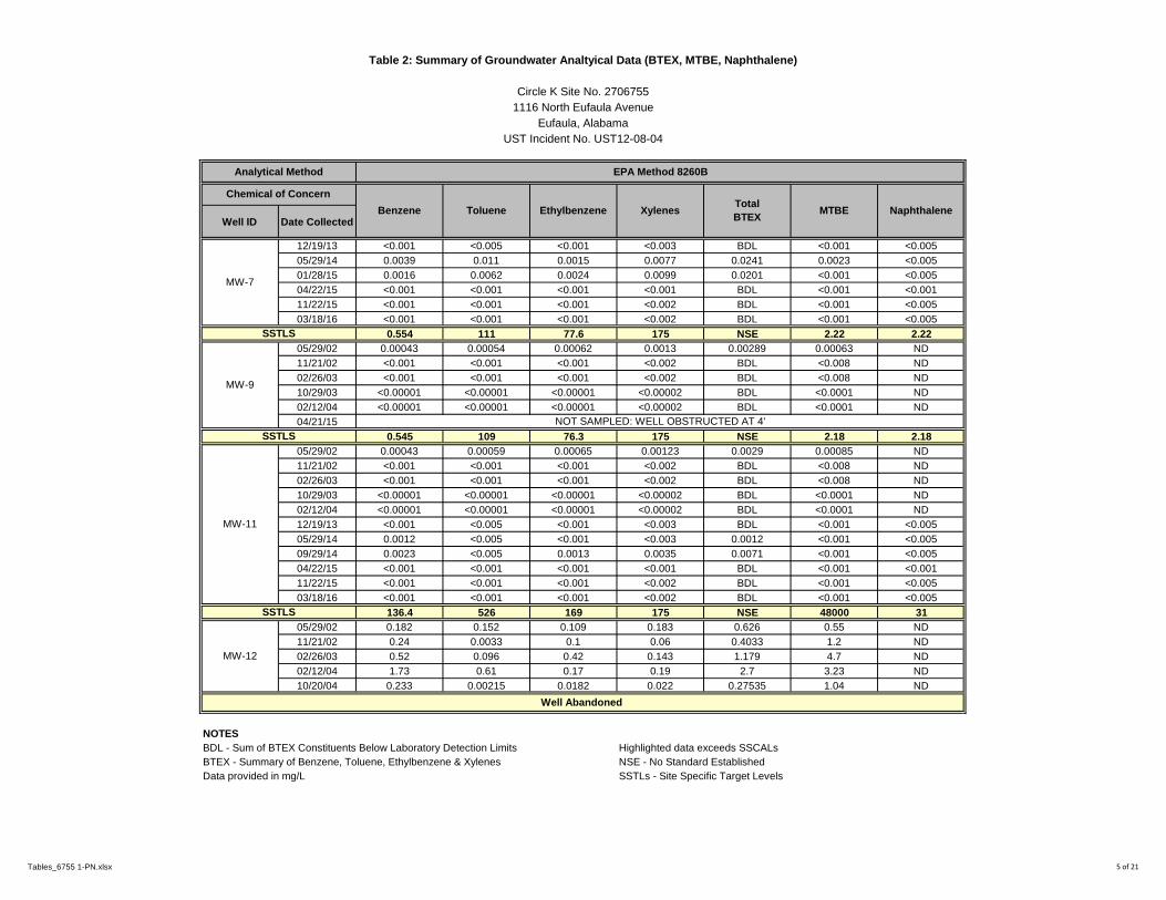
Table 2: Summary of Groundwater Analtyical Data (BTEX, MTBE, Naphthalene)
Circle K Site No. 2706755
1116 North Eufaula Avenue
Eufaula, Alabama
UST Incident No. UST12-08-04
Well ID Date Collected
12/19/13 <0.001 <0.005 <0.001 <0.003 BDL <0.001 <0.005
05/29/14 0.0039 0.011 0.0015 0.0077 0.0241 0.0023 <0.005
01/28/15 0.0016 0.0062 0.0024 0.0099 0.0201 <0.001 <0.005
04/22/15 <0.001 <0.001 <0.001 <0.001 BDL <0.001 <0.001
11/22/15 <0.001 <0.001 <0.001 <0.002 BDL <0.001 <0.005
03/18/16 <0.001 <0.001 <0.001 <0.002 BDL <0.001 <0.005
0.554 111 77.6 175 NSE 2.22 2.22
05/29/02 0.00043 0.00054 0.00062 0.0013 0.00289 0.00063 ND
11/21/02 <0.001 <0.001 <0.001 <0.002 BDL <0.008 ND
02/26/03 <0.001 <0.001 <0.001 <0.002 BDL <0.008 ND
10/29/03 <0.00001 <0.00001 <0.00001 <0.00002 BDL <0.0001 ND
02/12/04 <0.00001 <0.00001 <0.00001 <0.00002 BDL <0.0001 ND
04/21/15
0.545 109 76.3 175 NSE 2.18 2.18
05/29/02 0.00043 0.00059 0.00065 0.00123 0.0029 0.00085 ND
11/21/02 <0.001 <0.001 <0.001 <0.002 BDL <0.008 ND
02/26/03 <0.001 <0.001 <0.001 <0.002 BDL <0.008 ND
10/29/03 <0.00001 <0.00001 <0.00001 <0.00002 BDL <0.0001 ND
02/12/04 <0.00001 <0.00001 <0.00001 <0.00002 BDL <0.0001 ND
12/19/13 <0.001 <0.005 <0.001 <0.003 BDL <0.001 <0.005
05/29/14 0.0012 <0.005 <0.001 <0.003 0.0012 <0.001 <0.005
09/29/14 0.0023 <0.005 0.0013 0.0035 0.0071 <0.001 <0.005
04/22/15 <0.001 <0.001 <0.001 <0.001 BDL <0.001 <0.001
11/22/15 <0.001 <0.001 <0.001 <0.002 BDL <0.001 <0.005
03/18/16 <0.001 <0.001 <0.001 <0.002 BDL <0.001 <0.005
136.4 526 169 175 NSE 48000 31
05/29/02 0.182 0.152 0.109 0.183 0.626 0.55 ND
11/21/02 0.24 0.0033 0.1 0.06 0.4033 1.2 ND
02/26/03 0.52 0.096 0.42 0.143 1.179 4.7 ND
02/12/04 1.73 0.61 0.17 0.19 2.7 3.23 ND
10/20/04 0.233 0.00215 0.0182 0.022 0.27535 1.04 ND
NOTES
BDL - Sum of BTEX Constituents Below Laboratory Detection Limits Highlighted data exceeds SSCALs
BTEX - Summary of Benzene, Toluene, Ethylbenzene & Xylenes NSE - No Standard Established
Data provided in mg/L SSTLs - Site Specific Target Levels
MW-11
MW-7
SSTLS
SSTLS
SSTLS
Well Abandoned
MW-9
NOT SAMPLED: WELL OBSTRUCTED AT 4'
MW-12
MTBE NaphthaleneXylenesTotal
BTEX
Analytical Method EPA Method 8260B
Chemical of Concern
Benzene Toluene Ethylbenzene
Tables_6755 1-PN.xlsx 5 of 21

Table 2: Summary of Groundwater Analtyical Data (BTEX, MTBE, Naphthalene)
Circle K Site No. 2706755
1116 North Eufaula Avenue
Eufaula, Alabama
UST Incident No. UST12-08-04
Well ID Date Collected
01/18/05 0.701 0.0711 0.131 0.182 1.0851 1.38 ND
07/25/05 0.0439 0.00095 0.00408 0.00244 0.05137 0.27 ND
11/30/05 0.0968 0.00222 0.00159 0.00892 0.10953 0.412 ND
02/27/06 0.198 0.00409 0.00277 0.01354 0.2184 0.372 ND
05/24/06 0.18 0.031 0.0096 0.061 0.2816 0.18 ND
09/07/06 0.0168 <0.00016 <0.00017 0.0119 0.0287 0.109 ND
09/24/07 0.142 <0.005 0.0346 0.0265 0.2031 0.055 ND
03/06/08 0.00506 0.06 0.0385 0.277 0.38056 0.00601 ND
04/15/08 0.00359 <0.005 <0.001 <0.001 0.00359 0.00584 ND
05/20/08 0.0145 <0.005 <0.001 <0.001 0.0145 0.0262 ND
08/01/08 0.0281 <0.005 0.00139 0.0038 0.03329 0.0499 ND
04/16/09 <0.001 <0.005 <0.001 <0.001 BDL 0.00858 ND
08/18/09 0.00818 <0.005 <0.001 <0.001 0.00818 0.00194 ND
01/12/10 0.0123 <0.005 <0.001 <0.001 0.0123 0.015 ND
05/07/10 0.007 <0.005 <0.001 <0.001 0.007 0.039 ND
08/27/10 0.048 <0.005 0.002 <0.001 0.05 0.004 ND
12/17/10 0.0167 <0.005 0.001 0.0031 0.0208 0.0027 ND
04/20/11 0.196 0.138 0.0958 0.0842 0.514 0.0034 ND
01/31/12 3.09 13 1.52 6.55 24.16 0.131 ND
05/30/12 1.84 12.773 6.79 5.274 26.677 0.18 ND
09/19/12 1.7 5.6 1 4.4 12.7 0.17 ND
10/13 to 4/15
10/08/13 0.41 1.4 0.21 1.4 3.42 <0.1 ND
12/19/13 0.52 1.5 0.23 1.3 3.55 <0.1 <0.50
05/08/14 0.98 2.7 0.32 1.9 5.9 0.03 <0.12
136.4 526 169 175 NSE 48000 31
NOTES
BDL - Sum of BTEX Constituents Below Laboratory Detection Limits Highlighted data exceeds SSCALs
BTEX - Summary of Benzene, Toluene, Ethylbenzene & Xylenes NSE - No Standard Established
Data provided in mg/L SSTLs - Site Specific Target Levels
Well Abandoned
EW-12
SSTLs
MW-12
WELL ABANDONED
Naphthalene
Chemical of Concern
EthylbenzeneBenzene TolueneTotal
BTEXMTBEXylenes
Analytical Method EPA Method 8260B
Tables_6755 1-PN.xlsx 6 of 21

Table 2: Summary of Groundwater Analtyical Data (BTEX, MTBE, Naphthalene)
Circle K Site No. 2706755
1116 North Eufaula Avenue
Eufaula, Alabama
UST Incident No. UST12-08-04
Well ID Date Collected
05/30/14 0.84 2.6 0.37 2 5.81 <0.025 <0.12
09/29/14 0.65 1.1 0.12 0.73 2.6 <0.025 <0.12
01/28/15
04/21/15
136.4 526 169 175 NSE 48000 31
05/29/02 0.0223 0.00632 0.00558 0.0148 0.049 0.237 ND
11/21/02 0.016 <0.001 <0.001 <0.002 0.016 0.57 ND
02/26/03 0.2 0.0035 0.021 0.029 0.2535 1.3 ND
10/29/03 0.0519 0.00257 0.00391 0.00361 0.06199 0.176 ND
02/12/04 0.0205 0.00289 0.00136 0.00243 0.02718 1.22 ND
10/20/04 0.0529 0.00551 0.0053 0.0069 0.07061 2.41 ND
01/18/05 0.0317 0.00165 0.00203 0.00387 0.03925 0.435 ND
05/02/05 0.101 0.0385 0.00818 0.0425 0.19018 0.568 ND
07/25/05 0.105 0.00141 0.00212 <0.00002 0.10853 1.67 ND
11/30/05 0.0725 0.00096 0.00221 0.00189 0.07756 0.581 ND
02/27/06 0.153 0.0116 0.00668 0.03598 0.20726 1.931 ND
05/24/06 0.073 <0.00017 <0.00016 <0.00026 0.073 1.3 ND
09/07/06 0.266 <0.00016 0.029 0.00374 0.29874 3.3 ND
09/25/07 0.867 <0.025 0.513 0.0212 1.4012 1.16 ND
03/07/08 0.584 <0.05 0.328 0.0821 0.9941 1.97 ND
04/15/08 0.318 <0.05 0.31 0.0824 0.7104 1.27 ND
05/21/08 0.217 0.0162 0.13 0.044 0.4072 0.894 ND
08/01/08 0.0955 0.0174 0.0392 0.00817 0.16027 0.545 ND
04/16/09 0.598 0.898 0.225 1.15 2.871 1.7 ND
08/18/09 0.19 0.0669 0.0688 0.18 0.5057 0.53 ND
01/12/10 0.354 0.174 0.116 0.308 0.952 1.03 ND
NOTES
BDL - Sum of BTEX Constituents Below Laboratory Detection Limits Highlighted data exceeds SSCALs
BTEX - Summary of Benzene, Toluene, Ethylbenzene & Xylenes NSE - No Standard Established
Data provided in mg/L SSTLs - Site Specific Target Levels
SSTLs
Well Abandoned
MW-14
MTBE Naphthalene
EW-12NOT SAMPLED: FP = 0.02'
NOT SAMPLED: FP = 0.02'
Benzene Toluene Ethylbenzene XylenesTotal
BTEX
Chemical of Concern
Analytical Method EPA Method 8260B
Tables_6755 1-PN.xlsx 7 of 21

Table 2: Summary of Groundwater Analtyical Data (BTEX, MTBE, Naphthalene)
Circle K Site No. 2706755
1116 North Eufaula Avenue
Eufaula, Alabama
UST Incident No. UST12-08-04
Well ID Date Collected
05/07/10 0.405 0.302 0.324 0.678 1.709 0.195 ND
08/27/10 0.197 0.165 0.157 0.451 0.97 0.105 ND
12/17/10 0.481 0.198 0.381 0.32 1.38 0.584 ND
04/20/11 0.328 0.234 0.261 0.267 1.09 0.534 ND
01/31/12 2.72 4 1.09 3.03 10.84 0.757 ND
05/30/12 2.41 1 2.82 4.1615 10.3915 0.9155 ND
09/19/12 1.9 0.84 0.66 2.5 5.9 0.8 ND
10/13 to 4/15
10/08/13
12/19/13
05/08/14 1.4 6.8 1.8 11 21 1.1 0.78
05/29/14
9/29/14* 0.14 <0.5 0.35 2.1 2.59 <0.1 <0.5
01/28/15
04/21/15 0.267 0.756 0.252 1.38 2.655 0.217 0.102
136.4 526 169 175 NSE 48000 31
05/29/02 0.00135 0.00154 0.00204 0.00385 0.00878 0.176 ND
11/21/02 <0.001 <0.001 <0.001 <0.002 BDL 1.8 ND
02/26/03 <0.001 <0.001 <0.001 <0.002 BDL 0.42 ND
10/29/03 <0.00001 <0.00001 <0.00001 <0.00002 BDL 0.0461 ND
02/12/04 0.0047 <0.00001 <0.00001 <0.00002 0.0047 1.36 ND
10/20/04 0.00459 0.00053 0.00093 0.00163 0.00768 0.346 ND
01/18/05 <0.00001 <0.00001 <0.00001 <0.00002 BDL 0.318 ND
05/02/05 <0.00001 <0.00001 <0.00001 <0.00002 BDL 0.391 ND
07/25/05 <0.00001 <0.00001 <0.00001 <0.00002 BDL 0.45 ND
136.4 526 169 175 NSE 48000 31
NOTES
BDL - Sum of BTEX Constituents Below Laboratory Detection Limits Highlighted data exceeds SSCALs
BTEX - Summary of Benzene, Toluene, Ethylbenzene & Xylenes NSE - No Standard Established
Data provided in mg/L SSTLs - Site Specific Target Levels
Analytical Method EPA Method 8260B
MW-14
WELL ABANDONED
MW-15
SSTLs
NOT SAMPLED: FP = 0.03'
EW-14
NOT SAMPLED: FP = 0.11'
NOT SAMPLED: FP = 0.20'
NOT SAMPLED: FP = 0.02'
XylenesTotal
BTEXMTBE Naphthalene
Chemical of Concern
Well Abandoned
SSTLs
Benzene Toluene Ethylbenzene
Tables_6755 1-PN.xlsx 8 of 21

Table 2: Summary of Groundwater Analtyical Data (BTEX, MTBE, Naphthalene)
Circle K Site No. 2706755
1116 North Eufaula Avenue
Eufaula, Alabama
UST Incident No. UST12-08-04
Well ID Date Collected
11/30/05 0.0013 <0.00001 <0.00001 <0.00002 0.0013 0.269 ND
02/27/06 <0.00014 <0.00016 <0.00017 <0.00026 BDL 0.3379 ND
05/24/06 <0.00014 <0.00017 <0.00016 <0.00026 BDL 0.21 ND
09/07/06 <0.00014 <0.00016 <0.00017 <0.00026 BDL 0.46 ND
09/24/07 <0.001 <0.005 <0.001 <0.001 BDL 0.228 ND
03/07/08 0.126 0.0286 0.00992 0.155 0.31952 1.01 ND
04/15/08 0.0456 0.0066 0.00306 0.0685 0.12376 0.735 ND
05/21/08 0.0289 <0.005 <0.001 0.0268 0.0557 0.377 ND
08/01/08 0.0115 <0.005 <0.001 <0.001 0.0115 0.284 ND
04/16/09 0.00752 <0.005 <0.001 <0.001 0.00752 0.45 ND
08/17/09 0.00128 <0.005 <0.001 <0.001 0.00128 0.199 ND
01/12/10 <0.001 <0.005 <0.001 <0.001 BDL 0.336 ND
05/07/10 0.011 <0.005 <0.001 <0.001 0.011 0.354 ND
08/27/10 <0.001 <0.005 <0.001 <0.001 BDL 0.096 ND
12/17/10 <0.001 <0.005 <0.001 <0.001 BDL 0.0798 ND
04/20/11 0.0022 <0.005 <0.001 <0.001 0.0022 0.126 ND
01/30/12 0.0451 1.29 0.834 4.89 7.0591 0.141 ND
05/30/12 0.02344 0.468 0.3735 3.6874 4.55234 0.15278 ND
09/19/12 0.0088 0.11 0.13 1.3 1.5488 0.087 ND
12/19/13 <0.1 <0.5 0.16 1.7 1.86 0.19 <0.5
04/22/15 0.301 0.17 0.309 1.09 1.87 0.397 0.12
11/22/15 1.49 0.321 0.502 1.76 4.073 0.336 0.183
03/18/16 2.96 10 0.974 5.38 19.314 0.204 <0.5
136.4 526 169 175 NSE 48000 31
10/08/13 2.2 9.5 1.1 6.2 19 0.13 ND
12/19/13 1 2.5 0.35 1.8 5.65 0.3 0.12
05/15/14 1.5 0.84 0.72 2.5 5.56 0.74 0.16
05/29/14 3.8 2.7 1.3 4.1 11.9 0.65 0.36
136.4 526 169 175 NSE 48000 31
NOTES
BDL - Sum of BTEX Constituents Below Laboratory Detection Limits Highlighted data exceeds SSCALs
BTEX - Summary of Benzene, Toluene, Ethylbenzene & Xylenes NSE - No Standard Established
Data provided in mg/L SSTLs - Site Specific Target Levels
MW-15
SSTLs
SSTLs
Chemical of Concern
Benzene MTBE NaphthaleneToluene Ethylbenzene XylenesTotal
BTEX
Analytical Method EPA Method 8260B
MW-15A
Tables_6755 1-PN.xlsx 9 of 21

Table 2: Summary of Groundwater Analtyical Data (BTEX, MTBE, Naphthalene)
Circle K Site No. 2706755
1116 North Eufaula Avenue
Eufaula, Alabama
UST Incident No. UST12-08-04
Well ID Date Collected
09/29/14 4.6 1.6 0.96 3.4 10.56 0.71 0.26
01/28/15 2.7 0.85 0.59 1.8 5.94 1.7 <0.25
136.4 526 169 175 NSE 48000 31
05/29/02 0.00097 0.00137 0.00175 0.00326 0.00735 0.00188 ND
11/21/02 <0.001 <0.001 <0.001 <0.002 BDL <0.008 ND
02/26/03 <0.001 <0.001 <0.001 <0.002 BDL <0.008 ND
10/29/03 <0.00001 <0.00001 <0.00001 <0.00002 BDL <0.0001 ND
02/12/04 <0.00001 <0.00001 <0.00001 <0.00002 BDL <0.0001 ND
10/20/04 0.00155 0.00041 0.00074 0.00087 0.00357 0.0066 ND
01/18/05 <0.00001 <0.00001 <0.00001 <0.00002 BDL 0.00148 ND
05/02/05 0.00162 0.00012 0.00079 0.00114 0.00367 0.0132 ND
07/25/05 <0.00001 <0.00001 <0.00001 <0.00002 BDL <0.0001 ND
11/30/05 0.00108 <0.00001 <0.00001 <0.00002 0.00108 0.00558 ND
02/27/06 <0.00014 <0.00016 <0.00017 <0.00026 BDL <0.00374 ND
05/24/06 <0.00014 <0.00017 <0.00016 <0.00026 BDL 0.0017 ND
09/07/06 <0.00014 <0.00016 <0.00017 <0.00026 BDL <0.00374 ND
09/24/07 <0.001 <0.005 <0.001 <0.001 BDL <0.001 ND
03/07/08 0.00228 <0.005 0.00172 0.0033 0.0073 0.00211 ND
04/15/08 <0.001 <0.005 <0.001 <0.001 BDL 0.00108 ND
05/21/08 <0.001 <0.005 <0.001 <0.001 BDL 0.00144 ND
08/01/08 <0.001 <0.005 <0.001 <0.001 BDL <0.001 ND
04/15/09 <0.001 <0.005 <0.001 <0.001 BDL 0.00143 ND
08/17/09 <0.001 <0.005 <0.001 <0.001 BDL 0.00306 ND
01/12/10 <0.001 <0.005 <0.001 <0.001 BDL <0.001 ND
05/06/10 <0.001 <0.005 <0.001 <0.001 BDL <0.001 ND
08/27/10 <0.001 <0.005 <0.001 <0.001 BDL 0.0013 ND
0.585 117 82 175 NSE 2.34 2.34
NOTES
BDL - Sum of BTEX Constituents Below Laboratory Detection Limits Highlighted data exceeds SSCALs
BTEX - Summary of Benzene, Toluene, Ethylbenzene & Xylenes NSE - No Standard Established
Data provided in mg/L SSTLs - Site Specific Target Levels
MW-15A
MW-16
SSTLs
SSTLs
XylenesTotal
BTEXMTBE Naphthalene
Chemical of Concern
TolueneBenzene
Analytical Method EPA Method 8260B
Ethylbenzene
Tables_6755 1-PN.xlsx 10 of 21

Table 2: Summary of Groundwater Analtyical Data (BTEX, MTBE, Naphthalene)
Circle K Site No. 2706755
1116 North Eufaula Avenue
Eufaula, Alabama
UST Incident No. UST12-08-04
Well ID Date Collected
12/17/10 <0.001 <0.005 <0.001 <0.001 BDL <0.001 ND
04/19/11 <0.001 <0.005 <0.001 <0.001 BDL <0.001 ND
01/30/12 <0.001 <0.005 <0.001 <0.001 BDL <0.001 ND
05/29/12 <0.001 <0.001 <0.001 <0.001 BDL <0.001 ND
09/18/12 <0.001 <0.001 <0.001 <0.001 BDL <0.001 ND
10/08/13 0.0032 0.012 <0.001 <0.003 0.0152 0.026 ND
12/19/13 0.026 0.0085 0.0038 0.037 0.0753 0.0033 <0.005
05/29/14 0.092 <0.005 <0.001 0.0088 0.1008 0.0023 <0.005
09/29/14 0.0054 <0.005 <0.001 <0.003 0.0054 0.0015 <0.005
01/28/15 0.0055 0.0097 0.0054 0.02 0.0406 0.0015 <0.005
04/22/15 0.0477 <0.001 <0.001 0.0081 0.0558 <0.001 0.0016
11/22/15 0.0931 0.0014 0.0016 0.0151 0.1112 0.0022 0.0064
03/18/16 0.0168 <0.001 <0.001 <0.002 0.0168 0.0011 0.0065
0.585 117 82 175 NSE 2.34 2.34
MW-16A 12/19/13 <0.0010 <0.005 0.0016 0.012 0.0136 0.0031 <0.005
0.585 117 82 175 NSE 2.34 2.34
05/29/02 <0.00001 <0.00001 0.00053 0.00104 0.00157 <0.0001 ND
11/21/02 <0.001 <0.001 <0.001 <0.002 BDL <0.008 ND
02/26/03 0.0016 <0.001 0.0014 <0.002 0.003 <0.008 ND
10/29/03 <0.00001 <0.00001 <0.00001 <0.00002 BDL <0.0001 ND
02/12/04 <0.00001 <0.00001 <0.00001 <0.00002 BDL 0.00133 ND
10/20/04 <0.00001 <0.00001 <0.00001 <0.00002 BDL <0.0001 ND
01/18/05 0.00306 0.00037 0.00066 0.00102 0.00511 0.00597 ND
05/02/05 <0.00001 <0.00001 <0.00001 <0.00002 BDL <0.0001 ND
07/25/05 <0.00001 <0.00001 <0.00001 <0.00002 BDL <0.0001 ND
11/30/05 <0.00001 <0.00001 <0.00001 <0.00002 BDL <0.0001 ND
02/27/06 <0.00014 <0.00016 <0.00017 <0.00026 BDL <0.00374 ND
05/24/06 <0.00014 <0.00017 <0.00016 <0.00026 BDL <0.00374 ND
09/07/06 <0.00014 <0.00016 <0.00017 <0.00026 BDL <0.00374 ND
0.585 117 82 175 NSE 2.34 2.34
NOTES
BDL - Sum of BTEX Constituents Below Laboratory Detection Limits Highlighted data exceeds SSCALs
BTEX - Summary of Benzene, Toluene, Ethylbenzene & Xylenes NSE - No Standard Established
Data provided in mg/L SSTLs - Site Specific Target Levels
SSTLs
SSTLs
MW-16
SSTLs
Benzene Toluene Ethylbenzene MTBEXylenesTotal
BTEX
Analytical Method EPA Method 8260B
Chemical of Concern
Naphthalene
MW-18
Tables_6755 1-PN.xlsx 11 of 21

Table 2: Summary of Groundwater Analtyical Data (BTEX, MTBE, Naphthalene)
Circle K Site No. 2706755
1116 North Eufaula Avenue
Eufaula, Alabama
UST Incident No. UST12-08-04
Well ID Date Collected
09/24/07 <0.001 <0.005 <0.001 <0.001 BDL <0.001 ND
03/06/08 <0.001 <0.005 <0.001 <0.001 BDL <0.001 ND
04/14/08 <0.001 <0.005 <0.001 <0.001 BDL <0.001 ND
05/20/08 <0.001 <0.005 <0.001 <0.001 BDL <0.001 ND
07/31/08 <0.001 <0.005 <0.001 <0.001 BDL <0.001 ND
04/15/09 <0.001 <0.005 <0.001 <0.001 BDL <0.001 ND
08/17/09 <0.001 <0.005 <0.001 <0.001 BDL <0.001 ND
01/11/10 <0.001 <0.005 <0.001 <0.001 BDL <0.001 ND
05/06/10 <0.001 <0.005 <0.001 <0.001 BDL 0.004 ND
08/26/10 <0.001 <0.005 <0.001 <0.001 BDL <0.001 ND
12/16/10 <0.001 <0.005 <0.001 <0.001 BDL <0.001 ND
04/19/11 <0.001 <0.005 <0.001 <0.001 BDL <0.001 ND
01/30/12 <0.001 <0.005 <0.001 <0.001 BDL <0.001 ND
05/30/12 <0.001 <0.001 <0.001 <0.001 BDL <0.005 ND
09/18/12 <0.001 <0.001 <0.001 <0.001 BDL <0.005 ND
10/08/13 <0.001 <0.005 <0.001 <0.003 BDL <0.001 ND
12/19/13 <0.001 <0.005 <0.001 0.0042 0.0042 <0.001 <0.005
05/29/14 0.0024 <0.005 0.0018 0.0055 0.0097 0.0035 <0.005
09/29/14 0.0026 <0.005 <0.001 0.0033 0.0059 <0.001 <0.005
01/28/15 0.0012 <0.005 0.0018 0.0083 0.0113 0.0077 <0.005
04/22/15 0.0013 <0.001 <0.001 <0.001 0.0013 0.0211 <0.001
0.585 117 82 175 NSE 2.34 2.34
05/29/02 <0.00001 0.00052 0.00052 0.00102 0.00206 <0.0001 ND
11/21/02 <0.001 <0.001 <0.001 <0.002 BDL <0.008 ND
02/26/03 0.0015 <0.001 0.0013 <0.002 0.0028 <0.008 ND
10/29/03 <0.00001 <0.00001 <0.00001 <0.00002 BDL <0.0001 ND
0.585 117 82 175 NSE 2.34 2.34
NOTES
BDL - Sum of BTEX Constituents Below Laboratory Detection Limits Highlighted data exceeds SSCALs
BTEX - Summary of Benzene, Toluene, Ethylbenzene & Xylenes NSE - No Standard Established
Data provided in mg/L SSTLs - Site Specific Target Levels
SSTLs
Chemical of ConcernTotal
BTEXBenzene Toluene Ethylbenzene Xylenes MTBE Naphthalene
Analytical Method EPA Method 8260B
MW-18
MW-19
SSTLs
Tables_6755 1-PN.xlsx 12 of 21

Table 2: Summary of Groundwater Analtyical Data (BTEX, MTBE, Naphthalene)
Circle K Site No. 2706755
1116 North Eufaula Avenue
Eufaula, Alabama
UST Incident No. UST12-08-04
Well ID Date Collected
02/12/04 <0.00001 <0.00001 <0.00001 <0.00002 BDL <0.0001 ND
12/19/13 <0.001 <0.005 <0.001 0.0035 0.0035 <0.001 <0.005
05/29/14 0.0014 <0.005 0.0023 0.0082 0.0119 <0.001 <0.005
09/29/14 <0.001 <0.005 <0.001 <0.003 BDL <0.001 <0.005
04/22/15 <0.001 <0.001 <0.001 <0.001 BDL <0.001 <0.001
11/22/15 <0.001 <0.001 <0.001 <0.002 BDL <0.001 <0.005
03/18/16 <0.001 <0.001 <0.001 <0.002 BDL <0.001 <0.005
0.585 117 82 175 NSE 2.34 2.34
05/29/02 0.00507 0.00818 0.00892 0.0147 0.03687 0.00627 ND
11/21/02 0.11 0.042 0.0073 0.0249 0.1842 0.17 ND
02/26/03 0.038 0.0014 0.021 0.0126 0.073 0.15 ND
10/29/03 0.00086 0.00109 0.00083 0.0045 0.00728 0.00208 ND
02/12/04 <0.00001 <0.00001 <0.00001 0.00141 0.00141 0.0412 ND
10/20/04 0.00205 0.00058 0.00117 0.00208 0.00588 0.0313 ND
01/18/05 0.00153 0.00045 0.0006 0.00101 0.00359 0.0122 ND
05/02/05 <0.00001 <0.00001 <0.00001 <0.00002 BDL 0.00611 ND
07/25/05 <0.00001 <0.00001 <0.00001 <0.00002 BDL <0.0001 ND
11/30/05 <0.00001 <0.00001 <0.00001 <0.00002 BDL <0.0001 ND
02/27/06 <0.00014 <0.00016 <0.00017 <0.00026 BDL <0.00374 ND
05/24/06 <0.00014 <0.00016 <0.00017 <0.00026 BDL <0.00374 ND
09/07/06 <0.00014 <0.00016 <0.00017 <0.00026 BDL <0.00374 ND
09/24/07 <0.001 <0.005 <0.001 <0.001 BDL 0.00136 ND
03/06/08 <0.001 <0.005 <0.001 <0.001 BDL <0.001 ND
04/14/08 <0.001 <0.005 <0.001 <0.001 BDL <0.001 ND
05/20/08 <0.001 <0.005 <0.001 <0.001 BDL <0.001 ND
07/31/08 <0.001 <0.005 <0.001 <0.001 BDL <0.001 ND
04/15/09 <0.001 <0.005 <0.001 <0.001 BDL <0.001 ND
08/17/09 <0.001 <0.005 <0.001 <0.001 BDL 0.001 ND
0.582 116 81.5 175 NSE 2.33 2.33
NOTES
BDL - Sum of BTEX Constituents Below Laboratory Detection Limits Highlighted data exceeds SSCALs
BTEX - Summary of Benzene, Toluene, Ethylbenzene & Xylenes NSE - No Standard Established
Data provided in mg/L SSTLs - Site Specific Target Levels
SSTLs
MW-19
MTBE Naphthalene
Chemical of Concern
Toluene Ethylbenzene XylenesTotal
BTEXBenzene
MW-20
SSTLs
Analytical Method EPA Method 8260B
Tables_6755 1-PN.xlsx 13 of 21

Table 2: Summary of Groundwater Analtyical Data (BTEX, MTBE, Naphthalene)
Circle K Site No. 2706755
1116 North Eufaula Avenue
Eufaula, Alabama
UST Incident No. UST12-08-04
Well ID Date Collected
01/11/10 <0.001 <0.005 <0.001 <0.001 BDL <0.001 ND
05/06/10 <0.001 <0.005 <0.001 <0.001 BDL <0.001 ND
08/26/10 <0.001 <0.005 <0.001 <0.001 BDL <0.001 ND
12/16/10 <0.001 <0.005 <0.001 <0.001 BDL <0.001 ND
04/19/11 <0.001 <0.005 <0.001 <0.001 BDL <0.001 ND
01/30/12 0.0023 <0.005 <0.001 0.0016 0.0039 <0.001 ND
05/29/12 <0.001 <0.001 <0.001 <0.001 BDL <0.005 ND
09/18/12 0.21 0.2 0.023 0.13 0.563 <0.005 ND
10/08/13 0.87 1.6 0.11 0.73 3.31 <0.020 ND
12/19/13 0.0098 0.027 0.0032 0.018 0.058 <0.001 <0.005
05/29/14 0.0054 0.0057 0.0042 0.014 0.0293 <0.001 <0.005
09/29/14 0.013 0.033 0.008 0.035 0.089 0.0021 <0.005
01/28/15 0.35 0.8 0.071 0.36 1.581 0.0047 <0.005
04/22/15 0.155 0.386 0.0603 0.544 1.1453 0.0022 0.0011
11/22/15 0.0064 0.0086 0.0038 0.0231 0.0419 <0.001 <0.005
03/18/16 0.0229 0.0671 0.0097 0.0477 0.1474 0.0012 <0.005
0.582 116 81.5 175 NSE 2.33 2.33
05/29/02 0.0018 0.00365 0.00463 0.00891 0.01899 0.00276 ND
11/21/02 <0.001 <0.001 <0.001 <0.002 BDL 0.0082 ND
02/26/03 0.003 <0.001 0.0013 <0.002 0.0043 <0.008 ND
10/29/03 <0.00001 <0.00001 <0.00001 <0.00002 BDL 0.00044 ND
02/12/04 <0.00001 <0.00001 <0.00001 <0.00002 BDL 0.00111 ND
10/20/04 0.00189 0.0004 0.00074 0.00087 0.0039 0.02 ND
01/18/05 <0.00001 <0.00001 <0.00001 <0.00002 BDL 0.00239 ND
05/02/05 <0.00001 <0.00001 <0.00001 <0.00002 BDL 0.00328 ND
07/25/05 <0.00001 <0.00001 <0.00001 <0.00002 BDL <0.0001 ND
11/30/05 <0.00001 <0.00001 <0.00001 <0.00002 BDL <0.0001 ND
02/27/06 <0.00014 <0.00016 <0.00017 <0.00026 BDL <0.00374 ND
0.534 107 74.7 175 NSE 2.14 2.14
NOTES
BDL - Sum of BTEX Constituents Below Laboratory Detection Limits Highlighted data exceeds SSCALs
BTEX - Summary of Benzene, Toluene, Ethylbenzene & Xylenes NSE - No Standard Established
Data provided in mg/L SSTLs - Site Specific Target Levels
SSTLs
MW-20
Analytical Method EPA Method 8260B
MTBE Naphthalene
Chemical of Concern
MW-21
SSTLs
Benzene Toluene Ethylbenzene XylenesTotal
BTEX
Tables_6755 1-PN.xlsx 14 of 21

Table 2: Summary of Groundwater Analtyical Data (BTEX, MTBE, Naphthalene)
Circle K Site No. 2706755
1116 North Eufaula Avenue
Eufaula, Alabama
UST Incident No. UST12-08-04
Well ID Date Collected
05/24/06 <0.00014 <0.00016 <0.00017 <0.00026 BDL <0.00374 ND
09/07/06 <0.00014 <0.00016 <0.00017 <0.00026 BDL 0.00813 ND
09/24/07 <0.001 <0.005 <0.001 <0.001 BDL 0.00474 ND
03/06/08 <0.001 <0.005 <0.001 <0.001 BDL 0.00162 ND
04/14/08 <0.001 <0.005 <0.001 <0.001 BDL 0.00325 ND
05/20/08 <0.001 <0.005 <0.001 <0.001 BDL 0.00463 ND
07/31/08 <0.001 <0.005 <0.001 <0.001 BDL 0.00423 ND
04/15/09 <0.001 <0.005 <0.001 <0.001 BDL 0.00517 ND
08/17/09 <0.001 <0.005 <0.001 <0.001 BDL 0.00383 ND
01/11/10 <0.001 <0.005 <0.001 <0.001 BDL 0.0043 ND
05/06/10 <0.001 <0.005 <0.001 <0.001 BDL 0.019 ND
08/26/10 <0.001 <0.005 <0.001 <0.001 BDL 0.004 ND
12/16/10 <0.001 <0.005 <0.001 <0.001 BDL 0.0023 ND
04/19/11 <0.001 <0.005 <0.001 <0.001 BDL 0.0121 ND
01/30/12 <0.001 <0.005 <0.001 <0.001 BDL 0.005 ND
05/29/12 <0.001 <0.001 <0.001 <0.001 BDL <0.005 ND
09/18/12 <0.001 <0.001 <0.001 <0.001 BDL 0.015 ND
10/08/13 <0.001 <0.005 <0.001 <0.003 BDL 0.063 ND
12/19/13 0.16 0.1 0.18 0.46 0.9 0.066 0.071
05/15/14 0.22 0.066 0.09 0.24 0.616 0.65 0.031
05/29/14 0.74 0.17 0.36 1.1 2.37 0.27 0.084
09/29/14 0.036 <0.05 0.011 0.042 0.089 0.073 <0.05
01/28/15 0.028 0.019 0.017 0.057 0.121 0.16 0.01
04/22/15 <0.001 <0.001 <0.001 <0.001 BDL 0.196 <0.001
11/22/15 <0.001 <0.001 <0.001 <0.002 BDL 0.0146 <0.005
03/18/16 0.0106 <0.001 0.0015 0.0025 0.0146 0.0599 <0.005
0.534 107 74.7 175 NSE 2.14 2.14
NOTES
BDL - Sum of BTEX Constituents Below Laboratory Detection Limits Highlighted data exceeds SSCALs
BTEX - Summary of Benzene, Toluene, Ethylbenzene & Xylenes NSE - No Standard Established
Data provided in mg/L SSTLs - Site Specific Target Levels
Analytical Method
SSTLs
Chemical of Concern
MW-21
EPA Method 8260B
Benzene Toluene Ethylbenzene MTBE NaphthaleneXylenesTotal
BTEX
Tables_6755 1-PN.xlsx 15 of 21

Table 2: Summary of Groundwater Analtyical Data (BTEX, MTBE, Naphthalene)
Circle K Site No. 2706755
1116 North Eufaula Avenue
Eufaula, Alabama
UST Incident No. UST12-08-04
Well ID Date Collected
05/29/02 0.0008 0.00065 0.00074 0.0015 0.00369 0.0529 ND
11/21/02 <0.001 <0.001 <0.001 <0.002 BDL 0.062 ND
02/26/03 0.0068 <0.001 <0.001 <0.002 0.0068 0.077 ND
10/29/03 <0.00001 0.00512 <0.00001 <0.00002 0.00512 0.0339 ND
02/12/04 0.0455 <0.00001 0.00288 0.00217 0.05055 0.162 ND
10/20/04 0.015 0.00041 0.00112 0.0012 0.01773 0.291 ND
01/18/05 0.0187 0.0002 0.00116 0.00167 0.02173 0.188 ND
05/02/05 0.0182 0.00012 0.00076 0.00116 0.02024 0.149 ND
07/25/05 0.0351 <0.00001 <0.00001 <0.00002 0.0351 0.262 ND
11/30/05 0.00553 <0.00001 <0.00001 <0.00002 0.00553 0.0591 ND
02/27/06 0.00955 <0.00016 0.00126 <0.00026 0.01081 <0.00374 ND
05/24/06 0.0078 0.0006 <0.00016 <0.00026 0.0084 0.083 ND
09/07/06 0.00321 <0.00016 <0.00017 <0.00026 0.00321 0.0823 ND
09/24/07 <0.001 <0.005 <0.001 <0.001 BDL 0.0117 ND
03/07/08 0.00769 <0.005 0.0027 0.0058 0.01619 0.121 ND
04/14/08 0.00404 <0.005 0.00151 0.0139 0.01945 0.0764 ND
05/20/08 0.0048 <0.005 0.00155 0.0113 0.01765 0.0424 ND
08/01/08 0.00191 <0.005 <0.001 <0.001 0.00191 0.0409 ND
04/15/09 0.0331 0.0801 0.022 0.116 0.2512 0.0394 ND
08/18/09 0.0293 0.0554 0.0228 0.0932 0.2007 0.0212 ND
01/12/10 0.0605 0.0368 0.0429 0.108 0.2482 0.088 ND
05/07/10 0.038 0.057 0.037 0.098 0.23 0.052 ND
08/27/10 0.02 0.0957 0.044 0.132 0.2917 0.017 ND
12/17/10 0.019 0.0133 0.0356 0.0769 0.1448 0.0331 ND
04/20/11 0.0198 0.0082 0.0308 0.0498 0.1086 0.0805 ND
0.585 117 82 175 NSE 2.34 2.34
NOTES
BDL - Sum of BTEX Constituents Below Laboratory Detection Limits Highlighted data exceeds SSCALs
BTEX - Summary of Benzene, Toluene, Ethylbenzene & Xylenes NSE - No Standard Established
Data provided in mg/L SSTLs - Site Specific Target Levels
Analytical Method
Chemical of Concern
MW-22
SSTLs
MTBE NaphthaleneEthylbenzene XylenesTotal
BTEX
EPA Method 8260B
Benzene Toluene
Tables_6755 1-PN.xlsx 16 of 21

Table 2: Summary of Groundwater Analtyical Data (BTEX, MTBE, Naphthalene)
Circle K Site No. 2706755
1116 North Eufaula Avenue
Eufaula, Alabama
UST Incident No. UST12-08-04
Well ID Date Collected
01/31/12 0.166 0.182 0.0413 0.177 0.5663 0.136 ND
05/30/12 0.3147 0.02634 0.0705 0.08093 0.49247 0.04349 ND
09/19/12 0.83 0.16 0.019 0.25 1.259 0.017 ND
10/08/13 7.5 17 1.3 6.8 32.6 0.97 ND
12/20/13 1.5 1.5 0.39 1.3 4.69 0.22 <1
05/15/14 0.4 0.037 0.098 0.21 0.745 0.11 0.028
05/29/14 0.83 0.63 0.22 0.7 2.38 0.087 <0.05
09/29/14 1.2 0.31 0.65 1.6 3.76 0.22 0.2
01/28/15 0.55 0.062 0.41 0.41 1.432 0.67 0.057
04/22/15 0.369 0.297 0.374 1.06 2.1 0.517 0.143
11/23/15 0.31 0.0958 0.739 1.69 2.8348 0.416 0.194
03/18/16 3.33 13.5 1.78 8.45 27.06 0.399 <0.5
0.585 117 82 175 NSE 2.34 2.34
05/29/02 0.0004 0.00061 0.00065 0.00125 0.00291 <0.0001 ND
11/21/02 <0.001 <0.001 <0.001 <0.002 BDL <0.008 ND
02/26/03 <0.001 <0.001 <0.001 <0.002 BDL <0.008 ND
10/29/03 <0.00001 <0.00001 <0.00001 <0.00002 BDL <0.0001 ND
02/12/04 <0.00001 <0.00001 <0.00001 <0.00002 BDL <0.0001 ND
10/20/04 0.00308 0.00049 0.00093 0.00164 0.00614 0.00803 ND
01/18/05 <0.00001 <0.00001 <0.00001 <0.00002 BDL <0.0001 ND
05/02/05 <0.00001 <0.00001 <0.00001 <0.00002 BDL <0.0001 ND
07/25/05 <0.00001 <0.00001 <0.00001 <0.00002 BDL <0.0001 ND
11/30/05 0.00077 <0.00001 <0.00001 <0.00002 0.00077 <0.0001 ND
02/27/06 0.000348 0.000183 <0.00017 <0.00026 0.000531 <0.00374 ND
05/24/06 <0.00014 <0.00017 <0.00016 <0.00026 BDL <0.00374 ND
09/07/06 <0.00014 <0.00016 <0.00017 <0.00026 BDL <0.00374 ND
09/24/07 0.0012 <0.005 <0.001 <0.001 0.0012 <0.001 ND
03/07/08 0.00165 <0.005 0.00129 <0.001 0.00294 0.00128 ND
0.545 109 76.3 175 NSE 2.18 2.18
NOTES
BDL - Sum of BTEX Constituents Below Laboratory Detection Limits Highlighted data exceeds SSCALs
BTEX - Summary of Benzene, Toluene, Ethylbenzene & Xylenes NSE - No Standard Established
Data provided in mg/L SSTLs - Site Specific Target Levels
MW-22
SSTLs
Chemical of Concern
MW-23
SSTLs
Benzene Toluene Ethylbenzene XylenesTotal
BTEX
Analytical Method EPA Method 8260B
MTBE Naphthalene
Tables_6755 1-PN.xlsx 17 of 21

Table 2: Summary of Groundwater Analtyical Data (BTEX, MTBE, Naphthalene)
Circle K Site No. 2706755
1116 North Eufaula Avenue
Eufaula, Alabama
UST Incident No. UST12-08-04
Well ID Date Collected
04/14/08 <0.001 <0.005 <0.001 <0.001 BDL <0.001 ND
05/20/08 <0.001 <0.005 <0.001 <0.001 BDL <0.001 ND
07/31/08 <0.001 <0.005 <0.001 <0.001 BDL <0.001 ND
04/15/09 <0.001 <0.005 <0.001 <0.001 BDL <0.001 ND
08/18/09 <0.001 <0.005 <0.001 <0.001 BDL <0.001 ND
01/12/10 <0.001 <0.005 <0.001 <0.001 BDL <0.001 ND
05/06/10 <0.001 <0.005 <0.001 <0.001 BDL <0.001 ND
08/26/10 <0.001 <0.005 <0.001 <0.001 BDL <0.001 ND
12/16/10 <0.001 <0.005 <0.001 <0.001 BDL <0.001 ND
04/19/11 <0.001 <0.005 <0.001 <0.001 BDL <0.001 ND
01/30/12 <0.001 <0.005 <0.001 <0.001 BDL <0.001 ND
10/08/13 <0.001 <0.005 <0.001 <0.003 BDL <0.001 ND
12/20/13 <0.001 <0.005 <0.001 <0.003 BDL <0.001 <0.005
05/29/14 <0.001 <0.005 <0.001 <0.003 BDL <0.001 <0.005
01/28/15 <0.001 <0.005 <0.001 <0.003 BDL <0.001 <0.005
04/22/15 <0.001 <0.001 <0.001 <0.001 BDL <0.001 0.0015
11/22/15 <0.001 <0.001 <0.001 <0.002 BDL <0.001 <0.005
03/18/16 <0.001 <0.001 <0.001 <0.002 BDL <0.001 <0.005
0.545 109 76.3 175 NSE 2.18 2.18
09/25/07 0.0569 0.0311 0.0188 0.0203 0.1271 0.0974 ND
09/19/12 2.9 2.5 0.41 0.67 6.48 0.13 ND
04/21/15 0.535 0.0011 0.0419 0.0091 0.5871 0.0579 0.0045
0.545 109 76.3 175 NSE 2.18 2.18
09/25/07 0.197 <0.05 <0.01 0.0467 0.2437 2.28 ND
09/19/12 0.44 0.0013 0.036 0.003 0.4803 0.4 ND
04/21/15 0.153 <0.001 0.0168 0.0025 0.1723 0.15 0.0049
0.585 117 81.9 175 NSE 2.34 2.34
09/25/07 0.397 0.082 0.038 0.0466 0.5636 2.2 ND
09/19/12 0.0016 <0.001 <0.001 <0.001 0.0016 0.0052 ND
04/21/15 1.14 2.17 0.486 2.54 6.336 0.968 0.143
0.585 117 82 175 NSE 2.34 2.34
NOTES
BDL - Sum of BTEX Constituents Below Laboratory Detection Limits Highlighted data exceeds SSCALs
BTEX - Summary of Benzene, Toluene, Ethylbenzene & Xylenes NSE - No Standard Established
Data provided in mg/L SSTLs - Site Specific Target Levels
SSTLs
SSTLs
SSTLs
MW-23
MTBE Naphthalene
SSTLs
Chemical of Concern
Benzene Toluene Ethylbenzene XylenesTotal
BTEX
MW-26
MW-24
MW-25
EPA Method 8260BAnalytical Method
Tables_6755 1-PN.xlsx 18 of 21

Table 2: Summary of Groundwater Analtyical Data (BTEX, MTBE, Naphthalene)
Circle K Site No. 2706755
1116 North Eufaula Avenue
Eufaula, Alabama
UST Incident No. UST12-08-04
Well ID Date Collected
09/25/07 0.00411 <0.005 <0.001 <0.001 0.00411 0.00427 ND
09/19/12 0.25 0.068 0.14 0.13 0.588 0.012 ND
04/21/15 0.53 0.115 0.168 0.241 1.054 0.0135 0.0463
136.4 526 169 175 NSE 48000 31
09/24/07 0.761 0.0153 0.507 0.662 1.9453 0.134 ND
04/21/15 0.636 0.064 0.228 0.568 1.496 0.0174 0.0602
136.4 526 169 175 NSE 48000 31
09/24/07 0.511 3.47 0.503 3.44 7.924 1.58 ND
04/21/15
136.4 526 169 175 NSE 48000 31
09/25/07 0.177 <0.005 0.00941 <0.001 0.18641 1.34 ND
04/22/15 0.165 0.877 0.239 1.36 2.641 0.0509 0.11
0.585 117 82 175 NSE 2.34 2.34
10/08/13
04/21/15 0.369 1.61 1.98 9.86 13.819 0.294 1.01
136.4 526 169 175 NSE 48000 31
10/08/13
12/19/13
04/21/15 0.746 3.93 1.75 10.4 16.826 0.234 0.829
136.4 526 169 175 NSE 48000 31
12/10/13 1 0.15 0.3 0.5 1.95 0.53 <0.05
12/19/13 0.16 0.031 0.038 0.078 0.307 0.084 0.005
06/11/14 0.94 0.67 0.42 0.61 2.64 0.29 0.1
09/29/14 0.3 <0.1 0.16 0.2 0.66 0.1 <0.1
04/21/15 0.931 0.619 0.899 1.52 3.969 1.08 0.235
11/23/15 0.464 0.0395 0.566 0.8 1.8695 0.512 0.197
03/18/16 0.451 0.201 0.66 1.44 2.752 0.494 0.165
0.496 99.3 69.5 175 NSE 1.99 1.99
12/19/13 0.53 5.7 1.2 11 18.43 0.3 0.34
06/11/14 0.22 2.3 0.74 4.5 7.76 0.14 0.25
09/29/14 0.23 1.6 0.66 3.7 6.19 0.12 0.27
04/21/15 0.131 0.293 0.193 0.98 1.597 0.0829 0.0729
11/23/15 0.0787 0.0513 0.181 0.596 0.907 0.0628 0.0713
03/18/16 0.057 0.0284 0.144 0.546 0.7754 0.0415 0.0653
0.496 99.3 69.5 175 NSE 1.99 1.99
NOTES
BDL - Sum of BTEX Constituents Below Laboratory Detection Limits Highlighted data exceeds SSCALs
BTEX - Summary of Benzene, Toluene, Ethylbenzene & Xylenes NSE - No Standard Established
Data provided in mg/L SSTLs - Site Specific Target Levels
SSTLs
SSTLs
MW-32
NOT SAMPLED: FP = 2.63'
NOT SAMPLED: FP = 4.49'
SSTLs
SSTLs
MW-34
MW-33
NOT SAMPLED: FP = 4.05'
MTBE Naphthalene
MW-30
MW-31
MW-27
MW-28
MW-29NOT SAMPLED: FP = 0.09'
Toluene Ethylbenzene XylenesTotal
BTEX
SSTLs
SSTLs
SSTLs
SSTLs
Analytical Method EPA Method 8260B
Chemical of Concern
Benzene
Tables_6755 1-PN.xlsx 19 of 21

Table 2: Summary of Groundwater Analtyical Data (BTEX, MTBE, Naphthalene)
Circle K Site No. 2706755
1116 North Eufaula Avenue
Eufaula, Alabama
UST Incident No. UST12-08-04
Well ID Date Collected
04/21/15 0.727 1.99 0.525 2.73 5.972 0.102 0.191
11/23/15 1.05 3.43 1.13 4.43 10.04 0.0536 0.459
03/18/16 1.31 4.17 1.49 6.19 13.16 0.0559 0.668
0.221 44.1 30.9 175 NSE 0.88 0.88
04/21/15 0.0132 0.312 0.197 1.27 1.7922 0.0025 0.0814
11/23/15 0.0934 0.231 0.381 2.54 3.2454 0.0333 0.184
03/18/16 0.0158 0.0209 0.15 1.89 2.0767 0.0084 0.124
0.183 36.7 25.7 175 NSE 0.73 0.73
04/22/15 0.434 0.143 0.331 0.917 1.825 0.0376 0.134
11/23/15 0.0099 0.016 0.159 0.507 0.6919 0.0011 0.0655
03/18/16 0.0338 0.0056 0.0152 0.101 0.1556 0.0254 0.0152
0.082 16.3 11.4 163.3 NSE 0.33 0.33
04/22/15 0.941 0.543 0.695 2.15 4.329 0.146 0.17
11/23/15 0.311 0.0159 0.127 0.0844 0.5383 0.0693 0.0221
03/19/16 0.207 0.0355 0.187 0.38 0.8095 0.0308 <0.01
0.022 4.36 3.05 43.6 NSE 0.087 0.087
04/22/15 <0.001 <0.001 <0.001 <0.001 BDL <0.001 0.0017
11/23/15 <0.001 <0.001 <0.001 0.0021 0.0021 0.0012 <0.005
03/19/16 <0.001 <0.001 <0.001 <0.002 BDL <0.001 <0.005
0.12 24 16.8 175 NSE 0.481 0.481
11/23/15 <0.001 <0.001 0.0092 0.0497 0.0589 <0.001 0.0061
03/19/16 <0.001 <0.001 0.0069 0.0422 0.0491 <0.001 0.0067
0.037 7.36 5.15 73.6 NSE 0.147 0.147
11/23/15 0.0757 <0.001 0.0569 0.0194 0.152 0.0119 0.0284
03/19/16 0.0381 <0.001 0.0473 0.0109 0.0963 0.008 0.0218
0.057 11.3 7.93 113.3 NSE 0.227 0.227
11/23/15 <0.001 <0.001 <0.001 <0.002 BDL 0.001 <0.005
03/19/16 0.006 <0.001 <0.001 <0.002 0.006 0.0164 <0.005
0.044 8.84 6.19 88.4 NSE 0.177 0.177
11/23/15 0.0156 0.0074 0.0568 0.125 0.2048 0.0041 0.0206
03/19/16 0.018 0.0193 0.136 0.234 0.4073 0.0075 0.097
0.034 6.75 4.73 67.5 NSE 0.135 0.135
11/23/15 <0.001 <0.001 <0.001 <0.002 BDL 0.0209 <0.005
03/19/16 <0.001 <0.001 <0.001 <0.002 BDL 0.0116 <0.005
0.036 7.15 5 71.5 NSE 0.143 0.143
NOTES
BDL - Sum of BTEX Constituents Below Laboratory Detection Limits Highlighted data exceeds SSCALs
BTEX - Summary of Benzene, Toluene, Ethylbenzene & Xylenes NSE - No Standard Established
Data provided in mg/L SSTLs - Site Specific Target Levels
MW-44
MW-43
MW-42
MW-41
MW-39
MW-38
MW-37
MW-36
MW-35
MW-40
Chemical of Concern
Benzene Toluene Ethylbenzene MTBE
SSTLs
SSTLs
Analytical Method EPA Method 8260B
XylenesTotal
BTEXNaphthalene
SSTLs
SSTLs
SSTLs
SSTLs
SSTLs
SSTLs
SSTLs
SSTLs
Tables_6755 1-PN.xlsx 20 of 21

Table 2: Summary of Groundwater Analtyical Data (BTEX, MTBE, Naphthalene)
Circle K Site No. 2706755
1116 North Eufaula Avenue
Eufaula, Alabama
UST Incident No. UST12-08-04
Well ID Date Collected
09/29/14 1.3 3.5 0.41 3.5 8.71 0.71 0.18
01/29/15 3.8 17 1.7 8.6 31.1 0.53 0.37
04/21/15 1.4 9.29 1.57 8.03 20.29 0.859 0.464
136.4 526 169 175 NSE 48000 31
09/29/14 <0.001 <0.005 <0.001 <0.003 0 <0.001 <0.005
01/28/15
04/21/15
136.4 526 169 175 NSE 48000 31
09/29/14 0.064 0.13 0.17 0.12 0.484 <0.0010 0.048
01/29/15 0.11 0.25 0.068 0.37 0.798 0.049 <0.1
04/21/15 0.0689 0.2 0.0383 0.266 0.5732 0.0307 0.0105
0.585 117 82 175 NSE 2.34 2.34
09/29/14 0.49 1 0.2 1.2 2.89 0.15 0.1
01/29/15 1 8.1 1.3 5.2 15.6 0.51 0.32
04/21/15 0.759 6.5 1.51 6.16 14.929 0.373 0.405
0.585 117 82 175 NSE 2.34 2.34
09/29/14 0.16 0.1 0.088 0.66 1.008 0.028 0.027
01/29/15 0.49 0.86 0.37 2 3.72 0.21 <0.10
04/21/15 0.161 0.447 0.361 1.55 2.519 0.152 0.123
0.583 117 81.8 175 NSE 2.34 2.34
NOTES
BDL - Sum of BTEX Constituents Below Laboratory Detection Limits Highlighted data exceeds SSCALs
BTEX - Summary of Benzene, Toluene, Ethylbenzene & Xylenes NSE - No Standard Established
Data provided in mg/L SSTLs - Site Specific Target Levels
SSTLs
RW-1
RW-2 NOT SAMPLED: FP = 0.07'
NOT SAMPLED: FP = 0.45'
RW-3
RW-4
RW-5
SSTLs
SSTLs
SSTLs
SSTLs
Analytical Method EPA Method 8260B
Chemical of Concern
Benzene Toluene Ethylbenzene XylenesTotal
BTEXMTBE Naphthalene
Tables_6755 1-PN.xlsx 21 of 21
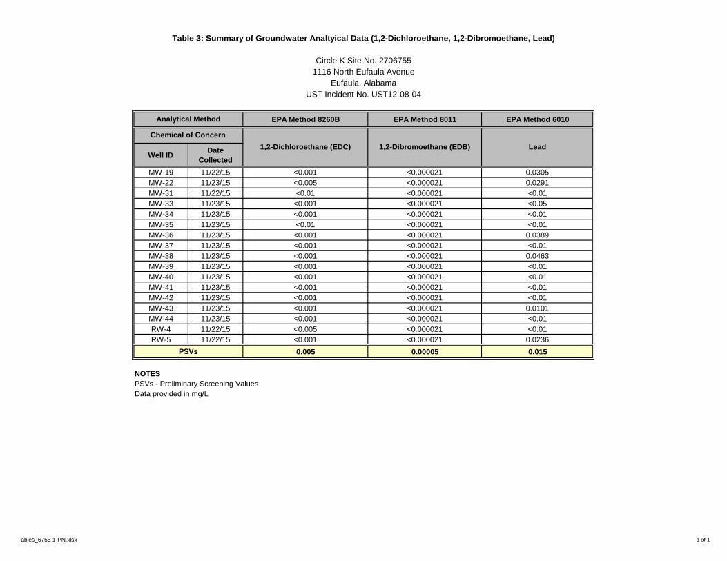
EPA Method 8260B EPA Method 8011 EPA Method 6010
Well IDDate
Collected
MW-19 11/22/15 <0.001 <0.000021 0.0305
MW-22 11/23/15 <0.005 <0.000021 0.0291
MW-31 11/22/15 <0.01 <0.000021 <0.01
MW-33 11/23/15 <0.001 <0.000021 <0.05
MW-34 11/23/15 <0.001 <0.000021 <0.01
MW-35 11/23/15 <0.01 <0.000021 <0.01
MW-36 11/23/15 <0.001 <0.000021 0.0389
MW-37 11/23/15 <0.001 <0.000021 <0.01
MW-38 11/23/15 <0.001 <0.000021 0.0463
MW-39 11/23/15 <0.001 <0.000021 <0.01
MW-40 11/23/15 <0.001 <0.000021 <0.01
MW-41 11/23/15 <0.001 <0.000021 <0.01
MW-42 11/23/15 <0.001 <0.000021 <0.01
MW-43 11/23/15 <0.001 <0.000021 0.0101
MW-44 11/23/15 <0.001 <0.000021 <0.01
RW-4 11/22/15 <0.005 <0.000021 <0.01
RW-5 11/22/15 <0.001 <0.000021 0.0236
0.005 0.00005 0.015
NOTES
PSVs - Preliminary Screening Values
Data provided in mg/L
PSVs
Analytical Method
Chemical of Concern
1,2-Dichloroethane (EDC) 1,2-Dibromoethane (EDB) Lead
UST Incident No. UST12-08-04
Table 3: Summary of Groundwater Analtyical Data (1,2-Dichloroethane, 1,2-Dibromoethane, Lead)
Circle K Site No. 2706755
1116 North Eufaula Avenue
Eufaula, Alabama
Tables_6755 1-PN.xlsx 1 of 1

APPENDIX A
Cost Proposal No. 27 – System Installation and Startup

CP
Facility Name:
Facility Address:
Owner Name:
Owner Address:
Employer Tax Number (IRS):
Approved Response Action Contractor Name:
25 W. Cedar St., Suite MPensacola, FL 32502
6/17/2016
Project Contact:
CP-27 System Installation
UST or AST Incident Number:
Circle K Stores Inc.
Facility I.D. Number:
I.3 Owner Information:
I.2 Facility Information
UST 12-08-04 22502-005-004253
Circle K Store #2706755
1116 North Eufaula Ave., Eufaula, AL
Alabama Tank Trust FundCost Proposal
Part I
I.1 Cost Proposal Information:
Cost Proposal Number: Date of Cost Proposal (mm/dd/yy):
74-1149540
251-607-1161
Paul Naman
Employer Tax Number (IRS): 04-3050515
Project Contact E-mail: [email protected]
Project Contact Phone #:
I.4 Response Action Contractor Information:
Approved Response Action ContractorAddress:
Environmental Compliance Services, Inc.
7856 Westside Park Dr., Suite G
Mobile, AL 36695
ADEM Form 31 DRAFT02/2016 version 1.2

CP
Cost Proposal Number: Facility Name:
CP-27 System Installation Circle K Store #2706755
I.5 Activity Information:
Site Stabilization/Initial Abatement
Preliminary Investigation
Secondary Investigation / Additional Well Installation
Alabama Risk Based Corrective Action (ARBCA)
Groundwater Sampling
Free Product Removal/Mobile Enhanced Multiphase Extraction (MEME)
Develop Corrective Action Plan
Corrective Action
Stockpile Sampling / Management / Disposal
Provision of Alternate Water Supply
Pilot Test
Monitoring/Recovery/Injection Well Abandonment
System Decommissioning/Removal
Activities/Other/Brief Summary of Activities:
Provide proposed completion date for this phase of work activities:
Provide projected date of cleanup completed:
I.6 Subcontractor Information:
Indicate Subcontractors to be used during this phase of work:
Drilling
Analytical Laboratory
Tetrasolv Filtration
Data Power Source
Action Resources
Environmental Compliance Services
Domermuth Environmental
Walker Hill Environmental
Accutest Laboratories
Carbon Vendor
Electrical Contractor
Soil Disposal - System installation
System Equipment/Installation
Soil Cuttings/Development Water Disposal
12/31/2018
31-Dec-16
Remediation System Installation and Startup
Indicate below the activities for which the cost proposal is submitted:
Name & Address Service Provided
ADEM Form 31 DRAFT 02/2016 version 1.2


CP
CP Total CP #
$157,591.79 CP-27 System Installation
Unit $ Units Quantity Requested$
Additional Well Installation Report (>4wells)(as an adder) $1,352 /report 1 $1,352.00
CA System Installation Report (all Classes same) $7,210 /report 1 $7,210.00
Total Report and Plan Costs $8,562.00
Part II- Alabama Tank Trust Fund Itemization Form "B" Cost Proposal
Porous material 0-30 feet $309 /well 7 $2,163.00
Site Survey during Investigation (not a Licensed Surveyor) $240 /sow 1 $240.00
System Installation Oversight (up to 7 days in field) $8,314 /system 1 $8,314.00
System Startup $1,584 /system 1 $1,584.00
Mileage Rate $0.540
Mileage (One way office to site) 270
Number of round trips to site 4 $1,166.40
Technician(s)-travel time $60 /hr 16 $960.00
Geologist/Engineer-travel time $83 /hr 8 $664.00
PG/PE-travel time $115 /hr 8 $920.00
Per diem (greater than 12hrs) $30 /ext. day 15 $450.00
Per diem (overnight)(invoice required) $75 /day 15 $1,125.00
Equipment and Equipment Kits
Sampling Expendables(gloves, ice, string, jars, foil, distilled water, paper towels, etc.) $50 /sow 1 $50.00
Expendables O&M $25 /day 5 $125.00
Ozone Sparge O&M $75 /day 5 $375.00
Method Pass
ThroughSample #
8260 $65 /sample 10% 2 $143.00
8270 $130 /sample 10% 2 $286.00
239.2 10% $25 /sample 10% 2 $55.00
Other Air Samples/BTEXM/TPH $115.00 /sample 10% 4 $506.00
Total Field Costs $19,126.40
Part II- Alabama Tank Trust Fund Itemization Form "C" Cost ProposalScenarios Unit $ Unit Quantity Requested$
Mileage Rate (Current Federal Rate) $0.540
Mileage (drilling device "hauled" to the site)(ONE WAY mileage up to 150 miles) 1
(direct push, skid steer, etc.) $1.08 /mile 150
Number of Mobilizations (includes $200 mob/demob amount) 1 $524.00
Well Pad Completions for Monitoring Wells (2" and 4")(up to 8" cover)$150.00 /well 5 $750.00
Part II- Alabama Tank Trust Fund Itemization Form "A" Cost Proposal
Scenarios
Cost Proposal SummaryFacility I.D. # Incident Number Site Name
22502-005-004253 UST 12-08-04 Circle K Store #2706755
BTEX/MTBE/Naph (water)
PAH (water)
Lead (water)
ADEM Form 31 DRAFT 02/2016 version 1.2

CP
Well Pad Completions for Monitoring Wells (2" and 4")(12" cover) 2 $200.00 /well 2 $400.00
1" / 2" Monitoring Well/Injection Well (HSA) 3 $43.00 /foot 150 $6,450.00
4" Monitoring Well (HSA) 3 $45.00 /foot 36 $1,620.00
Drums $50.00 /drum 15 $750.00
Per Diem (overnight) (man days)(hotel receipts required) $75.00 /day 9 $675.00
Total Drilling Costs
Pass
Through Quoted Amount Requested$
$79,625.84 $79,625.84
Corrective Action System Rental $3,000.00 $3,000.00
Oxidizer Rental $3,500.00 $3,500.00
5% $150.00 $157.50
5% $3,000.00 $3,150.005% $2,000.00 $2,100.005% $4,000.00 $4,200.00
Water Treatment/Disposal Domermuth - Soil/Dev Water 15 drums 5% $1,280.70 $1,344.74Other/Misc. (receipts required) Electrical Install 5% $8,315.00 $8,730.75Other/Misc. (receipts required) Carbon Vessel/Carbon 5% $4,820.00 $5,061.00Other/Misc. (receipts required) Soil Disp - System Trenching - Action 5% $6,290.06 $6,604.56Other/Misc. (receipts required) Permits - City of Eufaula 5% $1,200.00 $1,260.00
Total Subs / Vendors / Utilities $118,734.39
Propane CostsSewer Disposal Costs
$11,169.00
Part II- Alabama Tank Trust Fund Itemization Form "D" Cost Proposal
Corrective Action System Install
Phone Costs (telemetry)Power Costs
ADEM Form 31 DRAFT 02/2016 version 1.2

CP
Projected Personnel Hour of Hour of City of Amount
Classification Departure Return Overnight Per diem
From To am/pm am/pm Stay claimed
Use this section to enter claims for daily per diems
Total number of daily per diems 0
Use this section to enter claims for extended daily per diems
Woodstock Eufaula Geologist 8:00 AM 8:00 PM Eufaula $30.00Eufaula Eufaula Geologist 8:00 AM 8:00 PM Eufaula $30.00Eufaula Eufaula Geologist 8:00 AM 8:00 PM Eufaula $30.00Eufaula Eufaula Geologist 8:00 AM 8:00 PM Eufaula $30.00
Woodstock Eufaula Tech 8:00 AM 8:00 PM Eufaula $30.00Eufaula Eufaula Tech 8:00 AM 8:00 PM Eufaula $30.00Eufaula Eufaula Tech 8:00 AM 8:00 PM Eufaula $30.00Eufaula Eufaula Tech 8:00 AM 8:00 PM Eufaula $30.00Eufaula Eufaula Tech 8:00 AM 8:00 PM Eufaula $30.00
Woodstock Eufaula Engineer 8:00 AM 8:00 PM Eufaula $30.00
Total number of ext. daily per diems 10
Use this section to enter claims for overnight per diems
Woodstock Eufaula Geologist 8:00 AM 8:00 PM Eufaula $75.00Eufaula Eufaula Geologist 8:00 AM 8:00 PM Eufaula $75.00Eufaula Eufaula Geologist 8:00 AM 8:00 PM Eufaula $75.00Eufaula Eufaula Geologist 8:00 AM 8:00 PM Eufaula $75.00
Startup Woodstock Eufaula Tech 8:00 AM 8:00 PM Eufaula $75.00Startup Eufaula Eufaula Tech 8:00 AM 8:00 PM Eufaula $75.00Startup Eufaula Eufaula Tech 8:00 AM 8:00 PM Eufaula $75.00Startup Eufaula Eufaula Tech 8:00 AM 8:00 PM Eufaula $75.00Startup Eufaula Eufaula Tech 8:00 AM 8:00 PM Eufaula $75.00Install Woodstock Eufaula Engineer 8:00 AM 8:00 PM Eufaula $75.00
Total number of overnight per diems 10
Drill Day 2Drill Day 3Drill Day4
Drill Day 1
Drill Day 1Drill Day 2Drill Day 3Drill Day 4
StartupStartupStartupStartupStartupInstall
Part II- Alabama Tank Trust Fund Itemization Form "E" Cost ProposalPer diem allowed for Alabama Tank Trust Fund Contractor Personnel Only
Maximum allowable rates are referenced on the "Maximum Rates" Tab in this document.This page should be submitted whenever per diem is being claimed.
Date
Points of
Travel
mm/dd/yy
ADEM Form 31 DRAFT 02/2016 version 1.2

CP
Projected Personnel Hour of Hour of City of Amount
Classification Departure Return Overnight Per diem
From To am/pm am/pm Stay claimed
Use this section to enter claims for daily per diems
Total number of daily per diems 0
Use this section to enter claims for extended daily per diems
Woodstock Eufaula Tech 8:00 AM 8:00 PM Eufaula $30.00Eufaula Eufaula Tech 8:00 AM 8:00 PM Eufaula $30.00Eufaula Eufaula Tech 8:00 AM 8:00 PM Eufaula $30.00Eufaula Eufaula Tech 8:00 AM 8:00 PM Eufaula $30.00Eufaula Eufaula Tech 8:00 AM 8:00 PM Eufaula $30.00
Total number of ext. daily per diems 5
Use this section to enter claims for overnight per diems
Startup Woodstock Eufaula Tech 8:00 AM 8:00 PM Eufaula $75.00
Startup Eufaula Eufaula Tech 8:00 AM 8:00 PM Eufaula $75.00Startup Eufaula Eufaula Tech 8:00 AM 8:00 PM Eufaula $75.00Startup Eufaula Eufaula Tech 8:00 AM 8:00 PM Eufaula $75.00Startup Eufaula Eufaula Tech 8:00 AM 8:00 PM Eufaula $75.00
Total number of overnight per diems 5
Part II- Alabama Tank Trust Fund Itemization Form "E" Cost Proposal Additional SheetPer diem allowed for Alabama Tank Trust Fund Contractor Personnel Only
Maximum allowable rates are referenced on the "Maximum Rates" Tab in this document.
Points of
Date Travel
mm/dd/yy
Startup
StartupStartup
StartupStartup
ADEM Form 31 DRAFT 02/2016 version 1.2

Trenching: 276 feet + 10 feet in compound + assumed 100 feet for discharge connection (unknown connection point)
PM 5 hrs $99.00 $495.00 Project setup,
Professional Engineer 5 hrs $115.00 $575.00 Field Changes, Confirmation of locations, etc.
Staff Professional - Eng/Geo 10 hrs $83.00 $830.00 Setup Subs, Hauloffs, Utility locate, Utility setups, etc.
Cnst Supervisor 226 hrs $77.00 $17,402.00 3 weeks, 7 days week, 10 hour days + 2 - 8 hour days for mob/demob
Laborer 226 hrs $60.00 $13,560.00 3 weeks, 7 days week, 10 hour days + 2 - 8 hour days for mob/demob
Laborer 226 hrs $60.00 $13,560.00 3 weeks, 7 days week, 10 hour days + 2 - 8 hour days for mob/demob
Mileage 700 miles $0.57 $399.00 400 RT + 300 local
Mini-Excavator 3 weeks $600.00 $1,800.00
Bob Cat 3 weeks $600.00 $1,800.00
Roll-offs 2 EA $6,290.00 $0.00 Action Resources ($6,290) includess 2 roll offs, rental, waste profiling, trandpostation and disposal (covered in CP for system install)
Cnst Debri disposal 60 yds $45.00 $2,700.00 2 x 30 CY rolloffs, 1 asphalt and C&D, 1 soil
Concrete (vaults) 2 cyds $115.00 $230.00 15 wells at 3cf concrete per
Concrete (trenches) 7.5 cyds $115.00 $862.50 Round up from 386 LF x 0.5 feet Depth
Saw Cutting 772 LF $4.25 $3,281.00 Assumed 386 LF x 2 (each side of trench)
Vaults 16 EA $400.00 $6,400.00 10 RW and 5 AS and 1 discharge
Stone 43 tons $30.00 $1,290.00 used 1.3 tons per CY - 386LF x 2 ft for trench, plus 0.25 CY per wellhead (15 total + 1 discharge connection).
Fence Contractor 120 LF $25.00 $3,000.00 Waiting on Quote - upped assumption to $25 LF
Materials (piping, hoses, etc.) 1 ea $5,516.34 $5,516.34 From Materials take off on next sheet.
Forklift 1 ea $750.00 $750.00 1 day rental for system placement
Electrician (estimated) 1 ea $8,315.00 $0.00 Data Power Source - ($8,315.00 ) line item covered in cost proposal for system install
Per Diem (3-men) 23 days $225.00 $5,175.00 21 days + 2 days mob
$79,625.84
Task: System Installation -
Propose to install a fence
20x40 compound south of
CK convenience building.
Remediation eq. to MPE
blower (Roots or Liquid
Ring), and air compressor
for Air Sparge (5 wells).
Propose Therm/Cat
oxidizer for initial 6
months. GWT -
discharge to sanitary
sewer (City permit).
Personnel - Subcontractor Quantity Units
Circle K #: 2706755
1116 North Eufaula Ave.
Eufaula, AL
Barbour County
Facility #22502-005004253Rate TotalTask
Task Subtotal

Cost ProposalDate
3/9/2016
Proposal #
5945
Name / Address
ENVIRONMENTAL COMPLIANCE SERVICES, INC7856 WESTSIDE PARK DRIVE, STE GMOBILE, AL 36695
Project Description
Environmental ServicesCircle K 67551116 Eufaula Ave.Eufaula, AL
PO Box 1147Foxworth, MS 39483
Customer Acceptance of Cost Propostal:
Total
Subtotal
Sales Tax (0.0%)
Walker-Hill Environmental, Inc.Phone: (601)736-3500 - Fax: (601)736-6006
Email: [email protected]
Description Unit Estimated Qty Cost Total
Mobilize/Demobilize lump sum 1 200.00 200.00TMileage per mile 150 2.16 324.00TDrill & Install (5) up to 30'- 2" sparge wells per foot 150 43.00 6,450.00TDrill & Install (2) up to 20' - 4" recovery wells per ft. 36 45.00 1,620.00T8" Well Completion per well 5 150.00 750.00T12" Well Completion per well 2 200.00 400.00T55 gallon drums per drum 15 50.00 750.00TPer-diem 3 man crew per day 3 225.00 675.00T
____________________________________________________________Authorized Signature Date
____________________________________________________________Name/Title
*Payment terms nte (30) days upon project completion. *1.5% interest will be charged monthly to all overdue invoices.
$11,169.00
$11,169.00
$0.00

DPS ~ Infrastructure Monitoring Systems, Inc.
11187 Bob Williams Parkway, Covington Georgia 30014 Phone: (770) 498-9622 Fax: (770) 498-9654
Ecs ADEL GA revised Page 1 of 1
5/4/2016
Kenneth Perignat
Environmental Compliance Services Inc.
9874 Main Street Suite 100 Woodstock Georgia 30188
Dear Ken:
As directed we have developed an application design and established pricing to install a new pole with a 120/240
Volt 200 amp three phase service with a 220 amp panel and extend conduit to wire the equipment in the compound
located at 1116 North Eufaula Avenue Eufaula Alabama. We will furnish all materials and equipment, permits to
complete the project.
The investment required for the prescribed scope-of-turnkey installation services is Eight Thousand Three Hundred
Fifteen Dollars……………………………………………………………………………………..$8,315.00.
We appreciate this opportunity, should you have any questions or require any clarification,
Please do not hesitate to call or email at [email protected] .
Sincerely,
Timothy M. Henrickson
Superintendent-of-Operations
6/21/2016 HA1505-0000-0829
Paul NamanEnvironmental Compliance Services, Inc.7856 West Side Park Dr.
Mobile, AL 36695
Action Environmental appreciates the opportunity to provide the following proposal for the Scope of
Work described herein. Founded in 1995, with ten locations throughout the southeastern, mid-south
and south central United States, Action Environmental is tactically positioned to deliver Environmental
and Industrial Services to a diverse customer base.
Action Environmental provides full turn-key services to our clients, which allows us to provide total
quality control to our clients. If the project involves environmental, construction, or waste related
services, we will put together a complete package of services to meet the project needs.
Action Environmental has completed thousands of projects in remediation, environmental construction,
and hazardous waste management. Action Environmental's areas of expertise range from initial site
investigations to advanced remediation using the latest technology. Our hands-on construction
experience coupled with our knowledge of permitting and regulatory requirements makes Action
Environmental the preferred contractor for any environmental project.
Action will deliver two roll offs to Circle K No. 6755, 1116 North Eufaula, Ave., Eufaula, AL. Action will set
up profile for the soil and then transport the boxes for disposal.
Action will have room to deliver the boxes on a long rail truck.
This proposal outline the Scope of Work, pricing for the same and any job specific assumptions or
conditions, as well as our standard Terms and Conditions. Any change in this scope of work will be
executed in writing and signed by all parties. Unless otherwise noted, all of our quotations are valid for
30 days from date of issuance or until replaced by a revision, communicated to the customer. To accept
this proposal and initiate the work, please sign and return to us.
Action Environmental would like to thank you for the opportunity to submit this proposal. Please
contact us if you have any questions or need clarification on this proposal.
Respectfully,

Billy Farris
Project Manager
Action Environmental
Accepted by: _________________________________
Dated: ______________________________________
PO#: ________________________________________

Equipment
Item Unit Price Quantity Amount
Roll Off Box (20 Cubic Yard) - StandardTime
Day $15.00 1 $15.00
Roll Off Box (20 Cubic Yard) - StandardTime
Day $15.00 1 $15.00
Roll Off Box (20 Cubic Yard) - StandardTime
Day $15.00 1 $15.00
Roll Off Box (20 Cubic Yard) - StandardTime
Day $15.00 1 $15.00
Equipment SubTotal: $60.00
Services
Item Unit Price Quantity Amount
Roll Off Spot Fee (<60 Mile) Each $500.00 2 $1,000.00
Services SubTotal: $1,000.00
Materials (Purchased)
Item Unit Price Quantity Amount
Liner Each $45.00 2 $90.00
Materials (Purchased) SubTotal: $90.00
Rental Equipment
Item Unit Price Quantity Amount
Roll Off Box Day $20.00 20 $400.00
Rental Equipment SubTotal: $400.00
Subcontractor
Item Unit Price Quantity Amount
ADEM Fee Each $300.00 1 $300.00
Subcontractor SubTotal: $300.00
Transportation & Disposal
Item Unit Price Quantity Amount
Transportation Mile $1,300.00 2 $2,600.00
Roll off delivery Mile $1,000.00 1 $1,000.00
Disposal Ton $42.00 20 $840.06
Transportation & Disposal SubTotal: $4,440.06

Total: $6,290.06

Terms & Conditions:
Action Environmental has standard work hours of eight (8) hours in a normal workday, Monday through Friday. Unlessotherwise quoted, work performed in excess of eight (8) hours outside the customary work hours and on Saturdays isconsidered overtime and will be invoiced at time and a half of the applicable straight time rate. Work performed on Sundaysand Holidays are considered premium and will be billed at twice the applicable straight time rate. Action Environmental has afour hour minimum for all services provided.
All personnel and equipment will be billed portal-to-portal (mobilization and demobilization). All Action Environmental projectsare subject to audit by a designated Action Environmental Safety Officer. Unless otherwise quoted, services provided prior to,during and or subsequent to actual project site activities will be included in the invoice.
For projects lasting longer than 7 calendar days or where waste disposal is part of the job, Action Environmental reserves theright to partial invoice.
The customer acknowledges that the estimated costs are based on an agreed upon scope between Action Environmental andthe customer and that the amount invoiced by Action Environmental will be based upon the labor, equipment, materials,disposal, fees actually expended in performing the scope of work.
Where changes to the original scope become necessary, Action Environmental will promptly notify the customer and obtain thenecessary authorization to proceed. In doing so, a revised price will be established in order to complete the project. Anychanges in the scope will be billed on a time & materials basis, and for actual disposal quantities if applicable.
Any additional labor, materials or equipment that may be required shall be invoiced in accordance with the ActionEnvironmental non-emergency fee schedule in effect at the time of service or in accordance with an established contract priceschedule in effect with the customer.
Delays in work, not caused by Action Environmental, will be billed at standby rates. Unless otherwise quoted, standby rates willbe the straight time / overtime rates (as appropriate) for personnel; 60% the hourly or daily rate (as appropriate) for companyowned equipment. Rented equipment and per diem charges will apply at quoted rates.
Applicable Federal, State, County, Parish and local sales tax and fees will be charged as appropriate. Taxes and fees are notincluded in the quoted prices but will be included at time of invoicing.
Quotes issued by Action Environmental are valid for 30 days unless otherwise noted. Action Environmental allows for standardterms of 30 days, contingent on the customer establishing credit worthiness with Action Environmental. Standard paymentmethods accepted are cash, check or EFT. Credit card payments will be accepted with a 5% convenience fee. Past due balanceswill bear interest charges at an annual rate of 18%.
This quotation is contingent on the Customer providing reasonable access to the site and that the Customer represents andwarrants to Action Environmental that they have the legal right, title and interest necessary to provide access to the site. Inaddition, the Customer warrants that it has supplied Action Environmental with complete and accurate information regardingdocumentation and/or information concerning the scope of work.
Customer shall pay any and all collection cost and expenses, including fees charged by any collection agency, reasonableattorney’s fees incurred by Action Environmental through its efforts to collect balances owed by customer. Interpretation andperformance of this agreement shall be governed and construed in accordance with the laws of the State of Alabama.
This quotation is submitted contingent on the above terms. Action Environmental recognizes that a customer may wish tonegotiate mutually acceptable terms and conditions which are reflective of the work contemplated and an equitabledistribution of the risks involved therein. In the event that such an agreement cannot be reached, Action Environmentalreserves the right to decline to enter into such an agreement without prejudice or penalty.

This proposal and all attachments and exhibits are considered confidential and proprietary and shall not be loaned, copied,
distributed, or published, in whole or in part, or used for any purpose other than for which they were intended without prior
written consent of Action Environmental.


APPENDIX B
Cost Proposal No. 28 – UIC Permit Application

CP
Facility Name:
Facility Address:
Owner Name:
Owner Address:
Employer Tax Number (IRS):
Approved Response Action Contractor Name:
25 W. Cedar St., Suite MPensacola, FL 32502
6/17/2016
Project Contact:
CP-28 UIC Permit
UST or AST Incident Number:
Circle K Stores Inc.
Facility I.D. Number:
I.3 Owner Information:
I.2 Facility Information
UST 12-08-04 22502-005-004253
Circle K Store #2706755
1116 North Eufaula Ave., Eufaula, AL
Alabama Tank Trust FundCost Proposal
Part I
I.1 Cost Proposal Information:
Cost Proposal Number: Date of Cost Proposal (mm/dd/yy):
74-1149540
251-607-1161
Paul Naman
Employer Tax Number (IRS): 04-3050515
Project Contact E-mail: [email protected]
Project Contact Phone #:
I.4 Response Action Contractor Information:
Approved Response Action ContractorAddress:
Environmental Compliance Services, Inc.
7856 Westside Park Dr., Suite G
Mobile, AL 36695
ADEM Form 31 DRAFT02/2016 version 1.2

CP
Cost Proposal Number: Facility Name:
CP-28 UIC Permit Circle K Store #2706755
I.5 Activity Information:
Site Stabilization/Initial Abatement
Preliminary Investigation
Secondary Investigation / Additional Well Installation
Alabama Risk Based Corrective Action (ARBCA)
Groundwater Sampling
Free Product Removal/Mobile Enhanced Multiphase Extraction (MEME)
Develop Corrective Action Plan
Corrective Action
Stockpile Sampling / Management / Disposal
Provision of Alternate Water Supply
Pilot Test
Monitoring/Recovery/Injection Well Abandonment
System Decommissioning/Removal
Activities/Other/Brief Summary of Activities:
Provide proposed completion date for this phase of work activities:
Provide projected date of cleanup completed:
I.6 Subcontractor Information:
Indicate Subcontractors to be used during this phase of work:
12/31/2018
31-Dec-16
UIC Permit
Indicate below the activities for which the cost proposal is submitted:
Name & Address Service Provided
ADEM Form 31 DRAFT 02/2016 version 1.2
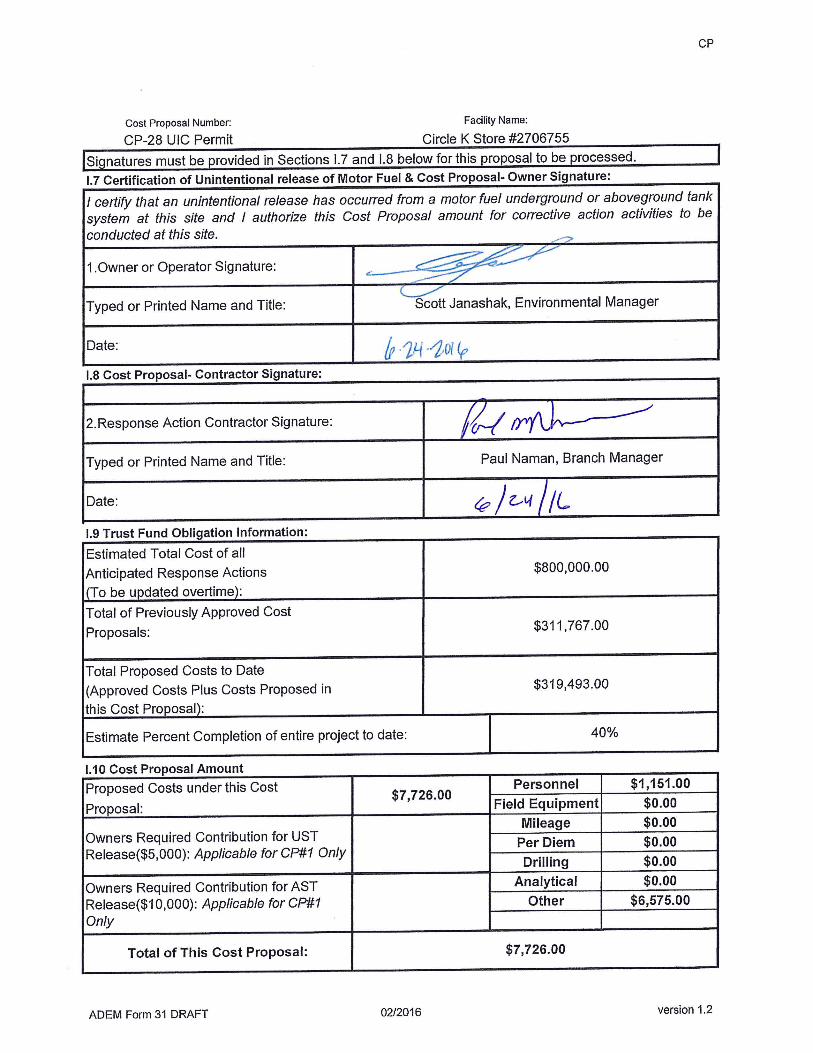

CP
CP Total CP #
$7,726.00 CP-28 UIC Permit
Unit $ Units Quantity Requested$UIC Permit Application preparation $1,151 /permit 1 $1,151.00
Total Report and Plan Costs $1,151.00
Part II- Alabama Tank Trust Fund Itemization Form "B" Cost Proposal
Postage / Shipping and Copying (plans reports, ADEM and owner) $85 /sow 1 $85.00
Total Field Costs $85.00
Part II- Alabama Tank Trust Fund Itemization Form "C" Cost Proposal
Total Drilling Costs
Pass
Through Quoted Amount Requested$
UIC Permit Application (permit fee) 10% $4,290.00 $4,719.00
UIC Permit Greenfield Fee (permit fee) 10% $1,610.00 $1,771.00
Total Subs / Vendors / Utilities $6,490.00
Part II- Alabama Tank Trust Fund Itemization Form "A" Cost Proposal
Scenarios
Cost Proposal SummaryFacility I.D. # Incident Number Site Name
22502-005-004253 UST 12-08-04 Circle K Store #2706755
$0.00
Part II- Alabama Tank Trust Fund Itemization Form "D" Cost Proposal
ADEM Form 31 DRAFT 02/2016 version 1.2

APPENDIX C
Cost Proposal No. 29 – Initial Quarter of O&M

CP
Facility Name:
Facility Address:
Owner Name:
Owner Address:
Employer Tax Number (IRS):
Approved Response Action Contractor Name:
6/17/2016
Project Contact:
CP-29 O&M
UST or AST Incident Number:
Circle K Stores, Inc.
25 W. Cedar St., Ste M. Pensacola, FL 32502
Facility I.D. Number:
I.3 Owner Information:
I.2 Facility Information
UST 12-08-04 22502-005-004253
Circle K Store #2706755
1116 North Eufaula Ave., Eufaula, AL
Alabama Tank Trust FundCost Proposal
Part I
I.1 Cost Proposal Information:
Cost Proposal Number: Date of Cost Proposal (mm/dd/yy):
74-1149540
251-607-1161
Paul Naman
Employer Tax Number (IRS): 04-3050515
Project Contact E-mail: [email protected]
Project Contact Phone #:
I.4 Response Action Contractor Information:
Approved Response Action ContractorAddress:
Environmental Compliance Services, Inc.
7856 Westsdie Park Dr. Suite G
Mobile, AL 36695
ADEM Form 31 DRAFT02/2016 version 1.2

CP
Cost Proposal Number: Facility Name:
CP-29 O&M Circle K Store #2706755
I.5 Activity Information:
Site Stabilization/Initial Abatement
Preliminary Investigation
Secondary Investigation / Additional Well Installation
Alabama Risk Based Corrective Action (ARBCA)
X Groundwater Sampling
Free Product Removal/Mobile Enhanced Multiphase Extraction (MEME)
Develop Corrective Action Plan
X Corrective Action
Stockpile Sampling / Management / Disposal
Provision of Alternate Water Supply
Pilot Test
Monitoring/Recovery/Injection Well Abandonment
System Decommissioning/Removal
Activities/Other/Brief Summary of Activities:
Provide proposed completion date for this phase of work activities:
Provide projected date of cleanup completed:
I.6 Subcontractor Information:
Indicate Subcontractors to be used during this phase of work:
Electrical Service
Analytical Laboratory
City of Eufaula
Propane Supplier - Eufaula, AL
AT&T
Alabama Power
Accutest Laboratories
Sewer Service
Natural Gas Service
Telephone Service
12/31/2018
31-Dec-17
Quarterly System O&M and Reporting
Indicate below the activities for which the cost proposal is submitted:
Name & Address Service Provided
ADEM Form 31 DRAFT 02/2016 version 1.2


CP
CP Total CP #
$71,069.42 CP-29 O&M
Unit $ Units Quantity Requested$
SEMR - DPVE, P&T Reports
1-12 wells, BTEX/MTBE/Naphthalene $4,704 /report 1 $4,704.00
SEMR - Ozone, AS, SVE, Chemox, Biosparge - Reports
SEMR adder >12 wells, BTEX/MTBE/Naph $35.75 /well 19 $679.25
Total Report and Plan Costs $5,383.25
Part II- Alabama Tank Trust Fund Itemization Form "B" Cost Proposal
Groundwater Sampling Set-up (2hrs tech time) $120 /sow 1 $120.00
Gauging Well (no sampling) $15 /well 11 $165.00
Groundwater Sampling and Gauging 2" Well $60 /well 21 $1,260.00
DPVE, Pump and Treat O&M 3 months $3,672 /quarter 1 $3,672.00
Mileage Rate $0.540
Mileage (One way office to site) 270
Number of round trips to site 7 $2,041.20
Technician(s)-travel time $60 /hr 56 $3,360.00
Per diem (6-12hrs) $11.25 /day 8 $90.00
Per diem (greater than 12hrs) $30 /ext. day 2 $60.00
Per diem (overnight)(invoice required) $75 /day 2 $150.00
Equipment and Equipment Kits
Sampling Expendables(gloves, ice, string, jars, foil, distilled water, paper towels, etc.) $50 /sow 1 $50.00
Expendables O&M $25 /day 8 $200.00
Groundwater Monitoring $160 /day 2 $320.00
Bailers $7 /bailer 21 $147.00
DPVE, SVE, AS, P&T O&M $145 /day 8 $1,160.00
Postage / Shipping and Copying (plans reports, ADEM and owner) $85 /sow 1 $85.00
Postage / Shipping (Sample Shipping) $50 /samples 1 $50.00
Method Pass
ThroughSample #
8260 $65 /sample 10% 21 $1,501.50
Other BTEXM/NAP QA/QC $65.00 /sample 10% 1 $71.50
Other BTEXM/TPH Air $115.45 10% 6 $761.97
Other Dicharge samples $220.00 10% 3 $726.00
Total Field Costs $15,991.17
Part II- Alabama Tank Trust Fund Itemization Form "C" Cost Proposal
Total Drilling Costs $0.00
Part II- Alabama Tank Trust Fund Itemization Form "A" Cost Proposal
Scenarios
BTEX/MTBE/Naph (water)
/sample
/sample
Cost Proposal SummaryFacility I.D. # Incident Number Site Name
22502-005-004253 UST 12-08-04 Circle K Store #2706755
ADEM Form 31 DRAFT 02/2016 version 1.2

CP
Pass
Through Quoted Amount Requested$
10% $450.00 $495.00
10% $7,500.00 $8,250.00
10% $7,500.00 $8,250.00
Rentals MPE Skid Rental $4,500.00 $4,500.00
Rentals AS Skid Rental $4,500.00 $4,500.00
Rentals Oxidizer Rental $10,500.00 $10,500.00
10% $12,000.00 $13,200.00
Total Subs / Vendors / Utilities $49,695.00
Part II- Alabama Tank Trust Fund Itemization Form "D" Cost Proposal
Phone Costs (telemetry)
Power Costs
Propane Costs
Sewer Disposal Costs
ADEM Form 31 DRAFT 02/2016 version 1.2
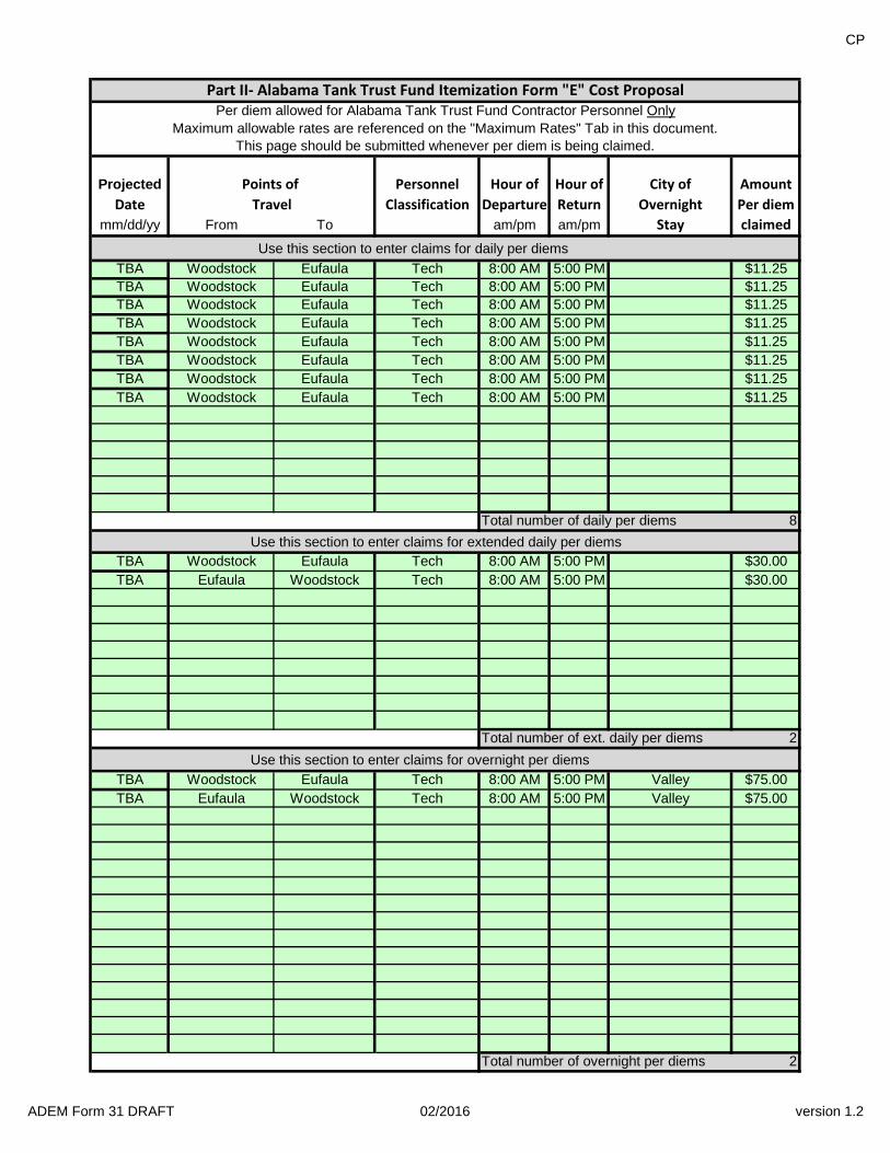
CP
Projected Personnel Hour of Hour of City of Amount
Classification Departure Return Overnight Per diem
From To am/pm am/pm Stay claimed
Use this section to enter claims for daily per diems
Woodstock Eufaula Tech 8:00 AM 5:00 PM $11.25
Woodstock Eufaula Tech 8:00 AM 5:00 PM $11.25
Woodstock Eufaula Tech 8:00 AM 5:00 PM $11.25
Woodstock Eufaula Tech 8:00 AM 5:00 PM $11.25
Woodstock Eufaula Tech 8:00 AM 5:00 PM $11.25
Woodstock Eufaula Tech 8:00 AM 5:00 PM $11.25
Woodstock Eufaula Tech 8:00 AM 5:00 PM $11.25
Woodstock Eufaula Tech 8:00 AM 5:00 PM $11.25
Total number of daily per diems 8
Use this section to enter claims for extended daily per diems
Woodstock Eufaula Tech 8:00 AM 5:00 PM $30.00
Eufaula Woodstock Tech 8:00 AM 5:00 PM $30.00
Total number of ext. daily per diems 2
Use this section to enter claims for overnight per diems
Woodstock Eufaula Tech 8:00 AM 5:00 PM Valley $75.00
Eufaula Woodstock Tech 8:00 AM 5:00 PM Valley $75.00
Total number of overnight per diems 2
TBA
TBA
TBA
TBA
Part II- Alabama Tank Trust Fund Itemization Form "E" Cost ProposalPer diem allowed for Alabama Tank Trust Fund Contractor Personnel Only
Maximum allowable rates are referenced on the "Maximum Rates" Tab in this document.This page should be submitted whenever per diem is being claimed.
Date
Points of
Travel
mm/dd/yy
TBA
TBA
TBA
TBA
TBA
TBA
TBA
TBA
ADEM Form 31 DRAFT 02/2016 version 1.2