Embed Size (px)
Citation preview

EXECUTIVE SUMMARY
FOR
PUBLIC HEARING
OF
JUNAD EXPN. OC (WANI NORTH AREA, WCL)
JANUARY - 2008
CENTRAL MINING PLANNING & DESIGNE INSTITUTE LTD.
REGIONAL INSTITUTE – IV
KASTURBA NAGAR, JARIPATKA, NAGPUR- 440014

INTRODUCTION
1 TYPE OF PROJECT
This is expansion of existing Junad Opencast with mine able reserve of 6.13 Mt and with maximum coal production target of 1.50 MTPA. The life of the mine is about 8 years.
2 NEED OF THE PROJECT
There is a substantial gap between demand and availability of coal for the mines of WCL as a whole. It is in national interest to open new mines/projects & to go for expansion of existing projects urgently so as to meet the requirement of coal for power and various other sectors.
The justification of this mine has been studied in the light of estimated demand for non-coking coal from power sector in Maharashtra and production forecast from existing, completed and ongoing projects of WCL.
3 LOCATION & COMMUNICATION
Junad OC Expn. mine is located in the Yavatmal district of Maharashtra state. It is bounded by Latitudes 20o 01' 05" to 20o 04' 10" N & Longitudes 79o 03' 09" to 79o 05' 00" E and falling in Survey of India Topo Sheet No. 55 P/4.
The existing mine is at a distance of about 140 km from Nagpur . However, the block is presently connected by a 3 km fair weather road with Aheri village which, in turn, is connected with Wani town towards North-West by a 19 km metalled road. The block may also be approached by a 3 km road from Ukni / Pimpalgaon project which is also being connected with Wani town via Bhalar village.
4 TOPOGRAPHY & DRAINAGE :-
The area of Junad Extension OC mine exhibits gently undulating topography. The general slope of the ground is from west to east. The elevation varies from 180 m to 195 m. The Wardha River flowing from north to south is the main drainage channel of the area.
5 CLIMATE :-
Junad block has extreme climate with temp. of 480 C during summer months and about 100 C during winter months . The average annual rainfall is about 1250 mm.
6 PRESENT LAND USE PATTERN :-
The entire land to be acquired for extension of the Junad OC project is covered by black cotton soil and is very fertile and is generally used for growing mainly the cash crops like cotton, sugarcane, chillies etc apart from standard agricultural products like rice , wheat & jawar. No village is falling in the proposed leasehold boundary of the project. All the land losers will be given compensation as per Company’s norms.

7 SITE DESCRIPTION: - The study area has been divided into two heads
• Core Zone • Buffer Zone
a) Core zone: The core zone consists of the mining leasehold area where mining and allied activities take place. The core zone comprises of 449.63 ha of land. The land usage is given below.
Sl. No
Land Particulars Total Land
1. Agricultural land 443.53 ha
2. Waste Land (Govt. Land)
6.10 ha
3. Forest Land - Total 449.63 ha
b) FEATURES IN BUFFER ZONE
Sl. No.
FEATURES DETAILS DISTANCE FROM MINE
1 Industries Nil Nil 2 Railway Lines Wani Railway Siding About 9.0 km 3 State Highway State Highway No.- 84 About 5.0 km 4 Other Coal
Mines Ukni OC, Pimpalgaon OC , Kolar Pimpri OC
3.0 – 5.0 km
5 Water Bodies Wardha River 125 m from mine boundary
6 Human Settlement
40 villages & WCL township within buffer zone
8 JUSTIFICATION: -
There is a substantial gap between demand and availability of coal for the mines of WCL as a whole. It is in national interest to open new mines/projects urgently so as to meet the requirement of coal for power and various other sectors. The justification of this mine has been studied in the light of estimated demand for non-coking coal from power sector in Maharashtra and production forecast from existing, completed and ongoing projects of WCL.

9 SOURCES OF DATA
This report has been formulated using various data from the following sources:
Sl. No.
Type of Data Sources
1 Mining and economic parameters and other miscellaneous data
CMPDIL and Wani North Area, WCL.
2
Environmental data including meteorological data, air quality, dust fall rate, water quality and noise level data.
Environmental-data generation for proposed Junad Extn. (Deep) OC of Wani North Area of WCL, Maharashtra carried out by CMPDI.
3 Socio-economic study & Land use/cover mapping buffer zone.
Census data 2001 & base line Socio - Economic survey.
4 Flora and fauna Survey Report prepared by the competent authority in this field.
5 Surface hydrology and hydrogeology
CMPDIL, RI- IV, Nagpur.
6 Meteorological data Environmental-data generation for Junad. Extn (Deep) OC of Wani North Area Maharashtra carried out by CMPDI.
7 Land use/cover mapping core zone.
As per State Govt. Record, data supplied by the concerned WCL area office.

INDIA MAP
UttarPradesh
Rajasthan
Gujarat
Andhra Pradesh
Karnataka
Meghalaya
Mizoram
Goa
Orissa
West Bengal
Haryana
H.P.
Maharashtra
W.C.L.
BiharAssam
NAGPUR
Laxadweep
BANGLA DESH
Andaman & Nicobar
NEPAL
PAKISTAN
AFGHANISTAN CHINA
MY
AN
MA
R
BAYOFBENGAL
ARABIANSEA
Madhya Pradesh
Jammu & Kashmir
TIBET
Uttaranchal
Jharkhand
Punjab
Delhi ArunachalPradesh
Nagaland
Manipur
Kerala
Tamil Nadu
SRILANKA
Chhatisgarh
INDIALocation of W.C.L.
LOCATION
MAP
OF
WCL

LOCATION PLAN
BHADRAWATI
KESURLI
KURAD
KONDA
MAJRI
TO NAGPUR
NEW MAJRI U/GNALGAON
TO W
AROR
A
PATALA
WADGAON
RALEGAON
GOURALABHANDAK R.S.BHANDAK R.S.
VIJGAON
CENTRAL RAILWAY MAIN LINE NEW MAJRIAMALGAMATED OPENCAST
KUSNA
JUNAKUNADA
CHARGAON
BORGAON
JUNADOPENCAST
DHORWASA CHIRADEVI
TO CHANDRAPUR
20-5'-0"
TELWASA
PIPRIUKNI
JUNADPRAGTINAGAR
GRGR
GRGR
GR GR
PIMPALGAONOPENCAST
DOPTALA
ARTERIAL ROADBRAHMNIH.T. LINE
KOLAR PIMPRIOPENCAST
KOLAR PIMPRIDEEP OPENCAST
KONA
SAWARLA KAWDITO W
ARO
RA
RAGNA
GOWARITO RAJUR
TO RAJUR
WANI
LALGUDA
CHIKHALGAON
MANDAR BLOCK
TO PANDHARKAWADA
NAVINWAGDHARA
BHALAR
BESA
BHALARTOWNSHIP
H.T. LINE
SURLIMANDARMANKI UKNIOPENCAST
C.G.M OFFICEWANI NORTH AREA
WARDHA
RIVER
Ref.Drg1) LOCATION PLAN WANI AREA AS RECIEVED FROM C.G.M.OFFICE2) PLATE No. (DRAFT) MASTER PLAN W.V.CF. CMPDI,2004
GORAJ
0M 1000M 2000M
2500M1500M500M
79-5'-0"79-0'-0"
TO K
AYAR
TO M
UK
UTB
AN
78-55'-0"20-0'-0"
20-5'-0"
78-55'-0" 79-0'-0" 79-5'-0"
N
CUSTOMERWESTERN COALFIELDS LIMITED
PLATE NO.I
JOB TITLE JUNAD O / CSUBJECT
LOCATION PLAN
ACTIVITY NAME DESIGNATION SIGNATURE DATEDESIGNEDDRAWNCHECKEDAPPROVEDR F :- 1: 50,000 SHEET 1
Drg No. REG NO.
RKS. ChauhanS.V. Bachuvar
V.S.Tambhane
Dy. C.G.Chief D' Man
R4 U/ G N 0S0 274
JOB NO. 4020866
RKS. Chauhan Dy. C.G.Dy. C.G.
JAN 05JAN 05JAN 05JAN 05
PLATE NO.I
JUNAD EXTN. O/C
JUNAD EXTN. O/C
10 GEOLOGY OF THE MINING BLOCK
The geological formation encountered in the present quarriable area are as follows :-
Thickness (m) Formation
Minimum Maximum Lithology
3.00 24.00 Soil (MWJ-24) (MWJ-27)
Black clayey soil and sandy soil
6.00 101.00 Kamthis (MWJ-37) (MWJ-12)
Yellow, brown, red, yellowish white ferruginous sandstone, occasionally grey sandy shale/shale.
Barakar 12.78 133.55 Grey white medium to grey sandstone (MWJ-20) (MWJ-27)

11 GEOLOGICAL STRUCTURE
Only 3 faults viz. Fault F3-F3, F4-F4 and F5-F5 are intersected in quarry. The fault F3-F3 is minor in nature and throw is 5 m. The throw of F4-F4 & F5-F5 is 20 m towards NE and 40 m SW respectively.
GEO - MINING PARAMETERS
Sl. No. Particulars EXTENSION QUARRY
1. FACE LENGTH (km) a) On the floor of composite seam 1.15 – 1.28 b) On surface 1.50 – 1.70 2. DEPTH UPTO FLOOR OF COMPOSITE
SEAM(m)
a) Initial 30 - 88 b) Final 170 3. WIDTH BELOW THE DECOALED VOID OF
EXISTING OC (m)
a) On the floor of composite seam 250 - 325 b) On surface
400 – 525
4. AREA OF THE QUARRY (ha) a) On the floor 35.20 b) On surface 70.50 5. GRADIENT OF SEAM 1 in 3 6. GRADE OF SEAM (WITH 5 CM
CONTAMINATION) E
7. U.H.V. (WITH 5 CM CONTAMINATION) 3822 8. AVG. SEAM THICKNESS(m) 17 9. NET MINEABLE RESERVES (Mt) 6.13
10. Average stripping ratio (t:m3) 1:8.26
The shovel dumper system of mining with horizontal slicing method is recommended for the proposed extension project with sump at the bottom-most horizon bench in the coal seam.
12 WASTE DISPOSAL & REHANDLING OF EXISTING OB DUMP
Two external OB dumps are proposed in dip side of the extended quarry beyond the major boundary Fault F1-F1 at a depth ranging from 350-400 m at the floor of coal seam. The main external OB dump No.1 lies exactly in the dip side of extended quarry from Aheri village in north to approach road for the project in south. The dump No.1 is proposed keeping safe distance from Pragati Nagar township, existing water pipeline, Wardha river and approach road to the project. External OB dump No.2 is located on other side of approach road.

In addition, about 10.33 Mm3 of OB already dumped by existing Junad OC in dip side of the quarry over coal bearing area where Junad Extension OCP is proposed also requires to be rehandled. The capacity of external OB dumps proposed is about 60.20 Mm3. Remaining 0.75 Mm3 of OB will be used is construction of safety embankment. The break up of OB quantities in external OB dumps is given in following table.
Capacity in Mm3 No. Dump 0-30m 30 -60m Total
i) Dump – 1 25.70 16.92 42.65 ii) Dump – 2 5.80 2.17 17.55
Total 60.20 The entire extension quarry which is 50.62 M.Cu.m. of existing Junad OC mine is dumped in dump no. 1 and 2 . About 10.33 M.Cu.m. of OB to be rehandled will also be dumped in dump no.2 (9.58 M.Cu.m.) and also used for construction of embankment(0.75 M.Cu.m.).
The external dumps have two benches each of 30m height and final angle of slope is proposed to be kept at maximum 28o.
A small coal handling plant is already in operation, installed at Pimpalgaon project (about 5 km away) for Junad OCP. The same CHP will cater to the needs of Junad Extension OC.
The CHP has facilities For crushing of coal to (-)200 mm size .The crushed coal is being loaded in trucks by pay loader and transported to Wani Siding for rail despatch.
Break up is given below .
Sl. No.
Particulars Land already acquired in existing Junad OC Mine
Land to be acquired under proposed Junad Extn. OC Mine
Total
1. Agricultural Land
269.25 ha*
2. Waste Land (Govt. Land)
174.28 ha 6.10ha 449.63 ha
3. Forest Land
NIL NIL NIL
TOTAL
174.28 ha 275.35 ha 449.63 ha
* This 269.25ha of land to be acquired includes 5.20 ha of land of Kolar pimpri extn oc and 13.85 ha of acquired land by existing pimpalgaon oc project. Both the projects are adjacent to Junad extension oc mine.

{Source of Data: - Sanctioned Project Report}
Changes of Land Use during Mining: Sl. No. Particulars Area (ha)
1 Quarry Area 101.70 2 External OB Dump 175.00 3 Infrastructure including
approach road etc. 15.00
4 Diversion of Nala 00.00 5 Embankment 20.00 6 Area needed for
rationalization & safe blasting zone
137.93
TOTAL 449.63
The Plantation programme will be as follows (considering 2500 Plants/ha) :
(Area figures are in ha) Sl. Particulars Ext.OB Backfilled Vacant Total No. Dump Area Land Area Nos. Area Nos. Area Nos. Area Nos. (Ha) (Ha) (Ha) (Ha) 1. At the end 140.00 350000 - - - 140.00 350000 of 5th Yr.
2. At the end 175.00 437500 - - 20 50000 195 487500 of 10th Yr & end of mine life ________________________________________________________________
The post-mining scenario can be summarized as below :
_______________________________________________________ Sl. Particulars Plantation Void Public Use Undisturbed Total No_______________________________________________________________ 1. External OB Dump 175.00 - - - 175.00
2. Excavation 101.70 - - 101.70 3. Infrastructure 3.00 - 7.00- - 10.00 4. Diversion of/
Roads/ nalla/ Embankment 17.00 - 8.00 - 25.00
5. Rationalisation of Mine boundary & Blasting zone - - - 137.93 137.93
Total 195.00 101.70 15.00 137.93 449.63

13 ANTICIPATED ENVIRONMENTAL IMPACTS & MITIGATION MEASURES
AIR POLLUTION IMPACT ASSESSMENT
The impact assessment has been carried out dealing with the following points:
(a) Phase-wise inventory of air pollution emission sources (b) Impact assessment
a. Phase-wise inventory of air pollution emission sources
The pollution sources are obvious and to assess the impact, the project life is divided into following time frames: Operation phase Post-operational stage
The activities associated with these time frames and having impact on the ambient air quality along with the pollutants are enumerated in the following sections:
Operational phase
During this phase, activities necessary for mining of coal, its handling and transport are taken up. Such activities having impact on ambient air quality are detailed below:
(i) Drilling : Dust (ii) Blasting of coal and
overburden : Dust and noxious gases
(iii) Handling of coal : Dust and noxious gases (iv) Overburden handling : Dust and noxious gases (v) Dump formation (internal) : Dust and exhaust fumes from
dumpers and dust till the development of green cover
(vi) Movement of vehicles : Dust and noxious fumes
Post-operational stage
During this stage of the project, the activities related to the closure of mine are to be carried out. Preparation of mine closure plan shall be carried out during the period four to five years before the closure of the mine. Some of the activities for the closure are:

Modifications in physical and biological reclamation of backfilled area Salvaging and shifting operation of HEMMs and other equipment Clearing of coal and other materials, restoration of infrastructure area &
colony area to the extent possible and necessary if not useful for other projects
Management of hydrology and hydrogeology. Redeployment of workforce, etc. Arrangement & implementation of post-operation monitoring mainly
keeping watch, vigil, etc. The activities having impact on the ambient air quality are enumerated below: (i) Movement of HEMMs for physical
reclamation of backfilled area : Dust and obnoxious
fumes (ii) Movement of vehicles for shifting and
salvaging operation of HEMMs and other equipment
: Dust and obnoxious fumes
(iii) Movement of vehicles for clearing of coal and other materials
: Dust and obnoxious gases
b. Impact assessment
The mining and its related activities create ambient air pollution. The impact of mining on ambient air quality are highlighted in the following paragraphs: (a) The ambient air quality is influenced due to the presence of RPM, SPM, SO2,
NOx, etc., which are generated due to various activities like drilling, blasting and handling related to the project. Further, the ambient air quality is affected marginally to a varying degree due to the mining activities of other nearby opencast and underground coal mines of the same coalfield. The concentration of pollutants may vary depending upon the various micro-meteorological parameters and the seasons of a year.
(b) The baseline ambient air quality has been generated at five locations surrounding the proposed site of Junad OC to assess the present ambient air quality scenario corresponding to the pre-mining status of the proposed project. The details of baseline data have been given in previous chapter. All the monitored parameters are well below the permissible limit. Thus it can be concluded that although the mine under consideration is operating since long but ambient air quality in the surrounding area has not been affected adversely. Now, with the start of the proposed expansion project, there is likelihood of addition of pollution to the existing concentration level of different attributes of ambient air. Efforts will be made by implementation of proper abatement measures so as to maintain the sinking capacity of ambient air to absorb the additional load , if any , thereby maintaining the quality of ambient air to the pre – mining level to the extent possible.

(c) Now in order to assess the likely contribution of pollution due to proposed expansion mining activities , air quality data of mine activity area of Pimpalgaon OCP have been considered to prove the fact that an operating mine with same production capacity of proposed expansion project , generates pollution load , even in dry season , well below the limit values, so the pollution load from proposed project will be much much less.
(d) Further, as per TOR received from MOEF, AAQ Prediction modeling has been done with ISCT – 3 and it has been found that there will be insignificant increase in the level of pollutants as such there will be negligible impact on the Ambient air quality due to proposed expansion of the mine.
PIMPALGAON OCP - WORKSHOP
141
254
201 204
274
335
65
11083 87
112 122
0
100
200
300
400
500
600
07.10.07 23.11.07 07.01.08 21.02.08 22.04.08 07.06.08
DATE OF STUDY
CO
NC
. IN
ug
/ cu.
m.
PLV FOR SPM
PLV FOR RPM

Hence , it is expected that pollution load to be generated due to increase production at Junad OC will be well within the permissible limit as the existing air pollution control measures will be further strengthened with close monitoring for efficient & effective implementation of the pollution control measures to make the operation eco-friendly and it is expected that ambient air quality will have no harmful effect on human being, flora and fauna, soil quality, surface structures and aesthetic value of the surrounding environment.
14 AIR POLLUTION CONTROL MEASURES
Since Junad OC is an operating mine, the environmental monitoring data generation is being done at four locations on regular basis as per the Env (Protection) Amendment Rule published Vide Gazette of dated 25.9.2000. In addition to data generation, following abatement measures have also been taken in order to suppress the dust and noxious gases generation to the maximum possible extent.
14-1 Drilling Operations
In order to reduce dust generated by drilling operation wet drilling is done.
PIMPALGAON OCP - SAM OFFICE
81 72
276
195
115
186
308
5530
120
7952
85
151
0
100
200
300
400
500
600
07.10.07 03.11.07 21.12.07 05.02.08 05.03.08 22.04.08 22.05.08
DATE OF STUDY
CO
NC
. IN
ug
/ cu.
m.
PLV FOR SPM
PLV FOR RPM

14.2 Blasting Operation
In order to minimize the generation of dust during blasting, the following
measures are adopted:
(a) Blast holes are properly placed/spaced/positioned.
(b) Blast is properly designed in respect of hole-spacing. Hole placing and blast design are looked into as a fresh case every time, by a competent Blasting Officer who takes into consideration the actual geo-mining conditions of the site.
(c) Blasting is being done between shifts or during the rest interval when the minimum number of persons is present around the blast area. In order to quickly disperse the dust generated in blasting operations, blasting is avoided when there is wind. Blasting is avoided in the mornings and during cloudy situations.
(d) Adaptation of Controlled Blasting Technique as permitted by DGMS.
14.3 Loading & Transport
Movement of vehicles and HEMM on haul roads, particularly when they are un - metalled, is another major source of dust generation. To minimize dust generation due to this operation, the following abatement measures will be taken.
(a) All long-life haul roads and service roads are properly constructed and
metalled. Unmetalled roads are being kept free of ruts, potholes etc.
(b) All haul-roads are regularly sprayed with water. Water sprinklers are regularly used in the project.
(c) Overloading of vehicles are avoided.
(d) Covering of loaded trucks by tarpauline.
(e) Regular cleaning of transportation roads.
(f) Adequate green belt have been developed all along the coal transportation road on both sides.
All the above-mentioned control measures will be continued during the balance life of the project.

14.4 OB Dumps
On the dump slopes and top surface, plantation of grass and trees will be done in phases and the details are as follows ;-
The Plantation programme will be as follows
(considering 2500 Plants/ha) : (Area figures are in ha)
Sl. Particulars Ext.OB Backfilled Vacant Total No. Dump Area Land Area Nos. Area Nos. Area Nos. Area Nos. (Ha) (Ha) (Ha) (Ha) 1. At the end 140.00 350000 - - - 140.00 350000 of 5th Yr.
2. At the end 175.00 437500 - - 20 50000 195 487500 of 10th Yr & end of mine life ________________________________________________________________
15 Coal Handling Plant
Lot of dust is generated in coal handling plant during operations like coal crushing, transfer and conveying. Following abatement measures are adopted for Coal Handling Plant. i) Enclosure of the crusher house where maximum dust is generated. Also
installation of dust suppression system in the crusher house (specially above the hopper in such a way that air borne dust is suppressed without adding much water to the coal).
ii) Minimising the height of coal-fall at transfer points (to reduce dust formation) and, if necessary, installing dust suppression measures.
iii) Enclosure of the belt conveyor to reduce the generation of dust due to blowing wind.
iv) Creation of a green belt on both sides of belt conveyors and around coal
stocks and the CHP building.
Noxious gasses are emitted through exhaust fumes during the operation of diesel / petrol operated equipment. In order to reduce such emission, regular maintenance of the diesel / petrol operated vehicles will also be carried out so that the emissions from these vehicles are under control. However, wherever, the condition will permit, petrol / diesel operated HEMM will be replaced by electrically operated ones.
Water sprinkling on coal stock/face, blanketing of exposed surface will be carried out to avoid spontaneous heating and minimize air pollution.
16 Ambient Air Quality Monitoring
The ambient air quality monitoring is being carried out on regular basis as per the Env (Protection) Amendment Rule, 2000 so as to ascertain the likely load of various air pollutants and thereby suitably modifying the various control measures.
JUNAD OC - SAM OFFICE
325
224
91
251
389
203 198 209 202
238
10688
64
98
203
94 85 98 87109
0
100
200
300
400
500
600
25.04.06 22.06.06 23.10.07 22.11.07 19.12.07 17.01.08 04.02.08 19.02.08 05.03.08 25.03.08
DATE OF STUDY
CO
NC
. IN
ug
/ cu.
m.
PLV FOR SPM
PLV FOR RPM

JUNAD OC - NEAR SUBSTATION
274
368
195
140
255
108
169
317
262242
283271
224
267
124
161
7659
110
6695 102 107
92113 118
93
131
0
100
200
300
400
500
600
05.04.07 25.04.07 05.05.07 29.05.07 22.06.07 23.10.04 03.11.04 05.12.07 04.01.08 17.01.08 03.02.08 19.02.08 04.03.08 25.03.08
DATE OF STUDY
CO
NC
. IN
ug
/ cu.
m.
PLV FOR SPM
PLV FOR RPM

JUNAD OC - BHALAR TOWNSHIP
167
101
168174 175
188
78
169
104117
149
99 103
163
114
75
35
62
89 84 86
15
5948
54
70
47 52
80
57
0
50
100
150
200
05.04
.07
25.04
.07
05.05
.07
21.05
.07
08.06
.07
23.10
.07
03.11
.07
23.11
.07
05.12
.07
04.01
.08
18.01
.08
05.02
.08
19.02
.08
05.03
.08
25.03
.08
DATE OF STUDY
CO
NC
. IN
ug
/ cu.
m.
PLV FOR SPM
PLV FOR RPM

JUNAD OCP - BORGAON VILLAGE
82
183176
146
163
189 185
164
99
118
10189
10193
113
47
98
83
64
8073
5162
42
64
5143
4838
54
0
50
100
150
200
06.04
.07
25.04
.07
05.05
.07
29.05
.07
07.06
.07
24.10
.07
06.11
.07
22.11
.07
05.12
.07
19.12
.07
05.01
.08
17.01
.08
04.02
.08
19.02
.08
06.03
.08
DATE OF STUDY
CO
NC
. IN
ug
/ cu.
m.
PLV FOR SPM
PLV FOR RPM
It may be seen from the above results that all parameters are within the permissible limits.
17 Plantation to Check Air Pollution
Plantation has been under taken in the mine area as mitigatives measure against air pollution, noise pollution and to increase the aesthetic value. The plantation will be developed at suitable places like overburden dump, along the road sides, unused land etc to arrest as well as reduce the rate of dispersion of dust generated due to various mining operations viz. quarrying, coal and OB transportation, OB dumping, CHP operation. Species to be planted (recommended by Forest Department) in the area are as follow.
a) Ornamental trees viz Gulmohar, Eucalyptus and fruit trees like Mango, Guava, Jamun and medicinal plant like Neem etc. will be planted in colony area, schools, dispensary, community buildings, play ground etc.
b) Ornamental shady trees will be planted e.g. around colony along roads, haul roads, and around industrial buildings etc.

c) The fast growing varieties of trees like Eucalyptus act as sound barriers where as ornamental shady trees e.g. Subabul, Kikar and karanj will add to the aesthetic look of the area. d) The Species to be planted on OB dumps etc are: Gravalia, Robusia, Punis, Vanetis, Semal, Karanj, Babul, etc
59,325 nos. of plants on embankment, vacant land & along coal transportation road.
a. WATER QUALITY
Impact Assessment on Water
Identification of the sources of water pollution
Likely sources of water pollution from this project along with the type of pollutants are as follows: (i) Sanitary (domestic) wastewater : Suspended solids and BOD.
(ii) Industrial wastewater from workshop
: Suspended solids, oil & grease;
(iii) Wastewater from mine : Suspended solids of coal, clay and oil;
(iv) Surface run-off passing through coal stockpiles
: Suspended solids;
(v) Storm water from leasehold area and built-up area
: Suspended solids.
Impact assessment
Mining and its related activities may create water quality problems. The impact of mining at the project on both surface and ground water sources has been assessed and given below:
(a) Surface water sources
Deterioration of water quality and pollution of water bodies due to discharge of mine effluent, if not treated.Change in relief pattern due to mining may cause flooding, siltation, choking and pollution. Mitigatory measures would involve provision of (i) garland drains on periphery to prevent surface run-off from entering into the quarry , (ii) catch drain around the dumps for avoiding siltation and (iii) sedimentation ponds for reducing the pollution of surface water bodies.
Possible overflow of water from nearby rivers/nallahs must be safeguarded
by stone pitching and strengthening the embankment along the side of the water course

• In order to assess the existing quality of surface as well as ground water quality surrounding the project site , water samples from five locations have been collected & analysed . The details are incorporated in the previous chapter. All the parameters are well within the permissible limit.
• The mine water discharge quality of existing opencast project is being monitored regularly as per Env. (Protection) Amendment Rule , 2000 . The result indicates that even in untreated condition mine pumped out water does not contain any pollution load.
• However, due care will be taken to treat the mine water discharge by
sedimentation for the proposed project. Effluents from workshop is continue to be treated in ETP and moreover water will be mostly recycled in Workshop & CHP. As such, possibility of adverse impact on natural watercourses after mixing is very remote. Garland drain around the OB dump & coal dump will be made to avoid siltation of natural water course.
Based on the data collected at similar coal mine, it can be concluded that the
impact due to proposed mining operation, the adverse impacts on water both surface as well as ground water will be insignificant.
18 WATER POLLUTION CONTROL MEASURES
Salient controls measures have been taken are as follows:
i) Industrial Effluent
The wastewater from workshop and CHP, which normally remain laden with oil and grease, suspended and dissolved solids etc. are treated in the Effluent Treatment Plant (ETP). Clear water coming out from the treatment plant is taken into the closed water circuit and recycled for its reuse. All parameter of ETP waste discharge are monitored regularly as per Env. (Protection) Amendment Rule, 2000 and found to be within permissible limits. ii) Mine Water
Most of the suspended particles are settled in the mine sump as initial settlement and the supernatant water is pumped out. This water is passed through sedimentation pond on surface, before being discharged in to natural drain. iii) Surface Run-off Adequate numbers of vegetation will be grown on the top surface and slopes of the dumps in order to arrest the erosion of soil and it also reduces surface run-off, which helps averting siltation of natural watercourses.
Catch drains of suitable size have been provided around periphery of the OB dump as well as soil dumps to arrest site and sediment flows from the respective dump sites.

In case of OB benches in the quarry, cross drainage have been provided which carries silt and sediments into main sump made at the floor of the seam which will accumulate all the silts and act as first stage settling pond. The water is then pumped out through pumps on to the surface and discharged in to surface settling tank/sedimentation pond. The clear water from the surface sedimentation tank is used for watering the mine area, roads and green belt development. The catch drains mentioned above are regularly desilted and maintained properly. In addition, garland drains have also been provided around the periphery of the excavated area, which carries surface run off and the drains are regularly desilted before onset of monsoon. These drains allows accumulation of silt materials and sufficient retention time for settling of silt materials. The domestic sewage disposal arrangement has been provided in the township. Regular water quality/effluent quality monitoring is also carried out so as to ascertain the likely load of pollutants and thereby suitably modifying the control measures. The existing water pollution control measures can be summarized as below :-
MINE WATER :- TWO STAGE SEDIMENTATIONINITIAL SEDIMENTATION - AT MINE SUMP (SIZE- 800mX60mX4m)
FINAL SEDIMENTATION - SEDIMENTATION POND AT SURFACE (SIZE- 24mX8mX1.5m)
INDUSTRIAL / WORKSHOP EFFLUENT:
WORKSHOP EFFLUENT IS BEING TREATED IN WORKSHOP ETP .
DOMESTIC EFFLUENT:THERE IS ONE INTEGRATED DOMESTIC EFFLUENT TREATMENT PLANT AT COMBINED TOWNSHIP(0.6MLD) AT BHALAR.
EXISTING WATER POLLUTION CONTROL MEASURES

In addition to the above, provision have also been made for augmentation/ strengthening of existing sedimentation pond as well as Workshop Effluent Treatment Plant.
19 IMPACT ON HYDRO-GEOLOGICAL REGIME
The projections on ground water inflow to the mine and the mine influence on ground water table for the final stage of the quarry. Therefore, change in mine production during intermittent stage will not effect the assessment except for some local variation within the predicted influence area. The monitoring of ground water level is being carried out regularly and resuls are shown below.
3579
May'04
Aug'0
4No
v'04
Jan'05
May'05
Aug'0
5Nov'
05Jan
'06
May'06
Aug'06
Nov'06
Jan'07
Aug'07
Nov'0
7Jan
'08
DTW
(m b
gl)
KOLAR Linear (KOLAR)
HYDROGRAPH OF OB WELL (WN5) AT KOLAR VILLAGE IN BUFFER ZONE OF JUNAD EXTN. OCM

0.31.83.34.8
May'04
Aug'04
Nov'04
Jan'0
5
May'05
Aug'05
Nov'05
Jan'0
6
May'06
Aug'06
Nov'06
Jan'0
7
May'07
Aug'07
Nov'07
Jan'0
8
DTW
(m b
gl)
NILAPUR Linear (NILAPUR)
HYDROGRAPH OF OB WELL (WN6) AT NILAPUR VILLAGE IN BUFFER ZONE OF JUNAD EXTN. OCM
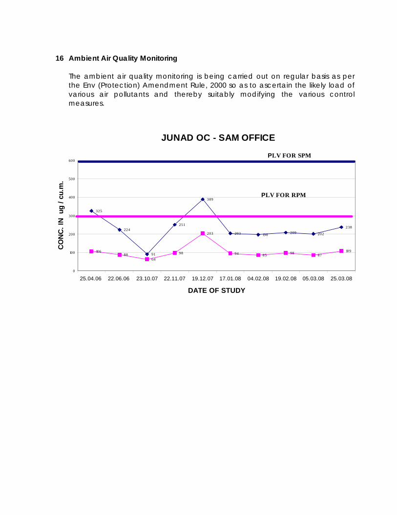
It can be inferred from the above graphs that the ground water level has not been affected adversely in the surrounding area due to ongoing mining activities. The radius of influence has been calculated as below :-
AVG. DEPTH -130 m
RADIUS OF INFLUENCE ABOUT 600 m OF JUNAD EXTN. OCM
600
20 Remedial measures to control ground water depletion
The following methodology and remedial measures will be taken to minimize the mine-induced impact on ground water levels and also adverse effects in the area. (i) Artificial recharge to ground water system at the periphery of the
anticipated influence area by local stagnation in low lying areas/drains by providing low height dams/bunds or by injection of mine water discharge. Surface water through tubewells /percolation structures.
(ii) The water shortage in the villages, if any, in the influence area can be supplemented by supply of water from outside source or from the mine water after treatment.
(iii) While reclamation of the mined area, void at the deepest portion of the pit has to be left. This residual pit void would initially serve as access for future expansion and subsequently it could be backfilled.
(iv) Regular well water monitoring in nearby villages will be carried out quarterly as per MOEF’s guidelines.

21 NOISE QUALITY
In order to assess the existing ambient noise level in the surrounding of proposed project site corresponding to pre-mining scenario ,baseline noise level data has been generated & details are enclosed as Annexure – III. All the values are well within the permissible limit.
Proposed mine would be associated with following activities that may generate noise during operation :
(a) Drilling (b) Blasting (c) Shovel operation (d) Dozing
(e) Movement of dumper (f) Operation of CHP / Workshop
22 NOISE POLLUTION CONTROL MEASURES
Monitoring of the noise control will be carried out on regular basis as per the Env (Protection) Amendment Rule 2000. While planning for an effective noise attenuation measures, the concept of source, path and receiver has been considered.
(A) Noise Control at Source
There are two areas where the noise generation can be checked at source.
(i) Proper Design
Since the generation of noise can be reduced by reducing the vibration amplitude, the area of vibrating part and frequency of vibration will be taken care that all loose contact between metal parts avoided. Shock absorbing pads will be fixed in the foundation of vibrating equipment / machines. In case of aerodynamic noise producing sources, mufflers will be provided with the machines. (ii) Proper Maintenance All machines and equipment will be properly maintained. Sound muffler system and bearing lubricating system etc. of equipment will be kept in proper condition.

(B) Noise control in Transmission Path
The measures are to be taken for control of noise along the transmission path have been put in following two categories:
(i) Air borne path (ii) Ground borne path
(i) Air Borne Path
The control in air – borne path has been planned in a number of ways as:
(a) The crusher house, screen house etc., which are source of high level noise generation are to be enclosed.
(b) Planting of furrows of trees along the thick foliage around the compound and wall of CHP, workshop and other industrial buildings. This will reduce the spread of noise. It can be also used as an acoustic enclosure to reduce ambient noise.
(ii) Ground Borne Path It has been proposed to provide vibration isolators in the form of vibration absorbing pads placed at the base of vibrating equipment.
(C) Noise Control at Receiver End
Even after adopting above measures, if desired noise level is not achieved at receiver end, in that case, following measures are suggested:
(a) The workers exposed to high noise level are provided with earplugs. (b) Provision of enclosed booths at the worksite to protect worker from noisy
environment.
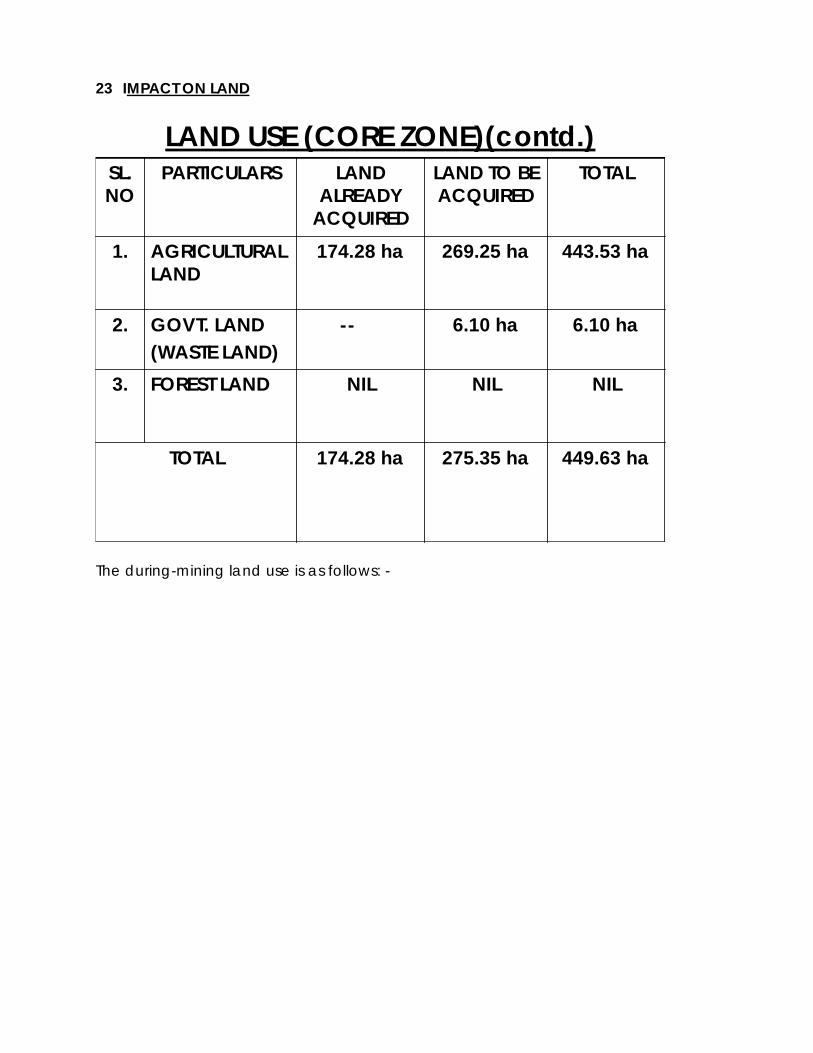
23 IMPACT ON LAND
LAND USE (CORE ZONE)(contd.)
6.10 ha--
449.63 ha
NIL
443.53 ha
TOTAL
174.28 ha
NIL
174.28 ha
LAND ALREADY
ACQUIRED
275.35 haTOTAL
NILFOREST LAND3.
6.10 haGOVT. LAND(WASTE LAND)
2.
269.25 haAGRICULTURAL LAND
1.
LAND TO BE ACQUIRED
PARTICULARSSL. NO
The during-mining land use is as follows: -

CHANGE IN LAND USE DURING MINING
67.43RATIONALISATION AREA670.50BLASTING ZONE5
449.63
20.00
15.00
175.00
101.70
AREA (ha)
TOTAL
EMBANKMENT4
INFRASTRUCTURE INCLUDING APPROACH ROAD ETC.
3
EXT. OB DUMP2
QUARRY AREA1
PARTICULARSSL. NO.
24 LAND RECLAMATION / LAND MANAGEMENT The following activities have been proposed for reclamation of land. 1. Backfilling of the excavated area to the extent possible. 2. Leveling of the backfilled area and carpeting with the topsoil. 3. Creation of garland drains in order to arrest the silt load, due to erosion, to enter
into natural watercourses during surface run-off.
4. Grass, legumes and different types of plants etc. will be planted on such reclaimed land in order to make it, as far as possible, conducive to agricultural growth.
5. Technical and biological reclamation of external OB dump. The density of trees is around 2000 – 2500 plants/Ha.

SOLID WASTE MANAGEMENT (PROPOSED)
0.75
EMBANKMENT TOTALEXTERNAL OB DUMP
60.20
DISPOSAL OF SOLID WASTE ( M.Cu.m.)
60.95SOLID WASTE (OVER BURDEN)
1.
PARTICULARSSL.NO.
EXISTING STATUS OF OB REMOVAL –i. OB REMOVED – 15.0 M.Cu.m.ii. OB IN EXTERNAL DUMP – 14.50 M.Cu.m.iii. OB IN EMBANKMENT - 0.50 M.Cu.m.
Points for reclamation of void of Junad OC Extn. mine i. Due to steep gradient and in order to maintain proper haul road of 1 in 16 gradient it will not be possible for backfilling of the void in the present proposal. ii. In order to backfill the void of Junad Extn. OC to the extent of –35 m it is proposed that the OB of adjacent Pimpalgaon Extn. OC could be utilized. iii. The approx. quantity of OB of proposed Pimpalgaon Extn . OC is 200 M.Cu.m. and is at a distance of about 5 k.m. iv. This will simultaneously help in reduction of land required for external OB
dump of proposed Pimpalgaon Extn. OC.

END OF MINING SCENARIO (AREA IN ha)
449.63137.9315.0101.70195.0TOTAL
137.93137.93---RATIONALISATIONOF MINE BOUNDARY & BLASTING ZONE
5
25.0-8.0-17.0DIVERSION OF ROAD / EMBANKMENT
4
10.0-7.0-3.0INFRASTRUCTURE3
101.70--101.70-EXCAVATION2
175.0---175.0EXTERNAL OB DUMP
1
TOTALUNDIST-URBEDAREA
PUBLIC USE
VOIDPLANTATIONPARTICULARSSL. NO.
25 PROGRESSIVE & FINAL MINE CLOSURE PLAN A. OBJECTIVES OF CLOSURE PLANNING
Mine closure planning has to be carried out at the starting of the mine and needs periodic reviewing and revision during its life cycle to cope with the geo-technical constraints, safety and economic risks, social and environmental challenges. Various other objectives are as follows:
(a) To allow a productive and sustainable after-use of the site which is
acceptable to the mine owner and the regulatory authority; (b) To protect public health and safety;
(c) To alleviate or eliminate environmental damage and thereby
encourage environmental sustainability;
(d) To minimize adverse socio-economic impacts.
B. DIFFERENT ASPECTS OF MINE CLOSURE PLANNING
The mine closure planning broadly involves the following aspects:
(a) Technical aspects; (b) Environmental aspects (c) Social aspects; (d) Financial aspects.
C. MINE CLOSURE OBLIGATIONS
There is need to define the liabilities, responsibilities and authorities of the mine management, other regulatory bodies, Central and State Governments after mine closure. Some obligations relating to the Mine Management Companies are as follows:
(a) Health & Safety: Regulation Nos. 6, 61, 106, 112 of Coal Mines Regulations, 1957 and its related DGMS Circulars;
(b) Environment
(i) Water (Prevention & Control of Pollution) Act, 1974; (ii) Air (Prevention & Control of Pollution) Act, 1981; (iii) Environmental (Protection) Act, 1986 and Environmental
Protection (Amendment) Rule , 2000; (iii) DGMS Directives on Noise & Ground Vibration;
(c) Forest : Forest (Conservation) Act, 1980 – Not applicable in this case.
(d) Rehabilitation : As per Company Policy.
(e) Decommissioning/asset disposal, etc.
F. CLOSURE COSTS
A financial provision of Rs. 1.00 per tonne has been provided in the approved project report for the entire life of the mine to undertake mine closure activities (for plantation in slope of dumps & quarry, for protection of mine boundary and continuation of monitoring programme and control of contaminated effluents). Closure cost may be reviewed under the changing circumstances and new legislative requirements.
26 Peripheral development: As per the present practices in WCL coal mines, adequate steps are being taken for
the local villagers by providing various infrastructural and welfare facilities and
giving assistance in health care in Wani North Area of WCL, under which the mine under consideration is operating. The various development works like construction of Primary, School, Post office, Shopping center, diversion of cart track for villagers, establishment of bank, diversion of irrigation canal etc; have been completed, mainly for catering to the needs/socio-economic upliftment of the neighbouring population.
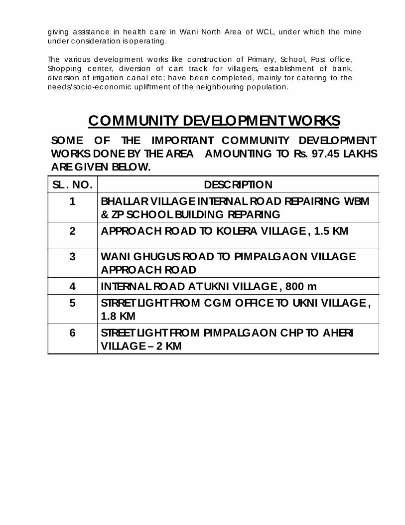
COMMUNITY DEVELOPMENT WORKSSOME OF THE IMPORTANT COMMUNITY DEVELOPMENT WORKS DONE BY THE AREA AMOUNTING TO Rs. 97.45 LAKHS ARE GIVEN BELOW.
STREET LIGHT FROM PIMPALGAON CHP TO AHERI VILLAGE – 2 KM
6
STRRET LIGHT FROM CGM OFFICE TO UKNI VILLAGE , 1.8 KM
5INTERNAL ROAD AT UKNI VILLAGE , 800 m4
WANI GHUGUS ROAD TO PIMPALGAON VILLAGE APPROACH ROAD
3
APPROACH ROAD TO KOLERA VILLAGE , 1.5 KM2
BHALLAR VILLAGE INTERNAL ROAD REPAIRING WBM & ZP SCHOOL BUILDING REPARING
1DESCRIPTIONSL . NO.

COMMUNITY DEVELOPMENT WORKS (contd.)
CONSTRUCTION OF A HALL AT RAMAIBAI MAHILA MANDAL AT RAJUR
14
SPORTS MATERIAL FOR Z. P. SCHOOL RAJUR13
REPAIRING OF PRIMARY SCHOOL RAJUR12
BOUNDARY WALL OF Z. P. SCHOOL RAJUR 11
HAND PUMP AT NEELPUR AND PIMPALGAON VILLAGE
10
REPAIRING OF Z. P. PRIMARY SCHOOL AT RAJUR9
ONE BOREHOLE AT BHANDEWADA VILLAGE INCLUDING WATER TANK
8
REPAIR OF Z. P. BUILDING AT AHERI VILLAGE7
DESCRIPTIONSL . NO.
27 REHABILITATION SCHEME There is no house oustees involved in the project. Only land losers are involved who will be suitably rehabilitated as per company norms.
28 PROJECT BENEFITS The benefits of the project can be summarized as below:- - The physical infrastructure in the area will be improved substantially by following ways:-
a) Development of road, thereby improving the communication. b) Improvement in Power, Telephone (including Mobile) facility. c) Improvement in Health Care facility & Educational facility. d) Improvement in Market / Trade & Business.

- The social infrastructure by way of cultural mixing of people of other states with local community glorifying “UNITY IN DIVERSITY”. - Substantial employment in the project & indirect employment for business & trading, contractor, transportation, vehicle contractor, nursery development.
29 ENVIRONMENTAL COST PROJECTION The details of expenditure incurred on environmental pollution control measures are given as below :-
EXPENDITURE INCURRED ON POLLUTION CONTROL MEASURES
72.04TOTAL
10.28WATER POLLUTION CONTROL MEASURES
3
37.26PLANTATION2
24.50AIR POLLUTION CONTROL MEASURES1
AMOUNT IN Rs. LAKH
PARTICULARSSL.NO.

The details of capital provision on environmental protection measures for proposed expansion project are as given below :-
PROPOSED CAPITAL FOR ADDITIONAL POLLUTION CONTROL MEASURES
37.16TOTAL10.16WATER TANKER 5
6.0LAND RECLAMATION MEASURES INCLUDING LAND USE MAPPING THROUGH REMOTE SENSING
4
5.0DUST SUPPRESSION ARRANGEMENT AT HAUL ROAD , STOCKYARD ETC.
3
8.0STRENGTHENING OF ETP FOR WORKSHOP EFFLUENT
2
8.0STRENGTHENING OF SEDIMENTATION POND FOR TREATMENT OF MINE WASTER WATER
1
AMOUNT IN Rs. LAKH
PARTICULARSSL.NO.
&&&&&&&&&&&&&&&