Embed Size (px)
Citation preview
JOURNAL OF COMMUNICATIONS SURVEYS AND TUTORIALS 1
Survey on UAV Cellular Communications:Practical Aspects, Standardization Advancements,
Regulation, and Security ChallengesAzade Fotouhi, Student Member, IEEE, Haoran Qiang, Student Member, IEEE, Ming Ding, Senior Member, IEEE,
Mahbub Hassan, Senior Member, IEEE, Lorenzo Galati Giordano, Member, IEEE,Adrian Garcia-Rodriguez, Member, IEEE, and Jinhong Yuan, Fellow, IEEE
Abstract—The rapid growth of consumer Unmanned AerialVehicles (UAVs) is creating promising new business opportu-nities for cellular operators. On the one hand, UAVs can beconnected to cellular networks as new types of user equipment,therefore generating significant revenues for the operators thatcan guarantee their stringent service requirements. On the otherhand, UAVs offer the unprecedented opportunity to realize UAV-mounted flying base stations that can dynamically repositionthemselves to boost coverage, spectral efficiency, and user qualityof experience. Indeed, the standardization bodies are currentlyexploring possibilities for serving commercial UAVs with cellularnetworks. Industries are beginning to trial early prototypes offlying base stations or user equipments, while academia is infull swing researching mathematical and algorithmic solutionsto address interesting new problems arising from flying nodesin cellular networks. In this article, we provide a comprehensivesurvey of all of these developments promoting smooth integrationof UAVs into cellular networks. Specifically, we survey (i) thetypes of consumer UAVs currently available off-the-shelf, (ii)the interference issues and potential solutions addressed bystandardization bodies for serving aerial users with the existingterrestrial base stations, (iii) the challenges and opportunities forassisting cellular communications with UAV-based flying relaysand base stations, (iv) the ongoing prototyping and test bedactivities, (v) the new regulations being developed to managethe commercial use of UAVs, and (vi) the cyber-physical securityof UAV-assisted cellular communications.
Index Terms—Unmanned Aerial Vehicles, Drones, CellularNetworks, Standardization, 5G and Beyond, Flying User Equip-ment, Flying Base Stations, Regulation, Security
I. INTRODUCTION
From aerial photography to search-and-rescue to packagedelivery — the use cases of consumer unmanned aerial ve-
A. Fotouhi is with School of Computer Science and Engineering, Universityof New South Wales (UNSW), Sydney, Australia, and also with AltranTechnologies, France (E-mail: [email protected]).
H. Qiang is with School of Electrical Engineering and Telecommunications,University of New South Wales (UNSW), Sydney, Australia, and also with theData61, CSIRO, Eveleigh, Australia (E-mail: [email protected]).
M. Hassan is with School of Computer Science and Engineering, Universityof New South Wales (UNSW), Sydney, Australia, and also with the Data61,CSIRO, Eveleigh, Australia (E-mail: [email protected]).
M. Ding is with the Data61, CSIRO, Eveleigh, Australia (E-mail:[email protected]).
L. Galati Giordano, and A. Garcia-Rodriguez are with Nokia Bell Labs,Ireland (E-mail: lorenzo.galati_giordano, [email protected]).
J. Yuan is with School of Electrical Engineering and Telecommunica-tions, University of New South Wales (UNSW), Sydney, Australia (E-mail:[email protected]).
hicles (UAVs) (a.k.a. drones) are exploding. According to areport from Federal Aviation Administration (FAA), the fleetof drones will be more than doubled from an estimated 1.1million vehicles in 2017 to 2.4 million units by 2022 [1]. It isexpected that new use cases will continue to emerge, fuellingfurther growth in UAVs. As many of these use cases wouldbenefit from connecting the UAVs to the cellular networksfor better control and communications, the growth in theUAV market is expected to bring new promising businessopportunities for cellular operators.
The Third Generation Partnership Project (3GPP), whichoversees the standards activities for cellular networks, hasrecently concluded a study item [2] to explore the challengesand opportunities for serving the UAVs as a new type ofuser equipment (UE), referred to as aerial UE. An interestingfinding of this study is that the enhanced line-of-sight (LOS)between aerial UE and ground base stations (BSs) wouldsignificantly increase interference in the system, which callsfor new strategies to seamlessly accommodate both aerial andground UEs in the same system. A variety of new techniqueshave already been proposed to address such interference issue,which show promising results.
While 3GPP is mainly concerned with connecting UAVs tocellular networks, industry and academia are advancing to thenext level of research and development that promises to har-ness the full potential of UAVs communications. In particular,they are exploring the unprecedented opportunity to realizeUAV-mounted flying relays and BSs that can dynamicallyreposition themselves to boost coverage, spectral efficiency,and user quality of experience (QoE). Major vendors havealready field-trialled their prototypes to demonstrate the proof-of-concept of such UAV-mounted flying BSs [3], [4]. A largenumber of papers have been published in recent years propos-ing novel algorithms to optimize positioning and mobility offlying relays and BSs [5]–[7].
Given the significant momentum and recent activities pro-moting UAV in cellular networks, it is timely to survey thisbrand-new field. Although several survey articles on UAV havebeen published in recent years, none of them had focusedon the practical aspects of cellular UAV communications. Forexample, the surveys in [8], [9] focussed on forming ad hocnetworks between many UAVs in the sky. Hayat et al., [10]surveyed communications demands for various applicationsof UAV and analysed the suitability of existing wireless
arX
iv:1
809.
0175
2v2
[cs
.NI]
31
Mar
201
9

JOURNAL OF COMMUNICATIONS SURVEYS AND TUTORIALS 2
UAVs in
Cellular
Networks
Regulation
Prototyping
and Field
Tests
Aerial BSs
Security
Future
Directions
UAV
Types
Standardization
• Cyber Security
• Physical Security
• Socio-Technical Concerns
• Regulation Frameworks
• Regulation History
• Facebook Aquila
• Google Loon
• Nokia F-Cell
• Eurecom Perfume
• Huawei Digital Sky
• Others
• Placement Optimization
• Mobility Optimization
• Power Consumption
• Fronthauling and Access
• Cost Model
• Mobile Edge Computing
• AUE Identifications
• UAV Simulators
• UAV Antennas
• Image Processing
• Deep Learning
• Physical Reliability
• Aerial Caching
• Characteristics
- Payload
- Flying Mechanism
- Range and Altitude
- Speed and Flight Time
- Power Supply
• Classification
• 3GPP Study Item
- Traffic Requirements
- Channel Modelling
- Performance Analysis
- Required Enhancements
• 3GPP Work Item
• Outside the 3GPP
Fig. 1: Taxonomy of the survey
technologies, including Bluetooth, Zigbee, Wi-Fi, WiMAX,and cellular, to meet these demands. In a magazine paper,Sekander et al., [11] analyzed the opportunities for drones toassist cellular networks, but specialized on combining dronesfrom different altitudes to form a multi-tier drone network. Inanother magazine paper, Zeng et al., [12] surveyed the issuesand opportunities for using drones to assist wireless networksin general without specific focus on cellular networks. Re-cently, Mozaffari et al., [7] delivered a comprehensive tutorialon UAV wireless communications. Our work complementstheir vision by covering a variety of cellular-specific issuessuch as the relevant 3GPP developments, vendor prototypesof flying BSs, regulations and cyber-security issues affectingcellular UAVs, and the potential impacts of UAV adoption onthe cost and business models of cellular networks.
A graphical illustration of the detailed taxonomy of oursurvey is presented in Fig. 1. This paper consists of sevenmain sections where the sections’ headings are displayed in thesecond level in Fig. 1. Accordingly, the third level representsthe subsections under each section. Specifically, we survey thetypes of consumer UAVs currently available off-the-shelf high-lighting their potential roles within cellular networks (SectionII), the 3GPP developments regarding interference issues andsolutions for serving aerial users (Section III), the challengesand opportunities for assisting cellular communications withUAV-mounted flying base stations or relays (Section IV),the most advanced UAV prototyping and field trial examples(Section V), the new regulations being developed to managethe commercial use of UAVs (Section VI), the cyber-physicalsecurity issues for UAV-assisted cellular communications (Sec-tion VII), and finally an overlook of the most promising futureresearch directions (Section IX) followed by the conclusions(Section X).
II. UAVS TYPES AND CHARACTERISTICS
UAVs, commonly known as drones, are available in differentsizes and specifications, as illustrated in Fig. 2. They canbe deployed quickly whenever needed, which makes thempromising candidates for providing cellular connectivity. In
this section, the characteristics and features of a few typicaldrones are summarized and explained (see Table I), withspecial focus on their impact on UAV-aided cellular commu-nications.
A. Payload
Payload refers to the maximum weight that a drone cancarry, which measures its lifting capability. Payloads of dronesvary from tens of grams up to hundreds of kilograms [18]. Thelarger the payload, the more equipment and accessories can becarried at the expense of a larger drone size, higher batterycapacity, and shorter duration in the air. Typical payloadsinclude video cameras and all sorts of sensors, which couldbe used for reconnaissance, surveillance and commercial pur-poses [19]. When assisting cellular communications, dronescan carry cellular UEs such as mobile phones or tablets, whoseweight is usually less than 1 kilogram [20]. BSs or remoteradio heads (RRHs) can also be carried by or mounted ondrones to provide cellular services. In this case, payload ofdrones should be at least a few kilograms.
B. Flying Mechanism
Depending on their flying mechanisms, drones can beclassified into three types:• Multi-rotor drones (also known as rotary-wings drones)
allow vertical take-off and landing, and can hover overa fixed location to provide continuous cellular coveragefor certain areas. This high manoeuvrability makes themsuitable for assisting cellular communications, since theycan deploy BSs at the desired locations with high preci-sion, or fly in a designated trajectory while carrying BSs.However, multi-rotor drones have limited mobility andconsume significant power as they have to fight againstgravity all the time.
• Fixed-wing drones can glide over the air, which makesthem significantly more energy efficient and able to carryheavy payload. Gliding also helps fixed-wing drones totravel at a faster speed. The downsides of fixed-wingdrones are that (i) they require a runway to take off andland as vertical take-off and landing are not possible [21],and (ii) they cannot hover over a fixed location. Fixed-wing drones are also more expensive than multi-rotordrones.
• Hybrid fixed/rotary wing drones have recently reachedthe market to provide a compromise between the twoabove-mentioned drone types. An illustrative example ofa hybrid fixed/rotary wing drone is the Parrot Swingshown in Fig. 2(a), which can take off vertically, quicklyreach its destination by gliding through the air, and thenswitch to hovering using four rotors.
C. Range and Altitude
The range (one hop) of a drone refers to the distance fromwhich it can be remotely controlled. The range varies from tensof meters for small drones to hundreds of kilometers for largeones. Altitude here refers to the maximum height a drone can

JOURNAL OF COMMUNICATIONS SURVEYS AND TUTORIALS 3
(a) Parrot Swing (front view). (b) Kogan Nano Drone. (c) Parrot Disco.
(d) DJI Spreading Wings S900. (e) Scout B-330 UAV helicopter. (f) Predator B.
Fig. 2: Images of different UAV types.TABLE I: Characteristics of different drone types
Micro (weight6100g) Very Small(100g<weight<2kg)
Small(2kg6weight<25kg)
Medium(25kg6weight6150kg) Large (weight>150kg)
Model Kogan Nano Drone Parrot Disco DJI Spreading WingsS900
Scout B-330 UAVhelicopter Predator B
Ref. [13] [14] [15] [16] [17]Illustration Fig. 2(b) Fig. 2(c) Fig. 2(d) Fig. 2(e) Fig. 2(f)
Weight 16g 750g 3.3kg 90kg 2223kgPayload N/A N/A 4.9kg 50kg 1700kgFlying
Mechanism Multi-rotor Fixed-wing Multi-rotor Multi-rotor Fixed-wing
Range 50-80m 2km N/A N/A 1852kmAltitude N/A N/A N/A 3km 15km
Flight Time 6-8min 45min 18 min 180min 1800minSpeed N/A 80km/h 57.6km/h 100km/h (horizontal) 482km/h
PowerSupply
3.7V/160mAhLi-battery
2700mAh/25A 3-cellLiPo Battery
LiPo Battery (6S,10000mAh∼15000mAh,
15C(Min))
Gasoline (heavy fueloptional)
950-shaft-horsepowerTurboprop Engine
Power Con-sumption N/A N/A Maximum: 3kW;
Hover: 1kW
Engine: 21kW; Onboardpower generator for
payload: 1.5kWEngine: 712kW
ApplicationRecreation; suitable to
carry sensors for indoorwireless data collection
Recreation; suitable tocarry cellular UEs
Professional aerialphotography andcinematography;
suitable to carry cellularBSs or UEs
Survey (dataacquisition), HD videolive stream; suitable tocarry or act as motorial
energy source forwireless energy transfer,and act as aerial caches;can carry cellular BSs
or UEs
Armed reconnaissance,airborne surveillance,and target acquisition
reach regardless of the country-specific regulations. The maxi-mum flying altitude of a given drone is a critical parameter forUAV-aided cellular communications, since a UAV BS needs tovary its altitude to maximize the ground coverage and satisfydifferent quality of service (QoS) requirements [22]. Overall,aerial platforms can be classified into two types depending ontheir altitude:• Low-altitude platforms (LAPs) are usually employed to
assist cellular communications since they are more cost-
effective and allow fast deployment. Moreover, LAPsusually provide short-range line-of-sight (LOS) linksthat can significantly enhance the communication perfor-mance [12], [23], [24].
• High-altitude platforms (HAPs) such as balloons can alsoprovide cellular connectivity [12]. Compared to LAPs,HAPs have a wider coverage and can stay much longer inthe air. However, HAP deployment is more complex andthey are mainly considered as a vehicle to provide Internet

JOURNAL OF COMMUNICATIONS SURVEYS AND TUTORIALS 4
connectivity to large fractions of world population cur-rently not served by cellular networks. More importantly,using HAPs in cellular communications may cause totalnetwork outage due to extremely large inter-cell interfer-ence [25], [26]. As such, they are rarely considered inthe literature on UAV-aided cellular networks, but ratherpursued by Internet companies. In Section V, we discussexamples of HAP introduced by Google and Facebook.
D. Speed and Flight Time
Small drones typically travel at speeds below 15 m/s [27],while large drones can reach an impressive speed of100 m/s [12]. When a UAV BS/relay flies in a designatedtrajectory to maximize its energy and spectral efficiency, itsspeed needs to be carefully considered if the trajectory requiresfrequent turns. The trade-off between a drone’s speed and itsturning agility is studied in [28]. The maximum time a dronecan spend in the air without recharging or refueling is referredto as its flight time or endurance. Small commercial dronesusually have a flight time of 20-30 minutes, while some largedrones can last for hours [29]. Emerging technologies haveprolonged the endurance of small drones. For example, theSkyfront Tailwind drone can achieve an endurance of up to 4.5hours with hybrid-electric power sources [30]. Nevertheless,the limited endurance of the existing off-the-shelf UAVs iscurrently one of the major practical factors restricting theirfull-scale deployment in cellular networks.
E. Power Supply
A drone’s power supply significantly determines its en-durance. While rechargeable batteries power most commercialdrones, some large drones can be powered by fuels such asgas for longer flight times [31]. Employing solar energy topower drones is also a promising technique [32]. For drone-mounted BSs, power supply needs to support the functionalityof both the drone and its on-board equipment such as antennaarray, amplifier, circuits, etc. For example, a typical aerial BSrequires 5 W as its maximum transmit power [33]–[35], whichshould be supplied by its on-board energy source.
F. An Example of Drone Classification
Civil aviation authorities usually classify drones based ontheir gross weights. Table I demonstrates such weight-basedclassification as adopted by Civil Aviation Safety Authority(CASA) Australia [36] by listing typical drones and theirfeatures, which are depicted in Fig. 2(b)−(f).
III. STANDARDIZATION:ENABLING UAV CELLULAR COMMUNICATIONS
The cellular industry has recognized the importance ofproviding support to low-altitude UAVs for enabling beyondLOS control and establishing a reliable communication [2],[37]–[40]. This section summarizes the outcomes and currentstatus of a number of industry-led initiatives with the abovetargets.
TABLE II: UAV communication requirements [2], [39], [42]
Data Type Data Rate Critical?
DL
Synchronization (PSS/SSS)N/A
3
Radio control (PDCCH) 3
Command and control (C&C) 60-100 kbps 3
ULCommand and control (C&C) 60-100 kbps 3
Application data Up to 50 Mbps 7
A. 3GPP Study Item Phase
The third generation partnership group (3GPP) defined astudy item (SI) in March 2017 with four fundamental objec-tives: i) the understanding of the UAV traffic requirements;ii) the development of a channel model to characterize air-to-ground propagation characteristics; iii) the determinationof whether the current LTE infrastructure could be reused toprovide cellular service to aerial devices; iv) the definition ofthe enhancements required to effectively serve UAVs buildingup on LTE Release 14 functionalities [41]. The SI finalizedin December 2017 and the main results in each of the abovefour areas are summarized in the following [2].
i) 3GPP Study Item: UAV Traffic Requirements
The 3GPP identified the traffic types that cellular networksshould cater for UAVs flying between ground level and 300meters. These are summarized in Table II and can be classifiedinto three categories: 1) synchronization and radio control, 2)command & control, and 3) application data.
1) The information contained within the synchronizationand radio control messages is essential for a success-ful association and connectivity to the network. Thetransmission of these signals must be robust enough toguarantee that they can be decoded by flying UAVs.Examples of synchronization and radio control signallinginclude primary and secondary synchronization signals(PSS/SSS) and the physical downlink control channel(PDCCH), respectively.
2) Command & control (C&C) traffic enables beyond line-of-sight UAV piloting and has strict quality of servicerequirements (QoS) in terms of latency and reliability.Cellular operators have identified an attractive businessopportunity in the management of this traffic, since itcan be offered as a complementary network serviceto organizations interested in reliably controlling theirUAVs.
3) While downlink data traffic is predominant in existingcellular communications, UAV application data transmis-sions are expected to be uplink-dominated. Transferral oflive video streaming data and photos captured by camera-equipped UAVs contribute towards this traffic imbalance.
ii) 3GPP Study Item: Channel Modelling
In order to characterize the performance of existing cellularnetworks when serving both ground and aerial devices, the3GPP developed a UAV-specific statistical channel modelbuilding upon that defined in [43]. This channel model com-

JOURNAL OF COMMUNICATIONS SURVEYS AND TUTORIALS 5
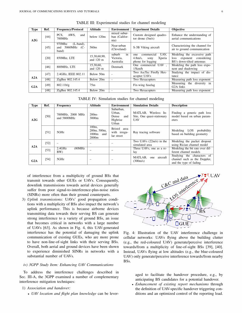
plements those developed by the academic community. Theseacademic models are summarized in Table III and Table IVinto three different categories (Air to Ground (A2G), Air toAir (A2A), and Ground to Air (G2A)) for completeness. The3GPP-proposed models for rural-macro (RMa), urban-macro(UMa), and urban-micro (UMi) BS deployments are the resultof a large number of measurement campaigns carried out bythe standard-contributing companies and its main UAV-relatedfeatures can be summarized as follows:
• UAV spatial placement: The 3GPP defines five differentcases depending on the density of UAVs in the network,i.e., it considers the deployment of Naerial = {0, 0.1, 1, 3, 5}UAVs per cellular sector (out of a total of 15 mobiledevices). Airborne devices are uniformly distributed be-tween 0 and 300 meters and travel at a speed of 160km/h.
• LOS probability: The LOS probability between groundBSs and UAVs grows as the latter increase their height.Remarkably, UAVs flying higher than 100 meters are con-sidered to be in LOS with all the cellular BSs deployedin the network in the UMa scenario.
• Path loss: The 3GPP model also captures the fact thatthe path loss exponent of ground-to-aerial links generallydecreases as UAVs increase their height. Indeed, UAVsin LOS with their BSs experience a path loss similar toof free-space propagation (α = 2.2).
• Shadowing: The standard deviation of the log-normallydistributed shadowing gain diminishes for increasingUAV heights, provided that the considered UAV-BS pairis LOS.
• Fast-fading model: Three different alternatives with avarying degree of implementation complexity are con-sidered in [2], namely, 1) a variation of the cluster delay-based channel model developed in [43] with UAV-specificchannel characteristics such as the existence of a specularreflection on the building roof for the UMa scenario, 2)an approach where the mean and standard deviation ofthe large scale parameters defined in [43] (delay spread,angular spreads of departure and arrival, and K-factor)are adjusted, and 3) a simpler alternative where, whencompared with the channel model of [43], only the K-factor is adjusted.
iii) 3GPP Study Item: UAV Performance Analysis
Based on the above traffic and channel characterizations,the companies involved in the SI evaluated the performanceof cellular networks serving both airborne and ground users(GUEs). These studies demonstrate that UAVs are more likelyto undergo downlink and uplink interference problems thanGUEs [2], [39], [40], [42], [55]–[59]. This is mainly dueto two factors, namely, that flying UAVs are likely to be inline-of-sight with a large number of base stations (BSs) [60],and that the majority of these BSs are downtilted [61], sincetheir deployment has been optimized for providing coverage toGUEs. This impacts all phases of the cellular communication,i.e., 1) association and handover, 2) downlink transmissions,and 3) uplink transmissions:
Fig. 3: 2D location of 150 meter-high UAVs (red dots) as-sociated to a three-sector BS site located at the origin [39].Hexagons illustrate the ground sectors covered by each BS.
1) Association and handover: In contrast to GUEs, flyingUAVs do not generally associate to their physicallyclosest BS. This is because cellular BSs generally focustheir main antenna beam towards the center of theirground coverage area [61]. Instead, the association ofairborne devices is dominated by the sidelobes of theirdirective BS antennas [2], [39]. This can be observed inFig. 3, which adopts the perspective of a tri-sector BS sitelocated in the center of the scenario and illustrates the2D location of its associated 150 meter-high UAVs (rep-resented by red dots). These UAVs are clustered in threeangular regions, which are consistent with the orientationsof the central BSs (120◦, 240◦, and 270◦). Differentassociation ranges highlighted in green can be observed,each corresponding to different antenna sidelobes of the12◦-downtilted BSs. Instead, the white regions delimitthe areas where the antenna gain of the considered BSsis smaller than -30 dB, i.e., close to the radiation nulls ofthe downtilted antennas. In these areas, UAVs associateto BSs other than those located in the origin because theyperceive an insufficient signal strength from the latter. Asa result of the existence of these non-contiguous associ-ation regions and the reception of high-power interferingreference signals, UAVs experience increased outage andhandover failure probabilities when compared to grounddevices.
2) Downlink transmissions: As illustrated in Fig. 4, a UAVreceives line-of-sight transmissions from a large numberof BSs when increasing its altitude. Indeed, measure-ment campaigns have demonstrated that airborne devicesflying at around 100 meters can receive signals fromBSs located up to 10 kilometers away [62]. This entailsthat a given UAV can undergo a substantial amount
JOURNAL OF COMMUNICATIONS SURVEYS AND TUTORIALS 6
TABLE III: Experimental studies for channel modeling
Type Ref. Frequency/Protocol Altitude Environment Experiment Details Objective
A2G[44] PCS, AWS, and
700MHz below 120mmixed subur-ban (Califor-nia)
Custom designed quadro-tor drone (5m/s)
Enhance the understanding ofaerial communications
[45]970Mhz (L-band),and 5060MHz (C-band)
560m Near-urban(Cleveland) S-3B Viking aircraft Characterizing the channel for
air to ground communication
[20] 850Mhz, LTE 15,30,60,90,and 120 m
suburb inVictoria,Australia
one commercial UAV,4.8m/s, sony Xperiaphone for logging
Modeling the excessive pathloss exponent consideringBS’s down-tilted antennas
[46] 800MHz, LTE 15,30,60,and 120 m Denmark One commercial UAV ,
15km/hModeling the path loss expo-nent and shadowing
A2A[47] 2.4GHz, IEEE 802.11 Below 50m - Two AscTec Firefly Hex-
acopter UAVsStudying the impact of dis-tance
[48] ZigBee 802.145.4 Below 20m - Two Hexacopters Measuring path loss exponent
G2A [49] 802.11b/g 75m Fix-wing fuselag Measuring the diversity inG2A links
[48] ZigBee 802.145.4 Below 20m - Two Hexacopters Measuring path loss exponent
TABLE IV: Simulation studies for channel modeling
Type Ref. Frequency Altitude Environment Simulation Details Description
A2G[50] 700MHz, 2000 MHz
and 5800MHz200m-3000m
Suburban,Urban,Dense andHighriseUrban
MATLAB, Wireless In-Site, One quasi-stationaryUAV
Finding a generic path lossmodel based on urban param-eters
[51] 5GHz
100m,200m, 500m,1000m and2000m
Bristol areawith irregu-lar street
Ray tracing software Modeling LOS probabilitybased on building geometry
A2A[52] – – – Two UAVs (22m/s) in the
simulated areaModeling the packet dropoutusing Rician channel model
[53] 2.4GHz (80MHzBW) – – Three UAVs, one as a re-
layModeling the bit rate over dif-ferent channel models
G2A [54] 5GHz – – MATLAB, one aircraft(300m/s)
Studying the characters ofchannel such as the Doppler,and the type of fading
of interference from a multiplicity of ground BSs thattransmit towards other GUEs or UAVs. Consequently,downlink transmissions towards aerial devices generallysuffer from poor signal-to-interference-plus-noise ratios(SINRs) more often than their ground counterparts.
3) Uplink transmissions: UAVs’ good propagation condi-tions with a multiplicity of BSs also impact the network’suplink performance. This is because airborne devicestransmitting data towards their serving BS can generatestrong interference to a variety of ground BSs, an issuethat becomes critical in networks with a large numberof UAVs [63]. As shown in Fig. 4, this UAV-generatedinterference has the potential of damaging the uplinkcommunication of existing GUEs, who are more proneto have non-line-of-sight links with their serving BSs.Overall, both aerial and ground devices have been shownto experience diminished SINRs in networks with asubstantial number of UAVs.
iv) 3GPP Study Item: Enhancing UAV Communications
To address the interference challenges described inSec. III-A, the 3GPP examined a number of complementaryinterference mitigation techniques:
1) Association and handover:• UAV location and flight plan knowledge can be lever-
Fig. 4: Illustration of the UAV interference challenge incellular networks: UAVs flying above the building clutter(e.g., the red-coloured UAV) generate/perceive interferencetowards/from a multiplicity of line-of-sight BSs [39], [40].Instead, UAVs flying at low altitudes (e.g., the blue-colouredUAV) only generate/perceive interference towards/from nearbyBSs.
aged to facilitate the handover procedure, e.g., byanticipating BS candidates for a potential handover.
• Enhancement of existing report mechanisms throughthe definition of UAV-specific handover triggering con-ditions and an optimized control of the reporting load.

JOURNAL OF COMMUNICATIONS SURVEYS AND TUTORIALS 7
A detailed evaluation of these UAV mobility enhancementtechniques is part of the work item (WI) study definedin [64], as detailed in Sec. III-B.
2) Downlink transmissions:• The full dimension MIMO (FD-MIMO) multi-antenna
BSs defined in LTE Release 13 enhance the perfor-mance of UAV communications thanks to a) theirbeamformed transmissions, which allow reducing theamount of interference generated towards the con-strained spatial regions where UAVs lie, and b) theirspatial multiplexing capabilities, which in turn enablea better utilization of the precious time/frequency re-sources.
• UAVs with directional antennas and beamforming ca-pabilities contribute to reduce the number of downlinkinterferers perceived by aerial devices. These interfer-ence mitigation gains can be further complementedwith a boost of the useful signal power in UAVsbeamsteering towards their serving BS. Clearly, thissolution entails a complexity increase in the design ofhardware UAV transceivers.
• Cooperative multipoint (CoMP) can convert the harm-ful line-of-sight BS interferers into useful signal con-tributors. Indeed, both UAV control and data transmis-sions benefit from intra- and inter-site cooperation [65].However, the gains attainable with this approach arelimited in practical deployments due to the large num-ber of BSs interfering towards a given UAV and theincreased inter-BS signalling load.
3) Uplink transmissions:• Uplink power control is essential to harmonize the
coexistence among GUEs and aerial devices. In thisline, approaches that define different fractional pathloss compensation factors and offsets P0 for UAVs andGUEs proved effective in mitigating the interferencegenerated by UAVs [24].
• Full dimension MIMO (FD-MIMO) can also benefituplink transmissions by enabling spatial separation ofground and aerial users, which have clearly distinguish-able propagation characteristics.
• UAVs with directional antennas and beamforming ca-pabilities generate a diminished amount of interferenceto the GUE-generated uplink transmissions owing to apotential decrease in both the number of interfered BSsand the UAV transmission power.
As the reader might have noticed, updated information aboutthe flying status of a mobile device is required to effectivelyimplement some of the above-mentioned solutions. The 3GPPconsidered a variety of device- and network-based solutionsto acquire this information. Among others, these include theuse of explicit UAV identification signalling, the exploitationof mobility history information, or the employment of mea-surement reports from mobile devices.
B. 3GPP Work Item: Main Outcomes and Way Forward
The above-mentioned observations led to the definition ofa WI in December 2017 [64]. The core part of this WI
was concluded in September 2018 and it provides furtherenhancements to LTE in the following areas [66]:• Uplink power control, by augmenting the existing frac-
tional power control mechanisms through a) the assign-ment of a UAV-specific path loss compensation factor,and b) the range extension of the P0 parameter [67].
• Signaling, to identify the status of airborne devices. Forinstance, the technical specification (TS) 36.331 nowdefines new reporting events that are triggered whenthe UAV height is above or below a BS-configurablethreshold [67].
• Interference detection, by allowing UEs to trigger a mea-surement report when a configurable number of referencesignals received from neighboring cells satisfy specificpower-related conditions [67].
• Subscription-based access, to prevent the non-authorizedconnection of cellular-connected UAVs. This is enabledthrough new network signaling from the core network tocellular BSs, allowing the latter to determine whether theUE subscription includes aerial functionalities.
• Mobility, where new radio resource control (RRC) sig-nalling was included to facilitate the flight plan commu-nication from UAVs to their serving BS. This informationcan be subsequently exploited to facilitate handovers.
Ultimately, it is expected that the 3GPP continues its workon the UAV space in the future, possibly through the definitionof a new WI focused on 5G-based solutions like massiveMIMO [39], [40], [68]–[70].
C. UAV Standardization Outside the 3GPP
Other standardization bodies have also considered the par-ticular characteristics of UAVs in the definition of new speci-fications:• The International Telecommunication Union Telecommu-
nication Standardization Sector (ITU-T) defined the workitem Y.UAV.arch for providing a functional architecturefor UAVs and UAV controllers using IMT-2020 net-works [71]. Additionally, this work item also aims atdefining capabilities in the application layer, the serviceand application support layer, as well as implementingsecurity measures for facilitating the integration of UAVsin IMT-2020 networks.
• The European Telecommunications Standards Institute(ETSI) technical report (TR) 103 373 aims at identify-ing UAV-specific use cases and understanding whethernew spectrum rules are required for enabling them [72].Additionally, the specifications of UAV wireless commu-nications have been pondered for determining how thefuture Internet Protocol (IP) suite architecture should beshaped [73].
• The Institute of Electrical and Electronics Engineers(IEEE) defined the Drones Working Group in 2015. Thisgroup aims to develop a standard for consumer drones,primarily with the intention of addressing privacy andsecurity concerns. With this purpose, the standard iscurrently focused on specifying 1) the taxonomy anddefinitions related to UAVs [74], and 2) the requirements,
JOURNAL OF COMMUNICATIONS SURVEYS AND TUTORIALS 8
systems, methods, testing and verification required topreserve the privacy and security of people and propertieswithin range of the UAVs [75].
IV. AERIAL BASE STATIONS: CHALLENGES ANDOPPORTUNITIES
The falling cost and increasing sophistication of consumerUAVs combined with miniaturization of BS electronics havemade it technically feasible to deploy BSs on flying UAVs.Because UAV BSs can be quickly deployed at optimumlocations in 3D space, they can potentially provide much betterperformance in terms of coverage, load balancing, spectralefficiency, and user experience compared to existing ground-based solutions.
The deployment of aerial BSs, however, faces several prac-tical issues. In particular, placement and mobility optimizationare challenging problems for aerial BSs, which have attractedsignificant attention from the research community. The op-timization of UAV power consumption and the developmentof practical recharging solutions for UAVs are also importantchallenges to overcome for sustaining the operation of aerialBSs. Finally, the optimization of the end to end link when amoving UAV connects a ground user to the wired backboneof the network is a non-trivial problem. In this section, wesurvey recent research addressing these issues.
A. Placement Optimization for Aerial BSs
The problem of optimum placement is more challengingfor aerial BSs compared to the conventional terrestrial BSsbecause an aerial BS can be placed at many different heightsin the sky [42], [76]. However, the coverage as well asthe UL and DL channels change with the altitude of theBS. Different researchers employed different algorithms tosolve the placement optimization problem for aerial BSs.Some researchers considered the height of the aerial BS asa variable in their optimization formulation thus treating it asa 3D placement problem, while others essentially solved 2Dplacement problems for constant heights. Optimizations alsodiffered in whether the backhaul, interference from other BSs,and existence of terrestrial BSs in the same coverage area wereconsidered in problem formulation. Finally, the objectives inof these optimizations varied from maximizing the systemcapacity to minimizing the required number of aerial BSsto minimizing the total transmit power of the entire aerialsystem. In this section, we survey these optimization studiesand compare their main features in Table V.
Using brute force search to maximize the 5th percentilespectral efficiency of the system, Merwaday et al., [77] opti-mized 2D placements of a small number of ‘helper’ aerial BSsto improve coverage of a large service area where some of theterrestrial BSs are damaged by natural disasters or maliciousattacks. Not surprisingly, the optimal locations for the aerialBSs were proposed to be along the cell edges, which has themost effect on the 5th percentile throughput. A less intuitiveobservation was that the height had little effect on the overallthroughput, but lowering the height of the aerial BSs markedlyimproved 5th percentile throughput. This was attributed to
rather line-of-sight environments in the simulations, whichcaused better SNR for cell-edge users due to smaller distanceto the aerial BSs. Similar 2D placement optimizations werealso studied by Rohde et. al., [78] and Galkin et. al., [79], butinstead of brute force search, they employed genetic algorithmand K-means clustering, respectively, to solve the optimizationproblem.
Yaliniz et. al., [80] attempted 3D placement optimization foraerial BSs in the context of heterogeneous networks (aerialBSs are used to augment terrestrial BSs), but observed thatthere are quadratic, exponential, and binary terms in theproblem formulation, which makes it a mixed integer non-linear problem. The authors show that the problem can beefficiently solved by using a combination of the interior pointoptimizer and bisection search. Mozaffari et. al., [81] alsostudied 3D placement optimizations, but sought to minimizethe total transmit power of a homogeneous network of aerialBSs. For such scenarios, the authors solved the 3D placementoptimization problem by dividing the problem into two sub-problems that are solved iteratively. Given the height of theaerial BSs, the first sub-problem obtains the optimal locationsof the UAVs using the facility location framework. In thesecond sub-problem, the locations of aerial base stations areassumed to be fixed, and the optimal heights are obtained usingtools from optimal transport theory.
The authors of [77]–[81] sought to maximize the systemperformance or minimize the total transmit power of thenetwork. In contrast, Košmerl et. al., [82] and Lyu et. al.,[83] analyzed the placement optimization problem with theobjective of obtaining the minimum number of aerial BSsthat can meet target user requirements in a given service area.While Košmerl et. al., [82] employed evolutionary computingto solve the problem, the authors of [83] observed that it canbe formulated as a Geometric Disk Cover (GDC) problem,whose objective is to cover a set of ground users in a regionwith the minimum number of disks of given radii wherethe radii is influenced by the height of the UAVs. Sincethe GDC problem is NP-hard, a polynomial-time heuristic,called spiral placement algorithm, was proposed to solvethe problem approximately. It was shown that the proposedspiral placement algorithm achieved near optimal solutionswith significantly lower complexity compared to the optimalsolution.
When a ground user is associated with an aerial BS, datais downloaded or uploaded using two distinct wireless links,the access link that connects the user to the UAV and thebackhaul link which connects the UAV to the core network.The placement of the UAV will affect both of these links.Works in [77]–[83] considers only the access link in theiroptimization formulation and assumes that the backhaul linkhas infinite bandwidth. In a recent work, Sun and Ansari [84]optimized the vertical placement of the aerial base station byjointly considering the spectral efficiency of the backhaul linkas well as the access link.
B. Mobility Optimization for Aerial BSsPlacement optimization studies surveyed in Table V do not
include mobility of aerial BSs in problem formulation. Mo-

JOURNAL OF COMMUNICATIONS SURVEYS AND TUTORIALS 9
TABLE V: Comparison of aerial BS placement algorithms
Reference Objective Dimension Backhaul Algorithm
Merwaday et. al., [77] Maximize 5th percentile throughput 2D Ignored Brute force search
Rohde et. al., [78] Maximize downlink throughput 2D Ignored Genetic algorithm
Galkin et. al., [79] Maximize downlink RSS 2D Ignored K-means clustering
Yaliniz et. al., [80] Maximize network revenue 3D Ignored Combination of interior point optimizer andbisection search
Mozaffari et. al., [81] Minimize total transmit power 3D Ignored facility location and optimal transport theory
Košmerl et. al., [82] Minimize required number of aerial BSs 2D Ignored Evolutionary Computing
Lyu et. al., [83] Minimize required number of aerial BSs 2D Ignored Spiral placement algorithm
Sun and Ansari [84] Maximize spectral efficiency 1D Considered STABLE (self-derived algorithm)1D: optimize vertical placement, i.e., the height for a specific 2D ground location
2D: optimize x and y coordinates on a horizontal plane at a specific height3D: optimize horizontal coordinates as well as the height
bility, however, is an intrinsic feature and capability of aerialBSs, which provide additional opportunities to dynamicallyimprove their placements in response to user movements onthe ground. To exploit the mobility features of aerial BSs, thepractical hardware limitations of the UAVs must be considered.The limitations on speed and accelerations are studied throughfiled experiments in [28] using a consumer UAV. Based on thetransportation methods of aerial BSs, there are two types ofmobilities considered in the literature:
1) UAVs are used only to transport a BS to a particularground location where the BS autostarts to serve theusers. If the BS needs to be relocated, it must shut downfirst before being transported to the new location. Thistype of aerial BSs therefore cannot serve while it isin motion, but it can resume its service as soon as itreaches a target location. As will be explained later inSection V-C, prototypes from Nokia Bell Labs [85] fallinto this category.
2) UAVs continue to carry the BSs and the BSs can contin-uously serve the ground users while they are flying. Forexample, prototypes from Eurecom [86], later describedin Section V-D, belong to this category.
Considering the first type of aerial BSs, Chou et. al., [87]studied a BS placement mechanism where the ground usersare not served by the BS when it is moving to a new location.The loss of service time due to BS mobility therefore becomesa critical parameter for the optimization. An aerial BS in thiscase should consider both the user density of the target locationas well as the moving time to the new location when decidingits target location. The authors of [87] have shown that thisproblem can be modelled as facility location problem, wherethe transport cost represents the loss of service time due tothe movement of the BS from previous location to the newlocation.
The second type of aerial BS mobility opens up newopportunities to employ aerial BSs due to their ability toserve ground users while in motion. In particular, under thisscenario, the cost of BS mobility becomes negligible. It is thenpossible to design more advanced solutions where aerial BSscan continuously cruise the service area to maximise network
performance under geospatial variance of demands.
In both types, although a single UAV can perform plenty oftasks, multiple UAVs can form a cooperative group to achievean objective more efficiently, and to increase the chanceof successful task operation. Additionally, the robustness ofthe communications will increase by employing cooperativeUAVs [88]. Maintaining the connectivity and controlling thedistance between multiple UAVs is one of the main challengesin employing cooperative UAVs [89]. Maximizing the cover-age area [90], cooperative carrying task [91], [92], searchingand localizing a target [93] are among the tasks that can bedone by multiple UAVs.
Designing cruising aerial BSs requires autonomous mobilitycontrol algorithms that can continuously adjust the movementdirection or heading of the BS in a way that maximizes systemperformance. These algorithms must also insure that multipleaerial BSs cruising in an area can maintain a safe distance fromeach other to avoid collisions. Fotouhi et. al., [94] proposeddistributed algorithms that take the interference signals, mobileusers’ locations and the received signal strengths at UEs intoconsideration to find the best direction for BS movements atany time. Controlling the mobility of a single serving UAVis also discussed in [95]. Game theoretic mobility controlalgorithms are proposed in [5], [96] for multiple aerial basestations cruising freely over a large service area without beingsubject to individual geofencing. The game theoretic mobilitycontrol not only increased 5th-percentile packet throughput by4x compared to hovering BSs, it also helped avoid collisionsas the BSs were implicitly motivated to move towards dif-ferent directions to maximize coverage and throughput. Thetrajectory of a single UAV also can be optimized to improvethe system performance. A UAV with a mission to fly betweena source and destination point is studied in [97]. During thismission it has to maintain a reliable connection by associatingwith a ground base stations at each time. In [98] a UAV isused to offload data traffic from cell edge users and improvetheir performance. It is shown that by using one single UAVand optimizing its trajectory, the throughput improves signif-icantly compared with the conventional cell-edge throughputenhancement scheme with multiple micro/small cells.
JOURNAL OF COMMUNICATIONS SURVEYS AND TUTORIALS 10
C. Power-Efficient Aerial BSs
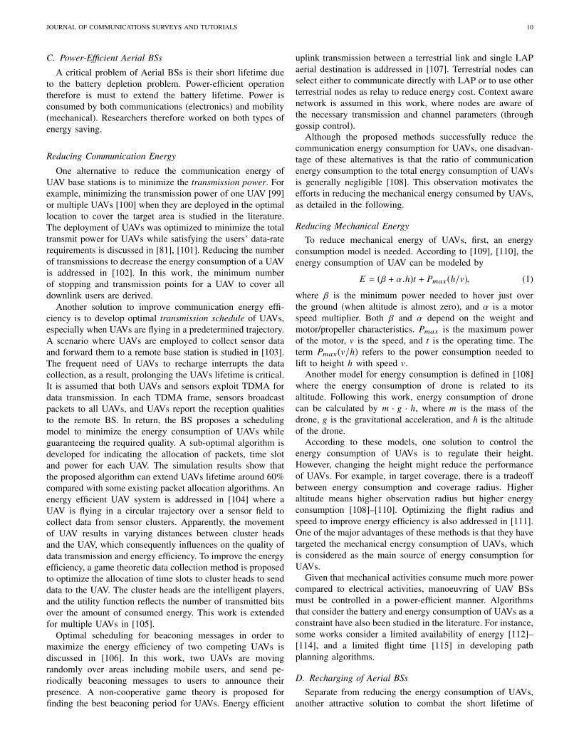
A critical problem of Aerial BSs is their short lifetime dueto the battery depletion problem. Power-efficient operationtherefore is must to extend the battery lifetime. Power isconsumed by both communications (electronics) and mobility(mechanical). Researchers therefore worked on both types ofenergy saving.
Reducing Communication Energy
One alternative to reduce the communication energy ofUAV base stations is to minimize the transmission power. Forexample, minimizing the transmission power of one UAV [99]or multiple UAVs [100] when they are deployed in the optimallocation to cover the target area is studied in the literature.The deployment of UAVs was optimized to minimize the totaltransmit power for UAVs while satisfying the users’ data-raterequirements is discussed in [81], [101]. Reducing the numberof transmissions to decrease the energy consumption of a UAVis addressed in [102]. In this work, the minimum numberof stopping and transmission points for a UAV to cover alldownlink users are derived.
Another solution to improve communication energy effi-ciency is to develop optimal transmission schedule of UAVs,especially when UAVs are flying in a predetermined trajectory.A scenario where UAVs are employed to collect sensor dataand forward them to a remote base station is studied in [103].The frequent need of UAVs to recharge interrupts the datacollection, as a result, prolonging the UAVs lifetime is critical.It is assumed that both UAVs and sensors exploit TDMA fordata transmission. In each TDMA frame, sensors broadcastpackets to all UAVs, and UAVs report the reception qualitiesto the remote BS. In return, the BS proposes a schedulingmodel to minimize the energy consumption of UAVs whileguaranteeing the required quality. A sub-optimal algorithm isdeveloped for indicating the allocation of packets, time slotand power for each UAV. The simulation results show thatthe proposed algorithm can extend UAVs lifetime around 60%compared with some existing packet allocation algorithms. Anenergy efficient UAV system is addressed in [104] where aUAV is flying in a circular trajectory over a sensor field tocollect data from sensor clusters. Apparently, the movementof UAV results in varying distances between cluster headsand the UAV, which consequently influences on the quality ofdata transmission and energy efficiency. To improve the energyefficiency, a game theoretic data collection method is proposedto optimize the allocation of time slots to cluster heads to senddata to the UAV. The cluster heads are the intelligent players,and the utility function reflects the number of transmitted bitsover the amount of consumed energy. This work is extendedfor multiple UAVs in [105].
Optimal scheduling for beaconing messages in order tomaximize the energy efficiency of two competing UAVs isdiscussed in [106]. In this work, two UAVs are movingrandomly over areas including mobile users, and send pe-riodically beaconing messages to users to announce theirpresence. A non-cooperative game theory is proposed forfinding the best beaconing period for UAVs. Energy efficient
uplink transmission between a terrestrial link and single LAPaerial destination is addressed in [107]. Terrestrial nodes canselect either to communicate directly with LAP or to use otherterrestrial nodes as relay to reduce energy cost. Context awarenetwork is assumed in this work, where nodes are aware ofthe necessary transmission and channel parameters (throughgossip control).
Although the proposed methods successfully reduce thecommunication energy consumption for UAVs, one disadvan-tage of these alternatives is that the ratio of communicationenergy consumption to the total energy consumption of UAVsis generally negligible [108]. This observation motivates theefforts in reducing the mechanical energy consumed by UAVs,as detailed in the following.
Reducing Mechanical EnergyTo reduce mechanical energy of UAVs, first, an energy
consumption model is needed. According to [109], [110], theenergy consumption of UAV can be modeled by
E = (β + α.h)t + Pmax(h/v), (1)
where β is the minimum power needed to hover just overthe ground (when altitude is almost zero), and α is a motorspeed multiplier. Both β and α depend on the weight andmotor/propeller characteristics. Pmax is the maximum powerof the motor, v is the speed, and t is the operating time. Theterm Pmax(v/h) refers to the power consumption needed tolift to height h with speed v.
Another model for energy consumption is defined in [108]where the energy consumption of drone is related to itsaltitude. Following this work, energy consumption of dronecan be calculated by m · g · h, where m is the mass of thedrone, g is the gravitational acceleration, and h is the altitudeof the drone.
According to these models, one solution to control theenergy consumption of UAVs is to regulate their height.However, changing the height might reduce the performanceof UAVs. For example, in target coverage, there is a tradeoffbetween energy consumption and coverage radius. Higheraltitude means higher observation radius but higher energyconsumption [108]–[110]. Optimizing the flight radius andspeed to improve energy efficiency is also addressed in [111].One of the major advantages of these methods is that they havetargeted the mechanical energy consumption of UAVs, whichis considered as the main source of energy consumption forUAVs.
Given that mechanical activities consume much more powercompared to electrical activities, manoeuvring of UAV BSsmust be controlled in a power-efficient manner. Algorithmsthat consider the battery and energy consumption of UAVs as aconstraint have also been studied in the literature. For instance,some works consider a limited availability of energy [112]–[114], and a limited flight time [115] in developing pathplanning algorithms.
D. Recharging of Aerial BSsSeparate from reducing the energy consumption of UAVs,
another attractive solution to combat the short lifetime of

JOURNAL OF COMMUNICATIONS SURVEYS AND TUTORIALS 11
UAVs is to consider charging locations for them and replaceexhausted UAVs with the fully charged ones. Comparing to themethods that focus on reducing the energy consumption, thissolution is more costly and complex, as replacing/chargingpoints must be designed in urban areas [109], [116], [117].Moreover, the battery consumption of UAVs needs to bemonitored regularly.
Sharma et al. [116] propose monitoring the battery levelof UAVs by Macro base stations (MBSs). When the batteryreaches a critical value, they are returned to MBS, and alreadycharged ones replace them. Similarly, replacing UAVs bynew ones is addressed in [109]. In this work, several UAVsexist to monitor mobile targets; however, an optimizationproblem is formulated to minimize the number of requiredUAVs. An algorithm for automating the replacement of UAVsis presented in [118], which can be used in a multi-UAVsenvironment. Employing this algorithm provides continuousuninterrupted service for users. Small recharging garages inBS towers, and in power-lines of urban areas are proposedby [119] and [117], respectively.
E. Fronthauling and access communication links
Assuming that it is feasible to efficiently fly a BS attachedto a UAV in terms of load, dynamic positioning and powerconsumption, a crucial remaining aspect is the establishmentof a communication link between the UAV and the terrestrialnetwork. This link, conventionally referred to as fronthaul, iscrucial to guarantee enough bandwidth and reliability in theaccess link between the UAV and the user terminals.
Due to the need of keeping the computational complexitylow, thus the associated energy consumption, it is foreseenaerial BS will generally work as relay nodes that requiresthe implementation of a reduced number of protocol stacklayers, with the simplest configuration that involves only layer-1 and substantially works as an amplify and forward node.Moreover, another crucial aspect to minimize the use of thespectrum will be the possibility for aerial BS to allow fronthauland access communications on the same frequencies. Recentfocus in the 3GPP 5G New Radio (NR) Release 15 wasprecisely on Integrated Access and Backhaul (IAB) networkarchitectures [120].
Taking into considerations the above mentioned aspects, thevalidation of the end-to-end performance of such a systemconstitutes a fundamental pillar for justifying the adoption ofaerial BSs in cellular communication systems.
Initial attempts towards this goal can be found in [121]–[123]. In [121], the authors analyse the achievable end-to-end system performance with different deployment of smallcell relays served by the spatial multiplexing capabilities of amassive MIMO wireless fronthaul link. Although not explicitlyaddressing the UAV scenario, aerial BSs are indicated inthe paper as an important upgrade to increase the requireddeployment flexibility to jointly maximize fronthaul and accesspropagation conditions. In line with this conclusion, andfocusing more on the aerial BS case, in [122], the authors studythe use of multiple UAVs for multi-hop relaying communica-tions. The placement of the UAVs is optimized to maximize
the end-to-end signal-to-noise ratio when applying differentrelay schemes, namely decode-and-forward and amplify-and-forward. Additionally, in [123] a multi-tier 5G scenario withIAB architecture, adopting massive MIMO terrestrial macroBSs and full-duplex (FD) drone small cells, is investigated.The achievable performance are presented for scenarios withonly one terrestrial macro BS, and one or more hovering aerialBS. The obtained conclusions do not consider the potential in-terference generated from and towards neighbouring terrestrialmacro BS which, due to high probability of LOS conditionsof the aerial BS, might result in harmful impact on a largegeographical area.
F. Paradigm-Shifting Cost Model of Aerial BSsNext generation cellular networks are expected to be 50
times more cost effective than 4G [105], [124]. Therefore,cost saving has become a major challenge for conventionalcellular operators. Costs of conventional cellular operatorsusually include capital expenditure (CAPEX) and operationalexpenditure (OPEX). CAPEX comprises acquisition, designand construction of site, purchase and implementation ofequipment, etc. OPEX is made up of recurring costs suchas site maintenance and rental, personnel expenses, electricity,etc. Fig. 5 depicts the CAPEX/OPEX breakdown in developedcountries.
It can be observed from Fig. 5 that cellular operators spendmore than half (52 %) of their CAPEX on site acquisition andconstruction, which is followed by the costs of BSs, networktesting, power and backhaul. However, CAPEX breakdown fordrone-cells is expected to be quite different. With flying dronescarrying cellular BSs, site-related costs could be significantlyreduced or even completely removed. While the costs of BSsand network testing for drone-cells should increase comparedto employment of terrestrial BSs due to the purchase andoperation of drones. Overall, drone-mounted BSs have thepotential to slash down the CAPEX of cellular operators bysignificantly reducing the site-related costs, which currentlyaccount for the lion’s share of the CAPEX.
In terms of OPEX, site-related costs also occupy a majorproportion. Site rental makes this percentage even larger, ifcellular operators do not own their sites [126]. As it canbe seen from Fig. 5, land rent constitutes up to 42% ofcellular operators’ OPEX in developed countries. The authorsin [127] also reveal that site rental dominates the OPEX ofcellular operators. Moreover, due to site shortage and stricterenvironmental regulations, site rental is becoming increasinglyexpensive [128]. Furthermore, promising 5G techniques suchas ultra-dense cell deployment make the costs of site rentaleven higher since a large number of BSs will be required.When using flying BSs, the most expensive part of OPEXcould be greatly reduced, at the cost of potentially higherexpenses on electricity and backhaul. There will also be someadditional costs such as annual registration fee for drones,flying insurance and their battery replacement.
Compared to traditional cells equipped with terrestrial BSs,cost model of drone-cells is paradigm-shifting. With BSsmounted on flying drones, both CAPEX and OPEX of con-ventional cellular operators could be significantly reduced by

JOURNAL OF COMMUNICATIONS SURVEYS AND TUTORIALS 12
(a) CAPEX
(b) OPEX
Fig. 5: CAPEX/OPEX breakdown in developed coun-tries [125].
saving site-related costs, which contributes to the improvementof cost effectiveness for conventional cellular operators. Inaddition, when employing terrestrial BSs or relays to extendthe cellular coverage, cell reorganization is required and couldbe expensive. This cost could be saved by deploying flyingBSs/relays instead. Moreover, new business models may alsoemerge. For example, the deployment of drone BSs couldfollow the time-variant movement of people/cellular UEs,which could be achieved by easy and cheap shipping meanssuch as public transportation systems (e.g. trains and buses).For another example, such paradigm-shifting cost model alsoenables some new cellular operators to provide opportunis-tic communication services. For drone fleet owners such asGoogle and Amazon, goods and data could be deliveredsimultaneously by flying drones following designated routes.
Fig. 6: Illustration of Facebook Aquila system architecture.
V. PROTOTYPING AND FIELD TESTS
Several drone communication prototypes have been alreadypresented in literature or shown to a wider audience duringexhibitions and commercial events. Their main scope is toextend coverage where ground wireless infrastructures are notfeasible or to improve end user performance using flexible anddynamic deployment of serving base stations where required.In this section, we provide a description of the most interest-ing ones targeting both high altitude (Facebook Aquila andGoogle Loon) and low altitude (Nokia F-Cell and EurecomPerfume) applications. We also discuss an example of ‘digitalsky ecosystem’ (Huawei) designed to promote and study usecases and applications. Finally, additional examples of testbedsinvolving drones are presented.
A. Facebook Aquila
One interesting example of high altitude drone BS is theFacebook Aquila project [129] [130], which aims at providingInternet coverage in remote areas directly from the sky. Themain component of the system architecture is an unmannedautonomous aircraft, named Aquila, which is capable of flyingat an altitude of 18-20km over a defined trajectory to createa communication coverage region of about 100 km. Aquila isself-powered through solar panels integrated on wings widerthan a Boeing 737 and has light weight to increase theflying time. Moreover, it counts with a control system toadjust the GPS-based route and monitoring the most importantflying parameters (like heading, altitude, airspeed, etc ...),and implements propellers able to operate at both low andhigh altitudes, thus at different associated air densities. Aquilaemploys free space optic (FSO) links to connect ground accesspoints, which in turn serve ground users using either Wi-Fior LTE technology. Facebook Aquila system architecture isillustrated in Fig. 6.
B. Google Loon
Similar to Facebook Aquila, the Google Loon project [131]aims at bringing Internet connectivity in remote areas. Thisis achieved by adopting stratospheric balloons to relay radio

JOURNAL OF COMMUNICATIONS SURVEYS AND TUTORIALS 13
Fig. 7: Google Loon system architecture.
communication links from ground stations to users’ LTEphones out of the coverage of traditional ground cellularcommunication infrastructures. However, Google’s Loon hasa number of features that makes it different to Facebook’sAquila. The first one is that the communication may be directlyrelayed to the end user and not to ground access points. Thesecond one is associated to the way the positioning of theballoons in the sky is controlled to generate the requiredcoverage area at the ground. Instead of using propellers tomaintain a pre-defined route, they appropriately adjust theiraltitudes taking advantage of the stratified wind currents in thestratosphere. In fact, each layer of stratosphere is associated toa different wind direction and speed which can be monitoredthrough machine learning algorithms and used to keep theballoon around the ideal location. Fig. 7 shows the systemarchitecture implemented by the project.
C. Nokia F-Cell
An interesting example of drone base stations prototypingfor low altitude applications is the Nokia F-Cell project [85].The fundamental problem that F-Cell tries to solve is thehigh cost associated to the deployment and installation of alarge number of small cells. F-Cell is an innovative solar-powered, self-configured and auto-connected drone deployedsmall cell served by a massive MIMO wireless backhaul. TheF-Cell architecture is comprised of a closed loop, 64-antennamassive MIMO array placed in a centralized location that isused to spatially multiplex up to eight energy autonomous F-Cells, each of which has been redesigned to require minimumprocessing power and mount a solar panel no larger than thecell itself. The key innovations proposed by F-Cell can besummarized in the following three aspects:
1) Remove the need for a wired power supply through thedesign of a energy-efficient small cell that reduces to theminimum the baseband signal processing, and the powerconsumption of the transceivers and their associated radiofrequency hardware components to consume no morethan 15 Watts.
(a) Nokia F-Cell design, including the carbon fibre external cradle and theinternal hardware.
(b) Nokia F-Cell system architecture.
(c) Nokia F-Cell showcase performed at Sunnyvale, CA, USA.
Fig. 8: Nokia F-Cell: (a) Design (b) System Architecture, and(c) Showcase.
2) Remove the need for a wired backhaul through theexploitation of massive MIMO spatial multiplexing capa-bilities below 6 GHz to provide high throughput wirelesslinks in non-LOS conditions.
3) Remove the constraint of a fixed deployment through theflexibilities introduced at point 1) and 2), together withan optimized design of the small cell, which weighs lessthan 6 Kg. Fig. 8(a) illustrates the design of the F-Cellprototype, including the external carbon-fibre cradle withintegrated solar panels and the internal box containingboth hardware transceivers and processing boards. Over-all, this allows the transportation and relocation of smallcells anywhere and at any time.
In order to remove these constraints, F-Cell promulgates anovel system architecture, which is illustrated in Fig. 8(b). Theessential feature introduced by F-Cell was the combination ofboth 1) a fully digital massive MIMO hub with 64 activetransceivers, and 2) analog repeaters. This transforms thewired backhaul into a multi-stage wireless fronthaul withsparse remote radio heads (RRHs). Fig. 8(c) presents a flying

JOURNAL OF COMMUNICATIONS SURVEYS AND TUTORIALS 14
test demonstration of the F-cell project, where the drone-transported F-Cell and the massive MIMO hub are highlightedin red. The proposed solution is completely transparent both tothe baseband units (BBUs) and to the user equipments (UEs).Importantly, F-Cell supports non-LOS wireless networkingin frequency division duplex (FDD) mode, where downlink(DL) and uplink (UL) transmissions are performed at differentfrequencies. This generally entails the need of performingcomplex signal processing tasks at the analog repeater duringthe channel estimation procedure [132]–[135]. However, inorder to simplify the repeater and reduce both its powerconsumption and associated weight, F-cell implements a jointuplink (UL) and downlink (DL) channel estimation procedureonly at the massive MIMO hub side [136]–[138]. Additionaldetails of the baseband hardware (HW) and software (SW)processing architecture and operations implemented at themassive MIMO hub are presented in [139].
D. Eurecom Perfume
In the context of a European Research Council (ERC)5-years funding scheme, Perfume project has studied anddeveloped the concept of "autonomous aerial cellular relayrobots", where UAVs act as a relay base stations capableto enhance connectivity and throughput performance for off-the-shelf commercial terminals [86]. The key target of thePerfume project is to design machine learning algorithms ableto find and constantly update the optimal 3D position of flyingwireless relays using fine-grained information of their LOSconditions together with other radio measurements [151].
E. Huawei Digital Sky
Huawei’s Wireless X Lab activated in 2017 the DigitalSky Initiative to boost trials of specific use cases involvingconnected drones. With this purpose, the city of Shanghaihas created an end-to-end ecosystem populated by key stake-holders such as mobile operators, cloud management firms,delivery companies, public transportation institutions, or evenair quality monitoring agencies. Two authorized flying zonesof 6km diameter and with a maximum height of 200m havebeen created, with distributed wireless charging zones at theground. In this ecosystem, cellular networks are involved toensure C&C between drones and ground control stations. Inparticular, one interesting use case is a remotely operatedpassenger carrying drone (a taxi drone), which is controlledthrough live high quality video streaming transmitted over a4.5G cellular network directly to the operation room [4].
F. Other relevant testbeds
There exist a number of smaller testbeds that verify practicalproblems like the reliability of UAV communication links,the UAV battery consumption, or the impact of weatherconditions. These testbeds are summarized in Table VI, andbelow we expand about some of the most relevant ones:
1) In [9], a realization of a low-cost test bed based onAR.Drone 2 and Raspberry Pi is presented. The main
idea is to validate the possibility of creating a flying ad-hoc network based on 802.11 standard able to establishcommunication links among UAVs.
2) An autonomous helicopter is also used in [140], [141] toinvestigate navigation system, comparing a pre-plannedtrajectory with the actual flight path by the helicopter. Amaximum error of 3 meters in one square kilometre areaof field experiment is reported. The navigation system istested for a single UAV.
3) An experimental test when a UAV acts as a relay to trans-mit information from an underwater vehicle to a groundbase station is described in [142]. In this setup, a UAVmoves in a circular way around an underwater vehiclewith the speed of 18m/s. The effect of altitude, trajectoryradius, waves, and weather conditions are analyzed inthe communication between the UAV and the underwatervehicle.
VI. REGULATION
The evolution of UAV regulations should keep pace with therapid emergence of UAVs, which significantly contributes tothe integration of UAV into national and international aviationsystems. In this section, socio-technical concerns of droneoperations are outlined first. Then we explain the main criteriathat constitute the current UAV regulation frameworks. Finally,the past and current status of UAV regulations are reviewed.
A. Socio-Technical Concerns of Drones
Emerging technologies have enabled the widespread use ofdrones and their strong operational capabilities. As a result,there are increasing concerns regarding privacy, data protectionand public safety from national and international aviationauthorities. To understand the motivation of the developmentof UAV regulations, socio-technical concerns of drones needto be analyzed.• Privacy: The operation of drones can be a serious
threat to the privacy of both individuals and businesses.For example, in the case that drones are employed fordeliberate surveillance, they could intentionally violateindividuals’ and businesses’ privacy. For missions suchas aerial photography and traffic monitoring, privacybreaches can instead be unintentional [159]. Moreover,high maneuverability and sensitive on-board instrumentshave made drones even more capable of privacy breaches.For example, small drones with a low noise level caneasily enter a private property without being noticed.1
Indeed, images and videos taken by high definition(HD) camera could be streamed live [159]. Althoughevery country has legislation to protect the privacy ofthe public’s and citizens’, such as the CommonwealthPrivacy Act 1988 in Australia and the US Privacy Actof 1974 [161] [162], these rules might be out-of-datedue to the rapid development of emerging technologies.Therefore, the operation of drones needs to be regulatedto further protect the privacy.
1The DJI Mavic Pro Platinum has achieved 4 dB (60%) noise reductioncompared to the DJI Mavic Pro [160].

JOURNAL OF COMMUNICATIONS SURVEYS AND TUTORIALS 15
TABLE VI: Specifications of testbeds and real experiments in the literature
UAV Model Objective Equipments Protocol Controller
AR.Drone 2 Communication between multiple UAVs [9] Raspberry Pi (Model B) 802.11Softwarecontroller(NodeJs)
Autonomous helicopter Accuracy of the navigation system [140],[141] – – Software
controller (C)
Skywalker X8 Investigating the impact of altitude, and mo-tion on communication quality [142] – 802.11g/
802.11bManual remotecontrol
Senior Telemaster airplane kit Evaluating load-carry-deliver protocol by oneUAV [143] –
802.11a/802.11g/802.11b
—
Dragonflyer X6 Aerial localization [144] Lenovo W500 laptop,Nokia N900 XBee Software
controller
NexSTAR Controlling the UAV path to improve linkquality between two mobile nodes [145] – 802.11b/
802.11gSoftwarecontroller
Fixed-wing and rotor based UAVs Validating the impact of UAV as a relay [146] – WiFi –
IRIS quadrotor Deriving the energy consumption model [113] – – –
Firefly (Ascending Technologies) Enhancing video streaming [147] AscTec’s Ubuntu 12.04 IEEE 802.11 Manualcontroller
Fixed wing UAV, captive balloon, Comparing the analytical and simulation re-sults of different channel models [148]
ARM-7 CPU with LinuxOS WLAN Manual
controller
Commercial UAV Distinguishing between terrestrial and aerialUEs [149], [150]
QualiPoc1 Androidsmart phone, LTE 800MHz
• Data Protection: During their operation, drones are usu-ally equipped with sensors that collect personal data suchas images, videos and location data. How these personaldata will be processed, used, stored and disclosed shouldconcern public institutions. According to data protectionlaws, citizens’ personal information should be protectedfrom abuses [163]. Invisible and indiscriminate data col-lection capabilities of drones contribute to infringe dataprotection rules. “Invisible” refers to the fact that dronescan secretly collect data due to their aerial capabilitiesand sensitive equipment on-board such as high resolutionand night vision camera. Then collected data could beimmediately uploaded online or transferred to a locationthat is distant from the data subject. Therefore, it isdifficult for data subjects to be aware of the leakage oftheir personal information. Moreover, as a result of highmobility, drones indiscriminately collect and store a massof data, which is against data protection principles [163].Consequently, operation of drones should also be gov-erned to protect personal information.
• Public Safety: Public safety is another major concernfor drone operations. Compared to traditional mannedaircraft, drones are usually insufficiently maintained andmore likely to encounter pilot errors. As a result, droneoperations are faced with higher safety risks. Accordingto [164], the accident rates for UAVs are significantlyhigher than those of manned aircraft. UAV accidentsinclude collisions with manned aircraft or terrain:– UAV collisions with manned aircraft might lead to
engine shutdowns or damaged surfaces, risking theloss of control. Therefore, in many countries there areconstraints such as maximum allowed flight heights
and minimum distances to airports for drones’ oper-ation [165].
– UAV collisions with terrain usually cause loss ofcontrol, which might hurt civilians on the ground.Hence some countries forbid drones to fly over certainareas such as specific urban areas with high populationdensity [165].
B. Criteria
Based on the socio-technical concerns specified above,UAV regulations are framed and developed. Current UAVregulations are mainly based on six criteria, as explainedbelow [166].• Applicability: Applicability describes the scope that UAV
regulations apply to. For example, drones are usuallyclassified into groups based on weight or purpose, whichmight be treated differently by UAV regulations.
• Technical requirements: Technical requirements specifythe mandatory instruments or techniques for drones.For example, collision avoidance mechanism could be atypical one.
• Operational limitations: UAV’s operation is usually re-stricted by many factors. Typical operational limitationsinclude maximum flight height, minimum distance toairport and individuals, prohibited areas, etc.
• Administrative procedures: Certain procedures and doc-uments might be required before a UAV is allowed tooperate, which include registration, operational certificateand insurance.
• Human resource requirements: For certain categories ofUAV and purposes of operation, the pilot needs to bequalified.

JOURNAL OF COMMUNICATIONS SURVEYS AND TUTORIALS 16
TABLE VII: Summary of the most representative current UAV regulations
Country Applicability TechnicalRequirements Operational Limitations Administrative
ProceduresHuman
ResourcesEthical
Constraints
Australia[36]
classification:weight/purpose N/A
• minimum distance to people: 30m• height limit: 120m• minimum distance to airport: 5.5km• daytime only (not after sunset)• by visual line of sight (VLOS) only• cannot operate over popular areas
insurancestrongly
recommended
>2kg: pilot’slicense
required
respectpersonalprivacy
Canada[152]
classification:weight/purpose N/A
• daytime only and not in clouds• marked with pilot’s name, address and
telephone number• maximum distance to pilot: 500m• height limit: 90m and VLOS only• minimum distance to vehicles, vessels
and the public:– 30m (250g<UAV’s weight61kg)– 76m (1kg<UAV’s weight635kg)
• minimum distance to heli-ports/aerodromes/natural hazardor disaster area: 1.9km/5.6km/9km
• away from controlled or restrictedairspace and do not interfere withpolice or first responders
Special FlightOperationsCertificate
required whenflying dronesfor work or
research, or thedrone weighs
over 35kg
N/Arespect theprivacy of
others
Chile[153]
classification:weight
emergencyparachuterequired
• minimum distance to people: 20m(vertical); 30m (horizontal)
• height limit: 130m• maximum take-off weight: 9kg• by VLOS and daytime only
flightauthorization
required
remote pilot’slicense
required
respect theprivacy of
others
China[154]
maximumweight: 7kg N/A
• minimum horizontal distance to otheraircraft: 10km
• minimum vertical distance to otheraircraft: 600m (altitude≤8400m);1200m (altitude>8400m)
• maximum speed: 120km/h• daytime only and by VLOS only
operationalsafety
evaluationrequired
pilotcertification
requiredN/A
Japan[155]
classification:weight/purpose N/A
• daytime only• by VLOS only• minimum distance to people, other
UAVs, ground properties and watersurface: 30m
• cannot fly over event sites• cannot carry hazardous materials• cannot drop any objects• prohibited airspace:
– 150m above ground level– airspace around airports– densely inhabited districts (DID)
permissionrequired foroperation in
the prohibitedairspace
N/A N/A
SouthAfrica[156]
maximumweight: 7kg;classification:
purpose
N/A
• height limit: 46m• minimum distance to people and
property (unless permitted): 50m• minimum distance to airport: 10km• by VLOS only• in daylight and clear weather condi-
tions
air serviceslicense andoperationalcertificaterequired
remote pilot’slicense
required
respectprivacy-by-
laws
UK[157]
classification:weight/purpose
beyond visualline of sight(BVLOS):collision
avoidancerequired
• minimum distance to people: 50m• height limit: 122m• minimum distance to congested area:
150m• by VLOS only (up to 500m)
approvals varyfor differentoperations
pilotcompetency
required
protect dataintegrity and
confidentiality
US[158]
classification:weight/purpose
operationduring civil
twilight:anti-collision
lights required
• height limit: 122m, VLOS only• minimum vertical distance to clouds:
152m• minimum horizontal distance to
clouds: 610m• minimum distance to airport: 8km• maximum speed: 161km/h
aircraftregistrationrequired;>25kg:
operationalcertificaterequired
remote pilotcertification
required
respectprivacy-related
laws

JOURNAL OF COMMUNICATIONS SURVEYS AND TUTORIALS 17
• Implementation of ethical constraints: This criterion ap-points the demands for data and privacy protection whenoperating drones.
C. UAV Communications Regulation
The potential of UAV applications and their implications interms of reliability requirements and coexistence with othersystems have not gone unnoticed by communications-relatedregulatory bodies. Below we summarize the most relevantadvances in this regard:• The Electronic Communications Committee (ECC) within
the European Conference of Postal and Telecommunica-tions Administrations (CEPT) formed a correspondencegroup on spectrum requirements for drones in Dec. 2015.This group produced the ECC 268 report discussing thetechnical, regulatory aspects and the needs for spectrumregulation for UAVs in Feb. 2018 [167]. This reportpaves the way to the harmonisation across Europe of thefrequencies dedicated to UAV communications. The useof cellular networks for UAV C&C communications is ad-dressed in this report and is currently under further study.Additionally, ECC 268 discusses the communicationsrequirements of both professional UAV use cases, whichcould benefit from using individual licensed spectrum,and non-professional UAV applications, where unlicensedbands may suffice for short range communications.
• The Federal Communications Commission (FCC) in theU.S. received in Feb. 2018 a petition for rule-making fromthe Aerospace Industries Association (AIA) [168]. Thepetition is seeking to allow the secure communication ofC&C and non-payload data between UAVs and licensedpilots in the 5030-5091 MHz band. The FCC has to gatherpublic comment before adopting a decision.
D. UAV Flying Regulation: Past and Present
• Past: The first UAV regulation was proposed in 1944,right after the World War II. The first internationallyrecognized aviation regulation, the Chicago Convention,pointed out that the operation of UAVs should be autho-rized to ensure the safety of manned civil aircraft [169].Since 2000, due to the rapid development of UAV andits increasing popularity, UAV regulations have evolvedboth nationally and internationally. In 2002, the UnitedKingdom and Australia first published their UAV reg-ulations. In 2006, the International Civil Aviation Or-ganization (ICAO) announced that it was necessary toissue an internationally acknowledged legislation for civiloperations of UAVs. Since 2012, an increasing number ofcountries have established their own UAV regulations.
• Present: Table VII examines the current UAV regula-tion frameworks of eight countries based on the criteriadetailed in Sec. VI-B. Notice that UAV operations arecurrently prohibited in some countries such as Egypt andCuba [170]. As it could be seen from Table VII, everycountry has specific operational limitations to preservethe safety of both the public and UAVs. Moreover,
most countries require the operation of UAVs to respectindividuals’ privacy. However, currently only the UK isaware of protecting the data collected by UAV operations.It is worthy mentioning that some countries are alsoproposing new drone regulations to address the safetydemand, increasing popularity and economic significanceof drones, such as Canada [152]. Besides internationaland national aviation authorities, large enterprise groupsare also making effort to help develop safe operationsfor drones. Recently, waivers for regulations have beengiven to Apple, Microsoft and Uber for their drone-testingprojects, which will help the Federal Aviation Authority(FAA) shape the future development of UAV regulationsin the US [171].
VII. SECURITY
Security is a very important issue for any digital system.For a UAV-aided wireless communication system, due to itsunmanned nature and required remote wireless communica-tion, security is an even more serious problem. For exam-ple, compared to terrestrial BSs, if a flying cellular BS iscompromised by attackers, then its serving UEs are morelikely to lose cellular connections since the UAV may directlycrash. Moreover, cellular UEs served by terrestrial BSs mightsuffer from strong interference due to LOS links, if a UAV ismanipulated by attackers. Therefore, it is significant to ensurethe security of UAV systems when drones are used for cellularcommunications. In this section, cyber-physical security ofUAV-assisted cellular communications is discussed.
A. Cyber Security
Since 2007, an increasing number of cyber-attacks tothe UAV systems have been reported due to popularity ofdrones [172]. When launching cyber-attacks, adversaries targetthe radio links of the UAV systems, which carry informationsuch as data requested by cellular UEs, control signals andglobal positioning system (GPS) signals for UAVs’ navigation.For example, with interception of these information, adver-saries are able to steal data transmitted and requested bydrones or even directly manipulate operating drones by takingadvantage of their control signals. Since both data and controlsignals are transmitted through the radio links, ensuring thesecurity of these wireless communication channels has becomean important aspect of the whole UAV system’s security. In thissubsection, we will first present the scenarios where dronesare used for cellular communications. Then, we evaluate theoverall risk levels of different UAV connection types, namely,satellite, cellular and Wi-Fi links. After that, we analyze andlist potential attack paths and corresponding defense strategies.
a) Use Cases: When drones are employed for cellularcommunications, they can serve as cellular UEs or flyingcellular BSs/relays, as shown in Fig. 9. In case of UAV UEs,drones can be directly controlled either by terrestrial BSsor by ground control stations (GCSs) through non-cellularconnections, which are mainly Wi-Fi connections [173]. Inthe first case, both data and C&C signals are transmittedvia cellular connections. In the second case, data and C&C

JOURNAL OF COMMUNICATIONS SURVEYS AND TUTORIALS 18
TABLE VIII: Risk analysis of radio links
Role of Drones Radio Link (Risk Level)
Cellular UEs
Terrestrial BSs to drones: cellular (Low)
Drones to GPS satellites: satellite (Medium)
Drones to GCSs: Wi-Fi (High)
Flying BSs/Relays
(Terrestrial BSs
controlled)
Terrestrial BSs to drones: cellular (Low)
Drones to GPS satellites:
satellite (Medium)
Flying BSs/Relays
(Third Party GCSs
controlled)
Terrestrial BSs to drones: cellular (Low)
Terrestrial BSs to third
party GCSs: cellular (low)
Drones to GPS satellites: satellite (Medium)
Third party GCSs to drones: Wi-Fi (High)
signals use two separate radio links. Moreover, some dronesare remotely controlled by GCSs via satellite connections,such as the well-known Predator [174]. When drones serve asflying BSs/relays, similar conditions are present with respectto the previous UAV UEs case. However, in the presenceof a third party GCS, flight path related data needs to becommunicated by the cellular network to the GCS. Navigationinformation such as position, timing and velocity can beacquired from GPS satellites through satellite connections.As could be seen from above, there are three categories ofradio links in these cases, which are satellite connection,cellular connection and Wi-Fi connection respectively. It isknown that compared to cellular networks and GPS networks,Wi-Fi networks are more insecure due to the unreliable andvulnerable security techniques [12]. For example, authorsin [175] inferred that commercial Wi-Fi based drones arevulnerable to basic security attacks, which are even capableby beginner hackers. They demonstrated that by exploitingthe standard ARDiscovery Connection process and the Wi-Fiaccess point, a flying Parrot Bebop 2 (its latest version) dronecan directly crash [175]. Since GPS signals are broadcast andthe signal format is specified to the public, it is easier toattack satellite connections than cellular connections whereencryption keys and scrambling code are exchanged end-to-end. Therefore, risk levels of cellular connections, satelliteconnections and Wi-Fi connections are evaluated as low,medium and high, respectively. Table VIII summarizes theradio links and associated risk levels in the three cases above.
b) Threat Identification and Countermeasure: After as-sessing the overall risk levels of the radio links in the use casesabove, threats for these radio links are identified and listed.Corresponding countermeasures are also presented. Finally,likelihood and impact of identified threats are evaluated inTable IX.• Jamming: Adversaries generate interference signals in the
same frequency band to disrupt the reception process,which is a common way of integrity attacks. For example,GPS jamming has become a critical threat for drones. Itwas reported that in 2012 a small drone crashed and ledto casualties, which was suspected to be caused by GPSjamming for the legitimate receiver [176]. For jamming
(a) UAV UEs.
(b) UAV BSs/relays controlled by terrestrial BSs.
(c) UAV BSs/relays controlled by third party GCSs.
Fig. 9: Use cases for cellular UAVs.
attacks, increasing the signal to noise ratio (SNR) couldbe a typical defense solution. However, this is alwayslimited by how much power the transmitter can provideand how to lower the noise at the receiver by effectivereceiver algorithms.
• Eavesdropping: Since both cellular and Wi-Fi connectionsemploy wireless channels, adversaries might be able toobtain the transmitted information directly from the openenvironment. Eavesdropping breaches the confidentialityaspect of security. Encryption and physical layer securitytechniques could be used as a protective mechanism [?].
• Hijacking: Hijacking here refers to attacks that adver-saries take over a radio link. For example, radio linksbetween drones and GCSs in our scenarios are all Wi-

JOURNAL OF COMMUNICATIONS SURVEYS AND TUTORIALS 19
Fi connections. To launch hijacking attacks, adversariescould first use deauthentication management frames todisconnect the association between a drone and thecorresponding GCS. Then the drone can be remotelycontrolled by adversaries via 802.11 protocols. Thereare several security techniques against deauthenticationattacks. Effective detection algorithms could be appliedand transmitted frames could be encrypted. For example,WPA2 (802.11i-2004) encryption mechanism with properkey length is recommended as a countermeasure [177].Moreover, dynamic secret key generation could providea even stronger protection [178]. Alternatively, a Wi-Fiaccess point (AP) could be hidden by disabling serviceset identifier (SSID) broadcasting and Wi-Fi UEs couldbe restricted to those with certain media access control(MAC) addresses.
• Spoofing: Adversaries can pretend to be some entity usingfalse information. A typical spoofing attack to drones isGPS spoofing. By transmitting false GPS signals withhigher power than the authentic ones, drones could betaken over by adversaries. To prevent GPS spoofingattacks, defense solutions such as jamming-to-noise senseand multi-antenna defense could be employed [179][180]. Another example of spoofing attack could beaddress resolution protocol (ARP) cache poisoning at-tack. In [175], authors successfully disconnected a dronefrom its controller by continuously sending spoofed ARPreplies with the valid controller’s MAC address.
• Denial of Service (DoS): For a DoS attack, adversarieswill send excessive requests to the server, which causesnetwork congestion. As a result, the legitimate users willlose their service. For example, in [175] authors employedthe Telnet application to fuzz the ARDiscovery (associa-tion between UAV and its legitimate controller) processwith simultaneous requests to become the controller forthe UAV, which resulted in the crash of the UAV.
B. Physical Security
Besides cyber attacks, adversaries could also launch physi-cal attacks to drones, which is another aspect of security con-cerns for UAV systems. To launch physical attacks, adversariesfirst need to obtain access to drones, which is achievable undertwo circumstances. First, adversaries can access a drone onthe ground (damaged or ran out of battery) or capture a flyingdrone. Second, adversaries can control drones by successfullylaunching cyber attacks as introduced before. Here we sum-marize the attack paths and corresponding countermeasuresaccording to attackers’ capability levels [181].• Low: Attackers aim to disassemble the captured drone to
access its internal data, e.g. telemetry data via commoninterfaces such as USB. To defend such attacks, self-destruction mechanisms could be applied on drones,which will be enabled under pre-defined circumstances.However, self-destruction mechanism should only be trig-gered when necessary due to its strong side effects, e.g.potential threat to public safety, loss of both data anddrones.
TABLE IX: Threat analysis
Threat Likelihood ImpactJamming High Low
Eavesdropping High MediumHijacking Medium HighSpoofing Medium High
DoS High High
• Medium: Attackers could access data through higher stan-dard interfaces such as Joint Test Action Group (JTAG)and also access the embedded system. In this case,information stored on the drone needs to be encrypted.However, encryption may only delay the time taken byadversaries to obtain their desired data.
• High: Adversaries are capable of launching advancedattacks such as side-channel attacks, fault injection at-tacks and software attacks to retrieve desired informationfrom a drone. To deal with such attacks, superior crypto-graphic mechanisms and secure key management shouldbe equipped by drones.
VIII. LESSONS LEARNED
In this section, we summarize the key lessons learned duringthis survey, providing an overall picture on the current statusof UAV cellular communications.
Sec. I: UAV types and characteristics. The variety of UAVmodels and associated features is nowadays already verywide. From consumer low-cost drones with limited capa-bilities in terms of flying time and payload – mainly suit-able for recreational photo/video shooting applicationsand possibly involving a single wireless communicationlink towards a ground access point – to commercial ormilitary drones capable of travelling long distances andcarrying heavy payloads – mainly suitable for strategicoperations like surveillance or wide area communicationcoverage involving high data throughput requirementsand complex wireless communication apparatuses. How-ever, although there already exists the possibility offinding a specific drone for almost every application, thisdoes not imply that the pick represents an economicallyviable option. In our view, one of the main drawbacksof the current UAV technology is still the presence of asignificant trade-off between flying time, carried payloadand associated costs. In the future, a joint optimization ofthese three important metrics is desirable. Although theresearch community is already working in this direction,it seems that several years are still required to close thisgap.
Sec. II: Standardization. All the major standardization bod-ies have already established dedicated study items andworking groups to analyse the specific requirements forenabling reliable communications towards and from fly-ing UAV through current cellular networks. Nevertheless,forecasting a future with a massive increase in the numberof flying UAVs, classical network infrastructures, evenwith all the required extensions, might not be capableto contextually offer high quality of service to ground

JOURNAL OF COMMUNICATIONS SURVEYS AND TUTORIALS 20
and aerial users. This is because they have been mainlydesigned to provide 2D coverage on the ground. With theintroduction of aerial users, future cellular communica-tion systems must embrace also the third dimension, withBSs able to point towards the sky and maybe dedicatespecific resources to this type of new users. For thisreason, massive MIMO 5G technology is foreseen as astrong candidate for introducing the required 3D spatialcommunication flexibility, thus pushing for an increasingfocus in the 3GPP standardization activity to enhanceand complement massive MIMO with UAV-dedicatedsolutions.
Sec. III: Aerial base stations. The widespread of UAV tech-nology has generated a lot of interest in the possibility todeploy BSs where and when needed. In theory, we foreseebenefits such as the avoidance of over-provisioned fixednetwork infrastructures to cope with hardly predictabledata traffic peaks in time and the reduction of CAPEX andOPEX associated to site acquisition and maintenance orwiring. However, in reality, multiple issues need to be ad-dressed before considering aerial BSs a cost-effective so-lution for replacing (even partially) conventional groundBSs. Current major concerns and research activities arefocused on optimal placement and mobility of aerial BSs,power efficiency, recharging, and security.
Sec. IV: Prototyping and field tests. Several organizationshave focused on verifying in realistic conditions theabove-mentioned drawbacks and constraints associatedwith aerial BSs. Innovative approaches include thoseusing futuristic autonomous solar-powered aircrafts, au-tonomous balloons, and self-powered aerial small cells.Although we find all these solutions extremely interestingand inventive, little can be said on their effectiveness ina wider cellular architecture with a mixture of aerial andground BSs. Moreover, none of them have proven to bea cost-effective solution ready for wide adoption into animminent product.
Sec. V: Regulation. Not only technical challenges are asso-ciated with UAV communications, but also the one relatedto privacy, public safety, administrative procedures, andlicenses. Rules have been put in place in the majority ofthe countries in the world with the aim to control andlimit the use of drones. Although different countries ap-ply similar regulations, mainly concerning flying height,weight and safety distance from people, we are still farfrom an unified view on a basic common set of rules tobe adopted world wide.
Sec. VI: Security. With increasing number of drones flyingin the sky, security becomes an extremely importantrequirement for drones not only to prevent actual fallingand injuring people, but also to protect the data they arecapturing and transferring to the ground network againstpossible hijacking. While it is clear that the problem canbe significantly alleviated by adopting top notch softwareand hardware technologies, we should be mindful aboutthe additional cost these might introduce to cellular-connected UAVs.
IX. FUTURE RESEARCH DIRECTIONS
In this section, we discuss the future research directions ofUAV cellular networks.
A. UAV Simulator
Real experiments with UAVs are inherently difficult due totough regulations and need for large open space. Consequently,majority of researchers resort to simulations to evaluate theperformance of their proposed systems and algorithms. Thesesimulations often assume that UAVs can move at any directionat any time without any specific constraints of obstacles orany hardware restrictions. As a result, such simulation resultsmay be far from realistic for many specific scenarios. Indeed,recent experiments with DJI quadcoptor drones have revealedthat there are specific hardware limitations in terms of lateralacceleration, which prevents the drone from making turns atarbitrary angles [28]. It would be useful to develop publiclyavailable simulators for UAVs, which would allow researchersto accurately simulate different types of drones according totheir hardware specifications and subject to location-specificobstacles.
There exists sophisticated open license simulators forground vehicles, such as SUMO [182], which allows re-searchers to precisely simulate the microscopic movements ofeach vehicle on the road subject to road restrictions availablefrom open maps, such as OpenStreetMap [183]. Currently,these maps only show the ground-based structures, such asroads and traffic lights. A future direction could be to add ex-tensions to these maps which include details of other obstacles,such as high-rise buildings, roof-top cranes, etc., which couldaffect UAV mobility in urban environment. Simulators such asSUMO could be extended to simulate microscopic mobilityof UAVs of different makes and models. These extensionswould allow UAV communications researchers to enjoy similarlevel of simulation support currently availed by researchersworking on vehicular communications. It is worth noting thatsome drone vendors are offering their own simulators, such asDroneKit from 3D Robotics [184], Sphinx from Parrot [185],and DJI Assistant from DJI [186], which allow researchers toconnect a propelar-less drone to the laptop and then collectdrone telemetric data without actually having to go out andfly the drone. However, these simulators are still tied to thereal drone, which still need to be purchased and connectedto the laptop. As such, they do not provide the full benefitof a simulator, which can be used widely by anyone withouthaving to purchase drones.
B. Advanced UAV Mobility Control Based on Image Process-ing and Deep Learning
Most consumer drones are equipped with high-fidelity cam-eras. With image processing and deep learning, UAVs canbe programmed to identify the optimal hovering location orthe optimal flying direction which would provide the bestsignal propagation between the UAV and the target groundBS (when UAV is acting as an aerial UE), or between theUAV and a ground UE (when the UAV is acting as an aerial

JOURNAL OF COMMUNICATIONS SURVEYS AND TUTORIALS 21
BS), while considering real-life obstacles, such as buildings,rooftop cranes etc. Furthermore, energy status estimation andpotential battery charging operations should be considered inadvanced UAV mobility control as well.
C. UAVs AntennasBecause of the drones’ ability to move in any direction
with different speed, a new antenna design for airbornecommunication is required to achieve high data rate. Onealternative to have high data rate transmission between UAVsand ground base stations is to have a tracking antenna installedon UAVs. The gyro, accelerometer and GPS information areutilized in order to track the ground station and tilt the antennaaccordingly [187]. Moreover, limited space is another concernfor installing antennas on UAVs [188], specially for smallUAVs. A tilted beam circularly polarized antenna is proposedto install on the bottom of UAV [189] to save space. Simulationresults showed that high performance in terms of return losses,axial ratio and radiation pattern can be achieved using suchantenna.
D. Aerial UE IdentificationOne of the main challenges in introducing aerial UEs in
LTE and 5G is identifying that an aerial UE has the propercertification to connect to the cellular networks. To this end,3GPP proposed both UE-based and network-based solutions toindicate that a UE is airborne. In the UE-based solutions, theUE can report informations such as altitude, flight mode andetc. With network-based techniques, different characteristicsof the UE such as the mobility history, handover, etc. canhelp in UE detection. As stated before, since having a LOS ismore probable for aerial UEs, they experience different radioconditions and interference than ground users. In this regards,three different machine learning techniques are employedin [149], [150] to detect the presence of aerial UEs usingstandard LTE radio measurements, such as RSRP (ReferenceSignal Received Power) and RSSI (Received Signal StrengthIndicator). The aerial UEs can be detected by up to 99%accuracy through these methods. Developing more advanceand intelligent algorithms, and utilizing various characteristicsin future will lead in more precise aerial UE detection.
E. Overcoming the Issue of Physical Reliability of UAVsBy nature, UAV-BSs are expected to suffer from a physical
reliability issue that does not concern existing terrestrial BSs.For example, UAVs can unexpectedly run out of battery,lose control due to sudden wind gusts, or even collide withother airborne objects. Such physical reliability issues willeventually affect the quality of wireless service and the overallquality of experience for the users. The physical reliabilityissue therefore must be addressed adequately before UAVsare integrated into cellular systems. It may take a long timebefore we can expect highly reliable UAVs systems at minimalcost. In the meantime, physical reliability must be factored inthe optimization models when designing UAV systems. Forexample, the placement optimization for UAV relays or BSscan include some physical failure and redundancy factor toimprove overall network availability.
F. Mobile Edge Computing with UAV-BSs
Cellular networks are moving towards a new paradigmcalled mobile edge computing where the BSs provide not onlycommunications, but also computing services to mobile users.This paradigm essentially brings the so-called cloud servicescloser to the mobile users thus reducing the latency for manyreal-time compute-intensive applications, such as augmentedreality, speech recognition, and so on [190].
Several issues arise when edge computing is supportedthrough UAV-BSs. To support computing services, UAV-BSswill have to be fitted with significant computing platforms,such graphical processing units (GPUs), which will increaseboth payload and energy consumption of UAV. Energy op-timizations for UAVs therefore will have to factor in thecomputing tasks as well to ensure that UAV batteries can lastlonger. Computing session continuity is another issue that willhave to be considered by the UAV path planning optimizationsas the mobility of UAV-BSs can cause serious disruptions toongoing computing tasks for mobile users. Indeed, researchershave realized such challenges and started exploring edgecomputing challenges and opportunities for UAVs [191].
G. UAV-supported Caching
With the rapid development of Internet-of-Things(IoT) [192], users’ demand for multimedia data such as videosand images containing high data volume has significantlygrown. Since the same popular contents are usually requestedby many users at different times, wireless caching can relievethe pressure of data accessing by pre-caching the popularcontents in local memory [34]. Owing to UAV’s inherent highmobility, aerial caching provides a superior solution to deliverthe contents more efficient than traditional static cachingby addressing the user mobility problem. Authors in [193]proposed the proactive deployment of UAV-supported cachingto improve users’ QoS in a cloud radio access network(CRAN). A very recent work investigated data popularityanalysis based on machine learning, which can be employedin UAV-supported caching [194]. Authors in [195] alsoshowed that UAV-supported caching could achieve highermultimedia data throughput in IoT system. Major challengesfor aerial caching include location optimization of UAVs,user-UAV association, the contents to cache at UAVs andefficient power control strategy.
X. CONCLUSION
We have surveyed complementary activities from academia,industry, and standardization on the important issue of integrat-ing UAV into cellular systems. Our survey reveals that 3GPPhas recently launched new study items to explore opportunitiesand challenges for serving UAVs using the existing 4G cellularnetworks. The outcomes of these preliminary studies point tosome major interference issues arising from the height of theUAVs, but most of them can be addressed by deploying addi-tional mechanisms in the existing 4G systems. It is expectedthat 5G and future systems will be better equipped to dealwith UAV related challenges. We have found that a numberof vendors have already built and demonstrated UAV-mounted

JOURNAL OF COMMUNICATIONS SURVEYS AND TUTORIALS 22
flying base stations as a sign of their readiness to embrace UAVinto the cellular systems. Our survey has identified a rapidlygrowing interest on this topic in the academic community,which has resulted in a growing number of publicationsand workshops. There is an increasing activity within theregulation bodies to design and implement new regulationsfor UAVs to promote public safety and individual privacy.Finally, we have identified new cyber-physical security threats,business and cost models, and future research directions forUAV-assisted cellular communication. We believe that UAVcellular communication is at a very early stage of developmentand we would expect to see continuing interest and progressin this exciting new research direction of cellular networkingin the coming years.
REFERENCES
[1] Hank Price. Federal Aviation Administration (FAA) Forecast FiscalYears 2017-2038. https://www.faa.gov/news/fact_sheets/news_story.cfm?newsId=22594/, 2018. [Online; accessed 25-Feb-2019].
[2] 3GPP Technical Report 36.777. Technical specification group radioaccess network; Study on enhanced LTE support for aerial vehicles(Release 15). Dec. 2017.
[3] International Business Times. Nokia and EE trial mobile basestations floating on drones to revolutionise rural 4G cover-age. url: http://www.ibtimes.co.uk/nokia-ee-trial-mobile-base-stations-floating-drones-revolutionise-rural-4g-coverage-1575795, 2016.
[4] Huawei. Connected Aerial Vehicle Live.http://www.huawei.com/en/industry-insights/innovation/xlabs/use-cases/mbbf2017-connected-aerial-vehicle-live. [Online; accessed20-May-2018].
[5] A. Fotouhi, M. Ding, and M. Hassan. Flying drone base stations formacro hotspots. IEEE Access, 6:19530–19539, 2018.
[6] U. Challita, W. Saad, and C. Bettstetter. Deep reinforcement learningfor interference-aware path planning of cellular-connected uavs. In2018 IEEE International Conference on Communications (ICC), pages1–7, May 2018.
[7] M. Mozaffari, W. Saad, M. Bennis, Y.-H. Nam, and M. Debbah. ATutorial on UAVs for Wireless Networks: Applications, Challenges,and Open Problems. ArXiv e-prints, Mar 2018.
[8] L. Gupta, R. Jain, and G. Vaszkun. Survey of Important Issues in UAVCommunication Networks. IEEE Communications Surveys Tutorials,18(2):1123–1152, Secondquarter 2016.
[9] I. Bekmezci, I. Sen, and E. Erkalkan. Flying ad hoc networks (FANET)test bed implementation. In 2015 7th International Conference onRecent Advances in Space Technologies (RAST), pages 665–668, June2015.
[10] S. Hayat, E. Yanmaz, and R. Muzaffar. Survey on UnmannedAerial Vehicle Networks for Civil Applications: A CommunicationsViewpoint. IEEE Communications Surveys Tutorials, 18(4):2624–2661,Fourthquarter 2016.
[11] Silvia Sekander, Hina Tabassum, and Ekram Hossain. Multi-tier DroneArchitecture for 5G/B5G Cellular Networks: Challenges, Trends, andProspects. CoRR, abs/1711.08407, 2017.
[12] Yong Zeng, Rui Zhang, and Teng Joon Lim. Wireless communicationswith unmanned aerial vehicles: opportunities and challenges. IEEECommunications Magazine, 54(5):36–42, 2016.
[13] Kogan. Kogan Nano Drone. https://www.kogan.com/au/buy/kogan-nano-drone/. Accessed: 2018-05-10.
[14] Parrot. PARROT DISCO. https://www.parrot.com/global/drones/parrot-disco#parrot-disco. Accessed: 2018-05-10.
[15] DJI. SPREADING WINGS S9000. https://www.dji.com/spreading-wings-s900/info#specs. Accessed: 2018-05-10.
[16] Aeroscout. Scout B-330 UAV Helicopter. https://www.aeroscout.ch/index.php/scout-uav-helicopters/scout-uav-helicopters-2. Accessed:2018-05-10.
[17] WIKIPEDIA. General Atomics MQ-9 Reaper, 2018 (accessed May 11,2018). https://en.wikipedia.org/wiki/General_Atomics_MQ-9_Reaper.
[18] Lina Tang and Guofan Shao. Drone remote sensing for forestryresearch and practices. Journal of Forestry Research, 26(4):791–797,2015.
[19] Paul Fahlstrom and Thomas Gleason. Introduction to UAV systems.John Wiley & Sons, 2012.
[20] A. Al-Hourani and K. Gomez. Modeling cellular-to-uav path-lossfor suburban environments. IEEE Wireless Communications Letters,7(1):82–85, Feb 2018.
[21] Kenzo Nonami, Farid Kendoul, Satoshi Suzuki, Wei Wang, andDaisuke Nakazawa. Introduction. In Autonomous Flying Robots, pages1–29. Springer, 2010.
[22] A. Al-Hourani, S. Kandeepan, and S. Lardner. Optimal LAP Altitudefor Maximum Coverage. IEEE Wireless Communications Letters,3(6):569–572, Dec 2014.
[23] M. Ding, P. Wang, D. Lopez Perez, G. Mao, and Z. Lin. PerformanceImpact of LoS and NLoS Transmissions in Dense Cellular Networks.IEEE Transactions on Wireless Communications, 15(3):2365–2380,March 2016.
[24] T. Ding, M. Ding, G. Mao, Z. Lin, D. López-Pérez, and A. Y. Zomaya.Uplink performance analysis of dense cellular networks with LoS andNLoS transmissions. IEEE Transactions on Wireless Communications,16(4):2601–2613, Apr. 2017.
[25] M. Ding and D. Lopez Perez. Please Lower Small Cell AntennaHeights in 5G. In 2016 IEEE Global Communications Conference(GLOBECOM), pages 1–6, Dec 2016.
[26] M. Ding and D. López-Pérez. Performance impact of base stationantenna heights in dense cellular networks. IEEE Transactions onWireless Communications, 16(12):8147–8161, Dec. 2017.
[27] Steven AP Quintero, Francesco Papi, Daniel J Klein, Luigi Chisci, andJoao P Hespanha. Optimal UAV coordination for target tracking usingdynamic programming. In Decision and Control (CDC), 2010 49thIEEE Conference on, pages 4541–4546. IEEE, 2010.
[28] A. Fotouhi, M. Ding, and M. Hassan. Understanding autonomous dronemaneuverability for Internet of Things applications. In 2017 WoWMoMWorkshop on the Internet of Things, pages 1–6, June 2017.
[29] Kelley Sayler. A World of Proliferated Drones: ATechnology Primer. https://www.cnas.org/publications/reports/a-world-of-proliferated-drones-a-technology-primer, 2015. [Online;accessed 20-May-2018].
[30] Skyfront. https://skyfront.com/. Accessed: 2018-05-10.[31] Magdalena Dudek, Piotr Tomczyk, Piotr Wygonik, Mariusz Korkosz,
Piotr Bogusz, and Bartłomiej Lis. Hybrid Fuel Cell – Battery Systemas a Main Power Unit for. Small Unmanned Aerial Vehicles (UAV).Int. J. Electrochem. Sci, 8:8442–8463, 2013.
[32] M Hasan Shaheed, Aly Abidali, Jibran Ahmed, Shakir Ahmed, Irman-tas Burba, Pourshid Jan Fani, George Kwofie, Kazimierz Wojewoda,and Antonio Munjiza. Flying by the Sun only: The Solarcopterprototype. Aerospace Science and Technology, 45:209–214, 2015.
[33] Silvia Sekander, Hina Tabassum, and Ekram Hossain. Multi-tierdrone architecture for 5g/b5g cellular networks: Challenges, trends,and prospects. IEEE Communications Magazine, 56(3):96–103, 2018.
[34] Haichao Wang, Guoru Ding, Feifei Gao, Jin Chen, Jinlong Wang,and Le Wang. Power control in uav-supported ultra dense networks:Communications, caching, and energy transfer. IEEE CommunicationsMagazine, 56(6):28–34, 2018.
[35] M. Ding, D. López-Pérez, G. Mao, and Z. Lin. Performance impact ofidle mode capability on dense small cell networks. IEEE Transactionson Vehicular Technology, 66(11):10446–10460, Nov. 2017.
[36] CASA Advisory Cirular. AC 101-10 v1.2 - Remotely-piloted aircraftsystems – Operation of excluded RPA (other than model aircraft), 2016.Available online: https://www.casa.gov.au/files/ac10110pdf (accessedon 25 May 2018).
[37] X. Lin, V. Yajnanarayana, S. D. Muruganathan, S. Gao, H. Asplund,H. Maattanen, M. Bergstrom, S. Euler, and Y. . E. Wang. TheSky Is Not the Limit: LTE for Unmanned Aerial Vehicles. IEEECommunications Magazine, 56(4):204–210, April 2018.
[38] B. van der Bergh, A. Chiumento, and S. Pollin. LTE in the sky: Tradingoff propagation benefits with interference costs for aerial nodes. IEEECommunications Magazine, 54(5):44–50, May 2016.
[39] G. Geraci, A. Garcia-Rodriguez, L. Galati Giordano, D. Lopez-Perez,and E. Bjoernson. Supporting UAV Cellular Communications throughMassive MIMO. In 2018 IEEE International Conference on Commu-nications Workshops (ICC Workshops), pages 1–6, May 2018.
[40] A. Garcia-Rodriguez, G. Geraci, D. López-Pérez, L. Galati Giordano,Ming ding, and E. Björnson. The Essential Guide to Realizing 5G-Connected UAVs with Massive MIMO. Available as arXiv:1805.05654,May 2018.
[41] NTT DOCOMO Inc., Ericsson. New SID on enhanced support foraerial vehicles. 3GPP RP-170779 RAN#75, Mar. 2017.

JOURNAL OF COMMUNICATIONS SURVEYS AND TUTORIALS 23
[42] D. López-Pérez, M. Ding, H. Li, L. Galati Giordano, G. Geraci,A. Garcia-Rodriguez, Z. Lin, and M. Hassan. On the downlinkperformance of uav communications in dense cellular networks. In2018 IEEE Global Communications Conference (GLOBECOM), pages1–7, Dec 2018.
[43] 3GPP Technical Report 38.901. Study on channel model for frequen-cies from 0.5 to 100 GHz (Release 14). May 2017.
[44] Qualcomm. LTE Unmanned Aircraft Systems, Trial Report. InQualcomm Technologies, Inc., 2017.
[45] D. W. Matolak and R. Sun. Air-ground channel characterization forunmanned aircraft systems: The near-urban environment. In MILCOM2015 - 2015 IEEE Military Communications Conference, pages 1656–1660, Oct 2015.
[46] R. Amorim, H. Nguyen, P. Mogensen, I. Z. Kovács, J. Wigard, and T. B.Sørensen. Radio Channel Modeling for UAV Communication OverCellular Networks. IEEE Wireless Communications Letters, 6(4):514–517, Aug 2017.
[47] N. Goddemeier and C. Wietfeld. Investigation of Air-to-Air ChannelCharacteristics and a UAV Specific Extension to the Rice Model. In2015 IEEE Globecom Workshops (GC Wkshps), pages 1–5, Dec 2015.
[48] N. Ahmed, S. S. Kanhere, and S. Jha. On the importance of link char-acterization for aerial wireless sensor networks. IEEE CommunicationsMagazine, 54(5):52–57, May 2016.
[49] H. T. Kung, C. K. Lin, T. H. Lin, S. J. Tarsa, and D. Vlah. Measuringdiversity on a low-altitude UAV in a ground-to-air wireless 802.11 meshnetwork. In 2010 IEEE Globecom Workshops, pages 1799–1804, Dec2010.
[50] A. Al-Hourani, S. Kandeepan, and A. Jamalipour. Modeling Air-to-Ground Path Loss for Low Altitude Platforms in Urban Environments.In 2014 IEEE GLOBECOM, pages 2898–2904, Dec 2014.
[51] Q. Feng, E. K. Tameh, A. R. Nix, and J. McGeehan. Modelling theLikelihood of Line-of-Sight for Air-to-Ground Radio Propagation inUrban Environments. In IEEE Globecom 2006, pages 1–5, Nov 2006.
[52] Y. Zhou, J. Li, L. Lamont, and C. A. Rabbath. Modeling of packetdropout for UAV wireless communications. In 2012 InternationalConference on Computing, Networking and Communications (ICNC),pages 677–682, Jan 2012.
[53] I. Y. Abualhaol and M. M. Matalgah. Performance analysis of multi-carrier relay-based UAV network over fading channels. In 2010 IEEEGlobecom Workshops, pages 1811–1815, Dec 2010.
[54] L. Ting-ting and L. Shun-lan. The simulation model of ground-to-airchannel and its application in SC-FDE. In 2009 ISECS InternationalColloquium on Computing, Communication, Control, and Management,volume 3, pages 186–189, Aug 2009.
[55] M. M. Azari, F. Rosas, A. Chiumento, and S. Pollin. Coexistence ofterrestrial and aerial users in cellular networks. In 2017 IEEE GlobecomWorkshops (GC Wkshps), pages 1–6, Dec 2017.
[56] M. M. Azari, F. Rosas, and S. Pollin. Reshaping cellular networksfor the sky: Major factors and feasibility. In 2018 IEEE InternationalConference on Communications (ICC), pages 1–7, May 2018.
[57] Z. Yin, J. Li, M. Ding, F. Song, and D. Lopez-Perez. Uplinkperformance analysis of base station antenna heights in dense cellularnetworks. 2018 IEEE Global Communications Conference (GLOBE-COM), pages 1–7, Dec. 2018.
[58] M. Ding and D. López-Pérez. On the performance of practical ultra-dense networks: The major and minor factors. The IEEE Workshopon Spatial Stochastic Models for Wireless Networks (SpaSWiN) 2017,pages 1–8, May 2017.
[59] M. Ding, D. Lopez-Perez, H. Claussen, and M. A. Kaafar. On thefundamental characteristics of ultra-dense small cell networks. IEEENetwork, 32(3):92–100, May 2018.
[60] M. Ding, D. López-Pérez, G. Mao, P. Wang, and Z. Lin. Will the AreaSpectral Efficiency Monotonically Grow as Small Cells Go Dense?IEEE GLOBECOM 2015, pages 1–7, Dec. 2015.
[61] J. Yang, M. Ding, G. Mao, Z. Lin, D. Zhang, and T. H. Luan. Optimalbase station antenna downtilt in downlink cellular networks. IEEETransactions on Wireless Communications, pages 1–1, 2019.
[62] R. Amorim, H. Nguyen, P. Mogensen, I. Z. Kovács, J. Wigard, andT. B. Sørensen. Radio channel modeling for UAV communication overcellular networks. IEEE Wireless Communications Letters, 6(4):514–517, Aug. 2017.
[63] Huazhou Li, Ming Ding, David Lopez-Perez, Azade Fotouhi, ZihuaiLin, and Mahbub Hassan. Performance analysis of the access link ofdrone base station networks with LoS/NLoS transmissions. SpringerINISCOM2018, pages 1–7, Aug. 2018.
[64] Ericsson. New WID on enhanced support for aerial vehicles. 3GPPRP-172826 RAN#78, Dec. 2017.
[65] Ming Ding and Hanwen Luo. Multi-point Cooperative CommunicationSystems: Theory and Applications. Springer, 2013.
[66] 3GPP Technical Document RP 181644. Summary for WI EnhancedLTE Support for Aerial Vehicles. Sept. 2018.
[67] 3GPP Technical Specification 36.331. Evolved Universal TerrestrialRadio Access (E-UTRA); Radio Resource Control (RRC); Protocolspecification. Sept. 2018.
[68] G. Geraci, A. Garcia-Rodriguez, L. Galati Giordano, D. López-Pérez,and E. Björnson. Understanding UAV Cellular Communications: FromExisting Networks to Massive MIMO. IEEE Access, 6:67853–67865,2018.
[69] P. Chandhar and E. G. Larsson. Massive MIMO for drone communi-cations: Applications, case studies and future directions. Available asarXiv:1711.07668, Nov. 2017.
[70] P. Chandhar, D. Danev, and E. G. Larsson. Massive MIMO forcommunications with drone swarms. Available as arXiv:1707.01039,July 2017.
[71] ITU-T Work Item Y.UAV.arch. Functional architecture for unmannedaerial vehicles and unmanned aerial vehicle controllers using IMT-2020networks. 2017.
[72] ETSI Technical Report 103 373. Use cases and Spectrum Considera-tions for UAS (Unmanned Aircraft Systems). Feb. 2018.
[73] ETSI Group Specification Next Generation Protocols 001. NextGeneration Protocols (NGP); Scenarios Definitions (v1.1.1). Nov. 2016.
[74] IEEE Project P2025.1. Standard for Consumer Drones: Taxonomy andDefinitions. Oct. 2015.
[75] IEEE Project P2025.1. Standard for Consumer Drones: Privacy andSecurity. Oct. 2015.
[76] C. Liu, M. Ding, C. Ma, Q. Li, Z. Lin, and Y. Liang. Performanceanalysis for practical unmanned aerial vehicle networks with los/nlostransmissions. 2018 IEEE International Conference on Communica-tions Workshops (ICC Workshops), pages 1–6, May 2018.
[77] A. Merwaday and I. Guvenc. UAV assisted heterogeneous networksfor public safety communications. In Wireless Communications andNetworking Conference Workshops (WCNCW), 2015 IEEE, pages 329–334, March 2015.
[78] Sebastian Rohde, Markus Putzke, and Christian Wietfeld. Ad hocself-healing of OFDMA networks using UAV-based relays. Ad HocNetworks, 11(7):1893–1906, 2013.
[79] B. Galkin, J. Kibilda, and L. A. DaSilva. Deployment of UAV-mountedaccess points according to spatial user locations in two-tier cellularnetworks. In 2016 Wireless Days (WD), pages 1–6, March 2016.
[80] R Irem Bor-Yaliniz, Amr El-Keyi, and Halim Yanikomeroglu. Efficient3-D placement of an aerial base station in next generation cellular net-works. In Communications (ICC), 2016 IEEE International Conferenceon, pages 1–5. IEEE, 2016.
[81] M. Mozaffari, W. Saad, M. Bennis, and M. Debbah. Optimal transporttheory for power-efficient deployment of unmanned aerial vehicles. In2016 IEEE International Conference on Communications (ICC), pages1–6, May 2016.
[82] J. Košmerl and A. Vilhar. Base stations placement optimization inwireless networks for emergency communications. In 2014 IEEEInternational Conference on Communications Workshops (ICC), pages200–205, June 2014.
[83] J. Lyu, Y. Zeng, R. Zhang, and T. J. Lim. Placement Optimization ofUAV-Mounted Mobile Base Stations. IEEE Communications Letters,21(3):604–607, March 2017.
[84] X. Sun and N. Ansari. Jointly optimizing drone-mounted base stationplacement and user association in heterogeneous networks. In 2018IEEE International Conference on Communications (ICC), pages 1–6,May 2018.
[85] NOKIA. F-Cell technology from Nokia Bell Labs revolutionizessmall cell deployment by cutting wires, costs and time. url:https://www.nokia.com/news/releases/2016/10/03/f-cell-technology-from-nokia-bell-labs-revolutionizes-small-cell-deployment-by-cutting-wires-costs-and-time/, Oct 2016.
[86] Eurecom. ERC Perfume Project. http://www.ercperfume.org/about/.[87] S. F. Chou, T. C. Chiu, Y. J. Yu, and A. C. Pang. Mobile small cell
deployment for next generation cellular networks. In 2014 IEEE GlobalCommunications Conference, pages 4852–4857, Dec 2014.
[88] J. Zhao, F. Gao, G. Ding, T. Zhang, W. Jia, and A. Nallanathan.Integrating communications and control for uav systems: Opportunitiesand challenges. IEEE Access, 6:67519–67527, 2018.
[89] Y. Qu, J. Wu, B. Xiao, and D. Yuan. A fault-tolerant cooperativepositioning approach for multiple uavs. IEEE Access, 5:15630–15640,2017.

JOURNAL OF COMMUNICATIONS SURVEYS AND TUTORIALS 24
[90] L. Ruan, J. Wang, J. Chen, Y. Xu, Y. Yang, H. Jiang, Y. Zhang,and Y. Xu. Energy-efficient multi-uav coverage deployment in uavnetworks: A game-theoretic framework. China Communications,15(10):194–209, Oct 2018.
[91] T. Chen, Q. Gao, and M. Guo. An improved multiple uavs cooperativeflight algorithm based on leader follower strategy. In 2018 ChineseControl And Decision Conference (CCDC), pages 165–169, June 2018.
[92] Y. H. Tan, S. Lai, K. Wang, and B. M. Chen. Cooperative heavy liftingusing unmanned multi-agent systems. In 2018 IEEE 14th InternationalConference on Control and Automation (ICCA), pages 1119–1126, June2018.
[93] P. de Sousa Paula, M. F. de Castro, G. A. L. Paillard, and W. W. F.Sarmento. A swarm solution for a cooperative and self-organized teamof uavs to search targets. In 2016 8th Euro American Conference onTelematics and Information Systems (EATIS), pages 1–8, April 2016.
[94] A. Fotouhi, M. Ding, and M. Hassan. Dynamic base station reposi-tioning to improve spectral efficiency of drone small cells. In 2017IEEE 18th International Symposium on A World of Wireless, Mobileand Multimedia Networks (WoWMoM), pages 1–9, June 2017.
[95] A. Fotouhi, M. Ding, and M. Hassan. Dynamic Base Station Reposi-tioning to Improve Performance of Drone Small Cells. In 2016 IEEEGlobecom Workshops (GC Wkshps), pages 1–6, Dec 2016.
[96] A. Fotouhi, M. Ding, and M. Hassan. Service on Demand: Drone BaseStations Cruising in the Cellular Network. In 2017 IEEE GlobecomWorkshops (GC Wkshps), pages 1–6, Dec 2017.
[97] Shuowen Zhang, Yong Zeng, and Rui Zhang. Cellular-enabled UAVcommunication: A connectivity-constrained trajectory optimizationperspective. CoRR, abs/1805.07182, 2018.
[98] J. Lyu, Y. Zeng, and R. Zhang. Uav-aided offloading for cellularhotspot. IEEE Transactions on Wireless Communications, 17(6):3988–4001, June 2018.
[99] M. Mozaffari, W. Saad, M. Bennis, and M. Debbah. Drone Small Cellsin the Clouds: Design, Deployment and Performance Analysis. In 2015IEEE GLOBECOM, pages 1–6, Dec 2015.
[100] M. Mozaffari, W. Saad, M. Bennis, and M. Debbah. Efficient De-ployment of Multiple Unmanned Aerial Vehicles for Optimal WirelessCoverage. IEEE Communications Letters, 20(8):1647–1650, Aug 2016.
[101] H. Claussen. Autonomous self-deployment of wireless access networks.volume 14, pages 55–71, Spring 2009.
[102] M. Mozaffari, W. Saad, M. Bennis, and M. Debbah. Unmanned AerialVehicle With Underlaid Device-to-Device Communications: Perfor-mance and Tradeoffs. IEEE Transactions on Wireless Communications,15(6):3949–3963, June 2016.
[103] K. Li, W. Ni, X. Wang, R. P. Liu, S. S. Kanhere, and S. Jha. Energy-Efficient Cooperative Relaying for Unmanned Aerial Vehicles. IEEETransactions on Mobile Computing, 15(6):1377–1386, June 2016.
[104] A. E. A. A. Abdulla, Z. M. Fadlullah, H. Nishiyama, N. Kato, F. Ono,and R. Miura. An optimal data collection technique for improved utilityin UAS-aided networks. In IEEE INFOCOM 2014 - IEEE Conferenceon Computer Communications, pages 736–744, April 2014.
[105] A. Abdulla, Z. M. Fadlullah, H. Nishiyama, N. Kato, F. Ono, andR. Miura. Toward Fair Maximization of Energy Efficiency in Mul-tiple UAS-Aided Networks: A Game-Theoretic Methodology. IEEETransactions on Wireless Communications, 14(1):305–316, Jan 2015.
[106] S. Koulali, E. Sabir, T. Taleb, and M. Azizi. A green strategic activityscheduling for UAV networks: A sub-modular game perspective. IEEECommunications Magazine, 54(5):58–64, May 2016.
[107] S. Kandeepan, K. Gomez, L. Reynaud, and T. Rasheed. Aerial-terrestrial communications: terrestrial cooperation and energy-efficienttransmissions to aerial base stations. IEEE Transactions on Aerospaceand Electronic Systems, 50(4):2715–2735, October 2014.
[108] Elhadi M. Shakshuki, Dimitrios Zorbas, Tahiry Razafindralambo,Di Puglia Pugliese Luigi, and Francesca Guerriero. Energy EfficientMobile Target Tracking Using Flying Drones. Procedia ComputerScience, 19:80 – 87, 2013.
[109] Luigi Di Puglia Pugliese, Francesca Guerriero, Dimitrios Zorbas, andTahiry Razafindralambo. Modelling the mobile target covering problemusing flying Drones. Optimization Letters, 10(5):1021–1052, 2016.
[110] Dimitrios Zorbas, Luigi Di Puglia Pugliese, Tahiry Razafindralambo,and Francesca Guerriero. Optimal drone placement and cost-efficienttarget coverage. Journal of Network and Computer Applications, 75:16– 31, 2016.
[111] Y. Zeng and R. Zhang. Energy-Efficient UAV Communication WithTrajectory Optimization. IEEE Transactions on Wireless Communica-tions, 16(6):3747–3760, June 2017.
[112] Sang-Jo Yoo, Jae hyun Park, Su hee Kim, and Anish Shrestha. Flyingpath optimization in UAV-assisted IoT sensor networks. ICT Express,
2(3):140 – 144, 2016. Special Issue on ICT Convergence in the Internetof Things (IoT).
[113] C. D. Franco and G. Buttazzo. Energy-Aware Coverage Path Planningof UAVs. In Autonomous Robot Systems and Competitions (ICARSC),2015 IEEE International Conference on, pages 111–117, April 2015.
[114] Marina Torres, David A. Pelta, José L. Verdegay, and Juan C. Torres.Coverage path planning with unmanned aerial vehicles for 3D terrainreconstruction. Expert Systems with Applications, 55:441 – 451, 2016.
[115] E. Yanmaz, R. Kuschnig, M. Quaritsch, C. Bettstetter, and B. Rinner.On path planning strategies for networked unmanned aerial vehicles.In Computer Communications Workshops (INFOCOM WKSHPS), 2011IEEE Conference on, pages 212–216, April 2011.
[116] Vishal Sharma, Kathiravan Srinivasan, Han-Chieh Chao, Kai-LungHua, and Wen-Huang Cheng. Intelligent deployment of UAVs in5G heterogeneous communication environment for improved coverage.Journal of Network and Computer Applications, 2016.
[117] Max Blenkin. Powerlines to charge drones:Lockheed Martin’s Mel-bourne research lab takes flight. http://australianaviation.com.au/2017/08/lockheed-martins-melbourne-research-lab-takes-flight/, 2017. Ac-cessed: 2017-08-23.
[118] Milan Erdelj, Osamah Saif, Enrico Natalizio, and Isabelle Fantoni.Uavs that fly forever: Uninterrupted structural inspection throughautomatic uav replacement. Ad Hoc Networks, 2017.
[119] Y. Li and L. Cai. UAV-Assisted Dynamic Coverage in a HeterogeneousCellular System. IEEE Network, 31(4):56–61, July 2017.
[120] 3GPP TR 38.874. Study on integrated access and backhaul. TechnicalReport (TR), May 2018.
[121] A. Bonfante, L. Galati Giordano, D. Lopez Perez, A. Garcia Rodriguez,G. Geraci, P. Baracca, M. M. Butt, and N. Marchetti. 5G MassiveMIMO Architectures: Self-Backhauled Small Cells versus Direct Ac-cess. arXiv preprint arXiv:1809.03953v1, 2018.
[122] Y. Chen, N. Zhao, Z. Ding, and M. Alouini. Multiple UAVs as relays:Multi-hop single link versus multiple dual-hop links. IEEE Transac-tions on Wireless Communications, 17(9):6348–6359, Sept 2018.
[123] A. Fouda, A. S. Ibrahim, I. Guvenc, and M. Ghosh. UAV-Based in-band Integrated Access and Backhaul for 5G Communications. ArXive-prints arXiv:1807.07230, July 2018.
[124] Wonil Roh. 5G mobile communications for 2020 and beyond-visionand key enabling technologies. Key note: at IEEE WCNC, 2014.
[125] Market Research Report: Emerging Market Opportunites. AnalysysMason, 2010.
[126] Djamal-Eddine Meddour, Tinku Rasheed, and Yvon Gourhant. On therole of infrastructure sharing for mobile network operators in emergingmarkets. Computer Networks, 55(7):1576–1591, 2011.
[127] Ekkehard Lang, Simone Redana, and Bernhard Raaf. Business impactof relay deployment for coverage extension in 3GPP LTE-Advanced.In Communications Workshops, 2009. ICC Workshops 2009. IEEEInternational Conference on, pages 1–5. IEEE, 2009.
[128] Harish Vadada. Radio Network Sharing - new paradigm forLTE. url: http://www.telecom-cloud.net/radio-network-sharing-the-new-paradigm/, March 2011.
[129] Facebook. Building Communications Networks In The Strato-sphere. https://code.facebook.com/posts/993520160679028/building-communications-networks-in-the-stratosphere/.
[130] T. Perry. Facebook Aims to Remake Telecom With MillimeterWaves and Tether-tennas. http://spectrum.ieee.org/view-from-the-valley/telecom/wireless/facebook-aims-to-remake-the-telecom-infrastructure-with-millimeter-waves-and-tethertennas, Apr. 2017.
[131] Google X. Balloon-powered Internet for everyone.https://www.google.com/intl/en-US/loon/.
[132] E. Björnson, E. G. Larsson, and T. L. Marzetta. Massive MIMO: tenmyths and one critical question. IEEE Communications Magazine,54(2):114–123, Feb. 2016.
[133] T. L. Marzetta and B. M. Hochwald. Fast transfer of channelstate information in wireless systems. IEEE Transactions on SignalProcessing, 54(4):1268–1278, Apr. 2006.
[134] L. P. Withers, R. M. Taylor, and D. M. Warme. Echo-MIMO: A two-way channel training method for matched cooperative beamforming.IEEE Transactions on Signal Processing, 56(9):4419–4432, Sep. 2008.
[135] J. Choi, D. J. Love, and P. Bidigare. Downlink training techniquesfor FDD massive MIMO systems: Open-loop and closed-loop trainingwith memory. IEEE Journal of Selected Topics in Signal Processing,8(5):802–814, Oct. 2014.
[136] T. L. Marzetta, O. Blume, P. Rulikowski, S. Maier, A. Pascht, andT. Klein. Frequency division duplex (FDD) massive MIMO backhaulfor repeater small cells. Patent US 2 016 134 438 (A1), May 2016.
JOURNAL OF COMMUNICATIONS SURVEYS AND TUTORIALS 25
[137] S. Wesemann and T. L. Marzetta. Channel training for analogFDD repeaters: Optimal estimators and cramer-rao bounds. IEEETransactions on Signal Processing, 65(23):6158–6170, Dec. 2017.
[138] X. Yao, M. Ding, D. L. Pérez, Z. Lin, G. Mao, and Y. Wu. Performanceanalysis of uplink massive mimo networks with a finite user density.2018 IEEE Wireless Communications and Networking Conference(WCNC), pages 1–6, Apr. 2018.
[139] L. Guan, L. Galati Giordano, and A. Bonfante. A flexible HW and SWco-operated baseband research platform for massive MIMO system. In2017 IEEE ICC, pages 1–7, May 2017.
[140] Gurkan Tuna, Bilel Nefzi, and Gianpaolo Conte. Unmanned aerialvehicle-aided communications system for disaster recovery. Journal ofNetwork and Computer Applications, 41:27 – 36, 2014.
[141] G. Tuna, T. V. Mumcu, and K. Gulez. Design strategies of unmannedaerial vehicle-aided communication for disaster recovery. In High Ca-pacity Optical Networks and Emerging/Enabling Technologies, pages115–119, Dec 2012.
[142] T. A. Johansen, A. Zolich, T. Hansen, and A. J. Sorensen. Unmannedaerial vehicle as communication relay for autonomous underwatervehicle - Field tests. In 2014 IEEE Globecom Workshops (GC Wkshps),pages 1469–1474, Dec 2014.
[143] C. M. Cheng, P. H. Hsiao, H. T. Kung, and D. Vlah. MaximizingThroughput of UAV-Relaying Networks with the Load-Carry-and-Deliver Paradigm. In 2007 IEEE Wireless Communications andNetworking Conference, pages 4417–4424, March 2007.
[144] Z. Liu, Y. Chen, B. Liu, C. Cao, and X. Fu. HAWK: An UnmannedMini-Helicopter-Based Aerial Wireless Kit for Localization. IEEETransactions on Mobile Computing, 13(2):287–298, Feb 2014.
[145] C. Dixon and E. W. Frew. Optimizing Cascaded Chains of UnmannedAircraft Acting as Communication Relays. IEEE Journal on SelectedAreas in Communications, 30(5):883–898, June 2012.
[146] Z. M. Fadlullah, D. Takaishi, H. Nishiyama, N. Kato, and R. Miura.A dynamic trajectory control algorithm for improving the communi-cation throughput and delay in UAV-aided networks. IEEE Network,30(1):100–105, January 2016.
[147] Severin Kacianka and Hermann Hellwagner. Adaptive Video Streamingfor UAV Networks. In Proceedings of the 7th ACM InternationalWorkshop on Mobile Video, MoVid ’15, pages 25–30, New York, NY,USA, 2015. ACM.
[148] N. Goddemeier, K. Daniel, and C. Wietfeld. Coverage evaluationof wireless networks for Unmanned Aerial Systems. In 2010 IEEEGlobecom Workshops, pages 1760–1765, Dec 2010.
[149] J. Wigard, R. Amorim, H. C. Nguyen, I. Z. Kovacs, and P. Mo-gensen. Method for detection of airborne UEs based on LTE radiomeasurements. In 2017 IEEE 28th Annual International Symposium onPersonal, Indoor, and Mobile Radio Communications (PIMRC), pages1–6, Oct 2017.
[150] R. Amorim, J. Wigard, H. Nguyen, I. Z. Kovacs, and P. Mogensen.Machine-learning identification of airborne uav-ues based on lte radiomeasurements. In 2017 IEEE Globecom Workshops (GC Wkshps),pages 1–6, Dec 2017.
[151] J. Chen and D. Gesbert. Optimal positioning of flying relays forwireless networks: A LOS map approach. In 2017 IEEE InternationalConference on Communications (ICC), pages 1–6, May 2017.
[152] Transport Canada. Flying your drone safely and legally,2018. https://www.tc.gc.ca/en/services/aviation/drone-safety/flying-drone-safely-legally.html (accessed on 29 October 2018).
[153] Direccion General De Aeronautica Civil Chile. Direccion GeneralDe Aeronautica Chile Dan 151—Operaciones de Aeronaves Pilotadasa Distancia (RPAS), 2015. Available online: http://http://www.dgac.gob.cl/transparencia/pdf2017/DAN_151Ed2.pdf (accessed on 26 May2018).
[154] Civil Aviation Administration of China. Civil Aviation Ad-ministration of China Measures for the Administration of AirTraffic in Civil Unmanned Aircraft Systems, 2016. Avail-able online: http://www.caac.gov.cn/XXGK/XXGK/GFXWJ/201610/P020161008345668760913.pdf (accessed on 26 May 2018).
[155] Civil Aviation Bureau. Japan’s safety rules on Unmanned Aircraft(UA)/Drone, 2015. http://www.mlit.go.jp/en/koku/uas.html (accessedon 29 October 2018).
[156] South African Civil Aviation Authority. RPAS regulations (Part101), 2015. Available online: http://www.caa.co.za/Pages/RPAS/Remotely\%20Piloted\%20Aircraft\%20Systems.aspx (accessed on 26May 2018).
[157] Civil Aviation Authority UK. Unmanned Aircraft SystemOperations in UK Airspace – Guidance), 2015. Available
online: https://publicapps.caa.co.uk/docs/33/CAP\%20722\%20Sixth\%20Edition\%20March\%202015.pdf (accessed on 25 May 2018).
[158] U.S. Department of Transportation Federal Aviation Administration.Advisory Circular Small Unmanned Aircraft Systems (sUAS), 2016.Available online: https://www.faa.gov/regulations_policies/advisory_circulars/index.cfm/go/document.list/parentTopicID/137 (accessed on26 May 2018).
[159] B. Liu, M. Ding, T. Zhu, Y. Xiang, and W. Zhou. Using adversarialnoises to protect privacy in deep learning era. 2018 IEEE GlobalCommunications Conference (GLOBECOM), pages 1–6, Dec. 2018.
[160] DJI. MAVIC PRO PLATINUM, 2018 (accessed May 11, 2018). https://www.dji.com/mavic-pro-platinum.
[161] Beverly Sibthorpe, Erich Kliewer, and Len Smith. Record linkage inaustralian epidemiological research: health benefits, privacy safeguardsand future potential. Australian and New Zealand Journal of PublicHealth, 19(3):250–256, 1995.
[162] Marc Langheinrich. Privacy by design—principles of privacy-awareubiquitous systems. In International conference on Ubiquitous Com-puting, pages 273–291. Springer, 2001.
[163] Rachel L Finn, David Wright, L Jacques, and P De Hert. Studyon privacy, data protection and ethical risks in civil remotely pilotedaircraft systems operations: Final report. Retrieved February, 27:2015,2014.
[164] Christopher Bolkcom and Elizabeth Bone. Unmanned aerial vehicles:Background and issues for congress, report for congress, congressionalresearch service. In Library of Congress, 2003.
[165] Bill Canis. Unmanned aircraft systems (UAS): Commercial outlook fora new industry. Congressional Research Service Washington, 2015.
[166] Claudia Stöcker, Rohan Bennett, Francesco Nex, Markus Gerke, andJaap Zevenbergen. Review of the current state of uav regulations.Remote sensing, 9(5):459, 2017.
[167] ECC Report 268. Technical and Regulatory Aspects and the Needsfor Spectrum Regulation for Unmanned Aircraft Systems (UAS). Feb.2018.
[168] FCC Petition for Rulemaking. Aerospace Industries Association (AIA)Petition for Rulemaking on Unmanned Aircraft Systems (UAS). Feb.2018.
[169] WM Sheehan. Air cabotage and the chicago convention. Harvard LawReview, 63(7):1157–1167, 1950.
[170] UAV System International. Banned Countries ForDrones. url:https://www.uavsystemsinternational.com/banned-restricted-countries-drones/ , May 2017.
[171] The Guardian. Apple, Microsoft and Uber test drones approved butAmazon left out in cold. url:https://www.theguardian.com/ technology/2018/may/10/apple-microsoft-uber-drones-approved-testing-amazon,May 2018.
[172] Ahmad Y Javaid, Weiqing Sun, Vijay K Devabhaktuni, and MansoorAlam. Cyber security threat analysis and modeling of an unmannedaerial vehicle system. In Homeland Security (HST), 2012 IEEEConference on Technologies for, pages 585–590. IEEE, 2012.
[173] Imad Jawhar, Nader Mohamed, Jameela Al-Jaroodi, Dharma PAgrawal, and Sheng Zhang. Communication and networking of uav-based systems: Classification and associated architectures. Journal ofNetwork and Computer Applications, 84:93–108, 2017.
[174] Joseph A Ouma, Wayne L Chappelle, and Amber Salinas. Facetsof occupational burnout among us air force active duty and nationalguard/reserve mq-1 predator and mq-9 reaper operators. Technicalreport, School of Aerospace Medicine Wright Patterson AFB OH,2011.
[175] Michael Hooper, Yifan Tian, Runxuan Zhou, Bin Cao, Adrian P Lauf,Lanier Watkins, William H Robinson, and Wlajimir Alexis. Securingcommercial wifi-based uavs from common security attacks. In MilitaryCommunications Conference, MILCOM 2016-2016 IEEE, pages 1213–1218. IEEE, 2016.
[176] CG Leela Krishna and Robin R Murphy. A review on cybersecurityvulnerabilities for unmanned aerial vehicles. In Safety, Security andRescue Robotics (SSRR), 2017 IEEE International Symposium on,pages 194–199. IEEE, 2017.
[177] Daojing He, Sammy Chan, and Mohsen Guizani. Communicationsecurity of unmanned aerial vehicles. IEEE Wireless Communications,24(4):134–139, 2017.
[178] [Chitra Javali, Girish Revadigar, Ming Ding, and Sanjay Jha. Secretkey generation by virtual link estimation. The 10th EAI InternationalConference on Body Area Networks, pages 301–307, Sep. 2015.
[179] Daniele Borio and Ciro Gioia. Real-time jamming detection usingthe sum-of-squares paradigm. In Localization and GNSS (ICL-GNSS),2015 International Conference on, pages 1–6. IEEE, 2015.
JOURNAL OF COMMUNICATIONS SURVEYS AND TUTORIALS 26
[180] Jaroslaw Magiera and Ryszard Katulski. Detection and mitigation ofgps spoofing based on antenna array processing. Journal of appliedresearch and technology, 13(1):45–57, 2015.
[181] Kamesh Namuduri, Serge Chaumette, Jae H Kim, and James PGSterbenz. UAV Networks and Communications. Cambridge UniversityPress, 2017.
[182] Michael Behrisch, Laura Bieker, Jakob Erdmann, and Daniel Kra-jzewicz. Sumo–simulation of urban mobility: an overview. InProceedings of SIMUL 2011, The Third International Conference onAdvances in System Simulation. ThinkMind, 2011.
[183] OpenStreetMap contributors. OpenStreetMap. http://www.openstreetmap.org/, 2004. [Online; accessed 1-May-2018].
[184] 3DR. DroneKit, Developer tools for drones. http://dronekit.io/, 2017.[185] Parrot. What is Sphinx. https://developer.parrot.com/docs/sphinx/
whatissphinx.html, 2017.[186] DJI Developer. Testing, Profiling and Debugging .
https://developer.dji.com/mobile-sdk/documentation/application-development-workflow/workflow-testing.html, 2017.
[187] S. R. Ganti and Y. Kim. Design of Low-Cost On-board Auto-trackingAntenna for Small UAS. In 2015 12th International Conference onInformation Technology - New Generations, pages 273–279, April2015.
[188] Randall L Musselman and Steve Eugene Watkins. Antenna Design forSmall UAV Locator Applications. American Society for EngineeringEducation (ASEE), 2017.
[189] Yohandri, Asrizal, and J. T. S. Sumantyo. Design of tilted beamcircularly polarized antenna for CP-SAR sensor onboard UAV. In 2016International Symposium on Antennas and Propagation (ISAP), pages658–659, Oct 2016.
[190] Ejaz Ahmed, Arif Ahmed, Ibrar Yaqoob, Junaid Shuja, Abdullah Gani,Muhammad Imran, and Muhammad Shoaib. Bringing computationcloser toward the user network: Is edge computing the solution? IEEECommunications Magazine, 55(11):138–144, 2017.
[191] S. Jeong, O. Simeone, and J. Kang. Mobile edge computing via a uav-mounted cloudlet: Optimization of bit allocation and path planning.IEEE Transactions on Vehicular Technology, 67(3):2049–2063, March2018.
[192] M. Ding and D. L. Pérez. Promises and caveats of uplink iot ultra-dense networks. 2018 IEEE Wireless Communications and NetworkingConference (WCNC), pages 1–6, Apr. 2018.
[193] Mingzhe Chen, Mohammad Mozaffari, Walid Saad, Changchuan Yin,Mérouane Debbah, and Choong Seon Hong. Caching in the sky:Proactive deployment of cache-enabled unmanned aerial vehicles foroptimized quality-of-experience. IEEE Journal on Selected Areas inCommunications, 35(5):1046–1061, 2017.
[194] P. Cheng, C. Ma, M. Ding, Y. Hu, Z. Lin, Y. Li, and B. Vucetic.Localized small cell caching: A machine learning approach based onrating data. IEEE Transactions on Communications, 67(2):1663–1676,Feb. 2019.
[195] B. Jiang, J. Yang, H. Xu, H. Song, and G. Zheng. Multimediadata throughput maximization in internet-of-things system based onoptimization of cache-enabled uav. IEEE Internet of Things Journal,pages 1–1, 2018.


![IEEE COMMUNICATIONS SURVEYS & TUTORIALS, ACCEPTED …€¦ · · 2015-08-12ieee communications surveys & tutorials, accepted for publication 1 ... limitations and advantages [15]](https://img.pdfslide.us/doc/110x75/5ac0b2117f8b9ac6688c7b16/ieee-communications-surveys-tutorials-accepted-2015-08-12ieee-communications.jpg)