Embed Size (px)
Citation preview
Joshua Tree Community Plan
Adopted March 13, 2007 Effective April 12, 2007

April 12, 2007 2
Acknowledgements The following persons contributed to the preparation
of the Joshua Tree Community Plan
Board of Supervisors Brad Mitzelfelt, First District
Paul Biane, Second District, Chairman Dennis Hansberger, Third District
Gary Ovitt, Fourth District, Vice Chairman Josie Gonzales, Fifth District
Planning Commissioners
Ken Anderson, First District Michael Cramer, Second District
Bill Collazo, Third District Mark Dowling, Vice Chairman, Fourth District
Audrey Mathews, Chair, Fifth District
General Plan Advisory Committee Mark Bulot, Redlands
Ted Dutton, Lake Arrowhead Scott Frier, Helendale Matt Jordan, Redlands
Michael Kreeger, Chino Hills Jornal K. Miller, Muscoy
Ken Morrison, Yucca Valley Kathy Murphy, Fawnskin
Mark Nuaimi, Fontana Marvin Shaw, Lake Arrowhead Doug Shumway, Apple Valley
Jean Stanton, Bloomington Eric Swanson, Hesperia
Joshua Tree Community Plan Committee
Mindy Kaufman Iona Chelette Celeste Doyle
Julian Gonzalez Nancy Karl

April 12, 2007 3
Additional Contributors Joshua Tree Municipal Advisory Committee
Joshua Tree Chamber of Commerce Local Homeowners Associations
Joshua Tree Community Advocates Joshua Tree National Park and Joshua Tree National Park Association
Joshua Basin Water District Morongo Basin Transportation Authority
The Citizens of Joshua Tree
County Staff Julie Rynerson Rock, AICP, Director, Land Use Services Department
Randy Scott, AICP, Deputy Director, Advance Planning Jim Squire, AICP, Supervising Planner
Carrie Hyke, AICP, Supervising Planner Dave Prusch, AICP, Senior Associate Planner
Ron Matyas, Senior Associate Planner Matt Slowik, REHS, Senior Associate Planner
Consultants to the County
URS Corporation
Frank Wein, DPDS, FAICP, Project Director Jeff Rice, AICP, Assistant Project Manager
Brian Smith, AICP, Environmental Manager Kavita Mehta, Urban and Environmental Planner
Cynthia Wilson, Environmental Planner Mari Piantka, Senior Environmental Planner
Michael Greene, INCE Bd. Cert., Senior Project Scientist Joseph Czech, Senior Project Engineer
Jun Wang, Senior Water Resources Engineer Cynthia Gabaldon, Senior Engineer
Veronica Seyde, Senior Scientist Tom Herzog, Senior Biologist
Bryon Bass, Senior Archaeologist Paul Nguyen, Senior Air Quality Scientist
Chris Goetz, Senior Project Geologist Jerry Zimmerle, Principal Engineer
Joe Devoy, GIS Specialist Matt Eimers, GIS Analyst Vidas Sekas, GIS Analyst
Wendy Lamont, Word Processor Wayne Lim, Senior Graphic Designer
Hogle-Ireland, Inc. Paul Ireland, Partner
Mike Thiele, AICP, Principal Kimiko Lizardi, Project Manager
Ron Pflugrath, AICP
Jacobson and Wack Bruce Jacobson, AICP, Principal
RBF Consulting
Laura Stearns, Planner
Stanley R. Hoffman Associates, Inc. Stanley R. Hoffman, FAICP, President
Debbie L. Lawrence, AICP, Project Manager Bravishwar Mallavarapu, Planner
April 12, 2007 4
ISMS, Inc. Doug Mende, Vice President
Economics Politics, Inc.
John Husing, Vice President
Meyer, Mohaddes Associates Viggen Davidian, P.E, Project Manager
Matthew Simons, T.E., Senior Transportation Engineer Adolfo Ozaeta, Project Engineer Yim Tse, Graphics Technician
Psomas
Dan McCroskey, PLS, Project Manager Duane Haselfeld Sergio Sanchez
Moore, Iacofano & Goltzman (MIG)
Pat McLaughlin, Office Manager Esmeralda Garcia, Project Associate
Special Acknowledgements
Bill Postmus, Past First District Supervisor and Chairman of the Board Theresa Kwappenberg, Past Third District Planning Commissioner
Michael E. Hays, AICP, Past Director, Land Use Services Department Sam Gennawey, Past Project Manager for MIG

TABLE OF CONTENTS
April 12, 2007 5
TABLE OF CONTENTS 1 INTRODUCTION......................................................................................................................................................................... 7
JT1.1 PURPOSE OF THE COMMUNITY PLAN ......................................................................................................................... 7 JT1.2 COMMUNITY BACKGROUND ......................................................................................................................................... 7
JT1.2.1 Location.................................................................................................................................................................. 7 JT1.2.2 History .................................................................................................................................................................. 11 JT1.2.3 Description of the Study Area........................................................................................................................... 11
JT1.3 COMMUNITY CHARACTER............................................................................................................................................ 12 JT1.3.1 Unique Characteristics ........................................................................................................................................ 12 JT1.3.2 Issues and Concerns .......................................................................................................................................... 12 JT1.3.3 Community Priorities......................................................................................................................................... 13
2 LAND USE.................................................................................................................................................................................... 15 JT2.1 LAND USE - INTRODUCTION ........................................................................................................................................... 15 JT2.2 GOALS AND POLICIES........................................................................................................................................................ 23
3 CIRCULATION AND INFRASTRUCTURE ........................................................................................................................ 27 JT3.1 INTRODUCTION ................................................................................................................................................................. 27 JT3.2 CIRCULATION – INTRODUCTION..................................................................................................................................... 27 JT3.3 GOALS AND POLICIES - CIRCULATION ........................................................................................................................... 33 JT3.4 INFRASTRUCTURE - INTRODUCTION ............................................................................................................................... 36 JT3.5 GOALS AND POLICIES – INFRASTRUCTURE.................................................................................................................... 42
4 HOUSING..................................................................................................................................................................................... 45 5 CONSERVATION....................................................................................................................................................................... 47
JT5.1 INTRODUCTION.................................................................................................................................................................. 47 JT5.2 GOALS AND POLICIES ........................................................................................................................................................ 47
6 OPEN SPACE............................................................................................................................................................................... 53 JT6.1 INTRODUCTION ................................................................................................................................................................. 53 JT6.2 GOALS AND POLICIES........................................................................................................................................................ 57
7 NOISE ............................................................................................................................................................................................ 59 8 SAFETY ......................................................................................................................................................................................... 61
JT8.1 SAFETY - INTRODUCTION............................................................................................................................................... 61 JT8.2 GOALS AND POLICIES ........................................................................................................................................................ 67
9 ECONOMIC DEVELOPMENT .............................................................................................................................................. 69 JT9.1 INTRODUCTION ................................................................................................................................................................. 69 JT9.2 GOALS AND POLICIES ........................................................................................................................................................ 69
10 IMPLEMENTATION............................................................................................................................................................... 73 OVERVIEW .................................................................................................................................................................................... 73 IMPLEMENTATION APPROACH................................................................................................................................................... 73
Capital Improvement Program (CIP)................................................................................................................................... 73 New Policies and Ordinances................................................................................................................................................ 73 Site Plan Review Process........................................................................................................................................................ 73 Development Code................................................................................................................................................................. 74 Progress Reporting.................................................................................................................................................................. 74
LIST OF FIGURES
FIGURE 1-1, VICINITY/REGIONAL CONTEXT ................................................................................................................. 9 FIGURE 2-1, LAND USE POLICY ............................................................................................................................................ 17 FIGURE 3-1, CIRCULATION ..................................................................................................................................................... 29 FIGURE 3-2, WATER DISTRICTS............................................................................................................................................. 39 FIGURE 6-1, JURISDICTIONAL CONTROL......................................................................................................................... 55 FIGURE 8-1, FIRE DISTRICTS .................................................................................................................................................. 63 FIGURE 8-2, FIRE STATIONS ................................................................................................................................................... 65

TABLE OF CONTENTS
April 12, 2007 6
LIST OF TABLES
TABLE 1: DISTRIBUTION OF GENERAL PLAN LAND USE DISTRICTS ................................................................. 19 TABLE 2: LAND USE POLICY MAP MAXIMUM POTENTIAL BUILD-OUT............................................................. 21 TABLE 3: POPULATION, HOUSEHOLDS AND EMPLOYMENT PROJECTION 2000-2030................................. 22 TABLE 4: MOBILITY STATISTICS ........................................................................................................................................... 31 TABLE 5. WATER PROVIDERS................................................................................................................................................ 36 TABLE 6: FIRE STATIONS ......................................................................................................................................................... 61

INTRODUCTION
April 12, 2007 7
1 INTRODUCTION
JT1.1 PURPOSE OF THE COMMUNITY PLAN The primary purpose of the Joshua Tree Community Plan is to guide the future use and development of land within the Joshua Tree Community Plan area in a manner that preserves the character and independent identity of the community. By setting goals and policies for the Joshua Tree community that are distinct from those applied countywide, the Community Plan outlines how the County of San Bernardino will manage and address growth while retaining the attributes that make Joshua Tree unique. Community plans focus on a particular community within the overall area covered by the General Plan of a jurisdiction. As an integral part of the overall General Plan, a community plan must be consistent with the General Plan. To facilitate consistency, the Joshua Tree Community Plan builds upon the goals and policies of each element of the General Plan. However, to avoid repetition, those goals and policies defined within the overall General Plan that adequately address the conditions of the community will not be repeated in this or other community plans. Instead, the policies that are included within the community plan should be regarded as refinements of broader General Plan goals and policies that have been customized to meet the specific needs or unique circumstances within individual communities.
JT1.2 COMMUNITY BACKGROUND
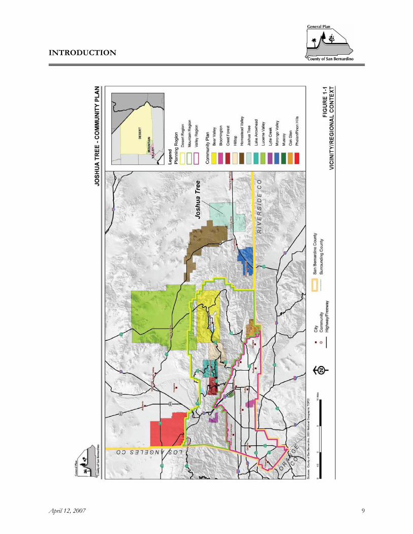
JT1.2.1 LOCATION Joshua Tree is nestled in the foothills in southeastern California’s Mojave Desert and is located in south-central San Bernardino County. The Joshua Tree plan area covers approximately 93.6 square miles. The plan area is generally bordered on the north by the Twentynine Palms Marine Corps Base, partially on the east by the City of Twentynine Palms and Copper Mountain, on the south by the Joshua Tree National Park, on the southwest by the Town of Yucca Valley and on the northwest by the eastern boundary of the Homestead Valley Community Plan area. Joshua Tree is located approximately 76 miles east of San Bernardino and 32 miles northeast of Palm Springs. The plan area is bisected by State Route 62, known as Twentynine Palms Highway (see Figure 1-1, Vicinity/Regional Context). Joshua Tree is near the center of the Morongo Basin region that stretches along Highway 62 from Morongo Valley through Homestead Valley, and includes area north along Highway 247 to Landers and surrounding communities.

INTRODUCTION
April 12, 2007 8
[This page intentionally left blank]
INTRODUCTION
April 12, 2007 9
Figure 1-1, Vicinity/Regional Context

INTRODUCTION
April 12, 2007 10
[This page intentionally left blank]

INTRODUCTION
April 12, 2007 11
JT1.2.2 HISTORY The first known inhabitants of the Joshua Tree area were the hunting and gathering Serrano Tribes. Although the Spanish and the Mormons both explored the area in later years, neither group settled permanently. The 1850’s brought settlements by ranchers and miners as the area continued to be a primary cattle drive route to Arizona. Development began to accelerate somewhat when an access route to the Mojave Basin was developed. In 1963, this access route grew to its current highway status (now the Twentynine Palms Highway) and opened up the area to continued development. In the past several decades, the community has continued to grow with the help of increased recreational travel on the Twentynine Palms Highway to the Colorado River and the nearby Joshua Tree National Park, which was established in 1936 as a National Monument. Joshua Tree National Monument, now a well known tourist attraction, became a wilderness area airshed station in 1977 and a world biosphere reserve in 1984. In 1994 it was named a National Park, resulting in an additional 234,000 acres and 163,000 wilderness acres added to the park’s holdings. Total holdings are approximately 800,000 acres. Other developments from the 1900s include the: Hi-Desert Airport established in 1928-29, Joshua Tree Branch of the County Library established in 1945, the Joshua Tree Chamber of Commerce formed in 1947, and the establishment of the Joshua Tree Fire Protection District in 1948. The Joshua Basin Water District was chartered in 1963. The 1970’s brought the Joshua Tree Community Center and Hi-Desert Playhouse. In 1984, The Joshua Tree Campus of College of the Desert, now known as Copper Mountain College, was built in the Panorama Heights area. While development has gradually increased in the Joshua Tree community, it has been slow; with growth from 7,439 residents in 1990 to about 8,016 in 2000. The original Joshua Tree Community Plan was adopted in September, 1980. The plan was intended as a short range plan to implement those portions of the General Plan that directly affected the community of Joshua Tree. The 1989 General Plan update proposed that comprehensive community plans be incorporated into the General Plan and Development Code, however full incorporation was not completed due to budget and staff constraints. The Phase I Scoping of the 2006 General Plan update, recommended that the Community Plan program be reinstated to help fulfill the need for development guidance within certain unique communities within the County. The Joshua Tree Community was selected as one of 13 areas that would have a community plan prepared in conjunction with Phase II of the San Bernardino County General Plan update.
JT1.2.3 DESCRIPTION OF THE STUDY AREA The Joshua Tree Plan Area is located approximately 76 miles east of San Bernardino, and 32 miles north and east of Palm Springs. Joshua Tree has an average elevation between 2,500 and 3,500 feet above sea level. Its climate is mild to moderate. The area is cooler in the summertime than the low desert areas and warmer in winter than the nearby mountains. Local temperatures can range from a high of 110 degrees Fahrenheit, or higher, to a low of about 32 degrees Fahrenheit. Precipitation is usually in the winter months and is less than 6 inches per year, although sporadic thunderstorms are not uncommon. With the occasional storms, several inches of rain may fall in a single event and can cause erosion of hillside areas and flash-flooding. The high elevation brings occasional winter snows. The planning area has soil composition that ranges from sandy to rocky. The east-west trending Pinto Mountain Fault divides the planning area roughly in half. Joshua Tree provides a preferred habitat for the Joshua tree plant that grows extensively throughout the plan area. The Joshua tree is a defining characteristic of the plan area that bears its name. The vegetative cover for the plan area also consists of yucca and bunchgrass, creosote, juniper, manzanita, catsclaw, sage, cactus and annual wildflowers. Wildlife that are native to the area include desert tortoise, jack and cottontail rabbits,
INTRODUCTION
April 12, 2007 12
coyote, ground squirrels, chuckwalla, pinion jays, eagles, quail, roadrunnersa variety of lizards including collared, leopard, fringe-toed, spiny, fence, side-blotched, night and desert horned lizards, a variety of snakes including colubrid, race, patch-nosed, leaf-nosed, gopher blind snakes and boas, and a variety of migratory bird species. For a detailed list of the sensitive species associated with the various habitats within the plan area. See the Conservation Background Report of the General Plan.
JT1.3 COMMUNITY CHARACTER
JT1.3.1 UNIQUE CHARACTERISTICS Nearby, Joshua Tree National Park, internationally recognized for its rock climbing opportunities, is a popular destination for many tourists interested in recreation opportunities such as hiking, camping and desert nature viewing. The community plan area shares many of the same rural characteristics of the National Park; as it is characterized by an abundance of open space and natural resources. The community plan area has historically been predominantly a retirement and second home community, with limited commercial development. Increased homebuilding and increased full-time population are more recent trends in the community.
JT1.3.2 ISSUES AND CONCERNS A series of public meetings for the preparation of the plan were held in 2003 and 2004. The issues and concerns identified in this section are based on input from those meetings. Several issues set Joshua Tree apart from other desert communities suggesting that different strategies for future growth may be appropriate. Among these are:
A. RELATIONSHIP TO THE JOSHUA TREE NATIONAL PARK
The Park is a significant natural resource that provides residents and visitors with ample scenic, recreation, economic and cultural opportunities. Joshua Tree is a gateway community that serves as an entry point to the Joshua Tree National Park. The west entrance to the Park is located in the southeast portion of the Joshua Tree plan area. In 2001, according to the National Park Service, Joshua Tree National Park had 1,280,917 recreational visitors. Of that total, 1,024,733 were non-local day, hotel and camp visitors. According to the 2001 National Park Service, it was one of the most visited National Parks in California. Joshua Tree National Park attracted more visitors than Sequoia National Park and Redwood National Park, which had 846,895 and 291,264 non-local day, hotel and camp visitors respectively. Many residents believe that as a gateway community, the plan area is ideal for establishment of visitor services, including lodging, food, fuel and automotive services, emergency services and visitor information. Many of the residents in Joshua Tree would like to enhance the availability of goods and services oriented to both local needs and that of visitors; however, in appreciation and recognition of the Park as a vital resource, the community is adamant that the Park be protected.
B. PRESERVATION OF COMMUNITY CHARACTER
Residents feel that the high quality of life experienced in their community should not be degraded by unmanaged growth and the subsequent impacts of traffic congestion, strains on infrastructure and threats to natural resources. The community’s natural beauty is characterized by an abundance of open space, scenic vistas and natural vegetation. As was mentioned previously the National Park is a
INTRODUCTION
April 12, 2007 13
valuable characteristic of the community. The community itself shares many of the same rural, peaceful, scenic and environmentally appealing qualities. Residents are concerned about the conversion of open space to development, particularly to a type of development that detracts from the natural setting and rural character currently enjoyed by the community. Residents have expressed the desire to retain their community character based on the following principles: to be vigilant about the preservation of the natural environment, and to create a central downtown core to enhance their tourist-based economy, without tarnishing the natural beauty of their community.
C. INFRASTRUCTURE
Like much of San Bernardino County, Joshua Tree faces the potential for significant growth. Residents understandably want to ensure that quality services and amenities are provided to meet the needs of a growing full-time population. Residents are particularly concerned about water supply, water quality, and traffic circulation.
JT1.3.3 COMMUNITY PRIORITIES The community’s common priorities that have influenced the goals and policies included within this Community Plan are:
• ENVIRONMENT
A key consideration in developing this Plan has been acknowledging the potential impacts that future development will have on the area’s natural resources. The goals and policies included in this Community Plan emphasize the protection of these sensitive resources, the integration of natural vegetation, open space and development designed to enhance the natural surroundings. In public workshops held to develop the General Plan and this Community Plan, the public has identified the following principal planning issues and concerns to be addressed in the Plan:
A. Preservation of open space. B. Conservation and protection of native wildlife and vegetation. C. Protect and conserve water resources. D. Visual and physical harmony between the natural and manmade environment.
• COMMUNITY CHARACTER AND QUALITY OF LIFE
The Joshua Tree Community Plan area will continue to experience growth as a variety of factors continue to drive people to migrate from more urban areas to areas attractive for their rural nature. As the plan area develops, it will be imperative that adequate services and infrastructure are provided, all improvements reflect the needs of locals as well as visitors, and all development maintains a sense of connection to the natural environment. Relating to community character and quality of life, the public has identified the following issues and concerns to be reflected and addressed in the Community Plan:
A. Acknowledge the service and infrastructure capacity and limitations of the area. B. Promote economic development that generates sustainable revenues, benefits the local people as well
as visitors, is compatible with the natural environment and surrounding uses, and supports conservation.
C. Develop Joshua Tree as a small town with a concentrated commercial and service core.

INTRODUCTION
April 12, 2007 14
D. Promote the development of community-oriented uses and public gathering places that will create a local gathering place, serve the commercial needs of the community and are designed with the rural character of the community in mind.
E. Maintain the value of Joshua Tree’s scenic and natural resources as the foundation of their community character and quality of life.

LAND USE
April 12, 2007 15
2 LAND USE
JT2.1 LAND USE - INTRODUCTION The purpose of the land use element is to address those goals and policies that deal with the unique land use issues of the Community Plan area that are not addressed by the overall County General Plan. Land use, and the policies that govern it, contribute fundamentally to the character and form of a community. With the continuing growth in many of the county’s rural areas, the importance of protecting valuable natural resources and preserving the rural character of these unique areas has become increasingly important. The purpose of the Land Use Policy Map is to provide provisions for orderly growth that will preserve the small town desert character of the community and protect the plan areas natural resources. The Joshua Tree Land Use Policy Map is provided in Figure 2-1. The Joshua Tree Community plan area contains some Bureau of Land Management lands. Those portions of the Bureau of Land Management lands that are within the Joshua Tree Community Plan area comprise 10,199.18 acres, which equates to approximately 17% of the total land area within the plan area. The Bureau of Land Management lands are not under the jurisdiction of the County of San Bernardino. Table 1 provides the general plan land use district distribution for the Joshua Tree Plan area. As shown in Table 1, the most prominent County land use district within the plan area is Rural Living (RL), which makes up approximately 74% or 37,101 acres of the total land area that is under the County’s jurisdiction. The second and third most prominent land use districts within the plan area are Resource Conservation (RC) and Single Residential (RS), which make up approximately 12% and 10% of the total land area under County jurisdiction, respectively. The Joshua Tree plan area also contains Multiple Residential, Community Industrial, Institutional (IN), and several commercial land use districts; however these land use districts only make up a small percentage of the total plan area. The majority of the commercial and industrial land use districts are concentrated along Highway 62 in the southwestern portion of the plan area.

LAND USE
April 12, 2007 16
[This page intentionally left blank]

LAND USE
April 12, 2007 17
Figure 2-1, Land Use Policy

LAND USE
April 12, 2007 18
[This page intentionally left blank]

LAND USE
April 12, 2007 19
Table 1: Distribution of General Plan Land Use Districts
Land Use Districts Area (Acres) 1 Percent of Total Land Area
Resource Conservation (RC) 5,886 12% Rural Living (RL) 17,636 35% Rural Living 5 (RL-5) 18,882 37% Rural Living 10 (RL-10) 205 <1% Rural Living 20 (RL-20) 378 <1% Single Residential (RS) 670 1% Single Residential 10,000 (RS-10M) 1,259 3% Single Residential 14,000 (RS-14M) 710 2% Single Residential 20,000 (RS-20M) 324 <1% Single Residential 1 ac (RS-1) 1,787 4% Multiple Residential 895 2% Office Commercial (CO) 64 <1% Neighborhood Commercial (CN) 44 <1% General Commercial (CG) 363 <1% Service Commercial (CS) 88 <1% Community Industrial (IC) 350 <1% Institutional (IN) 261 <1% Floodway (FW) 128 <1% Total Land Area Within Community Plan Boundary
49,930 100%
Source: URS Corporation
A. Community Character (Land Use Issues/Concerns)
One of the primary concerns expressed by residents was the impact of growth on the character of the community. The rural desert character of the Joshua Tree Community is defined in part by the geographic location, desert environment and low-density residential development. Residential development within the plan area is characterized by large lots, the varied placement of homes, and open spaces around the homes. The character of the community is further defined by the natural environment and by the limited commercial and industrial uses.
Input gathered from residents of the Joshua Tree Community plan area suggests that the primary land use concerns in the Joshua Tree Community are that the rural desert character of the area and the predominance of low-density residential land uses are preserved. Residents also articulated that there is a need to enhance the downtown core to provide a more pedestrian- friendly setting and more opportunity for community interaction. Residents further articulated a desire for commercial services and recreation oriented uses that are compatible with existing development and that will promote tourism and enhance the role of Joshua Tree as a gateway community to the Joshua Tree National Park. However, residents within the plan area perceive the community as lacking adequate
1 Non-jurisdictional lands within the Joshua Tree Community Plan area were extracted from the areas included within the table.
LAND USE
April 12, 2007 20
infrastructure and services, particularly water, paved road network, and stormwater and flood control facilities.
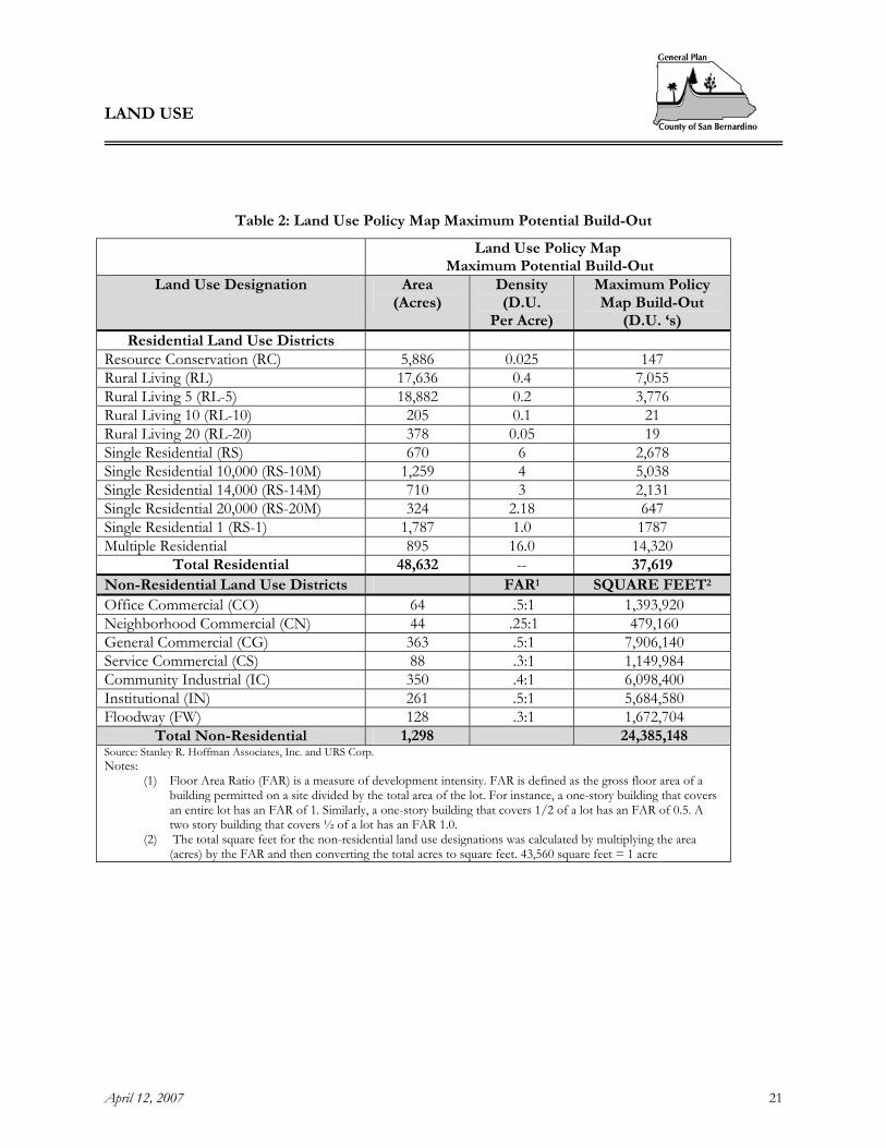
Table 2 provides the Land Use Policy Map Maximum Potential Build-out for the Joshua Tree Community plan area. This build-out scenario provides the maximum build-out potential of the Community Plan area based on the Land Use Policy Map. Table 2 does not account for constraints to the maximum build-out potential. However, the southwest corner of the community plan area, is within the Fire Safety Overlay. In this area, stricter building codes and limits to residential density constrain the development potential.
LAND USE
April 12, 2007 21
Table 2: Land Use Policy Map Maximum Potential Build-Out
Land Use Policy Map Maximum Potential Build-Out
Land Use Designation Area (Acres)
Density (D.U.
Per Acre)
Maximum Policy Map Build-Out
(D.U. ‘s) Residential Land Use Districts
Resource Conservation (RC) 5,886 0.025 147 Rural Living (RL) 17,636 0.4 7,055 Rural Living 5 (RL-5) 18,882 0.2 3,776 Rural Living 10 (RL-10) 205 0.1 21 Rural Living 20 (RL-20) 378 0.05 19 Single Residential (RS) 670 6 2,678 Single Residential 10,000 (RS-10M) 1,259 4 5,038 Single Residential 14,000 (RS-14M) 710 3 2,131 Single Residential 20,000 (RS-20M) 324 2.18 647 Single Residential 1 (RS-1) 1,787 1.0 1787 Multiple Residential 895 16.0 14,320
Total Residential 48,632 -- 37,619 Non-Residential Land Use Districts FAR1 SQUARE FEET2 Office Commercial (CO) 64 .5:1 1,393,920 Neighborhood Commercial (CN) 44 .25:1 479,160 General Commercial (CG) 363 .5:1 7,906,140 Service Commercial (CS) 88 .3:1 1,149,984 Community Industrial (IC) 350 .4:1 6,098,400 Institutional (IN) 261 .5:1 5,684,580 Floodway (FW) 128 .3:1 1,672,704
Total Non-Residential 1,298 24,385,148 Source: Stanley R. Hoffman Associates, Inc. and URS Corp. Notes:
(1) Floor Area Ratio (FAR) is a measure of development intensity. FAR is defined as the gross floor area of a building permitted on a site divided by the total area of the lot. For instance, a one-story building that covers an entire lot has an FAR of 1. Similarly, a one-story building that covers 1/2 of a lot has an FAR of 0.5. A two story building that covers ½ of a lot has an FAR 1.0.
(2) The total square feet for the non-residential land use designations was calculated by multiplying the area (acres) by the FAR and then converting the total acres to square feet. 43,560 square feet = 1 acre
LAND USE
April 12, 2007 22
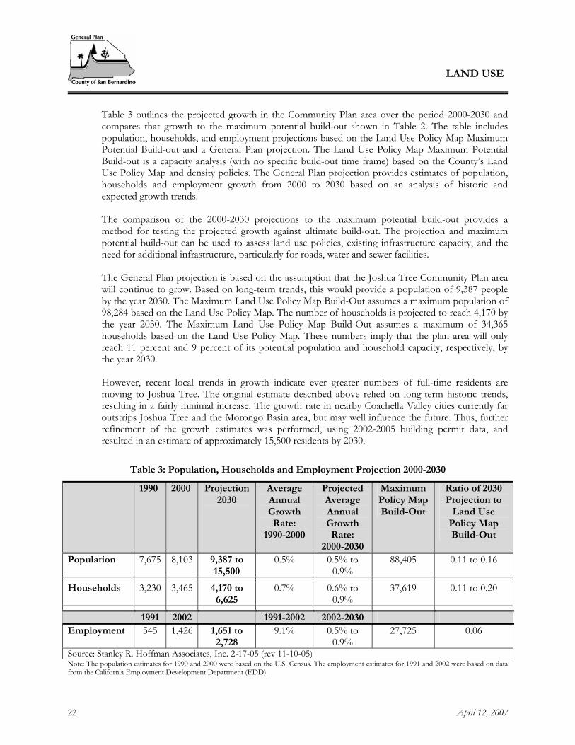
Table 3 outlines the projected growth in the Community Plan area over the period 2000-2030 and compares that growth to the maximum potential build-out shown in Table 2. The table includes population, households, and employment projections based on the Land Use Policy Map Maximum Potential Build-out and a General Plan projection. The Land Use Policy Map Maximum Potential Build-out is a capacity analysis (with no specific build-out time frame) based on the County’s Land Use Policy Map and density policies. The General Plan projection provides estimates of population, households and employment growth from 2000 to 2030 based on an analysis of historic and expected growth trends.
The comparison of the 2000-2030 projections to the maximum potential build-out provides a method for testing the projected growth against ultimate build-out. The projection and maximum potential build-out can be used to assess land use policies, existing infrastructure capacity, and the need for additional infrastructure, particularly for roads, water and sewer facilities.
The General Plan projection is based on the assumption that the Joshua Tree Community Plan area will continue to grow. Based on long-term trends, this would provide a population of 9,387 people by the year 2030. The Maximum Land Use Policy Map Build-Out assumes a maximum population of 98,284 based on the Land Use Policy Map. The number of households is projected to reach 4,170 by the year 2030. The Maximum Land Use Policy Map Build-Out assumes a maximum of 34,365 households based on the Land Use Policy Map. These numbers imply that the plan area will only reach 11 percent and 9 percent of its potential population and household capacity, respectively, by the year 2030. However, recent local trends in growth indicate ever greater numbers of full-time residents are moving to Joshua Tree. The original estimate described above relied on long-term historic trends, resulting in a fairly minimal increase. The growth rate in nearby Coachella Valley cities currently far outstrips Joshua Tree and the Morongo Basin area, but may well influence the future. Thus, further refinement of the growth estimates was performed, using 2002-2005 building permit data, and resulted in an estimate of approximately 15,500 residents by 2030.
Table 3: Population, Households and Employment Projection 2000-2030
1990 2000 Projection 2030
Average Annual Growth Rate:
1990-2000
Projected Average Annual Growth Rate:
2000-2030
Maximum Policy Map Build-Out
Ratio of 2030 Projection to
Land Use Policy Map Build-Out
Population 7,675 8,103 9,387 to 15,500
0.5% 0.5% to 0.9%
88,405 0.11 to 0.16
Households 3,230 3,465 4,170 to 6,625
0.7% 0.6% to 0.9%
37,619 0.11 to 0.20
1991 2002 1991-2002 2002-2030 Employment 545 1,426 1,651 to
2,728 9.1% 0.5% to
0.9% 27,725 0.06
Source: Stanley R. Hoffman Associates, Inc. 2-17-05 (rev 11-10-05) Note: The population estimates for 1990 and 2000 were based on the U.S. Census. The employment estimates for 1991 and 2002 were based on data from the California Employment Development Department (EDD).

LAND USE
April 12, 2007 23
JT2.2 GOALS AND POLICIES Goal JT/LU 1. Retain the existing rural desert character of the community.
Policies JT/LU 1.1 Require strict adherence to the land use policy map unless proposed changes are clearly
demonstrated to be consistent with the community character. JT/LU 1.2 In recognition of the community's desire to preserve the rural character and protect the
area’s natural resources, projects that propose to increase the density of residential land uses or provide additional commercial land use districts or zones within the plan area should only be considered if the following findings can be made: A. That the change will be consistent with the community character. In determining
consistency the entire General Plan and all elements of the Community Plan shall be reviewed.
B. That the change is compatible with surrounding uses, and will provide for a logical transition in the plan area’s development. One way to accomplish this is to incorporate planned development concepts in the design of projects proposed in the area.
C. That the change shall not degrade the level of services provided in the area, and that there is adequate infrastructure to serve the additional development that could occur as a result of the change. Densities should not be increased unless there exist or are assured services and infrastructure, including but not limited to water, wastewater, circulation, police, and fire, to accommodate the increased densities.
JT/LU 1.3 Development shall be required to maintain, conserve and be complementary to
environmentally sensitive areas and elements, including but not limited to: Joshua trees, Mojave yuccas, creosote rings and other protected plants, protected fauna, hillsides, scenic vistas, drainage areas, habitat, and unique geological features.
JT/LU 1.4 Reevaluate existing development standards relative to building heights, standards for
screening mechanical equipment and storage areas, lot coverage, hillside preservation and locational criteria for mechanical installations and infrastructure facilities to ensure adequate protection of scenic vistas and the rural desert character of the plan area.
JT/LU 1.5 Maintain a buffer between adjacent cities and the Joshua Tree community by maintaining
existing Rural Living (RL) districts at the outer edges of the plan area, and by including open space areas and/or conservation easements in new development within and along the perimeter of Joshua Tree.
JT/LU 1.6 Utilize Rural Living (RL) areas to buffer Resource Conservation (RC) areas from more
intensive land uses. JT/LU 1.7 Provide adequate screening such as walls, berms, xeriscape and desert landscape areas in new
developments. JT/LU 1.8 Require screening of storage containers.

LAND USE
April 12, 2007 24
JT/LU 1.9 Develop locally specific landscaping and xeriscaping standards that encourage the use of
native materials such as desert vegetation, boulders, and rustic wood elements.
JT/LU 1.10 Establish rural desert development standards that allow and encourage alternative housing types and construction methods, and that do not impose urban level requirements on rural development.
JT/LU 1.11 Limit future industrial development to those uses which are compatible with the Community
Industrial District or zone, are necessary to meet the service, employment and support needs of the Joshua Tree Community, do not have excessive water requirements, and do not adversely impact the desert environment.
Goal JT/LU 2 Support development of the existing downtown commercial area of Joshua Tree as a focal point and core activity center within the community.
Policies JT/LU 2.1 Support revitalization of the existing downtown commercial area by encouraging tourist
services and recreation-oriented retail uses that retain the natural desert character. JT/LU 2.2 Integrate pedestrian-friendly walkways and public transit stops into downtown areas and
other areas such as schools, hospital and clinics, and shopping areas. Goal JT/LU 3 Enhance commercial development within the plan area that is
compatible in type and scale with the rural desert character, is located appropriately, and meets the needs of local residents and visitors.
Policies JT/LU 3.1 Support the development of existing core areas within the community. Evaluate appropriate
uses for location within and adjacent to these core areas, including retail and service commercial, recreation, and higher density residential uses. Consider the following locations as core areas within the community: A. The existing downtown area, B. The College/Panorama Heights area, C. The Hospital, and D. In the existing commercially designated area, in the Sunfair area, located north of the
Roy Williams (Hi-Desert) Airport. JT/LU 3.2 Consider location of a commercial node in northern Joshua Tree when residential
development is sufficient to create a market for such services, and with sufficient buffering to prevent conflict with existing residential uses.

LAND USE
April 12, 2007 25
JT/LU 3.3 Avoid strip commercial development by encouraging the expansion of commercial uses within well-defined core areas of the community.
JT/LU 3.4 In coordination with the community, develop site design standards for commercial
development to ensure that architectural detailing and signage are compatible with the desert character of the community and contribute to a unifying theme, to ensure that sites are designed to be more pedestrian-friendly and provide adequate parking and buffers between commercial and adjacent residential uses.
JT/LU 3.5 Encourage the development or expansion of commercial uses that are compatible with
adjacent land uses and respect the existing positive characteristics of the community and its natural environment, and that provide buffering from environmentally sensitive areas.
JT/LU 3.6 Discourage regional commercial facilities within Joshua Tree. To avoid “big box”
commercial developments that are out of character with the rural desert community, establish development standards that restrict the size and scale of retail buildings.
JT/LU 3.7 Require desert-type vegetative landscaping or xeriscaping for all commercial and industrial
areas through the development review process. Goal JT/LU 4 Establish locational criteria for future development within the plan
area to ensure compatibility between uses.
Policies JT/LU 4.1 Provide transitional land uses and buffer residential and commercial uses from the highway
corridor and environmentally sensitive areas. JT/LU 4.2 Concentrate development in the existing core areas and discourage urban land use types and
densities in the outer regions. This can be accomplished by maintaining concentrations of Resource Conservation (RC) and Rural Living (RL) land use zones along the boundaries of the plan area, in particular those areas that are adjacent to the National Park.
JT/LU 4.3 Control commercial and industrial traffic impacts by:
A. Locate commercial districts in areas along well-traveled streets and divert commercial traffic away from residential streets. B. Orient commercial and industrial driveways away from residential areas whenever possible.
JT/LU 4.4 Limit “high density” residential development to areas compatible with adjacent land uses and
with adequate, convenient commercial, public services and infrastructure. JT/LU 4.5 Industrial land uses shall be located in areas where industrial uses will best serve the needs of
the community and will have a minimum adverse effect upon surrounding property with minimal disturbance to the natural environment and the total community.

LAND USE
April 12, 2007 26
Goal JT/LU 5. Enhance residential and commercial development by encouraging and accommodating mass transit facilities.
Policies JT/LU 5.1 Where projects are located on or in close proximity to a transit route, work with the
Morongo Basin Transit Authority to incorporate site design features to accommodate and to access mass transit facilities, such as bus stops, bus turn-outs and other passenger amenities.
CIRCULATION AND INFRASTRUCTURE
April 12, 2007 27
3 CIRCULATION AND INFRASTRUCTURE
JT3.1 INTRODUCTION The quality of life and the rural desert character of the community are dependent on the services that are provided. Residents in Joshua Tree expect that services such as water, roads, fire and police protection, and park and recreation facilities are provided at levels that meet their needs. At the same time, it is understood that acceptable levels of service should be provided in accordance with the rural character that is desired. Provisions for services in Joshua Tree should be commensurate with the rural lifestyle and low-density development. The impact of land development on services must be managed to ensure a balance between providing for population growth and preserving the rural character of the community.
JT3.2 CIRCULATION – INTRODUCTION One of the overriding goals expressed by residents of Joshua Tree is to maintain the existing character of the community. The character of the community can be significantly impacted by roads and the traffic generated from the region and the community. The Joshua Tree Community Plan area is located along the southern edge of San Bernardino between the United States Marine Corps Air Ground Combat Center and Joshua Tree National Park. Twentynine Palms Highway (SR-62) provides access from both the Yucca Valley to the west and Twentynine Palms to the east. Old Woman Springs Road (SR-247) is located in close proximity to the western boundary of the plan area and provides access to Lucerne Valley. The vast majority of travel trips in the plan area are made by automobile, using the existing network of state highways and County roads. A. Roadway System
The existing roadway system in Joshua Tree is characterized by a combination of a state highway and local roadways (see Figure 3-1, Circulation). A brief description of the local roadway network follows:
Twentynine Palms Highway (SR-62) is a four-lane state highway that originates as an interchange with I-10 in Riverside County and travels north into San Bernardino County. After passing through the community of Morongo Valley, it continues eastward along the southern edge of the county before terminating at Parker Dam Road and the Arizona State Line.
Aberdeen Drive1 is a two-lane secondary arterial that begins as an interchange with Old Woman Springs Road (SR-247) and extends east to Border Avenue.
Alta Loma Drive is a two-lane primary arterial that extends westward from Park Boulevard/Quail Springs Road. This facility provides a direct connection to the community of Yucca Valley located west of the Joshua Tree Community Planning Area.
1 Traffic counts were not available for this roadway therefore it is not included in Table 4.

CIRCULATION AND INFRASTRUCTURE
April 12, 2007 28
Winters Road2 is an unpaved two-lane roadway that extends eastward from Coyote Valley Road to Timothy Canyon Road. It is currently classified as a secondary highway.
Border Avenue is a two-lane secondary arterial that extends southward from Reche Road to Golden Street.
Coyote Valley Road3 is an unpaved, two-lane secondary highway that extends from Sunfair Road northwest then turns northeast into the United States Marine Corps Air Ground Combat Training Center.
Golden Street is a two-lane secondary arterial that extends between Sunburst Avenue and Border Avenue.
La Contenta Road is an two-lane secondary highway that extends from SR-62 to Vermiculite Mine Road. Between Alta Loma Road and Vermiculite Mine Road, it is unpaved.
Park Boulevard is a two-lane primary arterial that extends southward between SR-62 and Alta Loma Drive.
Quail Springs Road is a two-lane primary arterial that begins at the southern terminus of Park Boulevard and continues southeast before entering the Joshua Tree National Park. This facility is one of the two primary entrances to the park.
Rice Avenue4 is an unpaved, two-lane secondary highway that extends from Broadway to SR-62.
Sunburst Avenue is a two-lane secondary arterial that extends south from Golden Street to SR-62.
Sunever Avenue5 is an unpaved, two-lane secondary highway that extends from Broadway to SR-62.
Sunfair Road is a two-lane secondary arterial that travels north-south from SR-62. It is located immediately east of and used as the primary access to the Roy Williams (Hi Desert) Airport, as well as Copper Mesa Road
Sunny Vista Road is a two-lane secondary arterial that extends between SR-62 and Alta Loma Drive.
Yucca Mesa Road is a two-lane secondary arterial that travels southward from Aberdeen Drive into the community of Joshua Tree.
2 ibid 3 ibid 4 ibid 5 ibid

CIRCULATION AND INFRASTRUCTURE
April 12, 2007 29
Figure 3-1, Circulation

CIRCULATION AND INFRASTRUCTURE
April 12, 2007 30
[This page intentionally left blank]

CIRCULATION AND INFRASTRUCTURE
April 12, 2007 31
During meetings held by the County, residents expressed concerns regarding future traffic congestion, particularly traffic congestion on SR-62, and emphasized the need for alternate routes to SR-62 in the downtown core. SR-62 not only accommodates traffic from the local population but also serves as a major circulation route between the adjacent cities of Twentynine Palms and the Town of Yucca Valley. Identifying and implementing future improvements will be a challenge that will have to address: a) a lack of local control over state-highway improvements and b) improvements that may be in conflict with the community’s desire to maintain the area’s scenic and natural resources and rural desert character.
In addition, residents articulated the need for maintenance and improvements to the existing roadway system, particularly to those roads that are currently subject to frequent flooding. However, residents also emphasized their primary concern, to maintain the rural character of the community. Improvements to the circulation system within the community will need to be compatible with the community’s goal of maintaining the area’s character and scenic and natural resources. Residents expressed a preference that urban improvements such as sidewalks and street lighting be provided only as needed for safety. The operating condition of the roadway system within the plan area was examined in terms of congestion and delay. Table 4 provides the existing and future 2030 roadway operating conditions for major County roads and highways within the Joshua Tree Community Plan area. The operating conditions include: Average Daily Trips (ADT) data, Volume to Capacity (V/C) ratios and Level of Service (LOS) data. The Average Daily Trips (ADT) data was provided by the County Public Works Department. Most of the trips data was collected within the past one to two years. The Volume to Capacity (V/C) ratio was calculated using the traffic counts (or ADT) and is a standard tool for describing the typical operating conditions of a roadway. The Level of Service data is based on the V/C ratio and helps to categorize and describe the degree of congestion on the roadways.
Table 4: Mobility Statistics
Existing 2004 Operating Condition
Future 2030 Operating Conditions
Facility Begin-End ADT V/C LOS ADT V/C LOSAlta Loma Drive Sunny Vista Rd – Park Blvd 3,050 0.244 A 3,890 0.311 A Border Avenue Aberdeen Dr – Golden St 300 0.026 A 1,798 0.156 A Golden Street Sunburst Ave – Border Ave 1,450 0.116 A 1,497 0.120 A La Contenta Road SR-62 – Yucca Tr 2,250 0.180 A 2,976 0.238 A Park Boulevard SR-62 - Alta Loma Dr 2,450 0.196 A 2,562 0.205 A Quail Springs Road Alta Loma Dr – Rainbow Ridge Rd 1,200 0.096 A 1,527 0.122 A Sunburst Avenue Golden St – Crestview Dr
Crestview Dr – SR-62 2,900 4,400
0.232 0.440
A B
2,948 4,980
0.236 0.463
A B
Sunfair Road Broadway – SR-62 900 0.078 A 3,607 0.336 A Sunny Vista Road SR-62 – Prescott Tr 1,000 0.071 A 1,233 0.088 A Yucca Mesa Road Buena Vista Dr – SR-62 3,500 0.280 A 3,935 0.315 A State Highways SR-62 Yucca Mesa Rd – Sunfair Rd 16,600 0.553 C 23,600 0.787 D
Source: Meyer, Mohaddes Associates

CIRCULATION AND INFRASTRUCTURE
April 12, 2007 32
According to Table 4, most roads within the Community Plan area are operating at a level of service A. A level of service A is described as low-volume, free-flow traffic conditions with little or no delay throughout the day. Sunburst Avenue, between Crestview Drive and State Route 62, is operating at a level of service B, and State Route 62 between Yucca Mesa Road and Sunfair Road is operating at a level of service C. Both levels of service B and C are described as stable flow operations with relatively low volumes and acceptable delays experienced throughout the day. However there may be some peak hour congestion
Future 2030 conditions for the Joshua Tree Community Plan Area indicate that major County roads within the plan area are projected to continue to operate at levels of service A. Sunburst Avenue, between Crestview Drive and State Route 62 is projected to continue to operate at a level of service B. Traffic conditions on State Route 62 are projected to worsen to a level of service D. A level of service D is described as approaching unstable flow with poor yet tolerable delays experienced throughout the day. During peak hours, significant congestion and delays may be experienced.
B. Pedestrian and Bicycle Improvements and Public Transit
The plan area lacks appropriate pedestrian and bicycle improvements. Residents have expressed a desire to improve the pedestrian and bicycle circulation system within their community to appeal to both locals and visitors and to create a pedestrian friendly downtown. Creating a pedestrian environment requires provisions for walking and bicycle pathways as well as an inviting streetscape. Creating a pedestrian oriented downtown would provide a focal point for a future system of bike lanes and pedestrian pathways that could extend into the surrounding residential neighborhoods, other activity centers such as the hospital and the college, recreational areas and the entrance to Joshua Tree National Park. Rather than introducing curb, gutter, and sidewalk, the design concept should emphasize use of pervious materials and emulate a rural desert look. Public transit is provided by the Morongo Basin Transit Authority. The downtown area is lacking in transit amenities such as centralized bus stops, shelters and benches that also recognized the use of mobility devices and senior needs.
C. Scenic Routes
Joshua Tree has outstanding desert scenery. The rugged mountains and desert landscape are two examples that characterize these scenic values. Scenic routes play an important role in the preservation and protection of environmental assets and encouraging the growth of tourism - both important aspects of the Joshua Tree community. County Scenic Route designation recognizes the value of protecting scenic resources for future generations and places restrictions on adjacent development including specific sign standards regarding sign placement and dimensions, utility placement, architectural design, grading, landscaping characteristics, and vegetation removal. Joshua Tree contains two County Scenic Routes, SR-62 and Park Boulevard/Quail Springs Road. It is important to maintain the quality of views along these scenic corridors.
CIRCULATION AND INFRASTRUCTURE
April 12, 2007 33
JT3.3 GOALS AND POLICIES - CIRCULATION CIRCULATION
Goal JT/CI 1. Ensure a safe and effective transportation system that provides adequate traffic movement while preserving the desert landscape and rural character.
Policies JT/CI 1.1 Ensure that all new development proposals do not degrade Levels of Service (LOS) on State
Routes and Major Arterials below LOS C. JT/CI 1.2 Establish a circulation system within the plan area that is consistent with adopted land use
patterns, provides adequate connections to regional transportation facilities and provides emergency access, traffic and access control, traffic system management and other improvements in keeping with the desert character and scenic sensitivity of the plan area.
JT/CI 1.3 Design roads to follow natural contours, minimize cuts and fills and disturbance of natural
resources and native protected vegetation wherever possible. JT/CI 1.4 Preservation and protection of sensitive habitats shall have priority over road location,
relocation or realignment, when other practical alternatives are available. JT/CI 1.5 Preserve the status of Twentynine Palms Highway (SR-62) and Park Boulevard/Quail
Springs Road as County scenic routes and ensure protection of their scenic values through the following methods: A. Require compliance with the provisions of the Open Space Overlay; and B. Support the creation of a Hillside Preservation Ordinance that will include standards for
hillside development to regulate densities, address allowable cut and fill heights, soil and slope stability, grading and blending of contours, structural relationships, building foundations, and the like.
JT/CI 1.6 Seek State support and assistance for the designation of Twentynine Palms Highway (SR-62)
as an official State Scenic Highway. JT/CI 1.7 Ensure that new developments are coordinated with the construction of appropriate streets
and highways by encouraging development in the vicinity of existing road systems, to minimize the creation of additional roads until such time that they are needed.
JT/CI 1.8 Where feasible, prohibit the subdivision of land smaller than 2 ½ to 5 acres in size where
adequate paved access cannot be provided for by private or public means. JT/CI 1.9 Consider the ability of existing roads to handle projected traffic increases when reviewing
new development proposals.
CIRCULATION AND INFRASTRUCTURE
April 12, 2007 34
JT/CI 1.10 Coordinate with Caltrans and the local community to identify priorities and establish a plan for repairs and improvements to Twentynine Palms Highway (SR-62) . Priority shall be given to those roadways in need of flood safety improvements. The following roadways have been identified by Joshua Tree residents as requiring flood improvements: A. The intersection of Yucca Mesa/La Contenta and SR-62. Improvements to this
intersection will require coordination with the Town of Yucca Valley; and B. Sunburst Ave, north of SR-62. C. Aberdeen Avenue. D. The intersection of Sunfair Road and SR-62.
JT/CI 1.11 Coordinate with the local community to:
A. Identify priorities and establish a schedule to pave certain roads. B. Provide improved maintenance of dirt roads within the plan area. As part of this review, Public Works shall evaluate establishment of private road maintenance districts for unpaved roads not maintained by the County.
JT/CI 1.12 The general priorities for road paving as of the date of adoption of this plan will be
determined by factors such as public safety and access to schools and other facilities. Current community priorities include the following improvements (priority, exact locations and timing to be established through coordination with the community by County Department of Public Works) :
A. Extend and improve Commercial Way between Sunset and Hallee Road. B. Pave Sunburst Avenue between Golden and Aberdeen Avenues. C. Pave either Center or Rice from SR-62 north to Golden Avenue. D. Pave either Sunflower or Broadway between Sunburst and Sunfair Avenues. E. Select and improve a road south of and parallel to SR-62, between Sunburst Circle and Hallee Road.
JT/CI 1.13 Street lighting shall be provided in accordance with the Night Sky Protection Ordinance and
shall only be provided as necessary to meet safety standards. Streetlighting shall be designed so as not to interfere with star-gazing opportunities locally and in the National Park.
Goal JT/CI 2. Ensure safe and efficient non-motorized traffic circulation within the
community.
Policies JT/CI 2.1 Provide pedestrian improvements in the downtown area to enhance safety, provide a high
quality visitor experience, enhance the character of the area and reduce the need for vehicular travel. Work with Caltrans to provide a pedestrian crossing at Hallee Road and SR-62. Where feasible, separate pedestrian and bicycle traffic from vehicular traffic particularly along SR-62.
JT/CI 2.2 Maintain and improve existing sidewalks, and provide additional sidewalks along main,
paved streets in the central district, such as Park Boulevard, Commercial Street, El Reposo, Sunset Road, and Sunburst Avenue, and Hallee Road.

CIRCULATION AND INFRASTRUCTURE
April 12, 2007 35
JT/CI 2.3 Encourage new commercial developments to provide convenient pedestrian, handicap, and bicycle access, and bicycle parking.
JT/CI 2.4 Where feasible, establish and coordinate a separate system of bikeway and pedestrian trails
connecting residential areas, recreational facilities, activity centers, downtown Joshua Tree and the entrance to the National Park.
JT/CI 2.5 Promote safe and attractive pedestrian and bicycle crossings at logical points on SR-62, and
pursue opportunities to separate pedestrian and bicycle traffic from vehicular traffic. JT/CI 2.6 Provide bicycle lanes adjacent to Twentynine Palms Highway and throughout the planning
area, with safe crossing areas. JT/CI 2.7 Review site plans to determine if residential and commercial developments are designed for
pedestrian use. Future developments shall contain an internal system that connects to local through streets, and considers access to surrounding residential areas, recreational facilities, activity centers, downtown Joshua Tree and the entrance to the National Park.
Goal JT/CI 3. Improve safety on Twentynine Palms Highway (SR-62) in Joshua Tree
for vehicles, pedestrians, cyclists, the handicapped and others, while avoiding unnecessary interference with through traffic.
Policies JT/CI 3.1 Minimize the traffic load on SR-62 by the following:
A. Minimize the number of additional streets and direct access points to SR-62; B. Encourage traffic to enter and exit SR-62 at signalized intersections by providing
protected left turn lanes and a protected left turn in the light sequence; C. Synchronize traffic lights to maximize the flow of through traffic on SR-62 at the posted
speed limit; D. Encourage shared driveways for adjacent commercial and/or industrial uses to minimize
turning movements; E. Provide parallel, alternate routes to SR-62 in the downtown area. F. Request Caltrans review the speed limits and encourage the 45-mph speed zone to be
extended east of Sunburst intersection with SR-62 JT/CI 3.2 Work with Caltrans to provide a continuous center turn lane on SR-62 from Sunny Vista
Road to Hallee Road and from Sunburst to Rotary Way (aka entrance to Copper Mountain Community College)..
JT/CI 3.3 Encourage traffic to enter and exit SR-62 at lighted intersections by providing left turn lanes and a protected left turn in the light sequence.
JT/CI 3.4 Encourage installations of traffic signals on SR-62 to improve safety at the intersections of Rotary Way and Sunset Road, dependent upon traffic studies.

CIRCULATION AND INFRASTRUCTURE
April 12, 2007 36
JT/CI 3.5 All traffic lights from Hallee Road to the Copper Mountain Community College shall have crosswalks and protected crossing for pedestrians and the handicapped.
JT/CI 3.6 Provide bicycle lanes adjacent to SR-62 throughout the plan area to separate those uses from
highway and vehicular traffic. Goal JT/CI 4. Promote alternative modes of transportation.
Policies JT/CI 4.1 Work cooperatively with the Morongo Basin Transit Authority to encourage the expansion
of public transit routes and increased ridership within Joshua Tree as well as the Morongo Basin area.
JT3.4 INFRASTRUCTURE - INTRODUCTION The provision of adequate infrastructure services is essential for maintaining the health and quality of life of a community. Availability of adequate water supplies is a crucial component of supporting population growth. Residents have expressed that protection and preservation of water resources is important for the purpose of not only serving existing and future development but is also important for protection of the area’s natural resources. A. Local Water Service
The public water supply for the Joshua Tree Community is managed by the Joshua Basin Water District, serving over 4,000 connections and 100 square miles. The Joshua Basin Water District has an infrastructure system consisting of five wells, eleven booster stations, nineteen reservoirs, and is in the early planning phases for developing and constructing additional groundwater production wells. All water is obtained from groundwater wells. To meet future growth demands, the District will construct an extension of the Morongo Basin Pipeline to Joshua Tree. The Mojave Water Agency supplies State Project Water via the Morongo Basin Pipeline. The District has noted that their connections have been increasing by an average of approximately 5 percent per year in the last few years. General supply and policy information for the District is presented in Table 5.
Table 5. Public Water Supply
SERVICE PROVIDER
No. of Water Connections
Estimated Population
Served
Estimated Annual Water
Production
Policies Allow
Service outside of
boundaries
Imported Water Source
Annual Imported
water allotment
Imported Water Source amount
Joshua Basin Water District
4,096 8,137 1,777 A.F. NA NA NA 0 A.F.
Those private residents who have their own wells use the same groundwater supply as the Joshua Basin Water District. The local groundwater basin is not naturally recharged, according to research

CIRCULATION AND INFRASTRUCTURE
April 12, 2007 37
by the U.S. Geological Survey (2005).In the future, without recharge these residents will depend on the same imported water supply as the District.
At meetings held by the County of San Bernardino, residents in Joshua Tree expressed concerns about the availability of adequate water supplies to support projected population growth and suggested that water conservation methods be enacted.
B. Local and Regional Water
Joshua Tree is located in the Colorado River Basin, which covers approximately 20,000 square miles and includes portions of San Bernardino, Riverside and San Diego Counties, and all of Imperial County. Although Joshua Tree is regulated by the Colorado River Basin Regional Board, the groundwater supplies are managed in a local capacity by the Joshua Basin Water District. The regional purveyor of State Water Project water is the Mojave Water Agency. Currently, The Joshua Basin Water District does not utilize State Water Project resources but an extension of the Morongo Basin Pipeline is planned to connect to Joshua Tree. The District is entitled to purchase about 1,900 acre/feet per year from the Mojave water agency. Currently, the community uses about 1,700 acre/feet per year. To help meet future demands, the Joshua Basin Water District (JBWD) plans to construct production wells in the adjacent Copper Mountain ground-water sub-basin. The Water District and the USGS have recently studied the geohydrologic framework, recharge estimates, and groundwater flow in the Joshua Tree area. These recent studies indicate that groundwater is a finite resource and there is no significant natural recharge of the basin; thus future usage will eventually deplete this resource.. As growth continues in the desert, there may be a need to import water to supplement the available ground-water resources. The Morongo Basin Pipeline was completed in 1994 and deliveries began in 1995 to the Hi-Desert Water District in nearby Homestead Valley. The Pipeline has capacity to also deliver water to the Big

CIRCULATION AND INFRASTRUCTURE
April 12, 2007 38
[This page intentionally left blank]

CIRCULATION AND INFRASTRUCTURE
April 12, 2007 39
Figure 3-2, Water Districts

CIRCULATION AND INFRASTRUCTURE
April 12, 2007 40
[This page intentionally left blank]

CIRCULATION AND INFRASTRUCTURE
April 12, 2007 41
Horn-Desert View Water Agency, the JBWD and the County of San Bernardino water districts located in Morongo Valley6.
C. Wastewater
No sewer systems exist within the Joshua Tree Community Plan area. There are an unknown number of private septic systems as some properties may have multiple systems. The campground has a RV dump station that is serviced by a private septage company for disposal at the Landers Sanitary Landfill.
The Joshua Tree Community Plan area is located within the Colorado River Water Basin regulated by the Colorado River Regional Water Quality Control Board. The regulating document for this region is the Water Quality Control Plan that was adopted by the Regional Board in 1993 and last amended in November 2002. The Regional Board is currently in the process of developing and updating various regulatory requirements concerning urban runoff, septic systems, groundwater and surface waters in their jurisdiction.
Current regulations do not require a single-family residence of less than five units to report on domestic sewage use and maintenance. If a property is more than five single-family units, 20 mobile home spaces, 50 recreational vehicle spaces or exceeds 5,000 gallons per day, then an annual waste discharge report is required. Currently, for larger, non-residential systems, the Colorado Regional Board requires that “no part of the subsurface disposal systems shall be closer than 150 feet to any water well or closer than 100 feet to any stream, channel, or other water source.” The Regional Board also requires that a sufficient amount of land shall be reserved for a possible 100 percent replacement of the septic system. There is no density restriction at the present time, but it is under review by the Regional Board. The County Department of Environmental Health utilizes the requirements developed by each particular Regional Board.
D. Solid Waste
Residents expressed concerns with illegal dumping and proper waste disposal in their community. Based on input from residents in various desert communities, illegal dumping seems to be a pervasive issue that results in part from people wanting to avoid paying fees to dump at a proper site. Residents further explained that many people are not aware of County-sponsored free dump days. Solid waste is disposed at the Landers Sanitary Landfill. Local hauling services are provided by Waste Management, Inc. Septic tank pumpers utilize the septage disposal facilities at the landfill site. In addition, household hazardous waste is collected monthly at a facility operated by the County Fire Department.
E. Roy Williams (Hi-Desert) Airport
The Roy Williams ( formerly Hi-Desert) Airport is privately owned and serves small aircraft as a Fly-in Bed and Breakfast. No plans have been submitted to change or expand the current use. The
6 Legal matters would have to be addressed before water could be provided to water districts in Morongo Valley..
CIRCULATION AND INFRASTRUCTURE
April 12, 2007 42
Airport’s 2,500-foot runway is centrally located in the Morongo Basin, and is encompassed by relatively sparse development.. While the Twentynine Palms Airport serves as the regional airport for the Morongo Basin, the Roy Williams Airport has the potential to become an important air transportation facility.
JT3.5 GOALS AND POLICIES – INFRASTRUCTURE Goal JT/CI 5. Ensure adequate water sources and associated infrastructure to serve
the needs of existing and future water users in the Joshua Tree Community Plan area.
Policies JT/CI 5.1 Ensure that adequate water supplies and facilities are available or assured prior to approval
of new developments. JT/CI 5.2 Support efforts to continue and improve cooperation and communication among water
providers and the County in addressing water related issues. JT/CI 5.3 Recognize and coordinate with the AB3030 groundwater management plan enacted by the
Joshua Basin Water District in 1996. JT/CI 5.4 Through the environmental and development review process, restrict development that
would cause significant negative effects on the area's groundwater resources. JT/CI 5.5 Coordinate with the Joshua Basin Water District prior to approval for any new wells within
the Joshua Tree plan area. Goal JT/CI 6. Encourage and promote water conservation.
Policies JT/CI 6.1 Support conservation and efficient water use in an effort to minimize the need for new water
sources. JT/CI 6.2 Coordinate with local water providers to provide education for voluntary water
conservation. JT/CI 6.3 Promote the use of native low water use vegetation, especially drought tolerant plants in
landscaping and discourage inappropriate use of vegetation unsuited to the desert climate. JT/CI 6.4 Minimize the use of turf grass. JT/CI 6.5 Promote use of water efficient irrigation practices for all landscaped areas, including the
installation of recycled water systems.

CIRCULATION AND INFRASTRUCTURE
April 12, 2007 43
JT/CI 6.6 Encourage development of a water conservation demonstration garden in the downtown area.
Goal JT/CI 7. Ensure that infrastructure improvements are visually and physically
compatible with the natural environment and desert character of the community.
Policies JT/CI 7.1 Provide mitigation for the visual impacts of infrastructure structures, utilities and mechanical
installations through the development of appropriate screening and location criteria. JT/CI 7.2 Coordinate with service providers to relocate existing overhead utilities underground along
existing roadways and require underground utilities for new developments. JT/CI 7.3 Continue to retrofit street lights to reduce their operating costs and energy usage. JT/CI 7.4 Seek community input on the need for and placement of new street lights or removal of
street lights, especially to maintain local stargazing opportunities. Goal JT/CI 8. Encourage property maintenance and community aesthetics with the
promotion of water and soil conservation, recycling and proper waste disposal.
Policies JT/CI 8.1 Promote water and soil conservation through a variety of measures:
A. Require native and drought tolerant landscaping or xeriscaping in order to reduce watering needs, or retain native vegetation;
B. Promote use of water efficient irrigation practices for all landscaped areas; C. Minimize use of irrigated landscape areas in commercial landscape; Encourage soil
conservation methods for weed abatement that also limit fugitive dust. G. Provide educational materials regarding native desert plant protection ordinance and
protected wildlife. JT/CI 8.2 Continue to provide educational programs regarding locations, days and hours of operation,
recycling, free dump days and other useful information that will keep the public informed on proper solid waste disposal and proper locations for household hazardous waste drop-off facilities.

CIRCULATION AND INFRASTRUCTURE
April 12, 2007 44
Goal JT/CI 9. Provide for the continued viability and safe operation of the Roy
Williams Airport.
Policies JT/CI 9.1 Re-evaluate, and as necessary, revise the established review areas and regulations used to
control the type, height, location and density of uses around the airport. JT/CI 9.2 Restrict or prohibit uses that would adversely affect the safety of persons residing, working
or traveling within the safety review area or the viability of the airport. JT/CI 9.3 Maintain permanent clear zones at both ends of the runways. Goal JT/CI 10. Improve and support community facilities.
Policies JT/CI 10.1 Consider expansion and improvements to the Joshua Tree Library to meet the informational
and educational needs of residents as funds are available.
HOUSING
April 12, 2007 45
4 HOUSING [See the Housing Element of the General Plan]

HOUSING
April 12, 2007 46
[This page intentionally left blank]

CONSERVATION
April 12, 2007 47
5 CONSERVATION
JT5.1 INTRODUCTION Preservation and protection of the Community Plan area’s natural resources is extremely important to the residents of Joshua Tree. These resources contribute to the character and quality of life within the plan area and surrounding region. If the plan area’s sensitive resources are not effectively protected and managed, they will be permanently lost. A. Natural Resources
The natural vegetation and wildlife in the plan area contributes to the beauty and character of the area. During meetings held with the community, residents articulated the need to protect these natural resources as a main concern. Residents are particularly concerned with protection of Joshua Trees, Mojave yuccas and creosote rings.
The plan area is covered with a diverse biotic community of vegetation and wildlife. The plan area includes several general habitat types and respective sensitive species are associated with these habitats (For a detailed list of the sensitive species associated with the various habitats see the Conservation Background Report of the General Plan and the Open Space Overlay).
B. Historical and Cultural Resources
The preservation of historic and cultural resources is also important to residents and their desire to maintain the character of the plan area. Local areas of interest include ancient rock art sites at Coyote Canyon/Coyote Hole, east of Quail Springs Road, and north of Section Six.
C. Renewable Energy Resource
Residents indicated a desire to promote the use of renewable energy resources within the community plan area.
JT5.2 GOALS AND POLICIES It is important to note that some of the key issues and concerns identified under Section 7.1 are also addressed in other elements of the Community Plan. Goal JT/CO 1. Encourage conservation and protection of native wildlife and
vegetation habitats and soils.
Policies JT/CO 1.1 Require future land development to be compatible with the existing topography and scenic
vistas, and protect the natural vegetation.

CONSERVATION
April 12, 2007 48
JT/CO 1.2 Require retention of existing native vegetation for new development projects, particularly
Joshua trees, Mojave yuccas and creosote rings, and other species protected by the Development Code and other regulations. This can be accomplished by: A. Requiring a landscape plan, approved as part of the location and development plan
review and approval process for all new development projects. B. Requiring the Building Official to make a finding that no other reasonable siting
alternatives exist for development of the land prior to removal of a protected plant. C. Encourage on-site relocation of Joshua trees and Mojave yuccas. However, if on-site
relocation is not feasible require developers to consult a list that will be established and maintained in the County Building and Safety Office of residents willing to adopt and care for relocated trees.
D. The developer/home builder shall bear the cost of tree or yucca relocation. E. Retention and transplantation standards will follow best nursery practices.
JT/CO 1.3 Require future development to utilize water conservation techniques. JT/CO 1.4 Reduce disturbances to fragile desert soils as much as practicable in order to reduce fugitive
dust. The County shall consider the following in the development of provisions to limit clearing. A. Parcels of one acre or larger shall not be disturbed or cleared of natural vegetation
unless for the installation of building pads, driveways, landscaping, agriculture or other reasonable uses associated with the primary use of the land, including fire clearance areas.
B. Fire abatement or local clean-up efforts shall be accomplished by mowing or means other than land scraping whenever possible to minimize fugitive dust and windblown sand. When de-brushing or blading is considered the most feasible alternative, additional methods shall be required for erosion control.
C. The County Office of Building and Safety may issue permits for further grading or clearance of vegetation subject to Land Use Compliance review.
JT/CO 1.5 Mechanical removal of vegetation shall be minimized and limited to the building pad and
driveway. JT/CO 1.6 In the landscaping of individual sites, native and other drought tolerant plants shall be
encouraged. JT/CO 1.7 Encourage and educate the public to maintain properties in a manner to minimize fugitive
dust. Goal JT/CO 2. Preserve wildlife corridors between Bureau of Land Management
(BLM) land and Joshua Tree National Park.
Policies JT/CO 2.1 Maintain wildlife corridors along natural washes and other travel areas within the plan area to
facilitate wildlife travel to and from the National Park and BLM lands in north Joshua Tree. Once established, wildlife corridors shall be protected from surrounding development by establishing provisions for their protection. This can be accomplished by:

CONSERVATION
April 12, 2007 49
A. Requiring an appropriate buffer zone, setbacks, and joint use of drainage easements. B. Discouraging fencing and other restraints to wildlife travel. C. Encouraging developers to dedicate additional open space lands to link wildlife
corridors. D. Investigate the official establishment of a wildlife corridor overlay at a local scale, in
conjunction with the National Park. JT/CO 2.2 Flood control improvements shall retain the natural character of drainage areas as much as
possible. Goal JT/CO 3. Preserve significant historical and archaeological sites and structures,
which contribute to the unique character of the Community Plan area.
Policies JT/OS 3.1 During development application review, the County shall refer applications to the
Archaeology Information Center for evaluation of potential significant archaeological and historical resources in the Joshua Tree Community.
JT/OS 3.2 Continue to collect and use existing inventories compiled by local groups, in maintaining its
cultural resource database. JT/OS 3.3 Comply with, and when appropriate, apply county, state and federal laws and rules regarding
protection and preservation of archeological and historic sites and features within the Joshua Tree plan area.
Goal JT/CO4. Encourage utilization of renewable energy resources.
Policies JT/CO 4.1 Through the development process encourage building orientations conducive to utilizing
available solar energy. JT/CO 4.2 Encourage use of renewable and alternative energy systems for residential uses. Goal JT/CO5. Protect and improve the scenic environment adjacent to county-
designated scenic routes on Twentynine Palms Highway and Quail Springs Road in Joshua Tree.
Policies JT/CO 5.1 Preserve the status of Twentynine Palms Highway (SR-62) and Quail Springs Road as
County scenic routes, and ensure protection of their natural features through the following methods:
A. Require compliance with the provisions of the Open Space Overlay. B. Support hillside preservation regulations that will include standards for hillside
development to control densities, allowable cut and fill heights, soil and slope stability,
CONSERVATION
April 12, 2007 50
grading and blending of contours, structural relationships, building foundations, and the like.
JT/CO 5.2 Prohibit off-site advertising signs within the scenic corridor. JT/CO 5.3 Limit the size, height and number of on-premise signs to those necessary for identification. JT/CO 5.4 Screen all outside storage in designated scenic corridors for locations visible from scenic
routes. JT/CO 5.5 Minimize the amount of vegetation removal. JT/CO 5.6 Respect and enforce ordinances relating to endangered, listed, and species of concern. Goal JT/CO6. Provide aesthetically pleasing transitional areas on the borders of the
Joshua Tree plan area, particularly along Twentynine Palms Highway.
Policies JT/CO 6.1 Work with owners of properties within Joshua Tree to obtain conservation easements to
provide aesthetically pleasing gateways to Joshua Tree. Goal JT/CO7. Protect Joshua Tree viewsheds from physical degradation and
inappropriate development.
Policies JT/CO 7.1 Support hillside preservation regulations that will include standards for hillside development
to control densities, allowable cut and fill heights, soil and slope stability, grading and blending of contours, structural relationships, building foundations, and the like.
JT/CO 7.2 Minimize hillside grading throughout the planning area. JT/CO 7.3 Maintain Resource Conservation (RC) or Rural Living (RL) land use districts or zoning on
hillsides. JT/CO 7.4 Identify significant viewsheds and apply the following additional regulations to development
within those viewsheds: A. Limit the slope that can be graded; B. Limit hillside grading and sculpting; C. Limit the size of the area that can be graded relative to the lot size and/or the slope; D. Encourage retention of as much natural vegetation and terrain as possible; E. Impose height restrictions such that new development will not penetrate the ridge lines
in significant viewsheds; and F. Consider adopting regulations that limit the exterior colors, textures and lighting that
can be used within significant viewsheds.
Goal JT/CO8. Preserve the dark night sky as a natural resource to be enjoyed by residents and visitors to Joshua Tree.

CONSERVATION
April 12, 2007 51
Policies JT/CO 8.1 Protect the Night Sky by providing information about and enforcing existing ordinances:
A. Provide information about the Night Sky ordinance and lighting restrictions with each land use or building permit application.
B. Review exterior lighting as part of the design review process. JT/CO8.2 All outdoor lighting, including street lighting, shall be provided in accordance with the Night
Sky Protection Ordinance and shall only be provided as necessary to meet safety standards.

CONSERVATION
April 12, 2007 52
[This page intentionally left blank]

OPEN SPACE
April 12, 2007 53
6 OPEN SPACE
JT6.1 INTRODUCTION The character of the plan area is defined in part by its wide open spaces and natural features including vegetation, wildlife, and topography. Preservation of the area’s open space, scenery and natural resources is one of the most important issues articulated by residents of the Joshua Tree community and will be increasingly important as population growth increases the amount of development and recreational demands in the area. A. Recreation and Parks
The Joshua Tree plan area contains large sections of Bureau of Land Management (BLM) lands and is located adjacent to the Joshua Tree National Park. Approximately 17 percent of the land within the Joshua Tree Community Plan boundary is BLM land. Joshua Tree National Park provides opportunities for camping, rock climbing, nature viewing, etc. and is a major tourist attraction for the region, attracting approximately 1.2 million visitors per year (National Park Service, 2005). Section Six is a 605 acre area designated as Resource Conservation (RC) that is managed by County Service Area 20. Section Six provides recreational day use opportunities for locals and visitors (see Figure 6-1, Jurisdictional Control).
Joshua Tree residents are adamant about protection of the recreational opportunities, natural resources and scenic qualities of their community. As a gateway community to the National Park, management of open space and natural resources is a crucial component of sustaining the area’s economy and quality of life. It will be important to plan for future recreational facilities to ensure that as the area grows, valuable recreational activities are provided to meet the needs of local residents and visitors.
B. Trails
The Joshua Tree Community Plan Area currently does not contain any County-maintained trails that are specifically designated as recreational facilities. The National Park Service is responsible for maintaining any trails located within the Joshua Tree National Park. Community input indicates a need for the development of a multi-use non-motorized trail system linking recreation areas such as the entrance to the National Park and other activity centers such as the downtown and other commercial activity centers within the plan area.
C. Off-Highway-Vehicle (OHV) Use
Residents within the plan area expressed concerns with the unauthorized use of Off-Highway-Vehicles within the plan area. They articulated a need for better enforcement to restrict use of off-highway-vehicles to designated areas. There are no designated OHV areas in Joshua Tree. An ordinance is under development regarding OHV use. Approximately 45 miles north of the plan area, public access is available to the Johnson Valley Off-Highway Vehicle (OHV) Park. The park is over 140,000 acres and is managed by the BLM. It is open to the public for touring and also hosts competitive racing events.

OPEN SPACE
April 12, 2007 54
[This page intentionally left blank]

OPEN SPACE
April 12, 2007 55
Figure 6-1, Jurisdictional Control

OPEN SPACE
April 12, 2007 56
[This page intentionally left blank]
OPEN SPACE
April 12, 2007 57
JT6.2 GOALS AND POLICIES Goal JT/OS 1. Develop parks, recreation facilities and a non-motorized trail system to
meet the recreational needs of the community.
Policies JT/OS 1.1 Establish priorities and work with the County to identify opportunities for park
development and establish a park and recreation plan for the Joshua Tree Community. JT/OS 1.2 Explore the feasibility of developing a park in the Sunfair area. JT/OS 1.3 Encourage the development of recreational facilities within community parks such as,
swimming pools, athletic facilities and community centers when these facilities can be adequately funded and maintained.
JT/OS 1.4 Establish a plan for the development of a local multi-purpose (pedestrian, bicycle, and
equestrian) trail system within Joshua Tree. The plan shall provide trails and trail heads that link the entrance to the National Park, other recreational areas, residential neighborhoods, and commercial nodes.
JT/OS 1.5 When an approved Trails Plan is prepared and adopted, require dedication of easements for
trails as a condition of approval for all development projects, to facilitate community wide trail accessibility. The trail easement shall allow unobstructed trail access and provide connections to off-site trails.
JT/OS 1.6 Provide safe pedestrian access in commercial areas. JT/OS 1.7 Ensure the safety of trail users by providing designated trail crossings on major
roadways and appropriate directional and identification signage. JT/OS 1.8 Discourage unauthorized motorized use of the trail network by posting signage, providing
barriers where appropriate and enforcing violations. Goal JT/OS 2. Preserve open space lands to ensure that the rural desert character and
scenic vistas of the community are maintained.
Policies JT/OS 2.1 Work with the Bureau of Land Management (BLM) to ensure the preservation of BLM
lands within the plan area and surrounding the National Park and the plan area, particularly Section Five and lands contiguous with Section Five.

OPEN SPACE
April 12, 2007 58
JT/OS 2.2 Work with the Bureau of Land Management to explore land exchange opportunities within the plan area that would create a connected system of open space lands for preservation purposes and to maintain wildlife corridors.
JT/OS 2.3 Establish an Open Space land use district or zone and designate lands that should be used
for open space conservation purposes only, including Section Six. JT/OS 2.4 Section Six should continue to be maintained by CSA-20 as a day use only area with no
permanent facilities. JT/OS 2.5 Maintain Rural Living (RL) and Resource Conservation (RC) land use districts or zoning on
steep slopes and remote areas to minimize hillside grading and to protect the rural and natural environment.
JT/OS 2.6 Maintain zoning for low residential density and least intensive uses in areas adjacent to the
National Park to minimize impacts on open space lands and habitat. JT/OS 2.7 Where possible, require that open space areas set aside within individual developments be
contiguous to natural areas adjacent to the site. Isolated open space areas within development shall be specifically discouraged, but may be accepted if no adjacent open space areas are available.
JT/OS 2.7 Use open space corridors to link natural areas. JT/OS 2.8 The Joshua Tree National Park buffer area is recognized as an important open space area that
provides for wildlife movement and other important linkage values. Projects shall be designed to minimize impacts to this area.
JT/OS 2.9 Consider design, construction and maintenance techniques in the County Flood Control
District system, where technically and economically feasible, which allow the growth of habitat and the use of the flood control system by wildlife.
Goal JT/OS 3. Ensure that off-highway vehicle use within the plan area and in the
surrounding region is managed to protect residential uses and environmentally sensitive areas.
JT/OS 3.1 Work with the BLM, National Park Service, law enforcement agencies and adjacent
communities to improve management of off-highway vehicle use by establishing programs for off-highway vehicle use education.
JT/OS 3.2 Strictly enforce Off-Road Vehicle laws. JT/OS 3.3 Utilize signage to notify where OHV use is prohibited.

NOISE
April 12, 2007 59
7 NOISE [See the Noise Element of the General Plan]

NOISE
April 12, 2007 60
[This page intentionally left blank]

SAFETY
April 12, 2007 61
8 SAFETY JT8.1 SAFETY - INTRODUCTION Fire protection and emergency services are among the most crucial of community needs. The quality of life is dependent on the adequacy of these services. Fire hazard severity has been mapped as very high in areas near the intersection of Highway 62 and Sunset Avenue. The fire threat throughout most of the community plan area is considered moderate. However, fire safety is vital in all areas and fire prevention measures, especially vegetation management, is critical throughout the plan area. A. Fire Services
Fire protection services within the plan area are mainly provided in County Service Area 20 (Joshua Tree) by the San Bernardino County Fire Department (SBCFD), which provides administration and support for the fire districts and other services such as hazardous materials regulation, dispatch communication and disaster preparedness. (See Figure 8-1, Fire Districts) In Joshua Tree, the San Bernardino County Fire Department (SBCFD) provides services through the South Desert Division of their department1. The California Department of Forestry and Fire Protection (CDF) is another agency that provides seasonal fire protection services and or fire related information for the Joshua Tree community via mutual aid agreements.
There are three fire stations located within the Joshua Tree community and five more stations located in nearby communities. Table 6 lists the fire stations located within the plan area and provides details regarding the services that each station offers (see Figure 8-2, Fire Stations).
Table 6: Fire Stations
Fire Stations Fire District /Agency
Area Served Equipment Personnel (number and title)
EMT Response Capabilities
Availability of ambulance services
Nearest Medical Facilities
Joshua Tree Station 36
SBCFD Fire crews from the Joshua Tree station routinely assist the National Park Service, Twentynine Palms Fire, and the
The station houses one ICS Type I Engine Company, one Squad vehicle and one reserve engine.
Staffed daily with one Full-time Captain, and one Limited Term Firefighter (L.T.). A staff of
EMT-D Morongo Basin Ambulance (Private)
Hi-Desert Medical Center - Joshua Tree
1 More details on the South Desert Division of the SBCFD can be found in the Safety Background Report of the General Plan.

SAFETY
April 12, 2007 62
Fire Stations Fire District /Agency
Area Served Equipment Personnel (number and title)
EMT Response Capabilities
Availability of ambulance services
Nearest Medical Facilities
Marine Corps Fire Services
paid-call firefighters (PCFs) augment the on-duty crews.
Panorama Heights Station 35
SBCFD Panorama Heights and adjacent area
The station houses one Type II/III Engine Company and one Water Tender.
Fire Station 35 is home to our paid call crews from the local community.
EMT-D Morongo Basin Ambulance (Private)
Hi-Desert Medical Center - Joshua Tree
Copper Mountain Mesa Station 44
SBCFD This station is currently inactive due to staffing shortages. This station is located in the northeastern portion of the Joshua Tree area known as Copper Mountain Mesa. Units from Station 35 (Panorama) or Station 36 (Joshua Tree) handle these incidents.
N/A N/A N/A N/A Hi-Desert Medical Center - Joshua Tree
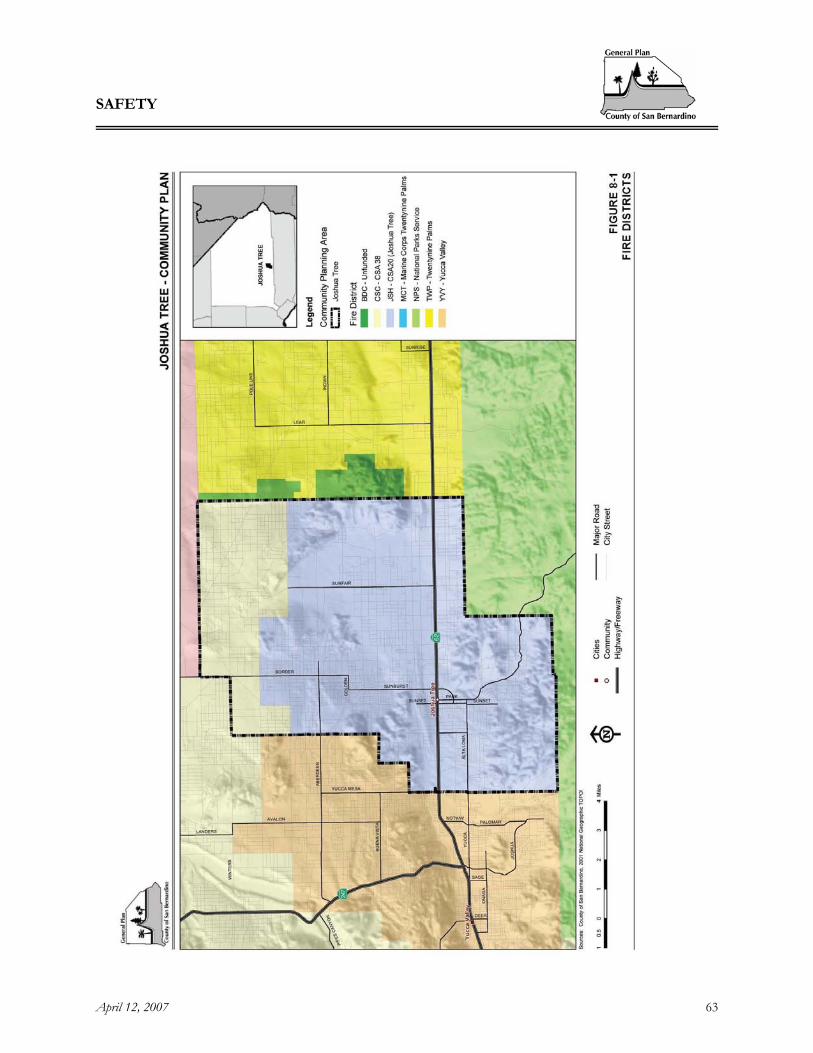
SAFETY
April 12, 2007 63
Figure 8-1, Fire Districts

SAFETY
April 12, 2007 64
[This page intentionally left blank]

SAFETY
April 12, 2007 65
Figure 8-2, Fire Stations

SAFETY
April 12, 2007 66
[This page intentionally left blank]
SAFETY
April 12, 2007 67
B. Evacuation Routes Residents’ primary concerns regarding safety in their community revolve around fire protection and the need for improved evacuation routes. SR -62 and SR-247 are designated as evacuation routes. Specific evacuation routes will be designated during an emergency in order to respond to the specific needs of the situation and circumstances surrounding the disaster and will be handled in accordance with the evacuation procedures contained within the County emergency management plan.
C. Flood Protection
Flood control facilities ensure public safety and welfare and planning, construction and maintenance of these facilities are the responsibilities of the San Bernardino County Flood Control District (SBCFCD). The SBCFCD is subdivided into six zones with interest, responsibilities, or geographical divisions distinctive of the particular zone. The Joshua Tree community plan area generally lies within Zone 6, which encompasses 17,200 square miles covering most of the Desert Region including portions of the San Gabriel and San Bernardino mountains.
In addition the Federal Emergency Management Agency (FEMA) provides a majority of flood hazard mapping in the County. The most common means of planning to avoid or at least mitigate flood damage is participation in the National Flood Insurance Program (NFIP). FEMA administers the program, which makes flood insurance available to those communities that have enacted local ordinances restricting development within the 100 year floodplain. The County is a participant in NFIP. Residents in Joshua Tree expressed a need for improved flood control within the community. Their concerns related to a reoccurring problem with flooding of major roadways within the plan area.
JT8.2 GOALS AND POLICIES
Goal JT/S 1. Provide adequate fire safety measures to protect residents of the plan area.
Policies JT/S 1.1 Ensure that all new development complies with applicable provisions of the Fire Safety
Overlay. JT/S 1.2 Work with the appropriate Fire Protection agencies and the County to ensure that there is
continued evaluation and enhancement of fire protection and fire service needs of the community commensurate with population growth, including the following recommendations: A. Support full staffing of Station 36 downtown; B. Support full staffing and equipping of Station 35 in Panorama Heights; and C. Support construction, full staffing and equipping of Station 44 in Copper Mountain
Mesa. JT/S 1.3 Work with County Supervisors, County Fire and the community to seek appropriate funding
mechanisms for improved fire protection services in Joshua Tree.

SAFETY
April 12, 2007 68
JT/S 1.4 Ensure adequate street signage to provide information for emergency vehicles. Goal JT/S 2. Ensure that emergency evacuation routes will adequately evacuate all
residents and visitors in the event of a natural disaster.
Policies JT/S 2.1 Work with Caltrans to ensure that an adequate road system and proper access are provided
to ensure safe and efficient evacuation for residents and visitors of the desert communities. JT/S 2.2 Work with the various fire agencies, any local Fire Safe Councils, Caltrans and the
community to ensure the development of an effective firebreak system. Goal JT/S 3. Coordinate land use planning efforts with flood control planning and
improvement programs.
Policies JT/S 3.1 Continue to coordinate land use and flood control efforts through the review of capital
improvements and development applications. JT/S 3.2 Utilize the Flood Plain Overlay and Floodway District to identify areas of flood hazard. JT/S 3.3 Minimize land use densities in flood hazard areas. JT/S 3.4 Establish development standards for flood prone areas. JT/S 3.5 Coordinate with appropriate agencies to provide adequate flood protection and funding
mechanisms for needed improvements, including coordination with Caltrans and the County for roadway improvements needed to curtail the major flooding problems within the plan area.
JT/S 3.6 Coordinate with local residents to identify priorities and establish a schedule for local flood
control improvements, including related road improvements within the plan area. JT/S 3.7 Current community priorities include the following improvements (priority, exact locations
and timing to be established through coordination with the community by County Department of Public Works) The following roadways have been identified by Joshua Tree residents as requiring flood improvements: A. The intersection of Yucca Mesa/La Contenta and SR-62. Improvements to this
intersection will require coordination with the Town of Yucca Valley. B. Sunburst Ave, north of SR-62. C. Sunburst, immediately north and south of the elementary school. D. South of SR-62 on Sunset Road. E. South of SR-62 on Park Boulevard. F. Sunfair and SR-62. G. Aberdeen Avenue.

ECONOMIC DEVELOPMENT
April 12, 2007 69
9 ECONOMIC DEVELOPMENT
JT9.1 INTRODUCTION As has been repeated throughout the various elements included within this community plan, one of the most important goals of the Joshua Tree Community is to enhance the community’s economic and cultural opportunities while maintaining the natural desert surroundings. It will be important to ensure that future development protects and enhances the natural resources, scenic beauty and character in order to continue to appeal to both residents and visitors. Joshua Tree National Park is a popular destination that offers opportunities for camping, rock climbing, nature viewing, etc. The National Park is a driving force in the economy of Joshua Tree. The community’s goal is to preserve and protect that asset as key to an expanded eco-tourism and recreation-based economy that also serves local needs. A growing community of artists, musicians and others drawn to the natural beauty of Joshua Tree is another key element of the local economy, attracting new residents and thousands of visitors to local events. In input gathered from residents, there is a strong desire to see the commercial areas, particularly the downtown area enhanced. As a gateway community to the National Park, Joshua Tree is perceived as ideal for establishment of additional recreation facilities, visitor services, including lodging, food service, fuel and automotive, emergency services and visitor information. Many of the residents in Joshua Tree would like to enhance the availability of goods and services oriented to both local needs and that of visitors. However, residents want to ensure that future development is unobtrusive and complements the character of the community. In addition to protecting the National Park and other natural resources including desert landscapes and vistas, the community’s economic plan relies on a small central business district that is pedestrian-friendly and includes community spaces for small gatherings, public displays of art, picnicking and other recreational opportunities.
JT9.2 GOALS AND POLICIES It is important to note that some of the key issues and concerns identified in Section 9.1 are also addressed in other elements of the Community Plan. Goal JT/ED 1. Preserve and protect Joshua Tree's unique and evolving community
atmosphere, artistic base and natural surroundings while providing jobs and improving its tax base.
Policies JT/ED 1.1 Promote diverse architectural styles and alternative construction methods that complement
the local landscape and vistas. JT/ED 1.2 Encourage small commercial footprints that maintain open space areas on site. JT/ED 1.3 Encourage and support small independent businesses.
ECONOMIC DEVELOPMENT
April 12, 2007 70
JT/ED 1.4 Support commercial development that is of a size and scale that complements the natural setting, is compatible with surrounding development and enhances the rural character by incorporating natural desert landscape elements.
JT/ED 1.5 Promote the expansion of home based businesses within the plan area. This may be
accomplished by exploring alternative provisions for home based businesses that are compatible with the rural nature of the plan area. This may allow for relief from certain requirements in the event that the business will provide an overall benefit or needed service to the community and that the use is compatible and/or adequately buffered from adjacent uses.
JT/ED 1.6 Support the expansion of recreational opportunities and facilities that are compatible with
the desert environment and water conservation efforts, and meet the needs of local residents and visitors.
JT/ED 1.7 Support the expansion of educational uses, research and development and healthcare
facilities within the plan area that are compatible with the rural desert character. JT/ED 1.8 Support the expansion of art and music related businesses and facilities including art
galleries, music studios, and outdoor music festivals. JT/ED 1.9 Promote economic development by establishing rural development standards and making
the permit process simpler and more efficient. JT/ED 1.10 Encourage and support the following Joshua Tree resources, and developments that support
and complement them. A long list of attractions and community groups includes but is not limited to: A. Roy Williams Airport; B. Hi-Desert Medical Center; C. Hi-Desert Playhouse and Cultural Center; D. Copper Mountain College; E. The Sportsman's Club; F. The Gem and Mineral Jamboree; G. Joshua Tree RV and Campground; H. The Gram Fest; I. The Joshua Tree Music Festival; J. The Wild West Coyote Fest; K. Turtle Days; L. Chuckwalla Music Festival; M. The Morongo Basin Transportation Authority; N. The Joshua Tree Branch of San Bernardino County Library; O. The Institute of Mental Physics; P. Joshua Tree Parks and Recreation (CSA-20); Q. Joshua Tree Community Center; R. Joshua Tree National Park; S. Joshua Tree National Park Association; T. Joshua Tree Chamber of Commerce; U. Joshua Tree Municipal Advisory Committee; and V. Local homeowners associations.
ECONOMIC DEVELOPMENT
April 12, 2007 71
JT/ED 1.11 Balance economic development with preservation of open space by maintaining
requirements for new and expanded developments to provide landscaped areas and buffers as needed to screen more intensive land uses.
Goal JT/ED 2. Retain the individual community identity of Joshua Tree, and remain
physically and politically separate from adjoining cities of Yucca Valley and Twentynine Palms.
Policies JT/ED 2.1 Discourage the extension of city limits or sphere of influence extending into Joshua Tree
from either Yucca Valley or Twentynine Palms. JT/ED 2.2 To provide separation and buffer from adjoining cities:
A. Maintain Rural Living districts where they exist along the perimeter.. B. Work with owners of properties within and along Joshua Tree’s perimeter to obtain
conservation easements and provide aesthetically pleasing gateways to the community. Goal JT/ED 3. Facilitate development of downtown Joshua Tree as a focal point and
core activity center within the plan area.
Policies JT/ED 3.1 Promote a vibrant and active commercial district in the downtown area with the following
recommendations: A. Create a downtown walking district; B. Improve traffic flow; C. Encourage mixed use zoning in the downtown area; D. Improve off street parking; E. Support and assist local efforts to create centrally located community spaces; F. Promote a pedestrian and bicycle-friendly community; and G. Promote a green and sustainable economy.
JT/ED 3.2 Encourage and support the preparation of a Specific Plan (or other document) for
downtown Joshua Tree which defines the area’s functional role and theme, provides appropriate site design standards and integrates a program for infrastructure.
JT/ED 3.3 The Specific Plan shall include provisions for the following downtown improvements:
A. A downtown plaza/gathering place/outdoor market area, B. Pedestrian/bicycle pathways and improvements, C. Downtown demonstration gardens with native plant life, D. Provisions for public art, and E. Tourist Visitors’ Center.

ECONOMIC DEVELOPMENT
April 12, 2007 72
Goal JT/ED 4. Commercial uses and commercial zoning districts within the community shall be of small scale as needed to provide goods and services to residents and travelers, and shall not be of a regional scale.
JT/ED 4.1 Commercial development shall be compatible with the rural environment, and shall protect
the quality of residential living. JT/ED 4.2 Commercial areas shall be located on heavily-traveled streets so that traffic is minimized
through residential areas. JT/ED 4.3 More intensive uses and higher density shall be located in proximity to existing infrastructure
or regional arterial roads. Goal JT/ED 5. Protect the Joshua Tree National Park and ensure its continuing presence as
a key economic force within the plan area.
Policies JT/ED 5.1 Continue to support and protect the Joshua Tree National Park and maintain the rural
character of Joshua Tree by maintaining low density land uses (RC, RL) in areas near the Park boundaries.
JT/ED 5.2 Focus commercial zoning away from the entrance to the Park. JT/ED 5.3 Continue to protect open space and viewsheds from and near the Park, and views of the
Park through height restrictions, low density zoning, and the native plant protection ordinance.
JT/ED 5.4 Continue to protect native flora and fauna through development review including biological
surveys where appropriate, and require project design and/or mitigation as necessary. JT/ED 5.5 Encourage tourist and recreation based businesses that complement the National Park.
IMPLEMENTATION
April 12, 2007 73
10 IMPLEMENTATION
OVERVIEW
The Community Plan, as part of the General Plan, provides goals and policies intended to guide development in a specific area over the next 25 years. To that end, Community Plans translate broad statements from the General Plan into specific actions designed to direct the physical development and public improvements within the given specific geographical area. Because the Community Plan is part of a long-range plan, the expectation is that some policies will be implemented immediately following the adoption of the General Plan while others will be initiated 10 to 15 years later. Therefore, it is important that key implementation priorities are established and subsequently monitored through a regular, but adaptable annual report process. The overarching goal in the Joshua Tree Community Plan is to maintain the character of the community. While the individual community plans have unique features, they also include common policies set forth in the General Plan. The most critical of these policies relate to two issues; (a) maintaining the existing balance of land uses; and (b) ensuring the adequacy of infrastructure and public services to attend to existing and future development. Implementation of policies related to these two issues shall be treated as priorities and shall be monitored by the annual report.
IMPLEMENTATION APPROACH
CAPITAL IMPROVEMENT PROGRAM (CIP) The County annually prepares a budget for available capital improvement funds, before reviewing all policies important to the development of the various communities. The CIP must then reconcile all competing interests for the budgeted funds. Implementation for many of the policies established in the Community Plan will be contingent upon available County funding. Other policies are considered ongoing and will be incorporated or are already incorporated in everyday activities by various County departments.
NEW POLICIES AND ORDINANCES Implementation measures include existing ordinances and procedures as well as recommended amendments to these measures. Recommendations for new policies and ordinances can promote the implementation of General Plan measures by further clarifying them in respect to the Community Plan area.
SITE PLAN REVIEW PROCESS Site Plan Reviews are required for all new developments. Concurrency issues of a development are reviewed with the site plan to ensure that the level of service for all public facilities will be adequate prior to, or concurrent with the new development. A Site Plan is approved only when its components are in compliance with all zoning and land development requirements.

IMPLEMENTATION
April 12, 2007 74
DEVELOPMENT CODE The purpose of land use regulations is to implement the Joshua Tree Community Plan. These regulations are presented in the Development Code. The Development Code also includes the following overlays:
• Additional Agriculture (AA) • Agricultural Preserve (AP) • Airport Safety (AR) • Alternate Housing (AH) • Biotic Resources (BR) • Cultural Resources Preservation (CP) • Fire Safety (FS) • Flood Plain Safety (FP) • Geological Hazard (GH) • Hazardous Waste (HW) • Mineral Resources (MR) • Noise Hazard (NH) • Open Space (OS) • Paleontologic Resources (PR) • Sign Control (SC) • Sphere Standards (SS)
PROGRESS REPORTING The Community Plan identifies numerous policies that range from area specific to regional and countywide. It is important that implementation of these policies be monitored. In fact, the State requires an annual report on the status of the General Plan and its implementation. The first purpose of the progress report is to inform the County’s Board of Supervisors on the status of implementing the County’s General Plan, including the Community Plans. Secondly, the progress report also provides a means to review the General Plan and determine if changes need to be made to the Plan or its implementation. Finally, the progress report serves as a method to regularly monitor the effectiveness of the General Plan.
California Government Code Section 56400(b)(1) mandates that all non-charter cities and counties submit an annual report to their legislative bodies discussing the status of the General Plan and progress in its implementation. Copies of this progress report must be sent to the Governor’s Office of Planning and Research (OPR) and the Department of Housing and Community Development (HCD). Organization of the report and determination of the relevant issues to include in the County’s annual progress report may be modified from year to year and adapted to incorporate new sources of information, changes in funding sources, and available staff resources. Pursuant to Government Code Section 56700, charter cities are exempt from the progress reporting requirements.


![U2 - The Joshua Tree - Partituras - [Sheet Music - Guitar Book]](https://img.pdfslide.us/doc/110x75/577cc1711a28aba711931193/u2-the-joshua-tree-partituras-sheet-music-guitar-book.jpg)


![[Teacher Name] presents: Saving Joshua Tree](https://img.pdfslide.us/doc/110x75/568130c3550346895d96e251/teacher-name-presents-saving-joshua-tree.jpg)