Embed Size (px)
Citation preview
Visigothic Symposium 2 Ó 2017-2018 ISSN 2475-7462
Late Antique Castros and Their Spatial Milieu in Northwestern Iberia
***
JORGE C. ARIAS UNIVERSITY OF CALIFORNIA, LOS ANGELES
ABSTRACT
Castros, a term used in Iberia to describe presumably defensive settlements, a.k.a.
hillforts, are most commonly associated with Bronze and Iron Age material cultures.
However, since the 1970s, there has been a growing recognition of the various roles
they continued to play after the Roman conquest, both as sites of continued, albeit
changing, forms of habitation and, even when unoccupied, as important nodes in the
mental landscapes of those who lived around them. In the late antique period, their
supposed reuse has been generally viewed as a reflection of a violent environment,
particularly thanks to a few terse passages in Hydatius’s Chronicle that mention
defensive actions centered around castellum. In order to examine this hypothesis, this
paper will look at a complete catalogue of castros with material evidence of use between
the third and eighth centuries CE in the regions of Galicia, Asturias, León, Zamora and
northern Portugal, the Iberian regions with the greatest concentrations of castros and
where their study has been an especially salient theme in scholarship. In particular, this
essay will focus on macro-level spatial relationships between late antique castros,
communication routes, and surrounding archaeological sites from the Roman, late
antique and early medieval periods (roughly the first to tenth centuries CE) to analyze
how castros fit into the late antique environment.
Jorge Arias
Visigothic Symposium 2 Ó 2017-2018 ISSN 2475-7462
2
ESSAY
Castros are settlements located in defensible locations, may also contain artificial
defenses and are the most characteristic archaeological element of northwestern Iberia.
Their name is derived from the Latin castrum, but this appears to be largely a post-
Roman development since the term was usually used to refer to military camps in the
Roman period. The earliest sites identified as castros date to the late Bronze Age around
the eighth and seventh centuries BCE and soon became the principal form of settlement
in northwestern Iberia at least until the first century CE, when, as the traditional
explanation went, the Roman conquest of this region motivated their abandonment in
favor of new lowland settlements. New evidence appearing in the 1970s of later use at
castros, most famously at Viladonga, challenged this interpretation and led to the theory
that these defensible settlements were reoccupied as a response to the barbarian
invasions of the late Roman period. This is the question that launched my doctoral
dissertation research and this brief essay explores a small part of this problem from a
macro-scale perspective analyzing the aggregate relationships between all castros with
evidence of late antique use and their surrounding social environment.1
The theory that the barbarian invasions of the fifth-century caused widespread violence
and motivated the reoccupation of castros is a classic example of textual interpretations
leading the interpretations of archaeological evidence. The main textual basis for this
is a couple of mentions by the fifth-century Gallaecian chronicler Hydatius that some
Hispano-Romans in ciuitates et castella survived the “plagues” brought by the 409
barbarian invasion of Hispania and that those holding the more secure castella killed
1 A warning to keep in mind: due to the constraints of space and a desire to include here as much analysis as possible, I have had to avoid going into specifics about particular sites and have instead included more illustrative descriptions. So, I please ask for your forgiveness if some sections seem too curt.
Jorge Arias
Visigothic Symposium 2 Ó 2017-2018 ISSN 2475-7462
3
or captured some Sueves during one of their raids in the year 430.2 Thus, Hydatius’s
castella were read back into the new late antique finds at castros as both sources seemed
to support the idea of a landscape shaped by violence. While there are many
terminological and chronological issues and questions of castro morphology to unpack
here, since space is limited I shall assume that Hydatius’s castella could have been
situated over today’s castros and see if the physical evidence available to us today could
support this assertion.
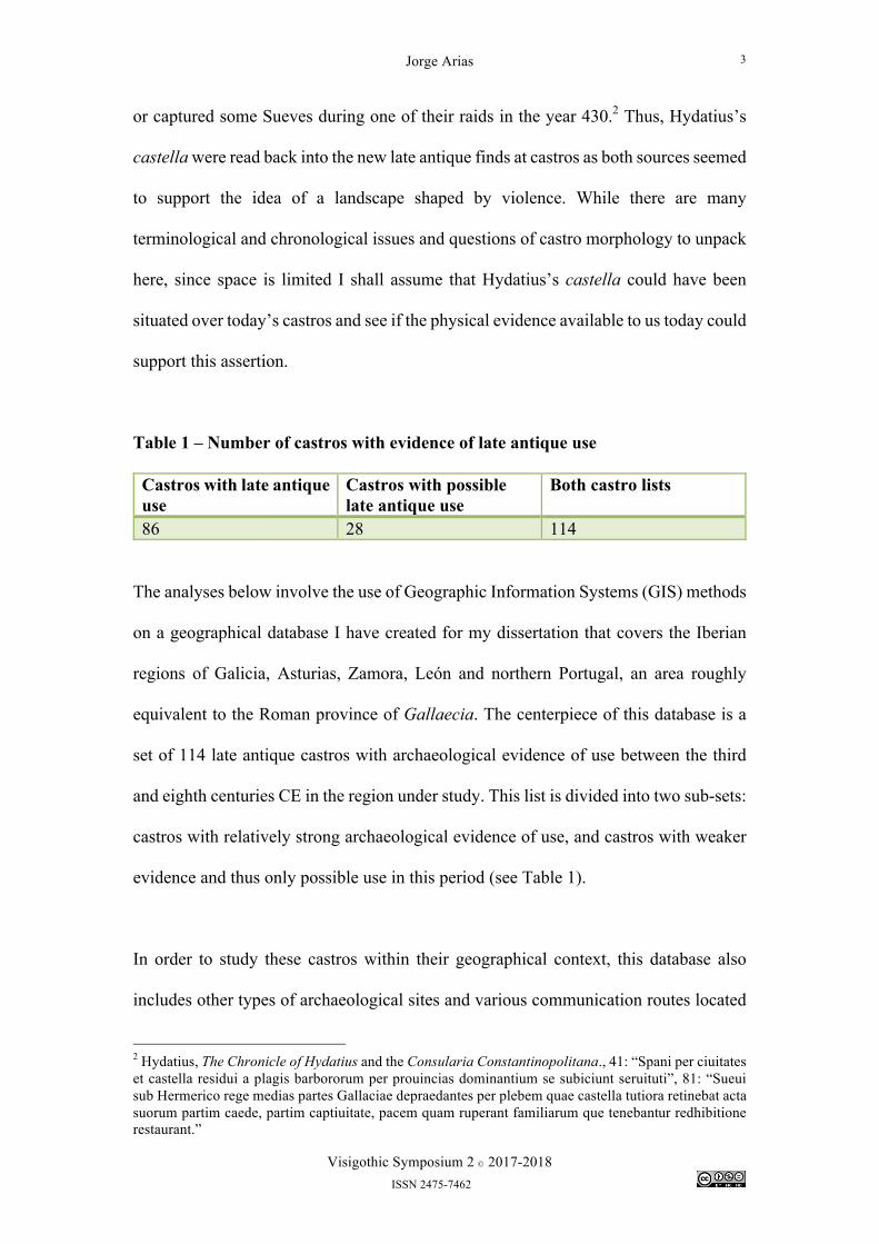
Table 1 – Number of castros with evidence of late antique use Castros with late antique use
Castros with possible late antique use
Both castro lists
86 28 114
The analyses below involve the use of Geographic Information Systems (GIS) methods
on a geographical database I have created for my dissertation that covers the Iberian
regions of Galicia, Asturias, Zamora, León and northern Portugal, an area roughly
equivalent to the Roman province of Gallaecia. The centerpiece of this database is a
set of 114 late antique castros with archaeological evidence of use between the third
and eighth centuries CE in the region under study. This list is divided into two sub-sets:
castros with relatively strong archaeological evidence of use, and castros with weaker
evidence and thus only possible use in this period (see Table 1).
In order to study these castros within their geographical context, this database also
includes other types of archaeological sites and various communication routes located
2 Hydatius, The Chronicle of Hydatius and the Consularia Constantinopolitana., 41: “Spani per ciuitates et castella residui a plagis barbororum per prouincias dominantium se subiciunt seruituti”, 81: “Sueui sub Hermerico rege medias partes Gallaciae depraedantes per plebem quae castella tutiora retinebat acta suorum partim caede, partim captiuitate, pacem quam ruperant familiarum que tenebantur redhibitione restaurant.”
Jorge Arias
Visigothic Symposium 2 Ó 2017-2018 ISSN 2475-7462
4
within a 5 km radius from these castros and variously dated to the Roman, late antique
and early medieval periods (roughly the first to tenth centuries CE). Most of the
surrounding sites are unpublished and gathered from the archaeological archives of the
local governments of the regions under study. The reasons for the wide chronological
coverage for surrounding sites is that there is usually little information available about
them because they have not been excavated, which together with a lack of precise
chronologies for most of the finds they contain, makes them impossible to date
precisely and leads to a significant invisibility of late antique sites. For example, a type
of roofing tile introduced by the Romans, known as tegula, is one of the most common
finds in this region, but its imprecise chronology can only tell us that a site was used
sometime between the first and seventh centuries CE.3 However, whenever tegula is
found at a site, and barring other more precisely dated finds, the dating is usually merely
given as “Roman.” Therefore, the labels used in archaeological databases can be
misleading. The approach followed here does not intend to argue that all surrounding
sites included in this study are related or contemporary to late antique castros, but
rather, to provide a wide temporal perspective to investigate changes in settlement
patterns through time.
3 María L. Ramos Sáinz, “La cerámica de aplicación arquitectónica desde época protoibérica hasta época visigoda (siglos VII a.C. - VII d.C.),” in La ruta de la cerámica: sala Bancaja San Miguel, Castellón, del 1 al 31 de marzo de 2000 (Asociación para la Promoción del Diseño Cerámico, 2000), 33.
Jorge Arias
Visigothic Symposium 2 Ó 2017-2018 ISSN 2475-7462
5
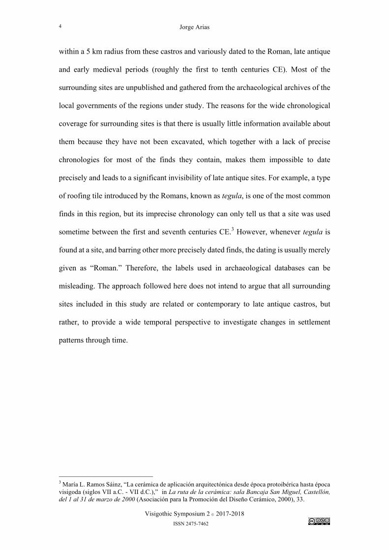
Figure 1 – Three-dimensional map of Viladonga castro (Lugo)
Jorge Arias
Visigothic Symposium 2 Ó 2017-2018 ISSN 2475-7462
6
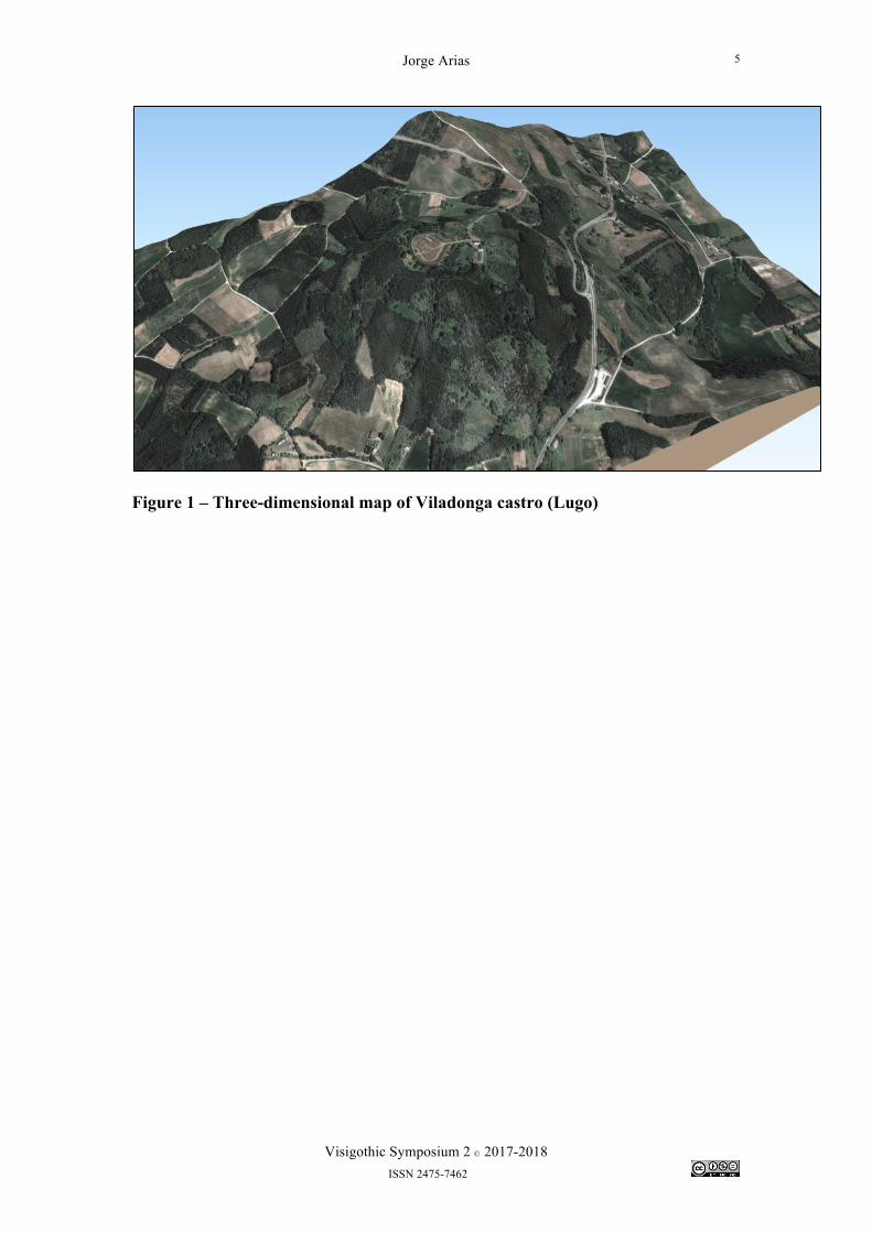
Late Antique Castros and Communication Routes
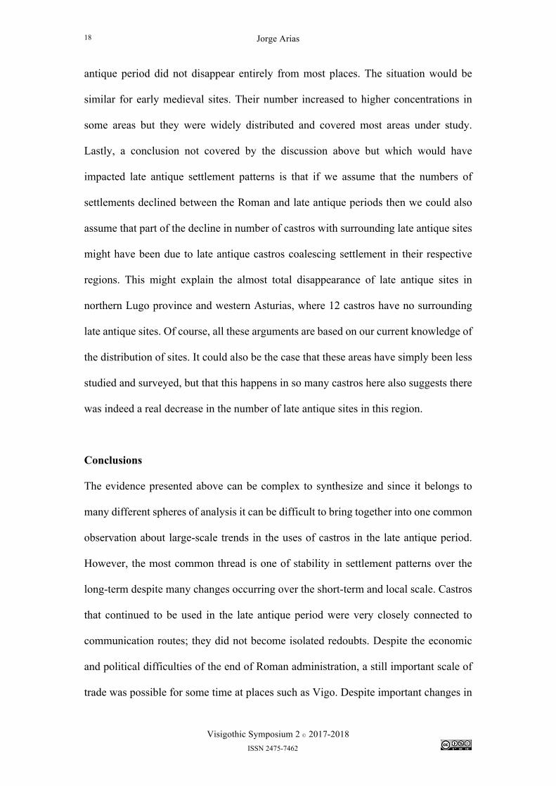
Figure 2 - Map of late antique castros and communication routes; Roman and/or medieval bridges have been removed to avoid cluttering map.
Jorge Arias
Visigothic Symposium 2 Ó 2017-2018 ISSN 2475-7462
7
First, let us begin with the relationships between late antique castros and their conduits
to the outside world. We do not know what the late antique communication network
looked like, but we can approximate some of it by using our fragmentary knowledge of
Roman roads and natural communication routes. The continued use of Roman roads,
of the route if not the physical road itself, is a well known phenomenon in the post-
Roman world.4 For this analysis I have constructed a digital map of Roman roads for
the regions of study based on two recent studies.5 These studies have incorporated both
textual sources, such as the Antonine Itinerary or the Ravenna Cosmography, and
studies of Roman mile markers (miliari) and other physical remains that can reveal
roads that would otherwise remain unknown. Additionally, I have collected
archaeological information on bridges dated to the Roman and/or medieval periods
within the 5 km area of study that I have outlined around each castro. The purpose of
this is to further complete our knowledge of secondary routes of the Roman road
network under the assumption that bridges usually would suggest the existence of a
route passing through them.6
Natural communication routes in this region entail both the ocean and major rivers. The
distribution of imported ceramics does suggest that oceanic trade continued into the late
antique period. Work on trade in the Roman and late antique period has highlighted
how ceramics imported from North Africa and the eastern Mediterranean continued to
flow to northwestern Iberia until the sixth and seventh centuries. These finds are most
4 Michael McCormick, Origins of the European Economy: Communications and Commerce, A.D. 300-900 (Cambridge, UK; New York: Cambridge University Press, 2001), 395. 5 Antonio Rodríguez Colmenero, Santiago Ferrer Sierra, and Rubèn Álvarez Asorey, Miliarios e outras inscricións viarias romanas do noroeste hispánico (Santiago de Compostela: Consello da cultura galega, sección de patrimonio histórico, 2004); Benito Sáez Taboada, As comunicacións romanas na provincia da Coruña (Santiago de Compostela: Edicións Lea, 2003). 6 Note: the inclusion of medieval bridges might seem anachronistic here, but the vast majority of bridges I have collected for this purpose are thought to have Roman-era foundations even if most of the bridge is medieval.
Jorge Arias
Visigothic Symposium 2 Ó 2017-2018 ISSN 2475-7462
8
often concentrated on the coasts.7 Recent work has particularly highlighted the hitherto
unknown importance of Vigo as an Atlantic trade center, as the evidence stands today,
the site with the largest number of late antique finds in the European Atlantic seaboard.8
It is difficult to know the navigable extent of rivers in the late antique period in
northwestern Iberia. Estimates can be made from the distribution of materials more
commonly traded on ships, such as amphorae or goods imported from the
Mediterranean, if these are found in sites in the interior and close to rivers. However,
as mentioned above, most of these distributions in northwestern Iberia are concentrated
on the coasts and only offer a few examples in the interior, which could have also
arrived there by land routes.9 Aside from the Douro/Duero, which is still commercially
navigable up to the border with Spain, and the Minho/Miño, which appears to have
been navigable up to the city of Ourense into the medieval period, rivers in this region
are too small, shallow or have too high a gradient to allow large-scale commercial use
for more than 20-40 km inland. The locations of sites interpreted to be river ports can
illustrate this. The uppermost river ports known in the Roman period on the Ulla and
Navia rivers are located at Pontecesures/Iria Flavia, 15-16 km inland, and at the site
known as Z.R.A de Porto, 6.5 km inland, respectively. This contrasts with the case of
the Douro/Duero mentioned above and two sites located just downriver from the city
of Ourense, Reza and Untes, mentioned as portum in documents dated to 942 and 951
7 Juan L. Naveiro López, El comercio antiguo en el N.W. peninsular: lectura histórica del registro arqueológico (A Coruña: Museo Arqueolóxico e Histórico, 1991), 242-5. See pp. 115-37 and 263 for a discussion of oceanic trade and a map of possible trade routes. 8 AdolfoFernández Fernández, El comercio tardoantiguo (ss. IV-VII) en el Noroeste Peninsular a través del registro cerámico de la Ría de Vigo (Oxford: Archaeopress, 2014), 475-78. 9 An interesting comparison here would be between ceramics imported from the Mediterranean, and which largely follow this pattern of coastal concentration and Late Hispanic Terra Sigillata, which, being produced in interior regions of Spain, mostly in La Rioja and along the Duero valley, seems to have had a strong overland/river distribution route, see Adolfo Fernández Fernández, O comercio tardoantigo no noroeste peninsular. Unha análise da Gallaecia sueva e visigoda a través do rexistro arqueolóxico (Noia: Toxosoutos, 2013), 13-14, 105-08, 175.
Jorge Arias
Visigothic Symposium 2 Ó 2017-2018 ISSN 2475-7462
9
from the Tumbo de Celanova.10 Navigation inland on these two rivers could thus reach
150-200 km upstream. However, even small and shallow rivers can be used to transport
goods on flat-bottom vessels, such as rafts or barges, and this technology would not
have been difficult to maintain.11
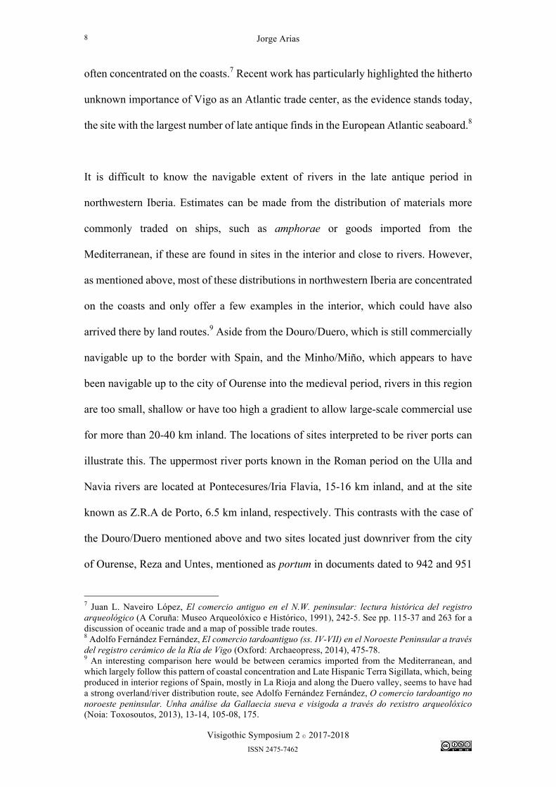
Table 2 - Late antique castros and communication routes Within 5 km of Castros with late
antique use (% of total)
Castros with possible late antique use (% of total)
Both castro lists (% of total)
a Roman road 56 (65.1%) 20 (71.4%) 76 (66.7%) a Roman and/or medieval bridge
29 (33.7%) 12 (42.9%) 41 (36.0%)
the ocean 24 (27.9%) 3 (10.7%) 27 (23.7%) a major river 35 (40.1%) 14 (50.0%) 49 (43.0%) one or more of the above
80 (93.0%) 26 (92.9%) 106 (93.0%)
Table 3 - Distance to nearest communication route Castros with
late antique use Castros with possible late antique use
Both castro lists
Mean distance to nearest communication route
1,972.1 m 1,688.0 m 1,902.3 m
Median distance to nearest communication route
980.4 m 1,298.6 m 1,072.5 m
The charts above summarize a number of relationships and point to some possible
conclusions about the locations of castros that survived in use into the late antique
period and possible elements of a late antique communication network. It stands to
reason that both subsets of castros, those with strong or weak evidence for late antique
10 Jorge López Quiroga, El final de la antigüedad en la Gallaecia: la transformación de las estructuras de poblamiento entre Miño y Duero, siglos V al X (Coruña: Fundación Pedro Barrié de la Maza, 2004), 582-83. 11 For a more in-depth discussion on river trade routes, see Naveiro López, El comercio antiguo en el N.W. peninsular, 137–39, 269.
Jorge Arias
Visigothic Symposium 2 Ó 2017-2018 ISSN 2475-7462
10
use, would have similar relationships with different communication routes since they
are categorized according to evidence and not geography. The most important
exception to this logic is the relationship between castros and the ocean, since there is
a 17.2% difference between both subsets. The best explanation for this discrepancy is
that there is a greater concentration of imported, usually luxury, ceramics found on the
coasts. These imported ceramics often provide the main basis for the dating of
archaeological sites because their widespread distribution and standardized industrial
production has fomented research and made the creation of chronological typologies
much easier. Therefore, particularly for the late antique period, we simply know more
about coastal sites and can date them better and with more confidence, so therefore they
tend to have stronger evidence for late antique use.
While some of these relationships on their own do not suggest a high degree of
correlation between the locations of castros and communication routes, for example,
that only 27.9% of castros with late antique use are located within 5 km of the ocean,
combining all routes together we get a more complete picture. Thus, we can see that a
very high number, 93%, are located within 5 km of at least one communication route.
Also, this measurement only varies by 0.1% between both sub-sets of castros. As we
can see in Table 3, the mean distances to the nearest communication route are not very
distant, but are even smaller if compared to the median distances. The important
disparities between the mean and median distances (829.8 m in the case of both castro
lists) show that there is an important number of outliers that are quite far from
communication routes and increase the mean. It entails, then, that for most late antique
castros the nearest communication route is located closer to the 1 km median distance
than the 2 km mean distance (approximately). Finally, castros with late antique use,
Jorge Arias
Visigothic Symposium 2 Ó 2017-2018 ISSN 2475-7462
11
possible late antique use and both castro lists have, respectively, an average of 1.92,
2.00 and 1.94 different communication routes within a 5 km radius, which means that
the vast majority of late antique castros were linked to more than one route within this
territory.
Analyzing castros not located within 5 km of any communication route would also help
us contrast these results. There are eight such castros: six with strong evidence and two
with possible late antique use. They all share a common feature, they are all located in
more remote mountainous areas of Lugo, Asturias and León, and near the Serra do
Cando. It might be argued that this high correlation is due more to the wide coverage
of the communication network used in this analysis. If we look at the map in Figure 2
above, this might make sense in areas of Galicia and northern Portugal where the
communication network is more dense. However, none of the castros without a route
within 5 km are located in the more sparsely populated Meseta regions of Zamora and
eastern León. If anything, the castros in this area seem to be more closely tied to Roman
roads or rivers than elsewhere. All the evidence points to a logical conclusion: that
castros with continued use into the late antique period were clearly intertwined with the
communication network.
Jorge Arias
Visigothic Symposium 2 Ó 2017-2018 ISSN 2475-7462
12
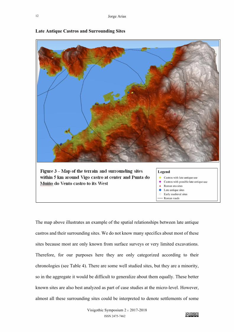
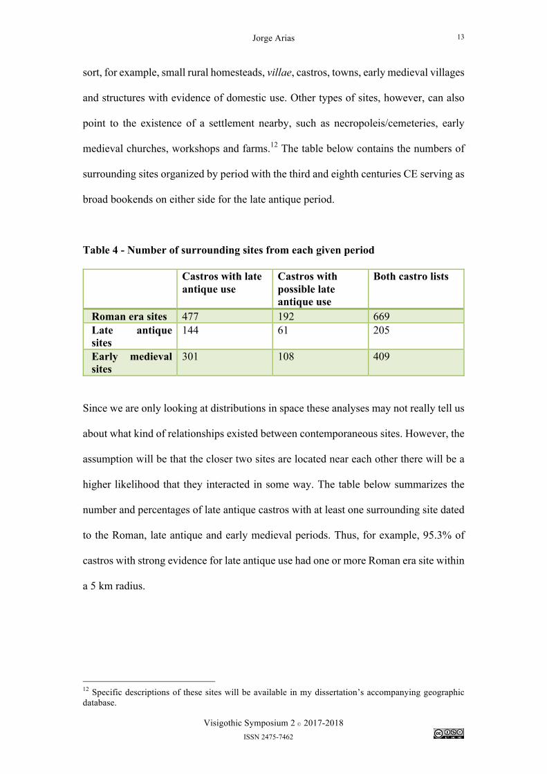
Late Antique Castros and Surrounding Sites
The map above illustrates an example of the spatial relationships between late antique
castros and their surrounding sites. We do not know many specifics about most of these
sites because most are only known from surface surveys or very limited excavations.
Therefore, for our purposes here they are only categorized according to their
chronologies (see Table 4). There are some well studied sites, but they are a minority,
so in the aggregate it would be difficult to generalize about them equally. These better
known sites are also best analyzed as part of case studies at the micro-level. However,
almost all these surrounding sites could be interpreted to denote settlements of some
Jorge Arias
Visigothic Symposium 2 Ó 2017-2018 ISSN 2475-7462
13
sort, for example, small rural homesteads, villae, castros, towns, early medieval villages
and structures with evidence of domestic use. Other types of sites, however, can also
point to the existence of a settlement nearby, such as necropoleis/cemeteries, early
medieval churches, workshops and farms.12 The table below contains the numbers of
surrounding sites organized by period with the third and eighth centuries CE serving as
broad bookends on either side for the late antique period.
Table 4 - Number of surrounding sites from each given period Castros with late
antique use Castros with possible late antique use
Both castro lists
Roman era sites 477 192 669 Late antique sites
144 61 205
Early medieval sites
301 108 409
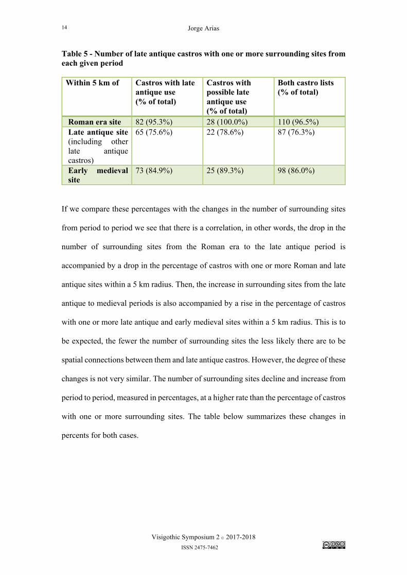
Since we are only looking at distributions in space these analyses may not really tell us
about what kind of relationships existed between contemporaneous sites. However, the
assumption will be that the closer two sites are located near each other there will be a
higher likelihood that they interacted in some way. The table below summarizes the
number and percentages of late antique castros with at least one surrounding site dated
to the Roman, late antique and early medieval periods. Thus, for example, 95.3% of
castros with strong evidence for late antique use had one or more Roman era site within
a 5 km radius.
12 Specific descriptions of these sites will be available in my dissertation’s accompanying geographic database.
Jorge Arias
Visigothic Symposium 2 Ó 2017-2018 ISSN 2475-7462
14
Table 5 - Number of late antique castros with one or more surrounding sites from each given period Within 5 km of Castros with late
antique use (% of total)
Castros with possible late antique use (% of total)
Both castro lists (% of total)
Roman era site 82 (95.3%) 28 (100.0%) 110 (96.5%) Late antique site (including other late antique castros)
65 (75.6%) 22 (78.6%) 87 (76.3%)
Early medieval site
73 (84.9%) 25 (89.3%) 98 (86.0%)
If we compare these percentages with the changes in the number of surrounding sites
from period to period we see that there is a correlation, in other words, the drop in the
number of surrounding sites from the Roman era to the late antique period is
accompanied by a drop in the percentage of castros with one or more Roman and late
antique sites within a 5 km radius. Then, the increase in surrounding sites from the late
antique to medieval periods is also accompanied by a rise in the percentage of castros
with one or more late antique and early medieval sites within a 5 km radius. This is to
be expected, the fewer the number of surrounding sites the less likely there are to be
spatial connections between them and late antique castros. However, the degree of these
changes is not very similar. The number of surrounding sites decline and increase from
period to period, measured in percentages, at a higher rate than the percentage of castros
with one or more surrounding sites. The table below summarizes these changes in
percents for both cases.
Jorge Arias
Visigothic Symposium 2 Ó 2017-2018 ISSN 2475-7462
15
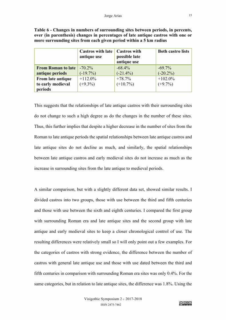
Table 6 - Changes in numbers of surrounding sites between periods, in percents, over (in parenthesis) changes in percentages of late antique castros with one or more surrounding sites from each given period within a 5 km radius Castros with late
antique use Castros with possible late antique use
Both castro lists
From Roman to late antique periods
-70.2% (-19.7%)
-68.4% (-21.4%)
-69.7% (-20.2%)
From late antique to early medieval periods
+112.0% (+9.3%)
+78.7% (+10.7%)
+102.0% (+9.7%)
This suggests that the relationships of late antique castros with their surrounding sites
do not change to such a high degree as do the changes in the number of these sites.
Thus, this further implies that despite a higher decrease in the number of sites from the
Roman to late antique periods the spatial relationships between late antique castros and
late antique sites do not decline as much, and similarly, the spatial relationships
between late antique castros and early medieval sites do not increase as much as the
increase in surrounding sites from the late antique to medieval periods.
A similar comparison, but with a slightly different data set, showed similar results. I
divided castros into two groups, those with use between the third and fifth centuries
and those with use between the sixth and eighth centuries. I compared the first group
with surrounding Roman era and late antique sites and the second group with late
antique and early medieval sites to keep a closer chronological control of use. The
resulting differences were relatively small so I will only point out a few examples. For
the categories of castros with strong evidence, the difference between the number of
castros with general late antique use and those with use dated between the third and
fifth centuries in comparison with surrounding Roman era sites was only 0.4%. For the
same categories, but in relation to late antique sites, the difference was 1.8%. Using the
Jorge Arias
Visigothic Symposium 2 Ó 2017-2018 ISSN 2475-7462
16
same analyses, but compared with castros with strong evidence for use between the
sixth and eighth centuries instead, the differences were 2.2% and 1.6% respectively for
surrounding late antique and early medieval sites. Therefore, the hypothesis that castros
with use in the later part of the late antique period would have been located within 5
km of an early medieval site at a higher rate does not hold true, and the same for castros
with use in the earlier part of the late antique period in relation to Roman era sites. This
second round of analysis thus results in the same conclusion as above, that the
distribution of surrounding sites in the space of our area of study, despite changes in
the number of surrounding sites, was rather stable.
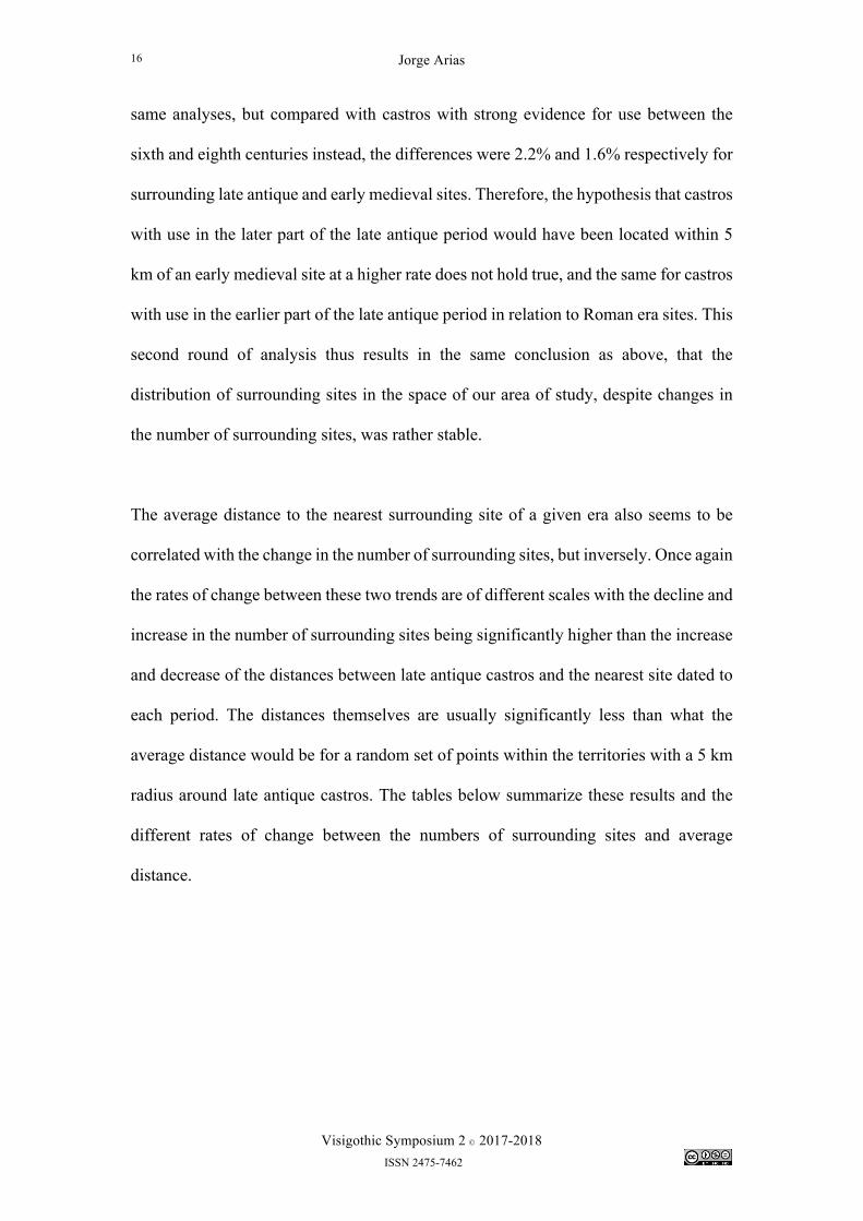
The average distance to the nearest surrounding site of a given era also seems to be
correlated with the change in the number of surrounding sites, but inversely. Once again
the rates of change between these two trends are of different scales with the decline and
increase in the number of surrounding sites being significantly higher than the increase
and decrease of the distances between late antique castros and the nearest site dated to
each period. The distances themselves are usually significantly less than what the
average distance would be for a random set of points within the territories with a 5 km
radius around late antique castros. The tables below summarize these results and the
different rates of change between the numbers of surrounding sites and average
distance.
Jorge Arias
Visigothic Symposium 2 Ó 2017-2018 ISSN 2475-7462
17
Table 7 - Average distance to nearest site (Observed Mean Distance)13 Castros with late
antique use Castros with possible late antique use
Both castro lists
Roman era site 1,569.1 m 1,691.8 m 1,630.5 m Late antique site (including other late antique castros)
2,189.4 m14 2,015.2 m 2,102.3 m
Early medieval site
1,768.5 m 1,751.0 m 1,759.8 m
Table 8 - Changes in numbers of surrounding sites between periods, in percents, over (in parenthesis) changes in the average distance to the nearest site for each given period, in percents. Castros with late
antique use Castros with possible late antique use
Both castro lists
From Roman to late antique periods
-70.2% (+39.6%)
-68.4% (+19.1%)
-69.7% (+28.9%)
From late antique to early medieval periods
+112.0% (-19.2%)
+78.7% (-13.1%)
+102.0% (-16.3%)
The differences in these rates of change suggest a few conclusions. First, that declines
and increases in the number of surrounding sites in different periods did not
proportionally impact the spatial relationships between late antique castros and
surrounding sites. Second, it follows then, that Roman era sites declined more sharply
in regions where they already had a higher concentration and that settlement in the late
13 This calculation only includes late antique castros that have at least one late antique site located within 5 km of them. This is due to the list of late antique sites being a sample based on the locations of late antique castros. If this were not controlled, then castros without late antique sites around them would skew the average distance since this would be calculated according to their nearest late antique site, which could be located anywhere outside the 5 km radius. So, for example, a castro that might be located 5.5 km from the nearest late antique site, but which site would not be catalogued here since it lies outside the study area, would have a nearest neighbor distance calculated according to a late antique site surrounding another castro further away. 14 The longest average distance observed here is for castros with strong evidence of late antique use and late antique sites, but this measurement was actually increased by the inclusion of three pairs of castros with no surrounding late antique sites but within 5 km of each other. If we did not include these cases the distance would be 11.6% smaller at 1,935.3 m.
Jorge Arias
Visigothic Symposium 2 Ó 2017-2018 ISSN 2475-7462
18
antique period did not disappear entirely from most places. The situation would be
similar for early medieval sites. Their number increased to higher concentrations in
some areas but they were widely distributed and covered most areas under study.
Lastly, a conclusion not covered by the discussion above but which would have
impacted late antique settlement patterns is that if we assume that the numbers of
settlements declined between the Roman and late antique periods then we could also
assume that part of the decline in number of castros with surrounding late antique sites
might have been due to late antique castros coalescing settlement in their respective
regions. This might explain the almost total disappearance of late antique sites in
northern Lugo province and western Asturias, where 12 castros have no surrounding
late antique sites. Of course, all these arguments are based on our current knowledge of
the distribution of sites. It could also be the case that these areas have simply been less
studied and surveyed, but that this happens in so many castros here also suggests there
was indeed a real decrease in the number of late antique sites in this region.
Conclusions
The evidence presented above can be complex to synthesize and since it belongs to
many different spheres of analysis it can be difficult to bring together into one common
observation about large-scale trends in the uses of castros in the late antique period.
However, the most common thread is one of stability in settlement patterns over the
long-term despite many changes occurring over the short-term and local scale. Castros
that continued to be used in the late antique period were very closely connected to
communication routes; they did not become isolated redoubts. Despite the economic
and political difficulties of the end of Roman administration, a still important scale of
trade was possible for some time at places such as Vigo. Despite important changes in
Jorge Arias
Visigothic Symposium 2 Ó 2017-2018 ISSN 2475-7462
19
the numbers of surrounding sites around castros, decreasing between the Roman and
late antique periods and then increasing to the early medieval period, there are no
regions that experienced a significant disappearance of settlements and no regions that
concentrated settlement beyond already existing long-term patterns. This suggests that
castros in the late antique period generally did not attract population movements from
other settlements, although there might be some exceptions as mentioned above in
northern Lugo and western Asturias. All of this suggests that castros were integral parts
of their respective settlement networks. This is an important point because the tendency
to separate castros from other types of settlements often creates the impression that
settlement patterns change according to the categories in which we have organized
them. The reality is that castros were just another type of settlement that experienced
changes according to the same local socio-economic and cultural conditions that
affected other settlements in their regions rather than simply based on their specific
attribute as defensive sites.
Jorge Arias
Visigothic Symposium 2 Ó 2017-2018 ISSN 2475-7462
20
Bibliography Primary Hydatius. The Chronicle of Hydatius and the Consularia Constantinopolitana. Edited and translated by R. W. Burgess. Oxford Classical Monographs. Oxford: Clarendon Press, 1993. Secondary Fernández Fernández, Adolfo. O comercio tardoantigo no noroeste peninsular. Unha análise da Gallaecia sueva e visigoda a través do rexistro arqueolóxico. Noia: Toxosoutos, 2013. Fernández Fernández, Adolfo. El comercio tardoantiguo (ss. IV-VII) en el Noroeste Peninsular a través del registro cerámico de la Ría de Vigo. Oxford: Archaeopress, 2014. López Quiroga, Jorge. El final de la antigüedad en la Gallaecia: la transformación de las estructuras de poblamiento entre Miño y Duero, siglos V al X. Colección Galicia histórica. Coruña, España: Fundación Pedro Barrié de la Maza, 2004. McCormick, Michael. Origins of the European Economy: Communications and Commerce, A.D. 300-900. Cambridge, UK; New York: Cambridge University Press, 2001. Naveiro López, Juan L. El comercio antiguo en el N.W. peninsular: lectura histórica del registro arqueológico. A Coruña: Museo Arqueolóxico e Histórico, 1991. Ramos Sáinz, María L. “La cerámica de aplicación arquitectónica desde época protoibérica hasta época visigoda (siglos VII a.C. - VII d.C.).” In La ruta de la cerámica: sala Bancaja San Miguel, Castellón, del 1 al 31 de marzo de 2000, 32–37. Asociación para la Promoción del Diseño Cerámico, 2000. Rodríguez Colmenero, Antonio, Santiago Ferrer Sierra, and Rubén Álvarez Asorey. Miliarios e outras inscricións viarias romanas do noroeste hispánico. Santiago de Compostela: Consello da cultura galega, sección de patrimonio histórico, 2004. Sáez Taboada, Benito. As comunicacións romanas na provincia da Coruña. Santiago de Compostela: Edicións Lea, 2003.