Embed Size (px)
Citation preview

prepared by:
Joplin Area Transportation Study Organizationp p y gJoplin Area Transportation Study OrganizationJoplin Area Transportation Study Organization
JOPLIN AREA TRANSPORTATIONSTUDYORGANIZATION
2030 LONG RANGE TRANSPORTATION PLAN
October 2010
CJW Transportation Consultants, LLCHWS Consulting Group, Inc.Land Vision, Inc.
Joplin Area Transportation Study Organization2030 LONG RANGE TRANSPORTATION PLAN
FINAL DRAFT
������������
����������� �������� ������������������ ������������������� ������������������
�������
���������������������
�����
��
������������� � ����������������������������������� ���������������������������
� ����� ��������������
�����������!��������"���#�������#�����������������#��������!�� ��������� �$�������� ��� �!��� ������� ��� ���� ����������� ��#����� �!���� �#� �!�� %������� ���!"��&�'�������������%���������������&�'����������������(��������)�����'�����#�����������������

Table�of�CJATSO�203
TABLE�O
JATSO�
Table�of�
Section�1
Backgro1.1�1.2�1.3�
1.31.3
1.4�1.41.4
1.5�1.51.5
1.6�1.61.6
Section�2
Existing2.1�
2.12.12.12.1
2.2�2.22.22.2
2.3�2.32.3
2.4�2.42.42.4
2.5�2.52.52.5
Section�3
2030�M3.1�3.2�
Contents�30�Long�Rang
OF�CONTEN
O�2030�
Contents�__
1�_________
ound�and�IntPurpose�of�SRole�of�JopliThe�Long�Ra
.1� Public�I
.2� Review�Planning�Fac
4.1� Demog4.2� Environ
Plan�Elemen.1� Major�T.2� Goals�a
�Plan�Implem.1� Plan�Ap.2� Plan�Us
2�_________
g�Conditions�ARoadway�Ne
.1� Functio
.2� Daily�Tr
.3� Bridge/
.4� High�CrTransit�Syste
.1� Existing
.2� Public�T
.3� Public�TNon*Motoriz
.1� Past�Pla
.2� ExistingAviation� ___
4.1� Recent�4.2� Existing4.3� Comme
Freight� ____.1� Rail�___.2� Truckin.3� Industr
3�_________
Modal�Recomm2030�Travel�Roadway�Re
ge�Transporta
NTS�LONG�RA
___________
___________
roduction�__Study/Introducn�Area�Transponge�Transportanvolvement� _of�Existing�Do
ctors�________raphic�Trends�
nmental�Issues�ts� _________
Transportationnd�Objectives�
mentation� ___pproval�Processse�__________
___________
Assessment�etwork�______onal�Classificatiraffic�Counts�an/Overpass�Condash�Locations�
em�_________g�Transit�and�PaTransit�OperatiTransit�Facilitiezed�Circulationans�and�Studieg�Non*Motorize____________Airport�Develo
g�Airport�Facilitercial�Flight�Op________________________g�__________ial�Parks� ____
___________
mendations�Demand�Modecommendatio
ation�Plan
ANGE�TR
__________
__________
____________ction�________ortation�Study�ation�Planning
_____________cumentation�_
_____________________________________
_____________�Issues�__________________
_____________s�___________
_____________
__________
________________________
on� _________nd�Level�of�Serditions� __________________
_____________aratransit�Servions� ________
es___________n� ___________s�___________ed�Circulation�
_____________opments�_____ties�_________
perations�_________________________________________________________
__________
___________el� __________ns�__________
JATSO�2030�Lo
RANSPOR
___________
___________
_______________________Organization�(�Process� ____
____________________________________________________________________________________________________________________________________
___________
___________________________________rvice�____________________________________________vices�________________________________________________________Facilities�____
________________________________________________________________________________________________
___________
___________________________________
ong�Range�Tra
TATION�P
__________
__________
_________________________(JATSO)�______
____________________________________________________________________________________________________________________________________________________________
__________
________________________________________________________________________________________________________________________________________________________________________________________________________________________________________________________________________________
__________
______________________________________
ansportation�P
PLAN�
___________
___________
___________________________________________________________________________________________________________________________________________________________________________________
___________
___________________________________________________________________________________________________________________________________________________________________________________________________________________________________________________________
___________
___________________________________
Plan�
T
________� T
__________
__________________________________________________________________________________________________________________________________________________________________________________________________
__________
________________________________________________________________________________________________________________________________________________________________________________________________________________________________________________________________________________
__________
______________________________________
TOC�1�
TOC�1�
__�1�1�
__�1�1�__� 1*1�__� 1*1�__� 1*1�__� 1*3�__� 1*3�__� 1*4�__� 1*4�__� 1*8�_�1*12�_�1*12�_�1*12�_�1*15�_�1*15�_�1*15�
__�2�1�
__�2�1�__� 2*1�__� 2*1�__� 2*3�__� 2*6�__� 2*9�_�2*10�_�2*11�_�2*12�_�2*16�_�2*16�_�2*16�_�2*19�_�2*21�_�2*21�_�2*22�_�2*23�_�2*23�_�2*23�_�2*24�_�2*26�
__�1�1�
__�1�1�__� 1*1�__� 1*6�
Table�of�CJATSO�203
3.23.23.2
3.3�3.4�
3.43.4
3.5�3.6�
Section�4
Financi4.1�
4.14.14.14.14.14.1
4.2�4.24.24.2
4.3�4.34.34.34.34.3
4.4�4.5�
�
LIST�OF�T�Table�1.1:�JTable�1.2:�JTable�1.3:�JTable�1.4:�J�Table�2.1:��Table�2.2:��Table�2.3:�Table�2.4:�Table�2.5:��Table�3.1:�Table�3.2:�Table�3.3:��Table�3.4:���
Contents�30�Long�Rang
.1� Roadwa
.2� Transpo
.3� TranspoTransit�SysteNon*Motoriz
4.1� On*Roa4.2� Off*Roa
Aviation� ___Freight� ____
4�_________
al�Plan�_____Funding�Sou
.1� Federal
.2� Federal
.3� Missou
.4� Local�Fu
.5� Other�F
.5� Total�PrRoadway�Fin
.1� Roadwa
.2� Project�
.3� Fiscally*Transit�Finan
.1� Local�Fu
.2� Commu
.3� State�Fu
.4� Federal
.5� SummaAviation�FinaNon*Motoriz
TABLES�
Joplin�Area�EstJoplin�Area�ProJoplin�Area�EstJoplin�MSA�Ra
Daily�Volumes2009�Traffic�V
Bridge/OverpaBridges�with�PMajor�Area�Tru
Committed�Pro2030�E+C�ForePotential�RoadTravel�Deman
ge�Transporta
ay�Constructioortation�Systemortation�Demaem�_________zed�Circulation
ad�Facility�Oppoad�Facility�Opp________________________
___________
___________rces�________l�Highway�Progl�Transit�Prograri�Department�unding�ProgramFunding�Prograrojected�Fundinancial�Plan�__ay�ImprovemeEvaluation�and*Constrained�Rncial�Plan�____unding�______unity�Match�__unding�______l�Funding�____
ary�of�Transit�Fancial�Plan�___zed�Financial�P
timated�Changojected�Changetimated�Changcial�Characteri
s�and�Levels�ofVolumes,�Capacass�Rating�Defioor�Ratings�in�ucking�Compan
ojects�in�2030�ecasted�Traffic�dway�Projects�
nd�Model�Outp
ation�Plan
n�___________m�Managemennd�Manageme
_____________n� ___________ortunities�____ortunities�____
__________________________
__________
_________________________grams�_______ams�_________of�Transporta
ms�__________ams�_________ng�2011*2030
_____________nt�Project�Costd�Prioritization
Roadway�Impro_________________________________________________________________unding�______
_____________Plan�_________
ge�in�Populatioe�in�Population
ge�in�Housing�...stics�................
f�Service�for�Urcities,�and�Levenitions�............the�Joplin�Are
nies�.................
E+C�Network�..Volumes,�Leve.......................ut:��Summary�
JATSO�2030�Lo
____________nt�__________ent�_________________________________________________________________________________
___________
_______________________________________________tion�Programs
________________________
_______________________ts�__________n�___________ovement�Plan________________________________________________________________________________________________
n�....................n�...................................................................
rban�Streets�...el�of�Service�..........................a�...........................................
.......................el�of�Service�fo.......................of�Project�Com
ong�Range�Tra
_____________________________________________________________________________________________________________________
__________
___________________________________________________s�__________________________________________________________________________________________
____________________________________________________________________________________________________________________
.......................
.......................
.......................
.......................
.......................
.......................
.......................
.......................
.......................
.......................r�Selected�Link.......................
mparison�.........
ansportation�P
____________________________________________________________________________________________________________
___________
_______________________________________________________________________________________________________________________________________________________________________________________________________________________________________________
........................
........................
........................
........................
........................
........................
........................
........................
........................
........................ks�.....................................................................
Plan�
T
_____________________________________________________________________________________________________________________
__________
___________________________________________________________________________________________________________________________________________________________________________________________________________________________________________________________________
.......................
.......................
.......................
.......................
.......................
.......................
.......................
.......................
.......................
.......................
.......................
.......................
.......................
TOC�2�
__� 1*6�__� 1*8�_�1*10�_�1*10�_�1*12�_�1*12�_�1*15�_�1*15�_�1*16�
__�1�1�
__�1�1�__� 1*1�__� 1*1�__� 1*2�__� 1*2�__� 1*3�__� 1*4�__� 1*6�__� 1*8�__� 1*8�_�1*10�_�1*14�_�1*17�_�1*17�_�1*18�_�1*18�_�1*18�_�1*18�_�1*19�_�1*19�
....�1*4�
....�1*5�
....�1*5�
....�1*7�
....�2*4�
....�2*5�
....�2*6�
....�2*9�
..�2*24�
....�1*1�
....�1*2�
....�1*7�
....�1*8�

Table�of�CJATSO�203
Table�4.1:�Table�4.2:�Table�4.3:�Table�4.4:�Table�4.5:�Table�4.6:�Table�4.7:�Table�4.8:��
LIST�OF�F�Figure�1.1:Figure�1.2:Figure�1.3:Figure�1.4:Figure�1.5:
Figure�2.1:Figure�2.2:Figure�2.3:Figure�2.4:Figure�2.5:Figure�2.6:Figure�2.7:Figure�2.8:Figure�2.9:Figure�2.10Figure�2.11
Figure�3.1:Figure�3.2:�Figure�4.1:Figure�4.2:
�
Contents�30�Long�Rang
Estimated�FunPotential�RoadPotential�ProjeComparison�ofRoadway�ProjeFiscally�ConstrEstimated�FedProject�Transit
FIGURES�
�Study�Area�...�Joplin�MSA�Es�Average�Trave�Water�Resour�Manmade�Re
�Access/Mobil�JATSO�Functio�Typical�Arteri�Volume�to�Ca��State�Bridge���Joplin�Traffic��Public�Transit�Sunshine�Lam��Current�Purp
0:��Current�Res1:�Freight�Netw
�Volume�to�Ca�Paths�and�Tra
�Fiscally*Const�MAPS�Fundin
ge�Transporta
ding�Projectiodway�Project�Cect�Alternativef�Project�Operaect�Benefit/Corained�2030�Roeral,�State,�andt�Revenue/Exp
.......................stimated�Changel�Time�to�Worrces�.................sources/Featu
ity�Relationshional�Classificatal�Capacities�...pacity�Ratio�anRatings�...........Crash�Analysis�Ridership�Tren
mp�Trolley�Routoses�of�Transit
sidence�of�Ridework�................
pacity�Ratio�anails�...................
trained�Roadwg�Share�by�Juri
ation�Plan
ns�for�Roadwaost�Estimates�.�Evaluation�Criational�Cost�Sast�Summary�....
oadway�Improvd�Local�MAPS�Fenses,�2011*20
.......................ge�in�Employmrk�per�Block�Gr.......................res�..................
p�....................tion�Map�................................
nd�Level�of�Ser.......................s�Intersectionsnds�over�the�Ptes�...................t�Trips�.............
ers�of�Transit�..........................
nd�Level�of�Ser.......................
ay�Plan�...........isdiction�..........
JATSO�2030�Lo
y�Improvemen.......................iteria�..............
avings�....................................vement�Plan�...Funding�throug030�................
.......................ment�................roup�in�Southw..............................................
.......................
.......................
.......................rvice,�2009�Bas.............................................ast�Ten�Years�.............................................................................................
rvice,�2030�E+C.......................
.......................
.......................
ong�Range�Tra
nts......................................................................................................................................gh�TIP�....................................
.......................
.......................west�Missouri�................................................
.......................
.......................
.......................se�Network�......................................................................................................................................................................
C�Network�..............................
.......................
.......................
ansportation�P
........................
........................
........................
........................
........................
........................
........................
........................
........................
........................
........................
........................
........................
........................
........................
........................
........................
........................
........................
........................
........................
........................
........................
........................
........................
........................
........................
........................
Plan�
T
.......................
.......................
.......................
.......................
.......................
.......................
.......................
.......................
.......................
.......................
.......................
.......................
.......................
.......................
.......................
.......................
.......................
.......................
.......................
.......................
.......................
.......................
.......................
.......................
.......................
.......................
.......................
.......................
TOC�3�
....�1*7�
....�1*9�
..�1*10�
..�1*12�
..�1*13�
..�1*15�
..�1*17�
..�1*18�
....�1*2�
....�1*6�
....�1*7�
..�1*10�
..�1*11�
....�2*1�
....�2*2�
....�2*4�
....�2*7�
....�2*8�
..�2*10�
..�2*13�
..�2*14�
..�2*15�
..�2*15�
..�2*28�
....�3*5�
..�3*14�
..�4*16�
..�4*17�

Chapter�
Section�1�Backgrou
1 SECTION
BACKG�1.1� P�A�Long�Raregion’s�tfuture� neAlthough�meant� to�issues�as�i�For�metroyears.� � Mthese� plaupdate,�o�
1.2� R
The� JoplinJoplin� mcomprehearea.��Theand�stateThe�vario(includes�Webb�CityDepartmeHSTCC�is�tarea�in�Sofor� the� sCartervilleOronogo,�Area� incluurbanizedare�not�cuboundarythe�red�lin�
1.3� T�The� deveundertakicommunit�
nd�and�Introd
N�1�GROUND�
PURPOSE�O
ange�Transporansportation
eeds� to� bettethe�plan�prooffer� strateg
identified�and
opolitan�areaMetropolitan�
ns� by� federance�adopted,
ROLE�OF�JO
n� Area� Transetropolitan�ensive”�regione�JATSO�Study�agencies�meus�agencies�rMAPS�and� Sy,�City�of�Carent� of� Transpthe�Regional�outhwest�Missmaller� mune,� Cliff� Village
Saginaw,� Shuding� jurisdicd�area�boundaurrently�urba
y�directly�corrne.���
THE�LONG�R
elopment� of�ing� of� transpty�leaders�wit
duction�
AND�INT
OF�STUDY/I
rtation�Plan�(n�infrastructuer� accommodvides�an�extegies� and�actiod�as�they�arise
s�such�as�JopPlanning� Org
al� legislation.�,�will�extend�t
OPLIN�AREA
sportation� Starea.� � An�nal�transporty�Area�is�comeet�periodicarepresented�dunshine�Lam
rl�Junction,�Japortation� (MPlanning�Com
ssouri;�two�ofnicipalities� we,� Dennis� Ac
hoal� Creek� Drctional� boundary.��JATSO�isnized,�but�ca
responds�to�t
RANGE�TRA
the� 2010� uortation� stakthin�the�JATS
TRODUCT
NTRODUCT
(LRTP)�is�a�doure.��It�presendate� the� expended�outlooons� that� can�e.�
plin,�the�LRTPganizations� (M
� The� LRTP� wthe�previous�
A�TRANSPO
tudy� OrganizaMPO� is� reqation�plannin
mprised�of�mally�through�adirectly�by�thp� Trolley� tra
asper�County,oDOT� D7),� a
mmission�thatf�those�count
within� the� Stcres,� Duenwerive,� Shoal� Crdaries� is� shows�also�requirean�be�expectehe�extent�of�
ANSPORTA
pdate� to� thekeholders� in� tO�Study�Area
JATSO�2030�Lo
TION�
TION�
ocument�that�nts�an�evaluatpected� changok�–�at�least�2
be� impleme
P�is�required�tMPOs)� are� sewas� last� updaplanning�hori
ORTATION�S
ation� (JATSOquired� to� c
ng�and�projecny�jurisdictio�policy�board
he�voting�memnsit�and� Jopl,�Newton�Cou
and� the� Harryt�provides�comties�are�Jaspetudy� Area� ineg,� Duquesnereek� Estates,�wn� on�Figured�to�develop�
ed�to�urbanizthe�JATSO�St
ATION�PLAN
e� JATSO� Lonthe� area,� the
a.�
ong�Range�Tra
serves�as�a�gtion�of�the�cuges� in� deman20�years�fromnted� in� the� s
to�be�updateetup� by� and�ated� and� adoizon�to�2030.
STUDY�ORG
)� is� the� fedeconduct� a� “ct�programmions;�represend�that�oversembers�of�pollin�Regional�Aunty,�the�Souy� S� Truman�mmunity�plan
er�and�Newtoncluding� Airpe,� Grand� Falls
Silver� Creeke�1.1.� � The�bl
transportatioe�over�the�netudy�Area�jur
NNING�PRO
ng� Range� Trae� general� pub
ansportation�P
guide�to�a�regurrent�systemnd� for� transpm�the�presentshort*term� to
ed�no�less�oftgiven� the� au
opted� by� JAT�
GANIZATIO
erally� designa“continuing,�ng�process�fotatives�from�
ees�and�approicy�board�areAirport� repreuthwest�Distr
Coordinatingnning�servicen.��HSTCC�is�tport� Drive,�s� Plaza,� Leaw
k,� and� Redingue� line� repreon�plans�that�ext�20�years.�risdiction�and
OCESS�
ansportation�blic,� technica
Plan�
gion�regardingm�and�that�sys
portation� sert�–�the�plan�io� begin� to� ad
ten�than�everuthority� to� uTSO� in� 2005.�
ON�(JATSO
ated� MPO� focooperative,
or�the�MPO’s�municipal,�cooves�MPO�ace�the�City�of�Jesentation),�Cict�of�the�Mis
g� Council� (HSes�for�a�four�cthe�represenBrooklyn� He
wood,� Loma�gs� Mill.� � The�esents� the� ex
include�area�This�20*year
d�is�represent
Plan� was� a�al� consultants
1�1�
g�that�stem’s�rvices.��s�also�
ddress�
ry�five�pdate�� This�
O)�
or� the�,� and�study�
ounty,�ctions.��Joplin�
City�of�ssouri�STCC).��ounty�tative�
eights,�Linda,�Study�
xisting�s�that�r�area�ted�by�
joint�s,� and�

��������
���� �������
��������
�������
����������
�������
��������
�������������
�����������
������������� ��������������
!�������"���
#�������$��� ��
%����&����'�(
������������
� ���������)�����
� ������**�+�����
�����
�
����
����
����
����
����
����
��
�����
�����
�����
�����
"�������
��
�� �**����������
����
�
��,��
�����������
!�
��������!�
�
-� �������
)�.���������
/0���������
01� �������
�����
����2�����
�3���#�����
4����(������
�������0151
��������&������5,5

Section�1�Backgrou
1.3.1��A� series� otelevisionarticle�in�acommunitmeeting.�social� serhaulers;�cthese�fochouse�for�In�additiophone�coposted� aquestionncomment�1.3.2��A�Long�Raincorporaefforts�anreviewed�LRTP� exisLRTP�proc
� Jo� FY� C� C� H� B� H� Jo� C� W� C� C� Jo� C� C� M� C� I*� M
nd�and�Introd
PUBLIC�INVO
of� public� me� and� radio� sta�local�newspty� stakehold� The� six� stak
rvice� agenciecommercial/eused�meeting
rmat.�
on�to�public�mntacts�were�nd� documen
naire� forms� ats�and�other�d
REVIEW�OF�E
ange�Transpoates�and�buildnd�documenta
and�assessedts.� � The� follo
cess.�oplin�MetropoY�2010*2013�Tity�of�Joplin,�Mity�of�Joplin,�MSTCC�Regionaicycle�and�PeSTCC�Coordin
oplin�Regionaity�of�Joplin�–
Webb�City,�Miity�of�Carl�Junarl�Junction,�oplin�West�Coity�of�Joplin�Tity�of�Joplin�–
Missouri�Stateity�of�Joplin,�M44,�Purpose�a
Missouri’s�Lon
duction�
OLVEMENT�
etings� was� htations,� utiliz
paper,�the�Jopers;� howevekeholder� inps;� educationa
employment/gs,�an�unfocu
meetings,�pubmade�availab
nts� were� disand� by� otherdocumented�c
EXISTING�DO
ortation�Plan,ds�upon�the�cation.��With�d�existing�planowing� is� a� pa
olitan�Area�LoTransportatioMissouri�–�CoMissouri�–�20al�Transportadestrian�Tran
nated�Public�Tl�Airport�Mas
–�Capital�Imprssouri�–�Com
nction,�MissoMissouri�–�Co
orridor,�PurpoTraffic�Signal�S–�Intersectionwide�Bicycle�Missouri�–�Citand�Need�Stug�Range�Tran
held� that� waszation� of� webplin�Globe.��Sir,� anyone� waut� meetings�al� institutions
/TIF�districts;�used�public�m
blic�involvemble�as�well�assplayed.� � Mr� means.� � Thcomments.�
OCUMENTATIO
,�much�like�oconcepts�andhelp�from�JATns�and�studiertial� list� of� d
ong�Range�Traon�Improvemomprehensive007�Regional�Otion�Plan,�200
nsportation�PTransit�–�Humster�Plan,�200rovement�Proprehensive�Puri�–�Transpo
omprehensiveose�and�NeedSystem�Asses�Traffic�CrashMap,�2004�tizens�Park�M
udy,�Novembensportation�Pl
JATSO�2030�Lo
s� advertised�bsites,� personix�of�the�meeas� welcome�were� groupes;� transit� proand�municip
meeting�was�h
ent�was�also�s�a�dedicatedany� comme
he� appendix�
ON�
ther�planning�recommendTSO�policy�bo
es�in�order�to�ocuments� th
ansportation�ent�Program�
e�Plan,�2003�UOrigin�and�De09*2013�lan�–�Phase�I�
man�Services�T02�Update�oject�programlan,�2008�Up
ortation�Plan,�e�Plan,�2000�U�Study,�Octob
ssment,�2008h�Analysis,�Jul
Master�Plan�er�2008�lan,�April�200
ong�Range�Tra
through� pubnal� invitation
etings�had�a�foto� participat
ed� as� followsoviders� and� bpal� leaders,�stheld�to�gathe
provided�thrd�website�whnts� were� suincludes� sca
g�documentsdations�from�oard�membeunderstand�bat� were� revi
Plan,�2005�Uand�amendm
Update�estination�Sur
&�II�Transportatio
m��date�2009�
Update�ber�2009�
y�2010�
07�
ansportation�P
blic� announcens� to� identifieocus�topic�forte� in� open� ds:� � emergencbicycle� interetaff�and�repre
er�input�in�a�m
rough�other�here�pertinenubmitted� thrnned� copies�
s,�does�not�exongoing�and�rs�and�staff,�better�the�coewed� and� he
Update�ments�
rvey�
on�Plan,�2007
Plan�
ements� on� seed� parties,� ar�various�groudiscussion� at�cy� responderest� groups;� fesentatives.� �
more�relaxed�
means.��Emant� informationrough� the� u
of� written� p
xist� in� isolatioprevious�plaa�consultant�ntext�in�whic
elped� to� guid
7�
1�3�
everal�nd� an�ups�of�
each�rs� and�reight�After�open�
il�and�n�was�se� of�public�
on.� � It�anning�
team�ch�this�de� the�

Section�1�Backgrou
1.4� P�1.4.1�
In�order�tcommunitArea� is� loJasper�and�While� theJATSO�StuNewton�developmacknowle�As�can�beyears�200�
J
Joplin MS Jasper Newton City o City o City o other
Carthage Neosho (n*�PopulatioSource:��U.�Most�of�tmore�prevcounties,�be�expectPlanning,�outpace�t������
nd�and�Introd
PLANNING�F
DEMOGRAPH
to�plan�for�futy�and�an�ide
ocated� entired�Newton�Co
e�definition�oudy�Area�havCounties� are
ment� into� thedged�when�c
�seen�from�Ta00�and�2009.��
JurisdictionaArea*
SACounty (entir
n County (entiof Joplin of Webb City of Carl Junctior MPO munici
(non-MPO conon-MPO comon�represents�S.�Census�Bure
his�growth�havalent�in�Jaspthe�majority�
ted�to�continJasper�Counhe�average�p
duction�
FACTORS�
HIC�TRENDS�
ture�transpoea�of�what�is�ely� within� theunties�in�Mis
of� the� Joplin�ve�changed�sie� fixed,� theeir� respectiveomparing�dem
able�1.1,�the��
Table�1.1:�Jo
al
e county) re county)
onipalities
ommunity)mmunity)total�populatioeau�
as�occurred�wper�County�thof�the�popul
ue�as�can�be�ty�will�continopulation�gro
rtation�needschanging�ab
e� Joplin� Metrsouri.�
MSA�has�notince� the�2000� municipalite� jurisdictionmographic�an
Joplin�MSA�h
oplin�Area�E
2000 CensuPopulatio
157,3104,652,645,5
9,85,29,3
12,610,5
on�within�jurisd
within�the�JAThan�Newton�Cation�and�lanseen�in�Tabl
nue�to�see�thowth�in�Misso
JATSO�2030�Lo
s,�an�understout�those�chropolitan� Sta
t�changed�sin0�census.� �Simies� within� ans.� � The� reland�other�data
has�experienc
Estimated�Ch�
us 2009 En Popu
322686636504812294303
668505dictional�boun
TSO�Study�AreCounty.��Althnd�area�of�JATle�1.2.��Accore�majority�of
ouri�which�is�e
ong�Range�Tra
tanding�of�thearacteristics�
atistical� Area�
nce� the�2000�milarly,�whileare� continuaative� fluidity
a�from�year�to
ced�an�estima
hange�in�Pop
Estimate ulation in
174,300118,17956,12150,20811,676
7,45011,494
14,05511,255
daries�regardle
ea�communitough�JATSO�eTSO�is�within
rding�to�the�Mf�growth�in�texpected�to�b
ansportation�P
e�existing�chais�necessary.(MSA),� whic
census,� the�e� the�boundaally� annexingy� of� jurisdicto�year.�
ated�10.8%�gr
pulation�
Net Change n Population
+16,97813,49
3,484,7041,8642,1562,19
1,3875
ess�of�JATSO�b
ties.��Also,�thiencompasses
n�Jasper�CounMissouri�Divishe�area,�but�be�close�to�tw
Plan�
aracteristics�o��The�JATSO�
ch� is� compris
boundaries�oaries�of� Jaspeg� more� landions� needs� t
rowth�betwee
% Chan in Popul8 +35446 41 2
70oundary�overla
s�growth�hass�a�portion�ofnty.��This�trension�of�Budgeboth�countie
wenty�percent
1�4�
of�the�Study�
sed� of�
of� the�er�and�d� and�to� be�
en�the�
ngelation10.8%12.9%
6.6%10.3%19.0%40.7%23.6%
10.9%7.1%
ap.�
s�been�f�both�
nd�can�et�and�es�will�t.�

Section�1�Backgrou
JurisA
Jasper NewtonJoplin MSSource:��U.�Just�as�pocontinuesto�outpacwill�affectJoplin� MSadvantage�
J
Joplin MS Jasper NewtonSource:��U.�The�primaJoplin�areJoplin� aremining.� � TMissouri�service� intransportone�third�employmJoplin.��Figfluctuatiothis�decadThe�areaswithin� anindustrial��
nd�and�Introd
sdictionalArea* County
n County SAS.�Census�Bure
opulation�hass�to�rise.��To�kce�the�growtht�nearly�all�asSA� as� well� ase�in�both�num
JurisdictionaArea*
SACounty (entir
n County (entiS.�Census�Bure
ary�reason�foea�is�a�primaryea’s� enrichedToday,� the� JoDepartment�
ndustries,� coation�and� logof�the�emploent�is�in�Jaspgure�1.2�show
ons�due�to�thede.��Many�of�s�of�employmd� around� theparks,�remed
duction�
Table�1.2:�Jo
2000
eau�&�Missouri
s� increased�akeep�up�with�th�of�housing�pects�of�the�t
s� the� county�mber�of�units�
Table�1.3:�
al
e county) re county) eau�
or�the�strong�gy�place�of�em� mineral� resoplin� area� is�of�Economic�nstruction� trgistics,�and�eoyment�is�in�Nper�County.��Fws�the�past�tee�national�ecothe�strongest
ment�growth�we� Joplin� areadiated�former
oplin�Area�P
PopuCensus
104,68652,636
157,322i�Division�of�Bu
nd�is�expectethe�expectedin�other�areatransportatiocomponentsand�percent�
Joplin�Area�
Number 2000 Censu
67,445,521,8
growth�and�cmployment�fo
ources� and� tstill� the� ecoDevelopmen
rades� and� mducational� in
Newton�CounFurthermore,�en�years�of�eonomy,�an�est�industries�inwill�most� like
a.� � These� locar�mining�area
JATSO�2030�Lo
Projected�Ch�
lation 2030 Proj
udget�and�Plan
ed�to�continud�population�das.��How�and�n�system.��Ta
s� of� that� chachange.�
Estimated�C�
of Housing us 2009 E468571897
concentrationor�the�greaterthe� resulting�onomic� centent,�the� larger�
manufacturersnstitutions.� � Ity,�and�the�rehalf�of�all�of
mployment�estimated�thren�the�region�aely�occur�alonations� may� ins,�and�opport
ong�Range�Tra
hange�in�Pop
ection in152,52866,111
218,639ning�
ue�to�increasedemand,�houwhere�this�h
able�1.3�shownge.� � Once� m
Change�in�H
Units Estimate
72,82549,61723,208
n�of�populatior�region.��Hist
economies� ter� of� the� gre
employers�es,� retailers� an� the� Joplin�emaining�twof�the�employmestimates�for�e�percent�gaiare�projectedng�corridors�nclude� existintunity�infills�a
ansportation�P
pulation�
Net Change n Population
47,84213,4761,31
e,�the�numbesing�in�the�Jo
housing�need�ws�the�increasmore,� Jasper�
ousing�
Net Change in Housing
+5,354,0461,31
on�in�the�Joptorically,�this�that� sprung�ater� region.�
entail� the�heaand� general�MSA,� genera
o�thirds�to�thrment�is�withi�the�Joplin�Min�has�been�e
d�to�grow�ovethat�provide�ng� and� propoalong�establis
Plan�
% Chan in Popul2 45 27 3
er�of�housingoplin�area�will
is�accommose�in�housing�
County� show
% Chain Hous
7 +61
lin�area�is�thais�grounded�up� to� suppor� According� t
althcare�and�service� prov
ally�one�quartree�quarters�on�the�city�lim
MSA.��Even�witexperienced�der�the�next�de
good�connecosed� businesshed�roadway
1�5�
ngelation45.7%25.6%39.0%
g�units�l�need�dated�in�the�ws� an�
ngesing+7.9%
8.9%6.0%
at�the�in�the�rt� the�to� the�social�
viders,�ter� to�of�the�
mits�of�th�the�during�ecade.��ctions�
ss� and�ys.�
Section�1�Backgrou
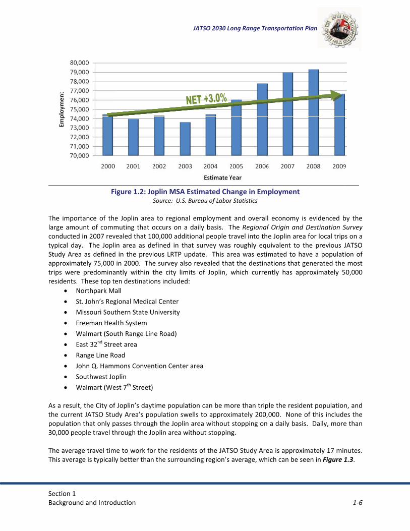
�The� impolarge� amoconductedtypical� daStudy�Areapproximtrips� werresidents.
� N� S� M� F� W� E� R� J� S� W
As�a�resulthe�currepopulatio30,000�pe�The�averaThis�avera��
nd�and�Introd
F
ortance� of� theount� of� commd�in�2007�revay.� � The� Jopliea�as�definedately�75,000�e� predomina.��These�top�tNorthpark�MaSt.�John’s�RegMissouri�SoutFreeman�HeaWalmart�(SouEast�32nd�StreRange�Line�RoJohn�Q.�HammSouthwest�JoWalmart�(We
lt,�the�City�ofnt�JATSO�Stu
on�that�only�people�travel�th
age�travel�timage�is�typicall
duction�
igure�1.2:�JoS
e� Joplin� areamuting� that� ovealed�that�10in� area� as� de
d� in� the�previin�2000.��The
antly� within� ten�destinatioall�gional�Medicathern�State�U
alth�System�uth�Range�Lineet�area�oad��mons�Conven
oplin�est�7th�Street)�
f�Joplin’s�daytdy�Area’s�po
passes�throughrough�the�Jo
me�to�work�foy�better�than
oplin�MSA�EsSource:��U.S.�B
a� to� regional�occurs� on� a� d00,000�additioefined� in� thatious� LRTP�upe�survey�alsothe� city� limit
ons�included:
al�Center�University�
e�Road)�
ntion�Center�a
time�populatipulation�swe
gh�the�Joplin�aoplin�area�wit
r�the�residenn�the�surround
JATSO�2030�Lo
stimated�Chureau�of�Labor
employmentdaily� basis.� � Tonal�people�tt� survey� wasdate.� �This�a�revealed�thats� of� Joplin,�
area�
ion�can�be�mells�to�approxarea�without�thout�stoppin
ts�of�the�JATSding�region’s�
ong�Range�Tra
hange�in�Empr�Statistics�
t� and� overallThe�Regional�travel�into�thes� roughly� equrea�was�estim
at�the�destinawhich� curren
ore�than�tripximately�200,0
stopping�on�ng.�
SO�Study�Areaverage,�whi
ansportation�P
ployment�
� economy� is�l�Origin�and�De�Joplin�area�uivalent� to� thmated� to�havations�that�gently� has� app
le�the�reside000.��None�oa�daily�basis
ea�is�approximich�can�be�see
Plan�
evidenced� bDestination�Sfor�local�trips
he� previous� Jve�a�populatienerated�the�roximately� 5
nt�populationof�this�include.��Daily,�more
mately�17�minen�in�Figure�1
1�6�
�
by� the�Survey�s�on�a�JATSO�ion�of��most�
50,000�
n,�and�es�the�e�than�
nutes.��1.3.�

Section�1�Backgrou
Fi
�
�Table�1.4��
Joplin MS White, n Hispani Black AmericaNative Asian Native HIslander
Two or mSource:��U.��
nd�and�Introd
igure�1.3:�AvSource:��U.S
shows�the�ra
SAnot Hispanic c
an Indian & A
Hawaiian & ot
more races S.�Census�Bure
duction�
verage�TraveS.�Census�Burea
acial�characte
Table�
Alaskan
ther Pacific
eau,�prepared�b
el�Time�to�Wau,�prepared�b
ristics�of�the�
1.4:�Joplin�M
2000 CensuPopulatio
157,3143,8
4,71,92,6
92
3,0by�Missouri�Ce
JATSO�2030�Lo
Work�per�Bloy�Missouri�Dep
Joplin�MSA.
MSA�Racial�C�
us 2009 En Popu
322848762918646
911228
009ensus�Data�Cen
ong�Range�Tra
ock�Group�inpartment�of�Ec
Characterist
Estimate ulation in
174,300153,191
9,6412,6702,745
1,716361
3,976nter�
ansportation�P
n�Southwestconomic�Develo
tics�
Net Change n Population
+16,9789,344,87
7529
8013
96
Plan�
t�Missouri�opment�
% Chan in Popul8 +3 9 102 39
5 83 5
7 3
1�7�
ngelation10.8%6.5%
00.2%39.2%
3.7%
88.4%58.3%
32.1%

Section�1�Backgrou
1.4.2��There�areand� chantransporttransportelements��Environmpopulatiofunded� pdiscriminaelderly,�abetween�in�the�pla�Another�environmspecies� cwells,�poo�Air� qualitapproximthat�perioagriculturother� resenvironmbe�to�minnational�a�Certainly,transportillustratesprotectedmore� in*dissues�for��Similarly,�enhancemcemeteriehazardouof� challeFigure�1.5consideredepth� assenvironm�
nd�and�Introd
ENVIRONME
e�several�issuenging� populatation� planneation�networof�the�enviro
ental� justiceons,� are� not� dplans� and� proate� against� ond/or�youth�the�general�pnning�and�pro
environmentent.��All�typean� be� adversor�air�quality,�
y� is� of� particately�one*thi
odically�exceeral�crops,�andpiratory� probent�and�publ
nimize�emissioair�quality�sta
� some� degraation� netwos� the� vast� amd.� �As� recommdepth� impact
individual�pr
there� are� mments.� � Somes,�and�others�sites,�need�nges� when�5� illustrates� jed� during� thesessment� woental�issues.�
duction�
ENTAL�ISSUES
es�that�arise�tion.� � While�
ers� must� weirk.��Poorly�plaonment,�both
e� is� an� ideadisproportionojects� are� reor� otherwise�populations.�
population�anogramming�p
tal� aspect� ths�of�natural�fesely� affectedand�soil�cont
cular� interestrd�of�the�em
eds�federal�std� there� is� incblems� in� bothlic�health,�onons�from�mondards.�
adation� of� nrk.� � While� n
mount� of� watmended�progt� assessment�rojects.�
manmade� feae� are� merely�kinds�of�pubto�be�consideconsidering�just� a� fractio
e� transportatiuld� be� requi
S�
when�trying�trying� to� fu
igh� the� otheanned�transpo�natural�and�
l� that� tries�nally� effectedequired� to� fo
encourage� a�The�burden
nd�those�tradprocess.�
at� can� be� aeatures�includ
d.� � Sometimetamination�ca
t� to� transporissions�that�landards�in�threasing�scienh� children� ane�of�the�prim
obile�sources.�
atural� resounot� every� feater� resources
grams�and�prwill� be� requ
atures� that�y� cultural� re
blic�facilities.�ered�for�othedevelopmen
on� of� the� mion� planning�red� with� any
JATSO�2030�Lo
to�accommoulfill� the� socer� effects� thaortation�netwmanmade,�an
to� ensure� td� in� a� negativollow� this� idany� adverse�s�and�benefititionally�unde
affected� by� tding�bodies�o
es,� impaired�an�negatively�
rtation� plannead�to�the�fo
he�summer.��Ontific�evidencend� adults.� � B
mary�objective�Fortunately
rces� can� be�ature� can� bes� in� the� Joplrojects�continuired� to� suffic
need� to� be�esources� that�Other�manmr�reasons�entt� patterns� a
manmade� feaprocess,� and
y� individual� p
ong�Range�Tra
date�the�tranciety’s� desireat� result� fro
works�can�resund�even�hum
that� certain�ve� way� by� thdeal� and,� as�
effect� on� mts�of�transpoerserved�by�t
the� transportof�water,�delic
environmentaffect�human
ning� because�ormation�of�gOzone�is�knowe� linking�urbecause� motoes�of�regiona
y,�the�Joplin�a
avoided� by�e� identified� ain� area� that�
nue�along� in� tciently� identi
considered�t� need� to� b
made�featurestirely.��These�and� environmtures� in� the
d� just� as� withproject� to� pro
ansportation�P
nsportation�ne� to� move� gom� the� existiult�in�adversean�populatio
populations,he� actions� of�
a� result,� thminority,� low*ortation�projethe�transport
tation� netwocate�ecosystetal� resourcesn�populations
cars� and� ligground*level�wn�to�damagan�air�polluti
or� vehicles� caal�transportatarea�currently
implementinat� the� LRTP�can� be� ruine
the� implemefy� and� mitiga
when� plannie� protected,s,�such�as�Susites�pose�so
mental� mitige� Joplin� area�h� natural� resooperly� evalua
Plan�
needs�of�a�grooods� and� peing� and� prope�effects�to�vans�themselve
,� or� segmenothers.� � Fed
he� LRTP� mus*income,� disa
ects�must�balaation�networ
ork� is� the� naems,�and�indivs� such� as� pos.�
ht� trucks� proozone,�a�poll
ge�plants,�inclion� to�asthman� affect� bottion�planning�y�complies�w
ng� a� well*plastage,� Figur
ed� if� not� proentation�procate� environm
ing� transport� such� as� schperfund�and�
ome�different�gation� techni� that� need� tources,� a� moate� these� typ
1�8�
owing�eople,�posed�arious�
es.�
nts� of�derally�st� not�abled,�anced�rk�and�
atural�vidual�lluted�
oduce�lutant�uding�a�and�
th� the��must�
with�all�
anned�re� 1.4�operly�ess,�a�
mental�
tation�hools,�other�kinds�
iques.��to� be�
ore� in*pes� of�

Section�1�Backgrou
After�envimitigationbelow:��
Wpd�Flovm�Stanpan�HNSeThst�
nd�and�Introd
ironmental�fen�of�adverse�e
Water�Qualityractices� haveownstream�o
loodplain� Mverlays,�flood
mitigated.�
teep�Slopes:�nd� through� trevent�erosiond�drainage�p
istoric� Structatural� Resouection�106�fohe�City�of�Joptructures.�
duction�
eatures�have�effects�due�to
y:��Stormwatee� been� impleof�transportat
anagement:�dplain�manag
�Steep�slopeshe�2006� Inte
on�and�degradpatterns,�and�
tures:� � The� Surces� protec
orm�prior�to�tplin�and�Web
been�identifio�the�transpo
er�managememented� to� b
tion�and�cons
� Through� sgement�is�reg
s�are�regulateernational�Budation�of�watfurther�fragm
State� Historic�cts� historic� she�constructibb�City�have�
JATSO�2030�Lo
ed,�there�areortation�netwo
ent�guidelinesoth� improve�truction�proje
stormwater� mulated�and�fl
ed�through�thilding�Code. �ter�quality,�lomentation�of�
Preservationsites� and� strion�of�a�federadopted� loca
ong�Range�Tra
e�some�safeguork.��Some�of
s�and�the�emwater� qualit
ects.�
managementlooding�due�t
he�City�of�JopThe�preserv
oss�of�topsoil,forest�and�ha
n� Office� withructures� by�rally�or�state�al�ordinances
ansportation�P
uards�in�placef�these�proce
ployment�of�ty� and� protec
t� guidelines�to�increased�
plin’s�engineevation�of�slop
�changes�in�nabitat�areas.�
in� the� Missorequiring� thfunded�trans
s�to�protect�d
Plan�
e�that�allow�foesses�are�desc
best�managect� against� flo
and� flood� zimpervious�a
ering�specificapes� is� importanatural�topog
uri� Departmehe� approval�sportation�prdesignated�hi
1�9�
or�the�cribed�
ement�ooding�
zoning�area�is�
ations�ant� to�raphy�
ent� of�of� a�
roject.��istoric�

��������
���� �������
��������
�������
����������
�������
��������
�������������
�����������
������������� ��������������
!�������"���
#�������$��� ��
%����&����'�(
������������
� ���������)�����
� ������**�+�����
�����
�
����
����
����
����
����
����
��
�����
�����
�����
�����
"�������
��
�� �**����������
����
�
��,��
�����������
!�
��������!�
�
-� �������
)�.���������
/0���������
01� �������
�����
����2�����
�3���#�����
� �������!�����#�����������������
�������!�����#����������
�������!�����#��������
2�������������
511�6���&��������
��������0151
�����!��������&������5,7

��������
���� �������
��������
�������
����������
�������
��������
�������������
�����������
������������� ��������������
!�������"���
#�������$��� ��
%����&����'�(
������������
� ���������)�����
� ������**�+�����
�����
�
����
����
����
����
����
����
��
�����
�����
�����
�����
"�������
��
�� �**����������
����
�
��,��
�����������
!�
��������!�
�
-� �������
)�.���������
/0���������
01� �������
�����
����2�����
�3���#�����
!�����88
!�����88���������
����������
�� $(�����������%�������
$(������'����������
"�������������������*������������
�������0151 "�9"��!��������:&������
&������5,;

Section�1�Backgrou
1.5� PChapteA� Long� Rtransit,�rafollowing
� R� Id� Es
co� B
�1.5.1�
As�a�chanthe� long�consideraofficials.� �this�study
� Ao
� Mc
� E� E� E
a� B� C
�1.5.2�
Goals� andreflect�locresulting�fthe�effectpart� of� thbrought�fo�Goals�areto�achieve
�Objectivea�more�sp
nd�and�Introd
PLAN�ELEMer�2 �Range� Transpail,�aviation,�b:�egional�trans
dentification�ostimate�of�coonstrained�plackground�an
MAJOR�TRA
nging�commurange� plann
ation.��JATSO�The� followin
y:�Accessibility� tother�amenitiMaintaining� mcorridors.�Establishing�aEnhancing�traEnsuring�safe�area.�Balancing�landConsidering�m
GOALS�AND�
d� objectives�cal�and�regionfrom�the�LRTtiveness�of�LRhe� previous� Lorth�from�the
e�the�broad�ase.��Goals�shou
� establ� identif� provid
es�are�stated�pecific�purpos
duction�
ENTS�
ortation� Planbicycle,�pedes
portation�goaof�future�neenceptual�costan�based�upo
nd�supporting
NSPORTATIO
nity,�the�Jopling� process,�developed�th
ng� represents
to� metropolites.�
mobility� alon
nd�improvingnsit�options�band�conveni
d�use,�transpomaintenance�i
OBJECTIVES�
provide� the�nal�values�out
TP�process.��InRTP�recommeLRTP.� � They�e�citizens,�mu
spirations�thauld:�ish�priorities�fy�needed�pu
de�benchmark
purposes�witse.��Objective
n� addresses�strian,�and�the
als,�objectiveds�and�prioritts�for�identifieon�identified�gg�data�
ON�ISSUES�
in�metropolitmany� conce
heir�goals�bass� a� synthesis�
tan� employm
g� Range� Line
g�access�manaby�continuingent�pedestria
ortation,�and�mplications�o
framework� ftlined�in�prevn�addition,�goendations�ovwere� review
unicipal�staff,�
at�the�public�
for�public�andblic�improvemks�for�public�in
hin�the�broads�should:�
JATSO�2030�Lo
all� transporte�movement�
s,�and�policieties�for�transped�transportagoals�and�prio
tan�area�faceerns,� desires,�sed�on�the�inof� the� major
ment� centers,�
e� Road,� I*44,
agement�on�bg�to�improve�tan�and�bicycle
environmentof�future�imp
for� the� develvious�and�ongoals�and�objecer�time.� �Theed� and� updaand�elected�o
have�determ
d�private�discments�and�senvestment.�
der�goal.��Eac
ong�Range�Tra
tation� modesof�freight.��M
es�portation�moation�improveorities�
es�many�trans� ideas,� and�
nput�of�citizenr� transportat
commercial�
,� Route� 171�
both�existing�the�existing�te�connection
tal�objectivesrovements.�
lopment� of� agoing�planningctives�provideese�goals�andated� with� JATofficials.�
mined�are�mos
cussion�and�corvices;�and�
ch�objective�r
ansportation�P
s,� including� aMajor�plan�ele
odes�ements�to�pro
sportation�chissues� were�ns,�municipalion� issues� de
areas,� recre
and� other� i
and�future�coransit�and�pa
ns�throughout
s.�
an� LRTP.� Theg�efforts�as�we�an�objectived�objectives�wTSO� input� ba
st�important�
onsideration;
relates�to�a�go
Plan�
automobile,� pements�includ
ovide�for�a�fis
allenges.��Thbrought� fort
l�staff,�and�eletermined� th
ational� areas
mportant� reg
orridors.�ratransit�systt�the�metrop
ey� are� intendwell�as�the�diae�basis�to�mewere�developased� on� the� i
for�the�Joplin
;�
oal�and�repre
1�12�
public�de�the�
scally*
rough�th� for�ected�rough�
s,� and�
gional�
tems.�olitan�
ed� to�alogue�easure�ped�as�issues�
n�area�
esents�

Section�1�Backgrou
�Together,policies.��A�
GcoO
GsyO
GchO
�GdO
nd�and�Introd
� be�suff� have�a� be�und
,� goals� and� oAs�part�of�the
oal� I:� Providomplements�Objectives:�
�
� �
�oal� II:�Provid
ystem�for�theObjectives:�
�
� �
�oal� III:� Be� ahanges.�Objectives:�
� �
oal�IV:�Providifferent�indiv
Objectives:��
�
duction�
ficiently�quana�general�timederstood�by�b
objectives� sere�LRTP,�the�fo
de� for� the� dland�develop
Maintain� adevelopmePreserve�rigPreserve� thaccess�on�m
de�for�the�deve�movement�o
Increase�saand�locatioMaintain�thUtilize� tranmanagemeoperation.�
aware� of� and
Invest�in�traApply� emelevels.�
de�for�a�balaniduals�and�ac
Continue� toalong� busintransit.� � CoconnectivitmaintainabImprove�pu
o Conser
o Utipro
ntifiable�to�gaeframe;�andboth�the�decis
ve� as� the� baollowing�eight
evelopment�ment�and�en
and� review� sent.�ght*of*way�fohe� hierarchy�minor�and�pri
velopment�anof�people�and
afety�by�routions.�he�existing�transportation� sent� to� increa
d� able� to� ad
ansportation�erging� and� n
nced�transportivities.�
o� examine� annesses� arteriontinue� to� crty� between�ble.�ublic�transporntinuing� to�rvices.�lizing� the� kn
ovider�in�the�i
JATSO�2030�Lo
auge�the�appr
sion*makers�a
sis� for� develot�goals�were�i
of� a� transpohances�comm
standards� for
or�future�arteof� streets� w
ncipal�arteria
nd�maintenad�goods.�
nely�identify
ansportation�system� manaase� the� effic
apt� to� techn
technology.ew� transpor
rtation�system
nd� secure� fuials� such� as�reate� a� systemajor� destin
rtation�in�the�obtain� local�
nowledge,� eximproved�sys
ong�Range�Tra
ropriateness�o
and�the�gene
opment� of� thdentified:�
ortation� systmunity�develo
r� site� develo
rial�alignmenwithin� the� Jopals.�
nce�of�an�eff
ing�and�addr
system.�agement� strciency� of� tr
nological� and
rtation� polici
m�that�provid
nding� for� altbike� paths,�m� of� bicycle�nations� in� th
metro�area�b� and� state
xpertise� andstem.�
ansportation�P
of�developme
eral�communit
he� LRTP� reco
tem� that� is� sopment.�
opment� to� fo
nts.�plin� area� and
ficient�and�sa
ressing�poten
ategies� whicraffic� signals�
d� federal� tra
es� from� stat
des�a�choice�o
ernative� tranlinear� parks,�routes� and�
he� metro� ar
by:�funding� for�
equipment� o
Plan�
ent�applicatio
ty.�
mmendation
supported� by
oster� well*pla
d� control� driv
afer�transport
tial�safety�ha
ch� address� aand� interse
nsportation�
te� and/or� Fe
of�travel�mod
nsportation� mtrails,� and� p
trails� that� prrea� and� tha
improved� t
of� current� se
1�13�
ons;�
ns� and�
y� and�
anned�
veway�
tation�
azards�
access�ection�
policy�
ederal�
es�for�
modes�public�rovide�at� are�
transit�
ervice�

Section�1�Backgrou
�GO
GO
GauO
GarO
�GO
nd�and�Introd
�
�
oal�V:�DeveloObjectives:�
� �
�oal�VI:�Provid
Objectives:��
� � �
�
�oal�VII:�Proviutomobiles,�iObjectives:�
� � � �
oal�VIII:�Mainrea.�Objectives:�
�
�
�
oal�IX:�DevelObjectives:�
�
duction�
o Ideimp
Support�airto�support�Support� freexisting�and
op�transporta
Utilize�all�pProvide� adcoordinate
de�a�transpor
Continue� tolocal�busineImprove�strImprove�infProvide� infbetween�mContinue� tpolicy.�
ide�a�transponcluding�pers
Meet�the�trExplore�traMeet�the�tr
ntain�low�env
Maintain� treduce�emiMinimize� tnoise*reducMinimize�careas� or�environme
op�a�future�tr
Support� deencourage�
entifying�transproved�publicrport�developexisting�and�f
eight�movemd�future�need
ation�improve
otential�funddditional� trafd�signalizatio
tation�system
o� improve� sigess.�reetscape�elefrastructure�afrastructure� s
modes.�o� support� de
rtation�systemsons�of�low�in
ransportationnsportation�mransportation
vironmental�i
he� Joplin� arissions.�the� impact� ocing�design.
construction�omitigate� trantal�concern.
ransportation
evelopment�carpools�and
JATSO�2030�Lo
sit�needs�andc�transportatipment�by�profuture�needsent�by�provid
ds.�
ement�project
ding�sources�fffic� capacity�n�and�parking
m�that�enhanc
gnage� on� reg
ements�in�dowand�accessibisupport� for� f
evelopment�
m�that�addrencome�or�pers
n�needs�of�themobility�oppon�needs�of�the
impact�from�t
ea’s� air� qua
of� noise� from
of�transportaansportation��
n�system�that
of� high� occud�vanpools.�
ong�Range�Tra
d�providing�aion.�oviding�an�ad.�ding�an�adeq
ts�consistent�
for�various�imthrough� low
g�restrictions
ces�the�econo
gional� routes
wntown�areality�to�industr
freight� faciliti
consistent� w
esses�the�needsons�with�dis
e�elderly�poportunities�for�e�disabled.�
the�transport
lity� standard
m� arterials� a
ation�facilitateimpacts� of
t�encourages�
upancy� mode
ansportation�P
�plan�for�area
dequate� lands
quate� infrastr
with�budget�
mprovements.w� cost� impros.�
omic�vitality�i
s� to� capture� t
s�and�main�strial�parks.�ies� to� include
with� local� zon
ds�of�personsabilities.�
ulation.�youth.�
tation�system
ds� and� encou
and� freeways
es� in�environf� projects� t
energy�conse
es� such� as� p
Plan�
as�to�be�serv
side� infrastru
ructure� to� su
restraints.�
.�ovements� su
n�the�Joplin�a
through� traff
treets.�
e� transfer� sta
ning� and� lan
s�without�acce
m�within�the�m
urage� metho
s� by� incorpo
nmentally�senthrough� area
ervation.�
public� transit
1�14�
ved�by�
ucture�
upport�
ch� as�
area.�
fic� for�
ations�
d� use�
ess�to�
metro�
ods� to�
rating�
nsitive�as� of�
t,� and�

�Backgrou
Chapte1.6� ��1.6.1�
The� LRTPinclusive�Federal� aAdministr�1.6.2�
The� LRTPproposalsand�reviefor�pursufor�residedocumentare� identcondition������
��
nd�and�Introd
�
�
�
er�3 �PLAN
PLAN�APPRO
P� goals,� objepublic� proce
agencies� incluration�(FHWA
PLAN�USE�
P� should� be�s,� working� onwing�progresing�grants�for
ents,�propertyt�should�be�rified.� � LRTP� gs�warrant�rec
duction�
Encourage�transportatDevelop� sdestinationUtilize� trinterconne
N�IMPLEME
OVAL�PROCES
ctives,� policiss.� � The� appuding� the� M
A),�and�the�Fed
consulted� bn� intergovernss�toward�mer�community�y�owners,�andreviewed�anngoals� should�consideration
pedestrian�tion�projects.street� netwons.�ansportationcted�signals�t
NTATION
SS�
es,� and� recoroval� process
Missouri� Depaderal�Transit�
y� elected� annmental� issueeeting�identifi
developmend�developers.ually�and�revalso� be� revie.�
JATSO�2030�Lo
travel� by��
ork� to� prov
system�to�reduce�veh
ommended� as� for� the� updartment� of� TAdministratio
nd� appointedes,� outlining� wied�goals.��Th
nt�activities.��T.��While�a�forvised�as�speciewed� periodi
ong�Range�Tra
incorporatin
vide� direct�
managementhicle�delays�an
actions� were�date� includedTransportatioon�(FTA).���
d� officials� wwork� progra
he�LRTP�proviThe�LRTP�sho
rmal�update�iific�actions�arcally� when� n
ansportation�P
ng� pedestria
travel� betw
t� improvemnd�energy�co
all� created�d� a� review� bon� (MoDOT),�
when� considems,� preparinides�supportiould�also�be�us�required�evre�achieved�a
new� circumst
Plan�
n� elements�
ween� origins
ments,� suchnsumption.�
as� a� result�y� local,� state
Federal� Hig
ring� developg� annual� budng�documentused�as�a�resvery�five�yearand�new�stratances� or� cha
1�15�
into�
� and�
h� as�
of� an�e,� and�ghway�
pment�dgets,�tation�ource�
rs,�the�tegies�
anging�
Section�2�Existing�C
SECTION
EXISTI�There�areexisting�cof�the�sinis� no� diffcontinue�but�also� iinfrastruc�
2.1� R�2.1.1��A� roadwcommunitnetwork� cstreet� by�However,roadway�each�streroadway.�
�As� can�freeways/
onditions�Ass
N�2��NG�CON
e�several�modonditions�is�ngle�largest�inerent.� � This�to�invest.� �Kenclude� the�p
cture.�
ROADWAY�
FUNCTIONAL
ay� network�ties,� industrican� carry� tradesign� prov
� access� and�classificationet.� �Figure�2.�
be� seen� in/expressways
sessment�
DITIONS�
des�of� transpnecessary�to�vestments�inassessment� bey�assets�of�tpublic� transit�
NETWORK
L�CLASSIFICA
serves� the�es,� businesse
affic� through�ides� a� level� omobility� ares�are�develop.1�shows�the�
FigurSource:��Tran
� Figure� 2.2s,�arterials,�co
ASSESSM
portation� thatestablish�a�st
n�a�communitbegins� the� pthe�transportsystem,�bicy
K�
TION�
flow� of� traes,� major� retan� area� efficof� access� to�� competing� fped�to�define
relationship�
re�2.1:�Accesnsportation�Pla
2,� there� areollectors,�and�
JATSO�2030�Lo
MENT�t�are� represetarting�point�ty�is�its�transprocess� of� kn
tation�networcle�and�pede
affic� and� prtail� centers,ciently� and� pthe� adjacent
functions� –� ae�the�relative�
between�acc
ss/Mobility�anning�Handbo
e� four� basilocal�streets.
ong�Range�Tra
ented� in� the� Jupon�which�
portation�infrowing� whererk�are�not�limestrian�system
rovides� accesand� recreati
provide� for� act� properties�as� one� increa�mobility�andcess,�mobility
Relationshiook,�ITE�(2nd�Ed
c� roadway�.��Freeways�a
ansportation�P
Joplin�area.� �assumptions�rastructure,�ae� and� what� amited�to�roadm,�aviation�sy
ss� and� connional� areas.�ccess� to� locaand� a� level� oases,� the� othd�access,�andy,�and�the�ov
�p�dition)�
classes� in�nd�expresswa
Plan�
An�assessmecan�be�built.
and�the�Joplinassets� in� whi
dways�and�brystem,�and� f
nectivity� bet� A� good� roa
al� land� uses.�of� traffic� mo
her� decreasesd�therefore,�rverall� function
the� Joplin�ays�provide�v
2�1�
ent�of�.��One�n�area�ich� to�idges,�reight�
tween�adway�� Each�
obility.��s.� � So�ole�of�n�of�a�
area:��ery��

��������
���� �������
��������
�������
����������
�������
��������
�������������
�����������
������������� ��������������
!�������"���
#�������$��� ��
%����&����'�(
������������
� ���������)�����
� ������**�+�����
�����
�
����
����
����
����
����
����
��
�����
�����
�����
�����
"�������
��
�� �**����������
����
�
��,��
�����������
!�
��������!�
�
-� �������
)�.���������
/0���������
01� �������
�����
����2�����
��������0151<23)!�3�3)
&!))��6
'!<2�<'����!3)!<��
"<2�!��!3)!<��
����)�3�!
�����
�3���#�����
&��������������*������&������0,0

Section�2�Existing�C
high� moblands.� � Cpropertiedistinguistraffic�vol�
Frlaselimpancolain
�PacAparMmau
�Colaotod
�LletrLow
�2.1.2��Roadway�evaluate�tdaily�traffto�AADT.�conditionrecommecapacity.�sections.�
onditions�Ass
bility� but� veryConversely,� los.��Collector�rh� roadway� cumes.��By�usi
reeways/Expand� is� carefuerve�the�largemited�access�rovide�no�dirnd� some� othonnect�to�maanes,� mediannterference�to
Principal� and�ccess� that� srterials� link�roperties� is� urterials� typic
Minor�arterialmoderate�leng
uxiliary�lanes�
ollectors:��Roand�uses�thanperating�speeo� permit� onevelopments
ocal� Streets:engths�on�locaraffic�access�tocal�streets�u
within�a�neigh
DAILY�TRAFF
capacities�anthe�operationfic�(AADT)�vo�That�compas,� to� F,� meanded�as�the�w� Table� 2.1� a
sessment�
y� limited� accocal� streets�routes�conneclassification�ing�these�crite
pressways:� � Rlly� controlledest�amounts�o
to�other�roarect�access�toher� major� higajor�destinations,� and� limito�through�tra
Minor� Artererve� moderatraffic� betw
usually� limiteally� provide�s� interconnec
gth�at�a�slightis�desirable�t
oadways�withn�arterials�andeds.��Collecto*street� park�and�at�inters
� � Roadways�al�streets�are�to�and�from�a
usually�providborhood�and
FIC�COUNTS�A
nd�levels�of�sen�of�roadwaylume�and�lev
arison�places�aning� very� poworst�acceptand� Figure� 2
ess.� � Arterialhave� the� loct�arterials�asuch� as� des
eria,�specific�
Roadways� prod� and� limitedof�traffic�for�ladways�throuo�adjacent� langhways.� � Expons,�other�citted� at*grade�ffic�movemen
rials:� � Roadwate� levels� ofween� freewaed� only� to� co
connectionsct�with�and�aly�lower�leveto�preserve�th
h�a�low�ranged�serve�lowerrs�usually�alloing.� � Turn�sections�with�
with� the� lowshort�and�at�
abutting�prope�curbs,�gutt�connect�to�c
AND�LEVEL�O
ervice�vary�asys�in�the�Studyvel�of�service�the�roadwayoor� operatinable�volume�2.3� show� rep
JATSO�2030�Lo
ls� have� high�owest� mobilitnd�local�streeign� speed,� oroadway�clas
oviding� the� hd� along� freewlong�trips�and
ugh�the�use�ond�uses.� �Frepressways� usties,�and�othe
intersectionnt.�
ways� with� an�f� traffic� voluays/expresswaonsolidated,� s
� between� adaugment� the�l�of�traffic�mohe�traffic�mob
e�of�traffic�mor�levels�of�trafow�only�two�llanes� are� dearterial�stree
west� range� ofslow�operati
perties�at�theers,�and�enclollector�stree
OF�SERVICE�
s�changes�in�y�Area,�two�m(LOS).��LOS�i
y� into�a�rangeg� conditionsto�capacity�t
presentative�
ong�Range�Tra
traffic� mobilty� but� allowets�together.�operational� sssifications�ca
highest� trafficways� and� expd�operate�at�hof�grade*sepaeways�typicaually� flow� ther�major�highns� are� used�
intermediateumes,� trip� leays� and� colshared,� or� ladjacent� comprincipal�art
obility�than�dobility�on�the�r
obility�that�prffic�volumes,�lanes�of�traffiesirable� on�
ets.�
f� traffic� mobng�speeds.��L
e�expense�of�osed�drainagets.�
land�uses�andmeasures�ares�based�on�co
e�from�A,�me.� � For� urbanhreshold.��LOdaily� capacit
ansportation�P
ity� but� low� aw� frequent� a
�Other�critertandards,� tra
an�be�defined
c� mobility.� � Apressways.� �high�speeds.�
arated� interchally� include�Inhrough� an� urhways.��Dedic
on� expressw
e� range� of� trengths,� and�llectors.� � Acrger*scale� lanmunities� and
terial� system�o�principal�arroadway.�
rovide�more�shorter�trip�
ic�but�are�typcollectors� a
bility� and� trafLocal�streets�p
the�mobility�ge.��Local�stre
d�travel�deme�provided:��tomparing�a�r
eaning�very�fanized� areas,�OS�E�indicatesties� for� typic
Plan�
access� to� adjccess� to� adj
ria�are�also�usavel� distance.�
Access� to� adjFreeways� typ�Freeways�pr
hanges�but�unterstate�highrbanized� areacated�and�auxways� to� min
raffic� mobilitoperating� sp
ccess� to� adjnd� uses.� � Prind� activity� ceand�serve� tr
rterials.��The�u
access�to�adjlengths,�and�ically�wide�endjacent� to�
ffic� volumes.�provide�immeof�through�tets�connect�b
and�are�madhe�annual�av
roadway’s�capavorable�opeLOS� D� is� typ
s�the�roadwayal� urban� roa
2�3�
jacent�jacent�sed�to�e,� and�
jacent�pically�rovide�sually�
hways�a� and�xiliary�
nimize�
y� and�peeds.��jacent�ncipal�nters.��
rips�of�use�of�
jacent�lower�
nough�larger�
� Trip�ediate�raffic.��blocks�
e.��To�verage�pacity�rating�pically�y�is�at�
adway�

Section�2�Existing�C
��
�
�Table�2.2�These�valIncluded�acongestio��
5
10
15
20
25
30
35
40
45
50
Aver
age
Daily
Tra
ffic
AssumptvolumeC
�
T2*3*4*5*
46
Assumptions
Capacities�ba
onditions�Ass
Table
shows�estimues�are�basedare�segments
on�and�traffic�
0
5,000
0,000
5,000
0,000
5,000
0,000
5,000
0,000
5,000
0,000
Two-LUndiv
tions: Peak Hour
Type�of�Stre*Lane�Undivi*Lane�Undivi*Lane�Undivi*Lane�Undivi4*Lane�Divid6*Lane�Divid:�Peak�Hour�equals
sed�on�signalizatio
sessment�
e�2.1:��Daily�V
Fig
ated�roadwayd�on�outputs�s�that�currentdelay�during�
Lanevided
ThreeUndi
r equals 10 perc
eet�ded�ded�ded�ded�ed�ed�s�10�percent�of�da
on�set�to�high�prio
Volumes�an
ure�2.3:�Typ
y�LOS�and�volfrom�the�200
tly�are�estimapeak�hours.
Typical Ar
e-Lanevided
FourUndi
ent of daily
�
Level�of101216232333
ily�volume�
ority�with�high�turn
JATSO�2030�Lo
d�Levels�of�S
pical�Arterial
lume�to�capa09�Base�Traveted�to�operat
rterial Capa
r-Laneivided
FiveUnd
Facility Type
So
Maf�Service�C�0,500�2,800�6,300�3,100�3,300�3,800�
ns�
ong�Range�Tra
Service�for�U
l�Capacities
city�ratios�forel�Demand�Mote�at�LOS�D�o
acities
e-Laneivided
FouDiv
e
ource: HWS Co
aximum�DaiLevel
ansportation�P
Urban�Stree
r�roadways�inodel�providedr�worse�and�e
r-Lanevided
SixDi
onsulting Group
�
ily�Traffic�Vol�of�Service�D12,800�15,600�19,800�28,100�28,300�41,100�
Plan�
ts�
n�the�Joplin�ard�by�JATSO.��experience�
x-Laneivided
LO
LO
LO
LO
LO
Inc. calculation
olume�D� Leve
2�4�
�
rea.��
S E
S D
S C
S B
S A
ns
�
el�of�Service�14,400�17,600�22,400�31,700�32,000�46,400�
E�

Section�2�Existing�C
�
COYOTE�DCOYOTE�DE�4TH�ST�E�7TH�ST�E�7TH�ST�E�7TH�ST�MADISONMADISONN�43�HWYN�RANGEN�RANGEN�RANGERANGE�LIRANGE�LIRANGE�LIRANGE�LIRANGE�LIRANGE�LIRANGE�LIRANGE�LIRANGE�LIRANGE�LIRANGE�LIS�HEARNES�HEARNES�HEARNES�ILLINOISS�MAIN�STS�MAIN�STS�RANGE�S�RANGE�S�RANGE�S�RANGE�S�RANGE�S�RANGE�S�RANGE�S�RANGE�
onditions�Ass
Table
�
STREET�DR�DR�
N�ST�N�ST�Y��LINE�RD��LINE�RD��LINE�RD�NE�RD�NE�RD�NE�RD�NE�RD�NE�RD�NE�RD�NE�RD�NE�RD�NE�RD�NE�RD�NE�RD�ES�BLVD�ES�BLVD�ES�BLVD�S�AVE�T�T�LINE�RD�LINE�RD�LINE�RD�LINE�RD�LINE�RD�LINE�RD�LINE�RD�LINE�RD�
sessment�
e�2.2:��2009�T
Arbor�RdApricot�DN�RangeMO�HwyGarden�GS�Spring�MO�HwyMO�HwyMO�HwyHodgdonTurkey�CS�of�E�NeE�6th�St�E�7th�St�E�10th�StE�11th�StE�22nd�SE�13th�StE�15th�StE�16th�StE�17th�StE�20th�StMall�Rd�GlendaleE�50th�StS�of�E�50SE�MurpRiver�RdNorledgeE�24th�StE�29th�StE�30th�StI*44�RamE�44th�StSaginawKeller�DrI*44�EB�R
Traffic�Volum
LOCA
FROM�d�Dr�
e�Line�Rd�y�249�SB�RampGrove�Rd�Valley�Ln�
y�171�WB�y�171�EB�y�171�n�Rd�Creek�Rd�ewman�Rd�
t�t�
St�t�t�t�t�t�
e�Blvd�t�
0th�St�phy�Blvd�
�e�Pl�t�t�t�
mp�t�
w�Rd�r�Ramps�
JATSO�2030�Lo
mes,�Capaci
ATION�
TO
Crow�Rd�McclellandTurk�Ave�
s� S�Spring�VaS�DuquesnGarden�GrW�2nd�St�MO�Hwy�1Gum�Rd�S�of�E�NewN�HodgdonE�NewmanE�4th�St�E�6th�St�E�7th�St�E�10th�St�E�20th�St�E�11th�St�E�13th�St�E�15th�St�E�16th�St�E�17th�St�Turkey�CreI*44�RampGlendale�BE�50th�St�E�7th�St�Norledge�PS�of�E�50thE�22nd�StE�24th�St�E�29th�St�E�36th�St�Keller�Dr�E�44th�St�I*44�EB�RamI*44�EB�Loo
ong�Range�Tra
ties,�and�Lev
NLAO�
d�Park�
alley�Ln�ne�Rd�rove�Rd�
171�WB�
wman�Rd�n�Rd�n�Rd�
eek�Rd�
Blvd�
Pl�h�St�
mps�ops�
ansportation�P
vel�of�Servic
NO.�ANES
�
V/C�2� 0.74�2� 0.78�2� 0.74�2� 0.80�2� 0.79�2� 0.80�2� 0.73�2� 1.10�2� 0.71�4� 0.75�4� 0.73�4� 0.75�4� 0.73�4� 0.75�4� 0.81�4� 0.81�4� 0.80�4� 0.80�4� 0.81�4� 0.87�4� 0.71�4� 0.71�4� 0.72�1� 0.79�3� 0.72�2� 0.77�3� 0.78�2� 0.71�2� 0.77�4� 0.80�4� 0.74�4� 0.74�4� 0.76�3� 0.95�2� 0.71�3� 0.95�3� 0.78�
Plan�
ce�
�
AADT�8,940�9,279�9,303�
13,980�13,995�14,079�8,897�
14,179�8,785�
27,186�26,300�27,223�26,297�26,827�28,931�29,024�29,032�28,491�29,001�31,428�25,599�25,599�25,938�5,912�5,471�6,924�
11,419�6,276�6,924�
29,032�26,593�26,593�27,213�16,466�11,809�16,466�14,574�
2�5�
�
LOS�D�D�D�D�D�D�D�F�D�D�D�D�D�D�D�D�D�D�D�E�D�D�D�D�D�D�D�D�D�D�D�D�D�F�D�F�D�

Section�2�Existing�C
S�RANGE�SCHIFFERSTATE�HWSTATE�HWSTATE�HWSTATE�HWSTATE�HWUS�HWY�6
US�HWY�6�Figure�2.4�2.1.3� B�Bridges�aconstruct�the� long� tacross� feathey� are�moderatefrom�a�lac�MoDOT�pas�well�ascondition�
So�Based�upoThe� only�Only�threNorthern�(bridge�noStudy�AreThe� Routrehabilita���
onditions�Ass
LINE�RD�RDECKER�AVE�WY�171�WY�171�WY�171�WY�D�WY�HH�66�
66�
4�illustrates�th
BRIDGE/OVER
re�the�most�cand� maintai
term�economatures� that�anot� properly
e� investment�ck�of�mainten
provided�infor�99�off*systemrating�standa
Very�Good�Good�Fair�Poor�Very�Poor�ource:��FHWA�
on�each�condbridge� that� ie�bridges�areArkansas�Ra
o.�L0859).� �Fiea.��Some�infote� P� bridge�tion�under�M
sessment�
E�32nd�SCrow�RdFir�Rd�Wall�St�E�of�Fir�RMO�HwyState�HwN�Prospe
N�Irwin�S
he�estimated�
RPASS�COND
critical�of� invn,� but� as� wit
mic� benefits�ore�otherwise
y� maintained�in�maintena
nance.���
rmation�inclum�structures�ard�for�state�s
Table�2.3:�
No�visibleSome�sligModerateDefectiveSeriously�
dition�rating,�is� rated� as� “Ve�rated�as�“Pilroad�(MNA)igure�2.5� illusormation�regaover� Turkey�
MoDOT’s�Safe�
�
St�d�
Rd�y�171�wy�AA�erity�Ave�
St�
roadway�LOS
ITIONS�
vestments� in�th� transportaof� the�provide�difficult� to� t
–� more� so� tnce�over� tim
ding�conditioas�of�mid*201structures�is�s
State�Bridge
e�defects,�neaghtly�defectively�defective�e�or�deteriora
damaged�co
29�of�the�70�Very� Poor”� isoor”.� �They�a)� (bridge�no.�strates� the� loarding�the�“Po
Creek� and� tand�Sound�B
JATSO�2030�Lo
E�30th�St�W�32nd�StE�of�Fir�RdMO�Hwy�4Wall�St�W�2nd�St�Split�Rail�DN�Irwin�St
Wolfe�Dr�
S�for�all�links�i
the�roadwayation� infrastrued� connectiotraverse,�but�than� other� ase�can�save�e
on�ratings�on�10.��This�inforshown�in�Tab
e/Overpass�
ar�new�condite�or�deterioraor�deteriorat
ated�componemponents�in�
state�bridgess� on� Route� Pare� the�westbL0290),�and�
ocation�and�coor”�and�“Vethe� Route� 1ridge�Program
ong�Range�Tra
t�
43�
Dr�
in�the�2009�B
y�network.� �Tucture� in� genons.� �They�no
they� also�pospects� of� the
even�more� in�
70�state�bridrmation�can�bble�2.3.����
Rating�Defin
tion�ated�componted�componeents�in�need�oneed�of�imm
s�are�in�the�“VP� crossing� Tubound�Routeboth� I*44�ovecondition�of� try�Poor”�brid
171� bridge� om.���
ansportation�P
4� 0.74�2� 0.74�2� 0.74�2� 0.73�2� 0.76�2� 0.70�2� 0.73�2� 0.79�
2� 0.78�
Base�model.���
hey�are�relatneral,� these� cot�only� functiose�a�very� see� roadway� ne
rehabilitatio
dge�structuresbe�viewed�in�t
nitions�
nents�nts�of�replaceme
mediate�repair
Very�Poor”�torkey� Creek� (b
e�171�bridge�erpasses�ovethe�state�struges�is�summaver� MNA� ar
Plan�
26,813�8,940�
13,193�13,170�13,660�8,812�8,373�9,677�
9,542�
�
tively�expenscosts� are� offsion�as�critica
erious�safety�etwork.� � Usun�costs� that�
s�in�the�Joplinthe�appendix
ent�r�
o�“Fair”�condibridge� no.�A0over�Missourr�Range�Line�uctures�withiarized�in�Table� both� slate
2�6�
D�D�D�D�D�D�D�D�
D�
ive�to�set� by�l� links�risk� if�
ually� a�come�
n�area�x.��The�
itions.��0827).��ri�and�Road�
in� the�le�2.4.��ed� for�

0.7059
0.79
980.
7923
0.72
94
0.7351
0.7071
0.78
97
0.7362
0.7731
0.7808
0.7433
I-44
HW
Y
STA
TE
HW
Y 9
6
E 2
0TH
ST
IVY
RD
W 2
0TH
ST
E Z
OR
A S
T
FIR
RD
FOU
NTA
IN R
D
W 7
TH S
T
US 71 HWY
E N
EW
MA
N R
D
AP
RIC
OT
DR
ELM
RD
STA
TE
HW
Y A
A
STA
TE
HW
Y Y
Y
270
STATE HWY JJ
E IV
Y R
D
SAG
INAW
RD
STA
TE
HW
Y V
REINMILLER RD
Bel
le C
ente
r R
d
240
STA
TE
HW
Y P
Ced
ar D
r
220
US HW
Y 71U
S H
WY
66
STA
TE
HW
Y Z
N 43 HWY
Gum Rd
DEER DR
RIV
ER
RO
AD
CO RD 230
PINE ST
HAW
THO
RN
E
E 3
2ND
ST
COUNTY RD
OLD
66
HW
Y
166
GU
M R
D
TEE
LN
US
HW
Y 6
6 I-44
HW
Y
IVY
RD
US 71 HWY
Jopl
inJo
plin
Car
Car
Web
b C
ityW
ebb
City
Lom
a Li
nda
Lom
a Li
nda
Lege
nd LOS
A,B
,C
LOS
D
LOS
E
LOS
F
Volu
me
to C
apac
ity R
atio
and
Lev
el o
f Ser
vice
20
09 B
ase
Net
wor
kFI
GU
RE
2.4

��������
���� �������
��������
�������
����������
�������
��������
�������������
�����������
������������� ��������������
!�������"���
#�������$��� ��
%����&����'�(
������������
� ���������)�����
� ������**�+�����
�����
�
����
����
����
����
����
����
��
�����
�����
�����
�����
"�������
��
�� �**����������
����
�
��,��
�����������
!�
��������!�
�
-� �������
)�.���������
/0���������
01� �������
�����
��������0151�� ������ �������� ��
+)!6�%���
%��� &�
<!'��!
+)!6�'��!
�����#������!�����&������0,;

Section�2�Existing�C
(BridMissouri P
Missouri
Interstate
Interstate
*�Bridges�cSource:��M�The�data�Route�171lifespan,�tto�the�Rou�2.1.4��While�funroadwaysand,�evennetwork.��The�City�othat�haveseverity,�Figure 2.6recommearea�for�tareas�out�In� additioadditionaintersectithat�had�sRoad�conAlso�genemajor�inteand�Madias�these�cwith� the�least�one��
onditions�Ass
Route dge Number)P / Central Cit(A0827)* 171 – westbo(L0290)* e 44 – eastbo(L0859)
e 44 – westbo(L0859)
committed�for�MoDOT�
provided�also1�bridge�menthese�bridgesute�P�bridge�m
HIGH�CRASH
nctions�of�accs�have�to�alson�more�so,�inj
of�Joplin�recen�had�a�high�sand� crash�6� shows� thndations.� �Alhe�years�200side�of�the�Ci
on� to� the� intel� intersectionons�reveal�treseveral�interstinues.� �High
erally�north�oersections�suson�in�Webb�corridors.��Crexception� of�kind�of�geom
sessment�
Table�2.4:�B
F) Cty Rd. Tur
ound MNA
ound BU 7L
ound BU 7L
rehabilitation�
o�indicated�thntioned�aboves�have�exceedmentioned�ab
H�LOCATIONS
ess�and�mobio�be�safe� in�ojury�and�loss�
ntly�completesusceptibility�rate� when�
he� intersectiong�with�this5�through�20ty�of�Joplin�a
ersections� wns� that� wereends�along�cesections�on�th�crash�densit
of� Joplin,� Rouch�as�the�inteCity.��Other�aash�rates�on�interchange
metric�deficien
Bridges�with�
Feature Crossed rkey Creek
A Railroad
71 / Range Line Rd. 71 / Range Line Rd.
in�MoDOT’s�Sa
hat�there�are�e.��Based�upoded�their�expbove,�will�be�
S�
ility�are�foreforder�to�be�e
of�human�liv
ed�a�study�thato�traffic�crasselecting� theons� that� ws� list�of� inter
009.��Using�thlso.�
ithin� Joplin� te� initially� revertain�corridohis�longer�listty�continues�ute�171�expeersections�of�arterials�arouthe�freewayss� along� I*44.�ncy�by�curren
JATSO�2030�Lo
Poor�Rating�
RatinPoor Ve
1
1
1
afe�and�Sound�
seven�bridgeon�the�assumpected�service50�years�old�b
ront�concerneffective.� � Inteves�are�the�un
at�identified�tshes.��The�stue� intersectio
were� furthersections,�Mois�data,�the�h
that� were� chiewed.� � The�
ors.��Range�Lint.��Outside�ofalong�the�Mariences�high�Route�171�and�Joplin�do�
s�are�typically� Every� interct�MoDOT�sta
ong�Range�Tra
gs�in�the�Jop
ngery Poor
1
Bridge�Progra
es�built�on�orption�that�the�life.��Also,�eby�the�year�2
s�in�providingerruptions�ofndesirable�sy
the�intersectiudy�took�into
ons� that� war� studied� a
oDOT�has�prohigh�crash�loc
osen� for� furtlocations� of
ne�Road�and�f�the�City�of�Jadison/Rangecrash�densitynd�Route�43�not�experien
y�near�or�belochange� alongndards.�
ansportation�P
plin�Area�
Year Built (Rebuilt)
1961
1949
1960 (1988) 1960
(1988) m�
r�before�1960he�average�breight�other�b030.�
g�an�efficient�f�traffic�flow,ymptoms�of�a
ions�within�tho�account�crarranted� furtnd� analyzed
ovided�crash�dcations�can�be
ther� study,� tf� this� longer�7th�Street�areJoplin,�the�tree�Line�corridoy.� �This� is�espin�Airport�Drce�quite�the�ow�state�aveg� I*44� in� the�
Plan�
EstimaAAD3,60
5,20
15,00
15,00
0�in�addition�tridge�has�a�50bridges,�in�ad
roadway�net�economic�ac
an�unsafe�roa
he�Joplin�city�sh�numbers,�
ther� investigd� for� shortdata�for�the�Je�identified�fo
here� were� selist� of� high�
e�the�two�corend�on�Rangeor� into�Webbpecially�eviderive�and�Routnumber�of�crrages�for�freeJoplin� area� h
2�9�
ated DT
0
0
00
00
to�the�0*year�dition�
twork,�ctivity�adway�
limits�crash�ation.��
t*term�Joplin�or�the�
everal�crash�ridors�e�Line�b�City.��ent�at�te�171�rashes�eways�has� at�

Section�2�Existing�C
�
�
2.2� T�While� sevplace� in� tmetropol
onditions�Ass
TRANSIT�SY
veral� types� othe� Joplin� aritan�areas�in�
sessment�
Figure�2.6:�
YSTEM�
f� public� tranrea.� � The� JopMissouri,�Sai
�Joplin�Traff
sportation� explin� area� has�nt�Louis�and�
JATSO�2030�Lo
fic�Crash�Ana
xist� in� Missono� access� t
Kansas�City.��
ong�Range�Tra
alysis�Inters
uri,� only� a� po� light� rail� t�Federally�rec
ansportation�P
sections�
ortion� of� theransit� as� is� fcognized�and
Plan�
ese� systems� afound� in� only
d�funded�univ
2�10�
�
are� in�y� two�
versity�

Section�2�Existing�C
transportalso�do�noMissouri�transit� sysystems,�e
2.2.1�
The� Joplinservices�toTransport�PRIVATE�AG�
HciNpMus���
NON�PROF�
ABto�Laupth�OanCeM�BCM�Thcipcl�
onditions�Ass
ation�serviceot�exist�in�thePublic�Transitstems� serve�elderly�and�d
EXISTING�TR
n� area� has� no�the�greatertation�Plan,�2
GENCIES�
Health�Care�Tritizens,� and�ewton,�and�Mrovider�uses�a
Medicaid�and�sing�a�fleet�of
FIT�AGENCIES�
rea� Agency�arton,�Jaspero�serve�its�clie
afayette� Hounfortunate� cirovider�uses�hrough�Friday
Ozark� Center:nd� area� youounties.� � Themergency� me
Monday�throu
oys� and� Girlounties.� � The
Monday�throu
he�Independeitizens,� includrovider� uses�ients.�
sessment�
s,�as� found�ae�Joplin�area.t�Associationportions� of� tisabled�trans
RANSIT�AND�P
umerous� ager�community.�007�these�ser
Transit�Inc.:��Tarea� youth,�
McDonald�Coa�demand�resMedicare�tra
f�eleven�vehic
on� Aging,� Rr,�Newton,�anents�and�oper
use:� � This�ircumstancesa�demand�re
y.�
� �This� organith,� includinge� provider� usedical� servicegh�Friday�and
ls� Club� of� Joe� provider� ugh�Friday.�
ent�Living�Ceding�those�on
a� demand� r
at�Missouri�St.��However,�o,�are�presentthe� JATSO� Stportation�ser
PARATRANSIT
encies� and� se�According�to
rvices�include
This�organizatincluding� ci
ounties�in�Missponse�systemansport� to�secles.�
Region� X:� � Thnd�McDonald�rates�two�veh
organization�s� in� Jasper,� Nsponse�syste
ization� serveg� citizens� onses� a� fixed� re� to� serve� itsd�one�weeken
oplin:� � This� ouses� a� fixed�
enter,�Inc.:��Thn�Medicaid,� inresponse� syst
JATSO�2030�Lo
tate�Universitother�forms�ot� in�the�Joplinudy� Area� as�
rvices,�and�a�f
T�SERVICES�
ervices� in� plao�the�HSTCC�Ce:�
tion�serves�dtizens� on� Mssouri�as�welm,�offers�a�noerve� its�client
his� organizatCounties.��Th
hicles�Monday
serves� disaNewton,� McD
m�to�serve�it
s� disabled� cit� Medicaid,� ioute� and� des� clients.� � Thnd�per�month
organization�route� to� ser
his�organizatin�Barton,�Jastem� and� a� n
ong�Range�Tra
ty�and�Southof�public�trann�area.� �Fedewell� as� a� my
few�taxicab�se
ace� to� providCoordinated�P
isabled�citizeMedicaid� and�
l�as�communon*emergencts.� �Health�Ca
tion� serves� dhe�provider�uy�through�Frid
abled,� low*inDonald,� Barry,
s�clients�and�
tizens,� senioin� Barton,� Ja
emand� respone� Ozark� Cen
h.�
serves� area�rve� its� clients
ion�serves�dissper,�Newtonon*emergenc
ansportation�P
heast�Missoursportation,�a
erally�classifieyriad� of� humervices.�
de� both� transPublic�Transit
ens,�senior�citMedicare,� i
nities�in�Southcy�medical�serare�Transit�em
disabled� and�ses�a�demandday.�
ncome,� and�,� and� Lawrenoperates�two
r� citizens,� lowasper,� Newtonse� system� ater� operates�
youth� in� Jas� and� operat
sabled,�senion�and�McDoncy� medical� se
Plan�
ri�State�Univeas�identified�bed�urban�and
man� service� ag
sit� and� paratt�–�Human�Se
tizens,�low*inin� Barton,� Jaheast�Kansasrvice,�and�promploys�ten�d
senior� citized�response�sy
other� citizence� Counties.o�vehicles�Mo
w*income� citon� and� McDand� provides
fourteen� ve
sper� and� Netes� three� ve
or,�and�low*inald�Countieservice� to� ser
2�11�
ersity,�by�the�d�rural�gency�
transit�ervices�
ncome�asper,�.��The�
ovides�rivers�
ens� in�ystem�
ens� in�.� � The�onday�
tizens,�Donald�s� non*ehicles�
ewton�ehicles�
ncome�.� �The�
rve� its�

Section�2�Existing�C
Ceansi�SaanmFr�Mcimva�OyopM���
PUBLIC�AGE�
Mciinreof�
2.2.2�
While� theparatrans�MAPS� beprovided�the�Sunshwith�the�aa�geograpCentral�CiJasper�Coarea� encoVillage,�DCreek�Estthe�corresservice�ara� few� of�Duquesnearea�is�sho�
onditions�Ass
erebral� Palsynd� McDonaldxteen�passen
alvation�Armnd� Newton� C
medical�servicriday.�
Metro� Emergeitizens�in�Jasp
medical�servican�services�M
OATS,�Inc.:��Thouth,�and� therovider�uses�a
Medicaid�trans
ENCIES�
Metro� Area� Pitizens,�low*inn� Jasper� and�esponse�systef�the�Joplin�a
PUBLIC�TRAN
e� Joplin� areasit�to�the�publ
gan� as� a� de58,630�rides�
hine�Lamp�Troaddition�of�twphic�area�rougity�Road/Rou
ounty�Road�2ompasses� parennis�Acres,�ates,�Silver�Csponding�devrea,�focusing�
the� other� me,�Webb�City,own�in�Figure
sessment�
y�of�Tri�Cound� Counties.� �nger�buses�Mo
my:� �This�orgaCounties.� Thee�to�serve�its
ency� Transpoper�County.��e�to�serve�its
Monday�throu
his�organizatie�general�pua�demand�ressport�to�serve
PublicTransit�ncome�citizen
Newton� Coem�to�serve�itrea.�
NSIT�OPERAT
a� has� numelic,�the�prima
mand� responto�the�Joplin
olley,�was�addwo�new�routeghly�105�squate�JJ�corridor00� (Prosperitrt� of� Carl� JunDuquesne,�Greek,�Redings
viated�serviceon�the�more�
municipalities�,�Leawood,�ae�2.8.����
nty:� �This� orgThe� provide
onday�throug
anization�serve� provider� us�clients.��The
ort� System� (The�provider
s�clients.��METgh�Friday.�
on�serves�disblic,� includingsponse�systeme�its�clients.��S
System� (MAns,�area�youthunties.� � Thets�clients.��MA
TIONS�
rous� agenciery�provider�o
nse� transit� sy�area�in�that�ded.��The�onees.��The�primaare�miles�in�sr�to�the�westty�Avenue)/Janction� and� alGrand�Falls�Pls�Mill,�and�W
e�area�compridense�populaeven� partia
nd�the�entire
JATSO�2030�Lo
anization� serer� uses� a� fixegh�Friday.�
ves� low*incomses� a� deman
e�Salvation�Ar
(METS):� � Thir�uses�a�demaTS�operates�s
sabled�citizeng�citizens�on�m,�offers�a�noSchedules�an
APS):� � This� orh,�and�the�ge� provider� us
APS�is�the�pri
es� and� servicf�transit�servi
ystem� operafirst�year.��Ine�route�and�dary�curb*to*cusize�generally�,�the�Douglasaguar�Road/Rl� of� the� munaza,�Joplin,�L
Webb�City.��Thse�an�area�thation�and�emlly� fall� withinety�of�Dennis
ong�Range�Tra
rves� disabled�ed� route� to�
me�citizens�and� response�rmy�operates
is� organizatioand�responseseven�ambula
ns,�senior�citizMedicaid,� in
on*emergencd�services�va
rganization� seneral�public,ses� a� deviatemary�provide
ces� in� placeices�to�the�Jo
ated� by� the� Cn�2007,�a�devideviated�servurb�service�p
y�bounded�by�s�Fir/Route�VRoute� AA�cornicipalities� of�Leawood,�Saghe�Sunshine�Lhat�is�more�co
mployment�cen� the� deviates�Acres.� �The�
ansportation�P
� area� youth�serve� its� clie
nd�homelesssystem� and�
s�four�vehicle
on� serves� dise�system�andances�in�addi
zens,�low*incn�87�countiescy�medical�serry�depending
serves� disableincluding�citi
ed� fixed� router�of�transit�s
e� to� provide�oplin�area�and
City� of� Jopliniated�fixed�ro
vice�area�was�rovided�by�M�Center�Cree
V�corridor�to�trridor� to� the�f� Airport� Drivginaw,�Shoal�Lamp�Trolley�ompact�than�nters�in�the�Ced� service� arSunshine�La
Plan�
in� Jasper,� Neents� and� ope
s� families� in� Ja� non*emer
s�Monday�th
sabled� and� s�a�non*emergtion�to�whee
come�citizenss� in�Missouri.rvice,�and�prog�on�the�coun
ed� citizens,� sizens�on�Medte� and� a� deervices�to�the
both� transitd�its�core�is�M
n� in� 1997.� �oute�service,�
expanded�inMAPS�encomp
k�to�the�nortthe�south,�aneast.� � This� se
ve,� CartervilleCreek�Drive,�service�routethe�primary�
City�of�Joplin.�rea;� these� inmp�Trolley�se
2�12�
ewton�erates�
Jasper�gency�rough�
senior�gency�
elchair�
,�area�.� �The�ovides�ty.�
senior�dicaid,�mand�e�core�
t� and�MAPS.�
MAPS�called��2009�
passes�h,�the�
nd�the�ervice�
e,� Cliff�Shoal�
es�and�MAPS���Only�
nclude�ervice�

Section�2�Existing�C
Figure� 2.scheduled�
�The�MAPSHowever,system�th2008*200accessiblemore� of� tparatransthat� is�notransit� rodisabled�system�thtransit�ser����������
20
40
60
80
100
120
Rid
ersh
ip
onditions�Ass
7� shows� the�d�MAPS�riders
Figure
S�scheduled�r� this� is� not�
hat�has�been�p9� fiscal� year.
e.� � By� providthe� general� p
sit�rides�in�theot�accommodutes� may� propublic� very� w
hat�serves�botrvices�accomm
0
,000
,000
,000
,000
,000
,000
sessment�
total� ridershship�and�Trol
e�2.7:�Public�Source:��
ridership�shoa� negative� pput�in�place.��.� � Every� vehicing� effect� ropublic,� but� ae�past.��Thereated�by�the�ovide� a� more
well.� � So� far,�th�the�disablemodate�a�var
Sched
Trolle
Total�
hip� over� the�ley�ridership.
Transit�RideMetro�Area�Pu
wed�steady�gpoint;� it� may�
The�trolley�ricle� in� the� MAutes� and� devlso� supplants
e�will�always�btransit�routee� cost*effecti
the� trolley� sed�public�andriety�of�trip�pu
duled�Ridership
ey�Ridership
Ridership
JATSO�2030�Lo
past� ten� ye���
ership�TrendublicTransit�Sys
growth�until�tmerely� indic
ides�surpasseAPS� and� trollviated� services� rides� that� wbe�a�need�fors�already� in�pive� service� thservice� seemd�the�general�urposes.���
Fiscal Y
p
ong�Range�Tra
ears� including
ds�over�the�Pstem,�City�of�Jo
the�inceptioncate� the� effe
ed�scheduled�ley� system� ise� areas,� the�would� have�
r�effective�andplace,�but�thhan� transit� ses� to� provide��public.��As�c
Year
ansportation�P
g� the� separat
Past�Ten�Yeaoplin�
n�of�the�Sunsectiveness� ofrides�for�the�
s� lift*equippetrolley� systehad� to� be� scd�equivalent�e�effective�pervice� that� d� the� former,�an�be�seen�in
Plan�
te� componen
ars�
hine�Lamp�Trf� the� trolley�first�time�oved� and� wheel�m� not� only� scheduled� as�paratransit�selacement�of�
does� not� serv� a� balanced�n�Figure�2.9,�
2�13�
nts� of�
�
rolley.��route�er�the�chair�
serves�MAPS�ervice�these�
ve� the�route�these�

NMAINST
NSTLOUISAVE
AC
NHIGHVIEWAVE
NOZARKAVE
NPATTERSONAVE
NBROWNELLAVEXEN
IAS
T
YUM
AS
T
WIN
DS O
RS
TV A
ND
A LIA
ST
T RE N
T ON
ST
SAL E
MS
TR
OLL
AS
TQ
UIN
CY
S T
PRIN
CE
T ON
ST
OD
ES
SAST
NA
SHVI
L LE
ST
LAU
REL
S T
NHIGHLANDAVE
TYSON DR
GOETZBLVD
HA
CK
BER
RY
LN
CA
STLE
RO
CK
DR
NO
RT H
VIE
WD
R
RID
GE
DR
NE
WM
AN
RD
NMICHIGANAVE NHIGHAVE
FRA N
K LI N
DR
FRIENDSHIPCIR
HIGHVIEWAVE
FLORIDAAVE
BROWNELLAVE
PATTERSONAVE
GRACEDR
NOZARKAVE
E4T
HS
T
E10
THS
T
NFORESTAVE EH
ILL
ST
SCHOOLAVE
E 5T
H S
T
NJOPLINAVE
NPEARLAVE
NWALLAVE
CST
ISLI
NG
TON
PL
JAC
CAR
DP
L
BRAMAR DR
FAIRMONT DRLAU
REL
RD
BELLAIREPL VALLE DR
MUR
PHY
BLVD
W1 S
TS
T
AST
N OLIVER AVE
AST
NHARLEMAVE
DST
NMONROEAVEMCKINLEYAVE
MONROEAVE
WINFIELDAVE
W7T
HS
T
W1 S
TS
T
NWALNUTAVE
OLIVERAVE
ADELEAVE
WILLARDAVE
W8T
HS
T
W9T
HS
T
TYLERAVEW
2 ND
ST
W3R
DS
T
MAIDENLNW
6TH
ST
NOAKAVE
W 1
1TH
ST
CHESTNUTAVE
INDIANAAVE
OHIOAVE
MINNESOTAAVE
IOWAAVE
MINNESOTAAVE
OHIOAVE
INDIANAAVE
KANSASAVE
CONNECTICUTAVE
HIGHAVE
STLOUISAVE
FORESTAVE
LAURACIR
LAUR
ALN
FORESTAVE
CAROLINACIR
E 15
TH S
T
MCCONNELLAVE
E 9T
H S
T
E11
T HS
T
E12
THS
T
EM
AR
KW
AR
DT
ST
E14
THS
T
E15
THS
T
FLORIDAAVE
STEPHENSBLVD
E27
THS
T
ILLINOISAVE
IOWAAVEE
22N
DS
T
MOFFETAVE
SERGEANTAVE
JACKSONAVE
W24
T HST
W25
THST
JUN
GE
BLV
D
WILLARDAVE
ADELEAVE
TYLERAVE
W22
ND
ST
W1 5
THST
W1 4
T HSTWILLARDAVE
W 9
TH S
T
W 1
7TH
ST
J UN
GE
BLV
DW
14TH
ST
W15
THST
W16
THS T
W 1
7TH
ST
W2 3
RD
ST
ADELEAVE
OLIVERAVE
W29
T HST
W 2
9TH
ST
W 3
0TH
ST
TER
R
W 2
4TH
ST
MYLINDALEAHLN
DBLVD
VAL L
EYV
IEW
LN
HIL
LTO
PLN
OA
KRID
GE
LN
THORNHILLDR
W 3
2ND
ST
W3 3
RD
S T
W3 4
THS T
W3 5
THST
W36
THST
PEARLAVE
HEARNESBLVD
OAKRIDGEDR
KENTUCKYAVE
W45
T HST
W43
RD
ST
W 4
2ND
ST
VIRGINIAAVE
GRANDAVE
VIRGINIA AVE
E37
THS
T
MISSOURIAVE
INDIANAAVE
CONNECTICUTAVE
E32
ND
ST
FERGUSONRD
MICHIGANAVE
NEWHAMPSHIREAVE
VERMONTAVE
TERRILN
E28
THS
T
E34
THS
TE
34TH
ST
E 33
RD
ST
NORMANDR
E33
RD
ST
STLOUISAVE
CONNECTICUTAVE
E26
THST
DELAWAREAVE
E33
RD
ST
GARRISONAVE
DAVISBLVDDAVISBLVD
HAWTHORNDR
E46
THS
T
E45
THS
TE
46TH
ST
E1 6
THS
T
E17
THS
T
E18
THS
T
NMILLERAVE
SOU
THST
JAM
ESTO
WN
CT
SSOURIAVE
LONEELMRD
BELL
EC
E NTE
RR
D
KELL
ER D
R
E25
T HS
T
E 20
TH S
T
ILLINOISAVE
E39
THS
TE
39TH
ST
E40
THS
T
E34
T HS
TWISCONSINAVE
MISSOURIPL
E3 6
TH
ST
E 36
TH S
T
HA
MMONSBLVD
OUTERR
D
OUTERRD
SILV
ER
CR
EE K
RD
LILIANRD
DO
UG
LAS
PL
E24
THS
T
ARIZONAAVE
E32
ND
ST
MORGANCTMORGANDR
FOXFIRELN
NORTHPARKLN
CA
NTE
RBURYLN
MAL
LR
D
CH
ELSE
AD
R
WELLI
VAL
LEY
DR
GLENWOODDR
COLLEGEVIEWDR
BIR
CH
LN
NE
WM
AN
RD
SYCAMORERD
CRESTDR
CR
ESTW
OO
DTE
R
SHERIDANDR
KE N
SINGTON RD
MU
RPHY BL VD
NTYLERAVE
ADELEAVE BST
W1S
TS
T
NHARLEMAVE
W21
S TST
TER
R
MCCOYAVE
W2 7
THS T
BRIA
R
WOOD DR
SERGEANTAVE
M
OHASKAAVE
MASSACHUSETTSAVE
E26
THS
T
E2 4
TH
ST
DELAWAREAVE
LITTLE CT
CAROLYNPL
NEWJERSEYAVE
PARKPL
PATTERSONAVE
MISSISSIPPIAVE
ARIZONAAVE
RO
SE
DA
LE P
L
E1 7
THS
TCH
RIS
LA
E1 0
T HS
T
CAM
PBEL
LPK
WY
E22
ND
ST
HIGHVIEWAVE
E 19
TH S
T
TEXA
SCI
R
PETERSAVE
SPRINGRIVERDR
BUTLERAVE
EBUCHANANRD
HODGDONRD
GRANDAVE
INDIANAAVE
NSCHIFFERDECKERAVE
NWASHINGTONAVE
NMAPLEAVE
NMCKINLEYAVE
FST
MC
INTO
SH
CIR
DR
MCINTOSHCIRDR
W
OODCRESTDR
REMINGTONPL 42N
DST
OAK
M
ONT D
R
RU
STIC
RID
GE
MCCLE
LL
ANDBLVD
BLVD
LO
R
N
JOPLINAVE
E33
RD
ST
GRANDAVE
W 4
2ND
ST
W41
S TST
KEN
SI N
GT O
NST
NTURKAVE
UTI
CA
ST
NFLORIDAAVE
MISSOURIAVE
E17
THS
T
EG
ST
ISLI
NGT ON PL
E29
THST
SEVI
LLE
CIR CI
RCL
R
EPO
OL
ST
NPORTERAVE
ESTFST
VA
LLEYDR
LAWNDR
MONTDR
E 25
TH S
T
WARNERDR
WIMER CT
NMAIDENLN
STARLITECIR
CRE
STW
OOD DR
CANTERBURY
LN
WHIPPORWILL ST
MOFFETAVE
LUKE
AVE
WES
TBER
RYLN W
E ST B
ER
RY
SQ
N
WES
T BE
RR
Y
WESTBERRYSQ
E25
THC
T
E1 8
THS
T
NCONNORAVE
NJACKSONAVE
NGRAYAVE
ING
ER
PL
ONE
IDA
ST
E9T
HS
T
MASSACHUSETTSAVE
STCHARLESAVE
TERRACEAVE
COMMERCIALAVE
VERMONTAVE
E 6T
H S
T
HIGHLANDAVE
EL
M
ST
NEWHAMPSHIREAVECLUBAVE
E6T
HST
SQS
PLAZ
AD
R
RIC
HM
ON
DRD
JAC
CA R
DS
T
MAR
KW
ARD
TBYERSAVE
MAIDENLN
WATER AVE
AVEANDERSONLECKIEST
AVENMCCOY
GLO
VER
A VE
MO
RG
AN
AV E
MCCOYAVE
W3R
DS
T
W7T
HS
T
JACKSONAVE
W31
STT E
RR
MANITOURD
BAK
ERS
BR
ANC
HD
R
KETRONDR
E20
THS
T
GA
BBY
STR
EET
BLV
D
W21
S TS T
W22
ND
ST
W23
RD
ST
W1 4
THS T
W1 6
THST
W1 7
T HS T
OLD
32N
D
ST
ZOR
A S
T
B UT T
ER
F IEL
DL
NST
A
RLITEDR
E3 R
DS
T
E43
RD
ST
NPARKAVE
PARKAVE
NLINCOLNAVE
W3 0
THST
W31
S TS T
W32
ND
S T
W29
THS T
W2 8
T HS T
W 2
7TH
ST
WIL
LOW
LN
MERIDIANPL
E34
THP
L
E3 5
THS
T
E36
THS
T
MONTANA PL
RHODEISLANDAVE
HAMPSH
IR
ETERR
E7T
HS
T
ADELECT
RI V
ER
-CR
EST
VALL
EY
DR
NSERGEANTAVE
NMOFFETAVE
NBYERSAVE
DST
CONNORAVE
IOWAAVE
W1S
TS
TCUNNINGHAMAVE
W4T
HS
T
HARLEMAVE
MURPHY BLVD
E
CARRING TON
TER
RACE
BST
AST NCLEVELANDAVE
ADAMSAVE
OLIVERAVE
W25
T HST
E6T
HS
T
E7T
HS
T
E 5T
H S
T
E4T
HS
T
E2N
DS
T
OZARKAVE
TURKAVETURKAVE
E8 T
HS
T
WAGGONERAVE
E19
THS
T
E2 4
THS
T
INDIANAAVE
E30
THS
T
E35
THS
T NORMANDR
E35
THS
T
MCCONNELLAVE
RUBYWAY
NMINAAVE
WALNUTAVE
W1S
TS
T
E6T
HST
MCCLE
LLAND
BLVD
MCCONNELAVEAVE
PATTERSON
CA
MB
RID
GE
RD
AKDR
ANAAVE
DELAWARECT
MCCONNELLAVE
MCCONNELLCTVILLAGECT FLORIDA
AVE
OZARKAVE
MISSISSIPPICT
MCCONNELAVE
VIRGINIAAVE
MCCLELLANDBLVD
MOFFETAVE
CONNORAVE
W 2
9TH
ST
W 2
6TH
ST
W1 0
THST
W1 1
THST
PICHERAVE
CUNNINGHAMAVE
PORTERAVE
BST
NPICHERAVE
MURPHYBL
VDNMAIDENLN
ARC
AD
IALN
N MURPHY BLVD
NLA
NDRETH AVE
SENECA ST
NMAINST
AST
COMINGOAVE
WIN
DSO
RST
VEST
AVIA
DR
GREENWOODDR
TYLERAVE
W32
ND
ST
WALNUTAVE
RD
NO
RTH
RIDGE
RDDEER RIDGE RD
RI DGE TRAIL RD
LONGVIEW RIDGE RD
SOLIVEST
YUM
AS
T
NSTCHARLESAVE
NINDEPE
NHIGHLANDAVE
BE
ATHEWSDR
GREENCRESTDR
WILLO WC
T
WINFIELDAVE
JEFFERSONAVE
MONROEAVE
W 3
0TH
ST
W 2
5TH
ST
CUNNINGHAMAVE
W 2
7TH
ST
CLEVELANDAVE
MEADOWAVEJESSICADR
HARLEMAVE
PORTERAVE
MURPHYAVE
EMPIREAVE
ANNIEBAXTERAVE
PORTERAVE
ROOSEVELTAVE
MONROEAVE
JEFFERSONAVE
W12
THST
EMPIREAVE
MCKINLEYAVE
CUNNINGHAMAVE
SCHIFFERDECKERAVE
W30
THS
T
MAINST
WALLAVE
CONNORAVE
JOPLINAVE
GRANDAVE
KENTUCKYAVE
PENNSYLVANIAAVE
MISSOURIAVE
SABRAAVE
STLOUISAVE
INDIANAAVE
ILLINOISAVE
WISCONSINAVE
KANSASAVEFERGUSONRD
POPLARDR
FINLEYAVE
HIGHLANDAVE
DELAWAREAVE
POPLARDR
E36
T HS
T
WISCONSINAVE
PARKAVE
SRANGELINERD
AVE
BRO
WN
ELL
DAYRD
W23
RD
ST
SUN
SE
TS O
UT H
DR
IRONGATESRD
W27
THS T
MINAAVE
SUN
SET
DR
HIGHLANDAVE
W24
T HST
W22
ND
ST
CROWRD
SCHIFFERDECKERAVE
COYOTEDR
MO
RIN
GSIDEDR
CED
ARR
IDG
ERDWESTBERRY
SQE
FAWNTRAIL
OLDO
RC
HA
RDR
D
ARBOR RD
NORTHRIDGETE
RR
NORTHRIDGERD
NO
RTH
RID
GE
CRANE DR
CLEVELANDAVE
STEV
ENS
DR
MISSISSIPPIAVEALABAMACT
ABIGAILLN
DUQUESNERD
E32
ND
ST
B ELL
ELO
CKE
RD
NILLINOISAVE
NINDIANAAVE
EUCLIDAVE
W2 3
RD
STTE
RR
SUNSETWESTDR
SUNSETEASTDR
KELLEYDR
W 2
1ST
ST
W20
THS T
W21
STST
MCCOYAVE
ADELEAVE
W1 6
T HS T
W10
THST
MURPHYAVE
JOPLINAVE
BYERSAVE
PEARLAVE
VIRGINIAAVE
WALLAVE
JACKSONAVE
PENNSYLVANIAAVE
W2N
DS
T
W4T
HS
T
W3 R
DS
T
W5T
HS
T
W7T
HS
T
W1 5
THST
W1 8
THST
E1 9
T HS
T
E16
THS
T
NSTLOUISAVE
PICHERAVE
EN
OR
THS
T
BRO
AD
WA
YS
T
E H
ILL
ST
E VA
LLE
Y S
TE
FUR
NA
CE
ST
MICHIGANAVE
MCKEEAVE
NGARDENAVE
COMINGOAVE
XEN
IAC
T
MA N
ITO
US
T
MOFFETAVE
SERGEANTAVE
MAINST
RAILROADAVE
NCOXAVE
MCKEEAVE
STLOUISAVE
E3R
DS
T
E11
THS
T
MASSACHUSETTSAVE
RANGELINERD
HIGHVIEWAVE
E12
T HS
T
E13
THS
T
MINNESOTAAVE
BROWNELLAVE
TEXASAVE
PRAI
RIE
RD
STONER
IDGE
DR
E8T
HS
T
E 9T
H S
T
W11
THST
W1 2
T HS T
J UN
GE
BLV
D
BIRDAVE
BYERSAVE
PEARLAVE
W46
THSTPA
RK
LN
LAVE
PEARLAVE
W4 4
THS T
KENTUCKYAVE
PENNSYLVANIAAVE
E38
T HS
T
CONNECTICUTAVE
MARJORIELN
OZARKAVE
TEXASAVE
NRANGELINERD
LAU
REL
ST
FROSTAVE
WKINGSDALERD
N K
ING
SD
ALE
RD
SKI
NG
SD
ALE
RD
GLE
NVI
EW
PL
HYW
ERLN
TEN
PIN
LN
TEN
P IN
L N
WHISPERINGOAKSDR
NO
RTH
VIE
WD
R
NORTHVIEWDR
INTE
RS
TATE
HW
Y-4
4
INTE
RSTA
TEH
WY-
44
NOHIOAVE
DS
T
HA
MP
T ON
PL
LONE ELM RD
VERMONTAVE
NEWHAMPSHIREAVENEWHAMPSHIREAVE
ROLA
NDPL
RO
LAND AVE
WIM
ERPL
ILLINOISAVE
WISCONSINAVE
MICHIGANAVE
(CAN
ANLA
ND
LN
)
E 20
TH S
T
BROWNELLAVE
ALABAMAAVE
FLORIDAAVE
FAIR
LAN
ED
R
MARYLANDAVE
LYN
DEL
LP
L
E21STST
CARO
LINA
PL
CAR
OLINA AVE
HIL
L SID
ED
R
NANDERSONAVE
PER
KIN
SS
T
SARCOXIETR
AIL
BELL
EC
E NTE
RR
D
VALVERD
W7T
HS
T
J UN
GE
BLV
D
W26
THST
W20
THS T W
32N
DST
TANYARDHOLLOWRD
BLACKCATRD
W27
THST
W26
THST
EVANWOODTERRACE W24
T HS T
W 2
3RD
ST
PA
RLA
NETWINHILLSRD
FAIRWAYDR
GO
LFLI
NK
DR
GARRISONAVE
E35
THS
T
ALABAMAAVE
RAINBOWDR
M
JOH
NSONDR
ST CLAIRECT
SERGEANTAVE
W26
THPL
W2 7
THPL
SPRING
HIL
L
REDFOXRU
N
PEAR BLOSSOM LNGO
LF
LINKSRDGOLF LINKS RD
DOUGHBOYDR
E 44
TH S
T
WISCONSIN AVE E43
RD
ST
TRAVISACRES RD
BLAIR RD
VE
ANNIERIDGE
WATER'SEDGE
BLV
D
NMINNESOTAAV
ROOSEVELTAVE
W 2
3RD
ST
RICH
ARD
JOSEPH BLVD
NO
RTH
RID
GE
CT
FOXFIRECT
GENEVAAVE
WRICHARD JOSEPHBLVD
NTREETOP LNNSUNNYSLOPELN NSUNCRESTLN
E ZO
RA
ST
NBADGLEY LN
ESU
NN
YA
CR
ESLN
NSUNNYTRAILLN NPASTELLN
SUNNYLN
NSUNNYWAYLN
SUNNYRUNLN
EJA
KES
RD
W2 8
THPL
AMBERBRUSH LN
SKEL
LEY
CT
STAT
EH
WY-
FF
SERENELN
BLAK
EST
INTE
RSTA
TEH
WY-
44E 20
TH S
T
HWY249 HWY71
REINMILLERRD
SHAD
YLN
E36
THS
TMISSISSIPPI AVE
KENTUCKYAVE
ARTI
ST I
CA
LLE
Y
COXAVEDIVISIONAVE
SPR
ING
S T
GALENAAVE
MINERALAVE JASP
ERST
WIL
SO
NST
PER
SIM
MO
NS
T
NMINERALAVE
VAN
DAL
IAS
T
MICHIGANAVE
REXAVE
MCKINLEYAVE
CATTAILSDR
CA
YUG
AS
T
W29
THST
CHESTER AVE
CAM
PBEL
LPK
WY
KANANAVE
E31
ST
ST
E29
T HS
TJA
ME
S TO
WN
CIR
OZARKAVE
E8T
HS
T
BITTERSWEET LN
TURKAVE
E 10
TH S
T
PETERSAVE
E 9T
H S
T
GENEVAAVE
WOODMONTDR
EDGEWOODRD
NCREEKSIDEDR
RU
STW
OODDR
E SU
NR
ISE
DR
WALNUT RIDGEDR
TUR
KEY
CR
EE K
RD
CE
NTR
AL
ST
PAR
CO
LLEG EVIE
WD
R
BLU
EH
ERO
ND
RC
YPR
ESS
CIR
MARZELLE CT
ADR
IEN
NE
DR
WIS
TER
IAW
AY
PEN
NY
L N
BEDFORDPL
OAKPARKDR
MO
OR
HEA
DD
R
DUQUESNE RD
TALL
GR
ASS
DR
QUAILCROSSING LN
PLU
MTH
ICK
E TD
R
ET I
FFA
NY
LN
VANHOOREBEKEDR
W28
THST
STJOH
N'SBLVD
CLEVELANDCT
CLEVELANDTERR
ROOSEVELTAVE
W24
THST
THST
AVE
SEVENST
SJENNIFERAVE
SEILERAVE
W2 8
THST
SHEARTLANDDRCOUNTRYCLUBDR
W31
STST
W25
THPL
REDFO
XCIR
EL A
KE S
IDE
CT
WAT
ER
'SED
GE
CT
NOTTING
HILLCIR
TRI STATERD
N
E VA
ND
ALI
A C
T
SPAR
K LIN
GW
ATE
RS
CT
CL E
AR
WA
TER
CT
RID
GE
VIE
WC
TRI
DG
EV
IEW
DR
RID
GE
VIE
WP
L
REXAVE
E9 T
HS
T
WAGGONERCIR
NOTTING
HILLDR
ARBORCT
SHAD
YR
IDG
ARIZONAAVEH
AW
THO
RN
CT
PLAZ
A D
R
ARIZONAAVE
SOC
CE R
FIE L
DR
D
NDUQUESNERD
KENSERCTE 32
ND
ST
BEDFORDAVE
30TH
ST
NG
AR
DEN
PL
MCKEEAVE
#*
#*#*
#*
#*
# *
# *
# *
#*
#*
#*
# *
#*
#*#*
#*
#*
#*# *
#*
#*
#*
#*
#*
# *
#*
#*
#*#*
´
!1
!2 !3
Æ a
Æ a
!4!5
!6
!7
!8
!9
!10!11
!13!15
!16
!17 !18 !19 !20 !21
!23
!26!27!28
!29!30
!32!33
!34!35
!36
!38!39
!40!41
!42
!43!44
!45
!48!49
!50!51
!54
Wal
mar
t
Free
man
H
ospi
tal
Sam
s
St. J
ohn'
sH
ospi
tal
MA
PSO
ffice
Wal
mar
t
MSS
U
!22
!53Fr
eem
an E
ast
Nor
thpa
rkM
all
!47
!25
!31
!14
!24
Food
-4-L
ess
Dill
ons
!37
!46
!52
!12
Æ aTr
ansf
er S
tatio
n
!0 !0 !0!0M
ultip
le R
oute
Sto
p
Blu
e R
oute
Sto
pG
reen
Rou
te S
top
Red
Rou
te S
top
Dev
iate
d Se
rvic
e A
rea
FIG
URE
2.8
SUN
SHIN
E LA
MP
TRO
LLEY
RO
UTE
S
Sour
ce: M
APS

Section�2�Existing�C
�Additionaplaces�oth
��
shoppin5%
onditions�Ass
ally,�even�withher�than�Jopli
me2
ng
volunteer2%
Carterville2%
sessment�
Figure�Source:��
h�the�focus�ofin�as�shown�b
Figure�2.1Source:��
edical24%
rhelper
4%
Carl�Junction4%
2.9:��CurrenMetro�Area�Pu
f�service�on�Joby�Figure�2.10
0:��Current�RMetro�Area�Pu
bu
TRIP�PU
Ridersh
JATSO�2030�Lo
nt�Purposes�oublicTransit�Sys
oplin,�fifteen�0.�
Residence�oublicTransit�Sys
usiness11%
URPOSE
Webb�City9%
Joplin85%
hip�by�Reside
ong�Range�Tra
of�Transit�Trstem,�City�of�Jo
percent�of�rid
of�Riders�of�Tstem,�City�of�Jo
dining1%
employment52%
ence
ansportation�P
rips�oplin�
des�still�serve
Transit�oplin�
educat1%
Plan�
e�residents�fro
tion%
2�15�
�
om�
�
Section�2�Existing�C
2.2.3�
The�Metryears.� � In�system,�ubetween�upgrade�ayears�andover�$1�mvarious� trequipmen�
2.3� NChapteAlternativwith�mancost,� healactivity,� npercent�(2�These� norelated� engoals�suchgrowing�ipublic�hewalkable��2.3.1�
The� JATSOmotorizedconsistenavailable���
BJAarpM
�� �
� � �
onditions�Ass
PUBLIC�TRAN
o�Area�Publicorder�to�acc
upgrades�in�faits�on*demanand�replace�v
d�can�vary�demillion�was�seransit� stops;�nt;�and�constr
NON�MOTOer�4 �ve�(non*motoy�metropolitalthy,� and� avanon*motorize2%)�of�all�non
on*motorized�nvironmentah�as�developnterest� in�enalth�organizaand�bikeable�
PAST�PLANS
O� area� has� ad� transportatcy� between�plans�were�re
icycle�and�PeATSO�supportrea.� � In�1999hase�complet
Map.��The�visio
EncouDevelometroEmphaProvidBe�pra
sessment�
NSIT�FACILITI
cTransit�Systecommodate�tacilities�have�nd�and�trolleyvehicles�and�pending�on�scured�to�provprovide� imp
ruct�bus�stora
ORIZED�CIR
orized)�modesan�area�resideailable� to� neaed� circulationn*motorized�t
modes� provl� impacts,� moing�and�maincouraging�wa
ations�are� loocommunities
S�AND�STUDIE
a� long� traditition/circulatiothese� past� e
eviewed�and�
edestrian�Trants�the�long�ra,�metropolitated�in�Decemon�in�the�199
rage�increaseop� a� comprpolitan�area.�asize�“neighb
de�a�safe�and�actical�in�impl
IES�
em�has�seen�the�increase� ibeen�necess
y�route�servicesystems�as�n
several�factorvide�several�fprovements� tage�and�main
RCULATION
s�of�circulatioents.��These�m
arly� everyonen� modes� are�rips�in�2000�w
vide� commuobile� emissio
ntaining�morealking�and�bi
oking� to�metrs�that�encour
ES�
ion� of� effection� needs� at�fforts� and� ma�summary�o
nsportation�Pange�planningan�Joplin�beg
mber�of�1999�9�plan�was�to
ed�pedestrianehensive� an
orhood”�conpleasant�meaementation.
JATSO�2030�Lo
many�expanin�demand�anary.��MAPS�nes.��MAPS�reg
needed.� �A� tyrs.��American�facility�improvto� the� MAPStenance�facil
N�
on�such�as�bimodes�are�lowe.� � While� gen
also� used� fowere�work*re
nities� with� tons,� and� noise�livable�comcycling�as�a�wropolitan�andrage�healthier
ively� planninthe� state,� m
most� recent� JAf�their�key�re
Plan�(Phases�g�efforts�for�ngan�a�two*pha
developed�ao:�
n�and�biking�ad� balanced�
nections�to�thans�of�pedest
ong�Range�Tra
sions�and�ennd�services,�a
now�operatesgularly�utilizeypical� service�Recovery�anvements:��con
S� administratities.��
cycling�and�ww�impact�on�erally� perceivor� work*relat
elated.�
the� opportunse� while� also�munities�andway�to�improd�state� transpr�lifestyles.�
g� for� the� lonmetropolitan,ATSO� Long� Rcommendati
1�&�2):�non*motorizeased�bicycle��Vision�State
ctivity.�pedestrian�
he�parks�and�rian�and�bicy
ansportation�P
nhancements�as�well�as� ims�and�maintaies�federal�Sec� life�of�a� tran
nd�Reinvestmnstruct�benchtion� building;
walking�contithe�environmved� as� primated� trips.� � A
nity� to� reducachieving� la
d�neighborhoove�public�heportation�pla
ng� term� in� re,� and� local� l
Range� Transpons�are�provi
ed�facilities�inand�pedestri
ement�and�Co
and� bicycle�
boulevard�syycle�travel.�
Plan�
over�the�pasmprove�the�ex
ins�twelve�vection�5307�funnsit�vehicle� isent�Act�fundhes�and�shelt;� purchase� ve
nue�to�be�poment,�efficienarily� a� recreaApproximately
ce� transportarger� quality� oods.� �There�ialth.� � Increasns� to�create�
egards� to� itsevels.� � To� e
portation� Planided�below.�
n�the�metropian�plan.� �Theonceptual�Fac
network� fo
ystem.�
2�16�
st�few�xisting�ehicles�nds�to�s� four�ing�of�
ters�at�ehicle�
opular�t,�low�tional�y� two�
ation*of� life�s�also�
singly,�more�
s� non*ensure�n,� the�
olitan�e� first�cilities�
r� the�

Section�2�Existing�C
�Pdfa
�� � � �
�Thof
�MInbbgeAro�Th�� � � �Waralpth
�CaIncomacth�Focicoco�
onditions�Ass
hase� 2,� compevelopment�acilities�throu
ConceConceRecomComm
he�recommenf�a�series�of�o
Missouri�Staten�2004,�the�Micycle�routes.icycle� routeseneral� topogrea� Transpor
oute�map�tha
hree�route�cla
Cross*ConneOff*roa
Within�the�curre�envisionedlong�Highwayroposed� rouhroughout�so
arl�Junction�Tn�2009,�Carl�Juommunity.� � A
motorized�travchieved�by�buhat�promote�s
ollowing�a�cuity� arterials� aonnections� tommunity�pe
sessment�
pleted� in� 200and� implemgh�four�distin
pt�developmept�refinemen
mmended�priomunity�input�
ndations�provoff*road,�on*ro
ewide�BicycleMissouri�Bicyc
.��Using�the�M� were� design
graphy.� � Indivrtation� Studyt�will�intercon
assifications�a
state�routes�ector�routes�ad�multi*user
rrent�boundad.��These�incluy�NN�and�Higutes� in� the�uthwestern�M
Transportatiounction�undeAs� part� of� thvel�is�essentiauilding�an�intesocial,�physic
ursory�reviewand� collectorsto� local� neigedestrians�and
01,� built� upoentation� stra
nct�phases�wh
ent�nt�ority�projects
vided�in�the�Poad,�rails*to*t
e�Route�Maple�Federation
Missouri�Depanated� for� thevidual� metrop
Organizationnnect�with�th
are�demarcat
r�paths�
ries�of�the�JAude�one�routeghway�C.��The
metropolitanMissouri.��
on�Plan�ertook�the�prehis� planning�al�for�the�comerconnected�al,�and�econo
w�of�non*motos� do� not� hav
ghborhoods,�d�bicyclists.�
JATSO�2030�Lo
n� the� Phase�ategies� for� bhich�included
Phase�2�studytrails,�and�sid
n�prepared�itsartment�of�Tre� state’s� rurapolitan� areasn� are� expectehe�proposed�c
ted�on�the�ma
ATSO�metropoe�from�the�noese�connecton� area� will�
eparation�of�ainitiative,� Ca
mmunity�to�canetwork�of�p
omical�health
orized�facilitie� sidewalks� eschools,� and
ong�Range�Tra
1� Conceptuaboth� on*road:�
y�were�used�adewalk�improv
s�second�versansportation
al� areas� bases� (e.g.� Joplin)ed� to� develocross*state�bi
ap�and�includ
olitan�study�aorth�along�Ro
or�routes,�wheprovide� gre
a�comprehenarl� Junction� idater�to�needs
pedestrian�acc�of�the�comm
ies� in�the�Cityeven� on� one�d� parks/trails
ansportation�P
al� Facilities� Md� and� off*ro
as�the�basis�fovements�sinc
ion�of�the�pro’s�(MoDOT)�1
ed� on� averag)� as� represen
op� their� own�cycle�routes.�
de:�
area�three�(3)oute�43�and�twen�linked�wit
eater� access�
sive�transpordentified� thas�of�all�its�citicessible�trans
munity.�
y,� it�was� fou� side� of� the�s� are� signific
Plan�
Map� and� idenad� non*moto
or�implementce�2001.�
oposed�cross10�service�dise� daily� traffi
nted� by� the� Jrespective� b��
)�connector�rwo�from�the�th�the�existin
to� municipa
rtation�plan�foat� promotingzens.��This�msportation�sys
nd�that,�generoad.� � As� a� rcantly� limite
2�17�
ntified�orized�
tation�
*state�tricts,�c� and�Joplin�
bicycle�
routes�south�g�and�alities�
or�the�g� non*
may�be�stems�
erally,�result,�ed� for�
Section�2�Existing�C
Tocoro��
��
�
�
�
�
�CiThthpW�HThtrcop�– – – – �Wefth�MToco
onditions�Ass
o�help�to�oveonsidered� woadway�enha
Roadwwere� rarterialocal�s
Pedestpedestpotentsidewa
Trafficpedest
Connedestinhousincenter
ity�of�Joplin�–he� City� of� Johat� connect� priority� as� we
Wildcat�Park.�
Harry�S�Trumahe� HSTCC� 20ransportationounties�of�Balan�generally�
SystemAccessSustainMainta
Within� each� offectiveness�he�study�area
Municipal�Stako� ensure� a� bommunities�w
sessment�
ercome�this�lihen� prioritizncement�pro
way�Classificatrecommendeals�and�collecttreets.�
trian�Activity�trian� activitytial� for�pedesalk�facilities�in
c�Volume�on�trians�and�bic
ectivity� –� Gations�is�imp
ng�developmer�should�be�a�
–�Citizens�Parplin’s� 2000�Cparks� and� po
ell� as� the� exp
an�Coordinati009*2013� Re
n� improvemearton,�Jasper,
include:�
m�preservatios�and�mobilityning�the�enviaining�accoun
of� these� goalof� implemen.��
keholder�Comroad� based� u
within�the�JAT
mitation,�Caring� sidewalkjects:�
tion�–�Depened.� �Sidewalkstors.��Sidewa
–�Generally,�.� � For� examstrian�activityn�these�areas
Adjacent�Strecyclists�decrea
Good� conneortant�to�encents,� schoolspriority.�
rk�Master�PlaCitizens� Park�oints� of� interpansion� of� th
ing�Council�Reegional� Transents� for� com�Newton,�and
on�and�safetyy�ronment�ntability�and�p
ls� a� series� ofntation� initiat
mprehensive�PunderstandinTSO�area,�a�c
JATSO�2030�Lo
rl�Junction�idek/trail� needs�
ding�on�the�rs�on�both�sidlks�on�at�least
the�land�use�ple,� streets�y�and� therefos.�
eets�–�As� theases�unless�g
ctivity� betwcourage�regul,�and�comme
an�Master� Plan
rest.� � This� dohe� existing� pa
egional�Transsportation� Pl
mmunities� witd�MacDonald
planning�
f� specific� objtives� in� regar
Plans��g� of� the� ove
cursory�review
ong�Range�Tra
entified�that�in� conjunct
roadway�classdes�of� the�strt�one�side�of�
surrounding�leading� to� sc
ore,�priority� s
e� traffic�on�a�ood�sidewalk
ween� differelar�walking�oercial� centers
� identified� ciocument� placark� system,� i
sportation�Pllan� outlines�thin� southw
d.��The�overa
jectives� haverds� to� transp
rall� goals� andw�of�the�avai
ansportation�P
the�followingtion� with� pe
sification,�typreet�are� recothe�road�are�
the�streets�dchools� and� pshould�be�giv
�street� increaks�and�crossw
ent� pedestrir�biking.��Cons� including� th
itizens’� stronces� trails� as� ancluding� the
lan�the� goals� a
estern� Missorching�goals�
e� been� identportation� imp
d� objectives�lable�compre
Plan�
g�factors�shouending� and� f
pical�cross*secommended� fo
recommende
ictates�the�leparks� have� aven� to� incorp
ases,� the�safewalks�are�prov
an� and� bicnnectivity�bethe�downtown
g� interest� in�a� high� comm
e� Nature� Cen
and� objectiveouri� includinfor�the�2009
ified� to� guidprovements� w
of� the� diversehensive�plan
2�18�
uld�be�future�
ctions�or� the�ed�for�
evel�of�a� high�porate�
ety�of�vided.�
cyclist�tween�n�core�
trails�munity�
ter� in�
es� for�g� the�*2013�
e� the�within�
sity� of�ns�was�

Section�2�Existing�C
uoci
�2.3.2��The� Joplincirculationplanned�rby� other�TransportReinvestmsidewalk�Additionaroadways�The�followthroughocondition�The� non*mfacilities� abelow.��
OThbpbsim�OThthsepw
�Pedestriaexisting� rextensiveemployeeprovision�dependenAt� the� timhave�been
onditions�Ass
ndertaken.��Wpportunities�irculation�sec
EXISTING�NO
n� metropolitan�facilities�earoadway�enha
means,� suctation�Enhancment� Act� (ARand�curb�ram
ally,� the�City�s.���
wing�is�a�genut�the�metro,�width,�or�co
motorized� cirand� off*road�
On�Road�Facilhese�facilitiesicycle� lane� isavement�maricycle�travel�gnage.��A�des
map.��A�sidewa
Off�Road�Facilhese� facilitieshe� common�eparated�fromrovided�eithe
way,�such�as�w
n� circulationroadways.� �� network� of
es,�shoppers,�of�sidewalks
nt�upon�whatme� of� develon�non*existen
sessment�
Where�approphave� been�
tion�of�the�JA
ON�MOTORIZ
an� area� has� mch�year.��Theancement�anch� as� the� scement�fundiRRA)� funding�mp�improvemof� Joplin� req
eral�descriptiopolitan�area.ompliance�to�c
rculation� mofacilities.� � A�
ities:�s�include�bicys� that� portiorkings�for�theis� legally�allosignated�bikealk�is�specifica
ities:�s� include�eithcombined� us
m�motor�veher�within�a�hiwithin�vacated
� has� historicDowntown� af� sidewalks�and�where�a�within�comm
t�year�and�whopment,� regunt�and/or�poo
priate�and�feincorporate
ATSO�Long�Ra
ZED�CIRCULA
made� significse�improvemd�reconstructidewalk� impng,�the�Turke(also� disbur
ments�throughuires� the�con
ion�of�the�typ.� � It� is�not� intcurrent�regul
des� are� dividbrief� descrip
ycle�lanes,�shaon� of� roadwae�sole�use�of�wed,�althoug�route�is�specally�designed
her�separatedse� facility� reicles�by�an�oghway�or�str
d�railroad�righ
cally� been� peareas� within�to� facilitate�
appropriate�rmercial�corridhere�the�partilations� requi
orly�enforced�
JATSO�2030�Lo
asible,�bicycled� into� the�nge�Transpor
ATION�FACILIT
cant� efforts� tments�have�typ
tion�projects.rovements� n
ey�Creek�Trairsed� throughh�Communitynstruction�of�
pes�and�locattended�to�be�ations�or�des
ded� into� twoption� of� each
ared�roadwayay� that� has� b
bicyclists.� �Agh�it�may�or�cifically�signed�and�reserved
d�bicycle�andeferred� to� aspen�space�oreet�right*of�w
hts*of*way�(e.
erceived� andmunicipalitithe� non*m
esidents.��Extdors�and�abutcular�area�waring� the� provby�the�munic
ong�Range�Tra
e/pedestrian�recommend
rtation�Plan.��
TIES�
to� expand� thepically�been�i.��In�some�casnear� Kelsey�l�extension�th
h� Transportaty�Developmen
sidewalks�on
tions�of�the�v�an�all�encom
sign�standard
o� types� of� fach� type� of� non
ys,�designatedbeen� designa
A�Shared�Roadmay�not�be�ad�and�often�pd�for�pedestr
d�pedestrian� fs� a� multi*user�physical�barway�or�within.g.�Rails*to*Tr
� provided� pries� have� traotorized� circtending�outstting�residentas�developedvision� of� sidecipality.����
ansportation�P
circulation�sations� of� th����
e� availability�mplementedses,�projects�Norman� Ele
hrough�Amertion� Enhancent�Block�Grann�all�new�col
various�non*mmpassing� inves.��
cilities.� � Thesn*motorized� f
d�bike�routesated� by� signsdway� is�any�raccompaniedpublished�on�ian�use.�
facilities� (suce� path.� � Off*rrier.� �Off*roan�its�own�indrails).���
rimarily� by� saditionally� prculation� neeide�of�the�dotial�areas�app
d�or�in�some�cewalks� within
Plan�
pecific�desirehe� non*moto
of� non*motod�concurrently
have�been�fuementary� thrican�Recoverement� funds)nt�(CDBG)�funlector�and�ar
motorized�facentory�by�mil
se� include� onfacility� is� pro
s,�and�sidewas,� striping,� aroadway�on�w
d�by�correspoa�supporting�
ch�as�sidewal*road� facilitiead�facilities�cependent�rig
sidewalks� aburovided� the�
eds� of� emploowntown�areapears�to�be�lacases�redeveln� these� areas
2�19�
es�and�orized�
orized�y�with�unded�rough�ry�and�),� and��nding.��rterial�
cilities�leage,�
n*road�ovided�
lks.��A�nd/or�which�
onding�route�
ks)�or�es� are�an�be�
ght*of*
utting�most�
oyers,�a,�the�argely�oped.��s� may�
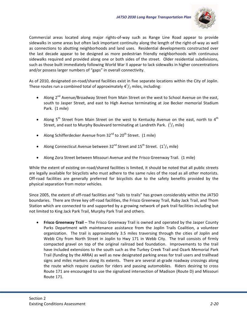
Section�2�Existing�C
�Commercsidewalksas�connecthe� last� dsidewalkssuch�as�thand/or�po�As�of�201These�rou�
� AsoPa
�� A
St
� A�
� A�
� A
While�theare�legallyOff*road�physical�s�Since�200boundarieStation�wnot�limite�
� FrPaoWcohTrsithRR
��
onditions�Ass
cial� areas� locs�in�some�areactions� to�abudecade� appes�required�anhose�built�immossess�larger�n
0,�designatedutes�run�a�com
long�2nd�Avenouth� to� Jaspeark.��(1�mile)�
long� 5th� Stretreet,�and�eas
long�Schifferd
long�Connect
long�Zora�Str
e�extent�of�exy�available�fofacilities� areeparation�fro
05,�the�extentes.��There�arehich�are�conn
ed�to�King�Jack
risco�Greenwarks� Departmrganization.� �
Webb� City� froompacted� grave�included�rail�(funding�gns�and�mile
he� route� whioute�171�areoute�171.�
sessment�
cated� along�as�but�often�
utting�neighboar� to� be� desd�provided�a
mediately�follnumbers�of�“
d�on*road/shambined�total�
nue/Broadwaer� Street,� and
et� from� Mainst�to�Murphy�
decker�Avenu
ticut�Avenue�
eet�between�
xisting�on*roaor�bicyclists�w
generally� pom�motor�veh
t�of�off*road�fe�three�key�ofnected�to�andk�Park�Trail,�M
way�Trail�–�Thment� with� m
The� trail� is�om� North� Stravel� on� top�extensions�t
by�the�ARRA)es�markers�alch� require� ca�encouraged�
major� rightslack�importanorhoods�and�signed� as� molong�one�or�lowing�Worldgaps”�in�over
ared�facilitiesof�approxima
ay�Street�fromd� east� to� Hig
n� Street� on� tBoulevard�te
ue�from�32nd�t
between�32nd
Missouri�Ave
d/shared�facwho�must�adh
referred� for�hicles.���
facilities�and�ff*road�facilitd�supported�bMurphy�Park�T
he�Frisco�Greeaintenance� aapproximateeet� in� Joplin�of� the� origino�the�south�s)�as�well�as�neong�its�extenaution� for� ridto�use�the�si
JATSO�2030�Lo
s*of*way� suchnt�continuity�land�uses.� �R
ore� pedestriaboth�sides�of
d�War�II�appearall�connectiv
s�exist�in�five�ately�41/2�mile
m�Main�Streetgh� Avenue� te
the� west� to�erminating�at�
to�20th�Street
d�Street�and�1
enue�and�the�
ilities�is�limitehere�to�the�sa
bicyclists� du
“rails�to�trailsies,�the�Friscoby�a�growing�Trail�and�othe
enway�Trail�isassistance� froly� 3.5� miles�to� Hwy� 171
al� railroad� bsuch�as�the�Tew�designate
nts.� �There�arders� and� pasgnalized�inte
ong�Range�Tra
h� as� Range�along�the�len
Residential�dan� friendly� nef� the�street.�ar�to�lack�side
vity.�
separate�loces,�including:
t�on�the�westerminating� at�
Kentucky� AveLandreth�Par
.��(1�mile)�
15th�Street.��(1
Frisco�Green
ed,�it�should�ame�rules�of�tue� to� the� sa
s”�has�growno�Greenway�Tnetwork�of�p
ers.���
s�owned�and�om� the� Joplitraversing� th
1� in� Webb� Citbed� foundatioTurkey�Creek�ed�parking�arere�several�at*ssing� automorsection�of�M
ansportation�P
Line� Road� angth�of�the�ri
developmentseighborhood�Older�resideewalks�in�high
ations�within
t�to�School�AvJoe� Becker� m
enue� on� the�rk.��(1/2�mile)�
11/3�mile)��
way�Trail.��(1
be�noted�thathe�road�as�afety� benefits
n�considerablyTrail,�Ruby�Japark�trail�faci
operated�by�n� Trails� Coa
hrough� the� cty.� � The� trailon.� � ImproveTrail�and�Oza
eas�for�trail�ugrade�roadw
obiles.� � RidersMadison�(Rout
Plan�
appear� to� prght*of*way�a
s�constructeds� with� contin
ential�subdiviher�concentra
n�the�City�of�J
venue�on�thememorial� Sta
east,� north��
�mile)��
at�all�public�stall�other�motos� provided� b
y�within�the�Jck�Trail,�and�lities�includin
the�Jasper�Clition,� a� voluities� of� Joplin� consists� of� fments� to� theark�Memoriausers�and�trai
way�crossings�s� desiring� to�te�D)�and�Mis
2�20�
rovide�s�well�
d�over�nuous�sions,�ations�
oplin.��
e�east,�adium�
to� 4th�
treets�orists.��
by� the�
JATSO�Thom�
ng�but�
ounty�unteer�n� and�firmly�e� trail�l�Park�ilhead�along�cross�
ssouri�

Section�2�Existing�C
� RCStcoalImm
�� Th
ptrFrthso
�In�additioarea� alsooperated�SchifferdeBoulevardalong�witwestwardfrom�KingJoplin.� � Tapproxim�
2.4� A�The� latestransportsummariz�The�Joplincargo,�genis�locatedwithin�theof�the�daiCity� Counconsists�oAirport�st�2.4.1��
� 20Jogrto
onditions�Ass
uby� Jack�Traarthage�and�ttate�Line.� � � Tonsisting� of� flong� the� maj
mprovementsmile�marker�si
hom� Stationroviding� linkarial� will� ultimrisco�Greenwhe� trail�has�bouth�as�fundi
on�to�the�off�r� provide� a� nopen� space
ecker� Park,� Md� Park� Trail.� �h�connection
d� to� link� withg�Jack�Park�toThe� trail� is� an
ately�1.5�mile
AVIATION�
t� update� to�ation� plannin
zes�subsequen
n�Regional�Aineral�aviation�directly�to�th
e�City�of�Joplily�operations
ncil,� is� in� placof�one�airfieldaff�is�cross*tr
RECENT�AIRP
003:��A�$500,oplin� Businesrowth.��Airpoo�help�bring�a
sessment�
il�–�The�Rubytraveling�thro
The�majority�firmly� packedority� of� the�
s�along�the�tagns�along�the
� Trail� –� Theages�betweenately� provide
way�Trail�trailhbeen�completng�becomes�a
road/rails*to*network� of� pes.� � These� inMcIndoe� ParThe� King� Jac
s�to�the�Frisc� three� other�17th�Street.�
n� 8� foot� widees.���
the� Joplin� Rng� process� rnt�implement
rport,�ownedn�and�corporahe�north�of�Rn’s�Public�Wo
s.��An�Airport�ce� to� provided�operations�mained�to�perf
PORT�DEVELO
,000�federal�gss� Developmort�officials�utadditional�serv
y� Jack�Trail� isough�the�towof� the� trail� isd� gravel.� � Wroute� make� iail� include�a�ne�entire�lengt
e� Thom� Statin�downtown�e� connectionhead�in�the�hted�by� the�Ciavailable.��
trails�facilitiepark� trail� facinclude� but� ark,� Ozark� Meck� Park� Trial�co�Greenway�
park� proper�The�Murphy
e� firmly� pack
Regional� Airporetains� the� rtations�of�tho
d�and�operateate�aviation�dRoute�171�andorks�DepartmAdvisory�Boa
e� guidance� anmanager,�fouform�operatio
OPMENTS�
grant�was�recent� and� Induilized�the�gravices�to�Joplin
JATSO�2030�Lo
s�approximatwns�of�Oronogs�primitive� inhile� completit� best� suitednew�bridge�ah�of�the�route
ion� Trail� is� CCarl�Junctions� between� th
heart�of�the�Cty�of�Carl� Jun
es�listed�abovilities� within�are� not� limitemorial� Parkconsists� of� aTrail.��Future
rties� within� Wy�Boulevard�Pked� gravel� su
ort� Master� Pecommendat
ose�recomme
ed�by�the�cityemands�for�md�east�of�Rou
ment.��An�Airpard,�consistingnd� direction� tr�operations�
ons�and�maint
eived�and�maustrial� Corpont�monies�to�n.�
ong�Range�Tra
tely�16� miles�go,�Carl�Junct�materials�wely� open� to�
d� for� hiking� aand�trailhead�e.��
Carl� Junctionn�and�the�Brihe� Ruby� JackCity�of�Joplin.nction�with�p
ve,�stakeholdetheir� diversi
ted� to� the�k� Trail,� King�an� 8*foot� wide�phases�planWebb� City,� asPark�Trail�is�a�urface� travers
Plan� was� in�tions� that� thndations.�
y�of�Joplin,�semuch�of�southute�43.��The�mort�Manager�g�of�seven�meto� the� Airporshift�personntenance�dutie
atched�by�a�$oration� (JBDIC�offer�new�in
ansportation�P
in�overall� letion,�and�onw
with�only�apprthe� public� it
and� mountainsignage�in�C
n’s� newest� warbrook�area
k� Trail� in� Car.��Approximatplans� to�exte
er�communitiity� of� municiMcClelland� PJack� Park� T
de� asphalt� tran�to�follow�a�ss� well� as� a� sopopular�walk
sing� the� park
2002,� and� JAhe� airport� pl
erves�the�comhwestern�Mis
management�is�responsibl
embers�apport� Manager.� Onel,�and�one�ses.�
$100,000�comC)� in� supporcentives�to�co
Plan�
ngth,� beginnward�to�the�Kroximately�3�ts� rough� subn� biking� purp
Carthage�as�w
walking/bikinga.� �As�plannedl� Junction� antely�¾�of�a�mnd� the� trail� t
ies�with�the�Jipality� ownedPark,� Dover�Trail,� and� Mail� within� thestreamway�fuoutherly� exteking�trail�in�cek� with� a� leng
ATSO’s� long�lan� put� forth
mmercial,�missouri.��The�aof�the�airpore�for�the�ove
ointed�by�the�JOther� airportseasonal�assi
mmitment�frort� of� the� airommercial�ca
2�21�
ing� in�Kansas�
miles�strate�poses.��
well�as�
g� trail�d,�the�
nd� the�mile�of�to� the�
JATSO�d� and�Park,�
urphy�e� park�urther�ension�entral�gth� of�
range�h� and�
litary,�irport�
rt�falls�ersight�Joplin�t� staff�stant.��
m�the�port’s�
arriers�

Section�2�Existing�C
� 20ye(pinp
� 20mA
� 20ge
�2.4.2��The�Airpoon� airpornavigationfrom�surfair�traffic��AIRSIDE�FA�
R6,loRas
�A13Dpap
�Liofliglig18in
�LANDSIDE�F�
TeThparte
onditions�Ass
004:��Federalear*old� termproximity�to�mnefficient� in� dossible�at�this008:� �Constru
million� traffic�dministration009:� � Airsidenerator,�and
EXISTING�AIR
ort’s�facilities�rt� property�nal�aids,�and�ace�to�air�tracontrol�towe
CILITIES�
unways:� � Th,500� feet� lon
ong� and� 150�unway�18/36sphalt�and�is�
prons:��The�p33,500�squarue� to� the� cavement�waspron�and�taxi
ighting�and�Vf�the�intersecght,�180�degrghting�to�assi8/36�are�equ
ntensity�runw
FACILITIES�
erminal�Buildhe�2*story,�5*rivate� luggagreas,�a�businerminal�will�a
sessment�
�funding�wasminal� building
main�runway)daily� operatios�terminal.�uction�of� the
control� town;�the�remaine� and� lands
d�lighting�proj
RPORT�FACIL
consist�of�twdirectly� assoairport�lightinnsportation�s
er�and�aircraft
e� Airport� useng�and�100� fe
wide.� � The� t6�is�paved�witin�fair�condit
primary�apronre�feet�of�conconstruction�s�added�nortiway�needs�of
Visual�Aids:��Tction�of�Runwrees�apart.��Tist�approachi
uipped�with�hway�lights.�
ding:� �The�ne*gate�termina
ge� screening�ess�center,� olso�be�able�to
�received�to�pg� that� had� b),�a�security�cons.� � In� gene
�new�$15�mier.� � 90%� of�ing�funds�we
side� improveject�and�a�par
LITIES�
wo�categories:ociated� with�ng.�The�landssuch�as�the�pat�maintenanc
es� a� three*rueet�wide.� �Ththird� runwayth�asphalt�anion.��Runway�
n�was�locatedncrete.��It�serv
the� new� terh�of�Runwayf�the�new�fac
The�airport�isways�18/36�anhe�runway�enng�aircraft�id
high�intensity
ew�airport� teal�includes�puarea,� a� cover
offices,�a� traino�accommoda
JATSO�2030�Lo
plan�and�desibecome� an� oconcern�(proxeral,� expansio
llion�terminathe� costs� w
re�supplied�bements� contirking�lot�impr
:�airside�and�aircraft� ope
ide�areas�inclassenger�terme�facilities.�
unway� systeme�secondary�
y� (Runway� 05d�is�in�excelle13/31�has�gr
d�in�the�southved�the�previrminal� facilit13/31�and�wility.��
�identified�bynd�13/31.��Thnds,�or�threshentifying�the�runway�light
rminal�encomublic�lobby,�aired� baggage�ning� facility,�ate�future�gro
ong�Range�Tra
ign�a�new�terobstruction� tximity�to�genon� of� airside�
al�was�complewere� covered�by�the�City�of�Jinued� includrovement.�
landside.��Therations,� suclude�those�faminal�building
m.� The� primarunway� (13/
5/23)� is� 3,60ent�conditionrooved�aspha
west�quadranious�terminaty,� approximwest�of�Runw
y�a�rotating�bis�beacon�pro
holds,�are�eque�runway�envts.� �Runway�5
mpasses�appirline�operaticlaim� area,� rboard� room,
owth.�
ansportation�P
rminal�to�repto� accommoeral�aviation�and� landside
eted� in�additthrough� the
Joplin.�ing� an� airfie
e�airside�facich� as� the� rucilities�that�pg.��Support�fa
ary� runway� (/31�or�Crossw04� feet� long� an.��Runway�05alt�in�good�con
nt�of�the�airpl�and�generalately� 20,000
way�18/36�to�
beacon�locateojects�one�greuipped�with�sironment.��R5/23�is�equip
roximately�22ons�and�tickerestrooms,� ca,�and�storm�s
Plan�
lace�the�nearodating� large
facilities),�ane� facilities� wa
tion�to�a�newe� Federal� Av
eld� electric�
lities�include�unways,� taxi
provide�a�tranacilities�includ
Runway� 18/3wind)� is�6,503and� 75� feet�5/23�is�pavedndition.���
port�and�consil�aviation�fac
0� square� yaraccommodat
ed�to�the�norteen�and�onestandard�threunways�13/3
pped�with�me
2,000�squareet�counter�aranopied� rentshelters.� � The
2�22�
rly�60*r� jets�
nd�too�as� not�
w�$3.5�viation�
vault,�
areas�ways,�
nsition�de�the�
36),� is�3� feet�wide.��
d�with�
ists�of�ilities.��
rds� of�te�the�
theast�white�
eshold�1�and�
edium�
e� feet.�eas,�a�
tal� car�e� new�

Section�2�Existing�C
�FiMpactein15dAFa
�Hh
�2.4.3��Through�lfederally*City�InterdepartingSaturdays�Commercinconsistelarger�airpa� peak� ofcommercyear�2009the�Joplincarrier.��TproposedWorth�anin�Joplin�t�
2.5� F
Across�theThese�monot� connshipping�amount�otransport�2.5.1��The�Joplin
onditions�Ass
ixed�Base�OpMizzou�Aviatio
arking,� hangccessories�anerminal�buildncluding�a�2,35,000� squareowns� for� apppproximatelyacility.�
Hangars:� � Theangar�units�a
COMMERCIA
late�2010,�thsubsidized� canational�Airp
g�from�Kansass�and�Sundays
cial�air�serviceency�of�air�serports,�rising�ff� over� 40,000ial�carriers�tr
9�produced�non�market�is�stiThe�bids�for�t� to�offer� flighd�St.�Louis�re
to�reverse�and
FREIGHT�
e�United�Statodes�can�be�gected� by� navcompanies,� s
of�air�cargo�wation.�
RAIL�
n�area�moves�
sessment�
perator�(FBO)on,�to�service�gars,� flight� tnd�aircraft�saling.�The�offic
300�square�foe� feet� of� maiproximately�y�23�addition
e� airport� owre�located�on
AL�FLIGHT�OP
e�airport� is�sarrier� commeort.��On�wee
s�City.��Only�tws.��The�curren
e�in�Joplin�hasrvice,�combinfuel�costs,�and0� annual� enpry�to�maintaino�more�than�4ill�strong�as�ehe�service�hahts�to�airport
espectively.��Bd�stabilize.��A
tes�and�the�wgrouped�into�vigable� watesuch� as� UPS�
within�the�reg
freight�by�ra
)�Facilities:��Tthe�general�a
training,� aircles.� �Mizzou�A
ce�space�for�toot�office�spacintenance� an14� aircraft� aal� tie*down�s
ns� several� T*n�the�airport�c
PERATIONS�
erved�by�oneercial� passengkdays,�they�owo�flights�fro
nt�operationa
s�been�intermned�with�the�rd�other�econlanements� inn�a�presence�4000�enplanevidenced�by�t
ave�come�frots�with� largerBoth�of�these�merican�Eagl
world,�goods�(four�categorrs,� freight� isand� Fed*Ex,�
gion.� �Rail�and
il�through�ser
JATSO�2030�Lo
The�Airport�praviation�activcraft� rentals,Aviation’s� fachis�building�cce�addition.�
nd� aircraft� stolong� the� souspaces�are�pr
*hangar� facilicampus�as�we
e�passenger�ager� service� boffer�three�fliom�Joplin�andl�contract�for
mittent�since�tresidual�effecomic�factors,
n� the� 1990s.� �in�the�Joplin
ements�for�Grthe�recent�bim�American�r�markets�thaproposals�cr
e�won�the�bid
freight)�are�mies:��boat,�pla
not� moved�operate� out�
d�trucking�are
rvice�of�three
ong�Range�Tra
resently�has�ovities.��Mizzou,� charter� figcility� is� locateconsists�of�apThe�hangar�sorage� area.�
uthern� edge�rovided�to� th
ities� and� sevell.�
airline,�Greatbetween� Jopli
ghts�departind�two�flights�fr�Great�Lakes�
the�deregulatcts�of�the�9/1,�has�led�to�a�� The� last� ten
n�market�despreat�Lakes�Airds�to�replaceEagle�and�Airan�the�currenreated�the�pod�and�will�beg
moved�using�ane,�train�andby� boat.� � Nof� the� Joplin
e�the�two�ma
e�railroads:�
ansportation�P
one�Fixed�Basu�Aviation�proghts,� mainteed�to�the�soupproximately�space�consists
Mizzou� Aviaof� the� gener
he�west�of� th
veral� privately
t�Lakes�Airlinein� Regional�Ang�from�Joplifrom�Kansas�Cexpires�late�i
tion�of�the�air1�terrorist�att�decline�of�en
n� years� have�pite�the�dowrlines.��Never
e�Great�Lakes�r�Choice�Onent�connectionotential�for�engin�its�contrac
many�modesd�truck.��As�t
None� of� the�n� Regional� Aajor�sources�
Plan�
se�Operator�(ovides�aircraftnance,� partsuthwest�of�th5,100�squares�of�approximation� provideral� aviation� ahe�Mizzou�Av
y� owned� sing
es,�which�proAirport� and� Kn�and�three�fCity�are�offerin�2010.�
rline�industrytacks,�proximnplanementsseen� a� numb
wnward�trendrtheless,�inter
Airlines�as�Jo.��If�selected,
n�does,�Dallanplanement�tct�late�in�201
�of�transportthe�Joplin�regmajor� produ
Airport� limitinof�regional�f
2�23�
(FBO),�t�fuel,�s� and�he�old�e�feet,�mately�es� tie*apron.��viation�
gle� T*
ovides�Kansas�flights�red�on�
y.��The�mity�to�
�since�ber� of�.� �The�rest�in�oplin’s�,�each�s*Fort�
trends�0.�
ation.��gion�is�uct� air�ng� the�reight������

Section�2�Existing�C
� Ka� B� M
KCS�and�BMNA�is�a�than� $25connects�MNA�is�prNorthern��2.5.2��The�Joplinbasis� andaccess.� �opportuninternatioInterstatefreight�be�The�Joplintotal,�it�is�5000� peoSexton�Inarea's�larg�
�
�� COM
1� Con2� Tri*S3� Tni�4� D�&
5�TranC��
6�BedTran
7� Tran8� Fron9� Dep
10� Jeff
11�DynDisp
12� R�&
onditions�Ass
ansas�City�Sourlington�Nor
Missouri�and�N
BNSF�are�ClasClass�II�railro0� million.� � Kregions�throurimarily�a�regArkansas.�
TRUCKING�
n�region�is�hid� continues� t
The� major�ities�are�bein
onal� inland� pe�49.��The�Jopeing�shipped�f
n�region�expeestimated�th
ople,� locally.� �c.,�Transport�gest�trucking�
MPANY�NAME��
n*Way�TruckloState�Motor�T(usa)�Inc�Aatc
&�D�Sexton�Incnsport�Distrib
d�Rock�Inc�Tri*nsit�Co��nsport�Distribntier�Leasing�pendable�Tranf Asbell�Excvtgno�Nobel�Tranpatch�Office���R�Trucking�In
sessment�
uthern�(KCS)�rthern�Santa�Northern�Arka
s�I�railroads,�oad,�which�meKCS� runs� norughout�the�cogional�railroad
storically�knoo� thrive� as� aroutes� conng�made�possiport.� � As� paplin�region�wifrom�the�Mid
eriences�signifhe�Joplin�trucCon*Way� TruDistribution�companies.��
Table�
oad�Inc��Transit�Co��co��c��bution�Compa
*State�Motor�
bution�CompaInc��
nsport�Inc��g�&�Trckg�Inc�nsportation�
ncorporated��
Fe�(BNSF)�ansas�(MNA)
meaning�theyeans�it�has�anrth*south� in�ountry�includd�that�connec
own�for�beinga� centrally� loecting� the� Jible�by�the�cuart� of� this� eill�benefit�frowest.�
ficant�truckinking�compan
uckload� Inc.,�Company�TDTable�2.5�list
2.5:�Major�A
D
any�T�D�
any��
C� Ca
D
JATSO�2030�Lo
y�have�annuannual�gross�redirection� and
ding�Chicago,�cts�to�local�ar
g�a�powerhouocated� MidweJoplin� regionurrent�push�theffort,� US*71�om�both�the�r
g�activity�andies�gross�oveTri*State� Mo
DC,�and�Bed�Rs�the�major�t
Area�Truckin
CITY��
Joplin��Joplin��
Duenweg��Carthage��
Joplin��
Joplin��Joplin��Joplin��
Carterville��arl�Junction��
Carthage��Duenweg��
ong�Range�Tra
al�gross�revenevenues�of�atd� connects� KTexas,�Califo
reas�througho
use�in�the�truest� hub� with
n� are� I*44� ahrough�KC�Sm� is� being� imroadway�imp
d�is�home�to�oer�½�billion�dootor� Transit� CRock�Inc�Tri*Srucking�comp
ng�Compani
LOCAL�EMPLOYEES�
2,440�1,135�220�218�
190�
174�150�85�68�65�
60�60�
ansportation�P
nues�of�more�t�least�$20�mKansas� City� arnia�and�the�out�Southwes
ucking�industh� great� Inters
nd� US*71.� �martPort�to�mmproved� to�provements�a
over�30�truckollars�annuallyCo.,� Tni� (usa)�State�Motor�Tpanies�in�the�
ies�
LOCATION�
HQ�Single�LocSingle�LocSingle�Loc
HQ�
HQ�Single�LocSingle�LocSingle�LocSingle�Loc
BrancHQ�
Plan�
than�$250�mmillion�but�no�
and� Dallas.�Pacific�Northstern�Missou
try�on�a�per�cstate� and� hig
Increased� fmake�Kansas�C
be� reclassifiend�the�increa
king�companiey�and�employInc.� Aacto,� D
Transit�Co.�arJoplin�region
TYPE�� ANV
� $25cation�� $cation��cation�� $
� $
� $2cation�� $cation��cation��cation��
ch�� $� $
2�24�
million.��more�BNSF�
hwest.��ri�and�
capita�ghway�reight�
City�an�ed� as�ase�in�
es.��In�y�over�D� &�D�re�the�.�
NUAL�SALES�VOLUME��
50,000,000*�$59,500,000�
$8,000,000�$26,034,199�
$30,900,000�
25,000,000*�$20,000,000�
$9,400,000�$5,200,000�$7,900,000�
$6,000,000*�$69,973,128�

Section�2�Existing�C
13� USF14� WC
15�L�&�Tran
16� Mpf
17�BueBulk
18� L�P�
19�C�&TRU
20� Stan21� Que22� J�C�C23� Que
24�ThoMO
25� J�&�26� Flee27� Har28� Atb29� Vitr30� Neo
31�MicTruc
32�HunCert
33�ServMov
34� AutTotal�EstAnnual�SSource:�
�
Curr2009©�20was�
*� Annu�At�a�regioare:�
� In� R� M� U� 3
onditions�Ass
F�Holland�Inc�Transport�InP�Transporta
nsportation�0f�Inc�Crossroa
esing�Bulk�Trak��and�F�Inc���C;�Fleet�Serv
UCKING,�&�TRndard�Trnsp�Seen�City�Air�FC�Trucking�Inceenscity�Air�Fompson�CapitOVE��
L�Transportatenor�Bros�Entrbor�Freight�Tt�Inc��
ran�Express�Inosho�Truckingchael�W�Bakercking��ntington�Woot.�Express�Logvant�Enterpriving��o�Truck�Transtimated�LocaSales�Volume
ent�year�data�is�9�by�Experian/Ap009�by�D&B®.�Alprovided�by�the
ual�Sales�Volume
onal�level,�the
nterstate�44;�Range�Line�RoMO�Rte.�249;�US�Rte.�71;�32nd�Street;�
sessment�
USFreightwayc��
ation�LLC�L&P�0s00��ads�Transportnsport�Inc�Bu
vice,�SHIKLES�ANSPORT��
Svcs�Inc��reight�Inc��c��rieght�Inc��al�Inc�CARS�O
tion��terprises�Inc��Tools�Usa�Inc��
nc��g�Inc��r�Mick�Baker�
ods�Logistics�Igistics��ses�Inc�Action
sport�Corp��l�Employees�
e�
for�the�year�200pplied�Geographll�rights�reserved�Joplin�Area�Cha
es�not�reported��
e�major�freigh
oad/US�71�Bus
ys��W
tation��uesing�
D
ON�THE�
nc�
n�
&� ��
�09,�5�year�projechic�Solutions.�Trad.�All�D&B�informamber�of�Comme
��estimated�base
ht�corridors,�a
siness�Route;
JATSO�2030�Lo
Joplin��Webb�City��
Carthage��Carthage��
Carthage��Joplin��
Duenweg��Joplin��Joplin��Joplin��Joplin��
Carthage��Joplin��
Carthage��Joplin��Joplin��Joplin��
Neosho��
Joplin��
Neosho��
Joplin��Joplin��
cted�data�is�for�thaffic�Count�data�mation�is�powereerce�
ed�on�similar�num
s�depicted�in
;�
ong�Range�Tra
59�40�
40�38�
25�25�
22�20�18�17�17�
17�16�14�11�11�10�10�
10�
10�
10�10�
5,315�
�the�year�2014.�M©�2009�by�Dataed�by�DUNSRight
mber�of�local�em
�Figure�2.11,
ansportation�P
BrancSingle�Loc
Single�LocSingle�Loc
BrancSingle�Loc
Single�LocHQ�
Single�LocSingle�LocSingle�Loc
Single�LocSingle�LocSingle�Loc
BrancSingle�Loc
BrancSingle�Loc
Single�Loc
Single�Loc
Single�LocHQ�
��
�More�About�Our�DaMetrix.�All�righttTM,�D&B's�Qua
mployee�
in�the�Joplin�
Plan�
ch�� $cation��
cation�� $cation��
ch�� $cation��
cation��� $
cation��cation��cation��
cation��cation��cation��ch�� $cation��ch��cation��
cation��
cation��
cation���
$5
�Data.�Demograpts�reserved.�Busiality�Process.�This
metropolitan
2�25�
$6,000,000*�$4,000,000�
$4,000,000*�$4,300,000�
$2,100,000*�$2,100,000�
$2,400,000�$2,000,000*�
$1,500,000�$1,100,000�$1,300,000�
$3,362,265�$3,200,000�$2,500,000�
$1,000,000*�$1,000,000�$500,000*�
$540,000�
$50,000�
$6,248,386�
$375,000�$500,000*�
567,982,978�
phic�data�©�iness�List�data�is�information�
n�area�
�

Section�2�Existing�C
� 7� M� M� S� 2� D
�These� regdowntowCrossroadPark,�Ced�2.5.3��There�are
� C� Jo� Jo� Jo� Jo� C
�The� largearea.��It�cCounty�Roas� one� ofCommuniFabricatio�Located�ssits�just�wto�Route�1�One�of�ththe�metroBoulevarddistributio�Another�iIndustrial�Line�RoadExpress�a�Two�smalon� the� w
onditions�Ass
7th�Street/MOMain�Street/MMcArthur�BlvdSchifferdecker20th�Street�Duquesne�Roa
gional� freightn� Joplin,� the�
ds�Center�Busar�Grove�Indu
INDUSTRIAL�
e�several�majorossroads�Ceoplin�Airpark�oplin�Southeroplin�Webb�Coplin�Westernedar�Grove�In
st� industrial�covers�the�areoad�190�(Prigf� the� top� siteication� Soluton,�and�Stand
outh�of�the�Jowest�of�St.�Lou171�providing
he�larger�induopolitan�aread.��It�includes�on�center�of�C
ndustrial�arePark.��The�pa
d,�and�west�ond�XPEDX.�
ler�industrial�west� side� of�
sessment�
O�Rte.�66;�MO�Rte.�43;��d./MO�Rte.�17r�Avenue�
ad�
t� corridors� seSt.� John’s/Fr
siness�Park,�tustrial�Park,�a
PARKS�
or�industrial�anter�Business&�Industrial�Pn�Industrial�Pity�Industrial�
n�Industrial�Pandustrial�Park
park,� Crossroea�just�south�
gmore�Avenuees� for� expanstions� and� Teard�Transpor
oplin�Regionauis�Avenue.��Ig�connections
ustrial�parks,�J.��It�covers�thGulf�States�P
Conway�Freig
a�located�in�tark�is�locatedf�Duquesne�R
areas,�Joplinthe� Joplin� a
71;�
erve� the� Ranreeman�Westthe�Joplin�Souand�the�Joplin
areas�in�the�Jos�Park�Park�Park�
Park�ark�k�
oads� Center�of�I*44,�nort
e).��The�Crossion� in� the� coechnology� (Crtation.��This�i
al�Airport�andn�addition�to
s�to�the�regio
Joplin�Southehe�area�just�nPaper�Companght�Trucking.
the�northeast�generally�no
Road.�It�includ
�Western�Indarea� east� of�
JATSO�2030�Lo
nge� Line� comt�medical�areuthern� Indust
n�Western�Ind
oplin�metro�a
Business� Parkth�of�Route�Fsroads�Industountry.� � IndusCST),� Great�industrial�par
d�Missouri�Roo�being�close�nal�Interstate
ern�Industrialnorth�of�Routny�and�the�Pi
t�part�of�the�orth�of�Zora�Sdes�such�freig
dustrial�Park�aSchifferdeck
ong�Range�Tra
mmercial� areaea,� the� Joplintrial�Park,�th
dustrial�Park.
rea:�
k,� is� located�F�(32nd�Streettrial�Park�has�stries� locatedOutdoor,� C
rk�has�excelle
ute�171,�the�Jto�the�airpor
e�and�highwa
�Park,�is�locate�FF,�south�ollsbury�Comp
metropolitanStreet,�south�oght�forwarde
and�Cedar�Grker� Avenue�
ansportation�P
a,� the� Joplinn�Airpark�&� Ine�Joplin�–�W
southeast� oft)�and�to�the�670�acres,�an
d� in� the� ParkComponent� P
nt�access�to�I
Joplin�Air�Parrt,�this�locatioys.��
ted�in�the�soof�20th�Street,pany.��Nearby
n�area�is�the�Jof�Cardinal�R
ers�as�Airborn
rove�Industriaat� 7th� Street
Plan�
� Regional� Aindustrial�Parebb�City� Indu
f� the� metropeastside�of�J
nd�has�been�k� presently� inPackaging,� B*44�and�US*7
rk�&�Industriaon�has�great�a
utheast�port,�and�aast�of�
y�on�Route�FF�
Joplin�–�Weboad,�east�of�R
ne�Express,�Fe
al�Park,�are�lot� and� 20th� S
2�26�
rport,�k,� the�ustrial�
olitan�Jasper�noted�
nclude�Bruner�71.�
al�Park�access�
ion�of�Davis�is�the�
b�City�Range�ederal�
ocated�Street,�

Section�2�Existing�C
respectiveWest�Corr�In� and� aresponsibof� chemictruck�bod
�����������������������������������������
onditions�Ass
ely.��Both�of�tridor�improve
round� these�ble�for�significcals,� batteriesies;�Pillsbury,
sessment�
these�locationements.��
industrial� acant�goods�ms,� fabricated�,�a�maker�of�f
ns�provide�rai
reas,� there�ovement�actimetal� produ
frozen�foods;�
JATSO�2030�Lo
il�access�and�
are� a� numbivity.��Some�oucts� and� auto
and�Tamko�R
ong�Range�Tra
will�see�grow
ber� of� large�of�the�largest�o� parts;� Able�Roofing�Produ
ansportation�P
wth�potential�
manufacturiinclude:�EaglBody� Corpor
ucts.��
Plan�
with�the�prop
ng� firms� thale*Pitcher,�a�mration,� a� mak
2�27�
posed�
at� are�maker�ker� of�

��������
���� �������
��������
�������
����������
�������
��������
�������������
�����������
������������� ��������������
!�������"���
#�������$��� ��
%����&����'�(
������������
� ���������)�����
� ������**�+�����
�����
=���!!
#2�&�!!
#2�&�!!
"2��!
!
������!������
�
����
����
����
����
����
��
�����
�����
�����
�����
"�������
��
��,��
�����������
!�
��������!�
�
-� �������
)�.���������
/0���������
01� �������
�����
����2�����
��������0151">���&���� �����������
!���
�����5�!������
2��9�����5�!������
� <���������?�#��������'���
�3���#�����
������!��������������
&���� ��2������&������0,55

Section�3�2030�Mod
SECTION
2030��A� Long�improvemnature�anprovide�oinclude�ansome�maycompletemunicipal�There�arethe�transpcorridor�t
� R� Tr� Tr� P�
3.1� 2
JATSO� stascenarios�determineconditionhighway� ctransportimprovemconstructwere� inclincluded�ia�10*year�Table�3.1��
Roadway�Zora�StreeZora�Stree7th�Street�SchifferdeMaiden�La��
dal�Recomme
N�3�MODAL�
Range� Tranments�that�cand�scope.� � Thr�enhance�con�additional�sy�not�come�td� over� a� shol�staff�to�impl
e�several�viablportation�systhat�is�projectoadway�consransportationransportationublic�Transpo
2030�TRAV
aff� provided�for� the� yea
e� future� travs� were� detecapacity.� � Aftation�conditio
ments�to�the�ion.� �This� is�cluded� are� thin�dedicated�transportatio
.�
et�et�
ecker�Ave.�ane�
endations�
RECOMM
nsportation�n�affect�the�r
hey� can� rangeonnectivity�acstop.��Some�reto�fruition�unort� duration,�ement�and�m
le�mobility�optem.��Some�wted�to�experietruction�
n�System�Mann�Demand�Maortation�
VEL�DEMAN
a� travel� demar� 2030.� � In�vel� volumes�rmined� by� coter� the� existions�is�to�examroadway�systcalled�an�exishose� projectslocal�fundingon�tax.��A�list
Table�3.1:�
From�Main�StrMain�StrDuquesn7th�Stree9th�Stree
MENDAT
Plan� provideregion’s�transe� in� size� fromcross�the�regioecommendatntil�closer�to�t
but� some� mmaintain.�
ptions�that�caways�to�improence�traffic�co
nagement�anagement�
ND�MODEL
mand� model�long� range�
on� the� roadomparing� theing� conditionmine�what�tratem�were�masting�plus�coms� contained�g�such�as�the��of�committe
Committed�
reet�(MO�43)reet�(MO�43)ne�Road�t�t�
JATSO�2030�Lo
TIONS�es� guidanceportation�sys
m�multi*millioon�to�traffic�sions�may�reqthe�2030�pla
may� require�
n�be�utilized�ove�the�efficieongestion�inc
L�
that� was� usplanning� stuway� system�e� most� rece
ns� are� assessansportation�ade�beyond�wmmitted�netwin� the� TransJoplin�10*Yea
ed�projects�in
Projects�in�2�
To�*�Range�LMO�24932nd�Str30th�Str
ong�Range�Tra
e� and� recomstem.��These�on� dollar� capsignal�upgrad
quire�only�a�ponning�horizoa� continual�
to�improve�oency�of�the�traclude:�
sed� to� forecaudies,� travel�
given� anticipnt� available�ed,� a� commoproblems�cou
what� is�currework� (E�+�C).sportation� Imar�Transportacluded�in�the
2030�E+C�Ne
Line�Road�9�reet�reet�
ansportation�P
mmendationsenhancemenital� improvem
des�to�alteringolicy�change�n.� �Furthermeffort� by� JAT
operation�andansportation
ast� travel� dedemand� mo
pated� growthtraffic� count
on� practice� iuld�be�expect
ently�funded�o.� �The�comm
mprovement�ation�Programe�2030�E+C�ne
etwork�
DescriNew�IWidenWidenWidenWiden
Plan�
s� on� needsnts�can�be�varment� projectsg�a�transit�routo�implemenore,�some�mTSO,� MoDOT
d�performanc�network�alon
emand� for� vaodels� are� ush.� � Existing� tts� with� streen� assessing� fted�if�no�addior�currently�uitted�projectsProgram� (TI
m�that�is�fundetwork�is�sho
iption�nterchange�n�to�4�Lanes�n�to�4�Lanes�n�to�4�Lanes�n�to�4�Lanes�
3�1�
� and�ried�in�s� that�ute�to�t,�and�
may�be�T,� and�
e�of�ng�a�
arious�ed� to�traffic�
et� and�future�tional�under�s� that�IP)� or�
ded�by�own�in�

Section�3�2030�Mod
The� primabreakdowat�individlook� at� thcapacities��
Ta�
��
RBRIARBROCENTRAL�CENTRAL�CENTRAL�CENTRAL�COYOTE�DCOYOTE�DCOYOTE�DCOYOTE�DCOYOTE�DCOYOTE�DE�20TH�STE�32ND�STE�7TH�ST�E�ZORA�STFIR�RD�I*44�RAMMADISONMADISONN�43�HWYN�43�HWYN�43�HWYN�LONE�EN�MAIN�SN�MAIN�SN�RANGEN�RANGEN�RANGEN�RANGEN�RANGEN�RANGE
dal�Recomme
ary� purpose�wns�or�capacit
ual�segmentshe� anticipates�and�levels�o
ble�3.2:�203
ROADWAY�OOK�DR�CITY�RD�CITY�RD�CITY�RD�CITY�RD�
DR�DR�DR�DR�DR�DR�T�T�
T�
P�N�ST�N�ST�Y�Y�Y�LM�AVE�
ST�ST��LINE�RD��LINE�RD��LINE�RD��LINE�RD��LINE�RD��LINE�RD�
endations�
of� performinty�problems�is�that�are�antd� condition� of�service�for�r
0�E+C�Forec
FR
Fir�Rd�W�20th�SUS�Hwy�W�JungeNewton�Arbor�RdApricot�DN�of�DeeS�of�ApriMcclellaDeer�Dr�WisconsUS�71�RaS�NorthpN�UplanBriarbroI*44�WB�MO�HwyMO�HwyOld�HwyGum�Rd�MO�HwyZora�St���Zora�St�RE�VeteraHodgdonTurkey�CE�NewmWaters�EE�Zora�StS�of�E�Ne
g� forecasts� on�the�transpoticipated�to�bof� the� overalroadway�segm
asted�Traffic
LOCATI
ROM�B
St� W66�EB� U
e�Blvd� URd� W
d� CDr� Mer�Dr� Sicot�Dr� And�Park� A
Nsin�Ave� Samp� Spark�Ln� Vd�Rd� Nok�Dr� LOn� S
y�171�WB� Wy�171�EB� My�43� C
Oy�171� G� H
Ramp� Eans�Way� En�Rd� SCreek�Rd� Nan�Rd� WEdge�Blvd� Et� Eewman�Rd� E
JATSO�2030�Lo
of� future� trafortation�systebe�congested,ll� corridor.� �Tments�include
c�Volumes,�
ON�
TO�Briarbrook�LnW�Junge�Blvd�US�Hwy�66�WBUS�Hwy�66�W�20th�St�Crow�Rd�Mcclelland�ParS�of�Apricot�DrApricot�Dr�Arbor�Rd�N�of�Deer�Dr�S�Michigan�AveS�Prigmore�AveVan�Winkle�StN�Main�St�RamLone�Elm�Rd�S�Rangeline�RdW�2nd�St�MO�Hwy�171�WCenter�Creek�DOld�Hwy�43�Gum�Rd�Hickory�Hills�DrE�Veterans�WaE�Eaglewood�RS�of�E�NewmanN�Hodgdon�RdWaters�Edge�BE�Zora�St�Enterprise�E�Newman�Rd
ong�Range�Tra
ffic� patterns� iem�will�occur�,�perhaps�theTable� 3.2� tabed�in�the�Year
Level�of�Ser
NO.�LANES
2�2�
B� 2�2�2�2�
rk� 2�2�2�2�2�
e� 4�e� 2�
4�mp� 2�
2�� 1�
2�WB� 2�Dr� 2�
2�2�
r� 2�y� 4�d� 4�
n�Rd� 4�4�
lvd� 4�4�4�4�
ansportation�P
is� to� be� able�or�worsen.��W
e�more�approbulates� the� pr�2030�E+C�ne
rvice�for�Sele
S�
��
V/C�0.79�0.73�0.76�0.71�0.88�0.75�0.88�0.76�0.76�0.70�0.76�0.76�0.86�0.72�0.70�0.71�0.71�0.76�1.25�0.70�0.71�0.81�0.78�0.77�0.78�0.80�0.77�0.77�0.75�0.75�0.80�
Plan�
to� identify� wWhile�one�canopriate�actionprojected� voluetwork.�
ected�Links
��
AADT�10,219�9,225�7,553�8,905�
11,400�9,505�
10,830�9,279�9,279�8,845�9,279�
19,319�10,970�25,435�8,529�9,179�6,609�9,471�
15,125�8,636�8,723�
10,208�9,915�
27,473�28,330�29,327�27,633�27,731�27,199�27,083�29,373�
3�2�
where�n�look�n�is�to�umes,�
��
LOS�D�D�D�D�E�D�E�D�D�D�D�D�E�D�D�D�D�D�F�D�D�D�D�D�D�D�D�D�D�D�D�

Section�3�2030�Mod
N�RANGEN�SCHIFFEN�SCHIFFENEWTONNEWTONOLD�66�BRANGE�LIRANGE�LIRANGE�LIRANGE�LIRANGE�LIRANGE�LIRANGE�LIRANGE�LIRANGE�LIRANGE�LIRANGE�LIRANGE�LIS�HEARNES�HEARNES�HEARNES�ILLINOISS�MADISOS�MADISOS�MAIN�STS�MAIN�STS�RANGE�S�RANGE�S�RANGE�S�RANGE�S�RANGE�S�RANGE�S�RANGE�S�RANGE�S�RANGE�SCHIFFERSTATE�HWSTATE�HWSTATE�HWSTATE�HWSTATE�HW
dal�Recomme
�LINE�RD�ERDECKER�AVEERDECKER�AVE�RD��RD�LVD�NE�RD�NE�RD�NE�RD�NE�RD�NE�RD�NE�RD�NE�RD�NE�RD�NE�RD�NE�RD�NE�RD�NE�RD�ES�BLVD�ES�BLVD�ES�BLVD�S�AVE�ON�AVE�ON�AVE�T�T�LINE�RD�LINE�RD�LINE�RD�LINE�RD�LINE�RD�LINE�RD�LINE�RD�LINE�RD�LINE�RD�
RDECKER�AVE�WY�171�WY�171�WY�171�WY�43�WY�86�
endations�
EnterpriE� Belle�CeE� S�of�W�Z
Central�CAshwooMO�171�Mall�Rd�E�4th�St�E�6th�St�E�7th�St�E�10th�StE�11th�StE�22nd�SE�13th�StE�15th�StE�16th�StE�17th�StE�20th�StGlendaleS�of�E�50E�50th�StSE�MurpW�CardiW�17th�SRiver�RdNorledgeE�24th�StE�29th�StE�30th�StE�36th�StI*44�RamE�44th�StSaginawKeller�DrE�32nd�SCrow�RdFir�Rd�Wall�St�E�of�Fir�RDouglas�State�Hw
se� Wnter�Rd� S
Zora�St� WCity�Rd� Ad�Ln� SEB�Ramp� M
TMEE
t� Et� E
St� Et� Et� Et� Et� Et� Ee�Blvd� I0th�St� Et� G
phy�Blvd� Enal�Dr� WSt� W� Ne�Pl� St� Et� Et� Et� E
mp� Et� K
w�Rd� Er� ISt� Ed� W
EM
Rd� WFir�Rd� S
wy�NN� R
JATSO�2030�Lo
W�Cardinal�DrS�of�W�Zora�StW�Zora�St�Ashwood�Ln�S�Country�ClubMO�171�WB�RaTurkey�Creek�RMall�Rd�E�4th�St�E�6th�St�E�7th�St�E�10th�St�E�20th�St�E�11th�St�E�13th�St�E�15th�St�E�16th�St�E�17th�St�*44�Ramp�
E�50th�St�Glendale�BlvdE�7th�St�W�17th�St�W�14th�Dt�Norledge�Pl�S�of�E�50th�St�E�22nd�St�E�24th�St�E�29th�St�E�32nd�St�E�36th�St�Keller�Dr�E�44th�St�*44�Ramps�
E�30th�St�W�32nd�St�E�of�Fir�Rd�MO�Hwy�43�Wall�St�S�of�Cedar�Dr�River�Rd�
ong�Range�Tra
4�2�2�2�
b�D� 2�amp� 2�Rd� 4�
4�4�4�4�4�4�4�4�4�4�4�1�2�3�3�4�4�2�2�4�4�4�4�4�3�2�3�4�2�2�2�2�2�2�
ansportation�P
0.70�0.75�0.73�0.89�0.89�0.73�0.76�0.74�0.79�0.79�0.84�0.84�0.83�0.82�0.84�0.91�0.75�0.76�0.99�0.97�1.07�0.87�0.72�0.74�0.89�0.97�0.83�0.76�0.76�0.78�0.85�0.85�0.70�0.85�0.77�0.75�0.86�0.85�0.88�0.71�0.74�
Plan�
25,567�9,562�9,310�
11,486�11,486�5,391�
27,136�26,012�27,980�28,335�30,122�30,265�30,236�29,480�30,180�33,129�27,332�27,471�7,408�
12,302�14,044�12,615�26,250�26,950�11,282�12,302�30,236�27,782�27,782�27,950�30,740�16,009�12,489�16,009�27,980�9,505�
15,303�15,182�15,691�12,520�9,156�
3�3�
D�D�D�E�E�D�D�D�D�D�D�D�D�D�D�E�D�D�F�F�F�E�D�D�E�F�D�D�D�D�E�E�D�E�D�D�E�D�E�D�D�

Section�3�2030�Mod
STATE�HWSTATE�HWSTATE�HWSTATE�HWSTATE�HWSTATE�HWSTATE�HWSTATE�HWSTATE�HWSTATE�HWSTATE�HWSTATE�HWSTATE�HWUS�71�RAUS�71�RAUS�HWY�6US�HWY�6W�ZORA�SW�32ND�SW�32ND�SW�32ND�SW�32ND�S
W�32ND�S�The�locatishown�in�
� Rp
� Rye
� Seca
�
dal�Recomme
WY�AA�WY�AA�WY�AA�WY�AA�WY�D�WY�D�WY�FF�WY�HH�WY�HH�WY�HH�WY�HH�WY�HH�WY�HH�MP�MP�66�66�St�ST�ST�ST�ST�
ST�
ions�where�trFigure�3.1.��Toute� 171� –�redicted�to�bange�Line�Roear�2030.�everal�corridoapacity,�parti
endations�
N�of�ElmS�of�Elm�E�Zora�StElm�Rd�W�2nd�SMO�HwyS�PrigmoCounty�RCounty�RSplit�RaiHwy�171State�HwE�CountySB�RampNB�RamN�ProspeN�Irwin�SN�lone�ES�Pearl�AS�Wall�AS�CountrIron�Gat
S�Catnip
raffic�volumeThese�locationThe� section�e�congested.�ad�–�Many�se
ors�that�tie�incularly�along�
m�Rd� SRd� E
t� SN
St� Wy�171� Wore�Ave� CRd�190� CRd�188� El�Dr� C
1�SB�Ramp� Hwy�AA� Sy�Road�188� Mp� ap� aerity�Ave� NSt� W
Elm�Ave� NAve� Sve� Sry�Club�R� Ses�Rd� S
�Ln� I
es�would�apprns�identified�wof� Route� 17
ections�of�Ra
nto�existing�fI*44.�
JATSO�2030�Lo
State�Hwy�HHElm�Rd�S�of�Elm�Rd�N�of�Elm�Rd�W�Church�St�W�2nd�St�County�Rd�180County�Rd�188E�of�County�RdCounty�Rd�190Hwy�171�NB�RaSplit�Rail�Dr�MPO�Boundaryat�E�32nd�St�at�E�32nd�St�N�Irwin�St�Wolfe�Dr�N�Upland�Rd�S�Wall�Ave�S�Joplin�Ave�S�Catnip�Ln�S�Schifferdecke
ron�Gates�Rd
roach�or�excewhere�future
71� between� F
nge�Line�Roa
reeway�interc
ong�Range�Tra
2�2�2�2�2�2�
� 2�� 2��188� 2�� 2�amp� 2�
2�y� 2�
2�2�2�2�2�4�4�2�
er� 2�
2�
eed�capacity�e�traffic�congeFir� Road� and
d�are�project
changes�are�
ansportation�P
0.71�0.73�0.73�0.74�0.75�0.80�0.71�0.85�0.85�0.85�0.74�0.96�0.81�0.75�0.79�0.91�0.92�0.75�0.71�0.74�0.97�0.71�
0.71�
for�a�Year�20estion�is�anticd� Route� 43� i
ted�to�approa
expected�to�
Plan�
7,892�8,171�8,171�8,256�9,324�
10,032�9,054�9,458�9,466�9,430�6,177�
10,899�9,001�8,644�8,805�
11,059�11,271�9,370�
25,802�24,885�12,362�8,912�
8,987�
030�E+C�netwcipated�includn� Airport� Dr
ach�capacity�
approach�or�
3�4�
D�D�D�D�D�D�D�D�D�D�D�F�D�D�D�E�E�D�D�D�F�D�
D�
work�is�de:�rive� is�
in�the�
reach�
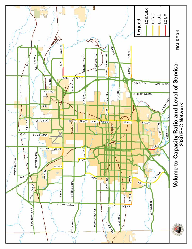
0.760
4
0.70
570.81
32
0.8115
0.7895
0.74
61
0.7342
0.779
0.7022
0.7092
0.70450.7636
0.7477
0.7654
0.7129
0.70
68
0.84
78
0.7453
0.7149
0.7414
0.71
8
0.74140.
8559
0.89
11
0.8845
0.90
65
0.8924
I-44
HW
Y
STA
TE
HW
Y 9
6
E 2
0TH
ST
IVY
RD
W 2
0TH
ST
E 7
TH
ST
E Z
OR
A S
T
FIR
RD
FOU
NTA
IN R
D
W 7
TH S
T
US 71 HWY
E N
EW
MA
N R
D
AP
RIC
OT
DR
ELM
RD
STA
TE
HW
Y A
A
STA
TE
HW
Y Y
Y
270
STATE HWY JJ
E IV
Y R
D
SAG
INAW
RD
STA
TE
HW
Y V
REINMILLER RD
Bel
le C
ente
r R
d
240
STA
TE
HW
Y P
Ced
ar D
r
220
US HW
Y 71
US H
WY
66
STA
TE
HW
Y Z
N 43 HWY
RIV
ER
RO
AD
CO RD 230
PINE ST
HAW
THO
RN
E
COUNTY RD
OLD
66
HW
Y
166
GU
M R
D
TEE
LN
US
HW
Y 6
6
IVY
RD
US 71 HWY
I-44
HW
YJo
plin
Jopl
in
Car
Car
Web
b C
ityW
ebb
City
LLi
d
Lege
nd LOS
A,B
,C
LOS
D
LOS
E
LOS
F
Volu
me
to C
apac
ity R
atio
and
Lev
el o
f Ser
vice
20
30 E
+C N
etw
ork
FIG
UR
E 3.
1

Section�3�2030�Mod
3.2� R�3.2.1��Building� nroadway�improve�a�A� numbetraffic,� stathrough�a
� Cto
� W� W
th� C� W� W� W
tw� W
le� W
tu�A�summaprojects�programmand�do�nodescribedprevious�projects�h��������������
dal�Recomme
ROADWAY�
ROADWAY�C
new� roads� ocapacity� for�
access�to�a�pa
r� of� roadwayakeholder� int
and�turn�lane�onstruction�oo�reduce�thro
Widening�of�RoWidening� of� Zhrough�lanes.onnection�of�
Widening�of�ScWidening�of�thWidening� of� 3wo*way�left*t
Widening�of�Beft*turn�lane�
Widening�of�Surn�lane�
ry�of�potentialready� com
med�for�2011ot�reflect�anyd�in�Section�4LRTP�have�re
have�been�bro
endations�
RECOMME
CONSTRUCTIO
r� widening� eall� types� of�
articular�area�
y� needs� and�terviews,� andcapacity�inclu
of�a�new�Wesough�traffic�anoute�171�from
Zora� Street� b�a�4*lane�Zora
chifferdeckerhe�Duquesne/32nd� Street� frurn�lane�lack�Cat�Road
St.�Louis�Aven
ial� roadway� immitted� in� th1�and�beyondy�prioritization.��Committed
etained�their�oken�down�in
ENDATIONS
ON�
existing� roadsmotorized� v
within�the�re
projects� wed� public� inpuude:�st�Corridor�nend�truck�traffim�Route�43�toetween� Rang
a�Street�from�r�Avenue�to�4�/Hall�corridorom� Schifferd
d�from�Route�
nue�from�Zor
mprovementhe� current� Jd.� �The�projecn.��Project�ev
d�projects�areidentification
n�shorter�segm
JATSO�2030�Lo
S�
s� can� help� avehicles.� � In�egion.�
re� identified�ut.� � Some� of�
ear/along�Cenic�on�city�routo�the�west�page� Line� Road�
Route�43�(Mthrough�lane
r�from�32nd�Stdecker� Avenu
66�(7th�Street
a�Street�to�R
t�projects� is� lATSO� Transpct� identificativaluation�and�identified�by
n�number�for�ments�and�are
ong�Range�Tra
alleviate� congsome� cases,
through� anathe� projects�
ntral�City�Roates.�
ast�Carl�Junctiand� Route� 2
ain�Street)�toes�from�Routetreet�north�thue� to� Central�
t)�to�32nd�Stre
Route�171�to�
listed� in�Tablportation� Imion�numbers�
d�prioritizationy�their�TIP�nu�traceability�e�identified�b
ansportation�P
gestion� by� pr,� new� or� imp
alysis� of� the�identified� th
d�connecting
ion�249� from� 2� t
o�the�proposee�66�(7th�Streehrough�Webb
City� Road� to
eet�to�include
include�a�ce
le�3.3.� � The� tmprovement�
have�been�an�as�part�of�t
umber.��Projepurposes.��In
by�number�an
Plan�
roviding� increproved� roads
forecasted� fhat� involve� a
g�Route�171�t
through� lanes
ed�West�Corriet)�to�Zora�Str�City�o� include� a� c
e�a�center�two
nter�two*way
table�also� incProgram� tha
assigned�arbitthis�LRTP�updcts�included�
n�some�cases,d�letter.�
3�6�
eased�s� also�
future�dding�
o�I*44�
s� to� 4�
dor.�reet�
center�
o*way�
y� left*
cludes�at� are�trarily�
date�is�in�the�,�such�

POTENTIAL�ROADWAY�PROJECTS
No. Route From To Description101a West�Corridor I*44 MO�66 New�highway�construction�w/�limited�access�(Scoping�TIP�#�09HS*10)101b West�Corridor MO�66 MO�171 New�highway�construction�w/�limited�access�(Scoping�TIP�#�09HS*10)102a MO�171 MO�43 Fir Widen�road�(2�to�4�lane�w/median�&�left*turn�lanes)�(Scoping�TIP�#�29HS*10)102b MO�171 Fir RTE�Z/Pennell Widen�road�(2�lane�to�4�lane�divided)�(Scoping�TIP�#�29HS*10)102c MO�171 RTE�Z/Pennell MO�96 Widen�road�(2�lane�to�4�lane�divided)�(Scoping�TIP�#�29HS*10)102d MO�171 MO�96 MPO�boundary Widen�road�(2�lane�to�4�lane�divided)103 Zora Range�Line MO�249 Improve�and�Widen�road�(2�lane�to�4�lane�w/median�&�left*turn�lanes)104 Zora West�Corridor Main Improve�and�Widen�road�(2�lane�to�4�lane�w/median�&�left*turn�lanes)
105a Schifferdecker MO�66 Zora Widen�road�(2�lane�to�4�lane�w/median�&�left*turn�lanes)135 20th Intersection�w/KCS * Grade�separation
106a Duquesne 7th�(MO�66) Newman Widen�road�(4�lane�to�4�lane�w/median�and�left*turn�lanes)106b Duquesne/Hall Newman 17th�(W.C.) Widen�road�(2�lane�to�4�lane�w/median�and�left*turn�lanes)107 Hall 17th�(W.C.) Hawthorne New�roadway�construction�&�Intersection�at�Centennial108 Range�Line Interchange�w/�I*44 * Reconstruct�interchange
109a MO�43 Intersection�w/�171 * Access�management�and�intersection�improvements113a Fir Peace�Church MO�171 Improve�and�add�center�turn�lane�and�roundabouts113b Fir Joplin Peace�Church Improve�and�add�center�turn�lane�and�roundabout115 Newman Duquesne MO�249 Improve�and�add�center�turn�lane116a MO�66 Maiden Schifferdecker Improve�and�add�center�turn�lane�(Scoping�TIP�#�28HS*10)116b MO�66 Maiden Range�Line Access�management�and�intersection�improvements�(Scoping�TIP�#28HS*10)117 20th West�Corridor Schifferdecker Improve�and�add�center�turn�lane
118a 32nd Schifferdecker Country�Club Improve�and�add�center�turn�lane118b 32nd Country�Club West�Corridor Improve�and�add�center�turn�lane�and�roundabouts136 15th Intersection�w/�KCS Grade�separation119 St.�Louis/Prairie�Flower Zora MO�171 Improve�and�add�center�turn�lane122 Black�Cat Newton MO�66 Improve�and�add�center�turn�lane124 17th Oronogo Range�Line New�roadway�construction127 RTE�Z RTE�YY MO�171 Improve�and�add�center�turn�lane�and�roundabouts128 CR�190 Interchange�w/�I*44 * Construct�interchange
134a RTE�FF Intersection�w/�Davis * Intersection�improvement137 Madison Daugherty Stadium Improve�and�add�center�turn�lane138 Connecticut 50th Highlander New�roadway�construction139 Duquesne Overpass�at�I*44 * New�overpass�construction140 Connecticut Overpass�at�I*44 * Improve�overpass�to�4�lane141 20th Duquesne MO�249 Improve�and�add�center�turn�lane142 Jackson Bridge�at�Shoal�Creek * Improve�bridge�at�Shoal�Creek143 Maiden Perkins Murphy Realign�and�improve144 Douglas�Fir State�Line Range�Line Preserve�corridor�for�east/west�arterial
106a Duquesne 32nd 7th Widen�road�(2�lane�to�5�lane)109b MO�43 MO�171 Carl�Junction Improve�and�add�center�turn�lane145 MO�66 Prosperity CR�190 Improve�and�add�center�turn�lane110 MO�171 Hall Main Access�management�and�intersection�improvements
111a Madison MO�171 13th�(W.C.) Access�management�and�intersection�improvements111b Range�Line 13th�(W.C.) 15th Access�management�and�intersection�improvements111c Range�Line Intersection�w/�15th * Access�management�and�intersection�improvements111d Range�Line 15th I*44 Access�management�and�intersection�improvements121 Peace�Church Zora Fir Improve�roadway125 Carl�Junction�Rd. Madison RTE�D New�roadway�construction126 44th Overpass�at�I*44 * New�overpass�construction
130a MO�96 RTE�JJ RTE�D Access�management�and�intersection�improvements130b MO�96 Intersection�w/�RTE�D Turn�lane�improvements131 RTE�D Hawthorne MO�96 Improve�and�construct�new�bridge132 RTE�D Intersection�w/�Ivy * Intersection�improvement133 RTE�FF Intersection�w/�Reinmiller * Intersection�improvement146 Old�71�(Tipton�Ford) Bridge�at�Shoal�Creek * Bridge�replacement
TIP�#03HL*10 20th Intersection�w/�Main * Intersection�improvementsTIP�#03HL*11 26th Maiden Schifferdecker Improve�and�add�center�turn�laneTIP�#02HL*11 Zora MO�43 Range�Line Widen�road�(2�lane�to�5�lane)TIP�#�01HL*10 Zora Interchange�at�Main * Interchange�construction�and�RR�grade�separationTIP�#01HL*11 Schifferdecker MO�66 32nd Widen�road�(2�lane�to�5�lane)TIP�#04HL*11 Broadway/Buchanan Florida St.�Louis Improve�and�add�center�turn�laneTIP�#05HL*11 St.�Louis Broadway Zora Improve�and�add�center�turn�lane
J*TC0516 26th Intersection�w/�Main * Intersection�improvementsTIP�#�02HL*10 Maiden�Ln. 9th*17th 20th*30th Widen�road�(4�to�5)TIP�#�7HS*11 MO�171 Interchange�w/RTE�HH * Ramp�improvementsPr
ojects�Alre
ady�Prog
rammed
Prop
osed
�Roa
dway�Projects
TABLE�3.3

Section�3�2030�Mod
Of�the�roatravel� demsummarizModel� datraveled,�network�i�
�
��3.2.2��Transportor�locatioincluding�monitorin�
dal�Recomme
adway�impromand� modelzes� the� outpuata� used� for�which� is�a�ms�included�in�
Table�3
2Alte
TRANSPORTA
tation�Systemn�by�examinitraffic� signa
ng�to�respond
endations�
vement�proje� to� compareut� from� sepa
comparisonmeasure�of�de
the�appendix
3.4:��Travel�D
2030 ernative
V
E+C 101a 101b 102a 102b 102c 102d 103 104
105a 135
106b 107 108
109a 116b 136 124 128
134a
ATION�SYSTE
m�Managemenng�solutions�al� improvem
d�to�incidents.
ects�given�coe� the� effects�arate� model� r� includes� th
elay.� �A�visualx.�
Demand�Mo
Vehicle MilesTraveled
(VMT)
3069210.173058120.323070150.523068073.463068289.253069220.333069210.173068656.513068142.453070019.53
3067901.44
3069703.083069308.51
3068605.75
3069240.73
EM�MANAGEM
nt�(TSM)�lookother�than�ad
ments,� limitin.�
JATSO�2030�Lo
nsideration,�of� each� on�
runs� with� eae� change� in�l�representat
odel�Output:
s VehicleHours
Travele(VMT)
73283.772300.573141.273180.373202.473283.073280.473186.373454.5
73135.1
73143.2
73252.473124.4
73322.6
73282.5
MENT�
ks�at�improvindding�lane�ca
ng� or� consol
ong�Range�Tra
19�projects�wthe� regional�ch� project� advehicle� mile
tion�of�the�pr
:��Summary�
e
d
Daily �Delay
(Hours75 0 59 -98326 -14235 -10349 -81.203 -0.749 -3.234 -97.45 1707 -148
-732825 -140
-7328-7328
42 -31.342 -159
-732863 38.8
-732856 -1.1
ng�traffic�opepacity.��This�clidating� drive
ansportation�P
were�evaluateroadway� ne
dded� to� the�es� traveled� arojects’�effect
of�Project�C
� y s)
Daily � Miles
0 3.2 -11090 2.5 940.4 3.4 -1137 26 -920.9 72 10.16 26 0 41 -553.7 0.8 -1068 8.6 809.4 84 -3E+06 0.5 -1309 84 -3E+06 84 -3E+06 33 492.9 9.3 98.34 84 -3E+06 88 -604.4 84 -3E+06 19 30.56
erations�withcan�include�aeways� and� i
Plan�
ed�in�the�203etwork.� � Tabl
network� by�and� vehicle�ts�on�the�roa
omparison
in�a�given�coa�variety�of�opintersections,
3�8�
0�E+C�le� 3.4�itself.��hours�
adway�
rridor�ptions�,� and�

Section�3�2030�Mod
Traffic�sigmeasure�increasingtotal.� The�Traffic�prothat� timinAccountinyield� signmitigate�benefits�aother�souretimed.�…upgradingThese�stuof� 145,00updates�hNational�T
The�City�otraffic� sigintersectigreater� eupdates�improvemcollaboratto�Main�S
Implementransportcommunicommuni�Another� Tlocation,�sa�roadwaystill�prese�The�City�oand� redecontinuedsuccessfuguidelineseasement�Potential�
� InR
dal�Recomme
gnal�timing�haavailable�to�tg�during�the�erefore� focu
ofessionals�hang� to� meet�ng�Office�reponificant� benecongestion� a
are�documenturces,�that�co…For�examplg�and�coordindies�showed�
00� vehicle� hohas�a�benefit/Transportation�
of� Joplin�andgnal� system(ons� on� 20th�xtent� on� its�signal� timing
ments� througte�to�providetreet�(MO�43
ntation� of� ination� safetycations� techncations*based
TSM� approacspacing,�and�y.��The�purporves�the�safe
of� Joplin�currevelopment/id� in� all� caseslly� implemens�should�suppts,�and�provid
TSM�projectsntersection� imegional�Airpo
endations�
as�a�greater�imthe�JATSO�jupast�20�yearssing� on� traf
ave�long�recochanging� tra
orted,�“Propefits� along� th
and� reduce� ated�in�numermpared�befoe,�the�state�o
nating�signal�can�annual�fue
ours.”� Anoth/cost�ratio�of�Operations�Co
�MoDOT�Dist(s).� � Adaptivand� 26th� Strroadway� systg� along� its�gh� its� Trackee�cross*coord3)�and�7th�Stre
telligent� trany� and� mobinologies.� � ITSd�information
ch� is� access� moperation�of�
ose�of�access�ty�and�traffic
rently� implemnfill� when� ts;� however,� cnt� a� standarport�the�consode�for�clear�fu
s�include�but�mprovementsort.�
mpact�on�tranrisdictions.�Ds.�Delays�at�tffic� signal� tim
ognized�the�vavel� patternserly�designed,e� corridors� a
accidents,� fueous�evaluatiore*and*after�
of�Washingtocontrol�equipel�reduction�oer� agency� re55:1,�with�an
oalition)�
trict�7�continve� traffic� sigeets� in� Joplitem� includingcorridors� oner� performanination�wher
eet�(MO�66)�th
nsportation� slity� and� enS� technologien�and�electron
managementdriveways,�mmanagement�movement�o
ments�access�the� opportuncooperation�rd� level� of� aolidation�of�d
unctional�area
are�not�limites� and� access
JATSO�2030�Lo
nsportation�sDelays�experie
raffic�signals�ming� is� trem
alue�of�desigs� and� charac,�operated,�aand� road� neel� consumptions,�providedresults�whenn�recently�co
pment�and�retof�295,500�gaecently� notesn�estimated�a
ue�to�make�agnal� operation,� and� MoDg� along� Rang
n� a� regular�nce� measurinre�their� routehat�were�imp
systems� (ITS)hances� prod
es� encompasnics�technolo
.� � Access� mamedian�openint�is�to�provideof�the�transpo
managemennity� presentsbetween� Moaccess� manadriveways�aloas�of�intersect
ed�to:�� managemen
ong�Range�Tra
system�efficieenced� in�road
contribute�amendously� be
gning�effectivecteristics.� Tennd�maintaine
etworks� on� wion,� air� pollu�to�us�(the�GA
n�signal�systemompleted�studtiming�existinallons�and�anns� that� a� proannual�user�s
advances� in� ion� has� receOT� is� consid
ge� Line� (Businbasis� and� qng� initiative.es� intersect,� iplemented�in�
)� is� a� specificductivity� thrss� a� broad� raogies.���
anagement� isngs,�interchane�access�to�laortation�syste
nt�along�majos� itself.� � AcoDOT� and� loagement� acroong�arterial�st
tions�of�publi
nt� to� Route�
ansportation�P
ency�than�anydway�travel�han�estimated�eneficial� to�
e�signal�timinn� years� ago,�ed�traffic�conwhich� they� autants� and� trAO)�by�FHWAms�were�instadies�quantifyng�signals�for�nual�reductio
ogram� of� regsavings�of�$64
improving�anently� been� indering� its� impness� 71).� � Mo
quantifies� the� � The� City�including�timspring�of�201
c� TSM� straterough� the� uange� of� wire
s� the� systemanges,�and�stre
and�developmem.�
or�corridors� fccess� managecal� jurisdictiooss� the� regireets,�encouric�roads.�
43� from� Zor
Plan�
y�other�operahave�been�ste25�percent�tregional� mo
ng�and�maintathe� U.S.� Ge
trol�signal�sysare� installed.�ravel� times.� TA,�states,�citiealled�expandeing�the�benefsix�signal�sys
on�in�vehicle�dgular� signal� t4�million.���(S
nd�maintaininnstalled� at�plementationoDOT� reviewe� effects� of�and� MoDOTing� improvem
10.�
egy� that� impuse� of� advaless� and� wir
atic� control� oeet�connectio
ments�in�a�way
or�both�greeement� shouons� is� requiron.� � Policiesrage�shared�a
ra� Street� to� J
3�9�
tional�eadily�
to�this�obility.�
aining�eneral�stems�They�
These�es�and�ed,�or�fits�of�
stems.�delays�timing�Source:�
ng�the�seven�
n� to� a�ws� and�
such�T� also�ments�
proves�anced�e� line�
of� the�ons�to�y�that�
nfield�ld� be�
red� to�s� and�access�
Joplin�

Section�3�2030�Mod
� In� In
I*� A
Sc� B
R� C
ro�3.2.3��Transportthat�use�trides�so�tvehicles.�providing�variable�wencourage�
3.3� T
The�existidisadvantobtaining�Area�Publstreams.��in�previou
� Rna
� Ufba
� UwM
� Eo
�The� succeparatransrecommecontinue�t
dal�Recomme
ntersection�imntersection� im44�to�Route�1ddition� of� tchifferdeckeretter� access�oad.�ontinued� trafoadways.�
TRANSPORTA
tation�Demanthe�transporthat�more�peo� In� some� catime�savings
work�hours�thed�to�support
TRANSIT�SY
ng�transit�systaged� public�
funding� throlicTransit�SystMAPS�has�im
us�LRTPs.��TheReplacement�number�of�veas�needed.���Upgrade�of�refunds�along�wby�MAPS.��Thand�the�utilizaUpgrades� to�well�as� the�uMAPS.�Expansion�of�of�service�tim
esses� of� the�sit� service� tondations� areto�be�desired
endations�
mprovementsmprovements171�urn� lanes� an
r�Avenue�to�Nmanagemen
ffic� signal� tim
ATION�DEMA
nd�Managemetation�systemople�can�movases,� lanes� as�during�peakhat�allow�pert�TDM�strateg
YSTEM�
stem�in�the�Joand� commu
ough� federal�tem�(MAPS)�h
mplemented�oese�recomme
program� foehicles,�MAPS
eservation�anwith�a�20%�locis�latest�enhaation�of�a�wefacilities:� � thpgrades� to� tr
transit�servicmes�have�led�t
past� several�o� the� Joplin� vital� to� the�
d�by�the�gener
s�and�access�ms� and� access�
nd� additionaNorth�Park�Lan
t� along� 32nd
ming� and� coo
AND�MANAG
ent�(TDM)�is�am.��The�most�
ve�through�a�are� reserved�k�congestion.�rsons�to�avoidgies.�
oplin�area�hasters� in� geneSection�5310
has�utilized�a�or�is�currentlyndations�incl
or� vehicles:� �S�has�a�progr
nd�tracking�sycal�match�wilancement�wilb�portal�for�pe� new� constransit� stops�w
ce:��both�the�io�an�increase
years� aside,�n� area.� � Op
continued� sural�public�and
JATSO�2030�Lo
management�managemen
l� access� mane.�
Street� betw
ordination� rev
GEMENT�
an�approach�tcommon�wayroadway�segfor� carpools
�Other�strated�traveling�d
s�been�succesral.� � Human�
0� funds� to�pavariety�of�fu
y�implementude:�even� with� e
ram�in�place�t
ystems:��A�$2ll�continue�thll�provide�acc
public�reservaruction� of� vewill�prove�be
ntroduction�oe�in�riders�serv
MAPS� needspportunities�uccess� of� MAd�are�feasible�
ong�Range�Tra
to�Route�171t� to� Range� L
anagement� to
ween� Schiffer
view� and� up
that�seeks�toy�is�to�encougment�with�ts� or� transit�egies�include�uring�the�com
ssful�in�provid� service� age
ay� for� transit�nding�sourceing�most�of�t
expansion� ofto�continually
244,032�granhe�upgrade�thcess�to�a�dispation�use.��ehicle� storageeneficial� to�bo
of�deviated�fived�by�MAPS
s� to� continueexist� to� inc
APS� while� othfor�impleme
ansportation�P
1�from�Route�Line� Road/Ma
o� Route� 66�
rdecker� Aven
dates,� espec
o�reduce�the�nrage�commuhe�same�for�vehicles� to� eencouraging�
mmuter�peak
ding�travel�opncies� have� bvehicles.� �Si
es�to�supplemthe�recomme
f� services� any�replace�and
t�through�fedhe�informatioatch�system�f
e� and� mainteoth� the�oper
ixed�routes�aS.�
e� to� provide� qrease� these�
hers� are� suggntation.�
Plan�
43�to�Hall�Stradison� Street
(7th� Street)�
ue� and� Duqu
ially� along� ar
number�of�veters�to�sharefewer�numbencourage� utelecommut
ks.� �Businesse
ptions�for�botbeen� successmilarly,� the�M
ment�other�revendations�pro
d� increase� id�upgrade�ve
deral�Sectionon�technologyfrom�every�ve
enance� facilitators�and�us
nd�the�adjust
quality� transiservices.� �
gested� only� if
3�10�
reet.�� from���
from�
uesne�
rterial�
ehicles�e�their�ers�of�se� by�ing�or�es�are�
th�the�sful� in�Metro�venue�
ovided�
n� the�ehicles�
�5309�y�used�ehicle�
ies� as��ers�of�
tment�
it� and�Some�f� they�

Section�3�2030�Mod
�CONTINUAL�
Vpavsua�inexm
�SHORT�TER�
Extophotsese�Tuerithpmveual�
LONG�TERM�
ExcoinarthasacmAarsuve
�
dal�Recomme
L�RECOMMENDA
Vehicle� Operarogram�for�trverage� of� twuccessful�in�kcertain� servi
nhibit� the� abxpansion� out
may�arise.�
M�RECOMMEND
xpansion�of�So*curb� serviceotential�riderave�shift�worther�activitieservices.��For�tee�how�to�bet
urnout�Impronhancementsders� more� co
hat� they� did�ublic� transit�
more�heavily�tehicle� turnounload.� � This�lso�provides�d
M�RECOMMEND
xpansion� of�onsolidation�ncreases� in� rireas� in� the� JAhere�may�be�is� 32nd� Streetctivity� center
more�Range�Lill�of�these�oprise.��Regardiuch�as�Genevehicular�traffi
endations�
ATIONS�
ations,� Replaransit�vehicle
wo� to� three� veeping�the�agice� becomes,ility� of� MAPStpaces� MAPS
DATIONS�
Service�Hourse� have� been�rs�that�have�nk�that�encoms�that�are�undthese�and�othtter�serve�the
ovements�to�s�such�as�sheomfortable� anot� know� exas�a� result�ofthan�others,�suts.� � Turnoutsnot� only� incrdecreases�in�t
DATIONS�
f Service� Areof� services�
dership�may�ATSO�Study� Ainterest�in�ext� and� as� far� wrs� were� suggine�Road�destptions�shoulding�trolley�sto
va�Avenue�maic.
acement,� anes�needs�to�bvehicles� needge�of�its�trans,� no� expansioS� to� properly� operational�
s:��The�existinexpanded� a
nonstandard�mpasses�all�ho
derserved�byher�various�ree�public.�
Trolley�Stopselters�and�benand� may� attraxisted� beforef� those� improsome�should�s� provide� a� rreases� safety�traffic�delay�a
eas:� � The� tinto� more�be�experienc
Area.� � Input� epanded�routewest� as� Schi
gested� includitinations.��Fu
d�be�considerops�on�Rangeay�allow�this�c
JATSO�2030�Lo
d� Maintenane�continued.�
ds� to� be� repsit�fleet�to�a�ron� or� otherwy� maintain� a
capabilities,�
ng�service�hound� encompaswork�hours.�
ours�of�the�day�public�transieasons,�MAPS
s:��Many�of�thnches.��Theseact� more� ride� the� enhanceovements.� �Abe�identified
refuge� for� theand� setback
along�the�adja
trolley� systecost*effectiv
ced�with� theencountered�es�that�serve�fferdecker� Aing� industrialrthermore,�o
red�and�reevae�Line,�the�uscorridor�to�be
ong�Range�Tra
nce:� � The� m�At�the�curre
laced� every�ecommended
wise� change� innd� replace� tundesirable�
urs�of�both�thss� standard� w�Some�indust
ay�and�every�dit,�such�as�we
S�should�inves
he�existing�troe�enhancemeers� because�ements� and/
As�certain� trod�for�other�poe� transit� veh
k� from� the� roacent�roadwa
em� has� beeve� deviated��addition�ofduring�LRTPthe�southwe
Avenue.� � Addl� parks,� safe�
other�cities�maluated�as�the�of�turnouts
e�more�fully�u
ansportation�P
maintenance�ent�level�of�tyear.� � So� fard�level.��No�mn� service� shoransit� vehiclefinancial� or�
he�trolley�syswork� hours,�tries,�such�asday�of�the�weeeknight�and�stigate�these�
olley�stops�haents�certainly�
residents� ten/or� are� more�olley�stops�cootential�enhaicle� while� pa
oadway� of� thay.���
n� beneficial�fixed*route�trolley� route� public�meet
est�portion�of�itionally,� expafter*school�
may�benefit�frhe�Joplin�areas�or�stops�aloutilized�witho
Plan�
and� replacetwelve�vehicler,� MAPS� has�
matter�how�deould� be� allowes.� � If� any� seliability� situa
stem�and�the�but� there� m
s�the�medicaleek.��There�mweekend�relpotential�nee
ave�benefitedmake�the�ex
nd� to� notice�willing� to� en
ontinue�to�beancements�sussengers� loae� transit� stop
in� the� effeservice.� � Fu
es� that� serve�tings� suggestsJoplin�as�far�
pansion� to� spdestinations
om�trolley�sea�grows�and�nong�frontage�out�hindering�
3�11�
ement�es,�an�been�
esired�wed� to�
ervice�ations�
curb*ay� be��field,�
may�be�igious�eds�to�
d�from�xisting�stops�
ngage�e�used�uch�as�d� and�p,� but�
ective�urther�other�s� that�south�
pecific�s,� and�ervice.��needs�roads�other�
Section�3�2030�Mod
3.4� N
Based�upodesires,� amunicipalidentifiedfacilities�coff*road�c�3.4.1�
� Ininimu
��� Si
sh�� B
W�
� Evth
��� W
bCR
�� Ev
faar
� Can
dal�Recomme
NON�MOTO
on�the�foundand� recomml� plans/progr.� �These�opp
currently�locaclassifications
ON�ROAD�F
nclude� pedesntersection� improvement�nder�the�road
idewalk�enhahould�be�cont
icycle/pedestWebb�City�sho
valuate� existhese�location
Where� currenetween� 13th
onsideration�ange�Line�and
valuate� the�acilities�in�conre�not�limited
�– Zora�S– Schiffe– Duque– 32nd�St– Black�C– Duque– Conne– Duque– Peace�– 15th�St�
onsider� additnd�7th�Avenue
endations�
ORIZED�CIR
ations�of�the�mendations� c
rams,� a� serieortunities�bu
ated�throughos�and�are�dep
FACILITY�OPP
trian� sidewamprovementprojects�with
dway�section�
ancement�andtinued�to�pro
trian�actuatioould�be�install
ing� inaccessis�to�meet�all�
tly� missing,�� Street� andshould�be�gi
d�Hammons�B
potential� to�njunction�witd�to:�
treet�from�Werdecker�Roadesne�Road/Hatreet�from�ScCat�Road�fromesne�Road�at�tecticut�Avenuesne�Road�froChurch�Aven
treet�at�the�Ka
tional� sharede�to�provide�e
RCULATION
2001�Bicycleollected� fromes� of� non*m
uild�upon�andout�the�JATSOicted�in�Figur
ORTUNITIES
lks� in� conjunts� within� thh�potential� toof�this�report
d/or�installativide�and�pro
on�and�signal�ed�to�enhanc
ble� pedestriaADA�standard
install� sidewd� I*44)� to� fiven�to� instalBoulevard�to�
and� where�h�planned/pr
West�Corridor�d�from�MO66all�Road�from�hifferdecker�
m�Newton�Rothe�I*44�Overe�at�the�I*44�O
om�32nd�Streetnue�from�Zoraansas�City�So
d� road� lanes� aenhanced�nor
JATSO�2030�Lo
N�
e�and�Pedestrim� stakeholdeotorized� (pe
d�complemenO�area.���The�re�3.2.�
ction� with� thhe� JATSO� sto� include�pedt.��
ion�at/near�emote�safe�trip
at�the�intersce�pedestrian
an� facilities� tds.�
alks� along� cofacilitate� pedlation�of�a�peenhance�ped
feasible� encroposed�road
to�Main�Stree6�to�Zora�Stre
7th�Street�to�Road�to�Coun
oad�to�MO66rpass�Overpass�t�to�7th�Street
a�Street�to�Firuthern�railroa
along� Main� Srth*south�con
ong�Range�Tra
ian�Transporter� interview
edestrian/bicynt�the�existing�opportunitie
he� various� pltudy� area.� �destrian�sidew
existing�and�pps�to/from�sc
section�of�13t
n�safety.�
o� formulate�
ommercial� codestrian� circedestrian�ove
destrian�cross
courage� the�dway�improve
et�et�17th�Street�in
ntry�Club�Driv
t�r�Road�ad�grade�sepa
Street� and� Jonnections�wit
ansportation�P
tation�Plan�asws� and� review
ycle)� opportug�frameworkes�are�divided
lanned/propoA� list� of�
walk�enhance
proposed�educhool.�
th�Street�and�
a� plan� to� ad
orridors� (e.g.culation� and�erpass�near�tings.���
installation�ements.��Thes
n�Webb�City�ve�
aration�
oplin� Avenue�hin�the�down
Plan�
s�well�as�the�w� of� the� vaunities� have��of�non*motod�into�on*roa
osed� roadwaplanned/propements� is� inc
ucation�institu
Madison�Str
ddress� and� co
� Range� Line�� enhance� sthe� intersecti
of� shared� bse�may�includ
between� A� Sntown�core.�
3�12�
goals,�arious�
been�orized�d�and�
y� and�posed�
cluded�
utions�
eet�in�
orrect�
Road�afety.��ion�of�
bicycle�de�but�
Street�

Section�3�2030�Mod
���� C
HC��������������������������������������������
dal�Recomme
onsider� linkinighway� NN� aonnection�to�
endations�
ng� the� desigand� Highwaythe�off*road�
gnated� State�y� C� via� a� sha
bike�route�in
JATSO�2030�Lo
�bicycle� conn
ared� road� rou�Spiva�Park�sh
ong�Range�Tra
nector� routesutes� along� Rhould�also�be
ansportation�P
s� south� of� Redings� Mill� R
e�considered.�
Plan�
Redings� Mill�Road/Main� S�
3�13�
along�Street.��

��������
���� �������
��������
�������
����������
�������
��������
�������������
�����������
������������� ��������������
!�������"���
#�������$��� ��
%����&����'�(
������������
� ���������)�����
� ������**�+�����
�����
�
����
����
����
����
����
����
��
�����
�����
�����
�����
"�������
��
�� �**����������
����
�
��,��
�����������
!�
��������!�
�
-� �������
)�.���������
/0���������
01� �������
�����
����2�����
�������01513����)@�������� ����!��
3����)@��������**�!��
3����)@�������A!�������3����A
3�����'��������� ����!��
3�����'���������**�!��
3�����'��������A!�������3����A
�3���#�����
'� ��?�3����&������/,0

Section�3�2030�Mod
3.4.2�
� Cbro
�� A
St
� CriJA
� CthA
� Esin
� Inan
� InC
� InSt
� EneeTr
� Ccoth
�
3.5� A�CommercHowever,well� to� aclandside�i�While� mobeen�provongoing�e
dal�Recomme
OFF�ROAD�F
oordinate� wicycle� connecoute�along�Ro
ssist�Carl� Juntation�Trail�fu
ontinue� enhading/hiking� m
ATSO�stakeho
onnect�the�Tuhrough� a� covenue�as�wel
stablish�connncrease�circul
nclude�trail�fand�Hawthorn
nclude� trail� fhurch�Avenue
nclude�trail�fatreet�and�Ran
nhance� signanhance� pedencourage�riderail.�
ontinue� to� eonnections/ehe�JATSO�stud
AVIATION�
cial� airline� se�Joplin�Regioccommodate�mprovement
ost� of� the� larvided,�presereffort.� �Contin
endations�
FACILITY�OPP
ith� the� Missctions� by� linkoute�43.�
nction�where�urther�south�t
ancement� of�material.� � Tholder�member
urkey�Creek�Tmbination� ofl�as�a�pedestr
nections�betwation�alterna
acilities�as�pare�Road.��
facilities� as� pe�and�MO�17
acilities�as�pange�Line�Road
age� at� trail/restrian/rider�ers�that�arriv
encourage� lanxtensions�of�
dy�area.��
ervice� and� eonal�Airport�h
an� increase�ts�consistent�w
rge� expenditurvation�of�thenuation�of�th
PORTUNITIES
ouri� Departmking� the� Ruby
feasible� in� ttoward�Joplin
the� Ruby� Jachese� efforts� srs�such�as�Car
Trail�to�Missof� off*street�rian�bridge�ac
ween�the�trailtives�for�area
rt�of�future�ro
part� of� future1.�
rt�of�future�rd.�
oadway� crossafety.� � Co
ve�by�automo
nd� donationsexisting�trail�
enplanementhas�seen�sign
in� demand� fwith�the�Jopli
ures� recomme�existing�infrhe�maintenan
JATSO�2030�Lo
ment� of� Trany� Jack� Trail� t
he�continued.�
ck� Trail� throushould� be� forl�Junction�an
ouri�South�Staand� on*streecross�Turkey�C
ls�in�McClellaa�bicyclists�an
oadway�impro
e� roadway� im
roadway�imp
ssing� areas� sonsider� instaobile�to�park�
s� where� geofacilities�as�w
ts� have� contificant�upgrafor� services.� �in�Regional�A
mended� in� theastructure�an
nce�recomme
ong�Range�Tra
nsportation� (to� the� design
d�extension�a
ugh� the� instaocused� withinnd�Oronogo.
ate�Universityet/sidewalk� iCreek.��
and�Park,�McInd�walkers.�
ovements�to�
mprovement
rovements�to
uch� as� Zora�llation� of� adat�the�North
graphically� awell�as�develo
tinued� to� dedes�over�the� An� extensivirport�Master
e� Joplin� Regind�addressingendations�and
ansportation�P
(MoDOT)� to�nated� State� b
and�enhancem
allation� of� firn� the� munici
y�(MSSU)�to�thimprovement
Indoe�Park,�a
Hall�Street�be
ts� to� Fir� Roa
o�17th�Street�
Street� and� tdditional� direh�Street�trailh
appropriate� topment�of�ne
ecline� over��past�decadee� program� or�Plan�have�b
onal� Airport�g�needs�as�thd�smaller�upg
Plan�
enhance� regbikeway� conn
ment�of� the�
mly� packed� gpal� boundar
he�North�Parkts� along� New
and�Shoal�Cre
etween�17th�S
ad� between�
between�Oro
the� Frisco� Trection� signag
head�for�the�
to� facilitate� few�facilities�w
the� past� dee�and� is�positf� both� airsideen�impleme
Master� Planhey�arise�will�grades�as�stat
3�15�
gional�nector�
Thom�
gravel�ies� of�
k�Mall�wman�
eek�to�
Street�
Peace�
onogo�
rail� to�ge� to�Frisco�
future�within�
ecade.��tioned�e� and�
ented.���
� have�be�an�ted�in�

Section�3�2030�Mod
the�Joplincloser.��At�In�the�megrants� toavailable.�Additionaenplanemcome� outcommerc�
3.6� F�The� regiostakeholdroadway�wcommunitsuggested�Improvingroutes�to�projects.�recommeCorridor�t�Grade�sepas�neededon�I*44�atand� improexisting� MCrossroad�One� of� thdesignateincluded�a�One�of�thUpdate�wpotential�formed� caindustrial���
dal�Recomme
n�Regional�Airt�that�time,�a�
eantime,�the�o� supplement
�
ally,� the� airpoment� number
t� from� undeial�air�service
FREIGHT�
onal� freight�der� public� inpwidening�andty.��Many�of�t
d�as�part�of�th
g� Duquesne� Rimprove�the� Duquesne� fnded�to�be�w
to�Main;�and�
parations�withd�improvemet�CR�190�wasoving�the�safMO� 249� andds�Industrial�P
he� items� disced� truck� routeas�an�append
he�recommenwas�to�form�a
improvemenalled� the� Joparea�permits
endations�
rport�Master�Pnew�master�
Joplin�Regiont� ongoing� co
ort� should� cos� can� increas
er� the� federa�to�the�Joplin
hauling� comput� process.�d�intersectionthe�projects�s
he�LRTP�proce
Road,� Zora� Se�efficiency�offrom� 7th� to� 1widened,� in� tSchifferdecke
h�the�Kansas�ents�and�are��considered�a
fety�of�all�mod� I*44� interchPark.�
cussed� that� ise� network� anix�to�the�repo
ndations�froma�Freight�Advnts�to�freight�plin� Industrials.�
Plan�will�be�nplan�update�w
nal�Airport�shosts� and� pro
ontinue� its� efse� –� even� toal� Essential�
n�area.��The�A
mmunity� has� Stakeholder�improvemen
suggested�by�ess.�
Street,� Schiffef�moving�frei7th� Street� is�
two�projects,�er�is�recomme
City�Southernincluded�in�ta�critical�projotorists�by�rehange.� There
s� not� part� ofnd� signing� thort.��
m�the�Joplin�Misory�Commitmobility�and
l� Developmen
JATSO�2030�Lo
necessary�untwill�be�neede
hould�take�adovide� funding
ffort� to� conn� the� point� thAir� Service� pmerican�Eagle
� provided� inr� participantsnt�projects�ththe�freight�st
erdecker� Aveight.�These�rorecommendefrom�Range�
ended�to�be�w
n�(KCS)�RR�onhe�recommeject�for�the�trmoving�a� lar
e� is� a� high� v
f� a� traditionahem� accordin
Metropolitan�ttee�(FAC)�to
d�access.�Sincnt� Authority�
ong�Range�Tra
til�the�plannined.�
dvantage�of�Fg� for� unique
nect� to� largerhat� Joplin� Reprogram� ande�contract�is�
nput� into� ths� shared� a� nat�would�be�btakeholders�a
nue� and� 20th
outes�are�all�ed� for� widenLine�to�MO�
widened�from
n�both�20th�Strnded�projectrucking�commrge�percentagvolume� of� tr
al� infrastructugly.� The� ove
Area�Long�Ra�review�and�
ce�the�2005�u(JIDA)� to� rev
ansportation�P
ng�horizon�for
Federal�Aviatie� opportuniti
r� hubs� in� theegional� Airpod� provide� a�a�good�start�f
his� plan� direnumber� of� sigbeneficial�to�are�within�the
h� Street� wereincluded� in�t
ning� from� 2� t249�and�from
m�MO�66�to�Z
reet�and�15th�ts.�Constructimunity,�provige�of� the�trucrucks� in� this�
ure� improvemrall� stakehold
ange�Transporate�the�regi
update�there�view� and� app
Plan�
r�that�study�c
ion�Administries� as� they�
e� expectationrt� may� be� abmore� sustai
for�this�trend
ectly� throughgnal� coordinthe�freight�hae�scope�of�pro
e� identified� athe�recommeto� 4� lanes;� Zm�the�future�ora.��
Street�were�ng�an�interchding�better�ack�traffic� from
area� servin
ment� is� creatder� comment
ortation�Plan,ion’s�TIP�regahas�been�a�g
prove� reques
3�16�
comes�
ration�come�
n� that�ble� to�inable�.�
h� the�ation,�auling�ojects�
as� key�ended�ora� is�West�
noted�hange�access�m�the�g� the�
ting� a�ts� are�
�2005�arding�group�
sts� for�
Section�4�Financial�
SECTION
FINAN
The� finanthe�transpnot�be�viefeasible,�f�The�first�sin�the�Joproadway,�evaluate�cost/beneexpect� ovtransport�
4.1� F�AnticipateMost� fedelocal� jurisimprovemmeans.��Mtransportimprovem�4.1.1�
There�arecould�be�a
� Nfr
� InIn
� Suimfathm
� Bth
� Coq
� STimp
Plan�
N�4�NCIAL�PLA
ncial� plan� addportation�plaewed�as�an�ufinancially*co
step�is�to�ideplin�region�alo
public� transthe� potentia
efit� analysis�ver� the� nextation�system�
FUNDING�S
ed�revenues�teral�and�statsdictions� or� i
ments� can� beMoDOT,�counation� project
ments�that�be
FEDERAL�HIG
e�several�fundapplicable�for
National�Highwreeways,�exprnterstate�Manterstate�highurface� Trans
mprovement�acilities,�and�ohan� 200,000�
minimum�amoridge� (BR)� fu
hese�funds�arongestion�Muality�througTP�Safety� Pr
mprovementsrioritized�at�t
AN�dresses� existin.��The�need
unfunded�wisnstrained�pla
ntify�funding�ong�with�theisit,� non*mot
al� benefits� ofand� tempere� 20� years,� acan�be�produ
OURCES�
through�the�ye� funding� proimplementati� financed� thr
nty�and�local�ts� and� seek� onefit�all�parti
GHWAY�PRO
ding�programr�funding�projway�System�ressways,�andintenance�(IM
hways�and�cansportation� Prprojects� incl
other�transposuch� as� the�
ount�that�musunds� are� usee�sub*allocatitigation�andh�congestion�rogram� (STPs� that� reducehe�state�leve
ng� and� potes�and�project
sh� list.� �The�ren�that�can�re
sources�and�ir�potential�vorized,� and�f� each.� � Onced� by� revenua� fiscally� souuced.����
year�2030�comograms�are�gion� of� projecrough� sharedjurisdictions�
opportunitieses.�
GRAMS�
s�available�thjects�in�the�Jo(NHS)�funds�ad�most�principM)�funds�are�nnot�be�usedrogram� (STPuding� roads,
ortation�improKansas� City,�
st�be�used�ond� for� bridge�ed�to�countie
d�Air�Quality�(relief�and�oth�S)� funds� ar
e� the� numbel.�
JATSO�2030�Lo
ntial� funding�ts�identified�iecommendatalistically�be�
mechanismsalue.��The�neother� enhane� the� recom
ue� streams� tnd� plan� with
me�primarily�generally�admcts� on� the� std� expenditureshould�conti
s� to� leverage
hrough�the�Feoplin�area.��Thare�available�pal�arterial�hiused�for�sub�for�capacity�
P)� funds� can�,� bridges,� puovements.��MSt.� Louis� and
�projects�withrehabilitatio
es�in�Missouri(CMAQ)�fundher�strategiesre� available�r� of� accident
ong�Range�Tra
� resources� avin�a�Long�Rantions�provideimplemented
s�available�foext�step�is�to�ncements� re
mmended� prohat� the� meth� the� most�
from�federalministered�bytate� highway�es� from� the�nue�working�
e� private� fund
ederal�Highwhese�programfor�use�on�de
ighways.�bstantial�main
improvemen� be� used� foblic� transpor
Metropolitan�ad� Springfield�hin�the�regionn� and� replaci�for�use�on�lods�are�availabs.�to� all� cities
ts� at� high� ac
ansportation�P
vailable� for� inge�Transpor
ed�should�be�d�over�the�nex
r�transportatprepare�costcommended�
ojects� are� priropolitan� arebenefit� to� th
l,�state,�and�ly� MoDOT�thr� system.� � Mprivate� sectotogether�to�
ding� to� share
way�Administrms�include�the
esignated�NH
ntenance�andnts.�or� a� variety�rtation,� bicycareas�with�a�p� metropolitan.�cement� projeocal�bridge�prble�for�project
s� and� countccident� locati
Plan�
mplementatirtation�Plan�sencompassext�20�years.
tion�improvemt�estimates�fo
in� the� planioritized� baseea� can� reasohe� Joplin� reg
ocal�governmough�allocatiany� new� roa
or� and� from� ppartner�in�fue� in� impleme
ration�(FHWAe�following:�HS�routes�incl
d�reconstruct
of� transportcle� and� pedepopulation�grn� areas,� rece
ects.� � A� portirojects.�ts�that�impro
ies� to� impleons.� � Project
4�1�
ion� of�hould�d� in�a�
ments�or�the�n� and�ed� on�onably�gional�
ments.��ion� to�adway�public�
unding�enting�
A)�that�
uding�
ion�of�
tation�strian�reater�eive� a�
ion� of�
ove�air�
ement�ts� are�

Section�4�Financial�
� Rim
� TrH
�4.1.2�
There�areapplicable
� Se� Se� Se
imeq
� Sed
� Sep
� Seooth
� SeseUtr
�4.1.3�
There� are(MoDOT)�following
� Stmaiex
Thar
� StwA
Plan�
ail�Highway�mprovementsransportationistoric,�2)�Sce
FEDERAL�TRA
e�several�funde�for�funding�ection�5303�0ection�5307�Pection� 5309�
mprovementsquipment�andection�5310�Pisabled�custoection� 5311�rograms.�Theection�5316�Jn�populationr�no�access�tohe�typical�comection� 5317�ervices� and� a.S.C.� 12101�
ransportation
MISSOURI�D
e� several� funthat�could�b
:�tate�Road�Fu
motor�fuel�taxid� funds,� bonxpenditures�io Mainte
highwo Presero Moder
efficieo Expans
hese� funds� crea.�tate� Road� Bo
with�borrowinct.���
Grade� Crosss�and�is�basedn� Enhancemenic�and�Envir
ANSIT�PROGR
ding�programprojects�in�th05�Program�pProgram�prov
Program� prs.� � It�also�prod�facilities.�Program�provmers.�Program� pr
ese�funds�canJob�Access�&�.��This�prograo�automobilemmuter�areas
New� Freedoalternatives� bet� seq.)� tha
n�to�and�from�
DEPARTMENT
nding� prograbe�applicable�
nd:��MoDOT’xes,�transportnd� issues� annclude:�enance� –� Reay�conditionsrvation�–�Activrnization� –� Uncy,�without�sion�–�Activitian� be� allocat
onds:� � MoDOg�limits�estab
sing� Programd�on�a�prioritient� Programronmental,�an
RAMS�
ms�available�thhe�Joplin�areaprovides�fundvides�funds�torovides� fundsovides�capital
vides�capital�
rovides� capitnot�be�used�iReverse�Com
am�aids�disades�and�have�a�s.�om� Programbeyond� thoseat� assist� indiv
jobs�and�em
T�OF�TRANSPO
ams� availablefor�funding�p
s�transportattation�relatedd� other� misc
gular,� routins.�vities�that�proUpgrades� toadding�physiies�focused�oted� by� MoDO
OT� is� authorizblished�by�the
JATSO�2030�Lo
m� (STP�RR)� iszed�ranking�o
m� (TE)� providnd�3)�Bicycle�
hrough�the�Fa.��These�proging�for�the�pl
o�urban�areass� and� discreassistance�fo
funding�for�t
al� and� operan�urban�area
mmute�Progrdvantaged�pe
need�to�use�
was� establise� required� byviduals� with�ployment�sup
ORTATION�PR
e� through� thprojects� in�th
tion�revenuesd�fees�includicellaneous� so
e� roadway� a
otect�the�infr� system� safcal�capacity.n�adding�cap
OT� for� use� on
zed� to� issue� de�legislature�
ong�Range�Tra
s� a� statewidof�grade�crossdes� funds� foand�Pedestria
ederal�Transgrams�includelanning�of�tras�for�transit�caetionary� granor�new�and�r
transportatio
ating� funds�s.�
ram�is�based�orsons�or�compublic�transit
shed� to� provy� the� Americ
disabilities�pport�services
ROGRAMS�
he� Missouri� Dhe�Joplin�area
s�are�derived�ing�vehicle�taources.� � The�
and� bridge� tr
rastructure�anfety,� function
acity�or�new�n� highway� an
debt� backed�through�ame
ansportation�P
e� program� fsings�in�the�st
or� three� projan�Facilities.�
it�Administrae�the�followinansit�projects.apital�and�opnts� for� fixed�replacement�
n�programs�s
to� rural� pub
on�a�formulammunities�wh
t�to�access�jo
vide� new� puban� Disabilitiewith� transpos.�
Department�a.� �These�pro
from�severalaxes,�licenses�
Major� categ
reatments� tha
nd�extend�facnality� and� o
facilities/servnd� bridge� pro
by� State� Roaendments�to�
Plan�
for� grade� crotate.�ect� categorie
ation�that�coung:�.�erating�expen
guideway� cbuses�and�re
serving�elderl
blic� transport
�that�is�depeich�may�have
obs�located�ou
blic� transportes� Act� of� 199ortation,� incl
of� Transportograms�includ
�sources,�incl�and�fees,�fe
gories� for� hig
at� sustain� ex
cility�service�liverall� opera
vices.�ojects� in� the� J
ad� Fund� revethe�State�Hig
4�2�
ossing�
es:� 1)�
uld�be�
nses.�capital�elated�
ly�and�
tation�
ndent�e�little�utside�
tation�90� (42�uding�
tation�de�the�
uding�deral*
ghway�
xisting�
ife.�tional�
Joplin�
enues,�ghway�

Section�4�Financial�
� OfefrofranTrfu�ThTr
�4.1.4��Local� funsales�taxethe� trans$5,662,50transit.� Tmaintena�In�additio2004.� It�improvem�The� two�available�portions�oclause.� TProjectedcapital�im�The�City�o$110,000�program.��The�city�o$690,000�annually.�estimated�The� City�approximto�a�recen��
Plan�
Other� State� aederal� sourcerom� the� Fedperating� androm�the�Fedennual� State�ransportationunding�for�tra
he� remainingrust�Fund,�Ge
LOCAL�FUND
ding� for� tranes.�The�City�osportation� sy00�for�2011.�The� highway�nce,�street�cl
on,�Joplin�pasis� estimated
ment�tax�fund
sales� taxes� pfor�projects�
of�the�Federahe� Capital� Im� revenues� fo
mprovement�p
of�Carl� Junctiannually.� � T
of�Webb�City�and� a� 3/8*
�With�approxd�the�two�pro
of� Oronogoately�$24,500
nt�bond�initiat
and� Federal� Fes� for� other�deral� Transit�
/or� planning�ral�Aviation�A
General� Fun� Assistance�ansit�operatio
g� funding� for�eneral�Fund�a
DING�PROGRA
nsportation� imf�Joplin�currestem.� Joplin�The�tax�is�usesystem� receieaning,�traffi
sed�a�3/8*cend� that� this� t
s�specific�pro
produce� suffilisted�in�the�Tl*aid�system.�
mprovement�or� 2011� are� eprojects.�
ion�currently�The� tax� reve
also�has�a�½�*cent� capital�ximately�$98grams�will�ge
o� also� has� a0,�which�is�cotive�that�finan
Funds:� � MoDmodal� activitAdministratiassistance� in
Administratiound� approprProgram� (ME
ons.�
other�modesppropriations
AMS�
mprovementsently�has�two
has� a� ½� ceed�for�aviatioives� about� $c�control,�and
nt�sales�tax�fax� will� gene
ojects�within�t
cient� revenuTIP�and�to�mThe�TranspoSales� Tax� is
estimated� to�
has�a�½�cenenues� primar
cent�transpoimproveme
1,500�commienerate�appro
a� ½� cent� traommitted�almnced�constru
JATSO�2030�Lo
DOT� also� admties.� These� inion� (FTA)� unn� non*urban�n�(FAA);�fundriations� for�EHTAP).� � MoD
s�comes� froms,�and�allocat
s� in� the� Jopli�transportatint� transportan,�new�projec
$5.3� million� fd�traffic�signa
or�capital�imerate� approxthe�MPO�area
ue� to� ensure�maintain�and�oortation�Sales�s� a� ten*year�
provide� app
t� transportatrily� provide�
ortation�salesnts� sales� taxtted�for�oper
oximately�$22
ansportation�most�entirely�t
ction�of�many
ong�Range�Tra
ministers� fundnclude� allocander� various�
areas;� allocading�from�the
the� MissouDOT� also� pro
m�state�sourction�of�motor�
in� metropoliton�sales�taxeation� tax� thacts,�maintenafor� new� impal�maintenanc
provements�fimately� $4,2a.���
that� local� nooperate�the�lTax�is�a�permtax� and� is�
proximately� $
tion�sales� taxfunding� for�
s�tax�programx� that� generrations,�main20,500�for�roa
sales� tax� thtoward�streety�local�roadw
ansportation�P
ds� from� a� vaations� and� di
programs� fations� and� die�State�Aviatiouri� Elderly� aovides� a� sma
ces,�which� in�fuel�and�veh
tan� area� comes�for�fundingat� will� generance�of�the�crovements� tce,�through�th
for�street�pro246,875� for�
on*federal� mlocally�owned
manent�sales�scheduled� t
$5.96� million�
x� that�generathe� city’s� st
m�that�generarates� approx
ntenance,�andadway�capita
hat� is� estimt�maintenanc
way�improvem
Plan�
ariety� of� statescretionary� g
for� transit� cascretionary� gon�Trust�Fundand� Handicall� amount� of�
clude� the�Avicle�user�fees
mes� primarily�g�improvemerate� an� estimurrent�systemhat� include� shis�tax.�
ojects�in�Aug2011.� The� c
matching� fundd�and/or�opetax�with�no�so� expire� in�for� new� roa
ates�approximtreet� mainten
ates�approximximately� $51d�debt�servicel�improveme
ated� to� gence�and�debt�sements.�
4�3�
e� and�grants�apital,�grants�d;�and�apped�
state�
viation�s.��
� from�nts�to�
mated�m�and�street�
ust�of�capital�
ds� are�erated�sunset�2014.��
adway�
mately�nance�
mately�15,000�e,�it�is�nts.�
nerate�ervice�

Section�4�Financial�
4.1.5�
In�additioavailable�t�
� Cocrwsatobrast
�Apofowthimthofn�Oththcospmfe�Abydco
�� Tr
seimacstbaiinsuMth
Plan�
OTHER�FUND
on�to�municipthrough�the�f
ommunity� Imreated�for�the
within�a�municales�tax,�a�speo� impose� speoundaries,� inamps�tunnelstorm�and�sew
� CID� is� createtition�signedf� the� real� prowners�of�realhat� describemprovementshe�governing�f�the�proposeonprofit�corp
Once�created,�hrough�the�imhe�propertiesosts�of�a�projepecifically�ben
maximum�of�1ees,�rents�and
�CID�may�alsoy�mortgage,�pistrict.� � Howorporation�w
ransportationeparate� politmprove,�mainctivity. A� TDtreet,�road,�hus� stop,� statirport,� railroa
nfrastructure.ubmit� the� pr
Missouri�Highwheir�prior�app
DING�PROGR
al�sales�tax�pfollowing�pro
mprovement�e�purpose�of�cipality.�A�CIDecial�assessmecial� assessmncluding,� buts,�overpasses�
wer�systems�a
ed� by� filing� wd�by�propertyoperty� withinl�property�wits� the� purpos�it�will�make�body�of�the�m
ed�district�by�poration.�
a�CID�that�is�mposition�of�s�within�the�dect�through�tnefit�the�prop
1%.�Either�typd�charges�for�
o�issue�bondspledge,�assign
wever,� the� boill�not�be�tax*
n�Developmeical� subdivisi
ntain�and�opeDD� can� finan
highway,�acceion,� garage,�ad,� light� rail,.� However,� broposed� projways�and�Traproval.�
RAMS�
programs,�othgrams.�
Districts� (CIfinancing�a�w
D�is�either�a�sment�or�a�real�ments. A� CIDt� not� limited�
and�underpand�other�site
with� the� muny�owners�than� the� proposthin�the�prop
oses� of� the�and�an�estimmunicipality�sordinance.�A
created�as�aspecial�asses
district.�A�CIDhe�impositionperties�within
pe�of�CID�maydistrict�prope
s,�notes�and�onment�or�deeonds� or� othe*exempt.�
ent�District�(Ton� that� may
erate�one�or�mnce� any� traness�road,� inteterminal,� han� or� other� m
before� constrject,� togethensportation�C
JATSO�2030�Lo
her�means�of�
ID):� � A� commwide�range�oeparate�politproperty�tax
D� may� fund� pto,� the� follo
asses,�traffic��improvemen
nicipality� wht�(1)�collectived� district� an
posed�districtproposed� d
mate�of�the�coshall�hold�a�p
A�CID�may�be�
�nonprofit�cosments�for�th�that�is�creatn�of�(1)�specian�the�district;y�finance�the�erty�or�service
other�obligatied�of�trust�of�er� obligations
TDD):���A�trany� be� created�more�transposportation*re
erchange,� intengar,� shelter,ass� transit� auction� or� fun
er� with� the� pCommission�a
ong�Range�Tra
financing�tra
munity� improof�public�facilitical�subdivisix,�or�a�nonpropublic� facilitieowing:� � sidesigns�and�sig
nts.���
ere� the� propvely�own�at�lend� (2)� are� m.��The�petitio
district,� the�osts�of�the�propublic�hearing
created�as�ei
orporation�cahose�improveted�as�a�politial�assessmen�(2)�propertycosts�of�a�proes�or�grants,�g
ions�and�mayany�or�all�of�ts� of� a� CID� t
sportation�deto� fund,� pro
ortation*relatelated� improersection,�sig,� rest� area,� dnd� any� similnding� of� anyproposed� plaand/or�the�lo
ansportation�P
ansportation�
ovement� distities,�improveon�with�the�p
ofit�corporatioes� or� improvwalks,� street
gnals,�utilities
posed� districteast�50%�of�tore� than� 50%
on�must�includservices� it�
oject.��Once�tg�and�may�apither�a�politic
n�finance�theements�that�sical�subdivisiots�for�those�i�taxes;�or�(3)�oject�throughgifts�and�don
y�secure�any�othe�property�that� is� create
evelopment�domote,� plan,�ted�projects�ovement,� incl
gning,�signalizdock,� wharf,�ar� or� related
y� project,� a� Tans� and� specal�transport
Plan�
improvemen
trict� (CID)� mements�or�sepower�to�impon�with�the�pvements� withts,� alleys,� brs,�drainage,�w
t� will� be� locathe�assessed�%� per� capita�de�a�five*yeawill� providehe�petition�isprove�the�cre
cal�subdivisio
e�costs�of�a�pspecifically�beon�can�financmprovementa�sales�tax�u
h�the�impositnations.�
of�such�obligaand�income�oed� as� a� non
district (“TDDdesign,� cons
or�to�assist�inuding� any� b
zation,�parkinlake� or� river�
d� improvemeTDD� is� requircifications,� tation�authori
4�4�
ts�are�
ay� be�rvices�
pose�a�power�hin� its�idges,�
water,�
ated� a�value�of� all�
r�plan�e,� the�s�filed,�eation�n�or�a�
roject�enefit�ce�the�ts�that�p�to�a�ion�of�
ations�of�the�
nprofit�
D”)�is�a�struct,�n�such�ridge,�
ng� lot,�� port,�
ent� or�red� to�o� the�ity�for�

Section�4�Financial�
Aspsupbyreppadreth�Oqrevop�Oas(2taisas�Aimcacamth
�� Tr
pwbtrp“C�Fogomincopcoin
Plan�
� “local� transppecial� road�ubdivision�haort,�airport,�ry�petition�of�egistered� votroposed� distroposed�projdopt� resolutequesting�its�he�proposed�p
Once� the� petiualified�voteregistered�voteoters� reside�roposed�distr
Once� created,ssessments�fo2)�a�property�ax�up�to�a�massue� bonds,� nssignment�or�
� transportatmprovementsan� finance� imannot� spend�
maturity,� whilhere�is�no�lim
ransportationlan,� design,� c
with�the�Missoe�used�for�prransportationroposed� proCommission”
ollowing�the�overning�bod
must� approvencorporation�orporation�mroject.� The� oorporation.� Sntergovernme
portation�autdistrict,� inteving�jurisdict
railroad,�light(1)�at�least�fers� within� thrict� or� (3)� thect�may�be�loions� calling�creation.�In�aproject�is�to�b
tion� is� filed,�rs�within�the�er�residing�wiwithin� the� p
rict.�
� a� TDD� can� for�those�imptax�in�an�am
aximum�of�onnotes� and� oth
deed�of�trust
tion� develops,�while�a�CID�mprovements
money� on� pe� CID� bonds�it�on�the�CID�
n�Corporatioconstruct,� maouri�highwayojects�that�ar
n�corporation�oject� with�).��
submission�ody�of�each�coue� the� projectmust�be�app
may� issue�bonobligations� m
Such� revenueental� cooper
thority”� is�a� crstate� compation�over�any�t�rail�or�otherifty�registere
he� district,� thhe� governing�ocated.�In�adfor� the� joint
all�cases,�the�pbe�located.�
the� circuit� cboundaries�oithin�the�propproposed� dis
finance� the� crovements�th
mount�not�to�ene�percent;�orher� obligationt�of�any�or�all
ment� districcan�finance�a
s� that� benefprojects� outsare� limited� tproperty�tax
ns:� �A�transpaintain� or� op
ys�and�transpre�owned�by�by�filing�an�athe� Missou
of�the�applicaunty,�city,�towt.� Upon� app
proved�by�thends,�notes�or�may� be� payas�may� includration� agree
JATSO�2030�Lo
county,� city,�act� agency,�bridge,�stree
r�transit�imprd�voters�with
he� owners� of�body� of� any
dition,�two�ot� establishmpetition�is�file
court� will� cerof�the�proposeposed�districtstrict,� the� ow
costs� of� a� prhat�specificalexceed�$0.10r�(4)�tolls�andns� and� may� s�of�the�prope
ct� (a� “TDD”)a�wide*array�it� the� propeside� of� its� boto� 20� years.�.�
portation�corpperate� any� trortation�systthe�State.�An
application�anuri� Highways
ation,�the�Comwn�or�village�
proval� at� thee�Commissionother�obligatble� out� of� ae�payments�ment� and� f
ong�Range�Tra
town,�villageor� any� loca
et,�highway,�drovement�or�hin�the�propo
all� of� the� rey� local� transp
or�more�local�ent� of� a� dised�in�the�circu
rtify� the� petited�district.�A�t�or�(2)�if�no�pwners� of� rea
roject� througly�benefit�the
0�per�$100�ofd�fees�for�use�secure� its� ob
erty�and�incom
)� can� only� fof�public�imp
erty� within� itoundaries.� TD� A� TDD� prop
poration�mayransportationem.� �A�trans
ny�city,�countnd�preliminars� and� Tran
mmission�wilin�which�all�o
e� local� level,n�and�filed�wtions�to�pay�any� of� the� pderived� fromfees,� tolls� a
ansportation�P
e,�county�higl� public� autdock,�wharf,�service.�A�TD
osed�district,�eal� property� lportation� auttransportatio
strict� and� thuit�court�of�th
tion� for� vote“qualified�vo
persons�eligibal� property� lo
h� the� imposie�properties�wf�assessed�vaof�the�projec
bligations� by�me�of�the�dist
finance� tranprovements�ats� boundariesDD� bonds� caperty� tax� can
y�be�created�n*related� projportation�cor
ty�or�private�pry�plans�and�snsportation�
l�hold�a�publor�part�of�the,� the� corpor
with�the�Secreall�or�any�pa
property� andm�other�entitiand� charges�
Plan�
hway�commihority� or� poferry,�lake�or
DD�may�be�cr(2)�if�there�alocated� withithority� in� whon�authoritiesen� file� a� pehe�county�in�w
er� approval� bter”�means�(1
ble�to�be�regisocated� withi
ition� of� (1)� swithin�the�diluation;�(3)�act.�A�TDD�mamortgage,� pltrict.�
nsportation*rend�services.�As;� a� CID� genan� have� a� 40not� exceed� $
to�fund,�project� in� connerporation�canparty�may�crespecificationsCommission�
ic�hearing�ane�project�is�loation’s� articletary�of�Stateart�of�the�cosd� revenues� oies�pursuant�
charged� by
4�5�
ssion,�olitical�r�river�eated�
are�no�in� the�hich� a�s�may�
etition�which�
by� the�1)�any�stered�n� the�
pecial�strict;��sales�y�also�ledge,�
elated�A�TDD�nerally�0*year�$0.10;�
mote,�ection�n�only�eate�a�s�for�a�
(the�
nd�the�ocated�les� of�e.�The�st�of�a�of� the�
to�an�y� the�
Section�4�Financial�
coim
So
4.1.5��This� is� anlevels.�ThLegacy� foapprovedthe�Hiringuntil�Deceprogram�sThe�HIRE�on�Septemto�$42�bigive�CongLU.��Howe�Federal� fincluded�iannually�t�In� additiokeeping�pestimatinprojectionnext�five�ythroughoimprovemallocated�maintenafunding�oexpenditupercent�(1�Of� the� locCapital� Imfunding�th�Table�4.1�next�20�ye�����
Plan�
orporation�fompose�specia
ource:��Missouri’
TOTAL�PROJ
n� uncertain� te� federal�aut
or� Users� (SAF�continuing�r
g�Incentives�toember�31,�20solvent,�incluAct�restores�
mber�30,�200llion,� the�amgressional� lawever,�at�this�ti
funding� for� Jin�the�currenthrough�2030
on� to� federapace�with�inflag� future� funns�for�highwayears�as�consut� the� state
ment�projectsto� JATSO�
nce,� etc.)� wiof� roadway� imure�projection1%)�annually�
cal� funding�smprovement�he�identified�
provides�a�suears.�
or�use�of�the�l�assessments
’s�Economic�Dev
JECTED�FUND
ime� for� transthorization�acETEA*LU),� exresolutions�too�Restore�Em010.�The�HIREuding�a�transf
$8.7�billion�o9�due�to�the�ount�designa
wmakers� timeime�Congress
JATSO� roadwt�TIP�through
0.�
l� funding� unation�and�rem
nding� in� the�ay/bridge�construction�of�the� continue� ts�are�based�oroadway� imll� continue� a
mprovement�ns�included�inin�2016�throu
ources,� the�CSales� Tax� prroadway�imp
ummary�of�pr
project.�Unlis,�property�ta
velopment�Tools:
DING�2011�2
sportation� fuct,�Safe,�Accopired� on� Sep
o�provide�fedmployment�(H
E�Act�containfer�of�$19.5�bof�obligation�provisions�of�
ated� in�the�fine� to� pass�anos�has�yet�to�pa
way� improvemh�2014�and�co
certainty,� stamain�volatile.
State� Transstruction�exphe�American�oward� compn�the�followiprovement� pt� the� same� rprojects�will�n�the�currentugh�2030.�
City�of� Joplin’rograms� are�
provement�pr
rojected�fund
JATSO�2030�Lo
ke�a�TDD,�a�taxes�or�sales�t
:��A�Practical�Gui
2030�
unding� projecountable,�Flexptember� 30,� 2deral� funding�IRE)�Act,�whi
ns�provisions�billion�from�thauthority�thaSAFETEA*LU.
nal�year�of�Sother�multi*yass�to�such�a�
ment� projectontinue�from
ate� transport�MoDOT�has�
sportation� Impenditures�alsRecovery�and
pletion.� � Prong�assumptioprojects� � (nrate� (19%)� asdecrease�pro
t�STIP;�and�3)
’s�and�City�ofanticipated� tojects.���
ding�available�
ong�Range�Tra
transportatiotaxes.�
ide�to�Building�a
ctions,� particxible,�Efficien2009.� Beginnto�states.� In
ch�extends�suneeded�to�k
he�General�Fuat�was�rescind.�This�action�rAFETEA*LU.�T
year� transporbill.�
ts� are� assumm�that�point�t
tation� reventherefore�ta
mprovement�so�reflect�the�d�Reinvestme
ojected� stateons:��1)�the�pnot� includings� identified� inoportionally�w)�state�fundin
f�Webb�City’to� make� the
�for�roadway�
ansportation�P
on�corporatio
a�Better�Missour
ularly� at� the�nt�Transportaning� October�
�March�2010urface�transpkeep�the� fedeund�to�the�Hided�from�therestores�the�sThe�extensiortation� act� to
med� to� matco�increase�at
ues� are� stagken�a�conservPlan.� � As� su�reduction�in�
ent�Act�of�200e� funding� fopercentage�ofg� debt� servin� the� currenwith�projecte
ng�will�begin�
s�Transportate� greatest� co
capital�impro
Plan�
n�has�no�abil
ri�
federal� and�ation�Equity�A1,� 2009,� Con
0,�Congress�pportation�progeral� transportghway�Trust�
e�highway�prospending�authn�was� intend� replace�SAF
ch� the� project�one�percent
gnant� and� arvative�approauch� state� fuspending�ove
09�(ARRA)�pror� JATSO� roaf�District�7�fuce,� operatiot� TIP;� 2)� Disted�highway/bto�increase�a
tion�Sales�Taontribution� to
ovements�ove
4�6�
lity�to�
state�Act:�A�ngress�passed�grams�tation�Fund.�
ogram�hority�
ded�to�ETEA*
ctions�t�(1%)�
e� not�ach�to�nding�er�the�ojects�
adway�nding�
ons� &�trict� 7�bridge�at�one�
x�and�oward�
er�the�

Projected
2011�Reven
ues
Percen
tAm
ount
Percen
t�Am
ount
TOTA
L�2011�2015
TOTA
L�2016�2020
TOTA
L�2021�2030
TOTA
L�2011�2030
STP�
Smal
l�Urb
an�F
unds
$277
,679
0%10
0%$2
77,6
79$1
,464
,704
$1,5
45,6
05$3
,331
,755
$6,3
42,0
63BR
O�(J
aspe
r)$2
13,2
440%
100%
$213
,244
$1,1
25,1
32$1
,200
,420
$2,5
87,6
63$4
,913
,214
BRO
�(New
ton)
$225
,763
0%10
0%$2
25,7
63$1
,194
,508
$1,2
88,0
04$2
,776
,462
$5,2
58,9
74Ea
rmar
k�Fu
ndin
g$6
,771
,000
0%10
0%$6
,771
,000
$6,7
71,0
00$0
$0$6
,771
,000
Stat
e�M
otor
�Veh
.�Allo
catio
n�to
�MPO
$4,9
90,9
0610
0%$4
,990
,906
0%$0
$0$0
$0$0
Stat
e�Re
venu
e�(M
oDO
T�Fu
ndin
g)*
��Tak
ing�
Care
�of�S
yste
m$1
3,00
0,00
081
%$1
0,53
0,00
019
%$2
,470
,000
$7,5
86,3
19$5
,601
,542
$12,
074,
864
$25,
262,
725
��Saf
ety
$11,
000,
000
81%
$8,9
10,0
0019
%$2
,090
,000
$6,4
19,1
93$4
,739
,766
$10,
217,
193
$21,
376,
152
��Fle
xibl
e$2
,000
,000
81%
$1,6
20,0
0019
%$3
80,0
00$1
,167
,126
$861
,776
$1,8
57,6
71$3
,886
,573
��Em
ergi
ng�N
eeds
$0$0
100%
$0$0
$0$0
$01/
2�Ce
nt�T
rans
port
atio
n�Sa
les�T
ax$5
,700
,000
70%
$3,9
90,0
0030
%$1
,710
,000
$8,6
01,3
00$9
,631
,510
$24,
109,
505
$42,
342,
315
3/8�
Cent
�CIP
$4,2
50,0
000%
$010
0%$4
,250
,000
$21,
377,
500
$23,
937,
964
$59,
921,
284
$105
,236
,748
Carl�
Junc
tion
1/2�
Cent
�Tra
nspo
rtat
ion�
Sale
s�Tax
$110
,000
100%
$110
,000
0%$0
$0$0
$0$0
1/2*
cent
�Tra
nspo
rtat
ion�
Sale
s�Tax
$690
,000
90%
$621
,000
10%
$69,
000
$347
,070
$388
,640
$972
,840
$1,7
08,5
503/
8*ce
nt�C
IP$5
15,0
0070
%$3
60,5
0030
%$1
54,5
00$7
77,1
35$8
70,2
15$2
,178
,315
$3,8
25,6
65
Oro
nogo
1/2*
cent
�Tra
nspo
rtat
ion�
Sale
s�Tax
$24,
426
100%
$24,
426
0%$0
$0$0
$0$0
$56,
830,
987
$50,
065,
442
$120
,027
,552
$226
,923
,981
*�Re
flect
s�Sta
te�fu
ndin
g�to
�ent
ire�D
istric
t�7
Jopl
in
FHW
A
Web
b�Ci
ty
Estim
ated
�Reven
ues�A
vaila
ble�for�R
oadw
ay�Projects
ESTI
MAT
ED�F
UN
DIN
G�P
ROJE
CTIO
NS�
FOR�
ROAD
WAY
�IMPR
OVE
MEN
TSTA
BLE�
4.1
Available�for�N
ew�Projects
Fund
ing�Ag
ency
Prog
ram
Committed
�for�O
&M
MoD
OT

Section�4�Financial�
4.2� R�4.2.1��In�order�tin�Sectionthe�followfor� prograrange� of�southweswas�perfoexisting�rigeographproject�de�The�total�million.� � Tstreet� andapproximfiscally�co�
Plan�
ROADWAY�
ROADWAY�IM
to�determine�n�3,�a�planninwing�page.� �Pammed� proje
incrementalst� Missouri.� �ormed�to�assights*of*way,ic�constraintsevelopment�f
estimated�coThe� portion� od� highway� imate�$264�mil
onstrained�lon
FINANCIAL
MPROVEMEN
the�financialng�level�cost�eProject�estimaects,� input� frl� costs� fromGiven� a� rangign�an�appro�number�of�es,�etc.��Cost�efor�each.�
ost�for� identiof� estimated�
mprovementslion�funding�g
ng�range�proje�
L�PLAN�
NT�PROJECT�C
�feasibility�ofestimate�wasates�are�baseom� JATSO� an
m� similar� conge� of� incremeopriate� level�oexisting�pointstimates�will�
fied�potentiafunding� reso
s� over� the� 20gap.��Therefoect�list.�
JATSO�2030�Lo
COSTS�
f�the�potentias�developed�fed�on�a�numbnd� the� Missonstruction� prental� costs,� fof�cost�as� lowts�of�access,�need�to�be�r
al�roadway�imources� summ0� year� periodore,�prioritiza
ong�Range�Tra
al�roadway�imfor�each�projeber�of�source
ouri� Departmerojects� throuurther� evaluaw,�medium,�onumber�of�a
refined�as�JAT
mprovement�marized� in� Secd� totals� $227ation�of�proje
ansportation�P
mprovement�ect�as�itemizes� including�pent� of� Transp
ughout� the� Jation� of� eachor�high�basednd�location�o
TSO�agencies�
projects� is�apction� 4.1� tha7� million,� whects�is�necessa
Plan�
projects�idened�in�Table�4previous�estimportation,� anJoplin� regionh� potential� pd�on�availabiof�existing�utbegin�scopin
pproximatelyt� are� availab
hich� equates�ary�to�develo
4�8�
ntified�4.2�on�mates�
nd� the�n� and�roject�lity�of�ilities,�
ng�and�
�$491�ble� for�
to� an�op�the�

No. Route From To Length�(mi.) Description Cost�(2010)101a West�Corridor I*44 MO�66 7.0 New�highway�construction�w/�limited�access�(Scoping�TIP�#�09HS*10) $65,625,000101b West�Corridor MO�66 MO�171 9.0 New�highway�construction�w/�limited�access�(Scoping�TIP�#�09HS*10) $84,375,000102a MO�171 MO�43 Fir 0.6 Widen�road�(2�to�4�lane�w/median�&�left*turn�lanes)�(Scoping�TIP�#�29HS*10) $2,520,000102b MO�171 Fir RTE�Z/Pennell 2.5 Widen�road�(2�lane�to�4�lane�divided)�(Scoping�TIP�#�29HS*10) $12,000,000102c MO�171 RTE�Z/Pennell MO�96 2.1 Widen�road�(2�lane�to�4�lane�divided)�(Scoping�TIP�#�29HS*10) $7,560,000102d MO�171 MO�96 MPO�boundary 1.1 Widen�road�(2�lane�to�4�lane�divided) $3,960,000103 Zora Range�Line MO�249 2.4 Improve�and�Widen�road�(2�lane�to�4�lane�w/median�&�left*turn�lanes) $10,080,000104 Zora West�Corridor Main 4.4 Improve�and�Widen�road�(2�lane�to�4�lane�w/median�&�left*turn�lanes) $18,480,000105a Schifferdecker MO�66 Zora 2.1 Widen�road�(2�lane�to�4�lane�w/median�&�left*turn�lanes) $8,820,000135 20th Intersection�w/KCS * * Grade�separation $15,000,000
106a Duquesne 7th�(MO�66) Newman 1.0 Widen�road�(4�lane�to�4�lane�w/median�and�left*turn�lanes) $2,504,000106b Duquesne/Hall Newman 17th�(W.C.) 2.0 Widen�road�(2�lane�to�4�lane�w/median�and�left*turn�lanes) $7,204,000107 Hall 17th�(W.C.) Hawthorne 3.0 New�roadway�construction�&�Intersection�at�Centennial $10,806,000108 Range�Line Interchange�w/�I*44 * * Reconstruct�interchange $15,000,000
109a MO�43 Intersection�w/�171 * * Access�management�and�intersection�improvements $1,000,000113a Fir Peace�Church MO�171 1.4 Improve�and�add�center�turn�lane�and�roundabouts $4,445,600113b Fir Joplin Peace�Church 0.5 Improve�and�add�center�turn�lane�and�roundabout $1,652,000115 Newman Duquesne MO�249 1.8 Improve�and�add�center�turn�lane $4,507,200116a MO�66 Maiden Schifferdecker 1.0 Improve�and�add�center�turn�lane�(Scoping�TIP�#�28HS*10) $3,602,000116b MO�66 Maiden Range�Line 3.0 Access�management�and�intersection�improvements�(Scoping�TIP�#28HS*10) $6,000,000117 20th West�Corridor Schifferdecker 2.0 Improve�and�add�center�turn�lane $7,204,000
118a 32nd Schifferdecker Country�Club 1.0 Improve�and�add�center�turn�lane $3,602,000118b 32nd Country�Club West�Corridor 1.0 Improve�and�add�center�turn�lane�and�roundabouts $3,602,000136 15th Intersection�w/�KCS * Grade�separation $15,000,000119 St.�Louis/Prairie�Flower Zora MO�171 2.0 Improve�and�add�center�turn�lane $7,204,000122 Black�Cat Newton MO�66 2.0 Improve�and�add�center�turn�lane $7,204,000124 17th Oronogo Range�Line 0.2 New�roadway�construction $800,000127 RTE�Z RTE�YY MO�171 2.7 Improve�and�add�center�turn�lane�and�roundabouts $13,530,000128 CR�190 Interchange�w/�I*44 * * Construct�interchange $15,000,000
134a RTE�FF Intersection�w/�Davis * * Intersection�improvement $500,000137 Madison Daugherty Stadium 0.6 Improve�and�add�center�turn�lane $2,820,000138 Connecticut 50th Highlander 0.8 New�roadway�construction $3,200,000139 Duquesne Overpass�at�I*44 * * New�overpass�construction $5,200,000140 Connecticut Overpass�at�I*44 * * Improve�overpass�to�4�lane $3,500,000141 20th Duquesne MO�249 1.8 Improve�and�add�center�turn�lane $6,483,600142 Jackson Bridge�at�Shoal�Creek * * Improve�bridge�at�Shoal�Creek $1,200,000143 Maiden Perkins Murphy 0.2 Realign�and�improve $960,000144 Douglas�Fir State�Line Range�Line 8.5 Preserve�corridor�for�east/west�arterial $35,700,000
106a Duquesne 32nd 7th 2.0 Widen�road�(2�lane�to�5�lane) $9,600,000109b MO�43 MO�171 Carl�Junction 1.3 Improve�and�add�center�turn�lane $4,682,600145 MO�66 Prosperity CR�190 1.0 Improve�and�add�center�turn�lane $3,602,000110 MO�171 Hall Main 0.4 Access�management�and�intersection�improvements $480,000
111a Madison MO�171 13th�(W.C.) 0.6 Access�management�and�intersection�improvements $300,000111b Range�Line 13th�(W.C.) 15th 4.0 Access�management�and�intersection�improvements $2,000,000111c Range�Line Intersection�w/�15th * * Access�management�and�intersection�improvements $750,000111d Range�Line 15th I*44 1.9 Access�management�and�intersection�improvements $950,000121 Peace�Church Zora Fir 2.1 Improve�roadway $3,150,000125 Carl�Junction�Rd. Madison RTE�D 0.5 New�roadway�construction $1,800,000126 44th Overpass�at�I*44 * * New�overpass�construction $5,000,000
130a MO�96 RTE�JJ RTE�D 9.1 Access�management�and�intersection�improvements $2,000,000130b MO�96 Intersection�w/�RTE�D * Turn�lane�improvements $550,000131 RTE�D Hawthorne MO�96 2.0 Improve�and�construct�new�bridge $3,000,000132 RTE�D Intersection�w/�Ivy * * Intersection�improvement $550,000133 RTE�FF Intersection�w/�Reinmiller * * Intersection�improvement $550,000146 Old�71�(Tipton�Ford) Bridge�at�Shoal�Creek * * Bridge�replacement $1,200,000
TIP�#03HL*10 20th Intersection�w/�Main * * Intersection�improvements $1,500,000TIP�#03HL*11 26th Maiden Schifferdecker 1.0 Improve�and�add�center�turn�lane $1,900,000TIP�#02HL*11 Zora MO�43 Range�Line 2.0 Widen�road�(2�lane�to�5�lane) $2,000,000TIP�#�01HL*10 Zora Interchange�at�Main * * Interchange�construction�and�RR�grade�separation $15,000,000TIP�#01HL*11 Schifferdecker MO�66 32nd 2.0 Widen�road�(2�lane�to�5�lane) $2,200,000TIP�#04HL*11 Broadway/Buchanan Florida St.�Louis 0.7 Improve�and�add�center�turn�lane $1,300,000TIP�#05HL*11 St.�Louis Broadway Zora 1.5 Improve�and�add�center�turn�lane $1,800,000
J*TC0516 26th Intersection�w/�Main * * Intersection�improvementsTIP�#�02HL*10 Maiden�Ln. 9th*17th 20th*30th 1.4 Widen�road�(4�to�5) $4,000,000TIP�#�7HS*11 MO�171 Interchange�w/RTE�HH * * Ramp�improvements $3,757,000
TOTAL������ $491,472,000
Projects�Alre
ady�
Prog
rammed
Prop
osed
�Roa
dway�Projects
TABLE�4.2POTENTIAL�ROADWAY�PROJECT�COSTS

Section�4�Financial�
4.2.2��In� order� ttraffic�opeare�shown
Traffic�Ope
Traffic
Re
Project�Cos
Co
Socio�Econ
Roadway
�Notes�on��
� Trco
� Pal
� Soisd
Plan�
PROJECT�EVA
to� compare� terations,�projn�below�in�Ta
Ta
ISSUES�eration�Factor
c�Flow�and�Con
educed�Trip�Len
sts�
onstruction�Co
nomic�Factors�
y�User�Econom
the�above�ev
raffic� Operatongestion�and
o In�ordethe� TrHours�NetwocalculaCapaci
o The� prTDM,�w
roject� Costs�lternative�usiocio�Econom
s� roadway� usetermine�theo The�co
improvconstrand�50pavempercen
o The�betime�a
VALUATION�AN
the� projects�ject�costs�anable�4.3.�
able�4.3:�Pot
rs�
ngestion�
ngth�
osts�
mic�Analysis�
valuation�crite
tion� Factors� –d�trip�length.�er�to�analyze�ravel� Demand
Traveled� (Vork.� For� the�ated�using�theity�Manual.�rojected� chawhich�calcula–� planning� lng�year�2010ic�Factors�–�a
ser� economice�economic�feost�takes�intovement� minu
ruction�eleme0�years,�respe
ment� and� strunt�for�pavemeenefit�includeand�travel�dist
ND�PRIORITIZ
objectively,� ad�socio*econ
tential�Proje
METHOD�
VHT�statistic
VMT�statistic
Estimated�c2
Use�VMT�adetermine�b
cons
eria�are�as�fol
–� the� traffic
the�traffic�flod� Model� (TDVHT)� for� eacintersection�e�intersection
nge� in� trip� leated�the�chanevel� constru
0�dollars.�an�important�c� values.� � Theasibility�overo�account�for�us� the� residents.��The�assectively.��The�uctures� was�ent�costs�andes�the�economtance�as�dete
JATSO�2030�Lo
ZATION�
an� evaluationomic�factors.
��
ect�Alternati�
OF�MEASUREM
cs�from�travel�dmodel�
cs�from�travel�dmodel�
cost�of�construc010�dollars�
and�VHT�statistbenefits�compastruction�costs
lows:�
operations� fa
ow�and�congeM)� was� usedch� individualand� intercha
n�average�del
ength� was� cage�in�Vehiclection� costs� w
criterion�in�ee� benefits� ar�a�20*year�pedepreciation
dual� values� bsumed�life�cyportion�of�toestimated� fo�20�to�40�permic�benefit�termined�by�th
ong�Range�Tra
n� process� wa.��The�project
ve�Evaluatio
MENT�
demand� D
demand� D
ction�in�
tics�to�ared�to��
actors� includ
estion�for�eacd� to� determinl� alternative�ange� alternalay�calculatio
alculated� for��Miles�Travel
were� develop
evaluating�eare� compared
eriod.�n,�which�inclubased� on� thcle�for�pavem
otal�estimatedor� each� projercent�for�struco�the�roadwahe�TDM.�For�
ansportation�P
as� developed�t�alternative�
on�Criteria�
U
Daily�vehicle�ho
Daily�vehicle�m
D
B/C
ded� analysis� o
ch�potential�pne� the� chang
compared�tives,� the� ch
ons�as�describ
each� alternaed�(VMT)�for�ped� for� each
ch�potential�d� with� the� co
udes�construche� useful� livement�and�strud�constructioect� and� rangctures.�ay�user�by�theach�alternat
Plan�
that� accounevaluation�cr
UNITS�
ours�traveled�(
miles�traveled�(V
Dollars�
C�Ratio�
of� the� traffic�
project�alternge� in� daily� Veto� the� 2030
hange� in� VHTbed�in�the�Hig
ative� by� usineach�alterna
h� potential� p
project�alternosts� (B/C� rat
cting�the�propes� of� the� vauctures�is�30�n�cost�allocated� from� 20�
he�change�in�tive,�benefits
4�10�
ts� for�riteria�
VHT)�
VMT)�
flow,�
native,�ehicle�0� E+C�T� was�ghway�
ng� the�tive.�roject�
native�io)� to�
posed�arious�years�
ted�to�to� 25�
travel��were�

Section�4�Financial�
�Of�the�55�the� systeJATSO� staincluded�iprocess.� �evaluatedproposedcosts,� traimprovem�The� quanalternativ�A� summaTable�4.5.����������������������
Plan�
estimayears�o
�
�
roadway�andm*wide� impaaff� and� the� cin�the�last�LRTProjects� wit
d� by� the� mac�projects�we
affic� crash� dments,�and�re
ntified� benefve�included�in
ary� of� benef.���
ated�for�the�sof�the�TDM.�
To� include�value�on�thmean�wageused�is�$15The� savingdeterminedaverage� vepurposes.�
d�bridge�projeact� of� each� inconsulting� teTP�update�anh� the� greatero� gravity� trare�prioritizeddata,� potentilative�potenti
fit� based� on��the�model�an
fit/cost� evalu
same�two�ana
time� savingshe�time�savede� rates� in� the
5.84.�gs� in� Vehicld� using� a� coehicle� cost� pe
ects�considern� the� Travel�
eam� during� and�projects�idst� perceived�avel� demand��through�othial� impact� tial�to�be�fund
travel� demnalysis�is�liste
uation� for� th
JATSO�2030�Lo
alysis�years,�2
s� in� the� evalud.��For�the�pue� Joplin�metr
e� Miles� Traost� of� $0.50�er� mile� allow
ed,�15�projecDemand� Mo
an� initial� screentified�throubenefit� to� thmodel� previ
her�means�byo� economic�
ded.�
and� model�ed�in�Table�4.
e� 15� project
ong�Range�Tra
2009�and�203
uation,� it� is� nrpose�of�this�
ropolitan�are
aveled� for� eper� mile,� wed� by� the� In
cts�were�evaluodel.� � These�eening� of� unugh�the�stakehe� region,� wiously� develoy�comparing�v
developmen
output� for� e4.�
ts� included�
ansportation�P
30,�consisten
necessary� to�study,�valuesa�are�used.� �
each� projectwhich� is� the�
ternal� Reven
uated�individ15� projects� wcompleted� p
eholder�and�pwhich� could� moped� by� JATSvolume/capant,� relation�
each� of� the�
in� the� mode
Plan�
t�with�the�an
place� a� mons�of�time�basThe�value�of
t� alternativecurrent� estim
nue� Service� fo
ually�to�detewere� identifiprojects� that�public�involve
most� effectiveO.� � The� remacity�ratios,�pto� other� p
potential� p
el� is� present
4�11�
nalysis�
netary�ed�on�f� time�
e� was�mated�or� tax�
rmine�ed� by�were�
ement�ely� be�aining�roject�hased�
roject�
ted� in�
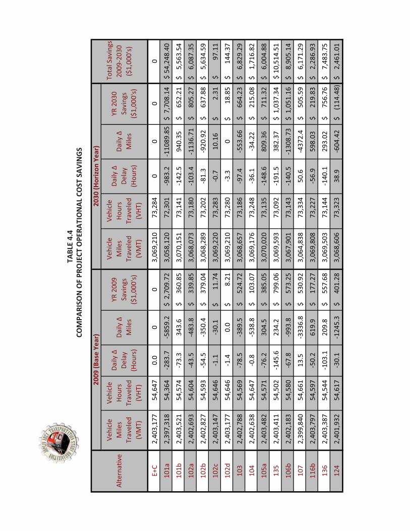
E+C
2,40
3,17
7��
54,6
47���
��0.
00
03,
069,
210
���73
,284
�����
00
00
101a
2,39
7,31
8��
54,3
64���
��*2
83.7
*585
9.2
2,70
9.72
$���
3,05
8,12
0���
72,3
01���
��*9
83.2
*110
89.8
57,
708.
14$�
��54
,248
.40
$��
101b
2,40
3,52
1��
54,5
74���
��*7
3.3
343.
636
0.85
$����
��3,
070,
151
���73
,141
�����
*142
.594
0.35
652.
21$�
�����
5,56
3.54
$����
�
102a
2,40
2,69
3��
54,6
04���
��*4
3.5
*483
.833
9.85
$����
��3,
068,
073
���73
,180
�����
*103
.4*1
136.
7180
5.27
$����
��6,
087.
35$�
����
102b
2,40
2,82
7��
54,5
93���
��*5
4.5
*350
.437
9.04
$����
��3,
068,
289
���73
,202
�����
*81.
3*9
20.9
263
7.88
$����
��5,
634.
59$�
����
102c
2,40
3,14
7��
54,6
46���
��*1
.1*3
0.1
11.7
4$�
������
� �3,
069,
220
���73
,283
�����
*0.7
10.1
62.
31$�
������
����
97.1
1$�
������
���
102d
2,40
3,17
7��
54,6
46���
��*1
.40.
08.
21$�
������
����
3,06
9,21
0���
73,2
80���
��*3
.30
18.8
5$�
������
��14
4.37
$����
����
103
2,40
2,78
8��
54,5
69���
��*7
8.5
*389
.552
4.72
$����
��3,
068,
657
���73
,186
�����
*97.
4*5
53.6
666
4.23
$����
��6,
829.
29$�
����
104
2,40
2,63
8��
54,6
47���
��*0
.8*5
38.8
103.
07$�
�����
3,06
9,17
6���
73,2
48���
��*3
6.1
*34.
2221
5.08
$����
��1,
716.
82$�
����
105a
2,40
3,48
2��
54,5
71���
��*7
6.2
304.
538
5.05
$����
��3,
070,
020
���73
,135
�����
*148
.680
9.36
711.
32$�
�����
6,00
4.88
$����
�
135
2,40
3,41
1��
54,5
02���
��*1
45.6
234.
279
9.06
$����
��3,
069,
593
���73
,092
���� �
*191
.538
2.37
1,03
7.34
$���
10,5
14.5
1$�
�
106b
2,40
2,18
3��
54,5
80���
��*6
7.8
*993
.857
3.25
$����
��3,
067,
901
���73
,143
�����
*140
.5*1
308.
731,
051.
16$�
��8,
905.
14$�
����
107
2,39
9,84
0��
54,6
61���
��13
.5*3
336.
853
0.92
$����
��3,
064,
838
���73
,334
�����
50.6
*437
2.4
505.
59$�
�����
6,17
1.29
$����
�
116b
2,40
3,79
7��
54,5
97���
��*5
0.2
619.
917
7.27
$����
��3,
069,
808
���73
,227
�����
*56.
959
8.03
219.
83$�
�����
2,28
6.93
$����
�
136
2,40
3,38
7��
54,5
44���
��*1
03.1
209.
855
7.68
$����
��3,
069,
503
���73
,144
�����
*140
.129
3.02
756.
76$�
�����
7,48
3.75
$����
�
124
2,40
1,93
2��
54,6
17���
��*3
0.1
*124
5.3
401.
28$�
�����
3,06
8,60
6���
73,3
23���
� �38
.9*6
04.4
2(1
14.4
8)$�
����
2,46
1.01
$����
�
Alte
rnat
ive
2030
�(Hor
izon
�Yea
r)
Tota
l�Sav
ings
�20
09*2
030�
($1,
000'
s)�
YR�2
009�
Savi
ngs�
($1,
000'
s)
Vehi
cle�
Mile
s�Tr
avel
ed�
(VM
T)
Vehi
cle�
Hour
s�Tr
avel
ed�
(VHT
)
Daily
�^�
Dela
y�(H
ours
)
Daily
�^�
Mile
s
YR�2
030�
Savi
ngs�
($1,
000'
s)
Daily
�^�
Dela
y�(H
ours
)
Vehi
cle�
Mile
s�Tr
avel
ed�
(VM
T)
Vehi
cle�
Hour
s�Tr
avel
ed�
(VHT
)
Daily
�^�
Mile
s
2009
�(Bas
e�Ye
ar)
TAB
LE 4
.4CO
MPA
RISO
N O
F PR
OJE
CT O
PERA
TIO
NAL
CO
ST S
AVIN
GS

No.
Route
From
To(m
i)De
scrip
tion
Total�
Saving
sDe
preciatio
nBe
nefit/Cost
101a
Wes
t�Cor
ridor
I*44
MO
�66
7.0
New
�hig
hway
�con
stru
ctio
n�w
/�lim
ited�
acce
ss�(S
copi
ng�T
IP�#
�09H
S*10
)$5
4,24
8,00
0$1
9,28
1,01
02.
8110
1bW
est�C
orrid
orM
O�6
6M
O�1
719.
0N
ew�h
ighw
ay�c
onst
ruct
ion�
w/�l
imite
d�ac
cess
�(Sco
ping
�TIP
�#�0
9HS*
10)
$5,5
63,5
4 0$2
4,78
9,87
00.
2210
2aM
O�1
71M
O�4
3Fi
r0.
6W
iden
�road
�(2�to
�4)�(
Scop
ing�
TIP�
#�29
HS*1
0)$6
,087
,350
$656
,272
9.28
102b
MO
�171
Fir
RTE�
Z/Pe
nnel
l2.
5W
iden
�road
�(2�to
�4)�(
Scop
ing�
TIP�
#�29
HS*1
0)$5
,634
,590
$3,1
25,1
061.
8010
2cM
O�1
71RT
E�Z/
Penn
ell
MO
�96
2.1
Wid
en�ro
ad�(2
�to�4
)�(Sc
opin
g�TI
P�#�
29HS
*10)
$97,
110
$1,9
68,8
170.
0510
2dM
O�1
71M
O�9
6M
PO�b
ound
ary
1.1
Wid
en�ro
ad�(2
�to�4
)$1
44,3
7 0$1
,031
,285
0.14
103
Zora
Rang
e�Li
neM
O�2
492.
4Im
prov
e�an
d�W
iden
�road
�(2�to
�4)
$6,8
29,2
90$2
,625
,089
2.60
104
Zora
Wes
t�Cor
ridor
Mai
n4.
4Im
prov
e�an
d�W
iden
�road
�(2�to
�4)
$1,7
16,8
20$4
,812
,663
0.36
105a
Schi
fferd
ecke
rM
O�6
6Zo
ra2.
1W
iden
�road
�(2�to
�4)
$6,0
04,8
80$2
,296
,953
2.61
135
20th
Inte
rsec
tion�
w/K
CS*
*Gr
ade�
sepa
ratio
n$1
0,51
4,51
0$5
,528
,494
1.90
106b
Duqu
esne
/Hal
lN
ewm
an17
th�(W
.C.)
2.0
Wid
en�ro
ad�(4
�to�5
)$8
,905
,140
$1,8
76,1
054.
7510
7Ha
ll17
th�(W
.C.)
Haw
thor
ne3.
0N
ew�ro
adw
ay�c
onst
ruct
ion�
&�In
ters
ectio
n�at
�Cen
tenn
ial
$6,1
71,2
90$5
20,8
5111
.85
116b
MO
�66
Mai
den
Rang
e�Li
ne3.
0Ac
cess
�man
agem
ent�a
nd�in
ters
ectio
n�im
prov
emen
ts�(S
copi
ng�T
IP�#
28HS
*10)
$2,2
86,9
30$1
,562
,553
1.46
136
15th
Inte
rsec
tion�
w/�K
CS*
Grad
e�se
para
tion
$7,4
83,7
50$5
,528
,494
1.35
124
17th
Oro
nogo
Rang
e�Li
ne0.
2N
ew�ro
adw
ay�c
onst
ruct
ion
$2,4
61,0
10$2
08,3
4011
.81
Not
es/A
ssum
ptio
ns:
1. $
15.8
4/hr
val
ue o
f tim
e2.
7%
dis
coun
t rat
e3.
$0.
50/m
ile tr
avel
ed4.
Stru
ctur
e Li
fe =
50
year
s, P
avem
ent L
ife =
30
year
s5.
Dep
reci
atio
n =
Tota
l Pro
ject
Cos
t - T
otal
Res
idua
l Val
ue
TABL
E�4.
5RO
ADW
AY�P
ROJE
CT�B
ENEF
IT/C
OST
�AN
ALYS
IS�S
UM
MAR
Y

Section�4�Financial�
4.2.3��As�previoavailable�developinstreams�hand�Long*periods� tdescribedsummarizbased�on��Although�agencies�opportundescribed�������������������������������
Plan�
FISCALLY�CO
usly�discussefor�street�an
ng� the� fiscallhave�been�gro*Term�(2021*o� match� ant
d� in� Section� 4zed�in�Table�4the�criteria�d
the� remaininwhose� jurisdities� as� futur
d�in�Section�4.
ONSTRAINED�
d,�the�portiod�highway�imy� constraineouped�in�thre2030).��The�roticipated� fun4.2.2.� � The� r4.6�and�illustrdescribed�in�T
ng� proposed�dictions� in� wre� land� use�.1.4.�
ROADWAY�IM
n�of�estimatemprovementsed� long� rangeee�analysis�peoadway�impr
nding� levels�resulting� 20*yrated�in�FigurTable�4.3.�
projects� shohich� these� p(re)developm
JATSO�2030�Lo
MPROVEMEN
ed�funding�res�over�the�20�e� roadway� ieriods:��Shortrovement�probased� on� pryear� fiscally�re�4.1.��The�p
uld�be�considprojects� woulment� occurs� o
ong�Range�Tra
NT�PLAN�
esources�sumyear�period�
mprovementt*Term�(2011ojects�were�throject� costs�constrained�rojects�are�lis
dered�visionald� exist� shouor� through� c
ansportation�P
marized�in�Setotals�$227�m
t� plan,� the� p*2015),�Mid*T
hen�grouped�and� the� prioroadway� impsted�in�relativ
ary� long*termuld� look� for� acreative� finan
Plan�
ection�4.1�thamillion.��As�pprojected� revTerm�(2016*2into�these�an
oritization� prprovement� pve�order�of�pr
m� unfunded�nadditional� funcing� program
4�14�
at�are�art�of�venue�2020),�nalysis�rocess�plan� is�riority�
needs,�unding�ms� as�

RECO
MM
END
ED�F
ISCA
LLY�
CON
STRA
INED
�203
0�RO
ADW
AY�IM
PRO
VEM
ENT�
PLAN
No.
Route
From
To(m
i.)De
scrip
tion
Cost�(2
010)
2011�2015
2016�2020
2021�2030
101a
*W
est�C
orrid
orI*4
4M
O�6
67.
0N
ew�h
ighw
ay�c
onst
ruct
ion�
w/�l
imite
d�ac
cess
�(Sco
ping
�TIP
�#�0
9HS*
10)
$65,
625,
000
$500
,000
$54,
475,
456
111c
Rang
e�Li
neIn
ters
ectio
n�w
/�15t
h*
*Ac
cess
�man
agem
ent�a
nd�in
ters
ectio
n�im
prov
emen
ts$7
50,0
00$7
72,5
0011
8b32
ndCo
untr
y�Cl
ubW
est�C
orrid
or1.
0Im
prov
e�an
d�ad
d�ce
nter
�turn
�lane
�and
�roun
dabo
uts
$3,6
02,0
00$4
,840
,787
102a
MO
�171
MO
�43
Fir
0.6
Wid
en�ro
ad�(2
�to�4
)�(Sc
opin
g�TI
P�#�
29HS
*10)
$2,5
20,0
00$2
,597
,600
111b
Rang
e�Li
ne13
th�(W
.C.)
15th
4.0
Acce
ss�m
anag
emen
t�and
�inte
rsec
tion�
impr
ovem
ents
$2,0
00,0
00$2
,060
,000
118a
32nd
Schi
fferd
ecke
rCo
untr
y�Cl
ub1.
0Im
prov
e�an
d�ad
d�ce
nter
�turn
�lane
$3,6
02,0
00$4
,300
,976
111d
Rang
e�Li
ne15
thI*4
41.
9Ac
cess
�man
agem
ent�a
nd�in
ters
ectio
n�im
prov
emen
ts$9
50,0
00$9
78,5
0013
520
thIn
ters
ectio
n�w
/KCS
**
Gra
de�se
para
tion
$15,
000,
000
$17,
910,
784
108
Rang
e�Li
neIn
terc
hang
e�w
/�I*4
4*
*Re
cons
truc
t�int
erch
ange
$15,
000,
000
$15,
450,
000
107
Hall
17th
�(W.C
.)Ha
wth
orne
3.0
New
�road
way
�con
stru
ctio
n�&
�Inte
rsec
tion�
at�C
ente
nnia
l$1
0,80
6,00
0$2
,060
,000
134a
RTE�
FFIn
ters
ectio
n�w
/�Dav
is*
*In
ters
ectio
n�im
prov
emen
t$5
00,0
00$5
15,0
0010
5aSc
hiffe
rdec
ker
MO
�66
Zora
2.1
Wid
en�ro
ad�(2
�to�4
)$8
,820
,000
$11,
853,
342
128
CR�1
90In
terc
hang
e�w
/�I*4
4*
*Co
nstr
uct�i
nter
chan
ge$1
5,00
0,00
0$2
0,15
8,74
611
6bM
O�6
6M
aide
nRa
nge�
Line
3.0
Acce
ss�m
anag
emen
t�and
�inte
rsec
tion�
impr
ovem
ents
�(Sco
ping
�TIP
�#28
HS*1
0)$6
,000
,000
$2,5
00$7
,164
,314
116a
MO
�66
Mai
den
Schi
fferd
ecke
r1.
0Im
prov
e�an
d�ad
d�ce
nter
�turn
�lane
�(Sco
ping
�TIP
�#�2
8HS*
10)
$3,6
02,0
00$2
,500
122
Blac
k�Ca
tN
ewto
nM
O�6
62.
0Im
prov
e�an
d�ad
d�ce
nter
�turn
�lane
$7,2
04,0
00$9
,681
,574
109a
MO
�43
Inte
rsec
tion�
w/�1
71*
*Ac
cess
�man
agem
ent�a
nd�in
ters
ectio
n�im
prov
emen
ts$1
,000
,000
$1,0
30,0
0010
3Zo
raRa
nge�
Line
MO
�249
2.4
Impr
ove�
and�
Wid
en�ro
ad�(2
�to�4
)$1
0,08
0,00
0$1
2,03
6,04
713
615
thIn
ters
ectio
n�w
/�KCS
*G
rade
�sepa
ratio
n$1
5,00
0,00
0$1
7,91
0,78
412
417
thO
rono
goRa
nge�
Line
0.2
New
�road
way
�con
stru
ctio
n$8
00,0
00$1
,075
,133
119
St.�L
ouis/
Prai
rie�F
low
erZo
raM
O�1
712.
0Im
prov
e�an
d�ad
d�ce
nter
�turn
�lane
$7,2
04,0
00$9
,681
,574
101b
Wes
t�Cor
ridor
MO
�66
MO
�171
9.0
New
�hig
hway
�con
stru
ctio
n�w
/�lim
ited�
acce
ss�(S
copi
ng�T
IP�#
�09H
S*10
)$8
4,37
5,00
0$5
00,0
0014
2Ja
ckso
nBr
idge
�at�S
hoal
�Cre
ek*
*Im
prov
e�br
idge
�at�S
hoal
�Cre
ek$1
,200
,000
$1,4
32,8
6314
6O
ld�7
1�(T
ipto
n�Fo
rd)
Brid
ge�a
t�Sho
al�C
reek
**
Brid
ge�re
plac
emen
t$1
,200
,000
$1,2
36,0
00
TIP�
#03H
L*10
20th
Inte
rsec
tion�
w/�M
ain
**
Inte
rsec
tion�
impr
ovem
ents
$1,5
00,0
00$1
,500
,000
TIP�
#03H
L*11
26th
Mai
den
Schi
fferd
ecke
r1.
0Im
prov
e�an
d�ad
d�ce
nter
�tur n
�lane
$1,9
00,0
00$1
,900
,000
TIP�
#02H
L*11
Zora
MO
�43
Rang
e�Li
ne2.
0W
iden
�road
�(2�to
�4)
$2,0
00,0
00$2
,000
,000
TIP�
#�01
HL*1
0Zo
raIn
terc
hang
e�at
�Mai
n*
*In
terc
hang
e�co
nstr
uctio
n�an
d�RR
�gra
de�se
para
tion
$15,
000,
000
$8,2
40,0
00TI
P�#0
1HL*
11Sc
hiffe
rdec
ker
MO
�66
32nd
2.0
Wid
en�ro
ad�(2
�to�4
)$2
,200
,000
$2,2
00,0
00TI
P�#0
4HL*
11Br
oadw
ay/B
ucha
nan
Flor
ida
St.�L
ouis
0.7
Impr
ove�
and�
add�
cent
er�tu
rn�la
ne$1
,300
,000
$1,3
00,0
00TI
P�#0
5HL*
11St
.�Lou
isBr
oadw
ayZo
ra1.
5Im
prov
e�an
d�ad
d�ce
nter
�turn
�lane
$1,8
00,0
00$1
,800
,000
TIP�
#�02
HL*1
0M
aide
n�Ln
.9t
h*17
th20
th*3
0th
1.4
Wid
en�ro
ad�(4
�to�5
)$4
,000
,000
$4,0
00,0
00TI
P�#�
7HS*
11M
O�1
71In
terc
hang
e�w
/RTE
�HH
**
Ram
p�im
prov
emen
ts$3
,757
,000
$3,7
57,0
00
TOTA
L������
$315
,297
,000
$54,
401,
600
$60,
755,
769
$111
,766
,612
* Allo
catio
n of
fund
ing
for W
est C
orrid
or re
flect
s a
phas
ed c
onst
ruct
ion
redu
ctio
n in
sco
pe to
mat
ch fu
ture
ava
ilabl
e fu
nds.
Projects�Already�Programmed
Proposed�Roadway�Projects
TABL
E�4.
6

515
555�
558�
51/
55B
51;
555�
500
55C55C�
3<'�D�15$�955
3<'�D�10$�951
3<'�D�10$�955
1/$�955
3<'�D�1;$�955
507
510��51B
3<'�D�1
7$�955
50C
51-
5/8
5/;
51C
570
578
555�
5/7
15$�951
3<'�D�-$�955
3<'�D�1/$�951
�
����
����
����
����
����
����
��
�����
�����
�����
�����
"�������
��
�� �**��������
��,��
����������
�
!�
��������!�
�
-� �������
)�.���������
/0���������
01� �������
�����
����2�����
�3���#�����
�������������
!����<����������
�������"�������
� #�����
�� !��������������
� <����� ���
� <�����������
����������0151 &�����9����������!����'��
&������7,5

Section�4�Financial�
4.3� T�Funding�fofunding�b�
�InformatiTable�4.7�
FEDOperating�
$1,7Capital�
$81TOTAL�
$2,5Source:��Tr
4.3.1�
Local� nonJoplin’s� trtransportannually,�permanen�
Plan�
TRANSIT�FIN
or�the�Metro�reakdown�by
on�from�MAPshows�the�fu
Table�4.7:
DERAL�
02,263�
16,207�
18,470�ransportation�I
LOCAL�FUND
n*federal� matransportationation� systemwhich�approx
nt�tax�and�do
Federal53.5%
State4.0%
NANCIAL�P
Area�PublicTy�jurisdiction.�
Figure�4Source:��
PS�and�the�TIPunding�breakd
:�Estimated�
STATE�
$286,26
$0�
$286,26Improvement�P
DING�
tching� funds�n� sales� tax.� �
m.� � The� ½� ceximately�2.2�mes�not�have�a
Fare9.2%
Local33.3%
PLAN�
Transit�System��
4.2:�MAPS�FuMetro�Area�Pu
P�provide�thedown�by�both
Federal,�Sta
68�
68�Program�
for� transit� oThe� tax� is� d
ent� transpormillion�is�usean�expiration�
s%
TRANSIT�F
JATSO�2030�Lo
m�comes�from
unding�ShareublicTransit�Sys
following�esth�funding�cate
ate,�and�Loca�
LOCAL�
$1,453,531
$180,593
$1,634,124
operations� andedicated� to�tation� sales�d�for�the�trandate.�
UNDING�SO
ong�Range�Tra
m�a�variety�of�
e�by�Jurisdicstem,�City�of�Jo
timates�of�cuegory�and�jur
al�MAPS�Fun
FA
$53
$53
nd� capital� exfunding� trantax� generate
nsit�system.��T
Webb�Cit0.7%
OURCES
ansportation�P
sources.��Figu
ction�oplin�
rrent�fundingrisdiction.���
nding�throug
ARES�
35,000
$0
35,000
penses� comensit� and� impes� approximThe�transport
ty
Joplin32.2%
Duquesne0.0%
Plan�
ure�4.2�show
g�for�transit.��
gh�TIP�
TOTAL
$3,977,06
$996,800
$4,973,86
e� from� the� Cprovements� tately� $5.9� mtation�sales�ta
Cartervil0.1%
Carl�Juncti0.3%e
4�17�
s�the�
�
62
0
62
City� of�o� the�
million�ax�is�a�
lle
ion
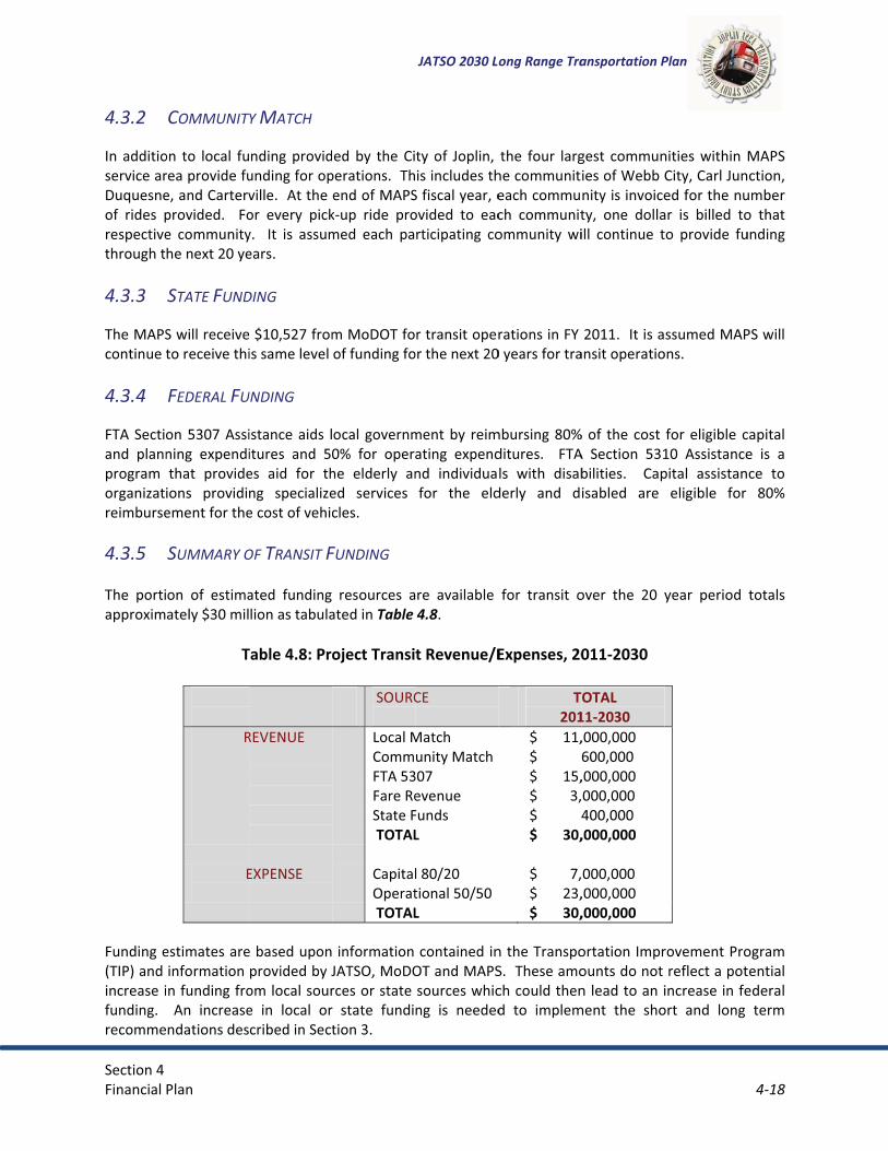
Section�4�Financial�
4.3.2�
In� additioservice�arDuquesneof� rides� prespectivethrough�t�4.3.3�
The�MAPScontinue�t�4.3.4�
FTA�Sectiand� plannprogram�organizatreimburse
4.3.5��The� portiapproxim�
Funding�e(TIP)�and�increase�ifunding.�recomme
Plan�
COMMUNIT
on� to� local� furea�provide�fue,�and�Cartervprovided.� � Foe� communityhe�next�20�ye
STATE�FUND
S�will�receiveto�receive�thi
FEDERAL�FU
on� 5307�Assining� expendithat� provide
ions� providiement�for�the
SUMMARY�O
on� of� estimaately�$30�mil
T
����
R
��E
��
estimates�areinformation�
in�funding�froAn� increase
ndations�des
Y�MATCH�
nding� providunding�for�opville.��At�the�or� every� picky.� � It� is� assumears.�
DING�
�$10,527�fromis�same�level�
UNDING�
istance�aids� litures� and� 50es� aid� for� thng� specializee�cost�of�vehic
OF�TRANSIT�F
ated� funding�lion�as�tabula
Table�4.8:�Pro
REVENUE������
EXPENSE��
e�based�uponprovided�by�J
om�local�soure� in� local� orcribed�in�Sect
ed� by� the� Ciperations.��Thend�of�MAPS
k*up� ride� promed� each� pa
m�MoDOT�foof�funding�fo
ocal�governm0%� for� operhe� elderly� aned� services�cles.�
FUNDING�
resources� aated�in�Table�
oject�Transi
�SOURC��Local�MCommFTA�53Fare�ReState�F�TOTAL��CapitalOperat�TOTAL
� informationJATSO,�MoDOrces�or�state�r� state� fundition�3.�
JATSO�2030�Lo
ty� of� Joplin,�is�includes�th
S�fiscal�year,�eovided� to� eacrticipating� co
r�transit�operor�the�next�20
ment�by� reimating� expendnd� individuafor� the� eld
re� available�4.8.�
t�Revenue/E�
CE�
Match�unity�Match
307�evenue�Funds�L��
l�80/20�tional�50/50L��
contained�inOT�and�MAPSsources�whicng� is� needed
ong�Range�Tra
the� four� larghe�communiteach�commuch� communitommunity� wi
rations�in�FY�0�years�for�tra
mbursing�80%ditures.� � FTAls� with� disab
derly� and� d
for� transit� o
Expenses,�20
T201
�$�������11,�$�������������$�������15,�$���������3,�$������������4�$�������30,���$���������7,�$�������23,�$�������30,
n�the�TranspoS.��These�amoch�could�thend� to� implem
ansportation�P
gest� communies�of�Webb�nity�is�invoicety,� one� dollaill� continue� t
2011.��It�is�aansit�operatio
%�of� the�cost�A� Section� 531bilities.� � Capisabled� are�
over� the� 20� y
011�2030�
TOTAL�11�2030�,000,000��600,000��,000,000��000,000��400,000��,000,000��
000,000��,000,000��,000,000��
ortation�Improunts�do�not�n�lead�to�an�i
ment� the� sho
Plan�
nities� within�City,�Carl�Juned�for�the�nu
ar� is� billed� toto� provide� fu
ssumed�MAPons.�
for�eligible� c10� Assistancepital� assistan
eligible� for�
year� period�
rovement�Proreflect�a�pot
increase�in�feort� and� long�
4�18�
MAPS�ction,�
umber�o� that�unding�
PS�will�
capital�e� is� a�ce� to�
80%�
totals�
ogram�tential�ederal�
term�
Section�4�Financial�
4.4� A�The�annuafor�the�patransportfluctuate�have�incre�Given�thagrants�shoapproximcommercexperiencwill�declin�
4.5� N�It� is� recogidentifiedduring�themunicipalsolicitatioThe� guidifunding� feconomy�individual�In� additioseries�of�options� wspecific�ap�TransportThe� TransSurface�Trensure�tracompetiticonstructlocated� inproviding�trails.�Comeconomieand�visito�CommuniThe�Command� Urba
Plan�
AVIATION�F
al�operating�east�two�years.ation�sales�tafrom�year�to�eased�to�appr
t�no�significaould�be�expecately�$1.0�miial�services�m
ce�a�shortfall�fne.�
NON�MOTO
gnized�that� im� previously� me�anticipated�lities� strategi
on�of�the�neceing� objectivefor� other� pla
of� scale� in� elly.�
on� to� the� vatargeted�fund
will� require� applicability�to
tation�Enhancsportation� Enransportationansportation�ve�selection�pion.� Transpon� both� ruralfunding�to�c
mmunities�mes�by�restorinor�centers.�
ity�Developmemunity�Develan� Developm
FINANCIAL�
expenses�for�.��Significant�f
ax,�service�chayear�and�typ
roximately�$2
nt�capital�impcted�either.��Illion�to�spend
may�increase�afunding.��Unle
ORIZED�FIN
mplementatiomay� be� beyolife�of�this�plcally�assess� t
essary�funding� is� to� efficie
anned� transpexecution� of�
rious� fundingding�options�
a� more� detaio�the�desired�
cement�Progrnhancement�n�Program�funspending�supprocess�for�trrtation� Enhan� and� urban�onstruct�sideay�also�use�tg�historic�bui
ent�Block�Graopment�Blocent� (HUD)� t
PLAN�
the�Joplin�Refinancing�souarges�and�useical�pay�for�ca
22�million�ove
provements�af�service�chard�annually�at�annual�user�feess�other�sou
NANCIAL�PL
on�of�all�of� tond� the� finanan�(i.e.�2030)
the� benefit�og�for�the�proj
ently� packageportation� infeach� project�
g� methods� aare�also�avaled� evaluationon*motorize
ram:�Program� req
nds�annually�pports�more�transportationncement� funcommunities
ewalks,�bike�lathe�Transportildings,�renov
ant�Program�(ck�Grant�Proghrough� its� O
JATSO�2030�Lo
gional�Airporrces�for�the�a
er�fees,�and�feapital�improver�the�past�few
are�expected�rges�and�feespresent�fund
ees,�but�it�is�lurces�of�fundi
LAN�
he�potential�ncial� feasibili).��As�a�result
of�each� improject.��This�wille� non*motorirastructure� iabove� what�
available� for�ilable� for�non
on� prior� to� ped�improvem
quires� each� sfor�designatethan�just�roadn�related�activds� are� availas.� These� proanes�and�to�ctation�Enhanvating�streets
(CDBG):�gram�is�adminOffice� of� Com
ong�Range�Tra
rt�has�been�beairport�come�federal�grantsvements.��Thew�years.�
in�the�near�fus�remain�consding�levels.��Thikely�that�theng�are�identif
non*motorizty� of� JATSO�,�it�is�imperat
ovement� conl�require�a�coized� transpoimprovement� would� have�
motorized� trn*motorized�project� imple
ments.���
state� to� reseed�Transportads.�This�progrvities�other�thable� for� a� varojects� help� cconvert�abancement�Progcapes�or�prov
nistered�by�thmmunity� Plan
ansportation�P
etween�$1.7�from�the�City.��The�federal
e�total�net�ass
uture,�no�signstant,�the�airphe�addition�o
e�airport�will�cfied,�the�airp
ed� improvemand� its� mem
tive�that�JATScurrent�with�
oordinated�anrtation� improt� projects� thbeen� possib
ransportationimprovemen
ementation� t
erve� 10� percation�Enhanceram�provides�han�routine�hriety� of� proje
create� more�doned�railroa
gram�to�revitaviding�transp
he�U.S.�Depanning� and� D
Plan�
and�$1.9�milly�of�Joplin�l�grant�funds�sets�of�the�air
nificant�federport�only�will�of�American�Econtinue�to�ort’s�net�asse
ment�opportumber� commuSO�and�its�me
identificationd�sustained�eovement� withereby� gaininble� if� implem
n� improvements.� �These�fuo� determine�
cent� of� its� Feement�activitfunding�thro
highway�and�bect� types,� tha
travel� choicad�rights�of�walize� local� reg
portation�mus
rtment�of�Hoevelopment.�
4�19�
ion�
rport�
al�have�agle�
ets�
unities�unities�ember�n�and�effort.��h� the�ng� an�ented�
ents� a�nding�their�
ederal�ties�to�ough�a�bridge�at� are�es� by�
way�to�gional�seums�
ousing�� The�

Section�4�Financial�
primary�oeliminatiobecause� eCDBG� hasbarriers�buse�of�a�fo�RecreatioThe� RecrTransportaid�assistanon� motoThe� progwheelchaterrain�vegrant� roustate.�Thevariety�of�Missouri�SMissouri�SThe�Highwto�provideincluding�Behavioraenforcemsidewalksorganizatfunds.��Source:�MRPC
�
Plan�
objectives�of�on�of�slums�aexisting� conds� been� used�
by�providing�cormula�that�t
nal�Trails�Proeational� Traitation�Equity�ance�programorized� recrearam� provideir� use),� bicyc
ehicle�riding�aund� each� yeae�Recreationaf�recreational�
Safe�Routes�toSafe�Routes�tway�Safety�Die�safer�bikingthose�with�d
al�activities�ment� efforts.�
s,�crosswalks,�ions�may�sub
C�Regional�Transp
CDBG�is�to�bnd�blight,�me
ditions� pose� ato� enhance�
curb�ramps�anakes�into�acc
ogram���Deparils� Program�Act:�A�Legacy
m�that�helps�stional� trails� us� funds� for�cling,� inline� sand�four*wher� and� distrib
al�Trails�Progrtrail�opportu
o�School�Progto�School�Proivision�is�respg�and�walkingisabilities.�Th
may�be�used�fInfrastructurlighting�and�
bmit�applicati
ortation�Plan�Chap
enefit� low*�aeet�other�coma� serious� or�
public� facilitnd�other�acceount�commu
rtment�of�Natwas� authoriz
y�for�Users�(SAstates�provideuses.� Annual�many� recrea
skating,� equeeel�driving.�Thbutes� the� funram�encourag
unities.��
gram:�gram�(SRTS)�w
ponsible�for�ag�accommodahere�are�two�for�public�awre� projects� ibike�racks.�Stions�to�MoDO
pter�7�
JATSO�2030�Lo
and�moderatemmunity�deveimmediate� thties� such� as�essible�paths.nity�need.�
tural�Resourczed� in� the� 2AFETEA*LU).�Te�and�maintai
funding� for�ational� trail�estrian,� crosshe�Departmending� in� respoges�trail�enth
was�created�administrationations�for�chiareas�eligible
wareness�and�include� engitate,�local,�anOT�to�receive
ong�Range�Tra
e*�income�peelopment�neehreat� to� healsidewalks,� p��HUD�decide
ces:�2005� Safe,� AThe�Recreatioin�recreationthis� programuses,� such� as*country� skiint�of�Natural�onse� to� recre
husiasts�to�wo
by�Section�14n�of�SRTS�fedldren�in�kinde�for�funding,outreach�cam
neering� and�nd�regional�age�a�grant�from
ansportation�P
ersons,�aid�in�eds�having�a�lth.� � Through
paths,� and� stes�the�quantit
Accountable,�onal�Trails�Proal�trails�for�bo
m� is� approximas� pedestrianing,� off*road�Resources�h
eational� trailork�together�
404�of�the�SAderal�funds.�Tergarten�thro,�behavioral�ampaigns,�traf
constructiongencies,�schom�federal�saf
Plan�
the�preventiparticular�ur
h� these� objecreets� and� rety�of�each�gra
Flexible,� Effogram�is�a�fedoth�motorize
mately� $1,000n� (hiking,� run
motorcyclingolds�a�compe� needs� withito�provide�a
AFETEA*LU�inThe�funding�isough�eighth�gand�infrastruffic�educationn� efforts� suols,�and�non*
fe�routes�to�s
4�20�
ion�or�gency�ctives,�emove�ant�by�
ficient�deral*d�and�0,000.��nning,�g,� all*etitive�in� the�
a�wide�
2005.�s�used�grade,�cture.�
n,�and�ch� as�*profit�school�


![[Songbook]Scott Joplin - The Best of Scott Joplin](https://img.pdfslide.us/doc/110x75/552ca7e14a7959e17c8b47ca/songbookscott-joplin-the-best-of-scott-joplin.jpg)