Embed Size (px)
Citation preview

JOINT REGIONAL PLANNING PANEL (Hunter Central Coast Region)
JRPP No 2014HCC017
DA Number 439/2014/DA
Local Government Area
Greater Taree City Council
Proposed Development
Integrated Development (Staged) - Precinct 3 Old Bar Concept Plan (526 Lots) & Stage 1 Subdivision – 66 lots & residue
Street Address Forest Lane, Sheaffe Avenue - Old Bar
Lot 14 DP 733054, Lots 117, 217, 218 & 219 DP 753149, Lots 591 & 592 DP 1180317, Lot 2 DP 1022067, Lot B DP 377867
Applicant/Owner Applicant – Lidbury Summers & Whiteman Owners – A A & A M Taylor & Rawson Communities Pty Ltd, G V Love, M W Goodear, R M Sainisch-Plimer, Archer Properties No 3 Pty Ltd, R J & J M & P Trad, A A & A M Taylor, Jarberg Pty Ltd, P M Stone
Number of Submissions
1 Public Submission 4 Government Agency Submissions (NSW Office of Water, NSW Rural Fire Service, Office of Environment & Heritage, Roads and Maritime Services)
Regional Development Criteria (Schedule 4A of the Act)
Coastal Subdivision
Development within the coastal zone for the purposes of the subdivision of land into more than 100 lots and is not in the metropolitan coastal zone.
List of All Relevant s79C(1)(a) Matters
State Environmental Planning Policy No. 44 – Koala Habitat Protection
State Environmental Planning Policy 71 – Coastal Protection
State Environmental Planning Policy (Infrastructure) 2007
State Environmental Planning Policy State and Regional Development) 2011
Greater Taree Local Environmental Plan 2010
Greater Taree Development Control Plan 2010
List all documents submitted with this report for the panel’s consideration
Assessment report and conditions
Statement of Environmental Effects and supporting documents and reports
Subdivision plans
Recommendation Approval (subject to the conditions)
Report by Arnna Fotheringham – Development Planner
Report date

Executive Summary
Reason for Consideration by Joint Regional Planning Panel
The purpose of this report is to seek the Joint Regional Planning Panel’s (the Panel) determination of a development application (DA) for the subdivision of land at Forest Lane/Sheaffe Avenue, Old Bar. The Panel is the determining authority for this DA, pursuant to Part 4 of State Environmental Planning Policy (State and Regional Development) 2011 and Schedule 4A of the Environmental Planning and Assessment Act 1979 (the Act), as the proposed development is within the coastal zone for the purposes of subdivision of land into more than 100 lots, not in the metropolitan coastal zone. The proposal is also ‘integrated development’ for the purposes of section 91 of the Act and requires separate approval under the following:
Sec 100B Rural Fire Act 1997
Sec 90 National Parks and Wildlife Act 1994
Sec 91 Water Management Act 2000 Following public exhibition of the proposal, one (1) submission was received. The Site The subject site comprises Lot 14 DP 733054, Lots 117, 217, 218 & 219 DP 753149, Lots 591 & 592 DP 1180317, Lot 2 DP 1022067, Lot B DP 377867 at Forest Lane/Sheaffe Avenue, Old Bar.
Proposal The subdivision is a staged application in accordance with Sec 83B of the EP& A Act. The application seeks consent for a Concept Plan and Stage 1 subdivision. The concept plan proposes a subdivision to create 526 lots in the following stages.
Stage 1– 66 Lots
Stage 2 – 5 Lots
Stage 3 – 126 Lots
Stage 4 – 16 Lots
Stage 5 – 38 Lots
Stage 6 – 86 Lots
Stage 7 – 71 Lots
Stage 8 – 47 Lots
Stage 9 – 7 Lots
Stage 10 – 64 Lots

Permissibility The proposed subdivision is permissible with Consent. Public Notification The application was publicly exhibited and neighbour notified during which time one (1) submission was received. Recommendation That the Panel determine Development Application 439/2014 for Precinct 3 Old Bar Concept Plan (526 Lots) and Stage 1 Subdivision – 66 lots approved subject to the conditions contained in this report.
Assessment Report and Recommendation
1 Context and History
The subject land area is known as Precinct 3 Old Bar and identified for urban growth under the Old Bar/Wallabi Point Development Strategy, Greater Taree Draft Conservation and Development Strategy 2005 and the Mid North Coast Regional Strategy. The land was rezoned for residential purposes in accordance with the Planning Proposal on 17 June 2011 as Amendment No. 3 to Greater Taree Local Environmental Plan 2010. The proposed concept plan is in keeping with the subdivision layout considered as part of the rezoning process.
2 Site Description
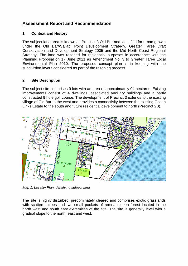
The subject site comprises 9 lots with an area of approximately 94 hectares. Existing improvements consist of 4 dwellings, associated ancillary buildings and a partly constructed 9 hole golf course. The development of Precinct 3 extends to the existing village of Old Bar to the west and provides a connectivity between the existing Ocean Links Estate to the south and future residential development to north (Precinct 2B).
Map 1: Locality Plan identifying subject land
The site is highly disturbed, predominately cleared and comprises exotic grasslands with scattered trees and two small pockets of remnant open forest located in the north west and south east extremities of the site. The site is generally level with a gradual slope to the north, east and west.

The land is identified on Council’s mapping as bushfire prone and with local flooding affecting the land within the Racecourse Creek area.
Map 2: Bushfire prone land Map 3: Report Extract – Flood modelling
J Wyndham Prince Pty Ltd
3 The Proposal
The subdivision is a staged application in accordance with Sec 83B of the EP& A Act. The application seeks consent for a Concept Plan and Stage 1 subdivision. Concept Plan 526 lots in 10 stages as follows:
Stage 1– 66 Lots
Stage 2 – 5 Lots
Stage 3 – 126 Lots
Stage 4 – 16 Lots
Stage 5 – 38 Lots
Stage 6 – 86 Lots
Stage 7 – 71 Lots
Stage 8 – 47 Lots
Stage 9 – 7 Lots
Stage 10 – 64 Lots Stage 1
The subdivision of Lot 591 DP 1180317 into 66 lots delivered in the following stages:
Sub-stage 1A – 14 Lots (lots 1 – 14) Sub-stage 1B – 10 Lots (lots 15 – 24) Sub-stage 2A – 10 Lots (lots 25 – 34) Sub-stage 2B – 10 Lots (lots 35 – 44)

Sub-stage 3A – 9 Lots (lots 45 – 53) Sub-stage 3B – 13 Lots (lots 54 – 66)
Preparation of the site, including removal of remnant vegetation as necessary; the installation of temporary construction fencing; the implementation of sediment and erosion control measures.
Construction of seven (7) new public roads to service the proposed subdivision as follows:
Road No. 1 (part) – boulevard road – has a total width of 23.5m, comprised of two (2) x 6.2m verges including shared bicycle/pathway, two (2) x 2.5m parking and a 6m carriageway. Road No. 2 – access place – has a total width of 14m, comprised of two (2) x 3.75m verges and a 6.5m carriageway. Road No. 3 (part) – access place – has a total width of 14m, comprised of two (2) x 3.75m verges and a 6.5m carriageway. Road No. 4 – access place – has a total width of 14m, comprised of two (2) x 3.75m verges and a 6.5m carriageway. Road No. 5 (part) – access place – has a total width of 14m, comprised of two (2) x 3.75m verges and a 6.5m carriageway. Road No. 6 (part) – access place – has a total width of 14m, comprised of two (2) x 3.75m verges and a 6.5m carriageway. Road No. 7 (part) – collector road ha a total width of 20m, comprised of two (2) x 4.5m verges, two (2) 2.5m parking and a 6m carriageway.
The implementation of a water sensitive urban design stormwater system and drainage reserve.
Provision of street lighting as well as underground water, sewerage, electricity and telecommunications services.
Minor filling (approx. 250mm) of flood affected sites to the 1% AEP level as identified in the modelling carried out by J Wyndham Prince Pty Ltd.
4 Statutory Assessment
Environmental Planning and Assessment Act 1979
In determining a development application, the consent authority, is to take into consideration such of the following matters as are of relevance to the development. The relevant matters for consideration are summarised below:

Section 79C(1)(a)(i) The provisions of any environmental planning instrument State Environmental Planning Policy (State and Regional Development) 2011 The SEPP identifies a range of developments that due to their nature, scale, impact or location are deemed to be of regional significance. Such applications require that the Joint Regional Planning Panel (JRPP) become the consent authority. As this development will create in excess of 100 lots, is not within the metropolitan coastal zone and is partly within a sensitive coastal location, the JRPP is the relevant consent authority. State Environmental Planning Policy (Infrastructure) 2007 (ISEPP) Schedule 3 of the ISEPP Infrastructure identifies those developments that, due to either their scale or location (on or near an arterial road) require referral to Roads and Maritime Services (RMS) as traffic generating developments. Subdivision are listed as a type of development requiring referral to the RMS, but only where they consist of more than 200 lots or where they include a connection to a classified road, either directly or indirectly via another road within 90m of the classified road. The RMS has responded and raise no objection to the proposed development and no requirements are imposed. State Environmental Planning Policy 44 – Koala Habitat Protection (SEPP 44) SEPP 44 aims to encourage the ‘proper conservation and management of areas of natural vegetation that provide habitat for koalas’. The SEPP requires that before granting consent for development on land over 1 hectare in area, a consent authority must be satisfied as to whether or not the land is ‘potential or core koala habitat’. The site is highly disturbed and predominately cleared and the remaining vegetation on site does not comprise potential or core koala habitat. Statement Environmental Planning Policy 71 – Coastal Protection (SEPP 71) The subject site is located within the coastal zone and therefore is affected by the provisions of SEPP 71 – Coastal Protection. In accordance with Clause 7 of this SEPP, the consent authority is required to have regard to the matters for consideration identified under Clause 8 in assessment of the application. To this end, the proposal has been assessed and is considered to be consistent with the relevant matters as listed under Clause 8 of SEPP: (b) Existing public access to and along the coastal foreshore for pedestrians or
persons with a disability should be retained and, where possible, public access to and along the coastal foreshore for pedestrians or persons with a disability should be improved,

Comment: The proposed development does not front the foreshore and will not impact on existing public access arrangements.
(c) Opportunities to provide new public access to and along the coastal foreshore for
pedestrians or persons with a disability, Comment: The proposed development will not interfere with existing
opportunities to provide public access to the coastal foreshore. (d) The suitability of development given its type, location and design and its
relationship with the surrounding area, Comment: The proposed development is consistent in form and scale with the
existing subdivision pattern and desired strategic outcomes.
(e) Any detrimental impact that development may have on the amenity of the coastal foreshore, including any significant overshadowing of the coastal foreshore and any significant loss of views from a public place to the coastal foreshore,
Comment: The proposed subdivision is not located within the foreshore area.
The proposed development is for subdivision only and will not adversely impact on foreshore amenity.
(f) The scenic qualities of the New South Wales coast, and means to protect and
improve these qualities, Comment: The proposed development being that of a subdivision and not
located on the foreshore is unlikely to have a detrimental effect on the scenic qualities of the coast. The site is not situated in a visually prominent coastal location nor on a section of the coast with any notable features or with state significance. As such, the scenic qualities of the New South Wales coast are unlikely to be diminished to any degree by the proposed development.
(g) Measures to conserve animals (within the meaning of the Threatened Species
Conservation Act 1995) and plants (within the meaning of that Act), and their habitats,
Comment: The proposed development will have no adverse impact on
threatened species populations or ecological communities or their habitats. (h) Measures to conserve fish (within the meaning of Part 7A of the Fisheries
Management Act 1994) and marine vegetation (within the meaning of that Part), and their habitats
Comment: The proposed development will have no adverse impact on fish or
aquatic habitats. (i) Existing wildlife corridors and the impact of development on these corridors,
Comment: The subdivision has no adverse impact on the existing wildlife corridors which are to be retained on site.

(j) The likely impact of coastal processes and coastal hazards on development and
any likely impacts of development on coastal processes and coastal hazards, Comment: The eastern extremity of the development site is located within the
coastal hazard area and in the future may be subject to coastal erosion. The application proposes that no residential lots, roads, utilities or the like be located within this area. Coastal processes and hazards will have no adverse impact on the development and similarly the development will not contribute adversely to coastal processes or hazards.
(k) Measures to reduce the potential for conflict between land-based and water-
based coastal activities, Comment: There are no land/water based issues associated with the proposed
development. (l) Measures to protect the cultural places, values, customs, beliefs and traditional
knowledge of Aboriginals, Comment: The site is identified as having items of Aboriginal significance.
Protection measures proposed include retaining certain items in situ, controlled relocation, reporting of any other identified items and completion of an Aboriginal Heritage Impact Permit prior to the commencement of Stage 1.
(m) Likely impacts of development on the water quality of coastal waterbodies,
Comment: A stormwater management strategy has been undertaken. Stormwater from the site will be treated to ensure there is no increase in volume and no decrease in quality of water discharged from the site. This will ensure that there will be no adverse impact on the water quality of coastal water bodies.
(n) The conservation and preservation of items of heritage, archaeological or historic
significance, Comment: the proposed development does not contain items of heritage
significance and is not located in a heritage conservation area. (o) Only in cases in which a council prepares a draft local environmental plan that
applies to land to which this Policy applies, the means to encourage compact towns and cities,
Comment: Not applicable
(p) Only in cases in which a development application in relation to proposed
development is determined:
(i) the cumulative impacts of the proposed development on the environment, and
(ii) measures to ensure that water and energy usage by the proposed development is efficient.

Comment: The proposal is consistent with strategic planning outcomes and will not result in detrimental cumulative impacts. All water and energy uses will be considered in the design of the future residential development.
It is also considered that the proposed development is consistent with all Part 4 Development Control provisions of SEPP 71.
Masterplan Clause 18 of SEPP 71 provides that certain consents may only be issued where a ‘masterplan’ has been adopted by the Minister. However, the Act provides that where a staged application is made pursuant to s83C of the Act a masterplan is not required.
Greater Taree Local Environmental Plan 2010 (GTLEP) The subject land is zoned: R1 General residential; R5 Large Lot Residential; RE2 Private Recreation; E2 Environmental Conservation and E3 Environmental Management under the Greater Taree Local Environmental Plan 2010. The land is also identified as an urban release area.
Map 4: Land zoning – GTLEP
The overall concept plan and stage 1 proposal comply with the objectives of the respective zones in that they will provide for future urban growth with a variety of housing density, provides land for the use of recreational purposes and will protect and manage the existing ecological and cultural values of the land. Therefore, they are considered to be consistent with the specific objectives of each zone. Clause 4.1 – Minimum subdivision lot size This clause nominates a minimum allotment size applying to each zone. Each allotment within the subdivision and relevant zone complies with the minimum lot size map.

Clause 4.1A – Subdivision of Certain Residential Lots This clause prohibits subdivision of the land as proposed unless each lot is connected to a reticulated water and sewerage system. Mid Coast Water have confirmed that the lots can be connected to reticulated water and sewer. A servicing strategy has been prepared. Clause 5.5 – Development within the Coastal Zone The aim of this clause is to provide protection of the coastal environment. The concept is consistent with the aims of the clause in that the development:
Does not front the foreshore and will not impact on existing public access arrangements.
Is for subdivision only and will not adversely impact on foreshore amenity.
Will not have a detrimental effect on the scenic qualities of the coast.
Will not be adversely affected by or contribute adversely to Coastal processes and hazards.
Will not increase the volume nor decrease the quality of water discharged from the site.
Clause 6.1 – Urban Release Areas This clause requires that the Director General has certified that satisfactory arrangements have been made for the provision of designated State Public Infrastructure in relation to that lot. The Director General has certified that no arrangements will be required for the designated state public infrastructure in respect of the urban release areas of Old Bar which included Precinct 3. Clause 6.2 – Public Utility Infrastructure This clause requires that essential public utility infrastructure be provided to the proposed lots. The development will be provided with essential public utility infrastructure including reticulated water and sewer, electricity and telecommunications. Clause 6.3 – Development Control Plan (DCP) This clause provides that development consent must not be granted for development of land in an urban release area unless a development control plan has been prepared. Although a DCP has been prepared, it does not specifically address the requirements of Clause 6.3. However, the Act provides that where a staged application is made pursuant to s83C of the Act, a development control plan is not required.

Clause 7.1 – Acid Sulfate Soils The subject land is identified as potentially having Class 3, 4 and 5 Acid Sulfate Soils (ASS) on the Acid Sulfate Soils maps.
Map 5: Acid Sulfate Soils – GTLEP Under sub-clause (3), development consent must not be granted for works identified in the table within sub-clause (2), unless an acid sulfate soils management plan has been prepared. Works listed as Clause 3 are as follows:
Class 3 Works more than 1 metre below the natural ground surface. Works by which the watertable is likely to be lowered more than 1 metre below the natural ground surface.
Class 4 Works more than 2 metres below the natural ground surface. Works by which the watertable is likely to be lowered more than 2 metres below the natural ground surface.
Class 5 Works within 500 metres of adjacent Class 1, 2a, 2b, 3 or 4 land that is below 5 metres Australian Height Datum and by which the watertable is likely to be lowered below 1 metre Australian Height Datum on adjacent Class 1, 2a, 2b, 3 or 4 land.
Accordingly, the preparation of an Acid Sulfate Soils Management Plan is required to address the impact of ASS on any excavation in excess of 1 metre deep. This includes any excavation for services and retention basins. The development consent has been conditioned to requirement an ASS Management Plan to be submitted with the construction certificate. Section 79C(1)(a)(ii) Any Draft Environmental Planning Instruments There are no draft environmental planning instruments applying to this land.

Section 79C(1)(a)(iii) Any Development Control Plan Greater Taree Development Control Plan 2010 (DCP) Part C Subdivision Part C of the DCP provides specific development controls for residential subdivision. It is considered that the concept plan can be compliant with the objectives and general design principles of the plan which addresses requirements for road design, and construction, filling and levelling and drainage. Stage 1 of the proposed development is compliant with the requirements of the DCP. Although specific details of stages 2 to 10 have not been provided, they are not required at the concept stage. However, the detail submitted with the concept application would suggest that stages 2 to 10 can be compliant with the DCP. Separate applications will be lodged for stages 2 to 10 at which time an assessment will be carried out for compliance in accordance with the DCP. Part E Flooding The land has been identified as flood prone land. A stormwater and flood management strategy prepared by J Wyndham Prince Pty Ltd identified the extent of inundation attributable to local flooding. (Refer Map 3) All affected residential lots and roads are to be filled to a level above the 1% flood to ensure that the development will not adversely affected by the hazard of flooding. Several proposed lots within stage 1 will require approximately 250mm of fill to above the 1% flood level. Part L Local Area Plan – Precinct 3 Old Bar The Precinct 3 Area Plan provides broad controls for subdivision, roadways, parks and conservation of environmental area. The concept plan is generally consistent with the local area plan in that:
conservation areas are to be retained.
the major collector/boulevard road is similarly located.
it allows for various types of residential housing noting that the golf course mews allotments (stages 3 and 10) should have minimum area lot size of 750m² to encourage multiple dwelling development.
it is provided with access to active and passive recreation areas. Development contributions will be collected for the establishment of a local park within the precinct.

Stage 1 seeks minor variations from the prescriptive controls, however it remains compliant with the objectives of the plan in that:
It has no impact on conservation areas.
The boulevard/collector road is similarly located, however the road is proposed to be of a different design. The major change being the deletion of the central median and increasing the verge width. These changes will not reduce the capacity of the road network or opportunities for landscaping. The changes will however improve intersection with other roads and reduce the ongoing maintenance burden.
It is provided with access to active and passive recreation areas. Development contributions will be collected for a local park.
Section 79C(1)(a)(iiia) Any planning agreement or any draft planning agreement N/A Section 79C(1)(a)(iv) Any matters prescribed by the regulations N/A Section 79C(1)(a)(v) Any coastal zone management plan N/A Section 79C(1)(b) The likely impacts of that development Context and Setting The proposed development is an extension of the adjoining residential areas and is compatible with the existing character of the Old Bar locality. The large lot residential component to the west also maintains the existing vegetation characteristics of the site. The proposed development is not considered to be out of context with the surrounding land uses. Roads, Access and Traffic Access to the overall subdivision is to be provided via two main thoroughfares, one existing and one proposed. A boulevard/collector road will link the subdivision to the Old Bar Precinct 2B development, which adjoins the northern boundary of the site. While parts of the boulevard/collector road are to be constructed with various stages of the subdivision, including Stage 1, it will not be useable as an access road until Precinct 2B is developed. Existing access to the site is from Forest Lane which links Saltwater Road to the west with Wyden Street to the east. Forest Lane will continue to provide access to the subdivision during and after completion.

Existing access arrangements will require upgrading when identified thresholds have been reached. Traffic calming devices will need to be provided within Wyden Street upon a threshold of 100 lots being reached. A roundabout will be required at the intersection of Forest Lane and Saltwater Road in addition to the upgrading of Forest Lane to collector road standard when a threshold of 250 lots has been reached. Stage 1 of the development will construct part of the boulevard/collector road, however access will be from Forest Lane. Stage 1, being only sixty six lots will not trigger upgrading of the existing road network. Stormwater A Stormwater and Flood Management Strategy has been prepared by J Wyndham Prince. The study provides details of a stormwater management systems and identifies land south of Forest Lane and minor areas to the north of Forest Lane as flood prone land. Filling the flood prone areas of the site will provide suitable safeguard against flooding and will have no discernable impact on drainage. A stormwater management system will be provided in the form of detention basins and water quality devices proposed to be delivered in two stages. The first being the establishment of a temporary system which will eventually be decommissioned and replaced by an end of line stormwater management system within the approved golf course to the south. Upon construction of the final system it will be possible for the land on which the temporary systems existed to be developed as housing lots. While the temporary and final systems will suitably control stormwater discharges in terms of quantity and quality, the temporary systems are not supported for amenity and management reasons. The temporary system includes a stormwater detention basin which runs parallel with Forest Lane. Adjoining the basin will be the rear yards of residential allotments, resulting in the Forest Lane Streetscape being dominated by the rear yards and fencing of the residential lots. It would be preferable for the residential lots and development to front and address the Forest Lane Streetscape. In relation to the ongoing management of the stormwater system, it is preferable to have one system on one lot managed by one party instead of several independent systems on several lots, potentially managed by different parties. Construction of independent temporary systems in lieu of the final system will also remove any incentive for construction of the final system. It is also questionable as to why a temporary system would be constructed when the final system (or part thereof) can be constructed without impediment for each stage of the development. This being the case it is recommended that approval not be granted for temporary stormwater management systems and that the stormwater management system be located within the approved golf course lot as depicted for the final stormwater management system. Land intended for the temporary systems can be retained as a development lot.

Utilities The proposed subdivision will be supplied with utilities services including underground electricity, telecommunications, sewer and water services. Soils Acid sulfate soils have been identified on land within the development area. As discussed under the heading ‘Clause 7.1 Acid Sulfate Soils’, a Management Plan will be required for any works within this area, prior to construction works. Flora and Fauna The site is highly disturbed and mostly cleared of any significant vegetation. Undisturbed areas have been identified and retained within the E2 Environmental Conservation and E3 Environmental Management areas. The concept plan does not propose to impact on the conservation and management areas. A 7 part test has been carried out and concludes that the proposed development will not have an adverse impact on any threatened species, populations or ecological communities. The report focusses largely on areas in the north west of the site (where the majority of the undisturbed vegetation exists) and provides recommendations and mitigations measures where any vegetation is proposed for removal. Stage 1 requires the removal of scattered trees within the site and will be subject to the same mitigations measures. Conditions of consent reflecting these recommendations have been included in the draft conditions and are largely focused on mitigating any potential impacts on threatened fauna that may be present during the clearing of vegetation. Conditions of consent reflecting these recommendations have been included in the draft conditions and are largely focused on mitigating any potential impacts on threatened fauna that may be present during the clearing of vegetation. Hazards The overall concept plan area identifies bushfire and flooding as hazards to the development site. Section 91 of the EP & A Act classifies the development as ‘Integrated Development’ which requires that for the development to proceed, a Bushfire Safety Authority from the NSW Rural Fire Service (RFS) under S100B of the Rural Fires Act 1997 is required. A bushfire assessment was carried out which identified the key vegetation being the areas of forest within the site and on adjoining land to the north west and west. Grassland and shrub land vegetation present a lower level of risk. The report was provided to the NSW RFS and a Bushfire Safety Authority was subsequently issued. The General Terms of Approval have been included in the draft conditions of consent.

The site is also subject to flooding and any residential lot or road will be filled to a level above the 1% flood to ensure that the development will not adversely affected by the hazard of flooding. Social and Economic Impact in the Locality The proposed development was identified through the rezoning process as an urban release area. Its location will facilitate the expansion of the Old Bar Village and provide a range of housing density opportunities. It is also likely to provide positive economic impacts that can attributed to the construction phase of the development. Section 79C(1)(c) The suitability of the site for the development The development site is considered to be suitable for the proposed subdivision with appropriate management of stormwater, ecology, bushfire and archaeological heritage being implemented. The development will not contribute to unmanageable transport demands and all services will be available. Section 79C(1)(d) Any submissions made in accordance with this Act or the Regulations Public Submissions The application was notified to adjoining property owners and advertised in the Manning River Times, between the 18 July 2014 and 1 August 2014. One (1) submission was received and the relevant planning issue raised is summarised below.
Summary of Issue Planning Comment/Response
Concern that Racecourse Creek, in its current state, will not have the capacity to cope with additional stormwater from the proposed 526 additional lots.
Council’s Flood and Drainage Engineer has reported that based on modelling results and flood difference maps, flood levels downstream of Precinct 3 within Racecourse Creek to the ocean outlet will not increase for the proposed development in any of the modelled flood events. In addition, Council currently has works programmed to occur within Racecourse Creek to improve existing flows restricted by private development and vegetation.
Public Authorities As the proposed development is identified as ‘Integrated Development’, the following public authorities were consulted for their comments and General Terms of Approval. NSW Rural Fire Service The subject land is identified as bushfire prone land. Therefore, pursuant to S100B of the Rural Fires Act, the application was referred to the NSW Rural Fire Service for a Bushfire Safety Authority (BSA). The General Terms of Approval have been included in the draft conditions of consent.

NSW Road & Maritime Services The proposed development was referred to RMS for comment under ISEPP for traffic generating development and advise that no objections are raised and no requirements are to be imposed. NSW Office of Water The NSW Office of Water advised that for Stage 1 of the proposed development, no controlled activity approval will be required as works are not occurring upon waterfront land. In regard to the concept plan, a controlled activity approval is not required, as it is a concept only and no physical works are proposed. As the proposed development is to be ‘staged’ approval, any subsequent development application lodged involving controlled activities should be referred to the Office of Water for consideration. NSW Office of Environment and Heritage (OEH) There are six (6) items of heritage significance found or previously recorded within the development site. This being the case the application was referred to the NSW Office of Environment and Heritage. The General Terms of Approval have been issued which requires an application to OEH for an Aboriginal Heritage Impact Permit to allow for the community collection of AHIMS Site #30-6-0186 (SOB 1) and any unknown objects recovered during any works associated with Stage 1 Subdivision. The General Terms of Approval have been included in the draft conditions of consent. Section 79C(1)(e) The public interest The public interest has been considered as part of the proposal including any issues raised by submissions. It is anticipated that the proposed development will provide a positive impact within the locality through the orderly development of land and the imposition of conditions. The proposal satisfied relevant planning controls and approval of the development is considered to be in the public interest. 5 Other matters for consideration Both the Greater Taree 2001 and Old Bar 2010 Section 94 Plans (S94 Plan) apply to the subject site. However, the Old Bar 2010 S94 Plan provides that services and amenities will be delivered once all monies have been collected. This means that development (subdivision) would need to be completed before the services and amenities are provided. Specifically to this development, access to the majority of the Precinct 3 subdivision and in particular, Stage 1, is reliant on the construction of a link road. This link road is a critical piece of infrastructure for Precinct 3 and is to be funded by development contributions in accordance with the S94 Plan. This presented a significant problem as the link road is actually required to be constructed as one of the first pieces of infrastructure to enable the development to occur.

This anomaly is proposed to be addressed by reviewing Council’s Development Contribution Plans. Review of the plans should address future stages of the Precinct development but will not be completed before determination of the concept plan and Stage 1. Therefore, a report was presented to Council which resolved the development contribution for the construction of the link road be waived for Stage 1 of the development and will be constructed by the Developer at their cost. All other S94 contributions will be required to be paid towards, open space, community cultural services, emergency services and the like. Conditions are proposed to require the payment of these contributions. 6 Recommendation The application has been assessed in accordance with Section 79C of the Environmental Planning and Assessment Act 1979. Issues raised during the assessment and public exhibition of the application have been considered in the assessment of the application. Where relevant, conditions have ben recommend to manage the impact attributed to these issues. The site is suitable for the proposed development, is not contrary to the public interest and will not have a significant adverse social, environmental or economic impact. Consequently it is recommended that the application be approved, subject to the attached conditions. 7 Attachments
1. Approval Plans