Embed Size (px)
Citation preview

JOINT PUBLIC NOTICE
April 4, 2016 United States Army State of Louisiana Corps of Engineers Department of Environmental Quality New Orleans District ATTN: Water Quality Certifications Regulatory Branch Post Office Box 4313 Post Office Box 60267 Baton Rouge, Louisiana 70821-4313 New Orleans, Louisiana 70160-0267 (504) 862-2284 (225) 219-3225 [email protected] [email protected] Project Manager Project Manager Sara Fortuna Elizabeth Hill Permit Application Number WQC Application Number MVN-2015-01060-WKK WQC 160330-01
Interested parties are hereby notified that a permit application has been received by the New Orleans District of the U.S. Army Corps of Engineers pursuant to: [X] Section 10 of the Rivers and Harbors Act of March 3, 1899 (30 Stat. 1151; 33 USC 403); and/or [X] Section 404 of the Clean Water Act (86 Stat. 816; 33 USC 1344).
Application has also been made to the Louisiana Department of Environmental Quality, Water Quality Certifications, for a Water Quality Certification (WQC) in accordance with statutory authority contained in LRS30:2047 A(3), and provisions of Section 401 of the Clean Water Act (P.L.95-17).
PIPELINE REPLACEMENT IN ST. MARY PARISH
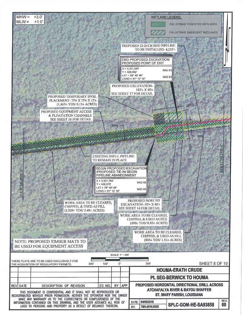
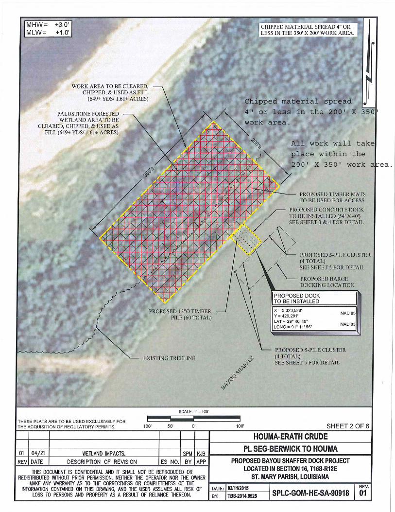
NAME OF APPLICANT: Shell Pipeline Company, Post Office Box 2648, OSP 41082B, Houston, Texas 77252-2648. LOCATION OF WORK: Bateman Island, crossing Atchafalaya River and Bayou Shaffer, located in near the community of Morgan City, in St. Mary Parish, Louisiana, as shown on the enclosed drawings. Location: POB: Latitude: 29°40ʹ52ʺ N / Longitude: -91°13ʹ31ʺ W, POE: Latitude: 29°40ʹ47ʺ N / Longitude: -91°11ʹ21ʺ W, Hydrologic Unit Code for West of Bayou Shaffer: 08080101 – Atchafalaya River Basin, Hydrologic Unit Code for East of Bayou Shaffer: 08090302 – Terrebonne, West-Central Louisiana Coastal Basin CHARACTER OF WORK: Atchafalaya River Segment: Cut and abandon 4,160 feet of an existing 22-inch Shell Pipeline, conduct drilling and excavation operations to install 1,120-foot long pipeline to connect to the new HDD pipeline and to the existing pipeline at Berwick Station, construct a 40-foot wide by 50-foot long bore pit within a 200-foot wide by 200-foot long work space connected to a 40-foot wide by 1,140-foot long excavated work space, place approximately 7,825 cubic yards excavated fill material in three temporary spoil placements, 980 cubic yards of wood chips along pipeline, and a total of approximately 365 cubic yards within a 30-foot wide by 75-foot long and a 30-foot wide by 230-foot long areas in the Atchafalaya River. Bateman Island Segment: Cut and abandon 4,160 feet of an existing 22-inch Shell Pipeline, conduct drilling and excavation operations to install 4,860 feet of the HDD pipeline, construct a 40-foot wide by 50-foot long bore pit within a 250-foot wide by 250-foot

-2- long work space and a 40-foot wide by 50-foot long bore pit within a 200-foot wide by 200-foot long work space connected to a 80-foot wide by 2,860-foot long excavated work space, which includes placing 1,275 cubic yards of wood chips in a 10-foot wide by 2,860-foot long temporary spoil placement area along the south side of an 30-foot wide existing right-of-way (ROW), and placing approximately 1,275 cubic yards of wood chips in a 10-foot wide by 2,860 foot long flotation channel within part of the ROW, 2,330 cubic yards of wood chips in a 30-foot wide by 2,860 foot long temporary spoil placement and 2,330 cubic yards of wood chips in a 15-foot wide by 2,860-foot long flotation channel, all on the north side of the ROW, place approximately 1,160 cubic yards of excavated fill material within temporary excavated workspace near bore pit area that is located within the 250-foot wide by 250-foot long work space, and 1,280 cubic yards of excavated fill material near bore pit area that is located within the 200-foot wide by 200-foot long work space. East of this work space, cut and abandon 5,175 feet of an existing 22-inch Shell Pipeline, install a 50-foot wide by 1,289-foot long excavated work space, place approximately 2,135 cubic yards of wood chips along 4,255-foot long HDD pipeline, and construct 40-foot wide by 54-foot long concrete dock, install four 5-pile clusters, and conduct clearing, grading, and chipping operations to place approximately 649 cubic yards of wood chips in a 200-foot wide by 350-foot long work space. Bayou Shaffer Segment: Place 240 cubic yards of rip rap within a 30-foot wide by 155-foot long area in Bayou Shaffer, cut and abandon 5,175 feet of an existing 22-inch Shell Pipeline, install 4,255-foot long HDD pipeline, install a 40-foot wide by 50-foot long bore pit within a 200-foot wide by 200-foot long work space connected to a 75-foot wide by 400-foot long work space, place approximately 3,300 cubic yards of excavated material near bore pit area, 3,485 cubic yards of wood chips within a 75-foot wide by 125-foot long temporary spoil placement. Approximately 1.84 acres of jurisdictional wetlands west of Atchafalaya River levee and 0.21 of an acre of open water in the Atchafalaya River would be permanently impacted via project implementation. Approximately 12.29 acres of jurisdictional wetlands east of the Atchafalaya River levee and 0.10 of an acre of open water in Bayou Shaffer in would be permanently impacted via project implementation. Temporary impacts include 0.46 of an acre of non-wetlands and 3.63 acres of temporary spoil placement work areas. Therefore, a total of 14.1 acres of jurisdictional wetlands would be permanently impacted via project implementation. The applicant agrees to compensate for wetland impacts by purchasing credits at a Department of the Army approved mitigation bank.
The comment period for the Department of the Army Permit and the Louisiana Department of Environmental Quality WQC will close 20 days from the date of this joint public notice. Written comments, including suggestions for modifications or objections to the proposed work, stating reasons thereof, are being solicited from anyone having interest in this permit and/or this WQC request and must be mailed so as to be received before or by the last day of the comment period. Letters concerning the Corps of Engineers permit application must reference the applicant's name and the Permit Application Number, and be mailed to the Corps of Engineers at the address above, ATTENTION: REGULATORY BRANCH. Similar letters concerning the Water Quality Certification must reference the applicant's name and the WQC Application number and be mailed to the Louisiana Department of Environmental Quality at the address above. Individuals or parties may request an extension of time in which to comment on the proposed work by writing or e-mailing the Corps of Engineers Project Manager listed above. Any request must be specific and substantively supportive of the requested extension, and received by this office prior to the end of the initial comment period. The Section Chief will review the request and the requestor will be promptly notified of the decision to grant or deny the request. If granted, the time extension will be continuous to the initial comment period and, inclusive of the initial comment period, will not exceed a total of 30 calendar days.

-3-
The application for this proposed project is on file with the Louisiana Department of Environmental Quality and may be examined during weekdays between 8:00 a.m. and 4:30 p.m. Copies may be obtained upon payment of costs of reproduction.
Corps of Engineers Permit Criteria
The decision whether to issue a permit will be based on an evaluation of the probable impacts,
including cumulative impacts of the proposed activity on the public interest. That decision will reflect the national concern for both protection and utilization of important resources. The benefit which reasonably may be expected to accrue from the proposal must be balanced against its reasonably foreseeable detriments. All factors which may be relevant to the proposal will be considered including the cumulative effects thereof; among those are conservation, economics, aesthetics, general environmental concerns, wetlands, historic properties, fish and wildlife values, flood hazards, floodplain values, land use, navigation, shoreline erosion and accretion, recreation, water supply and conservation, water quality, energy needs, safety, food and fiber production, mineral needs, considerations of property ownership and, in general, the needs and welfare of the people.
The U.S. Army Corps of Engineers is soliciting comments from the public, federal, state, and local agencies and officials, Indian Tribes, and other interested parties in order to consider and evaluate the impacts of this proposed activity. Any comments received will be considered by the U.S. Army Corps of Engineers to determine whether to make, modify, condition, or deny a permit for this proposal. To make this decision, comments are used to assess impacts on endangered species, historic properties, water quality, general environmental effects, and other public interest factors listed above. Comments are used in the preparation of an Environmental Assessment and/or an Environmental Impact Statement pursuant to the National Environmental Policy Act. Comments are also used to determine the need for a public hearing and to determine the overall public interest of the proposed activity.
The New Orleans District is unaware of properties listed on the National Register of Historic Places near the proposed work. The possibility exists that the proposed work may damage or destroy presently unknown archeological, scientific, prehistorical, historical sites, or data. Issuance of this public notice solicits input from the State Archeologist and State Historic Preservation Officer regarding potential impacts to cultural resources. The New Orleans District has determined that out of the 18.53 acre project footprint, 0.31 of an acre is located in waters known to be utilized by the pallid sturgeon (Scaphirhynchus albus) and the West Indian Manatee (Trichechus manatus) and 1.84 acres of jurisdictional wetlands utilized by the Louisiana Black Bear (Ursus americanus luteolus) and determined the activity is not likely to adversely affect these species based on the Standard Local Operating Procedure for Endangered Species in Louisiana (SLOPES), dated October 22, 2014, between the U.S. Army Corps of Engineers, New Orleans and U.S. Fish and Wildlife Service, Ecological Services Office. If this permit is issued, the applicant has agreed to the following conditions provided in the SLOPES manual: Standard Manatee Conditions for In-Water Activities, Appendix LBB-01 Conditions for General Activities That Would Occur within Louisiana Black Bear Breeding Habitat, and the Appendix LBB-03 Conditions for Activities That Would Occur within Louisiana Black Bear Critical Habitat.

-4-
This notice initiates the Essential Fish Habitat (EFH) consultation requirements of the Magnuson-Stevens Fishery Conservation and Management Act. The applicant's proposal would result in the destruction or alteration of 0.31 of an acre of EFH utilized by various life stages of red drum and penaeid shrimp. Our initial determination is that the proposed action would not have a substantial adverse impact on EFH or federally managed fisheries in the Gulf of Mexico. Our final determination relative to project impacts and the need for mitigation measures is subject to review by and coordination with the National Marine Fisheries Service.
If the proposed work involves deposits of dredged or fill material into navigable waters, the
evaluation of the probable impacts will include the application of guidelines established by the Administrator of the Environmental Protection Agency. Also, a certification that the proposed activity will not violate applicable water quality standards will be required from the Department of Environmental Quality, Water Quality Certifications, before a permit is issued.
Any person may request, in writing, within the comment period specified in this notice, that a public hearing be held to consider this application. Requests for public hearings shall state, with particularity, the reasons for holding a public hearing.
The applicant has certified that the proposed activity described in the application complies with
and will be conducted in a manner that is consistent with the Louisiana Coastal Resources Program. The Department of the Army permit will not be issued unless the applicant received approval or a waiver of the Coastal Use Permit by the Department of Natural Resources.
You are requested to communicate the information contained in this notice to any other parties whom you deem likely to have interest in the matter. Darrell S. Barbara Chief, Western Evaluation Section Enclosure

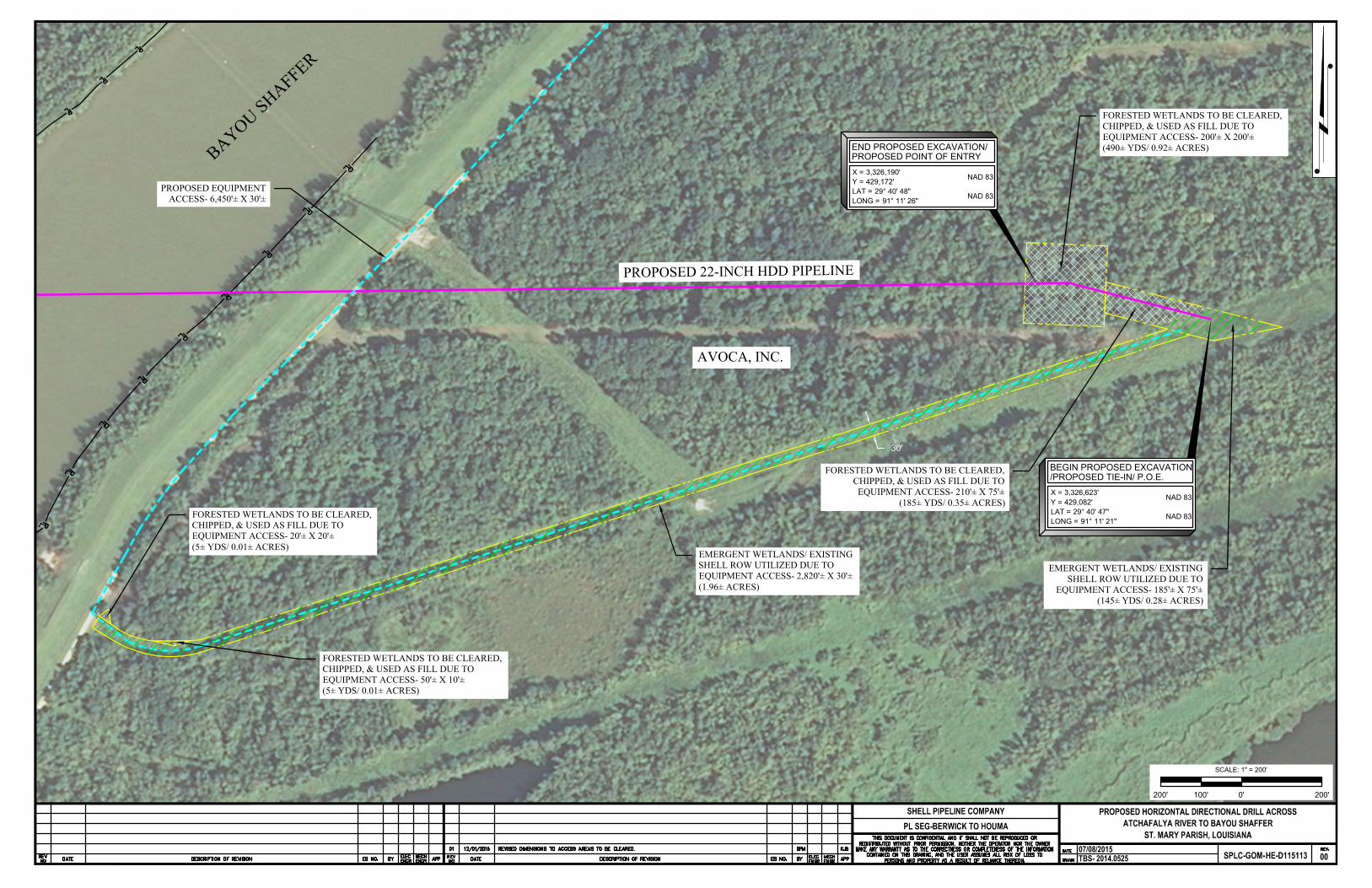
AVOCA, INC.
LONG =LAT =Y =X = 3,326,190'
429,172' NAD 83
29° 40' 48"91° 11' 26" NAD 83
END PROPOSED EXCAVATION/PROPOSED POINT OF ENTRY
LONG =LAT =Y =X = 3,326,623'
429,082' NAD 83
29° 40' 47"91° 11' 21" NAD 83
BEGIN PROPOSED EXCAVATION/PROPOSED TIE-IN/ P.O.E.
PROPOSED EQUIPMENTACCESS- 6,450'± X 30'±
BAYOU SHAFFER
PROPOSED 22-INCH HDD PIPELINE
FORESTED WETLANDS TO BE CLEARED,CHIPPED, & USED AS FILL DUE TOEQUIPMENT ACCESS- 50'± X 10'±(5± YDS/ 0.01± ACRES)
FORESTED WETLANDS TO BE CLEARED,CHIPPED, & USED AS FILL DUE TOEQUIPMENT ACCESS- 20'± X 20'±(5± YDS/ 0.01± ACRES)
EMERGENT WETLANDS/ EXISTINGSHELL ROW UTILIZED DUE TOEQUIPMENT ACCESS- 2,820'± X 30'±(1.96± ACRES)
30'
FORESTED WETLANDS TO BE CLEARED,CHIPPED, & USED AS FILL DUE TOEQUIPMENT ACCESS- 200'± X 200'±(490± YDS/ 0.92± ACRES)
FORESTED WETLANDS TO BE CLEARED,CHIPPED, & USED AS FILL DUE TO
EQUIPMENT ACCESS- 210'± X 75'±(185± YDS/ 0.35± ACRES)
EMERGENT WETLANDS/ EXISTINGSHELL ROW UTILIZED DUE TO
EQUIPMENT ACCESS- 185'± X 75'±(145± YDS/ 0.28± ACRES)
0'100'200' 200'
SCALE: 1" = 200'

XX26
1120' X 30' NewROW to beinspected.
400' X 30' newROW to beinspected.


Chipped material spread
4" or less in the 200' X 350'
work area.
All work will take
place within the
200' X 350' work area.


WEST OF LEVEE (Inside) EAST OF LEVEE (Outside)
EXCAVATIONS
Non-Vegetated Water
Bottoms
80 CYS
0.01 ACS
Wetlands
4425 CY
0.623 ACS
10,970 CY
2.897 ACS
Non-Wetlands
3400 CY
0.46 ACS
Fill Excavated
Material
Non-Wetlands
2650 CY
0.15 ACS
Wetlands
5255 CY
0.3 ACS
10,970 CY
3.33 ACS
Chipped Trees
Wetlands
906 CY
1.84 ACS
6402 CY
12.29 ACS
Non-Wetlands
74 CY
0.15 ACS
82 CY
0.16 ACS
Rip Rap
Non-Vegetated Water
Bottoms
605 CY
0.31 ACS
Total Excavations
18,875
3.99 ACS
Total Fill
26,944 CY
18.53 ACS
TOTAL PROJECT IMPACTS
![Maryland’s Money Follows the Person [Title] Demonstration · 2020-03-22 · Maryland Transition Numbers •2,860 transitions since program approval in 2008 –Older Adults- 1,306](https://img.pdfslide.us/doc/110x75/5f4cf69f3f4a5e5681167807/marylandas-money-follows-the-person-title-demonstration-2020-03-22-maryland.jpg)