Embed Size (px)
Citation preview
Joint Land Use StudyPublic Draft June 2016

This study was prepared under contract with the City of Bastrop, Texas, with financial support from the Office of Economic Adjustment, Department of Defense. The content reflects the views of the City of Bastrop and the other JLUS Partners and does not necessarily reflect the views of the Office of Economic Adjustment.

Public Draft Joint Land Use Study
Prepared Under Contract with:
City of Bastrop 1311 Chestnut Street
Bastrop, TX 78602
Prepared by:
June 2016

This study was prepared under contract with the City of Bastrop, with financial support from the Office of Economic Adjustment, Department of Defense. The content reflects the views of the City of Bastrop and the JLUS Partners and does not necessarily reflect the views of the Office of Economic Adjustment.
June 2016 Public Draft Joint Land Use Study
Policy Committee The Policy Committee (PC) served an active and important role in providing policy direction during the development of the Camp Swift Joint Land Use Study. The Policy Committee was composed of the following individuals:
LTC Jamey Creek Texas Military Department
COL Robert Crow Texas Military Department
Marc Holm City of Elgin
Dock Jackson City of Bastrop
LTC Phillip Kost Camp Swift Army National Guard
Kerry Lacy City of Elgin
BG Tracy Norris Texas Military Department
Paul Pape Bastrop County
Emily Parks Bastrop Independent School District
Bubba Snowden Bastrop County
Michael Talbot City of Bastrop
Technical Committee The Technical Committee (TC) served a key role in the development of the Camp Swift Joint Land Use Study. They provided the overall technical support, review, and guidance of the study. The TC was composed of the following individuals:
Smith Covey Pines & Prairies Land Trust
Carolyn Dill Bastrop County
Roy Dill Texas Department of Transportation
Blake Dommert Bastrop County
Mike Fisher Emergency Operations Center
Robin Howard Texas Military Department
Todd McClanahan Texas Parks and Wildlife
Melissa McCollum City of Bastrop
Amy Miller City of Elgin
Kirsten Mt. Joy Texas Military Department
Joe Newman City of Elgin
Melanie Pavlas Pines & Prairies Land Trust

Public Draft Joint Land Use Study June 2016
Technical Committee (continued) LTC Phillip Kost
Camp Swift Army National Guard
John Landwehr Coast Range Investments
Maj. Ed Limbo Camp Swift Army National Guard
Colton Stabeno Lost Pines Habitat Conservation
Cathy Stevens Capital Area Metropolitan Planning Organization
City of Bastrop The City of Bastrop served as the overall JLUS project management agency and the administrator of the Office of Economic Adjustment grant that helped to fund the study.
Melissa McCollum, AICP, LEED-AP Director Planning and Development Department
Marie Murnan Planning Technician Planning and Development Department
JLUS Consultant / Technical Advisors Matrix Design Group was the project consultant hired to conduct the JLUS project through coordination with and assistance from the City of Bastrop, the PC, the TC, the public, and other stakeholders.
Mike Hrapla
Project Manager
Celeste Werner, AICP Deputy Project Manager
Rick Rust, AICP, GSP Technical Manager
Michele Zehr Mora Lead Planner

April 2016 Public Draft Joint Land Use Study Page i
Acronyms ...................................................................................................................................................... v
1. Introduction ......................................................................................................................................1
What Is A JLUS?...................................................................................................................................................................... 1 JLUS Goal and Objectives ...................................................................................................................................................... 1 Why Prepare A JLUS? ............................................................................................................................................................ 2 JLUS Partners / Public Outreach ........................................................................................................................................... 2 JLUS Study Area ..................................................................................................................................................................... 4
2. Community Profiles ...........................................................................................................................7
Study Area Growth Trends .................................................................................................................................................... 7 Development Overview within the JLUS Study Area ........................................................................................................... 8
3. Military Profile ..................................................................................................................................9
Texas Military Department ................................................................................................................................................... 9 Texas Army National Guard .................................................................................................................................................. 9 Camp Swift Economic Impact ............................................................................................................................................. 10 Current Mission and Military Operations ........................................................................................................................... 10 Camp Swift Mission Footprint ............................................................................................................................................. 10
4. Compatibility Tools .........................................................................................................................21
Federal Plans and Programs ................................................................................................................................................ 21 Texas Army National Guard / Camp Swift .......................................................................................................................... 21 State of Texas Legislation, Agencies / Programs, and Initiatives / Other Information .................................................... 22 County and Local Jurisdiction Planning Tools .................................................................................................................... 23
5. Compatibility Assessment ...............................................................................................................25
Identification of Compatibility Issues ................................................................................................................................. 25 Methodology and Evaluation .............................................................................................................................................. 25 Camp Swift Compatibility Issues by Factor ........................................................................................................................ 25 Air Quality ............................................................................................................................................................. 25 Anti-Terrorism / Force Protection ....................................................................................................................... 26 Biological Resources ............................................................................................................................................. 26 Climate Adaptation ............................................................................................................................................... 26 Communication / Coordination ........................................................................................................................... 26 Cultural Resources ................................................................................................................................................ 27 Dust / Smoke / Steam ........................................................................................................................................... 27 Energy Development ............................................................................................................................................ 27 Land / Air Space Competition .............................................................................................................................. 27

Page ii Public Draft Joint Land Use Study June 2016
Land Use ................................................................................................................................................................ 28 Legislative Initiatives ............................................................................................................................................. 28 Light and Glare ...................................................................................................................................................... 28 Noise ...................................................................................................................................................................... 28 Public Trespassing................................................................................................................................................. 29 Roadway Capacity ................................................................................................................................................. 29 Safety Zones .......................................................................................................................................................... 29 Vertical Obstructions ............................................................................................................................................ 29
6. Recommended Options ..................................................................................................................31
Recommended Options....................................................................................................................................................... 31 Military Awareness Areas .................................................................................................................................................... 32 How to Read the Recommended Options Table................................................................................................................ 40
Figures
Figure 1 Camp Swift JLUS Study Area .................................................................................................................................. 5 Figure 2 Forecasted Population in Bastrop County, 2010-2050......................................................................................... 8 Figure 3 Unobstructed Clear Zone ..................................................................................................................................... 12 Figure 4 Fixed Small Caliber Arms Noise Contours ........................................................................................................... 13 Figure 5 Improvised Explosive Device (IED) Noise Contours ............................................................................................ 14 Figure 6 Demolition Two Pound Charge Noise Contours ................................................................................................. 15 Figure 7 Demolition 40 Pound Charge Noise Contours .................................................................................................... 16 Figure 8 Obstacles Near Drop Zone ................................................................................................................................... 17 Figure 9 DOD Rotary Wing Imaginary Surfaces ................................................................................................................. 18 Figure 10 BASH Relevancy Area ........................................................................................................................................... 19 Figure 11 Unobstructed Clearance Area Military Awareness Area .................................................................................... 34 Figure 12 Camp Swift Small Arms / IED Military Awareness Area ...................................................................................... 35 Figure 13 Camp Swift Demolition Noise Military Awareness Area ..................................................................................... 36 Figure 14 Camp Swift Drop Zone Obstacle-Free Military Awareness Area ........................................................................ 37 Figure 15 Camp Swift Vertical Obstruction Military Awareness Area ................................................................................ 38 Figure 16 Camp Swift Military Awareness Overlay District ................................................................................................. 39 Figure 17 How to Read JLUS Options ................................................................................................................................... 41
June 2016 Public Draft Joint Land Use Study Page iii
Tables
Table 1 JLUS Sponsor Responsibilities and Participants .................................................................................................... 3 Table 2 JLUS Policy Committee (PC) Responsibilities and Participants ............................................................................. 3 Table 3 JLUS Technical Committee (TC) Responsibilities and Participants ....................................................................... 3 Table 4 Study Area Population, 2000-2010 ........................................................................................................................ 8 Table 5 Issues / Options by Compatibility Factor (Alphabetized by Factor) ................................................................... 42

Page iv Public Draft Joint Land Use Study June 2016
Please see next page.

June 2016 Public Draft Joint Land Use Study Page v
A A Airborne ACUB Army Compatible Use Buffer AGL above ground level APZ Accident Potential Zone APZ-LZ Accident Potential Zone – Landing
Zone AR Army Regulation ARR Austin-Round Rock ASP Ammunition Supply Point AT / AT / FP
Anti-Terrorism / Force Protection
B BASH Bird / Wildlife Aircraft Strike Hazard BfSB Battlefield Surveillance Brigade BISD Bastrop Independent School District BRAC Base Realignment and Closure BUG Backlight, Uplight, and Glare
C CAB Combat Aviation Brigade CAMPO Capital Area Metropolitan Planning
Organization CAPCOG Capital Area Council of Governments CFR Code of Federal Regulations COM Communication / Coordination CP Comprehensive Plan CR Cultural Resources CZ Clear Zone
D DA PAM Department of the Army Pamphlet dB decibel dBA A-weighted decibel dBP Peak decibels DEAAG Defense Economic Adjustment
Assistance Grant DNL Day-Night Average Sound Level DOD Department of Defense DODI Department of Defense Instruction du dwelling unit DZ Drop Zone
E ED Energy Development e.g. for example EMS Environmental Management System ESA Endangered Species Act ESQD Explosive Safety Quantity Distance ETJ Extraterritorial Jurisdiction
F FAA Federal Aviation Administration fc footcandle (unit of measurement for
light emission) FEMA Federal Emergency Management
Agency FM Farm to Market Road FM Field Manual ft feet (unit of measurement) FY fiscal year

Page vi Public Draft Joint Land Use Study June 2016
G GIS geographic information system
H HB House Bill
I ICRMP Integrated Cultural Resources
Management Plan ID Infantry Division i.e. For example IED Improvised Explosive Device IESNA Illuminating Engineering Society of
North America IGA Intergovernmental agreements INRMP Integrated Natural Resources
Management Plan IWFMP Integrated Wildland Fire
Management Plan
J JLUS Joint Land Use Study
K, L LAS Land / Air Space Competition LGC Local Government Code LPHCP Lost Pines Habitat Conservation Plan LPS Low-Pressure Sodium LU Land Use
M MCA Military Compatibility Area MCOD Military Compatibility Overlay District MOA Memorandum of Agreement MOU Memorandum of Understanding MOUT Military Operations in Urban Terrain MSA Metropolitan Statistical Area MTC-L Maneuver Training Center – Light
N NGOs nongovernmental organizations NOAA National Oceanic and Atmospheric
Administration NOI Noise NOTAMs Notices to Airmen NRHP National Register of Historic Places NVG night vision goggles NZ Noise Zone
O OE Obstruction Evaluation OEA Office of Economic Adjustment OMB Office of Management and Budget ONMP Operational Noise Management Plan
P PC Policy Committee PK MET Single Event Peak Level Exceeded by
15 Percent of Events PL Public Law PT Public Trespassing

June 2016 Public Draft Joint Land Use Study Page vii
Q, R RC Roadway Capacity REPI Readiness and Environment
Protection Integration RFMSS Range Facility Management Support
System RMSC Regional Military Sustainability
Commission ROW Right-of-Way
S SA Safety Zones SARNAM Small Arms Range Noise Assessment
Model SARSA Small Arms Range Safety Areas SDZ surface danger zone SH State Highway SIPs State Implementation Plans SR State Route
T TC Technical Committee TC Troop Command TCEQ Texas Commission on Environmental
Quality TMPC Texas Military Preparedness
Commission TPWD Texas Parks and Wildlife Department TXARNG Texas Army National Guard TXDOT Texas Department of Transportation TXMF Texas Military Forces TXNG Texas National Guard
U USAF United States Air Force US United States USFWS United States Fish and Wildlife
Service
V VO Vertical Obstructions
W, X, Y, Z

Page viii Public Draft Joint Land Use Study June 2016
Please see next page.

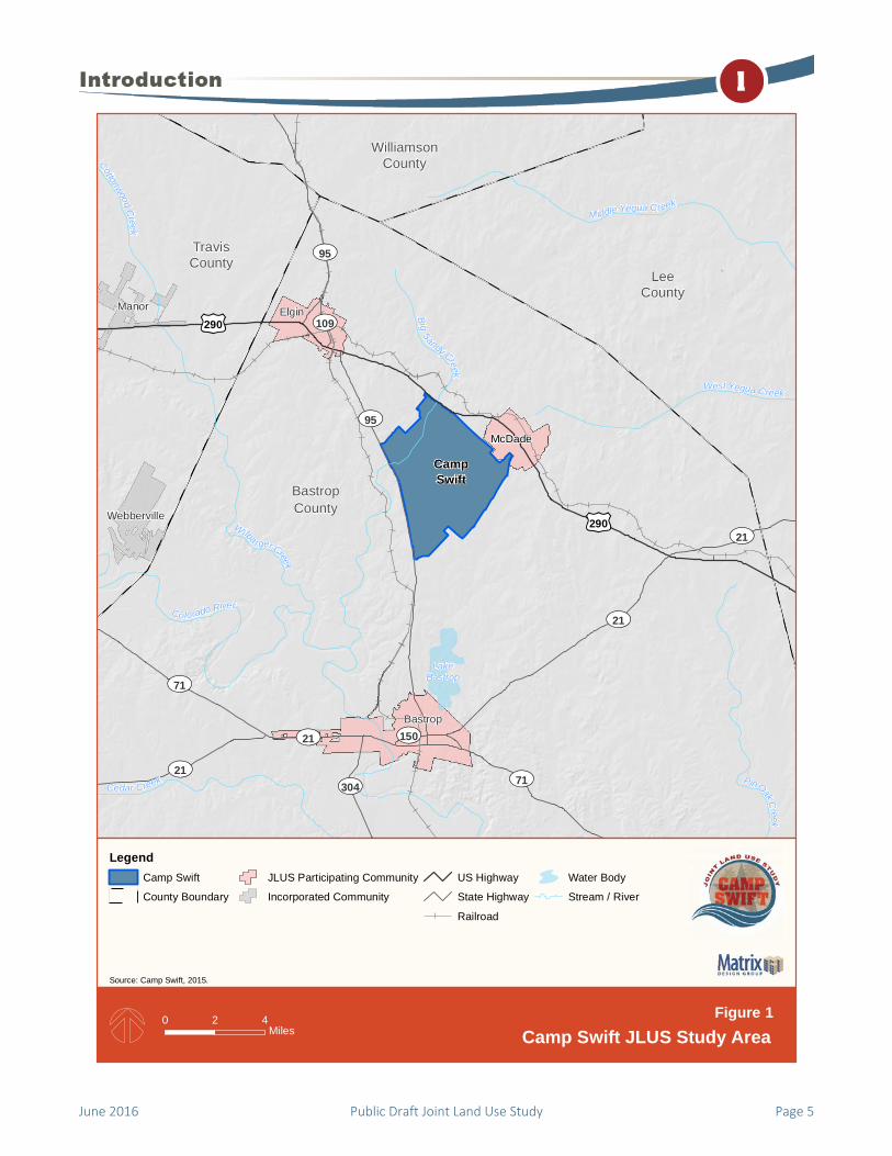
Camp Swift is s i tuated in north central Bastrop County, Texas covering approximately 11,750 acres, which includes administrative faci l i t ies, he l icopter operational areas, and tra ining areas. The communities that partic ipated as partners in this Jo int Land Use Study (JLUS) were Bastrop County; the Ci ty of Bastrop; the C ity of Elg in, and the Community of McDade. To promote and coordinate the compatibi l i ty of future growth around the instal lat ion, an organized communicat ion effort between Camp Swift / Texas Mi l itary Department (TMD), the partner jurisdic tions, and other stakeholder enti t ies is essential .
The Camp Swif t JLUS is a proactive approach for mit igating existing and prevent ing future mil itary compatibi l i ty i ssues by faci l i tating col laborat ion between local communities, the publ ic , and the Texas Army National Guard (TXARNG). This study seeks to prevent confl icts experienced between the mi l i tary and local communities by engaging the mil itary and local dec ision-makers in a co l laborat ive multi -agency communication and planning process .
What Is A JLUS? A JLUS is a planning process accomplished through the collaborative efforts of a comprehensive list of stakeholders in a defined study area. These stakeholders include local community, state, and federal officials, residents, and the military, who come together to identify compatible land uses and growth management recommendations within and adjacent to active military installations. The intent of the process is to establish and foster a relationship between the local communities, agencies, and Camp Swift / TMD.
JLUS Goal and Objectives The goal of the Camp Swift JLUS is to protect the viability of current and future military operations, while simultaneously promoting community growth, sustaining the environmental and economic health of the region, and protecting public health, safety, and welfare.
To help meet this goal, three primary guiding principles were identified:
Understanding. Convene community and military representatives to identify, confirm, and understand the issues in an open forum, taking into consideration both community and Camp Swift perspectives and needs. This includes public awareness, education, and input organized in a cohesive outreach program.
Collaboration. Encourage cooperative land use and resource planning among Camp Swift and surrounding communities so future community growth and development are compatible with Camp Swift’s operational missions, while at the same time seeking ways to reduce operational impacts on adjacent lands and communities within the Study Area.
Options. Provide a set of mutually supported tools, options, and procedures from which local jurisdictions, agencies, and Camp Swift can select and prepare then use to apply the options developed during the JLUS process. The options proposed include both operational measures to mitigate installation impacts on surrounding communities and local government and agency approaches to reduce community impacts on military operations. These tools will help decision makers resolve compatibility issues and prioritize projects within the annual budgeting process of their respective entity / jurisdiction.
June 2016 Public Draft Joint Land Use Study Page 1

Why Prepare A JLUS? Collaboration and joint planning among military installations, local communities, and agencies should occur to protect the long-term viability of existing and future military missions. Working together also enhances the health of economies and industry of the communities before incompatibility becomes an issue. Recognizing the close relationship that should exist between installations and adjacent communities, the Department of Defense, Office of Economic Adjustment (OEA) implemented the JLUS program in an effort to mitigate existing and future conflicts and enhance communication and coordination among all stakeholders. This program aims to protect property rights and control within the JLUS Study Area while protecting current and future operational and training missions at Camp Swift.
Economic Benefit to the Region Camp Swift is under the TXARNG, which makes up the largest population segment in the TMD. In Fiscal Year (FY) 2011, the Army National Guard awarded over $5 million dollars of military construction contracts to the state of Texas, $2.6 million specifically for Camp Swift.
In lieu of direct jobs and traditional economic output data, the intensity of usage at the installation helps to characterize the economic potential of Camp Swift on the local economies. From 2012-2014, 346,561 Guardsmen were reported to have used Camp Swift for training. There were several hundred thousand persons, non-DOD who used the Camp Swift training ranges and areas during this time as well. This usage equates to more than 250,000 users of Camp Swift’s assets annually through the years 2012-2014. Indirect benefits include catering and local purchases made at various eateries and businesses, like Walmart.
JLUS Partners / Public Outreach The JLUS process is designed to create a locally relevant document that builds consensus and obtains support from the various stakeholders involved. To achieve the JLUS goals and objectives, the process included a public outreach program with a variety of participation opportunities for interested and affected parties.
Stakeholders An early step in any planning process is the identification of stakeholders. Informing and involving them early in the project is essential to understanding, addressing, and resolving their most important issues through the development of integrated options. Stakeholders include individuals, groups, organizations, and governmental entities interested in, affected by, or affecting the outcome of the JLUS document. Stakeholders identified for the Camp Swift JLUS include, but were not limited to, the following:
The public (including residents and landowners) Local jurisdictions (counties and cities) DOD officials (including OEA representatives) Camp Swift / TMD Local, regional, and state planning agencies Bastrop Independent School District Nongovernmental organizations
Policy and Technical Committees The development of the Camp Swift JLUS was guided by two committees, comprising city, county, Camp Swift / TMD personnel, federal and state agencies, local governments, and other stakeholders.
Policy Committee. The Policy Committee (PC) consisted of officials from participating jurisdictions, military installation leadership, and representatives from Camp Swift and federal and state agencies. The PC was responsible for the overall direction of the JLUS, preparation and approval of the study design, approval of JLUS options, and approval of draft and final JLUS documents.
Technical Committee. The Technical Committee (TC) was responsible for identifying and studying technical issues. Membership included city planners and staff, military base planners and staff, and other subject matter experts as needed to help assist in the development and evaluation of implementation options and tools. Items discussed by the TC were brought before the PC for consideration.
Page 2 Public Draft Joint Land Use Study June 2016

The PC and TC served as liaisons to their respective stakeholder groups. The PC and TC members were charged with conveying committee activities and information to their organizations and constituencies and relaying their organization’s comments and suggestions to both committees for consideration. The PC members were encouraged to conduct meetings with their organizations and / or constituencies to facilitate this input. The responsibilities and participants for the JLUS sponsors, the PC, and the TC are identified in Tables 1, 2, and 3, respectively.
Table 1. JLUS Sponsor Responsibilities and Participants
Responsibilities Participants
Coordination Accountability Grant management Financial contribution
Office of Economic Adjustment
City of Bastrop
Table 2. JLUS PC Responsibilities and Participants
Responsibilities Participants
Policy direction Study oversight Monitoring Report adoption
City of Bastrop City of Elgin Bastrop County Camp Swift / TMD Texas National Guard
(TXNG) / Texas Army National Guard (TXARNG)
Bastrop Independent School District
Table 3. JLUS TC Responsibilities and Participants
Responsibilities Participants
Identify issues Provide expertise to
address technical issues
Evaluate and recommend options to the PC
Provide draft and final report recommendations to the PC
City of Bastrop City of Elgin Bastrop County Camp Swift / TMD TXNG / TXARNG Bastrop Independent
School District Texas Department of
Transportation Texas Parks and
Wildlife Pines & Prairies Land
Trust Emergency Operations
Center
Public Workshops In addition to the PC and TC meetings, a series of public workshops were held throughout the development of the JLUS. These workshops provided an opportunity to exchange information with the greater community, assist in identifying the issues to be addressed in the JLUS, and provide an opportunity for input on the proposed options. Each workshop included an interactive presentation and facilitated exercise for the public to participate in the development of the plan.
Public Outreach Materials Joint Land Use Study Overview / Compatibility Factors Fact Sheet. At the beginning of the JLUS process, a Fact Sheet was developed describing the JLUS program, objectives, public participation methods, and the Camp Swift JLUS Study Area. This Fact Sheet was made
available at the meetings and on the website for review by interested members of the public.
June 2016 Public Draft Joint Land Use Study Page 3

This Fact Sheet also described each of the 25 compatibility factors used for the JLUS analysis. While not every factor applied to the Camp Swift JLUS, the list provides an effective tool to ensure a comprehensive evaluation of compatibility factors is conducted within the JLUS Study Area.
Options Tools Fact Sheet. JLUS options comprise a variety of actions that local governments, military installations, agencies, and other stakeholders can use to promote compatible land use planning. This Fact Sheet provided an overview of the option types that could be applied to address compatibility issues in the Study Area. This Fact Sheet was an internal JLUS organization brochure.
Website. A project website was developed to provide stakeholders, the public, and media representatives with access to project information. This website was maintained for the duration of the project to ensure information was easily accessible. Information contained on the website included program points of contact, documents, maps, public meeting information, and other JLUS resources. The project website is located at www.campswiftjlus.com.
JLUS Study Area Camp Swift is located approximately nine miles north of the City of Bastrop and approximately four miles southeast of the City of Elgin in Bastrop County, east of the City of Austin, Texas. The installation is located in a primarily rural agriculture area, surrounded by farmland, forests and small communities such as McDade. There are transportation corridors within the study area that are projected to grow. These corridors include State Highway 95 on the installation’s western boundary and U.S. Highway 290 on the installation’s northern boundary. It is important to note that this area is located in the Capital Area Metropolitan Planning Organization and Capital Area Council of Governments planning area. Although this area is not as urban as Austin, Texas, the installation and
surrounding communities are connected geographically and economically to the Capital region.
The Camp Swift JLUS Study Area was designed to encompass all operational areas of the installation, including all lands in the vicinity that may impact or be impacted by current and future military operations. This area includes land associated with helicopter operations, training ranges, and demolition activities within the county of Bastrop, the cities of Bastrop and Elgin, and the Community of McDade as illustrated in Figure 1. The Study Area was finalized and refined based on information and input collected from the public and the JLUS communities.
Page 4 Public Draft Joint Land Use Study June 2016
June 2016 Public Draft Joint Land Use Study Page 5
WilliamsonCounty
TravisCounty
LeeCounty
BastropCounty
McDade
Webberville
Bastrop
Manor Elgin
£¤290UV21
UV150
UV109
UV304
UV71
UV71
UV95
UV95
UV21
UV21
UV21
£¤290
LakeBastrop
Colorado River
Cottonwood Creek
West Yegua Creek
Cedar Creek PinOakCreek
W ilba rger Creek
Middle Yequa Creek
Big Sandy Creek
CampSwift
LegendCamp Swift
County Boundary
JLUS Participating Community
Incorporated Community
US Highway
State Highway
Railroad
Water Body
Stream / River
Source: Camp Swift, 2015.
0 42Miles
Figure 1 Camp Swift JLUS Study Area

Please see next page.
Page 6 Public Draft Joint Land Use Study June 2016

The Camp Swif t JLUS Study Area includes the faci l i t ies at Camp Swift , Bastrop County, City of Bastrop, Ci ty of Elgin, and the Community of McDade. Captur ing and describing certain demographic characterist ics of the part ic ipat ing JLUS communities can help to provide a basel ine context from which informed decisions can be made when developing compatib i l i ty opt ions.
The goal i s to provide information that enables stakeholders to gain an understanding of population and development trends that have the potential to affect the future missions and operations of Camp Swif t. I t is intended that th is information, combined with other factors presented herein, to the extent al lowable under Texas law and with ample input from the publ ic , he lp decis ion-makers develop consistent, informed planning pol ic ies about future development and economic growth of the communities they represent before compatibi l i ty i ssues arise. Further, this section is designed to foster an understanding by the mil itary about the types of act ivi t ies occurring “outs ide the fence” when considering future miss ions and operations.
Study Area Growth Trends Extraordinary growth has been reported within the State of Texas, which was identified as the state with the highest number of individuals moving into it (529,000) between April 1, 2010 and July 1, 2011. The 2.9 percent increase in total population has the local communities planning for potential encroachment issues from larger surrounding cities. The eastward expansion from Austin is palpable with the metropolitan area of Austin, Round Rock, and San Marcos being named as the second fastest growing metropolitan area in the US, with an increase in population of 3.9 percent.
Population Population data for Texas, Bastrop County, and the communities within the Study Area is based on a combination of information provided by the U.S. Census Bureau and the Texas State Data Center. Population growth observed from the 2000 and 2010 Census counts show an increase of nearly 30 percent for Bastrop County, which is approximately 38 percent higher than the State of Texas as a whole. The communities identified in Table 4 are all within the Study Area, and all have demonstrated significant population increases ranging from 28-49 percent between 2000 and 2010. These communities all exhibited a greater increase in population than the growth recorded at the county and state levels.
June 2016 Public Draft Joint Land Use Study Page 7

Table 4. Study Area Population, 2000-2010
Area 2000 2010 Number Change
Percent Change
Texas 20,851,820 25,145,561 4,293,741 20.6%
Bastrop County
57,733 74,171 16,438 28.5%
City of Bastrop
5,340 7,218 1,878 35.2%
City of Elgin
5,700 8,135 2,435 42.7%
McDade, CDP
459 685 226 49.2%
Source: US Census Bureau 2000 & 2010
In addition to the population growth already experienced within Bastrop County between 2000 and 2010, the population forecast from 2010 to 2050 projects an additional 11.6 percent, or 8,615 additional people, as illustrated on Figure 2. The most significant increase in population is anticipated to occur within the next 15 years, with conditions projected to be relatively stable from 2040 to 2050.
Figure 2. Forecasted Population in Bastrop County, 2010-2050
Source: US Census Bureau, 2010; Texas Data Center, 2014. Projections of the Population of Texas and Counties in Texas by Age, Sex and Race/Ethnicity for 2010-2050.
Development Overview within the JLUS Study Area Land uses throughout the JLUS Study Area range from open space, protected habitat conservation areas, and agriculture, to the residential and urban population centers of Bastrop County and the Cities of Bastrop and Elgin.
The area surrounding Camp Swift is a mix of protected habitat areas, agriculture, rural residential and open space lands. At the time this JLUS was developed, there were discussions about phased subdivisions located in the unincorporated county southwest of Camp Swift.
Economic Growth Trends Bastrop County, with its proximity to Austin, is well positioned to acquire some of the workforce demand. The cities of Bastrop and Elgin already have large factions of workers that have chosen to live in the rural historic communities and commute to Austin for work. In addition to the segment of the rural population commuting to Austin for work, there are an estimated 591 local businesses employing 3,604 employees within five minutes from downtown Bastrop. The Bastrop Independent School District is the largest employer in the area with over 1,300 employees.
The education sector makes up over 15 percent of employment in the City of Elgin, and with the new addition of a local branch of Austin Community College, the education sector is poised for additional employment opportunities. The majority of the population of Elgin is employed in retail trade, with education serving as the second largest employment industry. Elgin’s economy is composed of approximately 440 businesses centered primarily on retail, food, and various local services. Elgin, like the City of Bastrop, is ideally situated for residents choosing the commuter route rather than work within the city as evidenced by the 60 percent of residents currently working outside of the city limits.
The proximity to Austin and ease of travel have paved the way for economic and housing development within the Camp Swift JLUS Study Area. With plans for shopping and retail aimed at increasing employment opportunities for Elgin, and the newly built higher learning institution, combined with plans for new subdivisions southwest of Camp Swift, it is apparent that the rural communities of Bastrop County will continue to grow at a rate that is on par with population projections for the county.
Page 8 Public Draft Joint Land Use Study June 2016
To appropriately develop and assess compatibi l i ty i ssues for the Camp Swif t JLUS, it is important to understand the mi l i tary operations and act ivi t ies associated with Camp Swift miss ions and how those operations interface with nearby communities. This sect ion provides a brief overv iew of the miss ion and mil i tary operational footprint at Camp Swif t.
This information wil l aid stakeholders as they make informed decisions re lative to the future development and economic growth of the ir communities, which may be inf luenced by instal lation activ it ies due to their relative proximity to Camp Swift . These decisions ul t imately impact the cont inued existence and future ro le of the instal lat ion.
Texas Military Department The Texas Military Department (TMD) consists of four organizations, they are:
Adjutant General’s Office, Texas Air National Guard, Texas Army National Guard, and Texas State Guard.
The TMD is the largest military force in the country, and has deployed over 31,000 soldiers and airmen in support of the Global War on Terror since 2001. The TMD mission is to provide the Governor and President with mission-ready, trained forces in support of state and federal initiatives. These initiatives include:
Natural disasters, Civil unrest, Protect critical infrastructure and resources, Protect Texans from all hazards, and Protect Federal Emergency Management Agency
Region VI.
In order to achieve the mission, over 5.5 million square feet of facility space is owned, leased, or licensed by the state of Texas to support the TMD. The Texas National Guard (TXNG) inventory has over 100 facilities in 65 counties across the state of Texas. These facilities are Readiness Centers (armories), maintenance facilities, Army aviation support facilities, Armed Forces Reserve Centers, and Air Wings.
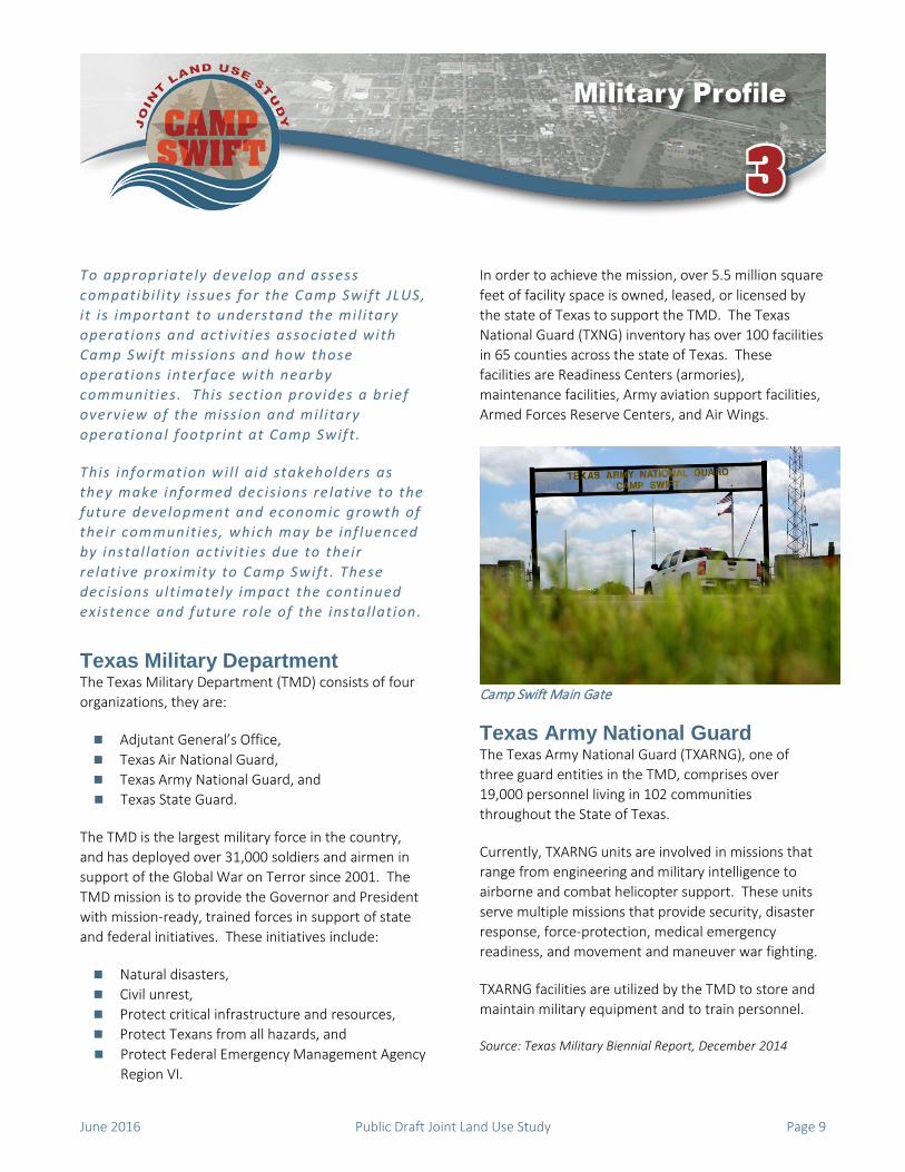
Camp Swift Main Gate
Texas Army National Guard The Texas Army National Guard (TXARNG), one of three guard entities in the TMD, comprises over 19,000 personnel living in 102 communities throughout the State of Texas.
Currently, TXARNG units are involved in missions that range from engineering and military intelligence to airborne and combat helicopter support. These units serve multiple missions that provide security, disaster response, force-protection, medical emergency readiness, and movement and maneuver war fighting.
TXARNG facilities are utilized by the TMD to store and maintain military equipment and to train personnel.
Source: Texas Military Biennial Report, December 2014
June 2016 Public Draft Joint Land Use Study Page 9

Camp Swift Economic Impact In addition to its strategic military value, Camp Swift contributes economically to both the local and regional economies through the purchase of goods and services. Approximately 250,000 people, both military and non-military, used Camp Swift ranges and training areas annually between 2012 and 2014.
In addition, Camp Swift, as a facility under the TXARNG, makes up the largest population segment in the TMD. In Fiscal Year (FY) 2011, the Army National Guard awarded over $5 million dollars of military construction contracts to the state of Texas, $2.6 million specifically for Camp Swift. This means approximately $2.6 million could have been awarded to local companies, either as primes or as subcontractors that bid on and won military construction contracts.
Source: Camp Swift Range Facility Management Support System (RFMSS), 2012-2014.
Current Mission and Military Operations Camp Swift’s mission is to provide Inactive Duty Training and annual training primarily for the TXARNG and Reserve Forces, and to a lesser degree, for active components of the Armed Forces and other government and civilians organizations. The goal of this mission is to sustain a highly trained and ready force for wartime operations and community-based capability to respond rapidly to the needs of civil authorities in times of natural or man-made disasters.
Camp Swift Cantonment Area
The Camp maintains institutional training as well as pre-mobilization missions, and is oriented towards providing national defense and troop readiness for the protection of the United States from foreign and domestic threats.
Source: Texas Military Biennial Report, December 2014
Camp Swift is a Maneuver Training Center-Light (MTC-L) with both pre-mobilization and institutional training missions, and it has six designated training areas, of which over 200 acres consists of firing ranges. The Camp is the premier site for pre-mobilization training for the TXARNG and is the preferred training center for the 72nd Infantry Brigade Combat Team.
Training activities currently conducted at Camp Swift range from small arms and weapons qualifications and proficiency to land navigation and combat engineering skills. Training facilities on the base include; seven live-fire ranges, which comprise a Light Demolition Range and an Improvised Explosive Device (IED) Lane, a Drop Zone for airborne training, military operations in urban terrain (MOUT), physical training, aerial personnel and equipment drops, land navigation, and night vision operations.
Camp Swift Mission Footprint Mission and training activities at Camp Swift generate a number of impacts that can affect the health, safety, and quality of life of the general public in surrounding communities. Examples of mission impacts include noise and vibration from demolition activities or aviation operations.
These overlapping spatial patterns comprise the mission footprint. The mission footprint serves as a compatibility tool that can be used by surrounding private property owners and proximate jurisdictions in making informed land use decisions.
Explosive Safety Quantity Distance In addition to the live-fire ranges, the Ammunition Supply Point (ASP), which is a munitions storage facility located within Training Area IIA, has an associated Explosive Safety Quantity Distance (ESQD) arc. The ESQD arc defines the area that would be affected by an explosion at the ASP. Inhabitable buildings are not
Page 10 Public Draft Joint Land Use Study June 2016
allowed to be located within ESQD arcs. Contours of the ASP ESQD arcs are based on the type and amount of ammunition / ordnance stored and the current ASP ESQD arcs are contained within the boundaries of the installation.
Surface Danger Zones For safety purposes, each small arms live-fire range is required by Army Regulation to have a designated Surface Danger Zone (SDZ). SDZs encompass the anticipated area where munitions and debris could fall after fired from a certain point. Camp Swift only supports weapons training with ammunition that generates SDZs that are contained entirely within the boundary of the installation.
Unobstructed Clear Zone The Military Handbook, Design Guidelines for Security Fencing, Gates, Barriers, and Guard Facilities identifies a combined interior / exterior clear zone distance of 50 feet minimum. A 30 feet minimum internal clear zone is mandatory, with the remaining 20 feet being reserved for outside of the fence line. The clear zone serves multiple purposes, including: reducing opportunities for intruder concealment, maintaining a 50 foot wide fire break, and in the case of Camp Swift, maintains adequate separation between the installation and the roadways. This 20 foot clearance zone, ideally, would be maintained through development coordination with the military. There is no desire to acquire the 20-foot clear zone through fee simple purchase. Easements may be used as a tool in this case. Figure 3 illustrates the 20 foot unobstructed clear zone outside the boundary of Camp Swift.
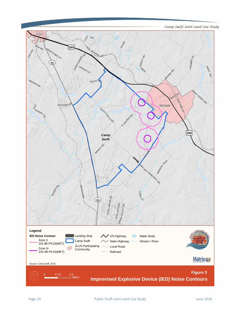
Small Caliber Weapons Noise Contours The primary sources of small arms noise at Camp Swift include small caliber weapons firing, Figure 4, and IED Lane noise contours, Figure 5. These along with the large caliber noise contours comprise the noise zones for Camp Swift.
Large Caliber Weapons Noise Contours Large caliber weapons noise contours comprise noise zones for demolition activities. More specifically, Camp Swift has capabilities to perform a 2-lb. and 40-lb. charge demolition explosion, Figures 6 and 7, respectively.
Drop Zone Obstacle Free Area The Drop Zone (DZ) Obstacle Free Area is a footprint of the personnel and equipment drops activities. Camp Swift performs DZ operations and as such requires a 1,000 meter operational area from the Blackwell DZ. This DZ Obstacle Free Area is illustrated in Figure 8.
Helicopter Imaginary Surfaces The helicopter imaginary surfaces define volumes of airspace that must remain free of obstructions to air navigation in order to maintain safe navigable airspace around the airfield. Each imaginary surface builds upon each other as illustrated in Figure 9. Helicopter imaginary surfaces include three surfaces, and it should be noted that improvement of the existing landing strip at Camp Swift, in order to accommodate rotary wing landings, would require application of the following imaginary surfaces:
Primary surface, Approach-departure clearance surface, and Transitional surface.
If Camp Swift / TMD improves the landing strip, then the imaginary surfaces would apply and thus, there would be minimal impact on land outside the installation. Currently, the approach-departure clearance surface and the transitional surface extend off Camp Swift minimally.
Source: United Facilities Criteria, Airfield and Heliport Planning and Design
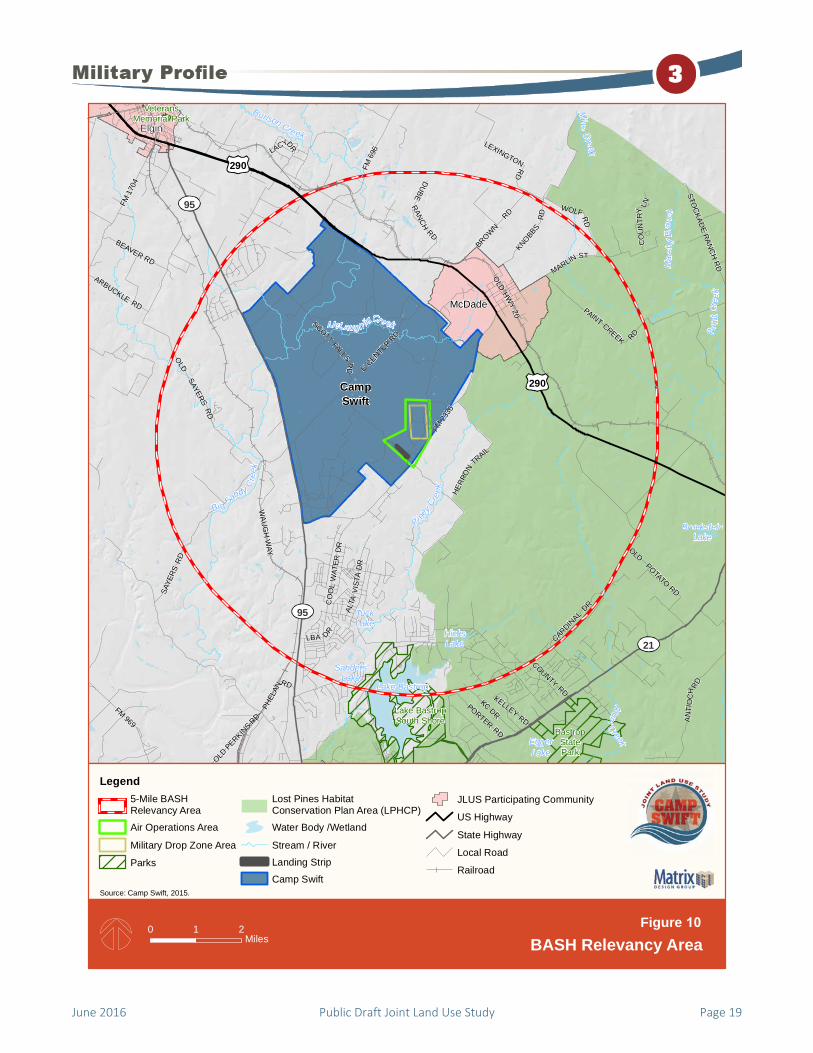
Bird Aircraft Strike Hazard The Bird / Wildlife Aircraft Strike Hazard (BASH) area comprises an additional safety zone around the airfield as illustrated on Figure 10. Camp Swift has a variety of facilities and natural areas that inadvertently provide ideal habitat for a variety of wildlife. The FAA has identified a five statute mile area radiating outward from an area of air activity where birds and wildlife pose the greatest safety risk to aircraft, referred to as the BASH Relevancy Area. It is important to note that aviation operations occur minimally at Camp Swift, and as such the risk profile associated with this footprint is minimal. While not an issue right now, this footprint should be considered in the future if Camp Swift is aligned with other aviation missions, i.e. fixed-wing missions.
June 2016 Public Draft Joint Land Use Study Page 11

Page 12 Public Draft Joint Land Use Study June 2016
290
95
95
McDade
Pin
eyCree
k
McLaughlin Creek
BigSa
ndyCreek
Dogwood Cre ek
HICKORY DR
IMPA
CT
RD
MCACRES
DR
FLAM
ING
OAK DR
FM23
36
OLD
MC
DAD
E
RD
OLD HWY 20
RICHMO
ND ST
JORD
AN L
N JUN
IPERTR
L
SPENCE LN
SAYERS
RD
EELY RD
SCOTT LN
BROWN
RD
KNOBBS RD
HERR
ONTR
AIL
ARBO
RS
CIR
OAK HILLCEMETERY
RDWA
UG
HW
AY
DUBERANCH
RD
E
CENTE
RRD
SCOTT FALLS
RD
CampSwift
LegendClearance Area (20 feet)
Camp Swift
JLUS Participating Community
US Highway
State Highway
Local Road
Railroad
Landing Strip
Water Body
Stream / River
Source: MIL-HNDBK-1013/A, 1993.
0 10.5Mile Unobstructed Clearance Area
Figure 3

June 2016 Public Draft Joint Land Use Study Page 13
290
95
290
95
McDade
Elgin
Piney Creek
McLau g hlinCreek
Mine Creek
A lumCreek
BigSa
ndyCreek
West
Yegu
aCree
k
Little Sandy Creek
Dogwood Creek
FM69
6
GRUETZNER LN
ALTA
VIS
TAD
R
HICKORY DR
IMPA
CT
RD
CO
OL
WAT
ERD
R
MCACRES DR
FM23
36
OLDH
WY
20
OLD
MCDADE RD
WACO ST
KN
OB
BSRD
GR
EEN
VALL
EYD
R
SPENCE LNCH
RIST
ENSE
N RD
VFW RD
FM 1
704
PAINT CREEK RD
BEAVER RD
SCOTT LN
OLD
SAYERS RD
BROWN R
D
LACY DR
HERR
ON
TRAIL
SAYE
RS
RD
OAK
HILL CEMETERY
RD
CO
DY
LN
WA
UG
H W
AY
WO
LF R
D
ECENTE
R
RD
SCOTT FALLS
RD
DUBERAN
CH
RD
CampSwift
LegendFixed Small CaliberNoise Contour
Zone II87 dB PK15(MET)Zone III104 dB PK15(MET)
Landing Strip
Camp Swift
JLUS ParticipatingCommunity
US Highway
State Highway
Local Road
Railroad
Water Body
Stream /River
Source: Camp Swift, 2015.
0 1.50.75Miles
Figure 4Fixed Small Caliber Arms Noise Contours
Page 14 Public Draft Joint Land Use Study June 2016
290
95
290
95
McDade
Elgin
Piney Creek
McLau g hlinCreek
Mine Creek
A lumCreek
BigSa
ndyCreek
West
Yegu
aCree
k
Little Sandy Creek
Dogwood Creek
FM69
6
GRUETZNER LN
ALTA
VIS
TAD
R
HICKORY DR
IMPA
CT
RD
CO
OL
WAT
ERD
R
FM23
36
OLDH
WY
20
OLD
MCDADE RD
WACO ST
KN
OB
BSRD
GR
EEN
VALL
EYD
R
SPENCE LNCH
RIST
ENSE
N RD
VFW RD
FM 1
704
PAINT CREEK RD
BEAVER RD
SCOTT LN
OLD
SAYERS RD
BROWN R
D
LACY DR
HERR
ON
TRAIL
SAYE
RS
RD
OAK
HILL CEMETERY
RD
CO
DY
LN
WA
UG
H W
AY
WO
LF R
D
ECENTE
R
RD
SCOTT FALLS
RD
DUBERAN
CH
RD
CampSwift
Source: Camp Swift, 2015.
0 1.50.75Miles
Figure 5Improvised Explosive Device (IED) Noise Contours
LegendIED Noise Contour
Zone II115 dB PK15(MET)Zone III130 dB PK15(MET)
Landing Strip
Camp Swift
JLUS ParticipatingCommunity
US Highway
State Highway
Local Road
Railroad
Water Body
Stream / River

June 2016 Public Draft Joint Land Use Study Page 15
290
95
290
95
McDade
Elgin
Piney Creek
Big Sandy Cree
k
McLau g hlinCreek
Mine Creek
A lumCreek
West
Yegu
aCree
k
Little Sandy Creek
Dogwood Creek
FM69
6
GRUETZNER LN
ALTA
VIS
TAD
R
HICKORY DR
IMPA
CT
RD
CO
OL
WAT
ERD
R
MCACRES DR
FM 23
36
OLDH
WY
20
OLD
MCDADE RD
WACO ST
KN
OB
BSRD
GR
EEN
VALL
EYD
R
SPENCE LNCH
RIST
ENSE
N RD
VFW RD
FM 1
704
PAINT CREEK RD
BEAVER RD
SCOTT LN
OLD
SAYERS RD
BROWN R
D
LACY DR
HERR
ON
TRAIL
SAYE
RS
RD
OAK
HILL CEMETERY
RD
CO
DY
LN
WA
UG
H W
AY
WO
LF R
D
ECENTE
R
RD
SCOTT FALLS
RD
DUBERAN
CH
RD
CampSwift
LegendDemolition Two PoundCharge Noise Contour
Moderate Complaint Risk115 dB PK15(MET)High Complaint Risk130 dB PK15(MET)
Landing Strip
Camp Swift
JLUSParticipatingCommunity
US Highway
State Highway
Local Road
Railroad
WaterBodyStream /River
Source: Camp Swift, 2015.
0 1.50.75Miles
Figure 6Demolition Two Pound Charge Noise Contours

Page 16 Public Draft Joint Land Use Study June 2016
290
95
290
95
McDade
Elgin
Piney Creek
A lum Creek
BigSa
ndy
Creek
Little S andyCre ek
Spicer Creek
Dogwoo d Creek
GRUETZNER LN
CARDINAL DR
ALTA
V IS
TAD
R
HICKORY DR
FOO
THIL
LR
D
IMPA
CT
RD
LBA DR
MCACRES DR
FM23
36
OLD
HW
Y20
OLD MCDADERD
FM 1
704
WACO ST
SPENCE LN
VFW RD
PAINT CREEKRD
WOLF RD
SCOTT LNBEAVER RD
CO
OL
WAT
ERD
R
OLD
SAYERS RD
PLUM
ST
BROWN R
DKNOBBS
RD
HERR
ON
TRAIL
SAYE
RS
RD
OAK
HILL CEMETERY
RD
CO
DY
LN
WA
UG
H W
AY
E
CENTER
RD
SCOTTFALLSR
D
DUBERANCH
RD
CampSwift
LegendDemolition 40 PoundCharge Noise Contour
Moderate Complaint Risk115 dB PK15(MET)High Complaint Risk130 dB PK15(MET)
Landing Strip
Camp Swift
JLUSParticipatingCommunity
US Highway
State Highway
Local Road
Railroad
WaterBodyStream /River
Source: Camp Swift, 2015.
0 1.50.75Miles
Figure 7Demolition 40 Pound Charge Noise Contours

June 2016 Public Draft Joint Land Use Study Page 17
McDade
Pin
eyCree
k
McLaughlin Creek
BigSa
ndyCreek
Dogwood Cre ek
HICKORY DR
IMPA
CT
RD
MCACRES
DR
FLAM
ING
OAK DR
FM23
36
OLD
MC
DAD
E
RD
OLD HWY 20
RICHMO
ND ST
JORD
AN L
N JUN
IPERTR
L
SPENCE LN
SAYERS
RD
EELY RD
SCOTT LN
BROWN
RD
KNOBBS RD
HERR
ONTR
AIL
ARBO
RS
CIR
OAK HILLCEMETERY
RDWA
UG
HW
AY
DUBERANCH
RD
E
CENTE
RRD
SCOTT FALLS
RD
CampSwift
LegendDrop Zone Obstacle-FreeAreaMilitary DropZone Area
Camp Swift
Blackwell Drop Zone Area of ActivityLanding Strip
JLUS ParticipatingCommunity
US Highway
State Highway
Local Road
Railroad
Water Body
Stream / RiverSource: Camp Swift, 2008. Army FM 83-21.38, 2006.
0 10.5Miles Obstacles Near Drop Zone
Figure 8
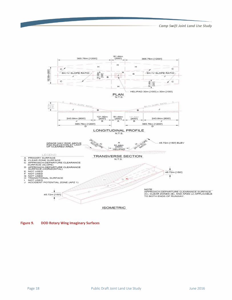
Figure 9. DOD Rotary Wing Imaginary Surfaces
Page 18 Public Draft Joint Land Use Study June 2016
June 2016 Public Draft Joint Land Use Study Page 19
290
95
290
95
21
McDade
Elgin
Burlson Cre ek
AlumCreek
Pi ney
Creek
Bi g Sandy Cr
eek
McLaug h linCreek Paint
Cree
k
Mine Creek
Marsh
yBran
ch
FM69
6
STOC
KADE R
ANC
H R
D
ALTA
VIST
AD
R
LBA DR
COUNTY RD
FM23
36
OLD
HWY
20
KNOBBS
RD
FM 969
FM 1
704
AN
TIO
CH R
D
OLD P
ERKINS R
D
PAINT CREEK RD
PHEL
AN
RD
CO
UN
TRY LN
ARBUCKLE RD
KC DR
BEAVER RDMARLIN ST
CARDINAL
DR
OLDSAYERS
RD
PORTERRD
CO
OL
WAT
ERD
R
SAYE
RSR
D
BROWN
RD
LACYDR
OLDPOTATO
RD
HERR
ON
TRAIL
LEXINGTONRD
WA
UG
H W
AY
WOLFRD
KELLEYRD
ECENTE
RRD
SCOTT
FALLS RD
DUBERANCH
RDCampSwift
SandersLake
BrocksteinLake
TuckLake
HicksLake
Lake Bastrop
EggerLake
Lake BastropSouth Shore
BastropStatePark
VeteransMemorial Park
Legend5-Mile BASHRelevancy Area
Air Operations Area
Military Drop Zone Area
Parks
Lost Pines HabitatConservation Plan Area (LPHCP)
Water Body /Wetland
Stream / River
Landing Strip
Camp Swift
JLUS Participating Community
US Highway
State Highway
Local Road
Railroad
Source: Camp Swift, 2015.
0 21Miles
Figure 10BASH Relevancy Area

Please see the next page.
Page 20 Public Draft Joint Land Use Study June 2016

This sect ion provides an overview of p lans and programs that are currently used or appl ied in evaluating and addressing compatibi l i ty i ssues in the Camp Swift JLUS Study Area. Re lative to compatibi l i ty planning, there are a number of existing plans and programs that are e ither designed to address compatibi l i ty di rect ly or indirect ly .
This is not meant to be an exhaust ive l is t of plans and programs that inf luence p lanning in this study area, but rather a highl ight of the plans and programs for the Camp Swif t JLUS. For an exhaustive l is t of plans and programs refer to Chapter 4 of the Background Report.
Federal Plans and Programs
Ammunition and Explosives Safety Standards 385-64 The Department of the Army Pamphlet 385-64 details the Army’s safety criteria and standards for operations involving ammunition and explosives. The pamphlet includes mandatory procedures and guidance as well as preferred methods of accomplishing those procedures. Pertinent information in the pamphlet includes, but is not limited to, explosives safety training standards, explosives safety management programs, safety inspection procedures, and guidance for the creation of installation ammunition / explosive location maps. Camp Swift personnel utilize these standards when preparing for training to ensure safety management is of the essence.
Army Regulation 200-1, Environmental Protection and Enhancement This regulation implements federal, state, and local environmental laws and DOD policies for preserving, conserving, and restoring the environment. This
regulation should be used in conjunction with 32 Code of Federal Regulation Part 651, provides Army policy on National Environmental Policy Act requirements, and supplemental program guidance. This regulation defines Army Environmental Management System (EMS) framework and the five interconnected EMS areas of policy which are policy, planning and implementation, program management and operation, checking and corrective action and management review. This is pertinent to military installations that have environmental resources such as habitats for protected species.
Texas Army National Guard / Camp Swift
Army Compatible Use Buffer Program Title 10, Section 2684a of the United States Code authorizes the Department of Defense (DOD) to partner with local and state governments and private organizations to establish buffer zones around active military assets. Within the Department of the Army, this program is called the Army Compatible Use Buffer (ACUB) program. Through the ACUB program, military installations work with partners (e.g. Land Trusts, Nature Conservancy, other established foundations, and willing landowners) to establish buffer zones that protect habitat, sensitive areas, and training areas without acquiring any new land for Army ownership.
Texas Army National Guard Operational Noise Management Plan The Environmental Noise Management Program was established by the Army as the framework for the control of noise produced by Army activities. This is done in accordance with the Noise Control Act of 1972 which seeks to limit the effects of any activity which may, "present danger to the health and welfare of this Nation's population" (PL 92-574 1972). The primary strategy for noise management is the ONMP. The current TXARNG Statewide Operational Noise
June 2016 Public Draft Joint Land Use Study Page 21
Management Plan (ONMP), which includes Camp Swift, was adopted in 2014. The ONMP provides a methodology for analyzing noise related to military training operations, educates and discusses noise mitigation measures, noise complaint management procedures, and noise abatement
State of Texas Legislation, Agencies / Programs, and Initiatives / Other Information
Legislation
House Bill 2232 Creating a Regional Military Sustainability Commission House Bill 2232 (HB 2232), Creating a Regional Military Sustainability Commission (RMSC) passed in 2015 Texas Legislative Session is a tool that can provide jurisdictions that meet certain criteria the authorization to provide limited land use planning that would be compatible with military operations. The criteria includes the following:
is a county that has three or more locations of a joint military base located in it;
has a population of more than 1.7 million; or
is a county that is adjacent to a county described by the preceding bullets; or
is a municipality located in a county that meets the previous bullets.
Jurisdictions meeting the criteria would enact the HB, establish and fund a RMSC, and identify the appropriate planning area as delineated by the HB. Ultimately this would assist jurisdictions to consider military compatibility in areas where traditional land use planning may not apply. It should be noted that Bastrop County and the Cities of Bastrop and Elgin do not meet the criteria for HB 2232, thus the law does not apply to the participating jurisdictions in this JLUS.
Texas Local Government Code
Texas Local Government Code Chapter 240, Outdoor Lighting Texas LGC, Title 7, Subchapter B: Outdoor Lighting near Observatories and Military Installations was enacted
September 1, 1987 and subsequently amended September 2001, May 2007, and January 2012. The LGC grants certain Texas counties authority to regulate the use of lighting to mitigate interference with military training activities, operations, or research within five miles of a military installation. Counties authorized to adopt these regulations must meet two criteria: they must have a population greater than one million and host at least five military bases. An adjacent county to the sponsoring county also has the authority to regulate lighting types, adopt shielding requirements, and specify times of usage in their county areas within five miles of the designated military base.
Source: Texas International Dark Sky Association website; House Bill No. 1852, Texas Constitution and Statutes, 2001.
Agencies / Programs
Texas Military Preparedness Commission In 2003, Senate Bill No. 652 established the Texas Military Preparedness Commission and the Texas Military Value Revolving Loan Account. The Commission’s responsibilities includes reporting to the Governor’s office and working with state agencies in preparing annual reports for the Governor and Legislature regarding the military installations, their adjacent communities, and the associated defense-related business within the state.
Under the law, a community near a military installation may request financial assistance to prepare a comprehensive defense installation and community strategic impact plan (SIP) that identifies the communities’ long-range goals and development proposals. Information required within the SIP includes a list of existing and future land uses surrounding the military installation; the proposed distribution, location, and extent of land uses, e.g. housing, business, industry, agriculture, recreation, public facilities and grounds; and other categories of existing and proposed land use regulations, e.g. zoning, annexation, and planning recommendations.
Source: Senate Bill No. 652, Texas Legislature website
Page 22 Public Draft Joint Land Use Study June 2016
Initiatives / Other Information
Real Estate Disclosures Real estate disclosures are used in some Texas jurisdictions to notify potential homebuyers of conditions affecting the property which they should be aware of prior to purchase. Section 5.008 of the Texas Property Code requires real estate disclosures to be provided to the purchaser on or before the effective date of the contract binding the purchaser to a property purchase.
Source: Texas Real Estate Commission website.
County and Local Jurisdiction Planning Tools The planning tools used by the study area jurisdictions were analyzed and categorized as permanent, semi-permanent, or conditional. It is important to note that unlike counties in other states, Texas counties do not have traditional land use authority (zoning); however, there are a few counties in Texas (Bexar, Guadalupe counties) that have minimal regulatory authority due to recent state legislation. Counties are not legally bound by statute to develop comprehensive plans. Similar to cities, however, Section 232 of the Texas LGC provides counties with the authority to regulate the subdivision of land. Under this authority, the focus of a county’s ability to regulate the subdivision of land is limited to roads, streets, drainage, and rights-of-way.
Bastrop County
Comprehensive Plan / Zoning Bastrop County is not authorized by law to develop a comprehensive plan or zoning regulations. Counties in Texas do not have a planning function.
Subdivision Regulations Bastrop County has adopted subdivision regulations pursuant to Texas LGC Chapter 232 to regulate lots, streets, drainage, and rights-of-way, which can guide development within unincorporated areas in a limited capacity.
Bastrop County does not have the ability to regulate subdivisions in any municipality’s ETJ unless the land owner has entered into an agreement with the County.
Building Codes Texas LGC Chapter 233, County Regulation of Housing and Other Structures, provides counties the authority to regulate residential building codes in unincorporated areas within the county. The authority is restricted to:
new residential construction, additions comprising more than 50 percent of
the original structure, occurring after September 1, 2009, and does not apply to modular home construction.
Bastrop County utilizes and references the 2009 International Code Series and amendments found in the Bastrop County Rules for the Enforcement of the International Fire Code and International Building Codes.
City of Bastrop
Comprehensive Plan Approved in May 2001, the Comprehensive Plan of the City of Bastrop focuses on preserving the historic character of the city while recognizing its place within a vibrant and bustling metropolitan region.
The City of Bastrop Comprehensive Plan does not contain any policies related to military compatibility.
Zoning Ordinance The City of Bastrop’s Zoning Code is Chapter 14 of the City Code and current zoning defines the maximum height limit for any building as 2 ½ stories or 35 feet, which typically does not pose as a threat to aviation operations.
In 2007, the City replaced Section 45 of Article 12 “Appendix A” of the Bastrop City Code, which pertained to the rules governing lighting and glare standards, with new outdoor lighting standards. The purpose for the revision was to prevent light pollution, waste, trespass, or clutter while maintaining night-time safety, security, and productivity.
June 2016 Public Draft Joint Land Use Study Page 23

Regulation related to noise, dust and smoke, and vibration is covered in Section 44 of Chapter 12.
Subdivision Ordinance Chapter 10 of the City Code sets forth standards for the subdivision of land. Provisions for the subdivision platting process, inspections, variances, and parks and public areas are included in Chapter 10, as well as design criteria for streets, alleys, sewers and drainage structures.
Building Code Chapter 3 of the Bastrop City Code establishes building regulations, including construction standards, for construction within the city limits. The City has adopted the following codes:
The National Electric Code, 2011 Edition
The International Building Code, 2009 Edition
Annexation Ordinance In November 2011, the City of Bastrop approved an annexation ordinance to annex approximately 1,265 acres into the city, extending the city limits by approximately one and half miles to the west and a little over a half mile to the north via only a sliver of a parcel totaling 17 acres. It is unknown at the time of the Camp Swift JLUS if the city planned for additional annexations and if Camp Swift was notified of this action.
City of Elgin
Comprehensive Plan The City of Elgin Comprehensive Plan was officially adopted by City Council in October 2009.
The City of Elgin’s Comprehensive Plan does not contain any policies related to military compatibility.
Zoning Ordinance The City of Elgin’s Zoning Code is Chapter 46 of the City Code and current city regulation defines the maximum height limit for any building as 90 feet, which corresponds to the maximum height allowed within the General Industrial District.
The City has not adopted a lighting ordinance.
Subdivision Ordinance Chapter 36 of the City’s Code establishes standards for the subdivision of land. Provisions for the subdivision platting process, inspections, variances, and parks and public areas are included in Chapter 36, as well as design criteria for streets, alleys, sewers and drainage structures.
Building Code Elgin has adopted Building Codes by reference under Article II Section 6-19. Building codes regulate building construction, materials, alteration, and occupancy to ensure health, safety, and welfare within the community. The City of Elgin has adopted the following Codes by reference:
The International Building Code; 2006 Edition
The International Residential Code for One and Two Family Dwellings 2006 Edition
Annexation History The City of Elgin has not annexed any land in the last 10 years; however, the planning and development department is considering annexation. It is unknown at the time the Camp Swift JLUS was developed if Camp Swift / TXARNG were notified of this potential action.
Page 24 Public Draft Joint Land Use Study June 2016
Identification of Compatibility Issues Compatibility, in relation to military readiness, can be defined as achieving a balance between the needs and interests of a military installation, including its operational areas, and those of the communities that surround it. The goal of compatibility planning is to promote an environment where private property owners, the community, and military entities communicate, coordinate, and apply mutually supportive options that allow all stakeholders to achieve their respective objectives.
A number of factors assist in determining whether community and military plans, programs, and activities are compatible or in conflict with joint land uses such as community activities and military installations. For this JLUS, the 25 compatibility factors below were reviewed to identify, determine, and establish a set of key JLUS compatibility issues.
Methodology and Evaluation The methodology for the Camp Swift JLUS consisted of a comprehensive and inclusive discovery process to identify key stakeholder issues associated with the compatibility factors. At the initial Policy Committee (PC) and Technical Committee (TC) workshops and public meetings, stakeholders were asked to identify the location and type of issue in conjunction with compatibility factors they thought existed today or could occur in the future. As a part of the evaluation phase, the PC, TC, and the public examined and prioritized the extent of existing and potential future compatibility issues that could impact land within or near the Study Area. Other factors and associated issues were analyzed based on available information and similarity with other community JLUS projects around the country.
Of the 25 compatibility factors considered, eight were determined to be inapplicable to this JLUS:
Frequency Spectrum Capacity Frequency Spectrum Impedance / Interference Housing Availability Infrastructure Extensions Marine Environments Scarce Natural Resources Vibration Water Quality / Quantity
Camp Swift Compatibility Issues by Factor
Air Quality Air quality is defined by numerous components that are regulated at the federal and state level. For compatibility, the primary concerns are pollutants that limit visibility (such as particulates, ozone, etc.) and potential non-attainment of air quality standards that may limit future changes in operations at the
June 2016 Public Draft Joint Land Use Study Page 25

installation or in the area. The following Air Quality issue was identified:
Potential for Ozone Nonattainment The new national air quality standard for ozone could potentially put Bastrop County into nonattainment for ozone, which can have an impact on community activities and military operations.
Anti-Terrorism / Force Protection Anti-Terrorism / Force Protection (AT) relates to the safety of personnel, facilities, and information on an installation from outside threats. Methods to protect the installation and its supportive facilities can impact off-installation uses.
Security Concern around Gate Access Roadway infrastructure improvements can increase queuing issues which causes a general security concern for the installation.
Development Compliance with AT / FP Standards Continued growth and future development near Camp Swift may increase issues with AT / FP compliance.
Biological Resources Biological resources include federal and state listed species (threatened and endangered species) and the habitats they live in or utilize. These resources may also include areas such as wetlands and migratory corridors that support these species. The presence of sensitive biological resources may require special development considerations and should be included early in the planning process. The following Biological Resources issue was identified:
Biological Resource Monitoring There are numerous biological resources in the area, including those that inhabit the Lost Pines Habitat Conservation Plan Area, which should be continually monitored, coordinated, and updated as necessary.
Houston Toad
Climate Adaptation Climate adaptation is the gradual shift of global weather patterns and temperature resulting from natural factors and human activities (e.g. burning of fossil fuels) that produce long-term impacts on atmospheric conditions. The effects of climate adaptation vary and may include fluctuations in sea levels, alterations of ecosystems, variations in weather patterns, and natural resource availability issues. The results of climate change, i.e. ozone depletion and inefficiencies in land use, can present operational and planning challenges for the military and communities as resources are depleted and environments altered. The following Climate Adaptation issue was identified:
Climate Adaptation Related to Flooding and Drought Conditions Concerns from years of severe drought conditions and recent flooding, and their associated impacts on the communities and base.
Communication / Coordination Communication / coordination relates to the level of interaction on compatibility issues among military installations, jurisdictions, land and resource management agencies, and conservation authorities. The following Communication / Coordination issues were identified:
Page 26 Public Draft Joint Land Use Study June 2016

Lack of Formalized Communication between
Local Jurisdictions and the Installation Lack of formalized communication between Camp Swift and local communities makes it difficult to share vital information and voice concerns related to noise, safety, and military training operations.
Limited Public Affairs Limited military resources available to the local newspaper have minimized opportunities for coverage of activities at Camp Swift.
Limited Public Affairs for TXARNG / Camp Swift Limited public affairs resources available for TXARNG / Camp Swift have minimized opportunities for coverage of installation operations and activities for community affairs.
Cultural Resources Cultural resources are an aspect of a cultural system that is valued by or significantly representative of a culture or contain significant information about a culture. A cultural resource may be a tangible entity or a cultural practice. Tangible cultural resources are categorized as artifacts, records, districts, pre-contact archaeological sites, historic archaeological sites, buildings, structures, and objects. Historic properties are cultural resources that are eligible or listed on the National Register of Historic Places. Cultural resources may prevent development, require development constraints, or require special access by Native American tribal governments or other authorities. The following Cultural Resources issue was identified:
Access to Historic and Cultural Resources Camp Swift has historic and cultural sites on the installation; including burial grounds and a historic wine cellar, which could have restricted access during times of heightened security or with mission changes.
Dust / Smoke / Steam Dust results from the suspension of particulate matter in the air. Dust (and smoke) can be created by fire (controlled or prescribed burns, agricultural burning, and artillery exercises), ground disturbance (agricultural activities, military operations, grading), industrial activities, or other similar processes. Dust,
smoke and steam are compatibility issues if sufficient in quantity to impact flight operations (such as reduced visibility or cause equipment damage). The following Dust / Smoke / Steam issues were identified:
Prescribed Burn Smoke Impacts Smoke from prescribed burns conducted at Camp Swift migrate off installation onto public and private properties.
Dust and Smoke from Community Activities Can Impact Base Operations Dust and smoke generated from agricultural and construction activities can impede, delay, or postpone base operations and activities.
Prescribed burn at Camp Swift
Energy Development Development of energy sources, including alternative energy sources (such as solar, wind, or biofuels) could pose compatibility issues related to glare (solar energy), vertical obstruction (wind generation), or water quality / quantity. The following Energy Development issue was identified:
Potential for Future Alternative Energy Development There are no controls for alternative energy development in the area.
Land / Air Space Competition The military manages or uses land and air space to accomplish testing, training, and operational missions. These resources must be available and of a sufficient
June 2016 Public Draft Joint Land Use Study Page 27
size, cohesiveness, and quality to accommodate effective training and testing. Military and civilian air operations can compete for limited air space, especially when the airfields are proximate to each other. Use of this shared resource can impact future growth in operations for all users. The following Land / Air Space Competition issue was identified:
Unrestricted Airspace Over Camp Swift General aviation and personal aircraft enter the airspace over the live fire training ranges without proper notification.
Land Use The basis of land use planning relates to the government’s role in protecting the public’s health, safety, and welfare. County and local jurisdictions’ growth policy plans, zoning ordinances, and subdivision regulations can be the most effective tools for preventing or resolving land use compatibility issues. These tools can encourage the separation of land uses that differ significantly in character. Land use separation also applies to properties where the use of one property may impact the use of another. For instance, industrial uses are often separated from residential uses to avoid impacts related to noise, odors, lighting, etc. The Land Use issues were identified as:
Potential Development Adjacent to Camp Swift. If the right-of-way for State Highway 95 is acquired, then the roadway can be expanded, which could potentially spur development in areas near the base that may not be compatible.
Legislative Initiatives Legislatives initiatives are federal, state, or local laws and regulations that may have a direct or indirect effect on a military installation to conduct its current or future mission. They can also constrain development potential in areas surrounding the installation. The following Legislative Initiatives issue was identified:
State Legislation Applicability There are two new House Bills that potentially address limited land use authority for counties in Texas that could be applied to this area.
Light and Glare This factor refers to man-made lighting (street lights, airfield lighting, building lights) and glare (direct or reflected light) that disrupts vision. Light sources from commercial, industrial, recreational, and residential uses at night can cause excessive glare and illumination, impacting the use of military night vision devices and air operations. Conversely, high intensity light sources generated from a military area (such as ramp lighting) may have a negative impact on the adjacent community. The following Light and Glare issue was identified:
Light Encroachment from New Development Unregulated lighting in nearby jurisdictions can facilitate light encroachment on Camp Swift, which could adversely impact night vision training operations.
Noise Sound is the mechanical energy transmitted by pressure waves in a compressible medium such as air. More simply stated, sound is what we hear. As sound reaches unwanted levels, this is referred to as noise. The central issue of noise is the impact, or perceived impact, on people, animals (wild and domestic), and general land use compatibility. Exposure to high noise levels can have a significant impact on human activity, health, and safety. The following Noise issues were identified:
Noise Generated by Community Activities Noise associated with past activities at nearby ALCOA mine were often attributed to Camp Swift, prompting complaints from the surrounding communities.
Noise Generated by Training Activities Noise generated from training activities at Camp Swift can prompt complaints from the surrounding communities.
Noise Generated by Transient Helicopters Several military / National Guard rotary wing units within the region and state traverse the area over Camp Swift, which causes noise that is attributed to the installation.
Page 28 Public Draft Joint Land Use Study June 2016

Public Trespassing Public Trespassing addresses either purposeful or unintentional trespassing onto a military installation. The potential for trespassing increases when public use areas are in proximate to the installation. The following Public Trespassing issue was identified:
Trespassing on Camp Swift Trespassing in the northwest corner of the installation near the historic dam is a safety concern as people shoot guns and, at times, engage in unlawful activities.
Roadway Capacity Roadway capacity relates to the ability of existing freeways, highways, arterials, and other local roads to provide adequate mobility and access between military installations and their surrounding communities. The following Roadway Capacity issue was identified:
State Highway 95 is at Capacity SR 95 is operating at capacity at some segments of the roadway. To meet future demand, some roadway improvements could require obtaining right-of-way from Camp Swift.
FM 2236 branches southwest around Camp Swift Military Reservation to Texas 95 north of Bastrop
Safety Zones Safety zones are areas in which property owners and jurisdictions should consider lesser densities and intensities for residential and non-residential development, in terms of concentrations of people, due to the higher risks to public safety. Issues to
consider include aircraft accident potential zones, weapons firing range safety zones, and explosive safety zones. The following Safety Zones issues were identified:
Obstacles near Drop Zone There are obstacles near Blackwell Drop Zone that have the potential to impede military training activities.
Uncontrolled Airspace Over Training Ranges General aviation and personal aircraft operations in the area over the training ranges can pose safety hazards for both pilots and training personnel.
Vertical Obstructions Vertical obstructions are created by buildings, trees, structures, or other features that may encroach into the navigable airspace used for military operations (aircraft approach, as well as military training routes). These can present a safety hazard to both the public and military personnel.
Imaginary Surfaces Extend Off-Installation into Unincorporated Areas There are no controls for building or structure heights including trees in the unincorporated areas where the imaginary surfaces extend off-installation.
Wind Energy Potential at Heights of 80 Meters There are no land use controls in areas around Camp Swift for wind energy development above 80 meters.
June 2016 Public Draft Joint Land Use Study Page 29

Please see next page.
Page 30 Public Draft Joint Land Use Study June 2016

RT
r
c
a
M
lo
s
t
c
c
c
d
t
J
t
u
a
c
s
o
a
i
b
b
c
a
RecommeThis chapter id
recommended
collaborative e
applicable loca
Military Depar
ocal organizat
stakeholders t
the region. Sin
collaborative p
chapter repres
coordinated ap
developed wit
throughout the
LUS recomme
that can be im
use and resour
and potential c
civilian‐military
significantly m
options functio
and are the cu
mportant to n
but rather a re
be carried out
current and po
The goal of the
planning to
co
and the military
ended Opdentifies and o
d options deve
effort between
al jurisdictions
tment (TMD),
tions, the gene
hat own or ma
nce the Camp
planning proce
sent a true con
pproach to co
h the support
e process.
endations inco
plemented to
rce planning.
compatibility i
y interface can
itigated. As su
on as the hear
lmination of t
note that the J
ecommended
by the JLUS p
otential future
e Camp Swift JL
o foster the succ
ommunities’ eco
y mission and p
ptions organizes the
eloped through
n representati
, Camp Swift /
state and fed
eral public and
anage land or
Swift JLUS is t
ess, the option
nsensus plan;
mpatibility pla
of stakeholde
orporate a vari
promote com
Upon applicat
ssues arising f
n be removed
uch, the recom
rt of the JLUS d
he planning p
LUS is not an a
set of options
articipants to
e compatibility
US is to promote
cessful coexisten
onomic activitie
otential growth
h a
ves of
/ the Texas
eral agencies,
d other
resources in
the result of a
ns in this
a realistic and
anning
ers involved
ety of options
mpatible land
tion, existing
from the
or
mmended
document
rocess. It is
adopted plan,
which should
address
y issues.
e compatibility
nce of the
es
h opportunities.
,
d
s
.
The k
estab
optio
comm
the T
initia
coor
actio
to op
addr
optio
RecThe k
need
form
deve
key to the app
blishment of a
on COM‐1A) to
mittee will allo
TMD, and othe
al work togeth
dination proce
ons for membe
ptions over tim
ress key comp
ons and applic
commendedkey to a succe
ds of all involve
med the basis u
eloped. These
The recomm
the underst
taking of pro
The goal of
recommend
coordinatio
opposed to
In order to m
regulation, m
recommend
area for wh
(e.g., within
recommend
Similar to ot
numerous s
create a sol
of all parties
do not have
stakeholder
may result i
that address
individual ci
plication of the
a JLUS Coordin
o oversee the
ow local jurisd
er interested p
her to establish
edures, recom
er agencies, an
me to ensure t
atibility issues
cation.
d Options Gessful plan is b
ed stakeholde
upon which th
e guidelines inc
mended option
anding that th
operty value a
this JLUS was
ded options in
n, and informa
the regulatory
minimize or el
many of the o
ded within the
ich the issue t
the noise con
ded for the wh
ther planning
stakeholders, t
ution or optio
s. In lieu of el
e 100 percent
rs, it was deter
n the creation
s the same iss
ircumstances.
e options is th
nation Commit
JLUS applicat
dictions, Camp
parties to cont
h communicat
mmend or refin
nd make adjus
the JLUS conti
s through reali
Guidelines alancing the d
ers. Several gu
e options wer
clude:
ns were devel
hey must not r
as defined by s
to focus the
the commun
ation perspect
y perspective.
liminate the n
options are onl
e certain geogr
they address o
ntours), instea
hole JLUS Stud
processes tha
the challenge
on that meets t
iminating opti
buy‐in from a
rmined that th
n of multiple o
sue but are tai
e
ttee (see
ion. This
p Swift /
tinue their
tion and
ne specific
stments
nues to
istic
different
uidelines
re
oped with
result in a
state law.
ication,
tive as
.
eed for
ly
raphic
occurs
ad of
dy Area.
at include
is to
the needs
ions that
ll
he option
options
lored to
June 2016 Public Draft Joint Land Use Study Page 31

MI
A
g
lo
a
m
f
T
w
a
a
d
n
f
T
f
C
E
4
O
D
Since th
docume
are subj
of the re
jurisdict
conflict
state or
Military An compatibilit
Awareness Are
geographic are
ocal communi
activities may
mission. An M
following:
Provide
public o
Create a
planning
Promote
commun
uses rem
Protect
military
More ac
be affec
Protect
The MAAs are
where the reco
applied. This t
applied to the
deemed not su
not adversely i
for their locati
There are five
for the Camp S
Clearance Area
Explosive Nois
4) Drop Zone (
Obstruction M
District (MAOD
is JLUS is inten
ent,” and state
ect to change
ecommended
tion or party sh
between the o
federal law.
Awarenesy planning, th
ea” (MAA) is u
ea where milit
ities, and conv
affect the mili
MAA is designat
awareness to
f areas where
a broader fram
g decisions aro
e an orderly tr
nity and milita
main compatib
and maintain
installations a
ccurately ident
cted by military
the public hea
used to define
ommended JL
technique ens
appropriate a
ubject to a spe
impacted by J
on or circums
MAAs with se
Swift JLUS. Th
a MAA; 2) Sma
e Device MAA
DZ) Obstacle‐
MAA. The Milit
D) contains all
nded to be a “
e and federal r
, before imple
options, the r
hould ensure t
option and an
ss Areas e generic term
sed to formal
tary operation
versely, where
tary’s ability t
ted to accomp
the communi
military activ
mework for ma
ound military i
ransition betw
ary land uses s
ble.
operational ca
and areas.
tify areas that
y missions, an
alth, safety, an
e the geograp
LUS options are
ures the optio
reas, and loca
ecific compatib
LUS options in
tance.
veral subzone
ey are: 1) Uno
all Arms / Imp
A; 3) Demolitio
Free MAA; an
ary Awarenes
the MAAs and
“living
regulations
ementing one
responsible
there is no
y existing
m “Military
ly designate a
s may impact
e local
o carry out its
plish the
ities and the
ities occur.
aking sound
installations.
ween
so that land
apabilities of
can affect or
d
nd welfare.
hic areas
e to be
ons are
ations that are
bility issue are
nappropriate
es proposed
obstructed
rovised
on Noise MAA;
d 5) Vertical
s Overlay
d their
s
e
e
;
assoc
MAO
follow
(Tab
Area
UnoAreaThis
from
uses
and o
unob
comp
SmaNoisThis
noise
and t
Each
For t
>104
IED L
and N
off‐in
incom
(e.g.,
impa
and I
DemThis
40‐p
Figur
subz
and t
DroThis
DZ ac
illust
addit
ciated subzon
OD and MAAs
wing pages. I
le 5), options
are identified
obstructed Ca MAA] (FigMAA, as illust
m the installatio
within this M
off the installa
bstructed view
pliance with A
all Arms / Imse MAA (FigMAA, as illust
e contours for
the Improvise
h set of noise c
the small arms
4 dB PK15(MET
Lane Course, N
NZ III at 130 d
nstallation. Th
mpatible deve
, residential, s
acted by noise
IED training.
molition NoiMAA includes
ound demolit
re 13. The De
ones—one fo
the 40‐pound
p Zone ObsMAA includes
ctivity area th
trated on Figu
tional level of
es proposed f
are described
n the Recomm
that apply to
d by the term
Clearance Agure 11) trated on Figur
on boundary i
AA should not
ation. This wil
w for Camp Sw
AT/FP standard
mprovised Egure 12) trated on Figur
r the small arm
d Explosive De
contours conta
s range, the NZ
T) extends off
NZ II measured
dB PK15(MET)
his MAA is me
elopment of no
schools, churc
e generated fro
ise MAA (Fis all land unde
ion noise cont
molition Noise
r each charge
charge.
stacle-Free s all land withi
at extends ou
re 14. This M
safety for DZ
for this JLUS. T
and illustrate
mended Optio
the entire JLU
“Study Area”.
Area MAA [C
re 11 is a 20‐fo
n all direction
t obstruct the
ll enable a clea
wift to ensure
ds well into th
Explosive D
re 12 is the m
ms caliber train
evice (IED) Lan
ains noise zon
Z III measured
f‐installation.
d at 115 dB PK
both extend
ant to minimi
oise‐sensitive
hes, etc.) in ar
om small arms
igure 13) r the 2‐pound
tours shown o
e MAA contain
—the 2‐pound
MAA (Figun 1,000 meter
tside the insta
AA provides fo
training exerc
The
ed on the
ns Table
US Study
Clear
oot area
s. Land
view into
ar,
e future.
Device
odeled
ning area
ne Course.
nes (NZ).
d at
For the
K15(MET)
ze
land uses,
reas
s firing
d and
on
ns two
d charge
re 14) rs of the
allation as
or an
cises.
Page 32 Public Draft Joint Land Use Study June 2016

VT
r
t
la
o
s
B
S
M(T
a
f
J
a
Vertical ObsThis MAA com
reservist units
training operat
and under this
overflight, incl
shows the pred
Bastrop Count
Swift JLUS.
Military Awa(Figure 16) The MAOD con
associated sub
for the applica
LUS options.
a composite m
struction MAprises the flig
use to perform
tions, as illustr
s MAA could b
uding low altit
dominant fligh
y, which is the
areness Ov
ntains all the a
bzones to com
tion of the rec
The MAOD is
map.
AA (Figure ht corridor tha
m necessary a
rated on Figur
be impacted fr
tude flying. Fi
ht corridor tha
e Study Area fo
erlay Distric
aforementione
prise one ove
commended C
illustrated on
15) at various
aviation
re 15. The
rom
igure 15 only
at is located in
or the Camp
ct
ed MAAs and
rlay district
Camp Swift
Figure 16 as
n
June 2016 Public Draft Joint Land Use Study Page 33

Page 34 Public Draft Joint Land Use Study June 2016
290
95
95
McDade
Pin
eyCree
k
McLaughlin Creek
BigSa
ndyCreek
Dogwood Cre ek
HICKORY DR
IMPA
CT
RD
MCACRES
DR
FLAM
ING
OAK DR
FM23
36
OLD
MC
DAD
E
RD
OLD HWY 20
RICHMO
ND ST
JORD
AN L
N JUN
IPERTR
L
SPENCE LN
SAYERS
RD
EELY RD
SCOTT LN
BROWN
RD
KNOBBS RD
HERR
ONTR
AIL
ARBO
RS
CIR
OAK HILLCEMETERY
RDWA
UG
HW
AY
DUBERANCH
RD
E
CENTE
RRD
SCOTT FALLS
RD
CampSwift
LegendClearance Area (20 feet)
Camp Swift
JLUS Participating Community
US Highway
State Highway
Local Road
Railroad
Landing Strip
Water Body
Stream / River
Source: MIL-HNDBK-1013/A, 1993.
0 10.5Mile Unobstructed Clearance Area Military Awareness Area
Figure 11

June 2016 Public Draft Joint Land Use Study Page 35
290
95
290
95
McDade
Elgin
Piney Creek
McLau g hlinCreek
Mine Creek
A lumCreek
BigSa
ndyCreek
West
Yegu
aCree
k
Little Sandy Creek
Dogwood Creek
FM69
6
GRUETZNER LN
ALTA
VIS
TAD
R
HICKORY DR
IMPA
CT
RD
CO
OL
WAT
ERD
R
MCACRES DR
FM23
36
OLDH
WY
20
OLD
MCDADE RD
WACO ST
KN
OB
BSRD
GR
EEN
VALL
EYD
R
SPENCE LNCH
RIST
ENSE
N RD
VFW RD
FM 1
704
PAINT CREEK RD
BEAVER RD
SCOTT LN
OLD
SAYERS RD
BROWN R
D
LACY DR
HERR
ON
TRAIL
SAYE
RS
RD
OAK
HILL CEMETERY
RD
CO
DY
LN
WA
UG
H W
AY
WO
LF R
D
ECENTE
R
RD
SCOTT FALLS
RD
DUBERAN
CH
RD
CampSwift
LegendSmall Arms/IEDMAA
IED Noise ContourZone II115 dB PK15(MET)Zone III130 dB PK15(MET)
Camp Swift
JLUS ParticipatingCommunity
US Highway
State Highway
Local Road
Railroad
Water Body
Stream /River
Source: Camp Swift, 2015.
0 1.50.5 1Miles Small Arms / IED Military Awareness Area
Figure 12Camp Swift
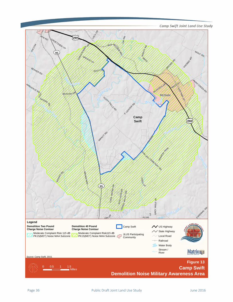
Page 36 Public Draft Joint Land Use Study June 2016
290
95
290
95
McDade
Piney Creek
McLau ghlin Creek
A lum Creek
BigSa
ndy
Creek
Little S andyCre ek
Spicer Creek
Dogwoo d Creek
FM69
6
GRUETZNER LN
CARDINAL
DR
ALTA
VIS
TAD
R
HICKORY DR
IMPA
CT
RD
LBA DR
MCACRES DR
FM23
36
OLD
HW
Y20
OLD MCDADERD
WACO ST
LACY
DR
SPENCE LN
CHRI
STEN
SEN RD
FM 1
704
VFW RD
ARBUCKLE RD
PAINT CREEK RD
GR
EYW
OLF
LN
WOLF RD
SCOTT LNBEAVER RD
OLD
SAYERS RD
CO
OL
WAT
ERD
R
PLUM
ST
BROWN R
D
KNOBBSR
D
GR
EEN
VALL
EYD
R
HERR
ON
TRAIL
SAYE
RS
RD
OAK
HILL CEMETERY
RD
CO
DY
LN
WA
UG
H W
AY
E
CENTER
RD
SCOTT FALLS
RD
DUBERAN
CH
RD
CampSwift
LegendDemolition Two PoundCharge Noise Contour
Moderate Complaint Risk 115 dBPK15(MET) Noise MAA Subzone
Demolition 40 PoundCharge Noise Contour
Moderate Complaint Risk115 dBPK15(MET) Noise MAA Subzone
Camp Swift
JLUS Participating CommunityJLUS ParticipatingCommunity
US Highway
State Highway
Local Road
Railroad
Water Body
Stream /River
Source: Camp Swift, 2015.
0 1.50.5 1Miles
Demolition Noise Military Awareness Area
Figure 13Camp Swift

June 2016 Public Draft Joint Land Use Study Page 37
McDade
Pin
eyCree
k
McLaughlin Creek
BigSa
ndyCreek
Dogwood Cre ek
HICKORY DR
IMPA
CT
RD
MCACRES
DR
FLAM
ING
OAK DR
FM23
36
OLD
MC
DAD
E
RD
OLD HWY 20
RICHMO
ND ST
JORD
AN L
N JUN
IPERTR
L
SPENCE LN
SAYERS
RD
EELY RD
SCOTT LN
BROWN
RD
KNOBBS RD
HERR
ONTR
AIL
ARBO
RS
CIR
OAK HILLCEMETERY
RDWA
UG
HW
AY
DUBERANCH
RD
E
CENTE
RRD
SCOTT FALLS
RD
CampSwift
LegendDrop Zone Obstacle-FreeMilitary Awareness Area(1,000 meters from the DZ Activity Area)
Blackwell Drop Zone Area
SWIFT_BDY_20120518_ProjectCamp Swift
JLUS Participating CommunityJLUS ParticipatingCommunity
US Highway
State Highway
Local Road
Railroad
Water Body
Stream / River
Source: Camp Swift, 2015. Field Manual 25-32.
0 10.5Miles
Drop Zone Obstacle-Free Military Awareness Area
Figure 14Camp Swift
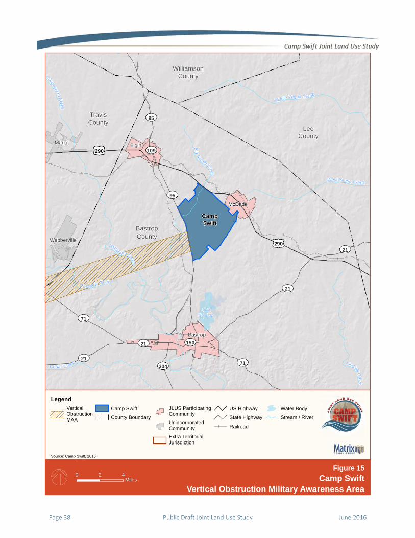
Page 38 Public Draft Joint Land Use Study June 2016
WilliamsonCounty
TravisCounty
LeeCounty
BastropCounty
McDade
Webberville
Bastrop
Manor Elgin
29021
150
109
304
71
71
95
95
21
21
21
290
LakeBastrop
Colorado River
Cottonwood Creek
West Yegua Creek
Cedar Creek PinOakCreek
W ilba rger Creek
Middle Yequa Creek
Big Sandy Creek
CampSwift
LegendVertical ObstructionMAA
Camp Swift
County Boundary
JLUS ParticipatingCommunityUnincorporatedCommunityExtra TerritorialJurisdiction
US Highway
State Highway
Railroad
Water Body
Stream / River
Source: Camp Swift, 2015.
0 42Miles
Vertical Obstruction Military Awareness Area
Figure 15Camp Swift
Vertical Obstruction Military Compatibility Area

June 2016 Public Draft Joint Land Use Study Page 39
TravisCounty
LeeCounty
BastropCounty
DryCre e k
Bur lson C re ekRe
dGull
yCree
k
Gills
Branch
ElmCree
k
Piney Cre
ek
Ced ar Creek
Cotton
woodC
reek
Wilba
rg erCr
ee
kAlu
m Creek
Ma haCr eek
Big Sandy
Creek
ColoradoRiver
FM 6
96
MARLIN ST
FM 3000
ORC
HARD
RD
FM 1441
N AVE C
FM
535
ROEMER RD
MUNDINE RD
OLD LEXINGTON RD
FM 23
36
OLD
HW
Y20
OLD MCDADERD
FM 1
704
SHILOH RD
TUCKST
MONKEY RD
CEDAR LN
POPE
BENDNORTH
GOTIER TRACE RD
BALCH RD
LITTIG
RD
KC DR
BEAVER RD
SMIT
HRD
TAHITI AN
DR
OLD71
CARDINAL DR
FM 2
0
OLDSAYERS
RD
W SH 71 SVC RD
LAU
RA
LN
MT OLIVE RD
JENKIN
S RD
CO
OL
WAT
ER
DR
SAYE
RS
RD
FM969
LOVE
RSLN
BR
OW
NRD
LOW
EREL
GIN
RD
FM
1209
LEISURE LN
WAU
GH
WAY
WOLFRD
DRVW
E
CENTERRD
CampSwift
150
109
212
304
95
71
71
95
21
290
Elgin
Bastrop
McDade
LegendMilitary AwarenessOverlay DistrictDrop Zone Obstacle-FreeMilitary Awareness Area(1,000 meters from the DZ Activity Area)Small Arms/IED MAA
Vertical Obstruction MAAVertical Obstruction MAA
Demolition Two PoundCharge Noise Contour
Moderate Complaint Risk 115 dBPK15(MET) Noise MAA Subzone
Demolition 40 PoundCharge Noise Contour
Moderate Complaint Risk 115 dBPK15(MET) Noise MAA Subzone
SWIFT_BDY_20120518_ProjectCamp SwiftCounty BoundaryJLUS ParticipatingCommunity
InterstateUS HighwayState HighwayLocal RoadRailroadWater BodyStream /River
Sources: Bastrop County, Camp Swift, Matrix Design Group.
0 21Miles Military Awareness Overlay District
Figure 16Camp Swift

HOT
id
d
R
T
i
i
a
c
w
li
i
t
f
r
Is
a
e
n
a
How to ROptions TThe options ar
dentified duri
discussed in de
Report. The pu
avoid fu
that wo
eliminat
compati
provide
commun
To make the o
n a table form
nformation on
applied. The o
correspond wi
within each fac
inkage betwee
ntended to re
the format and
following para
read the inform
ssue or Option
alpha‐numeric
each specific is
number is com
and this ID (e.g
Read the RTable re designed to
ng preparatio
etail in Chapte
urpose of each
ture actions, o
uld cause a co
te or reduce th
ibility issues w
for enhanced
nications and
ptions easier t
mat that provid
n when and ho
options are arr
th their comp
ctor is present
en the option
solve or minim
d content of th
graphs provid
mation presen
n ID. The issue
c identifiers th
ssue and optio
mposed of the
g., COM‐1, CO
In Progress St
this option ha
responsible p
table.
On‐Going Stam
this option is
responsible p
table. In addi
awareness th
are already im
Recomme
address the is
n of the JLUS,
er 5 of the Bac
h option is to:
operations, or
ompatibility iss
he adversity o
where possible
and on‐going
collaboration.
to use, they ar
des the option
ow that option
ranged in a tab
atibility factor
ted first to pro
and the condi
mize. Figure 17
he option tabl
e an overview
nted for each o
e # and option
at provide a re
on. An option’
Compatibility
M‐1B, etc.).
tamp. This sta
as been initiate
parties indicate
mp. This stam
currently on‐g
parties indicate
ition, this prov
at the respons
mplementing t
ended
ssues
and
ckground
r approvals
sue;
f existing
, and
g
.
re presented
and
n can be
ble to
r. The issue
ovide a
ition it is
7 highlights
e. The
w of how to
option.
n # are unique
eference for
’s reference
Issue number
mp indicates
ed by the
ed in the
mp indicates
going by the
ed in the
vides
sible parties
the option.
r
Milit
the a
appli
optio
optio
they
Issue
issue
or op
actio
whic
Time
time
the y
initia
Shor
Mid
Long
On‐g
Resp
are a
milita
respo
has r
is sho
symb
indic
apply
that
direc
parti
acron
ary Awareness
applicable MA
ied. The MAA
ons are define
ons are design
apply to the e
e / Option. In
e or option. Th
ption stateme
on. Each set o
ch they are me
eframe. This c
frame of each
year in which a
ated or if it is a
rt O
2
(w
O
2
(w
g O
2
(w
c
going A
ponsible Party.
a series of colu
ary entity, age
onsibility for a
responsibility
own under the
bols that repre
cates that the
ying the optio
the entity play
ctly responsibl
ies are identifi
nym in the he
s Area (MAA).
AA in which the
A geographies
ed in Option LU
nated as “Stud
entire JLUS Stu
bold type is a
his is followed
nt that describ
f options is pr
eant to addres
column indicat
h option. The t
an option is re
an on‐going ac
Option propos
2016 – 2017
within year of
Option propos
2018 – 2019
within 2‐3 yea
Option propos
2020 – 2022
within 4‐6 yea
completion)
An on‐going op
At the right e
umns, one for
ency, and orga
applying the JL
relative to app
eir name. Thi
esent their rol
entity identifi
on. A hollow sq
ys a key suppo
le for applicat
ied by their na
eading at the t
This column
e option shoul
for the Camp
U‐1A. Some o
y Area”, mean
udy Area.
title that desc
d by the comp
bes the recom
receded by the
ss.
tes the project
timeframes de
ecommended
ction.
ed for initiatio
f JLUS complet
ed to be initia
ars of JLUS com
ed to be initia
ars from JLUS
ption
end of the opt
each jurisdict
anization with
LUS options. I
plying an optio
s mark is one
e. A solid squ
ed is responsi
quare () ind
orting role, bu
ion. The respo
ame or assigne
op of each pag
indicates
ld be
Swift JLUS
of the
ning that
cribes the
lete issue
mmended
e issue
ted
escribe
to be
on in
tion)
ated in
mpletion)
ated in
tion table
tion,
f an entity
on, a mark
of two
uare () ble for
icates
ut is not
onsible
ed
ge.
Page 40 Public Draft Joint Land Use Study June 2016

F
Figure 17. How to Read JLUS Options
June 2016 Public Draft Joint Land Use Study Page 41
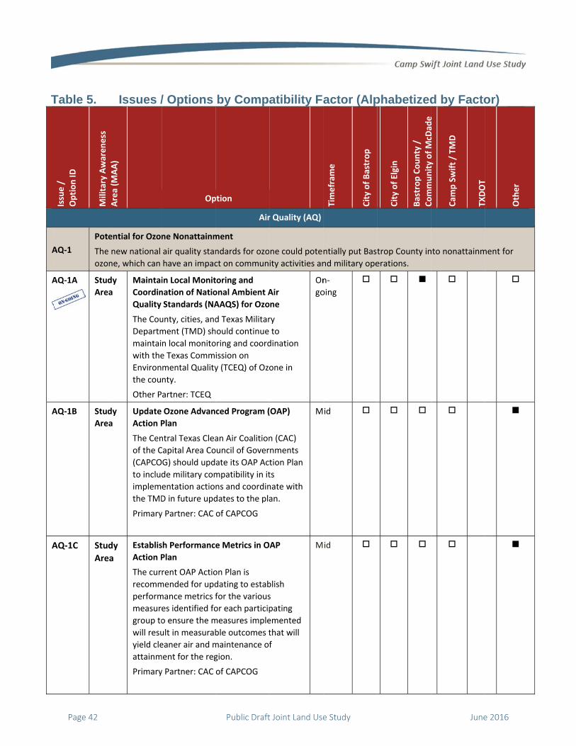
T
A
A
A
A
Table 5.
Issue /
Option ID
Military Awareness
AQ‐1
Pot
The
ozo
AQ‐1A
Stud
Are
AQ‐1B Stud
Are
AQ‐1C Stu
Are
Issues /Area (M
AA)
ential for Ozon
e new national
ne, which can
dy
ea
Maintai
Coordin
Quality
The Cou
Departm
maintai
with the
Environ
the cou
Other P
dy
ea
Update
Action P
The Cen
of the C
(CAPCO
to includ
implem
the TMD
Primary
dy
ea
Establis
Action P
The cur
recomm
perform
measur
group to
will resu
yield cle
attainm
Primary
/ Options
Op
ne Nonattainm
air quality stan
have an impac
in Local Monit
nation of Natio
Standards (NA
unty, cities, and
ment (TMD) sh
n local monito
e Texas Comm
mental Quality
nty.
artner: TCEQ
Ozone Advan
Plan
ntral Texas Clea
Capital Area Co
G) should upd
de military com
entation actio
D in future upd
y Partner: CAC
sh Performanc
Plan
rent OAP Actio
mended for upd
mance metrics f
es identified fo
o ensure the m
ult in measurab
eaner air and m
ment for the reg
y Partner: CAC
by Comp
ption
Air
ment
ndards for ozo
ct on commun
toring and
onal Ambient A
AAQS) for Ozo
d Texas Militar
hould continue
oring and coord
ission on
y (TCEQ) of Ozo
ced Program (
an Air Coalition
ouncil of Gover
ate its OAP Ac
mpatibility in it
ns and coordin
dates to the pla
of CAPCOG
e Metrics in O
on Plan is
dating to estab
for the various
or each particip
measures imple
ble outcomes t
maintenance of
gion.
of CAPCOG
atibility Fa
r Quality (AQ)
ne could poten
ity activities an
Air
one
ry
to
dination
one in
On
go
(OAP)
n (CAC)
nments
tion Plan
ts
nate with
an.
M
AP
blish
s
pating
emented
that will
f
M
actor (Alp
Timefram
e
City of Bastrop
ntially put Bast
nd military ope
n‐
oing
id
id
phabetized
City of Elgin
Bastrop County /
CommunityofMcD
ade
trop County in
erations.
d by Facto
Community of McD
ade
Cam
p Swift / TM
D
TXDOT
nto nonattainm
or)
TXDOT
Other
ment for
Page 42 Public Draft Joint Land Use Study June 2016
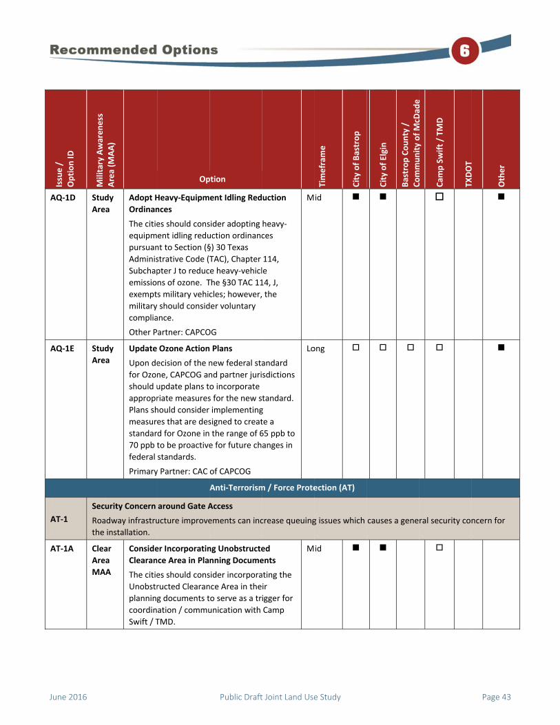
A
A
A
A
Issue /
Option ID
Military Awareness
AQ‐1D Stud
Are
AQ‐1E Stud
Are
AT‐1
Sec
Roa
the
AT‐1A Clea
Are
MA
Area (M
AA)
dy
ea
Adopt H
Ordinan
The citie
equipm
pursuan
Adminis
Subchap
emissio
exempt
military
complia
Other P
dy
ea
Update
Upon de
for Ozon
should u
appropr
Plans sh
measur
standar
70 ppb t
federal
Primary
urity Concern
adway infrastru
installation.
ar
ea
AA
Conside
Clearan
The citie
Unobstr
planning
coordin
Swift / T
Op
Heavy‐Equipm
nces
es should cons
ent idling redu
nt to Section (§
strative Code (T
pter J to reduc
ns of ozone. T
s military vehic
should consid
ance.
artner: CAPCO
Ozone Action
ecision of the n
ne, CAPCOG an
update plans t
riate measures
hould consider
es that are des
d for Ozone in
to be proactive
standards.
y Partner: CAC
around Gate A
ucture improve
er Incorporatin
nce Area in Pla
es should cons
ructed Clearan
g documents t
ation / commu
TMD.
ption
ent Idling Red
sider adopting
uction ordinanc
§) 30 Texas
TAC), Chapter
e heavy‐vehicl
The §30 TAC 11
cles; however,
der voluntary
OG
Plans
new federal sta
nd partner juri
o incorporate
s for the new s
implementing
signed to creat
the range of 6
e for future ch
of CAPCOG
Anti‐Terrorism
Access
ements can inc
ng Unobstructe
nning Docume
sider incorpora
nce Area in the
to serve as a tr
unication with
uction
heavy‐
ces
114,
le
14, J,
the
M
andard
sdictions
tandard.
g
te a
65 ppb to
anges in
Lo
m / Force Prote
crease queuing
ed
ents
ating the
ir
igger for
Camp
M
Timefram
e
City of Bastrop
id
ong
ection (AT)
g issues which
id
City of Elgin
Bastrop County /
CommunityofMcD
ade
causes a gene
Community of McD
ade
Cam
p Swift / TM
D
TXDOT
ral security co
TXDOT
Other
ncern for
June 2016 Public Draft Joint Land Use Study Page 43

A
A
A
Issue /
Option ID
Military Awareness
AT‐1B Clea
Are
MA
AT‐2 Dev
Con
AT‐2A Clea
Are
MA
Area (M
AA)
ar
ea
AA
Conside
Camp Sw
some of
mission
concern
velopment Com
ntinued growth
ar
ea
AA
Develop
(MOU) f
The citie
particip
Camp Sw
establis
the mili
infrastru
impact A
should i
Estaage
EstainteCam
Estadevappimp
Other P
Op
er Gate Closure
wift / TMD sho
f the gates tha
critical activiti
ns near the inst
mpliance with
h and future de
p a Memorand
for Coordinati
es and countie
ating agencies
wift / TMD to d
h procedures f
tary regarding
ucture improve
AT/FP complia
include but no
ablish points oency,
ablish triggers ensity, density,mp Swift), and
ablish proceduvelopment withproval so TMD pact AT/FP stan
artners: TCEQ,
ption
es
ould consider c
t do not suppo
ies to minimize
tallation.
AT/FP Standa
evelopment ne
dum of Unders
on
es and other
s should work w
develop a MOU
for coordinatin
development
ements that m
nce. Such pro
t me limited to
f contact for e
for coordinatio, height, proxim
ures for sharingh Camp Swift pcan advise howndards.
, CAPCOG
closing
ort
e AT/FP
Lo
ards
ear Camp Swift
standing
with
U to
ng with
and
may
ocedures
o:
ach
on, (e.g., mity to
g plans of prior to w it may
M
Timefram
e
City of Bastrop
ong
t may increase
id
City of Elgin
Bastrop County /
CommunityofMcD
ade
issues with AT
Community of McD
ade
Cam
p Swift / TM
D
TXDOT
TFP compliance
TXDOT
Other
e.
Page 44 Public Draft Joint Land Use Study June 2016

A
B
B
B
Issue /
Option ID
Military Awareness
AT‐2B Clea
Are
MA
BIO‐1
Bio
The
Con
BIO‐1A Cam
Swi
BIO‐1B Stud
Are
Area (M
AA)
ar
e
AA
Conside
Design G
Gates, B
(MIL‐HD
Camp Sw
an upda
the MIL
guidanc
guidanc
and pro
commu
commu
conside
Other P
See Opt
logical Resour
ere are numero
nservation Plan
mp
ift
Update
Manage
Camp Sw
for an u
rare or s
the Texa
Other P
Departm
Wildlife
dy
ea
Develop
(RMPs)
TPWD s
JLUS pa
for othe
includin
habitat.
Primary
Op
er Updating M
Guidelines for
Barriers, and G
DBK‐1013/10)
wift / TMD sho
ate or developi
L‐HDBK‐1013/1
ce to the milita
ce should estab
ocedures about
nities and edu
nities on the b
ration of new
artner: U.S. A
tions for AT‐1.
ces Monitorin
ous biological r
n Area that sho
Integrated Na
ement Plan (IN
wift / TMD sho
update of the IN
special species
as Horned‐Liza
artners: Texas
ment (TPWD),
Service (USFW
p Resource Ma
for Other Rare
should partner
rticipating ent
er rare or speci
ng the Texas Ho
.
y Partners: TPW
ption
ilitary Handbo
r Security Fenc
Guard Facilities
ould consider i
ing an addend
10 that provide
ry’s communit
blish points‐of‐
t coordinating
cating the
benefits of plan
AT/FP standar
rmy
Biologic
g
resources in th
ould be continu
atural Resourc
NRMP)
ould budget an
NRMP to includ
s of concern in
ard.
Parks and Wil
United States
WS)
anagement Pla
e Species
with USFWS a
ities to develo
ial species of c
orned‐Lizard a
WD, USFWS
ook,
cing,
s
nitiating
um for
es
ties. The
‐contact
with the
nning in
rds.
Lo
cal Resources (
e area, includi
ually monitore
es
nd plan
de all
cluding
dlife
Fish and
Lo
ans
and other
p RMPs
oncern
nd its
Lo
Timefram
e
City of Bastrop
ong
(BIO)
ng those that
d, coordinated
ong
ong
City of Elgin
Bastrop County /
CommunityofMcD
ade
inhabit the Los
d, and updated
Community of McD
ade
Cam
p Swift / TM
D
TXDOT
st Pines Habita
d as necessary.
TXDOT
Other
at
.
June 2016 Public Draft Joint Land Use Study Page 45
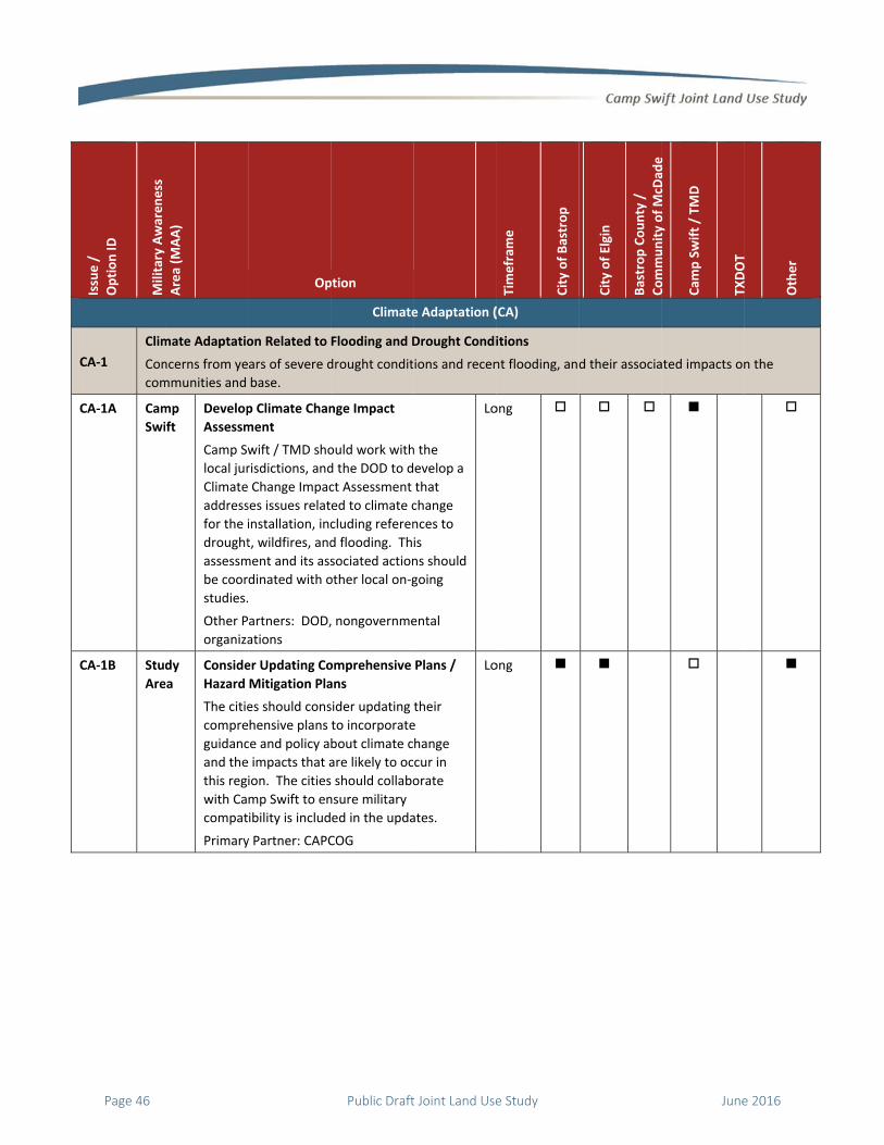
C
C
C
Issue /
Option ID
Military Awareness
CA‐1
Clim
Con
com
CA‐1A Cam
Swi
CA‐1B Stud
Are
Area (M
AA)
mate Adaptatio
ncerns from ye
mmunities and
mp
ift
Develop
Assessm
Camp Sw
local jur
Climate
address
for the i
drought
assessm
be coor
studies.
Other P
organiza
dy
ea
Conside
Hazard
The citie
compre
guidanc
and the
this reg
with Ca
compat
Primary
Op
on Related to
ars of severe d
base.
p Climate Chan
ment
wift / TMD sho
risdictions, and
Change Impac
ses issues relat
installation, inc
t, wildfires, and
ment and its ass
dinated with o
artners: DOD,
ations
er Updating Co
Mitigation Pla
es should cons
hensive plans
ce and policy a
impacts that a
ion. The cities
mp Swift to en
ibility is includ
y Partner: CAPC
ption
Climate
Flooding and D
drought condit
nge Impact
ould work with
d the DOD to d
ct Assessment
ed to climate c
cluding referen
d flooding. Th
sociated action
other local on‐g
, nongovernme
omprehensive
ans
sider updating
to incorporate
bout climate c
are likely to oc
s should collabo
nsure military
ed in the upda
COG
e Adaptation (
Drought Condi
ions and recen
h the
evelop a
that
change
nces to
is
ns should
going
ental
Lo
Plans /
their
e
hange
cur in
orate
ates.
Lo
Timefram
e
City of Bastrop
(CA)
itions
nt flooding, an
ong
ong
City of Elgin
Bastrop County /
CommunityofMcD
ade
d their associa
Community of McD
ade
Cam
p Swift / TM
D
TXDOT
ated impacts on
TXDOT
Other
n the
Page 46 Public Draft Joint Land Use Study June 2016

C
C
1
C
1
Issue /
Option ID
Military Awareness
COM‐1
Lac
Lac
info
COM‐
1A
MA
COM‐
1B
MA
Area (M
AA)
k of Formalize
k of formalized
ormation and v
AOD Conside
Commit
Formali
Camp Sw
will tran
Commit
monitor
recomm
resoluti
commu
and cur
compat
Other P
District
School D
School D
AOD Invite a
as a No
Plannin
Bodies
In an eff
partner
stakeho
Swift ag
availabl
mission
develop
Commis
and oth
Note: Th
provide
being co
to appro
project
Op
d Communica
d communicati
voice concerns
er a Camp Swif
ttee
ze through a re
wift Policy and
nsition to a JLU
ttee, and be re
ring the achiev
mended JLUS o
ons and act as
nication and sh
rent events as
ibility.
artners: Bastro
(BISD), CAPCO
District (EISD),
District (MISD)
Camp Swift R
n‐Voting Mem
g Commission
fort to continu
ship, include in
olders and Cam
grees to provid
e, to attend an
compatibility
pments at City
ssion, County C
er select agen
he Camp Swift
technical info
onsidered, but
ove, condition
or developme
ption
Communicatio
tion Between
on between C
related to noi
ft JLUS Coordin
esolution that
d Technical Com
US Coordination
esponsible for
vement of the
ptions or feasi
a forum for co
haring of infor
sociated with m
op Independen
OG, Elgin Indep
McDade Indep
, TPWD
epresentative
mber of the Jur
n and Other Pla
ue a collaborat
n a MOU betw
mp Swift that Ca
e a representa
nd comment o
issues on prop
Council, Plann
Commissioner
cy board meet
t representativ
rmation on ite
shall not direc
ally approve, o
nt application.
on / Coordinat
Local Jurisdict
amp Swift and
se, safety, and
nation
the
mmittees
n
ble
ontinued
mation
military
nt School
endent
pendent
Sh
e to Serve
risdiction
anning
ive
een
amp
ative, as
n
posed
ing
Court
tings.
e will
ems
ctly vote
or deny a
.
M
On
go
Timefram
e
City of Bastrop
tion (COM)
tions and the I
d local commun
d military traini
hort
id /
n‐
oing
City of Elgin
Bastrop County /
CommunityofMcD
ade
Installation
nities makes it
ing operations
Community of McD
ade
Cam
p Swift / TM
D
TXDOT
difficult to sha
.
TXDOT
Other
are vital
June 2016 Public Draft Joint Land Use Study Page 47

C
1
(
C
1
C
1
Issue /
Option ID
Military Awareness
COM‐
1B
(cont’d)
COM‐
1C
MA
COM‐
1D
Stud
Are
Area (M
AA)
Other P
EISD, Lo
AOD Provide
Agencie
Pre‐Dev
Conside
same M
Camp Sw
a proces
use, ma
etc. sub
be revie
periods
review p
a proact
conflicts
applicat
Primary
MISD, T
dy
ea
Develop
Camp Sw
through
to facilit
MOU th
respons
Study A
informa
Poineac
Roleon c
Resreso
Comand
Trigcomplan
Op
rimary Partner
ost Pines Habit
e Copies to Cam
es that Review
velopment App
er establishing
MOU used for o
wift and the ju
ss that provide
aster plan, subd
bmittals located
ewed by Camp
shall conform
periods for com
tive approach
s early in the p
tion phase.
y Partners: BISD
TXNG
p Memorandu
wift / TMD sho
h the JLUS Coor
tate the develo
hat delineates t
sibilities for eac
rea. This MOU
ation such as:
nt of contact ah agency,
e in communiccompatibility c
sponsibility in colution of com
mmunity and md
ggers for coordmmunication, (nning, water re
ption
rs: BISD, CAPCO
at Conservatio
mp Swift as On
w
plications / Pro
a MOU (may b
other options) b
urisdictions, for
es copies of co
division, annex
d within the M
Swift. Such re
to existing com
mment. This s
to identifying p
proposed deve
D, CAPCOG, EIS
m of Understa
ould collaborat
rdination Com
opment of a fo
the roles and
ch agency in th
U should conta
nd informatio
cating with thconcerns,
coordinating onmpatibility conc
military respon
dination and e.g., infrastrucesources plann
OG,
on, MISD
ne of the
oposals
be the
between
rmalizing
nditional
xation,
MAOD to
eview
mmunity
upports
potential
lopment
SD,
Sh
anding
te
mittee
ormal
he JLUS
ain
n for
e base
n the cerns,
se times,
cture ning,
M
Timefram
e
City of Bastrop
hort
id
City of Elgin
Bastrop County /
CommunityofMcD
ade
Community of McD
ade
Cam
p Swift / TM
D
TXDOT
TXDOT
Other
Page 48 Public Draft Joint Land Use Study June 2016

C
C
2
C
C
3
Issue /
Option ID
Military Awareness
COM‐2
Lim
Lim
acti
COM‐
2A
Stud
Are
COM‐3
Lim
Lim
inst
COM‐
3A
Stud
Are
Area (M
AA)
ecoto s
Other P
Coordin
mited Public Aff
ited military re
vities at Camp
dy
ea
Develop
for Pub
Camp Sw
local jur
delineat
informa
effort to
commu
points o
informa
jurisdict
mited Public Aff
ited public affa
tallation opera
dy
ea
Establis
Media W
Camp Sw
official F
webpag
public w
TMD sh
address
importa
activitie
Op
onomic developsubdivision pla
artners: TPWD
nation Committ
fairs
esources availa
p Swift.
p Memorandu
lic Affairs
wift / TMD sho
risdictions to d
tes procedures
ation with the l
o be proactive
nications. The
of contact for j
ation to be sha
tions, frequenc
fairs for TXARN
airs resources
tions and activ
sh Official Face
Webpage(s)
wift / TMD sho
Facebook and
ges to provide
who follow the
ould distribute
ses to local juri
ant information
es, operations,
ption
pment, new orts, etc.)
D, TCEQ, JLUS
tee
able to the loca
m of Understa
ould work with
evelop a MOU
s for sharing
local jurisdictio
and consisten
e MOU should
urisdictions, ty
red with local
cy, etc.
NG / Camp Sw
available for T
vities for comm
ebook and Oth
ould establish a
/ or other soci
notifications to
pages. Camp
e the webpage
sdictions to sh
n about Camp
and events.
r changes
al newspaper h
anding
h the
U that
ons in an
t with
set
ypes of
M
wift
TXARNG / Camp
munity affairs.
her Social
an
al media
o the
Swift /
e
hare
Swift
Sh
Timefram
e
City of Bastrop
have minimize
id
p Swift have m
hort
City of Elgin
Bastrop County /
CommunityofMcD
ade
d opportunitie
minimized oppo
Community of McD
ade
Cam
p Swift / TM
D
TXDOT
es for coverage
ortunities for c
TXDOT
Other
e of
overage of
June 2016 Public Draft Joint Land Use Study Page 49
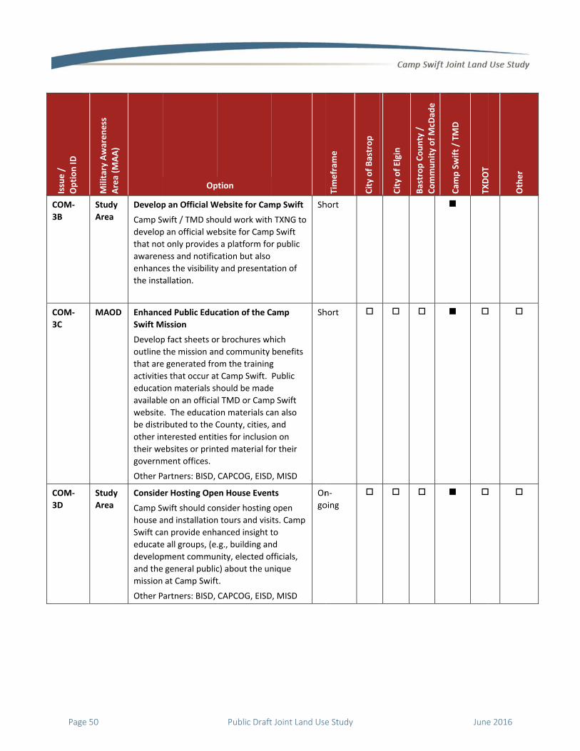
C
3
C
3
C
3
Issue /
Option ID
Military Awareness
COM‐
3B
Stud
Are
COM‐
3C
MA
COM‐
3D
Stud
Are
Area (M
AA)
dy
ea
Develop
Camp Sw
develop
that not
awaren
enhance
the inst
AOD Enhance
Swift M
Develop
outline
that are
activitie
educatio
availabl
website
be distr
other in
their we
governm
Other P
dy
ea
Conside
Camp Sw
house a
Swift ca
educate
develop
and the
mission
Other P
Op
p an Official W
wift / TMD sho
p an official we
t only provides
ess and notific
es the visibility
allation.
ed Public Educ
Mission
p fact sheets o
the mission an
e generated fro
es that occur at
on materials sh
e on an officia
e. The educatio
ibuted to the C
nterested entit
ebsites or print
ment offices.
artners: BISD,
er Hosting Ope
wift should co
and installation
an provide enh
e all groups, (e
pment commun
general public
at Camp Swift
artners: BISD,
ption
Website for Cam
ould work with
ebsite for Camp
s a platform fo
cation but also
y and presenta
cation of the C
r brochures wh
nd community
om the training
t Camp Swift.
hould be made
l TMD or Camp
on materials ca
County, cities,
ies for inclusio
ted material fo
CAPCOG, EISD
en House Even
nsider hosting
n tours and visi
anced insight t
.g., building an
nity, elected of
c) about the un
t.
CAPCOG, EISD
mp Swift
h TXNG to
p Swift
r public
tion of
Sh
Camp
hich
benefits
g
Public
e
p Swift
an also
and
on on
or their
D, MISD
Sh
ts
open
ts. Camp
to
nd
fficials,
nique
D, MISD
On
go
Timefram
e
City of Bastrop
hort
hort
n‐
oing
City of Elgin
Bastrop County /
CommunityofMcD
ade
Community of McD
ade
Cam
p Swift / TM
D
TXDOT
TXDOT
Other
Page 50 Public Draft Joint Land Use Study June 2016

C
C
C
Issue /
Option ID
Military Awareness
COM‐3E MA
CR‐1
Acc
Cam
whi
CR‐1A MA
Area (M
AA)
AOD Foster E
Accurat
Camp Sw
surroun
state go
geograp
layer or
bounda
transpo
facilities
Other P
cess to Historic
mp Swift has hi
ch could have
AOD Enhance
Personn
Camp Sw
visibility
that ma
visits to
enhance
limited
Procultpro
Reaandthe concangrocemreso
Op
Enhanced Publ
te Mapping
wift / TMD sho
nding local, cou
overnments wi
phic informatio
r geodatabase
ries for inclusi
ortation, park a
s, and other re
artners: BISD,
c and Cultural
istoric and cult
restricted acce
e Visibility of C
nel
wift / TMD sho
y of the cultura
anage the acce
the historic ce
ements can inc
to:
viding links ontural resourcescedures on Ca
aching out to thd other enthusiprocedures an
ntact informatio provide a pasups enabling ameteries and otources.
ption
lic Awareness
ould provide al
unty, regional,
th an accurate
on system (GIS
of the installat
on in all land u
and recreation,
elated planning
CAPCOG, EISD
Cultura
Resources
tural sites on th
ess during time
Cultural Resou
ould enhance t
al resources pe
ss and schedul
emeteries. Suc
clude but not b
webpages abos and their accemp Swift and
he groups, famiasts to informnd to collect thon so the instas to those famaccess to the ther pertinent
Through
ll of the
and
e
) data
tion
use,
, public
g efforts.
D, MISD
Sh
al Resources (C
he installation;
es of heighten
urces
the
ersonnel
ling of
ch
be
out the essibility
milies, them of heir allation ilies and
cultural
M
Timefram
e
City of Bastrop
hort
CR)
; including bur
ed security or
id City of Elgin
Bastrop County /
CommunityofMcD
ade
rial grounds an
with mission c
Community of McD
ade
Cam
p Swift / TM
D
TXDOT
d a historic wi
changes.
TXDOT
Other
ne cellar,
June 2016 Public Draft Joint Land Use Study Page 51

C
D
D
D
D
Issue /
Option ID
Military Awareness
CR‐1B MA
DSS‐1
Pre
Smo
pro
DSS‐1A MA
DSS‐2
Dus
Dus
ope
DSS‐2A MA
Area (M
AA)
AOD Update
Manage
Camp Sw
for the u
identifie
access o
installat
delineat
pamphl
ensure a
such sit
scribed Burn S
oke from presc
perties.
AOD Enhance
Camp Sw
notificat
Poswebesta
Distjuriand
Estaann
st and Smoke f
st and smoke g
erations and ac
AOD Commu
Propose
Dust, Sm
Commu
existing
and pro
subdivis
steam t
Op
Integrated Cu
ement Plan (IC
wift / TMD sho
update of the
ed personnel r
of the cultural
tion. This poin
ted on all the i
ets distributed
appropriate pe
es.
Smoke Impacts
cribed burns co
e Notification
wift / TMD sho
tions for presc
sting notificatiobsite for Campablished),
tributing notifisdictions’ publd
ablishing publinouncements.
from Commun
generated from
ctivities.
unicate with Ca
ed Developme
moke, or Steam
unicate with Ca
facilities unde
oposed develop
sions that gene
hat are located
ption
ultural Resourc
CRMP)
ould budget an
ICRMP to inco
esponsible for
resources on t
nt of contact sh
nformational
d to the public
ersons have ac
Dust, Sm
s
onducted at Ca
of Prescribed
ould enhance t
cribed burns by
ons to the officp Swift / TMD (w
cations to localic information
c service
nity Activities C
m agricultural a
amp Swift Reg
ents that Gene
m Within the M
amp Swift abou
ergoing renova
pments and
erate dust, smo
d within the M
ces
nd plan
rporate
the
the
hould be
to
ccess to
Lo
moke, Steam (
amp Swift migr
Burns
their
y:
cial when
al n offices,
Sh
Can Impact Ba
and constructio
garding
rate
MAOD
ut any
ations
oke, or
MAOD
Sh
Timefram
e
City of Bastrop
ong
DSS)
rates off instal
hort
se Operations
on activities ca
hort
City of Elgin
Bastrop County /
CommunityofMcD
ade
lation onto pu
s
n impede, dela
Community of McD
ade
Cam
p Swift / TM
D
TXDOT
blic and privat
ay, or postpon
TXDOT
Other
te
e base
Page 52 Public Draft Joint Land Use Study June 2016
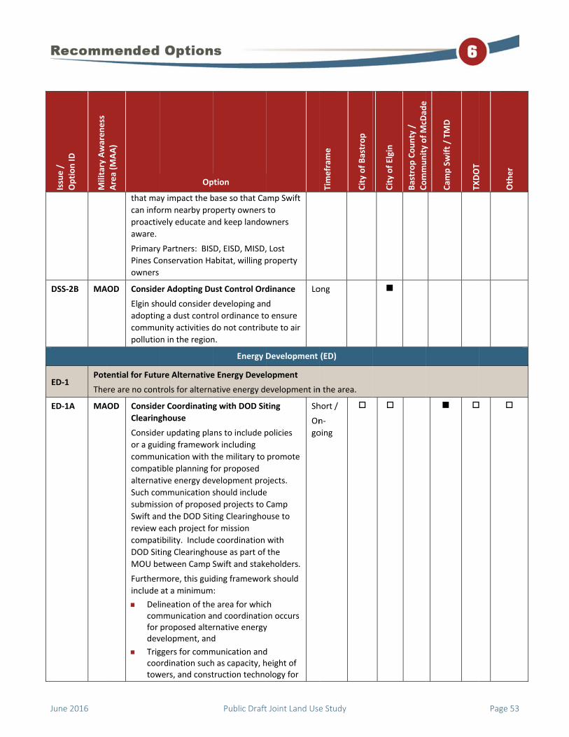
D
E
E
Issue /
Option ID
Military Awareness
DSS‐2B MA
ED‐1 Pot
The
ED‐1A MA
Area (M
AA)
that ma
can info
proactiv
aware.
Primary
Pines Co
owners
AOD Conside
Elgin sh
adoptin
commu
pollutio
ential for Futu
ere are no cont
AOD Conside
Clearing
Conside
or a gui
commu
compat
alternat
Such co
submiss
Swift an
review e
compat
DOD Sit
MOU be
Further
include
Delcomfor dev
Trigcootow
Op
ay impact the b
orm nearby pro
vely educate an
y Partners: BIS
onservation Ha
er Adopting Du
ould consider
g a dust contro
nity activities d
n in the region
ure Alternative
trols for alterna
er Coordinating
ghouse
er updating pla
ding framewor
nication with t
ible planning f
tive energy dev
mmunication s
sion of propose
nd the DOD Sit
each project fo
ibility. Include
ting Clearingho
etween Camp S
more, this guid
at a minimum
ineation of themmunication aproposed altevelopment, and
ggers for commordination suchwers, and const
ption
base so that Ca
operty owners
nd keep landow
D, EISD, MISD,
abitat, willing p
ust Control Ord
developing an
ol ordinance to
do not contrib
n.
Energy D
e Energy Devel
ative energy d
g with DOD Sit
ns to include p
rk including
the military to
for proposed
velopment pro
should include
ed projects to
ing Clearingho
or mission
e coordination
ouse as part of
Swift and stake
ding framewor
:
e area for whicnd coordinatiornative energyd
munication andh as capacity, htruction techno
amp Swift
to
wners
, Lost
property
dinance
d
o ensure
ute to air
Lo
Development
lopment
evelopment in
ting
policies
promote
ojects.
e
Camp
use to
with
the
eholders.
rk should
ch on occurs y
d height of ology for
Sh
On
go
Timefram
e
City of Bastrop
ong
(ED)
n the area.
hort /
n‐
oing
City of Elgin
Bastrop County /
CommunityofMcD
ade
Community of McD
ade
Cam
p Swift / TM
D
TXDOT
TXDOT
Other
June 2016 Public Draft Joint Land Use Study Page 53

E
L
L
Issue /
Option ID
Military Awareness
ED‐1B Stud
Are
LAS‐1
Unr
Gen
not
LAS‐1A MA
Area (M
AA)
solacon
Note: T
requirem
Title 32,
211 sha
facilitat
energy p
Clearing
compat
Other P
willing l
dy
ea
“Red, Y
Develop
which th
location
mutuall
incomp
and heli
Primary
restricted Airsp
neral aviation a
ification.
AOD Conside
Schedul
Aviation
Operato
Camp Sw
schedul
with GA
the vicin
schedul
as:
Tim
Tim
Ran
Op
ar panels (e.g. ncentrated sola
The DOD Siting
ments and stan
, Code of Feder
all advise and g
te the early sub
project propos
ghouse for mili
tible review.
artners: BISD,
andowners
ellow, Green”
p a "Red, Yellow
he TXNG comm
ns where struct
y agreed upon
atible with freq
icopter flight r
y Partner: TXNG
pace Over Cam
and personal a
er Sharing Unc
le Information
n (GA) and Per
ors
wift should co
e information
A and personal
nity of the inst
es should inclu
mes of year,
mes of day,
nges that are “h
ption
photovoltaic oar power).
Clearinghouse
ndards publish
ral Regulations
guide the proce
bmission of ren
sals to the
itary mission
CAPCOG, EISD
Map
w, Green" Map
municates spec
tures that exce
n height would
quency interfe
outes.
G
Land / Air Sp
mp Swift
ircraft enter th
lassified Train
n with General
rsonal Aircraft
nsider sharing
regarding the
aircraft opera
allation. The t
ude informatio
hot,”
or
e
ed in
s, Part
ess to
newable
D, MISD,
p in
cific
eed a
be
erence
M
pace Competit
he airspace ove
ing
training
ranges
tors in
training
on such
M
Timefram
e
City of Bastrop
id
tion (LAS)
er the live fire
id
City of Elgin
Bastrop County /
CommunityofMcD
ade
training range
Community of McD
ade
Cam
p Swift / TM
D
TXDOT
es without prop
TXDOT
Other
per
Page 54 Public Draft Joint Land Use Study June 2016

L
L
Issue /
Option ID
Military Awareness
LAS‐1B MA
LAS‐1C MA
Area (M
AA)
Day
Poinque
Includin
on an of
aviators
AOD Conside
Avoidan
Camp Sw
Range A
“hot” or
delineat
minimu
Poinincl
StanCam
Distor pjuri
Other P
Adminis
Bergstro
Houston
AOD Provide
Area, Es
Over th
Southea
Camp Sw
other lo
pilots op
that the
avoid ar
south /
aware r
visually
Swift.
Op
ys when ranges
nts of contact estions or conc
ng this informa
fficial website
s in the area an
er Developing
nce Program
wift should co
Avoidance Prog
r active. The p
te the followin
m:
nts of contact uding GA facili
ndard Operatinmp Swift Range
tribution methposted on officsdictions and a
artners: Feder
stration (FAA),
om Internation
n, Dallas, US Ai
e Notices to Air
specially Airme
e Installation f
ast
wift should coo
ocal airports to
perating in the
e Camp Swift ra
rea. Enhance N
southeast area
anges are “hot
see the red fla
ption
s are not “hot,
information if cerns arise.
tion or a notifi
would also be
nd the general
and Sharing Ra
nsider develop
gram when ran
program should
ng information,
for all nearby aities,
ng Procedures es are “hot,” an
hods (e.g., emacial websites ofairports.)
ral Aviation
area airports—
nal Airport (AB
ir Force
rmen (NOTAM
en Entering Ai
from the Sout
ordinate with A
provide NOTA
e area and info
anges are “hot
NOTAMs flying
a to ensure the
t” as they may
ags displayed b
” and
ication
nefit
public.
ange
ping a
nges are
d
, at
airports
when nd
il blasts f local
— Austin
IA),
Lo
Ms) in the
rspace
h /
ABIA and
AMs to
rm them
t” and to
g in the
ey are
not
by Camp
Sh
Timefram
e
City of Bastrop
ong
hort
City of Elgin
Bastrop County /
CommunityofMcD
ade
Community of McD
ade
Cam
p Swift / TM
D
TXDOT
TXDOT
Other
June 2016 Public Draft Joint Land Use Study Page 55

L
(
L
L
L
Issue /
Option ID
Military Awareness
LAS‐1C
(cont’d)
LAS‐1D
MA
LU‐1
Pot
If th
spu
LU‐1A MA
Area (M
AA)
Other P
other af
AOD Strobe L
Camp Sw
strobe l
nighttim
Conside
brochur
informa
for nigh
governi
ential Develop
he right‐of‐way
r development
AOD Conside
Overlay
Availab
Efforts
Conside
subzone
and com
could as
compat
the MAO
the Rec
narrativ
military
subzone
Cleafooin aareand
Smacovran
Op
artners: ABIA,
ffiliated airport
Light for Night
wift should co
ight notificatio
me flight trainin
er developing a
re or adding to
ational brochur
ttime training
ng agencies.
pment Adjacen
y for State High
t in areas near
er Including th
y District (MAO
le Mapping an
er including the
es information
mmunication e
ssist in achievin
ibility in the fu
OD and its sub
ommended Op
ve. The MAOD
awareness are
es:
arance Area Mt area from theall directions. La should not od off‐installatio
all Arms / IED Nvers the area foges and its noi
ption
Houston, Dalla
ts
ttime Flight Tra
ntinue to use t
on method for
ng of Blackhaw
an information
o an already ex
re about this to
and distribute
La
nt to Camp Sw
hway 95 is acq
r the base that
e Military Awa
OD) Informatio
nd Communica
e MAOD and it
in available m
fforts. The MA
ng military
uture. A descri
bzones can be f
ptions section
consists of fiv
eas (MAAs) an
MAA – This MAAe installation bLand uses withbstruct the vieon.
Noise MAA – Tor the small armse contours an
as, and
aining
the
wk pilots.
al
isting
ool used
e to local
Sh
and Use (LU)
wift
uired, then the
may not be co
areness
on in
ation
s
mapping
AOD
ption of
found in
ve
d several
A is a 20‐boundary in the ew into
This MAA ms nd the
M
On
go
Timefram
e
City of Bastrop
hort
e roadway can
ompatible.
id /
n‐
oing
City of Elgin
Bastrop County /
CommunityofMcD
ade
n be expanded,
Community of McD
ade
Cam
p Swift / TM
D
TXDOT
, which could p
TXDOT
Other
potentially
Page 56 Public Draft Joint Land Use Study June 2016

L
L
Issue /
Option ID
Military Awareness
LU‐1B MA
LU‐1C
Clea
Zon
MA
Area (M
AA)
IED conZon130
Demincl40‐
DroMAmetthe
Vercomcorto popecan
AOD Coordin
TMD / T
TXDOT s
improve
the Cam
This coo
particip
advisem
to Camp
could im
installat
Other Pa
ar
ne
AA
Acquire
Additio
the Com
Develop
Identify
compet
(ACUB)
Protecti
to estab
landow
Op
Lane and its antours containine II 115 dB PK0 dB PK15(MET
molitions Noiseudes all land upound demolit
op Zone ObstacAA includes all lters of the DroBlackwell Dro
rtical Obstructimprises the preridor that varioperform necesserations. Land be impacted b
nate Roadway
TXNG / Camp S
should coordin
ements propos
mp Swift MAOD
ordination inclu
ate in any pre‐
ment of potent
p Swift, and an
mpact military
tion.
artner: TXNG
e Lands that W
nal Buffer Betw
mmunity to Pro
pment
y lands that me
e for Army Com
and Readiness
ion Integration
blish easement
ners or conside
ption
ssociated noisng two noise z15(MET) and ZT).
e MAA – This Munder the 2‐potions noise con
cle‐Free MAA –land within 1,0op Zone Activityp Zone.
on MAA – Thisedominant flighous reservist usary aviation truses under thby low altitude
Improvement
Swift
nate any roadw
sed / planned w
D with the insta
udes invitation
‐planning meet
ially adverse im
ny other matte
operations at t
Would Provide a
ween Camp Sw
omote Compa
eet the criteria
mpatible Use B
s Environmenta
n (REPI) progra
ts from local, w
er fee simple p
e zones, Zone III
MAA und and ntours.
– This 000 y Area at
s MAA ht nits use raining is MAA e flying.
ts with
way
within
allation.
n to
tings,
mpacts
rs that
the
On
go
an
wift and
tible
to
Buffer
al
m funds
willing
purchase.
Lo
On
go
Timefram
e
City of Bastrop
n‐
oing
ong /
n‐
oing
City of Elgin
Bastrop County /
CommunityofMcD
ade
Community of McD
ade
Cam
p Swift / TM
D
TXDOT
TXDOT
Other
June 2016 Public Draft Joint Land Use Study Page 57

L
L
L
Issue /
Option ID
Military Awareness
LU‐1D MA
LU‐1E MA
LU‐1F MA
Area (M
AA)
Other P
Habitat
Land Tr
Colorad
Conserv
AOD Develop
(ACUB)
The ACU
installat
compat
Other P
Habitat
Land Tr
Colorad
Conserv
AOD Conside
Conserv
Conside
easeme
characte
installat
opportu
program
Primary
Trust, T
River La
willing l
AOD Conside
Master
School D
and con
identify
Primary
EISD, M
Op
artners: BISD,
Conservation,
ust, The Natur
do River Land T
vancy, willing la
p An Army Com
Plan
UB will identify
tion that are hi
ibility or at risk
artners: BISD,
Conservation,
ust, The Natur
do River Land T
vancy, willing la
er Evaluating t
vation Easeme
er developing a
ent program to
er of the critica
tion. Pursue co
unities utilizing
ms and involvin
y Partners: Pine
he Nature Con
and Trust, Texa
andowners
er Coordinating
Plans with Ca
Districts should
nsulting with Ca
ing future scho
y Partners: Scho
ISD)
ption
EISD, Lost Pine
MISD, Pines &
e Conservancy
Trust, Texas Lan
andowners
mpatible Use B
y areas outside
igh priority to a
k for encroach
EISD, Lost Pine
MISD, Pines &
e Conservancy
Trust, Texas Lan
andowners
he Potential fo
ent Program
a conservation
preserve the r
al areas adjace
onservation pa
g REPI and ACU
ng local land tr
es & Prairies La
nservancy, Colo
as Land Conser
g School Distri
mp Swift
d consider coo
amp Swift prio
ool sites.
ool Districts (B
es
& Prairies
y,
nd
Buffer
e the
achieve
ment.
es
& Prairies
y,
nd
Lo
On
go
or a
rural
ent to the
artnering
UB
usts.
and
orado
vancy,
Lo
On
go
ict
rdinating
or to
BISD,
On
go
Timefram
e
City of Bastrop
ong /
n‐
oing
ong /
n‐
oing
n‐
oing
City of Elgin
Bastrop County /
CommunityofMcD
ade
Community of McD
ade
Cam
p Swift / TM
D
TXDOT
TXDOT
Other
Page 58 Public Draft Joint Land Use Study June 2016

L
L
L
L
Issue /
Option ID
Military Awareness
LEG‐1
Stat
The
be a
Stat
LG‐1
Ligh
Unr
adv
LG‐1A Stud
Are
LG‐1B MA
Area (M
AA)
te Legislation A
ere are two new
applied to this
te laws do not
ht Encroachme
regulated light
versely impact
dy
ea
Conside
Compat
The nex
zoning o
amendi
incorpo
(BUG)‐r
new fixt
Illumina
America
comme
AOD Conside
The City
a lightin
in the ci
impact o
at a min
BUG‐rat
develop
resident
include
establis
footcan
lines, et
Op
Applicability
w House Bills t
area.
apply to the JL
ent from New
ing in nearby j
night vision tra
er Amending L
tible Lighting
xt time the City
ordinance, it sh
ng its lighting o
rate Backlight,
ated fixtures, a
ture recomme
ating Engineeri
a to mitigate l
rcial developm
er Developing
y of Elgin shoul
ng ordinance to
ity, which can
on nighttime t
nimum should
ted fixtures for
pment and fully
tial uses. The
controls for tim
h lumens per f
dles a fixture c
tc.
ption
Legislati
hat potentially
LUS participati
Light
Development
urisdictions ca
aining operatio
ighting Ordina
y of Bastrop am
hould consider
ordinance to
, Uplight, and G
as BUG fixture
nded by the
ng Society of N
light pollution
ment.
a Lighting Ord
ld consider dev
o control light
have an adver
raining. The o
include regula
r commercial
y cutoff fixture
ordinance sho
mers for lights
fixture and how
can emit over p
ve Initiatives (
y address limite
ng jurisdiction
t and Glare (LG
n facilitate ligh
ons.
ance for
mends its
r
Glare
s are the
North
from
Lo
inance
veloping
pollution
se
ordinance
tions for
es for
uld also
,
w many
property
Lo
Timefram
e
City of Bastrop
(LEG)
ed land use au
s.
G)
ht encroachme
ong
ong
City of Elgin
Bastrop County /
CommunityofMcD
ade
uthority for cou
ent on Camp Sw
Community of McD
ade
Cam
p Swift / TM
D
TXDOT
unties in Texas
wift, which cou
TXDOT
Other
s that could
uld
June 2016 Public Draft Joint Land Use Study Page 59

N
N
N
N
Issue /
Option ID
Military Awareness
NOI‐1
Noi
Noi
com
NOI‐1A Sma
Arm
Noi
MA
&
Dem
litio
Noi
MA
NOI‐1B Sma
Arm
Noi
MA
&
Dem
litio
Noi
MA
NOI‐1C
MA
Area (M
AA)
se Generated
se associated w
mplaints from t
all
ms
se
AA
mo‐
ons
se
AA
Conside
Building
Conside
new con
uses loc
Demolit
be requ
so as to
greater
all
ms
se
AA
mo‐
ons
se
AA
Conside
The City
its noise
compat
interior
to or wi
modele
AOD Leverag
Easeme
High Pri
Camp S
Prioritiz
addition
the exis
encroac
Also see
Op
by Community
with past activ
the surroundin
er Requiring So
g Standards Fo
er requiring sou
nstruction of n
cated in the Sm
tions Noise MA
ired to be desi
limit their inte
than 45 dB.
er Amending N
y of Elgin shoul
e ordinance to
ibility regulatio
noise levels as
thin a majority
d for the insta
ge ACUB and R
ents of Non‐Fe
iority for Prese
wift
ze parcels that
nal buffer to Ca
sting and future
chment.
e Options LU‐2
ption
N
y Activities
vities at nearby
ng communities
ound Attenuat
or New Constru
und attenuatio
noise sensitive
mall Arms / IED
AAs. Structure
igned and cons
erior noise leve
Noise Ordinanc
ld consider am
incorporate m
ons and establ
s the city is pro
y of the noise c
llation.
REPI Funds to A
deral Lands th
erving the Mis
would provide
amp Swift and
e missions from
A through LU‐
Noise (NOI)
y ALCOA mine
s.
tion
uction
on for
land
and
s shall
structed
el to no
Lo
ce
mending
military
ish
oximate
contours
Lo
Acquire
hat are
ssion at
e an
protect
m
2C
Lo
On
go
Timefram
e
City of Bastrop
were often att
ong
ong
ong /
n‐
oing
City of Elgin
Bastrop County /
CommunityofMcD
ade
tributed to Cam
Community of McD
ade
Cam
p Swift / TM
D
TXDOT
mp Swift, prom
TXDOT
Other
mpting
Page 60 Public Draft Joint Land Use Study June 2016
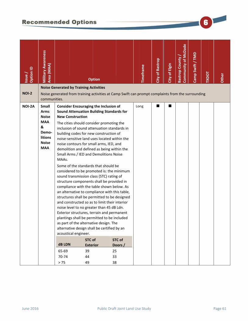
N
N
Issue /
Option ID
Military Awareness
NOI‐2
Noi
Noi
com
NOI‐2A Sma
Arm
Noi
MA
&
Dem
litio
Noi
MA
Area (M
AA)
se Generated
se generated f
mmunities.
all
ms
se
AA
mo‐
ons
se
AA
Conside
Sound A
New Co
The citie
inclusio
building
noise‐se
noise co
demolit
Small A
MAAs.
Some of
conside
sound t
structur
complia
an alter
structur
and con
noise le
Exterior
planting
as part o
alternat
acoustic
dB LDN
65‐69
70‐74
> 75
Op
by Training Ac
from training a
er Encouraging
Attenuation Bu
onstruction
es should cons
n of sound att
g codes for new
ensitive land us
ontours for sm
tion and define
rms / IED and D
f the standards
red to be prom
ransmission cl
re components
ance with the t
rnative to comp
res shall be per
nstructed so as
vel to no great
r structures, te
gs shall be perm
of the alternat
tive design sha
cal engineer.
N STC o
Exter
39
44
49
ption
ctivities
activities at Cam
g the Inclusion
uilding Standa
sider promotin
enuation stand
w construction
ses located wit
all arms, IED, a
ed as being wit
Demolitions N
s that should b
moted is: the m
ass (STC) rating
s shall be provi
able shown be
pliance with th
rmitted to be d
s to limit their i
ter than 45 dB
errain and perm
mitted to be in
tive design. The
all be certified b
of
rior
ST
Do
25
33
38
mp Swift can p
of
ards for
g the
dards in
of
thin the
and
thin the
oise
be
minimum
g of
ided in
elow. As
his table,
designed
interior
Ldn.
manent
ncluded
e
by an
TC of
oors /
5
3
8
Lo
Timefram
e
City of Bastrop
prompt compla
ong
City of Elgin
Bastrop County /
CommunityofMcD
ade
aints from the s
Community of McD
ade
Cam
p Swift / TM
D
TXDOT
surrounding
TXDOT
Other
June 2016 Public Draft Joint Land Use Study Page 61

N
N
N
Issue /
Option ID
Military Awareness
NOI‐2B Sma
Arm
Noi
MA
NOI‐2C Sma
Arm
Noi
MA
NOI‐2D Sma
Arm
Noi
MA
&
Dem
litio
Noi
MA
Area (M
AA)
all
ms
se
AA
Conside
Attenua
Residen
Conside
provide
standar
and com
include
assist pr
structur
funding
should b
program
all
ms
se
AA
Sound A
Significa
modifie
by 50 pe
relocati
alteratio
within t
arms sh
sound a
apply to
an incre
(as defin
the stru
all
ms
se
AA
mo‐
ons
se
AA
Develop
Technic
Develop
either th
building
educatio
techniq
required
thresho
Jurisdict
to prod
other st
these m
Op
er Developing
ation Retrofit P
ntial Uses
er developing a
s guidance on
ds for retrofitt
mmercial facilit
grant opportu
roperty owner
res in noise‐sen
sources for re
be identified a
m materials as
Attenuation fo
ant (defined as
s, alters or exp
ercent) extens
on, reconstruc
on of an existin
the Zone II nois
all include the
attenuation ma
o changes in a s
ease in the num
ned by the 201
ucture.
p and Provide
cal Support
p and provide e
hrough inclusio
g codes or as a
onal documen
ues which can
d 45 dB Ldn int
old.
tions could pu
uce technical s
takeholders dis
materials.
ption
a Voluntary So
Program for
a program that
sound attenua
ting existing re
ties. The progr
unities available
rs in retrofitting
nsitive areas. O
etrofitting hom
nd provided w
well.
or Existing Stru
s an activity tha
pands an existi
ion, enlargeme
ction or substa
ng residential u
se contour for
e implementati
aterials. This s
structure that
mber of habita
10 U.S. Census)
Sound Attenu
educational ma
on in the adop
supplemental
t, describing b
be used to ach
terior noise ma
rsue funding fr
support materi
stributing and
ound
t
ation
sidential
am can
e to
g
Other
mes
within the
Lo
uctures
at
ng use
ent,
ntial
use
small
on of
hall also
result in
ble units
) within
Lo
ation
aterials,
pted
uilding
hieve the
aximum
rom DOD
ials, with
using
M
Timefram
e
City of Bastrop
ong
ong
id
City of Elgin
Bastrop County /
CommunityofMcD
ade
Community of McD
ade
Cam
p Swift / TM
D
TXDOT
TXDOT
Other
Page 62 Public Draft Joint Land Use Study June 2016

N
N
N
Issue /
Option ID
Military Awareness
NOI‐3
Noi
Sev
whi
NOI‐3A Stud
Are
NOI‐3B Stud
Are
Area (M
AA)
se Generated
eral military /
ch causes nois
dy
ea
Enforce
“Fly Nei
Camp Sw
policy to
their rot
when po
resident
shared w
on the C
and com
dy
ea
Foster E
Military
Mappin
Provide
regiona
accurate
utilized
Support
planning
Other P
See Opt
Op
by Transient H
national guard
se that is attrib
e and Inform A
ighbor‐Friendl
wift should co
o “fly neighbor
tary wing rout
ossible avoidin
tial areas. This
with local com
Camp Swift we
mpleted).
Enhanced Publ
y Flight Paths T
ng
all of the surro
l and state gov
e electronic m
by the TMD / T
t Facility for inc
g efforts.
artner: TXNG
tions for NOI‐1
ption
Helicopters
d rotary wing u
buted to the ins
About The
ly” Protocol
ntinue to follo
r‐friendly,” rou
es over rural a
ng overflight of
policy should
mmunities and p
ebsite (once de
lic Awareness
Through Accur
ounding local,
vernments with
ap of the flight
TXNG Army Av
clusion on app
1
units within the
stallation.
w the
uting
reas and
f
be
posted
eveloped
M
Of
rate
county,
h an
t paths
viation
licable
M
Timefram
e
City of Bastrop
e region and st
id
id
City of Elgin
Bastrop County /
CommunityofMcD
ade
tate traverse th
Community of McD
ade
Cam
p Swift / TM
D
TXDOT
he area over C
TXDOT
Other
amp Swift,
June 2016 Public Draft Joint Land Use Study Page 63

P
P
P
P
Issue /
Option ID
Military Awareness
PT‐1
Tres
Tres
gun
PT‐1A Clea
Are
MA
PT‐1B Clea
Are
MA
PT‐1C Clea
Are
MA
Area (M
AA)
spassing on Ca
spassing in the
ns and, at times
ar
ea
AA
Develop
Appreh
Camp Sw
Bastrop
local law
the mon
trespass
The init
Camp Sw
trespass
appropr
appropr
facilitat
maintai
Other P
Office, E
ar
ea
AA
Increase
Installat
Install “
Area” si
every 10
installat
and wel
ar
ea
AA
Enhance
Utilize s
schedul
/ TXNG
complet
the con
the bou
typical d
any susp
such su
(summe
Op
amp Swift
e northwest co
s, engage in un
p MOU for Mo
ending Trespa
wift / TMD sho
p County Sherif
w enforcement
nitoring and ap
sers that tresp
ial apprehensi
wift Military Po
sers would be
riate civil autho
riate prosecuti
e the safety of
n military read
artners: Bastro
Elgin and Bastr
e Situational A
tion Boundary
No Trespassing
igns along the
00 feet along t
tion for the pu
lfare.
e Perimeter Se
surveillance dro
ing additional
aviators to con
te perimeter p
clusion of miss
undary) around
day and night m
pected trespas
rveillance duri
er, hunting sea
ption
Public
orner of the ins
nlawful activitie
onitoring and
assers
ould coordinat
ff’s Office and o
t agencies to a
pprehending o
ass on Camp S
on would occu
olice, and the
transferred to
orities to ensu
on. This would
f the public and
diness.
op County She
rop Police Dep
Awareness at t
y
g – DANGER Li
horizontal dist
the perimeter o
blic’s health, s
ecurity From th
ones and cons
flight time by T
nduct partial o
passes (prior to
sion training an
d the installatio
missions and re
ss activity. Incr
ng high activity
son, etc.).
Trespassing (P
stallation near
es.
e with
other
ssist in
f
Swift.
ur with
the
re
d
d
riff’s
artments
Sh
the
ve‐Fire
tance
of the
afety,
M
he Air
ider
TXARNG
r
o or at
nd within
on during
eport
rease
y periods
M
Timefram
e
City of Bastrop
PT)
the historic da
hort
id
id
City of Elgin
Bastrop County /
CommunityofMcD
ade
am is a safety c
Community of McD
ade
Cam
p Swift / TM
D
TXDOT
concern as peo
TXDOT
Other
ople shoot
Page 64 Public Draft Joint Land Use Study June 2016

P
P
R
R
Issue /
Option ID
Military Awareness
PT‐1D Clea
Are
MA
PT‐1E Clea
Are
MA
RC‐1
Stat
SR 9
imp
RC‐1A Stud
Are
Area (M
AA)
ar
ea
AA
Develop
Flags –
Camp Sw
around
indicatin
Camp Sw
about th
announ
NOTAM
ar
ea
AA
Initiate
Engage
jurisdict
agencie
program
officers
Swift inf
the base
Other P
te Highway 95
95 is operating
provements wo
dy
ea
Infrastr
Notify a
expansi
When c
provide
extendi
vicinity
capacity
Swift sh
be prep
would h
incomp
infrastru
inducem
done ea
optimiz
Op
p Awareness P
Ranges HOT”
wift should co
the perimeter
ng the ranges a
wift should als
his practice thr
cements, web
Ms.
“Eyes On Cam
local commun
tions to work w
s to create a v
m, whereby cit
that witness t
form a designa
e.
artners: BISD,
5 is at Capacity
g at capacity at
ould require ob
ucture Plannin
and coordinate
on plans with
ommunities or
rs move forwa
ng / enhancing
of Camp Swift,
y, acquisition o
hould be notifie
pared to discus
help reduce po
atible develop
ucture line (inc
ment). The coo
arly in the plan
e compatibility
ption
Program For “R
ntinue to post
of the ranges
are HOT, or ac
so enhance aw
rough public
site postings, a
mp Swift” Prog
ity groups and
with law enforc
oluntary vigila
izens and publ
respassing ont
ated point of c
TPWD, EISD, M
Roadw
y
t some segmen
btaining right‐o
ng Coordinatio
e infrastructure
Camp Swift / T
r other service
ard with any pl
g infrastructure
, such as a roa
of right‐of‐way
ed. The provide
s alternatives t
tential future
ment along th
compatible gro
ordination shou
ning process t
y and reduce c
Red
red flags
tive.
areness
and
On
go
ram
d
cement
nce
ic safety
to Camp
ontact at
MISD
Lo
way Capacity (R
nts of the roadw
of‐way from Ca
on
e
TMD.
ans of
e in the
dway
, Camp
er should
that
e
owth‐‐
uld be
o
osts
On
go
Timefram
e
City of Bastrop
n‐
oing
ong
RC)
way. To meet
amp Swift.
n‐oing
City of Elgin
Bastrop County /
CommunityofMcD
ade
future deman
Community of McD
ade
Cam
p Swift / TM
D
TXDOT
nd, some roadw
TXDOT
Other
way
June 2016 Public Draft Joint Land Use Study Page 65

S
S
S
Issue /
Option ID
Military Awareness
SA‐1 Obs
The
SA‐1A
DZ
Obs
Free
MA
SA‐1B MA
Area (M
AA)
associat
TMD sh
within a
delay de
Other P
Also see
stacles near Dr
ere are obstacle
s
e
AA
Coordin
to Have
Camp Sw
relation
and coo
in bodie
the Obs
ensure s
equipm
drop zo
Primary
AOD Initiate
3‐21.38
Camp Sw
update
to incor
requirem
off‐insta
Primary
Op
ted with plan c
ould prepare a
a reasonable ti
evelopment.
artners‐+: BISD
e Option COM‐
rop Zone
es near Blackw
nate with Priva
e a Boat in Nea
wift / TMD sho
nships with nea
ordinate with t
es of water loca
stacle‐Free Dro
safety precaut
ent or military
ne (DZ) area a
y Partner: Prop
Update Field M
wift / TMD / TX
of Field Manua
rporate guidan
ments that nee
allation on priv
y Partner: TXNG
ption
changes. Camp
and provide fee
meframe so as
D, EISD, MISD
‐1D
Safe
well Drop Zone
ate Property O
arby Water Bo
ould establish
arby property o
hem to placing
ated on private
op Zone Area.
ions are met s
y personnel mis
nd land in the
perty owners
Manuals 57‐38
XNG should ini
als 57‐38 and 3
ce for handling
ed to occur
vate property.
G
p Swift /
edback
s not to
ety Zones (SA)
that have the
Owners
dy
owners
g a boat
e land in
This will
hould
ss the
water.
M
8 and
itiate an
3‐21.38
g safety
M
Timefram
e
City of Bastrop
)
potential to im
id
id
City of Elgin
Bastrop County /
CommunityofMcD
ade
mpede military
Community of McD
ade
Cam
p Swift / TM
D
TXDOT
y training activi
TXDOT
Other
ities.
Page 66 Public Draft Joint Land Use Study June 2016

S
S
S
S
Issue /
Option ID
Military Awareness
SA‐2
Unc
Gen
bot
SA‐2A Cam
Swi
SA‐2B
MA
SA‐2C Stud
Are
Area (M
AA)
controlled Airs
neral aviation a
h pilot and tra
mp
ift
Small A
Designa
Camp Sw
TXNG an
ranges d
airspace
NOTAM
SARSA‐c
airports
Other P
AOD Red Flag
“Hot” S
Camp Sw
flags aro
Swift ra
dy
ea
Initiate
(AR 390
Camp Sw
update
addend
addition
includin
and soc
website
efforts.
Primary
Also see
Op
space Over Tra
and personal a
ining personne
Arms Range Saf
ation
wift should coo
nd the FAA to
designated as a
e. This will ass
Ms and official p
controlled airs
s and installatio
artner: FAA, TX
gs Posted Arou
tatus
wift should co
ound the range
nges are hot a
Update of Arm
0‐15)
wift / TMD sho
of AR 390‐15 o
um specific to
nal guidelines f
ng outreach to
ial media outle
es / webpages t
y Partner: US A
e Options LAS‐
ption
aining Ranges
ircraft operati
el.
fety Areas (SA
ordinate with t
have airspace
a SARSA‐contr
ist in coordina
posting of the a
pace with othe
ons.
XNG
und Ranges to
ntinue to post
es indicating th
nd active.
my Regulation
ould either init
or develop an
this area incor
for notification
local radio sta
ets and other o
to enhance no
Army
1C, PT‐1D
ons in the area
RSA)
the
over its
olled
tion of
area as a
er
Sh
o Indicate
the red
he Camp
On
go
390‐15
iate an
rporating
n
tions
official
otification
M
Timefram
e
City of Bastrop
a over the train
hort
n‐
oing
id
City of Elgin
Bastrop County /
CommunityofMcD
ade
ning ranges ca
Community of McD
ade
Cam
p Swift / TM
D
TXDOT
n pose safety h
TXDOT
Other
hazards for
June 2016 Public Draft Joint Land Use Study Page 67

V
V
V
Issue /
Option ID
Military Awareness
VO‐1
Ima
The
ima
VO‐1A Ver
Obs
MA
VO‐2 Win
The
Area (M
AA)
aginary Surface
ere are no cont
aginary surface
rt
s
AA
Develop
The Cou
should c
develop
the unin
While th
land use
the mili
aviation
compat
mission
Other P
nd Energy Pote
ere are no land
See Opt
Op
es Extend Off‐
trols for buildin
es extend off‐in
pment Coordin
unty, cities, and
consider estab
pment coordina
ncorporated ar
he County doe
e authority, for
tary in areas su
n operations co
ible developm
s.
artners: BISD,
ential at Heigh
use controls i
tions for Issue
ption
Vertical
Installation int
ng or structure
nstallation.
nation
d other agenci
blishing formal
ation procedur
reas of the cou
s not have trad
rmal coordinat
ubject to overf
ould assist in
ent and preve
EISD, MISD
hts of 80 Meter
n areas around
VO‐1
Obstructions
to Unincorpor
e heights includ
es
res for
unty.
ditional
tion with
flight and
nt loss of
M
rs
d Camp Swift f
Timefram
e
City of Bastrop
(VO)
rated Areas
ding trees in th
id
for wind energy
City of Elgin
Bastrop County /
CommunityofMcD
ade
he unincorpora
y developmen
Community of McD
ade
Cam
p Swift / TM
D
TXDOT
ated areas whe
t above 80 me
TXDOT
Other
ere the
eters.
Page 68 Public Draft Joint Land Use Study June 2016

Photo Credits:Bastrop Sign by Sleeping Owl Photography, 2012, www.visitbastroptx.com; Bastrop Texas 1 by Larry D. Moore, CC BY SA 3.0, commons.wikimedia.org; Rail Bridge over the Colorado River, Bastrop TX by Luke Parker, 2014, CC BY SA 2.0, Flickr.com;