Embed Size (px)
Citation preview

Johnston, R., Jones, K., Manley, D., & Owen, D. (2016). Macro-ScaleStability with Micro-Scale Diversity: Modelling Changing EthnicMinority Residential Segregation – London 2001-2011. Transactionsof the Institute of British Geographers, 41(4), 389-402.https://doi.org/10.1111/tran.12142
Peer reviewed versionLicense (if available):CC BY-NCLink to published version (if available):10.1111/tran.12142
Link to publication record in Explore Bristol ResearchPDF-document
This is the author accepted manuscript (AAM). The final published version (version of record) is available onlinevia Wiley at http://onlinelibrary.wiley.com/doi/10.1111/tran.12142/abstract. Please refer to any applicable termsof use of the publisher.
University of Bristol - Explore Bristol ResearchGeneral rights
This document is made available in accordance with publisher policies. Please cite only thepublished version using the reference above. Full terms of use are available:http://www.bristol.ac.uk/red/research-policy/pure/user-guides/ebr-terms/

1
Macro-Scale Stability with Micro-Scale Diversity: Modelling
Changing Ethnic Minority Residential Segregation – London
2001-2011
Ethnic residential segregation is a frequent issue raised in commentaries regarding British cities, with
many claims that it is increasing and posing a threat to social cohesion. Most academic studies of
ethnic residential segregation there have shown that it has decreased recently, however, although the
statistical significance of their findings is not evaluated. In addition, those studies very largely ignore
issues of spatial scale, both in the measurement of segregation and the processes leading to its
creation. The present paper rectifies that situation by, for the first time, modelling ethnic segregation
in London at the 2001 and 2011 censuses within a Bayesian statistical framework at three scales,
which allows for the statistical significance of any changes to be formally assessed – something not
possible heretofore. It finds that for most of the seven ethnic minority groups studied segregation was
as great, if not greater, at the macro- as at the micro-scale, with both measures larger than at the meso-
scale, and with significant reductions in segregation across the decade, especially at the micro-scale.
Key words. ethnicity, residential segregation, scale, modelling, London
Introduction
The issue of ethnic minority residential segregation occasionally attracts considerable media
attention in the UK (on which see Finney and Simpson 2009). This was the case again in
spring 2016 with a television documentary and an associated newspaper article regarding the
social, cultural and political attitudes of Muslim residents.1 This stimulated a full-page banner
headline in a tabloid newspaper proclaiming WARNING ON UK MUSLIM GHETTOES,2
and a Labour MP, Chuka Umunna, proclaimed – as reported in the same newspaper’s online
version – that ‘Britain is becoming more ethnically segregated , with “widening cracks in our
communities” … people may seek “Donald Trump style” solutions if politicians did not act
first’.3
Such claims – that Britain, according to Umunna, has ‘become more ethnically segregated as
a nation as immigration has risen over the past decades’ – led to the establishment in March
2016 of an All-Party Parliamentary Group on Social Integration, whose stated purpose was to
‘drive forward a cross-party conversation on policy solutions to break down barriers to
integration and create opportunities for people from all walks of life to build bonds of trust’.4
And yet academic studies of ethnic minority residential segregation have shown that those
barriers have been reduced over recent decades, that the groups usually categorised as Black
Minority Ethnic (BME) have become less segregated and many urban neighbourhoods
ethnically more diverse (Catney 2016; Johnston et al. 2015) – although one commentator has
1 The Channel 4 programme, can be watched on http://www.channel4.com/programmes/what-british-muslims-
really-think/on-demand/62315-001; the newspaper article appeared in The Sunday Times -
http://www.thesundaytimes.co.uk/sto/Magazine/Features/ article1685107.ece?CMP=OTH-gnws-standard-
2016_04_09. 2 It appeared in the Daily Mail - http://www.dailymail.co.uk/news/article-3533041/Warning-UK-Muslim-
ghettoes-Nation-nation-developing-says-former-equalities-watchdog.html. For an early, non-technical, response
to that claim see Johnston et al. (2016). 3 http://www.dailymail.co.uk/wires/pa/article-3603928/UK-ethnically-segregated-Chuka-Umunna.html 4 http://www.publications.parliament.uk/pa/cm/cmallparty/160428/social-integration.htm.

2
claimed that although ‘There is more mixing in some parts of our society … there is
undoubtedly also more segregation in residential areas, more segregation in schools, and
more segregation in workplaces’.5
Almost all of those studies of ethnic residential segregation have two major limitations: they
are conducted at a single spatial scale only; and they are descriptive only – lacking any base
in inferential statistics that allows robust statements to be made regarding the extent and
intensity of any change. This paper thus extends those earlier studies with an examination of
changing ethnic minority residential segregation in London between 2001 and 2011 using a
recently-developed procedure that introduces a simultaneous multi-scalar approach based on
inferential statistical modelling. The results provide new material relevant to the ongoing
debates regarding the changing intensity of segregation of London’s seven largest ethnic
minority groups – Bangladeshi, Indian and Pakistani from South Asia, Chinese, Black
African, Black Caribbean and Black Other. In turn, these stimulate discussion regarding that
segregation’s multi-scalar layers and the location-decision-making processes which produced
and reproduce them.
Segregation and Scale
Is scale important in the analysis of urban ethnic residential patterns (as Fowler 2015 has
recently argued), and if so, how can it be formally measured? Did London’s ethnic groups
become significantly more or less segregated over the 2001-2011 decade, and were similar
patterns of change observed at various scales?
It is implicit – and occasionally explicitly stated – that segregation levels are higher, the
smaller the scale of resolution of the areal units deployed in its measurement. (Logan et al.
2015, 1070, for example, state that the purpose of their study of American Black ghettos is
‘not to demonstrate that segregation is higher at a finer spatial scale, which is already well
known.) Most of the explicit studies reach this conclusion, however, by assessing segregation
levels at two (rarely more) spatial scales independently of each other (as in Woods 1977 and
Peach 1996). Other studies also using single-figure indices produce comparable findings (e.g.
Krupka 2007), as do more recent investigations which although multi-scale in their
structuring treat each scale as an independent realisation rather than an element in a multi-
scale spatial process (as in Reardon et al. 2008 2009 and Östh et al. 2015; see also Wright et
al. 2011a 2011b).
This finding regarding scalar variations – although never formally tested – appears counter-
intuitive. Although it is almost invariably the case that where ethnic groups are spatially
concentrated into particular urban neighbourhoods, it is also almost invariably the case that
those neighbourhoods are concentrated into particular larger-scale segments of the residential
fabric only; neighbourhood segregation at the micro-scale is embedded within district-level
segregation at the macro-scale. Maps of the distribution of ethnic minorities within cities –
whether schematic as in the early diagrams associated with the Chicago School or the myriad
published choropleth depictions of particular cities – almost all show that the neighbourhoods
where a segregated group’s members are concentrated tend to be clustered together in
particular parts of a city only. It was for this reason that early critics of the commonly-used
indices – of dissimilarity and segregation, and less so of isolation and exposure – pointed out
5 http://www.theguardian.com/world/2016/may/23/britain-more-segregated-15-years-race-expert-riots-ted-
cantle.
3
that they are aspatial and should be enhanced by taking account of the spatial location of the
areal units where the concentration occurs (e.g. Morgan 1993; Morrill 1991). These studies
(and many others undertaken since, as in, for example, Wong 1993 2014) indicate that
although the five dimensions of segregation identified by Massey and Denton (1988) may be
conceptually – if not empirically (Johnston et al. 2007) – independent, nevertheless
investigations of the outcome of the (usually inferred) segregation processes need to take
more than one of them into account – in particular clustering and/or concentration plus
unevenness and/or isolation. (On the relationship between the outcomes and processes, see
Simpson 2004; Johnston et al. 2005.)
Furthermore, the empirical finding that segregation is greater at smaller scales is also
potentially statistically incorrect since calculation of the level of segregation at any one scale
necessarily incorporates, to an unknown extent, segregation at any higher scales as well. This
argument was initially made by Duncan et al. (1961, 84) – ‘if one system of areal units is
derived by subdivision of the units of another system, the index computed for the former can
be no smaller than the index for the latter, and usually will be larger. Thus the index of
concentration on a county basis will exceed the index on a State basis, because the county
index takes into account interstate concentration’. Basically, if any spatial distribution results
from the operation of processes at two or more scales, then they have to be explicitly
recognised through a variance decomposition or similar approach – as clarified by Haggett’s
classic papers (1964 1965, following Krumbein and Slack 1956; see also Reardon et al. 2000;
Voas and Williamson 2000; Johnston et al. 2003). Subramanian et al. (2001) and Browne et
al. (2005) have placed this realisation in a geographical multilevel modelling framework
which, unlike the earlier studies, can cope with imbalance (that is, different numbers of lower
level units in higher-level units) and model non-continuous data, such as discrete counts,
correctly. Any analysis of a process – such as that of determining where to live – that is
multi-scalar in the dimensions of its resultant patterns must recognise this; by missing-out a
level in such a spatial hierarchy, an over-emphasis is likely to be placed on variation at its
lower levels: the micro- may well be stressed at the expense of the macro- (Tranmer and Steel
2001). The results from a standard non-multilevel analysis will be misleading as the
segregation from multiple scales will be confounded in the single-scale analysis.
As many cartographic representations produced since the pioneering Chicago School studies
of the 1920s-1930s show, members of ethnic minority groups tend to cluster in particular
parts of a city only – in an inner zone, for example; or in a particular sector; or in a suburban
enclave (see, for example, Johnston et al. 2014a for maps of ethnic clustering in London in
2001 and 2011). Within those areas they are then concentrated in certain neighbourhoods but
(relatively) absent from others. To investigate this multi-scale phenomenon formally, we
deploy a modelling procedure which investigates segregation at a number of scales, each net
of segregation at larger scales, thereby gaining purchase on the relative importance of
segregation at those scales.
This modelling procedure not only allows analysts to explore the scale issue but also has
other advantages over both the traditional single-number index measures and recent
developments of alternative procedures. The great majority of the latter are descriptive only6
– very few studies make any attempt to evaluate segregation patterns using statistical
6 As are alternative procedures using classification approaches (e.g. Wright et al. 2011; Johnston et al. 2015)
which do not assess whether the population structures of areas differ significantly from each other, although
some do assess whether different types are spatially autocorrelated in their distributions (e.g. Poulsen et al.
2011).

4
modelling and significance testing (the main exceptions are Allen et al. 2015; Lee et al. 2015:
see also Leckie et al. 2012, Gorard et al. 2013, and Jones and Johnston 2013 regarding
comparable studies of ethnic segregation in schools).7 Because that great majority of studies
lacks any inferential statistical foundation, it is not possible to assess the extent of any
differences – between the levels of segregation for one group and another at a particular
scale, for example; or between the level for one group at different dates (at one or more
scales). Do such differences, as portrayed, for example, in Catney (2015a 2015b), occur as a
result of chance only, reflecting natural variations in the distribution of population counts and
the statistical unreliability of analyses of data – especially percentages and other ratios – with
observed small numbers in many of the observation units? (On this, see, for example,
Winship 1977 1978; Carrington and Troske 1997; and Voas and Williamson 2000.) Being
able to obtain confidence intervals for a measure of the degree of segregation is particularly
important when examining change, lest chance fluctuations are misinterpreted as genuine
differences. As Lee et al. (2015, 82) express it, a measure of uncertainty is a desirable
accompaniment to any index of segregation to ensure that any observed pattern is unlikely to
be the outcome of simply random sampling variation, but previous attempts to develop one –
using the same, Bayesian, statistical framework as deployed here – have been unsuccessful
(see Mulekar et al. 2008). Indeed, they argue that ‘the creation of uncertainty intervals … a
cornerstone of statistical inference and should be routinely constructed for segregation
measures’ (Lee at al. 2015, 94): the method exemplified here has been developed to meet that
demand. Lee et al.’s (2015) approach to the problem also takes into account the spatial
autocorrelation evident – though rarely measured – in most patterns of ethnic residential
segregation through standard measures of such patterns (e.g. Moran’s I). Our approach, using
a spatial hierarchical structuring of the data, differs from theirs but addresses the same issue –
spatial autocorrelation is explicitly implicated in our models (the nesting of OAs into
MSOAs, for example).8
Substantively we investigate the changing multiscale geography of ethnicity in Greater
London using census data for 2001 and 2011, focusing on the seven largest BME groups –
Bangladeshi, Indian, Pakistani, Chinese, Black African, Black Caribbean and Black Other.
London is an increasingly multi-ethnic city and cartographic descriptive studies have shown
that at both of those dates each of the main ethnic groups was concentrated in certain
segments of the urban area only (Johnston et al. 2014a) whilst between the two censuses there
was considerable change, characterised as increased (though different) ethnic diversity in
both the neighbourhoods where the White populations formerly predominated and those
where Non-Whites formed the majority (Johnston et al. 2015a). The methodology applied
here explores that patterning in greater depth and statistical rigour than heretofore; full details
of the statistical procedures are available elsewhere (Jones et al. 2015) so the present paper
focuses on introducing the underlying concepts and illustrating how the outputs are
interpreted. A technical Appendix specifies the model used in the analysis.
Application of this multi-level modelling approach to the study of segregation patterns
explicitly recognises the argument – recently stressed by Fowler (2015) – that urban
7 The lack of any indication of statistical significance does not apply only to those studies using the standard
single-number indices – such as those of dissimilarity and segregation (though see Allen et al. 2015; Lee et al.
2015) – but also those using typologies of neighbourhood population structures (e.g. Johnston et al. 2015;
Wright et al. 2011). 8 Note also Allen et al.’s (2015, 64) conclusion that where minority sizes and the areal units analysed are both
small, ‘the level of segregation observed is known to be significantly greater than systematic segregation’; in the
London data analysed here, the median number of members of any one ethnic group in an OA in 2011 is only 6.

5
residential patterns are multi-scalar in their outcomes. Secondly, it uses measures of the
intensity of segregation at those multiple scales that have a firm statistical basis so that
differences in their value – both across groups at any one date and between different dates
within groups – can be assessed and their statistical significance evaluated; in particular the
statistical significance of any changes between 2001 and 2011 can be assessed, to establish
whether segregation increased or decreased then, and to what extent at various scales.
Thirdly, these statistically rigorous findings are used to extend appreciation of the residential
decision-making processes. By placing studies of residential change on a firmer, more
statistically rigorous footing than heretofore, both description and understanding of the spatial
structure of one of the world’s most multi-ethnic cities is substantially enhanced.
Modelling multi-scale segregation
The modelling procedure applied here has five main advantages over traditional descriptive
procedures. First, it analyses the geographies of all of the designated ethnic groups
simultaneously, thereby providing a single synoptic view of their relative patterning.
Secondly, it can incorporate data for more than one time period, facilitating rigorous analyses
of change. Thirdly, it operates at more than one spatial scale, allowing appreciation of the
extent of clustering and concentration at various levels of spatial resolution; its measures are
not aspatial. Fourthly the distributions at each scale can be compared across time periods to
identify the extent to which a particular ethnic group occupies the same space at different
dates. Finally, it is based on the rigorous foundation of Bayesian statistics in characterising
uncertainty.
The modelling procedure (set out in full in Jones et al. 2015; see also Manley et al. 2015a)
builds on the pioneering work of Kish (1954) and Moellering and Tobler (1972) and develops
on that by Leckie et al. (2012) and Leckie and Goldstein (2014). Because the data used –
especially for areal units at the smallest scale – include small absolute counts (i.e. many areas
have few residents in many of the ethnic groups studied), we use a Poisson model. The
observed counts for each ethnic group in each of the areal units are compared with the
expected counts for that group there if its members were evenly distributed across all areas in
line with the distribution of the total population. The natural logarithms of the ratios of those
observed:expected counts are modelled, in a multilevel framework. The London example
analyses the distribution patterns at three scales – the census output area (OA – the smallest,
or micro-, unit), the census middle level output area (MSOA – the intermediate, or meso-,
scale), and the local authority (LA – the largest unit, or macro-scale) while taking account of
the inherent Poisson variation in the counts.
Figure 1 illustrates the model structure, using a two-scale spatial structure only for simplicity
of representation – the LA and the MSOA; the measure of segregation (MRR – see below) is
on the vertical axis. The solid line in the centre of each of the three diagrams shows the ratio
for London as a whole (i.e. the ratio between the observed and expected numbers, which are
the same – hence the ratio is 1.0 in the raw data or 0 in its logged form). The thinner lines
show the ratios for each of two LAs; the dashed lines show the ratios for three of the MSOAs
in one of the LAs and the dotted lines show the ratios for three MSOAs in the other LA. In
the left-hand diagram, there is a substantial difference between the two LAs – both from the
London-wide situation and from each other; but there is much less variation in the ratios for
the constituent MSOAs within each of the LAs: segregation appears to be greater at the
macro-scale (inter-LA) than at the meso-scale (intra-LA), the latter holding the former
constant. In the central diagram, the two LAs do not differ substantially either from London’s

6
overall ratio or from each other but there is substantial variation across the MSOAs within
each: segregation in this case is greater at the meso- than the macro-scale. Finally, the right-
hand diagram shows substantial variation at both scales.
The goal of the modelling procedure is to evaluate the degree of segregation, for each of the
seven ethnic groups, at each of the scales – macro-, meso- and micro- in the current example
– net of its degree at the next larger scale. In the London case, therefore, it assesses the extent
of segregation across the LAs around the London-wide ratio, the extent across all of the
MSOAs (each assessed within the relevant LA), and the extent across all of the OAs (each
assessed within the relevant MSOA). The key statistic for this evaluation is the Median Rate
Ratio (MRR), which is derived from the modelled variances of the logged observed:expected
ratios.9 Each MRR value has associated Bayesian Credible Intervals (CIs), which – in the
present example and following standard practice regarding statistical testing – encompass
95% of all the likely estimated values; unlike standard confidence intervals, however, these
Bayesian measures are not based on asymptotic normality assumptions and so can be
asymmetric. (The approach was originally developed by Larsen and Merlo (2005) for
multilevel logit models – the Median Odds Ratio – and extended by Larsen (2006) to log
Poisson models – the Median Mean Ratio. We prefer the term Median Rate Ratio as being
more descriptive of what it measures, as do Chan et al. (2011).The term mean ratio comes
from the use of the Poisson model in the analysis of mean incidence rates and Larsen was
aiming to develop a comparable measure for the interpretation of random effects.)
Interpretation of the MRR values can be appreciated through the following example.
Randomly select two areas for a particular ethnic group at a particular scale. These are draws
of the observed:expected ratios on the log scale from a distribution with the estimated
variance – the larger the variance the greater the segregation, and the greater the likelihood of
a substantial difference between the ratios. Repeating this many times, selecting pairs of areal
units at random, obtaining the log rates, exponentiating them, and then calculating the ratio of
the largest value to the smallest, produces a frequency distribution for those ratios, from
which we can derive the median value. If there is little or no segregation there will be little
variation in the ratios; the median, or typical, ratio will be close to 1.0. If there is segregation
at that scale, on the other hand, the median ratio will be greater than 1.0. The MRR values
can be classified in the same way that Cohen (1988) suggested for the effect sizes of odds
ratios: values greater than 4.3 indicate very large ratios, and hence high degrees of
segregation (at that scale) – the ethnic group under consideration is substantially concentrated
in some of the areas and relatively absent from the others; MRRs between 2.5 and 4.3 and
between 1.5 and 2.5 indicate medium and small levels of segregation respectively; and MRRs
less than 1.5 are considered low. Although valuable as a baseline, our focus here is largely on
the relative size of the MRRs and their statistical significance rather than on Cohen’s
classification: further research is being undertaken to find a more-readily interpretable
measure (such as a rescaling of the MRR).
London’s ethnic populations
The data used in the analyses here are taken from the 2001 and 2011 censuses of England and
Wales. These are available at a variety of spatial scales, for which we have selected three: the
9 The calculation of the MRR is a simple transformation of the between-area variance for a particular group at a
particular scale: 𝑀𝑅𝑅 = exp[√2 ∗ 𝑉𝑎𝑟𝑖𝑎𝑛𝑐𝑒 ∗ 0.6745]; the value 0.6745 is the 75th percentile of the
cumulative distribution function of the Normal distribution with mean 0 and variance 1.
7
Output Areas (OA) which are the smallest available; which nest within the Middle-Level
Super Output Areas (MSOAs); and which in turn nest within the 32 Local Authorities (LAs –
the London Boroughs) – respectively, they represent local neighbourhoods, suburban and
inner city districts, and the main administrative units within the city’s geography.10 Most of
the OAs (some 97% across all boroughs) were common at the two censuses, and using
information provided by the Office of National Statistics (ONS) we have been able to
reconstruct the map of those OAs that were changed between the two enumerations to create
a common data set comprising 24,033 OAs, with mean populations of 298 in 2001 and 340 in
2011. These were nested into the 983 MSOAs – giving an average of 24 OAs in each: their
mean population in 2011 was 8,315, with a standard deviation of 1,448. In turn, the MSOAs
were nested within the 32 boroughs, whose 2011 populations ranged from 158,649 to
363,378; there was an average of 759 OAs in each borough.
The analyses of ethnic segregation in this three-scale hierarchy use the ONS classification
into the eleven largest types taking into account changes in reporting self-identified ethnicity
between the two censuses. Our focus here is on the seven named minority groups in the ONS
classification – Bangladeshis, Indians, Pakistanis and Chinese plus Black Africans, Black
Caribbeans and Black Other.11 Those reporting a mixed ethnicity (mainly White-Asian and
White-Black) are combined as are the various White sub-groups (in part because of the
differing definitions in the two censuses); measures of their segregation are included below
for comparative purposes only with attention focused on the seven groups.12 The groups, with
their total populations, are shown in Table 1. London’s population increased by just over 1
million during that decade (14 per cent). The White population declined, however, whilst all
of the minority ethnic groups – with the exception of the longest-established Black
Caribbeans – increased substantially, through a combination of natural increase and
immigration. The modelling undertaken here allows an appreciation of the impact of that
substantial shift to a more multi-ethnic city on population distributions: did the various
groups become more or less spatially segregated, and if so at what scales?
The analyses reported below evaluate the MRR values, with their associated CIs, for each of
those eleven groups, at each of the three scales – net of the higher scales – for each of the two
censuses. In their interpretation, it is important to note that this is just one of a very large
number of possible spatial realisations that could be deployed with these data, and that the
usual caveats regarding the modifiable areal unit problem (MAUP) need to be taken into
account. This applies in particular to the larger spatial units – the local authorities (LAs) –
although these boroughs are meaningful entities within London, being responsible for a range
of public services, such as education, and spatial variations in their provision are relevant to
household location decisions. Given the clarity of the findings set out below, however, it is
almost certain that whatever division of London was deployed at the largest scale the same
general pattern would emerge, though this claim remains an important issue to be evaluated
in future research; it may be too (as Fowler 2015, argues) that different configurations are
relevant to different parts of an urban area – another issue for further research.
10 We do not treat the small City of London as a separate borough for these analyses. 11 There is much debate about the validity of the ‘official’ classification of ethnic groups developed by the
Office of National Statistics and used in most official, and some other, data collections: some groups are based
on country of origin – such as Indian and Pakistani – and others on skin colour and continent of origin – such as
Black African; see, for example, Berthoud (1998) and Sillitoe and White (1992). 12 In 2001 there were three categories – White British, White Irish and White Other. The heterogeneity of the
third was slightly reduced in 2011 by the separation out of Gypsy/Irish Traveller, but the group remains very
heterogeneous. These latter are also the groups for which definitions changed between the 2001 and 2011
censuses (Catney 2015b, Table 1).

8
The pattern of segregation
The MRR values for each of the ethnic groups, at each of the scales, and for both dates, have
been arranged in two separate ways in order to illustrate fully the patterns of segregation
revealed by the modelling.
Segregation by Ethnic Group and Scale
In the first – Table 2 – they are organised by ethnic group and scale. No single, stylised fact
summarises the segregation patterns portrayed there, but a number of important findings
stand out. The first is that most of the MRR values were not particularly large on Cohen’s
scale. Only two (for Bangladeshis at the LA and OA scales) could be categorised as very
large (i.e. greater than 4.3) in 2001 and none in 2011. Only seven more (out of a total of 33)
fell into the large category (2.5-4.3) in 2001, and three in 2011. Indeed, excepting the
Bangladeshis there was very little evidence of intense segregation; nevertheless, many of the
MRR values exceed 2.0; at the OA scale for example, the ratio of the observed:expected
number of members of the BME group in randomly-selected pairs of neighbourhoods
indicates that on average concentration is some neighbourhoods is at least twice the rate it is
in others.13 Of the MRR indices greater than 2.5, across the two dates, seven occurred at the
macro- (LA) scale and a further five at the micro- (OA, neighbourhood) scale, with none at
the intermediate (or meso-scale) represented by the MSOAs.
For a majority of the seven groups segregation at the macro- (LA) scale was not significantly
different in 2001 from that for the micro- (neighbourhood) scale.14 Each group was
concentrated in particular boroughs within London, and within those was clustered to the
same extent in some neighbourhoods much more than others, suggesting a clear two-scale
decision-making process regarding residential location. Segregation was significantly less at
the meso-scale for most groups, however, suggesting that within each borough – whether a
group was numerous there or not – there was relatively little variation in its distribution
across the constituent districts (represented by the MSOAs); Figure 2 illustrates this general
V-shaped pattern of substantially more segregation at the macro- and micro- than the meso-
scales; the most marked differences across the three scales are for Bangladeshis, followed by
Pakistanis and Black Others.
These general patterns apply to all seven of the main BME groups, with one exception. There
was significantly greater segregation for the Black Caribbean population at the macro- than at
the meso-scale, and then at the meso- than at the micro-scale. Of the main ethnic groups
13 At this pioneering stage of work using the modelling procedure it is difficult to establish a paradigm
frequency distribution for the MRR values and it may be that ratios exceeding 4.3 are rare in all cities. To date,
the only comparable investigation – of Auckland, New Zealand (Manley et al. 2015b) – has resulted in a very
similar pattern of MRR values. See, however, a further study of Sydney, using a much more disaggregated set of
ancestral groups, for which many of the MRR are much larger than observed for Auckland and London
(Johnston et al. 2016). 14 This conclusion is drawn by comparing the 95%CIs for the two MRR values. If they overlap, then it is very
likely that the difference between the two values could have been a chance occurrence only. Thus in Table 2, for
example, the distributions for Bangladeshis in 2001 at the Borough (3.48:7.85) and OA (5.88:6.33) scales
clearly overlap, so that we cannot conclude that the MRR for the latter scale – 6.09 – is significantly larger than
that for the former – 4.99. However, neither of those distributions overlap that for the MSOA scale (2.24:2.51)
and so it can reasonably be concluded that segregation was higher at both the macro- and the micro-scales than
it was at the meso-scale.
9
identified in the census, the Black Caribbeans have been in London in substantial numbers
for the longest period – with the main wave of immigrants being initiated in the late 1940s to
meet advertised labour demands. As Table 1 shows, by the twenty-first century growth of this
group had almost ceased, with little immigration during the 2001-2011 decade. Over the fifty
years those claiming Black Caribbean ethnicity had become more integrated into London’s
economy and society than many of the later-arriving groups; they remained concentrated into
particular boroughs (including those where they originally settled), as the relatively high
MRR value for that scale indicates, but they were significantly less segregated at the smaller
scales, indicative of a much wider distribution across their chosen districts (the meso-scale
MSOAs) than was the case with the other specified groups then. Indeed, the Black Caribbean
MRR at the OA scale was significantly smaller than that for all of the six ethnic groups above
it in Table 1.15
Finally regarding the patterns in 2001, there is a division into two sets of ethnic groups,
according to whether segregation was greater at the macro- or micro-scale. The first –
including Bangladeshis, Pakistanis, and Chinese – are those more segregated at the latter,
neighbourhood, scale. They are all – to a greater or lesser extent – concentrated into
particular boroughs at the macro-scale, but within those boroughs’ districts they are (in most
cases relatively strongly) clustered into particular micro-scale neighbourhoods. Among the
seven BME groups, however, only for the Chinese is the micro-scale MRR value
significantly larger than that for the macro-scale: in relative terms the Chinese are more
widely distributed across the city’s boroughs than the Bangladeshis and Pakistanis, for
example, but wherever they are concentrated at that scale they are significantly more
segregated into particular neighbourhoods within individual districts.16 The Black Caribbean,
Black African and Black Other groups (both of the latter relatively heterogeneous in cultural
backgrounds) were more segregated at the macro- than the micro-scale – but in all cases
there is no significant difference between their borough and OA MRR values.
Turning to the situation for each group in 2011, shown in Table 2’s second set of columns,
there is evidence of considerable change during the preceding decade. Among the seven
largest minority groups only for the Chinese was segregation greater at the micro- than at the
macro-scale – and significantly so. Higher MRR values at the macro- rather than the micro-
scale (although not significantly so in five cases) suggests considerable diversification in
local population composition at the neighbourhood scale during the decade. Relative to the
changes at the borough scale, neighbourhoods became more diverse over the decade, notably
for four of the BME groups: for Bangladeshis, for example, the micro-scale MRR fell from
6.09 to 3.57; for Pakistanis, Chinse and Black Others there was a decline of c1.0 in that
MRR. Neighbourhood segregation in London clearly declined over the decade.
Segregation by Scale and Over Time
To examine patterns of change in more detail, the data in Table 2 are reordered in Table 3.
The ethnic groups are arranged within each of the scales according to their MRR values in
15 For comparable patterns in Manchester, over a longer time period, see Brown and Cunningham (2016). 16 Interestingly, the more heterogeneous Indian population is not in this group – but its separate Hindu, Muslim
and Sikh populations may well be more segregated at the neighbourhood scale, a hypothesis that cannot be
tested because of the absence of data on religion by ethnicity at the OA scale. Indians as a collective entity
congregate in particular boroughs, but do not congregate as much as other Asian groups in particular
neighbourhoods.

10
2001. Where an MRR value is significantly smaller than that above it in the list for 2001, the
two values are separated by a horizontal line to inquire whether there are significant
differences in inter-group segregation levels: for example, at the MSOA scale the CIs for
Bangladeshis and Black Other do not overlap; Bangladeshis were significantly more
segregated than Black Others at that scale then. Secondly, where the MRR value for an ethnic
group in 2011 is significantly smaller than that for 2001, the 2011 value (in the right-hand set
of columns) is shown in bold; in the one case where the 2011 MRR value is the larger of the
two (for Whites), this is shown in italics.
Several major findings emerge from this table. The first is that – in general, and in line with
other studies using descriptive approaches – the South Asian ethnic groups (particularly the
predominantly Muslim Bangladeshis and Pakistanis) were the most segregated At the larger
two scales – LA and MSOA – the three Black ethnic groups were also high up the listing, but
they were less so at the OA scale; they are concentrated in particular boroughs but, unlike the
Bangladeshis and Pakistanis, not also as concentrated in particular neighbourhoods within
them.
A second major finding is that although there were substantial differences in levels of
segregation at the borough scale across the groups at both dates – a ratio of over 4:1 in 2001
(4.99:1.24) and just under 3:1 in 2011 (3.80:1.31) – there was only one case of an MRR
significantly different from the next largest (a function, in considerable part, of the small
number of observations at this scale, producing much wider CI spans than at the other
two17).18
At the meso-scale (MSOA) the MRR values are, as noted in the discussion of Table 1, much
smaller, and there is also much less variation – a ratio between the largest and the smallest of
only 1.87 in 2001 and 1.63 in 2011. Nevertheless, the much narrower CI spans mean that the
differences between adjacent pairs in the ordering of ethnic groups in 2001 were more likely
to be statistically significant and in five cases – including the three most segregated at this
scale (Bangladeshi, Black Other and Pakistani) – there was a statistically significant fall in
the level of segregation between 2001 and 2011. Consistent with arguments regarding socio-
spatial mobility within those groups, they became significantly more widely distributed
across the districts within each borough, resulting in locally more diversified populations at
that scale.
This patterning of changes in the degree of segregation in terms of statistical significance is
even clearer at the micro-scale. In all but two cases each group was significantly less
segregated than that with the next highest MRR in 2001; and for all but one of the seven of
the largest minority groups the level of segregation at this scale was significantly smaller in
2011 than in 2001: the exception was for the Black Caribbeans, for whom there was no
change. At this finest scale, substantial de-segregation characterised the experience of most of
London’s largest ethnic minorities.
17 In this context it is important to have regard to Ziliak and McCloskey’s (2008) argument regarding the over-
attention paid to significance testing in the social sciences. The findings at the Borough scale show very
substantial differences that should be recognised as such: that many of the differences are not statistically
significant indicates the need for some caution in their interpretation – a situation that could only be overcome
by simulation studies that grouped the MSOAs into 32 Borough-scale units many times. The MRR values for
each could then be compared to see if those produced for the ‘actual’ Boroughs are representative of the
simulation-derived frequency distributions. 18 The argument developed in the previous footnote applies to the analyses of change over time as well.

11
Stability in Distributions
As well as measuring the degree of segregation we are often also interested in the degree to
which there is the same pattern of ratios for any one ethnic group across the observation units
at a particular scale at two separate dates; have their spatial distributions changed over the
period? A further output from the modelling procedure is a set of correlations – interpretable
in the same way as standard product-moment correlation coefficients – between the logged
ratios. Such correlations are shown in Table 4 for each of the ethnic groups being studied, at
each of the three scales.
One finding stands out from this table: the correlations are on average very high (0.87) at
both the borough and the MSOA scales, but much smaller (0.55) at the OA scale. For all of
the groups, there was very little change in their distributions across London at the macro- and
meso-scales (only two of the correlations were less than 0.83): each was found concentrated
in very much the same boroughs and, within the boroughs, in the same districts as before. At
those scales, London’s ethnic geography changed very little. At the micro-scale, on the other
hand, there was much more change, with most of the correlations substantially smaller than
those for the higher two scales. London’s macro- and meso-scale ethnic geographies may
have changed very little over the twenty-first century’s first decade, but the micro-scale
geographies changed considerably; neighbourhoods were becoming ethnically more diverse
in their ethnic structures – as Catney (2015a) and Johnston et al. (2015) have shown for the
micro-scale only, though without placing such changes in the wider macro- and meso-scale
contexts.
This finding is clearly consistent with those set out earlier in the analyses and discussion of
the MRR values. Among the seven BME groups the greatest stability – at all three scales –
was for Black Caribbeans; for many of the others – notably the Asian groups other than
Indians – stability at the macro- and meso-scales was associated with considerable instability
at the micro-scale. Individual small neighbourhoods were much more likely to see the ethnic
composition of their populations change than were districts and boroughs – as a consequence,
demonstrated by the MRR values in Tables 2 and 3, of greater diversification at that scale.
Discussion
The findings from this pioneering modelling of multi-scale ethnic segregation in London over
a decade when the city’s Non-White population increased substantially have thrown greater
light on the situation than most other studies, and indicated a requirement for what Lee et al.
(2008, 785) identified as ‘an even greater need for scale-specific theorizing about
segregation’ – a task that they however avoided. The reasons for that need are clear from this
London case-study, which has shown that segregation there was as great at the macro- as at
the micro-scale for most groups, and also greater at both of those than at the meso-scale. (A
very similar set of findings emerged from a parallel application of the method to another,
though very different, multi-ethnic city: Manley et al. 2015b.)
Why is it that – for this large city in particular and, probably, for many others although
extensive further research is needed before any wider generalisations can be drawn – macro-
scale processes are apparently as important an influence on the evolving residential mosaic as
micro-scale processes for members of ethnic minority groups the majority of whose
members’ labour market situations mean that they are relatively disadvantaged in the housing

12
market, substantial segments of which are closed to them (on which see Khattab et al. 2015)?
In a city as large as London, members of those groups nevertheless have considerable choice
of where to live because there are multiple segments comprising relatively low-cost housing
(private sector, public sector, or social) that they could afford. (On housing choice, see van
Ham 2012.) In most cases, initial migrants in a particular group gravitate towards an area –
such as the docklands districts to the north of the Thames in London’s East End for
Bangladeshis – and others join them there through processes of chain migration. As the group
grows the area in which it is concentrated expands into adjacent neighbourhoods whilst some
members who are economically and socially mobile – especially those in the second and later
generations, with their families – move away from those core neighbourhoods, but in many
cases not too far. For many, their job situations may restrict their choice of destinations to the
same city sector, where they may also want to remain so as to be in relative proximity to
family, social networks and cultural institutions in the area where many of their co-ethnics
remain concentrated. Within that favoured segment, therefore, there are micro-scale
(neighbourhood) concentrations where members of the ethnic group form relatively large
proportions of the local population, and others where they are relatively less numerous. Over
time, the neighbourhood clusters become slightly less pronounced, as group members move
not only to adjacent neighbourhoods but also to nearby districts within that favoured segment
of the city.
For other groups – notably those categorised as White, whose residential patterns have not
been a focus of the analyses here – decisions on which macro-segment of the city to live in
probably reflect a slightly different set of factors, such as access to employment opportunities
and/or social, educational and cultural facilities and institutions, plus housing densities and
costs. There may also be negative influences suggesting they actively avoid certain segments
of the spatial housing market – such as the presence there of substantial ethnic minority
populations (Schelling 1969; Clark 1991). Once such a pattern is established, it then becomes
self-sustaining; many people moving home tend to stay within the same general area of the
metropolis.. (On search spaces in London, see Rae and Sener 2016.)
This sketch of multi-scale location decision-making provides the framework for an
appreciation of the patterns revealed by the modelling reported here. Minority ethnic groups
cluster, for a variety of reasons, in particular segments of the city – the macro-scale patterns
illustrated by the high levels of segregation reported at the borough scale; in part this reflects
housing market constraints because of income levels, but most groups are spatially more
concentrated than their incomes would require (Johnston et al. 2016). Each group is
concentrated in a few London boroughs only, and as a consequence, though to a lesser extent,
so are those who are not involved in such clustering for cultural as well as economic reasons,
notably Whites in the classification deployed here plus those in the heterogeneous Mixed and
Other categories. Within each of the boroughs, there is little segregation at the meso-scale of
the district, however. In those boroughs where a particular group is concentrated, they tend to
form roughly the same proportion of the population across its MSOAs (or at least the
variation is much less than it is across boroughs at the macro-scale), as is also the case (with
much smaller percentages) in those where they are not clustered. In general, across each
major segment of the city’s suburbs there is much less diversity in the ethnic composition of
its districts’ populations than is the case when comparing those major segments with each
other.
Within the meso-scale districts, however, there is considerable micro-level segregation, as
indicated for the OAs in the present analyses. Most ethnic groups are clustered into particular

13
segments at the macro-scale, but they rarely predominate there (Johnston et al. 2014a);
clustering is not necessarily associated with concentration and predominance within the local
population. Nevertheless, within those macro-scale areas of clustering there are almost
invariably – especially for the ethnic minority groups whose geographies are analysed here,
such as London’s South Asians – neighbourhoods where they form a substantial proportion
of the local population. Hence the bi-polar nature of the findings reported here: segregation,
according to our modelled measure, is greatest at the macro- and micro-scales, reflecting the
clustering of group members into particular segments of the urban fabric and their
concentration into preferred neighbourhoods within those segments. Both macro- and micro-
scale segregation declined over the decade studied, however: regarding the latter, there was
significantly less variation across the OAs within individual MSOAs in the relative presence
of members of almost all of the minority ethnic groups compared to what might be observed
if they were evenly distributed. Neighbourhoods were becoming significantly less segregated
– more so than boroughs; the macro-scale patterning of the mosaic was changing less than its
micro-scale detail.
The modelling framework adopted here not only enables evaluation of this multi-scale sketch
of residential segregation processes not available from the host of studies using single-
number indexes at single scales only; it also throws greater light on changes to the residential
mosaic. The statistical foundation for the modelling procedure provides the basic
information. For example, not only are Black Caribbeans – the longest established of
London’s main minority ethnic groups and the one that grew least between 2001 and 2011 –
less segregated than most of the other BME groups but this is particularly marked at the
micro-scale. They are still clustered into particular macro-scale segments of the city but, as
expected of a long-established group that has experienced more economic and socio-cultural
integration than other, more recent arrivals, they are not as concentrated into specific micro-
scale neighbourhoods within those segments as members of those other groups. Increasingly,
for the Black Caribbeans, macro- rather than meso- and micro-scale segregation is the
dominant feature of their residential geography. Indeed, the findings for change over the
2001-2011 decade indicate that this is the emerging situation with all of those minority ethnic
groups. Each was significantly less segregated at the micro-scale in 2011 than 2001:
individual neighbourhoods where they are clustered are becoming more diverse in their
ethnic composition.
Conclusions
Residential segregation is a frequently-raised issue in discussions of Britain’s increasingly
multi-ethnic, multi-cultural society, not simply as an aspect of its geography to be described
but also because it is presented by some as raising problems within – even threats to – that
society. Thus Professor Ted Cantle is quoted in the Guardian article referred to earlier saying
that increased segregation ‘risks fuelling prejudice’ and that ‘growing divisions had led to
mistrust within communities across the country’, adding that ‘We know that people who live
in closed communities are more fearful of other and more likely to be prejudiced to people
from other backgrounds’.19 Accurate measurement of segregation and how it is changing is
necessary to put such comments into context.
19 http://www.theguardian.com/world/2016/may/23/britain-more-segregated-15-years-race-expert-riots-ted-
cantle.

14
The research on London reported here, using a statistically more robust procedure than other
studies of segregation, has provided clear evidence that neighbourhood-level segregation of
seven BME groups decreased over the 2001-2011 decade, but that this decrease has been set
within a more stable geography of macro-scale segregation for each of those groups. All
seven are concentrated in a small number of boroughs only – the Chinese less so than the
other six groups – and this element of London’s residential fabric has changed less over the
decade: each group is firmly established in some major segments of the metropolis only, but
within those segments has become somewhat more widely dispersed over their constituent
neighbourhoods. This does not, of course, necessarily imply that the problems identified by
commentators as linked to segregation are also diminishing in their intensity and importance,
but it does indicate that their presence cannot be associated with increasing segregation.
The modelling approach to the study of ethnic residential segregation employed here, on
which those conclusions are based, was introduced as having five main advantages over the
standard, single-scale descriptive indices normally deployed in such study, plus several of the
more sophisticated procedures developed recently. The case study of London has illustrated
those advantages, providing very substantial extensions to that appreciation. Its conclusions
cannot be immediately applied to other places without empirical confirmation and it may be
that (as shown by Krupka 2007 and Reardon et al. 2008 2009 for US cities and Johnston et al.
2014b 2015b for England and Wales: see also Catney 2016 – albeit all of them using
descriptive measures of segregation only) the degree of segregation varies according to local
circumstances within an urban system – as might the relative importance of segregation at
different scales. But the patterns observed for London are consistent with what is generally
known about household residential location-decision-making, including by members of
ethnic minority groups (e.g. Simpson et al. 2008; Stillwell and Phillips 2006).
This paper has thus established the multi-scale nature of changing patterns of ethnic
residential segregation in London on a rigorous statistical basis, allowing assessments of the
significance of differences between the intensity of groups over time. Significant
neighbourhood change, resulting in greater diversity of local population characteristics, has
occurred for most of London’s seven largest ethnic minority groups between 2001 and 2011,
but this has been set within much less evidence of comparable change at the meso-scale, and
none of significant change at the macro-scale. Greater neighbourhood diversity has occurred
within a matrix of little significant variation at the district and borough scales. The macro-
scale outlines of London’s ethnic geographies remained largely unchanged over that decade –
the different groups remained clustered in the same sections of the urban area – but within
that broad pattern there was significant micro-scale change.

15
Acknowledgements
We are grateful to the editors and reviewers whose comments on earlier versions of this paper
have led to significant improvements in its presentation.
References
Allen B, Burgess S, Davidson R and Windmeijer F 2015 More reliable inference for the
dissimilarity index of segregation The Econometrics Journal 18 40-66
Berthoud R 1998 Defining ethnic groups: origin or ethnicity? Patterns of Prejudice 32 53-63
Brown, L and Cunningham, N 2016 The inner geographies of a migrant gateway: mapping
the built environment and the dynamics of Caribbean mobility in Manchester, 1951-
2011 Social Science History 40 93-120
Browne W J 2012 MCMC Estimation in MLwiN, v2.25. Bristol: University of Bristol, Centre
for Multilevel Modelling, available at http://www.bristol.ac.uk /cmm/software/mlwin/
download/manuals.html (accessed 17 June 2016)
Browne W J, Subramanian S V, Jones K and Goldstein H 2005 Variance partitioning in
multilevel logistic models that exhibit overdispersion Journal of the Royal Statistical
Society: Series A (Statistics in Society) 168 99-613.
Carrington, W. J. and Troske, K. R. 1997 On measuring segregation in samples with small
units Journal of Business & Economic Statistics 15 402-409.
Catney G 2015a Towards an enhanced understanding of ethnic group geographies using
measures of clustering and unevenness The Geographical Journal doi:
10.1111/geoj.12162
Catney G 2015b The changing geographies of ethnic diversity in England and Wales, 1991-
2011 Population, Space and Place, doi 10.1002/psp.1954
Catney G 2016 Exploring a decade of small area (de-)segregation in England and Wales
Urban Studies 53 1691-1709
Chan P S, Maddox T M, Tang F, Spinler S. and Spertus J. A. 2011 Practice-level
variation in warfarin use among outpatients with atrial fibrillation American Journal
of Cardiology 108 1136-1140.
Clark W A V 1991 Residential preferences and neighborhood racial segregation: a test of the
Schelling segregation model Demography 28 1-19.
Cohen J 1988 Statistical Power Analysis for the Behavioral Sciences (second edition)
Lawrence Erlbaum Associates, Hillsdale, NJ

16
Duncan O D, Cuzzort R P and Duncan B 1961 Statistical Geography: Problems in
Analysing Areal Data The Free Press, Glencoe, IL
Finney N and Simpson L 2009 “Sleepwalking to Segregation”? Challenging Myths about
Race and Racism The Policy Press, Bristol
Fischer C S, Stockmayer G, Stiles J and Hout J 2004 Distinguishing the geographic levels
and social dimensions of U.S. metropolitan segregation Demography 41 37-59.
Fowler C S 2015 Segregation as a multiscalar phenomenon and its implications for
neighborhood scale research: the case of South Seattle, 1990-2010 Urban Geography,
doi 10.1080/02723638. 2015.1043775
Gorard S, Hordosy R and See B H 2013 Narrowing down the determinants of between-
school segregation: an analysis of the intake to all schools in England, 1989-2011
Journal of School Choice: International Research and Reform 7 182-195
Haggett P 1964 Regional and local components in the distribution of forested areas in
southeast Brazil: a multivariate approach The Geographical Journal 130 365-377.
Haggett P 1965 Scale components in geographical problems in Chorley R J and Haggett P
eds Frontiers In Geographical Teaching Methuen, London 164-185.
van Ham M. 2012 Economics of housing choice in Smith S J, Elsinga M, Fox-O’Mahony L,
Ong S E and Wachter S eds The International Encyclopedia of Housing and Home
Elsevier, Oxford Entry 94
Johnston R J, Forrest J, Manley D and Jones K 2016 The scale of segregation: ancestral
groups in Sydney, 2011 Urban Geography doi 10.1080/02723538.2016.1139867
Johnston R J, Manley D and Jones K 2016 In search of Britain’s Muslim ghettoes.
Environment and Planning A 45, doi 10.1177/0308518X16651873
Johnston R J, Owen D, Manley D and Harris R 2016 House price increases and higher
density housing occupation: the response of non-White households in London, 2001-
2011 International Journal of Housing Policy doi 10.1080/14616718. 2015.1130607.
Johnston R J, Poulsen M F and Forrest J 2005 On the measurement and meaning of
segregation: a response to Simpson Urban Studies 42 1221-1227.
Johnston R J, Poulsen M F and Forrest J 2007 Ethnic and racial segregation in U.S.
metropolitan areas 1980-2000: the dimensions of segregation revisited Urban Affairs
Review 42 479-504
Johnston R J, Poulsen M F and Forrest J 2014a London’s changing ethnic landscape,
2001-2011: a cartographic exploration Local Population Studies 92 38-57. Johnston R J, Poulsen M F and Forrest J 2014b The changing ethnic composition of urban
neighbourhoods in England and Wales 2001-2011: creating nations of strangers? Geography 99 67-74.

17
Johnston R J, Poulsen M F and Forrest J 2015 Increasing diversity within increasing
diversity: the changing ethnic composition of London’s neighbourhoods, 2001-2011
Population, Space and Place 21 38-53
Johnston R J, Poulsen M F and Forrest J. 2016 Ethnic residential patterns in urban
England and Wales, 2001-2011: a system-wide analysis Tijdschrift voor Economische
en Sociale Geografie 107 1-15
Johnston R J, Voas D and Poulsen M F 2003 Measuring spatial concentration: the use of
threshold profiles Environment and Planning P: Planning and Design 30 3-14.
Jones K and Johnston R J 2013 Measuring segregation – a cautionary tale Environment and
Planning A 42 1264-1270.
Jones K, Johnston R J, Manley D, Owen D and Charlton C 2015 Ethnic residential
segregation: a multi-level, multi-group, multi-scale approach – exemplified by London
in 2011 Demography 52 1995-2019.
Jones K and Subramanian S V 2014 Developing Multilevel Models for Analysing
Contextuality, Heterogeneity and Change. Bristol: University of Bristol, Centre for
Multilevel Modelling – available at https://www.researchgate.net/
publication/260771330_Developing_multilevel_models_for_analysing_contextuality_
heterogeneity_and_change_using_MLwiN_Volume_1_%28updated_June_2014%29?
ev=prf_pub (accessed 17 June 2016)
Khattab N, Johnston R J and Manley D 2015 ‘All in it together?’ Ethnoreligious labour-
market penalties and the post-2008 recession in the UK Environment and Planning A
47 977-995.
Kish L 1954 Differentiation in metropolitan areas American Sociological Review 19 388-
398.
Krumbein W C and Slack H A 1956 Statistical analysis of low level radio activity of
Pennsylvanian black fissile shale in Illinois Bulletin of the Geological Society of
America 67 739-762.
Krupka D J 2007 Are big cities more segregated? Neighbourhood scale and the
measurement of segregation Urban Studies 44 187-197.
Larsen K 2006 New measures for understanding the multilevel logistic regression model The
Bochum Workshop on ‘Statistische Methoden fur korrelierte Daten’; paper available
from http://www.biometrie.uni-heidelberg.de/statmeth-ag/veranstaltungen/bochum06/
Vortrag_Larsen.pdf
Larsen K and Merlo J 2005 Appropriate assessment of neighborhood effects on individual
health: integrating random and fixed effects in multilevel logistic regression American
Journal of Epidemiology 161 81-88

18
Leckie G and Goldstein H 2015 A multilevel approach to measuring changing patterns of
ethnic composition and segregation among London secondary schools Journal of the
Royal Statistical Society: Series A (Statistics in Society) 178 405-24
Leckie G, Pillinger R, Jones K and Goldstein H 2012 Multi-level modelling of social
segregation Journal of Educational and Behavioral Statistics 37 3-30
Lee D, Minton J and Pryce G 2015 Bayesian inference for the dissimilarity index in the
presence of spatial autocorrelation Spatial Statistics 11 81-95
Logan J R, Zhang W and Chunyu M D 2015 Emergent ghettoes: Black neighborhoods in
New York and Chicago, 1800-1940 American Journal of Sociology 120 1055-1094
McCullagh P and Nelder J A 1989 Generalized Linear Models Chapman and Hall, London
Manley D, Johnston R J, Jones K and Owen D 2015a Occupational segregation in
London: a new framework for meddling segregation in Tammaru T, Van Ham M and
Marcinczak S eds Socio-Economic Segregation in European Capitals: East meets
West Routledge, London 30-54
Manley D, Johnston R J, Jones K and Owen D 2015b Macro-, meso- and micro-scale
segregation: modelling changing ethnic residential patterns in Auckland, New
Zealand, 2001-2013 Annals of the Association of American Geographers 105 951-967
Massey D S and Denton N A 1988 The dimensions of residential segregation Social Forces
67 281-315
Moellering H and Tobler W 1972 Geographical variances Geographical Analysis 4 34-50
Morgan B S 1983 An alternate approach to the development of a distance-based measure of
segregation American Journal of Sociology 88 1237-1249
Morrill R L 1991 On the measure of geographic segregation Geography Research Forum 11
25-36
Mulekar M, Knutson J and Champanerkar J 2008 How useful are approximations to
mean and variance of the index of dissimilarity? Computational Statistics and Data
Analysis 52 2098-2109
Östh J, Clark W A V and Malmberg S 2015 Measuring the scale of segregation using k-
nearest neighbor aggregates Geographical Analysis 47 34-49.
Peach C 1996 Does Britain have ghettos? Transactions, Institute of British Geographers
NS21 216-235
Poulsen M F, Johnston R J and Forrest J 2011 Using local statistics and neighbourhood
classifications to portray ethnic residential segregation: a London example Environment
and Planning B 38 636-658

19
Rae A and Seber E 2016 How website users segment a city: the geography of housing
search in London Cities 52 140-147
Reardon S F, Farrell C R, Matthews S A, O’Sullivan D, Bischoff K and Firebaugh G
2009 Race and space in the 1990s: changes in the geographic scale of racial
residential segregation, 1990-2000 Social Science Research 38 57-72
Reardon S F, Matthews S A, O’Sullivan D, Lee B A, Firebaugh G, Farrell C R and
Bischoff K 2008 The geographic scale of metropolitan racial segregation
Demography 45 489-514
Reardon S F, Yun J T and Eitle T M 2000 The changing structure of school segregation:
measurement and evidence of multiracial metropolitan-area school segregation 1989-
1995 Demography 37 351-364
Schelling T C 1969 Dynamic models of segregation, Journal of Mathematical Sociology 1
143-186
Sillitoe K and White H P 1992 Ethnic group and the British census: the search for a
question Journal of the Royal Statistical Society Series A 155 141-163
Simpson L 2004 Statistics of racial segregation: measures, evidence and policy Urban
Studies 41 661-681
Simpson L, Gavalas V and Finney N 2008 Population dynamics in ethnically diverse
towns: the longer-term implications of immigration. Urban Studies 45 163-183
Stillwell J and Phillips D 2006 Diversity and change: understanding the ethnic geographies
of Leeds Journal of Ethnic and Migration Studies 32 1131-1152
Subramanian S V, Duncan C and Jones K 2001 Multilevel perspectives on modelling
census data Environment and Planning A 33 399-417
Tranmer M and Steel D G 2001 Ignoring a level in a multilevel model: evidence from UK
census data Environment and Planning A 33 941-948
Voas D and Williamson P 2000 The scale of dissimilarity: concepts, measurement and an
application to socio-economic variation across England and Wales Transactions of the
Institute of British Geographers NS25 465-481
Winship C 1977 A re-evaluation of indexes of residential segregation Social Forces 55
1058-1066.
Winship C 1978 The desirability of using the index of dissimilarity or any adjustment of it
for measuring segregation Social Forces 57 717-720
Wong D W S 1993 Spatial indices of segregation Urban Studies 30 559-572

20
Wong D W S 2014 Using a general spatial pattern statistic to evaluate spatial segregation in
Lloyd C D, Shuttleworth I G and Wong D W S eds Socio-Spatial Segregation:
Concepts, Processes and Outcomes The Policy Press, Bristol 45-64
Woods R I 1976 Aspects of the scale problem in the calculation of segregation indices:
London and Birmingham, 1961 and 1971 Tijdschrift voor Economische en Sociale
Geografie 67 169-174
Wright R, Holloway S and Ellis M 2011a Reconsidering both diversity and segregation: a
reply to Johnston, Poulsen and Forrest, and to Peach Journal of Ethnic and Migration
Studies 37 167-176
Wright R, Ellis M, Holloway S and Wong S 2011b Patterns of racial segregation and
diversity in the United States: 1990-2010 The Professional Geographer 66 173-182
Ziliak S T and McCloskey D N 2008 The Cult of Statistical Significance: How the Standard
Error Cost Us Jobs, Justice and Lives University of Michigan Press, Ann Arbor, MI

21
Appendix: Model Specification
Jones et al. (2015) discuss the general specification the Poisson multilevel level model for
estimating the degree of segregation. Here, in practice, we fit a four-level random-effects
Poisson model using data for eleven ethnic groups at four spatial scales at two time points,
2001 and 2011. To explicate the exact model that was used, while saving space, we show the
formulation for only two example ethnic groups (Black African and Black Caribbean) and for
just two geographical scales; OA and MSOA. This requires a three-level model:
𝑂𝑖𝑗𝑘~𝑃𝑜𝑖𝑠𝑠𝑜𝑛(𝜋𝑖𝑗𝑘)
𝐿𝑜𝑔𝑒(𝜋𝑖𝑗𝑘) = 𝐿𝑜𝑔𝑒(𝐸𝑖𝑗𝑘) + 𝛽1𝑗𝑘𝐴𝑓𝑟𝑖𝑐01𝑖𝑗𝑘 + 𝛽2𝑗𝑘𝐴𝑓𝑟𝑖𝑐11𝑖𝑗𝑘 +𝛽3𝑗𝑘𝐶𝑎𝑟𝑖𝑏01𝑖𝑗𝑘
+𝛽4𝑗𝑘𝐶𝑎𝑟𝑖𝑏11𝑖𝑗𝑘
𝛽1𝑗𝑘 = 𝛽1 + 𝑣1𝑘 + 𝑢1𝑗𝑘
𝛽2𝑗𝑘 = 𝛽2 + 𝑣2𝑘 + 𝑢2𝑗𝑘
𝛽3𝑗𝑘 = 𝛽3 + 𝑣3𝑘 + 𝑢3𝑗𝑘
𝛽4𝑗𝑘 = 𝛽4 + 𝑣4𝑘 + 𝑢4𝑗𝑘
[
𝑣1𝑘
𝑣2𝑘𝑣3𝑘
𝑣4𝑘
] ~𝑁(0,
[ 𝜎𝑣1
2
𝜎𝑣12 𝜎𝑣22
𝜎𝑣32
𝜎𝑣34 𝜎𝑣42 ]
)
[
𝑢1𝑗𝑘
𝑢2𝑗𝑘
𝑢3𝑗𝑘
𝑢4𝑗𝑘
]~𝑁(0,
[ 𝜎𝑢1
2
𝜎𝑢12 𝜎𝑢22
𝜎𝑢32
𝜎𝑢34 𝜎𝑢42 ]
)
𝑉𝑎𝑟(𝑂𝑖𝑗𝑘|𝜋𝑖𝑗𝑘) = 𝜋𝑖𝑗𝑘
where 𝑂𝑖𝑗𝑘 is the long stacked vector of the observed count for ‘individuals’ i in OA j in
MSOA k. The other observed variables are the expected counts (𝐸𝑖𝑗𝑘) for the each ethnic
group if their numbers were distributed evenly according to the total population size of the
OA. There are also four separately coded dummy (0/1) variable (e.g.𝐴𝑓𝑟𝑖𝑐01𝑖𝑗𝑘) that
identify which count represents which ethnic group in which year.
As is common with count data we assume that they come from an underlying Poisson
distribution with a mean rate of . However, it is the natural log of the underlying rate that is
modelled and this is achieved by the use of an offset which is the log of the expected count
with a coefficient constrained to 1 (McCullagh and Nelder 1989). There are four intercepts in
the model, 𝛽1 gives the log average rate across London for Black Africans in 2001, while 𝛽4
is the equivalent average log rate for the Caribbean population in 2011. We anticipate that
each of these estimates will when exponentiated give the all-London rate for the mean area as
1 as the sum of the observed counts will equal to the sum of the expected. Around these
averages differentials are allowed to vary so that 𝑣1𝑘 give the differential for MSOA k for
Black Africans in 2001. If this value is positive there are more of such people than an even
distribution suggests; while if the random differential is negative there are less. Additionally
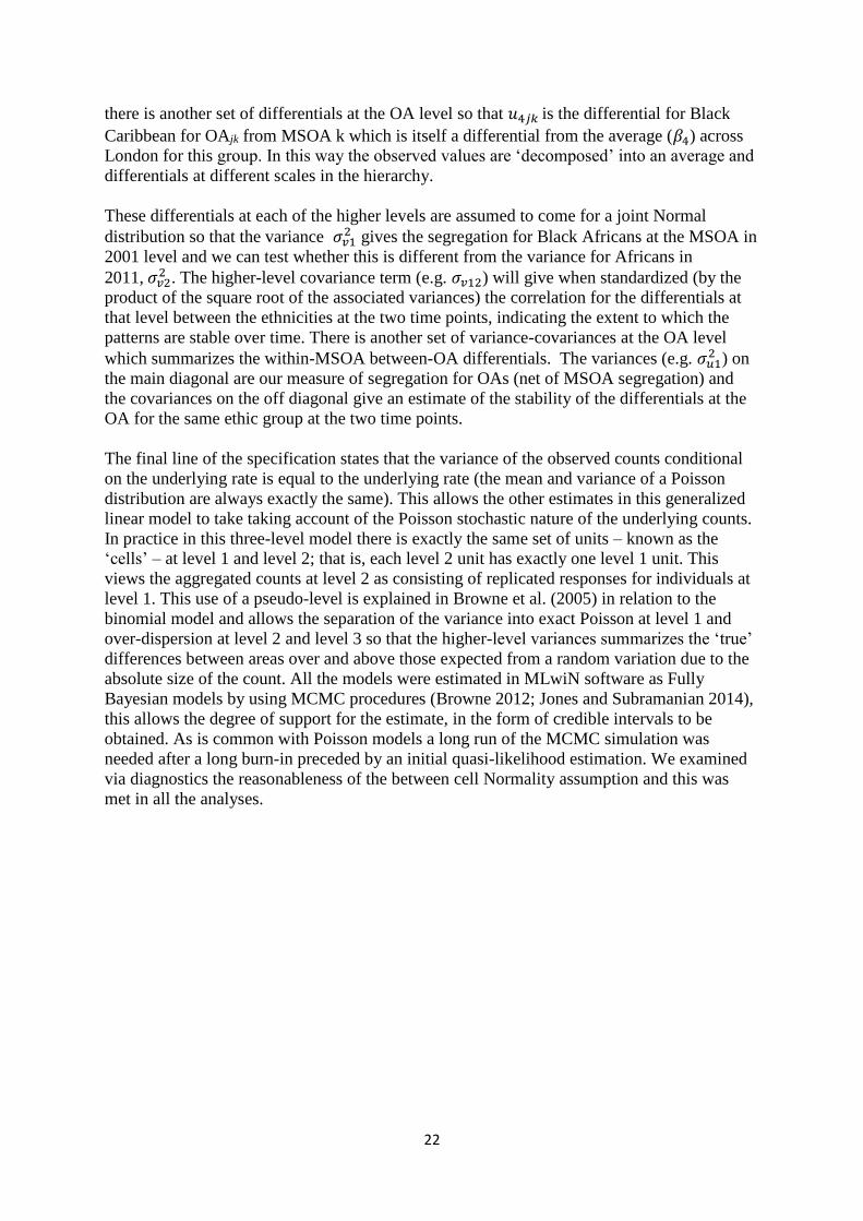
22
there is another set of differentials at the OA level so that 𝑢4𝑗𝑘is the differential for Black
Caribbean for OAjk from MSOA k which is itself a differential from the average (𝛽4) across
London for this group. In this way the observed values are ‘decomposed’ into an average and
differentials at different scales in the hierarchy.
These differentials at each of the higher levels are assumed to come for a joint Normal
distribution so that the variance 𝜎𝑣12 gives the segregation for Black Africans at the MSOA in
2001 level and we can test whether this is different from the variance for Africans in
2011,𝜎𝑣22 . The higher-level covariance term (e.g. 𝜎𝑣12) will give when standardized (by the
product of the square root of the associated variances) the correlation for the differentials at
that level between the ethnicities at the two time points, indicating the extent to which the
patterns are stable over time. There is another set of variance-covariances at the OA level
which summarizes the within-MSOA between-OA differentials. The variances (e.g. 𝜎𝑢12 ) on
the main diagonal are our measure of segregation for OAs (net of MSOA segregation) and
the covariances on the off diagonal give an estimate of the stability of the differentials at the
OA for the same ethic group at the two time points.
The final line of the specification states that the variance of the observed counts conditional
on the underlying rate is equal to the underlying rate (the mean and variance of a Poisson
distribution are always exactly the same). This allows the other estimates in this generalized
linear model to take taking account of the Poisson stochastic nature of the underlying counts.
In practice in this three-level model there is exactly the same set of units – known as the
‘cells’ – at level 1 and level 2; that is, each level 2 unit has exactly one level 1 unit. This
views the aggregated counts at level 2 as consisting of replicated responses for individuals at
level 1. This use of a pseudo-level is explained in Browne et al. (2005) in relation to the
binomial model and allows the separation of the variance into exact Poisson at level 1 and
over-dispersion at level 2 and level 3 so that the higher-level variances summarizes the ‘true’
differences between areas over and above those expected from a random variation due to the
absolute size of the count. All the models were estimated in MLwiN software as Fully
Bayesian models by using MCMC procedures (Browne 2012; Jones and Subramanian 2014),
this allows the degree of support for the estimate, in the form of credible intervals to be
obtained. As is common with Poisson models a long run of the MCMC simulation was
needed after a long burn-in preceded by an initial quasi-likelihood estimation. We examined
via diagnostics the reasonableness of the between cell Normality assumption and this was
met in all the analyses.

23
Table 1. London’s changing ethnic population, 2001-2011.
Group 2001 2011 Group 2001 2011
Bangladeshi 153,841 222,127 Black African 378,924 573,931
Indian 437,084 542,857 Black Caribbean 343,616 344,597
Pakistani 142,719 223,797 Black Other 60,311 170,112
Chinese 80,124 124,250
Mixed 226,282 405,279 Asian Other 133,109 398,515
White 5,103,176 4,887,435 Other 112,812 281,041.
TOTAL 7,171,998 8,173,941

24
Table 2. The MRR values, with associated Low and High CIs,
for each ethnic group, at each scale, at each date
2001 2011
LowCI MRR HighCI LowCI MRR HighCI
Bangladeshi
Borough 3.48 4.99 7.85 2.81 3.80 5.57
MSOA 2.24 2.36 2.51 1.98 2.06 2.17
OA 5.88 6.09 6.33 3.49 3.57 3.65
Pakistani
Borough 2.45 3.17 4.40 2.35 3.01 4.10
MSOA 2.00 2.08 2.17 1.86 1.92 1.99
OA 3.27 3.35 3.43 2.37 2.41 2.45
Indian
Borough 1.91 2.29 2.89 1.88 2.26 2.82
MSOA 1.76 1.81 1.87 1.72 1.76 1.81
OA 1.88 1.90 1.92 1.77 1.78 1.80
Chinese
Borough 1.51 1.71 1.99 1.40 1.55 1.76
MSOA 1.60 1.65 1.71 1.57 1.61 1.66
OA 3.14 3.21 3.28 2.15 2.18 2.20
Black African
Borough 2.07 2.55 3.02 1.71 2.01 2.47
MSOA 1.87 1.93 1.99 1.91 1.97 2.04
OA 2.04 2.06 2.08 1.91 1.93 1.95
Black Caribbean
Borough 2.14 2.67 3.52 1.93 2.34 2.98
MSOA 1.80 1.85 1.91 1.74 1.79 1.84
OA 1.69 1.71 1.72 1.70 1.71 1.73
Black Other
Borough 2.38 3.07 4.20 1.97 2.41 3.08
MSOA 2.01 2.09 2.18 1.82 1.87 1.93
OA 2.87 2.94 3.01 1.94 1.96 1.98
Asian Other
Borough 1.80 2.13 2.64 1.55 1.76 2.07
MSOA 1.69 1.74 1.79 1.49 1.52 1.55
OA 2.35 2.39 2.42 1.67 1.68 1.69
Mixed
Borough 1.33 1.44 1.60 1.27 1.36 1.49
MSOA 1.27 1.28 1.30 1.24 1.26 1.27
OA 1.64 1.65 1.66 1.51 1.51 1.53
Other
Borough 1.83 2.18 2.71 1.68 1.95 2.34
MSOA 1.52 1.56 1.60 1.40 1.42 1.47
OA 2.29 2.32 2.36 1.71 1.72 1.73
White
Borough 1.18 1.24 1.31 1.24 1.31 1.42
MSOA 1.23 1.24 1.25 1.31 1.33 1.35
OA 1.14 1.15 1.16 1.19 1.20 1.20

25
Table 3. The MRR values, with associated Low and High CIs at each scale,
for each ethnic group, at each scale and date.
Borough Scale 2001 2011
LowCI MRR HighCI LowCI MRR HighCI
Bangladeshi 3.48 4.99 7.85 2.81 3.80 5.57
Pakistani 2.45 3.17 4.40 2.35 3.01 4.10
Black Other 2.38 3.07 4.20 1.97 2.41 3.08
Black Caribbean 2.14 2.67 3.52 1.93 2.34 2.98
Black African 2.07 2.55 3.02 1.71 2.01 2.47
Indian 1.91 2.29 2.89 1.88 2.26 2.82
Other 1.83 2.18 2.71 1.68 1.95 2.34
Asian Other 1.80 2.13 2.64 1.55 1.76 2.07
Chinese 1.51 1.71 1.99 1.40 1.55 1.76
Mixed 1.33 1.44 1.60 1.27 1.36 1.49
White 1.18 1.24 1.31 1.24 1.31 1.42
MSOA Scale 2001 2011
LowCI MRR HighCI LowCI MRR HighCI
Bangladeshi 2.24 2.36 2.51 1.98 2.06 2.17
Black Other 2.01 2.09 2.18 1.82 1.87 1.93
Pakistani 2.00 2.08 2.17 1.86 1.92 1.99
Black African 1.87 1.93 1.99 1.91 1.97 2.04
Black Caribbean 1.80 1.85 1.91 1.74 1.79 1.84
Indian 1.76 1.81 1.87 1.72 1.76 1.81
Asian Other 1.69 1.74 1.79 1.49 1.52 1.55
Chinese 1.60 1.65 1.71 1.57 1.61 1.66
Other 1.52 1.56 1.60 1.40 1.42 1.47
Mixed 1.27 1.28 1.30 1.24 1.26 1.27
White 1.23 1.24 1.25 1.31 1.33 1.35
OA Scale 2001 2011
LowCI MRR HighCI LowCI MRR HighCI
Bangladeshi 5.88 6.09 6.33 3.49 3.57 3.65
Pakistani 3.27 3.35 3.43 2.37 2.41 2.45
Chinese 3.14 3.21 3.28 2.15 2.18 2.20
Black Other 2.87 2.94 3.01 1.94 1.96 1.98
Asian Other 2.35 2.39 2.42 1.67 1.68 1.69
Other 2.29 2.32 2.36 1.71 1.72 1.73
Black African 2.04 2.06 2.08 1.91 1.93 1.95
Indian 1.88 1.90 1.92 1.77 1.78 1.80
Black Caribbean 1.69 1.71 1.72 1.70 1.71 1.73
Mixed 1.64 1.65 1.66 1.51 1.51 1.53
White 1.14 1.15 1.16 1.19 1.20 1.20
In the left-hand columns, for each of the spatial scales MRR values that are significantly
different from those immediately below them in the table are underlined. In the right-hand
columns those MRR values significantly smaller than the comparable ones in the left-hand
columns are in bold, whereas those significantly larger are in italics.

26
Table 4. The correlations between distributions for 2001 and 2011
for each ethnic group sorted at each scale
Borough MSOA OA
Group Corr Group Corr Group Corr
Black Caribbean 0.93 White 0.96 White 0.98
Black Other 0.92 Black Caribbean 0.94 Black Caribbean 0.80
White 0.91 Indian 0.92 Indian 0.71
Mixed 0.90 Black African 0.92 Black African 0.68
Pakistani 0.89 Black Other 0.91 Chinese 0.52
Asian Other 0.88 Pakistani 0.89 Pakistani 0.51
Indian 0.88 Chinese 0.89 Bangladeshi 0.50
Other 0.83 Bangladeshi 0.87 Mixed 0.41
Chinese 0.83 Mixed 0.84 Black Other 0.38
Black African 0.83 Asian Other 0.83 Asian Other 0.36
Bangladeshi 0.76 Other 0.66 Other 0.21

27
Figure 1. The modelling structure illustrated
(a) (b)
)
(a)
(c)
)
(a)
Borough (A)
Borough (B) MSOAs
Borough (A)
Borough (B)
Borough (B)
Borough (A)
London London London
Borough (A) MSOAs
Borough (B)

28
Figure 2. The MMR values for each ethnic group at each scale, 2001. (The divisions on
Cohen’s scale are shown as dashed lines.)