Embed Size (px)
Citation preview
Athens Journal of Architecture January 2015
9
John Nolen and Raymond Unwin:
Garden City Collaborators
By Michael O’Brien
The English Garden City Movement, advocated by Ebenezer Howard
and the associated town designs by Raymond Unwin were some of
the earliest reactions to the environmental degradation and
placelessness of the European Industrial City circa 1900. John
Nolen (1869 - 1937) was one of the earliest American adopters of
the Garden City ideals. Over the course of his career, Nolen
designed fifty-five new towns and subdivisions across the United
States. Most of these plans had elements that were adapted from Sir
Raymond Unwin’s principles and spatial conditions to fit the unique
cultural landscape of the emerging American middle class. Place-
making was one of the central goals of the Garden City. Places, at
multiple scales, town, neighborhood, and street distinguished the
Garden City from the monotonous and chaotic landscape of most
cities. A unique characteristic of the planned communities and
subdivisions by Nolen is that they demonstrate the potential of
integrating landscape architecture, architecture and planning
principles to construct an underlying infrastructure of place-
anchors, to guide place-making during build-out phases, even when
build-out occurred decades later. Plans designed by Nolen’s firm
after 1920 characteristically included strong formal elements,
central greens, axial boulevards and a hierarchy of spatial
conditions extending from the town center to the thoughtful
termination of a residential street. These post-1920 plans showed
what I am calling “place anchors” that established landmarks at the
scale of neighborhood, district, and town. This paper will present a
comparative study of the “as designed” and “as built” conditions of
two projects designed in the early 1920’s and “built-out” in the
competitive post-depression economy of the late 1930’s. The
projects, in Mariemont, Ohio and at Windsor Farms, Virginia, are
the result of John Nolen’s unique transformation of Garden City
principles to fit the landscape of the emerging American suburb.
Raymond Unwin and Early Ideas on Place Making in Towns
Sir Raymond Unwin, a leader in the Planning and Garden City movements
described a number of design-related planning considerations on the subject of
Professor, Texas A&M University, USA.
Vol. 1, No. 1 O’Brien: John Nolen and Raymond Unwin: Garden City Collaborators
10
place making in his 1909 book, Town Planning in Practice.1 “Much of the
picturesqueness of old Gothic towns springs from the narrowness of the streets.
Not only does this narrowness give the sense of completeness and enclosure to
the pictures in the streets themselves, but also it is much easier with such
narrow streets to produce the effect of enclosure in a place into which they may
lead. Where roads are wide and bounded by small buildings, the definite street
effect is apt to be lost altogether, the relation between the two sides is not
sufficiently grasped, and on such roads some quite different effects may need
to be worked out, if they are to be successful.”2
“We have seen in speaking of places and squares how important to the
effect is a sense of enclosure, the completion of the frame of buildings; and
much the same applies to street pictures.”3
These quotes and further citations from Unwin confirm that he was
learning from Camillio Sitte’s “City Planning According to Artistic
Principles”, (Unwin, 1909) and clearly recognized the necessity for design of
the spatial enclosure and sequence of release into urban places.4 Place, in his
examples is represented by abrupt enlargements of the space formed by the
street such that it is possible to perceive that one is not in a linear space
suggestive of motion, but in a space proportioned more equally in its length
and width to suggest pause. Unwin specifically illustrated the planning
principles underpinning these picturesque streets in “Town Planning In
Practice,” Chapter Nine “Of Plots and the Placing of Buildings.”5 Unwin
illustrates in plan and perspective, the effect of manipulating the location and
orientation of buildings relative to adjacent buildings and the street. Unwin’s
examples addressed three general conditions:
1. Intersections.
2. Street space between intersections.
3. Visual control of sight lines on curving streets.
Unwin used plan diagrams and perspective sketches to illustrate various
ways of working with these conditions. He consistently sought to maintain the
uniformity of rooflines and the visual enclosure of the street by using building
mass to contain the street space and then releasing it in carefully considered
locations. This heightened the sense of street enclosure provided by the small,
detached houses and yields the maximum spatial impact. As a strategy to
further enhance the spatial definition of the street, Unwin emphasized using the
group house, or attached type of row house, to overcome the space-defining
limitations of small single-family detached houses. As he put it, “In residential
districts one of the greatest difficulties to be contended with is the constant
1Unwin, Sir Raymond, “Town Planning in Practice: An Introduction to the Art of Designing
Cities and Suburbs” Charles Scribner & Sons, New York, 1909. 2Ibid p. 245.
3Ibid p. 245.
4Ibid p. 215.
5Ibid p. 319.
Athens Journal of Architecture January 2015
11
multiplication of buildings too small in scale to produce individually an effect
on the road, and every opportunity should be taken to group buildings so that
units may be produced of larger scale.”6 “Even where it is not possible to avoid
much repetition of semidetached or detached houses, they should be arranged
to give some sense of grouping.”7
Unwin as both architect and planner saw a critical overlap between
planning, landscape architecture and the architecture professions. “...especially
where it is possible for the site planner to be in touch with the designer of the
buildings, much may be done to produce interest and variety in the street
pictures, while at the same time maintaining the general sense of unity which is
usually so wanting in modern suburban roads.”8 For Unwin the appropriate
allocation of areas for public use, road width, and control of land use was not
alone sufficient to make a town.
Buildings are the space-bounding elements in Unwin’s examples. In the
European model of the village, upon which Unwin based his principles, the
urban street was built to such a density that the streets are bounded by the
nearly-continuous walls of adjacent buildings. One may conclude that while
Unwin’s design goals for the carefully constructed picturesque were clearly a
source for the designs by John Nolen and his firm, a significant transformation
of design elements was necessary to apply these principles to the lower density
American suburb.
Place in the Plan: The Intersections
Beginning around 1920, the office of John Nolen began to employ a
unique overlay of formal/axial street patterns from the City Beautiful
movement and the informal, curvilinear street patterns of the Garden City
Movement. In the Nolen firms’ plans from 1920 to the firm’s dissolution in
1934, places are nested in a hierarchy to reveal successive layers of distinction.
"My corner” may be found in the larger ground, the “my school”
neighborhood, while both are figures in the yet larger ground of “my town.”
Intersections of major and minor streets are the primary place making
figures in these Nolen plans. The lots between the intersections play the role of
ground establishing a more dense spatial enclosure punctuated/articulated by
schools and parks acting as second layer of place-anchors and neighborhood
greens, “T”, “X”, “Y” and “+” intersections as a tertiary layer of place-anchors.
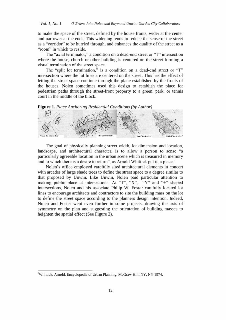
I have characterized these place-anchoring residential conditions as: (See
Figure. 1)
“Face the intersection” a condition where houses at “Y” or irregular “T”
intersections orient to the actual center of the intersection rather than
maintaining a parallel relationship to their streets.
“The street room,” a condition where houses at the end of a long straight
street have a smaller setback, forming a gateway or defined entrance to the
block. Houses along this street have setbacks that increase incrementally so as
6Ibid p. 350.
7Ibid p. 350.
8Ibid p. 351.
Vol. 1, No. 1 O’Brien: John Nolen and Raymond Unwin: Garden City Collaborators
12
to make the space of the street, defined by the house fronts, wider at the center
and narrower at the ends. This widening tends to reduce the sense of the street
as a “corridor” to be hurried through, and enhances the quality of the street as a
“room” in which to reside.
The “axial terminator,” a condition on a dead-end street or “T” intersection
where the house, church or other building is centered on the street forming a
visual termination of the street space.
The “split lot termination,” is a condition on a dead-end street or “T”
intersection where the lot lines are centered on the street. This has the effect of
letting the street space continue through the plane established by the fronts of
the houses. Nolen sometimes used this design to establish the place for
pedestrian paths through the street-front property to a green, park, or tennis
court in the middle of the block.
Figure 1. Place Anchoring Residential Conditions (by Author)
The goal of physically planning street width, lot dimension and location,
landscape, and architectural character, is to allow a person to sense “a
particularly agreeable location in the urban scene which is treasured in memory
and to which there is a desire to return”, as Arnold Whittick put it, a place.9
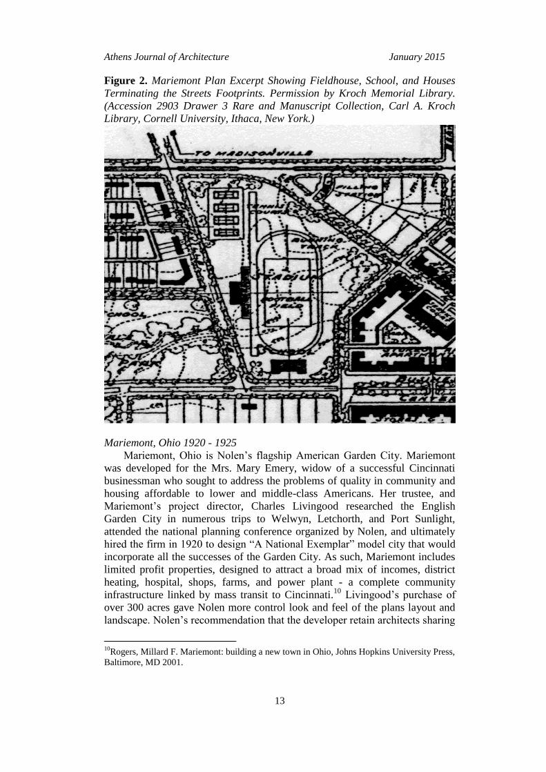
Nolen’s office employed carefully sited architectural elements in concert
with arcades of large shade trees to define the street space to a degree similar to
that proposed by Unwin. Like Unwin, Nolen paid particular attention to
making public place at intersections. At “T”, “X”, “Y” and “+” shaped
intersections, Nolen and his associate Philip W. Foster carefully located lot
lines to encourage architects and contractors to site the building mass on the lot
to define the street space according to the planners design intention. Indeed,
Nolen and Foster went even further in some projects, drawing the axis of
symmetry on the plan and suggesting the orientation of building masses to
heighten the spatial effect (See Figure 2).
9Whittick, Arnold, Encyclopedia of Urban Planning, McGraw Hill, NY, NY 1974.
Athens Journal of Architecture January 2015
13
Figure 2. Mariemont Plan Excerpt Showing Fieldhouse, School, and Houses
Terminating the Streets Footprints. Permission by Kroch Memorial Library.
(Accession 2903 Drawer 3 Rare and Manuscript Collection, Carl A. Kroch
Library, Cornell University, Ithaca, New York.)
Mariemont, Ohio 1920 - 1925
Mariemont, Ohio is Nolen’s flagship American Garden City. Mariemont
was developed for the Mrs. Mary Emery, widow of a successful Cincinnati
businessman who sought to address the problems of quality in community and
housing affordable to lower and middle-class Americans. Her trustee, and
Mariemont’s project director, Charles Livingood researched the English
Garden City in numerous trips to Welwyn, Letchorth, and Port Sunlight,
attended the national planning conference organized by Nolen, and ultimately
hired the firm in 1920 to design “A National Exemplar” model city that would
incorporate all the successes of the Garden City. As such, Mariemont includes
limited profit properties, designed to attract a broad mix of incomes, district
heating, hospital, shops, farms, and power plant - a complete community
infrastructure linked by mass transit to Cincinnati.10
Livingood’s purchase of
over 300 acres gave Nolen more control look and feel of the plans layout and
landscape. Nolen’s recommendation that the developer retain architects sharing
10
Rogers, Millard F. Mariemont: building a new town in Ohio, Johns Hopkins University Press,
Baltimore, MD 2001.
Vol. 1, No. 1 O’Brien: John Nolen and Raymond Unwin: Garden City Collaborators
14
similar design ideals contributed to furthering Nolen’s vision for Mariemont,
integrating plan, landscape and building during the initial design and build-out.
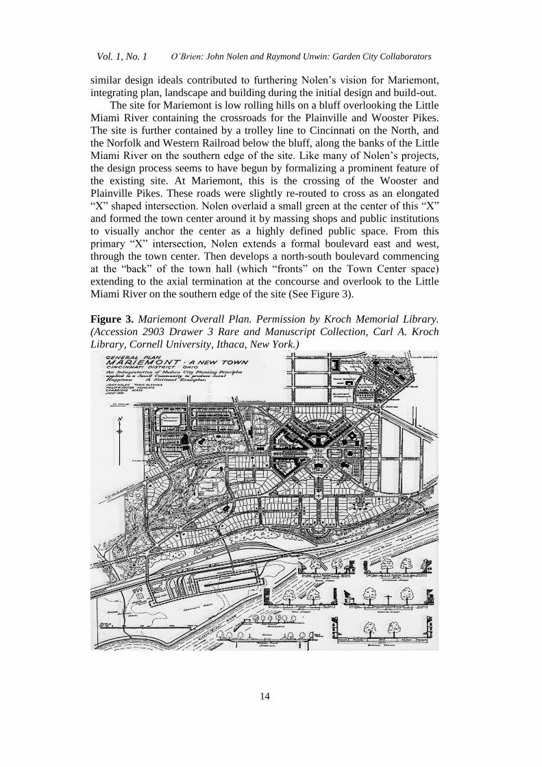
The site for Mariemont is low rolling hills on a bluff overlooking the Little
Miami River containing the crossroads for the Plainville and Wooster Pikes.
The site is further contained by a trolley line to Cincinnati on the North, and
the Norfolk and Western Railroad below the bluff, along the banks of the Little
Miami River on the southern edge of the site. Like many of Nolen’s projects,
the design process seems to have begun by formalizing a prominent feature of
the existing site. At Mariemont, this is the crossing of the Wooster and
Plainville Pikes. These roads were slightly re-routed to cross as an elongated
“X” shaped intersection. Nolen overlaid a small green at the center of this “X”
and formed the town center around it by massing shops and public institutions
to visually anchor the center as a highly defined public space. From this
primary “X” intersection, Nolen extends a formal boulevard east and west,
through the town center. Then develops a north-south boulevard commencing
at the “back” of the town hall (which “fronts” on the Town Center space)
extending to the axial termination at the concourse and overlook to the Little
Miami River on the southern edge of the site (See Figure 3).
Figure 3. Mariemont Overall Plan. Permission by Kroch Memorial Library.
(Accession 2903 Drawer 3 Rare and Manuscript Collection, Carl A. Kroch
Library, Cornell University, Ithaca, New York.)
Athens Journal of Architecture January 2015
15
The clearest examples of place-anchoring practices employed by Nolen
and Foster can be found on the drawings for Mariemont. At Mariemont,
Nolen’s high level of control over the selection and practices of the town
landscape architect, lead architect, and participating architects resulted in
commercial and institutional buildings constructed in close conformance to the
axial siting and space definition shown on Nolen’s plans for Mariemont’s town
center.11
The residential districts, built-out between 1925 and 1950, were not
constructed in as close-conformance with Nolen’s plans.
The plan for Mariemont skillfully combined curvilinear, diagonal, and grid
structures to prevent the endless open street vista, common to most grid-plan
cities. As Unwin demonstrated, the curvilinear street created vistas that were
always changing and limited to the length of the curve’s tangent from traffic
lane to the front of the buildings. Nolen was not able to replicate the building
massing that provided Unwin with fully bounded spatial “street pictures” and
so employed large shade trees to provide the primary spatial boundary of the
street. Houses at Mariemont provided a secondary spatial enclosure for street
and public spaces. As such, the centerline of the house or building, at key
places in the plan, would often be included on the drawings, and frequently
generalized building footprint would be shown. These hints were backed up by
design review guidelines at Mariemont that limited style, material, and site
location.
The July 1921 plan for Mariemont contained design intentions for 19 of
the 20 proposed residential street intersections. Aerial photography indicates,
and field-surveys confirm that only five of those intersections were fully
constructed as designed. These five, were simple spatial conditions, the
termination of a visual axis formed by the street, reinforced by mature shade
trees and completed by the prominent siting of a house to center the mass on
the centerline of the street. That these simple plan intentions were realized in
the decades of build-out following the plan design may be due to the close
association to normal builder practices, centering the house on the lot, used for
residential siting. Many of the remaining designed residential place-anchors
required more complex rotations of the house to orient the front of the house
towards the invisible center-point of irregularly shaped “Y” and “X”
intersections, a practice further from the norms of residential siting practiced
by builders.
The network of residential, commercial, and institutional place-anchors
designed by Nolen is sufficiently dense as if to suggest it is scaled to the
pedestrian journey. Visual connections between places and the changes in
spatial scale between lane, street, road, and boulevard seem more oriented to
the person on foot, than the person in a car. The car would seem to suggest
longer distances between places as it takes less time to traverse. A person’s
short-term memory or journey-memory capacity seems to be fixed. If we travel
11
Venice, Nokomis, Clewiston Florida and Windsor Farms, Virginia seem to
share this structure.
Vol. 1, No. 1 O’Brien: John Nolen and Raymond Unwin: Garden City Collaborators
16
on foot, the landmarks need to be closer together to allow us to judge our
position on the journey. If we travel by car, the landmarks could be farther
apart but still fall within the time we hold landmarks in our journey-memory.
One of the ways I propose that we judge the richness of a town or city is in the
places per mile (PPM). The ubiquitous commercial strip we encounter so
frequently today may be perceived as placeless because the visual competition
by each store/mall to be a landmark dulls our ability to perceive any landmark
places, this combined with the car-scaled eight-lane roads and thousand-car
parking lots, reduces our perceived places per mile.
Old Town Alexandria, Boston, Wrigleyville in Chicago or most every city
developed before the automobile was dominant, like Mariemont, offers a
sufficient density of places-per-mile traveled that many people perceive these
towns as pedestrian-scaled.12
In the Virginia and Florida projects that followed Mariemont, Nolen and
Foster had less institutional control over residential siting and planting, but did
possess control over the space of the intersections and the termination of visual
axes through careful design and layout of the lot lines.
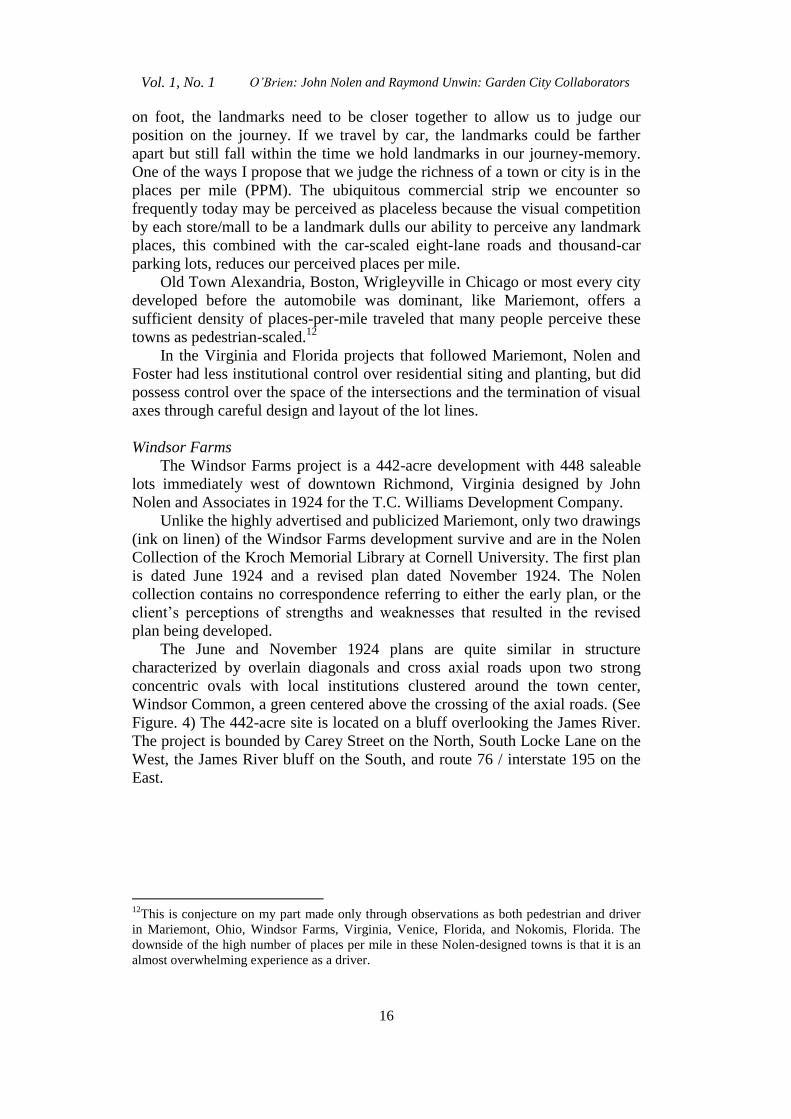
Windsor Farms
The Windsor Farms project is a 442-acre development with 448 saleable
lots immediately west of downtown Richmond, Virginia designed by John
Nolen and Associates in 1924 for the T.C. Williams Development Company.
Unlike the highly advertised and publicized Mariemont, only two drawings
(ink on linen) of the Windsor Farms development survive and are in the Nolen
Collection of the Kroch Memorial Library at Cornell University. The first plan
is dated June 1924 and a revised plan dated November 1924. The Nolen
collection contains no correspondence referring to either the early plan, or the
client’s perceptions of strengths and weaknesses that resulted in the revised
plan being developed.
The June and November 1924 plans are quite similar in structure
characterized by overlain diagonals and cross axial roads upon two strong
concentric ovals with local institutions clustered around the town center,
Windsor Common, a green centered above the crossing of the axial roads. (See
Figure. 4) The 442-acre site is located on a bluff overlooking the James River.
The project is bounded by Carey Street on the North, South Locke Lane on the
West, the James River bluff on the South, and route 76 / interstate 195 on the
East.
12
This is conjecture on my part made only through observations as both pedestrian and driver
in Mariemont, Ohio, Windsor Farms, Virginia, Venice, Florida, and Nokomis, Florida. The
downside of the high number of places per mile in these Nolen-designed towns is that it is an
almost overwhelming experience as a driver.
Athens Journal of Architecture January 2015
17
Figure 4. Windsor Farms Overall Plan. Permission by Kroch Memorial
Library. (Accession 2903 Drawer 3 Rare and Manuscript Collection, Carl A.
Kroch Library, Cornell University, Ithaca, New York.)
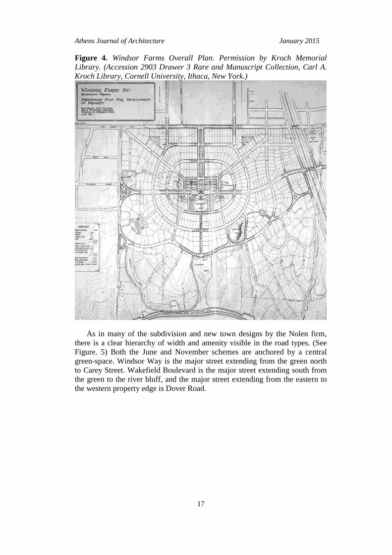
As in many of the subdivision and new town designs by the Nolen firm,
there is a clear hierarchy of width and amenity visible in the road types. (See
Figure. 5) Both the June and November schemes are anchored by a central
green-space. Windsor Way is the major street extending from the green north
to Carey Street. Wakefield Boulevard is the major street extending south from
the green to the river bluff, and the major street extending from the eastern to
the western property edge is Dover Road.
Vol. 1, No. 1 O’Brien: John Nolen and Raymond Unwin: Garden City Collaborators
18
Figure 5. Road Types Diagrams. Permission by Kroch Memorial Library.
(Accession 2903 Drawer 3 Rare and Manuscript Collection, Carl A. Kroch
Library, Cornell University, Ithaca, New York.)
Like Mariemont, it seems Windsor Farms is structured by Nolen’s formal
connection of the primary features of the site. Nolen connects Carey Street to
the James River bluffs by extending a north-south boulevard from Carey Street
to the green, Windsor Common. As at Mariemont, Nolen interrupts/terminates
the boulevard at the town center, Windsor Common and its surrounding public
buildings, then continuing the connection from the “back” of the green to the
river overlook with a formally landscaped street, Wakefield boulevard. Also
similar to Mariemont, an east-west cross axis is developed along the back edge
of the green. Two concentric oval roads overlay the cross axis and substantially
fill out the site.
Landmarks as Place-Anchors:
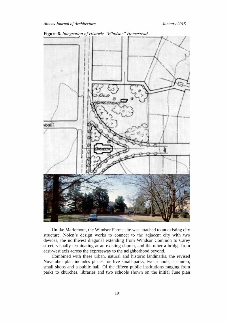
The site for Windsor Farms has one primary natural feature, the James
River bluff, two historic features, Windsor, the original homestead of Martha
Washington’s nephew, William Dandridge, and an earthworks constructed to
house a cannon battery during the Civil War. Nolen further employs these
historic features of the site, centering Calycanthus street on the reconstructed
“Windsor” homestead, honoring it as a termination of a visual axis, (See
Figure. 6) and terminating the minor southeast diagonal street at the battery-
park.
Athens Journal of Architecture January 2015
19
Figure 6. Integration of Historic “Windsor” Homestead
Unlike Mariemont, the Windsor Farms site was attached to an existing city
structure. Nolen’s design works to connect to the adjacent city with two
devices, the northwest diagonal extending from Windsor Common to Carey
street, visually terminating at an existing church, and the other a bridge from
east-west axis across the expressway to the neighborhood beyond.
Combined with these urban, natural and historic landmarks, the revised
November plan includes places for five small parks, two schools, a church,
small shops and a public hall. Of the fifteen public institutions ranging from
parks to churches, libraries and two schools shown on the initial June plan
Vol. 1, No. 1 O’Brien: John Nolen and Raymond Unwin: Garden City Collaborators
20
while only nine are included in the revised November plan. In both plans, these
public institutions are generally treated as landmarks and visual terminations of
axis. Unlike Mariemont, Nolen’s drawings for Windsor Farms show no
indication of siting orientation or massing for housing.
Suggestions to Future Builders Unknown:
Unlike his role at Mariemont, Nolen had little control over the
programming and initial build-out at Windsor Farms. He expressed this
concern to the developer T.C. Williams directly and indirectly to Henry Morse,
a New Jersey Architect working on the house for T.C. Williams at Windsor
Farms. In a letter to Henry Morse Nolen expressed concern for the architectural
progress of the development as a whole. He complimented Morse on his work
for Williams and sent him a brochure on Mariemont, citing it as an example of
following through on the character of the plan (Nolen, 1926) Nolen was
perhaps hoping Morse would advocate a controlled approach to style and
design in Windsor Farms in the course of his conversations with T.C. Williams
about the house.13
Perhaps Nolen’s concern for architectural follow-through is
behind the level of detail included for proposed buildings shown on the plan.
At Windsor Farms’ central space, a solid block identified as “stores” on
the western side, “hall” in the center and “shops” on the eastern side receive
and terminate the Windsor Way visual axis along the southern edge of Windsor
Common. The center of this block, labeled as “hall” has a recess, roughly as
wide as the Windsor Way Boulevard. This recess is the planner/landscape
architect’s suggestion to the future architect and builder that the massing of the
"hall" should receive Windsor Way with a massing recess. The stores and
shops adjacent to the central hall are wrapped slightly around the corners of the
southeast and southwest diagonal roads. This is another suggestion from
planner to, future architect/builder, as a reminder that the role of the corner is
to compress the space, acting as a frame for the release to Windsor Common
itself.
Neighborhood centers such as this were frequently proposed by Nolen’s
office, but were less frequently constructed. This may be due to a
misunderstanding between the developers expectation, i.e. Nolen will lay out
streets and lots for residential neighborhoods, and Nolen’s expectation, i.e.
“this developer retained my firm to plan a neighborhood that will offer
residents ready access to shops for daily needs, schools and churches.”
Mariemont has the strongest example of a constructed neighborhood center,
while the many such centers shown on the various drawings for Kingsport
Tennessee and Nokomis, Florida failed to materialize. At Windsor Farms even
the significant reduction of the neighborhood center between the June and
November plans was not enough to insure its construction (Nolen 1922).
13
Letter from John Nolen to Henry Morse dated April 20, 1926. (Accession 2903 Box 66,
Windsor Farms File, Rare and Manuscript Collection, Carl A. Kroch Library, Cornell
University, Ithaca, New York.)
Athens Journal of Architecture January 2015
21
Street Hierarchy
Even given the loss of the neighborhood center during the build out phase
the hierarchy of street rights-of-way closely corresponded to the widths and
landscape densities shown on the November plan. Windsor Way, the boulevard
connecting Windsor Common in the center of the plan to Carey Street to the
North is the widest street in the plan. The right-of-way for Windsor Way is one
hundred and forty feet in width making it the widest in the development. Next
widest is Dover road, the major east-west street, at eighty feet wide. Wakefield
Road, falling on the central North-South axis and connecting the central ring
road, Oxford Circle with the outermost ring road (variously Berkshire,
Sulgrave, and Cantebury Roads) is also eighty feet in width. The major
diagonal roads, Coventry and Exeter both have a sixty-foot right-of-way, while
the minor diagonals, Avon and Hathaway, are a fifty-foot right-of-way. The
smallest right-of-way, forty feet, belongs to Clovelly Road, Long Lane, and St.
David’s Lane.
The preservation of the street rights-of-way hierarchy, and close
conformance to the landscape massing as shown on the revised November plan
substantially preserve the spatial qualities of containment and release that
appear to have been Nolen’s primary intention.
Build-Out
The later “build-out” phases for Nolen and Foster’s Mariemont, Ohio
project overlaps the Windsor Farms project by three years or so. As was often
the case design of the individual lots and control of building placement on the
lots was a primary method for assuring that the “build-out” phase of the project
would be consistent with the planned spatial character of streets. Nolen
understood the primary role streets play in establishing the character of a place
having frequently criticized the grid plan city for its endless vistas and inherent
impersonal quality.
No guidance or limitations for residential siting appear on the drawings for
Windsor Farms, in fact no drawings dated after November 1922 are to be found
in the Nolen archives (Nolen 1922) There are references in the correspondence
files to additional design work undertaken by associate Phillip Foster from the
Jacksonville office, however, the Nolen archives do not include them.
Without explicit indications on the drawings, the more subtle and complex
spatial conditions (inspired by Unwin) found at Mariemont are not to be found
in great quantity at Windsor Farms. Perhaps the clearest residential place-
anchor to be found in Windsor Farms lies at the intersection of Gun Club Road
and Tomacee Street. Like those intended place-anchors that were realized
during the build-out decades at Mariemont, this place condition is the simple
termination of the Tomacee street axis at Gun Club road. Here, Nolen, or
perhaps Foster adjusted lot dimensions to insure that a lot centerline would
correspond with the street centerline, combined with the normal builder
practice to center a house on its lot, a thoughtful termination of the axis occurs,
without design controls and without a suggestion of massing on the plans.
Vol. 1, No. 1 O’Brien: John Nolen and Raymond Unwin: Garden City Collaborators
22
Another fragment of success lies at the intersection of Berkshire Road, the
middle concentric oval road and Coventry Street, the major Northwest diagonal
street connecting Windsor Common to the existing church on Carey Street. At
the corner intersection between Berkshire and Coventry, two of the houses are
rotated so that the center of their “face” is oriented to the invisible centerpoint
of the intersection. Again, the drawings show no indication of a suggestion for
residential massing or orientation and one can only speculate that the
combination of lot shape, and Foster’s site supervision may have resulted in
this partial emphasis made on this important intersection.
Conclusion, the Importance of Place-Anchors
John Nolen’s planned communities went through a key metamorphosis
between early 1910 and 1921 adding layers of spatial intention to the already
topographically sensitive schemes produced by the firm. The spatial intentions,
imported from Unwin (Unwin, 1909) and transformed for the decreased spatial
density of the suburb, was implemented primarily through control of street
width and careful attention to landscape - particularly the street trees. The
spatial intent was aimed at developing a hierarchy of “places” to counteract the
pervasive “placeless” grid-planned neighborhoods common in developing
American cities. The place hierarchy began with a community center having
boulevards, open spaces, and community buildings that were at a much larger
scale than the surrounding residential community. The second order in this
hierarchy was the distribution of public greens and parks along major streets.
The third order was the neighborhood place, a prominently sited house at the
end of a street, or a sequential enlargement of the street setback to make a
broader room on the narrow street, or the re-orienting of the houses away from
the orthogonal intersection towards a diagonal orientation to the center of the
intersection. These third order places were the most difficult to achieve for
Nolen, as they would have required a level of property control that may have
been perceived as restrictive to the point of reducing lot sales.
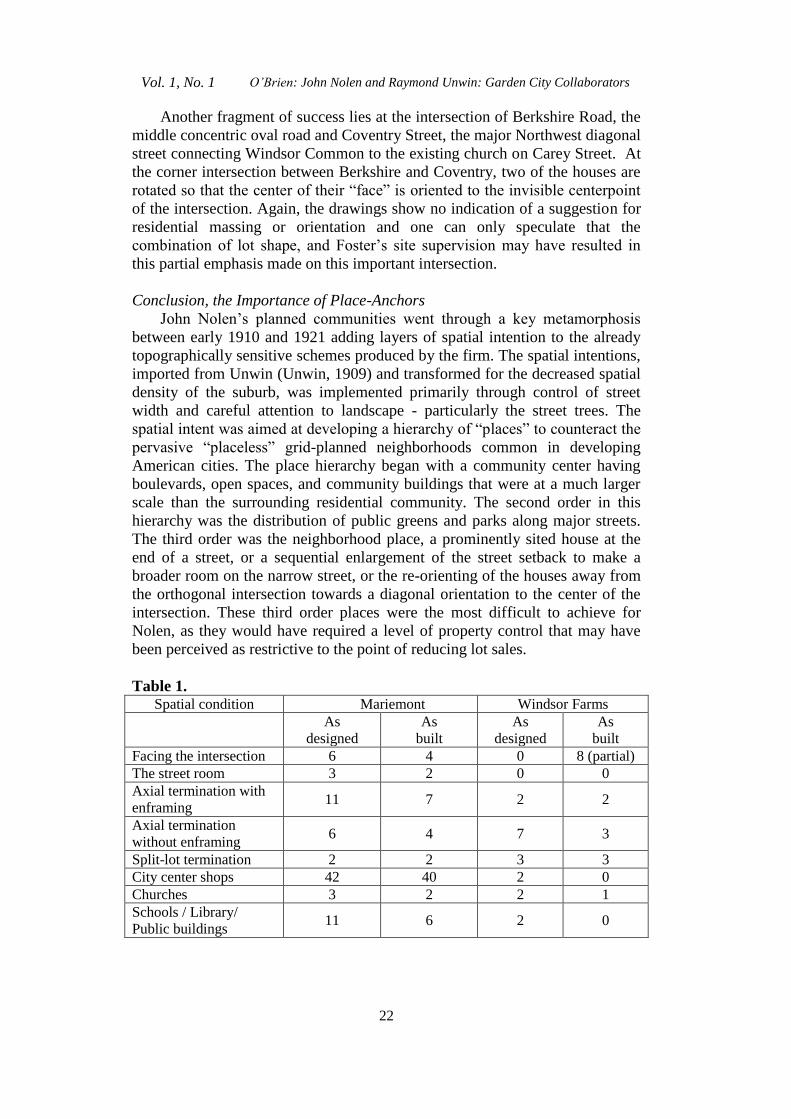
Table 1. Spatial condition Mariemont Windsor Farms
As
designed
As
built
As
designed
As
built
Facing the intersection 6 4 0 8 (partial)
The street room 3 2 0 0
Axial termination with
enframing 11 7 2 2
Axial termination
without enframing 6 4 7 3
Split-lot termination 2 2 3 3
City center shops 42 40 2 0
Churches 3 2 2 1
Schools / Library/
Public buildings 11 6 2 0
Athens Journal of Architecture January 2015
23
Overall, Mariemont has a stronger correspondence between the number of
the Unwin-inspired spatial elements in the “as-designed” and “as-built”
conditions of the plan than does Windsor Farms. This higher fidelity of the
buildout to the design is likely related to the buildout occurring closer to the
time of Nolen’s involvement in Mariemont, and the financial difficulties
surrounding the latter 1920’s and 1930’s buildout of Windsor Farms.
It must be said that Mary Emery’s vision of “A National Exemplar”
(Rogers, 2001) was a key factor in the rapid buildout of Mariemont. The
attention to detail executed by Ms. Emery’s project manager, Charles
Livingood, in quickly retaining a number of architects who’s body of work was
consistent with the English Village aesthetic is an indicator of the desire to
follow through on original design intentions. This is contrasted by Windsor
Farms developer T.C. Williams investing very little in following through on
Nolen’s village intentions.
Clarence Perry (Perry, 1929) and Clarence Stein both grasped this need for
anchoring new developments with public buildings as evidenced in their
independent formulations of the “neighborhood unit” in 1929. Perry went so
far as to call the school “the neighborhood capitol” deserving of a dignified
site.14
Progressive era planners such as John Nolen rarely held full control over
the subdivision, village or new town they were designing. In Nolen’s case,
elements of the plan were frequently omitted during the “build-out” phase of
the project. The omitted elements were typically public in nature, open space
preserves, small greens, golf courses, neighborhood commercial centers and
civic centers. One might speculate that the developers of these subdivisions,
villages and new towns were less concerned with these land uses and more
concerned with saleable residential lots. Yet Nolen and his associates
understood that neighborhoods needed anchors and persisted in designing plans
around them. Even with these losses, these towns and subdivisions remain
highly desirable places to live. This may be due to the clarity of structure, clear
hierarchy of streets, with strong lines of enclosure from the now-mature
landscape elements that combine to present a place rich in detail – having a
presence of many smaller places within a larger place. Andres Duany, (Unwin,
1909) in the Preface to the reprinting of Town Planning in Practice states “The
communities that stand today as the result of its prescriptions are still
successful in all the ways that matter. This can be said of Letchworth,
Hampstead, and Welwyn in England and of Yorkship and Mariemont in the
United States. These are all robust survivors having withstood the degradation
of modernist Planning from the reductive diagrams of social-democratic
Europe to the wholesale abdication of principle before North American ‘market
forces.” Duany continues, speaking of Mariemont and its promise.
“Mariemont, designed in 1926, is the only civic community within the
featureless sprawl that surrounds Cincinnati, Ohio. As testimony that suburbia
14
Perry, Clarence A. “Neighborhood and Community Planning” Volume VII Regional Plan of
New York and it’s environs, 1929, Committee on The Regional Plan of New York and its
environs, NY, NY p. 17.
Vol. 1, No. 1 O’Brien: John Nolen and Raymond Unwin: Garden City Collaborators
24
could have been otherwise, this new town elegantly accommodates both the
pedestrian and the modern complement of automobiles.”
References
Unwin, Sir Raymond, “Town Planning in Practice: An Introduction to the Art of
Designing Cities and Suburbs” Charles Scribner & Sons, New York, 1909.
Whittick, Arnold, Encyclopedia of Urban Planning, McGraw Hill, NY, NY 1974.
Rogers, Millard F. Mariemont: building a new town in Ohio, Johns Hopkins
University Press, Baltimore, MD 2001.
Perry, Clarence A. “Neighborhood and Community Planning” Volume VII Regional
Plan of New York and its environs, 1929.
Nolen, John. Accession 2903 drawer 3 Rare and Manuscript Collection, Carl A. Kroch
Library, Cornell University, Ithaca, New York, 1922.
Letter from John Nolen to Henry Morse dated April 20, 1926. (Accession 2903 Box
66, Windsor Farms File, Rare and Manuscript Collection, Carl A. Kroch Library,
Cornell University, Ithaca, New York.)
Road types diagrams. Permission by Kroch Memorial Library. (Accession 2903
drawer 3 Rare and Manuscript Collection, Carl A. Kroch Library, Cornell
University, Ithaca, New York.)