Embed Size (px)
Citation preview

Volume III:CommunityPlans
Joelton
Adopted June 22, 2015Amended August 24, 2017
A General Plan for Nashville & Davidson County

III - J - 2 ADOPTED AUGUST 24, 2017 JOELTON
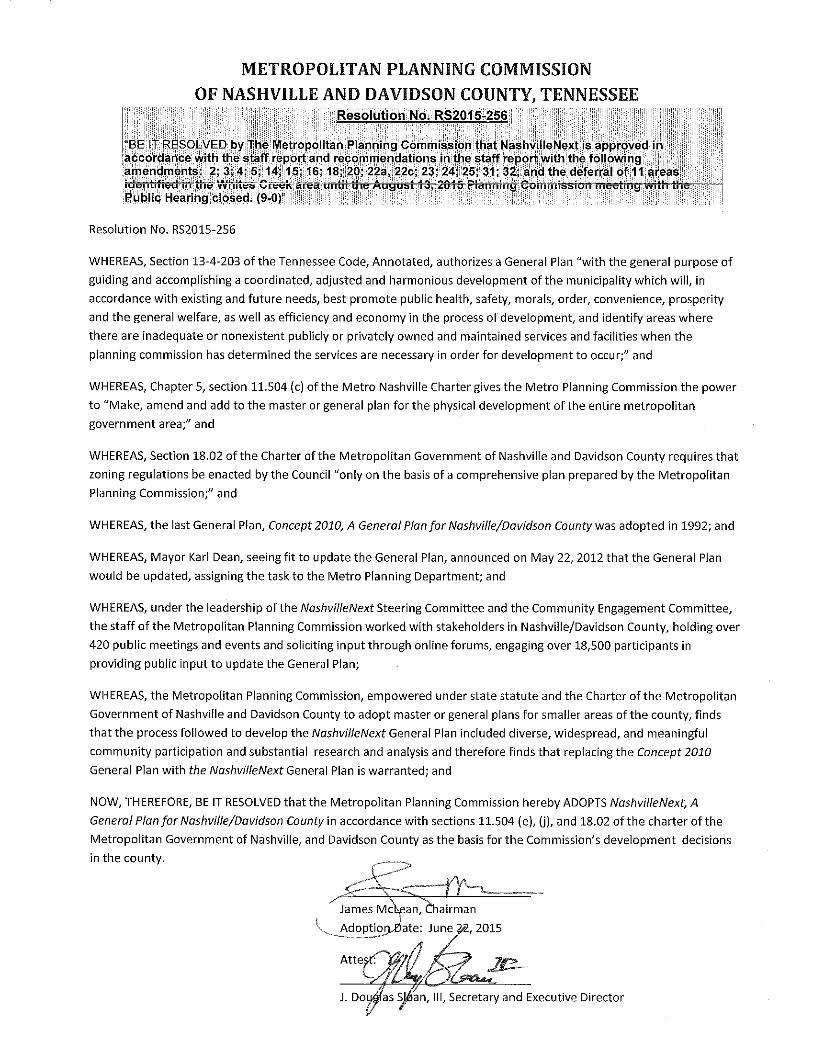
JOELTON ADOPTED AUGUST 24, 2017 III - J - 3

III - J - 4 ADOPTED AUGUST 24, 2017 JOELTON
I Vision, Trends, & StrategyVolume I presents the role and powers of the plan, key trends and issues that the plan addresses, a summary of the plan’s strategy and approach to the future, and implementation goals and policies.
II Elements• Land Use, Transportation & Infrastructure
• Arts, Culture & Creativity
• Economic & Workforce Development
• Education & Youth
• Health, Livability & the Built Environment
• Housing
• Natural Resources & Hazard Adaptation
III Communities Nashville’s Community Plans provide history and context for Nashville’s 14 Community Planning Areas, along with community-specific issues, strategies, and sketches of how different places in the community could change over time. Detailed Community Character Maps link the broad, county-wide Growth Concept Map to character policies that guide zoning and development decisions.
Community Character ManualThe Community Character Manual provides detailed explanations of the character policies used in the Community Character Maps.Community Plan Areas: Antioch-Priest LakeBellevueBordeaux-Whites CreekDonelson-Hermitage-Old HickoryDowntownEast NashvilleGreen Hills-Midtown
JoeltonMadisonNorth NashvilleParkwood-Union HillSouth NashvilleSoutheastWest Nashville
IV ActionsSpecific tasks for Metro departments and partners to undertake, within a recommended timeframe.
V Access Nashville 2040Volume V is the overarching vision of how transportation works under NashvilleNext.
THE NASHVILLENEXT PLANEach part of the plan has a role to play. Some parts are broad and visionary, while others are specific and detailed. This section helps users of the plan understand how the parts fit together and support one another. No part of the plan is intended to stand alone; each can only be understood as working together with the rest of the plan.
Marrowbone Lake Dam

JOELTON ADOPTED AUGUST 24, 2017 III - J - 5
Contents
Community Profile 7
History Highlights 8
Role in the County and Region 8
Growth & Preservation Concept Map and the Community’s Role 9
The Transect 15
Community Character Policy Plan 16
Supplemental Policies 17
How to use the Community Character Policies 19
Community Character Policies 20
Enhancements to the Open Space Network 24
Enhancements to the Transportation Network 25
JOELTON
What is a Community Plan?
NashvilleNext, the long-range plan for growth, development, and preservation in Nashville/Davidson County through 2040, provides a high-level, countywide view of how Nashville manages growth and preservation to improve the quality of life for residents and to promote prosperity. The Growth & Preservation Concept Map illustrates the vision.
A Community Plan is the key planning policy guide for decision-making regarding a community’s future built and natural environments. There are 14 Community Plans covering Nashville/Davidson County. Each plan is prepared by the Planning Department staff in cooperation with residents, business owners, property owners, institutional representatives, and development professionals. The Community Plans explain each community’s role in NashvilleNext’s vision and apply Community Character Policies to every property in Davidson County to implement that vision through land use decisions such as zone changes and subdivision requests.
Each Community Plan is adopted by the Planning Commission and describes the role the community plays in realizing the overall vision of the County. The Community Character Policies are guided by the Community Character Manual (CCM), a countywide document which provides direction, in alignment with NashvilleNext for zoning and development decisions.
For the most current information on the Community Character Manual and the Community Plans: www.nashville.gov/Planning-Department/Community-Planning-Design.aspx

III - J - 6 ADOPTED AUGUST 24, 2017 JOELTON
History of the Planning Process
In 1988, the Planning Department began creating “community plans” as a means of fine-tuning the countywide general plan. These community plans examined specific issues and needs, and projected growth, development, and preservation in fourteen communities. The Joelton Community Plan was first adopted by the Planning Commission in 1992, after working with a Citizens Advisory Committee.
The Planning Commission adopted Joelton Plan’s first update in 1997 after several community workshops; the second plan update was adopted in 2003 after substantial community participation in workshops. In 2013, its policies were translated to their closest equivalents in the Community Character Manual because it was one of nine community plans that had not been updated since the adoption of the CCM in 2008. Another Plan update occurred in 2015 as part of NashvilleNext, reflecting the values and vision of numerous participants, balanced with sound planning principles to achieve a realistic, long-term plan for sustainable growth, development, and preservation. In 2017, the 14 Community Plans were reformatted and streamlined to make them easier to comprehend and to interact with online. Some minor updates were also made.
Over the decades, the community continues to grow and strives to balance growth with preserving its rural character while providing needed services, retail, recreations, and employment opportunities and improving the appearance of corridors, as well as their walkability. In order to enhance the community, a coordinated and persistent effort in following the adopted plan is required by residents, property owners, business owners, public/private agencies, developers, investors, and elected officials.
For additional information regarding Community Plans, please visit: www.nashville.gov/Planning-Department/Community-Planning-Design.aspx
Marrowbone Lake

JOELTON ADOPTED AUGUST 24, 2017 III - J - 7
JOELTON
Community Profile
Description/Location
The Joelton community is bounded by Little Marrowbone Road/Old Hickory Boulevard to the south, the Cheatham County line to the west, the Robertson County line to the north and Lickton Pike, Crocker Springs Road and Ivy Point Road on the east. Containing approximately 39.6 acres square miles, Joelton represents seven percent of all land in Metro.
A rural development pattern in the midst of rugged terrain has defined Joelton’s character for decades. New development since the 1990s has been concentrated within a half-mile radius of the I-24/Whites Creek Pike interchange, which stretches west to Old Clarksville Pike and downtown Joelton. Retaining Joelton’s small commercial center and its rural character are critical parts of this plan.
Major Neighborhoods/Communities
Joelton’s rural character means that there are few traditional neighborhoods or distinct communities in the form that exists in more intensely developed areas of the county. The portion of Joelton from the ridgeline north and west, where the terrain is less rugged, falls within the boundary of the Joelton Neighborhood Association. From the ridgeline southeast falls within the boundary of the Whites Creek Neighborhood Association. The southwest corner of the community is considered Marrowbone. Smaller neighborhood associations and subdivisions include Jacobs Valley, William Hill, Joelton Heights, Ridgeview Estates, and Coopertown Farms.
Joelton has three neighborhood and retail centers. The largest is the commercial center at I-24 and Whites Creek Pike. Two smaller retail centers are along Clarksville Pike at intersections with Eatons Creek Road and Old Hickory Boulevard. Together, these offer modest shopping options, restaurants, and services. Smaller businesses, restaurants, and bed and breakfasts are scattered throughout the community, some on larger roads and some tucked away.
To see the Joelton Community’s demographic information, please visit: www.nashvillenext.net
Fire Station 30 on Old Clarksville Pike
Paradise Ridge Community Center

III - J - 8 ADOPTED AUGUST 24, 2017 JOELTON
History Highlights
Joelton was settled principally by German, Scots-Irish, and Italian immigrants. Agriculture through small family farms on fertile lands and subsistence farming in the hills forged the economic backbone of the community until the 1920s. Small farms line Whites Creek Pike in the northern section of the area. Many feature bungalows as farm houses — an indication of the widespread rural popularity of this house type better known for its suburban examples.
The build environment along the Whites Creek Pike and Clarksville Pike corridors illustrates the pre-interstate era of automobile travel. Examples include the Hilltop Motor Court, concrete highway bridges, and Reding’s Service Station. Resources associated with the recreational history of the twentieth century are also a distinctive feature of the area, particularly around Lake Marrowbone, constructed in 1940, with its New Deal-era infrastructure.
Joelton was served by a separate utility district until 1974. Councilman Gary Bates was instrumental in bringing Metro services into Joelton including a fire hall in 1978, paved road and street lights, and other amenities. The high school closed in 1980.
Role in the County and Region
This section considers the Joelton community in the context of the region. Joelton’s collection of unique resources described in the following pages demonstrates the interconnectedness of the Middle Tennessee region. Joelton’s rural character, farmland, and environmental treasures, such as forests, streams and rivers, rolling hills, and wildlife
Diversity of Housing TypesNashvilleNext calls for housing diversity that is tailored to the context (rural, suburban, or urban) and character of the area. NashvilleNext calls for the addition of more diverse housing types ranging from detached accessory dwelling units (sometimes called “granny flats”) to cottage developments to townhouses, manor houses, and low-rise stacked flats.
Aging in place means that a person can live in their neighborhood/community over their entire life. Housing diversity allows for aging in place — the idea that there is housing in a neighborhood or community for people at each point in their life — whether they are just starting out, buying their first home, needing a larger home for a family, downsizing to a smaller home for retirement, or needing assisted living. Housing diversity also addresses the overall affordability of housing by adding to the supply of housing that is financially attainable for all members of the community.
Finally, housing diversity responds to demographic changes that are driving changes in housing preferences. By 2040, seniors will make up one-quarter of the Nashville/Davidson County population as Baby Boomers age. Meanwhile, during the next 25 years, Millennials (the generation born after 1984) will be exiting school, entering the workforce, and forming families. Initial indicators suggest that Millennials are waiting longer to form families and have children. With Baby Boomers having no more children and Millennials waiting longer to have children, it is projected that by 2040, fewer than one in five households will have children. The fastest growing type of household will be the single-person household.
These demographic changes are leading to changes in the types of housing that people are looking for. More individuals and families want to be in neighborhoods with services and amenities — restaurants and retail — that are within walking distance and/or are served by transit. They are looking for homes with less maintenance, which may mean foregoing a yard for a townhouse or a unit in a stacked flat development.
These demographic changes are driving the development of stacked flats or mixed use developments with commercial on the first floor and residential above. The demolition of homes in neighborhoods — replaced by a duplex or two separate units or cottages — is also an indicator of these demographic changes and changing market preferences.
NashvilleNext also calls for diversity of housing in the Transition and Infill areas that flank High Capacity Transit Corridors. Again, the type of housing and the design of the site are unique to the setting. For example, the addition of low-rise stacked flats along a prominent corridor in an urban setting may be appropriate. Meanwhile, a single-family home could have a smaller detached accessory dwelling located in the backyard.

JOELTON ADOPTED AUGUST 24, 2017 III - J - 9
For the most current information on Nashville’s designated historic properties, districts, and resources, contact the Metro Historical Commission: www.nashville.gov/Historical-Commission.aspx
To read more about the rich history of Joelton, please visit: www.nashville.gov/mpc/
habitat, help define the region’s character, sustain the diversity of places within Davidson County, add to the local food system, and clean our county’s water and air. Residents within and beyond Joelton treasure the rural countryside near Nashville.
Commercial
Joelton includes key regional routes, most particularly I-24, Clarksville Highway, and Whites Creek Pike. These bring residents in from Cheatham County to services in Joelton and the rest of Davidson County. Commercial services in Joelton are primarily local-serving, with some highway commercial at I-24 and Whites Creek Pike, with isolated places that attract tourists.
Residential Development
Joelton is a predominantly rural community, offering residents quiet homes with ample access to open space. Residential land in is overwhelmingly single-family detached. Though pockets of suburban-style subdivisions exist, most residential subdivisions follow the rural pattern of dividing with more or less even access along the main road.
Natural Features and Environmental Treasures
Joelton’s rural development pattern on a hilly terrain also provides key natural services. With the highest percentage of tree canopy coverage of all of Nashville’s 14 community planning areas, Joelton helps clean the region’s air and reduce its heat island effect. Joelton’s forested land also helps to soak rainwater into the ground, supporting the health of Marrowbone and Whites Creeks.
Joelton is located on the Highland Rim and its Appalachian topography and soil characteristics resemble those of the Cumberland Plateau. Creeks snaking through the uplands drain into the Cumberland River; most prominent of these waterways are Whites Creek, Eaton’s Creek, Bull Run Creek, and Little and Big Marrowbone Creeks. Joelton is almost evenly divided into two distinct topographic areas. In the southern area of the community, heavily forested steep slopes (defined in this document as slopes of 20 percent and greater, or a rise of 20 feet or more for every 100 feet of horizontal distance) and narrow ridges and valleys are the predominant features. In the northern portion, level to rolling land is the predominant condition, with occasional steep sided ravines with streams at the bottom.
Joelton has two significant public open spaces. The Joelton Community Center and Park is on land donated to the Metro Parks Department, with sports facilities maintained by the community. Paradise Ridge Park and Community Center is located north of I-24.
Nashville Communities & the Region
The impacts of growth, development, and preservation in Nashville’s communities do not stop at Community Plan area borders. Each community has many unique resources whose growth, development, or preservation can impact surrounding communities within Nashville/Davidson County. In turn, each community benefits from the utilization of its resources by adjacent communities and the larger region. The health of each of these assets impacts each Community Plan area and contributes to Davidson County’s unique role in the larger Middle Tennessee region.

III - J - 10 ADOPTED AUGUST 24, 2017 JOELTON
Figure J-1: Growth & Preservation Concept Map Joelton detail
I24 E
I24 W
WH
ITES
CR
EE
K P
IKE
CLARKSVILLE PIKE
OLD HICKORY BLVD
Joelton
Bordeaux - Whites Creek
´CentersTier One
Tier Two
Tier Three
Green network
Open space anchor
Missing an anchor
Neighborhood
Transition
Special impact area
High capacity transit corridorsImmediate need
Long-term need
Regional connection

JOELTON ADOPTED AUGUST 24, 2017 III - J - 11
To see the entire Growth & Preservation Concept Map, please refer to NashvilleNext Volume I: Vision, Trends & Strategy online: www.nashvillenext.net
Growth & Preservation Concept Map and the Community’s Role
The Growth & Preservation Concept Map (Concept Map) is a county-wide vision and tool for aligning spending, regulations, and Metro programs to shape improvements in quality of life so that new development and redevelopment aligns with community values. The Concept Map provides guidance for the entire county. Six key factors reflecting Nashville/Davidson County community members’ priorities guided the design of the Concept Map:
• Protect sensitive environmental features;
• Build a complete transit network;
• Maintain household affordability across income levels;
• Create “activity centers” — areas of employment, residences, services, civic uses, retail and restaurants — throughout most parts of Davidson County;
• Protect and enhance the character of different parts of Davidson County; and
• Allow for strategic infill that supports transit lines and activity centers.
The Concept Map for Joelton, shown in Figure J-1, illustrates the key concepts listed above: preserving environmentally sensitive features and open space and preserving the established character of rural areas.
The Concept Map represents the vision for the community. The starting point for the Concept Map was the most recent Joelton Community Plan update (2003). There was also consideration of the growth that had occurred in the intervening years, i.e., understanding the trends in growth and preservation that the community has faced. The Concept Map also reflects the input received during NashvilleNext on how Joelton should grow and what the vision for Nashville is in the future and deliberation on what role Joelton should play in the future.
Because they are generalized on the Concept Map, the development of transition areas must be considered on a case-by-case basis, looking at factors including, but not limited to:
• Depth of properties in and abutting the corridor or center
• Existing features that can create a transition, such as alleys
• Overall infrastructure network
• Presence of historic zoning or other zoning tools to preserve character
• Other tools

III - J - 12 ADOPTED AUGUST 24, 2017 JOELTON
Green Network
The green network on the Concept Map reflects natural and rural areas that provide natural resources (such as water and land for farming), ecological services (such as cleaning air and slowing water runoff), wildlife habitat, and recreation opportunities. The network also includes sensitive natural features that can be disturbed or destroyed by development or that pose a health or safety risk when they are developed (such as steep slopes and floodplains).
Much of Joelton is in the Concept Map’s Green Network. This area is contiguous steep slopes, woodlands, floodways and floodplains. Further north, the terrain is less severe, and the Green Network protects the area’s rural character.
Neighborhoods
Neighborhood areas on the Concept Map are primarily residential areas offering a mix of housing types and character, with smaller civic and employment areas and small neighborhood centers. Neighborhoods have different context – primarily rural, with a few small pockets of suburban close to I-24.
Centers, Transitions and Infill
There are no Centers or High Capacity Transit Corridors identified in Joelton. The community’sthree small commercial centers primarily serve the Joelton area and are not intended as major residential or commercial hubs. Because there are no major Centers or Corridors, no Transitional or Infill areas are presented on the Concept Map. Minimal development within the transitions adjacent to the commercial centers may still occur between adjacent Community Character Policies.
The Concept Map places Center areas into one of three tiers:
• Tier One: These centers are the focus of coordinated investments to shape growth and support transit service in the next ten years.
• Tier Two: These centers receive some investments to manage growth, though less than Tier One centers.
• Tier Three: These areas are not designated to receive coordinated investments in the next ten-year period to shape demand. Rather, investments may be made to support their current functions, and Metro will work with the private sector to ensure new development and redevelopment support Nashvillians’ vision for centers.

JOELTON ADOPTED AUGUST 24, 2017 III - J - 13
PAGE LEFT INTENTIONALLY BLANK

III - J - 14 ADOPTED AUGUST 24, 2017 JOELTON
Figure J-2: The Transect Joelton detail
I24 E
I24 W
WH
ITES
CR
EE
K P
IKE
CLARKSVILLE PIKE
OLD HICKORY BLVD
Joelton
Bordeaux - Whites Creek
´Transects Legend
Centers
Subarea Boundaries
Anchor Parks
Priority Corridors
Immediate Need
Long-Term Need
T1 Natural
T2 Rural
T3 Suburban
T4 Urban
T5 Center
T6 Downtown
D District
Water

JOELTON ADOPTED AUGUST 24, 2017 III - J - 15
The Transect
Planning in Nashville has, for many years, used the “Transect,” which is a system for categorizing, understanding and guiding the various development patterns of a region, from the most rural to the most urban. The Transect calls for all elements of the natural and built environment to be consistent with the character of the Transect category within which they are located. Figure J-3 illustrates the range of categories in a general Transect.
The Nashville/Davidson County Transect consists of seven categories of natural and built environments. Each category is listed below with its presence in Joelton:
• T1 Natural: Not present.
• T2 Rural: includes most of Joelton.
• T3 Suburban: Not present.
• T4 Urban: Not present.
• T5 Centers: Not present.
• T6 Downtown: Not present.
• D District: Not present.
The Transect system is used to ensure diversity of development in Nashville/Davidson County. It recognizes that portions of the Southeast community are urban and other neighborhoods are suburban in character and should be encouraged to remain that way. Both development patterns are viable and desirable, but thoughtful consideration must be given to development proposals to ensure that these different forms of development are maintained. Figure J-2 shows the transect in the Joelton Community Plan area.
Figure J-3: The Transect
Credit: Center for Applied Transect Studieshttps://transect.org/

III - J - 16 ADOPTED AUGUST 24, 2017 JOELTON
Community Character Policy Map
The Joelton Community Character Policy Map presented as Figure J-4 builds upon the Growth & Preservation Concept Map (Concept Map). The Community Character Policies, as defined in the Community Character Manual (CCM), take the Concept Map to the next level of detail by addressing the form and character of each area in Joelton. The Joelton Community Plan applies a range of rural Community Character Policies to every parcel in Joelton in order to match up with the area’s rural character.
Community Character Policies are designed to coordinate the elements of development to ensure that the intended character of an area is achieved. These policies are the standard by which development and investment decisions are reviewed and future zone change requests are measured. The policies avoid one-size-fits-all development and reinforce and enhance the development pattern of existing neighborhoods. The policies also encourage additional housing options in strategic locations, enhance the character of centers and corridors, and preserve green spaces and environmentally sensitive features.
Joelton’s natural and open space includes areas with environmentally sensitive features and public parks. Application of Conservation (CO) policy to these areas encourages the preservation of all environmentally sensitive features — particularly floodplains, floodways, and steep slopes. Research has shown that the headwaters of many streams and tributaries to the Cumberland River lie in these steep slopes. Preservation of these features can reduce the impact of future flooding by slowing down and absorbing stormwater runoff during rain events. CO policy encourages the preservation and/or reclamation of these features.
Application of T2 Rural Countryside (T2-RCS) policy to southeast Joelton encourages maintenance of rural landscapes. It also maintains areas with an established development pattern consisting of very low density residential development, secondary agricultural uses, and civic and public benefit uses. T2-RCS areas are intended to preserve rural character as a permanent choice and do not serve as a holding or transitional zone
Please see “How to Use the Community Character Policies” section on page 19 for more guidance.
For the most up-to-date Community Character Policy Map, visit our website: www.nashville.gov/Planning-Department/Community-Planning-Design/Our-Communities.aspx

JOELTON ADOPTED AUGUST 24, 2017 III - J - 17
for future urban development. T2 Rural Maintenance (T2-RM) policy is applied to a large swath of the remainder of the community, which is also intended to preserve the character of rural neighborhoods.
T2 Rural Neighborhood Center policy (T2-NC) is applied to the community’s three small rural commercial areas that primarily serve Joelton area residents. It’s also applied to the I-24/Whites Creek Pike interchange area where commercial uses serve both Joelton and I-24 travelers. T2-NC policy is intended to maintain opportunities for neighborhood-scale commercial services.
In some cases, additional guidance is needed beyond that which is provided in the CCM. That may be the case if there is a unique feature in the area to be addressed, or if the standard guidance in the CCM needs to be adjusted to address the characteristics of the area. In these cases, there are “supplemental policies” that are applied. There are no Supplemental Policies for Joelton.
Supplemental Policies
Joelton does not have any supplemental policies.

III - J - 18 ADOPTED AUGUST 24, 2017 JOELTON
Figure J-4: Community Character Policy Map
Bordeaux - W
hites Creek
I24 E
I24 W
WHITES CREEK PIKE
CLARKSVILLE PIKE
OLD HICKORY BLVD
BRILEY PKW
Y
USHY 431
BRILEY PKW
Y
Com
munity C
haracter Policy M
ap: Joelton
µ Comm
unity Character Policies
Supplem
ental Policy A
reas
CO
Conservation
CI C
ivicO
S O
pen Space
TR Transition
T1 OS
Natural O
pen Space
T2 RA R
ural Agriculture
T2 RC
S R
ural Countryside
T2 RM
Rural M
aintenanceT2 N
M R
ural Neighborhood M
aintenanceT2 N
C R
ural Neighborhood C
enter
T3 NM
Suburban N
eighborhood Maintenance
T3 NE
Suburban N
eighborhood Evolving
T3 RC
Suburban R
esidential Corridor
T3 NC
Suburban N
eighborhood Center
T3 CM
Suburban M
ixed Use C
orridorT3 C
C S
uburban Com
munity C
enterT4 N
M U
rban Neighborhood M
aintenanceT4 N
E U
rban Neighborhood E
volvingT4 R
C U
rban Residential C
orridorT4 N
C U
rban Neighborhood C
enterT4 C
M U
rban Mixed U
se Corridor
T4 MU
Urban M
ixed Use N
eighborhoodT4 C
C U
rban Com
munity C
enterT5 M
U C
enter Mixed U
se Neighborhood
T5 RG
Regional C
enterT6 D
N D
owntow
n Neighborhood
T6 CP
Dow
ntown C
apitolT6 D
C D
owntow
n Core
T6 SB
Dow
ntown S
econd and Broadw
ayD
DR
District D
estination Retail
D E
C D
istrict Em
ployment C
enterD
I District Im
pact
D IN
District Industrial
D M
I District M
ajor InstitutionalD
OC
District O
ffice Concentration
Water

JOELTON ADOPTED AUGUST 24, 2017 III - J - 19
How to use the Community Character Policies
The Community Character Manual (CCM) is the dictionary of Community Character Policies that are applied to every property in each community. The CCM has three main functions: to explain and institute the Community Character Policies; to provide direction for the creation of implementation tools such as zoning; and to shape the form and character of open space, neighborhoods, centers, corridors, and districts within communities.
The following is the step-by-step process of how to read and understand which Community Character Policies apply to any given property.
First, look at the Community Character Policy Map to determine what the policy is for the property. Note that while each Community Plan includes a Community Character Policy Map (Policy Map), it is a static map of policies when the Community Plan was adopted; it will not include any amendments made to the Community Character Policies after the initial adoption. For the most up-to-date Community Character Policy Map, use the online maps at http://maps.nashville.gov/propertykiva/site/main.htm
When using the Policy Map to determine the guidance for a particular property, there are several items on the map to be aware of: the Community Character Policies and Supplemental Policies.
Second, read the Community Character Policy in the CCM.After looking at the Policy Map and determining which Community Character Policy is applied to the property, turn to the Community Character Manual to read that policy. The CCM will provide guidance, per Community Character Policy, on a variety of design principles, appropriate zoning districts, and building types. A brief description of the Community Character Policies is found on the following pages, but the reader is urged to review the entire policy within the CCM. The CCM is found at the beginning of Volume III of NashvilleNext.
Third, read the Community Plan to determine if there are any Supplemental Policies for the area.Within some Community Character Policy areas there are unique features that were identified during the planning process where additional guidance is needed beyond what is provided in the CCM. This additional guidance is referred to as a Supplemental Policy and is included in each Community
Plan. The Supplemental Policies may provide additional specificity or they may describe conditions that deviate slightly from the CCM policy. In all cases, users should first refer to the CCM document to understand the policy’s general intent, application, characteristics, and design principles. Then look at the Community Plan for any Supplemental Policies that discuss unique conditions that may exist. When a Supplemental Policy is applied to an area, then the guidance of the Supplemental Policy supersedes the guidance given in the Community Character Policy.
The Supplemental Policies are shown on the Policy Map in the Community Character Plan with an outline and hatching. A description of each Supplemental Policy is included in the Community Plan. The Supplemental Policies can also be found on the online maps, by going to the area in question, and turning on “Supplemental Policy Areas” under “Plans and Policies.”
Finally, read the “General Principles” in the CCM for additional guidance on specific development and preservation topics.In addition to the Community Character Policy and Supplemental Policies unique to the area, users are encouraged to review the “General Principles” at the beginning of the CCM, where topics such as creating sustainable communities, healthy and complete communities, and distinctive character are addressed.

III - J - 20 ADOPTED AUGUST 24, 2017 JOELTON
Community Character Policy SummaryFor a full definition of each Policy, see the Community Character Manual.

JOELTON ADOPTED AUGUST 24, 2017 III - J - 21

III - J - 22 ADOPTED AUGUST 24, 2017 JOELTON

JOELTON ADOPTED AUGUST 24, 2017 III - J - 23

III - J - 24 ADOPTED AUGUST 24, 2017 JOELTON
Enhancements to the Open Space Network
Each Community Plan complements and draws from the Nashville Open Space Plan and Plan To Play: Countywide Park and Greenways Master Plan (“Plan To Play”) for projects and enhancements. Plan To Play serves as a guide for future investments in and growth of our park system in the coming decades. The Plan To Play process occurred throughout 2016 and included an inventory of past and current plans, an analysis of programs and facility offerings, review of peer cities, and public participation. Plan To Play’s Guiding Principles are: open to all, relative and diverse, promoting healthy lifestyles, green, strategic and productive, safe, uniquely Nashville, transparent, and a good investment.
Plan To Play also discusses greenways. Greenways serve an open space/recreational function and a transportation function, contributing to the transportation network. Adding greenways or other trails can improve the area’s quality of life as development brings more residents, workers and visitors to the area. Additional greenways and improved roadway crossings increase connectivity among residential, schools, and mixed use centers, adding value to a neighborhood by providing residents and workers with alternative transportation options such as walking and cycling. In this way, greenways encourage active and healthy lifestyles.
In some areas, a multi-use path may be a more appropriate solution than a sidewalk, bikeway, or greenway. A multi-use path is a greenway, but instead of following a river or creek as a greenway does, it follows a street. A multi-use path can be beneficial by being a more efficient provision of infrastructure (if it is built on one side of the corridor, unlike sidewalks and bikeways built on both sides of a street) and the greenway-like design can be more in keeping with a rural or suburban setting.
Plan To Play should be consulted for more detailed information about existing parks, parkland needs, and the vision for parks and greenways.
Greenway
Training for the Mayor’s 5k run
Greenway trailheadBoth the Open Space Plan and Plan To Play is online: http://www.nashville.gov/Parks-and-Recreation/Planning-and-Development.aspx

JOELTON ADOPTED AUGUST 24, 2017 III - J - 25
Cycling
Walking
Transit
Enhancements to the Transportation Network
In addition to community character, each of the Community Plans considers the needs of vehicular users, bicyclists, pedestrians, and transit users in its guidance and recommendations. They do so by using Access Nashville 2040 and the Major and Collector Street Plan (MCSP), which implements Access Nashville 2040. Other plans under Access Nashville 2040 include WalknBike, the strategic plan for sidewalks and bikeways, which establishes high-priority sidewalk areas and outlines future sidewalk and bikeway projects for the city; the Plan To Play, described above; and the Metropolitan Transit Authority’s strategic master plan nMotion, which establishes guiding principles and policies for improving public transportation. There are additional plans that outline committed funding and project priorities, including the city’s Capital Improvements and Budget Program. For information on the transportation network, please refer to Access Nashville 2040 in Volume V of NashvilleNext.
Nashville/Davidson County’s transportation network has evolved over the last decade to include choices in transportation that are context sensitive (meaning that the street is designed in a way to complement the character of the area, whether it is rural, suburban or urban) and serve a wider range of users, including pedestrians, bicyclists and transit users, what is referred to as a “multimodal” network. Funding is limited and the need to improve the multimodal network far outweighs existing resources. Sidewalk, bikeways, and greenways projects compete against street projects, the urgent need to maintain existing infrastructure investments across the county, and projects that are regionally significant.
Community priority projects reflect a balance between community concerns, development pressures, and project feasibility. Access Nashville 2040 outlines two types of transportation projects — those that represent a “Community Priority” and those that meet a “Countywide Critical Need.” The community’s priority transportation projects are described there. Please refer to Access Nashville 2040.
Access Nashville 2040 is online: www.nashvillenext.net/
nMotion is online: www.nashvillenext.net/
WalknBike is online: www.nashvillenext.net/