Embed Size (px)
Citation preview
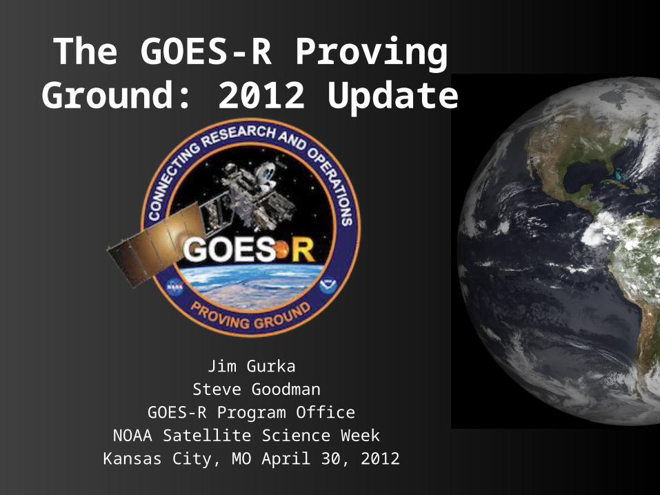
The GOES-R Proving Ground: 2012 Update
Jim Gurka Steve Goodman
GOES-R Program OfficeNOAA Satellite Science Week Kansas City, MO April 30, 2012
Contributors
Timothy Schmit, Mark DeMaria and Daniel LindseyNOAA/NESDIS/Center for Satellite Applications and Research (STAR)
Anthony Mostek and Brian MottaNWS Training Division, Boulder CO
Bonnie ReedGeneral Dynamics Information Technology
Geoffrey Stano and Richard BlakesleeNASA/MSFC Short-term Prediction Research and Transition (SPoRT) Center, Huntsville, AL
Russell SchneiderDirector, NOAA/NWS/Storm Prediction Center, Norman, OK
Chris SiewertCooperative Institute for Mesoscale Meteorological Studies, NOAA/NWS/Storm Prediction Center, Norman, OK
Donald Macgorman and Kristin KuhlmanNOAA/ Office of Atmospheric Research/ NSSL, Norman OK
Wayne FeltzCooperative Institute for Meteorological Satellite Studies (CIMSS), Madison WI
Michael FolmerNOAA/ NWS/ CampSprings, MD
Outline
– Overview of the GOES-R Proving Ground– Examples of activities from the PG & Satellite Blogs– Plans for 2012– PG & training– Looking to the future– Summary
GOES-R Proving Ground
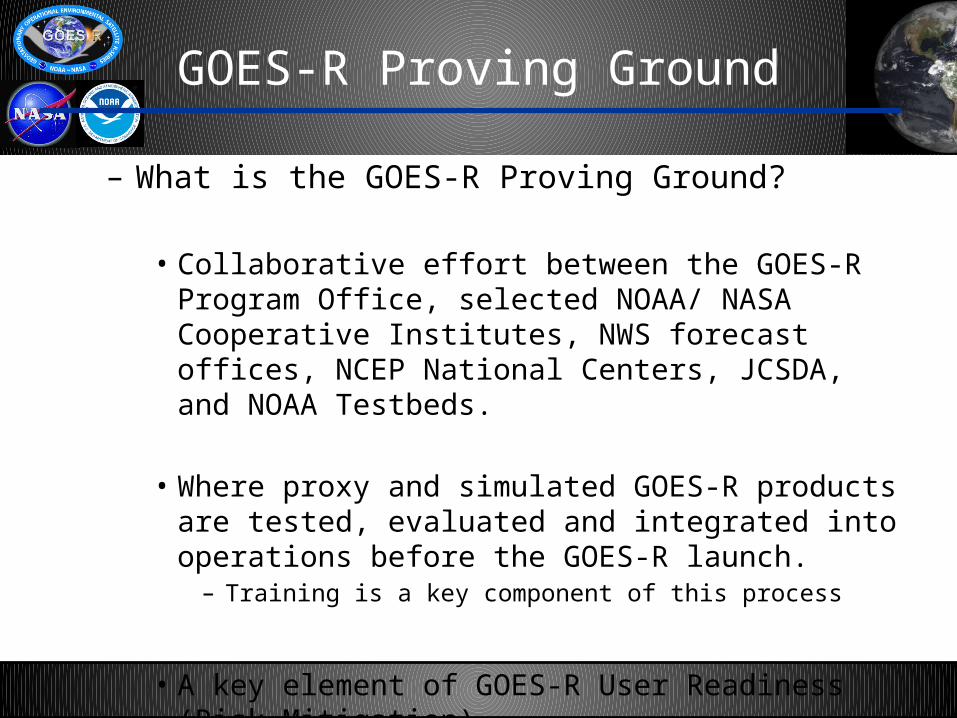
– What is the GOES-R Proving Ground?
• Collaborative effort between the GOES-R Program Office, selected NOAA/ NASA Cooperative Institutes, NWS forecast offices, NCEP National Centers, JCSDA, and NOAA Testbeds.
• Where proxy and simulated GOES-R products are tested, evaluated and integrated into operations before the GOES-R launch.
– Training is a key component of this process
• A key element of GOES-R User Readiness (Risk Mitigation)
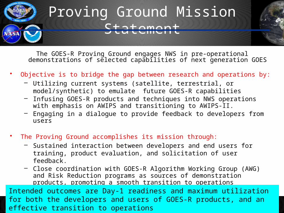
Proving Ground Mission Statement
The GOES-R Proving Ground engages NWS in pre-operational demonstrations of selected capabilities of next generation GOES
• Objective is to bridge the gap between research and operations by: – Utilizing current systems (satellite, terrestrial, or model/synthetic) to emulate future
GOES-R capabilities– Infusing GOES-R products and techniques into NWS operations with emphasis on
AWIPS and transitioning to AWIPS-II. – Engaging in a dialogue to provide feedback to developers from users
• The Proving Ground accomplishes its mission through:– Sustained interaction between developers and end users for training, product
evaluation, and solicitation of user feedback.– Close coordination with GOES-R Algorithm Working Group (AWG) and Risk Reduction
programs as sources of demonstration products, promoting a smooth transition to operations
Intended outcomes are Day-1 readiness and maximum utilization for both the developers and users of GOES-R products, and an effective transition to operations
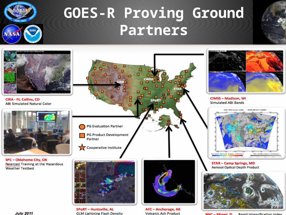
GOES-R Proving GroundPartners
6
UPDATE
Proving Ground Product Evaluation
Baseline Products• Cloud and Moisture Imagery• Volcanic Ash: Detection and Height• Hurricane Intensity• Lightning Detection: Events, Groups &
Flashes• Rainfall Rate/QPE• Total Precipitable Water• Fire/Hot Spot Characterization• Cloud Top Phase• Cloud Top Height• Cloud Top Temperature• Derived Motion Winds• Aerosol Detection• Aerosol Optical Depth
7
Future Capabilities• Aircraft Icing Threat• Convective Initiation• Enhanced “V”/Overshooting Top Detection• Low Cloud and Fog• SO2 Detection
The following products are part of current GOES-R Proving Ground demonstrations:
GOES-R PG Blogs Samples
– A wealth of information in the PG and satellite blogs• See: http://www.goes-r.gov/users/proving-ground.html
– Keep those BLOGS coming!• Leap Day Severe Weather (CIMSS): Several tornados over
Missouri and Illinois• May 24, 2011 (HWT): Tornadic Storms in Oklahoma• Dallas Tornados (CIMSS)• A tale of 3 Northern Hemisphere Storms (HPC /OPC/SAB
PG posted on the “Wide World of SPoRT”• Alabama Severe Wx, March 2, 2012 (Wide World of SPoRT)• Clouds vs Snow (CIRA)• Synthetic fog product (CIRA)
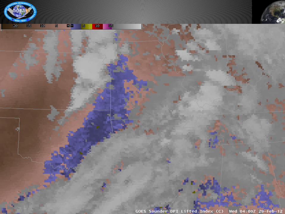
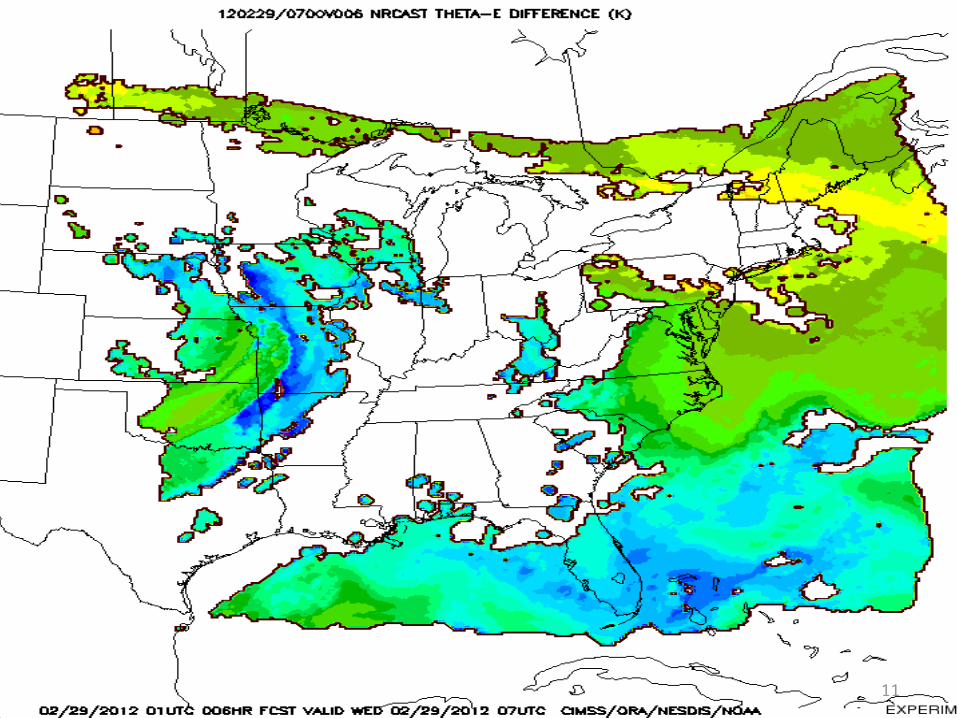
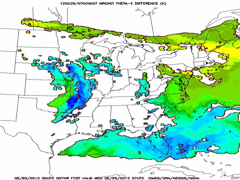
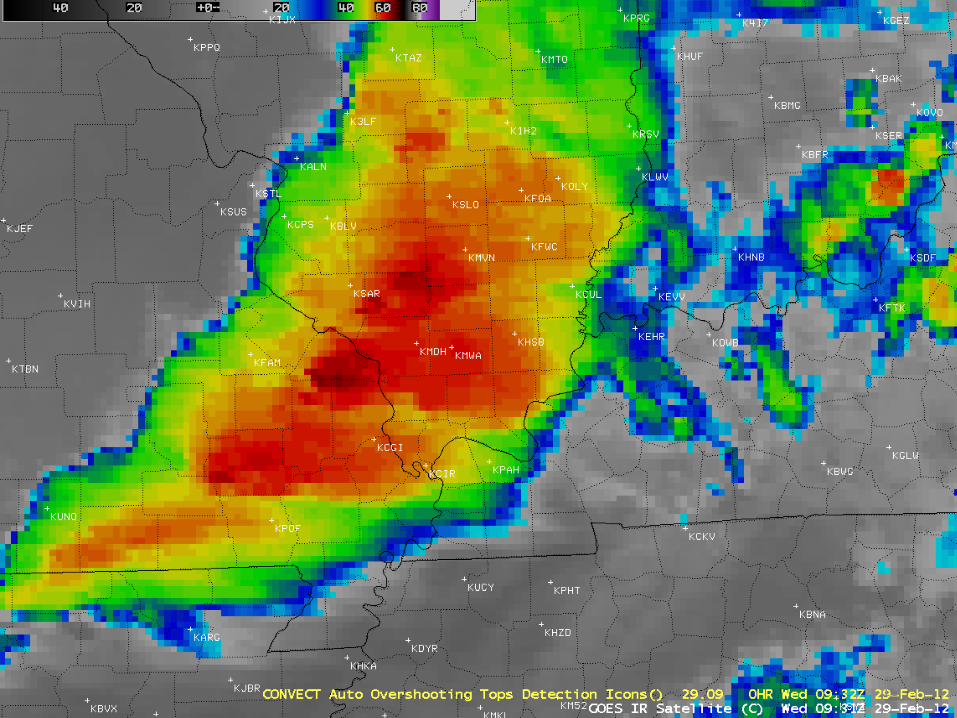
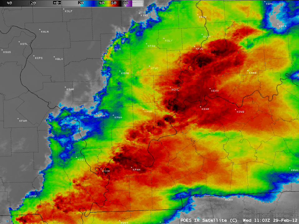
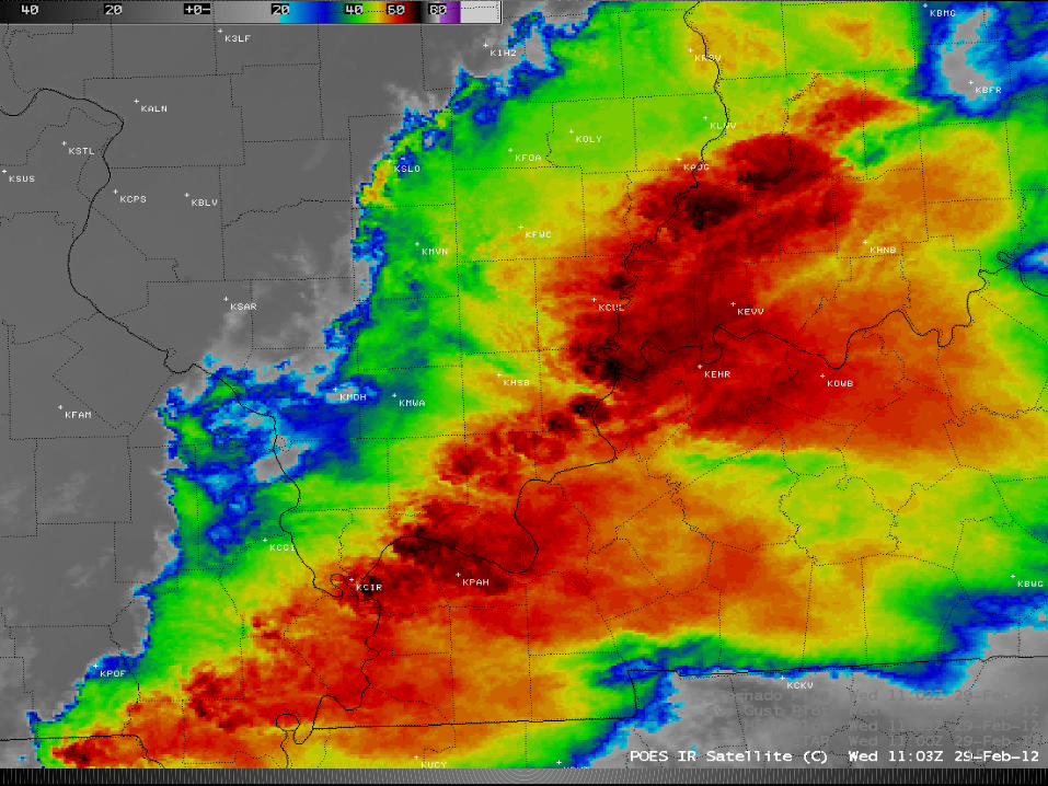
Leap Day Severe Wx
– Several tornados over Missouri including one near Branson and one near Lebanon
– GOES DPI LI at 0400 and 0700 UTC show tongue of instability movg east across MO
– NearCast suggested strong instability would help sustain development of Tstms over SW MO
– As cold front continued east, tornado hit Harrisburg IL at 10:56 UTC causing 6 deaths
– OT indicated 45 min prior to tornado hitting Harrisburg – Examples of AVHRR cloud type, cloud height, and hi res
IR
10
11
12
13
14
15
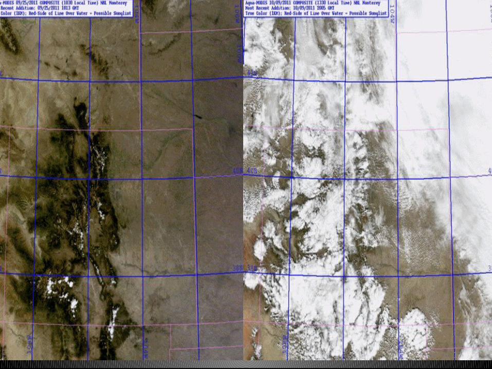
Cloud Cover vs Snow
– With short wave IR bands to be on GOES-R, this multi- channel product allows for distinguishing water cloud vs ice cloud vs snow cover
– With GOES-R this capability will be further improved with high temporal refresh enabling detection of snow fields currently obscured by cloud cover
17
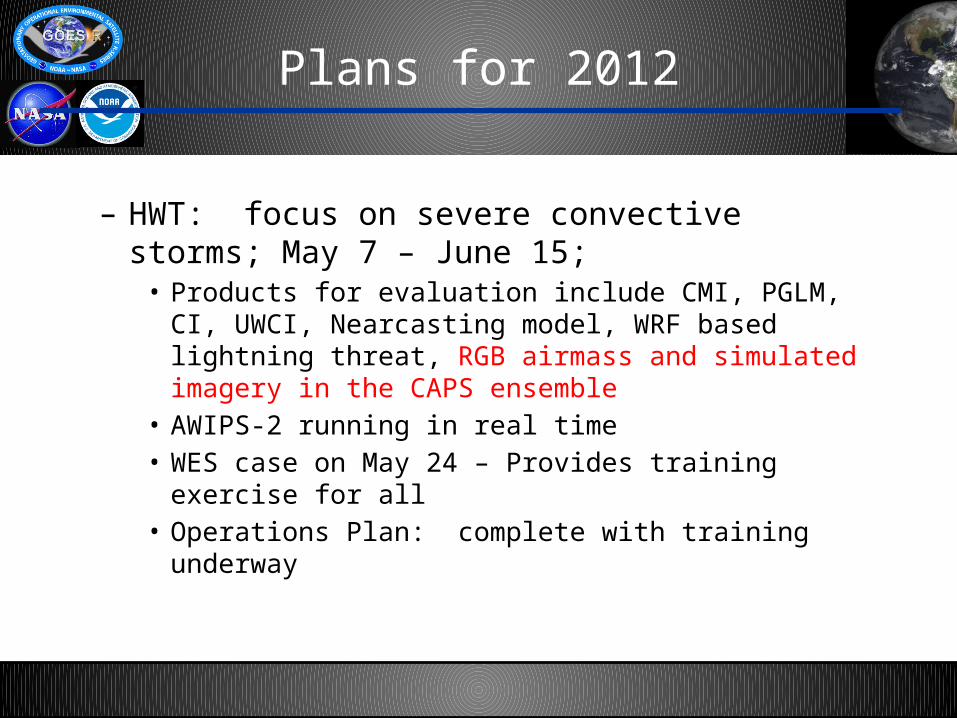
Plans for 2012
– HWT: focus on severe convective storms; May 7 – June 15;
• Products for evaluation include CMI, PGLM, CI, UWCI, Nearcasting model, WRF based lightning threat, RGB airmass and simulated imagery in the CAPS ensemble
• AWIPS-2 running in real time• WES case on May 24 – Provides training exercise for all • Operations Plan: complete with training underway
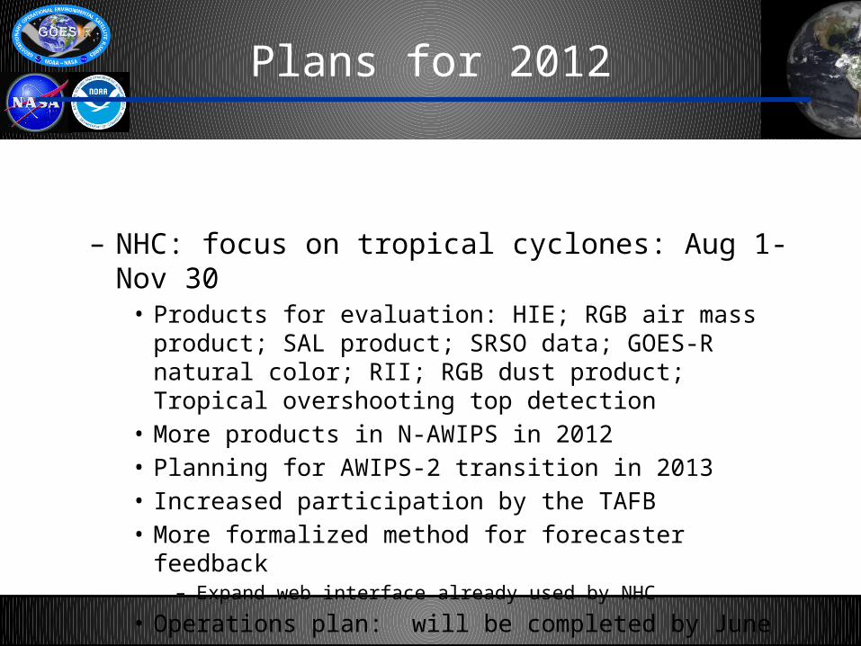
Plans for 2012
– NHC: focus on tropical cyclones: Aug 1- Nov 30• Products for evaluation: HIE; RGB air mass product; SAL product;
SRSO data; GOES-R natural color; RII; RGB dust product; Tropical overshooting top detection
• More products in N-AWIPS in 2012• Planning for AWIPS-2 transition in 2013• Increased participation by the TAFB• More formalized method for forecaster feedback
– Expand web interface already used by NHC
• Operations plan: will be completed by June
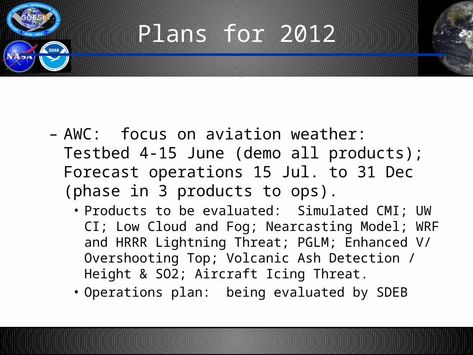
Plans for 2012
– AWC: focus on aviation weather: Testbed 4-15 June (demo all products); Forecast operations 15 Jul. to 31 Dec (phase in 3 products to ops).
• Products to be evaluated: Simulated CMI; UW CI; Low Cloud and Fog; Nearcasting Model; WRF and HRRR Lightning Threat; PGLM; Enhanced V/ Overshooting Top; Volcanic Ash Detection / Height & SO2; Aircraft Icing Threat.
• Operations plan: being evaluated by SDEB
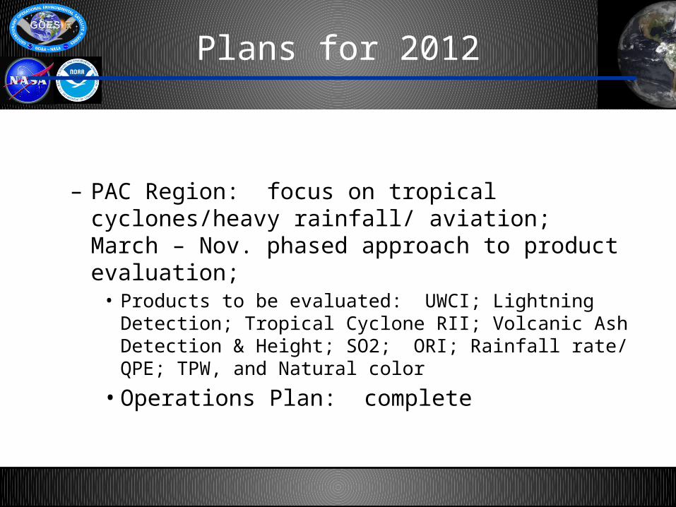
Plans for 2012
– PAC Region: focus on tropical cyclones/heavy rainfall/ aviation; March – Nov. phased approach to product evaluation;
• Products to be evaluated: UWCI; Lightning Detection; Tropical Cyclone RII; Volcanic Ash Detection & Height; SO2; ORI; Rainfall rate/ QPE; TPW, and Natural color
• Operations Plan: complete
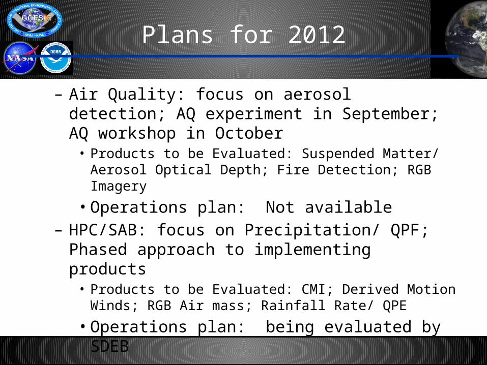
Plans for 2012
– Air Quality: focus on aerosol detection; AQ experiment in September; AQ workshop in October
• Products to be Evaluated: Suspended Matter/ Aerosol Optical Depth; Fire Detection; RGB Imagery
• Operations plan: Not available– HPC/SAB: focus on Precipitation/ QPF; Phased approach
to implementing products • Products to be Evaluated: CMI; Derived Motion Winds; RGB Air
mass; Rainfall Rate/ QPE
• Operations plan: being evaluated by SDEB
Plans for 2012
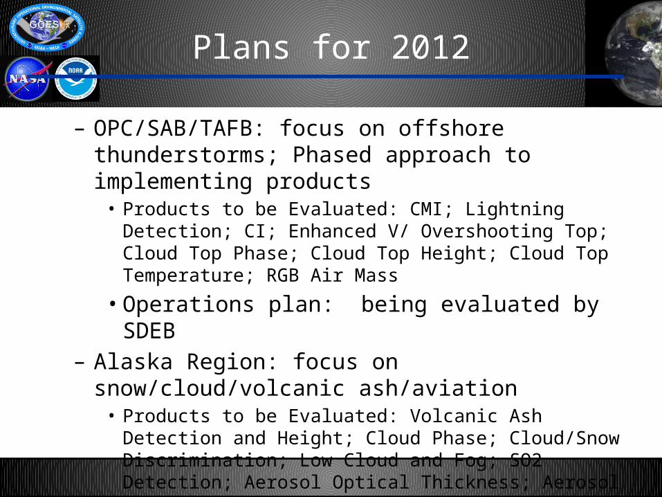
– OPC/SAB/TAFB: focus on offshore thunderstorms; Phased approach to implementing products
• Products to be Evaluated: CMI; Lightning Detection; CI; Enhanced V/ Overshooting Top; Cloud Top Phase; Cloud Top Height; Cloud Top Temperature; RGB Air Mass
• Operations plan: being evaluated by SDEB– Alaska Region: focus on snow/cloud/volcanic ash/aviation
• Products to be Evaluated: Volcanic Ash Detection and Height; Cloud Phase; Cloud/Snow Discrimination; Low Cloud and Fog; SO2 Detection; Aerosol Optical Thickness; Aerosol Particle Size Parameter; Suspended Matter
• Operations plan: Not available
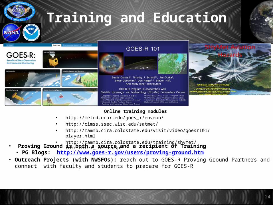
Training and Education
Online training modules• http://meted.ucar.edu/goes_r/envmon/• http://cimss.ssec.wisc.edu/satmet/• http://rammb.cira.colostate.edu/visit/video/goesr101/player.html• http://rammb.cira.colostate.edu/training/shymet/forecaster_intro.asp
24
• Proving Ground is both a source and a recipient of Training• PG Blogs: http://www.goes-r.gov/users/proving-ground.htm
• Outreach Projects (with NWSFOs): reach out to GOES-R Proving Ground Partners and connect with faculty and students to prepare for GOES-R
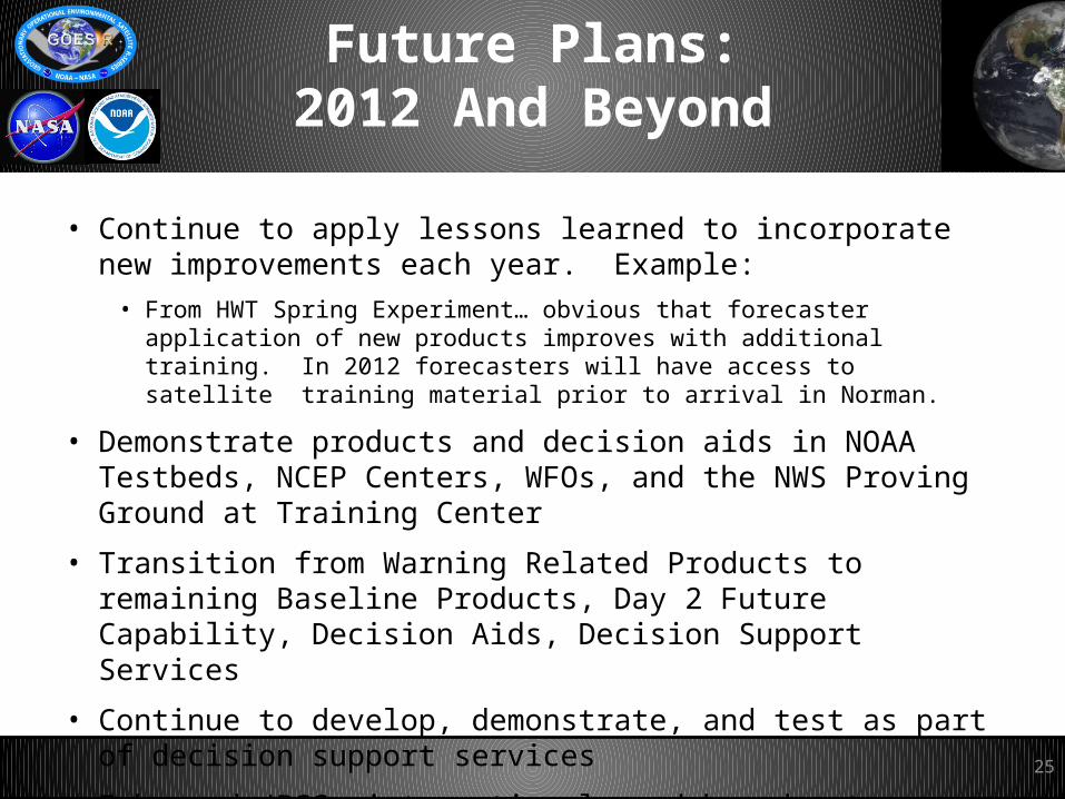
Future Plans:2012 And Beyond
• Continue to apply lessons learned to incorporate new improvements each year. Example:
• From HWT Spring Experiment… obvious that forecaster application of new products improves with additional training. In 2012 forecasters will have access to satellite training material prior to arrival in Norman.
• Demonstrate products and decision aids in NOAA Testbeds, NCEP Centers, WFOs, and the NWS Proving Ground at Training Center
• Transition from Warning Related Products to remaining Baseline Products, Day 2 Future Capability, Decision Aids, Decision Support Services
• Continue to develop, demonstrate, and test as part of decision support services
• Enhanced JPSS, international, and broadcaster community collaboration
25
Summary
• GOES-R Proving Ground provides mechanism to:
– Involve CIs, AWG, National Centers, NOAA Testbeds and WFOs in user readiness
– Get prototype GOES-R products in hands of forecasters
– Keep lines of communication open between developers and forecasters
– Allow end user to have say in final product, how it is displayed and integrated into operations
• Proving Ground continues to grow and plans are in place for 2012 and beyond.
• For GOES-R to be a success, forecasters must be able to use GOES-R products on Day 1!
26

27
Backup
28
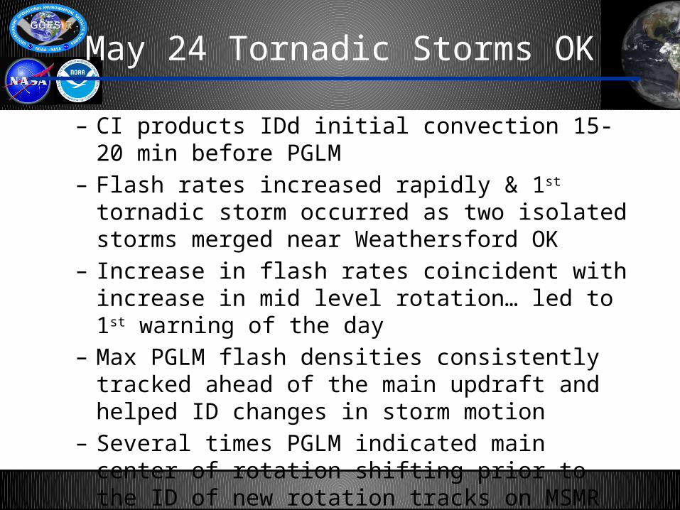
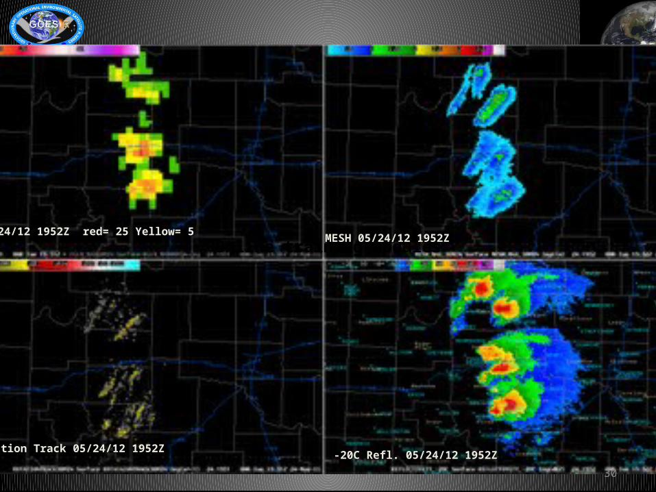
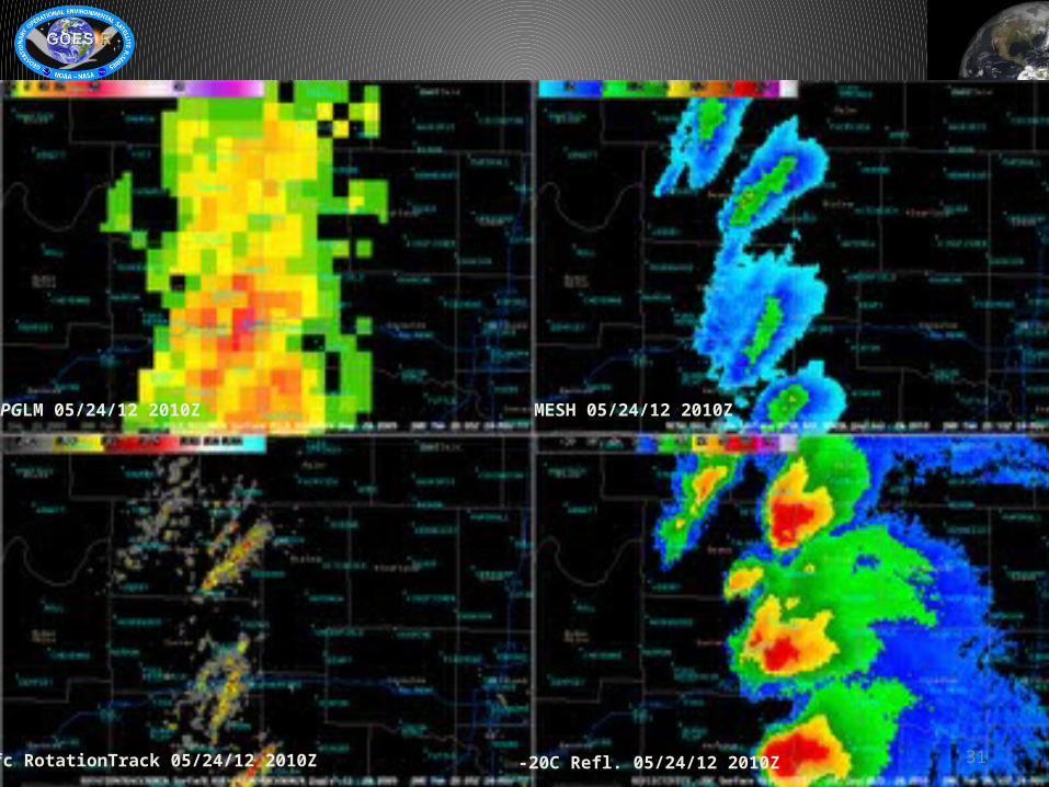
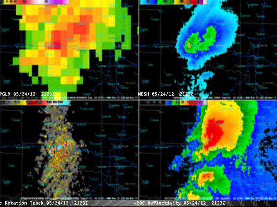
May 24 Tornadic Storms OK
– CI products IDd initial convection 15-20 min before PGLM
– Flash rates increased rapidly & 1st tornadic storm occurred as two isolated storms merged near Weathersford OK
– Increase in flash rates coincident with increase in mid level rotation… led to 1st warning of the day
– Max PGLM flash densities consistently tracked ahead of the main updraft and helped ID changes in storm motion
– Several times PGLM indicated main center of rotation shifting prior to the ID of new rotation tracks on MSMR
– While lgtng jumps preceded many of the tornados, fcstrs would also like to examine trends for individual storms
30
Online training modulesPGLM 05/24/12 1952Z red= 25 Yellow= 5
MESH 05/24/12 1952Z
Sfc Rotation Track 05/24/12 1952Z-20C Refl. 05/24/12 1952Z
31
PGLM 05/24/12 2010Z MESH 05/24/12 2010Z
Sfc RotationTrack 05/24/12 2010Z -20C Refl. 05/24/12 2010Z
32
PGLM 05/24/12 2123Z MESH 05/24/12 2123Z
Sfc Rotation Track 05/24/12 2123Z -20C Reflectivity 05/24/12 2123Z
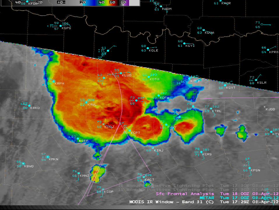
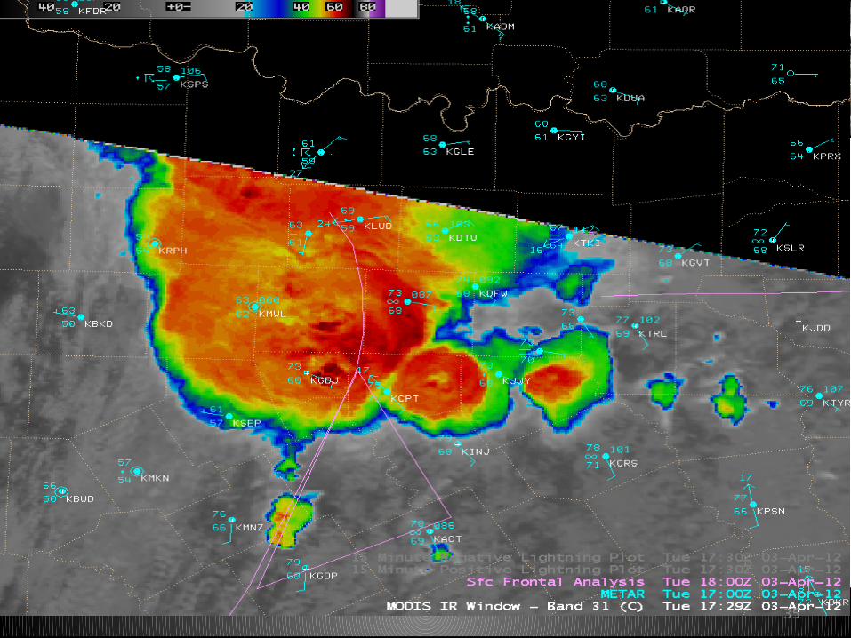
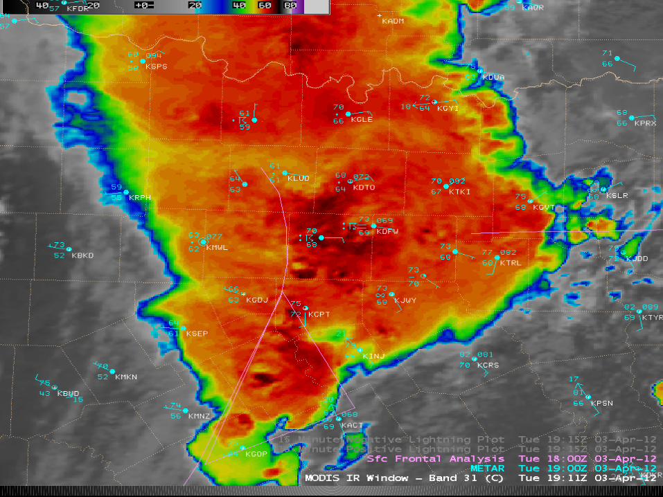
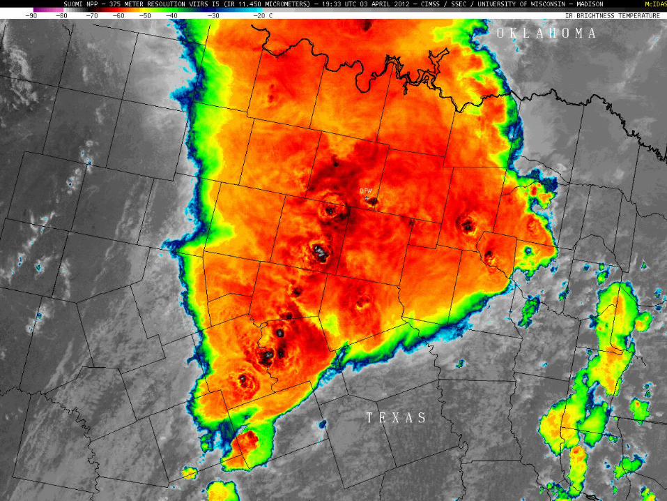
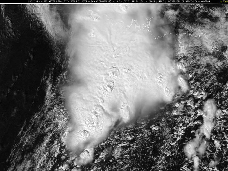
Dallas/Fort Worth tornados
– Thunderstorms along cold front on April 3 produced a number of tornados and hail as large as 2.75 inches.
– Striking comparisons of resolution on Suomi NPP and MODIS images vs GOES
– With more details available on Higher res MODIS, pronounced thermal couplet (-63C/-52C) exhibited by storm located just east of Cleburne (KCPT) where 1st tornado was reported by spotters at 17:35 UTC
34
35
36
37
38
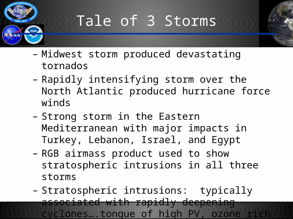
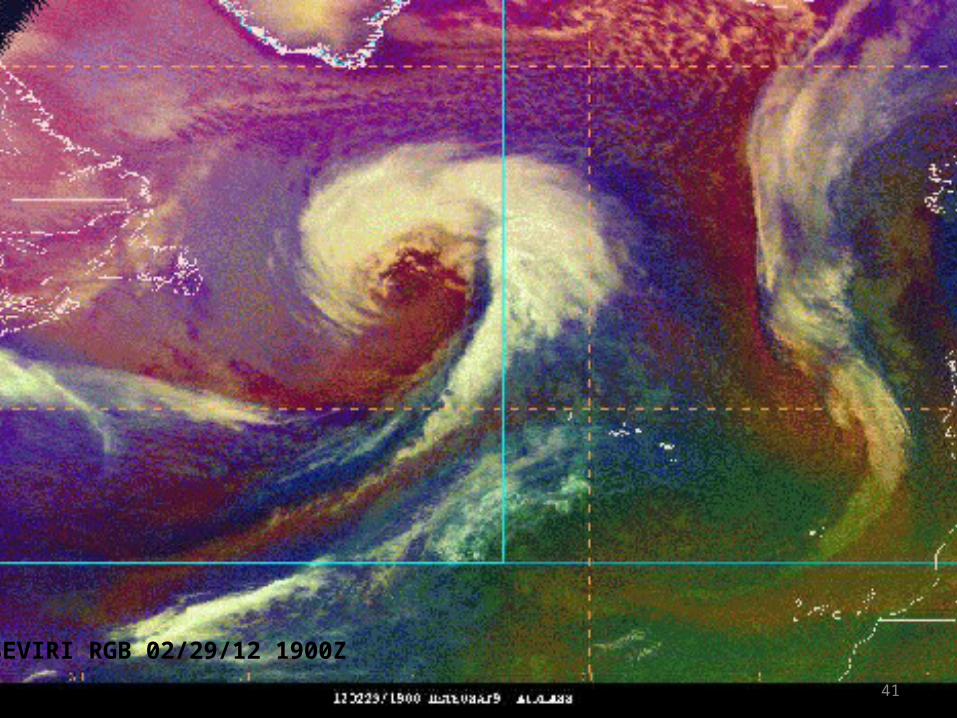
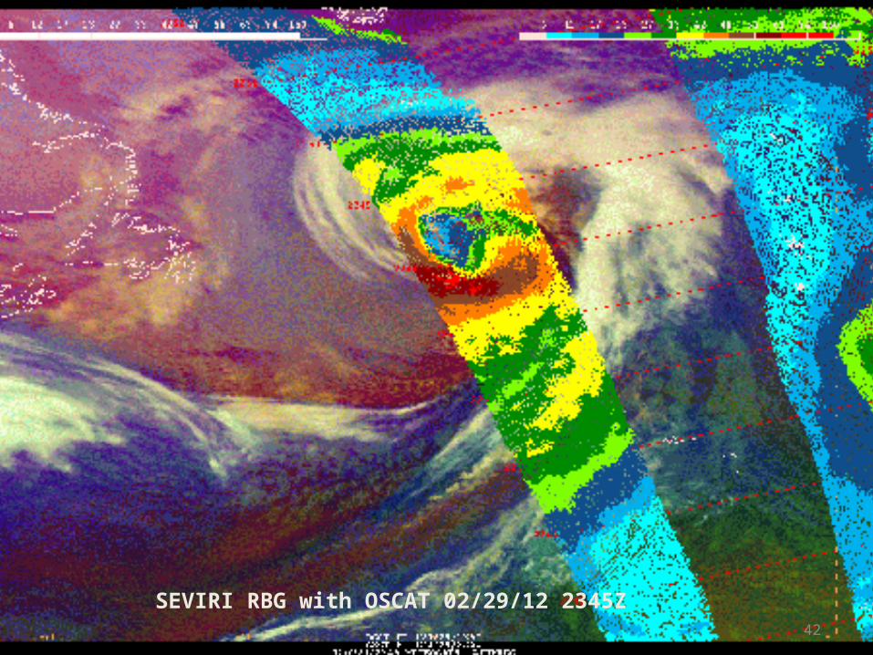
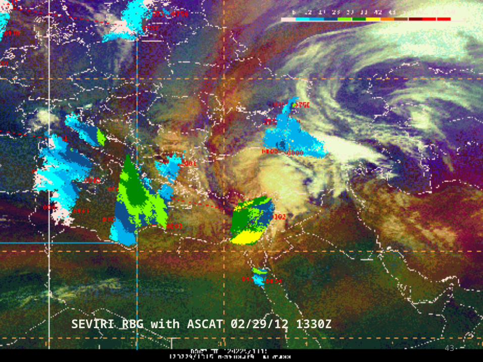
Tale of 3 Storms
– Midwest storm produced devastating tornados– Rapidly intensifying storm over the North Atlantic
produced hurricane force winds– Strong storm in the Eastern Mediterranean with major
impacts in Turkey, Lebanon, Israel, and Egypt– RGB airmass product used to show stratospheric intrusions
in all three storms– Stratospheric intrusions: typically associated with rapidly
deepening cyclones….tongue of high PV, ozone rich air subsides isentropically into the troposphere
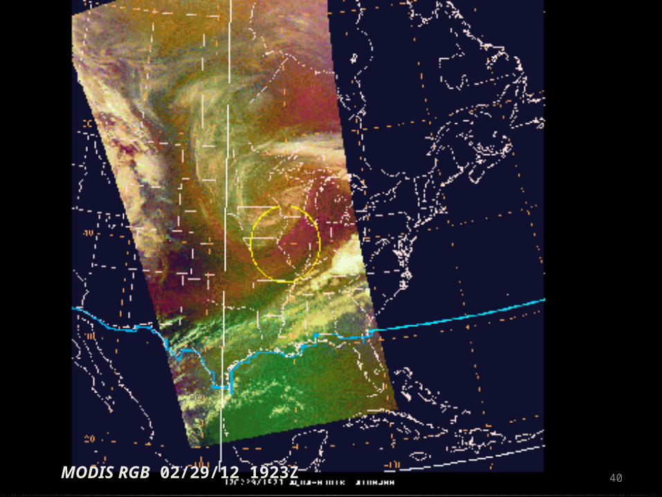
40MODIS RGB 02/29/12 1923Z
41
SEVIRI RGB 02/29/12 1900Z
42
SEVIRI RBG with OSCAT 02/29/12 2345Z
43
SEVIRI RBG with ASCAT 02/29/12 1330Z
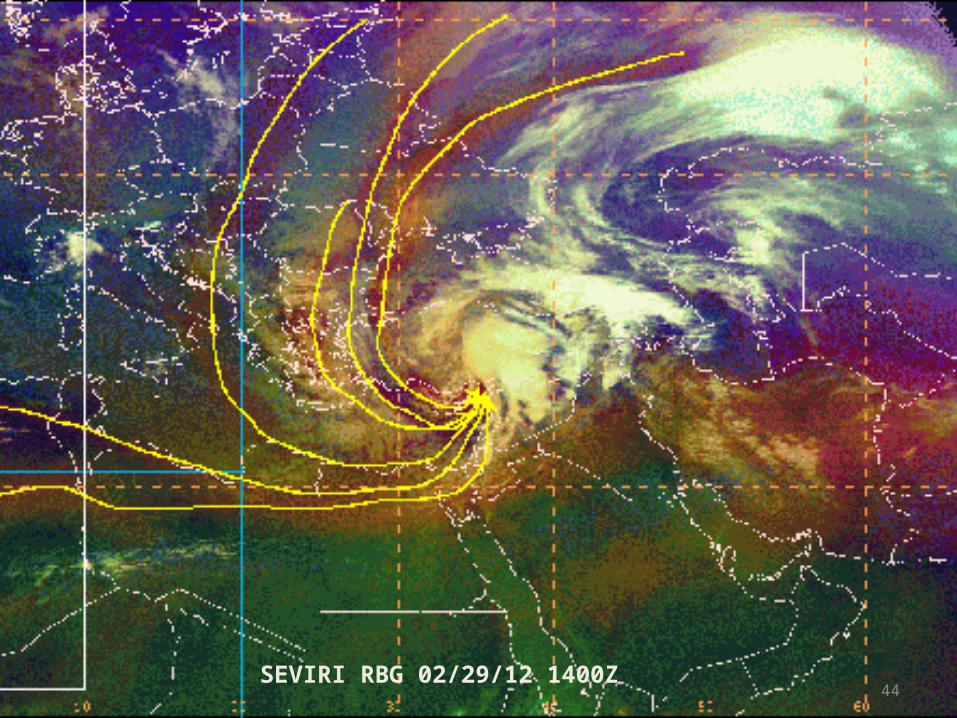
44SEVIRI RBG 02/29/12 1400Z
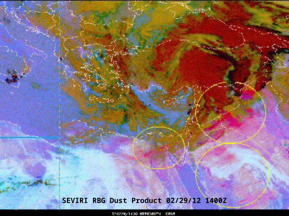
45SEVIRI RBG Dust Product 02/29/12 1400Z
March 2, 2012 Huntsville
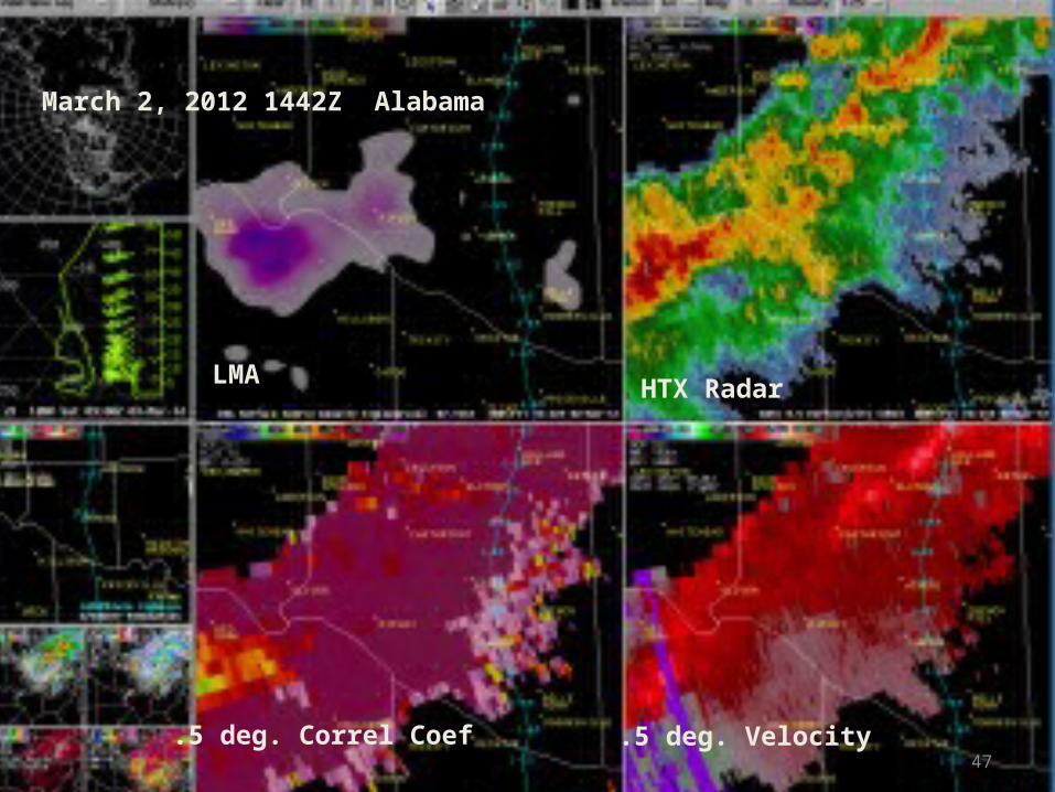
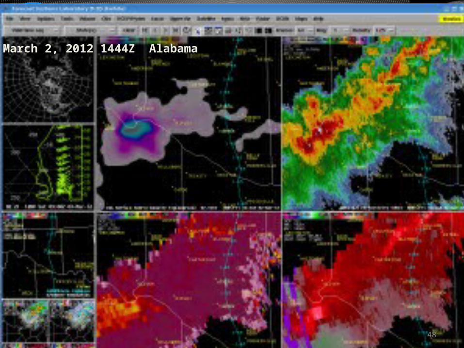
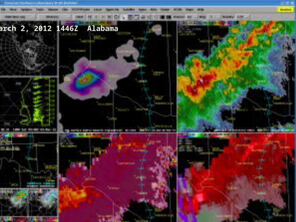
– With inconclusive signals from radar…LMA source density spike tips balance in favor of issuing warning
– With LMA updates every 2 minutes vs 6 minutes for radar in VCP 11, lightning spike was indicated before radar update
– Storm produced golfball size hail
47
March 2, 2012 1442Z Alabama
LMA HTX Radar
.5 deg. Correl Coef .5 deg. Velocity
48
March 2, 2012 1444Z Alabama
49
March 2, 2012 1446Z Alabama
Synthetic Fog Product
– Synthetic fog product produced from the NSSL WRF-ARW
– 10.35 – 3.9 micrometer difference– Color scheme in example…. Grey into light blue represents
increasing confidence in liquid water clouds– Example shows good agreement between forecast and
observation
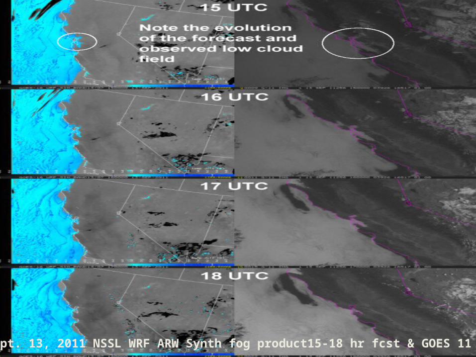
51Sept. 13, 2011 NSSL WRF ARW Synth fog product15-18 hr fcst & GOES 11
What is available now?
Listed/linked on GOES-R Home page • Proving Ground Overview• Presentations from GUCs/ AMS/ etc:
• http://www.goes-r.gov/users/conf-mtgs.html
• GOES-R 101 (SHyMet)• Satellite Meteorology for Grades 7 – 12• GOES-R: Benefits of Next-Generation Environmental Monitoring
(COMET)• GOES-R Trifold flyer
• http://www.goes-r.gov/users/training.html
Recent COMET Publications
• Monitoring the Climate System with Satellites
• Space Weather Basics (2nd Edition)• Atmospheric Dust• Satellite Feature Identification
• http://www.meted.ucar.edu