Embed Size (px)
Citation preview
W
GEOLOGICAL SOCIETY OF MALAYSIA
Jil. 22, No.6 (Vol. 22, No.6) Nov-Dec 1996 .
KANDUNGAN (Contents) CATATAN GEOLOGI (Geological Notes)
Teh Guan Hoe: Electronprobe microanalysis and geochemistry of a complex 389 Cu-Fe-Sn-Zn ore
Basir Jasin, Uyop Said and Ang Duen Woei: Discovery of Early Jurassic 395 Radiolaria from the tuff sequence, near Piching, West Sarawak - Correction
PERTEMUAN PERSATUAN (Meetings of the Society)
Khor Peng Seong: Quarrying of dimension stones in Malaysia 397
B.J. Hensen: Synplutonic basaltic dykes in the Moruya Batholith, NSW, 399 Australia: Genetic implications
Laporan Fiesta Sains - Aktiviti Memburu Fosil 400
Seminar Geologi dan Sekitaran - Laporan 402 Senarai kertaskerja yang dibentangkan 403 Senarai kertaskerja dalam Prosiding Seminar 404
Petroleum Geology Conference 1996 - Laporan 406 Welcoming Address by Yg Berusaha Dr. Ahmad Tajuddin Ibrahim 407 Opening Address by Yg Bhg Dato' Mohamad Idris B. Mansor 412 Programme 414 Abstracts of Papers & Posters 417
BERITA-BERITA PERSATUAN (News of the Society)
Keahlian (Membership)
Pertukaran Alamat (Change of Address) Current Addresses Wanted
Pertambahan Baru Perpustakaan (New Library Additions)
BERITA-BERITA LAIN (Other News)
Local News
The Third Conference on Geochemistry Kalendar ( Calendar)
447
448
448
449
451 460 461
..
Majlis (Council) 1996/97
Presiden (President) Naib Presiden (Vice-President) Setiausaha (Secretary) Penolong Setiausaha (Asst. Secretary) Bendahari (Treasurer) Pengarang (Editor)
Khalid Ngah Ibrahim Komoo Ahmad Tajuddin Ibrahim S. Paramananthan Lee Chai Peng Teh Guan Hoe
Presiden Yang Dahulu (Immediate Past President) : Fateh Chand
1996-98 Abd. Ghani Mohd Rafek Abdul Rahim Samsudin Abdul Hadi Abd. Rahman Tan Boon Kong
1996-97 Khoo Kay Khean Hoh Swee Chee Ibrahim Abdullah Mohd Shafeea Leman
Jawatankuasa Kecil Pengarang (Editorial Subcommittee)
Teh Guan Hoe (PengerusilChairman)
Fan Ah Kwai Ng Tham Fatt J.J. Pereira
Lembaga Penasihat Pengarang (Editorial Advisory Board)
Aw Peck Chin Azhar Hj. Hussin K.R. Chakraborty Choo M un Keong Chu Leng Heng Denis N.K. Tan
Foo Wah Yang C.A. Foss N.S. Haile C.S. Hutchison Lee Chai Peng Leong Lap Sau
Mazlan Madon Ian Metcalfe S. Paramananthan John Kuna Raj Senathi Rajah Shu Yeoh Khoon
P.H. Stauffer Tan Boon Kong Tan Teong Hing Teoh Lay Hock H.D. Tjia Yea p Cheng Hock
The Society was founded in 1967 with the aim of promoting the advancement of earth sciences particularly in Malaysia and the Southeast Asian region.
The Society has a membership of about 600 earth scientists interested in Malaysia and other Southeast Asian regions. The membership is worldwide in distribution.
Published by the Geological Society of Malaysia, Department of Geology, University of Malaya, 50603 Kuala Lumpur, Tel: 603-757 7036 Fax: 603-756 3900 E-mail: geologl@po,Jarlng,my
Printed by Art PrInting Wo'*s Sdn. 8hd., 29 Jolon Rlong, 591CXJ Kuala Lumpur.
Electronprobe microanalysis and geochemistry of a complex Cu-Fe-Sn-Zn ore
TEHGUANHoE Geology Department University of Malaya 50603 Kuala Lumpur
Abstract: The electronprobe micro analyzer (EPMA) has become the state-of-the-art tool in earth science for the accurate analysis of not only the major but also minor and trace element compositions of minerals and ores.
Besides the conventional wavelength dispersive spectrometers (WDS) for very accurate composition determinations, EPMAs nowadays have a fully integrated energy dispersive spectrometer (EDS) which will provide for fast full spectrum scan of elemental composition. The EDS results, especially for the heavier elements, are quite close to that ofthe WDS. For microprobe analysis a probe diameter of 0.2-1 11m is typical.
Results on a complex Cu-Fe-Sn-Zn ore on the EPMA show the versatility of quantitative analyses of the EPMA with WDS or EDS or both combined.
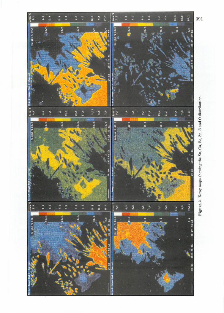
Besides obtaining accurate quantitative analyses ofthe various mineral species present, and observing their compositional distribution by backscattered electron (BSE) images, line analyses can be performed as well as X-ray maps which show the concentration of each element versus a colour scale and the area fraction of each concentration segment.
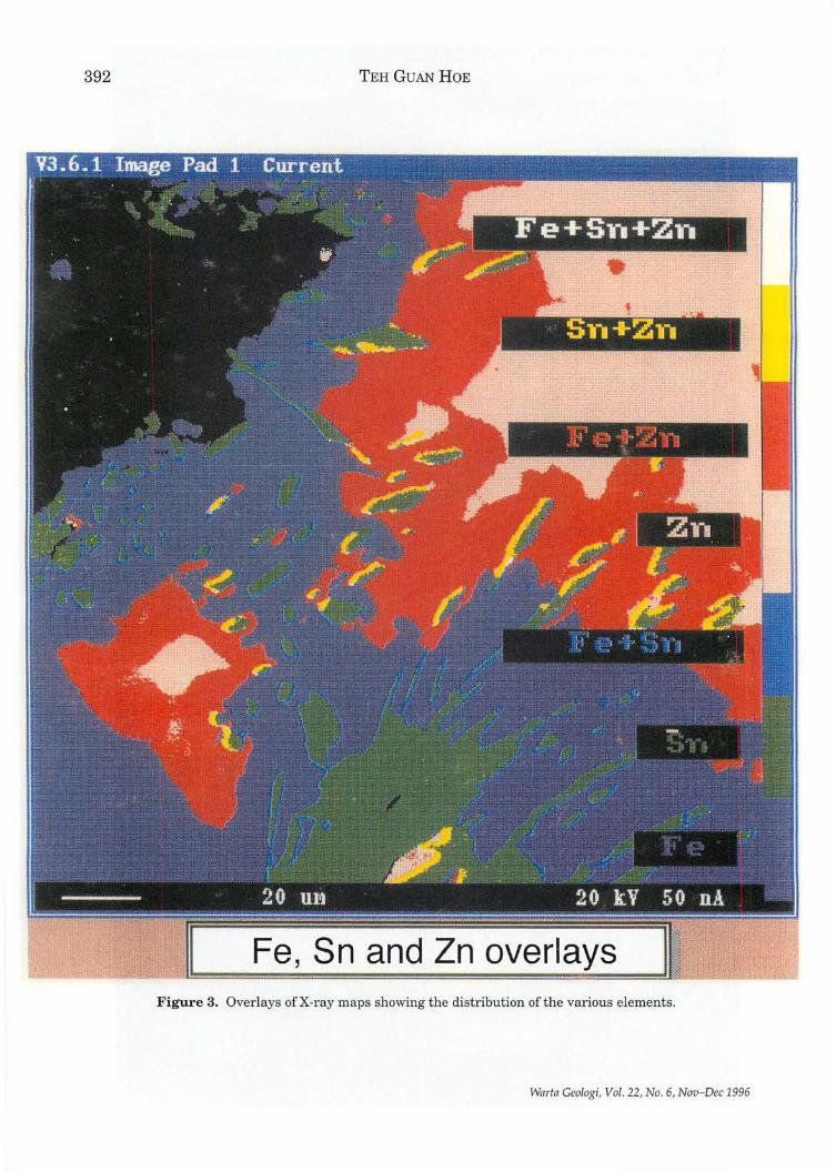
There is also the option of making an overlay of 3 or more different X-ray maps where each element is assigned a certain colour. These maps provide easier differentiation of the various phases present.
On the other hand, higher resolution « 10 nm) is possible with SE (secondary electron) images and are therefore used primarily on the EPMA for displaying topographic rather than compositional information.
With the accurate ideI)tification of mineral phases by the EPMA together with the powerful image processing software and image analysis packages, paragenesis of an ore is greatly enhanced and the resulting maps of mineral distribution will ultimately simplify extraction procedures.
INTRODUCTION
The electronprobe micro analyser (EPMA) or sometimes called the electronprobe X-ray micro analyser is the state-of-the-art tool in earth science for accurate analyses of materials down to about 0.2 to 1 /lm probe size (Read, 1993; Potts, 1995).
EPMAs nowadays have fully integrated
ISSN 0126-5539
conventional wavelength dispersive spectrometers (WDS) for very accurate composition determinations and an energy dispersive spectrometer (EDS) for fast full spectrum scan of elemental compositions (Scott, et al., 1995). In addition besides optical viewing, EPMAs have both secondary electron (SE) and backscattered electron (BSE) images for better differentiation of topography or elemental composition.
Warta Geologi, Vol . 22, No. 6, Nov-Dec 1996, pp. 389-394
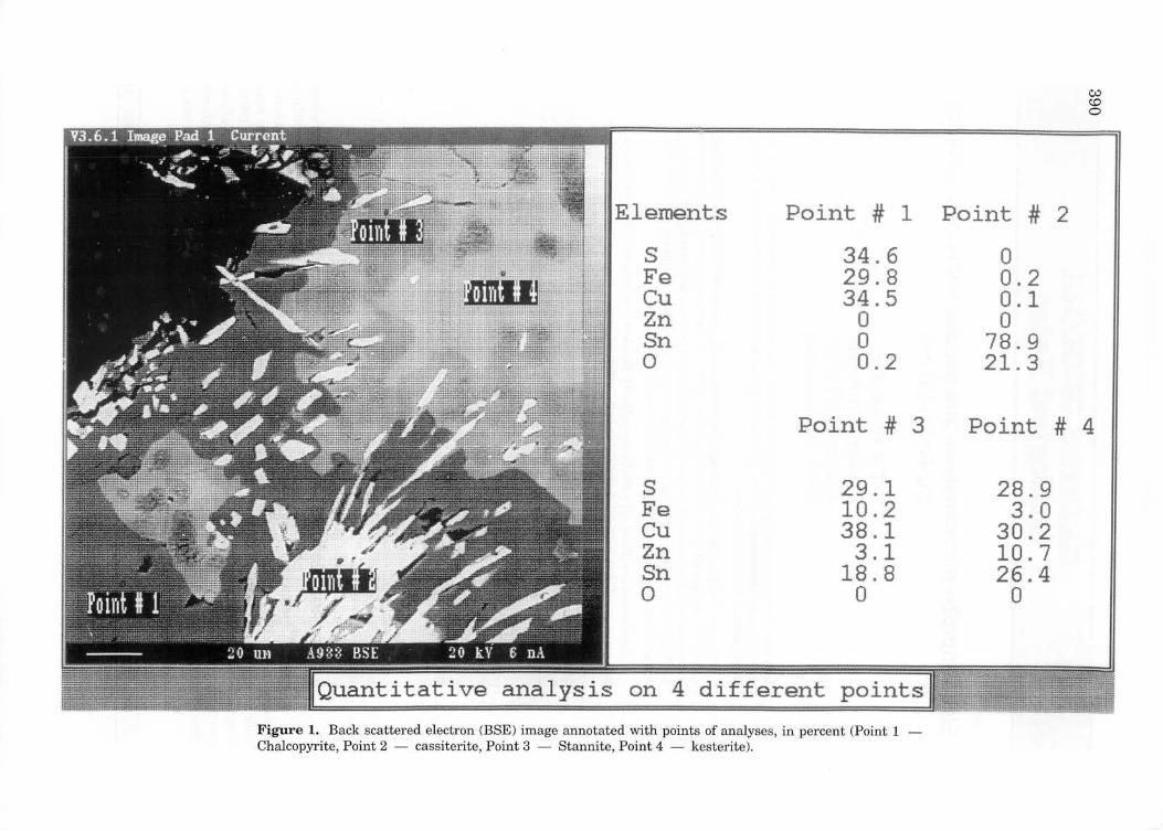
Elements Point # 1
S 34.6 Fe 29.8 Cu 34.S Zn 0 Sn 0 0 0.2
Point # 3
S 29.1 Fe 10 . 2 Cu 38.1 Zn 3.1 Sn 18.8 0 0
IQuantitati';~ analysis on 4 different points/
Figure 1. Back scattered electron (BSE) image annotated with points of analyses, in percent (Point 1 Chalcopyrite, Point 2 - cassiterite, Point 3 - Stannite, Point 4 - kesterite).
Point # 2
0 0.2 0.1 0
78.9 21.3
CJ,;l co o
Point # 4
28.9 3.0
30.2 10.7 26.4
0
392 TEHGUANHoE
Fe, Sn and Zn overlays Figure 3. Overlays of X-ray maps showing the distribution of the various elements.
Warta Geologi, Vol. 22, No.6, Nov-Dec 1996
ELECTRONPROBE MICROANALYSIS AND GEOCHEMISTRY OF A COMPLEX CU-FE-SN-ZN ORE 393
INSTRUMENTATION AND ANALYSIS
The EPMA available at the Geology Department, University of Malaya, is a highly automated Cameca SXI00 which is workstationbased, with full instrument control and quantitative, qualitative software via windows and multi-task user environment. It has a kV range of 0-50 kV, 4 wavelength dispersive spectrometers (3 vertical and 1 horizontal) and a total of 12 diffracting crystals for detection of elements from Be to U. The Rowland circle of 160 mm warrants better X-ray spatial resolution. The PGT energy dispersive spectrometer has a Si (Li) X-ray detector. Up to 40 elements can be analysed in any WDS and EDS combination.
Image acquisition and processing of video, X-ray signals in beam or stage scanning modes is possible. BSE images of the surface of the specimen analysed provide a visual picture of the analytical points and thus prevent misleading data from wrong analytical points.
On the other hand, higher resolution « 10 nm) is possible with SE (secondary electron) images and are therefore used primarily on the EPMA for displaying topographic rather than compositional information.
A high energy beam of electrons from the electron gun strikes the polished surface of the sample emitting characteristic X-rays among other secondary radiations.
The EDS will provide fast full spectrum scan of elemental composition. The amounts of the elements present are then determined on the WDS (or EDS) by comparisons with standard specimens.
The sample chosen for analysis is a complex tin ore from Hock Leong Mine, Kuala Lumpur area (Teh, 1982).
RESULTS
The results of the EPMA analyses show that the mineral species present are cassiterite (Sn02), stannite [Cu2(Fe,Zn)SnS4], kesterite [Cu2(Zn,Fe)SnS4J and chalcopyrite (CuFeS2).
Warta Geologi, Vol. 22, No.6, Nov-Dec 1996
The points of analysis can be annotated on the image (Fig. 1). The analyses show that the ore not only has complex intergrowths of cassiterite (Sn02) with other sulphides like stannite [Cu2(Fe,Zn)SnS4], kesterite [Cu2(Zn,Fe)SnS41 and chalcopyrite [CuFeS21 but also shows spectacular textures.
The BSE (back scattered electron) image of the area of analyses provides a picture of the spectacular texture of the specimen. To enhance the distribution of Cu, Fe, Sn, Zn, ° and S, Xray maps can be generated and various combinations of X-ray maps can be assigned various colours as overlays. The X-ray maps provide a guide to the elemental distribution (Fig. 2) while the resulting overlays provide easier differentiation of the various phases present, a very useful aid for mineral extraction (Fig. 3).
CONCLUSION
The electronprobe X-ray microanalyzer (EPMA) is the state-of-the-art tool for the accurate identification of mineral phases and together with the powerful image processing software and image analysis packages, mineral paragenesis can be greatly enhanced and the resulting X-ray maps of elemental and mineral distribution can help simplify extraction procedures.
ACKNOWLEDGEMENTS
The author ackaowledges the F-vote research fund from the University of Malaya for work on the EPMA. The EPMA at University of Malaya was bought with funding from the 6th Malaysia Plan (RM6). Assistance from the personnel at Cameca, France, and the local agent, Delta Advantech are appreciated.
REFERENCES
POTTS, P.J., 1995. In: Microprobe Techniques in the Earth Sciences. Potts, P.J., Bowles, J.F.W., Reed, S.J.B. & Cave, M.R. (Eds.). Chapman & Hall, 419 p.
REED, S.J.B., 1993. Electron microprobe analysis. 2nd Edition. Cambridge University Press, 326 p.
394 TEH GUAN HOE
SCOTT, V.D., LOVE, G. AND REED, S.J.B., 1995. Quantitative electron-probe microanalysis. 2nd Edition. Ellis Horwood, 311 p.
TEH, G.H., 1982. New data on Malaysian stannites. In: Proceedings GEOSEANConference '81, Manila, p.509-519 .
• eo liliiii ••
Manuscript received 23 September 1996
Warta Geologi, Vol. 22, No.6, Nov-Dec 1996
395
CORRECTION - Warta Geologi 22(5), 343-347
Discovery of Early Jurassic Radiolaria from the tuff sequence, near Piching, West Sarawak
BASIR JASIN, UYOP SAID ANDANG DUEN WOEI
Page 345 under Conclusion - "The age of the Kedadom Formation now ranges from Early Triassic to Late Triassic" should read "The age of the Kedadom Formation now ranges from Early to Late Jurassic".
------~ .. ~~~.~.-------
Warta Geologi, Vol. 22, No.6, Nov-Dec 1996
Warta Geologi, Vol. 22, No. 6, Nov-Dec 1996
0 z 0 r=:l
UJ Z r=:l
0 UJ
Z Z r=:l r=:l
P-< ::q P::4 0 '":i ~ !Xl
395
CORRECTION - Warta Geologi 22(5), 343-347
Discovery of Early Jurassic Radiolaria from the tuff sequence, near Piching, West Sarawak
BASIR JASIN, UyOp SAID ANDANG DUEN WOEI
Page 345 under Conclusion - "The age of the Kedadom Formation now ranges from Early Triassic to Late Triassic" should r ead "The age of the Kedadom Formation now ranges from Early to Late Jurassic".
------~ .. --~.~.-------
Warta Geologi, Vol. 22, No.6, Nov-Dec 1996
SPECIAL LOW-PRICED SOFT-COVER EDITION LIMITED STOCK! GET YOUR COPY NOW!
Member RM50.00 PRICE: Non-Member RMIOO.OO
Student Member RM30.00 Cheques, Money Orders or Bank Drafts must accompany all orders. Orders will be invoiced for postage and bank charges. Orders should be addressed to:
The Hon. Assistant Secretary GEOLOGICAL SOCIETY OF MALAYSIA c/o Dept. of Geology, U niverszty of Malaya 50603 Kuala Lumpur, MALAYSIA
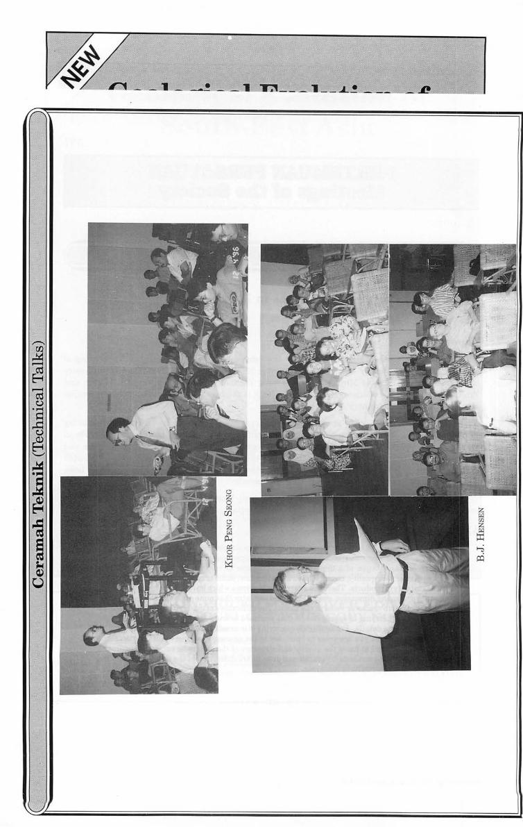
Quarrying of dimension stones in Malaysia KHOR PENG SEONG
Laporan (Report)
397
It was timely when Mr. Khor Peng Seong offered to present his talk on "Quarrying of dimension stones in Malaysia" on the 4th December 1996 at the Geology Department, University of Malaya. Being Head of Mining and Quarrying Technology Unit, Division of Research and Training Department of Mines, Malaysia, Mr. Khor is the best person to talk on the dimension stone industry in the country.
A·s the industry is very much in its infancy compared to some of our neighbouring countries, Mr. Khor touched on the some of the difficulties of quarrying dimension stones in Malaysia and to be successful one has to have a good knowledge of rock characteristics and structures, quarrying skills and marketability of the products. The talk was well illustrated with beautiful slides on some of the quarrying methods for marble and granite presently been used by various dimension stone quarries in the country.
The audience of 50 certainly benefited immensely from the talk and undoubtedly have a better idea of the dimension stone industry in Malaysia.
Abstrak (Abstract)
The production of dimension stones looks like a simple and sure way to produce value added products from our rock resources but its apparent simplicity can be deceiving. Successful exploitation of a dimension stone resource is very difficult and requires good knowledge ofrock quality, characteristic and structure, skills of quarrying and knowledge of marketability of products. There are quarries in Malaysia which have put out big investments to start producing dimension stones but found out later that none of the blocks can be used because of micro cracks or veins in the block. The difficulties of quarrying dimension stones compared to quarrying of aggregates, is that you need to know the rock to be quarried right up to the minute details. For aggregate quarrying it is usually sufficient to know the quality of rock at the bench you are going to blast, say to the nearest 10 m, but for dimension stone quarrying you need to know the quality and structure of the rock to be cut, to the nearest 1 cm. The quarrying methods for marble and granite are different and the talk will survey the methods used at present in Malaysia.
G.H. Teh
--------------.. ~.~~~.~.--------------
Warta Geologi, Vol. 22, No.6, Nov-Dec 1996
Synplutonic basaltic dykes in the Moruya BathoHth, NSW, Australia: Genetic impUcations B.J. HENSEN
Laporan (Report)
399
Professor B.J. Hensen of the Department of Applied Geology, University of New South Wales, Australia, gave the above talk to keen audience of 25 on the 20th December 1996 at the Geology Department, University of Malaya.
Abstrak (Abstract)
Folded and partially dismembered basaltic dykes occur in the Tuross Head Tonalite pluton of the Moruya Batholith. The dykes are cut by late aplite dykes at Bingie Bingie Point. Even though the dykes are clearly intrusive, locally cutting the foliation and oriented enclaves of the tonalite, and locally have chilled margins, they have been subsequently backveined and disrupted by the tonalite, which was only partly solidified when the basaltic dykes intruded.
The mineralogy of the dykes consists predominantly of hornblende and plagioclase, suggesting the basaltic liquid picked up water from the surrounding tonalite magma. The texture indicates fast cooling and subsequent minor subsolidus recrystallisation, particularly of the finer portions of the rock, in response to heating caused by crystallisation of the enveloping tonalite.
In terms of major and trace elements the basalts plot on, or close to, the well correlated variation trends for the Moruya Batholith established by previous workers and attributed to restite unmixing.
The field relationships of the dykes indicate that basaltic intrusion was coeval with the formation of the granitoids and the chemistry suggests that the basalts and the granitoids may be syngenetic. The granitoids probably represent mixtures of crustal and mantle derived magmatic components, which have undergone subsequent fractional crystallisation. This interpretation is consistent with a previously reported Sr isotope initial ratio of 0.70404-0.70408 and ~d of + 3.3±4 for the Moruya Batholith.
G.H. Teh .. ., ..
Warta Geologi, Vol. 22, No.6, Nov-Dec 1996
400
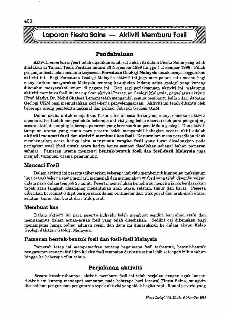
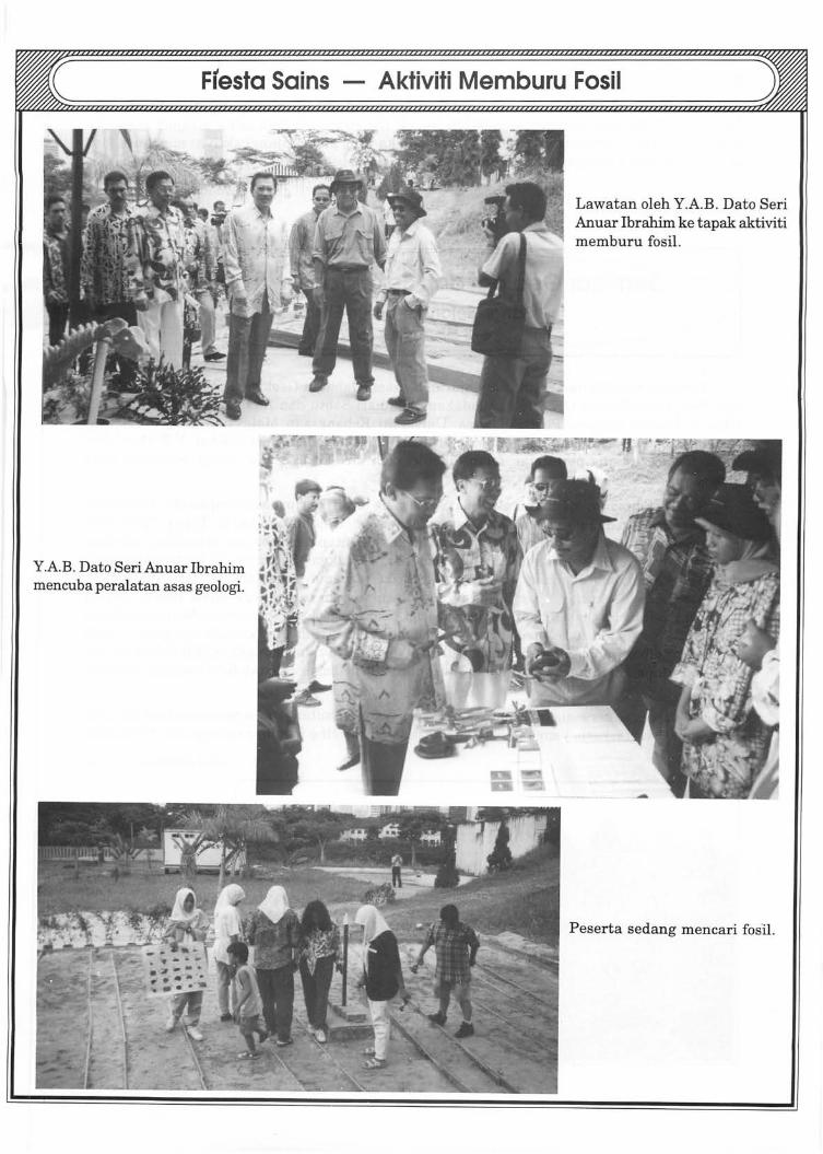
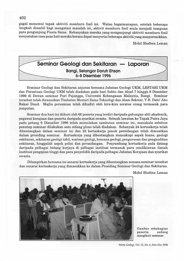
Laporan Fiesta Sains - Aktiviti Memburu Fosil
Pendahuluan Aktiviti memburu fOBil telah dijadikan salah satu aktiviti dalam Fiesta Sains yang telah
diadakan di Taman Tasik Perdana antara 23 November 1996 hingga 1 Disember 1996. Pihak penganjur fiesta telah meminta kerjasama Persatuan Geologi Malaysia untuk menyelenggarakan ak.tiviti ini. Bagi Persatuan Geologi Malaysia aktiviti ini juga merupakan satu medan bagi menyedarkan masyarakat Malaysia tentang kewujudan bidang sains geologi yang kurang diketahui masyarakat umum di negara ini. Dari segi perlaksanaan aktiviti ini, walaupun aktiviti memburu fosil ini merupakan aktiviti Persatuan Geologi Malaysia, penyelaras aktiviti (Prof. Madya Dr. Mohd Shafeea Leman) telah mengambil semua pembantu beliau dari J abatan Geologi UKM bagi memudahkan kerja-kerja penyelenggaraan. Aktiviti ini telah dibantu oleh beberapa orang pembantu makmal dan pelajar Jabatan Geologi UKM.
Dalam us aha untuk menjadikan fiesta sains ini satu fiesta yang menyeronokkan aktiviti memburu fosil telah menyediakan beberapa aktiviti yang boleh disertai oleh para pengunjung secara aktif, disamping beberapa pameran yang berunsurkan pendidikan geologi. Dua aktiviti tumpuan utama yang mana para peserta boleh mengambil bahagian secara aktif adalah aktiviti mencari fosil dan aktiviti membuat kas fosil. Kesuntukan masa persediaan tidak membenarkan acara ketiga iaitu menyusun rangka fosil yang turut dicadangkan pada peringkat awal (fosil untuk acara ketiga hanya sempat disediakan sebagai bahan pameran sahaja). Pameran utama mengenai bentuk-bentuk fosil dan fosil-fosil Malaysia juga menjadi tumpuan utama pengunjung.
Mencari Fosil
Dalam aktiviti ini peserta (dibenarkan beberapa individu membentuk kumpulan maksimum lima orang) bekerja sama mencari, mengenali dan menamakan 25 fosil yang telah disembunyikan dalam pasir dalam tempoh 25 minit. Peserta memerlukan kemahiran mengirajarak berdasarkan tapak atau langkah disamping menentukan arah utara, selatan, timur dan barat. Peserta diberikan koordinat 6 digit berupajarak dalam centimeter dari titik pusat dan arah-arah utara, selatan, timur dan barat dari titik pus at.
Membuatkas
Dalam aktiviti ini para peserta individu boleh membuat sendiri bancuhan resin dan menuangnya dalam acuan-acuan fosH yang telah disediakan. Sedikit caj dikenakan bagi menampung harga bahan adunan resin, dan dana ini dimasukkah ke dalam akaun Kelab Geologi J abatan Geologi Malaysia.
Pameran bentuk-bentuk fosil dan fosil-fosil Malaysia
Pamerah tetap ini mempamerkan tentang bagaimana fosil terbentuk, bentuk-bentuk pengawetan sesuatu fosH dan koleksi fosil tempatan dari usia setua lebih setengah biliun tahun hingga ke beberapa ribu tahun.
Perjalanan aktiviti Secara keseluruhannya, aktiviti memburu fosH ini telah berjalan dengan agak lancar.
Aktiviti ini kurang mendapat sambutan pada beberapa hari terawal Fiesta Sains, mungkin disebabkan pengurusan pengaturan tapak aktiviti yang tidak begitu rapi. Ramai peserta yang
Warta Geologi, Vol. 22, No.6, Nov-Dec 1996
Ftesta Sains - Aktiviti Memburu Fosil
Y.A.B. Data Seri Anuar Ibrahim mencuba peralatan as as gealagi.
Lawatan aleh Y.A.B. Data Seri Anuar Ibrahim ke tapak aktiviti memburu fosil.
Peserta sedang mencari fasil.
402
gagal menemui tapak aktiviti memburu fosil ini . Walau bagaimanapun, setelah beberapa langkah diambil bagi mengatasi masalah ini, aktivit memburu fosil mula menjadi tumpuan para pengunjung Fiesta Sains. Kebanyakan mereka yang mengunjungi aktiviti memburu fosil menyatakan rasa puas hati mereka kerana dapat menyertai beberapa aktiviti yang menyeronokkan.
Bangi, Selangor Daruh Ehsan 6-8 Disember 1996
Mohd Shafeea Leman
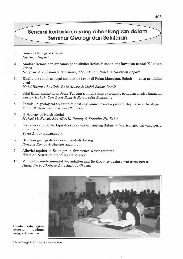
Seminar Geologi dan Sekitaran anjuran bersama Jabatan Geologi UKM, LESTARI UKM dan Persatuan Geologi UKM telah diadakan pad a hari Sabtu dan Ahad 7 hingga 8 Disember 1996 di Dewan seminar Puri Pujangga, Universiti Kebangsaan Malaysia, Bangi. Seminar tersebut telah dirasmikan Timbalan Menteri Sains Teknologi dan Alam Sekitar, Y.B. Dato' Abu Bakar Daud. Majlis peresmian telah dihadiri oleh kira-kira seratus orang termasuk para jemputan.
Seminar dua hari ini diikuti oleh 66 peserta yang terdiri daripada gabungan ahli akademik, pegawai kerajaan dan peserta daripada syarikat swasta. Sebuah lawatan ke Tapak Putra Jaya pada petang 6 Disember 1996 telah memulakan sambutan seminar ini, manakala sebelum penutup seminar dilakukan satu sidang pleno telah diadakan. Sebanyak 24 kertaskerja telah dibentangkan dalam seminar ini dan 22 kertaskerja penuh persidangan telah dimuatkan dalam pro siding seminar. Kertaskerja yang dibentangkan mencakupi aspek konse; geologi sekitaran, sekitaran geologi tabii, warisan geologi, bencana geologi, pengurusan dan pengauditan sekitaran, hinggalah aspek polisi dan perundangan. Penyumbang kertaskerja pula datang daripada pelbagai bidang kerjaya di pelbagai institusi termasuk para cendikiawan ilmiah institusi pengajian tinggi dan para penyelidik daripada pelbagai Jabatan Kerajaan dan syarikat swasta.
Dilampirkan bersama ini senarai kertaskerja yang dibantangkan semasa seminar tersebut dan senarai kertaskerja yang dimasukkan ke dalam Prosiding Seminar Geologi dan Sekitaran.
Mohd Shafeea Leman
Gambar sebahagian peserta sedang mengikuti seminar.
Warfa Geologi, Vol. 22, No. 6, Nov-Dec 1996
Senarai kertaskerja yang dibentangkan dalam Seminar Geologi dan Sekitaran
1. Konsep Geologi sekitaran Nasiman Sapari
403
2. Analisis kemasinan air tanah pada akuifer kedua di sepanjang kawasan pantai Kelantan Utara Haryono, Abdul Rahim Samsudin, Abdul Ghani Rafek & Nasiman Sapari
3. Kualiti air tanah sebagai sumber air tawar di Pulau Manukan, Sabah - satu penilaian awal Mohd Harun Abdullah, Baba Musta & Mohd Zailon Ramli
4. Sifat fiziko-kimia tanah J ohor Tenggara: implikasinya t erhadap pengurusan sis a buangan Anizan Isahak, Tan Boon Kong & Kamarudin Samuding
5. Fossils: a geological treasure of past environment and a present day natural heritage Mohd Shafeea Leman & Lee Chai Peng
6. Hydrology of North Kudat Majeed M. Faisal, Shariff A.K. Omang & Sanudin Hj. Tahir
7. Struktur canggan berlapis-fasa di kawasan Tanjung Balau - Warisan geologi yang perlu dipelihara Tajul Anuar Jamaluddin
8. Bencana geologi di kawasan Lembah Kelang Ibrahim Komoo & Maziah Sulaiman
9. Alluvial aquifer in Selangor: a threatened water resource Nasiman Sapari & Mohd Nazan Awang
10. Malaysia's environmental degradation and its threat to surface water resources Hamirdin b. Ithnin & Ame Saifude Ghazali
Gambar sebahagian peserta sedang mengikuti seminar.
Warta Geologi, Vo l. 22, No. 6, Nov-Dec 1996
404
11. Geotechnical problems in limestone terrain with emphasis on cavities and sinkholes Chow Weng Sum, Jamaludin Othman & P. Loganathan
12. Development of Pulau Redang: implication to marine environment Md. Shahid Ayub, Mohd Tadza Abdul Rahman & Daud Mohamad
13. Sludge Farming: its effect on underground water system Foo Say Moo & Norhanita Mohd. Nordin
14. Heavy metal content of soil from Maran, Pahang: its implication to suitability ofland for agriculture Sahibin Abdul Rahim, Mohamad Md Tan & Mohd Barzani Gassim
15. Environmental management and geosciences: trends and challenges Joy Pereira & S. Paramananthan
16. Siri pereputan uranium-torium sebagai unsur surih di dalam geologi marin Che Abd. Rahim Mohamed
17. Kajian awal model mudah bagi menentukan mendapan habuk di sekitar kuari Izhar Abadi b. Ibrahim Rais & Mohamad Haniza b. Mahmud
18. Soil remediation using surfactant flushing and surfactant washing Shahidan Radiman & Mohd Raihan Taha
19. Microgravity as an effective tool in sinkhole investigation Jamaludin Othman
20. Effects of soil physico-chemical characteristics on soil and slope stability Rashid Ahmad
21. Pollutant transport assessment studies in groundwater system by artificial and environmental isotopes Mohd Tadza Abdul Rahman, Md. Shahid Ayub & Daud Mohamad
22. The use of electrical imaging for mapping subsurface pollution Loke Meng Heng
23. Penilaian impak alam sekitar dan geologi sekitaran Abdul Rahim Samsudin
24. EIA dari segi falsafahnya, dan kelemahan perlaksanaannya untuk aspek geologi Ramzani Abdullah & Nasiman Sapari
1. Rate of geological processes in Malaysian environment Tjia Hong Djin
2. Analisis kemasinan air tanah pada akuifer kedua di sepanjang kawasan pantai Kelantan Utara Haryono, Abdul Rahim Samsudin, Abdul Ghani Rafek & Nasiman Sapari
Warta Geologi, Vol. 22, No.6, Nov-Dec 1996

405
3. Kualiti air tanah sebagai sumber air tawar di Pulau Manukan, Sabah - satu penilaian awal Mohd Harun Abdullah, Baba Musta & Mohd Zailon Ramli
4. Sifat fiziko-kimia tanah Johor Tenggara: implikasinya terhadap pengurusan sisa buangan Anizan Isahak, Tan Boon Kong & Kamarudin Samuding
5. Fossils: a geological treasure of past environment and a present day natural heritage Mohd Shafeea Leman & Lee Chai Peng
6. Hydrology of North Kudat Majeed M. Faisal, Shariff A.K. Omang & Sanudin Hj. Tahir
7. Bencana geologi di kawasan Lembah Kelang Ibrahim Komoo & Maziah Sulaiman
8. Alluvial aquifer in Selangor: a threatened water resource Nasiman Sapari & Mohd Nazan Awang
9. Development of Pulau Redang: implication to marine environment Md. Shahid Ayub, Mohd Tadza Abdul Rahman & Daud Mohamad
10. Heavy metal content of soil from Maran, Pahang: its implication to suitability ofland for agriculture Sahibin Abdul Rahim, Mohamad Md Tan & Mohd Barzani Gassim
11. Environmental management and geosciences: trends and challenges Joy Pereira & S. Paramananthan
12. Siri pereputan uranium-torium sebagai unsur surih di dalam geologi marin Che Abd. Rahim Mohamed
13. Kajian awal model mudah bagi menentukan mendapan habuk di sekitar kuari Izhar Abadi b. Ibrahim Rais & Mohamad Haniza b. Mahmud
14. Soil remediation using surfactant flushing and surfactant washing Shahidan Radiman & Mohd Raihan Taha
15. Microgravity as an effective tool in sinkhole investigation Jamaludin Othman
16. Beach nourishment as means of coastal erosion control: the Malaysian experience Lee Say Chong
17. Effects of soil physico-chemical characteristics on soil and slope stability Rashid Ahmad
18. Pollutant transport assessment studies in groundwater system by artificial and environmental isotopes Mohd Tadza Abdul Rahman, Md. Shahid Ayub & Daud Mohamad
19. The use of electrical imaging for mapping subsurface pollution Loke Meng Heng
20. Penilaian impak alam sekitar dan geologi sekitaran Abdul Rahim Samsudin
21. Struktur canggan berlapis-fasa di kawasan Tanjung Balau - Warisan geologi yang perlu dipelihara Tajul Anuar Jamaluddin
Warta Geologi, Vol. 22, No.6, Nov-Dec 1996
406
The Petroleum Geology Conference this year, the 19th in the series, attracted a sizeable turnout of about 300 registered participants at the newly opened Rennaissance Hotel, Kuala Lumpur on the 9th and 10th December 1996.
As the President was away performing his umrah , this year's Welcoming Address was performed by the Honorary Secretary, Dr . Ahmad Tajuddin Ibrahim.
The Opening Address this year was given by Yg. Bhg. Dato' Mohamad Idris Mansor, Senior Vice President Petronas and Managing Director/CEO, Petronas Carigali Sdn. Bhd. In his speech he updated the Malaysian exploration efforts and the achievement to be among the world's top 25 for both oil and gas. With regards to the large potential of hydrocarbon resources yet to be found in Malaysia, he proposed they be comprehensively explored and effectively exploited utilising the latest state-of-the-art technology. He informed the gathering that Petronas is trying to improve the PSC terms to encourage exploration especially in gas and as such synergistic alliances between oil or service companies are essential to the success offuture exploration efforts.
To round up the Opening Ceremony, Mohamad Yamin Ali of PRSS was presented a momento for the Society's Geoscientist Award 1996 by Dato Mohamad Idris Mansor.
A total of 24 oral presentations and 5 posters were presented over the 2-day Conference. In addition there were 2 Keynote Papers, one by Nick De'Ath of Triton and the other by Chris Wright of Mobil. All the presentations received keen attention and comments from the enthusiastic audience.
In its effort to promote the awareness ofthe Conference to University students, the Society sponsored the bus transport for a large delegation from the Universiti Sains Malaysia, Penang and local transportations for those from Universiti Malaya.
The exhibition by 10 companies to display their various computer-aided and other techniques in the oil exploration industry was well attended. Digicon was again the host for welcomed drinks at the exhibition site . Schlumberger (M) Sdn. Bhd. sponsored the first day's lunch, Western Atlas (M) Sdn. Bhd. the Ice-breaker Reception and Petronas the Conference bags besides a host of other generous contributors.
During the first lunch break, winners of the Society's Photographic Competition 1996, were awarded their prizes .
Despite hosting the Petroleum Geology Conference at a new venue this year, the Organising Committee, under the Chairmanship of Ali Mohd Shariff, still managed to put up a highly commendable conference and exhibition.
G.H . Teh
Warta Geolngi, Vol. 22, No. 6, Nov-Dec 1996
PETROLEUM GEOLOGY CONFERENCE 1996 9 a 10 December 1996
,t/~td(jl~~~~/
407
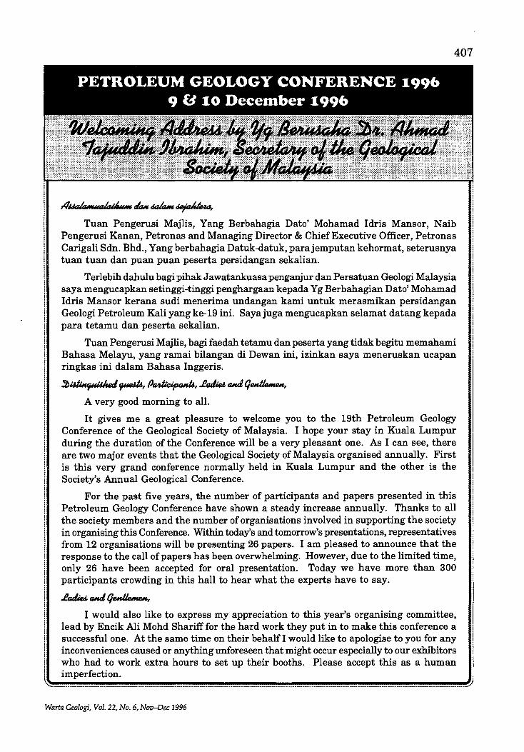
Tuan Pengerusi Majlis, Yang Berbahagia Dato' Mohamad Idris Mansor, N aib Pengerusi Kanan, Petronas and Managing Director & Chief Executive Officer, Petronas Carigali Sdn. Bhd., Yang berbahagia Datuk-datuk, parajemputan kehormat, seterusnya tuan tuan dan puan puan peserta persidangan sekalian.
Terlebih dahulu bagi pihak J awatankuasa penganjur dan Persatuan Geologi Malaysia saya mengucapkan setinggi-tinggi penghargaan kepada Y g Berbahagian Dato' Mohamad Idris Mansor kerana sudi menerima undangan kami untuk merasmikan persidangan Geologi Petroleum Kali yang ke-19 ini. Saya juga mengucapkan selamat datang kepada para tetamu dan peserta sekalian.
Tuan Pengerusi Majlis , bagi faedah tetamu dan peserta yang tidak begitu memahami Bahasa Melayu, yang ramai bilangan di Dewan ini, izinkan saya meneruskan ucapan ringkas ini dalam Bahasa Inggeris.
A very good morning to all.
It gives me a great pleasure to welcome you to the 19th Petroleum Geology Conference of the Geological Society of Malaysia. I hope your stay in Kuala Lumpur during the duration of the Conference will be a very pleasant one. As I can see, there are two major events that the Geological Society of Malaysia organised annually. First is this very grand conference normally held in Kuala Lumpur and the other is the Society's Annual Geological Conference.
For the past five years, the number of participants and papers presented in this Petroleum Geology Conference have shown a steady increase annually. Thanks to all the society members and the number of organisations involved in supporting the society in organising this Conference. Within today's and tomorrow's presentations, representatives from 12 organisations will be presenting 26 papers . I am pleased to announce that the response to the call of papers has been overwhelming. However, due to the limited time, only 26 have been accepted for oral presentation. Today we have more than 300 participants crowding in this hall to hear what the experts have to say.
I would also like to express my appreciation to this year's organising committee, lead by Encik Ali Mohd Shariff for the hard work they put in to make this conference a successful one. At the same time on their behalf I would like to apologise to you for any inconveniences caused or anything unforeseen that might occur especially to our exhibitors who had to work extra hours to set up their booths . Please accept this as a human imperfection.
Warta Geologi, Vol. 22, No . 6, Nov-Dec 1996
408
~.......... .... m= .. _ .... :: .. mm_~m.: _.. : .. _ m _~ ..... ~ .. _m~: __ :~:~::.:._ ..... ___ , .. L .. ~ L L1.. .. _ "L'~~'~'~':~'~:'" :_ L _L ___ :~m~~:~m .... ____ L __ m .. ,)
PETROLEUM GEOLOGY CONFERENCE 1996 9 a 10 December 1996
407
AIMiIa""Wik;~_ eItu.~~,
Tuan Pengerusi Majlis, Yang Berbahagia Dato' Mohamad Idris Mansor, N aib Pengerusi Kanan, Petronas and Managing Director & Chief Executive Officer, Petronas Carigali Sdn. Bhd., Yang berbahagia Datuk-datuk, parajemputan kehormat, seterusnya tuan tuan dan puan puan peserta persidangan sekalian.
Terlebih dahulu bagi pihak J awatankuasa penganjur dan Persatuan Geologi Malaysia saya mengucapkan setinggi-tinggi penghargaan kepada Y g Berbahagian Dato' Mohamad Idris Mansor kerana sudi menerima undangan kami untuk merasmikan persidangan Geologi Petroleum Kali yang ke-19 ini. Saya juga mengucapkan selamat datang kepada para tetamu dan peserta sekalian.
Tuan Pengerusi Majlis, bagi faedah tetamu dan peserta yang tidak begitu memahami Bahasa Melayu, yang ramai bilangan di Dewan ini, izinkan saya meneruskan ucapan ringkas ini dalam Bahasa Inggeris.
~idlMer;uidl.eJ~, P~I4,.faJia awL qM~,
A very good morning to all.
It gives me a great pleasure to welcome you to the 19th Petroleum Geology Conference of the Geological Society of Malaysia. I hope your stay in Kuala Lumpur during the duration of the Conference will be a very pleasant one. As I can see, there are two major events that the Geological Society of Malaysia organised annually. First is this very grand conference normally held in Kuala Lumpur and the other is the Society's Annual Geological Conference.
For the past five years, the number of participants and papers presented in this Petroleum Geology Conference have shown a steady increase annually. Thanks to all the society members and the number of organisations involved in supporting the society in organising this Conference. Within today's and tomorrow's presentations, representatives from 12 organisations will be presenting 26 papers. I am pleased to announce that the response to the call of papers has been overwhelming. However, due to the limited time, only 26 have been accepted for oral presentation. Today we have more than 300 participants crowding in this hall to hear what the experts have to say .
.faJia ruuI, q~,
I would also like to express my appreciation to this year's organising committee, lead by Encik Ali Mohd Shariff for the hard work they put in to make this conference a successful one. At the same time on their behalf I would like to apologise to you for any inconveniences caused or anything unforeseen that might occur especially to our exhibitors who had to work extra hours to set up their booths. Please accept this as a human imperfection.
Warta Geologi, Vol. 22, No.6, Nov-Dec 1996
408 (f .. _.
Companies and organisations related to the petroleum. industry in this country have given their fullest support and co-operation in organising this conference. To date, the society has received in cash of 26,000 Ringgit Malaysia and the rest in kind in organising today's conference. On behalf of the society I would like to thank EPMI, Sarawak Shell Berhad, Nippon Oil, Triton Oil Company of Thailand, Carigali-PTTEPI Company Sdn. Bhd & MTJA, Texaco Exploration Penyu Inc., Geophysical Consultants, OPIC and Conoco Asia Pacific, and others who have contributed to the Society in kind such as Schlum.berger, Atlas Wireline Services and Petronas. We interpret this as their support for this Conference which has been regarded as the leading forum for exchange of ideas and information among petroleum experts in this region.
The Society is indeed very pleased with the ever increasing financial support. To all donors and sponsors, please accept our sincere thanks. In return the Society would like to ensure the donors and sponsors that they will continue to enjoy the ever popular Petroleum Geology Conference every year.
<JWiM ~,"i M~,
Sebelum saya mengundurkan diri, sekali lagi saya ingin merakamkan berbanyak ucapan terima kasih kepada Yang Berbahagia Dato Mohamad Idris Mansor kerana sudi bersama kita di pagi yang indah ini.
Sekian terima kasih and thank you.
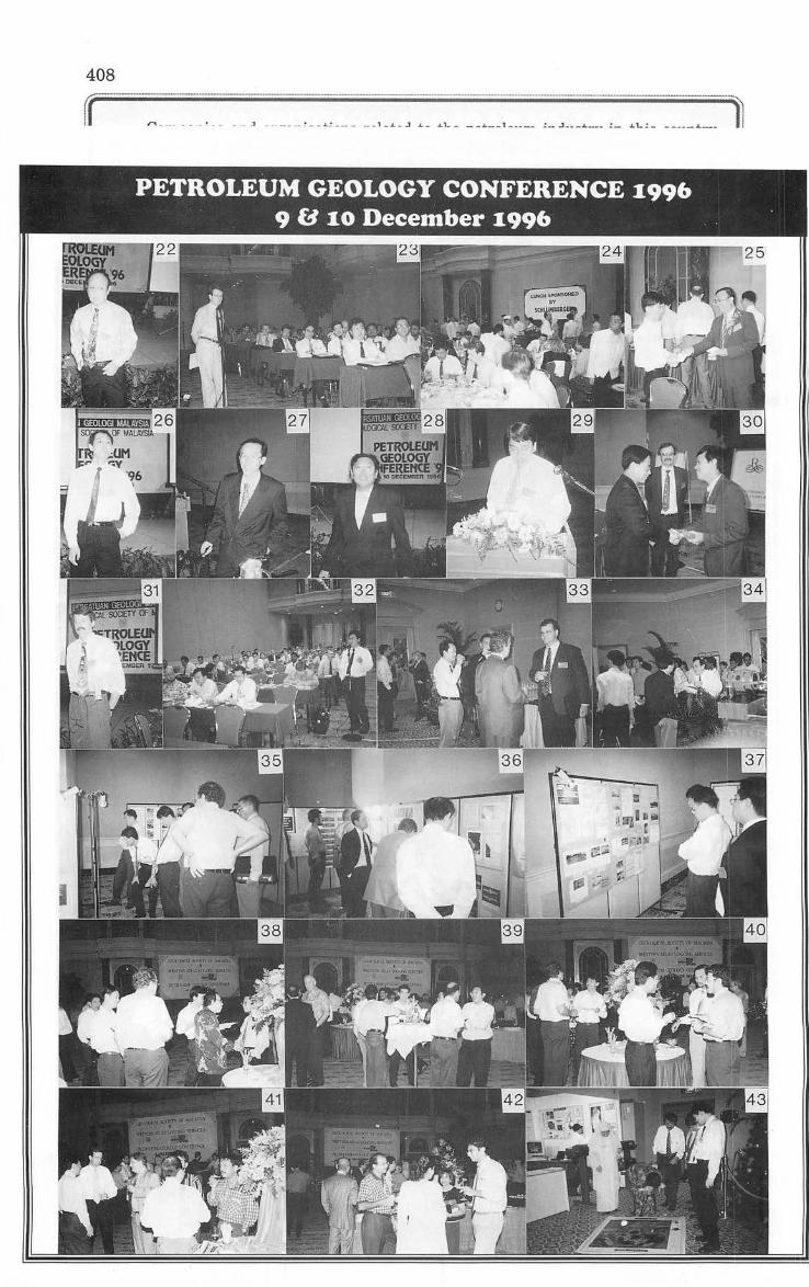
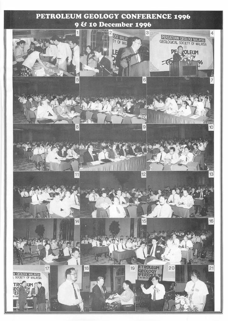
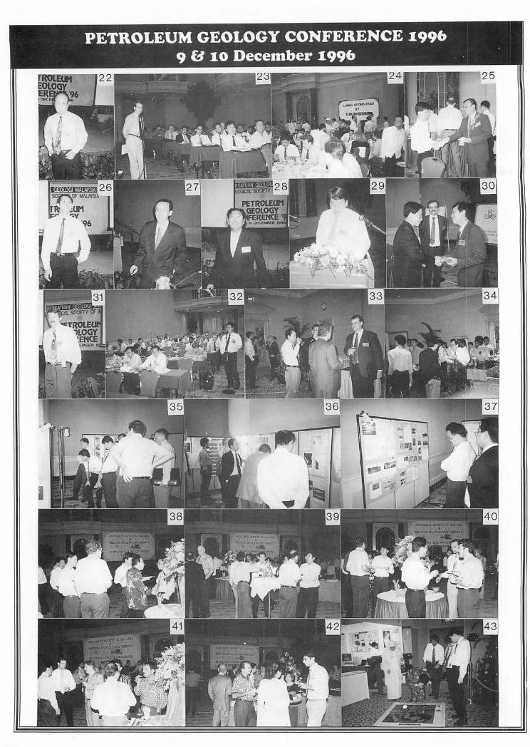
1. Busy at the registration desk. 35-37. Totally absorbed in the Poster Display. ·2. The MCs starting off the ceremony. 38-42. At the Ice-Breaker Reception hosted by Westem 3. Hon. Sec. Ahmad Tajuddin with the Welcoming Atlas.
Address. 43-48. Keen interest shown at the Exhibition Booths. 4. Yg. Bhd. Dato' Mohamad Idris with the Opening 49. Lunch sponsored by the Society.
Address. 50. William Primavesi on Swathe Bathymetry. 5-16. Sections of the crowd at the Opening Ceremony. 51. Nick De'Ath with his Keynote Paper. 17. GeoscientistAward 1996 winner, Mohamad Yamin 52. Liew Kit Kong with a query from the floor.
Ali. 53. Kenny Goh on the Cakerawala Field. 18. Ismail Che Mat-Zin with the first paper. 54. Peter Whiting on 3D migration. 19. Boniface Bait receiving momento from Session 55. JosephJ. Lambiase on the Baram Delta Complex,
Co-Chairman Dave Lehman. Brunei. 20. Leong Lap Sau with his presentation. 56. Kenneth Wong with his presentation. 21. Yap Kok Thye on the Tapis Field. 57. Mohd Tahir on Angsi Group K gas resource. 22. Ko Ko Kyi on improving formation evaluation. 58. H.D. Tjia on Tectonics of Sarawak Basin. 23. Jonathan Redfeam with a question. 59. Mohd Jamaal Hoesni with his paper. 24. Lunch sponsored by Schlumberger. 60. Chris Wright presenting his Keynote Paper. 25. Ng Tham Fatt receiving his prize for the Society's 61. Mohd Raji on optimising oil development at Tabu.
Photographic Competition. 62. Abdul Hadi presenting his paper. 26. Eric Chow answering a query. 63. Salahuddin Saleh Karimi on deepwater Block SB-G. 27. Robert Wong on the Labuan-Paisley Syncline. 64. Adnan A.M. Aqrawi with his presentation. 28. Azhar Hj. Hussin helping outwith Abdul Hadi's paper. 65. NasirHj Darman receiving momentofrom Session 29. John Voon with his presentation. Co-Chairman Phil Magor. 30. C.P. Lee presenting Session Co-Chairman Lee 66. Wan Hasiah Abdullah receiving momento for her
King Sim with a token while Co-Chairman Cedric Poster from Ahmad Tajuddin. Philp looks on. 67. Mazlan Madon being congratulated for his
31. D.E. Fitz on determining water saturation. Posters. 32. A question from the floor. 68. Organising Chairman, Ali Mohd Shariff with his 33-34. Time for drinks at Digicon's Hospitality Comer. Closing Remarks.
Warta Geoiogi, Vol. 22, No.6, Nov-Dec 1996
PETROLEUM GEOLOGY CONFERENCE 1:996 9 a 1:0 December 1:996 . .
PETROLEUM GEOLOGY CONFERENCE 1996 98,10 December 1996 '
412
'lf~ B~, :Ll~.II/u"d cJ~ j~, ~oJ the q~ S0ck4oJM~, tlWil: liLt MoIuJ skvuU, fJ~ e~ oJ the 1996 p~ q~ e~.
:Ll~~, P~, .fad.ie4. aJ, q~,
Assalamualaikum and good morning to all .
First of all, I must say that I am privileged to be present here in the midst of prominent geoscientists and experts of the oil & gas industry and also to be invited to deliver this opening address in the 19th Petroleum Geology Conference organised by the Geological Society of Malaysia. I would like to take this opportunity to extend my warmest welcome to those who have travelled from abroad to be here with us today. "Selamat Datang ke Malaysia" as we commonly greet visitors to our country.
I would like to praise the Geological Society of Malaysia for their continuing efforts all these years in organising this annual event to promote new geological concepts and providing a forum to exchange ideas and share experience. I am happy to note that more than 300 participants are gathered today to listen and deliberate on 27 technical papers and participate in 6 posters sessions on topics ranging from advanced seismic processing techniques to specific geological concepts to the optimisation offield development plans. I understand that key note papers for today and tomorrow will highlight on the future exploration challenges and strategies in carrying out E&P business into the 21st century. Participants will also get the opportunity to be exposed to the latest technology being used in search for hydrocarbons which is now a necessity in view of the diminishing obvious prospects to be explored.
Let me update you on the exploration efforts and the achievement in Malaysia. As of 31 October 1996, a total of over 1.168 million line km of seismic data have been acquired and some 947 exploration wells drilled resulting in the discovery of 121 oil fields and 202 gas fields. Our domestic, exploration efforts can be considered very successful with an enviable average success ratio of 1 in 4.5 for oil exploration. The total hydrocarbon reserves discovered to date stands at over 7.4 billion barrels of oil and over 89 trillion standard cubic feet of gas . Net of production, the remaining reserves stand at over 4 billion barrels of oil and more than 80 trillion standard cubic feet of gas. In the world reserves ranking, Malaysia is placed amongst the top 25 for both oil and gas.
The revenue generated from the exploration of these reserves has contributed significantly to the development of Malaysia. Currently, we have 33 oil fields and 9 gas fields producing at a production level of about 630,000 BOPD and 4.3 billion SCFGPD.
Warta Geologi, Vol . 22, No. 6, Nov-Dec 1996

413
Our national demand for crude oil currently runs at 61% of daily production. The current domestic supply and demand balance indicates that Malaysia will in all probability be a net importer of oil by the middle of the next decade; this is assuming no new fields are found and no new field development takes place .
..I!tJ;a ruuI, f/MtJe"""" Like in many established petroliferous areas in the world, exploration in Malaysia
is rather mature and becoming very challenging. There is still a large potential hydrocarbon resources yet to be found in Malaysia and most of it are believed to be trapped in more subtle stratigraphic plays, deeper overpressure objectives and in the frontier deepwater areas. I am confident that these remaining hydrocarbon reserves can be comprehensively explored and effectively exploited through constructive and innovative means utilising the latest state-of-the-art technology. The service sector can play an important role in this.
New and innovative ideas have recently resulted in some hydrocarbon discoveries in the northern Malay Basin in deeper objectives and stratigraphic channel plays. New ideas would tend to result in new discoveries if we were to make a paradigm shift in our exploration efforts.
From the commercial viewpoint Petronas is currently looking at some ways to improve the PSC terms to encourage companies to explore in Malaysia with a reasonable return on their investment.
Unlike before when oil was the focus of the PSC contractors operating in Malaysia, gas is becoming the preferred energy source in this region. With an increasing demanding gas market in the region coupled with the advantage of being a more environmentally friendly fuel, many oil companies are now focusing on gas exploration in Malaysia. With LNG demand in this region reaching its peak by the tum of the century, I foresee an intensified gas exploration programme that will be carried out in the next couple of years.
In the area of Research and Development, R&D, Malaysia has the necessary infrastructure required to facilitate and promote R&D works. We believe that Malaysia can serve as a regional R&D centre for companies active in the ASEAN region. Today's business world recognises few borders and many oil companies have come to Malaysia . to venture in both the upstream and the downstream sectors. Malaysia is committed to being the centre of excellence in the region and can offer efficient business and technical infrastructures and provide an educated, competent and motivated workforce to potential foreign investors .
...I!rJi.4. ruuI, q_u.",.,., I would like to conclude by reminding you that innovative concepts, new aggressive
technology and synergistic alliances with oil/services companies are essential to the future success of our exploration efforts. I trust this Conference will provide a forum for all of you to discuss and debate on this. I would like to take this opportunity to
I congratulate the members of the Organising Committee for efforts in bringing about this Conference. l It is with great pleasure that I declare the 19th Petroleum Geology Seminar open.
Thank you.
~-~~.~~~~~~~.-~~-~.-.~~~.~.~.~~-~ .. -~~~~--~~-~.~~~.~~--~~
Warla Geologi, Vol. 22, No.6, N(1O-Dec 1996
414
Day 1, 9th December 1996 (Monday)
08:00
08:50
09:05
09:20
09:30
Registration
Arrival of Invited Guests
Welcoming Address by Dr. Ahmad Tajuddin Hon. Secretary Geological Society of Malaysia
Opening Address by YBhg Dato' Mohamad Idris Mansor Senior Vice-President, PETRONAS & Managing Director & CEO, Petronas Carigali Sdn. Bhd.
Coffee Break
Session 1: Morning Session
Co-Chairman: Dave Lehman (EPMI) and Effendy Cheng Abdullah (PMU)
10:30 Paper 1: Tectonic evaluation and sedimentation history of Sarawak Basin Ismail Che Mat-Zin (PCSB)
10:55 Paper 2: AVO Depth Modelling Leong Lap Sau (USM) and Ng Tong San (PCSB)
11:20 Paper 3: Geochemical fingerprinting in D35 Oil Field, offshore Sarawak Boniface Bait (SSB) and Redzuan Abu Hassan (PRSS)
11:45 Paper 4: Sequence stratigraphy of the Group J, Tapis Field, Malay Basin Yap Kok Thye (EPMI)
12:10 Paper 5: Effort towards improving formation evaluation Ko Ko Kyi (PCSB)
12:30 Lunch Break (Hosted by Schlumberger (M) Sdn. Bhd,)
Session 2: Afternoon Session
Co-Chairman: Lee King Sim (SSB) and Cedric Philp (Mobil)
13:45 Paper 6: Comparison of resistivity and capillary pressure approaches to determining water saturation from wireline log data D.E. Fitz and Khushairi Zainu (EPMI)
14:10 Paper 7: 2D marine exploration seismic data from high resolution seismic survey P.M. Tong, H.S. Low and K.F. Chow (Racal Survey (M) Sdn. Bhd,)
14:35 Paper 8: Sequence stratigraphy ofthe Upper Miocene Stage IVC in the LabuanPaisley Syncline, northwest Sabah Basin Robert Wong (PMU)
Warta Geologi, Vol. 22, No. 6, Nov-Dec 1996
415 15:00 Paper 9: Modelling Late Miocene sea level change in Baram Delta, offshore
Sarawak, East Malaysia: An exploration attempt Abdul Hadi Abd Rahman (University of Malaya)
15:25 Tea Break
15:50 Paper 10: Technology application in prospect evaluation, offshore Sabah John 'W>on, W. Pool, N. Casson, KB. Lim, J. Ting, E. Telatovich and G. Bloch (SSPC)
16: 15 Paper 11: An analysis of the benefits of 3D pre-stack time migration Peter Whiting (Digicon Geophysical Limited)
16:40 End of Day One
19:00 lee Breaker Reception (Hosted by Western Atlas (M) Sdn. Bhd.)
Day 2, 10th December 1996 (Tuesday)
Session 8: Morning Session
Co-Chairman: Yusof Johari (PCSB) and Phil Magor (lPC)
08:30 Keynote Paper 1: Oil companies exploration strategies in the 21st century Nick De'Ath (Triton)
08:55 Paper 12: Integrated reservoir characterisation of Cakerawala Field-Block A-18, MTJDA Kenny Goh (Triton Energy), Sonny Lim H.B. (CTOC) and Amiruzan Apandi (PCSB)
09:20 Paper 13: Tidal successions of the wave-dominated.Baram Delta Complex, Brunei Joseph J. Lambiase (Universiti Brunei Darussalam)
09:45 Paper 14: Harmonization of vintage 3D surveys Kenneth Wong Ung Sing (SSB / SSPC)
10:15 Coffee Break
10:45 Paper 15: Tectonics of the Sarawak Basin H.D. Tjia (PRSS)
11:10 Paper 16: Swathe Bathymetry - a real time pipeline route modelling tool? William Primavesi and Tham Siew Kee (Racal Survey (M) Sdn. Bhd.)
11:35 Paper 17: Angsi Group K gas resource appraisal and development challenges Mohd Tahir, Zainuddin Yusoff, David. E. Nice and Chua Hwa Tian (EPMI)
12:00 Paper 18: Occurrence of novel biomarker fingerprints in Malay Basin sediments: Source implications Mohd Jamaal Hoesni and Peter Abolins (PRSS)
12:30 Lunch Break
Session 4: Afternoon Session
Co-Chairman: Al Kaplan (Triton Energy) and Brian F. Maxted (CTOC)
14:00 Keynote Paper 2: Challenges for the E&P industry in the 21st Century Chris Wright (VP Mobil New Ventures-Asia/Pacific, UK)
14:25 Paper 19: Integration of sequence stratigraphy and reservoir management to optimise oil development at Tabu Mohd Raji (EPMI)
Warta Geologi, Vol. 22, No.6, Nov-Dec 1996
416 14:50
14:15
15:45
16:10
16:35
17:00
17:25
Poster 1:
Poster 2:
Poster 3:
Poster 4:
Poster 5:
Paper 20: Clay mineral diagenesis and reservoir quality of the Upper Cycle V (Late Miocene) sandstones of Bar am Field, offshore Sarawak, East Malaysia Abdul Hadi Abd. Rahman (University of Malaya)
Paper 21: Seismic identification of depositional processes in a turbidite fan environment, deepwater Block SB-G, NW Sabah Salahuddin Saleh Karimi (PRAD, PMU) and Jeffrey J. Labao and Mario M. Wannier (SSPC)
ThaBreak
Paper'22: Preservation of organic matter in lacustrine/deltaic sediments of southern Mesopotamia Adnan AM. Aqrawi (PRSS)
Paper 23: Importance of geological parameters to reservoir simulation - a case study Nasir Hj Darman, Izman Hamid and Rapi Mat Som (PRSS)
Paper 24: Deep reservoir potential of the North Malay Basin Robert Wong and Salah uddin Salleh Karimi (PMU)
Closing Remarks by Organising Chairman
POSTER SESSION
Sedimentological aspects of the Temburong and Belait Formations, Labuan Mazlan Madon (PRSS)
Thermal history reconstruction of NW Malay Basin using 2-dimensional basin modelling software NashrolAriffHussain and Mahadir Ramly (PCSB) and Robert H. Lander (Geologica (formerly Procom), Norway)
Gravity anomalies, isostasy, and the tectonic evolution of the Malay and Penyu Basin Mazlan Madon (PRSS)
Coal as a source rock for oil: Petrographic evidence from Tertiary coals, onshore Sarawak Wan Hasiah Abdullah (University of Malaya)
PGIPMS - an integrated Petroleum Geological Information Processing and Modelling System S. Sivaji (University of Malaya)
Warta Ge%gi, Vol. 22, No.6, Nov-Dec 1996
417
Keynote Paper 1
Oil companies exploration strategies in the 21 st century
NICK DE'ATH
Triton
The oil industry is at a critical stage in its history as oil demand continues to rise to fuel thirsty economies . Even at modest growth rates a 50% increase in current production is forecast by 2020. Demand for gas is likely to outstrip oil. And yet discovery rates have declined dramatically over the past 20 years partly due to finite resources, restricted geography and the reliance on quantitative risk analysis. With the rise of the national oil companies during the same period, they now own 94% of proven reserves and the world will be reliant, once again, on OPEC oil by 2010. The multinationals have seen their reserve base decline 11% just in the last two years while they still own 75% of the market. It's no surprise that strategic alliances are essential to both NOC's and Multinationals.
The upstream industry has been spectacularly unsuccessful in predicting oil price and value loss is being offset by dramatic downsizing and operational efficiency as a strategic objective. But survival demands not only adapting to the changing environment but a commitment to a strategic positioning, which implies trade-offs. The meganational alliances should concentrate on capturing the resources through low risk megaprojects, while the independents need to exploit their strengths as the creative qualitative risk takers.
Appropriate people skills need to be aligned with strategic positioning but only risk takers generate growth where they can capitalize on uncertainty to create opportunity.
Keynote Paper 2
Challenges for the E & P industry in the 21 st Century
CHRIS WRIGHT
VP Mobil New Ventures-Asia/Pacific, UK
The Challenges facing the Exploration and Production Industry in the 21st Century are some of the challenges the Industry has faced since 1986 but there also challenges and/or constraints on the Industry that have only emerged in the 1990s. Fundamental to the industry are product prices-primarily oil prices. However oil prices are outside the industry's control and this speech will focus on those areas where we can have some impact.
Successful Exploration will be the main challenge for the Industry in the 21st Century. Whilst there are ample crude supplies in the Middle East to supply the world
Warta Geologi, Vol. 22, No.6, Nov-Dec 1996
418 needs into the 21st Century, Companies will need to add reserves to their books or their business will decline. This can be achieved through exploration acquisitions, or contract lifting agreements with Governments or National Oil companies. For the Majors and larger Independents the challenge will be to replace their current large profitable fields. For the National Oil companies the challenge will be to attract continued investments in their maturing or frontier areas. For the Service Industry the challenge will be to provide the goods and services required to efficiently and effectively explore and produce hydrocarbons at the lQwest possible cost. Basically these are Challenges the industry has faced since 1986. However in the 21st Century these challenges will be greater as the industry pursues ever more elusive reserves.
This will call for forging new relationships between companies and countries that have had no history of working together. The companies that will be most readily acceptable to nations opening their borders will be those with demonstrated project management skills, financial strengths, leadership, a history of technology transfer and development of local talent, and a track record of environmental responsibility. The relationships will prosper if they are based on sound business judgement and commercial interests that demonstrate a potential win/win situation for all concerned.
Technology has shaped and will continue to shape our industry in many ways. Technology breakthroughs in recent years have enabled us to find and develop oil and gas at much lower costs than just a few years ago, to be able to recover more from existing reservoirs - and to do so while improving our environmental record. A number of key Technologies will be critical for the Industry to meet the Challenges of the 21st Century.
The constraints on the industry will also be examined. The industry has been struggling to lower costs for the last decade. Cost Reduction and Efficiency Improvements will be fundamental for a healthy Industry in the 21st Century but there are limits to what can be achieved. Alliancing and Partnering have been successful in the Gulf of Mexico and the North Sea both relatively mature E & P areas. There is tremendous scope to transfer these savings to other parts of the world but stringent procurement policies, local content policies, and mistrust are all obstacles that must be overcome if the industry is to achieve comparable savings around the world.
Government can also discourage investments in a number of other ways. Excessive Environmental Legislation is a constraint on our Industry in parts of the US and Western Europe. There is also a growing propensity by the US Government to impose unilateral trade sanctions on companies doing business in "non favored" countries.
The challenges facing the E & P Industry in the 21st Century will be addressed by the capital and human resources of the industry. Capital for investment will only be available from a profitable Industry and the Industry's Human Resources are the sole source of the Technology, Project Management skills. Field Development skills, Operations Management skills, and Business skills will be brought to bear on the problems facing the industry in the 21st Century.
Warta Geologi, Vol. 22, No.6, Nov-Dec 1996
419 Paper 1
Tectonic evolution and sedimentation history of Sarawak Basin
ISMAIL CHE MAT-ZIN
PETRONAS Carigali Sdl). Bhd. Wisma Peladang, Jalan Bukit aintang P.O. Box 12407, 50776 Kuala Lumpur
A seismic stratigraphic study of the regional lines for the offshore Sarawak area was undertaken with the 'aim' of reviewing the present understanding of the tectonics and the paleo-depositional environments of the Sarawak Basin. The study was integrated with biostratigraphy and wireline log data from the wells drilled throughout the basin.
Seven unconformities were identified within the Tertiary sediments and these were used as the markets for the seismic correlations. Where the unconformities become conformable, well data were used to guide the correlation of the conformities. Palaeoenvironment maps were generated which document the interaction oftectonics and sediments throughout the basin history. The.development of the Sarawak Basin commenced in late Oligocene times with deposition along a coastline running in a NW-SE direction, which is almost perpendicular to the present day coastline. The coastline was oriented to the present day NE-SW during late Miocene'times.
The study revealed that the Sarawak Basin was formed as a result of NW-SE trending right lateral fault movement during late Oligo-Miocene times. This dextral movement was responsible for creating the earlier NW-SE coastline and divided the offshore Sarawak area into two sub-basins. Deposition and preservation of coastal plain and shallow marine sediments continued in the eastern area while the western area remained as a 'high' until late Miocene times. The dextral strike-slip movement which controlled the evolution of the Sarawak Basin is sub-parallel to a number of lineaments elsewhere in Sarawak. The timing of movement of these suggests progressive younging in an eastward direction. It is also believed the late structuration of the sediments and the formation of structural traps is linked to these tectonic movements.
Paper 2
AVO Depth Modelling
LEONG LAP SAUl AND N G TONG SAN2
1Geophysics Program, School of Physics Universiti Sains Malaysia
11800 Penang
2PETRONAS Carigali Sdn. Bhd. Wisma Peladang, Jalan Bukit Bintang P.O. Box 12407, 50776 Kuala Lumpur
Elimination strategies are useful call options in the decision process of prospect evaluation and well-site selection. Enhanced confidence levels might be derived from a risk appended interpretation. The method of amplitude variation with offset analysis (AVO) from otherwise conventionally derived data is one such approach. Given a eMP gather, the horizontal display of the variation of P-wave amplitudes provide a quick-look at any promising direct hydrocarbon indicators. The method is analytic and lends itself
Warta Geologi, Vol. 22, No.6, Nov-Dec 1996
420 to a detailed search for tell-tale oil-bearing rock properties during field development. A problem arises from application of AVO analysis with data collected over basins originating from widely different geological settings and geographical recording conditions. This study addresses the problem of expected model AVO signatures with depth and attempts to provide some guidelines as to the necessary conditions that need be weighted prior to opting for an AVO analysis in risk reduction in an unknown prospect.
The partition of energy for an oblique seismic wave incident on an interface of contrasting acoustic impedence is described by the Zeoppritz's equations. In the presence of a gas-sand horizon, reflection amplitudes increase with angles from the normal. The Zeoppritz's equations, its approximations and extensions are used to compute the angular dependence of reflection coefficients for P-waves impinging on an interface. Input parameters are trival, viz. P- and S-wave velocities and densities across an interface of interest. We distinguish next between isotropic reflections and that in an anisotropic medium. Practical approximations of Shuey's three-term formulation for the isotropic case are found in Aki and Richards, pg. 153 and in Smith and Gidlow, pg 994. For weakly anisotropic reflections, Thomsen's equation 10 provides a very useful extension for describing subsurface formations . which are invariably anisotropic.
In our model studies, we examined, for illustrative purposes, both isotropic and anisotropic reflection amplitudes for ideal coal/country rock interfaces and a typical Malay Basin shale/sand velocity/density column with depth. Our model study suggests that the anisotropic nature of the overlying cap rock above pay sands need be reviewed. Conventional wisdom dictates that full attention be focused on the oil/gas bearing layer; 'our study suggests that anisotropic shales can mask or invert an otherwise AVO anomaly or lack of it. Anomalous AVO signatures appear to manifest only at shallow depths. Our model study suggests that the deepest zone where anomalous offset amplitudes fade away demarcates the depth where the clastic velocities cross-over.
We recommend, prior to sending out data for AVO processing, the following factors be considered: .
1. Good Data Quality
- trade-off is a function of assigned confidence levels that can be tolerated, and, need be weighted during interpretation.
2. Availability of P-wave velocity, S-wave velocity and density information basin characteristics are critical, there are presently no known cheap way of extracting S-wave velocities. Assuming a value of Poisson's ratio, back-calculating the S-wave velocity is an unsound option. In the worst case situation, use the rule of closest well.
3. Combined isotropic and anisotropic amplitude modelling
the basis of enhanced AVO signatures, inherent masking due to layer anisotropy, and, factors affecting seismic amplitude, need be appreciated.
Warta Geologi, Vol. 22, No.6, Nuv-Dec 1996
Paper 3
Geochemical fingerprinting in 035 Oil Field, offshore Sarawak
BONIFACE BAITI AND REDZUAN ABU HASSAN2
lSarawak Shell Berhad Lutong, Miri
Sarawak
2Petronas Research & Scientific Services Sdn. Bhd. Lot 1026, PKNS Industrial Estate
54200 Hulu Kelang, Selangor
421
Crude oil geochemical fingerprinting had been applied successfully to identify reservoir compartmentalisation in the D35 oil field, offshore Sarawak. Both lateral and vertical compartmentalisation of the reservoirs were identified and these were supported by the pressure data and production performance of the producing wells.
The traditional application of geochemistry has been towards solving explorationrelated problems such as source rock evaluation and oil-source correlations. A shift has occurred towards the application of geochemical analyses to production and reservoirrelated problems. The compositional heterogeneity of fluids (oil; gas and water) in a reservoir is an important concept in reservoir geochemistry, particularly in compartmentalisation studies. Lateral variations in composition of the oil, either inherited during filling or post-accumulation, will persist whereas mechanical instability within a single petroleum system is unlikely without the presence of barriers to diffusive mixing.
Paper 4
Sequence stratigraphy of the Group J, Tapis Field, Malay Basin
YAP KOK THYE
Esso Production Malaysia Inc. Kompleks Antarabangsa
Jalan Sultan Ismail 50250 Kuala Lumpur
The Tapis field was discovered in 1969. Ten exploration and eighty development wells had been drilled between 1969 and 182. In 1992, the Joint Research Study between EPMI and Carigali identified opportunities for further development which included Tapis C and D infill drillings, west and south flank development by the installation of two additional platforms. These opportunities were identified as a result of an integrated study of 3D seismic data, sequence stratigraphy and new log analysis calibrated by core data and production performance.
Tapis is a simple anticline cut by a number of faults which are interpreted to be post Group J in origin. The lack of tectonic activity during the Group J time, the flat nature of the basin and dense well control make Tapis an ideal field for detailed sequence stratigraphic analysis.
The Group J in the Malay Basin comprises of two third order sequence sets with the third order sequence boundaries at the base of the Group J and J-21 sequence.
Warta Geologi, Vol. 22, No.6, Nov-Dec 1996
422 The Lower Group J is made up of a number of well-defined upward coarsening
prograding lowstand clinoforms (J-70, J-60, J-40 and J-30). However it contains no reservoir rock in Tapis due to its rather distal location.
The lower part of the younger Group J sequence set is commonly called the Middle Group J (J-21, J-20.5, J-20, J-19.S, J-19.5, J-19, J-1S). The J-21 through the J-19.S sequences is aggradationally staked. The sequences then back-stepped through to the J-1S. Each fourth order sequence is made up of a retrograditionally staked sandstoneclaystone couplet. The Middle Group J is very sand prone. It contains the largest inplace reserve in the Malay Basin. This is also the major reservoir unit in Tapis.
The upper part of the younger Group J sequence set is called the Upper Group J (J-15, J-10, J-S, J-5, J-3). The J-15 through the J-3 sequences is retrograditionally staked. As in the Middle Group J, each fourth order sequence is made up of a retrogradationally staked sandstone-mudstone couplet, but unlike the Middle Group J, this unit is siltprone.
The reservoir units of Middle Group J map out as elongated sand bodies aligned in a NW-SE to WNW-ESE direction. This direction is that of the strand line indicated by stratal downlaps and changes in depositional facies.
The Malay Basin is a closed-end, narrow structural trough which was connected to the ancestral South China Sea via the West Natuna Basin. The narrow restriction, experienced especially during lowstand sea level caused tidal currents to be extreme. This resulted in.deposition of deltas which were skewed parallel to the shore-line. The constant reworking of bottom sediment by long shore tidal current resulted in the concentration of linear subtidal sand ridges parallel to the axis of the basin.
In the Middle J in Tapis, tidal currents are interpreted to have winnowed out the often heavily bioturbated sandstones into a series of clean, linear sand bodies resulting in a heterogeneous reservoir made up of good (>100 md) and intermediate quality « 100 md) rock. The good quality rock can often be imaged as high amplitudes bodies on seismic.
The modern analogues for the Middle Group J sandstones in Tapis are the massive marine sand bars in the Malacca Straits which are reworked by the strong tides moving in and out of the narrow seaway. Tides in the Malacca Straits have an average mean spring range of 4.3 meters with average tidal current velocities of 1 to 1.5 m/sec. These tidal-ridge sands are aligned parallel to the axis of the seaway.
Detailed well log sequence stratigraphic analysis in conjunction with seismic imaging enable us to accurately map out the distribution of the Group J reservoir sand bodies in Tapis. This has resulted in the identification of development opportunities in Tapis and exploration potential in areas adjacent to Tapis.
Paper 5
Effort towards improving formation evaluation
Ko Ko KYI
PETRONAS Carigali Sdn. Bhd. Wisma Peladang, Jalan Bukit Bintang P.O. Box 12407, 50776 Kuala Lumpur
Some of the formation evaluation problems encountered in Malaysian oil and gas fields comprise sands with low formation water salinity, low resistivity low contrast pay sands, thinly laminated sand shale sequences, sands with high irreducible water saturation
Warta Geologi, Vol. 22, No.6, Nov-Dec 1996
423 and presence of complex minerals. Evaluation of formations having low connate water salinity, sometimes close to being fresh, has always been difficult. In some cases, the resistivity contrast between hydrocarbon bearing sand, especially oil bearing zones, and water bearing sand is very low, making it difficult to determine the fluid type. Thinly laminated sand shale sequences which are present in Malaysian fields exhibit low resistivity and low contrast pay sands. High apparent water saturation values have been computed in zones which are known to produce clean oil with no water cut. This has been attributed to high irreducible connate water. In some cases, high water saturation is associated with the so called intermediate quality IQ rocks. The presence of some complex minerals such as siderite and limonite may cause underestimation of porosity if the gain densities of such minerals are not properly taken into account. This requires a complex model for mineralogical composition during formation evaluation. Several measures have been taken to overcome these problems in formation evaluation with the intention of better understanding the reservoirs and thus enhancing the hydrocarbon potential of the oil and gas fields in Malaysia.
Some of the approaches undertaken to resolve these problems are the use of nuclear magnetic resonance tools (CMRTM and MRILTM) to detect and confirm the occurrence of high irreducible connate water saturation. Resistivity logging tools with better vertical resolution such as the Array Laterolog Tool (ARJTM), the Array Induction Tool (AITTM) and the Thin Bed True Resistivity Tool (TBRtTM) have helped to a certain extent in resolving thinly laminated sand shale sequences. Measurements from the high resolution resistivity tools have led to better estimation of the formation resistivity leading to more reliable values of fluid saturations. In addition, application of more suitable water saturation models, such as Dual Water Model, has resulted in improved formation evaluation. Formation imaging tools such as the Formation Micro Scanner Tool (FMSTM), Formation Micro Imager Tool (FMITM) and the Circumferential Borehole Imaging Tool (CBILTM), have been used to detect bioturbation which usually causes degeneration of reservoir quality. These imaging tools have also helped to resolve thinly laminated sand shale sequences. Another approach adopted to improve formation evaluation in laminated shaly sands is the use of resistivity modelling technique. Currently PETRONAS Carigali, in collaboration with Sarawak Shell Berhad, is conducting a modelling study of the laminated sand shale sequences in the West Lutong Field using the SANDWICHTM software. A project is presently being undertaken by PETRONAS Research and Scientific Services, together with Schlumberger, to improve formation evaluation of Low Resistivity Low Contrast pay sands by using resistivity modelling techniques. In view of enhancing formation evaluation capability, PETRONAS Carigali has adopted a probabilistic petrophysical evaluation method replacing the deterministic evaluation method previously used. This probabilistic method is able to model for complex mineralogical compositions. Furthermore, this probabilistic model takes into account uncertainties in tool responses, log calibrations etc., thus leading to more accurate evaluation results.
As a paradigm shift in petrophysical data acquisition, PETRONAS Carigali is using Logging While Drilling logs as the definitive logs in one of the oil fields in offshore Peninsular Malaysia. In the ongoing development drilling in this field, wireline conveyed logs are no longer run except for specialised tools such as the wire line formation tester or imaging tools. LWD logs are the main logs used for petrophysical evaluation of these wells. This approach has been taken for several reasons. Present day LWD tools are very reliable in performance and the basic data acquired by them are as good as those acquired by the wireline tools. Under most conditions, LWD logs tend to give measurements which are more representative of the actual formation parameters due to the very fact that data acquisition is being done right after drilling through the formation before extensive invasion by mud fluids has taken place. In highly deviated development wells, LWD logs are preferred over conventional to wireline logs which most probably will have to be run on drill pipe, incurring additional rig time and cost. The use of LWD logs has
Warta Geologi, Vol. 22, No.6, Nov-Dec 1996
424 also resulted in substantial cost saving compared to wireline logs, since wiper trips are no longer required. In the particular case of the Dulang Field, where reservoir sands are at relatively shallow depths and are of unconsolidated nature, drilling of while drilling gives logs with better quality than the conventional logs, either wireline or pipe conveyed, since the latter is run usually after severe washouts have occurred. Furthermore, LWD logs being acquired almost instantaneously after drilling and transmitted up-hole in real time, decisions on revised well trajectories if required, well completion strategy etc. can be made very quickly with inherent cost savings.
Further improvement in formation evaluation is achieved by taking an integrated approach whereby all available information such as mud logs, drill cutting descriptions, formation tester results, core description and analysis data, well test data, etc. are taken into account when petrophysical evaluation of a well or a field is carried out. Based on core description and core analysis data, a comprehensive mineralogical model is constructed as an input to formation evaluation. Core data such as permeability, capillary pressure data whenever available are used to verify and calibrate the evaluated results thus leading to a more rol?ust interpretation.
Paper 6
Comparison of resistivity and capillary pressure approaches to determining water saturation from wireline log data
D.E. FITZ AND KHUSHAIRI ZAINUM
Esso Production Malaysia Inc. P.O. Box 10857
50728 Kuala Lumpur·
Current resistivity log analysis for water saturation in the Malay Basin frequently overestimates water saturation in very silty and shaly reservoirs due to shoulder bed effects on resistivity tools and excessive resistivity suppression in highly laminated sands and silts. Simple resistivity forward modelling approaches are used to show the degree of water saturation increase due to these effects. Capillary pressure models offer an alternative approach to the resistivity models that circumvent much of the shoulder bed and laminated sand effect. These models are based primarily on nuclear log data which has better vertical resolution than resistivity log data and which responds almost linearly to changes in silt and shale content rather than highly non-linearly for resistivity data. The weakness of capillary pressure models, however, lies in the accuracy to which formation permeability can be estimated from log data. This paper will contrast resistivity and capillary pressure approaches by showing some examples from Seligi, Belumut and Angsi wells and will also present some new approaches such as magnetic resonance log data to improving formation permeability estimates.
Warta Geologi, Vol. 22, No.6, Nov-Dec 1996
425 Paper 7
20 marine exploration seismic data frQm high resolution seismic survey
P.M. TONG, H.S. Low AND K.F. CHOW
Racal Survey (M) Sdn. Bhd. Wisma Naza, 4th Floor 12, Jalan Sungei Besi 57100 Kuala Lumpur
The introduction of gun clusters and longer streamers in site survey requirements has enabled leading-edge survey companies such as Racal Survey to acquire deeper seismic data in the Far East Region, in many areas to the pay zones.
Our 320 cu inch clusters will image seismic reflectors to 2.0 and 2.5 seconds TWT and our recently introduced 1,280 cu inch clusters/arrays have achieved seismic penetration to 3.5 and 4.0 seconds TWT.
The above TWTs which represent depths of between 2 km and 4 km are well within many of the oil companies targets in the Far East.
This paper will describe the developments in source and streamer configurations that have enable the above to be achieved. Suitable examples will be used to support our claims.
Paper 8
Sequence stratigraphy of the Upper Miocene Stage Ive in the Labuan-Paisley Syncline, northwest Sabah Basin
ROBERT WONG
Petroleum Resource Assessment Department Petroleum Management Unit
PETRONAS Kuala Lumpur
A sequence stratigraphic study of the Upper Miocene Stage Ive has been carried out in the Labuan-Paisley Syncline, Northwest Sabah Basin with the aim of identifying new hydrocarbon plays in the study area. The Stage Ive contains up to 4,000 m thick, clastic sediments deposited in coastal plain to bathyal environments probably between 8.2 Ma and 10.5 Ma indicating an immense sedimentation rate of approximately 1,700 meterslMa. The top and base of the Stage Ive are marked by the Shallow Regional and Upper Intermediate Unconformities respectively which are pronounced tectonic boundaries in the NW Sabah Basin.
The overall r~gressive Stage Ive sediments are characterised by oblique to shingled progradation towards the westerly-northwesterly directions as suggested by the mapping of the pronounced shelf-edges. A generalised third-order sequence within the Stage Ive includes very thin transgressive systems tract and very thick highstand and lowstand systems tracts. A Type-I, third order sequence boundary separates the Stage Ive into two third-order sequences. This sequence boundary is evidenced by the occurrence of a major erosional slump scar at the western part of the syncline. The depositional model derived from this study includes thick shelf sands and basin floor/submarine fans interspersed
Warla Geo/ogi, Vol. 22, No.6, Nov-Dec 1996
426 by thinner sands of the levee-channel complexes at the shelf slopes.
The Intra Stage IVC sequence boundary is thought likely to be caused by the fall in sea-level probably between 8.5 Ma and 9.0 Ma. This fall in sea-level is not represented in the global sea-level chart of Haq et al. (1987), suggesting that this fall in sea-level could be small and localised but it is evident in a basin with large sediment supply.
This sequence stratigraphic study has resulted in the identification of various hydrocarbon plays. They comprise basin floor/submarine fans, slope fanllevee channel complex and shelf-edge/slump scar plays. The basin floor/submarine fan play is considered the highest ranked but requires additional seismic coverage for detailed mapping.
Paper 9
Modelling Late Miocene sea level change in Baram Delta, offshore Sarawak, East Malaysia: an exploratory attempt
ABDUL HAD! ABD. RAHMAN
Departme~ ~ Geo~gy
University of Malaya 50603 Kuala Lumpur
The Baram field is a small oilfield situated in the north-eastern flank of the Baram Delta Province, offshore Sarawak, East Malaysia. A mathematical model of progradational basin filling was created using a commercial software for the Late Miocene succession of the field to investigate the possible controls of sea level change on the development of the siliciclastic sequence and their bounding surfaces. This model was based on four lines of evidence, namely core data, fieldwide wireline logs, seismic sections and average thickness variations across the field.
The cored intervals of the Upper Cycle V (Late Miocene) of Baram field display reservoir successions dominated by thick swaley cross-stratified (SCS) sandstones and other shallow marine, wave and storm-dominated facies interbedded with laminated shelfal mudstones. The vertical facies organisation of these successions suggest deposition during shoreface progradation associated with a fall of relative sea level.
Well log analysis and correlation of the Upper Cycle V succession reveal a stacking pattern comprised of three scales of depositional cyclicity, i.e. the parasequences (-10 to -30 m thick), the parasequence sets (-45 to -130 m thick) and the major cycles (-600 to -800 m thick).
Fieldwide, dip-oriented seismic sections show very well-developed horizontal to slightly upward convex layers traceable over great distances, which suggests a ramp-type margin, in which the basin floor dipped gradually seaward and lacked a distinct shelf-slope margin.
These evidences suggest that the Upper Cycle V deposition and build-up stratigraphy may have been strongly controlled by superimposed short-term, medium-term and longterm sea level changes. It is thus interpreted that the parasequences and parasequence sets represent the -20 K precessionary and -100 K eccentricity Milankovitch cycles, respectively. This interpretation ·places the lower boundary of the Upper Major Cycle (Upper Cycle V) to -6.3 Ma, which correlates well with a major global eustatic sea level fall.
The Clastic Modelling Program allows the construction of two-dimensional models for the late Miocene succession of the Baram field. The model obtained correlates close to the wireline log models. These models illustrate that high frequency sea level fluctuations
Warta Geologi, Vol. 22, No.6, NcnrDec 1996
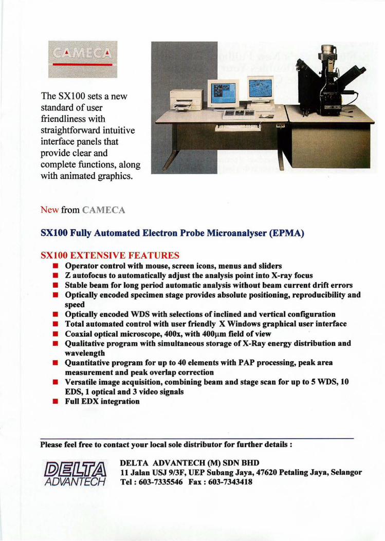
The SX 100 sets a new standard of user friendliness with straightforward intuitive interface panels that provide clear and complete functions, along with animated graphics.
New from CAMECA
SXIOO Fully Automated Electron Probe Microanalyser (EPMA)
SXIOO EXTENSIVE FEATURES • Operator control with mouse, screen icons, menus and sliders • Z autofocus to automatically adjust the analysis point into X-ray focus • Stable beam for long period automatic analysis without beam current drift errors • Optically encoded specimen stage provides absolute positioning, reproducibility and
speed • Optically encoded WDS with selections of inclined and vertical configuration • Total automated control with user friendly X Windows graphical user interface • Coaxial optical microscope, 400x, with 400J.1m field of view • Qualitative program with simultaneous storage of X-Ray energy distribution and
wavelength • Quantitative program for up to 40 elements with PAP processing, peak area
measurement and peak overlap correction • Versatile image acquisition, combining beam and stage scan for up to 5 WDS, 10
EDS, 1 optical and 3 video signals • Full EDX integration
Please feel free to contact your local sole distributor for further details:
@&[l:,il~ ADVANTECH
DELTA ADV ANTECH (M) SDN DHD 11 Jalan USJ 9/3F, UEP Subang Jaya, 47620 Petaling Jaya, Selangor Tel: 603-7335546 Fax: 603-7343418
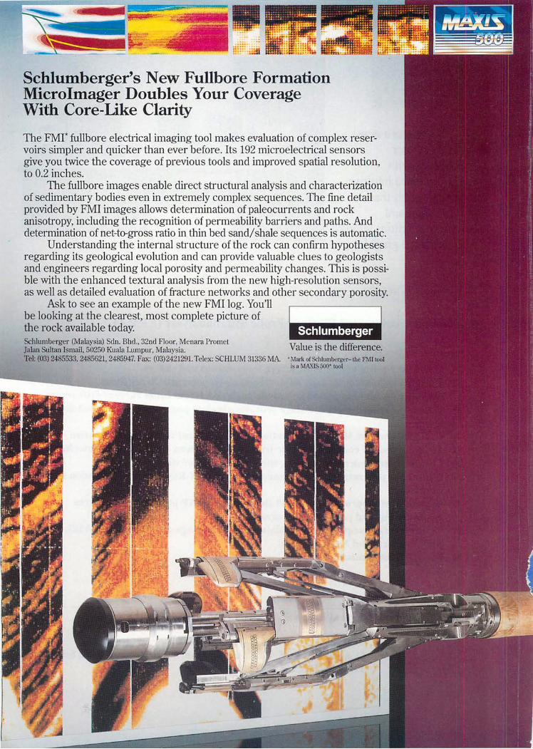
Schlumberger's New Fullbore Formation Microlmager Doubles Your Coverage With Core-Like Clarity
The FMI* fullbore electrical imaging tool makes evaluation of complex reservoirs simpler and quicker than ever before. Its 192 microelectrical sensors give you twice the coverage of previous tools and improved spatial resolution, to 0.2 inches.
The fullbore linages enable direct structural analysis and characterization of sedimentary bodies even in extremely complex sequences. TI1e fine detail provided by FMI linages allows determination of paleocurrents and rock anisotropy, including the recognition of permeability barriers and paths. And determination of net-to-gross ratio li1 thin bed sand/shale sequences is automatic.
Understanding the internal sb-ucture of the rock can confirm hypotheses regarding its geological evolution and can provide valuable clues to geologists and engineers regarding local porosity and permeability changes. This is possible with the enhanced textural analysis from the new high-resolution sensors, as well as detailed evaluation of fracture networks and other secondary porosity.
Ask to see an example of the new FMI log. You'll be looking at the clearest, most complete picture of the rock available today. Schlumberger (Malaysia) Sdn. Bhd., 32nd Floor. Menara Pro met Jalan Sultan Ismail. 50250 Kuala Lumpur, Malaysia. Tel: (08) 2485533, 2485621, 2485947. Fax: (03)2421291. Telex: SCHLUM 81336 MA.
.. -$Oi' Ii ,i.j§j. !§IJ Value is the difference. • Mark of Schlumbcrgc:r-lhe FMllool i" a MA'GS 500- 1001
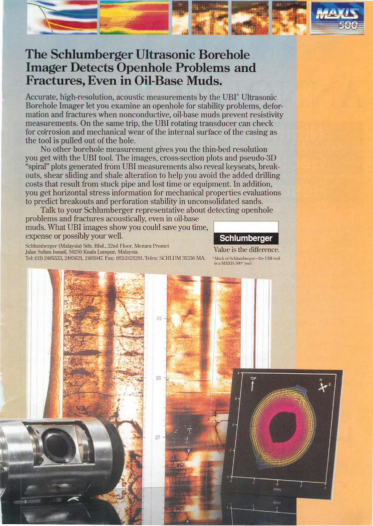
The Schlumberger Ultrasonic Borehole Imager Detects Openhole Problems and Fractures, Even in Oil-Base Muds. Accurate, high-resolution, acoustic measurements by the UBr Ultra onie Borehole Imager let you examine an openhole for stability problem ,deformation and fractures when nonconductive, oil-ba e mud prevent re i tivity measurements. On the same trip, the UBI rotating tran ducer can check for co'rrosion and mechanical wear of the internal urface of the ca ing a the tool is pulled out of the hole.
No other borehole measurement give you th thin-b d re olution you get with the UBI tool. The images, cro s- ection plot and p eudo-3D "spiral" plots generated from UBI mea urement al 0 reveal key eat , breakouts, shear sliding and shale alteration to help you avoid the added drilling cost that result from stuck pipe and lost time or equipment. In addition, you get horizontal stres information for mechanical propertie evaluation to preclict breakouts and perforation stability in uncon olidated ands.
Talk to your Schlumberger representative about detecting open hole problems and fractures acoustically, even in oil-base muds. What UBI images show you could save you tinle expense or possibly your well. Schlumberger (Malay ia) Sdn. Bhd .. 32nd Floor. M l1ara Prom I Jalan ullan Ismail, 50250 Kuala Lumpur. 1alaysia. 1"1: (03) 24 5533. 2485621. 2485947. Fax: (03)242129 1. Telex: CHLUM 31336 r. IA. '~I"rk or : 'hlumber)!L'r-lIw l ' IU 1001
;'" ~ 1 A.X1 500' 1001
ANNOUNCEMENT Ninth Regional Congress on Geology, Mineral and Energy Resources of Southeast Asia
Kuala umpur, Malaysia. 17-19 August 1998
ofNfalaysia is organising the GEOSEA '98 in Kuala Lumpur from 17 to The Geological VV'-<1.~L
19 August 1998. Congress is held triennially in Southeast Asia and it offers an to exchange scientific and technical information and advancement in geology, excellent
mineral and Congress is a communIty
among geoscientists from within and outside the region. The GEOSEA geoscientific event in the region and has been well attended by the geoscientific
rid-wide.
The technical ...... "', ....... " of GEOSEA '98 consists of oral and poster presentations on geology and w. .. ~",~EOSEA core region - Brunei, Cambodia, Indonesi Hong Kong, Laos, related aspects
Malaysia, and technical
New Philippines, Singapore, Thailand and Vietnam. A scientific tlY'Yitp GEOSEA '98, displayin the latest state-of-
the-art products afui~)r-srems
Other related activi fieldtrips. Social events __ A~.'''~
Make a note in your diary <l.H' ..... ""'J·.
For further information, please contact:
~GEOSEA '98 ~~~~
1r<-P.~.
~'/0{~
r ··\ A l~ '7;o'f'''' .• 1967 /:j
-, 1'1'1\1 .
GEOLOGICAL SOCIETY OF
MAl.AYSIA
The Organising Secretary, GEOSEA '98 Geological Society of Malaysia c/o Department of Geology, University of Malaya, 50603 Kuala Lumpur Malaysia Tel: +(603) 7577036 Fax: +(603) 756 3900 Email: [email protected]
431 enable sands to be spread over large areas within a shallow, low lying shelf. These exploratory models render further support to the interpretation of high-frequency relative sea level oscillations in the Upper Miocene shallow marine clastics of the Baram field, and possibly for the whole of Baram Delta.
Paper 10
Technology application in prospect evaluation, offshore Sabah
J. VOON, W. POOL, N. CASSON, K.B. LIM, J. TING, E. TELATOVICH AND G. BLOCH
Sabah Shell Petroleum Company Limited Lutong, Miri
Sarawak
Application of geological and geophysical technology plays an integral part of the overall evaluation of the prospectivity of Block SBl. Operating in today's difficult economic climate requires the judicious use of tools to minimise uncertainties of porefills, reservoir properties and geopressure information from seismic. The objective is to integrate the advanced technologies in overall risk reduction, in particular, the recognition of oil, in order to enhance the economic viability of some marginal prospects in SBl.
One of the most critical factors in risk reduction is the application of integrated geophysical and geological techniques of Direct Hydrocarbon Indication (DHI) detection and reservoir characterisation. In order to optimise efficiency in reaching our goals, a combination of both proprietary and commercially available software are run on powerful workstations. Techniques include post stack 3D volume image processing, optical stacking, probabilistic amplitude calibration, quantitative Amplitude vs Offset (AVO) analysis and regional rock properties calibration. To support such an integrated approach, true amplitude acoustic impedance data sets were generated for both 3D and 2D. Near and far offset 3D migrated volumes provide an additional insight into porefill and lithologic information. A rock properties database was compiled to establish different classes of lithological trends across different geological settings (proximal topset to distal turbidites), together with an AVO calibration set over fields to ascertain the AVO response for the different lithoclasses. In addition, this calibration set serves as a QC tool for evaluating subsequent true amplitude processing for AVO. To compliment the various geophysical tools, the application of quantitative forward geological modelling to simulate stratigraphic geometries and depositional environments plays an integral part in reducing reservoir risks.
Within the proximal top set stratigraphy (Stage IVD to F), there is compelling evidence in the East Baram Delta that most hydrocarbon-bearing sands, within normal compaction trend (hydrostatic) are supported by DHI. However, recognition of oil can be ambiguous. In the turbidite settings, thick units of acoustic soft shales predominate the stratigraphy and the characteristic bright spots detection are not apparent. DHI expressions in overpressured sequences are different and in some cases their total absence may not be condemnatory. Despite encouragement from AVO and amplitude calibration within numerous prospects, there are mapped amplitude anomalies that do not have a downdip fit to structure, which may imply a stratigraphicllithological overprint, and should still be considered viable exploration targets.
Warta Geologi, Vol. 22, No.6, Nov-Dec 1996
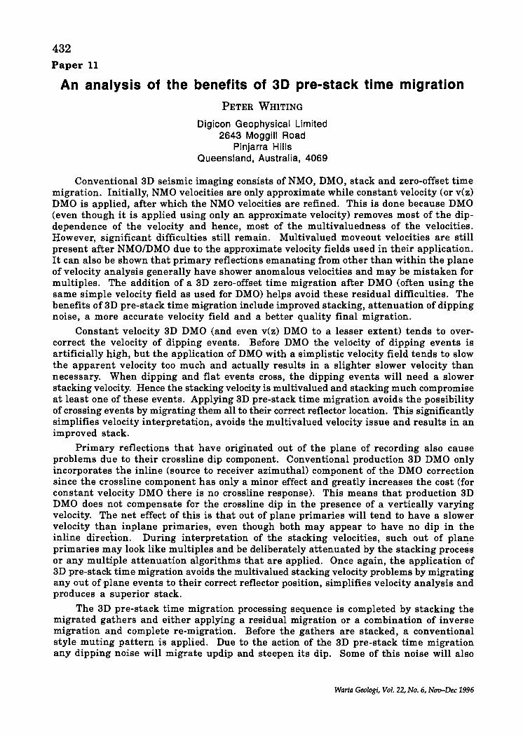
432 Paper 11
An analysis of the benefits of 3D pre-stack time migration
PETER WHITING
Digicon Geophysical Limited 2643 Moggill Road
Pinjarra Hills Queensland, Australia, 4069
Conventional 3D seismic imaging consists of NMO, DMO, stack and zero-offset time migration. Initially, NMO velocities are only approximate while constant velocity (or v(z) DMO is applied, after which the NMO velocities are refined. This is done because DMO (even though it is applied using only an approximate velocity) removes most of the dipdependence of the velocity and hence, most of the multivaluedness of the velocities. However, significant difficulties still remain. Multivalued moveout velocities are still present after NMO/DMO due to the approximate velocity fields used in their application. It can also be shown that primary reflections emanating from other than within the plane of velocity analysis generally have shower anomalous velocities and may be mistaken for multiples. The addition of a 3D zero-offset time migration after DMO (often using the same simple velocity field as used for DMO) helps avoid these residual difficulties. The benefits of 3D pre-stack time migration include improved stacking, attenuation of dipping noise, a more accurate velocity field and a better quality final migration.
Constant velocity 3D DMO (and even v(z) DMO to a lesser extent) tends to overcorrect the velocity of dipping events. Before DMO the velocity of dipping events is artificially high, but the application of DMO with a simplistic velocity field tends to slow the apparent velocity too much and actually results in a slighter slower velocity than necessary. When dipping and flat events cross, the dipping events will need a slower stacking velocity. Hence the stacking velocity is multivalued and stacking much compromise at least one of these events. Applying 3D pre-stack time migration avoids the possibility of crossing events by migrating them all to their correct reflector location. This significantly simplifies velocity interpretation, avoids the multivalued velocity issue and results in an improved stack.
Primary reflections that have originated out of the plane of recording also cause problems due to their crossline dip component. Conventional production 3D DMO only incorporates the inline (source to receiver azimuthal) component of the DMO correction since the crossline component has only a minor effect and greatly increases the cost (for constant velocity DMO there is no crossline response). This means that production 3D DMO does not compensate for the crossline dip in the presence of a vertically varying velocity. The net effect of this is that out of plane primaries will tend to have a slower velocity than inplane primaries, even though both may appear to have no dip in the inline direction. During interpretation of the stacking velocities, such out of plane primaries may look like multiples and be deliberately attenuated by the stacking process or any multiple attenuation algorithms that are applied. Once again, the application of 3D pre-stack time migration avoids the multivalued stacking velocity problems by migrating any out of -plane events to their correct reflector position, simplifies velocity analysis and produces a superior stack.
The 3D pre-stack time migration processing sequence is completed by stacking the migrated gathers and either applying a residual migration or a combination of inverse migration and complete re-migration. Before the gathers are stacked, a conventional style muting pattern is applied. Due to the action of the 3D pre-stack time migration any dipping noise will migrate updip and steepen its dip. Some of this noise will also
Warla Geologi, Vol. 22, No.6, Nw-Dec 1996
433
migrate into the standard muting zone and is therefore removed before stack. Consequently if the stacked data is denigrated such dipping noise cannot be re-introduced. Muting the dipping noise also helps simplify velocity analysis.
As mentioned above, interpreting velocities after 3D pre-stack time migration is greatly simplified. Often somewhat complicated analyses are transformed into more easily interpreted panels, with clearer primary trends. Velocities can be interpreted with more confidence and out of plane primaries do not appear to be multiples. Consequently, it can prove advantageous to attempt multiple suppression (or more aggressive multiple suppression) on the 3D pre-stack time migrated gathers.
The velocity field interpreted from 3D pre-stack time migrated gathers is generally more stable and more closely resembles the true velocities of the medium. Coupling this with the fact that the velocities are naturally interpreted in migrated position, the resulting velocity field is ideal for a high fidelity final zero offset time or depth migration. The 3D pre-stack time migration can be exactly removed after stack if the migration used was either constant or a single velocity function with depth. This inverse migrated dataset is then identical to a conventional stacked dataset except that is has the benefits of the superior stacking and noise attenuation as outlined above. At this pint an improved stacked volume is available as well as a superior migration velocity field which are the ingredients for an excellent final migration with a high fidelity algorithm. The closer resemblance of the interpreted velocities with the true earth velocities also assists with depth conversion
After applying this technique widely to synthetic and real 3D datasets, all of the above benefits can be demonstrated. Synthetic data examples clearly show the theoretical benefits of 3D pre-stack time migration. Real data examples give an indication of the practical extend of improvements.
The addition of an approximate 3D pre-stack time migration to the conventional NMO/DMO sequence has a number of positive benefits and conforms with the application of approximate velocity NMO and simplified velocity DMO. The application of 3D prestack time migration can be thought of as a transform. The data is transformed to the migrated gather domain where velocity analysis, noise attenuation and multiple suppression can be easier, and is then inverse transformed after stack using inverse migration. The result is a superior stack and migration velocity field. However, it should be remembered that the pre-stack migration is a time migration. If rapid lateral variations exist the process will not be applicable as the time migration will not be able to migrate the events to their correct location.
Paper 12
Integrated reservoir characterisation Cakerawala Field-Block A-18, MTJDA
KENNY GOH\ SONNY LIM H.B.2 AND AMIRUZAN APANDI3
lTriton Energy
2Carigali Triton Operating Company
3PETRONAS Carigali Sdn. Bhd. Wisma Peladang, Jalan Bukit Bintang P.O. Box 12407, 50776 Kuala Lumpur
The Cakerawala Field is located in BlockA-18, Malaysia-Thailand Joint Development Area (MTJDA). This is offshore, in the South China Sea, in the North Malay Basin/South
Warta Ge%gi, Vol. 22, No.6, Nov-Dec 1996
434 Gulf of Thailand. It is operated by Carigali-Triton Operating Company Sdn. Bhd. (CTOC) on behalf of its Shareholders Petronas Carigali (JDA) Sdn. Bhd. and Triton Energy Limited, Contractors to the Malaysia-Thailand Joint Authority (MTJA). The Production Sharing Contract was signed on the 21st April 1994.
The Cakerawala Field was discovered by Well Pilong-1. This was drilled by Esso in 1971. The Field was confirmed by CTOC Appraisal Well Cakerawala-1A11A-ST in 1995. CTOC drilled Field Delineation Wells Cakerawala East-I. Cakerawala-2 and -3 in 1996. The seismic database comprises a 2 km x 0.5 km grid of 1994 2D (c. 6,000 line km) and a 1995 3D survey (630 sq. km).
The petroleum system ofthe Cakerawala Field comprises stacked, Mid-Late Miocene clastic reservoirs, trapped in a fault/dip closed structure, sealed and charged intraformationally with lean gas/condensate and oil. The pay is contained in Shallow, Intermediate and Deep Reservoirs. There are two principal gas pools. These occur in the Shallow Reservoirs.
Integrated reservoir characterisation of the two principal gas pools has been undertaken. The hydrocarbon pore volume parameters (net pay, porosity, water saturation, hydrocarbon feet, bulk volume gas) for each reservoir were determined through petrophysical evaluation of the Field wells. These were then calibrated to selected seismic reflectivity attributes and acoustic impedance. Geostatical modelling techniques were then employed to generate reservoir property maps. These have been used to refine the pool model, estimate reserves and plan their development.
Paper 13
Tidal successions of the wave-dominated Baram Delta Complex, Brunei
JOSEPH J. LAMBIASE
Universiti Brunei Darussalam Brunei
The Baram Delta complex of northwest Borneo has long been regarded as a wavedominated delta succession. However, recent outcrop and subsurface studies in Brunei indicate that in some areas more than half of the sandstones were deposited by tidal currents in shallow water environments. The strata often consist of repeated, coarseningupward successions of lagoonal shales which grade upward through mixed tidal flat sandstones and mudstones into flood and ebb tidal delta sandstones. A sharp contact between a sandstone and an overlying shale marks the top of each succession; the upper surface of the sandstone often is heavily burrowed with an ichnofacies indicative of a lagoonal to shallow marine environment.
The stacked successions of coarsening-upward lithologies capped by what could easily be interpreted as flooding surfaces strongly suggest a series of progradational units separated by marine flooding events. This is especially true when successions that are below seismic resolution are interpreted from wireline logs. However, the facies transitions indicate exactly the opposite; the lagoon-tidal flat-flood tidal delta-ebb tidal delta succession is one of transgression. Each succession is terminated by an abrupt landward facies shift from ebb tidal delta sandstones to lagoonal shales.
Modern analogues for the various tidal successions occur on the Brunei coast amid a variety of tidal environments that are contemporaneous with the active wave-dominated Baram Delta. Structural segmentation of the margin results in differential subsidence
Warta Geoiogi, Vol. 22, No.6, Nov-Dec 1996
435 and controls sediment supply; these processes interact with eustatic sea-level changes to generate repetitive shoreline geometries that accumulate tidal sediments, thereby accounting for the abundant tidal successions.
Paper 14
Harmonization of vintage 3D surveys
KENNETH WONG UNG SING
Sarawak Shell Berhad/SSPC Lutong, Miri
Sarawak
SSB began her 3D seismic campaigns in the Balingian province in 1984 and has acquired eleven 3D surveys covering an area of 1,645 sq. km over the years. The surveys were shot in various orientations by different contractors using different geometrics and parameters. Seismic interpretation across boundaries of 3D surveys have been problematic although there had been previous attempts to merge datasets. By the application of proprietary processing software in-house,· the eleven datasets had been merged and harmonized into a continuous single 3D dataset which facilitates interpretation across the artificial boundaries defined by the extent of individual 3D surveys. This paper describes the application of an efficient and cost effective process in improving the data quality and increasing the amount of interpretable data of the vintage surveys.
Paper 15
Tectonics of the Sarawak Basin
H.D. TJIA
Petronas Research & Scientific Service Sdn. Bhd. Lot 1026 PKNS Industrial Estate
54200 Hulu Kelang
Patterns and orientations of folds and fractures exhibited by the top surfaces of Cycle I through Cycle VI sequences define certain tectonic domains that also reflect changes in tectonic stress regimes during the Tertiary development of the Sarawak Basin. Overprinted structural pattern are especially noticeable in the Luconia and Balingian provinces. The offshore tectonic domains and their boundaries show certain relationships with tectonic domains onshore Sarawak and Brunei. Fold wavelengths in pre-Setap formations range between 3 to 5 km, which contrast sharply to those of postSetap folds. The latter are mainly very broad synclines and elongated basins. These disharmonic deformation styles were facilitated by the ductile Setap shales. From NE Sarawak over Brunei-Lawas into the Klias peninsular, the structures change strike across distinct regional lineaments, known as the Belait zone, Jerudong Line and Tangoa Line (new name). Drag structures indicate that left-lateral fault slip along these lineaments persisted well into post-Setap time. Raised Plio-Pleistocene planation surfaces indicate regional tilting from the land towards the South China Sea. As result of Quaternary regional tilting, the trend of more recent hydrocarbon migrations would have been towards land. Some of the hydrocarbons now exploited from the coastal areas of Miri, Baram and Brunei may have been sourced by kitchens located offshore.
Warta Geologi, Vol. 22, No.6, Nov-Dec 1996
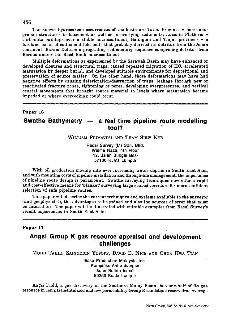
436 The known hydrocarbon occurrences of the basin are Tatau Province = horst-and
graben structures in basement as well as in overlying sediments; Luconia Platform = carbonate buildups over a stable microcontinent; Balingian and Tinjar provinces = a foreland basin of collisional fold belts that probably derived.its detritus from the Asian continent; Baram Delta = a prograding sedimentary sequence comprising detritus from Borneo and/or the Reed Bank microcontinent.
Multiple deformations as experienced by the Sarawak Basin may have enhanced or developed closures and structural traps, caused repeated migration of He, accelerated maturation by deeper burial, and developed suitable environments for depositional and preservation of source matter. On the other hand, those deformations may have had negative effects by causing deterioration/destruction of traps, leakage through new or reactivated fracture zones, tightening or pores, developing overpressures, and vertical crustal movements that brought source material to levels where maturation became impeded or where overcooking could occur.
Paper 16
Swathe Bathymetry a real time pipeline route modelling to.ol?
WILLIAM PRlMAVESI AND THAM SlEW KEE
Racal Survey (M) Sdn. Bhd. Wisma Naza, 4th Floor 12, Jalan Sungei Besi 57100 Kuala Lumpur
With oil production moving into ever increasing water depths in South East Asia, and with mounting costs of pipeline installation and through-life management, the importance of pipeline route design is paramount. Swathe surveying techniques now offer a rapid and cost-effective means for 'blanket' surveying large seabed corridors for more confident selection of safe pipeline routes.
This paper will describe the current techniques imd systems available to the surveyor (and geophysicist), the advantages to be gained and also the sources of error that must be catered for. The paper will be illustrated with suitable examples from Racal Survey's recent experiences in South East Asia.
Paper 17
Angsi Group K gas resource appraisal and development challenges
MOHD TAHIR, ZAINUDDIN YUSOFF, DAVID E. NICE AND CHUA HWA TIAN
Esso Production Malaysia Inc. Kompleks Antarabangsa
Jalan Sultan Ismail 50250 Kuala Lumpur
Angsi Field, a gas discovery in the Southern Malay Basin, has one-half of its gas resource in compartmentalized and low permeability Group K sandstone reservoirs. Average
Warta Geologi, Vol. 22, No.6, Nuu-Dec 1996-
437
porosity in the K is 12 percent with a permeability of 0.7 millidarcies. Production tests conducted on the first two exploration wells flowed at rates which are considered noncommercial. The Angsi K reservoirs also exhibit vertical and horizontal compartmentalization. Vertical compartments are defined by intraformational shale layers which separate K sands into downward increasing pressure compartments. Horizontal compartments are defined by lateral facies changes and fault segmentation. The lateral facies changes are confined to the base of sand packages where braided stream deposits have cut down into mud rocks isolating the basal sands from hydrocarbon migration. Fault segmentation has created additional barriers to migration into some segments of the structure. Although the faults appear to be discontinuous by 3D mapping with throws rarely exceeding the thickness of the K sands, the faults must be sealing because of different fluid contacts across fault planes with apparent sand to sand juxtaposition.
Despite these complexities, the K reservoirs remain a sizable resource and efforts were made to test for increased deliver ability through fracture stimulation. The results of a propped hydraulic fracture stimulation performed on Angsi-4 were encouraging with a four-fold increase in initial gas production rate. A good, commingled, post-frac production rate was achieved from three Group K reservoirs. Further studies such as full-field and single well reservoir models, in addition to fluid and special core analyses, are being conducted to aid in determination of ultimate gas recovery and to aid in field development plan optimization.
Paper 18
Occurrence of noval biomarker fingerprints in Malay Basin sediments: Source implications
MOHD JAMAAL HOESNI AND PETER ABOLINS
Petronas Research & Scientific Service Sdn. Bhd. Lot 1026 PKNS Industrial Estate
54200 Hulu Kelang
A suite of almost identical biomarker distributions has been observed in sediment extracts from parts of the southern Malay basin. The characteristic biomarker fingerprint is observed in sediments from as young as Group H (Middle Miocene) to as old as Group M (Oligocene). Geochemical analyses carried out on these extracts indicate that they are, in fact, oil stains and not indigenous bitumen.
Biomarker distributions of an oil have been used to infer some genetic attributes of its source origin. Produced oils previously described in the Malay basin have been considered non-marine, and are believed to have been derived from a mixture of coaly and freshwater lacustdne Miocene and Oligocene sediments. The lacustrine biomarker fingerprints are characterised by the presence of gammacerane, C28 and C29 tricyclic terpanes and low Tm/Ts, whereas bicadinanes and oleanane are indicative of oils derived from the coaly sediments.
In comparison, the newly recognised oil stains display significant differences from both the coaly and lacustrine-sourced oils described above. These differences include:
• • • • • •
High concentration of C21-CS1 tricyclic terpanes Low hopane/sterane ratio Lack of higher plan biomarkers Low Pr/Ph ratio Elevated C29 hopane Non-waxy oil,
Warta Geologi, Vol. 22, No.6, Nov-Dec 1996
438
and therefore suggests a possible occurrence of a third oil family in the basin. The issue at hand is the need to locate where this third oil family could be sourced. As the oils are detected in the Group M sediments, the group M and older sediments could possibly be candidates for the source of the oils. Of these possibilities, a pre-Tertiary carbonate source is perhaps more controversial, but Mesozoic carbonates cannot be ruled out as there is an apparent correlation of biomarker distribution with the carbonates. The widespread occurrences of inorganic-sourced carbon dioxide detected in the northern part of the basin demonstrate the existence of a deep carbonate platform.
Regardless of the source of the third oil family, it is considered that its generation and migration pre-date the Middle and Upper Miocene basin structuration, and any significant oil accumulation would therefore be found trapped stratigraphically.
Paper 19
Integration of sequence stratigraphy and reservoir management to optimise oil development at Tabu
MOHD RAJI
Esso Production Malaysia Inc. Kompleks Antarabangsa
Jalan Sultan Ismail 50250 Kuala Lumpur
The Tabu Field is a: small oil field discovered in 1978. The structure is a simple east-west trending compressional anticline in the Palas-Guntong-Tabu trend. The field is segmented by two N-S trending normal fault systems into 3 fault blocks; east, central and west. The main reservoirs are the Miocene 1-25 and 1-35 sandstones which contribute as much as 75% of the Tabu-B conformable proved plus probable reserves. The east fault block at Tabu Field was first developed in 1983 from the Tabu-A platform. In 1986 a 3D seismic survey was acquired over the field which provided a good subsurface image of the reservoir sandstones.
The 1-25 sandstone reservoir package is composed of the 1-30 highstand and the 1-25 lowstand sequences. The 1-30 highstand, interpreted to be deposited in a deltaic environment, is overlain by fluvial rocks of the 1-25 lowstand. Several meters above the 1-25 reservoir lies a thin and minor 1-23 lowstand sandstones. The interpreted sequence boundary at the base of the 1-25 lowstand separates a sand-dominated package above from the mud-stone package below. Seismic attributes calibrated to physical properties from log data were used to generate a new pay sandstone map over the 1-25 oil reservoir interval. Results indicated that the absolute amplitude has a high correlation coefficient with physical properties from well data and the map was used as predictive tool for the development wells.
Tabu-B development was begun in 1995 with less than 50% of the reserves in the proven category. The high development cost at Tabu B made it a marginal project to development in this low oil price environment. This paper describes how the use of a multi-disciplinary team approach turned this marginal development into a cost effective endeavour. The use of sequence stratigraphy and seismic attributes as well as innovative solutions in reservoir engineering and drilling technologies were the key ingredients in this successful development.
Warta Geologi, Vol. 22, No.6, Nov-Dec 1996
439
Paper 20
Clay mineral diagenesis and reservoir quality of the Upper Cycle V (Late Miocene) sandstones of Baram Field, offshore
Sarawak, East Malaysia
ABDUL HADI ABD RAHMAN
Department of Geology University of Malaya 50603 Kuala Lumpur
The Late Miocene shallow marine sandstones from the Baram field (depths of -6,700 ft to -10,000 ft), in Baram Delta Offshore Sarawak, display a complex diagenetic texture which directly affects their reservoir quality. The main diagenetic mineral phases identified, in the order of precipitation, are: siderite, chlorite-smectite, chlorite, illite and quartz cementation. Minor occurrences of hematite pigmentation, feldspar dissolution, kaolinite precipitation and pyrite mineralisation were also recognised.
Siderite cementation in general tend to reduce and destroy porosity, by forming small acicular, pore lining crystals or rhombic, pore-filling cements. However, extensive siderite cementation are restricted only to strongly bioturbated horizons or mudstone clasts zones. Low porosity values, ranging between 10 to 15% (-1.0 to 6.0 mD), characterises these intervals.
Diagenetic clay mineralisation is pervasive and widespread within the Baram sandstones. Chlorite-smectite occurs as grain-coating "honeycomb" structure within limited zones of the reservoir. Chlorite, being the most dominant clay phase, occur as chlorite peloids, grain-coating chlorite and pore-filling mineral. The presence of the grain-coating type of chlorite appears to have inhibited the precipitation of quartz cement. Sandstone intervals with grain-coating chlorite commonly exhibit high reservoir quality (0: 19.3-28.6; k: 100.0-810.0 mD), Illite mineralisation is largely confined to detrital mudclasts and clayey laminations.
The presence of grain coating may have contributed to the preservation of good porosity at greater depths in the sandstones of Baram field.
Paper 21
Seismic identification of depositional processes in a turbidite fan environment, deepwater Block SB-G, NW Sabah
SALAHUDDIN SALEH KARIMIl, JEFFREY J. LABA02 AND MARIO M. WANNIER2
1Petroleum Resource Assessment Department Petroleum Management Unit
PETRONAS Kuala Lumpur
2West Sabah Exploration Team Sabah Shell Petroleum Co.
Lutong, Sarawak
A seismic interpretation and mapping project of the Intra Stage IV F, Upper Lingan Fan Unit was carried out in the deepwater Sabah area 120 km Northwest of Kota
Warta Geologi, Vol. 22, No.6, Nov-Dec 1996
440 Kinabalu. The objective of the project was to delineate the internal architecture of the Upper Seismic sequence of Lingan Fan Unit in an attempt to understand the environment of deposition and the processes involved. With the understanding of depositional environment, reservoir characteristics could be interpreted. .
The Upper Lingan Fan Unit is a multi-sequence turbidite unit characterised by a period of active channelling and downcutting as the Lingan Fan progrades basinward. Three seismic facies were delineated from interpreted seismic paper sections of several vintages. Isochores of these three facies were generated and analysed in relation to a depth structure map on Top Lingan Fan Unit.
The mapped turbidite sequence is interpreted to be a combination of: a) Channel lob (Facies I), b) Levee-channel/crevasse splay deposits (Facies II) and c) Onlapping distal lowstand prograding wedge (Facies III). Identification and interpretation of these facies gives a better understanding of the possible reservoir quality found in any exploration prospects.
The results of this shallow analogue study gives a better insight in the complex processes involved in the deposition of a turbidite system. Additionally, it also highlights the complexities and resolution issues to be expected in a seismic interpretation at deeper depths. With the availability of high quality seismic data, it is possible to delineate the internal architecture and constrain the predicted reservoir quality in turbidite prospe~ts.
Paper 22
Preservation of organic matter in the lacustrine/deltaic sediments of southern Mesopotamia
AnNAN A.M. AQRAWI
Petronas Research & Scientific Services Sdn. Bhd. Lot 1026 PKNS Industrial Area 54200 Hulu Kelang, Selangor
Organic-geochemical studies of the Holocene sediments at the surface and in shallow boreholes in the Tigris-Euphrates Delta of SE Iraq are integrated in this paper with sedimentological and stratigraphic studies. Limited organic preservation was found to have occurred in surface sediments from marshland areas ("Ahwar"), although organicrich sediments (peats) were observed within older Holocene borehole sequences.
Reeds of Phragmites and Typha sp. are the main source of organic material in both the surface and the underlying sediments in this area. Petrographic studies indicated that this material consists mainly of "immature" components such as woody structures, algal amorphous and herbaceous matters, with some marine structures and pollen.
The principal factor controlling organic-matter preservation in this arid deltaic setting seems to have been the comparatively high rates of sedimentation, particularly in early-middle Holocene. Most of these organic-rich sediments (5-15% TOC) are overlain by middle Holocene brackish/marine sediments of the transgressive Hammar Formation. The organic-rich sediments are usually older than these transgressive sediments (Le. 6,000-9,000 years BP, according to their location within the study area).
Warta Geologi, Vol. 22, No.6, Nuv--Dec 1996
441 Paper 23
Importance of geological parameters to reservoir simulation a case study
NASIR HJ DARMAN, IZMAN HAMID AND RAP I MAT SOM
Petronas Research & Scientific Services Sdn. Bhd. Lot 1026, PKNS Industrial Estate
54200 Hulu Kelang, Selangor
Reservoir simulation is a tool to predict future reservoir performance under various "what if' conditions, and reservoir performance is conditioned by a factor which is only predictable and details of this factor would remain unknown even after the end of the life of a field. Poor assessment of its characteristics would lead to a disastrous conclusion. This factor is geological. To illustrate this point, a reservoir simulation study was performed on an oil field situated in the offshore area of Sarawak. Two specific objectives of the study on a field that has been in production for 11 years, were:
i) to quantify the remaining oil reserves, and ii) to optimise production through development of good reservoir management strategies.
In the study, a special emphasis was given to obtained a good set of geological parameters which were necessary as input into the simulation, and these include:
a) development of geological structure of the field which was generated through integration of seismic and well data,
b) development of stratigraphic setting of the various correctable units using both the seismic and well data, and
. c) examination of cores for reservoir textures in terms of pore geometry and connectivity and porosity, and for reservoir internal sedimentary structures which may influence fluid flow.
Seismic data were used to map the field and to assist in predicting the reservoir continuity between wells. These parameters lead to the development of 2D geological model and individual 3D reservoir model. The 11 year production history was used to calibrate and validate the simulation results, from which the full field model was used to predict the remaining oil reserves and field production performances.
The result of the study was exciting from two points; it enabled planners to exploit the field optimally, and what is even more important is that it indicated the importance of the good geological input into the reservoir simulator.
Paper 24
Deep reservoir potential of the North Malay Basin
ROBERT WONG AND SALAHUDDIN SALEH KARIMI
Petroleum Resource Assessment Department Petroleum Management Unit
PETRONAS Kuala Lumpur
Exploration in the North Malay Basin began in the late sixties. By late seventies, a few gas fields have been discovered. The producing reservoirs are restricted within the Groups D and E. Group F generally contains overpressure shales. Only a few wells
Warta Geologi, Vol. 22, No.6, Nov-Dec 1996
442 have penetrated the deeper Group H & I. Based on these well data, it is generally thought that the Group D and E sands are the main reservoirs and all appraisal wells only targeted the Group D and E reservoirs. These data are inconclusive because sediment thickness and facies variation both laterally and vertically have not been taken into account. By studying the seismic facies based on recently acquired high quality regional lines and calibrating with the well data, we were able to predict the depositional environments and hence the lithofacies. The Group F sequence generally contains weak, discontinuous reflectors, indicating the predominance of shales in a neritic setting. The Group H & I sequences generally comprise a band of strong, continuous events representing sands, shales and coals in a lower coastal plain environment. Amplitude anomalies in the form of 'gas sag' are also observed within the Group H & I. These observations are also supported by pressure data which suggests an abnormal trend in Group F but returning to normal trend in Group H & I. Coupled with the fact that the 'geopressure threshold' has increased with the improvement in drilling technology, the deeper reservoirs posed new objectives in the North Malay Basin.
In late 1995, the deep reservoir potential was tested by the drilling of a well which targeted the Group H & I horizons in a prospect which contains previously tested, gas bearing shallow reservoirs in the Group D. The well successfully penetrated the overpressure zone in Group F and found new reservoirs in the Group H & I. These 'sweet spots' were tested to contain substantial amount of gas and condensate. The pressure trend in this well has shown that the abnormal pressure trend is encountered in the Group F but it went back to normal trend again in Group H & I where the main reservoirs are situated, as predicted. The results of this well indicate that there is indeed a deep reservoir potential in the North Malay Basin, thereby opening up a new play in the process. Many of these 'sweet spots' below the overpressured interval are yet to be found and tested.
Poster 1
Sedimentological aspects of the Temburong and Be-Iait Formations, Labuan
MAZLAN MADON
Petronas Research & Scientific Services Sdn. Bhd. Lot 1026 PKNS Industrial Area
54200 Hulu Kelang
The stratigraphy of Labuan island is basically an extension of onshore western Sabah, Brunei, and northern Sarawak. Wilson (1964) recognized three lithostratigraphic units on the island (in younging order): Temburong Formation, Setap Shale Formation, and Belait Formation. A major unconformity exists between the Belait and Setap and has been correlated offshore with the Deep Regional Unconformity (DRU) (Levell, 1987). This unconformity is related to the folding and uplift of the Crocker Formation flysch belt during the middle-late Miocene following the cessation of southeastward subduction of oceanic crust beneath Borneo. The rocks beneath the DRU in Labuan are generally highly deformed and indurated, typical of the "Older Setap" which Brondijk (1962) named the Temburong Formation. Hence, in this paper the stratigraphy of Labuan is regarded as comprising the Temburong Formation overlain unconformably by the Belait Formation; the Setap Shale Formation, as has been re-defined by Brondijk (1962), is absent.
The Belait Formation crops out in the northern part of Labuan as a prominent strike ridge that extends from Tg. Kubong to Tg. Layang-Layangan and in the eastern part of
Warta Geologi, Vol. 22, No.6, Nuo-Dec 1996
443
the island from Tg. Kubong to Tg. Batu, essentially forming the two limbs of the northeastwardplunging Labuan Anticline~ The Temburong Formation forms the core of this anticline and underlies the remaining part of the island. Excellent exposures of the Temburong Formation occur along the coast near Tg. Layang-Layangan, where the formation consists of an overall regressive (shallowing) sequence ofheterolithic facies deposited in environments ranging from relatively deep water and unstable slopes to shallow nearshore settings. The sedimentology of the Belait Formation is described based on field work in the Tg. Kubong area, which included detailed logging of a major road-cut at Chimney. Here, the basal Belait is a sequence of conglomerate and sandstone laid down by fluvial systems that were eroding into the uplifted Temburong Formation. A transition from high-relief low-sinuosity to low-relief high-sinuosity fluvial system is indicated by the upwarddecreasing grain size and pebble content in the channel fill deposits, and by the occurrence of coal in the overlying alluvial plain deposits, exposed on Bukit Kubong. The fluvial succession passes upwards into a transgressive (deepening) sequence of nearshore and offshore shallow marine sandstones and mudstone. Syndepositional deformational structures are a common feature of the shallow marine deposits in both the Temburong and the Belait Formations which represent sedimentation on a formerly actively-deforming continental margin.
Poster 2
Thermal history reconstruction of NW Malay Basin using 2-dimensional basin modelling software
NASHROL ARIFF HUSSAIN!, MAHADIR RAMLyl AND
ROBERT H. LANDER2
'PETRONAS Carigali Sdn. Bhd. Wisma Peladang, Jalan Bukit Bintang P.O. Box 12407, 50776 Kuala Lumpur
2Geologica (formerly Procom), Norway
In any basin evaluation, accurate geohistory and thermal reconstruction is critical, especially the timing of hydrocarbon generation and migration. The accuracy of the present generation basin modelling softwares may be in question as the geohistory construction is limited to one-dimensional (I-D), i.e., single vertical section that corresponds with depth.
The 2D modelling software that was utilised in this project handles both horizontal and vertical sections for the geohistory reconstruction (burial and tectonic) and also performs sediment compaction, fault restoration and subsidence analysis which are useful in understanding the structural/tectonic evolution and thermal history of NW Malay Basin, thus, has open new exploration strategy and concept as well as new exploration play types.
Warta Geologi, Vol. 22, No.6, Nov-Dec 1996
444 Poster 3
Gravity anomalies, isostasy, and the tectonic evolution of the Malay and Penyu Basins
MAZLAN MADON
Petronas Research & Scientific Services Sdn. Bhd. Lot 1026 PKNS Industrial Area
54200 Hulu Kelang
The structure and stratigraphic architecture of the Malay and Penyu Basins, in particular the recognition of synrift and postrift phases of subsidence, indicate that the basins were formed by lithospheric extension. The subsidence history derived from backstripped biostratigraphic data is typical of extensional basins; rapid initial subsidence during the first 10 Ma or so, followed by slower subsidence due to cooling of the lithosphere. Stretching (8) factors estimated using ID-backstripping and subsidence modelling techniques range from 1.2 on the flanks to about 4 at the centre of the Malay Basin. These 8 values predict present heat flows that are comparable to those derived from drill stem tests and production tests and, thus, provide support for the lithospheric stretching model.
Free-air gravity data for the eastern offshore Peninsular Malaysia show two main regions of negative anomalies in the order of -20 mGal that are related to the formation of the underlying Malay and Penyu Basins. Gravity anomalies are a sensitive indicator of the density contrasts in the upper lithosphere that may arise from lithospheric extension. Hence, an understanding of the mechanisms of extension, subsidence, and isostatic compensation and their influence on gravity anomalies can provide us with clues to the origin of these basins.
Several profiles of gravity anomalies and sediment thickness across the basins were modelled using an iterative forward-modelling technique that combines 2D (flexural) backstripping and gravity modelling to investigate the relationship between crustal stretching! thinning and gravity anomalies. If Airy isostasy is assumed, the -20 mGal free-air gravity anomaly over the Malay Basin is not compatible with the observed 14 km of sediment fill. This great sediment thickness implies a large amount of crustal thinning and tectonic subsidence that should have resulted in a positive rather than negative anomaly. The modelling results suggest that Airy isostatic compensation alone could not have generated the nearly up to 5 km of total tectonic subsidence in the basins. Even poorer results are obtained if the lithosphere is assumed to have a finite flexural rigidity. Hence, processes other than lithospheric stretching may have contributed to the total tectonically induced subsidence.
The Moho depth beneath the basins as constrained by the free-air gravity data is deeper than the backstrip Moho depth predicted using Airy isostasy, by about 25%. This implies that the basins are undercompensated isostatically. The discrepancy between the calculated and backstrip Moho is attributed to uncompensated tectonic subsidence that may have resulted from thin-skinned extension, i.e. crustal extension that did not involve the mantle lithosphere. The Malay and Penyu Basins are therefore interpreted as hybrid basins formed by a combination of whole-lithosphere stretching and thin-skinned crustal extension.
Warta Geologi, Vol. 22, No.6, Nov-Dec 1996
445 Poster 4
Coal as a source rock for oil: Petrographic evidence from Tertiary coals, onshore Sarawak
WAN HASIAH ABDULLAH
Department of Geology University of Malaya 50603 Kuala Lumpur
A decade has now passed since Cook and Struckmeyer (1986) published a paper on "The role of coal as a source rock for oil" based mainly on petrographic evidence. The mid 80's was the time when an increasing number of workers in the field of petroleum geochemistry began to reconsider the long held view that coals could only source gas. Now, in the mid 90's, the majority of geochemists take a more open view on the role of coal and prefer to consider each case on their own merits with no preconceived notions on whether or not they can generate oil.
The onshore and offshore Tertiary sedimentary sequences of Sarawak contain numerous coal seams of Oligocene and Lower Miocene age. The offshore extensions and equivalents of these onshore basins contain oil that is considered to be possibly sourced from these coals and related terrestrial-derived organic matter. Despite this, very little information has been published on the geochemical and petrographic characteristics of the Sarawak coals. To rectify this, all the major Tertiary coal deposits of Sarawak have been visited and samples collected. In this preliminary study, results from two areas i.e. the Bintulu area and the Sepang block of the Merit-Pila coalfield will be presented emphasizing on the type of common liptinitic constituents of the coals and the petrographic features indicating oil generation from coals.
A number of petrographic features that are commonly considered to indicate oil generation and expulsion from coals have been observed in the Sarawak coals. Such features include:
• the occurrence of exsudatinite veins • development of micrinite • changes of fluorescence intensity • occurrence of oil droplets and oil haze
In addition to these, coal macerals which are considered associated with oil generation are also observed and include bituminite and fluorinate. Petrographically, therefore, there is little doubt that these coals possess a very high oil-generating potential.
The question of whether a coal can generate oil is not straightforward; a definite yes or a definite no should not be offered depending upon which school of thought you prefer. Many issues have to be considered, such as which liptinitic maceral possess the greatest potential; does the maceral vitrinite have a role to play; what is the relationship between organic microlithotypes and inorganic constituents, hence depositional environment, and how do they influence oil generation; at what maturation level is generation of oil from different macerals likely to occur; and what processes/conditions are required for the effective expulsion of oil from coal. Many of these issues still do not have satisfactory answers but it is hoped that the Sarawak coals, due to their variety in type, setting and maturity, will provide some answers.
Warta Geologi, Vol. 22, No.6, Nov-Dec 1996
446 Poster 5
PGIPMS an integrated Petroleum Geological Information Processing and Modelling System
S. SIVAJI
Department of Geology University of Malaya 50306 Kuala Lumpur
The Petroleum Geological Information Processing and Modelling System (PGIPMS) is a customized, domain oriented, data and information storage, processing and modelling system in which GIS technology forms the core and is used to integrate spatio-temporal and associate attribute data. The system architecture is conceptualized and the knowledge base is developed based on the maximum integration of different disciplines to understand the complex interactions and relationships of different geological processes through a common, consistent applications interface. The system consists of various modules, components and sub-components and are linked together in a generic framework. The different system modules being developed are: 1) Data Entry Module 2) Data Processing and Analysis Module 3) Modelling Module 4) Decision Support Module 5) Document Management Module and the 6) Data Browser Module.
The complexity of the basin history, structure and the processes associated with hydrocarbon generation and migration demands spatial integration and the synthesis of a number of numerical and descriptive models to better understand the petroleum geology of the basin. To effectively use the analytical and modelling engines of the system, and to extract inherent spatial relationships observed in the geospatial data and information, object-oriented technology is used to model the complex nature of geological processes. Process-specified numerical modelling programmes are embedded in the system using Visual Basic and Pascal programming languages. The System provides multivariate, multileveled knowledge-based analysis for decision making and the integration of multiple data sources obtained from remote sensing techniques.
This paper illustrates the advantages of embedding a quantitative geological modelbase within an integrated software environment, and the extensive application capabilities of the GIS's vector-and raster-based analytical modules in Petroleum Geology, and as well as other related disciplines.
Warta Geologi, Vol. 22, No.6, Nov-Dec 1996
447
KEA~l!~~J~embership) __ , __ w, ___ ,,~
The following applications for membership were approved:
Full Members
L Ahmad Nizam Hasan 304, Apt. A9, Section 4, Wangsa Maju, 53300 Kuala Lumpur.
2. Zaidin bin Satimin No. 59,JalanBukitCanggang28/9, Taman Alam Megah, 40400 Selangor.
3. Ahmad Hatta Kamaruzzaman Schlumberger-Geoquest , 32nd Floor , Menara Promet, Jalan Sultan Ismail, Kuala Lumpur.
4. Bishop E. John 85, Neram Road, Singapore 807780.
5. J onahan Redfern 25 WentworlhHouse, Irving Mews, London N12FP.
Student Members
L Francis Ho Ik Sing Jabatan Geologi, Universiti Kebangsaan Malaysia, 43600 Bangi.
6. Kenneth Charles Tregonning Level 36, Menara Lion, 165 J alan Ampang, 50450 Kuala Lumpur.
7. Charlie Lee EPS-WSB, Sarawak Shell Bhd., 98009 Miri.
8. John Voon Wei Khin 2259 J alan Berembang 6, Miri.
9. Mikael Rosenkrans Odum Maersk Oil, Wisma Bonauli, P .O. Box 1668/ JKS, J akarla Selantan.
10. Paul W.B. Ebdale, c/o Amerada Hess, 33 Grosvenor Place, London SW1X 7HY.
11. Margaret Eileen Hall OPIC, Wisma Nusantara, Jalan Puncak, Kuala Lumpur.
----------__ H.~ • ._.~~.~.~. __ ----------
Warla Geologi, Vo l. 22, No.6, Nov-Dec 1996
448
The following members have informed the Society of their new addresses:
1. Michael C. Friederich P.T. Austindo Mining Corporation, Graha Irama, 3rd Floor, JI Rasuna Said 1-2, Jakarta 10310, Indonesia.
2. Henry Litong Among J abatan Kajibumi Malaysia, Sarawak, P.O. Box 560, JIn. Wan Abdul Rahman, 93712 Kuching, Sarawak.
3. Wong See Ching 90 Taman Impian, Jalan Changkat Jong, 36000 Teluk Intan, Perak Darul Ridzuan
4. K.R. Chakraborty GC-61, Sector III, Salt Lake, Calcutta 700 091, India.
----------__ .H.H • .-~~.H.~-----------
CURR
The GSM is seeking the addresses of the following members. Anyone knowing the new addresses please inform the Society.
1. Jasmi Ab. Talib Pusat Remote Sensing Negara, 13 Jalan Tun Ismail, 50480 Kuala Lumpur.
2. Manohar Suppiah Resources Consultants, 10, Laluan Perajurit 6, Taman Ros, 31400 Ipoh, Perak.
------------.~.H.~~~.H.~.------------
Warta Geologi, Vol . 22, No . 6, Nov-Dec 1996
449
The Society has received the following publications:
l. The University of Kansas: Paleontological 13. AAPG Bulletin vol. 80/10, 1996. contributions, no. 8,1996. 14. Pooncarie geological map, 1996.
2. AAPG Explorer, Sept, Oct '96. 15. Cootamundra geological map, 1996. 3. Episodes, vol. 19, nos. 1 & 2, 1996. 16. Explanatory notes: Aua Branch geological 4. Acta Geoscientia Sinica, nos. 3-4, 1994. sheet 1:250,000, 1996.
5. Continental dynamics, vol. 1, no. 1, 1996. 17. Quarterly notes, no. 100, 1996.
6. Acta Geoscientia Sinica, vol. 17, 1996. 18. Construction materials, 1996.
7. Acta Geoscientia Sinica, sp. issue 1996. 19. Petroleum prospectivity: Clarence-
8. Journal of Hebei College of Geology, vol. Moreton Basin, NSW, 1996.
18, nos. 5 & 6, 1995 & vol. 19, nos. 1-4, 20. Annual Report 1994: Geological Survey of 1996. Malaysia.
9. Bulletin Centres Recherches Exploration- 2l. Tin International, vol. 69, no. 6, 1996. Production Elf Aquitaine, vol. 20, no. 1, 22. SOPAC, vol. 13, nos. 213,1996. 1996.
23. U.S. Geological Survey Bulletin 1996, nos. 10. Monthly Statistics on mining industry in 2156, 2000-M, 2000-N, 2128, 2042-B, 2157.
Malaysia, Aug & Sept 1996. 24. U.S. Geological Survey: Professional Paper
II. Workshop on reassessment of coal & 1996: no. 1387, 1538-K, 1555, 1406-D. mineral deposits under market economy
25. U.S. Geological Survey: Circular 1996: no. conditions: proceedings, 1995. 1119.
12. Techno Japan, vol. 29, no. 9, 1996.
. . ., ,..
Warta Geologi, Vol. 22, No.6, Nov-Dec 1996
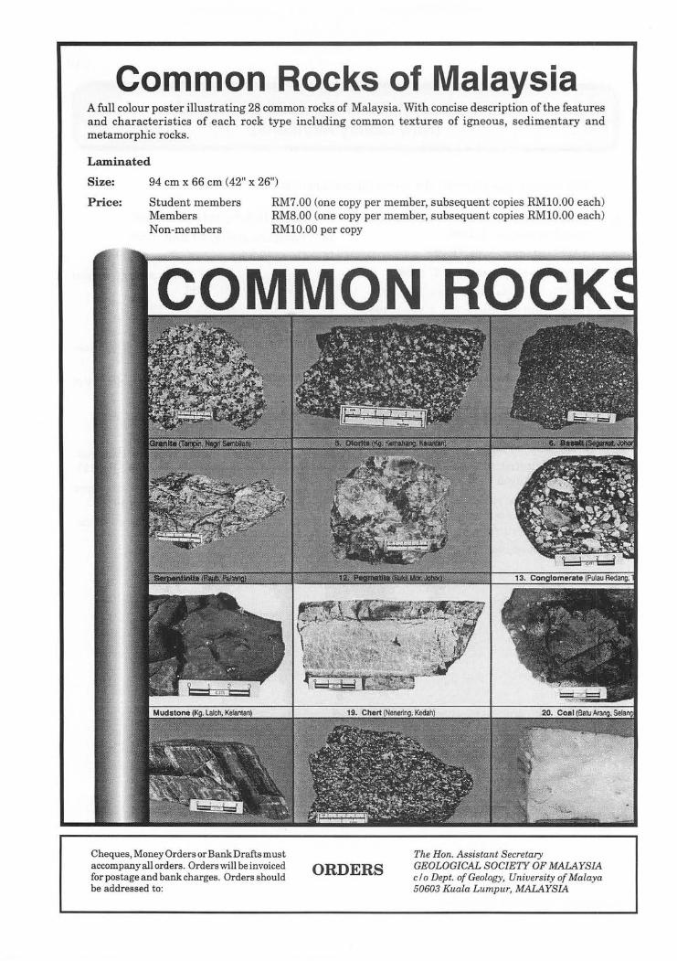
Common Rocks of Malaysia A full colour poster illustrating 28 common rocks of Malaysia. With concise description ofthe features and characteristics of each rock type including common textures of igneous, sedimentary and metamorphic rocks .
Laminated
Size: 94 cm x 66 cm (42" x 26")
Price: Student members Members Non-members
RM7.00 (one copy per member, subsequent copies RMIO.OO each) RM8.00 (one copy per member, subsequent copies RMIO.OO each) RMIO.OO per copy
COMMON ROCK
Cheques, Money Orders or Bank Drafts must accompany all orders. Orders will be invoiced for postage and bank charges. Orders should be addressed to:
ORDERS The Hon. Assistant Secretary GEOLOGICAL SOCIETY OF MALAYSIA c/o Dept. of Geology, University of Malaya 50603 Kuala Lumpur, MALAYSIA

451
Le>c:al Nevvs .
Shell launches exploration, production arm The revamp of Sarawak Shell Bhd. (SSB)/
Sabah Shell Petroleum Co. Ltd. (SSPC) has led to the birth of Shell Malaysia's Exploration and Production (EP) organisation which was officially launched in Lutong, Miri last Friday.
Shell EP started its intensive organisation review in January this year to create a new framework which was founded on declining profitability, fragile growth prospects, increased competition and the need to continually adapt to a changing business environment.
The changes brought about by the review include fewer organisational layers, teamwork, state-of-the art maintenance, alliancing, capability and management and more information technology enabling tools.
Under the major restructuring exercise, over 600 employees were laid off and the revamp involved a redundancy payment of about RM100 million.
SSB/SSPC managing director Tan Ek Kia said multi-disciplinary teams had been created under the exercise.
"There is now more focus on the bottom line in the business units which have become the heart of the new company while the service units are more customer-focused."
"The way forward is clear. We must deliver breakthrough performance - be innovative and manage our relationship well."
Star, 4.11.1996
PLUS conducts soil tests on slopes Projek Lebuhraya Utara-Selatan has
commenced soil and stability tests on the slopes along the Km 303.8 Gopeng -Tapah stretch ofthe North-South Expressway to make it safer for motorists.
The company will soon carry out works to cut the slopes to push them further from the road.
State Public Utilities and Infrastructure Development Committee Chairman Datuk Ong Ka Chuan said this was because PLUS was planning to re-open the Gopeng-Tapah stretch near Gua Tempurungwhich was closed following a landslip earlier this year.
The stretch of road was closed when alandslip occurred on Jan 6 near Gua Tempurung when the concrete embankment ofthe slope collapsed, killing lorry co-driver Abdul Hamid Kodin, 34, and injuring his colleague Hasry Hamid, 37.
Warta Geologi, Vol. 22, No . 6, Nov-Dec 1996
A temporary 545-meter slip-road was subsequently constructed at the Gua Tempurung rest and service area about 120 m from the slope to replace the affected stretch. Motorists are now using the slip-road which was opened on January 22.
Following the incident, PLUS was ordered to conduct stability and soil tests on three slopes nearest to the Gua Tempurung rest area.
It appointed an independent consultant to assist in investigations to determine the cause of the landslip while Central Soil Lab Sdn. Bhd. conducted lift-off tests on the slopes to determine their balance and stability.
Ong said PLUS had decided against the move to build a pre-fabricated tunnel along the stretch as it was too costly.
He said after the soil and stability tests were completed, PLUS would cut the slopes to make
452
it more gentle and then, conduct slope restoration works.
Following this, he said, stabilisation works would be carried out, such as strengthening the slopes with undergrowth or cement grouting and ensuring that the drainage system was in order.
He said it would probably take a year for the repair and rehabilitation works to be completed and a few months more before the road could be re-opened to traffic.
This, he said, was to ensure that the area was stable.
NST, 12.11.1996
Carigali-Triton makes fourth major gas find Dallas-based Triton Energy Limited has
announced the discovery of a fourth major natural-gas field, the "Bumi", on BlockA-18 in the Malaysian-"Thailand Joint Development Area in the Gulf of Thailand.
The "Bumi" discovery well exhibited 403 feet of net gas pay, one of the best wells drilled on Block A, based on the results of electronic logs, Triton, the international oil and gas exploration company, said in a statement released from Dallas yesterday.
This is the fourth discovery well and the ninth successful well drilled on Block A-18 by the operator, Carigali-Triton Operating Company.
CTOC is jointly owned by Petronas Carigali Sdn. Bhd., an exploration and production subsidiary ofPetronas (50 per cent) and Triton (50 per cent).
The well is expected to have the highest total gas flow test of any well drilled to date on the block, Triton senior vice president, Operations AI Turner said.
He said the gas tested from the well had the lowest content of carbon dioxide compared with other wells in the block.
Block A-18, which covers 293,757 ha is located about 450 km from Kuala Lumpur, and 750 km from Bangkok in the northern Malay Basin.
NST, 14.11.1996
New guidelines on prevention, control of soil erosion to be introduced soon
The Department of Environment has drawn up new guidelines on the prevention and control of soil erosion to minimise land degradation in d.evelopment projects.
The guidelines govern, among others, hillslope development, land conversion for gold courses, landfills, development of mining land, forestry, resort development, land reclamation, housing and power generation.
DOE director-general Tan Meng Leng told the New Straits Times today that they would provide a standard reference on mitigative measures to take for 26 types of activities, of which 19 are listed under the Environmental Impact Assessment regulations.
He said they would be introduced soon, adding that Science, Technology and
Environment Minister Datuk Law Hieng Ding had already briefed the State Excos in charge of environmental affairs on them.
"With the new guidelines, State Governments and developers will have no excuse {arnot knowing what the mitigative measures are. "
There had been complaints in the past about the lack of uniformity with regard to guidelines on minimising soil erosion.
Further, legislation such as the Land Conservation Act 1960 is silent on what types of activities are allowed based on the gradients of hillslopes.
Soil erosion due to earth-works and land clearing has been identified as a major cause of water pollution. Last year, of the 119 rivers monitored by the DOE, 45 per cent of them had
Warta Geologi, Vol. 22, No.6, Nov-Dec 1996
been found to be heavily polluted with suspended solids.
It has also resulted in loss offertile top soil and flooding in the down-stream.
As the severity of soil erosion is determined by rainfall, gradient, soil type and the extent of vegetation cover, the new guidelines have listed eight general reference codes for erosion prevention and control.
They include a checklist detailing measures to minimise soil erosion and preserve the top soil, drainage control at construction sites, sediment prevention and slope stabilisation.
For instance, the guidelines on logging stipulate that there should not be any felling above 500 metres of elevation within a watershed to protect the water quality and in predominantly steep terrains above 30 degrees in gradient.
bW hi'
453
And when logging road cuts are made, they should be at an angle of less than 20 degrees to ensure a stable slope and prevent further erosion.
The guidelines also spell out the costs involved to prevent soil erosion during earthwork, cons~ruction and operation phases.
For instance, the costs of protecting slopes using methods such as hydroseeding, mulching, planting of legumes and turfing are factored.
'With the new guidelines, it is hoped that planners and project proponents will be able to identify potential erosion risk areas in their project sites based on the understanding of the processes which underlie the causes and effects of erosion. "
"By doing so, they will then be able to plan and develop the sites by avoiding such critical areas," Tan said.
NST, 18.11.1996
Demand for natural gas to grow faster The Asia Pacific region's demand for natural
gas is expected to expand by 16 per cent between now and the year 2000 compared with just a four per cent growth projected for oil during the same period.
Deputy Prime Minister Datuk Seri Anwar Ibrahim said yesterday the bullish outlook for natural gas was fuelled by environmental concerns and new technology in the processing and use of gas.
This, he said, would no doubt have an impact on the dynamics of the industry and would contribute towards the evolution of gas as the preferred fuel.
"Countries which previously ignored their natural gas resources are now in the process of developing the industry with an eye towards the export market, "he said when opening a four-day conference on Gas Information Exchange in the Western Pacific Area at the Putra World Trade Centre in Kuala Lumpur.
The conference,jointlyorganised by Petronas and the Malaysia Gas Association, is attended by industry representatives from 13 countries.
Anwar said a decade ago, Japan was the only major user of gas in the region. In the last five years, however, South Korea and Taiwan have joined the ranks of gas importers.
"Similarly, otherc9untries such as Malaysia, Indonesia and Thailand are using more of their
Warta Geologi, Vol. 22, No.6, Nov-Dec 1996
gas supply to fuel their energy needs," he said, noting that the strongest growth in gas use was in the Asia Pacific.
This development would also transform the industry from being supply-driven to marketdriven, he added.
Natural gas currently accounts for 22 per cent of the region's energy demand against 42 per cent for oil and 26 per cent, coal.
Anwar said Malaysia's gas industry had grown rapidly over the last 10 years, buoyed by the Government's strategy to diversity energy resources, reduce dependence on oil and boost foreign exchange earnings.
"The oil shocks of the late 1970s made vividly clear the dangers of relying too heavily on a single source of energy to drive the country's development," he said.
Last year, natural gas contributed 29 per cent to the country's energy mix from just three per cent in 1985, and would account for onethird of Malaysia's total requirements in five years, he added.
Liquefied natural gas had also become a major export earner for Malaysia, he said.
For example, in the interim September trade figures, lower export earnings were offset to some extent by receipts from LNG, which recorded an increase of 67.6 per cent.
NST, 19.11.1996
454
Terengganu keen on calcium silicate deal The Terengganu State Government plans to
set up a joint venture company with Sirim Bhd. to produce calcium silicate, used mainly in Malaysia as a high quality building and insulation material.
The first plant, estimated to cost RM26 million, is likely to be set up at Bukit Senyamok near Rantau Abang, where high grade silica sand deposits are found in abundance.
Terengganu Menteri Besar Tan Sri Wan Mokhtar Ahmad said yesterday the 1.14 million tonnes of silica sand deposits in that area, with 99.7 per cent silica content, were the highest in quality in the country.
He added that the State Government's equity in the project would most probably be held by the State Economic Development Corporation or Perbadanan Terengganu Bhd.
He told reporters this after witnessing the signing of a memorandum of understanding between the State Government and Sirim to commercialise a new technology in the manufacture of calcium silicate developed by Sirim.
"Details of the joint venture have yet to be finalised. However, we have carried out a feasibility study on the project which is expected to get off the ground next year. "
Wan MOkhtar said the plant would have a production capacity of 3,700 tonnes per year. Annual production cost is estimated at RM6
tiil
million and revenue is expected to be RMll.6 million.
Calcium silicate is a premium, high quality building material widely used in advanced countries.
The local market for this product is RM1.3 billion. This does not include calcium silicate imported for other purposes, especially as insulation materials.
Currently, all calcium silicate products used in the country are imported from Germany and Japan.
Wan Mokhtar also said apart from large deposits of silica sand, other materials necessary for production of calcium silicate such as lime, pulp, bentonite and cement were also available locally.
"Based on our feasibility study, we may even have to expand the project within four years because of the great demand for calcium silicate in future. "
"We expect that the greatest bulk of our production will be used locally, especially in various petro-chemical projects over the next 10 years."
Sirim chairman Dr. Mohd Ariffin Aton said the manufacturing technology was developed by Sirim over 12 years.
This is the third technology developed by Sirim through its Intensified Research Priority Area.
NST,20.11.1996
Petronas pioneers drilling technology Petronas Carigali Sdn. Bhd. yesterday
claimed a major breakthrough in drilling technology when it successfully completed drilling a tri-Iateral horizontal well, believed to be the first of its kind in the world, in the Bokor field off Sarawak.
The well comprises branches of three horizontal wells which are drilled from a single main trunk each designed to drain an individual reservoir, enabling production of more oil at a lower cost.
Petronas presidentandchiefexecutive Datuk Mohd Hassan Marican said the technology would provide Petronas with a technical and strategic advantage in the development of oil fields ..
"It will not only improve project profitability but also make development of small fields attractive. This is indeed the well of the future."
Mohd Hassan said the technology could now be applied tothe development ofPetronas oilfields thus reducing the number of wells required to produce oil, leading to smaller offshore platforms.
NST, 22.11.1996
Warta Geologi, Vol. 22, No.6, Nov-Dec 1996
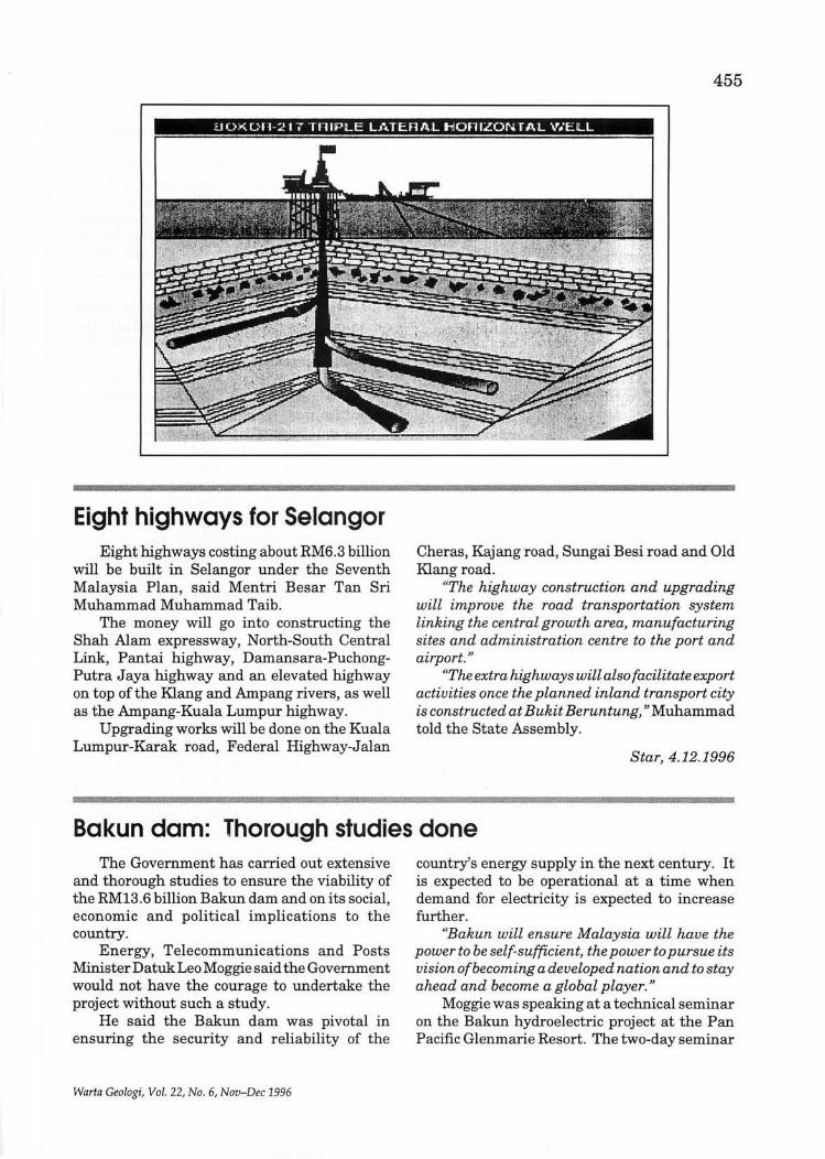
455
i10.-<;UII-217 TniPiLE LATERAL HOniZONTAL WEL L
Ii :
Eight highways for Selangor Eight highways costing about RM6.3 billion
will be built in Selangor under the Seventh Malaysia Plan, said Mentri Besar Tan Sri Muhammad Muhammad Taib.
The money will go into constructing the Shah Alam expressway, North-South Central Link, Pantai highway, Damansara-PuchongPutra Jaya highway and an elevated highway on top of the Klang and Ampang rivers, as well as the Ampang-Kuala Lumpur highway.
Upgrading works will be done on the Kuala Lumpur-Karak road, Federal Highway-Jalan
: '
Cheras, Kajang road, Sungai Besi road and Old Klang road.
"The highway construction and upgrading will improve the road transportation system linking the central growth area, manufacturing sites and administration centre to the port and airport."
"The extra highways will also facilitate export activities once the planned inland transport city is constructed at Bukit Beruntung," Muhammad told the State Assembly.
Star, 4.12.1996
Bakun dam: Thorough studies done The Government has carried out extensive
and thorough studies to ensure the viability of the RM13.6 billion Bakun dam and on its social, economic and political implications to the country.
Energy, Telecommunications and Posts Minister Datuk Leo Moggie said the Government would not have the courage to undertake the project without such a study.
He said the Bakun dam was pivotal in ensuring the security and reliability of the
Warta Geologi, Vol. 22, No.6, Nov-Dec 1996
country's energy supply in the next century. It is expected to be operational at a time when demand for electricity is expected to increase further.
"Bakun will ensure Malaysia will have the power to be self-sufficient, the power to pursue its vision of becoming a developed nation and to stay ahead and become a global player. "
Moggie was speaking at a technical seminar on the Bakun hydroelectric project at the Pan Pacific Glenmarie Resort. The two-day seminar
456
is jointly organised by the Malaysia National Committee of the World Energy Council and the Malaysian Institute of Engineers.
The seminar is to provide the 175 participants, who are mainly engineers, an opportunity to study the technical aspects of the dam construction.'
Moggie said the Government had to be realistic in its approach to the country's energy needs despite the development of new and renewable sources of energy. The commercial viability of the new forms of energy was an important consideration.
"It is evident at the moment that the cost of producing electricity on a large scale, from solar, biomass or wind, is relatively high compared to production from conventional fuels and hydro sources. »
Moggie said the Government would however continue to step up measures to promote the large scale use of new and renewable sources of energy as reflected by its commitment at the recent World Solar Summit in Harare.
Later, the Economic Planning Unit's deputy director-general (sectoral) Datuk Dr. Samsudin Hitam said the dam's developer would have to ensure the economic and financial costs remain at RM13.6 billion.
I~ a keynote address, he said the contractors would have to be highly efficient, cost effective
and master the methodology of managing the project's costs throughout the implementation period.
Samsudin said one of main factors in the successful completion of the project lay in the scheduling and planning of the project.
"As many tasks have to be completed concurrently, careful planning is required to ensure that the work progresses smoothly. Close co-operation among all parties involved is crucial."
Samsudin said the Bakun dam when commissioned by 2003, would reduce the country's reliance on depletable fossil fuels for electricity generation. .:.
The project would also satisfy the country's environmental concerns as hydro electricity generation was environment-friendly.
He said this would help reduce the emissions of carbon dioxide, nitrogen oxide, sulphur dioxide emitted by the use offossil fuels.
Samsudin said local engineers, scientists and technical workers should use opportunities from the project to upgrade their knowledge and expertise to master new technologies.
Samsudinsaid the Government was satisfied that there were enough checks and balances to ensure the requirements and conditions of the project were met.
NST, 4.12.1996
Penang third link sites under study The state government is studying a site in
Batu Kawan on the mainland and another in Batu Maung on Penang Island for the proposed third link.
State Infrastructure and Public Amenities Committee chairman Datuk Dr. Hilmi Yahaya said the sites were proposed by construction giant Mekar Idaman in its conceptual plan submitted recently.
He said under the proposal, an 11 km bridge would be built from Batu Kawan and connected to a tunnel for the last three-kilometres to Batu Maung.
"The tunnel, to be built at the deeper end of
the sea, will facilitate passage for ships and not obstruct air traffic at the Penang International Airport in Bayan Lepas,» he tole The Star.
Dr. Hilmi said the sites were further south than mentioned in the original proposal, where the third link (between Bayan Lepas and Bukit Tengah) would have passed through Pulau Jerejak.
He said the state was awaiting a detailed proposal from Mekar Idaman, a subsidiary of UEM Engineering.
It is learnt that the project cost is estimated at between RM2 billion and RM3 billion.
Star, 5.12.1996
Warta Geologi, Vol. 22, No.6, Nov-Dec 1996
457
Petronas to pay USM RM215 m The Cabinet has directed Petronas Berhad
to pay Universiti Sains Malaysia RM215 million to set up the National Petroleum University at USM's branch campus in Sri Iskandar, Perak.
Education Minister Datuk Seri N ajib Tun Razak said USM's engineering faculty, which is presently situated there, would be transferred to Penang"at a sitewhichis yet to be determined".
"This is still under negotiation with the state government and the development committee but USM hopes to set up seven engineering faculties there, "he said after opening Kolej Antarabangsa Berjaya yesterday.
N ajib said on Monday that Petronas would receive the letter of offer to set up a university from the Government next month.
He had also said that Tenaga N asional Berhad would be issued a letter of offer next week.
The idea for the takeover was mooted by the Perak government several years ago. The university is expected to be operational by July.
N ajib added that besides Telekom Malaysia, Tenaga and Petronas, the Government has also approved the setting up of the Multimedia University and Commonwealth University.
He said a joint venture between a local company and the Massachusetts Institute of Technology to set up the Malaysian University of Science and Technology was planned.
"We have also received other applications, . and consideration will be given when the
applicants have sent us their business and academic plans, " he said
He added that several well-known universities had expressed interest in setting up branch campuses, citing Notingham, Bristol and Monash as examples.
Star, 18.12.1996
Kedah to build a varsity on Pulau Tuba Kedah plans to set up an international
university and a branch campus of Universiti Malaya in Pulau Tuba, off Langkawi.
Mentri Besar Datuk Seri Sanusi Junid said yesterday the university project had been approved in principle by the Cabinet when he was Agriculture Minister two years ago.
"The state government has set up a committee to look into the project, " he told newsmen after signing an MoU to appoint Universiti Malaya as the state advisory body on traditional and historical buildings and landscape architecture.
Pulau Tuba, about 10 minutes by boat from Langkawi, is basically a fishermen's island with a population of about 5,000.
Sanusi also said the state was working with
universiti Malaya to set up its branch campus housing the faculty ofleisure and tourism on the island.
Describing Pulau Tuba as an "island of knowledge," he said the state was considering the University's request for a 40-ha site for the campus.
However, the university would have to bear the construction costs for the campus and faculty, he said.
Sanusi said he had directed the relevant authorities to help speed up the project.
He added that the state would sign more MoUs with other local universities to promote Kedah as an education centre of excellence.
Star, 20.12.1996
City projects may require geo-tech reports Developers of projects in the inner city here
may be required to include geo-technical reports when submitting their plans to the Penang Municipal Council for approval.
Council president Dr. Teng Hock Nan said
Warta Geologi, Vol. 22, No.6, Nov-Dec 1996
the council would consider imposing the condition on developers if more construction works were found to cause cracks to neighbouring houses.
Speaking to reporters after chairing a council meeting on Saturday, he said at present only
458
developers of hillside projects were required to submit a geo-technical report.
On the incident of cracks to houses in several town areas, Dr. Teng said the council would engage a geo-technic expert to determine the cause of the cracks if necessary.
"At the moment we are not engaging any expert but are monitoring the situation closely, " he said.
He was commenting on a call by Consumers Association of Penang (CAP) for the council to urgently commission ageo-technic study in Jalan Sungai Ujong, Rope Walk and Magazine Road areas where cracks have appeared in some
houses. The cracks were believed to have been caused by recent construction works in the vicinity.
CAP president S.M. Mohd Idris said only such an assessment would enable council to take the necessary measures to safeguard public safety.
"The council must not wait fora major tragedy to happen before it obtains independent expert advice, " he added.
He said the council should freeze all further earthworks in the areas pending the outcome of such a study.
Star, 23.12.1996
Sorak Mining to set up silica sand plant A high grade silica sand production plant
would soon be established on Balambangan Island off Kudat following a successful preliminary study of the miners deposits there.
Sorak Mining Sdn. Bhd. managing director Michael Kinsuan told a news conference in Kota Kinabalu last Monday the plant would be built at Tanjung Padang on the island after a fourmonth technical feasibility study which would start this month.
"A silica sand reserve of 50 million tonnes was identified at the island, and the land lease for quarry operation has been approved for a
Work begins on cement plant Hongkew Holdings (M) Sdn. Bhd.'s
contractor, Hyundai Heavy Industries Co. Ltd., has commenced construction of a cement plant at Gua Musang, Kelantan.
In a statement, Hongkew said the contractor had completed the earth-works and was now carrying out piling works on the ground.
Construction was progressing according to
period of30years with an additional option of 10 years," he said after the signing of a technical feasibility study agreement between Sorak Mining, Sirim Bhd., and Kota Kinabalu Industrial Park (KKIP).
Kinsuan said Sorak lV..ining was investing RM40 million to establish a high grade silica production plant with a capacity of one million tonnes per year as well as in infrastructure.
He said the targeted markets are South Korea, Japan, Taiwan, the Philippines, Singapore and also the local market.
Star, 25.12.1996
schedule and commercial production was expected to start in the first quarter of 1999, the company said.
Upon completion, the company said the plant would have a production capacity of about 800,000 tonnes of clinker annually which was expected to yield revenue ofRM163,200,000 per annum.
. NST, 26.12.1996
Warta Geologi, Vol. 22, No.6, Nov-Dec 1996
459
Two Shell companies see big rise in production this year Sarawak Shell Bhd. (SSB) and Sabah Shell
Petroleum Co. (SSPC) have recorded substantial increases in gas production for this year, and expect the growth to continue next year.
"This year, the gas production has increased significantly compared to previous years as two new platforms (M3 and M1) have come on-line," SSB/SSPC managing director Tan Ek Kia said yesterday.
"About 2.7 billion standard cu ft of LNG aiquefied natural gas) was produced. The increase is about 60 to 70 per cent for 1996. We expect a similar amount of increase next year, "he told reporters during a luncheon here.
Tan said it had been projected that gas production would continue to rise while oil production may see a decline.
This, he stressed, was due to natural factors such as decreasing oil reserves.
=
Currently, Shell and Petronas Carigali produce about 200,000 barrels of oil ~ day.
An exploration and evaluation exercise was being conducted off the coast ofMiri by Shell and Petronas to look for new oil and gas reserves, said Tan, adding that hundreds of millions of ringgit were being spent on these activities.
"There will be a lot of seismic exploration activities to explore for new wells," he said.
On the company's performance for 1996, he said Shell had managed to achieve its targets.
As for the targets for 1997, Tan said the company was gearing up for internal restructuring to face tougher challenges.
Declining to reveal further details of SSBI SSPC's plans for 1997, Tan would only say that several new projects have been outlined.
Star, 31.12.1996
Esso to have 30 platforms in Terengganu Esso Production Malaysia Inc. (EPMI), which
has invested more than RM20 billion since it began operations over two decades ago, will boast of30 platforms in offshore Terengganu by next year, chairman Philip J. Dingle said yesterday.
He said the company which had over 20 years operated 26 platforms in nine producing fields offshore Terengganu, recently installed two more platforms in the Lawit gas field which is currently under development and would install another two (Raya-A and Seligi-F) next year as it expanded its operations.
Dingle was speaking to reporters after the
Warta Geologi, Vol. 22, No.6, Nov-Dec 1996
launch of Esso's 1997 calendar themed "Visit Terengganu year 1997" by Terengganu State Culture, Arts and Tourism Development Committee chairman, Datuk Aziz Awang here.
EPMI as operator is developing the Raya and Seligi fields on behalf of the joint venture between the company and Petronas Carigali Sdn. Bhd.
He said initial production from these two new platforms was scheduled in early 1998, with oil production from Raya-A and Seligi-F expected to peak about 24,000 barrels per day (bpd) and 23,000 bpd respectively.
Sun, 31.12.1996
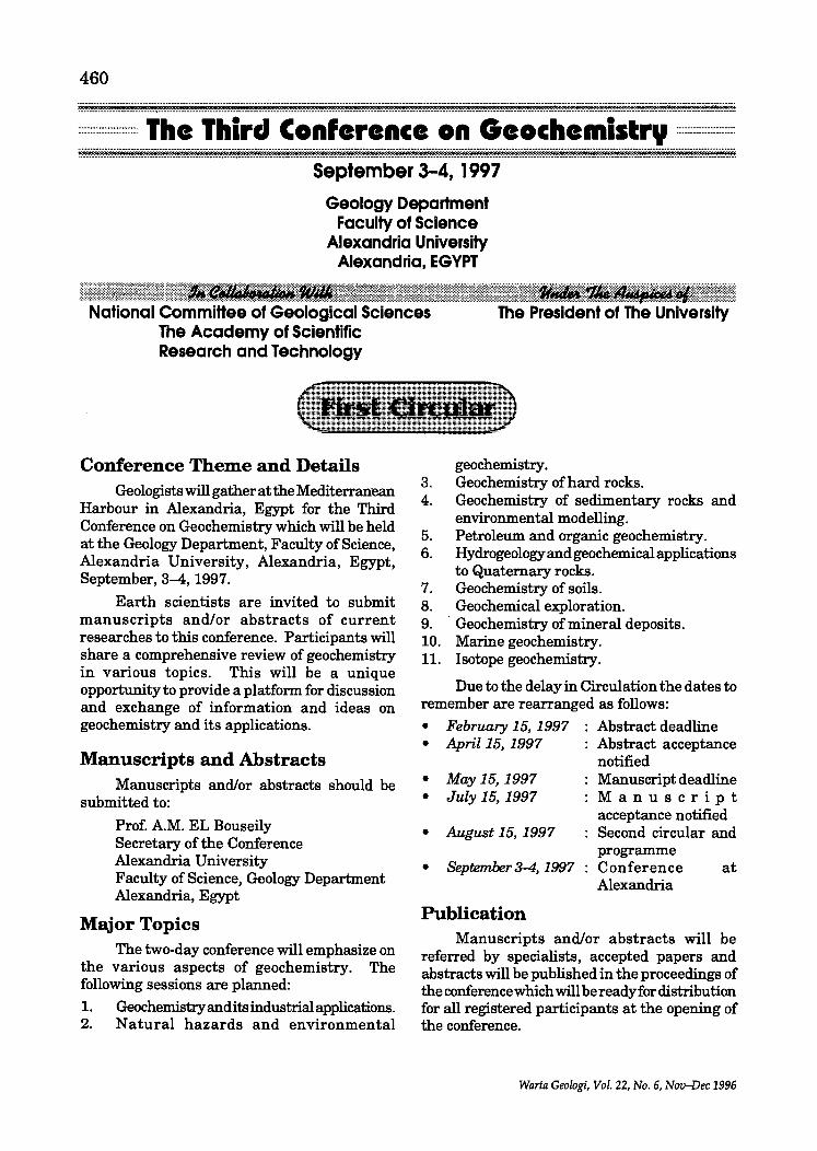
460 ............ _........... .. ........ _..................... . .......... _ ... . . ::::::::::::::::.~:::: .... :. .. ... ::::~. .. .. :::::::::::::::::::::::::::::::::: .... ::::.. .. :: ................ : ................. ::~::::::::..... ..::::: ........ :::::::::.:::::::::::.:::.~:::::::::::..... .... .. .... ::: ............ :::::::~. .._.... ._... ......... ........ ....... . .... ..
:::::::::::::::::::::= The Third Con'erence on Geochemistry ::::::::==::::::: ..................................... _.......... . ................................. _ .............. _ ..... .
................................................ ................................................................................... _ ....................................... -............. .. ............ _ .......... _ ...... · .................... _ .. _ ............................ ·September 3-4. 1997
Geology Department Faculty of Science
Alexandria University Alexandria. EGYPT
National CommiHee of Geological Sciences The Academy of Scientific Research and Technology
. The President of The University
Conference Theme and Details Geologists will gather at the Mediterranean
Harbour in Alexandria, Egypt for the Third Conference on Geochemistry which will be held at the Geology Department, Faculty of Science, Alexandria University, Alexandria, Egypt, September, 3-4, 1997.
Earth scientists are invited to submit manuscripts and/or abstracts of current researches to this conference. Participants will share a comprehensive review of geochemistry in various topics. This will be a unique opportunity to provide a platform for discussion and exchange of information and ideas on geochemistry and its applications.
Manuscripts and Abstracts Manuscripts and/or abstracts should be
submitted to:
Prof. A.M. EL Bouseily Secretary of the Conference Alexandria University Faculty of Science, Geology Department Alexandria, Egypt
Major Topics The two-day conference will emphasize on
the various aspects of geochemistry. The following sessions are planned:
1. Geochemistry and its industrial applications. 2. Natural hazards and environmental
geochemistry. 3. Geochemistry of hard rocks. 4. Geochemistry of sedimentary rocks and
environmental modelling. 5. Petroleum and organic geochemistry. 6. Hydrogeology and geochemical applications
to Quaternary rocks. 7. Geochemistry of soils. 8. Geochemical exploration. 9. . Geochemistry of mineral deposits. 10. Marine geochemistry. 11. Isotope geochemistry.
Due to the delay in Circulation the dates to remember are rearranged as follows:
• February 15,1997 Abstract deadline • April 15, 1997 : Abstract acceptance
• May 15, 1997 • July 15,1997
• August 15, 1997
notified Manuscript deadline Manuscript acceptance notified Second circular and programme
• September3-4,1997 Conference at Alexandria
Publication Manuscripts and/or abstracts will be
referred by specialists, accepted papers and abstracts will be published in the proceedings of the conference which will bereadyfor distribution for all registered participants at the opening of the conference.
Warta Geologi, Vol. 22, No.6, Nov-Dec 1996
ASSOCIATION OF EUROPEAN GEOLOGICAL SOCIETIES (10th Meeting), Karlovv Vary, Czechoslovakia. (Geological Society, Burlington House, Piccadilly, London W1V OJU, UK. Phone: +44 (0) 71-434 9944)
CANADIAN INSTITUTE OF MINING, METALLURGY AND PETROLEUM (99th annual general meeting), Vancouver, British Columbia, Canada. (J ohn Gaydos, Meetings Manager, Canadian Institute of Mining and Metallurgy, 1 Place Alexis Nihon, 1210-3400 de Maisonneuve Boulevard West, Montreal, Quebec H3Z 3B8, Canada. Phone: (514) 939-2710; Telefax: (514) 939-2714)
DROUGHT, GROUNDWATER POLLUTION AND MANAGEMENT (International Workshop), Dindigul, India. (Managing Director, Tamilnadu Water Supply and Drainage Board, TW AD House, Chepauk, Madras 600 005, India)
MANAGEMENT, London, UK. (Dr. Richard K. Bullard, School of Surveying, University of East London, Longbridge Road, Dagenham, Essex, RM8 2AS, UK. Tel: +44 (0181) 590 7722; Fax: +44 (0181) 849 3618; E-mail: [email protected])
GEODYSSEA (GEODYNAMICS OF S . AND S.E. ASIA) (International Symposium), Penang, Malaysia . (Dr. Peter Wilson, GeoForschungZentrum Potsdam, Telegrafenberg A17, D-14473 Potsdam, Germany. Fax: (49)-331-288 1111; E-mail: [email protected])
Warta Geologi, Vol. 22, No.6, Nov-Dec 1996
461
GEOTECHNICAL ENGINEERING IN ASIA: 2000 AND BEYOND (Third Asian Young Geotechnical Engineers Conference), Singapore. (Dr. T.S. Tan, Department of Civil Engineering, National University of Singapore , 10 Kent Ridge Crescent, Singapore 119260. Phone: (65) 772-2160; Fax: (65) 779-1635; E-mail: [email protected])
PETROLEUM SYSTEMS OF S.E. ASIA & AUSTRALASIA (International Conference), Jakarta, Indonesia. (Dr. Ron Noble, ARCO Indonesia Inc., PO Box 260888, Plano TX 75026. Phone: 62-21-521-9028; Fax: 62-21-521-9063; E-mail: [email protected])
International Symposium of AEG), Jerusalem, Israel. (IGES Secretariat, P.O. Box 50006, Tel Aviv, 61500 Israel. Telefax: 972 3 5140000; Email: [email protected])
CLAY CONFERENCE, Ottawa, Canada. (J.B. Percival, Geological Survey of Canada, 601 Booth St., Ottawa, Ontario, KIA OE8. Phone: 613/992-4496; Fax: 613/943-1286; E-mail: [email protected])
···· ~·6~i~u;;6~~ ··········· !J;rI~bsbL0TI~NS ··· .
FOR UNDERGROUND STRUCTURES (International Symposium), Lillehammer, Norway. (Mrs. Siri Engen, Norwegian Society of Chartered Engineers, P.O. Box2312, Solli, N-0201 Oslo, Norway. Fax: +4722947502)
ENVIRONMENT (International Symposium of IAEG), Athens, Greece. (Symposium Secretariat, P.O. Box 19140, GR-11710 Athens, Greece. Telefax: 301 381 3900; 301 924 2570)
LEARNING ABOUT THE EARTH AS A SYSTEM (Second International Conference on Geoscience Education), University of Hawai'i, Hilo . (Dr. M. Frank Watt Ireton, GeoSciEd II
462
Local Arrangements Coordinator, American Geophysical Union, 2000 Florida Avenue, NW, Washington, DC 20009. E-mail: [email protected])
II
GEOLO(]Y AND ENVIRONMENT (50th Geological Congress of Turkey), Istanbul, Turkey. (Secretary GEOENV '97, PK 464, Kizilay, 06424 Ankara, Turkey. Phone: 90 3~2 4343691; Telefax: 90 312 4342388; E-mail: [email protected])
D MENT Int Symposium), Istanbul, Turkey, by the Chamber of Geologica I Engineers. (1. Yilmazer, GEOENV '97, P.K. 464 Kizilay, 06424 Ankara, Turkey. Phone: 9-0-312-4343601; Fax: 9-0-312-4342388; E-mail: [email protected])
. .. .:. . . .
PERMIAN OF EASTERN TETHYS : BIOSTRATIGRAPHY, PALAEOGBOGRAPHY & RESOURCES (International Conference), Melbourne, Australia. (The Secretariat, Permian of Eastern Tethys Conference, School of Aquatic Science & Natural Resources Management, Deakin University, Rusden Campus, 662 Blackburn Road, Clayton, Victoria 3168, Australia. Phone: 61-3-92447429; Fax: 62-3-92447480; E-mail: [email protected])
CANADIAN INSTITUTE OF MINING, METALLURGY AND PETROLEUM (100th annual general meeting), Quebec, Canada. (John Gaydos, Meetings Manager, Canadian Institute of Mining and Metallurgy, 1 Place Alexis Nihon, 1210-3400 de Maisonneuve Boulevard West, Montreal, Quebec H3Z 3B8, Canada. Phone: (514) 939-2710; Telefax: (514) 939-2714)
10TH IAGOD SYMPOSIUM, Australia. (Professor 1.R. Plimer University of Melbourne , Parkville, VIC 3052, Australia. Phone: 613 3446520; Telefax: 6133447761)
INTERNATIONAL PLATINUM SYMPOSIUM (IAGOD/CODMUR), Johannesburg, South Africa. (Dr. C.A. Lee, P.O. Box 68108, Bryanston, South Africa. Phone: 2711411 2253; Telefax: 2711 692 3693)
INTERNATioNALMINER1L~bI~kL .. ASSOCIATION: IMA '98 (17th General Meeting), Toronto, Canada. (Professor A.J. Naldrett, Department of Geology, University of Toronto, Canada M5S 3B1. Phone: (461) 978 3030; Telefax: (416) 978 3938; E-mail: [email protected])
GEOSEA . '98(~inth Regional Congress on Geology, Mineral and Energy Resources of Southeast Asia), Kuala Lumpur, Malaysia. (The Organising Secretary, GEOSEA '98, Geological Society of Malaysia, c/o Department of Geology, University of Malaya, 50603 Kuala Lumpur, Malaysia. Phone: +(603) 757 7036; Fax: +(603) 759 3900; E-mail: [email protected])
PHYSICAL, CIIEMICAL AND BI()LOGICAL ASPECTS OF AQUIFER-STREAM SEDIMENT INTERRELATIONS (28th IAR Congress) (Dr. J. Rosenschein, USGS MS 414, National Center, Reston Va 22092, USA; Telefax: 7036485722)
Warla Geologi, Vol. 22, No.6, Nov-Dec 1996
KANDUNGAN (CONTENTS)
1-5 Kewujudan Fonnasi Lambir di SinkIin Ulu Bok, Sarawak Utara Lim Chun Hui and Mohd. Shafeea Leman
7-13 Potential Alkali-Silica reaction in some Malaysian rock aggregate and their test results Sazali Yaacob, Yeap Ee Beng and Hashim Abdul Razak
15-23 Geology and related activities in the construction of Batu Dam, Kuala Lumpur Saim Suratman
25-35 Kinematic analysis of striated fractures in Titiwangsa granitoid, Karak Highway - Selangor side H.D. Tjia
37-46 A stratigraphic log of Semantan Fonnation along part of the Mentakab-Temerloh Bypass, Pahang I. Metcal fe and K.R. Chakraborty
47-59 Microstructures ofthe defonned granites of eastern Kuala Lumpur - Implications for mechanisms and temperatures of defonnation NgTham Fatt
61-68 Seismic and borehole analysis of Pantai Kundor, Melaka Abd. Rahim Samsudin and Umar Hamzah
69-77 Engineering properties of granitic soils and rocks of Penang Island, Malaysia Tan Boon Kong
79-96 Comparative geochemistry of the sedimentary and metasedimentary clastic rocks of the Kuantan area, Pahang, Malaysia Sidibe Yaya Tiemoko, Tan Teong Hing and Ahmad Jantan
97-112 The sedimentology and tectonics of the Temburong Formation - deformation of early Cenozoic deltaic sequences in NW Borneo Robert B. Tate
113-121 The significance of Upper Permian brachiopods from Merapuh area, northwest Pahang Mohd Shafeea Leman
123-133 Application of soil geochemistry to the detection ofSb-Au mineralization in the Buffalo Reefarea, Kuala Medang, Pahang J.J. Pereira, E.B. Yeap and T.F. Ng
135-144 Characterisation of the weathering profile developed over an amphibole schist bedrock in Peninsular Malaysia J.K. Raj
145-155 Geology of the Gunung Danum conservation area: Geochemistry and soil aspects Muhamad Barzani Gasim, Dale Brunotte, Sahibin Abdul Rahim, Sahat Sadikun and Sanudin Tahir
157-1 68 Joint spacing of granitic rocks in the eastern Kuala Lumpur area, Peninsular Malaysia Ng Tham Fan
169-174 Kajian geofizik di Kuala Betis, Kelantan Abdul Rahim Samsudin, Kamal Roslan Mohamad, Ibrahim Abdullah dan Ab. Ghani Rafek
Cheques, Money Orders or Bank Drafts must accompany all orders. Orders will be invoiced for postage and bank charges. Orders should be addressed to:
Editor: G.H. Teh
PRICE:
RM35.00
The Han. Assistant Secretary GEOLOGICAL SOCIETY OF MALAYSIA c 10 Dept. of Geology, University of Malaya 50603 Kuala Lumpur, MALAYSIA
KANDUNGAN (CONTENTS)
1-9 Relationship of gabbro and pillow lavas in the Lupar Formation, West Sarawak: Implications for interpretation of the Lubok Antu Melange and the Lupar Line N.S. Haile, S.K. Lam and R.M. Banda
11-18 Post migration processing of seismic data Dashuki Mohd.
19-30 The stratigraphy of northern Labuan, NW Sabah Basin, East Malaysia Mazlan B. Hj. Madon
31-53 Depositional and diagenetic histories of reservoir sandstones in the Jerneh field, central Malay Basin Mazlan B. Hj . Madon
5~59 Improved characterisation of carbonate reservoirs using non-linear modelling M. Prins
61-65 Borehole gravimetry survey in Central Luconia carbonate reservoirs Mah Kok Gin and Frans van den Berg
67~0 Structural development at the west-central margin of the Malay Basin Liew Kit Kong
81-91 Abnormal pressure occurrence in the Malay and Penyu basins, offshore Peninsular Malaysia - a regional understanding Mohd Shariff Bin Kader
93-104 A quantitative study of the seismic time-amplitude renection characteristics in an oil field Ng Tong San, Idrus Mohd Shuhud and Leollg Lap Sau
10~117 Application of sequence stratigraphic techniques on the non-marine sequences: An example from the Balingian Province, Sarawak Ismail Che Mat Zin and Jaafar Sipan
119-126 Inversion tectonics in the Malay Basin: evidence and timing of events H.D. Tjia
127-143 Dent Group and its equivalent in the offshore Kinabatangan area, East Sabah Ismail Che Mat Zin
14~156 Complex transtensional structures and the hydrocarbon potential of the Greater Sarawak Basin, Sarawsk as defined by synthetic aperture radar M.P.R. Light, DJ. Bird, G.A. Posehn and M.A.A. Hudi
157-161 Melange on the Jerudong Line, Brunei Darussalam, and its regional significance Charles S. Hutchison
162-174 Geothermics of the Malaysian sedimentary basins Mohd Firdaus Abdul Halim
17~186 Tectonic implications of well-bore breakouts in Malaysian basins H.D. Tjia and Mohd Idrus Ismail
Cheques, Money Orders or Bank Drafts must accompany all orders. Orders will be invoiced for postage and bank charges. Orders should be addressed to:
PRICE:
RM50.00
The Hon. Assistant S ecretary GEOLOGICAL SOCIETY OF MALAYSIA c / o Dept. of Geology, University of Malaya 50603 Kuala Lumpur, MALAYSIA
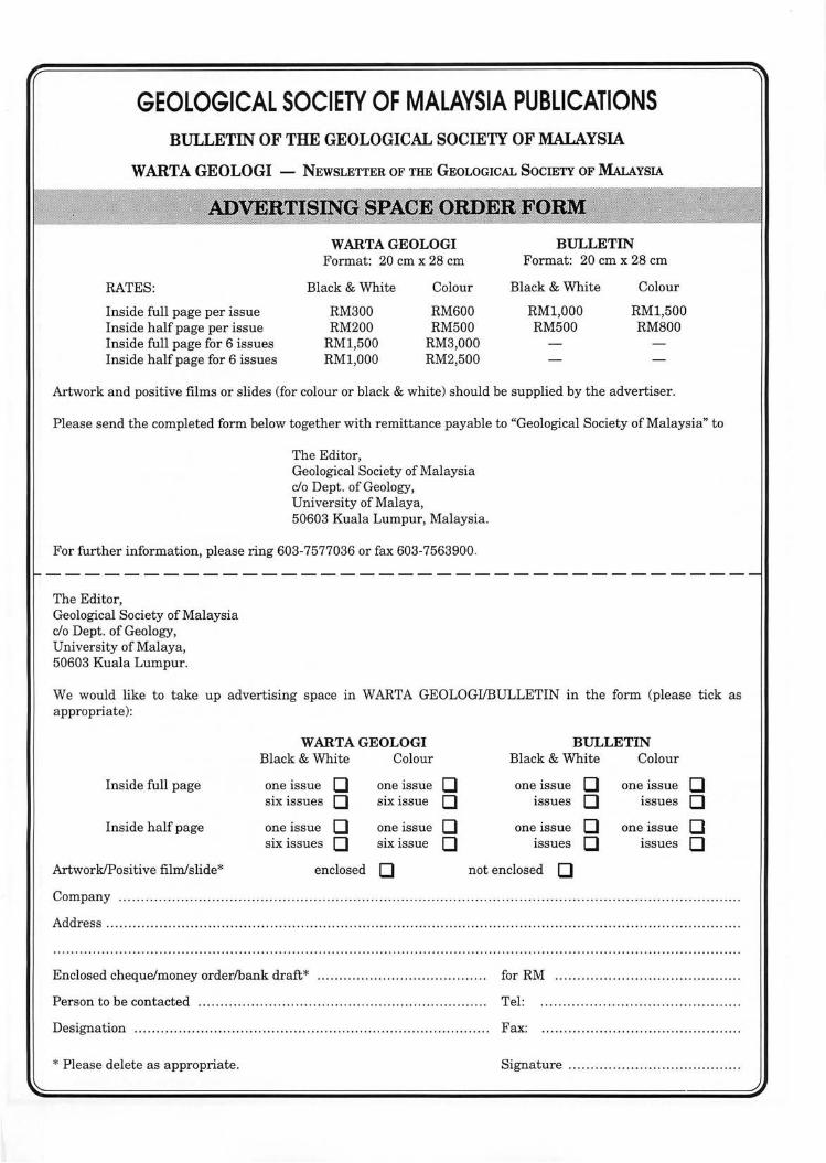
GEOLOGICAL SOCIETY OF MALAYSIA PUBLICATIONS BULLETIN OF THE GEOLOGICAL SOCIETY OF MALAYSIA
WARTA GEOLOGI - NEWSLETIER OF THE GEOLOGICAL SOCIETY OF MALAYSIA
RATES:
Inside full page per issue Inside half page per issue Inside full page for 6 issues Inside half page for 6 issues
W ARTA GEOLOGI Format: 20 cm x 28 cm
Black & White
RM300 RM200
RMl,500 RMl,OOO
Colour
RM600 RM500
RM3,000 RM2,500
BULLETIN Format: 20 cm x 28 cm
Black & White
RMl,OOO RM500
Colour
RMl,500 RM800
Artwork and positive films or slides (for colour or black & white) should be supplied by the advertiser.
Please send the completed form below together with remittance payable to "Geological Society of Malaysia" to
The Editor , Geological Society of Malaysia do Dept. of Geology, University of Malaya, 50603 Kuala Lumpur, Malaysia.
For further information, please ring 603-7577036 or fax 603-7563900.
The Editor, Geological Society of Malaysia do Dept. of Geology, University of Malaya, 50603 Kuala Lumpur.
We would like to take up advertising space in WARTA GEOLOGIIBULLETIN in the form (please tick as appropriate):
WARTA GEOLOGI BULLETIN Black & White Colour Black & White Colour
Inside full page one issue 0 one issue 0 one issue 0 one issue 0 six issues 0 six issue 0 issues 0 issues 0
Inside half page one issue 0 one issue 0 one issue 0 one issue 0 six issues 0 six issue 0 lssues 0 issues 0
ArtworkIPositive filmfslide* enclosed 0 not enclosed 0 Company ...... .. ................................. ....... . ........ ... .... ...... . ...... ... ....... . .. .... .. .. .. .. ...... ..... . . . ... . ........... . ... ... . . .
Address . ... . . ...... .. ... . .... . .. .. . .. .. ... .... .. . .. . .. ................... . ...... .. .. ... ... ... ... ...... .... . . .. . ..... . ..... . . .... ... .... .... ... .. .... . . .
Enclosed cheque/money orderlbank draft* ....... .. .. ... .. ..... . ......... .. .. .... for RM .. ........................ .. .... . .... . ... .
Person to be contacted ..... .. ...................... . .............. .. ......... .. ......... Tel:
Designation .. .. . ... ..... .. .. .. .. . .. .. ... ..... .. .. . .... ........ .. ... .. ..... .. ..... .. .. .. . ... . Fax:
* Please delete as appropriate. Signature .... ......... . .. . ..................... .
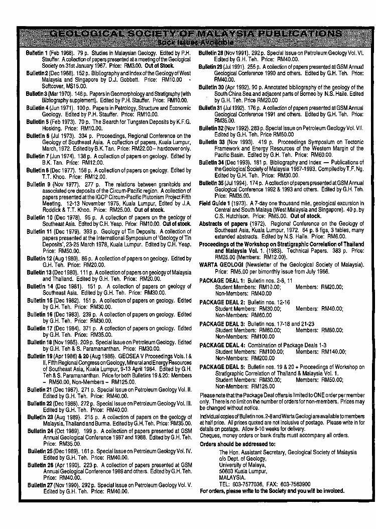
Bulletin 1 (Feb 1968). 79 p. Studies in Malaysian Geology. Edited by P.H. Stauffer. A collection of papers presented at a meeting of the Geological Society on 31st January 1967. Price: RM3.oo. Out of Stock.
Bulletin 2 (Dec 1968). 152 p. Bibliographyand Index olthe Geology of West Malaysia and Singapore by D.J. Gobbet!. Price: RM10.00 -Softcover, M$15.00.
Bulletin 3 (Mar 1970). 146 p. Papers in Geomorphology and Stratigraphy (with Bibliography supplement). Edited by P.H. Stauffer. Price: RM10.oo.
Bulletin 4 (Jun 1971). 100 p. Papers in Petrology, Structure and Economic Geology. Edited by P.H. Stauffer. Price: RM10.00.
Bulletin 5 (Feb 1973). 70 p. The Search for Tungsten Deposits by K.F.G. Hosking. Price: RM10.00.
Bulletin 6 (JuI1973). 334 p. Proceedings, Regional Conference on the Geology of Southeast Asia. A collection of papers, Kuala Lumpur, March, 1972. Edited by B.K. Tan. Price: RM22.00- hardcover only.
Bulletin 7 (Jun 1974). 138 p. A collection of papers on geology. Edited by B.K. Tan. Price: RM12.00.
Bulletin 8 (Dec 1977). 158 p. A collection of papers on geology. Edited by T.T. Khoo. Price: RM12.00.
Bulletin 9 (Nov 1977). 277 p. The relations between granitoids and associated ore deposits of the Circum-Pacific region. A collection of papers presented at the IGCP Circum-Pacific Plutonism Project Fifth Meeting. 12-13 November 1975, Kuala Lumpur, Edited by J.A. Roddick & T.T. Khoo. Price: RM25.00. Out of stock.
Bulletin 10 (Dec 1978). 95 p. A collection of papers on the geology of Southeast Asia. Edited by C.H. Yeap. Price: RM10.oo. Out of stock.
Bulletin 11 (Dec 1979). 393 p. Geology of Tin Deposits. A collection of papers presented at the International Symposium of 'Geology of Tin Deposits', 23-25 March 1978, Kuala Lumpur. Edited by C.H. Yeap. Price: RM50.00.
Bulletin 12 (Aug 1980). 86 p. A collection of papers on geology. Edited by G.H. Teh. Price: RM20.00.
Bulletin 13 (Dec 1980). 111 p. A collection of papers on geology of Malaysia and Thailand. Edited by G.H. Teh. Price: RM20.00.
Bulletin 14 (Dec 1981). 151 p. A collection of papers on geology of Southeast Asia. Edited by G.H. Teh. Price: RM30.00.
Bulletin 15 (Dec 1982). 151 p. A collection of papers on geology. Edited by G.H. Teh. Price: RM30.00.
Bulletin 16 (Dec 1983). 239 p. A collection of papers on geology. Edited by G.H. Teh. Price: RM30.00.
Bulletin 17 (Dec 1984). 371 p. A collection of papers on geology. Edited by G.H. Teh. Price: RM35.00.
Bulletin 18 (Nov 1985). 209 p. Special Issue on Petroleum Geology. Edited by G.H. Teh & S. Paramananthan. Price: RM30.00.
Bulletin 19 (Apr 1986) &20 (Aug 1986). GEOSEA V Proceedings Vols.1 & II, Fifth Regional Congress on Geology, Mineral and Energy Resources of Southeast Asia, Kuala Lumpur, 9-13 April 1984. Edited by G.H. Teh & S. Paramananthan. Price for both Bulletins 19 & 20: Members - RM50.00, Non-Members - RM125.00.
Bulletin 21 (Dec 1987). 271 p. Special Issue on Petroleum Geology VoLiI. Edited by G.H. Teh. Price: RM40.00.
Bulletin 22 (Dec 1988). 272 p. Special Issue on Petroleum Geology Vol. III. Edited by G.H. Teh. Price: RM40.00.
Bulletin 23 (Aug 1989). 215 p. A collection of papers on the geology of Malaysia, Thailand and Burma. Edited by G.H. Teh. Price: RM35.00.
Bulletin 24 (Oct 1989). 199 p. A collection of papers presented at GSM Annual Geological Conference 1987 and 1988. Edited by G.H. Teh. Price: RM35.00.
Bulletin 25 (Dec 1989). 161 p. Special Issue on Petroleum Geology Vol. IV. Edited by G.H. Teh. Price: RM40.00.
Bulletin 26 (Apr 1990). 223 p. A collection of papers presented at GSM Annual Geological Conference 1989 and others. Edited by G.H. Teh. Price: RM40.00.
Bulletin 27 (Nov 1990). 292 p. Special Issue on Petroleum Geology Vol. V. Edited by G.H. Teh. Price: RM40.00.
Bulletin 28 (Nov 1991). 292 p. Special Issue on Petroleum Geology Vol. VI. Edited by G.H. Teh. Price: RM40.00.
Bulletin 29 (JuI1991). 255 p. A collection of papers presented at GSM Annual Geological Conference 1990 and others. Edited by G.H. Teh. Price: RM40.00.
Bulletin 30 (Apr 1992). 90 p. Annotated bibliography of the geology of the South China Sea and adjacent parts of Borneo by N.S. Haile. Edited by G.H. Teh. Price RM20.00
Builetin31 (JuI1992). 176 p. A collection of papers presented atGSM Annual Geological Conference 1991 and others. Edited by G.H. Teh. Price: RM35.oo.
Bulletin 32 (Nov 1992). 283 p. Special Issue on Petroleum Geology Vol. VII. Edited by G.H. Teh. Price RM50.00
Bulletin 33 (Nov 1993). 419 p. Proceedings Symposium on Tectonic Framework and Energy Resources of the Western Margin of the Pacific Basin. Edited by G.H. Teh. Price: RM60.00.
Bulletin 34 (Dec 1993). 181 p. Bibliography and Index - Publications of the Geological Society of Malaysia 1967-1993. Compiled by T. F. Ng. Edited by G.H. Teh. Price: RM30.00.
Bulletin 35 (JuI1994). 174 p. A collection of papers presented at GSM Annual Geological Conference 1992 & 1993 and others. Edited by G.H. Teh. Price: RM35.00.
Field Guide 1 (1973). A 7-day one thousand mile, geological excursion in Central and South Malaya (West Malaysia and Singapore). 40 p. by C.S. Hutchison. Price: RM5.00. Out of stock.
Abstracts of papers (1972). Regional Conference on the Geology of Southeast Asia, Kuala Lumpur, 1972. 64 p. 8 figs, 3 tables, many extended abstracts. Edited by N.S. Haile. Price: RM6.00.
Proceedings of the Workshop on Stratigraphic Correlation of Thailand and Malaysia Vol. 1. (1983). Technical Papers. 383 p. Price: RM25.00 (Members: RM12.00).
WARTA GEOLOGI (Newsletter of the Geological Society of Malaysia). Price: RM5.00 per bimonthly issue from July 1966.
PACKAGE DEAL 1: Bulletin nos. 2-8, 11 Student Members: RM10.00; Members: RM20.00; Non-Members: RM40.00
PACKAGE DEAL 2: Bulletin nos. 12-16 Student Members: RM30.00; Members: RM40.00; Non-Members: RM60.00
PACKAGE DEAL 3: Bulletin nos. 17-18 and 21-23 Student Members: RM60.00; Members: RM80.00; Non-Members: RM100.00 .
PACKAGE DEAL 4: Combination of Package Deals 1-3 Student Members: RM100.00; Members: RM140.00; Non-Members: RM200.00
PACKAGE DEAL 5: Bulletin nos. 19 & 20 + Proceedings of Workshop on Stratigraphic Correlation of Thailand & Malaysia Vol. 1. Student Members: RM30.00; Members: RM50.00; Non-Members: RM125.00
Please note that the Package Deal offers is limited to ONE order per member only. There is no limit on the number of orders for non-members. Prices may be changed without notice. Individual copies of Bulletin nos. 2-8 and Warta Geologi are available to members at half price. All prices quoted are not inclusive of postage. Please write in for details on postage. Allow 8-10 weeks for delivery. Cheques, money orders or bank drafts must accompany all orders. Orders should be addressed to:
The Hon. Assistant Secretary, Geological Society of Malaysia c/o Dept. of Geology, University of Malaya, 50603 Kuala Lumpur, MALAYSIA. TEL: 603-7577036, FAX: 603-7563900
For orders, please write to the Society and you will be invoiced.
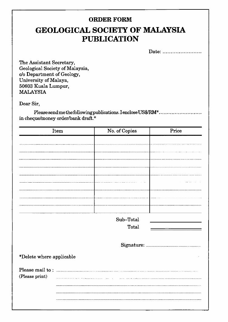
ORDER FORM
GEOLOGICAL SOCIETY OF MALAYSIA PUBLICATION
The Assistant Secretary, Geological Society of Malaysia, c/o Department of Geology, University of Malaya, 50603 Kuala Lumpur, MALAYSIA
Dear Sir,
Date: ....................... .
Please send me the following publications. I enclose US$IRM* .......................... . in cheque/money orderlbank draft. *
Item No. of Copies Price
-_ .. __ ......... __ ............ _ .... _ .. _-_ ................ _ ... _ .... __ .. _ .......... __ ... __ ........ _ ...... _ ..... _ .... _ .. _ ..................... _ .. -
-_ ... _-_ .. _ ... _ .. _-_ ........................... __ ....................... _ .. _ ............. __ ..... _-..................... --.. --_ ................... _ ............... _ ........ _ .. _ ....... _ ........................ _ .. .
-------_ .. _ ......... __ .. __ .. - -_ ........ _ .... _ .. _ .. _-_ ........ __ .- ......... __ .......... _ ............. _ .................................. _-.
*Delete where applicable
Sub-Total Total
Signature: .......................................... _ ................................................................... .
Please mail to: .......................................................................................................................................................................................................................................................................................................... . (Please print) ..... _ ....................................................... _ ............................................................................................................................................................................ _ .................................................. .
GEOLOGICAL SOCIETY OF MALAYSIA PUBLICATIONS
General Information "'«:-:' .. ,,' :: ... ';':::",::;x.:«.;:. .,. "". ~ ... ·;·'w ,w,; ,~~,.:~:;:;.
Papers should be as concise as possible. However, there is no fixed limit as to the length and number of illustrations. Normally, the whole paper should not exceed 30 printed pages. The page size will be 204 x 280 mm (8 x 11 inches) .
The final decision regarding the size of the illustrations, sections of the text to be in small type and other matters relating to printing rests with the Editor.
The final decision of any paper submitted for publication rests with the Editor who is aided by a Special Editorial Advisory Board. The Editor may send any paper submitted for review by one or more reviewers. Authors can also include other reviewers' comments oftheir papers. Scripts of papers found to be unsuitable for publication may not be returned to the authors but reasons for the rejection will be given. The authors of papers found to be unsuitable for publication may appeal only to be Editor for reconsideration if they do not agree with the reasons for rejection. The Editor will consider the appeal together with the Special Editorial Advisory Board.
Unless with the consent ofthe Editor, papers which have been published before should not be submitted for consideration.
Authors must agree not to publish elsewhere a paper submitted and accepted.
Authors alone are responsible for the facts and opinions given in their papers and for the correctness of references etc.
One set of proofs will be sent to the author (iftime permits), to be checked for printer's errors . In the case of two or more authors, please indicate to whom the proofs should be sent.
Twenty-five reprints of each article published are supplied free-of-charge. Additional reprints can be ordered on a reprint order form, which is included with the proofs.
Correspondence: All papers should be submitted to
The Editor (Dr. Teh Guan Hoe) Geological Society of Malaysia
c/o Geology Department University of Malaya 50603 Kuala Lumpur
MALAYSIA Tel: (603) 7577036 Fax: (603) 7563900
Script .~~quir~me~~s Scripts must be written in Bahasa Malaysia (Malay) or English.
Two copies ofthe text and illustrations must be submitted. The scripts must be typewritten double-spaced on paper not exceeding 210 x 297 mm (or 8.27 x 11.69 inches, A4 size). One side of the page must only be typed on.
Figure captions must be typed on a separate sheet of paper. The captions must not be drafted on the figures . The figure number should be marked in pencil on the margin or reverse side.
Original maps and illustrations or as glossy prints should ideally be submitted with sufficiently bold and large lettering to permit reduction to 18 x 25 cm: fold-outs and large maps will be considered only under special circumstances.
Photographs should be of good quality, sharp and with contrast. For each photograph, submit two glossy prints, at least 8 x 12.5 cm and preferably larger. Use of metric system of measurements (SI) is strongly urged wherever possible.
An abstract in English which is concise and informative is required for each paper.
References cited in the text should be listed at the end of the paper and arranged in alphabetical order and typed double-spaced. The name ofthe book or journal must be in italics. The references should be quoted in the following manner:
lIAMrLTON, W., 1979. Tectonics of the Indonesian region. U.S. Geological Survey Professional Paper 1078, 345p.
HOSKING, K.F.G., 1973. Primary mineral deposits. In Gobbett, D.J . and Hutchison, C.s. (Eds.), Geology of the Malay Peninsula (West Malaysia and Singapore). Wiley-Interscience. New York, 335-390.
HUTcmsoN, C.S., 1989. Geological Evolution of South-east Asia. Clarendon Press, Oxford. 368p.
SUNTHARALINGAM, T., 1968. Upper Paleozoic stratig:-aphy of the area west of Kampar, Perak. Geol. Soc. Malaysia Bull. 1, 1-15.
TAYLOR, B. , AND HAYES, D.E., 1980. The tectonic evolution of the South China Sea basin. In: D.E. Hayes (Ed. ), The Tectonic and Geologic Evolution of Southeast Asian Sea and Islands, Part 2. Am. Geophy. Union Monograph 23,89-104.
Submission orelectronic text. In order to publish the paper as quickly as possible after acceptance, authors are requested to submit the final text also on a 3.5" diskette. Both Macintosh and PC (DOSlWindows) platforms are supported. Main text, tables and illustrations should be stored in separate files with clearly identifiable names. Text made with most word processors can be readily processed but authors are advised to provide an additional copy of the text file in ASCII format . Preferred format for illustration is Encapsulated PostScript (EPS) but authors may submit graphic files in their native form. It is essential that the name and version of softwares used is clearly indicated. The final manuscript may contain parts (e.g. formulae, complex tables) or last-minute corrections which are not included in the electronic text on the diskette; however, this should be clearly marked in an additional hardcopy of the manuscript. Authors are encouraged to ensure that apart from any such small last-minute corrections, the disk version and the hardcopy must be identical. Discrepancies can lead to proofs of the wrong version being made.
GEOLOGICAL SOCIETY OF MALAYSIA PUBLICATIONS
Papers should be as concise as possible. However, there is no fixed limit as to the length and number of illustrations. Normally, the whole paper should not exceed 30 printed pages. The page size will be 204 x 280 mm (8 x 11 inches).
The final decision regarding the size of the illustrations, sections of the text to be in small type and other matters relating to printing rests with the Editor.
The final decision of any paper submitted for publication rests with the Editor who is aided by a Special Editorial Advisory Board. The Editor may send any paper submitted for review by one or more reviewers. Authors can also include other reviewers' comments oftheir papers. Scripts of papers found to be unsuitable for publication may not be returned to the authors but reasons for the rejection will be given. The authors of papers found to be unsuitable for publication may appeal only to be Editor for reconsidera tion if they do not agree with the reasons for rejection. The Editor will consider the appeal together with the Special Editorial Advisory Board.
Unless with the consent of the Editor, papers which have been published before should not be submitted for consideration.
Authors must agree not to publish elsewhere a paper submitted and accepted.
Authors alone are responsible for the facts and opinions given in their papers and for the correctness of references etc.
One set of proofs will be sent to the author (if time permits), to be checked for printer's errors. In the case of two or more authors, please indicate to whom the proofs should be sent.
Twenty-five reprints of each article published are supplied free-of-charge. Additional reprints can be ordered on a reprint order form, which is included with the proofs.
Correspondence: All papers should be submitted to
The Editor (Dr. Teh Guan Hoe) Geological Society of Malaysia
do Geology Department University of Malaya 50603 Kuala Lumpur
MALAYSIA Tel: (603) 7577036 Fax: (603) 7563900
Scripts must be written in Bahasa Malaysia (Malay) or English.
Two copies ofthe text and ill ustrations must be submitted. The scripts must be typewritten double-spaced on paper not exceeding 210 x 297 mm (or 8.27 x 11.69 inches, A4 size). One side of the page must only be typed on.
Figure captions must be typed on a separate sheet of paper. The captions must not be drafted on the figures. The figure number should be marked in pencil on the margin or reverse side.
Original maps and illustrations or as glossy prints should ideally be submitted with sufficiently bold and large lettering to permit reduction to 18 x 25 cm: fold-outs and large maps will be considered only under special circumstances.
Photographs should be of good quality, sharp and with contrast. For each photograph, submit two glossy prints, at least 8 x 12.5 cm and preferably larger. Use of metric system of measurements (SI) is strongly urged wherever possible.
An abstract in English which is concise and informative is required for each paper.
References cited in the text should be listed at the end of the paper and arranged in alphabetical order and typed double-spaced. The name ofthe book or journal must be in italics. The references should be quoted in the following manner:
HAMILTON, W., 1979. Tectonics of the Indonesian region. U.S. Geological Survey Professional Paper 1078, 345p.
HOSKING, K.F.G., 1973. Primary mineral deposits. In Gobbett, D.J. and Hutchison, C.S. (Eds.), Geology of the Malay Peninsula (West Malaysia and Singapore). Wiley-Interscience. New York, 335-390.
HUTcmsoN, C.S., 1989. Geological Evolution of South-east Asia. Clarendon Press, Oxford. 368p.
SUNTHARALINGAM, T. , 1968. Upper Paleozoic stratigraphy of the area west of Kampar, Perak. Geo!. Soc. Malaysia Bull. 1, 1-15.
TAYLOR, B., AND HAYES, D.E., 1980. The tectonic evolution ofthe South China Sea basin. In: D.E. Hayes (Ed.), The Tectonic and Geologic Evolution of Southeast Asian Sea and Islands, Part 2. Am. Geophy. Union Monograph 23,89-104.
Submission of electronic text. In order to publish the paper as quickly as possible after acceptance, authors are requested to submit the final text also on a 3.5" diskette. Both Macintosh and PC (DOSlWindows) platforms are supported. Main text, tables and illustrations should be stored in separate files with clearly identifiable names. Text made with most word processors can be readily processed but authors are advised to provide an additional copy of the text file in ASCII format. Preferred format for illustration is Encapsulated PostScript (EPS) but authors may submit graphic files in their native form. It is essential that the name and version of softwares used is clearly indicated. The final manuscript may contain parts (e.g. formulae, complex tables) or last-minute corrections which are not included in the electronic text on the diskette; however, this should be clearly marked in an additional hardcopy of the manuscript. Authors are encouraged to ensure that apart from any such small last-minute corrections, the disk version and the hardcopy must be identical. Discrepancies can lead to proofs of the wrong version being made.
Ni~ ~
siberu~ SUMATRA
CAMBODIA(,"," '.VIETNAM
.-.\ .r
ala Terengganu
~Lingga
°Singkep
200 Ian
LAUT CHINA SELATAN (South China Sea)
o Natuna
Belitung
110° E
NEGERI-NEGERI MALAYSIA (STATES OF MALAYSIA)
1 PERLIS 8 PAHANG 2 KEDAH 9 NEGERI SEMBI LAN 3 PULAU PI NANG 10 MELAKA 4 PERAK 11 JOHOR 5 KELANTAN 12 SABAH 6 TERENGGANU 13 SARAWAK 7 SELANGOR
.-P. Banggi
KALIMANTAN
S