Embed Size (px)
Citation preview
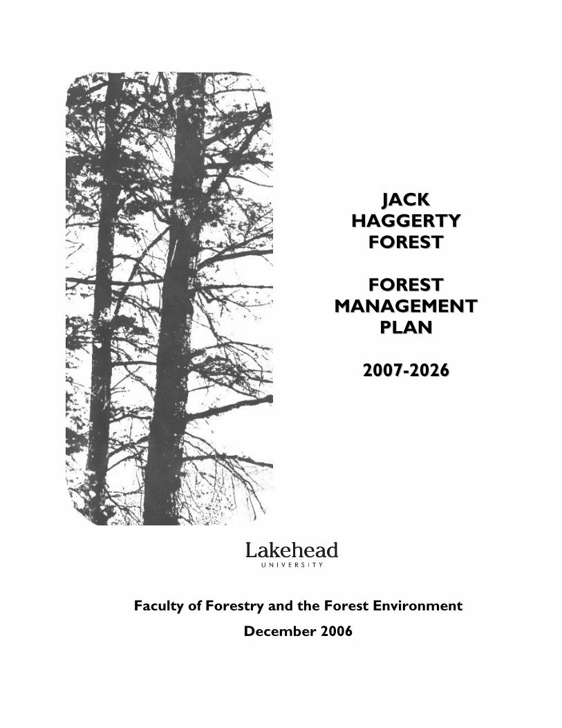
JJAACCKK HHAAGGGGEERRTTYY
FFOORREESSTT
FFOORREESSTT MMAANNAAGGEEMMEENNTT
PPLLAANN
22000077--22002266
Faculty of Forestry and the Forest Environment
December 2006
Jack Haggerty Forest • Management Plan 2006-2026
ii
Forest Management Plan for the
Lakehead University Jack Haggerty Forest
For the Operating Period 2007-2026
Faculty of Forestry and the Forest Environment
December 2006
Jack Haggerty Forest • Forest Management Plan 2006-2026
iii
Forest Management Plan for the Jack Haggerty Forest We certify that this plan has been prepared to the best of our professional skill and recommend that this forest management plan be approved for implementation.
Amberley Anderson, R.P.F. Date: Plan Author
Patrick Cybulski Date: Operations Manager
Kevin Ride, R.P.F. Date: Plan Advisor
Approved by: Dr. Reino Pulkki, R.P.F. Dean Faculty of Forestry and the Forest Environment, Lakehead University Thunder Bay, Ontario
Jack Haggerty Forest • Forest Management Plan 2006-2026
iv
ACKNOWLEDGEMENTS
Thank you to the many people who helped in the completion of this Management Plan, especially Kevin Ride and Patrick Cybulski who were essential to the completion of this plan. Thank you also to Tomislav Sapic for rectifying the aerial photos. The 2006-2007 Off Campus Properties Committee consists of A. Anderson, P. Cybulski, M. Leitch, F. Luckai, R. Pulkki, K. Ride and J. Wang.
Jack Haggerty Forest • Forest Management Plan 2006-2026
v
TABLE OF CONTENTS
Page
1.0 INTRODUCTION AND DESCRIPTION 1
1.1 Location 1 1.2 Division of Area 4
1.3 Physical Features 4 1.4 Climate 4 1.5 Species 5 1.6 History of the Forest 5 1.6.1 Historical Harvesting Operations 6 1.6.2 Historical Silvicultural Operations 6 1.6.3 Research 6
1.7 Forest Inventory 7 1.8 Forest Unit Classification 8 1.8.1 Red Pine Dominant (PrDom) 8 1.8.2 Conifer Low (CnLow) 9 1.8.3 Black Spruce Pure (SbPur) 9 1.8.4 Poplar Pure (PoPur) 9 1.8.5 Balsam Fir Dominant (BFDom) 9 1.8.6 Conifer Mix (ConMx) 10 1.8.7 Hardwood Mix (HrdMw) 10 1.8.8 Mixed 10 2.0 REVIEW OF PREVIOUS PLAN 13
2.1 Summary of Previous Plan 13 2.2 Summary of Production Forest 14 2.3 Objective Achievement of Previous Plan 14 2.4 Objectives of Previous Plan 14
3.0 ISSUES AND RECOMMENDATIONS 16
3.1 Forest Condition 16 3.2 Inventory 16 3.3 Student Use 17
3.3.1 Use by students within the Faculty of Forestry and the Forest Environment 17
3.3.2 Use by students outside the Faculty of Forestry and the Forest Environment 17
3.4 Student Employment 17 3.5 Research 18
Jack Haggerty Forest • Forest Management Plan 2006-2026
vi
3.6 Access 18 3.7 Protection 18 3.8 Record Keeping 18 3.9 Wildlife Management 19 3.10 Forest Classification 19 3.11 Allowable Harvest Calculation 19 3.12 Seismic Station 20 3.13 Forest Certification 20
4.0 STRATEGIC DIRECTION 21
4.1 Overall Goal 21 4.2 Objectives 21
4.2.1 Teaching Facility 21 4.2.2 Forest Composition 21 4.2.3 Research 22 4.2.4 Access 22 4.2.5 Information 22 4.2.6 Protection 22
4.3 Soils 23 4.4 Access Plan 23
4.4.1 Current Road Status 23 4.4.2 Road Construction 23 4.4.3 Public Access 23
4.5 Trapping 24 4.6 Forest Analysis 24
4.6.1 Allowable Harvest 24 4.6.2 Forest Composition 26
4.7 Harvesting Operations 27 4.7.1 Harvesting System 27 4.7.2 Harvest Eligibility and Allocation 27
4.8 Fish and Wildlife 30 4.9 Environmental Protection 30 4.10 Gravel and Mining 30 4.11 Field School 31 4.12 Research Proposals 31
5.0 APPENDICES 32
5.1 Order-in-Council (#806/53) 33 5.2 Past Research Projects in the Jack Haggerty Forest 37
Jack Haggerty Forest • Forest Management Plan 2006-2026
vii
LIST OF TABLES
Table Page 1. Thunder Bay climate characteristics. 5 2. Forest Unit descriptions and areas. 8 3. Summary of silvicultural treatments from previous plan. 13 4. Allowable cut for 20-year period (1986-2006). 13 5. Animals harvested in the Jack Haggerty Forest. 24 6. Term 1 allowable harvest area by forest unit and age
class (ha/year). 26
Jack Haggerty Forest • Forest Management Plan 2006-2026
viii
LIST OF FIGURES
Figure Page 1. Location of and access to the Jack Haggerty Forest. 2 2. Map of the Jack Haggerty Forest. 3 3. Plot locations of the stratified random sample design. 7 4. Age class distribution of the Jack Haggerty Forest. 11 5. Forest Unit distribution of the Jack Haggerty Forest. 12 6. Long-term forecast of harvest volumes of three different management scenarios. 25 7. Selected management alternative forecast of hardwood and conifer (SPF) volumes through time. 26 8. Selected management alternative forecast of forest composition through time. 27 9. Harvest Eligibility Map. 28 10. Harvest Allocation Map. 29
Jack Haggerty Forest • Forest Management Plan 2006-2026
1
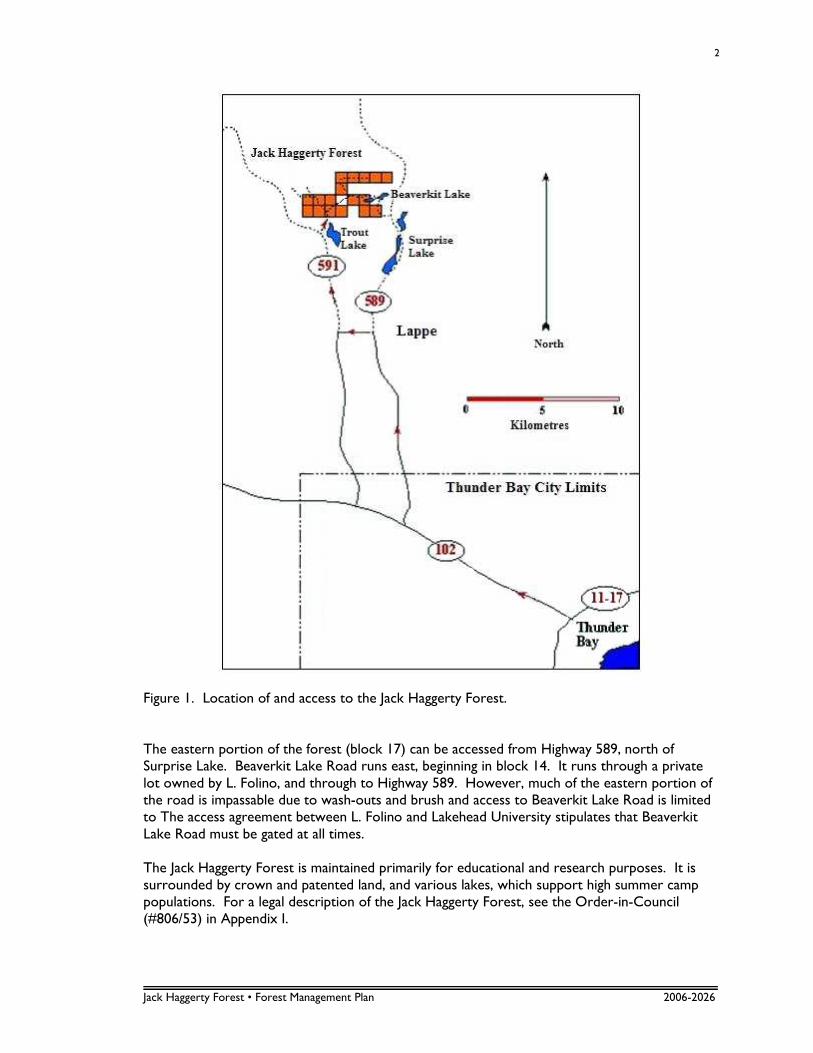
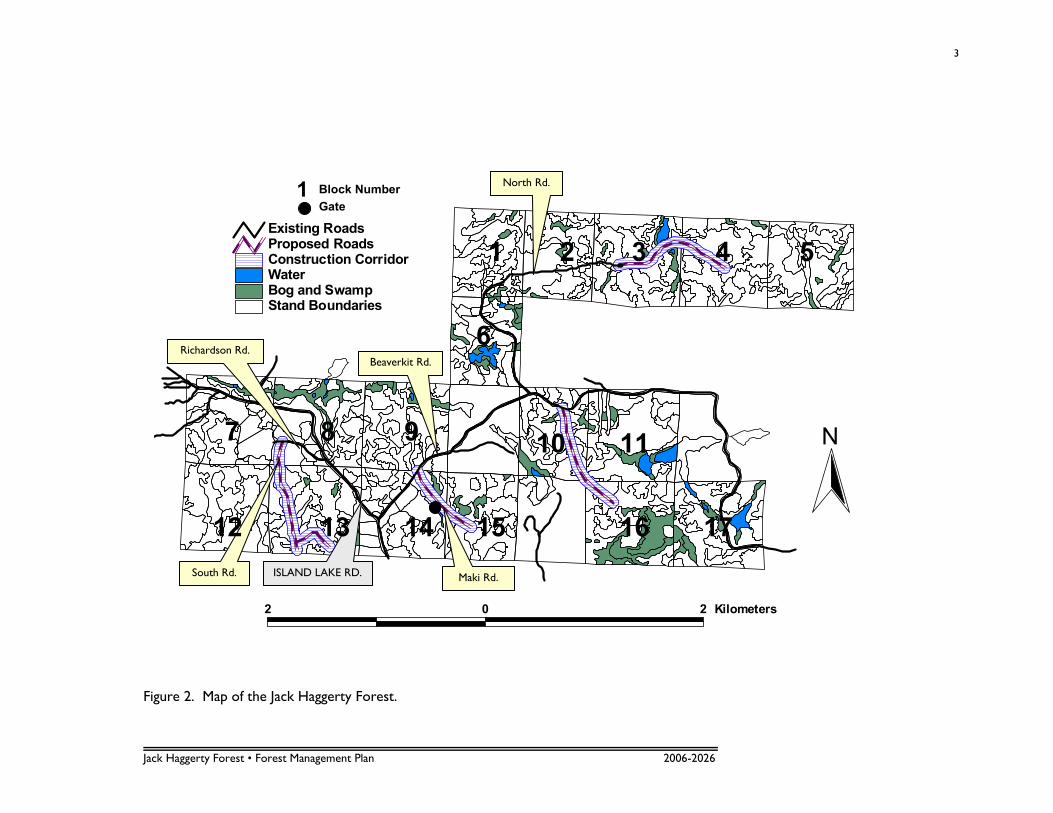
1.0 INTRODUCTION AND DESCRIPTION The purpose of this plan is to provide a 20 year strategic direction and a 5 year operational plan that are consistent with the identified objectives. This plan replaces the 1986 management plan for the Lakehead University Jack Haggerty Forest which expired in 2006. This plan will expire in 2011 at which point the strategic direction should be reviewed and adjusted if necessary and a new 5 year operational plan should be written. The Jack Haggerty Forest consists of just over 1000 ha of forested private property owned by Lakehead University and administered by the Faculty of Forestry and the Forest Environment Off Campus Properties Committee. As private property, this landbase is not subject to the Crown Forest Sustainability Act or the Forest Management Planning Manual for Ontario’s Crown Forests (FMPM). Some principles and practices prescribed by this manual have been adopted in this plan. However, due to its status as private land and its relatively small size, this plan does not merit as in-depth a process and scope as prescribed by the FMPM. It is geared toward private land management. 1.1 LOCATION The Lakehead University Jack Haggerty Forest is located in the Thunder Bay district in the North Central Region of Ontario and is located within the boundaries of the Lakehead Forest. It is located in Fowler and Jacques Townships, approximately 36 km northwest of Thunder Bay, Ontario; northwest along Highway 102 and north along Highway 591 (Mapleward Road). Latitudes of the south and north boundaries are 48˚38” and 48˚40”, respectively. The east and west boundaries are described by longitudes 89˚20” and 89˚25” (Figure 1). The forest has a total area of 1039.1 hectares (ha), which is divided up into 17 blocks (Figure 2). Block boundary lines were cleared to a three metre wide strip. The total area can further be classified as 12.3 ha of water, 962.8 ha of forested land, and 64.0 ha of non-productive forest consisting of open muskeg, brush and alder, rock and roads. Access to the Jack Haggerty Forest can be gained in two ways (Figure 1). The western portion can be accessed via the Trout Lake Road, which runs northwest from Highway 591, west of Trout Lake. This road traverses the western blocks and continues on to One Island Lake. At the skidder garage in block 7, the Island Lake Road branches off to the north, accessing the northern portion of the forest limits (Figure 3).
Jack Haggerty Forest • Forest Management Plan 2006-2026
2
Figure 1. Location of and access to the Jack Haggerty Forest. The eastern portion of the forest (block 17) can be accessed from Highway 589, north of Surprise Lake. Beaverkit Lake Road runs east, beginning in block 14. It runs through a private lot owned by L. Folino, and through to Highway 589. However, much of the eastern portion of the road is impassable due to wash-outs and brush and access to Beaverkit Lake Road is limited to The access agreement between L. Folino and Lakehead University stipulates that Beaverkit Lake Road must be gated at all times. The Jack Haggerty Forest is maintained primarily for educational and research purposes. It is surrounded by crown and patented land, and various lakes, which support high summer camp populations. For a legal description of the Jack Haggerty Forest, see the Order-in-Council (#806/53) in Appendix I.
Jack Haggerty Forest • Forest Management Plan 2006-2026
3
Stand BoundariesBog and SwampWaterConstruction CorridorProposed RoadsExisting Roads
2 0 2 Kilometers
N
Figure 2. Map of the Jack Haggerty Forest.
North Rd.
Beaverkit Rd. Richardson Rd.
Maki Rd.
Block Number
Gate
ISLAND LAKE RD. South Rd.
1 2 3 4 5
6
7
1
8 9 10 11
12 13 14 15 16 17
Jack Haggerty Forest • Forest Management Plan 2006-2026
4
1.2 DIVISION OF AREA The 1039.1 ha of the Jack Haggerty Forest has been divided into 17 blocks for ease of educational exercises (Figure 3). There are 12, 65 ha blocks, and five 49 ha blocks. The boundaries have been surveyed and cleared to increase accessibility to the forest. Due to the small size of these compartments (49 to 65 ha), the forest is managed as a single unit. 1.3 PHYSICAL FEATURES The Jack Haggerty Forest is located on the Canadian Shield with rock formed during the Precambrian era. The soil materials in the western portion of the forest limits are primarily ground moraine and outwash plain resulting from glaciers during the Pleistocene period. The eastern blocks are bedrock plains resulting from the same glacial period. Cover deposits range from shallow to moderately deep (5 cm – 3 m) loams, silts and sands. Pockets of deep (>3 m) organic soils are also present throughout the Jack Haggerty Forest. The presence of stones and rocks is generally moderate. The topography of the area is flat to moderately rolling. Very few steep hills are present. The underlying bedrock is granitic and some small outcrops occur. The small lakes and creeks located within the Jack Haggerty Forest boundaries cover a total area of 13.2 ha. The largest lake is Beaverkit Lake, located in the eastern portion of the forest in block 11. 1.4 CLIMATE The Thunder Bay area has a continental climate with warm to hot summers and cooler winters with a Great Lake moderating influence. Summer daytime temperatures vary from 15° C to 30° C, while nights tend to be cooler and less humid than southern locations. Recent winter daytime temperatures have ranged from spring-like to relatively cold with sunny days. Spring and autumn are short with cool days and evenings. Precipitation is highly variable from year to year. The prevailing westerly winds are generally moderate. The frost-free season averages 101 days, with frosts occurring as late as June 15 and as early as September 1. Data from two Thunder Bay weather stations (Environment Canada) summarizing typical long-term climatic characteristics for the period 1971-2000 are presented in Table 1.
Jack Haggerty Forest • Forest Management Plan 2006-2026
5
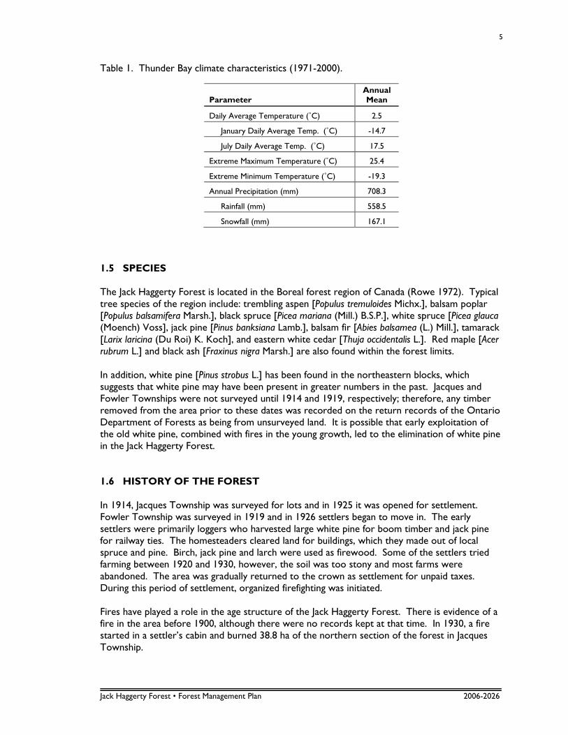
Table 1. Thunder Bay climate characteristics (1971-2000).
Parameter
Annual Mean
Daily Average Temperature (˚C) 2.5
January Daily Average Temp. (˚C) -14.7
July Daily Average Temp. (˚C) 17.5
Extreme Maximum Temperature (˚C) 25.4
Extreme Minimum Temperature (˚C) -19.3
Annual Precipitation (mm) 708.3
Rainfall (mm) 558.5
Snowfall (mm) 167.1
1.5 SPECIES The Jack Haggerty Forest is located in the Boreal forest region of Canada (Rowe 1972). Typical tree species of the region include: trembling aspen [Populus tremuloides Michx.], balsam poplar [Populus balsamifera Marsh.], black spruce [Picea mariana (Mill.) B.S.P.], white spruce [Picea glauca (Moench) Voss], jack pine [Pinus banksiana Lamb.], balsam fir [Abies balsamea (L.) Mill.], tamarack [Larix laricina (Du Roi) K. Koch], and eastern white cedar [Thuja occidentalis L.]. Red maple [Acer rubrum L.] and black ash [Fraxinus nigra Marsh.] are also found within the forest limits. In addition, white pine [Pinus strobus L.] has been found in the northeastern blocks, which suggests that white pine may have been present in greater numbers in the past. Jacques and Fowler Townships were not surveyed until 1914 and 1919, respectively; therefore, any timber removed from the area prior to these dates was recorded on the return records of the Ontario Department of Forests as being from unsurveyed land. It is possible that early exploitation of the old white pine, combined with fires in the young growth, led to the elimination of white pine in the Jack Haggerty Forest. 1.6 HISTORY OF THE FOREST In 1914, Jacques Township was surveyed for lots and in 1925 it was opened for settlement. Fowler Township was surveyed in 1919 and in 1926 settlers began to move in. The early settlers were primarily loggers who harvested large white pine for boom timber and jack pine for railway ties. The homesteaders cleared land for buildings, which they made out of local spruce and pine. Birch, jack pine and larch were used as firewood. Some of the settlers tried farming between 1920 and 1930, however, the soil was too stony and most farms were abandoned. The area was gradually returned to the crown as settlement for unpaid taxes. During this period of settlement, organized firefighting was initiated. Fires have played a role in the age structure of the Jack Haggerty Forest. There is evidence of a fire in the area before 1900, although there were no records kept at that time. In 1930, a fire started in a settler’s cabin and burned 38.8 ha of the northern section of the forest in Jacques Township.
Jack Haggerty Forest • Forest Management Plan 2006-2026
6
The combined effects of land clearing, logging and firefighting led to a change in species composition. Jack pine forest units decreased due to over-harvesting and the lack of fire to open the serotinous cones for seeding. The amount of white birch and trembling aspen increased due to their light seed and profuse sprouting abilities. Road access was developed in the Townships by 1931. Highway 591 extended to Trout Lake and Highway 589 went to Two Island Lake. Between 1940 and 1953, the timber demand increased due to the growing requirements of the construction and the pulp and paper industries. Jack pine and spruce were the desired species. From 1950 to 1953, several portable sawmills were operational within the boundaries of the Jack Haggerty Forest. These mills high-graded local jack pine and spruce. Scarification was non-existent prior to 1956 and site disturbance from horse-logging was minimal. Jack pine seed requires mineral soil exposure to germinate, therefore, logged areas filled in with white birch and trembling aspen. In 1948, the two year Technical Forestry program was initiated at Lakehead Technical Institute in Thunder Bay. The Jack Haggerty Forest was first used by technical students during the fall field school in 1951. This practice has continued since then. On March 12, 1953, an order-in-council transferred control of the land from the Department of Lands and Forests to the Department of Education for the use of Lakehead Technical Institute (Appendix I). In 1957, the Lakehead Technical Institute became the Lakehead College of Arts, Science and Technology and in 1962, it attained university status. The government of Ontario authorized the granting of an undergraduate forestry degree in 1971. The first forestry degree graduating class was in May of 1973. 1.6.1 Historical Harvesting Operations In late 1953, the land use permits were cancelled and all portable sawmills in the area were shut down due to the high-grading that was occurring. No further cutting operations occurred until 1972, when the Lakehead University School of Forestry began hiring contractors to cut overmature stands. The hiring of contractors continued until the late 1980’s, at which point harvesting became the responsibility of technical staff. 1.6.2 Historical Silvicultural Operations Barrels and chains were the primary method of site preparation from 1972 to 1979. These cutovers were planted with bareroot black and white spruce. Areas left for natural trembling aspen or jack pine regeneration were not site prepared. Site preparation in the 1980’s was done
with a Bräcke Badger and in the 1990’s, a TTS power disc trencher was used. Tree planting of bareroot stock continued to be the main means of regeneration, but cerkon cones were also used on several sites. 1.6.3 Research Several research projects were initiated in the Jack Haggerty Forest in the 1970’s, including permanent sample plots and a provenance trial. A more detailed description of these projects can be found in Appendix II.
Jack Haggerty Forest • Forest Management Plan 2006-2026
7
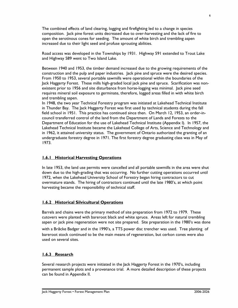
1.7 FOREST INVENTORY The original forest inventory occurred in three stages, in 1978, 1979 and 1981. Data was collected using a systematic line plot sampling design with a sampling intensity of one percent. Circular plots were 0.04 ha in size and spaced 200 m apart. All trees 10 cm and larger in diameter at breast height (dbh) were tallied in 2 cm diameter classes. A forest stand map was prepared based on aerial photo interpretation and field cruise data. Stand composition was determined from plot data. Stands with no inventory or permanent sample plots had species composition, stocking and height determined though photo interpretation. Age class was determined from historical knowledge and neighbouring stand information. More recently, in the fall of 2001, seven senior year students were hired to cruise the Jack Haggerty Forest. These students were directed to perform modified point sample cruise in a stratified random design. Forty points (only 25 for the Conifer Lowland (CnLow)) were randomly located in each forest unit across the forest (Figure 3). At each location a point sample prism sweep was conducted (BAF=2m2/ha). Trees were tallied by species and the DBH of each sampled tree was measured. The age of at least one co-dominant tree was also measured at each location. The vegetation type (OMNR Forest Ecosystem Classification) was recorded at each point. Notes regarding qualitative observations of the stand condition (decay, mortality, advanced regeneration) were also recorded. Tree height was not considered an important variable to measure as a great amount of mensuration has already been conducted in this area over the years and fairly accurate DBH to height regressions and local volume tables exist. Measuring the heights at each plot would have slowed the progress of the cruisers and provided little new information.
Figure 3. Plot locations of the stratified random sample design.
Jack Haggerty Forest • Forest Management Plan 2006-2026
8
The data for each of these plots was entered into an MS Access database. With the use of Local Volume Tables (2000) estimates of merchantable volume per hectare by species were calculated for each plot. Estimates of the average merchantable volume per hectare by each forest unit were then calculated with 95% confidence intervals. The tally sheet notes indicate several consistent trends. The forest is generally poorly stocked with a great deal of mortality. Much of the volume is found in either very large trees that are still alive but may contain significant decay, or second growth younger trees. There is a great deal of balsam fir and some white and black spruce advanced regeneration in the forest. There was some indication from the notes that the species composition from the 1994 inventory may be becoming outdated as one crew made efforts to provide new estimates of species composition which in some cases differed 20-30% from the composition in the inventory. 1.8 FOREST UNIT CLASSIFICATION The Jack Haggerty Forest has been subdivided into eight forest units (FU) for the purposes of management (Table 2). These forest units have been loosely based on OMNR’s Northwest Regional standard forest units but have been condensed to accommodate the relatively small size of this forest. This forest contains relatively few jack pine and as such, there is no forest unit classification for a pure jack pine or jack pine dominated mixedwood. Most of the stands are in a mixed condition and, therefore, these forest units have been designed to reflect mostly subtle differences in forest composition. Table 2. Forest unit descriptions and areas.
Forest Unit Definition Hectares
PrDom >=90% Pr 0.5
CnLow >=90% Sb 33.0
SbPur >=70% Sb 92.4
PoPur >=70% Po 116.3
BFDom >= 50% conifer and >= 50% Bf 147.6
ConMx >= 60% conifer 206.9
HrdMw >= 60% hardwood 196.0
Mixed All Else 129.3
1.8.1 Red Pine Dominant (PrDom) The red pine dominant forest unit is greater than 90% red pine. This forest unit is comprised of one plantation in the 0-10 year age class, a little less than 0.5 ha in size. This forest unit is a result of past silvicultural practices, and although very little of this forest unit shows up in the current inventory, much more will show up in the next inventory.
Jack Haggerty Forest • Forest Management Plan 2006-2026
9
1.8.2 Conifer Low (CnLow) This forest unit is made up of greater than 90% black spruce. Black spruce commonly grows as pure stands within the Jack Haggerty Forest. Most of the pure stands are found on organic soils, often in distinct small kettle depressions. Associated species in this forest unit would be tamarack and eastern white cedar. There are only a total of 33 ha of this forest unit, of which just over 20 are in the 91-100 year age class. Six ha fall in the 51-60 year age class and the rest are divided between the 11-20, 101-110 and 111-120 year age classes. 1.8.3 Black Spruce Pure (SbPur) The black spruce pure forest unit is made up of greater than 70% black spruce. While still composed mainly of black spruce, unlike the CnLow forest unit, this forest unit is found on drier, upland sites and not on organic soils. Ninety-two hectares of the Jack Haggerty Forest fall under this forest unit. Most of this is in the 91-100 year age class (37 ha). An additional 14 ha are in the 0-10 year age class. Nearly 11 ha are in the 51-60 year age class, and the remaining area falls into another eight different age classes, including the 141-150 year age class. 1.8.4 Poplar Pure (PoPur) The poplar pure forest unit is made up of greater than 70% poplar. Trembling aspen stands in the Jack Haggerty Forest occur on the finer textured deeper loams and sandy soils. Occasionally, they occur on clay and organic soils. Where they exist, these sites typically regenerate well to PoPur following harvest. The forest tent caterpillar [Malacosoma disstria Hbn.] outbreaks of the recent past, and their continuous defoliation of trembling aspen trees, have caused damage to the trembling aspen forest unit, which is evident simply through visual assessment. A large number of trembling aspen trees have succumbed to the continuous defoliation. 1.8.5 Balsam Fir Dominant (BFDom) Balsam fir does not occur as a pure stand in the Jack Haggerty Forest but is frequently associated with other conifers. The balsam fir dominant forest unit consists of greater than 50% conifer and greater than 50% balsam fir. Nearly 148 hectares of the Jack Haggerty Forest fall under this forest unit. Of the 148 hectares, nearly 65 are in the 91-100 year age class, 54 are in the 51-60 year age class and 14 are in the 61-70 year age class. The remaining area falls into the 101-110 and 111-120 year age classes. Balsam fir stands in the Jack Haggerty Forest are found on sand or coarse loam soils and occasionally on heavier silt and clay soils. Balsam fir is very susceptible to spruce budworm [Choristoneura fumiferana (Clem.)] attack and the high proportion of balsam fir in the forest has led to severe spruce budworm problems in the past. As a result of the spruce budworm infestations, much of the mature BFDom forest unit has experienced nearly 100% mortality. Balsam fir is very abundant in the understory of stands throughout the forest.
Jack Haggerty Forest • Forest Management Plan 2006-2026
10
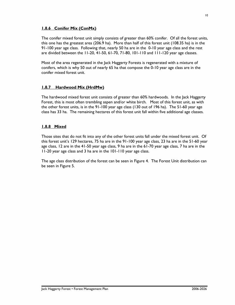
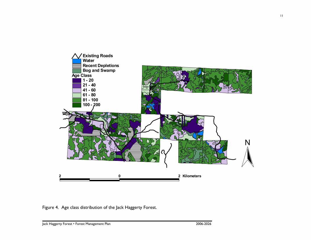
1.8.6 Conifer Mix (ConMx) The conifer mixed forest unit simply consists of greater than 60% conifer. Of all the forest units, this one has the greatest area (206.9 ha). More than half of this forest unit (108.35 ha) is in the 91-100 year age class. Following that, nearly 50 ha are in the 0-10 year age class and the rest are divided between the 11-20, 41-50, 61-70, 71-80, 101-110 and 111-120 year age classes. Most of the area regenerated in the Jack Haggerty Forests is regenerated with a mixture of conifers, which is why 50 out of nearly 65 ha that compose the 0-10 year age class are in the conifer mixed forest unit. 1.8.7 Hardwood Mix (HrdMw) The hardwood mixed forest unit consists of greater than 60% hardwoods. In the Jack Haggerty Forest, this is most often trembling aspen and/or white birch. Most of this forest unit, as with the other forest units, is in the 91-100 year age class (130 out of 196 ha). The 51-60 year age class has 33 ha. The remaining hectares of this forest unit fall within five additional age classes. 1.8.8 Mixed Those sites that do not fit into any of the other forest units fall under the mixed forest unit. Of this forest unit’s 129 hectares, 75 ha are in the 91-100 year age class, 23 ha are in the 51-60 year age class, 12 are in the 41-50 year age class, 9 ha are in the 61-70 year age class, 7 ha are in the 11-20 year age class and 3 ha are in the 101-110 year age class. The age class distribution of the forest can be seen in Figure 4. The Forest Unit distribution can be seen in Figure 5.
Jack Haggerty Forest • Forest Management Plan 2006-2026
11
Age Class1 - 2021 - 4041 - 6061 - 8081 - 100100 - 200
Bog and SwampRecent DepletionsWaterExisting Roads
2 0 2 Kilometers
N
Figure 4. Age class distribution of the Jack Haggerty Forest.
Jack Haggerty Forest • Forest Management Plan 2006-2026
12
Forest UnitsBFDomCnLowConMxHrdMXMixedPoPurPrDomSbPur
Recent DepletionsBog and SwampWater
2 0 2 Kilometers
N
Figure 5. Forest Unit distribution of the Jack Haggerty Forest.
Jack Haggerty Forest • Forest Management Plan 2006-2026
13
2.0 REVIEW OF PREVIOUS PLAN
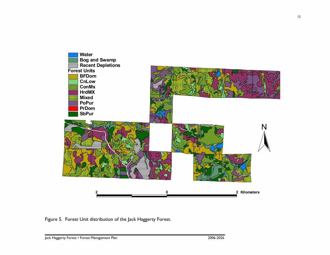
2.1 SUMMARY OF PREVIOUS PLAN The previous management plan for the Jack Haggerty Forest was for the period 1986-2006. It was written by Leslie Hawkins, R.P.F. and Bob Pickard, R.P.F. In this plan, the overall policy was to manage the forest as an outdoor laboratory and research area, while demonstrating proper forest management techniques, and providing revenue in support of the forest when possible. The old plan managed the forest according to seven Working Groups. A summary of silvicultural treatments and the allowable cut for the 20-year planning period for each Working Group are shown in Tables 3 and 4, respectively.
Table 3. Summary of silvicultural treatments from previous plan.
Working Group
Rotation (yrs.)
Harvesting Method Site Preparation
Regeneration Method Tending
Pj
70 - selective cut - barrels and chains - cone slash - hand clean Bw &
- clearcut - mechanical - planting Po as needed
- direct seeding
Sb
110 - selective cut - mechanical on uplands - planting - clean on uplands
- strip cut - winter blading on - direct seeding for Bw & Po
- seed tree organics
- natural seed
Bf 65 - clearcut - mechanical - plant to Sw or Sb - clean Po, Bw & Bf
Po
70 - clearcut - mechanical & - suckering - hand clean
- selective cut herbicides - plant to conifer conversions
Bw
65 - clearcut - mechanical - plant to conifer - hand clean
- selective cut - stump sprouts conversions
Sw
- clearcut when - mechanical - hand plant Sw
merchantable
Ce - clearcut when - assess needs as - assess needs as
found encountered encountered
Table 4. Allowable cut for 20-year period (1986-2006).
Working Rotation Adjustment Area-Age Class Gerhardt's
Group (yrs.) Period (yrs.)
Area (ha) Volume (m3) Volume (m3)
Pj 70 30 26.6 3757.50 3833.80
Sb 110 45 37.8 4214.61 4211.40 Bf 65 40 108.8 13592.38 13565.40
Po 70 35 161.6 25362.88 25395.40
Bw 65 35 104.8 10798.59 11420.20
TOTAL 439.6 57725.96 58426.20
Jack Haggerty Forest • Forest Management Plan 2006-2026
14
Unfortunately, in this previous plan, stands were allocated based solely on stand age and composition, without consideration for their location or proximity to roads. As a result, many allocated stands were not harvested as scheduled. The previous plan also had an allowable cut of 439.6 ha, which is over 40 percent of the entire area of the Jack Haggerty Forest and over 46 percent of the productive forest land. At such a high percentage, this upper limit was impractical.
2.2 SUMMARY OF PRODUCTION FOREST In the previous plan, volumes were derived from forest inventory cruise data and from Plonski’s normal yield tables (1974) using aerial photo interpretation. There was an obvious imbalance in age class distribution under the even-aged management system, which is still apparent today.
2.3 OBJECTIVE ACHIEVEMENT OF PREVIOUS PLAN Typically a Report of Past Operations and Independent Forest Audits are produced prior to writing forest management plans under the Crown Forest Sustainability Act. This facilitates the identification of issues and allows the writers of the plan to build upon past experiences when re-adjusting the strategic direction of the next plan. For this reason a brief critique of the objective achievement of the previous plan has been included. This should not be taken as a criticism of the previous plan author or implementers of the plan but rather it is to serve as a foundation for improvement of the next plan. Many of the objectives of the previous plan were ambiguous statements that, through time, have lost their significance. Some objectives have been fulfilled reasonably well, while others have received inadequate attention.
2.4 OBJECTIVES OF PREVIOUS PLAN 1. Provide a field laboratory for use by faculty, staff and students. 2. To designate and protect areas for the research needs of the School of Forestry. 3. To grow and harvest the highest value of wood products from each site. 4. To manage forest production under the even-aged management system. 5. To provide for and enhance fish and wildlife habitats. 6. To minimize the negative impacts of forestry operations on sensitive environments such as shallow sites and
watersheds. 7. To fully access the northern blocks of the Forest with a main road as funds become available. 8. To provide for other uses such as recreation, public education, trapping and the protection of botanically
important sites. 9. To initiate and maintain an accurate record-keeping system.
Jack Haggerty Forest • Forest Management Plan 2006-2026
15
Students and faculty use the Jack Haggerty Forest extensively for educational purposes. Courses such as Dendrology, Mensuration, Harvesting and Forest Pathology find practical use of the forest through field trip excursions and hands-on field exercises. A large number of students have also gained from part-time and summer employment in the forest. Although the forest is well used by faculty and staff, strategies such as annually canvassing faculty’s needs and identifying special areas has not been carried out. The use of this forest by researchers has greatly diminished in recent years. This is probably due to numerous compounding factors (e.g. faculty retirements, current forest condition, access, scale and theme of contemporary research etc.). Strategies identified in the last plan such as annually canvassing faculty and identifying areas on maps and on the ground have not been carried out. This forest has been managed under even-aged silvicultural systems and harvest levels over the past 10 years have been modest compared with the potential of the forest. Excellent efforts have been made to regenerate the forest according to site conditions. The enhancement of fish and wildlife habitats is relatively pointless without identifying which species should be managed for. Strategies such as identifying wildlife habitats have not been carried out. However the cutting patterns of previous operations are leading to a more multi-aged forest structure and are in keeping with suggested strategies. The forest consists of many fragmented, small-size cuts. Contemporary forest management paradigms no longer embrace a featured species approach. Sensitive sites have been protected reasonably well. Firstly, there are very few sensitive sites on this forest. Secondly, current practices such as walking each area prior to harvest, harvesting primarily in winter, and the small scale nature of harvesting operations have produced no indication that operations should be criticized. Good progress has been made towards improving the access to the northern blocks. The proposed road in the previous plan has been completed and construction has progressed beyond where it was forecasted. There are now only a few northern blocks without road access. The provision of other uses of the forest (recreation, public education, trapping and protection of botanically important areas) has had mixed success. The forest is clearly used by hunters and trappers however this use is difficult to quantify. From a practical standpoint, it has become common practice to hinder (not restrict) the use of the forest by the general public. This has been done primarily to reduce the incidence of vandalism. There is little interest or value in using this forest as a site for public education. The record keeping practice of forest activities during the past 20 years has been poor. It takes a great deal of effort to discern from the records what treatments were conducted where.
Jack Haggerty Forest • Forest Management Plan 2006-2026
16
3.0 ISSUES AND RECOMMENDATIONS 3.1 FOREST CONDITION
The current forest condition could be described as “degraded”. The harvesting that occurred in the early 1950’s was unmanaged and was followed by little or no silvicultural activity. It is likely that only the highest value conifer timber white pine, black spruce and jack pine were harvested from most of the stands, a practice known as high-grading or selective harvesting. Without seeding or planting of conifer species, the resulting forest gaps would have most likely been filled with an in-growth of hardwoods and balsam fir. The forest is primarily in the 91 to 100 and 51 to 60 year age class. The next most abundant age class is 0-10 years. Other age classes are more poorly represented or nonexistent. The oldest trees found in the 2001 survey were a 126 year old black spruce and a 120 year old jack pine. It is plausible that most of the current forest originated from a wildfire approximately 125-130 years ago. This fire would have likely favoured the regeneration of a conifer dominated forested landscape (relatively pure black spruce and jack pine stands, mixed stands dominated by conifer and hardwood stands on soils most appropriate for their continued regeneration, red and white pine would have occurred on suitable soils). By 1950, these trees would have been approximately 70-80 years of age and ideal for harvest. The current forest is likely in a fairly un-natural state, both in terms of stocking, and species content. This strategic direction of this plan should put this forest on a trajectory leading to a more pure conifer and more fully stocked condition. 3.2 INVENTORY
The inventory used for this plan was produced in 1991 and is becoming outdated for the purposes of forest management. There is certainly a need for a new full inventory. The 2001 survey indicated that in many stands, the actual forest composition differs from the inventory by approximately 20%. Most dramatic are the balsam fir dominated stands which have experienced nearly 100% mortality due to spruce budworm infestations. Many of the previously regenerated sites have not been updated in the inventory to reflect their “free-to-grow” status. Furthermore much of the newly depleted areas have not been removed from the 1991 inventory. Within the Jack Haggerty Forest, there are several areas of value to note, including past research sites and memorial stones and plaques. The locations of most values on the Jack Haggerty forest are known, but these should be located using a GPS and stored in a Values database for future planning purposes. Recently, colour digital aerial photos (1:4000) were purchased for the Jack Haggerty Forest and are being rectified for use in GIS. It is recommended that this photo sequence be used as the base of a new inventory that should be produced within the next 5 years. The photos should be used to produce new stand and compartment maps. Because the area of the Jack Haggerty Forest is relatively small, and because the old inventory is somewhat outdated, an inventory should be undertaken in the form of a stratified random
Jack Haggerty Forest • Forest Management Plan 2006-2026
17
sample, with the strata being individual stands. Points should be randomly located on the map within the stand boundaries. In this manner, every stand within the Jack Haggerty Forest can be sampled, using modified points, with the number of points in each stand dependent on the size of the stand. This will produce reliable, up-to-date inventory data. 3.3 STUDENT USE
3.3.1 Within the Faculty of Forestry and the Forest Environment
Although the level of use by students is decent, it could be enhanced by operational activities that create better demonstration areas. This might increase the value of the forest to other classes such as silviculture and fish and wildlife. Some ideas include: 1) clearcutting 1 ha and 1 acre in a square shape to calibrate the students’ eye, 2) taking photos in the same locations from year to year to use as a teaching tool, 3) creating site treatment summary sheets that could be used for field trips, 4) practicing snag retention in limited areas as demonstration sites, 5) construction of a moose and deer exclosure. These and/or other ideas should be implemented to enhance the value of the forest as a demonstration area for students. Technical staff associated with the Jack Haggerty forest could undertake enhancement projects such as these as time permits, and canvas faculty for other ideas that are practical for the Jack Haggerty Forest. 3.3.2 Outside the Faculty of Forestry and the Forest Environment
Use by other Programs and Faculties at Lakehead University is encouraged. The Department of Geography does use the Jack Haggerty Forest each fall, but other programs such as Outdoor Recreation, Parks & Tourism, Science and Environmental Studies and Geology could also benefit from the use of the Jack Haggerty Forest, both because of its proximity to the University and its abundance of natural resources. It is recommended that the Jack Haggerty Forest be marketed to other Programs and Faculties at Lakehead University. Making Adjunct Professors of the Faculty of Forestry and the Forest Environment from other Faculties and Associations aware of this opportunity is the first step. 3.4 STUDENT EMPLOYMENT Since the last plan was written, nearly 70 students have been employed in the Jack Haggerty Forest. The students ranged from high school students to forestry graduate students and the length of their work terms ranged from 2-month summer positions to 9-month internships. Funding for student employment has been received from the Ontario Work Study Program (OWSP), Human Resources Development Canada (HRDC), and FedNor. The remainder of the funds were generated from the Jack Haggerty Forest. The Jack Haggerty Forest has also provided fundraising opportunities for student groups such as the Timbersports Team, the Forestry Ring Ceremony and the Forestry Symposium. These opportunities have included the delivery of loads of firewood to sell and payment for treeplanting.
Jack Haggerty Forest • Forest Management Plan 2006-2026
18
The experience that students gain through working in the Jack Haggerty Forest is invaluable. It is expected that the practice of hiring students will continue. 3.5 RESEARCH
It is recognized that the management of this forest should accommodate research interests where practical. However there is little point in carrying out activities for the purposes of attracting research. There is clearly no need to keep research as a primary objective of the forest. Instead, there should be an objective related to accommodating research proposals as they arise. 3.6 ACCESS
The Jack Haggerty Forest is reasonably accessible; however more road access is needed for future harvesting activities. Improved road access will also enhance other uses of the forest. However, it is also recognized that unlimited use by the general public is not desirable. In order to maintain some control of unauthorised users, existing roads should be extended and new access off of the MTO roadway should be limited as much as possible. Current access restrictions, such as gates, should be maintained as needed.
3.7 PROTECTION
The northeastern most block (block 5) is difficult to access due to steep terrain. This area was not logged previously and contains the few white pine and red maple on the forest. The steep terrain and the presence of white pine make this an ideal location to protect from forest harvesting and to use for other purposes. Over the course of this operational plan, a recognisance of the area should be undertaken to determine the feasibility and potential applications of a recreational/demonstration trail in this block. At this time, it would also be useful to investigate if some work should be done to promote natural regeneration of white pine (e.g. manual site preparation). Operational practices should continue to protect sensitive sites where encountered. The practice of inspecting each new cut area prior to harvest and adjusting the harvest prescriptions should be continued. 3.8 RECORD KEEPING
Significant improvements in the record keeping of activities associated with this forest can be made. It would seem that the limiting factor to achieving sound record keeping is staff time. The faculty should reserve more technical time to be spent on maintaining records and establish a permanent manager dedicated to continual management, record-keeping and developing opportunities. A Microsoft Access database and a Stand Fact Sheet have been created and should be completed at minimum for each harvested stand. This will keep records up-to-date, organized and easily accessible.
Jack Haggerty Forest • Forest Management Plan 2006-2026
19
3.9 WILDLIFE MANAGEMENT
The previous plan had objectives related to enhancing wildlife habitats. This practice is impractical without first identifying featured species. Furthermore this forest is quite small and dispersed and therefore does not completely encompass a complete home range of typical featured species. It is difficult to conceive of any activities within this forest having significant impacts on any wildlife species at a broader scale. It is more appropriate to embrace the concepts of emulating natural disturbances, while thinking of this forest in the context of the broader forest landscape in which it is located. The surrounding forest is similar to the Jack Haggerty in terms of its “de-graded” state. Therefore, a long-term goal of returning the forest to a more natural composition might actually provide small amounts of habitat types that are relatively scarce in the broader landscale (e.g. mature conifer dominated stands). 3.10 FOREST CLASSIFICATION
The previous forest management plan was based on working groups, which is a practice that has become outdated. This forest management plan should be based on more contemporary classification of more ecologically and silviculturally meaningful forest units. 3.11 ALLOWABLE HARVEST CALCULATION
The size of this forest, its current condition and the anticipated demand from the forest make the calculation of a responsible allowable harvest a fairly simple task. Simply dividing the total productive area of the forest by the average rotation age would suffice, but there are good reasons to use slightly more complex allowable harvest calculation methodologies. Unlike larger Crown forests, no business relies on a steady annual supply of products from this forest. Harvesting capacity on this forest is limited and can vary from year to year. Market conditions for different products also fluctuate greatly from year to year. It would be most advantageous to have a harvest policy which has a responsible upper limit but which is flexible from year to year and allows for the selection of different stand types. This would allow for a better flow of revenue from the forest. It is also desirable to use a forest model that can forecast long-term changes in forest composition and account for anticipated growth and yield, revenues and silviculture expenditures. Although it may seem excessive for such a small forest, a tool such as the Strategic Forest Management Model (SFMM), currently the only provincially approved model for use on Crown forests in Ontario, should be used. A series of simple models have been constructed within SFMM that allow for scoping of a variety of options. A responsible upper limit of harvest (area by forest unit) can be set for the 5 year period and long-term projections of harvest levels and forest composition can be made.
Jack Haggerty Forest • Forest Management Plan 2006-2026
20
3.12 SEISMIC STATION
The Geological Survey of Canada (GSC), a Natural Resources Canada Program, operates a Canada-wide network of over 100 instruments called seismographs. These instruments are used to record weak ground motion from small earthquakes and distant sites. In 1986, a seismic station was constructed in block 7 in the Jack Haggerty Forest by Faculty technologists. It is one of many stations located throughout the country as part of the Canadian National Seismograph Network (CNSN). The equipment and building are maintained by the Faculty of Forestry and the Forest Environment under the direction of Natural Resources Canada, who pays for services on a fee for service basis, as well as for the rental of property. 3.13 FOREST CERTIFICATION
Many managed forests have achieved or are currently pursuing forest certification under various certification systems (Forest Stewardship Council – FSC, Sustainable Forestry Initiative – SFI, Canadian Standards Association Sustainable Forest Management Standard – CSA, and Program for the Endorsement of Forest Certification Schemes – PEFC). The possibility of certifying the Jack Haggerty Forest exists, but the appropriateness and suitability of certification is currently uncertain and needs to be examined. The most likely certification for the Jack Haggerty Forest is by the Forest Stewardship Council (FSC). The FSC is an international network to promote responsible management of the world’s forests. The FSC has 10 Principles and 57 Criteria that address legal issues, indigenous rights, labour rights, multiple benefits, and environmental impacts surrounding forest management, which the Jack Haggerty Forest would have to meet. Although the cost of certification varies (auditor’s fee, application fee and program fee included), depending on the location and size of the company or forest area, there are concerns that the cost may be prohibitive to certifying the Jack Haggerty Forest under FSC.
Jack Haggerty Forest • Forest Management Plan 2006-2026
21
4.0 STRATEGIC DIRECTION
The current plan has a similar overall policy and management objectives as the previous plan. However, since the previous plan was written, there have been many changes in prescribed practices.
4.1 OVERALL GOAL
The Jack Haggerty Forest is to be managed primarily as an outdoor teaching facility for the Faculty of Forestry and the Forest Environment. The forest is to be self-sustaining, with revenues generated by harvesting reinvested in silviculture and management activities and infrastructure related to forest improvements and maintenance.
Each of the following objectives and strategies in some way contribute or compliment this overall goal. 4.2 OBJECTIVES 4.2.1 Teaching Facility: To provide an educationally meaningful destination for use by faculty, staff, and students. Strategies:
1) Where practical operational activities will be modified to serve as meaningful field trip destination areas. Some ideas include: a. Cutting two square patches of 1 ha and 1 acre, b. Establishing fixed points from where photos will be taken from year to year to
track the development of plantations etc., c. Establishing a small moose and deer exclosure, d. Cutting half a patch clear and the other half with residual snags.
2) Encourage the faculty to provide suggestions as to projects that will improve the interpretive value of the forest.
4.2.2 Forest Composition: To regenerate the forest to a more conifer dominated state without using herbicide. Strategies:
1) A variety of stands will be selected for harvest that include a range of merchantability so that revenues gained from the more merchantable stands can help re-habilitate the less merchantable areas,
2) Seedlings will be planted as soon as practical following harvest to ensure minimal hardwood competition,
3) Site preparation and motor-manual tending (where necessary) will be used to control competition,
Jack Haggerty Forest • Forest Management Plan 2006-2026
22
4.2.3 Research: To accommodate research initiatives as opportunities arise. Strategies:
1) When practical forest operations will be modified to accommodate research interests. This may involve activities not considered or prescribed in this plan (e.g. cutting areas not initially allocated or the use herbicides). Such exceptions to this plan will be considered on a case by case basis and any conflicts will be resolved by the Off Campus Properties Committee.
4.2.4 Access: To enhance access to the forest for all users by further developing the existing road network. Strategies:
1) As funding permits the road network of the forest will be expanded, 2) All new roads will be constructed to an “all weather” standard, 3) All new roads will be constructed off of existing private roads rather than the
highway to allow for some control of access if necessary, 4) No new restrictions on the use of the forest by the general public will occur unless
substantial issues arise, and 5) A recognizance of the north eastern block will be conducted to determine the
potential for a walking trail. 4.2.5 Information: To improve the condition of information related to the management of the forest. Strategies:
1) A new inventory will be created within the period of this 5 year operational plan and the Management Plan will be updated based on this data,
2) A values collection exercise will be carried out within the period of this 5 year operational plan. Where practical, this information will be collected with GPS and be stored in a GIS.
4.2.6 Protection: A) To provide an area of the forest where harvesting will be excluded.
Strategies:
1) The north eastern block of the forest will not be harvested in the future. This block will be removed from all wood supply calculations.
B) To conduct harvesting, road building and silvicultural activities in a manner that is sensitive to the environment.
Strategies: 1) The practice of inspecting each area prior to harvest will continue. All sensitive
areas such as intermittent streams, stick nests etc. will be identified and protected appropriately.
Jack Haggerty Forest • Forest Management Plan 2006-2026
23
4.3 SOILS A cursory soils survey of the Jack Haggerty Forest was done in October 1983. Preliminary soils classification boundaries were determined by interpreting aerial photography (landforms, drainage patterns) and the forest type map. Transects were located to sample these units and further refine the map. Soil sampling was done using a probe to a depth of 61 cm. Relative depths beyond 61 cm were estimated based on topography and rockiness. Soil features recorded were species present, depth of litter layer, soil texture, relative soil depth, drainage, rockiness, stoniness, topography, aspect and pH.
4.4 ACCESS PLAN 4.4.1 Current Road Status All roads currently constructed within the Jack Haggerty Forest are built for all-weather access. However, some roads still require gravel and maintenance. Beaverkit Road, from the gate to the North Road, has been gravelled since the last plan. It is an all-weather road, but several hundred metres past the North Road, it has been dug up to prevent access to Folino’s property from the east off of Hwy. 589. This road is to be kept gated at all times. For the safety of snowmobilers, the gate is left open during winter months when the road is not ploughed. The North Road, off of Beaverkit Road, was extended since the last plan. It is an all-weather road, but the first several hundred metres off of Beaverkit Road require upgrading in the form of new gravel. Past this point, the road is very grown in and requires brushing. A new road has also been pushed in off of Beaverkit Road in block 14. At the time of the plan, this road still requires upgrading in the form of gravel and a culvert installation. Maki Road, which branches east off of Island Lake Road in block 8, is also in need of gravel and a culvert installation. Richardson Road runs west off of Island Lake Road, directly across from Maki Road. Richardson Road is an all-weather road, but it is in need of roadside maintenance/brushing. South Road runs south off of Richardson Road and is in need of gravel. Another road runs west off of Island Lake Road near the northwest corner of block 7. It is an all-weather road. 4.4.2 Road Construction Access of the Jack Haggerty forest will be improved by the construction of new roads. Approximately 4.5 km of new roads are foreseen as being required over the next 20 years. These roads are illustrated in Figure 2. All road construction activities are expected to take place within the 50 m buffer shown in Figure 2. There is no fixed schedule for road construction. Roads will be constructed as needs and opportunities arise. All of these new roads provide access off of existing private roads. 4.4.3 Public Access This forest is used by members of the general public not affiliated with the Faculty of Forestry and the Forest Environment. The most common uses of the forest are hunting and
Jack Haggerty Forest • Forest Management Plan 2006-2026
24
snowmobiling. Access is controlled, but not restricted to the public with a gate (Figure 2), which is closed in the summer months. 4.5 TRAPPING Trapping is one of the multiple uses of the Jack Haggerty Forest. Trapping has always been conducted in the Jack Haggerty Forest, but records have only been kept since the fall of 2003. Trapping is currently carried out only in the winter months, by one trapper, Gary Korpela. Traps are not located directly next to roadways and the trapper is very conscientious and conscious of other users. The number and types of animals trapped in the Jack Haggerty Forest during the winters of 2003-2004, 2004-2005 and 2005-2006 are shown in Table 5. Table 5. Animals harvested in the Jack Haggerty Forest.
No. Harvested
Animal 2003-2004 2004-2005 2005-2006
Beaver [Castor canadensis] 0 6 4
Lynx [Lynx canadensis] 0 1 1
Marten [Martes americana] 8 10 3
Mink [Mustela vison] 3 0 1
Red Squirrel [Tamiasciurus hudsonicus] 0 12 0
River Otter [Lontra canadensis] 0 1 0
Weasel/Ermine [Mustela erminea] 8 8 6
TOTAL 19 38 15
4.6 FOREST ANALYSIS 4.6.1 Allowable Harvest The allowable harvest has been calculated using the Strategic Forest Management Model (SFMM). A model was constructed with simple inputs reflecting knowledge about forest succession, growth and yield and post harvest succession. A variety of scoping runs were performed by setting up the model to seek 1) the maximum volume over the entire planning horizon, and 2) a steady flow of timber throughout the planning horizon. Scenario 1, (Max Volume) indicates that a total of 22 ha/yr (2713 m3/yr) can be harvested in the first 10 year term of the model (220 ha in the first 10 years). This is similar to the “accelerated harvest” direction in the last plan but is considered to be impractical and undesirable. Volume projections in subsequent terms were erratic and considered undesirable (T2 76 m3/yr, T3 688 m3/yr, T4 757 m3/yr, T5 204 m3/yr, etc.). Scenario 2, (Steady Flow) provided a more acceptable amount of harvest in each of the terms (883 m3/yr). For term 1, the model forecasted 7 ha/yr to be harvested. The model however
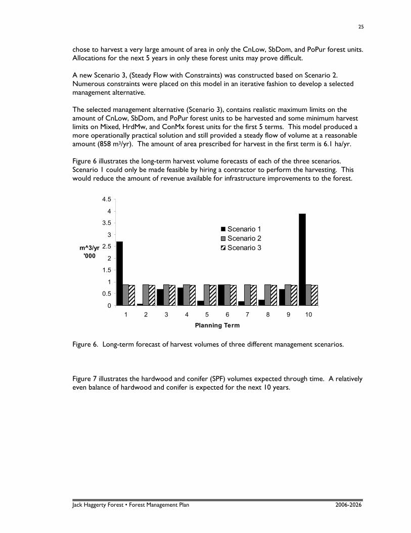
Jack Haggerty Forest • Forest Management Plan 2006-2026
25
chose to harvest a very large amount of area in only the CnLow, SbDom, and PoPur forest units. Allocations for the next 5 years in only these forest units may prove difficult. A new Scenario 3, (Steady Flow with Constraints) was constructed based on Scenario 2. Numerous constraints were placed on this model in an iterative fashion to develop a selected management alternative. The selected management alternative (Scenario 3), contains realistic maximum limits on the amount of CnLow, SbDom, and PoPur forest units to be harvested and some minimum harvest limits on Mixed, HrdMw, and ConMx forest units for the first 5 terms. This model produced a more operationally practical solution and still provided a steady flow of volume at a reasonable amount (858 m3/yr). The amount of area prescribed for harvest in the first term is 6.1 ha/yr. Figure 6 illustrates the long-term harvest volume forecasts of each of the three scenarios. Scenario 1 could only be made feasible by hiring a contractor to perform the harvesting. This would reduce the amount of revenue available for infrastructure improvements to the forest.
0
0.5
1
1.5
2
2.5
3
3.5
4
4.5
1 2 3 4 5 6 7 8 9 10
Planning Term
m^3/yr
'000
Scenario 1
Scenario 2
Scenario 3
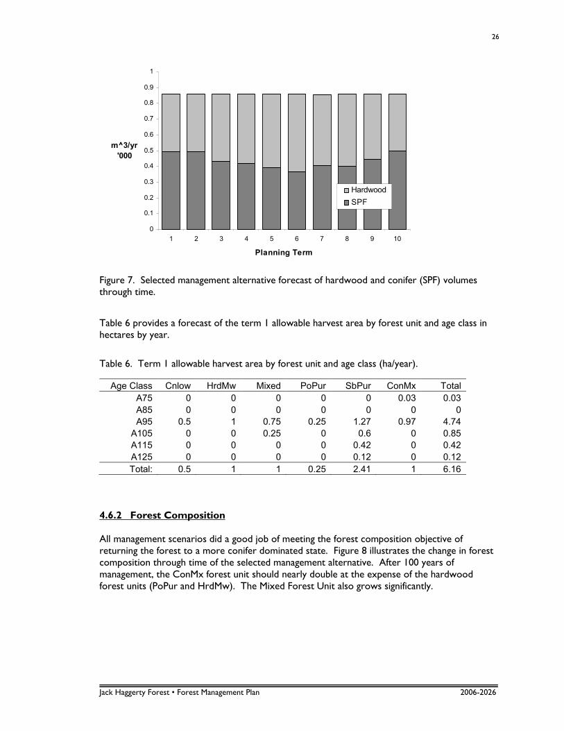
Figure 6. Long-term forecast of harvest volumes of three different management scenarios. Figure 7 illustrates the hardwood and conifer (SPF) volumes expected through time. A relatively even balance of hardwood and conifer is expected for the next 10 years.
Jack Haggerty Forest • Forest Management Plan 2006-2026
26
0
0.1
0.2
0.3
0.4
0.5
0.6
0.7
0.8
0.9
1
1 2 3 4 5 6 7 8 9 10
Planning Term
m^3/yr
'000
Hardwood
SPF
Figure 7. Selected management alternative forecast of hardwood and conifer (SPF) volumes through time.
Table 6 provides a forecast of the term 1 allowable harvest area by forest unit and age class in hectares by year.
Table 6. Term 1 allowable harvest area by forest unit and age class (ha/year).
Age Class Cnlow HrdMw Mixed PoPur SbPur ConMx Total
A75 0 0 0 0 0 0.03 0.03
A85 0 0 0 0 0 0 0
A95 0.5 1 0.75 0.25 1.27 0.97 4.74
A105 0 0 0.25 0 0.6 0 0.85
A115 0 0 0 0 0.42 0 0.42
A125 0 0 0 0 0.12 0 0.12
Total: 0.5 1 1 0.25 2.41 1 6.16
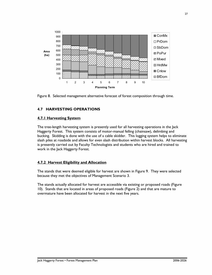
4.6.2 Forest Composition All management scenarios did a good job of meeting the forest composition objective of returning the forest to a more conifer dominated state. Figure 8 illustrates the change in forest composition through time of the selected management alternative. After 100 years of management, the ConMx forest unit should nearly double at the expense of the hardwood forest units (PoPur and HrdMw). The Mixed Forest Unit also grows significantly.
Jack Haggerty Forest • Forest Management Plan 2006-2026
27
0
100
200
300
400
500
600
700
800
900
1000
1 2 3 4 5 6 7 8 9 10
Planning Term
Area
(ha)
ConMx
PrDom
SbDom
PoPur
Mixed
HrdMw
Cnlow
BfDom
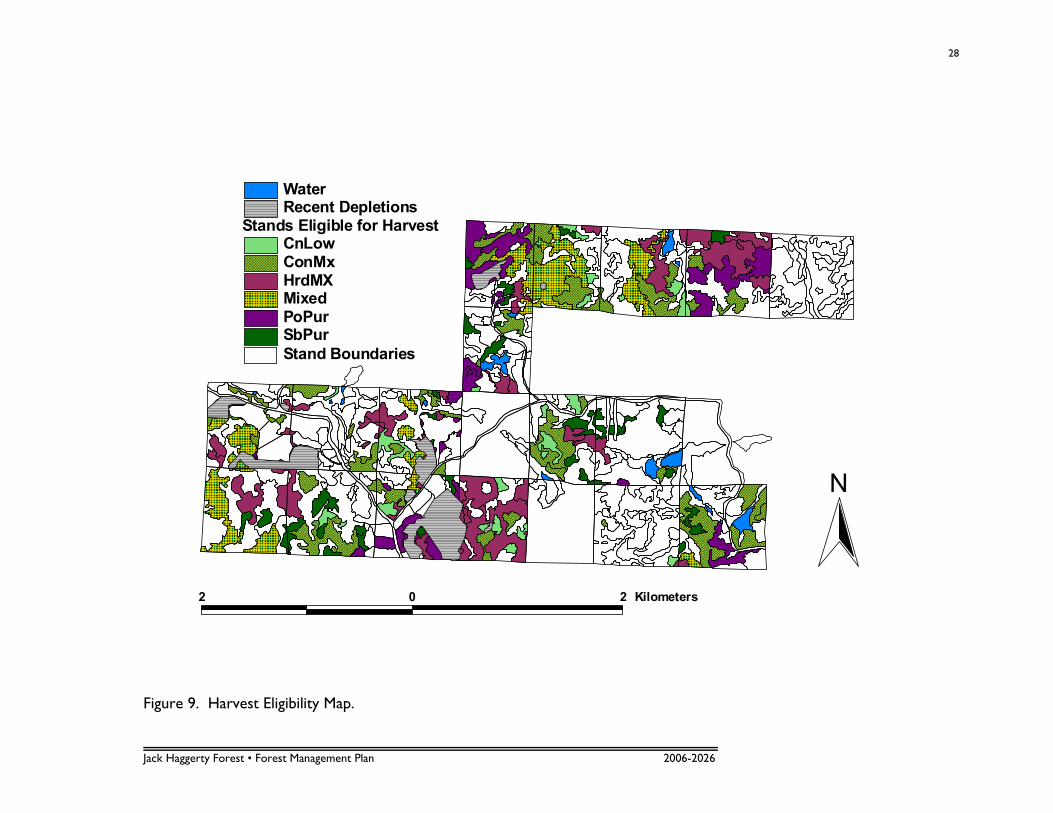
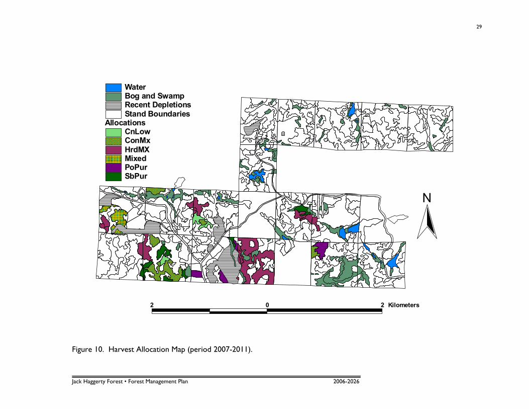
Figure 8. Selected management alternative forecast of forest composition through time. 4.7 HARVESTING OPERATIONS 4.7.1 Harvesting System The tree-length harvesting system is presently used for all harvesting operations in the Jack Haggerty Forest. This system consists of motor-manual felling (chainsaw), delimbing and bucking. Skidding is done with the use of a cable skidder. This logging system helps to eliminate slash piles at roadside and allows for even slash distribution within harvest blocks. All harvesting is presently carried out by Faculty Technologists and students who are hired and trained to work in the Jack Haggerty Forest. 4.7.2 Harvest Eligibility and Allocation The stands that were deemed eligible for harvest are shown in Figure 9. They were selected because they met the objectives of Management Scenario 3. The stands actually allocated for harvest are accessible via existing or proposed roads (Figure 10). Stands that are located in areas of proposed roads (Figure 2) and that are mature to overmature have been allocated for harvest in the next five years.
Jack Haggerty Forest • Forest Management Plan 2006-2026
28
Stand Boundaries
Stands Eligible for HarvestCnLowConMxHrdMXMixedPoPurSbPur
Recent DepletionsWater
2 0 2 Kilometers
N
Figure 9. Harvest Eligibility Map.
Jack Haggerty Forest • Forest Management Plan 2006-2026
29
AllocationsCnLowConMxHrdMXMixedPoPurSbPur
Stand BoundariesRecent DepletionsBog and SwampWater
2 0 2 Kilometers
N
Figure 10. Harvest Allocation Map (period 2007-2011).
Jack Haggerty Forest • Forest Management Plan 2006-2026
30
4.8 FISH AND WILDLIFE Fish and wildlife resources have not been inventoried in the Jack Haggerty Forest. There are very few bodies of water within the forest limits. Beaverkit Lake is the only major lake. Roads that cross this lake or streams flowing into it must use culverts or bridges to avoid sedimentation of the waterway. A 40 m riparian zone will be left if any harvesting occurs in the vicinity of the lake. Riparian zones are easily maintained in the forest because most lakes and streams are surrounded by swamp, alder or otherwise non-commercial timber. The disjointed forest limits, and the relatively small size, make managing for wildlife difficult. However, allowances will be made to provide and protect riparian zones, edges, snags and dead and downed material, where possible. The abundance of overmature timber will provide snags, dead and downed material, and age diversity when small blocks are cut and regenerated. A diverse forest structure will ensure abundant wildlife habitats. The relatively low annual harvest and small cutting pattern outlined in this forest management plan should not negatively impact any fish or wildlife species within the forest. 4.9 ENVIRONMENTAL PROTECTION Small cutovers are preferred to encourage age-class diversity and natural regeneration. Cutover size should not present a problem within the Jack Haggerty Forest, due to the small annual harvest area. Small cutovers could also provide a different forest structure for research based on small, dispersed cuts, making up a small percentage of the forest annually, versus larger cuts that are most often found on Crown Land. Insect and disease outbreaks will be assessed if and when they arise, and the method of control will be determined by the Off Campus Properties Committee. The proximity of homes and cottages to the forest will obviously be considered in these decisions. Fire control is carried out by the Ministry of Natural Resources. Personnel, equipment and radio communication are located at the Fire Management Headquarters on Arthur Street in Thunder Bay. 4.10 GRAVEL AND MINING There are two main gravel pits located in the Jack Haggerty Forest. They are located in the north east corner of block 7 and the eastern central portion of block 6. Gravel is for sale to the public at negotiable rates, usually sold by the yard. Signs are posted in the gravel pit in regards to the sale of gravel. The pits are in immediate need of rehabilitation and stabilization because the north banks are eroding into the bordering private property. Subsurface rights are controlled by the Faculty of Forestry and the Forest Environment and currently, there are no active mining claims within the boundaries of the Jack Haggerty Forest.
Jack Haggerty Forest • Forest Management Plan 2006-2026
31
4.11 FIELD SCHOOL The Jack Haggerty Forest is used for instruction and demonstration purposes during the fall field school, which normally occurs during the first two weeks in September. The following courses regularly use the Jack Haggerty Forest during field school: Dendrology, Mensuration, Entomology, Pathology, Silviculture, and Harvesting. Fourth year students also have an opportunity to work within the forest limits as part of their thesis project. 4.12 RESEARCH PROPOSALS Although the Jack Haggerty Forest is available for research, there are currently no proposed research projects within the forest limits. There has been some recent discussion with researchers from the Ontario Ministry of Natural Resources in regards to finding appropriate research sites within the Jack Haggerty Forest.
Jack Haggerty Forest • Forest Management Plan 2006-2026
32
5.0 APPENDICES
Jack Haggerty Forest • Forest Management Plan 2006-2026
33
5.1 APPENDIX I – ORDER-IN-COUNCIL (#806/53)
Lands Division 90829
Toronto, March 27th, 1953.
Dear Sir:
Re: Lakehead Technical Institute
I am enclosing herewith a certified copy of an Order-in-Council dated March 12th, 1953, vesting in the Minister of Education for the Province of Ontario for the use of the Provincial Technical Institute known as the “Lakehead Technical Institute” Lots 1, 2 and 3, concession 1, Township of Fowler, the south part broken lot 10, broken lot 11, west half of south half lot 12, and east half of north half lot12, concession 1, and the north half lot 9, north half lot 10, north half lot 11, north half lot 12, and west half of south half lot 12, concession 2, in the Township of Jacques, containing 2543.0 acres, more or less, in the District of Thunder Bay. The said lots are more particularly described in Schedule “A” and shown outlined in red on plan prepared by the Division of Surveys, both of which are attached to this Order. Yours truly, c.c. to: W. D. Cram Chief, Division of Land and District Forester, Recreational Areas. Port Arthur, Ont. J. P. Bolduc, M.R. Port Arthur, Ontario. EFE/AS Enc. M. L. S. Beattie, Supt, of Secondary Education, Department of Education, THE BUILDINGS. (Copy)
Jack Haggerty Forest • Forest Management Plan 2006-2026
34
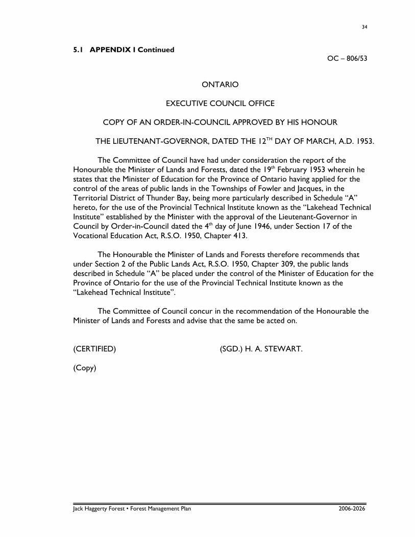
5.1 APPENDIX I Continued OC – 806/53
ONTARIO
EXECUTIVE COUNCIL OFFICE
COPY OF AN ORDER-IN-COUNCIL APPROVED BY HIS HONOUR
THE LIEUTENANT-GOVERNOR, DATED THE 12TH DAY OF MARCH, A.D. 1953.
The Committee of Council have had under consideration the report of the Honourable the Minister of Lands and Forests, dated the 19th February 1953 wherein he states that the Minister of Education for the Province of Ontario having applied for the control of the areas of public lands in the Townships of Fowler and Jacques, in the Territorial District of Thunder Bay, being more particularly described in Schedule “A” hereto, for the use of the Provincial Technical Institute known as the “Lakehead Technical Institute” established by the Minister with the approval of the Lieutenant-Governor in Council by Order-in-Council dated the 4th day of June 1946, under Section 17 of the Vocational Education Act, R.S.O. 1950, Chapter 413. The Honourable the Minister of Lands and Forests therefore recommends that under Section 2 of the Public Lands Act, R.S.O. 1950, Chapter 309, the public lands described in Schedule “A” be placed under the control of the Minister of Education for the Province of Ontario for the use of the Provincial Technical Institute known as the “Lakehead Technical Institute”. The Committee of Council concur in the recommendation of the Honourable the Minister of Lands and Forests and advise that the same be acted on. (CERTIFIED) (SGD.) H. A. STEWART. (Copy)
Jack Haggerty Forest • Forest Management Plan 2006-2026
35
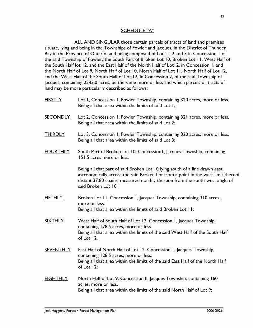
SCHEDULE “A”
ALL AND SINGULAR those certain parcels of tracts of land and premises situate, lying and being in the Townships of Fowler and Jacques, in the District of Thunder Bay in the Province of Ontario, and being composed of Lots 1, 2 and 3 in Concession 1 of the said Township of Fowler; the South Part of Broken Lot 10, Broken Lot 11, West Half of the South Half lot 12, and the East Half of the North Half of Lot12, in Concession 1, and the North Half of Lot 9, North Half of Lot 10, North Half of Lot 11, North Half of Lot 12, and the West Half of the South Half of Lot 12, in Concession 2, of the said Township of Jacques, containing 2543.0 acres, be the same more or less and which parcels or tracts of land may be more particularly described as follows: FIRSTLY Lot 1, Concession 1, Fowler Township, containing 320 acres, more or less. Being all that area within the limits of said Lot 1; SECONDLY Lot 2, Concession 1, Fowler Township, containing 321 acres, more or less. Being all that area within the limits of said Lot 2; THIRDLY Lot 3, Concession 1, Fowler Township, containing 320 acres, more or less. Being all that area within the limits of said Lot 3; FOURTHLY South Part of Broken Lot 10, Concession1, Jacques Township, containing
151.5 acres more or less. Being all that part of said Broken Lot 10 lying south of a line drawn east
astronomically across the said Broken Lot from a point in the west limit thereof, distant 37.80 chains, measured northly thereon from the south-west angle of said Broken Lot 10;
FIFTHLY Broken Lot 11, Concession 1, Jacques Township, containing 310 acres,
more or less. Being all that area within the limits of said Broken Lot 11; SIXTHLY West Half of South Half of Lot 12, Concession 1, Jacques Township,
containing 128.5 acres, more or less. Being all that area within the limits of the said West Half of the South Half
of Lot 12. SEVENTHLY East Half of North Half of Lot 12, Concession 1, Jacques Township,
containing 128.5 acres, more or less. Being all that area within the limits of the said East Half of the North Half
of Lot 12; EIGHTHLY North Half of Lot 9, Concession II, Jacques Township, containing 160
acres, more or less. Being all that area within the limits of the said North Half of Lot 9;
Jack Haggerty Forest • Forest Management Plan 2006-2026
36
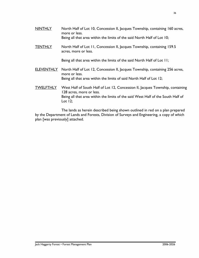
NINTHLY North Half of Lot 10, Concession II, Jacques Township, containing 160 acres,
more or less. Being all that area within the limits of the said North Half of Lot 10; TENTHLY North Half of Lot 11, Concession II, Jacques Township, containing 159.5
acres, more or less. Being all that area within the limits of the said North Half of Lot 11; ELEVENTHLY North Half of Lot 12, Concession II, Jacques Township, containing 256 acres,
more or less. Being all that area within the limits of said North Half of Lot 12; TWELFTHLY West Half of South Half of Lot 12, Concession II, Jacques Township, containing
128 acres, more or less. Being all that area within the limits of the said West Half of the South Half of
Lot 12; The lands as herein described being shown outlined in red on a plan prepared by the Department of Lands and Forests, Division of Surveys and Engineering, a copy of which plan [was previously] attached.
Jack Haggerty Forest • Forest Management Plan 2006-2026
37
5.2 APPENDIX II – PAST RESEARCH PROJECTS IN THE JACK HAGGERTY FOREST Research projects in the Jack Haggerty Forest were initiated in 1970, when Honourary Professor Leo Vidlak established three permanent sample plots to study the influence of lime applications on different black spruce sites. Forestry technicians Dave Wotton, in 1974, and Brian Moore, in 1977, carried out complete analysis of all three plots. In 1976, Professor Vidlak initiated a third research project on a 4 ha, 1972 trembling aspen cut, which was planted to black and white spruce. The purpose of the project was to study “The influence of aspen sucker growth on planted spruce and associated vegetation in Northwestern Ontario”. The site was first released in 1975 by first year students, and it was anticipated that suckering would occur within the next three years. The intensity of the suckering, as well as the effects of manual release on it, were to be investigated. Three 0.0004 ha permanent sample plots were established to study the growth and spacing of the spruce seedlings. These plots were measured in the spring and fall of 1976 and again in 1977 and 1979 by Professor Vidlak. Four permanent sample plots were established in 1978 to monitor growth of different stand types in Fowler Township. Also in 1978, Claude Garton, curator of Lakehead University’s herbarium, set up a research project in a residual Populus ecosystem and in the surrounding 1972 and 1973 spruce plantations. Eight, 10 m x 10 m plots were set up to conduct a vegetation study and to record future trends on the vegetation in the various sites. In 1979, university technician Brian Moore conducted a mortality study in the same ecosystem, recording and mapping the location of dead trees along transects through the area. During the 1979 fall field school, 20 permanent sample plots were established along a baseline in Fowler Township by Degree II students. In 1985, Professor Robert Farmer initiated a research project in the Jack Haggerty Forest. Approximately 2 ha of overmature black spruce were harvested in order to create a site for Larix laricina provenance trials.