Embed Size (px)
Citation preview
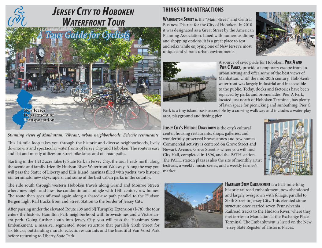
Jersey City to HobokenWaterfront tour
New JerseyDepartment ofTransportation
THINGS TO DO/ATTRACTIONS
Washington street is the “Main Street” and Central Business District for the City of Hoboken. In 2010 it was designated as a Great Street by the American Planning Association. Lined with numerous dining and shopping options, it is a great place to rest and relax while enjoying one of New Jersey’s most unique and vibrant urban environments.
A source of civic pride for Hoboken, Pier a and Pier C Parks, provide a temporary escape from an urban setting and offer some of the best views of Manhattan. Until the mid-20th century, Hoboken’s waterfront was largely industrial and inaccessible to the public. Today, docks and factories have been replaced by parks and promenades. Pier A Park, located just north of Hoboken Terminal, has plenty of lawn space for picnicking and sunbathing. Pier C
Park is a tiny island oasis accessible by a curving walkway and includes a water play area, playground and fishing pier. Jersey City’s historiC doWntoWn is the city’s cultural center, housing restaurants, shops, galleries, and wonderfully preserved brownstones and row homes. Commercial activity is centered on Grove Street and Newark Avenue. Grove Street is where you will find City Hall, completed in 1896, and the PATH station. The PATH station plaza is also the site of monthly artist festivals, a weekly music series, and a weekly farmer’s market.
harsimus stem embankment is a half-mile-long historic railroad embankment, now abandoned and largely overgrown with foliage, parallel to Sixth Street in Jersey City. This elevated stone structure once carried seven Pennsylvania Railroad tracks to the Hudson River, where they met ferries to Manhattan at the Exchange Place Terminal. The Embankment is listed on the New Jersey State Register of Historic Places.
A Tour Guide for Cyclists
Stunning views of Manhattan. Vibrant, urban neighborhoods. Eclectic restaurants.
This 14 mile loop takes you through the historic and diverse neighborhoods, lively downtowns and spectacular waterfronts of Jersey City and Hoboken. The route is easy and flat and mostly utilizes on-street bike lanes and off-road paths.
Starting in the 1,212 acre Liberty State Park in Jersey City, the tour heads north along the scenic and family-friendly Hudson River Waterfront Walkway. Along the way you will pass the Statue of Liberty and Ellis Island, marinas filled with yachts, two historic rail terminals, new skyscrapers, and some of the best urban parks in the country.
The ride south through western Hoboken travels along Grand and Monroe Streets where new high- and low-rise condominiums mingle with 19th century row homes. The route then goes off-road again along a shared-use path parallel to the Hudson Bergen Light Rail tracks from 2nd Street Station to the border of Jersey City.
After passing under the elevated Route 139 and NJ Turnpike Extension (I-78), the tour enters the historic Hamilton Park neighborhood with brownstones and a Victorian-era park. Going further south into Jersey City, you will pass the Harsimus Stem Embankment, a massive, segmented stone structure that parallels Sixth Street for six blocks, outstanding murals, eclectic restaurants and the beautiful Van Vorst Park before returning to Liberty State Park.
New York
Jersey City
Secaucus
Kearny
Union City
Bayonne
North Bergen
Weehawken
OCEAN
SUSSEX
ATLANTIC
BURLINGTON
MORRIS
SALEM
WARREN
MONMOUTH
CUMBERLAND
HUNTERDON
BERGEN
CAPE MAY
MIDDLESEX
SOMERSET
MERCER
CAMDENGLOUCESTER
PASSAIC
ESSEX
UNION
Hoboken
1
2
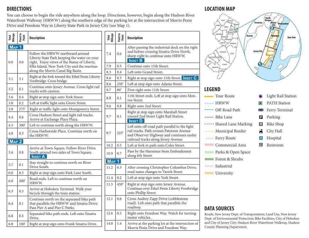
DIRECTIONS
DATA SOURCESRoads, New Jersey Dept. of Transportation; Land Use, New Jersey Dept. of Environmental Protection; Bike Facilities, City of Hoboken and City of Jersey City; Hudson River Waterfront Walkway, Hudson County Planning Department.
You can choose to begin the ride anywhere along the loop. Directions, however, begin along the Hudson River Waterfront Walkway (HRWW) along the southern edge of the parking lot at the intersection of Morris Pesin Drive and Freedom Way in Liberty State Park in Jersey City (see Map 1).
LOCATION MAP
LEGEND
Tota
l M
ileag
e
Poin
t to
Poin
t
Description
0.0 0.0
Follow the HRWW northward around Liberty State Park keeping the water on your right. Enjoy views of the Statue of Liberty, Ellis Island, New York City and the marinas along the Morris Canal Big Basin.
3.1 3.1 Right at the fork toward the Ethel Pesin Liberty Footbridge. Cross bridge.
3.2 0.1 Continue onto Jersey Avenue. Cross light rail tracks with caution.
3.6 0.4 Right at stop sign onto York Street.3.8 0.2 Left at traffic light onto Grove Street.3.8 275’ Right at traffic light onto Montgomery Street.
4.4 0.6 Cross Hudson Street and light rail tracks. Arrive at Exchange Place Plaza.
4.5 300’ Left to continue north along the HRWW.
4.8 0.3 Cross Harborside Place. Continue north on the HRWW.
5.6 0.8Arrive at Town Square. Follow River Drive South around two sides of Town Square.
5.7 0.1 Stay straight to continue north on River Drive South.
6.0 0.3 Right at stop sign onto Park Lane South.
6.0 200’ Road ends. Left to continue north on HRWW.
6.3 0.3 Arrive at Hoboken Terminal. Walk your bicycle through the train station.
6.4 0.1Continue north on the separated bike path that parallels the HRWW and Sinatra Drive. Pass Pier A and Pier C Parks.
6.8 0.4 Separated bike path ends. Left onto Sinatra Drive.
6.8 100’ Right at stop sign onto Frank Sinatra Drive.
Tour Route
HRWW
Off-Road Path
Bike Lane
Shared Lane Marking
Municipal Border
Ferry Route
Commercial Area
Parks & Open Space
Forest & Shrubs
Industrial
University
Light Rail Station
PATH Station
Ferry Terminal
Parking
Bike Shop
City Hall
Hospital
Restroom
Tota
l M
ileag
e
Poin
t to
Poin
t
Description
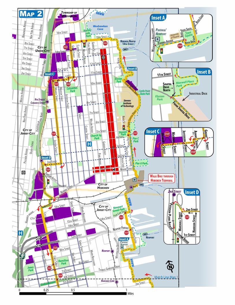
7.4 0.6
After passing the industrial dock on the right and before crossing Sinatra Drive North, sharp right to continue onto HRWW.
7.9 0.5 Continue onto 15th Street.8.3 0.4 Left onto Grand Street.8.6 0.3 Right at stop sign onto 11th Street.8.6 250’ Left at stop sign onto Adams Street.8.7 80’ First right onto 11th Street.
8.8 0.1 11th Street ends. Left at stop sign onto Mon-roe Street.
9.6 0.8 Right onto 2nd Street.
9.7 0.1Right at stop sign onto Marshall Street toward 2nd Street Light Rail Station.
9.7 225’
Left onto off-road path parallel to the light rail tracks. Path crosses Paterson Avenue and Observer Highway and continues under railroad tracks along Jersey Avenue.
10.2 0.5 Left at fork in path onto Coles Street.
10.9 0.7 Pass by the Harsimus Stem Embankment along 6th Street.
11.2 0.3 After crossing Christopher Columbus Drive, road name changes to Varick Street.
11.4 0.2 Left at stop sign onto York Street.
11.5 450’ Right at stop sign onto Jersey Avenue. Continue over Ethel Pesin Liberty Footbridge onto Phillip Street.
12.1 0.6 Cross Audrey Zapp Drive (cobblestone road). Left onto path that parallels the roadway.
12.6 0.5 Right onto Freedom Way. Watch for turning motor vehicles.
14.0 1.4 Arrive at the parking lot at the intersection of Morris Pesin Drive and Freedom Way.
Map 1
Inset A
Map 2
Inset B
Map 1
Inset D
Inset C

\
\
\
\
\
\
\
\
\
\
\
\
\
\
\
\\
\
\\
\ \
\
\
\
\
\
\
\
\
\
\
\
\
\
\
\
\
\
\
\
\
\
3RD STREET
GRAND STREET
PHILLIP STREET
5TH STREET
AUDREY ZAPP DRIVE
YORK STREET
COLE
S ST
MONITO
R STR
EET
BURM
A ROA
D
JERSE
Y AVE
NUE
VARI
CK ST
REET
THEODORE CONRAD DRIVE
MORRIS PESIN DRIVE
HART
DRIVE
BRIGHT STREET
JOHNSTON AVENUE
VAN VORST STREET
WASHINGTON STREET
THOMAS MCGOVERN DRIVE
MONTGOMERY STREET
NEWARK AVENUEPAC
IFIC A
VENU
E
GRAND STREET
MARIN BOULEVARD
GROV
E STR
EET
FREEDOM WAY
BRUN
SWICK
STRE
ET
MONM
OUTH
STRE
ET
ETHEL PESINLIBERTY
FOOTBRIDGE
HUDSON STREET
YORK STREET MARIN BOULEVARD
WARREN STREET
GREENE STREET
SUSSEX STREET
MORRIS STREET
DUDLEY STREET
CHRISTOPHER COLUMBUS DRIVE
MONTGOMERY STREET
PHILLIP STREET
HARBORSIDE PLACE
ESSEX ST.
HARBORSIDE
MARIN BLVD.JERSEY AVE.
EXCHANGE PL.
HARISMUS COVE
LIBERTY STATE PARK
GROVE ST. EXCHANGE PL
PAULUS HOOK
LIBERTY STATE PARK
LIBERTY HARBORMARIN BLVD.
HUDSON RIVER WAT
ERFR
ONT W
ALKW
AY (H
RWW
)
F
MAP 1 Match Line Map 2
0 0.5 10.25Miles
Liberty Science Center
Statueof
Liberty
EllisIsland
CRRNJTerminal
ColgatePark
Empty Sky9/11
Memorial
Liberty StatePark
Morris Canal Big Basin
Morris CanalLittle Basin
Van VorstPark
Exchange
Place Plaza
Liberty StatePark
RIDEBEGINS/
ENDS
CROSS WITH CAUTION
\
\
\
\
\
\
\
\
\
\
\
\
\
\
\\
\\
\\
\\
\\
\\
\\
\\
\\
\\
\\
\\
\
\
\
\\
\\
\
\
\
\
\
\
\
\\
\\
\\
\\
\\
\\
\\
\\
\\
\\
\\
\
\
\
\
\
\ \
\
\
\
\
\
\
\
\
\
\
\
\\
\\
\
\
\\
\
\
\
\
\
\
\
\
\
\
\
\
\
\
\
\
\\
\
\\
\\
\\
\\
\\
\\
\\
\\
\\
\\
\\
\\
\\
\\
\\
\\
\\
\
CLINTON STREET
MADISON STREET
JEFFERSON STREET
PALIS
ADE A
VENU
E
7TH STREET
MONROE STREET
BLOOMFIELD STREET
WASHINGTON STREET
COLES STREET
GRAND STREET
ADAM
S STREET
OGDE
N AVE
NUE
10TH STREET
5TH STREET
HUDSON STREET
JACKSON STREET
16TH STREET14TH STREET
NEW
YORK
AVEN
UE
JERSEY AVE
3RD STREET
RIVER STREET
2ND STREET
4TH STREET
BERG
ENLIN
E AVE
NUE
6TH STREET
MONMOUTH STREET 8TH STREET
14TH STREET
MARIN BOULEVARD
17TH STREET
PATERSON AVENUE
1ST STREET
15TH STREET
OBSERVER HIGHWAY
GARDEN ST
PALIS
ADE A
VENU
E
DRIVE
12TH STREET
9TH STREET
8TH STREET
2ND STREET
7TH STREET
16TH STREET
7TH STREET
6TH STREET
GRAND STREET
12TH STREET
2ND STREET
11TH STREET
10TH STREET
5TH STREET
15TH STREET
14TH STREET
8TH STREET
RIVER ST
6TH STREET
9TH STREET
13TH STREET
COLES STREET
ERIE STREET
GROVE STREET
GROVE STREET
18TH STREET MARIN BOULEVARD
THOMAS GANGEMI
WAS
HING
TON B
OULE
VARD
PATE
RSON
PLANK R
OAD
NEWARK STREET
11TH STREET
GARDEN STREETPARK A
VENUE
WILLOW A
VENUE
CLINTON STREET
WASHINGTON STREET
PARK AVENUE
MANH
ATTA
N AVE
NUE
NEW
YORK
AVEN
UE
WEB
STER
AVEN
UE
WILLOW A
VENUE
HOBO
KEN AVENUE
4TH STREET
RIVER DRIVE SOUTH
NEWPORT PARKWAY
FRAN
K SINA
TRA D
RIVE
FRANK SINATRA DRIVE
5TH STREET
HRWW
P ARK LANE SOUTH
HRWW
3RD STREET
2ND STREET
NEWARK STREET
SINATR
A DRIV
ESIN
ATRA D
RIVE
SINAT
RA DR
IVE NO
RTH
HRWW
139
14TH STREET
12TH STREET
139
NEWPORT
HARISMUS COVE
9TH STREET/CONGRESS STREET
Match Line Map 1
PAVONIA/NEWPORT
NEWPORT
HOBOKEN NORTH-14TH STREET
Pier A Park
Stevens Park
Elysian Park
Columbus Park
Church Sq. Park Pier C
Park
Harbor-side Park
Castle Point Skate Park
HamiltonPark
JonesPark
Newport Green Park
Embankment
F0 0.5 10.25
Miles
CITY OF JERSEY CITY
CITY OF JERSEY CITY
CITY OF HOBOKEN
CITY OF UNION CITY
TOWNSHIP OFWEEHAWKEN
StevensInstitute
of Technology
MAP 2
WALK BIKE THROUGHHOBOKEN TERMINAL
Industrial Dock
WeehawkenCove
2ND STREET
MAR
SHAL
L STR
EET
HARR
ISON
STRE
ET2ND STREET
0 250 ft
PATERSON P
LANK AVEN
UEPATERSON AVENUE
1ST STREET
Inset D
Inset D
MONROE STREET
ADAM
S STREET
12TH STREET
MANH
ATTA
N AVE
NUE
Columbus Park
Inset C MADISON STREET
JEFFERSON STREET
GRAND STREET
Inset C
ElysianPark
Maxwell Place
Park
FRANK SINATRA DRIVE
SINATRA DRIVENORTH
11TH STREET
INDUSTRIAL DOCK
Inset BInset B W
ASHI
NGTO
N BOU
LEVA
RD
PAVONIA/NEWPORT
PAVONIA AVENUE
Universityof Phoenix
TownSquareRIV
ER DRIVE SOUTH
RIVER DRIVE
SOUTH
RIVER COURT
RIVER DRIVE SOUTH
W
ASHI
NGTO
N BOU
LEVA
RD
Inset A
Inset A
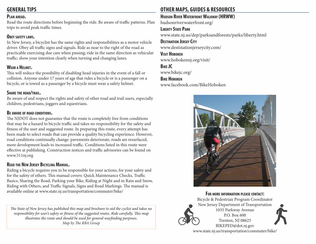
GENERAL TIPSPlan ahead.Read the route directions before beginning the ride. Be aware of traffic patterns. Plan trips to avoid peak traffic times.
obey safety laWs.In New Jersey, a bicyclist has the same rights and responsibilities as a motor vehicle driver. Obey all traffic signs and signals. Ride as near to the right of the road as practicable exercising due care when passing; ride in the same direction as vehicular traffic; show your intention clearly when turning and changing lanes.
Wear a helmet.This will reduce the possibility of disabling head injuries in the event of a fall or collision. Anyone under 17 years of age that rides a bicycle or is a passenger on a bicycle, or is towed as a passenger by a bicycle must wear a safety helmet.
share the road/trail.Be aware of and respect the rights and safety of other road and trail users, especially children, pedestrians, joggers and equestrians.
be aWare of road Conditions.The NJDOT does not guarantee that the route is completely free from conditions that may be a hazard to bicycle traffic and takes no responsibility for the safety and fitness of the user and suggested route. In preparing this route, every attempt has been made to select roads that can provide a quality bicycling experience. However, road conditions continually change: pavements deteriorate, roads are resurfaced, more development leads to increased traffic. Conditions listed in this route were effective at publishing. Construction notices and traffic advisories can be found on www.511nj.org
read the neW Jersey biCyCling manual.Riding a bicycle requires you to be responsible for your actions, for your safety and for the safety of others. This manual covers: Quick Maintenance Checks, Traffic Basics, Sharing the Road, Parking your Bike, Riding at Night and in Rain and Snow, Riding with Others, and Traffic Signals, Signs and Road Markings. The manual is available online at www.state.nj.us/transportation/commuter/bike/ for more information Please ContaCt:
Bicycle & Pedestrian Program CoordinatorNew Jersey Department of Transportation
1035 Parkway AvenueP.O. Box 600
Trenton, NJ [email protected]
www.state.nj.us/transportation/commuter/bike/
OTHER MAPS, GUIDES & RESOURCEShudson river Waterfront WalkWay (hrWW)hudsonriverwaterfront.org/liberty state Parkwww.state.nj.us/dep/parksandforests/parks/liberty.htmldestination Jersey Citywww.destinationjerseycity.com/visit hobokenwww.hobokennj.org/visit/bike JCwww.bikejc.org/ bike hobokenwww.facebook.com/BikeHoboken
The State of New Jersey has published this map and brochure to aid the cyclist and takes no responsibility for user’s safety or fitness of the suggested routes. Ride carefully. This map
illustrates the route and should be used for general wayfinding purposes.Map by The RBA Group