Embed Size (px)
Citation preview
Jerrettspass and District ANDREW HALLIDAY
The geology of a district has a great influence on its history, and so it is with the Jerrettspass area. Millions of years ago there was consider
able volcanic activity in the British Isles. In this
particular area there was intrusive vulcanicity whereby rocks cool and solidify underground and are later
exposed by the layers above them being eroded away. A good example of this is Goraghwood quarry, which
is in fact a dyke or underground intrusion originating from Slieve Gullion. At Jerrettspass, a fault or crack
in the rock has been eroded over the years to produce a fairly narrow glen similar to those found in the Glens
of Antrim. During the ice age this intrusion was
exposed, and as the ice receded, the material suspended in it was deposited over the area in the form of an
uneven series of mounds known as Drumlins.
Therefore, an immense river must have flowed through this valley at one time, which disappeared leaving a
line of marshes surrounded by rich alluvial soil.
Across this bogland, passes were made at convenient
places. Those in our immediate neighbourhood were
at Jerrettspass, Knockanarney, Aughantarraghan,
Poyntzpass and Scarva Pass where the old subsidiary roads are still in existence.
Jerrettspass in the early part ofthe 16th century was
known as "Lameses" or "Lambs Pass". Formerly this
ancient pass, like its neighbours at Poyntzpass and
Scarva, was defended by a castle, the three being built
by the Duke of Albemarle. This immediately shows
the importance given to these passes as focal points for safe passage and as places for the local inhabitants to meet.
DANE'S CAST
Knockanarney pass connects the parishes of
Donaghmore and Drumbanagher. At Knockanarney the old road over "Barrack Hill" passes a portion of
the remains of an ancient earthwork known as "The
Dane's Cast". This road continues up the Church Hill
through the townland of Lissummon where the remains
of a fort crown the summit. Near the fort is a "statue
menhir" or "standing stone" which probably marks
the grave of a former chieftain. The lofty position of
Lissummon Fort must have been invaluable in the days of primitive warfare for it commands an extensive view
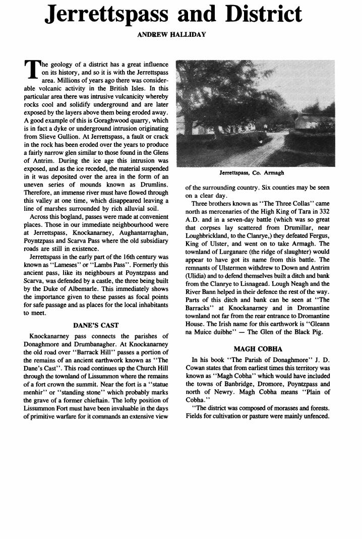
HBBBK - . -^iiBHBBBBHH Jerrettspass, Co. Armagh
of the surrounding country. Six counties may be seen
on a clear day.
Three brothers known as "The Three Collas" came
north as mercenaries of the High King of Tara in 332
A.D. and in a seven-day battle (which was so great that corpses lay scattered from Drumillar, near
Loughbrickland, to the Clanrye,) they defeated Fergus,
King of Ulster, and went on to take Armagh. The
townland of Lurganare (the ridge of slaughter) would
appear to have got its name from this battle. The
remnants of Ulstermen withdrew to Down and Antrim
(Ulidia) and to defend themselves built a ditch and bank
from the Clanrye to Lisnagead. Lough Neagh and the
River Bann helped in their defence the rest of the way. Parts of this ditch and bank can be seen at "The
Barracks'' at Knockanarney and in Dromantine
townland not far from the rear entrance to Dromantine
House. The Irish name for this earthwork is "Gleann na Muice duibhe" ? The Glen of the Black Pig.
MAGH COBHA
In his book "The Parish of Donaghmore" J. D.
Cowan states that from earliest times this territory was
known as "Magh Cobha" which would have included
the towns of Banbridge, Dromore, Poyntzpass and
north of Newry. Magh Cobha means "Plain of
Cobha."
"The district was composed of morasses and forests.
Fields for cultivation or pasture were mainly unfenced.
J_POYNTZPASS AND DISTRICT LOCAL HISTORY SOCIETY
Fences first appeared in the 7th century A.D. Land was farmed in a primitive fashion, corn of various
kinds being the chief crop. Pasture was usually for cows being chief article of wealth. The houses were
mostly of wood with families of superior rank living in the forts which were generally of circular form/1
The Magenis (Maginies) family ruled Magh Cobha
from the 12th century A.D. until the 17th century A I)
In 1607, during the Plantation of Ulster Sir Arthur
Magenis submitted to the new system and the land was
divided into large estates. The Magenis family cm tied
land to the east of Jerrettspass, the estate tailed
Dromantine.
The Drumbanagher estate beside Drom.miuu was
granted in 1610 to Sir Garret Moore. It was hiIki ned
by his fifth son, Arthur, whose direct descendant, John
Moore, sold the estate to Lieutenant Colonel Maxwell
Close in 1818. The original house was huini dnwn and
and in the years 1832-37 Colonel Close built a castU
of Scottish freestone in Italian style Imin a design In
W. H. Playfair. A demensc wall was hmh in 1K47 lo
give employment dining the Limine
LOCAL VOLDNTKIRS \M) YKOMKN
During the American Wai <>l huK ikmuIciut, whu h
began in 1776, many of the Hntish troops usual I \
stationed in Ireland were withdrawn to fight in
America. As a result, the local inhabitants were leli
defencless against attack and the ret ore ihe\ assi mhli d
together in 1779 at Belfast: thus heran tin Indi
Volunteers.
Lord Charlemont took command ol tin ( <unity
Armagh Volunteers in 1780, eventually Ionium- the
United National Army becoming its first Commanding General. By 1782 this forced numbered KM),(MM).
Local Volunteer companies were formed dl Acton,
Tullyhappy, Tyrones Ditches, Lisdiumgorc,
Drumbanagher, Killevy and Mullaghglass I hose
Volunteers were almost exclusively Protestant and
were seen as a source of danger to the Irish Parliament
in Dublin.
The Government decided to disband this force b\
substituting militia and yeomanry under its orders and
supervision.
Mullaghglass yoemanry was recruited in 1797 by
George Atkinson of Millvale, formerly Lieutenant in
First Newry Volunteers. This was a cavalry crops of
54 men called "Mullaghglass Mounted Yeomen" ?
officially merely infantry. Drumbanagher Infantry was
recruited in 1798 by John Moore who was Captain and
C. Warburton being Lieutenant.
"THE BATTLE OF THE PASS"
As a result of the "Penal Laws" which were
enforced during the 18th century both Presbyterians and Roman Catholics suffered. Some persecuted
Presbyterians emigrated across the Atlantic. There was
great competition for land in the Jerrettspass area, Protestant tenants being ousted by Catholic tenants and
vice-versa. When the 1798 rebellion broke out a young
Presbyterian farmer banded together his friends and
neighbours ? both Protestant and Catholic ? and
turned them into a branch of the Society of United
irishmen. The members coveted the notice of the
military authority and for this they had not long to wait.
They had weekly meetings for drill. On one of these
occasions ?
a fine summer evening ?
there arrived
a small party of the Armagh Militia, a still smaller party of cavalry known as the Welsh Horse and a few
mounted yeomen. The entire company was under the
command of a Lieutenant Tuskin.
The "Defenders of the Pass" as they called
themselves were armed with old muzzle-loading guns,
antiquated pistols and pikes made in local forges. An
eye-witness at the time recalled how, accompanied by
other members of the family he was taken to a field on his mother's farm overlooking the scene of the
conflict. There, he watched as the advancing militia
and horsemen were confronted by a handful of
peasants. He heard the sound of the guns; the crack
ol the pistols and the clash of pikes and swords. The "
Battle of the 'Pass" resulted in the complete route
ol the locals.
The leader was taken prisoner, tried by martial law, and was executed on the spot. Whilst this summary
punishment was being inflicted, the cavalry advanced into County Down and set fire to houses of those
regarded as suspects leaving many homeless all over
the face of Glenn and Barr.
Although it was not a great triumph, it was sufficient
to give the officer in command the right to call the place "Tuskin's Pass".
The mounted Yeomen who took part in the
engagement were most likely the Mullaghglass Cavalry
Corps. This was the only body of yoemenry allowed
to rctian its arms after disbandment. They acted as law
enforcers or police, capturing at one stage Michael
Collier a notorious mail coach robber.
POYNTZPASS AND DISTRICT LOCAL HISTORY SOCIETY_9
GERRARD'S PASS
In later years when a Post Office was established in
the little settlement, the name of the postmaster was
"Gerald" later corrupted into "Gerard". He was a
relative ofthe young man who had suffered in the 1798
rebellion. By his influence the village became known
as "Gerrard's Pass."
Through time the spelling changed the 'Jerritz Pass'
and then to the present name of Jerrettspass.
BHfejij BMB^^^^BL*BBSS21 ' *
*^^^&t^?3feitiiK0M&^*S^KK3^K^^^^El^R
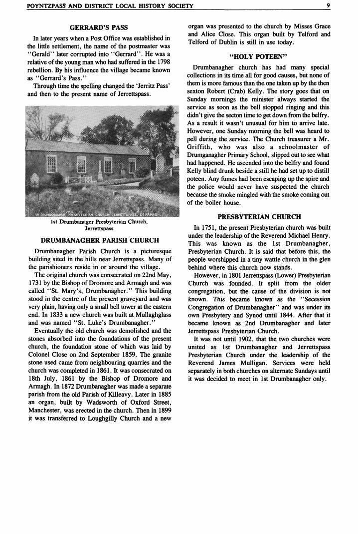
1st Drumbanager Presbyterian Church,
Jerrettspass
DRUMBANAGHER PARISH CHURCH
Drumbanagher Parish Church is a picturesque
building sited in the hills near Jerrettspass. Many of
the parishioners reside in or around the village. The original church was consecrated on 22nd May,
1731 by the Bishop of Dromore and Armagh and was
called "St. Mary's, Drumbanagher." This building stood in the centre of the present graveyard and was
very plain, having only a small bell tower at the eastern
end. In 1833 a new church was built at Mullaghglass and was named "St. Luke's Drumbanagher."
Eventually the old church was demolished and the
stones absorbed into the foundations of the present church, the foundation stone of which was laid by Colonel Close on 2nd September 1859. The granite stone used came from neighbouring quarries and the
church was completed in 1861. It was consecrated on
18th July, 1861 by the Bishop of Dromore and
Armagh. In 1872 Drumbanagher was made a separate
parish from the old Parish of Killeavy. Later in 1885 an organ, built by Wadsworth of Oxford Street,
Manchester, was erected in the church. Then in 1899
it was transferred to Loughgilly Church and a new
organ was presented to the church by Misses Grace
and Alice Close. This organ built by Telford and
Telford of Dublin is still in use today.
"HOLY POTEEN"
Drumbanagher church has had many special collections in its time all for good causes, but none of
them is more famous than the. one taken up by the then
sexton Robert (Crab) Kelly. The story goes that on
Sunday mornings the minister always started the
service as soon as the bell stopped ringing and this
didn't give the secton time to get down from the belfry. As a result it wasn't unusual for him to arrive late.
However, one Sunday morning the bell was heard to
pell during the service. The Church treasurer a Mr.
Griffith, who was also a schoolmaster of
Drumganagher Primary School, slipped out to see what
had happened. He ascended into the belfry and found
Kelly blind drunk beside a still he had set up to distill
poteen. Any fiimes had been escaping up the spire and
the police would never have suspected the church
because the smoke mingled with the smoke coming out
of the boiler house.
PRESBYTERIAN CHURCH
In 1751, the present Presbyterian church was built
under the leadership of the Reverend Michael Henry. This was known as the 1st Drumbanagher,
Presbyterian Church. It is said that before this, the
people worshipped in a tiny wattle church in the glen behind where this church now stands.
However, in 1801 Jerrettspass (Lower) Presbyterian Church was founded. It split from the older
congregation, but the cause of the division is not
known. This became known as the "Secession
Congregation of Drumbanagher" and was under its own Presbytery and Synod until 1844. After that it
became known as 2nd Drumbanagher and later
Jerrettspass Presbyterian Church.
It was not until 1902, that the two churches were
united as 1st Drumbanagher and Jerrettspass
Presbyterian Church under the leadership of the
Reverend James Mulligan. Services were held
separately in both churches on alternate Sundays until
it was decided to meet in 1st Drumbanagher only.
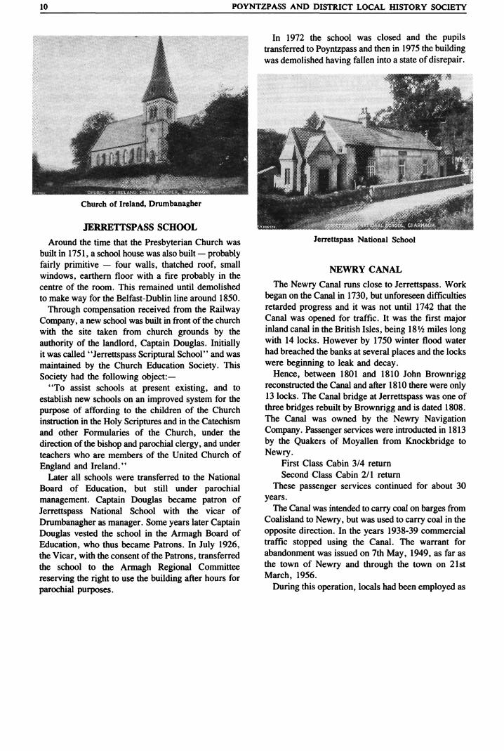
10_POYNTZPASS AND DISTRICT LOCAL HISTORY SOCIETY
Church of Ireland, Drumbanagher
JERRETTSPASS SCHOOL
Around the time that the Presbyterian Church was
built in 1751, a school house was also built ? probably
fairly primitive ? four walls, thatched roof, small
windows, earthern floor with a fire probably in the
centre of the room. This remained until demolished
to make way for the Belfast-Dublin line around 1850.
Through compensation received from the Railway
Company, a new school was built in front of the church
with the site taken from church grounds by the
authority of the landlord, Captain Douglas. Initially it was called "Jerrettspass Scriptural School" and was
maintained by the Church Education Society. This
Society had the following object:? "To assist schools at present existing, and to
establish new schools on an improved system for the
purpose of affording to the children of the Church
instruction in the Holy Scriptures and in the Catechism
and other Formularies of the Church, under the
direction of the bishop and parochial clergy, and under
teachers who are members of the United Church of
England and Ireland." Later all schools were transferred to the National
Board of Education, but still under parochial
management. Captain Douglas became patron of
Jerrettspass National School with the vicar of
Drumbanagher as manager. Some years later Captain
Douglas vested the school in the Armagh Board of
Education, who thus became Patrons. In July 1926, the Vicar, with the consent of the Patrons, transferred
the school to the Armagh Regional Committee
reserving the right to use the building after hours for
parochial purposes.
In 1972 the school was closed and the pupils transferred to Poyntzpass and then in 1975 the building
was demolished having fallen into a state of disrepair.
Jerrettspass National School
NEWRY CANAL
The Newry Canal runs close to Jerrettspass. Work
began on the Canal in 1730, but unforeseen difficulties
retarded progress and it was not until 1742 that the
Canal was opened for traffic. It was the first major inland canal in the British Isles, being I8V2 miles long
with 14 locks. However by 1750 winter flood water
had breached the banks at several places and the locks were beginning to leak and decay.
Hence, between 1801 and 1810 John Brownrigg reconstructed the Canal and after 1810 there were only 13 locks. The Canal bridge at Jerrettspass was one of
three bridges rebuilt by Brownrigg and is dated 1808.
The Canal was owned by the Newry Navigation
Company. Passenger services were introducted in 1813
by the Quakers of Moyallen from Knockbridge to
Newry.
First Class Cabin 3/4 return
Second Class Cabin 2/1 return
These passenger services continued for about 30
years.
The Canal was intended to carry coal on barges from
Coalisland to Newry, but was used to carry coal in the
opposite direction. In the years 1938-39 commercial
traffic stopped using the Canal. The warrant for
abandonment was issued on 7th May, 1949, as far as
the town of Newry and through the town on 21st
March, 1956.
During this operation, locals had been employed as
POYNTZPASS AND DISTRICT LOCAL HISTORY SOCIETY_11
"Lighter men" who worked on the barges which
carried coal on the Canal. At Jerrettspass there is the
remains of a jetty where coal etc., was off-loaded and
wheeled by wheelbarrow to the local coal merchants
yard, which was a short distance away.
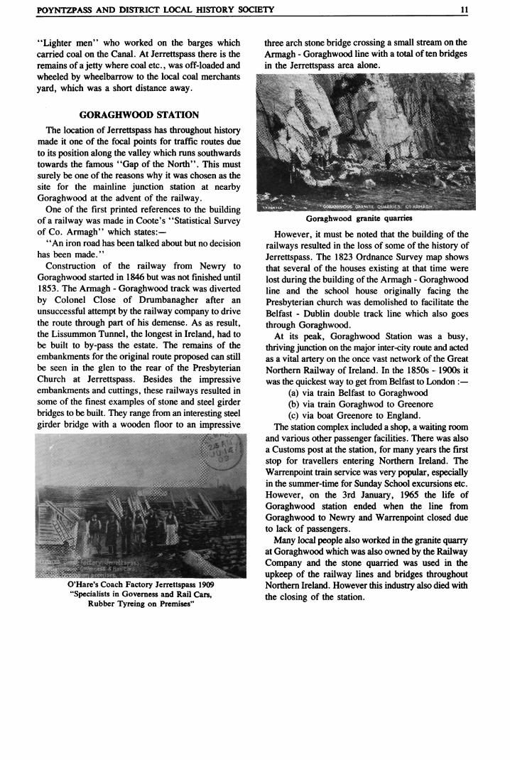
GORAGHWOOD STATION
The location of Jerrettspass has throughout history made it one of the focal points for traffic routes due
to its position along the valley which runs southwards
towards the famous "Gap of the North". This must
surely be one of the reasons why it was chosen as the
site for the mainline junction station at nearby
Goraghwood at the advent of the railway. One of the first printed references to the building
of a railway was made in Coote's "Statistical Survey of Co. Armagh" which states:?
"An iron road has been talked about but no decision
has been made."
Construction of the railway from Newry to
Goraghwood started in 1846 but was not finished until
1853. The Armagh - Goraghwood track was diverted
by Colonel Close of Drumbanagher after an
unsuccessful attempt by the railway company to drive
the route through part of his demense. As as result, the Lissummon Tunnel, the longest in Ireland, had to
be built to by-pass the estate. The remains of the
embankments for the original route proposed can still
be seen in the glen to the rear of the Presbyterian Church at Jerrettspass. Besides the impressive embankments and cuttings, these railways resulted in some of the finest examples of stone and steel girder bridges to be built. They range from an interesting steel
girder bridge with a wooden floor to an impressive
-ipr'.. <&?t&
O'Hare's Coach Factory Jerrettspass 1909
"Specialists in Governess and Rail Cars, Rubber Tyreing on Premises"
three arch stone bridge crossing a small stream on the
Armagh - Goraghwood line with a total often bridges
in the Jerrettspass area alone.
Goraghwood granite quarries
However, it must be noted that the building of the
railways resulted in the loss of some of the history of
Jerrettspass. The 1823 Ordnance Survey map shows
that several of the houses existing at that time were
lost during the building ofthe Armagh - Goraghwood
line and the school house originally facing the
Presbyterian church was demolished to facilitate the
Belfast - Dublin double track line which also goes
through Goraghwood. At its peak, Goraghwood Station was a busy,
thriving junction on the major inter-city route and acted
as a vital artery on the once vast network ofthe Great
Northern Railway of Ireland. In the 1850s - 1900s it was the quickest way to get from Belfast to London :?
(a) via train Belfast to Goraghwood (b) via train Goraghwod to Greenore
(c) via boat Greenore to England. The station complex included a shop, a waiting room
and various other passenger facilities. There was also a Customs post at the station, for many years the first
stop for travellers entering Northern Ireland. The
Warrenpoint train service was very popular, especially in the summer-time for Sunday School excursions etc.
However, on the 3rd January, 1965 the life of
Goraghwood station ended when the line from
Goraghwood to Newry and Warrenpoint closed due to lack of passengers.
Many local people also worked in the granite quarry at Goraghwood which was also owned by the Railway
Company and the stone quarried was used in the
upkeep of the railway lines and bridges throughout Northern Ireland. However this industry also died with
the closing of the station.
\2_POYNTZPASS AND DISTRICT LOCAL HISTORY SOCIETY
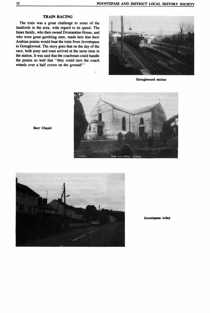
TRAIN RACING
The train was a great challenge to some of the landlords in the area, with regard to its speed. The Innes family, who then owned Dromantine House, and
who were great gambling men, made bets that their Arabian ponies would beat the train from Jerrettspass to Goraghwood. The story goes that on the day of the
race, both pony and train arrived at the same time in the station. It was said that the coachman could handle the ponies so well that "they could turn the coach
wheels over a half crown on the ground!"
I JL y. *\\-' /^ JL~ - JK.mi
Goraghwood station
^^^^Hk i:^* *''*"' ^^****,**?fc_ H>. .||*"""11 w HH1B
Barr Chapel ^^^HJ? ^^Br r
-^ p ,3HH^^W
^^^^^^^^^^^^^^^^^^^^^^^^^^^^^^^^^^^^^^H Jerrettspass