Embed Size (px)
Citation preview

Licensed to Elefant air. Printed on 27 Jan 2008.Notice: After 11 Feb 2008 0901Z, this chart may no longer be valid. Disc 23-2007
JEPPESENJeppView 3.5.2.0
| JEPPESEN SANDERSON, INC., 2007. ALL RIGHTS RESERVED.
INNSBRUCK, AUSTRIALOWI/INNINNSBRUCK
JEPPESEN+
CHANGES:
AIRPORT.BRIEFING
1.1. ATIS*D-ATIS 126.02
1.2. NOISE ABATEMENT PROCEDURESAccording to the Austrian ordinance 'Zivilluftfahrzeug-Laermzulaessigkeits-verordnung ZLZV-2005' the following is applicable:Approaches and departures to/from Austrian civil aerodromes are only permitted to be performed by subsonic jet ACFT if the produced noise does not exceed the noise limits specified in chapter 3 of ICAO Annex 16, Vol I.
1.3. LOW VISIBILITY PROCEDURESLow visibility take-off becomes effective when RVR for TDZ is 400m or less and will be activated with the phrase "LOW VISIBILITY PROCEDURES IN OPERATION" via RTF or ATIS.
1.4. OTHER INFORMATION1.4.1. GENERAL
Extensive glider activity.
1.4.2. SPECIAL NOTESDue to mountainous terrain in vicinity of APT and the requirement for visual manoeuvring, it is considered essential that pilots shall practise approaches in VMC (including Missed Apch, Circling and Departure), prior operating in IMC. Training in VMC may be substituted by simulator training, provided an adequate visual scene of the vicinity INNSBRUCK is available. Contingency procedures and balked landing procedures shall be included in pilots training and shall be practised before operating in IMC.When designing a balked landing procedure to RWY 26 the following guiding principles shall be considered:Climb with MAX gradient at least 6.1% along northern side of the INN valley. Start LEFT turn when passing 3200' West of APT. MAX turn radius 1.0 NM (1800m) at turning point D3.2 OEV (111.1 MHZ) West of station. AD obstruction chart type B is recommended for preparation.
During FOEHN conditions (surface wind 100-180^, average windspeed 15-25 KT, gusts 30-50 KT) severe turbulence associated with horizontal windshear and severe downdraughts at various altitudes have to be expected especially over the city of INNSBRUCK below 5000'. To minimize operation in turbulence, pilots may - during a LOC DME West (or SPECIAL LOC DME West) procedure - request if practicable a visual approach to RWY 08 from a position West of APT.If a full LOC DME West procedure is executed it is recommended to stop descent at 7000'. After passing AB Lctr proceed visually to a position over or South of APT but not below 5000'.Thereafter continue descent and join right-hand baseleg for RWY 08. A downdraught over the river INN on final approach to RWY 08 may be expected too. When executing an approach procedure from the East (via RTT NDB) stop descent at 5000' and continue as described above to RWY 08. Caution is advised when actual outside air temperature differs from ISA by more than MINUS 10^C, due to substantial difference between true altitude and indicated altitude. Pilot will be informed accordingly by ATC.A cloud base report for the area of AB Lctr and for the visual manoeuvring area (procedures WEST) taken by two ceilometers, will be included in the INNSBRUCK MET REPORT and transmitted on National Innsbruck VOLMET Broadcast if the indicated cloud base is below 5000' AAL.In the area around INNSBRUCK it may happen that different values of visibility exist in various directions mainly caused by a haze or mist layer over the city. If such situations are observed and the ground visibility is 8km or less, an additional reference in plain language to the INNSBRUCK MET REPORT is made indicating this situation and the various values of visibility. This plain-language-appendix refers especially to an existing haze layer and as far as possible to the estimated visibility above this haze layer.
10-1P20 APR 07
New page.
1. GENERAL
Licensed to Elefant air. Printed on 27 Jan 2008.Notice: After 11 Feb 2008 0901Z, this chart may no longer be valid. Disc 23-2007
JEPPESENJeppView 3.5.2.0
| JEPPESEN SANDERSON, INC., 2007. ALL RIGHTS RESERVED.
INNSBRUCK, AUSTRIALOWI/INNINNSBRUCK
JEPPESEN+
CHANGES:
AIRPORT.BRIEFING
1.4.3. ADDITIONAL SERVICESurveillance based on multilateration is used by INNSBRUCK Tower/APP in order to provide additional service for the provision of air traffic services in the INN Valley.This non-standard ICAO system is using on board transponder mode A/C/S replies by calculating time/distance of signals in order to locate position and altitude of ACFT.All standard ICAO Radar procedures, phraseology and services apply.Radar service will be initiated by identification procedure for ACFT equipped with serviceable transponder mode A/C/S: Departures when entering RWY.
10-1P120 APR 07
New page.
1. GENERAL

Licensed to Elefant air. Printed on 27 Jan 2008.Notice: After 11 Feb 2008 0901Z, this chart may no longer be valid. Disc 23-2007
JEPPESENJeppView 3.5.2.0
| JEPPESEN SANDERSON, INC., 2007. ALL RIGHTS RESERVED.
INNSBRUCK, AUSTRIALOWI/INNINNSBRUCK
JEPPESEN+
CHANGES:
AIRPORT.BRIEFING
2.1. OTHER INFORMATION2.1.1. ATC PROCEDURES
No approach clearance will be issued by ATC below CEIL 1300’ and 1500m ground visibility.In case of low fog, haze, mist or blowing snow over the APT a clearance for approach will be granted on pilots request provided- the RVR is at least 1000m and- the visibility above the layers is at least 5.0 km and there are no clouds below
3100' AAL.
2.1.2. SPECIAL RNP 03 RNAV RWY 26 GUIDELINES
2.1.2.1. EQUIPMENT REQUIREMENTSApproved Dual FMCS installation according AC20-130A including RNP capability of 0.3 NM or better (smaller 0.3 NM).
Dual GPS and IRS (DME/DME, VOR/DME and LOC update not authorized).
FMS must be capable to perform ARINC 424 "RF" Path Terminator.
Required RNP RNAV functions (28) according JAA TGL Draft XZ published 23 JAN 2004.
2.1.2.2. APPLICATIONThis procedure requires special authorization by the Austrian Civil Aviation Authority for each operator and ACFT type.
Only operators of multi-engine ACFT shall apply for such permission.
The application shall contain:- ACFT type- FMS type and certification- instrument approach and landing chart- flight crew training documentation for normal and non-normal operation including
documentation changes (FCOM, AFM, etc.)- Data file with ARINC 424 coding of the procedure- Safety Analysis in regard to accuracy, integrity, continuity and availability for
normal and non-normal operations (refer to probability functions stated in RTCA DOC 236 and JAA TGL XZ Draft)
The relevant data shall be submitted in a listed form together with copies of the relevant pages of the Aeroplane Flight Manual or Performance Manual.
Applications shall be conveyed at least six weeks prior to the intended operations.
Operators shall address their application to:Austro Control GmbH
Flugsicherungsstelle InnsbruckATM/TERM Innsbruck
Postfach 16026 Innsbruck
AUSTRIA
FAX: +43 (0) 5 1703 6665 +43 (0) 5 1703 6666
e-mail: [email protected]
10-1P220 APR 07
New page.
2. ARRIVAL
Licensed to Elefant air. Printed on 27 Jan 2008.Notice: After 11 Feb 2008 0901Z, this chart may no longer be valid. Disc 23-2007
JEPPESENJeppView 3.5.2.0
| JEPPESEN SANDERSON, INC., 2007. ALL RIGHTS RESERVED.
INNSBRUCK, AUSTRIALOWI/INNINNSBRUCK
JEPPESEN+
CHANGES:
AIRPORT.BRIEFING
3.1. OTHER INFORMATION3.1.1. ATC PROCEDURES
No departure clearance will be issued by ATC below CEIL 1500’ and/or 1500m ground visibility.
In case of low fog, haze, mist layers or blowing snow over the APT a clearance for departure on RWY 08 will be granted to pilots for multi engine ACFT only provided - the RVR is at least 600m and - the visibility above the layers is at least 5.0 km and - there are no clouds below 3100' AAL.
10-1P320 APR 07
New page.
3. DEPARTURE

Licensed to Elefant air. Printed on 27 Jan 2008.Notice: After 11 Feb 2008 0901Z, this chart may no longer be valid. Disc 23-2007
JEPPESENJeppView 3.5.2.0
181^D29
162^D19
003^15
14000BRENO 2A
158^
17
9500
TULSI 3A
20
1400
0
BREN
O 2
B
314^
ALG
OI
N47 2
6.8 E010 2
9.3
STARs c
rossin
g t
hro
ugh
Airspace
up t
o F
L125
"C
lass E
"
KEM
PTEN
109.6
KPT
KP
T
N47 4
4.7 E010 2
1.0
D
227^
52 9500
Apt Elev
LOWI/INN10-2 .STAR.INNSBRUCK
INNSBRUCK, AUSTRIA
126.02 1900'Alt Set: hPaTrans level: By ATC Trans alt: 11000'
SBG 3A
| JEPPESEN SANDERSON, INC., 2005, 2007. ALL RIGHTS RESERVED.
ARRIVALS
BRENO TWO ALFA (BRENO 2A) [BREN2A]
SALZBURG THREE ALFA (SBG 3A)[RAST4A]
BRENO TWO BRAVO (BRENO 2B) [BREN2B]
[ALGO4A]
RASTA FOUR ALFA (RASTA 4A)
TULSI THREE ALFA (TULSI 3A) [TULS3A]
RA
STA
N47 2
9.7 E013 2
2.9
NA
NIT
N47 2
3.6 E012 2
0.8
260^
276^
43
FL1
50
FL150
RA
STA
4A
17
*D-ATIS
ALGOI FOUR ALFA (ALGOI 4A)
(183
^ br
g to
362
BZO
)
121^
2613
000
ALG
OI 4A
16 NOV 07 .Eff.22.Nov.
STAR BAGSI 4A withdrawn.
MSA
090^
270^
360^
13,0
00'
13,6
00'
14,4
00'
KTI
ND
B
SB
G
D11
3.8
SBG
SALZ
BURG
N48 0
0.2 E012 5
3.6
IN
N
420
INN
INNSB
RUCK
N47 1
3.8 E011 2
4.1
KTI
413
KTI
KUHTAI
N47 1
2.9 E011 0
1.7
RTT
303
RTT
RATTEN
BERG
N47 2
5.9 E011 5
6.4
TULS
I
104^
284^
13000
N46 5
8.8 E011 2
2.6
BRENO
9500
(IA
F)
(IA
F)
NO
T TO
SCA
LE
DMUNICH
MU
N
112.3
MUN
N48 1
0.8 E011 4
9.0
228^
048^
CHANGES:
JEPPESEN
25
12000
060^
N47 4
2.1 E011 4
7.3
Licensed to Elefant air. Printed on 27 Jan 2008.Notice: After 11 Feb 2008 0901Z, this chart may no longer be valid. Disc 23-2007
JEPPESENJeppView 3.5.2.0
75 100 150 200 250 300
201' per NM 251 334 501 668 835 1003
If unable to cross D0 OEJ at 4800' and D76700',
4700'4300'.
1
Apt Elev
.SID..Eff.15.Mar.
Trans level: By ATC Trans alt: 11000'
INNSBRUCKINNSBRUCK, AUSTRIA
1900'
LOWI/INN
066^
Ceiling: Ground visibility:1500' 1500mFlight visibility during visual operations:
75 100 150 200 250 300
292' per NM 365 486 729 972 1215 1458
6700'.
Due to high terrain in the vicinity of airportas well as along the departure flight path itis absolutely necessary to observe the re-quired minimum climb gradient of
Gnd speed-KT
OEJ east of OEJ at a higher ceilingand visibility is necessary. In this case climbvisually either via AB atabove
or RUM at or
Gnd speed-KT
AB
ABSAM
313 ABN47 17.3 E011 30.1
RATTENBERG
303 RTTRTT
N47 25.9 E011 56.4
Meteorological minimums:
For aircraft CAT A & B 3km, for aircraftCAT C & D 5km.
SIDs crossing throughAirspace
up to FL125"Class E"
292' per NM (4.8%) until passing
| JEPPESEN SANDERSON, INC., 2006, 2007. ALL RIGHTS RESERVED.Climb gradients; RTT SIDs transferred.
10-3
MSARTT NDB
14,100'
10,700'100^
270^
050^
9500'
9500
066^
068^
228^
50 6 10 15 20 25 3035
D7.5 OEJ
D0 OEJ
RUMR
OEJAB
D7 OEJ
RTT
10000'
9000'8000'
7000'
6000'
5000'4000'
3000'
2000'VISUAL
(4.8%)
201' per NM (3.3%)
Minimum holdingaltitude 9500'
048^
068^
201' per NM
VISUAL068
^
At or above
7
21
INITIAL
DEPARTURE
9500'
068^066^
1
3.1
R
NOT TO SCALE
At or above
4800'
4300'
4700'
6700'
D4.4 OEJ D15.4 OEJ
4.4
CHANGES:
JEPPESEN
NM from DER
At or above
per NM292'
REQUIRED MINIMUM CLIMB PROFILE
Climb on runway track with maximum rate of climb until intercepting OEJ course (D7.5 OEJ)inbound to AB, continue on 068^ OEJ course. At OEJ change to 066^ and continue tousing OEJ back course, then turn LEFT to RTT. After RTT join SID or cleared ATS route.Due to erroneous LOC indications when off centerline from 2 DME before until 2 DME afterLOC-DME station, use AB as additional guidance.
D7.5OEJ
RUM
D4.4 OEJ
LOC DME109.7 OEJ
D15.4 OEJ
At9500'
D7 OEJ
6700'At or above
D0 OEJ
4800'4800'At or above
4700'
DEPARTUREINITIAL
1 At
At or above4300'
1
INITIAL DEPARTURE
3
OEJ
2 MAR 07
(3.3%)
Initial climb clearance By ATCINITIAL CLIMB/ROUTING
RWY 08 INITIAL DEPARTURE PROCEDUREFOLLOWED BY SIDS SHOWN ON CHARTS 10-3B & 10-3C

Licensed to Elefant air. Printed on 27 Jan 2008.Notice: After 11 Feb 2008 0901Z, this chart may no longer be valid. Disc 23-2007
JEPPESENJeppView 3.5.2.0
Ceiling: Ground visibility:1500' 1500mFlight visibility during visual operations:
75 100 150 200 250 300
201' per NM 251 334 501 668 835 1003
Due to high terrain in the vicinity of airportas well as along the departure flight path itis absolutely necessary to observe the re-quired minimum climb gradient of
Apt Elev
.SID..Eff.15.Mar.
Trans level: By ATC Trans alt: 11000'
INNSBRUCKINNSBRUCK, AUSTRIA
10-3A
1900'
LOWI/INN
Gnd speed-KT
Therefore the procedure requires sufficientceiling and flight visibility until aircraft isestablished on OEJ.
RATTENBERG
303 RTTRTT
N47 25.9 E011 56.4
AB
ABSAM
313 ABN47 17.3 E011 30.1
SIDs crossing throughAirspace
up to FL125"Class E"
Meteorological minimums:
For aircraft CAT A & B 3km, for aircraftCAT C & D 5km.
201' per NM (3.3%).
Climb gradients; RTT SID transferred. | JEPPESEN SANDERSON, INC., 2006, 2007. ALL RIGHTS RESERVED.
MSARTT NDB
14,100'
10,700'100^
270^
050^
9500'
9500
066^
7
LOC DME109.7 OEJ
O E J
068^
228^
0 6 10 15 20 25 3035
OEJAB
D7 OEJ
RTT
10000'
9000'8000'
7000'
6000'
5000'4000'
3000'
2000'
NM from DER
VISUAL
201' per NM (3.3%)
Minimum holdingaltitude 9500'
REQUIRED MINIMUM CLIMB PROFILE
048^
VISUAL
9500'
068^
066^
D7 OEJ
21
D0 OEJ
D0 OEJ
RUMR
At or above
RUMR
5
4300'4800' 6700'
At or aboveAt orabove
D4.4 OEJ D15.4 OEJ
D4.4 OEJ
D15.4 OEJ
4.4
CHANGES:
JEPPESEN
Due to erroneous LOC indications when off centerline from 2 DME before until 2 DME afterLOC-DME station, use AB as additional guidance.
using OEJback course, then turn LEFT to RTT. After RTT join SID or cleared ATS route.
At9500'
6700'At or above
4800'At or above
At or above4300'
NOT TO SCALE
Climb visually with maximum rate of climb along northern side of the valley (visual track270^-275^). In the area of village 'ZIRL' turn visually LEFT, join OEJ on course 068^ inboundto AB, continue on 068^ OEJ course. At OEJ change to 066^ and continue to
068^
2 MAR 07
201' per NM
(3.3%)
Initial climb clearance By ATC
RWY 26 INITIAL DEPARTURE PROCEDUREFOLLOWED BY SIDS SHOWN ON CHARTS 10-3B & 10-3C
INITIAL CLIMB
Licensed to Elefant air. Printed on 27 Jan 2008.Notice: After 11 Feb 2008 0901Z, this chart may no longer be valid. Disc 23-2007
JEPPESENJeppView 3.5.2.0
R227^
RASTAN47 29.7
E013 22.9
OBEDI
DSALZBURG
113.8 SBGSBG
N48 00.2 E012 53.6
At RTT 095^ bearing to OBEDI.
At RTT 085^ bearing to RASTA.
Apt Elev
.SID..Eff.15.Mar.
Trans level: By ATC Trans alt: 11000'
INNSBRUCKINNSBRUCK, AUSTRIA
10-3B
1900'
LOWI/INN
SIDs crossing throughAirspace
up to FL125"Class E"
| JEPPESEN SANDERSON, INC., 2004, 2007. ALL RIGHTS RESERVED.
N47 19.7 E013 19.8RATTENBERG
303 RTTRTT
N47 25.9 E011 56.4
59
57
12000
13000
085^
095^
047^
3795
00
INSOLN47 50.4 E012 37.2
At RTT intercept SBG R-227 inbound to INSOL.
INSOL 2H
, 2J
RASTA 3H, 3J
OBEDI 2H, 2J
SIDs renumbered & withdrawn.
MSARTT NDB
14,100'
10,700'100^
270^
050^
9500'
OBEDI TWO HOTEL (OBEDI 2H)
CHANGES:
JEPPESEN
SID ROUTING
RWY 26 DEPARTURES
RWY 08 DEPARTURES
NOT TO SCALE
9500 22
8^
048^
INSOL TWO HOTEL (INSOL 2H)
INSOL TWO JULIETT (INSOL 2J) [INSO2J]
TO EAST
Initial climb clearance By ATC
2 MAR 07
RASTA THREE HOTEL (RASTA 3H)
OBEDI TWO JULIETT (OBEDI 2J) [OBED2J][RAST3J]RASTA THREE JULIETT (RASTA 3J)
FOR INITIAL CLIMB-OUT REFER TO CHARTS 10-3 OR 10-3A
INSOL 2H, 2J
OBEDI 2H, 2J
RASTA 3H, 3J

Licensed to Elefant air. Printed on 27 Jan 2008.Notice: After 11 Feb 2008 0901Z, this chart may no longer be valid. Disc 23-2007
JEPPESENJeppView 3.5.2.0
KOGOLN47 37.3 E011 22.1
295^
Apt Elev
.SID..Eff.15.Mar.
Trans level: By ATC Trans alt: 11000'
INNSBRUCKINNSBRUCK, AUSTRIA
10-3C
1900'
LOWI/INN
SIDs crossing throughAirspace
up to FL125"Class E"
RATTENBERG
303 RTTRTT
N47 25.9 E011 56.4
At RTT 295^ bearing to KOGOL.
| JEPPESEN SANDERSON, INC., 2004, 2007. ALL RIGHTS RESERVED.
2611000
SIDs renumbered & withdrawn.
MSARTT NDB
14,100'
10,700'100^
270^
050^
9500'
9500
228^
048^
CHANGES:
JEPPESEN
RWY 26 DEPARTURES
RWY 08 DEPARTURES
NOT TO SCALE
KOGOL TWO HOTEL (KOGOL 2H)
Initial climb clearance By ATC
TO WEST
2 MAR 07
KOGOL TWO JULIETT (KOGOL 2J) [KOGO2J]
ONLY AVAILABLE FOR FLIGHTS WITH RFL 120 OR BELOWFOR INITIAL CLIMB-OUT REFER TO CHARTS 10-3 OR 10-3A
INITIAL CLIMB/ROUTING
Licensed to Elefant air. Printed on 27 Jan 2008.Notice: After 11 Feb 2008 0901Z, this chart may no longer be valid. Disc 23-2007
JEPPESENJeppView 3.5.2.0
Ceiling: Ground visibility:1500' 1500mFlight visibility during visual operations:
75 100 150 200 250 300
395' per NM 494 658 987 1317 1646 1975
Due to high terrain in the vicinity of airportas well as along the departure flight path itis absolutely necessary to observe the re-quired minimum climb gradient of
Apt Elev
.SID..Eff.15.Mar.
Trans level: By ATC Trans alt: 11000'
INNSBRUCKINNSBRUCK, AUSTRIA
10-3D
1900'
LOWI/INN
Gnd speed-KT
Therefore the procedure requires sufficientceiling and flight visibility until aircraft isestablished on OEJ.
AB
ABSAM
313 ABN47 17.3 E011 30.1
SIDs crossing throughAirspace
up to FL125"Class E"
Meteorological minimums:
For aircraft CAT A & B 3km, for aircraftCAT C & D 5km.
| JEPPESEN SANDERSON, INC., 2006, 2007. ALL RIGHTS RESERVED.SID KPT 1Z transferred; ADILO 1H established.
395' per NM (6.5%) until D0 OEJ, then365' per NM (6%) until completion of turn.
365' per NM 456 608 911 1215 1519 1823
INNSBRUCK
420 INNINN
N47 13.8 E011 24.1
289^
2013000
N47 20.8 E010 56.9ADILO
413 KTIKTI
N47 12.9 E011 01.7
KUHTAI
MSAKTI NDB
13,000'
13,600'14,400'
090^ 270^
360 ^
LOC DME109.7 OEJ
O E J
068^
VISUAL
D0 OEJ
RUMR
D4.4 OEJ
4.4
CHANGES:
JEPPESEN
RWY 26 DEPARTURE
NOT TO SCALE
2 MAR 07
INITIAL CLIMB/ROUTING
Initial climb clearance By ATC
ADILO ONE HOTEL (ADILO 1H)
Climb visually with maximum rate of climb along northern side of the valley (visual track270^-275^). In the area of village 'ZIRL' turn visually LEFT, join OEJ on course 068^ inboundto AB, continue on 068^ OEJ course to D0 OEJ, turn RIGHT to INN, 289^ bearing to ADILO.
7700'At or above
At or above4300'
165 KTMAX
25^MinimumBank
ALTERNATE RTT 2H - INN - ADILO

Licensed to Elefant air. Printed on 27 Jan 2008.Notice: After 11 Feb 2008 0901Z, this chart may no longer be valid. Disc 23-2007
JEPPESENJeppView 3.5.2.0
Apt Elev
.SID..Eff.15.Mar.
Trans level: By ATC Trans alt: 11000'
INNSBRUCKINNSBRUCK, AUSTRIA
1900'
LOWI/INN
Ceiling: Ground visibility:1500' 1500mFlight visibility during visual operations:
Due to high terrain in the vicinity of airportas well as along the departure flight path itis absolutely necessary to observe the re-quired minimum climb gradient of
Meteorological minimums:
For aircraft CAT A & B 3km, for aircraftCAT C & D 5km.
10-3E
535' per NM (8.8%) until D0 OEJ, then395' per NM (6.5%) until completion of turn.
75 100 150 200 250 300
535' per NM 668 891 1337 1782 2228 2674
Gnd speed-KT
395' per NM 494 658 987 1317 1646 1975
AB
ABSAM
313 ABN47 17.3 E011 30.1
289^
2013000
N47 20.8 E010 56.9ADILO
413 KTIKTI
N47 12.9 E011 01.7
KUHTAI
INNSBRUCK
420 INNINN
N47 13.8 E011 24.1
| JEPPESEN SANDERSON, INC., 2006, 2007. ALL RIGHTS RESERVED.RNAV SID RTT 1X transferred; ADILO 1J established.
SIDs crossing throughAirspace
up to FL125"Class E"
MSAKTI NDB
13,000'
13,600'14,400'
090^ 270^
360 ^
068^
3.1
4.4
CHANGES:
JEPPESEN
Climb on runway track with maximum rate of climb until intercepting OEJ course (D7.5 OEJ)
D7.5OEJ
3
2 MAR 07
Initial climb clearance By ATCINITIAL CLIMB/ROUTING
RWY 08 DEPARTUREALTERNATE RTT 2J - INN - ADILO
ADILO ONE JULIETT (ADILO 1J)
inbound to AB, continue on 068^ OEJ course to D0 OEJ, turn RIGHT to INN, 289^ bearing toADILO.
068^
D0 OEJ
165 KTMAX
25^MinimumBank
LOC DME109.7 OEJ
O E J
D4.4 OEJ7500'
At or above
NOT TO SCALE
Licensed to Elefant air. Printed on 27 Jan 2008.Notice: After 11 Feb 2008 0901Z, this chart may no longer be valid. Disc 23-2007
JEPPESENJeppView 3.5.2.0
Ceiling: Ground visibility:1500' 1500mFlight visibility during visual operations:
75 100 150 200 250 300
201' per NM 251 334 501 668 835 1003
Due to high terrain in the vicinity of airportas well as along the departure flight path itis absolutely necessary to observe the re-quired minimum climb gradient of
| JEPPESEN SANDERSON, INC., 2007. ALL RIGHTS RESERVED.
Apt Elev
.SID..Eff.15.Mar.
Trans level: By ATC Trans alt: 11000'
INNSBRUCKINNSBRUCK, AUSTRIA
10-3F
1900'
LOWI/INN
Gnd speed-KT
Therefore the procedure requires sufficientceiling and flight visibility until aircraft isestablished on OEJ.
RATTENBERG
303 RTTRTT
N47 25.9 E011 56.4
AB
ABSAM
313 ABN47 17.3 E011 30.1
SIDs crossing throughAirspace
up to FL125"Class E"
Meteorological minimums:
New chart.
For aircraft CAT A & B 3km, for aircraftCAT C & D 5km.
201' per NM (3.3%).
MSARTT NDB
14,100'
10,700'100^
270^
050^
9500'
9500
066^
7
LOC DME109.7 OEJ
O E J
068^
228^
0 6 10 15 20 25 3035
OEJAB
D7 OEJ
RTT
10000'
9000'8000'
7000'
6000'
5000'4000'
3000'
2000'
NM from DER
VISUAL
201' per NM (3.3%)
Minimum holdingaltitude 9500'
REQUIRED MINIMUM CLIMB PROFILE
048^
VISUAL
9500'
068^
066^
D7 OEJ
21
D0 OEJ
D0 OEJ
RUMR
At or above
RUMR
5
4300'4800' 6700'
At or aboveAt orabove
D4.4 OEJ D15.4 OEJ
D4.4 OEJ
D15.4 OEJ
4.4
CHANGES:
JEPPESEN
RWY 26 DEPARTURERATTENBERG TWO HOTEL (RTT 2H)
Due to erroneous LOC indications when off centerline from 2 DME before until 2 DME afterLOC-DME station, use AB as additional guidance.
using OEJback course, then turn LEFT to RTT. After RTT join SID or cleared ATS route.
At9500'
6700'At or above
4800'At or above
At or above4300'
NOT TO SCALE
Climb visually with maximum rate of climb along northern side of the valley (visual track270^-275^). In the area of village 'ZIRL' turn visually LEFT, join OEJ on course 068^ inboundto AB, continue on 068^ OEJ course. At OEJ change to 066^ and continue to
068^
2 MAR 07
201' per NM
(3.3%)
INITIAL CLIMB/ROUTING
Initial climb clearance By ATC

Licensed to Elefant air. Printed on 27 Jan 2008.Notice: After 11 Feb 2008 0901Z, this chart may no longer be valid. Disc 23-2007
JEPPESENJeppView 3.5.2.0
75 100 150 200 250 300
201' per NM 251 334 501 668 835 1003
If unable to cross D0 OEJ at 4800' and D76700',
4700'4300'.
1
INITIAL DEPARTURE
RVR:Take-off alternate required.
300mINITIAL SPECIAL PERFORMANCE DEPARTURE
| JEPPESEN SANDERSON, INC., 2007. ALL RIGHTS RESERVED.
Apt Elev
.SID..Eff.15.Mar.
Trans level: By ATC Trans alt: 11000'
INNSBRUCKINNSBRUCK, AUSTRIA
1900'
LOWI/INN
066^
Ceiling: Ground visibility:1500' 1500mFlight visibility during visual operations:
75 100 150 200 250 300
292' per NM 365 486 729 972 1215 1458
6700'.
Due to high terrain in the vicinity of airportas well as along the departure flight path itis absolutely necessary to observe the re-quired minimum climb gradient of
Gnd speed-KT
OEJ east of OEJ at a higher ceilingand visibility is necessary. In this case climbvisually either via AB atabove
or RUM at or
Gnd speed-KT
AB
ABSAM
313 ABN47 17.3 E011 30.1
RATTENBERG
303 RTTRTT
N47 25.9 E011 56.4
Meteorological minimums:
New chart.
For aircraft CAT A & B 3km, for aircraftCAT C & D 5km.
10-3G
SIDs crossing throughAirspace
up to FL125"Class E"
292' per NM (4.8%) until passing
MSARTT NDB
14,100'
10,700'100^
270^
050^
9500'
9500
066^
068^
228^
50 6 10 15 20 25 3035
D7.5 OEJ
D0 OEJ
RUMR
OEJAB
D7 OEJ
RTT
10000'
9000'8000'
7000'
6000'
5000'4000'
3000'
2000'VISUAL
(4.8%)
201' per NM (3.3%)
Minimum holdingaltitude 9500'
048^
068^
201' per NM
VISUAL068
^
At or above
7
21
INITIAL
DEPARTURE
9500'
068^066^
1
3.1
R
NOT TO SCALE
At or above
4800'
4300'
4700'
6700'
D4.4 OEJ D15.4 OEJ
4.4
CHANGES:
JEPPESEN
RATTENBERG TWO ZULU (RTT 2Z)RWY 08 SPECIAL PERFORMANCE DEPARTURE
RATTENBERG TWO JULIETT (RTT 2J)RWY 08 DEPARTURE
NM from DER
At or above
per NM292'
REQUIRED MINIMUM CLIMB PROFILE
Climb on runway track with maximum rate of climb until intercepting OEJ course (D7.5 OEJ)inbound to AB, continue on 068^ OEJ course. At OEJ change to 066^ and continue tousing OEJ back course, then turn LEFT to RTT. After RTT join SID or cleared ATS route.Due to erroneous LOC indications when off centerline from 2 DME before until 2 DME afterLOC-DME station, use AB as additional guidance.
D7.5OEJ
RUM
D4.4 OEJ
LOC DME109.7 OEJ
D15.4 OEJ
At9500'
D7 OEJ
6700'At or above
D0 OEJ
4800'4800'At or above
4700'
DEPARTUREINITIAL
1 At
At or above4300'
1
INITIAL DEPARTURE
3
OEJ
2 MAR 07
(3.3%)
SPECIAL AUTHORIZATION REQUIRED
Initial climb clearance By ATCINITIAL CLIMB/ROUTING
Licensed to Elefant air. Printed on 27 Jan 2008.Notice: After 11 Feb 2008 0901Z, this chart may no longer be valid. Disc 23-2007
JEPPESENJeppView 3.5.2.0
6
8
068^
245^
L 12
R152^
22
20
332^
15
289^
D39 KPT
D22 KPT
11000'.
| JEPPESEN SANDERSON, INC., 2007. ALL RIGHTS RESERVED.
Apt Elev
.SID..Eff.15.Mar.
Trans level: By ATC Trans alt: 11000'
INNSBRUCKINNSBRUCK, AUSTRIA
10-3H
1900'
SIDs crossing throughAirspace
up to FL125"Class E"
DKEMPTEN
109.6 KPTKPT
N47 44.7 E010 21.0
At or above11500'
INNSBRUCK
420 INNINN
N47 13.8 E011 24.1
At or above9400'
AB
ABSAM
313 ABN47 17.3 E011 30.1
At or above5600'
LOWI/INN
to KPT.
MAX 154 KT and bank angle of at least 25^, after passing INN MAX 250 KT up to
This SID requires a minimum climb gradientof608' per NM (10%) until passing INN.
413 KTIKTI
N47 12.9 E011 01.7
KUHTAI
N47 25.6E010 35.8
Climb on runway track with maximum climb gradient, intercept 068^ bearing to AB, turn RIGHT,intercept 245^ bearing to INN, 289^ bearing, join airway
L 12.R.
New chart.
13000
MSAKTI NDB
13,000'
13,600'14,400'
090^ 270^
360^
NOT TO SCALE
75 100 150 200 250 300
608' per NM 760 1013 1519 2025 2532 3038
CHANGES:
JEPPESEN
KEMPTEN ONE ZULU (KPT 1Z)RWY 08 SPECIAL PERFORMANCE DEPARTURE
Gnd speed-KT
2 MAR 07
SPECIAL AUTHORIZATION REQUIRED
Initial climb clearance By ATCINITIAL CLIMB/ROUTING

Licensed to Elefant air. Printed on 27 Jan 2008.Notice: After 11 Feb 2008 0901Z, this chart may no longer be valid. Disc 23-2007
JEPPESENJeppView 3.5.2.0
SID
s c
rossin
g t
hro
ugh
Airspace
up t
o F
L125
"C
lass E
"
This
SID
requir
es m
inim
um c
limb g
radie
nts
of
425' per
NM
(7%)
until W
I005, th
en
304' per
NM
(5%)
until passin
g W
I008.
WI0
05
(3000'+
) -
WI0
06
(5450'+
) -
WI0
07
(6750'+
) -
(9500'+
).
RATT
ENBE
RG
303
RTT
RTT
WI0
01
N47 2
5.9 E
011 5
6.4
WI0
02
N47 2
2.6 E
011 4
9.5
WI0
03
WI0
05
N47 1
5.1 E
011 1
6.1
WI0
06
N47 1
8.3 E
011 0
5.2
WI0
07
N47 1
9.2 E
010 5
9.0
WI0
08
N47 1
6.6 E
010 5
9.4
| JEPPESEN SANDERSON, INC., 2007. ALL RIGHTS RESERVED.
Apt Elev
.Eff.15.Mar.
Trans level: By ATC Trans alt: 11000'
INNSBRUCKINNSBRUCK, AUSTRIA
10-3J
1900'
LOWI/INN
New chart.
.RNAV.SID.
6750'
At
or a
bove
4.3
281^
066^4
.3
At
or a
bove
5450'
8.1
292^
112^
At
or a
bove
9500'
5.7 054^
15.7
067^
7.4
2.7
079^
259^
MA
X165 K
T
RADIUS
1.3
5 5
WI0
08 -
WI0
06 -
WI0
05 -
WI0
03 -
WI0
02 -
WI0
01
At
or a
bove
3000'
N47 1
6.3
E011 2
6.8
MSA
RTT
ND
B
14,1
00'
10,7
00'
100^
2 70^
050^
9500
'
NO
T TO
SCA
LE75
100
150
200
250
300
425' per
NM
532
709
1063
1418
1772
Gnd s
peed-K
T
304' per
NM
380
506
760
1013
1266
1519
2127
CHANGES:
JEPPESEN
2 MAR 07
RTT 1X
GPS AND IRS REQUIREDDME/DME, LOC AND VOR/DME UPDATING NOT AUTHORIZED
RWY 26 SPECIAL PERFORMANCERNAV (RNP 0.3) DEPARTURE
SPECIAL AUTHORIZATION REQUIRED (REFER TO PAGE 12-1A)
IN
ITIA
L C
LIM
B/R
OU
TIN
G
Licensed to Elefant air. Printed on 27 Jan 2008.Notice: After 11 Feb 2008 0901Z, this chart may no longer be valid. Disc 23-2007
JEPPESENJeppView 3.5.2.0
Elev1906'
Elev1893'
6562'2000m
Control Tower1988'
GLIDER STRIPS
L
B
Z
RVRRVR
6224' 1897m
MET + AIS
A
1500m 1
1 Special performance departure: RVR 300m, take-off alternate required.
TAKE-OFF
ABCD
All Rwys
01^E
Apt Elev
*INNSBRUCK Tower
126.02 120.1
10-9
| JEPPESEN SANDERSON, INC., 2000, 2007. ALL RIGHTS RESERVED.
1500' -
47-15 47-15
47-16 47-16
11-19
11-19
11-20
11-20
11-21
11-21
11-22
11-22
Run-upposn
Y
A
B
2277'
2228'
2087'
2907'
2133'
2343'
2749'
2172'
2287'
2021'
2024'
2152'
2008'
1977'
2049'2024'
1966'
1 6365' 1940m6365' 1940m
(15m)
(15m)
AIR CARRIER
20 APR 07
For AIRPORT BRIEFING refer to 10-1P pages
*D-ATIS
1
ARP
260^
RWY
ADDITIONAL RUNWAY INFORMATION
ThresholdLANDING BEYOND
USABLE LENGTHS
WIDTHTAKE-OFFGlide Slope08
26 45m148'
2028'
5000
1500
1000
1000500
0
0
Feet
Meters
2000 3000 4000
26
1900' INNSBRUCKINNSBRUCK, AUSTRIA
CHANGES:
JEPPESEN
N47 15.6 E011 20.6
08080^
LOWI/INN
HIRL CL HIALS SFL REIL PAPI (3.5^)HIRL CL PAPI (3.5^)
(38W, 20R & W, 8R)
D-ATIS. Notes transferred to 10-1P pages.
Licensed to Elefant air. Printed on 27 Jan 2008.Notice: After 11 Feb 2008 0901Z, this chart may no longer be valid. Disc 23-2007
JEPPESENJeppView 3.5.2.0
AUSTRIAGERMANY
LO(D)-21
3000
5000
7000
9000
30003000
3000
5000
5000
5000
5000
5000
5000
5000
5000
5000
7000
7000
7000
7000
7000
7000
7000
7000
7000
7000
7000 70
00
7000
7000
5000
5000
9000
9000
9000
90009000
7000
9000
7000
5000
5000
5000
3000
3000
3000
3000
7000
5000
5000
7000
7000
7000
7000
9000
5000
3000
5000
5000
7000 7000
7000 7000
9000
5000
7000
5000
5000
9000
9000
70007000
9000
7000
7000
3000
5000
3000
50005000
80003000
70005000
MSARTT NDB
Refer toMissed Apch
above
OEV OEVOEV
OEVOEV
OEVOEV
OEV
OEV
OEVOEV
OEV
OEV
OEVOEV
OEV
ALS out
OEV
12
05
510
15
INNSBRUCK, AUSTRIA LOC DME EAST11-1INNSBRUCK
126.02 119.27
*INNSBRUCK Radar (APP) *INNSBRUCK Tower
120.1
MISSED APCH:BRIE
FIN
G S
TRIP
TM
Climb on LOC crs (255^) with max gradient to D1.0 OEV, then turn LEFT (max radius 0.9 NM, eg.: 155 KT,
D14.0 OEV turn LEFT to RTT NDB and hold at 9500'.
Alt Set: hPa
LOC
255^
MDA(H) Apt Elev
RWY
1900'
1893'
Trans alt: 11000'Trans level: By ATCRwy Elev: 67 hPa
HIALS
LOC DME
Minimum Alt
111.1OEV
9500'D18.2 OEV
PAPI PAPIREIL
1
JEPPESEN
FinalApch Crs Refer to
MinimumsPA
NS O
PS
OFFSET LOC
LOWI/INN
(see 19-10)
25^ bank) onto 060^ to AB Lctr, rejoin LOC overhead AB Lctr and continue climb on 075^ with max gradient. At
| JEPPESEN SANDERSON, INC., 2002, 2007. ALL RIGHTS RESERVED.
8944'
8665'
(7607')
6 APR 07.Eff.12.Apr.
5791'
7890'
8045'8094'
OEV
OEV
OEVOEV
3
123
*D-ATIS
Ceiling required at MDA(H).
4470'
3610'
Due to mountains, the coverage of LOC OEVand DME OEV is restricted to 27 NMwithin +/- 10^ of the nominal inbound track.Caution advised outside this area reflections exist.
Profile: flightpath and terraincontours aredepicted to scale.
ENSURE OEV LOC DMEPROPERLY IDENTIFIEDOVERHEAD RTT NDB
withprescribed
flight tracks
Missed apch climb
gradient mim 4.0%Missed apch climbgradient mim 3.1%
PILOTS USING THIS CHART MUST REFER TO THE NOTESON PAGE 10-9A.
228^04
8^
9500
RATTENBERG303 RTTR T T21
0^
D26.1 OEV
255^
075^
MAX RADIUS 0.9 NM
VISUAL PROCEDURE
270^
050^
100^
9500'
10,700'
14,100'
WARNING: Be aware of back course indication on reciprocal track.
CIRCLE-TO-LAND
Gnd speed-Kts 70 90 100 120 140 160
MDA(H)
3900'(2007')
FLIGHT VISIBILITY
26VISUAL STRAIGHT-IN LANDING RWY
2800m
3700m
ABC
DD
C
BA
477 613 681 817 953 1090
(IAF)
intercept LOC
210^255^
1893'
9500'
RTT NDBD26.1 OEV
AB LctrD6.3 OEV
rRUM
255^
RWY 26
8570'
6860'
5180'6010'
RUM
060^
R
47-10
47-20
47-30
11-10 11-20 11-30 11-40 11-50 12-00 12-10
D1.0 D8.0 D10.0D12.0
D14.0D16.0
D18.2D21.0
D1.0D8.0
D10.0
D12.0D14.0
D16.0
D18.2 D21.0
For ground visibility & ceiling requirement see 10-9A.
Loc Crs offset 5^
255^ 111.1 OEVO E V
Rwy centerline 260^
GS 3.80^or6.7%LOC Descent Gradient
D4.2 OEV
3930'
D4.2 OEV
D5.0(2507')4400' 11
MDA(H)
For MAP see profile.
CHANGES:
7411'
7543'
5860'
6086'
9472'
9905' 9174'
9062'
7691'
8393'
9938'
9042'
7205'
5125'
8734'
9003'
8327'
9213'
7188'
9019'
3193'
D14.0OEV
7710'
(e.g. 155 KT, 25^ BANK)
SEE 19-10
D6.3 OEV
ABSAM313 ABA B
Communications. Procedure. Minimums.
D3.6
D6.0
D5.0D4.8
4500m
Missed apch climb
gradient mim 5.0%MDA(H)
3400'(1507')1
3.8^ GS indication available between D18.2 OEV and MDA.D3.6 OEV (MAP for climb grad mim 5.0%)D4.8 OEV (MAP for climb grad mim 4.0%)D6.0 OEV (MAP for climb grad mim 3.1%)

Licensed to Elefant air. Printed on 27 Jan 2008.Notice: After 11 Feb 2008 0901Z, this chart may no longer be valid. Disc 23-2007
JEPPESENJeppView 3.5.2.0
AUST
RIA
GER
MANY
LO(D)-21
3000
5000
7000
9000
3000 3000
3000
5000
5000
5000
5000
5000
5000
5000
5000
5000
5000
7000
7000
700070
00
7000
7000
7000
7000
7000
7000
7000 70
00
7000
7000
5000
5000
9000
9000
9000
9000 9000
7000
9000
50005000
3000
3000
3000
3000
7000
5000
5000
7000
7000
7000
9000
5000
3000
5000
5000
7000 7000
7000 7000
9000
7000
5000
7000
5000
7000
5000
7000
7000
9000
9000
8000
5000
7000
9000
7000
7000
3000
5000
3000
3000
MSARTT NDB
OEVOEV
ALS out
LOC DME
OEV
OEV
OEV
OEVOEV
OEV
OEV
255^
(TO BE USED FORMISSED APPROACH)
D0.0 OEJ
05
510
15
INNSBRUCK, AUSTRIAINNSBRUCK
126.02 119.27
*INNSBRUCK Radar (APP) *INNSBRUCK Tower
120.1
MISSED APCH:BRIE
FIN
G S
TRIP
TM
Alt Set: hPa
LOC
255^
MDA(H) Apt Elev
RWY
1900'
1893'
Trans alt: 11000'Trans level: By ATCRwy Elev: 67 hPa
HIALS
Minimum Alt
111.1OEV
9500'
Special LOC DME EAST
255^
47-20
47-30
D1.0
O E V
FinalApch Crs Refer to
MinimumsPA
NS O
PS
OFFSET LOC
LOC DME
D18.2 OEV
Refer toMissed Apch
aboveREILPAPI PAPI
7411'
7543'
9905' 9174'
9062'
7691'
8393'
9042'
5791'
7205'
8734'
9003'
8327'
9213'
7188'
8094'
9019'
8045'
3193'
OEV
OEVOEV OEV
OEV
OEVOEV
OEVOEV
7890'
Climb on OEV LOC crs (255^) with max gradient to D1.0 OEV, then turn LEFT (max radius 0.86 NM
outbound OEJ LOC back crs (066^), continue climb with max gradient to 9500', then turn LEFT to RTT NDB and hold.
LOWI/INN
e.g. 153 KT, 25^ bank) onto 060^ to AB Lctr, intercept OEJ LOC crs (068^). Upon passing OEJ LOC station proceed
(see 19-11)
MAX RADIUS0.86 NM
(e.g. 153 KT,25^ BANK)
| JEPPESEN SANDERSON, INC., 2002, 2007. ALL RIGHTS RESERVED.
11-2JEPPESEN
MIM MISSED APCH CLIMB GRAD ACCORDING SPECIAL AUTHORIZATION
8665'
8944'
(7607')
6 APR 07.Eff.12.Apr.
*D-ATIS
Communications.
3.8^ GS indication available between D18.2 OEV and MDA.
4470'
3610'
Due to mountains, the coverage of LOC OEVand DME OEV is restricted to 27 NMwithin +/- 10^ of the nominal inbound track.Caution advised outside this area reflections exist.
Profile: flightpath and terraincontours aredepicted to scale.
ENSURE OEV LOC DMEPROPERLY IDENTIFIEDOVERHEAD RTT NDB
missed approach climb gradient.Special crew training necessary.
PILOTS USING THIS CHART MUST REFER TO THE NOTES ONPAGE 10-9A.
228^04
8^
9500
RATTENBERG303 RTTR T T
D26.1 OEV
255^
CIRCLE-TO-LAND
with prescribed flight tracks
26VISUAL STRAIGHT-IN LANDING RWY
(IAF)
1893'RWY 26
D15.4 OEJ066
^
068^
066^
47-10 11-10 11-20 11-30 11-40 11-50 12-00 12-10
D14.0D16.0
AB
C
D
ABC
D
This procedure is intended to be used only bymulti-engine aircraft with special performance,e.g. small turn radius, increased one-engine-out
109.7 OEJO E J
ACCORDING SPECIAL AUTHORIZATION
8570'7710'
6860'6010'
5180'
D8.0
D10.0
D12.0D14.0
D16.0
D6.3 OEVAB Lctr
3930'
D5.0
rRUM
RUMD4.2 OEVR
D4.2
270^
050^
100^
9500'
10,700'
14,100'
Gnd speed-Kts 70 90 100 120 140 160GS 3.80^or
6.7%LOC Descent Gradient
CHANGES:
Due to erroneous LOC indications from D2.0 OEJ before until D2.0 OEJ after LOC DME station, use AB Lctr for additional guidance.
THE USE OF THIS PROCEDURE REQUIRES AUTHORIZATION BY
Loc Crs offset 5^
255^ 111.1 OEV
Rwy centerline 260^
6086'
9938'
MAP as approved.
477 613 681 817 953 1090
D1.0
060^
D5.0D8.0D10.0
D12.0
D18.2D21.0
210^
9472'
intercept LOC
255^
D18.2 D21.0
210^ 9500'
RTT NDBD26.1 OEV
AUSTRO CONTROL GMBH.
VISUAL PROCEDURE
SEE 19-11
D6.3 OEV
ABSAM313 ABA B
OEV

Licensed to Elefant air. Printed on 27 Jan 2008.Notice: After 11 Feb 2008 0901Z, this chart may no longer be valid. Disc 23-2007
JEPPESENJeppView 3.5.2.0
AUST
RIA
MANY
GER
LO(D)-21
5000
3000
50005000
5000
50007000
5000
7000
7000
7000
9000
9000
5000
5000
5000
7000
7000
5000
7000
7000
7000
7000
5000
9000
5000
9000
9000
50005000
7000
9000
3000
3000
5000
9000
9000
7000
7000
7000
7000
9000
7000 5000
3000
7000
5000
8000
9000
7000
5000
5000
7000
7000
7000
7000
7000
5000
5000
7000
3000
5000
3000
7000
7000
5000
5000
7000
7000
9000
7000
7000
9000
90007000
50005000
500030
00
MSAKTI NDB
OEJ
OEJ
OEJ
OEJ
OEJ
13000'1
1
APT
.CEILING.REQUIRED.
For ground visibility & ceiling requirement see 10-9A.
05
510
15
INNSBRUCK, AUSTRIA LOC DME WEST11-3INNSBRUCK
*ATIS
126.02 119.27
*INNSBRUCK Radar (APP) *INNSBRUCK Tower
120.1
MISSED APCH:BRIE
FIN
G S
TRIP
TM
Alt Set: hPa
LOC
068^
MDA(H)Apt Elev 1900'
Trans alt: 11000'Trans level: By ATCApt Elev: 68 hPa
Minimum Alt
109.7OEJ
Climb on LOC crs (068^) with max gradient. Upon passing LOC station (D0.0 OEJ) proceed outbound LOCback crs on 066^ and continue climb with max gradient to 9500', then turn LEFT to RTT NDB and hold.
No FAF 5000'(3100') 270^090^
360^
13,000'
13,600'14,400'
JEPPESEN
FinalApch Crs
PA
NS O
PS
Lighting-Refer toAirportChart
Refer toMissed Apch
above
LOWI/INN17 MAR 06
(see 19-10)
| JEPPESEN SANDERSON, INC., 2002, 2006. ALL RIGHTS RESERVED.
8665'
8944'
ENSURE OEJ LOC DMEPROPERLY IDENTIFIEDOVERHEAD KTI NDB
Profile: flight path and terrain contours aredepicted to scale.
PILOTS USING THIS CHART MUST REFER TO THE NOTESON PAGE 10-9A.
228^04
8^
9500
RATTENBERG303 RTTR T T
ABSAM313 ABA B
VISUAL PROCEDURE
CIRCLE-TO-LAND
RUMR
FOLLOWED BYVISUAL APPROACH
104^
284^
066^
066^
068^
068^
D24.3 OEJ
104^
KUHTAIK
LOC DME
OEJOEJ
13000MHA
A
B
C
D
A
B
C
D
NOT APPLICABLE
For prescribed flight tracks
MDA(H) CEIL-FLIGHT VIS
(3100')5000' 3100'- 3000m
(3100')5000' 3100'- 5000m
1900'
1 Min
284^104^
11500'
D20.4OEJ
D17.4OEJ
068^
KUHTAIK
D24.3 OEJRUMR
D6.5 OEJ
AB LctrD4.4 OEJ
OEJ LOC DMEAICHBERG
RTT NDBD15.4 OEJ
10500'
9000'
7500'5000'
2
2
066^
up to 7000' 1:40 (2.5%),
thereafter 1:50 (2.0%).
Minimum climb gradientfor Missed Approach:
STRAIGHT-IN LANDING
47-10
47-20
47-30
11-10 11-20 11-30 11-40 11-50 12-00
D20.4
D17.4
D14.4
D11.4
D0.0
D14.4
D11.4
OEJ
OEJ
D15.4 OEJ
068^
KTI NDB/Gnd speed-Kts 70 90 100 120 140 160
581 747 830 996 1163 13298.2%LOC Descent Gradient
CHANGES:
MAP at AB Lctr / D4.4 OEJ
intercept LOC
Due to erroneous LOC indications from D2.0 OEJ before until D2.0 OEJ after LOC DME station, use AB Lctr for additional guidance.
7684'
9081'
7411'
7543'
9472'
9213'
9174'
9062'
7691'
8393'
9042'
8179'
7205'
9291'
9278'
9003'
8327'
3193'
10502'
6877'
9213'
7188'8061'
9019'
8035'
KUHTAI413 KTIK T I
(IAF)
LOC DME
O E J068^ 109.7 OEJ
D4.4 OEJ
D6.5 OEJ
7789'
9905'
Chart references.
see 19-10
10500' must be maintaineduntil established on LOC.
Licensed to Elefant air. Printed on 27 Jan 2008.Notice: After 11 Feb 2008 0901Z, this chart may no longer be valid. Disc 23-2007
JEPPESENJeppView 3.5.2.0
LO(D)-21
5000
3000
50005000
5000
50007000
5000
7000
7000
7000
9000
9000
5000
5000
5000
5000
7000
7000
7000
7000
5000
7000
7000
7000
7000
7000
5000
5000
5000
7000
3000
5000
5000
3000
5000
7000
7000
7000
70007000
7000
9000
7000
7000
9000
90007000
50005000
3000
5000
5000
9000
9000
5000500
0
7000
9000
3000
3000
5000
9000
9000
7000
7000
7000
7000
9000
7000
9000
7000
5000
9000
8000
7000
7000
5000
9000
MSAKTI NDB
Lighting-Refer toAirportChart
Refer toMissed Apch
above
OEJ
OEJ
1
1
APT
.CEILING.REQUIRED.
For ground visibility & ceiling requirement see 10-9A.
05
510
15
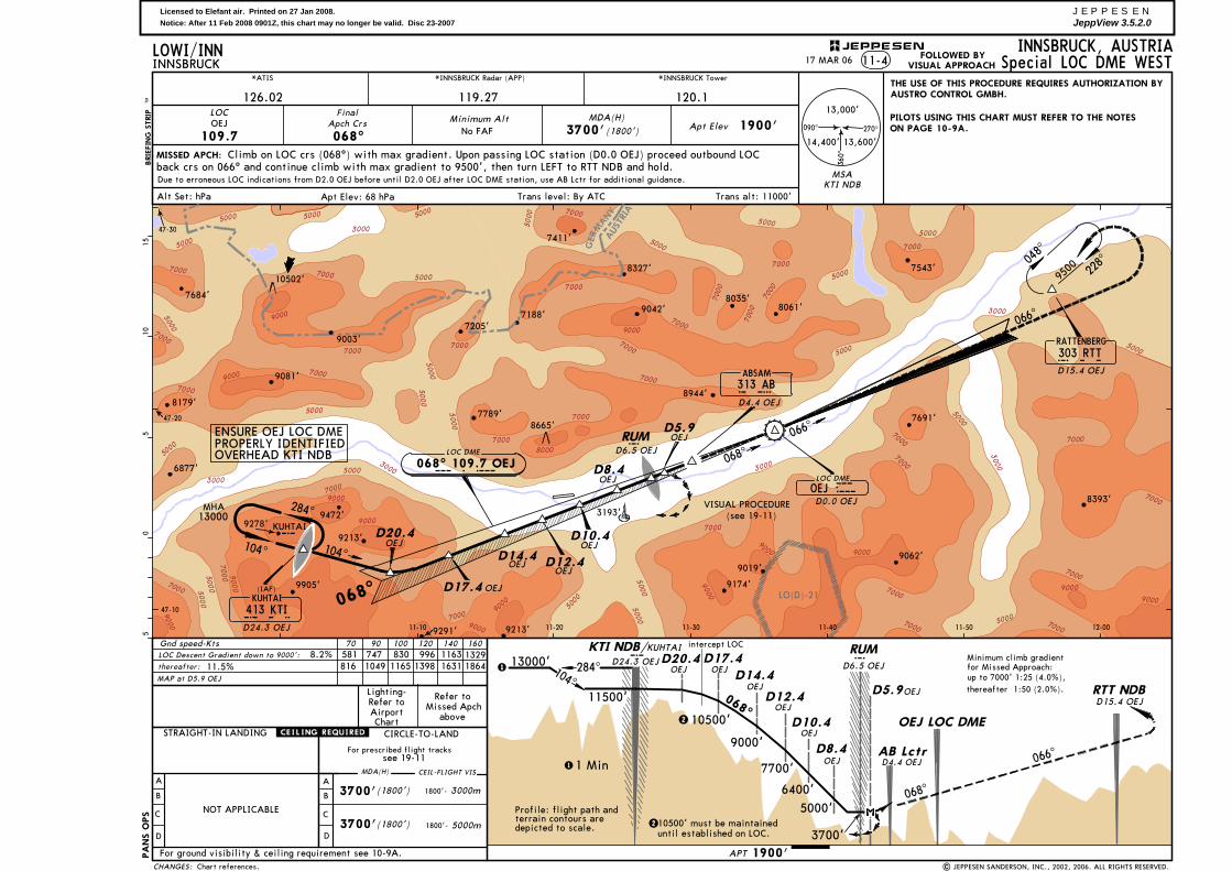
INNSBRUCK, AUSTRIA11-4INNSBRUCK
*ATIS
126.02 119.27
*INNSBRUCK Radar (APP) *INNSBRUCK Tower
120.1
MISSED APCH:BRIE
FIN
G S
TRIP
TM
Alt Set: hPa
LOC
068^
MDA(H)Apt Elev 1900'
Trans alt: 11000'Trans level: By ATCApt Elev: 68 hPa
Minimum Alt
109.7OEJ
Climb on LOC crs (068^) with max gradient. Upon passing LOC station (D0.0 OEJ) proceed outbound LOCback crs on 066^ and continue climb with max gradient to 9500', then turn LEFT to RTT NDB and hold.
No FAF 3700'(1800') 270^090^
360^
13,000'
13,600'14,400'
Special LOC DME WEST
OEJ
OEJ
OEJOEJ
OEJ
JEPPESEN
FinalApch Crs
PA
NS O
PS
| JEPPESEN SANDERSON, INC., 2002, 2006. ALL RIGHTS RESERVED.
17 MAR 06LOWI/INN
8665'
8944'
AUST
RIA
MANY
GER
ENSURE OEJ LOC DMEPROPERLY IDENTIFIEDOVERHEAD KTI NDB
Profile: flight path and terrain contours aredepicted to scale.
PILOTS USING THIS CHART MUST REFER TO THE NOTESON PAGE 10-9A.
228^04
8^
9500
RATTENBERG303 RTTR T T
D15.4 OEJ
VISUAL PROCEDURE
104^
284^
066^
066^
068^
068^
104^
LOC DME
O E J
068^ 109.7 OEJLOC DME
OEJD0.0 OEJ
13000MHA
OE
J
1900'
13000'
1 Min
11500'
D20.4OEJ
D17.4OEJ
KUHTAIK
D24.3 OEJRUMR
D6.5 OEJ
AB LctrD4.4 OEJ
OEJ LOC DME
RTT NDBD15.4 OEJ
10500'
9000'
2
up to 7000' 1:25 (4.0%),thereafter 1:50 (2.0%).
Minimum climb gradientfor Missed Approach:
OEJD8.4
7700'
284^104^
6400'
5000'
068^
066^
47-10
47-20
47-30
11-10 11-20 11-30 11-40 11-50 12-00
D8.4
D5.9
D14.4
D12.4
D10.4
D5.9OEJ
OEJ
OEJ
OEJ
23700'
068^
KTI NDB/
CIRCLE-TO-LAND
A
B
C
D
A
B
C
D
NOT APPLICABLE
For prescribed flight tracks
MDA(H) CEIL-FLIGHT VIS
(1800')3700' 1800'- 3000m
(1800')3700' 1800'- 5000m
Gnd speed-Kts 70 90 100 120 140 160581 747 830 996 1163 13298.2%
CHANGES:
MAP at D5.9 OEJ
thereafter: 11.5%LOC Descent Gradient down to 9000':
1631 18641165 1398816 1049
STRAIGHT-IN LANDING
intercept LOC
Due to erroneous LOC indications from D2.0 OEJ before until D2.0 OEJ after LOC DME station, use AB Lctr for additional guidance.
7684'
9081'
7411'
7543'
9213'
9174'
9062'
7691'
8393'
9042'
8179'
7205'
9291'
9278'
9003'
8327'
3193'
10502'
6877'
9213'
7188'8061'
9019'
8035'
FOLLOWED BYVISUAL APPROACH
RUMR
D6.5 OEJ
D20.4
D17.4
D14.4 D12.4
D10.4
9472'
7789'
9905'
D24.3 OEJ
KUHTAI413 KTIK T I
(IAF)
THE USE OF THIS PROCEDURE REQUIRES AUTHORIZATION BYAUSTRO CONTROL GMBH.
(see 19-11)
see 19-11
D4.4 OEJ
ABSAM313 ABA B
10500' must be maintaineduntil established on LOC.
Chart references.
KUHTAIK

Licensed to Elefant air. Printed on 27 Jan 2008.Notice: After 11 Feb 2008 0901Z, this chart may no longer be valid. Disc 23-2007
JEPPESENJeppView 3.5.2.0
AUSTRIAMANYGER
LO(D)-21
[3.50^]
[3.50^]
[TCH 50']
[RW26]
[RW26]
5000
3000
50005000
5000
5000
7000
5000
7000
7000
7000
9000
9000
5000
5000
5000
7000
7000
7000
7000
7000
5000
5000
7000
7000
7000
7000
7000
5000
5000
5000
7000300
0
5000
5000
3000
5000
7000
7000
7000
70007000
7000
9000
7000
7000
9000
90007000
50005000
5000
9000
5000
9000
9000
50005000
7000
9000
3000
3000
5000
9000
9000
7000
7000
7000
7000
9000
7000 5000
3000 500030
00
7000
5000
8000
9000
8000
MSARTT NDB
05
510
15
INNSBRUCK, AUSTRIA12-1INNSBRUCK
126.02 119.27
*INNSBRUCK Radar (APP) *INNSBRUCK Tower
120.1
MISSED APCH:BRIE
FIN
G S
TRIP
TM
DA(H)Minimum Alt
2600'
WI~~1
LOWI/INN
Apt Elev
RWY 1893'
1900'WI~~2
9500'
259^
234^
292^
281^
066^
112^
079^
259^
WI~~5
WI~~2
WI~~3
WI~~6
WI~~7
WI~~8
WI~~5
HIALS
PAPI PAPIREIL
WI~~1WI~~2
FinalApch Crs
054^
247^
067^
WI~~3
(7607') (707')
Climb to 9500' via RNAV missed approach track to WI~~1 and hold.
RWY26
| JEPPESEN SANDERSON, INC., 2007. ALL RIGHTS RESERVED.
ALS out
RVR
RVR 1500m
RWY26
9718'
5918'
3061'
8094'8045'
5010'
9249'
2770'
2490'
2343'
2546'
3212'3035'
RVR 2000m
RVR 2000m1800m
434 557
RNAV (RNP) RWY 26
RNAV259^
RNP 0.3
MAX 165 KT
via9500'
Alt Set: hPa Rwy Elev: 67 hPa Trans level: By ATC Trans alt: 11000'1. SPECIAL AIRCREW & AIRCRAFT AUTHORIZATION REQUIRED
*D-ATIS
(refer to AIRPORT BRIEFING 10-1P pages). 2. GPS and IRS required (DME/DME, LOC and VOR/DME updating
20 APR 07
Note.
not authorized). 3. Request "RNP RNAV approach RWY 26". 4. Procedure NA below airport temperature -7^C.
228^04
8^
9500
DA(H) 2600'
47-10
47-20
47-30
11-10 11-20 11-30 11-40 11-50 12-00
Gnd speed-Kts 100 120 140 160619 743 867 991
CHANGES:
7684'
9081'
7411'
7543'
9472'
9213'
9174'9062'
7691'
8393'
9042'
7205'
9278'
8327'
9213'
9019'
9905'
Descent angle
234^
1893'
9500'
RWY 26 3.7 16.7 5.7
11-00
26STRAIGHT-IN LANDING RWY
270^
050^
100^
9500'
10,700'
14,100'
(707')
RATTENBERG303 RTTR T T
247^
259^
7188'
JEPPESEN
8665'8051'7789'
.JAR-OPS.
9070
MAP at DA
3.70 20.4 26.1
5.7
16.7
3.7
8.1
4.3
4.3
5.0
7.4
9003'
NOTAUTH
LNAV
A
B
C
D
LNAV/VNAVRNP 0.3

Licensed to Elefant air. Printed on 27 Jan 2008.Notice: After 11 Feb 2008 0901Z, this chart may no longer be valid. Disc 23-2007
JEPPESENJeppView 3.5.2.0
7000
3000
5000
3000
4000
5000
3000
7000
3000
4000
6000
40006000
30004000
50006000
7000
3000
3000
40005000
6000
7000
3000
4000
5000 8000
8000
5000
8000
MISSEDAPPROACHPOINT
C
D
CIRCLE-TO-LANDWITH PRESCRIBED FLIGHT TRACKS
FLIGHT VISIBILITY
After apch 11-1 After apch 11-3
MDA(H) 4500' MDA(H) 5000'(2600') (3100')
3000m
For ground visibility & ceiling requirement see 10-9A.For SPECIAL NOTES see 10-9A.
INNSBRUCK, AUSTRIAINNSBRUCK1900'
B
A
5000m
Having established effective external visual reference at MISSED APCH POINT, make a RIGHT turnin level flight (maximum radius of turn 0.9 NM/1700m).When reaching westerly heading ensure that approach to the aerodrome can be accomplished visually.If found impossible to maintain visual conditions on approach to aerodrome, turn RIGHT to rejoinOEJ LOCALIZER via AB Lctr and follow the MISSED APCH as prescribed on 11-3.If meteorological conditions guarantee a safe approach and landing continue visually either straight-into final for RWY 26 or on a right-hand circuit to RWY 08.
068^ 109.7 OEJLOC DME
O E J
MAX
11-30
47-15
11-20 11-25
313 ABA B
255^ 111.1 OEVILS DME
O E V
47-15
11-2011-15 11-3011-25
a b
313 AB
02.
52.
5
SFL
3700
3700
PA
NS O
PS
Apt Elev
SPECIAL CIRCLING PROCEDURES
MDA(H) 5000'(3100')
Missed apch climb gradient mim5.0% 4.5%
OFFSET LOC
2.5
02.
51
in=
2.5
NM
D4.4 OEJ
LOWI/INN19-1017 MAR 06
| JEPPESEN SANDERSON, INC., 2002, 2006. ALL RIGHTS RESERVED.
(e.g. 159 KT 25^ BANK)
RADIUS0.9 NM
RUMR
255^RUMR
ABSAM
264^
229^
ABSAM
3061'
3061'2546'
2907'2927'
3193'
2165'
3100'
3087'
2973'
2884'
2008'
2343'2083'
2067'2071' 2093'
2165'
2973' 2884'
2008'
2907' 2927' 3061'2546'
3193'
2067' 2071' 2093'
3061'2083'
2343'
CHANGES:
JEPPESEN
2490'
2490'
3100'
Chart reindexed.
SFL
VISUAL APPROACH PROCEDURE11-3
264^
254^
279^
following the instrument approach
From
KUHTA
I N
DB
VISUAL APPROACH PROCEDURE11-1
Having established effective external visual reference the flight shall be continued with visual refer-ence either straight-in to RWY 26 (distance to be flown visually up to 6 NM) or on to a right-handcircuit to RWY 08. The prescribed minimum flight visibility shall be observed during the visual partof the procedure.
following the instrument approach
From
RA
TTEN
BER
G N
DB
068^
Licensed to Elefant air. Printed on 27 Jan 2008.Notice: After 11 Feb 2008 0901Z, this chart may no longer be valid. Disc 23-2007
JEPPESENJeppView 3.5.2.0
30004000
50006000
7000
3000
3000
40005000
6000
7000
3000
40005000 80
00
8000
313 ABA B
255^ 111.1 OEVILS DME
O E V
47-15
11-2011-15 11-3011-25
02.
52.
5PA
NS O
PS
254^234^
264^3700
to RUMMKR
VISUAL APCH AFTER IFR APCH FROM WEST (11-4): Having established effective external visualreference at MISSED APCH POINT (MAP), make a RIGHT turn in level flight (maximum radius ofturn 0.4 NM/700m).When reaching westerly heading ensure that approach to the aerodrome can be accomplishedvisually. If found impossible to maintain visual conditions on approach to aerodrome, turn RIGHTto rejoin OEJ LOCALIZER via AB Lctr and follow the MISSED APCH as described on 11-4.If meteorological conditions guarantee a safe approach and landing continue visually eitherstraight-in to final for RWY 26 or on a right-hand circuit to RWY 08.
VISUAL APCH AFTER IFR APCH FROM EAST (11-2): Having established effective external visual reference the flight shall be coninued with visual reference either straight-in to RWY 26(distance to be flown visually up to 6 NM) or on a right-hand circuit to RWY 08. The prescribedminimum flight visibility shall be observed during the visual part of the procedure.
(MAP 11-4)
MAX
INNSBRUCK, AUSTRIA
SPECIAL CIRCLING PROCEDURES
C
D
CIRCLE-TO-LANDWITH PRESCRIBED FLIGHT TRACKS
FLIGHT VISIBILITY
MDA(H) 3700'(1800')
3000m
For ground visibility & ceiling requirement see 10-9A.For SPECIAL NOTES see 10-9A.
B
A
5000m
After apch 11-2 & 11-4
OFFSET LOC
INNSBRUCK1900'Apt ElevLOWI/INN
19-1117 MAR 06
| JEPPESEN SANDERSON, INC., 2002, 2006. ALL RIGHTS RESERVED.
RADIUS 0.4 NM(e.g.104 KT 25^ BANK)
255^RUMR
ABSAM
3061'
3061'
2546'
2907' 2927'3193'
2165'
3087' 2973'
2884'
2008'
2343'2083'
2067'2071' 2093'
CHANGES:
JEPPESEN
D5.9 OEJ
2490'3100'
Chart reindexed.
SFL
VISUAL APPROACH PROCEDURE
From
RA
TTEN
BER
G N
DB
11-2 & 11-4
068^
following the instrument approaches
From
KUHTA
I N
DB