Embed Size (px)
Citation preview
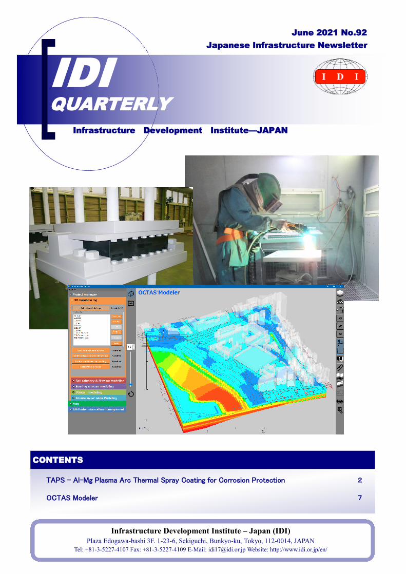
TAPS - Al-Mg Plasma Arc Thermal Spray Coating for Corrosion Protection 2
CONTENTS
Infrastructure Development Institute – Japan (IDI)
Plaza Edogawa-bashi 3F. 1-23-6, Sekiguchi, Bunkyo-ku, Tokyo, 112-0014, JAPAN
Tel: +81-3-5227-4107 Fax: +81-3-5227-4109 E-Mail: [email protected] Website: http://www.idi.or.jp/en/
IDI QUARTERLY
Japanese Infrastructure Newsletter
Infrastructure Development Institute—JAPAN
June 2021 No.92
OCTAS Modeler 7
Infrastructure Development Institute - Japan
2
TAPS - Al-Mg Plasma Arc Thermal Spray Coating for Corrosion Protection
High durability and low maintenance costs for bridge components in harsh environments
1. Introduction
Kawakin Core-Tech is a top Japanese
manufacturer with more than 70 years of
history engaged in the development, design,
manufacture, and sales of seismic devices
(seismic isolation and dampers), and structural
bearings, and expansion joints for bridges and
buildings. We are ready to respond to global
needs for safety and reliability, and we look
forward to supporting you in your project.
2. Outline
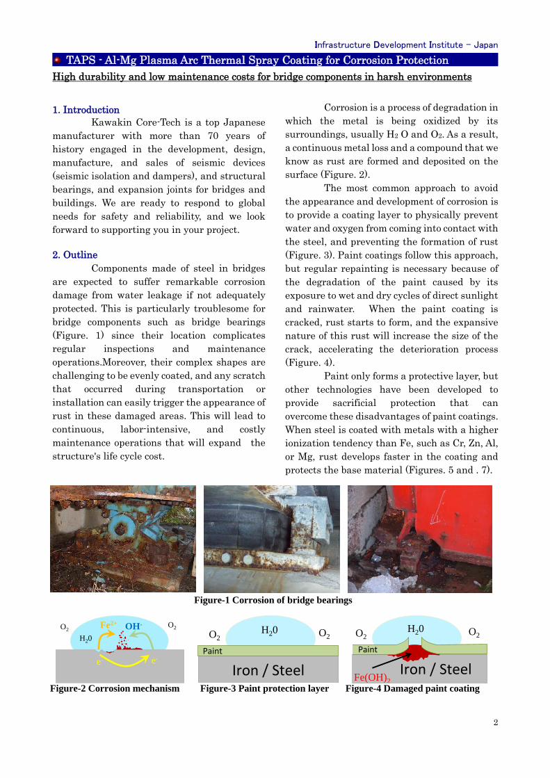
Components made of steel in bridges
are expected to suffer remarkable corrosion
damage from water leakage if not adequately
protected. This is particularly troublesome for
bridge components such as bridge bearings
(Figure. 1) since their location complicates
regular inspections and maintenance
operations.Moreover, their complex shapes are
challenging to be evenly coated, and any scratch
that occurred during transportation or
installation can easily trigger the appearance of
rust in these damaged areas. This will lead to
continuous, labor-intensive, and costly
maintenance operations that will expand the
structure's life cycle cost.
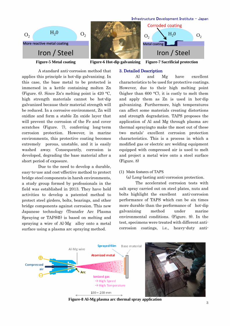
Corrosion is a process of degradation in
which the metal is being oxidized by its
surroundings, usually H2 O and O2. As a result,
a continuous metal loss and a compound that we
know as rust are formed and deposited on the
surface (Figure. 2).
The most common approach to avoid
the appearance and development of corrosion is
to provide a coating layer to physically prevent
water and oxygen from coming into contact with
the steel, and preventing the formation of rust
(Figure. 3). Paint coatings follow this approach,
but regular repainting is necessary because of
the degradation of the paint caused by its
exposure to wet and dry cycles of direct sunlight
and rainwater. When the paint coating is
cracked, rust starts to form, and the expansive
nature of this rust will increase the size of the
crack, accelerating the deterioration process
(Figure. 4).
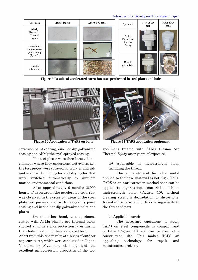
Paint only forms a protective layer, but
other technologies have been developed to
provide sacrificial protection that can
overcome these disadvantages of paint coatings.
When steel is coated with metals with a higher
ionization tendency than Fe, such as Cr, Zn, Al,
or Mg, rust develops faster in the coating and
protects the base material (Figures. 5 and . 7).
Figure-1 Corrosion of bridge bearings
Figure-2 Corrosion mechanism Figure-3 Paint protection layer Figure-4 Damaged paint coating
H20
O2O2
e- e-
Fe2+ OH-H20 O2O2
Iron / Steel
Paint
H20 O2O2
Iron / SteelFe(OH)2
Paint
Infrastructure Development Institute - Japan
3
A standard anti-corrosion method that
applies this principle is hot-dip galvanizing. In
this case, the base metal to be protected is
immersed in a kettle containing molten Zn
(Figure. 6). Since Zn's melting point is 420 °C,
high strength materials cannot be hot-dip
galvanized because their material strength will
be reduced. In a corrosive environment, Zn will
oxidize and form a stable Zn oxide layer that
will prevent the corrosion of the Fe and cover
scratches (Figure. 7), conferring long-term
corrosion protection. However, in marine
environments, this protective coating becomes
extremely porous, unstable, and it is easily
washed away. Consequently, corrosion is
developed, degrading the base material after a
short period of exposure.
Due to the need to develop a durable,
easy-to-use and cost-effective method to protect
bridge steel components in harsh environments,
a study group formed by professionals in the
field was established in 2013. They have held
activities to develop a patented method to
protect steel girders, bolts, bearings, and other
bridge components against corrosion. This new
Japanese technology (Transfer Arc Plasma
Spraying or TAPS🄬) is based on melting and
spraying a wire of Al-Mg alloy onto a metal
surface using a plasma arc spraying method.
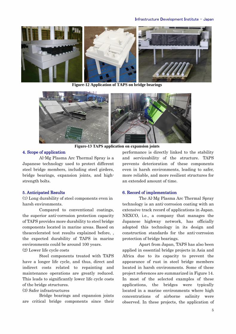
3. Detailed Description
Al and Mg have excellent
characteristics to be used for protective coatings.
However, due to their high melting point
(higher than 600 °C), it is costly to melt them
and apply them as Zn is used in hot-dip
galvanizing. Furthermore, high temperatures
can affect some materials creating distortions
and strength degradation. TAPS proposes the
application of Al and Mg through plasma arc
thermal sprayingto make the most out of these
two metals' excellent corrosion protection
characteristics. This is a process in which a
modified gas or electric arc welding equipment
equipped with compressed air is used to melt
and project a metal wire onto a steel surface
(Figure. 8)
(1) Main features of TAPS
(a) Long-lasting anti-corrosion protection.
The accelerated corrosion tests with
salt spray carried out on steel plates, nuts and
bolts highlight the excellent anti-corrosion
performance of TAPS which can be six times
more durable than the performance of hot-dip
galvanizing method under marine
environmental conditions. (Figure. 9). In the
test, specimens were treated with different anti-
corrosion coatings, i.e., heavy-duty anti-
Figure-8 Al-Mg plasma arc thermal spray application
Figure-5 Metal coating Figure-6 Hot-dip galvanizing Figure-7 Sacrificial protection
H20 O2O2
More reactive metal coating
Iron / Steel
H20 O2O2
Metal coating
Iron / Steel
Corroded coating
Infrastructure Development Institute - Japan
4
corrosion paint coating, Zinc hot-dip galvanized
coating and Al-Mg thermal sprayed coating.
The test pieces were then inserted in a
chamber where they underwent wet cycles, i.e.,
the test pieces were sprayed with water and salt
and endured humid cycles and dry cycles that
were switched automatically to simulate
marine environmental conditions.
After approximately 9 months (6,000
hours) of exposure in the accelerated test, rust
was observed in the cross-cut areas of the steel
plate test pieces coated with heavy-duty paint
coating and in the hot-dip galvanized bolts and
plates.
On the other hand, test specimens
coated with Al-Mg plasma arc thermal spray
showed a highly stable protection layer during
the whole duration of the accelerated test.
Apart from this, the results of a series of outdoor
exposure tests, which were conducted in Japan,
Vietnam, or Myanmar, also highlight the
excellent anti-corrosion properties of the test
specimens treated with Al-Mg Plasma Arc
Thermal Spray after years of exposure.
(b) Applicable in high-strength bolts,
including the thread.
The temperature of the molten metal
applied to the base material is not high. Thus,
TAPS is an anti-corrosion method that can be
applied to high-strength materials, such as
high-strength bolts (Figure. 10), without
creating strength degradation or distortions.
Kawakin can also apply this coating evenly to
the threaded part.
(c) Applicable on-site
The necessary equipment to apply
TAPS on steel components is compact and
portable (Figure. 11) and can be used at a
construction site. This makes TAPS an
appealing technology for repair and
maintenance projects.
Figure-9 Results of accelerated corrosion tests performed in steel plates and bolts
Figure-10 Application of TAPS on bolts Figure-11 TAPS application equipment
Infrastructure Development Institute - Japan
5
4. Scope of application
Al-Mg Plasma Arc Thermal Spray is a
Japanese technology used to protect different
steel bridge members, including steel girders,
bridge bearings, expansion joints, and high-
strength bolts.
5. Anticipated Results
(1) Long durability of steel components even in
harsh environments.
Compared to conventional coatings,
the superior anti-corrosion protection capacity
of TAPS provides more durability to steel bridge
components located in marine areas. Based on
theaccelerated test results explained before, ,
the expected durability of TAPS in marine
environments could be around 100 years.
(2) Lower life cycle costs
Steel components treated with TAPS
have a longer life cycle, and thus, direct and
indirect costs related to repainting and
maintenance operations are greatly reduced.
This leads to significantly lower life cycle costs
of the bridge structures.
(3) Safer infrastructures
Bridge bearings and expansion joints
are critical bridge components since their
performance is directly linked to the stability
and serviceability of the structure. TAPS
prevents deterioration of these components
even in harsh environments, leading to safer,
more reliable, and more resilient structures for
an extended amount of time.
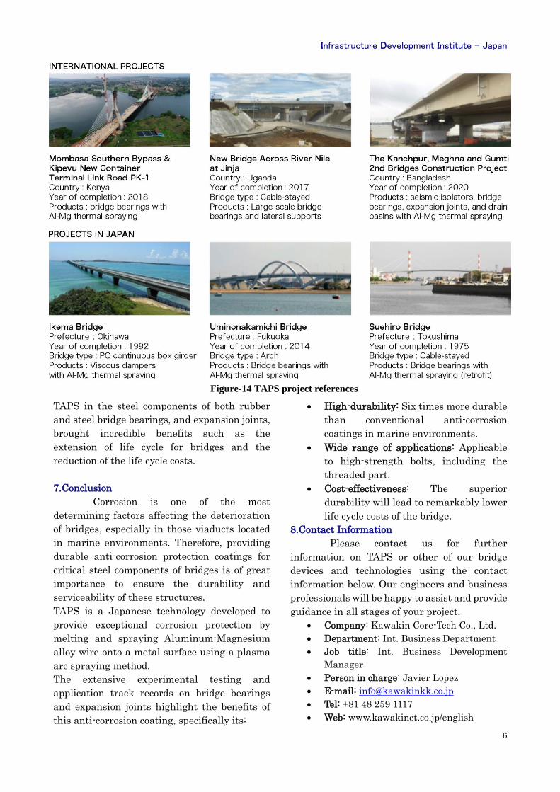
6. Record of implementation
The Al-Mg Plasma Arc Thermal Spray
technology is an anti-corrosion coating with an
extensive track record of applications in Japan.
NEXCO, i.e., a company that manages the
Japanese highway network, has officially
adopted this technology in its design and
construction standards for the anti-corrosion
protection of bridge bearings.
Apart from Japan, TAPS has also been
applied in essential bridge projects in Asia and
Africa due to its capacity to prevent the
appearance of rust in steel bridge members
located in harsh environments. Some of these
project references are summarized in Figure 14.
In most of the selected examples of these
applications, the bridges were typically
located in a marine environments where high
concentrations of airborne salinity were
observed. In these projects, the application of
Figure-12 Application of TAPS on bridge bearings
Figure-13 TAPS application on expansion joints
Infrastructure Development Institute - Japan
6
TAPS in the steel components of both rubber
and steel bridge bearings, and expansion joints,
brought incredible benefits such as the
extension of life cycle for bridges and the
reduction of the life cycle costs.
7.Conclusion
Corrosion is one of the most
determining factors affecting the deterioration
of bridges, especially in those viaducts located
in marine environments. Therefore, providing
durable anti-corrosion protection coatings for
critical steel components of bridges is of great
importance to ensure the durability and
serviceability of these structures.
TAPS is a Japanese technology developed to
provide exceptional corrosion protection by
melting and spraying Aluminum-Magnesium
alloy wire onto a metal surface using a plasma
arc spraying method.
The extensive experimental testing and
application track records on bridge bearings
and expansion joints highlight the benefits of
this anti-corrosion coating, specifically its:
• High-durability: Six times more durable
than conventional anti-corrosion
coatings in marine environments.
• Wide range of applications: Applicable
to high-strength bolts, including the
threaded part.
• Cost-effectiveness: The superior
durability will lead to remarkably lower
life cycle costs of the bridge.
8.Contact Information
Please contact us for further
information on TAPS or other of our bridge
devices and technologies using the contact
information below. Our engineers and business
professionals will be happy to assist and provide
guidance in all stages of your project.
• Company: Kawakin Core-Tech Co., Ltd.
• Department: Int. Business Department
• Job title: Int. Business Development
Manager
• Person in charge: Javier Lopez
• E-mail: [email protected]
• Tel: +81 48 259 1117
• Web: www.kawakinct.co.jp/english
Figure-14 TAPS project references
Infrastructure Development Institute - Japan
7
OCTAS Modeler
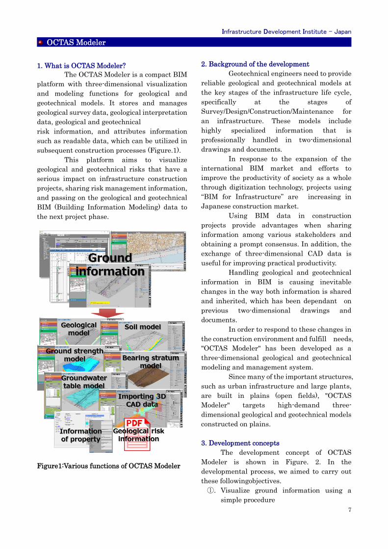
1. What is OCTAS Modeler?
The OCTAS Modeler is a compact BIM
platform with three-dimensional visualization
and modeling functions for geological and
geotechnical models. It stores and manages
geological survey data, geological interpretation
data, geological and geotechnical
risk information, and attributes information
such as readable data, which can be utilized in
subsequent construction processes (Figure.1).
This platform aims to visualize
geological and geotechnical risks that have a
serious impact on infrastructure construction
projects, sharing risk management information,
and passing on the geological and geotechnical
BIM (Building Information Modeling) data to
the next project phase.
Figure1:Various functions of OCTAS Modeler
2. Background of the development
Geotechnical engineers need to provide
reliable geological and geotechnical models at
the key stages of the infrastructure life cycle,
specifically at the stages of
Survey/Design/Construction/Maintenance for
an infrastructure. These models include
highly specialized information that is
professionally handled in two-dimensional
drawings and documents.
In response to the expansion of the
international BIM market and efforts to
improve the productivity of society as a whole
through digitization technology, projects using
“BIM for Infrastructure” are increasing in
Japanese construction market.
Using BIM data in construction
projects provide advantages when sharing
information among various stakeholders and
obtaining a prompt consensus. In addition, the
exchange of three-dimensional CAD data is
useful for improving practical productivity.
Handling geological and geotechnical
information in BIM is causing inevitable
changes in the way both information is shared
and inherited, which has been dependant on
previous two-dimensional drawings and
documents.
In order to respond to these changes in
the construction environment and fulfill needs,
"OCTAS Modeler" has been developed as a
three-dimensional geological and geotechnical
modeling and management system.
Since many of the important structures,
such as urban infrastructure and large plants,
are built in plains (open fields), "OCTAS
Modeler" targets high-demand three-
dimensional geological and geotechnical models
constructed on plains.
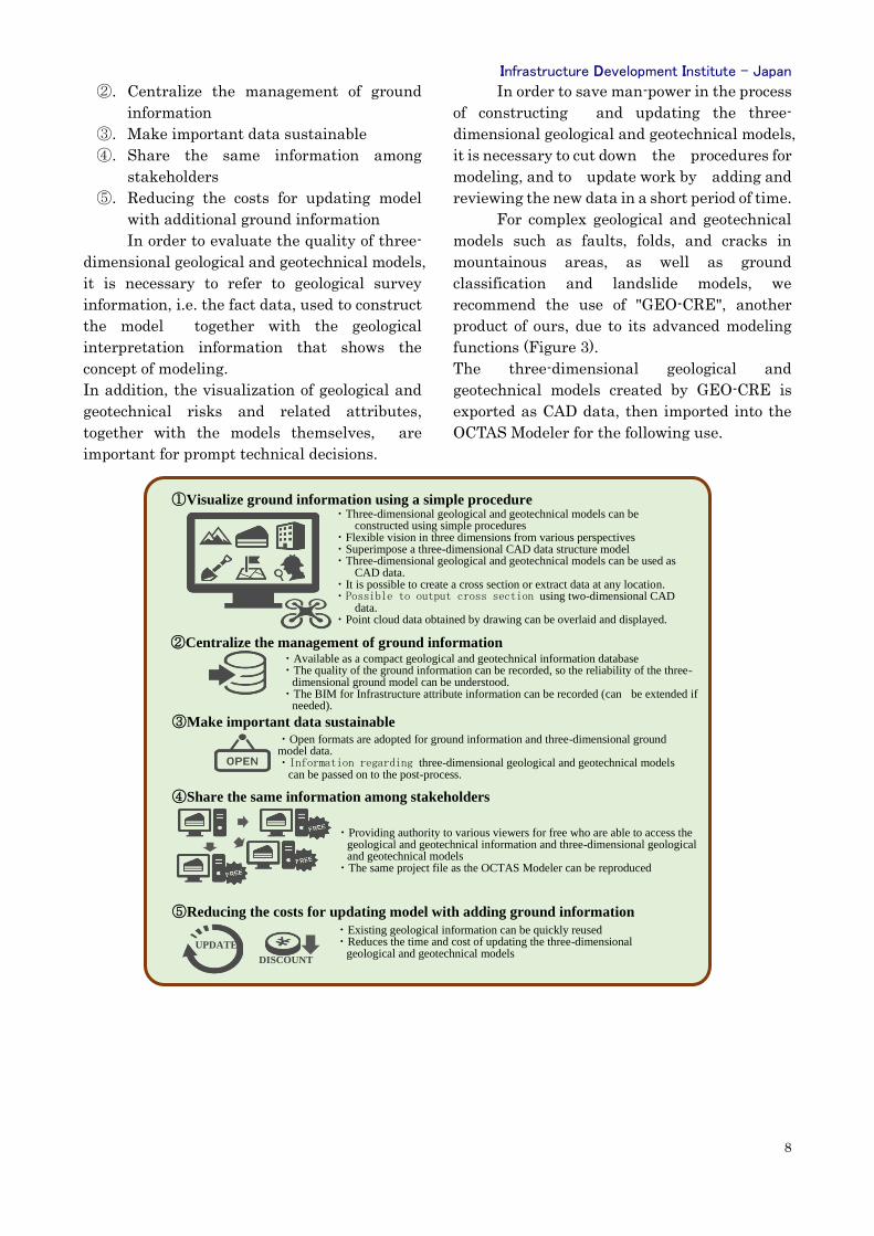
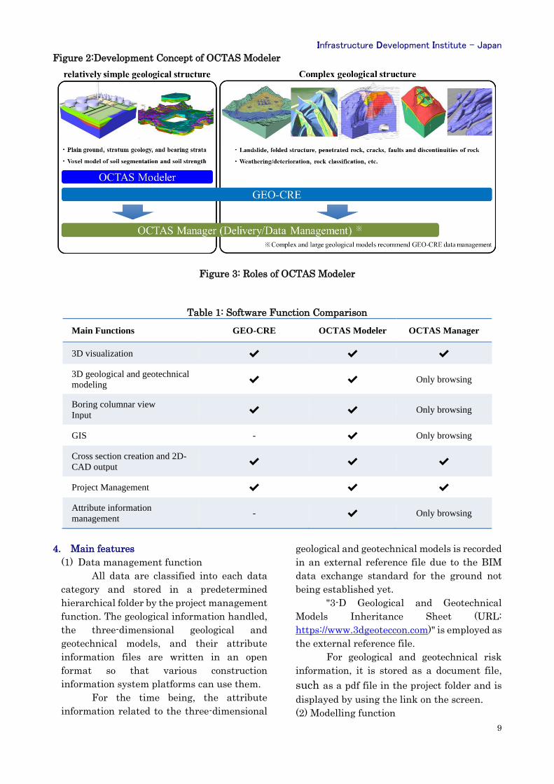
3. Development concepts
The development concept of OCTAS
Modeler is shown in Figure. 2. In the
developmental process, we aimed to carry out
these followingobjectives.
①. Visualize ground information using a
simple procedure
Infrastructure Development Institute - Japan
8
②. Centralize the management of ground
information
③. Make important data sustainable
④. Share the same information among
stakeholders
⑤. Reducing the costs for updating model
with additional ground information
In order to evaluate the quality of three-
dimensional geological and geotechnical models,
it is necessary to refer to geological survey
information, i.e. the fact data, used to construct
the model together with the geological
interpretation information that shows the
concept of modeling.
In addition, the visualization of geological and
geotechnical risks and related attributes,
together with the models themselves, are
important for prompt technical decisions.
In order to save man-power in the process
of constructing and updating the three-
dimensional geological and geotechnical models,
it is necessary to cut down the procedures for
modeling, and to update work by adding and
reviewing the new data in a short period of time.
For complex geological and geotechnical
models such as faults, folds, and cracks in
mountainous areas, as well as ground
classification and landslide models, we
recommend the use of "GEO-CRE", another
product of ours, due to its advanced modeling
functions (Figure 3).
The three-dimensional geological and
geotechnical models created by GEO-CRE is
exported as CAD data, then imported into the
OCTAS Modeler for the following use.
③Make important data sustainable
・Open formats are adopted for ground information and three-dimensional ground model data. ・Information regarding three-dimensional geological and geotechnical models
can be passed on to the post-process.
②Centralize the management of ground information ・Available as a compact geological and geotechnical information database ・The quality of the ground information can be recorded, so the reliability of the three-
dimensional ground model can be understood. ・The BIM for Infrastructure attribute information can be recorded (can be extended if
needed).
①Visualize ground information using a simple procedure ・Three-dimensional geological and geotechnical models can be
constructed using simple procedures ・Flexible vision in three dimensions from various perspectives ・Superimpose a three-dimensional CAD data structure model ・Three-dimensional geological and geotechnical models can be used as
CAD data. ・It is possible to create a cross section or extract data at any location. ・Possible to output cross section using two-dimensional CAD
data. ・Point cloud data obtained by drawing can be overlaid and displayed.
④Share the same information among stakeholders
・Providing authority to various viewers for free who are able to access the geological and geotechnical information and three-dimensional geological and geotechnical models
・The same project file as the OCTAS Modeler can be reproduced
⑤Reducing the costs for updating model with adding ground information
・Existing geological information can be quickly reused ・Reduces the time and cost of updating the three-dimensional
geological and geotechnical models UPDATE
DISCOUNT
Infrastructure Development Institute - Japan
9
Figure 2:Development Concept of OCTAS Modeler
Figure 3: Roles of OCTAS Modeler
Table 1: Software Function Comparison
Main Functions GEO-CRE OCTAS Modeler OCTAS Manager
3D visualization ✔ ✔ ✔
3D geological and geotechnical
modeling ✔ ✔ Only browsing
Boring columnar view
Input ✔ ✔ Only browsing
GIS - ✔ Only browsing
Cross section creation and 2D-
CAD output ✔ ✔ ✔
Project Management ✔ ✔ ✔
Attribute information
management - ✔ Only browsing
4. Main features
(1) Data management function
All data are classified into each data
category and stored in a predetermined
hierarchical folder by the project management
function. The geological information handled,
the three-dimensional geological and
geotechnical models, and their attribute
information files are written in an open
format so that various construction
information system platforms can use them.
For the time being, the attribute
information related to the three-dimensional
geological and geotechnical models is recorded
in an external reference file due to the BIM
data exchange standard for the ground not
being established yet.
"3-D Geological and Geotechnical
Models Inheritance Sheet (URL:
https://www.3dgeoteccon.com)" is employed as
the external reference file.
For geological and geotechnical risk
information, it is stored as a document file,
such as a pdf file in the project folder and is
displayed by using the link on the screen.
(2) Modelling function
Infrastructure Development Institute - Japan
10
The modelling function allows to
develop various three-dimensional models by
using simple procedures such as the geological
and geotechnical model, bearing stratum
model, soil compartment model, soil strength
model and the groundwater table model.
BS-Horizon is employed to interpolate
a surface, and IDW (Inverse Distance
Weighting) is used as a three-dimensional
interpolation algorithm for the voxel model.
The interpolation algorithm suite can be
extended in the future.
(3) Basic Function
The interface consists of three-
dimensional viewers and minimal set of
function buttons and operation panels. The
operation panel has a simple GIS function, a
monitoring function, a preview screen, and a
data view function that enables retrieval and
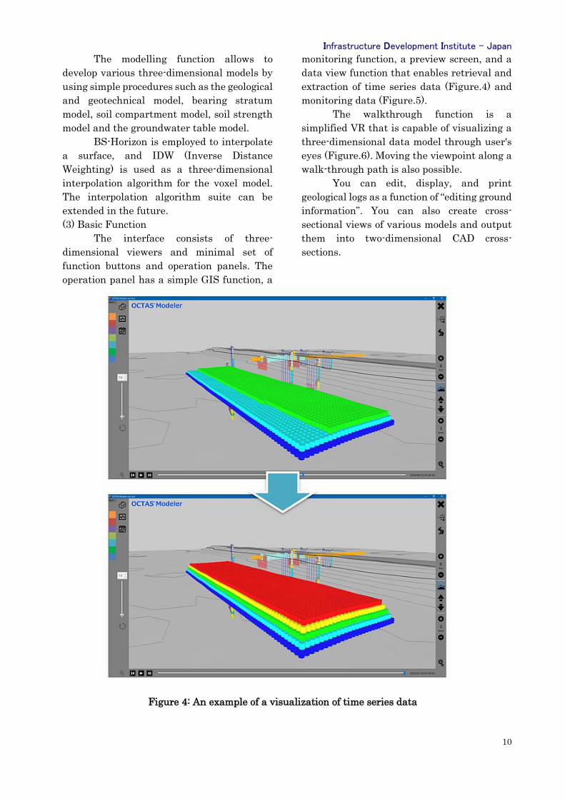
extraction of time series data (Figure.4) and
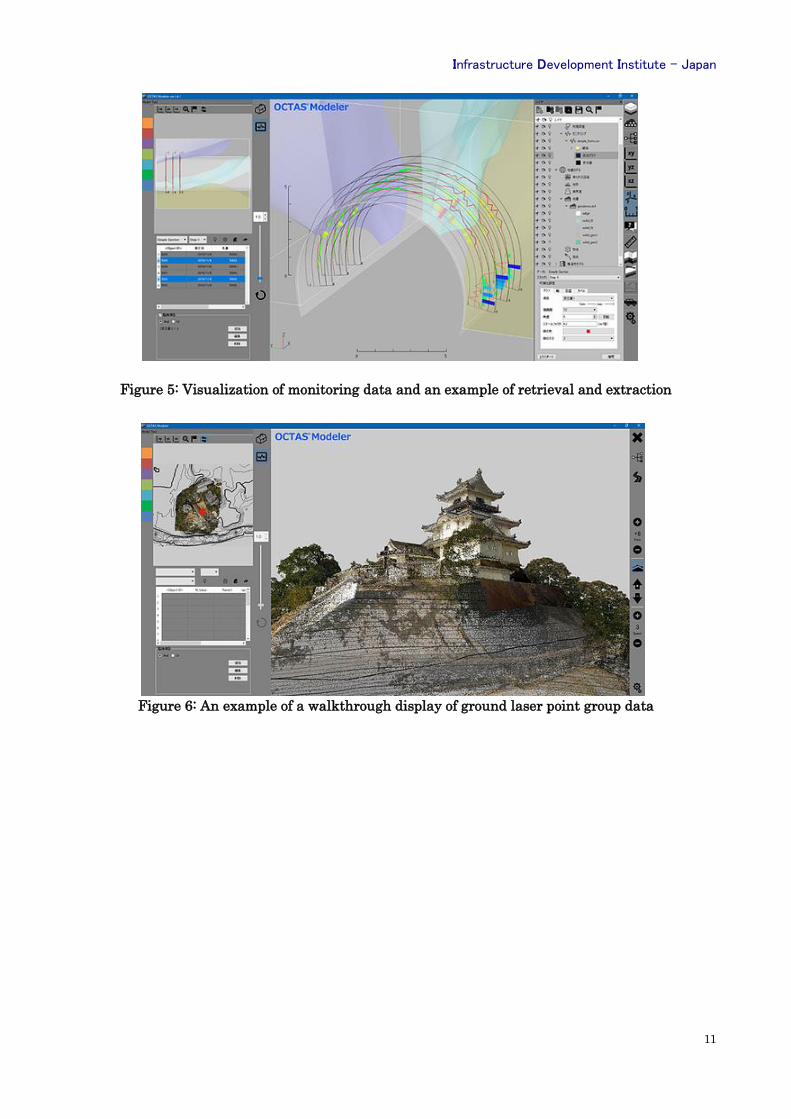
monitoring data (Figure.5).
The walkthrough function is a
simplified VR that is capable of visualizing a
three-dimensional data model through user's
eyes (Figure.6). Moving the viewpoint along a
walk-through path is also possible.
You can edit, display, and print
geological logs as a function of “editing ground
information”. You can also create cross-
sectional views of various models and output
them into two-dimensional CAD cross-
sections.
Figure 4: An example of a visualization of time series data
Infrastructure Development Institute - Japan
11
Figure 5: Visualization of monitoring data and an example of retrieval and extraction
Figure 6: An example of a walkthrough display of ground laser point group data
Infrastructure Development Institute - Japan
12
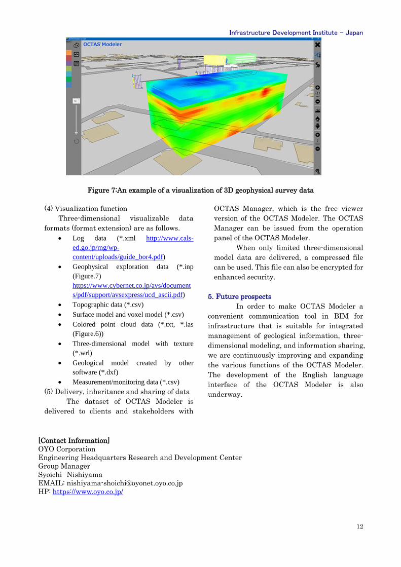
Figure 7:An example of a visualization of 3D geophysical survey data
(4) Visualization function
Three-dimensional visualizable data
formats (format extension) are as follows.
• Log data (*.xml http://www.cals-
ed.go.jp/mg/wp-
content/uploads/guide_bor4.pdf)
• Geophysical exploration data (*.inp
(Figure.7)
https://www.cybernet.co.jp/avs/document
s/pdf/support/avsexpress/ucd_ascii.pdf)
• Topographic data (*.csv)
• Surface model and voxel model (*.csv)
• Colored point cloud data (*.txt, *.las
(Figure.6))
• Three-dimensional model with texture
(*.wrl)
• Geological model created by other
software (*.dxf)
• Measurement/monitoring data (*.csv)
(5) Delivery, inheritance and sharing of data
The dataset of OCTAS Modeler is
delivered to clients and stakeholders with
OCTAS Manager, which is the free viewer
version of the OCTAS Modeler. The OCTAS
Manager can be issued from the operation
panel of the OCTAS Modeler.
When only limited three-dimensional
model data are delivered, a compressed file
can be used. This file can also be encrypted for
enhanced security.
5. Future prospects
In order to make OCTAS Modeler a
convenient communication tool in BIM for
infrastructure that is suitable for integrated
management of geological information, three-
dimensional modeling, and information sharing,
we are continuously improving and expanding
the various functions of the OCTAS Modeler.
The development of the English language
interface of the OCTAS Modeler is also
underway.
[Contact Information]
OYO Corporation
Engineering Headquarters Research and Development Center
Group Manager
Syoichi Nishiyama
EMAIL: [email protected]
HP: https://www.oyo.co.jp/
About IDI and IDI-quarterly
Infrastructure Development Institute-Japan (IDI) is a general incorporated
association operating under the guidance of Ministry of Land, Infrastructure,
Transport and Tourism of Japanese Government.
IDI provides consulting services to facilitate international assistance to developing
countries, to promote international exchange of information and human resources,
and to support globalization of project implementation systems targeting both
developed and developing countries in the field of infrastructure.
IDI has been publishing a free quarterly journal called “IDI Quarterly” since1996 to
introduce information related to public works and construction technologies
developed in Japan, to foreign countries. We have distributed the journal to
administration officials in more than 90 countries around the world via e-mail.
It will be highly appreciated if you could send us your opinions, impressions, etc.
regarding the articles.
We also welcome your specific requests regrading technologies you would like to
see on following Quarterly issues.