Embed Size (px)
Citation preview

MEMBER REPORT
ESCAP/WMO Typhoon Committee
10th Integrated Workshop
Japan
Kuala Lumpur, Malaysia
26 – 29 October 2015


CONTENTS
I. Overview of tropical cyclones that have affected Members’ areas in 2015 1. Meteorological assessment
2. Hydrological assessment I. Report on the collapse of a dyke along the Kinu River on 10 September 2015 II. Sediment-related incidents in Japan in 2015
II. Summary of progress in Key Result Areas Asian Conference on Disaster Reduction (ACDR) 2015
Urban Search-and-rescue Training in Singapore as an ADRC activity for disaster reduction
Visiting Researchers from ADRC Member Countries
Activities of TC, Korea and ICHARM at the 7th World Water Forum in Korea, April 2015
Introduction of SAPHIR/Megha-Tropiques radiance data to JMA’s operational global NWP system, June 2015
Initiation of Himawari-8 operation on 7 July 2015
TCC products and publications related to tropical cyclones
Evaluation of the accuracy of tropical cyclone intensity estimation using single ground-based Doppler radar observation


Overview of tropical cyclones that have affected Members’ areas in 2015
1. Meteorological assessment
In 2015, 13 tropical cyclones (TCs) of tropical storm (TS) intensity or higher had come within 300 km of the Japanese islands as of 5 October. Japan was affected by 7 of these, with 4 making landfall. These 7 TCs are described below, and their tracks are shown in Figure 1.
(1) TY Noul (1506) Noul was upgraded to TS intensity east of Yap Island at 18 UTC on 3 May. NOUL
gradually turned northwestward and reached its peak intensity with maximum sustained winds of 110 kt and a central pressure of 920 hPa east of Luzon Island at 00 UTC on 10 May. Gradually turning northeastward, NOUL accelerated along Okinawa Islands and transformed into an extratropical cyclone east of Tanegashima Island at 06 UTC on 12 May.
A peak gust of 44.1 m/s and a 24‐hour precipitation total of 79.5 mm was recorded at
Ishigakijima (47918). Cancellations of flights and ship departures were reported in Okinawa Prefecture. (2) TY Chan-hom (1509) Chan-hom was upgraded to TS intensity around the Marshall Islands at 12 UTC on 30
June, and gradually turned west-southwestward. Chan-hom reached its peak intensity with maximum sustained winds of 90 kt and a central pressure of 935 hPa around Miyakojima Island at 18 UTC on 9 July. Keeping its northwestward track, it passed between Miyakojima Island and Kumejima Island with TY intensity late on 9 July. After turning north-northeastward in the East China Sea, Chan-hom transformed into an extratropical cyclone in the northern part of the Korean Peninsula at 00 UTC on 13 July.
A peak gust of 41.2 m/s was recorded at Naha (47936), and a 24‐hour precipitation
total of 230.0 mm was recorded at Nago (47940). Power outages and cancellations of flights and ship departures were reported in
Okinawa Prefecture. (3) TY Nangka (1511) Nangka was upgraded to TS intensity over the sea around the Marshall Islands at 18
UTC on 3 July and gradually turned westward. Keeping its northwestward track, Nangka reached its peak intensity with maximum sustained winds of 100 kt and a central pressure of 925 hPa around the northern part of the Mariana Islands at 06 UTC on 9 July. After sharply turning north-northwestward over the sea south of Japan, Nangka made landfall in Muroto City, Kouchi Prefecture with TY intensity around 14 UTC on 16 July. After passing Shikoku Island, it made landfall in Kurashiki City, Okayama Prefecture with STS intensity around 21 UTC the same day again. Turning northeastward, Nangka weakened to TD intensity over the Sea of Japan at 12 UTC on 17 July.
A peak gust of 42.6 m/s was recorded at Murotomisaki (47899), and a 24‐hour
precipitation total of 357.5 mm was recorded at Owase (47663). Swollen river and drainage caused by heavy rain resulted in two fatalities, and damage
to houses and farm products, power outages and transport disruption were also reported across a wide area stretching from Kyushu to Tohoku region.
(4) TY Halola (1512)
Halola crossed longitude 180 degrees east with STS intensity over the sea east of the Marshall Islands after 18 UTC on 12 July 2015 and entered the western North Pacific. Halola reached its peak intensity with maximum sustained winds of 80 kt and a central pressure of 955 hPa south of Iwoto Island at 18 UTC 21 July. After turning northward and passing through the Amamigunto Islands with TY intensity, it was downgraded to TS intensity west of Kyushu Island at 06 UTC on 26 July. Keeping its northward track, Halola passed through Saikai City, Nagasaki Prefecture around 09 UTC and made landfall on Sasebo City, Nagasaki Prefecture around 10 UTC that day. Turning north-northeastward, it weakened to TD intensity over the northwestern part of Kyushu Island at 12 UTC that day.
A peak gust of 43.7 m/s was recorded at Minamidaitojima (47945), and a 24‐hour
precipitation total of 285.0 mm was recorded at Yakushima (47836). Damage to houses and cancellations of ship departures were reported in Kyushu
region. (5) TY Goni (1515) Goni was upgraded to TS intensity east of Guam Island at 18 UTC on 14 August. It
reached its peak intensity with maximum sustained winds of 95 kt and a central pressure of 935 hPa west of the Mariana Islands at 06 UTC on 17 August and gradually turned westward. After moving westward for more than three days, Goni turned sharply northward over the sea north of Luzon Island and passed through Iriomotejima Island around 10 UTC on 23 August. It turned northeastward and passed through Akune City, Kagoshima Prefecture after 19 UTC on 24 August. After Goni passed through Uki City, Kumamoto Prefecture after 20 UTC on 24 August, it made landfall in Arao City, Kumamoto Prefecture with TY intensity after 21 UTC the same day. Goni entered the Sea of Japan and transformed into an extratropical cyclone northwest of the Oki Islands at 12 UTC on 25 August.
A peak gust of 71.0 m/s was recorded at Ishigakijima (47918), and a 24‐hour
precipitation total of 535.0 mm was recorded at Owase (47663). A swollen river caused by heavy rain resulted in one fatality, and damage to houses
and farm products, power outages and transport disruption were also reported across a wide area stretching from Okinawa to Kanto-Koshin region.
(6) STS Etau (1518) Etau was upgraded to TS intensity southwest of the Ogasawara Islands at 12 UTC on 7
September. Moving northward, it reached its peak intensity with maximum sustained winds of 50 kt and a central pressure of 985 hPa southwest of Torishima Island at 06 UTC the next day. After turning north-northwestward, Etau passed through the Atsumi Peninsula, Aichi Prefecture after 00 UTC on 9 September and then made landfall in the Chita Peninsula, Aichi Prefecture with TS intensity. Moving northwestward, Etau entered the Sea of Japan and transformed into an extratropical cyclone over the same waters at 06 UTC on 9 September.
A peak gust of 25.5 m/s was recorded at Omaezaki (47655), and a 24‐hour
precipitation total of 391.0 mm was recorded at Nikko (47690). Flooding and a landslide caused by heavy rain resulted in eight fatalities, and damage
to houses and farm products, power outages and transport disruption were also reported across a wide area stretching from Tokai to Tohoku region.
(7) TY Dujuan (1521)

Dujuan was upgraded to TS intensity southeast of Okinotorishima Island at 18 UTC on 22 September. Moving west-northwestward, it reached its peak intensity with maximum sustained winds of 100 kt and a central pressure of 925 hPa south of Okinawa Island at 00 UTC on 27 September. After hitting Taiwan Island and the southern part of China, Dujuan weakened to TD intensity at 12 UTC 29 September.
A peak gust of 81.1 m/s and a 24‐hour precipitation total of 203.5 mm were recorded
at Yonagunijima (47912). Damage to houses, power outages and cancellations of flights and ship departures
were reported in Okinawa region.
Figure 1 Tracks of the 7 named TCs affecting Japan in 2015 The numbered circles represent the genesis point of each named TC, while the squares show the dissipation point. The numbers indicate the last two digits of the identification number for each named TC.
Figure 2 Surface analysis chart at 00 UTC 9 Sep. 2015 STS Etau, caused serious damage to Japan in September 2015, is making landfall in the main island of Japan.

Figure.3 The number of tropical cyclones (TS intensity or higher) forming in the western North Pacific (top), those that approached Japan (middle) and those that hit Japan (bottom) as of 30 September, 2015. The thin, solid and dashed lines represent annual, five-year running means and normal values (1981 – 2010 averages), respectively. JMA describes inter-annual variability and long-term trends regarding typhoon activity in its Climate Change Monitoring Report every year. This annual report is distributed to the Japanese public as well as to NMHSs via the Tokyo Climate Center’s website (http://ds.data.jma.go.jp/gmd/tcc/tcc/products/gwp/gwp.html).

2. Hydrological assessment
I. Report on the collapse of a dyke along the Kinu River on 10 September 2015
Typhoon Etau brought unprecedentedly heavy rain to the Kanto and Tohoku regions of
Japan from 9 to 10 September. Cumulative rainfall in the Kinu River basin reached its
highest-ever level during this time, and overtopping water caused a 200-m-long dyke
collapse that resulted in flooding over a wide area of Joso City in Ibaragi Prefecture.
Kinu River Basin
The Kinu is a Class A river with a main-course length of 176.7 km. Its basin has an area
of 1,761 km2 and is home to around 550,000 people. The upstream area is mountainous,
and the middle and downstream reaches are occupied by urban areas or cropland.
Precipitation
An autumn rain front enhanced by Typhoon Etau brought heavy rain to the northern
part of Tochigi Prefecture over a period of three days from 9 to 11 September. The
three-day total of 613 mm recorded at Ikari rainfall gauge station far exceeded the
previous record of 462 as well as totals at other stations.
251658240
Fig. 1 Rainfall trend, cumulative rainfall and topographical conditions of the Kinu River
basin (source: MLIT document*)
Dyke collapse along the Kinu River
Records from the Mitsukaidou gauge station, which is 10.95 km from the source of the

Kinu River, show that the maximum expected water level was exceeded over a period of
five hours from 11 a.m. to 4 p.m. on 10 September. Overtopping occurred along the left
bank 21 km from the river’s source at 11:46, causing the dyke there to collapse at around
12:50. The collapsed section extended to a length of around 200 m.
Fig. 2 Images of overtopping and hydrograph data for an area near the dyke collapse
point (source: MLIT document*)
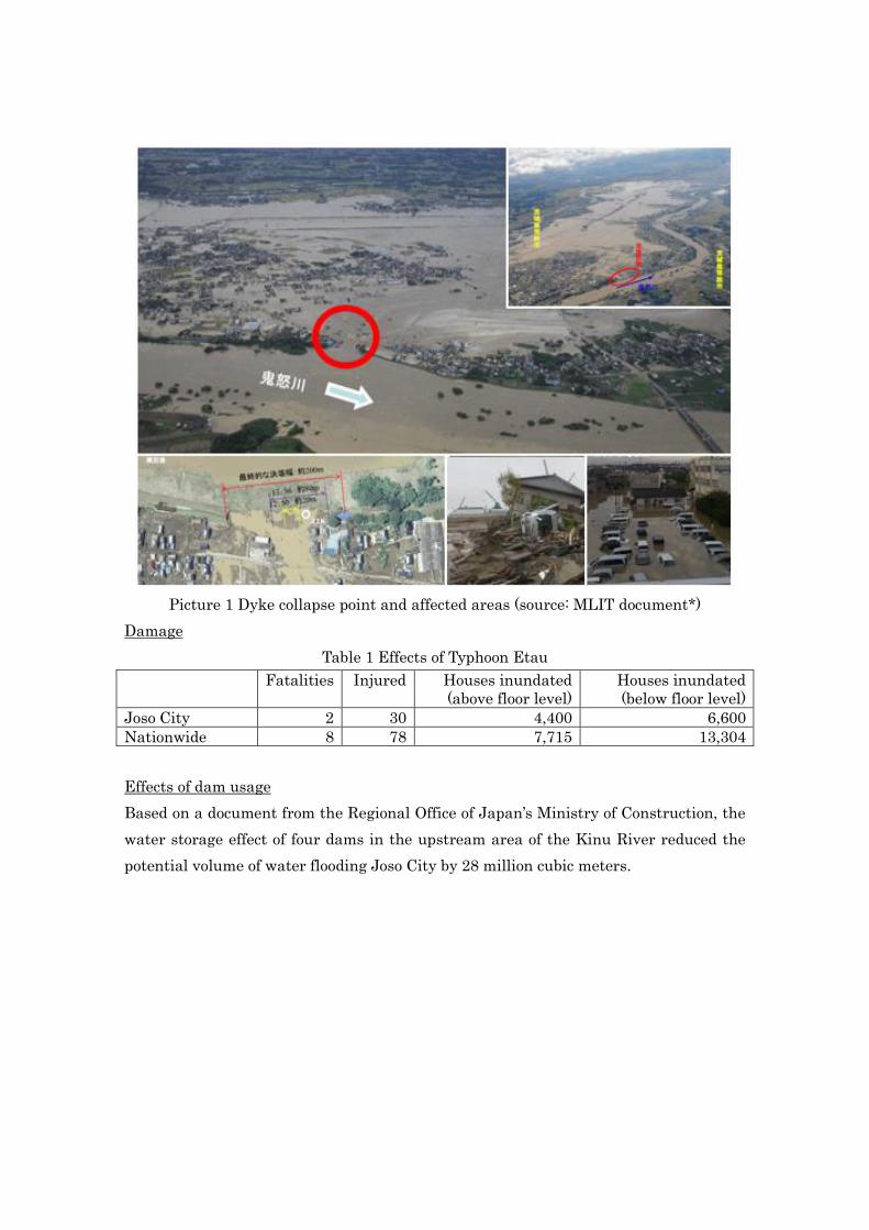
Picture 1 Dyke collapse point and affected areas (source: MLIT document*)
Damage
Table 1 Effects of Typhoon Etau
Fatalities Injured Houses inundated
(above floor level)
Houses inundated
(below floor level)
Joso City 2 30 4,400 6,600
Nationwide 8 78 7,715 13,304
Effects of dam usage
Based on a document from the Regional Office of Japan’s Ministry of Construction, the
water storage effect of four dams in the upstream area of the Kinu River reduced the
potential volume of water flooding Joso City by 28 million cubic meters.
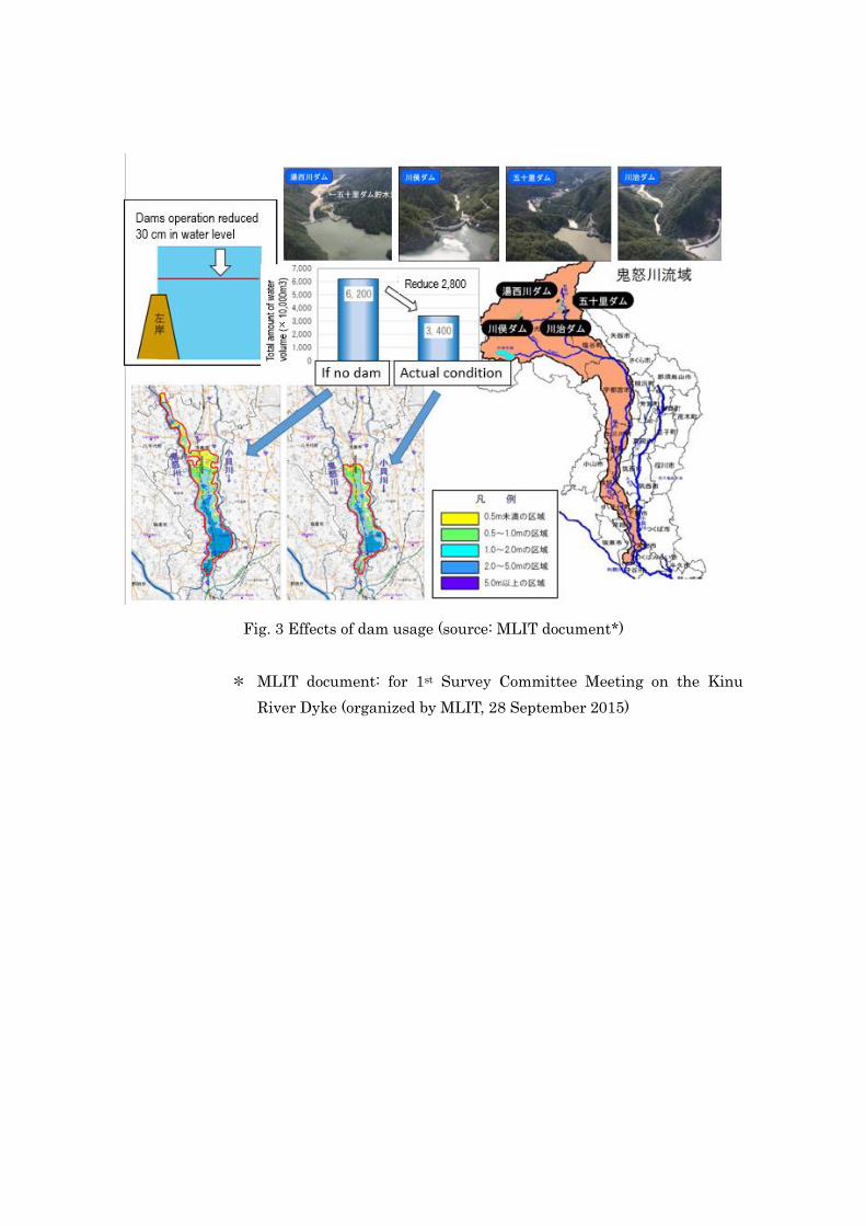
Fig. 3 Effects of dam usage (source: MLIT document*)
* MLIT document: for 1st Survey Committee Meeting on the Kinu
River Dyke (organized by MLIT, 28 September 2015)

II. Sediment-related incidents in Japan in 2015
1. Outline of sediment-related incidents in 2015
A total of 491 sediment-related incidents had been reported as of August 31 2015,
including 84 debris flows, 35 landslides and 372 slope failures (Fig. 4). The fatality count
has remained at one.
2. Major sediment-related incidents
This report outlines three major sediment-related incidents that occurred in the
Tarumizu area of Kagoshima Prefecture and in the Nikko and Kanuma areas of Tochigi
Prefecture.
Fig. 4 Sediment-related incidents in 2015 (as of August 31)

Debris flows in Tarumizu that were triggered by wall failures in the Aira Caldera rushed
down mountain slopes, picking up material as they went. Flows occurred on June 24,
July 5 and July 28, flooding a house below floor level and damaging a bridge over a
national road. A total of 75 residents in 41 households were evacuated (Fig. 5).
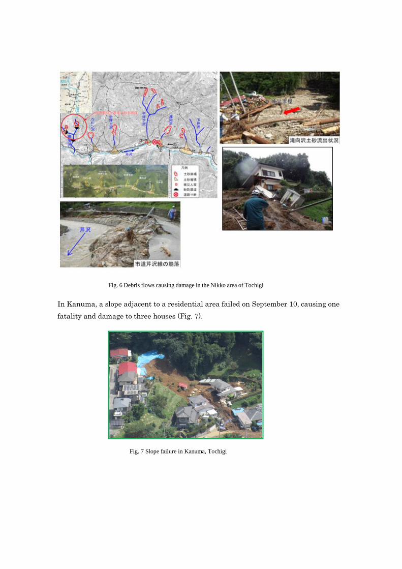
Debris flows in Nikko occurred in the early hours of September 10 at nine locations
along eight mountain streams in the Serizawa district. Nakamiyori Rainfall Station
near Serizawa recorded cumulative precipitation of 589 mm from the onset of rainfall on
September 8 through September 10 with an hourly maximum of 57 mm. Although there
were no fatalities, the area was seriously affected. A total of 25 residents were
temporarily stranded, four houses were badly damaged, and sediment runoff damaged
local roads at seven locations (Fig. 6.)
Fig. 5 Debris flows causing damage in the Tarumi area of Kagoshima
In Kanuma, a slope adjacent to a residential area failed on September 10, causing one
fatality and damage to three houses (Fig. 7).
Fig. 3 Debris flows in Nikko, Tochigi, and damage
Fig. 7 Slope failure in Kanuma, Tochigi
Fig. 6 Debris flows causing damage in the Nikko area of Tochigi
II. Summary of progress in Key Result Areas
Asian Conference on Disaster Reduction (ACDR) 2015
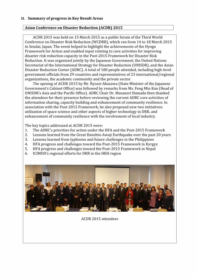
ACDR 2015 was held on 15 March 2015 as a public forum of the Third World Conference on Disaster Risk Reduction (WCDRR), which ran from 14 to 18 March 2015 in Sendai, Japan. The event helped to highlight the achievements of the Hyogo Framework for Action and enabled input relating to core activities for improving disaster risk reduction capacity in the Post-2015 Framework for Disaster Risk Reduction. It was organized jointly by the Japanese Government, the United Nations Secretariat of the International Strategy for Disaster Reduction (UNISDR), and the Asian Disaster Reduction Center (ADRC). A total of 180 people attended, including high-level government officials from 29 countries and representatives of 23 international/regional organizations, the academic community and the private sector. The opening of ACDR 2015 by Mr. Ryosei Akazawa (State Minister of the Japanese Government’s Cabinet Office) was followed by remarks from Ms. Feng Min Kan (Head of UNISDR’s Asia and the Pacific Office). ADRC Chair Dr. Masanori Hamada then thanked the attendees for their presence before reviewing the current ADRC core activities of information sharing, capacity building and enhancement of community resilience. In association with the Post-2015 Framework, he also proposed new two initiatives: utilization of space science and other aspects of higher technology in DRR, and enhancement of community resilience with the involvement of local industry.
The key topics addressed at ACDR 2015 were: 1. The ADRC’s priorities for action under the HFA and the Post-2015 Framework 2. Lessons learned from the Great Hanshin-Awaji Earthquake over the past 20 years 3. Lessons learned from typhoons and future challenges in the Philippines 4. HFA progress and challenges toward the Post-2015 Framework in Kyrgyz 5. HFA progress and challenges toward the Post-2015 Framework in Nepal 6. ICIMOD’s regional efforts for DRR in the HKH region
ACDR 2015 attendees
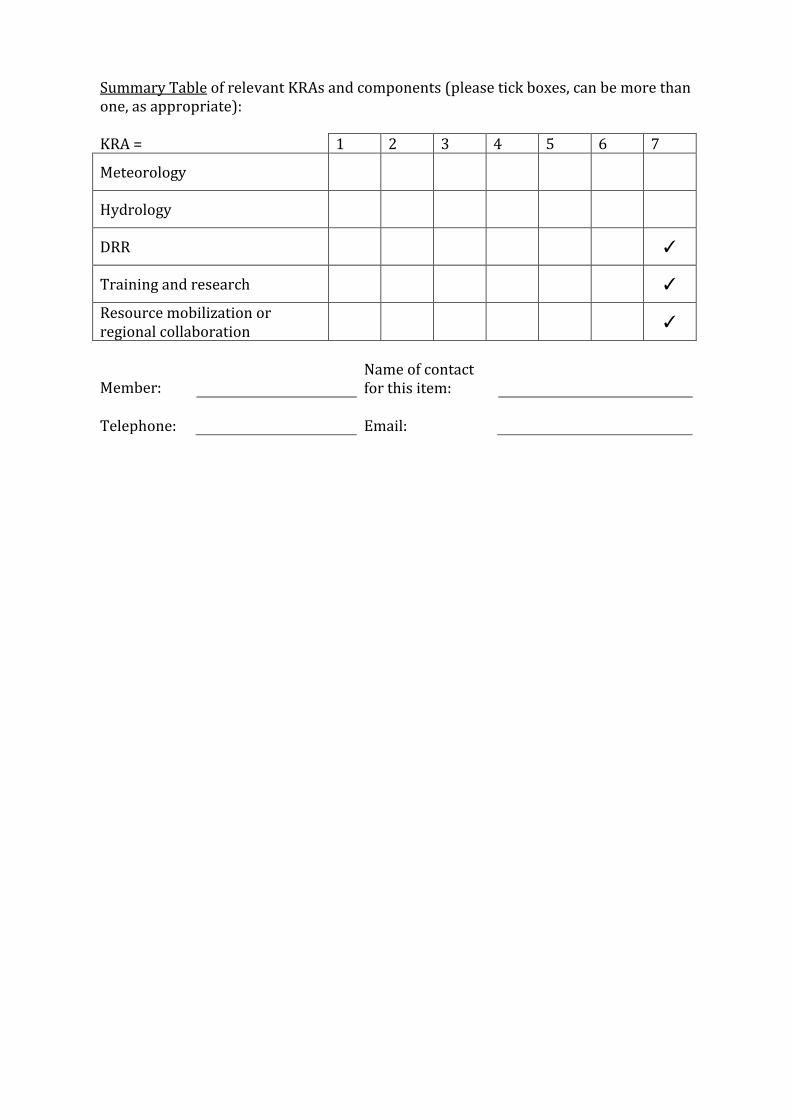
Summary Table of relevant KRAs and components (please tick boxes, can be more than one, as appropriate):
KRA = 1 2 3 4 5 6 7
Meteorology
Hydrology
DRR
✓
Training and research
✓
Resource mobilization or regional collaboration
✓
Member: Name of contact
for this item:
Telephone:
Email:

Urban Search-and-rescue Training in Singapore as an ADRC activity for disaster reduction
The Singaporean Government holds a training course every year for search and rescue officers. The course has hosted trainees from outside Singapore for the past ten years to teach the search-and-rescue expertise required in urban disaster situations. The training facility complex of the Civil Defense Academy (CDA) run by the Singapore Civil Defense Force (SCDF) is one of the highest-level facilities of its kind in Asia. As part of efforts to utilize the SCDF’s expertise and facilities, the ADRC has hosted relevant officers from Member Countries on the training course since 2001. As of March 2015, 52 individuals had taken the course. One officer from Azerbaijan attended the October 2015 course.
Nations dispatching trainees over the past 5 years
FY 2009 (2): Armenia, Sri Lanka FY 2010 (3): Bhutan, Mongolia and Maldives FY 2011 (2): Bangladesh, Russia FY 2012 (2): Mongolia, Thailand FY 2014 (2): Bhutan, Maldives (*)
Urban search-and-rescue training in Singapore (2013)
* The achievement of FY 2014 originally was it of FY 2013 which has recruited the participants by the former fiscal year. It was carried out in April 2014 because couldn't determine the participants during that fiscal year.

Summary Table of relevant KRAs and components (please tick boxes, can be more than one, as appropriate):
KRA = 1 2 3 4 5 6 7
Meteorology
Hydrology
DRR
✓
Training and research
✓
Resource mobilization or regional collaboration
Member: Name of contact
for this item:
Telephone:
Email:
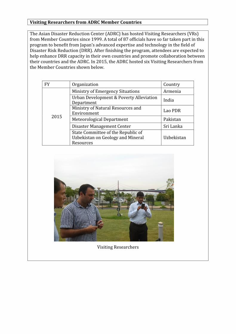
Visiting Researchers from ADRC Member Countries
The Asian Disaster Reduction Center (ADRC) has hosted Visiting Researchers (VRs) from Member Countries since 1999. A total of 87 officials have so far taken part in this program to benefit from Japan’s advanced expertise and technology in the field of Disaster Risk Reduction (DRR). After finishing the program, attendees are expected to help enhance DRR capacity in their own countries and promote collaboration between their countries and the ADRC. In 2015, the ADRC hosted six Visiting Researchers from the Member Countries shown below.
FY Organization Country
2015
Ministry of Emergency Situations Armenia
Urban Development & Poverty Alleviation Department
India
Ministry of Natural Resources and Environment
Lao PDR
Meteorological Department Pakistan
Disaster Management Center Sri Lanka
State Committee of the Republic of Uzbekistan on Geology and Mineral Resources
Uzbekistan
Visiting Researchers

Summary Table of relevant KRAs and components (please tick boxes, can be more than one, as appropriate):
KRA = 1 2 3 4 5 6 7
Meteorology
Hydrology
DRR
✓
Training and research
✓
Resource mobilization or regional collaboration
Member: Name of contact
for this item:
Telephone:
Email:

Activities of TC, Korea and ICHARM at the 7th World Water Forum in Korea, April 2015
1. UNESCAP/WMO Typhoon Committee/4th Meeting of TC Working Group on Hydrology and Thematic Session (Theme 1.3.3)
The 4th Meeting of the Typhoon Committee (TC) Working Group on Hydrology (WGH) was held during the 7th World Water Forum (WWF7) in Daegu, Korea. This annual meeting in Korea is a sub-event of the WGH event organized by the Han River Flood Control Office of Korea’s Ministry of Land, Infrastructure and Transport. Sixteen members of TC WGH attended from Japan, Laos, Malaysia, Korea, Thailand, Viet Nam and America. On April 15 there was a closed meeting at which attendees reported on TC-related activities and discussed relevant matters under the chairmanship of Chief Researcher Yoshio Tokunaga from ICHARM. On the next day there was an open session titled Preparedness, Response and Adaptation against Extreme Floods under Climate Change, at which TC WGH members delivered a presentation before a general audience and a number of experts. One of the speakers was Yoshio Tokunaga, who presented on flood analysis using satellite data.
4th Meeting of the Typhoon Committee (TC) Working Group
2. Concluding Session with the 7 session coordinators of Theme 1.3: Adapting to change: Monitoring risk and uncertainty for resilience and disaster preparedness This ICHARM-hosted session chaired by ICHARM Director Toshio Koike drew about 70 attendees. To summarize the results of seven water-related disaster sessions held in the thematic process of WWF7, attendees and representatives from each session discussed the implementation roadmap drafted under ICHARM’s initiative from the preliminary stage in terms of its content and how the world should proceed with the plan. The implementation roadmap is considered a key component in the practical

application of outcomes from WWF7, and is emphasized in a ministerial declaration with high expectations. The WWF7 secretariat even developed the Action Monitoring System (see http://ams.worldwaterforum7.org/) to support monitoring and sharing of progress in the implementation of actions listed in the roadmap. ICHARM is expected to play an ongoing leading role in putting the roadmap against water-related disasters into action.
ICHARM Director Toshio Koike (far left)
Summary Table of relevant KRAs and components (please tick boxes, can be more
than one, as appropriate):
KRA = 1 2 3 4 5 6 7
Meteorology
Hydrology ✓ ✓
✓
✓ ✓
DRR
Training and research
Resource mobilization or regional collaboration
Member: Japan Name of contact
for this item: Yoshio Tokunaga
Telephone: +81-(29)-879-6807
Email: [email protected]
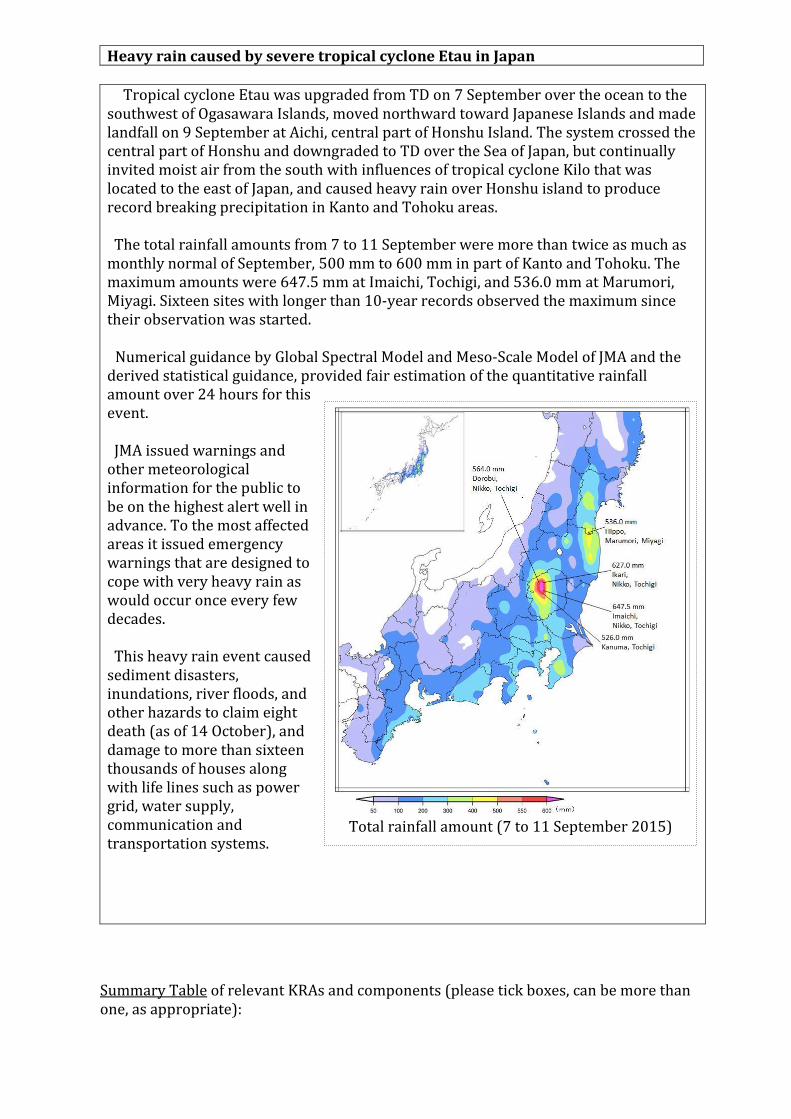
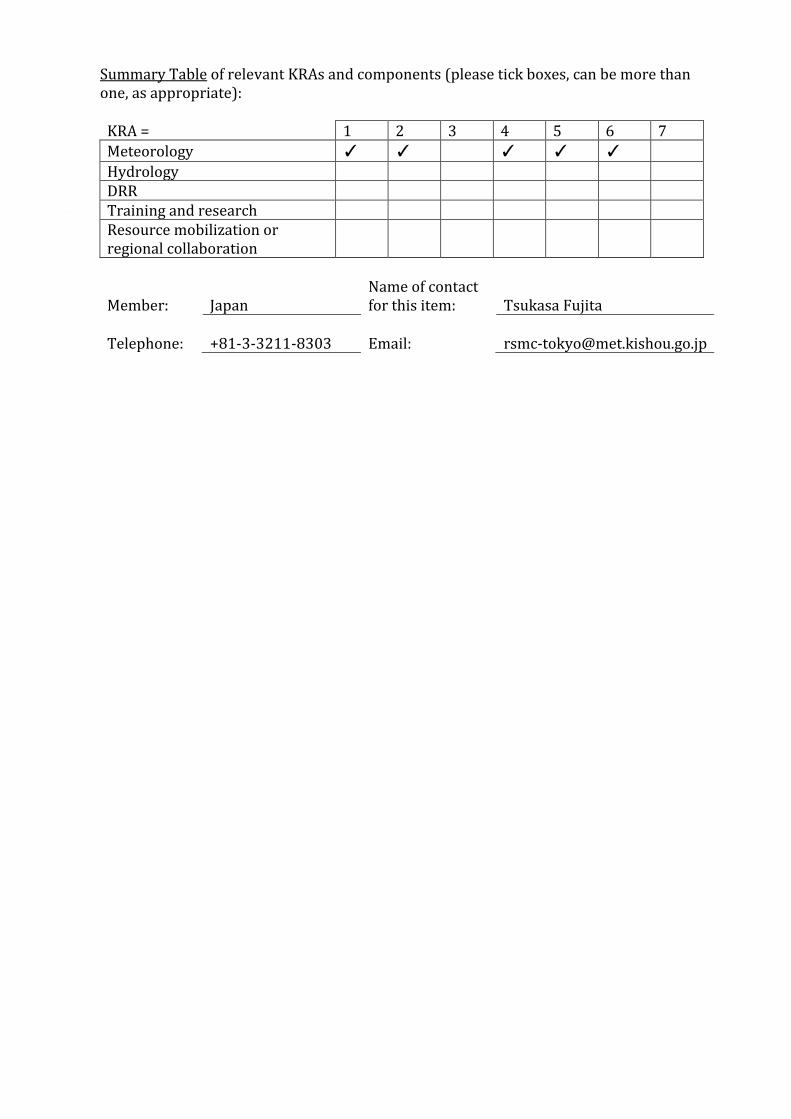
Heavy rain caused by severe tropical cyclone Etau in Japan
Tropical cyclone Etau was upgraded from TD on 7 September over the ocean to the southwest of Ogasawara Islands, moved northward toward Japanese Islands and made landfall on 9 September at Aichi, central part of Honshu Island. The system crossed the central part of Honshu and downgraded to TD over the Sea of Japan, but continually invited moist air from the south with influences of tropical cyclone Kilo that was located to the east of Japan, and caused heavy rain over Honshu island to produce record breaking precipitation in Kanto and Tohoku areas. The total rainfall amounts from 7 to 11 September were more than twice as much as monthly normal of September, 500 mm to 600 mm in part of Kanto and Tohoku. The maximum amounts were 647.5 mm at Imaichi, Tochigi, and 536.0 mm at Marumori, Miyagi. Sixteen sites with longer than 10-year records observed the maximum since their observation was started.
Numerical guidance by Global Spectral Model and Meso-Scale Model of JMA and the derived statistical guidance, provided fair estimation of the quantitative rainfall amount over 24 hours for this event. JMA issued warnings and other meteorological information for the public to be on the highest alert well in advance. To the most affected areas it issued emergency warnings that are designed to cope with very heavy rain as would occur once every few decades. This heavy rain event caused sediment disasters, inundations, river floods, and other hazards to claim eight death (as of 14 October), and damage to more than sixteen thousands of houses along with life lines such as power grid, water supply, communication and transportation systems.
Summary Table of relevant KRAs and components (please tick boxes, can be more than one, as appropriate):
Total rainfall amount (7 to 11 September 2015)

KRA = 1 2 3 4 5 6 7
Meteorology ✓
✓ ✓
Hydrology
DRR
Training and research
Resource mobilization or regional collaboration
Member:
Japan Name of contact for this item:
Tsukasa Fujita
Telephone:
+81-3-3212-8303 Email:

15th Typhoon Committee Attachment Training at the RSMC Tokyo - Typhoon Center
The 15th ESCAP/WMO Typhoon Committee Attachment Training 2015 course was held at JMA Headquarters from 22 to 31 July 2015. The RSMC Tokyo – Typhoon Center has organized ESCAP/WMO Typhoon Committee Attachment Training courses every year since 2001 with the support of the WMO Tropical Cyclone Programme (TCP) and the Typhoon Committee to enhance the capacity of Committee members in typhoon analysis and forecasting. In accordance with a decision passed at the 3rd Joint Session of the Panel on Tropical Cyclones and the Typhoon Committee held in February 2015 in Bangkok, this training was attended by six experts from the Typhoon Committee and the Panel on Tropical Cyclones. These were Mr. Soim Monichoth from Cambodia, Ms. Praphasri Udjai from Thailand, Mr. Tran Van Hung from Vietnam, Mr. Md. Azizur Rahman from Bangladesh, Mr. Hussain Afshal from the Maldives, and Mr. Hla Tun from Myanmar. The training focused on imparting practical information and skills on tropical cyclone analysis and forecasting through lectures and exercises using the Satellite Analysis and Viewer Program (SATAID). The teaching covered a range of areas including Dvorak analysis, interpretation of microwave data, quantitative precipitation estimation (QPE), quantitative precipitation forecasting (QPF) and storm surge forecasting. Prof. Yuichi Ono (the Assistant Director of the International Research Institute of Disaster Science (IRIDeS) at Tohoku University) also gave an introductory lecture on the Sendai Framework for Disaster Risk Reduction 2015 – 2030 to enhance related understanding and promote the use of the framework for the enhancement of such services.
Identified opportunities/challenges, if any, for further development or collaboration: The participants reported that the training course is beneficial but better to extended to further deepen their understanding of the tropical cyclone analysis/forecasting, and related topics. In 2015, the participants from PTC were invited with the financial supports of Japan. Japan plans to provide the financial supports in 2016. However, it is tentative and sustainable financial arrangements are to be needed to ensure participation of PTC’s Members in the training in the future. RSMC Tokyo also identified potential high needs for capacity developments of meteorological/hydrological warnings in the region at the JMA/WMO workshop on effective tropical cyclone warning in the Southeast Asia. RSMC Tokyo plans to extend the training by 2 days to provide lectures on warning developments/coordination with financial supports by the WMO secretariat (DPFS and PWS).
Summary Table of relevant KRAs and components (please tick boxes, can be more than one, as appropriate):
KRA = 1 2 3 4 5 6 7
Meteorology ✓ ✓ ✓ ✓ ✓
Hydrology DRR Training and research Resource mobilization or regional collaboration
Member:
Japan
Name of contact for this item:
Tsukasa Fujita
Telephone:
+81-3-3211-8303
Email:

Recent improvements of Numerical Typhoon Prediction Website operated by the RSMC Tokyo-Typhoon Center
The Center has been operating the NTP website since October 2004 as its contribution to the WMO/ESCAP Typhoon Committee. On 26 May 2015, the Numerical Typhoon Prediction Website was re-launched with a completely new design for enriched content and improved user friendliness. The website is available only to the registered Typhoon Committee Members, SWFDP-SeA Members, participating NWP and Satellite centers.
Contents available at the website are listed below. RSMC TC Advisories: 4 times/day
Track and intensity forecast up to 3 days and track forecast up to 5 days. NWP Weather Map: Twice/day
Mean sea level pressure and 500 hPa Geopotential height (up to 72 hours at 00 TC, up to 168 hours at 12 UTC) of nine major NWP centers (BoM, MSC, CMA, DWD, KMA, UKMO, NCEP, ECMWF and JMA)
TC track guidance: 4 times/day TC track guidance of nine deterministic NWP models (BoM, MSC, CMA, DWD, KMA, UKMO, NCEP, ECMWF and JMA), ensemble TC track guidance of JMA’s TEPS, ECMWF and NCEP
Satellite imagery: every 30 minutes Infrared, Visible and water vaper imagery of Himawari-8
TC Analysis and EDA Analysis: 4 times/day Center position and its accuracy, T number analyzed by the Center.
Satellite Microwave Products Microwave TC snapshot (37GHz(H,V,PCT), 89GHz(H,V,PCT)), AMSU-based TC intensity estimation (Central pressure, Maximum sustained wind), TBB snapshot at several channels and cross section of TC
Sea Surface Temperature: once/day Sea Surface Temperature in the area of responsibility
Tropical Cyclone Heat Potential: once/day Tropical Cyclone Heat Potential in the area of responsibility. A measurable metric calculated by the summation of ocean heat content from the surface down to the depth of the 26 °C isotherm
Stream line: 4 times/day Stream line (850 hPa, 200 hPa) based on initial fields of the JMA’s global model
Vertical Wind Shear: 4 times/day Vertical Wind Shear of initial fields (200 hPa - 850 hPa) of the JMA’s global model
Storm Surge Forecast: 4 times/day Storm surge distribution maps (up to 72 hours ahead) and Time series storm surge forecasts (up to 72 hours ahead) derived from storm surge model by JMA

Graphical Tropical Cyclone Advisory for SIGMET: 4 times/day Center position, Maximum sustained wind speed, Direction and speed of movement, Central pressure, height and area of CB associated with a TC
RSMC Annual Report and Technical Review: once/year Climatology and Best track data: at all times
Summary Table of relevant KRAs and components (please tick boxes, can be more
than one, as appropriate):
KRA = 1 2 3 4 5 6 7
Meteorology
✓ ✓
Hydrology
DRR
Training and research
Resource mobilization or regional collaboration
Member:
Japan Name of contact for this item:
Tsukasa Fujita
Telephone:
+81-3-3211-8303 Email:
Identified opportunities/challenges, if any, for further development or collaboration: Continuous improvement of the site is beneficial to Members and feedbacks from Members are solicited to enhance and effectively improve the site.
Introduction of SAPHIR/Megha-Tropiques radiance data to JMA’s operational global NWP system, June 2015
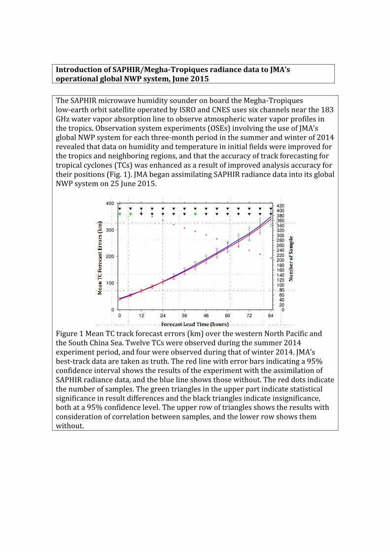
The SAPHIR microwave humidity sounder on board the Megha-Tropiques low-earth orbit satellite operated by ISRO and CNES uses six channels near the 183 GHz water vapor absorption line to observe atmospheric water vapor profiles in the tropics. Observation system experiments (OSEs) involving the use of JMA’s global NWP system for each three-month period in the summer and winter of 2014 revealed that data on humidity and temperature in initial fields were improved for the tropics and neighboring regions, and that the accuracy of track forecasting for tropical cyclones (TCs) was enhanced as a result of improved analysis accuracy for their positions (Fig. 1). JMA began assimilating SAPHIR radiance data into its global NWP system on 25 June 2015.
Figure 1 Mean TC track forecast errors (km) over the western North Pacific and the South China Sea. Twelve TCs were observed during the summer 2014 experiment period, and four were observed during that of winter 2014. JMA’s best-track data are taken as truth. The red line with error bars indicating a 95% confidence interval shows the results of the experiment with the assimilation of SAPHIR radiance data, and the blue line shows those without. The red dots indicate the number of samples. The green triangles in the upper part indicate statistical significance in result differences and the black triangles indicate insignificance, both at a 95% confidence level. The upper row of triangles shows the results with consideration of correlation between samples, and the lower row shows them without.

Summary Table of relevant KRAs and components (please tick boxes, can be more
than one, as appropriate):
KRA = 1 2 3 4 5 6 7
Meteorology ✓
✓ ✓ ✓
Hydrology
DRR
Training and research
Resource mobilization or regional collaboration
Member: Japan Name of contact
for this item: Hisaki Eito
Telephone: +81‐3‐3211‐8408
Email: [email protected]

Initiation of Himawari-8 operation on 7 July 2015
The Himawari-8 geostationary meteorological satellite managed by the Japan Meteorological Agency (JMA) began operation at 02 UTC on 7 July 2015, replacing the previous MTSAT-2 operational satellite. The first operational true-color composite imagery captured three typhoons in the Pacific.
Himawari-8 is the world’s first new-generation geostationary meteorological satellite. Its number of bands, time interval and spatial resolution are dramatically improved over those of the previous generation. These significant enhancements are expected to contribute even more to the prevention and mitigation of weather-related disasters in the East Asia and Western Pacific regions.
JMA has introduced two new services for the provision of Himawari-8 imagery. One is the HimawariCast service, by which primary sets of imagery are disseminated for operational meteorological services via communication satellite. The other is the HimawariCloud service, by which full sets of imagery are delivered to National Meteorological and Hydrological Services (NMHSs) via an Internet cloud service. JMA also continuously provides Himawari-8 imagery in SATAID format via the WIS/GISC Tokyo server with its automatic downloader. Updates are posted on the following website, which also provides sample data and sample source code for reading Himawari-8 imagery: http://www.jma-net.go.jp/msc/en/support/

Summary Table of relevant KRAs and components (please tick boxes, can be more than one, as appropriate):
KRA = 1 2 3 4 5 6 7
Meteorology
✓
Hydrology
✓
DRR
✓
Training and research
Resource mobilization or regional collaboration
Member: Japan Name of contact
for this item: Yasushi Izumikawa
Telephone:
+81 3 3212 8341
Email: [email protected]
TCC products and publications related to tropical cyclones
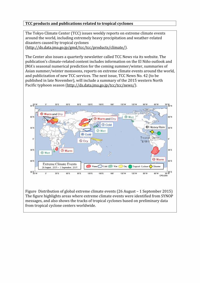
The Tokyo Climate Center (TCC) issues weekly reports on extreme climate events around the world, including extremely heavy precipitation and weather-related disasters caused by tropical cyclones (http://ds.data.jma.go.jp/gmd/tcc/tcc/products/climate/).
The Center also issues a quarterly newsletter called TCC News via its website. The publication’s climate-related content includes information on the El Niño outlook and JMA’s seasonal numerical prediction for the coming summer/winter, summaries of Asian summer/winter monsoons, reports on extreme climate events around the world, and publicization of new TCC services. The next issue, TCC News No. 42 (to be published in late November), will include a summary of the 2015 western North Pacific typhoon season (http://ds.data.jma.go.jp/tcc/tcc/news/).
Figure Distribution of global extreme climate events (26 August – 1 September 2015) The figure highlights areas where extreme climate events were identified from SYNOP messages, and also shows the tracks of tropical cyclones based on preliminary data from tropical cyclone centers worldwide.
Summary Table of relevant KRAs and components (please tick boxes, can be more than one, as appropriate):
KRA = 1 2 3 4 5 6 7
Meteorology ✓
✓
✓
✓
Hydrology
DRR
Training and research
Resource mobilization or regional collaboration
Member: Japan
Name of contact for this item:
Ayako Takeuchi
Telephone: +81-3-3212-8341 (Ext. 3157)
Email: [email protected]

Evaluation of the accuracy of tropical cyclone intensity estimation using single ground-based Doppler radar observation
MRI/JMA developed a new system for estimating the intensity (central pressure) of tropical cyclones (TCs) using single ground-based Doppler radar observation. The method involves the use of the ground-based velocity track display (GBVTD) technique (Lee et al., 1999), in which tangential winds are retrieved, and the gradient wind balance.
The intensities of 28 TCs that approached Japan were estimated, and the accuracy of the estimation method was evaluated. Compared with best-track data from RSMC Tokyo, the estimated intensities of the TCs had a root mean square error of 8.37 hPa and showed a bias of 1.51 hPa. This level of accuracy is comparable to or better than those of Dvorak and satellite microwave-derived estimates. The results confirm that Doppler radar intensity estimates have sufficient accuracy and utility for operational use.
References Lee, W.-C., B. J.-D. Jou, P.-L. Chang and S.-M. Deng, 1999: Tropical cyclone kinematic structure retrieved from single-Doppler radar observations. Part I: Interpretation of Doppler velocity patterns and the GBVTD technique. Mon. Wea. Rev., 127, 2419 – 2439.
Summary Table of relevant KRAs and components (please tick boxes, can be more than one, as appropriate):
KRA = 1 2 3 4 5 6 7
Meteorology ✓ ✓ ✓ ✓
Hydrology
DRR
Training and research
Resource mobilization or regional collaboration
Member: Japan Name of contact
for this item: Udai Shimada
Telephone: +81-29-853-8672
Email: [email protected]