Embed Size (px)
Citation preview
January 2015 – v 2.0(Revised Feb. 2016)

Page intentionally left blank.
Contents
NHDOT Bridge Design Manual v2.0 Page vi
January 2015
Chapter 3 Preliminary Design 3.1 Preliminary Design Requirements 3.1-1 3.1.1 Design Requirements 3.1-1 3.1.2 Preliminary Costs Estimate 3.1-1 3.1.3 Approvals 3.1-2 3.1.4 Preliminary Geotechnical Design Recommendations 3.1-2 3.1.5 Preliminary Maintenance of Traffic Plan 3.1-3 3.2 Preliminary Plans 3.2-1 3.2.1 Format 3.2-1 3.3 Permits 3.3-1 3.3.1 Environmental Permits 3.3-1 3.3.2 Wetlands Permit Plan and Application 3.3-3 3.4 Roadway Design Guidelines 3.4-1 3.5 Right-of-Way Purchase Plans 3.5-1 References 3.R-1 Appendix A Appendix 3.2-A1 Preliminary Plan Checklist 3.2-A1-1 Appendix 3.3-A1 NHDOT Permit Flowchart 3.3-A1-1 Appendix 3.3-A2 Introduction to Coast Guard Bridge Permitting 3.3-A2-1 Appendix B Appendix 3.2-B1 Sample Preliminary Plans 3.2-B1-1 Appendix 3.3-B1 Sample Bridge Wetland Impact Plan 3.3-B1-1

Page intentionally left blank.
Chapter 3 Preliminary Design
Chapter 3 Preliminary Design
3.1 Preliminary Design Requirements
3.1.1 Design Requirements
The Preliminary Plan preparation stage is the most important phase of bridge design because it is the basis for the final design by “locking in” the design. The Preliminary Plan should completely define the bridge geometry and concepts so the final bridge and roadway design can proceed with minimal revisions.
At the Preliminary Plan stage, the tasks required to prepare contract documents for bids are at approximately 40-50% of the Project Development process (see Chapter 1, Section 1.4.3 Project Development Tasks, for further information regarding the Preliminary Plan stage tasks).
It is not necessary at the Preliminary Design stage to complete all calculations necessary to produce contract plans, but main design concerns need to be given careful thought in order to assure that the design concept can progress to a completed project. For example, if clearance above the design flood is a concern, girder height calculations should be performed and deflections should be checked.
Preliminary design involves evaluating many bridge features, including the elements of the bridge (foundations, abutments, piers, girders, bearings, and expansion joints), materials (concrete, steel) and geometrics (clearances, structure depth, structure width, span lengths). The designer must evaluate each feature to identify the most appropriate selection.
Foundation concerns should be resolved at this time. A decision should be made between options such as the use of spread footings or piles, and integral or stub abutments. Soil limitations, site characteristics, and engineering judgment will all be necessary in determining the substructure configuration. The substructure concept should be investigated sufficiently to assure that the concept is viable.
The Preliminary Plan design should include the following: • Finalized bridge geometry. • Substructure concept. • Superstructure concept. • Site Plan (A site plan to scale showing the wing layout, curbs and sidewalks, and
limits of stone, and all existing contours to show how the proposed bridge and required grading will blend with the existing ground.)
3.1.2 Preliminary Costs Estimate
A preliminary cost estimate should be developed when the bridge type, foundation type, deck area and adjacent retaining wall types are determined. At the preliminary stage, the cost estimate is based on recent bidding history of similar structures, degree of difficulty of construction, inflation trends, and time for completion of construction. It should be accurate enough to preclude an unexpected increase at the time of the PS&E estimate, which is based on completed design quantities. The preliminary cost estimate shall be updated as changes are made to the preliminary plan or new data influences the costs.
NHDOT Bridge Design Manual v2.0 Page 3.1-1 January 2015
Chapter 3 Preliminary Design
The Preliminary Estimate (Modified Project Agreement) is the second estimate processed to update the funds authorized for Preliminary Engineering, Right-of-Way and the funds programmed for Construction. The estimate is created and routed in STYP-RMS.
3.1.3 Approvals
Preliminary Design is that part of the design/plan development process between the Hearing (Finding of Necessity) and approval from the Bridge Administrator and Commissioner’s Office to move forward with final design. If the project includes Federal oversight, approval from FHWA is also required.
Once approval of the Preliminary Plans is obtained, the Preliminary Plans become a record and shall be stored electronically as .pdf and .dgn files. The electronic plans shall be hard copied and placed in a separate Preliminary Plan folder in the BRC folder on the N:\ drive.
If Highway Design initiates the project, the Preliminary Plan submittal cannot be approved until Highway Design’s “Slope and Drain” submission is approved, which “locks in” the horizontal and vertical alignments.
The lead Bureau (Highway Design or Bridge Design) will set up meetings with the Cultural and Natural Resource Agencies through the Project Environmental Manager. If the project is initiated by Bridge Design, the Senior Project Engineer will set up the meetings.
• The meeting with the Cultural Resource Agencies typically includes the State Historic Preservation Office (SHPO), FHWA, and the Army Corps of Engineers (ACOE). At this meeting, the project shall be presented noting any historic impacts. All Cultural Resource Agencies must “sign-off” on the project prior to meeting with the Natural Resource Agencies.
• The meeting with the Natural Resource Agencies typically includes FHWA, ACOE, the Environmental Protection Agency (EPA), NH Department of Environmental Services (NHDES), US Fish and Wildlife Service (USFWS) and NH Fish and Game (NHFG). At this meeting, the project shall be presented noting all environmental impacts (permanent and temporary).
3.1.4 Preliminary Geotechnical Design Recommendations
The preliminary geotechnical design recommendations provide general recommendations based on existing soil information and any preliminary subsurface investigation that may have been conducted for the project. These general geotechnical recommendations are used to select the bridge foundation and initiate the preliminary structure design. The geotechnical recommendations are used in conjunction with the input of the Hydraulic Study (as applicable) to establish support locations. Prior to beginning work on preliminary bridge design, the bridge designer will review the preliminary geotechnical design recommendations to gain knowledge of the anticipated soil conditions at the bridge site and the recommended general foundation types.
The preliminary geotechnical design recommendations provide a preliminary footing elevation and an expected nominal and ultimate bearing pressure when spread footings are recommended. For deep foundations, the recommendations will include the use of driven piles or drilled shafts. Driven piles will include pile geotechnical driving resistance and type. This preliminary geotechnical information is used to estimate sizes of foundation members and prepare the preliminary design of the bridge.
NHDOT Bridge Design Manual v2.0 Page 3.1-2 January 2015
Chapter 3 Preliminary Design
3.1.5 Preliminary Maintenance of Traffic Plan
Due to the proximity of existing structures or a congested work area, it may be necessary to build a structure in multiple phases. The arrangement and sequencing of each phase of construction is unique to each project, and the bridge designer must consider the requirements for adequate construction clearances and the requirements of the traveling public. If phase construction is required, then a staging sequence and controlling lane/construction dimensions must be shown in the contract documents.
The various components of the bridge phase construction shall match those of the approach roadway, and the nomenclature used to identify the various stages (phases) of construction shall be the same for the roadway and the bridge (e.g., Phase 1 and Phase 2).
Designers shall evaluate Accelerated Bridge Construction (ABC) techniques to mitigate negative impacts to the traveling public. Additional information regarding ABC techniques is available on FHWA’s Accelerated Bridge Construction Website: http://www.fhwa.dot.gov/bridge/abc/ .
The Preliminary Maintenance of Traffic Plan shall include a cross section(s) defining all phases of removal and construction. The following information should be provided:
• The existing superstructure and substructure layout with overall dimensions (field verified).• Type of temporary railing or barrier.• Proposed temporary lane widths, measured as the clear distance between temporary barriers.
o A temporary single lane width of 11’-0” [3350-mm] or greater is preferred.o Minimum temporary lane widths (typically 14-ft. ) may be required by the Traffic
Control Committee and NETC (New England Transportation Consortium) MultistatePermit Routes (see the NETC map located at:http://www.nh.gov/dot/org/operations/highwaymaintenance/overhaul/documents/netcmultistatepermitroutes.pdf)
o The designer should ensure that lane and lateral clearance requirements are satisfied foreach construction phase of the project.
o A closure pour may be required for some situations such as large deflections, wide decks,long flexible girders that can twist or if the difference in elevation between deck phasingjoints is ≥ 1-in (25-mm).
• Location of phase construction cut lines. The existing structure should be evaluated todetermine where the cutline can be placed to provide structural adequacy.o Cut lines through substructure should be carefully evaluated to maintain structural
integrity through staged removals.o Temporary shoring may be required and should be considered.
• Temporary modifications to superelevated sections (existing and/or proposed) on the deckand/or shoulder in order to accommodate the traffic from the phase construction.
• Profile grade, alignment, and approximate location and width of temporary structures.• Location of temporary shoring.
NHDOT Bridge Design Manual v2.0 Page 3.1-3 January 2015

Chapter 3 Preliminary Design
Page intentionally left blank.
NHDOT Bridge Design Manual v2.0 Page 3.1-4 January 2015
Chapter 3 Preliminary Design
3.2 Preliminary Plans
3.2.1 Format
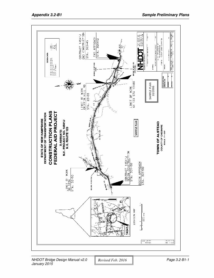
The Preliminary Plans should include the following: (See Appendix 3.2-A1 for Preliminary Plan Checklist and Appendix 3.2-B1 for Sample Preliminary Plans)
1. Front Sheet: Project Titles Location Map Approval Signature Box Traffic Data Project Layout with bridge number noted.
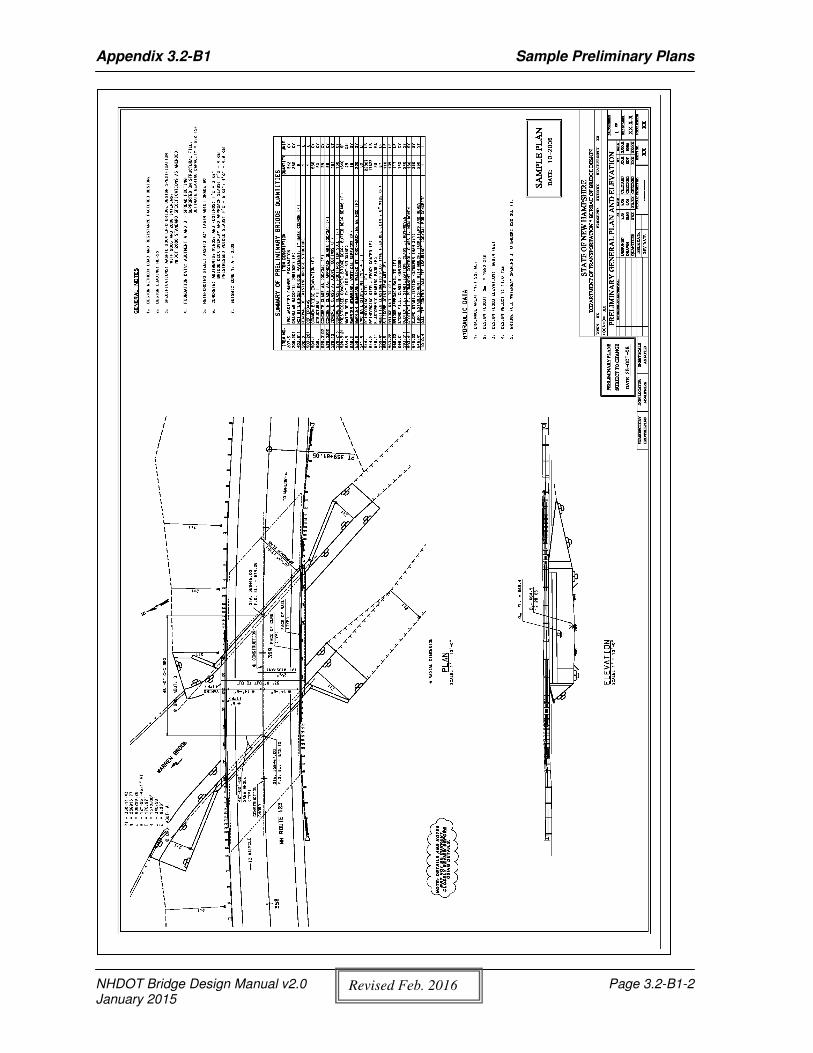
2. General Plan and Elevation: Bridge General Plan & Elevation General Notes Hydraulic Data
3. Site Plan and Profile: Profiles of upper and lower roadways (or channel) Typical approach cross sections for the upper and lower roadways (or channel) Typical cross sections for lower roadway (or channel) and as modified for the bridge
proximity Utilities data as applicable Site Plan (proposed stone layout and slopes, slope indicators, detour bridge, existing
contours, curve data, outline of existing and proposed bridge substructures, route andchannel names, north arrow, proposed alignment and stations, and roadwayundercrossing clearance)
Deck section (if space available, otherwise put on separate sheet)
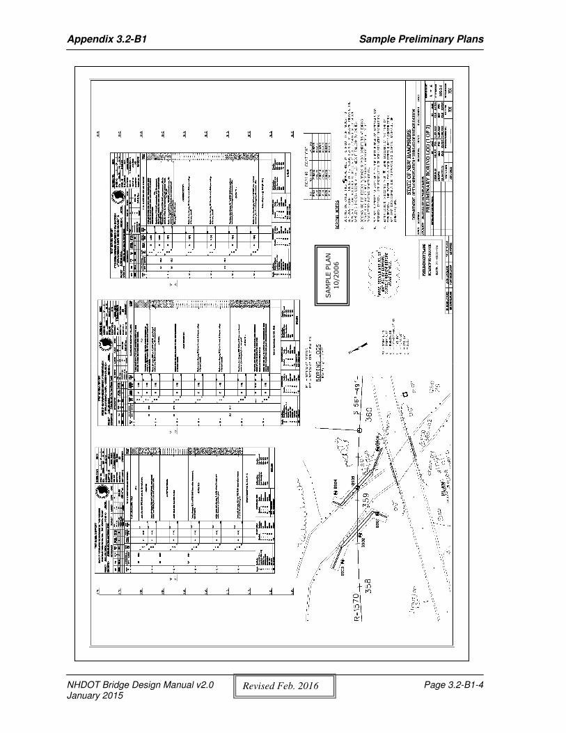
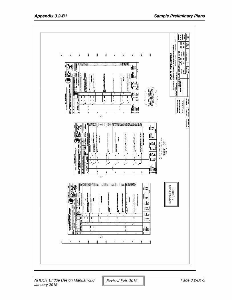
4. Boring Log: Boring Logs Boring Layout Plan and Locations Boring Notes
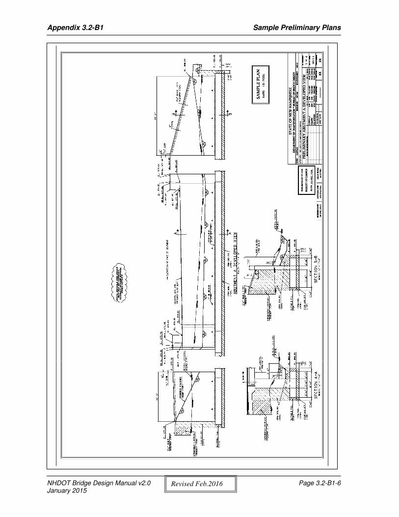
5. Abutment and Pier Developed View: Developed abutment, wingwall, and pier elevations, and other details as required.
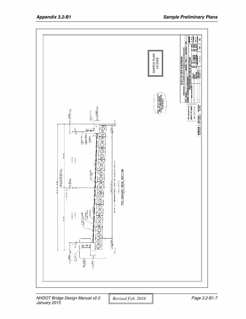
6. Deck Section: Preliminary deck section of bridge (if doesn’t fit on Site Plan sheet)
7. Roadway Sheets: Detail plan Profile Cross-sections
*
* Include only if required for Bridge Design leadprojects with roadway approach work.
NHDOT Bridge Design Manual v2.0 Page 3.2-1 January 2015
Chapter 3 Preliminary Design
Copies of the Preliminary Plans shall be sent to the other Bureaus for review and comment. Note on the transmittal letter the date you would like comments back (approximately 2 weeks) and the proposed advertising date.
The Preliminary Plans shall be sent to the following agencies and bureaus as appropriate: FHWA (Include preliminary estimate, hydraulic report and geotechnical report. If an
exempt project, only send plans for interstate roads.) Highway Design Design Services Construction Bridge Maintenance Materials and Research Neighboring State (if in a border town) District Engineer Turnpikes (if located on/over Turnpike) Traffic
NHDOT Bridge Design Manual v2.0 Page 3.2-2 January 2015
Chapter 3 Preliminary Design
3.3 Permits
3.3.1 Environmental Permits
The NH Wetlands Permit process is required when wetlands or surface waters are impacted by a proposed project. Delineation and classification of wetlands is the responsibility of the Bureau of Environment. The Senior Project Engineer shall coordinate with the Bureau of Environment, Bureau of Highway Design, and Bureau of Construction to review the proposed areas of impact prior to submission to the Wetlands Bureau. See Appendix 3.3-A1 for a NHDOT Permit Flowchart.
A deck rehabilitation/replacement project does not require a Wetlands Permit, if construction access is not allowed under the bridge, no scaffolding or temporary falsework will be used under the bridge, and there is no work is to be done on abutments or piers located in the water. A note shall be placed on the plans requiring the Contractor to remove any construction debris from the water with no disturbance to the riverbed. If the Contractor’s method of work involves impacts, the Contractor shall obtain a Wetlands Permit.
At the beginning of the project, the “Orange Sheet”, “Request for Stream Crossing Assessment”, and “Green Sheet” forms are sent to the Environmental Project Manager as noted in Chapter 1, Section 1.4.3. The designer shall be communicating with the Environmental Project Manager from the beginning of the project through the permitting.
The Bureau that initiates the project (Highway Design or Bridge Design) will be preparing the necessary documents to obtain the required permits. For guidelines to prepare the permits, see the following:
• Highway Design Manual, Chapter 2 Appendix 2-14, Wetland Plans Check List• Highway Design Manual, Chapter 2 Appendix 2-15• New Hampshire Department of Transportation Permit Process Manual for NH Wetlands
Bureau Permit• Bureau of Environment website:
Listed below are the permits that may be required on a project:
1. NH Wetlands Permit:A NH Wetlands permit is required when wetlands or surface waters are impacted by aproposed project.• Prior to submitting a Wetlands Permit Application, the project impacts must be
reviewed at the monthly Natural Resource Agency meetings hosted by the Bureau ofEnvironment.
• Allow at least 6 months from the time the application is submitted to the advertisingdate. (for large projects allow more than 6 months.)
• If debris such as trees, brush, or other obstructions to the stream flow are in thestreambed upstream or downstream of the bridge, the wetland permit should includethis area as a temporary impact for clearing of the debris.
2. US Army Corps of Engineers Permit:A US Army Corps of Engineers (ACOE) permit is required for projects that impact wetlandsor surface waters (river or stream banks below ordinary high water).
There are two US ACOE permit types:
NHDOT Bridge Design Manual v2.0 Page 3.3-1 January 2015
Chapter 3 Preliminary Design
a) State Program General Permit (SPGP): • Minimum Impact - The SPGP is automatically obtained with the issuance of the NH
Wetlands Permit. • Minor Impact - A 30 day wait is required after issuance of the NH Wetlands Permit.
After 30 days the project may proceed. (written approval may or may not be received).
• Major Impact - The project must receive written approval of the SPGP before construction can begin.
Specific criteria for the 3 impact levels of the SPGP (e.g. length of affected shoreline and impacted area) are listed in the New Hampshire Department of Transportation Permit Process Manual for NH Wetlands Bureau Permit.
b) Individual ACOE Permit is required when: • More than 3 acres of wetland or surface water are impacted. • Construction work is below ordinary high water on a wild and scenic river or wild
and scenic study river. • Construction work in tidal waters. • The Army Corps of Engineers requires an individual permit. Coordinate with the
Bureau of Environment when preparing plans for an individual permit.
3. Shoreland Permit: A Shoreland permit is required when the project is within 250-ft. of a protected lake, pond, tidal water, or fourth-order or greater stream.
• The DES list of designated waterbodies subject to the Shoreland Water Quality Protection Act can be found at: http://des.nh.gov/organization/divisions/water/wetlands/cspa/water_bodies.htm
• If a Shoreland Permit is required, a Shoreland Impact Plan needs to be included. See DES website for further information at: http://des.nh.gov/organization/divisions/water/wetlands/cspa/index.htm
4. Water Quality Certification: • For SPGP, a water quality permit is automatically obtained. • For individual ACOE permits, a water quality certification must be requested.
(Coordinate with the Bureau of Environment to obtain a water quality certificate. Allow approximately 2 weeks to obtain.)
5. Coastal Zone Management: A Coastal Zone Consistency finding is necessary for federally funded projects that require an individual ACOE permit or a Coast Guard Permit. Coastal Zone Consistency should be coordinated through the Bureau of Environment. The process may require 6 months to complete.
The following is required: • Environmental Study • NH Wetlands Permit
NHDOT Bridge Design Manual v2.0 Page 3.3-2 January 2015
Chapter 3 Preliminary Design
• Water quality Certificate• Army Corps of Engineers Permit Application
6. US Coast Guard Permit:Required for impacts to all navigable waters. When FHWA Bridge Program Funds are used,a USCG permit shall not be required if the FHWA determines that the proposed construction,reconstruction, rehabilitation, or replacement of the federally aided or assisted bridge is overwaters:
• Which are not to be used or are not susceptible to use in their natural condition or byreasonable improvement as a means to transport interstate or foreign commerce; and
• Which are (a) not tidal, or (b) if tidal, used only by recreational boating, fishing, andother small vessels less than 21 feet in length.
The Bureau of Environment maintains a list of rivers that are generally considered to require a USCG permit. If a dam exists between the subject bridge and the ocean then FHWA typically does not consider the river to be navigable.
The following is required: • Wetlands Bureau Permit• Coastal Zone Consistency findings
Coordination with the Coast Guard through the Bureau of Environment should be initiated as soon as potential impacts are known. The process may require one to two years to complete. See Appendix 3.3-A2 for Introduction to Coast Guard Bridge Permitting.
3.3.2 Wetlands Permit Plan and Application
The Wetlands Permit Plan and application should be submitted to the Bureau of Environment Project Manager and should include the following (forms are located at: Bureau of Environment website or G:\BUR16\WETLANDS):
Checklist for NHDES Standard Dredge & Fill Permit Applications NH Wetlands Permit Application Intra-Department Project Informational Form Standard Dredge and Fill Application Location map USGS map with designated project area Pictures Part WT 404 Criteria For Shoreline Stabilization Form 20 Questions Form SPGP Appendix B Copy of specifications for the shoreline stabilization used.
(e.g., Item 583.x, Riprap, Section 583; Item 585.x, Stone Fill, Section 585) Wetlands Impact Plan
(See Highway Design Manual, Chapter 2 Appendix 2-14, Wetland Plans Check List, and Appendix 2-15, and Bridge Design Manual, Chapter 3, Appendix 3.3-B1) • Front Sheet
NHDOT Bridge Design Manual v2.0 Page 3.3-3 January 2015

Chapter 3 Preliminary Design
o A PE stamp is required when the wetland impacts involve a total riprap length > 100 linear ft. (30.5-m) per Admin. Rule Env-Wt 404.04(e).
• Standard Symbol Sheets • Wetland Impact Plan • Shoreland Impact Plan (if required)
NHDOT Bridge Design Manual v2.0 Page 3.3-4 January 2015
Chapter 3 Preliminary Design
3.4 Roadway Design Guidelines
If the Bureau of Bridge Design initiates the project and minimal approach work is required, the Bureau of Bridge Design will undertake the design of the roadway approaches to the bridge. The designer shall refer to the NHDOT Highway Design Manual, AASHTO A Policy on Geometric Design of Highways and Streets and AASHTO Roadside Design Guide for reference.
NHDOT Bridge Design Manual v2.0 Page 3.4-1 January 2015

Chapter 3 Preliminary Design
Page intentionally left blank.
NHDOT Bridge Design Manual v2.0 Page 3.4-2 January 2015
Chapter 3 Preliminary Design
3.5 Right-of-Way Purchase Plans The Bureau that initiates the project (Highway Design or Bridge Design) will develop the Right-of-Way (ROW) Purchase Plans.
ROW Purchase Plans are not included with the construction plans; they are a separate set of plans used only to appraise, acquire and record the right-of-way needed for the project. ROW Purchase Plans show the required easements and right-of-way needed for the construction of the project. The Bureau of ROW uses the purchase plans to communicate and negotiate with property owners, and to appraise the areas of take.
The following is additional information on developing the Right-of-Way Purchase Plans:
• See Highway Design Manual, Chapter 10, “Right-of-Way”, for additional information and the Right-of-Way Purchase Plans Check List: http://www.nh.gov/dot/org/projectdevelopment/highwaydesign/designmanual/index.htm
• Send a number of copies of ROW Purchase Plans to the Bureau of ROW equal to the number of property owners in the project limits. The ROW Purchase Plans should be sent to: Right-of-Way Engineer, Bureau of Right-of-Way
• Contact the Bureau of Highway Design and Bureau of ROW for the most recent method used for developing ROW Purchase Plans.
NHDOT Bridge Design Manual v2.0 Page 3.5-1 January 2015

Chapter 3 Preliminary Design
Page intentionally left blank.
NHDOT Bridge Design Manual v2.0 Page 3.5-2 January 2015
Chapter 3 Preliminary Design
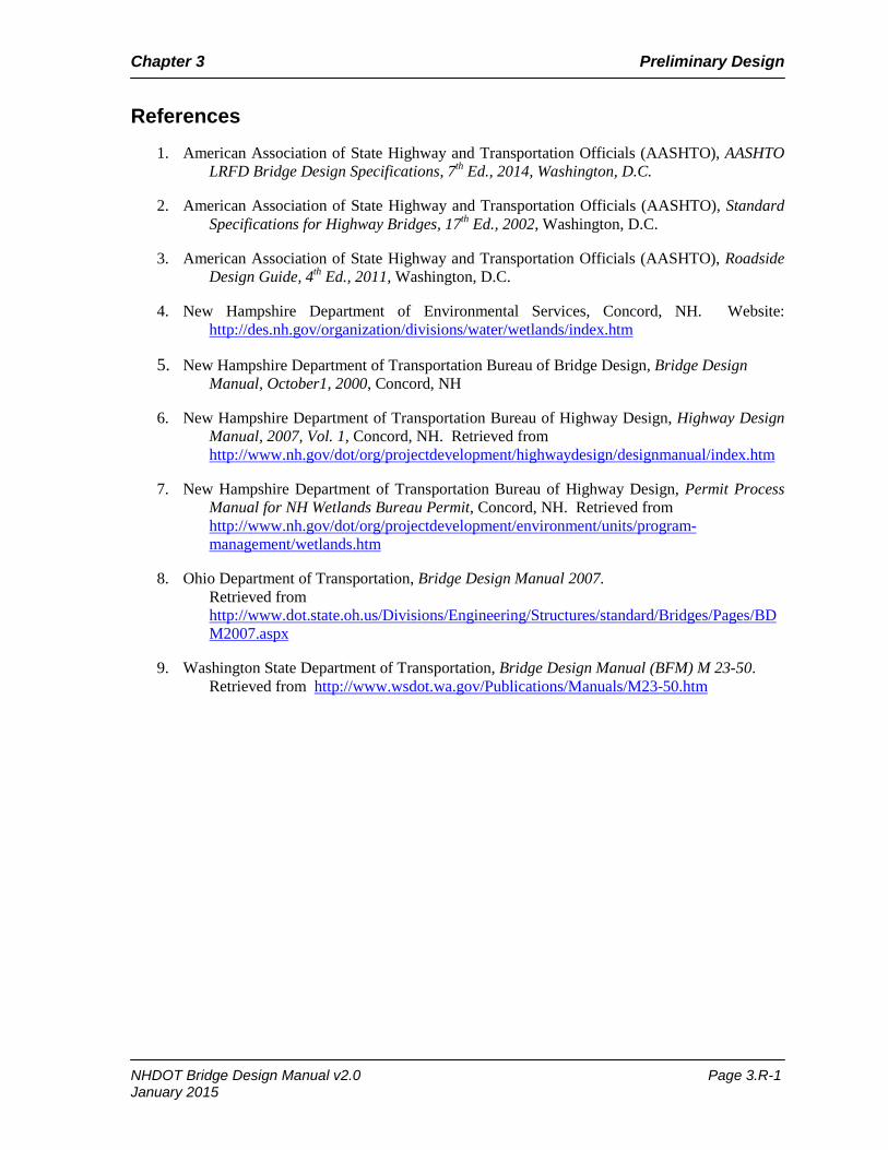
References 1. American Association of State Highway and Transportation Officials (AASHTO), AASHTO
LRFD Bridge Design Specifications, 7th Ed., 2014, Washington, D.C.
2. American Association of State Highway and Transportation Officials (AASHTO), Standard Specifications for Highway Bridges, 17th Ed., 2002, Washington, D.C.
3. American Association of State Highway and Transportation Officials (AASHTO), Roadside Design Guide, 4th Ed., 2011, Washington, D.C.
4. New Hampshire Department of Environmental Services, Concord, NH. Website: http://des.nh.gov/organization/divisions/water/wetlands/index.htm
5. New Hampshire Department of Transportation Bureau of Bridge Design, Bridge Design Manual, October1, 2000, Concord, NH
6. New Hampshire Department of Transportation Bureau of Highway Design, Highway Design Manual, 2007, Vol. 1, Concord, NH. Retrieved from http://www.nh.gov/dot/org/projectdevelopment/highwaydesign/designmanual/index.htm
7. New Hampshire Department of Transportation Bureau of Highway Design, Permit Process Manual for NH Wetlands Bureau Permit, Concord, NH. Retrieved from http://www.nh.gov/dot/org/projectdevelopment/environment/units/program-management/wetlands.htm
8. Ohio Department of Transportation, Bridge Design Manual 2007. Retrieved from http://www.dot.state.oh.us/Divisions/Engineering/Structures/standard/Bridges/Pages/BDM2007.aspx
9. Washington State Department of Transportation, Bridge Design Manual (BFM) M 23-50. Retrieved from http://www.wsdot.wa.gov/Publications/Manuals/M23-50.htm
NHDOT Bridge Design Manual v2.0 Page 3.R-1 January 2015

Chapter 3 Preliminary Design
Page intentionally left blank.
NHDOT Bridge Design Manual v2.0 Page 3.R-2 January 2015
January 2015 – v 2.0(Revised Feb. 2016)

Page intentionally left blank.
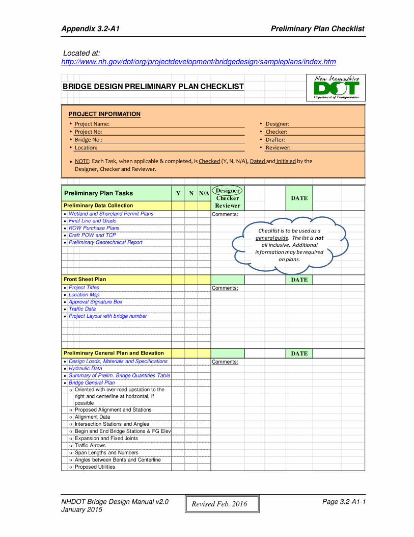
Appendix 3.2-A1 Preliminary Plan Checklist
NHDOT Bridge Design Manual v2.0 Page 3.2-A1-1 January 2015
Revis ed Feb. 2016
Located at: http://www.nh.gov/dot/org/projectdevelopment/bridgedesign/sampleplans/index.htm
BRIDGE DESIGN PRELIMINARY PLAN CHECKLIST
PROJECT INFORMATION
� Project Name: � Designer:
� Project No: � Checker:
� Bridge No.: � Drafter:
� Location: � Reviewer:
� NOTE: Each Task, when applicable & completed, is Checked (Y, N, N/A), Dated and Initialed by the
Designer, Checker and Reviewer.
Preliminary Plan Tasks Y N N/A
Preliminary Data Collection
� Wetland and Shoreland Permit Plans Comments:
� Final Line and Grade
� ROW Purchase Plans
� Draft POW and TCP
� Preliminary Geotechnical Report
Front Sheet Plan DATE
� Project Titles Comments:
� Location Map
� Approval Signature Box
� Traffic Data
� Project Layout with bridge number
Preliminary General Plan and Elevation DATE
� Design Loads, Materials and Specifications Comments:
� Hydraulic Data
� Summary of Prelim. Bridge Quantities Table
� Bridge General Plan
�
� Proposed Alignment and Stations
� Alignment Data
� Intersection Stations and Angles
� Begin and End Bridge Stations & FG Elev
� Expansion and Fixed Joints
� Traffic Arrows
� Span Lengths and Numbers
� Angles between Bents and Centerline
� Proposed Utilities
Designer
Checker
Reviewer
DATE
Oriented with over-road upstation to the
right and centerline at horizontal, if
possible
Checklist is to be used as a
general guide. The list is not
all inclusive. Additional
information may be required
on plans.
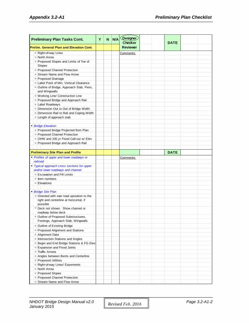
Appendix 3.2-A1 Preliminary Plan Checklist
NHDOT Bridge Design Manual v2.0 Page 3.2-A1-2 January 2015 Revis ed Feb. 2016
Preliminary Plan Tasks Cont. Y N N/A
Prelim. General Plan and Elevation Cont. Right-of-way Lines Comments: North Arrow
Proposed Channel Protection Stream Name and Flow Arrow Proposed Drainage Label Point of Min. Vertical Clearance
Working Line/ Construction Line
Label Roadways Dimension Out to Out of Bridge Width Dimension Rail to Rail and Coping Width Length of approach slab
Bridge Elevation Proposed Bridge Projected from Plan Proposed Channel Protection OHW and 100 yr Flood Call-out w/ Elev Proposed Bridge and Approach Rail
Preliminary Site Plan and Profile DATE Comments:
Excavation and Fill Limits Item numbers Elevations
Bridge Site Plan
Outline of Existing Bridge Proposed Alignment and Stations Alignment Data Intersection Stations and Angles Begin and End Bridge Stations & FG Elev Expansion and Fixed Joints Traffic Arrows Angles between Bents and Centerline Proposed Utilities Right-of-way Lines/ Easements North Arrow Proposed Slopes Proposed Channel Protection Stream Name and Flow Arrow
Outline of Bridge, Approach Slab, Piers, and Wingwalls
Oriented with over road upstation to the right and centerline at horizontal, if possibleDeck not shown. Show channel or roadway below deck
Profiles of upper and lower roadways or railroad
Designer Checker Reviewer
DATE
Proposed Bridge and Approach Rail
Proposed Slopes and Limits of Toe of Slopes
Outline of Proposed Substructures, Footings, Approach Slab, Wingwalls
Typical approach cross sections for upper and/or lower roadways and channel
Appendix 3.2-A1 Preliminary Plan Checklist
NHDOT Bridge Design Manual v2.0 Page 3.2-A1-3 January 2015 Revis ed Feb. 2016
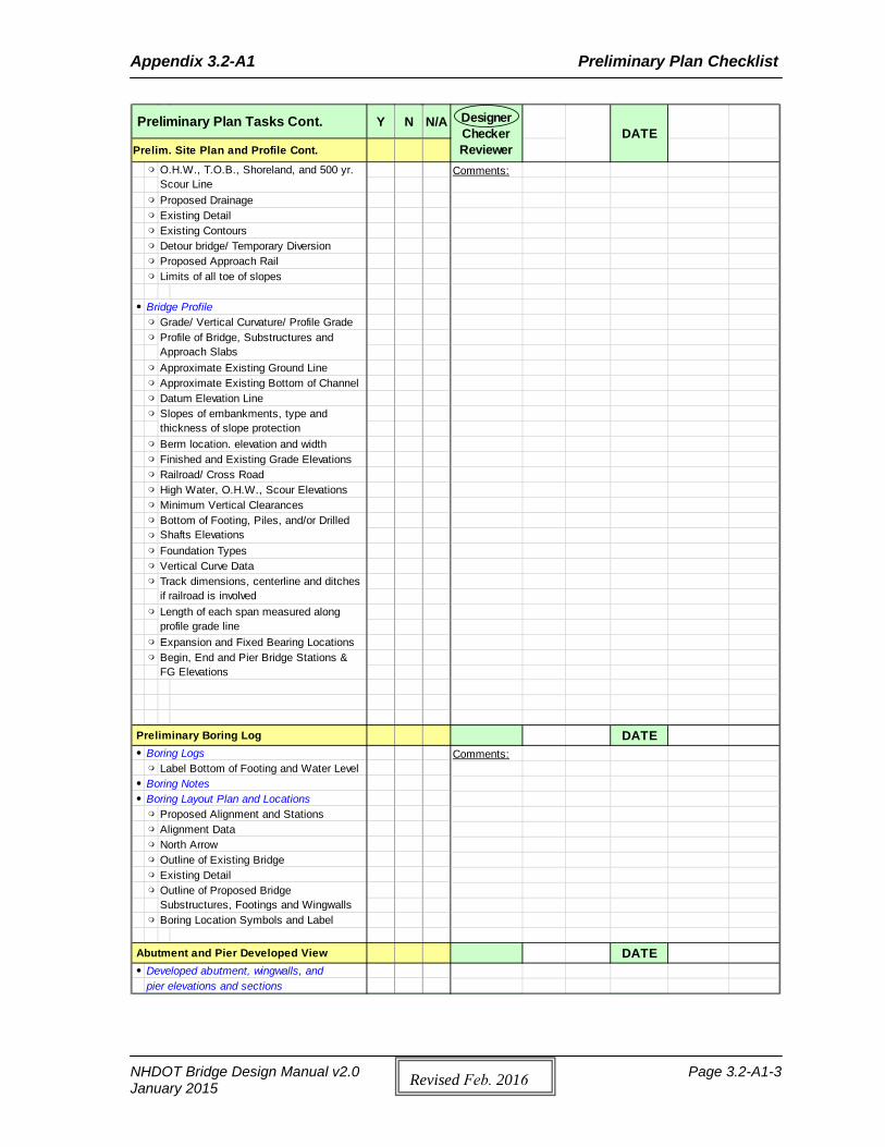
Preliminary Plan Tasks Cont. Y N N/A
Prelim. Site Plan and Profile Cont. Comments:
Proposed Drainage Existing Detail Existing Contours Detour bridge/ Temporary Diversion Proposed Approach Rail Limits of all toe of slopes
Bridge Profile Grade/ Vertical Curvature/ Profile Grade
Approximate Existing Ground Line Approximate Existing Bottom of Channel Datum Elevation Line
Finished and Existing Grade Elevations Railroad/ Cross Road High Water, O.H.W., Scour Elevations Minimum Vertical Clearances
Foundation Types Vertical Curve Data
Expansion and Fixed Bearing Locations
Preliminary Boring Log DATE Boring Logs Comments: Label Bottom of Footing and Water Level
Boring Notes Boring Layout Plan and Locations Proposed Alignment and Stations Alignment Data North Arrow Outline of Existing Bridge Existing Detail
Boring Location Symbols and Label
Abutment and Pier Developed View DATE Developed abutment, wingwalls, and
pier elevations and sections
Track dimensions, centerline and ditches if railroad is involvedLength of each span measured along profile grade line
Begin, End and Pier Bridge Stations & FG Elevations
Designer Checker Reviewer
DATE
Outline of Proposed Bridge Substructures, Footings and Wingwalls
Profile of Bridge, Substructures and Approach Slabs
Slopes of embankments, type and thickness of slope protection
Bottom of Footing, Piles, and/or Drilled Shafts Elevations
O.H.W., T.O.B., Shoreland, and 500 yr. Scour Line
Berm location. elevation and width
Appendix 3.2-A1 Preliminary Plan Checklist
NHDOT Bridge Design Manual v2.0 Page 3.2-A1-4 January 2015 Revis ed Feb. 2016
Preliminary Plan Tasks - Cont. Y N N/A
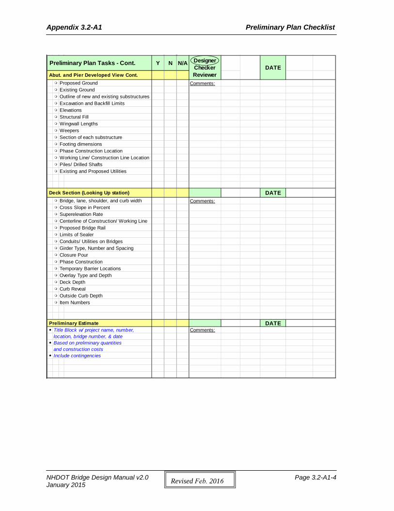
Abut. and Pier Developed View Cont. Proposed Ground Comments: Existing Ground Outline of new and existing substructures Excavation and Backfill Limits Elevations Structural Fill Wingwall Lengths Weepers Section of each substructure Footing dimensions Phase Construction Location Working Line/ Construction Line Location Piles/ Drilled Shafts Existing and Proposed Utilities
Deck Section (Looking Up station) DATE Bridge, lane, shoulder, and curb width Comments: Cross Slope in Percent Superelevation Rate Centerline of Construction/ Working Line Proposed Bridge Rail Limits of Sealer Conduits/ Utilities on Bridges Girder Type, Number and Spacing Closure Pour Phase Construction Temporary Barrier Locations Overlay Type and Depth Deck Depth Curb Reveal Outside Curb Depth Item Numbers
Preliminary Estimate DATE Title Block w/ project name, number, Comments:
location, bridge number, & date Based on preliminary quantities
and construction costs Include contingencies
DATEDesigner Checker Reviewer
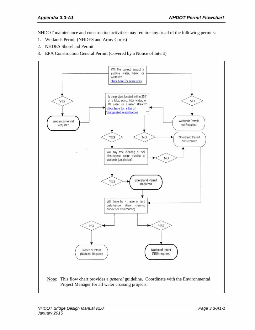
Appendix 3.3-A1 NHDOT Permit Flowchart
NHDOT maintenance and construction activities may require any or all of the following permits: 1. Wetlands Permit (NHDES and Army Corps)2. NHDES Shoreland Permit3. EPA Construction General Permit (Covered by a Notice of Intent)
Note: This flow chart provides a general guideline. Coordinate with the Environmental Project Manager for all water crossing projects.
click here for a list of designated waterbodies
click here for resources
NHDOT Bridge Design Manual v2.0 Page 3.3-A1-1 January 2015

Appendix 3.3-A1 NHDOT Permit Flowchart
Page intentionally left blank.
NHDOT Bridge Design Manual v2.0 Page 3.3-A1-2 January 2015

Appendix 3.3-A2 Intro to Coast Guard Bridge Permitting
INTRO TO COAST GUARD BRIDGE PERMITTING A. Who Must Apply for a Bridge Permit
1. Any individual, partnership, corporation, or local, state, or federal legislative body, agency,
or authority planning to construct or modify a bridge or causeway across a navigable waterway of the United States must apply for a Coast Guard bridge permit. This includes all temporary bridges used for construction access or traffic detour.
2. For bridges constructed by the state or municipal agencies, primary authority to apply for a
permit for the construction of a bridge project will be presumed without proof.
3. If state law does not require a license, primary authority may be granted in the charter of a corporation or the authority inherent in ownership of the land where the structure will be placed. In these cases, an extract from the charter and evidence of sufficient real estate interest to allow construction of the bridge should be submitted with the application. In such cases where the Coast Guard doubts the applicant’s ability to construct and utilize the bridge, particularly for a private bridge owner, proof of property rights must be furnished to the Coast Guard as part of the application.
4. Failure to obtain a bridge permit before commencing bridge construction or modification work
is a federal offense, punishable by civil and criminal penalties. B. Bridge Permit Application Guide
1. The Bridge Permit Application Guide assists the applicant in applying for a Coast Guard bridge
permit to:
a. Construct a new bridge or causeway, or
b. Reconstruct or modify an existing bridge or causeway across navigable waters of the United States.
2. The Bridge Permit Application Guide is located on the Bridge Program website:
http://www.uscg.mil/hq/cg5/cg551/. C. How the Coast Guard Can Help
1. The local Coast Guard District Bridge Office is one of the best sources of information for the
project. The applicant should direct all project-related questions, concerns, comments, and requests to the bridge program staff in the Coast Guard District Bridge Office where the project is located.
2. A map of the district boundaries is located at the end of this document so the applicant may
locate the Coast Guard District Bridge Office in the project area. 3. A list of the mailing addresses and telephone numbers of the Coast Guard District Bridge
Offices is located on the Bridge Program website: http://www.uscg.mil/hq/cg5/g551/. The responsibility for processing all bridge permit applications is at the District Commander organizational level.
NHDOT Bridge Design Manual v2.0 Page 3.3-A2-1 January 2015
Appendix 3.3-A2 Intro to Coast Guard Bridge Permitting
4. A glossary is also located on the Bridge Program website: http://www.uscg.mil/hq/cg5/g551/, providing explanations to many key terms involved in obtaining a Coast Guard bridge permit.
D. Requirements and Laws A bridge permit is the written approval of the location and plans of the
bridge or causeway to be constructed or modified. Federal law prohibits the construction of these structures unless the Coast Guard first authorizes them.
E. Coast Guard Bridge Permitting Authority
1. In 1967, the Coast Guard was transferred to the Department of Transportation. One of the
Coast Guard’s newly assigned duties was to issue bridge permits.
2. In 2002, the Coast Guard preserved its assigned duties under the Homeland Security Act of 2002 when transferred from the Department of Transportation to the Department of Homeland Security.
3. The Secretary of Homeland Security delegated this authority to the Commandant, U. S. Coast
Guard, on 28 February 2003, by Department of Homeland Security Delegation Number: 0170.1.
4. The Coast Guard approves bridge location and plans under the authority of several Acts
pertaining to bridges. F. Legislation Pertaining to Bridges
1. These Acts include Section 9 of the Rivers and Harbors Act of 1899 and the General
Bridge Act of 1946.
a. The purpose of these Acts is to preserve the public right of navigation and to prevent interference with interstate and foreign commerce. The General Bridge Act of 1946, as amended, the Rivers and Harbors Act of 1899, as amended, and the Act of March 23, 1906, as amended, all require the location and plans of bridges and causeways across the navigable waters of the United States be submitted to and approved by the Secretary of Homeland Security prior to construction. The General Bridge Act of 1946 is cited as the legislative authority for bridge construction in most cases.
b. These Acts placed the navigable waters of the United States under the exclusive control of
the U. S. Coast Guard to prevent any interference with their navigability by bridges or other obstructions except by express permission of the United States Government.
G. Bridge Program Policy
1. Under the previously mentioned Acts, the Coast Guard's mission is to administer the Bridge Program. The Coast Guard approves the location and plans of bridges and causeways and imposes any necessary conditions relating to the construction, maintenance, and operation of these bridges in the interest of public navigation.
2. The Coast Guard is also required by law to ensure environmental considerations are given
careful attention and importance in each bridge permitting decision.
3. As explained further in Section C of the Bridge Permit Application Guide, relevant NHDOT Bridge Design Manual v2.0 Page 3.3-A2-2 January 2015
Appendix 3.3-A2 Intro to Coast Guard Bridge Permitting
environmental statutes and executive orders for bridge project compliance include those listed in the Bridge Permit Application Guide.
4. The Coast Guard is obligated to consult with and obtain comments from any federal agency
with legal jurisdiction or special expertise concerning any environmental or navigational impact involved. Such comments are generally obtained through direct coordination with affected agencies, responses to the public notice, and the Local Notice to Mariners (LNM).
5. The Coast Guard Bridge Program protects the freedom of navigation and the quality of the
environment by taking a balanced approach to total transportation systems, both land and water modes, in all program actions.
6. The bridge statutes and subsequent court interpretations require bridges provide for the
reasonable needs of navigation, not for all the needs of navigation. The reasonable needs of land traffic must also be met.
7. Therefore, Coast Guard bridge permit actions consider the overall goals of the U.S. Department
of Homeland Security in a balanced manner to accommodate the needs of all modes of transportation.
8. Rules and regulations governing the U. S. Coast Guard bridge permit program are listed in
Parts 114 and 115 of Title 33, Code of Federal Regulations (CFR). A copy may be found in most local libraries, online at the U.S. Government Printing Office website or purchased from the Superintendent of Documents, U.S. Government Printing Office, Washington, DC 20401.
H. Navigable Waters
1. Navigable waters for Coast Guard bridge permitting purposes are defined by 33 CFR § 2.36,
unless specifically declared otherwise by Congress, to include:
a. Territorial seas of the United States;
b. Internal waters of the United States subject to tidal influence; and c. Internal waters of the United States not subject to tidal influence that:
1) Are or have been used, or are or have been susceptible for use, by themselves or in
connection with other waters, as highways for substantial interstate or foreign commerce, notwithstanding natural or man-made obstructions that require portage, or
2) A governmental or non-governmental body, having expertise in waterway
improvement, determines to be capable of improvement at a reasonable cost (a favorable balance between cost and need) to provide, by themselves or in connection with other waters, as highways for substantial interstate or foreign commerce.
2. If the applicant is uncertain whether or not a waterway is susceptible to improvement for
navigation, is tidal, or is considered navigable, contact the Coast Guard to obtain information regarding a navigability determination.
3. The classification of certain waterways or portions of waterways as navigable
occasionally changes, changing the information required for applicants.
NHDOT Bridge Design Manual v2.0 Page 3.3-A2-3 January 2015
Appendix 3.3-A2 Intro to Coast Guard Bridge Permitting
4. For these reasons, if an applicant is planning to construct a new bridge or causeway or modify
an existing bridge or causeway over a canal, channel, stream, river, lake, bay, or other body of water or waterway, they should contact the local Coast Guard District Bridge Office before submitting a formal permit application.
5. Additionally, due to the different characteristics of the waterways and navigation in each
District, needed information varies from one District to another. An applicant should contact the local District Office for applicability of requirements listed in the Bridge Permit Application Guide.
I. Temporary Bridges
1. Any proposed temporary bridge requires a bridge permit prior to construction. Follow the
same procedures and information requirements as for a permanent bridge.
2. A temporary bridge is often used during the construction of a permanent bridge. A request for the approval of this type of temporary bridge should be included in the application for the permanent bridge.
J. Time Limits for Construction
1. Based on the estimate given in the application, a reasonable period of time will be
allowed for the construction of the bridge project covered by the permit.
2. Coast Guard bridge permits specify that the permit becomes null and void unless construction of the bridge is commenced and completed by certain dates. This time period is usually three years and five years, respectively, from the date of the permit.
3. Longer construction times can be requested and substantiated with good reasons. The specified time should correspond to the actual time needed to complete construction, since a time extension may not be routinely granted.
4. If the authorized work is not completed within the time specified in the permit, the permit is null
and void. A new application and approval are required before construction work can continue.
5. However, if a written request for a time extension is submitted at least 30 days before the expiration date of the permit, the existing permit will remain in effect during processing. Work may continue until the final agency action is taken on the time extension request.
K. Bridge Protective Systems
1. When considering an application for a bridge permit, the Coast Guard may require a
bridge protective system to provide navigation safety.
2. In the permit application, the applicant must consider the possible need for a bridge protective system that would promote safer navigation through the bridge.
3. The need for a bridge protective system is based on present and future navigation
transiting the proposed bridge site.
NHDOT Bridge Design Manual v2.0 Page 3.3-A2-4 January 2015
Appendix 3.3-A2 Intro to Coast Guard Bridge Permitting
4. When required, the applicant must submit a plan for a bridge protective system that includes the following information:
a. A description of the proposed type of bridge protective system (include a description of the
construction methods and materials from the standpoint of navigation safety).
b. The dimensions and minimum clear horizontal distance normal to the channel axis measured between the most restrictive parts of the bridge protective system.
5. When changes in navigation affect the safety of navigation and the bridge structure, the Coast
Guard District Commander may require the installation of bridge protective systems at the bridge owner’s expense.
6. A Vessel Impact Assessment shall be completed to determine the type of bridge
protective system required for the bridge, if applicable. L. Clearance Gauges
1. When necessary for reasons of safety of navigation, the District Commander may require or
authorize the installation of clearance gauges in accordance with 33 CFR § 118.160. Early coordination and consultation with the cognizant Coast Guard District Bridge Office is necessary for making this determination.
2. Under special or peculiar circumstances, or conditions which make compliance with these standards impractical, the bridge owner may apply in writing to the District Commander for permission to deviate from these standards or obtain a waiver of the requirement for clearance gauges. In some instances, the District Commander may authorize use of electronic measuring devices as replacement for the fixed gauges.
M. Approval of Falsework and Construction Procedures
1. Clearances provided for navigation through or under the bridge spans associated with falsework
and construction activities must be approved by the Coast Guard. This is not a separate permit action by the Coast Guard but applicants should consult with the local Corps of Engineers Regulatory office for matters under the jurisdiction of the Corps. The Coast Guard will review, coordinate and approve the proposed temporary navigational clearance restrictions through or under a bridge by use of falsework, pilings, floating equipment, closure of draws, or any work or activities which temporarily reduce the navigational clearances and design flood flows, including obstruction of any or all spans of the bridge. Early coordination with the Coast Guard District Bridge Office is required for proposed construction/demolition plans.
2. A Coast Guard bridge permit normally includes a condition stating the plans for
cofferdams, falsework, or any other temporary structures to be placed in the water to facilitate the bridge construction, must be submitted to and approved by the District Commander before the start of construction.
3. Approval of a temporary reduction of previously approved navigational clearances for any of
these temporary structures varies greatly. Approval depends on the location of the bridge, type of river traffic, the time of year the structures will be in place, etc.
4. For these reasons, the applicant must specify the minimum navigational clearances
NHDOT Bridge Design Manual v2.0 Page 3.3-A2-5 January 2015
Appendix 3.3-A2 Intro to Coast Guard Bridge Permitting
required during the construction of a bridge in any construction contract.
5. The applicant may obtain this information by writing to the appropriate Coast Guard District Commander.
6. Requests for approval of the proposed plans for temporary structures and erection schemes shall
be made in writing to the Coast Guard District Commander early enough to allow proper review, coordination and approval. This request must include the proposed plans, including drawings on 8 ½ x 11 paper, tentative work scheduled for the temporary structures and any other temporary hazards to navigation, such as a moored floating plant.
7. Plans for cofferdams, falsework bents, brackets, temporary dolphins, survey towers, test piles,
work dikes, etc., should be submitted to the Coast Guard District Commander for his approval prior to commencement of construction. Use of these types of items may require review and permitting by the Corps of Engineers under the provisions of Section 10 of the River & Harbor Act of 1899 and/or Section 404 of the Clean Water Act.
N. Pre-Construction Conferences Coast Guard District Bridge Office personnel shall be invited to
attend any pre-bid and pre-construction meetings for a bridge permitted by the Coast Guard. The Coast Guard appreciates the opportunity to explain procedures and answer any questions concerning our requirements. Invitations for Coast Guard personnel to attend pre-bid/pre-construction meetings should be made by contacting the Coast Guard District Bridge Office.
O. Maintenance
1. Bridges constructed under a Coast Guard permit must be maintained in accordance with the
applicable Bridge Act, permit conditions and approved plans. No further authorization is required for routine maintenance. The Coast Guard District must be provided advance notification regarding any maintenance that will affect navigation to allow timely review, coordination with waterway users and approval prior to deviating from the approved plans or operation of the bridge.
2. Repairs to a bridge which do not alter the clearances, type of structure, or any integral part of the
substructure or superstructure or navigation conditions, but which consist only in the replacement of worn or obsolete parts, may, if the bridge is a legally approved structure, be made as routine maintenance without approval of the U.S. Coast Guard.
P. Transfer of Permits
1. Although a permit is issued to a specific party, the approval granted for a bridge permit is not
restricted to construction, operation, or maintenance of the bridge by that party.
2. The permit passes with the title when it is transferred to an assignee or purchaser of the bridge. The new owner or assignee must strictly comply with the terms and conditions of the permit.
Q. Bridge Navigational Lighting
1. Bridges across waterways, which support nighttime navigation, are required to display
navigational lights in accordance with Part 118 of Title 33, CFR.
NHDOT Bridge Design Manual v2.0 Page 3.3-A2-6 January 2015
Appendix 3.3-A2 Intro to Coast Guard Bridge Permitting
2. Approval of navigational lights and other required signals must be obtained, prior to construction, from the Coast Guard District Commander (Bridge Office) with jurisdiction over the bridge project area.
3. The permittee is responsible for maintaining proper temporary navigational lighting and other
such markings, as prescribed, on bridges during construction. Permanent lighting must be maintained on the bridges after the completion of construction.
4. The District Commander may exempt bridges over waterways with no significant
nighttime navigation from the lighting or other signal requirements.
5. For the best service and ease of maintenance, lighting installations should incorporate the recommended features outlined below in accordance with 33 CFR Part 118.
6. If the applicant considers bridge lighting during the bridge design phase, it can help avoid future
difficulties.
7. Since the bridge lighting requirements in 33 CFR Part 118 are specified as performance standards, the applicant should ensure the lighting equipment proposed for a specific bridge project meets these standards by contacting the local Coast Guard District Bridge Office.
8. Any person required by 33 CFR Part 118 to maintain lights and other signals upon any bridge
or abutment over or in the navigable waters of the United States who fails or refuses to maintain such lights and other signals, or to obey any of the lawful rules and regulations relating to the same is subject to a penalty as provided in 14 United States Code (U.S.C.) 85.
9. No person shall obstruct or interfere with any lights or signals maintained in accordance with
the regulations prescribed in this part. Any person violating the provisions of 33 CFR § 118.10 shall be deemed guilty of a misdemeanor and be subject to a fine for each offense. Each day during which such violation shall continue shall be considered a new offense.
10. Additional information can be found in the Coast Guard Bridge Lighting and Other
Signals guide found at http://www.uscg.mil/hq/cg5/cg551/. R. Navigation Evaluation
1. Section 2.A.2.g.17.a) of the Bridge Permit Application Guide requires an applicant for a Coast
Guard bridge permit to prepare a navigation evaluation. This evaluation shall be conducted to identify and evaluate current and future navigational needs with regards to the sufficiency of proposed horizontal and vertical clearances provided by a bridge project. Items which should be taken into consideration for this evaluation include, but are not limited to:
a. Review of all bridges upstream and downstream of the proposed bridge site to
determining existing minimum horizontal and vertical clearances; b. Review of guide clearances for the waterway; c. Waterway layout and geometry; d. Waterway depth and fluctuations; e. Current speed and direction;
NHDOT Bridge Design Manual v2.0 Page 3.3-A2-7 January 2015
Appendix 3.3-A2 Intro to Coast Guard Bridge Permitting
f. Type and size of vessels utilizing the waterway to include: 1) Vessel Name 2) Vessel length overall 3) Vessel beam 4) Vessel draft 5) Vessel air draft
g. Vessel transit frequencies, transit speeds and load configurations; h. Vessel traffic characteristics; i. Review of annual cargo movements (cargo types and quantities); j. Site-specific information such as historical data on vessel allisions/collisions, rammings
and groundings in the waterway, bridge/waterway geometry, sailing path, stream speed, and wind speed;
k. All vessels and cargoes that will need to be partially disassembled/dismantled in order to transit the proposed bridge and whether the vessels currently possess that capability;
l. Proposed bridge clearance impact on present and prospective upstream commercial activity, e.g. jobs, and economic growth and development. Address any existing or planned commercial/industrial developments negatively affected by the proposed clearances and discuss the economic impacts the proposed clearances will have on these businesses; and
m. Any existing facilities on the waterway that are or could be considered critical infrastructure, key resources, or important/unique US industrial capability i.e. are these facilities unique or one of only a few of the type in the area. Address whether the proposed clearances negatively impact those facilities and their customers.
2. Additional guidance on determining the reasonable needs of navigation can be found on the
Coast Guard Office of Bridge Programs website: http://www.uscg.mil/hq/cg5/cg551/Navigational%20Clearance%20Methodology%20Whi te%20Paper%2010%20Oct%2012(website%20version).pdf
Please contact your local Coast Guard District Bridge Office should you have any additional questions regarding navigation evaluations.
S. District Commander’s Investigation
1. All bridge related work including new construction, replacement, alteration, demolition, etc are
considered to be “proposed” until permitted or approved by the appropriate Coast Guard office.
2. Upon submission of a bridge permit application, a request for a bridge permit is investigated by the Coast Guard District bridge program staff to ensure: a. The proposed bridge is under Coast Guard jurisdiction (i.e., across navigable waters of the
United States).
b. The application includes all of the necessary information, including one set of reproducible plans on 8 ½ x 11 inch format, and adequate environmental and other supporting documentation. (As part of an initial review, a preliminary decision is made to determine the required type of environmental document.)
NHDOT Bridge Design Manual v2.0 Page 3.3-A2-8 January 2015
Appendix 3.3-A2 Intro to Coast Guard Bridge Permitting
c. The proposed bridge provides for the reasonable needs of navigation.
3. The Coast Guard District Commander undertakes a rigorous independent investigation to
determine the possible impacts of the proposed project on navigation and the human environment.
4. As part of the District Commander’s independent investigation, scoping/coordination meetings
and consultation may be required to determine the level of environmental documentation (See Section 2.A. of the Bridge Permit Application Guide). In addition, a notice requesting public comment is issued to all known interested individuals, adjacent property owners, expertise groups, and government agencies.
5. The Coast Guard District bridge program staff receives, evaluates, and acts upon the responses
to the public notice. The applicant will be furnished any substantive comments received in response to the public notice to resolve or dispute the issues that are raised. Normally, the public comment period is 30 days.
6. Public meetings shall be held when determined necessary by the Coast Guard, due to
substantial issues concerning the proposed bridge’s effect on the reasonable needs of navigation.
7. Public meetings may also be held, when appropriate, in accordance with the statutory
requirements of the National Environmental Policy Act of 1969 (NEPA).
8. The purpose of a public meeting is to allow interested parties to express their views and develop pertinent data for evaluating the permit application.
9. Following the Coast Guard District Commander’s investigation, the request for the permit is
forwarded to Coast Guard Headquarters with the case record and the District Commander's recommendation for issuance or denial of the permit.
10. In certain cases, the District Commander may issue or deny the permit.
T. Headquarters Review
1. When a Coast Guard Headquarters final agency action is required, the staff of the Permits
Division, Bridge Program Office, U. S. Coast Guard Headquarters in Washington, DC, reviews and evaluates the case file submitted by the District Commander.
2. Based on this evaluation, the District Commander's recommendation may be accepted or rejected, and a bridge permit may be issued or denied.
NHDOT Bridge Design Manual v2.0 Page 3.3-A2-9 January 2015

Appendix 3.3-A2 Intro to Coast Guard Bridge Permitting
Page intentionally left blank.
NHDOT Bridge Design Manual v2.0 Page 3.3-A2-10 January 2015
January 2015 – v 2.0(Revised Feb. 2016)

Page intentionally left blank.
Appendix 3.2-B1 Sample Preliminary Plans
NHDOT Bridge Design Manual v2.0 Page 3.2-B1-1 January 2015
Revise d Feb. 2016
SAMPLE PLAN
10/2006
Appendix 3.2-B1 Sample Preliminary Plans
NHDOT Bridge Design Manual v2.0 Page 3.2-B1-2 January 2015
Revise d Feb. 2016

Appendix 3.2-B1 Sample Preliminary Plans
NHDOT Bridge Design Manual v2.0 Page 3.2-B1-3 January 2015
Revise d Feb. 2016
SAMPLE PLAN
10/2006
Appendix 3.2-B1 Sample Preliminary Plans
NHDOT Bridge Design Manual v2.0 Page 3.2-B1-4 January 2015
Revise d Feb. 2016
SAMPLE PLAN
10/2006
Appendix 3.2-B1 Sample Preliminary Plans
NHDOT Bridge Design Manual v2.0 Page 3.2-B1-5 January 2015
Revise d Feb. 2016
SAMPLE PLAN
10/2006
Appendix 3.2-B1 Sample Preliminary Plans
NHDOT Bridge Design Manual v2.0 Page 3.2-B1-6 January 2015
Revise d Feb.2016
Appendix 3.2-B1 Sample Preliminary Plans
NHDOT Bridge Design Manual v2.0 Page 3.2-B1-7 January 2015
Revise d Feb. 2016
SAMPLE PLAN
10/2006

Appendix 3.2-B1 Sample Preliminary Plans
NHDOT Bridge Design Manual v2.0 Page 3.2-B1-8 January 2015
Revise d Feb. 2016
Page intentionally left blank.
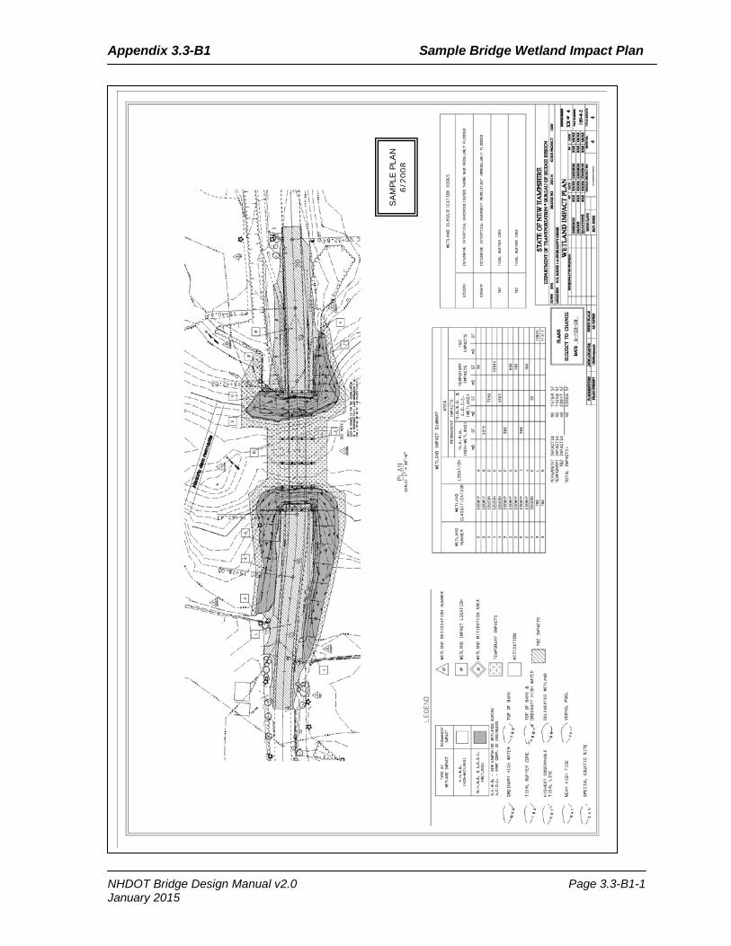
Appendix 3.3-B1 Sample Bridge Wetland Impact Plan
SAM
PLE
PLAN
6/
2008
NHDOT Bridge Design Manual v2.0 Page 3.3-B1-1 January 2015

Appendix 3.3-B1 Sample Bridge Wetland Impact Plan
Page intentionally left blank.
NHDOT Bridge Design Manual v2.0 Page 3.3-B1-2 January 2015