Embed Size (px)
Citation preview
i
Jalsrot Vikas Sanstha Kathmandu
December 2016
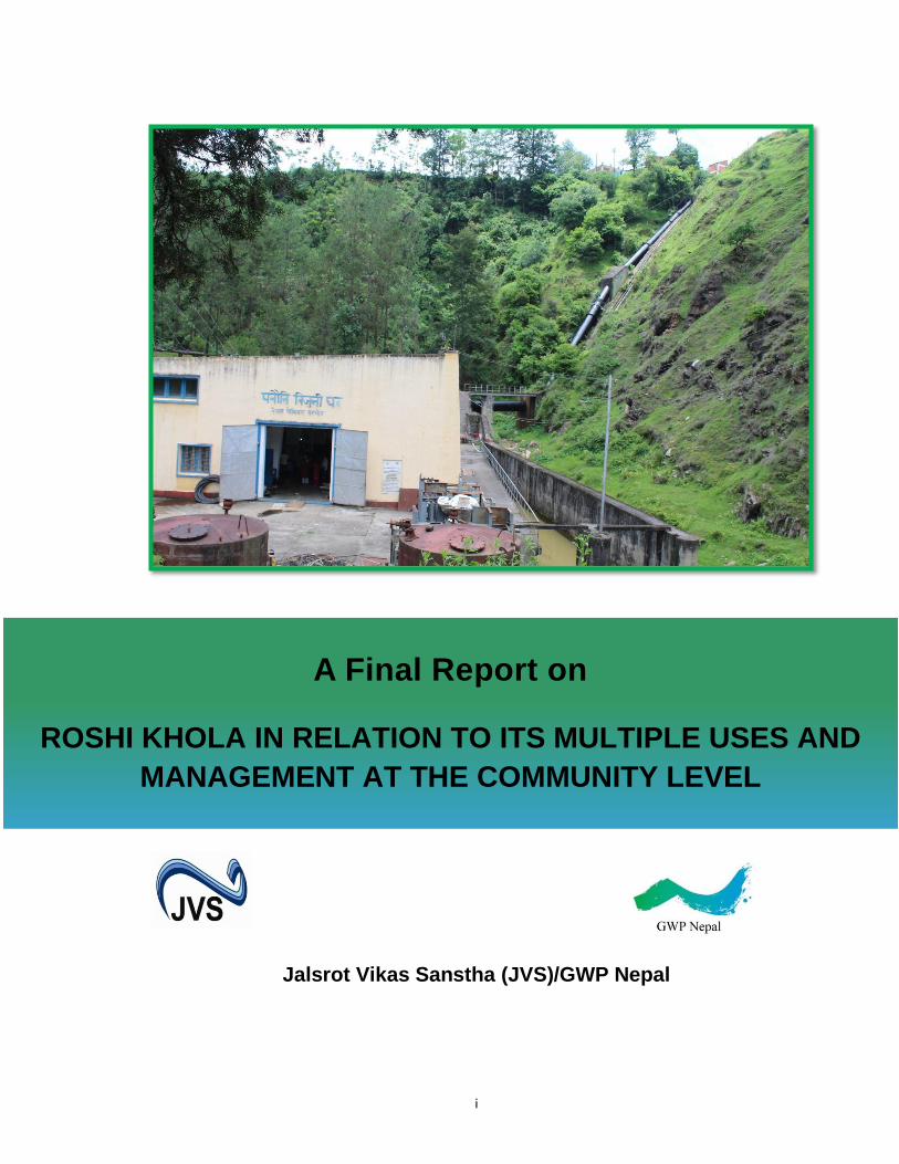
Jalsrot Vikas Sanstha (JVS)/GWP Nepal
A Final Report on
ROSHI KHOLA IN RELATION TO ITS MULTIPLE USES AND
MANAGEMENT AT THE COMMUNITY LEVEL
ii
Disclaimer
The findings, interpretations and conclusions expressed herein are those of the author(s) and do not necessarily reflect the views of the
institution.
iii
Foreword
This research was part of WACREP activity of Jalsrot Vikas Sanstha (JVS)/GWP Nepal. JVS/GWP Nepal highly appreciates the contribution of Mr. Prakash Gaudel for conducting the research. Our sincere gratitude also goes to Mr. Batu K. Uprety and Dr. Vijaya Shrestha for reviewing the draft by providing valuable suggestions. JVS/GWP Nepal also acknowledges the contribution from Mr.Tejendra GC and Ms. Anju Air during the preparation of this publication.
Jalsrot Vikas Sanstha (JVS)/GWP Nepal
iv
Acronyms
DDC : District Development Committee
DHM : Department of Hydrology and Meteorology
DoED : Department of Electricity Development
GoN : Government of Nepal
GWP : Global Water Partnership
HEP : Hydroelectric Project
JVS : Jalsrot Vikas Sanstha
KVIWSP : Kavre Valley Integrated Water Supply Project
MoEn : Ministry of Energy
MoI : Ministry of Irrigation
MoUD : Ministry of Urban Development
MW : Megawatt
NEA : Nepal Electricity Authority
NGO : Non-governmental Organization
NPC : National Planning Commission
NWSC : Nepal Water Supply Corporation
VDC : Village Development Committee
WUA : Water Users Association
v
Contents
Introduction ................................................................................................................ 1
Objective of the Study ................................................................................................. 1
Methodology .............................................................................................................. 1
Study Area ................................................................................................................. 3
Legal and Policy Framework ........................................................................................ 5
(i) Water Resources Act, 1992 and Rules, 1993 .......................................................... 5
(ii) Local Self Governance Act, 1999 and Rules, 2000 ................................................. 6
(iii) Soil and Watershed Conservation Act, 1982 and Rules, 1985 ................................. 6
(iv) Government of Nepal (Allocation of Business) Rules, 2012 ................................... 6
History of Watershed Development ............................................................................... 7
Multiple Water Use in Roshi Khola ............................................................................... 7
(i) Drinking Water ................................................................................................... 8
(ii) Irrigation ........................................................................................................... 9
(iii) Water Mills ..................................................................................................... 10
(iv) Hydropower .................................................................................................... 10
(v) Others ............................................................................................................. 11
Drivers of Change ..................................................................................................... 11
(i) Population Growth ............................................................................................ 12
(ii) Urbanization and Land-use Change .................................................................... 12
(iii) Climate Change ............................................................................................... 12
Stakeholders' Perception ............................................................................................ 12
Major Issues and Challenges ...................................................................................... 14
Conclusion and Way Forward ..................................................................................... 16
References ................................................................................................................ 17
Annexes ................................................................................................................... 18
1
1. Introduction
The demand for water is on the rise as never seen before. The ever increasing
population, altering land-use, urbanization and changing climate are some of the
major drivers for such increase in water demand. Those water bodies which have
initially been used for a purpose are being increasingly used for multiple purposes.
These increasing sectoral demand for water often result in conflicts and
deterioration of resources. In order to assess the sectoral approach of water
allocation, the associated conflicts and the possible adaptable management
practices, JVS/GWP Nepal has carried out this case study. This case from the
Roshi Khola, a tributary of Koshi River in Nepal, presents a typical example of
sectoral allocation of water and associated conflicts among the users. The case
further identifies the policy gaps and recommends the possible ways to address
such conflicts.
1. Objective of the Study
a) To assess nature of water allocation for different uses and associated
conflicts;
b) To analyze the impact of non-climatic and climatic drivers of change on water
allocation and water security in the Roshi Khola watershed; and
c) To document the adaptation practices adopted by multiple users (farmers,
hydropower companies, water mill owners and drinking water suppliers) to
cope with increasing water demand.
2. Methodology
Desk study was carried out by reviewing the different publications, literatures and
records available on Roshi Khola watershed and water-uses. In addition, relevant
policies, laws and guidelines or norms were reviewed.
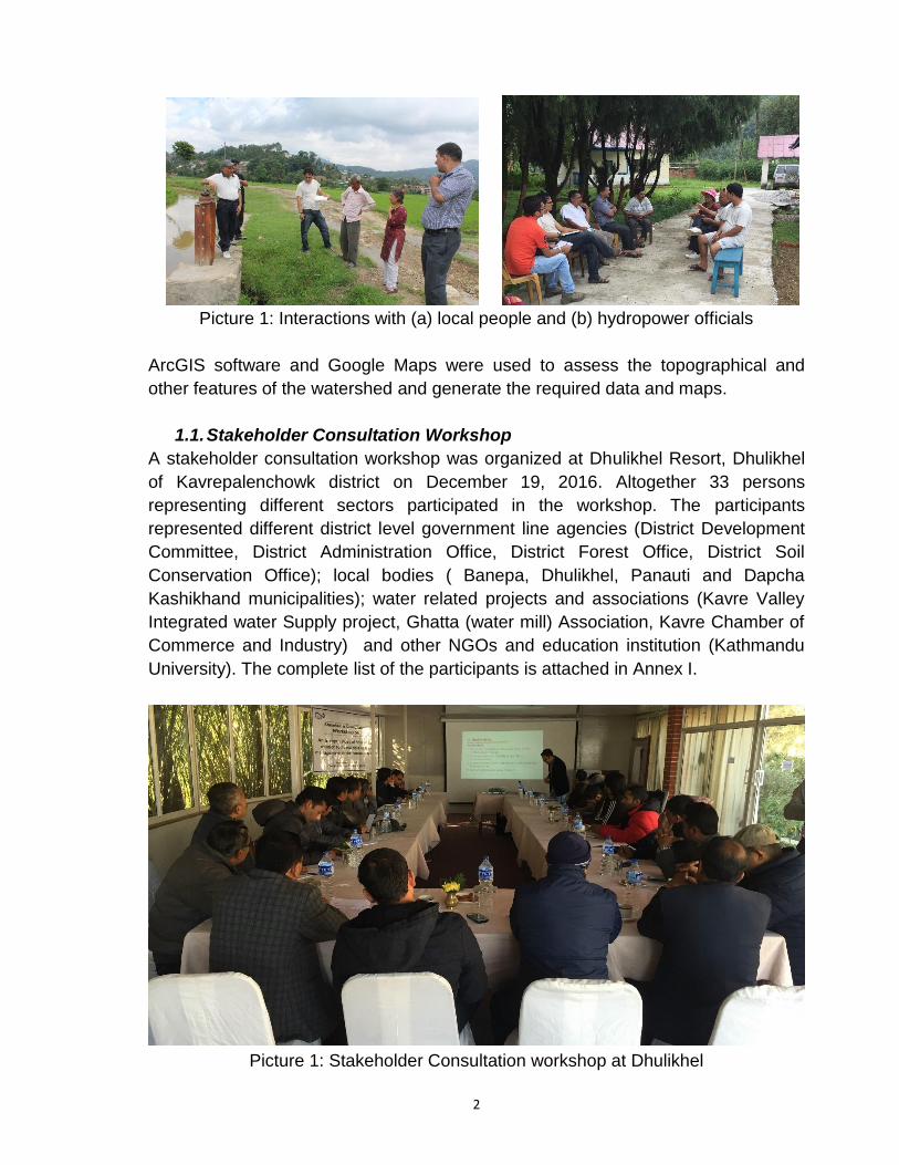
A reconnaissance survey of the Roshi Khola watershed was carried out by the
study team in 18th June 2016. The team walked from intake to hydropower
generation site to observe uses of canal water which (canal) was constructed to
channel water for hydropower generation. Discussions were held with the local
people, farmers and the officials of Panauti Hydroelectric Project (HEP).
2
Picture 1: Interactions with (a) local people and (b) hydropower officials
ArcGIS software and Google Maps were used to assess the topographical and
other features of the watershed and generate the required data and maps.
1.1. Stakeholder Consultation Workshop
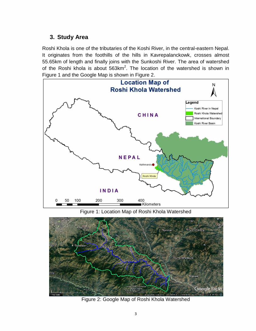
A stakeholder consultation workshop was organized at Dhulikhel Resort, Dhulikhel
of Kavrepalenchowk district on December 19, 2016. Altogether 33 persons
representing different sectors participated in the workshop. The participants
represented different district level government line agencies (District Development
Committee, District Administration Office, District Forest Office, District Soil
Conservation Office); local bodies ( Banepa, Dhulikhel, Panauti and Dapcha
Kashikhand municipalities); water related projects and associations (Kavre Valley
Integrated water Supply project, Ghatta (water mill) Association, Kavre Chamber of
Commerce and Industry) and other NGOs and education institution (Kathmandu
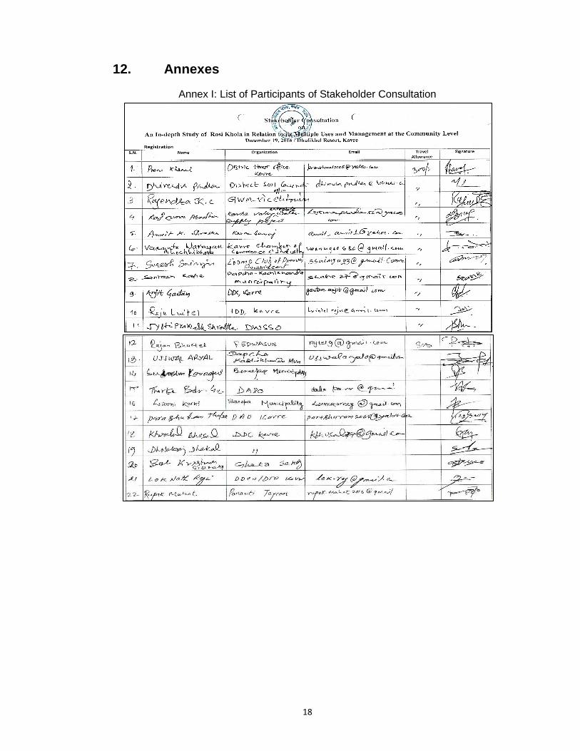
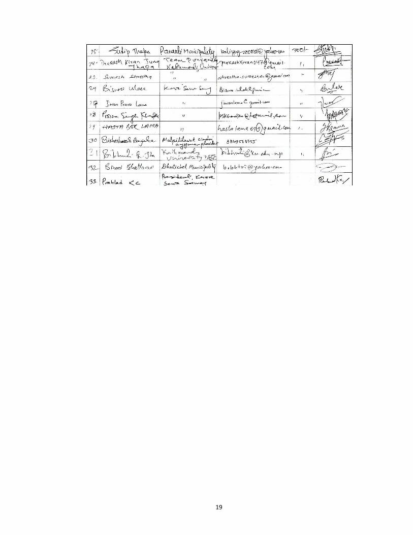
University). The complete list of the participants is attached in Annex I.
Picture 1: Stakeholder Consultation workshop at Dhulikhel
3
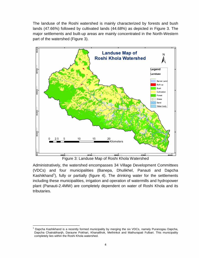
3. Study Area
Roshi Khola is one of the tributaries of the Koshi River, in the central-eastern Nepal.
It originates from the foothills of the hills in Kavrepalanckowk, crosses almost
55.65km of length and finally joins with the Sunkoshi River. The area of watershed
of the Roshi khola is about 563km2. The location of the watershed is shown in
Figure 1 and the Google Map is shown in Figure 2.
Figure 1: Location Map of Roshi Khola Watershed
Figure 2: Google Map of Roshi Khola Watershed
4
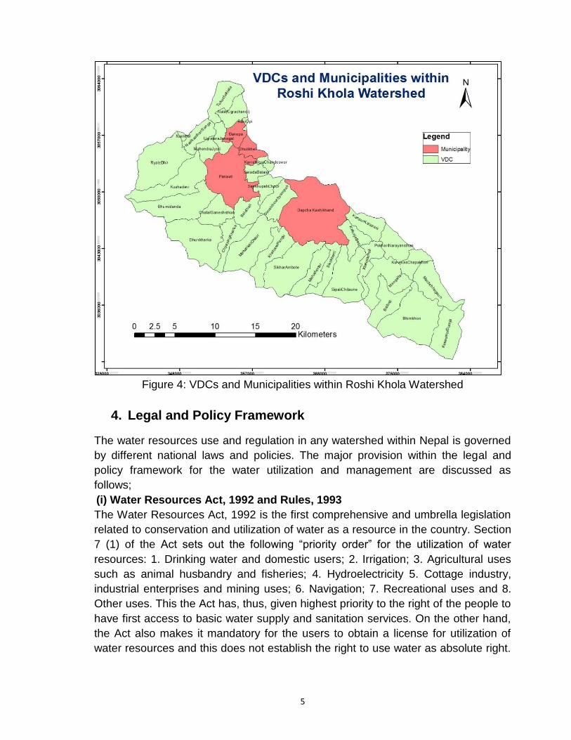
The landuse of the Roshi watershed is mainly characterized by forests and bush
lands (47.66%) followed by cultivated lands (44.68%) as depicted in Figure 3. The
major settlements and built-up areas are mainly concentrated in the North-Western
part of the watershed (Figure 3).
Figure 3: Landuse Map of Roshi Khola Watershed
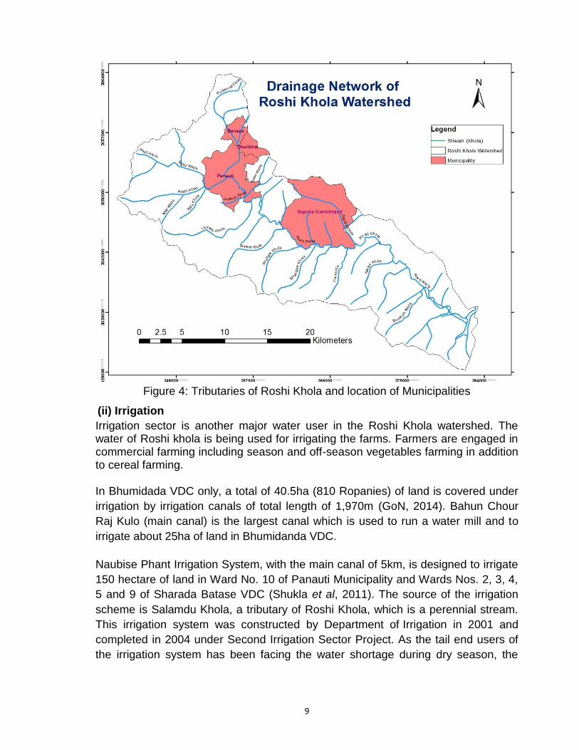
Administratively, the watershed encompasses 34 Village Development Committees
(VDCs) and four municipalities (Banepa, Dhulikhel, Panauti and Dapcha
Kashikhand1), fully or partially (figure 4). The drinking water for the settlements
including these municipalities, irrigation and operation of watermills and hydropower
plant (Panauti-2.4MW) are completely dependent on water of Roshi Khola and its
tributaries.
1 Dapcha Kashikhand is a recently formed municipality by merging the six VDCs, namely Puranogau Dapcha, Dapcha Chatrabhanjh, Daraune Pokhari, Khanalthok, Methinkot and Mathurapati Fulbari. This municipality completely lies within the Roshi Khola watershed.
5
Figure 4: VDCs and Municipalities within Roshi Khola Watershed
4. Legal and Policy Framework
The water resources use and regulation in any watershed within Nepal is governed
by different national laws and policies. The major provision within the legal and
policy framework for the water utilization and management are discussed as
follows;
(i) Water Resources Act, 1992 and Rules, 1993
The Water Resources Act, 1992 is the first comprehensive and umbrella legislation
related to conservation and utilization of water as a resource in the country. Section
7 (1) of the Act sets out the following “priority order” for the utilization of water
resources: 1. Drinking water and domestic users; 2. Irrigation; 3. Agricultural uses
such as animal husbandry and fisheries; 4. Hydroelectricity 5. Cottage industry,
industrial enterprises and mining uses; 6. Navigation; 7. Recreational uses and 8.
Other uses. This the Act has, thus, given highest priority to the right of the people to
have first access to basic water supply and sanitation services. On the other hand,
the Act also makes it mandatory for the users to obtain a license for utilization of
water resources and this does not establish the right to use water as absolute right.
6
However, such provision of licensing is made only for commercial use and is not
applicable for individual or community use and consumption of water resources.
Similarly, the Water Resources Rules (1993) provides procedural mechanism for
the implementation of the Act, 1992 and covers different provisions regarding the
formulation of Water Users Associations (WUAs) and District water Resources
Committees and licensing for water uses. Further, it provides a dispute settlement
mechanism through the formation of water Resources Utilization Inquiry committee.
(ii) Local Self Governance Act, 1999 and Rules, 2000
The Act, 1999 empowers the local bodies (VDCs, Municipalities and District
Development Committees-DDCs) to make rational use of water resources available
locally. These local bodies have been authorized by the Act, 1999 and the Rules,
2000 to prepare plans and execute water resources development projects as
drinking water, irrigation, drainage, electricity, waterways and others within their
areas of jurisdiction (Sections 28, 96 and 189). In relation to local or community
level disputes settlements, the Act, 1999 has given the judicial power to the VDCs
and municipalities to hear the first instance of issues or cases related to water
disputes within their areas of jurisdiction (Sections 33 and 101).
(iii) Soil and Watershed Conservation Act, 1982 and Rules, 1985
The Act defines 'soil and water conservation' as acts to prevent or save any area
from being destroyed from natural calamities such as flood, landslide and soil-
erosion and keep the volume and flow of water in a normal condition or keep on
maintaining cleanliness by preventing the flow of water from being muddy. With the
objective of conserving soil and watershed, the Act, 1982 (and the Rules, 1985)
have the provisions for declaring , by a notification in the national gazette, any area
within Nepal as a conserved watershed area where such conservation needs are
felt (Section 3). However, the Act does not prevents GoN from using and distributing
water resources (section 24).
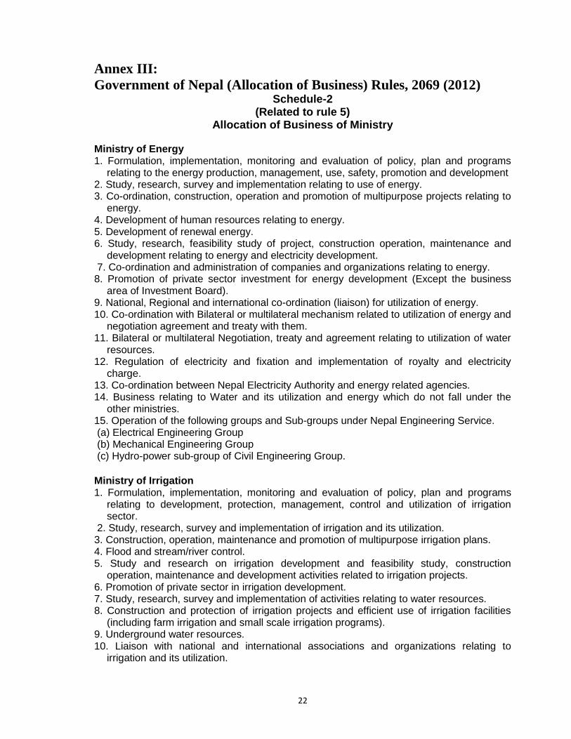
(iv) Government of Nepal (Allocation of Business) Rules, 2012
This Rules allocates the business to be performed by the Ministry. According to
Rule 5, Schedule 2 of the Rules (2012), the Ministry of Energy (MoEn) is
responsible for business relating to water and its utilization and energy which do not
fall under the other ministries. In addition the MoEn is also responsible for bilateral
or multilateral Negotiation, treaty and agreement relating to utilization of water
resources (Annex III). Whereas the Ministry of Irrigation (MoI) is responsible for the
business related to study, research, survey and implementation of irrigation and its
utilization. Similarly, MoI is also responsible for study, research, survey and
implementation of activities relating to water resources and bilateral and multilateral
7
negotiation, treaty and agreement on the matters of irrigation and its utilization
(Schedule 2).
5. History of Watershed Development
The watershed is characterized by multiple water uses, and has a long history of
water resources development and uses. The water was traditionally being used for
domestic uses, irrigation, running water mills and for religious/cultural practices. The
scientific study of the watershed started with the installation of a gauging station at
Roshi Khola (station no. 640, elevation 1480m, for drainage area of 87km2) by the
Department of Hydrology and Meteorology (DHM) in 1963. The continuous gauge
height recording was done from the year 1964 to 1987 and the station was shut
down in the year 1988. These recording were mainly carried out for the purpose of
hydropower generation from the Panauti project.
Panauti HEP is the third hydro-project of Nepal, after 500kW Pharping in 1911 and
640kW Sundarijal in 1934. The Panauti HEP was commissioned in 1965 to use
water of the Roshi Khola. This project was built with support from the then USSR.
This 2.4MW Panauti Project was the first bilateral HEP (after the end of Rana
regime) developed in Nepal. Though Russia was keen in executing a 10MW HEP
and investigated the Lower Bagmati, it supported smaller Panauti Project on the
Roshi Khola where Nepal had already carried out studies (Pun, 2008). Furthermore,
no required data was available for bigger project. The Panauti hydropower is a run-
of-river (RoR) project with a peaking reservoir pond and with three units of 0.8MW
each.
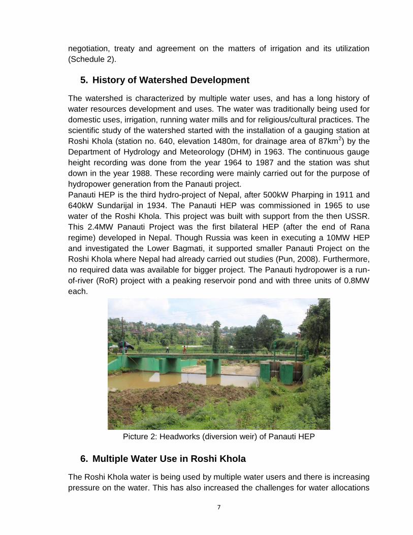
Picture 2: Headworks (diversion weir) of Panauti HEP
6. Multiple Water Use in Roshi Khola
The Roshi Khola water is being used by multiple water users and there is increasing
pressure on the water. This has also increased the challenges for water allocations
8
for different uses. A multitude of users compete for their share of available water of
the Roshi Khola. Some of the major water uses on the waters of the Khola, based
on the literature review as well as field visits are discussed below. These uses of
water are discussed in the priority order as set out by Water Resources Act, 1992.
(i) Drinking Water
The water from the Roshi Khola watershed is currently being used for drinking and domestic purposes. The three municipalities - Banepa, Panauti and Dhulikhel depend on the water of Roshi Khola for domestic and other uses. Residents of Dhulikhel Municipality receive water mainly from Khar Khola System, which was built in 1987 (MoUD, 2013). Khar Khola is one of the main tributaries of the Roshi Khola (Figure 4). The water is supplied by a system of 14km long transmission pipe, 500m3 masonary reservoir through 814 private connections and 27 stand posts (MoUD, 2013). This water supply system diverts (abstracts) about 15-16 litre per second (lps) of water from the Khar Khola to meet the local demand (GoN, 2014). Harirukhdol spring Khola and Mul Khola are the sources of the existing water supply scheme of Panauti Municipality. This system consists of 3.8km of transmission pipelines and two reservoirs of 140m3 and 500m3 capacities which serves about 27% population of the municipality (MoUD, 2013). There are other small schemes and spring sources in Panauti.
In Banepa Municipality, Dhaneshwor Water supply system is the first piped water
supply system constructed in 1941 with Dhaneshwor Khola as the source and with
a reservoir of 25m3 capacity (MoUD, 2013). The DWSS constructed Sashipani
system in 1974 which is the largest water supply system in Banepa. It has about
7.5km transmission pipeline and 450m3 capacity reservoir (MoUD, 2013). Both of
these systems are operated and maintained by Nepal Water Supply Corporation
(NWSC).
In order to meet the domestic need of the people, mainly in these three municipal
areas, there are immediate future plans for drawing more water from the Roshi
Khola. The Government of Nepal (GoN) with financial assistance of Asian
Development Bank (ADB) is implementing Kavre Valley Integrated Water Supply
Project (KVIWSP) under the Secondary Towns Integrated Urban Environmental
Improvement Project (STIUEIP). As a combined water supply scheme for these
three municipalities, the plan is to extract more water from Roshi Khola and its
tributaries such as Khar Khola, Gudgude Khola, Bairamahadev Kholsi, and
Shishakhani Kholsi (GoN, 2014). Figure 4 shows the location of three municipalities
and the tributaries of the Roshi Khola.
9
Figure 4: Tributaries of Roshi Khola and location of Municipalities
(ii) Irrigation
Irrigation sector is another major water user in the Roshi Khola watershed. The water of Roshi khola is being used for irrigating the farms. Farmers are engaged in commercial farming including season and off-season vegetables farming in addition to cereal farming. In Bhumidada VDC only, a total of 40.5ha (810 Ropanies) of land is covered under
irrigation by irrigation canals of total length of 1,970m (GoN, 2014). Bahun Chour
Raj Kulo (main canal) is the largest canal which is used to run a water mill and to
irrigate about 25ha of land in Bhumidanda VDC.
Naubise Phant Irrigation System, with the main canal of 5km, is designed to irrigate
150 hectare of land in Ward No. 10 of Panauti Municipality and Wards Nos. 2, 3, 4,
5 and 9 of Sharada Batase VDC (Shukla et al, 2011). The source of the irrigation
scheme is Salamdu Khola, a tributary of Roshi Khola, which is a perennial stream.
This irrigation system was constructed by Department of Irrigation in 2001 and
completed in 2004 under Second Irrigation Sector Project. As the tail end users of
the irrigation system has been facing the water shortage during dry season, the
10
irrigation water users have taken initiative to develop pump water from Roshi Khola
(Shukla et al, 2011).
In addition to these diversions from the natural water course, it is interesting to
observe that the water from the open canal of the Panauti HEP is also being
diverted for irrigation purposes. The study team has observed, not only gravity-
diversion, but also the pumped/lift irrigation from the canal by using electric water
pumps in addition to the seven gates/openings.
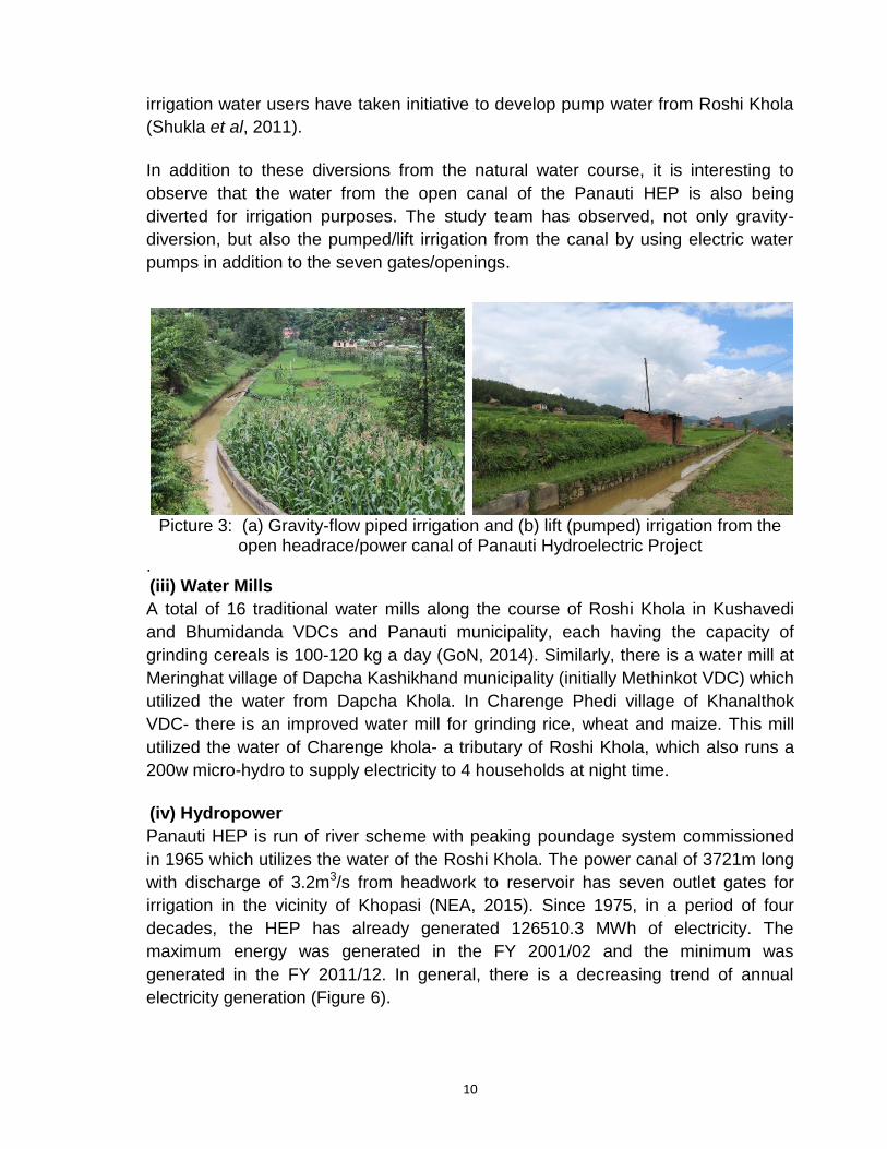
Picture 3: (a) Gravity-flow piped irrigation and (b) lift (pumped) irrigation from the
open headrace/power canal of Panauti Hydroelectric Project . (iii) Water Mills
A total of 16 traditional water mills along the course of Roshi Khola in Kushavedi
and Bhumidanda VDCs and Panauti municipality, each having the capacity of
grinding cereals is 100-120 kg a day (GoN, 2014). Similarly, there is a water mill at
Meringhat village of Dapcha Kashikhand municipality (initially Methinkot VDC) which
utilized the water from Dapcha Khola. In Charenge Phedi village of Khanalthok
VDC- there is an improved water mill for grinding rice, wheat and maize. This mill
utilized the water of Charenge khola- a tributary of Roshi Khola, which also runs a
200w micro-hydro to supply electricity to 4 households at night time.
(iv) Hydropower
Panauti HEP is run of river scheme with peaking poundage system commissioned
in 1965 which utilizes the water of the Roshi Khola. The power canal of 3721m long
with discharge of 3.2m3/s from headwork to reservoir has seven outlet gates for
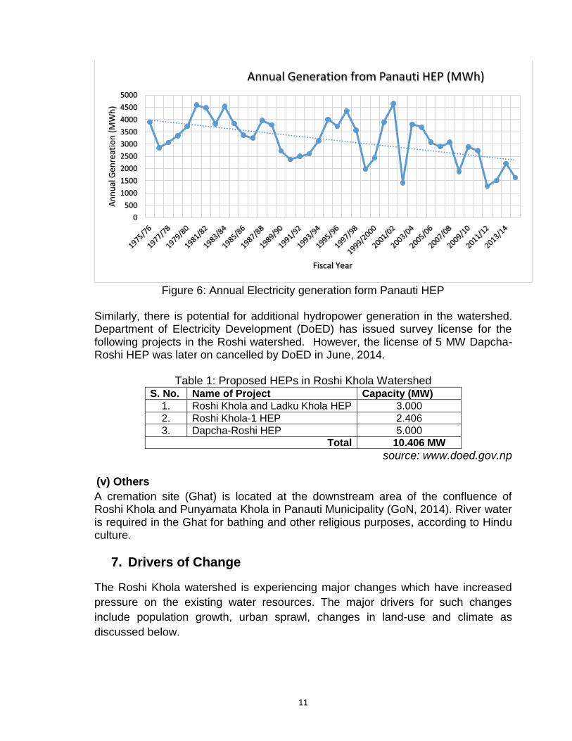
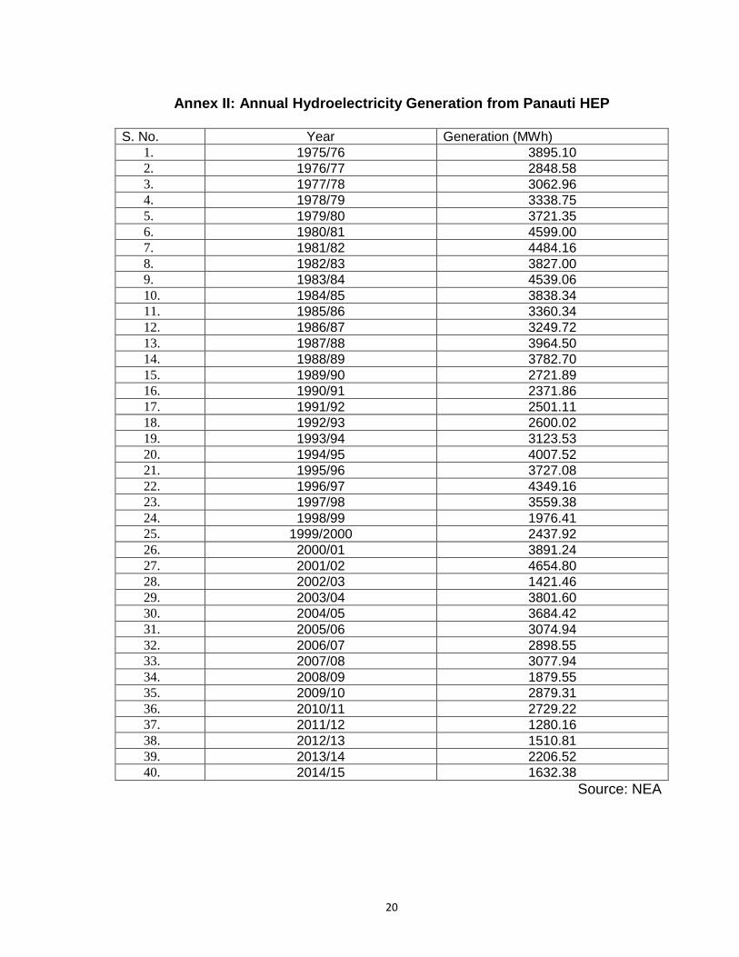
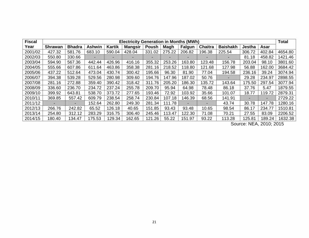
irrigation in the vicinity of Khopasi (NEA, 2015). Since 1975, in a period of four
decades, the HEP has already generated 126510.3 MWh of electricity. The
maximum energy was generated in the FY 2001/02 and the minimum was
generated in the FY 2011/12. In general, there is a decreasing trend of annual
electricity generation (Figure 6).
11
Figure 6: Annual Electricity generation form Panauti HEP
Similarly, there is potential for additional hydropower generation in the watershed. Department of Electricity Development (DoED) has issued survey license for the following projects in the Roshi watershed. However, the license of 5 MW Dapcha-Roshi HEP was later on cancelled by DoED in June, 2014.
Table 1: Proposed HEPs in Roshi Khola Watershed S. No. Name of Project Capacity (MW)
1. Roshi Khola and Ladku Khola HEP 3.000
2. Roshi Khola-1 HEP 2.406
3. Dapcha-Roshi HEP 5.000
Total 10.406 MW
source: www.doed.gov.np (v) Others
A cremation site (Ghat) is located at the downstream area of the confluence of Roshi Khola and Punyamata Khola in Panauti Municipality (GoN, 2014). River water is required in the Ghat for bathing and other religious purposes, according to Hindu culture.
7. Drivers of Change
The Roshi Khola watershed is experiencing major changes which have increased
pressure on the existing water resources. The major drivers for such changes
include population growth, urban sprawl, changes in land-use and climate as
discussed below.
0
500
1000
1500
2000
2500
3000
3500
4000
4500
5000
An
nu
al G
enre
atio
n (
MW
h)
Fiscal Year
Annual Generation from Panauti HEP (MWh)
12
(i) Population Growth
The Roshi Khola watershed is experiencing changes in the population size. In ten
years of time, the population of Kavre Panachowk district, which include most of the
Roshi khola watershed, has decreased from 383,479 in 2001 to 381,937 in 2011.
On the contrary, the population in the three municipalities within Roshi watershed of
Kavre district has increased (Table 2). The increase in the urban population has
increased pressure on waters of the Roshi Khola.
Table 2: Population Rise in Municipalities of Roshi Khola Watershed
S. No. Municipality
Population Percentage
Change (%) 2001 2011
1. Banepa 15,822 24,764 +56.51
2. Dhulikhel 11,521 14,283 +23.97
3. Panauti 25,563 27,358 +7.02
4. Dapcha-Kashikhand 23,526 21,324 -9.36
Total 76,432 87,729 +14.78
Source: CBS, 2014
(ii) Urbanization and Land-use Change
Banepa, Panauti and Dhulikhel Municipalities are three rapidly emerging cities in
the within Roshi Khola watershed. The urbanization in other parts of the watershed
is also on the rise. The recent formation of a new municipality (Dapcha
Kashikhanda) by merging six VDCs indicates such urban sprawl in the watershed.
There are 19,591 households in the four municipalities of the Roshi Khola
watershed (CBS, 2014).
(iii) Climate Change
Water resource is one of the hardest hit sectors of climate change. Though Kavre
was regarded as less vulnerable to climate change (MoEnv, 2013); over the last 10
years, water sources in Kavre have gradually dried up (NPC, 2013). Of late, many
districts have turned out to be more vulnerable than indicated by the National
Adaptation Programme of Action (NAPA) including district of Kavre, which was
listed as vulnerable, have faced severe water scarcity in the last few years (NPC,
2013).
8. Stakeholders' Perception
JVS Nepal organized a Workshop on December 19, 2016 at Dhulikhel, the district
headquarter of Kavrepalanchowk. There were 33 participants from different sectors
like district level government officers, representatives from Water Mill association,
irrigation water users, students and local people.
13
The primary purpose of the workshop was to receive the perceptions of different
stakeholders of the Roshi Khola about the challenges of water management and its
multiple use. The workshop also focused on identifying the potential measures to
meet those challenges. During the workshop, the majority of the respondents have
agreed that the discharge in the Khola is diminishing and the water quality is
deteriorating. The participants further expressed their concerns regarding the
diminishing water of the Roshi khola and need to regenerate it. Further, there is no
regular monitoring conducted by the responsible agencies. The major issues and
concerns raised by different stakeholders is listed below;
Lack of proper watershed management has resulted in the drying of stream;
The watermills and hydropower projects are functional only in wet season;
Stone mining and crushers are creating nuisance along with road
construction increasing turbidity of the Roshi Khola;
forest encroachments and forest fires are on the rise;
Encroachments of banks and flood plains of Roshi Khola;
Solid waste dumping at Roshi Khola;
lack of intra-governmental coordination- resulted in impacts on Roshi Khola-
licensing of stone crushers and KVWSIP;
Fish diversity has decreased; and
decrease in the traditional ponds in the Roshi watershed.
For addressing these existing as well as new and emerging issues related to water
management in Roshi Khola, the participants highlighted the need for integrated
development with inter-sectoral coordination. The major suggestions received from
the workshops are as follows;
Since the resource and limited and multiple use is being done, proper
management is required. The main problem is drying up of streams and
diminishing water availability; Checkdams and watershed management is
necessary;
Afforestation program in the watershed can help to improve the situation;
Irrigation Service Fee (ISF) endorsement can help water management in
Roshi watershed;
The government needs to provide license at the upper reach for hydropower
generation, so that there will be no impact on other uses in the middle or
lower reach of the watershed;
The provision of license for storage projects in the upper catchment of the
Roshi khola can help to increase the water availability in the dry season;
not to provide license for HEP in the middle stretch of Khola where there are
water diversions for other uses;
non-conventional methods for irrigation; shift in crop type from water intense
to less water intense crops;
14
Restoration and management of wetlands; and
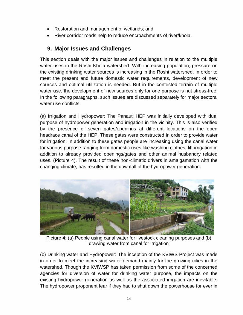
River corridor roads help to reduce encroachments of river/khola.
9. Major Issues and Challenges
This section deals with the major issues and challenges in relation to the multiple
water uses in the Roshi Khola watershed. With increasing population, pressure on
the existing drinking water sources is increasing in the Roshi watershed. In order to
meet the present and future domestic water requirements, development of new
sources and optimal utilization is needed. But in the contested terrain of multiple
water use, the development of new sources only for one purpose is not stress-free.
In the following paragraphs, such issues are discussed separately for major sectoral
water use conflicts.
(a) Irrigation and Hydropower: The Panauti HEP was initially developed with dual
purpose of hydropower generation and irrigation in the vicinity. This is also verified
by the presence of seven gates/openings at different locations on the open
headrace canal of the HEP. These gates were constructed in order to provide water
for irrigation. In addition to these gates people are increasing using the canal water
for various purpose ranging from domestic uses like washing clothes, lift irrigation in
addition to already provided openings/gates and other animal husbandry related
uses. (Picture 4). The result of these non-climatic drivers in amalgamation with the
changing climate, has resulted in the downfall of the hydropower generation.
Picture 4: (a) People using canal water for livestock cleaning purposes and (b)
drawing water from canal for irrigation (b) Drinking water and Hydropower: The inception of the KVIWS Project was made
in order to meet the increasing water demand mainly for the growing cities in the
watershed. Though the KVIWSP has taken permission from some of the concerned
agencies for diversion of water for drinking water purpose, the impacts on the
existing hydropower generation as well as the associated irrigation are inevitable.
The hydropower proponent fear if they had to shut down the powerhouse for ever in
15
lack of water. Even though the Panauti HEP is quite old and small HEP, it puts
forward an important issue that needs to be addressed.
As the HEP is owned and operated by the government body, the GoN may direct or
choose for the shut-down of the power house and provide all water for drinking
water or other uses. But had it been the private owned HEP, what would have been
the case? Is our legal and policy framework flexible enough to address such issue
of multiple water uses? Is the priority order of water-use set out by the Water
Resources Act, 1992 applicable where the government have already provisioned
license for commercial uses like hydropower much earlier than the realization of
need of the same water for drinking or irrigation uses? Similarly, who is to bear the
cost of encroachment of such an unregulated water extraction of the headrace
canal of HEP through the polythene pines and the ultimate loss of power generation
from the HEP?
And who is to be blamed, the HEP or people, who has the right for water use, the
traditional user (HEP) or new comers (farmers) as canal water is already provided
to farmers in designated areas? The case of Roshi Khola puts forward these
questions that need to be addressed prior to the proliferation of the similar cases to
other watershed or basins of Nepal.
The priority of water use can best fit in a watershed where no any water resources
development works have been carried out. But in the case where the license has
been provided by the government for other commercial uses, conflict can arise.
Hence there is a need of master-plan for the basin development and optimal use of
the resources. This is what the Integrated Water Resources Management (IWRM)
deals about. Though already incorporated in the Water Resources Strategy, 2002
by the government, the concept was neither institutionalized nor operationalized.
In the lack of any watershed/river-basin organization in the Roshi Khola, there in a multitude of organization, both formal and informal, who claim to regulate the water use of Roshi Khola. The local bodies, VDCs and Municipalities, claim to have right over the water use within their areas of jurisdiction, whereas the hydropower claims on the basis of obtained license for water use. In addition, the local farmers and ghatta owners also share similar claims. In such context of contested terrain of water use, the users groups and different institutions share conflicting relations with the local and central government. The lack of authority delegation to the local levels (district) from the central level and lack of coordination among the different line agencies have further aggravated the situation.
16
10. Conclusion and Way Forward
The water of Roshi Khola is being used for different consumptive purposes ranging
from domestic (drinking water and sanitation) to irrigation. The non-consumptive
use of water such as hydropower generation and agro-processing thorough water
mills (ghatta) are common. In such watershed of multitude of users and decreasing
water resources, the government intends to abstract more water for some purpose
(water supply) jeopardizing other existing uses of hydropower and irrigation.
On the other hand, the study area was sadly lacking in rain-water harvesting
methods observed during the field visit and also verified by the stakeholders.
Capturing water in the rainy season in small ponds/reservoirs and using them later
was rare, though much required in such water stressed areas. In the future, where
climate is expected to be more uncertain, the government seems not to be well
prepared with alternative plans and mitigation measures for other sectoral water
users in the Roshi watershed.
The lack of umbrella ministry- the Ministry of Water Resources shall be increasing
realized in the very near future, in the present context where the different uses of
water are governed by different sectoral ministries/agencies. Though the GoN
(Allocation of Business) Rules, 2012 has allocated MoEn with less mandate of
water management, the main focus is on energy. Same is with the case of MoI,
where the primary focus is given on irrigation sector. The confusion persists within
the legal and institutional framework, and thus the conflicts. For instance, the
provision of licensing for hydropower by MoEn in the same area/stretch of river
where MoUD plans to abstract water for drinking water or where MoI indents to
divert water for irrigation shall lead us to zero sum development and increasing
water-conflicts. This case this shows that there is a lack of institutional as well as
legal and policy framework to cope with emerging issues of water management,
mainly in those watersheds where water resources have already been exploited.
The current situation of Roshi clearly calls for overcoming policy and institutional
level challenges through policy and action research. There are opportunities for
improving the situation by reforming the policies and allocating clear business to the
institutions both at central and local level.
17
11. References
CBS, 2014. National Population and Housing Census 2011- Village Development Committee/Municipality-Kavrepalanchowk. Central Bureau of Statistics, Government of Nepal, Kathmandu.
GoN 2014. Addendum to the Initial Environmental Examination of Kavre Valley Integrated Water Supply Scheme. Environmental Assessment Document. Nepal: Secondary Town Integrated Urban Environmental Improvement Project. Retrieved from: https://www.adb.org/sites/default/ files/project-document/150826/36188-023-iee-08.pdf
MoEnv, 2010. Climate Change Vulnerability Mapping for Nepal. Ministry of Environment, Kathmandu.
MoUD, 2013. Final Report for Environmental Impact Assessment (EIA) of Kavre Valley Integrated Water Supply Project (KVIWSP). Ministry of Urban Development, Department of Urban Development and Building Construction, Secondary Towns Integrated Urban Environmental Improvement Project, Project Coordination office, Babarmahal, Kathmandu.
NEA, 2010. Generation 8th Issue, Nepal Electricity Authority, Durbar Marg, Kathmandu.
NEA, 2015. A Year in Review- Fiscal Year 2014/2015, Nepal Electricity Authority, Durbar Marg, Kathmandu.
NPC, 2013. Environmental Causes of Displacement. National Planning Commission Government of Nepal, Kathmandu.
Pun, S.B. 2008. Hydropower Development in Nepal: Lessons from Past Models In: Hydro Nepal: Journal of Water, Energy and Environment. Issue No. 2, pp. 5-8.
Shukla, A; Sijapati, S and Paudel, T. 2011. Building Social Capital and Livelihood through Multifunctional Water Users' Associations in Nepalese Irrigation Systems - Analysis of Selected Cases of Farmer Managed Irrigation Systems. International Network on Participatory Irrigation Management -Nepal (INPIM-Nepal), Lalitpur, Nepal.
18
12. Annexes
Annex I: List of Participants of Stakeholder Consultation
19
20
Annex II: Annual Hydroelectricity Generation from Panauti HEP
S. No. Year Generation (MWh)
1. 1975/76 3895.10 2. 1976/77 2848.58
3. 1977/78 3062.96 4. 1978/79 3338.75
5. 1979/80 3721.35
6. 1980/81 4599.00 7. 1981/82 4484.16
8. 1982/83 3827.00 9. 1983/84 4539.06
10. 1984/85 3838.34 11. 1985/86 3360.34
12. 1986/87 3249.72
13. 1987/88 3964.50 14. 1988/89 3782.70
15. 1989/90 2721.89 16. 1990/91 2371.86
17. 1991/92 2501.11 18. 1992/93 2600.02
19. 1993/94 3123.53
20. 1994/95 4007.52 21. 1995/96 3727.08
22. 1996/97 4349.16 23. 1997/98 3559.38
24. 1998/99 1976.41 25. 1999/2000 2437.92
26. 2000/01 3891.24
27. 2001/02 4654.80 28. 2002/03 1421.46
29. 2003/04 3801.60 30. 2004/05 3684.42
31. 2005/06 3074.94
32. 2006/07 2898.55 33. 2007/08 3077.94
34. 2008/09 1879.55 35. 2009/10 2879.31
36. 2010/11 2729.22 37. 2011/12 1280.16
38. 2012/13 1510.81
39. 2013/14 2206.52 40. 2014/15 1632.38
Source: NEA
21
Fiscal Year
Electricity Generation in Months (MWh) Total
Shrawan Bhadra Ashwin Kartik Mangsir Poush Magh Falgun Chaitra Baishakh Jestha Asar
2001/02 427.32 581.76 683.10 590.04 428.04 331.02 275.22 206.82 196.38 225.54 306.72 402.84 4654.80
2002/03 550.80 330.66 - - - - - - - - 81.18 458.82 1421.46
2003/04 594.90 567.36 442.44 426.96 416.16 355.32 253.26 163.80 123.48 156.78 203.04 98.10 3801.60
2004/05 555.66 607.86 611.64 463.86 358.38 281.16 218.52 118.80 121.68 127.98 56.88 162.00 3684.42
2005/06 437.22 512.64 473.04 430.74 300.42 195.66 96.30 81.90 77.04 194.58 236.16 39.24 3074.94
2006/07 394.38 539.28 529.56 280.98 309.60 194.76 147.96 187.02 50.76 - 29.28 234.97 2898.55
2007/08 281.16 272.88 359.40 390.42 318.42 311.76 205.20 186.30 135.72 143.64 175.50 297.54 3077.94
2008/09 336.60 236.70 234.72 237.24 255.78 209.70 95.94 64.98 78.48 86.18 37.76 5.47 1879.55
2009/10 399.92 643.81 538.70 373.72 277.65 193.46 72.92 103.92 35.66 101.07 18.77 119.72 2879.31
2010/11 369.85 557.42 609.79 238.54 258.74 230.84 107.18 146.39 68.56 141.91 - - 2729.22
2011/12 - - 152.64 262.80 249.30 281.34 111.78 - - 43.74 30.78 147.78 1280.16
2012/13 266.76 242.82 65.52 126.18 40.65 151.85 93.43 93.48 10.65 98.54 86.17 234.77 1510.81
2013/14 254.80 312.12 283.29 316.75 306.40 245.46 113.47 122.30 71.08 70.21 27.55 83.09 2206.52
2014/15 180.40 134.47 175.53 129.34 162.65 121.26 55.22 151.97 93.22 113.28 125.81 189.24 1632.38
Source: NEA, 2010; 2015
22
Annex III:
Government of Nepal (Allocation of Business) Rules, 2069 (2012)
Schedule-2 (Related to rule 5)
Allocation of Business of Ministry
Ministry of Energy 1. Formulation, implementation, monitoring and evaluation of policy, plan and programs
relating to the energy production, management, use, safety, promotion and development 2. Study, research, survey and implementation relating to use of energy. 3. Co-ordination, construction, operation and promotion of multipurpose projects relating to
energy. 4. Development of human resources relating to energy. 5. Development of renewal energy. 6. Study, research, feasibility study of project, construction operation, maintenance and
development relating to energy and electricity development. 7. Co-ordination and administration of companies and organizations relating to energy. 8. Promotion of private sector investment for energy development (Except the business
area of Investment Board). 9. National, Regional and international co-ordination (liaison) for utilization of energy. 10. Co-ordination with Bilateral or multilateral mechanism related to utilization of energy and
negotiation agreement and treaty with them. 11. Bilateral or multilateral Negotiation, treaty and agreement relating to utilization of water
resources. 12. Regulation of electricity and fixation and implementation of royalty and electricity
charge. 13. Co-ordination between Nepal Electricity Authority and energy related agencies. 14. Business relating to Water and its utilization and energy which do not fall under the
other ministries. 15. Operation of the following groups and Sub-groups under Nepal Engineering Service. (a) Electrical Engineering Group (b) Mechanical Engineering Group (c) Hydro-power sub-group of Civil Engineering Group.
Ministry of Irrigation 1. Formulation, implementation, monitoring and evaluation of policy, plan and programs
relating to development, protection, management, control and utilization of irrigation sector.
2. Study, research, survey and implementation of irrigation and its utilization. 3. Construction, operation, maintenance and promotion of multipurpose irrigation plans. 4. Flood and stream/river control. 5. Study and research on irrigation development and feasibility study, construction
operation, maintenance and development activities related to irrigation projects. 6. Promotion of private sector in irrigation development. 7. Study, research, survey and implementation of activities relating to water resources. 8. Construction and protection of irrigation projects and efficient use of irrigation facilities
(including farm irrigation and small scale irrigation programs). 9. Underground water resources. 10. Liaison with national and international associations and organizations relating to
irrigation and its utilization.
23
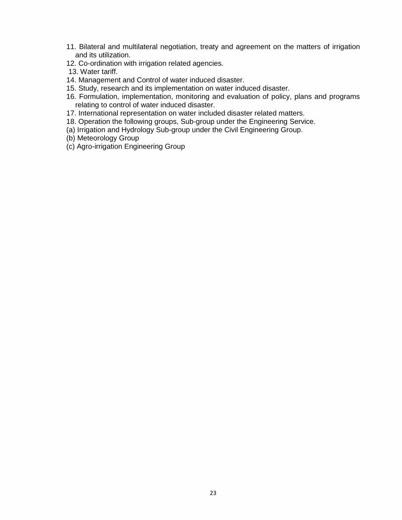
11. Bilateral and multilateral negotiation, treaty and agreement on the matters of irrigation and its utilization.
12. Co-ordination with irrigation related agencies. 13. Water tariff. 14. Management and Control of water induced disaster. 15. Study, research and its implementation on water induced disaster. 16. Formulation, implementation, monitoring and evaluation of policy, plans and programs
relating to control of water induced disaster. 17. International representation on water included disaster related matters. 18. Operation the following groups, Sub-group under the Engineering Service. (a) Irrigation and Hydrology Sub-group under the Civil Engineering Group. (b) Meteorology Group (c) Agro-irrigation Engineering Group