Embed Size (px)
Citation preview

Zt J1r 0 o
r
ASSESSMENT REPORT
GEOCHEMICAL REPORT
ON THE
JOCK CLAIM GROUP
79 UNITS
OMINECA MINING DIVISION
1
Cby
Il I CH
MINr
SHEILA A CRAWFORD
LOCATION 57013 to 57017 N Latitude
126053 to 126057 W LongitudeN T S 94E 2W and 7W
OWNER OPERATOR SERE 1 LTD
DATES WORK PERFORMED August 11 12 and 29 1981
k
DATE OF REPORT March 1982
r
INTRODUCTION
TABLE OF CONTENTS
GEOCHEMICAL SOIL ROCK AND SILT SAMPLING
ANALYSISGEOCHEMICAL
GEOCHEMICAL
CONCLUSIONS
RESULTS AND INTERPRETATION
AND RECOMMENDATIONS
CERTIFICATE OF QUALIFICATIONS
STATEMENT OF EXPENDITURES
LIST OF ILLUSTRATIONS
oFigure 1
Figure 2
Figure 3a
Figure 3b
Figure 3c
Figure 4a
Figure 4b
Figure 4c
Figure 4d
Figure 4e
Figure 4f
o
Location Map Jock Claim GroupClaims Map Jock Claim GroupGold and Silver Geochemistry
Jock Claim Group
Copper and Molybdenum GeochemistryJock Claim Group
Lead and Zinc GeochemistryJock Claim Group
Gold in Soils Jock 3
Silver in Soils Jock
Molybdenum in
Geology Jock
soil grid3 soil grid3 soil gridsoil grid
Jock 3 soil
grid
Copper in Soils Jock
Lead in Soils Jock 3
Soils
3 soil
grid
Page
1
4
5
6
14
15
16
2
3
In Pocket
r
8
9
10
11
12
13

1
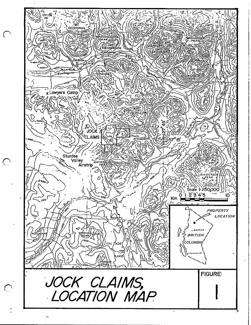
nINTRODUCTION
The Jock claim group is located between 57013 and
57017 N latitude and 126053 and 126057 W longitudein the Toodoggone River map sheet area N T S 94E
2W and 7W Omineca Mining Division see Figures 1 and 2
Topography is moderately rugged Approximately two thirds
of the property lies above tree line
Access is by plane from Smithers to Sturdee Valleyairstrip a distance of 280 kilometres and from the
airstrip to the property by helicopter a distance of
10 kilometres
The claim group is comprised of the following claims
Claim Name Record No
0 JOCK 1 2652
JOCK 2 2653
JOCK 3 2892
JOCK 4 2893
JOCK 5 2894
ITSCH 4129
No of Units
20
20
18
8
4
9
79
The claims are owned and operated by SEREM Ltd Pre
vious work is described in the assessment report submitted
by SEREM Ltd in March 1981
o
During the 1981 field season geochemical soil and
silt sampling along with minor mapping and prospectingwere carred out on these claims The Itsch claim was staked
to cover an area of favourable geology 253 soil and silt
and 5 rock samples were analysed for gold and silver and
copper lead zinc or molybdenum The purpose of this
survey was to test areas of anomalous silt values or
favourable geology see 1981 report
1
v n
t
n
n JOCK CLA MLOCATION MAP
FIGURE
II

no InARG2
618111
ATLAS368213
1J lI
n
THE PI L R
o J JJ047
r
O J I29967J
U rUI
u
HERCULeS368613Ii ItI O 6
ooj II 2202 o
3Jo
i6 3 J J 0200 r
JlI JOCKZ
lOC 4UC INO
GOSSAN 226221J1
I
JOCK
I l1I n
11I
6 18USI HIU
JOCK270314II
r
nn
II
JO K27QO 4
Uh 11I
I
tolr
JOCK J2897
II UI
IL
o J SC
j
60TCH J3 8
11
In
oGOTCHtJ1I2 8J t
o cr
11 1
JO tz u
nu l t
JOCK LA MCLAIMS MAP
FIGURE
2
4
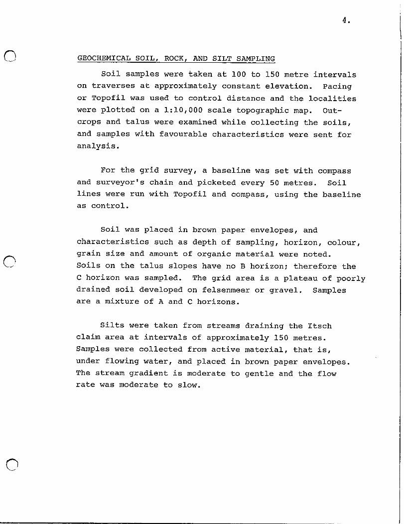
n GEOCHEMICAL SOIL ROCK AND SILT SAMPLING
Soil samples were taken at 100 to 150 metre intervals
on traverses at approximately constant elevation Pacingor Topofil was used to control distance and the localities
were plotted on a 1 10 000 scale topographic map Out
crops and talus were examined while collecting the soils
and samples with favourable characteristics were sent for
analysis
For the grid survey a baseline was set with compass
and surveyor s chain and picketed every 50 metres Soil
lines were run with Topofil and compass using the baseline
as control
o
Soil was placed in brown paper envelopes and
characteristics such as depth of sampling horizon colour
grain size and amount of organic material were noted
Soils on the talus slopes have no B horizon therefore the
C horizon was sampled The grid area is a plateau of poorlydrained soil developed on felsenmeer or gravel Samplesare a mixture of A and C horizons
Silts were taken from streams draining the Itsch
claim area at intervals of approximately 150 metres
Samples were collected from active material that is
under flowing water and placed in brown paper envelopesThe stream gradient is moderate to gentle and the flow
rate was moderate to slow
o

5
o GEOCHEMICAL ANALYSIS
Samples were sent to Min En Laboratories and were
ana lysed for gold silver copper lead zinc and
molybdenum The analytical procedure for each element
is briefly described below
The samples are dried at 950 C Soil and stream
sediment samples are screened by 80 mesh sieve to
obtain the minus 80 mesh fraction for analysisThe rock samples are crushed and pulverized byceramic plated pulverizer
For gold a suitable sample weight 5 or 10 gramsis pretreated with HN03 and HCI04 mixture
After pretreatment the samples are digested with
Aqua Regia solution and after digestion the samplesare taken up with 25 HCl to suitable volume
Sample solutions are prepared with Methyl Iso ButylKetone for the extraction of gold
o with a set of suitable standard solutions
analysed by Atomic Absorption instrumentsobtained detection limit is 5 ppb
gold isThe
For silver copper lead zinc and molybdenum samplesweighing 1 0 gram are digested for 6 hours with HN03and HCI04 mixture
After cooling the samples are diluted to standard
volume The solutions are analysed by Atomic
Absorption Spectrophotometers using the CH2H2 AirFlame combination for silver copper and lead The
C2H2 N02 mixture is used for molybdenum
o
o
6
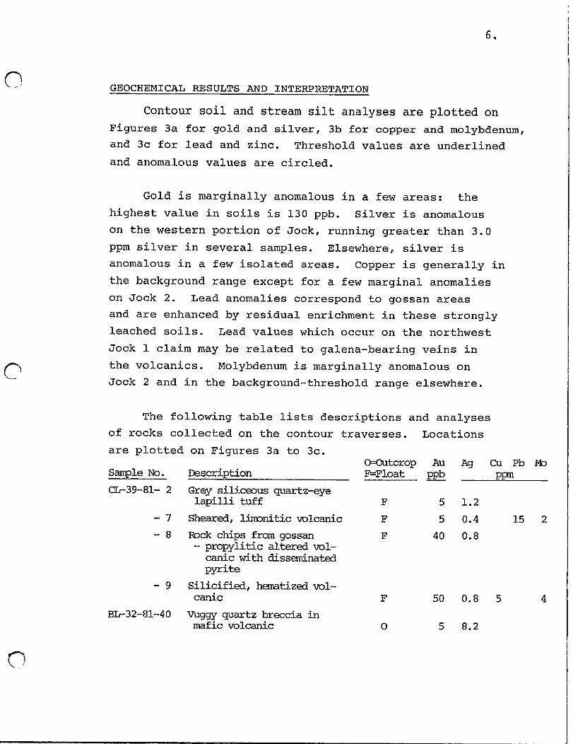
GEOCHEMICAL RESULTS AND INTERPRETATION
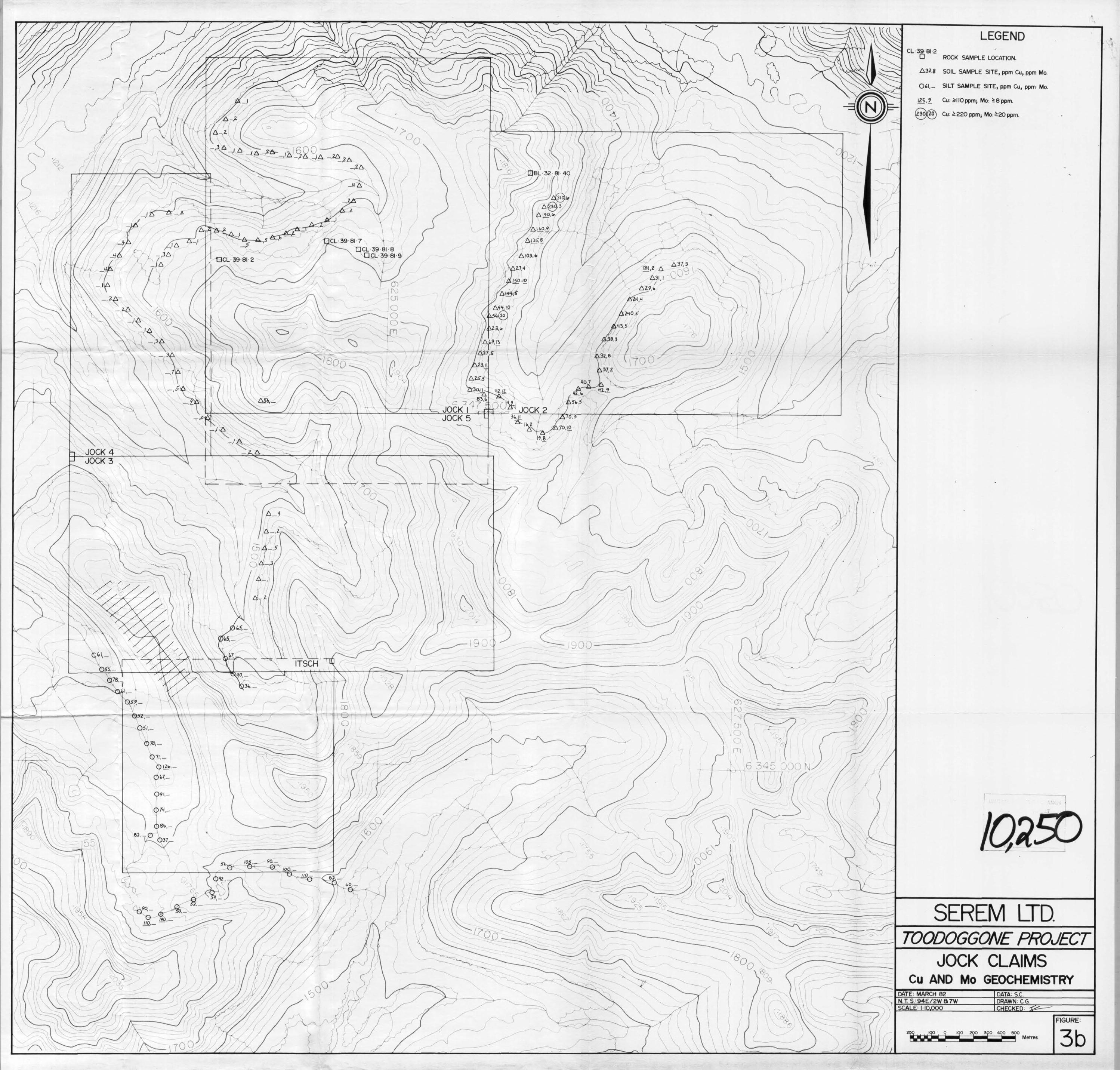
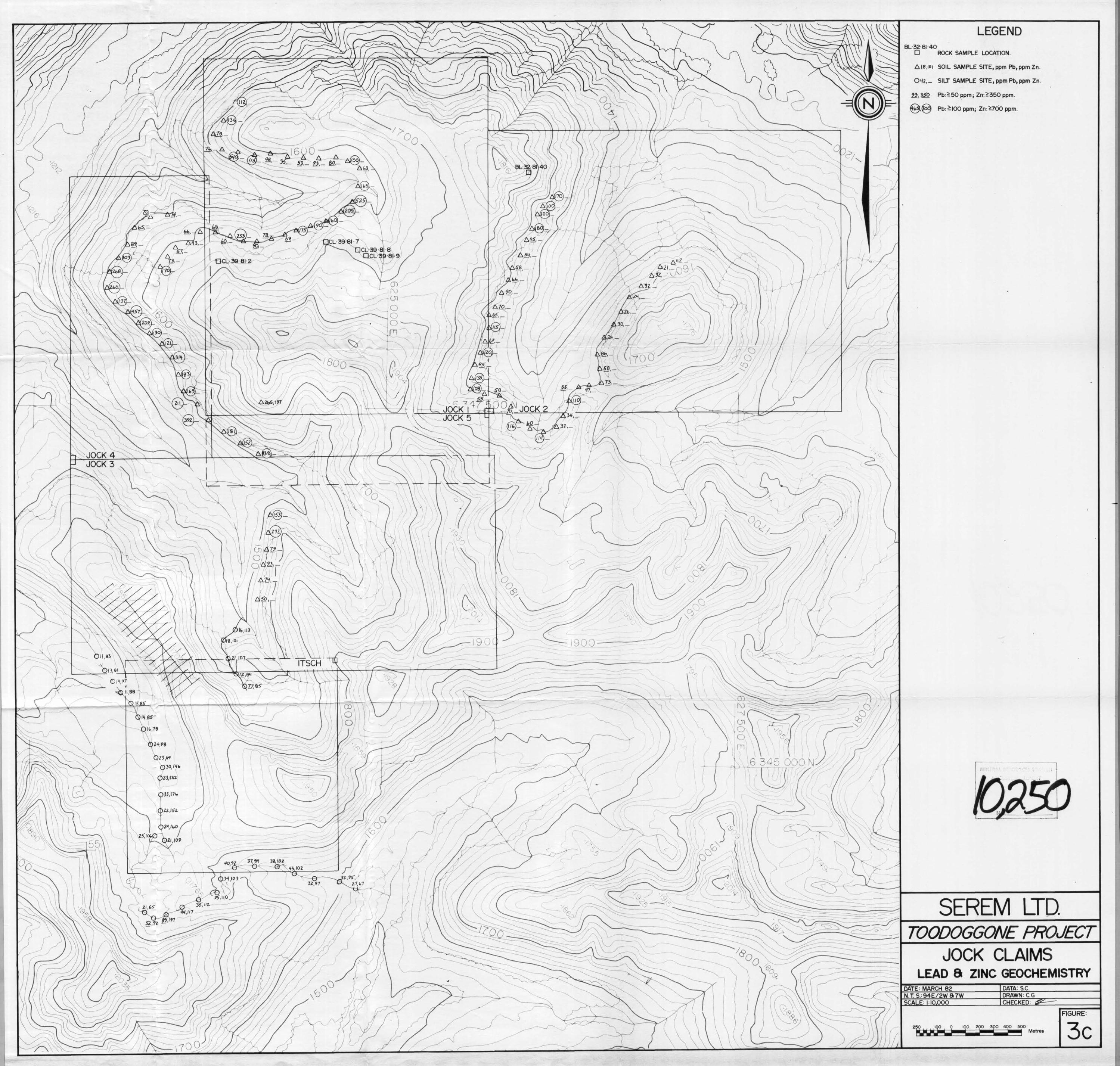
Contour soil and stream silt analyses are plotted on
Figures 3a for gold and silver 3b for copper and molybdenumand 3c for lead and zinc Threshold values are underlined
and anomalous values are circled
Gold is marginally anomalous in a few areas the
highest value in soils is 130 ppb Silver is anomalous
on the western portion of Jock running greater than 3 0
ppm silver in several samples Elsewhere silver is
anomalous in a few isolated areas Copper is generally in
the background range except for a few marginal anomalies
on Jock 2 Lead anomalies correspond to gossan areas
and are enhanced by residual enrichment in these stronglyleached soils Lead values which occur on the northwest
Jock 1 claim may be related to galena bearing veins in
the volcanics Molybdenum is marginally anomalous on
Jock 2 and in the background threshold range elsewhereo
The following table lists descriptions and analysesof rocks collected on the contour traverses Locations
are plotted on Figures 3a to 3c
Description
Grey siliceous quartz eyelapilli tuff
Sheared limonitic volcanic
Rock chips from gossan
propylitic altered vol
canic with disseminated
pyriteSilicified hamtized volcanic
BIr32 81 40 Vuggy quartz breccia inmafic volcanic
Sample No
CIr39 81 2
7
8
9
o
OOutcrop Au Ag CU Pb ibFFloat ppb ppn
F 5 12
F 5 0 4 15 2
F 40 0 8
F 50 40 8 5
o 5 8 2
7
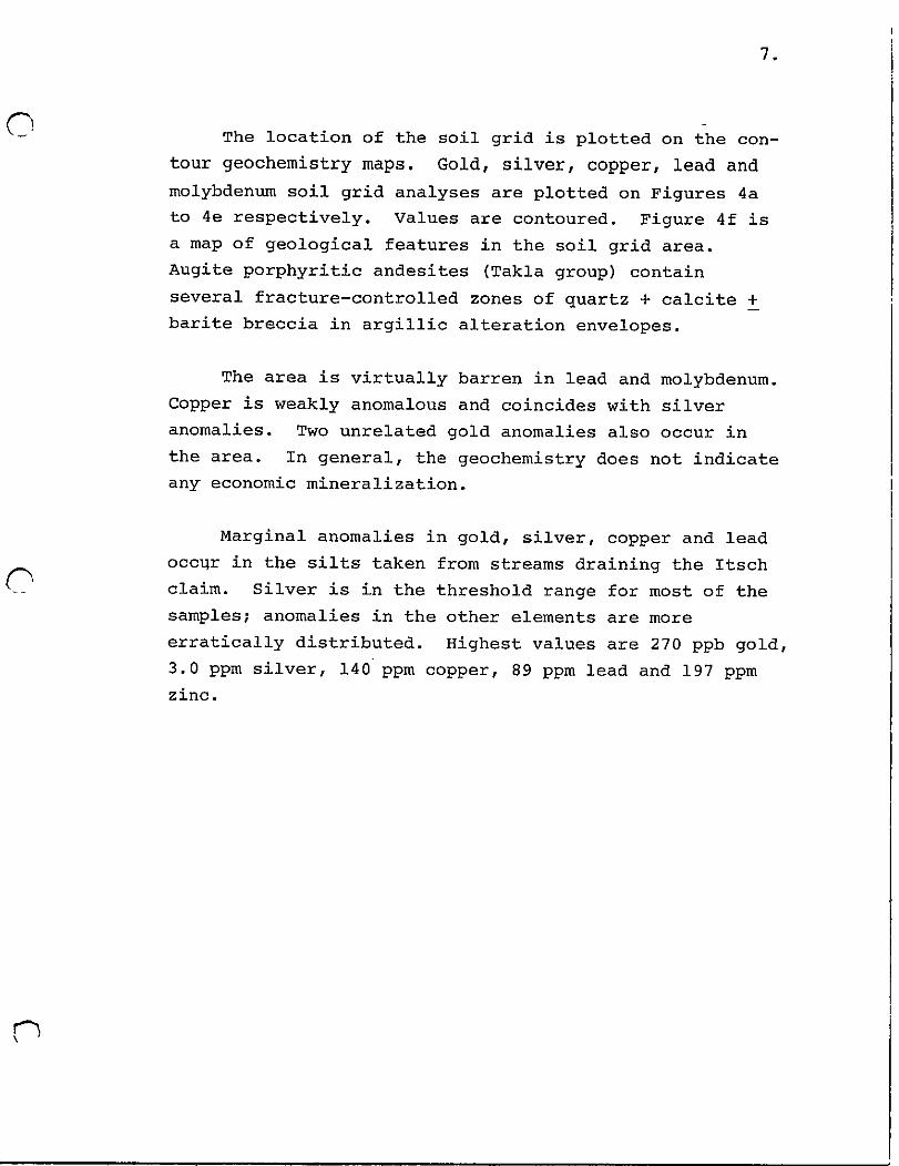
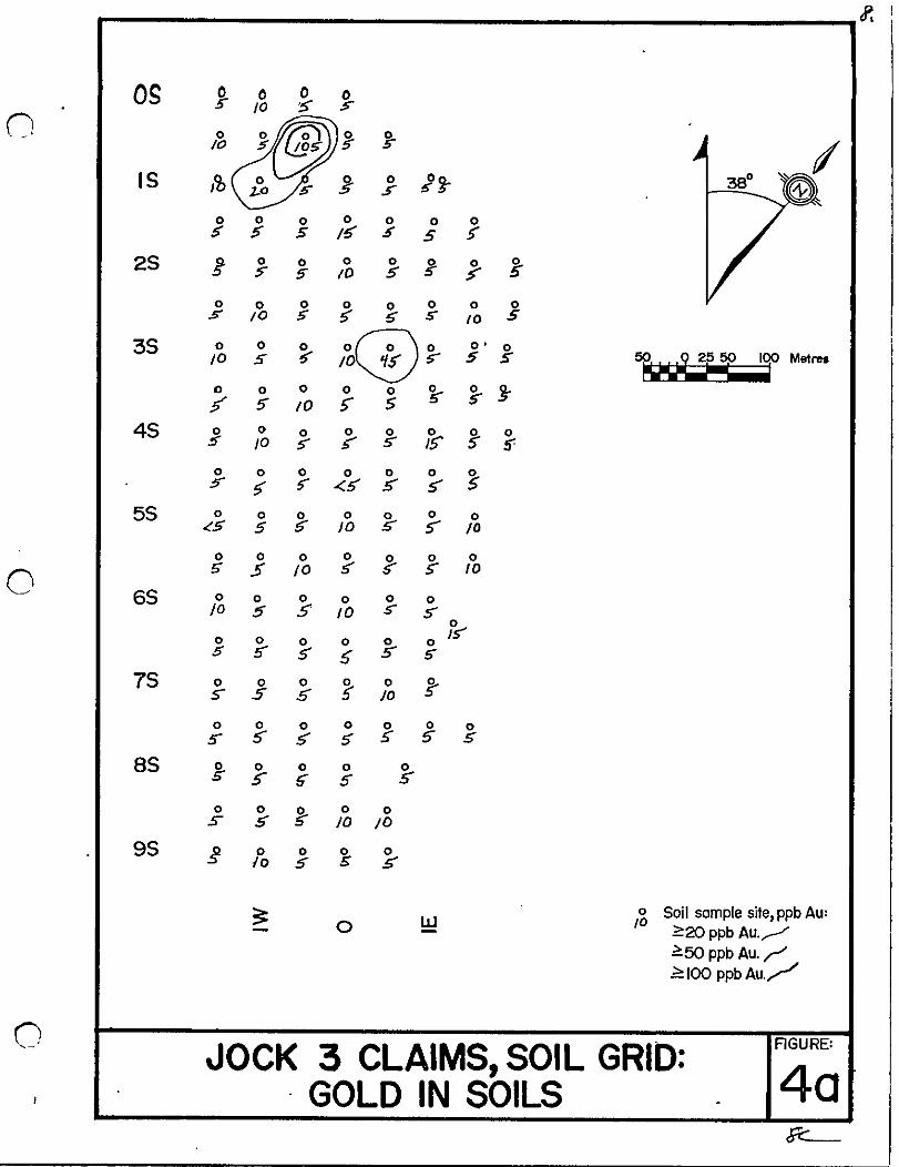
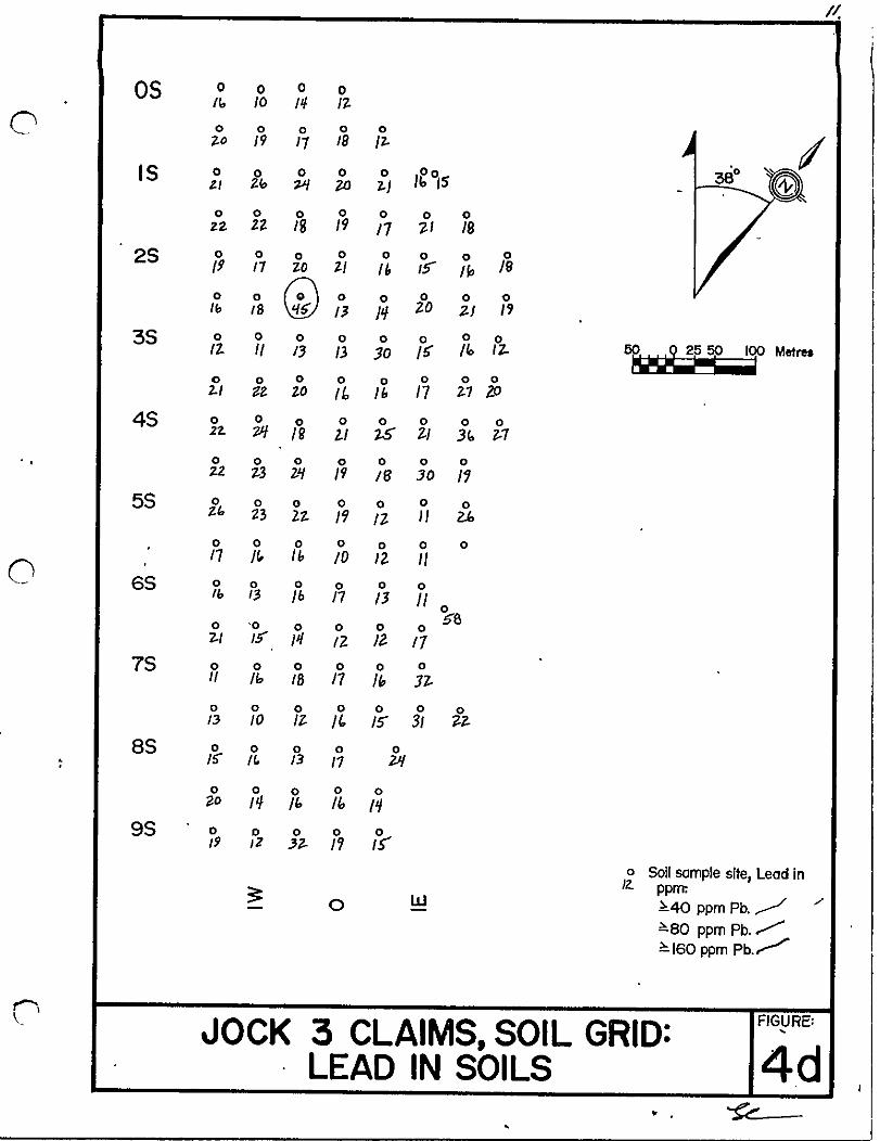
o The location of the soil grid is plotted on the con
tour geochemistry maps Gold silver copper lead and
molybdenum soil grid analyses are plotted on Figures 4a
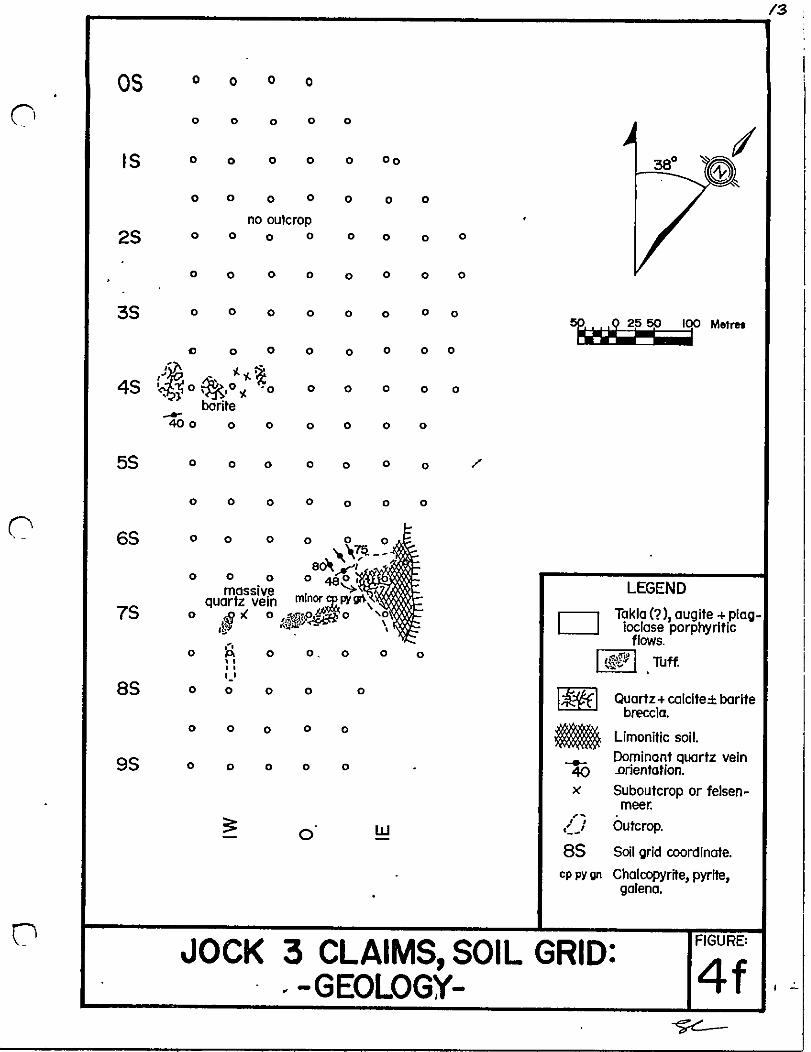
to 4e respectively Values are contoured Figure 4f is
a map of geological features in the soil grid area
Augite porphyritic andesites Takla group contain
several fracture controlled zones of quartz calcite
barite breccia in argillic alteration envelopes
The area is virtually barren in lead and molybdenumCopper is weakly anomalous and coincides with silver
anomalies Two unrelated gold anomalies also occur in
the area In general the geochemistry does not indicate
any economic mineralization
o
Marginal anomalies in gold silver copper and lead
occ r in the silts taken from streams draining the Itsch
claim silver is in the threshold range for most of the
samples anomalies in the other elements are more
erratically distributed Highest values are 270 ppb gold3 0 ppm silver 140 ppm copper 89 ppm lead and 197 ppm
zinc
n
If
os 0 0 05 1
0 010 5
IS b 0 151
0 0 0 0 0 0 05 5 s 5 5
25 g o 0 0 0 0 5s ID 5
0 0 0 0 0 0 0 01 10 S G S 0 5
35 0 0 0 O@O O 010 S 5 0 5 5 5 5 Melrea
0 0 0 0 0 0 j5 10 i 5 S
45 0 0 0 0 0 0 S o10 S 5 S 15 s
0 0 0 0 0 0 Ss S 5
55 0 0 0 0 0 0 05 5 ID S S ID
0 0 0 0 0 0 0
05 5 10 S 5 ID
65 0 0 0 0 0 00 5 5 0 s
0
0 0 0 0 0Is
0
s J 5 5 5 5
75 0 0 0 S o S5 S 0
0 0 0 0 0 0 05 5 5 5 5 5
85 0 0 0 0 05 S 5 5 S
o 0 0 0s 5 ID D
95 0 0 0 0
0 S S S
0 Soil sample site ppb Au0 W 0
20 ppb Au
50 ppb Au rIOO ppbAu
0JOCK 3 CLAIMS SOIL GRID
AGURE
40GOLD IN SOILS

9
os 0 0 0 01 9 0 0 0 1
CI 0 0 0 0 0
Oe 07 0 0 OS
IS 0 0 0 0 01 8 93 1 1 0 0 7 0
0 0 0 0 0 0 01 1 2 0 0 8 0 9 O S 1 0
2S 0 0 0 0 0 0 0 0
1 0 1 0 0 Q9 0 9 0 9
0 0 0 0 0 0 0 0Z 2 O 0 9 0 9 09 0 3
35 0 0 0 0 0 0 0 02 O S 0 7 08 0 1 0 0 0 1 OO Metres
0 0 0 0 0 0 01 1 3 18 O a 3 09
45 0 @o 0 0 0 0 0II z o I b 1 3 11 1 1 1 1
0 0 0 0 0 01 1 I z 1 1 0 as 1 3
55 0 0 0 0 0 0o1 1 1 5 0 6 0 6
0Z 7@ I b
0 0 0
Z b 09 10
0 65 0 0 0 0 0 01 0 0 9 1 0 0 9 0 06
0 0f6
0 0 0 0
0 9 09 1 1 09
75 0 0 0 0 0 0
1 0 1 2 0 Of 7 1 1
0 0 0 0 0 0 00 9 0 5 0 7 0 1 as IZ 1 0
85 0 0 0 0 001 DS 0 7 09 i
0 0 0 0 0as 0 7 09 0 0 7
95 0 0 0 0 009 0 9 1 0 09 07
3 0 Soil sample site Silver 1n0 W 0
pplm
2o ppm A930ppm Ag4 0 ppm Ag
0JOCK 3 CLAIMS SOIL GRID
FIGURE
4bSILVER IN SOILS
Y

0
os o I 0 0 07 0 II 6
n 0 0 0 0zll a ro
IS 0 0 0 0 o 0055 15 0 10 10 7
o 0 0 0 0 0
116 IS I 1 II 1 e
25 0IIJ 0 0 0 0 0 0
0 za 3 2 S b 9I
o J 0 0 0 0 0 0 0
h3 8 3S I fI I 0 II
35 0 0 0 0 0 0 0 0
51 5J 31 IS 0 e 12 Matreo
rD
10 0 0 0 0 0
is 5 27 U 2 13 J1
45 o I 0 I0 0 0 0 0 0
IZ I 9 b6 13 If 11 IIf
0 0 0 0 0 0 05 15 71 I li l If
55 0 0 0f15 0 0 09 70 8 I
CI i J7 31
0 0 o 0 0 0 06 2 90 30 21 30
n65 0 0 0 0 0 0
1 3 36 27 31 370
0 0 0 0 0 o31
30 3Z Z J I 23 29
75 0 0 0 0 0 0
51 16 j 13 18
o I 0 0 0 0 0 018 U 2 If Ie 110
85 01 0 0 0 01 I 53 20 27
Io 0 0 o 0
88 38 31 6E
95 b o 6 o 0
3 7 11 610
3 0 Soli sample site ppm Cu0 W
60 ppm Cu
IOO ppm Cu
200 ppm Cu
nJOCK 3 CLAIMS SOIL GRID
FIGURE
4cCOPPER IN SOilS
II
os 0 0 0 010 11 I
0 0 0 0 0 0
70 19 17 18 2
IS 0 0 0 0 0 eoSt 710 UJ 2
0 0 0 0 0 0 0
1Z 2 18 9 17 t I 18
25 0 0 0 0 0 0 0 0
19 17 10 21 Ib IS lip 19
0 0 J 0 0 0 0 0Ib 18 J N ZO 21 19
35 0 0 0 0 0 0 0 011 II 13 13 0 15 110 IZ Metres
0 0 0 0 0 0 0 021 tt 20 Ii II 17 77
4S 0 0 0 0 0 0 0 022 VI Ig 21 5 ZI 3 77
0 0 0 0 0 0 0u 73 21 19 18 30 11
5S 0 0 0 0 0 0 071 23 2 2 19 IZ 2k
0 0 0 0 0 0 0
017 1 Ib 0 IZ 1
65 0 0 0 0 0 0II 13 Ib 17 13 11
0
0 0 0 058
0 0ZI IS II Z 12 7
75 0 0 0 0 0 0
II It 18 17 1 JZ
0 0 0 0 0 0 013 10 IZ 1 IS 31 7
8S 0 0 0 0 0I 13 11 ZJ
0 0 0 0 070 11 1 I I
95 0 0 0 0 019 12 32 11 IS
0 Soil sample site Lead in
3Il ppm
0 W40 ppm Pb
80 ppm Pb
160ppm Pb
JOCK 3 CLAIMS SOIL GRIDLEAD IN SOILS
FIGURE
4dp
I
os
CI
IS
25
35
o o
o o
o o
o o
o
no outcropo 0 0
o o
o o
l 0 0
As4S o
IO0
barite400 0 0
55
o 65
75
85
95
Q
o o
o o
o o
o o o
o 00o o
o o o oo
o o oo
o oo o oo
o o 0
Metreso o o
o o o 0o
o o o o 0
o o oo
o o oo o
o o o o o
o 0 0 0 0 0
80o 0 0 0 480 f
massivequartz vein minor P Pl gr
o SJ 0 Oli 0 O
IW lli Y99 oo a
oo
o o
o o
o o 0 o
3
LEGEND
Takla augite plagioclase porphyritic
flows
Tuff
QuartH calcitebarlfebreccia
Limonitic soil
Dominant quartz veinorientation
Suboutcrop or felsenmeer
OutcropSoil grid coordinate
Chalcopyrne pyritegalena
FIGURE
JOCK 3 CLAIMS SOIL GRIDGEOLOGY
o
o o o
o o o
o40x
o o
o l1J
85cp py on
4f
14
o CONCLUSIONS AND RECOMMENDATIONS
The Jock claim group is underlain by volcanic rocks
which have been subjected to intense hydrothermal altera
tion A large highly leached gossan formed by later
oxidation of disseminated pyrite affects the geochemical
signature of the area by enhancing certain elements such
as lead and diluting others such as copper Geochemical
sampling ha9 outlined an area on Jock 2 and one on the
Itsch claims which have anomalous precious metal values
These areas should be mapped and prospected in detail
Further work would depend on these results
o
o
15
o CERTIFICATE OF QUALIFICATIONS
I Sheila A Crawford certify that
1 I am a geologist employed by Serem Ltd
2 I have an Honours Bachelor of Science degree
First Class in Geology from Carleton Universityin ottawa Ontario
3 I have worked in mineral exploration or
geological mapping since 1976 and have acted in
responsible positions since 1979
4 I personally examined the property and directed
the geochemical survey
S I have no financial interest either direct or
indirect in the property
Vancouver B C
1

CJ STATEMENT OF EXPENDITURES
Analyses
197 soils and silts analysed for Au Ag CU PbM or Zn
56 soils and silts analysed for Au Ag Pb M
2 rocks analysed for Au Ag CU or Pb M
1 rock analysed for Au Ag CU
2 rocks analysed for Au Ag
Shipping st Smithers to Van uver Laboratory258 samples
16
@ 10 55 2 078 35
@ 9 65 540 40
@ 11 05 22 10
@ 10 15 10 15
@ 9 25 18 50
@ 0 30 77 40
2 746 90 2 747 00
Wages
Contour soil rock and stream silt sarrplingAugust 11 12 1981
C Lormand 2 days @ SO dayB Lane 2 days @ s6 day
Soil grid survey August 29 1981
C IDJmand 1 day @ SO day
C Greig 1 day @ SO dayEvaluation mapping and supervision Aug 12 29 1981
S Crawford 2 x 5 day @ 92 dayReport writing and map preparation March 1982
S Crawford 2 days @ l1s dayDrafting March 1982
C Greig llz days @ 72 day
Board Lodging and Field Expenses
7 days @ 52 dayTransportation
Helicopter 1 hr 40 min @ 47shr
1bpographic Map 1 10 000 scale
Buxnett Resources
1btal
1
100 00
112 00
50 00
50 00
92 00
230 00
108 00
742 00
364 00
792 00
948 00
5 593 00