Embed Size (px)
Citation preview
! j. '1
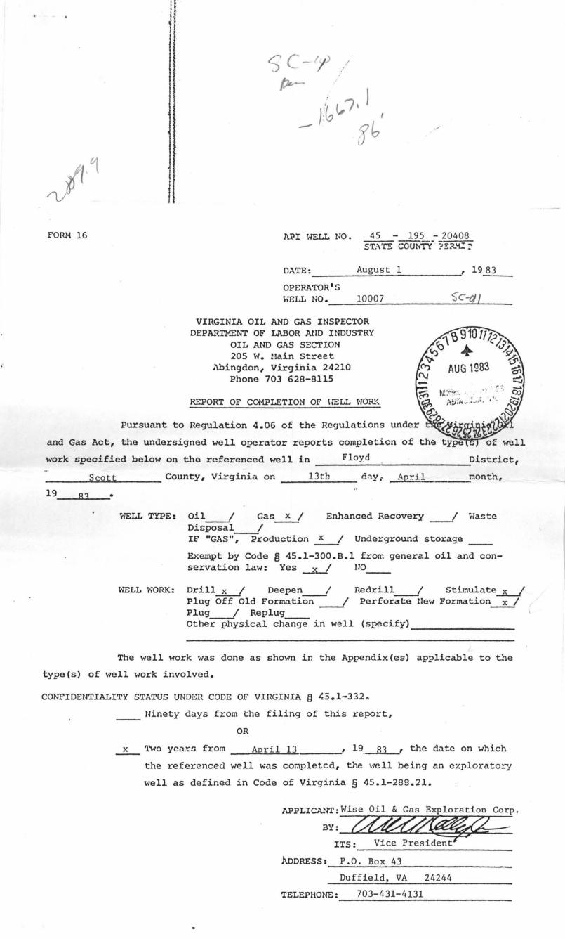
FORM 16 1\.P I WELL NO. 45 - 195 - 20408 STA'rE COUNTY-' ?:.:::t<.C::,
DATE: ____________ A_u~g~u_s_t __ 1 _____________ , 19_8_3 __ _
OPERATOR'S HELL NO • __ ~1..:..00~0;;..;.7 ______ ~_C_-(j~/ __
VIRGINIA OIL AND GAS INSPECTOR DEPARTMENT OF LABOR AND INDUSTRY
OIL AND GAS SECTION 205 W. Main Street
Abingdon, Virginia 24210 Phone 703 628-8115
REPORT OF COMPLETION OF HELL HORK
Pursuant to Regulation 4.06 of the Regulations
and Gas Act, the undersigned well operator reports completion
work specified below on the referenced well in _______ F_l_o..,;Y_d ____________ -..;-District,
______ --"s~co:..::o~t...:.t ....... ____ County, Virginia on ___ 1_3;...t_h_. _____ d:'\y;- April t:\onth,
HELL TYPE: Oil __ 1 Gas~ Enhanced Recovery __ I Waste
l'1ELL WORK:
Disposal 1 IF "GAs";--Froduction ~ Underground storage
Exempt by Code § 45.1-300.B.l from general oil and conservation law: Yes ~ no
Drill x 1 neepen ____ 1 Redrill-.J Stinulate..1L..l Plug Off Old Formation ___ I Perforate New Formation-LI Plug 1 Replug Other physical change in well (specify) ____________ ~ __
The well work was done as shown in the Appendix(es) applicable to the
type (5) of "lell work involved.
CONFIDENTIALITY STATUS UNDER CODE OF VIRGINIA § ~5~l-332~
Ninety days from the filing of this report,
OR
x Two yea.t"s from ___ --"Ao!.Ip;:..:r::...;:i:;,.:;1"---'=1::.:3'-______ ,' 19. 83 , the date on which
the referenced well was cOr.1pletcd, the VICll being an exploratory
well as defined in Code of Virginia § 45.1-288.21.
APPLlCANT:Wise Oil & Gas Exploration Corp.
BY: -ITS: Vice Preside;t
ADDRESS: P.O. Box 43
Duffield, VA 24244
TELEPHONE: ____ 70_3_-_4_3_l_-_4_13_l ___________ ___
I
J
FORB 16 J\~)PF;!-ID::: TYPE .. • l\., S!-iEET 1 (OD'vi::RSE)
API HELL ~jO'_EL St :l ::C!
195 - 20408
DATE: August 1, 1983 Operator's l'le1l No. 10007 ----------------------------
REPORT OF CONPLETION OF l'lELL \'lORK IF DRILLING, REDRILLING OR DEEPENING IS INVOLVED
DRILLING CONTRACTOR Clint Hurt & Associates ----------~~~~~~~~~----------------------------------------
ADDRESS ____ ~M~i~d~l~a~n~du,~T~e"x~a~s~ __________________________________________________________ _
TELEPHONE 915-683-6381 -------------------------------------------DEPTH OF COMPLETED \'lELL 5803 FEET
--------~~--------------~
DRILLING RIG Rotary x I Cable Tool __ --<I
GEOLOGICAL DATA DEPTH THICKNESS Top Bottom
Fresh water: 131'
Salt water: n/a
tUNING IN AREl\:' Name Yes No Mined
Out Coal seams: 264' 265' x
706' 708' x 985' 988' x
1076' 1078' x 1115' 1120' x
oil and Name gas:
Gas 4616' 4712' Berea/Shale
The data on depth of strata is based on the s('lUrce (s) checked ;:,el",-,!
x Applicant's own drilling experience in the area
Information supplied by the coal operator. in the area ---Information already in the possession of the Inspector
--~
x As follows: ____ W~e~.l~l_L~o~g~s ________________________________ ___
"
FORM 16
t · i 1 1-1
I
I :1 t
I
i\PPE~DIX TYPE;\, SHSET 1 (REVERSE)
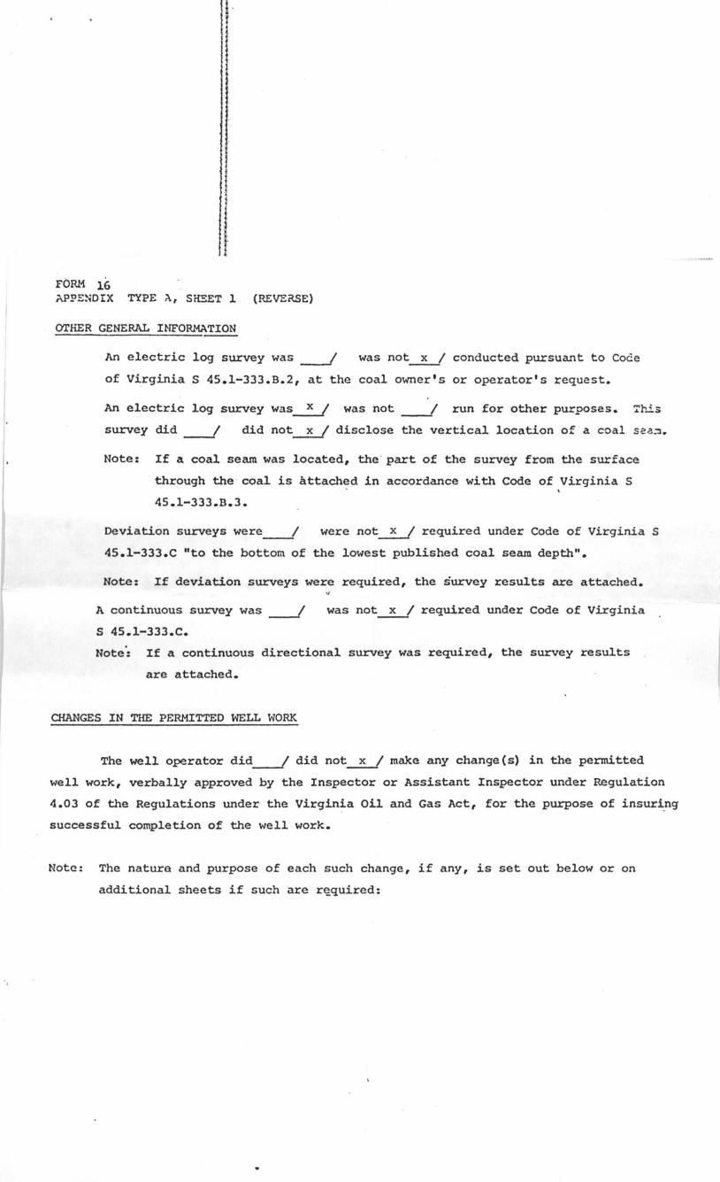
OTHER GENERAL INFORMATION
An electric log survey was ----I was not~ conducted pursuant to Code
of Virginia S 45.1-333.B.2, at the coal owner's or operator's request.
An electric log survey was~ was not ____ I run for other purposes. Tr~s
survey did ____ I did not~ disclose the vertical location of a coal seG~.
Note: If a coal seam was located, the ' part of the survey from the surface
through the coal is attached in accordance with Code of Virginia S
45.1-333.B.3.
Deviation surveys were ____ 1 were not~ required under Code of Virginia S
45.l-333.C "to the bottom of the lowest published coal seam depth ...
Note: If deviation surveys were required, the survey results are attached.
A continuous survey was ----I S 4S.l-333.C.
was not~ required under Code of Virginia
Note': If a continuous directional survey was required, the survey results
are attached.
CHANGES IN THE PERMITTED WELL WORK
The well operator did ____ 1 did not~ make any change(s) in the permitted
well work, verbally approved by the Inspector or Assistant Inspector under RegUlation
4.03 of the Regulations under the Virginia Oil and Gas Act, for the purpose of insuri.ng
successful completion of the well work.
Note: The natura and purpose of each such change, if any, is set out below or on
additional sheets if such are r~quired:
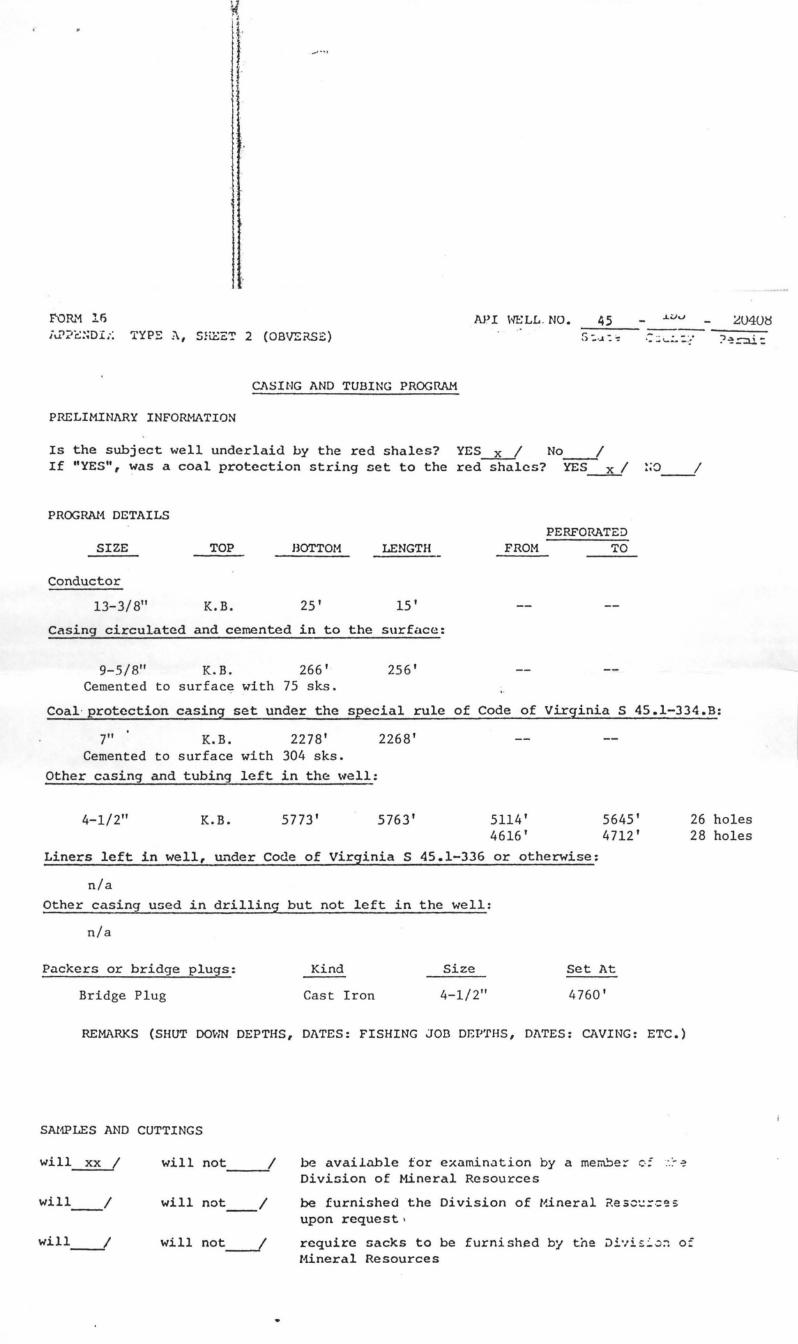
API HELL . NO. 45 ~040~
TYP~;\, SHBET 2 (OBV£RS£) :, : . ..l: ': --------.: :;,\.-.:. -:::- ?~=:U:
CASING AND TUBING PROGRAM
PRELIMINARY INFORMATION
Is the subject well underlaid by the red shales? YES~ No ____ 1 If "YES", was a coal protection string set to the red shales? YES __ x_1 :;0 __ 1
PROGRAI1 DETAILS
SIZE TOP HOTT0t1 LENGTH
Conductor
13-3/8" K.B. 25' 15'
Casing circulated and cemented in to the surface:
9-5/8" K. B. 266' 256' Cemented to surface with 75 sks.
FROM PERFORATED
TO
Coal· protection casing set under the special rule of Code of Virginia S 45.l-334.B:
7" K.B. 2278' 2268' Cemented to surface with 304 sks.
Other casing and tubing left in the \'Iell:
4-1/2" K.B. 5773' 5763' 5114' 4616'
5645' 4712'
Liners left in well, lli.der Code of Virginia S 45.1-336 or otherwise:
n/a Other casing u5ed in drilling but not left in the well:
n/a
Packers or bridge plugs: Kind Size Set At
Bridge Plug Cast Iron 4-1/2" 4760'
REMARKS (SHUT DOvrn DEPTHS, DATES: FISHING JOB DEP'fHS, DATES: CAVING: ETC.)
SAl1PLES AND CUTTINGS
will xx 1 will not 1 -~
wi 11 __ 1 will not /
be available for examination by a me~e~ c·;.-.:- ~ Divi5ion of Mineral Resources
be furni5hed the Division of l~.ineral ?e s~',;;, ·::e s upon request.
26 holes 28 holes
wi 11 __ 1 will not---f require sacks to be furnished by the ~i'lis~~~ of ttineral Resources
,J"
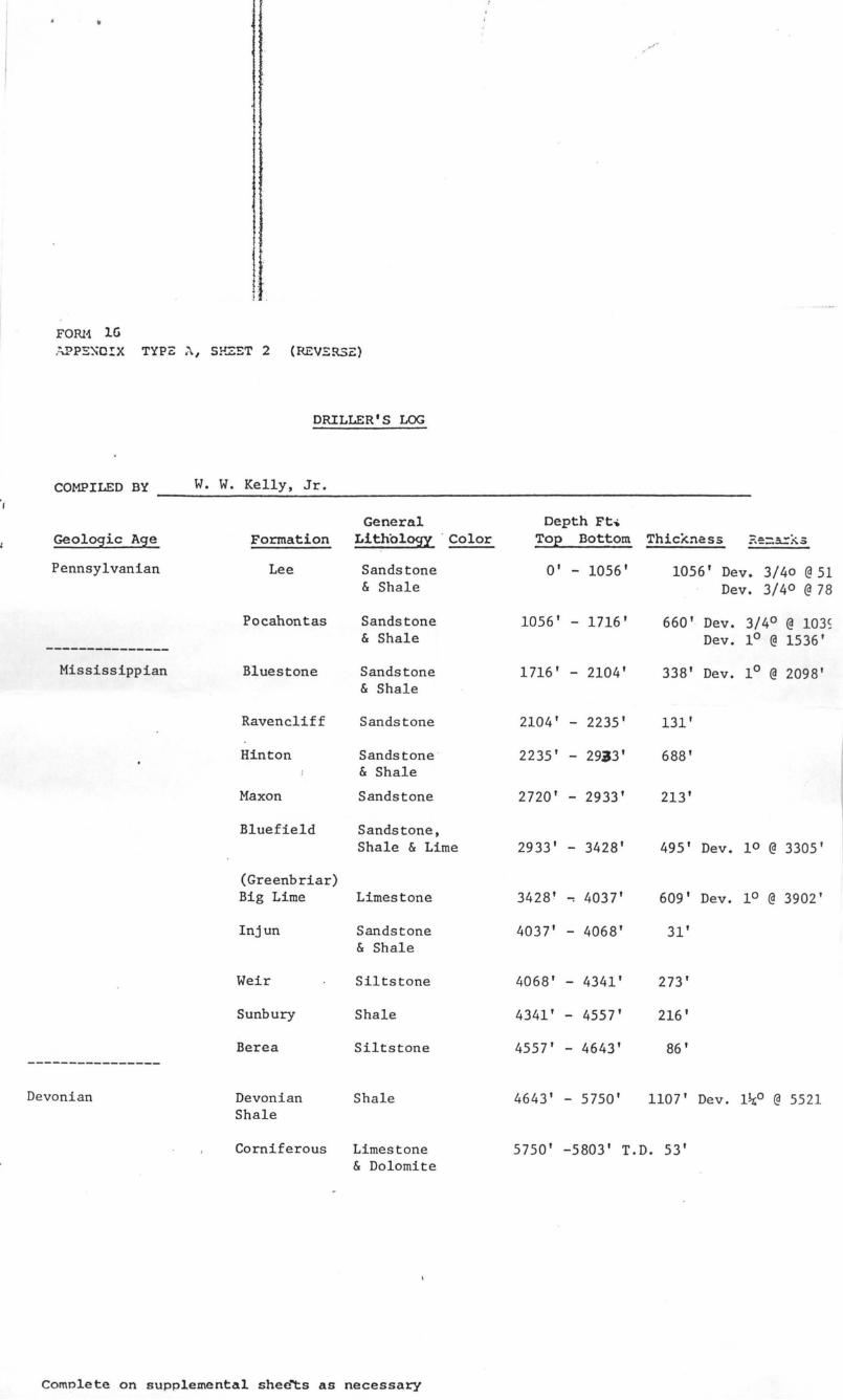
FORl1 lG .~,.pPE);Q!:X TYPe::., SHZET 2 (REV'::R5e:)
DRILLER • S LOG
COMPILED BY W. W. Kelly, Jr. t
General Depth Ft .. Geologic Age Formation Lithology . Color Top Bottom Thici<n<!ss ?.e=~~s
Pennsylvanian Lee Sandstone 0' - 1056' 1056' Dev. 3/40 @ 51 & Shale Dev. 3/40 @ 78
Pocahontas Sandstone 1056' - 1716' 660' Dev. 3/40 @ 1035 & Shale Dev. 10 @ 1536' ---------------
Mississippian Bluestone Sandstone 1716' - 2104' 338' Dev. 10 @ 2098' & Shale
Ravencliff Sandstone 2104' - 2235' 131'
Hinton Sandstone 2235' - 29.J3' 688' & Shale
Maxon Sandstone 2720' - 2933' 213'
Bluefield Sandstone, Shale & Lime 2933' - 3428' 495' Dev. 10 @ 3305'
(Greenbriar) Big Lime Limestone 3428' ..., 4037' 609' Dev . 10 @ 3902'
Injun Sandstone 4037' - 4068' 31 ' & Shale
Weir Siltstone 4068' - 4341' 273'
Sunbury Shale 4341' - 4557' 216'
Berea Siltstone 4557' - 4643' 86 ' ----------------
Devonian Devonian Shale 4643' - 5750' 1107 ' Dev. l~o @ 5521 Shale
Corniferous Limestone 5750' -5803' T.D. 53' & Dolomite
complete on supplemental shec~s as necessary
• •
l ' f '
I
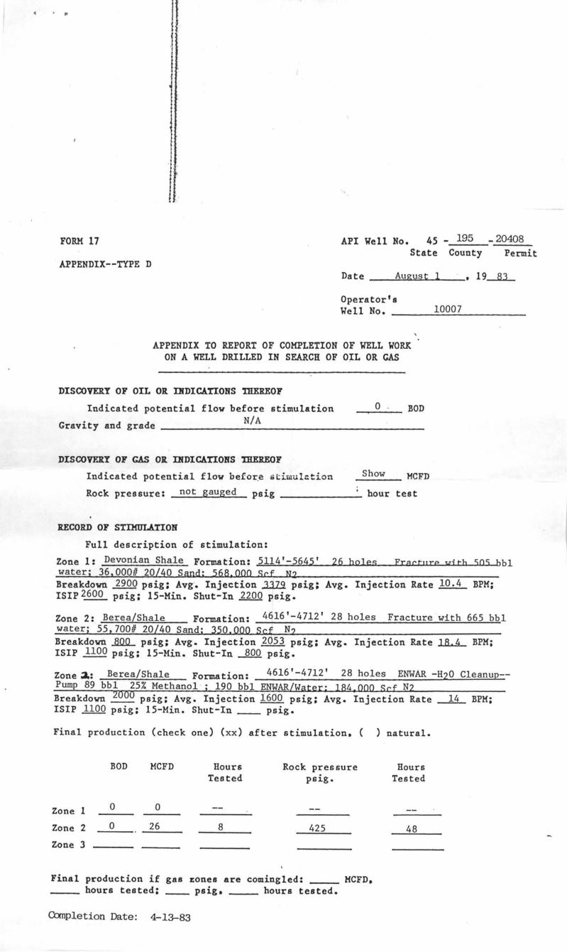
FORM 17 API Well No. 45 - 195 - 20408 State County Permit
APPENDIX--TYPE D Da t e __ ..:.A=u"",g"",u"",s,-"t,-""l __ • 19--1tL
Operator's Well No.
APPENDIX TO REPORT OF COMPLETION OF WELL WORK ON A WELL DRILLED IN SEARCH OF OIL OR GAS
DISCOVERY OF OIL OR DlDICATIONS llIEREOF
Indicated potential flow before stimulation o ' BOD Gravity and grade ___________ N_/_A ______________________ __
DISCOVERY OF GAS OR DlDlCATIONS llIEREOF
Indicated potential flow oefor,e iitilllul::tion Show }ofCFD
Rock pressure: not gauged psig ____________ . bour test
RECORD OF STIMULATION
Full description of stimulation:
10007
Zone 1: Devonian Shale Formation: 5114'-5645' water; 36,000# 20/40 Sand: 568,000 Scf N2
26 boJ es Fracture wi tb 505 bb1
Breakdown 2900 psig: Avg'. Injection ..1.1ll psig: ISIP 2600 psig: 15-Min. Shut-In 2200 psig.
Avg. Injection Rate 10.4 BPM:
Zone 2: Berea/Shale Formation: 4616'-4712' 28 holes Fracture with 665 bb1 water; 55,700# 20/40 Sand; 350,000 Sef N2 Breakdown ~ psig: Avg. Injection 2053 psig: Avg. Injection Rate ~ BPH: ISIP 1100 psig: 15-lotin. Shut-In 800 psig.
Zone~: Berea/Shale Formation: 4616'-4712' 28 holes ENWAR -H20 Cleanup--Pump 89 bb1 25% Methanol ; 190 bb1 ENWAR/Water: 184,000 Sef N2 Breakdown 2000 psig: Avg. Injection 1600 psig: Avg. Injection Rate ~ BPH: ISIP 1100 psig: I5-Min. Shut-In __ psig.
Final production (check one) (xx) after stimulation. ( ) natural.
BOD HCFD Hours Rock pressure Hours Tested paige Tested
Zone 1 0 0
Zone 2 0 26 8 425 48 Zone 3
Final production if gas zones are comingled: HCFD. ____ hours tested: ___ psig. hours tested.
Completion Date: 4-13-83
o
2
-< r 11-4 -.: \0 ,~ , . ,,~
II~
1\ '\\
. ,
,
..;
~ .
N.w Location. :: • • DrUI 0" ........ ,0 ...... 0"""" •........ 0
. . "
... _-----
Fa ... -~~~~~~~~~~~~~U1XL __ -J
Tract -------
Q: a dran g 1. ___ --..,;.tr_T_, --:...:;.:..:~.:.;;..:.:.:.:.--.:.--------J
C,ount '1_-=-.:;..~-+-.,..:;.....I
Engln •• r ........ ~IU.::~~+L~~~~~~L __ --J EnQIM.,'. FIte No , ______ DrawinQ NO . _____ .....
Scale ," =
Latitud. 36-52-30
, r ..,
• - o4t; ,
.+ -10007
~ • . £~ ... .
, ~ )"" '-
t.0enot.. . wit en United Stale. oPOQrGphic Mcrp •• teal. I to 24.000 lat- ':
Uu d e and '0"""" • b.ing "",.."ted .. ' , by horder ...... tIhown. "i - Denali. .n.IM" apace. on border line of oriQlral tradn"
, ,
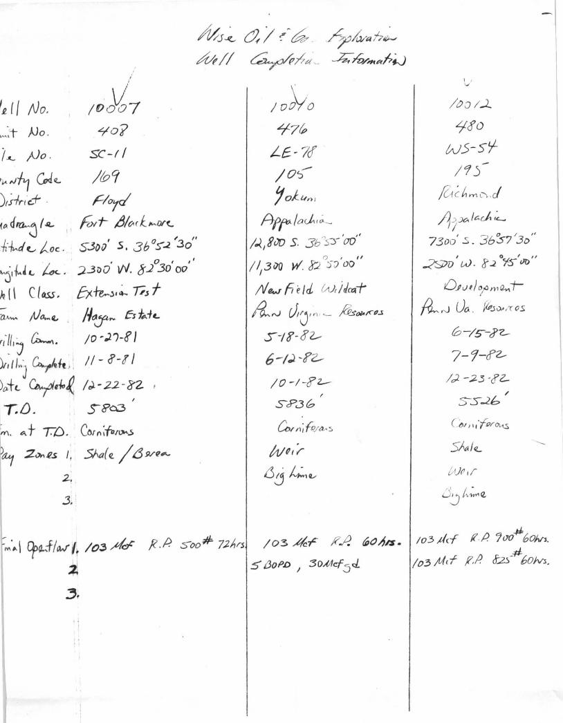
'£ (I No. ",,:t- )Jo .
i ..... )Jo.
I()O~7 LlO'?
SC-(/
~ Nft G,J~ /b9 )(f1y.('c..+ . Poye! {~d~~ I.IL. Fmf- 4/~( KJWY('
kJv-d f-. toe , 5301)' s. 3b 0S'~ 130"
~I~~c..~. ;J.3iJO· W. 8.2°30'00"
)Q [\ Class, &fe...J'~ TiJ f ~ ft}o-~ //~ Es~·h.
(J-~'Ij ~. /0 ,).')-f I
)rtfl"J ¥ h , II - ~-! I
)~+(. ¥t1o~ I J - 22 -8'Z
"D. S8'c3
~. e;. t TD. ~(I;fa.r~s
~ ;2."", Il.S I. SAar (!. / t3 9/fl,,*
2.
3.
MJ~ ai (~6,~ /?,~ah~
M // ~;-t;P.',., J;; yO/mRt?1.J
10)YO ~7(P
L£- 7! /o~
'jo):wn l
Aff1'lo~';-
1.J..,iiJD s. 3 b 'S'Y'OO"
() , " 1/,3 ilO W. J>:2 )~ GO
Ngwhdd W, iJad"
A.~ r.AJ,n, ..... ;G.$()/,f~(/.s
S -I?-o2-
6-/~ ~?Z-
/0 -/-g:'z.-
~";(O/tt-5
WQ,i-
6j~Q/
~~.~\ Dpo.,..f/wt /o~ Ad' F.P. soo# 72J,rs /03 4~ i?-I! ~oA/$.
-1l S /JOPD I :30Alfcf:sd
~f
V
l oa 1..1...
Ljto
w.5-5tf /15-
/ZI c h.·ftL'\ . J
11 rx;. / c;dt I~
73tJo' ..s. 36571
30"
I 0 I " .::?9v w. g ~ YS tID
{).Pv#.)~m~-r
~ ~ UtA . ~Jw/r 05
fO -Is--t?7..--
7-9-cf2./;2. -;2.3 -<YZ-
t V(I ,/'
.# /03,1/cf f(.p '7(}'(} 60Nl.
/03 ;f;f(T ,F,i? J-~--#60fvs.
FOR tv' 2 • Cor:I: 'onwl'al th (\f \ ' i. r;: lnin
DL!' .:L!:r..rr::lT OF L\;)O~ AIm U:DU:;T;:Y Divisi rlrt 01 1.:in(:5
Bi;; SLon ~~ G~;J, Vj r~jnja
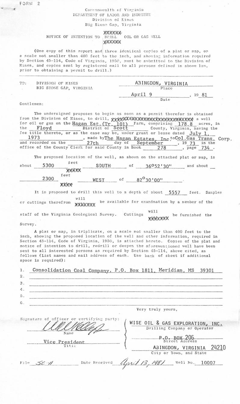
)&R90~XJ NOTICE OF UiTE!\'TlOi; TO n r. 1LL OIL on GAS ;'''-ELL
(On e c npy of th is roport anrl l:::~" en U cal cor' os of a n J at or map, on n scale not . smaller than 400 fect lo the inch, anu sh0\': in ; irlir)rmatirJn r e quired by Section 45-114, Code of Virginja, 1950, :ntlst be s'.Ibrr.,ttt c d to the Divisi0.n of MlllCS, and copies sent by r E:f:istcred mail to all p c r:>ons defined in above 10.'.1',
pr' ior to obtaining a permit to drill.)
DIVISJO;{ OF l.lI NES
BIG STONE GAP, VIRGINIA
Gentlemen:
A3INGDON~ VIRGINIA Place'
____ A~p_r_i_1~9 __ _=---------, 19 81 Date
The undersigned proposes to b e gin as soon as a permit therefor is obtained
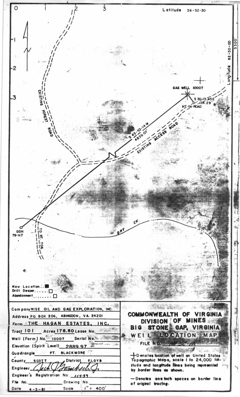
from the Division of rUnes, to drill, XJ<**'XXX~:~O~XXlXX~XX~XXX~XX'X~ a well f or oil or gas on the Hagan Es t. (Tr. lOll-Farm, comprising 178.8 acres, in the Floyd Distric't of Scott County, Virginia, having the :ee title thereto, or as the case may be, under grant or lease dated July 1,
1973 , mad e by-The Hagan Estates Inc ~oCol. Gas , Trans. Corp. and r ecorded on the 27th day of September , 19 JL in the office of the County Cler}: for said county in Book 278 , page 734 .
The propcsed locotion of the well, as shown on the attached plat or map, is
5300 feet
about SOUTH · of 360 52'30" and about X*~XX
feet 2300 WESI of B~'QQ"
It is proposed to drill this well to a depth of about 5557
will
feet. Samples
or cuttings therefrom be available for e:-:amination by a member of the
will staff of th e Virginia Geolog ical Survey. Cuttings be furnished the
Survey.
A plat or map, in triplic2't€, on a scale not s:naller th~n 400 feet to the inch, showing the proposed location of the v:ell and other information, required in Section 45-114, Code of Vir&inia, 1950, is attac hed h e reto. Coples of the plat and notice of intention to drill, redrill or deepen 'the af o rem~ntione~ well have been sent to all jnterested persons as required by S e ction 45-114, above cited, as follows (List names and mail nddress of each. Use back of sheet if additional space is required):
1. Consolidation Coal Company, P.O. Box 1811, Meridian, MS .39301
2.
3.
~ .
5.
G .
Very truly yours,
WISE OIL & GAS EXPLORATION~ INC. Dri 11 ing Company or Operator
Vice President ____ ~P~.~~y ?n.~6 ______ _
Street ~ss Tit l.:.
AJINGDON~ VIRGINIA 24210 City or Town, and State
\'/ell 1'0. . 10007
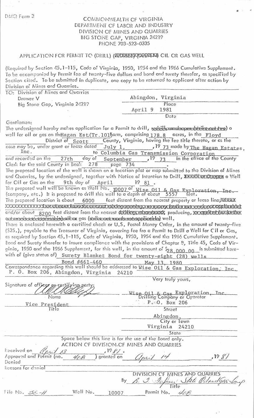
D:/O Form 3 CO,t,t;MON\fl/EALTH OF VIRGINIA
DEPARTfv\ENT CF LABOR AND !I"-lDUSTRY DIVISION OF MINES AND QUARRIES BIG STOi-JE GAP, VIRGINIA 24219
PHONE 703-523-0335
APPLICATION FOR PERtv:1T TO (DRILL) (~ OIL OR GAS WELL
(Re quire d by Sedion 45.1-115, Code Of Virginin, 1950, 1954 ond tk~ 1966 Cumulative Supplement. To be occorr.pcmi 2d by Permit fee of tWGnt},-five dollors and bond and surety therefor, as speciried by S(;: ction cii-ed. To be submitted in duplicate , one copy to be returned to applicant oher action by Division oi fy·;ir.es and Quarries. TO: Division of f/iin es and Quarries
Drawer V Big Stone Gap, Virginia 2L;.21?
Ge ntbm2n:
Abingdon, Virginia rlace
April 9 1981
The undersigne d hereby mo!~ es applicafion for a Permit to drill, ~x~~fbge~bt~) a w~dl ror oil or gas on th41agan Est(Tr . lOl~arm, comprising 178.8 acres, in the Floyd
District of Scott County, Virginia, having the fee title thereto, or 05 the
•
-~-o-:;e-m-a-}',~r-,.,-_,-u-n---;-d:?r grant or lec52 dated July I, , 19.-ZL made by The Hagan Estates, Inc . to Columbia Gas Transmission Corporation
oodrecord:::donthe 27th day of September ,19 73 in the office of the County Cl e rl~ for t:1e said Coun~y in Boo!: 278 poge 734 The proposed location of the we ll is s!. own on a loc-o-. t-:--io-n-p-rla-~-or-fil-,cr-p-s-ubmitt2d to the DiviSion of Mines Gnd Quarri es, by the undersigned f toge ther w:th Notice of InT2ntion to Drill, ~ a Wett for Oil or Gcs on the 9th doyof April 19 81 . Th~ proposc:d well will be known as Well No . ~OO of \.Jj s~ OJ 1 & Gas E] t · I
• • • • - • --- -- , --- - - -- - -}}p- ora--:lon , -nc. (corTl?cny , erc.) It IS piOposed to an II th IS we l to a Gepth of OiJcut 5557 teet. Tne propose d location is about 6000 feef dis tant from the ne:orest property or leClse linei'~
Correspondence regardIng tnls we ll should 62 ao or25~ed to Wise Oil & Gas ExI2LoratiQn - Inc ... P. O . Box 206, Abingdon, Virginia 24210 •
Nom:::!
Vice Pres~dent Tit e
Very tru I y yours t
Wise-Oil ~ Gas Exploration, Inc. Dri llingtompony or OF'0rctor
, - P .~ ()O . Box 206
Street
Ab i!lg don I
City or Town Virginia 24210
State Space be low this l ine is f or the use of the Board only .
. ACTION OF DIVISION~OF MINES AND QUARRIES F:2ce ived on tf{,.AA--I /3 , 19 f/ 0 --, -
t.pprov:?d and Pclmit (no. -¥bg ) granted on ~I /~ Denied ~
,19 r/
R e csons-rfo-r-d"~-_ n-",o'I----------------------------------------------------
DIVISION CF ~~INES ANDQUARRrES
d J \~JLL ! Jd~ &1,4<c/(4£,~~ !fitle j; /
By
We ll No. 10007 Permit No. ~8 ----~~~-------- --~~~----------------

~------r---~-'J2r---~~3--------------------~~2~30~0~' ~~~l I Latitude 36-52-30
2
3
r,
/' / /
I / II
I I ,I
" I I
" " " , ,I
/1 '/ I r
~\ I (ii \ \ ~ \ % \\ Cl \\
~\\ ~ \\
_ A \
\ -1l \ \ ~\\ 0,\ ,,-
"-
"'''
- '
. "' :-...-- -~ ~'_; -::o.~
·i·:, :,~-
\ '
'-" , . .. " \\_" --
/---//
/ / ' // .
1/ /1
II II
Ii , '
-.~.;~':.
. " .... " ... -...... ." . ...
.. -------
New Lo C otion .: .• Drill D~eper . ••••. 0 Abordonment •. •• •••. 0
. - ..
... . :,
8 0 0
", I pi) , 10 .. 0 ,., .,
N CI)
a. "'0 , :::S
,,+-10007
Y'1~~i~3, ~ ~ ,
~_\ ,., j,.~ ~'",c,,~
';;'~:~~~1! ~ • ?--- .. ~"-: ;:~ !.-..- .~'.
'. i . . Z' - ~ " ,,-,
~'~~ :" ,::7:: -X~:/ '~"V-:' ' '',"::"_;, -:-,!''''r
• T ~ • "-:--::-;;j;~~.~.~.
',';, ·:·: ~~·"t:.'~~
.. ~' -{~'~ ' .. ~",;"~ ,,
-~,.:.-:-... "' ... '~~~,.. Com panyWISE Oil AND GAS EXPLORATION INC.
Address PO, BOX 206, ABINGDON, VA. 24201 COMMONWEALTH OF VIRGINIA ""~-Farm ·' TH'E " HA GA N ESTAT SIN c" DIVISION ' OF NINES , . .,:..;,';' Tract 101 Acres 178.80 Lease No. 81 G ST-ONE ' .. GAP. VIRGINIA'r,~ Well (Farm) No.' 10007 Serlol NO.---~ ·~J. WEI l " . L'ibc A Tt O'N ,::,:'M'A'P '~':~~
. Elevation (Spirit Level) -:-~-. __ ~~~L-________ ~
Quadrangle FT. BLACK MORE ------------~--------~ ,
Co un' Y---':..=;.+~+--.,....q-......4
Enolne8r~~~~~~~~~~~~~tL ______ -J Engineer's No ,
~~~----------4
File No. __ ~ ____ Do' N r wIng 0 , -------J Date Scale I to = 400'
..... ~-""'I .... # ... ~ ...... :.:.' ..:J •.• ,.:,., ... ~-.>' ....... (~
, FI LE N 0' ~',::, j4if~!??~4:.~;~.~(~;~; :~~: . • ~'.J("" -~/!!. -h- 1..."-• • c::- _A.,.~ ,);~-.~:
, """" ... ,j , ' +0 enotes location of \H~II 'on United -S 't~te; .' , TOPOl;lrophic Maps. scal~ I to 24.000 101- . jtu dean d Ion Oitud& lin~ I be-inQ rep~98nted
by bord ~r lines 01 shown.
- D~noles on~ inch .pace. on border line of ori9ml tracing.


![Algebra 2C Week of 3.30-4.03[4119]](https://img.pdfslide.us/doc/110x75/62b78199daaec44cab6f07e9/algebra-2c-week-of-330-4034119.jpg)