Embed Size (px)
Citation preview
DRECP Proposed LUPA and Final EIS CHAPTER IV.4. GEOLOGY AND SOILS
Vol. IV of VI IV.4-1 October 2015
IV.4 GEOLOGY AND SOILS
IV.4.1 Approach to Impact Analysis
This chapter addresses the potential impacts on geologic and soil resources from
implementing the Bureau of Land Management (BLM) Land Use Plan Amendment (LUPA)
for the Desert Renewable Energy Conservation Plan (DRECP) alternatives. This analysis is
based on the description in Volume II of the Proposed LUPA, including actions associated
with renewable energy development that would be permitted within Development Focus
Areas (DFAs).
This chapter provides an analysis of impacts from geologic hazards and problematic soils;
Volume III, Chapter III.4 describes existing conditions for geologic hazards and soil resources.
Three tables supporting this chapter appear in Appendix R2.4. These tables present the
acreage of soil texture, erosive soils, and expansive soils within DFAs for each alternative.
Specific impacts of renewable energy facility development would depend on a variety of
factors, including project location within the DFAs, type and scale of technology, the size of
the development, and site-specific soil conditions. Due to the uncertainty of specific
locations for development within the DFAs, this impact analysis is based on the total
acreage of land that could be affected.
This analysis of impacts on geology and soils assumes that:
Soil resources within BLM-administered lands will be managed to meet standards in the
Rangeland Health Standards and Guidelines for California and Northwestern Nevada.
Substantial surface disturbance to soil—including exposure of bare ground, loss of
vegetation and soil biotic crusts, and rutting on unsurfaced roads—would increase
soil compaction, water runoff, and downstream sediment loads. It would also lower
soil productivity and increase fugitive dust emissions, degrading water and air
quality, altering channel structure, and affecting overall watershed health, air
quality, and potentially human health.
Several factors would influence the degree of impact to any one disturbance or
series of disturbances, including the disturbance’s location within the watershed,
the time and degree of the disturbance, existing vegetation, and levels of
precipitation at the time of the disturbance.
Any access roads would follow the design standards of the BLM Roads Design
Handbook H-9113-1 or the higher standard required by the State of California to
protect air or water quality.
DRECP Proposed LUPA and Final EIS CHAPTER IV.4. GEOLOGY AND SOILS
Vol. IV of VI IV.4-2 October 2015
Surface soil stockpiles would be set aside for future restoration after grading
or excavation.
Design features and management practices identified in the Best Management
Practices and Guidance Manual for Renewable Energy Development (California
Energy Commission [CEC] 2010]) would be followed for site-specific projects.
The DRECP Environmental Impact Statement (EIS) and LUPA are programmatic
documents; the analysis is therefore primarily for typical impacts and does not evaluate
site-specific impacts from specific projects. Project-specific impacts would instead be
assessed during the permitting process and in supplemental National Environmental
Policy Act (NEPA) or joint NEPA/California Environmental Quality Act (CEQA) documents
(for projects under CEC jurisdiction). Because the specific locations of future renewable
energy projects are still undetermined, this impact analysis presents information on
faults and problematic soils within DFAs, Variance Process Lands, and BLM LUPA
conservation designations.
IV.4.2 Typical Impacts Common to All Action Alternatives
The potential effects of renewable energy development (solar, wind, geothermal and
transmission) upon geology and soils are evaluated through review of completed CEQA and
NEPA documents, the Solar Programmatic Environmental Impact Statement (Solar PEIS),
the Wind PEIS, and the Geothermal PEIS. Existing conditions for geology and soils are
described in Chapter III.4.
This section analyzes the typical direct and indirect impacts of solar, wind, and geothermal
projects and transmission lines. Approval of a LUPA alternative would facilitate the
development of renewable energy projects within defined DFAs by streamlining both
permitting decisions and mitigation actions for protected species. Each future project
would undergo required NEPA and/or CEQA analysis, but information in this EIS could
prove useful for document preparation. Impacts related to renewable energy projects and
transmission would vary depending upon the technology proposed, the location of the
project area, the time and degree of disturbance from development, and the size and
complexity of the facility.
LUPA components could have indirect impacts on geologic features including important
scenic and structural geologic features and seismic risk; seismic activity and other geologic
hazards may have indirect impacts on projects. LUPA alternatives could also cause indirect
impacts on soils, particularly sensitive soils. The alteration or removal of vegetative cover
could require more and wider roads or cause surface disturbances in areas with high wind
or water erosion. Other project activities could damage soil surface covers like desert
pavement or biological soil crusts.
DRECP Proposed LUPA and Final EIS CHAPTER IV.4. GEOLOGY AND SOILS
Vol. IV of VI IV.4-3 October 2015
Because LUPA land designations would be managed to protect ecological, historic, cultural,
scenic, scientific, and recreation resources and values, they would also provide general
protection for geologic and soil resources. While other land uses are allowed within these
areas, those uses must be compatible with the resources and values that the land
designation is intended to protect.
Guidelines for the allowable uses and management of National Conservation Lands, lands
with wilderness characteristics, and trail management corridors appear in the LUPA
description in Volume II. Details on the goals, objectives, allowable uses, and management
actions for each Area of Critical Environmental Concern (ACEC) and Special Recreation
Management Area (SRMA) appear in LUPA worksheets in Appendix H.
IV.4.2.1 Impacts of Renewable Energy and Transmission Development
This analysis considers a wide range of potential geologic impacts from renewable
energy development and transmission. Impacts include soil erosion, disturbance of
desert pavement, and potential effects of geologic hazards including active faults,
potentially active volcanoes, landslides and mudslides, and the impacts of expansive or
corrosive soils over the lifetime of renewable energy projects. Each of these impacts is
discussed in the following sections.
IV.4.2.1.1 Impacts of Site Characterization
Site characterization for renewable energy projects includes land surveying; biological,
cultural and paleontological surveys; and geotechnical studies. These activities create
ground disturbances with a range of impacts. Land surveying and biological, cultural,
and paleontological surveying are low-impact activities. Geotechnical studies have low
to moderate impact, depending upon specific site environments. Impacts from site
characterization also include increased soil erosion and the potential disturbance of
desert pavement.
IV.4.2.1.2 Impacts of Construction and Decommissioning
Soil erosion. Soil erodibility is determined primarily by soil texture. Soils with high silt
content erode more readily than soils with high clay content. Weathering happens when
wind or water gradually break rocks down (e.g., when water freezes within the cracks of
rocks then expands the rocks to the point of fracture). Weathered soils are more susceptible
to erosion because they have smaller particles, but a wide range of soil particle size is
susceptible to erosion, depending on the strength of the wind or water flows. Portions of the
desert contain soils with a moderate to high potential for erosion from wind and water.
DRECP Proposed LUPA and Final EIS CHAPTER IV.4. GEOLOGY AND SOILS
Vol. IV of VI IV.4-4 October 2015
During project construction and decommissioning excavation, grading, construction
activities, and watering for dust control could all contribute to soil erosion. If blasting is
required during excavation, it could also disturb the soil and increase erosion. In addition,
without effective best management practices (BMPs), storms could increase erosion during
both construction and decommissioning.
Desert pavement. As stated in Volume III, Section III.4.2, about 60% of the surficial
geologic formations within the DRECP area are alluvium (material deposited by moving
water). Over time, alluvium can form a protective surface crust of pebbles called desert
pavement. The disturbance of desert pavement would substantially increase surface
erosion from wind and water and create dust hazards. These surficial deposits are valuable
because the natural regeneration of desert pavement is very slow in the Mojave Desert.
Excavation, grading, and ground disturbance from workers, vehicles, and equipment would
damage existing desert pavement.
Sand Transport. Sand transport corridors are zones where windblown sands move across
the desert. They are important because they create valuable habitat for sensitive biological
resources. Development of renewable energy projects in some parts of the desert, including
the Eastern Riverside County region, would be in or near important sand transport
corridors. The sand transport corridor in the eastern portion of Riverside County runs
parallel to Interstate 10 (I-10) in Riverside County between Desert Center and Blythe.
Other sand transport corridors include the Mojave River corridor (including the Kelso
Dunes), Bristol Trough corridor (including the Cadiz and Danby dunes), Rice Valley
corridor (including the Rice Valley Dunes), and Clark’s Pass corridor (including the Dale
Lake Dunes and Ford-Palen Dunes) (U.S. Geological Survey [USGS] 2003).
Renewable energy projects in these regions could interrupt sand transport and
consequently affect valuable habitat within corridors containing active sand dunes.
Conversely, sand transport could also damage renewable energy facilities and hinder
energy production. Large areas of dune systems and sand transport corridors are located in
the central and southern portions of the DRECP area. Approximately 1,781,000 acres of
dune systems and sand transport corridors exist in the entire DRECP area (Data Basin
2014[a]). The highest concentrations of dune systems and sand transport corridors in the
DRECP area are:
841,000 acres in the eastern part of Riverside County.
245,000 acres in the Imperial Valley region.
205,000 acres in the Central Mojave region.
DRECP Proposed LUPA and Final EIS CHAPTER IV.4. GEOLOGY AND SOILS
Vol. IV of VI IV.4-5 October 2015
See Chapter III.4, Figure III.4-2, Dune Systems and Sand Transport Corridors within the
DRECP Area, Section III.4.2.2.1.1.
IV.4.2.1.3 Impacts of Operations and Maintenance
Seismic, volcanic, or landslide activity. Based upon the number and length of active faults
described in Section III.4.3, the southern California desert is seismically active. Some of the
longest and most active faults in the state pass through the desert, including the San Andreas
Fault. See Figure III.4-4, Earthquake Faults within the DRECP Area and Table III.4-2, Largest
Faults Within the DRECP Area, for the specific locations and strengths of faults in the DRECP
area. Seismic activity is likely in areas both around and west of the San Andreas and
Superstition Hills faults. Major earthquakes like the Landers Earthquake of 1992 (Richter
magnitude 7.3), will continue to strike, causing property damage. See Table III.4-3 (in Section
III.4.4, Earthquakes Within the DRECP Area With a Magnitude 6.0 or Higher. Based on project
location, future earthquakes could damage renewable energy facilities and transmission lines.
Volcanic activity is of greatest concern in areas of recent eruptions. Younger volcanic flows
exist in the Salton Buttes in the Imperial Borrego Valley ecoregion subarea (see
Appendix R1, Table R1.4-1, Regional Geology in the DRECP Area), in areas east of Barstow
near the Pisgah Crater, and in southern Inyo County. However, the low likelihood that
renewable energy facilities would be located in the immediate area of an active volcanic
site means that volcanic activity is not likely to affect renewable energy development.
Geothermal resources would more likely be sited in areas with volcanic activity. These
resources have been identified in Imperial County, as well as in the Coso and Randsburg
areas of Inyo and San Bernardino counties.
Solar facilities are not generally built on steep slopes where landslides are most likely. It is
therefore unlikely that landslides would damage solar projects. Before site design and
construction, site-specific geotechnical investigations would be required to ensure that landslide
hazards to wind turbines would be minimal during project operations and maintenance.
Expansive soils. Expansive soils have a high clay content, which has a greater ability to
shrink and swell with changes in soil moisture content. This includes soils with clay, silty
clay, and clay loam textures. As these soils expand and contract, they could damage
structural and operational elements of renewable energy facilities. Nearly 589,000 acres of
expansive soils are within the DRECP area.
The highest concentrations of expansive soils within the DRECP area are:
156,000 acres in the Death Valley area.
DRECP Proposed LUPA and Final EIS CHAPTER IV.4. GEOLOGY AND SOILS
Vol. IV of VI IV.4-6 October 2015
89,000 acres in the eastern end of Riverside County.
69,000 acres in the Owens River Valley.
For further details on soil texture by ecoregion subarea, see Appendix R1, Figures R1.4-1
through R1.4-10.
Corrosive Soils. As stated in Section III.4.2.2.2, mild to aggressive soil corrosivity within
the DRECP area could corrode ungalvanized steel and concrete. Soil corrosion could create
hazards that could potentially undermine the long-term integrity of renewable energy
infrastructure, including damage to foundations and other parts of structures over the
lifetime of the renewable energy projects.
Vegetation in the desert is specifically adapted to its native soil characteristics. Playas,
North American warm desert alkaline scrub, herb playa, and wet flat all indicate
potentially damaging corrosive soil. Approximately 509,000 acres of these soils are
within the DRECP area (Data Basin 2014[b]). The highest concentrations of potentially
corrosive soils are:
133,000 acres in the Death Valley portion of the DRECP area.
117,000 acres in the Central Mojave portion of the DRECP area.
63,000 acres in the Lucerne Valley portion of the DRECP area.
55,000 acres in the West Mojave portion of the DRECP area.
28,000 acres in the Owens Valley portion of the DRECP area.
For further information on corrosive soils within the DRECP area, see Section III.4.2.2.2,
Corrosive Soils, and Figure III.4-3, Potentially Corrosive Soils Within the DRECP Area.
IV.4.2.2 Impacts of the Ecological and Cultural Conservation and Recreation Designations
Lands within conservation areas are protected from development, so renewable energy
projects would not be built in those areas.
IV.4.3 Impact Analysis by Alternative
The following sections present impact analyses for the No Action Alternative, the Preferred
Alternative, and Alternatives 1 through 4.
DRECP Proposed LUPA and Final EIS CHAPTER IV.4. GEOLOGY AND SOILS
Vol. IV of VI IV.4-7 October 2015
IV.4.3.1 No Action Alternative
The No Action Alternative assumes that renewable energy, transmission development, and
mitigation for projects in the DRECP area would occur on a project-by-project basis and in
a pattern consistent with past and present renewable energy and transmission projects.
The No Action Alternative identifies approximately 2,804,000 available acres for renewable
energy development. The No Action Alternative does not include new BLM LUPA
conservation designations, though existing conservation comprises approximately 7.6
million acres of the DRECP area in all alternatives.
IV.4.3.1.1 Impacts of Renewable Energy and Transmission Development
Available developable areas in the No Action Alternative are concentrated on BLM land in the
Tehachapi Mountains, West Mojave, Imperial Valley, Eastern Riverside County, and Kingston
and Funeral Mountains regions of the DRECP area. Impacts to soils, geology, and geologic
hazards would result from the development of solar, wind, and geothermal projects. There
would also be impacts from transmission development.
The potential for increased soil erosion is quantified by the acreage of erosive soils that may
be disturbed during construction and decommissioning and, to a lesser degree, during site
characterization. The potential for impacts from geologic hazards is based on miles of active
fault lines within 25 miles of developable areas under the No Action Alternative. Other
geology and soil impacts such as disturbance to desert pavement and structural damage from
expansive or corrosive soils are assessed more qualitatively.
In general, under the No Action Alternative, existing BLM land management plans within
the LUPA Decision Area would continue. Existing ACECs and wildlife allocation areas would
continue to limit adverse impacts to geology and soils because only projects consistent with
those areas’ goals and objectives would be allowed. Existing SRMAs would continue to
experience potentially adverse effects from soil erosion, depending upon the extent of
allowable uses and management practices within specific SRMAs.
Under the No Action Alternative, development would continue on certain BLM lands
including Solar Energy Zones, Solar PEIS Variance Lands, and with a project-specific LUPA.
Impact SG-1: Expose people or structures to injury or damage from seismic, volcanic, or
landslide activity.
As described in Volume III, Section III.4.3, the DRECP area is seismically and volcanically
active with major fault lines, young volcanic features, and landslide sediment deposits.
Within the DRECP area, major faults include some of the largest in the state, such as the San
Andreas and San Jacinto fault systems. During the lifetime of a renewable energy facility,
DRECP Proposed LUPA and Final EIS CHAPTER IV.4. GEOLOGY AND SOILS
Vol. IV of VI IV.4-8 October 2015
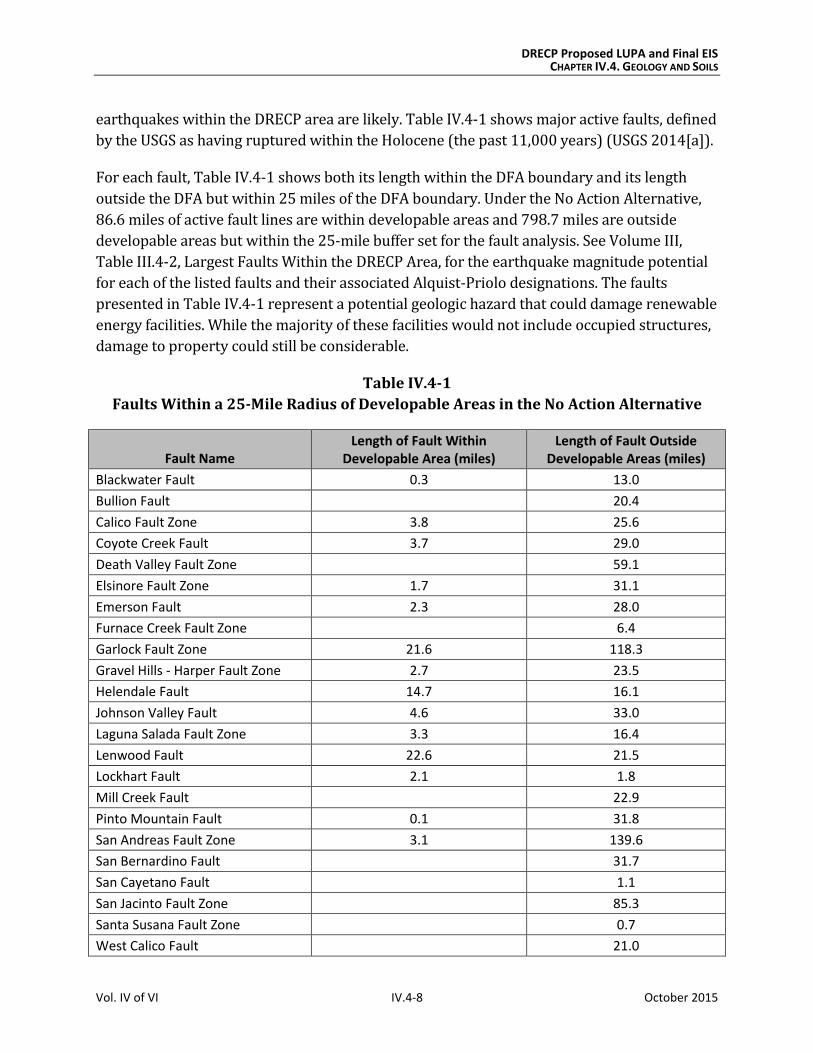
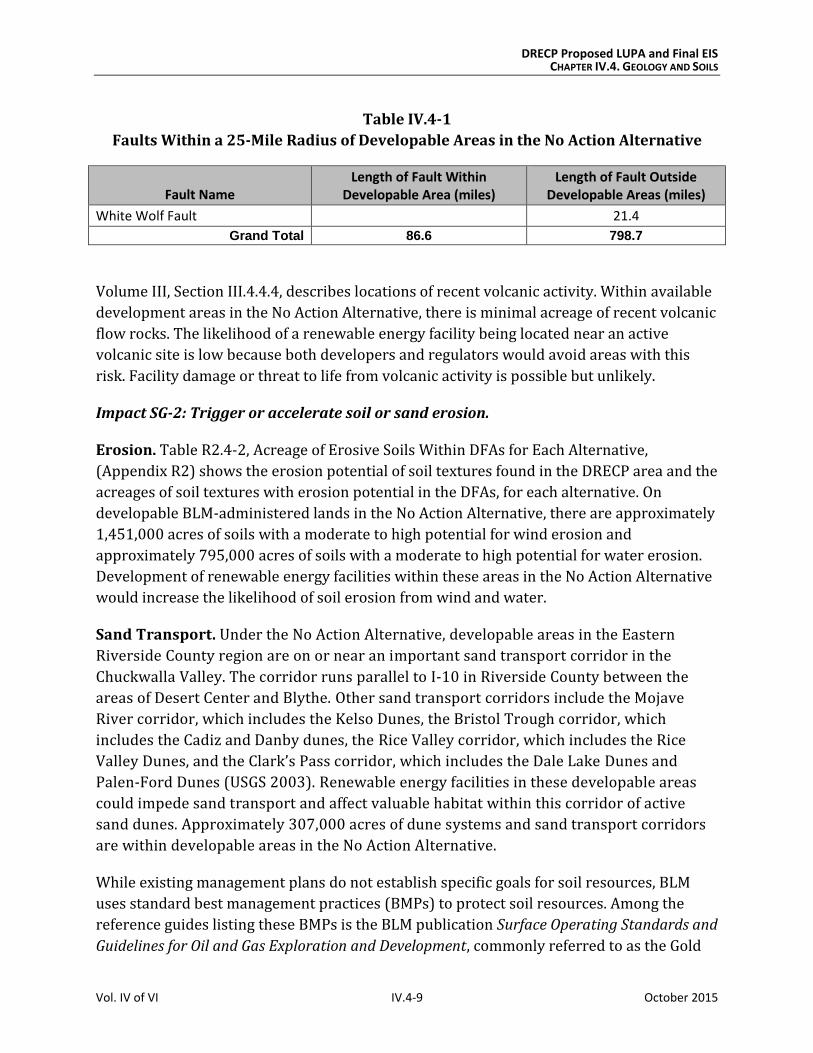
earthquakes within the DRECP area are likely. Table IV.4-1 shows major active faults, defined
by the USGS as having ruptured within the Holocene (the past 11,000 years) (USGS 2014[a]).
For each fault, Table IV.4-1 shows both its length within the DFA boundary and its length
outside the DFA but within 25 miles of the DFA boundary. Under the No Action Alternative,
86.6 miles of active fault lines are within developable areas and 798.7 miles are outside
developable areas but within the 25-mile buffer set for the fault analysis. See Volume III,
Table III.4-2, Largest Faults Within the DRECP Area, for the earthquake magnitude potential
for each of the listed faults and their associated Alquist-Priolo designations. The faults
presented in Table IV.4-1 represent a potential geologic hazard that could damage renewable
energy facilities. While the majority of these facilities would not include occupied structures,
damage to property could still be considerable.
Table IV.4-1
Faults Within a 25-Mile Radius of Developable Areas in the No Action Alternative
Fault Name Length of Fault Within
Developable Area (miles) Length of Fault Outside
Developable Areas (miles)
Blackwater Fault 0.3 13.0
Bullion Fault 20.4
Calico Fault Zone 3.8 25.6
Coyote Creek Fault 3.7 29.0
Death Valley Fault Zone 59.1
Elsinore Fault Zone 1.7 31.1
Emerson Fault 2.3 28.0
Furnace Creek Fault Zone 6.4
Garlock Fault Zone 21.6 118.3
Gravel Hills - Harper Fault Zone 2.7 23.5
Helendale Fault 14.7 16.1
Johnson Valley Fault 4.6 33.0
Laguna Salada Fault Zone 3.3 16.4
Lenwood Fault 22.6 21.5
Lockhart Fault 2.1 1.8
Mill Creek Fault 22.9
Pinto Mountain Fault 0.1 31.8
San Andreas Fault Zone 3.1 139.6
San Bernardino Fault 31.7
San Cayetano Fault 1.1
San Jacinto Fault Zone 85.3
Santa Susana Fault Zone 0.7
West Calico Fault 21.0
DRECP Proposed LUPA and Final EIS CHAPTER IV.4. GEOLOGY AND SOILS
Vol. IV of VI IV.4-9 October 2015
Table IV.4-1
Faults Within a 25-Mile Radius of Developable Areas in the No Action Alternative
Fault Name Length of Fault Within
Developable Area (miles) Length of Fault Outside
Developable Areas (miles)
White Wolf Fault 21.4
Grand Total 86.6 798.7
Volume III, Section III.4.4.4, describes locations of recent volcanic activity. Within available
development areas in the No Action Alternative, there is minimal acreage of recent volcanic
flow rocks. The likelihood of a renewable energy facility being located near an active
volcanic site is low because both developers and regulators would avoid areas with this
risk. Facility damage or threat to life from volcanic activity is possible but unlikely.
Impact SG-2: Trigger or accelerate soil or sand erosion.
Erosion. Table R2.4-2, Acreage of Erosive Soils Within DFAs for Each Alternative,
(Appendix R2) shows the erosion potential of soil textures found in the DRECP area and the
acreages of soil textures with erosion potential in the DFAs, for each alternative. On
developable BLM-administered lands in the No Action Alternative, there are approximately
1,451,000 acres of soils with a moderate to high potential for wind erosion and
approximately 795,000 acres of soils with a moderate to high potential for water erosion.
Development of renewable energy facilities within these areas in the No Action Alternative
would increase the likelihood of soil erosion from wind and water.
Sand Transport. Under the No Action Alternative, developable areas in the Eastern
Riverside County region are on or near an important sand transport corridor in the
Chuckwalla Valley. The corridor runs parallel to I-10 in Riverside County between the
areas of Desert Center and Blythe. Other sand transport corridors include the Mojave
River corridor, which includes the Kelso Dunes, the Bristol Trough corridor, which
includes the Cadiz and Danby dunes, the Rice Valley corridor, which includes the Rice
Valley Dunes, and the Clark’s Pass corridor, which includes the Dale Lake Dunes and
Palen-Ford Dunes (USGS 2003). Renewable energy facilities in these developable areas
could impede sand transport and affect valuable habitat within this corridor of active
sand dunes. Approximately 307,000 acres of dune systems and sand transport corridors
are within developable areas in the No Action Alternative.
While existing management plans do not establish specific goals for soil resources, BLM
uses standard best management practices (BMPs) to protect soil resources. Among the
reference guides listing these BMPs is the BLM publication Surface Operating Standards and
Guidelines for Oil and Gas Exploration and Development, commonly referred to as the Gold
DRECP Proposed LUPA and Final EIS CHAPTER IV.4. GEOLOGY AND SOILS
Vol. IV of VI IV.4-10 October 2015
Book, last updated in 2007. Under the No Action Alternative, BLM’s management of geology
and soil resources through these standard BMPs, as well as mitigation imposed as a result
of NEPA review, would reduce adverse impacts during construction.
Impact SG-3: Expose structures to damage from corrosive or expansive soils.
As stated in Section IV.4.2.1.3, Impacts of Operations and Maintenance, corrosive soils
could damage foundations and structural elements of renewable energy facilities.
Expansive soils could cause soils to shrink or swell, damaging foundations and other
structural elements. The No Action Alternative includes 70,000 acres of potentially
expansive soils. See Table R2.4-3, Acreage of Expansive Soil Textures Within DFAs for Each
Alternative (Appendix R2). Expansive soils include clay, clay loam, silty clay, and silty clay
loam. Corrosive soils are widespread throughout the DRECP area. Playas, North American
warm desert alkaline scrub, herb playa, and wet flat all indicate the presence of potentially
corrosive soil. Approximately 36,000 acres of potentially corrosive soils are within
developable areas in the No Action Alternative.
Impact SG-4: Destroy or disturb desert pavement.
Renewable energy facilities in the No Action Alternative may damage desert pavement.
Excavation and grading during construction and decommissioning, as well as ground
disturbance from workers, vehicles, and equipment, would damage or disturb this
important habitat. Specific locations of desert pavement that have not been mapped would
require field surveys.
Impact Reduction Strategies
Laws and Regulations
Existing laws and regulations would reduce the impacts of renewable energy projects in
the absence of the DRECP. Relevant regulations are presented in the Regulatory Setting in
Volume III. Note that because this EIS addresses amendments to BLM’s land use plans,
these plans are addressed separately and are not included in this section.
Mechanisms in relevant regulations would reduce impacts as follows:
The Clean Water Act of 1972 requires operators of construction sites that disturb
one acre or more to obtain a permit under the National Pollutant Discharge
Elimination System’s (NPDES) general permit entitled Stormwater Discharges
Associated With Construction Activity. Stormwater runoff from construction
activities can significantly affect water quality. This permit requires preparation of a
Stormwater Pollution Prevention Plan, which must include a site description; a map
DRECP Proposed LUPA and Final EIS CHAPTER IV.4. GEOLOGY AND SOILS
Vol. IV of VI IV.4-11 October 2015
that identifies sources of stormwater discharges on the site; anticipated drainage
patterns after major grading; areas where structural and nonstructural measures
will be employed; surface waters, including wetlands; and locations of discharge
points to surface waters.
The California Building Code (CBC) Section 1613.3.5 (CBC 2013) requires all new
construction to follow earthquake design guidelines by completing a geotechnical
investigation for all buildings in Seismic Design Categories C, D, E, and F. The
majority of the DRECP area is made up of categories C, D, and E, which are based on
the following three criteria:
1. Probable site ground motion – Probable site motion is based on Federal
Emergency Management Agency (FEMA) maps, the maximum acceleration of an
object in an earthquake, and a structure’s response to wave acceleration. See
Volume III, Figure III.4-13, Peak Horizontal Ground Acceleration Within the
DRECP Area.
2. Soil site classifications – Soil classifications A through F include hard rock, rock,
dense soil, stiff soil, soft soil, and special soils.
3. Building occupancy type – Building occupancy contains four types: agricultural,
essential, hazardous structures in the event of a collapse, and “other.”
In addition, Appendix J of the CBC requires that developers obtain county grading
permits that would contain requirements for the appropriate management of on-
site drainage and erosion control.
The Alquist-Priolo Earthquake Fault Zoning Act (1972) prohibits permitting of
buildings used for human occupancy where construction is across active faults.
In addition, the Solar PEIS includes numerous design features that would reduce the
impacts of solar energy development on geology and soil resources (full text of all design
features is shown in Appendix W). Relevant design features include the following:
SR1-1 would minimize soil erosion and geologic hazards by identifying local factors
that would cause slope instability or on-site soil erosion as well as geologic hazard
concerns in proximity to the proposed project.
SR2-1 would minimize soil erosion and sediment transport during all project phases.
It requires minimal ground disturbing activities, culverts to control runoff to
minimize erosion, and project siting to avoid disturbing desert pavement and areas
with unstable slopes and soils. Construction grading must comply with
requirements in CBC 2013. It also requires soil testing that complies with American
Society for Testing and Materials standards, studies to determine the effects from
DRECP Proposed LUPA and Final EIS CHAPTER IV.4. GEOLOGY AND SOILS
Vol. IV of VI IV.4-12 October 2015
construction on sand transport corridors, and replanting project areas with native
vegetation to reduce exposed soil through wind and water erosion.
SR3-1 requirements would prevent erosion and geologic hazard design elements
during operations and maintenance by requiring permanent barriers around
washes and wetlands to control erosion; maintaining catch basins, roadway ditches,
and culverts; and performing routine site inspections to monitor the effectiveness of
erosion and sediment control measures.
SR4-2 would restore the original grade and drainage patterns on a project site
during reclamation and decommissioning.
SR4-3 would restore a site’s natural vegetation patterns and prevent future erosion
and sedimentation by seeding and transplanting native plant communities during
reclamation and decommissioning.
WR1-1 would control project site drainage, erosion, and sedimentation through
hydrologic analysis and modeling that would identify 100-year 24-hour rainfall
events and calculate projected runoff; this would comply with NPDES requirements,
manage runoff from impervious surfaces, create or improve landscaping for capturing
runoff, and demonstrate that a project will not increase the risk of flooding.
Typical Mitigation Measures
Under the No Action Alternative, individual projects would continue to be reviewed and
approved with mitigation measures adopted by BLM. Mitigation for geology and soils
generally includes the following:
Protect disturbed soil from wind erosion during project construction. Prior to
receiving a construction permit, the applicant shall submit to the lead agency, for
review and approval, a sedimentation and erosion control plan that identifies how
disturbed surface soils will be stabilized to prevent wind erosion during
construction and immediately after construction until revegetation begins. Wind
erosion control measures include, but are not limited to, the use of mulch, soil
stabilizers, and temporary revegetation (all compatible with special status species).
This sedimentation and erosion control plan may also include standard provisions
for dust control with water trucks or the periodic application of soil stabilizers.
Reduce effects of ground shaking. Prior to issuance of construction permits, the
design-level geotechnical investigations the applicant performs shall include site-
specific seismic analyses to evaluate ground accelerations for the design of project
components. Based on these findings, project structure designs shall be modified as
deemed appropriate by the project engineer if anticipated seismic forces are found
to be greater than standard design load stresses on project structures. Study results
DRECP Proposed LUPA and Final EIS CHAPTER IV.4. GEOLOGY AND SOILS
Vol. IV of VI IV.4-13 October 2015
and proposed design modifications shall be submitted to the lead agency for review
before final project design and issuance of a construction permit.
Protect desert pavement. Grading for new access roads or work areas in areas
covered by desert pavement shall be avoided or minimized. If avoidance of these
areas is not possible, the desert pavement surface shall be protected from damage
or disturbance from construction vehicles temporary surface mats. A plan to
identify and avoid damaging sensitive desert pavement shall be prepared and
submitted to the lead agency for review and approval prior to construction. This
plan shall include:
o Defining all locations of surface disturbance including new access roads and
grading locations.
o Developing specific measures to protect desert pavement from damage or
disturbance by using temporary mats.
o Applying a nontoxic soil stabilizer before project operation. The applicant shall
develop, for review and approval by the lead agency, a plan that outlines the
frequency of nontoxic soil stabilizer applications, based on the specifications of
the selected soil stabilizer.
o Evaluating the potential for replacement of desert pavement with a similar
gravel-sized layer where required.
Conduct landslide surveys and protect against slope instability. A landslide
survey of any steep hillside areas shall be conducted in and adjacent to areas of
planned project construction. The survey will identify areas with the potential for
unstable slopes, landslides, earth flows, debris flows, and seismically induced slope
failure. If the results of the landslide survey indicate that slopes could likely fail and
damage these structures, appropriate support and protection measures shall be
designed and implemented to minimize potential damage. These design measures
may include, but are not limited to, retaining walls, re-engineered slopes, removal of
potentially unstable materials, and avoidance of areas below highly unstable areas.
Study results and proposed design modifications shall be submitted to the lead
agency for review before final project design and issuance of construction permits.
Conduct geotechnical studies to assess problem soil characteristics. Prior to
issuance of construction permits, these design-level geotechnical studies by the
applicant shall identify the presence, if any, of potentially detrimental soil chemicals
such as chlorides and sulfates. Appropriate design measures for protection of
reinforcement, concrete, and metal-structural foundation components against
corrosion shall be used, such as corrosion-resistant materials and coatings, thicker
components for projects exposed to potentially corrosive conditions, and passive or
DRECP Proposed LUPA and Final EIS CHAPTER IV.4. GEOLOGY AND SOILS
Vol. IV of VI IV.4-14 October 2015
active cathodic protection systems. The geotechnical studies shall also identify areas
with potentially expansive or collapsible soils and include appropriate design
features, including the excavation of potentially expansive or collapsible soils during
construction and replacement with engineered backfill, ground-treatment
processes, and redirection of surface water and drainage away from expansive
foundation soils. Studies shall conform to industry standards and American Society
for Testing and Materials standards for field and laboratory testing. Study results
and proposed solutions shall be submitted to the lead agency for review and
approval prior to construction permit issuance.
Protect sand and sand transport corridors. To mitigate loss of sand transport
corridors, the project owner shall provide compensatory mitigation that may
include compensation for lands purchased in fee title or in easement, in whole or in
part, in the following ratios:
o 3:1 mitigation for direct impacts on stabilized and partially stabilized sand dunes
o 1:1 mitigation for direct impacts on non-dune Mojave fringe-toed lizard habitat
o 0.5:1 mitigation for indirect impacts on stabilized and partially stabilized
sand dunes
If compensation lands are acquired, the project owner shall provide funding for the
acquisition in fee title or in easement, initial habitat improvements, and long-term
maintenance and management of the compensation lands. The compensation lands
must include, at a minimum, the number of acres of stabilized and partially
stabilized sand dune habitat defined by the lead agency.
Compensation lands selected for acquisition shall provide suitable habitat for any
sand-dependent species. Compensation lands must:
o Be located within the bounds of the sand transport corridor from which
habitat was lost.
o Build linkages between known populations of sand-dependent species.
o Be near larger blocks of lands either already protected or planned for protection,
or which could be protected long-term by a public resource agency or a
nongovernmental organization dedicated to habitat preservation.
o Not have a history of intensive recreational use or other disturbance that might
make habitat recovery and restoration unworkable.
o Not be characterized by high densities of invasive species, either on or immediately
adjacent to parcels that might jeopardize habitat recovery and restoration.
DRECP Proposed LUPA and Final EIS CHAPTER IV.4. GEOLOGY AND SOILS
Vol. IV of VI IV.4-15 October 2015
o Not contain hazardous wastes that cannot be removed to make a site suitable
for habitat.
o Include water and mineral rights as part of the acquisition.
o Be on land where long-term management is practicable.
Security for Implementation of Mitigation: The project owner shall provide
financial assurances to the lead agency that guarantee an adequate level of funding
is available to implement the acquisitions and enhance sand-dependent species
habitat, as described in this mitigation measure.
Preparation of Management Plan: The project owner shall submit to the lead
agency a Management Plan that reflects site-specific enhancement measures for
sand-dependent species habitat on acquired compensation lands. The objective of
the Management Plan shall be to enhance the value of the compensation lands and
may include actions such as weed control, fencing to keep out livestock, erosion
control, or protection of sand sources or sand transport corridors.
IV.4.3.1.2 Impacts from Ecological and Cultural Conservation and Recreation Designations
The No Action Alternative has no new conservation designations, but even without approval
of one of the action alternatives existing LLPAs, including wilderness areas, would be
protected from development. Under the No Action Alternative, renewable energy projects
would still be evaluated and approved with project-specific mitigation requirements.
IV.4.3.1.3 Impacts of Transmission Outside the DRECP Area
Outside of the DRECP area, additional transmission lines would be needed to deliver
renewable energy to load centers (areas of high demand). It is assumed that new
transmission lines outside of the DRECP area would use existing transmission corridors
and substations in the more populated coastal areas of the state. Locations outside of the
DRECP area where new transmission lines might be constructed are in San Diego, Los
Angeles, North Palm Springs–Riverside, and the Central Valley. These areas and their
associated geology and soils are described in Volume III, Section III.4.8.
Impact SG-1: Plan components would expose people or structures to injury or damage
from seismic, volcanic, or landslide activity.
Active fault lines are located both near and across transmission corridors. Transmission tower
failure could expose people or structures to injury or damage from seismic activity or landslides;
service interruptions could also result. However, the risk of earthquakes and landslides is
considered during site evaluations and in specifications for tower and span designs.
DRECP Proposed LUPA and Final EIS CHAPTER IV.4. GEOLOGY AND SOILS
Vol. IV of VI IV.4-16 October 2015
Impact SG-2: Soil or sand erosion would be triggered or accelerated due to
plan components.
Transmission tower construction requires earthwork to establish construction areas,
tower footings, and site access. Soil disturbed in the process could erode, with the greatest
risk being on slopes. Except where corridors pass through the Tehachapi and San Gabriel
mountains, transmission corridors outside the DRECP area are in relatively flat terrain. Soil
susceptibility to erosion varies by soil type, slope, and vegetative cover. To control erosion,
transmission line developers would be required to prepare and implement stormwater
pollution prevention plans, which would include erosion control and site restoration.
Because of their spacing and relatively narrow profile, transmission towers would not
impede natural sand transport.
Impact SG-3: Plan components would expose structures to damage from corrosive or
expansive soils.
Corrosive soils could damage tower foundations and expansive soils could cause soils to
shrink or swell; both could damage structure foundations. Typical foundation
installation involves excavating or boring and installing reinforced steel bar cages and
encasing them in concrete. Where soil conditions could potentially damage footings, the
excavation is oversized and backfilled with suitable material that will not either corrode
or damage footings.
Impact SG-4: Plan components would destroy or disturb desert pavement.
Renewable energy facilities in the Preferred Alternative may cause damage to desert
pavement. Excavation and grading during construction and decommissioning, as well as
ground disturbance from workers, vehicles, and equipment, would cause damage or
disturbance to this important habitat. Specific locations of desert pavement that have not
been mapped would require field surveys.
IV.4.3.2 Preferred Alternative
IV.4.3.2.1 Impacts of Renewable Energy and Transmission Development
Under the Preferred Alternative, activities associated with solar, wind, and geothermal
development and operation would be permitted within DFAs. The Preferred Alternative
includes 388,000 acres of DFAs, approximately 7.6 million acres of existing
conservation within the DRECP area, and approximately 4.9 million acres of BLM LUPA
conservation designations.
DRECP Proposed LUPA and Final EIS CHAPTER IV.4. GEOLOGY AND SOILS
Vol. IV of VI IV.4-17 October 2015
In the Preferred Alternative, dispersed solar development is anticipated in the West Mojave
and Eastern Slopes ecoregion subarea, the Cadiz Valley and Chocolate Mountains ecoregion
subarea, and the Imperial Borrego Valley ecoregion subarea. Dispersed wind development
is anticipated in the West Mojave and Eastern Slopes ecoregion subarea, the Pinto Lucerne
Valley and Eastern Slopes ecoregion subarea, and the Cadiz Valley and Chocolate
Mountains ecoregion subarea. Dispersed geothermal development is anticipated in the
Imperial Borrego Valley and the Owens River Valley ecoregion subareas.
Under the Preferred Alternative, DFAs are located primarily in the Imperial Borrego Valley
ecoregion subarea, the Cadiz Valley and Chocolate Mountains ecoregion subarea, the West
Mojave and Eastern Slopes ecoregion subarea, and the Panamint Death Valley ecoregion
subarea. Impacts to soils, geology, and geologic hazards would occur within the DRECP area
from the development of solar, wind, geothermal, and transmission facilities, both within and
outside of DFAs.
Soil erosion potential can be quantified based on acreage of erosive soils that may be
disturbed during construction and decommissioning and, to a lesser degree, during site
characterization. The potential for impacts from geologic hazards can be quantified based on
miles of active fault lines within 25 miles of DFAs in the Preferred Alternative. Other geology
and soil impacts such as disturbance to desert pavement and structural damage from
expansive or corrosive soils are assessed qualitatively.
The Proposed BLM LUPA conservation designations (e.g., National Conservation Lands, ACECs,
wildlife allocations, lands with wilderness characteristics, and trail management corridors)
would limit renewable energy development and be managed to protect various ecological,
historic, cultural, scenic, and scientific resources and values, which would also provide general
protection for geologic and soil resources. Disturbance caps on National Conservation Lands
and ACECs would provide further protections. National Conservation Lands would make up
the majority of proposed BLM land designations under the Preferred Alternative.
Existing or expanded SRMAs would also prohibit surface-occupying renewable energy
development, but could conversely still cause soil erosion from recreation, depending upon
the extent of allowable uses and management within specific SRMAs.
Impact SG-1: Expose people or structures to injury or damage from seismic, volcanic, or
landslide activity.
As described in Volume III, Section III.4.3, the DRECP area is seismically and volcanically
active, with major fault lines, young volcanic features, and landslide sediment deposits.
Within the DRECP area, major faults include some of the largest in the state, including the San
Andreas and San Jacinto faults. During the lifetime of a renewable energy facility,
earthquakes within the DRECP area are likely. Table IV.4-2, Faults Within a 25-mile Radius of
DRECP Proposed LUPA and Final EIS CHAPTER IV.4. GEOLOGY AND SOILS
Vol. IV of VI IV.4-18 October 2015
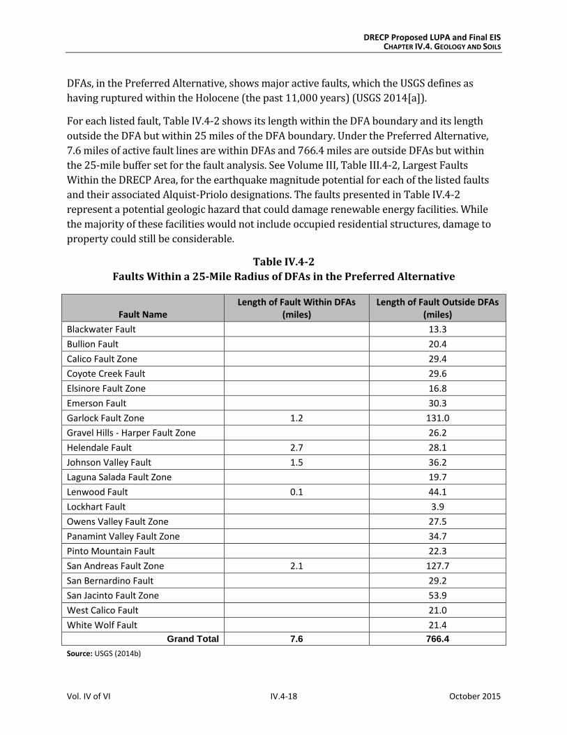
DFAs, in the Preferred Alternative, shows major active faults, which the USGS defines as
having ruptured within the Holocene (the past 11,000 years) (USGS 2014[a]).
For each listed fault, Table IV.4-2 shows its length within the DFA boundary and its length
outside the DFA but within 25 miles of the DFA boundary. Under the Preferred Alternative,
7.6 miles of active fault lines are within DFAs and 766.4 miles are outside DFAs but within
the 25-mile buffer set for the fault analysis. See Volume III, Table III.4-2, Largest Faults
Within the DRECP Area, for the earthquake magnitude potential for each of the listed faults
and their associated Alquist-Priolo designations. The faults presented in Table IV.4-2
represent a potential geologic hazard that could damage renewable energy facilities. While
the majority of these facilities would not include occupied residential structures, damage to
property could still be considerable.
Table IV.4-2
Faults Within a 25-Mile Radius of DFAs in the Preferred Alternative
Fault Name Length of Fault Within DFAs
(miles) Length of Fault Outside DFAs
(miles)
Blackwater Fault 13.3
Bullion Fault 20.4
Calico Fault Zone 29.4
Coyote Creek Fault 29.6
Elsinore Fault Zone 16.8
Emerson Fault 30.3
Garlock Fault Zone 1.2 131.0
Gravel Hills - Harper Fault Zone 26.2
Helendale Fault 2.7 28.1
Johnson Valley Fault 1.5 36.2
Laguna Salada Fault Zone 19.7
Lenwood Fault 0.1 44.1
Lockhart Fault 3.9
Owens Valley Fault Zone 27.5
Panamint Valley Fault Zone 34.7
Pinto Mountain Fault 22.3
San Andreas Fault Zone 2.1 127.7
San Bernardino Fault 29.2
San Jacinto Fault Zone 53.9
West Calico Fault 21.0
White Wolf Fault 21.4
Grand Total 7.6 766.4
Source: USGS (2014b)
DRECP Proposed LUPA and Final EIS CHAPTER IV.4. GEOLOGY AND SOILS
Vol. IV of VI IV.4-19 October 2015
Volume III, Section III.4.4.4, describes the locations of recent volcanic activity. Within DFAs
in the Preferred Alternative, there is less than one square mile of recent volcanic flow
rocks. The likelihood of a renewable energy facility being located near an active volcanic
site is so low that facility damage or threat to life is possible but unlikely.
Impact SG-2: Trigger or accelerate soil or sand erosion.
Erosion. Table R2.4-2, Acreage of Erosive Soils Within DFAs for Each Alternative
(Appendix R2), shows the erosion potential of soil textures found in the DRECP area and
acreage of soil textures with moderate to high potential for erosion found in DFAs in each
alternative. Within DFAs in the Preferred Alternative, there are approximately 210,000
acres of soils with a moderate to high potential for wind erosion and approximately
107,000acres of soils with a moderate to high potential for water erosion. Development of
renewable energy facilities within these areas of DFAs in the Preferred Alternative would
increase the likelihood of soil erosion from wind and water.
Sand Transport. Under the Preferred Alternative, DFAs in the East Riverside region are on
or near an important sand transport corridor in the Chuckwalla Valley. The corridor runs
parallel to I-10 in Riverside County between Desert Center and Blythe. Other sand
transport corridors include the Mojave River corridor, which includes the Kelso Dunes, the
Bristol Trough corridor, which includes the Cadiz and Danby dunes, the Rice Valley
corridor, which includes the Rice Valley Dunes, and the Clark’s Pass corridor, which
includes the Dale Lake Dunes and Palen-Ford Dunes (USGS 2003). Renewable energy
facilities in these DFAs could impede sand transport and affect valuable habitat within this
corridor of active sand dunes. Within DFAs in the Preferred Alternative, there are
approximately 79,000 acres of dune systems and sand transport corridors.
Impact SG-3: Expose structures to damage from corrosive or expansive soils.
As stated in Section IV.4.2.1.2, Typical Impacts, corrosive soils could damage foundations
and structural elements of renewable energy facilities. Expansive soils could cause soils to
shrink or swell, damaging foundations and other structural elements. The Preferred
Alternative includes approximately 16,000 acres of potentially expansive soils. See Table
R2.4-3, Acreage of Expansive Soil Textures Within DFAs for Each Alternative
(Appendix R2), which defines areas of clay, clay loam, silty clay, and silty clay loam.
Corrosive soils are widespread throughout the DRECP area. Playas and North American
warm desert alkaline scrub, herb playa, and wet flat all indicate potentially corrosive soil
within the DRECP area. The Preferred Alternative includes approximately 18,000 acres of
potentially corrosive soils within the DFAs.
DRECP Proposed LUPA and Final EIS CHAPTER IV.4. GEOLOGY AND SOILS
Vol. IV of VI IV.4-20 October 2015
Impact SG-4: Destroy or disturb desert pavement.
Renewable energy facilities in the Preferred Alternative may damage desert pavement.
Excavation and grading during construction and decommissioning, as well as ground
disturbance from workers, vehicles, and equipment, would damage or disturb this
important habitat. Specific locations of desert pavement that have not been mapped would
require field surveys.
Impacts on Variance Process Lands
Variance Process Lands are neither reserve lands nor DFAs. They are a subset of the variance
lands identified in the Solar PEIS Record of Decision and additional lands that, based on
current information, have moderate to low ecological value and ambiguous value for
renewable energy. If renewable energy development occurs on Variance Process Lands,
LUPA would not be required, so the environmental review process would be simpler than if
the location were left as undesignated.
Variance Process Lands for each alternative are as shown in Chapter IV.1, Table IV.1-2, and
in Volume II, Chapter II.3, Figure II.3-1 for the Preferred Alternative. Development of the
Variance Process Lands would have similar air quality effects as described under Impacts
SG-1 through SG-4.
Impact Reduction Strategies
Implementation of the Proposed LUPA would enhance conservation of many BLM-
administered public lands, as well as the development of renewable energy generation and
transmission facilities on other lands. The impacts of renewable energy development
covered in the DRECP would be lessened in several ways. First, it incorporates
Conservation and Management Actions (CMAs) for each alternative, including LUPA-wide
CMAs and CMAs for specific land designations such as Natural Landscape Conservation
System (NLCS) lands, ACECs, and wildlife allocations. Also, the implementation of existing
laws, orders, regulations, and standards would reduce the impacts of project development.
Conservation and Management Actions
The conservation strategy for the Preferred Alternative (presented in Volume II, Section
II.3.4) defines specific actions that would reduce the impacts of this alternative. The
conservation strategy includes specific land designations and CMAs for the Preferred
Alternative. This section presents summaries of relevant CMAs that would reduce impacts
to geology and soils. The full text of all CMAs is presented in Section II.3.4.2.
DRECP Proposed LUPA and Final EIS CHAPTER IV.4. GEOLOGY AND SOILS
Vol. IV of VI IV.4-21 October 2015
CMAs for the Preferred Alternative for Geology and Soils
LUPA-SW-2: Buffer zones, setbacks, and activity limitations directly associated with soil and
water resources, not including the biological associated or dependent resources will be
determined on a site-specific basis, consistent with the LUPA protection goals for these
resources. In general, placement of long-term facilities within buffers or protected zones
will be discouraged.
LUPA-SW-8: As determined necessary on an activity specific basis, prepare a site plan
specific to major soil types present (≥5% of footprint or laydown surfaces) in Wind
Erodibility Groups 1 and 2 and in Hydrology Soil Class D as defined by the USDA Natural
Resource Conservation Service to minimize water and air erosion from disturbed soils on
activity sites.
LUPA-SW-9: The extent of desert pavement within the proposed boundary of an activity
shall be mapped if it is anticipated that the activity may create erosional or ecologic impacts.
Disturbance of desert pavement within the boundary of an activity shall be limited to the
extent possible, and shall not exceed 10% of the desert pavement mapped within the
activity boundary without BLM approval.
LUPA-SW-10: The extent of additional sensitive soil areas (cryptobiotic soil crusts, hydric
soils, highly corrosive soils, expansive soils, and soils at severe risk of erosion) shall be
mapped if it is anticipated that an activity will impact these resources. To the extent
possible, avoid disturbance of desert biologically intact soil crusts, and soils highly
susceptible to wind and water erosion.
Biological CMAs Relevant to Geology and Soils
LUPA-BIO-7: This CMA requires restoration of temporary disturbance areas, such as
construction areas for pipelines and transmission, staging areas, and construction-related
roads. Restoration activities include the restoration, reclamation, and revegetation of
temporarily disturbed areas.
LUPA-BIO-8: General closure and decommissioning of activity sites must include
appropriate restoration measures such as recontouring, the installation of erosion control
measures, and the restoration of vegetation and soil profiles.
LUPA-BIO-9: The protection of water dependent species through this CMA would require
implementation of activity specific drainage, erosion, and sedimentation control actions, the
maintenance of natural drainages and hydrologic function, the reduction of impervious
surfaces, the use of retention basins as appropriate. This CMA also requires the stabilization of
DRECP Proposed LUPA and Final EIS CHAPTER IV.4. GEOLOGY AND SOILS
Vol. IV of VI IV.4-22 October 2015
disturbed areas, the minimization of wind and water erosion, and the maintenance of long-term
erosion control measures.
LUPA-BIO-13: General siting and design criteria in this CMA would maximize the use of
existing roads, routes, and utility corridors, and would minimize new disturbance areas.
LUPA-BIO-15: Use state-of-the-art construction and installation techniques that minimize
new site disturbance, soil erosion and deposition, soil compaction, disturbance to
topography, and removal of vegetation.
LUPA-BIO-DUNE-1: For activities that potentially occur within or bordering Aeolian and
sand transport corridors, complete studies to verify the accuracy of the DRECP dunes and
sand resources mapping, as shown in Appendix H, and to determine if a proposed activity
would interfere with a sand transport corridor.
LUPA-BIO-DUNE-2: Activities that potentially affect the amount of sand entering or
transported within Aeolian transport corridors will be designed and operated to minimize
interference with these processes.
LUPA-BIO-DUNE-3: Any facilities or activities that alter site hydrology (e.g., sediment
barrier) will be designed to maintain continued sediment transport and deposition in the
Aeolian corridor in a way that maintains the Aeolian sorting and transport to downwind
deposition zones. Site designs for maintaining this transport function must be approved by
BLM in coordination with USFWS and CDFW as appropriate.
DFA-VPL-BIO-DUNE-2: Within Aeolian corridors that transport sand to dune formations
and vegetation types downwind inside and outside of the DFAs, all activities will be
designed and operated to facilitate the flow of sand across activity sites, and avoid the
trapping or diverting of sand from the Aeolian corridor. Buildings and structures within the
site will take into account the direction of sand flow and, to the extent feasible, build and
align structures to allow sand to flow through the site unimpeded. Fences will be designed
to allow sand to flow through and not be trapped.
Air Resources CMAs Relevant to Geology and Soils
LUPA-AIR-5: A fugitive Dust Control Plan will be developed for all projects where the
NEPA analysis shows an impact to air quality from fugitive dust.
Laws and Regulations
Similar to the No Action Alternative, existing laws and regulations will reduce certain
impacts of DRECP implementation. Relevant regulations are presented in the Regulatory
DRECP Proposed LUPA and Final EIS CHAPTER IV.4. GEOLOGY AND SOILS
Vol. IV of VI IV.4-23 October 2015
Setting in Volume III, Section III.4.1. The requirements of relevant laws and regulations are
summarized for the No Action Alternative in Section IV.4.3.1.1.
IV.4.3.2.2 Impacts of Ecological and Cultural Conservation and Recreation Designations
The conservation designations included in the Preferred Alternative would total 4,926,000
acres (see Chapter IV.1, Table IV.1-1, Summary of Alternative Components). This would
protect soil resources by limiting development within the DRECP area, which could also
reduce potential effects from geologic hazards.
IV.4.3.2.3 Impacts of Transmission Outside the DRECP Area
The impacts of transmission outside of the DRECP area on geology and soils would be the
same under all alternatives. These impacts are as described for the No Action Alternative in
Section IV.4.3.1.3, Impacts of Transmission Outside the DRECP Area.
IV.4.3.2.4 Comparison of the Preferred Alternative With No Action Alternative
Under the No Action Alternative, development would continue under existing BLM land
designations and protective requirements, including those of the Solar PEIS. Development
would be more constrained under the Preferred Alternative because LUPA would
encourage development within DFAs and prohibit development within expansive
conservation areas. Therefore, potential impacts from soil erosion and loss of desert
pavement would be more severe under the No Action Alternative.
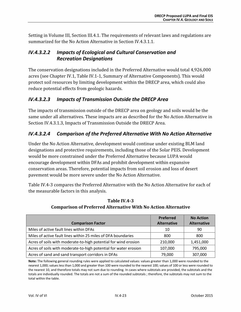
Table IV.4-3 compares the Preferred Alternative with the No Action Alternative for each of
the measurable factors in this analysis.
Table IV.4-3
Comparison of Preferred Alternative With No Action Alternative
Comparison Factor Preferred
Alternative No Action
Alternative
Miles of active fault lines within DFAs 10 90
Miles of active fault lines within 25 miles of DFA boundaries 800 800
Acres of soils with moderate-to-high potential for wind erosion 210,000 1,451,000
Acres of soils with moderate-to-high potential for water erosion 107,000 795,000
Acres of sand and sand transport corridors in DFAs 79,000 307,000
Note: The following general rounding rules were applied to calculated values: values greater than 1,000 were rounded to the nearest 1,000; values less than 1,000 and greater than 100 were rounded to the nearest 100; values of 100 or less were rounded to the nearest 10, and therefore totals may not sum due to rounding. In cases where subtotals are provided, the subtotals and the totals are individually rounded. The totals are not a sum of the rounded subtotals ; therefore, the subtotals may not sum to the total within the table.
DRECP Proposed LUPA and Final EIS CHAPTER IV.4. GEOLOGY AND SOILS
Vol. IV of VI IV.4-24 October 2015
Geographic Distinctions. Many impacts to geology and soils could occur throughout the
DRECP area. In the Preferred Alternative, significant dune systems and sand transport
corridors occur within DFAs in the East Riverside area, specifically along I-10. Active faults
are concentrated primarily in DFAs in the Imperial Borrego Valley, West Mojave and
Eastern Slopes, and Panamint Death Valley ecoregion subareas.
IV.4.3.3 Alternative 1
Alternative 1 includes 81,000 acres of total DFAs, approximately 7.6 million acres of
existing conservation within the DRECP area, and approximately 4.9 million acres of BLM
LUPA conservation designations.
Under Alternative 1, dispersed solar development is anticipated for the Cadiz Valley and
Chocolate Mountains, Imperial Borrego Valley, Owens River Valley, Pinto Lucerne Valley
and Eastern Slopes, and West Mojave and Eastern Slopes ecoregion subareas. Dispersed
wind development is anticipated in the Cadiz Valley and Chocolate Mountains and the Pinto
Lucerne Valley and Eastern Slopes ecoregion subareas. Dispersed geothermal development
is anticipated in the Imperial Borrego Valley ecoregion subarea.
IV.4.3.3.1 Impacts of Renewable Energy and Transmission Development
Under Alternative 1, DFAs are primarily in the Cadiz Valley and Chocolate Mountains,
Imperial Borrego Valley, Owens River Valley, and Pinto Lucerne Valley and Eastern
Slopes ecoregion subareas. Impacts related to soils, geology, and geologic hazards would
result from development of solar, wind, geothermal, and transmission facilities, both
within and outside of DFAs.
The potential for soil erosion can be quantified based on acreage of erosive soils that may be
disturbed during construction and decommissioning, as well as, to a lesser degree, during
site characterization. The potential for impacts from geologic hazards can be quantified
based on miles of active fault lines within 25 miles of DFAs in Alternative 1. Other geologic
and soil impacts such as disturbance to desert pavement and structural damage from
expansive or corrosive soils are assessed qualitatively.
Proposed BLM land use designations (e.g., National Conservation Lands, ACECs, wildlife
allocations, and trail management corridors) would prohibit renewable energy
development and be managed to protect ecological, historic, cultural, scenic, and scientific
resources and values; this would additionally provide general protection for geologic and
soil resources. Disturbance caps on National Conservation Lands and ACECs would provide
further protections. ACECs would make up the majority of the proposed BLM land
designations under Alternative 1.
DRECP Proposed LUPA and Final EIS CHAPTER IV.4. GEOLOGY AND SOILS
Vol. IV of VI IV.4-25 October 2015
Existing or expanded SRMAs would also prohibit surface-occupying renewable energy
development, but could also conversely cause soil erosion from recreation uses, depending
on the extent of allowable uses and management within specific SRMAs.
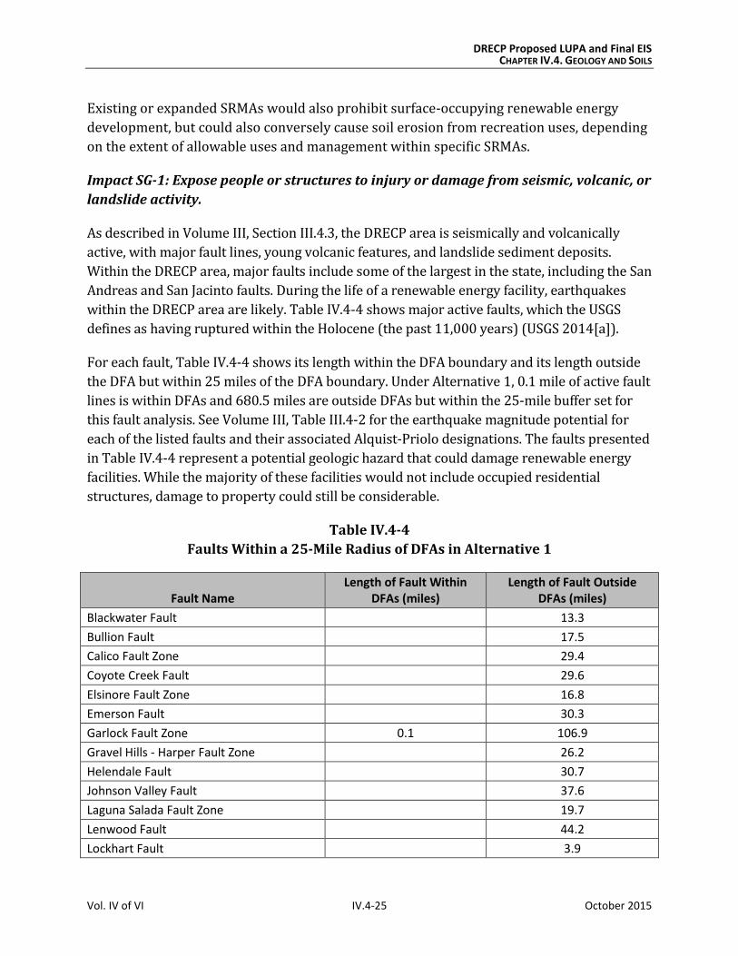
Impact SG-1: Expose people or structures to injury or damage from seismic, volcanic, or
landslide activity.
As described in Volume III, Section III.4.3, the DRECP area is seismically and volcanically
active, with major fault lines, young volcanic features, and landslide sediment deposits.
Within the DRECP area, major faults include some of the largest in the state, including the San
Andreas and San Jacinto faults. During the life of a renewable energy facility, earthquakes
within the DRECP area are likely. Table IV.4-4 shows major active faults, which the USGS
defines as having ruptured within the Holocene (the past 11,000 years) (USGS 2014[a]).
For each fault, Table IV.4-4 shows its length within the DFA boundary and its length outside
the DFA but within 25 miles of the DFA boundary. Under Alternative 1, 0.1 mile of active fault
lines is within DFAs and 680.5 miles are outside DFAs but within the 25-mile buffer set for
this fault analysis. See Volume III, Table III.4-2 for the earthquake magnitude potential for
each of the listed faults and their associated Alquist-Priolo designations. The faults presented
in Table IV.4-4 represent a potential geologic hazard that could damage renewable energy
facilities. While the majority of these facilities would not include occupied residential
structures, damage to property could still be considerable.
Table IV.4-4
Faults Within a 25-Mile Radius of DFAs in Alternative 1
Fault Name Length of Fault Within
DFAs (miles) Length of Fault Outside
DFAs (miles)
Blackwater Fault 13.3
Bullion Fault 17.5
Calico Fault Zone 29.4
Coyote Creek Fault 29.6
Elsinore Fault Zone 16.8
Emerson Fault 30.3
Garlock Fault Zone 0.1 106.9
Gravel Hills - Harper Fault Zone 26.2
Helendale Fault 30.7
Johnson Valley Fault 37.6
Laguna Salada Fault Zone 19.7
Lenwood Fault 44.2
Lockhart Fault 3.9

DRECP Proposed LUPA and Final EIS CHAPTER IV.4. GEOLOGY AND SOILS
Vol. IV of VI IV.4-26 October 2015
Table IV.4-4
Faults Within a 25-Mile Radius of DFAs in Alternative 1
Fault Name Length of Fault Within
DFAs (miles) Length of Fault Outside
DFAs (miles)
Owens Valley Fault Zone 30.0
Pinto Mountain Fault 17.5
San Andreas Fault Zone 109.7
San Bernardino Fault 29.3
San Jacinto Fault Zone 56.5
West Calico Fault 21.0
White Wolf Fault 10.5
Grand Total 0.1 680.5
Source: USGS 2014b.
Volume III, Section III.4.4.4, describes the locations of recent volcanic activity. Within DFAs
in Alternative 1, there is very little area of recent (Holocene) volcanic flow rocks.
Developers would avoid locating renewable energy facilities near an active volcanic site, so
facility damage or threat to life would be possible but unlikely.
Impact SG-2: Trigger or accelerate soil or sand erosion.
Erosion. Table R2.4-2, Acreage of Erosive Soils Within DFAs for Each Alternative,
(Appendix R2) presents the erosion potential of soil textures found in the DRECP area
and the acreage of soil textures with moderate to high potential for erosion in DFAs for
each alternative. Within DFAs in Alternative 1, there are 44,000 acres of soils with a
moderate to high potential for wind erosion and 41,000 acres of soils with a moderate to
high potential for water erosion. Development of renewable energy facilities within these
DFAs in Alternative 1 would increase the likelihood of soil erosion from wind and water.
Sand Transport. In Alternative 1, DFAs in the East Riverside region are on or near an
important sand transport corridor in the Chuckwalla Valley. The corridor runs parallel to I-
10 in Riverside County between Desert Center and Blythe. Other sand transport corridors
include the Mojave River corridor, which includes the Kelso Dunes, the Bristol Trough
corridor, which includes the Cadiz and Danby dunes, the Rice Valley corridor, which
includes the Rice Valley Dunes, and the Clark’s Pass corridor, which includes the Dale Lake
Dunes and Palen-Ford Dunes (USGS 2003). Renewable energy facilities in these DFAs could
impede sand transport and affect valuable habitat within this corridor of active sand dunes.
Within DFAs in Alternative 1, there are approximately 15,000 acres of dune systems and
sand transport corridors.
DRECP Proposed LUPA and Final EIS CHAPTER IV.4. GEOLOGY AND SOILS
Vol. IV of VI IV.4-27 October 2015
Impact SG-3: Expose structures to damage from corrosive or expansive soils.
As stated in Section IV.4.2.1, corrosive soils could damage foundations and other structural
elements of renewable energy facilities. Expansive soils could cause soils to shrink or swell,
also damaging foundations and structural elements. Alternative 1 includes 343,000acres of
potentially expansive soils. See Table R2.4-3, Acreage of Expansive Soil Textures Within
Developable Areas for Each Alternative (Appendix R2), which includes clay, clay loam, silty
clay, and silty clay loam. Playas, North American warm desert alkaline scrub, herb playa,
and wet flat all indicate potentially corrosive soil within the DRECP area. Alternative 1
includes approximately 90 acres of potentially corrosive soils within DFAs.
Impact SG-4: Destroy or disturb desert pavement.
Renewable energy facilities constructed in DFAs under Alternative 1 may damage desert
pavement. Excavation and grading during construction and decommissioning, as well as
ground disturbance from workers, vehicles, and equipment, would damage or disturb this
important habitat. Specific locations of desert pavement that have not yet been mapped
would require field surveys.
Impacts on Variance Process Lands
Variance Process Lands are neither reserve lands nor DFAs. They are a subset of the
variance lands identified in the Solar PEIS Record of Decision and additional lands that,
based on current information, have moderate to low ecological value and ambiguous value
for renewable energy. If renewable energy development is built on Variance Process Lands
LUPA would not be required, so the environmental review process would be simpler than if
the location were left as undesignated.
Variance Process Lands for each alternative are shown in Chapter IV.1, Table IV.1-2 and in
Volume II, Chapter II.4, Figure II.4-1, for Alternative 1. Development of Variance Process
Lands would have similar air quality effects as described under Impacts SG-1 through SG-4.
Impact Reduction Strategies
Implementation of the Proposed LUPA would result in new conservation designations
for many acres of desert lands as well as for development of renewable energy
generation and transmission on other lands. The impacts of this development would be
lessened in several ways. First, LUPA incorporates CMAs for each alternative. The
implementation of existing laws, orders, regulations, and standards would also reduce
the impacts of project development.
DRECP Proposed LUPA and Final EIS CHAPTER IV.4. GEOLOGY AND SOILS
Vol. IV of VI IV.4-28 October 2015
Conservation and Management Actions
The CMAs for Alternative 1 (presented in Volume II, Section II.4.4) define specific actions
that would reduce the impacts of this alternative. Section II.4.4.2, presents specific CMAs
for Alternative 1. The CMAs in Alternative 1 that are relevant to geology and soils would be
the same as the CMAs for the Preferred Alternative that are presented in Section IV.4.3.2.1,
except as described below.
All of the CMAs that are described for the Preferred Alternative would apply to Alternative 1,
with the following modifications for activities within DFAs:
Limit disturbance of sensitive soil areas so that no more than 1% of sensitive soil
areas within a proposed project footprint would be disturbed by construction.
Exclude renewable energy development that would disturb sand dunes.
Limit disturbance of sand flow corridors so that no more than 1% of sand flow
corridors within a proposed project footprint would disturbed by construction.
Limit disturbance of desert pavement so that no more than 5% of desert pavement
within a proposed project footprint would be disturbed by construction.
Avoid development in flood plains, unless its effects can be mitigated.
Create a 0.25-mile protective offset around playas.
Laws and Regulations
As defined under the No Action Alternative, existing laws and regulations will reduce
certain impacts of Plan implementation as summarized in Section IV.4.3.1.1. Relevant
regulations are described in more detail in Volume III, Section III.4.1, Regulatory Setting.
IV.4.3.3.2 Impacts of Ecological and Cultural Conservation and Recreation Designations
The conservation designations proposed in Alternative 1 would total 4,863,000 acres (see
Chapter IV.1, Table IV.1-1, Summary of Alternative Components). This would protect soil
resources by limiting both development within the DRECP area and the amount of land
available for development, which would also reduce potential geologic hazards.
IV.4.3.3.3 Impacts of Transmission Outside the DRECP Area
The impacts of transmission outside of the DRECP area on geology and soils would be the
same under all alternatives. These impacts are as described for the No Action Alternative in
Section IV.4.3.1.3, Impacts of Transmission Outside the DRECP Area.

DRECP Proposed LUPA and Final EIS CHAPTER IV.4. GEOLOGY AND SOILS
Vol. IV of VI IV.4-29 October 2015
IV.4.3.3.4 Comparison of Alternative 1 with Preferred Alternative
The impacts of renewable energy on BLM lands under LUPA for Alternative 1 would be less
than under the Preferred Alternative. LUPA land designations under Alternative 1 would
offer similar protection to soil resources as those under the Preferred Alternative;
however, CMAs under Alternative 1 would have stricter limits on disturbance to sand flow
corridors, desert pavements, and sensitive soils.
Table IV.4-5 compares Alternative 1 with the Preferred Alternative for each of the
measurable factors included in this analysis.
Table IV.4-5
Comparison of Alternative 1 With the Preferred Alternative
Comparison Factor Alternative 1 Preferred
Alternative
Miles of active fault lines within DFAs 0 10
Miles of active fault lines within 25 miles of DFA boundaries 700 800
Acres of soils with moderate to high potential for wind erosion 44,000 210,000
Acres of soils with moderate to high potential for water erosion 41,000 107,000
Acres of sand and sand transport corridors in DFAs 15,000 79,000
Note: The following general rounding rules were applied to calculated values: values greater than 1,000 were rounded to the nearest 1,000; values less than 1,000 and greater than 100 were rounded to the nearest 100; values of 100 or less were rounded to the nearest 10, and therefore totals may not sum due to rounding. In cases where subtotals are provided, the subtotals and the totals are individually rounded. The totals are not a sum of the rounded subtotals ; therefore, the subtotals may not sum to the total within the table.
Geographic Distinctions. Many impacts related to geology and soils could occur
throughout the DRECP area so are not useful in distinguishing one alternative from
another. Under Alternative 1, there are fewer acres in DFAs in eastern Riverside County.
Therefore, fewer areas of dune systems and sand transport corridors are within DFAs in
this region. In this alternative, active faults are concentrated primarily in the DFAs within
the West Mojave and Eastern Slopes ecoregion subarea.
IV.4.3.4 Alternative 2
Under Alternative 2, renewable energy projects would be encouraged within DFAs.
Alternative 2 includes 718,000 acres of total DFAs, which is approximately 7.6 million acres
of existing conservation within the DRECP area and approximately 5.2 million acres of BLM
LUPA conservation designations. In Alternative 2, solar development is located primarily in
the Cadiz Valley and Chocolate Mountains, Imperial Borrego Valley, and West Mojave and
Eastern Slopes ecoregion subareas. Wind development is located primarily in the Cadiz
Valley and Chocolate Mountains and Imperial Borrego Valley ecoregion subareas.
DRECP Proposed LUPA and Final EIS CHAPTER IV.4. GEOLOGY AND SOILS
Vol. IV of VI IV.4-30 October 2015
Dispersed geothermal development is anticipated in the Imperial Borrego Valley and the
Owens River Valley ecoregion subareas.
IV.4.3.4.1 Impacts of Renewable Energy and Transmission Development
Under Alternative 2, DFAs are located primarily in the Cadiz Valley and Chocolate Mountains
ecoregion subarea, the Imperial Borrego Valley ecoregion subarea, and the West Mojave and
Eastern Slopes ecoregion subarea. Impacts to soils, geology, and geologic hazards would
occur within the DRECP area from development of solar, wind, geothermal, and transmission
facilities, both within and outside of DFAs.
The potential for soil erosion can be quantified based on acreage of erosive soils that may be
disturbed during construction and decommissioning and, to a lesser degree, during site
characterization. The potential for impacts from geologic hazards can be quantified based on
miles of active fault lines within 25 miles of DFAs in Alternative 2. Other geologic and soil
impacts such as disturbance to desert pavement and structural damage from expansive or
corrosive soils are assessed qualitatively
Impact SG-1: Plan components would expose people or structures to injury or damage
from seismic, volcanic, or landslide activity.
As described in Volume III, Section III.4.3, the DRECP area is seismically and volcanically
active, with major fault lines, young volcanic features, and landslide sediment deposits.
Within the DRECP area, major faults include some of the largest in the state, including the San
Andreas and San Jacinto faults. During the lifetime of a renewable energy facility,
earthquakes within the DRECP area are likely. Table IV.4-6 shows major active faults, which
the USGS defines as having ruptured within the Holocene (the past 11,000 years) (USGS
2014a). For each fault, Table IV.4-6 presents its length within the DFA boundary and its
length outside the DFA but within 25 miles of the DFA boundary. In Alternative 2, 9.5 miles of
active fault lines are within DFAs and 818.3 miles are outside of DFAs but within the 25-mile
buffer set for this fault analysis. See Volume III, Table III.4-2, for the earthquake magnitude
potential for each of the listed faults and associated Alquist-Priolo designations. The faults
presented in Table IV.4-6 represent a potential geologic hazard that could damage renewable
energy facilities. While the majority of these facilities would not include occupied residential
structures, damage to property could still be considerable.
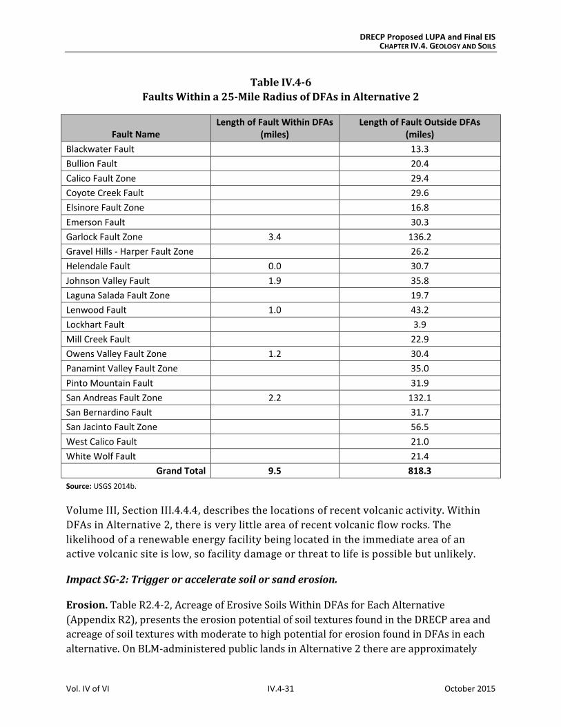
DRECP Proposed LUPA and Final EIS CHAPTER IV.4. GEOLOGY AND SOILS
Vol. IV of VI IV.4-31 October 2015
Table IV.4-6
Faults Within a 25-Mile Radius of DFAs in Alternative 2
Fault Name Length of Fault Within DFAs
(miles) Length of Fault Outside DFAs
(miles)
Blackwater Fault 13.3
Bullion Fault 20.4
Calico Fault Zone 29.4
Coyote Creek Fault 29.6
Elsinore Fault Zone 16.8
Emerson Fault 30.3
Garlock Fault Zone 3.4 136.2
Gravel Hills - Harper Fault Zone 26.2
Helendale Fault 0.0 30.7
Johnson Valley Fault 1.9 35.8
Laguna Salada Fault Zone 19.7
Lenwood Fault 1.0 43.2
Lockhart Fault 3.9
Mill Creek Fault 22.9
Owens Valley Fault Zone 1.2 30.4
Panamint Valley Fault Zone 35.0
Pinto Mountain Fault 31.9
San Andreas Fault Zone 2.2 132.1
San Bernardino Fault 31.7
San Jacinto Fault Zone 56.5
West Calico Fault 21.0
White Wolf Fault 21.4
Grand Total 9.5 818.3
Source: USGS 2014b.
Volume III, Section III.4.4.4, describes the locations of recent volcanic activity. Within
DFAs in Alternative 2, there is very little area of recent volcanic flow rocks. The
likelihood of a renewable energy facility being located in the immediate area of an
active volcanic site is low, so facility damage or threat to life is possible but unlikely.
Impact SG-2: Trigger or accelerate soil or sand erosion.
Erosion. Table R2.4-2, Acreage of Erosive Soils Within DFAs for Each Alternative
(Appendix R2), presents the erosion potential of soil textures found in the DRECP area and
acreage of soil textures with moderate to high potential for erosion found in DFAs in each
alternative. On BLM-administered public lands in Alternative 2 there are approximately
DRECP Proposed LUPA and Final EIS CHAPTER IV.4. GEOLOGY AND SOILS
Vol. IV of VI IV.4-32 October 2015
420,000 acres of soils with a moderate to high potential for wind erosion and
approximately 219,000 acres of soils with a moderate to high potential for water erosion.
Development of renewable energy facilities within these areas of DFAs in Alternative 2
would increase the likelihood of soil erosion from wind and water.
Sand Transport. Under Alternative 2, development in the East Riverside region are either
on or near an important sand transport corridor in the Chuckwalla Valley. The corridor
runs parallel to I-10 in Riverside County between the areas of Desert Center and Blythe.
Other sand transport corridors include the Mojave River corridor (including the Kelso
Dunes), the Bristol Trough corridor (including the Cadiz and Danby dunes), the Rice Valley
corridor (including the Rice Valley Dunes), and the Clark’s Pass corridor (including the Dale
Lake Dunes and Palen-Ford Dunes) (USGS 2003). Renewable energy facilities in these DFAs
could impede sand transport and affect valuable habitat within this corridor of active sand
dunes. Within DFAs in Alternative 2, there are approximately 107,000 acres of dune
systems and sand transport corridors.
Impact SG-3: Expose structures to damage from corrosive or expansive soils.
As stated in Section IV.4.2, Typical Impacts Common to All Action Alternatives, corrosive soils
could damage foundations and structural elements of renewable energy facilities. Expansive
soils could shrink or swell, also damaging foundations and structural elements. Alternative 2
includes approximately 29,000 acres of potentially expansive soils in DFAs. See Table R2.4-3,
Acreage of Expansive Soil Textures Within DFAs for Each Alternative (Appendix R2), which
includes clay, clay loam, silty clay, and silty clay loam. Playas, North American warm desert
alkaline scrub, herb playa, and wet flat all indicate potentially corrosive soil. Alternative 2
includes approximately 21,000 acres of potentially corrosive soils.
Impact SG-4: Destroy or disturb desert pavement.
Renewable energy facilities constructed in DFAs in Alternative 2 may damage desert
pavement. Excavation and grading during construction and decommissioning, as well as
ground disturbance from workers, vehicles, and equipment, would damage or disturb this
important habitat. Specific locations of desert pavement that have not been mapped would
require field surveys.
Impacts on Variance Process Lands
Variance Process Lands are neither reserve lands nor DFAs. They are a subset of the
variance lands identified in the Solar PEIS Record of Decision and additional lands that,
based on current information, have moderate to low ecological value and ambiguous value
for renewable energy. If renewable energy development is built on Variance Process Lands,
DRECP Proposed LUPA and Final EIS CHAPTER IV.4. GEOLOGY AND SOILS
Vol. IV of VI IV.4-33 October 2015
LUPA would not be required, so the environmental review process would be simpler than if
the location were left as undesignated.
Variance Process Lands for each alternative are shown in Chapter IV.1, Table IV.1-2, and in
Volume II, Chapter II.5, Figure II.5-1, for Alternative 2. Development of the Variance
Process Lands would have similar air quality effects as described under Impacts SG-1
through SG-4.
Impact Reduction Strategies
Implementation of the Proposed LUPA would both conserve some desert lands and develop
development renewable energy projects on other lands. The impacts of the renewable
energy development covered under LUPA would be lessened in several ways. First, the
DRECP incorporates CMAs for each alternative, including LUPA-wide CMAs and CMAs for
specific land designations such as NLCS lands, ACECs, and wildlife allocations. Also, the
implementation of existing laws, orders, regulations, and standards would reduce the
impacts of project development.
Conservation and Management Actions
The conservation strategy for Alternative 2 (presented in Volume II, Section II.5.4) defines
specific actions that would reduce the impacts of this alternative. Section II.5.4.2 presents
specific CMAs for Alternative 2. The CMAs in Alternative 2 relevant to geology and soils
would be the same as the CMAs for the Preferred Alternative presented in Section
IV.4.3.2.1, except as described below.
Unlike the Preferred Alternative, this alternative would not implement CMA LUPA-BIO-13.
All of the remaining CMAs described for the Preferred Alternative would apply as well to
Alternative 2, with the following modifications for activities within DFAs:
Limit disturbance of sensitive soil areas so that no more than 20% of the sensitive
soil areas within a proposed project footprint would be disturbed by construction.
Limit disturbance of sand dune areas so that no more than 5% of sand dune areas
within a proposed project footprint would be disturbed by construction.
Limit disturbance of sand flow corridors so that no more than 5% of sand flow
corridors within a proposed project footprint would be disturbed by construction.
Limit disturbance of desert pavement so that no more than 5% of desert pavement
within a proposed project footprint would be disturbed by construction.
DRECP Proposed LUPA and Final EIS CHAPTER IV.4. GEOLOGY AND SOILS
Vol. IV of VI IV.4-34 October 2015
Avoid development in a flood plain unless it can be mitigated.
o Exceptions: Exceptions to any of these stipulations may be granted by the
authorized officer if the operator submits a plan that demonstrates that:
The impacts from the proposed action are temporary.
The impacts are minimal or can be adequately mitigated.
Critical resources, including threatened and endangered species, are
fully protected.
o Modifications: No modifications will be granted.
o Waivers: No waivers will be granted.
Biological and Air Resources CMAs relevant to geology and soils under the Preferred
Alternative apply to Alternative 2 as well.
Laws and Regulations
Similar to the No Action Alternative, existing laws and regulations will reduce certain
impacts of Plan implementation; they are summarized in Section IV.4.3.1.1. The
requirements of relevant regulations are described in more detail in Volume III, Section
III.4.1, Regulatory Setting.
IV.4.3.4.2 Impacts of Ecological and Cultural Conservation and Recreation Designations
The conservation designations under Alternative 2 would total 4,863,000 acres (see
Chapter IV.1, Table IV.1-1, Summary of Alternative Components). This would protect soil
resources by limiting both development within the DRECP area and the amount of
developable land.
IV.4.3.4.3 Impacts of Transmission Outside the DRECP Area
The impacts of transmission outside of the DRECP area on geology and soils would be the
same under all alternatives. These impacts are described for the No Action Alternative in
Section IV.4.3.1.3, Impacts of Transmission Outside the DRECP Area.
IV.4.3.4.4 Comparison of Alternative 2 With Preferred Alternative
Table IV.4-7 compares Alternative 2 with the Preferred Alternative for each of the
measurable factors included in this analysis.
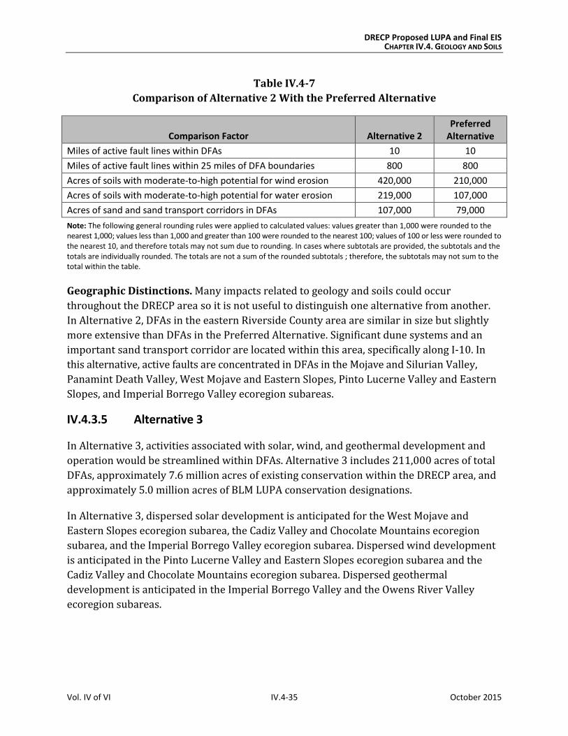
DRECP Proposed LUPA and Final EIS CHAPTER IV.4. GEOLOGY AND SOILS
Vol. IV of VI IV.4-35 October 2015
Table IV.4-7
Comparison of Alternative 2 With the Preferred Alternative
Comparison Factor Alternative 2 Preferred
Alternative
Miles of active fault lines within DFAs 10 10
Miles of active fault lines within 25 miles of DFA boundaries 800 800
Acres of soils with moderate-to-high potential for wind erosion 420,000 210,000
Acres of soils with moderate-to-high potential for water erosion 219,000 107,000
Acres of sand and sand transport corridors in DFAs 107,000 79,000
Note: The following general rounding rules were applied to calculated values: values greater than 1,000 were rounded to the nearest 1,000; values less than 1,000 and greater than 100 were rounded to the nearest 100; values of 100 or less were rounded to the nearest 10, and therefore totals may not sum due to rounding. In cases where subtotals are provided, the subtotals and the totals are individually rounded. The totals are not a sum of the rounded subtotals ; therefore, the subtotals may not sum to the total within the table.
Geographic Distinctions. Many impacts related to geology and soils could occur
throughout the DRECP area so it is not useful to distinguish one alternative from another.
In Alternative 2, DFAs in the eastern Riverside County area are similar in size but slightly
more extensive than DFAs in the Preferred Alternative. Significant dune systems and an
important sand transport corridor are located within this area, specifically along I-10. In
this alternative, active faults are concentrated in DFAs in the Mojave and Silurian Valley,
Panamint Death Valley, West Mojave and Eastern Slopes, Pinto Lucerne Valley and Eastern
Slopes, and Imperial Borrego Valley ecoregion subareas.
IV.4.3.5 Alternative 3
In Alternative 3, activities associated with solar, wind, and geothermal development and
operation would be streamlined within DFAs. Alternative 3 includes 211,000 acres of total
DFAs, approximately 7.6 million acres of existing conservation within the DRECP area, and
approximately 5.0 million acres of BLM LUPA conservation designations.
In Alternative 3, dispersed solar development is anticipated for the West Mojave and
Eastern Slopes ecoregion subarea, the Cadiz Valley and Chocolate Mountains ecoregion
subarea, and the Imperial Borrego Valley ecoregion subarea. Dispersed wind development
is anticipated in the Pinto Lucerne Valley and Eastern Slopes ecoregion subarea and the
Cadiz Valley and Chocolate Mountains ecoregion subarea. Dispersed geothermal
development is anticipated in the Imperial Borrego Valley and the Owens River Valley
ecoregion subareas.
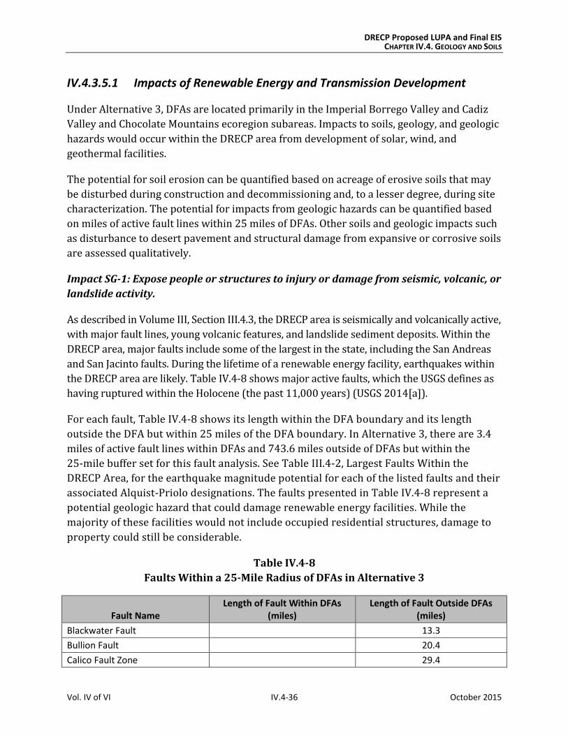
DRECP Proposed LUPA and Final EIS CHAPTER IV.4. GEOLOGY AND SOILS
Vol. IV of VI IV.4-36 October 2015
IV.4.3.5.1 Impacts of Renewable Energy and Transmission Development
Under Alternative 3, DFAs are located primarily in the Imperial Borrego Valley and Cadiz
Valley and Chocolate Mountains ecoregion subareas. Impacts to soils, geology, and geologic
hazards would occur within the DRECP area from development of solar, wind, and
geothermal facilities.
The potential for soil erosion can be quantified based on acreage of erosive soils that may
be disturbed during construction and decommissioning and, to a lesser degree, during site
characterization. The potential for impacts from geologic hazards can be quantified based
on miles of active fault lines within 25 miles of DFAs. Other soils and geologic impacts such
as disturbance to desert pavement and structural damage from expansive or corrosive soils
are assessed qualitatively.
Impact SG-1: Expose people or structures to injury or damage from seismic, volcanic, or
landslide activity.
As described in Volume III, Section III.4.3, the DRECP area is seismically and volcanically active,
with major fault lines, young volcanic features, and landslide sediment deposits. Within the
DRECP area, major faults include some of the largest in the state, including the San Andreas
and San Jacinto faults. During the lifetime of a renewable energy facility, earthquakes within
the DRECP area are likely. Table IV.4-8 shows major active faults, which the USGS defines as
having ruptured within the Holocene (the past 11,000 years) (USGS 2014[a]).
For each fault, Table IV.4-8 shows its length within the DFA boundary and its length
outside the DFA but within 25 miles of the DFA boundary. In Alternative 3, there are 3.4
miles of active fault lines within DFAs and 743.6 miles outside of DFAs but within the
25-mile buffer set for this fault analysis. See Table III.4-2, Largest Faults Within the
DRECP Area, for the earthquake magnitude potential for each of the listed faults and their
associated Alquist-Priolo designations. The faults presented in Table IV.4-8 represent a
potential geologic hazard that could damage renewable energy facilities. While the
majority of these facilities would not include occupied residential structures, damage to
property could still be considerable.
Table IV.4-8
Faults Within a 25-Mile Radius of DFAs in Alternative 3
Fault Name Length of Fault Within DFAs
(miles) Length of Fault Outside DFAs
(miles)
Blackwater Fault 13.3
Bullion Fault 20.4
Calico Fault Zone 29.4
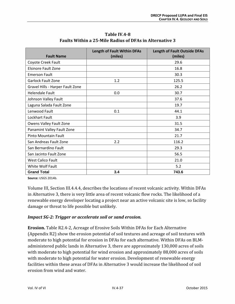
DRECP Proposed LUPA and Final EIS CHAPTER IV.4. GEOLOGY AND SOILS
Vol. IV of VI IV.4-37 October 2015
Table IV.4-8
Faults Within a 25-Mile Radius of DFAs in Alternative 3
Fault Name Length of Fault Within DFAs
(miles) Length of Fault Outside DFAs
(miles)
Coyote Creek Fault 29.6
Elsinore Fault Zone 16.8
Emerson Fault 30.3
Garlock Fault Zone 1.2 125.5
Gravel Hills - Harper Fault Zone 26.2
Helendale Fault 0.0 30.7
Johnson Valley Fault 37.6
Laguna Salada Fault Zone 19.7
Lenwood Fault 0.1 44.1
Lockhart Fault 3.9
Owens Valley Fault Zone 31.5
Panamint Valley Fault Zone 34.7
Pinto Mountain Fault 21.7
San Andreas Fault Zone 2.2 116.2
San Bernardino Fault 29.3
San Jacinto Fault Zone 56.5
West Calico Fault 21.0
White Wolf Fault 5.2
Grand Total 3.4 743.6
Source: USGS 2014b.
Volume III, Section III.4.4.4, describes the locations of recent volcanic activity. Within DFAs
in Alternative 3, there is very little area of recent volcanic flow rocks. The likelihood of a
renewable energy developer locating a project near an active volcanic site is low, so facility
damage or threat to life possible but unlikely.
Impact SG-2: Trigger or accelerate soil or sand erosion.
Erosion. Table R2.4-2, Acreage of Erosive Soils Within DFAs for Each Alternative
(Appendix R2) show the erosion potential of soil textures and acreage of soil textures with
moderate to high potential for erosion in DFAs for each alternative. Within DFAs on BLM-
administered public lands in Alternative 3, there are approximately 130,000 acres of soils
with moderate to high potential for wind erosion and approximately 88,000 acres of soils
with moderate to high potential for water erosion. Development of renewable energy
facilities within these areas of DFAs in Alternative 3 would increase the likelihood of soil
erosion from wind and water.
DRECP Proposed LUPA and Final EIS CHAPTER IV.4. GEOLOGY AND SOILS
Vol. IV of VI IV.4-38 October 2015
Sand Transport. Under Alternative 3, DFAs in the East Riverside region are on or near an
important sand transport corridor in the Chuckwalla Valley. The corridor runs parallel to I-
10 in Riverside County between Desert Center and Blythe. Other sand transport corridors
include the Mojave River corridor, which includes the Kelso Dunes, the Bristol Trough
corridor, which includes the Cadiz and Danby dunes, the Rice Valley corridor, which
includes the Rice Valley Dunes, and the Clark’s Pass corridor, which includes the Dale Lake
Dunes and Palen-Ford Dunes (USGS 2003). Renewable energy facilities in these DFAs could
impede sand transport and affect valuable habitat within this corridor of active sand dunes.
Within DFAs in Alternative 3, there are approximately 32,000 acres of dune systems and
sand transport corridors.
Impact SG-3: Expose structures to damage from corrosive or expansive soils.
As stated in Section IV.4.2, Typical Impacts Common to All Action Alternatives, corrosive
soils could damage foundations and structural elements of renewable energy facilities.
Expansive soils could cause soils to shrink or swell, also damaging foundations and
structural elements. Alternative 3 includes 15,000 acres of potentially expansive soils. See
Table R2.4-3, Acreage of Expansive Soil Textures Within DFAs for Each Alternative
(Appendix R2), which includes clay, clay loam, silty clay, and silty clay loam. Playas, North
American warm desert alkaline scrub, herb playa, and wet flat all indicate potentially
corrosive soil. Alternative 3 includes approximately 15,000 acres of potentially corrosive
soils within DFAs.
Impact SG-4: Destroy or disturb desert pavement.
Renewable energy facilities in Alternative 3 may damage desert pavement. Excavation and
grading during construction and decommissioning, as well as ground disturbance from
workers, vehicles, and equipment, would damage or disturb this important habitat. Specific
locations of desert pavement that have not been mapped would require field surveys.
Impacts on Variance Process Lands
Variance Process Lands are neither reserve lands nor DFAs. They are a subset of the variance
lands identified in the Solar PEIS Record of Decision and additional lands that, based on
current information, have moderate to low ecological value and ambiguous value for
renewable energy. If renewable energy development is built on Variance Process Lands, a
LUPA would not be required, so the environmental review process would be simpler than if
the location were left as undesignated.
Variance Process Lands for each alternative are shown in Chapter IV.1, Table IV.1-2, and in
Volume II, Chapter II.6, Figure II.6-1, for Alternative 3. Development of Variance Process
Lands would have similar air quality effects as described under Impacts SG-1 through SG-4.
DRECP Proposed LUPA and Final EIS CHAPTER IV.4. GEOLOGY AND SOILS
Vol. IV of VI IV.4-39 October 2015
Impact Reduction Strategies
Implementation of the Proposed LUPA would result in new conservation designations for
some lands as well as the designation of areas for renewable energy generation and
transmission facilities. The impacts of the renewable energy development covered by the
LUPA would be lessened in several ways. First, the LUPA incorporates CMAs for each
alternative, including LUPA-wide CMAs and CMAs for specific land designations, such as
NLCS lands, ACECs, and wildlife allocations. Also, the implementation of existing laws,
orders, regulations, and standards would reduce the impacts of project development.
Conservation and Management Actions
The conservation strategy for Alternative 3 (presented in Volume II, Section II.6.4) defines
specific actions that would reduce the impacts of this alternative. Section II.6.4.2 presents
specific CMAs for Alternative 3. The CMAs in Alternative 3 that are relevant to geology and
soils would be the same as the CMAs for the Preferred Alternative that are presented in
Section IV.4.3.2.1, except as described below.
All of the CMAs that are described for the Preferred Alternative would apply to
Alternative 3, with the following modifications for activities within DFAs:
Limit disturbance of sensitive soil areas so no more than 1% of the sensitive soil
areas within a proposed project footprint shall be disturbed for construction.
Exclude renewable energy development in sand dune areas.
Limit disturbance of sand flow corridors so no more than 1% of the sand flow
corridors within a proposed project footprint shall be disturbed for construction.
Limit disturbance of desert pavement so no more than 5% of the desert pavement
within a proposed project footprint shall be disturbed for construction.
Avoid development in floodplains, unless such development can be mitigated.
Apply a 0.25-mile protective offset around playas.
Biological and Air Resources CMAs relevant to geology and soils under the Preferred
Alternative apply to Alternative 3 as well.
Laws and Regulations
As defined under the No Action Alternative, existing laws and regulations will reduce
certain impacts DRECP implementation; they are summarized in Section IV.4.3.1.1.
Relevant regulations are described in more detail in Section III.4.1, Regulatory Setting.
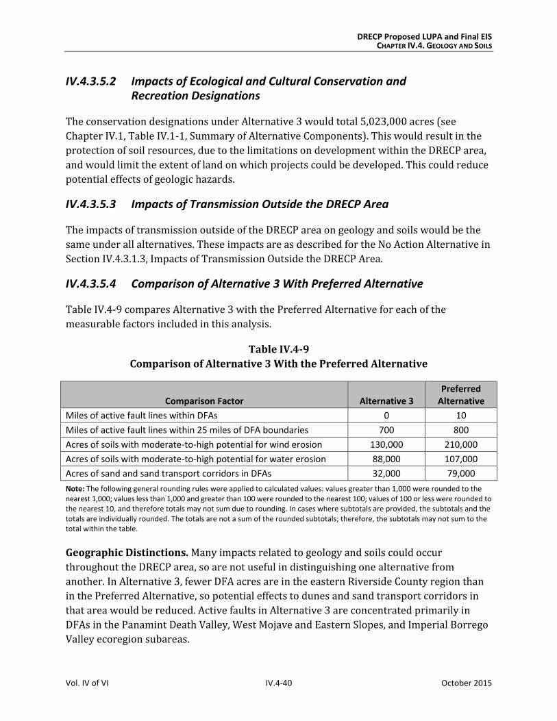
DRECP Proposed LUPA and Final EIS CHAPTER IV.4. GEOLOGY AND SOILS
Vol. IV of VI IV.4-40 October 2015
IV.4.3.5.2 Impacts of Ecological and Cultural Conservation and Recreation Designations
The conservation designations under Alternative 3 would total 5,023,000 acres (see
Chapter IV.1, Table IV.1-1, Summary of Alternative Components). This would result in the
protection of soil resources, due to the limitations on development within the DRECP area,
and would limit the extent of land on which projects could be developed. This could reduce
potential effects of geologic hazards.
IV.4.3.5.3 Impacts of Transmission Outside the DRECP Area
The impacts of transmission outside of the DRECP area on geology and soils would be the
same under all alternatives. These impacts are as described for the No Action Alternative in
Section IV.4.3.1.3, Impacts of Transmission Outside the DRECP Area.
IV.4.3.5.4 Comparison of Alternative 3 With Preferred Alternative
Table IV.4-9 compares Alternative 3 with the Preferred Alternative for each of the
measurable factors included in this analysis.
Table IV.4-9
Comparison of Alternative 3 With the Preferred Alternative
Comparison Factor Alternative 3 Preferred
Alternative
Miles of active fault lines within DFAs 0 10
Miles of active fault lines within 25 miles of DFA boundaries 700 800
Acres of soils with moderate-to-high potential for wind erosion 130,000 210,000
Acres of soils with moderate-to-high potential for water erosion 88,000 107,000
Acres of sand and sand transport corridors in DFAs 32,000 79,000
Note: The following general rounding rules were applied to calculated values: values greater than 1,000 were rounded to the nearest 1,000; values less than 1,000 and greater than 100 were rounded to the nearest 100; values of 100 or less were rounded to the nearest 10, and therefore totals may not sum due to rounding. In cases where subtotals are provided, the subtotals and the totals are individually rounded. The totals are not a sum of the rounded subtotals; therefore, the subtotals may not sum to the total within the table.
Geographic Distinctions. Many impacts related to geology and soils could occur
throughout the DRECP area, so are not useful in distinguishing one alternative from
another. In Alternative 3, fewer DFA acres are in the eastern Riverside County region than
in the Preferred Alternative, so potential effects to dunes and sand transport corridors in
that area would be reduced. Active faults in Alternative 3 are concentrated primarily in
DFAs in the Panamint Death Valley, West Mojave and Eastern Slopes, and Imperial Borrego
Valley ecoregion subareas.
DRECP Proposed LUPA and Final EIS CHAPTER IV.4. GEOLOGY AND SOILS
Vol. IV of VI IV.4-41 October 2015
IV.4.3.6 Alternative 4
Under Alternative 4, activities associated with solar, wind, and geothermal development
and operation would be permitted within DFAs. Alternative 4 includes 258,000 acres of
total DFAs, approximately 7.6 million acres of existing conservation within the DRECP area,
and approximately 4.4 million acres of BLM LUPA conservation designations. In
Alternative 4, both dispersed solar and dispersed wind development are anticipated for the
Cadiz Valley and Chocolate Mountains ecoregion subarea. Dispersed geothermal
development is anticipated in the Imperial Borrego Valley and in the Owens River Valley
ecoregion subareas.
Effects of Alternative 4 on geology and soils are described in the following sections. This
discussion includes the effects of renewable energy development, including transmission
development and other land use decisions within the LUPA Decision Area.
IV.4.3.6.1 Impacts of Renewable Energy and Transmission Development
Under Alternative 4, DFAs are located primarily in the Cadiz Valley and Chocolate
Mountains ecoregion subarea and the Imperial Borrego Valley ecoregion subarea portions
of the DRECP area. Impacts related to soils, geology, and geologic hazards would occur
within the DRECP area from development of solar, wind, and geothermal facilities. Impacts
would also occur from transmission development, both within and outside of the DFAs. The
potential for soil erosion can be quantified based on acreage of erosive soils that may be
disturbed during construction and decommissioning and, to a lesser degree, during site
characterization. The potential for impacts from geologic hazards can be quantified based
on miles of active fault lines within 25 miles of DFAs in Alternative 4. Other geologic and
soil impacts such as disturbance to desert pavement and structural damage from expansive
or corrosive soils are assessed qualitatively.
The BLM land use designations (e.g., National Conservation Lands, ACECs, wildlife
allocations, and trail management corridors) would prohibit renewable energy
development and be managed to protect ecological, historic, cultural, scenic, and scientific
resources and values; these designations would also protect geologic and soil resources.
Disturbance caps on National Conservation Lands and ACECs would provide further
protections. A combination of National Conservation Lands and ACECs would make up the
majority of the proposed BLM land designations under Alternative 4.
Existing or expanded SRMAs would also prohibit surface-occupying renewable energy
development, but could conversely cause to soil erosion from recreation uses, depending
on the extent of allowable uses and management within specific SRMAs.
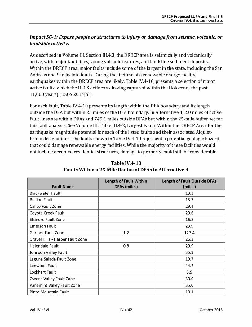
DRECP Proposed LUPA and Final EIS CHAPTER IV.4. GEOLOGY AND SOILS
Vol. IV of VI IV.4-42 October 2015
Impact SG-1: Expose people or structures to injury or damage from seismic, volcanic, or
landslide activity.
As described in Volume III, Section III.4.3, the DRECP area is seismically and volcanically
active, with major fault lines, young volcanic features, and landslide sediment deposits.
Within the DRECP area, major faults include some of the largest in the state, including the San
Andreas and San Jacinto faults. During the lifetime of a renewable energy facility,
earthquakes within the DRECP area are likely. Table IV.4-10, presents a selection of major
active faults, which the USGS defines as having ruptured within the Holocene (the past
11,000 years) (USGS 2014[a]).
For each fault, Table IV.4-10 presents its length within the DFA boundary and its length
outside the DFA but within 25 miles of the DFA boundary. In Alternative 4, 2.0 miles of active
fault lines are within DFAs and 749.1 miles outside DFAs but within the 25-mile buffer set for
this fault analysis. See Volume III, Table III.4-2, Largest Faults Within the DRECP Area, for the
earthquake magnitude potential for each of the listed faults and their associated Alquist-
Priolo designations. The faults shown in Table IV.4-10 represent a potential geologic hazard
that could damage renewable energy facilities. While the majority of these facilities would
not include occupied residential structures, damage to property could still be considerable.
Table IV.4-10
Faults Within a 25-Mile Radius of DFAs in Alternative 4
Fault Name Length of Fault Within
DFAs (miles) Length of Fault Outside DFAs
(miles)
Blackwater Fault 13.3
Bullion Fault 15.7
Calico Fault Zone 29.4
Coyote Creek Fault 29.6
Elsinore Fault Zone 16.8
Emerson Fault 23.9
Garlock Fault Zone 1.2 127.4
Gravel Hills - Harper Fault Zone 26.2
Helendale Fault 0.8 29.9
Johnson Valley Fault 35.9
Laguna Salada Fault Zone 19.7
Lenwood Fault 44.2
Lockhart Fault 3.9
Owens Valley Fault Zone 30.0
Panamint Valley Fault Zone 35.0
Pinto Mountain Fault 10.1
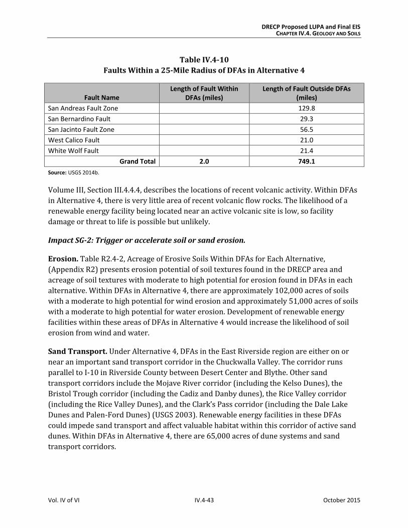
DRECP Proposed LUPA and Final EIS CHAPTER IV.4. GEOLOGY AND SOILS
Vol. IV of VI IV.4-43 October 2015
Table IV.4-10
Faults Within a 25-Mile Radius of DFAs in Alternative 4
Fault Name Length of Fault Within
DFAs (miles) Length of Fault Outside DFAs
(miles)
San Andreas Fault Zone 129.8
San Bernardino Fault 29.3
San Jacinto Fault Zone 56.5
West Calico Fault 21.0
White Wolf Fault 21.4
Grand Total 2.0 749.1
Source: USGS 2014b.
Volume III, Section III.4.4.4, describes the locations of recent volcanic activity. Within DFAs
in Alternative 4, there is very little area of recent volcanic flow rocks. The likelihood of a
renewable energy facility being located near an active volcanic site is low, so facility
damage or threat to life is possible but unlikely.
Impact SG-2: Trigger or accelerate soil or sand erosion.
Erosion. Table R2.4-2, Acreage of Erosive Soils Within DFAs for Each Alternative,
(Appendix R2) presents erosion potential of soil textures found in the DRECP area and
acreage of soil textures with moderate to high potential for erosion found in DFAs in each
alternative. Within DFAs in Alternative 4, there are approximately 102,000 acres of soils
with a moderate to high potential for wind erosion and approximately 51,000 acres of soils
with a moderate to high potential for water erosion. Development of renewable energy
facilities within these areas of DFAs in Alternative 4 would increase the likelihood of soil
erosion from wind and water.
Sand Transport. Under Alternative 4, DFAs in the East Riverside region are either on or
near an important sand transport corridor in the Chuckwalla Valley. The corridor runs
parallel to I-10 in Riverside County between Desert Center and Blythe. Other sand
transport corridors include the Mojave River corridor (including the Kelso Dunes), the
Bristol Trough corridor (including the Cadiz and Danby dunes), the Rice Valley corridor
(including the Rice Valley Dunes), and the Clark’s Pass corridor (including the Dale Lake
Dunes and Palen-Ford Dunes) (USGS 2003). Renewable energy facilities in these DFAs
could impede sand transport and affect valuable habitat within this corridor of active sand
dunes. Within DFAs in Alternative 4, there are 65,000 acres of dune systems and sand
transport corridors.
DRECP Proposed LUPA and Final EIS CHAPTER IV.4. GEOLOGY AND SOILS
Vol. IV of VI IV.4-44 October 2015
Impact SG-3: Expose structures to damage from corrosive or expansive soils.
As stated in Section IV.4.2, Typical Impacts Common to All Alternatives, corrosive soils
could damage foundations and structural elements of renewable energy facilities.
Expansive soils could cause soils to shrink or swell, also damaging foundations and other
structural elements. Alternative 4 includes approximately 3,000 acres of potentially
expansive soils. See Table R2.4-3, Acreage of Expansive Soil Textures Within DFAs for Each
Alternative (Appendix R2). Expansive soil textures include clay, clay loam, silty clay, and
silty clay loam. Playas, North American warm desert alkaline scrub, herb playa, and wet flat
all indicate potentially corrosive soil. Alternative 4 includes 10,000 acres of potentially
corrosive soils within DFAs.
Impact SG-4: Destroy or disturb desert pavement.
Renewable energy facilities constructed in DFAs in Alternative 4 may damage desert
pavement. Excavation and grading during construction and decommissioning, as well as
ground disturbance from workers, vehicles, and equipment, would damage or disturb this
important habitat. Specific locations of desert pavement that have not been mapped would
require field surveys.
Impacts on Variance Process Lands
Variance Process Lands are neither reserve lands nor DFAs. They are a subset of the variance
lands identified in the Solar PEIS Record of Decision and additional lands that, based on
current information, have moderate to low ecological value and ambiguous value for
renewable energy. If renewable energy development occurs on Variance Process Lands,
LUPA would not be required, so the environmental review process would be simpler than if
the location were left as undesignated.
Variance Process Lands for each alternative are as shown in Chapter IV.1, Table IV.1-2, and
in Volume II, Chapter II.7, Figure II.7-1 for Alternative 4. Development of Variance Process
Lands would have similar air quality effects as described under Impacts SG-1 through SG-4.
Impact Reduction Strategies
Implementation of the Proposed LUPA would create both additional conservation
designations for some desert lands and designate other areas for streamlined renewable
energy development. The impacts of renewable energy development within DFAs would be
lessened in several ways. First, it incorporates CMAs for each alternative, including LUPA-
wide CMAs and CMAs for specific land designations, such as NLCS lands, ACECs, and wildlife
allocations. Implementation of existing laws, orders, regulations, and standards would also
reduce the impacts of project development.
DRECP Proposed LUPA and Final EIS CHAPTER IV.4. GEOLOGY AND SOILS
Vol. IV of VI IV.4-45 October 2015
Conservation and Management Actions
The conservation strategy for Alternative 4 (presented in Volume II, Section II.7.4) defines
specific actions that would reduce the impacts of this alternative. Section II.7.4.2 presents
specific CMAs for Alternative 4. The CMAs in Alternative 4 that are relevant to geology and
soils would be the same as the CMAs for the Preferred Alternative that are shown in Section
IV.4.3.2.1, except as described below.
All of the CMAs described for the Preferred Alternative would apply to Alternative 4, with
the following modifications for activities within DFAs:
Limit disturbance of sensitive soil areas, so no more than 20% of the sensitive soil
areas within a proposed project footprint would be disturbed by construction.
Limit disturbance of sand dunes, so no more than 5% of the sand dunes within a
proposed project footprint would be disturbed by construction.
Limit disturbance of sand flow corridors, so no more than 5% of the sand flow
corridors within a proposed project footprint would be disturbed by construction.
Limit disturbance of desert pavement, so no more than 5% of the desert pavement
within a proposed project footprint would be disturbed by construction.
Avoid development in floodplains unless it can be mitigated.
o Exceptions: Exceptions to any of these stipulations may be granted by the
authorized officer if the operator submits a plan that demonstrates that:
The impacts from the proposed action are temporary.
The impacts are minimal or can be adequately mitigated.
Critical resources, including threatened and endangered species, are
fully protected.
o Modifications: No modifications will be granted.
o Waivers: No waivers will be granted.
Biological and Air Resources CMAs relevant to geology and soils under the Preferred
Alternative apply to Alternative 4 as well.
Laws and Regulations
As defined under the No Action Alternative, existing laws and regulations will reduce certain
impacts of LUPA implementation; they are summarized in Section IV.4.3.1.1. Relevant
regulations are described in more detail in Volume III, Section III.4.1, Regulatory Setting.
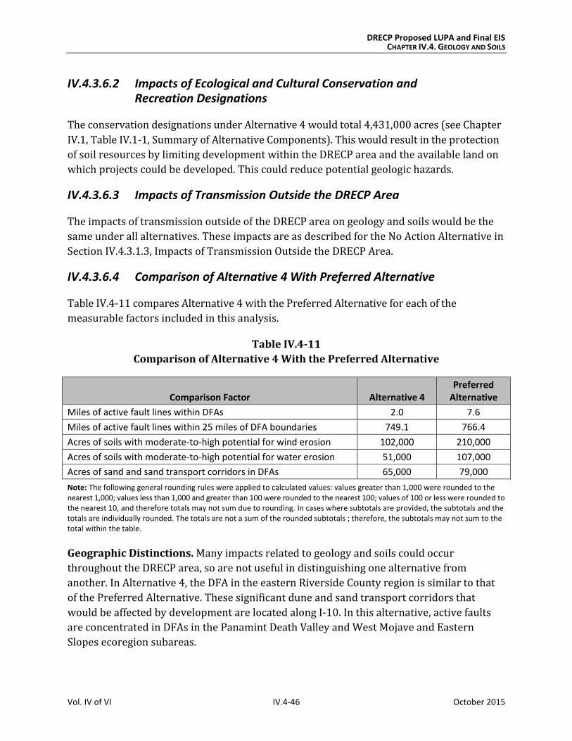
DRECP Proposed LUPA and Final EIS CHAPTER IV.4. GEOLOGY AND SOILS
Vol. IV of VI IV.4-46 October 2015
IV.4.3.6.2 Impacts of Ecological and Cultural Conservation and Recreation Designations
The conservation designations under Alternative 4 would total 4,431,000 acres (see Chapter
IV.1, Table IV.1-1, Summary of Alternative Components). This would result in the protection
of soil resources by limiting development within the DRECP area and the available land on
which projects could be developed. This could reduce potential geologic hazards.
IV.4.3.6.3 Impacts of Transmission Outside the DRECP Area
The impacts of transmission outside of the DRECP area on geology and soils would be the
same under all alternatives. These impacts are as described for the No Action Alternative in
Section IV.4.3.1.3, Impacts of Transmission Outside the DRECP Area.
IV.4.3.6.4 Comparison of Alternative 4 With Preferred Alternative
Table IV.4-11 compares Alternative 4 with the Preferred Alternative for each of the
measurable factors included in this analysis.
Table IV.4-11
Comparison of Alternative 4 With the Preferred Alternative
Comparison Factor Alternative 4 Preferred
Alternative
Miles of active fault lines within DFAs 2.0 7.6
Miles of active fault lines within 25 miles of DFA boundaries 749.1 766.4
Acres of soils with moderate-to-high potential for wind erosion 102,000 210,000
Acres of soils with moderate-to-high potential for water erosion 51,000 107,000
Acres of sand and sand transport corridors in DFAs 65,000 79,000
Note: The following general rounding rules were applied to calculated values: values greater than 1,000 were rounded to the nearest 1,000; values less than 1,000 and greater than 100 were rounded to the nearest 100; values of 100 or less were rounded to the nearest 10, and therefore totals may not sum due to rounding. In cases where subtotals are provided, the subtotals and the totals are individually rounded. The totals are not a sum of the rounded subtotals ; therefore, the subtotals may not sum to the total within the table.
Geographic Distinctions. Many impacts related to geology and soils could occur
throughout the DRECP area, so are not useful in distinguishing one alternative from
another. In Alternative 4, the DFA in the eastern Riverside County region is similar to that
of the Preferred Alternative. These significant dune and sand transport corridors that
would be affected by development are located along I-10. In this alternative, active faults
are concentrated in DFAs in the Panamint Death Valley and West Mojave and Eastern
Slopes ecoregion subareas.